1
PROJECT
ENVIRONMENTAL PROTECTION AND SUSTAINABLE
MANAGEMENT OF THE GUARANI AQUIFER
Argentina - Brazil - Paraguay - Uruguay
GEF BIRF OEA
BID REFERENCE TERMS FOR TECHNICAL SUPPORT TO THE
PILOT-PROJECT AT RIBEIRÃO PRETO (SÃO PAULO, BRASIL)*
11 October 2003
COD: 1/5041.1
*
Heraldo Campos
Consultant Geologist
PhD University of São Paulo
Post-Doc in Hydrogeology Polytechnic University of Cataluña
(048) 99895066
heraldocampos@yahoo.com
2
CONTENTS
EXECUTIVE DOCUMENT I
1. INTRODUCTION
2. PILOT-PROJECT RIBEIRÃO PRETO: STUDY AREA
3. GENERAL TIMETABLE FOR THE ACTIVITIES
4. FINANCIAL PROFILE
5. BID REFERENCE TERMS
EXECUTIVE DOCUMENT II
1. GUARANI AQUÍFER LOCAL MANAGEMENT PLAN
2. POTENTIALLY PARTICIPATING ORGANISATIONS
3
1. INTRODUCTION
The purpose of the present bid reference terms is to describe the results obtained by this
consultancy service [1] over the period between 01 September an 01 October 2003, in response
to the demands related to the "Project Environmental Protection and Sustainable Development
of the Guarani Aquifer System", being developed by Argentina, Brazil, Paraguay, and
Uruguay, with funds provided by GEF World Bank, and coordinated by the General
Secretary of OAS (GS/OAS).
The consultancy service is encompassed with the Component 5: "Development of
Groundwater Management and Mitigation Measures", to be designed for critical areas of
recharge and discharge which bear close relation with Component 2 "Development and
Implementation of a Guarani Aquifer System Management Framework (SAG)". Within
Component 5, this reference term prompts the actions of the Subcomponent 5A, designed to
develop transboundary projects in which mechanisms for management and protection of
groundwater will be assessed with reference to part of the Aquifer situated at the municipality
of Ribeirão Preto, Brazil.
The consultant has based his activities on the previous stage of work that was made digitally
available at the project's web page (http://www.sg-guarani.org), and summarized and adapted
excerpts of the following documentation: a) Preparation of the Project Environmental and
Sustainable Development of the Guarani Aquifer System, Activity 9; b) Preliminary Bid
Reference Terms for the Development of a Pilot Program at the region of Ribeirão Preto,
conducted by Engineer Alberto Calcagno in March 2001 (Objectives of the Pilot Program); c)
Preparation of the Seminar of the Pilot Area of Ribeirão Preto (description of activities of
PPRP, based on the same document by Alberto Calcagno, modified on 24.7.2003 by
UEEP/SP); and d) literature review.
Thus, the text breaks down into the following structure: Executive Document I (introduction,
study area of the Pilot Project of Ribeirão Preto, general timetable of activities, financial
profile and bid reference terms), Executive Document II (Guarani Aquifer local management
plan and potentially participating organizations), and annexes - only portuguese version
(consultancy information, illustrations of the study area, facsimile of bid reference term of
DAEE (1986), São Paulo State legislation on groundwater, records of the potentially
participating organizations and memorial of projects characterization.
2. THE AREA OF THE RIBEIRÃO PRETO PILOT-PROJECT.
The region of Ribeirão Preto (Figure 1) is situated at the northeast part of the state of São
Paulo, Brazil. Its choice as pilot area was mainly based on professional judgment and previous
knowledge of the area provided by the organizations involved in the State Unit for Project
Preparation in the State of São Paulo (UEPP/SP). The region of Ribeirão Preto has been
subject to a meaningful process of urban expansion together with agricultural and industrial
activity which entails intensive groundwater exploitation from Guarani Aquifer. The
significant number of wells has been causing problems of interference and risk of groundwater
contamination due to the raise of point and non-point pollution sources installed over such a
high vulnerability aquifer.
.............................
[1] Consultancy Service for the Devising of Bid Reference Terms for Technical Support of the Pilot Project
at Ribeirão Preto (São Paulo, Brazil) COD:1/5041.1, August 2003, Bid.
4
Figure 1 (fac-simile) Location map of the region of Ribeirão Preto proposed as Pilot Project
area.
5
3. GENERAL TIMETABLE OF ACTIVITIES
Worksheet 1 presents a summary of execution and global costs based on Calcagno's proposal
and the proposal presented for discussion during the Guarani Aquifer Seminar (UEPP/SP). It
also contains a list of implementing organizations, GEF funding, and governmental in kind
input.
3.1 In kind input
The governmental in kind input indicated in Worksheet 1 must be formalized through specific
instruments under the sponsoring of Guarani Project General Secretary. These in-kind
counterparts are considered to be potential and dependent upon relationships to be developed
in the course of the Pilot Project.
4. FINANCIAL PROFILE
Worksheet 2 presents the financial profile distributed in a 4-month basis with reference to GEF
funds to be made available and governmental in kind input allocated by expenditure categories.
5. BID REFERENCE TERMS
During the activities, it will be important that staff in charge of the execution of tasks
(consultants and/or contractors) to hold periodical meetings with the Pilot-Project Steering
Group as well as to present progress reports.
Based on the general timetable for the activities, financial profile, documents produced over
the period, and on the suggestions provided during the Guarani Aquifer Seminar, the
consultant proposes the following bid reference terms for the management of the Guarani
Aquifer System at the area of the Pilot-Project.
EARLY STAGE
BID REFERENCE TERM 1
Recompilation of available information and database configuration in GIS environment
October, November, December 2003
Execution: Ribeirão Preto Pilot-Project participating organizations
Potentially participating organizations (in kind): Geological Institute - SMA, CETESB,
Forestry Institute - SMA, DAERP, mayoralties situated in the area of the Pilot-Project,
DAEE, IPT, and COC College.
Tasks
The tasks will be carried out in strictly coordinated matching with corresponding tasks in the
characterization of aquifer and set up of regional information system described in Phase 1 of
the precedent "Bavaria Project"[2], using the information available. Such activity would be
developed in an integrated manner with the Ribeirão Preto Pilot-Project.
...........................................
[2] Technical co-operation between São Paulo State Secretariat for the Environment and the government of
Bavaria State (Germany) for technology transfer, exchange knowledge and building capacity on
management and protection of groundwater resources. In: Preparation of the Project Environmental and
Sustainable Development of the Guarani Aquifer System, Activity 09, Preliminary Bid Reference Terms
for the Development of a Pilot Project at the Region of Ribeirão Preto, by Alberto Calcagno, March 2001
(p. 14).
6
The engaged organizations are: Geological Institute - SMA, CETESB, Forestry Institute -
SMA, DAERP, mayoralties situated in the area of the Pilot-Project, DAEE, IPT, and COC
College plus potentially participating organizations.
The preliminary results of the " System of Information for the Environmental Management of
Groundwater Resources in the Outcropping Region of Guarani Aquifer at São Paulo State" are
embodied in the synthesis distributed during the Guarani Aquifer Seminar The project
accounts for resources from the implementing organizations themselves (IG, CETESB and
Forestry Institute), and additional financial support from PROCOP/CETESB and FAPESP.
The information to be re-compiled comprises all of those considered to be necessary for the
purpose of the study. At least, information on climatological, hydrological, geological,
hydrogeological, hydrochemical, and hydrodynamic characterizations as well as information
on contamination sources, land use, and social-economic, legal and institutional aspects of the
study area should be included.
At this very stage, system compatibility permitting, it will be possible to include the registry
and licensing database belonging to project GISAT (Geographic Information System about
Multiple Groundwater Uses), carried out by DAEE. Furthermore, it will be possible to include
data of SIGEST (Integration System Multiple Groundwater Uses). SIGEST represents an
institutional technological platform available on the Internet at http://www.sigest.fcth.br.
The information-recompiling task will be completed with adoption of proper configuration
and implementation of the management information system in a GIS environment.
BID REFERENCE TERM 2
Implementation of GIS-based system: system integration, adaptation, and data input.
January, February and March 2004
Services to be contracted: individual consultancy
Tasks
An individual consultancy service will be hired after the completion of information
recompiling, which will be performed with participation of organizations enrolled in Bid
Reference Term 1.
The consultant will be responsible for system integration, adaptation, and data input based on
information available at the "System of Information for the Environmental Management of
Groundwater Resources in the Outcropping Region of Guarani Aquifer at São Paulo State".
In order to achieve the goals, the consultant should attend the SISAG event (Montevideo)
presenting a briefing by the end of March 2004.
The consultant's professional background should be: academic expertise with solid
professional formation in IT and/or Cartography, preferably with experience in dealing with
groundwater management issues.
BID REFERENCE TERM 3
7
Devising an implementation of an strategic action plan for aquifer management
October, November and December 2003
Implementing Group: Ribeirão Preto Pilot-Project Steering Group
Tasks
The following aspects should be considered for the management of groundwater resources:
contamination problems and identified conflicts of use, participation of parties involved,
information sharing, and public consultation.
Such strategic action plan should properly define the range of studies to be developed,
products to be obtained, and procedures for institutional arrangements in view of the
development of the Program, thus contributing for the definition of the project management
approach.
The plan should allow centralized co-ordination, decentralized accomplishment, wide, sectorial
and local participation. That includes definition of ranges and ways of relating the program
with other activities, with other programs and institutions of states and countries participating
in the Guarani Project, as well as with complementary projects locally and internationally.
The strategic actions should include: on-going mechanisms of participation and consultation in
relation to project development and products, groups of discussion and advising, and best
organization arrangements for the planned tasks, and mechanisms for co-ordination and
internal follow-up of the project.
With reference to the "State System for Management of Water Resources", the pilot area of
Ribeirão Preto is under the jurisdiction of the "Rio Pardo Watershed Management
Committee". The Work Party 2 - "Operational Arrangements for the Execution and Strategic
Actions" - in the panel held at the Guarani Aquifer Seminar in Ribeirão Preto, has
recommended the establishment of a Guarani Aquifer Project Steering Group within the
structure of the referred Committee.
BID REFERENCE TERM 4
Devising of Bid Reference Terms for components and activities of the Pilot Program
As long as the Ribeirão Preto Pilot Project lasts (2003-2006)
To be implemented by: General Secretary of Guarani Project
Tasks
The bid reference terms for components and activities, in which Ribeirão Preto Pilot Project
may eventually be broken down, will be deepened and detailed through consultation and
participation mechanisms to be adopted in conjunction with implementing or guest
participants. The terms should include definition on the ranges or scope areas, working scale
and scale for presentation of partial products, which are specific to each activity or component.
The outcome should be: the definition of a detailed work plan in operational and financial
terms; a logical framework to each component/activity of the Ribeirão Preto Pilot Project; and
set up of targets to be achieved for assessment and follow-up consideration. In order to assure
consistency with the general program, bid reference terms to be formalized with the selected
implementing organizations, should clearly set aspects and goals to be achieved in each case.
For further bidding purposes, these bid reference terms were divided into three blocks. At this
stage, performance indicators for both consultancy and contractors should be specified.
8
DEVELOPMENT STAGE
BLOCK 1
BID REFERENCE TERM 5
January, February, and March 2004
Scope: services
Potentially participating organizations (in kind): Geological Institute, CETESB, Forestry
Institute, DAERP, DAEE, mayoralties situate din the area of the Pilot Project,
EMBRAPA, IPT and Sanitation Reinforcement Services State Health Authority.
Well log, land and groundwater use inventory
Tasks
To achieve the goals established for the development stage, the task of building up a well log
inventory will be performed simultaneously to the task of identifying and registering point and
non-point contamination sources.
The collected information on water supply and exploration wells should be confirmed by
further survey, its consistency double checked, and then updated and complemented. Checks
for consistency will include wellhead geographic coordinates and altimetry, static and dynamic
water table depth, total flow and specific capacity, current use and existing exploitation tool,
daily average production, etc. of the wells in the study area through in situ measurements,
including gauges, hydrochemical characteristics and groundwater sampling.
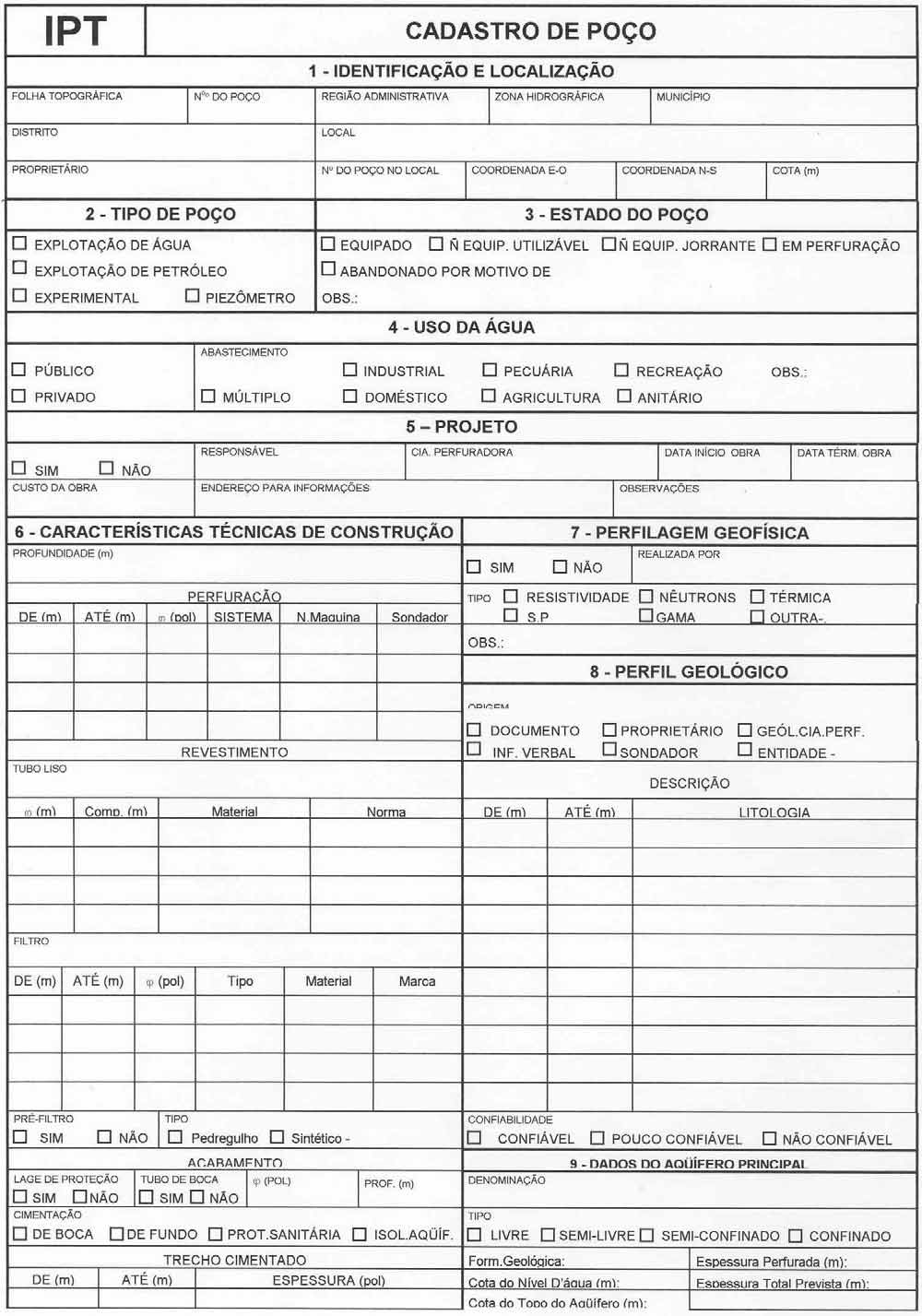
In order to record well log information, the contractor should take the IPT well register form
(Form 1, enclosed below as Ficha 1- fac-simile) for methodological and systematic guidance.
This form has been adapted for the working scale of the Project to include well register items
such as identification and precise location on topographic base map, GPS-taken coordinates
and altimetry. Contractor survey team must use appropriate equipment and positioning
devices.
Inventory of point and non-point contamination sources
The contractor should take the Memoir of Existing and Characterized Enterprises (MCE) from
CETESB Register, which is available in this document as annex, as methodological guidance
for undertaking the work.
The paper "Groundwater Vulnerability and Contamination Risk Mapping"
(IG/CETESB/DAEE, 1997) is recommended as reference for survey and classification of
contamination sources. The systematic field work approach to be adopted while recording
information on industries is presented in Form 2 (fac-simile from CETESB), available in the
this paper.
9
10

11
12
13
14
15
16
The assessments on non-point contamination sources of agricultural origin will be incorporated
with similar level of detail as point sources, to be complemented by EMBRAPA[3], State
Secretariat of Agriculture, and CATI (Coordination for Total Technical Assistance) studies.
The chosen contractor should be committed with presentation of a final report that properly
summarizes the obtained results.
Survey of complementary information and groundwater monitoring during the period of
execution of the Ribeirão Preto Pilot-Project
Tasks
The extent of area to be studied is approximately 2.500 km2, having the City of Ribeirão Preto
as main location reference, and River Pardo as the main axis for the area. The recommended
working scale is 1:50,000. It is expect to acquire hydrogeological data for each linear length of
1000 m on the basis of field survey and monitoring, with no need of additional borehole
drilling work.
According to information gathered at the region of Ribeirão Preto, the public water supply
system operates of about 150 well while the private sector operates 1,000 wells approximately.
The CETESB groundwater monitoring network performs monitoring of 12 wells situated in the
area proposed for study (from a total of 38 monitoring wells located in the area of occurrence
of the aquifer). It is also known that the municipality exploits at least 50 wells for public water
supply. Therefore, it is supposed that the existing number of boreholes/wells will be enough to
provide the necessary information on geological, hydraulic, hydrogeological, and
hydrochemical conditions of the regional as well as of the study area. It is also expected that
the existing information will be enough to select the wells that will comprise the local
monitoring network so enabling the developments planned in the Pilot Project outlook.
The selection of wells to be monitored, as well as definition of parameters to be used and
sampling periodicity will be done after discussions with participating organizations that will be
held as appropriate.
.........................................
[3] EMBRAPA Project: this is the first study, in Sao Paulo State, about the impacts caused by agricultural
and range activities on groundwater. It included the use of pesticides and nitrate of agricultural and
pasture activity origin, and part of the studies related with this project was developed in a pilot basin and
involving a significant monitoring of indicators. In: Preparation of the Project Environmental and
Sustainable Development of the Guarani Aquifer System, Activity 09, Preliminary Bid Reference Terms
for the Development of a Pilot Project at the Region of Ribeirão Preto, by Alberto Calcagno, March 2001
(p. 15).
17
Set up and operation of a local monitoring network
In a set of selected wells, periodical measures will be taken. These will include static and
dynamic water table depth, water quality (parameters related with register contamination
sources listed in the Regulation nb. 1469/00 of the Ministry of Health, and groundwater
exploitation parameters. Continuous record devices will be installed in a limited but
representative number of wells in response to modeling requirements. By the end of local
recharge analysis, a specific monitoring of hydro-climatic parameters will be undertaken,
and this will include installation and operation of registering devices.
This task will be developed with full engagement of the selected contractor and
participating organizations. The final product should be a monitoring network to be
implemented in accordance with local objectives of the Ribeirão Preto Pilot Project.
The selected contractor should observe the recommendations for a preliminary monitoring
network described in the work of Albert Mente (p.34)[4] as methodological guidance for
sampling and measurement parameters as follows:
.quantitative parameters: water table depth (piezometers), temperature and discharge of
wells, with variable frequency.
.qualitative parameters: pH, electric conductivity, main ions (calcium, magnesium, potash,
sodium, nitrates, chloride, sulfates, bicarbonates and others) heavy metals, organic
compounds and pesticides.
.bacteriological
The frequency for sampling should be variable; every two years, bi-monthly
(bacteriological), and monthly (quantitative and qualitative analysis).
BLOCK 2
BID REFERENCE TERM 6
January 2004 to March 2005
Scope: services
Potentially participating organizations (in kind): Geological Institute, CETESB,
DAERP, EMBRAPA, CATI, mayoralties located in the region of the Pilot Project
DAEE, IPT, universities and others.
Devising of conceptual hydro-geological model for groundwater flow simulation
..................................
[4] a) the roll of indicators and parameters to be used in the monitoring network is available in the text
provided by the consultancy for the Definition of Relevant Information to Aquifer Monitoring
Network (Component a. Expansion and Consolidation of the Current Knowledge, Activity a.2), by
Albert Mente, Recife, Brasil, September 2000, 69 p.; b) another methodological reference to be taken
could be the recently approved project by the Universities Fund: Hydrogeological Monitoring of the
Pilot Basin of Ribeirão do Onça at the Outcropping Region of Guarani Aquifer in the University of
São Paulo, São Carlos Campus; contact: Dr. Edson Cezar Wendland (ew@sc.usp.br).
18
Tasks
The tasks involve the development of various analyses for integration of recompiled data
and information. Amongst these tasks, the following may be highlighted:
.determination of aquifer system boundaries and hydro-stratigraphic tridimensional
framework
.water budget and direct recharge quantification
.identification of recharge zones and characterization of border conditions through
isotopic-hydrochemical studies and field trials for determination of hydraulic parameters
.analysis of groundwater use and risks of conflict, determination of critical cases of
overdraft interference or overexploitation
The analyses of groundwater use in critical cases of overdraft and over exploitation should
simulate different scenarios for aquifer behavior in terms of quantity and quality, at current
and future groundwater exploitation conditions. The analyses aim at determining patterns
of distribution (density, separation) and criteria for the operation of wells in order to avoid
overdraft interferences, shortage and overexploitation or induced problems of groundwater
quality.
Tasks will be developed in close co-operation between the selected contractor and
participating organizations. For the devising of the conceptual hydrogeological model for
groundwater flow simulation, the involved parties should take into consideration the
suggestions raised in Guarani Aquifer Seminar, described in Annex 1 Consultant briefing
(portuguese version).
Analysis of groundwater vulnerability and contamination risks; identification of areas
and critical situations, measures and actions for management
A territorial zoning of the study area in terms of natural groundwater vulnerability and
contamination risk will be performed at this stage of work. This should be subsidized by
the paper "Map of Groundwater Vulnerability and Contamination Risk
(IG/CETESB/DAEE, 1997) and applying the methodological concepts included in the
paper or similar ones. The approach to be taken should consider the best mechanism for
identifying point and non-point contamination sources, the availability of a computerized
groundwater flow and contaminant transportation models, as well as the best work scale
for the proposed analysis. The task should include the identification of remediation
strategies for current cases of high risk and for prevention of potential risk.
The participating organizations will be committed with presentation of a final report
including thematic maps compatible with local scale set for the Ribeirão Preto Pilot
Project.
Devising and designing proposals for the implementation of management measures and
actions
This task refers to the identification and design of criteria, measures and management
mechanisms for sustainable use and aquifer protection. These should be oriented to the
resource (land use zoning including preservation areas to protect springs, point
contamination source control, handling of non-point contamination) and to the source
(technology for construction of wells, well operation procedures, wellhead protection
zones, wellhead warning or restricted use zones). Criteria, measures, and management
19
mechanisms should be expressed in the form of user guidance and technical requirements,
legislation blueprints, decrees and regulatory acts, as well as other actions at governmental,
non-governmental, user, and private sector level.
In special, the instruments devised should provide direct subside to municipal or urban
structural plans, as well as they should support decision making related with authorizations
for surface and groundwater use. Subside should also be provided to environmental
licensing and controlling of any construction work or activities having direct or indirect
impact on the Guarani Aquifer System.
BLOCK 3
BID REFERENCE TERM 7
Design and implementation of social communication actions for raising awareness and
environmental education in relation to sustainable use and aquifer protection.
January 2004 to November 2006
Scope: services
To be implemented by: Ribeirão Preto Pilot Project Steering Group
Potentially participating organizations (in kind): Geological Institute, CETESB-
Ribeirão Preto, DAERP, IPT, mayoralties located in the region of the Pilot Project,
state and municipal secretariats for education, DAEE-Ribeirão Preto and others.
This task comprises identification, design and demonstration of methodologies for social
communication, public information and community capacity building (with emphasis on
available mechanisms of formal and informal education) about sustainable use and
protection of the Guarani Aquifer System. Methodologies should be devised in a manner to
allow full access and understanding by the social parties involved.
The accomplishment of the Ribeirão Preto Pilot Project offers multiple opportunities for
purpose activity and materials to raise public awareness and for education and involvement
of different sectors of the society. The monitoring work, modeling of hydrogeological and
groundwater quality conditions including simulation of current and potential scenarios for
the use, zoning of critical areas with reference to natural groundwater vulnerability and
contamination risk (point and non-point), and measures for management, protection and
sustainable use, if properly presented in audio-visual format and accessible to different
representative parties, are examples of such opportunities. Here again, it is important to
stress the need for suitable co-ordination with activities to be developed in the scope of
Guarani Project at regional level.
Currently, at the region of Ribeirão Preto a project called " Hemocenter Foundation
Educational Project Faculty of Medicine of the University of São Paulo" is being
developed and should be taken into consideration in the scope of this specific bid reference
term. As means of communication, this project has been using the "Journal of Sciences"
available at: http://ctc.fmrp.usp.br/education; contact: Mrs. Silvia Cardinale, journalist,
email: casadaciencia@pegasus.fmrp.usp.br
20
COMPLETION STAGE
BID REFERNCE TERM 8
Product dissemination, monitoring of indicators and actions for follow-up of the Pilot
Program in subsequent stages
July 2004 to June 2005
Services to be contracted: individual consultancy
To be implemented by: Ribeirão Preto Pilot Project Steering Group
Potentially participating organizations (in kind): Geological Institute, CETESB,
DAERP, IPT, DAEE, mayoralties located in the region of the Pilot Project, civil
society organizations, universities and others.
BID REFERENCE TERM 9
Final report (a proposal for the continuation of Ribeirão Preto Pilot Program should be
included)
July to December 2006
To be implemented by: Guarani Project General Secretary and Ribeirão Preto Pilot
Project Steering Group.
Potentially participating organizations (in kind): Geological Institute, CETESB,
DAERP, IPT, DAEE, mayoralties located in the region of the Pilot Project, civil
society organizations, universities and others.
EXECUTIVE DOCUMENT II
1. LOCAL MANAGEMENT PLAN FOR THE GUARANÍ AQUIFER
In order to start up the implementation of a local management plan for the Guarani
Aquifer, it is vital to deepen the local studies incorporating new well log data and also
fresh information on groundwater bacteriological and chemical analyses, definition of
recharge areas and wellhead protection zones. This is a need for updating and refinement
of the cartography and hydrogeological model for the area. It is also important to expand
the current monitoring network held by CETESB, which operates only 12 wells (11 of
them in Guarani Aquifer and one well in Serra Geral Aquifer; IPT, 2000, p.347; CETESB,
2001, http://www.cetesb.sp.gov.br).
The construction of a two-layer model (including Serra Geral Aquifer and Guarani
Aquifer) could be applied, at first hand, to a modeling program. Another important step
will be the availability of hydrogeological databank with remote access (e.g. Internet) to
exploitation data, so that a public and stakeholder participation process of investigation
could contribute for the knowledge and management of the groundwater reserve at the
scale of Ribeirão Preto municipality and surrounding region. A reference paper to respond
to such objectives is described in the work of Vives et al. (2001).It is applied satisfactorily
to the Basin of Arroyo del Azul, Azul, Argentina (Vives et.al.,2002a, 2002 b,
http://www.phi-g.org).
21
On the other hand, with regard to the problems related to overexploitation of groundwater
in the municipality of Ribeirao Preto, Monteiro (2003, p.176) suggests the following:
.the effective control of all borehole-drilling licenses, groundwater exploitation permits
(according to Law 9.034/94, Decree 41.258/96, Decree Municipal 264/88, Complementary
Law 204/92, Mineral Waters Regulation), as well as environmental licenses
(Environmental Code of Practice blueprint), taking technical-scientific, socio-economic,
environmental, and legal aspects into consideration
.re-location and location of new groundwater wells more distant from urban areas, aiming
at reducing the overdraft interference and progressive lowering of the potentiometric
surface that may lead to shortcomings
.update of well log inventory (according to Law 9.034/94) and charging the exploitation of
groundwater through installation of meters in all wells and with differentiated pricing
based on the type of user (according to Article 117 IV, of Environmental Code of Practice
blueprint)
.environmental education in all aspects regarding information, formation, public awareness
to problems related to water resource uses, aiming at a participating and sustainable society
taking consideration to the effective commitment of the organized civil society,
enterprises, NGO's and public administration.
Traditionally, decisions or policies to Integrated Management of Water Resources have
been based on scientific, technical and economic data or information produced and
presented by experts who are seldom exposed to third party scrutiny or liable to criticism
or consultation by interested groups. It is also worth noting that technical experts are not
used to interface with non-specialists and different background personnel. On the other
hand, community knowledge and interest may not draw the necessary attention to scientific
and technical developments (at least in the early instances of discussion). But after all, both
realities must be put forward and taken into consideration. This constitutes the so-called
collaborative planning (Ubbels y Verhallen, 2001), provided clear rules and premises are
established to integrate scientific knowledge and to be conveyed into the discussion
between the parties concerned. It is possible to conceive temporal stages for this
integration process, although these stages do not need to be set in a sequential order.
Besides that, according to the general orientation from UEPP/SP to the Guarani Project
(meeting dated August 29,2003), it is proposed an early strategic action program to the
pilot area of Ribeirão Preto in order to assure that management and protection measures are
set up since the early stage of work. In the course of the project, these actions should be
adjusted and consolidated.
I. Institutional Arrangement
In the scope of the "Sao Paulo State Water Resources Management System", the pilot-area
of Ribeirão Preto is encompassed in the jurisdiction of Rio Pardo Watershed Committee.
Therefore, it is recommended the establishment of a " Steering Group of Guarani Aquifer
Project" within the structure of the committee in accordance with the flowchart outlined
below:
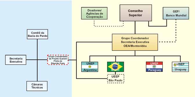
22
a. Organization
b. Structuring of the Steering Group
State(4)
Municipalities (4)
Users and Civil Soc. (6)
Universities (2)
DAEE
Ribeirão Preto
SMA
Serrana
CETESB Sertãozinho
SCTDE Jardinópolis
Cravinhos
.the Steering Group duties will be the following: i) to supervise the accomplishment of the
pilot project ii) implementation of strategic aquifer management and protection actions;
.the Steering Group will be established according to the Watershed Committee directives;
.the Steering Group will report to the Executive Secretary of the Watershed Committee,
which will provide administrative support.;
.the Steering Group will be also articulated with the federative state units, national units
and the General Secretary of Guarani Project.
II. Co-operation between Federative States and Municipalities
.agreement between: a) DAEE and the Mayoralty of Ribeirao Preto for borehole drilling
licensing; and b) with CETESB for environmental control of well operations, definition of
recharge areas and wellhead protection zones aiming at restricting installation of
potentially pollutant sources close to each other (similar agreements could be established
with other municipalities and between these with other boards of the state of São Paulo).
.share utilization of databank and information from Pilot Project.
III. Implementation of the social communication and environmental education plan, by
the Steering Group
23
IV. Devising and implementation of legal and complementary mechanisms
.amendments to the existing municipal structural plans in order to incorporate aquifer
protected areas;
.adoption of regulating measures for the use of groundwater, if applicable.
Measures indicated in items I, II and III are considered to be short-term and could be
implemented immediately (in between 3 months). On the other hand, legal measures such
as in item IV are long-term because they are dependent upon the studies planned in this
Pilot Project.
V. Legal Basis
There is a specific legislation regarding groundwater in the State of São Paulo, as well as
there is legislation about water resources in general. Such legal basis corresponds with the
following:
.State Law on Groundwater (Law Nb. 6.134, of 2 July 1988): it prescribes about
preservation of natural groundwater resources (Annex 4, portuguese version).
.Decree nb. 32.955 of 7 February 1991: it corresponds with a Regulatory Act in relation to
Law nb. 6.134/88; it prescribes about groundwater quantity and quality; it establishes and
classifies areas to be protected; it links the groundwater use with borehole drilling
licensing and well registration. It also prescribes about reinforcement and penalties (Annex
4, portuguese version).
.Decree nb. 41.258, 31/10/96 and DAEE Regulation nb. 717, of 12/12/96: it regulates
rights of use on water resources.
.State Law on Water Resources(Law nb. 7.663, of 30 December 1991): it establishes
directives for "State Policy on Water Resources" and to the "Integrated System for
Management of Water Resources".
.State Law on Environmental Pollution Control (Law nb. 997 of 31 May 1976): it
prescribes about environmental pollution control.
.Decree nb. 8468 of 8 September 1976: it approves the regulatory power of Law nb. 997.
2. POTENTIALLY PARTICIPATING ORGANIZATIONS
The proposed activities for the Guarani Aquifer Seminar for the potentially participating
organizations are shown in worksheet 3 (a and b):
Potentially Participating Organizations (Key notes)
1. Mineral Resource Research Company
2. Secretariat for Planning and Environmental Management the Mayoralty of Ribeirão
Preto.
3. School of Engineering, University of São Carlos - USP/ACE-Pau Brasil Ribeirão Preto
4. SENAC Environmental Technician (Cláudia Martinho Churata)
5. SENAC - Environmental Technician (Janete Franco Fonseca)
6. S.M. Gredpo Reflorestamento Ltda.
7. Public Attorney Office of the State of São Paulo
8. Department of Water Supply and Sewage Services of Ribeirão Preto- DAERP
9. Rubens Caldeira Monteiro
10. Cristiane Regina Stuchi
11. Institute of Geosciences - UNICAMP
12. Public Sanitation Company of the State of Paraná
24
13. University of Ribeirão Preto Chemical Engineering/Water Resources lab
14. Coordination for Total Technical Assistance (CATI) - Ribeirão Preto/State Secretariat
of Agriculture.
15. Brazilian Company for Agricultural Research (EMBRAPA)/Environmental Unit -
Jaguariúna/SP
16. School of Engineering at São Carlos/University of São Paulo
17. Institute of Geosciences/University of São Paulo
18. Department of Water and Hydropower/Ribeirão Preto
19. Nuclear Technology Development Center CDTN/CNEN
20. Regional Health Authority - DIR XVIII/Ribeirão Preto
21. Endemic Diseases Control Bureau (SUCEN)/State Secretariat of Public Health
Ribeirão Preto Headquarters.
22. Ribeirão Splash Park
23. ACAERP Engineering, Architecture and Agronomic Association of Ribeirão Preto
24. Students Union Barão de Mauá/UFSCAR
25. Teaching Bureau Sertãozinho Region
26. Tambori Organization
27. Jardim Progresso Dwellers Association
28. NGO - Vivacidade
29. OSCIP Cultural, Artistic, Historical and Environmental Conservation Trust
30. UNAERP-Chemical Engineering and Masters Course in Environmental Technology
31. IPT Technological Research Institute
32. CETESB/SMA
33. Geological Institute/SMA
34. Institute of Geosciences/UNESP
35. COC/Ribeirão Preto College
36. Forest Institute/SMA
25
QUADRO 3 a - ATIVIDADES PROPOSTAS E POTENCIAIS PARTICIPAÇÕES
Execução - Contrapartidas Potenciais
Atividade - Proposta para discussão
Contra-
partidas
1
2
3
4
5
6
7
8
9
10
11
12
13
14
15
ETAPA INICIAL
a.2 Adoção, configuração e adaptação do SIG
b,c,d
Implementação do SIG. Recompilação de dados e
a.3 informações, consistência e incorporação no SIG.
b,c,d
b
Elaboração e implantação de ações estratégicas para o
e
gerenciamento do Aquifero Guarani através do
estabelecimento de um esquema de gerenciamento
c
participativo
Elaboração dos TRs detalhados de
d
componentes e atividades do PPRP
ETAPA DE DESENVOLVIMENTO
e.1 Inventário de Poços e usos da água subterrânea*
c
b
b
b
c,d
b,c,f
b,c,d
Inventário de fontes de contaminação
e.4 pontuais e difusas
c
b
c,d
b,c,e
b,c,f
b,c,d,e
e.5
*
Estabelecimento e operação de uma rede de monitoramento
e.6
b,c,e
local p/ o PPRP e manutenção no SIG
c
b
c,d
f.1
b,c,g
c,d
Modelo Hidrogeológico Conceitual:
f.2
Conhecimento do arcabouço hidrogeológico, estudo
g
isotópico e hidroquímico, obtenção de parâmetros
hidráulicos, com ensaios de campo e balanço hídrico.
f.3
Análise de uso da água e riscos de conflito (interferências
e/ou superexplotação)
g
Análises da vulnerabilidade
b,c,d
c,d
h
e riscos de contaminação
Elaboração e desenvolvimento de
i.
propostas de medidas e ações de gestão
c,d,e
Desenho e implementação de ações de
j.
comunicação social /educ. ambiental
b,c,e
b,c,e
b,c
g
b,c,d,e
c,e
ETAPA DE ENCERRAMENTO
K.
Difusão de produtos e monitoramento de resultados,
sucessos e aprendizado
l.
c
m.
informe final e ações estratégicas de prosseguimento
c
Coordenação
a
Workshops
A=Grupo Coordenador; B=Apoio material/infraestrutura; C=Apoio recursos humanos; D=Disponibilização de informações/dados; E=Execução; F=Facilitador; G=Colaboração
26
QUADRO 3 b - ATIVIDADES PROPOSTAS E POTENCIAIS PARTICIPAÇÕES
Execução - Contrapartidas Potenciais
Atividade - Proposta para discussão
Contra-
partidas
16
17
18
19
20
21
22
23
24
25
26
27
28
29
30
31
32
33
34
35
ETAPA INICIAL
Adoção, configuração e adaptação do SIG
c,d
b,c,d,eb,c,d,e
g
g
Implementação do SIG. Recompilação de dados e
c,d
c,d
c,d
c,d
g
g
informações, consistência e incorporação no SIG.
Elaboração e implantação de ações estratégicas para o
g
c,d
e
e
e
e
gerenciamento do Aquifero Guarani através do
estabelecimento de um esquema de gerenciamento
participativo
Elaboração dos TRs detalhados de
componentes e atividades do PPRP
ETAPA DE DESENVOLVIMENTO
b,c,d
c,d
Inventário de Poços e usos da água subterrânea*
Inventário de fontes de contaminação
b,c,d
c,d
pontuais e difusas
g
b,c
*
Estabelecimento e operação de uma rede de monitoramento
c,d
c,d
g
g
local p/ o PPRP e manutenção no SIG
b
b,c
b,c,d
c,d,g
g
d,g
c,d
c,d
c,d
b,c,d b,c,d
Modelo Hidrogeológico Conceitual:
Conhecimento do arcabouço hidrogeológico, estudo
isotópico e hidroquímico, obtenção de parâmetros
hidráulicos, com ensaios de campo e balanço hídrico.
Análise de uso da água e riscos de conflito (interferências
e/ou superexplotação)
Análises da vulnerabilidade
g
g
c,d b,c,d,eb,c,d,e
e riscos de contaminação
Elaboração e desenvolvimento de
c
c
propostas de medidas e ações de gestão
a
d
d
g
c,d
Desenho e implementação de ações de
comunicação social /educ. ambiental
c,g
g
d
b,c
c,d
c
c
c,d
c,d
g
g
g
ETAPA DE ENCERRAMENTO
Difusão de produtos e monitoramento de resultados,
g
b,c
g
g
c
c
sucessos e aprendizado
informe final e ações estratégicas de prosseguimento
c
b,c
c
c
c
c
c
Coordenação
a,b,c
a,b,c
c
a
a
Workshops
A=Grupo Coordenador; B=Apoio material/infraestrutura; C=Apoio recursos humanos; D=Disponibilização de informações/dados; E=Execução; F=Facilitador; G=Colaboração
Worksheets 3 a and b - PROPOSED ACTIVITIES AND POTENTIAL PARTICIPATING ORGANIZATIONS
Document Outline