Integrated Environmental Assessment and Social Assessment
(EA/SA)
Of the GEF Project entitled
Reversal of Land and Water Degradation Trends in the Lake
Chad Basin
Lake Chad Basin Commission
N'Djamena January 2002
Lake Chad Basin GEF Project Integrated Environmental And Social Assessment (EA/SA)
1 Introduction ......................................................................................................................................1
1.1 Context .....................................................................................................................................1
1.2
Terms of Reference for the Environmental and Social Assessment .........................................1
1.3 Methodology.............................................................................................................................2
1.3.1 Key
Issues.........................................................................................................................3
1.3.2 Background
Documents....................................................................................................3
2 Description
of
the Proposed Project .................................................................................................4
2.1 Rationale
for
GEF Project Support...........................................................................................6
2.2 Monitoring
and Evaluation.......................................................................................................6
3 Relevant
Safeguard Policies .............................................................................................................7
3.1 Environment .............................................................................................................................8
3.2 Rural
Development...................................................................................................................9
3.3 Social
Development................................................................................................................10
3.4 International Law....................................................................................................................11
4 The
Waza-Logone Floodplain ........................................................................................................11
4.1 Baseline
Information ..............................................................................................................11
4.1.1
The Project Area.............................................................................................................11
4.1.2
The Waza Logone Project ..............................................................................................12
4.1.3
Waza Logone Phase IV ..................................................................................................12
4.2
Activities with Significant Environmental and Social Impact................................................13
4.2.1 Project
objectives............................................................................................................13
4.2.2
Activities with Significant Impacts.................................................................................13
4.3 Relevant
Safeguard
Policies ...................................................................................................13
4.4
Analysis of Significant Environmental and Social Impacts....................................................14
4.4.1
Increased Releases from Maga Dam ..............................................................................14
4.4.2 Rehabilitation/creation
of
a wildlife pond in Waza NP ..................................................18
4.4.3
Cleaning/enlarging of a channel connecting two streams on the floodplain...................19
4.5
Proposed Environmental and Social Mitigation Measures .....................................................21
4.5.1
Increased water releases from Maga Dam ......................................................................21
4.6
Proposed Monitoring and Evaluation Indicators ....................................................................24
4.7
Participation of Key Stakeholders in Project Preparation.......................................................25
5 Komadougou-Yobe
Integrated Wetlands Management..................................................................25
5.1 Baseline
Information ..............................................................................................................25
5.1.1
The Project Area.............................................................................................................26
5.1.2
The Previous Project Phase - Hadejia-Nguru Wetlands Conservation Project ...............27
5.1.3 Integrated
Wetlands
Management in the Komadougou-Yobe Basin..............................27
5.2
Activities with Significant Environmental and Social Impact................................................28
5.3 Relevant
Safeguard
Policies ...................................................................................................28
Lake Chad Basin GEF Project Integrated Environmental And Social Assessment (EA/SA)
5.4
Analysis of Significant Environmental and Social Impacts....................................................29
5.4.1
Clear blockages on channels in the floodplains..............................................................29
5.4.2
Promote increased flow from upstream systems.............................................................30
5.4.3
Promoting improved water management and common property access.........................31
5.4.4 Protected
areas
and conservation....................................................................................32
5.5
Proposed Environmental and Social Mitigation Measures .....................................................33
5.6
Proposed Monitoring and Evaluation Indicators ....................................................................33
5.7
Participation of Key Stakeholders in Project Preparation.......................................................34
6 Niger/Chad
Transboundary
Desertification Control.......................................................................35
6.1 Baseline
Information ..............................................................................................................35
6.1.1
The Project Area.............................................................................................................35
6.1.2 Project
Description .........................................................................................................35
6.2
Activities with Significant Environmental and Social Impacts ..............................................36
Project objectives............................................................................................................................36
6.2.1
Activities with Significant Impacts.................................................................................36
6.3 Relevant
Safeguard
Policies ...................................................................................................37
6.4 Environmental
and
Social Impacts .........................................................................................37
6.4.1 Dune
Stabilisation...........................................................................................................37
6.4.2
Range Management and water point development .........................................................40
6.5
Proposed Environmental and Social Mitigation Measures .....................................................42
6.5.1
Integration of Dune Fixation with Range and Forest Management ................................42
6.5.2
User Fees to Ensure Sustainability .................................................................................42
6.5.3
Fully Exploiting Lessons Learned by Others..................................................................43
6.6
Proposed Monitoring and Evaluation Indicators ....................................................................43
6.7
Participation of Key Stakeholders in Project Preparation.......................................................44
7
The Lake Chad Shorelines..............................................................................................................44
7.1 Baseline
Information ..............................................................................................................44
7.2
Activities with Significant Environmental and Social Impact................................................44
7.3 Safeguard
Policies ..................................................................................................................45
7.4 Environmental
and
Social Impacts .........................................................................................46
7.5
Participation of Key Stakeholders in Project Preparation.......................................................46
8 Lake
Fitri ........................................................................................................................................46
8.1 Baseline
Information ..............................................................................................................46
8.2
Activities with Significant Environmental and Social Impact................................................47
8.3 Environmental
and
Social Impacts .........................................................................................49
8.4
Participation of Key Stakeholders in Project Preparation.......................................................50
9
Upper Chari Basin Transboundary Pilot.........................................................................................50
9.1 Baseline
information...............................................................................................................50
Lake Chad Basin GEF Project Integrated Environmental And Social Assessment (EA/SA)
9.2
Activities with Significant Environmental and Social Impact................................................51
9.3 Environmental
and
Social Impacts .........................................................................................51
9.4
Participation of Key Stakeholders in Project Preparation.......................................................52
10
Linking Pilot Projects to the SAP/TDA......................................................................................52
10.1 The TDA and the SAP............................................................................................................52
10.2 Role of the Pilots in Support of the SAP ................................................................................53
11 Public
Consultation Strategy Plan ..............................................................................................54
11.1 Disclosure of the Environmental and Social Assessment.......................................................54
11.2 Public Consultation and Disclosure During Project Implementation .....................................54
11.2.1 Public
Consultation
and the Pilot Projects......................................................................55
11.2.2
Consultation in the Preparation of the TDA and the SAP ..............................................55
11.2.3. Identification of Lead Executing Institutions .................................................................57
11.3 Conflict
Resolution and Management ....................................................................................57
11.3.1
Need for a Framework for Conflict Resolution ..............................................................57
11.3.2
A Conflict Management Framework for the Pilot Projects ............................................58
Appendix A Contact List..........................................................................................................................1
Appendix B Improving the Effectiveness of Pilots ..................................................................................4
Context .................................................................................................................................................4
Suggestions for Improving Effectiveness of Pilots...............................................................................4
Preliminary Lessons Learned ...............................................................................................................5
Example of Pilot Project Specific Suggestions.....................................................................................6
Lake Fitri ..........................................................................................................................................6
Lake Chad Basin GEF Project Integrated Environmental And Social Assessment (EA/SA)
Executive Summary
The problems of land and water degradation in the Lake Chad Basin are now widely recognised. The Lake
Chad Basin Commission (LCBC) has approached the Global Environment Facility for support in
confronting these problems. The resulting project is entitled, "Reversal of Land and Water Degradation
Trends in the Lake Chad Basin". UNDP and the World Bank, have both assisted in developing the project.
Key elements of the project include completion of a Transboundary Diagnostic Analysis (TDA),
preparation of a Strategic Action Programme (SAP) and execution of six pilot projects in the five LCBC
countries. It is expected that a full-scale implementation of the SAP will be undertaken through a
subsequent phase of the project.
This report presents the conclusions of the Environmental and Social Assessment carried out on behalf of
the World Bank, as part of the preparatory work in developing the main project and the supporting pilot
project proposals. The World Bank contracted three independent consultants to work alongside staff
members from the LCBC in carrying out this assessment. The fieldwork was undertaken in October 2001.
The objectives of the Environmental Assessment and Social Assessment (EA/SA) can be summarised as
follows:
� Identify, qualify, and to the extent possible, quantify the likely negative and positive
environmental and social impacts of the project as presently designed;
� Propose mitigating measures to be implemented to avoid negative impacts;
� Ensure that the project is in compliance with the World Bank's Safeguard Policies and Quality At
Entry requirements;
� To enhance the quality and sustainability of the project.
The evaluation focused on the six proposed pilot projects, as these are the project components that were
expected to have direct positive and/or negative environmental and social impacts. The six pilots are
referred to in this report as the Waza-Logone Floodplains (northern Cameroon), the Komadougou-Yobe
Integrated Wetlands (the KYB pilot) (northern Nigeria), the Transboundary Desertification Control ( Niger
and Chad), the Lake Chad Shorelines pilot (Cameroon, Chad, Niger and Nigeria), the Lake Fitri pilot
(Chad) and Upper Chari Basin Transboundary Project (Central African Republic and Chad).
The work of the team in the field was constrained to an exceptional degree by evolving security
considerations during the mission. Ultimately, the team was able to visit four of the six proposed pilots.
Field visits were combined with interviews with key informants and local stakeholders. Following each
field visit, the full team reviewed their individual analyses to reach a consensus on key findings. The team
also contacted other experts within the four countries and internationally.
As required by OP 4.01, the Safeguard Policies were applied to all project activities, including those that
would be co-financed by other donors. Safeguard Policies were also applied to numerous pilot activities
that are to be "catalysed" or promoted by the pilot projects, but not funded by the projects.
All the pilot projects will involve negotiated changes to access to land and resources. This triggers OD 4.30
on Involuntary Resettlement (and the draft OP/BP 4.12 Involuntary Resettlement) even though physical
resettlement will rarely, if ever, be required by the pilots. The guidelines are clear that there is a need to
involve communities in the planning and implementation of interventions that result from these polices and
in most cases this implies the need for a conflict resolution mechanism. OP 4.12 sates "...particular
attention is paid to the needs of vulnerable groups ... especially those below the poverty line, the landless,
the elderly, women and children, indigenous peoples and ethnic minorities.".
Pilot specific impacts and proposed mitigating measures were analysed. Both the Waza Logone and the
KYB pilots will seek to catalyse changes in the management of existing dams upstream from the wetlands
targeted by these projects. OP 4.37 Safety of Dams requires that dam safety inspections will need to be
conducted on the Maga Dam in northern Cameroon for the Waza Logone pilot and the Tiga and Challawa
Gorge Dams in northern Nigeria for the KYB pilot.
1
Lake Chad Basin GEF Project Integrated Environmental And Social Assessment (EA/SA)
The Team's preliminary analysis indicates that there may be serious safety problems with the 30 km long
earth Maga Dam. "Piping" under the dam and the design of the emergency spillway are the principal
concerns. Correcting these defects may be very expensive and would require funding from other donors.
Both the Waza Logone and the KYB pilots will make modifications to floodplain channels to seek to
increase flooding of priority wetland areas. It is critical that floodplain residents and stakeholders are fully
consulted and involved through a participatory process in the planning of these changes. IUCN has done an
exemplary job of facilitating such a process before reopening floodplain channels on the Waza-Logone in
1994 and '97. Their methodologies should be used as a model for the new modifications.
The Desertification Pilot may have the most dramatic social, if not environmental, impacts of all the pilots
because it will necessitate radical changes to natural resource access rights and changes to the way the
range resources are used. Such changes are fraught with the potential for conflict and for inequities if not
managed in a strongly participatory and sensitive manner. However, such radical changes are absolutely
necessary � open access to resources in this fragile environment is a certain formula for continued
degradationSand dune fixation as proposed would have minimal impact and no measures for sustainability
are advanced. The Team proposes integrating sand dune fixation with range management with both
activities dependent on management systems based on equitable control of resource access rights.
It was found that the Upper Chari Basin and the Lake Fitri pilots will not have any significant
environmental or social impacts as presently designed. These projects will produce natural resource
management plans as their principal outputs, but will not implement these plans.
Lake Chad Shorelines will develop and implement a few community-based natural resource management
systems. However, the resources to be managed and the forms of management are not specified making it
impossible to assess impacts.
The assessment team proposes that the Transboundary Diagnostic Analysis for this project should include
the following key components:
� Identify and prioritise problems/issues relating to the degradation of land and water resources
within the Basin, focusing on transboundary problems and issues;
� Identify and analyse root causes of land and water degradation;
� Inventory of successful approaches/projects/pilots/traditional management systems
� Distil lessons learned and identify enabling conditions for success in reversing natural resource
degradation
� Define priorities and objectives for reversing natural resource degradation. This should include
priorities by natural resource sector and by geographic region within the Basin.
The Strategic Action Program should emphasise:
� Co-management of international water resources of the Basin;
� Sustainable management of natural resources based on TDA priorities and objectives;
� Sustainable, productive agriculture in priority zones of the watersheds.
� All of the support measures needed (capacity building, policy reform, sustainable funding, etc.) to
support the above.
The principle role of the pilot projects should be the development/testing/adoption of sustainable natural
resource management systems on a small scale to identify those that are best suited for large scale
application in the SAP. Proven and promising sustainable NRM systems will be critical to the SAP. But the
present level of development natural resource management systems in the Lake Chad Basin is very low.
The revised World Bank disclosure policy for GEF projects states "Make EA report self-standing
(and)...Make disclosure a prerequisite for beginning of appraisal". Appraisal has been scheduled for mid-
January 2001. The Bank requirement for the disclosure of EA and SA reports could be accommodated
2
Lake Chad Basin GEF Project Integrated Environmental And Social Assessment (EA/SA)
through a stakeholders' meeting to be organised by LCBC. This could be done in early January � or even in
parallel with the appraisal mission.
The executing institutions for the pilots will play key roles in the refinement and application of the public
participation plans. The lead institutions that will execute the Desertification pilot, Lake Chad Shorelines,
Lake Fitri and Upper Chari Basin have not yet been identified. One of the key steps remaining in project
development is their identification. The World Bank ASPEN unit expressed a desire to see organigrams of
responsibility for each pilot project. Obviously, this will not be possible until the lead executing agency is
identified for each pilot.
The World Bank Safeguard Policies that are triggered by the pilot projects are shown in the following table:
World Bank Safeguard Policies Triggered by Pilot Project Interventions
Lake Chad
Shoreline
Lake Fitri
Waza Logone
Komadougou-
Yobe Basin
Chari River
Desertification
Transboundary
4.01 Environmental Assessment
Applies to all pilot projects including co-financed components
Requires public consultation and dissemination of conclusions
4.04 Natural Habitats
Enhanced or no significant changes
4.09 Pest Management
Not applicable, no significant agricultural interventions
4.36 Forestry
Not applicable
Enhanced
Not applicable
4.37 Safety of Dams
Proposals to increase
Not applicable
releases from existing
dams
4.11 Cultural Property
Not applicable, will not destroy or limit access to cultural property
4.20 Indigenous Peoples
The pilots are not expected to have specific impacts on ethnic minorities, but
there may be impacts on other minority social groups not included in decision-
making processes. Their rights and interests will have to be protected through
the OPs 4.01 and 4.30
4.30 Involuntary Resettlement (and
Although it appears no one will be displaced/resettled, all pilots involve
OP/BP 4.12)
negotiated changes to natural resource access rights/usufruct rights.
7.50 International Waterways
Not applicable, no significant changes in water quality or discharge
7.60 Disputed Areas
Not applicable to the pilot projects, although some islands in Lake Chad are
currently disputed and under review at the Hague.
3
Lake Chad Basin GEF Project Integrated Environmental And Social Assessment (EA/SA)
1 Introduction
1.1 Context
Lake Chad is one of the larger lakes in Africa, but with a highly variable open water area it is ecologically
closer to the flood zones of large tropical rivers than true lakes. Lake Chad is the second largest wetland in
Africa. While the actual lake basin is around 25 million km�, much of the basin is arid or semi-arid with no
runoff contributing to the lake. The effective basin area is around one million km�.
The shift in rainfall regimes in the southern Sahel since the late 1960s has resulted in generally lower
rainfall with a corresponding reduction in the open water area of the lake. In parallel with the change in
rainfall patterns, human populations continue to increase rapidly, putting additional pressure on natural
resource systems. Throughout the basin there are now indications of unsustainable land use, with the key
problems being overgrazing, arable production on fragile and increasingly infertile soils, uncontrolled
cutting of trees for fuelwood or construction purposes, and little or no management of fisheries. The
reduction in surface water sources in the Chad Basin has intensified groundwater abstraction for domestic
and industrial supplies and there are already indications extraction rates may be exceeding recharge. Large
irrigation schemes established in the 1970s and `80s in the four countries bordering the lake are now largely
non-functional.
The problems of land and water degradation in the basin are now widely recognised and the Lake Chad
Basin Commission (LCBC) has already identified a number of transboundary issues. The five member
states have agreed on an initial Strategic Plan for the sustainable development of the Lake Chad basin.
Building on this, LCBC has approached the Global Environment Facility for support in confronting these
problems. The resulting project is entitled, "Reversal of Land and Water Degradation Trends in the Lake
Chad Basin". The two GEF implementing agencies, the UNDP and the World Bank, have both assisted in
developing the project. Key elements of the project include completion of a Transboundary Diagnostic
Analysis (TDA), preparation of a Strategic Action Programme (SAP) and execution of six pilot projects in
the five LCBC countries. It is expected that a full-scale implementation of the SAP will be undertaken
through a subsequent phase of the project.
This report presents the conclusions of the Environmental and Social Assessment carried out on behalf of
the World Bank, as part of the preparatory work in developing the main project and the supporting pilot
project proposals.
1.2 Terms of Reference for the Environmental and Social Assessment
World Bank internal procedures require that an Environmental Assessment be conducted for this project.
The World Bank contracted three independent consultants to work alongside staff members from the LCBC
in carrying out this assessment. The fieldwork was undertaken in October 2001.
The objectives of the Environmental Assessment and Social Assessment (EA/SA) can be summarised as
follows:
� Identify, qualify, and to the extent possible, quantify the likely negative and positive environmental
and social impacts of the project as presently designed;
� Propose mitigating measures to be implemented to avoid negative impacts;
� Ensure that the project is in compliance with the World Bank's Safeguard Policies and Quality At
Entry requirements;
� To enhance the quality and sustainability of the project..
The evaluation focused on the six proposed pilot projects, as these were expected to include direct activities
that would have positive and negative environmental and social benefits. The consultants were also
required to develop a participatory monitoring and evaluation plan covering any significant environmental
1
Lake Chad Basin GEF Project Integrated Environmental And Social Assessment (EA/SA)
or social impacts where these were not already included in monitoring proposals presented in the pilot
project outlines
In addition, following the World Bank requirements on Public Consultations (in OP4.01 Environmental
Assessment) in the EA/SA process, the consultants were required to develop a Public Consultation Strategy
that would allow for information dissemination and public consultation before and during the project
implementation phase. The consultants were also asked to assess the degree of participation of the key
stakeholders in project preparation and make recommendations on the extent to which they will be involved
in the implementation, monitoring and evaluation of the project activities.
Finally, the team was asked to review how the pilot project proposals could best fit into the overall
structure of the project, feeding lessons learned into the development of the TDA and the SAP.
The Evaluation Team included:
Roy Hagen � Team Leader, natural resources specialist
Amadou Konare � social assessment adviser
Nicholas Hodgson � environmental assessment adviser
Johnson Oguntola � LCBC head of water resources
Mey Mahamat- LCBC agropastoralist specialist
1.3 Methodology
The team met in N'Djamena at the beginning of October, coinciding with the LCBC Steering Committee
Meeting. This allowed for preliminary discussions with senior project partners before leaving for the field.
The team also benefited from the presence of Tracy Hart from the World bank and David La Roche of
UNDP, the two key individuals from the two GEF implementing agencies who have been directly involved
in putting the GEF project together. The team was provided with office facilities in N'Djamena by the
World Bank and started by reviewing the project documents while travel arrangements were made.
The work of the team in the field was conditioned to an exceptional degree by evolving security
considerations during the mission. A preliminary itinerary prepared prior to the Team's arrival was as
follows: Lake Fitri, Bol, Diffa, Nguigmi, Nguru, Kano, Maroua and finally CAR. All sites were to be
visited by overland travel from N'Djamena except for the CAR.
However, three major changes to the itinerary had to be made during the course of the mission based on the
following factors:
� Major riots broke out in Kano, Nigeria during the Team's first field visit in northern Cameroon. As a
result, the Team could neither get security clearance to either visit the Komodougou-Yobe pilot site
downstream from Kano nor clearance to drive across north-eastern Nigeria to the pilot sites around
Diffa and Nguigmi in south-eastern Niger.
� Most of Air Afrique's planes were seized by creditors after the mission began, making it impossible to
fly from N'Djamena to Niamey without going through Europe. To reach the Diffa/Nguigmi sites, two
of the team members flew to Niamey via Paris and were met by a LCBC team member and vehicle in
Niamey from where they drove the length of the country to Diffa/Nguigmi. This itinerary was then
reversed to return to N'Djamena
� The Bol area to the north of Lake Chad was excluded due to rebel activity in the area and military
operations against them during the course of the Assessment mission.
� Security clearance could not be obtained to travel outside of Bangui to the project site. The visit to
CAR was limited to a meeting with stakeholders held in Bangui.
The actual itinerary was as follows:
� Waza Logone � Maroua 7 to 9 October � whole team
� Lake Fitri � 16 to 18 October � whole team
2
Lake Chad Basin GEF Project Integrated Environmental And Social Assessment (EA/SA)
� Desertification � Diffa, Nguigmi (via Niamey and Paris) 21 to 29 October � Roy Hagen, Nicholas
Hodgson and Johnson Oguntola
� CAR � Bangui � 23 to 29 October � Amadou Konare and Mey Mahamat
The team adopted an approach where field visits were combined with interviews with key informants and
local stakeholders. Following each field visit, the full team reviewed their individual analyses to reach a
consensus on key findings. The team also contacted other experts within the four countries and
internationally for additional information on flood plain fisheries management and dam safety.
The team prepared a preliminary draft before leaving N'Djamena and presented their conclusions at a
meeting held in the LCBC meeting room on Friday 2 November, before leaving Chad on November 4.
A full draft was completed in English by November 14 and was submitted to LCBC and World
Bank/ASPEN for review. Review comments were received by December 9 and the final report was
prepared by early January 2002. The report will be translated by LCBC and the French version passed to
Roy Hagen for a final check.
1.3.1 Key
Issues
The approach taken by the team was based on recommendations in the World Bank Environmental
Assessment Sourcebook, which (in digital form) includes the most recent versions of the World Bank
Operational Policies as well as the updates. The team also based their comments on disclosure policy on the
World Bank "Disclosure Policy Revisions (August 2001" and the 2000draft World Bank Policy On
Information Disclosure.
The umbrella policy is OP 4.01 Environmental Assessment. This document indicates the range of the
study- natural environment (air, water, and land); human health and safety; social aspects (involuntary
resettlement, indigenous peoples, and cultural property); and transboundary and global environmental
aspects. This OP also indicates where the World Bank expects this policy to be applied; Footnote One is
very clear "This policy applies to all components of the project, regardless of the source of financing".
In at least two cases, Waza Logone and Komadougou Yobe, the pilot projects are expected to be
cofinanced. Therefore, following World Bank guidelines, the team has reviewed all of the pilot project
components, not just those expected to be financed by the World Bank.
The team was provided with both the full pilot project documents and the short project summaries for each
pilot project. In some cases there were differences between the short and long versions, with a different
emphasis placed on project components. Where this is the case, the team reviewed the document that
provides the greatest detail, as this is the document on which the project will be eventually implemented.
Also, the 1.5 to 2 page summaries generally do not provide enough detail to do an adequate assessment.
It is worth noting that the pilot projects also include direct and indirect actions. The project proposals for
Waza Logone and Hadejia-Nguru use the words such as "catalyse" for actions that the project will
promote rather than undertake themselves. This is effectively the same process as advocacy and as such
may not be a direct action but can have a direct impact. The team has therefore included in the review both
direct and indirect activities that can lead to significant environmental and social impacts.
1.3.2 Background
Documents
The team was provided with the following background documents:
� The GEF Project Brief Development and Implementation of a Strategic Action Program (SAP) For The
Lake Chad Basin Ecosystem; the Project Information Document (PID) and the Environmental and
Social Data Sheet Reversal of Land and Water Degradation Trends in the Lake Chad Basin
Ecosystem;
� The full proposal and the short summary, both entitled Outline of a GEF. Pilot Project on the
Rehabilitation and Integrated Management of the Hydrological and Ecological Resources of the
Waza-Logone Floodplain;
3
Lake Chad Basin GEF Project Integrated Environmental And Social Assessment (EA/SA)
� The full proposal Outline Definition of a GEF Pilot Project on Integrated Wetlands Management in
the Komadougou-Yobe Basin Integrated Wetlands Management in the Komadougou-Yobe Basin and
the short summary Integrated Management in the Komadougou-Yobe Basin;
� The full proposal French version Projet Pilote de Lutte Contre la Desertification dans la Bande
Transfrontaliere Niger/Tchad Chad-Niger piloting adaptive strategies to mitigate land and water
degradation on the northern margin of Lake Chad and the short summary Piloting adaptive strategies
to mitigate land and water degradation on the northern margin of Lake Chad.;
� The full proposal and the short summary Lake Fitri Management Plan Definition;
� The full proposal Lake Chad Shores RAMSAR Designation Project Outline and the short summary
Lake Chad Shoreline Management Plan;
� The French version of Gestion int�gr�e des zones humides transfrontali�res du bassin du Chari avec la
participation des populations locales and the short summary Land Use Impacts in the Head Waters of
the Lake Chad Basin
� Other key documents included The Lake Chad Conventional Basin � A Diagnostic Study of
Environmental Degradation, the Master Plan for the Development and Environmentally Sound
Management of the Natural Resources of the Lake Chad Conventional Basin and the LCBC Strategic
Action Plan.
In addition the team referred to the GEF Operational Strategy, the GEF Operational Programmes, Lessons
Learned During the GEF Pilot Phase, and the UNDP GEF Information Kit on Monitoring and Evaluation.
2 Description of the Proposed Project
This project review focuses on the activities of the pilot projects proposed for implementation within the
framework the GEF (UNDP/World Bank) project "Reversal of Land and Water Degradation Trends in the
Lake Chad Basin1".
The project builds on existing on-going interventions in the basin and on previous development proposals.
Previous activities are indicated by the following key reports:
A Diagnostic Study of Environmental Degradation in the Lake Chad Conventional Basin; formally
adopted by LCBC Member States in 1989.
The Master Plan; ratified by the Heads of State at a meeting in Abuja in 1994
The Strategic Action Plan for Sustainable Development of the Lake Chad Basin; financed under GEF
PDF B in 1995, this "indicative" plan defined a strategic approach to protect the shared resources of
the Lake Chad basin.
The long-term objective of the proposed GEF project can be summarised as "...ensure that the integrity of
the Lake Chad system is protected by integrated management of the basin's resources"...2".
The project has three immediate objectives. The first is capacity building among riparians and stakeholders.
The second is to complete a transboundary diagnostic analysis (TDA). The third is to prepare a GEF
1 This title is the one used in the PID and ESDS forms. The title is not always consistent between
documents and the GEF Project Brief refers to the project as "Development and Implementation of a
Strategic Action Programme for the Lake Chad Basin Ecosystem".
2 The actual wording in the text incorporates mechanisms within the objective "to achieve global benefits
through broad, basin wide participation in the development and implementation of measures that ensure
that the integrity of the Lake Chad system is protected by integrated management of the basin's resources",
or in the logframe as "Develop and implement measures that ensure Lake Chad achieves sustainability
through concerted, integrated management of its linked land and water resources".
4
Lake Chad Basin GEF Project Integrated Environmental And Social Assessment (EA/SA)
strategic action programme (SAP) for long-term implementation of priority actions to address
transboundary issues3.
The project has six principal outputs:
1. An established Program Co-ordination Unit (PCU) and nominated lead agencies in each country
2. Strengthened regional policy initiatives and institutional mechanisms to address transboundary issues
3. Fifteen completed community-endorsed plans for access to and the sustainable use of natural
resources.
4. A completed TDA and (in itself a major output) established monitoring systems and models of the
hydrological/ecological functions within the basin
5. Six Pilot Projects implemented � with feedback from implementation supporting the development of
the TDA and the SAP
6. A Strategic Action Programme endorsed by LCBC and donor support mobilised for implementation
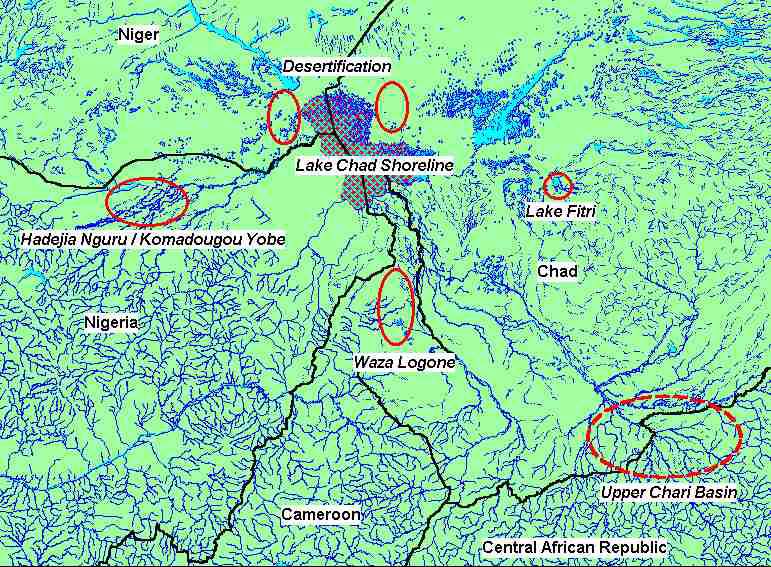
Figure 1 Pilot Project Sites
3 The Convention on the Protection and Use of Transboundary Watercourses and International Lakes
defines transboundary waters as "...any surface or ground waters which mark, cross or are located on
boundaries between two or more States...". Transboundary impacts are "...any significant adverse effect on
the environment resulting from a change in the conditions of transboundary waters caused by a human
activity...include effects on human health and safety, flora, fauna, soil, air, water, climate, landscape and
historical monuments or other physical structures or the interaction among these factors; they also include
effects on the cultural heritage or socio-economic conditions resulting from alterations to those factors".
5
Lake Chad Basin GEF Project Integrated Environmental And Social Assessment (EA/SA)
The only direct actions that the project will take that will have significant environmental or social issues are
in the six pilot projects.
The project start-up is expected for 2002 and to run for a period of four years. Total project cost is $13.1
million of which the GEF input is almost $10,000,000.
2.1 Rationale for GEF Project Support
The project comes under the GEF focal area International Waters Operational Programme (OP) 9
Integrated Land and Water Multiple Focal Area. This programme focuses on integrated approaches to the
land and water resource management on an area-wide basis. Expected global benefits are the protection of
international waters, conservation of the Lake Chad Basin ecosystems and conservation of biodiversity.
2.2 Monitoring and Evaluation
Both the main project and the pilot projects include monitoring/survey components.
The main project includes a significant commitment to carrying out hydrological studies and the further
development of a hydrological model linking surface water and groundwater. The logframe describes the
Output 4: A Completed TDA and Synthetic Framework for Concerted Management of the Basin, as
"Enhanced Scientific Knowledge of the Lake Chad Basin".
It is worth noting that the development of the TDA focuses on data and indicators, but is not clear what
process of consultation will be used to achieve a regional consensus on threats and priorities, nor on the
process of setting objectives or of identifying and selecting strategic options for achieving objectives. These
are all key to the GEF approach to developing a TDA and SAP4.
In addition to the studies proposed under the umbrella project, there is a varying emphasis put on
monitoring and the reasons for monitoring in the pilot projects.
There are three aspects to monitoring and evaluation in the pilot projects:
� Project Performance � to guide overall project management, evaluating whether or not projected or
planned activities took place;
� Project Impacts � to evaluate social or environmental impacts that are the result of direct or indirect
project actions; and
� Lessons Learned � to provide a wider evaluation of pilot project performance and impacts to feed in to
the development of the SAP, indicating replicability to other parts of the basin.
Project performance monitoring is covered by standard World Bank, UNDP and GEF procedures and will
be part of the normal tasks of pilot project management.
The direct and indirect pilot project impacts and any necessary monitoring requirements are discussed in
the following sections on each pilot project. "Lessons learned" will take the impact evaluation and placing
it in the broader environmental and social context of the basin, will allow future interventions to be
developed for implementation under the next phase of the SAP.
4 GEF describes the process of developing a SAP as "strategic joint fact finding" as a means of arriving at
a consensus on what actions are needed to address threats. In strategic joint fact finding, collaborating
states establish technical teams that work to establish a common baseline of facts and analysis of the
problem in the form of a transboundary diagnostic analysis (TDA), which is then used to set national
priorities for actions to address threats to international waters in the form of a strategic action program
(SAP).
6
Lake Chad Basin GEF Project Integrated Environmental And Social Assessment (EA/SA)
However, it is clear that many of the monitoring and research studies proposed for the pilot projects are not
necessary to evaluate either project performance or project impacts. It is also questionable whether the
proposed studies are necessary to evaluate the project impacts with a view to developing better projects for
implementation under the SAP.
There also appears to be considerable overlap in some of the proposed studies. The most obvious example
is hydrological studies, which are included in the main project and to a significant extent in four of the six
pilot projects.
Table 1 Proposed Surveys and Monitoring Studies
Broad Area of Proposed Study or Monitoring Programme
Project or Pilot Project
Hydrology
Socio-Economic
Natural Habitats
Development of SAP
Key Hydrological
Review of existing data and evaluation of gaps
and TDA
Measurements
Waza Logone
Rainfall,
Socio-Economic
Ecosystem Indicators,
Surface flow and floods,
Monitoring
Biodiversity,
Groundwater
Wildlife in Parks
Fisheries, Pasture...
Topographic and
Bathymetric Surveys
Komadougou-Yobe
Hydrological
Socio-Economic
Biodiversity and
Basin
Monitoring
Monitoring
Biological Resources
Inventory
Bathymetric Survey
Eco-monitoring
Desertification Groundwater Pasture
Monitoring
Monitoring
System
Lake Chad Shoreline
Simple and appropriate monitoring schemes �
according to RAMSAR Guidelines
Lake Fitri
Hydrological Surveys
Pastoral Groups,
Bird Counts, Nesting
Batha River and Lake
Fisheries, Problem
Sites and Wildlife
Floor
Analysis, Map Land Use
Resources
Chari River
Hydrological
Baseline Land Use Data
Transboundary
Monitoring System
and Ecosystem Status
3 Relevant Safeguard Policies
The World Bank uses Environmental Assessment to evaluate the environmental and social risks and
benefits associated with a bank-lending programme, which specifically include investment components of
hybrid loans, GEF projects and GEF components of Bank Projects.
The World Bank policy OP 4.01 Environmental Assessment is the umbrella for the Bank's safeguard
policies. The objective of the World Bank's Safeguard Policies is "...to ensure that Bank operations do not
cause adverse impacts and that they do no harm".
Key considerations in the EA process include:
� Integration with social assessment;
� Evaluation of alternatives;
� Public participation and consultation; and
7
Lake Chad Basin GEF Project Integrated Environmental And Social Assessment (EA/SA)
� Disclosure of information.
The safeguard policies can be roughly categorised into groups, relating to the Environment and Natural
Habitats, Rural Development, Social Development, and International Law.
Table 2 World Bank Safeguard Policies Triggered by Pilot Project Interventions
n
n
e
r
a
si
i
n
e
e
Fitri
ari Riv
Lake Chad
Shorel
Lak
Waza Logone
Ch
Komadougou-
Yobe B
Desertificatio
Transboundary
4.01 Environmental Assessment
Applies to all pilot projects including co-financed components
Requires public consultation and dissemination of conclusions
4.04 Natural Habitats
Enhanced or no significant changes
4.09 Pest Management
Not applicable, no significant agricultural interventions
4.36 Forestry
Not applicable
Enhanced
Not applicable
4.37 Safety of Dams
Proposals to increase
Not applicable
releases from existing
dams
4.11 Cultural Property
Not applicable, will not destroy or limit access to cultural property
4.20 Indigenous Peoples
The pilots are not expected to have specific impacts on ethnic
minorities, but there may be impacts on other minority social groups not
included in decision-making processes. Their rights and interests will
have to be protected through the OPs 4.01 and 4.30
4.30 Involuntary Resettlement
Although it appears no one will be displaced/resettled, all pilots involve
(and OP/BP 4.12)
negotiated changes to natural resource access rights/usufruct rights.
7.50 International Waterways
Not applicable, no significant changes in water quality or discharge
7.60 Disputed Areas
Not applicable to the pilot projects, although some islands in Lake Chad
are currently disputed and under review at the Hague.
3.1 Environment
OP 4.01 Environmental Assessment
Ensures that appropriate levels of environmental and social assessment are carried out as part of project
design. It also deals with the public consultation process, and ensures that the views project-affected groups
and local NGOs are taken into account.
However, this does not guarantee that the views of minority groups or economically or socially
disadvantaged groups are incorporated into proposals5. To some extent these issues are covered under OP
4.20 Indigenous People and OP 4.30 Involuntary Resettlement.
5 "A review of Bank experience found that while an increasing number of EAs involved consultation with
NGOs, consultation with local communities was more limited. Women and the poor were seldom
reached..." Update Number 5 - Environmental Assessment Sourcebook - Public Involvement in
Environmental Assessment: Requirements, Opportunities and Issues
8
Lake Chad Basin GEF Project Integrated Environmental And Social Assessment (EA/SA)
Given the uncertainty of the potential direct and indirect impacts of the pilot projects, the Bank requested
an EA on all project components.
It is worth noting that OP 4.01 applies to all components of a project with financing from the World Bank,
including cofinanced components financed by the recipient or by other agencies6.
OP 4.04 Natural Habitats
Supports the conservation of natural habitats and the maintenance of ecological functions. The Bank does
not support projects that involve the significant conversion or degradation of critical natural habitats.
The objective of the project is to conserve and protect natural habitats. The only possible negative impacts
would come through the introduction of potentially invasive species, with Prosopis sp. (Mesquite)
suggested for dune stabilisation and possible fuelwood production for fish smoking. However the species
has already been introduced and the proposals are to selectively manage the systems, which could then
promote indigenous species. The impact must therefore be considered as neutral.
3.2 Rural
Development
OP 4.09 � Pest Management
Promotes the use of biological or environmental control methods and reduces reliance on synthetic
chemical pesticides, and follows World Health Organisation's Recommended Classification of Pesticides
by Hazard and Guidelines to Classification.
None of the pilot projects are dealing directly with major agricultural projects and therefore the use of
pesticides or IPM. However, if the recommendations in the Komadougou-Yobe Basin Project are followed,
there will be a limit to the further expansion of irrigated agriculture. Pest management is therefore either
not relevant or neutral.
OP 4.36 � Forestry
Aims to reduce deforestation and enhance the environmental and social contribution of forested areas, the
Bank does not support commercial logging in primary tropical moist forest.
The project is only addressing forestry issues in the pilot project dealing with desertification. Here the
proposed impacts will be positive, as the interventions include dune rehabilitation with local and exotic tree
species, and the management of rangeland resources, which include woody vegetation.
OP 4.37 � Safety of Dams,
In view of the major potential impacts of dam failure, the Bank is concerned with the safety of new dams
and existing dams on which a Bank-financed project is directly dependent.
The project is proposing to "catalyse" increased wet season flood releases from Maga Dam above the Waza
Logone Floodplain, and also from dams in the upstream part of the Komadougou-Yobe Basin. As these are
significant changes to operating rules, the Bank will require a complete safety check of all dams affected by
qualified dam engineers, unless it can be shown that suitable inspections have already been done. There are
specific concerns, detailed in this report, with the structural integrity of Maga Dam.
6. Footnote 1 of OP 4.01 ""Bank" includes IDA; "EA" refers to the entire process set out in OP/BP 4.01;
"loans" includes credits; "borrower" includes, for guarantee operations, a private or public project
sponsor receiving from another financial institution a loan guaranteed by the Bank; and "project" covers
all operations financed by Bank loans... This policy applies to all components of the project, regardless of
the source of financing."
9
Lake Chad Basin GEF Project Integrated Environmental And Social Assessment (EA/SA)
3.3 Social Development
OP 4.11 � Management of Cultural Property
The Bank avoids projects that will significantly damage non-replicable cultural property, and will assist
only those projects that are sited or designed so as to prevent such damage.
None of the pilot projects will submerge or otherwise destroy any cultural sites, nor will there be restricted
access for cultural purposes to land that might have cultural value.
OD 4.20 � Indigenous Peoples
Defined as "...social groups with a social and cultural identity distinct from the dominant society that
makes them vulnerable to being disadvantaged in the development process. For the purposes of this
directive, "indigenous peoples" is the term that will be used to refer to these groups."
Projects must avoid or mitigate potentially adverse effects on indigenous people whose social and
economic status restricts their capacity to assert their interests and rights in land and other productive
resources.
Effectively the World Bank requires the project to develop a programme for addressing the issues based on
the informed participation of the indigenous people themselves. Any project that affects indigenous peoples
is expected to include components or provisions that incorporate an "Indigenous Peoples Development
Plan".
All the pilot projects are concerned directly or indirectly with managed access to natural resource systems,
however as yet no access/management agreements have been defined with communities. For example,
systems for controlling access rights to rangelands will need to be negotiated on the Desertification pilot,
but the specific sites and the specific groups that will be involved have not yet been identified. While it is
not clear that the projects will have impacts on "indigenous" groups, they are likely to have impacts on
sections of the society, such as women's groups or female led households that are not normally included in
the decision making processes. The pilot projects will need to ensure that the access/use rights of these
"minority" groups are identified and provided for in any agreements.
OD 4.30 � Involuntary Resettlement (and the draft OP/BP 4.12 Involuntary Resettlement)
Ensures that the population displaced by a project receives benefits from it; it also covers those with
usufruct or customary rights to the land or other resources taken for the project7. The OP is specifically
inclusive, ensuring that all those affected both directly and indirectly by project developments are
compensated as part of the project. Affected population, include those with income derived from informal
sector and non-farm activities, and from common property resources. The absence of legal title does not
limit rights to compensation.
The draft OP/BP 4.12 on Involuntary Resettlement will replace the original OD 4.30, but retains and
clarifies the existing principles covering household resettlement and restricted access rights, specifically
where the loss of access rights is linked to the management of protected areas.
The guidelines are clear that there is a need to involve communities in the planning and implementation of
interventions that result from these polices and in most cases this implies the need for a conflict resolution
mechanism. OP 4.12 sates "...particular attention is paid to the needs of vulnerable groups ... especially
those below the poverty line, the landless, the elderly, women and children, indigenous peoples and ethnic
minorities.".None of the pilot projects are expected to involve significant population resettlement.
However, as stated above, all the pilot projects are concerned directly or indirectly with managed access to
natural resources, and hence negotiated changes to usufruct rights.
7 World Bank ESSD definition "In some instances, people may lose the right to use resources without
losing possession of them. Such involuntary loss of access to resources may also be considered involuntary
resettlement."
10
Lake Chad Basin GEF Project Integrated Environmental And Social Assessment (EA/SA)
3.4 International
Law
OP 7.50 � Projects on International Waterways
Covers any body of water that forms a boundary between, or flows through, two or more states and any
tributary or other body of surface water that is a component of an international waterways. The guidelines
apply to projects that will adversely change the quality or quantity of water flows, and requires that the
issues involved are covered by an appropriate agreement between the riparian countries; or that the other
riparians have given consent to the project.
The proposals to "catalyse" wet season floods from Maga Dam and the dams in the Komadougou-Yobe
basin, if successful, will return river flow regimes to a more natural flow/flood cycle.
OP 7.60 � Projects in Disputed Areas
Relates to territorial disputes between different countries, a project can only be supported if the
governments concerned agree that, pending the settlement of the dispute, the project proposed for country
A should go forward without prejudice to the claims of country B.
The only disputed areas within the active basin, are islands in Lake Chad, and there are no pilot project
interventions that will affect their use.
4 The Waza-Logone Floodplain
4.1 Baseline
Information
4.1.1 The Project Area
The full title of this proposed pilot project is "Pilot Project on the Rehabilitation and Integrated
Management of the Hydrological and Ecological Resources of the Waza-Logone Floodplain (See Figure 2).
The project area covers around 8000 km2, roughly half of which is the active part of the Waza Logone
floodplain. The project area includes both the Waza National Park and the Kalamaloue National Park.
Much of the Waza NP is not on the floodplain.
The floodplains are highly productive, providing breeding grounds for fish, dry season pastures that support
cattle, and fertile land for arable crops and forestry products. Over 100,000 people directly earn all or part
(or most) of their livelihoods from the resources of the floodplains.
The area inundated in any year depends on over-bank flow from the Logone River, flow from seasonal
streams called "Mayos" flowing out of adjacent upland areas, direct rainfall onto the floodplain and water
released from the Maga Dam (whose reservoir is itself fed by these same three sources of water).
The 30km earthen Maga dam was constructed on the upper part of the floodplain in 1979 to provide water
for the SEMRY8 irrigated rice scheme. At the same time, a dike was constructed along the edge of the
Logone extending 20 km downstream from Maga Dam to prevent the irrigated rice fields from being
flooded from over-bank flow from the Logone. The Maga Dam and associated dikes altered the natural
flood patterns through trapping a number of seasonal streams in the upper part of the floodplain, and
through the diversion of part of the flow of the Logone River. The Maga Dam and associated dikes
significantly reduced the flooding of the Waza-Logone floodplain below the dam. In particular, in severely
reduced flows in the Mayo Vrick below the dam.
An IUCN hydrodynamic study of the floodplain reviewed the impacts of the dam for three scenarios, good
years, average years and drought years evaluated the impacts of this development9. The pre dam "average
year" flooded area was estimated at around 3385 km2, and following dam construction around 2420 km2, a
8 Soci�t� d'Expansion et de Modernisation de la Riziculture de Yagoua
9 Etude du Mod�le Hydrodynamique du Logone; Mott MacDonald/Projet Waza Logone 1999
11
Lake Chad Basin GEF Project Integrated Environmental And Social Assessment (EA/SA)
decrease of around 30%. The impact of this change was predominantly in reductions in flood extent in the
top end of the floodplain below the dam.
4.1.2 The Waza Logone Project
The social and environmental problems caused by the dam became apparent during the 1980s. These
impacts were particularly significant as this coincided with the most severe drought event since
meteorological records have been kept. The Waza Logone Project was established in 1988, with the support
of IUCN. The Project objectives included promoting the integrated management of the natural resources of
the floodplain, providing a sustainable livelihood for the local communities, maintaining biodiversity, and
in particular to maintain the integrity of the Waza National Park.
In 1992, under Phase II, the project began a process of evaluating the system constraints and opportunities,
collecting valuable data on socio-economics, hydrology and ecology, and initiating a process of stakeholder
participation in the evaluation and planning of the management of the floodplain. This lead to the idea of
creating breaks in the dike that extends downstream from Maga Dam as a means of increasing flooding and
partially restoring the ecology and livelihoods on the upper Waza-Logone floodplain. Project evaluation
indicated the idea was sound.
Supported by strong requests from local communities and the local administration, in 1994 SEMRY
allowed the project to open a section of dike that had blocked the flow from the Logone river to the Petit
Gorema floodplain channel, and flood waters re-entered the system (Figure 2).
Phase III started in 1995, with funding from the Netherlands Government and WWF. The Project continued
monitoring the effects of the 1994 release and continued the dialogue with affected communities and other
stakeholders. In 1997, a second break in the dike was opened to allow waters to flow into the Areit�k�l�
floodplain channel. The flow from here joins the original channel of the Mayo Vrick and with the
additional flow from the Petit Gorema re-instated flooding to a major part of the floodplain west of the
Logomatya channel. The total "average" flooded area has been increased by some 200 km2 equivalent to
6% of the original floodplain. The impact is locally very significant as the flooding is focused on the area
affecting the southern zone and the Waza National Park. The major achievements of the Waza Logone
project are at two levels.
Regionally and internationally: the project has drawn attention to the social, economic and ecological
benefits of maintaining or reintroducing floods in natural floodplains.
Within the floodplain: the "pilot" releases have been maintained and are effectively a permanent feature,
re-establishing flooding to some 6% of the floodplain with localised significant benefits to communities in
the south and other parts of the floodplain, and to the ecological integrity of Waza National Park.
4.1.3 Waza Logone Phase IV
GEF will provide part of the funding for the "Pilot Project on the Rehabilitation and Integrated
Management of the Hydrological and Ecological Resources of the Waza-Logone Floodplain". This is
intended to be the "Exit Phase" of the Waza Logone Project (as specified in the original proposal for Dutch
funding), with the focus of activities on handing over management responsibility of the ongoing
programme to local institutions.
The Dutch Government has committed to providing roughly 80% of the total project costs, leaving a GEF
commitment of US$ 475,000 over a three-year period.
The majority of financing for project activities is not clearly differentiated between donors. The exception
is direct field interventions related to the construction of dry season wildlife water supply ponds in the
National Park and the opening up of a natural stream channel that connects two larger river channels within
the floodplain.
The environmental and social assessment covers both the expected direct impacts of project activities and
the impacts of project facilitated activities.
12
Lake Chad Basin GEF Project Integrated Environmental And Social Assessment (EA/SA)
4.2 Activities with Significant Environmental and Social Impact
4.2.1 Project
objectives
The project document presents a "Development Objective" that is stated as:
The long-term enhancement and wise use of the Waza-Logone aquatic ecosystems, and a sustainable
improvement of the quality of life of its inhabitants, as a means of establishing working methodologies for
the integrated management of transboundary aquatic ecosystems.
The immediate or specific objectives are:
� To promote the integrated management and use of the water resources of the Chari-Logone Basin,
including the regular allocation of water for the inundation of the Waza-Logone Floodplains.
� To promote the restoration, enhancement and sustainable use of the biological resources of the
Waza-Logone Floodplains.
� To develop and implement an effective ecosystem, hydrology, and socio-economic monitoring and
evaluation system.
It should be noted that there is no proposal to convert any component of the wetlands to other use and
therefore no change of use - rather a restoration of use to previous "more natural" systems in the lower
floodplain, while protecting the existing investments in irrigation development immediately below the
Maga Dam.
4.2.2 Activities with Significant Impacts
The Logical Framework Analysis provides a detailed breakdown objectives, outputs and activities.
However, their wording is not always clear. Many of the outputs would be better described as either a long-
term development objectives, as they are clearly not an output achievable during the project period. As an
example, "Output 1.1 An equitable and sustainable allocation and distribution of the sub-basin's water
resources" is unlikely to be achieved during the project life.
A few of the activities listed are activities that will have environmental and/or social impacts and are
activities that the project is committed to implementing. In addition, however, many of the project activities
are part of a process of advocacy. A large part of the activities consist of "promoting" or "catalysing" other
activities that would be executed and funded by others. In this case, the project activity is to catalyse
something but not to do or to fund this themselves.
However there are key components of the objectives, outputs and activities that would have clear
environmental and/or social impacts . These can be categorised as follows:
� Increased releases of water to the floodplain from Maga Dam;
� Rehabilitation/creation of a wildlife pond in Waza NP
� Cleaning/enlarging of a channel connecting two streams on the floodplain
� Developing and implementing natural resource management plans
4.3 Relevant Safeguard Policies
OP 4.37 Safety of Dams is triggered by the proposed increase in release of waters from Maga Dam. . A
dam safety inspection by an qualified expert is required under this OP. This requirement is independent of
the Team's preliminary analysis of safety concerns presented below.
OP 7.50 Projects on International Waterways is triggered by this pilot because the pilot proposes to make
changes to the hydrologic regime of the Logone River, which is recognised as an international waterway,
forming the border between Chad and Cameroon .
13
Lake Chad Basin GEF Project Integrated Environmental And Social Assessment (EA/SA)
4.4 Analysis of Significant Environmental and Social Impacts
4.4.1 Increased Releases from Maga Dam
4.4.1.1 Description of proposed activity
The key phrase in the first objective is:
"...the regular allocation of water for the inundation of the Waza-Logone Floodplains"
This is primarily supported by the stated output:
"A restoration of the flood pulse of the Waza-Logone Floodplains."
Which will result from the following activities:
a) Catalyse construction of additional openings and canals, and the installation of sluice gates.
b) Catalyse regulated releases to the floodplains.
c) Catalyse construction clearance canals.
d) Catalyse releases from Maga Dam for additional floods for the Waza National Park.
e) Catalyse the construction of canals to direct releases from the dam to the park.
Items a), c) and e) would require funding that the project does not have. It is questionable that the project
will be able to "catalyse" them. Activities b) and d) are essentially one and the same. Achieving them
would be almost cost free. They would only require a change in the way that SEMRY manages the release
of waters from Maga Dam.
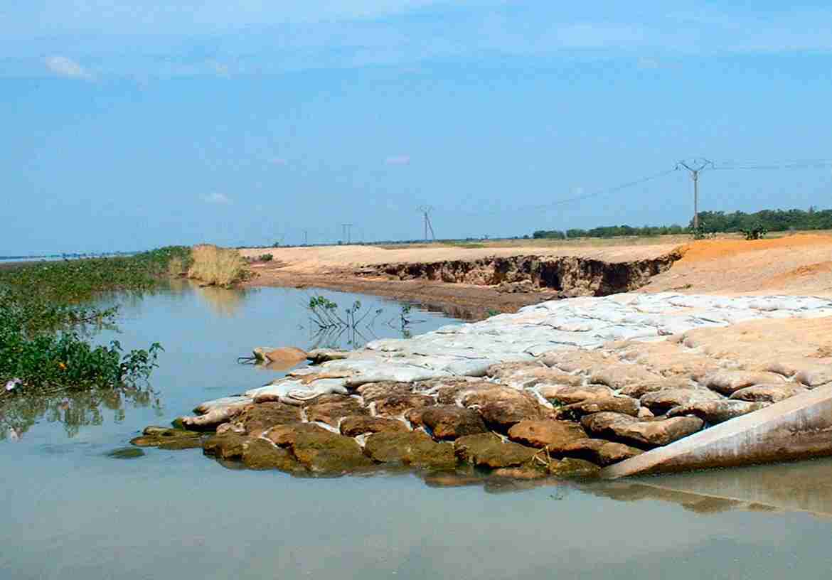
Photo 1 Maga Dam - Erosion and Sand Bag Protection on the Inside Dam Wall
14
Lake Chad Basin GEF Project Integrated Environmental And Social Assessment (EA/SA)
If structural and operational changes are made to manage increased releases, these would include channel
protection to reduce present, and avert future, flood risks within the irrigation zone and specifically protect
Maga town.
The emphasis is on restoring the natural ecological systems in the downstream zone, with the agreement of
the local communities. It would not affect or restrict access rights to communities in the irrigation areas.
4.4.1.2 Analysis of the feasibility of the proposed releases of water
The Maga Dam diverts water from the Logone River and traps a number of seasonal streams (Mayo
Tsanaga, Mayo Boula and Mayo Vrick). The spillway of Maga Dam spills directly back into the Logone
river.There are a number of problems with the design, operation and maintenance of the Maga dam and
there are a number of studies that can be drawn on to review options. These include a report by DELFT
which proposes an alternate spillway system.
The main structural and operational problems are listed below.
The design outlet capacity of the main sluice system, which is on the Mayo Vrick, is 50cumecs (cubic
meters/sec) 10. There are four additional sluices providing water to the rice scheme and these also pass
through drainage canals into the Mayo Vrick. However, the actual release capacity from the reservoir is
much less than design capacity. The main sluicegates can only safely release around 5 to 10cumecs without
flooding Maga town or the irrigated perimeter. When the Team visited the sites, roughly 5 cumecs were
being released, and this was close to the maximum possible. This is because the channel capacity of the
Mayo Vrick is now very low. This is partly as a result of silting and may also be partly caused by
vegetation growth during drought years. IUCN estimates that the bed of the Mayo Vrick would require
major cleaning and enlargement over a distance of about 15 km before it could handle 50 cumecs. The cost
of this might be in the millions of dollars and no donor has been identified.
The spillway is reported by SEMREY to periodically flow in the wrong direction, taking water from the
flooding Logone into the reservoir.
The failure of the dam would threaten both the immediate downstream population centres of Maga and the
other rice scheme settlements and the more distant floodplain populations.
4.4.1.3 Analysis of the environmental and social impacts
Following the opening of the first channel in 1994, IUCN carried out a preliminary Environmental Impact
Assessment of the first opening and of the proposed second channel opening, concluding that both were
mostly beneficial. There seems to be a broad consensus that the environmental and socio-economic impacts
of the re-inundation effected in 1994 and 1996 through the openings in the dikes that had been blocking the
Logone River were very positive.
All or most of the dwellings on the floodplains are located on natural levees or other areas that are only
slightly higher than the rest of the floodplain. Following the construction of Maga Dam in 1979, some
people had built on lower areas that were no longer flooded. IUCN project staff reported that floodplain
communities wished to have the channels reopened, even though it was expected that these dwellings
would be flooded out. As expected, the reopening of the two channels in 1994 and 1997 led to the flooding,
and subsequent abandonment, of some of these structures.
There has been no specific evaluation done by project proponents of the impacts of the proposed
modifications to the design and operation of the existing Maga Dam. However the preliminary discussions
have been based on modifications to the design and operation of the Maga dam, that would allow for the
release of floods to the upper part of the Waza Logone floodplain while protecting the existing investments
in the irrigation zone immediately below the Maga Dam.
If the proposed increased releases of water were effected, they would have major environmental and socio-
economic impacts on the upper Waza-Logone floodplain, at least partially restoring the natural
10 Quoted as 100cumecs in some documents.
15
Lake Chad Basin GEF Project Integrated Environmental And Social Assessment (EA/SA)
hydrological cycle and wetlands functions to the floodplains immediately below the irrigated zones.
Environmental and socio-economic impacts would be largely positive.
On the negative side, there are probably some people who have built on lower sites that would be flooded
once again by the proposed increased releases of water from the dam � in the same way that such people
with the channel opening in 1994 and 1997. The appears that the number of people that would be affected
has not been assessed.
4.4.1.4 Preliminary analysis of the safety of Maga Dam
OP 4.37 on Dam Safety states that "...the Bank is concerned about the safety of new dams it finances and
existing dams on which a Bank-financed project is directly dependent." The pilot project's proposed
increases in releases of water from Maga Dam would clearly trigger this OP.
Items 7, 8 and 9 of the OP then go on to state that "The Bank requires that the borrower arrange for one or
more independent dam specialists to (a) inspect and evaluate the safety status of the existing dam or DUC
(dams under construction), its appurtenances, and its performance history; (b) review and evaluate the
owner's operation and maintenance procedures, and (c) provide a written report of findings and
recommendations for any remedial work or safety-related measures necessary to upgrade the existing dam
or DUC to an acceptable standard of safety.
The Bank may accept previous assessments of dam safety or recommendations of improvements needed in
the existing dam or DUC if (a) the dam or DUC is located in the same country as the subject project; (b) an
effective dam safety program is already in operation there; and (c) full-level inspections and dam safety
assessments of the existing dam or DUC have already been conducted and documented.
Necessary additional dam safety measures or remedial work may be financed under the proposed project."
The Assessment Team did not include a dam safety specialist. The Team did find, however, indications that
Maga Dam is a not a safe structure. Risk factors for the dam include:
� Piping Maga Dam is an earthen dam built on the Logone floodplain. There is seepage under most
of the length of the damn. This seepage can, and periodically, does, develop into "piping" or active
holes at the base of the dam that must be stopped immediately, day or night, to avoid catastrophic
failure of the dam. Such near failures have occurred repeatedly in the past three years. They have
occurred during the current rainy season.
� The overflow spillway of a dam must be able to release excess water from the reservoir to avoid
failure of the dam. For Maga Dam, this would occur if the sluice gates became dysfunctional or if
they had insufficient capacity to handle excess floodwaters (Opening the sluice gates to full
capacity would cause severe flooding in Maga and the irrigated perimeter). The overflow spillway
on the Maga dam appears to be very poorly designed and maintained. It is located on the east side
of the reservoir upstream from Pouss (see Figure 1) on the edge of the Logone. When the Team
visited the site on October 7, 2001, the water level of the reservoir was only about 20-30 cm
higher than that of the Logone. The level of the Logone had already been falling since its peak this
year. With only a small increase in the water level of the Logone, water would flow from the
Logone over the spillway and into the reservoir � and there would be no way to stop it. The Mott
Macdonald report states that this is a regular occurrence. Also, the entire area on the reservoir side
of the spillway was choked with dense aquatic vegetation (probably rooted), further impairing the
functioning of the spillway. Also, there were signs of recent repair work, crudely done, on the
spillway. An exceptional flood on the Logone would result in huge amounts of water entering
Maga reservoir, putting the dam at risk.
� Inability to release floodwaters through sluice gates The village of Maga is located
immediately next to the Mayo Vrick and directly below the highest point of the dam. The ability
to open sluice gates to their full capacity for release of floodwaters is critical to dam safety.
However, one cannot use more than a small percentage of the design capacity of Maga Dam's
main sluice gates without flooding the town of Maga and the irrigated rice fields. Maga has grown
from a small village to a population centre of thousands of people � the offices of SEMRY are
located here.
16
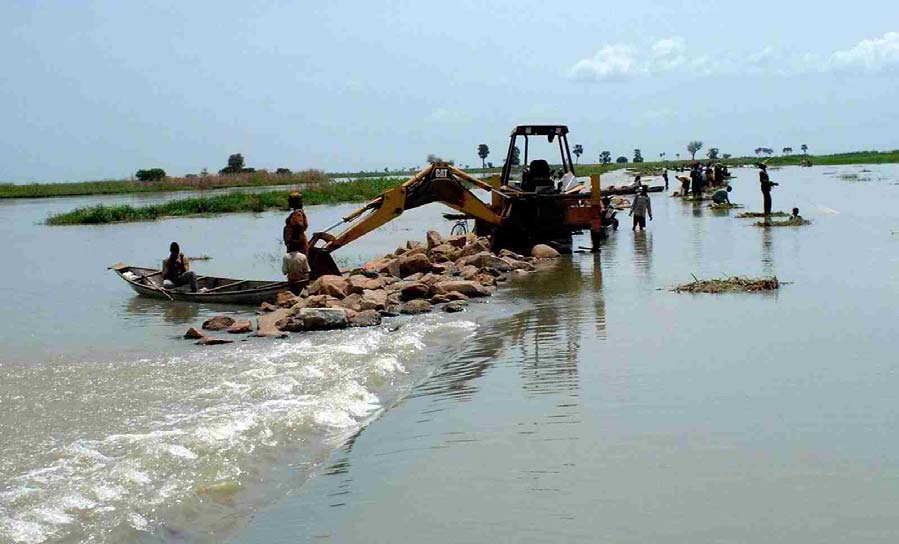
Lake Chad Basin GEF Project Integrated Environmental And Social Assessment (EA/SA)
� Dam management/maintenance capacity The damn is managed and maintained by the parastatal
SEMRY. It frequently cannot cover its own operating costs. SEMRY's heavy equipment
necessary for dam maintenance and for emergency repairs was said to be nearly all broken down
at the time of the Team's visit. SEMRY frequently must rely on requests for special funding from
the government and the government seeks emergency funding from donors.
Photo 2 The Spillway at Maga Dam � with flow from the reservoir into the river at below full flood
Failure of Maga Dam could be catastrophic for Maga town if the break occurred directly above the town.
This could include significant loss of life. It would also cause variable levels of flooding in all the villages
downstream on the Waza-Logone floodplain. Assessment of the severity of the impacts of dam failure on
these villages more removed from the dam would require specialised expertise. The impacts of dam failure
would probably be largely socio-economic. Environmental impacts would probably be temporary in nature
and not of great significance to the ecology of the floodplain.
The threat to human life of dam failure would be largely conditioned by circumstances. A daytime break
several kilometers from Maga would lead to a relatively gradual flooding of this population centre,
probably allowing much of the population to be evacuated. A night time break immediately above Maga
would be far more serious. Maga is located directly below one of the deepest portions of the reservoir.
Mid to long term impacts would depend on whether the dam was subsequently repaired. If it was not
restored, all of those who presently depend on the irrigated agricultural scheme would have to find other
livelihoods. Most of them would probably have to be relocated. The economic base for Maga town would
be severely reduced. The continued existence of Maga would require the construction of protective dikes
around the town. Access to Maga would be a problem, as much of the road into the town would be flooded.
OP 7.50 Projects on International Waterways
The Logone River is a recognised as an international waterway. Agreements exist on the maximum volume
of water that can be taken from the river by either Cameroon or Chad. The design of the Maga reservoir
and release structures takes account of these agreements.
The intake structure at the top end of the canal leading to the reservoir can be varied between 19 and 30
cumecs, in line with the international agreement. However, any modification of the spillway design may
17
Lake Chad Basin GEF Project Integrated Environmental And Social Assessment (EA/SA)
affect the potential releases back into the Logone, and as a result may have implications on the capacity to
abide by existing water extraction agreements.
One possible measure for increasing damn safety could be the construction of a new overflow spillway near
the western end of the dam � as discussed in the Delft report. Waters from such a spillway would be
released onto the floodplain, contributing to the project's objective. One would need to determine if this
would be compatible with the existing agreements on water sharing.
4.4.2 Rehabilitation/creation of a wildlife pond in Waza NP
4.4.2.1 Description of the proposed activity
The focus of direct action under the second project objective is indicated in Output 2.1 "An operational
drought management strategy for Waza and Kalamolue National Parks". The proposed activities are not
completely finalised, but at present it is planned that the key interventions will be the construction or
rehabilitation of a wildlife pond in Waza National Park, and the enlargement of a natural channel to direct
more water to an areas that would include the floodplain portion of Waza National Park. The first of these
two activities is analysed here.
The Waza National Park has a range of both floodplain and upland, rainfed habitats. The upland zones are
in the southern and western zones of the park. They are characterised by natural tree and shrub savannahs.
These upland zones provide rainy season habitat and grazing for wildlife, but their use in the mid to late dry
season is severely restricted by lack of water.
The national parks have already constructed a number of wildlife ponds, typically around 50 metres across
and a couple of metres deep. They are filled from direct rainfall and run-off during the rainy season.
However, some of these ponds do last for the whole dry season. When wildlife move out of the park to
watering spots in the adjacent land used by farming communities, they are exposed to poaching and there
have been conflicts with those who control access to these water points. The problem is particularly bad
during drought years. Park management has had to resort to transporting water in bowers to refill ponds.
The present proposal is for the GEF to finance the construction or rehabilitation of one pond (out of a half
dozen that are called for in the park management plan), to drill a borehole near the pond and to provide a
pump so that the pond can be recharged during the dry season. The site for the pond has not been chosen,
but it will be in the unflooded, upland tree savannah area of the park.
4.4.2.2 Analysis of the environmental and social impacts
Environmental impacts The principal environmental impacts of this activity would be on the wildlife and
on the natural habitats in the Waza NP. (OP 4.04 Natural Habitats applies here.) It is worth noting that the
upland areas where the pond would be rehabilitated/created is, in ecological terms, not the natural, dry
season grazing zone for wildlife. Prior to the occupation of the areas peripheral to the park, most of the
wildlife would have moved out of this area to the floodplain where they could rely on standing water in
residual ponds in floodplain depressions or on stream bottoms.
Under natural conditions, the wildlife were reliant on mobility, just as modern-day transhumant and
nomadic herders rely on mobility to find pasture and waters for the herds. Unfortunately, the possibility for
the wildlife of Waza NP to move freely in and out of the park is now greatly reduced � as it is increasingly
for most protected areas in the world. Waza NP was just part of a much larger ecosystem that no longer
exists. To maintain good populations of wildlife in the park, one must provide for the dry season water
needs for the wildlife. This will necessitate some changes to the natural ecology of the park and its natural
habitats.
Predicting and analysing the impacts of creating a new dry season wildlife pond is not a simple matter.
When wildlife are concentrated around a few dry season water points, they can have market impacts on the
habitats around the water points. The short-term environmental impact of the new pond in Waza NP will be
to reduce grazing/browsing pressure around other existing water points and to increase localised
grazing/browsing pressure around the new water point.
18
Lake Chad Basin GEF Project Integrated Environmental And Social Assessment (EA/SA)
However, if the limiting factor on wildlife populations is the availability of dry season water, then
increasing the availability of dry season water may lead to higher wildlife populations in the park. One
could easily envisage a scenario whereby one increases the number of dry-season water ponds to the point
where water is no longer the limiting factor � where the availability of browse and pasture becomes the
limiting factor. Providing too many dry season water points could easily lead to overgrazing/overbrowzing
and degradation of the natural habitats of the park. This is almost certainly not a significant risk for the
single pond to be funded under this project.
The Assessment Team finds that the project is in line with the Bank OP 4.04, "...the conservation of
natural habitats and the maintenance of ecological function." However, it is clear that there will be some
changes in vegetation structure around the water point. It is therefore recommended that the project
maintain an area of upland forest with no water points, as an example of unmodified habitat.
Social impacts The provision of additional water within the park should reduce conflict between wildlife
and communities at watering sites outside the park. There is no proposal to increase the extent or reduce
present access rights to the protected areas, as a result OD 4.30 and the draft OP/BP 4.12 on Involuntary
Resettlement are not triggered.
Figure 2 Proposed Channel Construction
4.4.3 Cleaning/enlarging of a channel connecting two streams on the floodplain
4.4.3.1 Description of the proposed activity
There are two main streams, the Logomatya and the Lorom� Mazra, flowing through the floodplains east of
Waza NP. They both flow parallel to the Logone river. They are key to feeding floodwaters onto the
floodplains, including those in eastern Waza National Park � see Figure 1.
19
Lake Chad Basin GEF Project Integrated Environmental And Social Assessment (EA/SA)
Prior to the construction of Maga Dam, the Mayo Vrick, the Petit Goroma and the Areit�k�l� channels fed
the Logomatya. All three of these were cut off by Maga dam and the dike along the Logone. The project
has reopened floodwater flow into the Petit Goroma and the Areit�k�l� channels in 1994 and '96 by
creating openings in the dikes along the Logone. The Lorom� Mazra, which was not affected by the
construction of the dike, runs between the Logomatya and the Logone River. As floodwaters rise, water
also flow through lesser channels and through overland flow across the entire floodplain between and
amongst the Logone, the Lorom� Mazra and the Logomatya. Direction of flow on any floodplain varies
over time as relative inputs from different waters sources vary.
The project proposes to open and enlarge an existing natural channel between the Lorom� Mazra and the
Logomatya to increase water from the former to the latter and to thereby increase overall flooding to the
west including the floodplain portion of the Waza NP. The Assessment team travelled by boat down the
Logomatya to the western end of this channel. The channel is only open for about 200m. Beyond that, it is
choked with aquatic vegetation through which it is still possible to pass by poling through in a small dugout
canoe. GEF funds would be used to clean and enlarge this channel over its full length of over 4 km.
4.4.3.2 Analysis of the environmental and social impacts
Environmental impacts
It is not entirely clear that this will have the expected impacts or how large the impacts will be. Before the
re-opening of the Petit Goroma and the Areit�k�l� channels, the flow of water into the Logomatya should
have been much less than it has been since they were reopened. The hydraulic head and hence flow of
water from the Lorom� Mazra to the Logomatya should have been significantly greater than it has been
since the two channels feeding the Logomatya were reopened. However, all but the lower hundred meters
or so of the existing channel is blocked with vegetation, indicating that there may not have been major
flows through this channel even when other water inputs into the Logomatya were much reduced. It also
indicates there may not be enough flow to prevent the channel from becoming blocked again in the future
(from vegetation growth and/or sediments) after the channel is cleaned and enlarged.
It is also possible that the Petit Goroma and the Areit�k�l� channels may be undergoing a "natural" process
that increases their capacity to carry waters into the Logomatya in compensation for the greatly reduced
flows from the Mayo Vrick that resulted from the construction of Maga Dam. To "fill the void" these two
channels might be undergoing a phenomenon of increased speed of water flow, deepening and widening of
their channels. On the Petit Goroma, a completely new side channel was cut off from this stream when it
was first opened, a channel that remains open today. The fact that virtually all of the villages along the
Logomatya are scarcely above water (perhaps 20 to 40 cm above the water level of the Logomatya)
indicates that the Logomatya has already returned to a flow approaching the pre-Maga Dam levels. Indeed,
houses constructed on lower sites that were not habitable prior to construction of Maga Dam are being
abandoned because of flooding, while village sites that existed prior to Maga Dam still remain viable.
If the cleaning and enlarging of the channel does work as envisaged, there will be a number of impacts on
the floodplain. The extra water flow will compensate for the decreased wet season flow in the Mayo Vrick,
and the flooded area would be expected to increase in this part of the floodplain.
A number of families/communities who had moved into the lower parts of the floodplain, following
decreased flooding can be expected to move back to their original settlement sites on higher ground within
the floodplain.
OP 4.01 Environmental Assessment - Public Consultation
The project has held extensive discussions with local floodplain communities, as well as conducting more
formal socio-economic surveys. It is clear that the benefits of restored/enhanced flooding are understood
and welcomed by the communities. The agreement to the initial "pilot" releases was at the request of local
communities and through the Governor and other representative bodies.
20
Lake Chad Basin GEF Project Integrated Environmental And Social Assessment (EA/SA)
OP 4.04 Natural Habitats
Again the project supports OP 4.04, through reinstating flooding to natural floodplain habitats. The benefits
will extend into both the national park and the surrounding community resource areas.
OD 4.30 Involuntary Resettlement
As a result of the increased releases to the Logomatya there has been a partial restoration of flooding to the
floodplain. As a result of this, households that had moved following the construction of the Maga dam to
areas nearer the river, have or are moving back to their original settlement areas on higher areas within the
floodplain.
Before the releases were made, discussions were held with all affected communities and the settlement
implications of re-flooding were made clear. All communities signed an agreement stating that they were
aware of these implications and wanted to floods to be re-instated.
The project will use the same process of dialogue that has been endorsed by the communities, before any
further modifications to the hydrology of the floodplain.
The project has in principle agreed to "co-management" of park resources. However, it is not clear what
this means as at present there is no formal agreements for extractive use of park resources, although
discussions have been held on the possibility of fishing in the park, under strict supervision/monitoring of
park staff.
4.5 Proposed Environmental and Social Mitigation Measures
4.5.1 Increased water releases from Maga Dam
Dropping the output and activities concerning increased releases of waters from Maga Dam might remove
the trigger for OP 4.37. This would not, however, remove the risks
Project Options:
Alternative 1: Drop the activities that trigger OP 4.37 Dam Safety
Achieving significant increases in water releases is unfeasible without making very large investments for
which no donor has been identified, (as discussed previously). The proposed "catalysed" intervention is
therefore unlikely to be undertaken.
There was no cost associated with water increases, so there would be no change in the project budget.
Removing the activity removes the "trigger" for OP 4.37 and one could argue that the dam safety
inspection would no longer be required. However, dropping the activity and dropping the dam safety
inspection will not diminish the risks of dam failure. Our preliminary analysis indicates that the risks are
very substantial.
Another section of OP 4.37 states, Because there are serious consequences if a dam does not function
properly or fails, the Bank is concerned about the safety of new dams it finances and existing dams on
which a Bank-financed project is directly dependent. Even if project activities do not depend on the safety
of Maga dam, the security, the homes, and, to some extent, the livelihoods and of nearly all of the
stakeholders of the Waza-Logone pilot depend on the safety of Maga Dam. The dozens of villages on the
floodplain in the project area would probably all be flooded � the extent of flooding needs to be analysed.
Widespread damage if not collapse, of homes, granaries and other buildings, might occur. It would be hard
to say that this pilot project is not dependent on the safety of Maga Dam.
If Maga Dam fails during the life of the project, and if it becomes known that the World Bank was aware of
the risk, the Bank could be exposed to criticisms and attacks in the regional and world media.
21
Lake Chad Basin GEF Project Integrated Environmental And Social Assessment (EA/SA)
Alternative 2: Conduct the Dam Safety Inspection and Find Funding for Corrective Measures
This is the ideal solution, and would in large part eliminate the risks of catastrophic dam failure. If the
repairs and modifications result in the ability to partially or fully restore the flood pulse on the Waza-
Logone, then all the environmental and socio-economic benefits of the natural floodplain system would be
enhanced.
However, the costs of repairing the dam to make it safe are almost certainly beyond the means of the
project. Other donors would have to be found. If acceptable repairs to the dam cannot be made, then World
Bank Safeguard policies would probably require that the Bank withdraw their funding from the Waza
Logone pilot project.
Alternative 3: An Economics of Dam Safety Study
If the dam safety inspection finds that the risk of dam failure is high � especially if there is risk of loss of
life-- and if repair costs would be very high, it may be very difficult to obtain funding for the needed
repairs. If this should prove to be the case, the Assessment Team suggests that it may be opportune to
conduct a study on the economics of achieving dam safety. This study would be an analysis of both the
costs and benefits of repairing and maintaining the dam versus the costs and benefits of decommissioning
the dam.
Decommissioning of old, low-head hydroelectric dams has become fairly common in the US in recent
years in situations where cost benefit analyses reveal that the costs of repairs and maintenance exceed the
benefits of these dams.
It is not clear to the team that the dam and the irrigated perimeter is, or can be, an economically viable unit,
even without considering the initial investment costs or the future expected repair costs needed to make it
safe. SEMRY is frequently subsidised by the Government of the Cameroon or by donors. It is said that rice
can presently be imported and delivered to consumers in Cameroon more cheaply than it can be produced
at Maga.
This alternative would consist of amending the project to provide project funding for the following steps:
1. Conduct the dam safety inspections;
2. Estimate the costs of making the needed repairs (make use of any earlier studies that may have
already been conducted, such at the study by Delft) and subsequent maintenance;
3. Using both standard and environmental accounting methods, conduct a cost benefit analysis of
continuing to operate the dam for irrigated agriculture (If this has already been done, bring the
study up-to-date) versus the costs of dismantling the dam (making a number of breaks in it to
restore normal floodplain flooding) and providing equitable indemnity payments to those who
presently benefit from it (resettlement, lump-sum payment or other). The economic and
environmental benefits of fully restoring the natural floodplain regime should be included in the
analysis.
4. Conduct a participatory synthesis of the above alternatives and develop the preferred alternative as
part of the Strategic Action Programme.
5. Mobilise funding for the preferred alternative. One must recognize that dismantling the dam would
also incur costs � including the costs of mitigation measures for those who have become
economically dependent on Maga Dam.
Costs of ensuring dam safety
Piping: the preliminary analysis would indicate that there may be two principal elements of costs of
eliminating risks of dam failure. Other than lack of routine maintenance, there seem to be two principal
22
Lake Chad Basin GEF Project Integrated Environmental And Social Assessment (EA/SA)
safety risks to the dam � piping and overtopping of the dam because of failure of the spillway and/or sluice
gates. The problem of piping may be potentially the most expensive to resolve. This would be true if piping
is a problem over a significant portion of the 30 km length of the dam. Corrective measures must be made
to render the affected areas of the dam impermeable. This is especially critical for that portion of the dam
immediately above Maga town.
Floodwater release: the second problem is the apparent inability to release floodwaters to prevent the dam
from being overtopped. As far as we know, the main sluice gates are functional. But they cannot be used to
release more than small quantities of water because the Mayo Vrick is badly sedimented up. We were told
that the Mayo Vrick would need to be dredged/enlarged over a long distance (roughly 20 to 30 km) and this
would be very expensive.
The inability to use the main sluice gates might be an acceptable situation if the dam had a proper spillway.
During the Assessment Team's briefing at LCBC, we learned that one possible solution to for the spillway
problem that has been proposed in the past (the Delft report) would be to construct a new spillway near the
western end of the dam (See Figure 2). This would certainly be an alternative that should be analysed. It
would have the added benefit of restoring excess floodwaters on to exactly that portion of the floodplain
that was the most negatively impacted by the construction of Maga Dam. Construction of a new spillway
would probably require the construction of an earthen dike to prevent uncontrolled flooding of the irrigated
rice fields.
If either Alternative 2 or 3 lead to measures to partially or fully restore the natural flood pulse on the Waza-
Logone floodplain below the dam, it will be critical to undertake a fully participatory dialogue with all
affected stakeholders. Particular attention will need to be given to any families/individuals who have
moved onto lower portions of the floodplain that would be re-inundated under the new water management
regime. IUCN appears to have done a commendable job in the past on facilitating such a dialogue. They
should facilitate a similar participatory process as needed during the new project.
Wildlife ponds
The project should seek a commitment from the institution charged with the management of Waza NP, that
some portion of the rainfed, upland tree savannah zone of the NP remain free of dry season water point
development. This will guarantee that a portion of this natural habitat will remain in a more natural
condition.
Floodplain channel opening
It is critical that floodplain residents on the Logomatya downstream from the channel to be opened between
the Lorom� Mazra and the Logomatya be fully consulted before the final decision is made to open this
channel. They should be asked if they think the opening of the channel will have the desired effects. They
should be asked if they think there is any risk that they would be flooded out as a result of the enlargement
of this channel. They should be asked if they fully accept the risks of increased flooding of their villages.
23
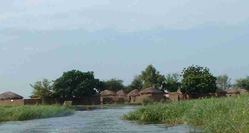
Lake Chad Basin GEF Project Integrated Environmental And Social Assessment (EA/SA)
Photo 3 Existing Channel Outlet between the Lorom� Mazra and the Logomatya
The Waza-Logone Project did an excellent job of informing and getting written agreements of floodplain
residents before making the two openings of the dikes in 1994 and 1997. The assessment team is confident
that project staff have to capacity inform and seek approval from stakeholders that would be affected by the
proposed channel cleaning.
4.6 Proposed Monitoring and Evaluation Indicators
Monitoring and Evaluation is seen as a key pilot project component and is a stated objective of the project �
"To develop and implement an effective ecosystem, hydrology, and socio-economic monitoring and
evaluation system.".
The proposed monitoring component effectively serves two purposes, firstly ensuring that the project is
effectively implemented and secondly to develop a better understanding of the interactions between the
hydrological, biological and socio-economic systems in the floodplains.
It is worth noting that over sixty percent of the GEF funding is going to support hydrological surveys as
part of the monitoring programme. The following aspects are included under the proposed monitoring
programme:
� Rainfall, surface flow and floods and groundwater at strategic locations in the basin.
� Ecosystem conditions, biodiversity and biological resources in the parks and the floodplains.
� Socio-economic conditions in the floodplain and uptake of "wise use options"
The project document does not explain why these surveys are needed, i.e., how the results of the
hydrological surveys, and monitoring of biodiversity will contribute to better management of the
floodplains or reversal or natural resource degradation.
The project has been carrying out detailed monitoring studies in the floodplains for over ten years. The
results of this research/monitoring exercise have demonstrated the considerable social and economic value
of wetlands and have been used to guide local, national and regional policy development.
The systems they have established are now well tried and understood by local staff. This is particularly true
of the socio-economic monitoring.
24
Lake Chad Basin GEF Project Integrated Environmental And Social Assessment (EA/SA)
However, there are some doubts about the capacity of parks staff to effectively monitor biological
parameters within the park, let alone in the surrounding flood plains. It is therefore recommended that
alternative options are identified for this activity. Having said this, it is recommended that monitoring in the
park specifically addresses ecological changes in both the areas adjacent to the new or rehabilitated water
holes, and in the upland forest areas that are left without dry season water. This needs to be done to
determine the ecological impact of the new water point that will be opened with GEF funds.
The project should provide regular reports on the process of resolving the issues of safety and water release
from Maga dam.
4.7 Participation of Key Stakeholders in Project Preparation
The pilot project was developed out of previous project proposals and as part of this exercise included
discussions with many of the key ministries and agencies that will be involved in project management.
At the national level discussions were held with the Ministry of Agriculture and the Ministry of Water and
Fisheries in Yaounde and with the National GEF Focal Point, Yaounde. Discussions were also held with
IUCN at Waza Logone and with IUCN, WWF and Birdlife International in Yaounde. Some staff members
of LCBC were also included in the consultation process. Although it was not possible to hold discussions
with any of the communities within the flood plain, the previous project held extensive consultations with
flood plain communities on the restoration of flooding to the upper part of the floodplain, and obtained
written consent for their actions from individual households.
SEMREY officials confirmed that the project has also held discussions with them on the issue of water
releases from Maga Dam. However, no funds have been identified to modify structures to achieve this.
5 Komadougou-Yobe Integrated Wetlands Management
5.1 Baseline
Information
This pilot project is effectively a continuation of the existing Hadejia-Nguru Wetlands Project, which has
been working in the area since 1987. The full project document for this pilot has a budget that would rely
primarily on cofinancing. Since the project mission the pilot project proposal logframe has been revised, as
has the accompanying budget.
Due to the prevailing security situation in Nigeria at the time of the evaluation, the Environmental and
Social Assessment team was unable to obtain security clearance to visit the project site, however
discussions were held with project staff and LCBC staff in N'Djamena. This review has been updated to
reflect the revised project document and background literature provided to the team after they had left the
region.
It must be emphasised that according to OP 4.01 this EA/SA covers all components of the proposal,
regardless of the financing source.
25
Lake Chad Basin GEF Project Integrated Environmental And Social Assessment (EA/SA)
Figure 3 Wetland Areas in the Komadougou Basin
5.1.1 The Project Area
The Komadougou-Yobe River forms the international boundary between Niger and Nigeria for the last 150
km before flowing into Lake Chad. The Komadougou-Yobe basin covers an area of around 150,000 km�,
and is the only perennial river system flowing in to the northern pool of lake Chad. Following the
construction of a number of dams on the upper watershed,the total flow from the system is now typically
less than 1% of the total annual surface and rainwater input to the lake.
The main flow into the Komadougou-Yobe river system is from the Hadejia and the Jama'are tributaries in
the wetter upland areas of Kano, Jigawa and Bauchi States in Nigeria. These two rivers flow into an
extensive floodplain, the Hadejia Jama'are wetlands, referred to in the project document as the Hadejia-
Nguru Wetlands after the two main settlements in the area.
Although described as wetlands, much of the Hadejia-Nguru floodplain is dry for some or all of the year, It
provides a wide range of resources including fertile agricultural soils, grazing, non-timber forest products,
firewood and fisheries. In addition, the wetlands are a unique migratory habitat for many wildfowl and
wader species from the Northern Hemisphere. A number of forest reserves are found on the floodplains
However, the floodplain has come under increasing pressure from drought and upstream water
developments. The maximum extent of flooding has declined from between 250,000 and 300,000 ha in
1960s and 1970s, to 70,000 to 100,000 ha more recently. There are also potential issues of water quality,
with some signs of increasing salinity in the Hadejia River.
The key management body responsible for water related development is the Hadejia Jama'are River Basin
Authority (HJRBA). The main long-term threat to the floodplain is water diversion through large-scale
water projects on the Hadejia and Jama'are Rivers. The largest upstream irrigation scheme at present is the
Kano River Irrigation Project, fed by the Tiga Dam completed in 1974. Water is also released from this
dam to supply Kano City.
The second major irrigation scheme within the river basin, the Hadejia Valley Project is under construction.
The HVP will be supplied by Challawa Gorge Dam on the Challawa River, upstream of Kano, which was
finished in 1992. Challawa Gorge may also provide water for Kano City.
26
Lake Chad Basin GEF Project Integrated Environmental And Social Assessment (EA/SA)
So far there has been little development on, the Jama'are River with only one small dam across one of its
tributaries. However, plans for a major dam at Kafin Zaki have been in existence for many years to provide
water for an irrigated area of around 84,000 ha. Work on Kafin Zaki Dam has been started and then stopped
a number of times, most recently in 1994, and its future is at present unclear.
There are also major land use changes within the wetlands themselves. Small-scale irrigation has greatly
increased largely through the use of small petrol-powered pumps and the ban on the importation of wheat
in 1988. As the use of small pumps spread, conflicts emerged between farmers and pastoralists, and
between small and large farmers for access to land.
The Hadejia-Nguru wetlands have been designated a RAMSAR site in recognition of the high biodiversity
and ecological values.
5.1.2 The Previous Project Phase - Hadejia-Nguru Wetlands Conservation Project
The the Integrated Wetlands Management in the Komadougou-Yobe Basin Pilot Project, is an extension of
The Hadejia-Nguru Wetlands Conservation Project (HNWCP). The original project was established in
1987 by IUCN, working together with the Federal Government of Nigeria, the Nigeria Conservation
Foundation and the Royal Society for the Protection of Birds.
The HNWCP project objectives were as follows:
� To explore appropriate use options for the water resources for the benefit of wildlife and human
communities
� To monitor wildlife resources, especially migrant water birds
� To develop conservation education and public awareness programmes
� To assist State Wildlife Departments by training staff
The project has carried out research on land use, fisheries, grazing pressure, hydrology and bird habitats.
The conclusions of the studies on floodplain environmental economics have made a major contribution to a
wider understanding of the major importance of flood plain to local and national economies. The project
has developed a management plan for the Dagona Waterfowl Sanctuary and trained game wardens on bird
identification and provided support in developing links with communities. The project has supported
environmental education programmes in local schools and villages.
5.1.3 Integrated Wetlands Management in the Komadougou-Yobe Basin
The pilot project proposal builds on the work carried out under HNWCP to extend the lessons learned to
the whole of the basin and more generally to water resources management throughout the Lake Chad Basin.
However, the focus of activities remains the Hadejia-Nguru Wetlands.
The pilot project is expected to have three financing inputs: one set of activities funded specifically under
the GEF; one set of complementary activities co-financed as part of the DFID funded "Jigawa
Enhancement of Wetlands Livelihoods Project"; and a third component funded under the draft proposal for
a GEF "Flyways" project. The final project proposal is still under revision, and the precise nature of the
complementary components still needs clarification.
However, it should be noted that the DFID logframe does not have an identical emphasis to the components
of the pilot project that are stated as being undertaken with DFID support.
The overall objective of the pilot project is stated as:
The long-term sustainability and wise use of the wetlands of the Komadougou-Yobe Basin as a
means of establishing working methodologies for the integrated management of trans-boundary
aquatic ecosystems
The project document includes the following three specific objectives:
� To promote the sustainable management and use of the water resources of the KYB by relevant
institutions and communities.
27
Lake Chad Basin GEF Project Integrated Environmental And Social Assessment (EA/SA)
� To promote the sustainable management and use of the biological resources of the wetlands of the
KYB by relevant institutions and communities.
� To develop and implement an effective ecosystem, hydrology, and socio-economic monitoring and
evaluation system.
It should also be noted that although the original budget of $2.5 million has been reduced to around
$500,000 to reflect the GEF financing component, this revised funding is spread across the entire project,
not focused on those components stated as being financed through the GEF.
5.2 Activities with Significant Environmental and Social Impact
The Logical Framework Analysis provides a breakdown of objectives, outputs and activities. Many of the
outputs would better be described as long-term development objectives, as they are clearly not an output
achievable during the project period. As an example, "Output 1.3 Hydrological rhythm of the downstream
component of the KYB restored".
The project has one significant activity that will have a direct impact:
� Clear blockages on floodplain channels to facilitate flows to downstream locations and floodplains.
To the extent that the hydrology of the floodplains has changed due to long term drought and to the
construction of upstream dams, this activity will clearly not, in itself, restore the hydrological rhythm of the
downstream floodplains. The other activities are all indirect, with the project "Catalysing" other agencies
to take actions to restore a managed flooding cycle that will emulate the natural flooding cycle.
The following activities are related to either releasing increased flows during the rains from upstream dams,
or reducing upstream water demand:
� Promote upgrading of existing water management plan for the basin, including catering for rainy
season releases.
� Catalyse redesign of an efficient water intake structure for Kano City Water Supply.
� Catalyse replacement of gravity irrigation with drip and sprinkler irrigation in large irrigation schemes.
Within the wetlands areas, the project is proposing to reduce water consumption and develop systems of
negotiated access to common property resources to reduce land/water resources in the wetlands:
� Promote residual moisture cultivation and the conjunctive use of surface and ground water in crop
production.
� Promote communal ownership of fisheries.
� Promote review of land tenure law for equity.
The project also has specific conservation/protection objectives, linked to the second objective, "Promote
the sustainable use of the biological resources...":
� Identify critical wetlands for conservation; assist in developing and implementing management plans
for critical wetlands.
� Provide equipment to assist in the management of protected areas.
� Catalyse designation of additional RAMSAR Sites
� Assist to conserve both in situ and ex situ threatened cultivars.
5.3 Relevant Safeguard Policies
OD 4.30 and the draft OP/BP 4.12 Involuntary Resettlement are triggered by the proposals for changing the
balance of community access to wetlands resources. This will be particularly the case if the project
promotes "protected area" approaches for conserving biodiversity in wetlands. The implication is that there
28
Lake Chad Basin GEF Project Integrated Environmental And Social Assessment (EA/SA)
may be a need for incorporating conflict resolution mechanisms. This is specifically an output of the
parallel DFID project.
OP 4.37 Safety of Dams is triggered by the proposed increase in release of waters from the upstream dams.
A dam safety inspection of Tiga Dam and Challawa Gorges Dam will need to be done, unless suitable
inspection acceptable to the Bank have recently been done. OP 4.37 requires that dam safety inspection be
done, even though the Team has no reason to suspect that there are any safety issues with these dams.
OP 7.50 Projects on International Waterways "...any river, canal, lake, or similar body of water that forms
a boundary between, or any river or body of surface water that flows through, two or more states...". The
last 150 km of the river is the international boundary between Nigeria and Niger
5.4 Analysis of Significant Environmental and Social Impacts
5.4.1 Clear blockages on channels in the floodplains
The only direct project activity that will have an impact is clearing/constructing channels within the
floodplain to try to direct water to key areas (Activity 1.3.1).
5.4.1.1 Analysis of the feasibility of clearing channels
Since the construction of the upstream dams, and within a general pattern of declining rainfall, there has
been a change in the extent and function of the floodplains. Sedimentation and blockage of wetland
channels has resulted in changed floodplain discharge patterns, and a number of channels have been cleared
to try to re-establish flood patterns.
Below the junction with the Burum Gana, the Hadejia River has become progressively choked with
vegetation. In 1993 it was not possible to detect any flow within the channel. Local populations are
increasingly influencing the distribution of flows on a local scale. They have cut a new channel for the
Hadejia River, and on the Marma Channel are actively involved in removing vegetation and excavating
irrigation ditches.
However, it is not clear how effective channel clearance is, as the benefits will tend to be short lived. Under
natural conditions, channels are kept open by high flow rates. Artificially cleared channels are likely to
need regular maintenance to keep them open11.
5.4.1.2 Analysis of the environmental and social impacts
Opening channels will redirect water to different parts of the floodplain. The flow rate in the river
downstream from the point where the canal is constructed or cleared will be deprived of flow, while the
area to which the flood is directed, will receive increased flooding.
The objective is to direct water to "key" areas. However with a complex pattern of natural resource systems
dependent on period and depth of flooding, the impact of this changed flow regime will be similarly
complex. The level of induced flooding can favour open water systems, swamp or grassland, but always
with a corresponding change in another zone with a reduced water supply.
The changes in the ecosystem function as a result of changed flooding patterns will have direct social
impacts � indeed the definition of a "key" area is a social intervention, implying a decision to favour a
certain group or groups of resource users.
11 Dr Julian Thomas of the Wetland Research Unit of the University College of London concludes in a
research paper, referring to the opening of the channel above Hadejia town, "...the benefits obtained
through the dredging of this channel appear to be short lived. Downstream of Hadejia town the discharge
of the Hadejia River declines rapidly as adjacent fadamas are inundated."
29
Lake Chad Basin GEF Project Integrated Environmental And Social Assessment (EA/SA)
The physical impact may favour grassland production and through this, transhumant pastoralist groups,
under certain conditions this may also favour fishing communities dependent on spawning/nursery areas in
flooded grassland.
Key areas are likely to also include protected areas with high biodiversity interest.
In all cases there can be no generalisation on environmental or social impacts as these will be highly site
specific. Without visiting the site and meeting with project staff and stakeholders, we cannot be more
specific in our analysis. However the decision on "key" areas must be made through a full consultation
process with all potentially affected communities.
OP 7.50 Projects on International Waterways
In theory any actions within the floodplain have the potential to change flow in downstream systems.
Interventions to locally increase flooding are likely to lead to reduced flow in the downstream, shared river
system. However changes are unlikely to be significant
5.4.2 Promote increased flow from upstream systems
The project proposal includes activities that it hopes will result indirectly in overall changes in the
management of water in the basin.
5.4.2.1 Description of the proposed activity
The main objective is to get agreement from the operators of the upstream dams and barrages and the
irrigation schemes to release additional water at key times during the wet season to recreate a more natural
flooding cycle.
In addition the project is hoping to influence decisions on the future expansion of irrigation, limiting the
areas to those already under the command of the dams and barrages This includes decisions on the future of
the Kafin Zaki Dam and the irrigation of 84,000 ha along the Jama'are Valley. The project would hope to
ensure that any future designs for Kafin Zaki Dam would incorporate outlet structures capable of releasing
the artificial floods.
The project also hopes to reduce upstream water demand through promoting lower water use irrigation
systems and through improved water supply systems for Kano.
5.4.2.2 Analysis of the environmental and social impacts
Dam safety
The proposed changes to the management of the upstream dams triggers OP 4.37 on Safety of Dams.
As an initial step, the previous studies on the upstream dams will need to be reviewed by a qualified dam
engineer, and on the basis of this a decision can be made on whether a more detailed dam safety inspection
will need to be carried out on each of the dams whose management will be affected. As far as the team is
aware, there is no reason to believe that there are problems with dam safety at any of these dams. The dams
have been subject to recent major flood events without significant damage to the dam structures12. The
releases are planned for the wet season, when the added discharges would reduce the risk of overtopping
and upstream flooding.
12 The floods in August/September which left over 200 people dead and property worth millions destroyed
in Kano and Jigawa States was caused by "unprecedented excessive rainfall recorded in most parts of the
country.". which resulted in "... very high in flow of water into Tiga and Challawa Gorge Dams this year.
The two dams started spilling one month earlier than the normal time they usually started spilling in the
previous years." Alhaji Shehu Abdulkadir, Managing Director Hadejia-Jama'are River Basin Development
Authority, (HJRBDA)
30
Lake Chad Basin GEF Project Integrated Environmental And Social Assessment (EA/SA)
Upstream/downstream trade-offs
The main environmental impacts of these promoted interventions would be increased flooding in the
downstream wetlands. However these could not happen without upstream impacts.
Managed flood releases, with timing and volume linked to a basin wide monitoring system would allow for
enhanced flood management, limiting flood release when there are major rains in the lower basin.
However, the proposal to limit further expansion of major irrigation schemes in the upper catchment does
have social and economic implications. The valuations carried out so far clearly show the macro economic
benefits of maintaining floodplain systems as opposed to the development of further irrigation, however
there are then decisions implied in this as to who will benefit � upstream irrigation users or downstream
floodplain users.
The promotion of more water-efficient irrigation systems does in itself have some environmental
implications. If he use of less water results in less flushing of salts from the irrigated soils, then it is likely
to increase the risk of salinization of soils in the irrigation schemes.
5.4.3 Promoting improved water management and common property access
The second objective of the project is "To promote the sustainable management and use of the biological
resources of the wetlands of the KYB by relevant institutions and communities." This objective has two
themes running through it: activities to promote community rights and community activities within the
floodplain; and activities related to the management of protected areas.
The most recent documentation on the pilot project indicates that this second objective will effectively be
incorporated into the complementary DFID funded "Jigawa Enhancement of Wetlands Livelihoods
Project". The institutional linkages between these two projects has not been clarified. However the DFID
project focuses more specifically on negotiating access rights to common property resources, rather than
the biodiversity conservation aspects.
5.4.3.1 Description of the proposed activity
The project recognises that there are some small-scale interventions that could reduce water demand within
the floodplain. However these impacts are likely to be limited. The project is proposing to promote a
process of dialogue relating to land tenure and access to common property resources in the floodplain.
Specifically the project will "Promote communal ownership of fisheries.", and "Promote review of land
tenure law for equity".
The DFID funded "Jigawa Enhancement of Wetlands Livelihoods Project" also deals with negotiated
access rights common property resources. While based in Jigawa State, the project will apply equally to the
whole of the wetlands.
The objectives of the DFID project are:
� Assist stakeholders to debate, define and reach agreement on, access rights to common property
resources and to make widely available the lessons learned both in the wetlands and nationally
� Help to inform government stakeholders on the livelihoods strategies and outcomes of the
wetlands poor and enhance their capacity to develop policies and service delivery mechanisms
which favour the poor
� Help to establish information collection and dissemination systems for livelihood and
environmental factors important to the livelihood strategies of the wetlands poor; promote
dissemination locally, nationally and regionally
� Assist wetlands customary and statutory stakeholders to debate and clarify institutional
responsibilities and to generate widespread understanding of those responsibilities
� Identify effective mechanisms for managing conflicts in the wetlands and demonstrate the value of
these mechanisms in selected areas; disseminate the lessons learned locally, regionally and
nationally
31
Lake Chad Basin GEF Project Integrated Environmental And Social Assessment (EA/SA)
The project has been approved and is currently under tender. The project is recognised as being a "process
project" and has a nine-month inception phase, which will be followed by a three to six year
implementation phase. The project will become active in 2002.
The present project proposal should be revised to clarify the institutional relationships between the two
projects and modified to ensure that there is a clearly defined congruence in the objectives as stated in the
DFID stand-alone project proposal and the objectives and activities assigned to the DFID project in the
pilot project proposal.
Analysis of the environmental and social impacts
The project hopes to "Promote residual moisture cultivation and the conjunctive use of surface and ground
water in crop production." This refers to flood recession farming and fadama irrigation, both existing
floodplain activities There are no significant negative environmental impacts expected as a result of this
indirect action.
The main focus of interventions is through addressing social, cultural and institutional constraints to
improved natural resources management. Land tenure and resource access rights are very sensitive issues.
However, the project is looking for negotiated solutions and no negative social impacts are expected.
The project specifically intends to promote community ownership of fisheries. There is no mention of
community management of fisheries. If traditional community management systems exist, and if they are
viable sustainable systems, and if the establishment/reestablishment of community ownership results in a
reinforcement or reestablishment of these traditional systems, then the environmental impacts should be
very positive. The social impacts could be positive or negative, depending on the equitability of the
traditional system. If there are no traditional fisheries management systems, then the establishment of
community ownership of fisheries by itself might be positive or it might be negative � it will all depend on
how they organise themselves and how they use these new rights.
5.4.4 Protected areas and conservation
5.4.4.1 Description of the proposed activity
The project is going to identify critical conservation areas, and assist in developing management plans for
these areas, one of which they expect to be designated as a RAMSAR site. The project will assist in in-situ
and ex-situ conservation of threatened cultivars.
The implicit assumption is that these conservation areas will be effectively protected areas, and that the
land use zones are defined on the basis of activities that are allowed that support the primary purpose of
biodiversity conservation13.
The emphasis is on training staff from line institutions in "community liaising", community based
development and integrated resources management.
5.4.4.2 Analysis of the environmental and social impacts
The outcome of these facilitating activities will have positive environmental impacts through the
conservation of "critical wetlands". However, the development of land use zone plans with communities
does imply restricting activities within those zones, and unless carefully managed this will result in
increased pressure on floodplain resources away from these protected areas.
This therefore triggers OD 4.30 and draft OP/BP 4.12 Involuntary Resettlement through changed access to
protected areas. As a result the project will need to establish a process of participatory project design and
conflict resolution to further develop these proposals. This process is specifically included in the DFID
proposal, although in the DFID case, not specifically to protected areas.
13 Catalyse formulation and implementation of land use zonation plans for the wetlands; Propagate wise
use options for wetlands biological resources
32
Lake Chad Basin GEF Project Integrated Environmental And Social Assessment (EA/SA)
The social interventions � stakeholder consultation, increasing awareness �link back to the proposals on
land tenure and common property access rights. If the protection theme is matched by the access rights
theme, then there should be no major social impacts.
5.5 Proposed Environmental and Social Mitigation Measures
Creation of protected areas
The project proposal includes environmental and social mitigation measures as part of the project activities.
Protection of critical wetlands through the creation of protected areas implies restricting access to and/or
use of resources. This is matched by interventions to promote access rights, such as "Promote communal
ownership of fisheries". However, this will probably not be adequate by itself. In the process of creating
protected area, one must identify all the stakeholders who have traditional tenure or use rights over the area.
These need to be fully documented. Specific mitigating measures will need to be negotiated with all of
these parties.
Redistribution of floodplain waters
One must ensure that all stakeholders that will be affected either positively or negatively are identified and
that they are fully involved in the planning for any actions that will redistribute waters on the floodplain.
Approval should be obtained from those who will receive additional waters and from those who would
receive less.
The project should attempt to assess the impact of redistribution of floodplain waters on downstream areas,
especially the transborder areas with Niger. If significant changes would result, non-objection from the
government of Niger should be sought before any measures are implemented.
Land tenure/access rights
The project should coordinate their actions fully with the DFID-funded project to avoid duplication and to
avoid conflicting messages/approaches.
Community ownership of fisheries
The project should ensure that the establishment or reestablishment of community ownership of fisheries
will be accompanied by the establishment or reestablishment of a fisheries management system that is
based on the biology and ecology of the fisheries resource. If sound traditional systems exist, they should
be re-established. If not, the project should assist the communities in developing sustainable fisheries
management systems.
5.6 Proposed Monitoring and Evaluation Indicators
The project includes specific monitoring and research studies, most of which are a continuation or extended
coverage of the existing programmes undertaken by the Hadejia-Nguru project.
The following components are included in the present project proposal:
� Baseline surveys of hydrology, ecology and socio-economy of the wetlands.
� Hydrological monitoring.
� Ecological monitoring.
� Socio-economic monitoring.
� Evaluation of all project activities.
More specifically the hydrology studies are expected to monitor river flow at key sites in the basin, monitor
ground water levels and flood extent and monitor the quality of ground and surface water at strategic
locations. The output will be a hydrological yearbook for the basin.
33
Lake Chad Basin GEF Project Integrated Environmental And Social Assessment (EA/SA)
The project also proposes to carry out topographic surveys of river channels and of the exposed floors of
the northern pool of Lake Chad. In addition the project proposes to carry out a reconnaissance bathymetric
survey of the northern pool of Lake Chad.
The project proposes to carry out an inventory of the biodiversity and biological resources of key wetlands
and develop systems to monitor ecosystem conditions.
The project expects to continue to undertake surveys of base line socio-economic conditions in and around
key wetlands and to monitor changes in socio-economic conditions and the uptake of "wise uses options".
The project intends to evaluate water resources development activities, uses, and demands throughout the
basin and compare these with water availability. With this information the project expects to refine the
Hadejia-Nguru Wetlands Conservation Project report "Water Management Plan Options" and extend it to
the whole of the Komadougou-Yobe basin.
It is not clear how much of the proposed monitoring or research studies will actively support either the
management of the proposed project interventions or the development of future project interventions.
It is therefore recommended that the project review the proposals, focusing socio-economic and ecological
monitoring and hydrological and bathymetric studies on specific sites where project activities are expected
to have impacts. This could then release more funds for project activities that would directly address issues
of sustainable management of the wetlands that have been affected by upstream changes in water release
and by climate change.
Specifically, the project should monitor the following:
� The extent to which physical measures to redistribute floodplain waters actually do redistribute the
waters, and the areas affected
� The environmental and social impacts of these redistributions
� The environmental and social impacts of increased releases of water from upstream dams.
� The impacts of community ownership of fisheries on the fisheries resources and on the equitability
of the distribution of costs and benefits of the new use/management systems that will be put in
place.
� The socio-economic impacts of the creation of protected areas on those stakeholders whose
tenure/access rights have been diminished.
� The environmental and social impacts of negotiated changes to land tenure and resource access
rights.
5.7 Participation of Key Stakeholders in Project Preparation
HNWP has been operating in the area for over 14 years, and has carried out a number of stakeholder
consultation exercises as part of the previous project activities. The preparation of the largely parallel DFID
financed project, the Jigawa Enhancement of Wetlands Livelihoods Project, has also involved considerable
stakeholder consultation.
The present project proposal includes indirect activities to ensure that the stakeholders are actively involved
in directing project activities as they develop.
� Facilitate the functioning of a stakeholder consultative forum.
� Catalyse the formulation of a regular consultation forum for authorities and communities.
The Assessment Team was not able to visit the site and therefore not able to make its own assessment of
stakeholder involvement in project preparation.
34
Lake Chad Basin GEF Project Integrated Environmental And Social Assessment (EA/SA)
6 Niger/Chad Transboundary Desertification Control
6.1 Baseline
Information
6.1.1 The Project Area
The area to the north of Lake Chad (referred to in the Diagnostic Study as the Northern Diagnostic Basin)
is the largest "drainage" area in the basin. However, there is virtually no surface flow from this area into the
lake, and indeed what little drainage pattern there is, flows away from the lake.
Moving sands and recent "ergs" cover the majority of the area. Wind erosion is a normal phenomena
throughout most of the area, and the change in rainfall patterns has moved the limits of wind erosion to the
south. However, the problem of erosion is exacerbated by poor land use practices in the transition zones to
the south. Overgrazing and cultivation on once stable dune structures has resulted in the loss of the
vegetation that held the dunes in place. The changing rainfall patterns have also increased grazing pressure
on the remaining rangeland, moving the pattern of transhumance southwards.
The project area is the extreme southern portion of the Northern Diagnostic Basin in the area with the
highest rainfall and the most stable ground cover. The project is located in the districts of Diffa, Nguigmi,
and Main�-Soroa in Niger and Bol, Liwa, and Rig-Rig in Chad. Project interventions during this pilot will
be restricted to a radius of 20 kilometres around these towns.
Niger:
The population of Departement of Diffa, is estimated at 210,000. East of Diffa there is a major wet season
grazing area, with seasonal ponds providing stock water. Although most of the entire area is ecologically
best suited for livestock production, rainfed agriculture occurs through much of the area.
Chad:
The main population centres are Bol and Mao, with a population of around 30,000. The rest of the
population are distributed in small villages around the wadis, or are nomadic/transhumant herders. In this
region, where annual rainfall amounts to less than 300 mm, Lake Chad plays a key role in the economy.
There are three separate hydro-ecological zones:
� The continental zone, inland from the Lake, the largely stable dunes of the Kanem erg, with some
irrigated crops.
� The intermediate zone, along the Lake shoreline, many of the wadis are flooded by Lake Chad, either
permanently or seasonally, and are used as polders for irrigation or for recession farming.
� The island zone of the Lake. The dominant economic activities here are livestock and fishing.
6.1.2 Project
Description
The present project concept has developed from an original proposal in the 1992 LCBC Master Plan. The
project addresses concerns linked to the wider management of the Lake Chad basin, and to the Convention
on Desertification. This pilot project will address land/resource degradation and desertification in the
transboundary area to the north and east of Lake Chad in the two countries of Niger and Chad. The project
proposes to work in the areas of sand dune fixation, range management, water point development and
agricultural improvements on upland, rainfed sites (as opposed to the lake itself and its associated wetlands
and shorelines).
and shorelines).
35
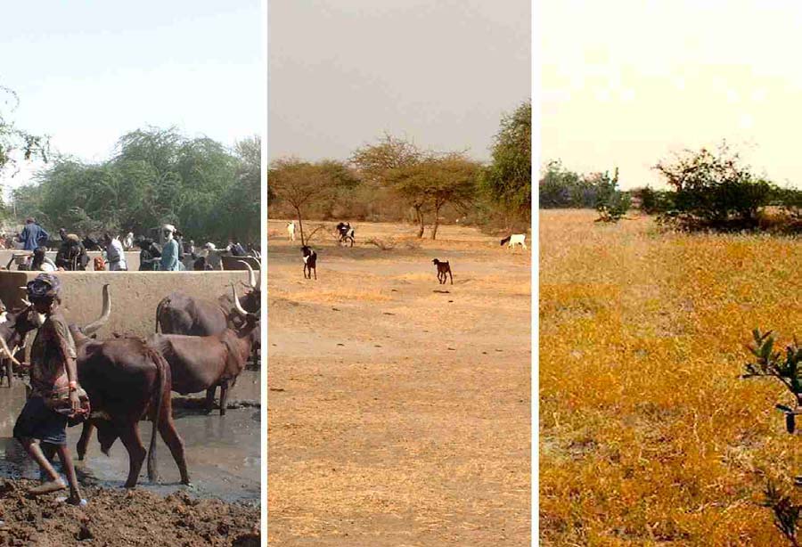
Lake Chad Basin GEF Project Integrated Environmental And Social Assessment (EA/SA)
Photo 4 Access to Water Points and Impacts of Grazing Pressure on Range Quality
6.2 Activities with Significant Environmental and Social Impacts
Project objectives
There are major differences in the statement of objectives between the short summary and the full project
document for this pilot. The specific objectives presented in the full document are the following (translated
from French by the Team):
1. Help local populations fight against the sanding-up of depressions, infrastructure and rangelands;
2. Improve the organisational capacities of villages in the project zone through the development of
their local expertise in the struggle against sand deposition and in their expertise in managing
natural resources;
Output 2 would indicate that natural resource management is limited to range management.
3. Improve and diversify their production systems.
Output 3 indicates this will be done through local credit.
6.2.1 Activities with Significant Impacts
The project lists a number of activities that should have direct and significant environmental and/or social
impacts.
Three activities should have significant environmental and/or social impacts:
� Dune stabilisation � This will have both environmental and social impacts.
� Range management with associated water point development (three schemes) � Major
environmental and social impacts.
36
Lake Chad Basin GEF Project Integrated Environmental And Social Assessment (EA/SA)
Activities that are considered to have insignificant impacts are the following:
� Activities related to improvements in agriculture are not expected to have significant environment
or social impacts because the scale of these activities is expected to be so small. The project
proposes to develop water points for a range of crops. Crops mentioned are red pepper, cassava,
wheat and the algae Spiruline. Impacts could be significant if the project were to introduce a new
crop or new production technique that yielded such high financial returns that this would lead to
greatly increased investments in areas cultivated or in ground water used. This is deemed unlikely.
The one possible exception is Spiruline culture that has some potential for market development on
a world scale. The project proposes to create artificial basins or ponds for Spiruline culture to be
filled with ground water. If a major market for Spiruline were to develop, this could lead to
significant environmental and social impacts, but the chances for this seem remote.
� The project also proposes to establish a credit scheme to fund minor local enterprises, which in
turn could have direct local environmental and social impacts. The fund is expected to be used for
the purchase of simple agricultural tools, drying equipment for algae, equipment for mining and
treatment of natron, and for small businesses. The scale of these impacts, however, will probably
be insignificant.
6.3 Relevant Safeguard Policies
The only safeguard policy that could potentially be triggered by this project is O.D. 4.2 on Indigenous
Peoples or OD 4.30 or draft OP/BP 4.12 Involuntary Resettlement � range management would involve
radical changes to access to range resources � this could potentially affect indigenous transhumant pastoral
groups.
The project should be guided by the greater details given in OP/BP 4.12 on the need for participatory
processes in drawing up the plans for managing access rights. This specifically includes the need to take
account of the needs of vulnerable groups and especially those below the poverty line, the landless, the
elderly, women and children, indigenous peoples and ethnic minorities.
6.4 Environmental and Social Impacts
6.4.1 Dune
Stabilisation
6.4.1.1 Description of the proposed activity
The project proposes to select dunes that pose immediate threats to important infrastructure or valuable
lands. The project document proposes a combination of physical and biological techniques for fixing or
stabilising sand dunes. The physical techniques will require large amounts of plant materials to construct a
checkerboard like pattern of fences or barriers across the dunes to be stabilised. These structures are
intended to minimise sand movement long enough for biological controls to be put in place. The biological
dune fixation measures proposed consist of the planting of perennial trees and shrubs. Nine species are
proposed for planting on the dunes including two exotics species of Prosopis. No mention is made of what
institutions, incentives or systems will be put in place for managing or protecting the dunes once they have
been successfully stabilised. Dune stabilisation would have both environmental and social impacts.
6.4.1.2 Analysis of the environmental and social impacts
The significance of the impacts of dune stabilisation will be a function of the approach used. If one only
imitates the techniques already employed in the Diffa area, the areas treated will be very small, and the
impacts will be relatively insignificant. If the approach would address fundamental causes that cause stable
dunes to become live dunes, the impacts could be very significant. This would involve addressing land
tenure and access rights. It would involve restrictions on the right to practice rainfed agriculture on fragile,
high-risk sites. It would involve an end to open access grazing of livestock on live dunes and on sites at risk
of becoming live.
37
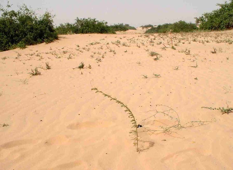
Lake Chad Basin GEF Project Integrated Environmental And Social Assessment (EA/SA)
Photo 5 Seedling Planted for Dune Stabilisation at Nguigmi
Environmental impacts
Positive impacts Dune activation might be considered the ultimate form of land degradation. The
stabilisation of dunes that have become active because of unsustainable land use practices is, in a de facto
sense, a clearly positive environmental benefit. Stabilised sand dunes will once again support vegetation
that serves as primary producers that recycle nutrients and that may serve as wildlife habitat.
Significance as a function of scale The significance of this activity will depend totally on the approach
and the techniques employed and the conditions of resource access and natural resource management
systems that will be put in place. The project document only talks of stabilising dunes that are threatening
infrastructure or lands of particular value. This is strictly a treatment of the symptoms of the unsustainable
land use practices that lead to the dune activation in the first place. The prodoc says nothing about
addressing root causes of dune activation. If the project does not address root causes, the areas that can be
treated will remain very small and so will the environmental impacts.
Risk that positive impacts will be temporary. The project document says nothing about what will be
done after the dunes are stabilised. It does not say how the stabilised dunes will be protected or managed
over time, who will be responsible, what incentives will be put in place, what restriction on use and access
will be developed and how recurrent costs will be covered. In the lack of such measures, one would expect
that dunes may become active again. The risk would be especially high during the next severe drought. If
this were to happen, not only would the positive environmental impacts be lost, but the psychological
impact could very well discourage local populations from ever again trying to stabilise the dunes.
Negative impacts The mechanical fixation of dunes requires large volumes of suitable plant materials for
the construction of "fencing" materials. The prodoc specifies that doum palm (Hyphaena thebaica) leaves
38
Lake Chad Basin GEF Project Integrated Environmental And Social Assessment (EA/SA)
and burning bush (Leptodinia pyrothechnica) branches will be relied upon. Needless to say, the availability
of such trees and shrubs in the vicinity of live dunes is usually severely limited � such resources are
frequently themselves in need of protection or regeneration. Harvest of such materials may actually
accelerate the degradation of the sites where they are harvested. There are no known management systems
in place that would ensure their sustainable harvest.
Risks posed by the use of invasive species The project proposes to primarily use Prosopis spp. for
biological fixation of dunes. Prosopis is the principal tree used for this purpose in Niger, and, almost
certainly, the principal species used successfully for dune fixation all across the Sahel. It has been widely
promoted by donor projects over the past 20 years for reforestation, fuelwood, agroforestry and dune
fixation.
Prosopis can also be a highly invasive species. The Assessment Team has seen it behaving as a successful
invader on sites in Niger, Chad and Cameroon. It can frequently invade highly degraded sites that have
little or no vegetation at all � sometime sites with less than 300 mm of rainfall. In Sudan, it has invaded
irrigated rice fields. In Niger, it has been highly invasive along stream banks in the Majia Valley. It has
invaded parts of the shorelines of Lake Fitri forming dense stands. It is so widely established across the
Sahel, that it would almost certainly be extremely difficult, if not impossible, to eradicate. Its seedpods are
eaten by livestock that disseminate its seeds widely. It is undergoing rapid expansion of its range into new
ecological niches across the Sahel. Prosopis will almost certainly become a prominent feature of many
Sahelian landscapes and ecosystems in the future.
There are probably no habitats or ecosystems in the pilot project area that can be considered to be anything
close to "natural". However, native species of trees and shrubs are still dominant throughout most of the
project area. Prosopis appears to be much more aggressive in regenerating on many sites than these native
species � and will, to an unknown extent, replace, or reduce the importance of, these native species .
Introducing Prosopis for dune fixation will certainly accelerate this process � but the process itself must be
considered largely inevitable.
Social Impacts
The social impacts of dune fixation will be a function of what sort of management systems and/or
restrictions are put into place. These are not specified in the project document, but they will be critical for
the long-term success of this effort.
Positive impacts:
� The protection of high value infrastructure, fields and pastures from dunes and sand encroachment.
This will have positive economic impacts and will increase food security.
� Sand dune fixation may restore some or all of the productivity of areas that had lost nearly all
productive capacity. Stabilised dunes can potentially produce wood and secondary forests products,
forage and browse for livestock (under controlled management systems), wildlife habitat and other
goods and services. Such use, however, will need to be very carefully controlled and monitored � one
must considered the restabilized dunes to be much more fragile than dunes that have never become
active in recent decades. Harvesting wood products from species that sprout readily from the stump
can probably be done sustainably with little risk � if done properly, it may actually improve canopy
cover and diminish wind erosion. The development of sustainable grazing systems on stabilized dunes
would be much more difficult and risky, but not necessarily impossible.
� The stabilisation of dunes can play a critical function of demonstrating that desertification can be
reversed by local populations. The development of live dunes is perhaps the most dramatic example of
desertification and degradation of natural resources. Successfully fixing a dune can go a long ways to
counter the fatalist notion sometimes encountered that desertification is "an act of god" that one is
fated to accept. Successfully fixing a dune may help convince people that they can also reverse forest
degradation, depletion of fish stocks, disappearance of wildlife, decrease in soil fertility, etc.
Negative impacts: If no long term management system is put in place, the positive environmental
impacts will be lost and the positive social impacts along with them. If the stabilised dunes were to become
active a second time, this could be highly demotivating to local populations.
39
Lake Chad Basin GEF Project Integrated Environmental And Social Assessment (EA/SA)
6.4.2 Range Management and water point development
6.4.2.1 Description of the proposed activity
The Assessment Team strongly supports the proposed development of range management systems as one
of the most critical activities needed to reverse the degradation of natural resources in the project area.
However, the project document provides almost no information about how this will be done. It speaks of a
strong involvement of transhumant pastoralists. It proposes to make use of traditional knowledge on the
management of pastoral resources. It speaks of involving all stakeholders in the "assisted regeneration" of
rangelands. Water points will be developed in association with the range management systems. The project
also proposes to develop an information system to inform herders about the availability of pastures.
However, none of this provides enough information to enable us to assess the impacts of this activity.
At this point we must make some basic assumptions about what the range management entails. Range
management is one of the least developed technical disciplines in Africa. This is probably due in part to the
fact that the two principal ex-colonial powers do not themselves have extensive pastures or rangelands �
range management is relatively undeveloped in universities and technical services.
Range management is based on the basic biology of the preferred forage and browse species. Grazing must
be controlled in such a way as to favour the reproduction and growth of these preferred species. There must
be an empowered management body/structure that has control over access to the rangelands. It means that
this management structure must be able to control the timing of range use by livestock. It may require
control of livestock numbers. It means that herders moving through the area must abide by the rules for
rangeland use that will be put in place by the management body to be developed � and that the management
body will have the authority to apply these rules.
Similarly, we assume that water point development will be fully integrated with the range management
system. The same management structure will control both water and range resources. The severe
degradation that so routinely occurs around water points across the Sahel will be avoided by including the
pasture areas close to the water points in the overall range management system.
In any case, open access grazing is totally incompatible with range management. Range management will
require a radical change in the present access rights and use systems.
6.4.2.2 Analysis of the environmental and social impacts
Environmental impacts
Positive impacts: From the environmental perspective, range management can be expected to have several
positive impacts:
� Increased soil cover and increased biomass production;
� Increased diversity of herbaceous and woody species. Overgrazing leads to the decrease and
disappearance of preferred forage and browse species;
� Greatly decreased wind erosion.
� Decrease and/or reversal of dune activation. Range management on fragile sites that are
susceptible to dune activation should prevent this from occurring in most cases. Range
management should be a key element of sand dune stabilisation and of the sustainable use of areas
that have been stabilised;
� Improved habitat for wildlife.
On heavier soils in other parts of the Lake Chad Basin, part of the rainfall received runs off into streams
and part infiltrates where it contributes to plant growth and to ground water recharge. The coefficients of
infiltration and of runoff are strongly influenced by the amount of vegetative cover. Cover is strongly
influenced by range management. On such sites, range management would have significant environmental
impacts on the hydrologic regime of streams draining the managed area. The LCBC should be aware that
40
Lake Chad Basin GEF Project Integrated Environmental And Social Assessment (EA/SA)
range management can be a powerful tool on such sites for influencing ground water recharge and stream
hydrology (Decrease in flood peaks, etc.).
Negative impact on groundwater recharge: On very sandy soils, all rainfall soaks into the ground,
whether or not the site is degraded. This is the case in most (perhaps for all) of the pilot project area. Range
management may have some negative impact on ground water recharge in the project area. This is because
the increase in vegetation cover that will result from range management should lead to an increase in
evapotranspiration. Increases in woody vegetation would have an especially strong impact. Deep-rooted
evergreen species continue to transpire throughout the dry season. Increases in perennial grasses would also
increase evapotranspiration. Although the impact of decreases in ground water recharge might be
considered negative, they should also be considered natural. The present degraded condition of the
rangelands is not natural.
Social Impacts
Positive impacts Range management would have a range of positive socio-economic impacts that would
include:
� Restored productivity and quality of pasture for livestock;
� Increased production of secondary products from trees, shrubs, perennial grasses;
� Increased food security;
� Increased confidence of local people that they can positively influence their environment and their
production systems. A successful range management pilot should serve to convince people that it
is possible to reverse resource degradation. Some people in the project area don't believe that
overgrazing is a problem. They believe, rather, that degradation of resources is a result of
decreased rainfall �that whether it rains or not depends on the "will of God" and is beyond human
control.
Risks of negative impacts that have been identified as potential impacts14:
� Risk that transhumants may be "left out" Because of their mobility, there is a risk that some
indigenous transhumant herders may be underrepresented or unrepresented in the range
management planning and implementation. Some transhumant herders are commonly not present
in the project area during parts of the year. If project start-up occurs during a severe drought year,
some transhumants who routinely use the project area during good rain years, may not even be
present.
� Risk of conflict generation Range management necessitates radical changes to traditional
methods of resource use. In particular, it necessitates an end to open access to range resources.
Open access may be the most equitable of all resource use systems, but it also the most
destructive. All herders will have to abide by the new rules that will be put into place. It is
unrealistic to believe that all parties will be in full agreement. The risk of conflict is inherent in
such a radical change in resource access rights. It is a necessary risk that one must seek to
minimise.
� Risk of to women/disadvantaged groups Some livestock owned by sedentary villagers are
allowed "free range" for all or part of the year. They are allowed to run free and are not
accompanied by a herder. Range management will require that all animals must be herded.
Although the total manpower needed for herding under a range management scheme may be
reduced (because flocks may be groups together), the costs may be increased for those who
previously invested little or nothing in this activity. The costs might be especially difficult for
women or disadvantaged groups who may only have a very small number of animals and who
traditionally let them run free unattended.
14 It must be emphasised that they wont' necessarily occur. They are risks.
41
Lake Chad Basin GEF Project Integrated Environmental And Social Assessment (EA/SA)
6.5 Proposed Environmental and Social Mitigation Measures
The project gives clear indications of possible approaches to rangeland management through the
negotiation of access rights and responsibilities to specified communities. However, as yet no specific
communities or areas have been identified. The project should take into account the guidelines on
participatory planning and stakeholder involvement in drawing up these management plans. The need to
include minority and disadvantaged groups is specified in the draft OP/BP Involuntary Resettlement.
6.5.1 Integration of Dune Fixation with Range and Forest Management
A number of negative impacts and risks can be avoided or mitigated by fully integrating the dune fixation
component of this project with the range management component and by expanding both to include
"forest" management. Uncontrolled open access grazing is one of the leading causes of dune activation.
Once dunes become partially or fully active, even relatively low-intensity open access grazing effectively
prevents grasses, shrubs and trees from re-establishing themselves and restabilizing the dune � even in
good rainfall years.
Live dunes and severely degraded sites should be integrated in the area under range management. As part
of the range management system developed, severely degraded areas should be closed to grazing and most
extractive use activities (cutting of fuelwood and construction materials, thatch harvest, etc.) should be
stopped until the sites recover. As they recover, more and more uses may be allowed as appropriate.
Such an approach is the only way to achieve positive environmental impacts on a significant scale. In the
Diffa Department, there are hundreds of square kilometres of live sand dunes that have become unstable in
the last 30 years. They cannot possibly be treated with the techniques proposed in the project document. It
is only through putting an end to open access and the development of management systems that one can
hope to restabilise these dunes under the climatic conditions that have prevailed since 1967.
If one can keep livestock off of the live dunes, then one can test other much more cost effective techniques
of re-establishing vegetative cover to fix the dunes in place. A variety of direct seeding techniques could be
used. The government of Mauritania has reported quite spectacular success in aerial seeding of four or five
tree species on live dunes in areas with as little as 50 mm average annual rainfall � in areas where no
livestock are present.
If species like Prosopis are used for dune stabilisation, they will very quickly develop into a resource that
can be harvested for construction wood, fuelwood and other things of value under a simple management
plan. Prosopis sprouts very readily from the stump and is easy to regenerate. Management systems can be
developed for all of the tree and shrub resources within the range management area. There is now a wealth
of forest management experience in Niger, Burkina Faso and other countries upon which to build. Adding a
forest management component should be done to ensuring that this key component of the ecosystem is
restored and used sustainably. Sustainable harvest of wood systems can generate revenues for the
management structure and for the user groups that harvest products under the management plans to be
developed.
6.5.2 User Fees to Ensure Sustainability
To sustain this pilot interventions beyond the end of the project, it is critical that the management structures
to be developed generate adequate revenues to cover maintenance costs, capital replacement (pumps,
boreholes) and other management costs. The project document makes no mention of this. The water points
to be developed presents the clearest need for this. Boreholes will be put in and equipped with pumps. The
pumps have operating and maintenance costs and must periodically be replaced.
Niger has a relevant policy to confront this need. The government there instituted a policy in 1992 that
requires that a water point user association be created. The association must develop a system of generating
revenues to cover such costs. Generally the water point management authority charges fees to those who
use the water.
This principle should be expanded to the range resource. The range resource has value. Managing the
resource involves costs. The management structure should charge users fees for the use of the resource.
Fees can also be used as a management tool to limit the use of the resource as needed � to avoid.
42
Lake Chad Basin GEF Project Integrated Environmental And Social Assessment (EA/SA)
6.5.3 Fully Exploiting Lessons Learned by Others
Failure of the range management effort could have a serious impact in discouraging LCBC partners to
undertake future attempts to reverse the degradation of the rangeland resources. One should not
underestimate the challenge of developing successful range management systems in the Sahel. Tens of
millions of dollars were invested in the 60s, 70s and early 80s in failed range management efforts in the
Sahel. Failure was so universal that most donors withdrew from the sector. Most of the early attempts
involved western style fenced ranches � generally run by government agencies instead of by local herders.
In retrospect, these early efforts appear rather na�ve.
The best way to mitigate the risk of failure is to do the best possible job of building upon lessons learned by
those few who continue to work in the range management sector. It appears that some of greatest successes
in the field have come out of the Pilot Pastoral Project (PPP) sponsored by the World Bank. This consists
of a network of field pilot efforts in about five Sahelian countries � including both Chad and Niger. These
activities have been running for about 4-5 years.
The management system is based on the basic biology of the preferred forage species at each site.
Management authority is in the hands of a management structure composed of the herders that use the
resource. The management system involves the division of the area to be managed into a variable number
of grazing parcels (the number is a function of the biology of the forage grasses). Only one parcel is open to
grazing at a time. The rotation system allows preferred range grasses on each parcel to complete their full
reproductive cycle producing mature seeds favouring the reproduction of these preferred species. The
rotation is achieved without fencing � all animals are accompanied by herders that keep them in the parcel
that is currently open for grazing.
The PPP has had very significant success in increased vegetative soil cover, increased forage production
and improvement in species diversity. During a fairly severe drought at one of the sites in Niger about three
years ago, the PPP site generated a good deal of interest because it was the only site in the whole area that
had forage throughout the whole dry season.
The PPP is certainly one of the most promising approaches to study � there may be others. In analysing and
adapting the best approaches, it is critical that herders from the pilot project areas be included amongst
those who visit the pilot sites of these ongoing projects.
6.6 Proposed Monitoring and Evaluation Indicators
The project proposal indicates that it will implement a pasture monitoring and evaluation system for the
whole of the project period. The system will be implemented with pastoralists and their representatives, to
provide information on forage availability.
However, this is only one of the proposed project activities and if the integrated approach recommended in
this report is adopted, then this should be reflected in an integrated monitoring system covering controlled
access to rangeland, regeneration of vegetation on dunes, and access to boreholes.
As a starting point, the project will need to document the process of negotiating and formally handing over
rangeland access rights and responsibilities to communities.
The key impact of the proposed interventions should be improved vegetation cover. The approach should
be to evaluate change in soil cover by vegetation, forage production, species composition and abundance.
The PPP has developed an effective monitoring system for these and other parameters � they should be
consulted and the monitoring system developed should be compatible with the PPP if possible to facilitate
comparison of impacts. . Subjective evaluations by herders can be supported by simple transect surveys.
The use of fixed point photography can contribute to a monitoring programme over a number of years.
The project is also proposing to construct boreholes to supplement existing water supplies. The water depth
and quality in these should be monitored over the season, along with the animal numbers using each water
source.
43
Lake Chad Basin GEF Project Integrated Environmental And Social Assessment (EA/SA)
6.7 Participation of Key Stakeholders in Project Preparation
The Assessment Team visited Diffa and Nguigmi in Niger but was not able to visit sites in Chad. The Team
was able to confirm that the consultant who developed the project document did travel to Diffa and did
meet with government technical services in the zone. We weren't able to confirm that he met with rural
user groups, but this is not surprising given that there is no contact list in the project document of those that
he may have met with.
The key will be to ensure that all stakeholders are involved in the development of agreements on rangeland
access in the implementation stage of the project, and in negotiations with government on formalising
access rights.
7 The Lake Chad Shorelines
7.1 Baseline
Information
The Project Area
The project area is defined as the shoreline of Lake Chad and the lake body itself. However, given the
extremes in the fluctuation in the depth/extent of the lake (less than 3000 km2 to over 25,000 km2 over the
past several decades), the actual project target area is unclear. As an example, the southern part of the lake
is more like a delta than a conventional lake. The "northern pool" is more like a conventional, though
shallow, lake, but it only fills from overflow from the southern pool. During all of the 80s and most of the
90s, this never happened and the northern pool remained dry. It has received waters again in some of the
past few years. Overtime, land that has been dry for decades can become a shoreline, a wetland or open
water.
The hydrology of the lake is quite unique and is not fully understood. 120 species of fish have been
recorded in the lake. The importance of the lake and its wetlands for migratory birds makes it a site of
global biodiversity importance
Cropping on the lake bed and recessional agricultural have become much more important in the recent
decades of decreased rainfall and lake levels. There are no traditional tenure systems for this and conflicts
are common. Large numbers of livestock use the lake bed and the wetland margins in the dry seasons �
conflicts are also common between herders and farmers.
Project Description
In July 2000, the Heads of State of the LCBC declared Lake Chad a "Transboundary RAMSAR site of
International Importance15". However, as yet none of the countries have designated any specific sites
around the lake.
The project will seek to promote the sustainable use of the natural resources of Lake Chad and its shores
by developing an overall agreement between the various owners, occupiers and interested parties through
the RAMSAR management planning process. RAMSAR contracting parties are expected to formulate and
implement their planning so as to promote the conservation of wetlands included in the (RAMSAR) List,
and as far as possible the wise use of wetlands in their territory.
7.2 Activities with Significant Environmental and Social Impact
Project Objectives
The stated wider objective of the project is:
15 With the support of the RAMSAR Bureau and the Living Waters Campaign of the World Wide Fund for
Nature (WWF).
44
Lake Chad Basin GEF Project Integrated Environmental And Social Assessment (EA/SA)
To maintain biodiversity and achieve the long-term sustainable use of the natural resources of Lake Chad
and its shores.
One immediate objective is defined as:
To sustainably manage the natural resources of the Lake Chad and its shores by providing support to the
development and implementation of a management plan according to the guidelines developed by the
RAMSAR convention.
The project proposes to carry out the management planning exercise at two levels, producing:
� A management plan and monitoring scheme for the Lake Chad and its shores produced according to
RAMSAR guidelines;
� Natural Resources-use action plans and sectoral codes of conduct developed and implemented in 4 � 6
communities selected according to agreed criteria. (Clearly this will not suffice for the achievement of
the immediate objective)
Effectively the first component is part of the overall project development of the Strategic Action
Programme, dealing at the macro level with regional/national lakeshore conservation priorities.
The National RAMSAR desk officer in each country will implement the local planning exercises through
the national agencies in which they are based.
The second level is site specific, with the "development and implementation of community-based natural
resource-use action plans". The emphasis of this planning exercise is "...voluntary agreements on sectoral
codes of conduct ... in the sustainable conservation of the sites". The implication is that the local action
plans will include the community acceptance of restricted access to certain resources or resource areas, but
with additional or alternative benefits developed for the affected communities.
However, as yet no specific sites have been confirmed, although Nguigmi in Niger and Bol in Chad have
been suggested.
Activities with Significant Impacts
The only direct action proposed by the project that could have environmental and social impacts is minor
funding for unspecified interventions:
� Provide seed funding for highest priority initiatives identified in the community action plans, within
limits of current project resources.
The "development and implementation of community-based natural resource-use action plans" will
probably have both environmental and social impacts. However, the project design does not even specify
what type of resources will be managed � fisheries or stands of cattails or lake bottom for recessional
agriculture or wetlands pasture resources or other.
7.3 Safeguard
Policies
The management plan and action plans will invariably have to address question of access rights to the lake,
its wetlands and its shorelines. Attention will need to be paid to safeguard policies on 4.20 Indigenous
Peoples and 4.30 and the draft OP/BP 4.12 Involuntary Resettlement as they relate to access rights to
resources and usufruct rights.
This is particularly relevant as it can be expected that the proposals, based on RAMSAR guidelines will
include protected area management, with restricted access rights negotiated with site specific communities.
Lake Chad is an international waterway, but OP 7.50 � Projects on International Waterways is not triggered
as the project is not expected to adversely impact on the quantity or quality of water in the lake.
45
Lake Chad Basin GEF Project Integrated Environmental And Social Assessment (EA/SA)
7.4 Environmental and Social Impacts
Environmental Impacts
As presently designed (the prodoc does not even specify which resources will be managed, how or by
whom), it is impossible to determine if the Shorelines pilot will result in any significant environmental
impacts. At this point, no significant environmental impacts are expected from this project. Any negative
trends in the degradation of the resource base of Lake Chad will be expected to continue.
Social Impacts
This pilot project strongly emphasises a participatory planning approach to develop strategic and
sustainable actions designed to reverse current resources degradation. This would yield significant benefits
for the overall process of future projects design and implementation, as well as for the various stakeholder
groups involved. If well designed these projects could foster ownership and accountability for project
results on the part of the various stakeholder groups. They could also address social equity issues brought
about by the proposed action plans and mitigate their adverse impacts on marginalized and vulnerable
groups, including women, youth and elderly people. However, as in any planning process, there are
potential risks that could affect project performance and sustainability. The project document does not
make it clear who is to manage Lake Chad and its shorelines or what the roles of the different community
and user group stakeholders will be in its management. There is a risk in engaging rural stakeholders over a
period of years during which no concrete changes are brought about in their lives. As people are engaged,
expectations are raised. The risk is that people will eventually become disillusioned and uncooperative if
nothing concrete comes out of the process.
Given the lack of traditional tenure systems over the present shorelines, it is not clear how access rights and
management authorities will be defined and developed. This will be a critical issue in project development,
because all forms of natural resource management require the definition of resource access rights and the
development of an empowered management structure or structures. Funding will need to be secured for the
implementation of the management plans. However there is no guarantee that funding will be obtained.
7.5 Participation of Key Stakeholders in Project Preparation
The full project proposal presents a rather long list of people consulted Nigeria, Niger, Cameroon and Chad
in developing the proposal. However, they are all institutional stakeholders � no community or user group
representatives from the lake were included. Given that the actual project sites have not been defined, it
would not be possible to hold discussions with those would be directly involved in the natural resource use
action plans. This aspect will need to be addressed as a high priority in developing these lake shore
management proposals. The project should initially draw on the proposed mechanisms for participation and
conflict resolution mechanisms in the DFID funded "Jigawa Enhancement of Wetlands Livelihoods
Project", and on the previous activities carried out on the Waza Logone and Hadejia Nguru projects. The
lack of traditional land tenure/resource access rights and the mobility of the "shorelines" will make this
pilot project especially challenging.
8 Lake
Fitri
8.1 Baseline
Information
The Project Area
Lake Fitri is located 300 km north-east of N'Djamena. Like Lake Chad, it is has no outlet, and like Lake
Chad, it is not salty. The project area is completely within Chad and has no direct transboundary
component. The annual rainfall is around 3-400 mm and highly variable. The lake is fed by the Batha River
that provides around 60% of the annual inflow, and by direct rainfall and local run-off. During periods of
low rainfall the lake can dry up, this has happened most recently in 1991, and previously in 1985 and 1913.
46
Lake Chad Basin GEF Project Integrated Environmental And Social Assessment (EA/SA)
Following a series of waterfowl counts in the mid-1980s, attention was drawn to the biodiversity value of
the lake. In 1987, the lake was declared a RAMSAR site. IUCN became involved in 1988 and assisted the
Government of Chad in registering Lake Fitri as a "Biosphere Reserve" in 1990. The project document
defines the project area as the Biosphere Reserve of Lake Fitri, which includes rainfed land around the lake
giving a total area of 195,000 ha.
The key global conservation importance is the very high populations of seasonal migratory birds and
afrotropical waterfowl. The lake environment also supports the endangered Red-fronted gazelle (Gazella
rufifrons) and there are reports of Roan (Hippotragus equinusa) and Tiang (Damaliscus lunatus) antelopes,
as well as Lion, in the wooded area south of the lake. This area also harbours a small elephant population.
There are two main groups that use the lake and the surrounding areas: sedentary Bilala farming
communities and transhumant Arab pastoralists. The lake and surrounding areas fall under the traditional
authority of the Sultan of Yao.
Access to resources was traditionally controlled by the Sultan of Yao, and there are some aspects of natural
resources management that are still relatively tightly managed. The most obvious example is fisheries, with
the use of nets banned, a closed season from September to November and permitted fishhook sizes
regulated. Less satisfactorily, the traditional system of limiting access to the lake and shore grazing for
transhumant pastoralists to a period late in the dry season, has broken down. The rainfall of the area is
marginal for sustainable rainfed agriculture, but rainfed agriculture continues to expand and conflicts
betweeen sedentary agriculturalists and transhumant herders have multiplied.
The increase in the area of recessional agriculture in the dry season has also resulted in more conflict
between transhumant pastoralists and sedentary farmers. Recently, there have also been conflicts between
groups of pastoralists over the control of wells � resulting in significant bloodshed.
Clearly there are already issues of access rights and conflicts between pastoralists and sedentary farmers
and between different groups of pastoralists. The project proposes to develop management plans at various
scales that will involve negotiation between different user groups, and advocacy to maintain the rights of
minority groups.
8.2 Activities with Significant Environmental and Social Impact
Project Objectives
The goal (global objective) of the pilot project is "To manage sustainably the natural resources of the Lake
Fitri area for the benefit of wildlife populations and rural communities."
Over the three-year project period, the project objectives can be summarised as:
1. Achieving a general consensus on the future management of the Lake Fitri ecosystem, based on the
interests of the local population groups and international conservation values;
2. Formulating a management plan, including identifying bottlenecks [It is not clear what this means] in
the Lake Fitri catchment area that threaten the lake's future water provision, and proposing strategies
to deal with them16;
3. Demonstrating the "cross-pollination function" of conservation and development, in the context of a
small water body in Sahelian Chad
The only safeguard policy that could potentially be triggered by this project is OD 4.30 or draft OP/BP 4.12
Involuntary Resettlement, given that there are already conflicts over access rights to lake shore and
hinterland resources.
16 This would appear to extend the potential project interventions to the whole of the Lake's watershed,
most of which is outside the present project area. The meaning of bottlenecks in this context is not clear,
but is understood to mean environmental and social issues that threaten the integrity of the lake system.
47
Lake Chad Basin GEF Project Integrated Environmental And Social Assessment (EA/SA)
Figure 4 Lake Fitri
The project should be guided by the greater details given in OP/BP 4.12 on the need for participatory
processes in drawing up the plans for managing access rights. This specifically refers to the need to take
account of the needs of minority groups including women and children. This will clearly need to be
extended if the project extends to the management of the larger catchment.
The project may also include the establishment of formal protected areas in and around the lake area, again
this will raise issues of access rights, and hence negotiation with local communities.
Activities with Significant Impacts
The focus of the project is compilation of existing studies, the holding of a "seminar", the conduct of new
studies, dialogue with stakeholders, the formulation of a management plan, approval of the plan, and the
establishment of a management platform, although this is not clearly defined.. None of these would have
any direct impacts.
The project has two minor unspecified activities that may have direct environmental and social impacts:
� Small-scale development activities, priority should be given to problems linked to ecological issues.
These are likely to build on and link with activities promoted by the NGO SECADEV.
� Small-scale conservation inputs � as yet unidentified.
The "small-scale development activities" would be undertaken for the purpose of gaining the confidence of
the local population groups. These would be identified through village problem assessments to be
conducted after project start-up. The activities already conducted by the NGO SECADEV are cited as
examples. These concern health, animal health and agriculture. By definition, such small-scale
development activities would normally not have any significant environmental or social impacts.
48
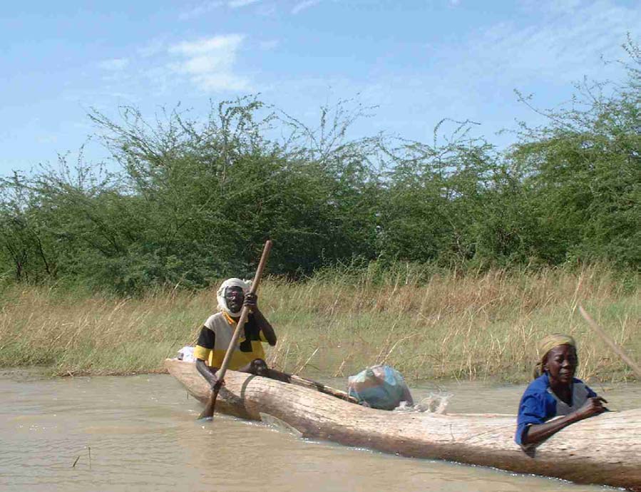
Lake Chad Basin GEF Project Integrated Environmental And Social Assessment (EA/SA)
A potential exception would involve the introduction of exotic species into the project area. The NGO
SECADEV has already done this with the introduction of promotion of Prosopis (mesquite). Prosopis is
frequently an invasive species that can sometimes have serious environmental and economic impacts.
Prosopis seems to be at least mildly invasive in the Lake Fitri area. A dense stand of Prosopis is developing
along the shoreline at Yao's little "port". However, this is only speculation. The introduction of exotic
species that could potentially be invasive is not mentioned as a potential activity in the project document.
As presently designed, the Lake Fitri pilot is not expected to have any significant environmental or social
impacts.
Photo 6 Dense Stands of Prosopis Established on the Shore of Lake Fitri
8.3 Environmental and Social Impacts
Environmental Impacts
No significant environmental impacts are expected from this project. Any negative trends in the
degradation of the resource base of Lake Fitri will be expected to continue during the life of project.
Social Impacts
This pilot project strongly emphasises a participatory planning approach to develop strategic and
sustainable actions designed to reverse current resources degradation. This would yield significant benefits
for the overall process of future projects design and implementation, as well as for the various stakeholder
groups involved. If well designed these projects could foster ownership and accountability for project
results on the part of the various stakeholder groups. They could also address social equity issues brought
about by the proposed action plans and mitigate their adverse impacts on marginalized and vulnerable
49
Lake Chad Basin GEF Project Integrated Environmental And Social Assessment (EA/SA)
groups, including women, youth and elderly people. However, as in any planning process, there are
potential risks that could affect project performance and sustainability.
There is a risk, however, in engaging rural stakeholders over a period of years during which no concrete
changes are brought about in their lives. As people are engaged, expectations are raised. The risk is that
people will eventually become disillusioned and uncooperative if nothing concrete comes out of the
process. The risk may be especially high at a site like Lake Fitri that has seen many exploratory missions
visit Yao. A number of field studies have been funded and conducted, but no donor-funded project (other
than very small-scale activities done through the NGO SECADEV) has ever been executed.
Funding will need to be secured for the implementation of these plans. However there is no guarantee that
funding will be obtained.
8.4 Participation of Key Stakeholders in Project Preparation
None of the stakeholders in the Lake Fitri area that the team met showed any convincing evidence of
having been consulted in the development of this project, At a meeting with the representatives of four
"groupements" and the head of the federation of seven "groupements", there was some discussion on a
consultant who had been in the area in late 2000, but this person had not discussed natural resource
management with them (fisheries, range, wildlife, forest or wetlands management).
The Sultan of Yao, the traditional head of the sedentary Bilala people living around Lake Fitri, is arguably
the most important individual stakeholder in this project. It is doubtful whether any project for Lake Fitri
could be executed without his approval. He had never heard of this project and said he had not met the
consultant who prepared the project document (although the Sultan is listed on the top of the list of persons
contacted in Yao). The Sultan showed the team bound copies of three IUCN reports from the late 1980s.
Significantly the Sultan of Yao stressed the issue of outside organisations coming to the lake, carrying out
studies and preparing reports and disappearing, leaving the communities with raised hopes but then no
actions.
The Sultan told the team that their principal concern in the area is the continued existence of the lake itself.
This, of course, depends on the management of the lake's watershed. It is not clear that the watershed will
be included in the proposed project.
The project proposal suggests SECADEV as a potential partner. SECADEV is the only significant national
NGO operating in the Lake Fitri area, and has a centre in Am'Djamena Bilala. The Assessment Team
discussed the project the two SECADEV professional staff in Am'Djamena. However, they had both just
been posted there and knew nothing about the project. They said they would definitely be interested in
collaborating with the project. They would appear to be a good potential partner, but it is doubtful that they
could take the lead in developing natural resource management systems for the lake and its surroundings.
9 Upper Chari Basin Transboundary Pilot
9.1 Baseline
information
The Project Area
The boundary used for planning purposes by the Lake Chad Basin Commission, described as the "new
conventional basin", specifically includes the upstream components of the Chari-Logone and
Komadougou-Yobe river systems. Lake Chad receives the majority of its water from the Chari River
system and its tributaries, Bahr Aouk, Bamningui, Bangora, Gribizi and Ouham.
The Chari pilot project site is defined loosely as the entire upper catchment of the Chari River, lying within
the Central African Republic and Chad.
50
Lake Chad Basin GEF Project Integrated Environmental And Social Assessment (EA/SA)
Project Description
The project focus is on establishing the basic data sets and monitoring systems that it expects to need for
developing projects and managing project interventions is the upstream catchment. The identified areas of
study include climatic, hydrological and ecological characteristics of the basin and an inventory of the
different resources use and management systems, including: land use, wild life, fisheries, and birds.
It is envisioned that the project will be co-managed by two co-ordinators � one in Chad and the other in
CAR � each with their team of experts, researchers, as well as their resource people from civil society.
These two committees are to be involved in both the planning and implementation of the project.
9.2 Activities with Significant Environmental and Social Impact
The specific objectives of the project are:
� Establish a transboundary co-ordination structure for the management of the Chari basin;
� Put in place a relevant and up-to-date database for water and land resource use systems in the
basin;
� Incorporate available information on trans-boundary hydro-systems for CAR and Chad in the
database and Lake Chad Basin Commission (LCBC) decision making processes;
� Identify and inventory eroded ecosystems;
� Elaborate an Information Education and Communication (IEC) program for the management of
the Chari Basin; and
� Identify income-generating activities.
Activities with Significant Impacts
The project logical framework has eleven activities, none of which have any direct environmental or social
impacts.
9.3 Environmental and Social Impacts
Environmental Impacts
No significant environmental impacts are expected from this project. Any negative trends in the
degradation of the resource base of the Upper Chari will be expected to continue.
Social Impacts
This pilot project proposes a participatory planning approach to develop strategic and sustainable actions
designed to reverse current resources degradation. This could yield significant benefits for the overall
process of future projects design and implementation, as well as for the various stakeholder groups
involved. If well designed these projects could foster ownership and accountability for project results on
the part of the various stakeholder groups. They could also address social equity issues brought about by
the proposed action plans and mitigate their adverse impacts on marginalised and vulnerable groups,
including women, youth and elderly people. The project could use as a starting point, the guidelines on
participatory process and conflict resolution mechanisms given in the relevant Operation Directives and
Policies (OD 4.30 and the draft OP/BP 4.12 on Involuntary Resettlement).
There is a risk, however, in engaging rural stakeholders over a period of years during which no concrete
changes are brought about in their lives and production systems. As people are engaged, expectations are
raised. The risk is that people will eventually become disillusioned and uncooperative if nothing positive
for them comes out of the process. Funding will need to be secured for the implementation of any plans that
are developed. However there is no guarantee that funding will be obtained.
51
Lake Chad Basin GEF Project Integrated Environmental And Social Assessment (EA/SA)
9.4 Participation of Key Stakeholders in Project Preparation
The CAR-Chad transborder pilot project appears to have been unilaterally developed by a national
consultant in conjunction with the CAR "Direction de l'Environnement" (Directorate of Environment), the
GEF focal point in the country.
Following discussions held with the CAR representative at the Steering Committee meeting at LCBC in
October 2001 in N'Djamena, the Central Africans organised a meeting between Assessment Team
members and stakeholders in Bangui. The majority of the stakeholders at the meeting were staff from the
Ministry of Environment. There was also a representative of WWF and two political appointees from the
proposed project area within CAR: the Mayor of Bossangoa, who deals mostly with administrative matters
and a national congress (Assembl�e Nationale) member, and a representative of N'D�l�, a province
covered by the project site. Local community and resource user representatives were not present at the
meeting.
It appears that no other stakeholder groups, among bilateral organisations or civil society, were involved in
project preparation. On several occasions participants claimed to have not seen the project document nor to
have been contacted to provide any inputs in its preparation.
The proposal stresses the transboundary nature of the project. However, project preparation has only
involved the Central African Republic. In the CAR, project preparation has involved very few people
besides the director of environment, the director of regional programs and a consultant.
The Ministry of Environment referred to the project proposal as an "avant-projet" � a preliminary draft of a
pre-project document.
10 Linking Pilot Projects to the SAP/TDA
10.1 The TDA and the SAP
Two of principal outputs of the full project are the TDA and the SAP. The GEF Operational Programs in
the International Waters (IW) recommends that "transboundary concerns are defined by neighbouring
countries in a transboundary diagnostic analysis". Furthermore, one should "formulate a Strategic Action
Program (SAP) of actions each country needs to take to address the priority transboundary concerns... and
to leverage non-GEF resources for implementing both baseline and additional actions".
The Transboundary Diagnostic Analysis for this project should include the following key components:
� Identify and prioritise problems/issues relating to the degradation of land and water resources
within the Basin, focusing on transboundary problems and issues;
� Identify and analyse root causes of land and water degradation;
� Inventory of what works/what doesn't work for reversing land and water degradation and for
sustainably managing water resources, rangelands, forests, fisheries, wildlife and agricultural
lands:
� Identify & analyse successful approaches/projects/pilots/traditional systems
� Distil lessons learned and identify enabling conditions for success in reversing natural
resource degradation
� Define priorities and objectives for reversing natural resource degradation. This should include
priorities by natural resource sector and by geographic region within the Basin.
The Strategic Action Program should emphasise:
� Co-management of international water resources of the Basin;
� Sustainable management of natural resources based on TDA priorities and objectives;
� Sustainable, productive agriculture in priority zones of the watersheds.
52
Lake Chad Basin GEF Project Integrated Environmental And Social Assessment (EA/SA)
� All of the support measures needed (capacity building, policy reform, sustainable funding, etc.) to
support the above.
10.2 Role of the Pilots in Support of the SAP
The principle role of the pilot projects should be the development/testing/adoption of sustainable natural
resource management systems on a small scale to identify those that are best suited for large scale
application in the SAP. Proven and promising sustainable NRM systems will be critical to the SAP. But the
present level of development natural resource management systems in the Lake Chad Basin is very low.
State of the Art in NRM
There is very little management of natural resources in the Lake Chad Basin. The present natural resource
use systems are characterised by de facto open access to resources i.e., no management at all. The
following is a very preliminary analysis of the present "State of the Art" for sustainable NRM in the Basin:
� Range Management � The World Bank-has funded the Pilot Pastoral Project (PPP) for four to five
years in both Chad & Niger. Early results of the community-based management approach are very
promising, but no one has yet attempted to replicate and adapt these pilots to new sites.
� Natural forest management � Harvest of wood products from natural forests is regulated by
national forestry services through permit systems. This should not to be confused with
management systems that ensure adequate regeneration of the resource harvested. Natural forests
subject to such permit systems are undergoing severe degradation all across Africa. The Team was
unable to identify any pilot natural forest management initiatives in the Basin. Burkina and Niger
(outside of the Basin) are leaders in natural dry forest management in Africa � both countries have
developed very successful community-based management approaches. Burkina has over
550,000ha under management.
� Fisheries management � There are very promising/successful, but isolated, examples of good
fisheries management to build upon. The traditional system controlled by the Sultan of Yao at Lac
Fitri in Chad seems to be an exceptionally successful case. There is a very successful example of
community-based river fisheries management involving three villages on the upper reaches of the
Chari River in Chad (at Nyala or Nyalama??). There may be others.
� Wildlife management � We are unaware of any ongoing pilot initiatives. The UNDP/GEF Manda
project in southern Chad proposes to include a community-based wildlife management
component.
� Wetlands management (for extractive uses of wetland resources) � None identified
� Groundwater management � None identified
� Watershed management � None identified
� Multiple use NRM/integrated NRM/environmental management � None identified. Most
successful or promising examples of natural resources management across Africa remain limited
to a single sector. There have been relatively few attempts to integrate management of multiple
resources on the same site � such as managing the forest, range and wildlife resources on the same
piece of dryland forest.
Once again the above analysis of the "state-of-the-art" for the Basin is very preliminary. The TDA will
have to perform a much more complete inventory. But the Team would be very surprised to learn that the
level of development is substantially better than this preliminary analysis would indicate. The pilot projects
should play a critical role in developing sustainable natural resource management systems that can
effectively reverse the degradation of land and water resources in the Basin.
Appendix B presents some suggestions from the Assessment Team on how the Effectiveness of the Pilots
might be improved.
53
Lake Chad Basin GEF Project Integrated Environmental And Social Assessment (EA/SA)
11 Public Consultation Strategy Plan
The GEF, World Bank and UNDP all have public disclosure policies. The 1994 Instrument for a
restructured GEF states "...GEF-financed projects shall provide for full disclosure of all non-confidential
information, and consultation with, and participation as appropriate of, major groups and local
communities throughout the project cycle."
The policy for disclosure of information on the Bank's GEF operations goes beyond this and provides for
more open access to GEF project-related information. In August 2001, the World Bank Disclosure policies
were revised. The revised policy for GEF projects states "Make EA report self-standing (and)...Make
disclosure a prerequisite for beginning of appraisal". In addition, during project preparation factual
technical documents will "...continue to be disclosed by the country director...". It is assumed that these
same criteria will apply to projects developed as part of the SAP and to the SAP and TDA themselves.
11.1 Disclosure of the Environmental and Social Assessment
The newly revised guidance for disclosure of Environmental Assessments requires disclosure prior to
project appraisal. Appraisal has been scheduled for mid-January 2001. The Assessment report will not be
completed until the beginning of January. It will then be translated into French. The Bank requirement for
the disclosure of EA and SA reports could be accommodated through a stakeholders' meeting to be
organised by LCBC. This could be done in early January � or even in parallel with the appraisal mission. .It
is recommended that LCBC invite key stakeholders from all pilot project sites to a meeting in N'Djamena
which would be attended by LCBC and national counterpart staff.
The following list of pilot project stakeholder groups is indicative of the range that should be invited to the
stakeholder meeting:
� Waza Logone � IUCN, SEMREY, National Parks and community leaders (lamido) from the flood
plain communities;
� Komadougou-Yobe/Hadejia Nguru � IUCN, Hadejia Jama'are River basin Development Authority,
National Conservation Foundation, DFID, community leaders;
� Desertification SODELAC, representatives from the Ministry of Environment, Livestock, Water and
Agriculture in Diffa and Nguigmi, the President of the Pastoralists Association in Nguigmi,
community leaders from Bol, Liwa and Rig-Rig;
� Lake Chad Shoreline Management Plan � RAMSAR, representatives of lake shore user groups,
� Lake Fitri � The Sultan of Yao, the Sous-Prefet of Ambasetna, RAMSAR, SECADEV, leaders of the
local Union of groupements in Yao;
� Upper Chari Basin � WWF, Ministry of Environment, non-governmental and other village
representatives from project sites.
Stakeholders should be provided with copies of the pilot project proposals and with the relevant sections of
the EA report in French or English as appropriate
11.2 Public Consultation and Disclosure During Project Implementation
The pilot project documents emphasise stakeholder consultation processes, as part of project development
and in monitoring project performance. Indeed the main project has as a clearly identified output
"Strengthened engagement of stakeholders", with the first activity "Create and provide resources ...for the
engagement of stakeholders and key user groups at all levels".
However the linkages between pilot stakeholder consultation and consultation within the main project is
less clear, despite the fact that in many cases it is likely to be the same stakeholder groups involved. While
promoting this strengthened engagement of stakeholders, the project proposals are less clear about the
actual role that this "engagement" has in guiding project management or in what the outputs from the
consultation process will be. Nor is it clear who will manage this consultation process.
54
Lake Chad Basin GEF Project Integrated Environmental And Social Assessment (EA/SA)
11.2.1 Public Consultation and the Pilot Projects
The Assessment Team found that stakeholder participation in pilot project preparation had generally been
insufficient at the level of user groups and community groups. It is very important that measures be taken to
correct this situation and to substantively involve these stakeholders in project development.
Although the guidelines are different for different levels of project intervention, the World Bank policies
recognise the benefits of the involvement of stakeholders at all stages of the project cycle. This includes
both the planning stages, and, during implementation, the management and monitoring � and if necessary,
modification � of project interventions.
The World Bank Participation Sourcebook focuses on the use of participatory planning approaches to
address poverty reduction at the macro-level. The concepts at the macro-level overlap with those being
developed to promote Community Driven Development that has so far been most successful at the micro
level.
The pilot projects include planning and management activities, and in most cases have identified possible
stakeholder communities or project sites for project interventions. The one main exception to this is the
Lake Chad Shoreline Project, which has not yet identified the proposed project sites round the lake.
A review of project experience with stakeholder involvement has indicated the following key issues that
will need to be addressed:
� Groups should demonstrate a need and have a common interest in the outcome of the project;
� There is clear understanding of the benefits and desired changes to be derived from the project;
� The groups (or communities) have the capacity, leadership, knowledge and skills needed to manage the
tasks for implementing the project;
� Groups (or communities) are capable of making and enforcing their own rules and regulations; and
� An inclusive decision-making process exists from the project design phase and throughout the project
life.
Many of the communities around the lake have their own clearly defined representative organisations that
provide effective channels for communicating local preferences. Traditional leaders occupy pivotal
positions for mobilising people and should be brought into the planning and management process, with due
concern for ensuring genuine representation of the stakeholders. Other communities do not have
representative structures or traditional leaders that can speak for them. No foolproof methods exist to
guarantee full local-level participation.
Each pilot project will have to define it's own community management structures depending on the
communities involved and the resource base that they will manage.
11.2.2 Consultation in the Preparation of the TDA and the SAP
As previously indicated the GEF sees the development of the TDA and the SAP as essentially a process of
consultation with stakeholders at all levels.
The GEF emphasises the need for country participation and country commitment to the preparation of the
TDA and the SAP.
"The centrepiece of the GEF strategy... is the concept of "strategic joint fact finding" as a means of
arriving at a consensus on what actions are needed to address threats... collaborating states establish
technical teams that work to establish a common baseline of facts and analysis of the problem in the form
of a transboundary diagnostic analysis (TDA), which is then used to set (national) priorities for actions to
address threats to international waters in the form of the SAP."
The process involved will vary from region to region, largely in response to the capacity of existing
national and regional institutions and the existence or otherwise of relevant treaties or conventions that can
support the subsequent implementation of the SAP.
55
Lake Chad Basin GEF Project Integrated Environmental And Social Assessment (EA/SA)
Building on the proposals that are in the document, it is recommended that the project support a national
consultation process through the strengthened stakeholder steering committees and with representatives
from these national stakeholder steering committees involved in regional level discussions.
As well as supervising the implementation of the pilot projects and the development of proposals for the
community resources management interventions to be funded under the subsequent phase of the project.,
these groups could then be given a specific role in the development of the TDA and the SAP, feeding into
the existing LCBC Basin Committee for Strategic Planning.
The management of these consultation processes will be a key task of the Project Co-ordination Unit.
A possible structure for public consultation process could involve the following components:
1. Creation of National Planning Teams with the following duties:
� At the initiation of pilot project activities, managing a public workshop at the pilot project site to
present and review the pilot project proposals
� Supervising the implementation of pilot projects
� Identifying key stakeholder groups at local and national levels, including the private sector,
community based organisations and NGOs
� Managing local and national workshops to develop three proposals in each country, for
community based resource management projects to be funded in the next phase of the SAP17.
� Managing national consultation workshops to develop national components of the TDA and the
SAP and to clarify national perspectives on priority issues and opportunities
� Preparing national reports as inputs to the regional consultation process.
2. Creation of a Regional Planning Team with representatives from the national planning teams, with the
following duties:
� Reviewing national information from the national planning processes, bringing together national
perspectives on priority issues and development options within a regional transboundary
framework
� Preparing a regional Transboundary Diagnostic Analysis, which not only covers threats, but also
identifies best practices and lessons learned from successful development interventions in the five
countries and in other parts of the world.
� Preparing a regional Strategic Action Programme which prioritises specific regional and national
projects and identifies key agencies, communities and sites where development interventions
should be focused.
� Presenting the TDA and the SAP to the LCBC Basin Committee for Strategic Planning and to the
Inter-ministerial Co-ordinating Committees for approval and subsequent endorsement.
� Managing regional consultation workshops and donor conferences to review the TDA and the
SAP and to gain donor commitment for future cofinancing.
The process of preparing the TDA and the SAP is recognised as being complex and will require a number
of meetings at national and regional level, as well as the two proposed donor meetings to leverage support
for future activities under the SAP.
The process of consultation will require facilitation by centrally recruited staff, to ensure that there is
coherence in the approach adopted by the different countries.
It should be noted that there are significant cost implications to this public discussion process that are not
covered in the present budget allocations.
17 Activity 3.3. in the main project document.
56
Lake Chad Basin GEF Project Integrated Environmental And Social Assessment (EA/SA)
11.2.3. Identification of Lead Executing Institutions
The executing institutions for the pilots will play key roles in the refinement and application of the public
participation plans. The lead institutions that will execute the Desertification pilot, Lake Chad Shorelines,
Lake Fitri and Upper Chari Basin have not yet been identified. One of the key steps remaining in project
development is their identification. The World Bank ASPEN unit expressed a desire to see organigrams of
responsibility for project execution. Obviously, this will not be possible until the lead executing agency is
identified for each pilot.
11.3 Conflict Resolution and Management
11.3.1 Need for a Framework for Conflict Resolution
The need for greater public consultation among stakeholder communities in planning and implementing
pilot projects has been discussed above.
However, there is an additional element to consultation that has not been emphasised: the role of
consultation process in avoiding or resolving conflicts within and between communities, helping
stakeholders with different interests explore and potentially find common interests. Part of the process of
stakeholder consultation is establishing how conflicts will be resolved.
The underlying theme of the core project and the pilots is the need to reverse a pattern of land and water
degradation. The causes of this degradation have been previously discussed, principally the decreases in the
rainfall regime and unsustainable land and resource use systems. The effect of this is increased pressure on
remaining resources and as a result increased potential for conflict over access to these resources.
These conflicts often arise because people have different uses for resources, such as forests, water, land or
pastures. An example is the recurrent disputes between herders and farmers or between several groups of
herders themselves in Lake Fitri watershed area. Disagreements also occur when the interests and needs of
individuals or groups in a given social setting are incompatible, or when the priorities of some user groups
are not considered in policies, programs and projects.
In situations where there are guidelines or legislation on improved management of resources, there may
then be conflict between those who play by the rules and those who don't. In the Waza Logone zone, many
of the present fishing practices are incompatible with conservation and sustainable use of resources. Many
fishermen ignore any restrictions on mesh size or controlled seasons. Such conflicts of interest are a
common feature of all societies, but the ways in which people respond to natural resource conflicts vary
considerably. Most communities have to certain extent their own ways of dealing with conflicts, using the
same basic procedures to address conflicts, including negotiation, mediation, arbitration and adjudication.
The Lake Chad basin is characterised by the coexistence of customary systems and national legal systems
for accessing and managing natural resources and the conflicts that may emerge over their use and control.
Customary conflict management systems, with adjudication through traditional community leaders and
elders, often encourage participation by members of the community and respect local values, customs and
hierarchy. They also foster decision-making based on collaboration, with consensus emerging from wide-
ranging discussions that could lead to local reconciliation. However, they seem to have been supplanted or
eroded by administrative laws and regulations.
The advantages of legal structures for managing natural resource conflicts include the fact that they are
officially established with defined procedures; result in decision that are legally binding; and involve
judicial and technical specialists in decision-making. Conversely, they may not consider indigenous
knowledge, local institutions and long-term community needs in decision making; may involve judicial and
technical specialists who lack the expertise, skills and approach required for broad participatory natural
resource management. In addition legal systems tend to use procedures that are generally adversarial and
promote a winner-loser situation.
57
Lake Chad Basin GEF Project Integrated Environmental And Social Assessment (EA/SA)
11.3.2 A Conflict Management Framework for the Pilot Projects
Clearly conflict management structures need to be established at the implementation level. Each pilot
project has a different set of stakeholders competing for different resources. However as many of the
communities already have their own clearly defined local representative organisations that are and will
continue to be involved in decisions on resources access, each pilot project will have to define it's own
conflict management structures.
This can be supported by the central project, and in particular through the proposed review of national
environmental legislation, and where necessary through the identification of "neutral" facilitators to support
local negotiations.
The pilot projects should work towards an integrated conflict management system, where local, customary
and national legal management systems are complementary and mutually reinforcing. Such a framework
should embody the following characteristics:
� Use stakeholder analysis to plan around the various situations as part of the conflict management
and negotiation procedures � averting conflict as part of the planning process;
� Build capacity to address complex situations involving many stakeholders;
� Emphasise capacity building within communities so local constituents become better
communicators, planners and managers of conflicts.
� Foster ownership in decision-making and implementation processes;
� Promote conflict management and resolution by building upon shared interests and finding points
of agreement;
58
Lake Chad Basin GEF Project Integrated Environmental And Social Assessment (EA/SA)
Appendix A Contact List
Pilot Projects
Names
Titles
Institutions
Waza Logone
Oyo, Pierre
Directeur
CACID Waza Logone
Kouokam, Roger
Chef DPP
CACID Waza Logone
Pirot, Jean Yves
Coordinateur
IUCN
Programme
Zones
Humides/eau
Santen, Jos� Van
Coordinateur
CML
Homologue
CEDC
Madi,
Ali
Coordinateur
CEDC Maroua
CEDC
Nono, Micheline T.
RAF
CACID Waza Logone
CACID/Waza
Logone
Mohamadou, Oumarou A.T. Ecologie
CACID Waza Logone
Appliqu�e
CACID Waza
Logone
Saleh, Adam
Conservateur du Conservation
Parc National de
Waza
Ngantou,
Daniel
Directeur
IUCN
Regional IUCN
BRAC
Peghouma,
Ibrahim
Responsible
CACID Waza Logone
Charg� de l'�co-
d�veloppement
Lake Fitri
K�l�l�, Mahamat
Sultan Yao/Lake
Fitri
Absakine
Ibrahim, Mahamat
President
Groupement des P�cheurs du Lac Fitri
Ousmane, Abakar
President
Douhounou -- Groupement des
Agriculteurs de Yao
Jerma, Mahamat
President
Marmiton -- Groupement des Agriculteurs
de Yao
Abba, Al Hadj Hassane President
Doumbourou -- Groupement des
agriculteurs de Yao
Yirima, Al Hadj
President Hijer
Hassane
Youssou, Mariam
Presidente
Siy� -- Groupement des femmes
Kaidela, Mariam
S�cr�taire
Siy� -- Groupement des femmes
1
Lake Chad Basin GEF Project Integrated Environmental And Social Assessment (EA/SA)
Dogo, Haoua
Pr�sidente
Logona -- Groupement des femmes
Issa, Aich�
S�cr�taire
Logona -- Groupement des femmes
Abba, Mariam
Tr�sori�re
Logona -- Groupement des femmes
Payouni,
Ahmad
Responsible
SECADEV-Direction
Unit� Appui et
Programmes
Bertran,
Hadji
Directeur
SECADEV--Ambassetna
D�l�gu�
Beral, Bernard
D�l�gu� adjoint SECADEV--Ambassetna
Lakeshore /
Kala, Badoua
Chef Service
Environnement-Diffa, Niger
Desertification
Sani, Garba
Charg� du G�nie Environnement-Diffa, Niger
Rural
Kanta,
Moussa
Directeur
CEG
Ouma, Hamza
Chef Service
Plan
Sani, Mamadou Gani
Chef Service
Elevage PI
Chabane, Hassine Ben Manager
Ramboll--Water & Sanitation Project
Mai, Manga Maina
D�put� National PCD/E
Yacouba
Louali,
Maroussa
Directeur Adjoint Hydraulique--Diffa, Niger
Mahamane
Community
Djimet, Abdel-Karim
Adjoint au Maire Mairie-Nd�l�, RCA
Participation In
Mandaba, Jean Michel Ministre D�l�gu� Minist�re de l'Environnement
The Integrated
Management Of Neby, Issa Michel
D�put� Sous-pr�fecture
Nd�l�
The Chari Basin Karalema, Jean
Divisionnaire
Eaux et For�ts--Nd�l�
Nguette, Eug�ne
Maire 4�me
Arrondissement de Bossanguoua
Arrondissement
Doungoube,
Gustave
Directeur
Direction de l'Environnement--RCA
Environnement &
Point focal FEM
Azouyangui,
Catherine
Directrice
Direction de l'Environnement--RCA
Environnement
Mbo, Basile
Chef de Division Division foreti�re de Bossanguoua
Foresti�re
Yamindou, Jean
Coordinateur
World Wildlife Fund (WWF)
Lake Chad Basin Sani, Mohamed
S�cr�taire
Commission du Bassin du Lac Tchad
Commission
Ex�cutif
(CBLT)
Gbafolo, Martin
Directeur
CBLT
D�partement des
Ressources en
Eau
2
Lake Chad Basin GEF Project Integrated Environmental And Social Assessment (EA/SA)
Assane, Mahamane
Directeur de la
CBLT
Planification et
du Suivi et
Evaluation des
Projets
Ahmed,
Sadick
Hydrologue
CBLT
Mey,
Mahamat
Agropastoraliste
CBLT
Oguntala, Johnson A.
Chef Unit�
CBLT
ressources en Eau
Yonkeu,
Emmanuel
Directeur
CBLT
D�partement
Documentation
Boukari, Modi
Chef Service
CBLT
Financier
Tam,
Lambert
S�cr�taire
CBLT
Ex�cutif Adjoint
Other Key People Gregor Hans Binkert
Country Manager AFMTD -- World Bank
Contacted
Fran�ois Rantrua
Senior
AFTES -- World Bank
Environmental &
Information
Specialist
Tracy
Hart
Senior
ATFU2 -- World Bank
Economist, Water
and Urban West
& Central Africa-
-
Robert
Calderisi
Country
Chad/Cameroon/CAR/Equ. Guinea/Gabon
Directeur
Charles
Donang
Senior Operations AFMTD -- World Bank
Ningayo
Officer
David Laroche
IW
UNDP
Mrs. Laokole
Program Officer UNDP--Chad
3
Lake Chad Basin GEF Project Integrated Environmental And Social Assessment (EA/SA)
Appendix B Improving the Effectiveness of Pilots
Context
The TOR for the Environmental Assessment calls upon the Team to make recommendations as to how the
pilot projects can better support other key elements of the full project:
The environmental and social assessment is expected to rely on previous texts written on
the greater Lake Chad conventional basin (such as the `Diagnostic Study') as well as the
GEF project documents so as to understand how the relative success or failure of these
six pilot projects may buttress the Strategic Action Program (SAP) and Transboundary
Diagnostic Analysis (TDA) exercises to be conducted in parallel during the course of
implementation. The environmental and social assessment is asked to creating a
framework for the feedback of information coming out of the pilot projects and the
SAP/TDA exercises. This would give the project an idea of where the gaps in the regional
environmental and social assessment may be sooner rather than later. These gaps can
then be addressed through the use of the funds allocated within the project to additional
technical studies during SAP implementation.
The title of the full project is "Reversal of Land and Water Degradation Trends in the Lake Chad Basin".
The main environmental problem in the basin countries is the degradation of the natural resource base. This
is caused by decades long decreases in the rainfall regime and by unsustainable land and resource use
systems. The people of the Lake Chad Basin can't change the climate. They must either adapt their
production systems to remain sustainable within the constraints of whatever climatic fluctuations come
their way or their resource base that forms the basis of their economies will continue to degrade.
One of the key causes of land and water degradation is the extensification of non-sustainble rainfed
agricultural systems that leaves soils eroded and depleted or that can only sustain crop production at very
low levels of productivity. Another key cause of degradation are de facto, open access, natural resource use
systems that prevail on the vast majority non-agricultural lands. Open access and sustainable management
are incompatible � there is no possibility of natural resources management under conditions of open access
to resources.
The main solutions to land and water degradation must be found in the development of flexible, sustainable
natural resource use/management systems and of productive, sustainable agricultural systems.
Opportunities for rapid progress in the development of sustainable natural resource systems are probably
greater than that for the development of productive, sustainable rainfed agricultural systems.
In situ conservation of natural resources can be achieved through sustainable use systems or through
protection. The creation of new protected areas would present a third option for reversing degradation and
of land and water resources. This could be used for limited areas of exceptionally high conservation value.
But protected areas cannot be a mainstream solution for reversing trends in land and water degradation in
the basin as a whole, because the livelihood of the vast majority of rural populations is dependent on the
use of their natural resources.
Suggestions for Improving Effectiveness of Pilots
In Chapter X of the EA/SA, the Assessment Team proposed that the principle role of pilots project should
be the development/testing/adoption of sustainable natural resource management systems on a small scale
to identify those that are best suited for large scale application in the SAP. The Team also argued that the
present level of development natural resource management systems in the Lake Chad Basin is very low.
If the full project does not contribute substantially to the further development of NRM systems, then the
needed systems will probably not be available as needed for developing and implementing the SAP. The
Assessment Team sought to identify ways to improve the effectiveness of the pilots for NRM system
development.
4
Lake Chad Basin GEF Project Integrated Environmental And Social Assessment (EA/SA)
Modify pilots to include NRM development At present three of the pilots do not include any
natural resource management activities � they only focus on the development of natural resource
management plans. Prior to project appraisal (now scheduled for January 2002) one could seek to modify
the pilots to include small-scale testing/development of key natural resource management systems. Given
the geographical dispersal of the pilots across different ago-ecological zones, one should be able to cover a
good range of key NRM systems that are needed in the Basin. To achieve this would require some shuffling
of pilot activities and budget items. We have shown in Table 1 in Chapter 2 some of the areas where such
savings/shifts might be achieved.
Build upon best practices for NRM The project brief includes language about sharing
experiences and lessons learned with other GEF IW projects and other GEF projects in the Basin. The
Assessment Team strongly recommends that the search for best practices and lessons learned be expanded
to all actors � GEF certainly has no monopoly on success stories. Success stories in NRM are few and far
between. It is critical that successes be sought out and analysed wherever they occur � whether they are
modern, donor-funded pilots or traditional systems like that at Lake Fitri. The pilots should seek to adapt
and build upon the best practices that are identified � not simply replicate what others have done.
Involve resource user in design/monitoring/evaluation Reversing natural resource degradation
necessitates changes to the way that rural resource users use or abuse their natural resources. It is critical
that farmer, herders, woodcutters, fishermen, etc. be involved front and centre in selecting, developing,
testing, monitoring and evaluating the natural resource management systems on the pilots. This will involve
arranging study tours for these stakeholders representatives to visit best practices identified elsewhere
and/or bringing resource users and technicians from success stories to work with the stakeholders on the
pilots. Sustainable NRM systems will only be adopted if it is in the best interests of the local resource users.
Develop monitoring systems to extract lessons learned If one accepts that a key role for the
pilots is to test and improve upon natural resource management systems, then the monitoring and
evaluation systems should be conceived in part to monitor the success or failure of what is being tested.
M&E systems need to involve monitoring and evaluation by both project technicians and by the local
stakeholders.
Preliminary Lessons Learned
The Team wishes to suggest a number of emerging "lessons learned" from across Africa. We suggest that
they should be treated as working hypotheses for consideration in refining and implementing the pilots.
� Management by government agencies has largely failed Upon independence, most African
governments assumed ownership of natural resource. The experience with government control and
"management" of natural resources has been a largely negative one. Laws, regulations, permits
systems and enforcement have not added up to sustainable management of natural resources.
� Major success stories are in CBNRM Most of the most successful and promising examples of
natural resources management across Africa are found in community-based natural resource
management approaches. There have been two large-scale programs that have developed. This has
involved community-based dry forest management in Sahel (especially Burkina and Niger) and
community-based wildlife management in southern Africa (especially Namibia, Botswana and
Zimbabwe).
� Key elements of successful CBNRM are generally the following:
� A legally constituted, representative community management structure is created;
� A contractual transfer of management rights if effected from government to this management
structure;
� The contract requires that the community ensure the regeneration of resources exploited. Most
contracts require the development and formal approval of natural resource management plans
� NRM is developed as a money making, economic activity. Revenues generated for:
� Community members/resource users
5
Lake Chad Basin GEF Project Integrated Environmental And Social Assessment (EA/SA)
� Community as a whole
� Management costs
� Capacity development of community structures is critical to success.
Example of Pilot Project Specific Suggestions
Lake Fitri
Two natural resource management opportunities were identified that could be developed at the Lake Fitri
pilot.
Natural Forest Management The Sultan of Yao expressed great concern about the overacting of
"forest" resources in the Lake Fitri area. He reported that it is legally sanctioned by forestry agents issuing
harvest permits for harvest for urban fuelwood supplies. The Sultan told the Team that fuelwood and other
wood products are becoming increasingly scarce for the villages around the lake. Smoke fish demands a
higher market price than dried fish, but wood for smoking is increasingly hard to come by.
An invasive species of Prosopis, introduced by SECADEV, has formed pure stands along the shore of Lake
Fitri. The Team was unable to determine the areal extent of these stands, but they are almost certainly
increasing in size. It would be quite simple to develop a simple management plan for sustainably harvesting
Prosopis � Prosopis resprouts readily from the stump when cut and is easy to regenerate from seed. The
management system for Prosopis could also be expanded to include natural stands/species also.
The Team explained the concept of management to the women's groupement in Yao, and asked if they
would be interested in harvesting/managing the Prosopis stand as a money-making activity. They could sell
wood to fishermen and to villagers. They indicated they would be quite interested in this. (Many of the
natural forest management community groups in Burkina Faso are comprised primarily of women).
Wildlife Management The area south of Lake Fitri is reported to still have populations of large
wildlife � even including a small herd of elephants. Lake Fitri may be one of the few sites amongst the
pilots that still has potential for wildlife management. A community-based approach, building on work in
southern Africa or Burkina Faso, developing safari hunting as the main revenue earner, might have good
potential here. This is approach is based on the idea that communities will protect wildlife population if
they realise substantial economic benefits from the wildlife.
Developing wildlife management at Lake Fitri might require a higher level of resources and expertise than
may be available without securing cofinancing
Fisheries Management Lake Fitri already has a basically sound fisheries management system
under the control of the Sultan of Yao. If a tropical fisheries expert was able to identify/propose
improvements to their system, it should be relatively easy to test/implement them through the existing
management structure. They is also probably opportunity to assist fishing groups to improve their
processing and marketing of their product.
Range Management There is a relatively high level of conflict between transhumant herders and
sedentary farmers. One should probably adopt a go-slow approach and not attempt to introduce range
management during the first phase of the project.
6
Document Outline