Assessment of the Safety of Maga dam, Cameroon
______________________________________________________________________________________
World Bank / Lake Chad Basin Commission
APPRAISAL OF THE SAFETY OF MAGA DAM,
CAMEROON
March 2002
1-1
Assessment of the Safety of Maga dam, Cameroon
______________________________________________________________________________________
Contents
1 Introduction.............................................................................................................. 1-1
1.1 Background...................................................................................................... 1-1
1.2
Terms of Reference.......................................................................................... 1-1
1.3 Previous
studies ............................................................................................... 1-1
1.4 Programme
of
work ......................................................................................... 1-2
1.5 Acknowledgments............................................................................................ 1-2
2
Description of the dam............................................................................................. 2-1
2.1 Access .............................................................................................................. 2-1
2.2 Scheme
layout.................................................................................................. 2-1
2.3 Hydrology ........................................................................................................ 2-1
2.3.1 Reservoir
characteristics .......................................................................... 2-1
2.3.2 Direct
catchment
inflows ......................................................................... 2-2
2.3.3
Indirect catchment inflows....................................................................... 2-2
2.3.4 Floods....................................................................................................... 2-2
2.3.5 Evaporation.............................................................................................. 2-3
3 The
Inspection.......................................................................................................... 3-1
3.1 Embankment .................................................................................................... 3-1
3.1.1 Geometry.................................................................................................. 3-1
3.1.2 Construction............................................................................................. 3-1
3.1.3 Crest ......................................................................................................... 3-1
3.1.4 Upstream
slope......................................................................................... 3-1
3.1.5 Downstream
slope.................................................................................... 3-2
3.2 Hydraulic
structures ......................................................................................... 3-2
3.2.1
Spillway between the reservoir and the Logone ...................................... 3-2
3.2.2 Main
outlet
works .................................................................................... 3-4
3.2.3
Irrigation outlet works.............................................................................. 3-4
4
Threats to the integrity of the dam........................................................................... 4-1
4.1 Embankment
stability ...................................................................................... 4-1
4.1.1 Upstream.................................................................................................. 4-1
4.1.2 Downstream ............................................................................................. 4-1
4.2 External
erosion ............................................................................................... 4-1
4.2.1 Waves....................................................................................................... 4-1
4.2.2 Rainfall..................................................................................................... 4-1
4.2.3 Overtopping ............................................................................................. 4-1
4.3 Internal
erosion ................................................................................................ 4-2
5 Emergency
planning ................................................................................................ 5-1
5.1 Responsibility .................................................................................................. 5-1
5.2 Surveillance...................................................................................................... 5-1
5.3 Population
at
risk ............................................................................................. 5-1
5.4 Warning
system ............................................................................................... 5-1
5.5 Emergency
preparedness ................................................................................. 5-1
5.5.1 Routine
maintenance................................................................................ 5-1
5.6 Conclusion ....................................................................................................... 5-2
1-2
Assessment of the Safety of Maga dam, Cameroon
______________________________________________________________________________________
6
Conclusions & Recommendations........................................................................... 6-1
6.1
Threats facing the dam..................................................................................... 6-1
6.2 Recommendations:
dam
safety ........................................................................ 6-1
6.2.1 Wave
erosion ........................................................................................... 6-1
6.2.2 Floods....................................................................................................... 6-2
6.2.3 Conclusion ............................................................................................... 6-3
6.3
Recommendations: Safety Plan ....................................................................... 6-3
6.3.1 Monitoring ............................................................................................... 6-3
6.3.2 Early
warning........................................................................................... 6-3
6.3.3 Emergency
stockpiles .............................................................................. 6-4
1-3
Assessment of the Safety of Maga dam, Cameroon
______________________________________________________________________________________
1 INTRODUCTION
1.1 BACKGROUND
The Maga dam was constructed in 1979 as part of the second SEMRY project, the object
of which was to expand and improve the cultivation of rice. The scheme that was
constructed comprised a 7,000 ha rice plantation irrigated with water supplied by the
Maga reservoir, which, with its associated flood protection dikes, also served to protect
the plantation against annual floods from the Logone river.
The scheme was constructed at the onset of a prolonged drought and had undesirable
consequences on the environment and the social economy of the wetlands downstream.
As part of a recent drive to address these problems, which are widespread in the Lake
Chad Basin, the Lake Chad Basin Commission (LCBC) commissioned a project entitled
"The Reversal of Land and Water Degradation Trends in the Lake Chad Basin" This
project comprised, inter alia six pilot projects, one of which was devoted the problems of
the Waza Logone flood plains in which Maga dam is situated.
During the field work that was undertaken as part of environmental and social
components of this pilot project the apparent hazard posed by the Maga dam was noted1,
and as a result the World Bank commissioned Mr L J S Attewill of Jacobs GIBB Ltd to
prepare this appraisal of the safety of Maga dam.
1.2 TERMS OF REFERENCE
The terms of reference for this appraisal and that of two dams in Nigeria are included as
Annex A to this Report.
1.3 PREVIOUS STUDIES
Previous studies consulted for this appraisal are:
- The Waza Logone Flood Restoration Study by Delft Hydraulics in 19942. This
study, funded by the IUCN, examined the various options by which the floodplain
could be restored. Two options, C &D, involved a new spillway through the left
abutment of Maga dam to take water directly to the western side of the flood plain.
Both these options were found to be economically feasible.
- The Logone Floodplain Model Study Report by Mott MacDonald in 19993. This
report describes the mathematical model of the Logone floodplain and of the
modelling of various options for the restoration of the floodplain. The study
recommended that the floodplain could best be restored by an option which involved
increasing the capacity of the Mayo Vrik to 100m�/s. The Delft preferred option was
not modelled.
- The Rehabilitation of the Waza-Logone Floodplain: Proposals for the Re-inundation
Programme, by the IUCN in 20004. In this report three further proposals, all
economically feasible, for re-inundation were considered. The most expensive option
involved increasing the capacity of Mayo Vrik to 100m�/s.
1-1
Assessment of the Safety of Maga dam, Cameroon
______________________________________________________________________________________
1.4 PROGRAMME OF WORK
Mr Attewill's itinerary for this appraisal was as follows:
Thursday evening
28th February Arrive N'Djamena
Friday morning
1st March
At LCBC offices in N'Djamena
Friday afternoon
Travel to Marua, Cameroon
Saturday 2nd March
Dam inspection
Sunday morning
Dam inspection
Sunday afternoon
3rd March
Discussions with Waza Logone Project
staff
Monday
4th March
Returned to N'Djamena
1.5 ACKNOWLEDGMENTS
Mr Attewill wishes to acknowledge with thanks the contribution, assistance and support
provided by the following:
LCBC staff
Mr Adamu � Executive Secretary
Mr Tochin � Administrative secretary
Dr Oguntola � Chief, Water Resources Unit
Mr Tchangtauf - Driver
Waza Logone Project staff
Mr Roger Kouokam � Chief DPP
Mrs Micheline Nono � Assistant Finance officer
Mr Emile Yanze � Logistics officer
SEMRY staff
Mr Yaye Zigla � Chief of the Unite des Travaux ret des Services
1-2
Assessment of the Safety of Maga dam, Cameroon
______________________________________________________________________________________
2
DESCRIPTION OF THE DAM
2.1 ACCESS
The Maga dam is situated some 85km east of the town of Magua, as shown in Figure 2.1
2.2 SCHEME LAYOUT
The SEMRY 2 scheme, of which the Maga dam is a part, comprises:
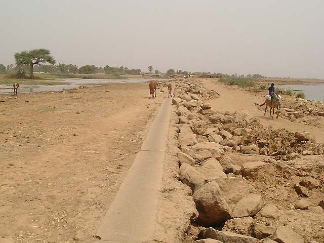
- the 27 km long Maga dam, with a maximum height of 6m. The dam extends from
the village of Guirvidig in the west (left abutment) to Pouss in the east (right
abutment)
- associated dikes along the left bank of the Logone, extending for 100km from
Yagoua to Tekele, upstream and downstream of Pouss respectively
- the Djafga canal, which connects the river Logone and the upstream end of the
reservoir
- a 750m long spillway which provides a hydraulic connection between the
reservoir and the Logone river
- the main offtake at Maga and four smaller irrigation offtakes
- the 7000 ha irrigation area
- the Mayo Vrik which provide the main drainage to the area
The scheme layout is shown in Figure 2.2
2.3 HYDROLOGY
2.3.1 Reservoir
characteristics
The characteristics of the reservoir are as follows:
Reference
Full storage level
312.5m
Level given by SEMRY: 312.72 is shown on
a the 1:200,000 Sogreah plan (Fig 2.2)
Minimum operational level 310.8m
Level given by SEMRY
Area at full storage level
400 km�
Mott MacDonald estimate
Volume at full storage level 680Mm�
Volume given by SEMRY
Volume at minimum
280Mm�
Volume given by SEMRY
operational level
Direct catchment area
6000 km�
Author's estimate (very approximate)
A tentative height storage curve is shown in Figure 2.3
2-1
Assessment of the Safety of Maga dam, Cameroon
______________________________________________________________________________________
313.5
312.5
311.5
310.5
309.5
reservoir level (m)
308.5
0
200
400
600
800
reservoir volume (Mcm)
Figure 2.3: Maga reservoir height storage curve
2.3.2 Direct catchment inflows
Five ephemeral streams known as mayo, drain the direct catchment area, of which two
main mayo, the Tsanaga and the Boula, whose catchments extend as far east as the
Mandara mountains to the west. No data were available on their mean annual inflow.
These mayo flow from August to October and are dry from November until July.
2.3.3 Indirect catchment inflows
Water flows into the reservoir from the Logone through three connections:
- The Mayo Gouerlou
- The Djafga canal
- The
spillway
Inflows to the reservoir via the mayo Gouerlou and the spillway are uncontrolled. Inflows
via the canal are controlled by an upstream weir and four 2.4mx1.78m sluice gates so as
to maintain the reservoir level between 312.10m and 312.19m from mid October to mid
February.
2.3.4 Floods
No flood data for the direct catchment were available for this appraisal.
Daily flows of the Logone river have been measured at Bongor, 75km upstream of Pouss,
since 1948. A plot of the annual maximum flows is presented in Figure 2.4. This plot
shows the marked reduction in flood peaks since the 1970's.
2-2
Assessment of the Safety of Maga dam, Cameroon
______________________________________________________________________________________
3000
2500
2000
1500
1000
Bongor (cumecs)
500
maximum annual flow at
0
1948
1958
1968
1978
1988
1998
year
Figure 3.4: annual maximum flows at Bongor
2.3.5 Evaporation
Annual evaporation from the reservoir is estimated at 1.85m, with the daily rate varying
between 3mm in August to 7mm in March-May: SEMRY estimate the annual loss of
water from the reservoir to be 200Mm�.
2-3
Assessment of the Safety of Maga dam, Cameroon
______________________________________________________________________________________
3 THE
INSPECTION
3.1 EMBANKMENT
3.1.1 Geometry
No construction details or drawings of the embankment were available for this appraisal.
The embankment appears to be a homogeneous embankment of compacted silty clay,
with the following dimensions:
- crest level:
314.25m
- crest
width:
3m
- upstream slope:
1v: 5h
- downstream slope:
1v : 2h
With the nominal crest level of 314.25m and a reported maximum reservoir level of
312.5m the minimum freeboard would be 1.75m. The actual level varies considerably
and in many places the minimum freeboard was observed to be considerably less than
1.75m. A level survey of the embankment crest is recommended.
3.1.2 Construction
For an embankment of this length it is most unlikely that the embankment fill was taken
from one or more borrow areas: it is much more likely that the material was excavated
from within the reservoir area, immediately upstream of the embankment. The evidence
for this, in the form of a lagoon running the length of the dam, was clearly visible at the
time of the visit. The fill material is a silty clay.
Similarly, it is probable that only the top layer of organic soil was stripped to a standard
depth by way of foundation preparation before embankment filling. It is possible that a
cut off trench was dug to reduce seepage, but prevailing high groundwater levels would
have made the excavation and filling of anything but a shallow trench difficult.
3.1.3 Crest
The crest level is variable, which probably results from variations in the quality of the
foundations resulting in post construction settlement. In addition there are regular dips of
about 20cm in the crest level at the points where access ramps have been built up the
downstream slope perpendicular to the dam axis. These ramps occur at approximately
100m centres.
3.1.4 Upstream slope
The upstream slope is not protected against wave attack except in the immediate vicinity
of the outlet structures. As a result wave action, which is particularly severe in August
and September when the reservoir is at its highest, has eroded material from the upper
part of the upstream slope and deposited it at lower levels, as illustrated in Figure 3.1 and
Photograph 1. This classic erosion process has already shortened the length of the
seepage path at reservoir full conditions and will undoubtedly continue until the entire
crest is eaten away, unless action is taken.
3-1
Assessment of the Safety of Maga dam, Cameroon
______________________________________________________________________________________
Figure 3.1: typical embankment cross section
Photograph 1: erosion of upstream shoulder
(photo credit: Nicholas Hodgson)
3.1.5 Downstream
slope
The downstream slope shows no sign of instability but has suffered moderate erosion
from rainfall. There is no sign of damage by burrowing animals and at the time of the
visit the downstream slope and the natural ground between the road and the downstream
toe appeared to be dry. However this strip of ground is widely reported to be wet when
the reservoir is full.
3.2 HYDRAULIC STRUCTURES
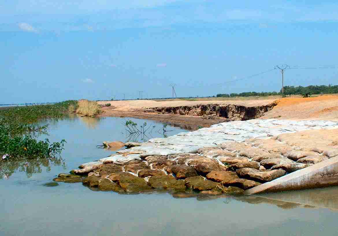
3.2.1 Spillway between the reservoir and the Logone
The spillway comprises a 750m long concrete cill set into the ground at 312.19m level, as
shown in Photograph 2.
3-2
Assessment of the Safety of Maga dam, Cameroon
______________________________________________________________________________________
Photograph 2: Maga/Lagone spillway in the dry season
The local guardian reports that the cill is submerged every year, with water flowing from
the river into the reservoir towards its upstream end and from the reservoir into the river
at its downstream end. This phenomenon is explained by the disparity between the
gradient of the water level in the river (about 1: 7500) and the horizontal water level in
the reservoir. Photograph 3, taken on October 7th 2001 after the flood peak, shows water
flowing out of the reservoir. During a major flood the river levels would be such that the
flow would be into the reservoir along the entire length of the spillway.
3-3
Assessment of the Safety of Maga dam, Cameroon
______________________________________________________________________________________
Photograph 3: flow from the reservoir into the Logone at the northern end of the
spillway. (photo credit Nicholas Hodgson)
3.2.2 Main outlet works
The main outlet works discharge into the Mayo Vrik and is situated at chainage
11+65km. The structure comprises five outlet culverts, each controlled by two 1.4m
x1.4m sluices with a maximum capacity of 10m�/s each, giving a total capacity of
100m�/s. However the downstream discharge channel is partially blocked by vegetation
and sediment deposits and its total capacity is reported to be only 6m�/s. The condition of
this structure is good.
3.2.3 Irrigation outlet works
There are four separate irrigation outlet works situated at the following chainages
(measured from the left abutment):
- 7+55km
- 15+6km
- 20+5km
- 26+5km
Each outlet comprises a concrete structure with two 2m x 2m sluices, each with 10m�/s
capacity, discharging into a concrete lined stilling basin.
3-4
Assessment of the Safety of Maga dam, Cameroon
______________________________________________________________________________________
4
THREATS TO THE INTEGRITY OF THE DAM
4.1 EMBANKMENT STABILITY
4.1.1 Upstream
The upstream slope of the embankment was constructed with a gentle slope and apart
from the erosion damage which is discussed below shows no sign of instability.
4.1.2 Downstream
Although the downstream slope has been constructed to a relatively steep slope there are
no signs of any instability. Should the upstream slope and crest continue to erode the pore
pressures in the downstream shoulder will increase during increased periods of high
reservoir level and slope and the risk of instability of the downstream slope will increase.
4.2 EXTERNAL EROSION
4.2.1 Waves
If no action is taken wave erosion will continue until the crest of the embankment is
eventually breached and the dam overtopped. To prevent this the damaged sections
should be repaired with compacted fill and the entire slope protected with stones between
elevations 312m and 313m.
Alternatively, or until this can be achieved, the maximum reservoir level should be
restricted to 312.2m.
4.2.2 Rainfall
The erosive effect of rainfall is not severe at present but should be kept under close
scrutiny: any area of the downstream slope where the erosion becomes particularly severe
should be repaired with compacted fill.
4.2.3 Overtopping
In the absence of any flood studies it is difficult to assess the threat posed by overtopping.
The maximum annual flow data presented in Figure 2.4 shows that the maximum flood
that has occurred in the Logone since the dam has been constructed was in 1994 when the
peak flow at Bongor was 1840m�/s. Unfortunately the records of river level at Pouss were
not available for inspection so it is not possible to know what the peak flow or river level
were at Pouss at that time. It is clear however that even the modest flood peaks that have
occurred in the lifetime of the dam have caused the reservoir level to rise to at least
312.5m, leaving a freeboard of less than 1.75m . The 1994 peak flow was only 67% of
the maximum recorded peak flow (2740m�/s in 1970) which itself should not be regarded
as a particularly severe event. It would seem to be probable that the return period of a
flood in the Logone that would result in the embankment being overtopped may be
relatively low, possibly as low as 1 in 100 years.
The situation is rendered even more complicated by the direct inflow into the reservoir of
the Mayo Boula and the Mayo Tsanaga. The author is not aware of any flood study that
has been carried out on these Mayo.
4-1
Assessment of the Safety of Maga dam, Cameroon
______________________________________________________________________________________
The ability of the embankment to resist erosion from overtopping is also difficult to
assess: the embankment is constructed of clay which by its nature is resistant to flowing
water and because the dike is very long the flow per metre length would also be low. This
would imply a shallow depth of water over the embankment crest � perhaps only a few
centimetres, and a low water velocity. It should also be considered that a major flood in
the Logone may also overtop the flood protection dikes downstream of Pouss so that the
entire area, including Maga would in any case be inundated.
However such considerations are always speculative and in the case of Maga dam, which
is unusually complicated hydraulically, especially so. The wisest policy is therefore to
prevent overtopping by means of additional spilling capacity. This can be achieved either
by restoring the original capacity of Mayo Vrik or by constructing a new spillway near
the left abutment. A detailed flood study would be required to determine the spillway
capacity required to prevent overtopping for the design flood, which should be taken to
be not less than 10,000 year return period.
4.3 INTERNAL EROSION
Anecdotal evidence suggests that there is considerable seepage through the embankment
and possibly its foundations when the reservoir level is above 312,2m level. All dams
suffer from seepage and seepage in itself is not necessarily a problem. The problem arises
if the seepage velocities are such as to erode material and thus create a void in the
embankment. Embankments composed of silt are especially vulnerable, clay
embankments such as Maga less so. The classic means of controlling internal erosion are
either to prevent the migration of solid particles by means of internal filters or to limit the
hydraulic gradient so that seepage velocities are kept low. Maga dam was not designed
with internal filters so the second option is the only one available. With the original
embankment geometry the maximum hydraulic gradient would have been 1 : 8, which is
safe. However the effects of the erosion of the upstream slope and the dam crest have
shortened the seepage path length with the result that at full reservoir level the hydraulic
gradient has increased to1 : 5. Further erosion will result in increases in the hydraulic
gradient so that if the embankment does not first fail by sliding it will fail by internal
erosion. It is therefore imperative to either repair the erosion damage or to reduce the
maximum reservoir level.
4-2
Assessment of the Safety of Maga dam, Cameroon
______________________________________________________________________________________
5 EMERGENCY
PLANNING
5.1 RESPONSIBILITY
It is understood that Cameroon Law holds the dam owner responsible for the safety of his
dam. In the case of Maga the dam is owned ultimately by the Ministry of Agriculture
through their wholly owned subsidiary SEMRY.
5.2 SURVEILLANCE
Although there is no formal safety plan at Maga, the daily records are kept of the
reservoir level and periodic inspections are made of the embankment. Unfortunately the
inspection was made at the weekend without any warning having been given to SAMRY,
with the result that the record of reservoir levels was not available. M Yaye Zigla, the
Head of the Unite des Travaux et des Services (UTS) was very helpful in providing a
description of the surveillance provided by SAMRY and the dam safety issues.
5.3 POPULATION AT RISK
The total population of the Maga scheme is estimated by SAMRY to be 20,000. However
many of these people live distant from the dam would not necessarily be at risk in the
case of a dam failure. Because the area downstream of the dam is so flat, the escaping
water would spread over a large area with relatively low velocities and depth. Therefore
it is reasonable to suppose that only the population living close to the dam would be at
risk of their lives. Clearly the most vulnerable population is that of Maga village, because
not only do they live close to the dam but also the dam is higher adjacent to the village
than elsewhere. The population of Maga is thought to number several thousand people.
5.4 WARNING SYSTEM
There is no formal warning system at Maga.
Warning systems work best when they can provide the population advance warning of a
possible emergency so that they can retreat to a safe haven on adjacent high ground. They
are usually triggered by a monitoring system that has identified unusual and unexplained
signals. At Maga there is no monitoring system other than the vigilance of the local
population and no adjacent high ground to retreat to.
However, as has been discussed in section 4 above, the most likely cause of an
emergency at Maga would follow from unusually high reservoir levels of which the
population at risk would be acutely aware.
5.5 EMERGENCY PREPAREDNESS
5.5.1 Routine
maintenance
The annual budget available for the maintenance of all ten dams owned by the Ministry
of Agriculture is F CFA 200million. The exact amount allocated to Maga dam is not
known but assuming all their dams face similarly acute problems, it will approximate to
F CFA 20 million or US$27,000
The SEMRY UTS have at their disposal the following plant in operational order:
- 1
scraper
5-1
Assessment of the Safety of Maga dam, Cameroon
______________________________________________________________________________________
- 2
bulldozers
- 2
trucks
- 1
loader
The use of this plant is often constrained for lack of funds for consumables � fuel etc, but
effort appears to be concentrated on emergency repairs and preventive work during
August � October when the reservoir level is at its highest. As an example, M. Zigli
recounted that last year they had carried out emergency repairs to five points on the dam
where there was excessive seepage.
5.6 CONCLUSION
The senior SEMRY manager resident at Maga, M Zigli understands his immediate
responsibility for the safety of Maga dam and works hard to discharge that responsibility.
He is of course severely restrained by lack of financial resources, but some technical
assistance and a relatively small budget specifically allocated to dam safety would yield
significant returns in terms of dam safety.
5-2
Assessment of the Safety of Maga dam, Cameroon
______________________________________________________________________________________
6
CONCLUSIONS & RECOMMENDATIONS
6.1 THREATS FACING THE DAM
There are two main threats facing the integrity of the dam:
1. continued erosion of the upstream face and crest of the embankment duse to wave
attack at high reservoir levels. If this continues unchecked it will result in one of
the following
- overtopping
- sliding failure of the downstream slope
- piping failure
2. overtopping of the embankment by a severe flood which would probably result
in a breach of the dam.
6.2 RECOMMENDATIONS: DAM SAFETY
6.2.1 Wave
erosion
There are two options that could be adopted to prevent the failure of the dam as a result
of wave damage, neither of which are easy or straightforward:
1. to repair the damaged portions of the embankment and protect the vulnerable zone
of the upstream face, between levels 312 and 313m, against wave attack. This is
the standard design imperative for the vast majority of embankment dams
2. to impose a limit on the maximum allowable reservoir level of 312.0m, some
0.5m lower than at present. This would result in the following:
- waves will break on the flatter slope of the embankment below the eroded
cliff. The flatter slopes will be effective in dissipating wave energy
- the longer seepage path will reduce the hydraulic gradient and thus reduce the
risk of piping failure
The repair and protect solution would of course be very expensive. The repairs would
involve the excavation of the damaged portions and the replacement of clay fill
compacted to the correct density and moisture content. The protection would involve
the placement of at least three layers of granular fill: a layer of sand adjacent to the
clay, a transition layer of coarse gravel or crushed rock and finally a layer of large
rock or rip-rap. Alternatively a protective system involving precast concrete blocks
placed on a geofabric could be considered. Even if only 10% of the upstream face
requires to be treated, the total cost, whichever solution were adopted, would cost
several million US dollars and would take several years to implement. Ultimately, of
course, it may be necessary to treat the entire 27km length of the embankment.
Lowering the maximum allowable reservoir level would reduce the volume of water
available for irrigation by approximately 100Mm�but would be entirely effective in
improving dam safety. The difficulty is how can the reservoir be controlled. The vast
majority of the inflows into the reservoir � the inflow of the Logone over the spillway
and the direct inflows of the Mayos Tsanaga and Boula cannot be controlled or even
accurately measured. The only available means of reservoir level control � releases
6-1
Assessment of the Safety of Maga dam, Cameroon
______________________________________________________________________________________
into Mayo Vrik � is quite ineffective. Thus controlling the reservoir level requires
either increasing the capacity of the controllable outflow or by reducing the inflow.
The outflow capacity can only be increased by either dredging the Mayo Vrik or by
costructing a new outlet structure as envisaged by Delft Hydraulics.
Inflows can only be reduced by raising the crest level of the 750m long
Maga/Longone spillway and reinforcing the flood protection dikes further upstream
as necessary.
Either of these options would be expensive, and like the repair-protect option would
take several years to implement.
6.2.2 Floods
The vast majority of embankment dams are provided with a spillway to evacuate extreme
floods so as to avoid overtopping. Maga dam is different from usual dams in that the
maximum reservoir level will depend almost totally on the river level at Pouss rather than
the volume of the inflow. Although a detailed flood study would be required to give a
reliable estimate of the return period of the overtopping flood it is likely to be low (that
is probable). Again there are two solutions available:
1. reduce inflows by raising the Maga/Logone spillway crest as discussed in 6.2.1
above and evacuate floods emanating from the direct catchment through the
existing outlet structure into Mayo Vrik, suitably dredged.
2. construct a new spillway towards the left abutment near the village of Guirvidig
A flood study would be required to confirm the details of
- the height to which the spillway should be raised
- the capacity required in Mayo Vrik
- the capacity of a new left abutment spillway
It is considered that dredging Mayo Vrik, which in many ways is highly desirable, would
not alone provide sufficient capacity to control the reservoir level in the event of an
extreme flood.
The first option, dredging the Vrik and raising the spillway crest level, is a major
undertaking which would require several years and many millions of dollars to
implement.
The left abutment spillway could be a relatively cheap undertaking, comprising a break at
a point where the embankment is 2-2.5 m high. The spillway would be uncontrolled and
the crest would be simply a concrete wall as at the Maga/Logone spillway, but set a little
lower at about 312m. It would be necessary to excavate a shallow unlined channel to
direct the flow clear of the SEMRY estate, possibly using the Arezilmatay channel shown
in Figure 6.2 of the Delft report and Figure 6.1 of this Report.
6-2
Assessment of the Safety of Maga dam, Cameroon
______________________________________________________________________________________
6.2.3 Conclusion
Solution for
Option
Embankment Overtopping
erosion
flood
Repair of embankment and protection against wave
attack
Controlling max reservoir level by raising Maga/Logone
spillway + dredging mayo Vrik
Controlling max reservoir level by constructing new left
abutment spillway
Only two options would ensure that the dam is safe against both threats. The first, raising
the Maga/Logone spillway, would in effect attempt to isolate the reservoir from the river
by construction a new dam along the left bank of the river. This would concentrate all the
flood flow of the Logone to the east of Pouss and would thus raise flood river levels.
The second option effectively provides more flood capacity and thus alleviates the
constriction at Pouss. The left abutment spillway could be constructed relatively quickly
and cheaply and could form the first stage of the option recommended by Delft in their
Flood Restoration Study.
6.3 RECOMMENDATIONS: SAFETY PLAN
6.3.1 Monitoring
It appears from the meeting with M Ziogli that SEMRY is already carrying out the basic
monitoring tasks. These however should be formalised and the results made more
accessible. Essential records that should be kept are:
- Daily readings of reservoir and river level
- Weekly readings of controlled inflows through the can sluices and outflows
- Records of walk over inspections � monthly in the dry season, weekly or even daily
at high reservoir level
- Record of all remedial or preventive works undertaken
In addition it is recommended that a detailed level survey of the embankment crest
should be carried out.
These records should be kept in a record book at the SEMRY office. In many countries
the law requires that such records should be checked for compliance annually by an
external inspector: a similar provision should be adopted at Magra.
6.3.2 Early
warning
Consideration should be given to the installation of a manually controlled siren situated at
the Vrik outlet to provide the most vulnerable population of a warning of a dam burst.
6-3
Assessment of the Safety of Maga dam, Cameroon
______________________________________________________________________________________
6.3.3 Emergency
stockpiles
Emergency stockpiles of materials and consumables should be maintained so that they
are readily available should the need arise. The following are considered essential:
Materials
Consumables
-
Clay
fill
-
diesel
-
Sand -
spares
- Gravel
- Sand
bags
6-4
Assessment of the Safety of Maga dam, Cameroon
______________________________________________________________________________________
References
1 Lake Chad Basin GEF Project: "Integrated Environmental and Social Assessment" - January
2002
2 Delft Hydraulics for IUCN: "Waza Longone Flood Restoration Study" � June 1994
3 Mott MacDonald: "Logone Floodplain Model Study Report" � May 1999
4 IUCN: "Rehabilitation of the Waza-Logone Floodplain: Proposals for the Re-inundation
Programme" � May 2000
6-5
Document Outline