Danube River Basin District
Part A - Roof report
Information required
according to Art. 3 (8) and Annex I
of the EU Water Framework Directive
Reporting deadline: June 22, 2004
Prepared by:
International Commission for the Protection of the Danube River (ICPDR) in cooperation with the
countries of the Danube River Basin.
The Contracting Parties to the Danube River Protection Convention and Bosnia-Herzegovina endorsed
this report at the 6th Ordinary Meeting of the ICPDR on December 1-2, 2003.
Overall compilation of country inputs, writing and editing were coordinated by Dr. Ursula Schmedtje,
Technical Expert for River Basin Management at the Secretariat of the ICPDR, in cooperation with the
members of the River Basin Management Expert Group.
ICPDR Document IC/077, 16-April-2004
International Commission for the Protection of the Danube River
Vienna International Centre D0412
P.O. Box 500
A-1400 Vienna, Austria
Phone: +(43 1) 26060 5738
Fax:
+(43 1) 26060 5895
e-mail: icpdr@unvienna.org
web:
http://www.icpdr.org/DANUBIS
3
Table of Contents
Information required according to Art. 3 (8) and Annex I WFD
1 INTRODUCTION ......................................................................................................... 5
1.1
Situation in the Danube River Basin District................................................................. 5
1.2
Status of this report ........................................................................................................ 6
2
STRUCTURE OF THE REPORT................................................................................. 6
3
INFORMATION GIVEN IN THE ROOF REPORT .................................................... 8
3.1 Competent
authorities .................................................................................................... 8
3.2
Geographical coverage of the Danube River Basin District.......................................... 8
3.2.1. The Danube River Basin District ................................................................................... 8
3.2.2. Characteristics of the Danube River and its main tributaries ....................................... 11
3.3
International relationships in order to ensure coordination ......................................... 13
3.3.1. General overview ......................................................................................................... 13
3.3.2. Coordination of WFD implementation at the basin-wide level.................................... 14
3.3.3. Bilateral and multilateral cooperation .......................................................................... 16
3.3.4. Cooperation of the ICPDR with the Black Sea Commission (ICPBS) ........................ 17
4
LIST OF ACRONYMS ............................................................................................... 17
5 ANNEXES................................................................................................................... 17
Annex 1: List of competent authorities on the national level (overview)
Annex 2: Convention on Cooperation for the Protection and Sustainable use of the Danube
River (Danube River Protection Convention)
Annex 3: Letters of commitment of Danube River Basin states, that have not signed the
Danube River Protection Convention, to cooperate with the ICPDR to implement
the WFD
Annex 4: Memorandum of Understanding between the International Commission for the
Protection of the Black Sea (ICPBS) and the International Commission for the
Protection of the Danube River (ICPDR) on common strategic goals
4
5
1 INTRODUCTION
1.1 Situation in the Danube River Basin District
The Danube River Basin is the second largest river basin of Europe1 covering 801 463 km˛ and
territories of 18 states including EU-Member States, accession states and non accession states. Where
a river basin district extends beyond the territory of the Community, the Water Framework Directive
2000/60/EC (WFD) requests the Member State or Member States concerned to ,,endeavour to
establish appropriate coordination with the relevant non-Member States, with the aim of achieving
the objectives of this Directive throughout the river basin district." (Art. 3.5 WFD).
The International Commission for the Protection of the Danube River (ICPDR) serves as the platform
for coordination to develop and establish the Danube River Basin Management Plan (DRBMP). In
November 2000 all Contracting Parties of the "Convention on Cooperation for the Protection and
Sustainable Use of the Danube River" (Danube River Protection Convention, DRPC) stated their
commitment to implement the WFD within their jurisdiction and to cooperate in the framework of the
ICPDR to achieve a single, basin-wide coordinated Danube River Basin Management Plan. For states
with territories of less than 2 000 km˛ in the Danube River Basin (DRB) the ICPDR has attempted to
establish appropriate bilateral coordination (for details see Chapter 3.3.2).
At the time of reporting eight states in the Danube River Basin are EU-Members, two are in the
accession process and one has applied for EU-Membership (see Table 1). By the time the deadline for
the completion of the River Basin Management Plan is reached in December 2009 probably two more
Danube states will have become EU Members.
Table 1 States in the Danube River Basin District
State ISO-Code
Status in the European Union2
Albania AL
-
Austria AT
Member
State
Bosnia-Herzegovina BA
-
Bulgaria
BG
Accession State
Croatia
HR
Accession Applicant (February 2003)
Czech Republic
CZ
Member State
Germany DE
Member
State
Hungary HU
Member
State
Italy IT
Member
State
Macedonia MK
-
Moldova MD
-
Poland PL
Member
State
Romania
RO
Accession State
Serbia-Montenegro CS
-
Slovak Republic
SK
Member State
Slovenia SI
Member
State
Switzerland CH
-
Ukraine UA
-
1 The area of the DRB was determined digitally with GIS. If other sources are consulted this value may vary slightly, because
other methods of calculation have been used.
2 The table reflects the situation at the time of reporting (June 2004).
6
The EU candidate countries in the Danube River Basin, which are scheduled to join on May 1, 2004,
have committed themselves to transpose and implement the WFD without any specific transposition
provisions, i.e. in the same deadlines as for Members States. Only when the WFD refers to another
piece of Community legislation where a transitional period has been granted, e.g. the Urban Waste
Water Treatment Directive (91/271/EEC), this period applies. Legal transposition is currently taking
place in all candidate countries at different paces, similar to the EU Member States. All of the
accession states are committed to completing transposition by the date of accession. For the
candidates, which may join in 2007, the WFD is part of the `acquis communautaire'. So far, no
transitional periods have been requested by these states. Croatia has applied for accession to the
European Union in February 2003. They have no reporting obligations but they are following the
process.
1.2 Status of this report
This report was agreed by all Contracting Parties under the Danube River Protection Convention and
Bosnia-Herzegovina at the 6th Ordinary Meeting of the ICPDR on December 1-2, 2003 in Vienna.
2 STRUCTURE OF THE REPORT
Due to the large number of states and the coordination requirements in the Danube River Basin
District (DRBD) it is necessary to divide the Danube River Basin Management Plan into two parts.
Part A (roof of the DRBMP) gives relevant information of multilateral or basin-wide importance,
whereas Part B (national input to DRBMP) gives all relevant further information on the national level
as well as information coordinated on the bilateral level (see Figure 1).
The ICPDR has a coordinating and supporting function, but does not report on its own. Each state will
deliver the roof report (Part A) and its own national report (Part B). This approach is also undertaken
for the delivery of information required according to Art. 3 (8) and Annex I WFD. In addition, the
ICPDR will informally send a copy of the roof report and a copy of the national reports (Part B) of
those countries not obligated to report to the European Commission.
Part A: Roof report
coordinated by the ICPDR
2
IC
o
rts
IC
L
3
ł
BL
PUB
NA
RO
E
o
n
a
l
rep
ti
EG
NY
1
A
IA
A
E
IA
-
GOVI
R
H REPU
ENIA
A
EN
A
C
IA-
V
SNI
RZE
B
NT
a
rt B: Na
P
GERMA
AUSTR
CZE
SLOVAK R
HUNGARY
SLO
CROATI
BO
HE
SER
MO
BULG
ROMANI
MOLDOVA
UKRAIN
including bilateral coordination: 1 with Switzerland and Italy, 2 with Poland, 3 with Albania and Macedonia
EU-Member States
Accession States
Accession applicants
Others
Figure 1: Structure of the report for the Danube River Basin District3
3 This figure reflects the situation at the time of reporting (June 2004).
7
Part A Roof report
The roof report contains information on issues of multilateral or basin-wide importance and
demonstrates the basin-wide coordination arrangements. This report will be sent by the states to
the European Commission with the national reports.
It is identical for all states. The ICPDR serves as the platform for coordination. The content of the
management plan results from the work of the ICPDR expert groups and is approved by the
ICPDR Ordinary Meetings.
The roof report addresses those issues of Annex I WFD relevant on the basin-wide scale, i.e.
information concerning the
1. Name and address of the competent authorities
2. Geographical coverage of the Danube River Basin District, and
6. International relationships.
Part B National report
The national report gives all relevant further information on the national level as well as
information coordinated on the bilateral level. It addresses all issues listed in Annex I WFD.
Regarding points 1., 2. and 6. the national information is given in addition to the information in
Part A.
The information needed to fulfill the requirements of Art. 3 (8) and Annex I WFD will be covered in
Part A (roof report) and Part B (national reports) as follows:
Part A
Part B
Roof report
National reports
1. Name and address of the competent authorities
X
X
2. Geographical coverage of the river basin district
X
X
3. Legal status of competent authority
X
4. Responsibilities
X
5. Membership
X
6. International relationships
X
X
Regarding 1. Name and address of the competent authorities the information given in Part A will be
for information purposes, in Part B for reporting purposes.
Regarding 2. Geographical coverage of the river basin district an overview of the Danube River Basin
District will be given in Part A. Part B will add further information on the national level.
Regarding 6. International relationships Part A will describe the international relationships to ensure
basin-wide coordination and will include an overview on existing bi- or multilateral agreements of the
Danube states. Part B will contain further information on bi-/multilateral agreements and other forms
of cooperation.
8
3 INFORMATION GIVEN IN THE ROOF REPORT
3.1 Competent authorities
The competent authorities are designated by the states. The link between these on the international
level is ensured through the ICPDR and its Contracting Parties. The ICPDR serves as the platform for
coordination for the implementation of the WFD in the Danube River Basin District on issues of
basin-wide importance (see chapter 3.3.2). A list of the (national) competent authorities is attached in
Annex 1 (overview).
3.2 Geographical coverage of the Danube River Basin District
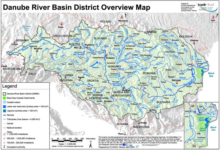
3.2.1. The Danube River Basin District
The Danube River Basin District covers 1) the Danube River Basin, 2) the Black Sea coastal
catchments on Romanian territory, and 3) the Black Sea coastal waters along the Romanian and partly
the Ukrainian coast (see Table 2).
Table 2 Area of the Danube River Basin District
Official area
Digitally determined
Territory
[km˛]
area [km˛]1
Danube River Basin (DRB)
18 countries (see Table 3)
801 463
Black Sea coastal river basins
Romania
5 198
5 122
Black Sea coastal waters
Romania and Ukraine
1 242
Danube River Basin District (DRBD)
807 827
1 For the purpose of comparison the areas were calculated using GIS on the basis of the DRBD overview map. The value for
the Black Sea coastal river basins differs slightly from the official data, since other methods of calculation have been used.
Figure 2 shows the geographical coverage of the Danube River Basin District. The outer boundary of
the Danube River Basin District was defined taking into consideration the hydrological boundaries of
the surface waters and groundwater. In a few small places the district boundaries of groundwater and
surface waters are not aligned (Germany, Slovenia and Bulgaria). Details can be found in the
respective national reports.
In addition to the Danube River Basin, the small coastal basins of the Black Sea tributaries lying on
Romanian territory between the Eastern boundary of the DRB and the coastal waters of the Black Sea
have been included in the Danube River Basin District. Here also lies the Danube-Black Sea Canal
(Canal Dunarea-Marea Neagra), which diverts part of the water of the Danube River directly to the
Black Sea. These coastal catchments were included in the DRBD, because they influence the coastal
waters along the Romanian coastline. The other Danube states agreed with including the Black Sea
tributaries on Romanian territory into the DRBD.
The coastal waters of the DRBD extend along the full length of the Romanian coastline and along part
of the Ukrainian coast up to the hydrological boundaries of the Danube River Basin. The Romanian
coastal waters were included in the DRBD, because the water quality and the morphology of the
seashore are substantially influenced by the Danube River. The Romanian coastal waters are
delineated at 1 nautical mile from the baseline, which is defined along 9 points within the territorial
sea of Romania as laid down in the Romanian Law No. 17/1990, modified by Romanian Law No.
36/2002. A detailed description of the coastal waters is contained in the Romanian national report
(Part B). The Ukrainian coastal waters are not defined by Ukrainian law. For WFD implementation
the coastal waters are defined in line with Art. 2.7 WFD at 1 nautical mile from the baseline.
Figure 2 Geographical coverage of the Danube River Basin District
10
Table 3 Coverage of the states in the Danube River Basin (DRB) and estimated population
(data source: Competent authorities in the DRB unless marked otherwise)
Official
Digitally
Percent of
Percentage
Percentage
Population
coverage
determined
population
State Code
of DRB
of DRB
in DRB
in DRB
coverage in
in DRB
[%]
in state [%]
[Mio.]
[km˛]
DRB [km˛]1
[%]
Albania
AL
126
< 0.1
0.01
< 0.01
< 0.01
Austria
AT
80 423
10.0
96.1
7.7
9.51
Bosnia-
Herzegovina
BA
36 636
4.6
74.9
2.9
3.58
Bulgaria
BG
47 413
5.9
43.0
3.5
4.32
Croatia
HR
34 965
4.4
62.5
3.0
3.71
Czech Republic
CZ
22 870
2.9
31.1
2.8
3.46
Germany
DE
56 184
7.0
16.8
9.3
11.49
Hungary
HU
93 030
11.6
100.0
10.2
12.60
Italy 2
IT
565
< 0.1
0.2
0.02
0.02
Macedonia
MK
109
< 0.1
0.2
< 0.01
< 0.01
Moldova
MD
12 834
1.6
35.6
1.1
1.36
Poland
PL
430
< 0.1
0.1
0.04
0.05
Romania
RO
232 193
29.0
97.4
21.0
25.94
Serbia-
CS
88 635
11.1
90.0
9.8
12.11
Montenegro
Slovak Republic
SK
47 084
5.9
96.0
5.2
6.42
Slovenia
SI
16 422
2.0
81.0
1.7
2.10
Switzerland
CH
1 809
0.2
4.3
0.02
0.02
Ukraine
UA
30 520
3.8
5.4
2.65
3.27
Total
100
80.95
100
1 For the purpose of comparison the coverage of the states was calculated using GIS based on the DRBD overview map.
These values differ slightly from the official data of some countries, since other methods of calculation have been used.
2 Data source: Autonomous Province of Bozen South Tyrol.
The coastal waters of Bulgaria are not included in the DRBD, since their characteristics are
substantially influenced by rivers on Bulgarian territory flowing into the Black Sea and by processes
in the Black Sea itself. The Bulgarian Water Law of 1999 designates 4 river basin districts in the
country. Their boundaries are based on the hydrological boundaries of the watersheds (surface water
and groundwater) between the river basins. Following these hydrological considerations, and the
provisions of Article 3 (1) of the WFD, Bulgarian coastal waters are assigned to the Black Sea River
Basin. The latter covers 25.2 % of the country's surface area and includes all rivers on Bulgarian
territory flowing into the Black Sea, coastal waters and territorial waters (Article 152 (1) 2 of the
Water Law). The other Danube States agreed with the inclusion of the coastal waters of Ukraine and
Romania into the DRBD and the exclusion of Bulgarian coastal waters.
The Danube River Basin District overview map depicts:
· the outer boundary of the Danube river basin district,
· the boundaries of the Danube River Basin and of the Black Sea coastal catchments,
· the boundaries of the coastal waters belonging to the DRBD,
· all rivers with catchments larger than 4000 km˛,
· all lakes, lagoons and reservoirs with a surface area of at least 100 km˛,
· the main canals used for navigation,
· the main cities including the capitals of the countries, and
· the locations of the competent authorities.
11
3.2.2. Characteristics of the Danube River and its main tributaries
The Danube River Basin is the second largest river basin of Europe, covering 801 463 km˛ and
territories of 18 countries (see Table 3). The Danube is 2780 km long and has an average discharge of
6460 m3/sec at its mouth in the Danube Delta. Some of its largest tributaries are characterised below.
Their key hydrologic characteristics are listed in Table 4.
The Inn is the third largest by discharge and the seventh longest Danube tributary. At its mouth in
Passau, it brings more water into the Danube than the latter itself. However, its catchment area of
26 130 km˛ is only nearly half as big as the Danube at this point. The main tributary of the Inn is the
Salzach River.
The Morava/March River is a left hand tributary of the Danube. Its catchment area of 26 658 km˛
covers parts of the Czech Republic, Slovakia and Austria. In terms of geological structure, this basin
forms a boundary between the Bohemian Highlands, the Carpathians and the Pannonian Province. It
is an ecologically valuable area with high diversity of species and landscape types.
The Drau/Drava is the fourth largest and fourth longest Danube tributary. It rises in the southern
Alps in Italy but is the dominant river of southern Austria, eastern Slovenia, southern Hungary and
Croatia. Main Austrian sub-tributaries are Isel, Möll, Lieser and Gurk, and the Mur/Mura with its
mouth at the Croatian-Hungarian border.
The Tysa/Tisza/Tisa River basin is the largest sub-basin in the Danube River Basin (157 186 km˛). It
can be divided into three main parts:
- the mountainous Upper Tysa in Ukraine (upstream of the Ukrainian-Hungarian border),
- the Middle Tisza in Hungary (receiving the largest tributaries: Bodrog River and Slaná/Sajó River
collecting water from the Carpathian Mountains in Slovakia and Ukraine as well as the
Somes/Szamos River, the Crisul/Körös River System and Mures/Maros River draining
Transylvania in Romania), and
- the Lower Tisa (downstream of the Hungarian-Serbian border, where it receives the Bega/Begej
directly, and other tributaries indirectly through the Danube Tisza Danube Canal System).
The Tysa/Tisza/Tisa River is also the longest tributary (966 km). By flow volume it is second largest
after the Sava River.
The Sava River is the largest Danube tributary by discharge (average 1564 mł/sec) and the second
largest by catchment area (95 419 km˛). It rises in the western Slovenian mountains and passes
through Croatian lowland before forming the border between Croatia and Bosnia-Herzegovina.
Continuing through Serbia-Montenegro it reaches its confluence with the Danube in Belgrade. Its
main sub-tributaries are Krka, Kupa, Una, Vrbas, Bosna, Drina and Kolubara.
The Iskar is the largest Danube tributary on Bulgarian territory. It springs from the Rila mountain
passes, flows through the outskirts of Sofia, crosses the Balkan mountains and continues its 368 km
long way to the Danube. Its catchment area is 8 684 km˛.
The Siret River Basin has the third-largest catchment area and is situated to the east of the
Carpathians. Its source lies in Ukraine and it flows through the territory of Ukraine and Romania. Its
main sub-tributaries are Suceava, Moldova, Bistrita, Trotus, Barlad and Buzau.
The Prut River is the second longest (950 km) and the last tributary of the Danube, with its mouth
just upstream of the Danube Delta. Its source is in the Ukrainian Wood Carpathians. Later it forms the
border between Romania and Moldova. Main sub-tributaries are Ceremosh, Derelui, Volovat, Baseu,
Corogea, Jijia, Chineja, Ciugur and Lapusna.
The Danube Delta is largely situated in Romania and partly in Ukraine. The entire protected area
covers 679 000 ha including floodplains and marine areas. The core of the reserve (312 400 ha) has
been established as a "World Nature Heritage" in 1991. There are 668 natural lakes larger than one
hectare covering 9.28 % of the Delta's surface. The Delta is an environmental buffer between the
Danube River and the Black Sea, filtering out pollutants and enabling both water quality conditions
and natural habitats for fish in the Delta and in the environmentally vulnerable shallow waters of the
north-western Black Sea. Moreover, it is Europe's largest remaining natural wetland a unique
ecosystem.
12
Table 4 The Danube and its main tributaries (catchments > 4 000 km˛) in the order of their
confluence with the Danube from the source to the mouth (data source: Competent
authorities in the DRB unless marked otherwise)
River Mouth
at
Length
Size of
Average
Time series
Danube km
[km]
catchment
discharge
for discharge
[km˛]1
[mł/sec]
values
Danube
0
2780
801 463
6 460
(1914-2003)
Lech
2 497
254
4 125
115
(1982-2000)
Naab
2 385
191
5 530
49
(1921-1998)
Isar
2 282
283
8 964
174
(1926-1998)
Inn
2 225
515
26 130
735
(1921-1998)
Traun
2 125
153
4 257
150
(1961-1999)
Enns
2 112
254
6 185
200
(1961-1999)
Morava/March
1 880
352
26 658
110
(1961-1999)
Raab/Rába
1 794
240
14 349
63
(1901-2000)
Vah
1 766
398
18 296
161
(1931-1980)
Hron
1 716
278
5 463
55
(1931-1980)
Ipel/Ipoly
1 708
197
5 108
22
(1931-1980)
Sió
1 498
124
14 693
39
(1931-1970)
Drau/Drava
1 382
893
41 238
577
(1946-1991)
Tysa/Tisza/Tisa
1 214
966
157 186
794
(1946-1991)
Sava
1 170
861
95 419
1 564
(1946-1991)
Tamis/Timis
1 154
359
10 280
47
(1946-1991)
Morava (CS)
1 103
430
37 444
232
(1946-1991)
Timok
846
180
4 630
31
(1946-1991)
Jiu
694
339
10 080
86
(1921-2003)
Iskar 636
368
8
684
54
(1936-1998)
Olt 604
615
24
050
174
(1921-1995)
Yantra 537
285
7
879
47
(1936-1998)
Arges 432
350
12
550
71
(1914-2003)
Ialomita 244
417
10
350
45
(1915-2003)
Siret 155
559
47
610
240
(1921-2003)
Prut 132
950
27
540
110
(1928-2003)
1 For the purpose of comparison the size of the catchments was calculated using GIS on the basis of the DRBD overview
map. These values may differ slightly from the official data, because other methods of calculation have been used.
Figure 3 is based on data calculated with the "Danube Water Quality Model", which was developed
during the Danube River Pollution Reduction Programme in 1999. It shows the relative contribution
of run-off into the Danube divided by the states where the run-off originates from. Austria shows by
far the largest contribution (22.1 %) followed by Romania (17.6 %). This reflects the high
precipitation in the Alps and in the Carpathian mountains. In the upper part of the Danube the Inn
contributes the main water volume adding more water than the Danube has at the point of confluence
with the Inn. In the middle reach it is the Drava, Tisza and Sava, which together contribute almost
half of the total discharge that finally reaches the Black Sea.
13
250 M990604g
water 10003 m3/a
Germany
Austria
Czech_Re
Slovakia
200
8.6
(4.3%)
Hungary
Slovenia
Croatia
Yugoslav
1.5
(0.7%)
Bosnia_H
Bulgaria
Romania
Moldova
Ukraine
35.6
(17.6%)
7.5
(3.7%)
150
17.8
(8.8%)
23.0
(11.3%)
100
13.0
(6.4%)
6.3
(3.1%)
8.8
(4.3%)
3.9
(1.9%)
2.5
(1.2%)
44.8
(22.1%)
50
29.5
(14.5%)
0
total 202.8
(100%)
r
U
r
r
r
c
e
e
e
e
d
er
Y
d
u
o
r
d
r
r
d
er
o
o
r
d
so
b
b
CR/
bo
b
bor
-H
o
t
O
G
D-A
K
RO
H
-R
-B
-
-S
U
U
A
/
Y
Y
BG
a
Inn
a
v
r
Delta
Mo
Drava
Iron Gate
690 m3/s
2310 m3/s Tisa
5520 m3/s
6550 m3/s
2860 m3/s Sava
3550 m3/s
Figure 3 Contribution of the water from each state (in %) to the cumulative discharge of the
Danube (in Mio m3/year), based on data for 1994-1997 using the `Danube Water Quality Model'
3.3 International relationships in order to ensure coordination
3.3.1. General
overview
In view of the size and number of states that have territories in the Danube basin coordination is
required on different levels in order to fulfil "the environmental objectives established under Article
4, and in particular all programmes of measures" (Art. 3.4 WFD). "In the case of an international
river basin district extending beyond the boundaries of the Community, Member States shall
endeavour to produce a single river basin management plan, and, where this is not possible, the plan
shall at least cover the portion of the international river basin district lying within the territory of the
Member State concerned." (Art. 13.3 WFD).
The roof report covers transboundary issues of basin-wide relevance. Other transboundary issues will
be dealt with in the national reports (i.e. issues with limited transboundary impacts).
For the development of the Danube River Basin Management Plan different international coordination
mechanisms are in place:
Framework for cooperation
Area of cooperation
International Commission for the Protection of
Danube River Basin
the Danube River (ICPDR)
Bilateral/multilateral cooperation
All other transboundary issues
not covered by the ICPDR
14
The ICPDR serves as the platform for coordination in the implementation of the WFD in the Danube
River Basin District on issues of basin-wide importance. Transboundary issues not covered by the
ICPDR are solved at the appropriate level of cooperation e.g. in the frame of bilateral/multilateral
river commissions. Local issues remain a national task. Generally, coordination will take place at the
lowest level possible so that the coordination via the ICPDR can be limited to those issues necessary
on the basin-wide level.
3.3.2. Coordination of WFD implementation at the basin-wide level
The Danube River Protection Convention forms the overall legal instrument for cooperation and
transboundary water management in the Danube River Basin (see Annex 2). The main objective of
the convention is the sustainable and equitable use of surface waters and groundwater and includes
the conservation and restoration of ecosystems. The Contracting Parties cooperate on fundamental
water management issues and take all appropriate legal, administrative and technical measures, to
maintain and improve the quality of the Danube River and its environment. Presently, Austria,
Bulgaria, Croatia, the Czech Republic, Germany, Hungary, Moldova, Romania, the Slovak Republic,
Slovenia, Serbia and Montenegro, Ukraine and the European Community are Contracting Parties to
the DRPC. Bosnia and Herzegovina has an observer status.
To facilitate the implementation of the DRPC, the Danubian states agreed that with its entry into force
the ICPDR is established. The ICPDR is therefore the framework for basin-wide cooperation (see
Figure 4).
Organisational Structure under the Danube River Protection Convention
CONFERENCE OF THE PARTIES
International Commission for the Protection
of the Danube River (ICPDR)
Implementation of Danube River Protection Convention (DRPC)
Decision making, management and coordination of regional cooperation
UNDP/GEF
Approval of the budget and annual work programme
Danube Regional Project
Follow up of activities and evaluation of results from Expert Groups
Creation of sustainable ecological condi-
Joint Action Programme
tions for land use and water mgmt
Capacity building and reinforcement of
trans-boundary cooperation
Strengthening public involvement in
Legal and Strategic issues
Permanent Secretariat (PS)
environmental decision making
(ad-hoc S EG )
Reinforcement of monitoring, evaluation
Supporting the ICPDR sessions
Strategic issues
and Information System
Supporting the Expert Groups
Legal issues
Administrative and
Coordinating the work programme
financial issues
Supporting project development and implementation
Maintenance of the Information System
River Basin Management
Ecology
Emissions
Monitoring, Laboratory
Accident Prevention
Flood Protection
( RBM EG )
( ECO EG )
( EMIS EG )
and Information Mgmt
and Control
( FP EG )
Integrated river basin
Emissions from point
( MLIM EG )
( APC EG )
management
Habitats and species
sources
Trans-National
Accident pol ution
Preparation and imple-
Implementation of the
protection areas
Emissions from diffuse
Monitoring Network
incidents
mentation of Action Plan
EU Water Framework
Management of
sources
Laboratory Quality
AEWS operation
for Sustainable Flood
Directive
wetlands and floodplains
Guidelines on BAT
Assurance
Accident prevention
Protection
Cartography and
GIS
( RBM/GIS ESG )
Danube Black Sea
Joint Technical WG
Economic
Analysis
( RBM/ECON ESG )
Figure 4: Organisational structure under the Danube River Protection Convention
15
At its 3rd Ordinary Meeting on November 27-28, 2000 in Sofia the ICPDR made the following
resolutions:
· The ICPDR will provide the platform for the coordination necessary to develop and establish the
River Basin Management Plan for the Danube River Basin.
· The Contracting Parties ensure to make all efforts to arrive at a coordinated international River
Basin Management Plan for the Danube River Basin.
In the ICPDR all Contracting Parties and Bosnia-Herzegovina as an observer support the
implementation of the WFD in their territories and cooperate in the framework of the ICPDR to
achieve a single, basin-wide coordinated Danube River Basin Management Plan. The ICPDR
President has addressed the other DRB countries not cooperating under the DRPC to commit
themselves to cooperate with the ICPDR to achieve a basin-wide coordinated DRBMP. Poland,
Switzerland, Macedonia and Albania have offered their support (see Annex 3). From Italy no
response was received. On the operational level, it is the obligation of the Contracting Parties to
ensure the necessary coordination with their DRB neighbours not cooperating under the DRPC.
The River Basin Management Expert Group was created to prepare and coordinate the necessary
activities for the implementation of the WFD. All states cooperating under the DRPC are represented
in the River Basin Management Expert Group. The group jointly agrees on the necessary actions for
the development of the Danube River Basin Management Plan, e.g. the development of a strategy for
establishing the RBM Plan, development of the roof report to the European Commission or
identifying needs for harmonisation of methods and mechanisms (see Figure 5).
The Danubian states cooperating under the DRPC report regularly to the ICPDR on the progress of
WFD implementation in their own states. These national reports serve as a means for exchanging
information between the states and for streamlining the implementation activities on the national
level. At each of its Ordinary Meetings and Standing Working Group Meetings the ICPDR deals with
the step-wise implementation of the WFD in the Danube River Basin and takes the necessary
decisions.
CH
IT
DE
UA
Bilateral agreements
AT
(examples)
PL
MD
CZ
ICPDR RBM
EG
- coordination
SK
RO
- information exchange
- develop strategy for RBM Plan
- develop DRB roof report for EC
- harmonisation of methods and
HU
BG
mechanisms
SI
CS
MK
BA
HR
Bilateral agreements
(examples)
AL
Figure 5 Coordination mechanisms for WFD implementation in the Danube River Basin (for
an overview of existing bilateral agreements see Table 5)
16
3.3.3. Bilateral and multilateral cooperation
Bilateral agreements are in place between almost all states in the Danube River Basin District, but it is
important to note that these agreements were not "established in order to ensure coordination" as
stated in WFD Annex I, 6. These are generally older treaties that deal with specific issues of
transboundary cooperation, which in many cases includes water management issues. Some of these
agreements have been adapted to cover issues related to WFD implementation, but generally they are
only used as the platform for coordination needed to fulfil the requirements of the WFD.
Bilateral agreements are in place between almost all the States that participate in the implementation
of the WFD in the Danube River Basin District. A very recent multilateral agreement is the
"Framework Agreement on the Sava River Basin" (entry into force at present pending). On the Tisza
River a multilateral cooperation has been initiated in the frame of the "Environmental Programme for
the Tisza River Basin" and the "Budapest Declaration" (Tisza Water Forum).
Like the DRPC the bilateral and multilateral agreements at present do not with the exception of the
Sava River Basin Agreement and the Environmental Programme for the Tisza River Basin make
reference to the WFD. Nevertheless, the fora based on these agreements are utilised for the
implementation of the WFD just as in the case of the ICPDR. They therefore serve as a platform for
cooperation for those issues that are best dealt with at the sub-basin level.
Table 5 gives an overview of the existing agreements and on the commissions based on them that are
being used for WFD implementation. There are cases where no formally approved bilateral
agreements and commissions implementing them exist, but regular meetings serve to facilitate
cooperation. Detailed information on the modes of cooperation at the bilateral and multilateral level
will be given in the national reports. The reports of Slovenia, Croatia, Serbia-Montenegro and Bosnia-
Herzegovina will include a short summary of the "Framework Agreement on the Sava River Basin".
Table 5 Overview of bilateral agreements and bilateral cooperations for WFD implementation
in the Danube River Basin District
AL AT BA BG CH CS CZ DE HR HU
IT MD MK
PL RO
SI
SK UA
AL
X
AT
(X) X X X (X) X X
BA
X
BG
X X X
CH
(X)
CS
X X
X
X
CZ
X
X X X
DE
X X
HR
X
X X
HU
X X X
X
X
X
X
IT
(X)
MD
X X
MK
X
PL
X
X
X
RO
X X X X
X
SI
X
X
X
SK
X X X X
X
UA
X X X
X X
X = formal agreement between neighbouring states, (X) = bilateral cooperation without formal agreement
17
3.3.4. Cooperation of the ICPDR with the Black Sea Commission (ICPBS)
Eutrophication is one of the principle causes for the degradation of the Black Sea. The land-based
input of nutrients via the Danube River into the Black Sea is claimed to be the most important driving
force for its eutrophication. In view of these cause-effect relationships a Memorandum of
Understanding (MoU) was signed by the ICPDR and the International Commission for the Protection
of the Black Sea (ICPBS) on November 26, 2001 in Brussels (see Annex 4) .
For its implementation the DanubeBlack Sea Joint Technical Working Group was charged with the
task, to assure the implementation of all technical measures of the MoU with particular attention to
the assessment of nutrient inputs into the Black Sea and the ecological status of the Black Sea.
Relevant information will be utilised in this context as much as possible. However, the ICPDR does
not cooperate with the ICPBS in a legal context relating to the implementation of the WFD within the
Danube River Basin District. The MoU is used as a basis to join the efforts of the states participating
in the commissions' activities to implement the WFD.
4 LIST OF ACRONYMS
DRB
Danube River Basin
DRBD Danube River Basin District
DRBMP Danube River Basin Management Plan
DRPC Danube River Protection Convention
EU
European Union
GEF
Global Environment Facility
ICPBS International Commission for the Protection of the Black Sea
ICPDR International Commission for the Protection of the Danube River
MoU
Memorandum of Understanding
UNDP United Nations Development Programme
WFD
Water Framework Directive
5 ANNEXES
Annex 1: List of competent authorities on the national level (overview)
Annex 2: Convention on Cooperation for the Protection and Sustainable use of the Danube River
(Danube River Protection Convention)
Annex 3: Letters of commitment of Danube River Basin states, that have not signed the Danube River
Protection Convention, to cooperate with the ICPDR to implement the WFD
Annex 4: Memorandum of Understanding between the International Commission for the Protection of
the Black Sea (ICPBS) and the International Commission for the Protection of the Danube
River (ICPDR) on common strategic goals
Document Outline