UNDP/GEF DANUBE REGIONAL PROJECT
"STRENGTHENING THE IMPLEMENTATION CAPACITIES FOR NUTRIENT REDUCTION AND
TRANSBOUNDARY COOPERATION IN THE DANUBE RIVER BASIN"
ACTIVITY 1.1.6 "DEVELOPING THE TYPOLOGY OF SURFACE WATERS AND
DEFINING THE RELEVANT REFERENCE CONDITIONS"
FINAL REPORT
prepared by
Dr. Mario Sommerhäuser
Dipl. Biol. (RO) Sabina Robert
Dipl. Umweltwiss. Sebastian Birk
PD Dr. Daniel Hering
at
University of Duisburg-Essen
D-45117 Essen, Germany
Univ. Prof. Dr. Otto Moog
DI Dr. Ilse Stubauer
DI Thomas Ofenböck
at
BOKU University of Natural Resources and Applied Life Sciences
A-1180 Vienna, Austria
December, 2003
This report has been prepared in cooperation with the following national consultants:
Name Country
Institution
Franz Schöll
Germany
German Federal Institute of Hydrology
Gunter Seitz
Germany
Government of Lower Bavaria
Veronika Koller-
Ministry for Agriculture, Forestry, Environment and
Austria
Kreimel
Water
Ministry for Agriculture, Forestry, Environment and
Birgit Vogel
Austria
Water
Ilja Bernardova
Czech Republic
Water Research Institute T.G.M. Prague
Karel Brabec
Czech Republic
Masaryk University
Jarmila Makovinska
Slovakia
Water Research Institute
Béla Csányi
Hungary
Water Resources Research Centre (VITUKI)
Országos Vízügyi Figazgatóság / National Water
László Perger
Hungary
Authority
Országos Vízügyi Figazgatóság / National Water
Szilvia Dávid
Hungary
Authority
Dagmar Surmanovic
Croatia
Croatian Waters
Marija Jokic
Croatia
Croatian Waters
Naida Andjelic
Bosnia-Herzegovina
Vodno podrucje slivova rijeke Save
Bozo Knezevic
Bosnia-Herzegovina
Vodno podrucje slivova rijeke Save
Ministry for Protection of Natural Resources and
Jovanka Ignjatovic
Serbia-Montenegro
Environment of the Republic of Serbia
Momir Paunovic
Serbia-Montenegro
Institute for Biological Research ,,Sinisa Stankovic"
Graziella Jula
Romania
National Administration ,,Apele Romane" (Rowater)
Ministry of Environment and Water, Executive
Mihail Mollov
Bulgaria
Environmental Agency
Ministry of Environment and Water, Executive
George Mungov
Bulgaria
Environmental Agency
Liudmila Cunician
Moldova
State Hydrometeorological Service
Svetlana Stirbu
Moldova
Monitoring Centre on Environmental Pollution
The authors like to thank all national consultants who have contributed to this report.
Furthermore, the assistance of Detlef Günther-Diringer, Wolfram Graf, Serban Iliescu,
Berthold F.U. Janecek, Matus Kudela, Carolin Meier, Yanka Presolska, Antal Schmidt, Astrid
Schmidt-Kloiber, Erika Schneider, Martin Seebacher, Luiza Ujvarosi, Yordan Uzunov,
Hartmut Vobis, Reinhard Wimmer and Ivanka Yaneva is very much appreciated. We also
thank Ivan Zavadsky, Ursula Schmedtje and Igor Liska as well as the concerned members of
the ICPDR experts groups for the fruitful collaboration.
We are grateful to Sandra Kramm for her administrative work within this project.

UNDP/GEF DANUBE REGIONAL PROJECT
"STRENGTHENING THE IMPLEMENTATION CAPACITIES FOR NUTRIENT REDUCTION AND TRANSBOUNDARY COOPERATION IN
THE DANUBE RIVER BASIN"
Table of Contents
INTRODUCTION ........................................................................................................................... 4
Typology of the Danube River part 1: top-down approach....................... ........6
INTRODUCTION ........................................................................................................................... 6
METHODS.................................................................................................................................. 8
RESULTS................................................................................................................................. 11
REFERENCES........................................................................................................................... 11
Typology of the Danube River part 2: bottom-up validation..................... ......15
INTRODUCTION ......................................................................................................................... 15
METHODS................................................................................................................................ 15
RESULTS................................................................................................................................. 17
SUMMARY ............................................................................................................................... 22
REFERENCES........................................................................................................................... 23
Definition of Reference Conditions for the Section Types of the Danube River25
INTRODUCTION ......................................................................................................................... 25
SECTION TYPE 1
UPPER COURSE OF THE DANUBE................................................................... 26
SECTION TYPE 2
WESTERN ALPINE FOOTHILLS DANUBE .......................................................... 28
SECTION TYPE 3
EASTERN ALPINE FOOTHILLS DANUBE ........................................................... 30
SECTION TYPE 4
LOWER ALPINE FOOTHILLS DANUBE .............................................................. 32
SECTION TYPE 5
HUNGARIAN DANUBE BEND .......................................................................... 34
SECTION TYPE 6
PANNONIAN PLAIN DANUBE .......................................................................... 36
SECTION TYPE 7
IRON GATE DANUBE.................................................................................... 38
SECTION TYPE 8
WESTERN PONTIC DANUBE .......................................................................... 40
SECTION TYPE 9
EASTERN WALLACHIAN DANUBE ................................................................... 42
SECTION TYPE 10 DANUBE DELTA .......................................................................................... 44
REFERENCES........................................................................................................................... 51
Proposal of the reference communities of macroinvertebrates of the Danube
River............................................................................................................... ......53

UNDP/GEF DANUBE REGIONAL PROJECT
"STRENGTHENING THE IMPLEMENTATION CAPACITIES FOR NUTRIENT REDUCTION AND TRANSBOUNDARY COOPERATION IN
THE DANUBE RIVER BASIN"
INTRODUCTION
The report at hand presents the final outputs of the Activity 1.1.6 of the UNDP/GEF
Danube Regional Project (DRP) "Strengthening the Implementation Capacities for
Nutrient Reduction and Transboundary Cooperation in the Danube River Basin". The
overall objective of the DRP is to complement the activities of the International
Commission for the Protection of the Danube River (ICPDR) required to strengthen a
regional approach for solving transboundary problems. This includes the
development of national policies and legislation, the definition of priority actions for
pollution control, especially nutrient reduction, and to establish sustainable
transboundary ecological conditions within the Danube River Basin (DRB) and the
Black Sea Basin area.
The presented results are part of the Output 1.1 "Development and implementation of
policy guidelines for river basin and water resource management" supporting the
Danube River Basin countries in the development of common tools and in
implementation of common approaches, methodologies and guidelines for sub-basin
management plans. The project assists in the implementation of the EU Water
Framework Directive in Danube River Basin in order to apply a basin wide concept of
river basin management.
With the reports of the activities 1.1.2, 1.1.6 and 1.1.7 the high priority tasks pressure
and impact analysis, typology of surface waters, ecological status assessment have
been executed. As products of this project we present a newly developed, validated
stream section typology for the Danube River, which completely fulfils the
requirements of the Water Framework Directive and is already agreed among the
Danube River countries. The section types are described by means of short tables
("passports"), which may serve as hydromorphological reference conditions. For the
definition of biological reference conditions an example is presented using historical
data of the fish fauna of the Danube.
Beside this, tools for the analysis of pressures and impacts along the Danube are
provided. For ecological assessment proposals for suitable methods have been
developed after checking a variety of possible metrics. In this context saprobic
reference conditions of the Danube are recommended based on macroinvertebrate
data of the Joint Danube Survey. Furthermore, results of a detailed overview on
biological and hydromorphological assessment methods used in the Danube River
Basin are presented along with descriptions of individual methods available at
http://starwp3.eu-star.at (Waterview Database).

UNDP/GEF DANUBE REGIONAL PROJECT
"STRENGTHENING THE IMPLEMENTATION CAPACITIES FOR NUTRIENT REDUCTION AND TRANSBOUNDARY COOPERATION IN
THE DANUBE RIVER BASIN"
The individual activities comprised the following steps:
Activity 1.1.2 "Adapt and implement common approaches and methodologies for
stress and impact analysis with particular attention to hydromorphological conditions"
1. Development of the methodological approach (overview on driving forces and
according pressures, development of criteria for significant impacts of a
pressure):
· Developing/completing a list of drivers that may cause important pressures
that change the hydromorphological conditions in the Danube River stretch
of the according country.
· Developing/completing a list of pressures induced by each of the drivers that
may provide important impacts on the biotic conditions in the Danube River
stretch of the according country.
· Developing/discussing a system to assess if a pressure has a significant
impact and the water body is at risk to fail the good ecological status.
2. Outlook on necessary activities to achieve an overview of stress and impacts
caused by changes of hydromorphological conditions in the Danube River.
Activity 1.1.6 "Develop the typology of surface waters and define the relevant
reference conditions"
1. Division of the entire Danube River into section types featuring homogeneous
abiotic characteristics.
2. Bottom-up validation of the proposed river-section types by means of Joint
Danube Survey data and similarity analyses.
3. Agreement on the proposed typology of the Danube River between the Danube
River countries and adaptation as part of the national typology systems for rivers.
4. Description of hydromorphological reference conditions for each of the section
types by means of type-specific ,,passports".
5. Description of biological reference conditions (Austrian reference fish fauna as
example).
Activity 1.1.7 "Implement ecological status assessment in line with requirements of
EU Water Framework Directive using specific bio-indicators"
1. Conducting an overview study on existing ecological status assessment and
classification systems in the Danube River Basin, which serve as a basis for
harmonisation in line with the requirements of the Water Framework Directive.
2. Test of potentially suited assessment metrics based on the benthic invertebrate
data of the Joint Danube Survey.
3. Establishing of type specific saprobic reference conditions for the Danube River
itself.
UNDP/GEF DANUBE REGIONAL PROJECT: -6-
ACTIVITY 1.1.6. TYPOLOGY OF SURFACE WATERS AND DEFINITION OF REFERENCE CONDITIONS FOR THE DANUBE RIVER
Typology of the Danube River
part 1: top-down approach
SABINA ROBERT, SEBASTIAN BIRK & MARIO SOMMERHÄUSER
INTRODUCTION
The development of a typology for the Danube River and the definition of according
reference conditions is an essential part of the UNDP/GEF Danube Regional Project,
considering the objectives of the Joint Action Program of the ICPDR and the Work
Plans of the ICPDR Expert Groups.
Aim of this study was to compile available data on top-down typological approaches
for the Danube River, to propose section types based on the available information, to
possibly validate it "bottom-up" as well as to define the (morphological and biological)
reference conditions for the proposed Danubian sections. A basic strategy of the
project's design was a close co-operation with experts ("national consultants") from
the Danube River Basin countries and to prepare an agreement among them.
Former systems subdividing the Danube River into sections
Several systems to subdivide the Danube River into ,,homogeneous" sections have
been established before based on different abiotic parameters (e.g. geological
structure, slope, geomorphology). None of these proposals meet the typological
requirements of the Water Framework Directive (EU WFD) (EUROPEAN UNION 2000).
In the following the different systems are briefly presented:
a. Based on the catchment geology various authors, e.g. LÁSZLÓFFY (1965) divide
the river into Upper, Middle and Lower Danube:
· The
Upper Danube Basin covers the area from the source tributaries in the
Black Forest down to the Devin Gate east of Vienna. The regions of the
Swabian and Falconian Alb, parts of the Bavarian and Bohemian Forests,
and the BohemianMoravian Uplands form the northern border of this
section, while the southern borders are composed by the Swabian-Bavarian-
Austrian foothills belt, comprised by major parts of the Alps. Major tributaries
from the right are Lech, Isar, Inn, Traun, Enns, and Morava from the left.
· The
Middle Danube Basin comprises the largest portion of the catchment.
It covers the part from Devin Gate to the Iron Gate dams (Serbia-
Montenegro/Romania) bordered by the Carpathians in the north and east,
parts of the Dinaric mountain range in the west and south. The major
tributaries in this region are (from the left) Váh, Hron, Ipel and Tisa, and from
the right Raba, Sio, Drava, Sava and Velika Morava. The most important
gorge section with a length of 117 kilometres is the Iron Gate which
represents the downstream border of this section.
· The Lower Danube Basin is formed by the Romanian-Bulgarian lowland
and its upland plateaus and mountains. It is bordered by the Carpathians
(north), the Bessarabian upland plateau (east) and by the Dobrogea and the
Balkan (south). The important tributaries in this region are Timok, Iskar and
-7-
ROBERT, BIRK & SOMMERHÄUSER: Typology part 1: top-down approach
Jantra from the south, and Jiu, Olt, Arges, Ialomita, Siret and Prut from the
north.
b. A division based on the river slope was presented by LÁSZLÓFFY (1965), resulting
in six sections:
· Mountain section (river km 2780 2497) from the confluence of the source
rivers Brigach and Breg down to the confluence of river Lech (average slope
= 101 cm/km);
· Upper Danube (river km 2497 1794) from the confluence of the river Lech
to the rejoining of the Danube-Mosoni at Gönyü (average slope =
40 cm/km);
· Middle Danube (river km 1794 1048) from the confluence of river Raab to
the cataract at the Iron Gate (average slope = 6 cm/km);
· Cataract-reach (river km 1040 941) between its two borders, on a 100 km
stretch there is an altitude difference of 28 m (average slope = 28 cm/km);
· Low Danube (river km 941 80) from the Wallachian lowland to the
Danube delta (average slope = 3.9 cm/km);
· Danube Delta (river-km 80 0), with an average slope of a few millimetres
on each kilometre.
c. A geomorphological division has been made for the purposes of the Joint Danube
Survey conducted in August/September 2001. Nine distinct reaches have been
characterised by specific geomorphological landscape features as well as
anthropogenic impacts (LITERÁTHY et al. 2002):
· Reach 1: Neu Ulm - confluence with the Inn River (river km 2581 2225).
Alpine river character; impact by hydroelectric power plants;
· Reach 2: River Inn - confluence with the Morava River (river km 2225 -
1880). Alpine river character; impact by hydroelectric power plants;
· Reach 3: Morava River Gabcikovo Dam (river km 1880 - 1816). Impact by
the construction of Gabcikovo Dam;
· Reach 4: Gabcikovo Dam upstream Budapest (river km 1816 - 1659).
Change of alpine into lowland river; Danube flows through Hungarian
Highlands;
· Reach 5: Budapest (upstream) confluence with the Sava River (river km
1659 - 1202). Danube crosses Hungarian Lowlands; impact by significant
emissions of untreated wastewater in Budapest;
· Reach 6: The Sava River/Belgrade Iron Gate Dam (river km 1202 - 943).
As a lowland river, the Danube breaks through the Carpathian and Balkan
mountains; impact by damming of Iron Gate hydroelectric power plant and
significant emissions of untreated wastewater in Belgrade;
· Reach 7: Iron Gate Dam confluence with the Jantra River (river km 943 -
537). Danube flows through Wallachian Lowlands (aeolian sediments and
loess); steep sediment walls of up to 150 m characterise the river bank on
the Bulgarian side;
· Reach 8: The Jantra River Reni (river km 537 - 132). Lowland river;
alluvial islands between two Danube arms;
-8-
ROBERT, BIRK & SOMMERHÄUSER: Typology part 1: top-down approach
· Reach 9: Reni Danube Delta arms / the Black Sea (river km 132 12).
Danube splits into three main Delta arms; characteristic wetland and estuary
ecosystem; slopes decrease to 0.001 .
Typology: top-down approach
The first step was the compilation of existing information concerning possible section
types in the Danube River Basin countries.
The relevant data have been collected using questionnaires (described in detail in
the mid-term report) which have been sent to national consultants. Additionally, other
available sources e.g. maps and literature on topography, geology, geomorphology
and soils were used to obtain an abiotic top-down division of the Danube into section
types characterised by homogeneous hydrological and morphological features.
This ,,a priori" draft typology was checked in two different ways: It was presented to
the national consultants for comments. In parallel, a bottom-up validation of the
section types was performed. For this ,,a posteriori" step the data set of the Joint
Danube Survey (benthic macroinvertebrates) was used and analysed using
ordination techniques (see MOOG et al. 2003, this report)
Table 1: List of all parameters used for the definition of Danube River section types
Alteration by human
Parameter
Origin of data
activities1
ILLIES (1978)
Ecoregion -
EUROPEAN UNION (2000)
LÁSZLÓFFY (1965)
Slope -
LITERÁTHY et al. (2002)
LÁSZLÓFFY (1965)
Geomorphology - BREU (1989)
Lithology/Sedimentology -
BREU (1989)
Soils 0
BREU (1989)
Bed load
+
BUSNITA (1967)
Water Temperature
+
LÁSZLÓFFY (1965)
Discharge + KNIE (1966)
LÁSZLÓFFY (1965)
Inundation zone
+
BUSNITA (1967)
LASZLOFFY (1965)
Islands +
LITERATHY et al.(2002)
METHODS
The first criterion established was the selection of appropriate parameters for the
definition of the section types: According to system B of the EU WFD parameters not
altered by human activities (ecoregion, slope, geomorphology,
lithology/sedimentology, soils and larger islands) as well as parameters potentially
influenced by perturbance (water temperature and discharge) have been chosen.
The acquisition of both types of data aimed at describing section types in near
1. 1 = not altered by human activities, 0 = indifferent, + = probably altered by human activities
-9-
ROBERT, BIRK & SOMMERHÄUSER: Typology part 1: top-down approach
natural condition. A compilation of all parameters used to define the sections is
presented in table 1.
Within the second step acquired data have been analysed to identify important
changes of abiotic conditions along the course of the river.
Some examples are presented below:
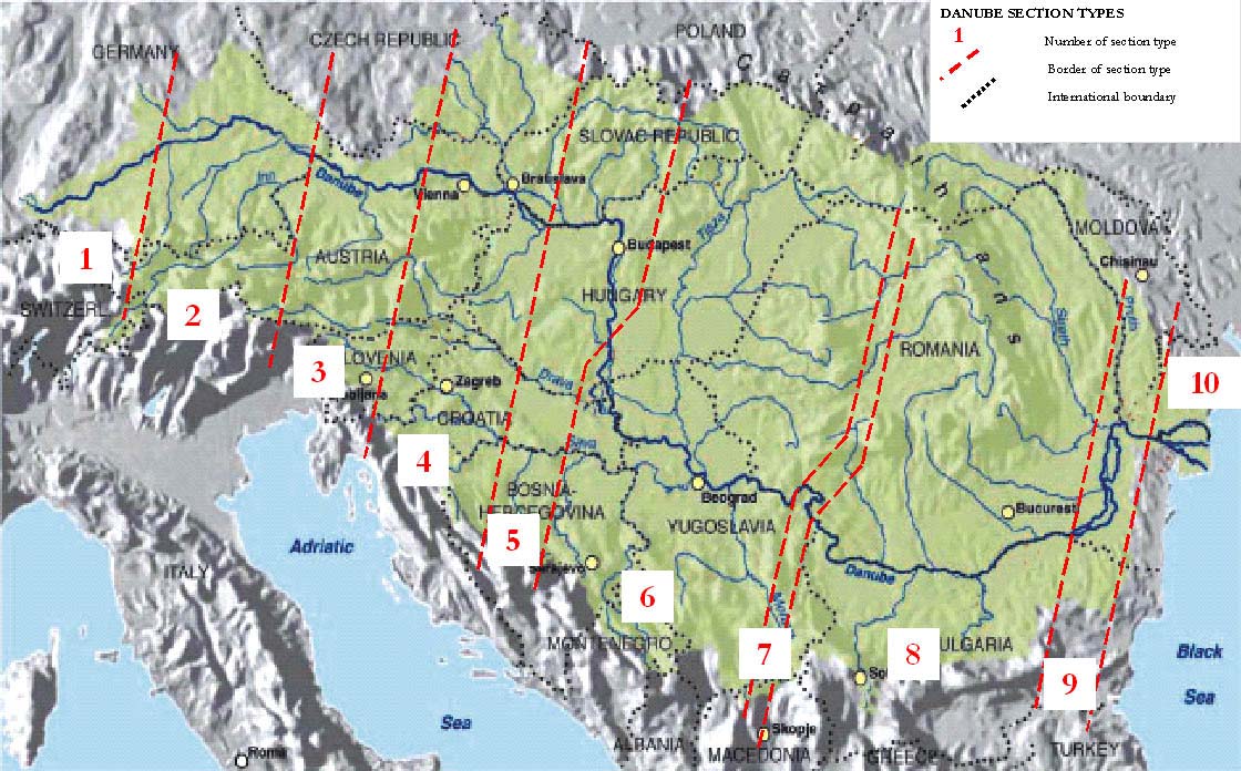
· On its way to the Black Sea the Danube crosses four ecoregions (ILLIES
1978) from west to east 9 (Central Highlands), 11 (Hungarian Lowlands),
10 (The Carpathians) and 12 (Pontic Province). According to the ecoregions
the Danube can be divided into four sections (see figure 1).
Figure 1: Division of the Danube River according to the four ecoregions (ILLIES 1978)
· Based on the slope evolution on the Danube (figure 2, LÁSZLÓFFY 1965) six
major shifts in the river slope from Regensburg (km 2376) to Sulina (km 0)
have been chosen as section type borders.
-10-
ROBERT, BIRK & SOMMERHÄUSER: Typology part 1: top-down approach
Figure 2: Six section type borders according to the slope values (LÁSZLÓFFY 1965)
· According to the geomorphological regions crossed by the Danube (figure 3,
ZINKE ENVIRONMENT CONSULTING 1999) eleven borders can be defined on the
river.
Figure 3: Eleven geomorphological borders along the Danube River considered as section and sub-
section type borders (ZINKE ENVIRONMENT CONSULTING 1999)
-11-
ROBERT, BIRK & SOMMERHÄUSER: Typology part 1: top-down approach
All other parameters have been evaluated and assessed this way in order to identify
the major abiotic changes and to define section borders.
In addition to the above mentioned parameters the influence of the tributaries`
hydrological character (e.g. confluence of River Iller and Inn with the Danube) and
the geomorphological variation along the river like breakthrough sections (e.g.
Danube bend) and lowland areas have also been considered.
By the help of expert knowledge the major changes of one or more parameters have
been considered as main borders for the section types. Less important changes form
sub-section type borders.
RESULTS
The Danube River has been divided into ten homogeneous section types. According
to the above mentioned criteria four of the section types (2, 4, 5 and 6) have been
subdivided into two and three sub-section types, respectively.
The typology proposal was presented at the 2nd Surface Water Workshop in Zagreb
in September 2003. With some constructive improvements mainly focusing on the
Hungarian Danube reach it has been accepted as a framework for the Danube River
Basin countries.
Names of the section types have been given according to the geographical region
the Danube is flowing through (e.g. section type 6 "Pannonian Plain Danube"). This
system has been chosen to simplify the areal allocation of the section. The rationales
for the section type borders are as follows: confluence of the Danube with important
tributaries (e.g. Iller in Neu Ulm; Inn in Passau); changes of the geomorphological
structure like breakthrough sections (e.g. Kazan pass between Bazias and Turnu
Severin) or lowland areas (e.g. Balta Brailei and Balta Ialomitei between
Chiciu/Silistra and Isaccea); delta formation (Danube Delta from Isaccea to Sulina).
The individual section lengths differ: The average length amounts to approx. 280 km,
the ,,Turnu Severin to Chiciu/Silistra" section is 553 km long. The shortest section
adds up to 100 km (e.g. Isaccea to Sulina).
All ten section types and the corresponding sub-section types are summarized in
table 2 and figure 4. The hydromorphological and habitat characteristics of these
section types are presented in detail in the "Definition of reference conditions for the
section types of the Danube River" (ROBERT et al. 2003, this report).
REFERENCES
BREU, J. (1989): Atlas der Donauländer. Map no. 132; Map no. 161; Map no. 181;
Österreichisches Ost-und-Südosteuropa-Institut. Deuticke, Wien.
BUSNITA, T. (1967): Die Ichthyofauna des Donauflusses. In: Liepolt, R. (ed.): Limnologie der
Donau Eine monographische Darstellung. Kapitel V: 198-224. Schweizerbart,
Stuttgart.
EUROPEAN UNION (2000): Directive of the European Parliament and of the Council
2000/60/EC establishing a framework for community action in the field of water policy.
Rep. No. PECONS 3639/1/00 REV1. Luxembourg (European Union).
-12-
ROBERT, BIRK & SOMMERHÄUSER: Typology part 1: top-down approach
GÜNTHER-DIRINGER, D. (2002): Inventory of Protected Areas in the Danube River Basin.
WWF-Auen-Institut Rastatt.
ILLIES, J. (1978): Limnofauna Europaea - Eine Zusammenstellung aller die europäischen
Binnengewässer bewohnenden mehrzelligen Tierarten mit Angaben über ihre
Verbreitung und Ökologie. Fischer, Stuttgart.
KNIE, K. (1966): Die physikalisch-chemischen Eigenschaften der Donauwassers. In: Liepolt,
R. (ed.): Limnologie der Donau Eine monographische Darstellung. Kapitel IV: 51-
83. Schweizerbart, Stuttgart.
LÁSZLÓFFY, W. (1965): Die Hydrographie der Donau. Der Fluss als Lebensraum. In: Liepolt,
R. (ed.): Limnologie der Donau Eine monographische Darstellung. Kapitel II: 16-57.
Schweizerbart, Stuttgart.
LITERÁTHY, P., KOLLER-KREIMEL V. & I. LISKA (eds.) (2002): Joint Danube Survey. Technical
Report of the International Commission for the Protection of the Danube River.
http://www.icpdr.org/pls/danubis/docs/folder/HOME/ICPDR/ICPDRANNUALREPORTS/2002/INDEX.HT
ML
MOOG, O., OFENBÖCK, T. & T. BATTISTI (2003): Typology of the Danube River part 2:
bottom-up validation. - this report.
ROBERT, S., BIRK, S. & M. SOMMERHÄUSER (2003): Definition of reference conditions for the
section types of the Danube River. this report.
ZINKE ENVIRONMENT CONSULTING (1999): Map 1, Geographical Indicators: Geomorphological
Regions and Annual Precipitation in Danube Pollution Reduction Programme.
http://www.icpdr.org//servlet/page?_pageid=53&_dad=danubis&_schema=DANUBIS&_type=site&_fsitei
d=1&_fid=202&_fnavbarid=1&_fnavbarsiteid=1&_fedit=0&_fmode=2&_fdisplaymode=1&_fcalledfrom=1&
_fdisplayurl=Datei MIME Typ:text/html
-13-
ROBERT, BIRK & SOMMERHÄUSER: Typology part 1: top-down approach
Table 2: The ten section types and its sub-sections
section type
1
2
3
4
5
6
7
8
9
10
confluence
Turnu
Krems
Bazias -
Chiciu/
section type
of Brigach
Neu Ulm -
Passau -
Gönyü/Klizska
Severin -
Isaccea -
Gönyü/
Baja - Bazias
Turnu
Silistra -
borders
and Breg -
Passau
Krems
Nemá - Baja
Chiciu/
Sulina
Klizska Nemá
Severin
Isaccea
Neu Ulm
Silistra
river km
2001 -
1791/1790 -
2786 - 2581 2581 - 2225 2225 - 2001
1497 - 1071
1071 - 931
931 - 378
378 - 100
100 - 0
(from - to)
1791/1790
1497
Upper
Western
Eastern
Lower
Western
Eastern
name of
Course of
Alpine
Alpine
Alpine
Hungarian
Pannonian
Iron Gate
Danube
Pontic
Wallachian
reach
the
Foothills
Foothills
Foothills
Danube Bend
Plain Danube
Danube
Delta
Danube
Danube
Danube
Danube
Danube
Danube
m
o
rád
má
rg
a
u
burg
- Baja
s
s
s/Viseg
as
ns
Pa
á
-Eszte
ro
rád
ge
sub-section
/
Klizska Ne
y
ma
type borders
s - Devin
a - tr. Sava
burg -
y
ü
n
s/Viseg
ns
Krem
- Nag
a
ro
Baja - tr. Drava
u Ulm - Re
ge
-
Gö
m
tr. Sava - Bazi
/
Klizska Nem
o
y
m
tr. Drav
Ne
Re
y
ü
Devin
n
Nag
Gö
Eszterg
76
25
80
90
0
-
-
9
95
97
79
70
71
river km
0
9
(from - to)
1-23
6-22
1-18
1/17
9-16
5-14
7-13
9-11
0-10
188
1/17
171
258
237
200
179
179
171
169
149
137
117
ecoregion
9
9
9
9
1
1
11 1
1
1
1
1
1
1
1
1
1
1
1
1
0
1
2
1
2
1
2
tr.= tributary
-14-
ROBERT, BIRK & SOMMERHÄUSER: Typology part 1: top-down approach
Figure 4: Map of Section Types (taken from GÜNTHER-DIRINGER 2002)
UNDP/GEF DANUBE REGIONAL PROJECT: -15-
ACTIVITY 1.1.6. TYPOLOGY OF SURFACE WATERS AND DEFINITION OF REFERENCE CONDITIONS FOR THE DANUBE RIVER
Typology of the Danube River
part 2: bottom-up validation
OTTO MOOG, THOMAS OFENBÖCK & THOMAS BATTISTI
INTRODUCTION
The application of the Water Framework Directive's methodology to assess the
ecological status of rivers needs to be based on a regional classification of river
types. In regional classifications landscape elements as ecoregions (annex 11 of the
WFD) or bioregions (MOOG et al. 2001) are used to create maps that allow managers
to make spatially explicit statements about the biological properties characteristic of
individual regions. This approach is based on the idea that the biological properties of
specific aquatic ecosystems can be inferred from knowledge of the region within
which aquatic ecosystems occur (HUGHES & LARSEN 1988, OMERNIK 1995, BARBOUR
et al. 1996, HAWKINS & NORRIS 2000).
To classify typological units of the Danube River a spatial typology fails as large
rivers show a self-contained development. Along the longitudinal gradient a large
river absorbs a catchment's characteristic and finally represents a mixture of different
influences. Therefore a separate typology for the Danube has been developed in an
a priori process by ROBERT et al. (2003). In an a posteriori procedure the
performance of this a priori classification system was gauged by its classification
strength. Following the collaboration of freshwater scientists (HAWKINS & NORRIS
2000) the degree to which classification minimised within-class biotic similarity
relative to between-class biotic similarity was determined. To describe the
relationship of the benthic invertebrate communities of different sites a ,,non-metric
multidimensional scaling" (NMS) was performed. This method measures the biotic
similarity between sites as compositional similarity by the Sřrensen or Bray-Curtis
coefficient. The similarity of sites can be visualised in scatterplots combined with a
choice of varying overlays. To quantify the classification strength which is defined as
the difference between mean within-class and mean between-class similarity the
methods described by SMITH et al. (1990), VAN SICKLE (1997), and VAN SICKLE &
HUGHES (2000) were used.
METHODS
Non-metric Multidimensional Scaling
The ten Danube reaches have been validated using biological data sets (benthic
macroinvertebrates) from the Joint Danube Survey (LITERÁTHY et al. 2002) and
comparing them by means of similarity analysis. Data from transactional station sites
have been combined to represent the whole community. Due to differences in the
sampling techniques presence/absence data were analysed. The objective aimed for
-16-
MOOG, OFENBÖCK & BATTISTI: Typology part 2: bottom-up validation
an approval/disapproval of the ten sections by the occurrence of characteristic
aquatic biocoenosis. For this purpose non-metric multidimensional scaling (NMS)
was used as ordination method (MCCUNE & MEFFORD 1999). Multivariate ordination
can graphically demonstrate whether the species composition reflects the set of an a
priori classification.
Classification of species composition data usually involves ordination or clustering of
sites to examine classes and structure. These require a distance or similarity
measure for site pairs, calculated from the taxonomic composition of the sites. A
primary requirement for a data set is taxonomic consistency, or always identifying a
given taxon as the same thing (NIJBOER & VERDONSCHOT 2000).
NMS reduces the dimensionality of multivariate data in order to visualise and
examine them with other, more conventional, exploratory analyses. NMS develops
an ordination from any distance or similarity matrix. The procedure ranks distances in
the original matrix, and then attempts to display these ranks of distances in a
specified number of dimensions, usually 2 or 3. In effect, NMS produces a map of the
entities from the distances among the sites. The goodness-of-fit of the estimated
distances is measured by the stress statistic (indicated in the figures). Additionally a
coefficient of determination (r˛) for the correlations between ordination distances and
distances in the original n-dimensional space is calculated and indicated as the
cumulative value of the axis shown in the figures. The computational procedure is
numerical approximation, beginning with an arbitrary configuration and reducing the
stress statistic in each successive approximation. When plotted in ordination space,
sites with similar species composition are close together. Ordination plots are thus
used to verify or falsify the a priori classification hypotheses. NMS is relatively robust
for species composition data, and has been applied frequently in recent years to
benthic macroinvertebrate data (e.g. REYNOLDSON et al. 1995, BARBOUR et al. 1996).
The Sřrensen/Bray-Curtis coefficient was used as distance measure. With
presence/absence data only, it is equivalent to the Jaccard coefficient (LEGENDRE &
LEGENDRE 1998).
Prediction of expected types can be derived from a geographic model, or with a
discriminant analysis based on physical data (e.g. MOSS et al. 1987, HUGHES &
LARSEN 1988, BARBOUR et al. 1996, MOSS 2000). Our approach is to check and
possibly modify and adjust the a priori model of the section types in order to develop
an optimum geographic and physical classification. NMS was performed with PC-
ORD 4.1 (MCCUNE & MEFFORD 1999).
Data refer exclusively to the Danube main channel, data from the Danube tributaries
were excluded. Sites with a known, significant impairment (e.g. by organic pollution
or hydromorphological alteration like weirs and water abstraction) have been
excluded from the analysis.
-17-
MOOG, OFENBÖCK & BATTISTI: Typology part 2: bottom-up validation
Quantifying the classification strength of the Danube Section Types (Van
Sickle analysis)
Analysis were conducted using MEANSIM6 software, available from the USEPA,
Western Ecology Division Web Site (http://www.epa.gov/wed). For the analysis the
Sřrensen coefficient is used. This Sřrensen similarity is the ratio between the
number of taxa common at two sites and the average number of taxa per site that
was found at the two sites; the measure can be interpreted as the proportion of the
assemblages found at two sites that are shared by the sites. The similarity matrix of
the result file must be converted in dissimilarity (as 1 - similarity).
The strength of each classification is valued by comparing within- and between-class
similarities. In a strong classification, similarities between sites in the same class tend
to be substantially greater than similarities among sites in different classes.
First the mean of all between-class similarities (Bbar) and the within-class mean
similarity (Wi) for each class is calculated. If a classification is strong Bbar is low, and
for each class, Wi is high.
The overall weighted mean (Wbar) of within-class similarities can be calculated as
Wbar = (n / N W
)
, where ni is the number of sites in class i, and N is the total
i
i
i
number in all classes (VAN SICKLE 1997, VAN SICKLE & HUGHES 2000). The overall
strength of all classifications can be expressed by the extent to which Wbar exceeds
Bbar. For example, classification strength can be measured by the unitless ratio
M = Wbar/Bbar. Alternatively, one may use classification strength CS= (Wbar - Bbar),
which preserves the original units of similarity. A permutation test was used to test
the null hypothesis that the CS value was not different from what might be expected
from randomly assigning sites to groups (SMITH et al. 1990, VAN SICKLE 1997). The
statistic CS was recalculated for each of 10,000 randomly chosen reassignments of
sites to groups of the same size as the tested classification (JACKSON & SOMERS
1989).
RESULTS
Non-metric Multidimensional Scaling
The ten section types of the top-down approach (ROBERT et al. 2003) were applied as
overlays, as well as the ecoregions (ILLIES 1978). As shown in figure 1 the Danube
biota confirm the validity of the ecoregion approach. The similarity of benthic
invertebrate assemblages within ecoregions is higher than among ecoregions.
-18-
MOOG, OFENBÖCK & BATTISTI: Typology part 2: bottom-up validation
NM
N S Danube
OEKR
O
9
11
12
107
i
s
3
Ax
Axi
Ax s 2
Figure 1: NMS scatterplot of JDS data. The overlay indicates the five ecoregions the Danube
River is passing through (9 = Central Highlands, 11 = Hungarian Lowlands, 12 = Pontic
Province, 10 = The Carpathians, 7 = Eastern Balkan) (ILLIES 1978)
Figure 2 presents a second scatterplot of the JDS data with the a priori (top-down)
approach as overlay. Nine of the ten sections are plotted here and grouped into the
three major reaches (Upper, Middle, Lower Danube). The first section type is missing
due to the lacking of JDS data, whose monitoring sites start at Neu Ulm (the
upstream border of section type 2).
-19-
MOOG, OFENBÖCK & BATTISTI: Typology part 2: bottom-up validation
Donau_jn_neu_nach_zagreb_ohne4und5
D 2 16
1 2
section type
2
Upper Danube
3
D 18
1 8 1
4
D2 2 3 0
5
D 18
1 9 5
6
7
D 16
1 9 1
D 19
1 13
D 19 4 2
13
D 19 4
D18
D1 6 9
8
D 18
1 0 6
D2 11
1 3
1
9
10
D0 53 2
D18
D1 12
1
D13 8 4
D 17
1 0 7
D176 8
4
7
D0 8 4 9
D 0 50 0
D 17
1 19
1
D 0 6 0 6
D 0 6 2 9
6
D 0 6 2
D 16
1 59
D
9
0 2 3 5
D0 550
D 15
1 8 6
D 0 4 8 8
D 16
1 3 2
D13D
3 0 12
0
1 59
i
s
3
D1 D
56
D 13
0
1 6 7
D 15
1 3 3
Ax
D 13
1 55
D 14
1 3 4
D 14
1 8 1
D 14
1 2 5
D
5
0 79 5
D 12
1 16
D
16
0 6 4 0
D0 0 56
D 12
1 0 2
D0
2
D
3 07 1
83 0
D 0 4 29 D
9 0 2 9 5
D 10
1 4 0
D 0 4 3 4
D 17
1 6 1
D
1
0 8 3 4
D 12
1 52
D 0 16
1 7
D0 579
D 0 6 8 5
Middle Danube
9
nube
D 0 6 0 2
D 11
1 3
1 2D0012
D 10
1 77
D 11
1 6
1 1
D
1
0 0 6 4
D 0 9 2 4
D 11
1 0
1 7
D10
D1 71
D1151
D10
D1 9 7
Lower Danube
D0 9 56
A xis 1
Figure 2: NMS scatterplot of JDS data for the Danube monitoring sites. The overlay indicates three
major regions with the ten section types (2 = Western Alpine Foothills Danube, 3 = Eastern
Alpine Foothills Danube, 4 = Lower Alpine Foothills Danube, 5 = Hungarian Danube Bend, 6 =
Pannonian Plain Danube, 7 = Iron Gate Danube, 8 = Western Pontic Danube, 9 = Eastern
Wallachian Danube, 10 = Danube Delta). Stress = 17.07.
Do na u_jn
j _ neu_nac h_za
z gre b_3_ 4
D 11
1 0
1 7
secti
ct on t
n y
t p
y e
D 10
1 9 7
3
4
5
6
D 10
1 77
D 11
1 6
1 1
D 10
1 71
7
D 1
D 11
1 3
2
1
1 216
2
1
D 12
1 52
D 17
1 6 1
D 14
1 3 4
D 14
1 2 5
D 15
1 3 3
D 14
1 8 1
D 16
1 3 2
D 12
1 59
D 13
1 55
5
D 11
1 5
1 1
5
D 12
1 0 2
D 13
1 6 7
D 158 6
D 13
1 0 0
D 158 6
D 15
1 6 0
D 16
1 59
3
5
3
s
Axi
D 17
1 0
7 7
D 1719
D 171
D 13
1 8 4
D 18
1 12
1
D 17
1 6 8
D 19
1 13
1
D 19
1 4 2
D 16
1 9 1
D 18
1 6 9
D 18
1 9 5
D 18
1 0 6
D 18
1 8
D 12 16
1 2
1
A xis 1
Figure 3: NMS Scatterplot of JDS data for the Danube monitoring sites. The overlay indicates three
section types (4 = Lower Alpine Foothills Danube, 5 = Hungarian Danube Bend, 6 =
Pannonian Plain Danube) according to the top-down typology. Stress = 18.82.
-20-
MOOG, OFENBÖCK & BATTISTI: Typology part 2: bottom-up validation
Figure 3 presents a separate analysis of the sections 4, 5 and 6. The other seven
have been excluded in this plot for a much clearer separation of the remaining
section types. This part of the river has intensely been discussed by the national and
international consultants because of its complexity from the geomorphological (e.g.
the breakthrough sections Vienna Gate, Devin Gate and Danube bend, the
anabranching areas in the Vienna Basin, the large alluvial zone "Zitny ostrov" and
"Szigetköz" and the Hungarian plain as well as the variability of the slope values) and
hydrological (e.g. the confluence of Morava, Drava, Tisa and Sava rivers) point of
view. The result given in figure 3 shows a clear separation of the benthic
communities in these section types and therefore provides a sound validation of the
top-down classification.
Figure 4 shows the clear separation of the section types 3 and 4, whose boundary is
the borderline between the ecoregion 9 (Central Highlands) and 11 (Hungarian
Lowlands). The result reflects also a generally distinct differentiation between the
benthic fauna in the landscape of the highlands (section 3) and the floodplains
(section 4).
Summarising all results of the analyses which cannot be presented here in detail, it
can clearly be stated that the top-down proposal (a priori approach) has generally
been validated. The stream section typology of the Danube River developed within
this project can be regarded as an important and sound product for further tasks of
implementing the WFD.
Donau_jn_neu_nach_za
z greb_3_4
D19
D1 13
1
secti
ect on t
n y
t pe
y
3
4
D186
D1
9
D18
D1 81
D 19
1 4 2
s
2
Axi
D211
D21 3
1
D181
D1 2
81
D180
D1
6
D 18
1 9 5
D216
D21 2
Axis
i 1
Figure 4: NMS scatterplot of JDS data for the Danube monitoring sites. The overlay indicates the
section types (3 = Eastern Alpine Foothills Danube, 4 = Lower Alpine Foothills Danube)
according to the top-down typology. Stress = 11.54.
-21-
MOOG, OFENBÖCK & BATTISTI: Typology part 2: bottom-up validation
Quantifying the classification strength of the Danube Section Types (Van
Sickle analysis)
Two alternative current typological classifications of the Danube are compared by the
use of mean similarity calculations: The nine geo-morphological Danube reaches
according to the JDS report (VOGEL & PALL 2002) and the ten Danube section types
proposed by the consultants of the UNDP/GEF Danube Regional Project (ROBERT et
al. 2003).
Although the proposed top-down typology of the UNDP/GEF DRP comprises ten
Danube River Sections for testing this typology benthic invertebrate data from only
eight types were available for analysis: No data exist for the Danube section 1; due to
hydropower use and ecological degradation of the according Danube reach no
sufficient data were available for statistical analysis of the Danube section 2. The
analyses have been carried out in two ways by considering the remaining eight main
types without (DRP8) and with sub-types. By including the sub-divisions of the eight
main sections into sub-section types biological data from a total of twelve reaches
could be analysed (DRP12).
A similar procedure needed to be undergone within the ,,JDS-types" analysis as there
exist no data for JDS type 1, and not enough data for JDS type 3.
Table 1: Strength of three classifications for invertebrate communities from the Danube River (data
source: JDS)
Species
P/A
Classification
No. of classes
CS (Wbar - Bbar) M
(Wbar/Bbar) Wbar
DRP8
8 (without subtypes) 0.114
0.778
0.517
DRP12 12
(with
subtypes)
0.123 0.769
0.535
JDS-types 7
0.114
0.780 0.517
All classifications showed statistical evidence (p<0.02) of greater CS (Wbar - Bbar)
than would be expected for randomly grouped sites (table 1). However, the observed
CS values indicate a comparably slight degree of dissimilarity. DRP8 and JDS-types
have the same CS values (0.114). DRP12 shows a slightly better classification
(0.123). Table 1 also reports M values (Wbar/Bbar). Values of M that are only slightly
less than 1.0 indicate a weak classification, and classification strength increases
progressively as M decreases from 1.0 towards 0. The M-Value of the DRP12
classification is 0.769 and shows a slightly better partition than the M-Value of the
Danube classification according to the JDS-types (0.780).
As the M values of this analysis are proportional high more background information
can be gained by having a look at the Wi values in relation to Bbar (Wi- Bbar) in table 2.
-22-
MOOG, OFENBÖCK & BATTISTI: Typology part 2: bottom-up validation
Table 2: Comparison of ,,Wi- Bbar" values of the three Danube typologies
DRP8
DRP12
JDS-types
Section Wi- Bbar Section/Subsec
Wi- Bbar Section
Wi- Bbar
3 0.203 3
0.194 2
0.153
4 0.140 4/1 0.142 4
0.1
5 0.145 4/2 0.120 5
0.2
6 0.130 5/1 0.129 6
0.073
7 0.042 5/2 0.163 7
0.069
8 0.073 6/1 0.239 8
0.097
9 0.114 6/2 0.194 9
0.006
10 0.088 6/3
0.112
7 0.033
8 0.064
9 0.105
10 0.079
Table 2 shows the values of classification of each section type. For a better
understanding of table 2 it should be stated that ,,Wi- Bbar"-values greater than 0.2
define a very good classification with respect to higher within similarities compared to
the between similarity values. Values at 0.1 define sufficient or good classification.
Lower or negative values show a bad classification.
Averaging the ,,Wi- Bbar"-values of DRP8, DRP12 and JDS (0.116, 0.131, 0.109)
confirms the result of table 1 by indicating the best classification strength of the
DRP12 typology.
The ,,Wi- Bbar"-values of Danube Section Type 7 show only weak classifications (Wk-
Bbar=0.042, 0.073, 0.088). This lower within similarity of the benthic invertebrate
communities could be explained by the effects of the hydro-power stations in the Iron
Gate section. The tailback of the barrages leads to a monotonous environment and
thus to a fauna that does not represent a distinct Iron gate community. The other
types show values between 0.114 and 0.203 which define a sufficient or good
classification.
The subdivision of the section types 4, 5 and 6 according DRP12 also shows a
sufficient or good classification with Wk-Bbar-Values between 0.112 and 0.239
(table 2). For JDS-types the sections 6 to 9 indicate weak classifications probably
due to the impacts of the Iron Gate Section. Sections 2 to 5 show a sufficient
classification with values between 0.1 and 0.2.
SUMMARY
Summarizing the results of the NMS ordination and the Van Sickle within-and-
between similarity analysis the top-down division of the entire Danube into ten
typological units according to the current proposal could be statistically confirmed by
the according bottom-up procedure.
-23-
MOOG, OFENBÖCK & BATTISTI: Typology part 2: bottom-up validation
The international consultants recommend the use of the current UNDP/GEF DRP
section typology of the Danube River as an important and sound typological tool for
the further tasks of implementing the WFD (see ROBERT et al. 2003 and table 3).
Table 3: UNDP/GEF DRP Danube Section Types
# Danube Section Danube Section Type
Stream kilometre
1
Upper Course of the Danube
2786 2581
2
Western Alpine Foothills Danube
2581 2225
3
Eastern Alpine Foothills Danube
2225 - 2001
4
Lower Alpine Foothills Danube
2001 - 1791/1790
5 Hungarian
Danube Bend
1791/1790 1497
6 Pannonian
Plain
Danube
1497 1071
7
Iron Gate Danube
1071 931
8
Western Pontic Danube
931 378
9
Eastern Wallachian Danube
378-100
10 Danube
Delta
100-0
REFERENCES
BARBOUR, M.T., GERRITSEN, J., GRIFFITH, G.E., FRYDENBORG, R., MCCARRON, E., WHITE, J.S.
& M.L. BASTIAN (1996): A framework for biological criteria for Florida streams using
benthic macroinvertebrates. Journal of the North American Benthological Society, 15:
185-211.
HAWKINS, C.P. & R.H. NORRIS (2000): Performance of different landscape classifications for
aquatic bioassessment: introduction to the series. Journal of North American
Benthological Society, 19 (3): 367-369.
HUGHES, R.M. & D.P. LARSEN (1988): Ecoregions: an approach to surface water protection.
Journal of the Water Pollution Control Federation, 60: 486-493.
ILLIES, J. (1978): Limnofauna Europaea - Eine Zusammenstellung aller die europäischen
Binnengewässer bewohnenden mehrzelligen Tierarten mit Angaben über ihre
Verbreitung und Ökologie. Fischer, Stuttgart.
JACKSON, D.A. & K.M. SOMERS (1989): Are probability estimates from the randomization
model of Mantel´s test stable? Canadian Journal of Zoology, 67: 766-769.
LEGENDRE, P. & L. LEGENDRE (1998): Numerical Ecology. Second English Edition. Elsevier,
Amsterdam.
LITERÁTHY, P., KOLLER-KREIMEL, V. & I. LISKA (eds.) (2002): Joint Danube Survey.- Technical
Report of the International Commission for the Protection of the Danube River, 261
pp.
MCCUNE, B. & M.J. MEFFORD (1999): PC-ORD. Multivariate Analysis of Ecological Data,
Version 4. MjM Software Design, Gleneden Beach, Oregon, 237 pp.
MOOG, O., SCHMIDT-KLOIBER, A., OFENBÖCK, T. & J. GERRITSEN (2001): Aquatische
Ökoregionen und Fließgewässer-Bioregionen Österreichs.- Eine Gliederung nach
geoökologischen Milieufaktoren und Makrozoobenthos-Zönosen. Im Auftrag des
Bundesministeriums für Land- & Forstwirtschaft, Umwelt & Wasserwirtschaft. Wien.
102 pp.
-24-
MOOG, OFENBÖCK & BATTISTI: Typology part 2: bottom-up validation
MOSS, D., FURSE, M.T., WRIGHT, J.F. & P.D. ARMITAGE (1987): The prediction of the macro-
invertebrate fauna of unpolluted running-water sites in Great Britain using
environmental data. Freshwat. Biol., 17: 41-52.
MOSS, D. (2000): Evolution of statistical methods in RIVPACS. In: WRIGHT, J.F., SUTCLIFFE,
D.W. & M.T. FURSE (eds.): Assessing the biological quality of fresh waters
RIVPACS and other techniques. Freshwater Biological Association: 25-38.
NIJBOER, R.C. & P.F.M. VERDONSCHOT (2000): Taxonomic adjustment affects data analysis:
an often forgotten error. Verh. int. Ver. Limnol. 27:1-4.
OMERNIK, J. M. (1995): Ecoregions: a spatial framework for environmental management. In:
DAVIS, W.S. & T.P. SIMON (eds.): Biological assessment and criteria. Tools for water
resource planning and decision making. Lewis Publishers, Boca Raton, Florida: 49-
62.
REYNOLDSON, T.B., BAILEY, R.C., DAY, K.E. & R.H. NORRIS (1995): Biological guidelines for
freshwater sediment based on BEnthic Assessment of SedimenT (the BEAST) using
a multivariate approach for predicting biological state. Aust. J. Ecol., 20: 198-219.
ROBERT, S., BIRK, S. & M. SOMMERHÄUSER (2003): Typology of the Danube River part 1:
top-down approach. this report.
SMITH, E.P., PONTASCH, K.W. & J. CAIRNS (1990): Community similarity and the analysis of
multispecies environmental data: a unified statistical approach. Water Research, 24:
507-514.
VAN SICKLE, J. (1997): Using mean similarity dendrograms to evaluate classifications. Journal
of Agricultural, Biological, and Environmental Statistics, 2: 370-388.
VAN SICKLE, J & R.M. HUGHES (2000): Classification strengths of ecoregions, catchments,
and geographic clusters for aquatic vertebrates in Oregon. Journal of the North
American Benthological Society, 19: 370-384.
VOGEL, B. & K. PALL (2002): Chapter 3, Nine Geo-morphological Danube Reaches. Joint
Danube Survey (JDS), Technical Report of the International Commission for the
Protection of the Danube River. In: LITERÁTHY, P., KOLLER-KREIMEL, V. & I. LISKA
(2002): Joint Danube Survey. Technical Report of the International Commission for
the Protection of the Danube River: 22-31.
UNDP/GEF DANUBE REGIONAL PROJECT: -25-
ACTIVITY 1.1.6. TYPOLOGY OF SURFACE WATERS AND DEFINITION OF REFERENCE CONDITIONS FOR THE DANUBE RIVER
Definition of Reference Conditions for the Section Types of the
Danube River
SABINA ROBERT, SEBASTIAN BIRK & MARIO SOMMERHÄUSER
WITH A CONTRIBUTION OF GERTRUD HAIDVOGL, SEVERIN HOHENSINNER, STEFAN SCHMUTZ & HERWIG
WAIDBACHER
INTRODUCTION
Definition and description of type-specific reference conditions are the basis for
biological river assessment according to the WFD. Due to the intense alteration of
virtually all rivers the description of near-natural reference conditions is particularly
difficult for large rivers (EHLERT et al. 2002, HERING et al. 2000). Here, long-lasting
and exhaustive anthropogenic disturbance has taken place. For this reason historical
data are best suited to provide information about morphological, hydrological and
biological characteristics the Danube once featured before man exceeded substantial
influence on the river.
In this chapter hydromorphological reference conditions for each of the ten section
types are presented as short characteristics (RefCond-Passports) based on both
historical data and expert opinion. In addition the reference fish fauna of the Austrian
section of the Danube is described, and guidance is given on how to define reference
communities based on historical data. These recommendations are intended to serve
as guidelines for other Danube River Basin countries.
Short description of section types (RefCond-Passports)
To acquire data on historical reference conditions specifically designed
questionnaires have been sent to the national consultants (see Annex 1). Within two
different parts historical source references have been stated and various
morphological, hydrological and habitat parameters have been described by the
national consultants for each section type. Some parameters could not be confirmed
by historical data, hence expert opinion of the consultants established a basis for
description.
Based on information given in the returned questionnaires and additional sources
such as catalogues of exhibitions of ancient river maps (GENERALDIREKTION DER
STAATLICHEN ARCHIVE BAYERNS 1998, ZÖGNER 1993) the RefCond-Passports have
been generated. Each passport comprises general data about the section type
(borderlines, ecoregions, catchment area, section length), a historical illustration,
descriptions of structural and habitat characteristics, sub-section types and important
tributaries (where applicable).
UNDP/GEF DANUBE REGIONAL PROJECT: -26-
ACTIVITY 1.1.6. TYPOLOGY OF SURFACE WATERS AND DEFINITION OF REFERENCE CONDITIONS FOR THE DANUBE RIVER
Section type 1
UPPER COURSE OF THE DANUBE
River km: 2786 - 2581
Borderlines: confluence of Brigach and Breg to Neu Ulm
Rationale for section type borders:
- upstream border: source of Danube River
- downstream border: confluence with river Iller
Country: Germany
Ecoregion: 9 (Central Highlands)
Catchment area:
8,100 km2 (at Neu Ulm)
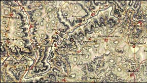
Illustrations: Map of Wirtemberg (1802) and Map of Schwaben (VON BOHNENBERGER et al. 1798-1828)
This section type is part of the German stream type 9.1
(calcareous low mountain water course catchment area 100 -
1000 km2) and 9.2 (large watercourses catchment area 1000
10000 km2) (SOMMERHÄUSER & POTTGIESSER 2003a, 2003b,
2003c). Canyon reaches alternate with plain floodplain sections
dominating at the right. Channel form is sinuous to meandering
and braided. The slope varies between 0.75 and 1.38 .
The main channel substrates are composed of bedrock, head-
sized boulders with a variable percentage of cobble, gravel and
sand. In the floodplain section of more than 300 m width riffle
and pool sections vary moderately. The bank structure is abort
Morphological characteristics
and sliding.
Due to the karst landscape the highly dynamic discharge
character is influenced by water infiltration at section
Immendingen to Möhringen and sporadically until Fridingen
(MNQ 3 m3/s; MQ 7-8 m3/s; MHQ approx. 20 m3/s). In case of
total infiltration the regeneration of the Danube River is made
by the tributaries and springs.
The hydrological regime shows high water level in February
and March and low water level between August and
September.
Habitat characteristics
The river shows a high percentage of eupotamon (AMOROS et
UNDP/GEF DANUBE REGIONAL PROJECT: -27-
ACTIVITY 1.1.6. TYPOLOGY OF SURFACE WATERS AND DEFINITION OF REFERENCE CONDITIONS FOR THE DANUBE RIVER
al. 1982) with primarily lotic side arms on the right side of the
floodplain section.
Tributaries
right tributary: Iller (km 2589) average annual discharge:
68 m3/s.
References
STAMMER (1954), SOMMERHÄUSER & POTTGIESSER (2003a,
2003b, 2003c).
UNDP/GEF DANUBE REGIONAL PROJECT: -28-
ACTIVITY 1.1.6. TYPOLOGY OF SURFACE WATERS AND DEFINITION OF REFERENCE CONDITIONS FOR THE DANUBE RIVER
Section type 2
WESTERN ALPINE FOOTHILLS DANUBE
River km: 2581 - 2225
Borderlines: Neu Ulm Passau
Rationale for section type borders:
- upstream border: confluence with river Iller
- downstream border: before confluence with river Inn (mountainous region)
Country: Germany
Ecoregion: 9 (Central Highlands)
Catchment area:
8,100 km2 (at Neu Ulm)
76,597 km2 (at Passau)
Illustration: Danube between Vohburg and Neustadt an der Donau (ca. 1807, GENERALDIREKTION
DER STAATLICHEN ARCHIVE BAYERNS 1998)
The Danube shows anabranching channel form of high
intensity (more than 65 percent) interspersed with meandering
morphology. Trough valley reaches alternate with meandering
valley sections. A highly dynamic breadth erosion causes
varying widths of the channels and shallow water depths.
Morphological characteristics
Gorge sections are Steppberg (km
2486
-
2478) and
Weltenburger Enge (km 2422 - 2414).
The channel substrates are dominated by cobbles, gravel or
sand. Sporadically a mixture of sand and gravel is present.
The slope varies between 1.1 at Ulm and 0.3 at
Regensburg.
The river shows a high percentage of eupotamon. The
anabranching reaches are characterised by numerous side
channels providing predominantly lotic habitats. Due to highly
Habitat characteristics
dynamic channel routing the in-channel islands are naturally
unvegetated or covered by annuals.
The floodplain vegetation consists of alluvial softwood and
hardwood forests and wetlands (mires and swamps).
UNDP/GEF DANUBE REGIONAL PROJECT: -29-
ACTIVITY 1.1.6. TYPOLOGY OF SURFACE WATERS AND DEFINITION OF REFERENCE CONDITIONS FOR THE DANUBE RIVER
right tributaries: Lech (km 2497) average annual discharge:
118 m3/s; Isar (km 2282) 176 m3/s.
Tributaries
left tributaries: Altmühl (km 2411) 22 m3/s; Naab (km 2386)
49 m3/s; Regen (km 2376) 40 m3/s.
This section has been subdivided into two sub-section types
between Neu Ulm (km 2581) and Regensburg (km 2376), and
between Regensburg (km 2376) and Passau (km 2225). The
Sub-section types
rationales for this subdivision are the lithological and relief
class border at Regensburg as well as the beginning of the
Bavarian Forest and of the highlands landscape with erosive
character.
References
GENERALDIREKTION DER STAATLICHEN ARCHIVE BAYERNS (1998)
UNDP/GEF DANUBE REGIONAL PROJECT: -30-
ACTIVITY 1.1.6. TYPOLOGY OF SURFACE WATERS AND DEFINITION OF REFERENCE CONDITIONS FOR THE DANUBE RIVER
Section type 3
EASTERN ALPINE FOOTHILLS DANUBE
River km: 2225 - 2001
Borderlines: Passau Krems
Rationale for section type borders:
- upstream border: confluence with river Inn
- downstream border: end of the highlands; borderline of ecoregion 9 and 11
Country: Austria
Ecoregion: 9 (Central Highlands)
Catchment area:
76,597 km2 (at Passau)
96,045 km2 (at Krems)
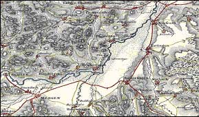
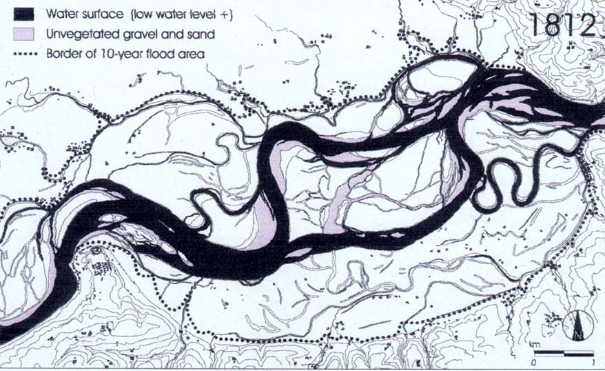
Illustration: Danube in the Machland Region in 1812 (HOHENSINNER et al. 2003)
This section type is composed of two main parts: the
breakthrough section "Oberes Donautal" (km 2225 - 2160) and
the anabranching stretch "Austrian Machland region" (km 2094
- 2084).
The breakthrough section is characterised by a steep, narrow
incised meander valley that confines the lateral development of
the river channel. Bedrocks interspersed with gravel are the
Morphological characteristics
dominant channel substrates.
Four short river reaches with chutes formed by outcropping
bedrocks (Kachlets) are present. Such reaches feature high
flow velocities and complex flow patterns. Gravel areas which
fall dry in times of extreme low water amount to 5 ha per km.
Backwaters and some smaller floodplain forests only exist in
the more spacious areas of the valley bottom. The backwaters
are not a formative element in the breakthrough section. They
UNDP/GEF DANUBE REGIONAL PROJECT: -31-
ACTIVITY 1.1.6. TYPOLOGY OF SURFACE WATERS AND DEFINITION OF REFERENCE CONDITIONS FOR THE DANUBE RIVER
are restricted to slip-off slopes, therefore their area amounts to
0.2 ha per river km. Small vegetated islands are also typical
elements with a spread area of approx. 0.7 ha per river km.
The average slope value for this section is 0.43 .
The channel system of the Machland stretch is branched by
several islands and gravel bars. This reach can be designated
as a gravel-dominated, laterally active anabranching section.
The sinuosity of the main channel is 1.32, its mean width
amounted to 550 m at low flow and 730 m at summer mean
water, and mean depth could reach 3.8 m along the thalweg.
Danube discharge is mainly influenced by alpine flow
conditions and peaks in spring/summer due to the snowmelt in
the Alps. Shallow-water zones with gentle bed gradients are a
formative element. This enables a high diversity of depths, flow
velocities and substrate conditions, resulting in a broad
spectrum of micro- and meso-habitats with extensive
shorelines.
The gravel banks/islands and highly outcropping rocks in the
breakthrough area offer a lotic environment almost throughout
the whole reach. Most tributaries discharge into the Danube
River at locations with large gravel bars and therefore provide
valuable spawning habitats for rheophilic fish species. The
backwaters offer interesting refuge habitats during floods and
special lentic habitats for stagnophilic species.
In the anabranching stretch the river-floodplain system is
Habitat characteristics
characterised by eupotamon water bodies (main channel and
side arms) to a very high extend, offering a primarily lotic
environment (97 percent of the overall water surface area at
low flow). Para-, plesio- and palaeopotamon water bodies are
less frequent in relation to eupotamon ones. They represent a
great variety of distinct lentic habitats and contribute to the high
extend of aquatic/terrestrial interfaces. The various floodplain
elements are in constant modification and renewal due to the
strong erosion/sedimentation processes.
right tributaries: Inn (km 2225) average annual discharge:
Tributaries
760 m3/s; Traun (km 2124) - 150 m3/s; Enns (km 2112)
230 m3/s; Ybbs (km 2057) 42 m3/s.
References
HAIDVOGL et al. (2003)
UNDP/GEF DANUBE REGIONAL PROJECT: -32-
ACTIVITY 1.1.6. TYPOLOGY OF SURFACE WATERS AND DEFINITION OF REFERENCE CONDITIONS FOR THE DANUBE RIVER
Section type 4
LOWER ALPINE FOOTHILLS DANUBE
River km: 2001 1791/1790
Borderlines: Krems Gönyü/Kliska Nemá
Rationale for section type borders:
- upstream border: borderline of ecoregions 9 and 11
- downstream border: end of alluvial fan (Schütt/Ostrov)
Countries: Austria/Slovakia/Hungary
Ecoregion: 11 (Hungarian Lowlands)
Catchment area:
96,045 km2 (at Krems)
149,950 km2 (at Gönyü)
Illustrations: (left) Danube at Vienna (1826); source: http://free.pages.at/j-orth/082vg01.jpg
(right) Schütt/Ostrov (ZÖGNER 1993)
The section type represents the beginning of lowland reaches
with meandering, anabranching and braided channels
exceptive two small breakthrough valleys at the Vienna Gate
(km 1949 - 1935) and Devin Gate (km 1880). Anabranching
reaches are situated in the Vienna Basin and the Danube
Lowland downstream Bratislava. Here, the Danube forms an
inland delta with three main river branches of braided or
anastomosing-meandering character: the Great Danube
Morphological characteristics
branch (middle), Malý (Little/Lesser) Danube (north, km 1869 -
1768), Mosoni Danube (south, up to Gönyü km 1791). These
branches form a large accumulation zone composed by the
Danubian islands: Large Danube Island "Zitný ostrov" (on the
north side) and Little Danube Island "Szigetköz" (on the south
side). Low current velocities and high groundwater levels
generate a large wetland area. Some of the branches are only
active during floods. The slope value decreases from 0.35 to
0.10 at Gönyü.
UNDP/GEF DANUBE REGIONAL PROJECT: -33-
ACTIVITY 1.1.6. TYPOLOGY OF SURFACE WATERS AND DEFINITION OF REFERENCE CONDITIONS FOR THE DANUBE RIVER
The dominant main channel substrates are represented by
large cobbles and gravel in the breakthrough sections, and
medium to coarse gravel layered by sands and loam in the
accumulation zone of the Danube Lowland. The gravel bed
near Bratislava is characterised by rapid rates of lateral erosion
and an extensive area of point bars and gravel bars. These
bars are partially covered by incipient and older woodlands.
The active floodplain varies between 10 km upstream and
downstream Vienna to 6 km upstream Váh. The floodplain area
of the inland delta (Schütt/Ostrov) amounts to more than
20,000 ha and is covered by one of the largest floodplain
forests in central and south-eastern Europe. It represents the
habitat of numerous macrophyte communities, humid willow-
poplar forests, ash-elm stands and drier elm-oak formations.
The breakthrough reaches show primarily lotic environments
composed of gravel banks and islands. Backwater sections
form lentic habitats during floods for stagnophilic species.
Habitat characteristics
In the anabranching reaches former braided segments that
became disconnected from the main channel, and old
meanders or similar forms resulting from another morphological
type without direct connection to the main channel are
frequent.
left tributaries: Kamp (km 1984) average annual discharge:
Tributaries
13 m3/s; March-Morava (km 1880) 105 m3/s.
right tributaries: Raab-Rába (km 1794) 80 m3/s.
This section has been subdivided into two sub-section types
according to its complexity. The first sub-section type between
Krems (km 2001) and Devin (km 1880) is composed of the two
breakthrough sections: Vienna Gate and Devin Gate and their
Sub-section types
corresponding anabranching areas: The Tullner-field and the
Vienna Basin. The second sub-section type is represented by
the inland delta, between Devin (km 1880) and Gönyü/Kliska
Nemá (km 1971/1970), the confluence of the Mosoni Danube
into the Danube.
LÁSZLÓFFY (1965); PISUT (2002); national consultants' opinion;
References
http://www.gabcikovo.gov.sk/doc/brown/chapters/ch2a.htm;
http://www.gabcikovo.gov.sk/doc/brown/chapters/ch16a.htm
UNDP/GEF DANUBE REGIONAL PROJECT: -34-
ACTIVITY 1.1.6. TYPOLOGY OF SURFACE WATERS AND DEFINITION OF REFERENCE CONDITIONS FOR THE DANUBE RIVER
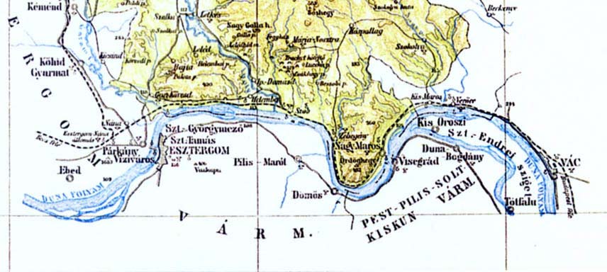
Section type 5
HUNGARIAN DANUBE BEND
River km: 1791/1790 - 1497
Borderlines: Gönyü/Kliska Nemá - Baja
Rationale for section type borders:
- upstream border: changing of slope characteristic
- downstream border: changing of substrate composition
Countries: Slovakia/Hungary
Ecoregion: 11 (Hungarian Lowlands)
Catchment area:
149,950 km2 (at Gönyü/Kliska Nemá)
207,430 km2 (at Baja)
Illustrations: (left) Danube bend (1894);
(right) Danube in the Hungarian Plain (1897) (LAJOS et al. 1943)
In this section the Danube passes breakthrough sections (the
Danube bend) and lowland areas (Hungarian plain), and
changes its watercourse from eastward to southward. In the
lowland area the Danube flows in a plain floodplain valley and
shows high anabranching (mainly cut-off loops) intensity (35 to
65 percent) or meandering (>1.26 sinuosity degree).
Morphological characteristics
The dominant main channel substrate consists of gravel in
different sizes (from coarse gravel to fine and medium sized
gravel), frequently interspersed with sand and hand sized
cobbles, organic sludge, mud, silt and clay in small
percentages. In the breakthrough section coarse blocks with
variable percentages of cobble and sand are present.
The average slope value varies between 0.10 at Gönyü
UNDP/GEF DANUBE REGIONAL PROJECT: -35-
ACTIVITY 1.1.6. TYPOLOGY OF SURFACE WATERS AND DEFINITION OF REFERENCE CONDITIONS FOR THE DANUBE RIVER
and 0.17 to 0.07 in the Hungarian bend.
The average width of the main channel amounts to 350 m; the
mean depth is 4 to 5 m. The main channel shows moderate
breadth erosion. This section is characterised by a mean
current velocity of 0.5 m/s.
After passing the breakthrough section (Danube bend) the
Danube forms two important isles: Szentendre (km 1692 -
1657) and Csepel (km 1642 - 1586).
The bank structure is variable with multiple sliding banks,
isolated fallen trees, wood collections and spur banks.
The floodplain is between 300 m (upstream Budapest) and
1500 m (downstream Budapest) wide. Lotic side arms and
dead arms, cut off channels and oxbow lakes, temporary side
arms and standing water bodies fed by the tributaries are
present in the floodplain.
The floodplain vegetation is represented by a dominant alluvial
softwood forest. Isolated alluvial hardwood forests and mixed
native forests are also present.
The dominant aquatic habitat in this section is the eupotamon
which has a mean width of 500 m. Less than 10 percent
parapotamon, plesiopotamon and palaeopotamon types are
present. The percent area of terrestrial habitats (e.g. banks,
Habitat characteristics
islands) makes up approx. 10
percent of the entire
eupotamon.
Biotic microhabitats are frequently formed by living parts of
terrestrial plants and tree trunks, rarely accompanied by
macrophytes, submerged plants, CPOM, FPOM and debris.
Tributaries
left tributaries: Váh (km 1766) average annual discharge:
190 m3/s; Hron (km 1716) 50 m3/s; Ipel (km 1708) 25 m3/s.
This section has been subdivided into three sub-section types
according to its geomorphological complexity. The first sub-
section type between Gönyü/Kliska Nemá (km 1791/1790)
and Esztergom (km 1719) is composed of an anabranching
area, part of the Large Danube Island (,,Zitný ostrov"). The
Sub-section types
second sub-section type is represented by the Danube bend
(breakthrough section) between Esztergom (km 1719) and
Nagymaros/Visegrad (km 1695). In the third sub-section type
between Nagymaros/Visegrad (km 1695) and Baja (km 1497)
the Danube flows through the Hungarian plain representing an
anabranching area.
References
national consultants' opinion (Slovakia and Hungary)
UNDP/GEF DANUBE REGIONAL PROJECT: -36-
ACTIVITY 1.1.6. TYPOLOGY OF SURFACE WATERS AND DEFINITION OF REFERENCE CONDITIONS FOR THE DANUBE RIVER
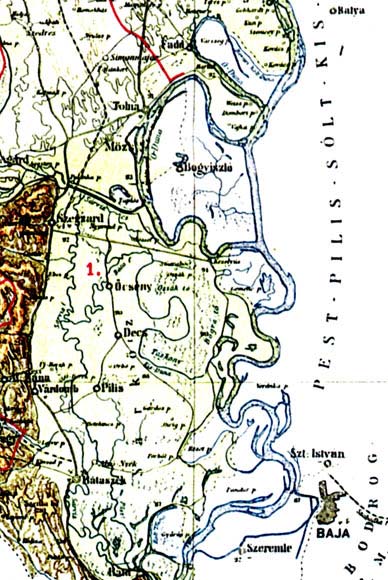
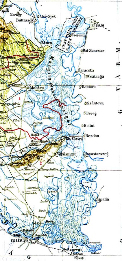
Section type 6
PANNONIAN PLAIN DANUBE
River km: 1497 - 1071
Borderlines: Baja - Bazias
Rationale for section type borders:
- upstream border: changes of substrate composition
- downstream border: beginning of breakthrough section "Kazan pass"
Countries: Hungary/Croatia/Serbia-Montenegro
Ecoregion: 11 (Hungarian Lowlands)
Catchment area:
207,430 km2 (at Baja)
570,900 km2 (at Bazias)
Illustration: Danube between Baja and Drava
confluence (1893) (LAJOS et al.
1943, modified)
The Danube in this section is passing through a floodplain
landscape with areas of accumulation, having a meandering
and plain floodplain valley with an anabranching channel
(mainly cut-off loops) and meandering sections (degree of
Morphological characteristics
sinuosity: 1.06 1.25 and partially more than 2).
A moderate breadth erosion is present in the main channel
(average width: approx. 750 m, mean depth: 6 m). The main
channel substrates are dominated by sand, and frequently fine
to medium-sized gravel occurs. Mud, sludge, silt, loam, and
UNDP/GEF DANUBE REGIONAL PROJECT: -37-
ACTIVITY 1.1.6. TYPOLOGY OF SURFACE WATERS AND DEFINITION OF REFERENCE CONDITIONS FOR THE DANUBE RIVER
clay are rare. The average slope value remains 0.04 ,
varying between Baja and Drava from 0.07 to 0.05 .
Wood collection and fallen trees are frequently present on the
river bank whose structure is partially sliding.
The large floodplain (max. width: 30 km) is characterised by a
diversity of water bodies close to the stream: lotic side arms
and dead arms, cut off channels, oxbow lakes and standing
water bodies fed by the tributaries. Alluvial hardwood and
softwood forests are dominant. Mixed native forests represent
the frequent vegetation types in the floodplain. The vegetation
in few sections is sporadically composed by meadow, wetland
(mire) and reeds.
In the lower reach of this Danube-section (Croatia/Serbia-
Montenegro) the largest tributaries with the highest runoff rate
(Drava, Tisa and Sava) create an Alpine runoff character
which substantially increases the catchment area.
The average current velocity in this section is 0.4 m/s.
The dominant aquatic habitat in this section is the eupotamon,
frequently accompanied by para- and palaeopotamon. The
percent area of terrestrial habitats (e.g. banks, islands)
represents approx. 20 percent of the entire eupotamon.
Habitat characteristics
The biotic microhabitats are frequently represented by debris,
CPOM, FPOM and sludge. Less than 30 percent submerged
plants, filamentous algae, macrophytes, living parts of
terrestrial plants as well as dead wood (tree trunks) are
present.
right tributaries: Drava (km
1382) average annual
discharge: 622 m3/s; Sava (km 1170) 1800 m3/s; Velika
Tributaries
Morava (km 1103) 206 m3/s.
left tributaries: Tisa (km 1214) 920 m3/s; Tamis-Timis
(km 1154) 104 m3/s.
This section has been subdivided into three sub-section types
according to the discharges of the most important tributaries
(Drava, Tisa and Sava) and the increase of the catchment
area. The first sub-section type is located between Baja
Sub-section types
(km 1497) and Drava confluence (km 1379), the second sub-
section type between the confluence of Drava river (km 1379)
and the confluence of Sava (km 1170). The third sub-section
type ranges from the confluence of the Sava river (km 1170)
to Bazias (km 1071).
GAVRILOVIC & DUKIC (2002); SIKORA et al. (1988);
References
Topographical Military-Maps (1974 and earlier); national
consultants' opinion (Hungary, Croatia and Serbia-
Montenegro).
UNDP/GEF DANUBE REGIONAL PROJECT: -38-
ACTIVITY 1.1.6. TYPOLOGY OF SURFACE WATERS AND DEFINITION OF REFERENCE CONDITIONS FOR THE DANUBE RIVER
Section type 7
IRON GATE DANUBE
River km: 1071 - 931
Borderlines: Bazias Turnu Severin
Rationale for section type borders:
- upstream border: beginning of the breakthrough section "Kazan pass"
- downstream border: end of the breakthrough section "Kazan pass"
Countries: Serbia-Montenegro/Romania
Ecoregion: 10 (The Carpathians)
Catchment area:
570,900 km2 (at Bazias)
578,300 km2 (at Turnu Severin)
Illustration: Iron Gates - Donauwerk
(1726) Luigi Fernando Marsigli
(ZÖGNER 1993)
Djerdap/Iron Gates canyon is composed of four
canyons (necks) and three extensions.
The braided channel is mostly rocky and shows areas
with deposits of medium and small particles of alluvial
materials (banks and islands). The main channel has
an average width of about 750 m and runs in a canyon
or trough valley form. Its mean depth amounts to
approx. 5.5 m. Slope values range from 0.04 to
0.25 .
The dominant main channel substrates are represented
Morphological characteristics
by large cobbles, boulders and bedrocks (numerous
rocks are situated directly under the water surface),
and frequent coarse, medium and partial fine gravel
interspersed with sand and mud in the slow-flowing
parts.
The river bank is isolated abort and sliding, and fallen
trees and wood collections are frequently present. The
breadth erosion is moderate. Spur banks are present.
The section is characterised by high current velocity
(1.8 to 4 m/s) and by longitudinal erosion. Shallow-
water zones with gentle bed gradients are dominant.
UNDP/GEF DANUBE REGIONAL PROJECT: -39-
ACTIVITY 1.1.6. TYPOLOGY OF SURFACE WATERS AND DEFINITION OF REFERENCE CONDITIONS FOR THE DANUBE RIVER
This enables a high diversity of depth, flow velocity and
substrate condition.
The flooded area is reduced to an average width of
about 150 m. Temporarily flooded areas (mostly to the
outflow of the Nera tributary) are present in the
floodplain as well as deciduous native forest along with
the hardwood alluvial forest and meadow.
The potamon offers a primarily lotic environment. The
Habitat characteristics
percent area of terrestrial habitats represents only
10 percent of the entire eupotamon area. Living parts
of terrestrial plants, FPOM and debris are rare.
ALMAZOV et al. (1963); IANOVICI et al. (1969); HYDRAULIC
SERVICES OF THE HARBOR ADMINISTRATION (1934);
References
STANESCU et al. (1967); THE INTERNATIONAL DANUBE
COMMITTEE (1870); national consultants' opinion
(Romania).
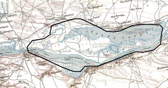
UNDP/GEF DANUBE REGIONAL PROJECT: -40-
ACTIVITY 1.1.6. TYPOLOGY OF SURFACE WATERS AND DEFINITION OF REFERENCE CONDITIONS FOR THE DANUBE RIVER
Section type 8
WESTERN PONTIC DANUBE
River km: 931 - 378
Borderlines: Turnu Severin Chiciu/Silistra
Rationale for section type borders:
- upstream border: south western border of ecoregion 12, slope-decrease to 0.04
- downstream border: beginning of wetland area
Countries: Romania/ Bulgaria
Ecoregion: 12 (Pontic Province)
Catchment area:
578,300 km2 (at Turnu Severin)
698,600 km2 (at Chiciu/Silistra)
Illustrations: Balta Potelu (GÜNTER-DIRINGER & WELLER 1999) and morphological profiles at the city of
Turnu Magurele (BANU 1967)
The Danube is passing a floodplain landscape with higher
plains of terraced accumulation in a meander and plain
Morphological characteristics
floodplain valley. The right bank is high and steep, the left
bank is low and terraced with wide floodplains.
The channel is partially braided with bars and islands and
partially anabranching (mainly cut-off loops). Meandering
UNDP/GEF DANUBE REGIONAL PROJECT: -41-
ACTIVITY 1.1.6. TYPOLOGY OF SURFACE WATERS AND DEFINITION OF REFERENCE CONDITIONS FOR THE DANUBE RIVER
reaches are also present (degree of sinuosity 1.06-1.25). The
main channel has moderate breadth erosion (average width of
830 m and mean depth of 8.5 m). Main channel substrates
frequently vary from fine and medium gravel to sand
accompanied by small percentages of coarse gravel and mud.
The average slope values remains 0.04 .
Multiple wood collections and isolated fallen trees are present
on the river banks. Their structure varies: abort and sliding
banks are present as well as bank spurs and nest banks. This
section is characterised by moderate values of current velocity
(1.30 m/s).
The average width of the floodplain is about 8000 m and the
diversity of water bodies in this area close to the stream is
large: lotic side arms connected to the main channel at both
ends, cut off channels, oxbow lakes and standing water
bodies fed by the tributaries.
Deciduous native forest, wetland (mire) and open grass is the
dominant vegetation in the floodplain, often accompanied by
alluvial soft wood forest, meadow and reeds. Sporadically the
vegetation is missing.
Average width of the eupotamon is 1500 m. The percent area
of terrestrial habitats represents 75 percent of the entire
eupotamon.
Habitat characteristics
The biotic microhabitats are frequently represented by
filamentous algae and macrophytes as well as CPOM and
debris. In less than 30 percent living parts of terrestrial plants
and FPOM are present.
right tributaries: Isker (km 636) average annual discharge:
55 m3/s; Jantra (km 536) 40 m3/s.
Tributaries
left tributaries: Jiul (km 692) 88 m3/s; Olt (km 604)
148 m3/s; Arges (km 432) 80 m3/s.
References
BANU (1967); IANOVICI et al. (1969); STANESCU et al. (1967);
national consultants' opinion (Romania).
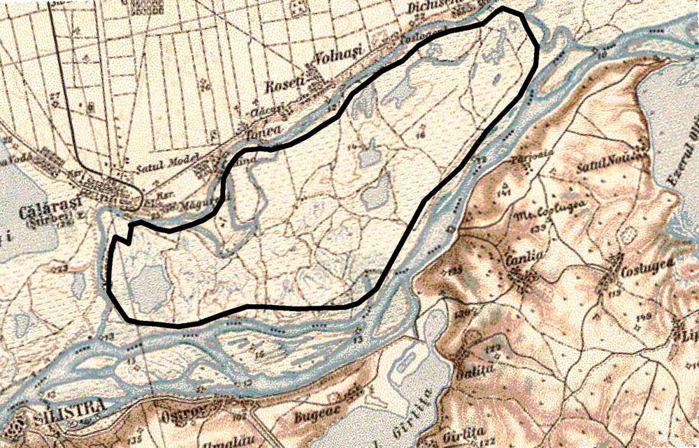
UNDP/GEF DANUBE REGIONAL PROJECT: -42-
ACTIVITY 1.1.6. TYPOLOGY OF SURFACE WATERS AND DEFINITION OF REFERENCE CONDITIONS FOR THE DANUBE RIVER
Section type 9
EASTERN WALLACHIAN DANUBE
River km: 378 - 100
Borderlines: Chiciu/Silistra - Isaccea
Rationale for section type borders:
- upstream border: beginning of wetland area
- downstream border: beginning of the Danube Delta
Countries: Romania/Moldova/Ukraine
Ecoregion: 12 (Pontic Province)
Catchment area:
698,600 km2 (at Chiciu/Silistra)
709,500 km2 (at Isaccea)
Illustrations: Balta Calarasi (GÜNTHER-DIRINGER & WELLER 1999), Morphological profiles at Balta
Braila (BANU 1967)
The Danube changes its watercourse northward forming a
wetland area with two large isles (374-248 km Balta Ialomita
and 238-169 km Balta Braila) and many natural lakes. The
Morphological characteristics
valley form is a meander and plain floodplain valley with a
braided channel (mostly long and narrow islands), composite
anabranching channel and meandering sections (>1.26 of
sinuosity degree).
UNDP/GEF DANUBE REGIONAL PROJECT: -43-
ACTIVITY 1.1.6. TYPOLOGY OF SURFACE WATERS AND DEFINITION OF REFERENCE CONDITIONS FOR THE DANUBE RIVER
The main channel has an average width of 650 m, a mean
depth of 10.5 m and shows moderate breadth erosion. The
dominant channel substrate is sand, frequently interspersed
with mud, organic sludge, silt, loam and clay. In small
percentages gravel is present in fine to medium size.
The bank structure is variable with multiple abort and nesting
banks and bank spurs. Fallen trees and sliding banks are
sporadically present.
The floodplain has an average width of 5500 m. Lotic side
arms and dead arms, cut off channels and oxbow lakes,
temporary side arms and standing water bodies fed by the
tributaries form the water bodies in the floodplain.
The average slope value remains 0.04 . The section is
characterised by slow current velocity (0.8 m/s).
More then 60
percent of the floodplain vegetation is
represented by deciduous native forest, wetland (mire) and
open grass frequently accompanied by alluvial softwood
forest, meadows and reeds. Isolated mixed native forest and
naturally unvegetated areas are present.
Eupotamon is the dominant aquatic habitat type and shows an
average width of 1000 m. The percent area of terrestrial
habitats amounts to 60 percent of the entire eupotamon.
Parapotamon, plesiopotamon and the palaeopotamon types
Habitat characteristics
are frequently present.
The FPOM is the dominant biotic microhabitat in this section,
frequently accompanied by macrophytes, living parts of
terrestrial plants, CPOM and debris. Tree trunks, branches
and roots are rarely present.
Tributaries
left tributaries: Ialomita (km 234) average annual discharge
39 m3/s; Siret (km 155) 241 m3/s; Prut (km 134) 89 m3/s.
ALMAZOV et al. (1963); BANU (1967); IANOVICI et al. (1969); THE
References
INTERNATIONAL
DANUBE
COMMITTEE
(1870); national
consultants' opinion (Romania).
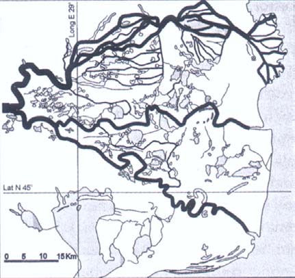
UNDP/GEF DANUBE REGIONAL PROJECT: -44-
ACTIVITY 1.1.6. TYPOLOGY OF SURFACE WATERS AND DEFINITION OF REFERENCE CONDITIONS FOR THE DANUBE RIVER
Section type 10
DANUBE DELTA
River km: 100 - 0
Borderlines: Isaccea - Sulina
Rationale for section type borders:
- upstream border: the beginning of the Delta, slope decrease to 0.001
- downstream border: mouth of the river into Black Sea
Countries: Romania/Ukraine
Ecoregion: 12 (Pontic Province)
Catchment area:
709,500 km2 (at Isaccea)
807,000* km2 at Sulina (*different figures given in the literature)
Illustration: Danube Delta about
1880 in BUIJSE et al.
(2002)
The Danube Delta is Danube's "youngest" territory having three
main water channels: Kilia, Sulina and Sf. Gheorghe, and
numerous canals and floating islands ("plauri"). Close to the
estuary the three main branches are divided into numerous
branches creating their own delta. At mean water levels
60 percent of this area is covered by waters (90 percent at high
levels). The shape of the delta is triangular. A large variety of
distinct lentic habitats is developed.
The valley form is plain floodplain and the channel form is
Morphological characteristics
diverse due to the complexity of the delta: braided channel
(braiding intensity 65 percent); split, sinuous and composite
anabranching; meandering channel (degree of sinuosity
>1.26). The average width of the main channels is 450 m at
Kilia, 400 m at Sulina and 450 m at Sf. Gheorghe. The mean
depth of the three branches amounts to 13 m. Slope values
vary between 0.04 and 0.001 .
The dominant substrates are sand, mud, sludge, silt, loam and
UNDP/GEF DANUBE REGIONAL PROJECT: -45-
ACTIVITY 1.1.6. TYPOLOGY OF SURFACE WATERS AND DEFINITION OF REFERENCE CONDITIONS FOR THE DANUBE RIVER
clay.
Multiple wood collections are present on the river bank; fallen
trees are sporadic. At several reaches the bank structure is
abort. Lotic side arms and dead arms, cut off channels and
oxbow lakes, temporary side arms and standing water bodies
fed by the tributaries constitute water bodies in the floodplain.
The average width of the floodplain is about 100 km.
This section is characterised by a medium current velocity of
0.7 m/s (Kilia 0.7 m/s, Sulina 0.65 m/s, Sf. Gheorghe 0.68 m/s).
Accumulations of sediment produce progression of the delta
which is permanently shaped by maritime currents.
The vegetation in this area is very complex, wetlands (mire)
and reeds are dominant. Alluvial hardwood forest, deciduous
native forest and open grass land are frequently present.
Alluvial softwood forest, mixed native forest, meadow and
naturally unvegetated areas are rare.
The percent area of terrestrial habitats represents 40 percent of
the entire eupotamon. Para-, plesio- and palaeopotamon show
Habitat characteristics
equal shares.
Living parts of terrestrial plants, FPOM and debris as biotic
microhabitats are rare.
ALMAZOV et al. (1963); IANOVICI et al. (1969); THE
References
INTERNATIONAL DANUBE COMMITTEE (1870); SIKORA et al. (1988);
national consultants' opinion (Romania).
UNDP/GEF DANUBE REGIONAL PROJECT: -46-
ACTIVITY 1.1.6. TYPOLOGY OF SURFACE WATERS AND DEFINITION OF REFERENCE CONDITIONS FOR THE DANUBE RIVER
Reference fish fauna of the Austrian Danube a guideline-proposal for the
definition of biological reference conditions based on historical data
The Austrian experience in describing the biological reference conditions by the use
of historical data may serve as guidance for the countries in the Danube River Basin
for applying, adapting or developing similar procedures.
The reference species composition of the Austrian Danube was compiled from
historical publications on the fish fauna of the Austrian Danube. The procedure is
described in this chapter. Data sources can be found in HAIDVOGL et al. (2003,
Annex 2) which is also the foundation for this subchapter.
,,Scientific" descriptions of the fish fauna of European rivers have been published
from the 18th century onwards. The earliest publications mostly deal with biological
characteristics of the species. When compiling the data about the historical fish fauna
of the Austrian Danube the inquiries for published data mainly concentrated on the
19th century because at that time the river could be considered as more or less
natural or nature like. The main purpose of historical analyses for describing
reference conditions is to gain information about the composition/distribution and
abundance before major anthropogenic impacts took place (canalisation and
constructions for flood protection and navigation, hydropower plants etc.). It is
recommended to start historical analyses by identifying and dating these impacts for
the concerned sections because of the sometimes poor quality of historical data from
the 19th century which improved throughout the 20th century.
Reports dealing with the fish fauna derive from this period of time, too. However,
these papers or notes must be reviewed carefully because they are sometimes
written by laymen. Besides published reports material about commercial fishery
registered in archives can provide important information about species occurring at a
particular site or catch of certain species. Though it depends on the organisation of
commercial fishery if the output was registered and traded.
Concerning abundance historical sources at the utmost allow a verbal classification
of main and well-known species. Even if data from commercial fishery are available
they can only indicate dominant and very frequent species but they do not exactly
reflect the ecological situation. As a consequence the historical analyses of the
Austrian Danube fish fauna were combined with more recent surveys and expert
judgement to get the complete species composition and abundance classes. The
basis for the classification of abundance in breakthrough and anabranching sections
was the description of the natural morphological conditions of the Austrian Danube.
The historical Austrian Danube fish fauna is presented in table 1:
UNDP/GEF DANUBE REGIONAL PROJECT: -47-
ACTIVITY 1.1.6. TYPOLOGY OF SURFACE WATERS AND DEFINITION OF REFERENCE CONDITIONS FOR THE DANUBE RIVER
Table 1: Fish fauna of the Austrian Danube Reference status of occurrence and abundance classes
xxxx = dominant; very large, self-sustaining populations in the Danube;
xxx = frequent; self-sustaining populations;
xx = rare;
x = very rare; only few specimen which occur only sporadically
Occurrence
Abundance Classes
Austrian Danube breakthrough anabranching
section
sections
sections
Acipenseridae:
Sterlet, Acipenser ruthenus
xx xx
Ship sturgeon, Acipenser nudiventris
x
x
Stellate sturgeon, Acipenser stellatus
x
x
Russian sturgeon, Acipenser gueldenstaedti
x
x
Great sturgeon, Huso huso
x
x
Salmonidae:
Danube salmon, Hucho hucho
xxx xxx
Brown trout, Salmo trutta
xx xx
Thymallidae:
European grayling, Thymallus thymallus
xx xx
Esocidae:
Nothern pike, Esox lucius
xx
xxx
Coregonidae:
Coregonen
x x
Umbridae:
European mudminnow, Umbra krameri
xx*
Cyprinidae:
Zope or Blue bream, Abramis ballerus
x xx
White bream, Abramis björkna
xx xxxx
Common bream, Abramis brama
xx xxx
Zobel or Danubian bream, Abramis sapa
x xxx
Bleak, Alburnus alburnus
xxxx xxxx
Spirlin, Alburnoides bipunctatus
x x
Asp, Aspius aspius
xx xx
Barbel, Barbus barbus
xxxx xxxx
Balkanian barbel, Barbus peloponnesius
x x
Prussian carp, Carassius auratus gibelio
x x
Crucian carp, Carassius carassius
x xx
Nase, Chondrostoma nasus
xxxx xxxx
Common carp, Cyprinus carpio
x
xx
Whitefin gudgeon, Gobio albipinnatus
xxx xxx
Gudgeon, Gobio gobio
x x
Kessler`s gudgeon, Gobio kessleri
xx xx
Danube gudgeon, Gobio uranoscopus
xx xx
Belica, Leucaspius delineatus
xx
European chub, Leuciscus cephalus
xxx xxx
Ide, Leuciscus idus
xx xxx
Eurasian dace, Leuciscus leuciscus
xxx xxx
Soufie, vairone; Leuciscus souffia agassiz
x x
Chekhon, Pelecus cultratus
x x
Eurasian minnow, Phoxinus phoxinus
xx xx
Bitterling, Rhodeus amarus
x xx
Rutilus frisii meidingeri
x x
Danube roach Rutilus pigus virgo
xx xxx
Roach, Rutilus rutilus
xxx xxxx
Rudd, Scardinius erythrophthalmus
x xxx
Tench, Tinca tinca
x xxx
Vimba, Vimba vimba
xx xxx
UNDP/GEF DANUBE REGIONAL PROJECT: -48-
ACTIVITY 1.1.6. TYPOLOGY OF SURFACE WATERS AND DEFINITION OF REFERENCE CONDITIONS FOR THE DANUBE RIVER
Occurrence
Abundance Classes
Austrian Danube breakthrough anabranching
section
sections
sections
Balitoridae
Stone loach, Barbatula barbatula
xx xx
Cobitidae:
Spined loach, Cobitis taenia
xx xx
Wheaterfish, Misgurnus fossilis
x xx
Siluridae:
Wels, Siluris glanis
xx
xxx
Gadidae:
Burbot, Lota lota
xxx
xxx
Percidae:
Balon's ruffe, Gymnocephalus baloni
xx xx
Ruffe, Gymnocephalus cernuus
x x
Schraetzer/Striped ruffe, Gymnocephalus schraetser
xxx xxx
Eurasian perch, Perca fluviatilis
xxx xxxx
Pikeperch, Zander, Sander luciopera
xx xxx
Volga pikeperch, Sander volgensis
x xx
Danube streber, Zingel streber
xxx xx
Zingel, Zingel zingel
xxx xxxx
Cottidae:
Bullhead, Cottus gobio
xxx
xxx
Petromyzonidae:
Eudontomyzon mariae
x x
57 Species
* Westward distribution only up to the Vienna basin / Wiener Becken
A systematic summary with types of historical data and proceeding of analyses is
presented below to simplify the search of information and definition of biological
references. This is composed of five types of data: Recent publications; Historical
publications by biologists; Historical publications by ichthyological laymen; Records in
archives' and museums' material.
Type 1: Search for recent publications on the history of the biology, geography etc. of
the relevant rivers, regions or cities
Before historical material is collected and analysed it should be examined if recent
historical studies have already been accomplished and published. Besides ecological
and biological publications the ones on geography and the history of specific regions
and cities should be considered, too.
Type 2: Publications about Danube fish species and fish assemblages by biological /
ichthyological experts (examples from Austria: Heckel, Heckel & Kner, Siebold,
Fitzinger, Lori etc.; see list of references in HAIDVOGL et al. 2003):
Period covered:
· From the late 18th century onwards; earlier documents could be available
(like e.g. MARSIGLI 1726), mainly from the 19th and early 20th century
Extend of possible information:
· Presence and absence of fish species; sometimes information about
occurrence in particular stretches or sites available; verbal classification of
abundance of certain species.
Quality of data:
UNDP/GEF DANUBE REGIONAL PROJECT: -49-
ACTIVITY 1.1.6. TYPOLOGY OF SURFACE WATERS AND DEFINITION OF REFERENCE CONDITIONS FOR THE DANUBE RIVER
· Information given in these publications is usually quite reliable. However
data are not based on systematic surveys. Therefore information about
occurring fish species and especially on distribution is likely to be
incomplete.
Problems encountered during analyses:
· Fish species lists could be incomplete due to taxonomic reasons (some
species might have been described only after anthropogenic impacts; e.g.
some Gobio sp. in the Austrian Danube section). In many cases these
species could be added by using more recent information.
· The taxonomic classification of some species was changed in the past.
During the analyses the correct species has to be identified.
· Sometimes only "common" and/or local names for species are given. These
species must also be identified during the analyses. When common names
are used one also faces the problem that similar names could refer to
different species in different regions (like the term Weißfisch/whitefish in the
Austrian Danube).
How to find the data:
· This type of data is usually easy to find in national and scientific libraries
(universities, museums). Some publications were not published as
monographs - therefore systematic inquiries in relevant journals must be
carried out.
Estimated efforts (given for one person): 2-3 weeks inquiry of relevant publications,
4-8 weeks for analyses.
Type 3: Reports published by ichthyological "laymen" in geographical and/or natural
history publications (examples from the Austrian Danube: KUKULA 1874, LORI 1871,
KRISCH 1900)
This type of data could be used in addition to publications by experts. Usually the
material is detected anyway when searching for publications in libraries.
Period covered:
· from the 18th century onwards; also several publications from the 16th
century.
Extend of possible information:
· Absence and presence of fish species, information on distribution and
abundance (classes).
Quality of data:
· Must be checked more carefully than sources of the type mentioned above
(authors usually not educated in biology).
UNDP/GEF DANUBE REGIONAL PROJECT: -50-
ACTIVITY 1.1.6. TYPOLOGY OF SURFACE WATERS AND DEFINITION OF REFERENCE CONDITIONS FOR THE DANUBE RIVER
Problems encountered during analyses:
· In principle the same as mentioned under type 2, experiences from Austrian
rivers showed that in most cases common/regional names for fish species
are the biggest problem (sometimes information cannot be used at all due to
that reason).
How to find these data: see above (type 2).
Type 4: Records on commercial fishery in historical archives
Period covered:
· from the late Middle Ages onwards; but rather 16th century and later
Extend of possible information:
· Presence of species at a certain site; most dominant species in certain
regions; quantitative information about amount of fish caught in a known
period; however, no information about the actual fish-stocks available;
possibly information of occurrence of species in specific habitat-types.
Quality of data:
· Data are usually quite reliable. However, it has to be taken into account that
quantitative information does not necessarily reflect the ecological situation;
it also shows the preferences for certain species.
Problems encountered during analyses:
· Only fish species which were of commercial interest are reported (however,
more species were caught than nowadays; in the Austrian Danube e.g.
cyprinids like nase, barbel, dace, bream or other small species like
bullhead).
How to find the data:
· First of all relevant archives must be found (defined) as there are
monasteries or castles which had fishing rights on the Danube or
associations of commercial fishermen on the Danube.
· The next step is to verify if archive material (still) exists at all. When
searching for data for the Austrian Danube valuable records from
commercial fishery were detected in the big monastery Herzogenburg (at the
mouth of the river Traisen). On the other hand an important monastery like
Klosterneuburg in the vicinity of Vienna supplied its need for fish at the
Viennese Fishery market. The monastery leased its fishing rights to
commercial fishermen and hence no data were traded in the monastery
archive.
· In a further step one has to find out whether the archive material is still
stored in the relevant monastery/castle or if it has been incorporated into a
national archive.
· One final point is that in most cases the material could only be read and
analysed by people who are familiar with old handwritings.
Estimated efforts: Although hard to estimate the method described is quite time-
consuming and the efforts depend on several factors especially how well the archive
materials are sorted and registered.
UNDP/GEF DANUBE REGIONAL PROJECT: -51-
ACTIVITY 1.1.6. TYPOLOGY OF SURFACE WATERS AND DEFINITION OF REFERENCE CONDITIONS FOR THE DANUBE RIVER
Besides material about commercial fishery it is also recommended to analyse
accounts of fish purchase, fish delivered to monasteries by fishermen or records of
delivery to fish markets. For the period covered, quality of data etc. the same has to
be said as for the sources described above. However, if accounts of fish-purchase or
reports about fish delivered by fishermen are used one has to verify the provenience
of fish. When fish market deliveries are analysed the origin of the fish must be
identified. Usually especially fish markets of larger cities were provided with fish from
larger areas. The Viennese market for instance was supplied with fish from Lower
and Upper Austria, from Bohemia and Hungary from as far back as the 16th century.
Type 5: Specimen of fish in museum collections
Finally, museum collections can provide valuable information about the occurrence of
a species on a specific site.
REFERENCES
ALMAZOV et al. (1963): The Outflow area of the Danube hydrological monograph
(incomplete reference).
AMOROS, C., RICHARDOT-COULET, M. & G. PAUTOU (1982): Les `Ensembles Fonctionelles´:
des entitčs čcologiques qui traduisent l`evolution de l`hydrosystčme en intčgrant la
gčomorphologie et l`anthropisation (example du Haut-Rhone francais). Revue de
Geographie de Lyon, 57: 49-62.
BANU, A.C. (ed.) (1967): Limonologia Sectorului Romanesc al Dunarii. Studiu Monografic.
Editura Academia Republicii Socialiste Romania, Bucuresti.
BUIJSE, A.D., COOPS, H, STARAS, M., JANS, L.H., VAN GEEST, G.J., GRIFT, R.E., IBELINGS,
B.W., OOSTERBERG, W. & F.C.J.M. ROOZEN (2002): Restoration strategies for river
floodplains along large lowland rivers in Europe. Freshwater Biology, 47: 889-907.
EHLERT, T., HERING, D., KOENZEN, U., POTTGIESSER, T., SCHUHMACHER, H. & G. FRIEDRICH
(2002): Typology and type specific reference conditions for medium-sized and large
rivers in North Rhine-Westphalia: biological aspects. Internat. Rev. Hydrobiol., 87:
151-163.
GAVRILOVIC, L. & D. DUKIC (2002): The rivers of Serbia. (incomplete reference).
GENERALDIREKTION DER STAATLICHEN ARCHIVE BAYERNS (ed.) (1998): Altbayerische
Flusslandschaften an Donau, Lech, Isar und Inn handgezeichnete Karten des 16.
bis 18. Jahrhunderts aus dem Bayerischen Hauptstaatsarchiv. Konrad, Weißenhorn.
GÜNTHER-DIRINGER, D. & P. WELLER (ed.) (1999): Evaluation of wetlands and floodplain
areas in the Danube River Basin (Annexes). Danube Pollution Reduction Programme.
WWF Danube-Carpathian-Programme and WWF-Auen-Institut, Rastatt.
HAIDVOGL, G., HOHENSINNER, S., SCHMUTZ, S. & H. WAIDBACHER (2003): Typology of the
River Danube and descriptions of reference condition based on historical data and
expert judgement. Department of Hydrology, Fisheries and Aquaculture, University of
Natural Resources and Applied Life Sciences, Wien: 19 pp. (Annex 2 this report)
HERING, D., GERHARD, M., KIEL, E., EHLERT, T. & T. POTTGIESSER (2000): Review study on
near-natural conditions of Central European Mountain Streams, with particular
reference to debris and beaver dams: Results of the "REG Meeting" 2000.
Limnologica, 31: 81-92.
UNDP/GEF DANUBE REGIONAL PROJECT: -52-
ACTIVITY 1.1.6. TYPOLOGY OF SURFACE WATERS AND DEFINITION OF REFERENCE CONDITIONS FOR THE DANUBE RIVER
HOHENSINNER, S., HABERSACK, H., JUNGWIRTH, M. & G. ZAUNER (2003): Reconstruction of the
characteristics of a natural alluvial river-floodplain system and hydromorphological
changes following human modifications: the Danube River (1812-1991). River
Research and Applications. (in press)
HYDRAULIC SERVICES OF THE HARBOR ADMINISTRATION (1934): The Danube map (km 1075 -
771). (incomplete reference)
IANOVICI, V. et al. (1969): Romanian Danube valley geography monograph University
course. (incomplete reference)
KRISCH, A. (1900): Der Wiener Fischmarkt. Wien.
KUKULA, W. (1874): Die Fischfauna Oberösterreichs. Fünfter Jahres-Bericht des Vereines für
Naturkunde in Oesterreich ob der Enns zu Linz. Verein für Naturkunde zu Linz: 2-25.
LAJOS et al. (1943): Pallas Nagy Lexikona, I-XVI. Pallas Irodalmi és Nyomdai
Részvénytársaság, Budapest.
LÁSZLÓFFY, W. (1965): Die Hydrographie der Donau. Der Fluss als Lebensraum. In: Liepolt,
R. (ed.): Limnologie der Donau Eine monographische Darstellung. Kapitel II: 16-57.
Schweizerbart, Stuttgart.
LORI, T. (1871): Die Fische in der Umgegend von Passau. 9. Jahresbericht des
naturhistorischen Vereines in Passau.
MARSIGLI, L.-F. (1726): Danubius pannonico-mysicus, observationibus. 7 vols. Hague.
PISUT, P. (2002): Channel evolution of the pre-channelised Danube River in Bratislava,
Slovakia (1712-1886). Earth Surface Process and landforms, 27: 369-391.
SIKORA, A., ÜRGE, L. & D. MIKLÓS (1988): Hydrology of the river Danube. Príroda, Bratislava.
SOMMERHÄUSER, M. & T. POTTGIESSER (2003A): Steckbriefe der bundesdeutschen
Fließgewässertypen Typ 9: Silikatische Mittelgebirgsbäche. (unpublished)
SOMMERHÄUSER, M. & T. POTTGIESSER (2003b): Steckbriefe der bundesdeutschen
Fließgewässertypen Typ 9.1: Karbonatische Mittelgebirgsbäche. (unpublished)
SOMMERHÄUSER, M. & T. POTTGIESSER (2003c): Steckbriefe der bundesdeutschen
Fließgewässertypen Typ 9.2: Große Flüsse des Mittelgebirges. (unpublished)
STAMMER, H.A. (1954): Übersicht über Geologie, Flußgeschichte und Hydrographie der
Donau bis Obernzell und des Mains. In: Liebmann, H. (ed.): Biologie und Chemie des
ungestauten und gestauten Stromes - beschrieben am Beispiel der Donau und des
Mains. Münchner Beiträge zur Abwasser-, Fischerei- und Flussbiologie, 2.
Oldenbourg, München.
STANESCU, V.A. et al. (1967): The Danube from Bazias to Ceatal Izmail hydrological
monograph. (incomplete reference).
THE INTERNATIONAL DANUBE COMMITTEE (1870): The Danube map between Braila and the
Black Sea (Map). (incomplete reference)
VON BOHNENBERGER, J.G.F., VON AMMAN, I.A. & E.H. MICHAELIS (1798-1828): Charte von
Schwaben (Schwab), Maßstab ca. 1:86400.
ZÖGNER, L. (ed.) (1993): Flüsse im Herzen Europas: Rhein, Elbe, Donau; kartographische
Mosaiksteine einer europäischen Flusslandschaft. Reichert, Wiesbaden.
UNDP/GEF DANUBE REGIONAL PROJECT: -53-
ACTIVITY 1.1.6. TYPOLOGY OF SURFACE WATERS AND DEFINITION OF REFERENCE CONDITIONS FOR THE DANUBE RIVER
Proposal of the reference communities of macroinvertebrates of the
Danube River
MARIO SOMMERHÄUSER, SABINA ROBERT & SEBASTIAN BIRK
The macroinvertebrate reference communities for the individual section types have
mainly been compiled from data on existing "reference" sites and from literature
sources. Results of the Joint Danube Survey (JDS, LITERÁTHY 2002) have been used,
not regarding data on impounded sections. In this survey more than 100 sampling
sites have been investigated. As additional historical information the huge taxa list for
the whole Danube compiled by DUDICH (1967) has been used which goes back
beyond 1920. Many of the major hydromorphological alterations (dams, hydropower
plants etc.) have been established later than DUDICH's review.
The information given in this chapter provides a first overview of macroinvertebrate
reference data.
The JDS data have been analysed by checking the presence/absence and
abundances of species to identify these taxa which are mainly occurring in certain
sections.
Four groups of species have been distinguished:
· section type-specific species, occurring predominantly in a certain section
type, e. g. the Danube Delta (example: the Venus mussel Chamelea gallina)
· reach specific species, occurring predominantly in a certain region, e. g. Upper
Danube River (example: the snail Ancylus fluviatilis)
· Danube-specific species, predominantly restricted to the Danube (e. g. pontic
fauna elements like the snail Theodoxus danubialis)
· large river-specific species, occurring predominantly in large rivers, e. g. river
Rhine (example: the caddisfly Hydropsyche contubernalis).
To get a first impression of the macroinvertebrate fauna of a certain section type not
only the `section type-specific species' should be considered. Additionally, the taxa of
the `reach specific species', the `Danube specific species', and the `large river
specific species' may occur.
No reference communities have been defined for the sub-sections. For the reference
community of section type 1 (Upper Course of the Danube) refer to POTTGIESSER &
SOMMERHÄUSER (2004).
The results of the analysis are presented in table 1.
-54-
SOMMERHÄUSER, ROBERT & BIRK: Proposal of the reference communities of macroinvertebrates of the Danube River
Table 1: Current status of a preliminary list of macroinvertebrate "reference species" for the section types and reaches of the Danube river (in process). Species
selected from data of the Joint Danube Survey (2001) and literature (DUDICH 1967, KUSEL-FETZMANN et al. 1998, RUSSEV et al. 1998). Large river type-
specific species after SCHÖLL & HAYBACH (2001).
Section type 2 Section type 3 Section type 4 Section type 5
Section type 6 Section type 7
Section type 8 Section type 9 Section type 10
river km
2581 - 2225
2225 - 2001
2001 - 1791/1790 1791/1790 - 1497
1497 - 1071
1071 - 931
931 - 378
378 - 100
100 - 0
(from to)
Eastern Alpine
Eastern
name of
Western Alpine
Lower Alpine
Hungarian
Pannonian Plain
Iron Gate
Western Pontic
Foothills
Wallachian
Danube Delta
section
Foothills Danube
Foothills Danube Danube Bend
Danube
Danube
Danube
Danube
Danube
number of
116 7
2
9
1
4
0
8
7
2
9
8
4
2
6
5
2
taxa (JDS)
Gammarus
Ephoron virgo
Erpobdella
Ephoron virgo
Paludicella
Isochaetides
Mytilus
Angulus exiguus
fossarum
Heptagenia
nigricollis
Heptagenia flava articulata
michaelseni
galloprovincialis Anodonta cygnea
Gammarus pulex coerulans
Ecdyonurus
Propappus volki Ostrea
Chamelea gallina
Gammarus
Brachyptera
aurantiacus
Lithoglyphus
sublamellosa
Mytilus
roeseli
trisfasciata
Ephoron virgo
naticoides
Pseudoanodonta galloprovincialis
Baetis alpinus
Isogenus
Heptagenia flava
Dreissena
complanata
Ostrea
Baetis fuscatus nubecula
Isogenus
polymorpha
sublamellosa
Heptagenia
Xantoperla
nubecula
Corophium
Unio pictorum
sulphurea
apicalis
Brachyptera
curvispinum
Gyraulus laevis
Potamanthus
Ceraclea
trisfasciata
Pontogammarus
Corophium
luteus
dissimilis
Xantoperla
obesus
volutator
section type- Dinocras
C. annulicornis
apicalis
Pontogammarus
Hemimysis
specific
cephalotes
Hydropsyche
Agapetus laniger
sarsi
anomala
species
Leuctra fusca
contubernalis
Ceraclea
Jaera sarsi
Caenis horaria
Elmis maugetii
Oecetis notata
annulicornis
Dikerogammarus
Elmis rietscheli
Psychomyia
C. dissimilis
haemobaphes
Hydropsyche
pusilla
Hydropsyche
Hydropsyche
contubernalis
bulgaromanorum
bulgaromanorum
Hydropsyche
Hydropsyche
exocellata
contubernalis
Hydropsyche
Psychomyia
pellucidula-Gr.
pusilla
Rhyacophila
dorsalis
Tinodes pallidulus
-55-
SOMMERHÄUSER, ROBERT & BIRK: Proposal of the reference communities of macroinvertebrates of the Danube River
Table 1 (continued)
Section type 2
Section type 3 Section type 4 Section type 5 Section type 6 Section type 7 Section type 8 Section type 9 Section type 10
river km
1791/1790 -
2581 - 2225
2225 - 2001
2001 - 1791/1790
1497 - 1071
1071 - 931
931 - 378
378 - 100
100 - 0
(from to)
1497
Eastern Alpine
Eastern
name of
Western Alpine
Lower Alpine
Hungarian
Pannonian Plain
Iron Gate
Western Pontic
Foothills
Wallachian
Danube Delta
section
Foothills Danube
Foothills Danube Danube Bend
Danube
Danube
Danube
Danube
Danube
Upper Danube reach
Middle Danube reach
Lower Danube reach
Cordylophora caspia
Branchiura sowerbyi
Ancylus fluviatilis
Dugesia tigrina
Theodoxus fluviatilis
Stylaria lacustris
Baetis rhodani
Branchiura sowerbyi
Cardium edule
reach
Cordylophora caspia
Ephemera danica
Ephemera danica
Stylaria lacustris
Unio pictorum
specific
Psychomyia pusilla
Esperiana esperi
Calopteryx splendens
Heptagenia sulphurea
Esperiana esperi
Limnomysis benedeni
species
Tinodes waeneri
Lymnaea stagnalis
Gomphus flavipes
Calopteryx splendens
Ferrissia wautieri
Caenis horaria
Stagnicola palustris
Ischnura elegans
Brachycentrus subnubilus
Hydrobia ventrosa
Caenis robusta
Theodoxus danubialis
Brachycentrus subnubilus
Ceraclea dissimilis
Lymnaea stagnalis
Gomphus flavipes
Theodoxus fluviatilis
Hydropsyche pellucidula
Stagnicola palustris
Ischnura elegans
Limnomysis benedemi
Theodoxus danubialis
danube - Cordylophora caspia, Microcolpia daudebartii, Lithoglyphus naticoides, Theodoxus danubialis, Theodoxus transversalis, Viviparus acerosus, Dreissena polymorpha,
specific Corophium curvispinum, Dikerogammarus haemobaphes, Dikerogammarus villosus, Echinogammarus ischnus, Obesogammarus obesus, Jaera istri
species
large River- Dina lineata, Dina punctata, Erpobdella nigricollis, Pisidium supinum, Sphaerium rivicola, Heptagenia flava, Gomphus flavipes, Gomphus vulgatissimus, Brychius
specific elevatus, Limnius spec., Orectochilus villosus, Brachycentrus subnubilus, Ceraclea annulicornis, Ceraclea dissimilis, Hydropsyche bulgaromanorum, Hydroptila
species sparsa, Psychomyia pusilla
-56-
ANNEX 2 - QUESTIONNAIRE: IDENTIFYING HYDROMORPHOLOGICAL PRESSURES ON THE DANUBE RIVER, PART C
Section type 2 (Western Alpine Foothills Danube). The macroinvertebrate fauna of this
section type is characterised by lithophilous species adapted to higher stream flow
velocities. The macroinvertebrate community can be regarded as `alpine-influenced'.
Typical species are the Amphipods Gammarus fossarum, Gammarus pulex, Gammarus
roeseli, the mayflies Potamanthus luteus, Heptagenia sulphurea, Baetis alpinus and
Baetis fuscatus, the stoneflies Dinocras cephalotes, and Leuctra fusca, the beetles Elmis
maugetii and E. rietscheli, and the caddisflies Rhyacophila dorsalis, R. nubila,
Hydropsyche pellucidula and Tinodes pallidulus.
Section type 3 (Eastern Alpine Foothills Danube). Also this section type is mainly
influenced by prealpine features, typical species are mainly lithophilous species e. g. the
mayfly Heptagenia coerulans which are supplemented by other species of larger rivers
like the mayfly Epheron virgo and a Danube-specific element, the flatworm Dendrocoelum
romanodanubiale.
Section type 4 (Lower Alpine Foothills Danube). In this section type the morphological
features change to a lowland situation. Beside the caddisfly Psychomyia pusilla several
taxa which are not restricted to this section but live in all three sections of the upper
Danube can be found, e. g. the sand-living mayfly Ephemera danica, the dragonfly
Calopteryx splendens and some caddisfly species which are specific for larger rivers in
general e. g. Brachycentrus subnubilus, Ceraclea dissimilis and Tinodes waeneri.
The Section types 5 7 are difficult to differentiate in terms of macroinvertebrate
community. Specific for all three sections are taxa which inhabit finer substrate types
(sand, mud) and macrophytes, e. g. the aquatic earthworms (Oligochaeta) Stylaria
lacustris and Branchiura sowerbyi, the snails Esperiana (Fagotia) esperi, Stagnicola
palustris, Lymnaea stagnalis, Theodoxus danubialis and T. fluviatilis, the dragonflies
Gomphus flavipes and Calopteryx splendens and Ischnura elegans. The shrimp
Limnomysis benedemi is an important brackish element which intruded into this area from
the Black Sea via the Danube Delta.
Section type-specific for section type 5 (Hungarian Danube Bend) with its naturally
constrained channel form and gravelly or sandy substrates are the mayfly Heptagenia
flava and the shrimp Dikerogammarus villosus. In section type 6 (Pannonian Plain
Danube) with its finer substrates (sand, loam and clay) and macrophytes e. g. the
Hydrozoan Hydra spec. and Paludicella articula, a river-specific Bryozoan, are to be
found. In section type 7 (Iron Gate Danube) with coarse blocks and gravels in the
breakthrough itself most lowland and large species rivers which are usually to be found
upstream and downstream of this section are lacking (most leeches, snails, shrimps,
dragonflies). There are no specific taxa which are restricted to this section type.
With section type 8 (Western Pontic Danube) the Danube flows through the Romanian
plain. This section is completely located in ecoregion 12 (Pontic Province). Only a few
-57-
ANNEX 2 - QUESTIONNAIRE: IDENTIFYING HYDROMORPHOLOGICAL PRESSURES ON THE DANUBE RIVER, PART C
species are characteristic for this section, additionally a lot of species which are
characteristic for the lower reach of the Danube in general are to be found, e.g. the
flatworm Dugesia tigrina, the mussel Unio pictorum, the mayflies Caenis robusta and C.
horaria and the snails Theodoxus danubialis and Ferrissia wautieri. With Cardium edule,
Cordylophora caspia and Hydrobia ventrosa mussels from the Black Sea are intruding
into these sections types.
In section type 9 (Eastern Wallachian Danube) the river is divided into several channels
forming extended wetland areas, the dominant substrates are sand or finer substrates.
Additional species for this section are the mussels Pseudanodonta complanata, Mytilus
galloprovincalis and Ostrea sublamellosa which are also to be found in section type 10.
Section type 10 (Danube Delta) represents the Danube Delta where the Danube is
divided into 3 major arms, the dominant substrates are of a very fine grain size (clay,
loam). The share of brackish species invading from the Black Sea increases, beside the
species mentioned above there are several species which seem to be restricted to this
section type like the mussels Chamelea gallina, Donax trunculus, and Angulus exiguus,
and the shrimps Hemismysis anomala and Corophium volutator. Typical insect species
are the dragonflies Gomphus flavipes and Ischnura elegans and mayflies Caenis horaria
and C. robusta. C. robusta is tolerant against higher salinity and is to be found in Delta
areas in general (e. g. the Delta of the Odra at the Baltic Sea).
Danube-specific taxa: Beside the species mentioned above which are more or less
specific for certain section types or certain reaches of the Danube (Upper-, Middle-,
Lower Danube) there are several macroinvertebrate species which are to looked at as
"Danube-specific". They have their main distribution area within the Danube river (some
of them are restricted to the Danube) e.g. the snails Fagotia acicularis, Lithoglyphus
naticoides, Theodoxus danubialis, the isopod Jaera istri, and the shrimps Corophium
curvispinum, Dikerogammarus haemobaphes and Echinogammarus ischnus.
According to SCHÖLL & HAYBACH (2001) several macroinvertebrates (most of them
widespread and common in the Danube River) can be regarded as typical species for
large rivers in general. They are inhabiting the different longitudinal zones of the Potamal,
e. g. the leeches Dina punctata, D. lineata and Erpobdella nigricollis, the mussels
Pisidium supinum and Sphaerium rivicola, the dragonflies Gomphus flavipes and G.
vulgatissimus, the beetle Brychius elevatus and the caddisflies Hydroptila sparsa,
Psychomyia pusilla, Hydropsyche bulgaromanorum, Brachycentrus subnubilus, Ceraclea
anulicornis and C. dissimilis.
-58-
ANNEX 2 - QUESTIONNAIRE: IDENTIFYING HYDROMORPHOLOGICAL PRESSURES ON THE DANUBE RIVER, PART C
REFERENCES
DUDICH, E. (1967): Systematisches Verzeichnis der Tierwelt der Donau mit einer
zusammenfassenden Erläuterung. In: Liepolt, R. (ed.): Limnologie der Donau Eine
monographische Darstellung. Kapitel V: 4-69, Schweizerbart, Stuttgart.
KUSEL-FETZMANN, E., NAIDENOW, W. & B. RUSSEV (1998): Plankton und Benthos der Donau.
Ergebnisse der Donauforschung, Band 4. E.d. by Internationale Arbeitsgemeinschaft
Donauforschung, WUV, Wien.
LITERÁTHY, P., KOLLER-KREIMEL, V. & I. LISKA (eds.) (2002): Joint Danube Survey.- Technical
Report of the International Commission for the Protection of the Danube River, 261 pp.
RUSSEV, B., PETROVA, A., JANEVA, I. & S. ANDREEV (1998): Diversity of Zooplankton and
Zoobenthos in the Danube River, its tributaries, and adjacent water bodies. Bulgaria's
Biological Diversity: Conservation Status and Needs Assessment. Biodiversity Support
Program. Volumes I and II.
POTTGIESSER, T & M. SOMMERHÄUSER (2004): Steckbriefe der bundesdeutschen
Fließgewässertypen. - http://www.wasserblick.net/servlet/is/18727/?lang=de
SCHÖLL, F. & A. HAYBACH (2001): Bewertung von großen Fließgewässern mittels Potamon-Typie-
Index (PTI). Verfahrensbeschreibung und Anwendungsbeispiele. BfG-Mitteilungen Nr. 23.
Bundesanstalt für Gewässerkunde, Koblenz.
-59-
ANNEX 1 - QUESTIONNAIRE: DESCRIPTION OF REFERENCE CONDITIONS
UNDP-GEF DANUBE REGIONAL PROJECT:
ACTIVITY 1.1.6 TYPOLOGY OF AND DEFINITION OF REFERENCE
CONDITIONS FOR THE DANUBE RIVER
DESCRIPTION OF
REFERENCE CONDITIONS
BASED ON HISTORICAL DATA AND
CONSULTANT'S KNOWLEDGE
Dear ...
Aim of the questionnaire in hand is to compile data on reference conditions of particular stretches of the
Danube which represent the unaltered state of river. Due to long-lasting and exhaustive anthropogenic
disturbance historical data are best suited to provide information about morphological, hydrological and
biological characteristics the Danube once featured before man exceeded substantial influence on the river.
The historical approach to reconstruct reference conditions of large rivers has proved itself for instance at the
Rhine river. Nevertheless, recent studies concerning analysis of historical conditions of the Danube are rare,
available publications are limited to the Austrian section (HAIDVOGL et al., 20032; HOHENSINNER et al., 20033).
Therefore, we rely on data you can provide by evaluation of sources in your country. In this context all
documents containing information about historical conditions of the Danube are valuable, ranging from old
publications and maps to antique paintings etc.. The age of relevant publications depends on the date of the
first major impacts made by man: Again, only data specifying the unmodified river status are important!
How to respond to this document
In the following two parts of this questionnaire we ask you to (A) list all existent documents you can get hold of
in detail, and (B) to describe the reference conditions extracted from theses sources by completing the
questions (morphological, hydrological, biological and habitat characteristics).
The Danube stretch in your country is likely to show different section-types as suggested by our `proposal for a
stream-section typology'. Similar to your report of sampling sites done in a previous questionnaire, we now
would like you to separately specify the historical state of each section based on information derived from
publications.
2.
2 HAIDVOGL G., HOHENSINNER S., SCHMUTZ S. & H. WAIDBACHER, 2003: Typology of the River Danube and Description of
Reference conditions based on historical data and expert judgement. Vienna (Dep. of Hydrobiology, Fisheries and Aquaculture
University of Natural Resources and Applied Life Sciences). (unpublished)
3.
3 HOHENSINNER, S.; HABERSACK, H.; JUNGWIRTH, M. & G. ZAUNER, 2003: Reconstruction of the characteristics of a natural
alluvial river-floodplain system and hydro-morphological changes following human modifications: the Danube River (1812-1991).
River Research and Applications. (in press)
-60-
ANNEX 1 - QUESTIONNAIRE: DESCRIPTION OF REFERENCE CONDITIONS
Please fill in two copies of this questionnaire concerning the section-types:
(...)
In case of only limited availability of historical data on morphology, hydrology or biology of the Danube River
your judgement as a national consultant is in demand: Please complete the open spaces of part B to your best
knowledge, but always identify your statements as consultant's knowledge, or derived from a specific source.
And please send copies of appropriate sources to us !
Where to send your information
Sabina Robert & Sebastian Birk
University of Duisburg-Essen
Faculty 9 - Institute of Ecology, Department of Hydrobiology
45117 Essen
Germany
phone (++)49 201 183 3201
fax (++)49 201 183 4442
please send your reply of this questionnaire to the following address
email: sebastian.birk@uni-essen.de
Deadline
Closing date will be
September, 1st 2003
We'd like to thank you for your efforts in advance and look forward to receiving your replies.
Sabina Robert and Sebastian Birk
-61-
ANNEX 1 - QUESTIONNAIRE: DESCRIPTION OF REFERENCE CONDITIONS
INFORMATION PROVIDED BY:
Please specify below which person(s) have contributed to the information submitted.
Date:
Country :
Name (1) :
Institution :
Address :
Telephone-No.:
Fax-No. :
E-mail Address
Name (2):
Institution :
Address :
Telephone-No.:
Fax-No. :
E-mail Address
-62-
ANNEX 1 - QUESTIONNAIRE: DESCRIPTION OF REFERENCE CONDITIONS
Part A
Table 1: List of existent sources describing the historical condition of the Danube River
E
E
G
URC
,
I
N
P
?
T
A
(e.g.
sh
c
harge
Y
SO
RT
IDE US
V
.
A
SOURC
GE
M
A
O
P
I
N
.)
O
T
T
UA
ION
COP
N
,
PA
THOR
G
AT
A
DA
,
RE
E
ETC
YEAR
N
U PRO
AU
OF DA
LA
RELEVANT
regime etc.)
YO
E
OF
E
(
MAP
SCALE OF
historical fi
WITH
community, river
ARTICL
INFORM
AN
C
NAM
TYP
morphology, dis
1
2
3
4
5
6
7
8
9
10
11
Comments and additional sources:
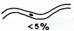
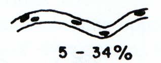
-63-
ANNEX 1 - QUESTIONNAIRE: DESCRIPTION OF REFERENCE CONDITIONS
- please fill in separately for each homogeneous section-type -
Part B
Name of section whose reference conditions are described in the following:
The described section ranges from stream km to stream km .
The reference state described below features the following special reference characteristics:
Please indicate whether provided information is based on data source (specifying the number according to table
of part A), or based on consultant's knowledge after each question.
MORPHOLOGICAL CHARACTERISTICS
1. Valley form (Comments: )
canyon
meander valley
trough
plain floodplain
other (please specify: )
ABOVE GIVEN INFORMATION IS BASED ON
DATA SOURCE NUMBER:
CONSULTANT'S KNOWLEDGE
2. Channel form
natural condition not modified by man !
a. braided
Braiding intensity (%) (Comments: )
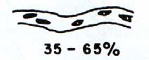
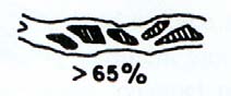
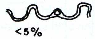
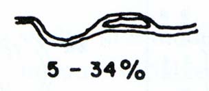
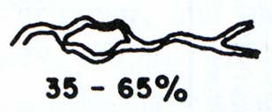
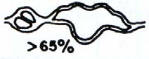
-64-
ANNEX 1 - QUESTIONNAIRE: DESCRIPTION OF REFERENCE CONDITIONS
Character
of
braiding
(Comments: )
mostly
bars
bars and islands
mostly islands of diverse shape
mostly islands, long and narrow
b.
anabranching
Anabranching intensity (%) (Comments: )
Character of anabranching (Comments: )
mainly sinuous side-channels
mainly cut-off loops
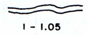

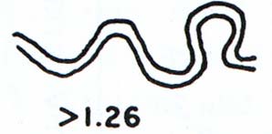
-65-
ANNEX 1 - QUESTIONNAIRE: DESCRIPTION OF REFERENCE CONDITIONS
split channel, sinuous anabranching
split channel, sub-parallel anabranching
composite
c. meandering
Degree of sinuosity of the main channel(s) (Comments: )
ABOVE GIVEN INFORMATION IS BASED ON
DATA SOURCE NUMBER:
CONSULTANT'S KNOWLEDGE
3. Average width of the channel(s) [m]
natural condition not mod fied by
i
man !
(please indicate separately for main and side channel(s) if applicable)
min:
mean:
max:
(Comments:
)
ABOVE GIVEN INFORMATION IS BASED ON
DATA SOURCE NUMBER:
CONSULTANT'S KNOWLEDGE
-66-
ANNEX 1 - QUESTIONNAIRE: DESCRIPTION OF REFERENCE CONDITIONS
4. Breadth erosion (Comments: ) natural condition not influenced by human activ ties !
i
high
moderate
none
ABOVE GIVEN INFORMATION IS BASED ON
DATA SOURCE NUMBER:
CONSULTANT'S KNOWLEDGE
5. Depth of channel(s) [m]
natural condition not modified by man !
(please indicate separately for main and side channel(s) if applicable)
min:
mean:
max:
(Comments: )
ABOVE GIVEN INFORMATION IS BASED ON
DATA SOURCE NUMBER:
CONSULTANT'S KNOWLEDGE
6. Main channel substrates (Comments: )
natural condition not modified by man !
rare
frequent
dominant
stream substrate
< 10%
10-30%
> 30%
type
description
megalithal
large cobbles, boulders and blocks, bedrock
> 40 cm
macrolithal
coarse blocks, head-sized cobbles, with a variable
> 20 cm to 40 cm
percentages of cobble, gravel and sand
mesolithal
fist to hand-sized cobbles with a variable
> 6 cm to 20 cm
percentage of gravel and sand
microlithal
coarse gravel (size of a pigeon egg to child's fist),
> 2 cm to 6 cm
with variable percentages of medium to fine
gravel
akal
fine to medium-sized gravel
> 0.2 cm to 2 cm
psammal/
6 µm to 2 mm
sand
psammopelal
sand and mud
0,6 µm to 6 µm
pelal
mud and sludge (organic)
< 2 µm
argyllal
< 2 µm
silt, loam, clay (inorganic)
ABOVE GIVEN INFORMATION IS BASED ON
DATA SOURCE NUMBER:
CONSULTANT'S KNOWLEDGE
-67-
ANNEX 1 - QUESTIONNAIRE: DESCRIPTION OF REFERENCE CONDITIONS
7. Bank structure (Comments: ) natural condition not influenced by human activities !
frequently multiple isolated
none
abort bank
sliding bank
fallen trees
wood collection
bank spur
nest bank
ABOVE GIVEN INFORMATION IS BASED ON
DATA SOURCE NUMBER:
CONSULTANT'S KNOWLEDGE
8. Width of former floodplain [m]:
natural condition not modified by man !
min:
mean:
max:
(Comments:
)
ABOVE GIVEN INFORMATION IS BASED ON
DATA SOURCE NUMBER:
CONSULTANT'S KNOWLEDGE
9. Presence of water bodies in the floodplain close to the stream (Comments: )
natural condition not modified by man !
arms connected to the river/stream
lotic side arms: both ends connected to the main channel
dead arms: only downstream end connected to the main channel
cut-off channels and oxbow lakes: permanent side arms completely isolated, flooded only by high
water level
temporary side arms
standing water bodies located in the floodplain and fed by tributaries
other types (please specify: )
no water bodies present in the floodplain
ABOVE GIVEN INFORMATION IS BASED ON
DATA SOURCE NUMBER:
CONSULTANT'S KNOWLEDGE
-68-
ANNEX 1 - QUESTIONNAIRE: DESCRIPTION OF REFERENCE CONDITIONS
HYDROLOGICAL CHARACTERISTICS
10. Current velocity [m/s] of main channel (measured at water surface):
natural condition not mod fied by
i
man !
min:
mean:
max:
(Comments:
)
ABOVE GIVEN INFORMATION IS BASED ON
DATA SOURCE NUMBER:
CONSULTANT'S KNOWLEDGE
HABITAT CHARACTERISTICS
11. Aquatic habitats (Comments: )
natural condition not modified by man !
rare
frequent dominant
< 10% 1030%
>30%
potamon types
main channel and side/secondary
eupotamon
channels
dead arms retaining a connection to
parapotamon
the main channel
former braided segments that
plesiopotamon
became disconnected from the main
channel
old meanders or similar forms
resulting from another
palaeopotamon
morphological type; without direct
connection to the main channel
ABOVE GIVEN INFORMATION IS BASED ON
DATA SOURCE NUMBER:
CONSULTANT'S KNOWLEDGE
12. Width of eupotamon [m] (main channel plus secondary channels):
natural condition not modified by man !
min:
mean:
max:
(Comments:
)
ABOVE GIVEN INFORMATION IS BASED ON
DATA SOURCE NUMBER:
CONSULTANT'S KNOWLEDGE
-69-
ANNEX 1 - QUESTIONNAIRE: DESCRIPTION OF REFERENCE CONDITIONS
13. Biotic microhabitats (Comments: )
natural condition not modified by man !
rare
frequent dominant
biotic microhabitats
< 30%
< 60%
> 60%
submerged plants, floating stands or mats, lawns
of bacteria or fungi, and tufts, often with
Phytal
aggregations of detritus, moss or algal mats
(interphytal: habitat within a vegetation stand,
plant mats or clumps)
Filamentous algae
fliamentous algae, algal tufts
Macrophytes
submers macrophytes, including moss and
Characeae
Living parts of
terrestrial plants
fine roots, floating riparian vegetation
Xylal (wood)
tree trunks (dead wood), branches, roots
CPOM
deposits of particulate organic matter, coarse
particulate organic matter as eg fal en leaves
FPOM
deposits of particulate organic matter, fine
particulate organic matter
Sapropel sludge
organic and inorganic matter deposited within
Debris
the splash zone area by wave motion and
changing water levels, e.g. mussel shells, snail
shells
ABOVE GIVEN INFORMATION IS BASED ON
DATA SOURCE NUMBER:
CONSULTANT'S KNOWLEDGE
14. Percent area of terrestrial habitats in the floodplain (banks, islands etc.)
natural condition not modified by man !
eupotamon: % of terrestrial habitats in the eupotamon
entire floodplain: % of terrestrial habitats in the floodplain
ABOVE GIVEN INFORMATION IS BASED ON
DATA SOURCE NUMBER:
CONSULTANT'S KNOWLEDGE
-70-
ANNEX 1 - QUESTIONNAIRE: DESCRIPTION OF REFERENCE CONDITIONS
15. Floodplain vegetation (Comments: )
natural condition not modified by man !
rare
frequent dominant
vegetation types
< 30%
< 60%
> 60%
alluvial forest (softwood, e.g. willow, alder etc.)
alluvial forest (hartwood, e.g. esh, meaple, elm etc.)
deciduous native forest
mixed native forest
coniferous
forest
wetland
(mire)
open
grass-/bushland
meadow
reeds
naturally
unvegetated
other (specify: )
ABOVE GIVEN INFORMATION IS BASED ON
DATA SOURCE NUMBER:
CONSULTANT'S KNOWLEDGE
-71-
ANNEX 1 - QUESTIONNAIRE: DESCRIPTION OF REFERENCE CONDITIONS
BIOTIC CHARACTERISTICS
16. Please register species of benthic invertebrates characteristic for the section you have
described above, adding information about abundance and recent presence.
(The following table is intended to preliminarily compile species to enable establishment of a harmonised reference
taxa list within a later phase of this project)
(Comments: )
abundance
Taxon
(indicate if abundance class
present/extinct
or ind./m2)
ABOVE GIVEN INFORMATION IS BASED ON
DATA SOURCE NUMBER:
CONSULTANT'S KNOWLEDGE
-72-
ANNEX 1 - QUESTIONNAIRE: DESCRIPTION OF REFERENCE CONDITIONS
GENERAL DESCRIPTION
17. Please describe the general character of the reference section:
(Example: About 1850 this Danube section was characterised to a very high extent by eupotamal water
bodies (main channel and side arms), offering a primarily lotic environment (97 % of the overall water
surface area at mean water). The active channel system was strongly branched by vegetated islands and
gravel bars. Shallow-water zones with gentle bed gradients were dominant. This enabled a high
diversity of depths, flow velocities and substrate conditions. Para-, plesio- and palaeopotamal water
bodies of the floodplain were much less frequent, but represented a great variety of distinct lentic
habitats. The various floodplain elements were subject to constant modification and renewal due to
strong erosion/sedimentation processes.)
-73-
ANNEX 2 HAIDVOGL ET AL.: DESCRIPTION OF REFERENCE CONDITIONS OF THE AUSTRIAN DANUBE
UNDP-GEF Danube Regional Project. Project Document Activity 1.1.6 - Typology of and
Definition of Reference Conditions for the Danube River
Description of Reference Conditions
of the Austrian Danube based on Historical Data with
special emphasis on hydromorphology and fish fauna
Haidvogl G., S. Hohensinner, S. Schmutz &
H. Waidbacher
Dept. of Hydrobiology, Fisheries and Aquaculture
University of Natural Resources and Applied Life Sciences
Version 2, August 2003
Guidance paper Reference Conditions and typology of the Austrian Danube
-74-
ANNEX 2 HAIDVOGL ET AL.: DESCRIPTION OF REFERENCE CONDITIONS OF THE AUSTRIAN DANUBE
Contents
1. Introduction............................................................................................. ......75
2.
Part 1: Guidelines for the reconstruction of the target fish fauna of
the Danube .................................................................................................... ......75
2.1. FISH ECOLOGICAL REFERENCE CONDITIONS OF THE AUSTRIAN DANUBE....................................... 75
2.2. METHODOLOGY FOR DESCRIBING THE REFERENCE FISH FAUNA OF THE AUSTRIAN DANUBE............. 78
2.3. GUIDANCE ON COLLECTING, REVIEWING AND ANALYSING HISTORICAL INFORMATION....................... 80
3. Part 2: Guidance on collecting and analysing historical
information regarding former hydromorphological conditions................ ......84
3.1. MORPHOLOGICAL DATA ....................................................................................................... 84
3.2. HYDROLOGICAL DATA ON THE HISTORICAL FLOW REGIME .......................................................... 84
3.3. ANALYSIS OF RIVER-MORPHOLOGY ON BASIS OF HISTORICAL SURVEYS ........................................ 85
3.4. METHODOLOGY OF HISTORICAL MAP ANALYSIS ........................................................................ 86
3.5. HYDROMORPHOLOGICAL CRITERIA TO DESCRIBE TYPOLOGICAL FEATURES AND REFERENCE
CONDITIONS .......................................................................................................................... 86
3.6. CURRENT STATUS OF HISTORICAL INFORMATION AND ANALYSIS REGARDING THE
HYDROMORPHOLOGY OF THE DANUBE RIVER.............................................................................. 86
3.7. TYPOLOGICAL OVERVIEW OF THE AUSTRIAN DANUBE RIVER ...................................................... 87
3.8. EXAMPLES FOR ANALYSING HISTORICAL HYDROMORPHOLOGICAL REFERENCE CONDITIONS............. 89
Appendix 1, References historical fish fauna ............................................... ......94
Appendix 2, References historical hydromorphological conditions .......... ......96
Guidance paper Reference Conditions and typology of the Austrian Danube
-75-
ANNEX 2 HAIDVOGL ET AL.: DESCRIPTION OF REFERENCE CONDITIONS OF THE AUSTRIAN DANUBE
1. Introduction
The Water Framework Directive (WFD) requires Member States to
differentiate the relevant surface water bodies with respect to type and to
establish reference conditions for these types. Consequently the main
purpose of this typology is the definition of type specific reference conditions
which in turn are used as the anchor of the classification system (MLIM-EG
working paper 13 May 2003).
Due to a long tradition of anthropogenic uses and influences of the Austrian
Danube (mainly flood protection, navigation, hydropower generation) no river
sections are left that could serve as basis for analysing the reference status.
As a consequence the reference conditions must be obtained by other
methods.
The aim of this paper is to present the Austrian experiences in describing
reference conditions of selected Danube reaches by the use of historical data.
Special emphasis is given to the fish fauna (part 1) and the
hydromorphological conditions (part 2). This paper at hand may serve as a
guidance for the Countries in the Danube River Basin for applying, adapting
or developing similar procedures.
2. Part 1: Guidelines for the reconstruction of the target
fish fauna of the Danube
In the first part of this report historical data were compiled in two ways: First
to describe the species composition and to classify abundance of
dominating/main fish species, in a second step the final classification of
abundance was done by expert judgement for both breakthrough and
anabranching sections (chapter 2.1.). This is in accordance with the
differentiation of morphological subsections of the Austrian Danube which is
focusing on breakthrough and anabranching sections. Chapter 2.2 deals with
historical analyses and methodology to characterise the reference fish fauna
of the Austrian Danube. Chapter 2.3 provides guidance for collecting and
analysing historical fish data to describe reference conditions.
2.1. Fish ecological reference conditions of the Austrian Danube
The reference species composition of the Austrian Danube was compiled
from historical publications on the fish fauna of the Austrian Danube. The
procedure is described in chapter 2.2, the data sources are cited in the list of
references in appendix 1. Adequate reports are available mainly from the 19th
and in parts from the 20th century. Apart from the species composition they
allow for a rough estimation of abundance classes for dominating species and
those which were important for commercial fishery. However, the historical
Guidance paper Reference Conditions and typology of the Austrian Danube
-76-
ANNEX 2 HAIDVOGL ET AL.: DESCRIPTION OF REFERENCE CONDITIONS OF THE AUSTRIAN DANUBE
reports do not provide sufficient information for a clear differentiation of
species composition and abundance classes in breakthrough and
anabranching section. Hence occurrence and abundance as listed in table 1
below was finally classified by expert judgement.
Table 1: Fish fauna of the Austrian Danube Reference status of occurrence and abundance
classes
Abundance classes: xxxx = dominant; very large, self-sustaining populations in the
Danube;
xxx = frequent; self-sustaining populations
xx = rare
x = very rare; only few specimen which occur only sporadically
Occurrence
Abundance Classes
Austrian Danube- Breakthrough anabranching
Section
sections
sections
Acipenseridae:
Sterlet, Acipenser ruthenus
xx xx
Ship sturgeon, Acipenser nudiventris
x
x
Stellate sturgeon, Acipenser stellatus
x
x
Russian sturgeon, Acipenser gueldenstaedti
x
x
Great sturgeon, Huso huso
x
x
Salmonidae:
Danube salmon, Hucho hucho
xxx xxx
Brown trout, Salmo trutta
xx xx
Thymallidae:
European grayling, Thymallus thymallus
xx xx
Esocidae:
Nothern pike, Esox lucius
xx xxx
Coregonidae:
Coregonen
x x
Umbridae:
European mudminnow, Umbra krameri
xx*
Cyprinidae:
Zope or Blue bream, Abramis ballerus
x xx
White bream, Abramis björkna
xx xxxx
Common bream, Abramis brama
xx xxx
Zobel or Danubian bream, Abramis sapa
x xxx
Bleak, Alburnus alburnus
xxxx xxxx
Spirlin, Alburnoides bipunctatus
x x
Asp, Aspius aspius
xx xx
Barbel, Barbus barbus
xxxx xxxx
Balkanian barbel, Barbus peloponnesius
x x
Prussian carp, Carassius auratus gibelio
x x
Crucian carp, Carassius carassius
x xx
Nase, Chondrostoma nasus
xxxx xxxx
Common carp, Cyprinus carpio
x
xx
Whitefin gudgeon, Gobio albipinnatus
xxx xxx
Gudgeon, Gobio gobio
x x
Kessler`s gudgeon, Gobio kessleri
xx xx
Danube gudgeon, Gobio uranoscopus
xx xx
Belica, Leucaspius delineatus
xx
European chub, Leuciscus cephalus
xxx xxx
Occurrence
Austrian Danube-
Section
Abundance Classes
Guidance paper Reference Conditions and typology of the Austrian Danube
-77-
ANNEX 2 HAIDVOGL ET AL.: DESCRIPTION OF REFERENCE CONDITIONS OF THE AUSTRIAN DANUBE
Ide, Leuciscus idus
xx xxx
Eurasian dace, Leuciscus leuciscus
xxx xxx
Soufie, vairone; Leuciscus souffia agassiz
x x
Chekhon, Pelecus cultratus
x x
Eurasian minnow, Phoxinus phoxinus
xx xx
Bitterling, Rhodeus amarus
x xx
Rutilus frisii meidingeri
x x
Danube roach Rutilus pigus virgo
xx xxx
Roach, Rutilus rutilus
xxx xxxx
Rudd, Scardinius erythrophthalmus
x xxx
Tench, Tinca tinca
x xxx
Vimba, Vimba vimba
xx xxx
Balitoridae
Stone loach, Barbatula barbatula
xx xx
Cobitidae:
Spined loach, Cobitis taenia
xx xx
Wheaterfish, Misgurnus fossilis
x xx
Siluridae:
Wels, Siluris glanis
xx xxx
Gadidae:
Burbot, Lota lota
xxx xxx
Percidae:
Balon's ruffe, Gymnocephalus baloni
xx xx
Ruffe, Gymnocephalus cernuus
x x
Schraetzer/Striped ruffe, Gymnocephalus schraetser
xxx xxx
Eurasian perch, Perca fluviatilis
xxx xxxx
Pikeperch, Zander, Sander luciopera
xx xxx
Volga pikeperch, Sander volgensis
x xx
Danube streber, Zingel streber
xxx xx
Zingel, Zingel zingel
xxx xxxx
Cottidae:
Bullhead, Cottus gobio
xxx xxx
Petromyzonidae:
Eudontomyzon mariae
x x
57 Species
* Westward distribution only up to the Vienna basin / Wiener Becken
Guidance paper Reference Conditions and typology of the Austrian Danube
-78-
ANNEX 2 HAIDVOGL ET AL.: DESCRIPTION OF REFERENCE CONDITIONS OF THE AUSTRIAN DANUBE
2.2. Methodology for describing the reference fish fauna of the Austrian
Danube
Short overview of historical publications
"Scientific" descriptions of the fish fauna of European rivers have been
published from the 18th century onwards. The earliest publications mostly deal
with biological characteristics of the species. If they refer to species
distribution this is rather done for larger areas than for particulate rivers (e.g.
Bloch, 1782-84, "Ökonomische Naturgeschichte der Fische Deutschlands, or
Meidinger, 1785-94, "Icones piscium Austriae indigenorum"). However, one of
the earliest more detailed descriptions of the Danube fish fauna dates as far
back as 1726 (Marsigli "Danubius pannonico myscius" 1726).
When compiling the data about the historical fish fauna of the Austrian
Danube the inquiries for published data mainly concentrated on the 19th
century because at that time the river could be considered as more or less
natural or nature like. Nevertheless channelisation of longer stretches was
already carried out in the first half of the 19th century (stretches in Upper
Austria) and a bit later in Vienna (1860ies and 70ies).
In the 19th century the number of studies dealing with the fish fauna of the
Danube in general and the Austrian Danube in particular increased. In 1832
Fitzinger published the Fauna of Lower Austria, considering also distribution
and information on abundance of fish (Fitzinger, 1832). Several years later
Fitzinger and Heckel characterised the Acipenseridae and their distribution in
the Danube (Fitzinger & Heckel, 1835). In 1858 Heckel and Kner published an
overview of the fish species of the Austrian monarchy including information
about the distribution and abundance of species. Siebolds valuable
description of the fish species of central Europe dates from 1863. It also
contains an overview of the status of ichthyological publication in parts of the
Hungarian Monarchy.
Moreover in the 19th century reports dealing with the fish fauna of the Austrian
Danube were also published in several journals. Examples are Kornhuber
(1863, 1900), Lori (1871), Kukula (1874) or Jeitteles (1862). There are even
small notes in fisheries journals, which can give hints on the occurrence of
fish species in a particulare place (for Austria the "Mitteilungen des
Österreichischen Fischereivereins" was revised). However, these papers or
notes must be reviewed carefully because they are sometimes written by
laymen. Additional information is available in publications about commercial
fishery and fish markets too (e.g. in Peyrer, 1874 or in Krisch, 1900). In the
1950ies two papers on the history of fish markets and trading in Upper Austria
were published (Kerschner, 1956, Wacha, 1956). The latter also lists many
Guidance paper Reference Conditions and typology of the Austrian Danube
-79-
ANNEX 2 HAIDVOGL ET AL.: DESCRIPTION OF REFERENCE CONDITIONS OF THE AUSTRIAN DANUBE
regional names for fish species, which are a useful basis for the correct
identification of fish species, named in non-scientific historical publications.
The literature mentioned above provides important information about the fish
fauna of the Austrian Danube in the 19th century. Further publications from the
19th and early 20th century which refer to downstream sections as well (e.g.
Mojsisovics, 1886/87 and 1897; Jeitteles, 1862) are listed in Appendix 1,
References. Besides published reports material about commercial fishery
registered in archives can provide important information about species
occurring at a particulate site or catch of certain species. Though it depends
on the organisation of commercial fishery if the output was registered and
traded (see chapter 2.3. for details).
Combination of historical information and expert judgement to obtain the
reference situation
The analyses of the historical publications allow a compilation of the historical
fish species composition of the Austrian Danube. However, there are some
exceptions. This is at first due to the late taxonomic description of some
species as e.g. Gobio albipinnatus (Lukasch, 1933) or Gymnocephalus baloni
(Holcik & Hensel, 1974) which have been added to the list according to more
recent surveys. Additionally some species have been listed which are
described only for tributaries of the Austrian Danube in historical sources
(Umbra krameri, Rutilus frisii meidinger, Leuciscus souffia and Sander
volgensis). In this context it has to be stressed that historical analyses hardly
ever result in a complete species list of a particular river. In many cases
species which were identified later or which are hard to detect must be
amended according to more recent surveys.
Concerning abundance historical sources at the utmost allow a verbal
classification of main and well-known species. Even if data from commercial
fishery are available they can only indicate dominant and very frequent
species but they do not exactly reflect the ecological situation. As a
consequence the historical analyses of the Austrian Danube fish fauna were
combined with more recent surveys and expert judgement to get the complete
species composition and abundance classes. The basis for the classification
of abundance in breakthrough and anabranched sections was the description
of the natural morphological conditions of the Austrian Danube (see part 2).
Guidance paper Reference Conditions and typology of the Austrian Danube
-80-
ANNEX 2 HAIDVOGL ET AL.: DESCRIPTION OF REFERENCE CONDITIONS OF THE AUSTRIAN DANUBE
2.3. Guidance on collecting, reviewing and analysing historical
information
The main purpose of historical analyses for describing reference conditions is
to gain information about the composition/distribution and abundance before
major anthropogenic impacts took place (channelisation and constructions for
flood protection and navigation, hydropower plants etc.). Hence data
collection for the Austrian Danube should concentrate on the middle of the
19th century, in some areas in Upper Austria on the first third of this century. It
is recommended to start historical analyses by identifying and dating these
impacts for the concerned sections because of the sometimes poor quality of
historical data from the 19th century which improved throughout the 20th
century.
Types of historical data and proceeding of analyses
Type 1: Search for recent publications on the history of the biology, Data type 1:
geography etc. of the relevant rivers, regions or cities
Recent
Before historical material is collected and analysed it should be examined if publications
recent historical studies have already been accomplished and published.
Besides ecological and biological publications the ones on geography and the
history of specific regions and cities should be considered too.
Type 2: Publications about Danube fish species and fish assemblages by
biological / ichthyological experts (examples from Austria: Heckel, Heckel & Data type 2:
Kner, Siebold, Fitzinger, Lori, etc.; see list of references in Appendix 1):
Historical
Period covered:
publications by
biologists
· From the late 18th century onwards; earlier documents could be
available (like e.g. Marsigli, 1726), mainly from the 19th and early 20th
century
Extend of possible information:
· Presence and absence of fish species; sometimes information about
occurrence in particular stretches or sites available; verbal
classification of abundance of certain species.
Quality of data:
· Information given in these publications is usually quite reliable.
However data are not based on systematic surveys. Therefore
information about occurring fish species and especially on
distribution is likely to be incomplete.
Problems encountered during analyses:
· Fish species lists could also be incomplete due to taxonomic reasons
(some species might have been described only after anthropogenic
impacts; e.g. some Gobio sp. in the Austrian Danube section). In
many cases these species could be added by using more recent
information.
Guidance paper Reference Conditions and typology of the Austrian Danube
-81-
ANNEX 2 HAIDVOGL ET AL.: DESCRIPTION OF REFERENCE CONDITIONS OF THE AUSTRIAN DANUBE
· The taxonomic classification of some species was changed in the
past. During the analyses the correct species has to be identified.
· Sometimes only "common" and/or local names for species are given.
These species must also be identified during the analyses. When
common names are used one also faces the problem that similar
names could refer to different species in different regions (like the
term Weißfisch/whitefish in the Austrian Danube).
How to find the data:
· This type of data is usually easy to find in national and scientific
libraries (universities, museums). Some publications were not
published as monographs - therefore systematic inquiries in relevant
journals must be carried out.
Estimated efforts (given for one person):
· 2-3 weeks inquiry of relevant publications, 4-8 weeks for analyses.
Data type 3:
Type 3: Reports published by ichthyological "laymen" in geographical and/or Historical
natural history publications (examples from the Austrian Danube: Kukula, publications by
1874, Lori 1871, Krisch 1900)
ichthyological
laymen
This type of data could be used in addition to publications by experts. Usually
the material is detected anyway when searching for publications in libraries.
Period covered:
· from
the
18th century onwards; also several publications from the 16th
century;
Extend of possible information:
· Absence and presence of fish species, information on distribution
and abundance-(classes).
Quality of data:
· Must be checked more carefully than sources of the type mentioned
above (authors usually not educated in biology).
Problems encountered during analyses:
· In principle the same as mentioned under 1, experiences from
Austrian rivers showed that in most cases common/regional names
for fish species are the biggest problem (sometimes information
cannot be used at all due to that).
How to find these data:
· see paragraph in 1,
Type 4: Records on commercial fishery in historical archives
Data type 4:
Period covered:
Records in
archvies
· from the late Middle Ages onwards; but rather 16th century and later
Extend of possible information:
· Presence of species at a certain site. Most dominant species in
certain regions; quantitative information about amount of fish caught
Guidance paper Reference Conditions and typology of the Austrian Danube
-82-
ANNEX 2 HAIDVOGL ET AL.: DESCRIPTION OF REFERENCE CONDITIONS OF THE AUSTRIAN DANUBE
in a known period; HOWEVER: no information about the actual fish-
stocks available; possibly information of occurrence of species in
specific habitat-types.
Quality of data:
· Data are usually quite reliable. However, it has to be taken into
account that quantitative information does not necessarily reflect the
ecological situation; it also shows the preferences for certain species.
Problems encountered during analyses:
· Only fish species which were of commercial interest are reported
(however more species were caught than nowadays; in the Austrian
Danube e.g. cyprinids like nase, barbel, dace, bream or other small
species like bullhead);
How to find the data:
· First of all relevant archives must be found (defined), as there are
monasteries or castles who had fishing rights on the Danube or
associations of commercial fishermen on the Danube.
· The next step is to verifiy if archive material (still) exists at all. When
searching for data for the Austrian Danube valuable records from
commercial fishery were detected in the big monastery
Herzogenburg (at the mouth of the river Traisen). On the other hand
an important monastery like Klosterneuburg in the vicinity of Vienna
supplied its need of fish at the Viennese Fishery market. The
monastery rented its fishing rights to commercial fishermen and
hence no data were traded in the monastery archive.
· In a further step one has to find out whether the archive material is
still stored in the relevant monastery/castle or if it has been
incorporated into a national archive.
· One final point is that in most cases the material could only be read
and analysed by people who are familiar with old handwritings.
Estimated efforts:
· Although hard to estimate the method described is quite time-
consuming and the efforts depend on several factors especially how
well the archive materials are sorted and registered.
Besides material about commercial fishery it is also recommended to analyse
accounts of fish purchase, fish delivered to monasteries by fishermen or
records of delivery to fish markets. For the period covered, quality of data etc.
the same has to be said as for the sources described above. However, if
accounts of fish-purchase or reports about fish delivered by fishermen are
used one has to verify the provenience of fish. When fish market deliveries
are analysed the origin of the fish must be identified. Usually especially fish
markets of larger cities were provided with fish from larger areas. The
Viennese market, e.g., was supplied with fish from Lower and Upper Austria,
Guidance paper Reference Conditions and typology of the Austrian Danube
-83-
ANNEX 2 HAIDVOGL ET AL.: DESCRIPTION OF REFERENCE CONDITIONS OF THE AUSTRIAN DANUBE
from Bohemia and Hungary from as far back as the 16th century (see e.g.
Schmeltzl, 1548).
Type 5: Specimen of fish in museum collections
Finally Museum collections can provide valuable information about the Data type 5:
Museum
occurrence of a species on a specific site.
materials
Guidance paper Reference Conditions and typology of the Austrian Danube
-84-
ANNEX 2 HAIDVOGL ET AL.: DESCRIPTION OF REFERENCE CONDITIONS OF THE AUSTRIAN DANUBE
3. Part 2: Guidance on collecting and analysing historical information
regarding former hydromorphological conditions
3.1. Morphological data
Historical maps and surveys provide a valuable basis to obtain morphological Data sources -
parameters describing the natural state of a river-floodplain system. For the morphology:
Austrian Danube section a wealth of these resources is available. Some of Maps and surveys
the most interesting ones for river analysis are listened in the following.
Analogue historical resources may also be available for the Danube River
sections up- and downstream of Austria.
· Military-topographical
surveys
in Austria: "Franziszeische Landesaufnahme" mostly prior to
channelisation (1806-1869, scale: 1: 28.800, Austrian State Archives
/ War Archive) and "Franzisko-josephinische Landesaufnahme"
(1869-1887, scale: 1 : 25.000) during river-channelisation. These
maps provide an overview of the former river-landscape, but may
lack of accuracy.
· River-surveys and maps for river-channelisation / navigation
e.g. in Austria: "Allgemeine Donau-Aufnahme" (in Upper Austria,
1817-1819) and "Nieder-Oesterreichische Donau-Stromkarte" (in
Lower Austria, 1805 from Porta, 1816-1817 from Lorenzo), scales: 1:
7.200 1 : 28.800. These maps built the basis for future
channelisation measures and therefore are surveyed rather
accurately. Besides morphological information, they also offer some
hydrological data, e.g. water surface levels, flow velocities,....
· Maps and surveys from aristocratic and monastery archives
Several surveys along running waters were evoked by property and
hunting-ground border conflicts between different landowners
following major floods. As a result, some accurate land surveys may
be found that enable good impressions of former river-landscape
conditions. In Austria, from 1700 onwards detailed maps exist (e.g.
for the floodplains near Vienna, Melk and in the Machland region,
1714-1730 from Marinoni).
3.2. Hydrological data on the historical flow regime
As pointed out, river-surveys in many cases show usable hydrological Data sources -
information like characteristic water surface levels, flow velocities and water
hydrology
depths. Besides the maps, historical records of stage heights at gauging
stations may also provide valuable data.
For example, in Austria from 1821 onwards, systematically recorded water
levels are available for three sites along the Danube River. The interpretation
of these data may be difficult due to channel changes and changing profiles
(erosion/sedimentation) at the gauging station. For this reason, exact
knowledge of the changes and the history of the gauging station are
Guidance paper Reference Conditions and typology of the Austrian Danube
-85-
ANNEX 2 HAIDVOGL ET AL.: DESCRIPTION OF REFERENCE CONDITIONS OF THE AUSTRIAN DANUBE
necessary. Since 1893, a broad spectrum of hydrological data exists but only
refers to time periods after river channelisation.
3.3. Analysis of river-morphology on basis of historical surveys
In the following, some examples for morphological data that can be obtained
Analysis of river
by analysing historical maps are listed:
morphology
1. Planform Properties:
sinuosity, bend radius of curvature, braiding, anabranching,
meander planform geometry
lengths of the shoreline (water-land-interfaces)
single instream structures: length, width, length of shoreline
2. Longitudinal Profile:
river depths in relation to the line of maximum velocity
pool-riffle-sequences
channel slope, water surface slopes
3. Cross Section:
widths of the river system, profile areas
4. Area Calculations:
water areas (main channel, side-channels, connected
abandoned channels, tributaries, isolated backwaters)
areas without vegetation (gravel, sand)
bays, islands, areas with pioneer vegetation
5. Heights of the Terrain:
areas without vegetation, areas with pioneer vegetation
higher terrain areas of the floodplain, vegetated islands
heights of the river banks
Based on these analyses the following parameters can be determined in
order to describe the characteristics of the specific river sections (examples):
· Morphological river classifications
(e.g. Leopold & Wolman 1957,
Silva 1991, Rosgen 1994)
· Braiding Indices
(e.g. Howard et al. 1970,
Bridge 1993, Thorne 1997)
· Total Sinuosity
(Richards 1982, Bridge 1993,
Robertson-Rintoul and Richards
1993)
· Fractal Dimensions
(Box-counting method)
(Nikora 1991, Nikora et al. 1997)
Guidance paper Reference Conditions and typology of the Austrian Danube
-86-
ANNEX 2 HAIDVOGL ET AL.: DESCRIPTION OF REFERENCE CONDITIONS OF THE AUSTRIAN DANUBE
3.4. Methodology of historical map analysis
First, selected maps have to be scanned and georeferenced with the help of
Analysis of
GIS/CAD-programs. The planform accuracy has to be computer-checked and
historical maps -
the errors in selected maps must be digitally rectified in order to eliminate methodology
errors of surveying and distortions of the maps due to air humidity. In a next
step, the scanned and rectified maps are vectorized and further evaluation
and analysis of individual parameters are performed with the help of CAD-
and GIS-programs.
By overlaying several maps in a chronological order it is possible to visualize
and calculate the channel dynamics. The compiled data are used to describe
the former river hydromorphology and to define an appropriate typology of
the analysed river sections.
3.5. Hydromorphological criteria to describe typological features and
reference conditions
· General
morphological parameters:
Sinuousity of the main channel, meander development, braiding
intensity, total sinuosity, widths of the floodplain area and the river
channels, channel slopes, channel substrate, calculated area values
of typical river structures, hydrological regime,...
· Characteristic water body types:
Classified due to their connectivity at specific water levels (e.g.
Amoros et al. 1982, 1987, Amoros and Roux 1988), area
calculations of the various water bodies, duration and character of
connection with the discharge regime of the main channel
· Expansion of aquatic habitats due to flooding and lateral
connectivity:
Water covered areas at characteristic hydrological events (e.g. at
low and mean flow, bankfull level, mean annual flood), areas that are
effected by "flow pulse" and "flood pulse" (Junk et al. 1989,
Puckridge et al. 1998, Tockner et al. 2000a, 2000b), widths of
flooded areas, flooded unvegetated and vegetated areas
· Channel
dynamics:
Area changes of typical morphological features, river bank migration,
volume calculation of erosion and aggradation (by comparison of
different temporal situations)
3.6. Current status of historical information and analysis regarding the
hydromorphology of the Danube River
Specific studies on the historical morphology of the Danube River are rare in
Literature and
Austria and also for other sections outside from Austria. Many studies and actual knowledge
articles are focused on historical-geographical issues and do not provide
accurate information for deriving reference conditions. Nevertheless, some
studies exist for specific Danube River reaches, e.g. for the anabranched
Guidance paper Reference Conditions and typology of the Austrian Danube
-87-
ANNEX 2 HAIDVOGL ET AL.: DESCRIPTION OF REFERENCE CONDITIONS OF THE AUSTRIAN DANUBE
section in the Austrian Danube Floodplain National Park downstream of
Vienna (e.g. Reckendorfer and Schiemer 2001) and near Vienna (Stummer
1982). More detailed information regarding former hydromorphology are
available for the anabranching Danube River in the alluvial zone of the
Machland region (Upper/Lower Austria). Besides two-dimensional
investigations (between 1715 and 1991), in this study, also three-dimensional
aspects that describe the former status of the whole floodplain in 1812 prior
to regulation are analysed (Hohensinner et al. in press a, b). Specific
information concerning the former river-morphology also exists for some
German Danube sections (e.g. Kern 1994).
For break-through sections of the Danube River, historical analyses are also
rare. In Austria, only one study is available for the section "Obere Donautal"
between Passau and Aschach (65 km length; Hohensinner 1995). This study
primarily provides area calculations of typical riverine elements in a canyon-
stretch of the Danube River in 1850.
3.7. Typological overview of the Austrian Danube River
The preliminary typology of the Austrian Danube sections shall be based on
Austrian Danube
the ecoregions and nine geomorphological sections used in the Joint Danube
Typology
Survey. Further, the Austrian stretch will be subdivided into break-through
sections and anabranching sections (e.g. based on the geomorphological
and palaeo-geographical criteria according to Kohl 1966).
According to the accuracy of the used historical sources, an additional
subdivision of these two types may be possible. For the break-through
sections:
· Chutes/cataracts/rapids
River reaches with bedrock-channels, high flow velocities,
outcropping bedrocks within the channel that determine flow
patterns, so-called "Kachlets"
· Break-through-sections without chutes
River-bottom characterised by gravel substrate and lower flow
velocities
For the anabranching sections:
· Transition from break-through to anabranching sections
(upstream end of the alluvial floodplain)
characterised by large shallow flooded boulders at the river-bottom,
these boulders derive from the upstream break-through sections and
were deposited in the upper end of the floodplain, so-called
"sphaeres" (Kugeln)
· Free anabranching sections without any influence of the break-
through sections
Guidance paper Reference Conditions and typology of the Austrian Danube
-88-
ANNEX 2 HAIDVOGL ET AL.: DESCRIPTION OF REFERENCE CONDITIONS OF THE AUSTRIAN DANUBE
Situated in the center of the anabranching sections with well
developed lateral connectivity, great widths of the river-system and
the floodplain, gravel/sand/silt as substrate
· Transition from anabranching to break-through sections
(downstream end of the alluvial floodplain)
hydrologically and also morphologically affected by the
downstream break-through section, augmented backwater flooding
effects at higher discharges due to the flow restriction of the
following canyon-reach, increased "flood pulse" effect as a
consequence of backwater flooding
These subdivisions mentioned above need some further discussion if they
are applicable as well as reasonable from the hydromorphological and
ecological point of view.
Guidance paper Reference Conditions and typology of the Austrian Danube
-89-
ANNEX 2 HAIDVOGL ET AL.: DESCRIPTION OF REFERENCE CONDITIONS OF THE AUSTRIAN DANUBE
3.8. Examples for analysing historical hydromorphological reference
conditions
Basic characteristics of a break-through section:
The Danube River in the Austrian "Obere Donautal"
(Hohensinner 1995)
The Danube River between Passau and Aschach (river-km 2225-2160) is Austrian Danube I:
characterised by the steep narrow canyon of the "Obere Donautal" that break-through
confines the lateral development of the river channel. The Danube`s original section
state in the "Obere Donautal" had been almost completely preserved until
1850. While the construction of the two hydropower plants Jochenstein
(1956) and Aschach (1964) was progressing, most of the typical river
structures disappeared.
The former natural morphological conditions of this Danube section were !!
analysed on the basis of river-survey maps from 1850 - 1860 (e.g. so-called
Methodology -
Proceeding
"Pasetti Karte", scale 1: 28.800). Planform accuracy was checked by
superimposing over current river maps. In order to improve planform
accuracy, the study river section was divided into subsections for which
specific scale-correction factors were determined. In a following step, the
area extensions of certain river/floodplain structures were manually
measured using a planimeter.
Because of the narrow river-canyon with a comparatively high channel slope,
gravel banks/islands and highly outcropping rocks (Kachlets) dominated the
Danube River and accordingly offered a lotic environment almost throughout
the whole study area. Backwaters and some smaller floodplain forests only
existed in the more spacious areas of the valley bottom. In 1850, gravel
areas, which fell dry in times of extreme low water, amounted to 5 ha per
river-km. Most tributaries discharged into the Danube River at locations with
large gravel bars and therefore provided valuable spawning habitats for
rheophilic fish species. Originally, this type of specific habitat showed
approximately 30 m per river-km.
Though backwaters were not a formative element in break-through sections,
the total area of such water bodies amounted to 0,2 ha per river-km. They
provided interesting refuge habitats during floods and special lentic habitats
for stagnophilic species.
The former "Obere Donautal" was characterised by four short river reaches
with chutes that were formed by outcropping bedrocks (Kachlets). Such
reaches featured high flow velocities and complex flow patterns. Small
Guidance paper Reference Conditions and typology of the Austrian Danube
-90-
ANNEX 2 HAIDVOGL ET AL.: DESCRIPTION OF REFERENCE CONDITIONS OF THE AUSTRIAN DANUBE
vegetated islands were also typical elements. In 1850, ca. 0,7 ha of
vegetated islands existed per river-km.
Analysing the time period before 1850 reveals that they evolved out of gravel
bars at the inner riverbank within some years. The further human-induced
development showed proceeding aggradation that led to the formation of
backwaters between former islands and the outer riverbanks.
Up to today, shallow water areas with fine sediments forming the channel
substrate have been highly increasing as a consequence of damming. The
loss of original river structures becomes apparent in the absence of adequate
habitats above all for the rheophilic fish fauna. Accordingly, the live stock of
the rheophilic fauna has been decreasing, while indifferent species are
getting stronger.
Basic characteristics of an anabranching section:
The Danube River in the Austrian Machland region
(Hohensinner et al. in press a, b)
This historical reference for an anabranching section of the Danube River is Austrian Danube II:
located in the eastern Machland (river-km 2094-2084) along the border of anabranching
Upper and Lower Austria. The Machland is the most eastern of three tectonic section
Danube basins in Upper Austria, which are separated by the Bohemian
Massif. Danube discharge is mainly influenced by alpine flow conditions and
peaks in spring/summer due to the snowmelt in the Alps (Mader et al. 1996).
The 33.8 km˛ large study area coincides with the present 10-year flood area,
which is delimited to the north by the terrace of the Würm glaciation and to
the south by the Tertiary hill country. Prior to channelisation, in 1812, 22.2
km˛ (66 %) belonged to the active zone. In this context the active zone (AZ)
includes the active channel system (water bodies and unvegetated
gravel/sand areas), vegetated islands and morphologically young floodplain
sections that were formed during Modern times since approx. 1500 A.D.
Originally, the AZ was partially flooded at mean annual flood, and total
inundation occurred every 3-5 years. On average the width of the whole
study area (10-year flood area) is 3200 m, that of the AZ 2100 m. The first
channelisation measures along this Danube reach were initiated around 1826
and the major phase of river straightening was already completed in 1859. In
the 20th century two hydropower plants, Ybbs-Persenbeug (1957, 23 km
downstream) and Wallsee-Mitterkirchen (1968, at the upstream border of the
study area) were constructed when most floodplain waters were separated
from the main channel by dikes.
Guidance paper Reference Conditions and typology of the Austrian Danube
-91-
ANNEX 2 HAIDVOGL ET AL.: DESCRIPTION OF REFERENCE CONDITIONS OF THE AUSTRIAN DANUBE
From 1714 onwards, exact surveys of the river landscape were conducted in
!!
order to determine property and hunting-ground borders after major floods.
Methodology -
Moreover, plans to improve navigation were initiated early, giving rise to a
Proceeding
series of detailed river maps of this Danube stretch from 1812 onwards. 120
historical maps (land surveys, estate maps, river surveys, navigation
maps,...) of this river reach have been found in various Austrian archives.
Gathering the most accurate ones, 45 selected maps were superimposed
over current detailed topographical surveys using AutoCAD Overlay.
Planform accuracy was checked by means of benchmarks, e.g. churches,
farms, streets and unchanged terrain structures. For this study, the most
accurate map (river survey from the former k.k. Landesbaudirection, scale 1:
6900) dating to 1812 was selected to describe the natural state of the river
landscape. In order to eliminate planform inaccuracies and map distortions,
the map was digitised, geometrically corrected using the benchmarks and
vectorised.
First results regarding the hydromorphological conditions in 1812 were
gathered by analysing the historical surveyed spot heights of the terrain and
the water levels (Hohensinner et al. in press a). Additionally, three-
dimensional digital terrain models (DTM) were generated in form of
triangulated irregular networks (TIN: model based on triangles) using the
CAD/GIS-program Autodesk Land Desktop for modelling the natural
reference situation in 1812 (Hohensinner et al. in press b). One of the great
advantages of these vector-based models is that breaklines of the terrain
surface as well as shorelines can be accurately edited. In a first step, the
historically mapped spot heights of the terrain surface and the water surfaces
at different stages were used to build TINs for each of these surfaces. In
order to estimate the level of the groundwater table between the channels in
the floodplain in 1812, the mapped spot heights of the water surfaces were
interpolated and incorporated into the TINs. In a following work step, water
cover at different water levels was calculated based on the intersection of
TINs of the terrain surface and specific water/groundwater surfaces.
Additionally, surface water volumes were computed by advanced
intersection-methods for specific flows.
In 1812, the Danube River channel system in the Machland was branched by
several vegetated islands and gravel bars. Mean total width of the channel
system amounted to 550 m at low flow (LW) and 730 m at summer mean
water (SMW). A main channel was clearly recognisable, but in some reaches
split into two morphologically similar anabranches with mean widths of 340 m
at LW and 450 m at SMW. The sinuosity of the main channel - measured
along the northern arm was 1.32. According to the classification of Leopold
and Wolman (1957), the main channel of the Danube River was sinuous.
Guidance paper Reference Conditions and typology of the Austrian Danube
-92-
ANNEX 2 HAIDVOGL ET AL.: DESCRIPTION OF REFERENCE CONDITIONS OF THE AUSTRIAN DANUBE
Because the Danube River also featured several small side arms, additional
parameters may be used to describe past conditions. The ratio of total active
channel length to valley length yields a total sinuosity of 5.22 (Richards 1982,
Bridge 1993, Robertson-Rintoul and Richards 1993).
Based on 42 transects with a regular spacing of 250 m, the braiding index for
1812 is 4.10 (Bridge 1993, Thorne 1997). Based on the river classification of
Nanson & Knighton (1996), the studied Danube River reach can be
designated as a gravel-dominated, laterally active anabranching river.
According to depth soundings at LW in 1812, the mean depth of both main
channel arms along the thalweg reached 3.8 m, whereas the minimum depth
was only 1.9 m. The analysis of the historical bed level by means of the
longitudinal profile measured in 1812 shows a mean slope of 0.00055 m per
m over the total river reach.
In 1812, this Danube River-floodplain system was characterised to a very
high extent by eupotamal water bodies (main channel and side arms),
offering a primarily lotic environment (97 % of the overall water surface area
at LW, 94 % at SMW); shallow-water zones with gentle bed gradients were
originally a formative element. This enabled a high diversity of depths, flow
velocities and substrate conditions, resulting in a broad spectrum of micro-
and meso-habitats with extensive shorelines. Para-, plesio- and
palaeopotamal water bodies of the floodplain were much less frequent in
relation to eupotamal ones. Nevertheless, they represented a great variety of
distinct lentic habitats and contributed to the high extent of aquatic/terrestrial
interfaces. The various floodplain elements were subject to constant
modification and renewal due to strong erosion/sedimentation processes.
Relic elements persevered longer solely on the older and higher terrace of
the "lower postglacial valley floor".
At mean water (MW) 41 % of the AZ were flooded and 57 % at bankfull water
level which approximately corresponds to the 1-year flood (Q1). At Q1,
flooding did not overtop the bank slopes and occurred only in the deeper,
partly vegetated areas of the floodplain. Thus, 16 % of the AZ were directly
affected by water level fluctuations between MW and Q1. Thereby, the water
surface expanded from the main channel over the AZ, enabling lateral
connections to habitats more than 2 km away from the main channel. When
water level rose above Q1, the whole floodplain was gradually inundated.
Total inundation of the AZ occurred during floods with return periods of 3-5
years (Q3-5).
The intensive lateral connectivity of the former Machland river landscape is
also reflected by the calculated volumes of surface water within the total
study site (10-year flood area). Based on the modelled DTMs for the natural
Guidance paper Reference Conditions and typology of the Austrian Danube
-93-
ANNEX 2 HAIDVOGL ET AL.: DESCRIPTION OF REFERENCE CONDITIONS OF THE AUSTRIAN DANUBE
situation in 1812, the water volume amounted to 24.3 Mio. mł at MW and
38.5 Mio. mł at approximately Q1. When the floodplain was entirely inundated
at Q3-5, water volume totalled c. 117.6 Mio. mł.
The highly dynamic hydromorphological processes of the former floodplain
resulted in permanently changing and complex connectivity-conditions and
therefore provided a high diversity of aquatic, semi-aquatic and terrestrial
habitats. In the former floodplain, backwaters and vegetated abandoned
channels served as transport and migration pathways for dissolved material,
sediments, biomass and organisms at high runoff and flood events. The
original aquatic/terrestrial transition zones and permanently changing habitat
compositions point to the key role of fluvial dynamics and hydrological
connectivity to sustain ecological integrity of natural river-floodplain systems.
Guidance paper Reference Conditions and typology of the Austrian Danube
-94-
ANNEX 2 HAIDVOGL ET AL.: DESCRIPTION OF REFERENCE CONDITIONS OF THE AUSTRIAN DANUBE
Appendix 1, References historical fish fauna
Antipa, G. (1938): Hommage a son oeuvre. Bucarest.
Balon, E. (1968): Einfluß des Fischfangs auf die Fischgemeinschaften der Donau. Arch
Hydrobiologie/Supplement XXXIV, = Donauforschung III, Heft (Issue) 3, p. 228-249.
Names many Hungarian papers and reports (no idea of the scientific value of these
information)
Bloch, M.-E., (1782-84): Oeconomische Naturgeschichte der Fische Deutschlands. Bd. 1-6.
Berlin.
Die internationale Fischereikonferenz in Wien. In: Mitteilungen des österreichischen
Fischereivereins, 1884. Contains a speech about the Hungarian situation of fishery
and in parts fish ecology and gives references like e.g. Reisinger, Specimen
Ichthyologiae, 1830.
Fischerei-Conferenz (1884): Die Internationale Fischerei-Conferenz 1884 in Wien.
Mitteilungen des Österreichischen Fischerei-Vereines Jg. 4: 100-195
Fitzinger, L. & Heckel, J., (1835): Monographische Darstellung der Gattung Acipenser
Annalen des Wiener Museums der Naturgeschichte. Bd. 1. Wien.
Fitzinger, L. (1832): Ueber die Ausarbeitung einer Fauna des Erzherzogthumes Oesterreich.
Beiträge zur Landeskunde Oesterreich´s unter der Enns. Verein für vaterländische
Geschichte, Statistik und Topographie. Wien. 1. Bd.
Heckel & Kner (1858) name also the distribution of the relevant species in the lower Danube
sections, especially for Hungary (translation of Heckel to Hungarian was done by
Cornel Chyzer).
Jeitteles, L. H. (1862): Über das Vorkommen von Lucioperca volgensis C.V. bei Wien.
Abhandlungen des naturhistorischen Museums. Bd. XII.
Jeitteles, L.H., (1862): Prodromus faunae vertebratorum Hungariae Superioris.
Verhandlungen der k.k. zool. Botan. Ges. Vol. XII.
Kerschner, T. (1956): Der Linzer Markt für Süsswasserfische. Naturkundliches Jahrbuch der
Stadt Linz 1956. Linz: 119-155.
Kerschner, T. (1956): Der Linzer Markt für Süßwasserfische. Naturkundliches Jahrbuch der
Stadt Linz 1956. Linz.
Kornhuber, A. (1900): Zoologische Bemerkungen. Verhandlungen des Vereins für Natur- und
Heilkunde zu Presburg. Verein für Natur- und Heilkunde zu Presburg Bd. XXI.
Kornhuber, A., (1863): Bemerkungen über das Vorkommen der Fische um Presburg und an
einigen anderen Orten Ungerns. Correspondenzblatt des Vereins für Natur- und
Heilkunde zu Presburg. II. Jg. Nr. 12. Pressburg.
Krisch, A. (1900): Der Wiener Fischmarkt. Wien.
Kukula, W. (1874): Die Fischfauna Oberösterreichs. Fünfter Jahres-Bericht des Vereines für
Naturkunde in Oesterreich ob der Enns zu Linz. Verein für Naturkunde zu Linz: 2-25.
Lori, T. (1871): Die Fische in der Umgegend von Passau. 9. Jahresbericht des
naturhistoriscen Vereines in Passau.
Marsigli, L.-F. (1726): Danubius pannoniconiysicus. Observationibus geographicis,
astronomicis, hydrographicis, historicis, physicis perlustratus ... T. 1-6. Hagae ...
Meidinger, C.v. (1785-1794): Icones piscium Austriae indigenorum. Wien.
Mojsisovics von Mojsvar, A. (1897): Das Thierleben der österreichisch-ungarischen
Tiefebenen. Wien.
Guidance paper Reference Conditions and typology of the Austrian Danube
-95-
ANNEX 2 HAIDVOGL ET AL.: DESCRIPTION OF REFERENCE CONDITIONS OF THE AUSTRIAN DANUBE
Mojsisovics, A. v. (1886/1887) names fish species of the Hungarian Danube in Die
österreichisch-ungarische Monarchie in Wort und Bild, Übersichtsband, 1. Abteilung,
Naturgeschichtlicher Teil, pp. 249
Mojsisovics, M. v. (1893): Bemerkungen zur ichthyologischen Literatur des Donaugebietes.
Mitteilungen des österreichischen Fischerei-Vereines: 11-12.
Peyrer, C. (1874): Fischereibetrieb und Fischereirecht in Oesterreich. Wien,
Ackerbauministerium.
Schmeltzl, W. (1548): Ein Lobspruch der Hochlöblichen weitberühmten Khünigklichen Stat
Wienn in Osterreich ... beschriben im 1548 Jahr. 3. Auflage. Wien, 1849.
Siebold, E. v. (1863): Die Süßwasserfische von Mitteleuropa. Leipzig, Verlag von Wilhelm
Engelmann.
Wacha, G., (1956): Fische und Fischhandel im alten Linz. Naturkundliches Jahrbuch der
Stadt Linz 1956. Linz.
Zirojevic, O (1995): Kulturraum Mittlere und Untere Donau: Traditionen und Perspektiven des
Zusammenlebens. Resita names species of the Hungarian Danube and gives
references in Hungarian.
Guidance paper Reference Conditions and typology of the Austrian Danube
-96-
ANNEX 2 HAIDVOGL ET AL.: DESCRIPTION OF REFERENCE CONDITIONS OF THE AUSTRIAN DANUBE
Appendix 2, References historical hydromorphological conditions
Amoros C, Richardot-Coulet M, Pautou G. 1982. Les `Ensembles Fonctionelles´: des entitčs
čcologiques qui traduisent l`evolution de l`hydrosystčme en intčgrant la
gčomorphologie et l`anthropisation (example du Haut-Rhone francais). Revue de
Geographie de Lyon 57: 49-62.
Amoros C, Roux AL, Reygrobellet JL, Bravard JP, Pautou G. 1987. A method for applied
ecological studies of fluvial hydrosystems. Regulated Rivers: Research and
Management 1: 17-36.
Amoros C, Roux AL. 1988. Interactions between water bodies within the floodplains of large
rivers: function and development of connectivity.
In: Connectivity in Landscape Ecology, Schreiber K-F (ed). Münstersche
Geographische Arbeiten 29: 125-130.
Bridge JS. 1993. The interaction between channel geometry, water flow, sediment transport,
erosion and deposition in braided rivers.
In: Braided Rivers, Best JL, Bristow CS (eds). Geological Society of London Special
Publication No 75: 13-72.
Hohensinner S. 1995. Bilanzierung historischer Flussstrukturen im Oberen Donautal als
Grundlage für die Revitalisierung des ehemaligen Altarmes bei Oberranna.
Diplomarbeit an der Universität für Bodenkultur Wien.
Hohensinner S, Habersack H, Jungwirth M, Zauner G. in press a. Reconstruction of the
characteristics of a natural alluvial river-floodplain system and hydromorphological
changes following human modifications: the Danube River (1812-1991). River
Research and Applications, John Wiley & Sons.
Hohensinner S, Egger G, Haidvogl G, Jungwirth M, Muhar S, Schmutz S. in press b.
Hydrological connectivity of a Danube River-floodplain system in the Austrian
Machland: changes between 1812 and 1991. Ecologie, International Journal of the
French Ecological Society.
Howard AD, Keetch ME, Vincent CL. 1970. Topological and geomorphic properties of
braided streams. Water Resources Research, 6: 1647-1688.
Junk WJ, Baylay PB, Sparks RE. 1989. The flood pulse concept in the river flood-plain
systems. Can. Spec. Publ. Fish. Aquat. Sci., 106: 110-127.
Kern K. 1994. Grundlagen naturnaher Gewässergestaltung. Geomorphologische
Entwicklung von Fließgewässern. Springer-Verlag, Berlin.
Kohl H. 1966. Das Donautal zwischen Passau und Hainburg.
Eine geomorphologisch-paläogeographische Betrachtung.
In: Geographische Rundschrift, 1966, 5, Wien: 186-196.
Leopold LB, Wolman MG. 1957. River Channel Patterns Braided, Meandering and Straight.
United States Geological Survey, Professional Paper 282 B.
Mader H, Steidl T, Wimmer R. 1996. Abflussregime österreichischer Fließgewässer. Beitrag
zu einer bundesweiten Fließgewässertypologie. Austrian Federal Environment
Agency (FEA), VIENNA, Monographien 82: 1-192.
Nanson GC, Knighton AD. 1996. Anabranching rivers: their cause, character and
classification. Earth Surface Processes and Landforms 21: 217-239.
Nikora VI. 1991. Fractal Structures of River Plan Forms. Water Resources Research, 27, 6:
1327-1333.
Nikora VI, Hicks DM, Smart GM. 1997. On the fractal sinuosity of rivers.
In: Study of erosion, river bed deformation and sediment transport in river basins as
Guidance paper Reference Conditions and typology of the Austrian Danube
-97-
ANNEX 2 HAIDVOGL ET AL.: DESCRIPTION OF REFERENCE CONDITIONS OF THE AUSTRIAN DANUBE
related to natural and man-made changes. Technical Documents in Hydrology, No.
10, International Hydrological Programme, UNESCO, Paris.
Puckridge JT, Sheldon F, Walker KF, Boulton AJ. 1998. Flow variability and the ecology of
large rivers. Marine Freshwater Research 49: 55-72.
Reckendorfer W, Schiemer F. 2001. Gewässervernetzung und Lebensraummanagement
Donau-Auen: Ökologische Grundlagen zukünftiger
Gewässervernetzungsmaßnahmen im Nationalpark Donau-Auen. Study by order of
Nationalpark Donau-Auen GmbH. Department of Limnology, University of Vienna:
Vienna.
Richards KS. 1982. Rivers. Form and Process in Alluvial Channels. Methuen, London.
Robertson-Rintoul MSE, Richards KS. 1993. Braided-channel pattern and palaeohydrology
using an index of total sinuosity. In: Braided Rivers, Best JL, Bristow CS (eds).
Geological Society Special Publication No 75: 113-119.
Rosgen, DL. 1994. A classification of natural rivers. Catena, 22: 169-199.
Silva AMA. 1991. Alternate Bars and Related Alluvial Processes. Queen`s University,
Kingston, Ontario.
Stummer D. 1982. Veränderungen der Stromlandschaft im Stadtbereich von Wien seit 1780
an ausgewählten Kartenbeispielen. Hausarbeit, Innsbruck, Geologische
Bundesanstalt Wien.
Thorne CR. 1997. Channel Types and Morphological Classification.
In: Applied Fluvial Geomorphology for River Engineering and Management, Thorne
CR, Hey RD, Newson MD (eds). John Wiley & Sons: Chichester: 175-222.
Tockner K, Baumgartner C, Schiemer F, Ward JV. 2000a. Biodiveristy of a danubian
floodplain: structural, functional and compositional aspects. In: Biodiversity in
wetlands: assessment, function and conservation, Volume 1, Gopal B, Junk WJ,
Davis JA (eds). Backhuys Publishers, Leiden, Netherlands: 141-159.
Tockner K, Malard F, Ward JV. 2000b. An extension of the flood pulse concept. Hydrological
Processes 14: 2861-2883.
Guidance paper Reference Conditions and typology of the Austrian Danube
Document Outline