PROJECT FOR THE ENVIRONMENTAL PROTECTION AND
SUSTAINABLE DEVELOPMENT OF THE GUARAN═ AQUIFER SYSTEM
TRANSBOUNDARY
DIAGNOSTIC
ANALYSIS
(TDA)
Version for the startup of the formulation
of the Strategic Action Plan
MONTEVIDEO, 29 MARCH 2007
i
TABLE OF CONTENTS
1. BACKGROUND................................................................................................... 8
2. OBJETIVES
........................................................................................................ 8
3. GUIDELINES FOR PREPARING THE TDA ....................................................... 8
INFORMATION............................................................................................................ 9
REQUIREMENTS ........................................................................................................ 9
PROCESS OF PREPARING THE TDA ........................................................................... 9
CONTENTS OF THE TDA .......................................................................................... 10
OTHER GUIDELINES FOR THE TDA ........................................................................... 10
4. CONCEPTUAL
AND
METHODOLOGICAL FRAMEWORK ........................... 10
GEF BACKGROUND ON OPERATIONAL PROGRAM 8 Ł WATER BODIES ....................... 11
DESIGN METHODOLOGY OF THE TDA....................................................................... 11
CONCLUSIONS ........................................................................................................ 13
5. METHODOLOGY USED IN PREPARING THE TDA OF THE GASP ............. 17
ACTIVITIES .............................................................................................................. 17
WORKING MEETINGS .............................................................................................. 19
Working meeting with experts from the countries, pilot projects, and universities
participating in the studies of the Universities Funds......................................... 20
Regional Technical Participative Workshops - RTPWs .................................... 20
National Technical and Institutional Workshops - NTIWs ..................................... 20
Joint Meeting...................................................................................................... 21
GUIDELINES FOR THE DESIGN OF CAUSAL CHAINS .................................................... 22
Critical Issues to be considered Ł preliminary list .............................................. 22
Classification of the causes ............................................................................... 22
Information Gaps ............................................................................................... 27
Mitigation Actions............................................................................................... 27
FINAL GUIDELINES................................................................................................... 27
Problems to be addressed ................................................................................. 27
Dynamics between the pilot projects and the TDA/ SAP ................................... 27
Actions to be proposed ...................................................................................... 27
CONCLUSIONS ON THE PREPARATION METHODOLOGY OF THE TDA ........................... 28
ii
6. SUMMARY OF THE MEETINGS HELD IN PREPARATION OF THE TDA ..... 29
EXPERTS MEETING.................................................................................................. 30
SUMMARY OF THE REGIONAL WORKSHOPS ............................................................. 30
SUMMARY OF THE NATIONAL WORKSHOPS .............................................................. 31
SUMMARY OF THE JOINT MEETING .......................................................................... 32
7. TDA PROPOSALS FOR EACH CRITICAL ISSUE .......................................... 43
CONSOLIDATION AND ANALYSIS OF THE RESULTS ..................................................... 43
CAUSES OF THE CRITICAL ISSUES ............................................................................ 43
INFORMATION GAPS ON THE CRITICAL ISSUES ......................................................... 46
MITIGATION ACTIONS FOR THE CRITICAL ISSUES ..................................................... 49
8. FINAL
TDA
PROPOSAL
.................................................................................. 52
CAUSES, INFORMATION GAPS AND PROPOSALS FOR MITIGATION ACTIONS ................ 52
ANALYSIS OF THE RESULTS...................................................................................... 56
9. FINAL CONSIDERATIONS - ASSESMENT OF THE TDA FORMULATION
PROCESS OF THE GUARANI AQUIFER SYSTEM .......................................................60
ANNEX 1 Ł GEF OPERATIONAL PROGRAM 8 Ł WATER BODIES .................... 62
ANNEX 2 - OTHER GEF PROJECT TDAS ............................................................ 64
GEF Bermejo ..................................................................................................... 65
GEF Pantanal/Alto Paraguay............................................................................. 65
GEF FREPLATA ................................................................................................ 65
GEF Framework Program ................................................................................. 71
GEF Projects in other regions ........................................................................... 73
GEF-SŃo Francisco ........................................................................................... 73
GEF-San Juan ................................................................................................... 73
ANNEX 3 - EXISTING INFORMATION ON THE GAS............................................. 76
FINALLY, WHAT IS THE GUARANI AQUIFER SYSTEM - GAS?....................................... 77
HISTORICAL PROGRESS IN THE PERCEPTION OF THE GAS ........................................ 83
CONSIDERATIONS ON THE GAS DYNAMICS............................................................... 84
PRESENT LEVEL OF EXPLOITATION .......................................................................... 88
POLITICAL AND ADMINISTRATIVE BORDERS AND GROUNDWATER................................ 94
iii
HYDROGEOLOGICAL CHARACTERIZATION OF CERTAIN GAS AREAS AND THE RESPECTIVE
GASP PROJECTS ................................................................................................... 96
CHALLENGES TO MANAGEMENT IN PRACTICE - TOWARDS THE TDA ........................... 96
10. ANNEX 4 - MANAGEMENT IN PRACTICE: THE ROLE OF THE PILOT
PROJECTS ............................................................................................................ 102
Concordia (AR) / Salto(UY) Pilot project......................................................... 102
Rivera (UY) Ł Santana do Livramento (BR) Pilot project................................ 105
Itap·a (PY) Pilot project .................................................................................. 108
RibeirŃo Preto (BR) Pilot project..................................................................... 109
11. REFERENCES ................................................................................................ 111
LIST OF CHARTS
Chart 1 - Geographic distribution of the GAS in the countries ......................... 81
Chart 2 Ł Basic information on the GAS ........................................................... 90
LIST OF FIGURES
Figure 1 Ł Methodology used in the preparation of the GASP TDA and SAP .......... 17
Figure 2 Ł Preparation stages of the GAS TDA ........................................................ 18
Figure 3 Ł Consensus-building levels to be considered for preparation of the TDA . 29
Figure 4 Ł Causal chain of the critical issue of pollution ........................................... 36
Figure 5 Ł Causal chain of the critical issue of over-exploitation ............................. 37
Figure 6 Ł Causal chain of the critical issue of management ................................... 38
Figure 7 Ł Information gaps on the critical issue of pollution .................................... 39
Figure 8 Ł Information gaps on the critical issue of over-exploitation ....................... 39
Figure 9 Ł Information gaps on the critical issue of Management............................. 39
Figure 10 Ł Mitigation actions for the critical issue of Pollution................................. 40
Figure 11 Ł Mitigation actions for the critical issue of Over-exploitation ................... 41
Figure 12 Ł Mitigation actions for the critical issue of Management ......................... 42
Figure 13 Ł Diagram of the causal chains of the GAS critical issues ....................... 44
iv
Figure 14 Ł Identified causes of the critical issues, classified................................... 45
Figure 15 Ł Synopsis of the information gaps on the GAS critical issues ................ 47
Figure 16 Ł Identified information gaps on the critical issues, classified................... 48
Figure 17 Ł Diagram of the types of action required to mitigate the causes and fill the
information gaps................................................................................................ 50
Figure 18 Ł Mitigation actions proposed for the critical issues, classified................. 51
Figure 19 Ł Causes of the critical issues of the GuaranĒ Aquifer System ................. 54
Figure 20 Ł Existing Information gaps on the critical issues of the GAS................... 54
Figure 21 Ł Proposals for Mitigation Actions for the critical issues of the GuaranĒ
Aquifer System.................................................................................................. 55
Figure 22 Ł GEF-Bermejo TDA: Causal chain of the top priority environmental
problems .......................................................................................................... 67
Figure 23 ŁTDA for GEF-Pantanal/Alto Paraguay: Critical Issue of Water Pollution 68
Figure 24 Ł Design methodology of the GEF-FrePlata Project TDA based on the
Pressure-State-Response model ...................................................................... 69
Figure 25 Ł One of the causal chains shown in the FrePlata TDA ........................... 70
Figure 26 Ł GEF Framework program: causal chain of the critical issue Non-
sustainable use of transboundary aquifers ...................................................... 72
Figure 27 Ł GEF SŃo Francisco: Causal chain of the critical issue Uncontrolled
exploitation of groundwater, dissociated from surface water ............................ 74
Figure 28 Ł GEF-San Juan: Causal chain-Root Effect of the main problems........... 75
Figure 29 Ł Location of the Guarani Aquifer ............................................................. 80
Figure 30 Ł Distribution of the GAS in the four countries.......................................... 82
Figure 31 Ł Hypothetical cross-section of the GAS, showing the potential impact of
disturbances in the tectonic plate and characteristics of the alluvial deposits of
the Parana river in the control of the flow regime.............................................. 86
Figure 32 Ł Temporal aspects of groundwater flow .................................................. 87
Figure 33 - Location of well drilling in the Brazilian GAS area .................................. 93
v
Figure 34 Ł Examples of transboundary transfers of groundwater ........................... 95
Figure 35 - Schematic hydrogeological mapa and cross-section of the Concordia-
Salto pilot project area ................................................................................... 104
Figure 36 - Schematic hydrogeological map of the water infrastructure and basic
hydrogeological section of the Rivera Ł Santana do Livramento Pilot Project
area, showing the probable underground flow regime before the development of
infrastructure ................................................................................................... 107
Figure 37 - Hydrogeological sketch and cross-section of the RiberŃo Preto Pilot
Project ............................................................................................................. 110
LIST OF TABLES
Table 1 Ł Differences between the rationalist and constructivist paradigms in
decision-making ................................................................................................ 14
Table 2 Ł Management Framework for the GAS ...................................................... 23
Table 3 Ł Classification and example of causas of the Critical Issues, and mitigation
actions............................................................................................................... 24
Table 4 Ł Summary: Critical Issues identified in the Pilot Projects ........................... 31
Table 5 Ł Critical issues listed by each country ....................................................... 34
Table 6 Ł Indicaciones de prioridades de las Proposals for Mitigation Actions for each
Critical Issue...................................................................................................... 57
Table 7 Ł Tentative priority ranking of the Proposals for Mitigation actions.............. 59
Table 8 Ł Common myths surrounding aquifers ....................................................... 78
Table 9 - Matters regarding information on the GAS which are crucial for the
formulation of the TDA ...................................................................................... 83
Table 10 Ł Issues on the continuity of the GAS that are crucial to the formulation of
the TDA ............................................................................................................. 84
Table 11 - Matters which are relevant to the GAS regime and key for the formulation
of the TDA ......................................................................................................... 87
vi
Table 12 - Aspects on the exploitation level of the GAS which are considered crucial
to the preparation of the TDA............................................................................ 94
Table 13 - Border issues which are crucial to the preparation of the TDA................ 96
Table 14 Ł Typology of possible flow situations in transboundary areas .................. 97
Table 15 - General table of hydrogeological characterization of the border areas and
the relevant GASP projects............................................................................... 98
Table 16 Ł Aspects of the GAS which are relevant to the TDA .............................. 100
Table 17 Ł Framework for the GAS management needs........................................ 101
Table 18 Ł Concordia (AR) / Salto(UY) Pilot Project............................................... 102
Table 19 Ł Expected results of the Concordia-Salto Pilot Project........................... 103
Table 20 Ł Rivera (UY) / Santana do Livramento (BR) Pilot Project....................... 105
Table 21 Ł Expected results of the Rivera Ł Santana do Livramento Project......... 106
Table 22 Ł Itap·a Pilot Project ................................................................................ 108
Table 23 - RibeirŃo Preto Pilot Project.................................................................... 109
vii
1. BACKGROUND
In accordance with the Terms of Reference - ToR, "the Governments of Argentina, Brazil,
Paraguay and Uruguay have agreed to move forward with a project for the `Environmental
Protection and Sustainable Development of the Guarani Aquifer System' (the Project), with
the support of the Global Environmental Facility (GEF) and the World Bank (WB) as the GEF
Implementation Agency.
The Project is based on the following 7 components:
1 - expansion and consolidation of the scientific and technical knowledge base of the
Guarani Aquifer System (GAS);
2 - joint development and implementation of a management framework;
3 - strengthening of stakeholder participation, social communication and environmental
education;
4 - monitoring and evaluation and dissemination of Project results;
5 - development of aquifer management and mitigation measures for the identified hot spots
or critical issues;
6 - assessment of the aquifer's geothermal potential and,
7 - project coordination and management.
Within the framework of the development of the Guarani Aquifer System Project, Activity 2e,
as described in the Project Implementation Plan (PIP), refers to the "preparation of a
Transboundary Diagnostic Analysis (TDA) of the GAS, the first step towards defining the
main current and emerging problems of the aquifer, their effects and the underlying root
causes to be addressed by an efficient management program, with a view to its sustainable
use and protection, followed by a Strategic Action Program (SAP)."
2. OBJETIVES
In short, a Transboundary Diagnostic Analysis - TDA document must be formulated,
containing:
1 - the main current and emerging problems affecting the Guarani Aquifer System,
2 - their effects on the resource and their root causes,
3 - an analysis of the cause and effect chain, and
4 - a priority analysis of the problems for an effective protection and sustainable use of the
aquifer system.
This document will identify and provide the technical and scientific grounds for the main
problems as perceived by the institutional and social stakeholders of the GAS region.
8
3.
GUIDELINES FOR PREPARING THE TDA
INFORMATION
The ToR determine that the TDA should take into account and include:
- Information on the project development stage, including the information contained in the
PAD (The World Bank. PAD: Project Appraisal Document - Document of the World Bank,
Report No. 23490-LAC dated May 17, 2002. Available at: http://www.sg-guarani.org) and
the PIP (Project Implementation Plan - the Project Operation Manual);
- Preliminary results of the Universities Fund projects (knowledge on system structure and
geometry, water flow and quality) and of the Guarani Citizenship Fund projects (aspects on
socio-economic, gender, cultural and customary use issues);
- Progress to date of the four (4) Pilot projects, including the BGR experience;
- Progress and results to date of the consultancy agreements and bids in execution;
- Lessons learned by the GS-GAS staff and regional experts; and
- Lessons learned from the specific experience and work of the legal experts team and
others supporting the Project.
REQUIREMENTS
The ToR also specify that this first version of the TDA should contain:
- "The known technical and scientific aspects of the GAS;
- the current legal and institutional GAS-related structure in the countries;
- the socio-economic situation of the region and uses of GAS water, including
groundwater assessment in terms of education, culture and gender".
Other requirements are "identification of other projects and actions under way in the aquifer
region and their interrelations and impacts on the Project and the aquifer".
In full compliance with the ToR, the present Preliminary TDA Document should provide an
account of the main current and emerging problems of the GAS that stem from the area's
economic, social and environmental situation and from the existing legal and institutional
conditions. Special attention should be paid to issues of transboundary interest and to the
most vulnerable areas. Once the main current and emerging problems are detected, their
effects on the GAS and root causes will be identified and addressed in a Strategic Action
Program-SAP in realistic terms and in order of priority.
PROCESS OF PREPARING THE TDA
The ToR establish that the TDA will be prepared on the basis of a process of consultation
and participation at the country level, involving each National Project Execution Unit (NPEU)
9
and key stakeholders (such as stakeholders from affected states and provinces, civil society
organizations, Pilot Project Local Committees, etc.). This interaction will help to adjust the
Preliminary TDA Document and to find the technical foundations of the identified and
perceived problems, with the support of the General Secretariat.
Consolidation of the TDA will be based on a consultative and participative process at the
multi-country level, in a workshop that integrates the recommendations of 4 previous regional
workshops. This will result in an adjusted TDA which will be discussed by the Coordination
Group (CC) before final review and approval by the CSDP (Steering Committee).
CONTENTS OF THE TDA
The TDA will identify and rank priority areas with critical problems and propose an evaluation
system. Among others, the document will take into account the following:
- population by gender;
- population income brackets;
- whether it is a recharge area or not;
- whether it is an at-risk area or not;
- current and future pollution levels;
- number and magnitude of the area's critical issues;
- potential aquifer use;
- other issues to be proposed.
OTHER GUIDELINES FOR THE TDA
The preparation process of the TDA will be preventive in nature, and identify potential
development scenarios, possible risks, negative effects on use for drinking water, irrigation
and other uses, and an efficient exploitation and sustainable management of the resource.
Aspects inherent to groundwater operation, current uses and the scope of potential local and
regional problems found in the aquifer region shall also be contemplated.
In more general terms, as well as identifying critical areas and zones, the TDA should
dedicate part of its content and focus to defining topics and issues of transboundary interest
with significant impact on the GAS management and protection. This means that the TDA will
generate a series of technical and institutional requirements, which will be prioritized and
then classified in terms of their transboundary impact. Two groups of essential activities will
arise from this analysis, one which is essentially transboundary, and another which is mainly
national, i.e., activities which must become priorities for each country. The overall analysis
should be discussed at length and be consensual.
10
The GS-GAS will disseminate the TDA among the stakeholders or interested parties,
including institutional, scientific, technical, social, economic and cultural actors. Workshops
will be conducted to discuss and adjust it, ensuring through each NPEU that representation
is broad-based.
4.
CONCEPTUAL AND METHODOLOGICAL FRAMEWORK
BACKGROUND ON GEF OPERATIONAL PROGRAM 8 Ł WATER BODIES
Operational Program Number 8-OP 8 finances the agreed incremental cost of additional
measures to solve transboundary environmental problems that affect certain water bodies,
based on countries' commitment to reform sectoral policies and activities and to finance the
required baseline investments. Environmental problems include pollution, over-exploitation of
biological and non-biological resources, degradation of habitats and non-indigenous species.
Annex 1 displays the short and long-term objectives of this operational program.
TDA METHODOLOGY
The TDA is a tool that helps to identify and assess the main existing and emerging
environmental problems (critical issues) in a basin or region, and to determine direct, indirect
and root causes. It also identifies cause and effect chains and seeks interrelations with the
degradation of water resources. Additionally, it also undertakes the detection of information
gaps and actions that are required to mitigate or prevent problems. The TDA focuses on the
transboundary aspects of a basin or region and its potential, contributing to the
implementation of the GEF operational strategy for international waters.
Methodologically, the TDA is a technical and scientific document structured in two main
pillars:
- available information and experience on the target area and the GAS, its physical
characteristics, composition and behavior; on the use of the resource and regional socio-
economic development; on the legal framework, the existing legislation and regulations, as
well as institutional information, particularly vis-Ó-vis capacities and competences; and
- stakeholder participation and their perception of the main problems and their causes,
including the institutional instances in each of the participating countries and their NPEUs.
11
To achieve the objectives, certain guidelines should be followed. These directives for the
TDA and SAP were proposed in a document formulated for the GEF (Mee, 2003) as follows:
- Broad-based stakeholder participation: all the parties involved in or affected by an
environmental problem or its solution should be involved in preparing the TDA and
consulted for the SAP formulation.
- Joint fact-finding: an independent specialist(s) selected by stakeholder representatives
should conduct the TDA by means of a broad-based consultative process, to ensure the
process and its products' suitability to the region.
- Transparency: the TDA should be a public-access document; during preparation and data
gathering, stakeholders should agree on the free dissemination of the resulting information
and products.
- Eco-systemic approach: this approach is based on the application of the appropriate
scientific methodologies, focused on the levels of biological organization involved in the
essential processes and interactions between organisms and the environment - therefore, it
should recognize that human beings are part of the ecosystem; furthermore, systems
should be defined by their natural limits and not by their political limits, which, however,
should be incorporated into the analysis.
- Adaptive management: TDAs and SAPs should be formulated in a series of
pragmatically defined stages; previously defined performance indicators should be
monitored at each stage, and pursuant to the results, joint planning should be developed for
progress monitoring and planning of the next stage.
- Actions should take into account the economic and social causes of a problem: an
analysis of the causal chains of transboundary problems and identification of social and
economic causes are of crucial importance in the formulation of the TDA; it should be
acknowledged that actions taken with the root causes in view have greater possibilities of
having long-term impacts on the problem.
- Accountability: The parties involved in SAP implementation should be entirely
accountable for their actions; the social stakeholders who are responsible for SAP
implementation should be clearly and unambiguously identifiable.
- Building of inter-sectoral policies: sectoral approaches should be avoided, as they
obstruct the inclusion of multiple purposes, application of economies of scale and an eco-
systemic approach.
- Step-by-step consensus-building: consensus-building at each stage of the TDA and
SAP preparation is essential to ensure the long-term sustainability of the process and its
results.
- Local strengthening: the SAP should propose practical solutions for transboundary
issues that require regional, national and local actions; the concept of local strengthening
implies that any issue that may be solved locally should not be taken to the highest levels
for solution; as a corollary, when a problem cannot be solved locally, then solutions should
be sought at higher levels of action, whether national or regional.
- Incremental costs: The SAP should detect any actions that generate incremental costs
as agreed by the parties, and separate them from those that refer to purely national
interests ("baseline actions").
- Donor partnerships: The process of formulating the SAP is intended to strengthen
cooperation among the development partners so that the identified problems are taken into
account and, whenever necessary, to assist the governments in covering the costs of
baseline actions, to encourage joint responsibility in SAP implementation and to avoid
overlapping of the donor community efforts.
12
- Intergovernmental commitments: approval and startup of the SAP as a contractual
agreement between governments should be a significant management objective of its
formulation process.
All the guidelines were accepted save the last one. On the contrary, the countries understood
that project results do not imply any such commitment or the actual execution of the SAP;
rather, they viewed it as the cornerstone for a Management Framework to be proposed to the
Parties so that they can eventually decide what type of sovereign agreement they will
subscribe.
In short, the TDA will provide identification of the main current and emerging problems that
were identified and perceived as priorities, the causes of the problems arising from the
economic, social and environmental conditions in the area, and the prevailing legal and
institutional conditions, with particular emphasis on issues of transboundary interest and
(most) vulnerable areas. It will lead to a logical development of the SAP based on a
reasonable, holistic and multisectoral assessment of the problems associated with
transboundary water systems.
Annex 2 provides summaries of TDAs designed for similar GEF projects.
CONCLUSIONS
The TDA and the SAP stem from an analytical and participative process, where the different
instances include broad-based stakeholder participation and information gathering and
assessment by means of pilot projects and sub-projects. A lesson learnt from the consulted
literature (see Annex 2) is that there is no single methodology for TDA preparation. On the
contrary, there are methodological adaptations to each project based on existing data and
the nature of problems and their causes. These aspects will be studied in depth in the
presentation of the proposed methodology for the preparation of the GASP TDA.
A significant aspect of the GEF methodology for TDA design is the paradigmatic change that
is required: from an approach defined as "rationalistic or realistic" to a "constructivist"
approach. Roy, Landry and Oral (1993) state that in counterpoint to the realistic or
rationalistic approach, the purpose of the constructivist approach is not to find a "truth that is
external" to the stakeholders involved in a process, but rather to develop a "set of keys" that
will open the doors to these stakeholders so that they continue to make progress in
accordance with their objectives and systems of values. This approach, states the author,
does not involve "prescriptions", but rather "recommendations". Each stakeholder builds on a
problem problem using his own set of values, and therefore solutions should be negotiated
13
by all the stakeholders, focusing on consensus. For this reason the GEF methodology relies
on participative workshops, where the TDA is developed on a step-by-step basis.
In the realist approach, the task of the consultant hired for the TDA preparation, is to "extract"
the stakeholders' preferences according to his own analysis of the submitted information.
The constructivist approach implies that the stakeholders build the solution/s, with the
consultant acting as the process "facilitator" and avoiding as far as possible to induct his own
values into results. For this reason, interaction among stakeholders in the process of
designing solutions is crucial. Table 1 displays some other basic differences between the
realistic and constructivist approaches, with comments on the preparation requirements of a
TDA.
All these factors should be considered in the preparation process of the Guarani Aquifer
System Project TDA.
14
Table 1 Ł Differences between the rationalist and constructivist paradigms in decision-making
Issue
Rationalist Paradigm
Constructivist Paradigm
Related aspects of TDA and SAP design
Decision-
Moment of choice of the Lengthy process involving interaction Approval of TDA and SAP and subsequent
making
optimal solution
among decision-making social
implementation
stakeholders
Characteristics Totally rational and
Endowed with their own set of values, Countries, with their respective social
of decision- objective
that are patent in their subjective stakeholders in the design process of the
makers
preferences
TDA and SAP
Problem to be A real problem, which may Problem to be constructed: each
Definition of the Transboundary Diagnostic
solved
be defined objectively
decision-maker builds his own vision of Analysis and the Strategic Action Program
the problem, subjectively
Models
Represent objective reality They are accepted tools, useful in the Causal chains as models for the dynamics
support of decisions by decision-making of identification of critical issues
social stakeholders
The results of Optimal
situations
Recommendations that focus on
Proposal and evaluation of mitigation
the models
respecting the values of the decision- actions for the critical issues
making social stakeholders, in negotiated
decisions
Purpose of
Finding the optimal solution Generating knowledge on a problem so Identification of root causes and analysis of
model
that decision-making social stakeholders mitigation actions, one of the cornerstones
construction
can negotiate a satisfactory decision for the SAP formulation
reached by consensus
Validation of
The model is valid when it The model is valid when it serves as a Causal chains are valid when they help to
the model
represents reality
tool for supporting a decision
reach consensus in the identification of
objectively
information gaps and proposals for
mitigation actions
Preferences of Extracted by the consultant They are constructed by the decision- Consultants facilitate the TDA preparation
the decision- / analyst
making social stakeholders with the process, on the basis of respect towards
makers
support of the consultant / facilitator
the preferences revealed by the decision-
making social stakeholders
15
Source: Adapted from Ensslin, Montibeller Neto and Noronha (2001)
16
5.
METHODOLOGY FOR THE PREPARATION OF THE GASP TDA
Figure 1 shows a diagram of the methodology that was applied in preparing the GASP TDA.
Figure 1 Ł Methodology used in the preparation of the GASP TDA and SAP
Review of the knowledge base was and is being carried out as a GASP activity. The pilot
projects were implemented to obtain management experience in specific GAS areas with
typical problems and to help fill certain previously identified critical information gaps. Their
results will assist in the diagnosis of key issues, which in turn will enable the identification of
new critical issues. Annex 3 summarizes the current status of the GAS knowledge base.
The TDA was prepared with a view to identifying the causes of each critical issue;
consequently, mitigation measures were proposed. Therefore this final TDA document is a
guideline for the formulation of the Strategic Action Program - SAP, which is the final
document of the GASP.
ACTIVITIES
Figure 2 shows a diagram of the activities that were performed in compliance with the Terms
of Reference and the resulting documents.
17
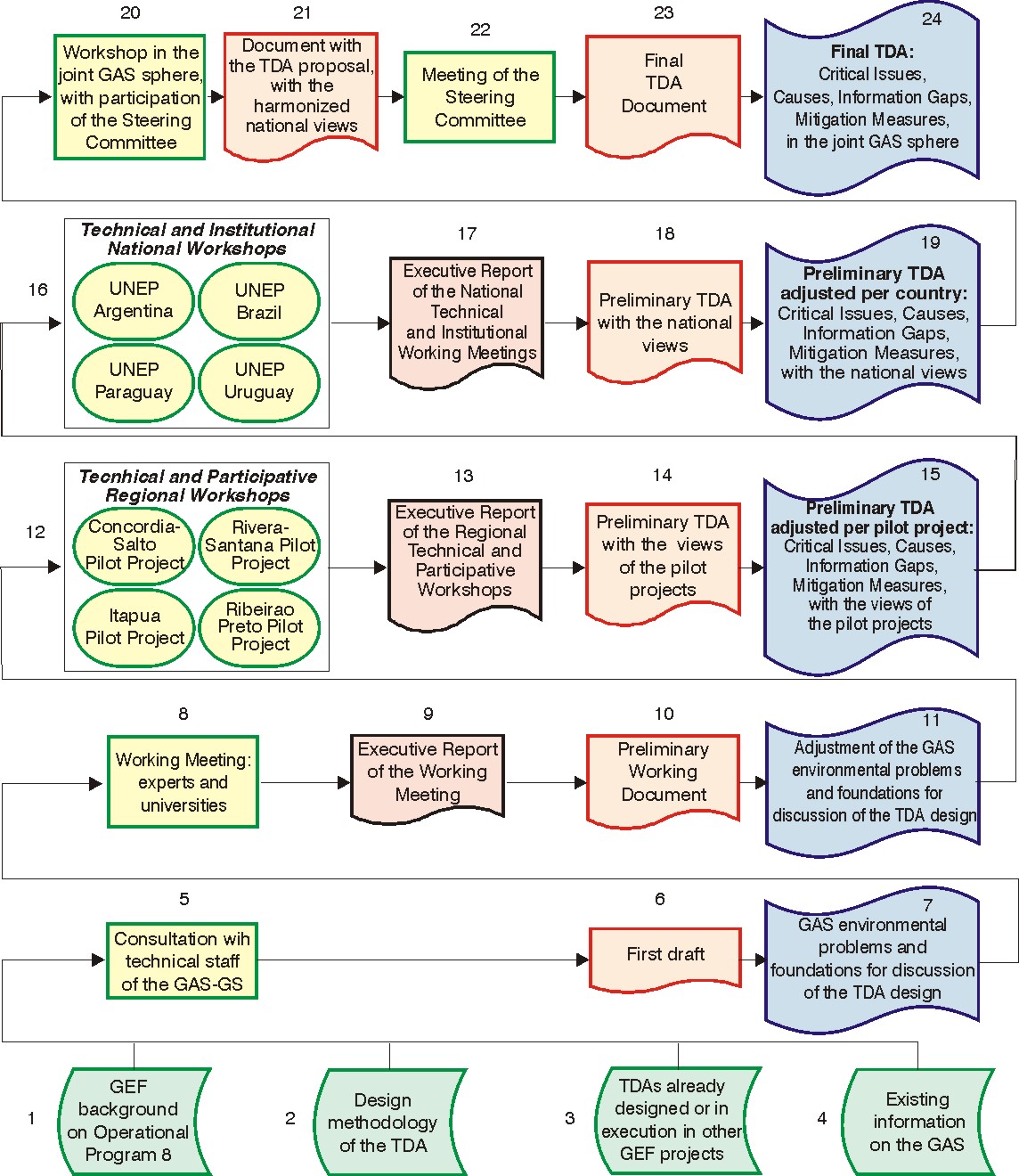
Figure 2 Ł Preparation stages of the GAS TDA
In further detail, the activities were:
1 - Review of the background on GEF Operational Program Number 8 (Water Bodies) which
is the basis for this project;
2 - Review of the methodology for these instruments;
3 - Review of the TDAs under way or completed for other GEF projects, to obtain guidelines
and models to be taken into account;
18
4 - Review and analysis of the existing information on the GAS;
5 - In consultation with the technical staff of the GAS-GS;
6 - Preparation of the first draft ...
7 - ... containing a preliminary view of the GAS environmental problems and the grounds for
discussion for the preparation of the TDA;
8 - Organization and moderation of a working meeting with the participation of experts from
the countries, the pilot projects and the universities participating in the Universities Fund
surveys, in coordination and with the support of the GAS-GS and DSD/OAS;
9 - Preparation of an executive report of the experts' working meeting, and inclusion of the
information and analysis obtained at the meeting in the TDA document;
10 - Integration of the overall work in a single TDA document called Preliminary Document
...
11 - ... which is an adjustment of the GAS environmental problems and the grounds for
discussion of TDA preparation, and a preliminary identification of the Critical Issues to be
addressed;
12 - Conduction of four (4) Regional Participative Technical Workshops - RPTWs based on
each Pilot Project (PP), with the participation of key regional stakeholders. The workshop
dynamics led the participants to identify, discuss and agree on critical issues, information
gaps, direct, indirect and root causes of the issues, and on proposals for mitigation actions;
13 - Preparation of a RPTW executive report ...
14 - ... in the form of a new preliminary TDA version ...
15 - ... containing PP views on the GAS environmental problems, a Preliminary TDA with
the views of the Pilot Projects;
16 - Conduction of four (4) National Technical and Institutional Workshops - NTIWs based
on the NPEUs of each country involved in the GASP, including key country stakeholders,
with participants from states, provinces and local pilot project committees. The preliminary
TDA with the pilot projects' views was reviewed, in order to adjust, prepare and submit the
Preliminary TDA adjusted to the national views;
17 - Preparation of NTIW executive reports ...
18 - ...incorporating the information and analysis by the NTIWs in the the TDA document ...
19 - ... resulting in a Preliminary TDA with the national views;
20 - Conduction of a workshop at the multi-country level of the GAS, with key
representatives from the 4 countries and their competent bodies and institutions;
21 - Addition of the adjustments approved in this meeting, producing the TDA with the
consensual national views, or the TDA proposal from the joint GAS sphere;
22 - Support to the GAS-GS and DSD/OAS in the Steering Committee and CSDP meetings
which evaluated the TDA proposal at the overall GAS level;
23 - Production of the final TDA document ...
24 Ł ... with the critical issues, information gaps, mitigation measures, at the overall GAS
level.
WORKING MEETINGS
Four types of meetings were held:
1) a technical meeting with experts, with the aim of improving a preliminary TDA document
prepared by the consultant, which summarized the main aspects of the GAS to inform the
participants of the regional workshops, which were carried out sequentially;
2) regional workshops in the pilot projects, to obtain the contribution of local views to the
TDA, for consideration of the critical issues for which these projects were selected;
3) national workshops, for the design of a national proposal from each country to the TDA,
once the local views of the pilot projects were known;
19
4) the joint meeting, with representatives from all the countries, for a harmonized
Transboundary Diagnostic Analysis of the Guarani Aquifer System.
Further information on these meetings is supplied below. The results of each meeting in are
shown in more detail in Chapter 6 of this report.
Working meeting with experts from the countries, pilot projects and universities
participating in the surveys of the Universities Fund
The objectives of this meeting were:
1 Ł To analyze, discuss, and improve the Preliminary Document, particularly with reference
to the summary on GAS information;
2 Ł To propose the critical issues to be analyzed in the RTPWs, with detailed descriptions,
taking into account the proposal of Table 17, Framework for the GAS management needs in
Annex 3.
Regional Participative Technical Workshops - RPTWs
Four (4) Regional Participative Technical Workshops - RPTWs were held, with the
participation of regional key stakeholders. In these workshops the dynamics led the
participants to identify, discuss and reach a consensus on critical issues, information gaps,
direct, indirect and root causes of these issues, and to make proposals for mitigation actions.
The RPTWS dynamics were:
1 - The Support Document, containing essential information on the GAS and the
methodology to be adopted, was submitted in advance in electronic form to workshop
participants;
2 - Presentation of the Support Document, summarizing the information and introducing the
key issues for the design of the TDA;
3 - Selection of the critical issues of interest of the pilot project;
4 - For each critical issue of interest, proposal and discussion of the causes, on the basis of
a ranking that will be presented later in this document, and identification of information gaps
that prevent identification of critical issues;
5 - Proposals for mitigation actions for the causes and information gaps that prevent
proposal or implementation of actions.
Causes, information gaps and mitigation actions were identified by means of a participation
technique involving the use of placards, by means of which participants submitted their
proposals and shared them with other participants. In some cases, it was necessary to
create working groups for reviewing specific critical issues.
20
National Technical and Institutional Workshops - NTIWs
Four (4) National Technical and Institutional Workshops Ł NTIWs were conducted, on the
basis of the indications of each National Project Execution Unit - NPEU involved in the
PGAS, attended by key stakeholders from each country and participants from the states,
provinces and local committees of the pilot projects.
The dynamics proposed for the NTIWs was:
1 - The Preliminary TDA Document with the views of the pilot projects was submitted in
advance to workshop participants in electronic format;
2 - Presentation of the Preliminary TDA Document, summarizing the information and
introducing the key issues for the preparation of the TDA with the national views;
3 - Selection of the critical issues of interest for the country;
4 - For each critical issue of interest, evaluation of the causes submitted by the RTPWs,
followed by proposals for improvement;
5 - Evaluation of the information gaps submitted by the RTPWs, and proposals for
improvement;
6 - In view of the causes, evaluation of mitigation actions and information gaps that may
obstruct proposal or implementation of actions, as submitted by the RTPWs, and
suggestions for improvement;
7 - If there was time, prioritize the causes, information gaps and mitigation actions for each
critical issue of interest.
The NPEUs adapted this dynamics to their interests and to the time available for the
workshops.
Joint Meeting
The main goal of the Joint Meeting - the last participative stage for the TDA preparation - was
to submit a joint country proposal for the GAS TDA to the Steering Committee-CSDP.
Preparation of this joint proposal required consensus-building on:
Ę the Causal Chains for each critical issue of the GAS, with detailed definitions that identify
the main causes existing in each country;
Ę the information gaps on each critical issue of the GAS, with detailed definitions that
identify the main information gaps existing in each country; and,
Ę particularly, a definition of the nature of the Action Programs reflecting the needs and
interest in joint and individual actions by each country for a sustainable use of the GAS.
The outcome of the Joint Meeting was a proposal by the four countries - with clear, concise
and non-redundant definitions - of the causes and information gaps for each Critical Issue,
and of proposals for action to mitigate the identified problems. The following were prepared:
21
Ę Causal chains for the GAS critical issues and their degree of relevance;
Ę Major information gaps to be filled by programs of action that include the generation of
strategic information on the GAS;
Ę Programs of action that are to be implemented jointly by the countries, with substantial
impact on the common asset that is the GAS;
Ę Priority ranking of actions, based on the interests of each country.
It is important to emphasize that the Programs of Action are a useful reference for the design
of the Strategic Action Program Ł SAP, which will conclude the preparation process of the
Guarani Aquifer System ProjectŁGASP.
GUIDELINES FOR THE DESIGN OF THE CAUSAL CHAINS
For the design of causal chains all the workshops adopted the following guidelines on the
identification of critical issues, causes, mitigation actions and information gaps.
Critical issues to be considered - preliminary list
The critical issues proposed in Table 2 were approved by the experts working meeting. The 7
critical issues were discussed at the Regional Participative Technical Workshops, and were
amended to depict the local critical problems more clearly.
Classification of the causes
The definitions shown in Table 3 were used to classify the causes in the causal chain.
An example that illustrates a causal chain is the lack of a Water Resource Policy, instituted
by a Water Law - which would qualify as a political and institutional cause - which may result
in the absence of a system to issue permits for water use - an economic and management
cause - which generates excessive use or use in low-priority activities - a technical cause -
leading to the critical issue of conflicts or non-sustainable use of water, whether of a
transboundary nature or not. Another example: presupposing that there is a Water Law in
place, an Information System on Water Resources is found to be lacking - an economic and
management cause - that enables adequate management decision-making regarding the
granting of rights of use. This cause would be classified as a secondary or economic-
management cause and the solution to conflicts arising from the use of water lies in its
mitigation.
22
Table 2 - Management Framework for the GAS
Typology
Situations with local transboundary effects in Potential situations
pilot areas
with regional
transboundary effects
1 Ł Pollution of drinking water wells due to
inadequate sanitation and unplanned land use
(R-P PP and R-S PP)
2 Ł Impacts on wetlands (mainly in the Esteros
de Ibera (AR) and Niembuc· (PY), as well as
on the Rio Uruguay, respectively) and decline
of the rivers' baseflows, possibly as a 7 - Growth of impacts
consequence of potential intensive exploitation
I - Protection of the
to a greater scale if
of groundwater for agricultural irrigation (GASP
GAS against
intensive land use
Component 1)
pollution and
and/or groundwater
3 - Impacts on the quality and recharge rate of
quantity-related
use is encouraged,
the aquifer as a result of extensive changes in
aspects
considering a) the
the use of agricultural soil as well as in farming current ecologic role
types and systems (PP IT)
of the aquifer
4 - Impacts on the water balance of water discharge and b) the
consumption caused by afforestation and its hydraulic continuity of
effect on the recharge (GASP Comp. 1)
the aquifer system in
5 Ł Salinization caused by deep unsealed the relevant areas
wells; it is unknown whether they are located in (GASP Comp. 1)
the GAS area (C-S PP)
II - Use of
6 - Decline of aquifer artesianism and
groundwater and
geothermalism due to uncontrolled exploitation
geothermal
of geothermal wells (C-S PP)
resources
III - Sustainable
management of
the GAS
Notes: RP PP: RibeirŃo Preto Pilot Project; R-S PP: Rivera-Santana do Livramento Pilot
Project; IT PP: Itap·a Pilot Project; C-S PP: Concordia-Salto Pilot Project.
Source: Based on FOSTER; KEMPER; GARDUčO (2004)
23
Table 3 Ł Classification and example of causes of the Critical Issues, and mitigation actions
Causes
Description
Examples
Possible mitigation actions
Natural Causes These are not dependent on human - Vulnerability to pollution of the GAS In general, there are no possible
action and are inherent to the natural recharge areas; - Topography and soil mitigation actions. Even when mitigation
environment.
type; - Climate change and extreme is possible, coexistence with or adoption
weather; - etc.
of precautionary or protective measures
vis-a-vis these causes is more viable
than any intention to change them.
Primary or
They include inadequate handling of - Over-exploitation or pollution of wells; - They may be prevented in the short
Technical
limited natural resources like water and Inadequately well design; - Very little or term by means of the dissemination of
Causes
soil, use of inadequate technologies, non-existent sanitation coverage; - knowledge, investments in non-
lack of monitoring systems, resource Inadequacy of land use vis-a-vis GAS structural measures (regulations, for
over-exploitation; inadequate system vulnerability; - Lack of diversification of example) and structural measures
operation; introduction of exotic plant uses and energy misuse; - Destruction (hydraulic works, for example), among
species, etc. One way to identify them of vegetation cover and overgrazing; - others.
as primary causes is their direct relation etc.
with environmental impacts.
Secondary or
They arise from inadequate economic - Absence of uses with higher added These causes are addressed by means
Economic and
signs or inadequate management value; - Environmental costs or costs of economic regulation measures and
Management
approaches. Examples of the former that count in the long term are not measures to improve management and
Causes
are the lack of resources for proper considered in decision-making; - Water management information systems;
environmental monitoring and
use by future generations is not results are achieved in the short and
management and that resource prices considered in decision-making; -
medium-term
do not reflect the real costs for the Uncontrolled water use, without permits;
ecosystem in the medium to long-term, - Undefined or incorrect use priorities; -
etc. Therefore, in this case there is a Poor and untimely assignment of
direct or indirect economic link (lack of human resources, infrastructure and
resources or inadequate prices,
budgets for adequate management; -
respectively) between the secondary Absence of systems of management
cause and the consequent primary information and dissemination; - Non-
causes. In the second case, the existent or inadequate exploitation
24
Causes
Description
Examples
Possible mitigation actions
examples are the non-existence of an plans; - Deficient human resources
adequate system of environmental training; - etc.
permits or granting of water use rights,
lack of knowledge or consideration of
the ecosystem's vulnerability, etc. In this
situation, there is a physical or
technological relation between the
secondary causes and the consequent
primary cause.
Tertiary or
They arise from the institutional setting, - Low level of government and social The institutional improvements that may
Political /
in other words, from the legal and organization; - Absence of legal lead to mitigation of this kind of
Institutional
organizational framework of a region or regulations; - Non-existence of
deficiency require political negotiations
Causes
country. It is the case of legislation institutions for water resource
and agreements, which may be
deficiencies, lack of effective
management; - Lack of policies on achieved by means of legislation in the
organization of the entities promoting social integration and gender issues; - medium and long term.
sustainable development, governance etc.
difficulties or Ł in a broad sense Ł from
governments' financial and
administrative ability to implement
policies.
Basic or social They refer to the foundations of a - Very little or non-existent stakeholder Due to their level of inertia, mitigation of
and cultural
society: its rules of conduct, ethics, participation; - Lack of adequate these causes may only be achieved in
causes
customs, traditions, religion, etc. There capacities in the population; -
the long term.
are several examples of these causes, Inadequate habits of certain ethnic
among which we may mention refusal to groups (e.g. uncontrolled burning) -
participate in public policies, limited Lack of social insertion; - Lack of
political and citizen awareness, difficulty consideration towards gender issues, as
in implementing community actions, part of the current culture; - etc.
lack of respect or consideration towards
minority rights, gender issues,
25
Causes
Description
Examples
Possible mitigation actions
difficulties in democratic coexistence,
lack of environmental ethics, etc. Their
existence hinders governance or the
political capacities that arise from the
relationship between the legitimacy of a
state and its government with society.
26
Information Gaps
Two types of information gaps were considered: 1) knowledge gaps on the causes of critical
issues and 2) gaps that prevent formulation of proposals for mitigation actions. The first
category includes cases where the absence of information prevents detection of the possible
causes of a specific critical issue. In the second case, the cause of a specific critical issue is
known, but the conditions to determine mitigation action are unknown.
Mitigation Actions
Three types of mitigation actions were considered: 1) mitigation of the main causes that act
against a sustainable use of the GAS, 2) actions to achieve financial sustainability of the
project in the future, and 3) actions to fill the information gaps.
FINAL GUIDELINES
A few final guidelines that were used in the formulation of the TDA are presented below:
Problems to be addressed
Management of the GAS should be intended to address only existing or emerging
groundwater problems - exclusively within its geographical range and notwithstanding aquifer
size; for this reason, it is necessary to:
- keep the framework of joint management within realistic limits, with the aim of minimizing
transaction costs; and
- trim down international coordination requirements to the minimum indispensable levels.
Dynamics between pilot projects and the TDA/SAP
It was important to preserve a dynamic relationship between pilot projects and the TDA/SAP,
which emphasizes:
- the dual nature of the Local Action Programs - LAPs, 1) as management units for
groundwater and 2) as information centers to provide "experience" to the TDA diagnoses
and SAP actions; and
- the convenience of making progress in action implementation, both at pilot and at national
and regional levels before making proposals to modify the legal and institutional
frameworks.
Actions to be proposed
Given the nature of the GAS, the mitigation actions to be approved in the TDA and that may
be considered as proposals for the SAP, should have the following characteristics:
- they should strengthen the basis for a common understanding of the GAS and promote its
sustainable exploitation and management;
- "services" should be obtained from the GAS as agreed by the four countries, ensuring
minimum negative effects;
- they should strengthen the approach of making good use of the opportunities that the
sustainable exploitation of the GAS has to offer, based on common understanding and
pragmatic cooperation mechanisms;
- they should anticipate emerging conflicts affecting more than one country and propose
approaches to their solution;
- they should have the support of social stakeholders and other interested groups.
CONCLUSIONS ON THE TDA PREPARATION METHODOLOGY
The proposed preparation process of the TDA was conducted in three spheres of
consensus-building: 1) regional, in the sphere of the pilot projects, 2) national, in each
country, and 3) joint, in the four GAS countries, at two levels:
- a participative level, within the regional sphere of the pilot projects, by means of four
Regional Technical Participative Workshops;
- an institutional level, within the national spheres, by means of four National Technical
Institutional Workshops, and at the Joint Meeting.
Regional, national and international consensus-building took place in these spheres. As
national and international consensus-building took place after regional consensus-building,
the result was the projection of regional harmonization over national interests, as shown in
Figure 3.
28
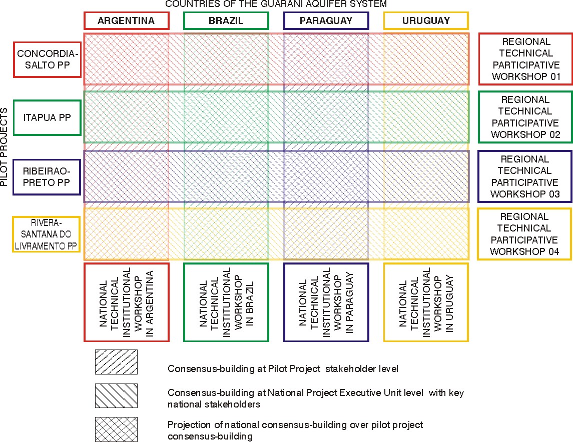
Figure 3 - Consensus-building levels to be considered in the preparation of the TDA
The last consensus-building instance at the overall level GAS was the Joint Meeting of
country representatives, held in Montevideo from 18 to 20 October, and at the GASP
Coordination Group meeting in Curitiba on November 23, 2006, with the participation of
representatives from the National Project Execution Units.
This ensures that the TDA document includes the input of the regional level (Pilot projects),
the national sphere (NPEUs) and the overall GAS sphere (Joint meeting and Coordination
Group meeting), and consequently so do the proposals for mitigation actions for the critical
issues which are the basis for the SAP formulation.
6.
SUMMARY OF THE MEETINGS HELD IN PREPARATION OF
THE TDA
The results of each meeting conducted for the preparation of the TDA will be reviewed
sequentially. A specific report was submitted after each meeting with detailed information.
29
EXPERTS MEETING
The Experts Meeting was held in Montevideo on 16 and 17 February 2006. 12 experts
attended, among them 2 GASP experts, 2 GASP trainees, and 2 pilot project facilitators. 3
experts are from Argentina, 4 from Brazil and the rest are from Uruguay. No Paraguayan
experts were present for force majeure reasons. The meeting achieved its objective of
supporting the TDA consultant in the formulation of the preliminary document, refining its
content and structure.
SUMMARY OF THE REGIONAL WORKSHOPS
The main objective of the regional workshops (RTPWs) was to evaluate the perceptions of
key stakeholders from the pilot projects of the current or emerging critical transboundary
issues of the GAS region and their causes, related information gaps and required mitigation
actions. These workshops were part of a fact-finding process that was intended to support
the national proposals, and the results were systematized and sent to the NPEUs for their
information before the national workshops took place.
The RTPWs were held in the pilot projects on:
Rivera - Santana do Livramento RTPW: 3 and 4 April 2006;
Concordia-Salto RTPW: 6 and 7 April 2006;
Itap·a RTPW: 10 and 11 April 2006;
RibeirŃo Preto RTPW: 12 and 13 April 2006.
Table 4 contains a summary of the critical issues that were identified in each pilot project for
subsequent formulation of their causal chains. They can be classified into 5 groups: the first
group deals with water pollution; the second deals with depletion of phreatic levels; the third
considers the impacts caused by inadequate use of water and soil; the fourth tackles the
problems arising from the growth of the described impacts; at the end there is a mention of,
the issue of the difficulty of implementing the Local Management Unit of GAS.
30
Table 4 Ł Summary: Critical Issues identified in the Pilot Projects
Critical issues
RS CS It
RP
Pollution of drinking water wells due to inadequate sanitation and X
X
X
unplanned use of soil
Pollution of drinking water wells from inadequate sanitation and solid X
waste disposal, population increase and unplanned use.
Depletion of phreatic levels, possibly as a consequence of intensive X
potential exploitation of groundwater
Reduction of artesianism or of GAS water levels
X
Non-sustainable use of the aquifer (decrease of artesianism and X
geothermalism and increase of salinization) caused by uncontrolled
exploitation of geothermal wells and by deep unsealed wells
Impacts on the balance of water consumption caused by afforestation X
X
and its effects on recharge
Impacts on the balance of water consumption vis-a-vis quality and X
quantity caused by extensive changes in the use of soil and in types
and systems of soil cultivation, and by afforestation and its effect on
recharge
Impacts on the quality and rate of a aquifer recharge as a result of X
extensive changes in the use of agricultural soil and in types and
systems of soil cultivation
impacts on the quality and rate of a aquifer recharge as a result of
X
extensive changes in the use of agricultural soil, and in types and
systems of soil cultivation and urbanization
Growth of the impacts described above if the regional agricultural X
policies and the market should favor the intensive and extensive use
of the local soil and/or the groundwater resources
Difficulties in the implementation of a Local Management Unit
X
X
X
Note: RS: Rivera-Santana do Livramento; CS: Concordia-Salto; It: Itap·a; RP: RibeirŃo
Preto.
SUMMARY OF THE NATIONAL WORKSHOPS
The national workshops had the main object of submitting a national TDA proposal for the
GAS. A summary of the results of the Regional Technical-Participative Workshops held in
the four pilot projects was provided beforehand to the countries. Each region's critical issues
were described, as well as their causal chains, identification gaps and proposals for
mitigation actions. Therefore it could be said that the pilot projects submitted their TDA
proposals to the national workshops.
There was no analysis of these proposals to avoid influencing the countries - they received
only the critical issues detected in each pilot project, their causal chains, identification gaps
and proposals for mitigation actions. They were forewarned that it was likely that each
country would be interested not only in the results of the pilot projects in its own territory but
31
in all the results, as the pilot projects are located in regions with typical GAS real or emerging
problems and the countries would benefit from the information obtained in any one of them.
The NTIWs were held in each GAS country on:
Brazil: 29 and 30 May 2006;
Paraguay: 1 and 2 June 2006;
Argentina: 12 and 13 June 2006;
Uruguay: 15 and 16 June 2006.
In the first workshop, which was held in Brazil, the participants decided to summarize the five
critical issues shown on Table 4 into three main issues:
1) GAS pollution problems: wells and the aquifer;
2) Quantitative problems arising from intensive over-exploitation; decline in GAS water
availability; and
3) Macro strategies: challenges to the sustainable management of the GAS
This was proposed to each workshop to maintain a certain degree of coherence and help the
final meeting to reach a consensus. Participants were free to accept it or to propose
alternatives. The results agreed to a certain extent with the Brazilian proposal, with a few
adjustments to the national situation by Argentina, as shown on Table 5. This country's final
proposal, which was submitted after its NPEU's analysis, can be found in Annex C of the
National Workshops Reports.
The National Project Execution Units - NPEUs selected the participants to the National
Technical and Institutional Workshops, which included NPEU members and other key
stakeholders.
SUMMARY OF THE JOINT MEETING
The Joint Meeting was held in Montevideo on 18, 19 and 20 October 2006, in the
MERCOSUR building where the Guarani Aquifer System Project has its headquarters. The
main references for this meeting were the National Technical and Institutional Workshops
and the systematized information submitted to the Joint Meeting by the TDA consultant.
Guidelines on the dynamics to be adopted at the meeting were sent to the NPEUs in
advance.
The meeting's main objective was to submit to the Project Steering Committee - CSDP a
joint proposal by the countries for the Transboundary Diagnostic Analysis of the Guarani
32
Aquifer System. The formulation of this joint proposal complied with consensus-building
requirements on:
Ę the causal chains for each GAS critical issue and its detailed definition as displayed on
Table 5, that identify the main causes which exist in each country;
Ę the information gaps on each critical issue and detailed descriptions, to define the main
information gaps which occur in each country; and
Ę definition of the nature of the mitigation actions, reflecting the requirements and interest in
joint and individual actions by each country regarding the sustainable use of the GAS.
33
Table 5 - Critical issues listed by each country
Types of
Argentina
Brazil
Paraguay
Uruguay
critical issue
Degradation of the quality of
the GAS water in general, and
in particular as a result of
salinization from over-
Pollution problems: wells and
1 - Pollution
exploitation of geothermal
Pollution of GAS water
Pollution and use of soil
the aquifer
wells, deep unsealed wells
and surface water bodies, due
to inadequate handling of
effluents from thermal use.
Reduction of water availability
in general, and in particular
quantitative and qualitative
Quantitative problems arising
2 - Over- problems (reduction of
Reduction of GAS water Over-exploitation (in the
from intensive over-
exploitation
artesianism and
availability
future)
exploitation: decline of GAS
geothermalism) and
water availability
interferences between
perforations.
Macro strategies: challenges Macro strategies for the Macro strategies: challenges
3 -
Challenges to the sustainable to a sustainable management sustainable management of to a sustainable management
Management management of the GAS
of the GAS
the GAS
of the GAS
The result of the Joint Meeting is a common proposal by the four countries - with clear,
concise and non-redundant definitions - of the causes and information gaps for each critical
issue and the proposals for actions to mitigate the identified problems. It contains:
Ę Causal chains for the GAS critical issues and their degree of relevance: these are
displayed on Figure 4 for the pollution issue, Figure 5 for the over-exploitation issue, and
Figure 6 for the management issue;
Ę Major information gaps to be filled by programs of action that include the generation of
strategic information on the GAS; these are shown on Figures 7 to 9 as identified for each
critical issue;
Ę Proposals for actions to be implemented jointly by the countries, with substantial impact
on the shared asset - the GAS; also a proposal for ranking the priorities to be assigned to
the actions from the point of view of the common interests of the countries, shown for
each critical issue on Figures 10 to 12.
It is important to emphasize that the proposals for actions are a useful reference for the
formulation of the Strategic Action Program - SAP, which will conclude the design process of
the Guarani Aquifer System ProjectŁGASP.
The detailed results of the Joint Meeting are submitted in a specific report. This final TDA
report contains a summary and analysis of these results, which are part of the TDA proposal
for the GAS.
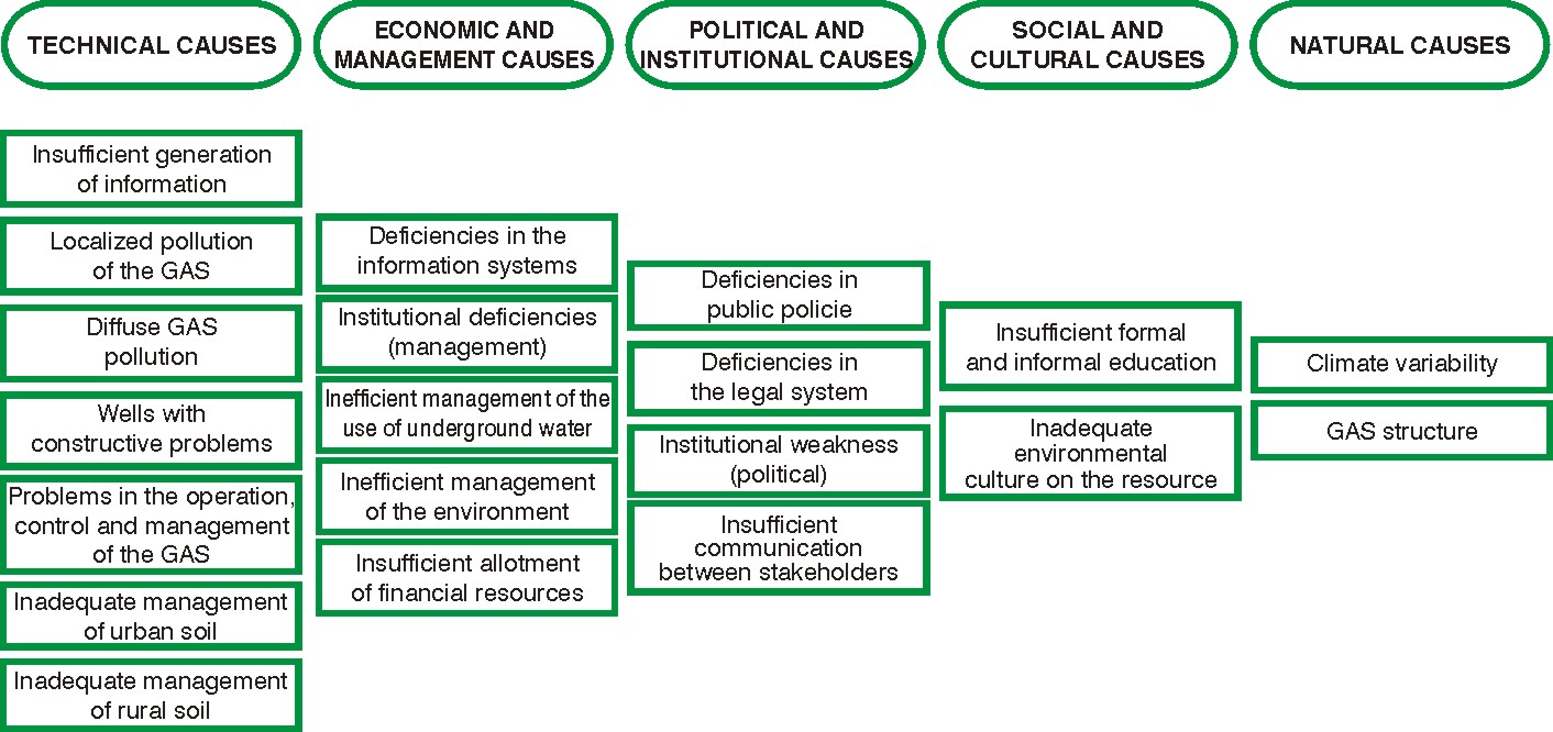
Figure 4 - Causal chain of the critical issue of pollution
36
Figure 5 Ł Causal chain of the critical issue of over-exploitation
(causes are organized into each category by their relative relevance regarding over-exploitation)
37
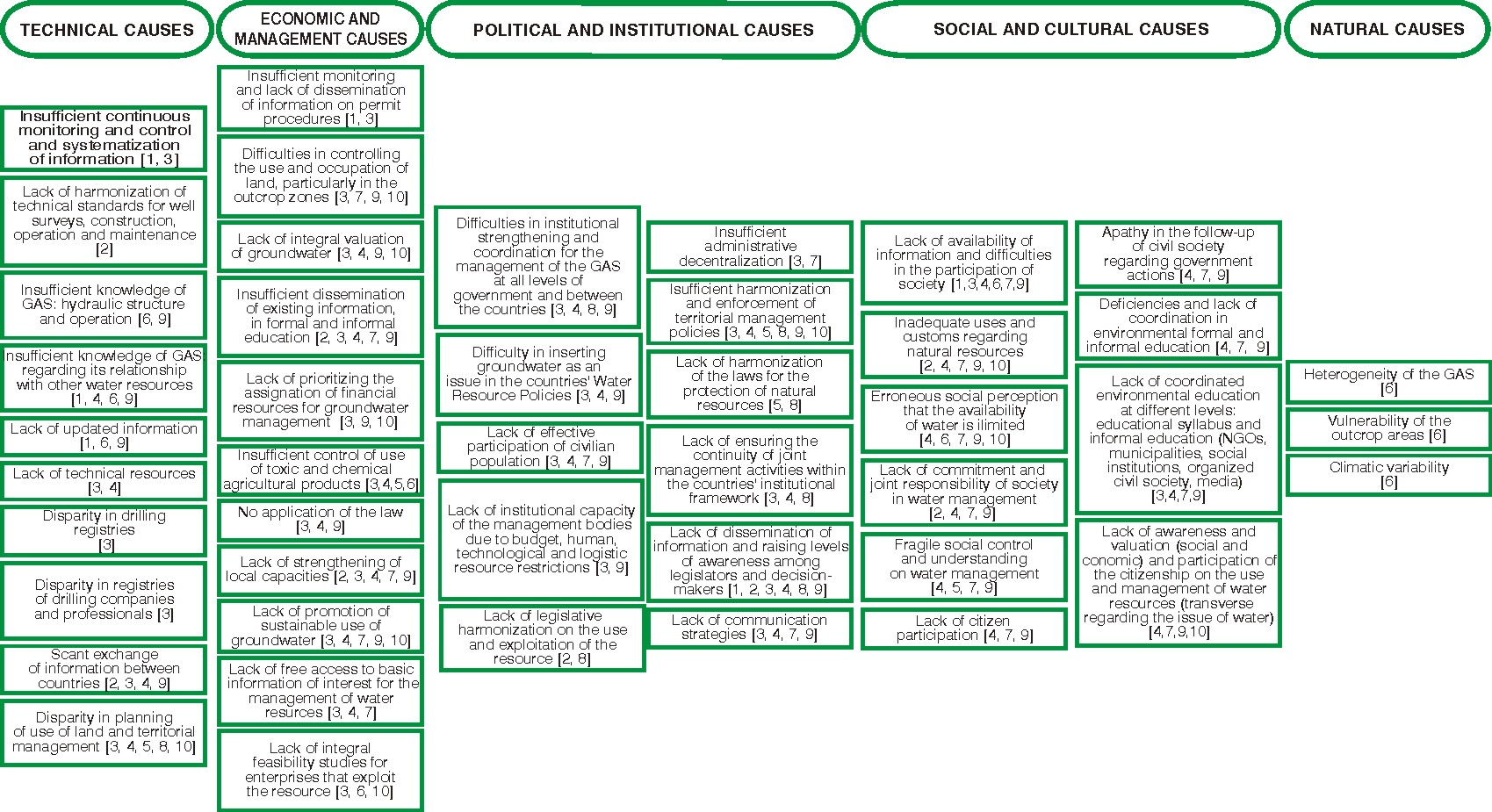
Figure 6 - Causal chain of the critical issue of management
(The numbers between square brackets refer to the actions shown on Figure 13, which mitigate the causes)
38

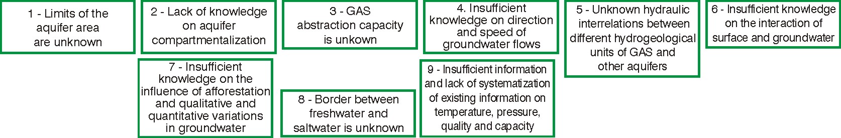
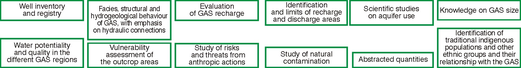
Figure 7 - Information gaps on the critical issue of pollution
Figure 8 Ł Information gaps on the critical issue of over-exploitation
(the information gaps are organized in accordance with their relative relevance regarding the critical issue)
Figure 9 - Information gaps on the critical issue of Management
39
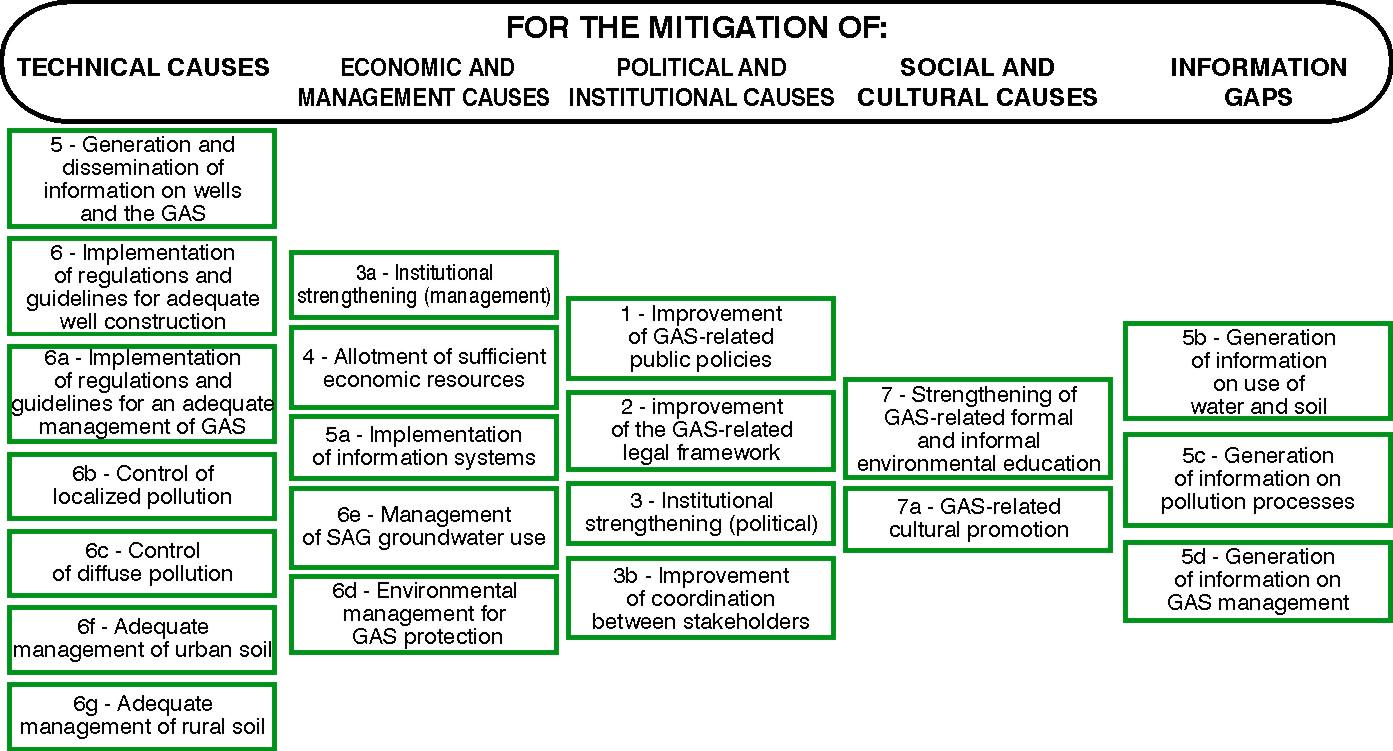
Figure 10 - Mitigation actions for the critical issue of Pollution
(The numbers refer to the relative priority of the actions)
40
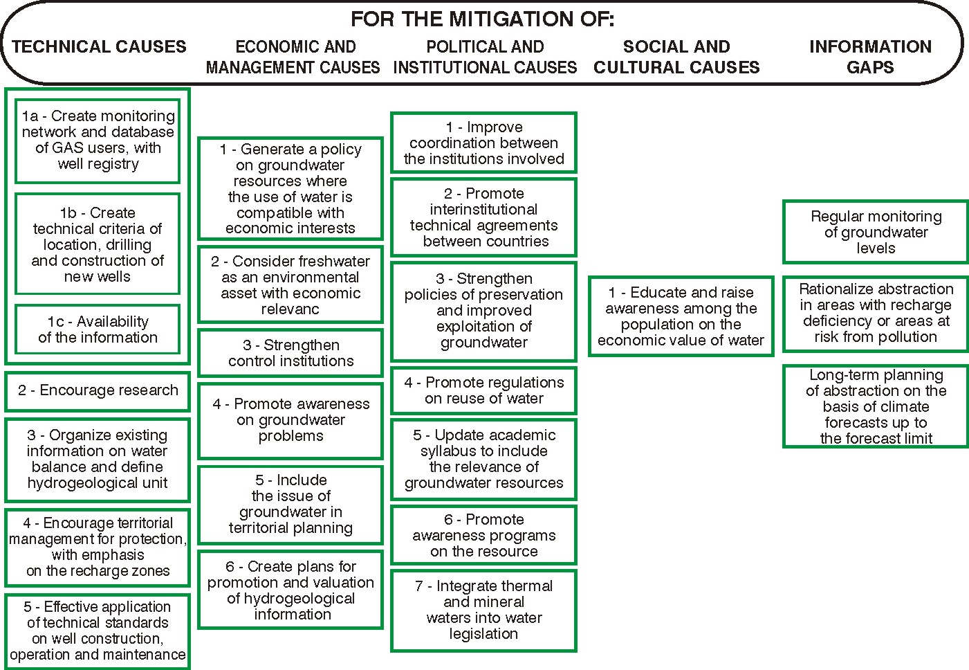
Figure 11 - Mitigation actions for the critical issue of Over-exploitation
(the mitigation actions are ranked in each category by their relative relevance vis-Ó-vis the critical issue)
41
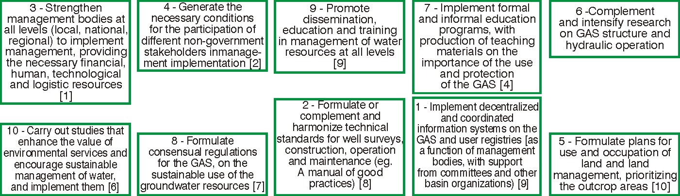
Figure 12 Ł Mitigation actions for the critical issue of Management
(The numbers between square brackets refer to the relative priority of the actions according to the number of causes that would be
mitigated by their implementation)
42
7.
TDA PROPOSALS FOR EACH CRITICAL ISSUE
This proposal consists in the identification of causes, information gaps and mitigation actions
for each critical issue that is presented in Table 5, with the country views on each. The
presentation, which is set out sequentially, contains an aggregate analysis of the causes,
information gaps and mitigation actions proposed for each critical issue, as a way of
establishing links between the root causes of the problems, the information needs and in
particular, with the proposals for action.
CONSOLIDATION AND ANALYSIS OF RESULTS
One of the possible consolidations of the results of the Joint Meeting is the classification of
the root causes of the critical issues, of the information gaps and the mitigation actions in the
main categories with which they were identified. This will contribute to the development of
proposals for action, which is the main focus of the GASP in the following phase, the
formulation of the Strategic Action Plan-SAP that the TDA is to support. This classification is
set out below.
CAUSES OF THE CRITICAL ISSUES
A general classification was proposed in the formulation of the causal chains, namely
technical, economic and management, political and institutional and social and cultural
causes. Sub-categories were created - as per Figure 13 - taking into consideration the
causes identified in the Joint Meeting. There are 5 subcategories for the technical causes, 4
subcategories for economic and management causes, 3 for political and institutional causes,
2 for social and cultural causes and 3 for natural causes. Figure 14 sets out the causes
identified in the Joint Meeting for the three critical issues, organized according to this
classification and providing an overview of the results. As ascertained during the Joint
Meeting, it is not possible or useful to draw links between causes, as it was concluded that
almost all the causes influence the others, which would make the result uninformative and
the figure too confusing.
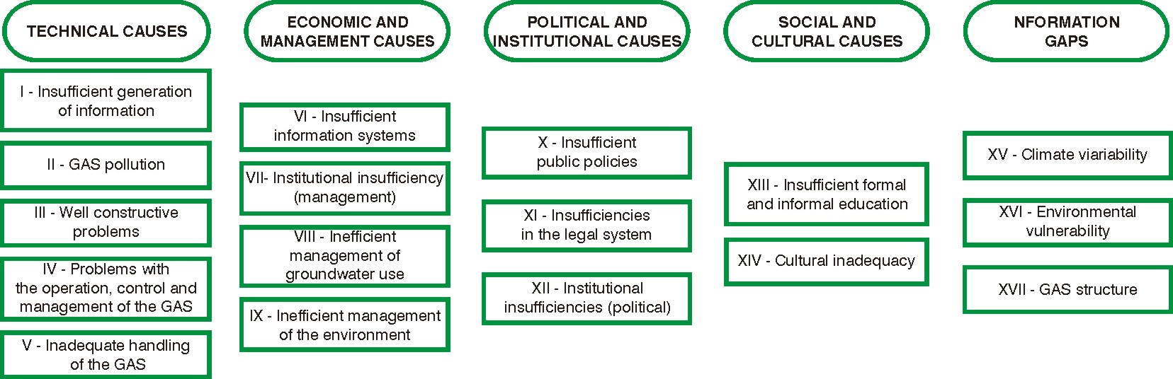
Figure 13 Ł Diagram of the causal chains of the GAS critical issues
Figure 14 Ł Identified Causes of the Critical Issues, classified
Figure 14 exhibits many contrasts between the results for each critical issue, which may be a
consequence of the essence of the issue and also of the professional training and
experience of the members of the group that identified the causes. For instance, it should be
noted that the results for the critical issue Pollution are presented in a very concise manner,
and using for the most part the denomination for the subcategory. One of the reasons for this
may be the professional training of the group members, mostly hydrogeologists, who are not
necessary specialists in water pollution. This may result in a lack of precision or definition of
the pollution problems. On the other hand, it may be a result of the nature of the pollution
problem itself, which has such heterogeneous spatial dynamics that it limits the possibilities
for precise definitions, and therefore requires more generalization.
At the opposite end are the causes of the Management issue, which are much more
abundant than the other issues. The reason for this may be the broader education of the
group members, who were experts, diplomats and environmentalists among others, in
consideration of the issue's complexity. It may be noted that strictly speaking Management is
not limited to political, legal, institutional and management aspects, but must also take into
account aspects of pollution and over-exploitation that were assessed in the other critical
issues.
An important note is that most of the identified causes do not refer to one single critical issue
- rather, most of them are adequate to explain the root of all the critical issues. This
conclusion leads to the simplification of causal chains by the aggregation of similar causes,
and will be presented later in this report.
INFORMATION GAPS ON THE CRITICAL ISSUES
The same attempt towards consolidation was applied to information gaps. The initial idea of
classifying them as gaps preventing the identification of causes and gaps which prevent
proposals for mitigation actions did not prove to be practical. This was due to the fact that
many of them have both consequences. Thus, they were classified into 6 categories, as
shown below in Figure 15.
46
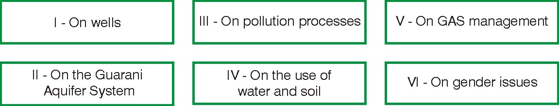
Figure 15 Ł Synopsis of the information gaps on the GAS critical issues
Figure 16 shows the information gaps that were identified for the three critical issues,
organized as per the above classification. It may be noted that most of them refer to the
composition, structure and processes of the Guarani Aquifer System.
The same comments that were made above on the causes apply to this case as regards the
possibility of considering one single figure for the critical issues and eliminating the existing
redundancies. In this case, however, the identifications found for the critical issue Over-
exploitation have almost the same detail as those for the critical issue of Management.
47
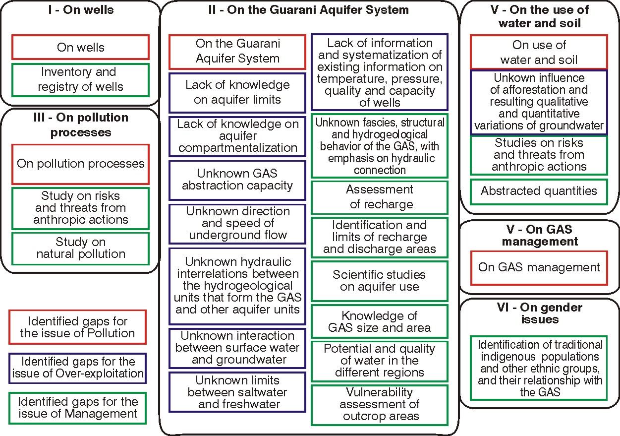
Figure 16 Ł Identified information gaps on the critical issues, classified
48
MITIGATION ACTIONS FOR THE CRITICAL ISSUES
The proposal for actions is of the greatest interest for the results of the TDA, as it is the basis
for the formulation of the Strategic Action Plan - SAP. There are two types of actions: actions
to mitigate the causes of critical issues and actions to fill the information gaps. To be
consistent with the classification of the causes and to help formulate the proposal for actions,
the same subcategories were used as for the causes. This will make it easier to link a
proposal for action with the causes it should mitigate or with the information gaps it must fill.
One exception was the subcategory of natural causes, which was not expressly considered
and the actions for which are presented in the subcategories of the other causes. There are
also mitigation actions to fill the information gaps, but those on wells and the GAS that
pertain to the two first subcategories were added to the subcategory "Generation and
dissemination of data on wells and the GAS", under Technical Causes.
The resulting 18 action categories are summarized in Figure 17. Figure 18 shows the results
of the Joint Meeting.
The former comments regarding the scant details on the critical issue of Pollution also apply
to the actions. In this case however, there is roughly the same amount of proposals for
mitigation actions for the critical issues of Over-exploitation and Management, as in the
information gaps.
49
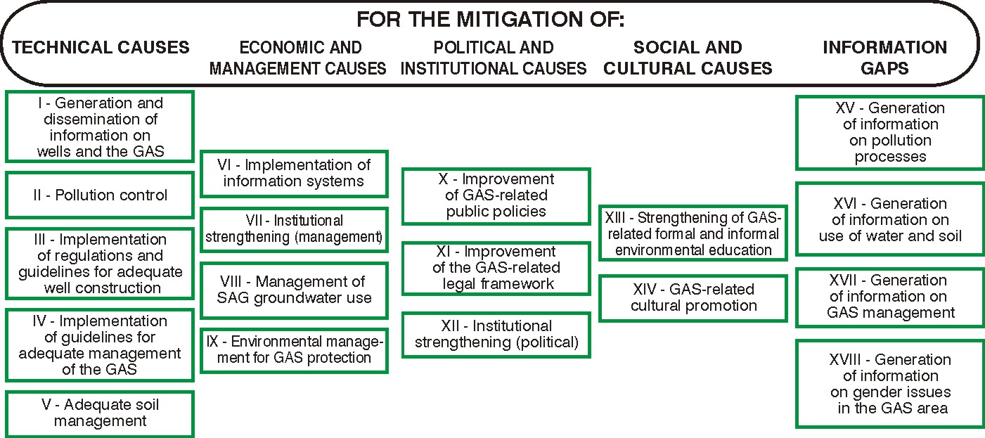
Figure 17 - Diagram of the types of action required to mitigate the causes and fill the information gaps.
50
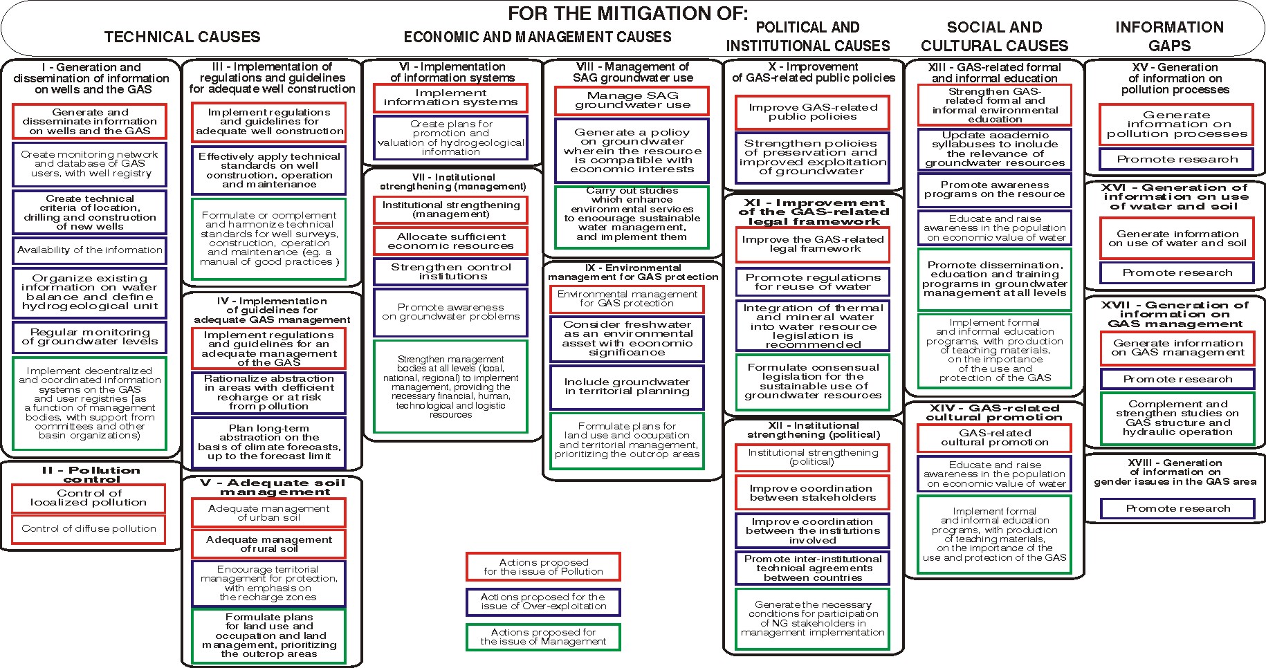
Figure 18 Ł Mitigation actions proposed for the critical issues, classified
51
8.
FINAL TDA PROPOSAL
A final proposal containing the causes, information gaps and mitigation actions for the critical
issues of the GAS is shown on Figures 14, 16 and 18 and takes into account the TDA
proposals for each critical issue as presented in the Joint meeting. This final proposal,
consolidated and classified, arrived at after eliminating redundancies and reorganizing the
figures. The results refer to all the critical issues, since, as noted above, there are no clear
dividing lines between causes, gaps and actions, with the sole exception of the pollution
control program.
CAUSES, INFORMATION GAPS AND PROPOSALS FOR MITIGATION ACTIONS
As a result, Figure 19 displays the causes of the GAS critical issues, namely 10 technical
causes organized in 5 subcategories; 12 economic and management causes organized in 4
subcategories; 12 political and institutional causes organized in 3 subcategories; 7 social and
cultural causes organized in 2 subcategories and 6 natural causes organized in 3
subcategories. Figure 20 shows the information gaps in 6 categories, among which those
referred to GAS outnumber the rest. Figure 21 displays mitigation actions for technical
causes, 10 actions organized in 5 subcategories; 5 actions are suggested for economic and
management causes, organized in 5 subcategories; 7 actions organized in 3 subcategories
are proposed for political and institutional causes; 5 actions for social and cultural causes;
and 2 actions for information gaps, in one specific subcategory.
To achieve these results there was a reorganization of the mitigation actions for social and
cultural and natural causes. Actions regarding formal and informal education were added to
the first group. In the cultural aspects, actions were added in a single subcategory described
as "Formal and informal education, and cultural promotion on the GAS". The reason is that
many of the mitigation actions for the critical issues in one subcategory also mitigate the
problems of another.
52
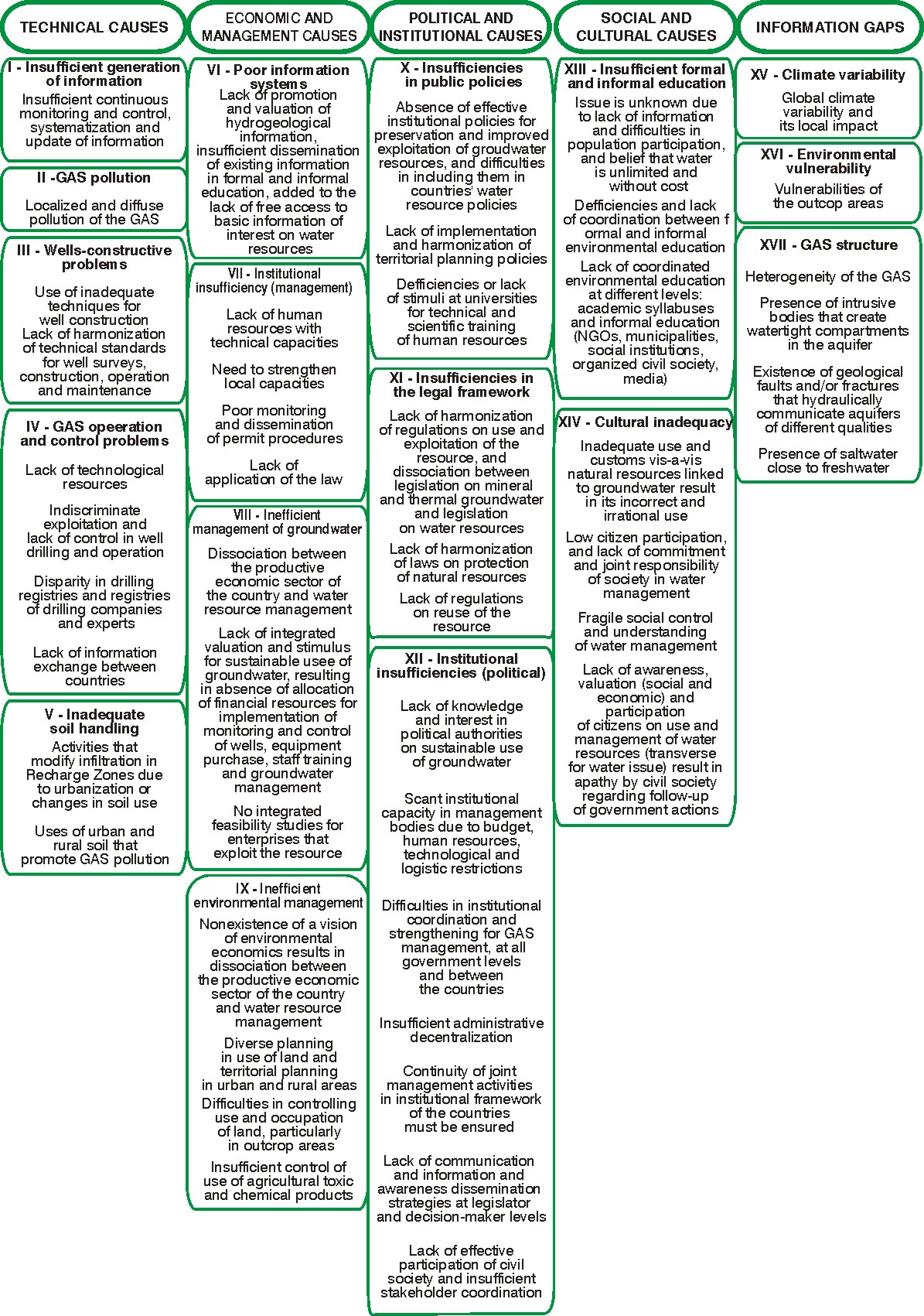
53
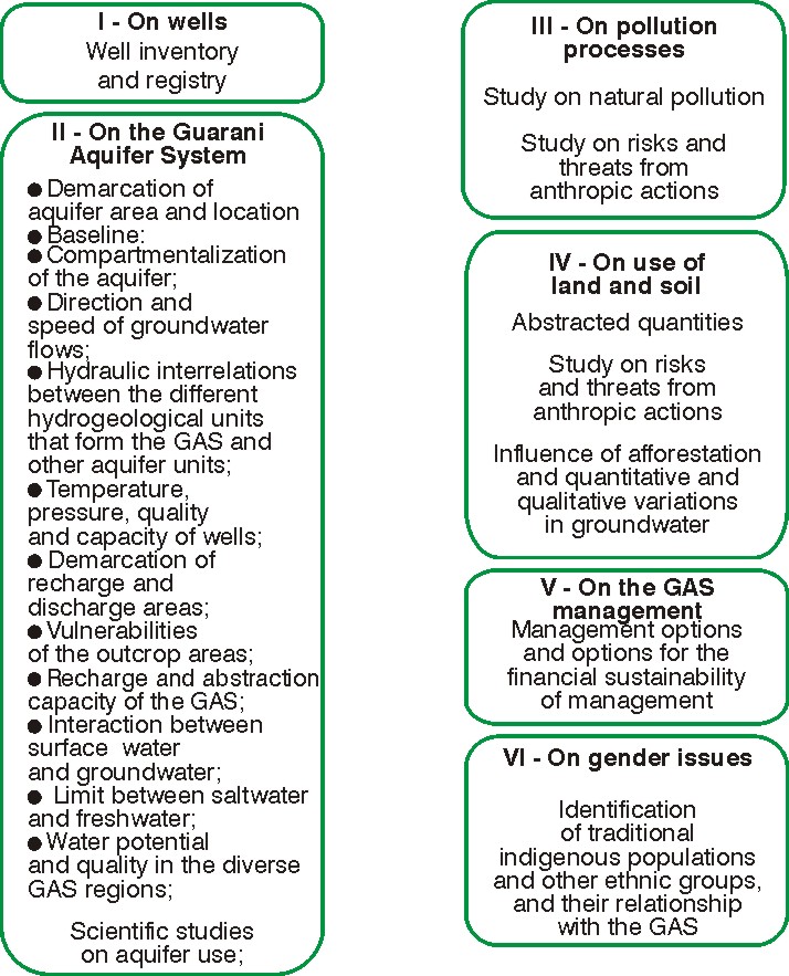
Figure 19 Ł Causes of the critical issues of the Guarani Aquifer System
Figure 20 Ł Existing Information gaps on the critical issues of the GuaranĒ Aquifer
System
Regarding natural causes it was understood that mitigation actions for other causes act
preventively in such a way that natural causes, that by definition cannot be mitigated, may be
mitigated too. Finally, it was understood that an action described as "Generation of
Information for GAS management" would fill the information gaps.
54
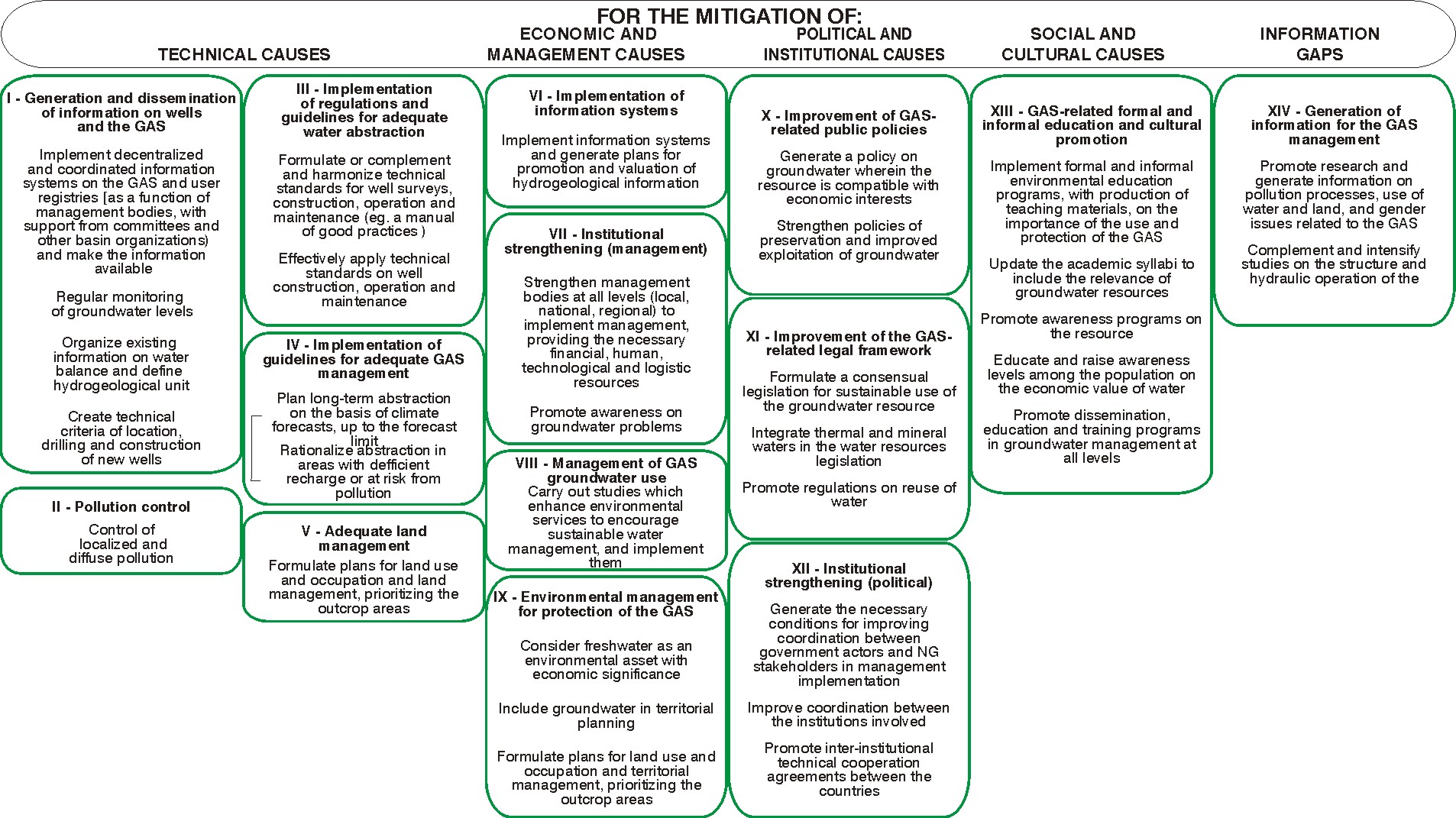
Figure 21 Ł Proposals for Mitigation Actions for the critical issues of the GuaranĒ Aquifer System
55
ANALYSIS OF THE RESULTS
In order to analyze the actions and propose the preliminary priorities, the indications of the
Joint Meeting are available on Figures 10, 11 and 12. However, the working groups that dealt
with the critical issues of Pollution, Over-exploitation and Management used different criteria
for establishing priorities. The Over-exploitation group ranked actions in accordance to each
kind of cause: technical, economic and management, political and institutional and cultural.
The groups that handled the issues of Pollution and Management ranked actions as a whole,
but the first group considered that certain actions have equal priority.
To deal with this difference in criteria the approach was the following. Considering the 14
Proposals for Mitigation Actions displayed on Figure 21, an evaluation was made of which
proposed actions for the mitigation of each critical issue were involved in a program and with
what kind of priority. For example, in the sub-group of actions 1 - "Generation and
dissemination of data on wells and the GAS" there is a proposed action for the critical issue
of Pollution with priority 5; 3 actions for the critical issue of Pollution with priorities 1, 1 and 3
respectively regarding the cause to be mitigated; finally, for the Critical issue of Management,
a mitigation action with priority 9 was proposed. Table 6 displays the results.
In the critical issue of Pollution, column R displays the priority for the actions. The top priority
subgroup is X - "Improvement of GAS-related Public Policies", because the action with the
highest priority pertains to this program. When there is more than one action in a subgroup,
as in VII - "Institutional strengthening (management)" and XII - "Institutional strengthening
(political)" the second has higher priority, because actions were ranked with priority 3 and 3,
while in the other group they have priorities 3 and 4. The same criterion was applied to the
remaining critical issues and the relative priority for each is displayed under the heading `R'
in Table 6.
It is worthwhile to note that this priority ranking is not and should not be considered as
conclusions by the countries, but rather as one of the results of the consultant's analysis
which is presented for information purposes to the countries and to be taken into account in
the preparation of the SAP.
56
Table 6 Ł Indications of priorities for the proposals for mitigation actions for each critical issue
Proposals for Action
Critical Issues
Pollution R
Over-exploitation R
Management R
I - Generation and dissemination of information on wells and the GAS
5
6 1 1 3 2 9
8
II - Pollution control
6 6 7 10
10
III - Implementation of standards and guidelines for adequate well 6 8 1 5 4 8 7
construction
IV - Implementation of standards and guidelines for adequate GAS 6 8 10
10
management
IX - Environmental management for the protection of the GAS
6 8 10
10
V - Adequate land management
6 6 7
4
5
7 10 9
VI - Implementation of Information Systems
6 8 6
9
10
VII Ł Institutional strengthening (management)
3 4 4 10 1
1
VIII - Management of GAS groundwater use
6 8
3
4
6
10
X - Improvement of GAS-related Public Policies
1
1 1 2 1 2 3 1 6
5
XI - Improvement of GAS-related legislation
2 2
4
7
8 7
6
XII - Institutional strengthening (political)
3 3 3 10 2
2
XIII- Formal and informal education, and cultural promotion on the GAS
7 7
9 5 6 1 3 3
4 3
XIV - Generation of information for GAS management
5 5 5 5
2
5 5
4
Note: the columns rank the priorities as set out by each working group that tackled each critical issue. The last column, R, displays the relative
priority of the proposal for action, for each group.
57
The subgroups of actions were assigned Number 1 when the priority for a certain critical
issue is very high, and number 2 for the second-highest priority, as shown on Table 7. For
the final classification, the first place was given to subgroups with top priority for a critical
issue, followed by those with the second-highest priority, and so on.
This criterion is the same as the one used to rank countries in the Olympic Games: first are
those who won the most gold medals; next those who obtained the most silver medals, etc.
The advantage of this criterion is that it avoids the "dictatorship of the majority", by which only
those actions that a significant number of voters consider important are given priority, and an
action with maximum priority for one single voter, if it does not have priority for the rest, may
end up ranked as without relevance. With this criterion, if there are N voters, an action that is
considered as having maximum priority by only one of them will at least be assured of having
priority N in the general computation.
The relative priorities of the subgroups of actions, proposed by the consultant by means of
this criterion, are displayed in Table 7. The three subgroups with the highest priority are: X Ł
"Improvement of GAS-related Public Policies"; VII Ł "Institutional strengthening
(management)" and XII Ł "Institutional strengthening (political)". Oddly enough, program VI Ł
"Implementation of Information Systems" obtained a low priority ranking, as it had low priority
for all the critical issues.
From these results it may be interpreted that the social stakeholders of the GAS perceive
improvement of public policies and institutional strengthening (both management and
political) as the highest priorities for the Guarani Aquifer System Project: two subgroups of
political and institutional mitigation actions, and one from the economic and management
category. Generation and dissemination of information on wells and the GAS is ranked as
fourth, followed by improvement of GAS-related legislation: one subgroup of mitigation
actions with technical causes, and another of a political and institutional nature. Finally,
formal and informal education and GAS-related cultural promotion also obtained a significant
ranking, a subgroup of mitigation actions of social and cultural origin. This ranking leads to
the conclusion that priorities are focused on the root causes, because they are those that are
displayed on the right hand side of the causal chain, and for this reason they generate more
permanent changes in the organization of society and its relationship with the environment
and the GAS.
58
Table 7 Ł Tentative priority ranking of the Proposals for Mitigation actions
Proposals for Mitigation Actions
Over-
Manage Final
Pollution exploitat ment
Priority
ion
X - Improvement of GAS-related Public Policies
1
1
5
1
VII Ł Institutional strengthening (management)
4 11 1 2
XII - Institutional strengthening (political)
3 10 2 3
I - Generation and dissemination of data on wells 6 2 4 4
and the GAS
XI - Improvement of GAS-related legislation
2 8 6 5
XIII- Formal and informal education, and cultural 14 3 3 6
promotion on the GAS
III - Implementation of standards and guidelines 9 4 7 7
for adequate well construction
XIV - Generation of data for the management of 5 5 4 8
the GAS
VIII - Management of the use of GAS groundwater 12
6 9 9
V - Adequate use of land
8 7 8 10
II - Pollution control
7 12 11 11
VI - Implementation of information systems
11 9 10 12
IV - Implementation of standards and guidelines 10 13 12 13
for an appropriate management of the GAS
IX - Environmental management for the protection 13 14 13 14
of the GAS
Once more, it is important to note that this ranking is merely indicative of the perceptions of
the social actors from the four countries, as interpreted by the consultant. The countries, on
the other hand, understand that the program is indivisible, and therefore must be addressed
as a whole when formulating the SAP. However, the countries believe that the deep concern
voiced at the Joint Meeting regarding the issue of improving public policies and an efficient
strengthening of the water management institutions in the four countries should be taken into
account at the time of designing the SAP. These should be instrumental in generating
changes in the organization of society, and consequently, in its relationship with the
environment in general and the GAS in particular.
59
9. FINAL CONSIDERATIONS - EVALUATION OF THE
FORMULATION PROCESS OF THE TDA OF THE GUARANI
AQUIFER SYSTEM
To sum up, it is important to evaluate the formulation process that was used for the TDA,
following the guidelines provided by Mee (1983). Pursuant to these, the following factors
must appear:
- Broad-based stakeholder participation - all the parties involved or affected by an
environmental issue or its solution should be involved in the preparation of the TDA: 142
social stakeholders took part in the design of the TDA via the regional workshops, 148 via
the national workshops and 33 in the Joint Meeting. The first were selected by the
facilitators of the Pilot Projects, prior approval of the GASP General Secretariat; the rest
were selected by the National Project Execution Units - NPEUs. This allowed for a broad-
based participation, in compliance with the guidelines, as arises from the reports of the
regional and national workshops.
- Joint fact-finding - the TDA should be directed by an independent expert or experts,
appointed by representatives of the social stakeholders through broad-based consultation,
to ensure that the process and its products are suitable for the region; the consultation
process consisted of 4 regional workshops in the context of the pilot projects, 4 national
workshops in the GAS countries and one Joint Meeting. The consultant acted as a facilitator
in the meetings, making only the necessary interventions to ensure that the meetings had
the appropriate dynamics. He was careful to avoid inducement or influence on results,
displaying them exactly as they were produced in the workshops, with small corrections
regarding form and classification but not contents. This enabled a process of regional
appropriation of the TDA to occur: it is not the consultant's TDA, or that of GASP experts, or
even a TDA by the experts or representatives of the regional public agencies. The TDA is,
up to now, the result of successive broad-based discussions, and it began at the baseline of
the process - the pilot projects - reaching the national spheres. Now it will reach the joint
level, after a sequence of successive appropriations which involved the broadest
geographic areas and stakeholder interests.
- Transparency: the TDA must be a public access document; both during design and fact-
finding by the stakeholders; the resulting products should be freely disseminated. The TDA
documents were made available on the GASP webpage by the GASP General Secretariat
with no access restrictions. The participants of the various workshops were informed and
therefore were easily able to access these documents.
- Eco-systemic approach: this approach is based on the application of the appropriate
scientific methodologies, focused on the levels of biological organization that involve the
essential processes and interactions between organisms and the environment - therefore it
must be recognized that human beings are a part of the ecosystem; also, the systems
should be defined by their natural limits and not their political ones, though these must be
recognized in the analysis. The classification of causes (technical, economic and
management, political and institutional, social and cultural and natural causes) made it
possible to make an eco-systemic analysis. Border issues were considered in the
contributions of the 11 experts that analyzed the Preliminary Document and assisted in the
formulation of this document, which guided the participants of the several workshops.
60
- Adaptive management: the TDA and the SAP should be formulated in a series of
pragmatically defined stages; at each stage, previously defined performance indicators must
be monitored, and depending on results, joint planning must be put into place to evaluate
progress and plan the following stage. The adaptive approach was defined in the
permanent discussions between the consultant and SG-GAS experts, NPEU coordinators
and experts from the OAS, World Bank and GW-Mate, who contributed significant
guidelines. The regional workshops were organized and evaluated jointly with the GASP
General Secretariat so that the guidelines for the national workshops were approved. In the
workshops, the consultant ensured that the participants established the appropriate
dynamics. However, objective performance indicators were not used, in the understanding
that they do not exist. Subjective performance indicators were adopted, based on workshop
attendance, participation of social stakeholders and results, analyzed jointly with the
General Secretariat of the GASP.
- Actions should take into account the economic and social causes of a problem: an
analysis of the causal chains of the transboundary problems and identification of social and
economic causes is of critical importance for the formulation of the TDA; it must be admitted
that actions taken in close proximity to the root causes have greater possibilities of having
long-term effects on problems. The classification that was used for the causes led to an
emphasis on social (social-cultural) and economic (economic-management) causes. Among
the mitigation actions that were proposed at the Joint Meeting, emphasis was on those with
direct action on root causes.
- Strengthening of intersectoral policies: sectoral approaches are to be avoided, as they
prevent the inclusion of multiple purposes, economies of scale and the eco-systemic
approach itself. This approach was ensured by the intersectoral origin of participants at the
workshops and the Joint Meeting.
- Gradual consensus-building: Consensus must be reached at each stage of TDA and
SAP formulation in order to ensure the long-term sustainability of the process and its
results. At the 8 workshops and 1 Joint Meeting results were always reached by consensus
and widely disseminated.
In this way, preparation of this TDA followed the required guidelines.
Regarding the constructive approach that was adopted - as indicated by the GEF
methodology itself - please note that, as with all paradigm shifts, there may be difficulties in
its application and understanding. Notwithstanding this, the design process of the TDA
complied strictly with the guidelines of this new GEF paradigm, and accordingly:
Ę There was constant interaction with stakeholders throughout 10 meetings, one of them
with experts, 4 of them regional in the pilot projects, 4 of them national and one of them a
joint meeting;
Ę Their values were respected and taken into account, by means of broad-based
participation, and joint construction of results based on feedback;
Ę The visions and perceptions of the stakeholders were incorporated into the TDA;
61
Ę Causal chains were regarded not as representations of objective reality, but rather as
tools to build consensus on the proposals for mitigation actions to be taken in the GASP
sphere;
Ę Information gaps and mitigation actions were taken not so much as critical information
failings and optimal solutions to solve the GAS problems, but rather as socially
constructed recommendations; for this very reason they have better chances of being
considered at the political level and actually implemented, and socially accepted and
supported.
ANNEX 1 - GEF OPERATIONAL PROGRAM 8 - WATER BODIES
Operational Program 8 Ł OP8 finances the agreed incremental cost of additional measures
to solve transboundary environmental problems which affect certain water bodies, based on
countries' commitment to reform policies and sectoral activities and to fund expected
baseline investments. Environmental problems include pollution, over-exploitation of
biological and non-biological resources, degradation of habitats and exotic species.
This program "may fund the transaction costs of neighboring countries collaborating on
defining the priority transboundary environmental concern of the waterbody and determining
expected baseline and additional actions needed to resolve each priority concern" (GEF Ł
2006).
The long-term objective of OP 8 is to "undertake a series of projects that involve helping
groups of countries to work collaboratively with the support of implementing agencies in
achieving changes in sectoral policies and activities so that transboundary environmental
concerns degrading specific waterbodies can be resolved".
The short-term objectives of OP 8, towards which the GAS may contribute, are to:
- "undertake a series of projects that utilize a spectrum of interventions for addressing
different transboundary environmental concerns in different types of waterbodies that are
representative of diverse geographic settings across the world;
- derive lessons learned from experiences in using various types of institutional
arrangements at the national and regional levels for collaboration in addressing
transboundary priority environmental concerns; provisions will be included for periodic
stock-taking and review of lessons learned as projects are implemented;
- assess the usefulness of Strategic Action Program formulation in leveraging national /
donor actions at the policy/investment levels, in coordinating support of regular
implementing agency programs, and in serving as a logical framework for monitoring and
evaluation;
62
- initiate actions toward resolving transboundary environmental concerns for a variety of
waterbody settings with at least one freshwater basin project and one large marine
ecosystem project in each of the world's five development regions: 1) Sub-Saharan Africa,
2) Asia, 3) Latin America/Caribbean, 4) Middle East/North Africa, and 5) Eastern
Europe/Former Soviet Union.
The view of the GEF is that projects for waterbodies encompass a wide range of
transboundary problems, geographic contexts and regions. The following GEF criteria are
applicable to the GAS:
- transboundary concerns are defined by neighboring countries in a transboundary
diagnostic analysis;
- transboundary concerns create significant threats to the functioning of the ecosystems and
a focus is placed on the highest threats;
- most countries contributing to the problems wish to collaborate;
- resources are programmed to support projects in many different development regions
rather than being clustered on one continent;.
Assistance may be provided by GEF to:
- conduct a transboundary diagnostic analysis to identify priority transboundary
environmental concerns;
- formulate a Strategic Action Program of actions each country needs to take to address the
priority transboundary concerns (including differentiation of agreed expected baseline
actions and those that would be additional in nature) and to leverage non-GEF resources for
implementing both baseline and additional actions;
- support the incremental cost of technical assistance, capacity building, limited
demonstrations, and certain investments needed to address the priority transboundary
concerns as outlined below under "Types of Activities".
- encourage the use of sound science and technological innovations for management.
".
Other GEF guidelines are:
- "Rather than addressing all the environmental problems GEF seeks to focus on the top
priority problems that are transboundary in nature so that sectoral policies and activities that
create the problems are changed:
- Joint actions among nations and regional cooperative institutional arrangements are often
key features of these projects;
- The projects run the range from capacity building and technical assistance to specific
investments with incremental costs;
- Institutional elements such as water quality standards/regulations, permit processes or
water minimization/pollution requirements are harmonized among countries;
- If applicable, institutional arrangements such as commissions are often Developer or
strengthened to provide mechanisms for countries to sustain actions after the GEF projects
end."
63
ANNEX 2 - OTHER GEF PROJECT TDAS
Several similar experiences were reviewed to find guidelines on how to apply the GEF
methodology to the GAS. The following studies, carried out in the Plata Basin, were of
particular interest:
- Strategic Action Program for the Bermejo Basin (Argentina and Bolivia) Ł (SAP Bermejo).
Source: Comisi¾n Binacional para el Desarrollo de la Alta Cuenca del RĒo Bermejo y
Grande de Tarija, OAS, UNEP, GEF (2000) Strategic Action Program for the Binational
Basin of the Bermejo River. 94p. Website: http://www.cbbermejo.org.ar/docs.htm
- Integrated Watershed Management Program for the Pantanal and Upper Paraguay River
Basin (Brazil) - (Pantanal/Alto Paraguay): Source: ANA/GEF/UNEP/OAS (2003) Diagnostic
Analysis of the Pantanal and Upper Paraguay River Basin. Executive Summary. 103 p.
- Environmental Protection of the Rio de la Plata and Its Maritime Front: Pollution
Prevention and Control and Habitat Restoration. Source: Transboundary Diagnostic
Analysis of the Rio de la Plata and its Maritime Front Ł Technical Document. Project:
UNDP/GEF RLA/99/G31. Montevideo, June 2005. Website:
http://www.freplata.org/documentos/TDA/default.asp, obtained on 30/01/2006.
- Framework for the Sustainable Development of the Water Resources of the Plata Basin
regarding the Hydrological Effects of Variability and Climate Change. Transboundary
Diagnostic Analysis. Final consultancy report, 17 January 2005
Other sources on GEF projects in other regions are:
- Brazil, Organization of American States (2004). Proposal for the Integrated Management
of Land-based Activities in the SŃo Francisco River Basin: Strategic Action Program for the
Integrated Management of the SŃo Francisco River Basin and its Coastal Zone
Transboundary Diagnostic Analysis: SAP: GEF SŃo Francisco; Final Report, 336 p.
- Formulation of the Strategic Action Program for the Integrated Management of the Water
Resources of the San Juan River Basin and its Coastal Zone (PROCUENCA SAN JUAN).
Report available at: http://www.oas.org/sanjuan/spanish/documentos/TDA/introduccion.html
Specific GEF documents were also consulted, namely:
- DUDA, A (2002). Monitoring and evaluation Indicators for GEF International Water
Projects, Monitoring and Evaluation Working paper 10, GEF. 11p.
- MEE, L. (2203) The GEF IW TODA/SAP Process Ł Notes on a proposed best practice
approach. Revision 5/6/2003. Mimeo.
- GONZALEZ, P (2004) La formulaci¾n del Programa Estratķgico de Acci¾n (PEA) y el
Anßlisis Diagn¾stico Transfronterizo (TDA). La metodologĒa del Fondo para el Medio
Ambiente Mundial en sus programas operacionales de Aguas Internacionales. 12p.
- BEWERS, J. M, UITTO, J. I. (s/d) International Waters Program Study Ł Final Report.
Global Environment Facility 52p. (mimeo).
64
Below is a summary of the results of the above projects' TDAs.
GEF Bermejo
The TDA for this project took into account baseline studies, thematic cartography,
zonification and regionalization, and the pilot studies. It identified the problems, their causes,
transboundary effects and root causes.
Causal chains were formulated in terms of (1) identified environmental problems, (2) effects
and symptoms (or ways to identify the effect), (3) direct causes and (4) basic causes, which
would be the root causes. (5) Strategic Actions were proposed.
Figure 22 shows the Causal Chain for the top priority environmental problems.
GEF Pantanal/Alto Paraguay
This Project adopted a methodology that enhanced stakeholder participation in the
formulation of the TDA and SAP and was supported by 44 previous sub-projects. The causal
chains were set out in terms of (1) critical issues, (2) their primary causes (technical), (3) the
secondary and tertiary causes (economic and institutional, respectively), and finally (4) the
root causes. These led to (5) the proposal of Top priority actions. Figure 23 shows an
example of one of the causal chains, water pollution.
It is worthwhile to note that in comparison with the Bermejo TDA, this project shows more
detail in the definition and classification of the causes which lead to the root of the problems.
On the other hand, the GEF-Bermejo deals better with aspects of environmental fragility and
sensitivity of the Direct Causes of natural origin in the formulation of the causal chain.
GEF FREPLATA
The methodology of the GEF-FREPLATA project was innovative in the use of the causal
analysis Pressure-State-Response - PSR model of the Organization for Economic
Cooperation and Development (OECD, 2004) to identify the root causes of the critical issues.
This approach provides for a classification of environmental indicators into 3 types:
Pressure - P: information on human activities that affect the environment; they do not
necessarily cause negative impacts, as they may be managed correctly;
State - S: information on the state or condition of the environment, i.e., the quality of the
environment and the operation of the more relevant environmental processes;
Response - R: information on preventive or corrective measures to mitigate environmental
impacts.
65
By applying the PSR model, the project identifies: (1) root causes. Subsequently, (2) the
immediate negative consequences of the root variables and (3) the negative impacts on the
ecosystem, and (4) on society. This data led to the causal chain that was used to formulate
proposals for (5) top priority actions. Additionally, it makes a vulnerability analysis of the uses
and services of the water environment and, by examining the trends of the root variables,
presents future scenarios for the environment. Figure 24 illustrates the process, and Figure
25 shows the chain that arises from the root variable Agro-industrial Activity.
66
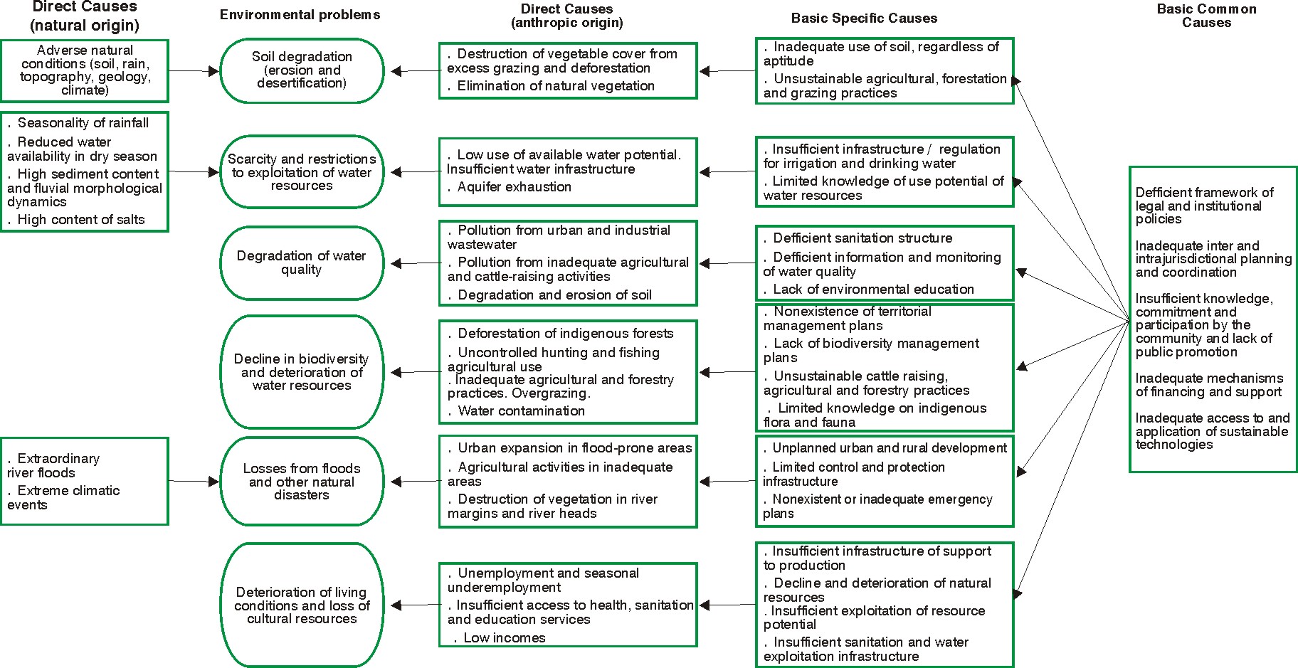
Figure 22 Ł GEF-Bermejo TDA: Causal chain of the top priority environmental problems
67
Figure 23 Ł GEF- Pantanal/Upper Paraguay River TDA: Critical Issue of Water Pollution
68
Figure 24 Ł Design methodology of the GEF-FREPLATA Project TDA based on the Pressure-State-Response model
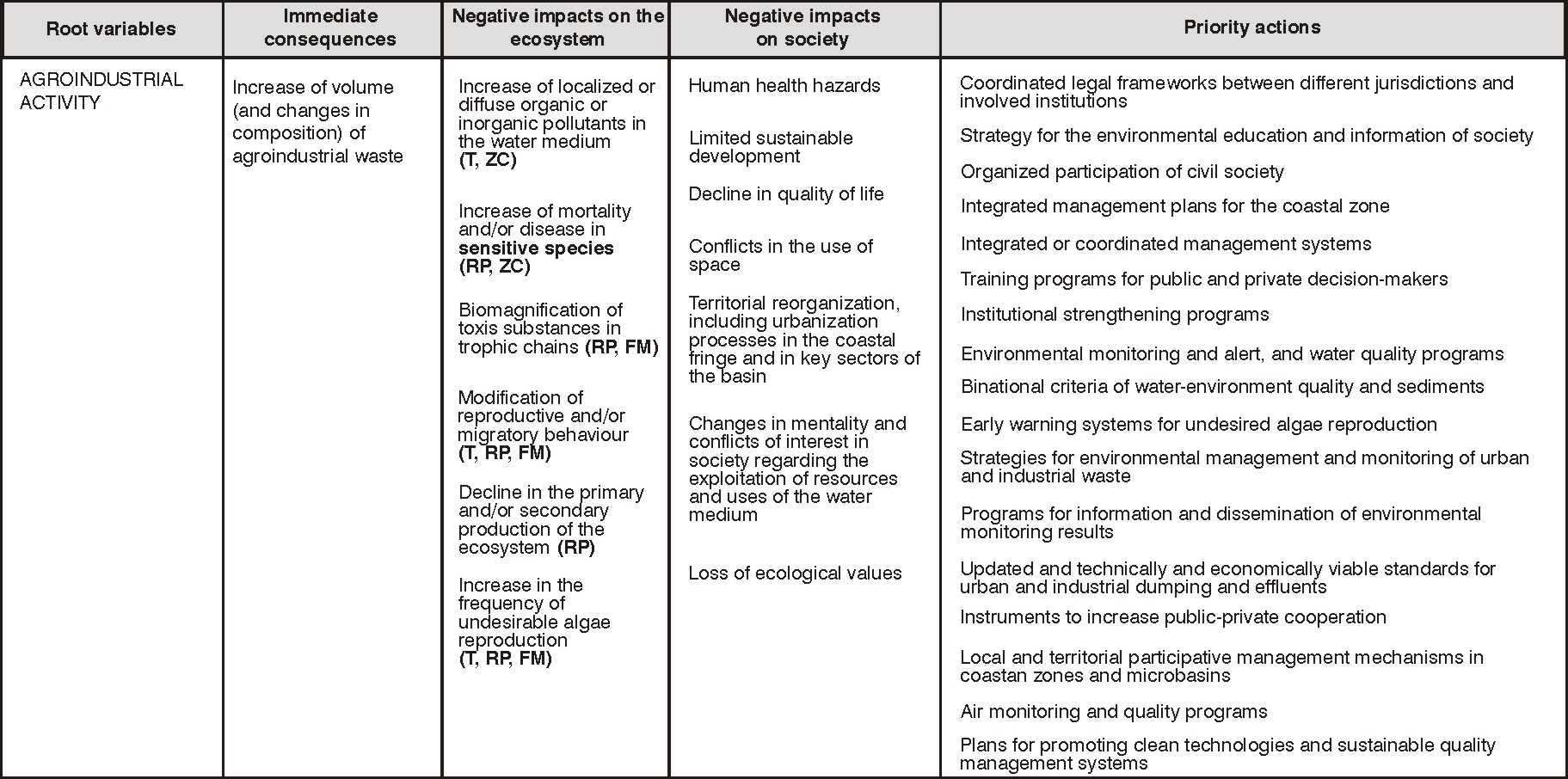
Figure 25 Ł One of the causal chains shown in the FrePlata TDA
70
GEF Framework Program
The Framework Program TDA applied a participative approach in two stages. During the first
stage a Vision of the Plata Basin was drawn up, and the second stage involved the design of
the Transboundary Diagnostic Analysis. National workshops were held in each of the five
countries of the basin, followed by an international workshop. The national workshops
worked on reaching a consensual national view of the basin's problems; the international
workshops reached a consensual overall view of the problems.
The following definitions were adopted to classify the causes in the causal chain:
- Primary or technical causes: these are causes that refer to inadequate handling of
scarce natural resources. One way to identify them is their direct relationship with
environmental impacts;
- Secondary or economic / management causes: these causes arise from inadequate
economic signs or management approaches. In this case there is a physical or
technological link between the secondary causes and the consequent primary cause;
- Tertiary or political / institutional causes: they arise from the institutional sphere, that is,
from the legal and organizational framework of a region or country;
- Baseline or social / cultural causes: these refer to the basic composition of society: its
standards of conduct, ethics, customs, traditions, religion, etc.;
- Root causes: the root causes are those which are found at the root of the critical
transboundary issue, by means of the basic or tertiary, secondary and primary causes.
Information gaps and proposed mitigation actions were identified as suggestions for SAP
formulation, as well as the causes for each transboundary critical issue.
The causal chain for the Critical issue Non-sustainable use of transboundary aquifers is
shown on Figure 26. The aquifers in this basin are: Guarani System (AR, BR, PY and UY);
Upper cretaceous sandstones, on the coast of the lower Uruguay River (AR and UY); the
Yrenda aquifer (PY) Ł Toba (AR) Ł Tarije±o (BO); Apa river aquifer (BR and PY), and
aquifers of the Pantanal, Furnas, Caiuß, Parecis and Serra Geral (BR).
71
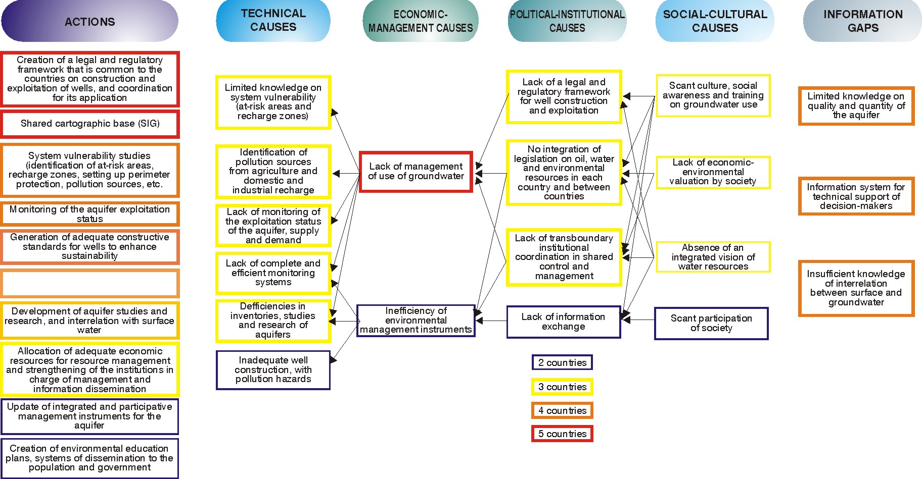
Figure 26 Ł GEF Framework program: causal chain of the critical issue Non-sustainable use of transboundary aquifers
72
GEF Projects in other regions
GEF-SŃo Francisco
This project was designed for the SŃo Francisco River Basin and its Coastal Zone in Brazil.
There was a certain similarity with the methodology used for GEF-Pantanal in the
implementation of 29 projects prior to TDA formulation, and also in the emphasis on
stakeholder participation.
The causal chains, though they are similar to the GEF-Pantanal/Upper Paraguay River, are
based on different definitions of primary, secondary and tertiary causes. They were
conceived in terms of (1) Critical Problems/Issues; (2) Primary causes (technical), (3)
Secondary causes (management), (4) Tertiary causes (political / social) and (5) Basic
Causes (socio-economic / cultural), which would be the causes. These lead to the proposals
for action. Figure 27 shows the causal chain of the critical issue "Uncontrolled exploitation of
groundwater, dissociated from surface water".
The classification of the causes is very similar to the GEF Framework Program, and is
obviously the source of the methodology that was used. La clasificaci¾n de las causas, muy
similar a las del GEF-Programa Marco, es explicada pues esto se inspir¾ en aquello para
definici¾n de las causas.
GEF-San Juan
This project was developed for the San Juan River Basin and its Coastal Zone, on the border
between Costa Rica and Nicaragua. Figure 28 displays the cause-effect-root chain, the top,
secondary and tertiary priority causes, and the root causes for these problems. The numbers
which appear in brackets next to each top priority or immediate cause indicate the
relationship between the cause and the main problems. The roman numbers which appear
between brackets next to the tertiary causes indicate, in order or priority, the existing
relationship between these and the causes of the problems.
73
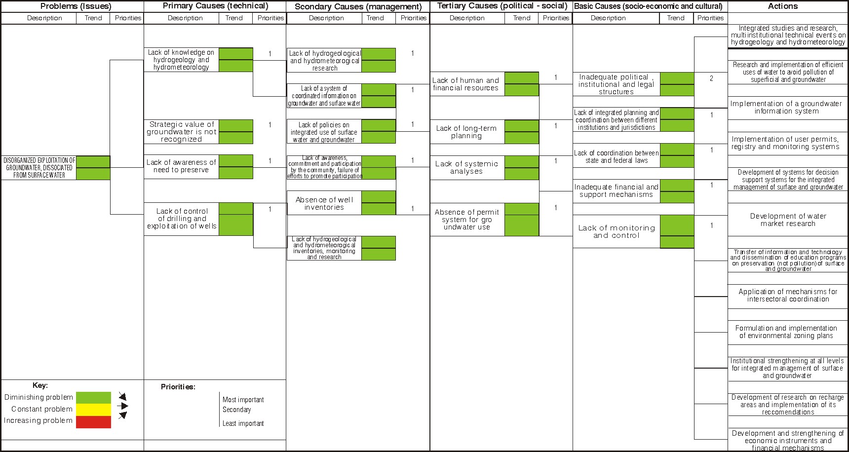
Figure 27 Ł GEF SŃo Francisco: Causal Chain of the Critical issue Uncontrolled Exploitation of groundwater, dissociated from
Surface water
74
Figure 28 Ł GEF-San Juan: Causal Chain-Root Effect of the main problems
75
ANNEX 3 - EXISTING INFORMATION ON THE GAS
This annex summarizes the current information that is available on the GAS, mainly research
work, much of which was produced with the support of the GASP. It should be mentioned
that this is a personal contribution by the consultant on the basis of a report especially
produced by geologist Roberto Kirchheim, and it should not be regarded as the official
position of the GAS countries.
As mentioned in the preceding chapter, when a Transboundary Diagnostic Analysis is
applied to a water body it becomes an exercise to assist in the identification of critical issues
and gaps for its shared transboundary management. In addition to identifying and describing
them, it attempts to analyze the cause and effect relationships between the gaps, proposing
actions that have the purpose of enabling and guiding the intended management process.
When the water body is an underground resource, which is difficult to perceive, more
specifically water that saturates pores and fractures of rocks in a wide geographical and
transboundary distribution, and it is also related to political borders and surface hydrographic
basis, this analysis becomes a complex challenge.
The hydrographical body which is the object of the present analysis is the GuaranĒ Aquifer
System (widely recognized throughout the region as the SAG). Its environmental
preservation and sustainable development are being addresses via the execution of a
complex GEF Transboundary Project which involves the governments of Argentina, Brazil,
Paraguay and Uruguay (henceforth the GASP). The GuaranĒ Aquifer System is considered
as a transboundary water body which is threatened by environmental degradation due to
over-exploitation and pollution, as defined by GEF Operational Program Number 8 (see
Annex 1). The long-term objective of the process which began with the Environmental
Protection and Sustainable Development of the Guarani Aquifer System Project is to attain
the sustainable management and use of that waterbody. Its purpose is to support the four
countries in the design and implementation of a joint institutional, legal and technical
framework to manage and preserve the GAS. The countries chose the Department of
Sustainable Development of the Organization of American States (henceforth DSD-OAS) as
the agency responsible for fund management and process direction, with the support of the
IRBD as the executing agency.
Therefore it is a challenge that deserves, first and foremost, to be considered in the light of
certain technical and scientific conceptual definitions, as well as legal and institutional ones.
76
Discussions should include the particular characteristics of the border areas and the survey
of a series of factors which affect the resource, as well as emerging factors that may
eventually lead to loss of quality and quantity. Additionally, when the Project was designed
and implemented it included strategies and results that should be included in the above
analyses.
Before presenting information on the GAS it is worthwhile to review certain myths regarding
aquifers in general, which prevent a proper perception of the problems involved. Table 8
contains a brief presentation of these myths.
┐FINALLY, WHAT IS THE GUARAN═ AQUIFER SYSTEM - GAS?
The GAS is a groundwater reservoir with a strategic role in the MERCOSUR region due to its
qualitative and quantitative potential, and also due to the potential exploitation of thermal
waters in certain areas.
From a geological point of view the GAS is formed by a sequence of rocks, predominantly
sandstone, whose fluvial and lacustrine sedimentation (analogous to the present-day
transition areas between rivers and lakes) and eolian sedimentation occurred in the Triassic
and Jurassic periods in a topographically depressed area of the south of the old South
American continent, called the Sedimentary Parana and Chaco-Parana Basin (Ara·jo et al
(1995).
These water-saturated rocks were extensively covered with basalt flows during the Upper
Cretaceous period, which may reach 1.000 m at certain points. This Basin, formed during the
long geological periods, is also described as cratonic, as it developed in the middle of the
continent and is distant from the tectonic plates (where mountain ranges, earthquakes and
volcanos are generated). Some of these rocks have shown high groundwater storativity and
transmissivity ratios, and their water can be extracted in appreciable quantities; this is why
they were called aquifers, and their hydrogeological significance introduced (Noyes et. al,
1972, Lohman et al, 1972 and Machado, 2005).
77
Table 8 Ł Common myths surrounding aquifers
Myth
Reality
The average recharge rate of This false paradigm does not take into account the need to
an aquifer may be taken as a preserve the natural discharges of the aquifer, or changes
factor for sustainable
that may occur in terms of phreatic / potentiometric levels
extraction
for other uses of groundwater such as preservation of
aquatic ecosystems, containing the enroachment of the
saline wedge.
Falling levels of aquifer Any exploitation of groundwater results in decreasing
groundwater always indicate levels, and it may take many years to recover large
over-exploitation - detected by aquifers - which in some cases may be interpreted as
the formation of large
constantly declining groundwater levels.
depression cones, a
substantial increase of
interference between wells
and loss of water levels,
among other effects.
Groundwater usually flows in This occurs exceptionally in areas of fractured calcareous
the shape of underground rocks
rivers
By drilling deeper wells new Deeper aquifer formations may be found, but abstracting
groundwater resources can be their groundwater usually results in induced leakage from
tapped
overlying layers of the aquifer.
The recharge rates of an This commonly-accepted paradigm may lead to serious
aquifer are constant
conflicts - recharge rates vary with the degree of
anthropization of the natural drainage (rivers), changes in
irrigation patterns, in the type of natural vegetation or
agricultural cover, reduction of infiltration rates in urban
areas, etc.
Source: Foster; Tuinhof; Kemper; Gardu±o; Nanni (2003)
In the uppermost layer of this sequence, in a desert climate environment, eolic and fluvial
sandstone deposits occurred, creating thick layers of greatly porous and permeable
sandstone in large geographic areas. This is what is known today as the main aquifer of the
GAS, though it is not the only one, as there are others in the layers of the Jurassic period
called Tacuaremb¾ (Argentina, Uruguay), Botucatu (Brazil) and Misiones (Paraguay). Due to
the fact that it is a multilayered group of rocks, and therefore a series of aquifers with
different hydrdynamic properties (porousness and permeability) and general characteristics
(geometry and chemistry), with confined and non-confined portions, the entire structure has
been characterized as an aquifer system. The connotation of aquifer system in the case of
GAS is used in an integrating manner, also to overcome the lack of a better definition and
specific information on the different aquifers that compose it and their inter-relationships
(personal opinion based on Machado, 2005).
78
The GAS, or rather the aquifers that form the GAS, are located in the sedimentary Parana
Basin located in the subsoil of the east and center-south of South America, underlying parts
of Argentina, Brazil, Paraguay and Uruguay, as displayed on Figure 29. In other words, its
limits do not conform to political and administrative territorial borders, and therefore it can be
defined as a transboundary water body.
Chart 1 and Figure 30 show a summary of the geographical distribution of the GAS in the
countries. In general terms, notwithstanding a certain degree of fragmentation, the GAS has
an average thickness of 250 m. In almost 90% of its total area it is confined by the overlying
basalt rocks, and in the central areas of the sedimentary basin its depth may reach over
1.000 m (information obtained by several researchers, among them ROCHA, 1997). The
total freshwater volume is estimated at approximately 46.000 km3, with 166km3 representing
the sum of the natural and indirect annual recharge. (BORGHETTI; BORGHETTI; ROSA
FILHO, 2004). It is generally believed that the stored water is drinkable, though in certain
deep zones there may be an excess of fluorides or salinization.
Table 9 shows certain outstanding aspects of the GAS.
79
Figure 29 Ł Location of the Guarani Aquifer
Source: Brazil. Secretaria de Recursos HĒdricos do Ministķrio do Meio Ambiente (2001) y
AMORE, VARGAS, OLIVEIRA (2001).
80
Chart 1 - Geographic distribution of the GAS in the countries
Characteristic
AR
BR
PY
UY
Total
1.000 km2
225,5 839,8 71,7 45
1.182
Area of the aquifer
% 19,1
71,0
6,1
3,8
100
Percentage of country area
6 10 18 25,3
10,3
%
Outcrop area in each country
0 67,8
30,1
2,1 100
Estimated population in the
2,6 24,9 1,9 0,6 30
GAS area
Million
inhabitants
Population in the outcrop
0 2,6 1,0
0,1 3,7
area
Estimated volume of water
1.000 Km3
8,7 32,5 2,8 2,3 46,3
Source: BORGHETTI; BORGHETTI; ROSA FILHO, 2004
81
30
UY
PY
25,3
4%
AR
6%
25
19%
20
18
15
10
10
6
5
BR
71%
0
AR
BR
PY
UY
a) Distribution of the total GAS area per b) Area covered by the GAS as a
country
percentage of the total country area
UY
PY UY
AR
2%
6% 2%
9%
PY
30%
BR
68%
BR
83%
c) Distribution of the outcrop area of the d) Distribution of the population over the
GAS per country
GAS area per country
UY
UY
3%
PY
5%
AR
6%
19%
PY
27%
BR
70%
BR
70%
e) Distribution of the population in the f) Distribution of the estimated water volume
outcrop area by country
of the GAS per country
Figure 30 Ł Distribution of the GAS in the four countries
82
Table 9 Ł Matters regarding information on the GAS which are crucial for the
formulation of the TDA
- It is necessary to improve the description of the GAS geometry and the interaction
between the aquifers that compose it; it is imperative to individualize them for a proper
interpretation of their state. Most studies were at a regional scale, when the full
understanding of the transboundary effects of the GAS depends on more localized
research.
- There is a huge lack of long-term data; historical series are almost non-existent.
- The limits of the GAS do not match the surface hydrographic basins, which are the basic
units used for the integrated management of water resources. This element contributed
additional complexity.
- Interactions between underground and surface flow systems are complex. Pumping of
water from an aquifer that is hydraulically connected with a surface water body may lead to
a significant decline in the discharge rate of the groundwater flow towards that body, or to
the reverse situation, an induced recharge from the surface waterbody.
- There are areas of the GAS which are not deemed productive from the quantitative point
of view, and/or their quality is unsatisfactory; this means that GAS quality is not
homogeneous, which is an important factor when defining management strategies. Further
information is need on quality and potential pollutants. Information on water quality was
obtained in preparatory consultancies for the Guarani Aquifer Project: CHANG (2001) and
SANTOS (2001). As an example, salinization was detected in Villa Elisa and La Paz (Entre
Rios, Argentina), Londrina (F), Cianorte (STD), Presidente Prudente (F, STD), Andradina
(F), Auriflama (STD), Santa Rosa (STD), Piratuba (STD), Erechim (F), Venancio Aires (F).
- There is insufficient information and research to evaluate the sustainability of current
extractions in areas of high use and dependence on groundwater.
- There is also insufficient information and research to evaluate sustainability of present
extractions in areas of high extraction and dependence on groundwater
- Discharge conditions are unknown.
HISTORICAL PROGRESS IN THE PERCEPTION OF THE GAS
The geological continuity of the GAS was recognized in the nineties, and originated in the
review of data from oil exploration drilling. The GAS appeared as a large, homogeneous
transboundary system, with high potential and excellent chemical water quality. However,
thanks to initiatives by diverse groups of researchers and experts, arguments and conceptual
models arose that challenged the alleged homogeneity and unrestricted connection. The
efforts of groups of regional experts and the inertia generated by preparatory actions for the
GEF Project and its widespread dissemination in scientific and communication media created
an awakening of hydrogeological sciences and the need for groundwater management.
Towards the end of the project preparation stage and the beginning of the implementation
stage, the approach to the GAS changed with the input of fresh information that was being
generated at a larger scale. It is now being viewed as an increasingly complex and less
homogeneous waterbody. Large tectonic structures which were mentioned in the literature
were studied in further depth from the hydrogeological point of view, leading to new
83
discussions on the regional / transboundary flows. It is still a debated issue, and the results
of the GAS technical consultancies will provide crucial data. For instance, the hydraulic
effects of the basic intrusive structures like the diabase dykes which cut through the aquifer
in some regions, or the displacement of plates due to faults are not too well-known and they
should be studied in depth. Whereas in certain situations these structures act as flow
barriers, as shown in the results submitted by Machado (2005 for the State of Rio Grande do
Sul, Brazil, to mention one among many studies), other initiatives, like geophysical research
in the geological structure of the Chaco-Parana basin in an area that focuses on the cities of
Salto (Uruguay) and Concordia (Argentina) within the framework of the Universities Fund,
indicate that uncertainty is still prevalent regarding the hydrogeological compartmentalization
of the GAS as a result of these structures (in the case of the main faults). Technical review of
the information and/or adoption of conceptual models is not an objective of this annex, nor is
it a part of the formulation and validation process of the TDA document.
Setting this discussion aside, the use of the GAS was and still is on the increase, with
escalating drilling and economic exploitation.
Certain issues that are considered crucial for the formulation of the TDA are shown on Table
10.
Table 10 Ł Issues on the continuity of the GAS that are crucial for the formulation of
the TDA
- New and multiple information on the GAS is being generated since the nineties, leading to
a substantial improvement of the understanding of the GAS as a groundwater body.
- There are indications of strong tectonic control with possible implications for hydraulic
operation and discontinuity. This fragmentation leads to significant changes in the
understanding of reserves and possible extraction volumes, and therefore in the local
sustainability of the GAS.
ASPECTS CONCERNING THE GAS REGIME
However, it is imperative to analyze the GAS flow regimes for the TDA. There is groundwater
flow from the direct and indirect recharge zones, which contribute to the preservation of the
permanent and/or active (regulating) reserves, and also to areas where there is natural
discharge. These areas exhibit the following characteristics at the regional level: (MENTE,
2001; ARA┌JO ET AL., 1995, FUNPAR, 2001 and BORGHETTI, BORGHETTI, and ROSA
FILHO, 2004):
84
Direct recharge zones: They occur in areas where erosion resulted in the exposure of part
of the GAS aquifer rocks. Recharge occurs by leakage of excess rainfall, and also by the
flow over the recharge zone, which is composed of the area of sandstone outcrops
(approximately 150.000 km2) and another much larger adjacent area, where a relatively thin
layer of fractured basalt covers the sandstone.
Indirect recharge zones: These are areas where surface water leakage (vertical filtration)
occurs through the basalt fractures, and also indirect flow along the overlying sedimentary
rock formations, where potentiometric levels favor leakage.
Discharge Zones: The GAS natural discharge regime is still largely unknown. It is
considered to occur regionally in areas with topographic heights below 300m, near the base
level of rivers like the Parana, Uruguay, Pelotas and TietĻ, or in their areas of influence
further downriver in their basins (Argentine Mesopotamia), and in the form of seepage in the
wetlands (Esteros de Ibera in the northeast tip of Argentina).
Associated to this view in terms of transfer characteristics is the notion of the GAS regime
regarding potentiometric levels (water pressure rates). The outcrop areas match the zones
known as free or unconfined areas, where the water is under the influence of atmospheric
pressure. In confined zones the water pressure is much greater than atmospheric pressure,
which causes water to surge in wells above the ceiling of the aquifer layer, or as springs and
artesian wells. The difference in pressure between the waters of contiguous aquifers and
their hydraulic characteristics determines the upwards or downwards vertical drainage.
Figure 31 shows an example of different areas of the GAS (recharge and discharge) induced
by tectonic effects, and their probable relationship with the alluvial strata of the main rivers of
the region (this specific example applies to the Parana River).
85
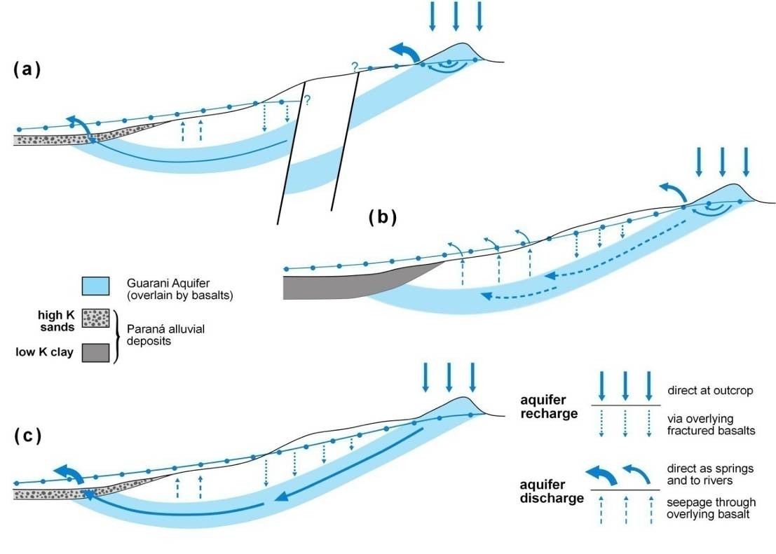
Figure 31 Ł Hypothetical cross section of the GAS, showing the potential impact of
disturbances in the tectonic plate and characteristics of the alluvial deposits of the
Parana river in the control of the flow regime.
SOURCE: FOSTER; KEMPER; GARDUčO (2004).
An area can be more or less vulnerable to surface pollution according to whether it is
confined or unconfined, a recharge or a discharge zone. It is an intrinsic vulnerability which
results in a potential pollution risk when there is contact with the source of pollution. In the
direct recharge areas in unconfined regimes, aquifers are formed mainly by permeable
sandstones, therefore the outcrop areas have a higher intrinsic vulnerability to pollution.
Vulnerability decreases as the degree of confinement of the aquifer increases.
Regarding flow transit, the temporal aspect is crucial. By definition an aquifer system shows
different flow levels, from relatively shorter local flows up to large deep flows with long transit
times. Figure 32 shows different situations with varying effects and magnitudes that respond
to system characteristics.
86
Figure 32 Ł Temporal aspects of groundwater flow
The temporal aspect is basic for an analysis of cause and effect relationships, which are
usually misunderstood in aquifer systems. Non-sustainable exploitation of an aquifer
occurring today will only be detected in a few years' time, depending on the distance
between the observation points and the abstraction area. Studies of scenarios which
evaluate the potential impacts of any intervention policy on the GAS, and therefore on
surface aquatic systems is one of the possible by-products of the project. Another goal is
fact-finding on the transference of impacts from one country or region to another. The project
design includes development of a monitoring and control network and result dissemination
via an open information system as one of the management tools.
Table 11 displays certain issues which are relevant to the GAS regime.
Table 11 - Matters which are relevant to the GAS regime and key for the formulation of
the TDA
- Definition of the characteristics and direction of the flow system of a regional aquifer like
the GAS is essential, and a starting point for shared management. More detailed studies
that are compatible with the scale of management actions are required, whether these are
regional or more local in impact.
- All water management policies should take into account the differences between the
different areas and the temporal aspect of cause and effect relationships. Different GAS
areas will respond in different ways to short, medium and long-term interventions. The
effects of abstraction development may take years to become evident. Therefore there is a
tendency to underestimate the collection of field data and its subsequent analysis to support
decision-making, until the impacts have already materialized.
- Additional knowledge of the outcrop areas, recharge zones and confined areas is required.
Strategies should be devised both for outcrop and confined areas.
87
PRESENT EXPLOITATION LEVEL
Current exploitation may be regarded as quite modest when it is evaluated in terms of the
GAS as a regional aquifer system, but there are significant variations on intensity and end
purpose of use. The hydraulic compartmentalization of the GAS may change the scenario for
use evaluation and the status of certain regions regarding already existing abstraction. As all
hypotheses, it needs further evaluation.
There are no updated and comprehensive well inventories in any of the countries. At the time
of Project preparation (CHANG, 2001) the available data was of approximately 1.000 wells in
Brazil, 347 in Uruguay (7 infrabasalt wells and 340 in outcrop areas), 7 deep wells in
Argentina and 200 wells in Paraguay. In Brazil, mainly in the southern region, a project for a
well inventory in the GAS area was implemented, which raised the amount of duly
inventoried wells to 1.700 (see SIAGAS, CPRM). Also, projects developed by universities via
the Universities Fund have significantly improved the level of information for the regions in
which they act, particularly the transboundary recharge areas. Nine academic subprojects
were funded via the Universities Fund. Four of these conducted their research in the pilot
areas. However, mainly in Brazil and Paraguay the number of known wells is a small
percentage of the existing ones. For evaluation of drilling in confined GAS areas (which,
depending of the pressure relationships may have hydraulic connections to the GAS) the
absolute figure and uncertainty increases considerably. Chart 2 summarizes the existing
information.
Well output varies in accordance with construction characteristics (diameter and depth) and
the specific capacity of the aquifer area. Most of the deep wells in operation produce an
average of 300 m3/h.
The estimate is that total groundwater production is some 1.000 to 3.000 Mm3/year,
concentrated mainly in Brazil. 80% of this is used for public urban supply (500 Brazilian
towns are totally or partially supplied by the GAS), 15% is used for industrial purposes and
5% is for tourist use in resorts (`SPAs').
A study that was carried out in Brazil (CHANG, 2001) detected a low level of water
consumption when compared to the regional recharge rate. The state of SŃo Paulo in Brazil
shows the highest consumption levels in comparison with active recharge. However, when
the same analysis is applied to sub-regions / cities a much more critical scenario appears,
i.e., there are signs of over-exploitation. During the next 25 years, if use is limited to the cities
which are reliant on the GAS today, the exploited quantities may still be replaced by direct
88
recharge. This will not be the case if all the cities become GAS-reliant. In this last case, the
states of PR, MG and SP will be abstracting more water than is recharged.
89
Chart 2 Ł Basic information on the GAS
Country Information on wells Main uses
Present requirements
Estimates for 2025
Potential conflicts
AR
Known wells: 7 deep Mainly for recreational Abstractions around
Improved knowledge of Risk of salinization of deep
wells
use
3.600m3/h, plus
reserves as use
waters; potential use conflicts
infrabasaltic and
expands.
in thermal areas.
shallow wells. In terms
of potentiality, use is
minimal.
BR Inventoried
wells:
Prevalent use is
Estimated abstractions Increasing pressure
Risk of pollution in the outcrop
3000; absolute
drinking water supply to at 111.000 m3/h (30 from use in the next few areas and franjas someras
number of wells is towns (70%), followed m3/s);
years.
due to inadequate sanitation,
still unknown. Most by industrial use (25%),
diffuse pollution from
of the wells are and irrigation and
agriculture, localized industrial
located in outcrop or recreational use (5%),
pollution. Decline in levels and
shallow areas;
interference between wells.
someras; western
Errors in construction of new
region of the state of
wells.
Sao Paulo with
countless
municipalities
supplied by the GAS
PY Approximately
200
Concentrated use in 9 Installed abstraction
Pressure from use will Problems arising from the
known wells and eastern departments;
capacity of 8.000 m3/h increase in the next few constructive characteristics of
countless
supply to towns (75%).
(2.2 m3/s) between
years.
wells; expansion of agricultural
unregistered wells;
infrabasaltic and
activity and resulting diffuse
25% are private
outcrop wells.
pollution
wells.
UY Registered: 12
Recreational uses in the Total use estimated at Pressure from use will Conflicts refer mainly to the use
infrabasaltic wells
departaments of Salto 2.415 m3/h (0,67 m3/s) grow constantly in the of termal water, particularly in
and 340 in outcrop and Paysand·;
next 25 years; tourism the outskirts of the city of Salto.
areas
remaining 340 wells are
will use more water in Regarding quality, the main
90
Country Information on wells Main uses
Present requirements
Estimates for 2025
Potential conflicts
used for drinking water
relative terms than other problem may occur in the
and irrigation.
activities.
outcrop areas (agrotoxics Ł rice
cultivation and activities and
forestation). Lack of sanitation
becomes a risk. Forestation
represents a risk, to be
confirmed by research.
Fuente: CHANG (2001), SANTOS (2001).
91
In the larger municipalities, where demand will encourage drilling of new wells, the effects of
over-exploitation will be significant. Decline in static and dynamic levels will be inevitable
unless systems of permits and control of abstracted volumes are implemented. Loss of
volume from interference with nearby wells is a likely situation. Economic factors, like the
loss of subsidies for electric energy or the possible implementation of charges for the use of
groundwater, may set limits to the use of GAS, partly discouraging the craze for new drilling.
It may be noted that in general in the regional context the search for exploitation and use of
groundwater resources as an alternative is growing significantly. Among others, the reasons
are the following:
- The perception that it is a use with no environmental impact;
- Progressive degradation of the quality of surface water resources and increasing costs of
collection and treatment;
- Vulnerability of surface reserves in times of drought;
- Technological progress of pumping equipment that enable the safe abstraction of large
volumes from great depths;
- Technological improvements in rotary and pneumatic drilling, reducing drilling costs and
labor times;
- Expansion of the supply of electric energy in rural areas, and often subsidies to energy for
certain productive activities;
- Progressive reduction in costs, reduction of timeframes and economic risks in construction
and construction times of deep wells;
- Improved knowledge of hydrogeology and reserves;
- Promotion of irrigation;
- Promotion of thermal tourism.
These tendencies can easily be verified in national/institutional databases (as for example
national census, new drilling licenses and permits for new wells, among others), where an
increase in the use of groundwater is patent both in urban and rural areas. There is also a
consensus between public decision-makers and technical and scientific actors; this is
maerialized in the amount of new wells that enter the systems for licenses and permits, and
the great coverage of goundwater in the media in the past few months.
Figure 33 shows the location of wells in the GAS area in Brazilian territory. Please note the
density of wells in the GAS outcrop areas, or in areas where the aquifer has little depth,
resulting from the cost of deep drilling and the risk of not finding quality water. The
distribution of wells in the other countries shows the same tendency.
92
Figure 33 - Location of well drilling in the Brazilian GAS area
Source: CHANG (2001)
Table 12 mentions certain sigues that are relevant to the above.
93
Table 12 Ł Aspects on the exploitation level of the GAS which are considered crucial
for the preparation of the TDA
- The notion that the volumes that are abstracted from the system must necessarily bcome
out of somewhere and inevitably will result in some type of change must be re-examined.
The abstracted water may originate in: (i) more water in the system (increase in the
recharge); (ii) less water leaving the system (decline in discharge); (iii) removal of water
from system storage;
- There are serious deficiencies in the well inventories in the countries / states / cities. The
speed of well construction surpasses the registration rate in the current registries. As a
consequence there are uncertainties on the real abstracted volumes and their spatial
distribution.
- The consequences of continued abstraction of groundwater from an aquifer system must
be taken into account by the actors involved and by society, and tolerance limits must be
evaluated and determined. Certain variables have to be assessed from an economic point
of view.
POLITICAL AND ADMINISTRATIVE BORDERS AND GROUNDWATER
The main aspect of a transboundary condition is the intersection of the natural flows of
groundwater within an aquifer with an international border, in such a way that water moves
from one side of the border to another, as shown on Figure 34. In a very simplified way, this
system may have its entire recharge zone on one side of the border, and the discharge zone
on the other. Another situation that arises from the same Figure in respect of the different
types of flows is that local flows are controlled by physical and geographical aspects like
topography, whereas regional flows are more influenced by aquifer geometry.
94
Figure 34 Ł Examples of transboundary transfers of groundwater
Source: Modified from IHP-VI (2001)
95
In fact, situations are much more complex and from the hydrogeological point of view the
flows which cross international borders can only be determined by means of observation and
analysis of consistent registers (in this case hydraulic parameters). Even in the case when
internacional borders lie on surface waterbodies (as rivers, for example), underlying aquifers
do not necessarily reflect a balanced transfer of groundwater from one side to the other.
Obviously the transboundary question does not contribute to aquifer geometry and regime,
but rather to institutional, legal, economic and social issues. It is necessary to recognize the
existence of socio-economic pressures that potentially induce the extraction of groundwater,
and whether these extractions in the present and emerging scenarios involve some kind of
non-sustainable impact or development situation in the broadest sense. Table 13 presents
certain relevant issues.
Table 13 Ł Border issues that are considered crucial for the preparation of the TDA
What are the possible transboundary problems that may emerge or become
intensified by the use of GAS water?
Contrariwise, what opportunities does the sustainable use of the GAS offer for solving
present or emerging transboundary problems?
Which are the possible problems for the sustainable exploitation of GAS water that
may emerge or become intensified by the problems or type of transboundary
occupation?
┐Al contrario, de quķ manera las instituciones creadas para tratar las cuestiones
transfronterizas podrßn ofrecer una oportunidad para el uso sostenible del GAS?
HYDROGEOLOGICAL CHARACTERIZATION OF CERTAIN GAS AREAS AND THE RELEVANT GASP
PROJECTS
Table 14 shows a theoretical conceptualization of the possible critical hydrogeological
aspects of the GAS. Annex 4 details the pilot projects. Finally, Table 15 characterizes the
hydrogeology of the border areas of GAS and identifies the relevant GASP projects in those
areas.
96
Table 14 Ł Typology of possible flow situations in transboundary areas
Borders and Hydro-
Main aspects
Necessary information
underground
geological
flows
zones
Borders with Recharge
> vulnerability, tendency to Evaluation of the water
hydraulic
zone
greater amount of wells, balance, modeling of
GAS
phreatic decline
abstractions and phreatic
connection
decline in space and time
Transit
zone < vulnerability; possible Intermediate situation
flow inversion
Discharge
Vulnerability arising from Evaluation of size of
zone
maintenance of surface discharges, degree of
waterbodies or recharges connection with surface
of more superficial aquifers bodies
Borders with Areas on the Situation that depends on the degree of
no hydraulic edge of the compartmentalization of the GAS. It may be a recharge or
GAS
hydrogeologic
discharge zone, or an area with varied vulnerability.
connection
al basin, with Relevance at national level. No relevance for
no
transboundary level.
transboundary
flow
Source: drawn up by Kirchheim especially for this report.
CHALLENGES TO MANAGEMENT IN PRACTICE - TOWARDS THE TDA
The preparation of the GASP was a preliminary version of the Transboundary Diagnostic
Analysis (TDA), and its main conclusions, which have been corroborated so far, are shown
on Table 16. Their analysis resulted in Table 17, which summarizes the management needs
of the GAS and their appropriate levels of resolution.
97
Table 15 Ł General table of hydrogeological characterization of the border areas and the relevant GASP projects
Hydrogeology
Countries and provinces /
Project Activities
Departments
Transit and discharge area, AR: Province of Entre Rios;
Project: Geophysical investigation of the geological structure of the
undefined interrelation with UY: Departments of Paysand· and Chaco-Paranaense basin, in an area centered in the cities of Salto
Uruguay River, hydrothermal Salto
(UY) and Concordia (AR) (17) UR (UY); UTN (AR); UNAM (MX);
potential in full development,
Project: Methodological development for evaluation of the recharge
mainly in the departments of
and vulnerability of the GuaranĒ Aquifer System in Argentina and
Salto and Paysand· (UY), and
Uruguay (12) - UNL (AR); DINAMA. (UY); INA. (AR); IHLLA (AR)
the province of Entre RĒos (AR)
Project: Why Project the GAS;
Project: Workshops for social stakeholders. Coastal thermal area;
Project: Movete por el ambiente (Move around the environment)
Project: Communication, dissemination and awareness-raising of civil
society in the GAS area;
Project: Teacher education and training: GuaranĒ Aquifer.
Confined aquifer zone;
AR: Province of Corrientes and Project: Estudo do movimento das ßguas subterrŌneas do sistema
connections with fractured
Province of Misiones;
Aq³Ēfero Guarani (GAS) atravķs de is¾topos, no Paranß, SŃo Paulo e
basalt aquifers; undefined
BR: States of Rio Grande do Sul, no Uruguai (16) Ł UFPR (BR). UR (UY); USP (BR)
interrelation with Uruguay
Santa Catarina, Paranß
Project: The power of communication through water;
River; hidrothermal potential;
Project: The GuaranĒ Aquifer goes to school: strategy for citizen
compartmentalization of the
participation and environmental education;
GAS
Project: Potencial sustainable industrial uses of the GuaranĒ Aquifer in
the province of Misiones. Analysis and dissemination.
Large outcrop and recharge AR: Provinces of Misiones,
Itapuß Pilot Project
area of the GAS; important Corrientes, Chaco and Formosa;
Environmental Education Campaign Ł GAS;
agricultural center with
PY: Departments of Neembuc·, Project: Dissemination and awareness-raising of the environmental
intensive use of agrochemicals Misiones, Itapuß and Alto Paranß
implications of the irracional management of the GAS in the eastern
region of Paraguay;
Project: Environmental education of leaders for the racional use of
GAS water in the departments of Itap·a and Caazapß in Paraguay;
Pilot Project on Environmental Promotion and Education on the GAS
98
Hydrogeology
Countries and provinces /
Project Activities
Departments
in the districts of Itakyry and Minga PorŌ;
Project: The power of communication through water; the GuaranĒ
Aquifer goes to school: strategy for citizen participation and
environment education;
Project: Potencial sustainable industrial uses of the GuaranĒ Aquifer in
the province of Misiones. Analysis and dissemination.
Outcrop area in the region of BR: State of Rio Grande do Sul;
Project Piloto Rivera-Santana
Rivera-Santana do Livramento UY: Departments of Rivera and Project: Vulnerability and hydrogeological risk of the GuaranĒ Aquifer
with GAS recharge.
Artigas.
System in the outcrop area of Rivera, Uruguay (28) UR (UY); UBA
Transit zone and confined
(AR);
aquifer to the west near
Project: Characterization of recharge and discharge areas of the GAS
Artigas-QuaraĒ; lack of
in Rivera - Livramento and QuaraĒ - Artigas. Vulnerability study in the
sanitation and use of
area of influence of Artigas Ł QuaraĒ(10 - UFSM (BR) UR (UY)
agrochemicals
Project: Communication, dissemination and awareness-raising of civil
society in the GAS area;
Project: Minuto agua (a minute for water); Teacher education and
training: GuaranĒ Aquifer
Outcrop and recharge area of BR: States of Paranß and Mato Project: Dissemination and awareness-raising on the environmental
the GAS, agricultural center Grosso do Sul
implications of the irrational use of the GAS in the eastern region of
with intensive use of
PY: Departments of Itapuß, Alto Paraguay;
agrochemicals
Paranß and Canindeyu
Project: Mbaracay·: a drop of life, a drop of hope for the Guarani
Aquifer
99
Table 16 Ł Aspects of the GAS which are relevant to the TDA
- The GASP is `preventive' in nature, since there are no conflicts to be solved, but rather
great potential benefits may be foreseen for cooperation between the countries, mainly
regarding a future sustainable use;
- In general, problems are mainly local and involve two countries, and can be solved by
means of agreements and actions at a level that is consistent with their significance;
- Potential transboundary effects might grow from the local scale to a basin scope only in
the measure that extensive changes occur in the use of soil for agriculture and under a
certain combination of hydrogeological conditions;
- The importance of GAS groundwater for socio-economic development determines the
need to strengthen the public bodies that are responsible for management, and train staff
from the technical and administrative points of view;
- In this sense, the following must be addressed: (a) the efficiency of the present institutional
arrangements in the field, (b) the ability of environment and water regulatory agencies to
take preventive measures instead of merely reacting to conflicts and demands, and (c) the
levels of participation of the diverse sectoral organizations of users on the use and risks of
groundwater.
- Equally, it is necessary to evauate the existing legal standards for management and
protection of groundwater in the countries/provinces/states of the Guarani aquifer, as well
as their implementation strengths and weaknesses, in view of the present and future
protection of the aquifer.
100
Table 17 Ł Framework of the GAS management requirements
Typology
Situations with transboundary local effects in Potential
pilot areas
situations with
regional
transboundary
effects
1 - Pollution of drinking water wells due to
inadequate sanitation and unplanned use of
land (R-P PP and R-S PP)
2 - Impacts on the wetlands (mainly the 7 - Growth of
Esteros de Ibera (AR) and Niembuc· (PY), as the impacts to
well as the Uruguay river, respectively) and a greater scale
reduction of the rivers' baseflow and a if intensive use
possible consequence of potentially intensive
I Ł Protection of
of soil and/or
exploitation of groundwater for agricultural
the GAS from
the water
irrigation (GASP Component 1)
pollution and
resource are
3 - Impacts on the quality and recharge rate of
quantity-related
encouraged,
the aquifer as a result of extensive changes in
aspects
considering a)
the use of agricultural soil as in cultivation the present
types and systems (IT PP)
ecologic role of
4 - Impacts on the water balance of water aquifer
consumption caused by afforestation and its discharge and
effect on recharge (GASP Comp. 1)
b) the hydraulic
5 - Salinization caused by unsealed deep continuity of
wells; it is unknown whether these last are in the aquifer
the GAS area (C-S PP)
system in the
II Ł Use of
6 - Reduction of aquifer artesianism and relevant areas
groundwater and
geothermalism due to uncontrolled
(GASP Comp.
geothermal
exploitation of geothermal wells (C-S PP)
1)
resources
III Ł Sustainable
management of
the GAS
Source: Based on FOSTER; KEMPER; GARDUčO (2004)
101
10. ANNEX 4 - MANAGEMENT IN PRACTICE: THE ROLE OF THE
PILOT PROJECTS
Four pilot projects on groundwater management were designed within the GASP, with a view
to identifying and promoting local agreements and actions for `typical problems' which are
specific to the management and protection of GAS groundwater. Two projects are
transboundary, while the other two are within one country and state. Information on these
projects is presented below, summarized from FOSTER; KEMPER; GARDUčO (2004).
Concordia (AR) / Salto(UY) pilot project
This pilot Project is transboundary and focuses of the analysis of the management of the
Guarani aquifer in an area that exploits geothermalism. Table 18 shows some of its
characteristics.
Table 18 Ł Concordia (AR) / Salto(UY) Pilot Project
Issue
Information
General
Covers an area of 500km2 on both sides of the Uruguay River, which is the
diagnosis international border between Argentina and Uruguay; it is the most populated
for the
part of the border region, with some 200.000 inhabitantes, distributed almost
area
equally on each side of the border. The GAS lies under basalt flows at 800 a
1.000m, and its groundwater exhibits artesianism and a strong geothermal
potential (temperatures from 36 to 48oC). The yield of geothermal wells is from
100 to 300m3/h, for well depths up to 1.500m. The main source of income in the
area is tourism and citrus and horticultural production.
Status of Salto (Uruguay) is the most developed thermal resort area in the MERCOSUR;
Use
Concordia recently began construction of its first thermal resort; the GAS is not
a significant source of drinking water, as the supply is covered by processing
plants that draw water from the Uruguay river and some shallow wells from
other aquifers.
Current institutional arrangements for water management are harmonious on
both sides of the border.
Real and Hydraulic Interference between neighbouring wells (to date there are eight
potential
geothermal wells in a relatively restricted area) which may reduce artesianism
impacts
and also the temperature of the groundwater.
It is necessary to evaluate whether there is any risk of salinization in the
completed works or in the works under way.
It is also necessary to assess if there is any risk of salinization from the south-
southeast of the GAS where there are aquifers (it is uncertain whether they are
GAS aquifers) which contain high salinity thermal water of natural origin.
Many thermal resorts still lack adequate management of water demand and
use.
Manage
To develop and disseminate in the community effective practices for the use of
ment
geothermal water, including efficient use, reuse and safe deposit of effluents.
Actions
To develop management capacities regarding water and geothermal resources,
- applying standardized criteria for the design, construction and operation of
102
Issue
Information
thermal wells. Strengthen the Transboundary Committee of the Concordia-Salto
pilot project.
The expected results and relevant management tools for the scope of this pilot project are
presented in Table 19. Figure 35 shows a schematic interpretatation of the regional
hydrogeology.
Table 19 Ł Expected results of the Concordia-Salto Pilot Project
Expected Results
Management tools to be developed
Coordinated Management of - Detailed databases with local hydrogeological data, as
the Groundwater Resource:
well as maps that are accessible via the local node of the
- conflict solving
aquifer geographic information system (SIGAS);
- preserve artesian flows
- Conceptual and numeric models of the aquifer, adequate
- preserve water temperature
for evaluating resource management scenarios;
- prevent salinization by - Diagnosis of the transboundary geothermal potential;
sealing wells with high - Coordinated aquifer management system, with agreed
salinization;
ruled for distribution, design, construction and operation of
- Optimization of the socio- wells and use of water;
economic and environmental - Institutional mechanism for consultation and agreement
benefits of the use of on proposals for the future development of the resource
hydrogeothermal resources;
and protective measures;
- to evaluate the development - Coordinated network for monitoring and exchanging
of a binational tourist area information on level, temperature, quality and use of
based on the use of thermal groundwater.
waters.
103
Figure 35 - Schematic hydrogeological map and cross-section of the Concordia-Salto Pilot Project
104
Rivera (UY) Ł Santana do Livramento (BR) Pilot Project
This is another transboundary pilot project, and its characteristics are shown on Table 20.
Table 20 Ł Rivera (UY) / Santana do Livramento (BR) Pilot Project
Issue
Information
General
Covers an area of 750 km2 on the border between Uruguay (Department of
diagnosis Rivera) and Brazil (State of RS). The cities of Rivera and Santana do Livramento
for the
have a total population of 200.000 inhabitants; fast growth, and they live and
area
interact practically as single city; main economic activity is agriculture-based
(cattle and sheep raising, production of meat and hides, grapes, rice, maize and
increasingly, soy); on the Uruguayan side there is forestry production and timber.
Status of The GAS is the main source of water supply with close to 170 wells (OSE) in
Use
Rivera and (DAE) in Santana do Livramento. These wells yield up to 5,1 and 8,7
Mm3/annum approximately, which represents around 70% and 100% of the total
public supply, respectively.
Real and Cover by the water supply network is over 95%; limited sewage network - 30% in
potential
Rivera and 40% in Santana do Livramento; substantial offload of wastewater to
impacts
an aquifer of relatively high vulnerability to pollution, either directly from septic
tanks or indirectly via polluted flows, uncontrolled dumps for municipal solid
waste; infiltration in the soil of a variety of industrial effluents and presence of
several gas stations with deficient maintenance represent additional threats to
the quality of groundwater.
Manage-
Strengthen the GuaranĒ Aquifer Transboundary Committee (COTRAGUA), with
ment
local user representatives from each country (local government offices, water
Actions
companies, drilling companies, several NGOs and bodies related to agriculture,
hydrology and public health).
Establish protection zones or perimeters for the main sources of public water
supply by means of adequate land use planning (both urban and rural), to ensure
sustainability and to protect the investments and the associated infrastructure at
the source.
To achieve the objects of this project, several specific management tools should be
developed as shown on Table 21. Figure 36 displays a schematic interpretation of the
regional hydrogeology.
105
Table 21 Ł Expected results of the Rivera Ł Santana do Livramento Project
Expected results
Management tools to be developed
Coordinated Management of the - Detailed databases with local hydrogeological data, as
groundwater resource to:
well as maps that are accessible via the local node of
-- solve conflicts
the aquifer geographic information system (SIGAS);
-- prevent groundwater pollution
- Conceptual and numeric models of the aquifer,
-- protect the sources of public adequate for evaluating resource management
water supply
scenarios and define protection areas;
-- control hydraulic interference
- Study for the diagnosis of the transboundary issues of
-- Mobilize investments to groundwater, for instance the effects of hydraulic
implement a joint action plan to interference and origin and transport of pollution
improve urban sanitation and - Coordinated aquifer management system, with agreed
territorial planning
ruled for land management, areas of protection of wells
-- Production of groundwater for and distribution, design, construction and operation of
public supply, concentrated in wells
fields with wells that are protected - Institucional mechanism for consultation and
from indiscriminate urban
agreement of proposals for future development of the
expansion and intensive
resource and protective measures l
agricultural practices.
- Joint action plan with top priority improvements of the
-- Optimization of socio-economic sewage network and final deposit of wastewater
and environmental benefits
- Coordinated network to monitor levels, temperature
arising from the sustainable use quality and use of groundwater, as well as the
of groundwater
implementation of a joint information system
106
Figure 36 - Schematic map of water infrastructure and hydrogeological section of the Rivera Ł Santana do Livramento pilot project
area, showing probable regime of the underground flow before infrastructure was developed
107
Itap·a Pilot Project (PY)
This pilot project was developed only for Paraguay and it studies the impacts of intensified
irrigation on the GAS. Table 22 summarizes its characteristics.
Table 22 Ł Itap·a Pilot Project
Issue
Information
General
The pilot project of the Itapuß Department (DI) involves predominantly
Diagnosis for agricultural and cattle-raising areas that cover 800 km2 on the southeast
the area
corner of Paraguay, in the districts of Bella Vista, Jesus, Trinidad, Hohenau
and Obligado.
Status of Use Nearly 50 wells are registered by SENASA, and inspected by the current
technical assistance project by Germany, together with the Secretariat for
the Environment (SEAM). Their depth ranges from 70 to 120 m, though a
few reach 300 m. Quite a few of the shallower wells exhibit signs of incipient
nitrate contamination.
Real and
Potential impact depends on the socio-economic and agricultural/irrigation
potential
evolution of the area;
impacts
Inadequate use of the soil and lack of planning;
Inadequate use of agricultural inputs.
Management To predict future trends and identify the need for management actions to
Actions
ensure the sustainable development of the groundwater resource and
Project the environment; to establish the potential of GAS to sustain
agricultural irrigation; to evaluate the effect of deforestation on GAS
recharge and its transformation into a grazing area where large amounts of
fertilizers and pesticides are used.
The relative importance of these `development processes' in areas with
different types of soils, with contrasting effects between the areas of basalt
and sandstone outcrops.
The relative vulnerability of the GAS to pollution in the layers beneath the
outcrops, with sandstone layers of variable thickness.
To develop an integral model for sustainable development of groundwater
and use of land for provincial governments and the many municipalities that
compose the area.
RibeirŃo Preto Pilot Project
This project, as the previous one, is executed in only one country, in this case Brazil. It
studies the impacts of the use of GAS water in an urban region with a high rate of
exploitation. Table 23 displays its characteristics, and Figure 37 shows a sketch of the
regional hydrogeology.
108
Table 23 - RibeirŃo Preto Pilot Project
Subject
Information
General
Population of 505.000 inhabitants; comprises an area of 651 km2, which
Diagnosis of includes 137 km2 of the outcrop of the Guarani Aquifer; substantial
the area
agricultural productivity; highly industrial area, and wide variety of very
active manufacturing enterprises.
Status of use
The GAS is exploited through over 1.000 wells. The DAERP (Departament
of Water and Sanitation) has 97 very active wells which produce some
3.700 l/s and an annual production set at 65 Mm3/annum. Uncertainty on
the real amount of abstracted groundwater - estimated growth from 45
Mm3/year in 1976 to 96 Mm3/year in 1996.
Real and
Reduction in the phreatic level (from 15 to 25m) has decreased and in fact
potential
almost eliminated natural discharge to surface water currents (almost
impacts
entirely replaced by waste water discharge). Some waterways which were
formerly effluents have become tributaries, increasing the risk of
groundwater pollution; abstraction exceeds the present recharge rate of
the aquifer; increase of the operative costs of drinking water supply;
reduction of well productivity; loss of groundwater confinement in some
wells.
Management
- To promote planning of the use of land in the recharge zone of the
Actions
Guarani Aquifer, in a manner that is consistent with its main function of
supplying high-quality municipal drinking water at low cost (vulnerability
maps of the aquifer, demarcation of protection areas at the source of
groundwater supply); - evaluate the risks entailed by sanitation, industrial
and agricultural activities, and promote actions to handle well-proven and
significant risks; - it is necessary to find a way to reduce demand by 20-
30% and ease the pressure on the groundwater resource, and to define a
sensible minimal value for the tract of land that must be protected for the
benefit of the supply of municipal drinking water; to consider the
strengthening of municipal capacities to produce groundwater from
confined areas, which are most protected ones, on one hand to replace the
sources with a high risk of pollution and, on the other, to cover the
increasing demand for water; - development of a numeric model as a tool
to integrate all the existing data, identify key research and monitoring
needs, evaluate possible scenarios for exploitation and management, and
to facilitate the dialogue between interested groups and the authorities.
109
Figure 37 - Hydrogeological sketch and cross-section of the area of the RiberŃo Preto Pilot Project
110
11. REFERENCES
AMORE, L.; VARGAS, F. P. H.; OLIVEIRA, W. A. O Mapa Esquemßtico do Sistema
Aq³Ēfero Guarani: como contribuińŃo Ó gestŃo. IN: Anales del II Simposio Paraguayo
de GeologĒa y III Simposio Paraguayo de Aguas Subterrßneas
y Perforaci¾n de Pozos. Asunci¾n, Paraguay. [CD-Room], 2001.
ANA/GEF/PNUMA/OAS. Diagn¾stico AnalĒtico del Pantanal y Cuenca del Alto Pa-
raguay. Resumo Ejecutivo. 103 p. 2003.
ARA┌JO, L.M. FRANCIA, A.B. Y POTTER, P.E. AcuĒfero Gigante del Mercosur en
Argentina, Brazil, Paraguay y Uruguay: Mapas hidrogeol¾gicos de las formaciones
Botucat·, Piramb¾ia, Rosßrio do Sul, Buena Vista, Misiones y Tacuaremb¾. UFPR y
Petrobrßs, Curitiba, Paranß - Brazil. 1995.
BEWERS, J. M, UITTO, J. I. International Waters Program Study Ł Final Report.
Global Environment Facility 52p. (mimeo). (s/f)
BORGHETTI, N. R. B., BORGHETTI, J. R. y ROSA FILHO, E. F. Aquifero GuaranĒ:
A verdadeira IntegrańŃo dos PaĒses do Mercosul. 2004
BRAZIL, ORGANIZAŪ├O DOS ESTADOS AMERICANOS. Proposta de Geren-
ciamento Integrado das Atividades Desenvolvidas em Terra na Bacia do rio SŃo
Francisco: Programa de Ań§es Estratķgicas para o Gerenciamento Integrado da
Bacia do rio SŃo Francisco e de sua Zona Costeira Ł SAP: GEF SŃo Francisco;
Relat¾rio Final, 336 p. 2004.
Brazil. SECRETARIA DE RECURSOS H═DRICOS DO MINISTERIO DO MEIO
AMBIENTE. Mapa Esquemßtico do Sistema Aq³Ēfero Guarani. In:
Secretaria-Geral do Projeto de ProteńŃo e Desenvolvimento Sustentßvel do
Sistema Aq³Ēfero Guarani.
[http://www.sg-guarani.org/index/site/sistema_acuifero/sa001.php], 2001.
CHANG, H. K., Atividade 3b- Uso atual e potencial do aq³Ēfero GuaranĒ Ł Brazil ,
Consultoria para la Preparaci¾n del PAD, 2001.
COMISIėN BINACIONAL PARA EL DESARROLLO DE LA ALTA CUENCA DEL R═O
BERMEJO Y GRANDE DE TARIJA, OAS, PNUMA, GEF. Programa Estratķgico de
Acci¾n para la Cuenca Binacional del RĒo Bermejo. 94p. Direcci¾n virtual:
http://www.cbbermejo.org.ar/docs.htm. 2000
111
COMIT╔ INTERGUBERNAMENTAL DE LA CUENCA DEL PLATA Ł CIC-PLATA.
Programa Marco para la Gesti¾n Sostenible de los Recursos HĒdricos de la Cuenca
del Plata en relaci¾n con los Efectos Hidrol¾gicos de la Variabilidad y el Cambio
Climßtico. Anßlisis Diagn¾stico Transfronterizo. Informe Final de consultoria. 2005.
COMPANHIA DE PESQUISAS DE RECURSOS MINERAIS, Sistema de InformańŃo
de ┴guas SubterrŌneas.
http://siagas.cprm.gov.br/wellshow/indice.asp?w=1280&h=768&info=1
DUDA, A. Monitorig and evaluation Indicators for GEF International Water Projects,
Monitoring and Evaluation Working paper 10, GEF. 11p. 2002.
ENSSLIN,L.; MONTIBELLER NETO, G.; NORONHA, S. M. Apoio Ó decisŃo:
metodologias para estruturańŃo de problemas e avaliańŃo multicritķrio de
alternativas. Editora Insular, Florian¾polis, 2001.
ENVIRONMENTAL PROTECTION AND SUSTAINABLE INTEGRATED WATER MA-
NAGEMENT OF THE GUARAN═ AQUIFER. Global Environmental Facility. Proposal
for Project Development Funds (PDF) Block B Grant OAS-WB-GEF Ł UNPP's of
Argentina, Brazil, Paraguay and Uruguay. 2000.
FONDO DE UNIVERSIDADES - Proyecto de Investigaci¾n geofĒsica de la estructura
geol¾gica de la cuenca Chaco-Paranense, en un ßrea centrada en las ciudades
Salto (Uruguay) y Concordia (Argentina), Universidad de la Rep·blica Oriental del
Uruguay, Universidad Tecnol¾gica Nacional y Universidad Nacional Aut¾noma de
Mķxico, 2005.
FOSTER, S.; KEMPER, K.; GARDUčO, H. GW-Mate. Colecci¾n de casos
esquemßticos. 9. Iniciativa para la Gesti¾n Transfronteriza del Agua Subterrßneo del
AcuĒfero GuaranĒ. GW-Mate, World Bank: 2004.
FOSTER, S.; TUINHOF, A.; KEMPER, K.; GARDUčO, H.; NANNI, M.
Characterization of Groundwater Systems: key concepts and frequent
misconceptions. GWMATE Briefing Note 2. World Bank, 2003
GLOBAL ENVIRONMENTAL FACILITY - GEF - Programa Operacional no. 8 Ł
Masas de Agua. Informe disponible en la direcci¾n virtual
http://www.thegef.org/Spanish/OP_Spanish/op_spanish.html, obtenido en
15/01/2006.
112
GONZALEZ, P. La formulaci¾n del Programa Estratķgico de Acci¾n (PEA) y el
Anßlisis Diagn¾stico Transfronterizo (TDA). La metodologĒa del Fondo para el Medio
Ambiente Mundial en sus programas operacionales de Aguas Internacionales. 12p.
2004.
IG/CETESB/DAEE - SMA y SRHSO. Mapeamiento de Vulnerabilidad y Riesgo de
Poluci¾n de las Aguas Subterrßneas en el Estado de San Pablo Volumen I y II, 1997.
IHP-VI, Internationally shared (transboundary) aquifer management Ł Their
significance and sustainable management, 2001.
LOHMAN S. W. ET AL. 1972. Definitions of selected groundwater terms-Revisions
and conceptual refinements. U.S. Geological Survey, Water-Supply Paper, 1988, 9 p.
MACHADO, JOS╔ LUIZ FLORES, CompartimentańŃo Espacial e Arcabouńo
Hidroestratigrßfico do Sistema Aq³Ēfero GuaranĒ no Rio Grande do Sul / Josķ Luiz
Flores Machado. Ł Porto Alegre: UNISINOS, Tese Ł Doutorado. 2005.
MEE, L. The GEF IW TODA/SAP Process Ł Notes on a proposed best practice ap-
proach. Revision 5/6/2003. Mimeo.
NOYES C. M., MALEY M. P., BLAKE R.G. Defining hydrostratigraphic units within
the heterogeneous alluvial sediments at Lawrence Livermore National Laboratory.
En: <http://www-erd.llnl.gov/library/JC - 139779.pdf>
OAS/UDSMA. Plan de Implementaci¾n del Proyecto Ł Proyecto para la Protecci¾n
Ambiental y Desarrollo Sostenible del GuaranĒ Aquifer System. 2002
ORGANIZATION FOR ECONOMIC DEVELOPMENT AND COOPERATION - OECD
Key Environmental Indicators. OECD Environment Directorate, Paris: 38 p. 2004.
PROCUENCA SAN JUAN. Formulaci¾n del Plan Estratķgico de Acci¾n para la
gesti¾n Integrada de los Recursos HĒdricos de la Cuenca del RĒo San Juan y su
Zona Costera. Informe disponible en la direcci¾n virtual
http://www.oas.org/sanjuan/spanish/documentos/TDA/introduccion.html
PROYECTO PNUD/GEF RLA/99/G31. Anßlisis Diagn¾stico Transfronterizo del RĒo
de la Plata y su Frente MarĒtimo Ł Documento Tķcnico. Montevideo, junio 2005.
Direcci¾n virtual http://www.freplata.org/documentos/TDA/default.asp, obtenido en
30/01/2006.
113
REBOUŪAS, A. C. Los recursos HĒdricos Subterrßneo de la Cuenca del Paranß:
Anßlisis de la Previabilidad. Tesis libre de Docencia. La Universidad de San Paulo.
1976.
ROCHA, G. A. El Gran manantial del Cono Sur. USP, Estudios Avanzados, Vol 30.
1997.
ROY, B.; LANDRY, M.; ORAL, M. Decision science or decision-aid science? In:
European Journal of Operational Research, 66 (2): 184-203, 1993.
SANTOS, J. DE LOS. G. Atividade 3b- Uso actual y potencial del acuĒfero GuaranĒ Ł
Argentina, Paraguay, Uruguay, ConsultorĒa para la Preparaci¾n del PAD, 2001.
THE WORLD BANK. PAD: Project Appraisal Document Ł Document of the World
Bank, Report No. 23490-LAC de 17 de Mayo de 2002. Disponible en la direcci¾n
virtual : http://www.sg-GuaranĒ.org
THE WORLD BANK. Project Appraisal Document on Proposed Global Environmental
Facility Trust Fund Grant for the Environmental Protection and Sustainable
Development of the GuaranĒ Aquifer System Project. 2002.
VIVES, L., CAMPOS, H., CANDELA, L.; GUARRACINO, L.. Premodelo del AcuĒfero
GuaranĒ. 1st Joint World Congress on Groundwater. Fortaleza, Brazil, 2000.
114
Codeword: GASP
115
Document Outline