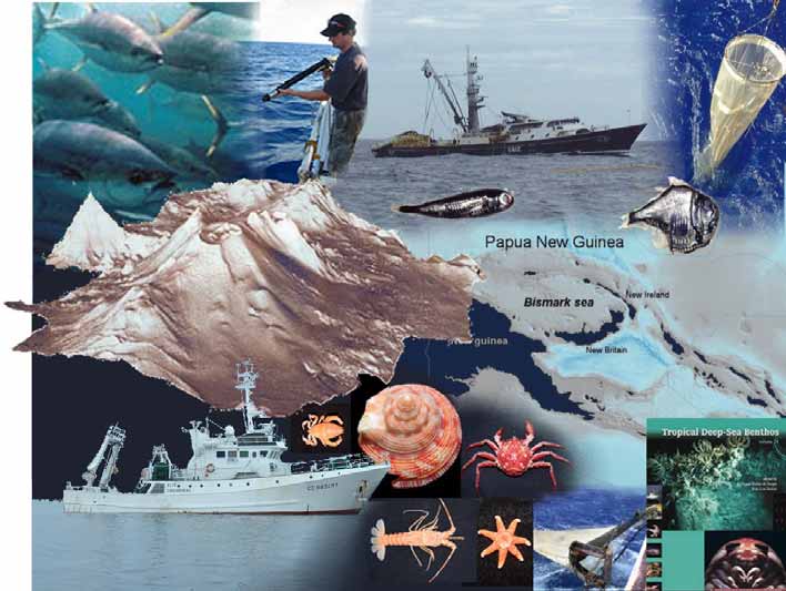
BISMARCK 2008
PELAGIC
Photo credits : SPC, IRD, NIWA, Valérie Allain-CPS, Christophe Maes-IRD, Bertrand Richer de Forges-IRD ; Map, layout: Julie-Anne Kerandel-CPS
2008 Campaign proposal
PROPOSITION DE CAMPAGNE A LA MER
IFREMER - IPEV IRD
NAME OF CAMPAIGN :
SUMMARY SHEET N°1
BISMARCK 2008 PELAGIC
BP2008
Date file prepared: JANVIER 2007
Year requested : 2008
Main mission leader
Other mission leader
Length of work (not including port-
Surname
RICHER DE FORGES
ALLAIN Valérie1
work zone transits) : 20 days
First name: Bertrand
Period (if necessary) : Just after Bismarck Agency :
Institut de Recherche pour Secretariat of the Pacific
2008 - Benthic, April-July 2008
le Développement (French Community (SPC)2
Institute of Research for
Development -IRD)
Zone :
Laboratory: P6 IRD MNHM CNRS,
Oceanic Fisheries
Bismarck Sea, Papua New Guinea
UR148/UMR7138,
Programme / Tuna
Systématique, Adaptation Ecology and Biology
et Evolution
Country whose territorial waters are
Address :
BP A5 98848 Noumea
BP D5 98848 Noumea
involved:
Cedex, New Caledonia
Cedex, New Caledonia
Papua New Guinea
Country whose economic zone is
Tel.:
+ 687 26 07 34
+ 687 26 20 00
involved:
Papua New Guinea
Fax :
+687 26 43 26
+687 26 38 18
E-mail :
richer@noumea.ird.nc valeriea@spc.int
Work : Bathymetry, biology (OPM, zooplankton, micronekton On-board scientific and technical teams
and acoustic measurements) and physical oceanography
Oceanic Fisheries Programme / Secretariat of the
(temperature, conductivity, fluorescence, oxygen and current Pacific Community (SPC) Noumea : 2
measurements).
IRD / LEGOS / UR065 Noumea : 1
IRD / ACAPPELLA / US004 Brest : 1
Ships wanted in order of preference: R/V Alis
IRD / US025 Noumea : 1
National Fisheries Agency Papua New Guinea: 1
Submarine : no
On-shore scientific and technical teams
Heavy equipment: IKMT micronekton pelagic trawl, WP2
Robert Leborgne and intern, IRD/CAMELIA/UR103
triple pelagic trawl, EK60 depth sounder, TAPs acoustic
Noumea
profiler, multibeam mapper, ADCP, XBT, LADCP,
Oceanic Fisheries team, SPC
thermosalinograph.
IRD/LEGOS/UR065 team Noumea
IRD/US025 team
Will an expedition be needed to recover the equipment?
IRD/ACAPPELLA/US004 team
no
Campaign theme
Ecosystem of the seamounts in the Bismarck Sea : understanding the interactions between seamounts
and the pelagic ecosystem through study of the pelagic fauna and oceanographic parameters
1 Christophe Maes, IRD Noumea LEGOS, and Erwan Josse, IRD Brest ACAPPELLA will be responsible, respectively, for the physical
oceanography and acoustics sections of this campaign.
2 SPC Secretariat of the Pacific Community : for information about this organisation, please see the footnote no. 4 (page 4).
2
PROPOSITION DE CAMPAGNE A LA MER
IFREMER - IPEV IRD
NAME OF CAMPAIGN :
ABSTRACT
BISMARCK 2008 PELAGIC
BP2008
ABSTRACT
The BISMARCK2008-PELAGIQUE (BP2008) cruise is one of two complementary campaigns (BB2008 and
BP2008) in the Bismarck Sea (Papua New Guinea) that have two objectives: to study the relationships between
tuna aggregations and seamounts in order to sustainably manage this important resource and to determine benthic
fauna biodiversity on the seamounts so as to preserve these exceptional ecosystems. The benthic section
(BB2008) involves mapping the seamounts and describing their benthic fauna. The pelagic part (BP2008) consists
of describing the zone's physical oceanography and the seamounts' specific characteristics through temperature,
salinity and courant profiles and describing the pelagic fauna (POM, zooplankton, micronekton) through acoustic
measurements, biomass and movement estimates, a fauna description and a description of the trophic structures
using stable isotopes. In addition, a longline fishing campaign will make it possible to estimate tuna catches, their
size structure, movements and trophic position. The goal is to gain a better understanding of the impact seamounts
have on the ecosystem, particularly on tuna. This campaign is a joint scientific and financial effort of the IRD and
the Secretariat of the Pacific Community (SPC). The expedition on the Alis will last 20 days from its departure from
Madang after the BB2008 cruise to its arrival in Rabaul. The scientific team comprises two SPC scientists, three
IRD scientists and a PNG observer from the National Fisheries Agency.
3
PROPOSITION DE CAMPAGNE A LA MER
IFREMER - IPEV IRD
NAME OF CAMPAIGN :
DOCUMENT N° 1
BISMARCK 2008 PELAGIC
BP2008
SCIENTIFIC, TECHNOLOGICAL OR TECHNICAL PROJECT
BISMARCK 2008
Pelagic Ecosystems and Benthic Biodiversity of the Seamounts in the Bismarck Sea.
Ecosystèmes pélagiques et biodiversité benthique des monts sous-marins de la Mer de Bismarck.
BISMARCK 2008 objectives
The scientific objective of this series of campaigns is to better understand the role of seamounts in both benthic
and pelagic ecosystems.
Bismarck 2008 is structured around two overall objectives, i.e. conservation, through an inventory of benthic fauna
biodiversity, and sustainable management of the exploitable resources and oceanic tuna fisheries linked to
seamounts.
In order to fulfil these objectives, several areas will have to be explored to both describe the seamounts and study
the benthic and pelagic fauna populations by highlighting pertinent parameters that make it possible to explain the
seamounts' role in the ecosystem. For those reasons, the study will cover :
- the seamounts' physical characteristics (bathymetry and oceanography),
- the biodiversity of the seamounts' benthic fauna,
- a study of the pelagic ecosystem, in particular micronekton (DSL3) that serves as food for tuna.
The selected study zone is the Bismarck Sea in Papua New Guinea. This region has several seamounts that have
not been studied. It is at the heart of the important western and central Pacific tuna fishery. And finally, a benthic
biodiversity study of this zone will make it possible to complete the series of MUSORTOM and related campaigns,
thereby ensuring geographic continuity of bathyal fauna samples from Taiwan to the Tonga Islands. In addition, the
work proposed in this zone complements a series of tuna tagging campaigns by the SPC4 in 2006 and 2007 (cf.
paragraph PNG tagging campaigns 06-01 and 07-01 page 12).
The Bismarck Sea is logistically interesting due as it has several ports that can handle large-size ships and provide
all the necessary supplies, i.e. Kavieng and Rabaul in the eastern part, Wewak and Madang in the western part
and Lae in the southwest.
In order to carry out a comprehensive sampling program on the bathymetric, oceanographic, benthic and pelagic
aspects, it has become clear that, for logistical reasons (different equipment and scientists), we need to conduct
two consecutive campaigns. One will be devoted to studying bathymetry/cartography and benthic biodiversity
(Bismarck 2008-Benthic), and the other to studying oceanographic characteristics and the pelagic ecosystem
(Bismarck 2008-Pelagic). Given the long transit time required to reach the study area (estimated 9 days from
Noumea), carrying out two consecutive campaigns will make it possible to optimise the ship's time once it is in the
zone. It should be noted that a study of large oceanic predators (tuna, marlin, sharks, etc.) will be carried out at the
same time as the Bismarck campaigns using a longliner chartered by SPC. This solution was chosen so as not to
overload the schedules of the Bismarck campaigns, which are already very ambitious in terms of sampling, and
because commercial fishing boats generally have better yields in terms of large pelagic fish catches.
This series of campaigns will make it possible to strengthen existing ties between the Secretariat of the Pacific
Community4, page 9 and the French Institute of Research for Development (IRD), two agencies that work to provide
scientific and technical support to developing countries in the Pacific and which have signed a Memorandum of
Understanding. So, in addition to providing scientific knowledge important for conserving and sustainably managing
Papua New Guinea's resources, the project will provide an opportunity to train PNG staff in scientific sampling
techniques. One or two PNG staff will be joining the scientific teams to participate in each of the campaigns.
3 Deep Scattering Layer : schools of small marine organisms (fish, molluscs, crustaceans, etc.) involved in nychthemeral vertical
migrations (at the surface at night, in the deep sea during the day) visible on echo-sounders.
4 SPC : Secretariat of the Pacific Community (http://www.spc.int/). SPC Headquarters are located in Noumea, New Caledonia
next to the IRD site. SPC also has offices in Fiji and in the Federated States of Micronesia, with a total of 344 staff, 191 of whom
work in Noumea. The SPC is a bilingual (French/English) international organisation (26 member countries) that delivers priority
programmes to its 22 Pacific island member countries and territories in Melanesia, Polynesia and Micronesia. It provides
technical assistance, professional and scientific support and advice on planning, management and skills transfer in the areas of
agriculture, forestry, coastal and oceanic fisheries, maritime affairs, community education, culture, women's and youth
development, demography and statistics, information technology and communications, media and public health.
4
PROPOSITION DE CAMPAGNE A LA MER
IFREMER - IPEV IRD
BISMARK 2008 PELAGIC: objectives and background
Theories and objectives
Certain seamounts are well known by fishers as places where pelagic fish congregate, thereby leading to high
catches (Fonteneau, 1991). In the Pacific, examples of this can be found in Australia (Britannia Seamount)
(Campbell & Hobday, 2003), Hawaii (Cross Seamount Emperor Seamount) (Beverly et al., 2004; Yasui, 1986),
and Tonga (Capricorn Seamount), in particular. The reason fish aggregate around seamounts is still open to
debate and several theories have been advanced to explain this phenomenon:
· A high primary production brought about by the specific oceanographic conditions (currents, nutrients, etc.)
around seamounts may allow development of a rich food chain that attracts pelagic fish (Boehlert & Genin,
1987). This theory implies that nutrients at the surface remain there long enough for plankton, and then an
entire food chain, to develop around the mount.
· It may be that the micronekton (DSL3, page5) involved in nychthemeral vertical migrations get trapped at
seamounts since the existence of the mounts may disturb this migration. An accumulation of micronekton
could attract large pelagic fish.
· The seamounts' non-food related role should not be overlooked in explaining the aggregation of large
pelagic fish around mounts, which may serve as spawning areas or nurseries for certain species.
· The theory of a "meeting place" has also been advanced, i.e. that in a uniform oceanic environment, fish
have a tendency to gather around landmarks, in this case seamounts, in particular so that they can form
larger schools to provide better protection against predators (Fréon & Dagorn, 2000a).
The purpose of this campaign is, then, to better understand and explain the influence seamounts have on
the pelagic environment, fish aggregation and fisheries linked to this ecosystem, in particular tuna
fisheries.
In order to fulfil this objective, several areas will have to be explored during the Bismarck 2008-Pelagic campaign in
order to both describe the seamounts' specific environments, particularly oceanographic factors that play a major
role, and study pelagic populations by concentrating on pertinent parameters that will help explain the link between
tuna and seamounts. For those reasons, the study will cover:
· the physical characteristics of the water masses entering the Bismarck Sea and a study on the disturbances
seamounts cause them, in particular, by measuring the currents, salinity and temperatures along the
vertical;
· the biological characteristics of the organic particulate matter, zooplankton and micronekton (DSL3, page5)
which are tuna's staple food, with measurements of their vertical movements and biomasses and species
identification, both around the seamount and far from them;
· study of certain of the biological parameters of tuna and large oceanic fish populations (diet and movements)
during the complementary tagging (PNG tagging) and longlining campaigns carried out and/or planned by
SPC.
The objectives of this campaign are complementary to those of the Bismarck-Benthic campaign, which will focus
on mapping seamounts and studying benthic fauna biodiversity (cf. corresponding campaign proposal), and the 06-
01 and 07-01 PNG tagging and the PNG-LL08-01 campaigns designed to study tuna movements and their trophic
links with seamounts (cf. paragraph PNG tagging 06-01 and 07-01 campaings, page 6).
5
PROPOSITION DE CAMPAGNE A LA MER
IFREMER - IPEV IRD
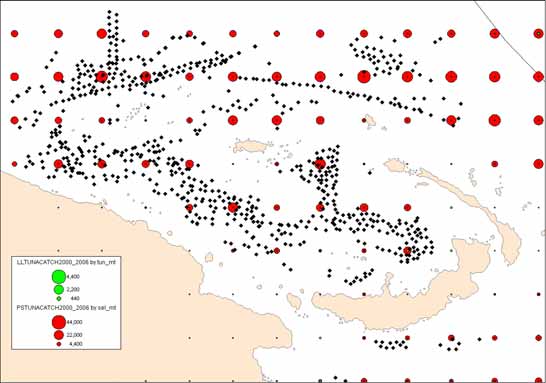
Tuna: a major resource for the Pacific and Papua New Guinea
Tuna is a major subsistence and economic resource in the Pacific, particularly for the region's developing
countries. Annual tuna production in the Western and Central Pacific was estimated at 2,145,367 tons in 20055, i.e.
the highest value ever reached, and an increase of 5% over the previous record set in 2004 (Williams & Reid,
2006). This tonnage accounts for 77% of Pacific production and 49% of world tuna production with a value of US$
3 billion.
Tuna fishing is carried out throughout the western and central parts of the Pacific but production is particularly high
in the equatorial zone (between 10ºN and 10ºS) where purse seiners operate almost exclusively (Figure 1). Papua
New Guinea's EEZ, which spreads out over some 2.4 millions sq km, is one of the biggest and most productive in
the region. Tuna fishing is the country's largest fishery with 91 local or related fishing units and 136 licensed foreign
purse seiners. In 2005 a total of 284,204 tons of tuna were caught in this EZZ, i.e. 13% of regional production
(Kumoru & Koren, 2006).
Figure 1. Tuna tonnages (skipjack, yellowfin, albacore and bigeye) caught by longlines (LL-green) and purse seine (PS-red)
for 2000-2006 in Western and Central Pacific (resolution of 1 sq degree). The scale is different for longline and purse seine.
Regionally, catches are composed of 67% skipjack (Katsuwonus pelamis), 20% yellowfin (Thunnus albacares),
8% bigeye (Thunnus obesus) and 5% albacore (Thunnus alalunga) ; 71% of this tonnage was caught by purse-
seiners, 11% by longliners, 10% by pole-and-line vessels and 7% by trolling and other artisanal techniques (Figure
Albacore
Troll /
Pole-and-
5%
Artisanal
Line
7%
10%
Bigeye
8%
Yellowfin
Longline
20%
11%
Skipjack
Purse
67%
seine
72%
A
B
2).
Figure 2. Distribution of tuna catch percentages (in tons), A) by species B) and by fishing gear. 2005 aggregate data for
Western and Central Pacific.
5 Best estimate dated August 2006 but which must be considered provisional.
6
PROPOSITION DE CAMPAGNE A LA MER
IFREMER - IPEV IRD
PNG tagging 06-01 and 07-01 campaigns
Purse-seine fishing, which accounts for nearly three-quarters of all catches (Figure 2), is done at the surface on
schools of fish that can be free or associated with floating natural debris (coconuts, tree trunks, etc.) or artificial
floating or anchored rafts (FAD : fish aggregation device) that tend to aggregate fish.
There has been a very dense deployment of anchored FADs in Papua New Guinea, particularly in the Bismarck
Sea (Figure 3), which makes it a area of special interest for study. In fact, FADs may act as ecological traps and
change the lifestyles of associated species (disturb migration patterns, negative impact on growth) (Fréon &
Dagorn, 2000b; Fonteneau et al., 2000; Marsac et al., 2000).
This problem is one of the research areas for the IRD's UR 109 Téthys6 and the FADIO7 program that operate in
the Indian and Atlantic Oceans. In the Pacific, on this same topic, i.e. better understanding the impact FADs have
on tuna behaviour, SPC has collaborated with several partners to organise a vast tuna tagging program whose first
phase took place from August to November 2006 (06-01 PNG tagging) and whose second phase is planned for
February to March 2007 (07-01 PNG tagging) in the Bismarck Sea (Oceanic Fisheries Programme of the
Secretariat of the Pacific Community, 2006). The results of the first tagging campaign, i.e. 06-01 PNG, have been
extremely encouraging with some 22,420 tuna tagged (62% skipjack, 35% yellowfin, 3% bigeye).
In addition to an in-depth study of the impact of FADs, these tagging campaigns also provide an opportunity to
collect samples from around seamounts in the zone. More specifically, the study around the seamounts covers
tagging small-size tuna (1679 tuna tagged during 06-01 PNG tagging) to study their movements and taking
biological samples (stomachs and muscle samples 62 tuna sampled around seamounts during 06-01 PNG
tagging) to study their feeding habits.
Since the primary objective of these campaigns is tagging, work at sea is conducted on a commercial pole and line
ship, the best fishing technique for tagging purposes but one that does not allow the collection of large-size
specimens or the recording of oceanographic parameters, and, even less so, collection of fauna samples from the
benthos or small pelagic species.
The Bismarck campaigns are, then, designed to collect benthic and pelagic fauna and SPC has planned an
expedition on the longliner PNG-LL 08-01 to collect large-size tuna to complete the work already done during the
06-01 and 07-01 PNG tagging campaigns with a view to better understanding the role seamounts play in the
ecosystem.
Figure 3. Tuna tonnages (see Figure 1 caption) and anchored FAD distribution (black diamonds) in the Bismarck Sea (Papua
New Guinea).
6 http://www.brest.ird.fr/ur109/activites/impacts.htm
7 FADIO project http://www.fadio.ird.fr/
7
PROPOSITION DE CAMPAGNE A LA MER
IFREMER - IPEV IRD
Characterising thermocline waters entering the Bismarck Sea
In oceanographic terms, the waters of subtropical origin that cross the Bismarck Sea contribute in large part to the
equatorial undercurrent in terms of the main thermocline (Tsuchiya et al., 1989 ; Fine et al., 1994 ; Blanke and
Raynaud, 1997). Variations in this mass flow and the physical and chemical properties of these waters are major
elements that come into play in the low-frequency modulation of the mean state of the equatorial rail current (Gu
and Philander, 1997, McPhaden and Zhang, 2002). Fluctuations in this mean state are, in their turn, involved in
low-frequency modulation of the ENSO (El Niño Southern Oscillation) phenomenon. At these time scales,
uncertainty about future changes in the ENSO against the background of global warming produce, in part,
uncertainty about oceanic circulation of the subtropical gyre.
In the southwest Pacific, thermocline waters are mainly fed by the Solomon Islands Sea. This water source, at
about 10°S, is the main study topic of the FLUSEC-1 oceanographic campaign, scheduled for June 2007 as part of
the international SPICE (www.ird.nc/UR65/SPICE) program. This campaign should make it possible to estimate the
meridional mass flow entering the Solomon Island sea, while, at the same time, differentiating the different origins
of these water masses (western rim Australian currents, north Vanuatu stream, etc.)
So, the Bismarck campaign provides an opportunity to complete this description of the physical properties of the
thermocline waters. It seems that these waters mainly transit by Vitiaz and St George Straits before joining the
equatorial regions. In fact, these two straits, which are relatively narrow (~50 km) and deep (~1000 m), are the only
passageways linking the Solomon Islands Sea to the Bismarck Sea (Figure 7). If possible, an estimate of the mass
flow will also be made. Direct estimates of the mass movements through these straits are extremely rare
(Lindstrom et al., 1987), but Butt and Lindstrom (1994) have shown that these movements account for half of the
water in the equatorial undercurrent between 149°E and 153°E. More recently, i.e. in 2006, the American
campaign KILO2006 (PI, Jim Murray) sampled the same zone but mainly in terms of current measurements without
being able to set up a large number of hydrological stations (data analysis is currently underway in collaboration
with Christophe Menkes).
We propose to complete these observations by hydrological measurements, analyse the data in a complementary
way and put them into a more general overview with the regional ocean circulation model made by ROMS,
available at the IRD Centre in Noumea. These actions will be carried out in collaboration with Christophe Menkes
(LOCEAN, Noumea) and the members of the LEGOS' OLVAC team in Noumea.
In this way, the oceanographic measurements made during the Bismarck campaign will allow a better
understanding of water mass circulation in both the region and the Bismarck Sea. This characterisation at the
scales of both the region and the zone is a prerequisite for characterising oceanographic parameters at the
smaller, seamount scale.
Conservation and the impact of fishing on seamounts
Seamounts are characterised by a high rate of endemism, support vulnerable benthic communities and are known
for aggregating pelagic species, whose species composition there differs from open-sea fauna. There is growing
interest in seamount ecosystems - in particular with regards to the conservation of these unusual ecosystems- and
so, in the impact of fishing. While bottom trawling has an undeniable impact on habitat and benthic fauna, the
possible impact of pelagic fisheries is still unknown but supposed to be very low or inexistent. (Koslow et al., 2001 ;
Campbell & Hobday, 2003). Scientific studies on such complex ecosystems have, however, been sporadic and
often limited in scope.
For all those reasons, the Bismarck project proposes to carry as complete a survey as possible (bathymetry,
oceanography, benthic and pelagic fauna) on a few seamounts in the Bismarck Sea.
Pelagic and benthic biology, bathymetry and oceanography: a mechanistic approach, multi-disciplinary
research
The theories mentioned in the "Theories and objectives" section (page 5) demonstrate the importance of sound
knowledge of oceanographic parameters in attempting to explain the influence seamounts have on the ecosystem.
This is particularly true for pelagic organisms whose habitat is the water mass, which can only be characterised by
oceanographic parameters such as temperature, current and salinity. Other parameters come into play when a
benthic ecosystem is involved, such as the type of substrate and topography.
A mechanistic approach seems to be the most appropriate one for this study, whose goal is to explain the
influences seamounts have on the ecosystem. These are physical parameters such as bathymetry and
oceanography, e.g. currents, temperature, that will make it possible to explain the existence and movement of
pelagic and benthic species. Integrating the results of these different disciplines will make it possible to go beyond
a descriptive study and should make it possible to gain a better understanding of the operating mechanisms of the
ecosystems at the seamounts studied.
8
PROPOSITION DE CAMPAGNE A LA MER
IFREMER - IPEV IRD
Research plan
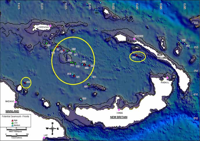
The seamounts in the Bismarck Sea have not been explored and detailed bathymetry of this area is spotty and
often limited to the coastal zones. The only data available for the moment are global satellite bathymetric data with
a precision of 2' (S2004/ETOPO2 data). Using these data, Kitchingman & Lai (Kitchingman & Lai, 2004) identified
a number of potential seamounts but detailed examination of these data revealed numerous errors. A new analysis
of global bathymetric data and SPC's historic information from past fish tagging programs in this zone made it
possible to identify some sure or highly-probable seamounts. There are three potentially interesting large zones,
i.e. in the east where a large bank spreads out at a depth of 400 m (a large number of fish have been tagged at this
site), in the west where there may be an isolated seamount at a depth of 600 m and, finally, in the central part of
the Bismarck Sea, where there are many possible seamounts (Figure 4).
The final choice of study sites will be based on the results of SPC's 06-01 and 07-01 PNG tagging campaigns,
which will locate seamounts in the zone. Then, detailed cartography during the benthic part of the 2008 Bismarck
project will allow us to make precise gridlines of the seamounts selected for sampling during the pelagic part.
Oceanographic measurements will be taken and fauna collected both at the seamounts and away from them in
order to be able to make comparisons and, in that way, better understand the effect seamounts have on the
pelagic ecosystem.
Operation timetable:
· Noumea Rabaul crossing and preparation : 10 days (about 1600nmi @ 9knots)
· Bismarck-Benthic campaign: 20 days (bathymetry and benthic fauna)
· Stopover in Madang : 2 days (supplies, change scientific teams, change equipment)
· Bismarck-Pelagic campaign : 20 days (oceanography and pelagic fauna)
· preparation and Rabaul Noumea crossing: 10 days (about 1600nmi @ 9knots)
i.e. a total time period of 62 days for the Bismarck project.
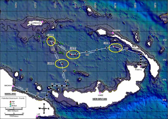
Figure 4. Potential and/or certified seamounts in the Bismarck Sea. The outlines in black show the 200-1000 depth zone.
The yellow circles show potential survey zones for the campaign. The numbers next to the seamounts show the depth at the
summit as predicted using altimetry satellite data. The colour code for the mounts show the level of priority for exploration
9
PROPOSITION DE CAMPAGNE A LA MER
IFREMER - IPEV IRD
Projet progress
The Bismarck is the continuation of two other major projects carried out by SPC and IRD.
The 2008 Bismarck-Benthic section is the continuation of the MUSORTOM and related campaigns (see the
corresponding project proposal for work progress) (Richer de Forges & Justine, 2006).
The 2008 Bismarck-Pelagic part is integrated into a vast project to study pelagic ecosystems in Western and
Central Pacific (see "Collaborations and ancillary programs" section, page10 and http://www.ffa.int/gef/). This
project focuses on studying the trophic relationships between large pelagic fish, and between 2001 and 2006, 3157
stomachs from 60 fish species were sampled, some 2793 (88%) of which were then examined.
The part of the project that focuses on the influence seamounts have on the pelagic ecosystem began in 2006,
when SPC organised a working group in March 2006 that brought together 14 specialists of seamounts in the
Pacific and Europe (SPC-New Caledonia, IRD-New Caledonia, University of Hawaii, NIWA8-New Zealand,
CSIRO9-Australia, Ministry of Fisheries-Tonga, IUCN10-Switzerland, FFA11-Solomon Islands) (Allain et al., 2006).
This meeting allowed the participants to make an inventory of the research on seamounts in the Pacific.
SPC has also begun, in collaboration with the NFA (Papua New Guinea National Fisheries Authority), a tuna
tagging program in the Bismarck Sea that includes tagging and sampling around seamounts. In November 2006,
after three months of fieldwork, more than 22,000 tuna had been tagged and more than 800 stomachs had been
sampled for the trophic relation study ; of these some 1679 tuna were tagged around seamounts and 62 stomachs
were sampled. A second campaign is taking place from February to May 2007. The two campaigns will make it
possible to identify seamounts in the study zone and get results on tuna behaviour around the mounts (how long
they stay there, vertical and horizontal migration) and on their feeding habits. The analysis phase for collected data
began in late November 2006.
Collaborations and ancillary programmes
The Bismarck 2008 -Pelagic campaign fits into SPC's "Pacific Islands Oceanic Fisheries Management Project
2005-2010" (OFMP)12 , which is a follow-up to the "Strategic Action Programme of the Pacific Small Island
Developing States 2000-2005 ", two GEF13-funded studies. The goal of these projects is to allow conservation and
sustainable management of the living resources of the Pacific Ocean and one of their activities is to improve
scientific knowledge about the tuna's pelagic ecosystem in the Pacific so as to provide guidance on managing this
resource.
For the project currently underway, the OFMP, in collaboration with the FFA11 and IUCN10, one new activity
consists of gaining a better understanding of the influence seamounts have on tuna resources and evaluating the
impact tuna fishing has on seamounts.
As part of this project, collaborative efforts have also begun with the PNG Fisheries Agency (NFA) to carry out the
PNG tagging campaigns, a sampling and tagging campaign in the Bismarck Sea. This agency has been advised of
preparations for the Bismarck 2008 project.
The study on biological samples (stomach contents) is being carried out in collaboration with taxonomists from
various countries, e.g. New Zealand, Australia, Hawaii, and stable isotope analyses are being done in collaboration
with the Stable Isotopes Biogeochemical Lab at the University of Hawaii.
This Bismarck 2008 project (Benthic and Pelagic) already has the support of the CENSEAM (see the letter of
support attached to the file). CENSEAM (Global Census of Marine Life on Seamounts14) is a Census of Marine Life
(CoML15) project, which brings together researchers from all over the world to improve knowledge about seamount
ecosystems.
The physical oceanographic observations to be carried out as part of this proposal will supplement efforts already
made as part of the international SPICE (www.ird.nc/UR65/SPICE) program under the direction of the World
Climate Research Program, CLIVAR/GOALS (Climate Variability and Predictability/Global Ocean Atmosphere
Land System). At the national level, the SPICE-France program headed by Lionel Gourdeau has been funded
through LEFE for a period of two years. We should recall that the Flusec-1 oceanographic campaign also depends
on these two research programs.
8 NIWA : National Institute of Water and Atmospheric Research, a national research agency in New Zealand.
9 CSIRO : Commonwealth Scientific and Industrial Research Organisation, a national research agency in Australia.
10 IUCN : International Union for the Conservation of Nature and Natural Resources or World Conservation Union, an
international organisation based in Gland, Switzerland that brings together countries, government agencies, NGOs and
scientists.
11 FFA : Forum Fisheries Agency, an international for tuna fisheries development and management in its 17 Pacific Island
member countries; it is based in Honiara, Solomon Islands.
12 OFM project: http://www.ffa.int/gef/
13 GEF : Global Environment Facility, an independent financial agency of the UN Development Program that provides funding to
developing countries for grassroots environmental and sustainable management projects.
14 CENSEAM: http://censeam.niwa.co.nz/
15 CoML: http://www.coml.org/
10
PROPOSITION DE CAMPAGNE A LA MER
IFREMER - IPEV IRD
Expected results
The goal of this study is to explain the influence seamounts have on the pelagic ecosystem by using a mechanistic
approach to determine how interactions between seamounts and the ecosystem operate. The expected results of
the campaign are:
1) A better understanding of the impact the seamounts studied have on oceanographic parameters such as
Taylor column formation, upwelling, main thermocline characteristics and vertical displacement, etc.
Through a ripple effect, these physical constraints have an impact on the entire ecosystem and so they
constitute variables which may explain phenomena observed in the food chain.
2) Better understanding of water mass displacement in the Bismarck Sea and straits.
3) Better understanding of the ecosystem's various pelagic and benthic components (biomasses, species
composition, movements), from the lower trophic levels (phytoplankton, zooplankton, micronekton) right up
to large predators (tuna and other large oceanic species through a complementary campaign longlining
by the SPC PNG LL 08-01) and their interactions (trophic relations through a study on stable isotopes,
stomach contents and movements).
4) Integration of the bathymetric and benthic fauna data collected during the Bismarck -Benthic campaign.
5) An overall report on the seamounts studies so as to understand how they operate (bathymetric-
oceanographic-benthic-pelagic interactions) and, in this way, get the information required for formulating
management and/or protection measures for these unusual ecosystems.
6) This complete study could provide a standard model for later studies on seamounts.
Depending on the results obtained, one or more scientific publications could be produced.
Bibliography
1. Allain, V., Kirby, D. S., & Kerandel, J.-A. 2006. Seamount research planning workshop report, 20-21 March 2006. 2nd
Meeting of the Scientific Committee of the Western and Central Pacific Fisheries Commission, WCPFC-SC2, Manila,
Philippines, 7-18 August 2006. EB IP5, 1-56. http://www.wcpfc.org/sc2/pdf/SC2_EB_IP5.pdf.
2. Beverly, S., Robinson, E., & Itano, D. 2004. Trial setting of deep longline techniques to reduce bycatch and increase
targeting of deep-swimming tunas. 17th Meeting of the Standing Committee on Tuna and Billfish, SCTB17, Majuro,
Marshall Islands, 9-18 August 2004. FTWG-7a, 1-28.
3. Blanke, B., and S. Raynaud, 1997: Kinematics of the Pacific equatorial undercurrent: an eulerian and lagrangian
approach from GCM results. J. Phys. Oceanogr., 27, 1038-1053.
4. Boehlert, G. W. & Genin, A. 1987. A review of the effects of seamounts on biological processes. (43), 319-334.
5. Butt, J., and E. Lindstrom, 1994: Currents off the east coast of New Ireland, Papua New Guinea, and their relevance to
regional undercurrents in the western equatorial Pacific Ocean. J. Geophys. Res., 99, 12 503-12 514.
6. Campbell, R. & Hobday, A. J. 2003. Swordfish - Environment - Seamount - Fishery interactions off eastern Australia.
Report to the Australian Fisheries Management Authority, No. 597.780994, pp. 1-97.
7. Fine, R. A., R. Lukas, F. M. Bingham, M. J. Warner, and R. H. Gammon, 1994: The western equatorial Pacific: a water
mass crossroads. J. Geophys. Res., 99, 25 063-25 080. 5.
8. Fonteneau, A. 1991. Monts sous-marins et thons dans l'Atlantique tropical est. Aquatic Living Resources. 4, 13-25.
9. Fonteneau, A., Pallares, P., & Pianet, R. 2000. A worldwide review of purse seine fishereis on FADs. Revue mondiale
des pêcheries à la senne sous DCP. In Pêche thonière et dispositifs de concentration des poissons. LeGall, J.-Y., Cayré,
P., & Taquet, M. Eds. IFREMER, Nantes, pp. 15-35.
10. Fréon, P. & Dagorn, L. 2000b. Review of fish associative behaviour: toward a generalisation of the meeting point
hypothesis. Reviews in Fish Biology and Fisheries. 10(2), 183-207.
11. Fréon, P. & Dagorn, L. 2000a. Review of fish associative behaviour: toward a generalisation of the meeting point
hypothesis. Reviews in Fish Biology and Fisheries. 10(2), 183-207.
12. Gu, D., and S.G. H. Philander, 1997: Interdecadal climate fluctuations that depend on exchanges between the tropics
and extratropics. Science, 275, 805-807.
13. Kitchingman, A. & Lai, S. 2004. Inferences on potential seamount locations from mid-resolution bathymetric data.
Fisheries Centre Research Reports. 12(5), 7-12.
14. Koslow, J.A., Gowlett-Holmes, K., Lowry, J.K., O'Hara, T., Poore, G.C.B. & Williams, A., 2001. Seamount benthic
macrofauna off southern Tasmania: community structure and impacts of trawling. Marine Ecology Progress Series,
213 : 111-125.
15. Kumoru, L. & Koren, L. 2006. Tuna Fisheries Report - Papua New Guinea. 2nd Meeting of the Scientific Committee of
the Western and Central Pacific Fisheries Commission, WCPFC-SC2, Manila, Philippines, 7-18 August 2006. FR WP-
15, 1-24. http://www.wcpfc.org/sc2/pdf/SC2_CR_PNG.pdf.
16. Lindstrom, E., R. Lukas, R. Fine, E. Firing, S. Godfrey, G. Meyers, and M. Tsuchiya, 1987: The Western Equatorial
Pacific Ocean Circulation Study, Nature, 330, 533-537.
11
PROPOSITION DE CAMPAGNE A LA MER
IFREMER - IPEV IRD
17. Marsac, F., Fonteneau, A., & Ménard, F. 2000. Drifting FADs used in tuna fisheries: an ecological trap? In Pêche
thonière et dispositifs de concentration des poissons. LeGall, J.-Y., Cayré, P., & Taquet, M. Eds. IFREMER, Nantes,
pp. 537-552.
18. McPhaden, M. J., and D. Zhang, 2002: Slowdown of the meridional overturning circulation in the upper Pacific Ocean.
Nature, 415, 603-608.
19. Oceanic Fisheries Programme of the Secretariat of the Pacific Community. 2006. Regional Tuna Tagging Project Phase
1: Papua New Guinea. 2nd Meeting of the Scientific Committee of the Western and Central Pacific Fisheries
Commission, WCPFC-SC2, Manila, Philippines, 7-18 August 2006. GN WP-11, 1-11.
http://www.wcpfc.org/sc2/pdf/SC2_GN_WP11.pdf.
20. Richer de Forges, B. & Justine, J.-L. (eds.), 2006. Tropical Deep-Sea Benthos. Vol. 24. In : Mémoires du Muséum national
d'Histoire naturelle, vol. 193 ; 420 p.
21. Tsuchiya, M., R. Lukas, R. A. Fine, E. Firing, and E. Lindstrom, 1989: Source waters of the Pacific equatorial
undercurrent. Prog. Oceanogr., 23, 101-147.
22. Williams, P. G. & Reid, C. 2006. Overview of tuna fisheries in the Western and Central Pacific Ocean, including
economic conditions - 2005. 2nd Meeting of the Scientific Committee of the Western and Centrral Pacific Fisheries
Commission, WCPFC-SC2, Manila, Philippines, 7-18 August 2006. GN WP-1, 1-40.
http://www.wcpfc.org/sc2/pdf/SC2_GN_WP1.pdf.
23. Yasui, M. 1986. Albacore, Thunnus alalunga, pole-and-line fishery around the Emperor Seamounts. NOAA Technical
Report NMFS. 43, 37-40.
12
PROPOSITION DE CAMPAGNE A LA MER
IFREMER - IPEV IRD
NAME OF CAMPAIGN :
DOCUMENT N° 2
BISMARCK 2008 PELAGIC
BP2008
CAMPAIGN DESCRIPTION
Methodology, list of work, strategy
LISTE OF WORK
In order to characterise water masses in the Bismarck Sea and straits and observe the impact seamounts have on
them, vertical profiles to a depth of 1000 m will be made for several parameters:
- temperature
- pressure
- salinity
- oxygen
- fluorescence.
In order to characterise pelagic fauna in the Bismarck Sea and at seamounts, samples several components of the
pelagic ecosystem will be sampled and various parameters will be measured:
Ecosystem component
Parameters measures
Comments
Organic particulate matter
Biomass estimates (filtration)
Trophic level (stable isotopes)
Zooplankton
Biomass estimates (net and acoustics)
Vertical movements (acoustics)
Species identification
Trophic level (stable isotopes)
Micronekton
Biomass estimates (trawling and acoustics)
Vertical movements (acoustics)
Species identification
Size structure
Trophic level (stable isotopes)
Other biological parameters as the occasion
presents itself (stomach contents, genetics, etc.)
Large oceanic species
Biomass estimates (longline and acoustics)
The acoustics will be
(tuna, marlins, sharks, etc.)
Vertical movements (acoustics and tags)
carried out during the
Species identification
Bismarck-Pelagic
Size structure
campaign, the rest of the
Trophic level (stable isotopes)
work to be conducted by
Stomach contents
SPC during additional
campaigns
STATIONS
A series of physical measurements stations will be set up at the beginning of the campaign in order to characterise
water mass exchanges between the Bismarck Sea and Solomon Islands Sea at St. George and Vitiaz Straits
(Table 1, Figure 7). In order to properly characterise hydrology in the Bismarck Sea, other stations will also be set
up along the itinerary along the transects between seamounts every ½ degree (Table 2, Figure 7). There will be 13
stations in the straits and 14 transect stations.
The 06-01 and 07-01 PNG tagging campaigns in 2006 and 2007 will make it possible to more precisely locate
seamounts in those areas identified as potentially interesting based on satellite data (Table 3, Figure 4, Figure 7).
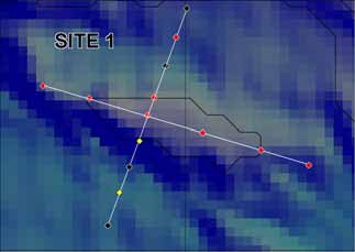
As an initial estimate, the mount on Site 1, whose existence has been proven, and at least one mount each in Sites
2, 3 and 4, whose existence and exact positions still need to be confirmed, will be explored. The Bismarck 2008 -
Benthic campaign will allow us to precisely locate these seamounts and determine their depths. It will also provide
detailed bathymetric maps of the seamounts explored and, in this way, make it possible to determine the feasibility
of studies at these sites and finalise the list of mounts to be explored during the Bismarck 2008 -Pelagic campaign.
The mount at Site 1 will be studied in depth since its existence has been proven and it is a large structure that
forms a vast plateau whose summit should be at a depth of about 400 m. There are plans to do two perpendicular
transects covering 14 stations in all, where physical measurements will be taken. OPM and zooplankton samples
will be taken at 10 of the 14 stations both during the day and at night, i.e. 20 zooplankton hauls. Trawling for
micronekton will be carried out at 8 of these stations during the day and at night in deep waters and at night on the
surface at six stations, i.e. 22 trawling runs (Figure 5).
13
PROPOSITION DE CAMPAGNE A LA MER
IFREMER - IPEV IRD
For the mounts at Sites 2, 3 and 4, sampling will be less detailed with one or two perpendicular transects
depending on the time available and prevailing sea conditions. Each transect will include a station at the summit of
the mount, two stations above the slope and two stations at a distance (where the depth is about 2000m) (Figure
6).
Priority during this study will be given to spatial stratification of the sample, but temporal stratification could also be
done depending on the amount of time available. This would consist of repeating at night some of the work carried
out during the day over all or part of the stations, taking care to avoid sunrise and sunset when the DSL makes its
vertical migrations. Night work would only involve fauna samples.
In spite of this preliminary estimate, it should be noted that the number of stations will be adapted to working
conditions at sea and the time available in line with the actual situation in the field.
Finally, since the purpose of this campaign is to determine the influence seamounts have on the pelagic
ecosystem, it would be best to have a comparative strategy with study of oceanographic parameters and pelagic
fauna at several sites located away from the selected seamounts. In that way, in addition to the analyses carried
out on the mounts, measurements will also be taken at control sites located at least 30 nautical miles from the
mounts (Table 2, Figure 7). Three control stations have been chosen : R4, R10 and R13.
Figure 5. Sampling plan at Site 1. The black diamonds show
those stations where only physical measurements will be taken,
the yellow diamonds: stations with only physical, OPM and
zooplankton ; red diamonds: stations with physical, OPM,
zooplankton and micronekton. The coordinates for the edges of
this map are 150.63E, 151.32E and 3.52S, 3.03S.
Figure 6. Three-dimensional diagram of a seamount showing the station
transects planned at various levels : summit (S), slope (P) and distant
stations (E).16
Name of
Longitude
Latitude
Number of
Strait
Transect
stations
(deg., min)
(deg., min)
stations
Transect 1 beginning
147°30 E
5°95 S
Vitiaz
D1 to D5
5 stations
Transect 1 end
147°50 E
5°15 S
Transect 2 beginning
147°50 E
5°15 S
Vitiaz
D6 to D8
3 stations
Transect 2 end
148°30 E
5°15 S
Transect 3 beginning
152°15 E
3°40 S
St George
D9 to D13
Transect 3 end
152°15 E
4°15 S
5 stations
Table 1. Positions of physical measurement stations in Vitiaz and St George Straits.
16 This diagram, which is given as an example and modified for the illustration, is a 3D-view of Bear Seamount located in the
Atlantic Ocean, whose summit is located at a depth of 1000 m (source of picture: National Oceanic and Atmospheric
Administration: http://www.oceanexplorer.noaa.gov/explorations/deepeast01/logs/sep13/media/bear_seamount.html).
14
PROPOSITION DE CAMPAGNE A LA MER
IFREMER - IPEV IRD
Transect
Longitude (dec.)
Latitude (dec.)
Comments
stations
R1 146.500 -5.500
R2 147.000 -5.736
R3 148.441 -5.000
R4 148.325 -4.500
Control
station
R5 148.153 -4.000
R6 147.912 -3.500
R7 148.000 -3.154
R8 148.500 -3.500
R9 149.000 -3.614
R10 149.500 -3.500
Control
station
R11 150.000 -3.422
R12 150.500 -3.325
R13 151.500 -3.449
Control
station
R14 152.000 -3.560
Table 2. Positions of the physical measurement transect stations along the itinerary. Sampling of pelagic fauna will also be
carried out at the control stations.
Site
Long (dec) Lat (dec) Depth (m)
Priority
site 1
150.874
-3.25139
404
high
site 2
148.608
-3.63461
530
medium
site 2
148.691
-3.65127
520
high
site 2
148.907
-3.68447
866
high
site 3
147.574
-2.90112
64
high
site 3
147.824
-3.05111
421
high
site 4
148.191
-4.05154
915
medium
site 4
148.275
-4.13441
481
high
144.524
-1.93455
504
high
144.674
-1.65108
644
low
145.108
-2.11793
649
high
146.207
-4.41825
608
high
147.108
-2.75118
857
low
147.341
-3.03428
921
low
147.975
-3.06746
763
low
148.125
-3.55136
744
low
148.174
-3.08404
635
low
148.208
-3.55126
810
low
148.274
-3.11779
871
low
148.324
-3.61786
773
low
148.541
-5.11793
806
medium
148.808
-1.10128
850
medium
148.874
-4.48435
831
low
148.975
-4.18453
911
medium
149.174
-1.33461
584
medium
149.191
-2.16727
865
medium
149.374
-1.03444
849
medium
152.741
-2.65109
789
medium
152.908
-2.7678
647
medium
Table 3. Positions of potential seamounts detected after analysis of satellite images and shown on Figure 4 and Figure 7.
WORK AT STATIONS
Physical oceanographic measurements will be taken at the strait stations, transect stations and seamount stations.
Acoustic measurements and biological samples will be taken at the three control stations (R4, R10 and R13) and
the seamount stations. In the event of temporal stratification of the samples, only the biological samples will be
repeated at night.
Physical oceanographic measurements : the work to be conducted at the stations (straits, transect and seamount)
will consist of temperature, conductivity, pressure, oxygen and fluorescence profiles using the SBE19 probe to
depths of up to 1000 m. Following US25's recommendations, this probe will be equipped with two Doppler current
meters (L_ADCP) to measure currents.
Biological samples (pelagic fauna) : organic particulate matter (OPM) samples will be taken at each station to
measure stable isotopes at the base of the food chain. For zooplankton, three consecutive vertical hauls will be
made at each station at depths of 100, 200 and 500 m to identify the species, estimate biomasses (dry weight) and
measure stable isotopes. Finally, micronekton samples will be taken at each control station and, for the seamounts,
at the summit station, on two stations on the slope and possibly at two stations located at a distance, both during
the day and at night in deep waters plus one surface sample at night at the summit station. The micronekton
samples collected during horizontal hauls will make it possible to identify the species, estimate biomasses and
measure stable isotopes. Acoustic measurements from the EK60 will be recorded on an on-going basis on the
15
PROPOSITION DE CAMPAGNE A LA MER
IFREMER - IPEV IRD
transects both at the seamounts and control stations in order to estimate micronekton biomasses and their vertical
movements. The TAPs acoustic profiler for zooplankton will be used at all the stations. Acoustic signals marking
the vertical migration phases of zooplankton and micronekton, i.e. at sunset and sunrise, will be recorded.
WORK EN ROUTE
Certain on-going physical oceanographic measurements will be made :
a) for the zonal and meridional currents using the hull ADCP (0-300 m),
b) for surface temperature and salinity using the thermosalinograph.
c) for the main meteorological parameters using the Batos station.
In terms of acoustics, on-going data acquisition is possible en route since the boat's speed is less than 7-8 knots.
METHODOLOGIES
Physical oceanographic measurements: the measurements to be taken en route do not require any equipment
handling; the hull ADCP, BATOS weather station and thermosalinograph will be powered up at the beginning of the
trip and will record the parameters on a continual basis. For each station, the Seabird SBE19 probe with all its
detectors and equipped with an LADCP will be dropped down to a depth of 1000 m using the side winch to record
the parameters. Each operation takes about an hour.
Biological samples (pelagic fauna) :
OPM : sample surface water (about 15 litres) using a special bucket designed for this purpose off the side of
the boat, transfer water into filter system, turn on pump (Gast Oil-less diaphragm-type pressure/ vacuum pump) for
filtering with Whatman GF/F filters, 25 mm (nominal pore size 0.7) with a Millipore Swinnex filter holder for different
amounts of time depending on how many particles there are. Filtering time is generally under an hour and requires
simple surveillance without any handling. Record the volume filtered. Keep filter in freezer.
Zooplankton : deploy and then slowly bring back in the WP2 triple net (200µm mesh) at the back of the boat
using a shunt from the small side winch, rinse net, record flow meter figures, recover; rinse and store plankton
samples in appropriate containers and storage devices so they can be examined later in the laboratory. The overall
operation, i.e. 3 consecutive vertical hauls, rinsing and storing samples, takes about 1.5 hours.
Micronekton : deploy IKMT net with the back winch to the depth of the DSL based on acoustic data; deep
horizontal hauls and oblique surface haul at night beginning just under the DSL surface depth as determined by
acoustics. Recover micronekton. Sort by taxonomic group (fish, cephalopods, crustaceans, gelatinous organisms).
Identify species, count on board or store samples for later examination in a laboratory depending on sample size
and the time available. The net is dragged for one hour each time and the overall operation, i.e. deployment,
dragging, recovering samples, takes between 1.5 and 2 hours.
Acoustic measurements: either the ALIS will be equipped with hull sounders, or the US004' transportable
EK60 will be installed on a pole off the side of the boat. Once the sounder has been turned on, the 3-4 available
frequencies (38, 70, 120 and 200KHz) will be acquired simultaneously while the boat goes at a speed of 7-8 knots.
The TAPs installed on the small side winch will be dropped to a depth of 200 m at a speed of 1m/s at the various
stations ; the operation is quick and takes about 10-15 minutes.
Overall outline of the mission, length, stopovers
In order to optimise use of transit time through the zone, it would be best for the two missions, i.e. Bismarck-
Benthic and Bismarck-Pelagic, to be scheduled one after the other. In the same way, since the detailed mapping
work is supposed to be done during the Bismarck-Benthic campaign, it is important that this mission take place first
since these data will then be used during the Bismarck-Pelagic campaign.
Provisionally, the missions should take place as follows:
Noumea Rabaul transit: 9 days (about 1600nmi @ 9knots)
set up equipment on-board, get supplies in Rabaul : 1 day
Bismarck-Benthic campaign : 20 days (bathymetry and benthic fauna)
stopover in Madang : 2 days (supplies, change scientific crews, change equipment)
Bismarck-Pelagic campaign : 20 days (oceanography and pelagic fauna)
Prepare boat for return trip, get supplies in Rabaul : 1 day
PNG Noumea transit: 9 days (about 1600nmi @ 9knots)
i.e. a total time of 62 days for the BISMARCK project including 20 days of transit, then 42 days in the zone, divided
into 2 days of stopovers and 20 days of field work for each mission (Benthic and Pelagic).
The two missions will visit the same sites to carry out different types of measurements and sampling.
The stopover is necessary given the very different nature of the work to be done during the two consecutive
missions. So, the scientific team will have to be changed and the equipment on board will have to be rearranged.
The stopover will also allow the boat to get supplies.
Desired time frame: between April and July 2008 (outside tropical storm season).
16
PROPOSITION DE CAMPAGNE A LA MER
IFREMER - IPEV IRD
Provisional daily timetable for work
Since both missions, i.e. benthic and pelagic, are supposed to cover the same zones, any changes made to the
itinerary during the first mission, i.e. benthic, will have to be repeated during the second, pelagic, mission.
Approximate
Days
Work
work times
D1-D9
Leave Noumea, transit, arrive in Rabaul ; take on scientists in Rabaul, take on
supplies 1600nmi at 9 knots, i.e. about 9 days
D10
Take on scientists at Rabaul, set up equipment, take on supplies
D11-D30
BISMARCK BENTHIC mission (please see corresponding campaign proposal for the
daily timetable)
D31-D32
Stopover in Madang, change scientific team, rearrange equipment, take on supplies
D33-D34
Transit Madang D1 with 2 physical measurement stations (R1 and R2)
15h
Transit between D1 and D5 with 5 physical measurement stations (D1 to D5)
12h
D34-D35
Transit between D5 and D8 with 3 physical measurement stations (D6 to D8)
9h
Transit between D8 and Site 4 with 2 physical measurement stations (R3 and R4) 14h
and 1 biological sample station (R4)
D35-D37
Work at Site 4 : 10 physical measurement stations
10h
10 OPM and zooplankton sampling stations
15h
7 micronekton sampling stations
14h
D38
Transit between Sites 4 and 3 with 2 physical measurement stations (R5 and R6)
14h
D39-D41
Work at Site 3 : 10 physical measurement stations
10h
10 OPM and zooplankton sampling stations
15h
7 micronekton sampling stations
14h
D41-D42
Transit between Sites 3 and 2 with 2 physical measurement stations (R7 and R8)
13h
D42-D44
Work at Site 2 : 10 physical measurement stations
10h
10 OPM and zooplankton sampling stations
15h
7 micronekton sampling stations
14h
D45-D46
Transit between Sites 2 and 1 with 4 physical measurement stations (R9 to R12) and 24h
1 biological sample station (R10)
D46-D50
Work at Site 1 : 14 physical measurement stations
14h
10x2 (day/night)=20 OPM and zooplankton sampling stations
30h
8x2(day/night)+6(surface)=22 micronekton sampling stations
44h
D51
Transit between Site 1 and D9 with 2 physical measurement stations (R13 and R14) 17h
and 1 biological sample station (R13)
D52
Transit between D9 and D13 with 5 physical measurement stations (D9 to D13)
10h
D53
Enter Rabaul Port, take on supplies, debark scientists, prepare the boat for the return
trip
D54-D62
Leave Rabaul, transit, arrive in Noumea 1600nmi at 9 knots, i.e. about 9 days
Situation map of the study zone
Figure 7 shows the overall and detailed situation of the study zone for the Bismarck project.
Site 1, which is located south of Djaul at 150º52'E and 3º15'S, is a large bank whose summit is located at a depth
of about 400 m. Its existence has been proven by several information sources, notably the tuna tagging operations
carried out by SPC in the 1990s. A special effort will be made at this site because it is the biggest and it is
particularly favoured by pelagic fisheries.
Site 2 includes several potential seamounts whose summits are located at depths of 866, 520 and 530 m in a
square situated between 148 º34'E - 3º46'S and 148 º59'E - 3º32'S.
Site 3 includes several potential seamounts whose summits are located at depths of 760, 420 and 65 m in a
square situated between 147 º33'E - 3º06'S and 148 º01'E - 2º51'S.
Site 4 includes several potential seamounts whose summits are located at depths of 480 and 900 m in a square
situated between 148 º09'E - 4º13'S and 148 º24'E - 4º00'S.
17
PROPOSITION DE CAMPAGNE A LA MER
IFREMER - IPEV IRD
Figure 7. Overall situation map and detailed map of the study zone for the Bismarck-Pelagic project. The itinerary is in white
with departure from Madang and arrival in Rabaul. The black squares show the hydrological stations in the straits (D1 to
D13) ; the black diamonds show the hydrological stations in the transects (R1 to R14). The seamounts are shown by coloured
triangles.
18
PROPOSITION DE CAMPAGNE A LA MER
IFREMER - IPEV IRD
NAME OF CAMPAIGN :
DOCUMENT N° 3
BISMARCK 2008 PELAGIC
BP2008
MEANS TO BE IMPLEMENTED
Support ship
The R/V Alis has the equipment needed for this study and is located on site in Noumea.
Equipment installed on support ship
- Hydrologic winch with slip rings 1500 m of cable required
- Hull ADCP, computer for acquiring data and computer for data processing.
- Computer for data processing and printer
- Seabird SBE19 probe
- Intercom (lab, bridge, winch)
- Complete Batos weather station
- Fax, e-mail, Imarsat-C
- Freezer (3m3) to store samples
- multi-beam mapper.
- EK60 hull probe (38, 70, 120 and 200 KHz)
-aft-winch , 1000 m of cable required
Mobile equipment / requesting team's equipment / equipment provided by
outside organisations
Equipment
Supplier
Number
Frequency and length of use
Oceanographic data
Thermosalinograph and computer for data IRD US 025
1
Continuously
acquisition and processing
XBT probe
IRD US 025
1
Replacement
for
SBE19
prove or in the event of bad
weather
LADCP (RDI) system + computer for data IRD US 025
1
At each station
acquisition
3 salinity sample containers
IRD US 025
1
At each station
Pelagic fauna
If the EK60 is not installed on the ship, IRD US 004
1
Continuously at each station
transportable SIMRAD EK 60 probe + computer
for data acquisition
TAPs acoustic profiler
IRD US 004
1
At each station
Equipment to filter out OPM (bottle, pump, filter)
SPC
1
At each station
WP2 - triple plankton net with flow meter
IRD UR 103
1 frame
At each station
6 nets
IKMT micronekton net
CSIRO Australia 1
At each station
CENSEAM
Heat chamber for dry weight (zooplankton)
IRD UR 103
1
After each sample
19
PROPOSITION DE CAMPAGNE A LA MER
IFREMER - IPEV IRD
NAME OF CAMPAIGN :
DOCUMENT N° 4
BISMARCK 2008 PELAGIC
BP2008
SAMPLE AND DATA ANALYSIS AND PROCESSING
Sample and data analysis and processing on board
Oceanographic data
Physical data will be processed in part on board and in part at the IRD Centre in Noumea (TSG, CTD, LADCP and
meteorological measurements on a PC). The IRD staff involved in data processing has a good deal of experience
in processing this type of data, based on more than 25 oceanographic campaigns carried out in the region since
1984.
Biological data
OPM : after the water sample has been taken, it is filtered until the filter becomes clogged. The volume of water
filtered is measured and the filter is kept in the freezer for analysis on land.
Zooplankton : after rinsing the nets and recovering the samples, the contents of one net will be stored in
formaldehyde for identification of the species composition, while the contents of the second net will be laid out on a
piece of silk to be dried in the heat chamber at 60º then frozen to determine the dry weight, and the contents of the
third net will be frozen for isotope measurements. These analyses will be done on land.
Micronekton : wherever possible, samples will be sorted on board with species identification, counting the number
of specimens, measuring the lengths of the specimens in sub-samples for each species (20 specimens per
species), storing 20 specimens per species in the freezer for analysis on land.
Acoustics : work on board will be limited to acquiring data.
Sample and data analysis and processing on land
Sample and data analysis and processing on land
Oceanographic data
Physical data will be processed in part on board and in part at the IRD Centre in Noumea (TSG, CTD, LADCP and
meteorological measurements on a PC). The IRD staff involved in data processing has a good deal of experience
in processing this type of data, based on more than 25 oceanographic campaigns carried out in the region since
1984.
Biological data
OPM : the frozen filters will be sent to the University of Hawaii for stable carbon and nitrogen isotope
measurements
Zooplankton : the samples in formaldehyde will be analysed at the CAMELIA Laboratory at IRD Noumea by an
intern under the supervision of Robert Leborgne. Analysis will make it possible to determine the sample's species
composition through sorting using a binocular microscope, and identification and quantification by taxa. A biomass
estimate will be made by measuring the dry weight of the sample put in the heating unit. Finally, the frozen
samples will be sorted by taxon and sent to the University of Hawaii to measure the stable carbon and nitrogen
isotopes.
Micronekton : those samples that are not processed on board will be processed at the SPC laboratory (sorting,
identification, counting, weighing and measuring). One sample of the various species will be sent to the University
of Hawaii for stable carbon and nitrogen isotope measurements. The stomach contents of certain species will be
examined.
Acoustics : Acoustic data will be processed by the IRD / ACAPELLA (US004) team by integrating the zooplankton
and micronekton data from the nets and dragging.
20
PROPOSITION DE CAMPAGNE A LA MER
IFREMER - IPEV IRD
NAME OF CAMPAIGN :
DOCUMENT N° 5
BISMARCK 2008 PELAGIC
BP2008
SCIENTIFIC AND TECHNICAL TEAM
1 Requesting team
Projet head: Bertrand Richer de Forges
Team leader: Valérie Allain
On-board team
Surname
Institute
Speciality Responsibility
Responsibility
First name
Laboratory
and role on board
and role on land
ALLAIN Valerie
CPS/OFP
Biology/Fisherie Oversee biological
Process micronekton
Noumea
s science
sampling, micronekton
samples, analyse data
identification
and write mission report
MAES Christophe
IRD/LEGOS/U
Physics Oversee
oceanographic
Process and analyse data
R065 Noumea
data, CTD and TSG data and write mission report
VARILLON David
IRD/US25
Electronics Oversee
electronic
and
Processing and filing
computer aspects
SPC Assistant
SPC/OFP
Biology/Fisherie Assist with biological
Help analyse data
Noumea
s science
sampling
JOSSE Erwan
IRD/ACAPELL
Acoustics
Record acoustic data
Analyse acoustic data
A/
US004
PNG Observer
National
Fisheries
Assist with biological
Fisheries
Science
sampling and recording
Authority
oceanographic data
Papua New
Guinea
Land team
Surname
Institute
Speciality
Responsibility and role Time spent
First name
Laboratory
Leborgne Robert
IRD/CAMELIA Zooplankton Analyse zooplankton
1 month
Noumea
data, supervision
Intern IRD/CAMELIA
Zooplankton Process zooplankton
5 months
Noumea
samples
Sanchez Caroline
SPC/OFP
Biology Process
biological
2 months
Noumea
samples
Leroy Bruno
SPC/OFP
Biology Process
biological
2 months
Noumea
samples
Popp Brian
University
of Biochemistry / Analyse stable isotope 2 months
Hawaii
isotope
samples
Menkes Christophe
IRD LOCEAN
Physics
Analyse physical data
2 months
Anne Lebouyrges- IRD/ACAPELL
Acoustics
Analyse acoustic data
2 months
Dhaussy
A/US004
21
PROPOSITION DE CAMPAGNE A LA MER
IFREMER - IPEV IRD
2 Bibliography of the requesting team: 2000-2006
RICHER DE FORGES, B. & HOFFSCHIR, C., 2000. Base de données sur la biodiversité marine littorale de Nouvelle-Calédonie. IRD : Nouméa.
Catalogues. Sciences de la mer. Biologie marine 2 ; 56 p.
RICHER DE FORGES, B., BOUCHET, P., DAYRAT, B., WARÈN, A. & PHILIPPE, J.-S., 2000. La campagne BORDAU 1 sur la Ride de Lau (îles Fidji).
Compte rendu et liste des stations. In : A. CROSNIER (ed.), Résultats des Campagnes MUSORSTOM, Volume 21. Mémoires du Muséum national
d'Histoire naturelle, 184 : 25-38.
RICHER DE FORGES, B., GARRIGUE, C., LABOUTE, P., FERRARIS, J., NEWELL, P., LAPETTITE, A., MOHAMMED, S., NATING, D., 2000.
Specific richness of the macrobenthos in the Fidjian lagoons (Viti Levu). 9th International Coral reef Symposium, october 23-27, 2000, Bali ; p. 322.
RICHER DE FORGES, B., KOSLOW, J. A. & POORE, G. C. B., 2000. Diversity and endemism of the benthic seamount macrofauna in the southwest
Pacific. Nature 405 : 944-947.
RICHER DE FORGES, B., KOSLOW, J. A. & POORE, G. C. B., 2000. Diversity and endemism of the benthic seamount fauna in the southwest Pacific. In :
Deepwater Coral symposium, August 2000 Halifax.
RICHER DE FORGES, B., NEWELL, P., SCHLACHER-HOENLINGER, M., SCHLACHER, T., NATING, D., Césa, F. & BOUCHET, P., 2000. La
campagne MUSORSTOM 10 dans l'archipel des îles Fidji. Compte rendu et liste des stations. In : A. CROSNIER (ed.), Résultats des Campagnes
MUSORSTOM, Volume 21. Mémoires du Muséum national d'Histoire naturelle, 184 : 9-23.
RICHER DE FORGES, B., 2001. La zone bathyale du Pacifique sud-ouest : diversité et endémisme. Mémoire d'Habilitation à Diriger les Recherches,
soutenue à Paris 6 le 17 Janvier 2001. 80 pp.
CAYRÉ, P. & RICHER DE FORGES, B., 2002. -- Faune mystérieuse des océans profonds. La Recherche, 355 : 59-61.
COHEN, B. L., AMEZIANE, N., ELEAUME, M., RICHER DE FORGES, B., 2003. Crinoid Phylogeny: a preliminary analysis (Echinodermata: Crinoidea).
Mar. Biol. 144 : 605-617.
RICHER DE FORGES, B., CHAUVIN, C., 2003. _ Richness and threatness on the seamounts biodiversity. The Deep Sea 2003 Conference, IUCN.
SCHLACHER, T. A., SCHLACHER-HOENLINGER, M. A., RICHER DE FORGES, B., HOOPER, J., 2003. _ Elements of richness and endemism in
sponge assemblages on seamounts. 10th Deep-Sea Biology Symposium, Oregon Coast, 25-29, 2003.
MARSHALL, B. A. & RICHER DE FORGES (eds), B., 2004. -- Tropical Deep Sea Benthos. Volume 23. In : Mémoires du Muséum national d'Histoire
naturelle, vol. 191 ; 640 p.
Gurao, G., Macpherson, E., Samadi, S., Richer de Forges, B. & Boisselier, M. C., Boisselier3, 2006. Description of the first larval stage of five Galatheoidea
species from Western Pacific (Crustacea: Decapoda: Anomura). Zootaxa,
RICHER DE FORGES, B., 2006. Découverte en mer du Corail d'une deuxième espèce de glyphéide (Crustacea, Decapoda, Glypheoidea). Zoosystema
28(1) : 17-29.
SAMADI, S., BOTTAN, L., MACPHERSON, E., RICHER DE FORGES, B., BOISSELIER, M.-C., 2006. Seamount endemism questioned by the
geographic distribution and population genetic structure of marine invertebrates. Marine Biology
RICHER DE FORGES, B. & J. L. JUSTINE (eds), B., 2006. -- Tropical Deep Sea Benthos. Volume 24. In : Mémoires du Muséum national d'Histoire
naturelle, vol. 193 ; 420 p.
Allain V., Lorance P. 2000. Age estimation and growth of some deep-sea fish from the northeast Atlantic Ocean. Cybium. 24 (3) suppl.: 7-16.
Allain V. 2001. Reproductive strategies of three deep-water benthopelagic fishes from the northeast Atlantic Ocean. Fisheries Research. 51: 165-176.
Lorance P., Dupouy H. & Allain V. 2001. Assessment of the roundnose grenadier (Coryphaenoides rupestris) stock in the Rockall Trough and neighbouring
areas (ICES Sub-Areas V-VII). Fisheries Research. 51: 151-163.
Allain V. 2001. The Reykjavik Conference on Responsible Fisheries in the Marine Ecosystem. SPC Fisheries Newsletter. 98:26.
Allain V. 2001. The pelagic ecosystem study in the Western and Central Pacific. SPC Fisheries Newsletter. 97: 18.
Allain V. 2001. Food web study in the tuna ecosystem of the western and central Pacific Ocean. SCTB14 BBRG2
Hall-Spencer J., Allain V. & Fosså J. H. 2002. Trawling damage to NE Atlantic ancient coral reefs. Proceedings of the Royal Society of London B. 269: 507-
511.
Allain V. 2002. Food web study in the tuna ecosystem of the western and central Pacific Ocean. SCTB15 BBRG7
Allain V. 2002. Trophic structure and tuna movement in the Equatorial Pacific. SPC Fisheries Newsletter. 102: 22-24.
Allain V., Biseau A. & Kergoat B. 2003. Preliminary estimates of French deepwater fishery discards in the Northeast Atlantic Ocean. Fisheries Research. 60:
185-192.
Godinot O. & Allain V. 2003. A preliminary Ecopath model of the warm pool pelagic ecosystem. SCTB16 BBRG5
Allain V. 2003. Diet of mahi-mahi, wahoo and lancetfish in the western and central Pacific. SCTB16 - BBRG6
Allain V. 2004. Diet of yellowfin tuna in different areas of the western and central Pacific Ocean. SCTB17 BIO1
Allain V. 2004. Ecopath model of the pelagic ecosystem of the WCPO and related projects. SCTB17 INF-ECO1
Smith P.J., McVeagh S.M., Allain V.& Sanchez C. 2005. DNA identification of gut contents of large pelagic fishes. Journal of Fish Biology. 67: 1178-1183.
Allain V. 2005. Diet of large pelagic predators of the western and central Pacific Ocean. WCPFC-SC1 BI WP-2
Kirby D.S., Allain V. & Molony B. 2005. Potential ecosystem indicators for the WCPO. WCPFC-SC1 EB WP-5
Allain V. 2005. Ecopath model of the pelagic ecosystem of the western and central Pacific Ocean. WCPFC-SC1 EB WP-10
Olson R., Young J., Allain V. & Galván-Magaña F. 2005. OFCCP workshop on the application of stable isotopes in pelagic ecosystems, La Paz, B.C.S.,
Mexico, 31 May1 June 2004. GLOBEC Newsletter 11(1): 42-44.
Allain V. 2005. What do tuna eat ?. SPC Fisheries Newsletter. 112: 20-22.
Allain V. & Leroy B. 2006. Ecosystem monitoring and analysis: stomach sampling overview of the GEF-SAP project 2000-2005 and stomach sampling
strategy of the GEF-OFM project 2005-2010. WCPFC-SC2 EB IP-6
Allain V., Kirby D & Kerandel J-A. 2006. Seamount Research Planning Workshop Report 20-21 March 2006. WCPFC-SC2 EB IP-5
Maes C., D. Behringer, R. W. Reynolds, and M. Ji, 2000 : Retrospective analysis of the salinity variability in the western tropical Pacific Ocean using an
indirect minimization approach, J. Atmos. Oceano. Tech., 17, 512-524.
Maes C., and D. Behringer, 2000 : Using satellite-derived sea level and temperature profiles for determining the salinity variability: a new approach, J.
Geophys. Res., 105, 8537-8547.
Maes C., 2000 : Salinity variability in the equatorial Pacific Ocean during the 1993-98 period, Geophys. Res. Lett., 27, 1659-1662.
Maes, C., J. Picaut, and S. Belamari, 2002 : Salinity barrier layer and onset of El Niño in a Pacific coupled model, Geophys. Res. Lett., 29(24), 2206,
doi:10.1029/2002GL016029.
Maes, C., M. J. McPhaden, and D. Behringer, 2002 : Signatures of salinity variability in tropical Pacific Ocean dynamic height anomalies. J. Geophys. Res.,
107(C12), 8012, doi:10.1029/2000JC000737.
Maes C., J. Picaut, Y. Kuroda, and K. Ando, 2004 : Characteristics of the convergence zone at the eastern edge of the Pacific warm pool. Geophys. Res. Lett.,
31, L11304, doi:10.1029/2004GL019867.
Maes, C., J. Picaut, and S. Belamari, 2005 : Importance of salinity barrier layer for the buildup of El Niño. J. Climate, 18, 104-118.
Maes C., K. Ando, T. Delcroix, W. S. Kessler, M. J. McPhaden and D. Roemmich, 2006 : Observed correlation of surface salinity, temperature and barrier
layer at the eastern edge of the western Pacific warm pool, Geophys. Res. Lett., 33, L06601, doi:10.1029/2005GL024772.
22
PROPOSITION DE CAMPAGNE A LA MER
IFREMER - IPEV IRD
Maes, C., E. Kestenare, A. Ganachaud, F. Gallois, M. Rodier, D. Varillon, G. Eldin, R. Chuchla, and A. Lapetite, 2006 : Rapport de la mission FRONTALIS 3
à bord du N.O. Alis du 22 avril au 19 mai 2005. Rapports de missions IRD de Nouméa, sciences de la mer, océanographie physique, no 20, 167 pp.
Ferry N., E. Remy, P. Brasseur and C. Maes, The MERCATOR global ocean operational analysis / forecast system: assessment and validation of a 11-year
reanalysis. J. Mar. Res., 2006, in press.
Gourdeau, L., W. S. Kessler, R. E. Davis, J. Sherman, C. Maes, and E. Kestenare, Zonal jets entering the Coral Sea, submitted to J. Phys. Oceanogr., 2007.
Delcroix, T., F. Baurand, G. Eldin, F. Gallois, Y. Gouriou, M. Rodier & D. Varillon, 2002 : Rapport de la mission FRONTALIS à bord du Navire
Océanographique l'Alis (Frontalis Cruise Report), 29 mars 26 avril 2001, 22°S-5°N / 155°E-165°E. UMR LEGOS, Toulouse, doc. interne, 130 pp.
Ioualalen, M., Y. Wakata, Y. Kawahara, Y. Gouriou, and D. Varillon, 2003 : Variability of the sea surface salinity (SSS) in the western tropical Pacific: on the
ability of an OGCM to simulate the SSS, and on the sampling of an operating merchant ship SSS network, J. Oceanogr., 59, 105-111.
Josse, E., Dagorn, L. and Bertrand, A., 2000. Typology and behaviour of tuna aggregations around Fish Aggregating Devices from acoustic surveys in French
Polynesia. Aquatic Living Resources, 13: 183-192.
Josse, E. and Bertrand, A., 2000. In situ acoustic target strength measurements of tuna associated with a fish aggregating device. ICES Journal of Marine
Science, 57: 911-918.
Bertrand, A. and Josse, E., 2000. Acoustic estimation of longline tuna abundance. ICES Journal of Marine Science, 57: 919-926.
Dagorn, L., Josse, E., Bach, P. and Bertrand, A., 2000. Modelling tuna behaviour at floating objects: from individuals to aggregations. Aquatic Living
Resources, 13: 203-211.
Bertrand, A. and Josse, E., 2000. Tuna target-strength related to fish length and swimbladder volume. ICES Journal of Marine Science, 57: 1143-1146.
Dagorn, L., Bach, P. and Josse, E., 2000. Movement patterns of large bigeye tuna (Thunnus obesus) in the open ocean determined using ultrasonic telemetry.
Marine Biology, 136 : 361-371.
Dagorn, L., Josse, E. and Bach, P., 2000. Individual differences in horizontal movements of yellowfin tuna (Thunnus albacares) in nearshore areas in French
Polynesia, determined using ultrasonic telemetry. Aquatic Living Resources, 13: 193-202.
Dagorn, L., Bertrand, A., Bach, P., Petit, M. and Josse, E., 2001. Improving our understanding of tropical tuna movements from small- to large-scales. In: J.R.
Sibert & J. Nielsen (Eds.), Electronic Tagging and Tracking in Marine Fisheries. Kluwer Academic Publishers, The Netherlands : 385-406.
Dagorn, L., Josse, E. and Bach, P., 2001. Yellowfin tuna associated with tracking vessel during ultrasonic telemetry experiments: contribution to the
tuna/floating object issue. Fishery Bulletin, 99: 40-48.
Bertrand, A., Bard, F.-X. and Josse, E., 2002. Tuna food habits related to the micronekton distribution in French Polynesia. Marine Biology, 140: 1023-1037.
Bertrand, A., Josse, E., Bach, P., Gros, P. and Dagorn, L., 2002. Hydrological and trophic characteristics of tuna habitat: consequences on tuna distribution
and longline catchability. Canadian Journal of Fisheries and Aquatic Sciences, 59: 1002-1013.
Bach, P., Dagorn, L., Bertrand, A., Josse, E. and Misselis, C., 2003. Acoustic telemetry versus instrumented longline fishing for studying the vertical
distribution of pelagic fish : the example of bigeye tuna (Thunnus obesus) in French Polynesia. Fisheries Research, 60(2-3): 281-292.
Bertrand, A., Josse, E., Bach, P. and Dagorn, L., 2003. Acoustic for ecosystem research: lessons and perspectives from a scientific programme focusing on
tuna environment relationship. Aquatic Living Resources, 16: 197-203.
Brehmer, P., Lafont, T., Georgakarakos, S., Josse, E., Gerlotto, F. and Collet, C., 2006. Omnidirectional multibeam sonar monitoring: applications in fisheries
science. Fish and Fisheries, 7:165-179.
Doray, M., Josse, E., Gervain, P., Reynal, L. and Chantrel, J., 2006. Acoustic characterisation of pelagic fish aggregations around moored fish aggregating
devices in Martinique (Lesser Antilles). Fish. Res. , 82:162-175.
3 - Collaborative efforts planned
This campaign will provide an opportunity to strengthen existing ties between SPC and IRD; these two agencies
have signed an MOU. So, the data on seamounts the IRD teams acquire during the Bismarck 2008 -Benthic
campaign will be used during the Pelagic campaign during which IRD and SPC staff will work together closely.
The Bismarck 2008-Pelagic campaign funded jointly by the IRD and SPC fits into SPC's "Pacific Islands Oceanic
Fisheries Management Project 2005-2010 " (OFMP)17, which is a follow-up to the "Strategic Action Programme of
the Pacific Small Island Developing States 2000-2005 " project, two GEF18.-funded studies.
SPC and the IRD play important roles in the transfer of skills to developing counties and, as part of this project,
collaborative efforts will be set up with the PNG Fisheries Agency (NFA) so that they take an active part in the
campaign (see Document no. 6).
CENSEAM is also going to provide support to this project; notably in terms of lending sampling equipment and
providing funding for transport of the materials.
The physical oceanographic observations made as part of this proposal will supplement efforts already made as
part of the international SPICE program (www.ird.nc/UR65/SPICE) under the responsibility of the World Climate
Research Programme, CLIVAR/GOALS (Climate Variability and predictability / Global Ocean Atmosphere Land
System). Nationally, the SPICE-France programme under the supervision of Lionel Gourdeau has been funded
through the LEFE for a two-year period. We should recall that the Flusec-1 oceanographic campaign also depends
on these two research programs.
17 OFM project: http://www.ffa.int/gef/
18 GEF : Global Environment Facility, independent financial agency of the United Nations Development Program that
provides funds to developing countries for projects on the environment and sustainable management at the grassroots level.
23
PROPOSITION DE CAMPAGNE A LA MER
IFREMER - IPEV IRD
NAME OF CAMPAIGN :
DOCUMENT N° 6
BISMARCK 2008 PELAGIC
BP2008
INTERNATIONAL ASPECTS AND CONTRACTUAL COMMITMENTS
Distinction between work in international waters EEZ territorial
waters
All the work will be conducted in the PNG's EEZ
Preliminary contacts
For this scientific project, initial contact has been made with Ludwig Kumoru (Fisheries Manager Tuna) at the
NFA-National Fisheries Agency (PNG fisheries agency) to inform the department of preparations for the project. A
detailed project description will also be sent out.
As part of the tagging operations conducted by SPC, close collaboration has been set up between SPC and the
NFA. The Bismarck 2008 project would, then, promote the excellent contacts that already exist between these two
agencies.
This project will also benefit from the experience acquired by SPC during the 2006 and 2007 tagging campaigns in
terms of logistics at the ports in Rabaul and Madang, whether this be for port access procedures, contacts with the
authorities; water, fuel and food supplies.
Invited foreign staff
An NFA Papua New Guinea staff member has been invited to take part in the campaign (duty travel costs funded
by SPC).
Post-campaigns events
As part of the GEF-OFMP project, an information bulletin about the project will be published on that project's19 Web
site and in the SPC Fisheries Newsletter20.
Other contractual commitments
In order to complete this study on seamounts and their impact on the pelagic environment, a sampling campaign of
large pelagic fish will be carried out at the same time or shortly afterwards. SPC plans to charter a commercial
longliner to fish for tuna and other large predators around the seamounts and in the zones between seamounts.
The purpose of this parallel fishing campaign is to determine the impact seamounts have on fishing yields, fish
sizes and the species composition of catches. In addition, biological samples will be collected to conduct isotope
and stomach content analyses, which will make it possible to supplement the food chain analysis undertaken
during the Bismarck 2008 campaign.
19 http://www.ffa.int/gef/
20 http://www.spc.int/coastfish/News/Fish_News/accueil-fish-news.htm
24
Document Outline