XI THE ARCTIC
XI-29 Arctic Ocean LME
XI-30 Beaufort Sea LME
XI-31 Chukchi Sea LME
XI-32 East Siberian Sea LME
XI-33 Kara Sea LME
XI-34 Laptev Sea LME
454
XI The Arctic
XI Arctic
455
XI-29 Arctic Ocean LME
M.C. Aquarone and S. Adams
The Arctic Ocean LME is centred on the North Pole and is bordered by the landmasses
of Eurasia, North America and Greenland, or more precisely, by the LMEs adjacent to
these landmasses (except for the Canadian Arctic Archipelago, see Figure XI-29.1). It
covers over 6 million km2, of which 2% is protected, and contains 0.2% of the world's sea
mounts (Sea Around Us 2007). Three prominent ridges (Alpha Mendeleev Ridge,
Lomonossov Ridge and Gakkel Ridge) divide the Arctic basin into four sub-basins. The
LME lies within the domain of the North Atlantic Oscillation. It has a perennial ice cover
that extends seasonally between 60° N and 75° N latitude. Ice cover reduces energy
exchange with the atmosphere, which results in reduced precipitation and cold
temperatures. The LME is subject to rapid climate change with the ice cover shrinking in
thickness and extent. The National Aeronautics and Space Administration (NASA)
reported on 13 September 2006 that, in 2005-2006, the winter ice maximum was about
6% smaller than the average amount over the past 26 years (NASA 2006). The sea ice
extent in September 2007 was about 20-25% below the long-term mean. Additional
reports pertaining to the Arctic Ocean LME are found in UNEP (2004,2005).
I. Productivity
The continental shelf is 100-200 km wide north of Alaska. In Siberia, it can extend to
over 1,600 km in some areas. In winter, the ice pack more than doubles in size,
extending to the encircling landmasses. Water masses typically circulate cyclonically but
the circulation patterns are complex and variable. For more information concerning the
movement of sea ice in this LME, see NASA (1992). NOAA's State of the Arctic Report
is available in PDF format at www.pmel.noaa.gov/. Low temperatures, ice cover and
extreme seasonal variations in light conditions are some of the physical characteristics
that slow down biological processes, limit the productivity of Arctic ecosystems and make
them more vulnerable to contaminants.
The Arctic Ocean primary production strongly depends on the ocean's sea ice cover
(SIC). Over the last decade, the Arctic SIC extent and thickness decreased dramatically.
The SIC area in 2007 and 2008 was 20-25% smaller than ever before. As the SIC
shrinks, the open water area (OWA) increases, accompanied by increase in primary
production. Since 1998, the Arctic OWA has increased at the rate of 0.07 × 10⁶ km2
year-1, resulting in elevated rates of annual primary production in most recent years, with
a 9-year peak in 2006 and the average pan-Arctic primary production of 419 ± 33 Tg C
a-1 in 19982006 (Pabi et al., 2008). The observed interannual variability of the SIC is
believed to be a major factor explaining year-to-year differences in primary production,
whereas SST changes (related to the Arctic Oscillation) and incident irradiance are
considered to be minor factors (Pabi et al., 2008). The total production for the deep
central Arctic Ocean is estimated to exceed 50 Tg C a-1 (Sakshaug, 2003).
According to Bluhm and Gradinger (2008), the seven core marine mammals of the Arctic
are: bowhead whale (Balaena mysticetus), beluga (belukha) whale (Delphinapterus
leucas), narwhal (Monodon monoceros), walrus (Odobenus rosmarus), bearded seal
(Erignathus barbatus), ringed seal (Phoca hispida), and polar bear (Ursus maritimus)
Fish fauna is not well studied partly because of the lack of commercial fishery. Among 60
fish species found in the Russian sector of the Arctic are Arctic cisco, European cisco,


456
29. Arctic Ocean
muksun (Coregonus muksun), Atlantic whitefish (Coregonus huntsmani), Arctic char,
navaga (Eleginus nawaga) and sheefish (Stenodus leucichthys). Arctic cod are the main
consumers of plankton in the Arctic seas. A bathymetric map is available at
www.ngdc.noaa.gov/
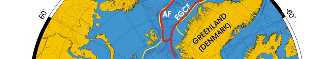
Oceanic Fronts (Belkin et al. 2008)(Figure XI-29.1): Observations of fronts in the open
Arctic Ocean are hampered by perennial ice cover that prevents satellite remote sensing
of fronts in the Arctic Basin. Hydrographic surface and subsurface data collected from
surface vessels, ice drifting stations and submarine revealed a major front in the central
Arctic that separates Atlantic waters from Pacific waters. Until the mid-1990s, this front
was located over the Lomonosov Ridge (LRF). Observations from the late 1990s and
early 2000s have documented a major shift of this front that occurred around 1995.
Since then, the front ran along Mendeleyev-Alpha Ridge (MARF). It is unclear yet if the
front will shift back in the future and if such shifts occurred in the past. In the Nordic Seas,
the water-mass Arctic Front (AF) separates the Greenland and Norwegian Seas, while
the East Greenland Current Front (EGCF) is a shelf-slope front.
Figure XI-29.1. Fronts of the Arctic Ocean LME. Acronyms: AF, Arctic Front; LRF, Lomonosov Ridge
Front; MARF, Mendeleyev-Alpha Ridge Front. Yellow line, LME boundary. After Belkin et al. (2008).
Arctic Ocean LME, Sea Surface Temperature
Linear SST trend since 1957: NA°C.
Linear SST trend since 1982: NA°C.
This LME has been excluded from the analysis (after Belkin, 2008) since it is covered by
sea ice almost year round, therefore SST data are deemed severely contaminated by the
sea ice presence.
XI Arctic
457
II. Fish and Fisheries
The Arctic Ocean LME, along with its surrounding LMEs is unique in that the melting and
freezing of ice creates rich habitats close to the sunlit surface. The wide continental
shelves provide large shallow areas, where freshwater from north-flowing rivers creates
estuarine conditions. There is a limited number of true Arctic species of commercial
importance. Arctic charr (Salvelinus alpinus) occurs throughout the Canadian Arctic, and
have been sighted farther north than any other fish species. In the summer, many stocks
of Arctic charr migrate to the sea, where they have a larger resource base to exploit and
thus are able to grow faster. While at sea, they feed on crustaceans and small fish.
Before winter, these migrants return to the rivers and lakes. Under extreme winter
conditions, they hardly feed at all. Sea mammals abound and are still exploited.
However, the Arctic LME does include waters seasonally ice-free and regularly
commercially fished, both in the Northwest Atlantic (including Davis Strait and Baffin Bay)
and in the Northeast Atlantic (waters north of Iceland and towards Svalbard). Thus,
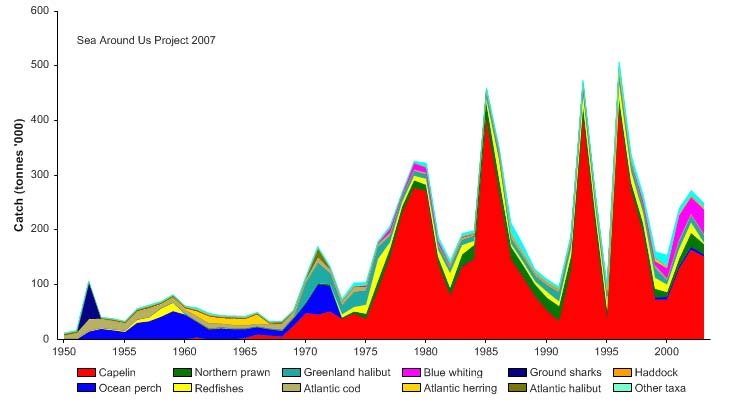
reported landings in the Arctic Sea LME (Figure XI-29.2) are dominated by catches taken
in the Atlantic waters. These reported landings show a series of peaks and troughs
(Figure XI-29.2). From the 1950s to early 1970s, the catch was dominated by ocean
perch and thereafter by capelin. The highest catch of about half a million tonnes,
consisting mainly of capelin, was obtained in 1996.
Only scattered reports are available for the coastal areas around the Arctic Archipelago
off the coastline of Canada bordering the Arctic Sea LME. This coastal region of the
Arctic Ocean has provisionally been designated as LME 65 (PAME 2007) in Figure XI-
29.1. Booth & Watts (2007) have verified the catches from these areas, as reported by
the Canadian Department of Fisheries and Oceans, from the bottom up, i.e., based on
the size of the human populations in coastal communities, and their seafood consumption
patterns. The resultant estimates of catches, which peaked at over 2,500 t in 1960
(driven by feed requirements for sled-dogs subsequently replaced by the snowmobile as
the major form of transport) before declining to around 600-700 t per year in recent years,
are small compared to the reported landings for the current Arctic LME. Nevertheless,
these catches are significant in terms of true arctic fisheries, and will form the
predominant catches for the anticipated new Arctic Archipelago LME. These data for the
new Arctic Archipelago LME can be found at www.seaaroundus.org.
Figure XI-29.2. Total reported landings in the Arctic Ocean LME by species (Sea Around Us 2007).
458
29. Arctic Ocean
III. Pollution and Ecosystem Health
Being away from immediate sources of pollution and shipping and fishing activities, the
Arctic Ocean LME is relatively clean and has intact or slightly disturbed ecosystems
(Lystsov 2006).
The Arctic Ocean is a sink for global pollution because of the flow of oceanic and
atmospheric currents. It is a fragile ecosystem threatened by land-based sources of
pollution, particularly POPs and heavy metals (Lystsov 2006), shipping, dumping and the
exploitation of offshore hydrocarbon. The Alfred Wegener Institute for Polar and Marine
Research observed in 2006, the highest air pollution on record since measurements
began in 1991. The orange-brown `Arctic Haze' over the west coast of Svalbard
contained up to fifty micrograms aerosol per cubic metre air in Ny-Alesund--values
usually measured during rush hour in cities and 2.5 times the concentrations measured
there in spring 2000. Increased warming is expected and climatic variability has already
had a significant impact on this LME (AWI 2006). A State of the Arctic Environment
Report is available at www.amap.no /assess/soaer-cn.htm. Ocean currents transport
contaminants into the Arctic Ocean. The main inflow of water is via the Norwegian
Current into the Barents and Kara seas, and via the West Spitsbergen Current through
Fram Strait into the Arctic Ocean. Persistent contaminants bioaccumulate in plants and
animals and their food webs. Fat, or the ability to gather and store energy as a means of
survival during the dark and cold winter, plays an important role in animal metabolism in
the Arctic. Fat increases biomagnification of fat-soluble contaminants, which is
accentuated in many Arctic animals by their long lives. Airborne pollutants can be
deposited on sea ice, which then melts and releases its pollutant load to the ocean
surface waters (see Pfirman et al. 1995 and 1999). Arctic deep water has an extremely
long residence time. Part of the legacy of the Cold War is environmental contamination,
mostly from nuclear tests at Novaya Zemlya but also from nuclear processing plants such
as Windscale/Sellafield, with chemical and radioactive contaminants (such as iodine,
caesium, plutonium and other radioactive isotopes) working their way into the Arctic food
chain. People who rely on marine systems for food resources are at risk.
Endangered marine species include walruses and whales. Fragile Arctic ecosystems are
slow to change and slow to recover from disruptions or a thinning polar icepack. On 15
May 2006 the Guardian reported record amounts of the Arctic ocean failed to freeze
during the recent winter, and that the sea ice reached an all-time low in March, down
some 300,000 square kilometres from 2005 and said that if the cycle continues, the
recovery of ice in winter will no longer be sufficient to compensate for increased melting
in the summer. The low-lying Arctic coasts of western Canada are particularly sensitive
to sea-level rise. Coastal erosion and retreat as a result of the thawing of ice-rich
permafrost are threatening communities, heritage sites, and oil and gas facilities.
IV. Socioeconomic Conditions
The Arctic Circle of 80° N Latitude encompasses parts of Sweden, Finland, Greenland,
Canada, Russia, the USA (Alaska), the Sverdrup Islands and the Svalbard (Spitsbergen,
Norway). Human settlement consists of small communities, nomadic groups of
indigenous people, and larger communities residing around a harbour, a factory or a
mineral resource. The Arctic coastal areas are among the most sparsely populated in the
world. The region is facing huge socioeconomic challenges and change. All
communities are dependent on the natural resources of this remote and harsh region.
Hunting and fishing are traditional sources of livelihood. In former times, fur seals and
whales were the object of a major trade. Indigenous groups number 1.5 million out of a
total Arctic population of 10 million. These indigenous groups have shown resilience and
an ability to survive changes in resource availability, but may be less well equipped to
XI Arctic
459
cope with the combined impacts of climate change and globalisation. Ice and fish are
critical to the traditional lifestyle of the indigenous populations. As Achim Steiner,
Executive Director of the UN Environment Programme (UNEP), recently said: "The costs
of climate change are already being paid by the peoples and communities of the Arctic"
(Science Daily, April 11, 2007).
The Arctic economy is a mixture of formal economies (commercial harvesting of fish, oil
and natural gas and mineral extraction, forestry, and tourism) and informal subsistence
economies (the harvesting of natural renewable resources such as seals and whales,
with seals, for instance, providing food, heat, light and clothing). Increasingly, the overall
economy is tied to distant markets. For example, in Alaska, gross income from tourism is
US$1.4 billion. Technological advances and climatic change threaten the tradition of
utilising the environment and its renewable resources for survival. The subsistence
economy enters into conflict with the expanded use of natural resources such as oil, gas,
metals and minerals. The growth of tourism will lead to new and more frequently used
navigation routes.
V. Governance
Sweden, Finland, Greenland, Canada, Russia, the U.S. (Alaska), and Norway (Svalbard-
Spitsbergen) border the Arctic Ocean LME. Russia has the longest coastline,
encompassing five adjacent LMEs (Barents, Kara, Laptev, East Siberian and Chukchi
Sea LMEs). Regional governance is important because of the unique character of this
LME. While the Arctic is made up of several large seas, it is essentially a semi-enclosed
ocean shared by the surrounding countries. The fragility of the Arctic Ocean calls for
reinforced efforts among neighbouring states. The Arctic Region has an independent
Regional Seas Programme that has not been established under UNEP, although it
participates in the global meetings of the Regional Seas, shares experiences and
exchanges policy advice and support to the developing Regional Seas Programmes.
In 1991, the Arctic countries adopted an Arctic Environmental Protection Strategy. In
1996, the Arctic Foreign Ministers agreed to the Ottawa Declaration. The Arctic Council
was founded as an intergovernmental forum for cooperation among national
governments and six Arctic indigenous organisations. In 2000, the Council agreed on a
strategic framework for sustainable development and its economic, social and cultural
aspects. The Arctic Monitoring and Assessment Programme (AMAP) presented a
comprehensive report on the state of the Arctic environment in 1998 (www.amap.no/).
The Programme for the Conservation of Arctic Flora and Fauna has finalised an overview
report on biodiversity and conservation in the Arctic, including its marine areas. The
Arctic Council is also engaged in work aimed at enhancing environmental safety in
connection with the transportation of oil and gas. An expert group on Emergency,
Prevention, Preparedness and Response (EPPR) has prepared a circumpolar map of
resources at risk from oil spills in the Arctic. Also a Working Group of the Arctic Council,
the Protection of the Arctic Marine Environment (PAME) has prepared a regional action
plan for the control of land-based sources of Arctic marine pollution. Climate variability
and change will pose challenges to the future prospects of humans and of nature in the
Arctic. To help address these challenges, the Arctic Council has adopted a new, project
on Climate Impact Assessment in the Arctic (ACIA).
References
AMAP (Arctic Monitoring and Assessment Program), State of the Arctic Environment Report at
www.amap.no /assess/soaer-cn.htm.
460
29. Arctic Ocean
AWI (2006) Record air pollution above the Arctic. Press release 11 May 2006. Online at
www.awi.de/en/news/press_releases/.
Belkin, I.M. (2008). Rapid warming of large Marine Ecosystems. Progress in Oceanography, in
press.
Belkin, I.M., Cornillon, P.C., and Sherman, K. (2008) Fronts in large marine ecosystems of the
world's oceans: An atlas. Progress in Oceanography, in press.
Bluhm, B. and Gradinger, R. (2008). Regional variability in food availability for Arctic marine
mammals. Ecological Applications 18(2) Supplement, 2008. pp. S77-S96.
Booth, S. and Watts, P. (2007). Canada's arctic marine fish catches. In: D. Zeller and D. Pauly
(eds.) Reconstruction of marine fisheries catches for key countries and regions (1950-2004).
Fisheries Centre Research Reports 15(2): 3-15.
Bruemmer, F. and Taylor, W.E. (1985). The Arctic World. Sierra Club books.
Carmack, E.C., Aagaard, K., Swift, J.H., Macdonald, R.W., McLaughlin, F.A., Jones, E.P., Perkin,
R.G., Smith, J.N., Ellis, K. and Kilius, L. (1997). Changes in temperature and contaminant
distributions within the Arctic Ocean, Deep-Sea Research II 44:1487-1502.
Cooper, L., Beasley, T., Dolvin, S., Grebmeier, J., Kelley, J., Scott, M. and Johnson-Pyrtle, A.
(1998). The distribution of radiocesium and plutonium in sea ice-entrained Arctic sediments in
relation to potential sources and sinks. Journal of Environmental Radioactivity 39(3):279-303.
Coquery, M., Cossa, D. and Martin, J.M. (1995). The distribution of dissolved and particulate
mercury in three Siberian estuaries and adjacent Arctic coastal waters. Water, Air, and Soil
Pol ution 80:653-664.
Engelhardt, F.R., ed. (1985). Petroleum effects in the Arctic Environment. Elsevier, Amsterdam,
The Netherlands.
Glassner, M.I. (1990). Neptune's Domain: A Political Geography of the Sea. Unwin Hyman.
Gorbunov, Yu.A. and Losev, S.M. (1994). Ice drift features in the northern region of the Laptev and
the East-Siberian Seas and the adjacent Arctic Basin in July-September 1993, Scientific
Results of the expedition LAPEX-93. Gidrometeoizdat, S.Petersburg, Russia. (In Russian).
Huntington, H.P., ed. (2000). Impacts of changes in sea ice and other environmental parameters in
the Arctic. Final report on the Marine Mammal Commission workshop, 15-17 February, 2000,
Girdwood, Alaska, United States.
ICES (2000). Report of the Arctic Fisheries Working Group. ICES CM 2000/ACM:3.
International Ocean Atlas Series (2000). Biological Atlas of the Arctic Seas: Plankton of the Barents
and Kara Seas. NOAA/UNESCO.
Johnston, D.M., ed. (1982). Arctic ocean issues in the 1980s, Proceedings of the Law of the Sea
Institute, Honolulu, U.S.
Krutskikh, B.A. (1978). Main dependences of the Arctic Seas regime variability in natural
hydrological periods. Moskva, Russia. (In Russian).
Layton, D., Vaughn, P., Yarrington, L., Maxwell, R., Preller, R., Bean, J., Carroll, J., Fuhrmann, M.,
Rigor, I., and Tucker, W. (1997). Transport of radionuclides in the Arctic seas, in Layton, D,
Edson, R. and Napier, B. (eds.), Radionuclides in the Arctic Seas from the Former Soviet
Union: Potential Health and Ecological Risks. Arctic Nuclear Waste Assessment Program
(ANWAP). United States Office of Naval Research, Washington D.C., U.S.
Lystsov, V.N. (2006). Arctic Ocean, p. 193- 211 in: UNEP/GPA (2006), The State of the Marine
Environment: Regional Assessments. UNEP/GPA, The Hague.
Maslowski, W, Newton, B., Schlosser, P., Semtner, A. and Martinson, D. (2000). Modeling recent
climate variability in the Arctic Ocean, Geophysical Research Letters 27: 3743-3746.
Matishov, G., Zyev, A., Golubev, V., Adrov, N., Slobodin, V., Levitus, S. and Smolyar, I. (1998).
Climatic Atlas of the Barents Sea 1998: Temperature, Salinity, Oxygen. NOAA Atlas NESDIS
26, Washington D.C., U.S.
Matishov, G.G. and Pavlova, L.G. (1990). General Ecology and Paleogeography of the Polar
Oceans. Nauka, St Petersburg, Russia.
Matishov, G.G., Timofeev, S.F., Drobysheva, S.S. and Ryzhov, V.M. (1994). The Evolution of the
Ecosystems and Biogeography of the European Arctic Seas. Nauka, St Petersburg, Russia.
Melnikov, S.A. and Vlasov, S.V. (1992). A summary report on contaminant levels in the
compartments of the marine environment of the Arctic Seas in 1990, Contaminant levels in the
compartments of the marine environment of the Arctic Seas in 1990. Arctic and Antarctic
Research Institute, St. Petersburg, Russia.
NASA (1992). Arctic and Antarctic Sea Ice, 1978-1987. Satellite passive-microwave observations
and analysis. Washington D.C., U.S.
XI Arctic
461
NASA (2006) Arctic ice meltdown continues with significantly reduced winter ice cover. 13
September 2006, online news feature at www.nasa.gov/centers/goddard/news/topstory/
2006/seaice_meltdown
NGDC (National Geophysical Data Center) at www.ngdc.noaa.gov/mgg/bathymetry/
arctic/arctic.html.
PAME (2007). Program for the Protection of the Arctic Marine Environment. Working Group
Meeting Report No: I-2007. March 6-7, 2007, Copenhagen, Denmark.
Pauly (2005). The Marine Trophic Index. www.seaaroundus.org/doc/saup_manual.htm#19
Pfirman, S., Crane, K., Kane, K. and Simoncelli, T. (1999). The Arctic at Risk: A Circumpolar Atlas
of Environmental Concerns. Defense Fund, New York, U.S.
Pfirman, S., Eicken, H., Bauch, D. and Weeks, W.F. (1995). The potential transport of pollutants by
Arctic sea ice. Science of the Total Environment 159:129-146.
Pharand, D. (1986). L'Arctique et le droit international de la mer, in L'Arctique: Espace strategique
vital pour les grandes paissances. Centre Quebecois des Relations Internationales, Colloque
d'etudes strategiques et militaires, Canada.
PMEL (Pacific Marine Environmental Laboratory) at www.pmel.noaa.gov/pubs/PDF/rich2952
/rich2952.pdf
Rey, L., ed. (1982). The Arctic Ocean: The Hydrographic Environment and the Fate of Pollutants.
Macmillan, London, U.K.
Sakshaug, E. and Holm-Hansen, O. (1984). Factors governing pelagic production in polar oceans,
p 1-18 in: Holm-Hansen, O., Bolis, L. and Gilles, R. (eds.), Marine Phytoplankton and
Productivity. Springer Verlag, Berlin, Germany.
Sakshaug, E. and Skjoldal, H.R. (1989). Life at the ice edge. Ambio 18:60-67.
Sakshaug, E., Hopkins, C.C.E. and Oritsland, N.A. (1991). Proceedings of the Pro Mare
Symposium on Polar Marine Ecology, Trondheim, Norway. Polar Research 10:1-662.
Science Daily. 2007. IPCC Report The Arctic: Thawing Permafrost, Melting Sea Ice and More
Significant Changes. UNEP, Intergovernmental Panel on Climate Change, April 11, 2007
online at www.sciencedaily.com/releases/2007/04/070410140922.htm
Sea Around us (2007). A Global Database on Marine Fisheries and Ecosystems. Fisheries Centre,
University British Columbia, Vancouver, Canada.
www.seaaroundus.org/lme/SummaryInfo.aspx?LME=64
Skjoldal, H.R. (1990). Management of marine living resources in a changing ocean climate p 1-7 in
Papers presented on the session "Research on natural resources management" of the
Conference "Sustainable Development, Science and Policy", Bergen 8-12 May 1990. Bergen
Foundation of Science Rep. No. BFS A90005.
UNEP (2004). Pedersen, S.A., Madsen, J. and Dyhr-Nielsen, M. Arctic Greenland, East Greenland
Shelf, West Greenland Shelf, GIWA Regional Assessment 1b, 15, 16. University of Kalmar,
Kalmar, Sweden. www.giwa.net/publications/r1b_15_16.phtml
UNEP (2005). Tsyban, A.V., Titova, G.D., Shchuka, S.A., Ranenko, V.V. and Izrael, Y.A. Russian
Arctic, GIWA Regional Assessment 1a., University of Kalmar, Kalmar, Sweden.
www.giwa.net/publications/r1a.phtml
462
29. Arctic Ocean
XI Arctic
463
XI-30 Beaufort Sea LME
M.C. Aquarone and S. Adams
The Beaufort Sea LME is a high-latitude LME bordered by northern Alaska and Canada.
It has a surface area of about 770,000 km2, of which 0.02% is protected, and contains
0.1% of the world's sea mounts (Sea Around Us 2007). An Arctic climate and extreme
environment characterise the LME, which is driven by major seasonal and annual
changes in Arctic climate conditions and is ice-covered for most of the year. The
anticyclonic Beaufort Gyre forms a clockwise drift pattern. Carleton Ray & Hayden
(1993), describe marine biogeographic provinces of the Bering, Chukchi and Beaufort
Seas.
I. Productivity
During much of the year light penetration is limited because of ice cover. Productivity is
relatively high only in the summer when the ice melts. As a whole, the Beaufort Sea is
considered oligotrophic. However, the coastal region supports a wide diversity of
organisms, some of which are unique to this coast. The Beaufort Sea coastal areas
provide habitat for ducks, geese, swans, shorebirds and marine birds. Many species of
birds and fish rely on river deltas, estuaries, spits, lagoons and islands in the coastal
waters for breeding, food, shelter and rearing their young. The Beaufort Sea LME is
considered a Class I, high productivity ecosystem (>300 gCm-2yr-1). An important
question is how this productivity might change under an altered climatic regime.
Melnikov et al. (2002) compared data from 1997-1998 with older data from 1979-1980 to
find a drastically impoverished fauna of late. This change may have been associated with
the high phase of the Arctic Oscillation in the early 1990s, accompanied by increased
melting, runoff increase, and freshening of the upper layer, As a result, diatoms became
scarce, replaced by freshwater green algae, while nematodes, copepods, amphipods and
turbellarians all disappeared. It becomes clear that the biological community response to
global change is most likely in the regions, where the sea ice retreat is rather remarkable,
e.g., in the region of Beaufort Gyre. For data on selected invertebrates, fishes, birds and
mammals, see Carleton Ray & Hayden (1993).
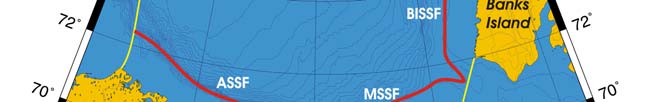
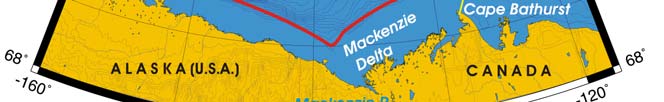
Oceanic fronts (Belkin et al. 2008)): The Shelf Break/Shelf-Slope Front (SSF) is the
most robust front within this LME (Figure XI-30.1). This front extends along the shelf
break and upper continental slope. The front's stability is at maximum where the shelf
break is best defined and where the upper slope is the steepest, e.g. off Cape Bathurst in
the Canadian Beaufort Sea (Belkin et al., 2003; Belkin et al., 2008).This place is well
known as the site of Cape Bathurst Polynya and also a "hot spot" of marine life where
sea birds and marine mammals congregate. Transient fronts form at the dynamic
boundary of the Mackenzie River plume and also within this plume (Belkin et al. 2008).


464
30. Beaufort Sea LME
Figure XI-30.1. Fronts of the Beaufort Sea LME. ASSF, Alaskan Shelf-Slope Front; BISSF, Banks Island
Shelf-Slope Front; MSSF, Mackenzie Shelf-Slope Front. Yellow line, LME boundary. After Belkin (2005)
and Belkin et al. (2008).
Beaufort Sea LME SST (after Belkin, 2008)
Linear SST trend since 1957: 0.17°C.
Linear SST trend since 1982: 0.34°C.
The Beaufort Sea warming was slow-to-moderate. Its annual variability was rather small,
<0.5°C. The only significant event occurred in 1998, when SST peaked at -0.6°C, a
whole degree above the all-time maximum of -1.6°C. A comparison of the SST time
series with the Arctic Oscillation (AO) index (Climate Prediction Center 2007) suggests a
strong correlation between SST and the AO index, with negative SST anomalies
corresponding to positive values of AO index.
Figure XI-30.2a. Beaufort Sea LME Annual Mean Sea Surface Temperature (SST) (left) and Annual SST
anomalies (right), 1957-2006, based on Hadley climatology. After Belkin. (2008).
XI Arctic
465
Figure XI-30.2b.The standardized seasonal mean Arctic Oscillation (AO) index during cold season (blue
line) is constructed by averaging the daily AO index for January, February and March for each year. The
black line denotes the standardized five-year running mean of the index. Both curves are standardized
using 1950-2000 base period statistics (Climate Prediction Center, 2007).
Beaufort Sea LME Chlorophyll and Primary Productivity: The Beaufort Sea LME is
considered a Class I, high productivity ecosystem (>300 gCm-2yr-1).
Figure XI-30.3. Beaufort Sea LME trends in chlorophyll a and primary productivity, 1998-2006. Values
are colour coded to the right hand ordinate. Figure courtesy of J. O'Reilly and K. Hyde. Sources
discussed p. 15 this volume.
II. Fish and Fisheries
NOAA statistics on Alaska in `Our Living Oceans' apply to all of Alaska, without a specific
statistical breakdown for the U.S. section of the Beaufort Sea LME. For statistics on the
beluga and other marine mammals in the Beaufort Sea, see NOAA (1999). There are
three coastal communities (Tuktoyaktuk, Sachs Harbour and Kaktovik) and two inland
communites (Aklavik and Inuvik) that make use of the Beaufort Sea, largely for
subsistence, but also some commercial fisheries occur in Canadian waters. Catches in
1950 were estimated to be approximately 167 tonnes before peaking in 1960 at
approximately 255 tonnes and in 2001 catches were estimated at approximately 58
tonnes. Important species include Dolly varden (Salvelinus malma), whitefish
(Coregonidae) and two other species Inconnu (Stenodus leucichthys) and Pacific herring
(Clupea pallasii) are of lesser importance.
466
30. Beaufort Sea LME
160
140
120
)
.
100
e
s
n
(ton
80
s
nding
60
La
40
20
0
1950
1960
1970
1980
1990
2000
Year
Broad whitefish
Whitefish
Inconnu
Pacific herring
Dolly varden
Charr
Starry flounder
Polar cod
Saffron cod
Salmon
Fourhorn sculpin
Mixed group
Figure XI-30.4. Total estimated catches (subsistence fisheries) in the Beaufort Sea LME (Sea Around Us
2007)
Due the tentative nature of these catch estimates, no indicators based on these data will
be presented (but see Sea Around Us 2007)
The benthic offshore community includes Arctic cod, saffron cod, eelpouts and sculpins
(Frost and Lowry 1983; Moulton and Tarbox 1987; Barber et al 1997; Jarvela and
Thorsteinson 1999). Arctic cod is a particularly important component of the food web of
the Beaufort Sea because they are prey for seals, seabirds and beluga whales
(Bradstreet et al. 1986). Smelt are thought to be one of the most common pelagic marine
fish in the Beaufort Sea and are prey for beluga whales, arctic cod and marine birds
(Norton and Weller 1984). Large winter aggregations of Arctic cod have been recently
discovered hydroacoustically under sea ice cover in Franklin Bay, SE Canadian Beaufort
Sea (Benoit et al., 2008). The estimated total biomass of cod would amply satisfy the
requirements of predators, mostly seals. Thus, "dense accumulations of Arctic cod in
embayments in winter likely play an important role in structuring the ecosystem of the
Beaufort Sea." (Benoit et al., 2008).
III. Pollution and Ecosystem Health
Valette-Silver, M.J. Hameedi, D.W. Efurd and A. Robertson reported in 1999 that,
"surficial sediments in the western Beaufort Sea contained generally high concentrations
of arsenic (up to 58 ppm as corrected for grain size), very low amounts of organo-chlorine
compounds and concentrations of total polycyclic aromatic hydrocarbons (PAHs) ranging
from 160 to 1100 ng/dry weight. Invertebrates contained higher concentrations of total
PAHs than fish, with naphthalene being the largest contributor. "Diagnostic ratios of
various PAH compounds in our samples do not suggest crude oil as the main source of
PAHs." Other sources of PAHs to the region include rivers outflow, coastline erosion, oil
seeps, diagenesis, and long-range atmospheric transport. "Organochlorine contaminants
were consistently found in our samples at concentrations generally Iower than those
found in other parts of the United States." Cesium (Cs) was found in measurable
amounts in all sediments and biota samples. Isotopic ratios showed that radionuclides
originated most likely from global fallout. Compared to other coastal areas off Alaska, the
Arctic, and the conterminous United States, Beaufort Sea contamination appears
generally low."
XI Arctic
467
There is increasing global concern regarding the effect of changes in the Arctic climate
on fish, marine mammals and associated wildlife, and regarding the socioeconomic
impacts of these changes. Changes in water flow, the transport of nutrients through the
Bering Strait and the loss of ice habitat caused by global warming will have an effect on
all the living resources of this LME. Oil and gas exploration, extraction and transport, and
new drilling projects targeting oil and gas in the Alaskan Beaufort Sea require constant
monitoring. Recommended impact assessments include analyses of potential mortality in
the event of spills, damage to food sources, production-related changes in marine
mammal distribution, movement, and abundance, and additionally, the risks and effects
of exposure of native people to contaminants in whales and other marine mammals from
the oil industry. Pollution and acoustical disturbance from vessel traffic on the proposed
Northern Sea Route are also concerns.
IV. Socioeconomic Condition
Economic activity is mostly concerned with the exploitation of natural resources
(petroleum, natural gas, fish and seals). Fishing contributes to the economy and
provides protein for the region's native people. The Inupiat catch fish and bowhead
whales, while the Inuvialuit catch several species of marine mammals. Ringed seals
were once important to the local cash economy, but the market for seal pelts has largely
disappeared. Whaling, however, continues to be a key subsistence activity. Oil has
been discovered in Prudhoe Bay, but offshore oil production costs are higher in the Arctic
than elsewhere. The Northstar Project targets oil in the Alaskan Beaufort Sea, but
scientists recommend that it should consider native hunters and consumers of whales in
the area. Whales and other marine mammals are vulnerable to contaminants from the oil
industry. Protection of the region's lifestyle is a major socioeconomic theme, as is the
need to protect and preserve the Arctic wildlife, its environment and biological
productivity.
V. Governance
The Beaufort Sea LME is bordered by Alaska (USA), the Yukon Territory, the Inuvik
Region and part of the Northwest Territories (Canada). There are transboundary issues
that need to be addressed by both countries. Fisheries governance in Alaska comes
under the Alaska Department of Fish and Game. In Canada, self-government is being
negotiated by two native groups, the Inuvialuit and Gwich'in, to ensure that they retain
control over their inherent rights and preserve their cultural identity and values within a
changing northern society. A Beaufort Sea Beluga Management Plan was developed in
1993 by the Fisheries Joint Management Committee. The goals of the plan were to
maintain a thriving population of beluga whales and a sustainable harvest of beluga for
the Inuvialuit people. In this volume, the Barents Sea LME (Chapter XIII-36) contains
additional information on Arctic governance.
References
Aagaard, K. (1984). The Beaufort undercurrent, p 47-71 in: Barnes, P. and Reimnitz, E. (eds), The
Alaskan Beaufort Sea: Ecosystems and Environment, Academic Press, New York, United
States.
Barber, W.E., R.L. Smith, M. Vallarino, and R.M. Meyer (1997). Demersal fish assemblages of the
northeastern Chukchi Sea, Alaska. Fish. Bull. 95: 195-209.
Belkin, I.M. (2008) Rapid warming of Large Marine Ecosystems, Progress in Oceanography, in
press.
468
30. Beaufort Sea LME
Belkin, I.M., P.C. Cornillon, and D. Ullman (2003). Ocean fronts around Alaska from satellite SST
data, Proceedings of the Amer. Met. Soc. 7th Conf. on the Polar Meteorology and
Oceanography, Hyannis, MA, Paper 12.7, 15 pp.
Belkin, I.M., Cornillon, P.C., and Sherman, K. (2008) Fronts in Large Marine Ecosystems of the
world's oceans: Progress in Oceanography,in press.
Benoit, D., Simard, Y., Fortier, L. (2008). Hydroacoustic detection of large winter aggregations of
Arctic cod (Boreogadus saida) at depth in ice-covered Franklin Bay (Beaufort Sea) J. Geophys.
Res., Vol. 113, No. C6, C06S90 http://dx.doi.org/10.1029/2007JC004276 12.
Bradstreet MSW, Finley KJ, Sekerak AD, Griffiths WB, Evans CR, Fabijan MF, Stallard HE (1986).
Aspects of the biology of arctic cod (Boreogadus saida) in arctic marine food chains. Canad.
Techn. Rep. Fish. Aquat. Sci. No.1491
Carleton Ray, G. and Hayden, B.P. (1993). Marine biogeographic provinces of the Bering, Chukchi,
and Beaufort Seas, p 175-184 in: Sherman, K. Alexander, L.M. and Gold B.D. (eds), Large
Marine Ecosystems: Stress, mitigation, and sustainability. AAAS Press, Washington, DC.
Climate Prediction Center, National Weather Service (2007) Monitoring weather and climate,
www.cpc.ncep.noaa.gov/products/precip/CWlink/ dailyaoindex/season.JFM.ao.gif
Frost, K.J., and L.F. Lowry (1983). Demersal fishes and invertebrates trawled in the northeastern
Chukchi and western Beaufort seas 1976-1977. U.S. Dep. Commer., NOAA Tech. Rep. NMFS-
SSRF-764, 22 p.
Jarvela, L.E. and L.K. Thorsteinson (1999). The Epipelagic Fish Community of Beaufort Sea
Coastal Waters, Alaska. Arctic 52, No. 1: 80-94.
Lister, C.R.B. (1987). Geothemal resources, p 739-751 in: Scholl, D.W., Grantz, A. and Vedder,
J.G., (eds). Geology and Resource Potential of the Continental Margin of Western North
America and Adjacent Ocean Basins Beaufort Sea to Baja California Houston Texas. Circom-
Pacific Council for Energy and Mineral Resources, Earth Science Series.
Melnikov, I.A. and L.G. Kolosova, H.E. Welch, L.S. Zhitina (2002). Sea ice biological communities
and nutrient dynamics in the Canadian Basin of the Arctic Ocean. Deep-Sea Research Part II,
49: 1623-1649.
Moulton, L.L. and K.E. Tarbox (1987). Analysis of Arctic Cod Movements in the Beaufort Sea
Nearshore Region, 1978-79. Arctic, Vol. 40 (1): 43-49.
NOAA (1999). Our living oceans Report on the Status of U.S. Living Marine Resources. U.S.
Department of Commerce , Washington, D.C.
Norton, D. and Weller, G. (1984) The Beaufort Sea: Background, History, and Perspective. Pp. 3-
22. In: Barnes, P.W., Schell, D.M., and Reimnitz, E. (eds), The Alaska Beaufort Sea. Academic
Press, Orlando.
Padman, L. and Dillon, T.M. (1987). Vertical fluxes through the Beaufort Sea thermohaline
staircase. Journal of Geophysical Research 92:10799-10806.
Sea Around Us (2007). A Global Database on Marine Fisheries and Ecosystems. Fisheries Centre,
University British Columbia, Vancouver, Canada. www.seaaroundusorg/ lme/ SummaryInfo.
aspx?LME=55
Valette-Silver, N., Hameedi, M.J., Efurd, D.W. and Robertson, A. (1999). Status of the
contamination in sediments and biota from the western Beaufort Sea (Alaska). Mar. Pollut. Bull.
38(8):702-722.
XI Arctic
469
XI-31 Chukchi Sea LME
S. Heileman
The Chukchi Sea LME is a high-latitude system situated off Russia's East Siberian coast
and the northwestern coast of Alaska. This LME is a relatively shallow marginal sea with
a surface area of 776,643 km2 , of which 5.4% is protected (Sea Around Us 2007), and
an extensive continental shelf. According to the Atlas of the Oceans (USSR Navy, 1980),
the Chukchi Sea alone has the surface area of 595,000 km2, water volume of 42,000
km3, and total water catchment area of 261,500 km2. Total river runoff is less than 100
km3. An arctic climate and major seasonal and annual changes in ocean climate, in
particular the annual formation and deformation of sea ice, characterise this LME. The
ice-free zone of the summer is about 150-200 km wide, the position of the ice edge being
determined by northward flowing streams of Pacific water through the Bering Straits
(Muench 1990). The ice cover of the Arctic Seas plays an important role in the Earth's
climate formation. Additional descriptions of the Chukchi Sea LME are found in Carleton
Ray & Hayden (1993) and UNEP (2005).
I. Productivity
Primary production from in situ data varies between 150-300 gCm-2yr-1, while maximum
concentration of zooplankton can be as high as 1300 mg m-3 (Lukianova 2005; Vetrov
and Romankevich 2004). Benthos biomass in this LME is higher than elsewhere in the
Arctic, up to 500 g m-2 (Lukianova 2005). The total biomass of this LME is 120 million
tonnes, while the annual production is 4.1 million tonnes of carbon (Vetrov and
Romankevich 2004). Most of the nutrients come from the Pacific water, although
upwelling of nutrient-rich bottom water, such as in Lancaster Sound, also creates
favourable conditions for phytoplankton growth. The annual formation and melting of sea
ice influence the productivity of this LME by releasing nutrients to the melt water. In
addition, seasonal faunal shifts between winter and summer (e.g., salmon, migratory
birds and mammals) have been described (Carleton Ray & Hayden 1993). In this
volume, the Barents Sea LME chapter presents additional information on the biodiversity
AND FOOD WEB OF Arctic Seas.
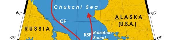
Oceanic fronts: Five fronts are found within this LME (Belkin et al. 2003; Belkin et al.
2008) (Figure XI-31.1). The Kotzebue Sound Front (KSF) bounds the northward Bering
inflow. Low-salinity Bering Sea waters flow around Chukotka northwestward along the
Chukotka Front (CF) toward Herald Valley. The Siberian Coastal Current/Front (SCCF)
enters the Chukchi Sea through Long Strait, rounds Wrangel Island and continues
northward via Herald Valley. The Herald Shoal Front (HSF) is situated over the steep
southern slope of the namesake shoal. A stable front extends along Barrow Canyon
(BCF).
Chukchi Sea LME SST (after Belkin 2008)(Figure XI-31.2)
Linear SST trend since 1957: 0.58°C.
Linear SST trend since 1982: 0.70°C.
The long-term warming of the Chukchi Sea over the last 50 years was modulated by
strong interannual variability, with a magnitude of about 0.5-1.0°C, as well as decadal
variability and at least one regime shift. Two regimes can be distinguished: (1) overall
cooling until 1983; (2) overall warming since 1983. The long-term warming accelerated


470
31. Chukchi Sea LME
after the all-time minimum of -1.0°C in 1983, and by 2005 SST reached 0.3°C, a 1.3°C
increase over 22 years. Even though the Chukchi Sea is affected by warm water influx
from the Bering Sea through the Bering Strait, this influx apparently is not critical for the
Chukchi Sea thermal regime. This is evidenced by the lack of Chukchi Sea manifestation
of the 1976-77 North Pacific regime shift, which was quite abrupt in the Bering Sea, in
both East and West Bering Sea LMEs. The impact of the Bering Sea inflow is two-fold,
since this inflow consists of two components, eastern and western, with potentially
different thermal signatures (Weingartner et al. 2005; Woodgate et al. 2006).
Figure XI-31.1. Fronts of the Chukchi Sea LME. BCF, Barrow Canyon Front; CF, Chukotka Front; HSF,
Herald Shoal Front; KSF, Kotzebue Sound Front; SCCF, Siberian Coastal Current Front. Yellow line,
LME boundary. After Belkin et al., 2003; Belkin et al., 2008).
Figure XI-31.2. Chukchi Sea LME Mean Annual Sea Surface Temperature (SST; left) and SST anomalies
(right), 1957-2006, based on Hadley climatology. After Belkin (2008).
XI Arctic
471
Chukchi Sea LME Chlorophyll and Primary Productivity: The Chukchi Sea LME is
considered a Class II, moderately high productivity ecosystem (150-300 gCm-2yr-1).
Figure XI-31.3. Chukchi Sea LME trends in chlorophyll a (left) and primary productivity (right), 1998-
2006. Values are colour coded to the right hand ordinate. Figure courtesy of J. O'reilly and K. Hyde.
Sources discussed p. 15 this volume.
II. Fish and Fisheries
Key marine species in this LME are salmon (Oncorhynchus spp.), herring (Clupea pallasii
pallasii), walrus (Odobenus rosmarus), seals, whales (Greenland whale, blue whale, killer
whale, beluga/belukha whale, and humpback whale being most common) and various
species of waterfowl. Total annual catch shows dramatic oscillations on the scale of two-
to-three years (Figure XI-31.4). Some of these oscillations are probably due to the impact
of varying ice and weather regimes, whereas others may have been caused by the
internal dynamics of this ecosystem. The key subsistence marine species are likely to
undergo shifts in range and abundance due to climate change. The central and eastern
Arctic Seas do not have a significant fishing industry, except near coastal areas. There is
no evidence of overfishing in this LME (UNEP 2005).
As salmon extends its range into the Arctic, and walleye pollock into the northern Bering
Sea, "the North Pacific Fishery Management Council has begun to develop an Arctic
Fishery Management Plan that will provide a framework for future commercial fishing in
the Chukchi Sea. Presently, the precautionary approach keeps the fishery closed while
scientific data can be collected and assessed." (Alaska Climate Impact Assessment
Commission 2008, p.21).
Very scarce data are available from the Russian part of the Chukchi Sea, which is only
sparsely populated. Pauly & Swartz (2007) estimated a fish catch of 100 tonnes per year
for the period 1950-2004, consisting overwhelmingly of salmonids. Catch figures are not
transferred to FAO.
Salmonids also dominate the catches from the Alaskan part of the Chukchi Sea, i.e.,
taken north of Cape Prince of Wales on the Seward Peninsula, which are collected from
commercial, subsistence and sport fisheries by Alaska's Department of Fish and Game.
The catches from the Alaskan Chukchi Sea were assembled by S. Booth and D. Zeller
(Sea Around Us Project, unpublished data), and added to the catch estimate from the
472
31. Chukchi Sea LME
Russian part of the Chukchi Sea. This resulted in Figure XI-31.4. As can be seen, the
overall catch from the Chukchi Sea range fluctuate between 500 tonnes and 3,000
tonnes and consists predominantly of salmonids.
3500
3000
2500
)
.
es
n 2000
n
(to
s
g
i
n 1500
Land
1000
500
0
1950
1960
1970
1980
1990
2000
Year
Chum salmon
Whitefish
Inconnu
Dol y varden
Pink salmon
Cods
Pacific herring
Flounders
Smelts
Coho salmon
Bering cisco
Mixed group
Figure XI-31.4. Total estimated catches (subsistence fisheries) in the Chukchi Sea LME (Sea Around us
2007)
Due the tentative nature of these catch estimates, no indicators based on these data will
be presented (but see Sea Around Us 2007).
III. Pollution and Ecosystem Health
Pollution: Pollution in the Chukchi Sea LME is generally slight and attributed mainly to
chemicals and oil spills (UNEP 2005). In spite of the considerable remoteness from
major economic activities, heavy metals, aromatic and chlorinated hydrocarbons, as well
as new contaminants (endosulfan, bromoform, dibromomethane, etc.) have been
discovered over the last few years in the Chukchi Sea LME. According to the data of the
Arctic Monitoring Regional Centre, a broad spectrum of trace metals was found in the
surface waters of the Chukchi Sea (GOIN 1996a-d, Roshydromet 1997-2002).
The distribution of organic pollutants in this LME has become increasingly pronounced
over the past decade (Izrael & Tsyban 1992, 2000, Tsyban 1999, Roshydromet 2001).
Great concern is caused by pollution of the Chukchi shelf by PCBs. Although their
atmospheric content decreased in 1993 compared to 1988, the concentrations of these
toxicants in the LME waters remained unchanged. The PCB content of the bottom
sediments has doubled between 1988 and 1993 (Hinckley et al. 1992, Izrael & Tsyban
2000). This fact is indicative of accumulations of organochlorines in the Chukchi Sea
LME. It is noteworthy that the long residence times of these compounds (several
decades) in the marine environment determines their active circulation along food webs
and accumulation in hydrobionts, including trade organisms. At present, it is believed
XI Arctic
473
that hexachlorocyclohexanes (HCHs) rank among the most widespread chlorinated
pesticides in the Arctic seas (Bidleman et al. 1995). For example, the HCH content of
water samples from the Chukchi Sea LME exceeds that of other chlorinated
hydrocarbons such as PCBs and DDT.
A serious concern arises from prospecting and production of oil and gas on the Chukchi
shelf. Exploration and industrial drilling impact the pelagic and bottom systems in a
number of ways, including the hazardous consequences of seismic prospecting and
pollution of water and bottom sediments by drilling fluids and slurries, oil, copper and
other metals pollution. In all the components of the Chukchi Sea ecosystem,
benzo(a)pyrene, an indicator of carcinogenic PAHs, has been found. The coefficients of
benzo(a)pyrene accumulation in particulate matter and in biota proved to be high (Izrael
& Tsyban 1992, Tsyban 1999, Izrael & Tsyban 2000, Roshydromet 1997-2002).
Contaminants are endangering marine mammals such as walruses and whales
(Reynolds III et al. 2005).
Habitat and community modification: The coastal areas of the Chukchi Sea LME are
thought to be in relatively pristine condition due to the sparse human population and the
region's general remoteness. There are no records of serious habitat loss in the region,
but there is evidence of localised degradation of some habitats. Habitat and community
modification were assessed as slight and mainly attributed to pollution (UNEP 2005).
Climate change is expected to have a profound ecological impact in the Arctic LMEs.
The Arctic climate is warming rapidly and much larger changes are expected (ACIA
2004). Species ranges are projected to shift northward on both land and sea, bringing
new species into the Arctic while severely limiting some species currently present,
leading to the possible extinction of some species. Salmon, herring, walrus, seals and
whales are likely to undergo shifts in range and abundance. On the other hand, some
arctic marine fisheries are likely to become more productive (ACIA 2004). A major issue
is the thinning polar ice pack. Ice and climate records show climate warming occurring in
the southern section of the LME. Climate change and receding sea ice are affecting the
distribution, migration patterns and abundance of some wildlife species.
At present the transboundary waters of the Chukchi Sea LME are in relatively healthy
condition (UNEP 2005). This may change, however, as a result of the rapid development
of the oil and gas industry on the Arctic shelf, the increased volume of oil and gas
transport as well as the accidental introduction of alien species with ship ballast water.
Management and development of the Chukchi Sea LME must take account of the
impacts of climate change.
IV. Socioeconomic Conditions
The coastal zone of the LME is mostly inhabited by indigenous peoples, most of whom
live in rural areas. Economic activity focuses on fisheries and the exploitation of
petroleum and natural gas. Contaminant levels in some Arctic indigenous groups can be
10 - 20 times higher than in most temperate regions (AMAP 1997). Heavy metals, PAHs
and other persistent toxic substances have a strong mutation effect in humans.. The
potential impact of rapid climate change could put the native human communities at risk.
The impact of recent climate warming is reflected in marine hunting data. This has
improved conditions for native hunting of walrus but has adversely impacted other human
activities (Mulvaney 1998). For instance, when sea ice is forming late, certain types of
hunting are delayed or may not take place at all. On the other hand, when sea ice melts
too quickly in the spring, it greatly decreases the length of the hunting season. There
have been substantial shifts in native hunting practices, subsistence activities and the
consumption of marine products on the Chukchi Peninsula during the last decade. The
474
31. Chukchi Sea LME
growth of poverty and unemployment in the coastal areas of the Russian Arctic seas is
closely connected with the destruction of natural systems and the loss of traditional types
of natural resource management.
V. Governance
The Chukchi Sea LME is bordered by Russia and the U.S. Any consultative framework
to manage the marine resources of the Arctic LMEs requires attention to the culture and
economy of indigenous peoples. Stakeholders in the Chukchi Sea LME include the Inuit
Circumpolar Conference and the Council of Elders of the Chukchi of Arctic Russia. In
September 1996, eight Arctic countries signed the Ottawa Declaration, under which the
Arctic Council Board, an international forum of the Arctic countries, was created. This
Board is an instrument for addressing Arctic pollution problems, in particular, those
related to sustainable development and Arctic environment protection.
The protection of nature in the Arctic, including of the Chukchi Sea LME, is regulated by
several international agreements and conventions. See the Barents Sea LME (Chapter
XIII-36) for more information on Arctic governance. GEF is supporting two projects in the
region. One project supports a National Plan of Action in the Russian Federation for the
Protection of the Arctic Marine Environment from Anthropogenic Pollution (Phase 1).
This project focuses on pre-investment studies of identified priority hot spots with known
significant transboundary consequences, with additional activities to include necessary
support through the development of legal, institutional and economic measures. The
other project, `Integrated Ecosystem Approach to Enhance Biodiversity Conservation and
Minimise Habitat Fragmentation in Three Selected Model Areas in the Russian Arctic',
will develop and implement integrated ecosystem management strategies in the Russian
Arctic and strengthen stakeholder capacity in sustainable biodiversity management.
Chapter XIII-36, Barents Sea LME, presents additional information on Arctic governance.
References
ACIA (2004). Impacts of a Warming Arctic. Arctic Climate Impact Assessment. University Press,
Cambridge, U.K.
Alaska Climate Impact Assessment Commission (2008). Final Commission Report, Alaska State
Legislature, March 17, 2008. http://www.housemajority.org/coms/cli/cli_final report_20080301
.pdf
AMAP (1997). Arctic Pollution Issues: A State of the Arctic Environment Report. Arctic Monitoring
and Assessment Program, Oslo, Norway.
Belkin, I.M. (2008) Rapid warming of Large Marine Ecosystems, Progress in Oceanography, in
press.
Belkin, I.M., Cornillon, P.C., and Sherman, K. (2008) Fronts in Large Marine Ecosystems of the
world's oceans: Progress in Oceanography, in press.
Belkin, I.M., P.C. Cornillon, and D. Ullman (2003). Ocean fronts around Alaska from satellite SST
data, Proceedings of the Amer. Met. Soc. 7th Conf. on the Polar Meteorology and
Oceanography, Hyannis, MA, Paper 12.7, 15 pp.
Bidleman, T.F., Jantunen, L.M. Falconer, R.L., Barrie, L.A. and Fellin, P. (1995). Decline of
hexachloro-cyclohexanes in the Arctic atmosphere and reversal of the air-water gas exchange.
Geophysichal Research Letters 22(3):219-222.
Carleton Ray, G. and Hayden, B.P. (1993). Marine biogeographic provinces of the Bering, Chukchi
and Beaufort Seas, p 175-184 in: Sherman, K., Alexander, L.M. and Gold, B.D (eds), Large
Marine Ecosystems Stress, Mitigation and Sustainability. AAAS Press, U.S.
GOIN (1996a). Annual of Marine Water Quality with Respect to Hydrochemical Indices for 1992.
Obninsk, Russia. (In Russian).
XI Arctic
475
GOIN (1996b). Annual of Marine Water Quality with Respect to Hydrochemical Indices for 1993.
Obninsk, Russia. (In Russian).
GOIN (1996c). Annual of Marine Water Quality with Respect to Hydrochemical Indices for 1994.
Obninsk, Russia. (In Russian).
GOIN (1996d). Annual of Marine Water Quality with Respect to Hydrochemical Indices for 1995.
Obninsk, Russia. (In Russian).
Hinckley, D.A., Bidleman, T.F. and Rice, C.P. (1992). Long-range transport of atmosphere
organochlorine pollutants and air-sea exchange of hexachloro-cyclohexane, in: Nagel, P.A.
(ed), Results of the Third Joint US-USSR Bering and Chukchi Seas Expedition (BERPAC),
Summer 1988, US Fish and Wildlife Service, Washington D.C., U.S.
Izrael Yu.A. and Tsyban, A.V., eds. (2000). Dynamic of the Bering and Chukchi Seas
Ecosystems.Nauka Publishing House, Russia. (In Russian).
Izrael, Yu.A. and Tsyban, A.V., eds. (1992). Investigation of the Ecosystems of the Bering and
Chukchi Seas. Issue 3. Gidrometeoizdat, St.Petersburg, Russia. (In Russian).
Lukianova, T.S. (2005) Estimation of bottom fauna biomass distribution in the Arctic Ocean.
Proceedings of the XII Congress of the Russian Geographic Society, St.Petersburg, vol.5, pp.
124-129 (in Russian).
Muench, R.D. (1990). Mesoscale phenomena in the polar oceans, p 223-285 in: Polar
Oceanography. Part A. Physical Science. Academic Press, San Diego, U.S.
Mulvaney, K. (1998). Arctic voices: Global warming is changing the traditional Eskimo environment.
New Scientist 160(2160):55.
Pauly, D. and Swartz, W. (2007) Marine fish catches in North Siberia (Russia, FAO Area 18). p. 17-
33 In Zeller, D. and Pauly, D.(eds.) Reconstruction of marine fisheries catches for key countries
and regions (1950-2005). Fisheries Centre Research Reports 15(2). Fisheries Centre,
University of British Columbia, Vancouver.
Reynolds III, J.E., W. F. Perrin, R. R. Reeves, S. Montgomery, and T. J. Ragen (editors) (2005)
Marine Mammal Research: Conservation Beyond Crisis, JHU Press, Baltimore, MD, 240 pp.
Roshydromet (1997). Review of the Environmental Pollution of the Russian Federation for 1996. M.
Roshydromet, Moscow, Russia. (In Russian).
Roshydromet (1998). Review of the Environmental Pollution of the Russian Federation for 1997. M.
Roshydromet, Moscow, Russia. (In Russian).
Roshydromet (1999). Review of the Environmental Pollution of the Russian Federation for 1998. M.
Roshydromet, Moscow, Russia. (In Russian).
Roshydromet (2000). Review of the Environmental Pollution of the Russian Federation for 1999. M.
Roshydromet, Moscow, Russia. (In Russian).
Roshydromet (2001). Review of the Environmental Pollution of the Russian Federation for 2000. M.
Roshydromet, Moscow, Russia. (In Russian).
Roshydromet (2002). Review of the Environmental Pollution of the Russian Federation for 2001. M.
Roshydromet, Moscow, Russia. (In Russian).
Sea Around Us (2007). A Global Database on Marine Fisheries and Ecosystems. Fisheries Centre,
University British Columbia, Vancouver, Canada. www.seaaroundus.org/lme/Summary
Info.aspx?LME=54
Tsyban, A.V. (1999). The BERPAC project: Development and overview of ecological investigations
in the Bering and Chukchi Seas, in: Loughlin, T.R. and Ohtani, K. (eds). Dynamics of the
Bering Sea. University of Alaska Sea Grant, AK-SG-99-03, Fairbanks, U.S.
UNEP (2005). Tsyban, A.V., Titova, G.D., Shchuka, S.A., Ranenko, V.V. and Izrael, Y.A. Russian
Arctic, GIWA Regional Assessment 1a. University of Kalmar, Kalmar, Sweden.
www.giwa.net/publications/r1a.phtml
Vetrov, A.A., and Romankevich, E.A. (2004) Carbon Cycle in the Russian Arctic Seas. Springer,
Berlin etc., 331 pp.
Weingartner, T., Aagaard, K., Woodgate, R., Danielson, S., Sasaki, Y. and Cavalieri, D. (2005).
Circulation on the North Central Chukchi Sea Shelf, Deep-Sea Research, Part II, 52 (24-26),
3150-3174.
Woodgate, R.A., Aagaard K. and Weingartner, T.J. (2006). Interannual changes in the Bering Strait
fluxes of volume, heat and freshwater between 1991 and 2004, Geophys. Research Letters,
33, L15609, doi.10.1029/2006GL026931.
476
31. Chukchi Sea LME
XI Arctic
477
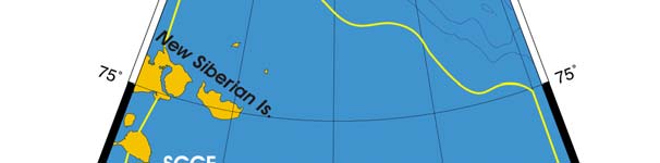
XI-32 East Siberian Sea LME
S. Heileman
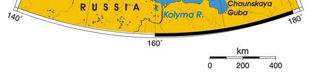
The East Siberian Sea LME is a high-latitude Arctic LME off Northeast Russia. A
topographical boundary with the Laptev Sea LME to the west is formed by the New
Siberian Islands. This LME is a relatively shallow, marginal sea with an extensive
continental shelf and a surface area of about 900,000 km2, of which 3.4% is protected
(Sea Around Us 2007). According to the Atlas of the Oceans (USSR Navy, 1980), the
Eastern Siberian Sea has the surface area of 913,000 km2, water volume of 49,000 km3,
and total water catchment area of 1,342,000 km2. Climatic conditions are extremely
severe, with major seasonal and interannual variation and ice cover for most of the year.
The total river runoff exceeds 200 km3/year, including Kolyma (135) and Indigirka (57)
Rivers.. A report pertaining to this LME is UNEP (2005).
I. Productivity
The East Siberian Sea is a Class I, high productivity ecosystem (>300 gCm-2yr-1). In situ
data on primary production are absent. The summer plankton bloom is short but intense.
The total monthly production in August-September is 2.5 million tonnes, while the annual
production is just 7 million tonnes owing to the very short vegetation season since this
LME encompasses the most ice-covered shelf sea in the Arctic (Vetrov and
Romankevich 2004). Coastal erosion and river discharges provide a major source of
suspended matter and nutrients to this LME. However, the availability of light and
nutrients has been restricted by seasonal ice cover for most of the year, limiting
production to a brief period after the ice melts in summer. Climate is the primary force
driving biomass changes in the LME. The formation and melting of ice complicate the
thermal, chemical, sedimentological and biological processes. The zooplankton of the
East Siberian Sea LME is dominated by Pacific species of copepods. The zooplankton
production in winter is less than 10 mgCm-2d-1, whereas in summer it varies between 25
and 65 mgCm-2d-1 (Vetrov and Romankevich 2004). Sea birds, ringed seal, walrus,
beluga/belukha whale, Arctic fox and polar bear make up the varied and rich fauna at the
edge of the drifting ice and on the shore. See the Barents Sea LME for additional
information on the biodiversity and food web of Arctic Seas.
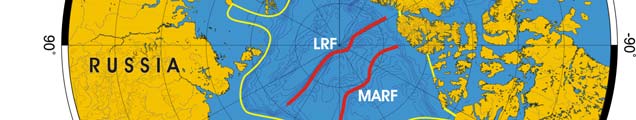
Oceanic fronts (Belkin et al. 2008)( Figure XI-32.1): The Siberian Coastal Current (SCC)
is associated with a front (SCCF) that extends across the southern part of this LME
(Figure XI-32.1). The front separates low-salinity coastal waters from offshore waters.
The SCC carries huge amount of fresh water from great Siberian rivers such as Ob',
Yenisey and Lena, and also Khatanga, Olenek, Indigirka, Yana, and Kolyma. The SCC
transports these waters along the SCCF eastward through Long Strait into the Chukchi
Sea. Estuarine fronts develop off the mouths of Indigirka and Kolyma, and also off Ayon
Island.
East Siberian Sea LME SST (after Belkin 2008)(Figure XI-32.2)
Linear SST trend since 1957: 0.37°C.
Linear SST trend since 1982: 0.36°C.
The East Siberian Sea warming was moderate. Its interannual variability was very small,
~0.2-0.4°C. The only major event occurred in 1988-90, when SST rose by 1°C in just two
years, reaching -0.3°C in 1990, thus exceeding by 1.3°C the all-time minimum of -1.6°C.

478
32. East Siberian Sea LME
This event nearly coincided with the largest increase of the Arctic Oscillation (AO) index
on record since 1950 (Climate Prediction Center 2007).
Figure XI-32.1. Fronts of the East Siberian Sea LME. AF, Ayon Front; IF, Indigirka Front; KF, Kolyma
Front; SCCF, Siberian Coastal Current Front. Yellow line, LME boundary. After Belkin et al. (2008).
Figure XI-32.2. East Siberian Sea LME mean annual SST (left) and SST anomalies (right), 1957-2006,
based on Hadley climatology. After Belkin (2008).
XI Arctic
479
East Siberian Sea LME Chlorophyll and Primary Productivity: The East Siberian
Sea is a Class I, high productivity ecosystem (>300 gCm-2yr-1).
Figure XI-32.3. East Siberian Sea LME trends in chlorophyll a (left) and primary productivity (right)
1998 2006. Values are colour coded to the right hand ordinate. Figure courtesy of J. O'Reilly and K.
Hyde. Sources discussed p. 15 this volume.
II. Fish and Fisheries
The number of species and stocks of biological resources in the East Siberian Sea LME
is small. Several valuable fish species are found in this LME, but the largest stocks are
generally concentrated in sub-estuarial zones. Much of the salmon catch is low-grade
pink salmon that is canned and sold domestically. Valuable species such as pollock,
halibut and crab are poised to play a more important commercial role. At present,
overexploitation is not of concern in the LME (UNEP 2005),
As in the Kara and Laptev seas, whitefish species (genus Coregonus), called `sig' in
Russian, form the bulk of the fishery in this LME. However, detailed records are available
only from the lower reaches of the Indigirka and Kolyma Rivers for the years from 1981 to
1990 (Larsen et al. 1996). These data, amounting to about 3,000 tonnes per year on
average, do not show any consistent trend, unlike those from the Kara Sea. Pauly &
Swartz (2007), in the absence of other data which may support an alternative estimation
procedure, extrapolated backward to 1950 the mean catch of the first three years with
data (1980-1982). Similarly, they extrapolated forward, from 1991 to 2004, the mean
catch of the last three years with data. An additional 30% of `other fish' was included,
following Larsen et al. (1996). The time series of the estimated catches are presented in
Figure XI-32.4.
Due the tentative nature of the East Siberian Sea LME catch estimates, no indicators
based on these data will be presented (but see Sea Around Us 2007).
480
32. East Siberian Sea LME
5000
4500
4000
3500
s
)
.
3000
ne
on
2500
s
(t
g
i
n
2000
nd
La
1500
1000
500
0
1950
1960
1970
1980
1990
2000
Year
Sardine cisco
Arctic cisco
Bering cisco
Broad whitefish
Muksun
Mixed group
Figure XI-32.4. Total estimated catches (subsistence fisheries) in the East Siberian Sea LME (from
Pauly & Swartz 2007)
III. Pollution and Ecosystem Health
Pollution: Runoff from industrial as well as agricultural areas in the Kolyma and Indigirka
watersheds makes a significant contribution to pollution in this LME. However, overall,
pollution is slight and attributed mainly to chemicals and spills, which are of greater
concern in localised areas (UNEP 2005). According to chemical monitoring data of the
Roshydromet network as well as the Arctic Monitoring Centre, several contaminants are
found in the LME. A broad spectrum of trace metals was discovered in the water and
bottom sediments. DDT, HCH and PCBs have been found in water samples, with
maximum concentrations found in the areas of river discharge (GOIN 1996a-d,
Roshydromet 1997-2002).
Particularly severe climatic and ice conditions increase the risk of pollution from shipping
and spills. The maximum concentrations (up to 80 µgl-1) of petroleum hydrocarbons were
observed near the Novosibirsk Islands and Wrangel Island (GOIN 1996a). Some other
hazardous contaminants (organochlorine compounds, heavy metals and radionuclides)
can be found in snow, ice, seawater, sediments and marine organisms. The average
concentrations of these contaminants are, however, very low. According to
microbiological indices, the waters in some areas vary from relatively clean to lightly and
moderately polluted (in localised zones in summer).
Habitat and community modification: Modification of habitats was assessed as slight
(UNEP 2005). While there are no records of serious habitat loss in the region, there is
evidence of localised degradation in some areas. Issues pertaining to the health of this
LME are endangered marine species such as walruses and whales, the fragile marine
ecosystem, which is slow to recover from disruptions or damage, and the thinning polar
ice pack.
XI Arctic
481
IV. Socioeconomic Conditions
A notable feature of this LME is the relatively low population density in the coastal areas.
Some parts of the coast are almost uninhabited, with the few small settlements separated
by long distances. The anthropogenic impact of these populations is thus considered to
be low.
V. Governance
The Soviet era adopted special measures for the protection of the marine environment
and the prevention of pollution in the Arctic areas adjacent to its northern coast. These
provided for special navigational rules. Other issues pertain to the legal status of the
Arctic areas. During the Soviet era, the East Siberian Sea was held to be internal waters.
For ongoing bilateral and multilateral science projects, see International Science
Initiatives in the Russian Arctic (ISIRA) under the auspices of The International Arctic
Science Committee (IASC). The Arctic Research Consortium of the United States
(ARCUS); the Arctic Ocean Sciences board (AOSB); Land-Ocean Interactions in the
Coastal Zones (LOICZ); the Arctic Monitoring and Assessment Programme (AMAP) and
Protection of the Arctic Marine Environment (PAME)--each under the aegis of the Arctic
Council; The International Human Dimensions Programme on Global Environmental
Change (IHDP) and the International Permafrost Association (IPA); the Canada-Russia
Joint Action Plan for an Enhanced Bilateral Partnership; CNS, the Multilateral Nuclear
Environmental Program in the Russian Federation and the Euro-Arctic Council are
examples of international partnerships for scientific research and management in the
Arctic..
References
Belkin, I.M. (2008) Rapid warming of Large Marine Ecosystems, Progress in Oceanography, in
press.
Belkin, I.M., Cornillon, P.C., and Sherman, K. (2008). Fronts in Large Marine Ecosystems of the
world's oceans: An atlas. Progress in Oceanography, in press.
Climate Prediction Center, National Weather Service (2007) Monitoring weather and climate,
www.cpc.ncep.noaa.gov/products/precip/CWlink/daily_ao_index/season.JFM.ao.gif
GOIN (1996a). Annual of Marine Water Quality with Respect to Hydrochemical Indices for 1992.
Obninsk, Russia. (In Russian).
GOIN (1996b). Annual of Marine Water Quality with Respect to Hydrochemical Indices for 1993.
Obninsk, Russia. (In Russian).
GOIN (1996c). Annual of Marine Water Quality with Respect to Hydrochemical Indices for 1994.
Obninsk, Russia. (In Russian).
GOIN (1996d). Annual of Marine Water Quality with Respect to Hydrochemical Indices for 1995.
Obninsk, Russia. (In Russian).
Larsen, L.H., Palerud, R., Goodwin, H. and Sirenko, B. (1996). The marine invertebrates, fish and
coastal zone features of the NSR area. INSROP Working Paper No 53, 42 p.
Pauly, D. and Swartz, W..(2007) Marine fish catches in northern Siberia (Russia, FAO Area 18). In:
Zeller, D. and Pauly, D. (eds.) Reconstruction of marine fisheries catches for key countries and
regions (1950-2004). Fisheries Centre Research Reports, FCRR, Vol 15(2).
Roshydromet (1997). Review of the Environmental Pollution of the Russian Federation for 1996. M.
Roshydromet, Moscow, Russia. (In Russian).
Roshydromet (1998). Review of the Environmental Pollution of the Russian Federation for 1997. M.
Roshydromet, Moscow, Russia. (In Russian).
Roshydromet (1999). Review of the Environmental Pollution of the Russian Federation for 1998. M.
Roshydromet, Moscow, Russia. (In Russian).
Roshydromet (2001). Review of the Environmental Pollution of the Russian Federation for 2000. M.
Roshydromet, Moscow, Russia. (In Russian).
482
32. East Siberian Sea LME
Roshydromet (2002). Review of the Environmental Pollution of the Russian Federation for 2001. M.
Roshydromet, Moscow, Russia. (In Russian).
Roshydromet 2000. Review of the Environmental Pollution of the Russian Federation for 1999. M.
Roshydromet, Moscow, Russia. (In Russian).
Sea Around Us (2007). A Global Database on Marine Fisheries and Ecosystems. Fisheries Centre,
University British Columbia, Vancouver, Canada. www.seaaroundus.org/lme/
SummaryInfo.aspx?LME=56
UNEP (2005). Tsyban, A.V., Titova, G.D., Shchuka, S.A., Ranenko, V.V. and Izrael, Y.A. Russian
Arctic, GIWA Regional Assessment 1a. University of Kalmar, Kalmar, Sweden.
www.giwa.net/publications/r1a.phtml
Vetrov, A.A., and Romankevich, E.A. (2004) Carbon Cycle in the Russian Arctic Seas. Springer,
Berlin etc., 331 pp.
XI Arctic
483
XI-33 Kara Sea LME
S. Heileman
The Kara Sea LME is a high-latitude Arctic system located off northern Russia. This
shallow LME has an area of 800,000 km2, of which 2.7% is protected (Sea Around Us
2007) and is seasonally ice-covered. According to the Atlas of the Oceans (USSR Navy,
1980), the Kara Sea has an average depth of 111 m, and a water catchment area of
6,589,000 km2. Warm ocean currents flowing into this LME from the North Atlantic
Ocean result in mostly ice-free conditions from May to October. Large rivers, of which
the total catchment area of 6.6 x 10⁶ km2 is equal to almost half the Russian territory, flow
into this LME discharging over 1200 km3 annually. These include (discharge in km3/yr)
the Yenisei (610), Ob' (395), Pyasina (82), Taz (45) and Taimyra (38) Rivers, of which
the first two are among the largest rivers of the Arctic. Freshwater and nutrient input from
these rivers and water exchange with the Arctic Ocean characterise this LME. Together
with the Laptev Sea LME, the Kara Sea LME plays a significant role in the ice and water
mass transport system of the Arctic (UNEP 2005).
I. Productivity
The Kara Sea LME is a Class I, high productivity ecosystem (>300 gCm-2yr-1). In situ
productivity data are sparse, patchy and extremely heterogeneous depending on location
and season (Vetrov and Romankevich 2004). The maximum primary production (PP) of
200 mgCm-2d-1 is observed in the Baidaratskaya Bay (west of the Yamal Peninsula). The
average PP from in situ data is 43 mgCm-2d-1 ((Vetrov and Romankevich 2004). The
availability of light and nutrients has been restricted by seasonal ice cover during part of
the year, limiting production to a brief period after the ice melts in the summer months.
Zooplankton production is relatively low and the distribution and species composition are
influenced by the proximity of the Atlantic Ocean. According to the most complete study
by Lukianova (2005), benthos biomass reaches 300 g/m-2 in the southern Kara Sea. The
sea's total biomass amounts to 41 million tons, while total annual production is between
1.4 and 2.0 million tons of carbon (Vetrov and Romankevich 2004). Generally, the
coastal zone and gulfs feature high benthos biomass and highest biodiversity nearly
400 taxa of various systematic groups. Polychaets (33%), crustaceans (30%) and
molluscs (21%) dominate among all identified species (Matishov, G.G., Dzhenyuk,
Sherman, K. 2006. Large Marine Ecosystems of the Shelf Seas of Russian Arctic. Paper
presented at the PAME Meeting).
Numerous species of marine mammals inhabit this LME. The most abundant species
are: Atlantic walrus (Odobenus rosmarus rosmarus), ringed seal (Phoca hispida),
common seal (Phoca vitulina vitulina), Greenland seal (Hisriophoca geonlandica
oceanica), crested seal (Cystophora cristata), killer whale, narwhal, and belukha whale
(Delphinapterus leucas). Fish fauna is not well studied partly because of the lack of
commercial fishery, except for the fishery for anadromous and semi-anadromous fish
species in the estuaries of Siberian rivers, e.g. Yenisei, Ob', Pyasina, Taz, and Taimyra.
Among 60 fish species found in the Russian Arctic Seas, a few species are considered
commercial, namely Arctic cisco, European cisco, muksun (Coregonus muksun), Atlantic
whitefish (Coregonus huntsmani; Russian "sig", a white fish of the salmon family), Arctic
char, navaga (Eleginus nawaga) and sheefish (Stenodus leucichthys),
Oceanic fronts (after Belkin et al. (2008): The Ob' and Yenisey River discharges to the
Kara Sea form a giant single freshwater plume, since both estuaries are close to each


484
33. Kara Sea LME
other (Figure XI-33.1). This plume spreads across the entire LME, up to Novaya Zemlya.
The distribution of this plume is largely determined by the wind field that is ultimately
governed by a large-scale atmospheric pressure pattern.
Figure XI-33.1. Fronts of the Kara Sea LME. OREF, Ob' River Estuarine Front; WKSF, West Kara Sea
Front; YREF, Yenisey River Estuarine Front. Yellow line, LME boundary. After Belkin et al. (2008).
Sharp salinity and temperature fronts are observed in the outer parts of Ob' and
Yenisey's estuaries called Obskaya Guba and Yeniseyskiy Zaliv, respectively, where
riverine waters meet oceanic waters. In the southwestern part of the LME, a front exists
between resident waters and the Atlantic inflow from the Barents Sea through Karskiye
Vorota, a strait that connects the Kara Sea with the Pechora Sea, a southeastern
extension of the Barents Sea.
Kara Sea LME SST (after Belkin, 2008)
Linear SST trend since 1957: 0.30°C.
Linear SST trend since 1982: 0.16°C.
The Kara Sea warming was slow, accentuated by a single event, the all-time maximum of
1995, which occurred concurrently with the Laptev Sea. Interannual variability here is
moderate, with a magnitude of 0.5°C, similar to the Laptev Sea. Thermal history of the
Kara Sea is negatively correlated with the Arctic Oscillation (AO) index. In this respect,
the Kara Sea is similar to the Beaufort Sea LME. At the same time, the Kara Sea SST
appears to be decorrelated from the adjacent Laptev Sea LME's SST since the latter is
negatively correlated with the AO index (Climate Prediction Center 2007). This pattern
can be explained by the lack of oceanographic connection between the Kara and Laptev
seas. Indeed, the only significant connection between these seas is through the shallow
Vilkitsky Strait, which is covered by sea ice year-round.
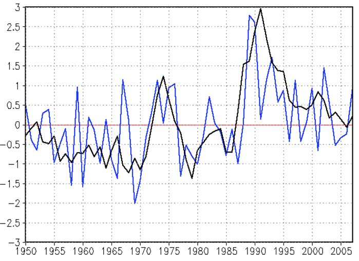
XI Arctic
485
Figure XI-33.2a. Kara Sea LME annual mean SST (top) and SST anomalies (bottomt), 1957 2006, based
on Hadley climatology. After Belkin (2008).
The standardized seasonal mean Arctic Oscillation (AO) index during cold season (blue
line) is constructed by averaging the daily AO index for January, February and March for
each year. The black line denotes the standardized five-year running mean of the index.
Both curves are standardized using 1950-2000 base period statistics (Figure XI-33.2b.
from Climate Prediction Center 2007).
Figure XI-33.2b. Standardized Seasonal Mean (JFM) AO index (1950-2007), Climate Prediction Center
2007.
486
33. Kara Sea LME
Kara Sea LME Chlorophyll and Primary Productivity: The Kara Sea LME is a Class I,
high productivity ecosystem (>300 gCm-2yr-1).
Figure XI-33.3. Kara Sea LME trends in chlorophyll a (left) and primary productivity (right). Values are
colour coded to the right hand ordinate. Figure courtesy of J. O'Reilly and K. Hyde. Sources discussed
p. 15 this volume.
II. Fish and Fisheries
As mentioned in the previous section, the Kara Sea benefits from the occasional intrusion
of `warm' water and its accompanying fauna, "as apparently occurred during 1919-1938,
when a strong inflow of warm Atlantic water into the Kara Sea, Northern Russia, led to
the eastward expansion of salmon" (Fleming and Jensen, 2002).
However, except for these occasional strays, the fish fauna of the Kara Sea is species
poor (see www.fishbase.org) with the bulk of the fisheries catches contributed by the
genus Coregonus, (Subfamiliy Coregoninae, Family Salmonidae) known as `whitefishes'
or `sig' in Russian. Six of their species make up about 80% of the total fisheries landing
in the LME (Larsen et al. 1996,).
Figure XI-33.4 is adapted from Pauly & Swartz (in press), who used a variety of sources,
notably Larsen et al. (1996) to reconstruct estimated catches from the Kara Sea for 1950
to 2004. The declining catches are explained in part by extreme pollution of the estuaries
and coastal areas and by overfishing (Pauly & Swartz in press). Due to the tentative
nature of these catch estimates, no indicators based on these data will be presented (but
see Sea Around Us 2007).
III. Pollution and Ecosystem Health
Pollution: Pollution was assessed as generally moderate in the LME (UNEP 2005),
which is impacted by a variety of anthropogenic contaminant sources (Layton et al. 1997,
Povinec et al. 1997). Almost 40% of the area is influenced by continental waters and
substantial amounts of pollutants introduced by the Ob' and Yenisei Rivers. Obsolete
technologies and the lack of facilities for processing industrial waste cause major
ecological problems. In the open waters of the Arctic the concentration of pollutants are
low or absent. However, localised shelf areas and most coastal zones are considerably
polluted. The state of a number of bays, gulfs and estuarine areas is considered to be
critical and even catastrophic, and partly explain the decline in the fisheries catch (Figure
XI-33.4). In fact, the concentrations of some chemical contaminants exceed the threshold
XI Arctic
487
16
14
12
.
es)
n
n 10
t
o
d
an
us
8
t
ho
s
(
g
6
i
n
nd
a
L
4
2
0
1950
1960
1970
1980
1990
2000
Year
Sardine cisco
Muksun
Bering cisco
Broad whitefish
Arctic cisco
Smelt
Longnose Siberian sturgeon
Mixed group
Figure XI-33.4. Total estimated catches (subsistence fisheries) in the Kara Sea LME (from Pauly &
Swartz 2007).
limits defined for the country. This situation is aggravated by the accumulation of
numerous contaminants in the bottom sediments. According to the chemical monitoring
data of the Roshydromet network (GOIN 1996 a-d, Roshydromet 1997-2002) and the
Arctic Monitoring Regional Centre, trace metals and petroleum hydrocarbons are the
most widespread pollutants in the Kara Sea LME. By far the most important source of
pollution is the Norilsk nickel processing plant that emits more than 1 million tons of sulfur
every year (AMAP 1997).
Suspended solids in the Ob' and Yenisei River deltas carry high levels of PCBs and DDT
(AMAP 1998). These toxic pollutants are found in practically all bays and estuarine
zones and their chronic impacts on marine organisms cause serious concern. Long-
range atmospheric transport may account for the high HCH concentrations in open areas
(GOIN 1996a-d, Roshydromet 1997-2002). Although radioactive materials are dumped
into the Arctic seas, there is no evidence of high concentrations of radionuclides in the
LME (AMAP 1997, 2002). Pollution from solid waste is caused by domestic waste and
metal barrels on the shores.
Oil and gas development, in particular oil extraction, oil spills, washing from the shore,
and pipeline transportation, pose a significant environmental threat. The maximum
permissible concentration of petroleum hydrocarbons has been exceeded in some areas,
for example, Cape Kharasavei and near the Arctic settlements Amderma and Dickson
(GOIN 1996a). Pollution of water and bottom sediments in the hydrocarbon fields occurs
from ejection of drilling slime, occasional and permanent leaks of fuel, lubricants, gas
condensate and drilling and other liquids.
Habitat and community modification: Habitat and community modification was
assessed as slight, with degradation of some habitats in localised areas (UNEP 2005).
Modification of the highly vulnerable habitats in the Kara Sea basin has occurred as a
488
33. Kara Sea LME
result of rapid industrial development of the Russian Arctic region after the 1970s. The
growth of oil and gas extraction is connected with the construction of ground and
underwater cross-country pipelines, building of roads and sea ports, construction of
artificial structures, noise and vibration that affect animals, and thermic impacts and
change of habitat of migrant birds and fishes. Another threat to the habitats is posed by
the mining and metallurgic industries. The immediate causes of modification of the neritic
system, lagoons and estuaries are increased chemical pollution and oil spills.
The health of the LME may worsen in the future as a result of the rapid development of
the oil and gas industry on the Arctic shelf, increased volume of oil and gas transport, as
well as the accidental introduction of alien species with ship ballast water.
IV. Socioeconomic Conditions
Economic development associated with oil extraction, mining and fish farming will result
in changes in diet and nutritional health and exposure to air-, water- and food-borne
contaminants in northern peoples who rely on marine systems for food (AMAP 1998,
Weller & Lange 1999, Freese 2000). Morbidity directly connected with chemical pollution
is of particular concern in this LME. The biomagnification of persistent contaminants in
Arctic food webs is affecting the health of Arctic inhabitants whose diet is based on
species at high trophic levels in both marine and terrestrial ecosystems. Contaminant
levels in some Arctic indigenous groups can be 10 to 20 times higher than in most
temperate regions (AMAP 1997). Heavy metals, PAHs and other persistent toxic
substances have a strong mutation effect in humans. (See Chukchi Sea LME for further
information.)
V. Governance
Under the aegis of the PAME working group of the Arctic Council three LME pilot projects
--West Bering Sea, Beaufort Sea (U.S. and Canada) and Barents Sea (Norway and
Russia) are being undertaken. Climate change adaptability is a priority among the
critical issues being addressed by the Arctic Council according to Norway's Minister of
Foreign Affairs, Jonas Gahr Střre's speech to the Arctic Council Ministerial Meeting in
Salekhard, Russia on 26 October 2006. The GEF CEO has endorsed two projects with
the Russian Federation: Support to the National Programme of Action for the Protection
of the Arctic Marine Environment, Tranche 1 (International Waters focal area project) and
An Integrated Ecosystem Management Approach to Conserve Biodiversity and Minimize
Habitat Fragmentation in Three Selected Model Areas in the Russian Arctic (ECORA), (a
multi-focal area project).
References
(2002). Arctic Pollution 2002. Arctic Monitoring and Assessment Programme, 2002, Oslo,
Norway.
AMAP (1997). Arctic Pollution Issues: A State of the Arctic Environment Report. Arctic Monitoring
and Assessment Program, Oslo, Norway.
AMAP (1998). Wilson, S.J., Murray, J.L. and Huntington, H.P. (eds), Arctic Pollution Issues. Arctic
Monitoring and Assessment Programme, Oslo, Norway.
Belkin, I.M. (2008) Rapid warming of Large Marine Ecosystems, Progress in Oceanography, in
press.
Belkin, I.M., Cornillon, P.C., and Sherman, K. (2008). Fronts in Large Marine Ecosystems of the
world's oceans: Progress in Oceanography, in press.
Climate Prediction Center, National Weather Service (2007) Monitoring weather and climate
www.cpc.ncep.noaa.gov/products/precip/CWlink/daily_ao_index/season.JFM.ao.gif
XI Arctic
489
Freese, C.H. (2000). The Consumptive Use of Wild Species in the Arctic: Challenges and
Opportunities for Ecological Sustainability. Report submitted to World Wildlife Fund, Arctic
Programme, Toronto, Ontario, Canada.
GOIN (1996a). Annual of Marine Water Quality with Respect to Hydrochemical Indices for 1992.
Obninsk, Russia. (In Russian).
GOIN (1996b). Annual of Marine Water Quality with Respect to Hydrochemical Indices for 1993.
Obninsk, Russia. (In Russian).
GOIN (1996c). Annual of Marine Water Quality with Respect to Hydrochemical Indices for 1994.
Obninsk, Russia. (In Russian).
GOIN (1996d). Annual of Marine Water Quality with Respect to Hydrochemical Indices for 1995.
Obninsk, Russia. (In Russian).
Larsen, L.H., Palerud, R., Goodwin, H. and Sirenko, B. (1996). The marine invertebrates, fish and
coastal zone features of the NSR area. INSROP Working Paper No 53, 42 p.
Layton, D., Vaughn, P., Yarrington, L., Maxwell, R., Preller, R., Bean, J., Carroll, J., Fuhrmann, M.,
Rigor, I. and Tucker, W. (1997). Transport of radionuclides in the Arctic seas, in: Layton, D.,
Edson, R. and Napier, B. (eds), Radionuclides in the Arctic Seas from the Former Soviet
Union: Potential Health and Ecological Risks. Arctic Nuclear Waste Assessment Program
(ANWAP). United States Office of Naval Research, Washington, D.C.
Lukianova, T.S. (2005) Estimation of bottom fauna biomass distribution in the Arctic Ocean.
Proceedings of the XII Congress of the Russian Geographic Society, St.Petersburg, vol.5, pp.
124-129 (in Russian).
Pauly, D. and Swartz, W. (2007). Marine fish catches in northern Siberia (Russia, FAO Area 18). In:
Zeller, D. and Pauly, D. (eds.) Reconstruction of marine fisheries catches for key countries and
regions (1950-2004). Fisheries Centre Research Reports,15(2): 17-33.
Povinec, P.P., Osvath, I., Baxter, M.S., Ballestra, S., Carroll, J., Gastaud, J., Harms, I., Huynh-
Ngoc, L., Liong Wee Kwong, L. and Pettersson, H. (1997). IAEA-MEL's contribution to the
investigation of Kara Sea radioactivity and radiological assessment. Marine Pollution Bulletin
35:235-241.
Roshydromet (1997). Review of the Environmental Pollution of the Russian Federation for 1996. M.
Roshydromet, Moscow, Russia. (In Russian).
Roshydromet (1998). Review of the Environmental Pollution of the Russian Federation for 1997. M.
Roshydromet, Moscow, Russia. (In Russian).
Roshydromet (1999). Review of the Environmental Pollution of the Russian Federation for 1998. M.
Roshydromet, Moscow, Russia. (In Russian).
Roshydromet (2000). Review of the Environmental Pollution of the Russian Federation for 1999. M.
Roshydromet, Moscow, Russia. (In Russian).
Roshydromet (2001). Review of the Environmental Pollution of the Russian Federation for 2000. M.
Roshydromet, Moscow, Russia. (In Russian).
Roshydromet (2002). Review of the Environmental Pollution of the Russian Federation for 2001. M.
Roshydromet, Moscow, Russia. (In Russian).
Sea Around Us (2007). A Global Database on Marine Fisheries and Ecosystems. Fisheries Centre,
University British Columbia, Vancouver, Canada.
www.seaaroundus.org/lme/SummaryInfo.aspx?LME=58
UNEP (2005). Tsyban, A.V., Titova, G.D., Shchuka, S.A., Ranenko, V.V. and Izrael, Y.A. Russian
Arctic, GIWA Regional Assessment 1a. University of Kalmar, Kalmar, Sweden.
http://www.giwa.net/publications/r1a.phtml
Vetrov, A.A., and Romankevich, E.A. (2004) Carbon Cycle in the Russian Arctic Seas. Springer,
Berlin etc., 331 pp.
Weller, G. and Lange, M. (1999). Impacts of Global Climate Change in the Arctic Regions,
International Arctic Science Committee, Centre for Global Change and Arctic System
Research, University of Alaska, Fairbanks, U.S.
490
33. Kara Sea LME
XI Arctic
491
XI-34 Laptev Sea LME
S. Heileman
The Laptev Sea LME is topographically defined by the New Siberian Islands
(Novosibirskie Ostrova) in the East and the Northern Land (Severnaya Zemlya) islands in
the West. The LME is a continental marginal sea, most of which is shallow with a deeper
northern section and a surface area of about 500,000 km2, of which 5.6% is protected
(Sea Around Us 2007). According to the Atlas of the Oceans (USSR Navy, 1980), the
Laptev Sea (defined in the north by shelf break) has the surface area of 475,000 km2,
water volume of 57,000 km3, and total water catchment area of 3,643,000 km2. Severe
climatic conditions with major seasonal and annual changes, perennial ice cover over
extensive areas, water exchange with the deep Arctic Ocean and freshwater input from
Siberian rivers. The total river runoff exceeds 700 km3/year, including Lena (532),
Khatanga (105), Olenek (38), Yana (31), Anabar, and Kotuy Rivers.
I. Productivity
The Laptev Sea LME is a Class I, high productivity ecosystem (>300 gCm-2yr-1). The
availability of light and nutrients is restricted by seasonal ice cover during part of the year,
limiting production to a brief period after the ice melts in the summer months. Locally,
primary production may exceed 800 mgCm-2d-1.in the southern part of this LME, with high
values (>300 mgCm-2d-1) also observed in the north where the Laptev Sea waters meet
the Atlantic waters (Vetrov and Romankevich 2004). The total biomass is 70 million
tonnes, while the total annual production is 2,4 million tonnes of carbon (Vetrov and
Romankevich 2004). Sea birds, ringed seal, beluga/belukha whale, walrus, Arctic fox and
polar bear make up the top trophic level of the rich and varied fauna of this region,
especially in the summer months when they can be found at the edge of the drifting ice
and on the shore.
Oceanic fronts: (Belkin et al. 2008)(Figure XI-34.1): This area features a huge river
runoff owing primarily to the discharge of the Lena River, as well as of the Khatanga
(merger of Kheta and Kotuy), Popigay, Anabar, Olenek and Yana rivers. Estuarine
offshore fronts develop as freshwater river plumes formed by Lena and Khatanga spread
over the vast shallow shelf of Laptev Sea. Similar to the Mackenzie River plume, these
plumes may contain multiple transient fronts that correspond to individual freshets.
The Siberian Coastal Current Front is less distinct in Laptev Sea compared to the East
Siberian and Chukchi seas. This front separates low-salinity inshore waters from saltier
offshore waters and acts as a conduit for the fresh waters on their route eastward. The
Laptev Sea continental slope is relatively steep and the shelf break is well defined,
therefore a shelf-slope front might exist along the shelf edge.


492
34. Laptev Sea LME
Figure XI-34.1. Fronts of the Laptev Sea LME. KREF, Khatanga River Estuarine Front; LREF, Lena River
Estuarine Front. Yellow line, LME boundary. After Belkin et al. (2008).
Laptev Sea LME SST (Belkin 2008)(Figure XI-34.2)
Linear SST trend since 1957: 0.32°C.
Linear SST trend since 1982: 0.12°C.
The Laptev Sea warming was slow but steady, modulated by strong interannual
variability. The largest interannual variability was observed between the all-time
maximum of 0.0°C in 1995 and the all-time minimum of -1.3°C in 1996. The peak of
1995 occurred simultaneously in the adjacent Kara Sea; it was not observed elsewhere.
Therefore the 1995 warm event was confined to just two contiguous LMEs, Laptev and
Kara Seas. The warm episode of the late 1980s-early 1990s was positively correlated
with the Arctic Oscillation index.
Figure XI-34.2a. Laptev Sea LME mean annual SST (left) and SST anomalies (right), based on Hadley
climatology. After Belkin (2008).
XI Arctic
493
Figure XI-34.2b. The standardized seasonal mean Arctic Oscillation (AO) index during cold season (blue
line) is constructed by averaging the daily AO index for January, February and March for each year. The
black line denotes the standardized five-year running mean of the index. Both curves are standardized
using 1950-2000 base period statistics (Climate Prediction Center, 2007).
Laptev Sea LME Chlorophyll and Primary Productivity: The Laptev Sea LME is a
Class I, high productivity ecosystem (>300 gCm-2yr-1).
Figure XI-34.3 Laptev Sea LME trends in chlorophyll a (left) and primary productivity (right), 1998-2006.
Values are colour coded to the right hand ordinate. Figure courtesy of J. O'Reilly and K. Hyde. Sources
discussed p. 15 this volume.
I. Fish and Fisheries
The fish fauna of the Laptev Sea is extremely impoverished, as it is remote from both the
Barents Sea to the west and Bering Sea to the east. As in the neighboring Kara and East
Siberian seas, whitefish species (genus Coregonus), or `sig' in Russian, form the bulk of
the fisheries catch in this LME, but detailed records are available only from the lower
reaches of the Lena and Yana rivers, and from Khatanga Bay for the years from 1981 to
1991 (Larsen et al. 1996). These data, amounting to about 3000 tonnes per year on
average, do not show any consistent trend, unlike those from the Kara Sea. Pauly &
Swartz (in press), in absence of other data which may support an alternative estimation
procedure, extrapolated backward to 1950 the mean catch of the first three years with
data (1980-1982) and extrapolated forward, for 1992 to 2004, the mean catch of the last
three years with data. An additional 20% of `other fish' was included, following Larsen et
al. (1996). The time series of the estimated catches are presented in Figure XI-34.4.
494
34. Laptev Sea LME
5000
4500
4000
3500
.
)
s
e 3000
n
2500
s
(ton
g
i
n
2000
nd
a
L
1500
1000
500
0
1950
1960
1970
1980
1990
2000
Year
Sardine cisco
Arctic cisco
Muksun
Broad whitefish
Bering cisco
Mixed group
Figure XI-34.4. Total estimated catches (subsistence fisheries) in the Laptev Sea LME (see Pauly &
Swartz 2007).
Due the tentative nature of these catch estimates, no indicators based on these data will
be presented (but see Sea Around Us 2007).
III. Pollution and Ecosystem Health
Pollution: Overall, pollution in the Laptev Sea LME was found to be slight and
attributable mainly to chemicals and spills in localised coastal areas (UNEP 2005). The
highest pollution levels are found in estuarine areas, in the Zarya Strait and near the
Novosibirsk Islands. River runoff and atmospheric transport play an important role in
marine pollution. Major sources of pol ution on the shelf are the oil and gas industry,
inland water and sea transport, ore mining and processing, accidental oil spills, and
towns and settlements situated on the coast and along the rivers (UNEP 2005). The air,
water and soil in industrial areas are polluted with harmful substances because of
obsolete technologies and the lack of facilities for processing industrial waste. Some of
the rivers are reportedly polluted with PCBs, DDT, heavy metals and viral contaminants.
DDT, HCH, PCBs and heavy metals have been recorded in localised areas of the Laptev
Sea LME (GOIN 1996a-d, Roshydromet 1997-2002). According to the chemical
monitoring data of the Roshydromet network as well as observations by the Arctic
Monitoring Centre, the phenol concentrations are higher than those in other Arctic seas,
with the highest phenol concentrations attributed to floating and sunken wood being
found in offshore areas.
Particularly severe climatic and ice conditions increase the threat of pollution from
shipping and spills. In 1991, concentrations of petroleum hydrocarbons exceeded the
Maximum Permissible Concentrations (MPCs) in some localised areas such as Tiksi Bay,
Bugor-Khaya Firth and Olenek Bay. In 1992, concentrations of petroleum hydrocarbons
varied within narrow limits (12-39 µgl-1) but in Bugor-Khaya Firth (a ship lane route) the
maximum level reached up to 200 µgl-1 (GOIN 1996a). In 1993 the level of petroleum
hydrocarbons did not exceed the MPCs (GOIN 1996b). In more recent years, the
XI Arctic
495
average concentration of petroleum hydrocarbons was 17.1 µgl-1 in the open waters and
up to 114 µgl-1 in Bugor-Khaya Firth (GOIN 1996c-d, Roshydromet 1997-2002).
Habitat and community modification: There are no records of serious habitat loss in
the region, but there is evidence of slight degradation in some localised areas because of
pollution (UNEP 2005). The ecosystem state in the open sea as a whole can be
characterised as favourable. The few ecosystem health issues include endangered
marine species as well as the fragile marine ecosystem, which is slow to recover from
perturbations, and the thinning polar ice pack.
IV. Socioeconomic Conditions
Economic activity in the Laptev Sea LME focuses on the exploitation of oil and natural
gas, although there are less oil and gas reserves in this LME than in the other Siberian
LMEs. Vast coastal areas remain practically unaffected by human activity. There are
relatively low population densities in the coastal areas and the few small settlements are
separated by long distances. In the entire Far Eastern Federal District of the Russian
Federation, of which the Laptev Sea coastal area is a part, the population density is
approximately one person per square kilometre and is currently declining. As a result,
the environmental impact of these populations is considered to be low. (See the Chukchi
Sea LME for more information.)
V. Governance
Special measures for the protection of the marine environment and the prevention of
pollution in the Arctic areas adjacent to Russia's northern coast were adopted in the
Soviet Era. These provided for special navigational rules on that coastline. There remain
questions pertaining to the legal status of the Arctic areas. During Soviet times, the
Laptev Sea was held to be internal waters. For ongoing bilateral and multilateral science
projects, see International Science Initiatives in the Russian Arctic (ISIRA) under the
auspices of The International Arctic Science Committee (IASC). The Arctic Research
Consortium of the United States (ARCUS); the Arctic Ocean Sciences board (AOSB);
Land-Ocean Interactions in the Coastal Zones (LOICZ); the Arctic Monitoring and
Assessment Programme (AMAP) and Protection of the Arctic Marine Environment
(PAME)--each under the aegis of the Arctic Council; The International Human
Dimensions Programme on Global Environmental Change (IHDP) and the International
Permafrost Association (IPA); the Canada-Russia Joint Action Plan for an Enhanced
Bilateral Partnership; CNS, the Multilateral Nuclear Environmental Program in the
Russian Federation and the Euro-Arctic Council are examples of international
partnerships for scientific research and management in the Arctic. See the Barents Sea
LME (Chapter XIII-36) for more information on governance.
References
Belkin, I.M. (2008) Rapid warming of Large Marine Ecosystems, Progress in Oceanography, in
press.
Belkin, I.M., Cornillon, P.C., and Sherman, K. (2008). Fronts in Large Marine Ecosystems of the
world's oceans: Progress in Oceanography, in press.
Climate Prediction Center, National Weather Service (2007) Monitoring weather and climate,
http://www.cpc.ncep.noaa.gov/products/precip/CWlink/daily_ao_index/season.JFM.ao.gif
GOIN (1996a). Annual of Marine Water Quality with Respect to Hydrochemical Indices for 1992.
Obninsk, Russia. (In Russian).
496
34. Laptev Sea LME
GOIN (1996b). Annual of Marine Water Quality with Respect to Hydrochemical Indices for 1993.
Obninsk, Russia. (In Russian).
GOIN (1996c). Annual of Marine Water Quality with Respect to Hydrochemical Indices for 1994.
Obninsk, Russia. (In Russian).
GOIN (1996d). Annual of Marine Water Quality with Respect to Hydrochemical Indices for 1995.
Obninsk, Russia. (In Russian).
Larsen, L.H., Palerud, R., Goodwin, H. and Sirenko, B. (1996). The marine invertebrates, fish and
coastal zone features of the NSR area. INSROP Working Paper No 53, 42 p.
Pauly, D. and Swartz, W. (2007). Marine fish catches in northern Siberia (Russia, FAO Area 18).
In: Zeller, D. and Pauly, D. (eds.) Reconstruction of marine fisheries catches for key countries
and regions (1950-2004). Fisheries Centre Research Reports. 15(2): 17-33.
Roshydromet (1997). Review of the Environmental Pollution of the Russian Federation for 1996. M.
Roshydromet, Moscow, Russia. (In Russian).
Roshydromet (1998). Review of the Environmental Pollution of the Russian Federation for 1997. M.
Roshydromet, Moscow, Russia. (In Russian).
Roshydromet (1999). Review of the Environmental Pollution of the Russian Federation for 1998. M.
Roshydromet, Moscow, Russia. (In Russian).
Roshydromet (2000). Review of the Environmental Pollution of the Russian Federation for 1999. M.
Roshydromet, Moscow, Russia. (In Russian).
Roshydromet (2001). Review of the Environmental Pollution of the Russian Federation for 2000. M.
Roshydromet, Moscow, Russia. (In Russian).
Roshydromet (2002). Review of the Environmental Pollution of the Russian Federation for 2001. M.
Roshydromet, Moscow, Russia. (In Russian).
Sea Around Us (2007). A Global Database on Marine Fisheries and Ecosystems. Fisheries Centre,
University British Columbia, Vancouver, Canada. www.seaaroundus.org/lme/SummaryInfo
.aspx?LME=57
UNEP (2005). Tsyban, A.V., Titova, G.D., Shchuka, S.A., Ranenko, V.V. and Izrael, Y.A. Russian
Arctic, GIWA Regional Assessment 1a. University of Kalmar, Kalmar, Sweden. www.giwa.net/
publications /r1a.phtml
Vetrov, A.A., and Romankevich, E.A. (2004) Carbon Cycle in the Russian Arctic Seas. Springer,
Berlin etc., 331 pp.