LMEs and REGIONAL SEAS
100
LMEs and Regional Seas
I WEST AND CENTRAL AFRICA
1. Benguela Current LME
2. Guinea Current LME
3. Canary Current LME
102
I West and Central Africa
I West and Central Africa
103
I-1 Benguela Current LME
S. Heileman and M. J. O'Toole
The boundaries of the Benguela Current LME extend from the Agulhas Current to
27o E longitude, and to the northern boundary of Angola. It encompasses the Exclusive
Economic Zones (EEZs) of Angola and Namibia, and part of the EEZ of South Africa,
with an area of 1.5 million km2 of which 0.59% is protected, and contains 0.06% of the
world's sea mounts (Sea Around Us 2007). One of its unique features is that it is
bounded in the north and south by two warm water systems, the Angola Current and
Agulhas Current, respectively. These boundaries are highly dynamic and the
neighbouring warmer waters directly influence the ecosystem as a whole as well as its
living resources. A strong wind-driven coastal upwelling system, with the principal
upwelling centre located off Lüderitz (27°S, southern Namibia), dominates this LME. The
system is complex and highly variable, showing seasonal, interannual, and decadal
variability as well as periodical regime shifts in local fish populations (Shannon & O'Toole
1998, 1999, 2003). The Benguela Current LME has a temperate climate, and plays an
important role in global climate and ocean processes (GEF/UNDP/UNOPS/NOAA 1999).
Its major estuaries and river systems include the Kwanza and Cunene Rivers. Books,
book chapters, articles and reports on this LME include Crawford et al. (1989),
Palomares and Pauly (2004), O'Toole et al. (2001), Shannon & O'Toole (2003), Shannon
et al. (2006) and UNEP (2005).
I. Productivity
The Benguela Current LME is a Class I, highly productive ecosystem (>300 gCm-2y-1).
The distinctive bathymetry, hydrography, chemistry and trophodynamics of the Benguela
Current LME make it one of the most productive marine areas of the world. The plankton
has been generally regarded as a diatom-dominated system, but this perception is to
some extent an artefact of past sampling (Shannon & O'Toole 1998). Copepods, which
are numerically the most abundant and diverse zooplankton group, play an important role
in the trophodynamics of this LME since they are the principal food of sardines,
anchovies, and other pelagic fish including the larval and juvenile stages of both fish and
squid. The high level of primary productivity supports an important global reservoir of
biodiversity and biomass of fish, seabirds, crustaceans, and marine mammals.
Favourable conditions exist for a high production of small pelagic fishes such as
sardines, anchovies, and round herrings. The LME's estuaries provide nursery areas for
a number of fish stocks that are shared among the bordering countries, while both the
estuaries and coastal lagoons provide critical feeding grounds for migratory birds.
The LME's considerable climatic and environmental variability is the primary driving force
of biomass change in the Benguela Current LME (Sherman 2003, Shannon et al. 2006).
Harmful Algal Blooms (HABs) regularly occur, and have been associated with fish
mortalities as a result of oxygen depletion in the water during and after major blooms
(Shannon & O'Toole 1998). Satellite images show frequent and widespread eruptions of
toxic hydrogen sulphide off the coast of Namibia (Weeks et al. 2004). Eruptions often
seem to be coincident with either increased intensity of wind-driven coastal upwelling or
the passage of a low-pressure weather cell. In 2001, nine major hydrogen sulphide
eruptions occurred, with the largest covering 22,000 km2 of ocean. Their relevance to the
fishery resources, including lobsters, is likely to be high. For example, a widespread
depletion of oxygen is blamed for the deaths of two billion young hake in 1993
(Hamukuaya et al. 1998, Weeks et al. 2004).
104
1. Benguela Current LME
Since 1995, efforts have been underway in the BENEFIT and Benguela Current LME
project (see Governance) to better understand this highly variable and complex system of
physical, chemical, and biological interactions and processes (Shannon et al. 2006).
Systematic surveys have been conducted to assess oceanographic conditions using both
shipboard sensors and satellite remote sensors for temperature, chlorophyll, nutrients,
and primary productivity.
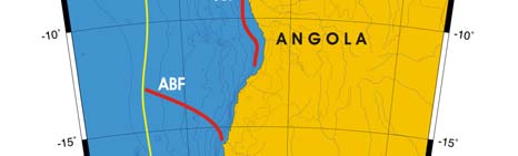
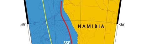
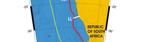
Oceanic fronts: The coastal upwelling zone off South Africa extends from Cape of Good
Hope (34.5°S) north to 13°S and consists of the two major areas, the northern and
southern Benguela upwelling frontal zones (UFZ) separated by the so-called Lüderitz line
(LL) at 28°S, where the shelf's width is at a minimum (Shannon 1985, Shillington 1998)
(Figure I-1.1). The northern UFZ is year-round, whereas the southern UFZ is seasonal).
A peculiar double front is observed within the southern UFZ, between 28°S-32°S, with the
inshore front close to the coast (a few tens of km) and the offshore front over the shelf
break (150-200 km off the coast). This double-front pattern can be explained by the
conceptual model put forth by Barange and Pillar (1992). A vast frontal zone develops
seasonally off the Angolan coast. This zone consists of numerous fronts; most fronts
extend ESE-WNW; the entire zone seems to protrude seaward from the Angolan coast
north of 20°S (Belkin et al. 2008). This zone is likely related to the Angola-Benguela
Front (ABF) (Shannon et al. 1987, Meeuwis & Lutjeharms 1990).
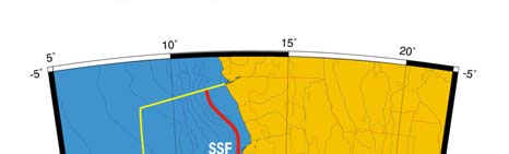
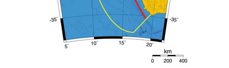
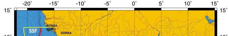
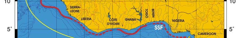
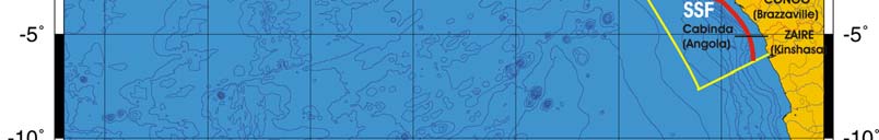
Figure I-1.1. Fronts of the Benguela Current. ABF, Angola-Benguela Front; LL, Lüderitz Line; SSF, Shelf-
Slope Front. Yellow line, LME boundary. (Belkin et al. 2008)
I West and Central Africa
105
Benguela Current SST
Linear SST trend since 1957: 0.26°C.
Linear SST trend since 1982: 0.24°C.
The Benguela Current's thermal history was punctuated by warm and cold events
associated with Benguela El Nińos and La Nińas, Atlantic counterparts of the Pacific El
Nińos and La Nińas. Fidel and O'Toole, in a presentation made at the 2nd Global
Conference on Large marine Ecosystems in Qingdao, distinguished five major Benguela
El Nińos over the last 50 years. The most pronounced warming of >1.2°C occurred after
the all-time minimum of 1958 and took 5 years to peak in 1963. Other warm events
peaked in 1973 and 1984, alternated with cold events of 1982 and 1992. Clearly,
decadal variability in the Benguela Current was strong through the last warm event of
1984. After that, the Benguela Current experienced a shift to a new, warm regime, in
which decadal variability is subdued. Some researchers also note the 1995 warm event,
although this maximum is not conspicuous from Hadley SST data. The post-1982
warming of the Benguela Current LME was spatially non-uniform: whereas SST in some
areas of northern Benguela (between 12-26°S) increased by 0.6 to 0.8°C, the inshore
shelf area of southern Benguela experienced a slight cooling (Fidel and O'Toole, 2007,
after Pierre Florenchie, University of Cape Town, personal communication).
The thermal history of this LME bears limited commonality with either the Guinea Current
LME (its northern neighbor) or to the Agulhas Current LME (its southern neighbor). This
is not at all surprising since these three LMEs are oceanographically disconnected.
Indeed, the Agulhas Current retroflects southwest of Cape Agulhas and therefore does
not feed the Benguela Current, save possibly for small occasional alongshore leakages.
In the north, the Angola-Benguela Front (ABF) blocks any direct along-shelf connection
between two neighbors, the Benguela Current LME and Guinea Current LME.
Correlation analysis suggests different responses to environmental forcing in the
northern, central, and southern parts of the Benguela Current region (Jury and Courtney,
1995). For example, the lower correlation in the southern Benguela between SST and
local winds suggests that SST variability here is often driven by advection, likely by the
Agulhas Current and its extension. The higher correlation in the central Benguela
between SST and local winds indicates that SST variability here is largely driven by local
upwelling.
Figure I-1.2. Benguela Current LME mean annual SST (left) and annual SST anomalies (right), 1957
2006, based on Hadley climatology (after Belkin 2008).


106
1. Benguela Current LME
Benguela Current Trends in Chlorophyll a and Primary Productivity: The Benguela
Current LME is a Class I, highly productive ecosystem (>300 gCm-2y-1).
Figure I-1.3. Benguela Current LME trends in chlorophyll a (left) and primary productivity (right) 1998-
2006; values are color coded to the right hand ordinate. Courtesy of J. O'Reilly and K. Hyde. Sources
discussed p.15 this volume.
II. Fish and Fisheries
The Benguela Current LME is very rich in pelagic and demersal fish. Most of the LME's
major fisheries resources are shared between the bordering countries or migrate across
national jurisdictional zones, and include sardine (Sardinops sagax), anchovy (Engraulis
capensis), hake (Merluccius capensis and M. paradoxus), horse mackerel (Trachurus
trachurus and T. trecae), sardinella (Sardinella spp.), and rock lobster (Jasus lalandii).
Artisanal, commercial (industrial) and recreational fisheries are all of significance in the
LME, with artisanal fisheries being particularly important for Angola. Total reported
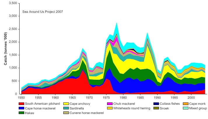
landings of the LME increased steadily from 1950 to a peak of about 3 million tonnes in
1978 (Figure I-1.4). In the subsequent years, however, the landings show a general
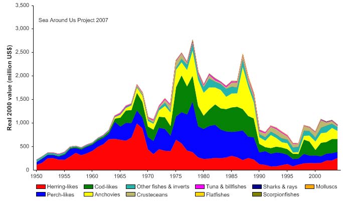
decline, down to about 1.1 million tonnes in 2004. The trend in the value of the reported
landings closely resembles that of the reported landings, peaking at just under 3 billion
US$ (in 2000 real US$) in 1978 (Figure I-1.5).
Figure I-1.4. Total reported landings in the Benguela Current LME by species (Sea Around Us 2007).
I West and Central Africa
107
Figure I-1.5. Value of reported landings in the Benguela Current LME by commercial groups (Sea
Around Us 2007).
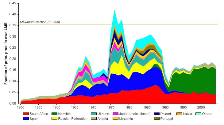
The primary production required (PPR; Pauly & Christensen 1995) to sustain the reported
landings in the LME reached one third of the observed primary production by the mid
1970s, but has since declined to half that level (Figure I-1.6). Although there were large
numbers of foreign fleets operating in the LME in the 1970s and 1980s, since the early
1990s, Namibia and South Africa have the largest ecological footprints in the region.
Figure I-1.6. Primary production required to support reported landings (i.e., ecological footprint) as
fraction of the observed primary production in the Benguela Current LME (Sea Around Us 2007). The
`Maximum fraction' denotes the mean of the 5 highest values.
Since the mid 1970s, the mean trophic level of the reported landings (i.e, the MTI, Pauly
& Watson 2005) has been relatively stable in this LME, (Figure I-1.7 top), but as the
amount of catch (tonnage) has declined over the same period, the FiB index shows a
rapid decline (Figure I-1.7 bottom).
108
1. Benguela Current LME
Figure I-1.7. Trophic level (i.e., Marine Trophic Index) (top) and Fishing-in-Balance Index (bottom) in the
Benguela Current LME (Sea Around Us 2007).
This decline of the FiB index is particularly strong off Namibia (Willemse and Pauly 2004),
where the ecosystem has been greatly modified, with jellyfish now dominating the food
web (Lynam et al. 2006). This is a case of `fishing down marine food webs' (Pauly et al.
1998), but one in which the species that replaced the exploited species are presently not
targeted by fisheries.
1950
1960
1970
1980
1990
2000
0%
100
10%
90
20%
)
80
%
(
s
30%
u
70
t
at
s
40%
y
60
ks b
50%
c
50
t
o
f
s
60%
o
40
er
b
70%
m
30
Nu
80%
20
90%
10
100%0
1950
1960
1970
1980
1990
2000
(n = 3894)
developing
fully exploited
over-exploited
collapsed
1950
1960
1970
1980
1990
2000
0%
100
10%
90
20%
80
)
%
30%
(
70
t
us
40%
t
a
60
s
k
c
50%
t
o
50
s
60%
h by
40
t
c
a
70%
C
30
80%
20
90%
10
100%0
1950
1960
1970
1980
1990
2000
(n = 3894)
developing
fully exploited
over-exploited
collapsed
Figure I-1.8. Stock-Catch Status Plots for the Benguela Current LME, showing the proportion of
developing (green), fully exploited (yellow), overexploited (orange) and collapsed (purple) fisheries by
number of stocks (top) and by catch biomass (bottom) from 1950 to 2004. Note that (n), the number of
`stocks', i.e., individual landings time series, only include taxonomic entities at species, genus or family
level, i.e., higher and pooled groups have been excluded (see Pauly et al. this vol. for definitions).
I West and Central Africa
109
The Stock-Catch Status Plots indicate that about 60% of commercially exploited stocks in
the LME has collapsed, with another 10% overexploited (Figure I-1.8 top), with fully-
exploited stocks contributing 50% of the catch (Figure I-1.8, bottom). However, fully
exploited stocks, while accounting for less than 30% of the stocks, provide over 50% of
the reported landings (Figure I-1.8).
Major changes in the key harvested species have occurred in the last century (Hampton
et al. 1999, Shannon & O'Toole 2003). While environmental variability has been a
contributing factor, some of these changes were undoubtedly the consequence of
overexploitation (FAO 2003, Sherman 2003). The decline in these fisheries is caused, in
part, by excessive fishing effort and overcapacity of fleets, excess processing capacity,
catching of under-sized fish, and inadequate fisheries management
(GEF/UNDP/UNOPS/NOAA 1999). As a result, the fisheries in the LME have
experienced years of catches well below the maximum or optimal sustainable yields, with
dramatic declines in stock sizes and catch per unit effort.
Decline in commercial fish stocks and non-optimal fishing of living resources is now a
major transboundary problem in the LME (GEF/UNDP/UNOPS/NOAA 1999). In all three
countries bordering the LME, major fisheries resources have undergone significant
changes in annual catch (Hampton et al. 1999, Tapscott 1999) and this is also true for
exploitation of invertebrate resources. For example, rock lobster catches have declined
dramatically since the early 1960s, particularly off Namibia, where catches are now well
below their 1960s peak. Assessments of the South African rock lobster resource have
shown it to be seriously depleted, and estimates of recruitment in recent decades are
only about 35% of its pre-exploitation condition (Hampton et al. 1999). The abalone
stock has also been declining since 1996 (Tarr et al. 2000) and the stock is considered to
be on the brink of collapse as a result of illegal fishing (Tarr 2000) and an ecological shift
in abundance (Tarr et al. 1996).
Some of the major stock fluctuations have undoubtedly been influenced by the large-
scale environmental perturbations that occur periodically in the system (Shannon &
O'Toole 1998, Shannon et al. 2006). System-wide changes in abundance of species and
species shifts (e.g., sardine and anchovy) are well-documented in this LME (e.g.,
Hampton et al. 1999, Shannon & O'Toole 2003). Fluctuations in abundance of the LME's
fish stocks have also been detected through acoustic surveys for pelagic species such as
sardines and anchovies (Barange et al. 1999, Hampton et al. 1999), and trawl surveys for
demersal species (Hampton et al. 1999). The geographic displacement of stocks (e.g.,
Sardinella aurita and S. maderensis in Angola into Gabon) is also a common
phenomenon with alongshore migration of fish populations across national boundaries in
the Benguela Current LME having important implications for resource management.
Global warming and associated phenomena are also expected to influence the LME's
upwelling system, with potentially significant impact on the local food webs and the entire
ecosystem, including fish recruitment and fisheries production.
Fluctuations in fish stocks can also have effects on top predators such as seabirds and
seals (Crawford 1999, Crawford et al. 1992). For example, the distribution of Cape
gannets, Cape cormorants, and African penguins has changed over the past three
decades in response to changes in the distribution and relative abundance of sardine and
anchovy (Crawford 1998). The high mortality and breeding failure of Cape fur seal
colonies in Namibia in 1994 and 1995 can be attributed to low food availability resulting
from low sardine abundance, a consequence of the catastrophic environmental variability
and anomalous low oxygen events (O'Toole 1996).
110
1. Benguela Current LME
Despite the vast scale of the fisheries in the LME, bycatch is not a major problem, and is
taken mostly in the large pelagic and demersal fisheries. Discarding is controlled by strict
regulations as well as by observers in some fisheries (e.g., Patagonian toothfish) but by
self-policing where the bycatch is used as a luxury product. In the demersal trawl fishery
of South Africa, 10% of the total catch is discarded (Walmsley-Hart et al. 2000). Both
South African and Angolan purse seine fisheries yield bycatch rates between 10-20% of
the total catch (Crawford et al. 1987).
The status of the fisheries is problematic, as the countries develop and implement
national and regional fisheries policies and management programmes (GEF/ UNDP/
UNOPS/ NOAA 2002). Furthermore, some stocks show signs of response to
environmental variability, e.g., recently correlated with a movement of sardines from
Namibian waters to the south and southwest coasts toward the Agulhas Bank (van der
Lingen et al. 2006). Sardine stocks in South Africa showed signs of recovery from the
mid-1990s as a result of careful control of bycatch of juveniles, and the introduction of an
operational management procedure which focused on rebuilding sardine stocks while
optimally utilising the anchovy. However, recent stock assessment surveys of sardines
around the Cape indicate a decline to very low levels compared with the mid 1990s.
III. Pollution and Ecosystem Health
Pollution: Virtually the entire coastline of the Benguela Current LME is exposed to the
open ocean and experiences a relatively high degree of wave action. Strong wave action
and currents tend to rapidly dissipate any pollution reaching the marine environment.
Pollution is not a serious problem in the open marine areas of most of the LME, and is
mostly evident in localised areas or hotspots such as ports and enclosed lagoons in all
three countries. Poorly planned coastal developments, inadequate waste management,
chronic oil pollution, inappropriate agricultural practices, contaminated stormwater run-off,
as well as industrial and sewage wastewater discharges are among the factors that
contribute to the deterioration of coastal and marine environments in the LME (UNEP
2005, Taljaard et al. 2006). Levels of pollution, with the exception of hotspots, are
considered moderate (UNEP 2005). With poor urban infrastructure, there is a very real
danger that a rapidly expanding urban population will pose a serious pollution threat, as
untreated sewage is discharged into the sea in increasing volumes. HABs have been
identified as a major transboundary problem, and their frequency of occurrence, spatial
extent, and duration appear to be increasing (GEF/UNDP/UNOPS/NOAA 1999).
Although HABs occur naturally in all three bordering countries (Tapscott 1999), several
factors, including nutrient loading from anthropogenic activities (e.g., discharge of
untreated sewage), can promote their incidence and spread. Toxins produced by HABs
have led to mortalities of fish, shellfish, and humans, as well as anoxia in inshore waters
that can cause mass mortality of marine organisms (GEF/UNDP/UNOPS/NOAA 1999).
Diamond mining operations impact negatively on the marine environment. Certain
mining activities are conducted close to national boundaries (e.g., diamond mining near
the Orange River mouth on both sides of the border between South Africa and Namibia),
across which negative consequences may be transmitted. Diamond mining is also
thought to affect marine living resources. For instance, although the dramatic decrease
in Namibian rock lobster catches in the 1990s may be attributed to large scale
environmental perturbations, it is evident that stock abundance might have also been
influenced by marine diamond mining (Tapscott 1999). While mining is the primary
cause of increased suspended solids in the marine areas, poor agricultural practices also
contribute to this problem, particularly in estuaries, lagoons, and sheltered bays. Marine
litter from land and shipping poses a serious growing problem throughout the LME, with
significant transboundary consequences (GEF/UNDP/UNOPS/NOAA 1999). Oil and gas
exploration and production are considered to pose a major threat, particularly off Angola,
I West and Central Africa
111
with oil spills sometimes causing severe local pollution which impacts artisanal fisheries.
A substantial volume of oil is transported through the region, and poses a significant risk
of contamination to coastal environments, damage to shared and straddling fish stocks,
and to coastal infrastructure (GEF/UNDP/UNOPS/NOAA 1999).
Habitat and community modification: Four estuaries and five coastal lagoons in the
Benguela Current LME are considered to be of transboundary significance. Several
lagoons have been designated as Ramsar sites. Species that are endemic to only one or
two estuarine systems within the LME are also present. The rare estuaries represent the
only sheltered marine habitat in the LME, and are important both for biodiversity and as a
focus of coastal development.
Habitat and community modification was assessed as severe in the Benguela Current
LME (UNEP 2005). The TDA produced by the GEF-supported Benguela Current Large
Marine Ecosystem (BCLME) Project has identified habitat destruction and alteration,
including modification of the seabed and coastal zone, and degradation of coastscapes,
as a transboundary problem in this LME (GEF/UNDP/UNOPS/NOAA 1999).
Nevertheless, compared to other parts of the world, these effects are minor in the
Benguela Current LME.
Modification of the few estuarine systems was found to be severe in the Benguela
Current LME (UNEP 2005). There is some loss of rocky and sandy foreshores in the
region due to port construction, seawalls, resort development, and coastal diamond
mining particularly in South Africa and Namibia, and some sand mining in Angola. The
invasion of a significant stretch of coastline by the alien mussel (Mytilus galloprovincialis)
has drastically altered community structure and functional group composition on the
shore. Exploitation of some species in the kelp beds and mangroves has led to changes
in community structure within these habitats.
The potential impacts of sea level rise on the coastal areas of the Benguela Current LME
include increased coastal erosion and inundation of coastal areas. Available evidence
suggests that variability and extremes in rainfall pattern are increasing in the south,
particularly in the drier western parts (Tyson 1986, Mason et al. 1999). The resulting
projected changes in stream flow are likely to have serious consequences for the
estuaries.
Pollution, particularly microbiological, chemical and solid waste as well as eutrophication,
is expected to become worse in the future, if poorly planned urbanization and economic
development in the coastal areas of this LME continue (UNEP 2005). Habitat
modification and loss are also expected to become worse if current practices continue,
increasing the concern over the cumulative future effects on the health of this ecosystem.
IV. Socioeconomic Conditions
A large part of the population of the countries bordering the Benguela Current LME lives
in urban areas, many of which are situated near the coast. The LME and its resources
are of considerable socioeconomic importance to the bordering countries. For example,
the production of oil and gas off the coast is the most important economic activity in
Angola, contributing 90% of the total Gross Domestic Product (GDP). The fisheries
sector is an important source of revenue, food, and employment in the three countries.
Traditionally, fisheries have contributed significantly to the livelihoods of coastal
communities. In Angola, this sector currently rates third after oil and diamond mining,
and is estimated to provide half of the animal protein consumed in the country. Fishing
contributes 9% to Namibia's GDP (SADC 2003), with annual fisheries exports worth over
225 million US$. Although the fisheries sector plays a small part in South Africa's
112
1. Benguela Current LME
economy, contributing about 1% to GDP (FAO 2006), it makes a significant contribution
to the regional economy of the Western Cape, which is the centre for the industrial
fisheries. In some coastal areas of South Africa, this sector is the dominant employer.
Fisheries constitute an important contribution to national revenue, employment, and food
security in the bordering countries. These include a variable and uncertain job market,
loss of national revenue, loss of food security, erosion of sustainable livelihoods, missed
opportunities through underutilisation and wastage, and loss of competitive edge on
global markets (GEF/UNDP/UNOPS/NOAA 1999). Unpredictable fisheries yields have
sometimes resulted in closure of fish processing plants. Conflicts between subsistence,
artisanal, commercial, and recreational fisheries also arise when resources become
scarce. Subsistence fisheries depletion may adversely affect the diet and consequently
the health of those dependent on fisheries. In many coastal settlements fishing is the only
source of livelihood for the poorer segments of the population. Reduced fisheries
resources also lead to migration of human populations from rural coastal areas to cities,
resulting in expansion of urban poverty. Regime shifts as well as factors possibly related
to climate change may displace fish stocks, contributing to socio-economic difficulties and
threats to breeding populations of endemic species, e.g. African penguin.
V. Governance
The Benguela Current LME is located within the UNEP Regional Seas for the West and
Central Africa Region, which was forged in the early 1980s. The West and Central
African Action Plan for the Protection and Development of the Marine Environment and
Coastal Areas of the West and Central African Region, the Abidjan Convention for Co-
operation in the Protection and Development of the Marine and Coastal Environment of
the West and Central African Region (Abidjan Convention) and associated Protocol
Concerning Co-operation in Combating Pollution in Cases of Emergency were adopted
by the Governments of the region in 1981. Projects on contingency planning, pollution,
coastal erosion, environmental impact assessment, environmental legislation and marine
mammals soon followed. A Conference of Plenipotentiaries, which met in Dakar,
Senegal, in 1991, adopted the Regional Convention on Fisheries Cooperation among
African States bordering the Atlantic Ocean (Dakar Convention), to which Angola has
acceded.
There is a strong need for harmonising legal and policy objectives and for developing
common strategies for resource surveys, as well as investment in sustainable ecosystem
management in the Benguela Current LME. In 1997 a major regional cooperative
initiative (BENEFIT: BENguela-Environment-Fisheries-Interaction and Training
Programme) was launched jointly by Angola, Namibia, and South Africa, together with
foreign partners (Norway and Germany) to enhance science capacity required for the
optimal and sustainable utilization of living resources of the Benguela Current LME. This
programme has been remarkably successful in developing cooperation among the three
countries and in helping to strengthen marine scientific capacity in the region. A GEF
grant and in-kind support of 38 million US$ to Angola, Namibia and South Africa, the
three countries participating in the Benguela Current LME assessment and management
project, will allow for significant additional support for initiating time-series measurement
of selected indicators of the ecosystem's productivity, fish and fisheries, pollution and
ecosystem health, and socioeconomics.
In March 2000, this regional cooperation was further enhanced with the initiation of the
implementation phase of the Benguela Current LME Programme (www.bclme.org), to
assist Angola, Namibia, and South Africa to assess and manage the marine resources of
the LME in an integrated and sustainable manner. This programme, which is funded in
part by the GEF and the 3 participating countries, chiefly addresses transboundary
I West and Central Africa
113
problems in three key areas of activity: the sustainable management and utilisation of
living resources; the assessment of environmental variability, ecosystem impacts and
improvement of predictability; and maintenance of ecosystem health and management of
pollution. Through this project, the Transboundary Diagnostic Analysis (TDA) and
Strategic Action Plan (SAP) were used to review the existing knowledge on the status of,
and to identify the threats to the Benguela Current LME. One of the main goals of the
BCLME Programme was the creation of the Benguela Current Commission. This
process was formalised through the signing of an Interim Agreement by the three
countries on 29 August 2006 in Cape Town. This transitional management entity, which
will last for four years, will be the precursor of the fully-fledged Benguela Current
Commission whose function and responsibilities will be to implement an ecosystem
approach to ocean governance in the Benguela region. This will include annual stock
assessments of key economic species, annual ecosystem reports, the provision of advice
on harvesting resource levels and other matters related to sustainable resource use,
particularly fisheries and the management of the Benguela Current LME as a whole.
References
Barange, M., Hampton, I. and Roel, B.A. (1999). Trends in the abundance and distribution of
anchovy and sardine on the South African continental shelf in the 1990s, deduced from
acoustic surveys. South African Journal of Marine Science 21: 367-391.
Barange, M. and Pillar, S.C. (1992). Cross-shelf circulation, zonation and maintenance
mechanisms of Nyctiphanes capensis and Euphausia hanseni (Euphausiacea) in the northern
Benguela upwelling system. Continental Shelf Research 12(9): 1027-1042.
Belkin, I.M. (2008) Rapid warming of Large Marine Ecosystems, Progress in Oceanography, in
press.
Belkin, I.M. , Cornillon, P.C., and Sherman, K. (2008) Fronts in Large Marine Ecosystems of the
world;s oceans. Progress in Oceanography, in press.
Crawford, R.J.M., Shannon, L.V. and Shelton, P.A. (1989). Characteristics and management of the
Benguela as a Large Marine Ecosystem, p 169-219 in: Sherman, K. and Alexander, L.M. (eds),
Biomass Yields and Geography of Large Marine Ecosystems. AAAS Selected Symposium 111.
Westview Press. Boulder, Colorado.
Crawford, R.J.M. (1998). Responses of African penguins to regime changes of sardine and
anchovy in the Benguela System, p 355-364 in: Pillar, S.C., Moloney, C.L. Payne, A.I.L. and
Shillington, F.A. (eds), Benguela Dynamics: Impacts of Variability on Shelf - Sea Environments
and their Living Resources. South African Journal of Marine Science 19.
Crawford, R.J.M. (1999). Seabird responses to long-term changes in prey resources off Southern
Africa, p 688-705 in: Adams, N. and Slotow, R. (eds), Proceedings of 22nd International
Ornithological Congress, Durban. Birdlife South Africa, Johannesburg, South Africa.
Crawford, R.J.M., Shannon, L.V. and Pollock, D.E. (1987). The Benguela Ecosystem. Part VI. The
major fish and invertebrate resources. Oceanography and Marine Biology 25:353-505.
Crawford, R.J.M., Underhill, L.G., Raubenheimer, C.M., Dyer, B.M. and Martin, J. (1992). Top
predators in the Benguela ecosystem implications of their trophic position, p 95-99 in: Payne,
A.I.L., Brink, K.J., Mann, K.J. and Hilborn, R. (eds), Benguela Trophic Functioning. South
African Journal of Marine Science 12.
FAO (2003). Trends in Oceanic Captures and Clustering of Large Marine Ecosystems Two
Studies Based on the FAO Capture Database. FAO Fisheries Technical Paper 435.
FAO (2006). Fisheries country profiles. www.fao.org/fi/fcp/fcp.asp
Fidel, Q. and O'Toole, M.J. (2007). Changing State of the Benguela LME: Forcing, Climate
Variability and Ecosystem Impacts. Presentation to the 2nd Global Conference on Large Marine
Ecosystems,11-13 September 2007,Qingdao, PR China. Available online at
www.ysfri.ac.cn/GLME-Conference2-Qingdao/ppt/18.1.ppt.
GEF/UNDP/UNOPS/NOAA (1999). Benguela Current Large Marine Ecosystem Transboundary
Diagnostic Analysis.
GEF/UNDP/UNOPS/NOAA (2002). Benguela Current Large Marine Ecosystem Strategic Action
Programme.
114
1. Benguela Current LME
Hampton, I., Boyer, D.C., Penney, A.J., Pereira, A.F. and Sardinha, M. (1999). Integrated Overview
of Fisheries of the Benguela Current Region: A Synthesis Commissioned by the United Nations
Development Programme (UNDP) as an Information Source for the Benguela Current Large
Marine Ecosystem (BCLME) Programme. Thematic Report 1: Synthesis and Assessment of
Information on the BCLME. UNDP, Windhoek, Namibia.
Hamukuaya, H., M.J. O'Toole and P.M.J. Woodhead (1998). Observations of severe hypoxia and
offshore displacement of Cape hake over the Namibian shelf in 1994. S. Afr. J. Mar. Sci. 19:57-
59.
Lynam, C.P., Gibbon, M.J., Axelsen, B.E., Sparks, C.A.J., Coetzee, J., Heywood, B.G. and
Brierley, A.S. (2006). Jellyfish overtake fish in a heavily fished ecosystem. Current Biology 16
(13): R492-R493.
Mason, S.J., Waylen, P.R., Mimmack, G.M., Rajaratnam, B. and Harrison, M.J. (1999). Changes in
extreme rainfall events in South Africa. Climate Change 41:249-257.
Meeuwis, J.M. and Lutjeharms, J.R.E. (1990). Surface thermal characteristics of the Angola-
Benguela front. South African Journal of Marine Science 9: 261-279.
O'Toole, M.J., Shannon L.V. de Barros Neto, and Malan, D.E. (2001). Integrated Management of
the Benguela Current Region A Framework for Future Development. P.228-251 In: B. von
Bodungen and R.K. Turner (eds): Science and Integrated Coastal Management, Dahlem
University Press, Berlin.
O'Toole, M.J. (1996). Namibia's marine environment. Namibia Environment 1:51-55.
Palomares, M.D. and Pauly, D. (2004). Biodiversity of the Namibian Exclusive Economic Zone: a
brief review with emphasis on online databases. p. 53-74 in: U.R. Sumaila, Boyer, D., Skogen,
M.D. and Steinshamm, S.I. (eds.) Namibia's fisheries: ecological, economic and social aspects.
Eburon Academic Publishers, Amsterdam.
Pauly, D. and Christensen, V. (1995). Primary production required to sustain global fisheries.
Nature 374: 255-257.
Pauly, D., Christensen, V., Dalsgaard, J., Froese R. and Torres, F.C. Jr. (1998). Fishing down
marine food webs. Science 279: 860-863.
Pauly, D. and Watson, R. (2005). Background and interpretation of the `Marine Trophic Index' as a
measure of biodiversity. Philosophical Transactions of the Royal Society: Biological Sciences
360: 415-423.
SADC (2003). Official SADC Trade Industry and Investment Review 2003. www.sadcreview.com/
Sea Around Us (2007). A Global Database on Marine Fisheries and Ecosystems. Fisheries Centre,
University British Columbia, Vancouver, Canada. www.seaaroundus.org/lme/SummaryInfo
.aspx?LME=29
Shannon, L.V., ed. (1985). South African ocean colour and upwelling experiment. Sea Fisheries
Research Institute, Cape Town.
Shannon, L.V., Agenbag, J.J. and Buys, M.E.L. (1987). Large- and mesoscale features of the
Angola-Benguela Front. South African Journal of Marine Science 5: 11-34.
Shannon, L.V. and O'Toole, M.J. (1998). An Overview of the Benguela Ecosystem. Collected
papers, First Regional Workshop, Benguela Current Large Marine Ecosystem (BCLME)
Programme, UNDP. 22-24 July 1998, Cape Town, South Africa.
Shannon, L.V. and O'Toole, M.J. (1999). Integrated Overview of the Oceanography and
Environmental Variability of the Benguela Current Region: Thematic Report 2, Synthesis and
Assessment of Information on BCLME: October 1998, UNDP, Windhoek, Namibia.
Shannon, L.V. and O'Toole, M.J. (2003). Sustainability of the Benguela: Ex Africa semper aliquid
novi, p 227-253 in: Hempel, G. and Sherman, K. (eds), Large Marine Ecosystems of the World
Trends in Exploitation, Protection and Research. Elsevier, Amsterdam, The Netherlands.
Shannon, V., Hempel, G., Melanotte-Rizzoli, P., Moloney, C. and Woods, J. eds. (2006). Benguela:
Predicting a Large Marine Ecosystem. Elsevier Science
Sherman, K. (2003). Physical, biological, and human forcing of biomass yields in Large Marine
Ecosystems. ICES CM2003/P: 12.
Shillington, F.A. (1998). The Benguela upwelling system off southwestern Africa, p 583-604 in:
Robinson, A.R. and Brink, K.H. (eds), The Sea, Vol. 11: The Global Coastal Ocean, Regional
Studies and Syntheses. John Wiley and Sons, New York.
Taljaard, S., Morant, P.D., van Niekerki, L. and Lita, A. (2006). Southern Africa, p 29 - 49 in:
UNEP/GPA (2006), The State of the Marine Environment: Regional Assessments. UNEP/GPA,
The Hague.
Tapscott, C. (1999). An Overview of the Socioeconomics of some Key Maritime Industries in the
Benguela Current Region (Draft): A Synthesis Commissioned by the United Nations
Development Programme (UNDP) as an Information Source for the Benguela Current Large
I West and Central Africa
115
Marine Ecosystem (BCLME) Programme. Thematic Report 6: Synthesis and Assessment of
Information on theBCLME. UNDP, Windhoek, Namibia.
Tarr, R.J.Q. (2000). The South African abalone (Haliotis midae) fishery: A decade of challenges
and change. Journal of Shellfish Research 19(1):537.
Tarr, R.J.Q., Williams, P.V.G. and Mackenzie, A.J. (1996). Abalone, sea urchins and rock lobster: a
possible ecological shift may affect traditional fisheries. South African Journal of Marine
Science 17:319-324.
Tarr, R.J.Q., Williams, P.V.G., Mackenzie, A.J., Plaganyi, E. and Moloney, C. (2000). South African
fishery independent abalone surveys. Journal of Shellfish Research 19(1):537.
Tyson, P.D. (1986). Climate Change and Variability in Southern Africa. Oxford University Press,
Cape Town, South Africa.
UNEP (2005). Prochazka, K., Davies, B., Griffiths, C., Hara, M., Luyeye, N., O'Toole, M.,
Bodenstein, J., Probyn, T., Clark, B., Earle, A., Tapscott, C. and Hasler, R. Benguela Current,
GIWA Regional assessment 44. University of Kalmar, Kalmar, Sweden.
http://www.giwa.net/publications/r44.phtml
van der Lingen, C.D., Shannon, L.J., Cury, P., Kreiner, A., Moloney, C.L., Roux, J-P, Vaz-Velho, F.
(2006). Resource and ecosystem variability, including regime shifts, in the Benguela Current
system. P.156 in Shannon, V., Hempel, G., Malanotte-Rizzoli, Paola, Moloney, C., Woods, J.,
eds. Benguela: Predicting a Large marine Ecosystem. Elsevier, Amsterdam, p.156.
Walmsley-Hart, S.A., Sauer, W.H.H. and Leslie, R.W. (2000). The quantification of by-catch and
discards in the South African demersal trawling industry. 10th Southern African Marine Science
Symposium (SAMSS 2000): Land, Sea and People in the New Millennium.
Weeks, S.J., Currie, B., Bakun, A. and Peard, K.R. (2004). Hydrogen sulphide eruptions in the
Atlantic Ocean off Southern Africa: Implications of a new view based on SeaWiFS satellite
imagery. Deep Sea Research Part I: Oceanographic Research Papers 51(2):153-172.
Willemse, N.E. and Pauly, D. (2004). Reconstruction and interpretation of marine fisheries catches
from Namibian waters, 1950 to 2000. p. 99-112 in: U.R. Sumaila, Boyer, D., Skogen, M.D. and
Steinshamm, S.I. (eds.) Namibia's fisheries: ecological, economic and social aspects. Eburon
Academic Publishers, Amsterdam.
116
1. Benguela Current LME
I-2 Guinea Current LME
S. Heileman
The geographical boundaries of the Guinea Current LME extend from the intense
upwelling area of the Guinea Current in the north, to the northern seasonal limit of the
Benguela Current in the south. While the northern border of the Guinea Current is
distinct, but with seasonal fluctuations, its southern boundary is less well-defined, and is
formed by the South Equatorial Current (Binet & Marchal 1993). Sixteen countries border
the LME - Angola, Benin, Cameroon, Congo, Democratic Republic of the Congo, Côte
d'Ivoire, Gabon, Ghana, Equatorial Guinea, Guinea, Guinea-Bissau, Liberia, Nigeria, Săo
Tomé and Principe, Sierra Leone and Togo. The tropical climate of the region is
influenced by the northward and southward movements of the Inter-Tropical
Convergence Zone (ITCZ) associated with the southwest monsoon and the Northeast
Trade Winds. This LME covers an area of about 2 million km2, of which 0.33% is
protected, and includes 0.15% of the world's sea mounts and 0.20% of the world's coral
reefs (Sea Around Us 2007). Twelve major estuaries and river systems (including the
Cameroon, Lagos Lagoon, Volta, Niger-Benoue, Sanaga, Ogooue, and Congo rivers)
form an extensive network of catchment basins enter this LME, which has the largest
continental shelf in West Africa, although it should be noted that the West Africa's shelf is
relatively narrow compared with many other shelves of the World Ocean. A volume on
this LME was edited by McGlade et al. (2002), while another (Chavance et al. 2004)
contains numerous accounts on this system. Other articles and reports include Binet &
Marchal (1993), UNEP (2004) and Ukwe & Ibe (2006).
I. Productivity
The Guinea Current LME is a Class I, highly productive ecosystem (>300 gCm-2y-1). The
Guinea Current LME is characterised by seasonal upwelling off the coasts of Ghana and
Côte d'Ivoire, with intense upwelling from July to September weakening from about
January to March (Roy 1995). Seasonal upwelling drives the biological productivity of
this LME, which includes some of the most productive coastal and offshore waters in the
world. The cold, nutrient-rich water of the upwelling system is subject to strong seasonal
and inter-annual changes (Demarcq & Aman 2002, Hardman-Mountford & McGlade
2002), linked to the migration of the ITCZ. The LME is subject to long-term variability
induced by climatic changes (Binet & Marchal 1993). Changes in meteorological and
oceanographic conditions such as a reduction of rainfall, an acceleration of winds, an
alteration of current patterns, and changes in nearshore biophysical processes might
have significant consequences for biological productivity (Koranteng 2001). The coastal
habitats and marine catchment basins also play an important role in maintaining the
LME's productivity (Entsua-Mensah 2002).
Oceanic fronts (Belkin et al. 2008): Fronts in the Guinea Current occur mainly off its
northern coast, in winter and summer (Figure I-2.1). The winter front appears to be the
easternmost extension of the coastal Guinea Current that penetrates the Gulf; the front
fully develops in January-February, reaching 5°E by March. The summer front emerges
largely off Cape Three Points (2°W), usually in July-September, the upwelling season in
the Gulf, and sometimes extends up to 200 km from the coast. Wind-induced upwelling
develops east of Cape Palmas (7.5°W) and Cape Three Points owing to the coast's
orientation relative to the prevailing winds. Current-induced upwelling and wave
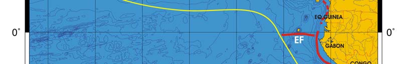
118
2. Guinea Current LME
propagation also contribute to the observed variability in the Gulf (Ajao & Houghton
1998).
Figure I-2.1. Fronts of the Guinea Current LME. EF, Equatorial Front; SSF, Shelf-Slope Front (solid line,
well-defined path; dashed line, most probable location). Yellow line, LME boundary. After Belkin (2008).
Guinea Current LME SST (after Belkin 2008)
Linear SST trend since 1957: 0.58°C.
Linear SST trend since 1982: 0.46°C.
The thermal history of the Guinea Current (Figure 1-2.2) included (1) a relatively stable
period until the all-time minimum of 1976; (2) warming until the present at a rate of ~1°C
in 30 years. Interannual variability of this LME is rather small, with year-to-year variations
of about 0.5°C. The only conspicuous event, the minimum of 1976, cannot be linked to a
similar cold event of 1972 in the two adjacent LMEs (Canary Current, Benguela Current)
because of the 4-year time lag between the two events, which seems too long for oceanic
advective transport of cold anomalies from one LME to another. The only plausible
explanation invokes a cold offshore anomaly, probably localized within the equatorial
band. Indeed, the North Brazil Shelf LME located on the western end of the equatorial
zone saw the all-time SST minimum in 1976, the same year as the all-time minimum in
the Guinea Current LME. Since the equatorial zone offers a fast-track conduit for
oceanic anomalies, it remains to be seen from high-resolution data if both minima were
truly synchronous hence caused by large-scale (ocean-wide) forcing or whether this
cold anomaly propagated along the equator from one LME to another across the Atlantic
Ocean.
I West and Central Africa
119
The above results are consistent with an analysis of AVHRR SST data from 1982-1991
(Hardman and McGlade, 2002). The latter study has found 1982-1986 and 1987-1990 to
be cool and warm periods respectively, with 1984 being exceptionally warm. As can be
seen from Hadley data, 1984 was exceeded first by 1988 and then by 1998, when SST
reached the all-time maximum probably linked to El-Nińo. The SST variability mirrors the
upwelling intensity, with strong upwelling in 1982-83, and weak upwelling in 1984 and
1987-1990 (Hardman and McGlade, 2002).
Figure I-2.2 Guinea Current LME mean annual SST (left) and SST anomalies (right), 1957-2006, based
on Hadley climatology. After Belkin (2008).
Guinea Current Trends in Chlorophyll and Primary Productivity: The Guinea
Current LME is a Class I, highly productive ecosystem (>300 gCm-2y-1).
Figure I-2.3 Guinea Current LME trends in chlorophyll a (left) and primary productivity (right), 1998-
2006. Values are colour coded to the right hand ordinate. Figure courtesy of J. O'Reilly and K. Hyde.
Sources discussed p. 15 this volume.
II. Fish and Fisheries
The Guinea Current LME is rich in living marine resources. These include locally
important resident stocks supporting artisanal fisheries, as well as transboundary
straddling and migratory stocks that have attracted large commercial offshore foreign
120
2. Guinea Current LME
fishing fleets. Exploited species include small pelagic fishes (e.g., Sardinella aurita,
Engraulis encrasicolus, Caranx spp.), large migratory pelagic fishes such as tuna
(Katsuwonus pelamis, Thunnus albacares and T. obesus) and billfishes (e.g., Istiophorus
albicans, Xiphias gladius), crustaceans (e.g., Penaeus notialis, Panulirus regius),
molluscs (e.g., Sepia officinalis hierredda), and demersal fish (e.g., Pseudotolithus
senegalensis, P. typus, Lutjanus fulgens) (Mensah & Quaatey 2002). Several fishery
resource surveys have been conducted in the LME (Koranteng 1998, Mensah & Quaatey
2002), with the Guinean Trawling Survey conducted in 1963-1964 having been the first
large-scale survey in West African waters (Williams 1968). Data from this survey have
recently been recovered (Zeller et al. 2005).
Total reported landings show a series of peaks and troughs, although there has been an
overall trend of a steady increase from 1950 to the early 1990, followed by fluctuations
with a peak at just over 900,000 tonnes (Figure I-2.4). Due to the poor species break-
down in the official landings statistics, a large proportion of the landings falls in the
category named `mixed groups'. The trend in the value of the reported landings
increased to a peak of around US$ 1 billion (in 2000 US dollars) in 1991 and thereafter
declined considerably until the mid 1990s, before recovering to just over US $800 million
(Figure I-2.5). Nigeria and Ghana account for about half of the reported landings in this
LME, while European Union countries such as Spain and France, as well as Japan, are
among the foreign countries fishing in the LME in recent times. Since the 1960s, high
fishing pressure by foreign and local industrial fleets has placed the fisheries in the LME
at risk (Bonfil et al.1998; Kacynski & Fluharty 2002).
Figure I-2.4. Total reported landings in the Guinea Current LME by species (Sea Around Us 2007).
I West and Central Africa
121
Figure I-2.5. Value of reported landings in the Guinea Current LME by commercial groups (Sea Around
Us 2007).
The primary production required (PPR; Pauly & Christensen 1995) to sustain the reported
landings in the LME reached 9% of the observed primary production in the early 1990s
and has fluctuated between 6 to 9% (Figure I-2.6). Nigeria and Ghana account for the
two largest ecological footprints in the LME.
Figure I-2.6. Primary production required to support reported landings (i.e., ecological footprint) as
fraction of the observed primary production in the Guinea Current LME (Sea Around Us 2007). The
`Maximum fraction' denotes the mean of the 5 highest values.
Since the mid 1970s, the mean trophic level of the reported landings (i.e., MTI; Pauly &
Watson 2005) has declined (Figure I-2.7 top), an indication of a `fishing down' of the local
food webs (Pauly et al. 1998). The FiB index, on the other hand, has remained stable
122
2. Guinea Current LME
(Figure I-2.7 bottom), suggesting that the increase in the reported landings over this
period has compensated for the decline in the MTI (Pauly & Watson 2005).
Figure I-2.7. Trophic level (i.e., Marine Trophic Index) (top) and Fishing-in-Balance Index (bottom) in the
Guinea Current LME (Sea Around Us 2007).
The Stock-Catch Status Plots show that fisheries on collapsed stocks are rapidly
increasing in numbers (Figure I-2.8, top). However, the catch is still overwhelmingly
supplied by stocks in the fully exploited category (Figure I-2.8, bottom), which account for
just under 30% of the stocks.
1950
1960
1970
1980
1990
2000
0%
100
10%
90
20%
)
80
%
(
s
30%
u
70
at
st
40%
y
60
b
50%
cks
50
o
f
st
60%
o
40
er
70%
mb
30
Nu
80%
20
90%
10
100%0
1950
1960
1970
1980
1990
2000
(n = 4762)
developing
fully exploited
over-exploited
collapsed
1950
1960
1970
1980
1990
2000
0%
100
10%
90
20%
80
)
30%
(
%
70
s
u
at
40%
60
st
ck
50%
o
50
st
y
60%
b
h
40
c
70%
Cat
30
80%
20
90%
10
100%0
1950
1960
1970
1980
1990
2000
(n = 4762)
developing
fully exploited
over-exploited
collapsed
Figure I-2.8. Stock-Catch Status Plots for the Guinea Current LME, showing the proportion of
developing (green), fully exploited (yellow), overexploited (orange) and collapsed (purple) fisheries by
number of stocks (top) and by catch biomass (bottom) from 1950 to 2004. Note that (n), the number of
`stocks', i.e., individual landings time series, only include taxonomic entities at species, genus or family
level, i.e., higher and pooled groups have been excluded (see Pauly et al., this vol. for definitions).
I West and Central Africa
123
While some fish stocks such as skipjack tuna, small pelagic fish in the northern areas of
the Gulf of Guinea, and offshore demersal fish and cephalopods are underexploited
(Mensah & Quaatey 2002), the level of exploitation was found to be significant in this
LME (UNEP 2004). The Guinea Current LME TDA (see Governance) has identified the
decline in fish stocks and unsustainable fishing as a major transboundary problem
(UNIDO/ UNDP/ UNEP/ GEF/ NOAA 2003) and reviews of the status of the LME's
fisheries resources indicate that several fish stocks are either overexploited or close to
being fully exploited (Ajayi 1994, Mensah & Quaatey 2002). These include small
pelagics and shrimps in the western and central Gulf of Guinea and coastal demersal
resources throughout the LME. There is also evidence of depletion of straddling and
highly migratory fisheries stocks, with heavy exploitation of yellow-fin and big-eye tunas
(Mensah & Quaatey 2002). Overexploitation has resulted in declining stock biomass and
catch per unit effort (CPUE), particularly for inshore demersal species, and this decline
has been attributed to trawlers operating in inshore areas (Koranteng 2002, Koranteng &
Pauly 2004).
The use of small-sized mesh, especially in trawl, purse and beach seine nets is a
widespread problem, especially in the central part of the region. This practice leads to
excessive bycatch, but because these catches, mainly of juvenile fishes, are generally
utilised, they are discarded only in a few fisheries (e.g., the shrimp fishery). Other
destructive fishing practices such as the use of explosives and chemicals are also
common in the inshore areas (e.g., see Vakily 1993).
There are indications that overexploitation has altered the ecosystem as a whole, with
impacts at all levels, including top predators. Species diversity and average size of the
most important fish species have declined as a result of overexploitation (Koranteng
2002, FAO 2003). Strong patterns of fish variability in the LME are thought to be related
to strong interactions between species or communities, as well as to environmental
forcing (Cury & Roy 2002). The influence of environmental variability on fish stock
abundance and distribution in the LME has been demonstrated, for example, by Williams
(1968), Koranteng et al. (1996), and Roy et al. (2002). Several oceanographic features
that influence fish recruitment have also been identified (Hardman-Mountford & McGlade
2002). For instance, the abundance and distribution of small pelagic fish species are
controlled mainly by the intensity of the seasonal coastal upwelling, which also
determines the period of the main fishing season (Bard & Koranteng 1995).
The most significant changes in species abundance are reflected in sardinella (Sardinella
aurita) and triggerfish (Balistes capriscus). The sardinella fishery experienced a collapse
in 1973, and was followed by a vast increase in the abundance of triggerfish between
1973 and 1988. The decline of the triggerfish after 1989 was followed by an increase of
the sardinella to unprecedented levels during the 1990s (Binet & Marchal 1993, Cury &
Roy 2002). Koranteng & McGlade (2002) attributed the almost complete disappearance
of the triggerfish after the late 1980s to environmental changes and an upwelling
intensification off Ghana and Côte d'Ivoire. The highly variable environment of the
Guinea Current LME contributes to uncertainty regarding the status of fisheries stocks
and yields which is likely to increase considering the impact of global climate change
(UNIDO/UNDP/ UNEP/ GEF/ NOAA 2003). Therefore, environmental variability must be
considered in the sustainable use and management of the region's fisheries resources.
Cooperation among the countries bordering this LME in the management of the fisheries
resources would help to improve the fisheries situation in the future.
124
2. Guinea Current LME
III. Pollution and Ecosystem Health
Pollution: LMEs have experienced various stresses as a result of the intensification of
human activities. The coastal and marine environments of the Guinea Current are
seriously polluted in the vicinity of large cities (Scheren & Ibe 2002). An assessment of
the state of the environment with respect to the GPA land-based sources of pollution in
this region is given by Gordon & Ibe (2006). More than 60% of existing industries are
concentrated in the coastal areas and an estimated 47% of the population lives within
200 km of the coast. Pollution from land-based sources is particularly important, and
together with sea-based sources, has contributed to a deterioration of water quality in the
bordering countries. The TDA has identified the deterioration of water quality from land
and sea-based activities as one of the four broad environmental problems in the LME
(UNIDO/UNDP/UNEP/GEF/NOAA 2003). Overall, pollution was assessed as moderate,
but more serious in coastal hotspots associated with the larger coastal cities (UNEP
2004). Despite being mainly localised, pollution also has transboundary impacts in this
LME through the transport of contaminants by wind and water currents along the coast.
Sewage is one of the main sources of coastal pollution in the LME (UNEP 1999) and
arises from generally poor treatment facilities and widespread release of untreated
sewage into coastal areas (Scheren & Ibe 2002). Microbiological pollution is localised
around coastal cities and remains a problem in terms of human health. Organic pollution
from domestic, industrial and agricultural wastes has resulted in eutrophication and
oxygen depletion in some coastal areas (Awosika & Ibe 1998, Scheren & Ibe 2002).
While the incidence of eutrophication is not widespread and tends to be episodic, there
are instances of continuous and persistent causes of eutrophication in large coastal water
bodies (e.g., the Ebrié Lagoon in Abidjan). The increasing occurrence of HABs is of
concern to the bordering countries (Ibe & Sherman 2002). Pollution from solid waste
originating from domestic and industrial sources and offshore activities is severe across
the entire region, with the enormous bulk of solid waste produced daily being a serious
threat. Pollution from suspended solids is moderate along the coast, and arises mainly
from soil loss from farms and deforested areas. Although much of the silt is trapped in
dams and reservoirs, this has caused extensive siltation of coastal water bodies.
Chemical pollution is serious in coastal hotspots. Some chemical contaminants enter the
aquatic environment through the use of pesticides, agro-chemicals including persistent
organic pollutants (POPs) and as industrial effluents. Large quantities of residues (e.g.,
phosphate, mercury, zinc) from mining operations are discharged into coastal waters. Oil
production is an important activity in some of the countries, especially Nigeria, and most
of these countries have important refineries on the coast, only a few of which have proper
effluent treatment plants. Moreover, the LME's coastline lies to the east and downwind of
the main oil transport route from the Middle East to Europe. Pollution from spills is
significant, and arises mainly from oil spills from production points, loading and discharge
points and from shipping lanes. Significant point sources of marine pollution have been
detected around coastal petroleum mining and processing areas, releasing large
quantities of oil, grease and other hydrocarbon compounds into the coastal waters of the
Niger delta and off Angola, Cameroon, Congo and Gabon. It is estimated that about
4 million tonnes of waste oil are discharged annually into the LME from the Niger Delta
sub-region (UNIDO/ UNDP/ UNEP/ GEF/ NOAA 2003). Much of the oil found on
beaches originates from spills or tank washing discharged from tankers in the region's
ports (Portmann et al.1989). Because of the wind and ocean current patterns in the
Guinea Current LME, any oil spill from the offshore or shore-based petroleum activities
could easily become a regional problem.
Habitat and community modification: The Guinea Current LME is interspersed with
diverse coastal habitats such as lagoons, bays, estuaries and mangrove swamps.
I West and Central Africa
125
Besides being important reservoirs of biological diversity, these habitats provide
spawning and breeding grounds for many fish, including transboundary species and
shellfish in the region, and therefore are the basis for the regenerative capacity of the
region's fisheries (Ukwe et al. 2001). Both anthropogenic activities and natural
processes threaten these habitats. Although this is mainly localised, there are
transboundary impacts related to migratory and straddling fish stocks that may use these
habitats as spawning and nursery grounds.
It is estimated that 30% of habitat modification has been caused by natural processes,
including erosion and sedimentation due to wave action and strong littoral transport.
Coastal erosion is the most prevalent coastal hazard in the LME. Human activities, on
the other hand, are thought to be largely responsible for habitat modification in this LME
(UNEP 1999). Habitat and biodiversity loss due to hydrocarbon exploration and
exploitation is significant. Many coastal wetlands have been reclaimed for residential and
commercial purposes, with accompanying loss of wetland flora and fauna. The
introduction of exotic species is also recognised as a transboundary problem
(UNIDO/UNDP/UNEP/GEF/NOAA 2003).
Mangroves and estuaries have suffered the most losses, followed by sandy foreshores
and lagoons. The LME has large expanses of mangrove forests (the mangrove system
of the Niger Delta is the third largest in the world). However, these mangrove forests are
under pressure from over-cutting, conversion into agricultural farms or saltpans, erosion,
salinity changes, and other anthropogenic impacts (e.g., pollution). About 60% of
Guinea's original mangroves and nearly 70% of the original mangrove vegetation of
Liberia is estimated to be lost (Macintosh & Ashton 2002). The grass Paspalum
vaginatum is replacing the original mangrove vegetation in these countries. In other
areas the extent of mangrove destruction is: 45% in the Lake Nokoue area (Benin), 33%
in the Niger delta (Nigeria), 28% in the Warri Estuary (Cameroon) and 60% in Côte
d'Ivoire. Dam construction has led to reduction of freshwater and sediment discharge in
the lower estuarine reaches of the rivers and altered the extent of intrusion of the
estuarine salt wedge inland. This has important ecological effects on the flora and fauna
of the coastal habitats.
Climate change is expected to also lead to habitat modification and loss. The IPCC
(2001) has reported that Africa is highly vulnerable to climate change and sea level rise.
Studies conducted in Nigeria estimated that over 1,800 km2, or 2% of Nigeria's coastal
zone, and about 3.68 million people would be at risk from a 1 m rise in sea level (Awosika
et al. 1992). Moreover, Nigeria could lose over 3,000 km2 of coastal land from floods and
coastal erosion by the end of the 21st Century. Sea level rise would result in modification
or loss of flora, fauna and biodiversity in flooded lands and coastal habitats, particularly in
brackish waters (Ibe & Ojo 1994).
The LME is an important reservoir of marine biological biodiversity and has natural
resources of global significance. Green, leatherback, hawksbill, loggerhead and olive
ridley turtles are found in the LME. The LME is also inhabited by marine mammals
(whales, dolphins, and manatees), among which are the Atlantic humpback dolphin and
the African manatee, both of which appear on the IUCN Red List of endangered species
(IUCN 2002). The humpbacked dolphin is classified as highly endangered and the
African manatee as vulnerable under the Convention on International Trade of
Endangered Species (CITES).
IV. Socioeconomic Conditions
The 16 countries bordering the Guinea Current LME have an estimated total population
of 300 million. At the present rate of population growth, this is expected to double in 20-
126
2. Guinea Current LME
25 years. Approximately 47% of the people live within 200 km of the coast (GIS analysis
based on ORNL 2003). Rapid expansion of coastal populations with areas of high
population densities has resulted from high population growth rates and movements
between rural and urban areas (UNEP 1999). In addition, many of the region's poor are
crowded in the coastal areas for subsistence activities such as fishing, farming, sand and
salt mining and production of charcoal.
The Guinea Current LME and its natural resources represent a source of economic and
food security for the bordering countries. In addition to being of major importance for
food security in this region, fisheries also provide employment for thousands of people
and are a substantial source of foreign exchange for countries such as Angola, Côte
d'Ivoire, Ghana, and Guinea. A large proportion of the population could potentially be
affected by overexploitation of fisheries (UNEP 2004). A reduction in the size and quality
of the fish catch has widespread socioeconomic impacts, since more than 500,000 men
and women along the coast from Mauritania to Cameroon are employed in the artisanal
fishery (Bortei-Doku Aryeetey 2002). In Ghana, the national fish requirement has been
estimated at 794,000 tonnes for a population of about 17.9 million, but fisheries
production in 1998 achieved only 57% of the required volume (Akrofi 2002).
Over the past three decades, there has been evidence of reduced economic returns, loss
of employment and user conflicts between artisanal and large commercial trawlers for
access to the fishery resources (ACOPS/UNEP 1998). Côte d'Ivoire reported losses of
about US$80 million in 1998 due to decreased fishing activities. This loss was attributed
to the degradation of the coastal zone and its resources (GEFMSP/ACOPS/UNESCO
2001). The overexploitation of transboundary and migratory fish by offshore foreign
fleets is having a detrimental effect on artisanal fishermen as well as on those coastal
communities that depend on the near-shore fisheries resource for food. Local
communities are at risk if artisanal fishing cannot proceed. This becomes particularly
serious in the context of exploding demographics in the coastal areas and the fact that
most of the fish catch is exported out of the region where all the countries, except Gabon,
were classified by the FAO as Low Income Food Deficit Countries in 1998 (FAO 2002).
The socioeconomic impacts of pollution and habitat degradation include loss of
recreational resources, pollution of food sources, decline in living coastal resources, and
subsequent loss of subsistence livelihoods and reduction in food security and economic
activity. In addition, increased pressure on governments to produce alternative
livelihoods, and political instability at local or national levels may also arise. Coastline
erosion also causes some concern because of the threat to coastal settlements, tourist
infrastructure, agricultural and recreational areas, harbour and navigation structures, and
oil producing and export handling facilities. The costs of coastal protection and habitat
restoration can be high. For example, the restoration of the Korle Lagoon in Ghana has
cost the government nearly US$65 million (Government of Ghana 2000). Public health
risks from the presence of sewage pathogens and HABs are of concern. The cost of
treatment of water-borne diseases is significant. For example, the Korle Lagoon
Ecological Restoration Project (Government of Ghana 2000) estimated the cost of
treatment to range from US$10 to US$50 per person, depending on the duration and
intensity of the disease.
V. Governance
The countries bordering the Guinea Current LME participate in numerous bodies that
work together on various aspects of coastal degradation and protection of living marine
resources. The LME comes under the UNEP Regional Seas Programme for the West
and Central Africa Region (see the Benguela Current LME for more information). They
I West and Central Africa
127
have adopted several international environmental conventions and agreements, among
which is the Abidjan Convention and the Dakar Convention.
Mechanisms to provide regional collaboration on transboundary issues in the form of a
regional coordination unit, and regionally agreed environmental quality standards and
monitoring protocols and methods have been limited. These and other environmental
issues are being addressed through joint projects. The GEF-supported Guinea Current
Large Marine Ecosystem Project (Ibe & Sherman 2002, Ukwe et al. 2006) is an
ecosystem-based effort to assist countries adjacent to the Guinea Current LME to
achieve environmental and resource sustainability by shifting from short-term sector-
driven management objectives to a longer-term perspective and from managing
commodities to sustaining the production potential for ecosystem-wide goods and
services (www.chez.com/gefgclme/). The pilot phase of this project (Water Pollution
Control and Biodiversity Conservation in the Gulf of Guinea Large Marine Ecosystem)
involved Côte d'Ivoire, Ghana, Togo, Benin, Nigeria and Cameroon, and ended in
November, 1999. In 1998, the Ministerial Committee of this pilot project signed the Accra
Declaration on Environmentally Sustainable Development of the Guinea Current LME, as
an expression of their common political will for the sustainable development of marine
and coastal areas of the Gulf of Guinea.
The second phase of this project `Combating Living Resource Depletion and Coastal
Area Degradation in the Guinea Current LME through Ecosystem-based Regional
Actions', has extended the pilot phase to include 10 additional countries (Angola, Congo
Brazzaville, Congo-Kinshasa, Equatorial Guinea, Gabon, Guinea, Guinea-Bissau,
Liberia, Săo Tomé and Príncipe, and Sierra Leone). This phase includes the preparation
of a TDA and a SAP. A project goal is to build capacity of the countries to work jointly
and in concert with other nations, regions and with GEF projects in West Africa to define
and address priority transboundary environmental issues within the framework of their
existing responsibilities under the Abidjan Convention and the UNEP Regional Seas
Programme. The Ministers of Environment of Angola, Benin, Cameroon, Congo, Côte
d'Ivoire, Democratic Republic of Congo, Equatorial Guinea, Gabon, Ghana, Guinea,
Guinea Bissau, Liberia, Nigeria, Sao Tome and Principe, Sierra Leone and Togo,
gathered in Abuja, Nigeria, 21 22 September, 2006 on the occasion of the First Meeting
of Ministers responsible for the implementation of the Guinea Current Large Marine
Ecosystem (GCLME) Project; the Ministers signed the Abuja Declaration on 22
September, establishing the framework for an Interim Guinea Current Commission. The
Interim Commission was brought into force on 22 September 2006 in Abuja, Nigeria, and
is presently operating from Accra, Ghana. The focus of the Interim Commission is on
achieving sustainable development through integration of environmental concerns in
planning,accounting and budgeting, building capacity through multi-sector participation,
management of transboundary water bodies and living resources of land, forests and
biodiversity conservation, and development of information and data exchanges.
References
ACOPS/UNEP (1998). Background Papers to the Conference on Cooperation for the Development
and protection of the Coastal and Marine Environment in Sub-Saharan Africa, 30 November-4
December 1998, Cape Town, South Africa.
Ajao, E. A. and Houghton, R.W. (1998). Coastal ocean of Equatorial West Africa from 10°N to
10°S. p 605-630 in: Robinson, A.R. and Brink, K.H. (eds). The Sea, Vol. II: The Global Coastal
Ocean, Regional Studies and Syntheses. John Wiley and Sons, New York, U.S.
Ajayi, T.O. (1994). The Status of Marine Fishery Resources of the Gulf of Guinea, in: Proceedings
of the 10th Session Food and Agricultural Organisation of the United Nations, CECAF, 10-13
October 1994, Accra, Ghana.
128
2. Guinea Current LME
Akrofi, J.D. (2002). Fish utilisation and marketing in Ghana: State of the art and future perspective,
p 345-354 in: McGlade, J., Cury, P. Koranteng, K. and Hardman-Mountford, N.J. (eds), The
Gulf of Guinea Large Marine Ecosystem: Environmental Forcing and Sustainable Development
of Marine Resources. Elsevier, The Netherlands.
Awosika, L.F. and Ibe, C.A. (1998). Geomorphic features of the Gulf of Guinea shelf and littoral drift
dynamics, p 21-27 in: Ibe, A.C., Awosika, L.F. and Aka, K. (eds). Nearshore Dynamics and
Sedimentology of the Gulf of Guinea. IOC/UNIDO. CEDA Press, Cotonou, Benin.
Awosika, L.F., French, G.T. Nicholls, R.J. and Ibe, C.A. (1992). The impacts of sea level rise on the
coastline of Nigeria, in: O'Callahan, J. (ed). Global Climate Change and the Rising Challenge of
the Sea. Proceedings of the IPCC Workshop at Margarita Island, Venezuela, 913 March 1992.
National Oceanographic and Atmospheric Administration, Silver Spring, U.S.
Bard, F. and Koranteng, K.A. eds. (1995). Dynamique et Usage des Ressources en Sardinelles de
l'Upwelling Cotier du Ghana et de la Cote d'Ivoire. ORSTOM Edition, Paris.
Belkin, I.M. (2008) Rapid warming of Large Marine Ecosystems. Progress in Oceanography, in
press.
Belkin, I.M., Cornillon, P.C. and Sherman K. (2008). Fronts in Large Marine Ecosystems of the
world's oceans. Progress in Oceanography, in press.
Binet, D. and Marchal, E. (1993). The large marine ecosystem of shelf areas in the Gulf of Guinea:
Long-term variability induced by climatic changes, p 104-118 in: Sherman, K., Alexander, L.M.
and Gold, B. (eds), Large Marine Ecosystems: Stress, Mitigation, and Sustainability. AAAS,
Washington D.C., U.S.
Bonfil, R., Munro, G., Sumaila, U.R., Valtysson, H., Wright, M., Pitcher, T., Preikshot, D., Haggan,
N. and Pauly, D. (1998). Impacts of distant water fleets: an ecological, economic and social
assessment. Fisheries Centre Research Reports 6(6).
Bortei-Doku Aryeetey, E. (2002). Socioeconomic aspects of artisanal marine fisheries management
in West Africa, p 323-344 in: McGlade, J., Cury, P. Koranteng, K. and Hardman-Mountford, N.J.
(eds), The Gulf of Guinea Large Marine Ecosystem: Environmental Forcing and Sustainable
Development of Marine Resources. Elsevier, The Netherlands.
Chavance, P., Ba, M., Gascuel, D., Vakily, M. and Pauly, D. (eds). (2004). Pęcheries maritimes,
écosystčmes et sociétés en Afrique de l'Ouest : un demi-sičcle de changement. Actes du
symposium international, Dakar - Sénégal, 24-28 juin 2002. Office des publications officielles
des communautés Européennes, XXXVI, collection des rapports de recherche halieutique ACP-
UE 15, 532 p. + Appendices.
Cury, P. and Roy, C. (2002). Environmental forcing and fisheries resources in Cote d'Ivoire and
Ghana: Did something happen? p 241-260 in: McGlade, J., Cury, P. Koranteng, K. and
Hardman-Mountford, N.J. (eds), The Gulf of Guinea Large Marine Ecosystem: Environmental
Forcing and Sustainable Development of Marine Resources. Elsevier, The Netherlands.
Demarcq, H. and Aman, A. (2002). A multi-data approach for assessing the spatio-temporal
variability of the Ivorian-Ghanaian coastal upwelling Understanding pelagic fish stock
dynamics, p 83-92 in: McGlade, J., Cury, P. Koranteng, K. and Hardman-Mountford, N.J. (eds),
The Gulf of Guinea Large Marine Ecosystem: Environmental Forcing and Sustainable
Development of Marine Resources. Elsevier, The Netherlands.
Entsua-Mensah, M. (2002). The Contribution of Coastal Lagoons to the Continental Shelf
Ecosystem of Ghana, p 161-169 in: McGlade, J., Cury, P. Koranteng, K. and Hardman-
Mountford, N.J. (eds), The Gulf of Guinea Large Marine Ecosystem: Environmental Forcing and
Sustainable Development of Marine Resources. Elsevier, The Netherlands.
FAO (2002). Low Income Food Deficit Countries. www.fao.org/ NEWS/FACTFILE/FF9607-e.htm
FAO (2003). Trends in Oceanic Captures and Clustering of Large Marine Ecosystems--2 Studies
Based on the FAO Capture Database. FAO Fisheries Technical Paper 435.
GEFMSP/ACOPS/UNESCO (2001). Sub-Saharan Africa Project, National Report of Côte d'Ivoire.
Gordon, C. and Ibe, C. (2006). West and Central Africa, p 5-28 in: UNEP/GPA (2006), The State of
the Marine Environment: Regional Assessments. UNEP/GPA, The Hague.
Government of Ghana (2000). Korle Lagoon Ecological Restoration Project, EIA (2000). Ministry of
Works and Housing, Ghana.
Hardman-Mountford, N.J. and McGlade, J.M. (2002). Variability of physical environmental
processes in the Gulf of Guinea and implications for fisheries recruitment: An investigation
using remotely sensed sea surface temperature, p 49-66 in: McGlade, J., Cury, P., Koranteng,
K. and Hardman-Mountford, N.J. (eds), The Gulf of Guinea Large Marine Ecosystem:
Environmental Forcing and Sustainable Development of Marine Resources. Elsevier, The
Netherlands.
I West and Central Africa
129
Ibe, A.C. and Ojo, S.O. (1994). Implications of Expected Climate Change in the West and Central
African Region: An Overview. UNEP Regional Seas Report and Studies 148.
Ibe, C. and Sherman, K. (2002). The Gulf of Guinea Large Marine Ecosystem Project: Turning
challenges into achievements. 27-39 in: McGlade J., P. Cury P., Koranteng, K. and Hardman-
Mountford, N.J. (eds), The Gulf of Guinea Large Marine Ecosystem: Environmental Forcing and
Sustainable Development of Marine Resources. Elsevier, The Netherlands.
IPCC (2001). Climate Change 2001: The Scientific Basis. Contribution of Working Group I to the
Third Assessment Report of the Intergovernmental Panel on Climate Change. Cambridge
University Press, Cambridge, U.K. and New York, U.S.
IUCN (2002). The World Conservation Union Red List. www.redlist.org/
Kaczynski, V.M, and Fluharty, D.L. (2002) European policies in West Africa: who benefits from
fisheries agreements? Marine Policy 26: 7593.
Koranteng, K.A. and D. Pauly. (2004). Long term trends in demersal fishery resources of Ghana in
response to fishing pressure. p. 243-252. In: P. Chavance, M. Ba, D. Gascuel, M. Vakily et D.
Pauly (Editors). Pęcheries maritimes, écosystčmes et sociétés en Afrique de l'Ouest : un demi-
sičcle de changement. Actes du symposium international, Dakar - Sénégal, 24-28 juin 2002.
Office des publications officielles des communautés Européennes, XXXVI, collection des
rapports de recherche halieutique ACP-UE 15.
Koranteng, K.A. (2002). Status of demersal fishery resources on the inner continental shelf off
Ghana. 261- 274 in: McGlade, J., P. Cury, K. Koranteng and N.J. Hardman-Mountford,eds. The
Gulf of Guinea Large Marine Ecosystem: Environmental Forcing and Sustainable Development
of Marine Resources. Elsevier, The Netherlands.
Koranteng, K.A. and McGlade, J.M. (2002). Physico-chemical changes in continental shelf waters
of the Gulf of Guinea and possible impacts on resource variability. 93-102 in: McGlade, J.,
Cury, P., Koranteng, K. and Hardman-Mountford, N.J. (eds), The Gulf of Guinea Large Marine
Ecosystem: Environmental Forcing and Sustainable Development of Marine Resources.
Elsevier, The Netherlands.
Koranteng, K.A. (2001). Structure and dynamics of demersal assemblages on the continental shelf
and upper slope off Ghana, West Africa. Marine Ecology Progress Series 220:1-12.
Koranteng, K.A. (1998). The Impacts of Environmental Forcing on the Dynamics of Demersal
Fishery Resources of Ghana. Ph.D. Thesis, University of Warwick, Warwick, U.K.
Koranteng, K.A., McGlade, J.M. and Samb, B. (1996). A Review of the Canary Current and Guinea
Current Large Marine Ecosystems, p 61-83 in: ACP-EU Fisheries Research Report 2.
Macintosh, D.J. and Ashton, E.C. (2002). A Review of Mangrove Biodiversity Conservation and
Management. Final Report, Centre for Tropical Ecosystem Research. University of Aarhus,
Denmark.
McGlade, J., Cury, P., Koranteng, K. and Hardman-Mountford, N.J., eds. (2002). The Gulf of
Guinea Large Marine Ecosystem: Environmental Forcing and Sustainable Development of
Marine Resources. Elsevier, The Netherlands.
Mensah, M.A. and Quaatey, S.N.K. (2002). An overview of fishery resources and fishery research
in the Gulf of Guinea. 227-239 in: J. McGlade, Cury, P., Koranteng, K. and Hardman-Mountford,
N.J. (eds), The Gulf of Guinea Large Marine Ecosystem: Environmental Forcing and
Sustainable Development of Marine Resources. Elsevier, The Netherlands.
ORNL (2003). Landscan 2002. Oak Ridge National Laboratory. http://www.ornl.gov/gist/
Pauly, D. and Christensen, V. (1995). Primary production required to sustain global fisheries.
Nature 374: 255-257.
Pauly, D. and Watson, R. (2005). Background and interpretation of the `Marine Trophic Index' as a
measure of biodiversity. Philosophical Transactions of the Royal Society: Biological Sciences
360: 415-423.
Pauly, D., Christensen, V., Dalsgaard, J., Froese R. and Torres, F.C. Jr. (1998). Fishing down
marine food webs. Science 279: 860-863.
Portmann, J.E., Biney, C., Ibe, A.C. and Zabi, S. (1989). State of the Marine Environment: West
and Central African Region. UNEP Regional Seas Reports and Studies 108.
Roy, C. (1995). The Côte d'Ivoire and Ghana coastal upwellings: Dynamics and changes. In: Bard,
F. and K.A. Koranteng, eds. Dynamique et Usage des Ren sardinel es de l'Upwel ing Cotier du
Ghana et de la Côte d'Ivoire. ORSTOM edition, Paris, France.
Roy, C., Cury, P., Fréon, P. and Demarcq, H. (2002). Environmental and resource variability off
northwest Africa and in the Gulf of Guinea: A review. 121-139 in: McGlade, J., Cury, P.,
Koranteng, K. and Hardman-Mountford, N.J. (eds), The Gulf of Guinea Large Marine
Ecosystem: Environmental Forcing and Sustainable Development of Marine Resources.
Elsevier, The Netherlands.
130
2. Guinea Current LME
Scheren, P.A.G.M. and Ibe, A.C. (2002). Environmental pollution in the Gulf of Guinea: A regional
approach. 299-320 in: McGlade, J., Cury, P. Koranteng, K. and Hardman-Mountford, N.J. (eds),
The Gulf of Guinea Large Marine Ecosystem: Environmental Forcing and Sustainable
Development of Marine Resources. Elsevier, The Netherlands.
Sea Around Us (2007). A Global Database on Marine Fisheries and Ecosystems. Fisheries Centre,
University British Columbia, Vancouver, Canada. www.seaaroundus.org/lme/SummaryInfo
.aspx?LME=28
Ukwe, C.N., Ibe, C. A. and Sherman, K. (2006). A sixteen-country mobilization for sustainable
fisheries in the Guinea Current Large Marine Ecosystem. Ocean and Coastal Management 49:
389-412..
Ukwe, C.N., Isebor, C.E. and Alo, B.I. (2001). Improving the Quality of Coastal Waters in the Gulf of
Guinea Large Marine Ecosystem through Mangrove Restoration. Proceedings of the 12th
Biennial Coastal Zone Conference, July 1519, 2001. NOAA/CSC/20120-CD, Cleveland, Ohio,
U.S.
UNEP (1999). Overview of Land-based Sources of and Activities Affecting the Marine, Coastal and
Associated Freshwater Environment in the West and Central African Region UNEP Regional
Seas Reports and Studies 171, UNEP, Nairobi, Kenya.
UNEP (2004). Abe, J., Wellens-Mensah, J., Diallo, O.S. and Mbuyil Wa Mpoyi, C. Guinea Current,
GIWA Regional Assessment 42. University of Kalmar, Kalmar, Sweden.
http://www.giwa.net/publications/r42.phtml
UNIDO/UNDP/UNEP/GEF/NOAA. (2003). Guinea Current Large Marine Ecosystem
Transboundary Diagnostic Analysis. Regional Project Coordinating Centre, Abidjan,
Côte d'Ivore.
Vakily, M. (1993). Dynamite fishing in Sierra Leone. NAGA, the. ICLARM Quarterly 16(4):7-9.
Williams, F. (1968). Report on the Guinean Trawling Survey. Organisation of African Unity
Scientific and Technical Research Commission 99.
Zeller, D., Froese, R. and Pauly, D. (2005). On losing and recovering fisheries and marine science
data. Marine Policy 29: 69-73.
I-3 Canary Current LME
S. Heileman and M. Tandstad
The Canary Current LME is a major upwelling region off the coast of northwest Africa,
bordered by Morocco, Mauritania, Senegal, Guinea-Bissau, the Canary Islands (Spain),
Gambia, Cape Verde and Western Sahara (a disputed, non-self governing territory). It is
strongly influenced by the Canary Current, which flows along the African coast from north
to south between 30° N 10° N and offshore to 20° W (Barton 1998). The surface
waters of the Canary Current are relatively cool as a result of the entrainment of upwelled
water from the coast as it flows southwards (Mittelstaedt 1991). Several drainage
systems in this region flow only seasonally because of the high seasonal variation in
rainfall, e.g., the Senegal and Gambia Rivers. The LME has an area of about 1.1 million
km2, of which 0.77% is protected, and contains 0.12% of the world's sea mounts and
0.01% of the world's coral reefs (Sea Around Us 2007). There are 7 major estuaries and
river systems draining into the LME including the Casamance, Senegal and Gambia.
Books, book chapters and reports pertaining to the LME include Bas (1993), Prescott
(1993), Roy & Cury (2003), Chavance et al. (2004) and UNEP (2005).
I. Productivity
The Canary Current LME is a Class I, highly productive ecosystem (>300 gCm-2y-1).
Hydrographic and climatic conditions play a major role in driving the dynamics of this
LME, which shows seasonal and longer-term variations (Bas 1993, Roy & Cury 2003).
Climatic variability is the primary driving force, with intensive fishing being the secondary
driving force, of biomass changes in the LME (FAO 2003, Sherman 2003). The biomass
of small pelagic fish species is clearly influenced by the LME's oceanographic conditions
(Bas 1993). A cyclonic gyre in the west acts to accumulate plankton from the north. The
massive nutrient-rich upwelling stimulates, although with fluctuating intensity, seasonal
bursts of primary productivity, then progressively of zooplankton and small pelagic fishes,
other opportunistic feeders and predators, including mackerel, tuna and marine mammals
in the pelagic zones. The normal community of zooplankton is composed of copepods,
but mysid shrimps are also very important in this LME (Bas 1993). Inhabited by a large
number of endemic and migrant species, the Canary Current LME is a unique ecosystem
of global significance.
Oceanic fronts (after Belkin (2008): Persistent northerly winds along the coast of
Northwest Africa cause a year-round coastal upwelling. The upwelled water is drawn
offshore by the Canary Current and also by current jets formed farther south, protruding
transversally several hundred km offshore (Barton 1998, Barton et al. 1998). These
processes create a large number of surface-intensified fronts that develop seasonally,
synchronised with coastal upwelling (Figure I-3.1). The upwelling zone expands in winter
and shrinks in summer and fall. It also migrates meridionally as the season progresses.
The zone begins its southern advance in October and reaches its maximum southward
extent (5°N) in January-March, then retreats northward, reaching 15°N in late summer.
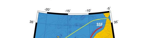
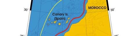
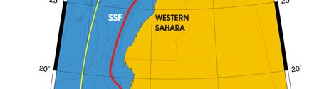
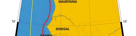
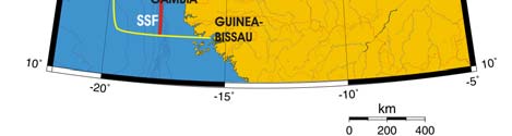
132
3. Canary Current LME
Cape Verde Is.
Figure I-3.1 Fronts of the Canary Current LME. SSF, Shelf-Slope Front. Yellow line, LME boundary.
After Belkin (2008).
Canary Current SST (after Belkin, 2008)
Linear SST trend since 1957: 0.48°C.
Linear SST trend since 1982: 0.52°C.
The moderate-rate warming since 1957 was interrupted by reversals (Figure 1-3.2). The
most significant cold spell occurred after the warm event of 1969 and lasted a decade.
The near-all-time maximum of 1969 was concurrent with the all-time maximum in the
Caribbean Sea LME. This simultaneity likely was not coincidental since both LMEs are
strongly affected and connected by trade winds blowing westward across the North
Atlantic. The synchronism of both maxima across the North Atlantic, over a 5,000-km
distance, strongly suggests a dominant role of atmospheric teleconnection, albeit
westward advection by trade wind currents could also have played a role.
The Canary Current is one of four major areas of coastal upwelling in the World Ocean.
Global warming is thought to increase the strength of equatorward winds, and hence to
increase the upwelling intensity, leading to cooling in major upwelling areas. While the
California Current LME and Humboldt Current LME indeed cooled over the last 25 years,
the Canary Current actually warmed, as did the Benguela Current LME. This result is
especially striking since the 20th century intensification of coastal upwelling off Northwest
Africa is well documented (McGregor et al., 2007). The ongoing warming in the
Mauritanian waters area is shown to have been beneficial for round sardinella (Sardinella
aurita), which thrives after upwelling intensification in spring followed by retention of
upwelled water and primary production enhancement - over shelf in summer (Zeeberg
et al., 2008).
I West and Central Africa
133
Figure 1-3.2 Canary Current LME mean annual SST (left) and SST anomalies (right), 1957-2006, based
on Hadley climatology, (after Belkin, 2008).
Canary Current Trends in Chlorophyll and Primary Productivity: The Canary
Current LME is a Class I, highly productive ecosystem (>300 gCm-2y-1).
Figure I-3.3. Canary Current LME trends in chlorophyll a (left) and primary productivity (right), 1998-
2006. Values are colour coded to the right hand ordinate. Figure courtesy of J. O'Reilly and K. Hyde.
Sources discussed p. 15 this volume.
II. Fish and Fisheries
The Canary Current LME is rich in fisheries resources among which are the small pelagic
fish such as sardine (Sardina pilchardus), sardinella (Sardinella aurita, S. maderensis),
anchovy (Engraulis encrasicolus), chub mackerel (Scomber japonicus) and horse
mackerel (Trachurus spp.) constitute more than 60% of the catch in the LME. Other
species caught in the LME include tuna (e.g., Katsuwonus pelamis), coastal migratory
pelagic finfish, hakes (Merluccius merluccius, M. senegalensis and M. poli), a wide range
of demersal finfish including Pagellus bellotti, Pseudotolithus sp., Dentex canariensis,
Galeoides decadactylus and Brachydeuterus auritus, cephalpods (Octopus vulgaris,
Sepia spp., and Loligo vulgaris) and shrimps (Parapenaeus longirostris and Penaeus
notialis). Most of these species are transboundary or migratory, with the distribution of
tunas often extending beyond the bordering countries' EEZs into international waters.
Fishing activities in the LME have increased over the last three decades. In addition to
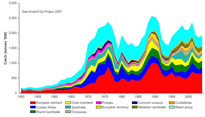
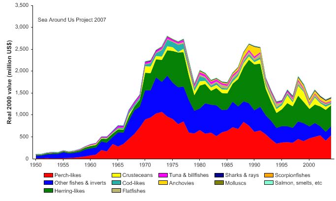
134
3. Canary Current LME
small national fleets, the EEZs of Mauritania, Senegal, Gambia and Guinea Bissau all
accommodate large distant water fleets from the European Union and Asia (FAO 2005a).
Total reported landings in the LME increased steadily to about 2.4 million tonnes in 1976,
followed by a series of large fluctuations between 1.5 and 2.5 million tonnes (Figure I-
3.4). The fluctuations in the total landings are also reflected in their value, which varies
between US$1.5 billion and just under US$3 billion (in 2000 US dollars; Figure I-3.5). In
recent years, however, both total reported landings and especially their value have
undergone a noticeable decline.
Figure I-3.4. Total reported landings in the Canary Current LME by species (Sea Around Us 2007).
Figure I-3.5. Value of reported landings in the Canary Current LME by commercial groups (Sea Around
Us 2007)
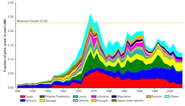
I West and Central Africa
135
From the late 1960s to early 1990s, distant-water fleets from members of the former
USSR, Spain and others countries accounted for most of the landings from the LME
(Bonfil et al. 1998). In 1992, reported landings from the former USSR ceased, and the
bulk of the landings were reported by the now independent countries of the former USSR.
Substantial foreign fishing continues, notably off Mauritania (Gascuel 2007).
The primary production required (PPR; Pauly & Christensen 1995) to sustain the reported
landing in the LME reached 25% of the observed primary production in the early 1970s,
but has since fluctuated to about 15% (Figure I-3.6). Spain, Morocco and Senegal are
currently the countries with the largest ecological footprints in this LME, although the
Soviet Union's republics (Russian Federation, Ukraine, Lithuania, Latvia, and Estonia)
also accounted for large footprints in the 1970s and 1980s.
Figure I-3.6. Primary production required to support reported landings (i.e., ecological footprint) as
fraction of the observed primary production in the Canary Current LME (Sea Around Us 2007). The
`Maximum fraction' denotes the mean of the 5 highest values.
The mean trophic level of the reported landings (i.e., the MTI; Pauly & Watson 2005) has
declined since the mid 1970 (Figure I-3.7 top), an indication of a `fishing down' of the food
web (Pauly et al. 1998). The FiB index indicates a possible slight decline during this
period (Figure I-3.7 bottom), suggesting a situation in which catches that should increase
when trophic levels decrease, are in fact decreasing (Pauly & Watson 2005).
The Stock-Catch Status Plots show that about 40% of exploited stocks can be
considered collapsed, and another 40% are overexploited in the LME (Figure I-3.8, top).
Still, over 70% of the catch originates from stocks that are classified as `fully exploited'
(Figure I-3.8, bottom).
Thus, overexploitation is of major concern in the bordering countries (UNEP 2005) of the
Canary Current LME. Many fish stocks are being fished at or beyond maximum
sustainable yield (MSY) levels in Senegal, Mauritania, Morocco and Gambia, and in
some countries such as Morocco, Senegal and Gambia, demersal production over the
past decade has been near and even above the MSY level (FAO 2005a). With the
exception of Cape Verde, the intensification of fishing activities in the region has had a
136
3. Canary Current LME
Figure I-3.7. Mean trophic level (i.e., Marine Trophic Index) (top) and Fishing-in-Balance Index (bottom)
in the Canary Current LME (Sea Around Us 2007).
1950
1960
1970
1980
1990
2000
0%
100
10%
90
20%
)
80
(
%
s
30%
t
u
70
a
st
40%
y
60
b
s
k
50%
c
o
50
f
st
60%
o
40
er
b
70%
m
30
u
N
80%
20
90%
10
100%0
1950
1960
1970
1980
1990
2000
(n = 5906)
developing
fully exploited
over-exploited
collapsed
0%
100
10%
90
20%
80
)
%
30%
(
70
s
u
at
40%
60
ck st
50%
o
50
st
y
60%
b
h
40
t
c
a
70%
C
30
80%
20
90%
10
100%0
1950
1960
1970
1980
1990
2000
(n = 5906)
developing
fully exploited
over-exploited
collapsed
Figure I-3.8. Stock-Catch Status Plots for the Canary Current LME, showing the proportion of
developing (green), fully exploited (yellow), overexploited (orange) and collapsed (purple) fisheries by
number of stocks (top) and by catch biomass (bottom) from 1950 to 2004. Note that (n), the number of
`stocks', i.e., individual landings time series, only include taxonomic entities at species, genus or family
level, i.e., higher and pooled groups have been excluded (see Pauly et al, this vol. for definitions).
I West and Central Africa
137
drastic impact on the pelagic resources, which have undergone a strong decline in
productivity (Fonseca 2000). High fishing pressure has also led to the marked decline in
the catch of the demersal finfish fishery accompanied by the opportunist expansion of
fisheries targeting octopus (Bas 1993, European Commission 2005). Bycatch and
discards were assessed as moderate, and can be attributed to the use of small-meshed
nets, especially in the artisanal fishery (UNEP 2005), although high discard rates were
observed in the Spanish cephalopod trawl fishery in Morocco (Balgueiras 1997).
Cephalopod trawlers fishing in Mauritania and Senegal were also found to discard 72%
and 60-75% of their total catch, respectively, while the Senegalese mixed fleet targeting
finfish and shrimps in shallow waters had a discard rate of 67%. Pech et al. (2001)
explore the difficulties in fitting a model of flexible multifleetmultispecies fisheries to
Senegalese artisanal fishery data.
Fish stocks in the LME are also expected to be influenced by global warming and the
consequent rise in sea surface temperatures. Upwelling intensity and sea surface
temperatures are strongly linked, and are believed to affect both the spatial distribution
and abundance of fish in the LME (Cury & Roy 1991, Roy & Cury 2003). For example,
periods of high sardine abundance appear to be associated with the ENSO variability
(Roy & Cury 2003). Positive values of the Southern Oscillation Index are also associated
with enhanced upwelling and coincide with higher catch rates (Roy & Reason 2001). The
impact of climate on fish stock abundance and distribution must be taken into
consideration in the development of fisheries management programmes in this LME.
III. Pollution and Ecosystem Health
Pollution: Pollution is a major concern in localised hotspots, especially in emerging
coastal mega-cities that are primary centres of industrial development and high
population densities (UNEP 2005). There is strong evidence of serious localised
degradation in the coastal environment of this and adjacent LMEs (Gordon & Ibe 2006).
Eutrophication and the decay of organic matter create anoxia and subsequent fish
mortality particularly in areas around major cities, bays and ports. Most countries in the
Canary Current LME have environmental laws related to industrial, toxic, hazardous and
medical wastes. However, enforcement of these regulations is inadequate, and pollution
from these sources is evident in localised areas, especially near expanding coastal cities
like Dakar (pop. 2,500,000 in 2007) in Senegal and Dar-el-Beida (Casablanca: pop.
3,900,000 in 2007) and Rabat (pop. 1,810,000 in 2007) in Morocco.
Some common features across the countries of the Canary Current LME are
desertification, overgrazing on fragile rangelands, cultivation of crops on steep slopes
(Cape Verde) and soil erosion. The resulting run-off and increased turbidity in the major
rivers leads to increased turbidity in coastal waters throughout the LME. Domestic and
industrial solid waste management and disposal are of concern in the bordering
countries, and efforts are being made to address the problem. Spills around oil refineries
are a chronic source of localised water column contamination. There is some evidence
of minor spills of hazardous materials, but this is limited to harbours and fishing ports
(UNEP 2002)
Habitat and community modification: Industrial development in the coastal zone of the
Canary Current LME, as well as migration of people from inland rural areas to the coastal
industrial centres, have led to increasing threats of coastal degradation and moderate
habitat modification in this LME (UNEP 2005). Over the last 2 - 4 decades, marshes,
swamps and mangroves have been degraded and lost through natural factors such as
drought, but more significantly, through human activities such as unsustainable
agricultural practices, urbanisation, mining and other industries, natural resources
138
3. Canary Current LME
exploitation, and modification of rivers that has reduced water supply to wetlands and
marine areas.
Approximately 30% of the surface area of wetland habitats has been permanently
destroyed. Those that have not been destroyed are being modified largely because of
continuing human activities. In some coastal lagoons there is a progressive decline of
certain endemic algae species such as Psidona oceanica, due to the spread of Caulerpa
prolifera. The replacement of mangroves by `tannes', with a complete disappearance of
mangroves, is evident in some areas. The construction of dams across certain tributaries
of, for example, the Gambia and Senegal Rivers, has resulted in the die-back of
extensive areas of mangrove forests. Significant quantities of sand from coastal erosion
also contribute to mangrove death, by preventing the influx of sea water into mangrove
areas. In addition, data indicate the extension of aquatic plants in estuaries and bays,
particularly due to flow alteration and reduction (UNEP 2002). Ongoing and planned
initiatives aimed at the control of pollution and the conservation of important habitats of
the Canary Current LME (see Governance) are expected to lead to an improvement in
the health of this LME (UNEP 2005).
IV. Socioeconomic Conditions
The total population of the countries bordering the Canary Current LME is about 58
million, of which an estimated 70% are directly reliant on the LME for their livelihoods.
More than 60% of the population lives in the coastal areas where most cities and
industrial infrastructure are located (UNEP 2002). These coastal populations are
engaged mostly in marine fisheries, agriculture and tourism activities. The backbone of
the countries' economy is based on agriculture and fisheries, with a very weak industrial
sector contribution to GDP.
Fisheries provide livelihoods, fish protein supplies and revenue for the bordering
countries, several of which are classified as Low-Income Food-Deficit Countries (FAO
2005b). These countries do not necessarily benefit from increased fish supplies or
increased government revenue when foreign fleets access their waters (Kaczynski &
Fluharty 2002). Much of the catch of the foreign fleets is exported or shipped directly out
of the region, while compensation for access is often low compared to the value of the
catch.
Overfishing has severe socioeconomic consequences in this LME, and includes
reduction in national incomes, loss in fishing industries, reduction of food supply, loss of
employment and increase in the cost of maritime surveillance as well as reduction of
biological diversity. Loss of employment (which may be as high as 80% in Senegal)
translates to impoverishment and suffering of people, among them being vulnerable
groups such as women, children and the elderly. Overfishing also leads to conflicts
among different user groups for dwindling resources. Depleted fisheries resources
accentuate protein deficiency particularly in small children, leading to diseases such as
kwashiorkor. This situation is aggravated mostly in rural areas where livestock is under
severe threat from droughts. Management of the fisheries of the Canary Current LME to
ensure sustainability is therefore of prime concern to all the bordering countries.
The economic sectors affected by pollution and habitat modification and loss are
agriculture, fisheries, and tourism. Impacts on fisheries as well as the agriculture sectors
can have severe economic ripples since they make a significant contribution to the
overall national product (more than 30% of GDP in the region). Socioeconomic impacts
include those of overfishing, as described above, as well as loss of tourism and
recreational amenities. Migration of people (occasionally transboundary) including
conflicts over resources could also arise. Loss of or modification of wetlands also results
I West and Central Africa
139
in shortage of firewood that is vital to the majority of households in rural areas. Pollution
around densely populated coastal cities such as Dakar is a major cause of losses in the
tourism industry in Senegal. In addition, pollution of coastal waters presents significant
public health risks, through contaminated bathing beaches and consumption of
contaminated fishery products. Loss and degradation of habitats also compromise the
quality of water as wetlands generally act as sinks for pollutants from land-based
activities. This in turn aggravates public health problems.
V. Governance
Several regional and sub-regional institutions and programmes are operating in the
Canary Current LME region, including the UNEP Regional Seas Programme for the West
and Central Africa Region (see the Benguela Current LME for more information), the
Gambia River Development Authority, the Senegal River Development Authority and the
Sub-Regional Fisheries Commission. The Ministerial Conference on Fisheries
Cooperation among African States Bordering the Atlantic Ocean and the Fishery
Committee for the Eastern Central Atlantic bring together all the states sharing the basins
and coastal areas to ensure the proper use and management of their resources. Most of
the bordering countries are signatories to various international environmental
conventions, including the Abidjan Convention and Dakar Convention. Cape Verde,
Guinea, Morocco and Senegal are members of the International Commission for the
Conservation of Atlantic Tunas and have formally agreed to the subsequent Protocols of
1992 and 1997. All the Canary Current LME countries, except Mauritania and Morocco,
are members of the Economic Community of West African States.
The coordinated management of this LME is a challenge (Prescott 1993). The
historically fragmented nature of coastal and marine resource management is a legacy of
the colonial past as well as of the political situation in these countries. There are
regionally incompatible laws and there is a paucity of environmental regulations. The
preparatory phase of the project `Protection of the Canary Current Large Marine
Ecosystem' has been finalised and a full scale project developed. The long-term
environmental goal of the CCLME program is to "reverse the degradation of the Canary
Current Large Marine Ecosystem caused by over-fishing, habitat modification and
changes in water quality by adoption of an ecosystem-based management approach"
and the CCLME project objective is to "enable the countries of the Canary Current Large
Marine Ecosystem to address priority trans-boundary concerns on declining fisheries,
associated biodiversity and water quality through governance reforms, investments and
management programs." A Preliminary TDA has confirmed the focus of regional concern
on depleted fisheries and on habitat, associated biodiversity and water quality critical to
fisheries.
The project will assist the seven participating countries to meet the sustainable fisheries
target of WSSD including contribution to implementation of the Environment Action Plan
under NEPAD. Close linkages are to be developed with GEF projects for the river basins
draining into the LME and the neighbouring GEF International Waters projects on the
Guinea Current and the Benguela Current LMEs. Consistent with other GEF LME
projects, a TDA and SAP will be prepared for the Canary Current LME.
References
Balguerias, E. (1997). Discards in fisheries from the eastern central Atlantic, in: Technical
Consultation on Reduction of Wastage in Fisheries, Tokyo, Japan, FAO Fisheries Report 547,
Supplement.
140
3. Canary Current LME
Barton E.D. (1998). Eastern boundary of the North Atlantic: Northwest Africa and Iberia, p 633-657
in: Robinson, A.R. and Brink, K.H. (eds), The Global Coastal Ocean: Regional Studies and
Syntheses. The Sea Vol. II.
Barton, E. D., Aristegui, J. Tett, P., Canton, M., Garcia-Braun, J., Hernadez-Leon, S., Nyhajaer, L.,
Almeida, C., Almunia, J., Ballestros, S., Basterretxea, G., Escanez, J., Garcia-Weill, L.,
Hernandez-Guerra, A., Lopez-Laatzen, F., Molina, R., Montero, M.F., Navarro-Perez, E.,
Rodriguez, J.H., Lenning, K.V., Velez, H. and Wild, K. (1998). The transition zone of the Canary
Current upwelling region. Progress in Oceanography 41(4): 455504.
Bas, C. (1993). Long-term variability in the food chains, biomass yields and oceanography of the
Canary Current ecosystem, p 94-103 in: Sherman K., Alexander, L.M. and Gold, B.D. (eds),
Large Marine Ecosystems: Stress, Mitigation, and Sustainability. AAAS, Washington D.C., U.S.
Belkin, I.M. (2008). Rapid warming of Large Marine Ecosystems, Progress in Oceanography, in
press.
Belkin, I.M., Cornillon, P.C. and Sherman K. (2008) Fronts in Large Marine Ecosystems of the
world's oceans. Progress in Oceanography, in press.
Bonfil, R., Munro, G., Sumaila, U.R., Valtysson, H., Wright, M., Pitcher, T., Preikshot, D., Haggan,
N. and Pauly, D. (1998). Impacts of distant water fleets: an ecological, economic and social
assessment. Fisheries Centre Research Reports 6(6)
Chavance, P., Ba, M., Gascuel, D., Vakily, M. and Pauly, D. (eds). (2004). Pęcheries maritimes,
écosystčmes et sociétés en Afrique de l'Ouest : un demi-sičcle de changement. Actes du
symposium international, Dakar - Sénégal, 24-28 juin 2002. Office des publications officielles
des communautés Européennes, XXXVI, collection des rapports de recherche halieutique ACP-
UE 15, 532 p. + Appendices.
Cury P. and Roy, C., eds. (1991). Pęcheries Ouest-africaines: Variabilité, Instabilité et
Changement. ORSTOM éditions, Paris, France.
European Commission, 2005. Rebuilding our marine ecosystems, protecting our future. Key
findings of the International Symposium on Marine Fisheries, Ecosystems and Societies in
West Africa Half a Century of Change. Dakar, Senegal, 24-28 June 2002.
FAO (2003). Trends in Oceanic Captures and Clustering of Large Marine Ecosystems Two
Studies Based on the FAO Capture Database. Fisheries Technical Paper 435.
FAO (2005a). Fishery Country Profiles. www.fao.org /countryprofiles/selectiso.asp?lang=en
FAO (2005b). Low-Income Food-Deficit Countries.
Gascuel, D. (2007). Lessons from a reconstruction of catch time series for Mauritania. The Sea
Around Us Project Newsletter, Issue 39, January/February 2007. Fisheries Centre, University of
British Columbia, Canada.
Gordon, C. and Ibe, C. (2006). West and Central Africa, p 5-28 in: UNEP/GPA (2006), The State of
the Marine Environment: Regional Assessments. UNEP/GPA, The Hague.
www.fao.org/countryprofiles/lifdc.asp?lang=en
Kaczynski, V.M. and Fluharty, D.L. (2002). European policies in West Africa: Who benefits from
fisheries agreements? Marine Policy 26(2): 75-93.
McGregor, H.V., Dima, M., Fischer, H.W. and Mulitza S. (2007) Rapid 20th-century increase in
coastal upwelling off Northwest Africa, Science,
315(5812), 637-639, DOI:
10.1126/science.1134839.
Mittelstaedt, E. (1991). The ocean boundary along the northwest African coast: Circulation and
oceanographic properties at the sea surface. Progress in Oceanography 26:307-355.
Pauly, D. and Christensen, V. (1995). Primary production required to sustain global fisheries.
Nature 374: 255-257.
Pauly, D. and Watson, R. (2005). Background and interpretation of the `Marine Trophic Index' as a
measure of biodiversity. Philosophical Transactions of the Royal Society: Biological Sciences
360: 415-423.
Pauly, D., Christensen, V., Dalsgaard, J., Froese R. and Torres, F.C. Jr. (1998). Fishing down
marine food webs. Science 279: 860-863.
Pech, N., Samba, A., Drapeau, L., Sabatier, R. and Laloe, F. (2001). Fitting a model of flexible
multifleetmultispecies fisheries to Senegalese artisanal fishery data. Aquat. Living Resour. 14
(2): 81-98.
Prescott, J.R.V. (1993). Role of national political factors in the management of LMEs: Evidence
from West Africa, p 280-291 in: Sherman, K., Alexander, L.M. and Gold, B.D. (eds), Large
Marine Ecosystems: Stress, Mitigation, and Sustainability. AAAS, Washington D.C., U.S.
Roy C. and Reason, C. (2001). ENSO related modulation of coastal upwelling in the Eastern
Atlantic. Progress in Oceanography 49:245-255.
I West and Central Africa
141
Roy, C. and Cury, P. (2003). Decadal environmental and ecological changes in the Canary Current
Large Marine Ecosystem and adjacent waters: Patterns of connections and teleconnection, p
255 - 278 in: Hempel, G. and Sherman, K. (eds), Large Marine Ecosystems of the World
Trends in Exploitation, Protection and Research. Elsevier B.V. The Netherlands.
Sea Around Us (2007). A Global Database on Marine Fisheries and Ecosystems. Fisheries Centre,
University British Columbia, Vancouver, Canada. www.seaaroundus.org/lme/SummaryInfo.
aspx?LME=27
Sherman, K. (2003). Physical, Biological, and Human Forcing of Biomass Yields in Large Marine
Ecosystems. ICES CM 2003/P: 12.
UNEP (2002). Africa Environment Outlook, Past, Present and Future perspectives. United Nations
Environment Programme, Nairobi, Kenya.
UNEP (2005). Tayaa, M., Saine, A., Ndiaye, G. and Deme, M. Canary Current, GIWA Regional
Assessment 41. University of Kalmar, Kalmar, Sweden. www.giwa.net/publications/r41.phtml
Zeeberg, J., Corten, A. Tjoe-Awie, P. Coca,J. and Hamady, B. (2007) Climate modulates the
effects of Sardinella aurita fisheries off Northwest Africa, Fisheries Research, 89(1), 65-75.
142
3. Canary Current LME