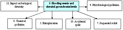
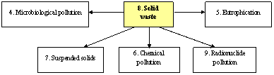
Figure 4.1
Outline of links between the transboundary environmental issues of the Dnipro
Basin
22 GIWA issues from five major concern areas were assessed in order to determine their relevance and transboundary nature in the context of the Dnipro Basin. The objective of the first stage of the TDA was to select criteria that would be used for the prioritisation of these transboundary issues. The following suite of criteria was subsequently used for this purpose:
1.
Transboundary
nature of an issue.
2.
Scale
of impacts of an issue on the Dnipro Basin and Black Sea ecosystems.
3.
Scale
of impacts of an issue on economic activities, the environment and human
health.
4.
Relevance
of an issue from the perspective of national priorities reflected in existing
national policies and action plans on environmental rehabilitation and
biodiversity conservation in the Dnipro Basin.
5.
Scope
of the systemic relationship with other environmental issues and economic
sectors.
6.
Expected
multiple benefits that might be achieved by addressing an issue.
7.
Lack
of perceived progress in addressing/solving an issue at the national level.
Each
transboundary issue was scored on the basis of the severity of their
environmental and socio-economic impacts, on a scale of 0 to 3 by the 16
members of the TDA team. The outcome of this exercise was a prioritised list of
the transboundary issues in the Dnipro basin. Two categories of priority are
shown, Priority A and B. Priority A issues are those with an environmental
and/or socio-economic impact score of 3. Priority B issues are those that
scored less than 3 for either environmental and/or socio-economic impacts. The
result of this exercise identified 12 major transboundary issues in the Dnipro
River Basin that required further detailed analysis (Table 4.1). Of those, the
following transboundary issues were considered as a priority, requiring more
detailed causal chain analysis:
Issue 4 Chemical pollution (Priority A)
Issue 6 Radionuclide pollution (Priority A)
Issue 8 Eutrophication (Priority A)
Issue 11 Loss/modification of ecosystems or ecotones and
decreased viability of stocks due to contamination and diseases (Priority A)
Issue 3 Flooding events and elevated
groundwater levels (Priority B)
Issue 1 Modification of the hydrological regime
(Priority B)
When addressing the identified transboundary issues,
consideration should be given to the interrelationships between them. These
interrelationships need to be taken into consideration when defining the
sequence of steps involved in problem solving (Figure 4.1). Table 4.2 reflects
the problem-solving sequence for the key transboundary issues existing in the
Dnipro Basin. This sequence is defined on the basis of the following criteria:
(1) the number of issues dependant on, or relating to a given issue, (2) the
location of an issue within the causal chain, and (3) what issues require
solving prior to addressing the issue under consideration. It should be noted
that an issue can only be effectively solved if the related root, underlying
and immediate causes have been properly identified. An overview of cause/effect
relationships between the priority transboundary issues is presented below.
Table 4.1 Modified
GIWA concerns and issues for the Dnipro River Basin
|
Issue |
Environ-mental Impact |
Human Impact |
Priority |
Reason for assigning
priority |
Transboundary
Justification |
|
1. Modification of hydrological regime |
3 |
2 |
A |
E, H |
Land
reclamation activities in the Upper Dnipro Basin. Excessive damming and
regulation of small and medium rivers. Construction of the Dnipro reservoir
chain. Construction of flow diversion canals. |
|
2. Changes in the water table |
2 |
2 |
B |
E, H |
Mining
developments, groundwater abstraction, excessive regulation of river flow. |
|
3. Flooding and elevated ground and surface waters and
elevated groundwater levels in various parts of the Basin |
2 |
2.5 |
B |
H |
River
bed siltation, degradation of river floodplains, forest cutting, land
reclamation activities |
|
4. Chemical pollution |
3 |
3 |
A |
E, H |
Presence of chemical compounds of
anthropogenic origin in the transboundary sections of the Dnipro Basin. |
|
5. Microbiological pollution |
2 |
2 |
B |
H |
Discharges
of insufficiently treated municipal sewage waters. Discharges of
insufficiently treated food processing industry wastewater. Non-point source
pollution (mainly during high flow periods). |
|
6. Pollution by radionuclides |
2 |
3 |
A |
E, H |
Consequences of the Chornobyl nuclear
accident. Significant extent of caesium- and strontium-contaminated areas in
the Dnipro Basin. Uranium mines in the Lower Dnipro Basin. |
|
7. Suspended solids |
2 |
1.5 |
B |
E |
Significant suspended substance flows from
point/non-point sources and drained/irrigated areas into the Dnipro Basin
water bodies. |
|
8. Eutrophication |
3 |
2 |
A |
E |
Inputs
of significant amounts of organic and nutrient substances into the Dnipro
Basin water bodies in the territory of all three countries of the Basin;
excessive regulation of flow; presence of shallow water areas in the Dnipro
reservoir chain, etc. |
|
9. Solid waste |
2 |
2 |
B |
E, H |
Significant number of industrial solid waste
disposal sites, MSW dumps and mining waste disposal sites etc. in the Basin,
particularly within Ukraine |
|
10. Accidental spills and
releases |
2 |
2 |
B |
E, H |
Incidental spills and releases of polluted
effluents from liquid waste storage facilities and industries; spills
resulting from pipeline breakdown accidents etc. |
|
11. Loss/modification of
ecosystems or ecotones and decreased viability of stocks due to contamination
and diseases |
3 |
2 |
A |
E |
1.
The areas of progressive
ecosystem and ecotone degradation due to economic activities have been
identified both in the Dnipro Basin as a whole and in the cross-border
territories. 2.
Significant changes in the
aquatic and land-based ecosystems have been registered in the Dnipro Basin.
Changes in flora and fauna species composition are reported to have occurred
in various parts of the Basin, including cross-border areas. 3.
High percentage of
parasitic invasions affecting aquatic biota, accumulation of harmful
compounds of anthropogenic origin in the aquatic biota and land-based flora
and fauna in the Dnipro Basin. |
|
12. Impact on biological and
genetic diversity |
2 |
2 |
B |
E, H |
Introduction and invasion of new species have
affected the biodiversity in the Basin. Pollution of water bodies in the
Dnipro Basin has affected the biological and genetic diversity of wildlife
species inhabiting the Basin. |
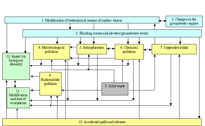
Figure 4.1
Outline of links between the transboundary environmental issues of the Dnipro
Basin
Table 4.2 Problem-solving
sequence for the key transboundary environmental issues
|
Issue |
Number
of issues dependant on/relating to a given issue |
Problem-solving
sequence |
|
Accidental spills and releases |
6 |
1 |
|
Flooding and elevated ground and surface waters |
6 |
|
|
Modification of hydrological regime of surface waters |
5 |
2 |
|
Chemical pollution |
5 |
|
|
Eutrophication |
4 |
3 |
|
Solid waste |
4 |
|
|
Suspended solids |
3 |
4 |
|
Radionuclides |
2 |
5 |
|
Microbiological pollution |
2 |
|
|
Changes in the water table |
1 |
6 |
|
Modification and loss of ecosystems or ecotones
and decreased viability of biological resources |
1 |
|
|
Impact on biological and genetic diversity |
1 |
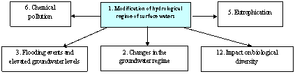
1. Modification of hydrological
regime of surface waters is
attributed to land drainage activities in the Upper Dnipro Basin, excessive
damming and regulation of smaller rivers, and construction of the chain of
Dnipro reservoirs and flow diversion channels. This can result in the following
impacts:
·
Modified
riparian habitats;
·
Depleted
fish stocks and decreased species diversity;
·
Changes
in water quality;
·
Decreased
wetland area;
·
Reduced
sediment transport capacity;
·
Changes
in biological diversity and food chains;
·
Changes
in sediment budgets;
·
Increased
intensity of river bank modification.
The diagram below illustrates how this issue is linked
to other transboundary issues:
2. Changes in the groundwater
regime are caused by mining
industry activities, groundwater abstractions, and excessive flow regulation.
This can result in the following impacts:
·
Decreased
productivity of natural resources;
·
Loss
of biodiversity and natural erosion barriers.
The diagram below illustrates how this issue is linked
to other transboundary issues:
![]()
3. Flooding and elevated ground
and surface waters are
caused by riverbed siltation, degradation of river floodplains, forest cutting
activities, and land drainage/irrigation activities. This can result in the
following impacts:
·
Degradation
(change) of terrestrial and riparian plant and animal habitats;
·
Additional
pollution (bacterial, chemical etc.) of water bodies due to runoff from flooded
territories;
·
Changes
in biotopes;
·
Increased
extent of territories with elevated groundwater levels.
The diagram below illustrates how this issue is linked
to other transboundary issues:
4. Microbiological pollution is associated with discharges of insufficiently
treated municipal wastewater and food industry process effluents, as well as
non-point pollution sources (mainly during high-flow periods). This can result
in the following impacts:
·
Deterioration
in drinking water quality;
·
Decreased
recreational value of water bodies;
·
Infestations/diseases
in aquatic and terrestrial species.
The diagram below illustrates how this issue is linked
to other transboundary issues:
![]()
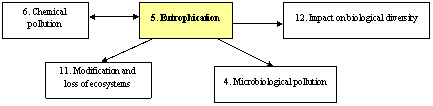
5. Eutrophication has developed as a result of large organic and
nutrient pollution loads entering the Basin water bodies in the territories of
the three riparian countries, excessive flow regulation, and the presence of
extensive shallow-water sections in the Dnipro reservoirs. This can result in
the following impacts:
·
Deterioration
in water quality due to intensive algal blooms;
·
Changes
in redox capacity;
·
Changes
in the structure and functions of aquatic ecosystems;
·
Changes
in species composition and the productivity of native fish species.
The diagram below illustrates how this issue is linked
to other transboundary issues:
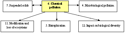
6. Chemical pollution of anthropogenic origin has been consistently
present at various levels in the transboundary sections of the Dnipro Basin.
This can result in the following impacts:
·
Deterioration
of surface and groundwater quality;
·
Depleted
fish stocks and decreased species diversity;
·
Changes
in the biodiversity of aquatic, riparian and terrestrial biological resources;
·
Changes
in riparian habitats;
·
Reproductive
dysfunction in aquatic organisms;
·
Behavioural
dysfunction in aquatic organisms;
·
Modified
community structure;
·
Increased
mortality of aquatic organisms;
·
Immuno-suppression
in aquatic organisms.
The diagram below illustrates how this issue is linked
to other transboundary issues
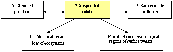
7. Suspended solids enter the Dnipro Basin water bodies with
discharges from point- and non-point pollution sources, exacerbated by land
drainage/irrigation activities. This can result in the following impacts:
·
Modification
of habitats;
·
Changes
in biological community composition;
·
Increased
sediment deposition and siltation;
·
Destruction
(blanketing) of benthic communities;
·
Fish
kills.
The diagram below illustrates how this issue is linked
to other transboundary issues:
8. Solid waste disposal represents a serious problem in the
Dnipro Basin. Large numbers of unorganised/non-engineered dumpsites containing
industrial/municipal/mining wastes are concentrated in the Basin posing a
continuous threat of water pollution. This can result in the following impacts:
·
Deterioration
of surface water and groundwater quality;
·
Modification
of terrestrial ecosystems;
·
Deterioration
of air quality;
·
Modification
of the hydraulic regime of small rivers;
·
Beach
and sediment compositional changes.
The diagram below illustrates how this issue is linked
to other transboundary issues:
9. Pollution by radionuclides is associated with the consequences of the
Chornobyl accident resulting in the contamination of large areas of land with
caesium and strontium, and uranium mining activities in the Lower Dnipro Basin.
When radionuclide concentrations and associated radiation doses are high,
as it was the case in the immediate aftermath of the Chornobyl accident in 1986, this can result in the following
impacts:
·
Mutagenic
effects;
·
Immune
system degradation in living organisms;
·
Mortality
of living organisms and changes in population number.
The diagram below illustrates how this issue is linked
to other transboundary issues:
Currently,
the environmental radioactivity levels in the Dnipro Basin are much lower than
ones, which could cause observable radiobiological effects, and the main
adverse effect of the radioactive contamination is unsuitability of the water
and biota for human use.
10. Accidental spills and
releases represent a continuous
threat of water pollution in areas where liquid industrial effluent storage
sites and pipelines are in a poor technical condition. This can result in the
following impacts:
·
Acute
deterioration of surface water and groundwater quality;
·
Deterioration
of air quality;
·
Mass
kills of living organisms;
·
Persistent
contamination of soils resulting in dramatic ecological changes.
The diagram below illustrates how this issue is linked
to other transboundary issues:
11. Modification and loss of
ecosystems and ecotones and decreased viability of biological resources due to
contamination and disease.
Progressive degradation of ecosystems and ecotones due to human activities has
become apparent in many areas. Significant changes have been found in aquatic
and terrestrial ecosystems, and plant and animal species composition. Parasitic
invasions have affected aquatic biota, exacerbated by the bioaccumulation of
hazardous substances of anthropogenic origin. This can result in the following
impacts:
·
Modification
and degradation of ecosystems;
·
Loss
of natural productivity;
·
Changes
in and loss of biodiversity;
·
Loss
of natural erosion barriers;
·
Loss
of carbon sinks and release of carbon to the atmosphere;
·
Loss
of migratory species using the habitat and altered migratory patterns;
·
Impacts
of estuarine system changes on adjacent coastal marine ecosystems;
·
Changes
in ecosystem stability;
·
Changes
in community structure both plant and animal;
·
Decreased
species diversity.
The diagram below illustrates how this issue is linked
to other transboundary issues:
![]()
12. Impact on biological and
genetic diversity is
associated with the introduction and invasion of alien species. Water pollution
has also undermined the biological and genetic diversity of species/communities
inhabiting the Dnipro Basin. This can result in the following impacts:
·
Changes
in biological community structure due to the overexploitation and/or depletion
of one or more key species;
·
Changes
in biological communities through deliberate and accidental introductions;
·
Changes
in community structure by food chain manipulation;
·
Changes
in community structure due to modification of species habitats;
·
Changes
to habitat and community structure resulting from destructive fishing
practices;
·
Degradation
of ecosystems.
The diagram below illustrates how this issue is linked
to other transboundary issues:
![]()
As well as determining the linkages between
transboundary issues, it was also necessary to identify the immediate causes of
each issue and determine their links with underlying sectoral causes.
The key sectors contributing to Issue 1: Modification of hydrological regime of surface waters are
(listed in order of priority) energy (hydropower), agriculture, transport
(river), urbanisation, industry and aquaculture. These sectors contribute to
the following immediate causes:
·
Flow
regulation, including required releases from the Dnipro reservoirs;
·
Flow
diversions between the river basins or within the basin;
·
Flow
abstraction for domestic and industrial purposes;
·
Land
drainage activities;
·
Flow
abstraction for irrigation;
·
Returns/runoff
of water;
·
Flow
diversion for aquaculture.
The key sectors contributing to Issue 2: Changes in the groundwater regime are (listed in order of
priority) industry, energy and urbanisation. These sectors contribute to the
following immediate causes:
·
Mining
industry activities;
·
Groundwater
abstraction;
·
Flow
regulation.
The key sectors contributing to Issue 3: Flooding events and elevated groundwater levels are
(listed in order of priority) agriculture, mining, urbanisation and transport.
These sectors contribute to the following immediate causes:
·
Modification
of the hydrological regime;
·
Runoff
from land surfaces;
·
Elevated
groundwater and surface water levels;
·
Discharges
of water.
The key sectors contributing to Issue 4: Microbiological pollution are (listed in order of
priority) industry, agriculture, and urbanisation. These sectors contribute to
the following immediate causes:
·
Discharges
of insufficiently treated municipal effluents;
·
Discharges
of insufficiently treated effluents from food processing industries;
·
Pollution
inputs from non-point sources (especially during high flow periods);
·
Discharges
from livestock-rearing sites.
The key sectors contributing to Issue 5: Eutrophication are (listed in order of priority)
agriculture, urbanisation, industry, aquaculture, energy and transport. These
sectors contribute to the following immediate causes:
·
Operational
discharge of liquids and gaseous effluents including cooling waters;
·
Runoff;
·
Emissions
from storage of liquid wastes;
·
Emissions
from storage of solid wastes;
·
Emissions
from transport.
The key sectors contributing to Issue 6: Chemical pollution are (listed in order of priority)
industry, agriculture, urbanisation, transport, energy and aquaculture. These
sectors contribute to the following immediate causes:
·
Operational
discharge of liquids and gaseous effluents including cooling waters;
·
Emissions
from storage of chemical products;
·
Emissions
from storage of solid waste;
·
Emissions
from storage of liquid wastes;
·
Emissions
from transport;
·
Runoff;
·
Growth
in the production of waste.
The key sectors contributing to Issue 7: Suspended substances are (listed in order of priority)
agriculture, urbanisation, industry and transport. These sectors contribute to the
following immediate causes:
·
Significant
inputs of suspended solids from point sources.
·
Significant
inputs of suspended solids from diffuse sources.
·
Significant
inputs of suspended solids as a result of land drainage/irrigation activities.
The key sectors contributing to Issue 8: Solid wastes are (listed in order of priority) industry,
agriculture and urbanisation. These sectors contribute to the following
immediate causes:
·
The
high rate of solid waste generation in the Basin;
·
The
large quantity of unorganised waste dumps and industrial waste disposal sites,
especially in Ukraine;
·
Accumulation
of waste generated by mining industries.
The key sectors contributing to Issue 9: Radionuclide pollution are (listed in order of priority)
the consequences of the Chornobyl accident, and industry (mining). These
sectors contribute to the following immediate causes:
·
Atmospheric
and aquatic releases of radionuclides during the Chornobyl accident;
·
Secondary
releases from sites contaminated with radionuclides as a result of the Chornobyl accident;
·
Point and diffuse discharges of mining process
waters and tailing wastes from disposal sites at uranium mines and
ore-processing plants;
·
Emissions/discharges from radioactive waste
disposal sites.
The key sector contributing to Issue 10: Accidental spills and releases are (listed in order of
priority) industry, urbanisation and energy. These sectors contribute to the
following immediate causes:
·
Episodic
accidental spills of polluted effluents from the liquid waste storage sites;
·
Episodic
accidental spills of polluted material from industries;
·
Spills
associated with pipework breakdown etc.
The key sectors contributing to Issue 11: Modification and loss of ecosystems or ecotones and decreased
viability of biological resources through contamination and disease are
(listed in order of priority) agriculture, energy, aquaculture, urbanisation,
industry and transport. These sectors contribute to the following immediate
causes:
·
Loss
or modification of aquatic habitats;
·
Changes
in land use;
·
Introduced
species;
·
Changes
in the sediment transport regime;
In addition the following transboundary issues also
contribute to Issue 11:
·
Modification of the hydrological regime (see Section 4.3.1);
·
Flooding events and elevated groundwater levels (see Section 4.3.3);
·
Chemical pollution (see Section 4.4.1);
·
Radionuclide pollution (see Section 4.4.3);
·
Eutrophication (see Section 4.4.5).
The key sectors contributing to Issue 12: Impact on biological and genetic diversity are
fisheries/aquaculture and transport. These sectors contribute to the following
immediate causes:
·
Introduction
and invasion of new species.
Modification
of the hydrological regime refers to an increase or decrease in the discharge
of streams and rivers as a result of human interventions on a local/regional
scale. The transboundary status of the issue is reflected in Table 4.1. A
detailed causal chain reflecting the links between this issue its immediate and
underlying causes is shown in Figure 4.2.
The
impacts of this issue are linked closely with those of a number of other issues
including changes in the groundwater regime (Section 4.3.2), flooding events
and elevated groundwater levels (Section 4.3.3), water resource pollution
issues such as chemical and microbiological pollution, and eutrophication
(Section 4.4) and modification and loss of ecosystems ands ecotones (Section
4.5).
Modification
of riparian habitats
Changes
in the temporal and spatial pattern of flooding in the floodplains of the
Dnipro Basin have led to a modification of riparian habitats. More details on
this impact can be found in Section 4.5 on the modification and loss of
ecosystems, Section 3.1.6 on nature reserves and protected areas and in the
Basin Passport.
Changes
in water quality
A
number of other Issues including chemical pollution (Section 4.4.1)
microbiological pollution (Section 4.4.2) and eutrophication (Section 4.4.5)
are closely linked with this issue. Modification of the hydrological regime can
significantly increase the impacts of these issues. Generally, water quality in
the Dnipro Basin greatly depends on water releases from the Kakhovka reservoir.
Salinity levels in the Dnipro-Buh Estuary tend to increase if discharge rates
at the reservoir dam fall below 1,000 m3/s. More details on changes in water quality can
be found in and Section 3.2.8 on the sanitary situation in the Basin and the
2000/2001 field survey results discussed in Section 3.3.2.
Significant
changes in the hydrological regime of watercourses in the Dnipro Basin are a
result of the following immediate causes (also refer to Table 4.17):
·
Flow
regulation, including required releases from the Dnipro reservoirs;
·
Flow
diversions between the river basins or within the basin;
·
Flow
abstraction for industrial and domestic purposes;
·
Land
drainage activities;
·
Flow
abstraction for irrigation;
·
Returns/runoff
of water;
·
Flow
diversion for aquaculture.
1. Extent of the river flow
regulation
There
are 102 reservoirs in the Belorussian part of the Dnipro Basin with a total
water surface area of 345 km2, and volume of 1,044 million m3.
Of that, 55 reservoirs (with a water surface area 206 km2 and a
capacity 585 million m3) and 730 ponds (water surface area 93 km2
and capacity 164 million m3) are located in the Pripyat River Basin.
The overall flow regulation ratio is 2-3%. In the Russian part of the Dnipro
Basin there are 25,000 artificial impoundments with a total area of 18,000
hectares with an overall flow regulation ratio of about 3%. In Ukraine, the
overall flow regulation ratio for reservoirs and ponds was about 22%, as of
1990. More details on the extent of hydro-engineering activities in the
Ukrainian part of the Basin can be found in the Basin Passport and in Section
4.3.3 on flooding events and elevated groundwater levels.
2. Flow diversion schemes
There are two major flow diversion schemes in the
Republic of Belarus with an annual capacity of 0.2-0.3 km3/year. The
first scheme (the Western Dvina/Berezina flow diversion system) supplies 0.2 to
0.25 km3/year of water from the Viliya river basin. The second
scheme (the Western Buh Basin/the Dnipro-Buh Channel) redistributes the flow
within the Dnipro Basin and diverts part of the flow (0.04-0.06 km3/year)
to the Western Buh Basin. In Ukraine there are 6 major
channels and 5 water conduits in operation, diverting 3.14 km3 of
flow (2000 figures) to supply Dnipro water to water-scarce areas in the country
(e.g. the Crimea). Further details on flow diversion schemes can be found in
Section 3.2.10 on water uses in the Basin.
3. Flow abstraction for
industrial and domestic purposes
In
2001, the total flow abstraction for industrial and domestic purposes within
the Belorussian part of the Dnipro Basin (excluding the Pripyat River) was 0.24
km3, with a maximum annual abstraction rate of 0.7 km3
between 1985 and 2001. In the Pripyat River Basin, flow abstraction was 0.18 km3
in 2001, with a maximum annual flow abstraction of 1.26 km3 between
1985 and 2000.
In
the Russian part of the Dnipro Basin, annual flow abstraction was 0.77 km3,
in 2000. The proportion of non-returnable flow abstraction in Ukraine is over
75%, with the Dnipropetrovsk (14%) and Kherson (23%) Oblasts being the major
water consumers. In 2000, the total annual flow abstraction for industrial and
domestic purposes in the Ukrainian part of the Dnipro Basin was 6.17 km3,
and the total flow abstracted in the Pripyat River Basin in that period was
1,086 million m3. Further details on flow abstraction can be found
in the Basin Passport and Section 3.2.10 on water uses in the Basin.
4. Land drainage and flow
abstraction for irrigation
Large
areas of land have been drained and irrigated in the 3 riparian countries. The
extent is shown in Table 4.3. In Belarus, the total length of the surface
drainage/irrigation network has reached 64,000 km, or twice the length of the
natural drainage network. More details on irrigation activities can be found in
Section 3.2.5 on agriculture in the Basin.
Table 4.3 Extent
of drained and irrigated land in the 3 riparian countries
|
Land
area |
Russia |
Belarus |
Ukraine |
|
Drained (million hectares) |
0.38 |
2.0 |
2.5 |
|
Irrigated
(million hectares) |
0.04 |
n/a |
2.6 |
The
highest levels of flow abstraction for irrigation in the Dnipro Basin occur in
the Ukraine with 0.86 km3 abstracted per year. The levels in Russia
and Belarus are significantly lower (0.003 km3/year and 0.004 km3/year,
respectively. Refer to Section 3.2.10 on Water uses in the Basin for more
information on flow abstraction.
5. Returns or runoff of water
In
2000, return flows as a result of industrial effluent discharges were 0.43 km3
in the Russian Federation, 0.4 km3 in the Republic of Belarus, and
0.5 km3 in Ukraine.
The
underlying causes of this issue arise in the following key sectors; energy
(hydropower), agriculture, transport (river), urbanisation, industry and
aquaculture. The effects of the resource uses and practices associated with
industry, urbanisation and fishery/aquaculture are less significant. A list of
the priority sectors for all issues is presented in Table 4.18 (Section 4.7)
A
detailed causal chain reflecting the links between the immediate and underlying
sectoral causes of this issue is shown in Figure 4.2 and a detailed description
of terminology used in this causal chain is given in the definition of terms in
Annex 2.
Based
on the causal chain in Figure 4.2, the priority sectoral resource uses and
practices and the underlying political, economic and governance causes of this
transboundary issue can be identified. These are shown in the Strategic Action
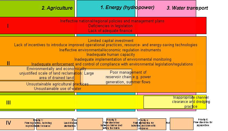
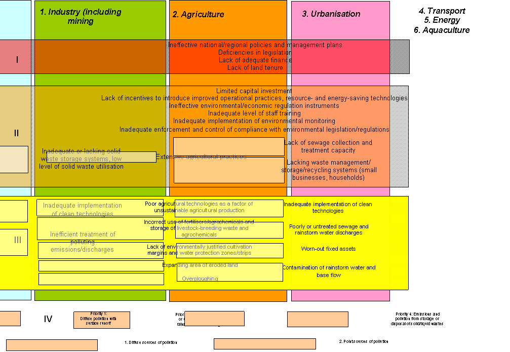
Programme (SAP) decision making management tool (Figure 4.3).
The
SAP decision making management tool shows the priority sectors for this issue
(colour coded with the causal chain) together with three hierarchical levels of
concern. These levels are:
|
Level 1: Political & Economical |
|
Level 2: Governance |
|
Legislation and
regulations |
|
Organisational and
institutional development |
|
Finance |
|
Programmes &
planning |
|
|
|
Regulatory
framework |
|
|
|
Monitoring &
control |
|
|
|
|
|
Level 3: Technical & Operational |
|
Level 4: Immediate causes |
Within
each level the priority resource uses and practices and the underlying
political, economic and governance causes for each transboundary issue are
listed. These can either cut across all sectors (e.g. Lack of finance) or be
sector specific (e.g. unsustainable agricultural practices).
Construction
of the Dnipro reservoir chain has had a profound effect on the hydrological
regime of the river. The need for this major development project was mainly
driven by a growing demand for hydroelectric power. As a result of the
reservoir construction, river flow in the middle and lower reaches of the
Dnipro has become fully regulated by water releases from the reservoir dams.
Agriculture
is the second significant sector affecting the hydrological regime of surface
waters. As a result of the development of large-scale drainage schemes in the
Pripyat River Basin, many smaller rivers have been canalized, partially or
completely. Numerous hydroengineering facilities and polders regulate and
divert a significant part of the river flow in the Pripyat Basin. The remaining
flow is regulated and redistributed by major flood-protection schemes during
the spring and summer/autumn high flow period.
In
Ukraine, especially in the southern regions, irrigated agriculture is a major
user of water. A dense network of irrigation channels has been constructed to
deliver water to drier areas of the Basin, resulting in the significant
redistribution of flow over time and space.
Water
transport is the third largest contributor to the issue of modification of
hydrological regime, where river flow is affected by channel-clearance and
dredging activities to enable navigation, especially during the low-water
period. A significant amount of water is diverted to the Dnipro-Buh Channel, a
major inter-basin water route, affecting surface water levels in the Upper
Pripyat Basin. The contribution of other sectors (industry, urbanisation, and
fishery/aquaculture) is relatively minor.
Changes
in the groundwater regime refer to changes in aquifers as a direct or indirect consequence
of human activity (including land drainage). As can be seen from Table 4.1,
this issue is considered to have a transboundary status because the impacts of
mining industries located within the riparian countries go beyond the national
borders, affecting the adjacent territories. However, based on the
prioritisation exercise detailed in Section 4.1, this issue was not considered
a priority transboundary issue. Consequently, detailed causal chain analysis
beyond the immediate causes of the issue was not carried out.
Figure 4.2 Causal chain for the issue of
modification of the hydrological regime of surface waters (see causal
chain definition of terms for more details)
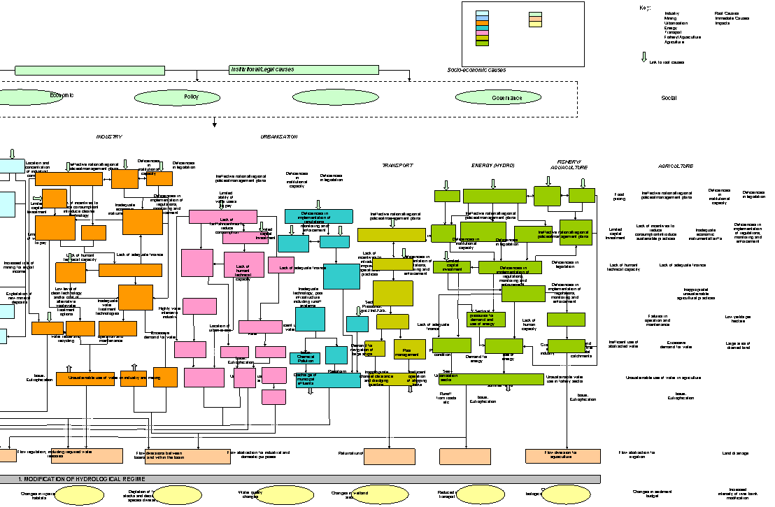
Figure 4.3 SAP
decision making management tool for the issue of modification of the
hydrological regime of surface waters
The
impacts of this issue are linked closely with those of a number of other issues
including modification of the hydrological regime (Section 4.3.1), flooding
events and elevated groundwater levels (Section 4.3.3), water resource
pollution issues such as suspended solids (Section 4.4.4) and modification and
loss of ecosystems ands ecotones (Section 4.5).
Loss of biodiversity and natural erosion barriers
A number of adverse effects on the environment have
resulted in a reduction in the area of forests
(with approximately a twofold reduction over the past 100 years), and a
decrease in fish stocks and wildlife resources. Section 3.1.4 describes the
forest resource in the Basin. Sections 3.1.5 and 3.1.6 describe the biological
resources and nature reserves and protected areas.
The
Dnipro Basin has been greatly affected by intensive farming. Large-scale
conversion of land to agriculture with little or no regard to soil property and
the construction of major land drainage/irrigation schemes and
livestock-rearing farms have lead to a loss of natural erosion barriers. The
quality of the land resource in the Basin is also progressively deteriorating
as a result of toxic contamination, soil erosion and intensive gorge
development. In impacted areas, soils are largely characterised by a medium to
high degree of fertile layer degradation. The erosion potential is greater for
agricultural fields located on steeper slopes, although the simple anti-erosion
practice of lateral slope tillage has been applied on only one third of this
erosion-susceptible land. Erosion has affected 1,300 hectares in the Republic
of Belarus and over 1.0 million hectares in the Russian Federation and in
Ukraine. 18.4% of drained land converted to agriculture has also been affected.
More details on the agricultural situation in the Basin can be found in the
Basin Passport and Section 3.2.5. The consequences of land drainage/irrigation
activities are shown in Section 4.4.4 on suspended solids.
Tree-planting
schemes designed to prevent erosion are not being implemented at the required
scale. The actual area of erosion-break plantations set up every year is only
about 1,000 hectares, opposed to a minimum requirement of 3,000 hectares,
suggesting that local authorities are reluctant to allocate land for this
purpose. Protective forest plantations also play a significant role in terms of
managing the environmental situation in the Lower Dnipro Basin, although their
proportion is extremely low, i.e. 1%, or approximately 40,000 hectares. The
soil permeability level in protective forest plantations is approximately 4
times higher than beyond their boundaries, thereby encouraging flow entrapment
and filtration and preventing losses associated with water and wind erosion.
More details on the forest resource in the Basin can be found in Section 3.1.3.
The
loss of perennial springs with flow rates of more than 0.1 m3/s have
been reported to be a problem in intensively drained areas (especially in the
Pripyat River Basin), although statistical evidence is not available. The rate
of desertification is very high in Ukraine, especially in the Zaporizhzhia,
Mykolaiv and Kherson Oblasts.
The
major immediate causes of changes in the groundwater regime in the Dnipro Basin
are:
·
Mining
industry activities;
·
Groundwater
abstraction;
·
Flow
regulation, including required releases from the Dnipro reservoirs.
1. Mining industry activities
A
significant proportion of the national mineral resource of Belarus and Ukraine
is concentrated in the Dnipro Basin, and together with its related mining
industries is one of the major contributors to waste generation and environment
pollution. A full description of mining industry activities is given in Section
3.1.4 on mineral resources and in the Basin Passport.
The
rich and diverse mineral resource base in the Dnipro Basin has driven the
large-scale development of mining and processing industries. The environmental
impact of these activities not only affects the regional geology, but also many
other aspects of the environment. Large-scale and long-term operations
associated with the extraction of minerals have distorted the geological and
hydrogeological balance in the Basin, including the groundwater table and water
quality. Mining operations involve the storage of stripped soils and wastes
associated with the enrichment process. This has resulted in the pollution of
the atmosphere, soil, surface and ground waters. Construction of technical
reservoirs and the pumping of saline mining waters have lead to a distortion of
the natural surface flow regime, thereby affecting the main water arteries in
the Dnipro Basin.
2. Groundwater abstraction
Groundwater
sources play a significant role in meeting the demand for water. The total
projected groundwater resource available in the Basin is about 25 km3,
with over 13 km3 being hydraulically isolated from the surface water
flow. The 2000 statistics for groundwater abstraction can be broken down by
country as follows: 0.687 km3 in the Republic of Belarus, 0.398 km3
in the Russian Federation, and 1.027 km3 in Ukraine. Over 90% of the
local population in the Russian part of the Dnipro Basin rely on the
groundwater supply, together with 5.8 million people in Belarus and 25 million
people in Ukraine. Land drainage/irrigation data are provided in Section 4.3.1
on modification of the hydrological regime.
The
projected groundwater resource available in the Russian part of the Dnipro
Basin is 2.31 km3/year with an actual daily consumption rate of
1,832,000 m3. Over 50% of the regional demand for drinking water is
covered from groundwater sources. The level of groundwater reserve drawdown is
below 1.7%. The groundwater resource distribution pattern is extremely uneven,
and the deficit is becoming more and more obvious in some areas. For instance,
less than 70% of the actual demand for groundwater supply is currently met in
Kaluga.
The
projected groundwater reserve in the Belorussian part of the Dnipro Basin is
9.27 km3/year. Total groundwater abstraction in this part of the
Basin was 721 million m3 in 1995, and 687 million m3 in
2000. Around 5.8 million people are reliant on this groundwater supply. In
Ukraine, the projected groundwater resource is 12.8 km3. Of that,
4.7 km3 is hydraulically isolated from the surface flow. Total
groundwater abstraction in the Ukrainian part of the Dnipro Basin was 1,645
million m3 in 1995, and 1,100 million m3 in 2000. More
details can be found in Section 3.2.10 describing the water uses in the Basin
and in the Basin Passport.
3. Flow regulation, including
required releases from the Dnipro reservoirs
Excessive
flow regulation contributes significantly to this issue. Relevant quantitative
data are provided in Section 4.3.1 on modification of the hydrological regime
of surface waters and Section 4.3.3 on flooding events and elevated groundwater
levels (hydro-engineering construction activities).
The
major sectors contributing to changes in the groundwater regime are industry,
energy, and urbanisation (see Section 4.2).
Flooding
events and elevated groundwater levels in the transboundary areas of the Basin
occur as a result of changes in the hydrological regime of rivers, the swamping
of river floodplains and land drainage/irrigation activities (Table 4.1). A
detailed causal chain reflecting the links between this issue and the immediate
and underlying causes of the issue is shown in Figure 4.4.
The
impacts of this issue are linked closely with those of a number of other issues
including modification of the hydrological regime (Section 4.3.1) changes in
the groundwater regime (Section 4.3.2) and modification and loss of ecosystems
and ecotones (Section 4.5).
Changes
in the nature of biotopes
Species
community structure has changed in the flooded/waterlogged areas of the
Ukrainian Polessie zone. The species pattern is now dominated by the common and
pygmy shrew (Sorex araneus and Sorex minutus). There has also been an
increased occurrence of the water shrew (Neomys
fodiens), root vole (Microtus
oeconomus Pall.), water vole
(Arvicola terrestris) and bank vole (Clethrionomys
glareolus), and a reduction in the dormice population (Muscardinus avellanarius L.).
More
details on the degradation of riparian habitats and the modification and
degradation of ecosystems in the Basin can be found in Sections 4.3.1 and 4.5.
The
major immediate causes of this issue in the Dnipro Basin are (also refer to
Table 4.17):
·
Modification
of the hydrological regime;
·
Runoff
from land surfaces;
·
Elevated
groundwater and surface water levels;
·
Discharges
of water from energy and urbanisation.
1. Modification of the
hydrological regime and runoff from land surfaces as a result of land
reclamation activities
Over
2 million hectares were drained to provide land for arable agriculture in the
Republic of Belarus and Russian Federation between the mid-1960s and 1980s,
leading to a loss of over 50% of the natural wetland area. The area of drained
land in the Republic of Belarus itself is 2 million hectares.
The
highly intensive use of land in the region is illustrated by the fact that
three fifths of the Basin area have lost their original natural landscape
features. About 50% of the territory is occupied by agricultural fields of
which over 60% is in Ukraine. Approximately 10% of the Basin area has been
designated for land reclamation purposes, 4% is occupied by urban centres and
about 1-4% has been lost due to construction of reservoirs and impoundments.
Within Ukraine, large-scale land reclamation activities commenced in 1966 and
the area of irrigated and drained farmland reached a peak of 2.6 and 2.5
million hectares respectively. More details on land reclamation activities can
be found in Sections 3.1.2 (land resource), 3.2.5 (agriculture), 4.3.1 on
modification of the hydrological regime and 4.4.4 on suspended solids.
2. Modification of the
hydrological regime and elevated ground and surface water levels as a result of
historical hydroengineering construction activities
The
Dnipro flow has been significantly modified by a large number of reservoirs,
channels, conduits, ponds, dams and shipping locks. The number of reservoirs
constructed in the Basin is 564 (with a total area of 775.6 km2 and
capacity of 46.2 km3). Waterlogging and salinisation of surface and
groundwater have affected the surrounding area of many of these reservoirs.
In
Belarus, 102 reservoirs have been constructed on the rivers draining the Dnipro
Basin, with a total water surface area of 345 km2 and capacity of
1,044 million m3. Of these,
four major reservoirs (the Zaslavsk, Osipovichi, Svetlogorsk and Chigirin) have
a combined water surface area of 74.29 km2. In the Pripyat River
Basin there are 55 reservoirs and 730 ponds. There are 25,000 artificial
reservoirs covering 18,000 hectares within the Russian part of the Dnipro
Basin. An example of these artificial reservoirs is the large cooling pond
attached to the Kursk Nuclear Power Plant site which results in elevated
groundwater levels in the adjacent housing area.
The
main stem of the Dnipro River in Ukraine has been artificially formed into a
series of 6 major reservoirs covering an area of 688 km2. In
addition, 6 major channels and 5 conduits have been constructed to supply water
from the Dnipro to dry regions of the country. The reservoir chain constructed
on the Middle and Lower Dnipro stretch, from the Pripyat River mouth to
Kakhovka, includes the Kyiv, Kremenchug, Dniprodzerzhinsk, Dniprovsky and
Kakhovka reservoirs. Very little of the natural river channel remains
downstream of Dniprodzerzhinsk.
Reservoir
construction in this part of the Basin has resulted in the loss of 694,800
hectares of land (including 250,000 hectares of farmland). Continuous
waterlogging and elevated groundwater levels have been reported to be a serious
issue in areas adjacent to the reservoirs. Section 3.1.1 on water resources and
major water bodies in the Basin gives more information on hydro engineering
construction activities.
3. Elevated ground and surface
water levels water from mining activities
Sludge
fields and tailing waste disposal sites are inherent to the ore enrichment and
agglomeration industries concentrated in the Basin. They are mainly located in
valleys and gullies and are often directly linked with other infrastructure
elements such as water collection and drainage systems, access roads, treatment
facilities, and settlement reservoirs. These sites pose a continuous threat of
water logging and saline contamination to adjacent surface water and
groundwater sources.
The
major sectors contributing to the issue of flooding events and elevated
groundwater levels are agriculture and energy and mining. Urbanisation and transport
contribute to a lesser degree. A list of the priority sectors for all issues is
presented in Table 18 (Section 4.7)
A
detailed causal chain reflecting the links between the immediate and underlying
sectoral causes of this issue is shown in Figure 4.4 and a detailed description
of terminology used in this causal chain is given in the definition of terms in
Annex 2.
Based
on the causal chain in Figure 4.4, the priority sectoral resource uses and
practices and the underlying political, economic and governance causes of this
transboundary issue can be identified. These are shown in the Strategic Action
Programme (SAP) decision making management tool (Figure 4.5).
The
SAP decision making management tool shows the priority sectors for this issue
(colour coded with the causal chain) together with three hierarchical levels of
concern (shown in Section 4.3.1). Within each level the priority resource uses
and practices and the underlying political, economic and governance causes for
each transboundary issue are listed. These can either cut across all sectors
(e.g. Lack of finance) or be sector specific (e.g. construction/poor design of
reservoir chain).
Justification
of the priority sectors that contribute to flooding events and elevated
groundwater levels is shown in Table 4.4 below.
Table 4.4 Justification
of priority sectors for flooding events and elevated groundwater levels
|
Priority |
Sector |
Justification of priority |
|
1 |
Agriculture: vast area of irrigated land in the southern regions of Ukraine
(Kherson, Mykolaiv, Dnipropetrovsk and Zaporizhzhia Oblasts) |
Excessive use of water for
irrigation, exacerbated by elevated groundwater levels.
Inadequate irrigation
practices.
Drainage/filtration of
water from irrigation channels.
Development of rice fields
without proper drainage systems. |
|
2 |
Energy
and mining: elevated groundwater levels in the
floodplain area of major reservoirs (Kyiv, Kaniv, Kremenchug and Kakhovka
reservoirs) |
1.
Variation of water levels
in the reservoirs directly affect groundwater levels and cause their
elevation. 2.
Construction and poor
design of reservoirs, located in the river floodplains: vast area of
agricultural land was inundated without proper containment and drainage arrangements. 3.
Derelict mines and
quarries are flooded, affecting the groundwater levels in the surrounding
area. |
|
3 |
Urbanisation: within the boundaries of urban centres |
Excessive watering of city
parks and gardens located in the built-up areas and individual garden plots.
Lack of rainstorm water
collection systems, combined with elevated groundwater levels. |
|
4 |
River
transport |
1.
The need to meet the
water-level requirement for navigation of river transport in the reservoirs. |
Figure 4.4 Causal chain for the issue of flooding
and elevated groundwater levels (see causal chain definition of terms for
more details)
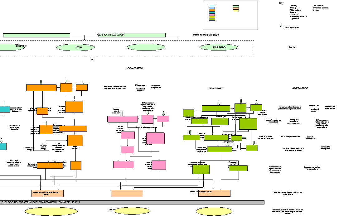
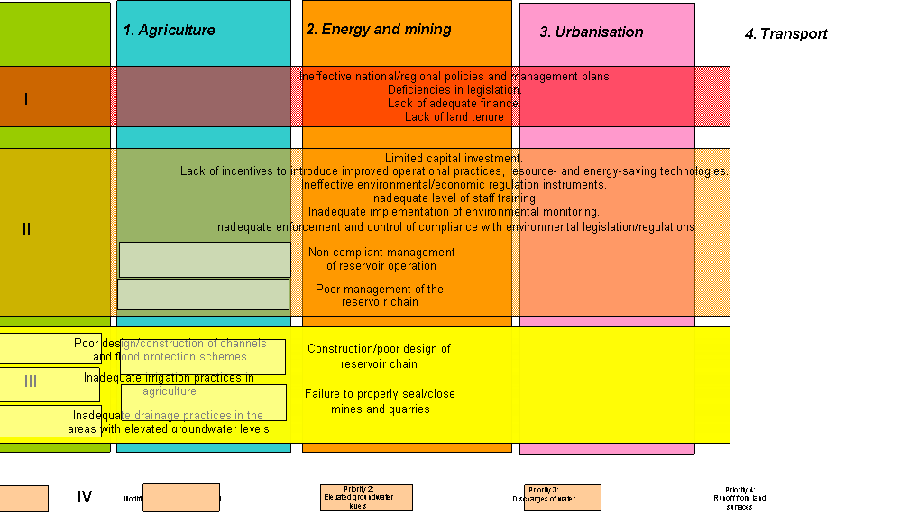
Figure 4.5 SAP decision making management tool for
the issue of flooding events and elevated groundwater
levels
Chemical
pollution refers to the adverse effects of chemical contaminants released to
standing or marine water bodies as a result of human activities. Chemical
contaminants are here defined as compounds that are toxic and/or persistent
and/or bioaccumulating. For the Dnipro Basin, chemical pollution also refers to
the exceeded guideline levels of chemical substances in water bodies of the
three riparian countries, and chemical pollution load carried with the river
flow to the Black Sea. The transboundary status of the issue is reflected in
Table 4.1. A detailed causal chain showing the links between the immediate and
underlying causes of this issue is shown in Figure 4.10.
The
impacts of this issue are linked closely with those of a number of other issues
including changes in the groundwater regime (Section 4.3.2), flooding events
and elevated groundwater levels (Section 4.3.3) and modification and loss of
ecosystems and ecotones (Section 4.5). The impacts of other water resource
pollution issues in this section such as microbiological pollution,
eutrophication, suspended solids, solid wastes and accidental spills and
releases (Section 4.4) are also closely linked.
Changes in biodiversity of aquatic, riparian and
terrestrial biological resources
The
most visible indication of environmental pollution associated with urban and
industrial sources is the existing state of river ecosystems. Such ecosystems
are greatly affected by municipal and industrial wastewater discharges,
particularly those that receive highly variable treatment levels. The
continuous pollution load in certain sections of the Dnipro Basin often causes
degradation of the rheophilous community structure and species composition.
Biological
survey results from a section of the Sozh River near Gomel, Belarus, have shown
that there is a direct relationship between a progressively increasing
anthropogenic load and a reduction in the diversity of zooplankton species. In
upstream sections there were 133 species compared to 38-46 species in the
section within the city boundaries, and 72-74 species downstream of the
discharge. The total number of species inhabiting the examined river sections
was 180.
A
similar picture emerges near large industrial centres in the Berezina River,
where taxonomic diversity is reduced as pollution load increases. In the river
section near Borisov the number of bottom community species fell from 90 to 57,
and in the river section near Bobruisk from 50 to 39. Individual
macroinvertebrate species and whole taxonomic groups were found to be missing
in the downstream sections, particularly those sensitive to changes in water
quality. For example, the number of mayfly species reduced from 8 to 2 near
Borisov, and no mayfly species were found downstream of Bobruisk. The
Oligosaprobic Blackfly (Simuliidae),
which is highly sensitive to changes in water quality, occurred only in the
upstream sections. Further details on changes in biodiversity are given in
Section 3.3.2 reviewing of the 2000-2001 field survey resu1ts (water quality,
metal contamination, persistent organic contamination, assessment of ecological
status and transboundary transport of pollution).
The immediate causes of chemical pollution
in the Dnipro Basin can be grouped into two hierarchical levels. The first
distinguishes point sources and diffuse sources of pollution. The second more
detailed level can be broken down into the following (also refer to Table
4.17):
·
Operational
discharge of liquids and gaseous effluents including cooling waters (point source);
·
Emissions
from storage of chemical products (point
and diffuse source);
·
Emissions
from storage of solid waste (point and
diffuse source);
·
Emissions
from storage of liquid wastes (point and
diffuse source);
·
Emissions
from transport (point and diffuse source);
·
Runoff
(point and diffuse source);
·
Growth
in the production of waste (point and
diffuse source).
1.
Operational discharge of liquids and gaseous effluents including cooling
waters
In
general, major water supply/sewerage systems are in poor repair and have
reached a high level of depreciation. The poor state of municipal utilities in
the Dnipro Basin is illustrated by the fact that wastewater discharges from
municipal wastewater treatment plants have been recognised as a major
(immediate) source of chemical and microbiological pollution and
eutrophication. Descriptions of the most significant pollution sources (or
‘hotspots’) in the Dnipro Basin are shown in Section 3.3.3. The transboundary
transport of pollution through the Basin is described in Section 3.3.2.
The
total annual volume of point source wastewater discharges in the Dnipro Basin
in 2000 was 6,843,000,000 m3 (a breakdown by country is shown in
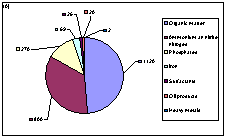
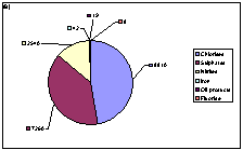
Figure 4.6) Of the total volume, the majority receives no, or only partial
treatment (Figure 4.7). In 2000, the water bodies of the Pripyat Basin received
164,000,000 m3 of wastewater within Belarus, and 363,730,000 m3
within Ukraine. Of that, 121,560,000 m3 received no treatment;
102,960,000 m3 was classified as ‘normatively clean’, i.e. not
requiring treatment; and 133,210,000 m3 was treated to the required
standard.
Figure 4.6
Annual volume of point source wastewater discharges in the Dnipro Basin in 2000
(m3/year)
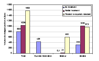
Figure 4.7 Level of treatment of wastewater discharges by total and each country
(year)
The
pollution load dynamics in the Russian part of the Dnipro Basin are shown in
Table 4.5. Table 4.6 shows the annual amounts of pollutants discharged with
effluents from point sources in the Russian part of the Dnipro Basin. Data on
the pollution load contained in effluents discharged into the Upper Dnipro in
1995 and 2000 are presented in Table 4.7.
Table 4.5 Pollution
load dynamics in the Russian part of the Dnipro Basin
|
Parameters |
Pollution load,
tonnes/year |
|
|
2000 |
Average over 1995-2000 |
|
|
Total iron |
726 |
955 |
|
Mineral nitrogen |
6029 |
5914 |
|
Suspended substances |
36756 |
31121 |
|
Sulphates |
83625 |
75948 |
|
Chlorides |
64178 |
57687 |
|
COD |
93771 |
69501 |
|
BOD5 |
11577 |
9479 |
|
Phenols |
6.81 |
5.96 |
|
Surfactants |
911 |
397 |
|
Total phosphorus |
929 |
459 |
Table 4.6 Pollutants
discharged with effluents from point sources in the Russian part
of the Dnipro Basin
|
Pollutant |
Tonnes/year |
|
Phosphorous |
1000 |
|
Surfactants |
150 |
|
Nitrates |
980 |
|
Iron |
105 |
|
Copper |
20 |
|
Zinc |
190 |
|
Organic matter (BOD) |
7,000 |
|
Oil products |
7 |
|
Suspended substances |
18,000 |
|
Sulphates |
34,000 |
|
Chlorides |
41,000 |
Table 4.7 Pollution
load contained in effluents discharged into the Upper Dnipro in 1995 and 2000
|
Polluting
compounds |
Unit |
1995 * |
2000 * |
|
Sulphates |
Thousand
Tonnes |
16.0 |
12.0 |
|
Chlorides |
Thousand
Tonnes |
28.5 |
19.1 |
|
BOD (total) |
Thousand
Tonnes |
7.0 |
2.9 |
|
Oil products |
Thousand
Tonnes |
0.07 |
0.04 |
|
Phenols |
Tonnes |
0.03 |
N/a |
|
Ammonium nitrogen |
Tonnes |
2094 |
1272 |
|
Nitrates |
Tonnes |
1087 |
1323 |
|
Nitrites |
Tonnes |
39.2 |
95.9 |
|
Iron |
Tonnes |
98.2 |
94.2 |
|
Copper |
Tonnes |
1.46 |
1.19 |
|
* - the State Water Cadastre (Inventory) data |
|||
The most polluted river sections in Belarus associated
with wastewater discharges are the Svisloch River downstream of Minsk, the
Berezina River downstream of Bobruisk, the Dnipro River downstream of Mogilev and Rechitsa, the Pripyat River downstream of
Mosyr, the Yaselda River downstream of Beresa, and the Usa River downstream of
Gomel. The actual dilution capacities of these rivers are far too low to be
able to meet the dilution demand.
In
2000, the Dnipro tributaries within Belarus received 7,930 tonnes of organic
matter (in terms of BOD); 5,400 tonnes of ammonium nitrogen; 1,909 tonnes of
nitrate nitrogen; 180 tonnes of oil products; 336 tonnes of iron; and 14.8
tonnes of copper. The contribution of transboundary, diffuse and point sources
of pollution to the total pollution flow from the territory of Belarus can be
evaluated from transboundary pollution load estimates and data on pollution
loads entering the rivers with wastewater discharges (averaged over the period
of 1995-2000). The results of this evaluation are presented in Table 4.8
Further information on the transboundary transport of pollution in the Basin is
presented in Section 3.3.3.
Table 4.8 Comparative
contribution of point and diffuse pollution sources to the total pollution flow
from Belarus (indicative data)
|
Pollution sources |
Contaminants, % |
|||||
|
Oil products |
Suspended substances |
BOD5 |
Ammonium nitrogen |
Copper |
Zinc |
|
|
Diffuse
sources |
75 |
50 |
76 |
82 |
56 |
90 |
|
Point
sources |
25 |
50 |
24 |
18 |
44 |
10 |
In
Belarus, 80% of the total wastewater volume entering the Dnipro River and its
tributaries contains polluting substances at elevated concentrations even after
primary, secondary and tertiary treatment. This proportion varies from 7% to
48% at the city/town level and from 8% to 25% at the Oblast level. Wastewater
discharges are concentrated in the Berezina and Svisloch River catchments, with
the latter receiving the major part of the pollution load (Table 4.9). The City
of Minsk appears to be the major contributor in terms of volume and pollution
load, generating more than 25% of the total (Figure 4.8). This has greatly
affected the ecological state of the Svisloch River itself, and the Dnipro
Basin as a whole.
Table 4.9 Pollution
load in the Svisloch River catchment
|
Pollutant |
tonnes |
% |
|
Nitrate nitrogen |
100 |
91 |
|
Organic matter |
3,480 |
81 |
|
Oil products |
9 |
75 |
|
Ammonium nitrogen |
2,120 |
71 |
|
Surfactants |
55.7 |
66 |
|
Phosphates |
810 |
63 |
|
Heavy metals |
35 |
73 |
|
Iron |
93 |
68 |
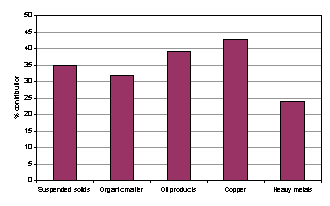
Figure 4.8 % contribution of pollution from the city of Minsk to the Svisloch
River and the Dnipro Basin (2000)
Within
Ukraine, about 900,000 tonnes of pollutants are discharged with effluents into
the Dnipro Basin water bodies from point sources. In 1990, the total amount of
discharged pollutants was 793,000 tonnes, whereas the 1991-1995 average annual
pollutant discharge was 1,003,000 tonnes. Clearly, the decline in production
and associated water consumption during this period did not result in a
reduction of pollution load discharged into the Dnipro Basin rivers.
2.
Emissions from storage of chemical
products, solid wastes and liquid wastes
Approximately 5,000 agrochemical and expired pesticide storage sites are
scattered throughout rural areas in Ukraine. Within the Russian Federation,
about 50% of chemical fertilisers and agrochemicals are stored at unorganised
and often uncontrolled sites.
According
to data from a waste inventory survey carried out in the mid 1990s, Ukraine has
2,670 waste landfill and disposal sites, with about a half of them (1,310
sites) located within the Dnipro Basin. These figures do not account for the
numerous on-site industrial waste storage facilities, and smaller waste dumps
located in rural areas.
There
are 300 toxic waste disposal sites in Ukraine (161 of them being located in the
Dnipro Basin), containing toxic substances at concentrations exceeding the
respective MAC limits by a factor 50. None of these sites are well engineered,
thereby posing a continuous threat to groundwater and surface waters.
Despite
the decline in production, toxic waste generation remains high in the Russian
Federation and in 2000 reached 125% of the 1990 level (1,200,000 tonnes). This
equates to 1.1% of the total annual amount of waste generated in the Russian
Federation. In the region, usage of toxic materials in industrial processes has
grown 2.4 fold over the last five years (from 66,000 tonnes in 1995 to 215,000
tonnes in 2000). Further details on waste disposal sites can be found in
Section 4.4.2 (immediate causes of microbiological pollution).
3. Runoff from agricultural
land and urbanised areas
Of
the total amount of nitrogen and phosphorus applied to agricultural land, about
20% of nitrogen and 5% of phosphorus reach the water bodies with surface
runoff. In Belarus, agricultural soils contain phosphorus and nitrogen
compounds at elevated concentrations. In 1989-1990, the annual nutrient load
discharged into the surface waters of the Dnipro Basin from agricultural areas
was 21,200 tonnes of nitrogen and 610 tonnes of phosphorus. Figure 4.9 reflects
the percentages contributed by various sources to the total nutrient load.
Another
related problem is the large-scale application of pesticides in the riparian
countries. Within the Russian Federation, the annual pesticide runoff rate is
about 1 kg/ha. Further details on the level of pesticides in the Dnipro
environment can be found in Section 3.3.2 (2000-2001 field survey results).
In
Belarus, significant pollution load enters surface waters with urban runoff
with 4,530 tonnes/year of oil products, 10,260 tonnes/years of organic matter
in terms of BOD5, 780 tonnes/year of ammonium nitrogen and 330
tonnes/year of phosphates (1990 data).
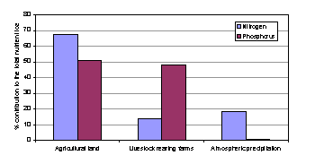
Figure 4.9 %
Contribution of 3 sources to the total nutrient load
According to survey data provided by the Ukrainian Municipal Utility
Research & Design Institute “UkrKommunNIIProgress”, about 78% of suspended
matter, 20% of organic matter and 68% of oil products enter surface waters with
rainstorm runoff drained from urban areas. Oil products contained in soils are
washed out into the surface waters and accumulated in the bottom sediments. Monitoring data over the past 10 years
indicates that oil product concentrations in water have increased over that
period, reaching 0.14 mg/l in 2000, compared to the MAC limit for fishery water
use of 0.05 mg/l.
4. Growth in the production of
waste
For
details on the growth of waste production, refer to the immediate causes of
chemical pollution described above and Sections 3.1.4 and 4.4.6 on mineral
resources and solid waste pollution in the Basin.
The
underlying causes of this issue arise in the following key sectors: industry, agriculture, and urbanisation.
Energy, aquaculture and transport contribute to a lesser degree. A list of the priority sectors for all
issues is presented in Table 4.18 (Section 4.7)
A
detailed causal chain reflecting the links between the immediate and underlying
sectoral causes of this issue is shown in Figure 4.10 and a detailed
description of terminology used in this causal chain is given in the definition
of terms in Annex 2.
Based
on the causal chain in Figure 4.10, the priority sectoral resource uses and
practices and the underlying political, economic and governance causes of this
transboundary issue can be identified. These are shown in the Strategic Action
Programme (SAP) decision making management tool (Figure 4.11).
The
SAP decision making management tool shows the priority sectors for this issue
(colour coded with the causal chain) together with three hierarchical levels of
concern (shown in Section 4.3.1). Within each level the priority resource uses
and practices and the underlying political, economic and governance causes for
each transboundary issue are listed. These can either cut across all sectors
(e.g. Lack of adequate finance) or be sector specific (e.g. inadequate
implementation of clean technologies).
Environmental
degradation in the Dnipro Basin can largely be attributed to the long-term
chemical contamination of air, soil, surface waters and groundwater. The impact
on the natural environment of anthropogenic chemical pollution is a legacy of
the large-scale unsustainable development of industry, agriculture and urban
areas in the Basin.
In
terms of point and diffuse sources of chemical pollution, diffuse sources are
more significant for the Basin as a whole, as they relate to spatial pollution,
i.e.:
·
Emissions
from storage or disposal of liquid/solid waste and chemicals;
·
Atmospheric
deposition of pollution;
·
Application
of fertilisers;
·
Application
of agrochemicals;
·
Pollution
of urbanised areas and transport networks.
Moreover,
diffuse pollution sources, as opposed to point sources, are very difficult to
regulate, and their adverse impact is likely to grow in the short to medium
term, as economic activity increases. The most effective options to prevent and
reduce diffuse pollution are:
(1)
The
establishment/reconstruction of water protection zones and strips;
(2)
The development and
implementation of environmentally sound waste management systems and facilities
for all types of waste; and
(3)
The collection and treatment
of rainstorm runoff from urban areas.
Figure 4.10 Causal chain for the issue of chemical
pollution (see causal chain definition of terms for more details)
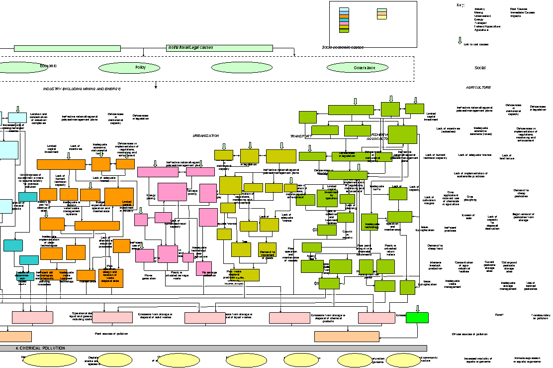
Figure 4.11 SAP decision making management tool for
the issue of chemical pollution
Microbial
pollution refers to the adverse effects of microbial constituents of human or
animal sewage released to water bodies. The most obvious evidence of the
transboundary status of this issue is the presence of microbiological
contaminants in the transboundary sections of the Dnipro River and its estuary
where its drains into the Black Sea (Table 4.1). However, based on the
prioritisation exercise detailed in Chapter 4, this issue was not considered a
priority transboundary issue. Consequently,
detailed causal chain analysis beyond the immediate causes of the issue was not
carried out.
The
impacts of this issue are linked closely with those of a number of other issues
including modification of the hydrological regime (Section 4.3.1) and water
resource pollution issues such as chemical pollution (Section 4.4).
The deterioration of drinking water quality and the
decreased recreational value of water bodies
There
have been numerous reports of the presence of pathogenic parasites in the local
water supplies of the Dnipro Basin. Survey results on the sanitary situation
suggest that non-disinfected sewage and wastewater are major carriers of
infective Helminth eggs and represent
a primary cause of contagious diseases.
Water
mains and related inspection wells are reported to be a source of water
pollution in the Russian Federation, due to their poor technical state,
frequent breaks and the absence of disinfection practices. 40% of water samples
collected in recreational areas were found to be non-compliant with regard to
sanitary and microbiological requirements due to the presence of Helminth eggs. The provision of good
quality drinking water has become a serious issue. Over 50% of municipal and
corporate water supplies do not meet sanitary standards, with one quarter of
water samples from centralised water supply systems and one third of samples
from municipal water mains being non-compliant with existing requirements.
In
Belarus, the percentage of non-compliant samples taken from or near public
water intakes remains consistently high. For example, of 756 samples taken for
chemical analysis, 27.6% were found to be non-compliant with regard to existing
water quality standards. In terms of biological parameters 14.4% of 2,414
samples taken were found to be non-compliant. A review of available data on the
impacts of anthropogenic pollution on human health in the Republic of Belarus
indicates that there is a direct relationship between the level of
microbiological pollution in river water and the increased incidence of various
contagious diseases.
Existing
water treatment processes are not capable of ensuring the safety of drinking
water. In particular, chlorination processes do not completely remove certain
persistent pathogenic viral agents. As a result, even pre-treated drinking
water may contain pathogenic viruses that pose a threat to human health. This
was the case in Gomel, where a large outbreak of water-borne enteroviral
meningitis affected over 600 people, of which 70.6% of them were children.
There
have been numerous and regular reports of the presence of pathogenic viruses,
bacteria and parasites in the local water supplies of the Belorussian part of
the Dnipro Basin. This represents a continuous threat of contagious disease
outbreaks in the region.
Of
greatest concern are regular reports of water-borne pathogens in the
transboundary sections of the Dnipro Basin within Belarus. These include the
Svisloch River (near Minsk); the Berezina River (near Svetlogorsk), the Pripyat
River (near Petrikov, Mosyr, and Narovlya), the Sozh River (near Gomel and
Krichev), and the Dnipro River (near Rogachev, Zhlobin, Rechitsa and Loev).
Table 4.8 shows the contribution of pollution sources to the total pollution
flow from Belarus and Figure 4.8 reflects the levels of pollution load received
by the Svisloch River and Dnipro Basin as a whole from the City of Minsk in
2000.
Significant
pollution load also enters the Pripyat Basin from both Belarus and Ukraine and
the levels for 2000 are shown in Figure 4.12.
|
|
|
Figure 4.12 Pollution
load (tonnes) entering the Pripyat Basin from (A) Belarus and (B) Ukraine (the
levels shown are for 2000)
The
2000 monitoring data provided by the Ukrainian Sanitary/Epidemiological Service
suggests that a considerable proportion of surface water bodies and drinking
water supplies contain water of unacceptable quality. In 2000, 26.6% of surface
water samples were found to be non-compliant with the existing sanitary
standards, and 15.5% of them did not meet the microbiological requirements. However,
the results of regular sanitary/bacteriological monitoring suggest that the
microbiological component of river water quality has remained relatively stable
over recent years.
Water
quality in the region is affected by pollution entering the Dnipro with
numerous agricultural, industrial and municipal wastewater discharges. It is
also affected by the nature of the region itself, where large-scale industrial
and agro-industrial operations are concentrated (refer to Section 3.3.3 on
Ukrainian hotspots for more details). Regular monitoring data indicates that
admissible limits for a range of pollutants have been consistently exceeded,
thereby greatly affecting the overall sanitary situation in the Dnipro Basin.
The sections where concentrations of pollutants have been generally higher than
average and in some instances have reached or exceeded admissible limits are
given below:
·
The
Dnipro River section within the Poltava Oblast (near the Psyol and Vorskla
River inflows and near the Sovetsky village where the river enters the
Dnipropetrovsk Oblast).
·
Within
the Dnipropetrovsk Oblast (in the Samara River mouth near Dnipropetrovsk, and
near Vasylivka where the river enters the Zaporizhzhia Oblast).
More
information on the deterioration of drinking water quality and the decreased
recreational value of water bodies in the basin can be found in Section 3.3.8
on the sanitary situation, Section 3.2.9 on water-borne diseases and
microbiological contamination and Section 3.3.2 (Review of the 2000-2001 field
survey results). Details on transboundary hotspots and transboundary transport
of pollution in the Dnipro Basin can be found in Sections 3.3.3 and 3.3.2.
The
following immediate causes
contribute to microbiological pollution in the Dnipro Basin (also refer to
Section 4.2):
·
Discharges
of insufficiently treated municipal wastewater;
·
Discharges
of insufficiently treated effluents by food processing industries;
·
Diffuse
pollution sources (especially during high flow periods);
·
Discharges
from livestock-rearing sites;
·
Discharges
from waste dumps.
1.
Discharges of insufficiently treated municipal wastewater and effluents
by food processing industries
Full
details on municipal wastewater discharges can be found in Section 3.2.7 on the
municipal utility sector, Section 3.2.10 on water uses in the Basin and in
Section 4.4.1 on chemical Pollution (immediate causes). Details on discharges
from food processing industries can be found in Section 3.2.4 on industry in
the basin and lists of transboundary hotspots in the Dnipro Basin can be found
in Section 3.3.3.
Discharges
of microbiological pollution also occur from Landfill sites. In the Kursk
Oblast in the Russian Federation, of 32 industrial and municipal waste dumps,
only one is an engineered sanitary landfill. In the Republic of Belarus, only
15% of generated municipal solid waste is currently managed and disposed of
properly, with only 4% of waste being recycled at the State Municipal
Enterprise (Ecores), the sole specialised waste recycling facility existing in
Belarus. There are numerous illegal waste dumps.
The
Environmental Inspectorate of the Ministry of Environmental Protection and
Nuclear Safety of Ukraine carried out a waste disposal site audit in 1995-1996.
This covered 2,208 sites (580 industrial waste disposal sites and 1,628
municipal waste disposal sites) occupying an area of 35,400 hectares. The audit
findings indicated that none of these sites met existing environmental safety
requirements. The situation with municipal solid waste management is critical.
For instance, the Zaporizhzhia Oblast has 27 operating landfills (occupying 209
hectares), 325 waste dumps in rural areas, and 373 cattle burial grounds. There
are 201 waste dumps in the Dnipropetrovsk Oblast, and 366 waste dumps in the
Poltava Oblast. None of the rural waste disposal sites and cattle burial
grounds meet environmental safety requirements. Refer to Section 4.4.1
(immediate causes of chemical pollution) for further details on waste disposal
sites.
2.
Diffuse pollution sources
The
following diffuse pollution sources contribute to the microbiological pollution
load received by water bodies in the Dnipro Basin:
(a)
Surface runoff from
urbanised areas and major highways.
(b)
Surface runoff and direct
discharges from livestock-rearing sites and rural settlement areas not
connected to centralised wastewater treatment services.
(c)
Pollution transport with
rainstorm and snowmelt water runoff from agricultural land.
Further
details on the poor coverage of centralised wastewater treatment in rural areas
can be found in Section 3.2.7 on the municipal utility sector.
The
underlying causes of microbiological pollution mainly relate to the following
sectors: industry urbanisation and agriculture (see Section 4.2).
Radionuclide pollution refers to the adverse effects
of the release of man-made and naturally occurring radioactive contaminants and
wastes into the aquatic and atmospheric environments from human activities. The transboundary significance of this issue is illustrated by the fact
that the Chornobyl accident affected the territories of many countries,
including the three nations of the Dnipro Basin (Table 4.1). A detailed causal
chain showing the links between the immediate and underlying causes of this
issue is shown in Figure 4.13.
The major sources of radionuclide pollution in the Dnipro Basin are the
territories contaminated as a result of the Chornobyl accident, nuclear power
plants (NPP’s), radioactive material extracting/processing industries and
radioactive waste disposal sites.
Impacts on human health and ecosystems from uranium
mines and related processing industries
Uranium mines and related processing industries in Ukraine have a number
of potential impacts on human health and the environment. They include:
·
Contamination
of mining process water with uranium and other radionuclides;
·
Discharge
of processing industry effluents to surface waters (usually after treatment);
·
Surface
runoff from contaminated mining and processing industry sites;
·
Radon
release from mines and mining/processing waste disposal sites;
·
Leaching
of radionuclides from tailings and their subsequent transport by river flow;
·
Erosion
of tailing waste sites leading to the spread of the fine tailing fraction by
high winds and migration through water;
·
Contamination
of surface waters and groundwater sources by poisonous non-radioactive
substances (e.g. heavy metals and chemical reagents used in the ore-enrichment
process).
Radioactive
effluents received by the Zhovtenka and Saksagan Rivers, and the Dnipro
reservoirs from uranium mines and ore-processing industries are usually
associated with relatively low chronic exposure levels, although radioactive
pollution levels can be as high as 1 Bq/l at or immediately downstream of
mining process water outlets. Consequently, this may result in additional
exposure of the local population through consumption of river water.
Impacts on human health and ecosystems as a result of
the Chornobyl accident
The
most serious consequences of the Chornobyl accident for the population were
caused by exposure to short-lived radionuclides, especially 131I,
which resulted in many thyroid cancers. Other radiation-induced health effects on the public
have not been revealed so far. The contribution of
freshwater pathways to human exposure is dependent on the direct consumption of
water, fish and irrigated farming products, as well as meat and milk produced
in the contaminated areas where the river floodplains are used for livestock grazing
and haymaking.
The
concentrations of 137Cs and 90Sr in the Dnipro Basin
watercourses are now well below the national limits and international guideline
levels for drinking water. However, enclosed lakes with no regular outflow
still present a radiological problem that will continue for some time. These
lakes, usually associated with underlying peat deposits, have a limited ability
to fix 137Cs. As a result, concentrations of 137Cs in these waters are
close to the permissible limits.
The levels in local fish species exceed these limits
by at least an order of magnitude. Moreover, radionuclide levels exceed
permissible levels in local forest products (wild
game, mushrooms, and berries), and in milk and meat produced by cattle grazing
on the contaminated floodplains. The contribution of freshwater pathways to
human exposure of 90Sr and 137Cs in water, ranges from
0.2% to 1.0% within the Russian Federation, from 0.1% to 1.5% within Belarus,
and from 1% to 7% within Ukraine
Strontium
transport from the Chornobyl Exclusion Zone to the Dnipro reservoirs increases
significantly during high flow periods. Although individual exposure levels remain low
(below 1 mSv), collective exposures may reach 20-30 person-Sv, or even 60
person-Sv as a result of elevated annual radionuclide transport from the Zone.
Enclosed
lakes located in the Republic of Belarus and the Bryansk Oblast of Russia are
considered as local hot spots in terms of average annual human exposure doses. Even 16 years after the
Chornobyl fallout, the annual dose of the local population living near the
Kozhany Lake (in the Bryansk Oblast) amounts one to two mSv, about half of it
due to consumption of local fish. Similar individual
exposures were recorded in the areas adjacent to the most heavily contaminated
lakes in Belarus.
The direct effect of radioactive pollution in 1986
on species diversity has only produced a response in pedogenetic invertebrate
communities residing in the vicinity of the Chornobyl NPP. Other wildlife communities have been more severely affected by secondary
ecological factors of radioactive pollution. For example, direct exposure
levels in the areas affected by the Chornobyl accident appear to be below
lethal levels that would be expected to cause mass kills among wildlife communities,
although the resultant radionuclide levels in many species have made them
unsuitable for human use. This has had an indirect effect on the abundance and
diversity of many wildlife species, especially commercial ones.
Two
opposite processes have developed in the most contaminated areas withdrawn from
use immediately after the Chornobyl accident. There has been a dramatic drop in
the population of synanthrope species, followed by their virtual disappearance
and an increase in the population of a number of species vulnerable to
anthropogenic effects. Likewise, trends in bird’s communities have followed a
similar pattern with a reduction of species diversity and populations of
synanthrope communities as opposed to the progressive development of communities
that are characteristic to woodland/shrub ecotones and successions. In
particular, there has been an increase in the population of those carnivorous
species that are vulnerable to anthropogenic effects. Similar trends have been
reported for other wildlife communities.
Key
features of radionuclide accumulation patterns are as follows:
·
In
aquatic phytocenoses, the ability to take-up and accumulate 90Sr and
137Cs is most pronounced in macrophyte species (Typha latifolia and Elodea
canadensis), and in algal communities dominated by Cladophora and Oedogonium
families.
·
Radionuclide
levels in various parts of aquatic plants were found to be subject to seasonal
variations, with radionuclide accumulation rates being proportional to the
concentrations of their macroanalogues in non-aquatic plants.
·
137Cs levels were measured in fish inhabiting the Kozhanovsky
Lake in the Bryansk Oblast of
Russia, and other lakes of a similar type in the Gomel and Mogilev Oblasts of
Belarus. There appeared to be differences amongst species within lakes, with 137Cs
levels generally highest in predator fish. Based on these results, a suite of
indigenous fish species may be ranked in terms of increasing levels of 137Cs:
gudgeon, crucian, tench, pike, and perch. 137Cs levels in fish samples varied within the range of
320 to 20,000 Bq/kg
(wet weight). There also appeared to be a direct relationship between
accumulation rates and fish age. In 1993, average 137Cs levels in
perch of 10-years of age were 40 kBq/kg (wet weight), exceeding EU guideline
levels of 0.6 kBq/kg of wet weight by about sevenfold.
Results
of a series of surveys carried out in the Republic of Belarus between 1986 and
1998 indicate that macrophytes, zoobenthos and fish inhabiting local water
bodies contained higher levels of radionuclide pollution.
In
fish, the highest levels of 137Cs were recorded in 1986-1987 in catfish (6´105 Bq/kg) and pike perch (4´105 Bq/kg). Results of surveys carried out in the Kyiv reservoir between
1987 and 1991 suggest that shellfish communities were more responsive to 90Sr, with
134, 137 Cs levels being generally higher in fish. The highest levels of 134, 137 Cs (up to 6´103 Bq/kg)
were recorded in pike in the autumn of 1987 and the winter of 1998. Bottom
sediments are estimated to contain over 90% of the total stock of Cs137
in the aquatic ecosystem.
Further
information on radionuclide contamination can be found in Section 3.3.2 (Review
of the 2000-2001 field survey results).
The
following immediate causes
contribute to radionuclide pollution in the Dnipro (also refer to Table 4.17):
·
Atmospheric
and aquatic releases of radionuclides during the Chornobyl accident;
·
Secondary
releases from sites contaminated with radionuclides as a result
of the Chornobyl accident;
·
Point
and diffuse discharges of mining process waters and tailing wastes from
disposal sites at uranium mines and ore-enrichment plants;
·
Emissions/discharges
from radioactive waste disposal sites
1.
Atmospheric and aquatic releases of radionuclides during the Chornobyl
accident and subsequent secondary releases
The
Chornobyl accident resulted in the contamination of extensive areas of woodland
and farmland and continues to be a serious problem in the Basin.
Radioactive
contamination is considered to be the major environmental problem in the
Belorussian part of the Dnipro Basin, with extensive areas of agricultural land
contaminated by 137Cs. Approximately 1.1 million hectares (89.7%) of
Belorussian agricultural land contaminated by 137Cs (>1 Ci/km2)
is located in the Dnipro Basin (See Section 3.1.2 and Figure 3.3 for more
details). The Gomel and Mogilev Oblasts(674,200 and 332,500 hectares
respectively) have suffered most from radioactive contamination of agricultural
land.
In
addition, surface runoff and ground water flow from contaminated areas has
significantly contributed to the existing levels of radionuclide pollution in
the Dnipro Basin (including washout of contaminated soil particles and
radionuclide metabolites during high flow periods). Surface runoff from
contaminated areas results in elevated concentrations of radionuclides in
water, bottom sediments and biota. Table 4.10 shows the levels of radionuclides
found in water samples taken from the Pripyat River within Ukraine immediately
after the Chornobyl accident in May 1986.
During
the 2000-2001 field survey organised within the framework of the current
UNDP-GEF Dnipro Programme and supported by the International Development
Research Centre, a special analytical programme was carried out to investigate
the levels of radioactive
contamination and distribution patterns throughout the
Dnipro Basin.
The
results of this survey show that the area most contaminated by radionuclides
lies in the Pripyat Basin immediately upstream of the Chornobyl NPP, where 90Sr
activity was estimated at 8,000 Ci. Levels of 137Cs, 239Pu and 240Pu
in soil were also extremely high in this area. However, these radionuclides are
bound with soil particles and therefore their contribution to human exposure
via freshwater pathways is relatively minor, especially in the post-Chornobyl
period.
Table 4.10 Levels
of radionuclides found in water samples from the Pripyat River, May 1986
|
Radionuclide |
Bq/l |
|
90Sr |
3.26-14.8 |
|
134Cs |
3.15 |
|
137Cs |
6.29 |
|
95Nb |
15.54 |
|
144Cs |
33.67 |
|
131I |
37.0 |
The
migration characteristics of radionuclides can be understood from an
appreciation of the chemistry of Cs and Sr. Cs has the ability to be taken up
by clay materials frequently occurring in natural soils, thereby weakening its
horizontal and vertical migration. Sr is less firmly bound by soil, being more
mobile in the environment. The soils in the Chornobyl Exclusion Zone are
heavily contaminated with 90Sr, and this contaminant can be washed
out during flooding events. The chemistry of these elements also explains their
behaviour upon entering the Dnipro reservoir chain, where 137Cs is
fixed onto clay sediments in the deeper sections of the reservoirs, especially
in the Kyiv reservoir. Very little 137Cs passes through the whole
chain of reservoirs, therefore the levels of 137Cs in river flow
entering the Black Sea are very similar to background levels. On the other
hand, although 90Sr levels progressively decrease downstream (mainly
due to dilution), a significant proportion of the pollution load reaches the
Black Sea.
Table
4.11 reflects annual radionuclide fluxes into the Pripyat River expressed in
absolute terms for a dry year (1997), a wet year (1999) and an average year
(2001). The contribution of the Pripyat River tributaries (Uzh, Braginka, and
Sakhan) to the total radionuclide load transported by freshwater pathways has
not exceeded 13% in recent years.
Analysis
of 90Sr migration data provided by the Chornobyl Exclusion Zone
Administration suggests that the highest contribution of radionuclide pollution
to the Dnipro water system is associated with the area adjacent to the
Chornobyl NPP site, varying from year to year between 60% and 70%. The total
radionuclide pollution load has been continuously decreasing, with 1999 being
the only exception due to exceptionally high flooding in the Pripyat River
Basin.
Table 4.11 Source-specific
fluxes of 90Sr into the Pripyat River
|
Radioactive
pollution sources |
Fluxes of 90Sr
(1012Bq) |
Contribution to 90Sr flow beyond the Exclusion Zone, % |
||||
|
1997 |
1999 |
2001 |
1997 |
1999 |
2001 |
|
|
Pripyat River (inflow into the Exclusion
Zone) |
0.80 |
3.21 |
1.29 |
26.1 |
29.9 |
36.2 |
|
Runoff from the left-bank polder |
0.33 |
1.39 |
0.57 |
10.8 |
12.9 |
16.0 |
|
Surface runoff, groundwater flow |
1.18 |
5.21 |
0.92 |
38.6 |
48.5 |
25.8 |
|
Filtration streams (cooling pond) |
0.13 |
0.08 |
0.10 |
4.2 |
0.7 |
2.8 |
|
Glinitsa River |
0.22 |
0.27 |
0.21 |
7.2 |
2.5 |
5.9 |
|
Sakhan River |
0.02 |
0.04 |
0.05 |
0.7 |
0.4 |
1.4 |
|
Uzh River |
0.17 |
0.27 |
0.20 |
5.6 |
2.5 |
5.6 |
|
Braginka River |
0.21 |
0.28 |
0.22 |
6.9 |
2.6 |
6.2 |
|
Total within the Exclusion Zone |
2.26 |
7.54 |
2.27 |
73.9 |
70.1 |
63.8 |
|
Total outflow beyond the Exclusion Zone |
3.06 |
10.75 |
3.56 |
100 |
100 |
100 |
90Sr remains a priority radionuclide contaminant transported by river flow
beyond the boundaries of the Chornobyl NPP site (Table 4.12.). In addition, 137Cs,
239Pu and 240Pu enter the rivers in the Basin with soil
particles as a result of erosion developing in the river catchments and
floodplains. These radionuclides are carried downstream with sediments and
deposited in the upper section of the Kyiv reservoir. However, they are
characterised by relatively low bioavailability levels. Accordingly,
radioactive pollution levels in river fish and biota have now significantly
reduced, and the embargo on fishing activities in the reservoirs has been
lifted.
Table 4.12 Estimated
stocks of cesium-137 and strontium-90 in catchments of major rivers entering
the Kaniv reservoir
|
River |
Catchment area, ‘thousands km2 |
Radionuclide content, thousands Cu |
||
|
Total area |
Area with Cs level above 1
Cu/km2 |
Cs-137 |
Sr-90 |
|
|
Dnipro |
105 |
29 |
275 |
6 |
|
Pripyat |
|
27 |
180 |
42 |
|
Desna |
89 |
61 |
8 |
1 |
Further
information on the redistribution and accumulation of radionuclides originating
from the territories affected by the Chornobyl accident can be found in Section
3.3.2 (Review of the 2000-2001 field survey results).
2.
Point and diffuse discharges of mining process waters and tailing wastes
from disposal sites at uranium mines and ore-enrichment plants.
Uranium
mines are concentrated in the Ukrainian part of the Dnipro Basin. The amount of
radioactive waste material generated by uranium mines and ore-processing plants in Zhovti Vody and Dniprodzerzhinsk is now higher than 65 million
tonnes. A significant amount of natural radioactive material is extracted and
processed by mining and ore-processing industries, contributing to the total
radioactive pollution load on the local environment. Uranium ore fields and
tailing waste disposal sites are major sources of potential radioactive
contamination. Surface runoff and leachate migration from tailing waste
disposal sites results in elevated levels of radionuclides in local rivers,
although they remain below the permissible levels set for drinking water sources. Further
information on radioactive pollution sources within the Dnipro Basin can be
found in Section 3.3.4.
3.
Emissions and discharges from nuclear power plants
There
are 20 nuclear power reactors in the Dnipro Basin, 13 of them operating at four
nuclear power plants within Ukraine (the Zaporizhzhia, the South-Ukrainian, the
Rivne, and the Khmelnitsk NPP’s), and 7 in the Russian Federation at two sites (the
Kursk and Smolensk NPP’s).
Results
of the IAEA expert review of emission/discharge statistics and monitoring data
on performance of nuclear power facilities in Ukraine and Russia suggest that
routine discharges from NPP’s are generally well below limits, and their
environmental impact is rather limited. Operators of nuclear power generating
facilities and radioactive waste disposal sites maintain strict control of
pollution migration beyond their sanitary zones. Total annual radioactivity
levels associated with process water discharges into water bodies don't exceed
1-2 Cu/year. Waste products are generally well managed at these facilities,
with continuous improvements in waste management and waste minimisation being
implemented. Waste and spent fuel facilities feature adequate environmental
protection systems, although they are reaching capacity in some instances.
The
underlying sectoral causes of radionuclide pollution are mainly associated with
resource uses and practices in the mining and energy sectors. A significant proportion of radionuclide
pollution load on the Dnipro Basin is a direct consequence of the Chornobyl
accident. A list of the priority sectors for all issues is presented in Table
4.18 (Section 4.7)
A
detailed causal chain reflecting the links between the immediate and underlying
sectoral causes of this issue is shown in Figure 4.13 and a detailed
description of terminology used in this causal chain is given in the definition
of terms in Annex 2.
Based
on the causal chain in Figure 4.13, the priority sectoral resource uses and
practices and the underlying political, economic and governance causes of this
transboundary issue can be identified. These are shown in the Strategic Action
Programme (SAP) decision making management tool (Figure 4.14).
The
SAP decision making management tool shows the priority sectors for this issue
(colour coded with the causal chain) together with three hierarchical levels of
concern (shown in Section 4.3.1). Within each level the priority resource uses
and practices and the underlying political, economic and governance causes for
each transboundary issue are listed. These can either cut across all sectors
(e.g. Lack of adequate finance) or be sector specific (e.g. location and
concentration of
NPP’s in the Basin).
The
causal chain for the issue of Radionuclide Pollution is quite specific: for
example, the consequences of the Chornobyl accident have been identified as an
individual sector, which is relevant for the analysis of this issue.
Figure 4.13 Causal chain for the issue of
radionuclide pollution (see causal chain definition of terms for more
details)
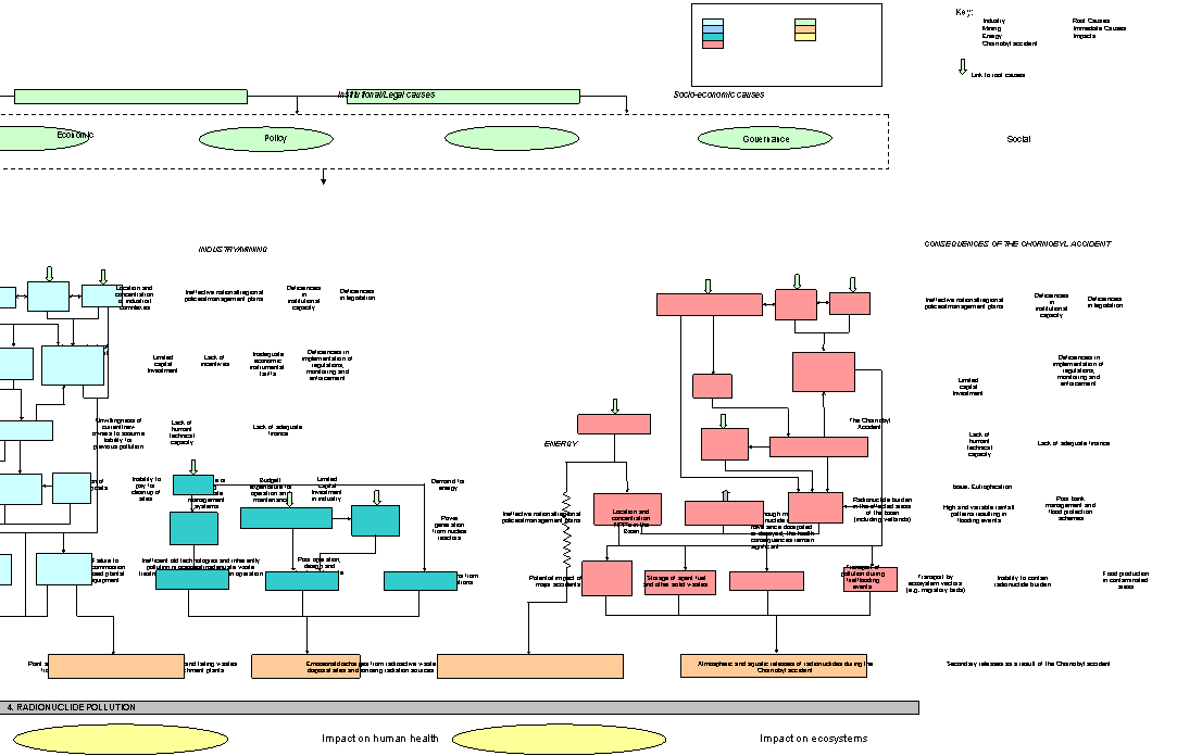
Figure 4.14 SAP decision making management tool for
the issue of radionuclide pollution
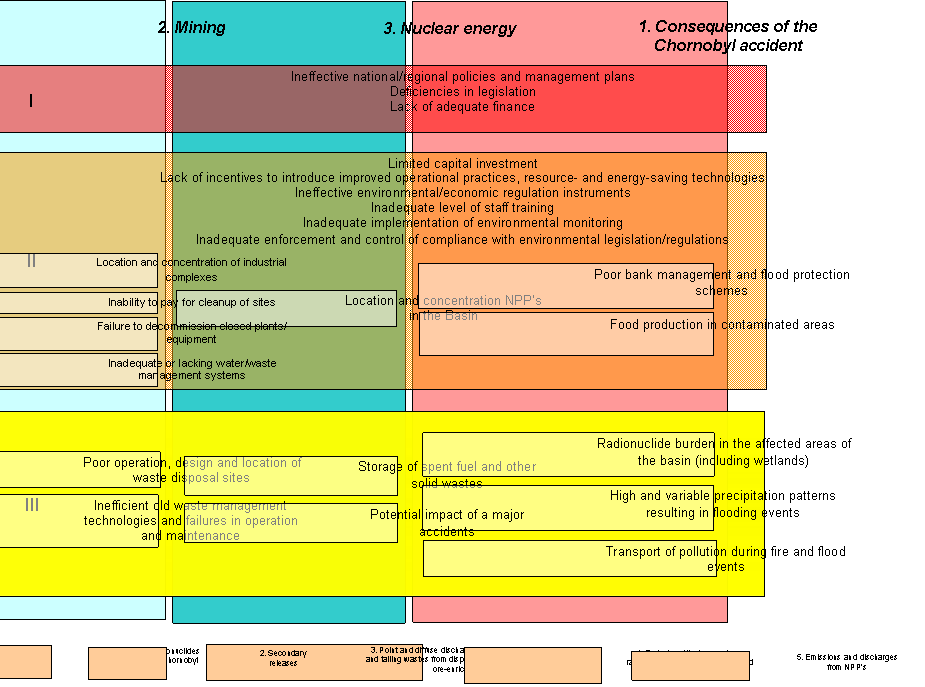
Analysis
of the radionuclide pollution issue, carried out by the IAEA experts, suggests
that the mining industry (including mining and enrichment of uranium ore) has
had a profound impact on the environment. This is illustrated by the fact that
the amount of tailing waste accumulated in the Basin as a result of past
activities is about 100 million tonnes. The majority of tailing waste storage
sites have not been closed/restored properly, and this is likely to pose a
long-term problem unless these sites are adequately managed. The tailing waste
storage site “D” in Dniprodzerzhinsk is considered to represent the major
danger in terms of potential environmental pollution due to its proximity to
the Dnipro River, poor technical state and the perceived risk of catastrophic
failure of its bund.
Limited
data is available on radionuclide concentrations in the vicinity of uranium
mines, processing sites and radioactive waste disposal sites. It is therefore
impossible to provide any accurate assessment of human exposure
doses associated with these sources. Therefore this sector is considered of top
priority.
The
second priority sector is nuclear energy. This is explained by the fact that
emissions during routine operation of nuclear power facilities in Ukraine and
Russia are relatively minor and far below existing mandatory limits. The RBMK
and VVER reactors have been subject to major regional and international
scrutiny. Immediately after the Chornobyl accident, urgent measures were taken
to improve the inherent safety of these reactors. An international in-depth
safety assessment process is currently underway to optimise these programmes.
There is space for improvement of the system of emergency preparedness and
response.
The
third priority sector is defined as “Consequences of the Chornobyl accident”.
According to the IAEA data, transboundary transport of radionuclides in the
Dnipro Basin is currently very close to the background levels, i.e. has
practically restored to the pre-Chornobyl levels.
Suspended
solids refers to the adverse effects of modified rates of release of suspended
particulate matter to water bodies resulting from human activities. Suspended
solids are transported from the territories of the riparian countries and
accumulated in the Dnipro Delta. The pollution potential is thereby
significantly increased in the coastal areas of the Black Sea. The
transboundary status of the issue is shown in Table 4.1. However, based on the
prioritisation exercise detailed in Chapter 4, this
issue
was not considered a priority transboundary
issue. Consequently, detailed causal chain analysis beyond the immediate causes
of the issue was not carried out.
The
impacts of this issue are linked closely with those of a number of other issues
including modification of hydrological regime (Section 4.3.1), flooding events
and elevated groundwater levels (Section 4.3.3) and modification and loss of
ecosystems and ecotones (Section 4.5). The impacts of other water resource
pollution issues in this section such as eutrophication and chemical and
microbiological pollution are also closely linked.
Modification of habitats and changes in the
composition of biological communities
The
retrospective analysis of the taxonomic composition of zooplankton inhabiting
the Pripyat River Basin indicates that significant changes in zooplankton
species composition have occurred since the commencement of intensive land
drainage activities in 1961, indicating that elevated levels of suspended
solids may have had an environmental impact. Further details on habitat
modification can be found in Section 4.5.
Increased rate of sedimentation and siltation
Bank
degradation processes in the Kremenchug reservoir have lead to massive inputs
of soil material, resulting in progressive sedimentation and siltation. The
total annual amount of soil material received by the reservoir as a result of
bank degradation is 87.5 million m3/year, with an annual degradation
rate of about 100 hectares per year. Erosion processes account for 150-180
kg/ha of humus, 8-10 kg/ha of nitrogen, and 5-6 kg/ha of phosphorus received by
the water bodies with surface runoff. Further information on sedimentation and
siltation can be found in Section 3.1.2 on land resources and Section 3.2.5 on
agriculture in the Dnipro Basin.
The
following immediate causes
contribute to suspended solid pollution in the Dnipro Basin (also refer to
Section 4.2):
·
Significant
inputs of suspended solids from point sources.
·
Significant
inputs of suspended solids from diffuse sources.
·
Significant
inputs of suspended solids as a result of land drainage/irrigation activities.
1.
Significant inputs of suspended solids from point sources
Annually,
18,000 tonnes of suspended solids enter the water bodies of the Dnipro Basin
with effluent discharges generated in the Russian Federation. In Belarus,
averaged data for the period between 1995 and 2000 indicates that suspended
solids accounted for 5% of the total volume of effluents discharged, with the
City of Minsk being the major contributor (Figure 4.8). In 2000, the Basin
received 28,720 tonnes of suspended solids with effluent discharged from
Ukrainian sources. More details on the inputs of suspended solids from point
source pollution can be found in Section 4.4.1. The transboundary transport of
suspended solids is described in Section 3.3.2.
2.
Significant inputs of suspended solids from diffuse sources
The
following diffuse pollution sources are considered to contribute to the
pollution of water bodies by suspended solids:
·
Surface
runoff from urbanised areas and major highways;
·
Microbiological
pollution entering water bodies with surface runoff;
·
Direct
discharges from livestock-rearing sites and rural settlement areas not
connected to centralised wastewater treatment services;
·
Transboundary
transport of contamination with atmospheric precipitation;
·
Pollution
transport with rainstorm and snowmelt water runoff from agricultural land;
·
Lack
of rainstorm runoff collection and treatment capacity.
Information
provided by the UkrKommunNIIProgress Institute indicates that 78% of suspended
solids enter the water bodies of the Basin with surface rainstorm runoff from
urbanised areas. More details on diffuse source pollution can be found in
Section 4.4.1.
3.
Consequences of land drainage/irrigation activities
In
the Republic of Belarus, 1.3 million hectares have been affected by erosion or
classified as susceptible to erosion, with about 7.5% of arable farmland being
subject to water and wind erosion. A significant proportion of agricultural
land in the Russian Federation has also been affected by water erosion.
In
Ukraine, large areas of land in the Western Volyn-Podol Province have been
affected by erosion, waterlogging and swamping. According to data provided by
the State Committee of land Resource Management of Ukraine, 35.2% of the Dnipro
catchment area has been eroded. A breakdown by Oblast is shown in Figure 4.15.
The largest eroded areas lie in the Donetsk Oblast followed by the Kirovhrad,
Mykolaiv and Kharkiv Oblasts where about 50% of arable farmland has been
affected. In the Dnipropetrovsk, Zaporizhzhia and Kirovhrad Oblasts, the total
area of eroded land has increased by between 4.6 and 11.2 % over the past 30
years.
The
annual loss of fertile soil due to washout from agricultural land is 14.3
tonnes/ha. Of 12.8 million hectares of eroded land in the Dnipro Basin, 1.2
million hectares consists of excessively washed-out soil that requires urgent
restoration and grassing. The most fertile Ukrainian black-earth soils have
been especially hard hit by erosion (up to 70%). The proportion of slightly
washed-out soil has increased by 26% over the last 15 years, with medium to
excessive soil washout increasing by 23%.
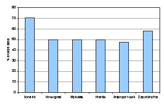
Figure 4.15 Breakdown
by Oblast of eroded arable farmland (%)
The
elevated right-bank catchment of the Dnipro between Kyiv and Dnipropetrovsk is
dissected by a dense eroded valley network, within which the erosion base is
relatively deep (100-160 m) in. The length of the valleys in this network range
between 2 km to 6 km, with slopes ranging between 8o and 30o,
and depths of several tens of metres. In the Kyiv, Cherkassy, Poltava and
Kirovhrad Oblasts about 1.5 million hectares of land surrounding the Dnipro
reservoirs has been affected by erosion. Within the catchment of the Kremenchug
reservoir, over 1.0 million hectares has been eroded.
Further
details on the consequences of land drainage/irrigation activities can be found
in Section 3.2.5 describing the agricultural situation in the Basin.
The underlying causes of suspended solid pollution are
mainly associated with resource uses and practices from the following key
sectors: agriculture, urbanisation, industry and
transport (see Section 4.2).
Eutrophication
including harmful algal blooms refers to artificially enhanced primary
productivity in receiving water basins as a result of the increased
availability or supply of nutrients. Data on nutrient and organic transport
from the Republic of Belarus and the Russian Federation into Ukraine and
ultimately the Black Sea provide the clearest evidence of the transboundary
status of this issue. The transboundary status of the issue is shown in Table
4.1. A detailed causal chain showing the links between the immediate and
underlying causes of this issue is shown in Figure 4.17.
The
impacts of this issue are linked closely with those of a number of other issues
including changes in the groundwater regime (Section 4.3.2), flooding events
and elevated groundwater levels (Section 4.3.3) and modification and loss of
ecosystems and ecotones (Section 4.5). The impacts of other water resource
pollution issues in this section such as suspended solids, chemical pollution
and microbiological pollution, (Section 4.4) are also closely linked.
Deterioration of water quality due to intensive algal
blooms
Ukraine: Reduced flow
circulation and extensive shallow-water sections in the reservoir chain have
intensified the effects of water pollution in the Dnipro Basin. The most
visible indication of pollution is the increased frequency of algal blooms related
to high loads of nutrients (especially nitrogen and phosphorus) entering the
Dnipro and its reservoirs.
Within
Ukraine, the total area of shallow-water sections in the reservoir chain is
1,341 km2. Of that, aquatic vegetation covers 480 km2
with a total mass of over 300,000 tonnes/year. Higher aquatic plants (reed,
rush, cattail, etc.) occupy approximately one third of the total shallow-water
area. However, reduced water circulation and expansion of shallow-water
sections frequently leads to (virtually annual) algal blooms, stimulated by
high loads of nutrients (nitrates and phosphates) received by the Dnipro
reservoirs. As a result of this, large quantities of dead algae fall to the
bottom, representing a source of secondary pollution. Shallow-water sections
are also conducive to siltation and swamping leading to the excessive growth of
higher aquatic plants and blue-green algae.
Changes in species composition and productivity of
indigenous fish species
Belarus: Acute and major
changes in the condition of aquatic ecosystems have been associated with the
construction of reservoirs in the Belorussian part of the Dnipro Basin. Flowing
rivers have been converted into stagnant water bodies with altered flow and
temperature regimes, resulting in changes in species diversity. Valuable
indigenous species have disappeared and have been substituted by opportunistic
species of low or no value.
Ukraine Commercial fish
yield significantly increased by up to 20,000-23,000 tonnes immediately after
the construction and filling of the reservoir chain. However, valuable fish
species including sturgeon, herring, and sabre carp (Pelecus cultratus L.) have virtually disappeared since this period
and currently only occur in the Dnipro Estuary. Semi-submerged vegetation thickets
have intensively developed in the shallow-water sections over the course of the
operational life of the reservoirs. The high density of this vegetation affects
light and air penetration, causing anoxic conditions in the bottom water layer,
thus reducing the fish spawning value of the ecosystem. Spawning and fattening
areas in the Dnipro and its reservoirs have reduced 3-fold.
More
information on changes in species composition in the basin can be found in
Section 3.1.6 on nature reserves and protected areas and Section 3.3.2 (Review
of the 2000-2001 field survey results).
As
with chemical pollution, the immediate
causes of eutrophication in the Dnipro Basin can be grouped into two
hierarchical levels. The first distinguishes the point and diffuse sources of
nutrients together with the existence of extensive area of shallow-water
sections in the Dnipro reservoirs (this cause relates specifically to the
energy sector). The second more detailed level can be broken down into the
following (also refer to Table 4.17):
·
Operational
discharge of liquids and gaseous effluents including cooling waters (point source);
·
Emissions
from storage of solid waste (point and
diffuse source);
·
Emissions
from storage of liquid wastes (point and
diffuse source);
·
Runoff
(point and diffuse source);
·
Growth
in the production of waste.
1.
Operational discharge of liquids and gaseous effluents including cooling
waters
Information
on nutrient loads from point and diffuse sources in the basin (including
organic matter and BOD) and the transboundary transport of pollution can be
found in Section 4.4.1 (chemical pollution) and Section 3.3.2 (review of the
2000-2001 field survey results).
Figure
4.13 shows the nutrient load entering Dnipro Basin from the 3 riparian
countries. Belarus is by far the greatest contributor of nutrients from point
sources followed by Ukraine and Russia.
In
Ukraine, discharges of cooling waters from nuclear and thermal power plants
cause thermal pollution of cooling ponds, which can potentially enhance the
impacts of eutrophication. However, this has a limited transboundary effect.
2. Runoff
Of
the total amount of nitrogen and phosphorus applied to agricultural land, about
20% of nitrogen and 5% of phosphorus reach the water bodies of the Basin with
surface runoff.
In
Belarus, agricultural soils contain phosphorus and nitrogen compounds at
elevated concentrations. In 1989-1990, the annual nutrient load discharged into
the surface waters of the Dnipro Basin from agricultural areas in Belarus was
21,200 tonnes of nitrogen and 610 tonnes of phosphorus. Figure 4.16 reflects
the percentages contributed by various sources to the total nutrient load.
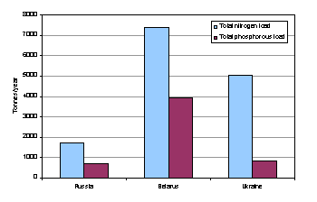
Figure 4.16 Total nitrogen and phosphorous load contributed by point sources
from the 3 riparian countries in the Dnipro Basin
3. Extensive area of
shallow-water sections in the Dnipro reservoirs.
The
flow regulation ratio in the Dnipro Basin ranges from 2-3% in the Russian
Federation and Republic of Belarus, to 22% in Ukraine. In the Pripyat River
Basin within Ukraine, 1% of river flow is regulated in the Ubort River,
reaching 11%-15% in the Ustia and Khomora Rivers.
The total area of shallow-water sections in the Ukrainian reservoir
chain is 1,341 km2. Of that, aquatic vegetation covers 480 km2.
Shallow-water sections with a depth of up to 2 m are reported to occupy over
19% of the total area of the Dnipro reservoirs (Table 4.13), affecting water
use, recreational value and the ecological state. These sections represent an
interface between the land and offshore waters of the reservoir, where various
physical, chemical and biological processes affecting water quality are most
pronounced. Being prone to swamping, shallow water sections impede access for
fishing, recreation, and livestock watering and are also able to strongly
affect the ecological state of the reservoir and riparian area under certain
conditions, e.g. during flow variations, when water exchange with the offshore
area is significant.
Table 4.13 Shallow-water
sections in the Dnipro reservoirs
|
Reservoir |
Area |
||
|
km2 |
% of area |
||
|
Kyiv reservoir |
312 |
34.0 |
|
|
Kaniv reservoir |
167 |
26.0 |
|
|
Kremenchug reservoir |
410 |
18.0 |
|
|
Dniprodzerzhinsk reservoir |
182 |
32.0 |
|
|
Dniprovsky reservoir |
160 |
39.0 |
|
|
Kakhovka reservoir |
110 |
5.1 |
|
|
Total |
1341 |
19.1 |
|
4. Growth in the production of
waste
For
details on the growth of waste production, refer to the immediate causes of
chemical pollution (Section 4.4.1) and Sections 3.1.4 and 4.4.6 on mineral
resources and solid waste pollution in the Basin.
The
underlying sectoral causes of this issue are very similar to those for chemical
pollution (see section 4.4.1). They are
mainly associated with resource uses and practices dominating the following
sectors: agriculture, urbanisation and industry. Aquaculture, energy and transport contribute to a lesser degree. A list of the priority sectors for all
issues is presented in Table 4.18 (Section 4.7)
A
detailed causal chain reflecting the links between the immediate and underlying
sectoral causes of this issue is shown in Figure 4.17 and a detailed
description of terminology used in this causal chain is given in the definition
of terms in Annex 2.
Based
on the causal chain in Figure 4.17, the priority sectoral resource uses and
practices and the underlying political, economic and governance causes of this
transboundary issue can be identified. These are shown in the Strategic Action
Programme (SAP) decision making management tool (Figure 4.18).
The
SAP decision making management tool shows the priority sectors for this issue
(colour coded with the causal chain) together with three hierarchical levels of
concern (shown in Section 4.3.1). Within each level the priority resource uses
and practices and the underlying political, economic and governance causes for
each transboundary issue are listed. These can either cut across all sectors
(e.g. Lack of adequate finance) or be sector specific (e.g. incorrect use and
storage of fertilisers and livestock-breeding wastes).
Agriculture
is a major contributor to the nutrient load received by aquatic ecosystems in
the Basin. High loads of nutrients enter the Dnipro and its tributaries with
surface runoff from agricultural fields and livestock breeding sites causing
the progressive eutrophication of aquatic ecosystems. In addition,
non-compliant agricultural practices and illegal ploughing activities within
the floodplain areas of the Basin, result in high levels of humus entering the
water bodies of the Dnipro and its tributaries. This, together with progressive
soil erosion is also a contributory factor.
Intensive
fishing and aquaculture also contributes to eutrophication. These practices
lead to the transport of exometabolites; artificial nutrition of the water; the
application of mineral fertilisers to enhance growth of aquatic plants; and
lime treatment to prevent diseases in fish. All these factors adversely affect
water quality and enhance eutrophication of fishponds and natural water bodies,
which receive, return waters.
Another
major contributing factor is the high nutrient load entering the water bodies
of the Basin with municipal wastewater discharges and surface runoff from rural
areas. Food processing and microbiological industries also produce effluents
containing nutrients and organic compounds.
Energy
and transport also encourage eutrophication, although in an indirect manner. In
particular, damming and regulation of larger rivers has led to the expansion of
shallow-water areas and the take-up and transport of nutrients and organic
compounds from land flooded as a result of damming. This has caused intensive
growth of blue-green algae and, consequently, reintroduced pollution into the
Dnipro River.
![]()

Figure 4.17 Causal chain for the issue of
eutrophication (see causal chain definition of terms for more details)
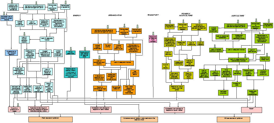
![]()
Figure 4.18 SAP decision making management tool for
the issue of eutrophication
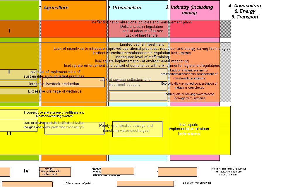
Solid
waste pollution refers to adverse effects associated with the introduction of
solid waste materials into water bodies or their environs. The transboundary
status of the issue is shown in Table 4.1. However, based on the prioritisation
exercise detailed in Chapter 4, this issue was not considered a priority transboundary issue. Consequently, detailed
causal chain analysis beyond the immediate causes of the issue was not carried
out.
The
impacts of this issue are linked closely with those of a number of other issues
including flooding events and elevated groundwater levels (Section 4.3.3) and
modification and loss of ecosystems and ecotones (Section 4.5). The impacts of
other water resource pollution issues in this section such as chemical and
microbiological pollution, eutrophication, suspended solids and accidental
spills and releases (Section 4.4) are also closely linked.
Deterioration of surface water and groundwater quality
Industrial
and municipal solid waste disposal sites pose a continuous threat of
environmental pollution. Groundwater quality is affected by leachate generated
at waste dumps and landfills located all over the Basin, and there is a
potential danger of surface water pollution due to leachate migration with
groundwater flow. Waste landfills present a significant impact to groundwater
quality in the Basin, particularly in waterlogged areas with elevated
groundwater levels. However, leachate generated at landfill sites is also able
to migrate through underlying rocks and affect deep aquifers.
The
storage and management of highly toxic waste represents a potential source of
surface water and groundwater contamination and is a serious issue in the
Republic of Belarus and Ukraine. Another area of concern is the management and
disposal of sludge generated by municipal wastewater treatment plants.
Generally, the practice of mechanical de-watering sludge is limited to large
urban centres such as Minsk and Mogilev. Considerable quantities of sludge have
accumulated in sludge fields attached to municipal wastewater treatment plants,
posing a threat of groundwater pollution.
Deterioration of terrestrial ecosystems
A
number of adverse effects on the natural environment, including the effects of
waste landfill sites, have resulted in a dramatic reduction in the area of
forests (approximately by twofold over the past century), fish stocks and
wildlife. For further information on the effects of waste disposal sites in the
basin, refer to Section 3.1.4 on mineral resources.
The
following immediate causes
contribute to solid waste generation in the Dnipro Basin (also refer to Section
4.2):
·
The
high rate of solid waste generation in the Basin;
·
The
large quantity of unorganised waste dumps and industrial waste disposal sites,
especially in Ukraine;
·
Accumulation
of waste generated by mining industries.
1.
The high rate of solid waste generation in the Basin.
The
situation in the Russian Federation can be illustrated by waste statistics from
the Kursk Oblast where about 1,200 million tonnes of waste have accumulated at
official (organised) waste disposal sites. Annual waste generation includes 1.5
million m3 of municipal solid waste and about 200,000 tonnes of
industrial waste. Only 20% of generated waste is recycled. About 1 million m3
of municipal solid waste is generated annually in the Bryansk Oblast and the
majority is disposed of illegally.
The
annual amount of solid waste generated in the Republic of Belarus can be broken
down by major categories as follows: industrial solid waste (88%), municipal
solid waste (10%) and municipal effluent treatment sludge (2%). The range of
generated industrial solid wastes includes about 800 waste types. The major
waste generators in the territory of Belarus are shown below:
·
The
Starobinsk Potassium Deposit: over 550 million tonnes of solid waste and 65
million tonnes of liquid waste have accumulated in an area of 5,000 hectares;
·
The
BelarusKaliy Enterprise in Soligorsk: about 680 million tonnes of halite waste
and clay/saline sludge;
·
The Gomel
Chemical Plant: over 15 million tonnes of phospho-gypsum;
·
MSW
landfills in Minsk, Gomel, Mogilev, Svetlogorsk, Bobruisk and Pinsk have
accumulated over 5 million tonnes of waste.
In
Ukraine, annual waste generation in the Dnipro Basin has varied between 424 and
458 million tonnes during the years 1996 to 2000 and is dominated by mining
industry waste (about 90%, when compared to 1.5% accounted for by municipal
solid waste). Solid waste disposal sites occupy about 84,000 hectares,
containing about 12 billion tonnes of waste material. Major waste generating
regions are:
·
The
Krivy Rih Iron-Ore Field: 7.1 billion tonnes;
·
The
Kremenchug area: 1.8 billion tonnes;
·
The
Western Donbass area: 0.2 billion tonnes.
2.
Large quantity of unorganised
waste dumps and industrial waste disposal sites, especially in Ukraine.
Solid
waste material can be grouped into three main categories: industrial solid
waste, municipal solid waste and wastewater sludge. The current situation
regarding waste management and disposal is critical, with many existing sites
in a very poor condition, operating illegally and not meeting ecological and
sanitary requirements. A number of disposal sites have been commissioned which
are currently operating without basic documentation and permits. Toxic waste
poses a major threat to the environment, as it is often stored at industrial
sites that generally lack the capacity for the correct storage and management
of this material. There are reports of toxic waste such as mercury and arsenic
being disposed of at municipal dumps and landfills.
There
are many illegal dumps in the Russian Federation. The Kursk Oblast has 32 waste
disposal sites occupying 80 hectares. Only one site (in the Oktyabrsky
District) can be described as an engineered landfill, constructed and operated
on the basis of approved design. The existing capacity for the reception and
storage of industrial waste at this site has now been reached, and significant
investment is required for its expansion and upgrade.
Sanitary
landfills are present in all larger connurbations in Belarus (Minsk, Mogilev,
Gomel, Svetlogorsk, Orsha, Bobruisk, and Pinsk). However, the existing waste
recycling capacity is extremely low Approximately 15% of generated municipal
solid waste is currently managed and disposed of properly, with only 4% of
waste being recycled at the State Municipal Enterprise, the sole specialised
waste recycling facility in Belarus. There are numerous illegal municipal solid
waste dumps. There are 7 industrial waste disposal sites in the Republic of
Belarus, with a total area of 1,405 hectares. The largest industrial waste
disposal sites are:
·
A
storage site for halite waste and clay/saline sludge, generated by the
‘BelarusKaliy’ Enterprise in Soligorsk, occupying 1,350 hectares;
·
A
phospho-gypsum waste site for the Gomel Chemical Plant, occupying over 60
hectares;
·
A
storage site for hydrolysis process waste generated by lignin plants in
Bobruisk and Rechitsa (20 hectares); and
·
An ash
disposal site for the Svetlogorsk thermal power plant (55 hectares).
A
waste inventory compiled in the mid-1990s in Ukraine indicated that out of a
total of 2,670 waste disposal sites, 1,310 were located in the Dnipro Basin. It
should be noted that these figures do not account for the numerous on-site
waste storage facilities and smaller dumps in rural areas. The total area of
waste disposal sites and dumps was estimated to be 84,000 hectares. A waste
disposal site audit, carried out by the Environmental Inspectorate of the
Ministry of Environmental Protection and Nuclear Safety of Ukraine in
1995-1996, covered 2,208 sites (580 industrial and 1,628 municipal) occupying
an area of 35,400 hectares. The audit findings indicated that none of these
sites met existing environmental safety requirements. Only 23% of these were
reported to have at least some form of design, and only 32% were equipped with
observation wells.
Many
sites are reaching or have reached capacity. The situation with regard to
municipal solid waste management is critical. For instance, the Zaporizhzhia
Oblast has 27 operating landfills, 325 waste dumps in rural areas, and 373
cattle burial grounds. There are 201 waste dumps in the Dnipropetrovsk Oblast,
and 366 waste dumps in the Poltava Oblast. None of the rural waste disposal
sites and cattle burial grounds meet environmental safety requirements. The
Zhitomyr and Volyn Oblasts are reported to have no specialised facilities for
the reception and disposal of toxic waste and this material is currently
disposed of at sanitary landfills or dumped illegally.
There
are 44 mining waste dumpsites near Kryvy Rih (on the Right-Bank of the Dnipro
catchment), where 1.64 km3 of mining waste occupies an area of 69 km2.
In the Kremenchug area (the Left-Bank of the Dnipro catchment), 11 waste
dumpsites occupy an area of 5.4 km2. The Samara River basin drains
the largest coal-mining area in Ukraine, the Western Donbass, where over 20
million m2 of
mining waste are stored at 13 dumps occupying an area of over 100 hectares.
Another
area of concern is the management and disposal of sludge, generated by
municipal wastewater treatment plants. In Belarus, the practice of mechanical
dewatering sludge is limited to the large urban centres of Minsk and Mogilev.
Considerable quantities of sludge have accumulated at sludge fields attached to
municipal wastewater treatment plants and pose a threat of groundwater
pollution.
The underlying causes of sold waste generation are
mainly associated with resource uses and practices dominating the following sectors: industry, agriculture and urbanisation (Section 4.2).
Accidental
spills/releases refers to the adverse effects of accidental episodic releases
of contaminants and materials to the aquatic environment as a result of human
activities. The transboundary status of the issue is shown in Table 4.1.
However, based on the prioritisation exercise detailed in Chapter 4, this issue
was not considered a priority transboundary
issue. Consequently, detailed causal chain analysis beyond the immediate causes
of the issue was not carried out.
The
impacts of this issue are linked closely with those of a number of other issues
including other water resource pollution issues in this section such as
chemical and microbiological pollution, eutrophication and suspended solids
(Section 4.4) are also closely linked.
The
increased risk of accidental pollution is inherent to a range of facilities and
operations in the Basin including a number of different types of industries
(e.g. mining, petrochemical and food), liquid waste storage sites, pipelines
and municipal utilities in urbanised areas. Accidental spills can cause the
acute deterioration of surface water, ground water and air quality. This can
result in the mass kill of living organisms, long-term pollution of the
environment and resultant ecological changes.
Mass
kills of aquatic organisms due to accidental spills of pollutants have been
reported in the Republic of Belarus. These mainly occur during winter periods,
when anoxic conditions develop in water bodies covered with ice. Regular fish
kills are common for the overwhelming majority of rivers in the Dnipro Basin
although there appears to be no arrangement for counting the number of
organisms killed.
Accidental
spills often result in elevated concentrations of pollutants in the
transboundary sections of watercourses and there have been numerous reports of
many exceeding maximum admissible levels (Table 4.14).
Table 4.14 Examples
of pollutants exceeding maximum admissible levels in the transboundary sections
of the Dnipro Basin as a result of accidental spills
|
Pollutant |
Year |
MAC Exceendence factor |
Location |
|
Nitrite nitrogen |
1997 |
26.5 |
Dnipro River near Orsha |
|
Iron |
1995 |
22.2 |
Ipout River near Dobrusha |
|
Oil products |
1996 |
31 |
Pripyat River near Mosyr |
|
Ammonium nitrogen |
1996 |
6.3 |
Dnipro River near Loyev |
|
Oil products |
1997 |
26.6 |
Pripyat River near Mosyr |
|
Nitrite nitrogen |
1999 |
37 |
Goryn River near Rechitsa |
|
Ammonium nitrogen |
2000 |
20 |
Pripyat River near Pinsk |
Such
spills and releases of pollutants are distributed unevenly over the Basin,
being mainly concentrated in the larger connurbations and industrial centres.
Elevated concentrations of pollutants in the air are often recorded during
inclement weather periods. Some examples of recorded exceedences are provided
in Table 4.15.
Table 4.15 Examples
of recorded exceedences of maximum admissible levels as a result of accidental
spills
|
Pollutant |
Year |
MAC Exceendence factor |
Location |
|
Suspended solids |
1995 |
4.6 |
Mosyr |
|
Formaldehyde |
1996 |
4.5 |
Pinsk |
|
Phenol |
1996 |
2.2 |
Gomel |
|
Phenol |
1997 |
7.4 |
Mogilev |
|
Formaldehyde |
1997 |
48.9 |
Mogilev |
|
Nitrogen dioxide |
1998 |
8.3 |
Mogilev |
|
Carbon dioxide |
1998 |
2.2 |
Mosyr |
|
Formaldehyde |
2000 |
3.6 |
Mosyr |
The
following immediate causes
contribute to accidental spills in the Dnipro Basin (also refer Section 4.2):
·
Episodic
accidental spills of polluted effluents from the liquid waste storage sites;
·
Episodic
accidental spills of polluted material from industries;
·
Spills
associated with pipework breakdown etc.
Two
opposing trends have dominated the environmental situation in the Dnipro Basin
between 1990 and 2000:
1.
A gradual (very slow)
improvement in the state of environment as a result of the general reduction of
pollution load.
2.
The increased risk of
potential pollution of the environment as a result of accidents and/or
emergency situations.
There
are a great number of high-pressure pipelines in the Republic of Belarus. Their
operation presents a significant risk to the environment. Statistical data
indicates that accidents occur once per year per 3,000 km of pipeline. Leaks in
oil pipelines are often difficult to detect, as they are mainly placed under
the surface. Oil products migrate to the aeration zone, groundwater aquifers,
the land surface, and finally reach surface waters with surface runoff and
groundwater flow. The high density of pipelines is exacerbated by the intensive
development of oil refineries, petrol storage facilities and filling stations
etc. Their operation poses a continuous risk of water pollution by oil products
and the related cost of environmental damage could amount to many hundreds of
billions of Roubles. The most typical accident and emergency scenarios are
described below:
1.
The risk of accidental
pollution from operations related to oil storage, refining and transportation.
This risk group includes 2,500 facilities including oil refineries, filling
stations, oil pipelines, oil storage facilities, and exploited oil fields.
2.
The large-scale
contamination of land as a result of accidents associated with oil pipelines.
An example of this was the accident at the Druzhba Oil Pipeline within the
territory of the Korenev Forestry Unit near Gomel.
3.
The potential danger of
accidental flooding and the resultant washout of pollutants from flooded areas.
In
the republic of Belarus, the potential for accidental pollution has increased
significantly due to the poor technical state and the significant depreciation
of assets and equipment in industry (by up to 70%).
In
the Ukrainian part of the Dnipro Basin, 20 accidental spills were reported in
2000, 10 during transportation and 10 during storage of material. In addition,
29 operational failures were reported to have taken place on pipelines. The
average depreciation of industrial equipment and assets in Ukraine is 50-70%.
The underlying causes of sold waste generation are
mainly associated with resource uses and practices dominating the following
sectors: industry, urbanisation and energy (Section 4.2).
Loss
of ecosystems or ecotones refers to the complete destruction of aquatic
habitats. Modification of ecosystems or ecotones refers to the extinction of
native species and changes in ecosystem functioning and services. This is one
of the most difficult issues to quantify due to difficulties in determining
spatial and temporal heterogeneity and an insufficient knowledge of species
composition. Modification and loss of ecosystems and ecotones and decreased
viability of biological resources is considered as one of the most significant
environmental issues in the Dnipro Basin. The transboundary status of the issue
is reflected in Table 4.1. A detailed causal chain showing the links between
the immediate and underlying causes of this issue is shown in Figure 4.19.
All
the transboundary issues analysed in this document impact on this issue to a
greater or lesser degree. Of particular importance are modification of the
hydrological regime (Section 4.3.1), flooding events and elevated groundwater
levels (Section 4.3.3), chemical pollution (Section 4.4.1), radionuclide
pollution (Section 4.4.3) suspended solids (Section 4.4.4) and eutrophication
(Section 4.4.5).
Modification
and degradation of ecosystems, loss and
modification of biological diversity and decreased species diversity.
Existing
nature reserves and protected areas occupy about 1.6% of the total area of the
Basin (see Basin Passport). The existing nature reserve area and capacity is
not sufficient to ensure the full protection and conservation of rare plant and
animal species, and their communities. For example, the Bryansk Woodland, a
State Natural Reserve in the Russian part of the Basin, occupies only 0.35% of
the total area of the Bryansk Oblast, considerably below the existing mandatory
limit of 2.2% set by the Russian Federation. Human activities have led to a
drastic reduction of forest coverage (by approximately twofold over the past century),
a depletion of fish stocks and a reduction in animal species diversity.
Since
the 17th century, 238 species have been lost in Belarus as a result
of human activities and changes in abiotic factors. Large-scale land drainage
schemes implemented in the Belorussian part of the Dnipro Basin over recent
decades have resulted in the loss and shrinkage of a number of valuable and
unique woodland communities of oak, ash, lime, black alder, and elm, as well as
specific flora and fauna systems. Over the past 100 years, 25 higher vascular
plants were reported to have become extinct and 40 animal species have lost
their habitats.
Generally,
the state of biological resources sustained by forests, wetlands and steppes in
the Dnipro Basin is poor and subject to a number of anthropogenic impacts,
particularly within the territory of Ukraine. The biological resources of the
Dnipro Basin have been and continue to be depleted at an alarming rate, and
urgent actions are needed to protect them in order to improve the environmental
situation in the Basin.
The
artificial conversion of the main stem of the Dnipro River into a series of
large reservoirs within Ukraine has had a profound impact on the natural
system. Very little of the original river channel remains, restricted to short
lengths which connect the reservoirs. As a result, the migratory pattern of
many valuable fish has been modified and populations have declined. Less
valuable opportunistic species have easily adapted to, and flourished in the
new conditions.
The
construction of the reservoir chain in Ukraine has led to dramatic changes in
fish species composition. For example, prior to the construction of the
Kakhovka reservoir, this section of the Dnipro River had been home to 28
commercial fish species, the most valuable of them being beluga (white
sturgeon), sturgeon, herring, and vimba (Vimba
Vimba). As species diversity has reduced, populations of valuable
long-lived species (catfish, mirror carp, and pike) have shrunk, and have been
substituted by less valuable short-lived species (roach, sardelle and silver
bream (Blicca bjoerkna)). Currently,
there are only 6 or 7 commercial fish species in the Kakhovka reservoir
(including bream, pikeperch, roach, silver carp (Hypophthalmichtys molitrix), crucian carp, and sardelle),
accounting for only 1% of the total fish catch.
Shallow-water
sections of the Dnipro reservoirs are the major spawning and dwelling areas for
the majority of fish stocks in the Basin and have shrunk as a result of
swamping and overgrowth by higher aquatic plants. Prior to the construction of
the reservoir chain, phytophilous fish species accounted for 85-90% of the
total fish catch spawned on the floodplains during spring high flows and many
of these species were permanently present in the river, its tributaries and
floodplain lakes. Currently, spawning and dwelling grounds of indigenous
species have reduced dramatically in those Dnipro reservoirs used intensively
for commercial fish-breeding activities. A result of the loss of the natural capacity
of the system to support the reproduction of indigenous fauna has been the
decline in the fish population and subsequently, a disproportionate growth of
phytoplankton populations.
Large-scale
land reclamation projects launched in the 1960 and 70s have led to a profound
transformation of the natural environment in the Dnipro Basin. Native flora and
fauna in the Polessie (Marshland) area have been worst hit by these
developments, with the loss of 31 vascular plant species, and 20 terrestrial
mammals (including the wild forest horse Eguus
gmelini silvaticus, fallow deer and sable). Retrospective analysis of the
taxonomic composition of zooplankton inhabiting the Pripyat River Basin
indicates that significant changes in zooplankton species composition have
occurred since the commencement of intensive land drainage activities in 1961,
indicating that elevated levels of suspended solids may have had an
environmental impact.
More
details can be found in Sections 3.1.5 and 3.1.6 on the biological resources, and
nature reserves and protected areas in the Dnipro Basin.
The
following immediate causes
contribute to the modification and loss of ecosystems and ecotones in the
Dnipro Basin (also refer to Table 4.17) a number of which are other transboundary
issues (in Italics):
·
Changes
in land use;
·
Loss
or modification of aquatic habitats;
·
Introduced
species;
·
Changes
in the sediment transport regime;
·
Modification of the hydrological regime (see Section 4.3.1);
·
Flooding events and elevated groundwater levels (see Section 4.3.3);
·
Chemical pollution (see Section 4.4.1);
·
Radionuclide pollution (see Section 4.4.3);
·
Eutrophication (see Section 4.4.5).
1.
Changes in land use and loss or modification of aquatic habitats
Aquatic
habitats in the Basin were lost or modified during the 1950’s to 1990’s as a
result of a number of activities. These include the construction of the
reservoir chain in the Ukrainian part of the Basin (see Sections 3.1.1, 4.3.1
and 4.3.3) and the subsequent poor management and operation of the chain
resulting in the loss of high value fish species (see above) and bank erosion
(Section 4.4.4). There have also been substantial changes in land use due to
the conversion of wetlands to agriculture and the improvement of existing
agricultural land through land drainage activities (see Sections 3.1.2, 4.3.1,
4.3.3 and 4.4.4). In more recent years, the increased role of mining for export
income has resulted in the growth of mining waste spoil dumps smothering large
areas of land (see Section 3.1.4) though the transboundary status of this is
relatively minor.
2. Introduced species
For
details on the introduction of alien or exotic species, refer to Section 4.6 on
impacts on biological and genetic diversity.
3. Changes in the sediment
transport regime
Bank
degradation in the reservoir chain has lead to large inputs of soil material
resulting in sedimentation and siltation (Section 4.4.4). Inputs of sediment
have also occurred due to conversion of forests and wetlands to agricultural
use and the subsequent erosion of these soils due to poor farming practices
(see Sections 4.3.2, 4.3.3 and 4.4.4).
The underlying causes of modification and loss of
ecosystems and ecotones are either associated with other transboundary issues
(see above) or with resource uses and practices from the following sectors: agriculture, energy and
fisheries/aquaculture. Urbanisation, industry and transport all contribute to a
lesser degree. A list of the
priority sectors for all issues is presented in Table 4.18 (Section 4.7).
A
detailed causal chain reflecting the links between the immediate and underlying
sectoral causes of this issue is shown in Figure 4.19 and a detailed
description of terminology used in this causal chain is given in the definition
of terms in Annex 2.
Based
on the causal chain in Figure 4.19, the priority sectoral resource uses and
practices and the underlying political, economic and governance causes of this
transboundary issue can be identified. These are shown in the Strategic Action
Programme (SAP) decision making management tool (Figure 4.20).
The
SAP decision making management tool shows the priority sectors for this issue
(colour coded with the causal chain) together with three hierarchical levels of
concern (shown in Section 4.3.1). Within each level the priority resource uses
and practices and the underlying political, economic and governance causes for
each transboundary issue are listed. These can either cut across all sectors
(e.g. Lack of adequate finance) or be sector specific (e.g. lack of efficient
system for reproduction of native fish/invertebrate species).
The
negative impact on terrestrial and aquatic ecosystems, leading to the decreased
viability of biological resources, is largely caused by activities in the
following sectors: agriculture, energy and fisheries/aquaculture.
Intensive
cultivation of land in the Dnipro Basin, where arable farmland covers up to 90%
of the area, is a major cause of the loss of integrity of terrestrial and
aquatic ecosystems. Terrestrial ecosystems, having lost their natural features
and ability to act as a barrier preventing the transport of nutrients and
pollutants into water bodies and watercourses are now contributing to the
problem of eutrophication. The transport of soil and humus particles, fulvic
acids, agrochemicals etc. with surface runoff from arable land has caused a
deterioration in water quality and re-sedimentation of solid particles in the
ecotone zones, which are loosing their ability to sustain specific flora and
fauna.
Hydroengineering
developments significantly affect aquatic ecosystems and surrounding areas.
Flow regulation results in the loss of vast areas of land, encourages migration
of nutrients into water mass and excessive growth of blue-green algae. As a
result, unique riparian ecosystems are replaced by plankton algae species,
which intensively develop in the shallow-water sections of the reservoirs.
Intensive
fishing/aquaculture has also contributed significantly to the modification of
river ecosystems. Numerous dams have been constructed on the smaller rivers,
which have lost their drainage capacity. The dams frequently overflow, leading
to the siltation and elevation of groundwater levels in the surrounding areas.
These transformations affect ecosystems and the biodiversity of smaller rivers.
Moreover, the monoculture approach is widely applied at fish-breeding farms,
contributing to the reduced biodiversity of native fish and invertebrate species.
The
indirect impacts of urbanisation, industry and transport on aquatic ecosystems
and the viability of biological resources mainly relate to elevated
concentrations of pollutants in air, water and soil.
This
issue refers to changes in genetic and species diversity resulting from the
introduction of alien and genetically modified species or local stocks as an
intentional or unintentional result of human fisheries activities including
aquaculture and restocking. It applies to all aquatic environments. The
transboundary status of the issue is shown in Table 4.1. However, based on the
prioritisation exercise detailed in Chapter 4, this issue was not considered a
priority transboundary issue. Consequently,
detailed causal chain analysis beyond the immediate causes of the issue was not
carried out.
The main environmental impacts of this issue
are:
·
Changes
in biological community structure due to overexploitation/depletion of one or more
key species.
·
Changes
in biological communities through deliberate and accidental introductions.
·
Degradation
of ecosystems.
The
following immediate cause
contributes to impacts on biological and genetic diversity in the Dnipro Basin
(also refer to Section 4.2):
·
Introduction
and invasion of new species.
1. Introduction
and invasion of new species.
In
some instances, biodiversity is threatened due to competition between
introduced/invading species, which are often better adapted to new conditions
than less flexible native species. The composition of fish species in the
Dnipro Basin has considerably expanded as a result of both the
introduction/acclimatisation and invasion of new species including:
·
Rainbow
trout (Salmo gairdneri) brought to
Belarus in 1956;
·
The
American catfish and channel catfish (Ictaluridae
family);
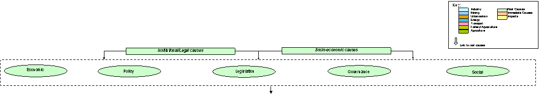
FISHERY/ AQUACULTURE TRANSPORT URBANISATION AGRICULTURE OTHER
ISSUES ENERGY INDUSTRY/MINING
Figure 4.19 Causal chain for the
issue of modification and loss of ecosystems and ecotones and decreased
viability of biological resources (see causal chain definition of terms
for more details)
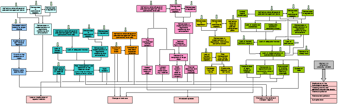

Priority 2: Loss or modification of
habitats 1.
Chemical pollution 2.
Modification of
hydrological regime 3.
Eutrophication 4.
Flooding and elevated
groundwater levels 5.
Pollution by
radionuclides Priority 4: Changes in the sediment
transport regime Priority 1: Change in land use Priority 3: Introduced species Figure 4.20 SAP decision making management tool for
the issue of modification and loss of ecosystems and ecotones and
decreased viability of biological resources
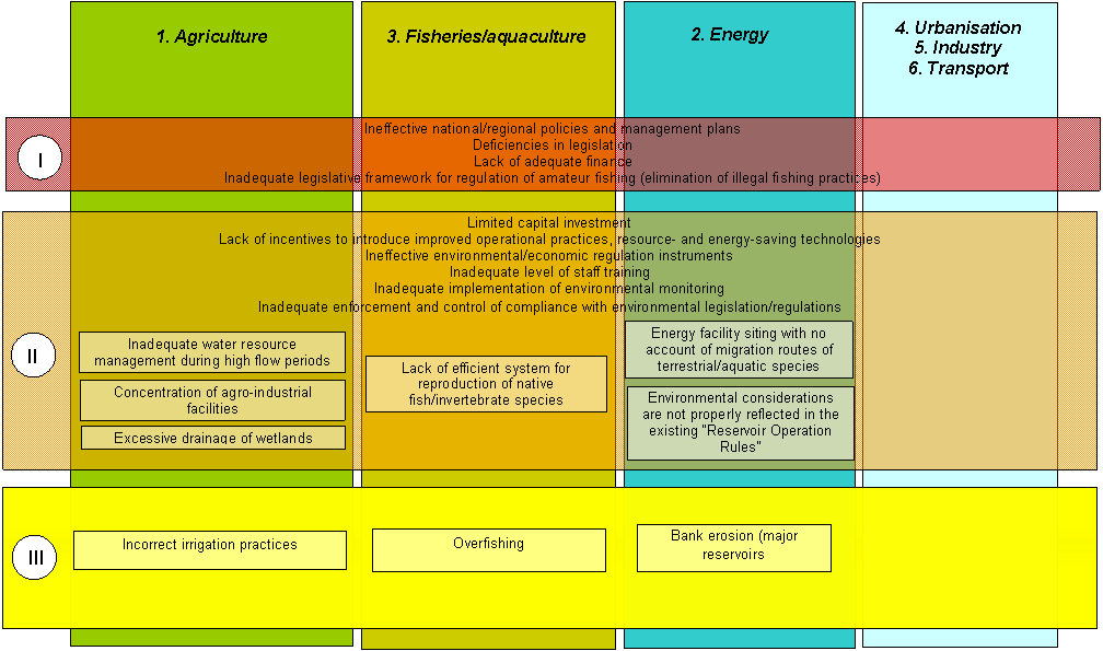
![]()
·
A
number of herbivorous carp-type fish species introduced from the Far East (Aristichthys nobilis, Hypophthalmichtys
molitrix, and Ctenopharyngodon idella),
as well as Pseudorasbora parva and Rapana thomasiana probably introduced
with breeding stock;
·
A
number of Black Sea/Baltic species whose native habitats were limited to the
Baltic Sea catchment before the mid 1950s. These are the sand goby (Gobius melanostomus), the round goby (Neogobius melanostomus), and the white
goby (Gobius fluviatilis), as well as
the three- and nine-spined stickleback (Gasterosteus
pungitis and Gasterosteus aculeatus).
Very
little is known about the expansion of Ponto-Caspian invertebrates in the Basin
although mollusc species such as Dreissena
polymorpha and Corophium curvispinum and
annelid species such as Caspiobdella
fadejevi have colonised the Berezina River.
The underlying causes of this issue are associated with
resource uses and practices from the following sectors:
transport and fisheries/aquaculture (Section 4.2).
Based
on the results of the previous sections in Chapter 4, the following tables show
the priority transboundary issues (Table 4.16), priority immediate causes
(Table 4.17) and priority sectors (Table 4.18) in the Dnipro Basin. In all
cases, 1 denotes the highest priority.
The
priority transboundary issues in Table 4.16 are presented in 3 groups. The
first identifies the priority transboundary issues identified by each riparian
country. The second group lists those that are considered as the priority
transboundary issues within the Basin as a whole. It should be noted that the
Basinwide priority transboundary issues are the same as those for each riparian
country. The third shows those that have a global context (i.e. effect areas
beyond the Dnipro Basin).
Table
4.17 shows the list of prioritised immediate causes. Chemical pollution and
eutrophication are prioritised in terms of their two hierarchical levels (see
Sections 4.4.1 and 4.4.5). Loss and modification of ecosystems is prioritised
in terms of its direct immediate causes those other issues that can also cause
this issue.
Table 4.16 (a) Priority
transboundary issues identified by each riparian country
|
Riparian Country |
Priority
Issue |
|
Russian Federation |
1. Chemical pollution (including pollution
transfer with air masses) |
|
2. Modification and loss of ecosystems |
|
|
3. Modification of hydrological regime |
|
|
4. Other issues are not significant |
|
|
Republic of Belarus |
1. Chemical pollution |
|
2. Modification and loss of ecosystems |
|
|
3. Modification of hydrological regime |
|
|
4. Pollution by radionuclides |
|
|
5. Flooding and elevated groundwater levels |
|
|
6. Eutrophication |
|
|
Ukraine |
1. Chemical pollution |
|
2. Modification and loss of ecosystems |
|
|
3. Modification of hydrological regime |
|
|
4. Eutrophication |
|
|
5. Flooding and elevated groundwater levels |
|
|
6. Pollution by radionuclides |
Table 4.16 (b) Basinwide
priority transboundary issues
|
Context |
Priority
Issue |
|
Basin wide |
1. Chemical pollution |
|
2. Modification and loss of ecosystems |
|
|
3. Modification of hydrological regime |
Table 4.16 (c) Priority
transboundary issues with a global context
|
Context |
Priority
Issue |
|
Global |
1. Conservation of landscape and biological
diversity |
|
2. Pollution of the Black Sea |
|
|
3. Consequences of the Chornobyl accident |
Table 4.17 Prioritised
Immediate Causes (1 denotes highest priority, 7 lowest priority)
|
Issue |
Priority Immediate Causes |
|||
|
1.
Chemical pollution |
1. Diffuse sources of pollution |
1. Runoff |
||
|
2. Untreated and poorly treated municipal
wastewater and rainstorm water |
||||
|
3. Operational discharges and emissions of
pollutants |
||||
|
2. Point sources of pollution |
4. Emissions from storage or disposal of
solid wastes |
|||
|
5. Emissions from storage or disposal of
chemical products |
||||
|
6. Emissions from storage or disposal of
liquid wastes |
||||
|
7. Automobile transport |
||||
|
2.
Modification and loss of ecosystems and ecotones, and decreased viability of
biological resources |
1. Change in land use |
Impacts of other issues: |
||
|
1. Chemical pollution |
||||
|
2. Loss or modification of aquatic habitats |
2. Modification of hydrological regime |
|||
|
3. Introduced species |
3. Eutrophication |
|||
|
4. Changes in the sediment transport regime |
4. Flooding and elevated groundwater levels |
|||
|
3.
Modification of hydrological regime |
1. Flow regulation, including required water
releases |
|||
|
2. Land drainage and flow abstraction for
irrigation |
||||
|
3. Flow diversions between basins and within
the basin |
||||
|
4. Flow abstraction for industrial and
domestic purposes |
||||
|
5. Returns/runoff of water |
||||
|
6. Flow diversion for aquaculture |
||||
|
4.
Eutrophication |
1. Diffuse sources of pollution |
1. Runoff |
||
|
2. Point sources of pollution |
2. Untreated and poorly treated municipal
wastewater and rainstorm water |
|||
|
3. Extensive area of shallow water sections
in the reservoir chain |
3. Operational discharges and emissions of
pollutants |
|||
|
4. Emissions from storage or disposal of
solid wastes |
||||
|
5. Emissions from storage or disposal of
liquid wastes |
||||
|
5.
Pollution by radionuclides |
1. Atmospheric and aquatic releases of
radionuclides during the Chornobyl accident (including secondary releases as
a result of the Chornobyl accident) |
|||
|
2. Point and diffuse discharges of mining
process waters and tailing wastes from disposal sites at uranium mines and
ore-processing
plants |
||||
|
3. Emissions/discharges from radioactive
waste disposal sites and ionising radiation sources |
||||
|
6.
Flooding and elevated groundwater levels |
1. Modification of the hydrological regime |
|||
|
2. Elevated groundwater levels |
||||
|
3. Discharges of water |
||||
|
4. Runoff from land surfaces |
||||
Table 4.18 Prioritised
list of sectors contributing to transboundary issues (1 denotes highest
priority, 6 lowest priority)
|
Issue |
Priority Sector |
|
1.
Chemical pollution |
1. Industry |
|
2. Agriculture |
|
|
3. Urbanisation |
|
|
4. Transport |
|
|
5. Energy |
|
|
6. Fishery/aquaculture |
|
|
2.
Modification and loss of ecosystems and ecotones and decreased viability of
biological resources |
1. Agriculture |
|
2. Energy |
|
|
3. Fishery/aquaculture |
|
|
4. Urbanisation |
|
|
5. Industry |
|
|
6. Transport |
|
|
3.
Modification of the hydrological regime |
1. Hydropower |
|
2.Agriculture |
|
|
3. Water transport |
|
|
4. Urbanisation |
|
|
5. Industry |
|
|
6. Fishery/aquaculture |
|
|
4.
Eutrophication |
1. Agriculture |
|
2. Urbanisation |
|
|
3. Industry |
|
|
4. Fishery/aquaculture |
|
|
5. Energy |
|
|
6. Transport |
|
|
5.
Pollution by radionuclides |
1. Consequences of the Chornobyl accident |
|
2. Mining and milling |
|
|
3. Energy |
|
|
6.
Flooding and elevated groundwater levels |
1. Agriculture |
|
2. Mining |
|
|
3. Urbanisation |
|
|
4. Transport |
The
12 transboundary environmental issues in the Dnipro Basin discussed in this
Chapter are driven by three Root Causes:
The
existing state of the Dnipro Basin ecosystem is ultimately the legacy of
large-scale unsustainable development in the decades prior to transition to a
market economy. This includes the concentration, scale and siting of industrial
and agricultural complexes in the Basin. The extensive use of natural resources
with little regard for ecosystem function has led to major and in some
instances irreversible changes in the terrestrial and aquatic ecosystems within
the Basin.
The
transition from a centrally planned to a market guided economy has been
accompanied by a sharp decline in standards of living, widened income
inequalities and a deterioration in health conditions. The uncertainty of the
conditions in which the economic transition is taking place, including the
institutional environment and the weak state of law enforcement have; (a)
hampered the progress of economic reform; (b) limited the development of market
mechanisms; and (c) led to an economy based on immediate profits that gives
little emphasis to environmental issues.
The
lack of past attention to the value of the natural environment (as a provider
of goods and services and for its intrinsic value) have led to a poor current
state of awareness of the consequences of environmental degradation in
government and civil society and a limited degree of motivation for
environmental protection.
According to the model shown in Figure 2.2, the major socio-economic consequences of the
above are:
·
The
deterioration of the demographic situation (e.g. increased mortality, decreased
life expectancy, changes in migration patterns);
·
The
transition from a centralised to a market economy;
·
Insufficient
engagement of the public in environmental decision-making;
·
The
inadequate level of environmental education;
·
A lack
of specialist training (e.g. in current environmental management approaches,
sustainable agricultural practices etc.);
·
Reduced
budget expenditures on social and environmental protection actions;
·
Socio-economic
development goals and objectives were not undertaken in an environmentally
sustainable manner during the period of transition to the market economy;
·
The
poor technical condition and the progressive depreciation of production assets
(including fixed assets employed in the environmental protection sector) that
do not meet environmental safety requirements;
·
The
unsustainable environmental and economic use of natural resources;
·
A
limited internal investment capability and an unfavourable investment climate;
·
Inadequate
management systems and a poorly developed institutional framework that is not
capable of supporting economic activities and water resource management on a
basin wide basis;
·
The
lack of consideration given to sustainable development factors in national and
regional socio-economic development plans.
Again, according to the
model shown in Figure 2.2, the major
policy driven consequences are:
·
The
socio-economic crisis;
·
Ineffective
and inefficient management systems;
·
The
lack of application of ownership rights (e.g. land tenure)
·
A lack
of regulation or a failure to price resource use;
·
Ineffective
credit finance policy, and a lack of incentives for the introduction of new
technologies and environmental actions;
·
The
declarative nature of environmental priorities in socio-economic development
strategies and environmental policies;
·
National
policies that do not focus on environmental education and awareness;
·
A lack
of institutional capacity.
The major legislation-related consequences are:
·
The
lack of a sustainable development concept embedded in environmental
legislation;
·
Inconsistencies
in environmental legislation, affected by inter-sectoral disagreements;
·
Gaps
in the existing legislative and regulatory framework that are not systematised and
structured properly;
·
An
inadequate legislative process and the declarative nature of laws;
·
The
inefficient economic and environmental review of draft legislation and
regulations;
·
Inefficient
legislation enforcement and implementation mechanisms;
·
The limited
involvement of the public in the legislative process;
·
The
limited practice of independent due diligence review of draft laws.
The major governance-related
consequences are:
·
A
prevalence of command-and-control tools (bans, limits, restrictions) that are
of little economic value and deterrent effect;
·
A lack
of proper justification when setting fees and charges for natural resource
usage and environmental pollution;
·
The
inappropriate use of funds;
·
A lack
of a programme-oriented basin management approach;
·
The
limited involvement of the public in the preparation and implementation of
environmental programmes;
·
Non-transparent
financing mechanisms;
·
The
ineffective enforcement and implementation of environmental legislation and
regulations;
·
Inadequately
financed and staffed environment agencies, monitoring organisations and
research/technical institutions;
·
Poor
existing environment monitoring systems that are not capable of meeting basin
wide management needs;
·
The
limited practice of environmental monitoring;
·
A lack
of institutional support and practical actions on the enhancement and
optimisation of management systems.
A detailed description of institutional, legal and policy factors that
need to be overcome in the Dnipro Basin is presented in Chapter 5.