Islamic Republic of Iran
( NCAP )
June , 2002
1st ed.
|
Table of contents: |
Introduction :
Chapter 1 :
TDA
NCAP /SAP
Chapter 2 :
Environmental Setting
Chapter 3 :
Socio-economic and Human Health
Chapter 4 :
Biodiversity
Chapter 5 :
Fisheries
Chapter 6 :
Chapter 7 :
Institutional and Legal Framework
Chapter 8 :
Coastal Planning and Management
Chapter 9 :
Summary of objectives , Interventions , targets
TDA
Introduction:
The Caspian Environment Program (CEP) is a regional umbrella program launched in may 1998 in Ramsar by the five Caspian Littoral States, Azerbaijan, Iran, Kazakhstan, Russia and Turkmenistan with the collaboration of International Community through inter alia the Global Environmental Facility (GEF), UNDP, World Bank, UNEP and EU/ Tacis.
The overall goal of the CEP is “Environmentally sustainable development and management of the Caspian environment, including living resource and water quality, so as to obtain the utmost long- term benefit for the human population of the region, while protecting human health, ecological integrity and the regions sustainability for future generations.”
During the first four years (May 1998- June 2002) activities of the CEP were focused on the production and endorsement of:
Establishment of the Program Coordination Unit (PCU) and ten Caspian Regional Thematic Centers / Theme
Transboundary Diagnostic Analysis (TDA)
National Caspian Action Plans (NCAP)
Strategic Action Program (SAP)
Priority Investment Portfolio
Framework Convention for the Protection of the Marine Environment of the Caspian Sea
Other Priorities as set by the Steering Committee
The overall governance of the CEP is provided by the Steering Committee. The National Organization is provided under the leadership of the National Focal Point, and includes the Intersectoral coordination Function (ISCF). The CEP implementation is under the guidance of the Management Advisory Group (MAGICA), and the management takes place at the Program Coordination Unit, led by the Program Coordinator.
Transboundary Diagnostic Analysis (TDA)
According to GEF guidance, the purpose of conducting a TDA is to Scale the relative importance of source and cause, both immediate and root, of transboundary water’s problems, and to identify potential preventive and remedial actions. A TDA is a scientific and technical assessment through which the water related environmental issue and problems of a region are identified and quantified, their causes analyzed and their impacts, both environmental and economics, assessed.
The TDA provides the technical basis for development of a Strategic Action Plan (SAP) in the area of international waters of the GEF. The TDA summarizes information available from the region, gathered both as part of ongoing national activities within the littoral states, as well as information made available since the inception CEP in may 1998.
The CEP established a series of ten Caspian Regional Thematic Centers (CRTCs) or Themes, throughout the Caspian region, in order to facilitate the acquisition of the information required to produce the TDA and to support the requirement of the NCAP, and SAP.
The TDA is a required element for preparation of the NCAP, and SAP. Each step is linked and provides information and background for the next step. The TDA focuses on the major Transboundary issue of the Caspian Region. Transboundary can be defined in several contexts. It can be an environmental issue that originates in one country, but affects other countries (e.g., river discharge), or it can be an environmental issue that comes from many countries (air pollution, transboundary rivers). In some cases, Transboundary has been defined as a problem common to several target countries even though they may not have common sources, however, this is not a general definition.
1.1.Geographical Scope of TDA
Within the Framework TDA approved at Ramsar in May 1998, it was agreed to take the boundaries as far out to sea a can be actively managed, and as far island as theadministrative boundaries of coastal provinces. Where these boundaries impinge too far island, the TDA should concentrate on a corridor width of between 100 and 200 km. Major rivers will be addressed with their lower reaches as a priority and the rest only as much as possible.
While the NCAPS represents the national and transboundary issues identified at the country level, the SAP represents a regional consensus on the necessary actions to take within a meaningful time frame to move towards environmental improvement (legislative and / or regulatory reform, environmental remediation or clean up, increased enforcement, etc.). Although formulation of the NCAP, and SAP relies on the scientific and technical justification provided in the TDA, the specific combination of activities contained in an NCAP or SAP is also determined by both national and regional policy considerations that may affect program direction, sustainability, and cost effectiveness.
The preliminary TDA was adopted by the Caspian littoral states at the Ramsar Steering Committee Meeting (May 1998). Subsequent to May 1998, our Regional experts meetings, experts have been held in July 2000, December 2000, July 2001 and November 2001, to discuss the format and content of meeting, attended by representatives of all Caspian littoral states and by the international partners. The scope of the final TDA was agreed, the list of Major Perceived Problems and Issues (MPPIs) was updated, the causal chain analysis was completed and the list actions/interventions were developed, in concert with the development of five regional Environmental Quality Objectives (EQOs).
In addition to the regional TDA Meetings each country held a National TDA Meeting, to review the progress on the TDA to date, to provide national recommendations for improving the TDA, and to provide general national input on the TDA process. The Final Draft TDA was reviewed in May 2002 in Baku, by the Caspian littoral states and international partners.
The first step in the TDA process was to identify the Major Perceived Problems and Issues (MPPIs). The significance of the perceived problems and issues should be substantiated on environmental, economic, social, and cultural grounds. The following last major perceived problems and issues was finalized to include existing problems / issues and emerging problems/ issues.
It is worth mentioning that due course of time i.e from the 1998 when the preliminary TDA took place till now the results of many studies in the region reveals that so called emerging problems and issues (introduced species and contamination from offshore oil and gas activities) are no more emerging problems but could be considered as existing problems. At present Navigational Risks are Considered to be one of the emerging problems of the Caspian Sea.
Each of the major perceived problems/ issue were analyzed on a scientific level, including biological, oceanographic, physical, and other perspectives of the problems. The next step was the “Causal Chain Analysis”, where the MPPLs were analyzed to determine the primary, secondary and root causes for these problems / issues.
Based on the Causal Chain Analysis, in order to address, the MPPIs, required interventions and actions directed at primary secondary or root causes were identified. Fortunately, root causes common to a number of different perceived problem and issues, so addressing a few root causes may have positive effects on several problems and issues.
In order to prioritize the interventions the TDA meeting identified a series of five Environmental Quality Objectives (EQOs), which represent the regional perspective major goals for the Caspian environment. Within each EQOs several specific targets were identified.
Finally, specific interventions or actions were identified to permit realization of each target, within the designated time frame. The time frames were limited to the first five to ten years periods. In summary, the EQOs led to identification of specific target to be met within the desired time frame, and identification of specific interventions and actions that can be considered in the framework of the NCAP and SAP.
The progression from EQOs to targets, to concrete activities is a logic chain that leads to consensus on complex environmental issue. The following EQOs were identified as:
Sustainable Economic Uses of Natural Resource of the Caspian Sea
Balanced Caspian Environment including Biodiversity Conservation (species habitat and genetic)
High Quality of Caspian Sea, Surface and Groundwater.
Sustainable Multiple Use of the Caspian Coastal Environment.
Strengthened Civil Society for the Purposes of Environmentally Sustainable Development
1.2.Summary of National TDA/NCAP Meetings
(26th-29th May 2001,Tehran)
Objectives of the Meeting
In order to review the progress on TDA to date, to provide national recommendation for improving the TDA and to provide general national input on the TDA process the TDA/NCAP Meeting were conducted from 26th to 28th May 2001 in Tehran. The Meeting was attended by NFP (National Focal Point), CRTCs (ERACL, ITCAMP, ER) Directors, PCU Representative, PPA (Public Participation Advisor), and different Governmental Orgnizations such as D.O.E Head Office, D.O.E Provincial Offices, National Water & Watershed Management, Ports & Shipping, Ministry of Forecign Affairs, Atomic Energy Organization, Jihad – Agriculture, Management & Planning, Ministry of Energy, Ministry of Industry & Mines, International Sturgeon Research Institute, and NGOs such as Green Society of Environmentalists, Iranian Society of Environmentalists. During the above-mentioned meetings three Thematic Groups were formed, namely:
I – Coastal Development and Management
II - Contaminant Assessment and Pollution Control
III – Fisheries and Biodiversity
Each Thematic Group consisted of the group leader and 5-7 experts in the relevant subject. The National TDA was used as a technical basis document for developing NCAP. Through NCAP, Caspian-related environmental issues and problems should be addressed, environmental issues prioritized and financial and political commitments at a national level identified.
The Thematic Groups were tasked to produce a series of out puts, including:
Identification of Perceived Problems and Issues
Identification of Preliminary Causal Chain Analysis
Identification of Primary, Secondary and Root Causes
Identification of potential interventions and their costs
Thematic Group I
(Coastal Development and Management)
Major Environmental issues:
I-Damage to Coastal Habitat/Landscape
II- Damage to Infrastructure
III- Decline in Socio-economic Conditions
Primary Causes:
Deforestation / Desertification
Urbanization/Industrial Development
Inadequate Agricultural Aquacultural Development
Inadequate Recreational Development
Land – based / Sea-based Pollution
Flooding
Earth – quake
Land – sliding
Secondary Causes:
• Land demand pressure
• Fire wood demand
• Salt water intrusion
• Over grazing
• Transportation
• Wrong irrigation practices
• No alternative for fuel
Root causes:
• Population growth
• Weak Economy
• Inadequate public awareness
• Inadequate public participation
• Inappropriate laws and regulations
Secondary Causes:
• Population migration to coastal areas
• Lack of local ownership
• Lack of shared management
• Lack of value for environmental economy
• Weak administration framework
Secondary Causes:
• Conflict of uses
• Poor or no environmental technology
• Lack of shared management
Secondary Causes:
• Conflict of uses
• Lack of government investments
• Weak tourism development planning
Dealt by the Thematic Group II (Contaminant Assessment and Control)
Flooding
Root Causes:
• Sea water level rise
• Storm – surges
• Lack of land use planning
Land – sliding
Root Causes:
• Natural
• Human activities on coasts
Primary Causes:
• Low quality and quantity of drinking water
• Low living condition
• Low income
• Improper public health
• Flooding
• Earth-quake
Secondary Causes:
Insufficient fresh water supply
Waste discharge of various sources
Salt water intrusion
Lack of job opportunities
Lack of productivity
Low sanitary standard
Inadequate medical facility
Land – based and sea – based pollution
Sea level fluctuation
Natural disasters
Insufficient labor market
Root Causes:
Weak economy
Cost of appropriate technology
Lack of Government Commitment
Lack of waste management
Population growth
Inappropriate laws and regulations
Weak enforcement and compliance
Inadequate public awareness / participation
Primary and Secondary Causes:
Natural sources of pollution
Anthropogenic sources of pollution
Natural disaster (Earth – quake)
Flooding (sea water level rise)
No Coastal Authority
Short – termed developmental goals
Common Root causes identified by the Thematic Group I (Coastal Development and Management)
No ICAM
Inappropriate laws / regulations
Weak enforcement and compliance
Weak economy
Inadequate EIA
Lack of government commitment
Cost of appropriate technology
Lack of Environmental Management System
Population growth/migration
Inadicquate public awareness / participation
No regional mechanism
Weak administration framework
Thematic Group II
(Contaminant Assessment and pollution Control)
Major Environmental Issues:
1-Oil and gas pollution
2-Agricultural pollution
3-Urban sewage
4-Urban solid waste
5-Industrial waste
6-Mining activities
7-Transportation
8-Thermal pollution
9- Dam construction
10-Sediment removal
Primary and Secondary Causes:
Refining
Initial flittering
Accidents
Exploration
Production
Oil tankers
Inappropriate transportation
Loading and off loading
Pipelines
Root Causes:
Not participating in the relevant international convention
Lack of relevant regional agreements
Inadequate monitoring
Inappropriate laws / regulations
Inappropriate enforcement / compliance
Lack of reception facilities
Lack of port control
Lack of navigational control system
Lack of environmental convention
Lack of oil industry commitment
Cost of appropriate technology
Lack of economic incentives / disincentives
Weak participation of NGOs and private sector
Primary and Secondary Causes:
High demand for fertilizers and pesticides consumption
Governmental subsidies
Lack of scientific production
Inadequate cultivation patterns
Root Causes:
Weak economy
Inadequate laws / resolution
Inadequate enforcement and compliance
Inadequate land use planning
High national demand for agriculture
Lack of economics incentives / disincentives
Primary and Secondary Causes:
Lack of appropriate sewage treatment system
Lack of urban planning and management
Lack of appropriate investment
Lack of public participation
Primary and Secondary Causes:
Lack of appropriate waste management system
Increased human activities
Conflict of uses
Lack of appropriate technologies
Lack of public participation
Lack of appropriate investments
Lack of urban planning
Root Causes for Urban Sewage and Urban Solid Waste:
Lack of government commitment
Inadequate public awareness
Lack of Laws / regulations
Lack of enforcement and compliance
No Integrated Coastal Area Planning and Management
Weak economy
Lack of economic incentives / disincentives
Weak participation of NGOs and private sector
Thematic Group III – (Fisheries and Biodiversity)
Major Environmental Issues:
I -Decline in Aquatic Biological Resources
II- Degradation of Local Hyrcanian Forest
III- Degradation of Watersheds of Southern Caspian Basin
IV-Degradation of Local Wetlands
Primary and Secondary Causes:
Increased commercial fishing
Habitat destruction
Increased competition for food and predition
Destruction of Natural Spawning and Nursery Areas
Reduction of water resources
Regulations of rivers
Conflict of uses
Dam construction
Exposure to Land – based and sea - based sources of pollution
Invasive species
Inadequate knowledge about Fish Stock Assessment
Causes:
State owned
Illegal logging
Disease and pest
Increased demand for wood
Urbanization
Conflict of uses
Increased demand for land
Low income
Causes:
Increased agricultural development
Industrial development
Increased Urbanization
Land – based and sea – based sources of pollution
Sea water level fluctuation
Land reclamation
Lack of Environmental Management system
Lack of Integrated Coastal Area Planning and Management
Population growth
Lack of tourism developments plan
Lack of appropriate Protected Area Management Plan
Inappropriate human resources for protection of the wetlands
Lack of planning for Eco – tourism
Inadequate laws / regulations
Inadequate enforcement and compliance
Weak economy
No regiona networksof Protcted Areas
Causes:
Deforestation
Desertification
Regulations of rivers
Land based and see – based sources of pollution
Decreased water resources supply
Climate change
Natural Causes
Increased human activities
High demand for water resource
Causes:
Inappropriate number of hunting license
Illegal Hunting
Illegal Trapping
Food Chain modification
Increased urbanization
Habital Destruction
Land reclamation
Inadequate environmental awareness
Inadequate laws / regulations
Inadequate economic incentives and disincentives
Lack of government investment for wildlife protection
Low income
Unemployment
Environmental Setting
Environmental Setting
General characteristics of Iranian Coastal zone
The Caspian Sea is conventionally subdivided into three parts: Northern, Middle and southern Caspian (Fig 1). Each of these parts has about the same area, but they differ significantly in depth that decreases from the south to the north. The southern part, the deepest lies in to Iranian side contain about two-third volume of water, its maximum depth reaches to 1025m and the average is about 330m. the middle Caspian contains almost the rest of the volume, leaving just one percent of it for Northern Caspian. The near shore Iranian coast sediment mainly consist of shell and sand but from the depth of more than 50m or more, mud is the dominant bottom sediment composition. Surface water temperature varies about 12 to 28 degree centigrade in winter and summer respectively. Current has a complex pattern and dominant general current pattern is from west to east and differs in summer compared with winter time. In western side the prevailing current directions north to south while in the eastern side it is from south to north. Surface salinity almost limited in 12 -13 gr/kg, the eastern part shows more saline water with low depth and higher evaporation rate.
It should be underlined that southern Caspian region is comprised of a sort of ecological continuum system beginning from high altitude mountains down to low land coastal zones, and having its reflection in all aspects of natural landscape ( landforms and geomorphology) hydrological system etc... This feature is important to note in all land, coastal planning and management undertakings.
Geology and Geomorphology of the Caspian Basin
The main geomorphologic element of the sea floor is in the south Caspian trough with an uneven floor relief and maximum depth. The western part of the middle Caspian and the entire south Caspian belong to an alpine geosynclinal’s system. The southern trough of the Caspian with the adjacent lowland forms a large inter-mountain mega depression bounded by folded mountain formations to the west, south and the east. The south Caspian trough is a region of young tectonic movements and of active mud volcanism not only on dry land, and in the shallows, but also deep within the trough. A so called granite layer, proper to typically oceanic regions, is absent over a considerable area of the trough. The South Caspian in the geological past was a part of the Tethys Sea, and therefore the floor devoid of the granite layer may be considered a relic of the sea that ceased to exist in the Cenozoic:
Stratigraphy of the Southern Coastline
The Mesozoic range and tertiary foothills of Alborz mountain range south of the coastal plain in Mazandaran Province, strike northwest. This reduces the coastal plain. They are eroded along old cliff lines of the Caspian Sea and are probably displaced along a flexure line in the narrow coastal plain. In the south of Chaloos.
Coastal Zones
Coastal Topography and Erosion
The slope of the Southern Caspian Sea varies in different part of the shoreline. Beaches can be grouped into three major types:
1-Beaches with high land slope, 0.5% or more.
2- Beaches with moderated land slope, 0.1% to 0.5%.
3-Lowland beaches with gentle slope, less than 0.1%.
Most of the beaches with high and moderate slopes are sandy, mixed with coarse or medium gray sand and the waves can easily disperse them. Beaches type 1 and 2 are subject to erosion. Most of these types of beaches are located in the west and in the middle parts of Caspian coastline.
Coastal Sand Dunes
Sand dunes are one of the prominent features along he coastal regions of Mazandaran and Gilan, some as high as 20 meters. These dunes are made of small sandy particles and fragments of shells and are parallel to the seashore. Distribution of these dunes is more prevalent in the eastern part of the coastline.
Coastal Sediments
These sediments constitute the upper parts of the coastline (Supratidal) and are generally made of uniforms sand particles (like Anzali beach), which favor the bathers and swimmers who come to the region for this purpose.
Deltatic Sediments
These sediments are formed at the river mouth distinguished by their triangular shape, they are formed in the gentle slope and are usually made of uniform particles. The most important delta in the Caspian Sea is the Sefid rood Delta, which forms a vast coastal plain in the southeastern region of the Caspian Sea. Sediments of this delta are carried up to 5 Km into the sea.
Wetland Sediments
These include sediments associated with the Caspian Sea wetlands having an average depth of 5 meters. The two major areas are the Anzali wetland and the Gorgan Bay. The sediments of these area mainly consist of silt and clay grains associated with high amount of organic matter originating from the lush vegetative growth.
Marine Sediments
There is a special pattern in the distribution of particles types and depths of sediments in the Caspian Sea. In the Southern Caspian, which is a also the deepest part of the sea, silt and clay with some carbonates cover a major part of the deep sea floor. Fine sand on the other hand, covers the shallower part; as sand and silty sediments cover the floor of bays and estuaries (Figure 8). Almost 50% of the sea floor with depth of more than 50 meters in southern and central parts is covered by fine particles of silt and clay, while in the rest of the sea floor in the shallower parts, sand and silt are prevalent. The carbonate compounds are more or less found in all sediments of middle southern Caspian region.
Geomorphology and Landscape
The southern part of the Caspian shores is a narrow coastal plain with an average width of about 50 km, created by the “regional regression” of the sea, which probably once extended as far as the foot of the Alborz Mountains. A large number of rivers originate in the northern foothills of Alborz, but they are mainly short rivers (especially on the western side, i.e. Gilan province ) and cover small distances before they enter the sea. Alborz and its associate mountains range form a continuous wall along the north of Iran. This system consists of parallel ranges, increasing in elevation from the north and the south and with unusually steep slope.
The southern Caspian Sea watershed is one of the largest water basins in the country. It extends as narrow strip from the northeast of Azerbaijan province to the northeast of Khorasan province.
The Sefid-rood River basin is the only basin that extends south to the Zagros Mountain. This basin comprises areas whose waters empty into the Caspian, and contains about 864 large and small rivers and streams. All other rivers, originate in the northern slopes of Alborz mountain range, are short with small watersheds and are characterized by mountainous, meandering and steep courses, interspersed with several waterfalls and deep valleys. Their water source during the summer and autumn are rain and natural springs and during the winter and spring melting snow.
The southern Caspian watershed covers an area of 177,000km2 (11% of the total national land area) and consists of 7 main basins and 11 sub-basins. The different provinces’ shares in the Caspian watershed are shown in table (2-1) .
|
Table (2-1) : Watershed area of the Northern Part of Iran |
|
|
||
|
Province |
Province Coverage (%) |
Basin (%) |
|
Gilan Mazandaran & Golestan East Azerbaijan West Azerbaijan Kurdistan Zanjan Hamedan Korasan |
100 100 70 20 50 100 - 5 |
8 26 25 4 8 20 1 9
|
The annual surface water flow in this watershed has been calculated at 14,650 million m3 (from statistics over a 24-year period) and is 21% of the country’s total annual water flow.
Table(2-2) : The specification of the main rivers and their basins |
|||||||
No. |
Bsin |
River |
Length (km) |
Basin(Km2) |
Water flow 106 M3/sec |
Average yearly flow 106 m3 |
Sedimentation(tons) |
|
1. 2. 3. 4. 5. 6. 7. 8. 9. 10.
11. 12. 13. 14. 15. 16. 17. 18. 19. 20. 21. 22. 23. 24. 25. 26. 27. 28. 29. 30. 3.1 32. 33. 34. 35. 36. 37. |
Talesh
Anzali Wetland
Sefidrood
Coastal Region of Caspian
Eastern Coastal Region |
Aras Astarachay Shafarood Havigh Harehdasht Navrood Gorgan-rood Ghorobas Shakhazar Ghaleh Roodkhan Passikhan Khalkael Cha-frood Sefid-rood Polrood Shaliman Disam Sham-rood Tonekabon Tarik-rood Shalman-rood Shard-rood Shin-rood Cheshmegileh Valam-rood Neka Doogh Gorgan-rood Chaloos Babol-rood Haraz Talar Kajoor Kasillan Sardab-rood Tajan Atrak |
1,070 36 55 24 28 50 70 65 54
66 54 60 800 80 54
180
350 180 170 185 150
67 172-192 54 |
40,800 180 ( In Iran) 350 110 250 390 550 280 230 144
840 230 210 67,000 1650 390 124 98 424 167 390 1,557 184 720 158 3,000 1,668 12,600 1,550 1500 4100 2,850
343 430 2,350-4,000 450 |
- 3.18 5.80 2.32
5.09 6.90 4.31 10.23 3.44
13.76 3.75 2.26 141.7
4.57 4.73 4.07 3.87 7.27 15.22 3.97 11.98 3.72 2.52 1.56 1.42 12.73 6.62 32.82 8.93
3.56
5.2 |
5.765 100 1,925 72.5 34.6 64 2,175 107 120 108
434 120 72.5 4,000 78 222 149 147 128 122 229 480 125 378 117 1,482 49 448 372 250-600 1,072 118
112 4,305 2,074 |
420,000
166,714 64,227 152,082 31,062 1,335.568 407,490 245,585 2,060,400 1,553,330
66,375
373,135 |
Ecological sensitivity
The geographical territory of the region consists of terrestrial and aquatic ecosystems. The aquatic ecosystems consist of marshes, wetlands and other bodies of water. The terrestrial ecosystem comprises high mountains, foothills and the plain adjacent to the mountains and the hills. The plain has two major parts one of which forms the coastal region and the other forms the plains away from the sea.
In addition to the general ecological sensitivity of the southern Caspian coastal strip and costal plains as part of a continuum natural landscape extending from very arid and high, altitudes to very low lying humid plans, the Caspian watershed and coastal zone hold important vulnerable ecosystems often with relic characteristics.
The Caspian watershed and its coastal zone hold important habitats, which are ecologically . Sensitive and contain many valuable flora and Fauna species. Coastal wetlands among them have significant importance and play and key role in sustainability and productivity of the Caspian Sea environment as a whole and its Southern part in specific (Firuz 1974, Holick 1991, 1992). This area protected by Iranian Department of the Environment (DOE).
It must be noted that area of the wetlands changes considerably by the Caspian Sea water level fluctuation. Despite the extensively rugged terrain and a climate of great extremes, Iran is one of the most Important wintering areas of waterfowl birds from the northern Asian continent including Siberia. The most Important wintering areas for waterfowl border the Caspian notably at Anzali wetland the bay of Gorgan, and Miankaleh Peninsula.
To the east of the coast, mountains are drawn away from the sea and vast plain of Gorgan exhibits a continuous flat plain, reaching Bandar-e-torkaman. The eastern coast also possess sandy deserts void of vegetation cover, in which the temperature is usually higher than the other places. In the central parts the coast are close to the mountains and coastal plain very narrow (few 1< 10 is places). To the west, the coastline gets wider because mountains are drawn to the south where the vast Delta of Sefid-rood River expands. This region comprises the coastal plain of the southern coast of Caspian Sea. In the west, the Talesh Mountains approach the Caspian basin; the width of the shore decreases and becomes narrow again. The important costal features along coastlines include Anzali marshes in the west. Sefid-rood Delta (cape) in the middle and Gorgan bay in the east. This bay is separated from the sea by Miankaleh peninsula. Intensive geological and tectonic investigations reveal vulnerability of all these mountainous areas to the seismic dangers. Existence of active faults in the western and southern regions also adds to the vulnerability of the region to tremor.
The narrowest part of Caspian (southern) coastal plain is located between Tonekabon (in the west of the Mazandaran province) and Roodsar( in the east of Gilan province). The coastal plain of the Caspian has beautiful landscape with resort and recreational areas such as Ramsar with fine sand beaches. In the Sefid-rood River Delta and Rasht area on the west, the coastal plain widens to 33 km. This area is densely populated and is covered mostly by rice paddies; tea plantation and citrus orchards are Cultivated on the lower foothills. The Anzali lagoon, which is rich in wildlife resources, is located in this area. The outlet to the Caspian Sea on the sand spit has developed into the Bandar-e-Anzali harbor.
Land Use
In the southern reaches of the Caspian Sea there are three of Iran’s beautiful and scenic provinces; namely Gilan, Mazandaran and Golestan provinces, situated from west to east, respectively. The total area of these provinces encompasses 3,4% of Iran’s territory.
In terms of landuse characteristics and potentials 6 different zone may be clearly recognized as follows:
1-Western Gilan Region: includes the cities of Astara and Talesh located in the highlands covered with condensed forests.
2- Central Gilan Region: includes five cities of Fooman, Soume’e - Sara, Anzali, Rasht and Roodbar. These areas incorporate forest covered mountainous regions and significant plains that are utilized to cultivate most of Iran’s rice crop.
3- Eastern Guilan Region: includes the cities of Lahijan, Astaneh, and langerood. There is a vast plain area in this region and the foothills are the source of the preponderance of the national tea crop.
4-Western Mazandaran Region: includes the cities of Ramsar, Tonekabon, Chaloos, Nowshahr and Noor. The mountainous area covered with scenic forests is significant as the coastal area is at its narrowest width here . Given the mountainous area- seashore juxtaposition – is a very attractive tourist and recreational area. Most of this region is covered with citrus groves.
5- Eastern Mazandaran region includes the cities of Amol, Babol, Babolsar, Ghaem-shahr, Sari and Beh-shahr. Here there are also vast plain and foothill areas.
6- Golestan Region: its major cities are Kord-kuy, Bandar-e Torkaman, Gonbad and Gorgan. Major parts of these regions are covered with plains that are cultivated for cereals and cotton.
These geographical specifications make these provinces one of the most prosperous areas in the country, Approximately, 8.5% of national agricultural lands are situated here although it only covers than 40% of the country’s area. Hence agriculture is the mainstay of the population.
The region’s entire water resource and watershed volume is used to irrigate farmlands and has to pass through residential and industrial areas, before emptying into the Caspian Sea. Consequently, a large amount of industrial wastes and contaminated discharges enter the Caspian Sea. The Iranian coastline is about 700 km, extended from Astara in the west to Bandar Hssangholi in the east. The Iranian Caspian littoral zone is a narrow coastal plain with an average width of about 50 km and the minimum less than one km in some part.
Caspian climate is best characterized by moderate temperature, high humidity and high precipitation, compared to the rest of country. The annual precipitation varies in different part of coastal plain, decreases from west to east, and varies about 2000 mm down to 200-300 mm respectively. Table 1 shows mean annual major climatic parameters along Iranian Caspian coastline ( IRIMO 1994).
Sea Water Level Fluctuation
Sea level rise is one of challenging problems, which has reached the dimension of a major economic and social crisis affecting all littoral states. This continuing rise in sea level compound the current environmental situation.
This century has seen two major changes in the Caspian level. In 1929 the Caspian sea stood at about –26m, since it had been maintained for nearly 100 years, this level was considered to be a perennial or secular average. In 1930, however, the water level started to fall rapidly, dropping by nearly 2 meters by 1941 and resulting in a considerable shrinkage of the offshore water areas. This regression, interrupted by two short-term rises in 1946-48 and in 1956-58, continued until 1977 down to the mark of-29.02, i.e. the lowest level registered in the past 200 years.
Yet contrary to all forecasts, the sea level began to rise by 1978 it rose by more than 2 m, with an annual rate of increase of 15 cm. This value was exceeded in some years, being as high as 39 cm in 1991. Such rapid changes in the water level significantly affect the seacoast dynamics and leave their impress on economic activities of the Caspian States.
While the causes of sea level changes are mainly natural or related to global anthropogenic influence on climate.
Sea Water Level Fluctuation- Anthropogenic Factors
Economic activities producing the most significant effect are irrigation of arid land areas, construction and exploitation of reservoirs, drainage of swamps and wetlands, land improvement activities, and industrial and municipal water use.
Mean while some of the more important factors increasing environmental impacts of sea level rise are:
Inadequate planning of coastal developments, resulting in unnecessary damage.
Reduced capabilities in meteorological, hydrological, and oceanographic monitoring, resulting in poor prediction of long- and short-term (surge) sea level changes.
Deterioration of hydrometeorological organizations and data collection in all CIS countries to the point that they are unable to function properly.
Lack of regional planning and cooperation in management of long-and short-term sea level changes.
In the Caspian Sea as an inland sea, the level naturally changes in response to changes in the balance of inputs (mostly river flow) and outputs (primarily evaporation). Geological instabilities play only a small role in the water level fluctuations. A part from small annual variations of about 0.20 m, during the past two centuries sea levels have been more than 3.5 m higher (1800) and 2.1 m lower (1977) than the present level.
The Caspian Sea level rise has been exerting considerable damages to the Caspian states, i.e., human habitation, industry, and navigation. It causes damages to the flora and fauna habitats. It increases the soil salinity and causes the rise in the ground water. Sea level fluctuation has both positive as well as negative impact on the environment of the Caspian Sea and its coastal states.
The rise of water level in the Caspian Sea during the past two decades has caused serious damages in the southern costal shores of this great lake.
For any kind of environmental planning and management primary zonings based on the following environmental characteristics at landscape and/or regional level world be required.
1-changes in precipitation, temperature and microclimate from east to west.
2- Changes in environmental characteristics from upland altitudes to low land costal plain.
3- Changes in landuse and socio-economic heaters resulting from above gradients along with relative development level existing in coastal provinces and districts.
4- Delineation of homogeneous zones in terms of basic ecological features.
Chapter 3
Socio-economic and Human Health
Socio –Economic Setting
The Caspian region as a whole is considered to be among the medium human development countries” when evaluated an the basis of the Human Development Index (HDI) of the basis of the united Nations Development programme. Iran is a many one of the lower rauking countries compared to other Caspian region nations in this respect.
The GDP for Iran in 1999 was 348.3 billions only but at the same time its human developmental Index is gradually mounting.
Although most Caspian region countries demonstrate an economic slowdown the HDI for Iran has increased steadily from 1980 onwards, reflecting considerable investment of the country in education and health sectors after the Islamic Revolution (1979).
Despite important potential in agricultural (including forestry) and fisheries development (important renewable natural resources) the most important asset for future economic development of Caspian region may be oil (a non renewable natural resource ) in near future atleast.
Vast oil and gas reserves have already altracted attention of domestic and international investors. Yet potential human and technological risks of natural resource degradation will also increase with the increased production in future. Iran is the only country that has halted or limited oil drilling activities in order to protect natural resources.
Important Economic Activities
In addition to the suitable climatic conditions of the Iranian coastal provinces of Gilan, Mazandaran and Golestan, this region enjoys a very fertile soil excellent for agricultural purposes. Therefore, this region has a special and prominent status in the country. In the plain soils are sedimentary the most appropriate kind of soil for agricultural purposes. Vast areas of plains are considered as most fertile parts of Iran.
One of the most important aspects of coastal provinces is their significant contribution in production of important crops like rice (more than 90% of the country`s production), tea, olive, cotton and citrus. In addition, production of oil seeds, vegetables and other cash crops are major agricultural products of the region.
In the animal husbandry sector too in view of Caspian coastal area’s suitable climate and forage resources, these provinces are very active and productive.
This region has also a prominent role in terms of number of production units in the country and provides most of the required productive hens and chickens to the poultry farm of the country. Furthermore, Gilan province is ranked number one in production of silk in Iran and was able to produce 3,069 tons of silk in 1998.
In the Caspian littoral provinces, after agriculture, industrial activities play an important role in the economy as income multiplicators.
According to the 1998 statistics, there were 13,904 industrial workshops and factories in the country, of which 1,132 workshops were in the Caspian provinces. The national industrial labor force numbered 875,528 of which 81,592 were in the Caspian provinces.
The added value of these light industrial units for the whole country stood at 36,961,339 rails and for Caspian 2,026,689 rials (5.5% of the national added value).
The total forests of the country were over 12,400,000 Hectares in 1995. The forest surface area in the coastal provinces was 1,912,000 Hectars in 1998 (15.4% of the national forests). Mazandaran province possesses 50% of the forests in the region followed by Gilan province (30% and Golestan province (20%).
The most important comparative advantage of three littoral provinces of Caspian sea for Iran is this great potential for forestry and sylviwltuial activities. The only industrially exploitable forests of Iran are found in Caspian region.
Although only 15% of the national forests are located in the Northern provinces, these coastal provinces provide a major portion of the national forest products. In 1997, this region produced 1,476,000 cubic meters of forest products, of which more than 50% belonged to the Mazandaran province, 29% to the Gilan province and 16% to the Golestan province.
The Aforestation program was conducted with the cooperation of public and private sectors, but only the state – owned sector provides the seedlings for this program.
Table (3-1): Forestation and forest utilization in the Caspian coastal provinces
|
|
|||||
|
|
Country |
Gilan |
Mazandaran |
Golestan |
Total Area |
|
Forest cover (ha.) Wood production (m3) commercial production (%)3 Afforestation (ha.) State-owned A. Private-owned A. Seeding Production (1000 Seedlings) State –Owned S. 1-1996 2-1998 3-1997 |
12,400,0001 ---
--- 24,095 5,857 18,238
52,310
52,310
|
569,0002 425,000
59 1,600 900 700
5,000
5000
|
964,0003 819,000
58 3,448 648 2,800
12,000
12,000 |
379,0002 232,000
66 2,930 630 2,300
7,000
7000
|
--- 1,476,000
61 7,978 2,178 5,800
24,000
24,000
|
|
Source: Iran Statistical Yearbook , 1998 & Provinces Statistical Books, 1997 |
|||||
The excessive past commercial exploitation of the northern forests has considerably reduced forests area and capability in this region. Therefore, a wide scale reforestation program had to be implemented on a national scale Hens, 24,095 Hectors of forests was replanted in the country in 1998, where 7,978 Hectares were in the region (approximately 33% of the national program).
Among different activities, agriculture, hunting, forestry and fishing are the largest contributors to employment comprising about 38% of employment opportunities. The second major employment sector in the region is services (including health, education and tourism) accounting for 17.7% of total workforce (or 10.8% for the country) of the region.
The third and forth ranks are credited to mining with 13.4% (country=0.8%) and to sales, hotels and restaurant with 12.4% (country=0.13). These figures show that first of all the utilization of natural resources (e.g. agriculture and mining) and mining play an important role in employment and consequently in the economics of the coastal provinces. Secondly, they are at wide variance with the national average.
From 2,575 mines in the country, 226 of them are located in the Caspian coastal provinces (8% of the total national mines). The mines in the coastal provinces are both public or privately owned.
Trends In Economic Development
The Iranian CEH lies between the Elborz mountain range and the sea, an area that in places narrows to a strip of a few kilometers. This CEH is relatively better off than the rest of the country as evidenced by higher HDI rates. Here agriculture is the most significant economic activity, providing jobs for more than one-third of the population. Rice, cotton, tea oily seeds, olives and oranges are the major products and provide for most of the national outputs. Forestry is also of importance, although it is not perceived to be a major source of income and jobs compared to farming. Agriculture is mechanized and highly dependent on the application of chemical fertilizers and pesticides. Runoff form farmland flowing into rivers that end up in the Caspian Sea is a relatively major environmental issue in the Iranian CEH. Iranian Caspian forests are estimated to cover some 9 million square hectares, having shrunk form 30 million hectares a generation ago. This massive deforestation has been caused by population pressure, and increase in flash floods that take a heavy toll on the financial and human resources of the region. An unwelcome environmental consequence has been the increased rate of nutrient release into the Caspian brought in by rivers from the deforested area.
Fisheries are a major economic activity. Fishing, fish processing and fish trade provide jobs and income for thousands, although the government’s strict control over fishing has in recent years forced many to abandon fisheries. Annual caviar production, although down from three-to-four hundred tones a decade age to 90 to 100 tonnes in 1999-2000, is perhaps still the largest source of currency revenue; however the revenue is not necessarily spent in the CEH. Industrial development has been limited to light industries except for a major power plant and two major wood and paper plants. Food processing and agro-industries are the principal components of the industry which provide jobs for close to a fifth of the population. Industry appears to cluster around the provincial capitals of Rasht and Sari, thus heavily polluting the rivers flowing through the area. Further expansion of the industry in the CEH will increase pressure on the limited available land for farming and will increase pollution. Local tourism is a major income earner. Each year millions of Iranians, mostly from the capital Tehran, visit the area during the summer. Thousands have built villas and dachas in the area, yet again adding to the pressure on the limited land. Although no figures are available on revenue generated by tourism, most of the service sector in the CEH is heavily dependent on tourism.
In spite of, or perhaps as a consequence of the relatively high rate of development, the Iranian CEH is beset by a number of issues. Unemployment is serious. Officially it is around 15 percent but it may be possibly as high as one-third of the population in major urban areas. This is due to the high rate of population growth, which in certain areas has been as high as 5 percent per annum, combined with agricultural mechanization and the slow growth of industry. Government policy to control fisheries has also led to a rise in unemployment. The rate of unemployments is expected to rise as the boom generation of the 1970s enters the labor market. A high rate of urbanization has also been a major concern in Iran. This has led to an alarmingly high rate of built-up areas in forests and farmland. Urban and rural waste disposal systems have broken down in many areas under population pressure, and sewage is turning into an environmental hazard for the Caspian. Waste is being dumped in landfill that are close to underground water tables in most of the CEH, or are close to rivers. Untreated urban sewage is directly flushed to the rivers and to wetlands connected to the sea in many places. This is impacting the quality of both recreational and underground water and can have serious health and tourism implications.
The great potential for international tourism on the Iranian side can be achieved with more investment in hotels and resorts, as well as some cultural overtures for the potential tourists.
In summary, numerous industries are tied to the Caspian Sea. The sea’s environmental status (pollution, water level, and wealth of biodiversity) may serve to help or hinder these various industries. Only effective intersectoral coordination and cooperation through integrated coastal are planning and management will enhance the future usage of the future usage of the sea.
Populations
The sharp demographic change in the Islamic Republic of Iran in recent decades has had significant economic and social consequences. Employment will be one of the greatest challenges the country has to face. Creating employment opportunities as well as canter to their educational needs would be an extra pressure on the existing economy atleast for another generation to come.
Even though population growth rate has been successfully controled the present rate remains a positive 1.7 percent Caspian region having a present population density of 38.8 per square kilometers as for example compared with 8.7 in Russia or 5.6 in Kazakhstan.
Further more, rapid and uncontrolled population growth, along with expanded urbanization, has clearly had a destructive impact on the country’s environment and ecosystem. This is especially true in the case of the Caspian region, where marine and forest resources are already under great pressure and this burden will be enhanced in future. In addition, soil erosion and deforestation have caused heavy floods in recent years in coastal areas accompanied by enormous destruction. Noise pollution and air pollution are rising. Oil, toxins and other pollutants are freely flowing into the sea. Indeed, the ever expanding burden of population in its various forms and degrees are arguably the most serious problems facing the coastal zone as well as other parts of the country.
More specifically the outstanding threat to the environment is the urban population that has doubled in 20 years from 17.85 million to 23.24 million. In the same period, the number of cities and towns leaped from 375 to 616. This increase has naturally hindered the adoption of measures to protect the urban environment. Greatly increasing its environmental impacts on terrestrial and marine environment.
The resulting disturbances are most clearly noticeable in relation to water pollution in coastal areas, especially rivers that pass through populated and industrial areas. The most conspicuous example of this phenomenon is the Zarjab River that enters the Anzali lagoon and carries the pollution load of numerous factories and towns (particularly the city of Rasht), into this water body. Many other rivers also empty their pollution loads into the Caspian Sea.
Because insufficient attention has been given to the environmental impact of water borne effluent, implacable urbanization and the industrialization associated with it have become the leading threats to the environment of the Caspian region. It is estimated that there are 500 and 473 large industrial units in Mazandaran and Gilan provinces respectively. Many of these facilities are constructed in close proximity to the coast, while some industrial regions have hundreds of factories. The Rasht industrial Center is the leading example in this respect.
Education
Result of relevant efforts has been improvement of the adult literacy rate from 57.1% to 75.5% and the increase in the combined school enrolment ratio from 65.6% to 75%. The principal impetus for this expansion was largely due to efforts for furthering education and employment opportunities. On the other hand, the ratio at the primary level declined from 122.5% in 1988 to 119.2% in 1997(3.6).
In the last 10 years establishing fisheries, marine and environmental science courses have increased. Today in all these provinces there are several private and governmental colleges and universities providing such education.
There are also at least four vocational high schools in the Northern provinces that provide courses in fisheries navigation, marine engineering (marine engines), commercial navigation and marine electronics and communication.
Human Health and Well-being
From 1960 to 1995, Iran’s human development index (HDI) indicators increased 0.452, moving Iran from the group of countries considered to have low human development to the ranks of those states enjoying medium human development.
The trend of growth in Iran’s HDI in the past decade (from 0.642 to 0.758), has not been constant. There was a slight decline in 1995 and 1997. Advances in the national HDI are rooted both in the process of modernization and in the process of the changes wrought in the last 20 years. The transformation of the social environment has significantly affected income, education and health (the three basic components of HDI), bringing not only progress but also challenges to the country.
Before the revolution, GDP per capita expanded at a rate equal to 150% from $1,985 in 1960 to $ 4,970 in 1976. After the revolution growth slowed but in the second decade it rose from $ 3,715 to $ 5,222. There are wide disparities in human development at the provincial level (Table 3-2 ). In 1990, some provinces including Tehran, Gilan, Mazandaran, and Golestan enjoyed higher levels of human development than many other provinces. This gap, largely explained by the different levels of gross expenditure per capita, derives from the scope of opportunity, investment and economic resources available in the provinces.
According to table (3-2) Gilan province is among the higher growth provinces and Mazandaran is listed in the medium range. Poverty distribution among the provinces is similarly uneven: It follows that provinces enjoying a higher level of human development have a lower level of poverty.
Table (3-3) delineates the gap between the richest and poorest provinces according to their ranking on the gross expenditure per capita index. The respective HDI, Human Poverty Index (HPI), Gender Development Index (GDI) and Gender Empowerment Measure (GEM) have been correlated and the positive difference shows that a particular province ranks higher on these indexes than the gross expenditure per capita index, while a negative difference indicates the reverse.
|
Table(3-2): Human Development by Province, 1996
|
|
||||||||||||||||||||||
|
Rank |
Province |
HDI |
GDI |
GEM |
HPI |
|
|||||||||||||||||
|
1 |
Tehran |
0.842 |
0.610 |
0.441 |
11.3 |
|
|||||||||||||||||
|
2 |
Qom |
0.795 |
0.555 |
0.229 |
17.6 |
|
|||||||||||||||||
|
6 |
Gilan |
0.759 |
0.646 |
0.279 |
20.9 |
|
|||||||||||||||||
|
12 |
Mazandaran |
0.724 |
0.566 |
0.245 |
22.1 |
|
|||||||||||||||||
|
26 |
Sistan & Baluchestan |
0.545 |
0.393 |
0.222 |
39.5 |
|
|||||||||||||||||
|
HDI = Human Development Index GDI = Gender –Related Development Index GEM = Gender Empowerment Measure HPI = Human Poverty Index Source: Human Development Report of I. R. of Iran, 1999. |
|
||||||||||||||||||||||
|
Table(3-3):Situation of Human Development and Gross Expenditure
Per
Capita Indices, 1996 |
|||||||||||||||||||||||
|
Rank |
Province |
GEP |
HDI |
DIFF |
GEP |
HPI |
DIFF |
GEP |
GDI |
DIFF |
GEP |
GEM |
DIFF |
||||||||||
|
1 |
Tehran |
1 |
1 |
0 |
1 |
1 |
0 |
1 |
4 |
-3 |
1 |
1 |
0 |
||||||||||
|
6 |
Gilan |
9 |
6 |
3 |
9 |
7 |
2 |
9 |
1 |
8 |
9 |
6 |
3 |
||||||||||
|
12 |
Mazandaran & Golestan |
13 |
12 |
1 |
13 |
10 |
3 |
13 |
7 |
6 |
13 |
10 |
3 |
||||||||||
|
20 |
Sistan & Baluchestan |
23 |
26 |
-3 |
23 |
26 |
-3 |
23 |
25 |
-2 |
23 |
19 |
4 |
||||||||||
|
Source: Human Development Report I. R. Iran, 1999.
|
|||||||||||||||||||||||
As it was mentioned above, the improvement in Iranian’s health status over the last 20 years has been one of the main reasons for the progress in human development in the country. Expansion of health facilities, particularly health care has greatly contributed to longer life expectancy, which is one of the three components of the human development index (HDI).
To maintain these trends and achieve higher life expectancy, it will be necessary to sustain basic health care, conduct stronger campaigns against communicable diseases, pay more attention to the prevention of non-communicable diseases, and take measures to prevent genetic diseases. Also promote a culture of using health and medical information; strengthen health information and health information dissemination centers, especially in rural and remote areas, to publish materials on health and medical issues, especially on local problems, productive health, immunization, prevention and control of endemic illnesses, and treatment of epidemic diseases were among the special services provided by the PHC in the recent years.
However, more progress in human development requires further development of the health network, particularly with respect to the provisions of basic health services aimed at reducing mortality.
Life expectancy in countries with high human development ranges from 75 to 80 years, indicating that there is still plenty of room for the improvement in health status. In this regard special emphasis has to be given to reducing mortality among children less than five years of age and mothers.
At the same time, qualitative improvements in health care services and universal health care coverage are also crucial to increase life expectancy. Some of the main and most urgent measures are:
Maintaining government’s role in providing health care services for all as subsidy programs in this area.
Strengthen the PHC
Improve the quality of health services and client satisfaction.
Expand and strengthen the medical information dissemination system.
Expand the role of private sector in policy making and health program design.
Another important issue in increasing health standards is food security. According to the definition given by International Conference on Nutrition held in 1992, food security is “access for all at all times to sufficient food needed for a healthy and active life”.
From this perspective, food security requires not only a sufficient supply of food, but also its equitable distribution. Therefore, it points out to the need for measures supporting food production and equitable distribution. The high priority accorded to food security in the general policies of government’s future plans reflects this important issue, from which, self sufficiency in agricultural products and subsidy on important main food items such as bread and dairy, are some examples of this policy. In addition to these general objectives, some other actions should be considered in the future, the most important of which are:
Continue to provide carefully targeted subsidies on basic goods and foodstuffs.
Reform the guaranteed purchase system for basic agricultural products such as rice, tea and citrus fruits, which are important food production in Caspian coastal provinces.
Plan for reducing food wastage and expand food-processing industries.
Set up a nutritional monitoring system.
Increase the public knowledge of basic food requirements and food consumption patterns by further diversification towards the consumption of more meat, eggs and diary products.
At the countriy level, among the strategies and measures aimed at achieving food security, those targeting the reduction of income poverty must take priority. As shown by surveys conducted, people who are unable to buy food are usually the worst hit by food poverty. Low consumption of nutritious foodstuffs, clearly traceable to the low purchasing power of some social groups, as well as a lack of nutrition awareness, also undermines food security.
Chapter 4
Biodiversity
Biodiversity
Introduction: regional perspective
The biological diversity of the Caspian and its coastal zone makes the region one of the most valuable ecosystems in the world. Many species are endemic, and there are many representatives from almost all major groups on Earth. A diversified range of habitats from vast river systems to extensive wetlands supports a diverse flora and fauna with high natural productivity. The mot important economic fauna is the sturgeon, harboring some 85 percent of the world’s population at its peak in the mid-1980s. The Caspian lies at the crossroads of migration routes of millions of birds and offers refuge for a number of rare and endangered species. At lest 15 globally threatened species use the region (geese, ducks, Pelican, crane, eagles, etc.) as well as IUCN-listed sturgeon species. Many flora and fauna species contained in red books of the five littoral countries are found in the Sea and coastal zone. From a flyway perspective, the wetlands in the region lie astride the East African flyway, the Mediterranean flyway, and the Central Asian-Indian flyway, involving millions of birds each year (estimates have been made that up to 10 million birds feed and rest here each year in spring and autumn.)
The overall picture of biodiversity at present time in the Caspian Sea is a result of the repeated linkage between the closed seas (Black Sea, Azov Sea and the Caspian Sea ) and the open seas. The total number of described species in the Caspian Sea compared with the Mediterrean Sea and the Black Sea is low. Yet the rate of endemism is higher.
Table(4-1): Comparison between diversity patterns across difference taxa in the Mediterranean
Sea, the Black Sea and the Caspian Sea.
|
|
Mediterranean Sea |
Black Sea |
Caspian Sea |
|
Mammals |
- |
4 |
1 |
|
Fish |
600 |
168 |
77-100 |
|
Invertebrates |
- |
1983 |
872 |
|
|
|
|
|
This is to certain extent due to the degree of isolation experienced during the course of the evolution.
The origins of the present species of the Caspian Sea can be conveniently classified as Pontian, Palearctics, marine and exotics. The number of Pontian species in the Caspian Sea is much more than any other groups of biota.
Caspian Habitats
Southern littorals of the Caspian Sea are a unique physiographic and climatic unit in Iran. This narrow stretch of land between south-western corners of the Caspian Sea to the steppes of northern Iran is located in the lee side of the Elbourz Mountain. This high and compact mountain range intercept most of incoming air parcel from north and west and create a very sharp climatic gradient from west to east in the southern Caspian Sea. In such few hundred kilometers, average annual precipitation range from 1800 mm in Anzali port to 100mm in east of the southern Caspian littorals.
Due to effect of the positioning of the Elbourz mountains clear altitudinal and west to east changes are evident in the vegetation cover in this area. Community types change as one move from west to east along the southern littoral of the Caspian Sea or when some one ascends the Elbourz mountains. The biodiversity gradient in the southern Caspian Sea is determined by the basic climate parameters such as average temperature and precipitation.
Terrestrial Habitats
The appearance of vegetation (i.e. closed forest, open woodland, scrubland and aquatic habitats) as the plant physiognomy and structural feature (evergreen forest, deciduous forest, thorn forest) have been used to describe vegetation types and habitats in the Southern Caspian Sea.
Threast to the Southern Caspian sea habitats are diverse and can also be classified according to the target habitats as indicated in table (4-3).
It should be noted that the Caspian Sea is an entirely closed system with a much more limited adsorptive capacity, consequently with more dramatic impacts of pollution or improper landuse. Resilience of ecosystems in southern Caspian basin is also negatively influenced by the existing short distant up land low land continuum systems with steep slope watersheds
Table (4-2): A physiognomic-structural classification of vegetation covers for the Southern Caspian
(formations proposed by.
|
I. Closed forests |
1-Temperate deciduous forest 1-1-Highland broad leaf forest 1-2- Lowland broad leaf forest without evergreens 1-3- Lowland broad leaf forest with evergreens
|
|
II. open Woodlands |
1-Temperate evergreen woodland 2-Fragmented deciduous woodland |
|
III. Scrublands |
1-Cushion Shrub land 2-Deciduous dwarf-scrublands |
|
IV. Grasslands |
1- Alpine tundra 2-Mountain bog 3-Pasture and meadows 4- Sand dune vegetation |
|
V. Aquatic environments |
1-Reed-Swamp formations of flowing water 2-Reed-swamp formations of salt water lagoons 3-flooding riverine bush land 4-flooding meadows 5-Rooted floating-leaf communities 6-Rooted underwater communities 7- Free floating fresh water communities |
There are numerous factually based accounts about the high levels of raw sewage and chemical contaminants that enter the Caspian as a result of a combination of one or more of the following processes: inundation by the rising Caspian of low - lying areas and oil processing facilities, inundation of fertilized agricultural lands, and raw sewage from settlements along each of the several rivers that flow into the sea.
Table(4-3): Human-induced threat to the southern Caspian Basin habitats.
|
I. Closed forests |
1-Temperated deciduous forest 1-1-Highland broad leaf forest 1-2-Lowland broad leaf forest without evergreens 1-3-Lowland broad leaf forest with evergreens |
1-Logging, browsing by cattle 1-1-Logging, browsing by cattle 1-2-Logging, browsing by cattle, agricultural development 1-3- Logging, browsing by cattle, agricultural development |
|
II. Open Woodlands |
1-Temperate evergreen woodland 2- Fragmented deciduous woodland |
1-Loggin, fire
2-Logging, browsing by cattle, agricultural development |
|
III. Scrublands |
1-Cushion shrub land 2-Deciduous dwarf-scrublands |
1-Fire, overgrazing 2-Fire, overgrazing |
|
IV. Grasslands |
1-Alpine tundra 2-Mountain bog 3-Pasture and meadows 4-Sand dune vegetation |
1-Overgrazing, erosion 2-Overgrazing, peat harvesting 3-Overgrazing 4-Solid waste |
|
V. Aquatic Environments |
1-Reed-swamp formations of flowing water 2- Reed-swamp formations of salt water lagoons 3-Flooding riverine bush land 4-Flooding meadows 5-Rooted floating-leaf communities 6- Rooted underwater communities 7- Free floating fresh water communities |
1-Eutrophication
2- Eutrophication, exotic species
3-Water regulation, pollution 4-Pollution, development 5-Eutrophication, exotica species 6- Eutrophication, exotic species 7-Eutrophication, exotic species
|
Other than environmental impacts of industrial pollution the fishing industry may cause more severe impact on fish biodiversity than elsewhere. The possibility of species shift for fishing industry once one economically important fish experiences drastic decline due to over fishing does not exist in Caspian. This is why in some cases the crush in fishing, industry may well end up with a complete extinction of economically interesting fishes.
Beyond direct effects on target fish population, fishing can also have powerful indirect effects. Bycatch, habitat destruction by trawling, harvesting predator, prey or competitors species and the “ghost fishing” in which number of species continue to entrapped and killed by lost or abandoned equipment.
Other threats to biodiversity in southern Caspian are directly or indirectly caused by agriculture animal husbandry as well as tourist and urban development.
Historically, low land forest clearance and the associated rice cultivation have shaped the landscape in many respects. However, the pastoral economy still is gaining from many secondary scrubs normally develops following incomplete clearance of the woodlands in marginal areas.
Overgrazing at high stocking densities has resulted in serious erosion and loss of vegetation and soil in many parts of the area.
The use of synthetic fertilizers and pesticides causes surface and groundwater pollution. In some parts of coastal zones excessive water uptake from underground sources has caused considerable penetration of saltwater into the former freshwater aquifer. This salinisation of the soil at the interface between underground freshwater and saltwater is developing in many areas in an alarming rate.
Nutrients arising from the agriculture sector which cause eutrophication (and deep water oxygen depletion ) and toxic algal blooms in turn, contain nitrogen and phosphorous which are found in manure, pesticides and fertilizers. They are introduced to the sea environment through percolation (as a result of improper application and/or storage), atmospheric emissions, and run-off. Nutrient concentration levels in rivers are often particularly high because of their high productivity, and external sources serve to increase these natural levels. In addition, the agriculture sector is responsible for about 45% of the global emissions of methane, a powerful global warming gas produced by decomposing animal wastes. The increasing industrialization of the agriculture sector, if continued, poses a threat not only to natural biodiversity but also to the diversity of cultural landscapes.
The tourism industry in southern Caspian Sea is a traditionally accepted form of earning and has been and important part of the economic development of the region for many decades. The coastal area of the Caspian Sea is the leading tourist destination for most people in the country especially for the residents of Tehran which are able to travel between the capital and the coast in just a few hours. In many weekends in parts of the littoral cities the number of visitors exceed to what could conveniently be called mass tourism. Probably the most important side effect of mass tourism on the Caspian Sea coastal habitats is solid waste. Many of the costal habitats in the Caspian Sea littorals are of outstanding significance in regard to biodiversity. At the same time, touristic pressure on these habitats is disproportionately high. One consequence of this is that the biological diversity of the Caspian Sea is steadily declining.
Many tourist facilities, particularly low level motel and huts were constructed on the Caspian dunes and beaches during last 30-40 years. As a result of this sea-front development, large-scale beach and dune erosion occurred. This is not only and ecological problem but an economic one: facilities sited on beaches are susceptible to storm damage and the effects of accelerated sea level rise. This is particularly important when Caspian Sea is on the rising course.
Urbanization claims large expanses of coastline alone southern Caspian Sea coasts. Urban development is a problem in many coastal region. The highest population density reported from southern Caspian Sea. Populations continue to migrate from inland to coastal areas, and from rural to urban areas in search of economic opportunity.
The process of urbanization leads to major impacts on land, air, water and landscape quality. Such impacts include the depletion and pollution of groundwater, air and noise pollution from urban traffic, occupation of sensitive habitats, landscapes, and/or prime agricultural lands, reduction of space needed for natural coastal dynamics, and visual disturbance.
Urbanization in coastal regions causes additional problems, as surrounding seas are often used as a repository for waste discharges of all kinds, which degrades coastal and marine habitats and has consequences for tourism, fishing, and/or agriculture. Discharges of industrial wastes to municipal sewage systems compound this problem. Not only do such discharges pose a threat to health, they are also a major source of litter, Even primary or secondary treatment, municipal sewage system are responsible for the discharge of nutrients which may result in toxic blooms of phytoplankton and cause major problems for fisheries. Finally, the expansion of coastal cities and suburbs is often accompanied by shoreline modification projects which cause further disturbance. The process of urbanization often results in the loss of fishing space and/or rights for the fishing community; traditional fishing grounds and small ports give way to other developments.
On of the major contributor to depletion and extinction of native species, second only to habitat loss, is the introduction of species into new environments. i.e. mnemiopsis effect.
Chapter 5
Fisheries
Fisheries
Introduction:
The Caspian Sea, the largest lake on the world, is a unique ecosystem. More than 110 fish species are found in this ecosystem, 25 of which are of commercial importance. Five of these are the commercially valuable species of sturgeons (H. huso, A. midiventris, A. persicus A. gueldenstaediü and A. stellatus) that are significantly important for their genetic diversity, as being threatened with extinction, for their long lived existence (as living fossils) as well as national economic importance. The Iranian Fisheries Company has for long given considerable attention towards the conservation and sustainable use of these valuable stocks and has constructed its exploitation based on scientific principles and findings.
At present, only fish is harvested in Islamic Republic of Iran and Seals are protected. Commercial fish species include 5 sturgeons. 18 bony fishes, and 3 Kilka (Sprat) species. Local consumption of caviar in Iran is negligible and almost all of the catch is exported.
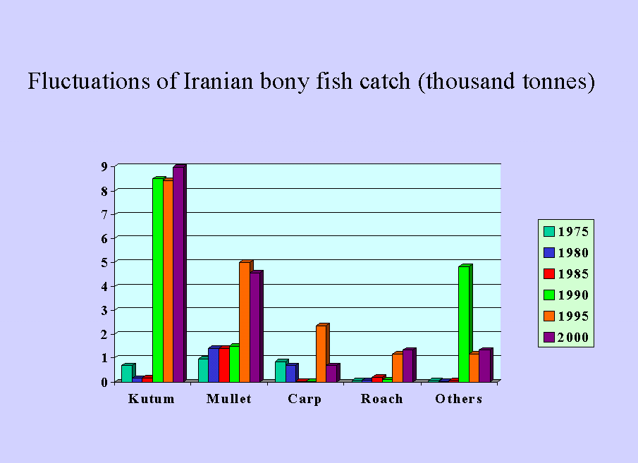
Bony fishes are locally popular. Kutum is most wanted fish in the Caspian Sea coasts and central Iranian cities. Mullet, Pike, Perch, Caspian trout, Carp, Roach and few other bony fishes are also fished by beach seine. Bony fish make living for a large number of fishermen. Iranian growing Kilka fishery is affected by comb-jelly invasion. Although there is a sharp reduction of Kilka production, it seems that success in an increase in human consumption may help fishermen overcome this problem.
1. Sturgeon Fisheries:
In the Caspian Sea sturgeon fishes are distributed from north to south all over the Caspian, however, studies show that there is a difference in each species distribution. For example, Persian sturgeon(Acipenser persicus) is mostly found in the south of the Caspian Sea. These fish migrate to fresh2water for propagation. Depending on water temperature there is a slight difference in their migration time Artificial propagation of sturgeons in Iran is a normal practice since 1970s. Today about 20 million sturgeon fish fingerlings are released into the rivers ending to the Caspian Sea each year. These young fish find their way to the sea and at the age of maturity, they migrated back to the river for propagation.
Sturgeons are benthic feeders, but some species such as Beluga (Huso huso) turn to fish feeding later in their life. Benthos such as Nereis diversicolor, Ampharetids, Mysids, Pseudocumids nd Scrobicularids and fishes such as Gobids, Atherinids and Clupeids are main foods for sturgeons.
Fishing season and sites are separately specified by Fisheries Research Centers for each species. Selling and trade of sturgeon fish and caviar are exclusive to the government. Private selling and export of sturgeon fish or caviar are prohibited and violators are prosecuted.
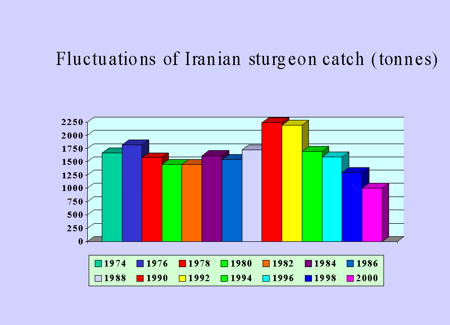
Persian sturgeon (Acipenser persicus) is the dominating species in Iranian side of Caspian Sea and consisted of 62.5% of the total catch in 2001. Comparing to 52.8% in the year 2000, this species showed a 10% increase in one year.
The overall trend of sturgeon fishing is decreasing (Sea Figure 1). This is due to illegal fishing after the collapse of the Soviet Union. Littoral states should take necessary measures to control illegal elements of overfishing. Iran is paying a great deal of expenses to control illegal fishing and in 2002 CITES has allowed Iran to exploit and export Persian sturgeon under Iranian regulations.
Figure (5-1): Long term annual harvest of Sturgeons in Iran.
2. Kilka Fisheries
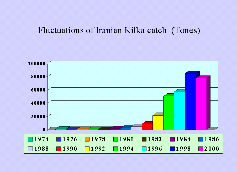
Kilka is fished by boats using funnel net. There are three species of Kilka in the Caspian Sea; these include Big-eye( Clupeonella grimmi). Anchovy( C. engrauliformis) and Common(C. cultriventris) Kilka.
Fishing for Kilka started in large scale from 1978 with a harvest of 7900 tones. Landings of Kilka kept increasing until 1999 when it reached 95000 tones. A decrease started from the year 2000 with a total catch of 78000 tones (See Figure 2).
Figure (5-2): Long term annual harvest of Kilka in Iran.
Apart from reductions in Kilka catch due to Mnemiopsis effects, there are some limitations in Kilka fisheries. Main Kilka fishing ports are limited to three. Boats are not designed to go fishing for a long period, which limits fishing grounds. Also there is a depth limitation for the fishing gears; this makes deeper stocks such as Big-eye Kilka unavailable to fishermen. Kilka is not popular fish, about 5% of the catch are consumed by human, and 95% are used in fish meal factories.
It is almost certain that invasion of the Caspian Sea by the comb jelly Mnemiopsis leidyi has caused this decrease in biomass of kilka. Feeding on zooplanktons it has a competitive on Kilka.
The Caspian Environment Programme (CEP) has organized some activities regarding invasion of the Caspian Sea by Mnemiopsis. One of these was to support the programmes Iranian fisheries Research Organization (IFRO) had in Iran to study on Beroe ovata which is another Ctenophore that predates on Mnemiopsis in its natural habitat(American waters).
3.Bony fish fisheries
There are 18 commercially important bony fishes in the Caspian Sea, which are caught using beach seine. Gill net was used in the past to catch bony fish but since it is harmful to sturgeon stocks, it is now outlawed and violators of the law are prosecuted. This fishery is old fashion and is not highly beneficial to fishermen. It is a traditional fishing to cover living cost of fishermen. However, it is not a big scale fishing industry. Kutum, Mullet, Common Carp, Roach, Caspian Trout, Pikeperch, Bream, Herring and catfish are main bony fishes of the Caspian Sea. Kutum and Mullet are more abundant than other species.
From 1974 until 1985, there were natural fluctuations of total catch of bony fishes in the Caspian Sea, From 1985 to 1987, there was a sharp decline in bony fish catch. Due to an increase in stock enhancement and artificial propagation, from 1988 there is a sharp increase in their catch.
Fisheries status of important bony fish species is as follows:
Figure (5-3): Long term fish annual harvest fluctuations in Iran
Kutum:
Kutum (Rutilus frisii kutum) is a highly popular fish species. It makes a significant part ( about 60%) of the income of beach seine fishermen. In order to avoid fishing spawners and help natural propagation, river Kutum fishing is now disallowed.
Due to over fishing, loss of spawning grounds, and reduction of water level of the Caspian Sea there were a steady decline in Kutum annual catch. This continued until early 1980s when it reached it’s lowest ever of around one hundred tones per year (see Figure 3). In middle 1980s when stock enhancement programmes of the Islamic Republic of Iran in the Caspian Sea worked well Kutum numbers increased. 27 million Kutum fingerlings in 1984 were released into the Caspian Sea. As artificial propagation results were promising, hatcheries increased their Kutum fingerling production and today fingerling release is 130 millions per year. A top fishing record of more than 12 thousand tones was recorded for Kutum in 1993. Now Kutum fishing is well managed and a production of around 7-9 thousand tones is remained steady for about 8 year.
B. Mullets:
Mullets ( Liza saliens and L. auratus) form about 30% of fishing income of bony fishermen. These two species unlike most Caspian fish species do not migrate to freshwater for spawning. Although mullets spend all their life cycle in the Caspian Sea, they have not been affected by the invading comb jelly, Munemiopsis leidyi. However, further increase in Mnemiopsis numbers may cause reductions in mullet catch in the future.
In the past, there were little fluctuations in mullet catch, however, recent years harvests is a little more than before and is about 3 to 4.5 thousand tones (See Figure 3).
C. Common Carp:
Before 1980s when Caspian water was low, Carp annual catch was small. For example in 1985 it was 16.4 tones (See Figure 3). With Caspian Sea water rise Carp production increased and 2300 tones harvest was reported in 1997, mostly form eastern areas.
The most important fish species interns of its economic value for Iran is sturgeon. Total income (value) and employment opportunities that exploitation of this Caspian Sea bioresource offers to Iran explain the large amount of investment the government on sturgeon research.
Various units of the Iranian Fisheries Company are involved in conservation and sustainable use of Caspian Sea sturgeons that include fisheries research on Caspian Sea for more than 80 years. At present 3 fishery research centers in the Gilan, Mazandaran and Golestan provinces and the International Sturgeon Research Institute equipped with modern and sophisticated instruments and laboratory equipment all of which are established along the coastal line of the Caspian Sea and staffed with more than 500 researchers and scientific experts are engaged in scientific research and investigation on different aspects of the Caspian Sea, sturgeons and bony fishes. More than US$ 4.5 million is allocated annually for research in these research centers. The fisheries research centers work in close collaboration with each other under umbrella of IFRO on specialized fields and conduct research on all aspects of the Caspian Sea. Each of these centers works on the specified objectives and follow definite strategies.
The national program on Caspian Sea sturgeons is determined by the Fisheries Company of I.R. of Iran in which objectives, are as follows:
I. Sustainable use of Caspian Sea sturgeons
II. Enhance and improve fishery shares to provide food security in the country
III. Increase added value and effectiveness
IV. Development of social and economic conditions of fisheries communities in the coastal regions of Caspian Sea.
Chapter 6
Pollution
Introduction
The Caspian Sea is under continuous ecological pressure due to the diverse point source and non point sources of pollution. Industrial, agricultural, and municipal wastes and pollutants are regarded as the main detrimental factors deteriorating the Caspian Sea ecosystem, and damaging its biological resources.
All the Caspian States are sharing common transboundary issues, regardless of being a contributor or recipient. The fact remains that no single country can hope to overcome these issues alone. These common treats to the bio-resources and the environment, demands full co-operation and co- ordination at the regional level.
Transboundary issues in the Caspian Sea are different in many ways to other water bodies of the world which could be attributed to the fact that the Caspian Sea is a closed sea and compared to the other seas, the pollutants in the Caspian Sea have either very long residence time or remain there for ever and have more severe impacts.
Based on the previous session the concentration level of all the contaminants except DDT and DDT – related compounds and of few heavy metals is less than the standard levels. Higher concentrations of heavy metals in the sediments in the Iranian coastal waters are mainly related to the natural background of those elements, and are not caused by human activity, therefore they are not considered pollution.
From the presented results it can be conclude that generally speaking the role of Iran in transboundary issues related to Caspian pollution is minor. Therefore the Iranian National Action Plan for transboundary issues would mostly concentrate on prevention of assurance of pollutant input to the Caspian Sea and less paying attention to mitigating the problems. On the contrary the local issues of the coastal pollution in the Iranian areas mainly related to public health are highly critical. The discharge of untreated effluent sewage together with not managed solid waste dumping has provided dangerous condition to the communities along the Iranian Coastal waters.
Therefore from national point of view the most important problems of pollution in the Iranian coastal areas arise from discharge of untreated domestic sewage. Not proper landfill dumping of solid waste and secondly due to the input of pesticides in to river from agricultural activities.
Pollution Sources in the Southern Caspian Sea
The pollution sources in the Southern Caspian Sea are as follow:
Municipal waste
Industrial waste
Agricultural waste
Shipping and oil industry
Municipal Waste
Cities along the Iranian coastline of the Caspian Sea have no sewage system at the present time. The effluent sewage from the cities is carried to the sea without any treatment through the rivers, channels and ground water. Also many villages townships and small communities next to the Caspian pollute it by their effluent discharge. Most pollution comes from the cities of Rasht and Anzali in Gilan and Chalus, Babolsar and Sari in Mazandaran. The Sefidrud River can be considered as the most polluted river in the region. Many small river or streams in the coastal area. Sometimes resemble open sewers. Untreated domestic effluent sewage discharge can be considered as a major threat to the public health. In addition it causes sever damages to the ecosystems of rivers and wetlands in the region. Therefore plays a significant role in decreasing of the natural resources in the Caspian Sea.
The current Iranian regulations do not allow landfills for domestic or industrial solid waste along the coastline. However, most of the cities near the coastline dump their solid waste on the riverbanks, where flooding washes the waste into the river and into the Caspian. The dumping sites are neither adequate nor properly built. The liquid run-offs flow in to the rivers and create health hazards. Floating debris on rivers is quite evident in almost all the rivers in the region. Unauthorized dumping of hospital wastes is another major concern. Unfortunately, incineration of this type of waste is not widely practiced.
Industrial Waste
The Iranian regulations do not allow locating heavy industries along the coastline. Most of industries located along the Iranian coast of the Caspian Sea are mainly food and fruit processing plants, paper, plastic, wood pulp, metal objects, building and construction materials.
Almost all of the industries, situated along the coastline, discharge their wastewater through the rivers into the Caspian. The effluents from these industries are mainly not treated or only partially treated which discharges into the local rivers. Solid industrial waste is another pollution problem. Fortunately, very little hazardous waste is produced in the Southern Caspian Coast.
Increase in the oil exploration and exploitation activities are the main source of the oil pollution in the Caspian Sea. So far there has been no oil exploitation activities in the Southern Caspian Sea and the contribution of Iran to the Caspian oil pollution can be considered negligible.
Agricultural Waste
Chemical fertilizers and pesticides are widely used along the Southern Caspian Coast due to agricultural intensification. Nitrates and phosphates are the main components of most chemical fertilizers used in Iran. During 1996, 241, 770 tons of fertilizer was used in the northern provinces of the IR-Iran, of which Urea has been the most commonly used (48%) (DOE, 1998).
The use of pesticides in southern Caspian provinces has increased as a result of agricultural intensification in recent years.
According to WHO. 3.2% of the authorized pesticides used in Iran are considered as extremely dangerous, 11.8% of these pesticides are classified as seriously poisonous and 24.7% are semi dangerous. In 1996, a total of 2,935,726 litters of liquid pesticides and 2,591,062 kg of solid pesticides were used in the southern Caspian provinces, herbicides (43%) and insecticides (74%) were the most commonly used chemicals (DOE, 1998). Pesticides including D.D.T, A.L.D, M.C, M.O.C. and H.C.H are still used in agricultural activities in the region (DOE, 1998).
Shipping
Shipping in the southern part of the Caspian adjacent to the tranian part is very limited and as a result, the pollution caused by shipping can be considered negligible in this area. However, pollution from shipping in the port yards and the adjacent waters is noticeable.
Pollution Levels in the Southern Caspian Sea
Measurements related with pollutants in water and sediments in the southern part of the Caspian Sea are limited.
Results of Studies Carried out by CEP
Results of the investigations and measurement of pollutants in sediment and seawater, supported by CEP demonstrate that:
Nutrients
According to the data collected throughout the studied stations, concentration of nutrients in the seawater. (Rf) is as follows:
phosphates (PO4)
PO4 in the sea water ranged between 0.03 and 0.15 ppm with an average of 0.06 ppm (DOE, 1998). Compared with the maximum standard level of phosphate of 1 ppm (WHO, 1984), none of the stations are polluted.
Nitrates (NO3)
The range of nitrate concentration in the surface seawater is between 0.03 and 0.41 ppm with an average of 0.21 ppm, where the maximum allowed rate by WHO is 50 ppm. The measurements showed the values much less than the standard level (DOE. 1998).
Estimation of input
The maximum river nutrient load is carried by the Sefid-rood (1840 tons per year) followed by Chaloos river (171 tons per year). The lowest loads were measured at extreme west (Astara) and east (Ghare-soo) rivers. The annual total load of these rivers in the Southern Caspian is estimated to be 2288 tons (DOE, 1998). The very low rate of concentration of nutrients measured in the seawater at different stations along the Southern Caspian coastline; where many of them were very closed to the river mouth, indicate the high mixing processes resulted from the very energetic area of the coastline.
4-Halogenated Hydrocarbons
PCBs
The results of the ASTP 2001 (De Mora and Sheikholeslami, 2002) showed a concertration of PCBs in the sediments of the Caspian coastal waters much less than the standard values (23 ng g-1). With the maximum of 7.7ng g-1. The Iranian coastal sample showed the concentration much less that the average concentration of the Caspian.
Pesticides
DDT and DDT-related compounds exhibit concentrations higher than the NOAAERL Azerbaijan and Iran. In the Iranian coasta waters the concentration of DDT compounds ranged between 0.7 to 4.6ng g-1. In comparisin with the NOAAERL values of 1.6 ng g-1 it shows a high concentration. However the current information is not sufficient to assess the impacts of this high concentration on the environment of the Caspian Sea.
c-Lindane, HCHs and other Chlorinated Pesticide
The Lindane concentration in the sediments of the southern Caspian Sea is negligible (mainly less than 20 pg g-1.
Regarding the HCHs, the ASTP 2001 (De Mora and Sheikholeslami, 2002) showed the range of 0.6 to 220 pg g-1 for the Southern Caspian, where the ISQG value is 320 pg g-1. The Endrin concentration in the sediments of the Iranian coastline varies from 4 to 81 pg g-1 regarding the regions. Which is much less than ISQG standards of 267 pg g-1.
Hence, was the most common pollutant and DI-Aldrine the least common pesticide used. The average concentration of pesticides indicates that waters in Gllan are more polluted as compared to waters of Mazandaran and : HCH isomers, total HC, total Aldrine and DDT were the most commonly used pesticldes.
According to these data, it can be seen that in the whole coastal region, an average of 26.8 litters of liquid and 43.6 of solid pesticides have been used in each km2. The type of pesticides used in the country is shown in Table 58.
According to the available data, each year more than 24 tons of chlorinated pesticides are carried into the southern Caspian basin by the inflowing rivers from Iranian coasts. These are the residue of the pesticides sprayed over the farmlands, orchards and other agricultural lands. The sprayed pesticides are broken down to less dangerous compounds and eventually are carried to the sea. It should be added that in recent years, the use of pesticides has increased because of agricultural intensification in Gilan, Mazandaran and Golestan provinces.
BOD Level
The amount of BOD was measured only in three stations located in the river mounts. results indicated levels ranging form 2.33 – 13.27 ppm (DOE. 1998). The results showed the concentration much less than the standard level of 50 ppm presented by WHO, 1984. Considering that the samples were taken at the river mouths. Where the high BOD level near the sea is expected, it can be conclude much less BOD level than the results in the open coastal water.
Petroleum Hydrocarbons
In Water
Based on the results obtained from investigations made at the sampling stations (from Astara to Babolsar), the concentration of petroleum hydrocarbons is negligible. Maximum 2.2 ppb, and the water is not polluted by hydrocarbons.
In Sediments
Based on the DOE results (1998), The petroleum concentrations in the sediment of sampling stations ranged from slightly polluted (18.6 ppm)up to heavily polluted. It is notable that the studied samples are mostly collected from the river mounts, where the port and shipping activities are located. So the mentioned levels cannot be considered as an indicator for the whole marine body of the southern Caspian Sea.
Regarding the new study done by De Mora and Sheikholeslami (2002, the total hydrocarbon concentrations are mostly ranged between 32 to 65 ppm, which indicates a not polluted area. The distribution of the total hydrocarbon concentration along the Iranian shows an increasing trend from east to west (De Mora and Sheikholeslami figure 2-1, 2002). As mentioned before the general circulation in the southern basin of the Caspian Sea is west to east (counterclockwise) and the oil exploration and exploitation in the Iranian side is almost nothing. The presence of the most oil polluted sediments in Azerbaijan coastal water, and the highest volume of the petroleum hydrocarbon discharge form Azerbaijan, lead us to conclude that the hydrocarbon inputs from the Azerbaijan plays a mjor role in the hydrocarbon detected in the sediments of the Iranian coastline waters.
In the Iranian Coastal waters, a high correlation between the concentration of PAHs and total hydrocabones is seen (De Mora and Sheikholeslami, figure 2-1 and 2-5,2002). The concentration of PAHs in the Iranian Coastal waters ranged between 72 to 954 ng g-1 which never exeed the NOAA Sediment Quality Guideline (4000 ng g-1).
The petroleum hydrocarbon input by rivers, flowing into the Caspian sea has been measured for two rivers, Astara (west) and shafa – rood (South of Astara). Approximately 0.61 tons of petroleum hydrocarbons annually enter the Caspian Sea through these two rivers (Table 6-1).
Further studies are needed to measure input of all other rivers in order to calculate the total petroleum hydrocarbons discharge into the sea.
|
Table (6-1): Input of petroleum Hydrocarbon into the Caspian Sea
|
|||
|
River |
Water Volume 106 m3 |
Petroleum Hydrocarbons
|
Percent |
|
Astara Shafa-rood Total |
101.0 192.5 293.5 |
0.181 0.428 0.609 |
29.72 70.72 99.99 |
Heavy Metals
Heavy metals concentrations were measured in rivers, Anzali wetland and the Caspian Sea sediments. The results form the data collected in the rivers show the various degrees of heavy metals concentrations, proportional to the distance from the industries or mines situated on the riverbank. Sediments of the Anzali wetland indicate high concentration levels of Hg, Cr, Pb and Zn. The concentration of other heavy metals can be considered negligible (DOE, 1998). The locations of the collected samples (Anzali wetand and) reveal that the presented data could not show the condition of heavy metal concentration in sediments of Caspian Sea properly. Although the new investigation (De Mora and Sheikholeslami, 2002) shows the metal concentrations are strongly correlated to the aluminum concentration - a good proxy for terrigenous material – and the amount of fine – grained sediments. Several metals (As, Cr, Ni) exhibit concentrations sufficiently high to exceed sediment quality guidelines. Such metals undoubtedly have a high natural background in this mineral rich region. However, anthropogenic activities, notably mining, may have further enhanced the metal burdens in the sediments of the Caspian Sea. This might explain apparent hot spots for copper and zinc in Azarbaijan and Iran. Several metals (Ag. Cd. Pd) have relatively low levels that pose no environmental concerns (De Mora and Sheikholeslami, 2002)
Various degrees of heavy metals concentration have also been determined in different fish muscles. Based on the degrees of heavy metal could be classified as: un-polluted, slightly polluted, and heavily polluted. Among the estimated heavy metals concentration in the fish muscles only silver (Ag) concentration is less than the permissible concentration. The concentration of (Cr) is about the permitted level, while concentration of Cd, Hg and pb is twice as much as the permissible concentration. The fishes of the Caspian Sea are polluted with certain concentration of Zn and Cu.
Fe and Mg are the most dominant toxic pollutants found in muscles of most of the fishes.
Invertebrates: concentration of heavy metals in invertebrates is much less than that of the fishes.
|
Table (6-2): Concentration of Organo-chloride Pesticides (ppm) along the Southern Caspian Sea.
|
||||||
|
No |
Location |
H.C.H |
D.D.T |
A.L.D |
M.O.C |
H.C |
|
1 2 3 4 5 6 7 8 9 10 11 12 13 14 15 16 17 18 19 20 21 22 |
Astara R. Nokandeh R. Shafarood RI. Anzall S. Sefid-rood R.. Chamkhaleh R. Ramsar R. Nashtarood R. Sardabrood R. Chaloos R. Sorkh-rood R. Babol-rood R. Talar R. Larim R. Tajan R. Ghane –soo R. Khagehnafas R. Anzall R. Gafrood R. Nashta –rood R. Babolsar S. Ashooradeh S. |
11.348 5.036 4.370 7.994 1.808 1.617 2.946 0.869 3.809 2.341 1.724 1.604 1.408 4.011 1.490 4.589 3.887 2.323 0.927 2.099 4.102 2.017 |
1.210 0.177 0.141 0.702 0.179 1.590 0.070 0.224 0.130 0.194 0408 0.432 0.256 0.354 0.463 1.844 0.614 0.0914 ND 0.003 0.006 0.021 |
4.250 0.942 0.830 2.067 0.236 0.209 0.459 0.185 0.057 0.332 0.040 0.289 0.491 0.671 0.557 0.791 0.864 0.209 0.106 0.022 0.138 0.017 |
ND ND ND 0.821 0.470 0.068 0.001 0.025 ND 0.187 0.849 ND 0.603 ND 0.483 0.054 0.513 0.0027 ND ND ND 0.318 |
2.251 1.505 1.601 1.425 1.131 1.206 1.391 0.920 0.448 1.636 1.442 1.739 1.281 0.985 0.858 0.944 0.855 1.570 1.083 1.877 1.537 1.533 |
It could be concluded that among the 5 surveyed rivers, the highest load of pesticides belong to Sefid – rood river and the lowest to Sardab-rood (while it passes the mountains before reaching the sea.)
|
Table (6-3) : Input of Pesticides into the Sea
|
|||||||||||||
|
No |
River |
Water Vol. |
HCH |
DDT |
ALD |
MOC |
HC |
Total Tons |
|||||
|
10`m3 |
Tons |
(%) |
Tons |
(%) |
Tons |
(%) |
Tons |
(%) |
Tons |
(%) |
|||
|
1 2 3 4 5 6 7 8 9 10 Total |
Astara Shafa-rood Nashta-rood Sardab-rood Chaloos Babol-rood Talar Tajan Ghar-e-soo Sefid-rood _ |
101.0 192.5 30.7 43.5 372.0 425.0 118.0 207.4 101.0 4000.0 5591.1 |
1.146 0.843 0.027 0.168 0.871 0.682 0.166 0.308 0.436 7.232 11.91
|
9.6 7.1 0.2 1.4 7.3 5.7 1.4 2.6 3.9 60.7
|
0.122 0.027 0.007 0.006 0.072 0.184 0.031 0.096 0.186 0.716 1.447 |
8.4 1.9 0.5 0.4 5.0 12.7 2.1 6.6 12.9 49.5 |
0.429 0.160 0.006 0.003 0.124 0.123 0.058 0.115 0.080 0.944 2.042 |
21.0 7.8 0.3 0.1 6.1 6.0 2.8 5.6 3.9 46.2
|
ND ND 0.001 ND 0.070 ND 0.071 0.010 0.005 1.880 2.037 |
- 0.04 - 3.4 - 0.3 0.5 0.2 92.3
|
0.227 0.309 0.029 0.020 0.609 0.735 0.151 0.178 0.095 4.524 6.877 |
3.3 4.5 0.4 0.3 8.9 10.7 2.2 206 1.4 65.8 |
1.92411.339 0.070 0.197 1.746 1.724 0.477 0.707 0.829 15.296 24.309
|
|
Table (6-4) : Concentration of heavy metals in water, sediment and biota |
||||||||||||||||||||
|
Surface Water |
Surface Sediment |
Aquatic Anmimal |
||||||||||||||||||
|
River |
Anzall Wetland |
Anzall Wetland |
Rivers |
Caspian Sea |
Caspian Fish |
Mollusks |
||||||||||||||
|
Metal
|
Permitted Level |
Concentration Range (ppm) |
Pollution Extend |
Concentration Range (ppm) |
Pollution Extend |
Mean Crust of Earth (ppm) (ppm) |
World Mean Sediment (ppm) |
Concentration Range (ppm) |
Pollution Extend |
Concentration Range (ppm) |
Pollution Extend |
Concentration Range (ppm) |
Pollution Extend |
Permitted Level (mg/kg) |
Concentration Range (ppm) |
Permitted Extend |
Concentration Range (ppm) |
pollution |
||
|
Hg
Cd
Pb
As
Cr
Cu Zn
Ni
V Fe
Mn
Ag |
0.001
1.000
1.000
0.010
1.000
1.000 1.000
1.000
3.000
0.001- 0.600 0.001 0.010 |
0.534
0.001-7.6
0.09-32.1
0.028
0.5-1.57
0.35-5.7 |
NP
NP
NP
NP
NP
NP |
0.23-0.77
0.01-0.04
0.13-0.37
0.01-0.04
0.98-1.93
0.02-0.04
0.01-0.11
0.26-0.45
0.35-1.33 0.07-0.03
0.01-0.47 |
VP
NP
NP
P
P
NP
NP
NP
NP
NP |
0.08
0.2
14
1.8
100
50
75
80
4.41
850
0.1 |
19
70
33
95
52
135 4.41
770 |
1.1-4.1
0.3-1
22.5-140
0.1-1.1
65.1-142.5
34-51
81.5-200
14.3-23.9
21-131.8 2.9-4.7
208-892 |
VP
P
VP
NP
P
NP
VP
NP
NP NP |
1.100-2.500
0.001-7.400
0.020- 7110.00 0.3-0.7
0.04-3403
0.003-132
0.01-853
0.01-200
34-77.6 0.8-5415
251-823
0.003 |
VP
NP-VP
NP-VP
NP
NP-VP
NP-VP
NP-VP
NP-VP
NP NP-VP
NP
NP |
14.2-109.7
17.3-168.1
13.2-104.7
45.3-112.7 0.9-5.8
207.5- 892.1 |
NP
NP-VP
NP
NP NP-P
NP |
10-2
15-0
200
50
0.02-21
<10
<15
1
26.2
<0.1
20.80 |
0.03
0.21
0.3-2.3
0.19
0.4-53.4 14.6-38
0.07-0.28 0.4-30.9 0.3 |
P
P
NP-P
NP
NP-P
P-VP
VP
P-VP
NP |
16.1
120.6
325.7
1492
20.2 |
|
||
Chapter 7
Institutional and Legal Framework
INSTITUTIONAL AND LEGAL FRAMEWORK
After a long period of tyranny and authoritarian kingdoms, almost a century ago, as a result of socio-political awareness of some strata of society, mainly in urban areas, power structure came under question. The main goal of this movement was to limit the absolute power of the king through formulation of a constitution and establishment of parliament.
During the last hundred years, different national, regional and local socio- political movements occurred. The main aim of them was to realize the goal of the Constitutional Movement, namely limiting the power of the government and enhance the authority of public domain.
Islamic Republic of Iran still is on her way to institutionalize a democratic political and social structure that corresponds with Islamic teachings.
A shift from governmental paternalism on the part of the central governments towords decentralization of decision making, is quite evident through political processes aimed at :
More participatory power structure
Preferring national interests to local and factional ones
Resolution of conflicting ideological positions
After the victory of Constitutional Movement and establishment of parliament, a series of changes brought about new situation along with the second effort to introduce modern bureaucracy. Adoption of new administrative system was carried out by establishment of variety of ministries and organizations. After about 40 years (40 to 50 years ago), with increase of the oil income and its effects in economy, economic domination of government became so conspicuous that leading role of the government in development of the country was undeniable.
Almost 25 years ago, administrative reform became an agenda of the government, and many efforts were paid to integrate and separate ministries and organizations. During the last 23 years, various efforts to integrate and separate ministries and organizations indicate lasting of the institutional weaknesses and deficiencies.
During the last two decades, various measures carried out to increase the efficiency and efficacy of ministries and state organizations. Decentralization, education of governmental managers, reduce the size of the state are just few of them. On this basis, considerable amount of national powers and responsibilities have been vested in to the provinces. The most important manifestation of the will to change and develop the administrative structure and functions can be observed in the 3rd Development Plan (2000 – 2004). The rules for the implementation of this plan start with the chapter on the reform of different layers of bureaucracy both at national and provincial levels. Although the systematic measures has commenced in the 3rd Development Plan, it prolongs to at least the fourth one. In other words, suitable institutional framework requires capacity development at individual, organizational and environmental levels.
Institutional development is influenced by the political one. Therefore through gradual political development, efficient government will manifest gradually, as it is happening.
Non governmental organizations are new and even though fast growing in IR Iran they lack financial and organizational capabilities to address major environmental issues that Iranian Caspian is facing today. Further more integration of the development planning process and environmental development despite attempts to bring these processes closer in Iran remain far from what is desired by many experts. Environmental stewardship is gaining attention but economic incentives are not enough to promote environmental protection. Government ownership of natural resources has further complicated compliance and monitoring of nationally accepted environmental regulations and standards.
At regional scale lack of agreements (instruments signed by the five Riparian states) that would make use of natural resources entirely legitimate, complicates international relations among the countries, creating an atmosphere of tension and distrust. Taking into account that each Caspian country has hydrocarbon resources in the Caspian and many foreign oil companies are active in the region. There is an urgent need for addressing these regional issues.
Legal Framework- Marine and Coastal Areas
According to the Iranian Coastal and Reclaimed Land Regulation ratified in 1975, territories adjacent to bodies of water are divided into three categories: reclaimed, coastal and sea limits.
Reclaimed land
Reclaimed lands are the areas recovered due to sea water level decline or reduction of any other water current on the shores of seas, lakes, islands or wetlands.
Only the width of these lands is mentioned directly in the National Regulations ratified in 1963. It stipulates the horizontal line as 150 cm above the water level from the last point of seawater advancement.
The Council of Ministers is entrusted to determine the width of the reclaimed lands of the other lakes and wetlands in the country.
Coastal land
Coastal lands are the territories with a specified width along the shoreline of seas, lakes or gulfs that are bound at least on one side to these bodies of water.
The width of the coastal lands of the Caspian Sea and other national lakes and wetlands has not yet been specified.
Sea limits
Sea limit is a part of the coastal or reclaimed land that is connected to seawater, a lake, gulf or wetland from one side. The sea limit width at Caspian Sea is 60 meters from the last point of water advancement in 1963.
The sea limit width of other national lakes and wetlands must be determined by the approval of the Council of Ministers.
By the national law of the Islamic Republic of Iran Department of the Environment has been appointed as the responsible authority for the environmental protection and development. Except in few cases related to the fisheries, the national laws and regulations are referred to the entire environment of the I.R. Iran in general and they do not specify the Caspian Sea in particular.
The Department of the Environment shall be responsible for the protection and enhancement of the environment, for the prevention and control of any form of pollution or degradation leading to the disturbance in the balance and proportion of the environment, and for the conduct of all matters related to wildlife and the aquatic biota of the territorial waters.
Regulations of the Department of the Environment (DOE)
The Protection of Seas and Rivers Against Petroleum Contamination at International Borders Act was ratified on February 2nd, 1976. Article 13 of this regulation concerning possible damages incurred to the ports or coastal structures stipulates that:
“In case of any damage incurred to the Iranian ports, beaches, coastal facilities, fishes or natural resources due to violation of these regulations, a court will sentence the concerned authorities to compensate the damages”
Article 18 of the same act in regard to ecological studies states that:
“Any kind of marine ecological study as well as prevention of water contamination within our national territorial jurisdiction is still entrusted to the Department of the Environment.”
According to the Article 19, the Ministry of Road and Transportation and the Ministry of Justice are bound to implement the above-mentioned law.
Regulations of Ports and Shipping Organization
The Ports and Shipping Organization (PSO) was established in 1960 according to the Ports and Shipping Organization’s Establishment Authorization Act under the supervision of the Ministry of Customs. Article for of the act stipulate that:
“The regulations incorporated in this act encompass all the ports, harbors, canals, navigable rivers and coastal waters. The limits of each port will be determined by the decree of the Council of Ministers. “
In 1969, special senatorial and parliamentary commissions ratified the General Regulations of the Ports and Shipping Organization. The organization was now defined as an affiliate of the Ministry of Finance. Nevertheless, the entire institution, including all its facilities and personnel were transferred to the Ministry of Road and Transportation on July 6, 1973.
This organization is considered to be the custodian of ports and marine transportation. In order to implement harbor management, the legislator has made the establishment of any wharf or any related facility contingent upon the issuance of a permit from the organization. It is evident that construction of any marine facility without a permit is a flagrant contradiction of the jurisdiction and powers of the PSO.
Regulations of the Ministry of Construction Jihad
At present, the Forests and Pastures Organization (FPO) affiliated to the Ministry of Construction Jihad) and the Ministry of Power are the two institutions with the greatest legal responsibilities with respect to the country’s coastal lands. Other public entities might have limited dealings with affairs related to these areas, but their interaction is insignificant in comparison with the above-mentioned ministries.
“The Forests and Pastures Organization is being established in order to implement the duties and regulations on the subject of protection, restoration, development and proper exploitation of forests, pastures, forestlands, natural groves reclaimed coastal lands and water sheds.”
On February 1 1994, ‘The Bill of Ratification Regarding the Comprehensive Objectives and Tasks of the Ministries of Agriculture and Construction Jihad‘ was approved by the Council of Ministers.
Article 1, Section A defines the goals and tasks of Ministry of Construction Jihad as:
“Protection, support, restoration, expansion and proper exploitation of forests, pastures, forestlands, natural groves and reclaimed coastal lands as well as protection of watersheds. “
In 2001, the Council of Ministers approved to consolidate the Ministries of Agriculture and Jihad and renamed it as the Ministry of Jihad and Agriculture.
Regulations of Ministry of Power
In 1968, both of houses of the legislature ratified the Article 66 “Water and Water Nationalization Process Regulation” that was abrogated by the 1982 “Fair Distribution of Water Act”. The previous measure says that construction of any type of superstructure on the shorelines of the seas and lakes are subject to the permission of the Ministry of Water and Electricity in accordance with the legal limits.
The Fair Distribution of Water Act plays an important role in matters concerned with coastal management. The 52-article regulation was ratified by Parliament on March 5 1983.
The Ministry of Power has a broad range of responsibilities concerning water-energy. Hence, any kind of interference, possession or exploitation of national water resources must be under the continual supervision of this ministry. Therefore, the legislator has subjected the establishment of any facility within the limits of any body of water, to prior approval by the Ministry of Power. It is clearly quite possible that the establishment of any superstructure, excavation, alteration and possession within the limits of any body of water could interfere with optimum exploitation of water resources by the Ministry of Power.
Regulations of Other Organizations
Regulations Concerning the National Trade and Industrial Free Zones
The Supreme Council of Trade and Industrial Free Zone in I.R. Iran ratified 16 articles of regulation regarding exploitation of land and national resources in the I.R. Iran’s Trade and Industrial Free Zone. Articles 5 and 15 are cited for better understanding our discussion:
ARTICLE 5:
All the rights concerned with the lands located within the boundary of each region and subject to the Urban Land Regulation, State Forests and Pastures Nationalization Act, State Forests and Pastures Protection and Exploitation Act and the Coastal and Reclaimed Lands Regulation will be exercised by the previously mentioned organization according to this regulation.
ARTICLE 15:
All the authorities entrusted to the concerned ministries in dealing with trespassing, occupation and destruction of public and national lands, coastal lands and the sea limits according to the State Forests and Pastures Protection and Exploitation Act ratified in 1969 and its subsequent amendments, Coastal and Reclaimed Lands Regulation ratified in 1975, the entrusted authorities subject to Articles 11 and 15 of the Environmental Protection Act as well as the special authorities delegated to other public institutions, from the date of this regulation will be entrusted to this organization within the jurisdiction of the Free Zones.
Regulations of Fisheries Joint Stock Company
The Fisheries Joint Stock Company (FJSC) is a national institution closely associated to the question of marine affairs. It is the sole legal authority for exploitation of aquatic resources in the country. All legal articles concerned with this company have emphasized the observance of other ministries’ regulations. And even though the company is not the decision- making authority in regard to national coastal management, there are certain legal articles worth mentioning that give this company freedom and authority in coastal constructions:
In Article 3 of the FJSC’s Memorandum of Association, the domain of its activities is described as the entirety of the bodies of water located within the jurisdiction of I.R. Iran including Caspian Sea, internal waters (including all the lakes, rivers, marshes, dam-lakes), coastal waters etc.
“Fisheries joint Stock Company could employ any potentially suitable area for establishment of fisheries facilities in its domain of activities by observing all the legal principles concerned with coastal waters. “
Article 4 of this act describes the duties of fisheries and Clause A stipulates its major tasks:
Establishment, development and maintenance of FJSC’s ports by observing the duties of other ministries.
Conducting all the necessary actions in order to protect the aquatic resources in the Sea of Oman, Persian Gulf, Caspian Sea, marshes, gulfs, estuaries and rivers related to the aforesaid sea by observing all the legal principles.
The FJSC has the legal responsibility of establishing structures for catching purposes in the coastal areas, but it has to acquire necessary permits from the concerned ministries. For example, the company has to obtain permission from the authorities listed below for port construction: a)National Forests and Pastures Organization, b)Ministry of Power, c)Ports and Shipping Organization according to Ports and Shipping Organization.
Unfortunately, there is no well-defined procedure for acquiring these permits. This results in time-consuming bureaucratic entanglements and potentially irreversible mistakes in exploitation of national water resources.
The Act of Establishment for the National Committee for the Abatements of Natural Disasters and their Effects
According to this law:
“This committee is being established to exchange information, studies and national research and to develop rational procedures for prevention and reduction of natural disasters’ effects due to storms, floods, drought, from pests, air pollution, earthquakes and earth movement, water level fluctuation in seas, lakes, rivers and etc… The chairman of this committee is the Interior Minister. The committee is comprised of ministers and high authorities of different institutions and ministries.
Following this act, the decree for its enforcement was ratified by the Council of Ministers on March 2, 1994. Article 1 of this directive stipulates that:
“In order to prevent and abate the effects of natural disasters, the aforesaid national committee is being established as a coordinating committee with nine supplementary research committees to exchange information, studies and scientific research.”
“The Supplementary Committee of Flood, Sea Water Level Fluctuation and River Overflow Prevention” has been established under the authority of the Ministry of Power and has the following members:
Ministry of Interior, Ministry of Power, Ministry of Construction Jihad, Ministry of Road and Transportation, Ministry of Housing and Urban Development, Housing and Building Research Center, I.R. Iran Broadcasting, National Meteorological Organization, National Geology Organization, Ministry of Agriculture and Ministry of Telecommunications. Its permanent secretariat is located in the Office of Protection, Engineering and Control of Rivers, Shorelines and Floods.
The Act for Establishment for the High Council of Oceanography
The above-mentioned council was instituted for scientific enhancement, development of a comprehensive policy, coordination of national activities and expertise and to insure proper exploitation of the valuable resources of the Persian Gulf, Sea of Oman and the Caspian Sea. Its establishment was ratified by the I.R. Iran Parliament on August 10 1991. The members of the aforesaid council are:
Minister of Road and Transportation, Director of National Meteorological Organization, Managing Director of the Ports and Shipping Organization, Director of the Department of the Environment, Managing Director of Fisheries and Aquatic Affairs Company, Director of the National Geology Organization, Managing Director of the Continental Shelf Oil Company, Deputy Minister of Culture and Higher Education, Commander of I.R. Iran Navy, Commander of Sepah-e-Pasdaran Navy, Director of the Armed Forces Geographical Organization, three experts in this field appointed by the chairman of the council and the Deputy Minister of Telecommunications for International Affairs.
The Minister of Road and Transportation is the chairman of the above-mentioned council and its secretariat is located in the National Meteorological Organization.
The High Council of Oceanography is comprised of seven specialized committees that include:
1. Committee of Oceanography, Dynamic Physics of Oceans and Marine Meteorology (National
Meteorology Organization)
2. Committee of Marine Services, Marine Law and Transportation (Ports and Shipping
Organization)
Committee of Ocean Engineering and Marine Topography (Oil Ministry)
Committee
of Marine Environment and Marine Contamination
Control and
Monitoring (Department of the Environment)
Committee
of Living Marine Resources (Fisheries and Aquatic
Affairs
Company)
Committee
of Inorganic Marine Resources (National Geology
Organization)
Committee
of Oceanographic Education and Culture (Ministry of Culture and
Higher Education)
High Council of the Environment (HCE)
The High Council of the Environment is composed of the Minister of Jihad , the Minister of Health , Director of the plan and Budget Organization , the Director of the Department of the Environment and four other qualified persons recommended by the Chairman of the Environmental High Council and appointed for a term of three years by the chairman. The Chairman of the High Council of the Environment is the President of I.R.Iran.
The Department of the Environment, here in after referred to, as the ‘Department’ shall be attached to the president of I.R.I Office. It is a corporate body with financial independence functioning under the supervision of the High Council of the Environment.
An Overview of Coastal and Reclaimed Land Regulations:
Coastal and reclaimed lands belong to the government, except in the cases that the law has foreseen. (See the Articles 3 and 4 of the Coastal and Reclaimed Lands Regulation).
Issuance of construction permit within the legal sea limits, depends directly on the status of the applicant (whether it is a public institution or the private sector):
I) In reference to Article 7 of the Coastal and Reclaimed Lands Regulation:
“If a public institution is planning to establish a necessary facility within the legal coastal limits, it has to obtain the permission of the Council of Ministers for the desired exploitation and application. Upon completion of this stage, the permission of the following authorities for construction on the land areas within the sea limits is required:
National Forests and Pastures Organization (According to the Coastal and Reclaimed Lands Regulation),Ministry of Power (according to the Fair Water Distribution Act, Article 2, Note 3), Ports and Shipping Organization (according to the General Regulations of Ports and Shipping Organization, Article 3, Clause 22)
If the private sector wants to establish a facility within the legal sea limits, it has to receive permission from at least four different authorities.
Permission of an institution that the facility’s activity falls within the jurisdiction of:
National Forests and Pastures Organization (for implementation of Coastal and Reclaimed Lands Regulation), Ministry of Power (for implementation under the Fair Water Distribution Act),Ports and Shipping Organization (According to the General Regulations of the Ports and Shipping Organization, Article 3, Clause 22).
In reference to Article 9 of the Coastal and Reclaimed Lands Regulation, sale, rent and exchange of coastal and reclaimed lands fall under the jurisdiction of the Ministry of Construction Jihad.
According to the Article 8 of the Fair Water Distribution Act, issuance of an operating permit or the transfer of operational rights to exploit sand, gravel and clay within the national coastal limits is entrusted to the Ministry of Power.
In reference to the Coastal and Reclaimed Lands Regulation, Article 4, Note 1, and according to the Urban Land Organization’s New Memorandum of Association, Article 5, Note 2 ratified by the Council of Ministers in 1988: The Urban Land Organization is authorized to implement the regulations related to this matter. This applies if the reclaimed lands or the lands within the coastal limits are considered inside city limits. (The Urban Land Organization was renamed the National Land and Housing Organization in 1993.)
According to the Coastal and Reclaimed Lands Regulation, Article 11, any trespassing into the aforesaid lands and their illegal occupation or destruction by removing sand, gravel, soil or stone is considered a public offense and is subject to legal punishment and if required to eviction and dispossession. The Ministry of Construction Jihad (FPO) is bound to immediately react and request police assistance in removal of the trespassers and to inform the court in writing about the location of the crime for the ensuing criminal prosecution
Environmental Laws and Regulations
Except in few cases related to the fisheries, the national laws and regulations are referred to the entire environment of the I.R.-Iran in general and they do not specify the Caspian Sea in particular.
National laws and regulations related to the protection of the environment in general could be enumerated as:
Law of “ Environmental Protection and Development” (1991)
Law of “ Protection and Exploitation of the Fisheries Resources “, (1974)
Law “Applicable to Any Economical, Cultural, Societal Development”, (1989).
Law of “ Prohibition of Any Establishments which is Against the Health and protection of the Urban and Sub-urban Areas “ , (1949)
Law of “ Protection of the Sea and Internal Water- bodies Against the Oil and Oil-products Pollution,”(1975).
Law Related to “ Punishments Applicable to the Over-exploitation of the Fishery Resources in the Persian Gulf and the Caspian Sea”, (1979).
Law of “ Proper Use of Water Resources”, (1982)
Law of “ Protection Against the Natural Environmental Damages”, (1991)
Law of “ Endangered Species of Wild Fauna and Flora,” (1974)
Law of “Environmental Protection Against the Water Pollution”, (1984).
Law of “Environmental Protection Against the Air Pollution”,(1975).
Environmental Protection and Enhancement Act, (1974).
Law of “Protection of the Natural Parks, Protected Areas and Sensitive Areas”, (1975).
Law of “Environmental Health”, (1992).
Law of “Establishment of the National High Council of Oceanography”, 1991.
Environment Impact Assessment (EIA)
In April 1994, the high council of the Environment (HCE), presided by the president of the Republic approved that major development projects (power plants, petrochemical plants, refineries, dams and water structures airports, ports, industrial estates, steels mills, etc.) must prepare EIA prior to their construction.
According to the clause 82 of the Law of the Second Five-Year Economic, social, and Cultural Development Plan (1994-1998), all major development projects, either productive or services, are obliged to prepare EIA as well as Feasibility Study.
The standard procedures was prepared and submitted to the HCE by the Iranian National Committee on Sustainable Development (INCISED), in the late 1997.
In January 1998 standard procedures for implementation of EIA was approved by the (HCE). In July 1997, collaborative project of about us $300000 was signed with the United Nations Development Programme (UNDP), to support activities institutional strengthening of EIA in the I.R.Iran implemented with cooperation of the Plan & Budget Organization(PBO) of I.R.Iran. The PBO was restructured and renamed as Planning and Management Organization by 2001.
According to the guideline of the Environmental High Council for the Environment (HCE) dated (23.Dec.1997), the proponents of the following national projects / programmes are obliged to prepare and submit Environmental Evaluation and Feasibility studies as well as Environmental Impact Assessment:
I) Petro-chemical factories /companies of any scale,
II) Refineries of any scale,
III) Power plants with regeneration potential of more than 100 MW,
IV) Steal industries with production capacity more than 300,000 tons / year,
V) Dams, and any other structures such as :
a)Dams with height more than 15 m. and/or with axially structures more than 40 hectares and /or with lake surface area of more than 400 hectares.
b)Artificial man-made lakes with surface area more than 400 hectares.
c)Irrigation and drainage projects / programmes extending more than 5,000 hectares.
VI) Industrial town (of any type) with area of more than 100 hectares.
VII) Air-port with run-way facilities more than 2000 meter
In accordance with the law of the Third Five Year Economic, Social and Cultural Development Plan (1998-2004) about twenty one types of development projects either production or services, are obliged to prepare EIA as well as Feasibility Study.
Public Participation in Coastal Planning and Management
The public participation in environmental affairs and the help it can give the government are tremendously important in environmental management today. In I.R. Iran, youth, women, the owners of production and industrial units and non-governmental associations are all involved in efforts to protect the environment.
Youth participation embraces the “Young Cooperators” scheme, school meetings in environmental issues and the work of environmental activists in schools. Women’s participation in environmental affairs has been less significant, however. There are many opportunities to enlist women’s involvement by raising their awareness of environmental issues such as the hazards caused by detergents and other domestic products and by improper use of agricultural chemicals in rural areas.
The role of industrial and production units in reducing environmental pollution has not been institutionalized, but managers of these units could, by rigorously applying environmental standards, play an important part in decreasing the inappropriate discharge of industrial effluent as well as limiting harmful factory emissions.
Although non-governmental organizations (NGOs) concerned with environmental issues are not yet sufficiently developed, there are signs that they are on the increase. The main environmental NGOs are the Green Front, which was established in 1991, the Association of Environmental Specialists, and the Women’s Society for the Campaign against Environmental Pollution, founded in 1994. These groups have been engaged primarily in educational and publicity activities.
Given the enormity and nature of the environmental challenges facing Caspian region, it is essential for ordinary people to get involved in preventing pollution and managing environmental issues. Indeed, it will simply be impossible to solve many of the current environmental problems without the enthusiastic public input, especially in coastal region of Caspian, where the whole area is populated and all lands are used for agricultural or other purposes adjacent to the sea.
The active participation and cooperation of the industrial and manufacturing sectors is also vital, given the role of industrial pollutants in pollution as a whole. The commitment of producers and manufacturers to observing environmental standards strictly is a basic requirement of enforcing laws aimed at preventing air, water and soil pollution and protecting Caspian’s natural environment. The establishment and expansion of environmental consultancy firms to advice producers and manufacturers on their compliance with these standards is of special importance here.
Since public awareness of environmental issues plays a crucial role in preventing pollution, NGOs involved in awareness-raising need to be supported by the government and particularly by the Department of the Environment. Another way to secure NGO participation in environmental affairs is to have NGOs include environmental objectives in their national terms of reference. The mass media also have a key part to play in heightening public awareness of environmental issues and promoting public participation in environmental protection.
Islamic City Councils
In order to enhance social, economic, development, health, cultural and educational programs and other welfare affairs, public participation in accordance with local circumstances is desirable. The supervision council of every village, district, city, township or province will administer the affairs of every village, district, city, township or province. People will elect the members of these councils.
Law determines the conditions of the elected and the elector, the limits of duties and authorities, the election procedure, the manner of supervision of the councils and their hierarchy in accordance with national unity, territorial integrity, subordination to central government and the basic principles of the Islamic Republic system.
Article 68 – The duties and authorities of the Village Islamic Council:
Supervising the proper execution of the decisions made by the Village Islamic Council.
Study and discernment of the present deficiencies, requirements and shortcomings in the village and preparing practical improvement plans and suggestions in these matters and submitting the same to the concerned authorities.
Attracting public participation and donations and cooperation with the executive authorities of the ministries and organizations that are active in regard to rural affairs and providing necessary accommodations for enhancement of these affairs.
Clarifying and justifying governmental policies and persuading the villagers to implement the aforesaid policies.
Supervise and follow up the implementation of the development projects and plans designated for the villages.
Collaboration with the concerned authorities for establishment, management, maintenance and operation of public, economic and social facilities required by the village.
Provide aid in emergency situations like war and natural disasters, helping the needy and unattended families with local donations.
viii. Try to resolve and arbitrate local disputes.
ix. Provide necessary bases for implementation of health regulations and preservation of environmental sanitation.
x. Cooperate with the local Law Enforcement Forces to uphold the law and public security.
xi. Provide suitable grounds for public participation in implementation of production activities initiated by ministries and public organizations.
xii. Attract public cooperation and participation in religious and cultural activities.
xiii. Elect an appropriate person as the Rural District Governor for four years according to the concerned regulations and presenting him/her to the District Governor for issuance of the mandated order.
Chapter 8
The State of Coastal Planning and Management
Caspian Coastal Zones are of strategic importance to the country. Almost 6 million people live on Caspian Coast of Iran and the Caspian Coastal Zones are a major source of food and raw material, a vital link for transport and trade, the location of some of our most valuable habitats, and suitable destination for tourism. Yet our coastal zones are facing serious problems of habitat destruction, decline bio-diversity, water and land contamination, coastal erosion and resource depletion. Our coastal zones are suffering from increasingly conflict between uses, marginalization, unemployment, destruction of property by erosion, unfavorable human health conditions, etc.
Policy and management responses to many of the problems have traditionally been from the sector most affected by the issue or from regulatory organizations. Often little or no regard has been given to the likely effect of one sector policy or management decision on other sectors.
The coastal zone governance in the Islamic Republic of Iran is multi-sectoral. Table indicates the relevant organizations / institutions involved in coastal planning and management. The Integrated Coastal Area Management & Planning (ICAMP) Concept has not been put in practice and the country lacks the integrated approach in the management of the coastal and marine areas. For example, there may be an efficient management practices in place for fisheries and bio-resources but it is subject to failure if not harmonized with other sectors management practices.
There is a need for a more integrated approach to management in the coastal and marine areas around the Caspian. There is a lack of expertise in general area of integrated coastal management planning and specifically on protected area management, coastal erosion management and sustainable tourism. Protecting coastal resources and shared marine environment can only be achieved through collaboration and coordination with other coastal states because of transboundary nature of the environmental issues. At the national level, the government authorities are not convinced enough that ICAMP is very important and essential since the concept of ICAMP is quite new.
The results of National TDA Reports (Causal Chain Analysis and Root Causes) reveals that amongst all "the lack of Integrated Coastal Area Management" was the most commonly referred root causes of many identified environmental issues in the Caspian Sea. The National Coastal Profiles have also indicated the same.
The main aim in the future in the context of Coastal Planning and Management is to enhance the development and implementation of ICAMP in the Caspian region and in cooperation with bio-diversity considerations in spatial planning and management of coastal and marine zones through development and implementation of a limited number of Pilot Projects and facilitating regional/international exchange of information.
|
# |
Name of the Organization |
Main Tasks |
Overlapping Tasks with the other Organizations |
Tasks that could be Coordinated |
Notes |
|
1
|
Department of the Environment |
Prevention, control and mitigation of pollution and destruction of the environment, protection of wildlife |
-With the Ministry of Energy for to the protection of rivers - With PSO in regard to Pollution - With Shilat Joint Stock Company for monitoring of aquatic resources and protection of species in the coastal areas |
- Determining the exploitation capacity of water resources for the protection of minimum water flow of the rivers - Not applicable - Control and protection of important species’ habitats including sturgeons
|
- |
|
2 |
Ministry of Energy |
Monitoring coastal areas, marsh beds, natural rivers, streams and public canals |
- With the governor general offices in regard to exploitation permission of sand, gravel and clay from the beds and limits of rivers, streams and legal limits of seas and lakes |
- Determining the exploitation capacity of sand, gravel and clay from the beds and limits of rivers and streams and |
- |
|
3 |
Ministry of Jihad & Agriculture |
Implementation of regulations concerning the sovereignty and incumbency over the soil, agricultural and barren lands outside the city limits, forest lands, constructed coastal lands, forests, pastures and prevention of excessive tree cutting |
-With the Ministry of Energy for the structured coastal lands -With DOE for the protection and support of structured coastal lands - With DOE for the establishment of forest parks and natural recreational areas |
- Specifying a common approach in regard to the implementation of Structured Coastal Lands Act ratified in 1975 through its legal amendment - Not applicable - Establishment of Forest Guard |
- |
|
4 |
Forests & Pastures Organization |
Continuous protection of natural resources and limits of the national forests and pastures as well as forest reserves |
-With Ministry of Energy in regard to structured coastal lands - With DOE for changing the use of the lands and areas managed by DOE
|
- Specifying a common approach for the implementation of Structured Coastal Lands Act through its legal amendment |
- For changing the use of areas managed by DOE, The Forests & Pastures Organizations has conflict of interest with DOE |
|
5 |
Shilat Joint Stock Company |
Fishing in the Caspian Sea and manufacturing of fishing industry products and protection and increase of fish |
- |
- With DOE in regard to specifying the exploitation capacity of aquatic resources in the Caspian Sea, multiplying the number of aquatics and making it economically profitable to aquaculture in the Caspian Sea
|
- In regard to the domestic fishing (rivers), it is discussed and resolved in the regulations
|
|
6 |
Ministry of Roads & Transportation |
Studying, preparing and implementing the comprehensive plans, coordinating in order to attain a common practical approach for national transportation |
- |
- DOE in regard to the Environmental Impact Assessment of establishment, development and operation of roads and ports
|
- |
|
7 |
Ports & Shipping Organization |
Administrating national ports, marine and commercial affairs |
- With DOE for controlling and preventing the entrance of oil contaminants into the Caspian Sea during loading, unloading and transportation of goods in the national ports |
- Determining the environmental capacity to accept contaminants without losing water self purification ability in the Caspian Sea and its coastal area, as well as monitoring - Conducting Environmental Impact Assessment for establishment of ports, prior to the commencement of the project
|
- |
|
8 |
Ministry of Housing & Urban Development
|
Coordinating the comprehensive plans in order to determine the population centers and to establish the desirable balance between population, expansion of cities and housing |
- With the municipalities for monitoring the urbanization activities of the private sector by observing the municipality’s criteria and regulations - With Forests & Pastures Organization |
- Turning over the aforesaid affairs to the Environmental Affairs & Coastal Sustainable Development Coordination Council |
|
|
9 |
National Organization for Land & Housing
|
Preparing and implementing the housing and urban development plans, implementing the regulations within the legal jurisdiction of cities |
- |
- With the municipality in regard to the urban environmental capacity to withstand the expansion of housing and urban development |
- |
|
10 |
The governor general offices in the three coastal provinces (Gilan, Mazandaran and Golestan) |
The governor generals are entrusted to implement the general policies of the government within their jurisdiction and have monitoring authority over the entire practical affairs in the province
|
- Differences of opinion with DOE for determining the methods of sand and gravel exploitation in the structured coastal lands - With Ministry of Energy, according to Article 66 of the 1984 Budget, issuance of exploitation permit for sand and gravel in the structured coastal lands is entrusted to the coastal governor general offices. |
- With Ministry of Energy for determining the sand and gravel exploitation capacity in the structured coastal lands |
- |
|
11 |
Municipalities of cities in Gilan, Mazandaran and Golestan Provinces
|
- Administrating the urban affairs of the coastal cities and organizing the occupations stationed within the city limits - Determining the garbage and waste dumping sites outside the city limits
|
- DOE and the Municipalities of the cities in the coastal provinces of Gilan, Mazandaran and Golestan have overlaps in regard to Clause 20 of Article 55 of Municipalities Law. |
- With DOE for determining the environmental regulations and standards - With the governor general offices and DOE for determining the garbage dumping sites outside the city limits |
- |
|
12 |
Main Bureaus of DOE in Gilan, Mazandaran and Golestan Provinces |
- Coordinating the activities of the affiliated units in the three coastal provinces of Gilan, Mazandaran and Golestan in regard to the DOE responsibilities and activities
|
- With Ministry of Energy in regard to the protection of rivers - With PSO for pollution control - With Shilat Joint Stock Company in regard to the control of aquatic resources
|
- Determining the exploitation capacity of water resources in order to retain the minimum river water flow - Not Applicable - Control and protection of important aquatic species’ habitats
|
- |
|
13 |
The Water & Sewage Companies located in the Coastal cities of the Caspian Sea |
- Development and exploitation of urban water distribution system, collection and transfer as well as treatment of urban sewage within the legal city limits in each province
|
- With the municipalities for the collection and transfer of surface waters - With DOE for the collection and transfer of surface waters - With Ministry of Heath for collection and transfer of surface waters |
- Preparing guidelines for methods of collection and transfer of urban surface waters as well as the recycling of water |
- |
In Accordance with the First Chapter of the Third Economic, Social and Cultural Development Plan (1998-2004), as well as the policy of improving the national bureaucratic and management structure emphasized in Article 2, the new policy of the government of the Islamic Republic of Iran is to eliminate the unnecessary governmental units and organizations who have common tasks and objectives and reduce the bureaucratic size of the government. Therefore, according to the objective of accumulating the related activities in the ministries and reducing the number of decision making bodies, which is stressed up on in the Clause A through Y of Article 2 of the Third Economic, Social and Cultural Development of the Islamic Republic of Iran, the following recommendation is being presented:
It is recommended to establish the Environmental Coordination Council of the Caspian Sea in the framework of a single article bill to be presented to the Parliament of the Islamic of Iran for ratification.
Recommendation for Establishment of the Environmental Coordination Council of the Caspian Sea
Article 1:
In order to coordinate the related development plans and projects as well as any activity in the coastal limits of the southern shorelines of the Caspian Sea (in necessary, include Persian Gulf and Sea of Oman as well), which requires destruction or alteration of natural environment and has negative impacts on the environment, as well as all the comprehensive plans within the coastal city limits that have direct or indirect negative impact of the environment; the Ministry of Road & Transportation, Ministry of Energy, Ministry of Jihad Agriculture, Management & Planning Organizations, Department of the Environment, Ports & Shipping Organization and Ministry of Housing & Urban Development are obligated to establish the Environmental Coordination Council of the Caspian Sea .
Prior to the implementation of a project, it has to be approved by the aforesaid Coordination Council and every big project has to have an Environmental Impact Assessment approved by the Department of the Environment in order to be reviewed by the Council.
Item 1 :
Members of the Council:
The Director of the Department of the Environment
Pertinent deputy of the Department of the Environment
Urban Development and Architecture Deputy of the Ministry of Housing and Urban Development
Water Affairs Deputy of the Ministry of Eenergy
Pertinent deputy of the Ministry of Jihad Agriculture (managing director of Shilat Joint Stock Company)
The representative of the three coastal provinces with full authority (Gilan, Mazandaran and Golestan Provinces)
Pertinent deputy of the Ministry of Road and Transportation (director of Ports and Shipping Organization)
Title 2:
The Council’s meetings could be held at any of the DOE offices in the coastal provinces of the Caspian Sea. Its chairperson would be the Vice President of the Islamic Republic of Iran (Director of the Department of the Environment) and it would include the directors of the council committees, a reporter and a coordinating secretary.
Title 3 :
The Environmental Coordination Council of the Caspian Sea would have 6 technical committees in the pertinent organizations and ministries at the national level in order to coordinate the activities and studies to attain sustainable development and the protection of the environment. These committees include:
Pollution Control Committee (Department of the Environment)
Coastal Architecture and Urban Development Committee (Ministry of Housing and Urban Development)
Training, Recreation and Public Participation Committee (Department of the Environment)
Physical Protection of Water Resources and Coastal Lands Committee (Ministry of Energy)
Transportation, Shipping and Marine Services Committee (Ports and Shipping Organization)
Protection of Natural Resources Committee (including living aquatic resources) (Ministry of Jihad Agriculture) and (Shilat Joint Stock Company)
Article 2:
Executive Responsibilities of the Committees:
1-Pollution Control Committee
I) Identifying the environmental consequences and dangers in the southern shorelines of the Caspian Sea
11) Assessing the development plans and preparing comprehensive environmental plans in the coastal area of the Caspian Sea
III) Monitoring the process of protecting the natural habitats
IV) Coordinating with the Transportation, Shipping and Marine Services Committee for control of oil contamination in the Caspian Sea
V) Cooperating with the other Council committees for the protection of the environment and prevention of its destruction
2-Coastal Architecture and Urban Development Committee
Assessing and reviewing the urban development plans (comprehensive and detail plans) in the districts and in the cities
Prioritizing the grow rate for various levels of city centers
Coordinating for the planning and decision-making of the rural development
Coordinating amongst the municipalities of the coastal cities and the pertinent
Main Bureau in the Ministry of Housing and Urban Development for issuance of construction permission compatible with the sustainable development and environmental protection of the Caspian coastal area
3 - Training, Recreation and Public Participation Committee
Cooperating with Tourism Organization in order to determine the tourism capacity of the Caspian coastal areas
Coordinating with the other committees for establishment of coastal eco-parks in order to enhance the ecological capacity of the coastal areas
Attracting public participation for the protection of the Caspian coastal areas by conducting eco-tours in the frame work of environmental policies
Providing environmental training to enlighten public opinion in regard to the environmental protection of the coastal areas
Determining the exploitation capacity of water resources of the watersheds in the Caspian coastal areas
Determining the exploitation capacity of sand and gravel in the Caspian Coastal areas and rivers flowing into the Caspian Sea
Providing environmental perspective and coordinating with the governor generals of the coastal provinces in regard to the issuance of sand and gravel exploitation permit in the Caspian coastal areas and rivers flowing into the Caspian Sea
Cooperating with the municipalities of the coastal cities and the water and sewage companies located in the coastal cities in order to regulate and systematize the surface waters and urban sewage
Assessing and providing recommendations in regard to the usage, application and separation lands, buildings and facilities located outside the legal limits of the coastal cities
Cooperating with the Forests and Pastures Organization for exploitation of coastal lands
5-Transportation, Shipping and Marine Services Committee
Cooperating with the Department of the Environment for monitoring and control of oil contamination in the Caspian Sea and its coastal areas
Cooperating with the international organizations and Ports and Shipping Organization for prevention of oil spills in the Caspian Sea
Establishing mechanisms for monitoring and control of the Caspian Sea and its coastal areas during loading and transportation of goods
Cooperating with the Department of the Environment for Environmental Impact Assessment of port construction prior to the implementation of the project in the Caspian shorelines
6- Protection of Natural Resources Committee(including living aquatic resources)
Determining the exploitation capacity of the aquatic resources in the Caspian Sea, especially Sturgeons
Cooperating with Shilat Joint Stock Company in order to implement environmental perspectives and issuance of fishing permits in the Caspian Sea
Determining methods for the protection of aquatics in the Caspian Sea
Cooperating with the Department of the Environment for control of fishing in the rivers flowing into the Caspian Sea
Cooperating with the Department of the Environment for protection of important aquatic species’ habitats and preventing their destruction
Article 3:
The Responsibilities of the Environmental Coordination Council and Sustainable Development in the Southern Shorelines of the Caspian Sea (it will be called hereinafter, Coordination Council)
Coordinating between the pertinent governmental organizations for materialization of sustainable development (coordination between development programmes and environmental objectives)
Cooperating with the Department of the Environment and Ports and Shipping Organization and supporting non-government environmental organizations (NGOs) in order to combat and prevent water contamination in an emergency situation in the Caspian Sea and its southern shorelines in the framework of the national regulations
Cooperating and preparing appropriate local executive policies for the protection and sustainable exploitation of marine and shoreline resources
Cooperating and coordinating with the pertinent organizations, universities, educational centers and NGOs in order to prepare and implement environmental training and public awareness programmes
Cooperating with the Planning Councils in the coastal provinces in order to enhance the role of environmental protection in the development plans of coastal provinces
Article 4:
The Executive Secretary of the Coordination Council is the governor general of the province and in the region, the governor generals of the coastal provinces who are members of the Coordination Council would be the Executive Secretaries in their own provinces.
Article 5:
The Secretariat of the Coordination Council is under the supervision of the Council’s Secretary whom is appointed by the council’s decree. The Secretariat is stationed at the Department of the Environment in each of the Caspian Sea coastal provinces.
Article 6:
The Duties of the Coordination Council Secretariat:
General secretariat tasks including correspondences, sending and receiving mails
Determining the date of the Coordination Council meetings and inviting the members to participate in the meetings and providing them with the meeting agendas
Doing the secretarial duties of the Coordination Council meetings
Putting in order and notifying the ratifications of the Coordination Council
Following up the implementation of the Council’s ratifications
Preparing and gathering the necessary information and conducting research activities in regard to the protection of the Caspian Sea southern shorelines
Establishing a data bank for the subject under study
Following up the preparation and implementation of comprehensive environmental plans according to the ratified priorities
Conducting specialized sessions with the cooperation of the pertinent organizations in order to attain the aforesaid objectives indicated in this set of regulations
Article 7:
The Secretary of the Coordination Council is the chairperson of the secondary meetings, which are convened to prepare the grounds for the implementation of the Coordination Council’s ratifications. Meanwhile, the Secretary signs all the correspondences of the Secretariat as well.
The Sustainable Development and Environmental Coordination Council of the Caspian Sea is established to coordinate the executive duties of the pertinent organizations in the legal limits of the coastal provinces. Its objective is to establish a coordinated link rather than a pure organizational link between the pertinent authorities. This is similar to the link between an organization and its affiliated sub-divisions. This link facilitates the implementation of ratifications made by the Sustainable Development and Environmental Coordination Council of the Caspian Sea.
The Sustainable Development and Environmental Coordination Council of the Caspian Sea acts as a local focal point for the sustainable development of coastal cities and villages. Also, it guides and monitors the planning and implementation of the development plans in the local societies. The Coordination Council by emphasizes on the Articles 7 and 100 of the Constitution has attained the legal backing for the attainment of the above-mentioned policies.
In order to improve the performance of the Sustainable Development and Environmental Coordination Council of the Caspian Sea, it is essential to expand the active interaction of the Council with the NGOs and establish an appropriate link with the governmental institutions in the coastal cities.
Ministry
of Jihad Agriculture (Shilat
Joint Stock Company) Ministry
of Housing & Urban Development
Department
of the Environment
Water
& Sewage Companies in the Provinces Transportation,
Shipping and Marine Services Committee Physical
Protection of Water Resources and Coastal Lands Committee Coastal
Architecture and Urban Development Committee Training,
Recreation and Public Participation Committee Pollution
Control Committee Environmental
Coordination Council of the Caspian Sea


Protection
of Natural Resources Committee (including living aquatic resources)
Chapter 9
Summary of objectives, Interventions, targets
|
Targets |
Interventions |
|
Control Population Growth |
a)Family planning b)Public Awareness Campaigns c)Public Education |
|
Control Population Migration through Reduction in Rural-urban Discrepancies |
a) Improvement of Educational Systems b)Provide Job Opportunities c)Improvement of Infrastructures d)Improvement of Public Participation
|
|
Improve Human Health Conditions |
a)Improvement of Drinking Water Supply b)Increased Public Health Care Units c)Improvement of Sanitation d)Public Awareness on Health
|
|
Perform Economic Adjustment Based on Social Development and Resource Availability |
a)Coordination of Socio-economic Policies and Resources Availability b)Public Participation Economic Incentive/ Disincentives
|
|
Improve Public Awareness and Stakeholders Participation |
a)Strengthen National Caspian NGO Network b)Environmental Awareness Training Programmes at Different Levels c)Encourage Media Coverage of Environmental Programmes & Events d)Revise Legislation for Inclusion of Stakeholders Participation in Decision Making Process
|
Table (1-Cont.) Summary of National Caspian Action Plan- I.R. Iran.
|
Targets |
Interventions |
|
Development and Implementation of National Caspian Biodiversity Plan of Action |
d) Inventory of Species, Population and Habitats e) Prepare Red Book of I.R.Iran f) Assessing Impact of Sea Water Level Fluctuation, and Pollution on Biodiversity g) Analytical Surveys on Livelihood Patterns, Cultural Diversity and Indigenous Knowledge of the Coastal Communities
|
|
Targets |
Interventions |
|
Establish a National Biodiversity Center in one the Coastal Provinces |
Establish a Biodiversity Task Force Implementing the Following Tasks:
m) Apply Different Genetic Preservation Methods for Selected Species Including Sturgeon |
|
Revise the National Laws/Regulations Related to Biodiversity |
Review and Revise Laws and Regulations Related to:
|
|
Targets |
Interventions |
|
Combat Invasive SP. ( Mnemiopsis leidyi ) |
a)Conduct Comprehensive Monitoring b) Encourage Public Participation c)Investigate Introduction of Beroe ovata as Potential Biological Treatment
e) Implement the Project at Regional Level
|
|
Improve Regional Cooperation for Biodiversity Conservation
|
Participate in Development and Implementation of Caspian Biodiversity Action Plan |
|
Targets |
Interventions |
|
Reduction of Contaminants Loads from Land-based Sources of Pollution |
- Develop National Plan of Action for Land-based Activities - Develop Environmental Assessment Programme - Determine Contaminants Loads Entering Caspian Sea by Rivers - Determine Spatio-temporal Distribution of Pollutants - Develop and Implement Watershed Management Plan - Develop Guidelines for: • Improving Irrigation Efficiency • Best Agricultural Practices • Integrated Pest Management • Rational Use of Fertilizers • Clean Technology • Use of Renewable Energies • Waste Management • Riverine Management - Conduct Pilot Projects On: - Solid Waste Disposal and Management • Sewage Treatment Plant • Clean Technology
• Improve existing Caspian Coastal Pollution Monitoring Laboratories |
|
To Improve Contaminants Monitoring Capacity |
• Establish a Center of Excellence for Pollution Monitoring in one of the Caspian Research Institutes
• Quantifical and Qualification of Contaminates Spatio-temporal Distribution of Contaminants • Oil Pollution Trajectory Models |
|
Targets |
Interventions |
|
|
• Implement Solid Waste Disposal and Management in Programme Major Coastal Cities - Implement Sewage Treatment Plant in Major Coastal Cities |
|
Improve Existing Legislative/Regulatory Measures |
- Review and Revise Existing Environmental Laws/regulations Including:
|
|
|
-Require Proper Drainage Systems for Agricultural, Industrial and Urban Wastewater -Impose Economic Incentives/Disincentives to Reduce Water Air and Soil Pollution Including: Eco-taxes, Polluter Pays Principle, Fines and Penalties, Raising Prices to Curb Excessive Consumption of Water, Electricity Fossil Fuels etc… -Apply Environmental Audit and Strict EIA for Land-based Activities and Development Plans |
|
Targets |
Interventions |
|
Reduction of Contaminants Loads from Sea-based Sources of Pollution |
• Develop and Implement National Oil Pollution Emergency Plan including: - Oil Pollution Reporting
|
|
To Minimize Navigational Risks |
- Develop Navigation Working Group
Establish Radio Communication Network |
|
Targets |
Interventions |
|
Improve Capacity Building and Institutional Strengthening |
( Farmers, Industry Workers, Managers, Decision Makers etc…)
|
|
Targets |
Interventions |
|
Conservation and Sustainable Use of Aquatic Bioresourses |
a) Role of Rivers and Lagoons in Fisheries b) An Inventory of Spawning Grounds. c) Impact of Pollution and Water Level Fluctuation d) Oceanographic and Meteorological Data
|
|
Targets |
Interventions |
|
|
|
|
To Achieve Conservation and Sustainable Use of Sturgeons
|
- Support and Assist the Region to Prepare Relevant Protocol
|
|
Targets |
Interventions |
|
Improve Socio-economic Conditions of Coastal Communities
|
|
|
Targets |
Interventions |
|
To Attain Effective Coastal Area Planning and Management |
|
|
Targets |
Interventions |
|
To Achieve Well Managed Protected Areas |
|
|
To Live with Sea Water Level Fluctuation |
|
|
To Promote Eco-tourism |
|
|
Establishment of an Environmental Training Center |
|
|
Reduce the Coastal Deforestation Rate by 50% by 2007 |
|
Environmental Issue/Problem
|
Targets |
Inadequate Socio-economic and Public Health Condition |
- Control Population Growth - Control Population Migration through Reduction in Rural-urban Discrepancies - Improve Human Health Conditions - Perform Economic Adjustment Based on Social Development and Resource Availability - Improve Public Awareness and Stakeholders Participation - Development and Implementation of National Caspian Biodiversity Plan of Action |
Threats to Biodiversity |
- Establish a National Biodiversity Center in one the Coastal Provinces
- Combat Invasive SP. ( Mnemiopsis leidyi ) - Improve Regional Cooperation for Biodiversity Conservation |
Land-Based and Sea-Based Sources of Pollution |
- Improve Capacity Building and Institutional Strengthening |
Decline In Commercial Fish Stock Including Sturgeon
|
- Improve Socio-economic Conditions of Coastal Communities |
Degradation of Landscapes and Damage to Habitats, Infrastructure and Amenities
|
|
Improvement of Sanitation Conditions
Increased Public Health Care Units
Develop Biodiversity Action Plan
Establishment of Biodiversity Center
Prepare Red Book of I.R.Iran
Revise Biodiversity Laws and Regulations
Conduct Pilot Project for Combating Mnemiopsis Leidyi
Develop National Plan of Action for Land-based Activities
Establishment a Contaminants Monitoring Center
Implementation of Solid Waste Disposal and Management Programme
Implementation of Sewage Treatment Plant
Implement Pashakola Integrated Project
Implement Watershed Management Project Including Sefid Rood
Develop Agrochemical Usage
Develop and Implement National Oil Pollution Emergency Plan
Develop Navigation Working Group and Navigation Risks Management
Establishment of National Fisheries Advisory Committee
Establishment Sturgeon Reference Center/Gene Bank
Increase Sturgeon Fingerlings Release and Culture
Establishment of National Council/Committee for the Planning and Management of the Caspian Coastal Areas
Revise National Legislation Pertinent to Coastal Areas
Conduct Integrated Coastal Area Planning and Management Pilot Project
Implement Protected Area Management Plan
Encourage and Collaborate with NGOs and Private Sectors for each of the Environmental Issues/Problems
Implementation of Relevant Public Awareness/Participation Programmes
Conduction of Different Training Courses for Different Target Groups
Priority Actions |
Transboundary |
National Com. |
Fundability |
Country Priority |
Health benefit |
Employment (Poverty Red.) |
Private Sector Participation |
Opposition |
National Technical Feasibility |
Impact (Expected results) |
Social & Economic Significance |
Sustainability |
Total Score
|
|
Development and Implementation of Solid Waste Disposal and Management Prog. |
4 |
5 |
5 |
5 |
5 |
5 |
5 |
5 |
5 |
4 |
4 |
5 |
57 |
|
Development and Implementation of Sewage Treatment Plant |
4 |
5 |
4 |
5 |
5 |
3 |
3 |
2 |
5 |
5 |
4 |
5 |
50 |
|
Establishment of a National Council/Committee for Integrated Coastal Area Planning and Management |
3 |
5 |
4 |
4 |
3 |
4 |
5 |
2 |
3 |
5 |
5 |
5 |
48 |
|
Establishment of Sturgeon Reference Center/Gene Bank |
5 |
4 |
5 |
5 |
2 |
2 |
2 |
5 |
5 |
2 |
3 |
5 |
46 |
|
Project on Renewable Energies |
2 |
3 |
3 |
3 |
4 |
4 |
4 |
5 |
5 |
3 |
3 |
5 |
44 |
|
Establishment of a National Biodiversity Center |
3 |
3 |
3 |
4 |
2 |
4 |
2 |
5 |
4 |
4 |
3 |
5 |
42 |
|
Establishment of Environmental Training Center |
3 |
3 |
3 |
4 |
2 |
4 |
2 |
5 |
4 |
3 |
3 |
5 |
41 |
|
Implementation of Watershed Management Project Including Sefidrood |
5 |
4 |
4 |
3 |
3 |
2 |
3 |
3 |
4 |
3 |
3 |
3 |
40 |
|
Establishment of a National Contaminants Monitoring Center |
5 |
3 |
3 |
4 |
3 |
3 |
2 |
3 |
5 |
3 |
2 |
3 |
39 |
|
Pashakola Integrated Project |
3 |
3 |
3 |
4 |
2 |
4 |
4 |
3 |
4 |
3 |
3 |
3 |
39 |