Document of
The World Bank
Report No: ICR00001198
IMPLEMENTATION COMPLETION AND RESULTS REPORT
(TF-50950 TF-51223)
ON A
GRANT
IN THE AMOUNT OF
(US$ 13.40 MILLION EQUIVALENT)
TO
ARGENTINA, BRAZIL, PARAGUAY AND URUGUAY
FOR THE
ENVIRONMENTAL PROTECTION AND SUSTAINABLE DEVELOPMENT OF THE
GUARANI AQUIFER SYSTEM PROJECT
July 31, 2009
Sustainable Development Department
Brazil Country Management Unit
Latin America and the Caribbean Region
CURRENCY EQUIVALENTS
(Exchange Rate Effective)
Currency Unit = US$
FISCAL YEAR
2003-2009
ABBREVIATIONS AND ACRONYMS
BGR
Bundesanstaltfuer Geowissenschaften und Rohstoffe (BGR) -- Federal Institute for Geosciences and
Natural Resources ("German Geological Survey")
BNWPP
Bank-Netherlands Water Partnership Program
CASs
Country Assistance Strategies
CPS
Country Partnership Strategy
ERR
Economic Rate of Return
FMR
Financial Management Reports
GAS
Guaraní Aquifer System
GEF
Global Environment Fund
GEO
Global Environment Objectives
GW Groundwater
GWMATE
Groundwater Management Team
IAEA
International Atomic Energy Agency
IEG
Independent Evaluation Group
IRR
Internal Rate of Return
IW
GEF International Water Program
LCR
Latin America and the Caribbean Region
M&E
Monitoring and Evaluation
MTR Mid-Term
Review
NCs
National Coordinators
NGOs Non-Governmental
Organizations
NPEU
National Project Execution Units
NPV
Net Present Value
OAS
Organization of American States
OP Operational
Policy
PAD Project
Appraisal
Document
PDO
Project Development Objective
PS Project
Secretariat
SAP
Strategic Action Program
SC Steering
Committee
SDR
Special Drawing Rights
SISAG
GAS Information System (SISAG - Sistema de Información del Sistema Acuífero Guaraní)
TA Technical
Assistance
TDA
Transboundary Diagnostic Analysis
Vice President: Pamela Cox
Country Director: Makhtar Diop
Sector Manager: Laura Tlaiye
Project Team Leader: Douglas C. Olson and Samuel Taffesse
ICR Team Leader: Douglas C. Olson and Samuel Taffesse
COUNTRY
Project Name
CONTENTS
Data Sheet
A. Basic Information
B. Key Dates
C. Ratings Summary
D. Sector and Theme Codes
E. Bank Staff
F. Results Framework Analysis
G. Ratings of Project Performance in ISRs
H. Restructuring
I. Disbursement Graph
1. Project Context, Global Environment Objectives and Design ................................... 1
2. Key Factors Affecting Implementation and Outcomes .............................................. 2
3. Assessment of Outcomes ............................................................................................ 8
4. Assessment of Risk to Development Outcome ........................................................... 8
5. Assessment of Bank and Borrower Performance ..................................................... 17
6. Lessons Learned ....................................................................................................... 21
7. Comments on Issues Raised by Borrower/Implementing Agencies/Partners .......... 23
Annex 1. Project Costs and Financing .......................................................................... 24
Annex 2. Outputs by Component ................................................................................. 25
Annex 3. Economic and Financial Analysis ................................................................. 41
Annex 4. Bank Lending and Implementation Support/Supervision Processes ............ 42
Annex 5. Beneficiary Survey Results ........................................................................... 44
Annex 6. Stakeholder Workshop Report and Results ................................................... 45
Annex 7. Summary of Borrower's ICR and/or Comments on Draft ICR ..................... 46
Annex 8. Comments of Cofinanciers and Other Partners/Stakeholders ....................... 51
Annex 9. List of Supporting Documents ...................................................................... 53
MAP
A. Basic Information
Environmental
Protection and
Sustainable
Country:
Latin America
Project Name:
Development of the
Guarani Aquifer
System Project
Project ID:
P068121
L/C/TF Number(s):
TF-50950,TF-51223
ICR Date:
07/30/2009
ICR Type:
Core ICR
MULTI-COUNTRY
Lending Instrument:
TAL
Borrower:
PROJECT ARG-BRA-
PAR-URU
Original Total
USD 13.4M
Disbursed Amount:
USD 13.4M
Commitment:
Revised Amount:
USD 13.4M
Environmental Category: B
Global Focal Area: I
Implementing Agencies:
Organization of American States
Cofinanciers and Other External Partners:
International Atomic Energy Agency
Bundesanstalt fur Geowissenschaften und Rohstoff (BGR): "German Geological Survey"
B. Key Dates
Revised / Actual
Process
Date
Process
Original Date
Date(s)
Concept Review:
03/19/2001
Effectiveness:
04/19/2003
02/26/2003
04/19/2004
11/08/2004
Appraisal:
12/10/2001
Restructuring(s):
10/31/2005
02/06/2007
06/28/2007
Approval:
06/13/2002
Mid-term Review:
11/21/2005
02/24/2006
Closing:
03/31/2007
01/31/2009
C. Ratings Summary
C.1 Performance Rating by ICR
Outcomes:
Satisfactory
Risk to Global Environment Outcome
Low or Negligible
Bank Performance:
Satisfactory
Borrower Performance:
Satisfactory
i
C.2 Detailed Ratings of Bank and Borrower Performance
Bank
Ratings
Borrower
Ratings
Quality at Entry:
Satisfactory
Government:
Highly Satisfactory
Implementing
Quality of Supervision:
Satisfactory
Satisfactory
Agency/Agencies:
Overall Bank
Overall Borrower
Satisfactory
Satisfactory
Performance:
Performance:
C.3 Quality at Entry and Implementation Performance Indicators
Implementation
QAG Assessments
Indicators
Rating
Performance
(if any)
Potential Problem Project
Quality at Entry
No
None
at any time (Yes/No):
(QEA):
Problem Project at any
Quality of
No
None
time (Yes/No):
Supervision (QSA):
GEO rating before
Satisfactory
Closing/Inactive status
D. Sector and Theme Codes
Original
Actual
Sector Code (as % of total Bank financing)
Central government administration
92
80
General education sector
3
5
Other social services
3
15
Renewable energy
2
Theme Code (as % of total Bank financing)
Climate change
17
7
Environmental policies and institutions
33
28
Participation and civic engagement
17
15
Water resource management
33
50
E. Bank Staff
Positions
At ICR
At Approval
Vice President:
Pamela Cox
David de Ferranti
Country Director:
Makhtar Diop
Vinod Thomas
Sector Manager:
Laura E. Tlaiye
Maria Teresa Serra
Project Team Leader:
Douglas C. Olson
Karin Erika Kemper
ICR Team Leader:
Douglas C. Olson
ii
ICR Primary Author:
Douglas C. Olson
Samuel Taffesse
iii
F. Results Framework Analysis
Global Environment Objectives (GEO) and Key Indicators(as approved)
Sustainable use and management of the Guarani Aquifer System in Argentina, Brazil,
Paraguay and Uruguay for current and future generations, supported by the joint
development and implementation of an adequate, functioning aquifer management
framework, based on sustainable technical, scientific, institutional, legal, financial,
political, and environmental grounds.
Revised Global Environment Objectives (as approved by original approving authority)
and Key Indicators and reasons/justifications
(a) GEO Indicator(s)
Original Target
Formally
Actual Value
Values (from
Revised
Achieved at
Indicator
Baseline Value
approval
Target
Completion or
documents)
Values
Target Years
Indicator 1 : Reduction of pollution risks
The management
framework & the
standards
established have
Value
Pollution risk due to
Pollution risks
diminished this risk
(quantitative or treatment of the aquifer as diminished or
in specific localities
Qualitative)
"open resource"
controlled
where it exists. The
aquifer is no longer
treated as open
resource.
Date achieved 04/16/2003
01/31/2009
01/23/2009
Comments
In general GAS faces a limited risk of contamination -- 90% of the aquifer is
(incl. %
covered by thick basalt and thus has limited exposure to pollution. Protection
achievement) measures have been introduced in vulnerable areas.
Indicator 2 : Overdraft risks
This risk, where it
occurs has been
addressed by
putting in place,
Value
Overdraft risks
well spacing
(quantitative or Unknown
diminished or
standards, zoning
Qualitative)
stabilized.
for protection and
extraction. In
general, overdraft
risks are minimal.
Date achieved 04/16/2003
01/31/2009
01/23/2009
Comments
With less than 0.003% actual extraction out of the estimated 30 trillion m3 stored
iv
(incl. %
in the aquifer, overdraft risk is negligible. In specific areas relevant measures,
achievement) such as delineating no-drilling zones, to reduce the risk were introduced.
Indicator 3 : Inter-country groundwater conflicts
Adoption of
common standards,
free information
Risk of inter-
flow, joint
Value
Multi-country inter-
country
monitoring &
(quantitative or ministerial forum
groundwater
cooperative
Qualitative)
established.
conflicts
management
diminished
framework
established are
mitigating this risk.
Date achieved 04/16/2003
01/31/2009
01/23/2009
Comments
Lateral flow of water is extremely slow thus transboundary impact is very
(incl. %
localized. Where there is a potential risk for conflicts the Project supported trust
achievement) building measures through sharing of data and joint monitoring.
Indicator 4 : Future Mitigation and stabilization costs
The agreed actions
by the countries
ensure that there
will not be future
Value
Not applicable since there Future mitigation
stabilization cost
(quantitative or were no stabilization and and stabilization
(or will be minimal)
Qualitative)
mitigation activities.
costs reduced
since they have
adopted measures
to mitigate negative
impacts on the
aquifer.
Date achieved 04/16/2003
01/31/2009
01/23/2009
Comments
The Project was preventive in nature since remediation of groundwater bodies is
(incl. %
a very expensive undertaking. Application of new methodologies & monitoring
achievement) system introduced will ensure that such risk is addressed in no time.
(b) Intermediate Outcome Indicator(s)
Original Target
Actual Value
Formally
Values (from
Achieved at
Indicator
Baseline Value
Revised
approval
Completion or
Target Values
documents)
Target Years
Indicator 1 : Well inventory carried out in all four countries
Value
No full inventory
(quantitative or
2000
7733
available.
Qualitative)
Date achieved 04/16/2003
01/31/2009
01/23/2009
Comments
No. of wells in the Region were underestimated. Achievement is 387% of the
(incl. %
original target.
achievement)
v
Indicator 2 : At least 70% of all wells assessed in terms of use and water availability, quantity
and quality
Value
No assessment was
(quantitative or
1400
733
available.
Qualitative)
Date achieved 04/16/2003
01/31/2009
01/23/2009
Comments
Given the vastness of the area and considering 90% is confined, a detailed study
(incl. %
of 733 wells, in the four main compartmentalizations of the Aquifer was
achievement) determined to be suefficient.
Indicator 3 : Establishing Aquifer System's western and southern limits
Aquifer System's
Aquifer System#s
western and
Value
Western Limit was
western and
southern limits
(quantitative or
unknown
southern limits
defined and map
Qualitative)
defined
prepared showing
the limit
Date achieved 04/16/2003
01/31/2009
01/23/2009
The project has determined the southern, western & northern limits based on the
Comments
geological characteristics of the subsoil and stratigraphic units. The geographic
(incl. %
coverage of GAS was determined to be 1,084,063.9km2 (or 92% of original
achievement) estimate)
Indicator 4 : Development of a preliminary conceptual aquifer model
A preliminary
conceptual aquifer
Conceptual model
Value
model is available
completed and
(quantitative or No model existed.
to help improve
discussed with
Qualitative)
understanding of
professionals in the
its principal
field
features
Date achieved 04/16/2003
01/31/2009
01/23/2009
Comments
A flow system is established where the possible existence of the four large
(incl. %
hydrodynamic areas that are directly related to the conceptual model presented:
achievement) NE, E, W, and S in the SAG. The outcrop sectors are specified and mapped.
Indicator 5 : Preparation of geological and hydrogeochemical maps
Geological and
Value
Thematic maps for
hydrogeochemical
(quantitative or No consolidated map.
the four priority
maps of priority
Qualitative)
areas prepared
areas produced
Date achieved 04/16/2003
01/31/2009
01/23/2009
Comments
The thematic and the additional land-use maps developed for the pilot project
(incl. %
localities include hydrogeological maps and show vulnerable areas of the
achievement) aquifer.
Indicator 6 : Preparation of general, regional hydrogeologic and thematic maps
A general, regional
Hydrological map
Value
hydrogeologic
and different
(quantitative or No regional map.
map, as well as
thematic maps
Qualitative)
thematic maps on
prepared
potentiometry with
vi
network flows,
surveys of
recharge and
discharge areas,
isotransmissivity
and
isoproductivity,
are available
Date achieved 04/16/2003
01/31/2009
01/23/2009
Comments
Hydrological Map, with 1:3,000,000 scale; thematic maps with 1:6,000,000
(incl. %
scale & 190 maps with 1:250,000 developed
achievement)
Indicator 7 : Assessment of water quality
338 samples
assessed for water
quality and
Value
distinguishing
Limited and disbursed
580 samples from
(quantitative or
pollution patterns
information available
346 wells analyzed.
Qualitative)
in terms of the
origin, impacts and
ways to remediate
the pollutants.
Date achieved 04/16/2003
01/30/2009
01/23/2009
Comments
A total of 580 samples (172% of target) from 346 wells (102.4% of target) were
(incl. %
analyzed. The result supported in developing a geochemical zoning of the GAS.
achievement)
Indicator 8 : Isotope studies
On 250 samples
specific isotope
studies are carried
out to support a
better
understanding on
608 samples
Guarani Aquifer
analyzed that
Value
System#s origin
determined age,
(quantitative or Not applicable.
and age, evolution,
relationship of
Qualitative)
hydrodynamic
regional flows and
behavior,
origins of GAS
boundary
waters.
conditions,
recharge-discharge
relationships, and
geothermal
character
Date achieved 04/16/2003
01/31/2009
01/23/2009
Comments
250% of the target was achieved. The analysis helped in establishing origin,
(incl. %
evolution, hydrodynamic behavior, boundary conditions, recharge-discharge
achievement) relationships and geothermal character.
Indicator 9 : Assessment of different water uses
vii
At regional level,
Different water
the studies
uses are assessed,
determined water
including forecasts
use by type.
relying on
At pilot level a
alternative socio-
detail study of uses
Value
economic
No full assessment
was conducted.
(quantitative or
scenarios
available.
Analysis to
Qualitative)
simulated through
determine the
digital aquifer
economical level of
modeling, to
exploitation for
support direct
regional and
decision making
selected areas was
models
conducted.
Date achieved 04/16/2003
01/31/2009
01/23/2009
An estimated 90% of the extraction is used to supply water for domestic and
Comments
industrial/commercial use. Of this, 66% is used for public water supply, 5% for
(incl. %
rural water supply, 16% for industrial use and 13% for recreation (thermal
achievement) tourism).
Preparation of descriptive maps of the aquifer showing present development and
Indicator 10 : abstractions
Descriptive maps
of the aquifer
showing present
Map of land use
development and
change developed;
abstractions,
3 maps for pilot
including water
region developed
Value
uses, geographic
showing both
(quantitative or Not available
distribution, and
technical and socio-
Qualitative)
socio-economic
economic data.
and environmental
Typical well
data, as well as
productivity data
typical well
made available.
productivity, are
available
Date achieved 04/16/2003
01/31/2009
01/23/2009
The thematic maps produced include relevant data on well productivity in the
Comments
different region of SAG -- in the state of Sao Paulo, considerable number of
(incl. %
wells produce between 150 and 300 m3/h, almost totally for cities public water
achievement) supply.
Indicator 11 : Development of regional technical rules and legal instruments
5 Regional
technical rules and
legal instruments
Value
developed to
6 manuals
(quantitative or Not applicable
control well
developed
Qualitative)
design,
construction and
operation
Date achieved 04/16/2003
01/31/2009
01/23/2009
viii
Comments
Six manuals (120% of target) and other technical-normative documents
(incl. %
developed taking into account the specific requirements and characteristics of
achievement) the GAS.
Indicator 12 : Assessment of aquifer vulnerability
Regional aquifer
vulnerability and
Regional map and
Value
associated risks
four pilot area maps
No assessment of the
(quantitative or
assessed, with
that depict
aquifer available.
Qualitative)
special emphasis
vulnerability
on transboundary
developed.
areas
Date achieved 04/16/2003
01/31/2009
01/23/2009
Comments
Not only regional map of vulnerability was produced but additional 4 maps were
(incl. %
developed for each Pilot areas -- 500% of target.
achievement)
Indicator 13 : Permanent monitoring network selected
184 wells
Value
selected for the
202 wells selected
(quantitative or Not available.
monitoring
for the monitoring
Qualitative)
network
network.
Date achieved 04/16/2009
01/31/2009
01/23/2009
A Commission was established and determined that 180 wells were sufficient for
Comments
monitoring GAS. However, the countries by themselves have added additional
(incl. %
wells that increased the total monitoring wells to 202. Thus, the target was met
achievement) by 110%.
Indicator 14 : monitoring network and equipment
Monitoring network
Monitoring
implemented;
network and
monitoring will be
Value
equipment
conducted through
(quantitative or Not available.
adequately
field visit unlike
Qualitative)
maintained, and
deploying
sustainably
equipment in the
financed
vast GAS area.
Date achieved 04/16/2003
01/31/2009
01/23/2009
Comments
Given the vast area of the aquifer and cognizant that there are no pressing
(incl. %
problems, it was decided to periodically monitor the wells than installing
achievement) equipment.
Indicator 15 : Establishment of regional information and documentation system
Hydrology Data
Web page
Base (HDB) and
Value
developed and
GAS base map
(quantitative or Not available.
provides relevant
developed and
Qualitative)
information on
available on the
Guarani Aquifer
web.
Date achieved 04/16/2003
01/31/2009
01/23/2009
Comments
Preparation of GAS base map was not foreseen but was added later to ensure
(incl. %
geo-referencing the data set collected through the Project.
ix
achievement)
Indicator 16 : Establishment of GAS Information System (SISAG)
One SISAG focal
point in each
Value
country equipped,
SISAG established
(quantitative or Not available.
set-up &
with 33 nodes
Qualitative)
functioning (total
4)
Date achieved 04/16/2003
01/31/2009
01/23/2009
Comments
824% of the planned target for the end of the project. SISAG integrates all
(incl. %
relevant data on GAS and is updated by each country.
achievement)
Workshops on sustainable technical, scientific, legal, institutional, political and
Indicator 17 : diplomatic agreements
Value
9 Workshops and 4
8 workshops and 4
(quantitative or Not applicable.
additional meetings
local meetings
Qualitative)
were conducted
Date achieved 04/16/2003
01/31/2009
01/23/2009
Comments
As part of the SAP dissemination, workshops are still going-on in the four
(incl. %
countries.
achievement)
Indicator 18 : Technical consensus proposal for a Legal Framework to manage the GAS
A general
consensus
established among
Value
Existence of an
governments and
(quantitative or Not available.
agreement
stakeholders on the
Qualitative)
sufficiency of
existing laws and
regulations.
Date achieved 04/16/2003
01/31/2009
01/23/2009
Comments
During the implementation of this project, the countries strengthened their
(incl. %
enforcement of existing laws and Paraguay approved new water law that put the
achievement) countries in par in establishing the legal basis for the management of GAS.
Indicator 19 : Multi-country agreement
Multi-country
agreement on an
The 4 countries
institutional,
agreed on an
financial, and
institutional,
technical
financial, and
framework to
Value
technical
jointly manage the
(quantitative or Not available.
framework to
Guarani Multi-
Qualitative)
coordinate the
country
management of
agreement on an
GAS and
institutional,
implement specific
financial, and
activities.
technical
framework to
x
jointly manage the
GAS exists and is
under
implementation
Date achieved 04/16/2003
01/31/2009
01/23/2009
Comments
With the understanding that GAS management is essentially local, the countries
(incl. %
agreed for coordinated management in lieu of joint management.
achievement)
Indicator 20 : Number of staff benefiting from twinning (staff exchange) arrangements
Technical
Assistance on
44 staff from the 4
demand, technical
Value
countries benefited
exchanges, and 40
(quantitative or Not applicable.
from combined
twinning (staff
Qualitative)
twinning and
exchange)
internship program
arrangements
implemented
Date achieved 04/16/2003
01/31/2009
01/23/2009
Comments
(incl. %
More than 110% of the target.
achievement)
Indicator 21 : # of events held to benefit organizations active in groundwater field
At least 8 events
(seminars,
13 events --
meetings,
seminars, meetings,
workshops) held to
workshops -- held
Value
improve water
to improve water
(quantitative or Not applicable.
management, with
management that
Qualitative)
benefit to at least
benefited more than
25 of the
45 of the countries'
countries'
organizations active
organizations
in GW field.
active in GW field
Date achieved 04/16/2003
01/31/2009
01/23/2009
Comments
Event were 163% of the target and benefiting organizations were 180% of the
(incl. %
target.
achievement)
Indicator 22 : Preparation of TDA
TDA prepared,
TDA
Value
approved by
documentation
(quantitative or Not applicable.
Steering Committee
produced and
Qualitative)
and widely
disseminated
disseminated
Date achieved 04/16/2003
01/31/2009
01/23/2009
Fully achieved. The TDA was prepared with the participation of relevant
Comments
stakeholders through 9 (4 at local, 4 national and 1 regional) workshops. The
(incl. %
TDA identified current and emerging problems in the protection and sustainable
achievement) use of the GAS...
Indicator 23 : Formulation of Communication plan
xi
Regional Public
Public
Communication
Communication
Value
and Participation
plan prepared for
(quantitative or Not applicable.
Plan formulated
implemented
Qualitative)
and documentation
effectively at all
available
levels
Date achieved 04/16/2003
01/31/2009
01/23/2009
Comments
It is estimated through the communication activity a total of 2.5 million people
(incl. %
are reached thereby enhancing their awareness about GAS.
achievement)
Provision of information through the Guarani Aquifer Geographic Information
Indicator 24 : System
Information and
The Guarani
document
Aquifer Geographic
dissemination is
Information System
continuously
completed during
Value
provided by the
the final days of the
(quantitative or Not system available.
Guarani Aquifer
project: the
Qualitative)
Geographic
Website provided
Information
information
System, especially
throughout project
via its Website
implementation
Date achieved 04/16/2009
01/31/2009
01/23/2009
Comments
(incl. %
achievement)
Indicator 25 : Establishment of Guarani Citizens' Fund
Guarani Citizens'
Guarani Citizens'
Fund established.
Value
Fund established
24 subprojects
(quantitative or Not applicable.
with US$ 240,000
awarded and 23
Qualitative)
in grants awarded
completed
to 24 subprojects
successfully.
Date achieved 04/16/2003
01/31/2009
01/23/2009
Comments
(incl. %
achievement)
Indicator 26 : Information dissemination campaigns in each country carried out at local level
One regional TV
Information
spot and 4
Value
dissemination
campaigns (1 per
(quantitative or Not available.
campaigns in each
pilot project)
Qualitative)
country carried out
conducted
at local level
Date achieved 04/16/2003
01/31/2009
01/23/2009
21 materials developed through the Citizen's Fund were made available to the
Comments
public. These documents were downloaded more than 51,000 times by visitors
(incl. %
from across the world. Recently, the average # of visitors to the website has
achievement) reached 3600/month.
xii
Indicator 27 : Dissemination of relevant project documentation
Only 1 document
translated and
Relevant project
disseminated
documentation has
through the project
Value
been translated
but the Citizen's
(quantitative or Not applicable.
into indigenous
Fund disseminated
Qualitative)
languages and
appropriate
disseminated
documents to
indigenous
community
Date achieved 04/16/2003
01/31/2009
01/23/2009
Comments
The translation of other technical documents were determined to lack sufficient
(incl. %
audience to justify the effort.
achievement)
Indicator 28 : Project monitoring and evaluation system
Project monitoring
An M&E system
Value
and evaluation
established and 16
(quantitative or Not applicable.
system is
periodic reports
Qualitative)
implemented and
prepared
functioning
Date achieved 04/16/2003
01/31/2009
01/23/2009
The M&E System computerized the administrative and management of the
Comments
Project. It included annual work plans, counterpart contributions, procurement
(incl. %
plan and the result framework. It was the main source of bi-annual reports and
achievement) monitoring.
Technical discussions, consultations and project progress information and
Indicator 29 : feedback
At least bi-annual
workshops (by
country) held for
Value
technical
14 workshops and
(quantitative or Not applicable.
discussions,
technical meetings
Qualitative)
consultations and
conducted
project progress
information and
feedback
Date achieved 04/16/2003
01/31/2009
01/23/2009
Comments
In addition to the 14 workshops, 6 were conducted to discuss with the consulting
(incl. %
firms contracted to carry out the scientific studies. With 20 workshops (unlike
achievement) original target of 10) for technical discussions, the target was achieved by 200%.
Indicator 30 : Preparation of progress reports
Progress reports,
together with
Value
project result and
71 reports prepared
(quantitative or Not applicable.
performance
and disseminated
Qualitative)
reports, generated
and disseminated
at least once per
xiii
year
Date achieved 04/16/2003
01/31/2009
01/23/2009
A total of 71 progress reports in three languages (Spanish, Portuguese and
Comments
English) were prepared and distributed by the Project. In addition, 12 bi-annual
(incl. %
and annual reports were produced that included Project implementation progress
achievement) and results.
Indicator 31 : Project/country stakeholders participation in relevant international events
Project/country
stakeholders
participate in at
Relevant staff
least four relevant
participated in at
Value
international
least 8 events; 2
(quantitative or Not applicable.
events, including
IW; 1 Mexico; 3
Qualitative)
GEF-IW meetings,
USA, 1 China; 1 C.
to share and
America
validate project
results
Date achieved 04/16/2003
01/31/2009
01/23/2009
Staff from GW management agencies from the 4 countries participated in 8
Comments
international events (200% of target) that not only provided the participants with
(incl. %
the opportunity to learn from other countries experiences but also to disseminate
achievement) Project results.
Indicator 32 : Project webpage
Value
A total of 634,397
Project webpage
(quantitative or Not available.
visits hosted by the
well maintained
Qualitative)
web page
Date achieved 04/16/2003
01/31/2009
01/23/2009
Comments
No quantitative target was established. However, the website remained popular
(incl. %
source of information on Guarani throughout project implementation.
achievement)
Socio-economic participatory stakeholder assessments (Concordia/Salto and
Indicator 33 : Rivera/Santana)
Socio-economic
A total of 4 socio-
Value
participatory
economic
(quantitative or Not applicable.
stakeholder
assessments carried
Qualitative)
assessments
out
carried out
Date achieved 04/16/2003
01/31/2009
01/23/2009
Comments
In each of the 2 pilot areas, socioeconomic studies were conducted by a
(incl. %
consulting firm (land and water uses) and individual consultants (specific
achievement) characteristics of each pilot). Achievement was 200%.
Indicator 34 : Raising of local awareness (Concordia/Salto and Rivera/Santana)
In Concordia/Salto
162,000 people in
and
Concordia/Salto
Value
Rivera/Santana,
and 147,000 in
(quantitative or Not applicable.
local awareness
Rivera Santana
Qualitative)
raised through
reached through
public
project supported
participation by
awareness creation
xiv
means of
activities
workshops,
consultations and
communications
campaign
Date achieved 04/16/2003
01/31/2009
01/23/2009
Comments
The target was to reach 100,000 people in each pilot region. Achievement was
(incl. %
162% in Concordia/Salto and 147% in Rivera/Santana.
achievement)
Conduct scientific studies -- geological, hydrogeological, and hydrogeochemical
Indicator 35 : (Concordia/Salto and Rivera/Santana)
Scientific studies
executed and
geological,
A total of 4
hydrogeological,
Hydrogeological
Value
and
Maps prepared and
(quantitative or Not applicable.
hydrogeochemical
detail studies in
Qualitative)
information
other thematic areas
available and
completed
periodically
updated
Date achieved 04/16/2003
01/31/2009
01/23/2009
Detailed geo-physical, hydrological, Isotope and geological studies conducted.
Comments
Digital map 1:50,000 scale for both pilots and 1:10,000 for central area of
(incl. %
Rivera/Santana produced. In addition to land use maps, a series of thematic
achievement) maps were prepared.
Indicator 36 : Establishment of database (Concordia/Salto and Rivera/Santana)
Databases on
In both
wells, water uses,
Concordia/Salto
and aquifer
and Rivera/Santana
Value
parameters are
hydrological Local
(quantitative or Not applicable.
available via
database containing
Qualitative)
SISAG and local
relevant
information
information created
networks in both
and available
pilot regions.
through SISAG
Date achieved 04/16/2003
01/31/2009
01/23/2009
Comments
(incl. %
achievement)
Indicator 37 : Hydrogeological models (Concordia/Salto and Rivera/Santana)
Specific sub-
For both
regional digital
Concordia/Salto
Value
hydrogeological
and Rivera/Santana
(quantitative or Not applicable.
models are
2 hydrological
Qualitative)
available to
numerical models
support decision
developed
making
Date achieved 04/16/2003
01/31/2009
01/23/2009
xv
Comments
The project also developed 4 conceptual models for each pilot region, which was
(incl. %
not part of the initial project design.
achievement)
Indicator 38 : Elaboration of aquifer management plan (Concordia/Salto and Rivera/Santana)
Local aquifer
management plan
elaborated,
including
Local management
institutional
plans elaborated
arrangements, well
that included areas
Value
permits system,
of protection, wells
(quantitative or Not available.
well and recharge
for monitoring and
Qualitative)
protection areas,
specific measures
sub-regional
for sustainable
monitoring
management
networks, and
minimum distance
criteria
Date achieved 04/16/2003
01/31/2009
01/23/2009
Comments
(incl. %
achievement)
Development of transboundary management framework (Concordia/Salto and
Indicator 39 : Rivera/Santana)
Specific
Specific
transboundary
transboundary
management
management issues
framework
identified and
developed to allow
framework
Value
testing and
developed;
(quantitative or Not available.
assessment of
transboundary
Qualitative)
specific strategies,
agreements made --
tools and actions
2 in
to solve problems
Concordia/Salto
and provide input
and 1 in
to regional actions
Rivera/Santana
Date achieved 04/16/2003
01/31/2009
01/23/2009
Comments
In both this transboundary regions, the Project supported the establishment of
(incl. %
Local Commissions composed of representatives from each country.
achievement)
Indicator 40 : Documentation of experiences (Concordia/Salto and Rivera/Santana)
Institutional, legal,
managerial, social,
Several
Value
and environmental
documentations
(quantitative or Not available.
experiences
available including
Qualitative)
documented to
lessons learned
allow replicability
assessments
Date achieved 04/16/2003
01/31/2009
01/23/2009
xvi
Comments
The SAP also includes the lessons learned from the activities supported by the
(incl. %
Project at local level in transboundary areas.
achievement)
Indicator 41 : Itapua, Paraguay, enhancing geohydrological knowledge
A complete analysis
of the
Geohydrological
characteristics of
knowledge of area
the Aquifer
increased, esp.
including
Value
regarding recharge
geohydrological;
(quantitative or Not applicable.
and discharge
recharge and
Qualitative)
characteristics and
discharge;
aquifer
vulnerability
vulnerability
conducted --
including numerical
model
Date achieved 04/16/2003
01/31/2009
01/23/2009
Comments
This pilot area was defined during project implementation and BGR supported
(incl. %
several activities in this pilot region.
achievement)
Indicator 42 : Socio-economic assessment (Itapua)
Socio-economic
2 socio-economic
assessment,
assessments
including water
conducted. Water
Value
usage and well
usage and well
(quantitative or Not applicable.
inventory, carried
inventory carried
Qualitative)
out, with emphasis
out; indigenous
on indigenous
populations strategy
populations
developed
Date achieved 04/16/2003
01/31/2009
01/23/2009
Comments
(incl. %
Socioeconomic study was 200% of the target.
achievement)
Indicator 43 : Public information campaign (Itapua)
In Itapua an
estimated 66,000
Value
Public information
people reached
(quantitative or Not applicable.
campaign carried
through public
Qualitative)
out
information
campaign
Date achieved 04/16/2003
01/31/2009
01/23/2009
Comments
(incl. %
The target was to reach 22,000, thus achievement was 300%.
achievement)
Indicator 44 : Elaboration of management priority actions and localities
Management
Value
Local Strategic
needs identified
(quantitative or Not available.
Action Plan
and proposal,
Qualitative)
developed
including priority
xvii
actions and
localities
elaborated
Date achieved 04/16/2003
01/23/2009
01/31/2009
Comments
(incl. %
achievement)
Indicator 45 : Participatory social assessment (Riberao Preto)
Participatory
social assessment,
A total of 5 studies
Value
consultations and
in social assessment
(quantitative or Not available.
local information
and socioeconomic
Qualitative)
dissemination
analysis conducted
carried out
Date achieved 04/16/2003
01/31/2009
01/23/2009
Comments
Due to its importance, intensive consultation was conducted in this pilot region.
(incl. %
A total of 5 (500% of target) socioeconomic studies were conducted to fully
achievement) address the potential of overexploitation risk in this pilot region.
Indicator 46 : Technical assistance for local aquifer management planning (Ribeirao Preto)
Technical
A total of 22
Value
assistance for local
events, missions,
(quantitative or Not applicable.
aquifer
and visits were
Qualitative)
management
conducted to
planning provided
provide TA
Date achieved 04/16/2003
01/31/2009
01/23/2009
In addition to the consultants and Project personnel involvement in the provision
Comments
of TA, the GWMATE group also provided several TA throughout project
(incl. %
implementation period. A total of 22 events as part of TA (or 275% of the
achievement) target) were delivered.
Indicator 47 : Elaboration of local aquifer management plan
Value
Local aquifer
Local Strategic
(quantitative or Not available.
management plan ---
Action Plan
Qualitative)
elaborated
developed
Date achieved 04/16/2003
01/31/2009
01/31/2009
01/23/2009
Comments
The project initially supported the preparation of Local Action Plan that later was
(incl. %
developed to Local Strategic Action Plan that will be the basis for the future
achievement) management of GAS in the locality.
Indicator 48 : Updating of geothermal data and development of new thematic maps
Geothermal data
Geothermal data
and pertinent
and relevant
Value
information
information
(quantitative or Not applicable.
updated and new
updated and new
Qualitative)
thematic maps
thematic maps
produced
produced
Date achieved 04/16/2003
01/31/2009
01/23/2009
Comments
The new map also identified areas with geothermal potential in Argentina and
(incl. %
Brazil.
achievement)
xviii
Indicator 49 : Analyses of feasibility of possible future geothermal activities
Task force
Analyses of socio-
established;
economic,
Analyses of socio-
financial, and
economic,
environmental
Value
financial, and
feasibility of
(quantitative or Not available.
environmental
possible future
Qualitative)
feasibility of
geothermal
possible future
activities and areas
alternative use of
carried out by
geothermal
Task Force
conducted.
Date achieved 04/16/2003
01/31/2009
01/23/2009
Comments
The studies conducted concluded that SAG has limited potential to be alternative
(incl. %
energy source due to its low temperature (between 25-80şC).
achievement)
Indicator 50 : Identification of possible pilot projects
Conceptual
Possible pilot
identification of
projects identified
Value
possible pilot
(drying wood and
(quantitative or Not applicable.
projects in the four
other products;
Qualitative)
countries is
greenhouse heating,
available
etc).
Date achieved 04/16/2003
01/31/2009
01/23/2009
Comments
The Project also identified the geographic regions where Guarani thermal water
(incl. %
could be exploited for the activities identified.
achievement)
Indicator 51 : Project well managed
Through several
layers of
Value
Project well
management (from
(quantitative or Not applicable.
managed and
local to regional)
Qualitative)
objective reached
project was
successfully
managed.
Date achieved 04/16/2003
01/31/2009
01/23/2009
The Project management coordinated the activities of national, state/provincial
Comments
and local governments and relevant stakeholders, in addition to the work of
(incl. %
consultants. Information disseminated widely. Communication campaign
achievement) effectively implemented.
G. Ratings of Project Performance in ISRs
Actual
Date ISR
No.
GEO
IP
Disbursements
Archived
(USD millions)
1
06/28/2002
Satisfactory
Satisfactory
0.00
xix
2
06/06/2003
Satisfactory
Satisfactory
0.48
3
12/21/2003
Satisfactory
Satisfactory
0.85
4
06/16/2004
Satisfactory
Satisfactory
1.08
5
09/01/2004
Satisfactory
Satisfactory
1.41
6
04/25/2005
Satisfactory
Satisfactory
1.72
7
05/05/2006
Satisfactory
Satisfactory
3.42
8
12/18/2006
Satisfactory
Satisfactory
5.42
9
06/13/2007
Satisfactory
Satisfactory
6.37
10
12/09/2007
Satisfactory
Satisfactory
8.32
11
03/10/2008
Satisfactory
Satisfactory
9.63
12
10/06/2008
Satisfactory
Satisfactory
11.45
13
12/18/2008
Satisfactory
Satisfactory
11.75
H. Restructuring (if any)
ISR Ratings at
Amount
Board
Restructuring Disbursed at
Restructuring
Reason for Restructuring &
Approved
Restructuring
Date(s)
Key Changes Made
GEO Change GEO
IP
in USD
millions
To change the Grant amount
04/19/2004
S
1.08
from SDR10.8 million to
US$13.4 million
To change the Special Account
11/08/2004
S
1.41
to Operational Account.
To change the financing
percentage following the Bank-
10/31/2005
S
2.51
wide revision of percentage of
financing applicable to the four
participating countries.
To extended the closing date
from March 31, 2007 to January
02/06/2007
S
5.42
31, 2009; reallocate the Grant
proceeds among categories; and
revise disbursement estimates.
increased the authorized
06/28/2007
N
S
6.82
allocation to Operational
Account to US$1.3 million.
xx
I. Disbursement Profile
xxi
1.
Project Context, Global Environment Objectives and Design
(this section is descriptive, taken from other documents, e.g., PAD/ISR, not evaluative)
1.1
Context at Appraisal (brief summary of country and sector background, rationale for Bank
assistance)
1.1.1 The Guarani Aquifer System (GAS) is an important groundwater resource that is shared by
Argentina, Brazil, Paraguay and Uruguay. For these four countries, groundwater, especially
deep aquifers, constitute a strategic reserve for water supply in the face of increasing scarcity
and pollution of surface water sources. However, what was known about the extent of the
GAS; levels of extraction, recharge and discharge; vulnerability to pollution and
contamination; and the transboundary impact was very limited and thus available knowledge
was preliminary. There was a general belief that the Guarani aquifer was faced with threats
stemming from uncontrolled abstraction, and pollution in the extraction and recharge areas.
In addition, the prevalent thought was that the resource had the potential to be a source of
contention among the countries since it was believed that the use of the aquifer by one
country would be at the expense of the other riparian countries.
1.1.2 Based on the limited knowledge available, the Project Appraisal Document (PAD; p.5)
argued that at the rate of use prevalent during project preparation and "considering the
growing use of groundwater for human consumption, it is easy to foresee an increasing threat
of pollution and depletion in the not too distant future. Uncontrolled use, without rules or
regulation, can alter the status of the [GAS] from that of a strategic reserve of drinking water
to that of a degraded waterbody that is the source of conflict among the countries."
Therefore, this GEF supported Environmental Protection and Sustainable Management of the
Guarani Aquifer System Project (the Guarani Project) was designed as a first step towards a
long-term objective of sustainable, integrated management and use of the GAS. The Project
was the first regional groundwater-related undertaking of the four countries and was
preventive, not only from the standpoint of forestalling overexploitation, pollution and
contamination, but also before disagreement among the countries became a reality and turned
to the worst.
1.1.3 The Country Assistance Strategies (CASs) and the fragmented approaches in the four
countries recognized the need for sustainable management of their water resources. Direct
linkage to the Guarani aquifer was made in the CAS for Brazil, which identified the aquifer
and its management as important for the country in terms of providing or potentially
providing water for domestic and industrial purposes to more than 500 municipalities in eight
states. The Argentina CAS mentions serious water quality problems due to aquifer "mining"
and vertical contamination. Although the CASs for Paraguay and Uruguay attached
importance to water resource management, linkage to the Guarani aquifer was not made. The
PAD described specific water sector issues included in the CASs for the four countries1--
issues that have bearings on the management of the water resources as they relate to each
country.
1.1.4 The general sector issue related to groundwater (GW) management and specific to the GAS
was a general lack of information and weak administrative mechanisms in all four countries.
1 The four CAS discussed by the PAD include: (i) Argentina: CAS. 2000. Report # 20345-AR; (ii) Brazil: CAS. 2000. Report # 20160-BR; (iii) Paraguay: CAS. 1997.
Report # 16346-PA; and Uruguay: CAS 2000. Report # 20355-UR.
1
1.1.5 The Bank's experience in implementing a large number of water projects and long-standing
policy dialogue regarding different aspects of water management in each of the four countries
was identified in the PAD as the rationale for Bank's involvement. Also, the Bank was a
leading agency in implementing GEF International Water (IW) projects that resulted in
developing a considerable in-house expertise and internationally-based knowledge of the
main issues relating to such initiatives.2
1.2
Original Global Environment Objectives (GEO) and Key Indicators (as approved)
1.2.1 The Project Development Objective (PDO) is the sustainable use and management of the
GAS in Argentina, Brazil, Paraguay and Uruguay for current and future generations,
supported by the joint development and implementation of an adequate, functioning aquifer
management framework, based on sustainable technical, scientific, institutional, legal,
financial, political, and environmental grounds.
1.2.2 In conformity with the GEF M&E guideline for IW, the PAD (p.3-4)) included key indicators
under the three categories: Process, Stress Reduction and Environmental Status. The
indicators and actual achievement are discussed under Section 3.2 (Achievement of GEO)
below. In addition, four indicators --(a) Pollution risks diminished or controlled: (b)
Overdraft risks diminished or stabilized: (c) Risk of future inter-country groundwater
conflicts diminished; and (d) Future mitigation and stabilization costs reduced-- were
identified to measure the Global objective and are also discussed in Section 3.2.
1.3
Revised GEO (as approved by original approving authority) and Key Indicators, and
reasons/justification
1.3.1 The PDO was not revised.
1.4
Main Beneficiaries (original and revised, briefly describe the "primary target group"
identified in the PAD and as captured in the GEO, as well as any other individuals and
organizations expected to benefit from the project)
1.4.1 The targeted Project beneficiaries were the 92 million people living in the Guarani region. In
addition, the beneficiaries include public and private institutions (mainly water agencies,
authorities and water user organizations), Non-Governmental Organizations (NGOs), civil
society organizations, universities, professionals in the field and policy makers at all levels.
These individuals and entities will benefit from increased knowledge, better sharing of
information and reduced conflict in relation to a strategic resource that potentially will
provide: (i) a sustainable supply of safe water for human populations; (ii) high-quality water
for industry; and (iii) a sustainable supply of thermal water for tourism, industrial and
municipal uses.
1.5
Original Components (as approved)
1.5.1 As designed the Project had seven components:
1.5.2 Component 1. Expansion and Consolidation of the Current Scientific and Technical
Knowledge Base on the Guarani Aquifer System (US$9.91 million or 37% of total Project
2 During the Guarani Project preparation, the Bank was involved in the implementation and/or preparation of some 23 GEF IW Projects, in addition to 15 other,
related GEF projects dealing with coastal and marine issues, and nine aquatic biodiversity projects with IW aspects. See the PAD for the Project. p. 19.
2
cost): The aim of this component was to synthesize, analyze, and expand the knowledge base
on the GAS and had two major sub-components: (i) Aquifer studies for consolidation and
expansion of the scientific knowledge base; and (ii) Technical socio-economic assessments of
current and future use scenarios of the GAS.
1.5.2. Component 2: Joint Development and Implementation of the Guarani Aquifer System
Management Framework (US$7.01 million or 26.2% of total Project cost). The aim of this
component was to develop a framework for the coordinated management (technical,
institutional, financial and legal) of the GAS and had five sub-components: (i) Design and
implementation of an aquifer monitoring network; (ii) Development and integration of an
Information System (SISAG - Sistema de Informacion del Sistema Acuífero Guarani); (iii)
Formulation of a Strategic Action Program (SAP); (iv) Institutional strengthening; and (vi)
formulation of Transboundary Diagnostic Analysis (TDA).
1.5.3. Component 3: Public and Stakeholder Participation, Education and Communication
(US$1.31 million or 4.9% of total Project cost). The aim of this Component was to promote
and support the participation and involvement of the public, and to foster environmental and
water resources education, social communication, and the dissemination of knowledge. The
component had four sub-components: (i) Design of a Regional Communications and Public
Participation Plan; (ii) Establishment of GAS Citizens' Fund; (iii) Creation and dissemination
of instruments to increase awareness, interest, and commitment among stakeholders; and (iv)
Formulation of an Indigenous Peoples Strategy.
1.5.4. Component 4: Project Monitoring and Evaluation, and Dissemination of Project Results
(US$0.48 million or 1.8% of total Project cost). The aim of this Component was to create and
implement a system for recording and analyzing progress achieved during the Project
implementation period. Two subcomponents were identified under this component: (i)
Development and implementation of a monitoring, evaluation and feedback system; and (ii)
Dissemination of Project results throughout the region and beyond.
1.5.5. Component 5: Development of Management and Mitigation Measures within Identified
"Hot Spots" (US$3.73 million or 13.9% of total Project cost). The aim of this Component
was to design, apply, and evaluate the costs and feasibility of good management practices at
specific sites within the GAS region. Four areas for pilot subprojects were identified to test the
proposed local management practices.
1.5. 6. Component 6: Assessment of Geothermal Energy Potential (US$0.28 million or 1.0% of
total Project cost). The aim of this Component was to evaluate the geothermal potential of the
GAS and was designed to be implemented in two phases. During Phase I, existing
geohydrological data were planned to be compiled and evaluated. In Phase II it was planned to
create a task force comprised of representatives from the four countries, supported by world
experts in the study and use of the enthalpic energy and to conduct a scientific evaluation of
the geothermal potential of the GAS based upon the data acquired during Phase one.
1.5.7. Component 7: Project Coordination and Management (US$ 4.04 million or 15.1% of total
Project cost). The aim of this Component was to provide organizational and administrative
support to the Project. The Project Secretariat (PS) was expected to carry out the traditional role
of project implementation units and the National Coordinators (NC -- composed of
representative from each country) was expected to act as a focal point for the dissemination of
Project results, and coordination and communication with other GEF-IW projects within the
Latin American region.
3
1.6 Revised
Components
1.6.1 The components of the Project were not revised. However, during implementation, due to their
close relationship, some studies were jointly contracted to achieve economies of scale.
1.7 Other
significant
changes
(in design, scope and scale, implementation arrangements and
schedule, and funding allocations)
1.7.1 In terms of Project design there were no major changes. The Project had a total of five
amendments. The first amendment was part of Bank-wide action taken to change GEF Grants
denominated in SDR to an equivalent in US$. The second amendment changed the Special
Account to an Operational Account. The third Amendment changed the financing percentage
following the Bank-wide revision of percentages of financing applicable to the four
participating countries. The fourth Amendment extended the closing date from March 31, 2007
to January 31, 2009; made a reallocation to the Grant proceeds among categories and revised
disbursement estimates. The fifth Amendment increased the authorized allocation to the
Operational Account from US$600,000 to US$1.3 million.
2.
Key Factors Affecting Implementation and Outcomes
2.1 Project Preparation, Design and Quality at Entry
(including whether lessons of earlier operations were taken into account, risks and their
mitigations identified, and adequacy of participatory processes, as applicable)
2.1.1 Notwithstanding the lack of Bank operational experience in multi-country GW, good use was
made of proven practices in aquifer management as well as GEF IW focal area experiences3 in
designing the Project. Based on lessons from GEF IW projects, the design correctly identified
that "a significant lag time may occur between the preparation of the ...SAP and its
implementation. For this reason, the Project was designed as the first phase of a larger Program.
Therefore, the elaboration of projects to implement the SAP will take place during the last year
of the proposed Project.." (PAD, p.18). That was exactly what came to pass.
2.1.2 The design also identified an important set of risks and corresponding mitigation measures.
One of the substantial risks that became relevant during implementation was "Project-supported
research and analysis of the aquifer are not carried out in a timely manner, leading to delays in
providing critical inputs to the SAP." Through the extension of the closing date this risk was
addressed.
2.1.3 The Project was exemplary in its design of participation mechanisms that allowed for the
involvement of learning institutions, NGOs, civil society organizations, public institutions at all
levels and the public at large in all phases of the Project including consultation, implementation
of Project activities and representation in local management. The evaluation report done as part
of Project closing by the Organization of American States (OAS) indicated that in one of the
workshops conducted during preparation more than 100 people participated representing a wide
array of institutions of the four countries.
2.1.4 Although the Project design rightly identified the need for a proactive communication strategy,
it did not identify it in the risk matrix. Early in Project implementation, the Project faced strong
3 Specifically, the PAD (p. 17) mentions the World Bank stakeholder consultation held during June 2000, and the GEF International Waters Conference held during
October 2000 from which lessons were drawn.
4
resistance from some groups who were providing somewhat distorted information to the public
at large about the Project objective and its activities. However, given the wide consultation
during Project preparation conducted in the four countries, it was difficult to foresee the
possibility of negative resistance to the Project.
2.1.5 Because of the lack of an existing institutional framework, Project design needed to put in place
a complete framework including Steering Committee (SC), National Project Execution Units
(NPEU) and the Project Secretariat (PS). This institutional framework and the mechanisms
adopted proved to be highly successful and played a critical role in Project implementation.
Details on the institutional framework and mechanisms are presented in Section 2.2 below.
2.1.6 The design, as represented in the PAD, was overly optimistic in terms of the time needed to
implement a four-country project that covers a total area of 1.08 million Km.2 4 As a result
disbursement estimates were also overly optimistic. An evaluation done by Independent
Evaluation Group (IEG) in 2006, as part of Bank-wide review of regional projects, observed
that "for the size of the Project area and the extensive list of studies planned under the Project,
the number of Project staff planned in the PAD was unrealistic as it was found later during
Project implementation." 5 In addition, from an operational perspective, the number of
indicators was large, but deemed to be necessary in order to adequately monitor the different
activities.
2.1.7 Overall, the design of the Project was sound and well articulated.
2.2 Implementation
(including any project changes/restructuring, mid-term review, Project at
Risk status, and actions taken, as applicable)
2.2.1 Project implementation was coordinated by the SC6 at regional level, the NPEUs in each
country, and local coordinating bodies (Pilot Local Management Commissions). The OAS was
the executing agent and the PS, which played the role of project coordinating unit, was created
under the administrative responsibility of the OAS. One representative from each NPEU
formed the NCs group that worked closely with the PS in providing clearance to contract
documents and reviewing advances in project execution. The NCs also served as a support
body for the SC who informed their respective representatives on the advances and issues in
project execution.
2.2.2 Initially, some time was needed to harmonize procedural differences between the OAS and the
Bank especially in contract signing and procurement rules, among others.
2.2.3 Finding of the Mid-Term Review (MTR): The MTR:7 (i) confirmed the relevance of the Project
objective and that it should remain unchanged; (ii) proposed to extend the Project closing date
and thus revise disbursement estimates; (iii) accepted the need to strengthen the PS by
increasing staffing and expanding office facilities; and (iv) recommended to deepen the
activities of the Project in the four pilot areas through contracting four local champions
(facilitators).
4 The project became effective 02/26/2003; original closing date 03/31/2007 (four years and a month)
5 IEG. 2006. "Guarani Aquifer Project: An Independent Evaluation of the World Bank's Support of Regional Programs." .
6 The Steering committee was formed by high level government officials from ministries of Environment, Water Resources and Foreign Affairs Relations from the four
countries to provide overall policy level decision making.
7 See the Aide Memoire of the MTR mission conducted between February 14-25, 2006.
5
2.3 Monitoring and Evaluation (M&E) Design, Implementation and Utilization
2.3.1 The PAD recognized the importance of M&E given the decentralized nature of Project activities.
It also foresaw the establishment of an Operational Monitoring and Evaluation System
(OM&E). An M&E team and system were put in place within the PS.
2.3.2 During implementation, the Logical Framework was updated following the Results Framework
that introduced a temporal element into the M&E process. The updated Results Framework
served Project supervision well at each stage of Project implementation such as progress in
the wells inventory, number of people accessing the web site, number of people reached
through the awareness building activities, among others. Some progress needed to be measured
in terms of percent of advance in implementation, as was done in the preparation of several
maps supported under the Project. Periodic reports from the four pilot sites and from other
Project activities, including the Citizen Fund and the University Fund, were fed into an M&E
system managed by the PS. Also, the NPEU reports were consolidated and provided in Project
progress reports prepared by the PS for SC Project oversight. The Oracle based system of the
OAS facilitated the monitoring of financial utilization and commitments and performed
satisfactorily for Project supervision and planning.
2.3.3 During several stages of implementation, the Project conducted evaluations that were important
in adjusting and establishing sequences and timing of Project activities. These evaluations were
carried out in conjunction with the MTR and with preparation of the TDA and the SAP. In
addition, the OAS contracted an external consultant to do the final evaluation of the Project.
Throughout Project implementation, the Project benefited from peer reviews, feedback and
quality control from the countries that was put in place by the OAS/PS. A total of 40 quality
control interventions were conducted. In addition to the usual Bank supervision, GWMATE8
provided important Technical Assistance (TA) by evaluating different products of consultants
hired by the Project. GWMATE also provided close oversight and support to the pilot
subprojects. All these interventions supported in the monitoring of Project implementation
progress, ensuring the quality of the outputs, and assessing that the Project remained relevant
and on track. The different stakeholder consultations also contributed to monitoring public
attitudes about the GAS and the Project.
2.3.4 As a final product, the Project deployed the GAS Information System (SISAG), with each
country having access to the system and an interface to directly update data (See Annex 2,
Component 2). Through SISAG the GAS now has a state-of-the-art information system that
will be instrumental in future monitoring and management of the aquifer.
2.4 Safeguard and Fiduciary Compliance (focusing on issues and their resolution, as applicable)
2.4.1 The PAD identified three safeguards issues that apply to the Project environmental
assessment (OP 4.01), indigenous people (OP 4.10) and international waters (OP 7.50).
2.4.2 The Project9 clearly contributed to significant improvements in environmental management by:
(i) greatly improving the knowledge base; (ii) developing and adopting manuals for well
drilling and protection, (iii) developing groundwater models that will aide decision-making for
sustainable management and use of the aquifer; (iv) defining criteria in the pilot areas for land
8 The Groundwater Management Team (GWMATE) is a group of international experts that provides Bank teams and client countries with technical assistance in
groundwater management, and is supported by the Netherlands and British governments.
9 For environmental assessment purpose, the project was classified as Category B.
6
use and solid waste management to protect the aquifer from contamination; (v) providing
information and guidance for locating and protecting wells in the pilot areas where they will
reduce overexploitation and reduce the risk of contamination; and (vi) establishing the extent of
sustainable geothermal water use that included: (a) identifying alternative use of geothermal
water, (b) formulating and adopting guidelines to control the potential for overexploitation; (c)
sensitizing the local users and authorities on the need for recycling water after geothermal use;
(d) playing a catalytic role in the establishment of common standards between neighboring
transboundary localities; and (f) defining the minimum distance required between wells.
(Annex 2 provides detail on manuals and potential uses).
2.4.3 At the initial stage of Project implementation, as designed, the PS informed indigenous
people's organizations in the three countries (except Uruguay where no indigenous peoples
were identified during Project preparation) about the Project and progress in its implementation.
Later, the Project developed an Indigenous People's Strategy that was disseminated widely.
Beyond what was seen in the PAD, the Project specifically earmarked resources from the
Citizen Fund to ensure the participation of indigenous organizations in awareness building
two subprojects funded by the Citizens Fund focused on indigenous people issues. As a result
of the development of this strategy, the SAP was able to identify and incorporate actions that
the three countries should follow to benefit and ensure the participation of indigenous people in
the future use and management of the Guarani aquifer.
2.4.4 For projects on international waterways, the requirement of (OP7.50) of the Bank is for the
riparian states to be formally notified in regard to the proposed Project. However, since the
four riparian countries were represented on the SC and jointly defined Project activities as part
of approval of annual plans, separate notification was deemed unnecessary.
2.4.5 Fiduciary Compliance: The Project complied with fiduciary requirements, as the quarterly
Financial Management Reports (FMR) and audit reports were in full compliance with Bank
procedures. The annual Project audit was carried out within the overall annual audit of the OAS.
This approach to auditing was pioneered by the Guarani Project and was later adopted by
another GEF financed and Bank implemented project10. No major problems surfaced with
regard to fiduciary compliance. Each year procurement post-reviews were conducted by the
Bank and no major problems were found in these reviews. However, it should be noted that
sometimes the submissions of quarterly FMR were delayed beyond the agreed dates set out in
the Grant Agreement.
2.5 Post-completion Operation/Next Phase (including transition arrangement to post-completion
operation of investments financed by present operation, Operation & Maintenance
arrangements, sustaining reforms and institutional capacity, and next phase/follow-up
operation, if applicable)
2.5.1 The Project was designed as the first stage of a long-term programmatic intervention in the
management of the GAS. At the end of Project implementation, the four countries decided that
the institutional mechanisms (SC, NPEU, PS and local entities) established during Project
preparation and enhanced during implementation will continue to operate in the future. The
management of the GAS will be the responsibility of the line agencies in each country
especially at local level.
10 Building the Inter-American Biodiversity Information Network (IABIN) project.
7
2.5.2 As part of the SAP, the countries, inter alia, agreed to: (i) maintain the SC that will conduct at
least three regular meetings annually as compared to two annual meetings during Project
implementation; (ii) reorganize the PS office that will be located in Montevideo (Uruguay) to
facilitate coordination among the countries; (iii) assume specific responsibility for monitoring
and coordinating follow-up activities; and (iv) finance follow-up activities from their own
budgetary resources. In addition, the countries are seeking to set up future institutional
arrangements that will integrate GW and surface water management in the Rio La Plata Basin
and the Guarani aquifer region.
2.5.3 All of these arrangements bode very well for the sustainability and further development of
Project outcomes.
3.
Assessment of Outcomes
3.1 Relevance of Objectives, Design and Implementation (to current country and global
priorities, and Bank assistance strategy)
3.1.1 The long-term objective of the Guarani Project, to sustainably use and manage the GAS is still
very relevant for the four countries. IEG (2006) made the following observation on the
relevance of the Project:
The Guarani Aquifer Project is very relevant to the issues of integrated water resource
management in the region... The Guarani Aquifer Project itself appears to have strong official
support from the four participating countries, as well as from a number (but not all) civil
society organizations. In mid-January 2006, the National Water Resources Council of Brazil
approved a "National Integrated Water Resources Management Plan," which includes a
chapter on groundwater for the first time. [I.E.G. 2006: p. 6]
3.1.2 The recently modified or adopted different water regulations, decrees and laws of each country
recognized the importance that the countries have now attached to GW management and its
sustainable use.
3.1.3 Design relevance: The Project genesis is found in the different universities of the region who
postulated that the Guarani aquifer was a huge regional GW system shared among the four
countries. However, detailed and comprehensive knowledge covering the whole system was
not readily available. Therefore, the Project was designed to focus on improving the
knowledge base that was to be followed by preparation of a SAP that would define future
institutional coordination mechanism among the four countries. Thus, the main design of the
Project was and still is highly relevant.
3.1.4 The Project is in line with the GEF IW focal area that addresses, among other things, to help
"countries to collaborate with their neighbors to modify human activities that place stress on
transboundary water systems..." 11 In conformity with GEF IW focal area, this Project
supported the countries in learning to work together on their key transboundary concerns and
set priorities for joint action as reflected in the SAP and other auxiliary declarations. As a
result of the Project, the risk of over-extraction and contamination of GW resources and any
transboundary impacts have been significantly reduced.
11 See http://www.thegef.org/interior_right.aspx?id=236.
8
3.1.5 The Project was a pioneer, not only because it was designed as a preventive intervention to
specifically support the future management of GW but also because it was the first multi-
country GW management undertaking for the GEF together with the Bank. The relevance of
the Project can be found in its priority in the four countries and from the current CASs. The
CAS for Argentina12 specifically stated that regional GEF activities are focusing, among others,
on shared water (both surface and the Guarani aquifer). The Brazil: Country Partnership
Strategy (CPS 13 FY2008-2011) states that the Bank Group will assist Brazil in fostering
coordinated efforts to address large transboundary issues in partnership with, among others, the
Guarani aquifer riparian countries. Although the CASs and CPS for Paraguay14 and Uruguay 15
did not specifically mention the Guarani aquifer, both CASs and the CPS aimed to improve
water resource management and enhance coverage of water supply and sanitation services.
3.16 Some of the factors that collectively make the Guarani aquifer a strategic resource for the four
countries in the future include: (i) climate change and its impact on the water resource balance;
(ii) intensification of agriculture and the resulting increase in demand for water; (iii) expanding
urbanization that intensifies the demand for reliable water supply, (iv) recurrent droughts; (v)
increased pollution of surface water; (vi) the aim to improve access to potable water in the
rural areas; and (vii) the reliance now and in the future of many settled areas on the Guarani
aquifer for their water supply for municipal and industrial uses. Thus, assessed from the
perspective of the four countries water development agenda, CASs, and the future strategic
importance of the GAS, the objective of the Project is still highly relevant.
3.2 Achievement of Global Environmental Objectives (including brief discussion of causal
linkages between outputs and outcomes, with details on outputs in Annex 2)
3.2.1 In evaluating the overall objective of the Project, the basic underlying assumptions of the
Project design have to be considered. First, according to the PAD (p.56), the Project was
conceived and designed as: "a first step toward achieving the long-term objective of a
sustainable management and use of the [GAS]." Second, the Project was conceptualized as a
protective and preventive intervention to reduce future risks of pollution, overdraft, intra-
country conflicts, and high cost of future mitigation and stabilization measures. Third, the
Project was conceived to usher in a cooperative framework that would lay the groundwork for
the long-term objective of the sustainable and integrated management and use of the GAS.
Reviews of the Global PDO indicators show that the aim of the Project was to reduce risks but
not necessarily to reverse degradation since in general the aquifer was assumed to have limited
contamination and little utilization relative to its potential. In light of this main conclusion
addressing the potential risks before the onset of resource degradation was the right approach
made during Project preparation.
3.2.2 Although the PDO might appear to be a long-term higher level objective, it provided a unique
opportunity to put in place an adequate, functioning aquifer management framework, based on
sustainable technical, scientific, institutional, legal, financial, political, and environmental
12 The World Bank. 2006. Argentina Country Assistance Strategy. May 4, 2006. Report No. 34015-AR. However, the CPS (Report
# 48476-AR and dated March 31, 2009,) that became operational after the Project closed does not refer to GAS.
13 The World Bank. 2008. Country Partnership Strategy. Report No. 42677-BR.
14 The World Bank. 2003. Paraguay: Country Assistance Strategy. November 2003. Report # 27341-PA. The CPS (Report #
48087-PY) was approved after the Project closed (April 2009)
15 The World Bank. 2005. Uruguay: Country Assistance Strategy. May 2005. Report # 31804-UY.
9
grounds in order to ensure sustainable use and management of the GAS for current and future
generations. The PDO was therefore determined to be highly relevant and achievable.
3.2.3 Establishment of an adequate, functioning aquifer management framework: One of the
Project main outcomes is the establishment of the institutional mechanism to coordinate the
activities of the four countries in the management of GAS that did not exist before the Project.
The Project also extended this new culture of cooperation among specialists, universities and
institutions in the four countries. Given results of the technical and scientific studies (see para.
3.23 below), the adopted coordination mechanisms are very light. The responsibilities of light
coordination mechanisms of the future PS include: (i) reviewing policy and developing
proposals; (ii) providing for comprehensive monitoring; (iii) coordinating institutional capacity
improvements and provision of TA; (iv) developing and improving manuals, procedures and
guidelines; and (v) continuously updating the knowledge base.
3.2.4 Development of the technical and scientific basis: Studies conducted through the Project
concluded that lateral movement of GW in the GAS is very slow and impacts from over
pumping and pollution are highly localized. This conclusion determines the type of
coordination (including political, legal, institutional and financial) that is needed because the
actions of one country will have no impact on the resource in other countries except in very
localized areas. Sharing of information and management approaches is beneficial and
coordinated management is specifically needed in a few small localities where transboundary
effects are perceived. Even though the need for coordinated management is limited to a few
local areas, the Project significantly enhanced the capacities of the four countries to manage the
GAS and their ability to have a rational dialogue. In fact, one of the important outcomes of the
Project was this understanding: that management of the aquifer is essentially a local set of
activities. During Project preparation the general opinion of governments, institutions and civil
society was that joint coordinated management was needed for the entire aquifer. The four
countries now have a good understanding and feel much more confident to develop and manage
the aquifer individually without worrying about wide-ranging regional/transboundary impacts.
This is a huge benefit. It would have been very difficult to get to this point and to have this
shared understanding without having a regional project. There was insufficient information and
knowledge basis (aquifer extent, geology, hydrogeology, hydrogeochemistry, flow dynamics,
age of water, etc.) prior to the Project to be able to reach this understanding and conclusion.
3.2.5 Another important outcome of the project is the extensive knowledge and the related technical
approaches and methodologies created that were precursor for the management of GAS and its
sustainable use. Continued cooperation will allow for continuously improving this
understanding, approaches, methodologies, and sharing of data and information in the future.
3.2.6 The Project achievement could be assessed from the perspective of GEO key performance
indicators and GEF IW indicators. As a preventive project, the key performance indicators
basically targeted the reduction of future risks. The four global objective indicators and their
status is given below: (details are given under Component 2).
(a) Pollution risks diminished or controlled: Almost 90% of the resource is covered by thick
basalt (confined aquifer) and therefore to a large extent the aquifer has little exposure to
pollution. However, in specific localities where the sandstone formation outcrops, the potential
risk for pollution is higher (such as the pilot regions Rivera/Santana and Ribeirao Preto). For
these areas the Project put in place a management framework and specific actions. The
approaches adopted for these areas and the fact that the resource is not treated as an open
resource throughout most of its extent have resulted in diminishing the pollution risks.
10
(b) Overdraft risks diminished or stabilized: The GAS does not show signs of overdraft except in
very localized areas. It is estimated that the total annual volumes of recharge and discharge are
basically in balance. The annual water extraction stands at about 1.04 billion m3/y, which is
about 0.003% of the estimated 30 trillion m3 stored in the aquifer. Nevertheless, there are some
specific areas that exhibit some existing and a risk of potential future overdraft. One of these
areas is Ribeirao Preto in Brazil (one of the pilot areas) where detailed studies were conducted
and relevant measures to reduce the risk were introduced. This risk, where it occurs has been
addressed by putting in place, well spacing standards, and zoning for protection and extraction.
In general, overdraft risks are now minimal due to the management framework established.
(c) Risk of future inter-country groundwater conflicts diminished: Such risk was framed based
on an early conceptualization that the use of GW from the GAS in one country could be at the
expense of the other riparian countries. This concept was derived from the characteristic
feature of surface water that exhibits upstream-downstream dynamics in a river basin.
However, the knowledge generated through several studies dispelled this misconception in that
the lateral flow of water is extremely slow, and is driven by natural hydraulic gradients that are
only modified in local areas where human interventions (extractions and artificial recharge) are
significant. For local transboundary areas with the potential risk of conflict, the Project
developed specific actions and cooperative management frameworks that have successfully
addressed this risk since the countries (and municipalities) are working closely together.
(d) Future mitigation and stabilization costs reduced: The basic fact that this Project was
preventive in nature ensures that it will be more cost effective than the alternatives.
Remediation of water quality deterioration in GW bodies, if at all possible, is a very expensive
undertaking. Recuperation of GW levels in overexploited areas requires drastic measures that
are very difficult to implement. The application of improved methodologies and management
approaches developed under the Project, including monitoring, will ensure that there are timely
interventions if and when the resource shows signs of stress.
3.2.7 Streams, lakes, wetlands and the biodiversity covering land areas to a large extent depend on
the sustainable discharge of GW for a healthy and flourishing ecosystem. Thus, by ushering in
the sustainable management that meets the demand for human use, and also meets
environmental needs, the Project will make a significant long-term contribution to the GEF
Environmental Objective.
3.2.8 Among the relevant process indicators16 included in the PAD, the Project achievement includes:
(a) Establishment of an institutional framework: The countries, through the SC (at multi-country
level), the NPEUs (one per country), and the Regional Coordination Unit, has established the
institutional framework.
(b) Existence of SAP: The SAP was finalized and approved by the SC. The SAP has now
become a living document to lead the joint and individual actions of the countries
3.2.9 In Stress Reduction,
16 The GEF International Waters categorizes relevant indicators into 3 major categories: Process, Stress Reduction, and
Environmental Status indicators.
11
(a) Communications campaign: An intensive communication campaign was undertaken that
reached more than 2.5 million people. The GAS is now well known not only within the four
countries but in international circles as well.
(b) Water quality threats identified and quantified: Potential water quality threats were identified
through the preparation of a vulnerability map and analyses that identified lack of adequate
wastewater and solid waste management, intensification of agriculture and unsupervised well
drilling (well head contamination). However, an important finding of the Project is that in its
present state, the Guarani aquifer water quality is essentially without contamination from
human activities. Except for the finding that showed somewhat elevated concentrations of
nitrates or other chemicals in some wells (still within acceptable limits) and areas with high
natural salinity or arsenic, the general conclusion was that the Guarani aquifer has very good
water quality through most of its extent and almost no contamination.
(c) Existence of norms for well design, construction and maintenance: Well design, construction
and maintenance guidelines were developed and adopted for different uses of GW (domestic
and industrial water supply, geothermal) and taking into account the specific zones of the
aquifer (outcropping, transition and confined).
(d) GW overuse identified together with management measures implemented and monitored in
specific "hot spots": In the Ribeirao Preto pilot area, there is presently some overexploitation
and a risk of a worsening overexploitation problem was identified. Management measures
were identified and adopted.
(e) In the Concordia-Salto area, studies indicated that there is a potential for overexploiting
geothermal water resources and measures were designed for limiting GW competitive
extraction through well spacing and other relevant measures for new geothermal development.
3.2.10 In terms of Environmental Status indicators, the following tasks were accomplished:
(a) The western limit of the aquifer was not clearly understood prior to the Project. Based on
geological criteria, it is now has been better defined. As a result the aquifer area in Argentina
was revised from an earlier estimate of 225,500 km2 to 228.255.26 km2.
(b) Conceptual and mathematical models that capture the hydrodynamic behavior and allow for
the evaluation of different development, management and climate change scenarios were
developed and are excellent tools for future management of the aquifer.
(c) The quantity of water extracted annually from Guarani is estimated at 1.04 billion m3/year.
3.3 Efficiency (Net Present Value/Economic Rate of Return, cost effectiveness, e.g., unit rate
norms, least cost, and comparisons; and Financial Rate of Return)
3.3.1 Estimates of investment efficiency using NPV or ERR were not made for the Project.
However, for the pilot areas a study 17 conducted by the Project indicated that Guarani
groundwater is an economically efficient mechanism to provide dependable public water
supply. The analysis showed that: (i) for Ribeirao Preto the IRR was 29.8%, with a long-term
average marginal cost of US$0.68/m3, which compares favorably with US$0.88/m3 for
17 See report of the project: "Evaluación del Potencial de Usos Termales y No Termales del Agua del SAG". Consorcio Guaraní.
Montevideo. Enero, 2008.
12
Montevideo, Uruguay; (ii) for Itapua, the IRR was 12.99% with an average marginal cost of
US$0.84/m3; and (iii) Rivera/Santana, 30.1% with a marginal cost of US$0.86/m3.18
3.3.2 One important factor that could also serve as a proxy for the efficiency of the Project is related
to the basic tenet on which the overall design of the Project was based, i.e., prevention is the
most cost effective intervention in GW. In general, it is nearly impossible and very costly to
restore a contaminated groundwater resource. It is also very difficult and costly to recover
water levels to historical norms in overexploited areas.
3.3.3 The majority of the people who lack access to a reliable and safe water supply system reside in
the rural areas of the four countries. 19 In areas where GW is available, it is generally the most
efficient and cost effective method of improving coverage of access to water supply since
scattered settlement patterns (the characteristic feature of rural areas) would require huge
investment cost for building water delivery networks and infrastructures. Improving
qualitatively the understanding on the dynamics of the GAS and the improved management
mechanisms ushered in by the Project will contribute to the efficient and reliable provision of
water supply to areas within the aquifer region.
3.4 Justification of Overall Outcome Rating (combining relevance, achievement of GEOs, and
efficiency)
Rating: Satisfactory.
3.4.1 The relevance of the Project is very clearly established given the action taken by the countries to
include GW in their overall water resource agenda and collaboration mechanisms they
established. The relevance is particularly important in the pilot areas. By identifying actions
that the countries should implement, the Project introduced a new pattern of utilization,
management and cooperation. In addition, the Project created the institutional framework and
mechanisms for future management of the resource at all levels that the countries have agreed
to continue to finance.
3.4.2 Assessed both from PDO and IW indicators, as discussed above in detail, the Project has
successfully achieved its goal. The Project supported the four countries in the joint
development and implementation of an adequate, functioning aquifer management framework.
The fact that: (i) the four countries will continue to cooperate and coordinate their activities
through the SC (for policy, decision making and budgetary aspects) and the PS for technical
matters; (ii) there are a set of detailed studies covering relevant thematic areas, a shared vision,
and a continuously updated information system; (iii) an organizational set-up has been agreed
for continuing with the activities initiated in the pilot localities; (iv) participation of the
stakeholders at local, state/provincial, and national levels in GAS management is now
functional and governments are committed to the participatory mechanism; and (v) the
countries have committed their own budgetary resources; all demonstrate that the countries
know and have agreed on what is necessary for the management of the GAS. This framework
will also improve the management of other GW systems in the countries and will contribute
towards improving integrated water resources management.
18 The marginal cost is relatively high, which could be explained by the huge surge of energy cost during this study period. However,
several studies have shown that energy utilization for pumping GW to be less than alternative means of water service delivery
(recycling, desalinization & surface water purification).
19 For example, in Brazil "lack of access to improved water supply is mainly a rural issue, with two-thirds of the 34 million people
without services living in rural areas." See CPS, 2008, Annex p.20.
13
3.5 Overarching Themes, Other Outcomes and Impacts (if any, where not previously covered or
to amplify discussion above)
(a) Poverty Impacts, Gender Aspects, and Social Development
3.5.1 The Project was not a poverty-focused intervention and did not specifically target a gender
theme. However, as part of Citizens' Fund some subprojects did address gender as it relates to
GW issues, which was limited to awareness building among female-headed households. The
Project has contributed to social development through its direct involvement of NGOs,
universities and civil society organizations and through its development of the Indigenous
Peoples Strategy. This Strategy identified that raising the awareness of these communities on
the importance of clean water was found to be highly relevant. The Project supported putting
in place a knowledge base, monitoring system and protection measures that will ensure the
availability of good quality uncontaminated water for human consumption in the future, which
is potentially a big benefit for the poor.
3.5.2 Further, the impact of the Guarani Project is beyond the Guarani aquifer proper. The
methodologies developed in studying aquifers, the instructive experiences in establishing
management frameworks, and the manuals and guidelines produced through the Project, among
others, are results that other aquifers in the four countries will benefit from. The fact that GW
has now become an integral part of the water agenda in the four countries attests to the fact that
the impact of Guarani Project was beyond GAS proper. By identifying arsenic and saline areas,
the Project has contributed to the health of the population of the region living in these specific
areas. In addition, the Project has created huge interest in the GAS and there are now a number
of PhD and MSc students studying the aquifer, as well as a number of environmental NGOs
working on issues related to Guarani. The interest the Project managed to galvanize was an
additional relevant outcome of the Project.
(b) Institutional Change/Strengthening
(particularly with reference to impacts on longer-term capacity and institutional development)
3.5.3 This Project had a substantial institutional impact and institutional development and
strengthening is an important part of Project outcomes. In fact, one of the major impacts of the
Project has been to establish an institutional framework from the local to the regional level that
did not exist before the Project. The improved knowledge base on the Guarani aquifer and the
enhanced technical capacity of specialists and decision makers provides a good foundation for
improved management of the aquifer in the future. The Project involved a wide array of
organizations through its participatory mechanisms and raised their understanding and
awareness in GW management. Undeniably, the Project has ushered in a behavioral change in
users and policymakers on the need for protection and management of the Guarani aquifer,
which, before the Project, was treated as an open resource available for use with only minimal
consideration or understanding of the resource dynamics and vulnerability.
3.5.4 Groundwater management has entered into the activities and agendas of agencies whose
responsibilities include monitoring, regulating, administering, using or managing of water
resources. At the regional level, the continuation of the SC, and at the country level, the
creation of new entities or the strengthening of existing water agencies demonstrate the
achievements in institutional development. The project also supported the creation of technical
committees in: SISAG; Monitoring and modeling; Capacity building and diffusion; and Local
management promotion group composed of specialists in the field from the four countries.
14
3.5.5 The Project also contributed to improving the capacity of universities. Through a BNWPP20
grant, the Project set up a University Fund that supported nine subprojects out of a total of 29
proposals presented for funding. A total of 21 universities and four public research institutions
from the four countries were associated to conduct the nine studies. The combined results of
the activities financed by this Grant included: (i) the training of high level professionals (14 in
PhD and MSc and 16 in BSc), (ii) the support for the development of five courses in
groundwater; (iii) high level scientific and technical analysis on the Guarani aquifer through
nine studies; (iv) mainstreaming of groundwater issues into the academic agenda of the
universities in the GAS region; and (v) introduction of a state-of-the-art system of monitoring
the Guarani groundwater, such as the use of satellite remote sensing data.
3.5.6 The Project utilized several mechanisms to improve the capacity of the professionals involved
in groundwater in the four countries, including more than 20 technical workshops. Through a
twinning and internship program, 40 professionals were trained by working with the consultant
firms contracted to study the Guarani aquifer and by studying specific themes related to the
GAS. In collaboration with the US Geological Survey, professionals responsible for
groundwater management from each country participated in a study tour to learn from US and
Mexico experience in transboundary groundwater management.
3.5.7 The Project supported the production of several guidelines and manuals that will be the basis for
providing permits for well drilling and development, for monitoring and for regulating the use
of GAS water. Today, local municipalities, state/provincial governments, and national water
agencies all share the same state-of-the-art database with a reliable data set that was made
possible through the Project.
3.5.8 As a part of the awareness building, the need to better understand the Guarani aquifer has
entered into the education programs of primary and secondary schools in the region although
not into the curriculum. School children are now being sensitized about the resource and the
need for protection of the aquifer. Educational materials were part of the outputs of the
activities financed under the Citizens' Fund. German Geological Survey (Bundesanstaltfuer
Geowissenschaften und Rohstoffe-- BGR), in Paraguay, also developed excellent educational
materials on the GAS that will continue to enhance awareness building activities started by the
Project.
3.5.9 The institutional strengthening has also benefited NGOs, civil society organizations and
indigenous communities by improving their knowledge about the Guarani aquifer and through
the provision of information and guidelines developed through the Project. These
organizations now have a much better understanding of the significance of the GAS and as a
result can better contribute to improved management of the aquifer. For example one NGO
(Raykatu) in the Rivera/Santana pilot area has taken inventory of unlicensed private shallow
wells, independent of the Project, with the aim to support the effort in protecting the aquifer
from pollution-related contamination. Another organization has developed an innovative
simple physical model to demonstrate how the GAS operates.
3.5.10 At each country level, significant advances have been made in institutional development
relative to groundwater management, in general and Guarani aquifer management, in
particular.
20 The Bank-Netherlands Water Partnership Program BNWPP.
15
(a) In Argentina, local actors, provincial and national responsible agencies in GW management have
developed a permanent working relationship coordinated by the new Directorate for GW in the
Sub-Secretariat for Water Resources (Subsecretaría de Recursos Hídricos) that was created as
an outcome of the Guarani Project. As a specific outcome of Project preparation, the National
Government created the Inter-ministerial Committee for GW, to help improve integrated water
resources management. In addition, provincial governments have placed GW management
prominently on their water management agenda.
(b) In Brazil, management of the GAS was included within the Implementation of Integrated
Management of Surface and GW Program for 2008-2011 with a budgetary allocation of $18
million. State governments have included GW in their water agendas and have invested in
studies, monitoring and in general improving the institutional basis necessary for sustainable
management.
(c) In Paraguay, the Project was prepared when the country lacked a well-defined framework for
GW management. With active participation and support by the BGR, the understanding about
the need for the management of the Guarani aquifer was quickly enhanced. The awareness and
the interest created provided stimulus for the passage of the Water Law by the Paraguay
Parliament in 2007. As a further outcome of the Project, the Government created a Guarani
Aquifer Unit within the Ministry of Environment.
(d) In Uruguay, although there was a semblance of initial management framework during Project
preparation, the Project strengthened the existing low level awareness of the public on the socio-
economic and strategic importance of the Guarani aquifer. A law which is under consideration
by parliament includes the creation of Guarani Aquifer Management Unit to ensure participation
and the sustainable use of the aquifer.
(c)
Other Unintended Outcomes and Impacts (positive or negative, if any)
3.5.11 At the outset, the Project faced a significant amount of negative resistance from some NGO
groups, mainly in Argentina and Brazil, that characterized the Project objective as a North
American (government and/or international corporation) intervention to control the GAS and
privatize its use. However, through the Project's awareness and communication campaigns
and the active leadership of the SC, in the end, it was clearly understood that the aquifer and
the Project were owned by the four countries, which ensured that the Project was carried out in
order to benefit the region.
3.5.12 As an upshot of the initial negative campaign, major media interest was generated in the region.
The aquifer and the Project continuously garnered attention from the local, national, regional
and international media. This media attention provided a means for the four countries and the
PS to correct misconceptions and generate significant support for Guarani aquifer protection
and for the Project.
3.5.13 Throughout the GAS region there has been a significant increase in land prices, which is
partially ascribed to an increased understanding that there is a vast potable water resource
available in the area.
3.6
Summary of Findings of Beneficiary Survey and/or Stakeholder Workshops (optional for
Core ICR, required for ILI, details in annexes)
3.6.1 Not applicable.
16
4.
Assessment of Risk to Development Outcome
Rating: Satisfactory
4.1 The Project objective enjoys a wide spectrum of support at regional, national and local
government (state, provincial and municipal) levels. Such support emanates from the
realization that the Guarani aquifer is an important strategic resource as a source of water for
different uses. The support of the governments is clearly demonstrated, inter alia, through the
institutionalization of GW management undertaken by all the countries and the allocation of
budgetary resources for the Project and for follow-up activities.
4.2
The conclusion that the risk to the development outcome is low is justified by the institutional
framework established at different levels; the improved professional capacity; the interest
created in studying further the aquifer through universities; the different agreements reached
among the countries; the manuals and methodologies developed by the Project; the technical
knowledge base created; and the legal framework established by each country. .
4.3
As mentioned above the management of the Guarani aquifer is best carried out at the local
level. A critical-mass of awareness, especially within NGOs and other civil society
organizations has been created in each country that provides the foundation for further
advances. In some countries, e.g. Brazil, there are strong groundwater associations that will
ensure that GW issues and their management remain visible on the overall water agenda. The
fact that the Project survived a negative campaign and won support at all levels bodes well for
the future sustainability of Project outcomes.
4.4
However, there are three factors that could potentially pose a risk to the development outcome.
(a)
The fact that in general there are no potential upstream-downstream impacts and that GAS
management is essentially a local issue may reduce the incentive for cooperation among the
countries. However, this risk is considered to be low given that the level of interest and
enthusiasm of the countries and the fact that they have maintained and agreed to strengthen
their cooperation in coordinating their activities in the management of the GAS.
(b)
The negative campaign about international intervention could reemerge. The fact that the
institutional framework put in place and the agreed SAP is now managed by the countries
without the involvement of international organizations makes this risk negligible.
(c)
The fact that there is very little present danger of significant overexploitation or
contamination may lessen the priority given to the aquifer's management. The mainstreaming
of GW management into existing institutional mandates, the major awareness building that the
Project successfully implemented, the existence of interest groups, the commitment of the
countries to collaborate in monitoring and coordinating their activities and in general the
behavioral change this Project has ushered in significantly lessen the risk that management and
conservation of the GAS will disappear from the agenda of the water sector of these countries.
Through the Project a general understanding was reached about the importance putting in
place and carrying out preventative measures.
5.
Assessment of Bank and Borrower Performance (relating to design, implementation and
outcome issues)
5.1
Bank
(a)
Bank Performance in Ensuring Quality at Entry (i.e., performance through lending phase)
Rating: Satisfactory.
17
5.1.1 Although the Guarani Project was the first international groundwater project, supported by the
Bank through GEF, the Bank team was able to guide Project preparation towards a well-
thought out and balanced design. The Bank team was proactive in: (i) making use of
available knowledge; (ii) enabling the creation of forums for participation of the stakeholders;
(iii) identifying and focusing on different relevant management themes; (iv) strongly
supporting the setting up of an institutional framework and mechanisms for good Project
implementation; and (v) identifying representative pilot regions with a broad array of problems
(the four pilots represented and emphasized overexploitation -- Ribeirao Preto; possible
contamination and pollution -- Rivera-Santana; geothermal potential -- Concordia-Salto; and
potential agricultural non-point source contamination -- Itapua). As noted by the IEG21
evaluation, stakeholders praised the substantial technical background of the first Bank Task
Team Leader (TTL) who took an active role in Project preparation and oversaw the first two
years of implementation.
5.1.2 Recognizing that coordinating such a complex and wide-ranging multi-country groundwater
project would require significant diplomatic and coordination skills and recognizing that the
Bank structure and potential for oversight and supervision could be insufficient, the Project
preparation team and the four countries were right to select the OAS as executing agency -- an
institution that has accumulated experience in the Region in managing international water
projects.
(b) Quality of Supervision (including of fiduciary and safeguards policies)
Rating: Satisfactory.
5.1.3 Overall, the Bank was able to deploy high level staff in the management of the Project
throughout the project cycle. All TTLs (there were three) maintained effective working
relationships with the GEF, the OAS, and with other partners. In addition, the Bank brought
high level advisory and TA through GWMATE. As expressed by IEG: "Stakeholders give
Bank staff high marks for its technical expertise during Project preparation and
implementation."22 While the review of procurement documents by the four countries was
going on, the Bank team reviewed the documents in parallel thereby reducing the approval
period after the countries provided their clearance. The Bank team also proactively supported
the OAS in harmonizing the two institutions' procedures in procurement, financial
management reporting and other operational issues.
5..1.4 The Bank facilitated information exchange among the donors and partners (Bank/GEF, BGR,
International Atomic Energy Agency IAEA, and OAS) that was instrumental in optimizing
the use of resources in data collection and in generation of high quality Project outputs. The
Bank team also emphasized the necessity for very close coordination among the different
consultants contracted to conduct technical studies, and supported the prioritization and
sequencing of activities thereby helping to ensure that the output of one activity could serve as
an input to another. The Bank team was also able to provide very important advice as
information started to be generated. The counterpart Project team could have easily gone off
track given the volume of information that they were receiving. The Bank team was
instrumental in distilling what was relevant and ensuring that the Project kept its priorities
right.
21 IEG. 2006. ibid.
22 IEG. 2006. ibid. p. x.
18
5.1.5 The Bank proactively worked to find solutions when the Project was faced with a negative
campaign. High-level Bank communications staff worked with the countries to develop a
communication plan, which was later successfully implemented and served to increase
awareness and reduce concerns. In addition, the Bank, through its LCR Communication
Advisor, provided information on the Project's objective and activities to environmental
journalists that contributed to an observed shift in public perceptions towards a more positive
response to the Project. The Bank team coordinated and directly contributed to dissemination
of information about the Project, which included presenting the Project at international
seminars as well as to Executive Directors and ambassadors of the four countries.
5.1.6 The Bank's support for increasing the capacity of the PS and in improving the procedures that
governed the way the PS carried out its functions was very instrumental in improving the pace
of Project implementation. Bank supervision was also innovative in suggesting that the
Project should have a presence at the local (pilot area) level which resulted in the contracting
of four facilitators for each one of the pilot areas. IEG made the point that the establishment
of: "a project institutional presence at the pilot site level has been a widely recognized
innovation."23 The supervision team also supported the development of Local Action Plans to
guide activities at the pilot level and shape the work of local institutional set-ups.
(c)
Justification of Rating for Overall Bank Performance
Rating: Satisfactory.
5.1.7 Overall the Bank's performance was satisfactory. The Bank team: (i) guided the excellent
preparation of a highly complex (both technically and institutionally) project; (ii) provided
strong support and made timely decisions as Project implementation was faced with a variety
of problems; (iii) provided high-level technical assistance; (iv) collaborated with partners; (v)
worked closely with the SC; and (vi) supported and arranged the participation of high level
professionals in international workshops and working visits to ensure that they benefited from
top quality TA.
5.2 Borrower
(a) Government
Performance
Rating: Highly Satisfactory.
5.2.1 The four country governments were represented through the SC. In the face of the negative
campaign against the Project, the SC remained focused and did not waver from its support for
the Project. This was a big achievement given the political nature of the negative campaign
and the possible mistrust that could have emerged. During the Project implementation period,
Argentina and Uruguay were engaged in a highly charged disagreement on the environmental
impact of a paper mill being built on the Uruguay side of the border of the two countries. The
fact that the SC functioned as a solid group (while two of the countries that are parties to the
SC were engaged in hot debate) testifies to the commitment that the four country governments
afforded to this Project.
5.2.2 The SC was very active and strongly took ownership of the Project on behalf of the four
countries. The SC had the responsibility of approving annual plans, facilitating counterpart
contributions by each country and overseeing the technical direction as reported to it by the
23 IEG. 2006. ibid. p. 25.
19
National Coordinators (NCs). The SC successfully executed its responsibilities and promoted
the participation of all donors (BGR, IAEA and the Bank) in its regular semi-annual meetings.
In addition to semi-annual meetings, the SC conducted extraordinary meetings as was
necessary to discuss pending issues or approve Project documents. The SC members were
actively engaged throughout Project implementation demonstrated by their detailed review and
comments on Project documents and their review and approval of Project annual plans.
5.2.3 As the Project closing approached, the SC established a Working Group to study and
recommend transition mechanisms, the financing of future activities, cooperation
arrangements, and the division of responsibilities. The continuation of the activities initiated
through the Project was directly due to the close involvement of the SC in Project
implementation and the interest that was shown in sustainable management and use of the
Guarani aquifer. The significant improvement in the institutional and technical capacity of the
four countries, the mainstreaming of groundwater into the national water agendas, and the
allocation of budgetary resources, both during Project implementation and after Project
closing, are testaments to proactive and successful role that the SC played. During Project
execution, counterpart financing reached 127% of the appraisal estimate that clearly
demonstrated the wide support and ownership the countries attached to this project.
(b)
Implementing Agency or Agencies Performance
Rating: Satisfactory.
5.2.4 Implementing agency (or the executing agency) for this Project was the OAS. The OAS
(including the PS staff that was contracted for implementing the Project) was able to
coordinate the work of different consultants; respond to queries and requests from each
beneficiary country; work with the different donors (GEF/Bank, BGR and IAEA); and support
the work of the SC. The OAS also partnered with the Bank in harmonizing the two
institutions' procedures in financial management, contract awards and applicable operational
guidelines and rules. Given the involvement of governments at different levels, the OAS
played a critical role in supporting good cooperation and in ensuring the participation of
different stakeholders. The diplomatic skills of the OAS was in play in handling some
perceived sensitive issues, such as the role of Local Pilot Subproject facilitators. The OAS
also strived to maintain balanced staff composition within the PS by contracting from each
country and also by benefiting the countries equitably from the internship and twining
programs. It also bodes well to the OAS accomplishment that the PS was constituted by high
level technical staff from the four countries.
5.2.5 The OAS also partnered with the Bank to proactively seek solution to problems during Project
implementation and more importantly for showing unyielding effort in pushing for the need to
clearly define and agree on future cooperation arrangements. The OAS experience in
international water was also clearly demonstrated during the preparation of TDA and SAP.
The OAS Argentina Office Chief, who was responsible for Project implementation
coordination, was instrumental in ensuring that SAP preparation reflected the relevant
knowledge generated from the vast information collected and that it focused on practical
actionable items. The OAS served as a good partner to the Bank throughout Project execution.
(c)
Justification of Rating for Overall Borrower Performance
Rating: Satisfactory.
5.2.6 Overall the combined performance of the Grant Beneficiary governments and the OAS (the
Project executing agency) was Satisfactory.
20
6.
Lessons Learned (both project-specific and of wide general application)
6.1
A regional project by its very nature is time consuming in all phases of the project cycle, and
the water sector brings additional complexity because of the numerous often fragmented
responsibilities for government entities at different levels. It is often difficult and time
consuming to reach consensus and move forward. Thus, future design of regional water and
GW projects should consider a more extended period for preparation and implementation than
is normal for a single country project.
6.2
In the absence of any other existing regional framework, regional projects have to set up their
own project implementation framework and determining staff composition is very important.
In the case of the Guarani Project, groundwater coordination mechanisms did not exist in the
MERCOSUR24 region before the advent of this Project, and the institutional framework for the
Project had to be developed from scratch including the setting-up of the SC, NPEUs, technical
committees, pilot local management commissions and the PS. In the formation of the PS, it
was necessary to find a balance among the countries in terms of representation of staff that
ensured the interests of each country was well represented and helped in avoiding mistrust
among the beneficiary countries.
6.3
In GW where management is mainly done at the local level, the presence of a local
coordinator/facilitator/champion is very important. Cognizant of the fact that the Guarani
Project covers a wide area, the SC, the OAS and the Bank were able to deploy facilitators at
the local level that was later found to have been invaluable in terms of coordinating Project
activities and organizing stakeholders participation, in the pilot areas.
6.4
It is important to consider and technically include shallow overlying aquifers in cases where a
GW Project is working on a confined aquifer. At the outset overlying basalt formation
aquifers on top of Guarani sandstones were not included in the Project technical and
management scope. Although the shallow aquifers have much less storage capacity than the
GAS, they are the first in line in groundwater use and need to be analyzed and monitored in
order to detect the first sign of stress and contamination before the problem becomes
widespread and reaches public wells that are normally deeper. During Project implementation
and the technical studies and management frameworks included the integration of shallow
aquifers, but it would have been better to have included them from the start.
6.5
In partnering with an established institution as an executing agency for a GEF project,
harmonization of procedures between the Bank and the executing agency is important and
should be dealt with early in project preparation and possibly addressed in the Grant
Agreement. In case of the Guarani Project, the OAS (the Executing Agency) was an
established institution with its own procurement, financial management and other operational
procedures. During Project implementation, it was necessary to go through the different
aspects of norms and procedures to align the two institutions' requirements.
6.6
A regional project should be represented by high level government officials from the relevant
ministries of each country to ensure that relevant agreements are made and implemented. In
addition, such a representation by high level officials will greatly support the sustainability of
project outcomes after its conclusion, since high officials can commit their country to
24 MERCOSUR is a regional trade agreement established in 1991 among the four same countries of GAS to promote
free movement of goods, capital, services and people among its member states..
21
implement follow-up actions and allocate budgetary resources. The Guarani Project benefited
from the participation of high level representatives from three ministries or agencies that
provided the forum for dealing with technical, operational and diplomatic issues jointly.
6.7
A regional project has to continuously engage national line-agency counterparts and
demonstrate the relevance of the project objectives and outcomes to their work programs and
institutional mandates in order to garner active engagement and support during project
implementation. The Guarani Project was able to demonstrate its importance starting from the
beginning that served it well during Project implementation. Once the riparian countries of the
Guarani aquifer realized the importance of the Project's outputs to their work, they shared
scientific and technical information and actively participated in developing management
approaches.
6.8
In addition to being a social good, in regard to the provision of good quality domestic water
supplies and to meeting environmental objectives, water is also an `economic good'.
Although there were efforts to undertake such an evaluation during Project implementation, a
good analytical and comprehensive study was not carried out. The availability of such a study
in the future would improve policy development and could garner the interest of decision-
makers at the highest level.
6.9
The place of regional projects in the Bank and in LCR: The Bank's experience in regional
projects is somewhat limited and lessons learned may not be captured fully given the Bank's
focus on country-based interventions. Such projects may be better managed under a regional
projects department or VPU office.
6.10 A regional groundwater project is only as good as the capacity that it creates at the national
and particularly at the local levels because, after all is said and done, uses, contamination,
pollution and management of groundwater occurs in space and time at the local level.
However, this does not mean that a regional coordination mechanism is irrelevant. Small/light
coordination mechanisms will be beneficial. In this regard, one of the achievements of the
Project was its ability to clearly identify the role of the different levels in the future
management of GAS.
6.11 For a regional project, a communication strategy should be developed early in project
preparation and continuously updated to reflect the changing circumstances. Using NGOs,
civil society organizations and learning institutions, especially those which have a presence at
the local level, for awareness building is effective because through time these organizations
have developed some credibility in their operational areas. Through the Citizens Fund, the
Guarani Project successfully utilized different communication strategy mechanisms and the
result was widely recognized as being very positive.
6.12 Groundwater studies need to clearly identify and delineate areas for conservation, sustainable
utilization or mining. In the Guarani outcropping areas, where the major use is concentrated,
sustainable utilization of the resource is possible due to a large amount of natural recharge.
However, in confined areas of the Guarani, recharge is low, but storage is very high. Although
if well managed the water in these confined areas could last for hundreds or even thousands of
years, true sustainable utilization may not be possible (for lack of recharge) and thus the
exploitation in these areas after a certain low limit, will need to be treated as mining.
22
7.
Comments on Issues Raised by Borrower/Implementing Agencies/Partners
(a) Borrower/implementing agencies
7.1
The Bank team shared the draft ICR with OAS, BGR and the IAEA. The first two provided a
formal comment on the ICR (see Annexes 7 and 8).
7.2 The OAS agreed with the overall Bank assessment of the Project except in rating the
Government Performance as Highly Satisfactory. The Organization recommended that the
rating should rather have been Satisfactory. The justification given by the OAS for the lower
rating is that the Government performance should be related to the "failure" of the countries in
establishing a strong regional institution and to a lesser extent for not requesting extension of
the closing date and a follow-up project.
7.3
As stated in the ICR, the project success to a large extent was a factor of the continuous
commitment of the participating countries. The SC never failed to support the Project by
always taking the hard decisions and sometimes by conducting extraordinary meetings.
7.4
The fact that the Steering Committee opted for a light coordination mechanism is informed
and is anchored on the solid findings of the different technical and scientific studies, which
firmly established that the management of the GAS is essentially a local undertaking. In such
circumstances, what is needed at the regional level is a coordination framework (which the
Project successfully established). Strict management should occur at the lower levels in each
country.
7.5
The four countries needed to demonstrate to their citizens that they have a sovereign right to
the sustainable use and management of the Guarani aquifer. It is therefore rational for the SC
not to request funding from the GEF or any other international organization in support of their
coordination activities. In fact, although the Bank initially was behind the idea to prepare a
follow-up project, the team quickly dropped the idea once it was learned that in general the
GAS is basically in a very good condition and that the countries have assumed full ownership
of the continuing regional cooperation framework. In addition, the Bank has explicitly
communicated that it would have been very difficult to get approval for a second extension of
the closing date.
7.6
Finally, during the Quality Enhancement Review meeting, participants were congratulatory to
the governments for their ability to establish a coordination mechanism commensurate with
the management needs and characteristics of the aquifer. After receiving the OAS comments,
the Bank project team revisited the rating, but after reviewing the role the SC played during
project execution and the agreed framework for continuing cooperation, the team decided to
maintain the Government Performance Rating as Highly Satisfactory.
(b)
Cofinanciers
(c)
Other partners and stakeholders
(e.g. NGOs/private sector/civil society)
7.7
BGR agreed with the overall assessment of the ICR and concluded that "the execution level of
the project is excellent, achieving the results and indicators previewed." (See Annex 8 for
detail). The Bank team completely agrees with the comments by BGR. Data and comments
provided by BGR were instrumental in improving the ICR.
23
Annex 1. Project Costs and Financing
(a) Project Cost by Component (in USD Million equivalent)
Actual/
Appraisal
Latest
Estimate Estimate Percentage
(USD
(USD
of
Components
millions) millions) Appraisal
1) EXPANSION OF THE KNOWLEDGE BASE
9.91
15.95
160.95
2) DEVELOPMENT OF A JOINT MANAGEMENT
FRAMEWORK 7.01
4.79
68.26
3) PUBLIC AND STAKEHOLDER
PARTICIPATION 1.31
1.3
98.9
4) MONITORING, EVALUATION AND
DISSEMINATION 0.48
0.23
48.37
5) DEVELOPMENT OF MANAGEMENT AND
MITIGATION MEASURES IN HOT SPOTS
3.73
3.92
104.99
6) ASSESSMENT OF GEOTHERMAL ENERGY
POTENTIALS 0.28
0.01
3.57
7) PROJECT COORDINATION & MANAGEMENT
4.04
5.37
132.92
Total Baseline Cost
Physical Contingencies
0
Price Contingencies
0
Total Project Costs
26.76
31.57 117.97
Project Development Facility/ Block B (PDF/B)
0.54
0.91
165.52
Front-end fee IBRD
0
Total Financing Required
27.3
32.48
118.97
(b) Financing
Appraisal Actual/Latest
Estimate
Estimate Percentage of
Source of Funds
Type of Cofinancing
(USD
(USD
Appraisal
millions)
millions)
Governments
11.99
15.32 127.77
[IBRD/IDA or GEF]
13.40
13.35
99.63
BNPP [WB-administered
TF]
0.1
0.29
290.00
IAEA [Parallel
financing]
0.30
0.63
210.00
BGR [Parallel
financing]
0.60
0.90
150.00
OAS [Parallel
financing]
0.32
0.32
100.00
Beneficiaries
[Parallel financing]
0.05
0.76
1520.00
Total
26.76
31.57
117.97
24
Annex 2. Outputs by Component
1.
Component 1: Expansion and Consolidation of the Current Scientific and Technical
Knowledge Base on GAS:
1.1.1 This component supported several studies for consolidation and expansion of the scientific
knowledge base on the structure and hydrodynamic behavior of the aquifer and to synthesize
and expand the existing knowledge base to meet specific objectives.
1.1.2 The studies resulted in creating new understanding on the dynamics of the GAS that was the
main prerequisite for the establishment of a management framework including defining
cooperative arrangements among the four countries and bi-national arrangements at the local
level. The different studies conducted resulted in important outputs:
(a)
Based on a detail study of geology and a technical analysis, the geographic area of
coverage of the Guarani was determined to be 1,087,879 Km2 (or 92% of the original
estimation of 1.182million km2). This improved definition of the area determined the
western limit of the GAS that was unknown during Project preparation and also better
defined the northern limit of the aquifer; (See Map 1). In addition, the coverage of GAS
in each country was determined, as given in the table below.
Table 1: Total surface area of Guarani by country
Country
% of country surface
Area (km2)
% of total GAS
area
Argentina
228,255
20.98
8.1
Brazil
735,918
61.65
8.7
Paraguay
87,536
8.05
21.5
Uruguay
36,170
3.32
19.5
Total
1,087,879
100
(b) The large extension of the Guarani aquifer is found in Brazil (constituting 68% of the
total area coverage of the aquifer). The 735,918 km2 area in Brazil distribution among
eight states is: Goiás 39,367.72 Km˛; Mato Grosso 7,217.57 Km˛; Mato Grosso do
Sul 189,451.38 Km˛; Minas Gerais 38,585.20 Km˛; Paraná 119,524.47 Km˛, Rio
Grande do Sul 154,680.82 Km˛; Santa Catarina 44,132.12 Km˛ and Săo Paulo
142,958.48 Km˛.
(c) Ninety-percent of Guarani aquifer water is good quality potable water: In great majority
of the aquifer water quality meets potable water standards. Water samples (916--346 in
laboratory and 580 "in situ") were analyzed in order to characterize the quality of the
water in different parts of the aquifer. This study identified areas with four types of
characteristics (calcium-bicarbonates, sodium-bicarbonates, sodium-chloride-sulfates,
and sodium-chlorides). High salinities (sometimes very high over 3 times the
concentration of ocean water) were found in some parts of the aquifer in Argentina. This
study also identified areas with relatively high levels of arsenic occurring and in certain
areas (from Salto-Concordia up to the boundary of the provinces of Entre Ríos -
Corrientes in Argentina).
(d) In terms of population distribution living in the GAS area, as depicted in the table below,
the majority of the population of Paraguay (56%) resides in the GAS area, while the
25
corresponding figure for Brazil is 43%. Around one-fifth of the population of Argentina
and Uruguay lives in the GAS area. (See Table 2 below for actual figures.) Overall, at
regional level, close to 47% of the population of the four countries live in the Guarani
aquifer area. However, out of the total 92 million people settled in the Guarani area, 87%
live in Brazil.
Table 2: Total Population living in the GAS region and distribution by country
Country
Population in
% of population of
% of
GAS
the country
population in
GAS
Argentina
7,947,667
20.59
8.64
Brazil
80,141,415
42.99
87.04
Paraguay
3,263,318
55.91
3.54
Uruguay
724,768
21.92
0.78
Total
92,077,168
46.67
100
(e) The total water reserve volume within Guarani aquifer is more than 30 trillion m3 (unlike
the original estimate of 40.000 trillion m3).
(f) The Isotope Studies demonstrated that the Guarani aquifer contains both new water and
water as old as 38,000 years. In addition, the existence of very old water in close
proximity to the outcropping areas of the aquifer was observed, which indicates that there
is very limited lateral movement of water in these areas.
(g) A conceptual model was developed that identified the flow dynamics of the Guarani
aquifer and defined four sub-sectors in terms of water flow dynamics and can be treated
as subsystems within the GAS;
(h) In general, the capacity of the aquifer and its sustainable yield were better defined the
recharge of Guarani aquifer is estimated to be 5 billion m3/year and the total reserve
stands at 30 trillion m3. The major user of the GAS water is Brazil at an annual
extraction of about 684 million m3/year. (See Map 3).
(i) Most production wells in the Guarani aquifer have high extraction capacity up to
300m3/h. On average, a well producing 75m3/h is considered to be economically and
financially viable.
(j) A number of technical manuals were produced to standardize procedure among the four
countries and to establish mechanisms that will facilitate the sustainable use of the
resource, by reducing potential contamination and overexploitation of groundwater
resource. The manuals included: (i) Tube Well Manual;; (ii) Manual on Applied
Geophysical Techniques for the GAS; (iii) Manual for Pump Testing;.(iv) Manual for
Protection of Wells and Reducing Vulnerability of Contamination of the GAS; (v)
Guidelines for Hydro-chemical Sampling and Analysis; and (vi) Guideline for Studying
Forest Areas and their Relation to Recharge of the GAS. These manuals have been
widely disseminated and are being adopted and used throughout the region.
(k) This component also had additional outputs that added to the information base that will
be important in better understanding the GAS environment, including:
26
(i) Climate change and its impact on the GAS region was partially analyzed.
Although precipitation is expected to increase in some areas, temperature
increases will be on the order of 3şC by year 2080 that will result in higher
evapotranspiration. As a result, it is expected that some areas of GAS may face a
water deficit balance, especially in Paraguay and Brazil between 150 and 200
South and between 490 and 570 West, which will increase the value of the
Guarani aquifer as a strategic reserve.
(ii)
The Project was able to form a consensus among technical specialists in the four
countries on what constitutes the Guarani aquifer from the perspective of
geological formations. As a result, the GAS is now well defined from geological
perspective by identifying the geological formations that comprise the aquifer in
the region. As depicted in Table 3 below, these geological formations are:
Misiones (in Paraguay) Misiones/Tacuarembo (Argentina), Tacuarembo
(Uruguay), Botucatu/Guara, Daturrita and Santa Maria (Southern Brazil)
Botucatu and Piramboia (Central and North Brazil) see Table 3 below.
Table 3: Geological formation that constitute GAS
Paraguay
Argentina
Uruguay
Brazil
Brazil
Section of
(South)
(Central-
aquifers
North)
Alto Paraná
Serra Geral
Arapey
Serra
Grupo
Overlying
(Curuzú
Geral
Baurú;
GAS
Cuatiá);
Posadas/Sola
Serra Geral
ri
ation
130 millions
years
GAS
Misiones
Misiones
Tacuaremb Botucatú/
Botucatú;
(Tacuarembó ó
Guará;
250 millions
Geological Form
)
Pirambóia
years
Caturrita
; Santa
María
Tacuary Gr.
Buena Vista
Buena
Sanga do Corumbataí/
Underlying
Independenc
Vista
Cabral
Río do
GAS
ia
Rasto
(iii)
Geological structures were identified that establish the border between freshwater
and saline water in the GAS. The Project determined that there is no clear
evidence that establishes the hydrological connection between GAS and wetlands
of Ibera (Corrientes province in Argentina)
(iv)
It is estimated that the total discharge of groundwater (both natural discharge and
extractions by humans) is more or less equivalent to the recharge at the regional
level, however, at the local level there are areas where overexploitation was
detected and measures were identified to curb the overexploitation in order to
achieve sustainable extraction.
27
(v)
The GAS directly discharges into a number of major and small river systems in
the region. The discharge to the Parana river is estimated at 0.9-1.8 m3/s and the
corresponding figure for Uruguay river is 7.4-9.8m3/s.
(l) A study of land use changes that analyzed the evolution during three periods (1980, 1990,
and 2007) was conducted using satellite images. The study showed that during this 34
year period the area used for agriculture increased from 22% in 1980 to 47% in 2007; the
land allocated to silvopasture increased from 11% to 23% during the same period; dense
forest decreased from 9% to 2%; and areas not cultivated decreased from 23% to 18%.
These changes in land use could have significant implications for management of the
GAS in the future although at this point credible conclusions can not be made on the
impact of land use changes on the quality and quantity of the Guarani aquifer water or on
the amount of recharge. It is considered likely that plantation forests could significantly
reduce recharge and increase water consumption (and eventually decrease discharge)
when compared to natural vegetation but with the data and models available it was not
possible to quantify this impact or determine if there would be a significant impact on the
quality and quantity of the water in the aquifer or in rivers fed by aquifer base flows. A
better understanding could be developed following a complete cycle of forestation (from
planting to harvesting) that may require 10 to 15 years period depending on the forestry
type.
1.2
To provide technical information for evaluation of current and future use scenarios, at the
regional level, the Project assessed land use patterns, evaluated existing water use, reviewed
the economy of the region and examined population and settlement patterns, among others.
Based on these studies and the mathematical model, the Project provided the technical tools
to assess future scenarios. In addition, detail socioeconomic studies were conducted in the
four pilot areas that provided instructive conclusions for the aquifer management in each
locality. The economic valuation (or the economic contribution of the GAS) was not
quantified. However, the cost of exploitation, IRR and marginal cost of extracting additional
cubic meter of water, under different scenarios, were estimated.
1.3
Currently, GAS is predominantly utilized to supply water for domestic and
industrial/commercial use (an estimated 90% of the extraction). Of this, 66% is used for
public water supply, 5% for rural water supply, 16% for industrial use and 13% for recreation
(thermal tourism). The most diversified use of the Guarani is observed in Brazil, while the
least diversification occurs in Argentina where existing wells are used exclusively for
recreation/thermal purposes. In Brazil, 44% of the wells are destined for public water supply,
25% for domestic use from private wells, 22% industrial, 7% rural and 2% for recreation. In
Paraguay, 96% of the wells are destined for public water supply in urban areas, while the
comparable figure for Uruguay is 93%, with an additional 5.7% being used in thermal
recreation. The Argentina province of Entre Rios has 15 registered thermal wells that are
exclusively used for recreation. (See Map 3)
1.4
The overall conclusion of the socio-economic analysis is that the use of the Guarani aquifer
will predominantly remain for domestic and industrial/commercial use either through public
water supply systems or private wells. This conclusion is based on the fact that the GW
resource was found to be economical, as a source of public water supply, but generally not
economical for irrigation use given other alternative water sources. In addition, in the great
majority of the region, the GAS is confined. With existing technologies its exploitation is in
general not economical, except for thermal recreation.
28
1.5
The IAEA supported this component by conducting isotope analysis on water samples from
390 sampling points (985 analyses) in Guarani region. An assessment of hydro-chemical and
isotope hydrology (18O, D, 14C/13C) and using data from hydro-geology map revealed that
the GAS can be divided in to 8 zones with distinct characteristics' in flow and age of the
groundwater. However, the three major zones are, outcropping, transition and confined
zones. (See Map 4).
1.6
BGR did an excellent job which greatly complemented the Project. BGR conducted a
detailed review of the Paraguay pilot area (Itapua) and worked closely with the Project by
providing data and study results as they were produced. BGR developed a model for the
oriental region of Paraguay including parts of Argentina and Brazil and transferred data and
results to the model for the Itapua pilot area that clearly demonstrated the flow dynamics in
the pilot area and areas surrounding Itapua. When the Project closing date was extended,
BGR also accommodated the Project by extending the closing date of their activities and by
financing related activities in Paraguay. BGR is now supporting the integration of Itapua
pilot region with basin management activities in the country. BGR also established a
database on Guarani aquifer in Paraguay that included an inventory of wells, extraction rates,
quality of water, identification of vulnerable areas and related variables. In addition to a
number of workshops that BGR organized and/or participated, the following outputs were
reported by BGR.
Table 4: BGR products in Paraguay
Field Work
Hydro census
Information from 350 (deep) wells collected
has been compiled and is finally documented.
Hydrochemistry
120Hydrological points were sampled.
Full chemical analysis (including non-metallic
tracers) by the BGR laboratory.
Groundwater Isotopic Analysis
12Locations were sampled for isotopes
e.g. 2H, 3H, 18O, 13C and 14C
Data banc
2000 Data sets elaborated from the desk
studies and from the hydro census (documents,
photos, lithological profiles and chemical
analysis).
Other activities:
Digital mapping
Base map and thematic maps
Conceptual Modelling
Interpretation and data compilation
Mathematical Modelling
3-D Groundwater flow simulation model
Reports , web site and PR
www.sag-py.org , reports, flyers + brochures
On the job training
Continuously
Advisory service and support
Continuously
2.
Joint Development and Implementation of the Guarani Aquifer System Management
Framework
2.1
The objective of this component was to develop a framework for the coordinated
management (technical, institutional, financial and legal) of the GAS. This framework was to
be established within the SAP to be implemented in the GAS region. The SAP was expected
to articulate the principal lines of action necessary for achieving the Project's long term
objective. This component had five sub-components:
29
2.2
Design and implementation of an aquifer monitoring network: The Project selected 180
wells for inclusion in the Guarani aquifer monitoring network that was deemed important for
providing data for decision making on the status of the aquifer, to help in identifying
emerging problems, and to support the sustainable use and management of the aquifer. A
regional commission, composed of experts in the field from the four countries was formed to
determine the selection criteria and to decide on the overall establishment of the monitoring
network. The commission selected 180 wells (less than the original target of 184 wells) after
determining that only less than 10% of the aquifer is found in outcropping areas where most
monitoring needs to be carried out given the potential vulnerability of the aquifer in these
areas. In areas where groundwater exploitation is showing signs of stress, governments have
shown the willingness to include additional wells in the monitoring network. The State of
Sao Paulo, for example, has included an additional 22 wells that have increased the number
of monitoring wells to 202. Thus, the target was met, and the number wells that will be
monitored will increase further given the expressed interest shown by the governments at all
levels.
2.3
The Project design planned to install monitoring equipments in these selected monitoring
wells. Once it was determined that the flow dynamics in the GAS is very slow, the need for
installing such equipment was discounted in favor of periodically monitoring these wells by
measuring water depth (or piezometric head) and by taking samples for analyses in
laboratories in the region. Some universities (e.g. FUCAI Catholic University in Itapua,
Paraguay) have committed to doing the laboratory analysis in the future.
2.4
In areas where there exists actual or potential overexploitation, the number wells to be
included in the regional monitoring network will be higher. For example, in Concordia-Salto,
where there is a potential for competitive exploitation of the Guarani for geothermal use, all
the 11 production wells presently under operation have been included into the 202 wells
selected for the regional monitoring network. (See Map 4).
2.5
Development and integration of an information system (SISAG): Deployment of SISAG
was delayed due to several factors including: (i) the decision to first prepare the cartographic
map set before embarking on development of the system; (ii) the number of wells (7730)
were found to be almost four times the original estimate (around 2000) and thus the collection
of the data set (the backbone of SISAG) was found to take more time; (iii) procurement
procedures to contract as one package was found to be cumbersome that later was broken-up
between hardware and software including training in the use of the system; and (iv) the
Brazilian government initiated its own information system and therefore some time elapsed
until a decision was made whether to use the Brazilian system for all countries for the sake of
compatibility or develop a separate system. The four countries finally determined that
SISAG should be developed as a separate system, with linkages to the Brazilian system.
2.6
The original design of the Project identified the preparation of specific technical information
such as geological and hydrogeochemical maps for priority areas as part of other technical
studies. However, during Project implementation, it was quickly recognized that there was a
need to include information collected through the different studies into a geo-referenced
cartographic data set. The bidding for the contract to produce these set of maps followed the
International Competitive Bidding method and the contract was awarded to the winning firm.
However, actual activities of the contract were not initiated immediately due to delays in
providing clearance by one of the countries and a formal complaint filed by one of the
bidding firms to the Regional Procurement Advisor's office. After reviewing the procedures
followed by the OAS/PS, the Procurement Advisor cleared the contract that was signed on
January 31, 2005. One-hundred-ninety maps (1:250,000 scale) and one overall map (1:
3,000,000) were produced. These maps were presented to NCs and geographic institutions of
30
the four countries. This map production utilized a peer review exercise that improved the
quality of the map set. The maps were made available to the countries through a web site and
will be part of the SISAG. Thus, the Project not only supported the technical preparation of
the maps but also involved the institutions of the countries that are future users of the
products. Two seminars were held that provided a forum for institutions involved in
cartographic work in each country to share their information and provide feedback to the
Guarani aquifer maps before they were finalized. The Base Map of GAS won a second place
in Best Data Integration category, awarded by ESRI (the company that designs and develops
the Geographic Information System GIS -- technology), in August 2008.
2.7
The implementation of SISAG followed the completion of the preparation of the cartographic
map set and was only implemented at the time of Project closing. SISAG is composed of five
central servers (one in each country and one for the regional coordination unit in Montevideo)
and 28 nodes. The Project initially planned to develop only five nodes/servers. However, the
need for connecting the institutions at all levels was determined to be of critical importance
not only to share available information but also to provide the platform to update the database
by all involved responsible institutions. The Project provided software and hardware and
training in the maintenance of the information system and this database is accessible to all
participating institutions. At present it includes data from 7730 wells. SISAG also includes
the cartographic maps that were developed for the region, which allows for representation of
information through a GIS. The database on wells includes depth, year of construction, and
amount of extraction of water and the geographic location, and other data. It will be through
the SISAG that the 202 plus monitoring wells will be updated to provide information on the
status of the aquifer.
2.8
SISAG includes a GIS based database with information on more than 7,000 wells in the GAS
region and detail information on several characteristics of the region, including land use
patterns, population distribution, potential use of SAG by regions; and spatial 3-dimensional
information (geological, geophysical, hydro-geological, hydro-chemical, isotopes, etc.) on the
GAS.
2.9
Development of Strategic Action Programme (SAP): As stated in the PAD, the task of
developing the SAP was carried out during the final year of Project implementation to take
advantage of improved scientific, technical and institutional/legal information on the GAS
that was made available in the later stages of Project implementation. The SAP is an agreed
action plan of the four countries. It lays out future forms of management of the aquifer and
the cooperation mechanisms, including financing of the activities identified for future
implementation. Following the GEF procedures, the SAP was prepared with the participation
of citizens, at the technical experts and public policy makers in the four countries and with
close involvement by the SC members and NCs. The SAP was approved by the countries in
November 2008 and the SC has agreed to oversee the implementation of the agreed actions.
The main agreements included definition of institutional mechanisms at all levels, the
assumption of specific responsibilities by each country to coordinate follow-up activities; and
the continuation of the activities started at pilot level. In terms of specific responsibilities:
Argentina will be responsible for the SISAG; Brazil for conceptual and mathematical model
maintenance and further development; Paraguay will coordinate training and capacity
improvement activities, and Uruguay will house the newly reorganized coordination unit.
The countries also assumed the responsibility to coordinate follow-up pilot Project activities:
Argentina for Concordia-Salto; Uruguay for Riveira-Santana 25 ; Paraguay for Itapua and
Brazil for Ribeirao Preto.
25 Santana in this document refers to Santana do Livramento in Brazil.
31
2.10
The SAP is under wide dissemination around the region and beyond. Specific agreed actions
include:
(a) Update and maintain the database and SISAG to serve as decision-support system;
(b) Maintain and further develop the GAS monitoring network and continued development
and use of the mathematical models
(c) Recognize the role of Local Commissions in Support of GAS management in the pilot
areas and to replicate lessons learned from these pilots in other areas where the Guarani
aquifer demonstrates similar characteristics and problems;
(d) Widely disseminate the knowledge generated through the Guarani Project and develop
the capacity of institutions of the countries in the management of GW;
(e) Ensure that public participation in the process of decision making is maintained and
provide priority to awareness building on environment and on the value of GW,
especially on the GAS aimed at enhancing effectiveness of GW management;
(f) Develop and implement shared principles for the sustainable use of the GAS with
specificity for different zones, especially in the recharge zone;
(g) Implement technical and scientific programs especially in the thematic areas considered
to be strategic for the management and protection of the GAS;
(h) Conduct an economic and environmental evaluation on the actual and future use of
thermal and non-thermal use of the GAS
(i) Generate technical and institutional capacity for the management of GW in coordination
and within a regional arrangement;
(j) Support the operational structure established for coordinating the activities of the four
countries.
2.11
Institutional Strengthening: In addition to benefiting public water and environmental
agencies in each country, the institutional strengthening activities benefited NGOs, learning
and other public institutions and private operators of wells. In terms of direct hands-on
training, a total of 44 staff from the four countries benefited from internships, out of which 9
were twinned with consulting firms that were conducting technical field work and studies and
35 benefited through the internship program established through the Project. The Project also
provided several training in specialized field, which is summarized under Table 5 below. In
addition, 75% of the consultants that worked for the consulting firms contracted to conduct
detail scientific studies were professionals from the region thereby contributing to improving
the in-country capacity of the four countries.
Table 5: Selected training workshops provided by the Project
No of
No of
Course/provider
institutions professionals
Groundwater management GWMATE
137
216
Digital cartography
59
101
Cap-NET (technical operation of wells, integrated water resource
management, public participation and technical demonstrations)
252
296
IAEA (training in isotope analysis)
Unknown
344
Training in Guarani data systems
22
32
Workshop on geology and geo-physics of Guarani
40
51
Hands-on training on the Guarani groundwater monitoring network
50
55
Sustainable use of Guarani groundwater
72
76
Introduction and calibration of conceptual models of SAG including
pilot areas
27
37
Use and understanding of hydrogeology map of GAS
7
7
32
2.12
Through this subcomponent, the BNWPP supported the establishment of University Fund in
the region to carry scientific studies in specific localities on specific themes related to the
Guarani aquifer. Nine subprojects were selected out of a total of 29 proposals presented for
funding. These nine studies covered three major thematic areas: (i) enhancing the existing
knowledge base on point and non-point sources of contamination of the GAS; (ii) evaluation
and assessment on the vulnerability of Guarani aquifer; and (iii) studies on recharge and
discharge areas to identify areas that need protection. The result of these studies were
published and widely distributed across the region. In addition, following the need for
cooperative management of the Guarani aquifer, the nine subprojects supported through the
University Fund were implemented jointly by two or three universities. A total of 21
universities and four public research institutions from the four countries were associated to
conduct the nine studies. The main findings of the studies financed under this fund are
available through the Project website: (http://www.sg-
guarani.org/index/site/proyecto_particular/pp003b.php)
2.13
Four of the studies were carried out in areas identified as "hot spots" with a potential for
conflicts with bordering countries and where signs of stress were evident. Because this Fund
made possible the mainstreaming of GW into the academic agenda of the institutions, the
activities initiated through the Grant will continue into the future ensuring the sustainability
of the outcomes. The universities also will play an active leadership role in providing the
necessary information for decision making and in monitoring of the resource into the future
unlike the pre-project phase where data and knowledge was limited, scattered and unshared.
Some of the initiatives undertaken under the University fund resulted in additional financing.
The Government of Rio Grande de Sol, for instance financed the installation of stations for
monitoring the region's environment.
2.14
As mentioned above, BGR and IAEA contributed to institutional strengthening. IAEA
provided training on isotope analyses that increased the capacity of several institutions and
professionals in the region and provided equipment to help institutions involved in GW
management to carry out their activities. Twenty-one hydro-geologists benefited from the
training provided by IAEA. BGR supported the new Guarani Unit in Paraguay by providing
vehicle, field equipment for hydro-geological investigations, computer facilities, intranet and
internet linkage and mapping and modeling software and continuous on-the-job training for at
least several Ministry of Environment staff and supported two master level studies and three
specific trainings in higher education.
2.15
Overall, institutions in the four countries at all levels are benefiting from the improved and
dependable knowledge base on the Guarani aquifer, tested management practices and
manuals for different technical aspects, improved information systems (software-and-
hardware) working models, and trained staff, among others. In addition, the fact that the
Project resulted in a well informed populous, in regard to the need for groundwater
management also facilitates the work of the institutions.
2.16
Transboundary Diagnostic Analysis (TDA): As a GEF supported international water
project, the Guarani Project developed a TDA through extensive participation of different
segments of the population. The TDA was approved and accepted by the countries following
intensive discussions conducted in each country through the facilitation of the NCs of each
country. The TDA identified critical root causes in the future sustainable management and
use of the Guarani aquifer and identified the following elements that later became the basis
for the preparation of the SAP.
(a) The TDA developed a framework for analyzing causes of critical issues and possible
mitigation measures. It classified the causes as: (i) natural caused by climate change,
33
topography or soil type which in general is not amenable to mitigation measure; (ii)
primary or technical resulting from low level sanitation coverage, unsuitable well
construction/perforation, destruction of vegetative cover; (iii) secondary or economic
management caused by attaching low value to environmental benefits, lack of priorities
and uncontrolled use of GW, among others; (iv) tertiary or political mainly due to lack
of legal norms, absence of managing institutions; and (v) fundamental or socio-cultural
resulting from lack of public participation and low level of capacity and limited
awareness.
(b) The TDA made some critical observations in respect to the need to strengthen public
organizations responsible for the management, technical training and administration and
made the recommendation to undertake activities that lead to improving: (i) the efficiency
of institutional arrangements at the local level; (ii) the capacity of environmental and
water regulatory agencies to take preventive measures rather than reactive measures after
conflicts occurs; and (iii) the participation of users among the different sectoral
organizations in the use and risk management in GW. In addition, the report confirmed
the need for reviewing the legal regime for the management and protection of GW in the
different national, provincial and state levels in the Guarani region to identify the strength
and weaknesses in implementation of actual and future protection of the Guarani aquifer.
In regard to the pilot regions, the preliminary report identified key results expected in
each pilot subproject.
2.17
It has to be noted that the TDA was conducted before the different technical studies were
completed. Therefore the TDA reflected available knowledge during the time and the general
perceptions about the aquifer. Hence, some of the conclusions of the TDA were later found
to lack a scientific basis. For example, the TDA was not able to appreciate the fact that
existing legal frameworks in each country were sufficient for the management of the aquifer
needing only the strengthening of enforcement mechanisms. In addition, it did not reflect
very well the fact that management of the GAS is essentially local in nature.
3.
Public and Stakeholder Participation, Education and Communication
3.1
Design of a Regional Communication and Public Participation Plan: During Project
preparation this became an important task when the Project was forced to deal with a negative
campaign that was undertaken by certain groups. The Project quickly prepared a
communication strategy with the support of the Bank's external relation department
professionals. It was important to undertake this activity immediately to avoid the possibility
of derailing the Project from its main tasks. However, some significant time was lost until a
person responsible for this task was brought on board in the PS. Initially technical staff
needed to allocate additional time to communicate Project objectives. In addition to the
systematic implementation of the communication strategy, what also helped was the forum
the Project created for participation. Stakeholders participation was formalized at all levels:
At local pilot areas NGOs, universities, citizen representatives, line-ministry agents and
private sector representatives were brought on board into the local management commission
created as part of the pilot subprojects.
3.2
The Project also attracted a large amount of coverage by news media in the region, especially
in print media. Although initially the coverage was negative, it quickly changed and started
to focus on the need for sustainable management of the resource. The Project also developed
a communication channel with Environmental journalists.
3.3
To help craft a strategy for public participation in GW, the PS organized a workshop, which
assessed the experiences of the Guarani Project and where lessons learned were extracted.
34
The review exercise and its conclusions and recommendations later contributed to the
formulation the SAP's public participation mechanism.
3.4
Establishment of Citizen Fund: The Citizen Fund supported 24 subprojects of which one
was not completed. A total of 2.3 million people are estimated to have been reached through
the activities of this fund that implemented subprojects that educated the public on
groundwater management issues trough distribution of learning materials and conducting
communication campaigns. These subprojects were implemented by NGOs, universities and
civil society organizations that proved to be an excellent mechanism to reach the population
at large since these organizations have established credibility in their communities. The
successful implementation of this task enhanced public understanding about the Project
objectives at the local level. Selected materials produced through this fund (21 out of 24) are
available for downloading at the Project web site, which has registered an average of 3,600
downloads per month. (http://www.sg-
guarani.org/index/site/proyecto_particular/pp003b.php).
3.5
Overall these subprojects were evenly distributed among the four countries and some were
implemented as joint ventures. The fund focused on pilot regions out of the 24 subprojects,
nine were in pilot regions (four in Concordia/Salto, two in Rivera/Santana, one Ribeirao Preto
and two in Itapúa) and six were operational in transboundary areas. The beneficiaries of this
fund were: 14 socio-environmental NGOs, nine universities, four professional associations
and two local representatives of public organizations. In addition, there were two subprojects
that were specifically geared to reach the indigenous community that trained local
environmental promoters and transmitted awareness building and educational messages using
the Guarani language.
3.6
The central theme of the large majority of these subprojects was diffusion of knowledge and
training of educators and civil society organizations. Some subprojects also dealt on
gender/groundwater issues. The training and educational materials produced by the
recipients of the fund are considered to be of high quality by the PS, the OAS and by the
professionals in the region.
3.7
Creation and dissemination of instruments to increase awareness, interest and commitment
among stakeholders: The Project Secretariat created a monthly newsletter which reached
4100 subscribers in its distribution list and since the initiation of this medium, a total of 70
newsletters were produced. The web site of the Project became a good source of information
on the Project and was very transparent in sharing important information developed through
the Project. The web site, on average, had 23,000 visitors per month. As part of the
communication strategy, the Project produced posters, leaflets and video clips on the Project
objective and on the need for sustainable management of the aquifer. These materials were
widely distributed by all agencies participating in the Project. The Project also developed
"TV spots" in cooperation with the media but without cost to the Project, which were
transmitted through TV and Radio in each country that reached an estimated 2.6 million
people. In addition, the countries carried out their own communication efforts in support of
the Project once it was determined that the NPEU should help in this task. At the pilot area
level, local facilitators were the main driving force in communications. Some localities
produced their own communication video clips independent to the Project that were
transmitted through local media outlets.
3.8.
Preparation of Indigenous people's strategy: As planned, during Project preparation, the PS
informed national indigenous people organizations in Argentina, Brazil and Paraguay on the
35
advances made in Project execution. Later on the Project supported the preparation of an
indigenous people's strategy that is now accessible through www.sg-guarani.org/indigenas.
3.9
In addition to the development of the indigenous people's strategy the Project helped achieve
two main results: (i) strengthened the link among indigenous people organizations (such as
INAI, Argentina; FUNAI, Brazil, INDI, Paraguay) and indigenous communities on the one
hand and institutions involved in water resource management at different levels, on the other
hand; (ii) in addition to providing information to the indigenous community leaders on the
GAS, the Project supported the inclusion of indigenous people issue into the SAP. Also, as
part of the indigenous people's strategy, the Project focused on what is relevant to these
target groups, such as building awareness on the use of clean water and thus has contributed
to future health improvement of these communities.
3.10 Further, the Citizens Fund supported two subprojects that trained trainers to enhance
awareness within the indigenous community and prepared relevant documents in indigenous
languages for distribution and use within the community and the school system.
4.
Project Monitoring and Evaluation, and Dissemination of Project Results (US$0.48
million or 1.8%)
4.1
During Project implementation, the PS was able to deploy an information system for the
management of Project implementation (Sistema Informatizado de Gestión del Proyecto --
SIGP). This system allowed for monitoring of Project implementation and provided updates
for SC meetings and Bank supervision missions. In addition, the system was instrumental in
monitoring annual work plans, financial management, procurement processes and timetable
and for accounting counterpart contributions. However, the system did not benefit from
updates from different Project activities since some of the indicators only started to be
realized later in Project implementation phase. For those that were monitorable, the system
provided information on the status of the advances made in Project execution.
4.2
In addition this component supported the dissemination of Project products. However, the
issue of import taxes delayed the distribution of the results of several scientific studies,
especially in Brazil. Using the OAS offices in the region and each country, dissemination
work was later enhanced. The Project also partnered with other agencies in groundwater to
help its dissemination activity.
5.
Development of Management and Mitigation Measures within Identified "Hot Spots"
5.1
Four `hot spots' were selected to pilot local management in the GAS region. In these areas
detailed studies on the aquifer characteristics and the related socioeconomic variables were
conducted. The pilot regions were selected to represent areas of the GAS with actual or
potential problems in overexploitation, and/or pollution/contamination and were identified as
potential areas for conflict and competition in the use of GAS. Two were transboundary
(Rivera, Uruguay /Santana, Brazil; and Concordia, Argentina /Salto, Uruguay) and the other
two were located in a single country (Ribeirao Preto, Brazil and Itapua in Paraguay). In each
pilot area, the Project first established a Local Management Commission composed of several
agencies and stakeholders. Later these commissions were transformed into `Support Groups
for Local Management of the GAS.' These local commissions now have an improved
understanding the Guarani aquifer, which was made possible through different training
workshops (groundwater management, isotope analysis, measuring flow mechanisms,
communication strategy, citizen participation, well drilling, water quality monitoring,
information system utilization and updating, etc).
36
5.2
The Project deployed information systems, provided office equipment and instruments for
field work (such as water quality measurement devices and GPSs for geo-referencing of wells
and other potential pollution sources) which will be instrumental in the future for monitoring
and updating of the database. The mathematical models developed for each pilot area will be
the main tool for deepening the understanding on the dynamics of the Guarani aquifer in the
local areas and will support simulation of different scenarios for use and management of the
aquifer to better inform decision-making. Thus, significant progress has been made in creating
and strengthening the institutional basis for the future management of the aquifer in the pilot
areas.
5.3 The pilot areas has come a long way in terms of managing the GAS controlling
contamination and pollution, such as lining of solid waste sites in Rivera; managing the risk of
overexploitation, such as in Ribeirao Preto and Concordia/Salto and monitoring agricultural
discharges, such as in Itapua. At the pilot level local monitoring networks will be maintained
as a part of the follow-up activities to the Project.
5.4
In two pilot sister towns (Rivera-Santana and Concordia-Salto) there is a potential risk for
conflicts caused by contamination or competitive exploitation and the Project supported
significant reductions in these risks through cooperative management actions. Before the
Project, these sister towns did not know the number of wells operating and/or the level of
extraction in each other's localities and there was also almost no information on GW quality
and pollution. At present they have an information system with all the relevant data on each
other's wells characteristics, water quality, level of extraction, and other relevant data for
monitoring the aquifer. Such sharing of detailed data and monitoring, and the creation of the
information system played a catalytic role in building trust among the different countries at all
levels thereby reducing the possibility for future conflicts. The two pilot areas have also
adopted a series of measures related to well locations and spacing, sanitation, and solid waste
management which significantly reduce the risk of contamination and overdraft.
5.5
Itapua pilot region became the primary region in the country where the new water law
regulations are being implemented. Through the support of BGR, the function of the pilot
region in Paraguay, Itapua, is now integrated into the basin committee where there is a strong
intuitional basis that include a local university and NGOs with a reputation within the
community.
5.6
The Project supported detail scientific studies on the different aspects of the Guarani aquifer at
the local level including socio-economic analyses. Several instructive conclusions emanated
from these detail studies:
(a) in Ribeirao Preto, under a business as usual scenario, the groundwater resource could be
totally depleted by 2030. Taking this into account, the Project in cooperation with the state
government: (i) established the importance of intensive monitoring, (ii) delineated areas for
protection, (iii) identified areas where new wells perforation should be prohibited; (iv) mapped
areas where new wells could be constructed, (v) planned for implementation of a demand
management program including leakage control, micro-measurement and tariff raising, and
(vi) planned for analyzing other surface water and groundwater sources of water in addition to
the Guarani aquifer that is presently Ribeirao Preto's only water supply source;
(b) in Concordia (Argentina) and Salto (Uruguay) the studies determined that established that the
aquifer has no hydraulic relationship with the freshwater of Paraguay river and intrusion of salt
water is not a significant risk. However, because recharge is practically non-existent, there is a
37
danger of greatly reducing the piezomteric heads in the confined Guarani aquifer if the two
sister towns embark on competitive exploitation of the geothermal water. They therefore: (i)
established the minimum distance necessary between geothermal wells; (ii) emphasized the
need to limit the total number of wells and amount of extraction from each well; (iii)
highlighted the importance of recycling geothermal water after its use in recreation/tourism;
(iv) supported the agreement reached between the two localities in adapting similar standards
in well perforations; and (v) include all operating wells in GAS monitoring network.
(c) in Riveira-Santana: in general, there is no problem of contamination of the Guarani GW in
this locality. However, some samples showed somewhat elevated concentrations of nitrates or
other chemicals (but still within acceptable limits). Also, although there is no perceived
overdraft in the pilot area, the mathematical model indicated that there is potential for
overexploitation in the future without adequate management and controls. Given the low
coverage of sanitation services (40% of the population in Santana and 30% in Rivera), the
observed preliminary detection of quality problems, and the potential for future
overexploitation, the Project determined that there is a need to: (i) improve solid waste
management and sanitation coverage; (ii) monitor water levels and water quality and operate
and maintain the local Guarani aquifer monitoring network, given that the aquifer is the main
source of water supply for the population of the two sister towns; (iii) register and monitor
private wells; (iv) locate new wells for public water supply in new protected areas in the two
localities and establish a perimeter to protect the wells including land use restrictions; and (v)
create a central location for the local commission that will facilitate public participation.
(d) in Itapua, Paraguay, This pilot region is characterized with 50% basalt overlaying and the
other 50% with Guarani sandstone outcropping area. There are more than 60 registered
operating wells in this pilot region that have between 70 to 120 m depth in the Guarani aquifer
and reach up to 300 m in the basalt covered areas. The pilot region is located in an area where
cultivation and livestock is the main economic activity. In addition, there is a plan to help
farmers to intensifying their farm. The specific critical issues in the management of the GAS
in this pilot area are related to: (i) possible contamination of drinking water supply wells from
inadequate sanitation, unplanned land use, and inadequate use of agro-chemicals; (ii)
hydrological balance related to forestation and its potential impact on recharge; and quantity
and quality of recharge to the aquifer that is affected by intensive agriculture and the system of
cultivation. Thus, the Project identified the following activities for management of GAS in
this locality: (i) protection of the source of municipal water supply by establishing a perimeter
for the protection of these wells; (ii) evaluate the use of Guarani water for supplementary
irrigation by first improving the capacity of the local university and then developing a
demonstration plot for evaluating the processes of agricultural related contamination; (iii)
develop a program for expanding the knowledge base on the local characteristics of the
aquifer; (iv) improve the capacity of local institutions including learning, public and private
institutions; (v) establish a local sub-committee under the local commission for
communication, awareness building, and updating of scientific knowledge; and (vi)
establishment of a center for public participation.
5.7
In addition, the Project accomplished the following in the pilot areas:
(a) collected available information related to Guarani aquifer in their respective regions
including digital maps, inventory of wells, studies on the local characteristics of the
resource and chemical analysis of different water wells;
(b) enhanced dissemination activities about the Project and the aquifer, as well as the need
for its sustainable management through: (i) media outlets that included radio, TV and
newspapers; (ii) workshops and local forums; (iii) locally produced video; and (iv) local
web sites;
38
(c) expanded cooperation with relevant institutions and incorporated additional stakeholders
in the local management commissions;
(d) provided representation of the Guarani Project in local basin management committees;
(e) strengthened the collaboration between transboundary agencies in case of the
Concordia/Salto pilot region a memorandum of understanding was signed to coordinate
their local actions in the management of the resource;
(f)
supported and championed tangible action to mitigate adverse impacts through control of
deforestation, creation of ecological parks, delineation of areas for protection, for well
drilling and for reforestation; .and finally
(g) developed a local management plan as part of the SAP that can be called Local SAP.
5.8
The facilitators that were later brought on board by the project, played a critical role in
coordinating stakeholder cooperation by facilitating a regular meeting of stakeholders and
pilot area local management commissions and by ensuring transparent information flow
among the commission members. The facilitators and pilot commissions were instrumental in
supporting the work of consulting firms, in dispelling inaccurate information, and in
improving awareness. The facilitators also prepared periodic reports on the status of Project
implementation and cooperation in the pilot areas.
5.9
In summary, a detailed study was carried out for all pilot areas to understand the dynamics of
the GAS in each locality. The institutional basis was established and relevant trainings were
provided to help in the management of the GAS in the specific localities. The lessons drawn
from the experience in these pilot areas is now readily available to be replicated in other hot
spots. The Guarani Project has identified three such new pilot areas for replicating the lessons
learned from these pilots. These three pilot areas are (i) the surrounding zones of the town of
Artigas (Uruguay)-Quarai (Brazil); (ii) Pedro Juan Caballero (Paraguay)/Ponta Pora (Brazil);
and Tres Frontiera region (Brazil/Paraguay/Argentina). Through the support of BGR work has
already began at the second pilot region that is shared between Brazil and Paraguay.
6.
Assessment of Geothermal Energy Potential
6.1
This component supported a detailed study of the hydro-thermal potential of the Guarani
aquifer. It is now determined that the groundwater temperature of the SAG is between 250-
800C. This signifies that the Guarani aquifer's potential as an alternative source of energy is
limited to certain activities, such as geothermal tourism, heated greenhouses, drying of various
products, such as wood and other agricultural products, fish farming, space heating of houses
and buildings, among others. Based on temperature, the Guarani aquifer geothermal potential
was classified into three zones. Table 6 shows the 3 zones and the potential use in each of the
three zones.
6.2 Some professionals in the field made the view that the Project should not have had a
geothermal component aimed at alternative energy sources. However, what the critics miss is
that it is only during Project implementation that it was determined the temperatures from the
thermal water were not high enough to economically develop the aquifer as an alternative
source of energy.
39
Table 6. Identification hydrothermal zones and possible uses.
SAG
Current use in
Hydrothermal
Potential Use
SAG
Zones
Geothermal heat pump, soil heating, fish farming,
Zone 1- (<30şC)
temperature control, cooling and heating of homes, water
heating, water parks;
Tourist Use /
Mushroom growing, beverage carbonation, greenhouses
Zone 2- (30şC -
Salto-Concordia and soil sterilization, fish farming, cement curing, water
50şC)
Hydrothermal
parks, freezing control, cooling and heating of homes,
Zone
water heating, pasteurization, chicken peeling;
Drying fruits and vegetables, beverage carbonation,
greenhouses and soil sterilization, processing Wood and
Zone 3- (>50şC)
paper pulp, cement curing, food processing, freezing
control, cooling and heating homes, water heating,
pasteurization;
Source: Adapted from the report of the evaluation of potential of thermal and non-thermal uses of
GAS water, Consorcio Guarani, 2008.
7.
Project Coordination and Management
7.1
The Project Secretariat that played the traditional role of PIU was structured to be the Project
operational. Under the management of the OAS, the PS was responsible for coordinating the
different consultant activities, that included the preparation of terms of reference and RFPs,
procurement/contracting, administration of the contracts, and monitoring and verifying the
products. The PS also procured equipment, carried out financial management, and
coordinated the day-to-day Project implementation activities. The PS successfully conducted
dissemination of Project results using different medium, coordinated communication activities,
supported the work of the SC, the Bank and other partners, prepared annual reports and plans,
and closely coordinated the work in the pilot areas. Given the number of institutions that were
involved in the Project and the area covered, the PS did a very good job of Project
implementation and coordination with many pressures from different corners.
7.2
The PS was staffed with capable technical professionals from the four countries who were
instrumental in analyzing the different consultants' products, conducting awareness building,
and coordination of technical peer reviews. The PS dedicated a considerable time in
coordinating consensus building effort regarding the detailed implementation of the Project
across multiple stakeholders in the four countries. The different training workshops and
institutional capacity improvement activities that were implemented through the Project were
also coordinated by the PS. The staff of the PS were active in sharing outputs with
stakeholders in the region through workshops and training events and the Project web site.
The PS also supported the establishment of local pilot offices and managed the provision of
office equipment, such as computers, to the four pilot regions.
40
Annex 3. Economic and Financial Analysis
(including assumptions in the analysis)
Not Applicable.
41
Annex 4. Bank Lending and Implementation Support/Supervision Processes
(a) Task Team members
Responsibility/
Names
Title
Unit
Specialty
Lending
Luiz Gabriel Azevedo,
Sector Leader, Environment
LCSES
TTL
Karin Kemper
Sr. Water Resource Specialist
LCSAR
TTL
Michael Carroll
Sr. Agriculturalist
LCSAR
Team Member
Alexander Bakalian
Water engineer
Team Member
Teresa Roncal
Procurement Analyst
LCSES
Team Member
Supervision/ICR
Fabiola Altimari Montiel
Sr Counsel
LEGLA
Team Member
ESDGW-
Stephen Foster
Consultant
Team Member
HIS
Hector Garduno
Consultant
ETWWA
Team Member
Ricardo Hirata
Consultant
LCSUW
Team Member
Sergio Alvaro Jellinek
Communications Advisor
LCREA
Team Member
Efraim Jimenez
Consultant
EAPCO
Team Member
Jorge Kamine
Counsel
LEGLA
Team Member
Ricardo Eduardo Lugea
Procurement Specialist
LCSPT
Team Member
Fabienne Mroczka
Financial Management Analyst
LCSFM
Team Member
Luis M. Schwarz
Senior Finance Officer
LOAFC
Team Member
Samuel Taffesse
Operations Officer
LCSAR
Co-TTL
Douglas Olson
Lead Water Resource Specialist LCSEN
TTL
Karin Kemper
Sr. Water Resource Specialist
LCSAR
TTL
Abel Mejia
Sector Manager
LCSEN
TTL
(b) Staff Time and Cost
Staff Time and Cost (Bank Budget Only)
Stage of Project Cycle
USD Thousands (including
No. of staff weeks
travel and consultant costs)
Lending
FY00
116.32
FY01
103.41
FY02
113.06
FY03
7.34
FY04
41.45
FY05
5.98
FY06
0.00
FY07
0.00
FY08
0.00
Total:
387.56
42
Supervision/ICR
FY00
0.00
FY01
0.00
FY02
0.00
FY03
38.24
FY04
77.78
FY05
64.22
FY06
71.81
FY07
71.68
FY08
101.23
Total:
424.96
43
Annex 5. Beneficiary Survey Results
(if any)
44
Annex 6. Stakeholder Workshop Report and Results
(if any)
45


Annex 7. Summary of Borrower's ICR and/or Comments on Draft ICR
46


47


48


49


50

Annex 8. Comments of Cofinanciers and Other Partners/Stakeholders
Hannover, July 10th, 2009
The World Bank
Attn.:
Mr. Douglas C. OLSON
Lead Water Resources Specialist
Mr. Samuel Taffesse
Operations Officer
Environmentally and Socially Sustainable Development,
Latin America and the Caribbean Region
Subject:
Guarani Project: Implementation Completion and Result Report (ICR)
Ref.:
Your E-mail dated July 07th, 2009
Dear Gentlemen,
your report reflects clearly the activities and the progress achieved by the Guaraní Project.
Keeping in mind that such an ambitious project with the special regional character can be
considered as a challenge, it can be stated that the execution level of the project is
excellent, achieving the results and indicators previewed.
In addition to my remarks on the draft version (I sent them to you by E-mail on Monday,
July 06th, 2009) there are no further comments of major importance on the ICR from my
side.
Please, allow me to illustrate with some words the background and the role of the BGR
project SAG-PY and its multiple functions.
51
The BGR participation in the Guaraní-Project cooperating agency has been suggested and
arranged during the preparation phase with The World Bank, OAS and SEAM
(Paraguay) (see agreed meeting minutes, Washington, May 21, 2002). The area in the
triangle Encarnación - Ciudad del Este - Caaguazú has finally been declared as the "hot
spot" in Paraguay for the development of regionally-appropriate groundwater
management. Later on, the activities have been extended to the whole oriental region of
Paraguay.
BGR has been commissioned by the BMZ (Federal Ministry for Economic Cooperation
and Development) to run the project SAG-PY "Sustainable Use of the Transboundary
Ground-water Resources of the Guaraní Aquifer System in Paraguay" as part of the
Technical Cooperation Project (BMZ Project No. 1994.2029.0) which provides funds for
assistance and cooperation in order to cover know-how deficits in the geo-sector.
The SAG-PY project was planned to enhance the knowledge about the Guaraní Aquifer
System in Paraguay, including also results from the Guaraní Project at a later stage. In
addition, results and products from SAG-PY were foreseen to be incorporated into the
Guaraní Project as Paraguay's national contribution.
The SAG-PY project activities started in Asunción in May 2003, a few days after
launching the Guaraní Project in Montevideo. In November 2003 the BMZ agreed to
prolong the duration of the SAP-PY project by one year (from 3 to 4 years) in
correspondence with the current SAG-GEF project phase ending in 2007. After a further
synchronization with the schedule of the Guaraní Project, SAG-PY has been completed
in February 2009.
Let us hope that the spirit of cooperation and mutual understanding between the countries
and all partners will continue during the future transboundary aquifer resources manage-
ment, recognising the experiences from the Guaraní Project,
Yours sincerely,
52
Annex 9. List of Supporting Documents
Manganelli, Alberto. 2009. Síntesis Hidrogeológica del Sistema Acuífero Guaraní. (Borrador ).
GEF. International Waters. http://www.thegef.org/interior_right.aspx?id=236.
Independent Evaluation Group (IEG).. 2006. "Guarani Aquifer Project: An Independent
Evaluation of the World Bank's Support of Regional Programs." Unpublished.
Project documents:
Estudio de la Dinámica del Agua Subterránea en el Sistema Acuífero Guaraní
(SAG) Mediante Técnicas Isotópicas. Agosto, 2008.
Evaluation of potential of thermal and non-thermal uses of GAS water,
Consorcio Guarani, 2008.
Evaluación sociodemográfica de la capacidad de adaptación a cambios de los
usos del Sistema Acuífero Guaraní. Agosto, 2007.
Mission Aide Memoires.
Servicios de Hidrogeología General, Termalismo y Modelo Regional del
Acuífero Guaraní:
Transboundary Diagnostic Analysis
Strategic Action Plan. 2009.
Project Appraisal Document. 2002. Report No. 23490-LAC.
Project website: http://www.sg-guarani.org/
The World Bank. 2000. Argentina: Country Assistance Strategy. Report # 20345-AR.
____..2000. Brazil: Country Assistance Strategy. Report # 20160-BR.
____.. 2000. Uruguay: Country Assistance Strategy. Report # 20355-UR.
____. 2003. Paraguay: Country Assistance Strategy. November 2003. Report # 27341-PA.
____.. 2005. Uruguay: Country Assistance Strategy. May 2005. Report # 31804-UY.
____.. 2006. Argentina Country Assistance Strategy. May 4, 2006. Report No. 34015-AR.
____.. 2007. Paraguay: Country Assistance Strategy. Report # 16346-PA.
____.. 2008. Brazil: Country Partnership Strategy. Report No. 42677-BR.
____. 2009. Argentina: Country Partnership Strategy. Report # 48476-AR
____. 2009. Paraguay. Country Partnership Strategy. Report # 48087-PY.
53
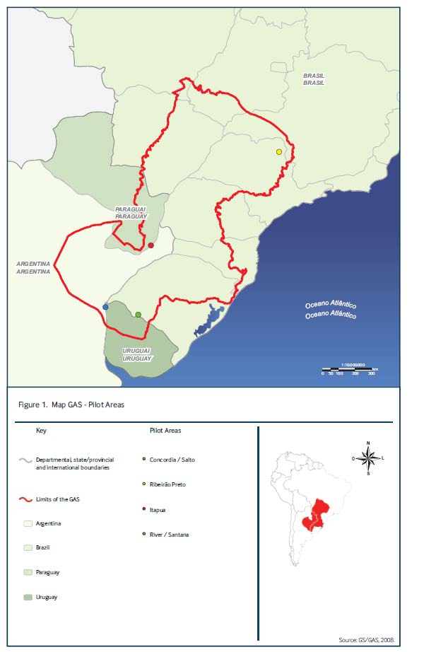
Map 1:
Geographical extension of the Guarani Aquifer System
54


Map 2:
Use of Guarani water by different sectors in the four countries
55


Map 3:
Classification of GAS Outcropping, semi-confined and highly confined regions
56
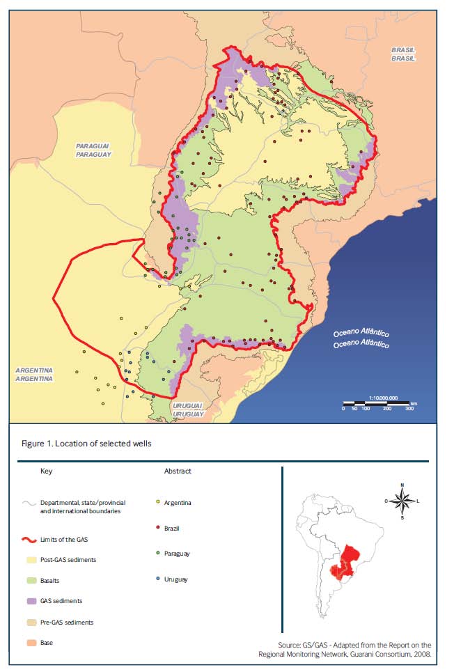
Map 4:
Distribution and Location of wells selected for GAS Monitoring Network
57