Document of
The World Bank
Report No:
PROJECT DOCUMENT
ON A
PROPOSED GRANT FROM THE
GLOBAL ENVIRONMENT FACILITY TRUST FUND
IN THE AMOUNT OF USD SEVEN MILLION
TO THE
SOUTHERN AFRICAN DEVELOPMENT COMMUNITY (SADC)
FOR A
GROUNDWATER & DROUGHT MANAGEMENT IN SADC PROJECT
{ March 8, 2005}
CURRENCY EQUIVALENTS
(Exchange Rate Effective {Date})
Currency Unit = US Dollar
FISCAL YEAR
January 1
December 31
ABBREVIATIONS AND ACRONYMS
GDE
Groundwater Dependent Ecosystems
GMISA
Groundwater Management Institute of Southern Africa
GW-MATE
Groundwater Management Advisory Team, formed with the support of the
Bank-Netherlands Water Partnership Program
ICA
Incremental Cost Analysis
LIMCOM
Limpopo River Basin Commission
MDG
Millennium Development Goals
NCSA
National Capacity Self-Assessment
PAD
Project Appraisal Document
PIM
Project Implementation Manual
PMU
Project management Unit
PSA
Project Services Agency
RISDP SADC
Regional
Indicative
Strategic Development Plan
RSAP
Regional Strategic Action Plan, for water, developed by SADC
SADC
Southern African Development Community
SADC WD
SADC Water Division
SADC WRTC SADC Water Resources Technical Committee
Sida
Swedish International Development Cooperation Agency
STAP
Scientific and Technical Advisory Panel of GEF
TDA
Transboundary Diagnostic Analysis
WB World
Bank
WSSD
World Symposium on Sustainable Development
ZAMCOM Zambezi
Watercourse
Commission
Vice President:
Gobind Nankani
Country Manager/Director:
Mark Tomlinson
Sector Manager:
Jaime Biderman
Task Team Leader:
Leonard John Abrams
AFRICA
Groundwater & Drought Management in SADC
CONTENTS
Page
A. STRATEGIC CONTEXT AND RATIONALE ................................................................. 1
1. Country and sector issues.................................................................................................... 1
2. Rationale for Bank and GEF involvement.......................................................................... 3
3. Higher level objectives to which the project contributes.................................................... 5
B. PROJECT DESCRIPTION ................................................................................................. 5
1. Lending
instrument ............................................................................................................. 5
2. Program objective and Phases ............................................................................................ 6
3. Project development objective and key indicators.............................................................. 6
4. Project
components............................................................................................................. 7
5. Lessons learned and reflected in the project design.......................................................... 10
6. Alternatives
considered
and reasons for rejection ............................................................ 11
C. IMPLEMENTATION ........................................................................................................ 12
1. Partnership
arrangements.................................................................................................. 12
2. Institutional and implementation arrangements................................................................ 13
3. Monitoring and evaluation of outcomes/results................................................................ 14
4. Sustainability and Replicability ........................................................................................ 15
5. Critical risks and possible controversial aspects............................................................... 16
6. Loan/credit conditions and covenants............................................................................... 18
D. APPRAISAL SUMMARY ................................................................................................. 18
1. Economic and financial analyses...................................................................................... 18
2. Technical........................................................................................................................... 19
3. Fiduciary ........................................................................................................................... 19
4. Social................................................................................................................................. 19
5. Environment...................................................................................................................... 20
6. Safeguard
policies............................................................................................................. 21
7. Policy Exceptions and Readiness...................................................................................... 22
Annex 1: Country and Sector or Program Background ......................................................... 23
Annex 2: Major Related Projects Financed by the Bank and/or other Agencies ................. 28
Annex 3: Results Framework and Monitoring ........................................................................ 30
Annex 4: Detailed Project Description...................................................................................... 34
Annex 5: Project Costs ............................................................................................................... 39
Annex 6: Implementation Arrangements ................................................................................. 40
Annex 7: Financial Management and Disbursement Arrangements..................................... 45
Annex 8: Procurement................................................................................................................ 52
Annex 9: Economic and Financial Analysis ............................................................................. 56
Annex 10: Safeguard Policy Issues............................................................................................ 57
Annex 11: Project Preparation and Supervision ..................................................................... 59
Annex 12: Documents in the Project File ................................................................................. 60
Annex 13: Statement of Loans and Credits.............................................................................. 61
Annex 14: Country at a Glance ................................................................................................. 62
Annex 15: Incremental Cost Analysis ....................................................................................... 63
Annex 16: STAP Roster Review ................................................................................................ 81
Annex 17: Determination of Pilot Areas................................................................................... 90
A. STRATEGIC CONTEXT AND RATIONALE
1. Country and sector issues
Regional issues
The Southern African Development Community (SADC) has the goal of fostering cooperation
and mutual benefit from the resources of the region amongst it member countries Angola, Bot-
swana, DRC, Lesotho, Mauritius, Malawi, Mozambique, Namibia, South Africa, Swaziland,
Tanzania, Zambia, Zimbabwe.
Whilst there is no formal poverty reduction strategy for the region, the 1996 SADC Policy and
Strategy for Environment and Sustainable Development states that the organization aims to:
· protect and improve the health, environment and livelihood's of the people in Southern Af-
rica, particularly the poor;
· preserve the natural heritage, biodiversity and life-supporting ecosystems in Southern Af-
rica; and
· support regional economic development on an equitable and sustainable basis for the bene-
fit of present and future generations.
Thus, poverty reduction is closely linked with protection of the environment and preservation of
life supporting ecosystems.
Countries in the region face natural constraints such as a high degree of spatial and temporal
variability in the rainfall, and imposed constraints including a lack of basic data and knowledge,
fragmented responsibility for management of water resources, lack of community involvement in
management, outdated policies, laws and regulations, and inadequate enforcement of existing
regulations. These constraints are particularly apparent in the case of groundwater resources.
Overarching these national issues is the regional issue of a lack of an effective mechanism to
manage the numerous transboundary watersheds, both surface and groundwater, in the region.
Member states signed the SADC Protocol on Shared Watercourse Systems in 1995. In 1996,
SADC established a Water Sector to further the protection and development of this vital regional
resource. The Protocol was revised in 2000 and came into force in 2003. A Regional Strategic
Action Plan (RSAP) for Integrated Water Resources Development and Management was devel-
oped in 1998 which includes 31 priority projects. The present proposal is designed to help im-
plement one of those priority projects - Project.6 entitled Regional Groundwater Management
Program in the SADC Region. This Program is overseen by a sub-committee of the SADC Wa-
ter Resources Technical Committee. This sub-committee has subsequently been incorporated
into the Project Steering Committee to provide technical oversight and representation of Member
States in the project governance.
Under the umbrella of the Revised Protocol for Shared Watercourses, riparian states have signed
an agreement for the joint management of surface and groundwaters in the Limpopo river basin.
This agreement includes the establishment of a River Basin Commission and forms the basis for
the development of common objectives, and harmonized laws and regulations for the manage-
ment of the surface and groundwater resources.
1
All countries in the Southern Africa region are eligible for World Bank and GEF funding
Sector issues and Project rationale
The development of countries in the region is highly dependent on adequate and reliable water
resources. Thus, the RSAP states that the region's water resources influences all aspects of the
region's social and economic development. Apart from domestic water supply and sanitation, it
is essential for agriculture, pastoralism, hydro-power generation, mining, tourism and industry.
About one third of the people in the region live in drought prone areas, where groundwater is the
primary source of drinking water for the human population and livestock, and most other activi-
ties. Groundwater is also the prime source of water for many ecosystems and their wildlife in
these dryland areas.
Groundwater resources in arid areas are under threat from over-exploitation, pollution, sedimen-
tation and introduction of exotic species. These threats arise primarily because of poverty linked
to an increase in population pressure, as well as from irrigated agriculture, tourism, mining and
pollution from human waste and agricultural chemicals. The threat to the groundwater resources
of these vulnerable areas also constitutes a major threat to the related groundwater dependant
eco-systems (GDEs) in drought prone areas of the region. Currently there is very limited
groundwater management in the countries of the region with inadequate resources dedicated to
the task and a general lack of effective institutions and technical capacity. The impacts of exploi-
tation of groundwater on GDEs is largely unknown, as is the resulting social and economic im-
pact of the degrading of GDEs on the communities in the affected areas, especially the very poor.
These problems are compounded by the cycli-
Box 1: Groundwater drought
cal nature and variability of climatic condi-
tions in the southern African region. The im-
Meteorological drought is defined by the degree
plementation period of the project may or may
of dryness (lack of precipitation) and the dura-
not coincide with a drought event which re-
tion of the dry period. Groundwater drought
quires that the outlook of the project must be
describes when groundwater resources fail as a
consequence of meteorological drought. How-
one of assisting the region and SADC Mem-
ever, the link between groundwater and mete-
ber States to develop and maintain a long term
orological drought is poorly understood, with
perspective of groundwater drought manage-
groundwater drought typically occurring later
ment and the protection of GDEs (Box 1).
than meteorological drought.
It is these questions which this project aims to address through four inter-related components
· Testing of practical local groundwater drought management strategies at pilot level;
· Research into GDEs, their occurrence, vulnerability, value and protection;
· The development of groundwater drought management tools and guidelines;
· The establishment of a regional Groundwater Management Institute of Southern Africa to
continue long term monitoring and the promotion of better management and awareness in
the SADC region and at national level.
2
2. Rationale for Bank and GEF involvement
Rationale for GEF involvement
The GEF is currently involved in several programs (in addition to this project) which address
specifically the utilization and protection of transboundary and international groundwater. This
indicates a growing concern for groundwater and for groundwater dependent ecosystems. These
projects include :-
Country Project
Name Re-
Focal Area
Agency
Project
Project
gion
Type
Stage
Egypt Developing
Renewable
AFR International UNDP Medium CEO Ap-
Ground Water Resources in
Waters
Size Pro-
proved
Arid Lands: a Pilot Case - the
ject
Eastern Desert of Egypt
Regional Protection of the North West
AFR International UNEP Medium CEO Ap-
Sahara Aquifer System
Waters
Size Pro-
proved
(NWSAS) and related humid
ject
zones and ecosystems
Regional Environmental Protection and LAC International IBRD Full
Size Council Ap-
Sustainable Integrated Man-
Waters
Project
proved
agement of the Guarani Aqui-
fer
Regional Managing
Hydrogeological AFR International UNEP Medium CEO Ap-
Risk in the Iullemeden Aqui-
Waters
Size Pro-
proved
fer System
ject
Global Conservation
and
Sustainable
CEX Biodiversity UNEP Full
Size CEO En-
Management of Below
Project
dorsed
Ground Biodiversity, Phase I
In addition there are a number of GEF projects covering related issues which are being under-
taken by the World Bank's cooperating partners in Southern Africa. These include:-
1. UNEP - Desert Margins Program (DMP) Phase1 (CEO Endorsed 2001 - under implementa-
tion)
The overall objective of the DMP is to arrest land degradation in Africa's desert margins
through demonstration and capacity building activities. In the Southern Africa region, this
project is working in Botswana, Namibia, South Africa and Zimbabwe to develop an inte-
grated national, sub-regional, and international action programme for developing sustainable
natural-resource management options to combat land degradation and loss of biodiversity.
The SADC Groundwater project will collaborate with this initiative to assist in the develop-
ment of the regional groundwater managment plans.
2. UNEP - Integrated Management of Dryland biodiversity through Land Rehabilitation in the
arid and semi-arid regions of Mozambique, Zambia and Zimbambwe (Council Approved - Oc-
tober 2002)
3
This project works in two transboundary areas (one between Mozambique and Zambia adja-
cent to one of the pilot areas of the current project ). The objective is to improve community-
based resource management, in order to address losses in soil productivity, reduced food se-
curity and increased vulnerability of local communities to stresses such as drought. Collabo-
ration will be established with this project to exchange information (data on drought, manag-
ment plans, engagement of communities etc).
3. UNEP - Zimbabwe - NCSA for Global Environmental Management (CEO Approved 2003)
4. UNEP - Swaziland - NCSA for Global Environmental Management (CEO Approved June
2003)
These projects are working to identify capacity needs to address all levels of environ-
mental management (focusing on the countries' ability to implement projects to support
the global environmental conventions) in the relevant countries. Preliminary assessments
done in each country point to the need for strong capacity building programs at different
levels for these initiatives to be successful. The SADC groundwater project will utilize
the results of the NCSAs (normally implemented over 12 months) to help build on local
and national groundwater management capacity.
Understanding the use, management and protection of groundwater in international river basins
in drought prone semi-arid areas, and the impact of groundwater and land use practices on
groundwater dependant ecosystems (GDEs), brings together a number of important issues which
fit within several GEF Focal Areas and Operational Programs. In large areas of Southern Africa
groundwater is the only dependable source of water for basic needs and food production, which,
given the high variability of the climate and increasing population pressure, potentially repre-
sents a considerable threat to both water resources (surface and groundwater) and GDEs, includ-
ing baseflow dependent wetlands. Careful management of these resources will be necessary if
both the Millennium Development Goals (MDGs) and the WSSD targets are to be reached.
The objective of the project is to strengthen the capacity of SADC member States in the man-
agement of transboundary groundwater resources in drought prone areas to meet human devel-
opment needs whilst protecting groundwater dependent ecosystems. This objective falls within
the International Waters Focal Area and is congruent with the GEF OP 9 "Integrated Land and
Water Multiple Focal Area Operational Program".
The proposed project also clearly falls under the GEF's Strategic Priority IW-2:- To expand
global coverage of foundational capacity building addressing the two key program gaps (in par-
ticular that of water scarcity and competing water use) and support for targeted learning. The
project will contribute to addressing important transboundary groundwater systems in the SADC
region with direct global environmental benefits associated with the proper management of the
Groundwater Dependent Ecosystems (GDEs). The project under consideration will contribute
directly to the targets under Strategic Priority IW-2 by developing country-driven management
programs for addressing transboundary priorities in one of the largest aquifer basins in Africa by
2006.
4
Rationale for Bank involvement
The World Bank's 1996 Africa Water Resources Management Initiative (AWRMI) seeks to sup-
port water resources analysis and policy reform at the national level and to assist riparian coun-
tries in the development of cooperative frameworks and programs in relation to shared water re-
sources. The AWRMI in turn builds upon the World Bank's long term vision of supporting inte-
grated water resources management programs and projects as stated in the 1992 Water Resources
Policy and 2003 Water Resources Sector Strategy.
At present the 1999 Regional Strategy for Southern Africa is the most appropriate guide to re-
gional investments. This document identifies improved management of transboundary resources,
including water, as one of five opportunities for regional cooperation.
The AWRMI seeks to establish partnerships with other multi- and bilateral donor agencies and
members of the civil society in order to strengthen ongoing and planned initiatives. Within such
cooperative approaches, the Bank has a comparative advantage in:
· analytical and operational work that draws on the Bank's cross-country experience;
· ensuring that policy reforms are consistent;
· being an honest broker in transboundary resources such as water basins;
· and using the specific expertise of the International Finance Corporation (IFC) and Multi-
lateral Investment Guarantee Association (MIGA) to promote private sector investments.
The present proposal, being focused on cross-country operational work and laying the foundation
for increased transboundary water resource management, draws on these strengths.
3. Higher level objectives to which the project contributes
The proposed project will be part of the GEF Operational Program 9 (Integrated Land/Water)
which has the goal of "helping countries utilize the full range of technical, economic, financial,
regulatory, and institutional measures needed to operationalize sustainable development strate-
gies for international waters and their basins". This incorporates a special focus on projects in
the African region. The proposed project promotes this goal with its objective of improving re-
gional technical capabilities and intervention strategies to promote better management of trans-
boundary groundwater resources.
The project contributes directly to the first two objectives of the SADC Policy for Environment
and Sustainable Development (above) and to the newly developed SADC Water Policy by im-
proving access to water and protecting groundwater dependent ecosystems in the Limpopo pilot
areas during times of drought, and by providing regional tools and an institution for the improved
management of groundwater in drought prone areas, including groundwater dependent ecosys-
tems (GDEs).
B. PROJECT DESCRIPTION
1. Lending instrument
The project will be financed through a GEF grant to be executed by the SADC Secretariat
through the implementation arrangements described in Section C2 below.
5
2. Program objective and Phases
Not Applicable
3. Project development objective and key indicators
The project objective is defined as: "The development of consensus on a SADC regional strate-
gic approach to support and enhance the capacity of its member States in the definition of
drought management policies, specifically in relation to the role, availability (magnitude and re-
charge) and supply potential of groundwater resources." This outcome contributes both to key
GEF programs and strategies as noted above, and to the overall objectives of SADC Regional
Groundwater Management Program.
The primary target groups for the project are the users of groundwater and groundwater depend-
ent ecosystems (GDEs) in drought prone areas in southern Africa. The target groups are ad-
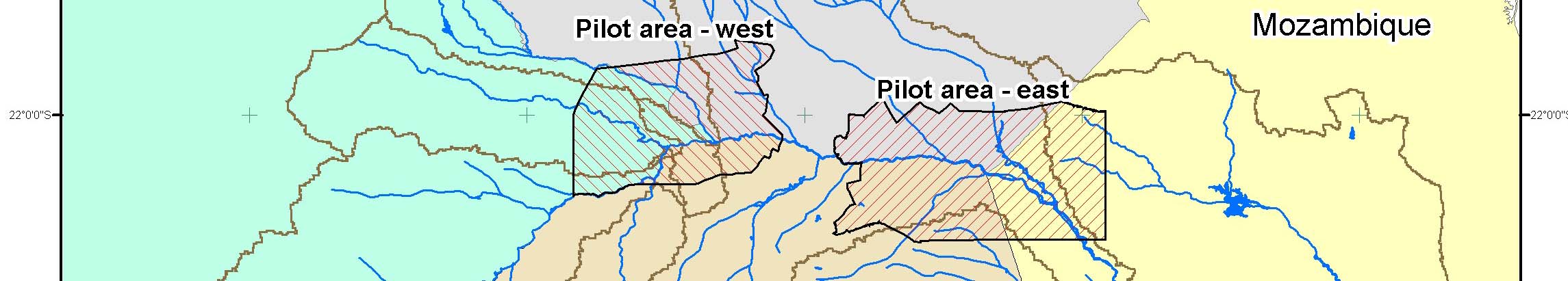
dressed at three scales through the project at a local level in the two pilot areas (Figure 1), at
the river basin level in the Limpopo river basin, and at the regional level through SADC.
At the pilot level the principal outcome of the project will be learning and demonstration of
ground water management techniques in the Limpopo pilot areas so that communities and users
of GDEs will be better able to mitigate against the negative effects of groundwater drought in the
long term. While communities in the pilot areas may not experience a groundwater drought dur-
ing the implementation of the project, they will be better equipped to deal with these phenomena
as a result of the activities. The outputs at the pilot level will consist of limited physical infra-
structure (monitoring boreholes, extraction boreholes, pans, alluvial sand storage curtains1, etc),
and non-structural measures such as improved government capacity, strengthening of groundwa-
ter user groups, heightened community awareness of the need to manage groundwater and de-
pendent ecosystems on a long-term basis and possibly water pricing. In addition, water conser-
vation techniques such as conjunctive use of surface and groundwaters and improvements in re-
charge will be tested in the pilot studies if circumstances are suitable.
At the national and regional level, the objective will be the building of consensus on a transbor-
der approach to groundwater management, including tools for management and decision making.
Environment Ministries (and equivalent institutions) represent the national stakeholders and the
SADC Environment and Land Management Unit represents the regional constituency with an
interest in better management of the GDEs. As a result of the project, these institutions will be
better able to manage GDEs through the knowledge gained, the provision of tools such as maps
and guidelines, and the establishment of a regional institution.
Progress towards achieving reduced groundwater drought vulnerability will be measured through
· the development and implementation of agreed management plans at pilot level;
· an improved ability of local groundwater users and GDEs to survive groundwater drought
conditions ;
1 Alluvial sand storage curtains are small subsurface barriers constructed across sand rivers to impound floodwaters
and thereby recharge alluvial aquifers.
6
· the ability of government officials to support the continuation and replication of these in-
terventions; and
· the application of lessons learnt and the use of management tools at regional level.
At the regional scale, the principal outcome will be supporting the strategy and institutional op-
tion/s that emerge from this consensus building process including regional management tools and
the potential establishment of a regional Groundwater Management Institute of Southern Africa
(GMISA). The GMISA will contain knowledge about managing groundwater droughts, includ-
ing water conservation techniques such as conjunctive use and improved recharge, and thereby
contribute to a long term solution to the problem across the SADC region. Progress will be
measured by endorsement by the SADC Water Resources Technical Committee of the regional
tools (maps, database, knowledge management system) and guidelines; dissemination of the
guidelines to member countries; and the establishment of the GMISA will contribute to a long-
term solution to the problem across the SADC region. including completion of its initial staffing
and workplan.
4. Project components
Component 1 Development, testing and demonstration of a groundwater drought man-
agement plan for the Limpopo river basin pilot areas
Rationale: The primary objective of this component is to test the application and replica-
bility of methods of decreasing the vulnerability of local communities and GDEs to the
effects of groundwater droughts. The rationale is also to ensure that practical on-the-
ground benefits accrue to local people from the project. The Limpopo basin has been se-
lected partly because of the pressures its groundwater resources are facing, partly because
of the extent of GDEs in the basin and partly because the groundwater assessment in the
Limpopo River Basin has been specifically identified as a priority in the SADC Regional
Groundwater Management Program. Two pilot areas have been selected within the Lim-
popo Basin (Figure 1) because they were trans-boundary, representative of GDEs, bio-
diverse, drought-prone, had good data availability, and had good local support.
Target Group and Outcome: Local communities, including local government, in the pilot
areas are the main target groups of this Component. Target groups also include the river
basin organisations, particularly LIMCOM, and regional offices of national Water De-
partments and Environment Departments. The main outcome at local level in the pilot
areas will be improved long-term ability to withstand the negative impacts groundwater
droughts on water security and groundwater dependent ecosystems.
Inputs: Inputs will include expertise in communications, facilitation and capacity building
to assist in the establishment and strengthening of stakeholder arrangements to develop
an agreed management plan. Further inputs will be funds and technical expertise for
physical interventions and data gathering, monitoring and interpretation to capture the
`learnings' from the pilot exercises. Where possible, a local tertiary institution will be
involved in data gathering.
7
Outputs: The outputs of this component will be improved ability of stakeholders in the pi-
lot areas to manage groundwater and GDEs, the small infrastructure assets constructed in
the pilot areas to reduce the shocks of groundwater droughts and the `learnings' derived
from the pilot process which will be the input to Component 2 of the project the devel-
opment of regional groundwater drought management support.
Sector Issues: This component will provide a greater understanding at the local level of
the role of groundwater in drought prone areas and measures which can be taken to bal-
ance human demand with the needs of GDEs.
Component 2 Regional groundwater drought management support
Rationale: In spite of the importance of groundwater resources for regional growth, fun-
damental tools for transboundary groundwater management, such as hydrogeological
maps and maps of groundwater vulnerability and water scarcity, are not available in the
SADC region. As a result there is little consensus on the measurement and management
of these resources. The tools developed in this component, together with the improved
knowledge generated through the research sub-component, meet some of the specific
needs identified by the SADC Regional Groundwater Management Program and will
contribute to building consensus on the management of transboundary resources.
Target group and Outcome: Groundwater and environment managers from national
agencies throughout region and SADC Environment staff will have access to an agreed
mapping of transboundary and national aquifers as a basis for future joint management,
improved knowledge of GDEs and the value of groundwater, and a set of guidelines for
local groundwater drought management planning.
Inputs: Hydrogeological map and data (from associated French government funded pro-
jects); landuse, economic and ecosystem data-sets. Climate data will be accessed from
national institutions and regional Drought Monitoring Centre.
Outputs: Improved knowledge of groundwater-dependent ecosystems, economic valua-
tion of groundwater; maps of groundwater vulnerability and water scarcity; greater
awareness amongst decision-makers of groundwater role; guidelines on better manage-
ment of groundwater-dependent ecosystems throughout region. The translation of infor-
mation gained through the pilot programs, regional data and information, and the GDE
research into practical management tools and guidelines will make the output of the pro-
ject both accessible and useful at regional and national levels.
Sector Issues: Greater understanding of GDEs and their vulnerability will contribute to
their protection and the sustainability of fragile resources upon which rural communities
depend. The impact upon and use of transboundary aquifers, particularly in the Limpopo
River Basin will be better understood through the project together with the development
of local management and physical modalities to `drought-proof' local areas or at least in-
crease their ability to cope with groundwater drought.
8
Component 3 Establishment of the Groundwater Management Institute of Southern Af-
rica (GMISA)
Rationale: There is a need to maintain a long-term regional awareness and capacity to ad-
dress groundwater drought because of the climatic variability and unpredictability in the
region. This is both to provide follow-through to the project (the implementation period
of which may not coincide with a drought event) and to maintain readiness and capacity
for future inevitable drought events which may occur anywhere in the SADC region. The
SADC Regional Groundwater Management Program has identified the need for an insti-
tution (sub-project 6) to raise understanding of groundwater management through re-
search, knowledge management, coordination and capacity building. The degree of con-
sensus for the establishment of the Institute and the commitment to its financial sustain-
ability on the part of the SADC Member States will be determined as a prerequisite for
the establishment of the Institute.
The provision of a Groundwater Drought Monitoring Fund (GDMF) to the Institute will
enable continuity of the project research program (included in Component 2) and assist
the Institute to establish itself, to continue monitoring the pilot areas and set up an initial
research program. This will greatly extend the value of the project, particularly given
that the project period may not coincide with a regional drought event. The GDMF, ad-
ministered and guided by the GMISA will be a key element in the management and pro-
tection of shared international aquifers in the SADC region and their dependent ecosys-
tems.
Target group and Outcome: National environment and water resource managers, SADC
Water Division and Environment Units, and developing River Basin Organizations will
have a regional institution that provides data, knowledge, training and other capacity
building, coordination with other regional activities and awareness raising of groundwa-
ter management.
Inputs: The Institution will be established with initial support from the project together
with in-kind support from the host institution. The data and knowledge derived from
Components 1 and 2 will also comprise significant inputs to the establishment of the In-
stitution. The GDMF will also assist in ensuring the sustainability of the Institute.
Outputs: Institution capable of taking lead role in regional groundwater drought man-
agement, if there is sufficient consensus and established commitment to the financial sus-
tainability of the Institute on the part of the SADC Member States.
Sector Issues: Provides node for promoting improved management to the benefit of all
sectors described in A.1.
9
Component 4 Project management and administration
Rationale: The project management is designed to provide maximum external support to
SADC Water Division (SADC-WD) through a Project Steering Committee, a Project Ser-
vices Agency and a Project Management Unit in response to lessons from earlier projects.
5. Lessons learned and reflected in the project design
Experience from a wide range of current work throughout the African Continent and in particular
from programs such as the Nile Basin Initiative suggests that for projects to be successful related
to shared international waters (both surface and groundwater), there is a need for the riparian
countries to establish a common vision for action and to have political commitment at the highest
possible level. In the case of this project, the Revised SADC Protocol on Shared Watercourses is
the common framework agreed to by all the Member States which is currently being translated
into a common management approach in the Limpopo and other river basins. The current project
will support the Limpopo River Basin Organisation (RBO) and develop common tools to be
housed in the regional institution to be established by the project as a precursor to a wider re-
gional approach to transboundary groundwater management.
GEF experience also stresses the need for implementing agency collaboration and donor coordi-
nation. SADC has established a strategic reference group consisting of various donors to provide
advice to the implementation of the Regional Strategic Action Plan (RSAP). The present project
is part of a Regional Groundwater Management Program being supported by various other do-
nors (see Technical Annex 1).
Experience also illustrates the importance of full stakeholder involvement in project preparation
and implementation. The project concept presented in this PAD is an outcome of the significant
consultative process that was part of the development of the Regional Strategic Action Program
(RSAP) and, subsequently, the regional groundwater management program. The project itself
will be steered by a group containing all stakeholders.
The Groundwater Management Advisory Team (GW-MATE), formed with the support of the
Bank-Netherlands Water Partnership Program, has been supporting the design of the current pro-
ject, by drawing on the multi-disciplinary international experience of its members. GW-MATE
was formed with support from the Bank-Netherlands Water Partnership Program to promote a
shift in emphasis from groundwater resource exploitation to improved management of the re-
source.
Experience through a number of World Bank engagements with the SADC Secretariat, including
the preparation phase of this project, indicates that SADC has limited project management capac-
ity. The management of the present project has therefore been designed to provide as much ex-
ternal support as possible through the appointment of a Project Services Agency to carry out the
day-to-day administrative, financial and procurement activities and a Project Management Unit
that will be responsible for the content of the project and the achievement of the project objec-
tives. An alternative implementation arrangement could have been direct implementation of the
10
project by the SADC Water Division with administration and financial management being under-
taken directly by the SADC Secretariat, however the experience during the project preparation
phase under a GEF PDF B Grant indicates that project implementation is not the strength or the
function of the SADC Secretariat or the Water Division. There is no experience of past com-
pleted World Bank projects being undertaken by SADC and therefore no relevant World Bank
OED reports (Implementation Completion Reports (ICRs), Project Performance Assessment Re-
ports (PPARs) etc.)
A key element of the sustainability of the proposed GMISA is the extent to which the commit-
ment of the SADC Member States to the financial viability of the Institution can be determined
and fostered.
Figure 1- Limpopo River Basin and East and West Pilot areas
6. Alternatives considered and reasons for rejection
The project is specifically designed to meet the needs of the SADC member countries. The
SADC Water Resources Technical Committee has emphasized the need to achieve practical on-
ground results through work at local level. The pilot subcatchment component will develop and
implement strategies for water supply for human needs and the protection of life supporting eco-
systems, as well as provide valuable input to the regional components and LIMCOM. The re-
gional and basin situation reports emphasize the impediment to management of GDEs due to a
11
lack of basic data. Consequently, this project will support the collection of environmental and
economic data on GDEs. The other regional components regional management tools and a
Groundwater Management Institute of Southern Africa - are included in direct response to the
request of the Sub-Committee for Hydrogeology. They will provide a common base on which
regional groundwater drought management can be developed.
The general design of the project emerged from an assessment of alternatives carried out by
SADC as part of the RSAP. The extensive situation analysis carried out at that time assessed
general aspects of groundwater management keeping in mind the need to promote regional coop-
eration. Forty-four water resource development projects were considered. Thirty-one of these
were then selected, using five criteria that represented the agreed development needs of countries
in the region. This analysis subsequently led to the adoption of the overall groundwater man-
agement program. SADC (with support of its donors) subsequently recommended that the
groundwater management program should focus on drought management issues and the devel-
opment of regional management tools because of the importance of groundwater resources in
arid areas and the agreed need to adopt a regional approach to transboundary aquifers.
The Project Steering Committee selected the Limpopo Basin for the pilot project activities be-
cause of the pressures it is experiencing, the importance of GDEs in the basin and the need to
support LIMCOM. Eight potential pilot areas within the Limpopo Basin were selected for
evaluation. Data were collected against eight criteria2, including three socio-political criteria.
The country representatives on the project Steering Committee assessed these potential sites in
March 2003 and endorsed the two pilot areas shown in Figure1 and described in Annex 17.
C. IMPLEMENTATION
1. Partnership arrangements
The project is a partnership between SADC (working through the Water Division), the govern-
ments and government departments of SADC Member States, the PMU and the stakeholders (in
particular the user communities in the pilot areas of the Limpopo River Basin). The project is
co-financed directly between GEF and the Swedish International Development Cooperation
Agency (Sida), and indirectly through contributions from the French and German governments
(through a hydrogeological mapping program, the outputs of which are important inputs to the
project) and the SADC Member States.
Sida is providing 0.5 million US dollars as co-financing to the project. These funds are in the
form of Bank implemented Trust Funds and will be employed through the AWRMI on activities
agreed with SADC.
The project will be carried out in close collaboration with a hydrogeological mapping program,
components of which are funded by the French and German governments. The mapping activi-
ties in sub-component 2.1 of the current project will be based on the hydrogeological map. The
map and associated databases will complement the vulnerability and scarcity mapping activities.
2 Replicability, drought proneness, impact on biodiversity, shared resource, data availability, user demand, water
use, and socio-economic characteristics.
12
These projects will all be coordinated through the SADC-WD and jointly overseen by the Project
Steering Committee.
The first phase of the development of the hydrogeological maps for the Southern African region
is an exploratory phase entitled "Preliminary Study for the Development of the Hydrogeological
Map and Atlas for the SADC Region". This has been funded by the French Government (US$
80,000) and has been undertaken during the preparation phase of the project which is the topic of
this PAD. The mapping exercised is to be financed by the German Government to the amount of
1 million Euro and is currently under preparation. The proposed Groundwater Management In-
stitute of Southern Africa will be the custodian of the outputs of these projects.
2. Institutional and implementation arrangements
Period of Implementation: The period of implementation is four years.
Executing Agency and the Steering Committee: The SADC Water Division (SADC-WD) is the
Executing Agency of the Project. It is located within the Directorate for Infrastructure & Ser-
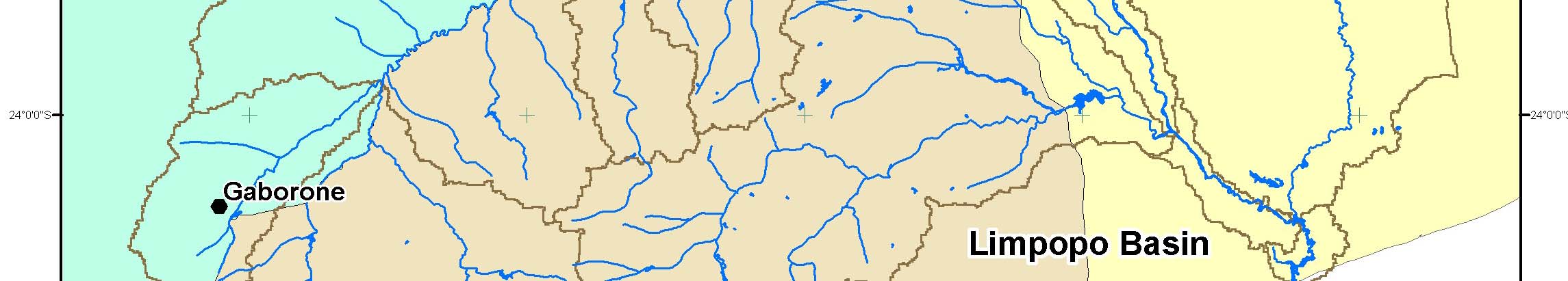
vices of SADC Secretariat located in Gaborone, Botswana. The implementation of the Project
will be guided by a multi-stakeholder Project Steering committee (PSC). At the technical level,
the SADC-WD is also guided by the Water Resources Technical Committee (WRTC).
The Steering Committee will report to the SADC Water Resources Technical Committee
(WRTC), and the Integrated Committee of Ministers. Local stakeholder committees will be es-
tablished in the pilot areas to guide local project activities.
The Limpopo Basin pilot activities will be carried out in close collaboration with the Limpopo
River Basin Commission (LIMCOM) which will be represented on the Steering Committee.
Project Management Unit (PMU) and the Project Services Agency (PSA): The Executing
Agency of the project (SADC-WD) will work through: (a) a Project Management Unit (PMU)
for technical implementation, and (b) a Project Services Agency (PSA) for conducting the finan-
cial management, administration and procurement functions. The GMISA (to be set up during
the project) will have a small unit to ultimately take over the functions of the PMU and PSA, in-
cluding procurement and financial administration.
PSA:
Project contracting, disbursement and financial management and reporting will be handled
through the PSA as these activities are beyond the capacity and functions of SADC-WD as cur-
rently constituted. The PSA will be a management group with experience in the administration
of development projects and that meets Bank requirements for financial management and pro-
curement. Both the PMU and the PSA will report to the SADC Secretariat through the SADC-
WD. The SADC Secretariat, being the project executing agency, will fulfill its responsibilities
for meeting Bank financial and procurement requirements through the PSA. Thus the SADC
Secretariat will be relieved of day-to-day functions of the management and administration of the
project whilst remaining the responsible executing agency.
13
On behalf of SADC-WD, the PSA will establish the PMU and contract a range of consultants to
carry out the pilot and regional activities. There is considerable groundwater expertise in gov-
ernment agencies, NGOs and the private sector in parts of the region particularly in South Af-
rica, Namibia and Botswana and wherever possible this expertise will be used in the project.
UNOPS has been identified by SADC through approved procurement processes as the PSA.
An Independent Review Panel of consultants will be at the disposal of SADC-WD. The objec-
tive of the Panel will be to provide an external resource to the project to review the technical and
scientific plans, technology use, hydro-geology, GDEs, social and economic impact etc.
PMU:
The PMU will be established in Gaborone, Botswana, in a separate office to the SADC-WD.
The role of the PMU will be to manage and coordinate the various consultancies that will be con-
tracted to undertake the different project activities. Technical staff for the PMU will be region-
ally selected through open competition according to criteria agreed with the Bank.
Financial Management
Financial management arrangements will be as per Annex 7: Financial Management and Dis-
bursement Arrangements. Adequate financial management staff and systems to ensure compli-
ance with Bank financial management requirements will be provided through PSA.
3. Monitoring and evaluation of outcomes/results
The endorsement of the project outcomes by the Water Resources Technical Committee and the
subsequent adoption of the tools and use of the Institute by the member countries will constitute
the ultimate measure of the extent to which the Development objectives are met. The data for
these indicators will come from the minutes of the Committee. Progress with the individual
components will be monitored through annual indicators that have been set for each component.
Data for these indicators will come from a variety of sources, including contractor reports, spe-
cial social surveys carried out in the pilot areas, a post-completion survey of government water
departments, and annual project progress reports submitted by SADC-WD to the Bank. The
PMU will have direct responsibility for collecting data on progress against these indicators and
ensuring that it is included in the reports. A Monitoring and Evaluation Strategy will be pre-
pared for the project.
Costs of monitoring are built into the budget, including the surveys of acceptance of the man-
agement plan in the pilot project areas and the post-completion survey of adoption by govern-
ment agencies.
The indicators will be included in the annual progress reports and will be assessed against the
targets agreed when the project is effective. Slippage against these targets will be discussed dur-
ing Bank supervision missions and the reasons for the slippage will be assessed. The Aide-
14
Memoirs will contain any actions that are agreed to correct serious problems that are uncovered
by the indicators.
Monitoring and evaluation will be strengthened by the independent Mid Term Review and the
provision in the project budget for the services of an Independent Review Panel which will com-
prise international and regional experts who will review and comment on every aspect of the pro-
ject on a continuous basis throughout the project. The Independent Review Panel will review the
conceptual and scientific design assumptions and outputs of the project and provide guidance to
the Project Steering Committee and the PMU (the Panel will not be engaged in project manage-
ment issues). This will assist in ensuring the scientific validity of the outputs which will in turn
strengthen the sustainability and replicability of the outputs.
4. Sustainability and Replicability
SADC's commitment to the project is illustrated by the extensive process that gave rise to the
proposal as well as the support received during preparation. The SADC Sub-Committee on
Hydrogeology acted as the Steering Committee for the preparation activities. Representation on
this committee was by those officials responsible for groundwater management within govern-
ment departments. The Sub-Committee noted the importance of this project to SADC member
countries during progress reviews of the RSAP. It is planned that this committee will form the
core of the Project Steering Committee for project implementation along with a broader repre-
sentation of stakeholder groups, thus ensuring continuity of oversight and commitment.
The tools developed during the project for regional management of groundwater will be sus-
tained through the SADC system and the Groundwater Management Institute of Southern Africa
(GMISA). The Institute is the most important element for the long-term sustainability of the
project's outputs. It will have the role of promoting the concept of regional management of
groundwater resources, building understanding about the benefits of regional management, de-
veloping capacity and furthering the use of the tools developed during the project.
The sustainability of the GMISA is of critical importance. Sustainability will require four main
criteria a) political endorsement and commitment; b) adequate leadership, c) technical and ad-
ministrative competence, and d) financial security. One of the primary objectives of the estab-
lishment phase of the Institute during the first 2 ˝ years of the project will be to ensure that these
criteria are achieved, without which the establishment of the GMISA will not proceed. The
measures taken to ensure this will therefore be determined during the project but would include:-
a) The SADC Secretariat will be requested to canvas and re-affirm the commitment to the
establishment of the Institute by the Member States. This will need to include appropri-
ate commitment to the financial sustainability of the Institute (see d. below).
b) Careful identification of the host institution within SADC such that the working condi-
tions of the head and small staff of GMISA are conducive to attracting the highest caliber
of professionals. The search process for the staff of the Institute will also need to be very
thorough.
15
c) The institute will be established during the course of the project so that it operates con-
currently with the project for 2 years. During this time the staff will benefit from a
planned program of training and development which is provided for in the project budget.
This will ensure that the Institute is competently run and the service that it provides to the
SADC region is of the highest professional standard.
d) Financial sustainability is critical and will require creative and sustained effort. A
number of avenues will be investigated such as
- `subscriptions' from the SADC Member State governments,
- the sale of products, outputs and services,
- levies on research funds administered by the Institute, and
- fund raising.
The costs of running the Institute for the first two years will come from the project budget
which will provide the opportunity for finances to be secured for the continued function-
ing of the organization. The 0.5$ million Groundwater Drought Monitoring Fund pro-
vided for in the project, whilst not intended to cover day-to-day running costs, will also
assist the Institute to establish itself and would provide some resources for running costs
through administration fees.
The purpose of the Limpopo pilot component is to test various management options at the local
scale, to learn from them and to replicate the lessons learned through the guidelines which will
be developed for region-wide application. In addition, LIMCOM will be involved in manage-
ment of the pilot project and, together with other international river basin organizations in the
region, will be able to replicate these lessons learned from the pilot areas. Lessons learned can be
replicated in other parts of the world through the GEF framework such as the GEF's outreach and
publication program, GEF Lessons notes, and country dialogue workshops. These avenues pro-
vide excellent opportunities for wider dissemination of results at the global level.
A Replication Plan will be prepared by the mid-point of the project and will be reviewed by the
Steering Committee, the SADC WD, the Review Panel and the Mid-Term Review. The Replica-
tion Plan will identify the key requirements required to ensure that the outputs of the project will
be taken up at a regional level and within Member States, and will identify detailed actions to be
undertaken during the remainder of the project period to ensure replication.
5. Critical risks and possible controversial aspects
Risk Risk
Risk Mitigation Measure
Rating
Development Objective
SADC organs weak on promoting
M
The Project Steering Committee will be struc-
partnerships with civil society, aca-
tured so that it can promote access to stake-
demic research institutions and the
holders and thereby develop the necessary part-
private sector
nerships.
Government institutions unable to
S
The awareness campaign (sub-component 2.3)
utilize the regional tools developed
will be specifically targeted towards increasing
and to use the services of the Institute,
support at political, management and commu-
16
because:
nity levels for a regional approach to groundwa-
· Priority given to national issues
ter drought management. To this end, there
over regional ones unless senior
needs to be a clear demonstration of the benefits
managers appreciate the useful-
of regional initiatives, and the Limpopo pilot
ness of such activities
studies will be utilized for this purpose.
· Shortage of trained manpower
· Lack of funds and equipment
The Institute does not acquire long-
M
The Institute will be housed in an established,
term institutional and funding support.
supportive organization and its TOR will require
it to actively seek long-term donor support.
Components
1. Riparian countries fail to reach a
N
The riparian countries have agreed to work co-
working relationship for management
operatively towards a LIMCOM organization
of transboundary aquifers in Limpopo
and have all endorsed the pilot project.
pilot study
2.1 The regional situation report noted N
The capacity building activities, together with
the great disparity in technical capac-
those being undertaken in parallel projects, will
ity amongst the member countries and
be designed to draw on the established capaci-
the associated risk that it may be diffi-
ties of South Africa, Botswana and Namibia in
cult to acquire the necessary data.
order to build regional links as well as increase
technical skills in other member countries.
2.1 Government and private sector
S
The French government hydrogeological map-
agencies are unwilling to provide data
ping project has noted this risk and will build
to a regional institution.
relationships to minimize it. The current project
will utilize this goodwill where possible. The
representatives on the Steering Committee will
be selected to provide direct high-level support
for access to data.
2.2 Hydrogeological base map is not
M
Both projects are part of the Regional ground-
completed in time.
water Management Program and progress is
monitored by the SADC-WD and the Project
Steering Committee. In addition, a representa-
tive of the French funding agency will be invited
onto the steering committee for the current pro-
ject.
2.2 Knowledge of ecosystem depend-
S
Existing knowledge about GDE will be used
ence on groundwater is not acquired
wherever possible. The research sub-component
during project timetable.
will be commenced as soon as practical, using
knowledgeable regional specialists, to maximize
the potential for acquiring the knowledge in time
for other sub-components.
3. The Institute is unable to acquire
M
Donor support will be partly determined by the
donor funds to finance regional
success of the pilot activities, the usefulness of
groundwater drought mitigation ac-
the regional guidelines and the willingness of
tivities
member governments to implement the guide-
17
lines.
4. SADC is unable to provide the ad-
S
An experienced PSA is being contracted specifi-
ministrative support required by the
cally to handle the day-to-day administrative
donors
activities.
Risk Rating - H (High Risk), S (Substantial Risk), M (Modest Risk), N(Negligible or Low Risk)
There are no specifically controversial aspects to the project.
6. Loan/credit conditions and covenants
None
D. APPRAISAL SUMMARY
1. Economic and financial analyses
The Incremental Cost Analysis provides the economic analysis of the project as a GEF supported
program. The project is of benefit as a `complimentary/supplementary' contribution to the de-
velopment of knowledge of the management and protection of groundwater and GDEs in trans-
boundary drought prone areas, complementary to existing efforts in the region.
The economic value of groundwater and GDEs in the SADC region has generally not been de-
termined. That these resources play a vital role in local economies (and collectively in national
economies) is unquestioned as in many semi-arid rural areas in the region groundwater is the
only dependable source of water without which there would be no economic activity at all, even
of a subsistence nature. One of the main outputs of this project is therefore precisely to contrib-
ute to the regional and global knowledge of the value of these resources.
The activities in the pilot areas will be carefully analyzed to determine the most cost effective
means of improving the management of resources and the security of services during drought
events. The analysis will need to include offsetting the costs of management and physical inter-
ventions against the cost of failure of supply during drought and the destruction of GDEs and
their ecological and economic benefits. Failure has a range of human, social and economic costs
at local and national levels including food insecurity, rural urban migration, environmental
degradation and increased long-term risk aversion to investment at local level resulting in the
persistence of rural poverty.
The primary financial concern within the project is sustainability of the Groundwater Manage-
ment Institute for Southern Africa (GMISA). This will be addressed as a major concern in the
establishment of the Institute during the project. The issue of financial sustainability of the Insti-
tute is more fully addressed in Section 4 above "Sustainability and Replicability".
Financial management of the project has been an issue of concern related to the capacity of the
SADC Secretariat to undertake the administrative, financial management and procurement re-
quirements of a project of this size. The capacity of the Secretariat to undertake these activities
in relation to the project preparation phase (through the PDF-B Grant) was appraised by a World
Bank Financial Management Specialist to be adequate for the preparation phase but not for the
execution phase. This conclusion is supported by the SADC Secretariat on the basis that their
function is not to execute projects but to coordinate and facilitate regional development issues.
18
To ensure adequate financial management of the project, a Project Services Agency (PSA) will
be contracted through the project to undertake these activities on behalf of the SADC Secretariat.
The details of the functions of the PSA are provided in Technical Annex 6 Implementation Ar-
rangements.
2. Technical
Technical appraisal of the project is accommodated through the STAP Review which focuses on
the scientific and technical soundness of the project in terms of the GEF STAP process (Refer to
Technical Annex 16: STAP Review). The STAP review was undertaken in two steps which pro-
vided the opportunity to incorporate points raised by the STAP reviewer on the first draft of the
PAD into the project design, thus strengthening the overall project design.
The technical quality of the project will be considerably strengthened through Independent Re-
view Panel comprising international and regional experts who will review and comment on the
conceptual and scientific design assumptions and outputs of the project and provide guidance to
the Project Steering Committee and the PMU.
3. Fiduciary
The project executing agency, SADC Secretariat, does not currently have adequate capacity, in-
cluding financial management, to implement the project, and can therefore not ensure necessary
compliance with all Bank financial management requirements. To minimize the aforementioned
risks and ensure the appropriate financial management capacity is in place prior to Project effec-
tiveness, it is intended to contract UNOPS as the PSA and it will be responsible for the financial
management aspect of the project. Also, the project is expected to set up the GIMSA, which will
have a small unit to ultimately take over, amongst other functions, the financial management.
The PSA to be constituted by UNOPS is responsible for financial management, procurement and
administrative functions on behalf SADC-WD. Without adequate staffing and proper segregation
of duties, there is a danger that some staff may perform incompatible functions resulting in poor
overall internal control. However, UNOPS has previous experience in implementing Bank-
Assisted Projects and has handled the financial management functions for some of these projects.
It is familiar with Bank Financial Management procedures and requirements. Also, it is expected
that it will provide adequate staffing in the PSA based on the Management Services Agreement.
4. Social
The project, in conjunction with other projects in the Regional Groundwater Management Pro-
gram, has the opportunity to lay the technical basis for cooperative management of shared aqui-
fers into the future. However, there will need to be the development of transboundary institu-
tional, legal and policy frameworks to be able to exploit this information. The current develop-
ment of ZAMCOM and LIMCOM are examples of such activities. There are no firm plans at
present for the promotion of such regional management initiatives. Groundwater management in
many SADC countries is so limited that there is a risk that countries will continue to focus on
national activities rather than take up the regional opportunities for socially and environmentally
beneficial groundwater management.
19
Stakeholders were involved by SADC during the development of the RSAP out of which the
Groundwater Management Program emerged. Stakeholders were again involved during project
preparation at both the regional and Limpopo pilot levels.
At the regional level there was a complex mechanism for government stakeholder input to the
project design through the multi-stakeholder project steering committee, SADC Sub-Committee
on Hydrogeology, SADC-WD, SADC Water Resources Technical Committee (WRTC), the Sec-
toral Committees of Ministers and the Council of Ministers. In addition, the consultants under-
taking the regional situation analysis contacted management agencies in all member countries to,
inter alia, obtain their inputs to the project design, including components such as the proposed
Institute.
Representatives of member countries, through the project steering committee, selected the pilot
areas. The consultants undertaking the Limpopo situation analysis consulted with rural commu-
nities at 5 sites to understand their use and dependency on groundwater as well as their percep-
tions of its availability and quality. A workshop was held in May 2003 to provide input from
stakeholder groups into the design of the project. Special attention was given to the importance
of protecting GDEs at this workshop. Industry, central and local government, conservation in-
terests, and catchment managers were represented at the workshop.
The implementation of the project will be overseen by a steering committee comprising govern-
ment representatives (based on the steering committee formed for the project preparation) to-
gether with representatives of other stakeholders including private sector and community groups.
The pilot area situation report did not note any instances of traditional rights or entitlements al-
though it did record occurrences of unequal access to groundwater.
The pilot project will inevitably advantage communities in the pilot areas over those elsewhere in
the Limpopo basin. For this reason, it is imperative that this component of the project is treated
as a pilot activity and not just as an end in itself. That is, the results from the pilot must be dis-
seminated to the Limpopo basin area (through LIMCOM) and the rest of the region through the
development of guidelines for local management plans and the activities of the Institute.
The monitoring program will include assessment of improvements in social wellbeing in the pi-
lot areas through surveys and feedback via the steering committee.
5. Environment
The project is specifically aimed at developing an improved understanding of GDEs and testing
management plans that will reduce the stress on these ecosystems in the pilot areas by promoting
more sustainable use of groundwater.
Poor rural communities are the prime beneficiaries in the pilot areas. The pilot areas include por-
tions of four countries Botswana, Mozambique, South Africa and Zimbabwe. The communi-
ties in the different countries vary in terms of their comparative wealth / poverty. Whilst small
20
scale agriculture provides some degree of food security, one of the main sources of income is
from migrant labor remittances. The communities depend largely on groundwater resources for
drinking water, small scale irrigation and stock watering. The tourist activities in the pilot areas
are also reliant on groundwater and the sustainability of GDEs. The management plans which
will be developed in the pilot areas as part of the project, and then promoted throughout the re-
gion via the guidelines, will be designed to reduce the vulnerability of these communities to
droughts by instituting better management practices, improved monitoring, and the construction
of infrastructure to provide better storage and increased recharge of groundwater.
The regional and basin level situation reports make it clear that there are localized instances of
nitrate pollution from human and cattle excretions where the concentrations are so high as to
pose a threat to the health of those using the groundwater. The project will also promote the need
for reduced groundwater pollution in its Public Awareness sub-component. It is expected that
this campaign will be well received, given the receptiveness of participants at the Stakeholder
workshop to the need for reducing these sources of pollution.
6. Safeguard policies
Safeguard Policies Triggered by the Project
Yes
No
Environmental Assessment (OP/BP/GP 4.01)
[ ]
[x]
Natural Habitats (OP/BP 4.04)
[ ]
[x]
Pest Management (OP 4.09)
[ ]
[x]
Cultural Property (OPN 11.03, being revised as OP 4.11)
[ ]
[x]
Involuntary Resettlement (OP/BP 4.12)
[ ]
[x]
Indigenous Peoples (OD 4.20, being revised as OP 4.10)
[ ]
[x]
Forests (OP/BP 4.36)
[ ]
[x]
Safety of Dams (OP/BP 4.37)
[ ]
[x]
Projects in Disputed Areas (OP/BP/GP 7.60)*
[ ]
[x]
Projects on International Waterways (OP/BP/GP 7.50)
[x] [
]
Safeguard Screening Category
The Safeguard Screening Category is S3.
Environmental Screening Category
The Environmental Screening Category is C.
Key Safeguard Policy Issues
The project has pilot scale interventions in two pilot areas in the Limpopo River Basin which are
designed to test the application and replicability of methods of decreasing the vulnerability of
local communities and GDEs to the effects of groundwater droughts. The pilot areas are in an
international water course the Limpopo River Basin and therefore OP/BP 7.50, "Projects on
International Waterways", is triggered. However, the four riparian countries of the Limpopo
river (Botswana, Mozambique, South Africa and Zimbabwe) are beneficiaries to the project as
the project will be implemented in each of those countries. The four countries have been repre-
* By supporting the proposed project, the Bank does not intend to prejudice the final determination of the parties' claims on the
disputed areas
21
sented on the Project Preparation Steering Committee which has been the body responsible for
over-seeing the preparation of the project and approving the selection of the Pilot Areas. Each of
the four riparian countries have sent specific Letters of Endorsement of the project, which is a
GEF requirement, and these are on file. Moreover, the recipient of the GEF grant will be the
SADC Secretariat which is mandated to implement the project by the SADC Member States in-
cluding the Limpopo riparian states. Under these circumstance the requirement of notification of
other riparians does not apply.
Capacity to Implement Recommendations
Policy OP7.50, although formally triggered, is already satisfied because of the involvement of all
SADC countries in the project selection and preparation. The capacity varies greatly across the
four countries bordering the Limpopo basin. South Africa and Botswana have good technical,
legal and institutional capacities for implementing safeguard requirements. Zimbabwe and Mo-
zambique have poorer capacities. However, given that the project is designed to reduce stress on
the environment, it is unlikely that there will be any impacts and the existing capacities should be
sufficient.
The extent to which the project would trigger the safeguard policies was discussed with SADC
officials during project preparation and it was agreed that the requirements of OP7.50 had been
met.
7. Policy Exceptions and Readiness
No exceptions required.
22
Annex 1: Country and Sector or Program Background
AFRICA: Groundwater & Drought Management in SADC
SADC groundwater related activities
The Southern African Development Community (SADC) was formed by Treaty in 1992, to replace the earlier
Southern Africa Development Coordination Conference. The Treaty was amended in 2001 to accommodate more
countries and the changing objectives of the region. Thirteen countries - Angola, Botswanna, DRC, Lesotho, Mauri-
tius, Malawi, Mozambique, Namibia, South Africa, Swaziland, Tanzania, Zambia, Zimbabwe - are now members.
SADC has the overall objective of "attaining an integrated regional economy on the basis of balance, equity and
mutual benefit for all member States". This overall objective will be pursued through three specific development
objectives:
· Poverty alleviation
· Food security
· Industrial development
In 1996 SADC developed a policy and strategy for environment and sustainable development. This strategy identi-
fied five priorities for action including: environmental monitoring networks, reports and guidelines; reducing threats
to human health and to ecosystems; promoting sustainable developments for benefit of future generations; managing
shared natural resources on an equitable and sustainable basis including international river basins; and accelerating
regional integration and capacity building.
The member countries of SADC identified water as a key resource that can benefit from cooperative management
and established the SADC Water Sector in 1996 with a secretariat to coordinate projects in this area. Two notable
outputs from the Water Sector are the SADC Protocol on Shared Watercourse Systems (and its subsequent amend-
ment), and the Regional Strategic Action Plan (RSAP) for Integrated Water Resources Development and Manage-
ment.
The SADC Water Resources Technical Committee (WRTC), the Sectoral Committees of Senior Officials and Min-
isters of Water acknowledged that more attention should be given to groundwater development and protection. To
address these issues a SADC Sub-Committee for Hydrogeology has been established with membership of each
Member State. A Regional Groundwater Management Program (RGMP) was initiated in 1996 with the overall ob-
jectives of promoting the sustainable development of groundwater resources, capacity building and supporting the
development and implementation of management frameworks at different scales. The Program was approved in
1998. It includes ten sub-projects:
1. Capacity Building in the Context of a Regional Groundwater Management Programme.
2. Formulation of Minimum Common Standards for Groundwater Development in the SADC Region (French
government support - COMPLETE).
3. Establishment of a Regional Groundwater Information System.
4. Establishment of a Regional Groundwater Monitoring Network.
5. Compilation of a Regional Hydrogeological Map and Alas for the SADC Region (French government sup-
port - IN PROGRESS).
6. Establishment of a Regional Groundwater Research Institute/Commission.
7. Construction of a Website on Internet and publication of quarterly Newsletters (COMPLETE).
8. Regional Groundwater Resource Assessment of Karoo Aquifers (ISARM project - IN PROGRESS).
9. Regional Groundwater Resource Assessment of Precambrian Basement Aquifers.
10. Groundwater Assessment of the Limpopo/Save Basin
These sub-projects are being progressively implemented with support from SIDA, the government of France, BGR
Germany, DFID, and UNESCO. The current proposal will contribute to sub-projects 1,3,4,5,6,and 10.
Current status of groundwater.
The continental SADC region covers 6.8 million km2 and has 15 major transboundary rivers and numerous, albeit
poorly understood, transboundary groundwater resources. In fact, every continental SADC country shares one or
more of its water systems and about 80% of the region falls within a transboundary water system.
23
Rainfall is highly variable across most of the region resulting in periodic droughts and floods. Drought is a term
with a wide variety of definitions. Meteorological drought is defined by the degree of dryness (lack of precipitation)
and the duration of the dry period. Social drought incorporates a consideration of the demand placed on the water
resource by different users. Groundwater drought describes when groundwater resources fail as a consequence of
meteorological drought. However, the link between groundwater and meteorological drought is poorly understood,
with groundwater drought typically occurring later than meteorological drought. One consequence of this is that
those in groundwater dependent areas do not always receive assistance because the crisis is perceived to have past
when the surface drought is over, whereas the groundwater drought may be far from over.
Drought is endemic to much of the region with major droughts occurring in 1946-7, 1965-6, 1972-3, 1982-3, 1986-
8, 1991-2 and 1994-5. The region's water resources influence all aspects of the region's social and economic devel-
opment, including hydropower, navigation, fishing, tourism, drinking water supplies, agriculture and industry and so
these droughts have had major economic and social impacts. During the 1991-2 drought the Malawian Kwacha was
devalued by 40% and over 3 million people were without adequate water supplies. In Zimbabwe, South Africa and
Lesotho severe water shortages affected large areas requiring emergency relief programs3. Many of these people had
been dependent on groundwater.
Some major aquifer types which occur across the region include: dambo systems4 supporting year round vegetable
production; low-yielding aquifers consisting of deeply weathered basement rock (widely used to supply drinking
water); sandstone formations; and aquifers in alluvial sediments associated with rivers and streams. Each possesses
distinct management challenges.
The status of groundwater development in each individual country largely reflects the importance of the resource in
that country. Member states such as Namibia, Botswana and South Africa, are largely dependent on groundwater
and are actively integrating the use of groundwater in their water resources management policies. Other SADC
Member States, that rely mostly on surface water, have little understanding of their groundwater resources. The
vulnerability of groundwater supply systems to drought often results from the poor design and insufficient depth of
wells, along with inappropriate pumping devices. The lack of water level monitoring and prediction is an aggravat-
ing factor.
In the SADC region, 37% of the population rely upon formal or improved groundwater supplies and 23% on reticu-
lated supplies from surface water sources. The remaining 40% rely upon unimproved sources, which may be either
groundwater or surface water, and which are generally unsafe and often prone to drought. About one third of the
people in the region live in drought prone areas. In the driest part of the region, groundwater is the primary source of
drinking water for the human population and livestock, irrigation for agriculture, industrial uses and town supply. It
is also essential for wildlife and other biota and hence is fundamental to the tourism industry in these dryland areas.
Activities in the domestic, agriculture, mining, industry and urban sectors can also degrade the groundwater re-
sources. The widespread use of on-site sanitation in rural and urban parts of the region can cause contamination of
shallow aquifers in fractured or karst bedrock with pathogens and nitrates, and groundwaters have been over-drawn
in some urban and peri-urban areas. For example, current waste disposal practices and uncontrolled drilling of
boreholes in Lusaka have led to a simultaneous drop in water levels and an increase in contamination of the uncon-
fined aquifer underlying the city.
The increase in commercial agriculture, particularly horticulture, in some parts of the region has led to the contami-
nation of some aquifers with fertilizer derived nutrients. For example, nitrates from fertilizers have now contami-
nated the shallow alluvial aquifers in the middle reaches of the Kafue Valley in Zambia. Nitrates have also entered
shallow groundwater systems in the Kutama and Sinthumule districts of Venda, South Africa because of modern
agricultural practices under dryland cropping, and excessive drawdown for irrigation has affected aquifers in dis-
tricts such as the Lomagundi Dolomite aquifer of Zimbabwe.
Mining activities have led to the contamination of aquifers with bacteria and other contaminants as well as the ex-
tensive loss of water, and even destruction, of some aquifers to the detriment of other users. Pollution from mineral
3 More details of the impact of droughts are available in the Regional Situation Analysis report.
4 Shallow colluvial sediments associated with seasonally inundated headwater swamps
24
processing has led to the contamination of aquifers with arsenic in Zimbabwe and heavy metals and sulphates in
shallow groundwater systems in Botswana.
Groundwater Dependent Ecosystems (GDEs)
A number of the regions ecosystems are dependent on groundwater.
Five wetland systems are recognised in the SADC Region: palustrine, riverine, lacustrine, estuarine and marine sys-
tems. Each of these systems occurs throughout the region, representing specific and usually highly localised ecosys-
tem (including human dependence on the services provided by the wetlands). These services include habitat for
fish and other food stocks, provision of fibre and natural medicines, crops for cattle grazing, and (in some cases such
as the Okavango Delta and Kruger National Park) support for wildlife on which tourism industries depend.
It is clear that the impact of groundwater drought is likely to be greatest in natural wetland ecosystems such as those
that occur in the Okavango Delta (Botswana), Zambezi, Kafue and Luangua flood plains (Angola and Zambia),
Lake Malawi and Lake Chilwa (Tanzania, Malawi and Mozambique), the Oshana system (Namibia), the sand river
systems (eastern Botswana, southern Zimbabwe and northern South Africa) and the dambo/mbuga/vlei valley sys-
tems (Zimbabwe, Zambia and Tanzania) amongst others. While all these ecosystems have received scientific study,
these investigations been mostly undertaken from a botanical/wildlife/natural environment perspective. The nature
of the groundwater-ecosystem interaction has not been reliably established, and in many cases has not been even
considered in the study of the wetland system. The extent to which these wetlands and other ecosystems are de-
pendent on groundwater is not known and constitutes a fundamental knowledge gap for managers. However, there
is qualitative evidence that the existence of many of them (and thus the existence of all flora, fauna and human activ-
ity that are part of them) may be threatened by changes in groundwater levels, groundwater discharges and/or
groundwater quality.
In the pilot areas of the Limpopo River, there are broadly three types of GDEs:
· Shallow, localized regolith aquifers with a limited amount of water storage
· Spring-type discharges associated with faults and contacts between rocks of different characteristics
· Floodplain systems with shallow, unconfined aquifers that are recharged primarily during flood events.
The last of these are believed to be the most important since they are the most likely to be used during droughts.
These floodplain GDEs provide habitat for a wide range of flora and fauna and also provide goods and services for
rural communities. Undisturbed floodplains display a sequence of vegetation types as one moves away from the
river. Riverbanks, particularly in depositional rivers, support reedbeds; on main rivers there is also typically tall
riparian forest. The remainder of the floodplain, being less well watered, typically has a woodland community or
palm savanna. Much of this natural vegetation in the western pilot area has been severely degraded, at least in South
Africa, with the levee forest cut adrift from the adjacent terrestrial environments by agricultural development. The
eastern pilot area contains more undisturbed areas.
There are a number of conservation areas within the two pilot areas, illustrating their ecological importance. The
western pilot area is centred on the proposed Limpopo-Shaste Transfrontier Conservation Area which consist of the
Vhembe Nature reserve, the Limpopo Valley Game Reserve and the Venetia Limpopo Nature Reserve in South Af-
rica and the Northern Tuli Game Reserve in Botswana. Zimbabwe does not have a conservation area in this pilot
area although the Tuli Circle Safari Area abuts the Tuli Game Reserve. The eastern pilot area contains parts of the
Kruger National Park (South Africa), Limpopo National Park (Mozambique) and Gonarezhou National Park (Zim-
babwe). Active negotiations are underway for these three Parks to be joined into a Greater Limpopo Conservation
Area.
The Madimbo section west of the Kruger National Park is a unique landscape with a wilderness character, where the
riverine vegetation includes two of the four most endangered plant communities in the Limpopo River system. The
area is also an important migratory route for elephants and buffalo and the transborder floodplains are considered to
be of international importance particularly for breeding waterbirds, fish and amphibians. The floodplain forest pro-
vides habitat for eight species of bat, terrestrial mammals and birds. An application is being developed for Ramsar
status for the area.
While it is generally known that most of these ecosystems are dependent on groundwater, there is no comprehensive
description of GDEs throughout the pilot areas. A comparison of wet and dry season LANDSAT images shows
25
probable GDEs along most of the watercourses of the western pilot area and as patches along the Limpopo and
Shaste Rivers where vegetation remains. The distribution of vigorous vegetation in the eastern pilot area also tracks
the water courses and is particularly prominent in the Limpopo and Levubu floodplains and the Mwenzi River.
There are also indications of GDEs on the slopes of flat, basalt-topped hills southeast of the Limpopo-Levubu con-
fluence and possibly in the north-east (Mozambique) part of this pilot area.
Issues Affecting Regional Groundwater Management
Lack of information. While surface water resources are generally well characterized in the region, there is a dearth
of even basic information for groundwater resources. In many cases even the extent of aquifers are not known, so
that it is difficult to predict the effects of groundwater usage in one location on groundwater users elsewhere.
Similarly, there is little information on the dependence of ecosystems on groundwater. Specific ecosystems such as
the Okavango Delta, the Zambezi, Kafue and Luangua floodplains, fringing wetlands around Lakes Malawi and
Chilwa, the Oshana system in Namibia, the sand rivers at the junction of Botswana, Zimbabwe and South Africa,
and the dambo valley systems have been studied. However, these studies have focussed on the wild-
life/vegetation/environmental aspects and have not paid much attention to the dependence of these ecosystems on
groundwater. Thus, there is a dearth of physical and ecological information available on groundwater systems in the
Southern Africa region and this lack of basic information limits management efforts.
Poor appreciation of the role of groundwater. Several countries in the SADC region share groundwater aquifers.
However, there is little understanding of their transboundary nature amongst managers and communities dependent
on the aquifers. Use of local aquifers may have a regional impact, as groundwater abstraction may reduce the base
flow of international river systems shared by several countries and thus potentially threaten ecosystems and down-
stream water users. Similarly, the opportunities for cooperation across borders to use groundwater resources to pro-
tect human and ecosystems from droughts are little understood. Currently there are no joint monitoring networks, let
alone management plans, in place for those shared aquifers.
Rainfall variability. The high degree of variability in rainfall and the associated shocks resulting from severe
droughts and floods have a severe impact on the economies and the life supporting ecosystems of some countries of
the region. Improved management of water resources is at the core of mitigating these water shocks. The impor-
tance of groundwater in drought management arises partly from its ability to provide renewable quantities of good
quality water and partly from the storage capacity of aquifers. If properly managed, these aquifers can be used to
reduce the stress on surface water resources during the dry periods. To do this in a sustainable way conjunctive
use of surface and groundwaters - requires a good understanding of the basic properties of the aquifer and good
management structures.
Legal and regulatory limitations. Laws in most member countries have been drawn up with regulation of surface
water sources in mind. For example, in Zambia there is no reference to groundwater in the water law5. The conse-
quence is that there is little legal backing for managing some of the characteristics peculiar to groundwater, such as
establishing private and public property rights. In addition, water law has not always kept up with the increasing
decentralization of responsibility for water management and the rise in responsibility of user groups.
Even where there is adequate legal backing, enforcement of formal regulations is typically weak because of lack of
basic resources, and a lack of training and capacity.
Institutional limitations.
Responsibility for management of the basic resource is often fragmented between different authorities and at differ-
ent scales. This issue has been exacerbated in recent years with the move towards decentralization of management
responsibility. Typically, local government, and Water Departments, Planning Departments and Environment De-
partments are responsible for different aspects of groundwater management, with both central and regional offices of
the departments further diffusing responsibility. Not only does this lead to convoluted decision making but it makes
the provision of even basic information for management, such as groundwater monitoring data, more difficult to
obtain.
5 Zambian water law is currently being revised.
26
There is a lack of personnel in many government offices with training and experience in groundwater management,
and funding constraints in many SADC countries prevent those personnel that do exist from carrying out their du-
ties. Thus, in Malawi, UNICEF (1995) have noted that it is not uncommon for district level technicians to be with-
out transport for months, making compilation of water supply assessments impossible. Technical staff will be
trained as part of the capacity building aspects of the current project.
As yet there are no transboundary institutions in the region tasked with managing transboundary waterbodies. How-
ever, treaties establishing the Limpopo Basin Commission and the Zambezi River Basin Commission are being ne-
gotiated at present. These commissions will include transboundary groundwater management in their mandates.
The former will be a potential home and source of continuity for the information and knowledge gained in the pilot
project.
--oo0oo--
27
Annex 2: Major Related Projects Financed by the Bank and/or other Agencies
AFRICA: Groundwater & Drought Management in SADC
For more details also see the Baseline Project table in Annex 15: Incremental Cost Analysis.
Project
Agency
Period Relevance to this project
Support for the Implementa-
SADC Water Division
2003-
Establishment of RBOs, including Limpopo
tion of the SADC protocol
with a large group of
2008
River Basin Commission, and support to RBOs
on Shared Water Resources
multilateral and bilat-
in carrying out Basin Plans.
eral Donor Agencies
Formulation and signing of riparian agreements
on equitable sharing of common water re-
sources.
Formulation of regional
SADC Water Division
2003-
Regional Water Sector Strategy
Sector Policy and Strategy
with support from Bel-
2005
Awareness creation on the policy and strategy
gium, GWP SA, IUCN,
Invent and others
Program for the sustainable
NORAD 2002
-
Guidelines and standards for implementing
development of groundwa-
2005
groundwater monitoring and management at
ter resources under the
local government level
community water and sani-
Groundwater data management system
tation program in South
Appropriate technology introduction
Africa
WaterNet, regional program University of Zim-
1999
Support capacity building component of this
to strengthen capacity in
babwe with funding
2005
project through its regional network of Institu-
IWRM in the SADC region
from NEDA/Sida
tions
/DANIDA
SADC-HYCOS project,
DWAF-SA with fund-
2003
Provides real time data on river flows in the en-
Hydrological Cycle Observ-
ing from EU, Nether-
2007
tire SADC region incl. the Limpopo River
ing System.
lands
Zambezi Basin Wetlands
CIDA Sep-
Ecosystem data and management. The informa-
Conservation and resources
tember
tion from this project will be used to inform the
Utilization Program
2003 -
development of vulnerability maps.
2005
Water Resources Manage-
DANIDA Com-
Data on water resources in the Limpopo tributar-
ment Study in Botswana
pleted.
ies will be used in Component 1.
Zambezi Action Plan
DANIDA
Ongo-
Situational analysis including environmental,
ing
hydrological, pollution and land use planning
studies. Will provide input information for
Component 2.
Water Management Plan of
FINIDA Com-
Includes water quality management plans in
the Limpopo River Catch-
pleted
several catchment areas and a water law review
ment, east of Messina,
process in the eastern pilot area. Plans will be
South Africa
used as basis for drought management plans
where possible.
Internationally Shared Aqui- UNESCO, FAO and
Com-
Study of joint management of Karoo aquifer
fer Resources Management
IAH
pleted
between Botswana, South Africa and Namibia.
Limpopo case study
Information will be fed into pilot area drought
management planning.
Rapid Environmental As-
USAID Com-
Provides data for Component 1.
sessment of the Limpopo
pleted
basin
Development of Minimum
French/GTZ
Com-
Provides an input to the development of the pilot
28
Common Standards for
pleted areas
Groundwater Development
in the SADC Region
Regional Hydrogeological
French/German BGR
2003-
Design complete. Provides base hydrogeologi-
Map and Atlas for the
2005
cal map (1.28 million US$) for Component 2.
SADC region
The last of these projects is particularly relevant to the present project since it will provide the
base on which the maps in Component 2 can be produced. It will undertake the onerous task of
collating and standardizing the existing groundwater data from the SADC countries which are
presently at different scales, of different periods and categorizations. The current project will
work closely with the steering committee for sub-project 5 to ensure that schedules are met and
outputs are compatible. The SADC member countries have expressed a strong desire to have the
standardized database freely available and accessible. To this end, the database will be main-
tained by the Institute along with the additional datasets and maps developed during the present
project.
--oo0oo--
29
Annex 3: Results Framework and Monitoring
AFRICA: Groundwater & Drought Management in SADC
Results Framework
PDO/Global Environ-
Outcome Indicators
Use of Results Information
mental Objective
PDO: The development of
SADC, RBO's & Member States bet-
· 1st six months determine the suc-
consensus on a SADC re-
ter able to mitigate against groundwa-
cessful establishment of the project
gional strategic approach to
ter drought by adopting the manage-
· YR1 YR3 determine if pilot les-
support and enhance the ca-
ment guidelines and tools.
sons are adequate for replication
pacity of its member States
and upscaling
in the definition of drought
· YR2 establish the extent to which
management policies, spe-
there is political will to set up the
cifically in relation to the
Institution
role, availability (magnitude
· YR4 - indicate the demand for the
and recharge) and supply
regional guidelines and manage-
potential of groundwater re-
ment tools and whether they will be
sources."
used by Member States
Global Environmental Ob-
Greater awareness of, and scientific
jective: Groundwater de-
knowledge about, groundwater de-
pendent eco-systems in
pendent eco-systems measured by
drought prone areas of
refereed reports on dependence in at
SADC better understood and least three representative ecosystems
protected
Component One :
Development and testing of a groundwater drought management plan for the Limpopo River
Basin pilot areas
Intermediate Results
Results Indicators
Use of Results Monitoring
Stakeholders and groundwa-
· Pilot area management plans
· Improve stakeholder involvement
ter dependent eco-systems in
adopted and implemented
and build commitment to program of
the pilot areas are less vul-
stakeholders
nerable to drought impacts
· Senior responsible officials and
· Identify level of commitment by re-
and regional implications are
professionals aware of /support pi-
sponsible authorities
identified.
lot area interventions and able to
· Review stakeholder awareness crea-
ensure sustainability of interven-
tion effectiveness
tions
· Indicate adequacy of capacity to sus-
tain maintenance and operation of in-
· 75% of stakeholders indicate con-
stalled works.
fidence in measures to reduce vul-
· Improve level of sustained commit-
nerability and willingness to par-
ment between droughts
ticipate in the implementation of
· Assess effect of management plan on
protective measures
sustainability of local GDEs
· Assess the quality and effectiveness
· Monitoring network & interpre-
of the Plan and its implementation
30
tive processes in place
adjust where necessary
· Lessons learned summarized and
passed onto those developing re-
gional tools
Component Two :
Regional groundwater drought management support
Intermediate Results
Results Indicators
Use of Results Monitoring
Regional management tools
· Guidelines and tools endorsed by
· Determine SADC's commitment to
and guidelines prepared
SADC Water Resources Technical
the outputs
Committee
· Identify and address difficulties with
· Planned guidelines and tools dis-
accessing data from national sources
seminated to 100% of Member
· Identify adequacy of environmental
States
data from research activities and feed
results back to researchers
Component Three :
Establishment of Groundwater Management Institute of Southern Africa
Intermediate Results
Results Indicators
Use of Results Monitoring
Groundwater Management
· Governance structure agreed and
· Identify difficulties in securing ini-
Institute of Southern Africa
established
tial sources of finance for recurring
established and financially
· Home institution identified and
costs
viable
agreement signed
· Identify problems with political en-
· Director and senior staff appointed
dorsement of host institution through
· Workplan approved by Board of
SADC systems
Directors and the Institution func-
tional
· Groundwater Drought Monitoring
Fund established
Component Four :
Project Management and Administration
Intermediate Results
Results Indicators
Use of Results Monitoring
Project successfully man-
· Project activities successfully
· Identify problem areas in the work-
aged, administered & im-
completed
ing interface between the PSA, the
plemented
· Required reports produced and
SADC Secretariat and the PMU
approved
· Project audits approved
31
Arrangements for results monitoring
Year
Data Collection & Reporting
Outcome Indicators
Baseline
YR1
YR2
YR3
YR4
Frequency
Data Collection In-
Responsibility
and Reports
struments
for Collection
SADC, RBO's & Member States
From Re-
100% adop-
In last year of
Minutes of meeting
Water Re-
better able to mitigate against
gional Situa-
tion
project
of SADC Water Re-
sources Tech-
groundwater drought by adopting
tion Analy-
sources Technical
nical Commit-
the management guidelines and
sis report
Committee
tee
tools.
Greater awareness of, and scientific
2 ecosys-
3 ecosys-
Academic literature
knowledge about, groundwater de-
tems
tems
pendent eco-systems measured by
refereed reports on dependence in at
least three representative ecosystems
Results for each Component
Component 1
Pilot area management plans
Review of
50
80
Annual pro-
Report from contrac-
PMU
adopted and implemented
pilot area
gress report
tors
facilities at
Senior responsible officials and pro-
commence-
60
75
Annual pro-
Survey as part of
PMU
fessionals aware of /support pilot
ment of
gress report,
MTR and ICR
area interventions and able to ensure planning
Yrs 2,4
sustainability of interventions
process
75% of stakeholders indicate confi-
50
75
Annual pro-
Survey as part of
PMU
dence in measures to reduce vulner-
gress report,
MTR and ICR
ability and willingness to participate
Yrs 2,4
in the implementation of protective
measures
Monitoring network & interpretive
Report from contrac-
processes in place
30
50
80
Annual pro-
tors
PMU
gress report
Lessons learned summarized and
Interim and final Re-
passed onto those developing re-
50
100
Annual pro-
ports to Regional
PMU
gional tools
gress report
component
32
Component 2
Guidelines and tools endorsed by
No baseline
100%
At end of pro-
Minutes of SADC
PMU
SADC Water Resources Technical
required
ject
Water Resources
Committee
Technical Committee
Planned guidelines and tools dis-
100%
At end of pro-
Post completion sur-
PMU
seminated to 100% of Member
ject
vey of water man-
States
agement agencies in
member countries
Component 3
Host institution identified and agree-
No baseline
100%
Annual
Annual progress re-
PMU
ment signed
required
port
Director and senior staff appointed
50%
100%
Annual
Annual progress re-
PMU
port
Workplan approved by Board of
100%
Annual
Annual progress re-
PMU
Directors
port
Component 4
Project activities successfully com-
No baseline
40%
60%
80%
6 months
Progress reports
PMU
pleted
required
Required reports produced and ap-
20%
60%
80%
100%
Quarterly &
Financial and other
PSA and PMU
proved
annual
reports to World
Bank
Project audits approved
20%
60%
80%
100%
Annual
Annual Audit reports
Independent
auditor
NOTE: Monitoring will be strengthened by the independent Mid Term Review and the provision in the project budget for the services
of an Independent Review Panel which will comprise international and regional experts who will review and comment on every aspect
of the project on a continuous basis throughout the project.
--oo0oo--
33
Annex 4: Detailed Project Description
AFRICA: Groundwater & Drought Management in SADC
Table 1: Summary of Component Activities and Tasks
COMPONENT 1 Development and Testing of a Groundwater Drought Management Plan
for the Limpopo River Basin Pilot Areas (2.3M US$)
Sub-Component 1.1 Development and testing of a Groundwater Drought Management Plan for the Lim-
popo River Basin Pilot Areas
Activities & Tasks
1. Establish local framework involving all stakeholders to ensure a transparent learning environment for
the exchange of learnings before, during and after the pilot interventions and to ensure maximum benefit
from the pilot demonstration activities.
2. Collate and assess existing information and knowledge on the institutional, biological, social, formal and
customary water rights and economic situation relevant to groundwater droughts in the pilot areas. In
addition prepare an inventory of groundwater uses, users, polluters and pollution profile. Assess oppor-
tunities for non-structural interventions such as changes in water pricing schedules to promote conserva-
tion.
3. Assess regulatory provisions and institutional arrangements in the pilot areas in the context of imple-
mentation of groundwater protection and management. Identify impediments to implementation and
propose measures to address these impediments.
4. Establish representative `nodes' within the pilot areas for interventions for groundwater drought mitiga-
tion. To be achieved using the output of Activity 1 and input from LBPTC and other stakeholders from
the pilot areas.
5. Develop management plans for the selected nodes, encompassing the following:
- physical interventions (e.g. artificial recharge infiltration dams or sand storage curtains)
- community awareness raising/education and involvement
- establishment of user organisations stakeholder management groups
- capacity building for professionals and user organisations in the pilot areas
- monitoring of environmental, social and economic indicators related to the intervention, including EIA
of proposed physical interventions
- data gathering.
6. Undertake data collection with assistance from local academic institution:
- inventory of boreholes
- basic hydrogeological characteristics
- groundwater quality
- permeability
- recharge areas
- wetland ecology
7. Implement physical interventions and associated capacity building (for professionals, technical staff and
local government staff such as water bailiffs) and awareness raising initiatives, including conservation
techniques such as conjunctive use and improved infiltration in recharge areas through vegetation man-
agement if suitable.
8. Undertake monitoring and evaluation of interventions with independent review panel
9. Establish lessons learnt from representative nodes and integrate into awareness creation programme (i.e.
Sub-component 2.3) and decision support guidelines for groundwater drought management developed
(under sub-component 2.4).
10. With input from the LBPTC identify and reach agreement on ongoing operational mechanism and insti-
tutions for continuing the local strategies
34
COMPONENT 2 Regional Groundwater Drought Management Support (2.4M US$)
Sub-component 2.1 Development of a Regional Groundwater Vulnerability Map (based on hydrogeologi-
cal map and database)
Activities & Tasks
1. Determine how groundwater drought vulnerability can be mapped in a workable dynamic timeframe (i.e.
develop vulnerability algorithm) [Vulnerability will entail considering GW quality and quantity in rela-
tion to the ecological and human environment. Attention will also be given to land-use zoning]
2. Collate existing data and assess information required for vulnerability mapping for the region (consider-
ing both existing in-country national and transboundary circumstances) including regional climate data
from national institutions and Regional Drought Monitoring Centre.
3. Collate and analyze historical climate events resulting in groundwater deficiency.
4. Agree on and prioritise transboundary aquifers for data collection and mapping at the regional scale.
Workshop with technical experts and decision makers.
[Prioritise regional transboundary aquifers, but also use in-country national data if available for future
mapping by the Groundwater Management Institute of Southern Africa]
5. Agree on monitoring plan required for development of the vulnerability map and further input to ensure
it remains dynamic.
6. Implement monitoring plan and establish update mechanism for database.
7. Establish data base and mapping system for the groundwater drought thematic maps.
8. Determine how GDEs distribution and vulnerability can be mapped in workable dynamic timeframe.
9. Provide pertinent training and essential equipment for monitoring, if necessary, to transboundary Mem-
ber States
10. Provide necessary capacity building in relation to monitoring, database and mapping system develop-
ment
11. Develop dynamic vulnerability map and associated thematic layers (from the data provided and also that
generated from sub-component 2.2 also develop static ground water scarcity and demand maps)
12. Workshop to present and obtain approval for maps
13. Capture lessons learned from map development process
Sub-component 2.2 Research of Groundwater Knowledge Gaps
Activities & Tasks
1. Review existing information on ecosystem dependence on groundwater in the SADC region using tech-
nical experts in hydrogeology and wetland ecology.
2. Undertake inter-comparable data collection pertaining to:
- identification of potential GDEs
- characterisation of the GDEs in different hydrogeological environments
- identification of the nature, extent and degree of dependency of the ecosystem on groundwater (includ-
ing noting the impacts of historic droughts on such system)
- identification and quantification of the goods and services delivered to society from the GDEs
- identification and quantification of the goods and services which contribute to drought resilience within
the local society and economy.
- indicate the value of the environmental role of groundwater (with special reference to drought prepar-
edness)
- assess the current management systems which relate to GDEs (and their intervention during historical
droughts) and indicate how they may be strengthened to implement the necessary protection mecha-
nisms and derive optimal benefits for drought preparedness.
- recommend pragmatic measures to address typical dependence cases.
3. Store data in database administered by the component consultant
4. Present results of research (including data) for incorporation into other components (such as: decision
support guideline development (sub-component 2.4), vulnerability mapping (sub-component 2.1) and for
content to be disseminated as part of awareness raising campaign (sub-component 2.3))
35
5. Develop methodology for economic valuation of groundwater (taking cognisance of the economic im-
pacts of historical groundwater drought events)
6. Select representative activities of the region and locations for the determination of groundwater valua-
tion
7. Collect additional data where necessary
8. Reach agreement on valuation methodology with Member States
9. Implement methodology and establish values of groundwater
10. Present results of research (including data) and methodology implementation for incorporation into other
components (such as: decision support guideline development (sub-component 2.4), vulnerability map-
ping (sub-component 2.1) and for content to be disseminated as part of awareness raising campaign
(sub-component 2.3))
Sub-component 2.3 Regional Awareness Creation regarding Groundwater
Activities & Tasks
1. Develop a focused awareness campaign strategy for the region's decision makers (targeting the water
resource sector and sectors influenced by groundwater drought). The strategy will augment the results
obtained during PDF-B and other SADC WD awareness initiatives [main focus relates to the importance
of GW and its use in mitigating against symptoms of drought and relation to GDE].
- Develop the content for the various audiences through which information can be most effectively dis-
seminated
- Establish the most appropriate mechanisms (i.e. the Web, newsletters, technical documentation, the
mass media etc) for raising groundwater drought awareness
- Establish indicators and anticipated outcomes of such a campaign
2. Execute the awareness campaign
3. Capture lessons learned from awareness raising campaign including a full evaluation for inclusion in the
decision support guidelines for groundwater drought management and the associated knowledge man-
agement database (i.e. subcomponent 2.4)
Sub-component 2.4 Develop Decision Support Guidelines and a Knowledge Management System for
Groundwater Drought Management in the Region
Activities & Tasks
1. Collate data and lessons learnt generated during component execution (this data should include data and
knowledge obtained during the project preparation phase and other related project throughout the re-
gion).
2. The data will be used to populate the knowledge management system (repository/database) and the les-
sons learnt will be used to produce decision support guidelines for groundwater drought management
(with particular reference to aspects such as social dynamics associated with `grassroots' groundwater
drought intervention, ecosystem responses to drought, groundwater valuation methodology, vulnerability
mapping, requirements for implementing groundwater management and protection, etc).
3. Guideline design and mechanism of dissemination to be determined through guidance obtained from
groundwater resource managers and lessons learnt during capacity building initiatives (undertaken as
part of sub-component 1.1 and 2.1)
4. Produce and disseminate decision support guidelines for groundwater drought management.
5. Maintain and update knowledge management system for the full duration of the project and transfer to
the Groundwater Management Institute of Southern Africa (GMISA) on its establishment (sub-
component 3.1)
36
COMPONENT 3 Establishment of the Groundwater Management Institute of Southern Af-
rica (GMISA) (0.42M US$; plus $500,000 Groundwater Drought Monitoring Fund)
Sub-Component 3.1 Identification and Establishment Of the Groundwater Management Institute
of Southern Africa
Activities & Tasks
Phase 1 Identification of the GMISA host and ensure consensus and commitment
1. Obtain re-endorsement of the concept of the GMISA and the criteria for selection of a host for the insti-
tution. [The concept for the GMISA will centre around: (i) the hosting and maintenance of project com-
ponent outputs, (ii) facilitation of action-oriented research, (iii) technology transfer, (iv) capacity build-
ing and (v) donor fund solicitation for groundwater drought intervention].
2. Refine and approve the criteria for host institution selection in consultation with relevant Member States
stakeholders. (Identify and agree on an enabling environment requirements such as day-to-day logistical
requirements (offices, communications, IT set up etc) and a capacity to accommodate and operate the
outputs from the other project components, e.g. database and mapping system, knowledge management
system, etc.).
3. Undertake a regional institutional analysis for the potential host (following on from initial institutional
analysis undertaken during the project preparation phase)
4. Present a shortlist of candidate institutions and select the GMISA host through SADC procedures
Phase 2 Establishment and initiation of the GMISA
5. In conjunction with Member States:
- design the RDGMI
- develop a mandate or charter for the Institution, including relationship with existing SADC bodies and
staffing/planning/financial aspects for an initial period of 5 years
6. Investigate and recommend appropriate mechanisms to ensure the operational and financial sustainabil-
ity of the Institution after the project period
7. Investigate and assess the potential of the GMISA to function as the solicitor of donor funds and act as
the financing mechanism for regional / transboundary groundwater drought mitigation (e.g. upgrading
existing water services and upgrading water infrastructure).
8. Generate the Terms of Reference of Institution staff and assist with their employment
9. Provide additional essential equipment to enable the institution to function (e.g. computers, etc.).
10. Provide necessary capacity building in relation to monitoring, database and mapping system develop-
ment
11. Initiate the functioning of the institution and the transfer of component outputs to be accommodated by
the GMISA
Establishment of the Groundwater Drought Monitoring Fund (GDMF)
12. Prepare GDMF Agreement including governing rules and procedures
13. Establishment of GDMF Account
14. Raise funds and initiate ongoing monitoring and research activities
COMPONENT 4 Project Management and Administration (1,8M US$)
Sub-Component 4.1 Project Steering Committee (PSC)
Activities & Tasks
1. Establish and activate/commission the project steering committee representing the technical, government
and community groups benefiting from the project outputs.
2. Convene and hold annual meetings and advise SADC WD on project implementation
37
Sub-Component 4.2 Project Services Agency (PSA)
Activities & Tasks
1. Procure and contract PSA according to World Bank guidelines
2. Set up procedures and systems for project administration
3. Establish the PMU and assist in the procurement of the Project Manager from within the region
4. Undertake administration, financial management and procurement activities in support of the PMU (and
on behalf of SADC Secretariat) for the full duration of the project
5. Undertake financial and procurement reporting
Sub-Component 4.3 Project Management Unit (PMU)
Activities & Tasks
1. Select PMU staff (i.e. permanent staff and supporting expert panel)
2. Develop project work plan
3. Implement, manage and monitor the work plan
4. Prepare Replication Plan by project Mid-Term
5. Liase with project stakeholders and coordinate project without other regional projects and initiates
6. Carryout project advocacy and project awareness creation roles and responsibilities [NOTE: this is
awareness creation relating to the project and not the groundwater drought awareness raising as to be
undertaken as part of Sub-component 1.1 and 2.3]
7. Ensure ongoing management of PMU
--oo0oo--
38
Annex 5: Project Costs
AFRICA: Groundwater & Drought Management in SADC
Total
Year 1
Year 2
Year 3
Year 4
Component 1- Pilot testing
1,735,903
167,376 354,376
574,376
639,776
Component 2- Regional Drought Management support
2,030,612
298,171 516,721
614,535
601,185
Component 2.1- Regional Drought Vulnerability Map
1,299,384
147,921 353,221
432,521
365,721
Component 2.2- Research of GW Knowledge Gaps
529,499
150,250 163,500
104,500
111,250
Component 2.3- Regional Awareness Creation
112,665
0
0
27,957
84,707
Component 2.4- Decision Support Guidelines and KM Sys-
tem
89,064
0 0
49,557
39,507
Component 3- Regional GW Management Institution 582,195
96,374 79,374
200,474
205,974
Component 4- Project Management and Administration
2,151,290
609,367 480,867
490,317
570,739
Component 4.1- Project Steering Committee 122,075
30,519
30,519
30,519
30,519
Component 4.2- Project Services Agent 614,549
153,637
153,637
153,637
153,637
Component 4.3- Project Management Unit 1,414,666
425,211
296,711
306,161
386,583
Groundwater drought monitoring fund
500,000
500,000
Total Project costs
7,000,000 1,171,287 1,431,337 1,879,702 2,517,674
Sida funds - Bank executed Trust Fund
500,000
125,000 125,000
125,000
125,000
France Hydrogeological Mapping Project
80,000
80,000
Germany - Hydrogeological Mapping Project - 1M Euro
1,220,000
406,667 406,667
406,667
EU, Netherlands + others - SADC HYCOS program 800,000
200,000
200,000
200,000
200,000
Total Foreign Contribution
9,600,000 1,982,954 2,163,004 2,611,368 2,842,674
Local SADC Governments Contribution * 3,520,000
880,000
880,000
880,000
880,000
Total 13,120,000 2,862,954
3,043,004 3,491,368 3,722,674
* Local funding will come from government contributions in the form of staff time and effort expended on the project through
the attendance of Steering Committee Meetings, time collecting, collating and transmitting information, reviewing and
commenting on draft outputs, assisting local project activities, provision of office space and services to visiting project staff,
etc. In addition to the funding from government, a considerable contribution will be made to the project by the communities
in the pilot areas over the five years of the project. This will be in terms of community representatives' engagement in the
governance and guidance of the pilot areas through local steering committees, engagement in localized site activities, assis-
tance with monitoring and data capturing exercises, etc. Contributions are assumed at a level of US$60,000 per year per
SADC country (assuming 12 active countries) with the four countries engaged directly in the pilot areas (Botswana, Mozam-
bique, South Africa and Zimbabwe) contributing a larger share of US$100,000 each.
--oo0oo--
39
Annex 6: Implementation Arrangements
AFRICA: Groundwater & Drought Management in SADC
The period of implementation is five years (beginning in 2004). The World Bank will be
the Implementing Agency. SADC Water Division (previously known as SADC Water
Sector Coordinating Unit (SADC-WSCU)) has been the Executing Agency during the
GEF PDF B project preparation phase. Project execution, both at a regional and river-
basin scale, will be undertaken by the SADC Secretariat, through the Water Division, via
a Project Services Agency (PSA) and a dedicated Project Management Unit (PMU). The
project will be guided by a multi-stakeholder Project Steering Committee (PSC).
SADC Water Division
The SADC Water Division (SADC-WD) is part of the Directorate of Infrastructure and
Services of the SADC Secretariat. The Division is based in Gaborone, Botswana and is
staffed by two senior seconded officials from Member States plus Technical Advisors
and Assistants which are funded through a number of cooperating partners. The SADC-
WD is implementing a Regional Strategic Action Plan (RSAP) for Integrated Water Re-
sources Development and Management (1999). The Water Sector has identified 31 prior-
ity projects within the RSAP. The present proposal is designed to help implement one of
those priorities, the Regional Groundwater Management Program in the SADC Region.
This Program is overseen by a sub-committee of the SADC Water Resources Technical
Committee.
The role of SADC-WD as Executing Agency for this project is consistent with their exist-
ing role of implementing the RSAP (which includes the groundwater project), including:
Strategic planning for the further development and implementation of the RSAP
(including prioritisation and communication)
Institutional coordination of consultation and reporting, during the full project
lifecycle
Project coordination between different project's outputs and activities, and the
dissemination of the outputs
Monitoring and evaluation of the RSAP
The SADC-WD is responsible to the Director of Infrastructure Services to ensure that all
RSAP projects deliver on their objectives.
The Water Division takes overall responsibility for the project management (at a strategic
level):
Coordination and responsibility for project funding and project outcomes
Prepare a Project implementation plan
Coordinate the Project with other water resources projects in the region
Facilitate and coordinate participation and contributions from participating coun-
tries
Coordinate and Supervise the activities of the PSA and PMU to:
1. Ensure project adheres to schedule and delivers agreed outputs
40
2. Ensure timely submission of progress reports
3. Certify financial reports related to the work done.
Act on recommendations from Project Steering Committee
Report progress to all SADC structures
Ensure that SADC decisions are reflected at the project implementation level
Cooperating Partners
The project is a partnership between SADC (working through the Water Division), the
governments and government departments of SADC Member States, the PMU and the
stakeholders, in particular the user communities in the pilot areas of the Limpopo River
Basin. The project is co-financed directly between GEF and the Swedish International
Development Cooperation Agency (Sida), and indirectly through contributions from the
French and German governments (essential hydrogeological mapping project) and the
Member States.
The project will be carried out in close collaboration with a hydrogeological mapping
program, components of which are funded by the French and German governments. The
hydrogeological maps will provide the base for the vulnerability mapping being under-
taken in this project. A representative of these projects will be invited to sit on the PSC
to ensure maximum coordination.
Project Steering Committee
The PSC will represent the stakeholders in the project and will provide advice to the im-
plementing agency on:
ToR for professional staff of the Project Management Unit
Changes to the project implementation plan
Annual work plans and budget
Progress with project implementation
It will also provide a direct communications channel with national institutions, NGOs,
and regional bodies to assist project staff in implementing the project. In particular, it
will act as a contact point for access to data, collected as part of other projects (especially
the hydrogeological mapping project) or held in national institutions or with NGOs. .
The PSC will be comprise 1 senior technical representative from each Member State, a
representative of SADC Environment Unit, SADC-WD and LIMCOM. Representatives
from related ministries of Member States, local government in pilot areas, a representa-
tive of the NGO community, Sida and other development partners may participate as
Observers, plus any other persons as agreed by the PSC. The PMU and the PSA are ob-
servers and serve the committee. The PSC Chairperson will be elected by a majority of
the PSC and will meet at least once a year.
Independent Review Panel
An Independent Review Panel will be established at the commencement of the project.
The objective of the Panel will be to provide an external resource to the project to review
the technical and scientific plans, technology use, hydrogeology, GDEs, social and eco-
nomic impact, etc. The Panel will be `dynamic' in that experts will be invited to join as
41
and when the topic under review requires their input, however a core group will be estab-
lished to provide continuity and to reduce the transaction costs of procuring their services
as short-term consultants. Panel members will be international and regional experts in
relevant fields. The Panel will not be engaged in project management issues but will
provide guidance to the Project Steering Committee, the SADC WD and the PMU, and
will act also as resource to the World Bank Task Team Leader. The Panel will be re-
sourced from the Sida Bank executed Trust Fund and not the GEF funds.
Project Services Agency
The day-to-day administrative activities on the project would be carried out by an exter-
nal, contracted Project Services Agency (PSA) that is experienced in project administra-
tion. The objective is to provide general administration, financial management, and pro-
curement services to support the SADC Secretariat in the effective execution and coordi-
nation of the project, as these activities are beyond the capacity and function of the Secre-
tariat as presently constituted. This was agreed to by the SADC Secretariat at a meeting
between the SADC Secretariat and the World Bank in Gaborone, Botswana on October 7,
2003. The Project Services Agency (PSA) will operate under the authority of the SADC
Secretariat and report on a day-to-day basis to the SADC-WD
The PSA's responsibilities will include administration, financial management and pro-
curement functions. This assignment will involve supporting operations at multiple geo-
graphic and organization levels. The PSA will support the SADC Secretariat and the
PMU in carrying out all activities required to ensure that the fiduciary requirements and
procedures of the World Bank are met. This will include the activities listed below and
in Annex 7: Financial Management and Disbursement Arrangements and Annex 8: Pro-
curement.
General administration and implementation support activities will include:-
Establishment of the PMU.
Preparation of project implementation manual(s) (PIM), including, inter alia, ad-
ministration, financial management, procurement and staffing procedures; and
customization of SADC manual(s) to PMU project-specific needs, all to be ap-
proved by the World Bank.
Preparation of administration/disbursement/procurement plans for the project
based on the work plan of the PMU.
Recruitment and hiring of staff of the PMU, based on a competitive selection
process in conjunction with the SADC Water Division as agreed in project docu-
ments.
Ensure effective mechanisms for electronic communication and management of
information are in place, including the establishment of guidelines for information
management.
The PSA would have expertise in general project administration and management, finan-
cial management, legal matters pertaining to contracts and procurement, selection and use
of consultants, procurement of contractors and goods, and information technology. The
PSA should ideally have experience in the SADC countries and with development pro-
42
jects. The PSA will propose the organization of the team (including geographic distribu-
tion of the staff) to best achieve the objectives of the assignment.
Project Management Unit (PMU)
The PMU will be established in Gaborone at a suitable venue separate from the offices of
the SADC Water Division and will report to the SADC-WD. The PMU will be responsi-
ble for technical implementation of the project at a day-to-day level to ensure that the
project objectives and outputs are achieved. Its functions will include:
Prepare, implement and manage the project work plan
Liase with project stakeholders and coordinate project with other regional projects
and initiates, state agencies, NGOs private sector and other parties in order to fa-
cilitate implementation of project components
Carry out project advocacy and project awareness creation roles and responsibili-
ties
Assist the PSA with the tender process for the provision of services and procure-
ment of equipment under the individual sub-projects
Assist the PSA in the management of contracts for the providers of services
Assist the PSA in the management of procurement of materials and equipment
Monitor progress and report to the Project Steering Committee and the SADC
Water Division on the progress of the project according to monitoring criteria es-
tablished in work plan
Provide coordination between project components to ensure achievement of over-
all project objectives
Providing documentation to PSC and responding to recommendations of PSC,
through SADC-WD
Coordinate project activities with other relevant projects, under guidance of
SADC-WD
Promote project outcomes to ensure sustainability
The PMU will be small 2 professional staff and 3 support staff in order to ensure
minimum costs to the project whilst ensuring greatest efficiency. It will be headed by a
Project Manager and will be assisted by a Technical Executive Officer. Expected duties
of the two senior staff are:
Project Manager:
Overall technical management of the project and the PMU,
Liaison and reporting to SADC-WD and PSC,
Liaison with the PSA,
Management and oversight of consultants,
Liaison with member countries, other projects and organizations,
Promoting the results of the project throughout the region.
Technical Executive Officer:
Support the Project Manager
Provision of technical expertise relating to hydrogeology and ecology.
If the Technical Executive Officer does not possess sufficient expertise to oversee the
work of consultants in the fields of hydrogeology, surface hydrology and wetland ecol-
43
ogy then specialist consulting knowledge will be brought in on an `as needed' basis. The
senior staff would be supported by a secretary, administrative assistant and a driver.
PMU staff will be recruited and appointed by the PSA in collaboration with the SADC-
WD. They will be recruited as follows:
· The Project Manager will be recruited competitively, with preference given to
candidates from SADC member countries other than the country hosting the
PMU. The position will be advertised in national, regional and international
press, seeking balance among the countries represented for the entire project.
The Technical Executive Officer will be recruited competitively, with preference
given to candidates from SADC member countries, following advertisement in
national, regional and international press.
· Support staff will be competitively recruited from the PMU host country or re-
gionally/internationally depending on local market response.
Figure 2: The proposed institutional structure.
SADC Integrated Committee of Ministers
Water Resources
Tech Committee
Independent
SADC
Review Panel
Project Steer-
ing Com.
(Water Division)
Country
Groundwater Man-
Reps.
agement Institute of
River Basins,
Southern Africa
Stakeholders
(New organization es-
PMU
PSA
tablished by project)
Consultants
44
Annex 7: Financial Management and Disbursement Arrangements
AFRICA: Groundwater & Drought Management in SADC
I. Summary of the Financial Management Assessment
A. GENERAL
Objective of the FM System
1. The objective of the Financial Management Systems (FMS) is to support the im-
plementing units in deploying Project resources to produce the required outputs and
with attention to economy, efficiency and effectiveness. Specifically, the FM systems
will be capable of producing timely, understandable, relevant and reliable financial
information that will enable the implementing units to plan, coordinate, monitor and
appraise the Project's overall progress towards the achievement of its objectives as
well as ensuring that costs are under control and Project funds are used for the pur-
poses intended.
Implementing Agencies
2. The SADC Water Division (SADC-WD), which is located within the Directorate
of Infrastructure & Services of SADC Secretariat, has overall responsibility for im-
plementing the Project. Project implementation will be guided by a multi-stakeholder
Project Steering committee (PSC). At the technical level, the SADC-WD will also
guided by the Water Resources Technical Committee (WRTC). With respect to day-
to-day project implementation, SADC-WD will work through: (a) a Project Manage-
ment Unit (PMU) for technical implementation, and (b) a Project Services Agency
(PSA) to be constituted by UNOPS for financial management, administration and
procurement.
3. The PSA will report to the SADC Secretariat through the SADC-WD. It will help
SADC Secretariat, i.e. the project implementing agency, to meet all Bank financial
management requirements. UNOPS will provide adequate financial management staff
and systems to ensure to ensure compliance with Bank financial management re-
quirements, including forwarding the quarterly Financial Monitoring Reports and au-
dited annual financial statements to the Bank. The staff will include qualified ac-
countants and an internal auditor. The internal auditor will carry out a systematic re-
view, evaluation and appraisal of the adequacy of the systems of managerial, finan-
cial, operational and budgetary control and their reliability in practice, and report to
SADC-WD, SADC Secretariat, UNOPS and PSA regularly.
B. RISK ANALYSIS
Inherent Risks
4. The project implementing agency, SADC Secretariat, does not currently have
adequate capacity, including financial management, to implement the project, and can
45
therefore not ensure necessary compliance with all Bank financial management re-
quirements.
5. To minimize the aforementioned risks and ensure the appropriate financial man-
agement capacity is in place prior to Project effectiveness, UNOPS has been con-
tracted as the PSA and it will be responsible for the financial management aspect of
the project. Also, the project is expected to set up GIMSA, which will have a small
unit to ultimately take over, amongst other functions, the financial management.
Control Risks
6. The overall Project risk from a financial management perspective is considered
moderate, provided the financial management action plan described in paragraph 36
is fully implemented.
Strength and Weakness
7. Strength: UNOPS has previous experience in implementing Bank-Assisted Pro-
jects and has handled the financial management functions for some of these projects.
Therefore, it is familiar with Bank Financial Management procedures and require-
ments.
8. Weakness: The PSA to be constituted by UNOPS is responsible for financial
management, procurement and administrative functions on behalf SADC-WD. With-
out adequate staffing and proper segregation of duties, there is a danger that some
staff may perform incompatible functions resulting in poor overall internal control.
C. FINANCIAL MANAGEMENT SYSTEMS
Funds Flow and Banking Arrangements
9. The overall project funding will be provided by GEF, SADC Governments and
bilateral donors. The Bank will disburse the GEF grant through a Deposit Account.
SADC-WD will open the following bank accounts, which will be managed by the
PSA on its behalf:
i.
A Deposit Account in US Dollars with a commercial bank to which the
initial deposit and replenishments from GEF will be lodged.
ii.
A Current (Project) Account with a commercial bank.
10. Also, the PSA will maintain a GEF Ledger Grant Account (Washington) in US
Dollars/SDR to keep track of draw downs from the GEF grant. The account will show
(a) deposits made into bank X by the Bank, (b) direct payments by the Bank, and (c)
opening and closing balances.
11. All bank accounts will be reconciled with bank Statements on a monthly basis
by the PSA. The bank reconciliation statements will be reviewed by designated
SADC-WD officials, and identified differences will be expeditiously investigated.
46
12. The PSA will be responsible for preparing and submitting to the World Bank con-
solidated applications for withdrawal, as appropriate. Appropriate procedures and
controls will be instituted and documented in the Project Implementation Manual
(PIM), which will be used by the PSA for project implementation, to ensure dis-
bursements and flow of funds are carried out in an efficient and effective manner.
13. The PSA will maintain a cumulative record of draw-downs from the GEF grant
that will be reconciled monthly with the Disbursement Summary provided by the
Bank.
14. Detailed banking arrangements, including control procedures over all bank trans-
actions (e.g. cheque signatories, transfers, etc.), will be documented in the PIM.
15. The grant will be allocated according to the expenditure categories provided as
follows:-
Amount in US$ % of Expenditures
Expenditure Categories
millions
to be Financed
Consultants' Services
2.40
100%
Works 1.61
100%
Goods 0.63
100%
Operating costs
1.00
100%
Training & Workshops
0.76
100%
Unallocated
0.60
Total project costs -
7.00
Disbursement Arrangements
Use of Reports Based Disbursements:
16. PSA shall submit payment requests to the Bank, copied to the SADC-WD, based
on Financial Monitoring Reports (FMRs). Documentation supporting all expenditures
claimed against FMRs will be retained by the PSA, and will be available for review
when requested by the Bank supervision missions and project internal and external
auditors. All disbursements are subject to the conditions of the GEF Grant Agree-
ment and the procedures defined in the Disbursement Letter.
Deposit Account:
17. The authorized allocation of the deposit account would be US$1 million. To the
extent possible, all of GEF's share of expenditures should be paid through the Deposit
Account.
18. The Deposit Account will be replenished through the submission of Withdrawal
Applications supported with quarterly FMRs and copies of relevant bank stateme-
ments. The withdrawal application shall include an amount required to finance Eligible
Expenditures during the six-month period following end of the quarter for which the FMR was pre-
47
pared. All disbursements will be channeled through Deposit Account, and in lieu of
such Deposit Account, SADC may choose to pre-finance project expenditure and
seek reimbursement from GEF.
19. Detailed disbursement procedures will be documented in the PIM.
Planning and Budgeting
20. Cash Budget preparation will follow the procedures outlined in the PIM. Addi-
tionally, financial projections or forecasts for the life of the project (analyzed by year)
will be prepared. On an annual basis, the PSA will prepare the cash budget for the
coming period based on the work program. The cash budget should include the fig-
ures for the year, analyzed by quarter. The cash budget for each quarter will reflect
the detailed specifications for project activities, schedules (including procurement
plan), and expenditure on project activities scheduled respectively for the quarter.
(Guidance on the preparation of budgets is available in the Bank publication entitled
"Financial Monitoring Reports: Guidelines to Borrowers".) The annual cash budget
will be sent to the TTL at least two months before the beginning of the project fiscal
year.
21. Detailed procedures for planning and budgeting will be documented in the PIM.
Fixed Assets and Contracts Registers
22. The PSA will prepare and regularly update a Fixed Assets Register. A Contracts
Register will also be maintained in respect of all contracts with consultants and sup-
pliers. The PSA will prepare Contract Status Reports quarterly. Control procedures
over fixed assets and contracts with consultants and suppliers/vendors will be docu-
mented in the PIM.
Information Systems
23. The PSA will establish and maintain adequate computerized system for tracking,
recording, classifying and reporting the project transactions.
Financial Reporting and Monitoring
24. Monthly, quarterly and annual reports will be prepared (as outlined in para-
graphs 29, 30, 31 and 32) for the purpose of monitoring project implementation. The
reports will be submitted to the project coordinators, project implementing units,
SADC Secretariat and the Bank. Detailed reporting procedures and the format, con-
tents and frequency of reports will be fully documented in the PIM.
25. Monthly: On a monthly basis, the PSA will prepare and submit the following re-
ports to SADC-WD and SADC Secretariat:
· A Bank Reconciliation Statement for each bank account;
48
· Monthly Statement of cash position for project funds from all sources, tak-
ing into consideration significant reconciling items;
· A monthly Statement of expenditure classified by project components, dis-
bursement categories, and comparison with budgets, or a variance analy-
sis; and
· Statement of Sources and Uses of funds (by GEF Category/ Activity show-
ing GEF);
26. Quarterly: The following financial monitoring reports will be prepared by the
PSA on a quarterly basis and submitted to SADC Secretariat, SADC-WD and the
Bank:
· Financial Reports which include a Statement showing for the period and cumu-
latively (project life or year to date) inflows by sources and outflows by main ex-
penditure classifications; beginning and ending cash balances of the project; and
supporting schedules comparing actual and planned expenditures. The reports will
also include cash forecast for the next two quarters.
· Physical Progress Reports which include narrative information and output indi-
cators (agreed during project preparation) linking financial information with
physical progress, and highlight issues that require attention.
· Procurement Reports, which provide information on the procurement of goods,
work, and related services, and the selection of consultants, and on compliance
with agreed procurement methods. The reports will compare procurement per-
formance against the plan agreed at negotiations or subsequently updated, and
highlight key procurement issues such as staffing and building Borrower capacity.
· FMR Withdrawal Schedule listing individual withdrawal applications relating to
disbursements by the reports-based method, by reference number, date and
amount.
27. Annually: The annual project financial Statements, which will be prepared by the
PSA will include the following:
· A Statement of Sources and Uses of funds (by GEF Category/ Activity);
· Statement of Cash Position for Project Funds from all sources;
· Statements reconciling the balances on the various bank accounts (including
GEF Deposit Account) to the bank balances shown on the Statement of Sources
and Uses of funds;
· FMR Withdrawal Schedules listing individual withdrawal applications relating
to disbursements by the reports-based Method, by reference number, date and
amount;
· Notes to the Financial Statements.
28. Indicative formats for the reports are outlined in two Bank publications: (a) Fi-
nancial Monitoring Reports: Guidelines to Borrowers-quarterly FMRs, and (b) Finan-
cial Accounting, Reporting and Auditing Handbook (FARAH) - monthly and annual
reports. The actual format will be fully documented in the PIM.
49
Accounting Policies and Procedures
29. GEF will be accounted for by the Project on a cash basis. This will be augmented
with appropriate records and procedures to track commitments and to safeguard as-
sets. Also, accounting records will be maintained in $.
30. The Chart of Accounts will facilitate the preparation of relevant monthly, quar-
terly and annual financial Statements, including information on the following:
· Total project expenditures
· Total financial contribution from each financier
· Total expenditure on each project component/activity, and
· Analysis of that total expenditure into civil works, various categories of goods,
training, consultants and other procurement and disbursement categories.
31. Annual financial Statements will be prepared in accordance with International
Accounting Standards (IASs). All accounting and control procedures will be docu-
mented in the FPM, a living document that will be regularly updated by the Project
Accountants.
D. ACTION PLAN
32. The following actions are to be implemented as specified.
S/N
ACTION
By Whom
By When
1 Prepare the Project Implementation Manual (PIM)
SADC Secretariat/ UNOPS
Effectiveness
2 Install a computerized financial management system
SADC Secretariat/ UNOPS
Effectiveness
3 Open US Dollar Deposit Account; Project Account and SADC Secretariat/ UNOPS
Effectiveness
advice the Bank of authorized bank signatories/specimen
signatures.
4 Deploy qualified accountants and internal auditor to the SADC Secretariat/ UNOPS
Effectiveness
PSA
5 Initial capacity building in Bank procedures and computer SADC Secretariat/ UNOPS
Effectiveness
applications completed.
6 Appoint qualified independent external auditors
UNOPS Effectiveness
Supervision Plan
33. Supervision activities will include review of quarterly FMRs; review of annual
audited financial statements and management letter as well as timely follow-up of is-
sues arising; annual review; participation in project supervision missions as appropri-
ate; and updating the FM rating in the Project Status Report (PSR).
2. Audit Arrangements
Internal Audit
34. The Internal Auditor in the PSA will perform internal audit activities for the pro-
ject. Regular internal audit reports will be submitted to the UNOPS, PSA, SADC-WD
and SADC Sedcretariat.
50
External Audit
35. The Project's financial statements will be audited in accordance with internation-
ally recognized auditing standards by independent auditors. The audit reports and fi-
nancial reports will be submitted to the Bank within 6 months of the end of the fiscal
year. In addition to an opinion on the financial statements expressed in their succinct
report, the auditors will be asked to review in depth all expenditures and internal con-
trols procedures used for their preparation during the period under review, in order to
express a separate opinion on them. In addition to the audit report, the external audi-
tors will be expected to prepare Management Letters giving observations and com-
ments, and providing recommendations for improvements in accounting records, sys-
tems, controls and compliance with financial covenants in the GEF Grant agreement.
36. It is the responsibility of UNOPS to appoint independent auditors which are ac-
ceptable to the Bank. UNOPS is also responsible for: (i) having the Project's financial
statements audited annually, and (ii) submitting to the Bank and SADC Secretariat
the audited statements together with management letters.
3. Procurement Arrangements
37. For GEF Funds, the project will observe procurement procedures outlined in the
Guidelines: `Procurement under IBRD and IDA Credits and Guidelines for the Use of
consultants by World Bank Borrowers and by the World Bank as Executing Agency.'
51
Annex 8: Procurement
AFRICA: Groundwater & Drought Management in SADC
A. General
Procurement for the proposed project would be carried out in accordance with the World
Bank's "Guidelines: Procurement Under IBRD Loans and IDA Credits" dated May 2004;
and "Guidelines: Selection and Employment of Consultants by World Bank Borrowers"
dated May 2004, and the provisions stipulated in the Legal Agreement. The general de-
scription of various items under different expenditure category is below. For each con-
tract to be financed by the Grant, the different procurement methods or consultant selec-
tion methods, the need for pre-qualification, estimated costs, prior review requirements,
and time frame are agreed between the Borrower and the Bank project team in the Pro-
curement Plan. The Procurement Plan will be updated at least annually, or as required, to
reflect the actual project implementation needs and to reflect improvements in institu-
tional capacity.
Procurement of Works: Works procured under this project, would include: Some con-
tracts for borehole drilling, Pans, alluvial sand storage curtains etc whose scope and con-
tent will depend upon the designs emanating from the Pilot project work at the beginning
of the project. The procurement will be done using the Bank's Standard Bidding Docu-
ments (SBD) for all ICB and NCB, to be agreed with the Bank. Some works of small
value will be procured by requesting for price quotations from at least three qualified
contractors. The request should clearly indicate the description of the works, the comple-
tion period and the modalities of payment. The bidder with the lowest evaluated quota-
tion will be awarded the contract.
Procurement of Goods: Goods procured under this project would include: one vehicle
and some office equipment. The procurement will be done using National Competitive
Bidding satisfactory to the Bank. Some items will be procured through Shopping.
Procurement of non-consulting services: There is no requirement for non-consulting
services.
Selection of Consultants: Consultants will be required for different assignments linked
to design of the Pilot system, implementing activities and regional decision support ac-
tivities. Consultants will also be required for construction supervision. Consultants will
design the works requirements emanating from the Pilot phase activities. Some part time
advisors will be hired to support specific components and tasks. A consultant will be ap-
pointed as a Project Services Agency to manage the project.
Short lists of consultants for services estimated to cost less than $ 100,000 equivalent per
contract may be composed entirely of national consultants in accordance with the provi-
sions of paragraph 2.7 of the Consultant Guidelines. Consulting services may be provided
by Universities, Government Research institutions, Training Institutions, NGOs and any
special organizations. Although QCBS procedure has been followed, it did not give the
52
expected results in terms of participation as well as of suitability and qualification of the
candidates. Ultimately, UNOPS ha been awarded the Project Services Agency contract
on a single source selection (SSS) basis. There is a need for an experienced provider of
procurement, financial and management services and UNOPS has experience of excep-
tional worth for the assignment. In addition, the PSA will need to build these same ca-
pacities in the Groundwater Drought Management Institute to be established. UNOPS as
a provider has available regional UN logistics and support facilities nearby in South Af-
rica. It also has ability to assume liability on behalf of SADC (signatures of contracts
with individual experts and consulting firms, handling of claims). The Agreement be-
tween SADC and UNOPS will be communicated to the Bank for non-objection
Operational Costs: Operational costs which would be financed by the project and pro-
cured using the implementing agency's administrative procedures as determined in the
Project Services Agency's Management Services Agreement and Project Implementation
Manual which will be reviewed for compliance with the Bank's requirements. This will
include the initial operational costs of the Groundwater Management Institute of South-
ern African which will be established during the course of the project.
Others: There are no special arrangements such as scholarships, Grants etc.
B.
Assessment of the agency's capacity to implement procurement
Procurement activities will be carried out by UNOPS, acting as the Project Services
Agency. The agency will provide a complete team to undertake project management ser-
vices including for procurement. The Procurement unit of this PSA will be staffed by
appropriate, trained staff in terms of the Management Services Agreement (MSA) to be
entered into between UNOPS and the SADC Secretariat and approved by the Bank.
UNOPS will prepare a Project Implementation Manual which will include, in addition to
the procurement procedures, the SBDs (including Request For Quotation, RFQ, forms) to
be used for each procurement method, as well as model contracts for works and goods
procured.
An assessment of the capacity of the Implementing Agency to implement procurement
actions for the project does not need to be carried out as these activities will be under-
taken by the Project Services Agency to be appointed as a condition of effectiveness.
The MSA will include a suitable organization and staffing plan. The risk is that the staff
actually deputed may not be adequately experienced in Bank procurement work. Special
attention will be paid when reviewing organizational structure for implementing the pro-
ject and the interaction between the project's staff responsible for procurement and the
SADC Secretariat unit responsible for administration and finance.
Most of the issues/ risks concerning the procurement component for implementation of
the project have been identified and include weak capacity and scarcity of experienced
staff. The corrective measures, which have been agreed, are part of the MSA which will
include that the PSA will provide technical assistance to build capacity and train staff to
be deputed by SADCC
53
The overall project risk for procurement is HIGH.
C. Procurement Plan
The Recipient, at appraisal, developed a Procurement Plan for project implementation,
which provides the basis for the procurement methods. This plan has been agreed be-
tween the Recipient and the Project Team on January 14, 2005 and is available at the
SADC Secretariat Water Division, Private Bag 0095, Gaborone, Botswana. It will also be
available in the Project's database and in the Bank's external website. The Procurement
Plan will be updated in agreement with the Project Team annually or as required to re-
flect the actual project implementation needs and improvements in institutional capacity.
D. Frequency of Procurement Supervision
In addition to the prior review supervision to be carried out from Bank offices, the
capacity assessment of the Implementing Agency would require six monthly super-
vision missions to visit the field to carry out post review of procurement actions.
Attachment 1
Details of the Procurement Arrangement involving international competition.
1. Goods and Works and non-consulting services.
(a) List of contract Packages that will be procured following ICB and Direct con-
tracting
:
2 3 4
5
6 7 8 9
1
Ref.
Contract
Estimated Procurement
P-Q
Domestic
Review
Expected
Comments
No.
(Description)
Cost
Method
Preference
by Bank
Bid-
(yes/no)
(Prior / Post)
Opening
Date
There are no ICB or Direct Contracts expected in this project
(b) However, ICB Contracts estimated to cost above US$ 150,000 per contract
and all Direct contracting will be subject to prior review by the Bank.
54
2. Consulting Services.
(a) List of Consulting Assignments with short-list of international firms.
1 2 3
4
5
6
7
Ref. Description of Assignment
Estimated Selection Review By Expected Contract
Comments
No.*
Cost
Method Bank (Prior Start date after Pro-
/ Post)
ject start
17Project Services Agency
614,549QCBS
Prior
Month 1
5Regional drought vulnerability assessment
550,800QCBS Prior
Month
6
& capacity building
8Research contract into groundwater valua-
505,500QCBS Prior
Month
6
tion and GDEs
2Consultant to Manage and monitor pilot
526,400QCBS Prior
Month
12
testing
11Management Consultants to establish
442,800QCBS Prior
Month
6
GMISA, capacity build
1Design & manage pilot testing
148,000QCBS
Prior
Month 6
9Regional Awareness Creation consultants
103,250QCBS
Prior
Month 24
12Events Management Consultant - Retainer
100,800QCBS
Prior
Month 1
*from Annex A of the Procurement Plan
(b) Consultancy services estimated to cost above $100,000 per contract and Single
Source selection of consultants (firms) for assignments estimated to cost above
$50,000 will be subject to prior review by the Bank.
(c) Short lists composed entirely of national consultants: Short lists of consult-
ants for services estimated to cost less than $100,000 equivalent per contract, may
be composed entirely of national consultants in accordance with the provisions of
paragraph 2.7 of the Consultant Guidelines.
--oo0oo--
55
Annex 9: Economic and Financial Analysis
AFRICA: Groundwater & Drought Management in SADC
The Incremental Cost Analysis provides the economic analysis of the project as a GEF
supported program. The project is of benefit as a `complimentary/supplementary' contri-
bution to the development of knowledge of the management and protection of groundwa-
ter and GDEs in transboundary drought prone areas, complementary to existing efforts in
the region.
The economic value of groundwater and GDEs in the SADC region has generally not
been determined. That these resources play a vital role in local economies (and collec-
tively in national economies) is unquestioned as in many semi-arid rural areas in the re-
gion groundwater is the only dependable source of water without which there would be
no economic activity at all, even of a subsistence nature. One of the main outputs of this
project is therefore precisely to contribute to the regional and global knowledge of the
value of these resources.
The activities in the pilot areas will be carefully analyzed to determine the most cost ef-
fective means of improving the management of resources and the security of services
during drought events. The analysis will need to include offsetting the costs of manage-
ment and physical interventionss against the cost of failure of supply during drought and
the destruction of GDEs and their ecological and economic benefits. Failure has a range
of human, social and economic costs at local and national levels including food insecu-
rity, rural urban migration, environmental degradation and increased long-term risk
aversion to investment at local level resulting in the persistence of rural poverty.
The primary financial concern within the project is sustainability of the Groundwater
Management Institute for Southern Africa (GMISA). This will be addressed as a major
concern in the establishment of the Institute during the project. The issue of financial
sustainability of the Institute is more fully addressed in Section 4 above "Sustainability
and Replicability".
Financial management of the project has been an issue of concern related to the capacity
of the SADC Secretariat to undertake the administrative, financial management and pro-
curement requirements of a project of this size. The capacity of the Secretariat to under-
take these activities in relation to the project preparation phase (through the PDF-B
Grant) was appraised by a World Bank Financial Management Specialist to be adequate
for the preparation phase but not for the execution phase. This conclusion is supported
by the SADC Secretariat on the basis that their function is not to execute projects but to
coordinate and facilitate regional development issues. To ensure adequate financial man-
agement of the project, a Project Services Agency (PSA) will be contracted through the
project to undertake these activities on behalf of the SADC Secretariat. The details of the
functions of the PSA are provided in Technical Annex 6 Implementation Arrange-
ments.
--oo0oo--
56
Annex 10: Safeguard Policy Issues
AFRICA: Groundwater & Drought Management in SADC
The project has pilot scale interventions in two pilot areas in the Limpopo River Basin,
which are designed to test the application and replicability of methods of decreasing the
vulnerability of local communities and GDEs to the effects of groundwater droughts.
Project activities will not result in any appreciable negative environmental or social im-
pacts. The small scale of the project activities and the nature of those activities (ground-
water monitoring and pilot interventions for improving groundwater management) make
it unlikely that resettlement or environmental damage will occur during implementation.
Through improved understanding and management of groundwater dependent ecosys-
tems (GDEs), the project is expected to improve environmental conditions in pilot areas,
and contribute knowledge to management of GDEs throughout the region.
The following safeguard policies are triggered:
International Waterways. The pilot areas are in an international water course the Lim-
popo River Basin. Requirements of notification have been met through two ways: (i) the
four countries involved in the Limpopo pilot areas (Botswana, Mozambique, South Af-
rica, and Zimbabwe) have been represented in the Project Preparation Steering Commit-
tee, which has been the body responsible for over-seeing the preparation of the project
and final approval of the selection of the pilot areas; and (ii) each of the four riparian
countries noted above have sent project Letters of Endorsement, which fulfills GEF re-
quirements. These are on file and attached to the Project Documents.
The following safeguard policies are not triggered:
Environmental Assessment. The primary objective of the project is to improve the sus-
tainability of natural resources through the use of a groundwater-dependent ecosystem
approach. Project design focuses on the implementation of specific components, which
as a whole, are designed to improve long-term water resource sustainability specific to
groundwater. The array of potential project activities, such as physical infrastructure
(monitoring boreholes, extraction boreholes, pans, alluvial sand storage curtains, etc);
non-structural measures such as improved government capacity, strengthening of
groundwater user groups, heightened community awareness; and water conservation
techniques, such as conjunctive use of surface and groundwater, and improvements, will
be confirmed during initial phases of the project. Although some of the activities cited
above may require further assessment, it is expected that few activities will have an envi-
ronmental impact. A Strategic Environmental Assessment to be prepared and disclosed
during initial phases of implementation will confirm the impact once specific pilot activi-
ties and sites are known.
Natural Habitats. The Limpopo River Basin Situation Analysis identified a number of
groundwater-dependent ecosystems in the region, including the riparian areas of the pro-
posed Limpopo-Shaste Transfrontier Conservation Area and the Greater Limpopo Con-
versation Area in the western and eastern pilot areas, respectively. Pilot activities will
57
not be implemented within protected areas, although interventions are intended to assis-
tant local communities during times of drought and thus reduce pressure on these ecosys-
tems.
Forestry. Although the Limpopo River Basin includes a number of protected forest ar-
eas, they are not within or adjacent to specified pilot areas. It is unlikely that any project
activities will have any significant effect on forest ecosystems.
Pest Management. The project will not finance or support the procurement or use of pes-
ticides directly or indirectly.
Cultural Property. The project will not include areas of significant cultural value.
Indigenous Peoples. The project will be implemented with local communities but will
not impact any indigenous peoples.
Involuntary Resettlement. The involuntary resettlement policy is not triggered because
project activities are unlikely to result in significant alteration of land or changes in ac-
cess for both communal and private land. Alteration or change in access is expected to
be voluntary and any such changes will be small, with accordingly some potential for im-
pacts. It is expected that project activities would result in minimal loss of income or live-
lihood for community members. Any interventions involving alteration of land or water
resource practices will be taken by individuals to improve both environmental and eco-
nomic sustainability. Likewise, community interventions are not anticipated to create
circumstances leading to involuntary resettlement.
Safety of Dams. The project does not involve any dams or construction of dams.
Projects in Disputed Areas. The project area does not include any disputed areas.
--oo0oo--
58
Annex 11: Project Preparation and Supervision
AFRICA: Groundwater & Drought Management in SADC
The key institution responsible for preparation of the project was the SADC Secretariat
through the Water Division, supervised and assisted by the World Bank project team.
Preparation timing
PDF-B Grant Letter of Agreement - June 28, 2001,
PCD Review Meeting
- February 28, 2002,
PDF-B Grant completion date
- extended from 12/31/02 to 10/30/04
A GEF PDF-B grant for $350,000 and the French government ($25,000), was used for
project preparation by the recipient to contract services for the following preparation ac-
tivities:
a) specialist groundwater advisor in support of SADC WSCU (now SADC-WD);
b) a regional situation analysis for SADC region;
c) a Limpopo basin situation analysis;
d) support for a project preparation steering committee;
e) support for a stakeholder workshop to gather views from affected stakeholders;
f) support for meetings of the hydrogeological map steering committee;
g) support for a Project Management Consultant to assist .
The grant was successfully carried out by the Implementing Agency. All planned outputs
were completed and consultant performance was satisfactory. The client completed the
PIP to the extended schedule and provided the information on which this PAD is based.
In addition, support was received from GWMATE for specialist groundwater advice and
from Sida for specialist water resources advice to the Bank TM.
Bank staff and consultants who worked on the project included:
Name Title
Unit
Responsibility
David Grey
Sr. Water Advisor
AFTU1
Overall advice and guidance
Len Abrams
Sr. Water Resources Sp.
AFTU1
Task manager
Jakob Granit
Water Resources Sp.
AFTU1
Previous task manager
Senai Alemu
Sr. Water Resources Sp.
AFTU1
Initial task manager
Edith Mwendu
Sr. Counsel
LEGAF
Legal issues
Edward Olowo-Okere Sr. Financial Mgmt Sp.
AFTFM
Financial Management
Slah Ben-Halima
Sr. Procurement Sp.
AFTPC
Procurement
Steve Gaginis
Financial Officer
LOAG2
Disbursement
Kristine Ivarsdottar
Sr. Social Development Sp.
AFTS1
Social Development
Robert Robelus
Sr. Environ. Assessment Sp.
AFTS1
Environmental Assessment
Serigne Omar Fye
Sr. Environmental Sp.
AFTS1
Safeguards Advisor
Christophe Crepin
Program Manager
AFTS4
GEF Regional Coordination
Ato Brown
Sr. Water and Sanitary Eng
AFTU1
Project Management, Institutions
Richard Cambridge
Operations Advisor
AFTQK Quality
Assurance
Richard Davis
Consultant
Water resources and environment
59
Annex 12: Documents in the Project File
AFRICA: Groundwater & Drought Management in SADC
World Bank Lending Preparation Documents
1. Minutes PCD review meeting
2. Integrated Safeguard Data Sheet
3. Project Information Document
4. Project Appraisal Document
GEF Documents
5. PDF (B) Grant Application
6. Project Executive Summary
7. Project Brief
8. Set of key SADC Government Endorsement Letters
9. GEF STAP Review
10. Incremental Cost Analysis
Project Preparation Documents
11. Project Steering Committee Minutes
12. Report on Pilot Area Stakeholder Meeting
13. SADC Region Situational Analysis
14. Groundwater Situation Analysis in the Limpopo River Basin
15. Limpopo Basin Social Assessment
60
Annex 13: Statement of Loans and Credits
AFRICA: Groundwater & Drought Management in SADC
NOT APLICABLE
61
Annex 14: Country at a Glance
AFRICA: Groundwater & Drought Management in SADC
62
Annex 15: Incremental Cost Analysis
AFRICA: Groundwater & Drought Management in SADC
Context
Countries in the region face natural constraints such as a high degree of spatial and temporal
variability in the rainfall, and imposed constraints including a lack of basic data and knowledge,
fragmented responsibility for management of water resources, lack of community involvement in
management, outmoded policies, laws and regulations, and inadequate enforcement of existing
regulations. These constraints are particularly apparent in the case of groundwater resources.
Overarching these national issues is the regional issue of a lack of an effective mechanism to
manage the numerous transboundary watersheds, both surface and groundwater, in the region.
Information presently available estimates that 33% of the population of the Southern African De-
velopment Community (SADC) region rely on formal or improved groundwater supplies and
27% on reticulated supplies from surface water sources. The remaining 40% rely on unimproved
sources, which may be either groundwater or surface water, and which are generally unsafe and
more often prone to drought. This clearly demonstrates the importance of groundwater as a re-
source.
Accordingly, the development of countries in the region is highly dependent on adequate and re-
liable water resources. The region's water resources influence all aspects of the region's social
and economic development. Apart from domestic water supply and sanitation, it is essential for
agriculture, pastoralism, hydro-power generation, mining, tourism and industry. About one third
of the people in the region live in drought prone areas, where groundwater is the primary source
of drinking water for the human population and livestock, and most other activities. Groundwater
is also the prime source of water for many ecosystems and their wildlife in these dryland areas.
Groundwater resources in arid areas are under threat from over-exploitation, pollution, trampling,
sedimentation and introduction of exotic species. These threats arise primarily because of pov-
erty linked to an increase in population pressure, as well as from irrigated agriculture, tourism,
mining and pollution from human waste and agricultural chemicals. The threat to the groundwa-
ter resources of these vulnerable areas also constitutes a major threat to the related groundwater
dependant eco-systems (GDEs) in drought prone areas of the region. Currently there is very lim-
ited groundwater management in the countries of the region with inadequate resources dedicated
to the task and a general lack of effective institutions and technical capacity. The impacts of ex-
ploitation of groundwater on GDEs is largely unknown, as is the resulting social and economic
impact of the degrading of GDEs on the communities in the affected areas, especially the very
poor. These problems are compounded by the cyclical nature and variability of climatic condi-
tions in the southern African region. The implementation period of the project may or may not
coincide with a drought event which requires that the outlook of the project must be one of assist-
ing the region and SADC Member States to develop and maintain a long term perspective of
groundwater drought management and the protection of GDEs
Related Development and Environmental Goals and Strategies
63
The overall objective of the Groundwater Management Programme (GMP) is to promote the sus-
tainable development of groundwater resources at a regional level, incorporating research, as-
sessment, exploitation and protection, particularly related to drought management. Consequently
the Project Objective is: "The development of a SADC regional strategic approach to support
and enhance the capacity of its member States in the definition of drought management
policies, specifically in relation to the role, availability (magnitude and recharge) and supply
potential of groundwater resources".
The project concept is to meet the above objective and to produce the major output through im-
plementation of activities at two different scales: the regional and the river basin levels (with the
latter including studies at the level of the pilot area, as described below).
a. The regional scale of the project will identify transboundary impacts of groundwater de-
velopment in the various river basins within the region, identify priority groundwater
drought prone areas and provide regional management tools (such as groundwater drought
vulnerability maps, a monitoring network and a groundwater information system to sup-
port the mapping tool). The tools developed will be applied through the SADC institu-
tional network, which is financed by the Member States and through the development of a
Regional Groundwater Drought Management Institution (RGDMI).
b. At the river-basin scale (i.e. the semi-arid Limpopo river basin) the role of groundwater in
proactive drought mitigation will be demonstrated in the semi-arid Limpopo river basin on
a conceptual scale and at the field-scale in a pilot sub-catchment simultaneously taking
into account applicability and replicability for the region as a whole. The outputs will con-
sist of physical infrastructure interventions (monitoring, bores, pans, sand dams, etc), and
institution and social interventions such as improved government capacity, formation of
groundwater user groups, and heightened awareness of the need to manage groundwater
and dependent ecosystems on a long-term basis.
Consequently the project will address the need for the SADC Member States to develop coopera-
tively a strategic regional approach to support and enhance the capacity of its member States in
the definition of drought management policies, specifically in relation to the role, availability
(magnitude and recharge) and supply potential of groundwater resources (as a portion of the
overall water resource). This will assist in reconciling the demands for socio-economic develop-
ment and those of the principal groundwater-dependent ecosystems.
In addition to projects and initiatives undertaken in the region under the auspices of the SADC
RSAP there are also numerous projects and initiatives undertaken within Member States (either
financed under their own auspices or through donor support) (refer to Annex 2 of PAD).
Further to this the World Bank's 1996 Africa Water Resources Management Initiative (AWRMI)
seeks to support water resources analysis and policy reform at the national level and to assist ri-
parian countries in the development of cooperative frameworks and programs in relation to
shared water resources. The AWRMI builds, in turn, upon the World Bank's long term vision of
supporting integrated water resources management programs and projects as stated in the 1992
Water Resources Policy and 2003 Water Resources Sector Strategy.
Outside of water-specific objectives, the project also contributes directly to the regional objec-
tives of the SADC Policy for Environment and Sustainable Development by improving access to
water and protecting water dependent ecosystems, and by providing regional tools and an institu-
64
tion for the improved management of groundwater in drought prone areas, including groundwater
dependent ecosystem (GDEs).
GEF Operational Program and Focal Area
The proposed project falls under the GEF Operational Program 9 (Integrated Land/Water) which
has the goal of "helping countries utilize the full range of technical, economic, financial, regula-
tory, and institutional measures needed to operationalize sustainable development strategies for
international waters and their basins." There is a particular focus on projects in the African re-
gion. The proposed project promotes this goal with its objective of improving regional technical
capabilities and intervention strategies to promote better management of transboundary ground-
water resources and groundwater dependent ecosystems.
The project meets the objective of the GEF's Strategic Priority IW-2: "To expand global cover-
age of foundational capacity building addressing the two key program gaps (in particular that of
water scarcity and competing water use) and support for targeted learning". The project will
contribute to addressing important transboundary groundwater systems in the SADC region with
direct global environmental benefits associated with the proper management of the Groundwater
Dependent Ecosystems (GDEs).
Baseline Scenario
The baseline consists of many projects and initiatives being undertaken in the region that relate to
water resources and specifically groundwater. However there is great disparity between the vari-
ous Member States with respect to the degree of attention and financing allocated to groundwater
management. Consequently the degree to which transboundary multilateral cooperation regard-
ing groundwater management in currently undertaken is very limited.
Where groundwater projects are undertaken there is lack of attention given to environmental and
sustainable development aspects of groundwater. There is also a tendency to address groundwa-
ter management issues reactively when crises arise as opposed to proactively to prevent problems.
Consequently there is very little information available regarding groundwater management to en-
able SADC to promote and advocate the proper management of groundwater in the region, and a
bias in the manner in which it is viewed as resource to assist in drought management. Moreover,
there is a lack of attention given to the coordination of projects and sharing of knowledge related
to groundwater throughout the region.
The baseline that is considered here is restricted to that of the water sector6, and is consequently a
more conservative estimation as projects with a focus on relevant terrestrial resource management
were not considered. Best estimates of the proportion of each of the projects and initiatives that
form the baseline situation have been made. It is important to note that a number of projects and
initiatives are parts of larger programmes that are in a constant state of flux, particularly in terms
of budget status and allocation. In other words the relation of the alternate case to the baseline
could fluctuate, making it difficult to accurately establish the potential unquantifiable costs asso-
ciated with a future baseline drought scenario (in the socio-economic and ecological sense) that
would be offset by undertaking these project components.
6 The baseline information considered has been obtained from the SADC Water Division, Member State
representatives on the project steering committee and the consultants responsible for the regional and river
basis assessments during PDF-B. .
65
Costs: Under the project, it is expected that the governments of the SADC region and interested
donors will invest approximately US$ 22.0 million in projects related to water and groundwater
resource management in the project area over the project period.
Benefits: The baseline scenario would produce mostly local and national benefits as the majority
of expenditures are targeting poverty reduction in poor communities. The baseline scenario will
result in very few global environmental benefits, as the participating governments are seeking to
cooperate under the SADC water unit, and so some basic collaboration in the Limpopo Basin and
SADC region as a whole will begin to occur. The baseline will not address a) transboundary im-
pacts of groundwater development in the various river basins within the region, b) identification
of priority groundwater drought prone areas, or c) cooperative production of regional and national
management tools for addressing important transboundary groundwater systems in the SADC
region with direct global environmental benefits associated with the proper management of the
Groundwater Dependent Ecosystems (GDEs).
GEF Alternative
The proposed GEF Alternative will provide a clear incremental enhancement of existing initia-
tives in the SADC Region. This will be demonstrated by the manner in which the components
`complement/supplement' existing initiatives, thereby contributing global environmental benefits.
System Boundary and Geographic Scope: The proposed Alternative has been under preparation
since 2001 and will have a five-year implementation period (i.e. 2004 2008). Some of the bene-
fits will clearly continue to accrue beyond this time boundary. Particularly beyond the pilot areas
as these projects are replicated and/or lessons are transferred throughout the region. However, all
the listed benefits will be achieved during the five-year implementation period.
The SADC region (inclusive of the following Member States South Africa, Lesotho, Swaziland,
Botswana, Namibia, Zimbabwe, Zambia, Malawi, DRC, Mozambique, Tanzania, Kenya) defines
the broader geographic boundary of the Project. There is a small degree of attention given to the
Indian Ocean Member States of Mauritius and Seychelles. Since the focus of the Project is pri-
marily on transboundary drought prone areas the spatial extent of the influence will be more de-
fined. In view of the fact that the project is also being carried out at a sub-regional scale vis a
vis the Limpopo River Basin (with associated pilot project areas) it is anticipated that there will
be a higher level of focus on the four Member States occurring in the basin, i.e. South Africa,
Zimbabwe, Mozambique and Botswana.
The scope of this benefit analysis should include all other significant changes brought on by the
decision to undertake the alternate project components instead of existing or proposed baseline
activities. In the current context, certain project components (such as the pilots) provide elements
of national benefits for those Member States, whereas the others have a more regional and global
benefit. Although more benefits may accrue to these specific Member States, the Alternative has
been developed to capture these lessons and replicate and scale-up these initiates throughout the
region. The replication and scaling-up is envisaged to manifest towards the latter part of the pro-
ject period and after project completion. Further to this, the current design of the project compo-
nents is such that there is an inter-relatedness among components aimed at ensuring that incre-
mental improvements within the pilot areas can be transferred to the level of the region.
66
Component 1 Development and testing of a groundwater drought management plan (GDMP)
for the Limpopo River basin pilot areas. (Total cost: US$ 10.174; Increment US$ 3.319)
Sub-Component 1.1 Development and testing of a Groundwater Drought Management Plan
(GDMP) for the Limpopo River Basin Pilot Areas
The purpose of Sub-component 1.1 is to a) develop and test a GW drought management plan
and associated interventions at a hands-on pilot scale so as to obtain empirical information that
could be replicated at the same scale elsewhere in the region, b) contribute to the scaling-up of
the information obtained for use in the development of generic decision support guidelines and
the region's knowledge base regarding GW drought mitigation (i.e. Sub-components 2.4), and
c) to use the opportunity of Member State cooperation and donor funding on the project to un-
dertake `grass-roots' physical intervention to mitigate against GW drought (i.e. drought-proof
an area by addressing poverty while still considering bio-physical environmental GW needs).
Component 2 Regional Groundwater Drought Management Support (Total cost: US$
17.621m; Increment: US$ 2.466m).
Sub-component 2.1 Development of a Regional Groundwater Vulnerability Map (inclusive of
data collation and database and associated systems development)
The overall purpose of Component 2 is to empower persons and organisations involved in the
management of groundwater in the region, to be able to mitigate against or minimise the ef-
fects of GW drought. To this end sub-components that will contribute to the facilitation of de-
cision support have been identified and will be developed and implemented. The first of these
sub-components relates to GW drought vulnerability mapping. Through the integration of
monitoring data storage/manipulation and mapping the value of establishing a groundwater da-
tabase will become evident to the Member States in a transboundary setting.
Sub-component 2.2 Research of Groundwater Knowledge Gaps
The project preparation process has revealed that much is still to be learnt about GW drought
aspects in the region, as well as its relevance in a biophysical and socio-economic context. In
spite of the importance of groundwater for the region being known to some extent, and the fact
that SADC policies support protection of the environment and poverty alleviation, the lack of
information pertaining to groundwater still remains. Whereas surface water resources are gen-
erally well characterized in the region, there is a paucity of information relating to the region's
groundwater resources.
Particularly for the purposes of informed management decisions relating to GW droughts and
how the relate to the biophysical-social interface. Two key areas are that of groundwater de-
pendent ecosystems (GDEs) and the value of groundwater in drought mitigation and manage-
ment. Consequently the purpose of this sub-component is to undertake research into these
fields with the intension of gaining a greater understanding groundwater drought management.
Sub-component 2.3 Regional Awareness Creation regarding Groundwater
67
Groundwater resources and related matters are seldom afforded the same attention as surface
water resources. Due to the inter-related nature of the two, in the context of the hydrological
cycle, and the role groundwater can play during drought periods, it is necessary for an aware-
ness creation initiative to be undertaken within the region to raise the importance of groundwa-
ter. This is deserving of further attention when one considers that the SADC RISDP states that
the `overall goal of the Water Sector is the attainment of sustainable, integrated planning, de-
velopment, utilization and management of water resources that contribute to the overall SADC
objective of an integrated regional economy on the basis of balance, equity and mutual benefit
for all Member States. Further to this, in spite of the RISDP seeing water resources and
drought related issues as key areas of intervention, it makes no mention of the word `ground-
water' anywhere in the document. Which further indicates the benefit of the project in making
groundwater more noticeable.
Sub-component 2.4 Develop Decision Support Guidelines and a Knowledge Management Sys-
tem for Groundwater Drought Management in the Region
With the disparity in knowledge around groundwater between Member States there is a press-
ing need for SADC Water Division to assist in bringing all Member States `up to speed' or
`levelling the playing fields' between the states. In addition to this changes in organisational
developments and areas of political focus throughout the region have resulted in deterioration
of certain Member States' knowledge of groundwater related matters. With such factors set in
the context of an ever burgeoning knowledge economy there is a need for knowledge and les-
sons learnt pertaining to groundwater to be coordinated and addressed so that such knowledge
is not lost to the region. Further to this there is a need for tools to be developed that can pro-
vide decision support to groundwater managers.
To address this, this project sub-component focuses on the development of decision support
guidelines for groundwater drought management and also the establishment of a knowledge
management system on the same phenomena that can be adopted by the RGDMI in the longer
term.
Component 3 Establishment of The Regional Groundwater Drought Management Institution
(RGDMI) (Total cost: US$ 2.579m; Increment: US$ 2.579m)
Sub-Component 3.1 Identification and Establishment Of the Regional Groundwater Drought
Management Institution (RGDMI)
An underlying theme for the majority of these components in this project is to raise the aware-
ness of groundwater and prioritise it use as a key resource with respect to sustainable devel-
opment of much of the population of the SADC region. Furthermore it is intended that
groundwater practitioners and decision makers be capacitated to mitigate against groundwater
droughts and/or to minimise the ravages thereof.
Furthermore the responsibility for management of the basic resource is often fragmented be-
tween different government authorities and at various levels of government. A factor which
has been exacerbated in recent years with the tendency of the region's Member States move
towards decentralization of management responsibility and a lack of personnel in many gov-
ernment offices with limited knowledge, training and experience in groundwater management.
The result is that there is a limitation to undertaking regional initiatives due to the multi-
country institutional arrangements involved.
68
In an attempt to correct this, there is a need to have dedicated resources allocated to the
groundwater drought initiative. Consequently it is imperative that all stakeholders (users, sup-
pliers, decision makers etc) have a specific regional groundwater drought management center
of expertise they can access. Consequently the establishment of a Regional Groundwater
Drought Management Institute (i.e. a centre of expertise within the region to deal with
groundwater drought related matters). Furthermore this institution will not only initially assist
SADC Water Division in the successful implementation of the GEF Project, but will also link
with other groundwater projects that fall within the auspices of the SADC Water Division and
individual states into the future (i.e. ensuring the sustainability of the project's intended influ-
ences).
Component 4 Project Management and Administration (Total cost: US$1.543m; Increment:
US$ 1.543m)
From the description of SADC WD's RSAP it is evident that SADC WD is responsible for a
broad range of matters pertaining to water throughout the whole SADC region. Groundwater
is only one such aspect of water they deal with, and groundwater drought an even smaller ele-
ment thereof. With such a broad ambit it can be appreciated that SADC WD do not have the
resources to undertake all project implementation and execution activities relating to such a
specific area of focus. Consequently, such responsibilities are allocated to mandated party on
their behalf. A similar arrangement has been proposed for this project.
As a consequence it is necessary for the management and administrative requirements of this
project to be dealt with as a separate and distinct project sub-component. The purpose of treat-
ing management and administration as a component is to ensure that the associated activities
are identified and resources allocated for the successful implementation and execution of the
project (and its components). Without a clear understanding of the activities to be undertaken
in setting up these (management and administration) support structures or making sufficient al-
location of resources for this role on the project, there is a strong likelihood that the success of
the project will be compromised.
There are three key parties who have been identified to be involved with the management and
administration of the project, namely:
Project Steering Committee (PSC)
Project Services Agency (PSA)
Project Management Unit (PMU).
Global Environmental Benefits of the GEF Alternative: The proposed alternative takes a re-
gional approach to the management of globally important groundwater resources, providing in-
herent global benefits. The components are designed to enhance the region's capacity with re-
spect to groundwater drought and the mitigation of associated impacts, through an integrated,
collaborative process. Research and support to decision makers in policy formulation should as-
sist in the development and implementation of long-term strategies for global environmentally-
friendly resource management plans at the regional level.
In parts of the region the use of groundwater has on the whole been neglected and an over-
reliance on reactive mechanisms to mitigate against drought has developed. The alternative pro-
posed here focuses on ensuring that the value of groundwater is recognised and that water is used
in a more proactive manner to address droughts. This aspect is further enhanced by the impor-
69
tance of groundwater being raised when adopting the proactive regional approach proposed in the
alternative.
The broad `knowledge management' related activities across the components (such as capacity
building, training, data collection and hosting of information within a proposed sustainable insti-
tution) aids sharing national efforts across the region and helps to bring all Member States onto a
more even footing, contributing to the long-term sustainable management of globally important
groundwater resources. Since most groundwater projects are primarily focused on physical, social
and economic environments the inclusion of the ecological environment in several components
further contributes to global environmental benefits.
Incremental Cost Matrix:
The incremental costs required to achieve all outputs of the Project amount to US$12,399,840, of
which US$ 7 000 000 is being sought from the GEF. The GEF contribution will be combined
with the Sida contribution of US$ 1 900 000 and allocated as follows:
70
Detailed Incremental Cost Matrix and Calculation for World Bank Implemented Outputs
Project Component
Cost Cate-
Cost
Domestic Benefits
Global Environmental Benefits
gory
($million)
1. Development And Testing Of A Groundwater Drought Management Plan (GDMP) For The Limpopo River Basin Pilot Areas
1.1 Development And
Baseline
6.854 From information that is available a number of projects
Since these projects take place in a multinational context
Testing Of A Ground-
(Project #: 1,
relating to groundwater are being undertaken in Botswana
certain regional benefits are derived for the associated
water Drought Man-
2, 4, 5, 6, 10,
and South Africa (portions of which overlap with the
Member States. The lack of coordination between the
agement Plan (GDMP)
11, 12, 14, 15,
Limpopo Basin). This is not the situation in Zimbabwe
initiatives and weak focus on the environment means that
For The Limpopo
16, 17, 18, 19,
and Mozambique. These projects provide benefits in
specific benefits are tenuous at best. The Limpopo Basin
River Basin Pilot Ar-
22, 25, 26, 27
terms of capacity building, monitoring (quality and quan-
Permanent Technical Committee (soon to become Lim-
eas
of baseline
tity), awareness training, cooperative governance, stake-
popo Commission) will aid in improving coordination,
project list)
holder participation but in a very disjointed manner. In
however their focus at present is biased towards surface
spite of the fact that work is being undertaken it is not
water.
focused on groundwater drought management per se, nor
is extensive consideration given to the transboundary
multinational context of groundwater management. Con-
sequently the benefits for each state is not necessarily
available for neighbouring states.
Alternative
10.174
Enhancement
of
water resource knowledge, on top of
Information analysis and knowledge generation beneficial
existing surface water knowledge. Improved knowledge
to LIMCOM operation. Attention dedicated toward en-
of importance of groundwater in drought management and sured knowledge generated and lessons learned trans-
IWRM. Actual on-the-ground physical interventions to
ferred to entire region. Improved ability to withstand the
improve the water supply situation and drought prepared-
negative impacts of groundwater droughts on water secu-
ness of the pilot areas. Enhanced capacity of water re-
rity and groundwater dependent ecosystems. Improved
source managers to plan and utilize groundwater - im-
cooperation between Member States to reduce down-
proved ability to withstand the negative impacts ground-
stream impacts and associated conflicts.
water droughts on water security and groundwater de-
pendent ecosystems.
Increment
3.319
2. Regional Groundwater Drought Management Support
2.1 Development of a
Baseline
4.757 Hydrogeological mapping for use at the local/national
, Partial distribution of data throughout the region, bene-
Regional Groundwater
(Project #: 3,
level.
fiting some participant countries. Increased capacity at
Vulnerability Maps
5, 6, 10, 15,
local and national level of some countries to interpret and
(inclusive of data col-
16, 19, 22,
use data on groundwater management.
lation and database and
26)
71
Project Component
Cost Cate-
Cost
Domestic Benefits
Global Environmental Benefits
gory
($million)
associated systems
Alternative 6.275
Member
states
with
transboundary aquifer situations will
Dynamic mapping tool to assist in regional cooperation.
development)
have new map layers for use in drought management and
Multinational river basin organizations and SADC WD
preparedness. Assistance provided in terms of where to
better enabled to understand regional and sub-regional
allocate funds appropriately for drought management
picture compared with mismatched and disjointed in-
purposes. Enhanced competence for monitoring and
country overview. Prudent project funding allocation to
mapping derived through knowledge transfer and capacity mitigate against drought i.e. greater leverage. Early
building.
warning mechanism to enable proactive management of
socio-economic impacts of drought thereby resulting in
the minimization of impacts on the natural environment.
Addresses some of the specific needs identified by the
SADC Regional Groundwater Management Program.
Attention dedicated toward ensured knowledge generated
and lessons learned transferred to entire region.
Increment
1.517
2.2 Research of
Baseline
2.375 Existing water resource research has a limited focus on
Limited to multinational river basin research. Economic
Groundwater Knowl-
(Project #: 2,
groundwater value and GDEs. Limited ability to protect
value of water research partly beneficial but inadequately
edge Gaps
3, 4, 8, 11, 15,
GDEs and understand importance of groundwater value
focused on the biological/ecological environment.
16, 20, 21,
due to an absence of knowledge. Existing research also
24)
geographically biased.
Alternative 2.971
Knowledge
generated
through specific research regarding
Appreciation of GDEs and groundwater value in a trans-
GDEs and groundwater value for Member States. Corre-
boundary and regional context. Attention dedicated to-
sponding groundwater knowledge to supplement existing
ward ensured knowledge generated and lessons learned
water resource knowledge base.
transferred to entire region. Addresses SADC's Policy
for Environment and Sustainable Development in terms
of protecting groundwater dependent ecosystem (GDEs).
Increment
0.595
2.3 Regional Aware-
Baseline
1.655 Awareness creation focused on general water issues, par-
Although benefit will be derived from awareness creation
ness Creation regard-
(Project #: 2,
ticularly aimed at decision makers. Bias to certain coun-
for decision makers focused on general water issues, it is
ing Groundwater
23)
tries.
not apparent what environmental benefits will be derived.
Alternative
1.889
Supplementation
of
existing awareness raising initiatives
Specific focus on GDEs and groundwater for drought
to ensure a more complete picture of water resources is
mitigation will ensure greater awareness amongst deci-
attained. Specific focus on GDEs and groundwater for
sion-makers of groundwater role. Promotion of improved
drought mitigation will ensure greater awareness amongst
groundwater and in turn water resources management to
decision-makers of groundwater role.
the benefit of all states. Attention dedicated toward en-
sured knowledge generated and lessons learned trans-
ferred to entire region.
Increment
0.235
72
Project Component
Cost Cate-
Cost
Domestic Benefits
Global Environmental Benefits
gory
($million)
2.4 Develop Decision
Baseline
6.366 The substantial number of projects and initiatives in each
As for the domestic situation the environmental benefits
Support Guidelines
(Project #: 2,
of the Member States provide domestic benefits, but there
derived from projects and initiatives have limited benefit
and a Knowledge
3, 4, 7, 9, 13,
is an absence of information sharing, knowledge man-
outside of the individual projects and results are inade-
Management System
14, 15, 16, 20,
agement and a paucity of information interpretation and
quately captured and shared between Member States and
for Groundwater
21, 22, 25, 27,
dissemination to end users.
the greater global groundwater community..
Drought Management
28)
in the Region
Alternative
6.486 Member states get to share in a wider knowledge base
Enhanced knowledge base between Member States across
from the rest of the region.
the region and to the broader global groundwater commu-
Coordination of knowledge and project outputs aids in the
nity. Coordination of knowledge and project outputs (as
development of guidelines to ensure better management of well as this projects components) aids in the development
groundwater-dependent ecosystems throughout region.
of guidelines to ensure better management of groundwa-
ter-dependent ecosystems, groundwater and in turn water
resources management to the benefit of all states
Increment
0.119
3. Establishment Of The Regional Groundwater Drought Management Institution (RGDMI)
3.1 Establishment Of
Baseline
0 There is no baseline situation for a regional institution
None
The Regional
(No baseline
such as the one considered here. Instead it is more appar-
Groundwater Drought
projects)
ent that knowledge management, mapping and project
Management Institu-
facilitation functions envisaged for the institution would
tion (RGDMI)
be spread through a number of institutions within each of
the host countries.
Alternative
2.579 Member states will all benefit from the establishment of
Addresses the SADC GMP need for an institution (sub-
the RGDMI.
project 6) to raise understanding of groundwater man-
agement through research, knowledge management, coor-
dination and capacity building. Research funds availabil-
ity for transboundary and multinational research which
contributes directly to management planning and decision
making. The RGDMI is a conduit for promoting im-
proved groundwater and in turn water resources manage-
ment to the benefit of all states.
Increment 2.579
4. Project Management and Administration
4. Project Manage-
Increment
1.543 The provision of project management and admini-
To ensure project success and provide a greater as-
ment And Admini-
stration functions separate to the SADC WD adds to surance that other global environmental benefits are
stration
SADC's capacity and ensures that the components
achieved.
are implemented correctly. In so doing there is a
lowered risk of project failure and a greater assur-
ance that other domestic benefits are achieved.
Totals
Baseline
22.008
Alternative
31.908
73
Project Component
Cost Cate-
Cost
Domestic Benefits
Global Environmental Benefits
gory
($million)
France and
1.3 Depending on how this co-financing contribution
The development and completion of regional map-
Germany**
may be allocated, there is the potential for it to aid
ping requirements deemed valuable in the context of
Member States to fulfill their mapping requirements groundwater drought mapping.
for vulnerability mapping or other themes that are
deemed valuable in the context of groundwater
drought mapping.
SADC
1.2 The SADC Governments' contribution via assis-
It is anticipated that the increased exposure of
Govt***
tance on the project and through the provision of
Member States' personnel to matters concerning
personnel for direct involvement in the project will
groundwater and its relationship to the environment
provide many domestic benefits in turn. These in-
will bode well in terms of informed decision making
clude technology transfer, exposure, a platform to
into the future particularly with regards to the pro-
communicate the Member States' needs and a
tection of groundwater.
heightened awareness of the importance of ground-
water.
Increment
$12.42
(GEF)
($7.0)
NOTES:
**
Governments of France and Germany have allocated US$ 80 000 and US$ 1.22 million respectively for hydrogeological mapping. This amount is not
allocated to any specific component or set of components as it provides a general input to the project as a whole.
***
SADC Governments will contribute US$ 1.2 million. As with the Government of France's allocation, the exact manner in which this allocation will be
spread across the components is not yet known.
74
Baseline projects considered in component design and incremental costs analysis
#
Project
Value (US$)
Agency
Relevance to this GEF project
1
The FET-Water programme (Framework pro-
100 000
DWAF / UNESCO /
This project is deemed to have relevance for the piloting
gramme for Education and Training for Water).
WMO
component as education and training methods relating to
Its key approach is one of networking educational
water will be undertaken. Since the FET programme was a
institutions and clients of education and training,
South African project, only a small portion of the value has
towards common objectives. The approach is
been considered for the ICA calculations.
presently piloted with the establishment of the
first network in the `water environment manage-
ment' field
2
Programme on the sustainable development of
4 000 000
NORAD
The NORAD programme was aimed at raising awareness
groundwater resources under the community
and improve local management of groundwater in South
water supply and sanitation programme, in South
Africa. Among other things the project considered water
Africa. The Programme targets local authorities
supply sustainability, resource protection, monitoring and
and water service providers and consists of 7
management and appropriate technologies for the develop-
interlinked projects including the auditing of
ment of local resources.
water supply sustainability, resource protection,
monitoring and management and appropriate
It is anticipated that the outputs from this project will serve
technologies for the development of local re-
as lessons for the establishment of the pilot areas and the
sources.
development of appropriate intervention technologies. Les-
sons from the SA context will be used for the other Member
States that make up the pilot areas.
This project also has relevance with component 2 in terms of
research, awareness raising and knowledge management.
As a South African project only small portions of the project
value have been used in the ICA calculations
3
Groundwater Resource Assessment Phase II.
400 000
DWAF
With the exception of the subcomponent on awareness crea-
Quantification of groundwater resources of the
tion this baseline project has relevance for the remainder of
country (RSA).
Component 2 and Component 1. However its relevance is
restricted to South Africa and the South African portion of
the Limpopo Basin in the case of Component 1.
4
Assessment of Surface Water Resources of
10 000 000
Various co-operating
Although this project is aimed at surface water the assess-
Southern African Development Community
partners have been ap-
ment of the surface water resource and compilation of data
(SADC) The overall aim for the study is to im-
proached including
and development of methodologies and models for estimat-
prove the ability of the Member States to make
SIDA and Netherlands
ing the resources cannot be divorced from groundwater. This
surface water resource assessments:
Government
will also determine low flow regimes in the various river
·
that support environmentally sustainable
basin and this links closely to the ground water resources
social and economic development
through base flow analysis.
·
through broad strategic water resource plan-
ning
It is therefore relevant to Component 1, Component 2.2.
75
#
Project
Value (US$)
Agency
Relevance to this GEF project
·
that are based on information and ap-
(research) and Component 2.4 (guidelines knowledge man-
proaches that are reliable and mutually ac-
agement). Due to its bias towards South Africa and surface
cepted within the region.
water only a small portion of this project value was consid-
ered for the ICA.
This aim is supported by five primary objectives.
·
(a) To generate monthly time series of
naturalised river flow at the sub-catchment
spatial scale (100 to 2500 km2), as well as at
major river and basin scale.
·
(b) To develop and distribute databases of
the generated river flow and associated in-
formation (spatial data, rainfall, evaporation,
water use, etc.)
·
(c) To develop and distribute tools for
accessing and applying the information con-
tained within the databases.
·
(d) To build capacity within the SADC
water resources community to make use of
the developed information and tools.
·
(e) To improve inter- and intra-country, as
well as international networking and to im-
prove the ability of SADC Member States to
develop water sharing programmes in a sus-
tainable and equitable manner.
5
GRIP- Groundwater Resource Information Pro-
2 000 000
DWAF
This baseline project is of major relevance to the GEF pro-
ject. Introduces procedures to capture borehole
ject because of its geographical location within the Limpopo
point data at village level in the Limpopo Prov-
basin (i.e. Component 1) and it relevance for the mapping
ince and transfer the data into information that
exercise (i.e. Component 2.2) in terms of information provi-
can be used for either water resources manage-
sion.
ment and planning or water services sector. Aq-
uifer and infrastructure information is captured.
6
National project on the upgrading and optimiza-
500 000
DWAF
As for project # 5 with the exception that it is not specifi-
tion of groundwater quality monitoring network.
cally focused on the Limpopo basin. Therefore also Compo-
nent 1 and 2.2.
7
A synthesis of the Hydrogeology of basement
85 000
DWAF
The relevance of this project is specific to Component 2.4
aquifers in Southern Africa: Research needs and
from the point of view that it adds to the overall knowledge
priorities
base of groundwater within the region.
8
Model, software and database development to
155 000
WRC
This is a portion of project #4 above but its relevance is
assist with implementation of PCN-14 As-
primarily linked to the research component 2.2. particularly
sessment of Surface Water Resources of SADC
GDEs
9
Prediction of hydroclimatic variation at intra-
125 000
WRC
The relevance of this project is specific to Component 2.4
annual and inter-annual time scales for water
from the point of view that it adds to the overall knowledge
76
#
Project
Value (US$)
Agency
Relevance to this GEF project
resource management
base of groundwater and drought related issues within the
region.
10
The development of a proto-type implementation
155 000
WRC
Information from the toxicants monitoring programme will
plan for a National Toxicants Monitoring Pro-
be used for the purposes of the pollution analysis to be un-
gramme (on behalf of DWAF)
dertaken in the pilot areas (Component 1) and for the map-
ping exercise (component 2.1) since vulnerability is influ-
enced by quality as well as quantity..
11
Review of research needs and priorities for water
62 000
WRC
Information from the review may contribute to the pollution
quality assessment studies and information sys-
analysis to be undertaken in the pilot areas and for the pur-
tems
poses of the groundwater research.
12
Daily Rainfall Mapping over South Africa
187 000
WRC and METSYS
The capacity building portion of this project is deemed to
through radar, satellite and gauge measurements:
provide relevance to the capacity building activities to be
Infrastructure and Capacity building
undertaken in the pilot (Component 1). The link between
this baseline project and the alternative is considered to be
marginal and consequent an equivalently marginal portion of
the value has been used in the ICA calculation.
13
Pilot Study: Setting resource directed measures
140 000
WRC
The relevance of this project is specific to Component 2.4
for groundwater (RSA)
from the point of view that it adds to the overall knowledge
base of groundwater
14
Global climate change and water resources in
345 000
WRC
The relevance of this project is specific to Component 1
Southern Africa: Potential impacts of climate
from the point of view of the mitigation strategies being
change and mitigation strategies
considered and for Component 2.4 from the point of view
that it adds to the overall knowledge base of groundwater
15
To calibrate and verify a predictive model for the
125 000
WRC
With the exception of the subcomponent on awareness crea-
occurrence of naturally occurring hazardous trace
tion this baseline project has relevance for the remainder of
constituents in groundwater
Component 2 and Component 1. However its relevance is
restricted to South Africa and the South African portion of
the Limpopo Basin in the case of Component 1.
16
Improved methods for aquifer vulnerability as-
540 000
WRC and CSIR
As for # 15.
sessments and protocols for producing vulner-
ability maps, taking into account soils informa-
tion
17
Evaluation of the requirements and mechanisms
45 000
WRC
The results of the project will contribute to the design and
for cooperative governance between catchment
development mechanisms to ensure pilot project sustainabil-
management agencies and local government
ity (i.e. Component 1).
18
Stakeholder participation in the establishment
155 000
AS for # 17
and governance of catchment management agen-
cies (CMAs): Best practice guidelines (RSA)
19
SADC-HYCOS project, Hydrological Cycle
5 000 000
DWAF-SA with fund-
Provides real time data on river flows in the entire SADC
Observing System (Phase 2).
ing from EU, Nether-
region including the Limpopo. Aims at developing a moni-
lands a.o
toring network and data base system that can interface with
component 2.1 of the project. It will also have relevance for
77
#
Project
Value (US$)
Agency
Relevance to this GEF project
the pilot in development the groundwater drought manage-
ment plan.
20
Zambezi Action Plan (ZACPLAN) Project 6
5 800 000
Sida, DANIDA and
This baseline project is considered to be relevant to Compo-
phase 1.2 : Sector Studies.
NORAD
nent 2.2 (research) and 2.4 (guidelines and knowledge man-
agement) since it considers the following: environmental,
hydrological, pollution and land use planning studies, some
direct groundwater information.
21
Maputo Basin Scoping Study
700 000
RSA, Mozambique and
This project will undertake a comprehensive study of water
Swaziland
related issues in the Basin that will assist the countries in
negotiating the equitable sharing of the resources. Due to
the extent of protected environmental areas in this basin the
project is considered to be relevant to Component 2.2 (GDE
research) and Component 2.4 (general knowledge acquisi-
tion)
22
Bobonong Groundwater Investigations and Re-
2 600 000
Botswana Government
This project is investigating the Ntane aquifer around the
sources Evaluation - Botswana
Bobonong villages. This aquifer extends into Republic of
South Africa and Zimbabwe. The intention is to delineate
the aquifer around so that land allocation in the area should
be done in a manner that would not pollute the resources.
Data produced by Rural Village Water Supply Programme
within the vicinity of Bobonong, which can be used for the
GEF project (Component 1, Component 2.1 and 2.4).
23
Awareness Creation on Water Issues:
1 310 000
SADC Water Division
To strengthen and broaden regional awareness of IWRM
·
Consultative forums on Water Issues
& IUCN, SARDC
concepts and principles at all levels to facilitate their practise
·
Awareness Building for Decision MakersIn-
IMERCSA and GWP-
in the region, contributing to equitable and sustainable utili-
volving the Media in Water Issues
SA as Implementing
sation of water, land and related resources
Agents
This is relevant to the awareness component of the Ground
Water Project (Component 2.3)
24
Economic Accounting of Water Use
2 000 000
SADC Water Division
The development of methodologies for estimating the eco-
nomic value of current water use and to investigate alterna-
tive water use practices and their implications on river ba-
sins in national and transboundary water. This will provide
methodologies for estimating the economic value of current
water use for use by member States. Relevant to the compo-
nent on ground water valuation (Component 2.2).
25
Support for the Implementation of the SADC
3 364 000
USA, Germany, Nether-
The overall objective of the Protocol is to develop closer co-
Protocol on Shared Watercourses
lands, Denmark, Swe-
operation for judicious, sustainable and coordinated man-
den, Norway, Finland,
agement, protection and utilization of the water resources of
Switzerland, EU, FGEF, shared watercourses and to advance the economic integra-
World Bank, GEF, UK,
tion agenda of the SADC region. Such an initiative is rele-
Italy, FAO
vant to Component 1 and Component 2.4.
78
#
Project
Value (US$)
Agency
Relevance to this GEF project
26
Capacity Building of the Water Sector
1 275 000
UNDP, Belgium, USA, To strengthen the human resource capacity of water re-
·
Training in Surveying, Mapping and Geo-
UNESCO, Germany,
sources institutions in the SADC region to enable them to
graphic Information Systems
Netherlands, Sweden,
contribute effectively to the sustainable integrated water
·
Human Resources Development Programme
SADC
resources development and management in the region. In
terms of the GEF project capacity building is undertaken as
part of Component 1 and 2.1.
27
Consultation and Participation of Stakeholders in
312 500
UK, UNDP, USA,
The deliberate and sustainable participation of stakeholders
Water Resources Management
World Bank, GEF
in policy and strategy formulation and implementation of
·
Promotion of Stakeholder Participation in
SADC
matters relating to water resources development and man-
Water Resources Management
agement at local, intermediate, national and regional levels.
·
Feasibility Study for Creating a Fund to
Such an initiative is relevant to Component 1 and Compo-
Support NGO and CBO Participation in Wa-
nent 2.4.
ter Resources Management Issues
·
Programme on Means to Empower Women
in Water Issues
28
Development of a Programme on Water Supply
257 000
WB WSP(ESA), Den-
The long-term objective is to contribute to the socio-
and Sanitation for the SADC Region
mark, Belgium, Swe-
economic growth of the SADC region through promotion of
den, UK
good public health and provision of sufficient water for eco-
nomic activities while protecting the environment. The im-
mediate objective is to develop a regional programme ad-
dressing water supply and sanitation. This programme is
deemed to be relevant to guideline and knowledge manage-
ment component (i.e. Component 2.4)
NOTES:
There are numerous other projects that are related to the GEF project components as can be evidenced in Annex 2 of the PAD. Unfortunately no accurate fi-
nancial information was readily available at the time of compiling this document. The exclusion of these projects from this table is consequently due the absence
of this information and is deemed to not be of material significance due to the low level of accuracy associated with costing the baseline situation. These pro-
jects are nevertheless still remain relevant and have been considered in component design.
· Value Project value presented is the total project value and not the portion of the project that is specific to this GEF Project.
· US$ value In instances where projects were valued in local currencies the end- November approximate exchange rate was adopted for the conversion.
79
Annex 16: STAP Roster Review
AFRICA: Groundwater & Drought Management in SADC
[Note to STAP Review. It was decided to undertake the STAP review in two steps to gain maximum use of the
process to the benefit of the project. The STAP Reviewer was sent an initial draft for early comments which were
worked into the document. The final draft was then reviewed again and the following STAP Review submitted. The
response to the initial and final reviews are included at the end of this Annex.]
TECHNICAL REVIEW OF THE PROJECT ON THE PROTECTION AND STRATEGIC USE OF
GROUNDWATER RESOURCES IN THE TRANSBOUNDARY LIMPOPO BASIN AND DROUGHT PRONE AREAS
OF THE SADC REGION.
SECOND VERSION.
Document prepared : November 28, 2003.
Supporting documents:
· First version of the Project Technical Review, with comments of the Project developers.
· Latest version of the Project Document. (November 2003).
General: Paragraphs from the first version of the Review, which have been already agreed upon,
are presented in an abbreviated form.
Key issues:
Questions related to the scientific basis and proposed technologies.
The project is concerned with the groundwater resources exposed to the impact of prolonged
drought periods which periodically affect the Limpopo basin. The remedial of drought's negative conse-
quences will be solved under a complex strategy, concerned with the conjunctive management of surface
and subsurface waters in the Zambezi and Limpopo rivers.
In principle, the project is technically and environmentally sound.
1. The definition of the climatic background of the project has been clearly presented by using
the explanatory Box (page 4 of the Project). The definition of the groundwater drought is also clear. The
revised name ,,Groundwater Management Institute of Southern Africa" covers proposed activities.
2. I agree that it is too early to specify accurately the mandate of the Institute which will come
into existence sometime in the middle of the Project. Let's hope that for the time being a risk ,,....that
countries will continue to focus on national activities", can be at least partly eliminated through institu-
tional measures such as using the pressure of the Steering Committee.
3. It has been agreed that proposed Sectoral Committee of Senior Officials and Ministers of Wa-
ter will be a useful tool in the sectoral approach - under the presumption that the participation of high
level officers can be guaranteed.
It is understood that from eight pilot areas in the Limpopo basin, mentioned in the Project, two
have been chosen for the initial phase. A schematic map of their location is very helpful.
From the same version it is understood that the Zambezi basin does not belong under the umbrella
of this Project. It has been only mentioned (page 3) with reference to the establishment of respective
River Basin Commissions
81
4. Comment to the inter-comparability in Review 1 was focused on the data which may be ac-
quainted in the Limpopo basin on the water level fluctuation, water quality etc. Perhaps we can agree that
such data should be processed uniformly in all pilot projects, so that the data analysts will have consistent
materials at their disposal. Any other inter-comparability of the pilot components has not been proposed.
5. Protective measures in the first Review (as stated by the Project developer ,,..presumably not
implemented under this groundwater project") have not been meant at this stage as a protection of the
GDEs, but as a protection of the recharge areas, surface of which has a significant impact on the forma-
tion of groundwater resources Other relevant problems, such as any kind of the groundwater mismanage-
ment, belong to other important issues.
No doubt that at the latter stage an introduction of other protective measures will be necessary for
GDEs and may require some assistance from the donors.
As for the dambos, there was no attempt to advertise once accomplished research work, merely I
wanted to emphasise that a solid survey of the literature relevant to GDEs behaviour in the region, can
provide useful and inexpensive results.
6. The tools and methodologies for TDA and SAP are reasonably covered.
7. The ecological carrying capacity, even if not directly discussed, can be assessed from the ma-
terials published in the Technical Annex 1, p.21 -. 25
8. The project scope is adequately covered.
9. The project components (page 4) have been presented in separate lines as suggested.
10. The components (not exactly technologies), mentioned under 9, do not pose any environ-
mental threat.
Questions related to the use of technology.
Relevant problems have been agreed upon accordingly with the first version of the review.
Questions related to the institutional arrangements..
The description of the institutional arrangements is adequately covered in the latest version of the
Project under C 2 and does not require further comments. Role of the World Bank in the institutional sys-
tem has been also explained - under A 2 and C 2.
Other questions.
1. Explanatory notes about the hydrogeological features have been provided in the first Re-
view.
2. It is understood that at the initial stage the project can not go to a great detail. Specific
technical aspects, such as about monitoring and measurements, will be incorporated at the latter stage.
3. With properly equipped and systematically monitored pilot areas the project scope can be
considered as adequate. As the proposed survey in the pilot areas will be rather laborious, it has been
agreed as useful to look for a participation of local universities and academic institutions.
4. A special Tab. has been prepared, which identifies so called critical risks and possible con-
troversial aspects as the issues of conflict.
Identification of the global environmental benefits.
Perhaps some globally applicable experience can be obtained through the demonstration projects -
if properly equipped and maintained. Although direct results are specific for each site, professional ex-
perience and methodology can be shared with similar projects elsewhere. A utilisation of the pilot areas
as training sites for technicians and postgraduates is under consideration.
82
How does the project fit within the context of the goals of GEF?
GEF general strategy is maintained throughout the project. This is because the support is given to
the group of countries sharing an extensive international basin and willing to co-operate. The capacity of
existing institutions, concerned with various aspects of groundwater, will be strengthened. Last but not
least, the supported project is focused on specific problems of the trans-boundary aquifers.
Regional context.
The Southern African Development Community - SADC has the goal of fostering co-operation
and mutual benefit from the natural resources of the region, formed by fourteen African states. Four of
them, namely South Africa, Botswana, Zimbabwe and Mozambique, are actively involved in a region
defined by the boundaries of the Limpopo international basin, with respectable size of about 440,000 km2.
Replicability of the project.
While the Limpopo basin has been chosen as a site of eight pilot areas, a replicability is antici-
pated for other areas located in the same basin and in the basins of neighbouring rivers north and south of
Limpopo.
Sustainability of the project.
Perhaps more than other natural resources, groundwater is very vulnerable to human interven-
tions. Once it is disturbed in terms of quality and/or quantity, the remedial is difficult if not impossible.
Protecting groundwater against irreversible damages and preserving it for future generations requires, first
of all, protective measures in the recharge areas and legal / juridical measures for the determination of
exploitation limits.
Secondary issues.
Linkages to other focal areas.
A path for the utilisation of Southern African experience in conjunctive use has been opened in
second paragraph of C 2.
Linkages to other focal programmes and action plans at regional and sub-regional levels.
Comment from the first version remains valid.
Other beneficial or damaging environmental effects.
The evaluation remains the same as in the first version of the Review.
Degree of involvement of Stakeholders in the project.
A question about the incorporation of the water pricing, raised under the Review 1, has been re-
considered with following conclusion of the project developers: It should be mentioned as one possible
approach out of many - but it would be uncomfortable to give the impression that water pricing is a man-
agement methodology. The detailed review of the use of groundwater resources in the pilot areas would
have to include the current practices which may or may not include water pricing issues.
Capacity building aspects.
A recommendation to train the bailiffs has been accepted.
83
REVIEW OF THE PROJECT APPRAISAL DOCUMENT AND ANNEXES.
________________________________________________________________________
Document accomplished: December 19, 2003
Supporting document: Project Appraisal Document (PAD) on a Proposed Loan/Credit from
the Environment Facility Trust Fund. (December,2003)
The pages 1 - 26 of the PAD have been already reviewed twice - as requested. Few remaining
comments to those pages also refer to the new text in PAD.
1. On page 23 there have been listed three types of the groundwater formations (in the text called GDEs
?). From the description of the pilot areas (Page 71) it follows that another important water bearing
units are the sandstone formations at WPA. It would be useful to add that aquifer to the list, because
in case of prolonged drought it may provide an alternative supply of water, extracted temporary from
non-renewable groundwater resources.
2. With reference to the floodplains in the Limpopo basin, particularly in the EPA (page 74), I wonder
whether on the list of projects in Annex 2 (p.26), does not belong another operational project (or a pro-
ject in the GEF pipeline), called: ,, Enhancing Conservation of Critical Network of Wetlands Required
by Migratory Waterbirds on the African Eurasian Flyways."
3. Page 28, third of the Results Indicators: It might be very helpful to extend that result as ,,.......75% of
stakeholders indicate confidence in measures to reduce vulnerability and willingness to participate in
the implementation of protective measures.
4. Page 32. I recommend to incorporate, perhaps under 4: ,,...develop management plan for drought ori-
ented early warning system, based on the analysis of the climatic situation." Of course, that the term
,,early" in this context is a matter of weeks, perhaps months.
5. Page 32: Under 5 I recommend to incorporate as another activity monitoring of groundwater level in
selected boreholes.
6. Page 33. Sub-component 2.1: Perhaps it should be also included: ,,.....Collate and analyse historical
climate events resulting in groundwater deficiency."
7. Page 33: It would be beneficial to the project (Sub-component 2.2) to include one more activity be-
yond 2, namely.: "... Determine how GDEs distribution and vulnerability can be mapped in workable
dynamic timeframe." This is because an existence of such map can facilitate, inter alia, the transfer of
knowledge from the pilot areas to other parts of the Limpopo basin.
8. Page 37: Isn't the term ,,Research endownment" somehow vague? Perhaps proposed / planned re-
search activities should be somewhere clearly specified; otherwise the allocated sum may not be effec-
tively used (See also page 35, bottom).
9. Page 43: Last of the Financial management functions and activities: Based on my experience from
Kenya, once so called independent audit of local project, made by a local auditor was a disaster. I rec-
ommend to specify the service of ,,external audits."
10. A mechanism should be formulated on how to control that the purchased vehicles, instruments and
other items will not be used for other purposes than for the determined projects.
11. Page 62, Project Component 3 / Alternative / Domestic Benefits: Is a single word ,,Each" sufficient for
an explanation of a wider context?
12. Page 63: Second explanatory note: ,,....respectively for hydrological mapping." Should be
,,...respectively for hydrogeological mapping"?
84
13. Pages 64 -68: The values given for individual projects seem to be mutually unbalanced. However, I
understand that it is unlikely at this stage to amend those values.
14. Page 66. Similar project as the project No. 19 would be much needed for selected groundwater bore-
holes /wells.. Real time data on the groundwater level fluctuation can significantly help to the
groundwater management.
Further minor corrections:
1. Please, decide whether you prefer to call the river Zambezi or Zambesi. I prefer Zambezi, however,
sometime the name Zambesi has also been used - as in the latest version of this PAD - see pages 8, 24,
25.
2. On page 4, line 2, the geographical name should be probably written as Southern Africa (and not
southern Africa), similarly like it is written elsewhere in the Project.
3. Page 19, line 8 from the bottom: requiremnts, write requirements.
4. Page 24, Second line from the bottom: Should it be towards instead to wards?
5. Page 33 / 2.1. / 7. Please, check the whole sentence ,,Provide pertinent...."
6. Page 42, line 6: The sentence is not clear (should the last word be ecology or ecological ,,something"?
7. Page 68. Second line from the bottom ,,specific to theis GEF Project"?
8. Page 72, third and fourth para: The rivers named Luvubu (once) and Levubu (twice) is probably the
same river. Please, check.
Congratulations to a perfect Project, much needed in Southern Africa!
Jaroslav Balek Ph.D.
Consultant. Tabor, December 19 , 2003.
Odolenova 4
390 01 Tabor
Czech Republic
Tel./fax +420 381 25 46 55
E-mail: jerrybalek@volny.cz
85
Responses to STAP Review
Initial review of first draft
Main issues raised during the review of first draft of Project Document and responses. Re-
sponses in Italics.
Questions related to the scientific basis and proposed technologies.
1. The term groundwater drought management requires clarification. Agree Text Box added
with clarification of the meaning of "groundwater drought".
2. For reasons of clarity it would be more appropriate to modify the name of the Regional
Groundwater Drought Management Institution. Agree name changed to Groundwater
Management Institute of Southern Africa (GMISA)
3. Information on sectoral problems of society and economy is briefly mentioned in the Appen-
dix D, page 14, as: ,,..a risk that countries will continue to focus on national activities rather
than take up the regional opportunities for socially and environmentally beneficial groundwa-
ter." It is felt that such risk should be eliminated at a very early stage of the project. Perhaps
the solution of social and economic aspects should be incorporated into the mandate of
planned ,,Regional Groundwater Drought Management Institution", as it is called in the pro-
ject.. This risk arises from the Regional Situation Analaysis report wherein a number of wa-
ter resource agencies stated to the consultants that they didn't place much priority on the In-
stitute since they were focussed on national water management problems. Placing wording
about this risk into the mandate of the Institute, which won't come into existence until mid-
way through the project, will help reduce the risk. Rather, building support for regional ap-
proaches to groundwater management seems to be a better way of lowering this risk (see Risk
Table C.5) and possibly by using the Steering Committee for influence. Thus, STAP reviewer
suggestion not taken up.
4. Clarification needed regarding the selection of the Limpopo River Basin pilot areas in terms
of the inter-comparability of data. The selection of the pilot areas is clarified in the text of
the PAD and Technical Annex 17: Determination of Pilot is added for clarity.
5. The project claims that the threat to the groundwater resources of these vulnerable areas also
constitutes a major threat to the related groundwater dependent ecosystems (GDEs) in drought
prone areas of the region. The project also claims that the implementation will lead to the
protection of water dependent ecosystems in the pilot areas during the times of drought, and
to the development of regional tools and institutional measures for improved management in
groundwater dependent ecosystems (GDEs). It should be taken into the account that some of
the tackled problems, concerned with GDEs, will require long-term approach and final solu-
tion may be not be available at the final stage of the project. True should make the claims
more realistic. This also relates to the issue of the project period being possibly `out of
synch' with drought cycles, particularly within the pilot areas, thus reducing the effectiveness
and value of the studies although the areas are perennially arid this is one of the reasons
why the Institute is so important to provide long-term consistency.
6. An economic impact of the GDEs degradation on the communities in affected areas is stated
in the project. At the same time, a reverse effect, i.e. an impact of the communities, for in-
86
stance pastoralists or charcoal burners, on the GDEs should be also taken into the account
and protective measures proposed. It is true that charcoal burning, soil erosion from over-
grazing, etc could be affecting the. The STAP reviewer is proposing that these degradation
issues be noted and protective measure be proposed (but presumably not implemented under
this groundwater project). The Reviwer is correct that merely focussing on groundwater is-
sues wont be sufficient to protect GDEs. The issue is whether adding this to the project de-
scription will be merely a symbolic action and whether the project should not actively cam-
paign with donors, national land mgmt bodies, etc to fix these non-groundwater issues. The
environmental degradation and related problems mentioned above are primarily a conse-
quence of poverty. The overuse and mismanagement of groundwater is at least an exacerbat-
ing factor if not also an impact of poverty. It may therefore be inevitable that the pilot studies
will link these factors. We need to keep the balance between addressing related issues and
ensuring that the project is feasible and doable.
7. The ecosystem classification covered in the Technical Annex 1 reflects present knowledge of
GDEs in the region but needs to be extended to properly include dambo wetlands. Agreed
the definition of GDEs will be thoroughly studied as a key area of initial research under the
project. The tools and methodologies for TDA and SAP are reasonably covered.
8. Various layout and textural suggestions were made and acted upon to clarify the document.
Questions related to the use of technology.
9. One can expect that the teams preparing hydrogeological maps will be equipped with innova-
tive technology, including GPS. Monitoring of the water level in the boreholes, data transmis-
sion, acquisition and analysis should be also based on modern technologies. Perhaps ground-
water data transmission through satellite should be considered as another innovative alterna-
tive. This is largely the task of the French and German parallel projects, although there is
some data collection envisaged in 2.1 and 2.2. Points will be addressed through the detailed
project design and implementation (note cost and training implications).
Questions related to the institutional arrangements..
10.The implementation of the over-all water related strategy should remain in the hands of
SADC, particularly its Water Sector. It is understood that the establishment of the Limpopo
Basin Commission has been negotiated and is under preparation. Supposedly, this will facili-
tate the project implementation at all stages. The transboundary groundwater management
should be also incorporated into the Commission's mandate. The Commission should also
serve as a centre of acquisition and dissemination of technical and public information rele-
vant to the project. The Limpopo Commission is on the Project Steering Committee the long
term institutional arrangements will be determined during the course of the project.
11.Clarity of the roles of all involved institutions is needed including official organisations and
NGOs, and the World Bank. Agreed
Other questions.
12.It is mentioned in the project that the pilot areas have been already selected, however, for the
time being their location has not been explained in the project. Map indicating pilot areas
added.
87
13.For a systematic analytical approach in the pilot areas it would be feasible to establish an
inventory of existing observed and unobserved boreholes, to activate the monitoring network
with adequate data acquisition, processing and analysis. Equally important will be to develop
sampling system for groundwater quality observation. The survey should be also concerned
with the pumping tests, basic hydrogeological characteristics, calculation of the safe yield
under variable climatic conditions and identification of the recharge areas. Meteorological /
climatological data should be also available for each pilot area. Detail added to Component
1 description.
14.With properly equipped and systematically monitored pilot areas the project scope can be
considered as adequate. As the proposed survey in the pilot areas will be rather laborious, it
might be useful to look for the participation of local universities and academic institutions.
Agreed and added to text.
Secondary issues.
Linkages to other focal areas.
15.A project linkage can be identified in relation to climatology, particularly to the analysis and
prediction of the climatic extremes as affecting groundwater regime. Agreed, particularly re-
lated to drought monitoring Centre in SA. Added to text.
16.Further linkage, which perhaps should have been more emphasised in the project, is the op-
timisation of conjunctive use of surface water and groundwater resources under various
strategies. In this field a solid experience is available in South Africa. Agreed this will be
addressed during implementation when all options will be pursued.
Other beneficial or damaging environmental effects.
17.Because the project is focused on the groundwater resources, it is recommended to initiate the
implementation of environmental protection measures in the recharge areas. Agreed and
added to text.
Degree of involvement of Stakeholders in the project.
18.In this relation a question is raised: Are the principles of water pricing desirable in the pilot
areas of this project? In other words, have they been already considered as another mechanism
leading to the effective groundwater management? The detailed review of the use of ground-
water resources in the pilot areas will include the current practices which may or may not in-
clude water pricing issues. Similarly, investigation of the range of possible future manage-
ment options may also include the water pricing issue. Therefore it would inevitably come up
if the process is adequately implemented. It is one possible approach out of many.
Capacity building aspects.
19.Capacity building aspects are well covered in Technical Annex 1: Regional and sector back-
ground. Perhaps it should be added that a significant part of the capacity building program
will be the training of technicians in situ and focused on the field work. Agreed and added to
text.
88
Final review of final document
Responses are given to the section entitled "Review of the project appraisal document and An-
nexes." Responses correspond to the numbering in this section of the STAP Review above.
1. Done
2. Could not identify the project referred to in the GEF database.
3. Added
4. It would be more appropriate for the project to provide information to other established SADC
drought early warning systems than to duplicate processes.
5. Monitoring in this context is results monitoring of the project itself, not monitoring of physical ele-
ments such as borehole water levels etc.
6. Added.
7. Added.
8. This has been changed to Groundwater Drought Management Fund.
9. Audits will be undertaken by independent auditors approved in terms of World Bank procedures and
fiduciary standards, and financed by the project.
10. The PMU will be subject to financial management controls through the independent Project Services
Agency.
11. Changed as suggested.
12. Changed as suggested.
13. The values are the costs of the actual projects as stated in the project documents.
14. Agreed - No response required.
Further minor corrections:
All corrections are addressed.
89
Annex 17: Determination of Pilot Areas
AFRICA: Groundwater & Drought Management in SADC
Groundwater drought management strategies will be tested in two pilot areas chosen during project prepa-
ration.
Selection of Pilot areas
Twelve criteria were selected for assessing the potential pilot areas:
· Representivity & replicability throughout SADC countries
· Drought-prone area (climatic drought) and drought vulnerable aquifers.
· Impact of abstraction on biodiversity, including cumulative and/or downstream effects.
· Aquifer with high competition between water users or user groups.
· Transboundary/shared resource (including downstream/cumulative impacts).
· Knowledge and data available
· Promote socio-economic poverty alleviation.
· Water-use predominantly rural and for agriculture.
· Maximum size 10 000 km2 and preferably within the same hydrolithological unit.
· Priority rating in SADC WSCU groundwater management programme.
· Local and provincial or district water management structures in place.
· Stakeholder commitment to Integrated Water Resource Management (IWRM)
The ecological dimensions were included in the representativeness and replicability criterion. Very little
information was available on these ecological dimensions and so they were interpreted using the geohy-
drological settings and the likely occurrence of GDEs. Thus, dolomitic settings were rated as important
because of the occurrence of cave and solution cavity systems which may support diverse and unique
fauna; and the extensive alluvial systems along the Limpopo and its tributaries were also rated highly be-
cause of the high probability of groundwater dependent ecosystems.
Each of the eight potential pilot areas was evaluated against these criteria by the consultants developing
the Limpopo Situation Analysis report. The overall score for the individual sites varied from 21 to 28.5.
These scores were then assessed by the project Steering Committee and two of the high scoring sites were
selected as the preferred pilot areas. These are referred to as Western pilot Site and Eastern Pilot Site (see
Figure 1).
Further information, especially socio-economic information,. was gathered about these two sites during a
field visit A workshop was held in May 2003 to provide input from stakeholder groups into the selection
of the pilot areas. Industry, central and local government, conservation interests, and catchment managers
were represented at the workshop. The two preferred pilot sites were endorsed by the workshop.
Western Pilot Area
The western pilot area (WPA) covers approximately 17,000 km2 centred on the junction between the
Limpopo and Shashe rivers which form the boundary between South Africa, Botswana and Zimbabwe.
These rivers and their tributaries, the Thune and Motloutse Rivers in Botswana and the Tuli and Umz-
ingwani Rivers in Zimbabwe, are ephemeral. Both the Motloutse and Shahse Rivers contribute signifi-
cantly to the flow in the Limpopo main stem and to the shared alluvial aquifer.
90
The area experiences warm summers and cool dry winters. Temperatures typically reach >40°C in sum-
mer in the Limpopo valley. The average annual rainfall varies between 250 mm and 500 mm with the
majority of the rain occurring in summer between the months of October to April. The mean annual po-
tential evaporation is very high (1 450-1 500 mm) in the central portion of the area, decreasing slightly in
southern Zimbabwe. Most of the western pilot area is classified as semi-arid.
Most of the WPA is classified as bushland, a roughly 50:50 mixture of woody species (trees and shrubs of
varying heights) and grasses. There are substantial areas of cultivated land on the southern side of the
Limpopo in South Africa. The pilot area contains floodplain forest and woodland types, which are par-
ticularly prominent on the floodplains of the Limpopo and its major tributaries. The forests on the river
banks themselves are important as a habit and refuge for many other species.
In Zimbabwe large areas of land are classified as communal land with a low density rural population un-
dertaking small-scale subsistence farming. Some land closer to Beit Bridge and the Limpopo River is set
aside for large scale commercial farming. To the west of the Thuli River a large area, known as the Tuli
Safari area is set aside for controlled hunting. The government developed Shashe, Bili Jarukanga and
Kwala irrigation schemes utilize groundwater from the alluvial aquifers associated with the Thuli, Shashe
and Umzingwane Rivers. These cover an area of some 260 ha.
The part of the study area in Botswana is almost exclusively used for stock farming, with small areas
where crops are cultivated on a small scale for subsistence farming. Some irrigation farming takes place
along the banks of the Limpopo River in an area referred to as the Tuli Block. In the eastern corner of the
study area in Botswana the triangle formed at the confluence of the Shashe and Limpopo Rivers, is a de-
clared Nature Reserve known as Northern Tuli Conservation area or Mashutu Reserve.
The part of the study area in South Africa is characterized by commercial game and stock farming, and
large areas are set aside as Nature and Game Reserves (i.e. Vhembe, Venetia Limpopo and Kimburger) or
Conservancy areas. At several places large commercial farms use groundwater from the alluvial aquifers
along the Limpopo River. The Venetia diamond mine, situated in the Venetia Limpopo Nature Reserve,
extracts large quantities of water from the alluvial aquifer of the Limpopo River for its operation.
A proposed Limpopo-Shashe Transfrontier Conservation Area, centred on the Shashe Limpopo conflu-
ence, is being discussed by the three governments. This would link the Northern Tuli game Reserve in
Botswana, the proposed Vhembe-Dongola National Park in south Africa and the Tuli Circle safari Area in
Zimbabwe.
The population densities are low throughout the area with less than 25 people per hectare. There are popu-
lation concentrations in the vicinity of the main towns shown on the map. In South Africa most of the
land is under commercial agriculture or game farming and the people are concentrated in small farm set-
tlements. The workers at the Venetia Mine are bussed in from Messina each day.
Groundwater Resources of WPA
The sedimentary rocks in the Tuli Basin in the center of the pilot area are capped with a thick layer of ba-
salt. During times when water demand was still relatively low, this fractured basalt was the main drilling
target. Borehole yields from this aquifer are generally low (<2 /s) compared to that from the underlying
sandstone aquifers, and the Total Dissolved Solids (TDS), are often found to be in excess of 1 000 mg/.
In addition this aquifer is more vulnerable to pollution. As a result, attention has lately shifted towards
the underlying Tsheung sandstone aquifer. The depth to the top of the sandstone varies over short dis-
tances and can be in excess of 400 m in places. However, yields are significantly higher than in the basalt
and the quality is also better. The best water strikes are normally encountered at the fractured zone just
below the contact with the overlying basalt, but continually increasing yields are observed with deeper
91
penetration into the sandstone. From the experiences to date, it is therefore concluded that the two most
prominent aquifers in this pilot study area would be the alluvial deposits associated with the Shashe and
Limpopo Rivers, and the confined fractured sandstone aquifer underlying the basalt in the Tuli Basin.
In Botswana the sandstone aquifer has been the target of geohydrological investigations to locate sustain-
able water resources for towns and villages in the region. The villages of Bobonong, Gobojango, Semo-
lale, Tsetsebjwe, Pont Drif, Mathatane, Motlalatau, Mabolwe, Lepokole in Botswana are totally depend-
ant on groundwater for their water supply.
Eastern Pilot Area
The eastern pilot area (EPA) is centred roughly on the intersection of the borders of Mozambique, South
Africa and Zimbabwe. Major tributaries include the Bubye from Zimbabwe, Levubu from South Africa
and Munezi from Zimbabwe via Mozambique. All make substantial contributions to flow in the middle
and lower Limpopo. The Levubu River maintained quite a strong perennial flow regime until the early
1990's when over-abstraction for irrigation in the upper reaches and droughts caused the river to become
seasonal.
The topography of the EPA is generally fairly flat to gently undulating, rising northwards towards the es-
carpment in Zimbabwe and the eastern Soutpansberg in South Africa. The northern end of the Lebombo
mountains crosses the area, roughly following the South Africa - Mozambique and the Zimbabwe - Mo-
zambique borders. There are extensive alluvial floodplain deposits along the Limpopo, beginning about
20 km upstream of the Levubu confluence and extending into Mozambique.
The EPA generally has a higher rainfall than the WPA, with only a small part in South Africa having 250-
300 mm per year and fairly large areas with more than 450 mm. A small portion of the Soutpansberg in
South Africa receives more than 500 mm. Most of the EPA has a mean annual potential evaporation of
1 450-1 500 mm per year, the maximum being 1 500-1 550 in Mozambique in the northeastern part. The
aridity index for the EPA is 0.30-0.40 over much of the catchment, reaching 0.20-0.30 in the low-lying
areas central part of the Limpopo valley in the western part and in Mozambique.
Much of the EPA is classified as woodland vegetation, interspersed with bushland. Grassland areas occur
in the north-western and northern parts of the Mozambican part of the EPA. Cultivated land occur as scat-
tered patches throughout the EPA except in the former hunting areas of Mozambique and the Kruger Na-
tional Park in South Africa. The most extensive and important azonal vegetation types are the floodplain
forest and woodland types, which are particularly prominent on the floodplains of the Limpopo and Lu-
vuhu Rivers. The forests are important as a habit and refuge for many species. Another distinctive type is
the salt tolerant vegetation, which occurs where there is groundwater discharge originating in the patches
of high salinity in the marine deposits in Mozambique.
The main land-uses in the South African and Zimbabwean sections of the EPA are extensive commercial
farming, game ranching or communal lands. There are large areas of irrigated land in the Luvuvhu
catchment but they fall mainly outside the boundaries of the Pilot Study Area. The proposed Greater
Limpopo TFCA occupies about 35% of the EPA. It includes three national parks, Gonarezhou in Zim-
babwe, the recently proclaimed Limpopo in Mozambique and Kruger in South Africa. Negotiations for
further expansions are underway, particularly the corridor that will link Gonarezhou and the Kruger. It
also has a number of African Iron Age settlements, including Thulamila in the park and at Gumbu and
Mabyeni in the Madimbo area to the west of the Kruger Park.
Population densities in the eastern area are generally higher than those in the WPA, with more than 25
people in the Sengwe area of Zimbabwe and as high as 100-500 per hectare in the former Venda home-
92
land in South Africa. The major conservation areas in South Africa have very low population densities
because the people were removed at the time the parks were established. Populations in the Mozambican
section are concentrated along the Limpopo Rivers where there are several small villages and a popula-
tion of roughly 14 000 people between the border in the north and Mapai in the south.
Groundwater Resources of EPA
From a geohydrological perspective, the Karoo age sedimentary rocks, the younger Cretaceous and Terti-
ary sediments in Zimbabwe and Mozambique, and the alluvial deposits associated with the Limpopo, Le-
vubu, Bubye and Nuanetsi rivers are the most important features in this study area. Borehole data are
only available for the South African portion of this pilot area, with a few records in Mozambique.
Groundwater Dependent Ecosystems in the two Pilot Areas
From the hydrogeological characteristics of the areas, there is reason to belive that groundwater plays an
important role in maintaining the ecosystems. However, very little quantitative information is available
about the groundwater dependence of ecosystems in the two pilot areas. Three main types of GDEs can be
expected from the geo-hydrology:
· Shallow, localized regolith aquifers with a limited amount of water storage. Discharge is likely to
vary seasonally and be unreliable during droughts. There is little information available on these
GDEs in the pilot areas.
· Spring-type discharges associated with fault zones, dykes and sills, and contacts between rocks
with different aquifer characteristics. The sensitivity of these GDEs will vary with the degree of
storage; GDEs associated with major aquifer discharges will be strongly to entirely dependent on
groundwater. Some of these systems may be associated with discharges from confined aquifers.
There is little information available on these GDEs in the pilot areas.
· Floodplain systems with shallow unconfined aquifers which can be reached by the root systems
of the trees in the woodlands and forests that typically develop on these floodplains; these sys-
tems are sustained mainly by recharge during periods when there is surface flow or flooding.
These system have, historically, been very reliable groundwater sources and the vegetation is
likely to be highly dependent on access to groundwater; the plants will be particularly sensitive to
sudden and rapid drops in water levels. These systems already sustain economically important
enterprises and are well suited to development for drought backup supply systems.
In the WPA, the floodplain ecosystems have been heavily disturbed, at least in South Africa, and the
levee forest has been cut off from the adjacent terrestrial environments by agricultural developments.
However, no detailed studies are available in this area.
In the EPA, thicket vegetation usually associated with drainage lines accounts for about 15% of the Lim-
popo National Park. Characteristic tree species of riverbanks include Acacia robusta. Scrub thickets on
sodic clays associated with the basalts on the floodplain margins include Azima tetracantha, Cordia
sinensis, Acacia tortilis and Ximenia caffra. Fever tree (Acacia xanthophloea) woodlands occur in depres-
sion on cut-off meanders with leadwood (Combretum imberbe), Acacia tortilis and lala palm (Hyphaene
benguellensis). Open mopaniveld is found on the older flood-plain surfaces, with Kirkia acuminata,
Commiphora africana, Combretum hereroense and Terminalia prunioides. Forty nine species of fish are
known in this area. Three species deserve special conservation status because of their rarity and limited
distribution, these being the two small seasonal pan inhabitants Nothobranchius orthonotus and Notho-
branchius rachovii, as well as the lungfish Protopterus annectens. Thirty four species of frogs are known
from the area. The Sandveld Pyxie (Tomopterna krugerensis) was discovered within the Kruger Park and
has its main area of distribution within the Transfrontier Park area, although it has also been recorded in
Kwa-Zulu Natal, South Africa.
93
The floodplain and pan communities around the Limpopo-Levubu confluence also support a wide variety
of species. The floodplain communities of this area are very similar to those described above for the Lim-
popo National Park with the addition of grasslands dominated by Sporobolus consimilis in the outer parts
of the floodplain. The Madimbo section to the west of Kruger National Park also is a unique landscape
with an accompanying wilderness character. The riverine vegetation of this area includes two of the four
most endangered plant communities in the Limpopo River system. The two remaining pans in this area,
Nyawadi/Banyini and Klein Pannetjie, are important historic migratory routes for elephants and buffalo
from Zimbabwe to the Transvaal Lowveld. The transborder floodplains are considered to be of interna-
tional importance, particularly for breeding waterbirds, 38 species of fish and 33 species of amphibians.
The floodplain forests also provide a habitat for eight species of bats and other mammals such as the
Samango monkey, Nyala antelope, Suni antelope, Four toed elephant-shrew, woodland mouse and a
range of bird species. An application for Ramsar status is being developed at present for this area.
94