PROJECT BRIEF
1. IDENTIFIERS:
PROJECT NUMBER
PROJECT NAME
Environmental Protection and Maritime Transport Pollution
Control in the Gulf of Honduras
DURATION
Five Years
IMPLEMENTING AGENCY
Inter-American Development Bank (IDB)
EXECUTING AGENCY
REQUESTING COUNTRIES
Belize, Guatemala, Honduras
ELIGIBILITY
The countries are eligible under paragraph 9(b) of the Global
Environment Facility (GEF) Instrument. The Strategic
Action Programme is consistent with the relevant provisions
of regional and global Conventions relating to International
Waters to which the countries are signatories and/or
contracting parties.
GEF FOCAL AREA
International waters
GEF PROGRAMMING FRAMEWORK
OP-10
2. Summary
This project proposal for the environmental management of the Gulf of Honduras (GOH),
"Environmental Protection and Maritime Transport Pollution Control in the Gulf of Honduras," has a
primary focus on demonstration of new and mixed technologies to address some of the major
environmental problems and issues of the Gulf leading to the degradation of marine and coastal
ecosystems by human activities. The long-term goal of the project is to reverse the degradation of the
coastal and marine ecosystems by enhancing the control and prevention of maritime transport-related
pollution in the major ports and navigation lanes, improving navigational safety to avoid groundings
and spills, and reducing land-based inputs to the adjacent coastal and marine areas within the Gulf of
Honduras. These issues have been identified as Major Perceived Problems and Issues (MPPI) during
the TDA process. Chemical spills, collisions, and ship groundings occur in this region due to lack of
capacity and lack of demonstration of both innovative and available technologies to minimize these
events through regional cooperation. At risk are the extensive barrier and patch reefs, sea grass
meadows, mangrove forests, and their associated biodiversity (including the dugong and manatee).
The Project has four main components with associated objectives identified by the root cause analysis
carried out during the project preparation process: (i) Building regional capacity for maritime and
land-based pollution control in Central America; (ii) Creating, analyzing and distributing marine
environmental information and contributing to demonstration of new technologies to address a
strategic action programme for the Gulf of Honduras; (iii) Enhancing navigational safety in shipping
lanes; and (iv) Improving environmental management in the regional network of five ports within the
Gulf of Honduras. The activities to be undertaken will complement other projects in the region to
provide a strong foundation for the long-term sustainable environmental management of the Gulf of
Honduras. In particular, the present, transport-related project focus complements the ongoing
MesoAmerican Barrier Reef System (MBRS), which is addressing other regional aspects of the GOH
environments. A preliminary Transboundary Diagnostic Analysis (TDA) has been prepared and
serves as the basis for preparation of this project proposal. The full Global Environment Facility
(GEF) project will update and expand the TDA, and will contribute to a regionally agreed SAP
(prepared in cooperation with MBRS), following clarification of some aspects of the environmental
status of the region as well as building grounds for SAP implementation. The present project is
consistent with the GEF International Waters Focal Area- Strategic Priorities in Support of World
Summit on Sustainable Development (WSSD) outcomes for FY 2003-2006.
-i-
3. Costs and Financing (Million US $)
US$
GEF:
Full Project
:
4,892,108
PDF Ł B
:
500,000
:
Subtotal GEF
:
5,392,108
Co-Financing:
PDF Ł B
Governments (in cash and kind)
:
0
Full Project
Governments (in cash and kind)
:
2,452,485
USAID/ PROARCA
:
1,220,010
IMO
:
125,000
MACHC
:
335,000
COCATRAM
:
432,000
TBD
:
1,702,480
Private Sector (Ports)
:
328,660
Subtotal Co-financing :
6,595,635
Total Project Cost :
11,987,743
4. Associated Financing (Million US $):
Governments (baseline)
:
46,425,389
TOTAL :
58,143,132
- ii -
5. GEF Operational Focal Point Endorsements
Belize:
Nancy Namis, Chief Executive Officer, Ministry of Economic Development
Date:
Guatemala:
Licenciada Enma DĒaz, Vice-Minister, Ministry of Environment and Natural
Resources
Date:
Honduras:
Patricia G. Panting, Minister, Ministry of Natural Resources and Environment
Date:
6. Implementing Agency Contact:
Ms. Michele Lemay.- Interamerican Development Bank
- iii -
ACRONYMS
ACDI
Canadian Agency for International Development
ALIDES
Alliance for Sustainable Development
CAPAS
Central American Protected Areas System
CEP
Caribbean Environment Programme
CCAD
Central American Commission on Environment and Development
CESSCO
Centro de Estudios y Contaminantes
CICAD
Central American Interparliamentary Commission on Environment
and Development
CIDI
Inter-American Council for Integral Development
COCAAP
Central American Commission on Port Authorities
COCATRAM
Central American Maritime Transport Commission
COMITRAM
Consejo Sectorial de Ministros de Transporte de Centroamķrica
CZMAI
Coastal Zone Management Authority and Institute
DGMM
Merchant Marines
EIA
Environmental Impact Assessment
EMPORNAC
National Port Authority - Guatemala
ENP
National Port Authority - Honduras
EQO
Environmental Quality Objective
FAO
Food and Agriculture Organization of the United Nations
FECAMCO
Federaci¾n de Cßmaras de Comercio de Centroamķrica
FECAEXCA
Federaci¾n de Cßmaras de Exportadores de Centroamķrica
GEF
Global Environment Facility
GIWA
Global International Waters Assessment
IA
Implementing Agency
IALA
International Association of Lighthouse Authorities
IDB
Inter-American Development Bank
IHO
International Hydrographic Office
IMDG
International Maritime Dangerous Goods
IMDS
Mesoamerican Sustainable Development Initiative
IMO
International Maritime Organization
IPC
Inter-American Port Commission
ISP
Inter-American Strategy for Participation
IW:LEARN
International Waters (IW) Learning, Exchange and Resource
Network Program
MACHC
Meso-American Commission for Hydrography and Charting
MARENA
Ministry of Environment and Natural Resources
MARPOL
International Convention for the Prevention of Pollution from Ships
MBRS
MesoAmerican Barrier Reef System
MIF
Multilateral Investment Fund
MPPI
Major Perceived Problem and Issue
NAP
National Action Plan
NAVO
U.S. Naval Oceanographic Office
NGO
Non-governmental Organization
NOAA
National Oceanic and Atmospheric Administration
OAS
Organization of American States
OMI
International Maritime Organization
OPRC
Convenio Internacional sobre Cooperaci¾n, Preparaci¾n y Lucha
contra la Contaminaci¾n por Hidrocarburos
PARCA
Central American Regional Environmental Plan
PCU
Project Coordination Unit
PDF
Project Development Facility
PNUMA
Same as UNEP, below (in Spanish)
PPM
Project Planning Matrix
- iv -
PPP
Plan Puebla Panama
PROARCA
Programa Ambiental Regional para CentroAmķrica (Regional
Environmental Program for Central America)
PROLEGIS
Harmonized Environmental Legislation Program (PROARCA)
RAP
Rapid Assessment of Point Sources and Non-Point Sources
REPICA
Meeting of Port Authorities of the Isthmus of Central America
ROCRAM-CA
Operating meeting on regional cooperation of maritime
administrations of Central America
SAP
Strategic Action Programme
SENA
National Secretary of the Environment
SERNA
Secretariat for Natural Resources and the Environment (Honduras)
SICA
Central American Integration System
SINEIA
National System of Environmental Impact Assessment
SOPTRAVI
Secretariat of Public Works, Transportation and Housing
TAG
Technical Advisory Group
TDA
Transboundary Diagnostic Analysis
TRIGOH
Trinational Alliance for the Gulf of Honduras
TPR
Tri-Partite Review
UNAM
Universidad Aut¾noma de Honduras
UNCLOS
United Nations Convention on the Law of the Sea
UNDP
United Nations Development Programme
UNEP
United Nations Environment Programme
UNESCO
United Nations Educational, Scientific and Cultural Organization
USAID
United States Agency for International Development
USGS
U.S. Geological Survey
USUARIOS
Central American Federation for Advice on Uses of International
Transport
VTS
Vessel Tracking System
WWF
World Wildlife Fund
ZOLIC
Industrial and Commercial Free Zone
- v -
TABLE OF CONTENTS
BACKGROUND AND CONTEXT Ł BAS ELINE COURSE OF AC TION...........................................................1
DEGRADATION OF COASTAL AND MARINE ECOSYS TEMS ...................................................................... 12
RATIONALE AND OBJECTIVES (ALTERNATIVE) ............................................................................................ 13
PROJECT ACTIVITIES AND EXPECTED RESULTS .......................................................................................... 14
RISKS AND SUSTAINABILITY..................................................................................................................................... 27
FINANCIAL SUSTAINABILITY.................................................................................................................................... 27
STAKEHOLDER PARTICIPATION ............................................................................................................................ 28
PROJECT MANAGEMENT FRAMEWORK............................................................................................................. 29
PROJECT COMMITTEES AND WORKGROUPS .................................................................................................. 30
REGIONAL EXECUTING AGENCY ........................................................................................................................... 32
PROJECT FINANCING AND INCREMENTAL COSTS....................................................................................... 36
INCREMENTAL COSTS .................................................................................................................................................. 37
MONITORING, EVALUATION AND DISSEM INATION..................................................................................... 37
LIST OF ANNEXES ............................................................................................................................................................ 40
LIST OF FIGURES
Figure 1. The Gulf of Honduras ............................................................................................................................................1
Figure 2. Oceanographic Currents in the Gulf of Honduras .............................................................................................4
LIST OF TABLES
Table 1: Cargo Imported/Exported through Gulf of Honduras Ports Annually (metric tons)....................................3
Table 2. Annual Average Imports and Exports from Ports in the Region (metrics tons)............................................3
Table 3: List of GEF Regional Projects in the GOH (download from www.gefonline.org/projectList.cfm)...........8
Table 4. Workplan and Timetable Ł Overall Duration of the Project ........................................................................... 24
Table 5. Factors for Considering Regional Executing Agency ...................................................................................... 35
Table 6: Summary of Project Financing (US$ million).................................................................................................. 36
Table 7: Other Co-financing (US$ million)........................................................................................................................ 37
Table 8: Summary of Baseline and Incremental Costs and Domestic Environmental Benefits............................... 37
Increment (A-B) ...................................................................................................................................................................... 37
Table 9: M&E Activities, Timeframes and Responsibilities.......................................................................................... 38
- vi -
Environmental Protection and Maritime Transport Pollution Control in the Gulf of Honduras
BACKGROUND AND CONTEXT Ł BASELINE COURSE OF ACTION
INTRODUCTION
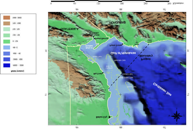
1.
The Project Area for the proposed GEF project includes the Gulf of Honduras, as well as the
watersheds in Belize, Guatemala, and Honduras that contribute to the Gulf (Figure 1). The Project Area
extends from Punta Isopo, in the southeast, northwest towards the Port of Belize, inwards along the
northern border of the Maya Mountains watershed, southwestward along the various watersheds of
Belize, into the Sarstoon, Laguna Izabal, and Motagua watersheds in Guatemala, and the Ulua, Lean,
Cuyamel, and Chamelecon watersheds in Honduras, and finally reaching the coast once again at Punta
Isopo. The Gulf of Honduras covers approximately 10,000 square kilometers, and the watersheds
make up some 53,700 km2, with roughly 5,800 km2 in Belize, 18,300 km2 in Guatemala, and 29,600
km2 in Honduras.
The western portion of the Gulf is lined by the MesoAmerican Barrier Reef Complex, the second
largest barrier reef system in the world. The complex interaction of open ocean waters, coastal waters,
and riverine flows is reflected in the varied ecosystems that contribute to the region's valuable
ecological diversity. The shallow waters of the Gulf provide refuge for marine species, such as
commercially exploited populations of shrimp, spiny lobster, conch and finfish, as well as the
Caribbean's largest population of West Indian manatee. The Gulf's watershed is culturally diverse,
with large populations of Garifuna, Mestizos, Mayans and Creoles, and important archaeological sites.
Figure 1. The Gulf of Honduras
-1-
Environmental Protection and Maritime Transport Pollution Control in the Gulf of Honduras
2.
In 2000, 11.4 million people lived in Guatemala, 6.4 million in Honduras, and 0.2 million in
Belize (UNDP 2002 Human Development Report). Between 2000 and 2015, the populations are to
expected to grow 1.6%, 2.4%, and 2.0% annually in Belize, Guatemala, and Honduras, respectively.
In 2000, approximately 12.4 million people lived in the Gulf of Honduras watershed, representing
roughly 70 percent of the population in the three countries. Most people live in rural areas, with a few
exceptions. Approximately 2 million people in the watershed live in the large urban centers of
Guatemala City, Guatemala and San Pedro Sula, Honduras, with several smaller population centers
located in the Gulf of Honduras coastal zone, directly affecting the coastal and marine ecosystems.
Roughly half a million people live along the coast of the Gulf of Honduras. Nevertheless, the
population density in this coastal zone is relatively low.
The three countries are at varying stages of economic and political development. Belize enjoys
relatively high human development, with GDP per capita of over $5600 annually and average life
expectancy over 74 years, with political stability. However, the area of Belize located within the Gulf of
Honduras watershed is largely rural, and the population is under -educated and impoverished compared
with the rest of the country. Guatemala, with an annual per capita GDP of approximately $3800, is less
developed than Belize and has experienced considerable political turmoil following a 36-year civil war.
Even though the country has the largest economy in Central America, a high percentage of all
Guatemalans live below the poverty level, with the wealth in the country distributed unequally.
Honduras in recent decades has suffered as a result of its proximity to the conflicts in Nicaragua and El
Salvador, and most recently from the devastating Hurricane Mitch in 1998, which caused almost $1
billion in damage and killed approximately 5,600 people. The country's current annual GDP per capita
is approximately $2,400.
3.
The poverty experienced in much of the Gulf's watershed, compounded by relatively high
population growth rates, has resulted in the overuse and misuse of the region's terrestrial, coastal and
marine resources. The economy of the watershed is based largely on agricultural production, with
coffee and bananas serving as two of the region's most significant exports. In coffee and banana
production, intensive methods are used that include fertilizers and other chemicals that runoff and
flow into waterbodies, causing increasing algae formation and the potential for dissolved oxygen
depletion. Additionally, a large percentage of the population is engaged in small-scale or subsistence
farming. Slash and burn methods have often been used, resulting in high rates of deforestation, and
increased runoff causing higher peaks in water flow after storms in areas of the watershed. Logging,
often uncontrolled, in upper watersheds has degraded coastal areas by causing siltation of rivers and
coastal waters that reduces productivity and smothers coral reefs. Reduction of water clarity due to
high sediment loads also affects sea grasses, an important habitat in the Gulf. Overfishing and
aquaculture are another source of degradation of the sensitive habitats and species of the region. Fish
stocks in the area, particularly in Belize, are under increasing pressure and many commercial species,
such as finfish, conch, and lobster are overexploited.
4.
Increasingly, land-based sources of pollution related to industrial, mining and tourism
activities are also becoming more significant. Agro-processing, textile and chemical industries, such
as the ones in the areas of San Pedro Sula in Honduras and Guatemala City, contribute effluents that
can reach the Gulf through the rivers of the Chamelecon and Motagua watersheds, respectively. As
the infrastructure does not exist to adequately handle industria l waste and wastewater, the Gulf has
been contaminated with chemicals, heavy metals and petroleum products. These and other activities,
such as the exploitation of oil in Laguna Izabal in Guatemala, are projected to increase in the future.
Increased tourism and its associated coastal development also affect habitats in the Gulf of Honduras
region, particularly in Belize, as well as in coastal areas of Guatemala and Honduras. This has
multiple consequences. Mangroves and coastal littoral forests have been destroyed to make way for
hotels and other tourism infrastructure, and the clearing of vegetation and dredging has lead to
increased sedimentation. Untreated sewage and wastewater from these new developments causes
nitrification, and garbage disposal from tourist boats and coastal development is often inadequate
resulting in solid waste entering waterways, further decreasing watery quality.
-2-
Environmental Protection and Maritime Transport Pollution Control in the Gulf of Honduras
5.
The growing economic activity in the region is affecting the marine and coastal ecosystems by
increasing port and shipping operations in the Gulf. This marine transport has been identified as one
of the major regional problems for the environment. National economic plans include expansion of
the marine transport sector to help revive the economies. In 2001, almost 6,000 ships passed through
the five ports included in this project and the trends indicate that this number will continue to increase.
Not only are there more ships entering the ports now, but they are also larger than before. As the
volume of goods increases, shipping companies are moving towards using deeper draught ships. This
is resulting in plans to expand current port operations and dredge deeper channels in order to
accommodate the larger vessels. The major port facilities on the Gulf of Honduras are Puerto Cortķs
in Honduras, Puerto Barrios and Puerto Santo Tomßs de Castilla in Amatique Bay in Guatemala, and
Big Creek in Belize. The Port of Belize City, while located north of the Gulf of Honduras, is also
included in this project due to t he potential for spills occurring at or near this port to affect the Gulf of
Honduras as a result of the prevailing oceanographic currents. Table 1 shows the cargo activity
(metrics tons) for each of the five ports in the regional part network, for each of the past seven years.
These figures show a clear increase on port activity. Table 2 summarizes the most recent import and
export statistics available for the ports in the region divided between hazardous and non-hazardous
cargo.
Table 1: Cargo Imported/Exported through Gulf of Honduras Ports Annually (metric tons)
1996
1997
1998
1999
2000
2001
2002
Belize City Port
449,378
487,099
504,450
578,407
610,505
704,837
n/a
Big Creek
65,868
57,774
57,683
64,157
134,621
90,232
n/a
Santo Tomas de Castilla
3,185,949
3,775,375
4,437,009
4,255,514
4,349,697
4,245,118
4,800,027
Puerto Barrios
n/a
n/a
n/a
n/a
n/a
1,679,700
1,353,113
Puerto Cortes
3,992,700
4,677,800
5,091,100
4,977,360
5,398,290
5,661,940
n/a
Table 2. Annual Average Imports and Exports from Ports in the Region (metrics tons)
Cargo
Sub-type
Belize
Guatemala
Honduras
Hazardous
187,364
2,379,181
1,140,447
Petroleum
187,352
2,094,003
1,065,834
Non-Petroleum
12
285,178
74,613
Non-Hazardous
624,958
4,466,583
4,022,694
Banana
45,140
853,648
355,873
Non-Banana
579,819
3,612,935
3,666,821
Total
812,322
6,845,764
5,163,141
6.
In addition to cargo going to and from the ports, traffic volume has been increased greatly by
cruise ship activity. In the Port of Belize City, cruise ship activity has more than tripled each of the past
few years. Plans for dredging a long navigation channel to bring cruise ships directly to the Port of
Belize are in their final stages.
7.
The Gulf of Honduras is a shared maritime body linked through oceanographic processes.
There is great interconnectivity between the ecosystems, with the integrity of each ecosystem
dependent on the health and influence of adjacent ecosystems. Environmental problems in the Gulf of
Honduras are highly transboundary due to the oceanography of the waterbody. There is a persistent
counter-clockwise long-shore flow over the shelf with a current speed of about 0.1 Ł 0.2 m/s, best
pronounced off the coast of Belize (Figure 2). During summer months, the buoyancy-driven counter-
clockwise coastal flow adds to the wind-driven current. During winter months, the buoyancy-driven
-3-
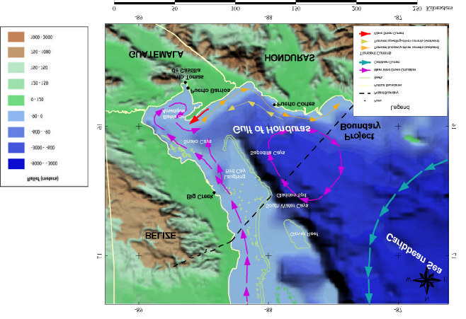
Environmental Protection and Maritime Transport Pollution Control in the Gulf of Honduras
circulation is at a minimum and the trade winds may induce coastal upwelling off the coast of
Honduras with its associated westward long-shore flow. The open sea boundary is under the influence
of a quasi-permanent cyclonic eddy generated in the southeast corner of the Cayman basin due to
interaction of the Caribbean Current with the coast of Central America and wind. As a result of the
prevailing oceanographic currents, the region is highly susceptible to marine pollution incidents. As
maritime traffic and port operations within and beyond the Gulf continue to rise, the potential for
catastrophic accidents, as well as chronic pollution, increases. As is discussed in more detail in the
preliminary TDA, a spill or pollution incident in one area of the Gulf could quickly spread to other
areas in including the MBRS, and it could have a devastating impact on sensitive habitats, threatening
fisheries resources and tourism.
Figure 2. Oceanographic Currents in the Gulf of Honduras
-4-
Environmental Protection and Maritime Transport Pollution Control in the Gulf of Honduras
8.
Marine transport has important environmental consequences, because the ports in the region
are adjacent to important and sensitive ecosystems. Daily port operations as well as the risk of ship
collisions or large oil spills pose a risk to coastal ecosystems, particularly in the semi-enclosed Bay of
Amatique. Guatemala registered 12 accidental spills between 1975 and 2002, for the most part at
Santo Tomßs de Castilla, with Puerto Barrios reporting a spill of fuel oil and sludge that occurred as a
result of a collision of a vessel with a pier in 1993. In Puerto Cortķs, although no oil spill accidents
were reported in its bay between 1994 and 2002, some accidents have occurred, at the companies
adjacent to the port's facilities. Currently, there are only limited environmental management systems
implemented in some of the ports included in this study, thus compounding the potential impact of a
spill. In addition to activities at the ports, the threat of oil and chemical spills resulting from
navigational risks is quite serious in the Gulf of Honduras. Due to the limited accessibility of Puerto
Barrios and Puerto Santo Tomßs de Castilla in Guatemala within the inner section of the Bay of
Amatique, the risk of collisions and groundings is significant. This risk is increased by the shallow
depths and narrow width of the navigation channels (on the average only 90 m wide and 11 m deep,
while many ships have drafts of up to 10.5 m). The potentially extreme weather in the region,
including frequent hurricanes, threaten, maritime safety. The age, type and maintenance of the ships
entering the Gulf of Honduras ports also play a part, as does the training of the ship crewmembers.
The need for improved navigational safety is widely recognized, including better communication
systems and infrastructure, as well as the capability to update bathymetric maps. Spills occurring in
the Gulf, particularly in the Bay of Amatique, have the potential to devastate nearby sensitive habitats.
9.
The Gulf supports a wealth of marine fishes and mammals, some of which are endangered,
such as the manatee. Amongst the western Caribbean coastal waters, the Gulf of Honduras is marked
by richness in coral, seagrass, and mangrove habitats, which are among the most productive
ecosystems on the planet, in terms of average net primary productivity. The productivity of the Gulf
is due to rivers transporting nutrients from the land, the nutrients from the open sea (upwelling), and
the close proximity of the swampy mangrove areas, the seagrass beds and the coral reefs. These
ecosystems are linked to one another in biologically important ways. The mangroves reduce the
amount of sediment transferred to seagrass beds and coral reefs. At the same time, coral reefs reduce
wave energy and thereby help to establish conditions favorable for the establishment of mangrove
stands.
However, the land-based and marine-based anthropogenic activities taking place in the Gulf
and its watershed are degrading coastal and marine ecosystems, and leading to a critical loss of
habitat. The causes are diverse. Recreational boats and commercial ships have hit and broken coral
reefs. Increased agricultural and commercial development have resulted in significant losses of
mangrove forests. Industrial, agricultural, and touristic development have contributed toxic pollutants,
sewage, and excessive nutrient loads, leading to eutrophication, loss of dissolved oxygen, and
siltation, among other problems. Forest cutting and poor watershed management have also led to
greatly increased siltation. In order to help preserve the wealth of terrestrial and marine species in the
region, Belize, Guatemala and Belize have established a great many protected areas which most of
them are found within the Gulf of Honduras watershed. Belize has designated 50 protected areas
nationally; in Guatemala 120 protected areas has been designated covering around 30% of the
country's territory. In Honduras, 102 protected areas cover roughly 27% of the national territory.
10.
The region has four Ramsar sites located within it:
Guatemala:
Punta de Manabique
Honduras:
Parque Nacional Jeanette Kawas
Refugio de Vida Silvestre Punta Izopo
Barras de Cuero y Salado.
11.
Recognizing the need to address priority transboundary concerns in the Gulf, the littoral
countries worked with the IDB to propose an initiative on environmental protection and maritime
transport pollution control in the Gulf of Honduras focusing on demonstrations of innovative
-5-
Environmental Protection and Maritime Transport Pollution Control in the Gulf of Honduras
technology mixes . This proposal resulted in a Global Environment Project Development Facility
Block-B (GEF PDF -B) grant, which facilitated the development of a Preliminary Transboundary
Diagnostic Analysis (TDA) and the development of this Project Brief. The TDA identified the supra-
national threats and responses. Risk assessment criteria were applied to identify priority regional threats,
responses, and targets.
12.
The project aims to contribute to a regionally agreed Strategic Action Programme (SAP) for
the integrated management of port and marine transport activities in the Gulf of Honduras and at
building the grounds for its implementation. It is envisioned that the SAP will be developed jointly
with the MBRS project. At the same time, this project aims to fully assess the risks from land-based
sources of pollution compared with those from port and maritime operations through the development
of a final TDA, and address limited areas of land-based sources of pollution not being adequately
focused on by other projects (such as MBRS). The goal is to enhance the ability of the countries to
plan for and manage current and future port and marine operations and land-based activities, so that
they will be done on a sustainable basis. The project will address such issues as the lack of capacity,
poor coordination, overlapping responsibilities, sectoral approaches to port and marine operations
control, and inadequate enforcement of laws within participating states.
GEF PROGRAMMING CONTEXT
13.
The programming context and the design of the present project is directed to the GEF
Operational Programme #10 which states: "In the Contaminant-Based Operational Program, the GEF
includes projects that help demonstrate ways of overcoming barriers to the adoption of best practices
that limit contamination of the International Waters environment. Four components characterize the
range of projects in this operational program. One set includes a set of limited demonstration projects
for addressing land-based activities while others include projects related to contaminants released
from ships, persistent toxic substances such as persistent organic pollutants (POPs), and targeted
regional or national projects useful in setting priorities for possible GEF interventions, meeting the
technical needs of projects in the focal area, or distilling lessons learned from experience (para 10.2)."
The present project proposal meets these requirements and will assist the countries of the Gulf of
Honduras to address contaminants released from ships, as well as important land-based activities.
14.
The Concept for this project began in the mid-1990's, as COCATRAM, TRIGOH, and other
regional entities recognized the need to focus on marine transport issues to protect the sensitive
receptors-at-risk (coral barrier reef, seagrass beds, mangroves, and sensitive species). Although the
present project has expanded to address land-based activities as well as marine-based, elements of the
original concept remain the same.
15.
The project is essentially regional and transboundary in nature and will enable the states of the
basin to build new and improve on existing regional cooperative frameworks, ensure adherence to
international conventions, as well as strengthen national laws, regulations, and management regimes to
improve the likelihood of sustainability of resource use and reduce existing and potential degradation.
The implementation of this project, and ultimately the SAP, will result in regional, and by extens ion
global, environmental benefits through protection of international waters, their resources, and sustainable
use of resources in conformity with the objectives of GEF Operational Program 10, i.e., "to develop and
implement International Waters projects that demonstrate ways of overcoming barriers to the use of best
practices for limiting releases of contaminants causing priority concerns in the International Waters focal
area, and to involve the private sector in utilizing technological advances for resolving these
transboundary priority concerns (para 10.3)."
16.
Under the Contaminant-Based Operational Programme 10, several outputs from the Ship-
Related Contaminants Component projects are envisaged. This includes the implementation "of
measures to prevent the transfer of non-indigenous species in ship ballast water, demonstration of new
technology to help ships avoid collisions in busy corridors and the implementation of measures to
-6-
Environmental Protection and Maritime Transport Pollution Control in the Gulf of Honduras
prevent unauthorized releases of contaminants while leveraging private sector investment. The new
information technology may discourage releases of oil and non-degradable waste, and provide a
means of determining whether ballast water was exchanged in accordance with best practices to
prevent transfer of species and to address MARPOL issues. Once barriers to use of the new
technology are overcome, efficiency gains and reduced insurance costs may raise the profits of the
private sector and some of these profits might contribute to financial sustainability following the end
of GEF involvement (para 10.16)."
17.
The project proposed will address all of the above points. Implementation of the final SAP
will thus assist in the conservation of natural resources and assist the countries in complying with their
national and regional obligations under various international conventions. At a global level, the
project and its SAP join regional and national activities into a coherent component of the global
environmental protection effort. The projects will have global benefits as port operations, safe
navigation, and water quality are improved, protecting valuable and unique habitats and the biodiversity
in the region.
18.
The present project also is consistent with the recent Draft GEF International Waters Focal
Area- Strategic Priorities in Support of WSSD Outcomes for FY 2003-2006. This document lists
various priorities, including:
Ę Priority D. Test the viability of technologies and innovative approaches for preventing the
releases of contaminants from land-based and ship-based sources and for addressing
competing uses of water resources under conditions of fluctuating climate in support of
various intergovernmental processes.
Ł Target: *By 2006, GEF will have successfully demonstrated the local feasibility of
these technology innovations in support of 4 or 5 different intergovernmental
processes such as those related to alien species in ship ballast water, ship-related
contaminants, land-based pollution sources, protection of biodiversity, and
adaptation to climatic fluctuations.
The present project will directly assist in addressing two of the key International Waters gaps:
addressing ship -based sources of pollution and land-based pollution sources (ports).
19.
The project is a part of a wider GEF regional effort involving other GEF Implementing
Agencies. The focus of this project on marine pollution control is intended to complement the World
Bank/GEF/CCAD Project for the Conservation and Sustainable Use of the Mesoamerican Barrier
Reef System (MBRS) as well as the on-going UNDP/GEF Conservation and Sustainable Use of the
Barrier Reef Complex in Belize. Both of these projects fall within the GEF Operational Program for
Biodiversity for Coastal, Marine and Freshwater Ecosystems (OP-2). Of note, the Threat and Root
Cause Analysis conducted for the MBRS project identified the tri-national area of the Gulf of
Honduras as a critical area. Port and ship-based pollution were recognized as significant threats to the
health of the reef ecosystem to be addressed by this complementary project.
20.
This project has been developed to avoid duplication with existing projects, especially the on-
going MBRS. The MBRS has four major components:
1. Marine Protected Areas (MPAs)
2. Regional Environmental Monitoring and Information System
3. Prom oting sustainable use of the MBRS
4. Public awareness and environmental protection
The present project does not address components 1 or 3 of the MBRS. However, it has been designed
to develop synergy with components 2 and 4 of the MBRS. Specifically, for component 2, the
monitoring, will be fully coordinated with MBRS more advanced plan for monitoring. In addition, the
data and information for the GOH project will be modeled and shared with the MBRS system, which
-7-
Environmental Protection and Maritime Transport Pollution Control in the Gulf of Honduras
is already considerably advanced. For component 4, the GOH project will share existing, developed
communications, environmental awareness activities, and education programs. Furthermore, the
components related to ballast water management would be coordinated with the initiatives being
developed under the UNDP/GEF global project for the "Removal of Barriers to the Effective
Implementation of Ballast Water Control and Management Measures in Developing Countries".
Close coordination with IMO during development of this second-phase Ballast Water Project will
permit effective sharing of information and technologies.
21.
The proposed project would also consider other initiatives, such as the UNDP/GEF project
"Wider Caribbean Initiative on Ship-Generated Wastes" and the UNEP/GEF project "Development of
Comprehensive Management Programme to Reduce Pesticide Releases from the Agricultural Sector
to the Marine Environment of the Caribbean Sea". The Wider Caribbean Initiative for Ship -Generated
Waste will focus on the MARPOL 73/78 Convention, with two major components: legal, technical
and institutional measures, and providing a forum for consensus building. The present project would
build on the outcomes of this project for ship wastes. IMO, as implementer of the ship waste project
and cooperating agency for the present project, will assist with lessons learned.
22.
The full list of regional GEF projects can be found in table 3.
Table 3: List of GEF Regional Projects in the GOH (download from www.gefonline.org/projectList.cfm)
GEF
Project
Country
Project Name
Region Focal Area
Agency
Project
Type
Grant
Stage
(US$M)
Establishment of a Programme for
Regional
the Consolidation of the Meso-
LAC
Biodiversity UNDP
Full Size
Project
10.940 CEO
Endorsed
American Biological Corridor
Central American Fund for
Regional
Environment and Development:
LAC
Biodiversity UNDP
Full Size
Project
15.000 Council
Approved
Account for the Global Environment
Regional Program on Electrical
Energy Efficiency in Industrial and
Regional
Commercial Service Sectors in 7
LAC
Climate
Change
UNDP
Full Size
Project
2.400 Pipeline
Countries in Central America
Creation and Strengthening of the
Medium
Regional
Capacity for Sustainable Renewable LAC
Climate
Size
0.750 CEO
Energy Development in Central
Change
UNDP
Approved
America
Project
Regional
Conservation and Sustainable Use
of the Mesoamerican Barrier Reef
LAC
Biodiversity IBRD
Full Size
Project
10.616 CEO
Endorsed
Regional
Indigenous Community Integrated
Ecosystems Management Project
LAC
Multiple
Focal Areas IBRD
Full Size
Project
10.700 PDF B
Accelerating Renewable Energy
Regional
Investments through CABEI in
LAC
Climate
Change
UNDP
Full Size
Project
6.100 PDF B
Central America
Environmental Protection and
Regional
Maritime Transport Pollution Control LAC
Internationa
l Waters
IADB
Full Size
Project
8.550 PDF B
of the Gulf of Honduras
Regional
Caribbean Renewable Energy
Development Programme
LAC
Climate
Change
UNDP
Full Size
Project
4.776 Council
Approved
Regional
Caribbean: Mainstreaming
Adaptation to Climate Change
LAC
Climate
Change
IBRD
Full Size
Project
5.345 CEO
Endorsed
Caribbean Planning for Adaptation
Regional
to Global Climate Change
LAC
Climate
(CARICOM)
Change
IBRD
Full Size
Project
6.825 CEO
Endorsed
Building Capacity for Conducting
Vulnerbility and Adaptation
Regional
LAC
Climate
Assessments in the Caribbean
Change
UNDP
Enabling
Activity
0.118 CEO
Approved
Region
-8-
Environmental Protection and Maritime Transport Pollution Control in the Gulf of Honduras
Medium
Regional
EcoEnterprises Fund
LAC
Biodiversity IBRD
Size
1.000 CEO
Approved
Project
Building Wider Public and Private
Constituences for the GEF in Latin
Medium
America and the Caribbean:
Regional
Regional Promotion of Global
LAC
Multiple
Focal Areas UNDP
Size
0.998 CEO
Approved
Project
Environment Protection through the
Electronic Media
Biodiversity Conservation and
Integration of Traditional
Medium
Regional
Knowledge on Medicinal Plants in
LAC
Biodiversity UNEP
Size
0.750 CEO
National Primary Health Care Policy
Project
Approved
in Central America and Caribbean
REGIONAL PROGRAMMING CONTEXT
23.
The issues raised by the preliminary TDA make it clear that the region as a whole lacks the
capacity and the information base for the integrated environmental management of the port and
maritime transport activities in the Gulf of Honduras. This is the background from which the project
has been formulated. The region, however, strongly supports reduction in pollution from port
operations and maritime transport, indicated by the support for the Cartagena Convention for the
Protection and Development of the Marine Environment of the Wider Caribbean Region and its
Protocol Concerning Co-operation in Combating Oil Spills in the Wider Caribbean Region. Article 3
of the Convention states, ""The Contracting Parties shall endeavour to conclude bilateral or
multilateral agreements including regional or subregional agreements, for the protection of the marine
environment of the Convention area." Thus this Project Brief directly supports the Cartagena
Convention. The project also will contribute to the objectives of the Mesoamerican Sustainable
Development Initiative (IMDS) of the Plan Puebla Panama (PPP), which aims at promoting natural
resources/sustainable development projects in multinational areas in Mesoamerica and promotes the
application of Strategic EIAs to assess and mitigate both direct and indirect impacts of
regional/transboundary projects.
24.
The preliminary TDA and this Project Brief indicates that there would be minimal overlap
between this project and the other activities which are taking place in the Gulf of Honduras region.
The IDB and other multilateral and international organizations are supporting various maritime-related
projects in the area. For example, the Canadian International Development Agency (CIDA) has
financed a first phase of an environmental action plan for port operations in Puerto Cortķs. A second
phase of the initiative is under consideration as possible co-financing for baseline activities to the
regional GEF project. Other projects related to this proposed GEF operation include the World Bank-
financed Sustainable Coastal Tourism and Management Project for the Caribbean Coast in Honduras,
the NASA/CCAD Mesoamerican Biological Corridor Program, the EU-funded WRIScS project, the
USGS Hurricane Mitch Project, COCATRAM activities, TRIGOH and the WWF Mesoamerican Reef
System Ecoregion Project. Additionally, USAID has funded the PROARCA program with the
objective to improve environmental management in the Mesoamerican Biological Corridor. The
specific objectives of the PROARCA project include: i) improving the management of protected
areas, ii) expand access to markets for environmentally friendly products and services, iii)
harmonizing environmental laws, and iv) increasing the use of less polluting technologies and
practices. The PROARCA project is being implemented in four specific regions: Gulf of Honduras,
Mosquitian Coast, Gulf of Fonseca, and the Cahuita-Amistad Rio Canas regions. COCATRAM is a
regional maritime entity that forms part of the Central American Integration System. COCATRAM
works with both the public and private sectors of its member countries providing technical assistance
and capacity building in areas related to international transport including security, environment,
facilitation, and legislation.
-9-
Environmental Protection and Maritime Transport Pollution Control in the Gulf of Honduras
25.
A relevant project being implemented by COCATRAM that can be strengthened through the
Gulf of Honduras project is the Regional Maritime Navigation Assistance System. During the design
stage of this project, efforts were made to coordinate with the existing projects in the region through
contacting and inviting representatives to participate in the regional stakeholders advisory committee.
During the full project phase, the regional projects coordination mechanism already in place under the
PROARCA program will be used to minimize duplication of efforts and exchange lessons learned.
PROARCA, as a parallel-funding agency, will sit on the GOH project's management committee, to
assure that local governments, villagers, and other stakeholders will be fully involv ed in the GOH
project.
26.
PROARCA also assists in the PROLEGIS project, implemented by CCAD and the USERA.
The project seeks to harmonize environmental protection policies in the region, with four fields of
actions:
1. Develop harmonized environmental stan dards and regulations
2. Increase the enforcement and compliance capacity of environmental legislation
3. Effectively apply key international agreements
4. Develop a harmonized regional system for environmental audits
As a parallel-financing agency, PROARCA will co-finance certain aspects of this GOH project.
27.
Another major regional player is the Trinational Alliance for the Gulf of Honduras
(TRIGOH), a coalition of nine conservation groups from Belize, Guatemala, and Honduras. Founded
in 1995, TRIGOH has promoted ecoregional fisheries management, reduced the risk of hazardous
spills, and expanded public awareness. With the IDB, they helped to start this project in its PDF -A
phases, and has been an active participant since.
28.
A further major player in the regional scene regarding marine pollution and navigation is the
International Maritime Organization (IMO). The IMO has been active in the GOH region for decades,
and has worked closely with the three countries on various aspects of international conventions
regarding navigation and shipping. At present, the IMO has ongoing national projects in the three
countries addressing national contingency planning for the offshore waters. In addition, IMO provides
technical assistance to the countries in various aspects of convention compliance. The present project
will expand on the IMO activities by bringing regionalization of the contingency planning and
technical assistance for conventions. Designed so as not to be duplicative of the IMO ongoing
baseline activit ies, the present project will regionalize many of the earlier and ongoing interventions
by the IMO. The IMO will be a major contributor to this project, providing technical expertise,
domain expertise in many of the areas of concern in this project, and even assistance to the Executing
Agencies if needed.
29.
There are a number of projects funded by the IDB of relevance to the current project and
efforts will be made through the local IDB offices to coordinate with them (see Annex L for a list of
all IDB-funded projects in Belize, Guatemala and Honduras). The IDB-financed program for the
environmental management in the Bay Islands in Honduras will contribute, among others, to the
sustainable management of the archipelago's coastal and marine resources as well as control of land-
based sources of pollution through investments in sewage collection and treatment facilities and solid
waste management. Another project aiming at decreasing the pollution of coastal waters is the IDB-
funded project for sanitation in the city of Puerto Cortķs in Honduras, which will ensure efficient and
sustainable arrangements for potable water supply and wastewater disposal services, including the
sewerage infrastructure to ensure the safe, environmentally acceptable disposal of liquid wastes.
NATIONAL PROGRAMMING CONTEXT
30.
The implementation of this project will supplement existing bi-lateral and national efforts to
address environmental issues in the Gulf of Honduras. This project, with its SAP based on the
preliminary TDA, contains several priority actions that will enhance the ability of countries of the Gulf
of Honduras to implement existing legal frameworks for enhancing the regional environmental
-10-
Environmental Protection and Maritime Transport Pollution Control in the Gulf of Honduras
management of the port and maritime transport operations and increase the ability of the riparian states
to reduce regional and transboundary environmental problems, i.e., to move the scale of operation from
the national level to the regional level.
31.
The Preliminary TDA contains an overview of the legal and regulatory basis for these actions in
the three participating countries. The countries all participate in various international treaties, including
the United Nations Convention on the Law of the Sea (UNCLOS), the International Convention for the
Prevention of Pollut ion from Ships (MARPOL) and other IMO-facilitated treaties related to marine
transport and pollution. There is little effective regionality to the national commitments to these treaties,
however, and cooperation and collaboration would strengthen the compliance with the treaties. This
project will improve the ability of the three participating countries to comply with the international
maritime treaties through the development of a regional regulatory framework.
32.
In addition to being signatories to the international maritime transport treaties, Belize, Guatemala
and Honduras have developed national legislation to govern port and marine activities that varies by
country. While a general legal framework exists to support program activities to address maritime
contamination and security, implementation has been inconsistent as there is a lack of supporting
regulations and adequate institutional support at the national level. In the case of Guatemala, the
situation is more confusing due to the fact that the country does not have a viable Port Authority. In
addition to these difficulties, each country has different ministries responsible for coastal planning,
compliance with international conventions, environmental monitoring, sanitation, and environmental
impact assessment. These agencies with the national maritime authorities form a complex network of
regulatory programs. The institutional and regulatory frameworks for the three countries are generally
impeded by fragmentation of responsibilities and deficiencies in program coverage.
The operation of the national port system varies among the three countries and even within countries
there are issues with fragmentation of responsibilities among the national regulatory agencies and
local government. Recent studies have suggested that the majority of Central American countries have
not given maritime issues the necessary emphasis. Global problems that have been identified
throughout Central America maritime administration include i) need to strengthen the legislative
framework and national policies governing maritime issues ii) inadequate financial resources for
personnel and equipment iii) need for better trained personnel iv) lack of stakeholder participation in
the development of international norms v) few academic or educational institutions that offer
specialized professional development.
SYSTEM BOUNDARIES
33.
The area for project activities is defined as follows:
a) The countries of the Gulf of Honduras: Belize, Guatemala and Honduras.
b) The approximate inland boundaries are defined as the limits of the drainage basins of the rivers
draining into the Gulf of Honduras (see Figure 1). The Project Area for the proposed GEF project
extends from Punta Sal, Punta Isopo, in the southeast, northwest towards the Port of Belize along
the Belize shoreline, inwards along the northern border of the Maya Mountains watershed,
southwestward along the various watersheds of Belize (numerous watersheds, lumped here as the
Maya Mountain watersheds), Guatemala (Sarstoon, Lagu na Izabal, Motagua), and Honduras
(Ulua, Lean, Cuyamel, Chamelecon), reaching the coast once again at Punta Isopo.
MAJOR PERCEIVED THREATS, PROBLEMS AND ISSUES
34.
As part of activities in the project preparation phase supported by a GEF PDF-B grant,
information and reports were collected which provided information on the problems relating to the
priority transboundary environmental concerns in the Gulf of Honduras. Based on the early project
-11-
Environmental Protection and Maritime Transport Pollution Control in the Gulf of Honduras
development activities, as well as the regional consensus Ł building process, this Preliminary TDA
identifies a single major perceived problem and issue:
DEGRADATION OF COASTAL AND MARINE ECOSYSTEMS
35.
The following major causes of the MPPI have been determined:
1. Negative environmental effects arising from existing and future port operations and
infrastructure development
2. Negative environmental effects arising from marine activities
3. Other Land-Based Activities (other than shipping-related) causing degradation of the
ecosystems of the Gulf of Honduras
36.
Coral reefs and mangroves are the most biologically diverse ecosystems in the Gulf of
Honduras and are greatly at risk. The northern part of the Gulf of Honduras is located within the
limits of the second longest barrier reef in the world (MBRS), which extends for 250 km and covers
22,800 km 2. The southern reefs are discontinuous and less developed when compared to northern
Belize. Large freshwater loads from the Motagua, Sarstoon and Dulce rivers limit reef development
to a few isolated corals and small patch reefs in the Gulf of Honduras itself. Several reef islands are
located near the eastern boundary of the Gulf. Coral reefs grow in clear water and are extremely
sensitive to pollution, whether due to chemical contaminants or suspended sediments. Coral reefs in
the Gulf have shown signs of degradation in recent years, bleaching has occurred on numerous
occasions, and they have been susceptible to diseases, perhaps related to anthropogenic causes. Coral
bleaching in response to elevated seawater temperatures was reported for much of the Caribbean
during 1983 and 1987, and the first well-documented mass bleaching event in Belize occurred in 1995
where 52% of coral colonies bleached. With nearly 60 coral species, the MBRS is one of the most
diverse coral reefs in the western Atlantic . The rapid expansion of coastal populations and
consequentially increased loads of domestic sewage, agricultural runoff and industrial effluent to the
marine environment, as well as the increased maritime operations and traffic, represent a significant
threat to the coral reef habitat. Spills from navigational accidents in the Gulf have the potential to
devastate reef ecosystems.
37.
Mangroves serve as critical habitat for many species within and beyond the Gulf. However,
significant areas of mangrove forests have been cut down in the Gulf, either for the wood or to make
way for agriculture or coastal development. In 1991, mangrove loss near Belize City was 3.6% rate.
Approximately 700 hectares of mangrove forests have been identified in the Atlantic Coast at a region
of Guatemala. For example, between 1992 and 1998, the mangrove coverage in Guatemala decreased
by 29%. Mangroves may still be found in several regions of the Gulf, including: Rio Sarstoon-
Livingston, Livingston-Punta de Palma, RĒo Dulce-El Golfete River, Puerto Barrios and Punta de
Manabique. The mangroves of the Sarstoon-Temash system and the Port Honduras-Payne's Creek
system form the largest mangrove stand on the coasts of Guatemala and Belize. In Belize, there are at
least 750 km2 of mangrove forest covering 3.4% of the national territory. In Honduras, mangroves
cover about 1200 km2. It is not known the extent to which the remaining stands have suffered
degradation from land-based and marine-based sources of pollution. Significant mangrove stands are
located in the vicinity of many of the ports included in this project, leaving them vulnerable to
pollution from port operations and contamination from navigational accidents.
38.
Seagrass habitats are important for fishery production, as a food source for certain threatened
animal species, and for coastal stabilization. Approximately 3,750 hectares of seagrass beds have
been identified in areas of the Gulf of Honduras, including BahĒa de Amatique, in Grac iosa Bay, and
off the coast of Belize. However, the status of seagrass beds in the Gulf of Honduras has not been
adequately assessed, and the extent to which these ecosystems have suffered degradation due to
pollution from land and marine-based sources is unclear. Seagrass beds are located in the vicinity of
many of the ports included in this study and the one major maritime accident that has occurred to date
in BahĒa de Amatique caused significant damage to nearby seagrass beds.
-12-
Environmental Protection and Maritime Transport Pollution Control in the Gulf of Honduras
39.
Based on the causal chain analysis shown in Annex M, the root causes of degradation of
marine and coastal ecosystems include:
Inadequate Legal/Regulatory Structure
Lack /Inadequate Use of EIA
Lack of Monitoring/Enforcement
Lack of National Standards and Regulations
Lack of Audit
Inadequate Regional Policies and Agreements
Inadequate National Policy Frameworks
Inadequate Infrastructure
Lack of ICZM
Lack of Early Warning System
Inadequate Investment
Inadequate Capacity
Lack of Minimum Training Standards
Lack of Education
Lack of Scientific Capacity and Knowledge
40.
The preliminary Transboundary Diagnostic Analysis provides more comprehensive
information on the root causes and sources of the identified problem. This document gives an initial
review of the actions to be taken to address this major perceived problem, either through mitigation or
elimination of the root causes. The evidence from the TDA indicates that there are many
organizations and institutions that deal with various aspects of marine transport in isolation, that often
develop policies and programs, which then result in conflicting interventions. There are also a large
number of laws, each dealing with different aspects of marine transport, which negates a holistic
approach. Management in the Gulf clearly lacks full participation of civil society in sustainable
development initiatives, and there is a general lack of understanding and awareness at all levels of the
link between the environment, the economy, and society. Certain exceptions exist, of course,
including the strong role played by the NGO TRIGOH.
RATIONALE AND OBJECTIVES (ALTERNATIVE )
41.
The broad development goal of this project is to reverse the degradation of the coastal and
marine ecosystems, by enhancing the control and prevention of maritime transport-related pollution in
the major ports and navigation lanes, improving navigational safety to avoid groundings and spills,
and reducing land-based inputs to the adjacent coastal and marine areas within the Gulf of Honduras.
42.
To satisfy the broad development goal, the project has four major components, namely:
Component 1: Building regional capacity for maritime and land -based pollution control in
the Gulf of Honduras;
Component 2: Updating the TDA, contributing to a region-specific SAP, and creating, analyzing and
distributing marine environmental information for the Gulf of Honduras;
Component 3: Enhancing navigational safety in shipping lanes;
Component 4: Improving environmental management and hazard reduction measures in the regional
network of five ports within the Gulf of Honduras.
43.
The TDA identified the major perceived problem and issue in the basin and then analyzed the
root causes, based on this analysis. The project proposes the four components in paragraph 37 to
address the highest priority problems in the Gulf of Honduras. The preliminary TDA lists two
overarching Environmental Quality Objectives as a possible basis for long-term action to improve the
-13-
Environmental Protection and Maritime Transport Pollution Control in the Gulf of Honduras
Gulf of Honduras environment. These EQOs were discussed at regional m eetings during preparation
of the project (e.g., Guatemala, March 2003), but they are only draft at this stage. As part of the full
TDA/SAP process, the EQOs will be updated and strengthened. They are presented here only to
indicate the major environmental drivers for the region.
44.
Certain themes are repeated in these EQOs, including the need for capacity building,
institutional strengthening, priority setting (Strategic Action Programme process), and the need to
initiate demonstration of technologies and approaches to manage more effectively coastal and marine
areas. The present GEF project addresses these four concrete aspects that are identified in the EQO
process in the preliminary TDA. The final SAP will include input from MBRS and other regional
projects in a fully participatory process, so these EQOs with their targets are certain to change.
Stabilized Marine and Coastal Water Quality
TARGETS (examples)
1. Reduce pollution from port and other land-based operations activities in the Gulf of Hondur as
by 25% by 2008
2. Reduce pollution from marine activities by 50% by 2008
3. Reduce risk of marine accidents, including coral destruction, by half by 2013
Prevention of Degradation of Sensitive Coastal and Marine Habitats
TARGETS (examples)
1. Rate of decline in the quality of selected coral reef sites halved by 2013
2. Rate of decline in the quality of selected mangrove sites halved by 2013
3. Stabilize seagrass inventory by 2020
45.
A major rationale for this project is to improve coordination and harmonize regional
approaches in the Gulf of Honduras, which is part of the overall Caribbean basin (covered by the
framework Cartagena Convention). Regional coordination and cooperation are not as effective as
they could be, despite significant past efforts at sectoral cooperation. As a result, globally significant
environmental resources are at risk, including the second largest barrier reef in the world, and vast
coastal mangrove areas. Working closely with MBRS and IMO, this project would assist the region to
create and or improve upon environmental management systems to mitigate ongoing pollution and to
help prevent potentially catastrophic maritime accidents.
PROJECT ACTIVITIES AND EXPECT ED RESULTS
46.
The four principal components offer the greatest potential project benefits in terms of
environmental protection from both national and transboundary perspectives over the interval of the
next five years. The four principal components and their associated objectives were developed for the
project based on the areas of threats identified by the preliminary TDA. These major components
have associated objectives, activities, and results, which are listed below in summary form.
47.
This project has a strong orientation towards demonstrations as a mechanism to encourage and
facilitate concrete changes in national and regional behavior and attitude towards the environment.
These demonstration activities have been outlined in broad form during this project preparation phase.
However, the actual demonstrations to be conducted will be selected during a competitive,
participatory process during the full project implementation. Selection process for the demonstrations
include: replicability; likelihood of successful execution; cost-sharing; and likelihood to contribute to
achievement of project goals.
48.
The demonstration activities included in this project encompass:
Activity 1.3:
Two demonstration projects to develop norms or provide technical assistance
for developing economic instruments or incentives.
Activity 3.4:
Demonstrate use of hydrographic data for environmental management
purposes.
-14-
Environmental Protection and Maritime Transport Pollution Control in the Gulf of Honduras
Activity 3.7:
Three demonstration projects related to navigational safety.
Activity 4:
Three demonstration projects for improvement of environmental activities at
ports.
49.
Component 1: Building regional capacity for maritime and land-based pollution control in
the Gulf of Honduras.
Objective: Create and consolidate a regional network for land-based and maritime pollution control
within the Gulf of Honduras, including the formulation of institutional and economic arrangements
that will assure the sustainability of the action program.
Activities:
The activities under this component concentrate on creation of the enabling environment and the
institutions that are required for the effective management of the Gulf of Honduras. The components
represent stakeholder activities and public -private sector partnerships, both of which are essential for
the project to succeed. The components will also include project management and coordination, and
project steering and monitoring at the regional level. A key to the long-term sustainability of project
activities is the formulation of arrangements for financing regional maritime pollution control and
prevention. Close coordination with MBRS is essential in carrying out these activities.
1.1
Put in place institutional arrangements for carrying out the project activities that will ensure
the sustainability of the action program.
Ę Establish a Regional Coordination Mechanism, building on existing institutional
arrangements such as the MBRS (see project management framework).
Ę Establish and empower the Project Steering Committee, including installation of the
National Focal Points as spearheads for National Interministerial Coordination (this
activity depends upon institutional arrangements decided upon).
Ę Draft and obtain MOUs or Agreements among high-level officials of the three countries
in support of the program and the SAP objectives and goals.
1.2
Identify, strengthen, and involve stakeholders.
Ę Develop a public participation and awareness (PPA) plan for the project including a
communication strategy, design of instruments (meetings, publications, status reports,
web sites, etc.) and its timetable for implementation.
Ę Implement the PPA workplan involving national experts, private and public sector, NGOs
and other interested parties.
Ę Establish regional information networks and information exchange mechanisms to
disseminate information in Central America through newsletters, a web page and
publications on the topic of maritime transport pollution control and the progress of the
project in order to enhance the replication of successful experiences (within the
framework of Cartagena Convention and Oil Spill Protocol).
Ę Develop a strategy to be implemented by the Project Coordinating Unit (PCU) to integrate
private sector involved in GOH development (industry, shipping, fisheries, tourism) into
activities of this project, as appropriate as sub-contractor, consultant or co-sponsor of
specific activities. Examples include public-private sector partnerships and similar
efforts.
Ę Conduct independent reviews and reporting of results annually to promote international
support and networking for the action program. This should include a role for IMO,
recogn izing their strong interest and domain expertise in this topical area.
1.3
Develop and conduct training workshops for stakeholders. These training workshops will
include both national and regional institutions. Additionally, links and exchanges with other
similar regions such as the Gulf of Fonseca will take place.
-15-
Environmental Protection and Maritime Transport Pollution Control in the Gulf of Honduras
Ę Conduct indicative survey of value-added training needs and educational programs in the
region related to environmental management in the maritime transport industry (e.g.,
ICAM, Coastal and Marine Environmental Management, Civil Society, environmental
crime investigation and legal prosecution, economic valuation of disasters, citizen
monitoring/ surveillance, and strategic planning for port personnel).
Ę Develop training courses for three priority training needs in local languages.
Ę Conduct or use existing one training session in each of the countries on each of the three
priority training areas, using a train-the-trainers approach.
Ę Conduct exchanges with other IW projects in Latin America (e.g. Frente Maritimo in
Uruguay/Argentina).
Ę Send competitively selected students to train in developed countries.
1.4
Formulate arrangements for economic instruments and incentives, and financing regional
maritime pollution monitoring, control and prevention, including the establishment of a
financing scheme in cooperation with the private sector and port authorities to contribute to
the financial sustainability of the program.
Ę Develop consultation process to determine costs, who pays, how is it paid, and legal and
operational aspects (includes fees from prosecution of environmental violations)
Ę Develop linkages with existing institutional arrangements (regional and supra-regional,
such as the Cartagena Convention) and international collaborations (with IMO).
Ę Propose incentive mechanisms and investigate feasibility of a trust fund for the Gulf of
Honduras environment.
Ę Identify tools such as conservation easements, land-use zoning, and other types of
incentives to control pollution and encourage the adoption of less polluting technologies.
Ę Identify incentives for private sector participation in monitoring and prevention of
pollution.
Ę Identify and assist in the improved quantification of economic benefits of maritime
pollution prevention, including, for example, reduced insurance costs, protection of
tourism assets, fisheries resources, etc.
Ę Conduct two demonstration studies including development of norms, technical assistance,
to support these instruments and incentives.
1.5
Agree on environmental performance indicators for the Gulf of Honduras through a broad
stakeholder process and develop a process to monitor those indicators, working closely with
MBRS (and using GEF guidance on indicators of July 2003).
Ę Conduct a broad stakeholder workshop to develop and agree upon performance indicators
to monitor impacts of the project on the environment. This workshop will address issues
of who monitors the progress, and how monitoring is to take place, building linkages with
existing national monitoring programs and monitoring activities in regional projects,
including the CZMAI in Belize, PMAI in Honduras, individual port authorities, and
MBRS regionally.
Ę Working with MBRS, design and implement a monitoring and modeling strategic
framework in order to use the indicators to assess the effectiveness of the project in
achieving the EQOs. The strategic framework should
i)
Establish a baseline of land based sources of pollution (water column and
sediment monitoring) through monitoring near or at the mouth of the rivers
for the watersheds: Ulua, Chamelec¾n (Honduras), Motagua, Izabal, Sart·n
(Guatemala), Tamash, Rio Grande, Golden Stream, Deep River, Upper
Fresh Creek, Monkey River (Belize),
ii)
Establish a baseline water and sediment quality within the Gulf,
iii)
Identify the relative impact of the different contaminants (nutrients,
sediment, BOD, toxics) and their sources (Land/Marine).
-16-
Environmental Protection and Maritime Transport Pollution Control in the Gulf of Honduras
50.
The results from the execution of the above activities under component 1 are summarized as
follows:
Outputs (Results):
Ę Improved national and regional capacities for effective environmental management of
maritime transport
Ę Stakeholders fully involved in project
Ę Increased knowledge and awareness by local stakeholders of maritime and land-based
transport pollution issues
Ę Sustainable regional financial mechanism for financing SAP activities developed
Ę Monitoring and evaluation process developed and implemented
51.
Component 2: Updating the TDA, contributing to a region-specific SAP, and creating,
analyzing and distributing marine environmental information for the Gulf of Honduras.
Objective: Fill technical gaps in understanding the state of the environment, undertake strategic
planning for concrete actions to reduce marine pollution in the Gulf of Honduras, and develop the
long-term capacity for gather ing, organizing, analyzing and disseminating marine environmental
information, as a complement to the MBRS Regional Environmental Information System (EIS).
Activities:
A full TDA will be completed under this component. A targeted SAP will also be contr ibuted to, and
endorsed as part of this activity, working closely with MBRS, focusing on priority marine and land-
based activities.
2.1
Expand the MBRS data and information management system to include maritime impacts
from port and navigation activities and land-based activities on the Gulf of Honduras.
Ę Building on the existing MBRS EIS where feasible, expand a Data and Information
Management System for the Gulf of Honduras to facilitate the updating of the TDA with
the monitoring program being implemented, and data sharing with other projects,
including the MBRS and the Central American Information System developed by CCAD.
Ę Develop mechanisms for the sharing of data and information for input into the Data and
Information Management System for the Gulf of Honduras.
Ę Create standards and protocols for the collection, processing, analysis and compilation of
data and GIS information.
Ę Develop a centralized system for access and distribution of the data to the organizations
involved in the control of maritime pollution and transport in the Gulf of Honduras.
Ę Develop technical capacity for the transfer and incorporation of hydrographical and
oceanographical data into GIS -based information systems.
Ę Publish an annual report of the state of the Gulf for general public distribution.
2.2
Update and complete TDA, including an updated assessment of the relative importance and
transboundary impact of land-based and marine-based sources of pollution and filling the gaps
identified in the Preliminary TDA.
Ę Fill gaps in knowledge of scientific and social issues, as identified in the preliminary
TDA, to develop an updated TDA (working closely with MBRS to avoid duplication).
Ę Conduct a thorough evaluation of the national and regional legal and institutional
frameworks addressing environmental management of the maritime transport industry and
land-based activities.
Ę Complete an analysis of the socio-economic conditions of the Gulf of Honduras region
that would affect efforts to improve environmental management of the maritime transport
industry.
-17-
Environmental Protection and Maritime Transport Pollution Control in the Gulf of Honduras
2.3
Contribute to, negotiate, and endorse at the national level a regional Strategic Action
Programme (SAP) for port and navigational pollution reduction measures as well as reduction
of other adverse land-based activities, and improvement of navigation safety .
Ę Establish regional expert group to facilitate the SAP.
Ę Establish national SAP committees to prepare national inputs.
Ę Conduct workshops (national and regional) to develop SAP: workshops will include
consideration of land-based activities, ports, and marine activities, contaminant reduction
goals and programs.
Ę Continue quarterly interministerial meetings in each country to discuss and refine SAP
components.
Ę Conduct regional workshop to review SAP.
Ę Obtain signatures on SAP by appropriate ministries followed by national endorsement.
Ę Conduct a regional donor conference to develop partnerships for carrying out the SAP.
Ę Prepare application materials for designation of the GOH as a Special Area under
MARPOL 73/78 and as a Particularly Sensitive Area.
52.
The results from the execution of the above activities under component 2 are summarized as
follows:
Outputs (Results):
Ę Gaps in knowledge of state-of-the-environment filled
Ę TDA updated, agreed upon and widely disseminated
Ę Regional SAP, which supports improved safety of navigation and protection of the marine
environment, completed and endorsed at the national level
Ę Partnerships for carrying out the SAP developed
Ę Reevaluate the target reduction goals established during the third year of the program.
Ę Develop contaminant reduction goals by watershed and parameters identified from the
monitoring and modeling, and programs to achieve them.
Ę Incremental improvement in knowledge capacity to control LBA
Ę Application for including the Gulf of Honduras as a Special Area under MARPOL 73/78 and
as a Particularly Sensitive Area, submitted to IMO.
53.
Component 3: Enhancing navigational safety in shipping lanes.
Objective : Enhance navigational safety in key ports and approaches with the goal of reducing marine
environmental pollution by improving hydrographic capacity in terms of improved navigation safety
products (e.g., nautical charts) and services (e.g., notice-to-mariners), and improving
coastal/oceanographic GIS database that can be used for an oil and chemical spill prevention and
contingency planning for the Gulf of Honduras to prevent damages associated with both operational
and accidental discharges at sea, and the ability to respond to accidental spills.
Activities:
The activities in this component focus on preventing accidental groundings and discharges from
maritime transport operations, and developing the infrastructure and capacity to address such spills if
they occur. Activities under this component focus on improving the hydrographic and oceanographic
cooperation in the region in order to both prevent and prepare for potential groundings and spills in the
Gulf related to maritime transport operations. Policy and legislative interventions will be defined, on
national and regional bases. New technologies will be demonstrated in order to aid in the prevention
of accidents and contingency plans will be developed for addressing accidents. These two
demonstration projects will be developed and agreed during the full project, with a focus on
replicability and incorporation into the SAP.
-18-
Environmental Protection and Maritime Transport Pollution Control in the Gulf of Honduras
3.1
Conduct navigational risk assessments and propose modifications in maritime shipping routes
and other risk reduction measures.
Ę Identify needs in improvement and expansion of signaling equipment (buoys, beacons,
lighthouses, etc.) and identify investment opportunities for SAP.
Ę Regionalize navigational safety communications capability by helping to establish
common regional communications protocols, and assisting in starting national
communications centers, to improve the overall security of maritime transport in order to
avoid ship collisions in busy corridors, as well as to enable monitoring, surveillance and
control of fishing and other commercial vessels, navigational routes and sea lanes, and
incidences of coastal pollution. Assistance in the areas of VHF/HF radio, radar,
Automated Identification System (AIS), and electronic navigational charts will help
establish this regional communications capability and assist compliance with the new
IMO/ISPS standards to be implemented by July 2004.
3.2
Review and draft reforms for the institutional, legal, policy, regulatory and enforcement
framework for navigational safety, including the prevention of oil and chemical spills, vessel
standards, prov ision of hydrographic services, certification, the framework for the definition
of liabilities; and facilitating the process of ratification, as well as promoting the compliance,
with international and regional conventions and agreements (such as international collision
regulations and other international IMO conventions like the Safety of Life at Sea).
Ę Complete national reports on institutional, policy, legal, regulatory and enforcement
frameworks for navigational safety, including at the international and national levels.
Ę Hold workshops to review regional and national frameworks and recommend more
unified policy/legal/regulatory/institutional frameworks for navigational safety.
Ę Draft policies, laws and other instruments to address gaps in institutional/ legal/
regulatory structure.
Ę Promote and introduce new regulations and technologies to avoid groundings and
collisions and adopt methods to prevent unauthorized discharge of toxic substances,
including ballast water. A specific activity is to establish a regional ballast water
exchange zone (limit), shoreward of which ballast water cannot be exchanged in the Gulf
of Honduras.
3.3
Cooperating closely with MBRS, establish a regional focus for oceanography related to oil
and chemical spill planning and respo nse, for oceanographic data processing, as well as
management and modeling (Marine) GIS-based data applications, that will share information
with the public and decision makers within the Gulf of Honduras region.
Ę Review and assess national capacities for oceanography (including oil spill modeling).
Ę Through a high-level workshop, develop and agree on a policy for regional cooperation in
oceanography, in support of oil spill and chemical spill response, with linkages to national
and regional spill response efforts.
Ę Obtain ongoing national budget and other financing, including private sector, to support
regional focus for oceanography related to spill planning and response.
3.4
Enhance capacity by developing and implementing a training program for national and
regional entities, including hydrography; inspection, pilotage, and oceanography related to
navigational safety and spills.
Ę Develop technical capacity and obtain necessary computers and software for oil and
chemical spill trajectory analysis and response, including training and education, working
closely with other regional modeling projects such as the MBRS.
Ę Develop training for processing of oceanographic data and data exchange compatible with
the project's Data and Information Management System.
Ę Develop methodologies and build capacity for oil and chemical spill damage assessments
and the determination of environmental restoration costs.
-19-
Environmental Protection and Maritime Transport Pollution Control in the Gulf of Honduras
Ę Assess needs for and develop training for specific operational areas such as pilotage, Port
Wardens, Port State Control, oil spill response, use of dispersants in response to oil spills,
etc.
Ę Establish an information sharing mechanism to ensure that relevant oceanographic
information (such as tides and water levels, currents, etc.) is made available to support
regional hydrographic activities, including the production of nautical charts.
Ę Building on the outcomes of the high level regional workshop of Activity 3.6, obtain
sustainable access to training, expertise and equipment (both hardware and software)
required for hydrographic product and service needs, hydrographic data collection,
processing, analysis, paper and electronic chart production and distribution, and
demonstrate in each country the application of this capacity for purposes of hydrographic
charting and other requirements of the project, in priority areas such as navigation
channels, high-value environmental resource areas, etc.
Ę Provide training on hydrographic data processing, archiving and production of electronic
navigational charts.
Ę Provide training on how to format hydrographic data so that it can be integrated into the
project data and information management system (including GIS) and used for non-
navigation purposes (such as coral reef mapping, coastal zone management, etc.)
3.5
Prepare a regional/transboundary oil and chemical spill prevention and contingency plan.
Ę Establish oil pollution reporting procedure for ships and offshore units (linked to activity
3.1).
Ę Plan and perform emergency spill response exercises, with national and regional
authorities, to demonstrate and evaluate capabilities of the regional response.
Ę Improve regional capacity for oil and chemical spill containment and clean-up by
identifying existing equipment and facilities (including using the oil spill brigade in
Guatemala as a regional model) and gaps in available facilities.
Ę Develop national emergency response plans for ship fires and groundings (national
obligation).
3.6
Building on the initial assessment / gap analysis of regional hydrographic capabilities of the
Meso-American and Caribbean Sea Hydrographic Commission (MACHC), hold a high-level
workshop to address institutional arrangements for regional capacity building. Participants
should include senior, decision-making representatives from each country's national
interministerial hydrographic apparatus, regional organizations such as COCATRAM,
MACHC and other key players. Such a workshop should 1) explore alternatives for regional
cooperation under the scope of the project, and 2) decide on a common approach, inclu ding
political arrangements that will effectively build regional capacity while reducing costs by
utilizing common assets.
Ę Each country establishes an interministerial mechanism (Commission, Committee,
Steering Group, etc.) with representatives from relevant government ministries (including
the National Geographic Institutes) and private sector entities to assess, organize and
coordinate national efforts related to hydrographic data collection, processing, production
and dissemination.
Ę Each country's interministerial coordination mechanism to reach a consensus on what
capabilities, products and services it could potentially provide in support of regional
hydrographic initiatives, including identifying and providing access to existing
hydrographic data.
3.7
Develop and implement a training/demonstration program for national and regional entities in
hydrography to improve technical capacity.
-20-
Environmental Protection and Maritime Transport Pollution Control in the Gulf of Honduras
Ę Building on the outcomes of IIIf(ii) obtain sustainable access to training, expertise and
equipment (both hardware and software) required for hydrographic data collection,
processing, analysis, paper and electronic chart production and distribution.
Ę Provide training on hydrographic surveying, data processing, archiving and production of
electronic navigational charts.
Ę Provide training on how to format hydrographic data so that it can be integrated into the
project data and information management system (including GIS) and used for non-
navigation purposes (such as coral reef mapping, coastal zone management, etc.)
3.8
Identify and conduct two demonstration pilot activities related to improved navigation safety
and marine environmental protection. Examples include improved navigational products and
services (e.g., producing electronic navigational charts for a key port) and regional vessel
tracking capabilities; improved processes for removal, transport, and treatment of chemical
wastes (including oil, solid waste and water); and pilot integration of environmental and
natural resource conservation and management data within Electronic Nautical Chart (ENC)
and associated maritime safety data and technologies.
Ę Host a regional workshop/symposium on best available technologies and best
environmental practices addressing navigational risks; broadly disseminate results from
the symposium.
Ę Select practical technologies/practices and implement demonstration projects, including
one on electronic charting.
Ę Monitor and report on progress of demonstration projects.
Ę Disseminate lessons learned from demonstration projects: encourage their application
throughout in the region.
54.
The results from the execution of the above activities under component 3 are summarized as
follows:
Results:
Ę Steps for reducing pollution from navigational risks identified
Ę Legal/policy/regulatory framework for improved navigational safety, including addressing oil
and chemical spills and improved hydrographic products and services, developed
Ę Regional capacity for addressing transboundary spills enhanced
Ę Two technologies for reducing navigational risks successfully demonstrated
Ę Regional capacity for hydrography and oceanography enhanced
Ę National and regional capacity for addressing oil and chemical spills improved
Ę Electronic charting linked to environmental management needs
55.
Component 4: Improving environmental management and hazard reduction measures in the
regional network of five ports within the Gulf of Honduras.
Objective: Improve environmental management in the regional network of five ports within the Gulf
of Honduras through preparation and implementation of environmental management investment and
action programs, including demonstration pilot activities and involvement of the private sector.
Activities:
The activities under this component focuses on improving the environmental management of port
operations in the Gulf of Honduras, at the five selected ports of interest (two in Belize, two in
-21-
Environmental Protection and Maritime Transport Pollution Control in the Gulf of Honduras
Guatemala, and one in Honduras). This project will deliver real benefits to the local people by the
implementation of demonstration projects. The project proposes three replicable demonstration
projects on themes formulated on the basis of national reports and needs assessed in the preliminary
TDA, including charting, dredge spoil disposal, etc. Specific criteria and guidelines for the selection
of demonstration projects will be developed early during the project execution phase, followed by
regional agreement on the priority demonstration projects, and then implementation, monitoring, and
reporting. As lead-in to the SAP (Component 2, Activity 2.2), the financial sustainability mechanisms
will be investigated, including determination of private sector involvement. Legal and policy
interventions at the port-level and national levels, fully harmonized regionally, will contribute to the
success of this component.
4.1
Conduct port operations risk assessments and propose concrete modifications to reduce
pollution risks.
Ę Conduct environmental evaluations in the five ports for developing guidelines, standards
and policies. Environmental evaluations should be focused on the identification and
recommendation of best environmental practices and instruments as the basis for
developing uniform guidelines and policies for the Gulf of Honduras region.
Ę Identify dredging needs and evaluate environmental impacts of dredging and dredge
disposal methods.
Ę Assess impacts of illegal discharge of ballast and oily ballast water and identify
infrastructure needs for treating ballast water.
Ę Assess impacts of oil and chemical spills occurring during loading and off-loading of
ships and introduce new technologies to avoid spills. Take into account the technical
information from component 2.1 in relation to ecological and social sensitive areas when
conducting risk assessments at ports.
4.2
Review the adequacy of compliance with existing conventions and suggest reforms for
national laws, policies, regulations and enforcement policies regarding port activities
(including enhanced use of international agreements and mechanisms to control and enforce
adequate certification of visiting ships).
Ę Conduct an assessment of the enforcement within each country of enforcement of
conventions.
Ę Complete national reports on policy, legal, regulatory and enforcement frameworks
regarding port activities.
Ę Hold a series of workshops to review national frameworks and recommend more unified
policy/legal/regulatory frameworks.
Ę Develop and/or harmonize EIA process for direct and indirect impacts, and for the
mitigation and prevention of environmental impacts associated with port expansion and
operation.
4.3
Develop harmonized regional guidelines, standards and policies for port environmental
management and security.
Ę Hold a series of workshops to discuss and agree on regional guidelines, standards and
policies for port environmental management.
Ę Broadly disseminate results of workshop.
Ę Build capacity and conduct learning exchange programs between ports (including training
extension activities in other Central American countries).
4.4
Identify sources of investment and develop investment plan for providing equipment and
facilities for minimizing environmental impacts of port operations, including solid waste and
oily ballast water disposal (as a contribution to the SAP).
Ę Identify projects for environmental management at the ports and mechanisms for
execution and funding.
-22-
Environmental Protection and Maritime Transport Pollution Control in the Gulf of Honduras
Ę Establish a port users' forum, to meet twice per year, to discuss environmental investment
needs. Private sector, potential investors and donor should be invited to the port forums.
Ę Forum attends SAP workshops and planning process, to provide input into the SAP
process.
4.5
Conduct demonstration pilot projects related to environmental improvements in three major
ports focusing where possible on private-public partnerships, including demonstrations of
port-specific hydrographic survey and electronic/paper nautical chart production activities,
and environmentally effective ways of disposing of contaminated dredge spoil.
Ę Identify and execute pilot projects for environmental services at the ports
Ę Identify and execute pilot projects on sensitive areas around ports
Ę Host regional workshop/symposium on best available technologies and best
environmental practices addressing sources of pollution from port operations; broadly
disseminate results from the symposium.
Ę Select technologies/practices and implement demonstration projects.
Ę Monitor and report on progress of demonstration projects.
Ę Disseminate lessons learned from demonstration projects; encourage their application
elsewhere in the region.
56.
The results from the execution of the above activities under component 4 are summarized as
follows:
Results:
Ę Steps for reducing environmental threats from port operations identified and supported at
three sites using Demonstration Projects
Ę Guidelines for reducing environmental threats from port operations agreed upon at the
regional level
Ę Legal/policy/regulatory framework for environmental management of ports developed
Ę Sustainable economic mechanism for improving port operations identified, including strong
private sector participation
57.
The Workplan for these Components and Activities is presented below in Table 3. A full
implementation plan will be developed by the staff of the Regional Coordination Mechanism
immediately upon beginning its operation and will be submitted to the project Steering Committee for
adoption.
-23-
Environmental Protection and Maritime Transport Pollution Control in the Gulf of Honduras
Table 4. Workplan and Timetable Ł Overall Duration of the Project
Time Frame
Component/Activities
Year 1
Year 2
Year 3
Year 4
Year 5
1. Building regional capacity for maritime and land-based pollution control in the
Gulf of Honduras
1.1 Put in place institutional arrangements for carrying out the project activities that will
ensure the sustainability of the action program.
1.2 Identify, strengthen and involve stakeholders.
1.3 Develop and conduct training workshops for stakeholders.
1.4 Formulate arrangements for economic instruments and incentives, and financing
regional maritime pollution monitoring, control and prevention, including the
establishm ent of a financing scheme in cooperation with the private sector and port
authorities to contribute to the financial sustainability of the program.
1.5 Agree on performance indicators for the Gulf of Honduras maritime transport pollution
control project through a broad stakeholder process and develop a process to monitor
those indicators.
2. Updating the TDA, developing a region-specific SAP, and creating, analyzing
and distributing marine environmental information for the Gulf of Honduras.
2.1 Develop a data and information management system for maritime impacts from port
and navigation activities and land- based activities on the Gulf of Honduras.
2.2 Update and complete TDA, including an updated assessment of the relative importance
and transboundary impact of land- based and marine- based sources of pollution and
filling the gaps identified in Preliminary TDA.
2.3 Prepare, negotiate, and endorse at the national level a regional Strategic Action
Programme (SAP) for port and navigational pollution reduction measures (as well as
reduction of other adverse land- based activities) and improvement of navigation safety.
-24-
Environmental Protection and Maritime Transport Pollution Control in the Gulf of Honduras
3. Enhancing navigational safety in shipping lanes
3.1 Conduct navigational risk assessments and propose modifications in maritime shipping
routes and other risk reduction measures.
3.2 Review and draft reforms for the institutional, legal, policy, regulatory and enforcement
framework for navigational safety, including the prevention of oil and chemical spills,
vessel standards, provision of hydrographic services, certification, the framework for the
definition of liabilities and facilitating the process of ratification, as well as promoting
the compliance, with international and regional conventions and agreements (such as
international collision regulations and other international IMO conventions like the
Safety of Life at Sea).
3.3 Building on existing institutional arrangements where feasible, establish a regional
focus for oceanographic related to oil and chemical spill planning and response, for
oceanographic data processing, as well as management and modeling (Marine) GIS-
based data applications, that will share information with the public and decision makers.
3.4 Enhance capacity by developing and implementing a training program for national and
regional entities, including hydrography; inspection, pilotage, and oceanography related
to navigational safety and spills.
3.5 Prepare a regional/transboundary oil and chemical spill prevention and contingency
plan.
3.6 Building on the initial assessment/gap analysis of regional hydrographic capabilities of
the Meso-American and Caribbean Sea Hydrographic Commission (MACHC), hold a
high - level workshop to address institutional arrangements regional capacity building.
Participants should include senior, decision-making representatives from each country's
national Interministerial hydrographic coordination mechanism (Commission, Steering
Group, etc.), regional organizations such as COCATRAM, MACHC and other key
players.
3.7 Identify and conduct three demonstration pilot activities related to navigational risk
reduction.
-25-
Environmental Protection and Maritime Transport Pollution Control in the Gulf of Honduras
4. Improving environmental management and hazard reduction measures in the
regiona l network of five ports within the Gulf of Honduras
4.1 Conduct port operations risk assessments and propose concrete modifications to reduce
pollution risks.
4.2 Review the adequacy of existing conventions and suggest reforms for national laws,
policies, regulations and enforcement policies regarding port activities (including
enhanced use of international agreements and mechanisms to control and enforce
adequate certification of visiting ships).
4.3 Develop harmonized regional guidelines, standards and policies for port environmental
management and security.
4.4 Identify sources of investment and develop investment plan for providing equipment
and facilities for minimizing environmental impacts of port operations, including solid
waste and oily ballast water disposal (as a contribution to the SAP).
4.5 Conduct demonstration pilot projects related to environmental improvements in three
major ports, including demonstrations of port-specific hydrographic survey and
electronic/paper nautical chart production activities, and environmentally effective ways
of disposing of contaminated dredge spoil.
-26-
Environmental Protection and Maritime Transport Pollution Control in the Gulf of Honduras
RISKS AND SUSTAINABILITY
58.
Good working examples of integrated planning and management among the three Gulf of
Honduras states are few, though there are numerous regional bodies and cooperative efforts (see the
Regional Programming Context). Considerable time and effort has already been spent to foster a new
paradigm of co-operation in the project preparation phase among the relevant decision makers. The
riparian countries have shown, through their efforts and commitment, their determination to solve joint
problems right from the beginning of the process. During the several regional workshops and meetings
held during the PDF-B process, the same if not an even greater sense of commitment has been shown by
the countries. This commitment would need to be continued with the wider set of decision makers as
well as the field personnel during project implementation. The incorporation of a project component
into the overall design that establishes a more strategic regional coordination framework has been
prompted by the existing weaknesses at various levels in the area of environmental management and
sustainable development. An effective regional coordination framework will reduce many of the risks
associated with the project. . A key function of the regional coordination mechanism would be to reduce
duplication of projects funded by various bi-lateral initiatives between the Gulf of Honduras countries
and donors.
59.
In all of the countries of the Gulf, levels of basic technical expertise are present in government,
academic institutions and non-governmental organizations that indicate that these institutions are well
placed to take an active part in implementing the activities that have been prioritized. There are some
areas where expertise in specific and highly specialized disciplines is not available in all the countries. It
is anticipated that the project will institute procedures to address these inadequacies very early during
project implementation.
60.
The proposed interventions were partly selected on the ability of the governments to sustain
them. The high political commitment shown by the governments so far in the project development
process is a fair indication of their continued interest and support. The long-term success of the project
will rest fundamentally with the political will of participating governments to cooperate and sustain
project interventions and outputs at project termination. This will be dependent on the success of the
planned public awareness interventions and the degree to which the private sector and public sees
ownership of the project. This sustainability of the project will be enhanced by the deliberate inclusion
of the major stakeholders in all aspects of project implementation. The most likely risk to sustainability
of the project is financial strain initiated by the vulnerability of the national economies to global
events. The countries in question, particularly Belize, are economically strained, and therefore cannot
channel major existing national budget to the marine environment. Financial stress reduces the ability
of the states to sustain needed levels of counterpart funding and also reduces the likelihood of
countries to assume the increased financial burden upon completion of GEF funding. Further risks
have been mentioned in the Log Frame Matrix.
61.
One key intervention contributing to project sustainability and the transferable sustainability
of the GEF contribution will be the demonstration projects and their replicability throughout the basin.
As such, one of the key criteria for demonstration project funding is a clear definition within the
proposal of the potential for replicability of the lessons learned and the best practices developed from
the demonstration project. These demonstration projects are consistent with the SAP development
process. Significant additional inputs will be required to ensure that the lessons learned are
transferred from one area to another in the basin and this will require considerable government
commitment of manpower and financial resources. Annex D provides an overview of the processes to
be used to address replicability of demonstration projects.
FINANCIAL SUSTAINABILITY
62.
Another important intervention, one that addresses the critical issue of financial sustainability
of the project, will be the establishment of a financing scheme in cooperation with the private sector
and port authorities. As discussed above, there is a risk that the economically-strained Gulf countries
-27-
Environmental Protection and Maritime Transport Pollution Control in the Gulf of Honduras
will not be able to provide adequate funding for protection of the marine environment and new
financial mechanisms are therefore required. During the implementation of the full project, a number
of financing arrangements will be analyzed in order to support regional maritime pollution
monitoring, control and prevention, to contribute to the financial sustainability of the program. While
it is likely that a range of international donors will be interested in funding SAP activities, it is
important to develop funding sources from within the region that are sufficient to keep the core SAP
activities on a solid financial footing. During the full project, a variety of approaches will be
considered for financing the SAP activities. Some of these include:
Ę Fees for port services, such as treatment of oily bilge water and garbage disposal.
Ę Port fees directly levied to support SAP activities. This could be based on a per boat basis or
on cargo tonnage, with the fee depending upon the potential toxicity of the cargo.
Ę Fees collected from cruise ship tourists.
Ę Reimbursements in the event of accidents. Money not used in the spill cleanup could be used
for SAP activities, such as those related to spill prevention.
Ę Partnerships with in-kind and monetary contributions from private, non-governmental and
international entities.
Ę Money from the general fund of each country.
63.
The approaches discussed here are not prescriptive, as to what should be done to generate
money on a sustainable basis. Rather, these are some potential approaches that the countries in the
region may consider to provide financing for SAP activities over the longer term. Generating money
from fees on imports and exports Ł perhaps differentiated by the hazard posed by the cargo Ł and fees
on cruise ship passengers are two approaches that can provide a significant core of funding for SAP
activities.
64.
It is likely that each country will want to choose their own mix of financing mechanisms,
because of differences in cargo and cargo volume, as well as existing differences in tariff structures
between countries. More generally, regardless of the types of funding mechanisms actually
implemented, it is critical that all aspects of financing are transparent, so that there are minimal
concerns about how the money is being spent. Stakeholders need to see how the money is collected,
how much is collected, and feel the money is well spent. And the benefits achieved by the SAP
activities have to be tangible to the stakeholders in the region. Without a sense of the money being
well spent, then there will be an inevitable loss in support.
65.
If competitive concerns can be overcome, and stakeholders see value in the SAP activities,
then the long-term financing of SAP activities should not be problematic. The amount of money
required by SAP activities is likely to be well within the capability of the region to finance on a long-
term sustainable basis. A more detailed discussion of sustainable financing options for SAP activities
is included in Annex K.
STAKEHOLDER PARTICIPATION
66.
Stakeholder involvement is recognized as an integral requirement for each project component.
In endorsing the project brief, the countries of the region recognize and embrace the need for this
direct involvement by all stakeholders in the project process. The primary stakeholders in this project
include:
Ę Public Sector: Ministry of Natural Resources and Environment and Ministry of Transportation
and Communications in the three countries. National Port Authorities in the three countries.
Publicly-owned ports in the region (Puerto Cortķs in Honduras and Puerto Santo Tomßs de
Castilla in Guatemala).
Ę Local Governments
-28-
Environmental Protection and Maritime Transport Pollution Control in the Gulf of Honduras
Ę Private Sector: Private ports in the Gulf of Honduras (Port of Belize City and Port of Big
Creek in Belize and Puerto Barrios in Guatemala.
Ę Non-Governmental Organizations (NGOs): TRIGOH (Trinational alliance of environmental
NGOs in the Gulf of Honduras), which includes TIDE in Belize, FUNDAECO and
FUNDARY in Guatemala, and PROLANSATE in Honduras.
Ę Regional Institutions: COCATRAM, CCAD, MACHC
Ę Regional Projects: PROARCA, MBRS.
67.
A stakeholder participation plan is attached to the optional Annexes as Annex F. It indicates
how the various stakeholders will be involved, and at what stages. In order to attain sustainability, the
activities are designed to address interests of large groups of stakeholders, and a significant portion of
the budget is designated for this task. Stakeholder participation in project management will also be
facilitated by the Citizens Advisory Committee, which is discussed in more detail below.
68.
Additionally, stakeholders have been actively involved in the development of this Project
Brief. To seek input throughout the development of this project, a Regional Stakeholders Advisory
Committee was created. This advisory committee was made up of a variety of governmental, non-
governmental and private sector stakeholders who participated in a series of public and individual
meetings and provided significant input in the development of the Preliminary TDA and the Project
Brief. Stakeholder participation included representat ives from government agencies such as the
merchant marines, national port authorities, ministry of environment, ministry of finance and tourism
institute; non-governmental organizations such as TRIGOH and its individual member organizations;
representatives from the private sector such as COBIGUA; and representatives from other projects in
the region such as the MBRS and COCATRAM. More than 60 representatives attended the three
public meetings held in each of the three countries participating in the project.
69.
The first meeting, held in San Pedro Sula, Honduras in November 2002; provided
stakeholders with a detailed overview of the GEF project concept and a forum to discuss the scope and
priority of sources of environmental degradation resulting from maritime transport, port operation,
navigational risks and land-based sources. Legislative and institutional considerations were also
discussed at this meeting. The second meeting, held in Guatemala City in March of 2003, presented
the preliminary findings of the draft TDA and a conceptual approach for the Project's regional
operating framework. Stakeholders participated in group discussions and provided input on the
relative importance of environmental problems of the Gulf. At the third meeting, held in Belize in
June 2003, the Stakeholder Committee reviewed and provided input on the first draft of the Project
Brief, discussed options for the project operating framework and began analyzing candidate
institutions under consideration for the regional exec uting institution. At the fourth and final meeting
held in Tegucigalpa, Honduras, the Stakeholder Committee reached agreement that the Regional
Executing Agency would be a collaborative effort between COCATRAM and CCAD. Defintion of
responsibilities and delegation of respective responsibilities will be outlined in a draft memorandum
included in the appendices of the Project Brief.
PROJECT MANAGEMENT FRAMEWORK
70. The management framework is a forum for collaborative decision-making. Stakeholders
represent different sectors including managers from local and national government, scientific
organizations and academia, industry, nongovernmental organizations, user groups, and international
organizations. Initiatives will require new or strengthening of existing laws and regulations and
regional harmonization of legislation. This Project provides the opportunity to evaluate, and where
useful, reformulate and broaden agency missions and organizational structure to better address
programs in terms of a watershed approach for the Gulf of Honduras. A transboundary watershed
approach will provide an opportunity to consider contaminant loading in the context of hydrologic
conditions and not solely political jurisdictions. The program will contribute a regional value to
existing national programs.
-29-
Environmental Protection and Maritime Transport Pollution Control in the Gulf of Honduras
71.
Regional Steering Committee: The Regional Steering Committee will consist of senior
representatives from the counterpart agencies for each country charged with environmental
management, port operation, and navigational safety. Additionally, the Committee will include donor
agencies, and the Executing Agency. Non-voting members may include partner institutions, technical
experts, and non-governmental organizations working on Project-related issues in the region. Steering
Committee members will be responsible for the review and approval of the annual project workplan
and budget and the review of proposed project activities and policies with national and regional
implications. The following Steering Committee membership was endorsed by the Stakeholders
Committee:
Ę Inter-American Development Bank
Ę Minister of the Counterpart National Institution for each country
- Minister of Environment or designate
- Minister of Transportation or designate
- Minister of Defense or designate
Ę Director of the Regional Executing Agency
Non-voting members may include:
Ę Management Committee Director
Ę USAID, IMO, MACH, TRIGOH among others
72.
Inter-American Development Bank : As implementing agency, the IDB will be responsible
for overseeing the development and implementation of the GEF project and ensuring that program
activities are executed in accordance with GEF requirements and meet the objectives outlined in the
GEF funding agreements.
73.
National Counterpart Age ncies: The GEF Project requires the designation of national
counterpart agencies for each of the three countries. Unlike some GEF projects that can be
categorized into a single program area, this project involves three broad program areas Ł
environmental management, port operations, and maritime transport. The recommendation for this
project is to designate three counterpart agencies to maximize coverage of the project elements. The
counterpart agencies, recommended by the Stakeholders Committee, include the Ministry of the
Environment, Ministry of Transportation, and the Maritime Division of the Ministry of Defense. for
each of the countries
74.
Project Coordination Unit: The Project Coordination Unit (PCU) will be responsible for the
direct implementation of the five-year project during the Project's initial phase. Figure 1 from Annex
I shows the PCU housed within the Regional Executing Agency, although the relationship is
administrative and project finances and staff resources are dedicated to the GEF project. In
consultation with the Management Committee, the PCU prepares the annual workplan and budget for
the project. The PCU also provides administrative, logistical, and technical support to the
Management Committee and other program committees.
PROJECT COMMITTEES AND WORKGROUPS
75.
Management Committee: The Management Committee will collaborate with the PCU and
build consensus among its diverse stakeholder membership concerning program activities to be
undertaken by the GEF program. Committee members serve as direct links to their respective
organizations to ensure that their input adequately reflects their institutions' and constituents'
concerns. The Management Committee will consist of members that are mid-level decision-makers
working in port operations, industry, national and local government, environmental groups, maritime
organizations, community groups, user organizations, pollution control and planning, or professional
organizations whose members' activities are directly or indirectly involved in projectŁrelated coastal
-30-
Environmental Protection and Maritime Transport Pollution Control in the Gulf of Honduras
issues, navigational safety, or port operations. In order to keep the committee with a manageable
number, membership should be limited to approximately 30 members and their alternates.
Maintaining a balance among the countries and the sectors is critical in order to have a meaningful
dialogue and representative participation. The Management Committee composition endorsed by the
Stakeholders Committee includes:
Ę Two national government representatives from each country to include the environmental
ministry and one other ministry representative working on project issues, which may include
navigational safety, coastal zone management, natural resources among other relevant program
areas.
Ę One local government representative from each country
Ę Two nongovernmental organization representatives working on marine pollution or navigational
safety issues from each country.
Ę One port authority representative from each country
Ę Two private sector/industry representatives from each country. Examples of participants could
include shipping, petroleum, tourism or other industries based on country priorities.
Ę One scientific or academic institution from each country
Ę Two international organization representatives and their alternate acting as regional experts.
Examples of expert institutions include the IMO and NOAA.
Ę Director of the Regional Executing Agency
76.
Citizens Advisory Committee: In large part, the long-term success and sustainability of the
GEF program will depend on broad public support consisting of stakeholders and the general public.
An informed and involved public will be one of the program's important goals. The Citizens
Advisory Committee will serve to develop activities to educate and involve the public in the decision-
making process and reinforce civil society participation during the development and implementation
phase of program activities. An important contribution to the program will be education of the general
public and user groups concerning the GEF program and its activities, and ultimately
institutionalization of program recommendations. The Citizens Advisory Committee representatives
should consider all sectors that will be affected directly and indirectly by the program activities.
77.
Technical Advisory Committee: The Technical Advisory Committee will consist of experts
representing a balance of scientific disciplines from the public and private sectors, academic
institutions, environmental organizations, and international organizations. Examples of potential
committee members include the IMO, MACH, MBRS, CESSCO, TRIGOH, and technical staff from
the counterpart agencies,. The Technical Advisory Committee will provide guidance to both the
Management Committee and the Project Coordinating Unit concerning research needs, sampling and
monitoring protocols, the prioritization of program activities based on technical considerations, and
the reconciliation of data from multiple sources. The Technical Committee will be respons ible for
reviewing deliverables produced by the GEF project in terms of technical accuracy.
78.
Other Ad hoc Workgroups: The Project also may identify the need to convene additional
workgroups based on the program priorities. Examples of other workgroup topics include local
government, finance and legislation. The municipalities also have a potentially important role in the
execution of program activities. The formation of a finance committee may be warranted to identify
and capture funding for country needs that contribute to the success of the GEF program, but are
ineligible due to the incremental cost restrictions. A legislative workgroup would focus on the
-31-
Environmental Protection and Maritime Transport Pollution Control in the Gulf of Honduras
development of regulations for international conventions and issues related to harmonization of
legislation on a tri-national basis.
REGIONAL EXECUTING AGENCY
79.
The Regional Executing Agency (REA) will function as the regional administrator of the GEF
funding and executing framework. An REA representative will sit on the Management Committee
and serve as a non-voting observer for the Steering Committee. The Regional Executing Agency will
be responsible to the IDB for project oversight in the region.
80.
As part of the development of the preliminary TDA and this Project Brief, the evaluation of
the proposed regional executing institution has been developed with input from the Regional
Stakeholder Advisory Committee. Stakeholders reviewed and commented on criteria for evaluating
the regional institution. In response to a request received at the third Regional Stakeholders meeting,
attendees were provided with the opportunity to submit proposals in consideration for regional
executing agency. Throughout the preliminary TDA and Project Brief development there has been an
emphasis on providing a transparent and inclusive planning and decision-making process.
81.
Candidate institutions were evaluated using criteria defining desirable characteristics for the
institution, as well as Project requirements established by GEF.
82.
Annex I shows proposed organization of the GEF project structure based on the working
relationship and responsibilities discussed below. The following criteria were developed as part of the
evaluation process for the regional executing structure:
1. Demonstrated fin ancial stability apart from any funding to be provided by GEF.
2. Administrative structure sufficient to administer the GEF funding program and respond to
program audits as needed.
3. Recognized regional importance by stakeholders working on maritime pollution and
navigational safety issues.
4. Expertise in the technical and management aspects in the program areas of marine pollution,
navigational safety, and coastal planning.
5. Established contacts with government officials, industry, port authorities, and civil society
organizations working on issues in the GEF program area.
6. Established public education and outreach programs and experience working with diverse
stakeholder groups.
7. Demonstrated interest and long-term commitment to working on marine pollution and
navigational safety issues in the Gulf of Honduras.
8. Demonstrated ability to coordinate ongoing regional programs to address the control of marine
pollution and navigation safety issues in the Gulf of Honduras.
9. Ability to convene regional meeting.
83.
The selected option for the Regional Executing Agency provides the project with a structure
that can best respond to the technical, political and administrative elements of the programs. In
developing the recommended option the following factors were considered:
-32-
Environmental Protection and Maritime Transport Pollution Control in the Gulf of Honduras
Ę Technical resources and experience to address three broad programmatic areas Ł maritime
transport, port operations and environmental management
Ę Formal work relationships with Belize, Guatemala, and Honduras
Ę Demonstrated ability to administer GEF projects either through previous GEF project
experience or administration of internationally-funded projects of similar scope and complexity
84.
Collaboration between COCATRAM and CCAD: After review of the areas of expertise
and strengths that each institution brings to the project, the region agreed that the project would
benefit from a collaborative effort between COCATRAM and CCAD. The details of the internal
coordination of a joint project execution are the subject of an MOU (A draft MOU prepared by
COCATRAM and CCAD is shown in Annex N). The project concept was originally proposed
through the Regional Action Plan "The Agenda for Maritime and Port Security in Central America",
prepared by COCATRAM, CCAD and PROARCA.
85.
COCATRAM provides the project with the technical background in the areas of maritime
transport and port operation. COCTRAM has extensive regional experience and established
relationships with government and industry. CCAD brings to the project complementary
programmatic experience, GEF project administration experience, and political relationships in the
environmental field, established outreach programs to NGOs and civil society, and membership by all
three project countries. CCAD would strengthen the project through a collaborative project execution.
86.
COCATRAM is a regional subsecretariat of SICA working to strengthen maritime transport,
port operation, navigation safety and related environmental issues. The commission serves in an
advisory capacity to governments to promote effective and sustainable development in the maritime
transport sector in Central America. COCATRAM has established itself as a small, but specialized
institution with established working relations with the ports, and local and national government
agencies. The Commission is well-known in Honduras and Guatemala. COCATRAM does not
currently have a formal working relationship with the Belize government.
87
COCATRAM is currently implementing several internationally-funded projects although it
has not previously administered a GEF project. COCATRAM is a small agency that operates by
contracting specialized experts to execute its program activities. If COCATRAM were to execute the
GEF project, it would need to contract additional project staff.
88.
COCATRAM is well-known and respected in the region as was indicated in the stakeholder
interviews. The area where the agency needs strengthening is its outreach efforts with civil society
and environmental NGOs working on similar issues in the region. Additionally, the lack of a formal
working relationship with the Belize government has resulted in less interaction with authorities.
COCATRAM has been working to strengthen and formalize its relationship with the Belize
government. A serious consideration of COCATRAM's ability to execute the project requires the
development of a formal working relationship with Belize through use of a memorandum of
agreement or other formal mechanism that meets the approval of IDB and GEF.
89.
The Comisi¾n Centroamericana de Ambiente y Desarrollo (CCAD) has a Presidency pro-
tempore which started in Costa Rica and is presently in Belize. Also, the CCAD has an Executive
Secretary and technical Ad-hoc Commissions dedicated to ensure the execution of the CCAD
functions and responsibilities. The Presidency of CCAD represents the Commission before regional,
international and national organisms. The Secretary is responsible for the implementation of
operational plans and projects at the reg ional level. CCAD has extensive experience with
administration of regional projects including GEF projects. Honduras, Belize and Guatemala are
members of CCAD.
-33-
Environmental Protection and Maritime Transport Pollution Control in the Gulf of Honduras
90.
The following table outlines the advantages that were found for a collaborative approach
between COCATRAM and CCAD.
-34-
Environmental Protection and Maritime Transport Pollution Control in the Gulf of Honduras
Table 5. Factors for Considering Regional Executing Agency
Technical Expertise in Project
Formal Work Relationship
Demonstrated Ability to
Observations
Areas
with Project Countries
Execute GEF Projects
COCATRAM
COCATRAM has extensive
Honduras and Guatemala are
COCATRAM has not yet
1. COCATRAM is actively involved in
experience working in the areas of
members of COCATRAM.
administered a GEF Project;
promoting sustainable development of the
maritime transport and port operations. COCATRAM does not have
however, it has administered
maritime transportation industry, port operations
This experience includes addressing
formal relations with Belize, but
various internationally
and navigational security in Central America
related environmental issues.
has informally included
funded projects.
including related environmental issues.
authorities in training and
COCATRAM is not involved in natural
technical strengthening programs.
resources, coastal planning, biodiversity and
other environmental issues that may be
potentially impacted by the project.
2. GEF and IDB would require COCATRAM to
have a formal mechanism by which Belize would
integrate into the GEF Project without being a
member of COCATRAM. It may be feasible to
formalize Belize participation through an MOU
with COCATRAM or alternatively through the
incorporation of SICA into the Project
Agreement with IDB since Belize is a member of
SICA.
CCAD
CCAD is involved in diverse aspects
Belize, Honduras and Guatemala
CCAD has successfully
CCAD is not involved in the core activities of
of environmental and natural resource
are members of CCAD
administered several GEF
the GEF Project but enriches the project by
management. CCAD is developing a
projects.
providing environmental expertise and
clean technology program
contributes to better understanding of land-based
sources of pollution in the GOH . In addition,
the Commissions' Board consists of the
Environmental Ministers of each of the three
country participants and strengthen s the program
coordination and regional implementation.
-35-
Environmental Protection and Maritime Transport Pollution Control in the Gulf of Honduras
PROJECT FINANCING AND INCREMENTAL COSTS
Project Financing
91.
The Project is designed to build new and improve on existing regional cooperative
frameworks, ensure adherence to international conventions, as well as strengthen national laws,
regulations, and management regimes to improve the likelihood of sustainability of resource use and
reduce existing and potential degradation. Additional financing for these future activities will be
sought at the completion of this action programme; hence, the GEF Project will serve to leverage and
catalyze further investments in the region. A detailed project budget, corresponding to the component
activities will be prepared with the stakeholders during the Appraisal phase.
92.
The Project will finance activities in the three countries as described in Table 3 below. The
Project builds on national activities in these countries and serves as a transboundary increment to
those national actions.
93.
Funding for this Project is within the context of the agreed GEF Project envelope and ensures
the commitment of all Governments and the support of bi-lateral and multilateral donors who have
expressed an interest in supporting the project.
94.
Total project cost for the full project is estimated to be US$.
Table 6: Summary of Project Financing (US$ million)
Project Components
Co-
Co-
GEF
TOTAL
financing
financing
Govts'
other
sources*
US$ millions
1: Building regional capacity for maritime
721,395
67,650
2,508,249
3,297,204
and land-bas ed pollution control in the
Gulf of Honduras Region.
2: Creating, analyzing and distributing
406,851
172,300
949,535
1,528,686
marine environmental information and
developing a strategic action plan for the
Gulf of Honduras.
3: Enhancing navigational safety in
958,491
2,700,200
1,007,640
4,666,331
shipping lanes.
4: Improving environmental management
365, 748
1,213,090
106,640
1,685,478
in the regional network of five ports
within the Gulf of Honduras.
TOTALS
2,452,485
4,153,150
4,572,064
11,167,699
Executing Agency
320,044
PDF (B)
500,000
Total Project Financing
11,987,743
* Note: See table 7: Other Co -financing (US$ million).
-36-
Environmental Protection and Maritime Transport Pollution Control in the Gulf of Honduras
Table 7: Other Co-financing (US$ million)
Project Components
PROARCA/
IMO
TBD*
COCAT
MACHC
Private
TOTAL
USAID
RAM
Sector
US$ millions
1: Building regional capacity for maritime and
- - - -
-
67,560
land- based pollution control in the Gulf of
67,560-
Honduras Region.
2: Creating, analyzing and distributing marine
17,100 -
-
55,200
72,300
environmental information and developing a
strategic action plan for the Gulf of Honduras.
3: Enhancing navigational safety in shipping
676,040 125,000 1,089,080
432,000
335,000 133,080
2,790,200
lanes.
4: Improving environmental management in
526,870 - 613,400
-
-
72,820
1,213,090
the regional network of five ports within the
Gulf of Honduras.
TOTALS
1,220,010 125,000 1,702,480 432,000
335,000
328,660
4,143,150
* Note: TBD - to be determined
INCREMENTAL COSTS
95.
The incremental costs analysis is presented in summary in Table 4 below, and is based on the
component costs and the discussion contained in Annex A. Annex A discusses the baseline activities,
the alternative scenario, the domestic and global benefits of each, and provides the level of funding.
Table 8: Summary of Baseline and Incremental Costs and Domestic Environmental Benefits
Alternative
Increment (A-B)
Component
Baseline
(B)
(A)
Govts'
Other
GEF
1: Building regional capacity for
maritime and land-based pollution
control in the Gulf of Honduras Region
17,472,457
20,769,659
721,395
67,560
2,508,249
2: Creating, analyzing and distributing
marine environmental information and
developing a strategic action plan for
the Gulf of Honduras
8,839,067
10,367,751
406,851
172,300
949,535
3: Enhancing navigational safety in
shipping lanes
12,335,423
17,001,754
958,491
2,700,200
1,007,640
4: Improving environmental management
in the regional network of five ports
within the Gulf of Honduras
7,778,441
9,463,919
365,748
1,213,090
106,640
TOTAL
46,425,389 57,603,084
2,452,485
4,143,150 4,572,064
MONITORING , EVALUATION AND DISSEMINATION
96.
Monitoring and evaluation includes a series of linked activities, including a complete Project
Document, Tripartite Reviews, Annual Project Reports, and mid-term and final project evaluations.
Monitoring and evaluation begins with preparation of the Project Document, complete with logical
framework matrix (Log Frame) developed according to strict M&E procedures, including clear
indicators of implementation progress and means of verification. This Project Brief includes the
required Log Frame matrix with progress indicators and verifiers. The monitoring of the progress in
executing the components and activities will be a central function of the Intergovernmental Project
Steering Committee, which will serve as the oversight body. This should be done in accordance with
the IADB's internal guidelines for project monitoring and evaluation. As part of its Terms of
Reference, the Project Steering Committee will review and evaluate the objectives and outputs of the
-37-
Environmental Protection and Maritime Transport Pollution Control in the Gulf of Honduras
project during execution as well as identify and respond to emerging issues as they arise. The project
will be subject to the annual GEF Project Performance Implementation Review based on the annual
programme/project report as described below.
97.
The annual programme/project report (APR) is designed to obtain the independent views of
the main stakeholders of a project on its relevance, performance and the likelihood of its success. The
APR form has two parts. Part I asks for a numerical rating of project relevance and performance as
well as an overall rating of the project. Part II asks for a textual assessment of the project, focusing on
major achievements, early evidence of success, issues and problems, recommendations and lessons
learned. The APR will be prepared by the Project Coordinator, after consultation with the relevant
stakeholders, and will be submitted to the IADB. The stakeholder review will focus on the logical
framework matrix and the performance indicators. Stakeholders could include a letter to the IADB
that they have been consulted and their views taken into account.
98.
The Gulf of Honduras project will be subject to Tri-Partite Review (TPR) once during the
project (at the end of the third year). The Tri-Partite Review (TPR) is a policy-level meeting of the
parties directly involved in the implementation of a project. The participants include the government,
the IADB, project management, the direct beneficiaries, and other stakeholders. On these occasions,
the Project Coordinator will submit an updated workplan (if required) and the latest Annual Project
Report (APR), and formulate recommendations for eventual adjustments of strategies and activities.
A draft APR shall be prepared at least two months in advance of the TPR to allow review by the
IADB prior to the meeting. The Executing Agency assures that the recommendations of the TPR are
carried out. Annual TPRs are not required as the Steering Committee meetings are expected to
address many of the issues that would normally be addressed in a TPR.
99.
The project will also participate in the GEF Project Implementation Review (PIR) process, in
addition to the APR and TPR. The PIR is mandatory for all GEF projects that have been under
implementation for at least a year at the time that the exercise is conducted. The PIR, which is carried
out between June and September, contains sections on basic project data, financial status, procurement
data, impact achievement and progress in implementation. The basic outline tends to follow the
structure of the Log Frame or PPM (Project Planning Matrix), with indicators assigned to
development objectives, immediate objectives, means of verification, and assumptions. The PIR
questionnaire is sent to the Project Coordinator, usually around the beginning of June. Project
Coordinators have on average 1.5 - 2 months to collect the necessary information, and submit it to the
IADB.
100.
A mid-term project evaluation will be conducted. At the end of 30 months a mid-term
evaluation, focusing on relevance; performance (effectiveness, efficiency and timeliness); issues
requiring decisions and actions; and initial lessons learned about project design, implementation and
management, will be made. A final evaluation, which occurs at the end of project implementation,
focuses on the same issues as the mid-term evaluation but also looks at early signs of potential impact
and sustainability of results, including the contribution to capacity development and the achievement
of global environmental goals. It should also provide recommendations for follow-up activities.
101.
In summary tabular form, the M&E process for the Gulf of Honduras project will be as
follows:
Table 9: M&E Activities, Timeframes and Responsibilities
Activity
Responsibilities
Timeframes
1. Drafting Project Planning
Project proponent together with
Documents: Prodoc,
RCU Staff and consultants and other
Logframe (including
During project design stage
stakeholders
indicators), M&E Plan
2. Annual Programme/Project
Project Coordinator in consultation
Annually
Report (APR)
with Project stakeholders
-38-
Environmental Protection and Maritime Transport Pollution Control in the Gulf of Honduras
Activity
Responsibilities
Timeframes
3. Tripartite Review (TPR)
The Governments, Project
At 36 months
Coordinator, project team, IADB
4. Project Implementation
Project Coordinator, IADB, project
Annually, between June and
Review (PIR)
team,
September
5. Mid-term and Final
Project team, IADB, UNEP/DGEF
At the mid-point and end of
evaluations
headquarters, UNEP/EOU
project implementation
102.
In addition to the standard IADB and GEF procedures outlined above, the project will benefit
from (at minimum) annual Steering Committee Meetings. The Steering Committee is the primary
policy-making body for the Gulf of Honduras project. The Project Coordinator will schedule and
report on Steering Committee Meetings.
103.
Meetings can also be organized ad hoc at the request of the coordinator and/or on request by
one of the participating countries. The Steering Committee will approve the final results of such
meetings.
104.
Working in concert with appropriate scientific and technical institutions and government
agencies in the region and in line with emerging GEF policies, the project will develop a set of
"environmental quality indicators " to track the short and long-term impacts of this project. Key
environmental indicators will include process indicators (e.g., policy, legal, institutional, etc. reforms),
stress reduction indicators (e.g., reduced pollutant loads, etc.), and environmental status indicators
(e.g., cleaner waters/sediments, restored habitats, etc.). The development of these indicators is part of
the SAP process, and is included as Task 1.5.
105.
Periodic Status Reports would be prepared at the request of the Steering Committee for
presentation at key meetings associated with the project; however, to the extent possible, the APRs
should be used for this purpose.
106.
The project will als o participate in the UNDP/UNEP/WB-GEF International Waters (IW)
Learning, Exchange and Resource Network Program (IW:LEARN) which will now enter in the
second phase. The Pilot Phase of IW.LEARN initiated procedures for incorporating lessons learned
into formulation and implementation of GEF IW projects by fostering a knowledge-sharing
community of GEF IW projects and partners through face-to-face interactions and distance learning.
Pilot activities demonstrated various distance learning, knowledge sharing and knowledge
management products and services, and tested their capacity-building value to this community. Many
of the ideas presented in this Project Brief have benefited from lessons learned from past GEF
projects. These ideas cover the project implementation modality, the M&E process, the identification
of objectives and tasks, and the public participation component. The GEF's IAs are now proposing to
use IW:LEARN's successfully tested techniques in an Operational Phase Full-Sized Project (FSP) to
build the capacity of GEF IW projects through ongoing exchanges of experience and active learning.
IW:LEARN is poised to address projects' priorities at the global scale and to collaborate with other
projects to replicate its services within their transboundary basins and subsets of the GEF IW
portfolio.
-39-
Environmental Protection and Maritime Transport Pollution Control in the Gulf of Honduras
LIST OF ANNEXES
Required Annexes:
Annex A.
Incremental Cost Annex
Annex B.
Logframe Matrix
Annex C.
STAP Roster Technical Review
Annex C1.
Implementing Agency Response to STAP/IA Comments
Optional Annexes:
Annex D
Demonstration process selection and replicability
Annex E
Preliminary Transboundary Diagnostic Analysis
Preliminary analysis of the transboundary environmental issues facing the Gulf of
Honduras. (Separate document.)
Annex F
Public Involvement Plan Summary
Summary of how various Stakeholders will be involved in the Gulf of Honduras,
including governance, management, and implementation, along with reference to the
major Objectives/Components where their participation is identified.
Annex G
Baseline Activities and Co-financing
Based on input from the countries, as well as the IADB, the baseline and co-financing
were identified to assist in the Incremental Cost Analysis.
Annex H
List of Publications Prepared During the PDF-B
Published materials available from the IADB describing the process and steps taken
to develop the Preliminary TDA and the Project Brief. (Not used at this time.)
Annex I
Institutional Arrangements
Schematic of the Implementation Structure for the Gulf of Honduras, including
governance, management, regional activities, and national activities.
Annex J
Copies of GEF Operational Focal Point Endorsement Letters
Annex K
Financial Sustainability Plan
Annex L
Projects Financed by the IADB
Annex M
Causal Chain Analysis
Annex M
Draft MOU Ł COCATRAM-CCAD
-40-