


"Reversing Environmental Degradation Trends
in the South China Sea and Gulf of Thailand"
SEAGRASS DEMONSTRATION SITES
IN THE SOUTH CHINA SEA
UNEP/GEF
Regional Working Group on Seagrass
First published in Bangkok, Thailand in 2007 by the United Nations Environment Programme.
Copyright © 2007, United Nations Environment Programme
This publication may be reproduced in whole or in part and in any form for educational or non-profit purposes
without special permission from the copyright holder provided acknowledgement of the source is made. UNEP
would appreciate receiving a copy of any publication that uses this publication as a source.
No use of this publication may be made for resale or for any other commercial purpose without prior permission
in writing from the United Nations Environment Programme.
UNEP/GEF Project Co-ordinating Unit, United Nations Environment Programme,
UN Building, 9th Floor Block A, Rajdamnern Avenue, Bangkok 10200, Thailand.
Tel. +66 2 288 1886
Fax. +66 2 288 1094
http://www.unepscs.org
DISCLAIMER:
The contents of this report do not necessarily reflect the views and policies of UNEP or the GEF. The
designations employed and the presentations do not imply the expression of any opinion whatsoever on the part
of UNEP, of the GEF, or of any cooperating organisation concerning the legal status of any country, territory, city
or area, of its authorities, or of the delineation of its territories or boundaries.
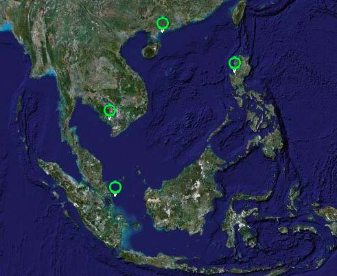
Cover Illustration: Google Earth Image of the South China Sea showing the location of the four seagrass
demonstration sites.
Photo credits:
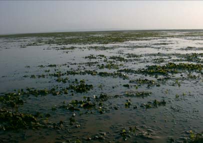
Page 1
Panoramic view of the extensive Hepu seagrass bed at low tide, China Professor Huang
Xiaoping
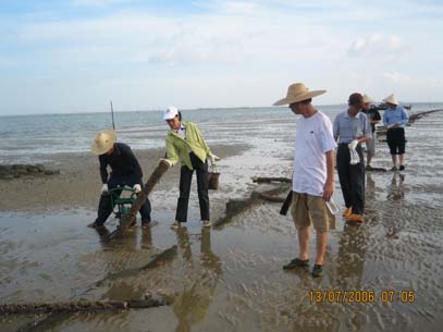
Page 2
Removal of posts used in illegal fish cage culture in the Hepu seagrass bed, China Professor
Huang Xiaoping
Page 4
5,000 seagrass posters have been distributed through, schools, pagoda and government
offices in Cambodia Mr. Ouk Vibol
Page 6
Seagrass float for the Bolinao Town Festival, 2007, Philippines Dr. Miguel Fortes
Page 7
Sand mining for export causes increased turbidity and loss of seagrass habitat, Indonesia
Mr. Tri Edi Kuriandewa
Page 8
Tourist accommodation constructed above a seagrass meadow in East Bintan, Indonesia
Mr. Tri Edi Kuriandewa
Editor:
Dr. John C. Pernetta
Contributors: Kampot: Mr. Khem Ponna; Hepu: Mr. Chonghua Wu; East Bintan: Mr. Supriyono: Bolinao:
Ms. Tutu B. Almonte
This publication has been compiled as a collaborative document of the Regional Working Group on Seagrass of
the UNEP/GEF Project entitled "Reversing Environmental Degradation Trends in the South China Sea and Gulf
of Thailand."
For citation purposes this document may be cited as:
UNEP. 2007. Seagrass Demonstration Sites in the South China Sea. UNEP/GEF/SCS Technical Publication No. 6.
SEAGRASS DEMONSTRATION SITES IN THE SOUTH CHINA SEA 1
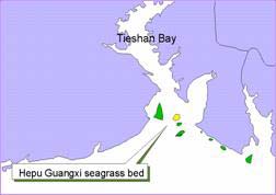
Hepu Seagrass Demonstration Site
The Hepu seagrass demonstration site is located, in
The goal of the project is to demonstrate community
Guangxi Province, People's Republic of China, at
based management, aimed at maintaining existing
21°28.5' North, 109°40.2' East. The total area of
biodiversity and environmental condition and using
seagrass in 2003 was 540 hectares (Figure 1)
seagrass resources rationally and sustainably. This
divided into seven beds in coastal areas adjacent to
is to be accomplished through maintaining a
Shankou and Shantian towns.
balance between utilisation and conservation,
based on community and government involvement.
Figure 1 Location of the seven seagrass beds surveyed
during 2002 and 2003.
Figure 2 Panoramic view of the extensive Hepu seagrass
bed at low tide.
There are 4 seagrass species: Halophila ovalis,
Halodule uninervis, Halophila beccarii and Zostera
The Hepu demonstration site aims to:
japonica. H. ovalis is the dominant species
· Establish a cross sectorial management
occupying 75% of the whole seagrass area and
framework for the sustainable use of the
having a percentage cover of more than 80%. The
seagrass site;
average biomass is 25.5g/m2; and the density is
·
Manage the site sustainably;
1,385 shoots/m2. Associated fauna and flora
· Conserve the seagrass ecosystem as a major
reported in the Hepu seagrass bed include 5
habitat for the purpose of biodiversity
penaeid shrimps, 12 gastropods, 1 seahorse
conservation, dugong protection, etc.; and,
species, a number of species of urchins, siganids,
· Educate and involve all stakeholders with
holothurians, and starfish. Less common are the
regard to the preservation of seagrass habitat.
green turtle (Chelonia mydas), dugong (Dugong
dugon), and Indo-Pacific hump-back dolphin (Sousa
Key achievements to date:
chinensis).
A key achievement of the seagrass component in
In Shankou, the population in 1999 was 65,881, of
China to date has been the enhanced awareness of
whom 42,677 work in the agricultural sector in a
the importance of seagrass meadows as spawning
land area of 2,267 hectares. In Shantian, the
and nursery areas for demersal fish and crustacean
population in 1999 was 16,387 with a labour force
species. The website <seagrass.scsio.ac.cn> is the
of 7,795 people working in the cultivation of
only website in China carrying information regarding
535.6ha. The local population of Shankou and
seagrass and has been an important tool in
Shantian are primarily dependent upon rice
sensitising senior government officials to the
cultivation and fish culture.
importance of seagrass ecosystems.
Current management of the area is the
The Management Board for the Hepu Seagrass
responsibility of two separate entities. The Shantian
demonstration site, with a membership of twelve
Town Government has management rights to the
people from various government sectors, was
sea area. The National Nature Reserve for Dugong,
established in 2004 and has operated smoothly with
which is under the jurisdiction of the Guangxi
regular meetings every 3 months. The Management
Province Environmental Protection Bureau, has the
Board is responsible for oversight of the
duty to protect dugong and seagrass.
implementation of the demonstration site activities
and for the development of policies and the over-
Threats to seagrass include natural threats such as
arching management plan. The board has been an
storms and strong waves, and human induced
effective mechanism for ensuring cross-sectorial co-
threats, which include gleaning, trampling, digging
ordination that has resulted in a multi-agency task
for Sipunculus nudus (acorn worms) and shellfish,
force of local government bodies, fishermen,
cage culture of oysters, fish fences, trawling, and
residents and students, being formed to physically
waste water pollution. Of these mariculture is
remove the posts and structures supporting illegal
perhaps of greatest importance, particularly the
mariculture pens and fences (Figure 3.) The first
extensive construction of fish pens.
action for enforcement covered an area of 1,100
Reversing Environmental Degradation Trends in the South China Sea and Gulf of Thailand
2 SEAGRASS DEMONSTRATION SITES IN THE SOUTH CHINA SEA
hectares and involved the mobilisation of more then
A second survey in October 2006 focussed on the
300 people and 12 vessels. This resulted in the
collection of data and information relating to the
removal of more than 50,000 illegal wooden posts
economic valuation of seagrass habitat in Hepu.
and 1 shelter, and cleaned 13 illegal mollusc culture
The outputs from these surveys have been used by
areas.
policy makers in developing plans for sustainable
use of seagrass resources.
Regarding capacity building, 20 persons have been
trained on seagrass survey techniques and a
number of items of equipment used for underwater
surveys and monitoring of water quality have been
purchased by the project.
Diverse activities have been carried out to enhance
public awareness of the importance and value of
seagrass including the publication and distribution
of a small book, 500 posters and brochures, and
400 copies of a video on protecting seagrass
ecosystems and preserving marine biodiversity. A
book has been published providing an introduction
to the ecological functions and importance of
seagrass, and provides guidance to local people on
Figure 3
Removal of posts used in illegal fish cage
how to protect and sustainable use their seagrass
culture in the Hepu seagrass bed.
resources. This book also contains the phone
number for reporting illegal activities in the area.
A management plan has been developed and
The project has convened three training courses for
reviewed by the Management Board and will be
teachers and pupils on ecological function and
approved by the local government for
economic value of seagrass; current status of the
implementation during and beyond the life of the
Hepu seagrass bed; and measures for conservation
project in order to maintain project outcomes. Part
and sustainable use.
of the management plan includes a draft zoning
framework in which 200 of the 300 hectares of
The effectiveness of this programme has been
seagrass are classified as a sustainable use zone.
assessed by the conduct of surveys and the
A National Seagrass Nature Reserve will be
evaluation of members of the public and
established in Hepu by mid-2008. The central
government officers' awareness of various aspects
government will provide permanent annual budget
of seagrass ecology and management every three
allocations to maintain activities of the reserve, thus
months. The results suggest that levels of
ensuring financial sustainability.
awareness have greatly improved since project
inception. More importantly, the designation of the
A re-evaluation of the existing criteria and a draft
Hepu seagrass bed as a demonstration site under
work plan to expand the National Dugong Reserve
the UNEP/GEF Project has resulted in the
has been finalised to cover a wider area of habitat
agreement of Government authorities to fund the
for this endangered species. Legislation to support
costs of construction of a seagrass education and
the management of Hepu seagrass was developed
information centre. Designs have been finalised by
and reviewed by the Management Board and wil be
the Tianjin Construction Design Institute and
approved by the local government as a basis for
construction will be completed in 2008.
more effective enforcement of management
regulations in the future.
It is recognised that the execution of the Hepu
demonstration site still has minor weaknesses,
Water and sediment quality have been monitored at
which need to be addressed. Representatives of the
seven monitoring stations by, the staff of the
local community, private sector and NGOs have not
Management Station of the Hepu Nature Reserve.
yet been included as members of the Management
Water temperature, transparency, pH, salinity, and
Board. As a consequence activities at the
data for other chemical attributes have been
demonstration site have not involved the private
col ected.
sector and NGOs, which may have resulted in
missed opportunities for the mobilisation of
In order to assess the status of seagrass beds in
additional financial and human resources. Approval
Hepu, an ecological survey was carried out at 6
of the management plan for the Hepu
areas (Xialongwei, Shabei, Beimu, Yingluo Port,
demonstration site has been delayed by the local
Ronggen Hil and Jiuhejingdi) in August 2006. This
government which has delayed the implementation
seagrass watch revealed that the degradation trend
of some activities.
in Hepu seagrass beds is still serious. The impacts
of human activity in Shabei and Xialongwei are
obvious. Digging for Sipunculus nudus,
Phascolosoma esculentus and shellfish occurs in
most areas, and is considered as the main cause of
seagrass degradation in terms of reduced cover.
Reversing Environmental Degradation Trends in the South China Sea and Gulf of Thailand

SEAGRASS DEMONSTRATION SITES IN THE SOUTH CHINA SEA 3
Prek Ampil, Kampot Demonstration Site
Prek Ampil demonstration site is geographically
Marine resources in Kampot Province are managed
located between 10°27' and 10°36' North, and
by both national and provincial fisheries agencies,
103°54' and 104°17' East, in Kampot Province of
while environmental agencies are responsible for
the Kingdom of Cambodia. It lies in the eastern
management and conservation of resources in
region of the Gulf of Thailand in close proximity to
marine protected areas and national parks. Tourism
Phu Quoc Island in Viet Nam. Management of the
in the area is limited and is dominated by local
two sites involves joint action by the Provincial
visitors. The government is committed to promoting
Governments of Kampot in Cambodia and Kien
eco-tourism in both the coastal and mountainous
Giang Province in Viet Nam. A range of habitats
areas of the adjacent Bokor National Park.
can be found in this area including seagrass
meadows, coral reefs, mangroves and coastal
The National Coastal Steering Committee has been
wetlands. The dominant marine habitat in the Prek
established to oversee the management and
Ampil area is however the extensive seagrass
development of the natural resources and
meadows that cover 25,240ha. making them the
environment for the whole coastline of the Kingdom
most extensive in the South China Sea (Figure 4).
of Cambodia. This committee includes
representatives from the Ministry of Agriculture,
Forestry and Fisheries, and the Ministry of
Environment together with the Provincial
Department of Tourism, the Royal Navy and
Provincial level institutions from the four coastal
municipalities/provinces.
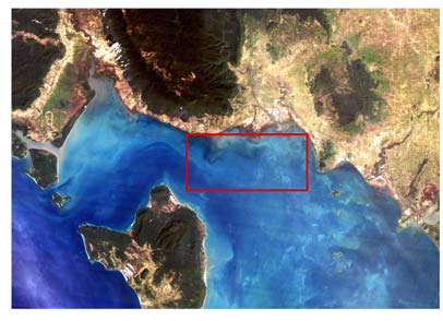
Figure 4 Transboundary seagrass management between
Kampot Province, Cambodia (red square) and
Phu Quoc Island (bottom centre of the image)
Kien Giang Province, Viet Nam
The seagrass meadows are located parallel to the
coast of Prek Ampil, and extend 150-300m from the
shoreline being widest in front of the Bokor National
Park. The area has a gentle slope with seagrass
occurring at depths from 1 to 4m. A number of other
Figure 5 Map of the Prek Ampil Seagrass Demonstration
ecosystems are associated with these seagrass
Site in Kampot Province
meadows including small patches of coral reefs
within them and other patches about 800m from the
The main threats to seagrass in Kampot are il egal
seaward edge of the seagrass. The seagrass
and inappropriate fishing activities such as the use
community is comprised of nine species: Enhalus
of motorised push nets and trawlers. Over-fishing,
acoroides, Thalassia hemprichii, Halophila beccarii,
pol ution from populated areas, increased sediment
Halophila decipiens, Syringodium isoetifolium,
inputs from coastal catchments, and intensive
Cymodocea rotundata, Halodule uninervis,
seaweed farming all threaten the health of seagrass
Halodule pinifolia, and Halophila ovalis. Thalassia
in the longer-term. With increased development of
hemprichii is the most dominant, fol owed by
the coast and population growth in the future,
Enhalus acoroides and Halodule uninervis.
seagrass beds could be seriously impacted if
appropriate management plans are not put in place
There are 31 villages in 9 communes surrounding
in the near future.
the demonstration site area. Forty two percent of
families are subsistent fishers and depend directly
The goal of the demonstration site is to encourage
on seagrass habitats. More than 600 small scale
more sustainable use of seagrass habitats, and to
fishing vessels are operated in the area using
reduce the impacts of human activities, through the
fishing gear such as beach seines, gill nets, traps
application of a new co-management strategy. The
and push nets. Mariculture of seaweed and semi-
objectives of the demonstration site are to:
intensive shrimp farming also occur in Kampot. The
· Develop and establish a co-ordinating
rest of the population is involved in rice and
mechanism among national and local
vegetable cultivation, small businesses, and fish
government agencies, local communities, and
processing.
between Cambodia and Viet Nam; in managing
seagrass resources in the coastal waters of
Kampot Province;
Reversing Environmental Degradation Trends in the South China Sea and Gulf of Thailand
4 SEAGRASS DEMONSTRATION SITES IN THE SOUTH CHINA SEA
· Develop and implement a long-term
limited, collection of biological and socio-economic
management plan including regulations for
data and information at the site level is crucial in
sustainable use of seagrass resources and
order to establish baselines against which the
ecosystems;
impacts of future developments can be measured,
· Enhance public awareness and to improve
and the effectiveness of long-term management
understanding among policy makers, managers
evaluated. Biological data relating to: seagrass
and local communities of the ecological
species distribution, density, and canopy height;
significance and economic value of seagrass
and socio-economic data on: resource uses,
habitats; and,
income of local communities and fishers, and
· Investigate possible mechanisms for ensuring
economic values of seagrass resources have been
financial sustainability of management and
collected through extensive surveys. These data will
improving the economic conditions of coastal
be incorporated into the GIS database and used in
communities.
the establishment of zones for different uses within
the management plan.
Key achievements to date
Capacity building commenced with a training course
The first and most important achievement has been
on project management and administration for
the establishment of two multi-sectorial and multi-
officers involved in executing activities at the site.
level management bodies for supervising and
Five local consultative workshops have been
guiding the implementation of the demonstration
convened to enhance public awareness regarding
site activities. The Management Board (MB) and
the value of seagrass and the need for
Management Advisory Group (MAG) are comprised
conservation. In addition, public awareness has
of members of relevant public sector organisations
been enhanced by the distribution of 2,000 posters
at national and provincial levels and are responsible
and 5,000 leaflets describing seagrass resources;
for dealing with political (MB) and scientific (MAG)
the functions and values of seagrass ecosystems;
matters, and were established by provincial
and the concepts of sustainable management and
declaration in October 2006. These management
conservation. These have been published and
bodies convene regular meetings, both separately
distributed to all relevant stakeholders, especially
and jointly, every three to six months in order to
local schools, pagoda and communities.
track progress and to guide the implementation of
activities. They also have a primary responsibility to
develop a long-term management plan based on
sound scientific data and information.
As the Kampot demonstration site lies in close
proximity to the Phu Quoc Island seagrass and
coral reef demonstration site in Viet Nam, (see
Figure 1) the Management Board and Management
Advisory Group have a responsibility to co-ordinate
their work with partners in Phu Quoc. Two joint
meetings have been convened between the
Management Boards of both sites to date. A
co-operative framework for ecosystem and resource
management has been drafted for review and
adoption by both provincial authorities. Technical
experts from both sites have agreed the format and
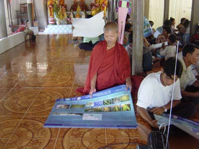
Figure 6 5,000 seagrass posters have been distributed
parameters to develop a joint GIS database to
through, schools, pagoda and government
support planning and management that will be
offices
finalised during project implementation.
Even though a considerable volume of outputs have
At the request of the Kampot Management Board,
been produced to date, management is still weak
Viet Nam has developed practical guidelines for
and further action is required. One of the most
resource assessment and monitoring and has
crucial outputs, the management plan for the
conducted a training course in support of activities
demonstration site, has not been finalised or
at Kampot. Representatives of the Kampot
approved and this remains to be completed in the
authorities and communities have visited Phu Quoc
near future. Management practices need to include
in order to learn from the experiences of their
future monitoring with involvement of local people to
Vietnamese counterparts in the management and
assess if management of seagrass resources has
conservation of seagrass resources. The guidelines
been effective as a consequence of the
focus only on seagrass and physical environmental
demonstration site activities.
conditions, but not on associated resources and
socio-economic indicators. The latter need to be
developed in order to track changes that result from
management actions.
Since data and information concerning the seagrass
community at the Kampot demonstration site is very
Reversing Environmental Degradation Trends in the South China Sea and Gulf of Thailand
SEAGRASS DEMONSTRATION SITES IN THE SOUTH CHINA SEA 5
Bolinao Seagrass Demonstration Site
Cape Bolinao is located on the north western tip of
remaining fifteen percent derive income from
Pangasinan Province (16o36' 16o46' North and
collecting shells for shell craft, charcoal making,
119o83' 119o97' East) and is surrounded by the
small businesses, and salaried employment. There
most extensive coral reef in the Lingayen Gulf. It
are about 3,000 people who are totally dependent
lies on the western margin of the Lingayen Gulf
on fishing for food and income. Only 37% are full-
facing the South China Sea to the North and West
time fishermen, 43% are part-time fishermen and
and the Caquiputan Strait to the East. One large
20% are engaged in fish processing and related
island, Santiago Island and several smaller ones
business, and small scale mariculture activities.
are located adjacent to Cape Bolinao (Figure 7).
Fish are sold by the fisher folk wholesale, retail and
by house-to-house peddling. Milkfish aquaculture in
Santiago Island is an integral part of the Lingayen
Bolinao has now become the major source of cash
Gulf system as a consequence of its' extensively
income for the local community, but tourism is
developed reef system and associated habitats.
growing rapidly.
The reef flat area is estimated at around 50 km2 of
which half the area (~25 km2) supports extensive
seagrass meadows. There are seven seagrass
species recorded from Santiago Island and Cape
Bolinao. Giant clams (Tridacna gigas) have been
over-exploited in the area and a giant clam hatchery
and nursery was developed at the Marine Science
Institute marine station with grow-out areas on
Santiago Island.
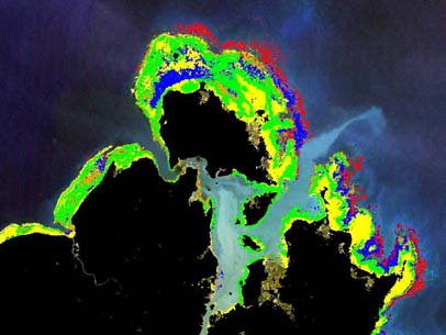
Figure 8 False colour image of the Bolinao reef system.
Red is coral reef, yellow bare sand, green
seagrass and blue mixed habitats.
The main threats to the marine environment at
Bolinao come from pollution by household wastes
and from cage mariculture, the clearing of
mangrove areas for fish ponds, catching siganid
juveniles in seagrass using push net, trampling of
Figure
7 Location of Bolinao in Northern Luzon,
seagrass beds and reef flats.
Philippines
This demonstration project aims to establish
Preliminary surveys have recorded a number of
functional linkages between and among community
species including: 10 species of holothurians, 11
groups, academic institutions, and local and
crustaceans, 1 starfish, and 149 gastropods. The
national government entities, such that the
reef flat, and in particular the seagrass beds, are
seagrass ecosystems that form the resource base
identified as critical spawning and nursery habitat
of local livelihoods will be enhanced, protected and
for juvenile rabbitfish and sea urchins. Rabbitfish
managed. In addition, the aim is to preserve the
(Siganus fuscescens) juveniles migrate from open
biodiversity in the seagrass meadows, marine fauna
sea to the seagrass areas to seek refuge and food
and flora alike, restore the degraded areas, and
while sea urchins (Tripneustes gratilla) remain
reduce threats and provide preventive actions to
within the bed to forage throughout their life cycle.
these threats.
Of the 30 barangays (the smallest local government
The objectives of the demonstration site are to:
unit in the Philippines) found in Bolinao, 20 are
·
Enhance resource management, particularly for
located in coastal areas and 22% of the total
seagrass based on comprehensive data and
population is engaged in fishing. Based on present
information;
use, the coastal waters of Cape Bolinao are divided
· Intensify and increase public awareness
into four zones; a fishery management zone for use
through an information, education and
by subsistence fisher folk; a multiple use zone; a
communication campaign;
trade and navigational zone; and an eco-tourism
· Strengthen stakeholders' capacity in
zone.
management of resources; and
· Design and implement an alternative, and/or
Forty four percent of the population is engaged in
supplemental livelihood programme.
fishing and forty one percent in agriculture. The
Reversing Environmental Degradation Trends in the South China Sea and Gulf of Thailand
6 SEAGRASS DEMONSTRATION SITES IN THE SOUTH CHINA SEA
Key achievements to date:
A significant achievement has been the support
from the project to enhance the quality of the local
The establishment and operation of the
danggit (Siganus spp.) product in terms both of
Management Board has created a functional
quality and packaging. This has more than doubled
linkage between stakeholders, and ensures policy
the original price of the product and raised its'
making in the context of a multi-sectorial approach.
acceptability. It was noted during the mid-term
The Board conducts regular meetings to draft and
evaluation that large quantities of juvenile rabbit fish
consider elements of a Bolinao Seagrass Reserve
are used to produce the "danggit". According to
Management Plan and to prepare an Ordinance for
information from meetings with villagers and local
the establishment of the Bolinao Seagrass Reserve.
community officers, it seems that there is a lack of
A Memorandum of Agreement encompassing
biological and catch information such that an
partnership amongst and between the Bolinao Local
analysis of the biology, species composition, life
Government, the Bolinao Marine Ecological Fund
cycles, spawning season and area, and catch
Foundation, Marine Science Institute and the
records should be undertaken as a matter of
Bolinao Seagrass Demonstration Site has been
priority. Other alternatives to improve local
signed to enhance co-ordination in marine resource
livelihood and to reduce threats to seagrass and
management.
associated habitats include the culture, harvesting
and marketing of sea cucumbers.
A database of seagrass resources at the Bolinao
demonstration site has been established,
encompassing both biological and socio-economic
data and information. A map of seagrass resources
has been prepared on the basis of field survey data
and this will be integrated into a GIS database. On
the basis of data and information obtained through
the field surveys, a Bolinao Seagrass Sanctuary
with the total area of 60ha has been established
divided into a 20 hectare core zone and a 40
hectare of buffer zone. Eleven permanent seagrass
monitoring sites have been established in different
areas, five on Santiago Island and six in coastal
barangays on the mainland. To operate the Bolinao
Seagrass Sanctuary, an ordinance was approved
by the Office of the Municipal Council in March,
2007. The Management Plan was developed and
finalised in July 2007.
Figure 9 Seagrass float for the Bolinao Town Festival,
2007.
A series of activities have been carried out to
enhance public awareness, including: convening of
The efforts of the local government in the
a project orientation workshop; dissemination of
conservation of coastal habitats are significant and
information on seagrass distribution obtained from
worthy of special note. The Mayor of Bolinao
the field surveys; preparation and distribution of
Municipality has promulgated a series of Municipal
awareness materials including billboard, comics,
Ordinances to establish a number of smal scale
seagrass T-shirts, and a video. Local newspapers
marine protected areas or sanctuaries, including 8
and TV have interviewed project participants and
for coral reefs, 8 for mangroves, and 1 for seagrass.
have broadcast information on the activities and
A system of "Bantay Dagat" (Sea Wardens) has
successes of the Bolinao site. The Seagrass
been established in order to enforce these
Festival, named "Tarektek" was initiated during the
ordinances. The sea wardens are fishermen from
Bolinao Town Fiesta in April 2007. The Bolinao
coastal villages and the local government provides
demonstration site was highlighted during this
them with a patrol boat and daily allowance.
festival by means of a float in the parade, and the
distribution of awareness materials to the public.
The of Bolinao demonstration site has focussed on
implementation of activities such as networking,
Two training courses have been organised one on
development of local ordinances, meetings and
seagrass taxonomy (50 trainees) and one on waste
training. Few practical activities have been
management (64 trainees). A study tour for
undertaken to date. Practical activities at the site
committee members was also organised to Puerto
level are considered urgent if the demonstration site
Princesa City, Palawan. In addition, training on
is to achieve all expected outcomes.
"Seagrass Watch" methods was organised for
volunteers including fisher folk, barangay officials
Activities involving the implementation of Seagrass
and local government personnel. The training
Watch and assessment of the socio-economic
events covered techniques for monitoring and
impacts of the municipal ordinance need to be
assessing seagrass meadows. The training and
initiated as soon as practical. In this regard a large
mobilisation of local police and "Bantay Dagat"
amount of information and data collected by
volunteers was intended to strengthen enforcement
"Bantay Dagat" members should be documented as
of Municipal Ordinances related to the management
these include potential indicators of value in
of coral reefs, mangroves and seagrass.
monitoring changes to resources in the area.
Reversing Environmental Degradation Trends in the South China Sea and Gulf of Thailand
SEAGRASS DEMONSTRATION SITES IN THE SOUTH CHINA SEA 7
East Bintan Seagrass Demonstration Site
Bintan Island is the largest, (1,591 km2) of 3,200
There are 31 commercial fish species reported from
islands in the Kepulauan Riau Province of
the site, among them the spotted coral and leopard
Indonesia. It is located about 810km northwest of
groupers (Plectropomus maculates and
Jakarta (Figure 10). The Census in 2000 showed
Plectropomus leopardus) are of transboundary
that 45,495 males and 48,200 females were
significance. It is reported by local experts that the
resident in 11,960 households of East Bintan giving
juveniles of coral groupers, Plectropomus spp. are
a density of 59 people km-2. The majority of the local
often found in coral reefs adjacent to Trikora Beach.
people are engaged in agriculture and fisheries
Shrimp species of economic importance associated
although some are employees in coastal resorts,
with this site include: banana prawn, Penaeus
which is a rapidly expanding source of employment
merguiensis, giant tiger prawn, Penaeus monodon,
in the area.
jinga shrimp, Metapenaeus addinis, and greasyback
shrimp, Metapenaeus ensis.
Figure 10
The Riau Archipelago, Indonesia.
East Bintan is rich in biodiversity and its' seagrass
habitats have a high density with seagrass cover of
up to 95% providing refuges and spawning areas
Figure 11
The East Bintan Seagrass demonstration site.
for a wide variety of marine species. There are ten
species of seagrass found in the area of Trikora
Due to the geographical location of the site, which is
Beach: Enhalus acoroides, Thalassia hemprichii,
close to Tanjung Pinang, Batam City and even
Cymodocea rotundata, Cymodocea serrulata,
closer to Singapore, Bintan Island is under heavy
Thalassodendron ciliatum, Halodule pinifolia,
development pressure and resource exploitation is
Halodule uninervis, Syringodium isoetifolium,
increasing. The island is currently undergoing rapid
Halophila ovalis, and H. spinulosa. These form both
development due to strong demand for resort
non-specific meadows and mixed associations.
development as well as high demands for
Thalassodendron ciliatum, Enhalus acoroides and
construction and reclamation materials, such as
Thalassia hemprichii have been recorded as the
rock, soil and sand, which are exported to
most common species that are widespread
Singapore. The provincial and local authorities face
throughout the area. The most significant seagrass
the challenge of simultaneously conserving the
species in the area is Halophila spinulosa since it is
seagrass and associated habitats whilst at the
rare in Indonesia.
same time strengthening local economic
development.
Coral reefs are well developed along the southern
and eastern coasts, and live coral coverage in the
reef edge of this area is fairly high (40 to 70 %),
dominated by massive coral genera such as
Porites. Approximately 70 species of reef fishes
have been recorded. Mangroves are found in the
northern part of Trikora Beach around the Tanjung
Berakit area. Endangered and threatened species
include the dugong (Dugong dugon), sea horse
(Hippocampus sp.), green turtle (Chelonia midas),
and hawksbill turtle (Eretmochelys imbricata).
Species considered nationally endangered include
the giant clams, Tridacna squamosa and Tridacna
crocea, and top shell, Trochus niloticus. The island
has beautiful, scenic beaches along the northern
coast where tourism development is concentrated.
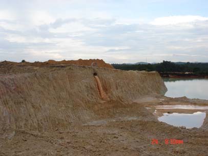
Figure 12 Sand mining for export causes increased
turbidity and loss of seagrass habitat.
Reversing Environmental Degradation Trends in the South China Sea and Gulf of Thailand
8 SEAGRASS DEMONSTRATION SITES IN THE SOUTH CHINA SEA
Observed problems at the site include degradation
including field research for economic valuation of
of the seagrass beds and a decrease in fish
seagrass and a study on the tourism potential.
resources resulting from physical changes to the
seabed, such as sand removal, and enhanced
The surveys provided information and data
sedimentation and siltation, in areas where coastal
essential for spatial zoning for sustainable use of
construction is being undertaken which reduce the
the seagrass resources in the area. Data on direct
area and vegetation cover in the seagrass beds.
uses of fisheries resources such as fish, crab, and
Increased turbidity adversely affects the
shellfish, and on indirect uses such as tourism have
photosynthetic capacity and growth of seagrass
been collected. These data suggest an economic
whilst increased organic and nutrient pol ution have
value of seagrass in East Bintan of US$2,287ha-1
resulted in enhanced growth of epiphytic algae.
year-1, of which tourism contributed the highest
values. Capture fisheries involve a greater number
Further direct threats to the seagrass habitats
of people, 574 households or 2,870 people,
include destructive fishing methods such as trawling
compared with tourism, 150 households or 750
and push netting. Without effective and integrated
people.
interventions, the degradation trends in this
regionally significant seagrass habitat will
The Local House Representative of Bintan has
accelerate with resultant loss of biodiversity.
adopted the spatial plan (Perda No. 14/2007) under
which four zones are designated: a conservation
This medium sized project aims to establish an
zone for habitat protection with bans of resort and
integrated management system for a total of 1,500
hotel construction, and permission only for fishing
hectares of the coastal and marine environment
by local communities. Diving, snorkel ing, tracking,
including seagrass and associated habitats, through
cycling and camping are arranged in a buffer zone
a cross-sectorial and participatory approach to
with specific regulations relevant to each activity.
addressing the threats, and the root-causes of
General coastal tourism zone requires the
current and future habitat degradation. The project
development of hotels, resorts, restaurants and real
plans to achieve three major outcomes, which wil
estate and the provision of services for boating,
create an environment, among al stakeholders, for
surfing, para-sailing, horse riding and diving. All
enabling and maintaining sustainable management
such activities including construction should be
of the area, as follows:
managed in accordance with the relevant
regulations to prevent sedimentation, erosion and
Management of the area is improved through: the
discharge of domestic waste.
establishment of appropriate institutional
arrangements to ensure a wide range of relevant
The next step for the Bintan site is the finalisation of
stakeholders participate in decision making, and on-
a sustainable tourism spatial plan. Since tourism
the-ground management activities in particular the
contributes enormously to Bintan's economy, the
local communities and the private sector; adoption
plan is of critical importance and a draft is under
of integrated area management plan, and
consultation with local stakeholders.
introduction/revision and enforcement of relevant
regulations.
Awareness on the importance of seagrass
habitats and associated ecosystems are
increased; and capacity for seagrass habitat
management is improved through: awareness
raising and capacity building among al
stakeholders in order to increase understanding of
the ecological and socio-economic value and
importance of seagrass and associated habitats;
and application of such knowledge for area
management and planning in particular among local
government officials and community members who
are involved in the area management; and
Environmental sustainability of local economic
activities is increased through the creation of an
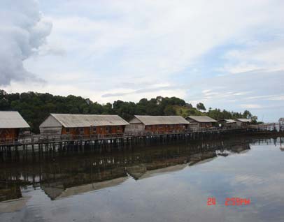
Figure 13 Tourist accommodation constructed above a
environment for sustainable economic activities
seagrass meadow in East Bintan.
such as sustainable tourism and other types of
alternative income generation options.
Awareness activities have included the
dissemination of a set of posters and leaflets on
Key achievements to date:
seagrass conservation to local communities and
related stakeholders. In addition, the local
The demonstration site of East Bintan has recently
government have provided 1.5 hectares of land at
become operational as a medium sized project. A
Trikora beach for development of a marine research
number of activities have already been undertaken
and information centre to benefit the local
with support of local government co-financing,
community, governmental entities, and local
stakeholders.
Reversing Environmental Degradation Trends in the South China Sea and Gulf of Thailand
DEMONSTRATION SITE MANAGERS
Mr. Ponna Khem; Kampot Site Manager, Fisheries Officer, Kampot Fisheries Office, Kampot Province,
Cambodia, Tel: 855 12 666 406, Fax: 855 33 932 661, E-mail: ponna@camintel.com;
ponnakam@yahoo.com
Mr. Chonghua Wu; Hepu Site Manager, Director, Environmental Protection Bureau of Beihai City, 198 Beihai
Road, Beihai City 536000, Quangxi, China, Tel: (86) 13 80789333, Fax: (86 779) 3051268; 3035928
Mr. Supriyono; East Bintan Site Manager, Head of Infrastructure and Natural Resources Division, Regional
Development Planning Agency of Bintan, Bappeda Kabupaten Bintan, Jl. Ahmad Yari km 5,
Tanjungpinang, Indonesia, Mobile: (62) 812 7741693, Tel: (62 771) 29647, Fax: (62 771) 29646,
E-mail: bimoyuhis@yahoo.com; mas_prie@telkom.net
Ms. Tutu B. Almonte; Bolinao Seagrass Site Manager, BML, UP MSI, Bolinao, Pangasinan, Philippines,
Tel: (63) 091 9657 7503, E-mail: tutualmonte@yahoo.com
MEMBERS OF THE REGIONAL WORKING GROUP ON SEAGRASS
Dr. Chittima Aryuthaka, Department of Marine Science, Faculty of Fisheries, Kasetsart University, Bangkhen,
Bangkok 10900, Thailand, Tel: (66 2) 579 7610; 561 3469, Fax: (66 2) 561 4287, E-mail: ffiscta@ku.ac.th
Dr. Hutomo Malikusworo, Indonesian Institute of Science, Pasir Putih 1, Ancol Timur, Jakarta 14330, Indonesia,
Tel: (62 21) 6471 3850, Mobile: (62) 815 952 0650, Fax: (62 21) 6471 1948,
E-mail: indo-seagrass@centrin.net.id
Mr. Ouk Vibol, Deputy Chief of Fishery Conservation, Fisheries Administration, Ministry of Agriculture, Forestry
and Fisheries, 186 Norodom Boulevard, PO Box 582, Phnom Penh, Cambodia, Tel: (855 23) 216 244,
Mobile: (855) 12 836 376, Fax: (855 23) 221 485, E-mail: aims1@online.com.kh
Mr. Xiaoping Huang, South China Sea Institute of Oceanology, Chinese Academy of Sciences,
164 West Xingang Road, Guangzhou 510301, Guangdong Province, China, Tel: (86 20) 8902 3210,
Mobile: (86) 13 6004 84979, Fax: (86 20) 8445 1672,E-mail: xphuang@scsio.ac.cn
Mr. Tri Edi Kuriandewa, Puslit Oseanografi, LIPI, Pasir Putih 1, Ancol Timur, Jakarta, Indonesia,
Tel: (62 21) 6471 3850; 316 9288, Mobile: (62) 81 5808 6468, Fax: (62 21) 6471 1948,
E-mail: indo-seagrass@centrin.net.id
Mr. Kamarruddin bin Ibrahim, Department of Fisheries, Turtle and Marine Ecosystem Center (TUMEC)
23050 Rantau Abang, Dungun, Terengganu, Malaysia, Tel: (609) 845 8169; 845 3169 (direct),
Mobile: (60) 13 9812500, Fax: (609) 845 8017, E-mail: kdin55@yahoo.com
Dr. Miguel Fortes, Marine Science Institute CS, University of the Philippines, Diliman, QC, 1101 Philippines,
Tel: 632 922 3958/59; Fax: 632 924 7678, Emails: fortesm@upmsi.ph; migueldfortes@gmail.com
Dr. Marco Nemesio E. Montańo, (2004-2006) Marine Science Institute, University of the Philippines, Diliman,
Quezon City 1101, Philippines, Tel: (632) 927 2693; 922 3942, Fax: (632) 924 7678,
Email: coke@upmsi.ph; montano.n@upmsi.ph
Dr. Suvaluck Satumanatpan, Faculty of Environment and Resource Studies, Mahidol University, Salaya
Campus, Nakorn Pathom 73170, Thailand, Tel: (66 2) 441 5000 ext. 182, Mobile: (66) 1 700 7512,
Fax: (66 2) 441 9509-10, E-mail: ensnt@mahidol.ac.th
Ass. Prof. Dr. Nguyen Van Tien, Senior Expert, Chairman of Scientific Committee, Institute of Marine
Environment and Resources (IMER), Vietnamese Academy of Science and Technology, 246 Da Nang
Street, Hai Phong City, Viet Nam, Tel: (84.31).761523; 760599; (home) (84 31) 825191, Mobile: (84) 0903
475468, Fax: (84 31).761521, E-mail: tiennv@imer.ac.vn


UNEP/GEF South China Sea Project Co-ordinating Unit
United Nations Building
Rajadamnern Nok
Bangkok 10200
Thailand
Fisheries Administration of Cambodia
Ministry of Agriculture, Forestry and Fisheries
186 Norodom Boulevard
P.O. Box 582
Phnom Penh
Cambodia
South China Sea Institute of Oceanology
Chinese Academy of Sciences
164 West Xingang Road
Guangzhou 510301
Guangdong Province
People's Republic of China
Puslit OSEANOGRAFI, LIPI
Pasir Patih 1
Ancol Timur
Jakarta,
Indonesia
Turtle and Marine Ecosystem Center (TUMEC)
Department of Fisheries Malaysia
23050 Rantau Abang
Dungun
Terengganu
Malaysia
Marine Science Institute
University of the Philippines
Diliman
Quezon City 1101
Philippines
Faculty of Environment and Resource Studies
Mahidol University
Salaya Campus
Nakorn Pathom 73170
Thailand
Institute of Marine Environment and Resources (IMER)
Vietnamese Academy of Science and Technology
246 Da Nang Street, Hai Phong City
Hai Phong City
Viet Nam