
"Reversing Environmental Degradation Trends
in the South China Sea and Gulf of Thailand"
LAND-BASED POLLUTION IN THE SOUTH CHINA SEA
UNEP/GEF
Regional Working Group on Land-based Pollution

First published in Thailand in 2007 by the United Nations Environment Programme.
Copyright © 2007, United Nations Environment Programme
This publication may be reproduced in whole or in part and in any form for educational or non-profit purposes
without special permission from the copyright holder provided acknowledgement of the source is made. UNEP
would appreciate receiving a copy of any publication that uses this publication as a source.
No use of this publication may be made for resale or for any other commercial purpose without prior permission in
writing from the United Nations Environment Programme.
UNEP/GEF
Project Co-ordinating Unit,
United Nations Environment Programme,
UN Building, 2nd Floor Block B, Rajdamnern Avenue,
Bangkok 10200, Thailand.
Tel.
+66 2 288 1886
Fax.
+66 2 288 1094
http://www.unepscs.org
DISCLAIMER:
The contents of this report do not necessarily reflect the views and policies of UNEP or the GEF. The designations
employed and the presentations do not imply the expression of any opinion whatsoever on the part of UNEP, of the
GEF, or of any cooperating organisation concerning the legal status of any country, territory, city or area, of its
authorities, or of the delineation of its territories or boundaries.
Cover Illustration: Sewage system draining to communal cesspit on land, and domestic solid waste
forming marine litter, Batam. Dr. Vo Si Tuan
Photo credits:
Page 2
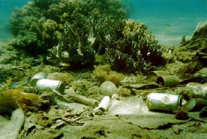
Solid Waste Littering a Coral Reef in Van Phong Bay, Viet Nam Dr. Vo Si Tuan
Page 3
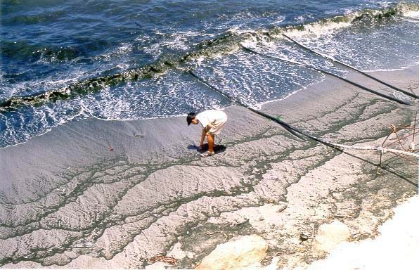
Algal Bloom as a Result of Nutrient Enrichment in Ca Na Bay, Viet Nam Department of Science
and Technology, Binh thuan Province
Page 4
Fish kill in Hainan Province, China - SEAFDEC
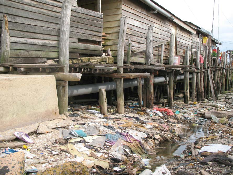
Marine Litter Discarded in a Coastal Fishing Village, Batu Ampur, Indonesia .Dr. Vo Si Tuan
Page 6
Compost Production from Organic Wastes in Batam Vil age, Indonesia Dr. Vo Si Tuan
Page 7
Vil agers with Locally Produced Compost Ready for Sale in Tanjung Riau Village, Batam,
Indonesia Mr. Noviandra
Edited and compiled by: Dr. Gullaya Wattayakorn and Dr. John. C. Pernetta
This publication has been prepared as a collaborative document of the Regional Working Group on Land-based
Pollution of the UNEP/GEF Project entitled "Reversing Environmental Degradation Trends in the South China Sea
and Gulf of Thailand."
For citation purposes this document may be cited as:
UNEP. 2007. Land-based Pollution in the South China Sea. UNEP/GEF/SCS Technical Publication No. 10.
LAND-BASED POLLUTION IN THE SOUTH CHINA SEA 1
OVERVIEW OF REGIONAL LAND-BASED POLLUTION CONCERNS AND ACTIONS
IN THE SOUTH CHINA SEA
INTRODUCTION
pol ution and contamination problems tend to be
Geographical setting
more prevalent than in the insular southern and
eastern portions of the sea.
The South China Sea is located in the Indo-West
Pacific between the Pacific Ocean on the East and
The South China Sea is connected to the Pacific
the Indian Ocean on the West, and has an area of
Ocean by the Taiwan, and Bashi, Straits; to the Sulu
3.447 million square kilometres and a maximum
and Celebes Seas by the Mindanao and Balabac
depth of 5,245 meters in the Manila Trench. It is
Straits; to the Indian Ocean via the Straits of
situated in the region between 3o South and 26o
Malacca; and, to the Java Sea by the Kalimantan
North latitude and between 100o and 121o East
and Gaspa Straits. The Bashi and Malacca Straits
longitude. The South China Sea is surrounded by
are the most important in terms of the exchange of
nine countries: China, Viet Nam, Cambodia,
water between the South China Sea and other water
Thailand, Malaysia, Singapore, Indonesia, Brunei
bodies. The South China Sea receives freshwater
and the Philippines and contains many islands,
input from many rivers, and the combined discharge
including Hainan in the Northwest. Most of the
from the Mekong, Pearl, Red and Chao Phraya
islands are found to the South and East in Indonesia,
Rivers is more than a billion cubic meters per year.
the Philippines, and Malaysia where hundreds of
The largest rivers draining into the South China Sea
smaller islands, atolls, submerged reefs and banks
include the Mekong and Red Rivers in South and
are also located. The northeastern sub-basin
North Viet Nam, and the Pearl River in Guangdong
occupies about fifty percent of the total area of the
Province, China. Discharges from these rivers,
South China Sea and includes a deep zone with
including land-based contaminants, influence the
abyssal plain, deep trenches and submerged peaks
distribution of marine habitats and resources in the
or guyots. There is an extensive continental shelf
South China Sea.
bordering the northern and western shores where
Figure 1
The South China Sea and Surrounding Areas.
Reversing Environmental Degradation Trends in the South China Sea and Gulf of Thailand
2 LAND-BASED POLLUTION IN THE SOUTH CHINA SEA
The South China Sea is located in the monsoon belt
source of contamination, discharged directly, while
of Southeast Asia with two monsoon periods: the
inputs via groundwater have not been measured.
Northeast monsoon from November to March in the
The major categories of waste discharged into the
winter, and the Southwest monsoon from June to
South China Sea include domestic sewage,
August is in the summer. The two inter-monsoon
industrial and agricultural wastes, mining and
seasons between April and May and between
construction wastes including sediments and mine
September and October are transitional periods of
tailings. Ship-based sources of pollution are a minor
unstable wind direction and speed. The South China
contributor to pol ution problems in the South China
Sea is influenced by typhoons which originate both
Sea, but may have severe impacts when large
inside the South China Sea and outside in the Pacific
volumes are released such as during major oil spills,
Ocean. Typhoons mainly affect the coastal areas of
and are significant in areas such as the Straits of
Taiwan, China, the Philippines and Viet Nam, and
Malacca where substantial volumes of shipping are
typhoon surges from 3.2 to 3.6 metres have been
concentrated during their passage from the Indian
recorded in China and Viet Nam.
Ocean to the South China Sea.
The tides of the South China Sea are complex in
comparison with most other seas or ocean areas
since there are four different tidal regimes within the
basin. Semidiurnal tides only occur in the Taiwan
Strait and northern Viet Nam; diurnal tides dominate
in the Gulf of Tonkin, and the Gulf of Thailand while
both irregular diurnal, and semi-diurnal tides are
found elsewhere in the basin, the latter
predominating in coastal areas of southern China,
Southern Viet Nam, Eastern Malaysia, Northwest
Kalimantan and in the Bashi Straits. Maximum tide
level at Minjiang (China) is 7.2m; Hong Kong (China)
2.7m; Cua Ong (Viet Nam) 4.7m; Sihanoukville
(Cambodia) 1.8m; Bangkok Bar (Thailand) 1.2m;
Figure 2 Solid Waste Littering a Coral Reef in Van Phong
East coast of Malaysia 3.5m; Singapore Straits 3.6m;
Bay, Viet Nam.
Sarawak (Indonesia) 5.4m; and Manila (Philippines)
2.2m. (Hydrographic Office, 1994).
Land-based sources of pollution
· Domestic sources: The total population of the
As a consequence of the monsoons; the water
nine countries bordering the South China Sea in
exchange between the South China Sea and
2003 was 1.716 bil ion people, of whom around
neighbouring water bodies; and the bathymetry of
600 million were located in the coastal
the South China Sea marine basin, there are two
catchments of the South China Sea. Sewage and
types of residual currents in the South China Sea.
domestic wastes, including liquid and solid
During the Southwest monsoon the main current
wastes are major pollutants of coastal waters. A
flows in a Southwest-Northeast direction along the
large proportion of domestic waste in the South
coast of Viet Nam, and from the Malacca and
China Sea region is discharged directly or
Kalimantan Straits to the Bashi and Taiwan Straits,
indirectly via rivers to the sea without proper
resulting in the development of clockwise currents in
treatment. It is estimated that the populations of
the southeastern portion of the South China Sea, the
countries bordering the South China Sea
Gulf of Thailand, and the Gulf of Tonkin. During the
generate one mil ion metric tonnes of sewage per
Northeast monsoon, the main current also flows
year. The low level of sewage treatment has led
along the coast of Viet Nam, but in an opposite,
to serious concern with regard to organic and
Northeast-Southwest direction. This is strengthened
nutrient pollution in the South China Sea. The
by currents from the Sulu and East China Seas,
high organic and nutrient content of untreated
resulting in an anticlockwise current in the Gulf of
sewage leads to eutrophication, the occurrence
Thailand and the Gulf of Tonkin. Currents are
of red-tides, and harmful algal blooms in localised
generally stronger in winter than in summer, except
areas of the coast. The consequences of this
in the Gulf of Thailand.
include anoxia of bottom waters, resulting in fish
and benthos mass mortality. Declines in seafood
Demographic and economic context
quality, and public health hazards may result
The countries bordering the South China Sea are
from build up of toxins in maricultured seafood,
some of the most densely populated and with the
particularly shellfish derived from phytoplankton
fastest growing economies in the world. It is
in the red tides and harmful algal blooms.
estimated that more than 270 mil ion people live in
Domestic wastes may also introduce pathogenic
the coastal zone of the South China Sea'.
bacteria, viruses and protozoa to the marine
Land-based activities are therefore the main source
environment which can be taken up by shellfish
of contaminants and pollutants in coastal waters.
and reintroduced into the human food chain.
Approximately 70% of contaminants entering the
· Industrial sources: These include liquid, solid
South China Sea are derived from coastal rivers, and
and gaseous wastes from coastal factories
include agricultural and urban run-off, industrial
involved in the manufacturing and processing of
discharges, and discharges from ports and harbours.
building materials, textiles, paints, food, minerals,
Coastal aquaculture is a significant and growing
Reversing Environmental Degradation Trends in the South China Sea and Gulf of Thailand
LAND-BASED POLLUTION IN THE SOUTH CHINA SEA 3
and hydrocarbons. Most factories employ
· Marine aquaculture sources: The aquaculture
obsolete technology and processes and the
sector has developed rapidly in Southeast Asia
waste waters discharged into the South China
over recent decades, largely in response to
Sea are normal y untreated or only partially
increased global demand for fish and shrimp
treated. These wastes contain significant
products. China is the world's largest aquaculture
amounts of heavy metals, oil and organic matter
producer much of it freshwater, whilst Thailand,
which can be toxic to marine organisms.
Viet Nam, Indonesia and the Philippines are also
amongst the world's most important aquaculture
producing countries. The major pol ution
problems caused by aquaculture include the
discharge of faecal matter from ponds and cages,
which is typically high in organic matter, nutrients,
and suspended solids, and contamination from
antibiotics and other drugs added to the water to
treat fish and crustacean diseases. The exposure
of acid sulphate soils during excavation of shrimp
farm ponds and the subsequent run-off of low pH
water to coastal waters during rainfall events is
also an issue of concern.
Figure 3 Algal Bloom as a Result of Nutrient Enrichment in
Ca Na Bay, Viet Nam.
· Port and harbour sources: The South China
Sea carries an enormous volume of marine
transport and numerous ports and harbours have
been constructed over recent decades to support
international, regional and domestic maritime
transport. Major wastes from ports and harbours
include toxic compounds released from
antifouling paints, such as tributyltin (TBT), and
oil discharged from ships. Tributyltin is an
effective biocide and is toxic to marine organisms
at concentrations as low as one nanogram per
litre. Ballast water often contains high
concentrations of crude oil, which is toxic to
Figure 4 Marine Litter Discarded in a Coastal Fishing
marine organisms. It may also contain exotic
Village, Batu Ampur, Indonesia.
organisms.
Contaminants and pollutants in the South China
·
Sea
Agricultural sources: The countries bordering
the South China Sea have a substantial
Land-based contaminants enter the marine
agricultural base. Large and increasing quantities
environment through either point sources such as
of pesticides and chemical fertilisers are used in
ports, harbours, and industrial complexes or through
the region. Improper handling and application of
non-point sources such as rivers or groundwater that
pesticides and fertilisers has caused pol ution of
contain agricultural run-off, liquid domestic wastes
ground water, nearby rivers and coastal waters of
and brackish-water aquaculture contaminants.
the South China Sea. Fish and shellfish are
Suspended solids are mostly derived from
extremely sensitive to pesticides, especially
land-clearance, logging, coastal construction and the
chlorinated hydrocarbons (e.g. the 96hLC
conversion of mangrove forests for other uses.
50 value
of aldrin to fish is 1 µg/L). Intensive animal
Nutrient loads are mainly derived from untreated
husbandry is now a growing source of nutrient
domestic wastes from coastal cities or urban areas
and organic matter contamination in the coastal
discharged directly into coastal water bodies or rivers
waters of China, Viet Nam, Thailand and
with minimal levels of treatment. Fertilisers,
Malaysia.
pesticides and herbicides in farming practices are
also known to enter coastal waters of the South
· Mining sources: The mining of coal, minerals
China Sea via runoff and leaching. Increased
and building materials on land can contaminate
suspended solids and nutrient loads impact the
the aquatic environment. Mining wastes include
productivity of marine ecosystems with suspended
the chemicals used in the extraction and primary
solids reducing light penetration and hence
processing of minerals, low pH water from mine
photosynthesis and enhanced nutrients increasing
settlement ponds, sediments eroded from mining
primary productivity. Concentrations of ammonia,
areas, and heavy metals leached from mine
nitrite, nitrate, and orthophosphate, are increasing
tailings dumps and spilled during transport. Dust
and exceed the ASEAN Marine Water Quality
from Vietnamese coal mines for example has
Criteria in many locations. Increased inputs of
degraded coral reef and seagrass habitats in
nutrients apparently correspond to the observed
coastal waters and sediments from mining have
frequency of red tides and harmful algal blooms.
smothered coral reefs in the Philippines.
Reversing Environmental Degradation Trends in the South China Sea and Gulf of Thailand
4 LAND-BASED POLLUTION IN THE SOUTH CHINA SEA
The Pearl River estuary in the People's Republic of
REGIONAL COLLABORATION IN ADDRESSING
China is essentially a black river as the result of
LAND-BASED POLLUTION PROBLEMS
significant increases in organic pollutants, including
nitrogen and phosphorus. Discharges to the South
Over the past three decades several regional
China Sea from the Pearl River estuary are not only
projects concerning marine pollution have been
high in nutrients but also cause very high Biological
implemented by various organisations in the South
Oxygen Demand (B.O.D.)
China Sea region. These projects have produced
useful information for marine pollution research and
monitoring at the regional level and have also built
capacity in the participating countries for marine
pol ution monitoring and management.
The Intergovernmental Oceanographic Commission
Sub-commission for the Western Pacific
(IOC/WESTPAC) has initiated several regional
projects dealing with marine pollution research and
monitoring, including an assessment of marine
pollution from river inputs which resulted in a regional
network of river monitoring systems to monitor
nutrients inputs to the Western Pacific Ocean. This
network extended over a wide geographic area from
Russia in the North to Australia in the South and Fiji
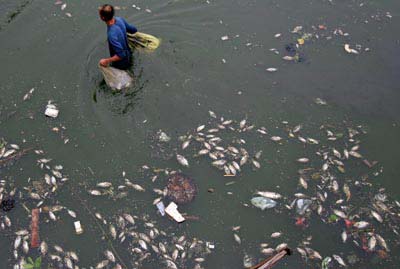
Figure 5 Fish kil in Hainan Province, China.
in the East. Two inter-calibration exercises were
Compared to suspended solids and nutrients, oils,
carried out as part of the project and training courses
heavy metals and persistent organic pollutants
on analytical methods were organised for
(POPs) pose an immediate threat to both living
technicians and scientists from water quality
resources and marine ecosystems of the South
laboratories within the region. The data generated
China Sea. Oil and grease pollution from land-based
from the project was transmitted to the Responsible
sources contributes about 50 % to the total oil
National Data Centre for WESTPAC (Japan
pol ution in the marine environment. The threat of oil
Oceanographic Data Centre, JODC), and relevant
pol ution to the marine environment and resources is
papers were published in the proceedings of the
even greater when there are no laws or limited law
IOC/WESTPAC Scientific Symposia.
enforcement. For example, in Cambodia and Viet
Nam there are no regulations pertaining to the
During the implementation of the global International
discharge of ship wastes, with most waste engine oil
Mussel Watch Project, IOC/WESTPAC initiated a
being discharged directly into coastal water bodies.
mussel watch project to monitor pollutants such as
Similarly, concentrations of oil and grease, mercury,
heavy metals and pesticides in the WESTPAC
and phenols exceed ASEAN Marine Water Quality
region. A regional network was established, and
Criteria in many coastal water areas of the South
training courses were organised. During the
China Sea due to weak regulations and minimal
implementation of the project, reference materials
monitoring and enforcement.
prepared by the National Environment Research
Institute, Japan were introduced to and used by the
Based on several studies conducted in the coastal
project. However, due to technical difficulties
waters of the South China Sea particularly in
monitoring activities were only carried out in a few
Thailand, the Philippines, Viet Nam, Malaysia and
participating countries. The project established a
Indonesia it has been found that concentrations of
mussel watch monitoring network within the region,
heavy metals such as mercury (Hg), Arsenic (As)
and trained scientists from regional laboratories.
and lead (Pb) have tended to increase over the past
two decades. These heavy metals have potential
A third activity was an assessment of pol utants from
negative impacts on the health of marine living
atmospheric deposition in the WESTPAC region
resources and humans who consume seafood
during which some attempts to monitor the
products. Sound and strategic actions are needed at
deposition of metals (Japan) and organic
all levels of government and by stakeholders to curb
compounds (PAH, in Thailand) were made. The
heavy metal pollution and accumulation in sediments
major findings of the project indicated that the inputs
and biota in the hotspots.
of nutrients to the sea via atmospheric deposition
could be as significant as those from river inputs. The
Water
Sediment
Biota
results of the surveys in the Yangtze River and
Cambodia
8 3
3
Yellow River supported this phenomenon.
China
102 >9
none
Indonesia
100 none
none
Following the United Nations Conference on
Malaysia
128 none
none
Environment and Development (UNCED) held in
Philippines
9 25
3
1992, the Intergovernmental Oceanographic
Thailand
170 50
15
Viet Nam
22 22
none
Commission of UNESCO developed the Global
Total
Ocean Observing System (GOOS). The
Intergovernmental Health of the Oceans Panel,
Table 1 Numbers of Coastal Water Monitoring Stations in
co-sponsored by IOC and UNEP, prepared a
the South China Sea.
strategy for monitoring and prevention of marine
Reversing Environmental Degradation Trends in the South China Sea and Gulf of Thailand
LAND-BASED POLLUTION IN THE SOUTH CHINA SEA 5
pollution. The HOTO Strategy provided scientific
At the national level, the national coordinators or
guidelines for marine pollution monitoring and
focal points were responsible for convening regular
prevention, and managing the impacts on human
meetings of a national land-based pol ution
health. The Strategy considered not only the
committee or working group. National working
chemical aspects of the pollution problem, but
groups for land-based pollution were developed in all
interdisciplinary approaches were proposed to the
participating countries, and were Chaired by the
governments and scientists engaged in the
National Focal Points. A total of 126 individuals
respective activities.
representing sixty six separate national institutions
were members of these committees which ranged in
Following the adoption of the Global Programme of
size from eight to twenty six members. A total of 12
Action for the Protection of the Marine Environment
institutions or agencies with expertise in various
from Land-based Pollution (GPA/LBA) in 1992, the
aspects of land-based pollution were sub-contracted
Regional Programme of Action for Implementation of
at the national level to assist in the completion of
the GPA/LBA was adopted in 1996, by the
tasks in the MoU signed with UNEP.
Coordinating Body for the Seas of East Asia
(COBSEA 1 ). Implementation of the Regional
Regional Information Base for Land-Based
Programme of Action has been carried out since
Pollution Management
then, including preparation of regional review,
A problem identified during the development phase
organization of relevant workshops and training
of the South China Sea Project was that, while many
courses. The primary focus of COBSEA has been on
valuable data sets on land-based pollution were
the sources of marine contamination and pol ution.
available within the region, the sharing of this
information was restricted by weak data
The Partnerships in Environmental Management for
management systems in most countries. Limited
the Seas of East Asia commenced as a GEF project
cross-sectorial integration between government
in 1992 and has subsequently grown and extended
ministries and departments involved in marine
its operations to cover sixteen countries in East Asia.
environment and natural resource management was
The main objectives have been to build national
also identified as a key constraint in improving the
and regional capacity to implement Integrated
information base for the management of land-based
Coastal Zone Management Programmes; to
pol ution of the South China Sea. In response to this,
reinforce and establish a range of functional
national and regional meta-databases were
networks; and to strengthen national capacity
compiled to enable the sharing of data about existing
pol ution data sets (i.e., metadata). During the period
for developing integrated coastal and marine
from 2003-2007, a total of 226 meta-data entries on
policies as part of the state policies for
land-based pol ution data sets have been
sustainable socio-economic development.
contributed to the regional online meta-database for
the South China Sea (http://metadata.unepscs.org)
ACTIVITIES OF THE SOUTH CHINA SEA
by Cambodia (12), China (27), Indonesia (13),
PROJECT
Thailand (28), and Viet Nam (146).
Networking under the South China Sea project
The Regional Working Group on Land-Based
The Regional Working Group for Land-based
Pollution also worked during the preparatory and
Pollution (RWG-LbP) established in the first meeting
operational phases of the South China Sea Project to
held in Bangkok, Thailand, 3 - 5 April 2002, is
collate data for inclusion in a regional GIS database
comprised of seven Focal Points from the
on: the coastal impacts of pollution (ambient water
participating countries2, two Regional Experts, and
quality/sediment quality); the impacts of pol ution on
one member from the Project Co-ordinating Unit
human health; pollution loading from key rivers
(PCU). The government designated Focal Points
draining into the South China Sea basin; and
were contracted to provide 25% of their time to the
land-based activities in coastal catchments of the
project under the Memoranda of Understanding
South China Sea. However, despite the large
signed between UNEP and the Specialised
number of water quality (539), sediment quality (99),
Executing Agency within which the focal point
and biota monitoring stations (21) in the South China
worked. The RWG-LbP links to other regional
Sea and Gulf of Thailand, very little information
working groups and two regional task forces one for
relating to data collected at monitoring stations was
Economic evaluation and one for Legal Matters.
contributed to the regional GIS database by the
countries (61 data sets in total). A total of 35 datasets
relating to the impacts of pol ution on human health,
and 68 data sets relating to pollution loading from
river catchments, were compiled at the regional level
1
over the 5 year period to 2007.
COBSEA = The Co-ordinating Body for the Seas of East
Asia, an intergovernmental forum of, presently 10
member countries, established by UNEP in 1981 and
Hot spot characterisation and priority ranking
designated by the then 5 member countries as a means
The target for the land-based pollution problem is to
to execute the East Asian Seas Action Plan (UNEP,
set and maintain region-wide water quality standards
1981) COBSEA was at that time congruent with the
and water quality objectives which will assist in
ASEAN Expert Group on the Environment (Para 36 of
UNEP, 1981).
maintaining the health of coastal ecosystems. In
2 Cambodia, China, Indonesia, Malaysia, Philippines,
order to achieve this goal the project has adopted the
Thailand and Viet Nam.
marine water quality criteria adopted by the
Reversing Environmental Degradation Trends in the South China Sea and Gulf of Thailand
6 LAND-BASED POLLUTION IN THE SOUTH CHINA SEA
Association of South East Asian Nations (ASEAN)
alternative points of intervention, along the chain of
and the biological and sediment quality standards
cause and effect. Optimal y, all causes are identified
used in the People's Republic of China for use in
and quantified and the potential benefits of
characterising potential regional "pol ution hot spots",
intervention at any one point along the chain are
the term which has been proposed for use within the
evaluated, where possible through some form of cost
framework of the UNEP/GEF project as follows:
benefit analysis. The causal chain therefore is used
to provide an objective basis for deciding between
"A limited and definable area in which there are
different types of intervention at a particular site.
prevailing environmental conditions attributable to
anthropogenic activities that adversely affect, or
On the basis of proposals and their ranking by the
threaten to affect, human health, threaten ecosystem
regional working group it was agreed that the
functioning, reduce biodiversity and/or compromise
proposals for the construction of an artificial wetland
resources and amenities of economic importance in
in the Ling Ding Yang sub-catchment of the Pearl
a manner that would appear to warrant priority
River estuary (China) and for Batam (Indonesia)
management attention"
were recommended to the Project Steering
committee for support.
The procedures employed in characterising pollution
hot spots in this project partially benefited from work
The Batam Pilot Site
conducted within the preparative (PDF-B) phase of a
The Municipality of Batam covers an area of
UNEP/GEF project on the Russian Arctic. However,
1,570.35km˛ located between 000 55' 010 55'North
the refinement and augmentation of these
and 1030 45' 1040 10' East, bordered by the
procedures within the South China Sea project have
Singapore Straits to the North, the Bintan Utara
substantial y enhanced their potential replicability.
Sub-District in the East, the Senayang Sub-District in
The criteria for ranking hot spots were agreed by
the South, and Moro Sub-District in the West. In
consensus and a total of 17 hotspots were
2003 the population was 562,661 persons, 268,431
characterised using the ranking system agreed at the
(48%) male and 294,230 (52%) female. Total
second meeting of the RWG-LbP (UNEP, 2002).
population growth from 1990 to 2000 was 12% and
over the period 2002 2003 it reached 5.5%.
In categorising the magnitude of the problems the
"impact on the marine environment" was evaluated in
Batam is located at a crossroads of international
terms of impacts on: water quality; sediment quality;
trade and is considered a major centre of economic
biological samples; changes in living marine
development in Indonesia. Significant increases in
organisms; and affected marine communities.
investment across all sectors but particularly in
Ambient water quality was itself defined in terms of:
commerce, industry, tourism, and real estate has
nutrients; faecal coliform bacteria; heavy metals and
occurred as a consequence of its proximity to
dissolved oxygen concentration.
Singapore and has resulted in negative impacts on
the environment and resources.
Ranking of the impacts resulting from contaminants
in the South China Sea marine basin suggests that
Coastal and marine habitats and the environment of
the reduction in water quality is apparently the major
Batam city as a whole have degradation as a
concern, followed by biological impacts which are
consequence of increased population and demands
less well demonstrated and thirdly contamination of
on marine resources of residents fol owing
sediments. In terms of the contaminants themselves
achievement of higher living standards. This has led
the most widespread and severe problems resulted
to overexploitation of resources, increase of
from enhanced nutrient inputs whilst heavy metals
domestic and industrial wastes, and physical
were found to be a significant problem in biological
destruction of coastal habitats. The major
samples, and sediments of certain hotspots. The
land-based pol ution problem in coastal waters
results form a sound basis for selection of pilot
adjacent to the City is contamination from heavy
activities addressing regionally significant impacts of
metals and nutrients.
specific contaminants in hot spots of the region and
capacity building.
In term of pollution management, the Agency for
Market and Sanitation of Batam City is responsible
Pilot activities
for the management of domestic waste. Usual y,
In evaluating potential pilot activities it was
domestic solid waste from markets and the
recognised that the resources available to the project
settlements in Batam are dumped in temporary sites
were insufficient to rectify all pol ution problems at
prior to composting, burial or, burning. The
even one pollution hotspot. The focus was to identify
Environment Impact Management Agency
potential pilot activities that would serve as
(Bapedalda) is in overall charge of environmental
replication models addressing particular types of
management with responsibilities for monitoring,
land-based pollution rather than to attempt the
control and supervision of natural resource use and
cleanup of individual sources or an entire "hotspot".
environmental impact analysis.
As part of this evaluation a "causal chain analysis"
With the support of the pilot project, a multi-sectorial
was conducted. A causal chain analysis is a
management board was established that will be
recommended GEF tool used in the identification of
maintained beyond the life of the project. This body
the causes of change in environmental state, the
not only co-ordinates the pilot activity but also
level or scale of threats at a particular site, and the
integrates the work of related entities in the planning
Reversing Environmental Degradation Trends in the South China Sea and Gulf of Thailand
LAND-BASED POLLUTION IN THE SOUTH CHINA SEA 7
and implementation of activities for the sustainable
development of the entire city. A rural village outside
Batam City was selected for trialling a communal
septic system and management of the solid wastes.
In managing the solid wastes in this village the
project organised waste collection, storage and
treatment at the village. Two hundred plastic rubbish
bins were provided for collection of solid wastes
separated into organic wet materials and
non-organic dry wastes. The organic wastes were
gathered in a temporary waste management site and
used to produce compost. Around 300 400kg of
compost is produced per month from organic waste.
The product is used as fertiliser in the village and
provides an additional source of income.
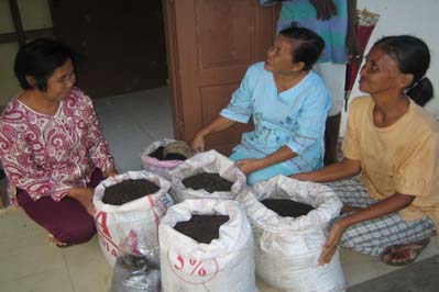
Figure 6 Villagers with Locally Produced Compost Ready
for Sale in Tanjung Riau Village, Batam,
Non-organic waste is transported for disposal at the
Indonesia.
solid waste dump site of the city.
The database on environment status and
management in Batam city has been developed to
include all data obtained by surveys and monitoring
made by environment sector during recent years,
and also data col ected through the monitoring
programme of the industry parks. This database is a
helpful tool for environment management of the city:
as a means to verify changes in environment state;
and to assess the effectiveness of the SUPER and
PROPER programmes in terms of reductions in
heavy metal contents in waste water discharged
from industrial enterprises of the city.
Modelling the impacts of nutrient inputs from
land-based sources
As part of the overall work of the project on the
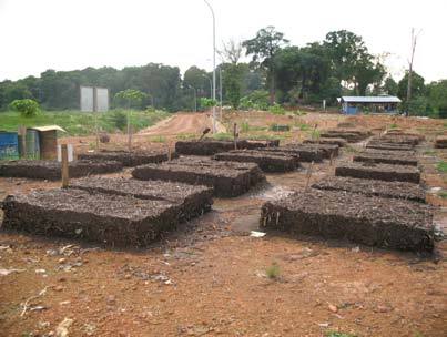
Figure 5
Compost Production from Organic Wastes in
Batam, Indonesia.
impacts of land-based pollution a model was
developed to evaluate the sensitivity of coastal
The project has worked closely with local
ecosystems to changes in nutrient flux from land via
communities in Tanjung Riau village in order to
rivers. The model is based on the relationship
address environment problems caused by domestic
between chlorophyll and nutrient concentration and
waste. Ten systems of communal septic tanks were
was developed by SEA START RC using river runoff
installed each providing for the needs of for 8- 10
data and remote sensing information of monthly
families. One third of householders of the village are
chlorophyll concentration in the surface waters of the
now connected to such systems and plans are in
South China Sea (UNEP, 2007a).
hand to replicate this system elsewhere.
Marine water along the Philippine coast from Luzon
The activities in domestic waste management have
to the Palawan Islands were found to have the
not only improved sanitary conditions in the village
highest assimilative capacity and this part of the
but have also proved helpful in enhancing
South China Sea is never likely to become eutrophic.
awareness and generating support from the local
However, this does not apply to the potential
community for environment management. The
eutrophication of bays and estuaries that were not
management board has encouraged replication of
the focus of this model. The Gulf of Thailand was
the practices in domestic waste management in
also found to have a high assimilative capacity while
Tanjung Riau village as part of the policy of
areas with low assimilative capacity include for
environment management of the city.
example the southern cost of China, central Viet
Nam, Peninsular Malaysia and the Straits of Malacca
In addition the pilot activity has further promoted the
(UNEP, 2007a)
adoption of the SUPER and PROPER programmes
of Indonesia that were introduced in 2002 with
The region now has a tool and trained people in each
respect to reduce heavy metals discharged from
country to undertake model ing of different scenarios
industry. Through activities executed by the pilot
of nutrient inputs to coastal waters. The model can
project, awareness of industrial sector enterprises
be run to estimate the monthly `effective' loading of
regarding waste management has improved
total nutrient from any catchment, as point or
significantly and compliance in reducing the heavy
non-point loading. The model output in chlorophyll
metal content of waste water has been enhanced.
equivalent units can be converted to nutrient
Involvement of industrial enterprises in environment
elements, such as N, using a Chlorophyll to nutrient
management in Batam serves as a good example for
ratio. The model can be used to simulate the monthly
wider dissemination and adoption.
responses of the chlorophyll biomass in any area of
Reversing Environmental Degradation Trends in the South China Sea and Gulf of Thailand
8 LAND-BASED POLLUTION IN THE SOUTH CHINA SEA
the South China Sea (at a resolution 0.1o x 0.1o) to
are required, yet often the financial resources to
different loading scenarios and to estimate the
invest in such infrastructure are lacking.
maximum monthly load of nutrient from any selected
catchment that would ensure the chlorophyll-defined
All countries in the region require an Environmental
biomass remains under a pre-defined limit.
Assessment (EIA) prior to initiating a major
development project and all have programmes to
Valuing the Impacts of Land-based Pollution
increase environmental awareness, and educate the
The Regional Task Force on Economic Valuation
public regarding environmental issues. In addition,
has developed a framework for the valuation of
monitoring of pol ution discharge points and water
land-based pol ution impacts on coastal habitats that
quality monitoring is also currently undertaken by all
includes:
countries.
· A checklist of the impacts of land-based pollution
Although these management practices are in place
on coastal habitats, specifying types of pollutants
some countries lack the capacity to enforce the
and their specific impacts on the four major
Environmental Acts due to limited budgets and
habitats [mangroves, coral reefs, seagrass, and
manpower. Private sector waste producers generally
wetlands];
do not have treatment facilities resulting in a low level
· A Framework for valuing the impacts of
of compliance with standards stipulated under the
land-based pollution on the four habitat types,
law.
categorising the various specific impacts in the
checklist into three categories, i.e. productivity,
Monitoring programmes for some countries involve
amenity, and human welfare;
extensive numbers of sites, but the data collected
are not used appropriately, being used merely for the
· Procedures to undertake valuation of impacts of
publication and dissemination of annual and
land-based pollution on the four habitat types, in
environment quality reports.
which valuation techniques, indicator of
measurement, data needed, and notes and
In order to address the key challenges and
assumptions were described for each specific
weakness in land-based pollution management, the
impact identified in the checklist and framework.
RWG-LbP, in its seventh meeting, suggested the
adoption of targets for land-based pollution including
The impact checklist, the framework, and the
the setting and maintaining of region-wide water
procedures for valuing the impact on the coastal
quality standards and water quality objectives which
habitats have been reviewed and checked by the
will assist in maintaining coastal ecosystem health.
members of all Regional Working Groups during the
sixth round of meetings.
References
In general impacts resulting from land-based
Hydrographic Office, Ministry of Defence, UK, 1994.
pollution either cause reductions in production of
Admiralty Tide Tables and Tidal Stream Tables,
specific resources which can be measured in terms
Volume 3, Pacific Ocean and Adjacent Sea.
of losses in market value; in loss of ecosystem
Published by the Hydrographer of the Navy,
services resulting from ecosystem level impacts; and
England.
economic losses resulting from il ness of individuals
UNEP, 2002. Reversing Environmental Degradation
eating contaminated seafood. Detailed procedures
Trends in the South China Sea and Gulf of
for the economic evaluation of these impacts in
Thailand. Report of the Second Meeting of the
terms of applicable valuation techniques for:
Regional Working Group on Land-based
productivity, amenity value, and human welfare are
Pol ution. UNEP/GEF/South China
provided in the guidelines for economic valuation
Sea/RWG-LbP.2/3.
(UNEP, 2007b)
UNEP, 2006. Reversing Environmental Degradation
Trends in the South China Sea and Gulf of
THE STRATEGY FOR FUTURE ACTIONS TO
Thailand. Report of the Seventh Meeting of the
ADDRESS LAND-BASED POLLUTION
Regional Working Group on Land-based
Pol ution. UNEP/GEF/South China
Countries bordering the South China Sea are
Sea/RWG-LbP.7/3.
experiencing problems with pollutants such as
UNEP, 2007a. Modelling the Carrying Capacity of
nutrients and organic wastes in their coastal waters.
the South China Sea Marine Basin with respect
These contaminants are derived mainly from sewage
to Nutrient Loading from Land-Based Sources
and agricultural discharge and if left unmanaged
in the context of the UNEP/GEF Project
could lead to eutrophication, decline in living
entitled: "Reversing Environmental
resources, and impacts on human health. Current
Degradation Trends in the South China Sea
land-based pollution management practices differ
and Gulf of Thailand". South China Sea
between countries.
Knowledge Document No. 5.
UNEP/GEF/SCS/Inf.5
Most countries have environmental laws which
require the establishment of standards and
UNEP, 2007b. Guidelines for Conducting Economic
enforcement to ensure compliance. In order to meet
Valuation of Coastal Ecosystem Goods and
standards and regulations stipulated under the law,
Services. UNEP/GEF/SCS Technical
structural facilities like waste water treatment plants
Publication No. 8.
Reversing Environmental Degradation Trends in the South China Sea and Gulf of Thailand
MEMBERS OF THE REGIONAL WORKING GROUP ON LAND-BASED POLLUTION
Dr. Gullaya Wattayakorn, Marine Science Department, Chulalongkorn University, Phayathai Road, Bangkok
10330, Thailand, Tel: (662) 218 5407; 218 5409, Fax: (662) 255 0780, E-mail: gullaya@chula.ac.th;
gul aya@gmail.com
Professor Dr. Law Ah Theem, Faculty of Maritime Studies and Marine Science, University Malaysia Terengganu
(UMT), Mengabang Telipot, 21030 Kuala Terengganu, Terengganu Darul Iman, Malaysia, Tel: (609) 668
3302, Fax: (609) 669 3193, E-mail: atlaw@umt.edu.my
Dr. Zainal Arifin, Research Center for Oceanography, Indonesian Institutes of Science, Jl. Pasir Putih l, Ancol
Timur, Jakarta, 14430, Indonesia, Tel: (62 21) 6471 3850 ext. 125, E-mail: zarifin@dnet.net.id
Mr. Pak Sokharavuth, Deputy Director Department of Pollution Control, Ministry of Environment, #48 Samdech
Preah Sihanouk, Sangkat Tonle Bassac, Khan Chamkarmon, Phnom Penh, Cambodia, Tel: (855 23) 222
439, Fax: (855 23) 987 880, E-mail: sokharavuth@online.com.kh
Professor Han Baoxin, Deputy Director, South China Institute of Environmental Sciences, 7 West Yuancun Road,
Guangzhou 510655, Guangdong Province, China, Tel: (86 20) 855 41616, Fax: (86 20) 8552 5658, E-mail:
hbx@scies.com.cn; bxhan@21cn.com
Mrs. Wahyu Indraningsih, Assistant the Deputy Minister of Environment on Marine and Coastal Degradation
Control Affairs, Ministry of Environment, Jl D.I. Panjaitan, Kebon Nanas, Jakarta 13410, Indonesia,
Tel: (62 21) 8590 5638, Fax: (62 21) 8590 4929, E-mail: pkepl@menlh.go.id; windraningsih@menlh.go.id
Mr. Hashim bin Daud, Director, Marine and Water Division, Department of Environment (DOE), Level 2, Podium 2,
Block 4G3 Precint 4, Federal Government Administrative Centre, 62574, Putrajaya, Malaysia,
Tel: (603) 8871 2104, Fax: (603) 8888 4070, E-mail: hd@doe.gov.my
Ms. Perseveranda-Fe J. Otico, Pol ution Research Section, Research And Development Division, Environmental
Management Bureau , (EMB), DENR Compound, Visayas Avenue, Diliman, Quezon City; Philippines,
Tel: (632) 426 4332; 426 4339, Fax: (632) 927 1518; 426 4340 E-Mail: fejotico@yahoo.com
Ms. Chutamad Kavinseksan, Acting Director Marine Environment Division, Ministry of Natural Resources and
Environment, 92 Soi Pahon Yothin 7, Pahon Yothin Rd., Sam Sen Nai, Phaya Thai, Bangkok 10400,
Thailand, Tel: (662) 2982253-4; Fax: (662) 298 2240
Dr. Nguyen Thi Viet Lien, Deputy Director (formerly Dr. Sc. Pham Van Ninh,) Center for Marine Environment
Survey, Research and Consultation, Institute of Mechanics, VAST, 264 Doi Can Street, Ba Dinh District,
Hanoi, Viet Nam, Tel: (844) 762 6087; 832 6195, Fax: (844) 832 7903, Email: nvlien@imech.ac.vn
Dr. Vo Si Tuan, Senior Expert, UNEP/GEF Project Co-ordinating Unit, United Nations Environment Programme,
2nd Floor, Block B, United Nations Building, Rajdamnern Avenue, Bangkok 10200, Thailand, Tel: (66 2) 288
2084, Fax: (66 2) 288 1094, E-mail: vo@un.org


UNEP/GEF South China Sea Project Co-ordinating Unit
United Nations Building
Rajadamnern Nok
Bangkok 10200
Thailand
Department of Pollution Control
Ministry of Environment
#48 Samdech Preah Sihanouk
Sangkat Tonle Bassac, Khan Chamkarmon
Phnom Penh,
Cambodia
South China Institute of Environmental Sciences
7 West Yuancun Road
Guangzhou 510655
Guangdong Province,
People's Republic of China
Ministry of Environment
Jl D.I. Panjaitan, Kebon Nanas
Jakarta 13410, Indonesia
Marine and Water Division
Department of Environment, Malaysia (DOE)
Level 2, Podium 2, Block 4G3 Precint 4,
Federal Government Administrative Centre
62574, Putrajaya, Malaysia
Pollution Research Section
Research And Development Division
Environmental Management Bureau
(EMB), DENR Compound, Visayas Avenue
Diliman, Quezon City; Philippines
Marine Environment Division
Ministry of Natural Resources and Environment
92 Soi Pahon Yothin 7, Pahon Yothin Rd.,
Sam Sen Nai, Phaya Thai
Bangkok 10400, Thailand
Center for Marine Environment Survey
Research and Consultation
Institute of Mechanics, VAST
264 Doi Can Street, Ba Dinh District,
Hanoi, Viet Nam