


"Reversing Environmental Degradation Trends
in the South China Sea and Gulf of Thailand"
CORAL REEF DEMONSTRATION SITES
IN THE SOUTH CHINA SEA
UNEP/GEF
Regional Working Group on Coral Reefs

First published in Bangkok, Thailand in 2007 by the United Nations Environment Programme.
Copyright © 2007, United Nations Environment Programme
This publication may be reproduced in whole or in part and in any form for educational or non-profit purposes
without special permission from the copyright holder provided acknowledgement of the source is made. UNEP
would appreciate receiving a copy of any publication that uses this publication as a source.
No use of this publication may be made for resale or for any other commercial purpose without prior permission
in writing from the United Nations Environment Programme.
UNEP/GEF Project Co-ordinating Unit, United Nations Environment Programme,
UN Building, 2nd Floor Block B, Rajdamnern Avenue, Bangkok 10200, Thailand.
Tel. +66 2 288 1886
Fax. +66 2 288 1094
http://www.unepscs.org
DISCLAIMER:
The contents of this report do not necessarily reflect the views and policies of UNEP or the GEF. The
designations employed and the presentations do not imply the expression of any opinion whatsoever on the part
of UNEP, of the GEF, or of any cooperating organisation concerning the legal status of any country, territory, city
or area, of its authorities, or of the delineation of its territories or boundaries.
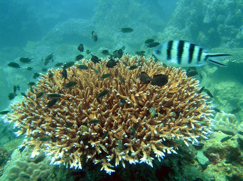
Cover Photo:
Acropora coral head and associated school of Dacylus sp. in Phu Quoc Mr. Nguyen Van
Long
Photo credits:
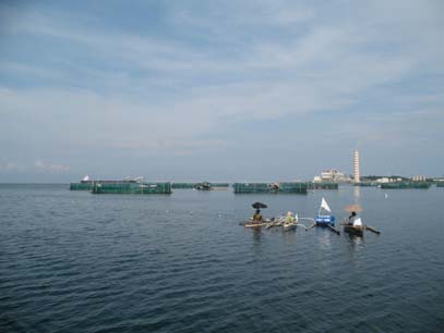
Page 2
Intensive grouper cage culture in Oryon Bay, Masinloc Dr. Vo Si Tuan
Page 4
Coral reef fish at An Thoi, Viet Nam Mr. Nguyen Van Long
Page 5
Diving among soft corals at Mu Koh Chang Island, Thailand Dr. Thamasak Yeemin
Page 6
Establishment of the local guide Centre in Mu Koh Chang, Thailand Dr. Thamasak Yeemin
Page 7
Typical fishing vessel in Bangka-Belitung Dr. Vo Si Tuan
Page 8
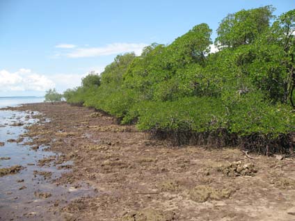
Mangroves on raised coral reef platform and beach rock adjacent to living coral reefs in
Selatnasik, Belitung, Indonesia Dr. Vo Si Tuan
Page 9
Apprehension of a fishing vessel and enforcement of fisheries regulations by the border army
in Ninh Hai, Viet Nam Dr. Vo Si Tuan
Page 10
Ninh Hai is a fringing reef system with very extensive reef flats extending from the shore,
Viet Nam Dr. Vo Si Tuan
Editor:
Dr. John C. Pernetta
Contributors: Belitung: Ms. Nurul Dhewani Mirah Syafrie; Koh Chang: Mr. Nipat Somkleeb; Masinloc:
Ms. Emerlinda Celeste Dion; Phu Quoc: Mr. Nguyen Xuan Niem; Ninh Hai MSP: Mr. Nguyen
An Khang; UNEP/GEF South China Sea Project Co-ordinating Unit, Dr. Vo Si Tuan.
This publication has been compiled as a collaborative document of the Regional Working Group on Coral Reefs
of the UNEP/GEF Project entitled "Reversing Environmental Degradation Trends in the South China Sea and
Gulf of Thailand."
For citation purposes this document may be cited as:
UNEP. 2007. Coral Reefs Demonstration Sites in the South China Sea. UNEP/GEF/SCS Technical Publication
No. 5.
CORAL REEF DEMONSTRATION SITES IN THE SOUTH CHINA SEA 1
Masinloc Coral Reef Demonstration Site
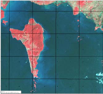
Masinloc is one of the 832 coastal municipalities in
The Municipality covers an area of 7,568 hectares
the Philippines consisting of thirteen Barangays
with a coastline length of 27.7km. This includes the
eleven of which are located around Oyon Bay that
island-barangay of San Salvador, located about
lies between 119'52" to 119"58 East longitude and
2.5km West of the mainland, which has a coastline
15o28"32' to 15o34"47' North latitude. Masinloc is
of 9.7km. Fifty one percent of the total reef area
located in the northern part of Zambales Province
within the municipality is found in Masinloc Bay.
(Figure 1).
PHILIPPINES
SOUTH
CHINA SEA
Luzon
Mindanao
CELEBES SEA
Figure 1 Map of Masinloc, Zambales.
Approximately 1,850 small-scale fisher folk depend
Masinloc has 261 hectares of mangroves in good
on the marine resources of Masinloc's coastal
condition located in small patches along the coast
waters, and the deteriorating state of the bay's
and nearby Panglit Island. A total of eight seagrass
resources is apparent from the decline in fish catch.
species are found in the mudflats and shallow areas
Catch statistics show a reduction from landings of
along the coasts of Masinloc, Palauig, Magalawa,
1,500 tonnes in 1990 to only 90 metric tons by
San Salvador, San Miguel and Panglit islands.
1992. Department of Environment and Natural
Resources (DENR) survey reports in 1994 indicate
The demonstration site aims to:
that 37% of the coral reefs in the area were in poor
· demonstrate a sustainable network of
condition. In order to reverse the deteriorating state
community-based marine sanctuaries by:
of Oyon Bay, the Local Government, community,
developing adaptive management strategies
and NGOs established a 127.5 hectare marine
and co-ordination through monitoring and
sanctuary. A co-management arrangement with the
performance of MPAs; enhancing coral reefs
Central Government Department of Environment
and their adjacent mangrove areas; and
and Natural Resources (DENR) was formalised
regulating and managing reef uses in
through the proclamation by Executive Order of the
surrounding reef areas;
whole of Oyon Bay, Masinloc as a Protected
· To help build local co-management capacities
Seascape.
and strengthen law enforcement capabilities of
Bantay dagat (sea wardens) personnel
Twenty four genera of corals, around 40% of the
together with the establishment of co-operative
total recorded from the South China Sea are found
co-ordination systems;
in Masinloc. 390 species of 139 genera of reef fish
· To conduct and implement livelihood support
have been identified in the area, representing 60%
mechanisms by determining potential
of the total number recorded in the national reef fish
alternative and/or supplemental livelihood
visual census database. Fish biomass estimates fall
options, and establishing appropriate
within the range of 10-20 tonnes/km2.
guidelines/policies for reef stewardship; and
Reversing Environmental Degradation Trends in the South China Sea and Gulf of Thailand
2 CORAL REEF DEMONSTRATION SITES IN THE SOUTH CHINA SEA
· To conduct an Information and Education
Information campaigns will also be undertaken in
Campaign in order to develop public
Magalawa and Luan where many illegal fishers
awareness about environmental issues and
reside. Public awareness billboards have already
concerns through the production of brochures
been installed in the guardhouses of the MPAs and
and posters regarding the coastal resources of
will be installed in the public plaza of Masinloc town.
Masinloc, Zambales and broadcasting
The layout of a calendar for 2008 is now being
knowledge on local radio.
prepared for printing as a means of enhancing
public awareness of coral reef ecosystems and the
Key achievements to date
significance of the marine protected areas.
A Marine Protected Area (MPA) network of three
In order to support the community's efforts in
newly established marine sanctuaries and the 17-
managing their resources, a livelihood project has
year old San Salvador MPA is being formalised with
been developed under the direction of the
the enactment of a Municipal Ordinance. The MPA
Livelihood Centre with a significant budget provided
Management Councils of each MPA have agreed to
as co-finance by the local government. The
meet on the first Friday of each quarter in order to
demonstration site project plans to establish a
exchange experiences, lessons learned and to
Coastal Resource Management Fund to sustain the
establish collaborative mechanisms for enforcement
Livelihood Centre and the CRM Board. It is planned
and other activities. The weak management of the
that P150,000 wil be provided annually by the
17-year old San Salvador marine protected area
Municipal Local Government Unit to fund CRM
that was developed by the HARIBON Foundation
initiatives.
serves as a lesson learnt on the need to improve
management effectiveness through greater
The culture and grow-out of sea cucumber has
involvement of local communities in practical and
been shown to improve local peoples' income and
long-term activities at the site level.
also to support recruitment of this important
resource in the sanctuaries. In addition, a
The MPA Ordinances include regulations for
continuous information campaign is being
enforcement, and organisation of communities in
undertaken through a village-to-village information
managing coastal resources. A "Bantay Dagat"
drive conducted in different villages within and
(Sea Warden) Federation has been established with
outside Masinloc.
48 volunteer members. This organisation conducts
enforcement patrols in the coastal waters of
Recognising the weakness of current
Masinloc. The local government provides a patrol
ecological/environmental monitoring, participatory
boat and patroller's allowance.
monitoring has been implemented to verify
outcomes with regard to changes in environmental
Capacity building has been undertaken through
state. MPA council members wil be trained in
training on reef fisheries licensing, resource
participatory monitoring and these fishers will
assessment and law enforcement. Law
conduct a snorkelling count of indicator species,
enforcement by local people has resulted in a
including important fish, sea cucumber, lobsters,
reduction in il egal fishing and greater protection of
etc. It is also planned to establish a monitoring
the core zone of the sanctuary. Local staff have
notice-board in each MPA so that people will know
also been trained in monitoring, and some
whether there is indeed an increase in marine
monitoring equipment has been purchased. Forty-
resources within and outside the MPA. In addition,
nine demarcation buoys were installed in four MPAs
resource-related indicators will also show whether
to delineate the core zones and areas where fishing
the network of small-scale MPAs will indeed support
is prohibited.
and enhance the living resources and result in the
conservation of biodiversity.
With the support of the project and local
government, guardhouses have been constructed
and mooring buoys installed at the three new
MPAs. A searchlight for night patrols (10,000,000
candlelight power), cell phones, and binoculars
were provided to facilitate enforcement of the no-
fishing policy in the MPAs and to monitor illegal
fishing in the coastal waters of Masinloc.
With the continuous patrolling and enhanced
visibility of the "Bantay Dagat", a decrease in illegal
fishing has been observed. Although the "Batay
Dagat" federation members have already been
trained on basic law enforcement, there is a need
for further training, particularly on the tactics of
apprehension and legal processes required for filing
cases in court.
Figure 2 Intensive Grouper cage culture in Oyon Bay,
Masinloc.
Reversing Environmental Degradation Trends in the South China Sea and Gulf of Thailand
CORAL REEF DEMONSTRATION SITES IN THE SOUTH CHINA SEA 3
Phu Quoc Coral Reef and Seagrass Demonstration Site
Phu Quoc is an archipelago, composed of 14
of macro-algae; 71 species of mollusc; 26 species
islands, 120km offshore from Rach Gia town, Kien
of crustaceans; 19 species of annelids; and 15
Giang Province in the south-western waters of Viet
species of echinoderms. Seagrass beds provide
Nam. Phu Quoc itself is the largest island covering
important subsistence and commercial resources
56,200 hectares and with a maximum altitude of
that support the livelihood of local communities and
603m above sea level. The northern tip of Phu
a transboundary population of dugong.
Quoc Island is close to the Cambodian coastline
and at the southern tip lie the An Thoi islands,
The Vietnamese government has approved recently
consisting of 13 small islands (Figure 3).
a major development plan for the islands, in which
tourism is anticipated to become the most important
Phu Quoc is a priority site listed in the Viet Nam
economic activity. The terrestrial and marine
Biodiversity Action Plan approved by the Prime
ecosystems, and endangered species in the area
Minister in 1995. The waters around Phu Quoc
have been assessed as having a high potential for
islands are considered to be the largest fishing
tourism development.
ground in Viet Nam. Diverse marine ecosystems
(seagrass, coral reefs, mangroves) support pelagic
As indicated in the socio-economic analysis, this is
and demersal fisheries not only around the islands
a large marine area with complicated management
but also in the sub-region.
requirements. The project approach consists of
three components. The special need for awareness,
education and capacity building at the provincial
level based on collection and acquisition of data
and information for management purposes.
Integration mechanisms and awareness education
receive more consideration at the district (island)
level. Establishment of suitable management
models depending on the characteristics of the
ecosystems and recent management will be
focused at a sub-site level. The outcomes of the
project will be presented clearly at the sub-site level
with areas continuing to be managed in suitable
ways and maintained after the closure of the
project.
Immediate objectives of the project are:
· To develop and establish a co-ordinating
mechanism among provincial sectors and
between Viet Nam and Cambodia in
management of coral reefs and seagrass beds
in the coastal waters of Kien Giang;
Figure 3 Phu Quoc and the An Thoi islands located in the
· To execute studies and monitoring activities in
transboundary waters between Cambodia and
order to col ect data and information for
Viet Nam. (Satellite images LandSat ETM,
planning and management purposes;
2002)
· To enhance public awareness and to improve
Remote sensing and ground truthing using manta-
management capacity for policy makers,
tows indicates that the total coral reef area in Phu
managers and local communities in resource
Quoc waters is more than 470ha, of which 360ha
conservation and environment protection;
(76%) is located around the An Thoi Islands. Live
· To improve environment management in the
coral cover averages 44.5%. A total of 260 species
islands (reforestation, waste management) to
from 49 genera of reef-building corals are recorded
minimize negative impacts on coastal
in Phu Quoc waters. The list of coral reef fish
ecosystems;
includes 152 species in 71 genera. The coral reefs
· To have some important sub-sites managed as
of Phu Quoc are very diverse in species of grouper
pilot sites with involvement of park authorities,
but less diverse in butterfly fishes when compared
local fishermen, tourist sector operators and
with other locations in Viet Nam. Recent surveys
others as appropriate; and
found 48 species of macro-mol uscs, 25 species of
· To execute pilot activities in financial
echinoderms, including 18 species of holothurians
sustainability at two sub-demo sites.
and 53 species of macro-algae. A number of sandy
beaches in the An Thoi islands used to be nesting
Key achievement to date
place of sea turtles.
The outputs of the project to date are a series of
Total seagrass area is more than 10,000 hectares
technical reports, including detailed inventories of
mainly distributed in the shallow waters of eastern
the biodiversity, and distribution of coral reef and
of Phu Quoc. The biodiversity of the seagrass beds
seagrass habitats, and socio-economic conditions.
is high having: 9 species of seagrass; 113 species
It is recognised by provincial government that
scientific data obtained through the project is helpful
Reversing Environmental Degradation Trends in the South China Sea and Gulf of Thailand
4 CORAL REEF DEMONSTRATION SITES IN THE SOUTH CHINA SEA
in planning for sustainable development in the
and the Provincial Government. The goal of the
island district. These data and information have
project is to improve the integration of fisheries and
been used in the zoning of pilot areas for
habitat management at the Phu Quoc Island habitat
management, including one for coral reefs in the
demonstration site, through the establishment and
southern group of islands at An Thoi (400ha) and
management of fisheries refugia, in critical
one for seagrass on the eastern coast of Ham Ninh
spawning and nursery areas.
commune (6,300ha). The coastal resource
management plan for the entire coastal waters of
the district will be prepared based on the data and
information collected through these surveys.
Establishment and smooth operation of the Project
Steering Committee, which includes leaders of
relevant sectorial departments at both provincial
and district levels ensure linkages between these
different sectors in implementing project activities.
The project approaches have also been integrated
in provincial policy related to: the plans for Phu
Quoc tourism development; regulations in the
fisheries sector; habitat management, and
endangered species protection; establishment of a
Marine Protected Area (MPA) and development of
the Kien Giang Biosphere Reserve.
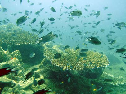
Figure 4 Coral reef fish at An Thoi, Viet Nam.
Phu Quoc in Viet Nam and the Kampot seagrass
demonstration site in Cambodia have been
This is hoped to improve the longer-term security of
identified by the South China Sea project as an
sustainable fisheries yields from Phu Quoc island
important demonstration site for transboundary
waters and adjacent areas. The entire process
management between the two Provinces. The
including the identification of critical spawning and
management teams of both the Kampot and Phu
nursery areas, preparation of a fisheries profile,
Quoc demonstration sites have been working
development of a management framework, and
together to develop a co-operative framework for
establishment of procedures for the enforcement
ecosystem and resource management in the
and guidelines for sustainable use and
coastal waters of Kien Giang and Kampot
implementation of long-term operational (day-to-
Provinces, including a joint GIS database to support
day) management of Ham Ninh fishery refugia has
effective management of resources in these
proceeded with strong involvement of local
transboundary waters.
fishermen.
Local fishermen and tourist businesses have
Recognising current weaknesses in the current
improved their awareness of the importance of coral
management of the pilot area for coral reefs, the
reef and seagrass habitats and have provided
Management Board has worked closely with the
support to project activities especially in the pilot
Coral Reef Focal Point and Hon Thom commune to
areas. Leaders of communes in the pilot areas have
propose mechanisms for the management of target
agreed to integrate environment issues in their
coral reef areas for adoption by the Provincial
activities at the site level.
Steering Committee.
Outputs of the project have been used for
Some training for local people in monitoring coral
development of a proposal for the establishment of
reefs and seagrass has been undertaken to date.
a marine protected area and zoning was based
However, trainees do not have sufficient capacity to
mainly on the results of the biodiversity surveys.
undertake monitoring on their own at the present
Formal establishment of a marine protected area
time. More training needs to be undertaken to
would ensure sustainability of the demonstration
ensure that long-term monitoring activities such as
site impacts. The Provincial Government has
the evaluation of the effectiveness of pilot area
decided to develop the Phu Quoc MPA in
management can be undertaken without
consultation with the Ministry of Fisheries and an
involvement of external organisations. Indicators
MPA Management Board was established in June
related to fisheries resources need to be developed
2007.
and the recent report on economic valuation has not
provided actual economic values of coral reef and
Recognising the importance of seagrass beds of
seagrass resources of the Phu Quoc archipelago.
Phu Quoc as spawning and nursery areas for many
Improved consultation with local communities with
species of economic importance including Strombus
regard to the col ection of economic data and
spp., Octopus, Cuttlefish, Rabbitfish, Shrimp and
information regarding the values of habitats and
Seahorse, a joint project for development of a
resources are required for improved management
fisheries refugium in the Ham Ninh area has been
of the site.
implemented. This involves co-operation between
the demonstration site management board, the Viet
Nam Specialised Executing Agency for Fisheries,
Reversing Environmental Degradation Trends in the South China Sea and Gulf of Thailand
CORAL REEF DEMONSTRATION SITES IN THE SOUTH CHINA SEA 5
Mu Koh Chang Coral Reef Demonstration Site
Mu Koh Chang is geographically located between
protection and two stations for marine enforcement.
11°56 and 12°16 North and 102°25 and 102°61
There are around 100 staff but none of them have
East, in the south of Trat Province and lies in the
been trained in marine conservation. The
eastern part of the Gulf of Thailand close to the
Department of National Parks, Plant and Wildlife
border between Thailand and Cambodia (Figure 5).
Conservation has recently established a National
There are three main island groups, namely Mu Koh
Park Management Board, including members from
Chang, Mu Koh Mak and Mu Koh Kut, comprising
government offices at the provincial and district
about 60 islands which support approximately
levels, DASTA, local volunteer groups, and the
16km2 of coral reef. The Thai Government has paid
business sector. In addition, volunteer groups for
most attention to Mu Koh Chang having declared it
conservation of natural resources and environment
as a special administrative zone in 2002.
have been established and are coordinated by the
Provincial Department of Natural Resources and
Environment (DONRE). Five of the volunteer
102o30' 102o42'
groups in the Koh Chang group of islands include
12o06'
12o06'
members from local tourist businesses, fishermen
and land users. The aim of establishing the
Trat Province
volunteer groups is to strengthen the ability of local
people to protect the natural resources for their own
Mu Koh Chang
benefit, against the impacts of commercial fishing
boats.
11o54'
11o54'
Mu Koh Mak
11o42'
11o42'
Mu Koh Kut
10 km
102o30' 102o42'
Figure 5 Location of Mu Koh Chang Island.
Mu Koh Chang is a priority of the central
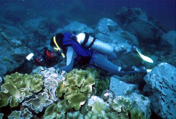
Figure 6 Diving among soft corals at Mu Koh Chang
government for tourism development and has
Island, Thailand.
received large investment from the government for
infrastructure related to tourism. Around 500,000
The main goal of the demonstration site project is to
people visit the islands annually and thirteen diving
remove or reduce the causes of coral reef
centres are operating on the islands. To support the
degradation in Mu Koh Chang by applying a new
development of tourism, the Royal Thai
model of co-management in the area and restoring
Government has created the Designated Area for
certain degraded areas for education and tourism
Sustainable Tourism Development Administration
purposes. The project highlights the importance of
(DASTA) as a public organisation.
co-ordination among government institutions, the
private sector, and local communities for
Fringing coral reefs are found around most of the
sustainable tourism development. The success of
islands and coral communities are also found on
this management model in Mu Koh Chang could be
off-shore pinnacles. Over 130 species in 45 genera
applied to other areas which have similar problems
of hard corals have been reported with average live
in Thailand and in other countries bordering the
coral coverage around 40%. Coral reef fishes of Mu
South China Sea.
Koh Chang are comparatively rich in both
abundance and diversity. Over 113 species of
The Thai Government has initiated a project to
fishes are recorded. Several endangered species,
develop Mu Koh Chang as an important regional
such as sea cows, dolphins, whales, sea turtles
eco-tourism site. A relatively large amount of
(Chelonia mydas and Eretmochelys imbricata) and
funding has been spent on infrastructure
whalesharks (Rhincodon typus) can be found in the
development and establishing new development
area. In general, the marine organisms found at Mu
and management schemes. Support from the
Koh Chang are of relatively high diversity for the
UNEP/GEF South China Sea Project focuses on
western section of the South China Sea.
the following immediate objectives:
In terms of conservation, Koh Chang National Park
· Raise public awareness and education on the
was established in 1982 for the conservation of
ecological importance and sustainable use of
natural terrestrial and marine resources. The park
coral reefs;
has established 5 patrol stations for forest
Reversing Environmental Degradation Trends in the South China Sea and Gulf of Thailand
6 CORAL REEF DEMONSTRATION SITES IN THE SOUTH CHINA SEA
· Build networks among government institutions,
restoration as a means of enhancing their
private sector and local communities for coral
awareness of the need to protect intact coral reefs
reef management and conservation as well as
and hence avoid the need for restoration.
secure approved mechanism for network long
term co-ordination;
Through participation in the volunteer groups, local
· Develop a sustainable eco-tourism programme
people protect the environment on which their
for Mu Koh Chang and its vicinity;
businesses depend. Three fishermen and tourist
· Encourage capacity building at all levels and
operator groups have participated in activities such
sectors;
as eco-tourism, training courses, and patrolling.
· Develop an alternative income generating
Seven SCUBA divers have been trained with the
programme for fishermen; and
support from the project and a diving centre.
·
Support coral reef monitoring and rehabilitation.
The demonstration site project has targeted
different groups for enhancing awareness,
including: primary school pupils; tour guide and
tourism businessmen; local communities; volunteer
groups; private sector organisations; and the staff of
relevant agencies working for coastal development
and conservation. More than 400 people had
attended training courses at the mid-term of the
project.
Establishment of mooring buoys in coral reef areas
used for diving and snorkelling is considered an
important means of avoiding anchor damage in
sensitive habitats. DASTA has invested in
establishing marker buoys to prevent small boats
anchoring on 4 reef areas. The large number of
tourist boats requires more mooring buoys in the
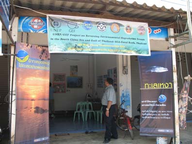
Figure 7 The local guide centre established in Mu Koh
area and the demonstration site project has
Chang, Thailand.
supported the establishment of additional buoys
Key achievements to date
and a mooring buoy committee, including users, to
plan and decide on the location and maintenance of
the mooring buoy system for the long term.
The management board of the demonstration site
has recognised the importance of establishing a co-
Most of the activities to develop a sound scientific
ordination mechanism for coral reef based tourism,
basis for management, including a study of the
and the need to develop a management plan and
carrying capacity for tourism; establishment of a
guidelines for the sustainable use of coral reef
GIS database on coral reefs and marine organisms;
resources. The management plan and guidelines
baseline monitoring of coral reef conditions; are
for sustainable tourism based on coastal resources
planned to be undertaken in the future since these
have been developed taking into account the
are seen as less urgent than the actions undertaken
functions of al relevant stakeholders and linkages
by the management team to date.
to the South China Sea network.
Regarding participation and contributions from the
UNEP/GEF has supported activities to engage
beneficiaries of project activities, members of the
members of local communities in sustainable
Local Guide Centre have expressed their
tourism through the Local Guide Centre. Members
willingness to share income in order to maintain the
of this centre use small fishing boats to run short
office of the Centre beyond the project. At present
tours to coral reef and mangrove areas. A large
there is no mechanism to obtain contributions from
number of householders in Klongson, Daan-kao,
hotels, resorts, and tour centres that use the natural
Daan-mai and Kaibae villages have received tourist
resources for their businesses. The Management
licences from the Tourist Authority of Thailand
Board has suggested that this issue should be
following training courses supported by the
considered in the framework of the management
UNEP/GEF grant. The income of local fishermen
plan and guidelines developed by the
has increased around 50% due to the establishment
demonstration site project.
of the guide centre as tourists now make bookings
directly. Hotels charge between 100 150 baht per
Many activities relating to sustainable tourism
visitor for making bookings.
based on coral reefs, and related habitats and
resources can be documented and the lessons
Awareness of the importance of coral reef
distributed regional y. Further work on sustainable
conservation has improved amongst all
uses and habitat management are needed as is
stakeholders through training organised by the
monitoring to verify that activities have in fact
project. Fishermen help the District Department of
reduced stress at the site level. Capacity building
Fisheries to prevent destructive fishing by reporting
for site management and enforcement wil be
any cases observed whilst they are at sea. The
carried out in 2008.
project has involved this group of fishermen in coral
Reversing Environmental Degradation Trends in the South China Sea and Gulf of Thailand
CORAL REEF DEMONSTRATION SITES IN THE SOUTH CHINA SEA 7
Belitung Coral Reef Demonstration Site
Bangka - Belitung Province is located in the South
The coral reefs found in the western waters of
China Sea between 01°30' and 02°46' South and
Belitung Island are currently categorised as being in
105°00' and 108°35' East. Belitung district is
good condition. Satel ite image interpretation and
ground truthing suggest that the reefs cover an area
composed of 5 sub-districts, one of which, the Selat
of approximately 3,493 hectares. This large area of
Nasik sub-district, was selected as the
coral reefs provides significant support to a variety
demonstration site of the UNEP/GEF South China
of uses, both direct and indirect, that benefit the
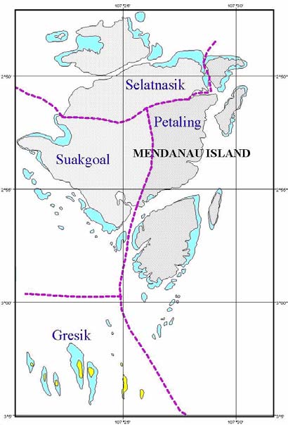
Sea Project (Figure 8). There are 26 islands within
coastal community. Coral reef fisheries in the area
the Selat Nasik sub-district, the biggest of which is
are productive, with an estimated to yield up to 5
Mendanau Island. Four villages comprise the Selat
tonnes/km2.
Nasik sub-district: Selat Nasik, Suak Gual, Petaling
and Gresik (Figure 10) of which only Gresik village
is located outside Mendanau Island.
107o30' 107o54' 108o54'
Mendanau
Island
2o51'S
2o51'S
20 km
107o30'
107o
108o54'
Figure 8 Bangka-Belitung, Indonesia.
The reefs West of Belitung Island, such as those
around Mendanau, and Batu Dinding Islands are
very extensive and slope gently from a sandy
bottom. Coral communities develop on the reef face
down to a depth of 7m, and are dominated by sub-
massive corals. Altogether 30 locations have been
surveyed and show an average coral coverage of
less than 25%. 187 species belonging to 74 genera
of hard corals have been recorded from the Belitung
Islands. Coral fish fishes number 218 species
belonging to 85 genera and 36 families. There are
105 species of molluscs, 35 species of crustaceans,
Figure 10 Mendanau Island, Bangka-Belitung Province.
and 36 species of echinoderms. In addition there
Coral reef areas are shaded in blue.
are 20 species of mangroves, 8 species of
seagrass, and 3 endangered species in the area.
The bulk of the community of Selat Nasik sub-
district is engaged in fishing activities. The
proportion of the population in each village engaged
in fishing are: Selat Nasik, 70 - 80%; Petaling, 50%;
Suak Goal, 75%; and, in Gresik 100%. These
figures clearly indicate the importance of coral reefs
to the people of the Selat Nasik sub-district despite
which both the coral reef and the fisheries remain in
good condition.
Coastal zone management in the Belitung district
has not been properly implemented to date. Marine
resource management is directed more towards
fishing activities and the control of illegal fishing
practices such as the use of trawls which is still
widespread. This is mostly undertaken by foreign
vessels and is beyond government control due to
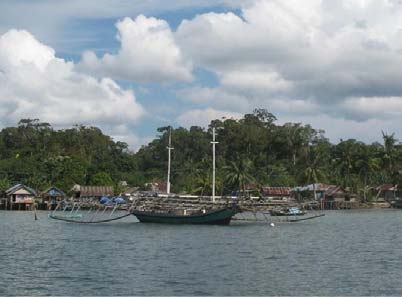
Figure 9 Typical fishing vessel in Bangka-Belitung.
weak law enforcement, limited equipment including
boats for surveillance, and a weak fishing permit
system. Apart from illegal fishing, destructive fishing
Reversing Environmental Degradation Trends in the South China Sea and Gulf of Thailand
8 CORAL REEF DEMONSTRATION SITES IN THE SOUTH CHINA SEA
techniques such as the use of explosive, and
use of coral reefs in the area. The management
poisons, are still widespread.
framework has been established to facilitate co-
ordination in the implementation of activities.
An attempt to curb destructive fishing practices has
been made by the community of Selat Nasik sub-
Initial awareness on the part of the community and
district by enforcing the "Ripuk Angkam" - a
stakeholders to the importance of coral reef habitats
traditional local measure. Foreign or non-resident
was established through an official project launch
fishers who use destructive fishing gear and
on 7th Feb 2007. Billboards and accompanying
practices are apprehended, and the boat and
publicity-generating materials such as calendars
fishing gear confiscated.
and T-shirts prepared earlier contributed to
awareness strengthening. School education is seen
The project aims to protect and to rehabilitate the
as crucial in transmitting the message of coral reef
coral reef ecosystem so as to sustain its use, as
conservation to the younger generation and the
well as the use of associated ecosystems in the
preparation and development of a curriculum
Bangka-Belitung Islands. The overall goal is to
together with the publication of seven books,
maintain healthy coral reef ecosystems and to
catering to the different primary school levels,
increase the prosperity of coastal vil age
highlighting the importance of coral reefs has been
communities. This project will improve the condition
undertaken. Teacher's guide-books have also been
of coral reefs in high priority areas through
published. The 700 primary school students in the
strengthened coordination among local government
district will be exposed to the developed curriculum
institutions in preparing "Perda" (local ordinances);
and books in the next semester. School teachers
and through community-based programmes and
have been trained on the curriculum and use of the
public advocacy in coral reef conservation and
books, and are generally enthusiastic about
sustainable use throughout the Bangka-Belitung
teaching it to students.
Province. To achieve the overall goal, the project
developed five intermediate objectives, namely to:
The Reef Watch programme is a community
participation activity involving about 20 volunteers,
· Enhance awareness of society at all levels of
al of whom are fishers contributing some of their
the value of sustained use of coral reefs;
time to patrolling the reefs. Interviews with some of
· Strengthen the legal basis of coral reef
the reef watchers indicated that a twice-weekly
management in Belitung;
patrol frequency was adopted.
· Improve information for decision making and
planning of sustainable use of resources;
Traditionally, local fishermen from Gresik Island
· Develop and implement a resource
have used only agreed fishing gear, and the
management plan, involving community
community has prohibited the use of light fishing
participation; and
and coral collection. Penalties for violations are
· Establish a livelihood programme in order to
quite severe, including confiscation of fishing gear
reduce threats by poor local people.
and boat, or expulsion from the village. This
traditional wisdom has been integrated in
developing and implementing a coral reef
management plan and legislation for the Belitung
demonstration site.
Delays in developing the legal instruments and
executing activities including enforcement, and
ecological and socio-economic monitoring have
resulted in significant delays when compared with
the schedule of the operational plan.
Plans are in hand to improve small-scale production
of fish crackers as a livelihood alternative. About 20
families are currently engaged in cracker production
and most of the stock is bought for sale in Belitung
where demand consistently takes up all supplies.
There are already indications of a decline in the
species used for fish cracker production and this will
Figure 11 Mangroves on a raised coral reef platform
limit any increase in production. Improved
and beach rock adjacent to living coral reefs
marketing to force a price increase and raise the
in Selatnasik, Belitung, Indonesia.
income level of households engaged in fish cracker
production is being attempted, but requires proper
Key achievements to date
economic analysis of the supply and demand and
availability of source species. The Management
The Project Management Board was established at
Board, is currently considering other forms of
the start of the activities and has held regular
alternative livelihood, including production of
meetings to date. It comprises a good
mangrove seedlings for transplantation.
representation of relevant stakeholders and shows
potential as a mechanism to guide the sustainable
Reversing Environmental Degradation Trends in the South China Sea and Gulf of Thailand
CORAL REEF DEMONSTRATION SITES IN THE SOUTH CHINA SEA 9
Ninh Hai Coral Reef Medium Size Project
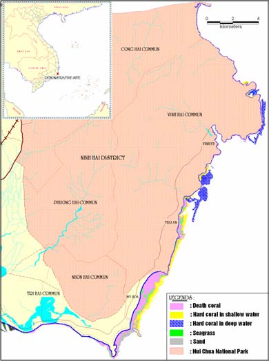
The Ninh Hai district coastal area of Ninh Thuan
Some 1,070ha of coral reefs with 40ha of seagrass
Province, south-central Viet Nam lies between 11o
beds are found in Ninh Hai coastal waters (Figure
72' and 11o58' North and from 109o22' to 109o12'
12). Reefs are distributed along more than 30km of
East. (Figure 12) Most of the adjacent coastal land
the shoreline, and sustain a rich biodiversity. The
extending to the peaks of the coastal mountain
area is close to Vietnam's up-welling area and the
range, was previously designated as Nui Chua
cooler up-wel ed waters reduce the threat of coral
Nature Reserve (1997-2003), mainly focusing on
bleaching and associated biodiversity degradation
the conservation of dry forests and primates on
resulting from high sea surface temperatures.
land. In 2003, the nature reserve was converted to
the Nui Chua National Park; and its conservation
Ninh Hai is one of the few remaining sites in Viet
focus was extended to encompass adjacent marine
Nam where coastal and marine habitats are stil in
waters of 7,352 hectares. Although the conservation
good condition. Some 307 reef-building coral
of coastal and marine habitats was not the major
species in 54 scleractinian genera, 3 species of
interest of the nature reserve until 2003, the
seagrass, 190 species of macro-algae, 147 species
conservation activities on land provided a certain
of reef-associated fishes, 115 species of molluscs,
degree of protection to the marine environment, as
24 species of crustaceans, 13 species of
the landscape and water courses were mostly
echinoderms and 22 species of polychaetes have
undisturbed, and land-based development threats
been recorded in recent years in Ninh Hai waters.
were restricted.
Live coral cover at 6 study locations surveyed in
2002 ranged from 16.3 to 55.9%, with a mean value
of 36.9±13.5%.
Data from socio-economic surveys conducted in
2002 indicate that some 30% of households are
dependent on fisheries. Fishing activities are small
scale, mostly using simple fishing gear and methods
because most fishing boats have small engines.
Fishing activities are focused in shal ow water areas
of less than 30 m depth, with increasing fishing
pressure on the marine resources and habitats of
the coastal area.
The coastal and marine habitats in Ninh Hai face
various anthropogenic threats such as: over-fishing;
destructive and illegal harvesting of coastal and
marine resources; collection of live corals and
mining; and siltation. These threats and their root-
causes have not been effectively addressed, so far,
due to weak management including a lack of
financial and human resources, as wel as the lack
of an integrated management plan.
Figure
12 Distribution of coral reef, and seagrass
habitats along the cost of Ninh Hai District.
The management system of the area is the
responsibility of two agencies: the Nui Chua
National Park authority, which focuses on the
terrestrial component, and the Sub-department of
Fisheries Protection under the Ninh Thuan
Department of Fisheries, which is responsible for
the marine component. Because of a lack of staff,
management facilities and low operational budget,
the Sub-department has insufficient capacity to
manage the area effectively. The local communities
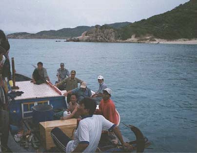
Figure
13 Apprehension of a fishing vessel and
and Army Border Station, have become involved in
enforcement of fisheries regulations by the
preventing destructive fishing practices during the
border army.
last 5 years.
Reversing Environmental Degradation Trends in the South China Sea and Gulf of Thailand

10 CORAL REEF DEMONSTRATION SITES IN THE SOUTH CHINA SEA
This medium sized GEF project aims to
capacity for local communities in coral reefs
demonstrate measures to reduce the stress to the
conservation in Vinh Hai and Thanh Hai
functioning of regional y significant coral reef and
Communes", a workshop was conducted on
seagrass habitats connected to the South China
"assessing and seeking new solutions for coral reef
Sea through conserving critical marine biodiversity
protection activities" in December 2005. In addition,
values, preventing ecosystem degradation and
a training programme for teachers, school children,
promoting sustainable utilisation of coastal
and fishermen on coral reef conservation was
resources in Ninh Hai waters. The project envisages
convened at Thanh Hai and Vinh Hai commune. A
three major outcomes as follows:
system of floating signal buoys was established at
Management of the site is improved through the
Hang Rai and My Hiep coral reef protection stations.
development of a zoned, multiple-use marine
protected area (MPA), establishment and
The local communities have become actively
functioning institutional arrangements for cross-
involved in management of coral reefs becoming
sectorial and participatory management, and
been involved in consultations regarding MPA
adoption of an integrated management plan.
zoning, sanctuary development, and possible
livelihood alternatives. Fishermen volunteers from
Pressure to coral reef ecosystems derived from
costal communes including even those who used to
unsustainable livelihoods of local people is
catch marine turtles, are now involved in
reduced through enhancing alternative livelihood
enforcement activities. Through their participation,
opportunities for local communities that place less
not only has the effectiveness of resource
pressure on coral reefs.
management been improved but also the
Knowledge and skills for the management of
awareness of local communities regarding the
coral reef habitats are increased through activities
importance of marine conservation for sustainable
that promote the acquisition of knowledge and
livelihoods has been enhanced.
management skills among local government officials
and awareness among stakeholders in conservation
Capacity building activities have included, a tour for
of coral reefs and other associated resources.
Ninh Hai coral reef conservation volunteers was
arranged to exchange information and experience
Achievement to date
on coral reef management with the communities in
Ran Trao Sanctuary (Khanh Hoa Province). In
Although the Ninh Hai coral reef demonstration site
addition, the Department of Science and
project has not been yet been approved by the GEF
Technology invited experts from the Nha Trang Bay
as a medium sized project, the Provincial Project
Marine Protected Area to convene a training
Steering Committee has already been established
programme of four courses for more than one
under the leadership of a Vice-Chairman of
hundred participants from relevant agencies, local
Provincial People's Committee (PPC). This
leaders, community associations, and the
committee is supported by an advisory council with
volunteers. Local people were instructed on tourism
participation of the National Coral Reef Focal Point,
development in conjunction with marine
experts from the Provincial Departments and
conservation, and trained in techniques of seaweed
representatives of the Nui Chua National Park.
cultivation.
Some activities have been implemented by the local
Using co-financing from the "Biodiversity
government, Department of Science and
Conservation" project, 2002 2004 two stations
Technology, and Sub-department of fishery
have been established to protect sea turtles in the
protection. The Department of Science and
area, with the involvement of local volunteers. A
Technology organised, in 2006, a beach clean-up
zoning scheme and model for community-based
campaign in Thai An hamlet of Vinh Hai commune
management of coral reefs and marine resources
as a means of increasing community awareness of
was approved by the Provincial People's Committee
the importance of a clean environment. During the
and two other stations have been established for the
campaign local people were provided brochures on
conservation of coral reefs and marine resources.
the importance of and how to protect, coral reefs.
During the period 2005 2006, two projects were
funded by the provincial government the first. The
first was an assessment of changing trends and the
possibility of restoring coral reef habitat and
associated resources through public participation.
The second involved upgrading the Ninh Hai coral
reef and associated ecosystems GIS Database in
support of decision making in environment
management. The provincial government has also
provided financial support to maintain the two small
community-based coral reef sanctuaries established
in 2003 in the coastal water of the district.
Under another project co-ordinated by the Sub-
department of fishery protection on "strengthening
Figure 14 Ninh Hai is a fringing reef system with very
extensive reef flats extending from the shore.
Reversing Environmental Degradation Trends in the South China Sea and Gulf of Thailand
DEMONSTRATION SITE MANAGERS
Ms. Emerlinda O. Celeste-Dion; Masinloc Site Manager, Marine Environment and Resources Foundation Inc.
MSI-UP, Marine Science Institute, University of the Philippines, Diliman, Quezon City, 1101 Philippines,
Tel:
(632)
9223959;
0478211870,
Mobile:
(63)
09158404840,
Fax:
(632)
9247678,
E-mail: emerlindaceleste@yahoo.com
Mr. Nguyen Xuan Niem; Phu Quoc Site Manager, Department of Natural Resource and Environment, Kien
Giang Province, DoNRE, 1226A Nguyen Trung Tyruc Street, Rach Gia, Kien Giang, Viet Nam,
Tel: (84 77) 915837, Mobile: (84) 913858049, Fax: (84 77) 915837, E-mail: nxniem@yahoo.com
Mr. Nipat Somkleeb; Koh Chang Site Manager, Marine Biodiversity Research Group, Department of Biology,
Faculty of Science, Ramkhamkaeng University, 104 Mu 3 Bann Klongson, Koh Chang, Trat Province
23170, Thailand, Tel: (66) 817351760, Fax: (66 2) 3108415, E-mail: somkleebn@hotmail.com
Ms. Nurul Dhewani Mirah Syafrie; Belitung Site Manager, Research Center for Oceanography, Indonesian
Institute for Sciences, CRITC-COREMAP-LIPI, Jl Raden Saleh 43, Jakarta 10330, Indonesia,
Tel:
(62
21)
3143080,
Mobile:
(62)
81381400342,
Fax:
(62
21)
31927958,
E-mail: ndhewani@coremap.or.id; ndhewani@yahoo.com
Mr. Nguyen An Khang; Ninh Hai MSP Site Manager, Institute of Oceanography, 01 Cauda, Nha Trang, Viet Nam,
Tel: (84 58) 590205, Mobile: (84) 0905024732, Fax: (84 58) 590698, E-mail: ankhang10@dng.vnn.vn
MEMBERS OF THE REGIONAL WORKING GROUP ON CORAL REEFS
Dr. Ridzwan Abdul Rahman, Borneo Marine Research Institute, Universiti Malaysia Sabah, Sepangar Bay,
Locked Bag 2073, 88999 Kota Kinabalu, Sabah, Malaysia, Tel: (60 88) 320 266; 320 121,
Mobile: (60) 13 864 4011, Fax: (60 88) 320 261, E-mail: ridzwan@ums.edu.my
Dr. Chou Loke Ming, Department of Biological Sciences, Faculty of Science, National University of Singapore,
14 Science Drive 4, Singapore, Tel: (65) 6874 2696, Mobile: (65) 9 734 9863, Fax: (65) 6779 2486,
E-mail: dbsclm@nus.edu.sg
Mr. Ouk Vibol, Deputy Chief of Fishery Conservation, Fisheries Administration, Ministry of Agriculture, Forestry
and Fisheries, 186 Norodom Boulevard, PO Box 582, Phnom Penh, Cambodia, Tel: (855 23) 216 244;
Mobile: (855) 12 836 376; Fax: (855 23) 221 485, E-mail: aims1@online.com.kh
Dr. Suharsono, Research Center for Oceanography LIPI, Puslit OSEANOGRAFI - LIPI, Pasir Putih 1 Ancol
Timur, Jakarta UTARA, Indonesia, Tel: (62 21) 64713850 ext 202; 3143080: 102, Mobile: (62) 811 904
806, Fax: (62 21) 64711948; 327 958, E-mail: shar@indo.net.id; director-co@indo.net.id
Mr. Abdul Rahim Bin Gor Yaman, Deputy Director, Marine Park Section, Ministry of Natural Resources and
Environment, Level 11, Lot 4G3, Precinct 4, Federal Government Administrative Centre, 62574 Putrajaya,
Selangor., Malaysia, Tel: (603) 8887 1368; Mobile: 19 2708505; Fax: (603) 8888 0489;
E-mail: abrahimgor@yahoo.com
Dr. Porfirio M. Alińo, Marine Science Institute, University of the Philippines, Diliman, Quezon City 1101,
Philippines, Tel: (63 2) 922 3949; 922 3921, Mobile: (63) 917 838 7042, Fax: (63 2) 924 7678,
E-mail: pmalino@upmsi.ph; pmalino@yahoo.com
Dr. Thamasak Yeemin, Marine Biodiversity Research Group, Department of Biology, Faculty of Science,
Ramkhamhaeng University, Huamark, Bangkok 10240, Thailand, Tel: (66 2) 310 8415,
Mobile: (66) 1 842 3056, Fax: (66 2) 310 8415, E-mail: thamsakyeemin@yahoo.com
Mr. Nguyen Van Long, Deputy Head, Department of Marine Living Resources, Institute of Oceanography, 01
Cau Da Street, Nha Trang City, Viet Nam. Tel: (84 58) 590 205; Mobile: (84) 905083332;
Fax: (84 58) 590 698; (84 58) 590 034; E-mail: nvanlong@dng.vnn.vn
Dr. Vo Si Tuan, Senior Expert, UNEP/GEF Project Co-ordinating Unit, United Nations Environment Programme,
2nd Floor, Block B, United Nations Building, Rajdamnern Avenue, Bangkok 10200, Thailand,
Tel: (66 2) 288 2084, Fax: (66 2) 288 1094; E-mail: vo@un.org


UNEP/GEF South China Sea Project Co-ordinating Unit
United Nations Building
Rajadamnern Nok
Bangkok 10200
Thailand
Fisheries Administration of Cambodia
Ministry of Agriculture, Forestry and Fisheries
186 Norodom Boulevard
P.O. Box 582
Phnom Penh
Cambodia
Research Center for Oceanography LIPI
Puslit OSEANOGRAFI - LIPI
Pasir Putih 1 Ancol Timur
Jakarta UTARA
Indonesia
Marine Parks Branch
Department of Fisheries, Malaysia
Jalan Sultan Salahuddin
50628 Kuala Lumpur
Malaysia
Marine Science Institute
University of the Philippines
Diliman, Quezon City 1101
Philippines
Marine Biodiversity Research Group
Department of Biology, Faculty of Science
Ramkhamhaeng University
Bangkok 10240
Thailand
Institute of Oceanography
01 Cau Da Street
Nha Trang City
Viet Nam