


United Nations
UNEP/GEF South China Sea
Global Environment
Environment Programme
Project
Facility
Reversing Environmental Degradation Trends
in the
South China Sea and Gulf of Thailand
National Reports
on
Seagrass in the South China Sea
NATIONAL REPORTS ON SEAGRASS IN THE SOUTH CHINA SEA
Table of Contents
1)
National Report on Seagrass in the South China Sea ş Cambodia
2)
National Report on Seagrass in the South China Sea ş China
3)
National Report on Seagrass in the South China Sea ş Indonesia
4)
National Report on Seagrass in the South China Sea ş Malaysia
5)
National Report on Seagrass in the South China Sea ş Philippines
6)
National Report on Seagrass in the South China Sea ş Thailand
7)
National Report on Seagrass in the South China Sea ş Viet Nam


United Nations
UNEP/GEF South China Sea
Global Environment
Environment Programme
Project
Facility
NATIONAL REPORT
on
Seagrass in the South China Sea
CAMBODIA
Mr. Ouk Vibol
Focal Point for Seagrass
Fisheries Administration, Ministry of Agriculture, Forestry and Fisheries
186 Norodom Blvd.
P.O. Box 582, Phnom Penh, Cambodia
NATIONAL REPORT ON SEAGRASS IN THE SOUTH CHINA SEA ş CAMBODIA
Table of Contents
1. INTRODUCTION .............................................................................................................................. 1
2. REVIEW OF NATIONAL DATA AND INFORMATION....................................................................1
2.1 THE IMPORTANCE OF SEAGRASSES TO HUMANS AND THE MARINE ECOSYSTEM............................. 1
2.2 GEOGRAPHIC DISTRIBUTION OF SEAGRASS .................................................................................2
2.3 PHYSICAL/CHEMICAL CHARACTERISTICS .....................................................................................3
2.4 BIOLOGICAL ASPECTS.................................................................................................................3
2.4.1 Seagrass ........................................................................................................................ 3
2.4.2 Associated Marine Biota ................................................................................................3
2.4.3 Marine Endangered Species..........................................................................................3
2.5 THREATS TO SEAGRASS .............................................................................................................4
2.6 CAUSAL CHAIN ANALYSIS, INCLUDING CONSTRAINTS IN ADDRESSING THREATS............................. 4
3. SOCIO-ECONOMIC SITUATION WITHIN COASTAL AREAS.......................................................6
3.1 POPULATION SIZE AND COMPOSITION..........................................................................................6
3.2 OCCUPATION..............................................................................................................................6
3.3 MIGRATION................................................................................................................................. 7
3.4 EDUCATION ................................................................................................................................ 8
3.5 HOUSEHOLD INCOME ..................................................................................................................8
3.6 GENERAL SOCIO-ECONOMIC PROBLEMS ......................................................................................9
4. INSTITUTIONAL ARRANGEMENTS AND NATIONAL LEGISLATION.......................................10
4.1 ROLES AND RESPONSIBILITIES IN COASTAL ZONE MANAGEMENT ................................................10
4.2 MANAGEMENT POLICIES AND GUIDELINES..................................................................................11
5. MANAGEMENT PERSPECTIVESşTHE DEVELOPMENT OF A NATIONAL SEAGRASS
ACTION PLAN...............................................................................................................................12
6. CONCLUSION AND RECOMMENDATIONS ................................................................................13
REFERENCES.......................................................................................................................................14
List of Tables
Table 1
Population size and density of Cambodia and its coastal areas.
Table 2
Reasons for migration into Cambodia's coastal zone by reason and gender.
Table 3
Average monthly household income by main source of income by stratum in
Cambodia during 1999 (Riel).
List of Figures
Figure 1
Map of seagrass distribution in Cambodia.
Figure 2
Causal chain analysis of threats to seagrass in Cambodia.
Figure 3
Population densities in the coastal zone of Cambodia (1996-1997).
NATIONAL REPORT ON SEAGRASS IN THE SOUTH CHINA SEA ş CAMBODIA 1
1. INTRODUCTION
Cambodia's shoreline is 435km long and includes the two provinces of Koh Kong and Kampot, and
the two municipalities of Sihanoukville and Kep. The seaward boundary has been defined as the outer
limit of the Exclusive Economic Zone (EEZ, 55,600sq. kilometres) (Nelson, 1999) but the landward
boundary has not yet been defined. Cambodia's coastal and marine areas contain a diverse range of
habitats and other living resources. Compared to neighbouring countries, these habitats and
resources remain relatively intact, providing important nursery and feeding areas for a variety of
species, especially those of significance to marine capture fisheries.
From a functional perspective, Cambodia's coastal zone is comprised of two inter-related systems,
ecological and socio-economic systems. The ecological system includes the physical, chemical and
biological parametres that provide natural resources, sequester pollutants and offer fundamental life-
support functions (e.g. clean air and water) for humans and other living organisms. The socio-
economic system is largely dependent upon the many functions and products of the ecological
system.
Seagrass beds are critical habitats that support a diverse range of resident and migratory species,
including some considered to be endangered and vulnerable. Since the 1972 Stockholm Conference
on the Human Environment, an over-riding concern in the protection of the marine environment has
been that of pollution. However, notwithstanding a number of regional action plans and conventions
that have since been developed and implemented for the management of marine pollution, the quality
of the marine environment has declined over the last thirty years (Miles, 1999).
The objectives of this report are to:
Ě Review past and ongoing research activities seagrass in Cambodia, including information
relating to geographical location, physical and biological attributes, environmental state, social
dependence and use, and economic valuation;
Ě Review past and ongoing seagrass-related programmes of concerned Ministries and NGOs,
including comments regarding programme needs, priorities, and costs and benefits;
Ě Provide information about seagrass management, highlighting efforts in the economic
valuation of seagrass goods and services carried out by concerned institutions;
Ě Discuss socio-economic and other influences on seagrass programme implementation in
Cambodia;
Ě Discuss institutional requirements for the management of seagrasses within Cambodia's EEZ;
and
Ě Provide baseline results from research and monitoring activities recently conducted in
Cambodia.
2.
REVIEW OF NATIONAL DATA AND INFORMATION
Very little research has been conducted on the status of fish stocks, the success of current
management arrangements, and the impact of fishing on the marine environment. Most research has
been funded by government and relevant organisations.
2.1
The Importance of Seagrasses to Humans and the Marine Ecosystem
The majority of seagrass studies in Cambodia have focused on ecosystem and management issues,
hence, socio-economic information relevant to these resources is scarce. However, there are some
reports detailing the importance of seagrass ecosystems to Cambodians. According to Tana and
Chamnan (1995) one species (Khmer name Smao Prayong) is eaten by Dugong (Dugong dugon).
Cambodia's marine fisheries depend significantly on seagrass ecosystems. A large number of
seagrass dependent fish and shrimp species are highly valuable in both domestic and international
markets, and are subject to high levels of legal and illegal fishing effort. The collection of invertebrates
by fishers using snorkel and mask is also popular in inshore seagrass areas.
Reversing Environmental Degradation Trends in the South China Sea and Gulf of Thailand
2 NATIONAL REPORT ON SEAGRASS IN THE SOUTH CHINA SEA ş CAMBODIA
According to statistics of the Department of Fisheries, 42,000 to 45,000 tonnes of marine fish and
invertebrates are harvested from Cambodia's marine waters every year. However, some observers
estimate that actual landings could be 10 to 20 times higher than the reported figure. The overall
representation of seagrass-dependent fish species in marine landings is unknown, but is most likely
high.
2.2
Geographic Distribution of Seagrass
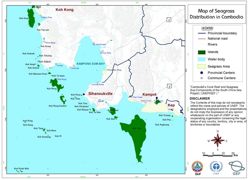
Seagrasses can be found in most shallow water areas of Cambodia's coastal zone. Recent surveys
provide information about the location of significant areas of seagrass (Figure 1). However, the
composition of seagrass species and variation in their distribution and abundance over time are
largely unknown.
Extensive beds occur in waters adjacent to Kampot Province and Kep Municipality, with seagrass
and/or mixed seagrass and Caulerpa beds found along the entire coast to the Cambodia-Viet Nam
border (Ethirmannasingam, 1996 in Nelson, 1999). According to district fisheries officials, large areas
of seagrass once occurred in Kampong Som Bay, although as a result of high intensity trawling and
push netting, seagrass distribution and abundance has diminished significantly in this area. A limited
survey conducted by Ethirmannasingam (1996) identified the presence of seagrass between
mainland Cambodia and Koh Kong Island.
Seagrass habitats in Cambodia can be divided into two main types: extensive seagrass meadows
along the mainland, and patches of seagrasses inter-mixed with corals around islands
(Ethirmannasingam, 1996 in Nelson, 1999). Much of the muddy coast of Kampot Province supports
seagrass beds, including extensive patchy beds near the river mouth at Kampot town and very large
beds east of Koh Tunsay. Inshore seagrass beds are mixed stands of several species, while offshore,
Enhalus acoroides occurs in extensive beds. Small seagrass beds have been observed in waters
adjacent to Koh Rong and Koh Rong Sanlem (Wetland International Asia-Pacific and Lower Mekong
Basin Program, 2001).
S
ource: DoF , 2004 a.
Figure 1
Map of seagrass distribution in Cambodia.
Reversing Environmental Degradation Trends in the South China Sea and Gulf of Thailand
NATIONAL REPORT ON SEAGRASS IN THE SOUTH CHINA SEA ş CAMBODIA 3
A survey conducted by Fishery Department officials in 2004 using GPS found that the total area of
seagrass in Cambodia's waters is 32,492ha (DoF, 2004 b). The seagrass area at Kampot covers
25,240ha, and can be divided into three meadows. The first, extending from Prek Trapeang Ampil to
Prek Kdat, has an area of 1,795ha; the second, extending from Prek Kdat to Prek Koh Torch
(Kilometre 12) covers 380ha; and the third, 23,065ha, starts at Prek Koh Torch and extends to Kep
Town. Seagrass beds typically occur in water depths of 3 to 4m, with salinity ranging from 25ppt to
30ppt, and most seagrass areas have been damaged by trawl and push net fishing. This damage
results from the fact that, despite a ban on trawling in water less than 20m depth, this law is not
enforced.
2.3 Physical/Chemical
Characteristics
Information about the environmental factors influencing seagrass distribution and abundance in
Cambodia is lacking. However, preliminary sea surface and air temperature, sedimentation, depth,
turbidity, and visibility data have recently been gathered. Generally, visibility is low to very low in areas
where most seagrass beds are situated, especially during the rainy season. The substrate is typically
muddy, although some areas are characterised by a mixture of sand and mud substrate types.
2.4 Biological
Aspects
2.4.1 Seagrass
Seagrass play an important role for marine animals, including dugongs and green turtles, and provide
habitat for many commercially important fish and crustacean species. They also maintain water
quality by absorbing nutrients and stabilising sediments (Short et al, 2001). A total of nine species of
seagrass have been reported from Cambodia's coastal waters by the Kampot Working Group (2002)
as follows:
Thalassia hemprichii,
Halodule uninervis,
Enhalus acoroides,
Halophila decipiens,
Cymodocea serrulata,
Halodule pinifolia,
Cymodocea rotundata,
Syringodium isoetifolium, and
Halophila ovalis
2.4.2 Associated Marine Biota
The exact number of seagrass associated species is unknown. Many economically important species
of fish and crustacean are associated with seagrass habitats and use these areas for spawning,
nursing grounds, as well as feeding. The shallow water seagrass beds occur on soft sediments. In
these areas, shrimp and demersal fish species, squid and cuttlefish, slipper lobster and mantis
shrimps are found amongst seagrass (Ing, 2003).
2.4.3 Marine Endangered Species
Many groups of marine living resources are under threat from human activities and natural
phenomena and some species of fish, reptiles, marine mammals and corals are becoming
endangered. Based on a review conducted for the fisheries component of UNEP/GEF South China
Sea Project, there are 12 species of marine mammals and 5 species of sea turtle in Cambodia's
marine waters (Ing, 2003). According to Tana (1995) there are three species of marine mammals
along the Cambodian coastline that are accidentally caught by gill nets and shrimp trawlers in the
seagrass beds of Sihanoukville and Kampot Bay, i.e., Irrawady dolphin (Orcaella brevirostris), Spinner
dolphin (Stenella longirostris) and dugong. Most species of marine mammals are assumed to be
vulnerable, endangered or critically endangered, either locally or globally and therefore conservation
of these species is a high priority of the Department of Fisheries.
Reversing Environmental Degradation Trends in the South China Sea and Gulf of Thailand
4 NATIONAL REPORT ON SEAGRASS IN THE SOUTH CHINA SEA ş CAMBODIA
2.5
Threats to Seagrass
Seagrasses are threatened by destructive fishing practices particularly demersal trawling, push
netting, and other active fishing gears that damage seagrass and disturb sediments (Tana, 1995).
Fisheries landings from seagrass areas have recently declined, leading to stakeholder concerns
about the effects of trawling in these areas. Decline in water quality associated with agricultural use of
fertilisers and pesticides, and increased erosion from unsustainable logging practices also threaten
seagrass. Fertilisers can encourage the growth of algae that out-compete seagrass or epiphytic algae
that reduce the ability of seagrass to photosynthesise, often leading to dieback. Erosion from poor
land use can result in increased water turbidity which reduces the quantity of sunlight reaching
seagrass plants, diminishing the photosynthetic capacity of the plants.
2.6
Causal Chain Analysis, Including Constraints in Addressing Threats
Cambodia's national coral reef and seagrass committee has convened numerous meetings at the
national level aimed at reviewing local and national threats to seagrass. Causal chain analyses have
been conducted to identify the causes of the five key threats to coral reefs and seagrasses in
Cambodia. These key threats include:
Ě Sedimentation,
Ě Unsustainable fishing practices,
Ě Seaweed farming on seagrass beds,
Ě New settlements near seagrass areas, and
Ě Unsustainable development in coastal areas.
Owing to the comparatively short coastline of Cambodia, the causes of degradation of seagrass beds
are similar in all areas. A series of flow charts have been prepared to highlight threats to seagrass at
the local and national levels. The example provided in Figure 2 is based on information for Kampot
Province.
These flow charts begin with the main threat at the top and then detail the root causes of these
threats. In response to the causes, a series of intervention measures have been identified that are
located at the base of the flow chart.
Seagrass and coral reef areas are thought to respond to key threats in a similar manner. However,
trawling and push net fishing is thought to be more damaging to seagrass, whilst cyanide and
dynamite fishing are more serious threats to coral reef areas.
Reversing Environmental Degradation Trends in the South China Sea and Gulf of Thailand
NATIONAL REPORT ON SEAGRASS IN THE SOUTH CHINA SEA ş CAMBODIA 5
E
RIN
LOSS OF
D MA
EFFECT
SEAGRASS
AN
ORGANISMS
s
ng
s
r
w
n
e
u
ch
nd
bl
d
o
ina
ng s
entatio
nd
l
i
ng ove
ed farmi
e
ution a
g practice
w
w
aila
ATE CAUSE
b
o
d
ia.
h
a
l fishi
ass mea
Poll
sedim
Unsusta
Sea
fishin
as tra
f
of T
Illeg
seagr
Gul
IMMEDI
nd
rass in Cam
seag
a Sea a
n
od
Chi
e
s
urce
h
o
t
h
nds
Sou
Dema
for marine
resourc
for food
and so
of liveli
the
s
of threats to
n
i
nds
analysi
n Tre
n
t
y
ass
y
atio
t
h
chain
d
nit
w
nit
g
on
n
t
p
ment
i
c
al
gra
y
on
og
ge
s
al
din
n
gro
n
f
o
rceme
elo
geme
e
l
e
d
a
l De
w
Cau
w
nce of seagr
Povert
latio
d commu
l dev
ent
erstan
Corrupti
mana
kno
Lack of commu
und
Popu
Limite
Lack of ecol
Coasta
v
i
r
onm
ROOT CAUSE
importa
Lack of la
g En
Figure 2
v
e
rsin
Re
ood
y
,
nd
ass
ih
ls
w
ic
y
s
t
e
m
l
e
o
r
l pol
dge a
n
the
rotect
nab
it
y
f
nd la
ent
r
ch and
l
e
s
tem
ona
i
n
istrative
a
w
impacts and
ns
d
of activities on
t
ive livel
ass
a
stai
n
t mode
n
t a
ss ecos
eness o
e of the seagr
optio
d adm
ork to p
agra
e kno
n
t nati
w
seagr
ar
geme
d capac
ences
p
l
y
su
geme
enforcem
w
anc
this ecosy
a
ystem an
q
u
e altern
Ap
Buil
a
l an
mana
frame
INTERVENTION
Provid
mana
leg
Promote rese
signific
ecos
Impleme
conse
Provid
monitor se
6 NATIONAL REPORT ON SEAGRASS IN THE SOUTH CHINA SEA ş CAMBODIA
3.
SOCIO-ECONOMIC SITUATION WITHIN COASTAL AREAS
The development of Cambodia's coastal zone continues to occur at a rapid pace, fueling concerns
regarding the unsustainable use of natural resources in the coastal zone. The status of many coastal
and marine resources is however, largely unknown.
This section aims to review information about the economic value of coral reefs and seagrasses in
Cambodia. Issues in the management of seagrasses and coral reefs, including the socio-economic
circumstances of coastal communities, problems at the operational management level, and
institutional frameworks will be discussed.
3.1
Population Size and Composition
The population census conducted in March 1998 (the first census in 36 years) showed a population of
11.4 million, with approximately 85% living in rural areas.
As can be seen in Table 1, populations ranged from 28,677 in Kep to 527,904 in Kampot Province.
The national average household size was found to be 5.2, which is slightly higher than the average
household size of 5.0 in Kampot province, but lower than Koh Kong (5.3), Sihanoukville (5.5), and Kep
(5.3). Women represent 52.1% of the population in Kampot; 48.8% in Koh Kong; 50.6% in
Sihanoukville; and 51.1% in Kep (Ministry of Planning, 1999).
On a provincial basis, the proportion of female-headed households ranged from 22.5% to 26.8%. In
coastal areas, 24.8% of households were headed by females; however, this is lower than the national
average (Ministry of Planning, 1999).
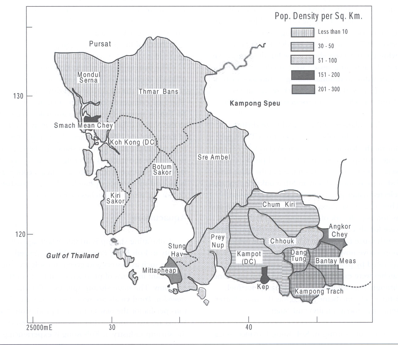
The average population density in Cambodia is 64 persons per km2, but the density in Koh Kong is
considerably lower at 12 persons per km2 compared with Kampot (108) and the municipalities of
Sihanoukville (179) and Kep (85). Table 1 and Figure 3 highlight the population size and density of
Cambodia and its coastal areas.
Table 1
Population size and density of Cambodia and its coastal areas.
Location
Areas (Km2)
Population
Women
Density (/km2)
(% of total)
Cambodia 181,035 11,426,223 51.8
64
Kampot 4873
527,904
52.1
108
Koh Kong
11160
131,912
48.7
12
Sihanoukville 868 155,376 50.5
179
Kep 336
28,677
51.0
85
Source: Ministry of Planning, 1999.
Cambodia's population is growing at an estimated annual rate of 2.4% (Ministry of Planning, 1999).
The population is mostly comprised of people of Khmer decent (90%) and the main ethnic groups are
the Cham, Vietnamese, and Chinese and others from different hill tribe groups. It is estimated that
95% of the population speak the Khmer language. The main religion in Cambodia is Theravada
Buddhism, while the Cham are Muslim. There are no estimates of the distribution of ethnic groups in
coastal areas. Village studies carried out by ECZM project showed that the proportion of Cham people
on at least part of the coastline is relatively high.
3.2 Occupation
There is a scarcity of clear information about the occupations of Cambodia's coastal people. However,
the ECZM project conducted a review of socio-economic circumstances observed in coastal areas of
Cambodia. It identified that most households depended on several occupations and sources of
income, but fishing was the main occupation in six villages of Sihanoukville, six villages of Kampot, five
villages of Koh Kong, and three villages of Kep. This study also indicated that most villagers also farm
rice for family consumption (Carl Bro International, 1999).
Reversing Environmental Degradation Trends in the South China Sea and Gulf of Thailand
NATIONAL REPORT ON SEAGRASS IN THE SOUTH CHINA SEA ş CAMBODIA 7
Source:
ICLARM,
2001.
Figure 3
Population densities in the coastal zone of Cambodia (1996-1997).
3.3 Migration
There was considerable rural to urban migration in the years immediately following the 1993 elections,
as villagers searched for better employment opportunities in the largely urban private sector generated
by the influx of international development assistance. Village studies carried out by the ECZM project
indicated that the present migration into and out of most coastal areas is limited. The migration into the
coastal areas of Koh Kong province has, however, been substantial over the last 20 years. Table 2
highlights the migration by reason and by gender.
Table 2
Reasons for migration into Cambodia's coastal zone by reason and gender.
Reason for migration
Both Sex (%)
Males (%)
Females (%)
Total
100 100 100
Transfer work
11.0
15.2
3.2
To search for employment
31.0
29.6
15.6
Education
2.5 2.8 1.6
Married 11.4
12.2
9.3
Family
moved
53.9 28.9 56.2
Natural
calamities
2.7 2.6 3.0
Return after replacement
6.0
5.3
6.1
Other
reasons
5.2 3.6 5.1
Source: Ministry of Planning, 1999.
Reversing Environmental Degradation Trends in the South China Sea and Gulf of Thailand
8 NATIONAL REPORT ON SEAGRASS IN THE SOUTH CHINA SEA ş CAMBODIA
3.4 Education
According to the 1998 census, 61.2% of Cambodia's literate population had not completed primary
education. In Kampot, Koh Kong, Sihanoukville, and Kep, the percentage of the population yet to have
completed education at a primary level was 65.9%, 58%, 56% and 68%, respectively. A small
percentage (1.45%) of Cambodia's literate coastal population had acquired literacy without formal
education and passing any grade or class. Cambodia is very much an oral society and letters are
rarely used to provide news to relatives or friends. Villagers in rural areas rarely have access to
newspapers, books, or any other written materials.
Recent studies show that gender disparity in education is greatest among the poor, but it is also
significant among the richest 20% of the population. Boys and girls have fairly similar school enrolment
rates until the age of 10; by 15 years of age, male enrolment is 50% greater than that of girls, and by
18 years of age, male enrolment rates are nearly three times as large as female enrolment rates. This
means that initially, parents send both their sons and daughters to school, but take the girls out of
school earlier than the boys. Household survey data suggest that more than 60% of children drop out
of school because they have to help the family with household and market work. Furthermore, parents
are often reluctant to send their girls to secondary school as they would be required to travel long
distances or stay away from home (Ministry of Planning, 1999).
3.5 Household
Income
According to a socio-economic survey conducted by the Ministry of Planning in 1999 (Ministry of
Planning, 1999), the subsistence agricultural sector dominates both total employment and incomes,
and there is a relatively small proportion of the population in wage employment. Nationally, earnings
from self-employment were estimated at 241,990 Riels (US$63.43) per household per month, or 60%
of the total monthly household income (Table 3). Income from wage employment amounted to 83,687
Riels (US$21.94) or 20% of total income, or one-third the value of earnings from self-employment. The
contribution from all other sources of income, which consisted of rental income, interest received
transfers, and imputed value of house rents etc., was about the same as that of wage employment.
In Phnom Penh, the main source of household income was wage employment contributing 35% of
total income, a share that is marginally higher than the contribution from other income sources. In the
case of Phnom Penh, income from the three main sources was nearly equal. In the rural sector,
however, self-employment income contributed over 70% of household income, with wage employment
contributing less than one sixth of the household income. In monetary terms, income from wage
employment amounted to only 48,442 Riels (US$12.70) per household per month. The relative
contributions from these three sources in the other urban areas were the same as for Cambodia as a
whole, although the numerical value of household income in the urban areas is more than 160% of the
value of household incomes in the rural sector (Ministry of Planning, 1999).
Table 3
Average monthly household income by main source of income by stratum in Cambodia
during 1999 (Riel).
Main Sources of
Cambodia
Phnom Penh
Other Urban
Rural
Income
Value % Value % Value % Value %
Total Income
403,334
100
1,139,553 100 515,027 100 314,247 100
Self-Employment
241,990 60
345,340 30.3 298,509 58.0 224,352 71.4
Income
Income from Wage
83,687 20.7
397,463 34.9 109,609 21.3 48,442 15.4
Employment
Other Income
77,657
19.3
396,750 34.8 106,909 20.8 41,452
13.2
Source: Ministry of Planning, 1999.
The 1999 survey conducted by the Ministry of Planning estimated the average monthly household
income of the country to be 403,334 Riels (US$105.72). There were large differences in the sectoral
distribution of household incomes; the households in Phnom Penh on average received 1,139,553
Riels (US$298.70) per month, which declined to 515,027 Riels in other urban areas and to 314,247
Riels (US$82.37) per month in the rural sector. Thus, the average income of households in Phnom
Penh was 262% higher than that of rural households, which depended mainly on farm incomes. The
Reversing Environmental Degradation Trends in the South China Sea and Gulf of Thailand
NATIONAL REPORT ON SEAGRASS IN THE SOUTH CHINA SEA ş CAMBODIA 9
differentials in household income were less marked among the ecological zones, rising from 319,211
Riels per month in the less developed Plateau and Mountain zone to 452,023 Riels (an increase of
41.6%) in the Plains zone that contains the capital city and several provincial towns with urban
populations (Ministry of Planning, 1999).
The average per capita income of Cambodia was 79,355 Riels (US$20.80) per month (Ministry of
Planning, 1999). Thus, the annual per capita income received by households amounted to US$249.60.
The average per capita monthly income of all ecological zones, other than that of the Plains zone was
lower than the national average. The differentials between the Tonle Sap zone, which had the lowest
per capita income, and the Plains zone, which had the highest, was less than 30%. The per capita
income of households in the Tonle Sap areas has dipped below that of the Plateau and Mountain zone
as the average household size in Tonle Sap is higher than that of the Plateau and Mountain zone.
The survey also indicated that the average income per person per month in the coastal zone is
US$19.50. The level is higher than that in the Tonle Sap zone (US$17.80) and mountain zone
(US$18.21), but is lower than in the plain (US$23.09).
3.6
General Socio-economic Problems
Lack of rice and other food: Many informants in socio-economic studies mentioned lack of rice for
several months each year as a major problem. Some also mentioned the lack of other types of food as
a problem. Most households had a small plot of land where they grew rice for household consumption.
However, most of the plots were small, which meant that the villagers had to purchase and/or borrow
rice for part of the year. Other reasons for lack of rice and other food were bad weather and insect
attacks. The two most commonly suggested solutions to this problem were for an outside organisation
to provide food and seeds/seedlings for different fruit trees. The provision of more land was suggested
in some villages.
Lack of water during the dry season: The main sources of water in most villages are dug wells and
ponds. However, most households lack water during several months of the dry season when they
either collect water from streams, springs, or ponds up to 5km from their houses or purchase water at
relatively high prices. The survey conducted by CZM/DANIDA (Nelson, 1999) suggested that an
outside organisation should construct more dug wells and/or ponds in villages.
Lack of schools, paths, and health facilities: Some children do not attend school because of the
distance to the school and/or because they have to look after younger siblings, help with household
work, farming, fishing, and other work. Many villagers identify the lack of schools and facilities, as well
as an insufficient number of teachers, as a major problem and suggest the construction of a school in
the village. Construction of proper paths and repair of paths is also considered a priority by many
villagers for easier access to markets, schools, and other facilities. Lack of hospitals/clinics is another
problem, especially for poor households who cannot afford to travel to hospitals or clinics far from their
village.
Lack of capital for productive use: Many households mentioned the lack of capital to invest in
fishing, farming, and other equipment as a major impediment to an improvement in their living
standards. Often villagers are forced to sell their products to the traders at low prices in lieu of paying
interest on loans. Other households borrow money from rich neighbours and other moneylenders at
interests of up to 150% per month. Provision of long-term loans with no or low interest is seen as the
solution to this problem. Villagers also suggested establishing a fishing association to be responsible
for the extension of loans.
Decline in fish catch: The living standards of people are reputed to have declined over recent years.
The main reasons for this are a significant reduction in availability of natural resources, especially
marine fishery resources, due to the use of trawlers in shallow water, the use of modern fishing
equipment like motorised push nets, a substantial increase in the number of fishers and boats, use of
dynamite in rocky and coral areas, and the destruction of mangroves in order to establish salt pans or
shrimp farms (Sihanoukville Coral Reef Working Group, 1999). Villagers have suggested that the use
of illegal fishing equipment and methods be controlled, and that seagrasses, coral reefs, and
mangrove be protected and rehabilitated to aid the resolution of this problem. Some villagers have
suggested that a mangrove protection group be established.
Reversing Environmental Degradation Trends in the South China Sea and Gulf of Thailand
10 NATIONAL REPORT ON SEAGRASS IN THE SOUTH CHINA SEA ş CAMBODIA
Lack of mechanisms for participation in decision-making: The participation of villagers in
decision-making is virtually non-existent. The only mechanism for villagers to express their views is
through the village leader to the commune leader and district authorities. If the district does not wish to
take action on their views there is no process of appeal. In some instances, this has led to rioting and
destruction of private property.
Fishing conflicts: Small-scale, trawl, and motorised push net fishers are in conflict over access to
inshore areas and fish resources. Trawls often destroy small-scale fishing gear and large commercial
operators typically do not pay compensation to local fishers. Small-scale fishers cannot claim
compensation as trawling is banned in most inshore areas and the crews of such vessels are usually
under the protection of high-ranking military, police, or government officials. Push net fishing is
believed to be highly destructive of habitats such as seagrass and may take large catches of juveniles
when used inshore.
4.
INSTITUTIONAL ARRANGEMENTS AND NATIONAL LEGISLATION
4.1
Roles and Responsibilities in Coastal Zone Management
There are a number of government bodies in Cambodia with responsibility for coastal zone
management. The main ministries include the Ministry of Agriculture, Fisheries and Forestry (MAFF),
the Ministry of Industry, Mines and Energy (MIME), the Ministry of Tourism (MT), the Ministry of Public
Works and Transport (MPWT), the Ministry of Rural Development (MRD), the Ministry of Women's
Affairs, the Ministry of Planning, and the Ministry of Environment. Additionally, there are a number of
existing ministerial committees with responsibility for certain key issues. The two of significance in the
coastal zone are the National Committee for Land Management, Urbanisation and Construction and
the Committee on Land Tenure. Also of relevance to the coastal zone is the Cambodian Development
Council, which is the body responsible for the management of foreign investments, including both
private business and donor investments.
A National Steering Committee chaired by the Minister of Environment, with representatives from other
institutions and ministries with a stake in the coastal zone, oversees Coastal Zone Management in
Cambodia (see below).
National Steering Committee
Minister
Ministry
of
Environment
(Chair)
Under-Secretary of State
Ministry of Agriculture, Fisheries and Forestry
Under-Secretary of State
Ministry of Tourism
Under-Secretary of State
Ministry of Industry, Mines and Energy
Governor
Kampot
Province
Governor
Kep
Municipality
Governor
Sihanoukville
Municipality
Governor
Koh
Kong
Province
Representative
Cambodian
Development
Council
Representative
Ministry of Public Works and Transport
Representative
Ministry of Rural Development
Chief
Coastal
Co-ordination
Unit
Representatives
NGO and other donor projects in the Coastal Zone
Day-to-day management of coastal resource and their use is the responsibility of the Ministry of
Agriculture, Forestry and Fisheries, particularly the Department of Fisheries (Nelson, 1999). There are
fisheries personnel at district and provincial levels responsible for patrolling and managing commercial
and medium scale fisheries. They also monitor and protect critical fisheries habitats such as
mangroves, seagrasses, and coral reefs.
The mandate of the Ministry of Environment overlaps with that of the Ministry of Agriculture, Forestry
and Fisheries to a certain extent. The Ministry of Environment is responsible for the management of
protected areas and for overseeing environmental protection. This includes protection of coral reefs,
seagrasses, and mangroves, particularly when they occur in a protected area. This overlap does not
seem to be problematic for managers on the ground, but requires legal clarification.
Reversing Environmental Degradation Trends in the South China Sea and Gulf of Thailand
NATIONAL REPORT ON SEAGRASS IN THE SOUTH CHINA SEA ş CAMBODIA 11
Ministry of Industry, Mines and Energy is responsible for management of industrial operations,
including licensing and regulation of salt farming, oil and gas exploration, mining, quarrying and
cement production, brewing, garment and shoe manufacturing, and small-scale industries such as
iron-mongery and cabinet-making.
Ministry of Public Works and Transport is responsible for management of the Port of Sihanoukville,
the ferries that run between Sihanoukville, Koh Sdach, Sre Ambel and Koh Kong, development of
infrastructure, sewage and waste disposal, and main roads (not rural roads that are the responsibility
of the Ministry of Rural Development).
Ministry of Rural Development is primarily responsible for assistance to the rural areas of the
country. The Ministry and its provincial and district offices are responsible for rural water supply
(wells), roads, community development, primary health care, credit schemes, small-scale irrigation and
other community-level initiatives for furthering the welfare of rural communities.
Ministry of Tourism promotes and develops tourism in Cambodia, including all aspects of planning,
legislation, and policy.
The provincial governors are highly influential in provincial areas. They control the budgets of
provincial sectoral departments. It is very unclear how decision-making powers are divided between
provincial and national decision-makers. It may depend on the personal power of the provincial
governor compared with officials at the central government level. A draft Environmental Impact
Assessment (EIA) Sub-decree is currently before the National Assembly (Nelson, 1999). This law will
require all coastal developments to pass an EIA administered by the Ministry of Environment.
There is currently no mechanism for coordinating the operational activities of the different ministries in
the coastal zone. In the future, coastal management may be managed through the National Steering
Committee or through the Coastal Co-ordinating Unit of the Ministry of Environment, which is now
trying to build its capacity through improvements to its facilities and equipment.
4.2
Management Policies and Guidelines
Broad guidelines for environmental management were outlined in the First 5-Year Socio-Economic
Development Plan (1996 to 2000), which states clearly that the country lacks a coherent management
structure for the sustainable use of the available natural resources. The plan identified seven key
environmental issues, among which degradation of the coastal zone was included. The plan also
indicates that coastal zone planning and local zoning and development plans should be developed for
the coastal region. Local area management plans should target specific types of anticipated activities,
such as aquaculture development, oil and gas production, or tourism resort development. The Ministry
of Environment in conjunction with the Ministry of Public Works and Transport and the National
Committee for Land Management, Urbanisation and Construction should conduct this planning.
The medium term goals of the government with respect to coastal zone management include:
Ě The development of a preliminary coastal zone master plan with delineation and zoning of
critical sections of the coast;
Ě The development of local area management plans for areas of intensified activity;
Ě Definition of the institutional mechanisms for implementation of the plans; and
Ě Provision of local infrastructure and services. Regulatory surveillance by MoE, development of
local institutions for the provision and maintenance of infrastructure, and compliance with
environmental criteria and surveillance.
Other national policies with respect to CZM include the fisheries policy, or more specifically, the
management of the marine fisheries in the country. The main points in this policy include:
Ě The creation of job opportunities and improved livelihoods for local communities;
Ě Equity in access to and distribution of benefits within the fisheries sector;
Ě The encouragement of integration of fisheries management within overall rural development in
fishing communities;
Ě The extension of institutional responsibilities of fisheries management to the communities; and
Ě The enhancement of protection and sustainable use of the fisheries resources of Cambodia.
Reversing Environmental Degradation Trends in the South China Sea and Gulf of Thailand
12 NATIONAL REPORT ON SEAGRASS IN THE SOUTH CHINA SEA ş CAMBODIA
Industrial sector policy is also significant to coastal areas in that it can play a key role in determining
whether coastal developments are undertaken in an environmentally-friendly manner or not. The main
elements of the existing industrial policy include:
Ě Encouragement of industrial development that ensures political, economic and social stability;
Ě The development of an industrial base for the country that will maximise the use of existing
natural resources, attract foreign investment, and promote technology transfer and human
resource development;
Ě Provision of support to the Ministry of Education in the development of vocational training;
Ě Increased effectiveness, competitiveness, and modernisation in the free market economy;
Ě The creation of special economic zones to facilitate new industrial foundations;
Ě The social and economic development of the country through industries, value-added natural
resource exploitation, sustainable economic development and job opportunities;
Ě Development of a petroleum training institute; and
Ě Development of agro-manufacturing and food processing industries.
Key policy initiatives within the tourism sector include:
Ě Increased foreign exchange earnings;
Ě Increased investment in all aspects of tourism;
Ě Employment creation;
Ě Increased regional development;
Ě Enhancement and preservation of national heritage; and
Ě Development and conservation of the physical and environmental resources in the coastal
areas.
Of critical importance to CZM on environmental policy:
Ě The implementation of all national policy and programmes relating to the environment
Ě The protection of the environment from all economic development
Ě Conservation through the creation of protected areas
Ě The development of laws and sub-decrees with respect to environmental management,
conservation, and protection
Ě The strengthening of existing laws and sub-decrees with respect to environmental
management, conservation, and protection
Ě The preparation and implementation of national and regional environmental action plans
through coordinating functions
Ě Ensuring sustainable development.
In addition to these general policy statements about the environment, the National Environmental
Action Plan (NEAP) provides clearer guidance on specific policy issues. This plan was adopted by the
Council of Ministers in 1997 and is meant to provide strategic guidance on key issues. It was
developed through a participatory process.
The main points of concern to the coastal sector in the NEAP include the section addressing coastal
fisheries management, biodiversity, and protected areas as they relate to coastal areas, energy
development, and urban waste management.
Although most ministries have policies to cover their area of responsibility, it must be noted that in
most cases these policies are extremely broad, do not reflect the reality of the capacity of the ministry
in question to implement them, and may not reflect the legal situation.
5.
MANAGEMENT PERSPECTIVESşTHE DEVELOPMENT OF A NATIONAL SEAGRASS
ACTION PLAN
The goal of the National Action Plan for Coral Reef and Seagrass Management in Cambodia is to
protect and manage coral reefs and seagrasses to promote the balance between utilisation and
conservation and ensure that the benefits of this sustainable use contribute to the reduction of poverty
and improve the quality of life for all Cambodia.
Reversing Environmental Degradation Trends in the South China Sea and Gulf of Thailand
NATIONAL REPORT ON SEAGRASS IN THE SOUTH CHINA SEA ş CAMBODIA 13
Mission:
Ě To maintain coral reef and seagrass diversity and production through the protection of
ecosystem integrity.
Ě To manage human activities and utilise coral reef and seagrass resources in a way that
preserves the ability of these ecosystems to sustain and improve quality of life for Cambodians.
Ě To ensure that the benefits coming from the sustainable use of these resources contributes to
poverty reduction and food security.
Aims and Objectives:
Awareness of the important roles, functions, and economic values of coral reef and seagrass
ecosystems is low among most Cambodians. As a result, these ecosystems have been poorly studied
and information about their contribution to quality of life in Cambodia is scarce. This makes the task of
developing policies and plans for resource management difficult.
Important aspects in the management and utilisation of coral reef and seagrass resources include:
conduct scientific research and monitoring; apply national policy, legal, and administrative frameworks;
enhance public awareness, communication and educational programmes; build and maintain human
capacity; and apply the management system. To achieve this goal, the National Action Plan has the
following objectives:
a. Implement National Policy, Legal, and Administrative Frameworks.
b. Establish management models to ensure sustainable use of coral reefs and seagrass.
c. Establish research and monitoring facilities to monitor coral reef and seagrass status to
support conservation and management.
d. Build cross-sectoral capacity for sustainable coral reef and seagrass management at national
and local levels.
e. Increase awareness within communities of the ecological roles and economical values of coral
reef and seagrass to realise the balance between utilisation and conservation of these
resources.
f. Create financial sustainability and improve economic status of coastal communities.
6. CONCLUSION
AND
RECOMMENDATIONS
Based on a review of existing research results it is clear that Cambodia's inshore seagrasses are
threatened by increasing human pressures. This pressure comes from a variety of activities, including
foraging on seagrass beds, the use of trawl or motorised push nets by commercial fishers, and a wide
range of natural events and human activities within the coastal zone.
The review of income levels in coastal areas indicates that most people are poor and rely on fishing as
a primary source of income and food. Due to socio-economic circumstances, including low levels of
general education in most coastal areas, some fishers employ destructive fishing methods and many
glean seagrass beds for a variety of food and ornamental organisms.
There is still a lack of clear policies and regulations for seagrass management in Cambodia. The
responsibilities of the Department of Fisheries and Department of Environment (DoE) overlap in all
coastal provinces. This has created confusion amongst departmental staff about their roles and
responsibilities in the management of these ecosystems.
This review highlights a need for research into the ecology and management of seagrasses in
Cambodia's coastal zone. It is generally recommended that the following actions be carried out.
Ě Biological research on seagrass should be conducted throughout Cambodia's EEZ.
Ě Socio-economics surveys should be used to improve understanding of the value of the goods
and services provided by seagrass ecosystems.
Ě Capacity of Cambodian marine scientists and managers should be developed.
Ě Public awareness and education programmes should be implemented at the community level.
More attention must be paid to the development of farmer and fisher knowledge about the role
seagrass ecosystems play in the maintenance of their livelihoods and food security.
Ě Policies and/or sub-decrees for coral reef and seagrass conservation and management should
be developed and implemented as soon as is practicable .
Reversing Environmental Degradation Trends in the South China Sea and Gulf of Thailand
14 NATIONAL REPORT ON SEAGRASS IN THE SOUTH CHINA SEA ş CAMBODIA
REFERENCES
Carl Bro International a/s (1999). Cambodian Socio-economist and International Sociologist: Socio-
economic and Natural resources studies in three villages in Koh Kong Province. DANIDA Ref.
No.104.Camb.1.MIKA.3, Cambodia.
DoF, (2004 a). Map of Seagrass Distribution in Cambodia. Department of Fisheries, Ministry of
Agriculture of Fisheries, Cambodia.
DoF, (2004 b). Seagrass Distribution in Cambodia. DoF Cambodia report.
Ethirmannasingam, S. (1996). Preliminary survey for Cambodian seagrass resources. Unpublished
report to Wetlands International, Cambodia-Mekong Programme. 5pp.
ICLARM (2001). Population Density in the Coastal Zone of Cambodia (1996-1997).
Ing, T. (2003). Fish Stocks and Habitats of Regional, Global and Transboundary Significance in the
South China Sea, Cambodia. Draft Report. Department of Fisheries, Cambodia.
Kampot Working Group (2002). State of Environmental Report, Kampot Province. EMCZ1 and MoE,
Phnom Penh, Cambodia.
Miles, E.L. (1999). The Concept of Oceans Governance: Evolution toward the 21st Century and
Principles of Sustainable Ocean Use. Coastal Management, 27: 1-30.
Ministry of Planning (1999). General Population Census of Cambodia 1998. Final Census Results.
National Institutes of Statistics. Ministry of Planning, Phnom Penh.
Nelson, V. (1999). Draft Coastal Profile: Volume I, II: The Coastal Zone of Cambodia-Current status
and Threats. MoE/DANIDA Coastal Zone Management Project, Phnom Penh, Cambodia.
Short, F.T., McKenzie, L.S., Coles, R.G. and Vidler, K.P. (2001). Seagrass Net Manual for Scientific
Monitoring of Seagrass Habitat (QDPI, QFS, Cairns). 56pp.
Sihanoukville Coral Reef Working Group (1999). Case Study on Coral Reefs of Sihanoukville, and
Destruction by Dynamite and Coral collection, Cambodia. EMCZ and MoE, Phnom Penh,
Cambodia.
Tana, T.S. (1995). Status of Marine Biodiversity Management in Cambodia and Possible Measures for
Effective Conservation. Paper prepared for formal presentation at the Global Marine Biodiversity
Forum, Jakarta, Indonesia. 12pp.
Tana, T.S. and Chamnan, C. (1995). Evaluation of the Pelagic Fisheries in Cambodia, A study on
Socio-Economics Vs Biological Impacts of the Coastal Communities. Paper prepared to be
presented at the Seminar on Socio-economics-Innovation Management "SOSEKIMA" 4-7
December 1995.
Wetland International Asia-Pacific and Lower Mekong Basin Program (2001). Final Report on Coral
Reef and Seagrass Surveys in Cambodia. MoE, Phnom Penh, Cambodia.
1 Environmental Management of the Coastal Zone.
Reversing Environmental Degradation Trends in the South China Sea and Gulf of Thailand


United Nations
UNEP/GEF South China Sea
Global Environment
Environment Programme
Project
Facility
NATIONAL REPORT
on
Seagrass in the South China Sea
CHINA
Mr. Xiaoping Huang
Focal Point for Seagrass
South China Sea Institute of Oceanology
Chinese Academy of Sciences, 164 West Xingang Road
Guangzhou 510301, Guangdong Province, China
NATIONAL REPORT ON SEAGRASS IN THE SOUTH CHINA SEA ş CHINA
Table of Contents
1. INTRODUCTION .............................................................................................................................. 1
2. REVIEW OF NATIONAL DATA AND INFORMATION....................................................................1
2.1 GEOGRAPHICAL DISTRIBUTION ....................................................................................................1
2.2 PHYSICAL AND CHEMICAL CONDITIONS ........................................................................................3
2.2.1 Hepu Seagrass Bed, Guangxi........................................................................................3
2.2.1.1 Topography, Landform and Seafloor Type ......................................................3
2.2.1.2 Sediment Characteristics ................................................................................. 3
2.2.1.3 Weather and Climate........................................................................................4
2.2.1.4 Ocean Hydrology..............................................................................................4
2.2.1.5 Quality of Seawater ..........................................................................................5
2.2.2 Li'an Seagrass Bed ........................................................................................................5
2.2.2.1 Landform and Sediment Type..........................................................................5
2.2.2.2 Weather and Climate........................................................................................5
2.2.2.3 Marine Hydrology .............................................................................................6
2.2.2.4 Water Quality....................................................................................................6
2.2.3 Xincun Seagrass Bed, Hainan .......................................................................................6
2.2.3.1 Landform and Sediment Type..........................................................................6
2.2.3.2 Weather and Climate........................................................................................6
2.2.3.3 Marine Hydrology .............................................................................................6
2.2.3.4 Seawater and Sediment Quality.......................................................................7
2.2.4 Liusha Seagrass Bed, Guangdong ................................................................................7
2.2.4.1 Weather and Climate........................................................................................7
2.2.4.2 Marine Hydrology .............................................................................................7
2.2.4.3 Seawater and Sediment Quality.......................................................................8
2.3 BIOLOGICAL RESOURCES OF SEAGRASS......................................................................................8
2.3.1 Seagrass Resources......................................................................................................8
2.3.1.1 Hepu, Guangxi .................................................................................................9
2.3.1.2 Pearl Port, Guangxi ........................................................................................10
2.3.1.3 Li'an, Hainan ..................................................................................................10
2.3.1.4 Xincun, Hainan ...............................................................................................11
2.3.1.5 Liusha, Guangdong ........................................................................................11
2.3.2 Marine Biota in Seagrass Beds....................................................................................12
2.3.2.1 Hepu, Guangxi ...............................................................................................12
2.3.2.2 Pearl Port........................................................................................................13
2.3.2.3 Li'an ................................................................................................................14
2.3.2.4 Xincun, Hainan ...............................................................................................15
2.3.2.5 Liusha, Guangdong ........................................................................................16
2.3.3 Marine Endangered Species........................................................................................16
2.4 THREATS TO SEAGRASS ...........................................................................................................17
2.4.1 Threats to the Main Seagrass Areas in China .............................................................17
2.4.1.1 Hepu Seagrass Beds, Guangxi......................................................................17
2.4.1.2 Liusha Seagrass Beds, Guangdong ..............................................................17
2.4.1.3 Li'an Seagrass Beds, Hainan.........................................................................18
2.4.1.4 Xincun Seagrass Beds, Hainan .....................................................................18
2.4.1.5 Seagrass Beds of Hong Kong........................................................................18
2.4.2 Causal Chain Analysis of Threats ................................................................................18
3. ECONOMIC VALUATION ..............................................................................................................18
3.1 ECONOMIC VALUATION OF MAIN SEAGRASS BEDS .....................................................................18
3.2 ECONOMIC VALUATION OF THE LI'AN SEAGRASS BEDS ...............................................................19
NATIONAL REPORT ON SEAGRASS IN THE SOUTH CHINA SEA ş CHINA
4. LEGAL SYSTEM AND ADMINISTRATION OFFICES ..................................................................19
4.1 LEGAL SYSTEM.........................................................................................................................19
4.1.1 National Laws...............................................................................................................19
4.1.1.1 Marine Environment Protection Law ..............................................................19
4.1.1.2 Administrative Law of Sea Area Usage..........................................................20
4.1.1.3 The Fisheries Law of the People's Republic of China ...................................20
4.1.2 Laws and Regulations..................................................................................................20
4.1.2.1 National laws and regulations ........................................................................20
4.1.2.2 Local laws and regulations.............................................................................21
4.1.3 Programme...................................................................................................................21
4.1.3.1 National Plan for Marine Development ..........................................................21
4.1.3.2 Classifying Principle and Type of Marine Nature Reserves...........................21
4.1.3.3 Technical Guidelines for the Division of Marine Functional Zoning ............... 22
4.1.3.4 Emergency Programme for Oil Spills .............................................................22
4.1.3.5 China Ocean Agenda 21 Century ..................................................................22
4.1.3.6 Action Plan of China for the Conservation of Biodiversity..............................22
4.2 ADMINISTRATIVE AUTHORITY.....................................................................................................22
4.2.1 National Administrative Authority .................................................................................22
4.2.1.1 State Environmental Protection Administration..............................................22
4.2.1.2 State Ocean Administration............................................................................23
4.2.1.3 Fishery Administration of the Ministry of Agriculture......................................24
4.2.2 Local Management Organisations ...............................................................................24
4.3 DISCUSSION .............................................................................................................................25
4.3.1 Effectiveness of Overall Laws and Regulations for Protection of the Marine
Environment .................................................................................................................25
4.3.2 Existing Problems and Suggestions.............................................................................25
5. RECOMMENDATIONS ..................................................................................................................28
5.1 PROBLEMS IN THE MANAGEMENT OF SEAGRASS ........................................................................28
5.2 PROSPECT OF SEAGRASS MANAGEMENT...................................................................................28
5.2.1 Legislation and Administration .....................................................................................28
5.2.2 Active Marketing and Education...................................................................................29
5.2.3 Construction of the Seagrass Management Department.............................................29
5.2.4 Prevention of Sea Area Pollution from Terrigenous and Oceanic Matters ..................29
5.2.5 Deep Research on Seagrass and Training for Researchers in this Field....................29
5.2.6 Database of Seagrass..................................................................................................29
REFERENCES.......................................................................................................................................30
NATIONAL REPORT ON SEAGRASS IN THE SOUTH CHINA SEA ş CHINA
List of Tables
Table 1
Geographical distribution of seagrass in the coastal waters of southern China.
Table 2
Seawater quality of seagrass areas in Hepu, Guangxi Unit: mg/L (except for pH and
salinity).
Table 3
Water quality of Li'an Bay (mg/L).
Table 4
Water quality in Xincun Bay.
Table 5
Sediment quality of Xincun Bay (mg/kg).
Table 6
Annual variation of seagrass area in eight sites of Hepu, Guangxi (hectares).
Table 7
Biomass and productivity of seagrasses in Li'an.
Table 8
Biomass and productivity of seagrasses in Xincun.
Table 9
Marine biota in seagrass beds at Hepu, Guangxi.
Table 10 Biomass (g/m ) and dwelling density (ind/m ) of mud
2 2
-dwelling benthos in Li'an
seagrass beds.
Table 11 Diversity index and measure of evenness of mud-dwelling benthos in seagrass
areas of Li'an.
Table 12 Main species of benthos and their relative proportions (%) in seagrass beds of
Xincun, Hainan.
Table 13
Economic value of ecosystem goods and services of Hepu seagrass bed.
Table 14
Economic value of seagrass areas of Li'an.
Table 15
Table of national legislation related to seagrass.
List of Figures
Figure 1
Seagrass distribution in the coastal waters of southern China.
Figure 2
Seagrass distribution in Hepu, Guangxi.
Figure 3
The distribution of seagrass in Pearl Port.
Figure 4
The distribution of seagrass at Li'an and Xincun.
Figure 5
Distribution of seagrasses at Liusha.
Figure 6
Causal chain analysis of the degradation of the seagrass beds in southern China.
Figure 7
Government Departments involved in seagrass management in China.
List of Annexes
ANNEX 1 Catalogue of associated species in different sites.
NATIONAL REPORT ON SEAGRASS IN THE SOUTH CHINA SEA ş CHINA 1
1. INTRODUCTION
Seagrasses are one of the most important ecosystems in the South China Sea (SCS). There are more
than 50 species of seagrass in the world, with more than 20 species in the South China Sea. They are
one of the three typical ecosystems of shallow seas. Seagrass can purify and improve water quality by
means of decreasing suspended matter, absorbing excessive nutrients, and improving clarity of water.
They provide habitats for many kinds of animals and act as a spawning field for various marine
organisms, providing a valuable nursery for commercially important fish and crustaceans. Their dense
roots can stabilise sediments and provide a natural seashore barrier against waves and tides.
Additionally, seagrass beds play an important role in the C, N and P cycles (Fortes, 1998).
The importance of seagrasses has been poorly recognised for a long time, which has led to their
worldwide depletion. There are many reasons for seagrass loss. However, effects of human activities,
such as pollution, eutrophication, and sedimentation and land reclamation have played a major role.
In China, there are few research reports on seagrasses. The main reports include "The
comprehensive investigation of the national shore and resources of beaches", "The comprehensive
investigation of resources of national islands", and "The comprehensive investigation of Nansha
Islands and its vicinity of sea regions". Currently, "The investigation of the ecosystems of the national
shore" is being conducted. Other related research includes "The plant record of Nansha Islands and its
vicinity inlands", "The plant record of the inshore islands of Hainan and Guangdong", "The
comprehensive report on resources of islands of Guangdong", "The comprehensive investigation of
the resources of Pearl River estuary's shore and beach", "The species and distribution of marine
biology in China", and "The China plant record". There are some journal articles about seagrass in the
South China Sea, including "Names and distributions of the plants in the South China Sea and its
shore" (Singapore), "The primary studies about the distribution, productivity, structure, and function of
seagrass in China", "Studies on the ecosystem of seagrass in China", "Studies on the geography of
seagrass in China", "Studies on the classification of seagrass systems", "Conservation and
management of Hong Kong seagrasses", "The research status about seagrass zoology in Hong
Kong", and "Seasonal cycles of growth and reproduction in the seagrass Zostera japonica in Hong
Kong".
Following publication of the research report entitled "Reversing Environmental Degradation Trends in
the South China Sea and Gulf of Thailand ş A Dissertation on the Seagrasses of China", a
comprehensive programme was initiated to identify the species, distribution and environmental
conditions of seagrasses in the South China Sea. This involved a field survey of the bays and
estuaries of Guangdong, Guangxi, Hainan Island, and Hong Kong, including meetings with
management organisations, fishers, residents, experts, and the analysis information obtained. The five
seagrass beds of Liusha, Hepu, Pearl Bay, Li'an, and Xincun were chosen for the study. These beds
have a diverse range of species and are easily managed and protected. The survey results include the
physical, chemical, and the socio-economic environment of the seagrass beds, as well as seagrass
biology and ecology (species, dwelling density, biomass, productivity, seagrass diversity, and rare
species). Following this study, the Hepu and Li'an, seagrass beds were adopted as sites for scientific
research on seagrass ecosystems in order to promote and advance research on the seagrass
ecosystems in China. The aim was to establish a seagrass management system for China, and to
promote seagrass protection and management. It is hoped that the above-mentioned work will reverse
seagrass degradation trends in China's waters and the wider South China Sea area.
2.
REVIEW OF NATIONAL DATA AND INFORMATION
Information was gathered from five seagrass beds located at Hepu, Pearl Bay (Guangxi), Liusha
(Guangdong), Li'an, and Xincun (Hainan).
2.1 Geographical
Distribution
Seagrass beds in Guangdong Province are located in Liusha Bay on the Leizhou Peninsula, Donghai
Island in Zhanjiang, and Hailing Island in Yangjiang. The seagrass beds in Liusha Bay are continuous,
with little or no space unoccupied by seagrass; Halophila ovalis covers more than 98% of the seagrass
bed area.
Reversing Environmental Degradation Trends in the South China Sea and Gulf of Thailand
2 NATIONAL REPORT ON SEAGRASS IN THE SOUTH CHINA SEA ş CHINA
In Guangxi, seagrasses are located in Hepu and Pearl Bay. The total area of seagrass in this area is
540ha, which is comprised of eight sites, namely Dianzhousha, Xialongwei, Beimu Salt-Field, Yingluo
Bay, Danshuikou in Shatian, Shanliaojiuhejingdi, Gaoshatou, and the foot of Ronggen Hill. The area of
seagrass at each site ranges from 20ha to 250ha. The substrate is predominantly composed of silt.
Seagrass beds in Hainan Province are located in Li'an Bay, Xincun Bay, Long Bay, and Sanya Bay. In
Li'an Bay, seagrass is distributed around the lagoon in soft sediments Enhalus acoroides is the
dominant species, whilst the total area of Halophila ovalis and Halodule uninervis accounts for less
than 10% of the total seagrass area. In Xincun Bay, seagrass are most common in southern areas of
the lagoon, and the most common seagrass species in the area is Enhalus acoroides. The total area
of Halodule uninervis at this site is less than 8%. In Long Bay, seagrasses were observed in areas on
the landward side of coral reefs, where the seafloor is mostly silt sand. The geographical distribution of
seagrass beds on the South China Sea coast of China is highlighted in Table 1 and Figure 1.
Table 1
Geographical distribution of seagrass in the coastal waters of southern China.
Province
Seagrass bed name
Area (ha.)
Coordinate
Seagrass species
Liusha Bay seagrass bed,
N20░26.75
Halophila ovalis,
900
Guangdong
E109░57.83
Halodule uninervis
Donghai Island seagrass bed,
N 21░4.8
Guangdong
9
Halophila beccarii
Zhanjiang
E 110░18.6
Hailing Island seagrass bed,
N 21░38.4
1
Halophila ovalis
Guangdong
E111░52.2
Halophila ovalis,
N 21░28.5
Halodule uninervis,
Hepu seagrass bed, Guangxi
540
E109░40.2
Zostera japonica,
Guangxi
Halophila beccarii
Pearl Bay seagrass bed,
N 21░36.1
Zostera japonica,
150
Guangdong
E108░12.7
Halophila beccarii
Enhalus acoroides,
Thalassia hemperichii,
Li'an seagrass bed, Hainan
N 18░29.1
320
Cymodocea rotundata,
E110░3.8
Halophila ovalis,
Halodule uninervis
Enhalus acoroides,
Xincun Bay seagrass bed,
N 18░24.1
Thalassia hemperichii,
Hainan
200
Hainan
E 109░58.2
Cymodocea rotundata,
Halodule uninervis
Enhalus acoroides,
Long Bay seagrass bed, Hainan
N 19░15.6
350
Thalassia hemperichii
E 110░39.0
Halophila ovalis
N 18░24.4
Enhalus acoroides,
Sanya seagrass bed, Hainan
1
E 109░22.2
Thalassia hemperichii
N 18░28.2
Zostera japonica,
Shenzhen Bay seagrass bed
--
Hong Kong
E 114░6
Halophila ovalis
(Fong, 1999)
N 22░31.8
Halophila beccarii,
Dapeng Bay seagrass bed
--
E 114░16.2
Ruppia maritime
Reversing Environmental Degradation Trends in the South China Sea and Gulf of Thailand
NATIONAL REPORT ON SEAGRASS IN THE SOUTH CHINA SEA ş CHINA 3
Figure 1
Seagrass distribution in the coastal waters of southern China.
2.2
Physical and Chemical Conditions
2.2.1 Hepu Seagrass Bed, Guangxi
2.2.1.1 Topography, Landform and Seafloor Type
The seagrass bed and the surrounding seafloor possess a complicated topography with deep troughs
and sand ridges, belonging to a coastal region with a strong current (Forestry Survey and Design
Institution of Guangxi, 2002; Chinese Bay Records Compilation Committee, 12th fascicule, 1993). Tidal
currents and waves seriously erode the coast. The main topographical features of the area are tidal
shoals, deep troughs caused by tidal currents, sand ridges, and seafloor plains.
Tidal shoals are located along the coasts of Shatian, Shaweinan, Wuninan and Yingluo Port. The
shoals are normally 1 to 1.5km wide, although they are 4km wide at Shaweinan and Wuninan. They
can be divided into sandy beach, silty beach, and sandy silt beach according to their sediment
compositions. Sandy beaches extend from Shatian to Wuni. Sandy silt beach is observed in the low-
tide zone of Shawei and Dianzhousha, mid to low-tide zones of Danshuikou, Yingluo Bay, and Beimu
Salt-Works, and sub-tide zones on the western side of Gaoshatou and Wangliusha. Mangrove beach
is observed in Yingluo Bay and the high-tide zone of the Dandou Sea. Seafloor plains are observed in
the mouth of Tieshan Bay, where water depth is more than 10m. The seafloor is smooth and wide, and
the sediments are composed mainly of sandy silt.
2.2.1.2 Sediment Characteristics
There are five sediment types in the seagrass beds at Hepu: coarse sand, medium size coarse sand,
medium sized fine sand, fine sand, and clay sand. Sediments at this site are mainly fine-medium size,
and are distributed on both sides of deep troughs in Tieshan Bay. Sediments are mostly yellow or
brown colour, and are comprised mainly of shellfish detritus and whole shellfish. Intertidal beaches
from the mouth of the Dandou Sea to the southeast side of Shatian Bay and to the western coast of
the Beimu Salt-Works are comprised of sand (88.4-99.5%), gravel (2.83%), and silt (0.34%).
Soft sediments are primarily observed at the high-tide zone and on tidal current sand ridges from Wuni
to Shatian. They are grey or greyish yellow in colour, and comprised mainly of fine sand and plant
detritus. Sand, gravel, and silt account for 90.54%, 1%, and 1.6%, respectively, and contains a high
quantity of shellfish detritus and live shellfish. The seafloor of the intertidal to nearshore zones of
Yingluo Bay and Shatian Bay are comprised mostly of soft sediments. Sediments in this area are
comprised of medium-fine grained sand (85%), coarse sand and fine gravel (10%), and clay (5%).
This mix of sediments appears to be highly suitable for seagrass growth.
Reversing Environmental Degradation Trends in the South China Sea and Gulf of Thailand
4 NATIONAL REPORT ON SEAGRASS IN THE SOUTH CHINA SEA ş CHINA
2.2.1.3 Weather and Climate
Air temperatures of the surveyed area are characterised by a temperature difference of only 13.8oC.
Average air temperature in the Hepu is 22.9oC, while the highest and lowest temperatures recorded
are 38.2oC and 1.5oC, respectively. There are no frosts and average rainfall is 1573.4mm. The rainfall
in a summer half year, and a winter half year, accounts on average for 83.4% and 16.6% of the rainfall
in the whole year, respectively. There are on average 144 rainy days per year at Hepu. There is
typically less rainfall and fewer rainy days a year in Hepu than in other coastal areas of Guangxi.
The yearly average number of hours with clear sky and sunshine is 1,766.7, with an average sunshine
frequency of 39.2% between dusk and dawn. The month with most sunshine is July (215.1 hours), and
the month with the least is February (63.6 hours). The maximum and minimum relative humidity is
84.5% (March to April) and 71.6% (November), respectively. Yearly average relative humidity is
79.9%. The maximum and minimum evaporation capacities are 210.1mm (July) and 85.1mm
(February). Yearly average evaporation capacity is 124.3mm.
2.2.1.4 Ocean Hydrology
The highest high tide level is 4.33m and the lowest low tide level is -2.75m. Average high and low tide
level is 1.62m and -0.91m, respectively. The average tide range is 2.53m, with a maximum of 6.25m.
The site is characterised of large tidal ranges. Tidal range is most significant during summer. Due to
the influence of land, tidal range decreases gradually from the mouth of bay to the inner bay. The
duration of flood ebb tides differ, with flood tides typically being longer than ebb tides. The average
period between high tides and low tides are 6.10 and 12.41 hours, respectively.
The direction of the tidal current is the same as the direction of the deep trough in the surveyed area.
The current at the mouth of the bay is NNE during flood tide and SSW during ebb tide. However, at the
top of the bay it is NNW during flood tide and SSE during ebb tide. The maximum velocity of the flood
tide current is about 60cm/s, approximately 2 to 4 hours before the high tide. The maximum ebb tide
velocity is 70cm/s, appearing 4 to 6 hours after high tide. Velocity at the surface layer is about 10cm/s
faster than that observed at the bottom layer, although their directions are the same. The tide in the
surveyed area is characterised by an alternating current. The velocity of the residual current is smaller
in the surveyed area, with greatest speeds observed at the mouth of the bay. The surface layer's
velocity is 13cm/s in winter and 10.3cm/s in summer, and does not exceed 10cm/s in other regions.
From the middle of the bay to the top of the bay, the direction of the residual current is SSW in
summer and WNW in winter. From the mouth of the bay to offshore waters, the direction of the
residual current is SSW in summer and W or SE in winter. Current directions of surface layers change
remarkably, with opposite current directions occurring in a few areas, especially where the direction of
the surface layer is 180░ opposite to that of the bottom layer current.
According to weather statistics, the prevailing and stronger wind comes from the north. Similarly, the
strongest and prevailing waves in the area come from the north. The prevailing waves from September
to March are from the north, but are primarily from the SW to SE from April to August. The maximum
wave height at the mouth of Tieshan Bay is 3.2m from the S to SSW direction. The minimum wave
height is 0.65m from the NE to ENE. In the inner of the bay, the maximum wave height is 3.41m from
the S to SSW. The minimum wave height is 0.18m, from the N to NNE. At the mouth of Tieshan Bay,
the average maximum and minimum wave periods are 6.4s and 2.9s, respectively, from the S to SSW
and NE to ENE, respectively. In the inner of the bay, the average maximum and minimum wave
periods are 6.7s and 1.5s, respectively, and from the S to SSW and the N to NNE, respectively.
According to statistical data, the annual average seawater temperature is 23.49oC. The extreme
highest temperature is 34.4oC (15 July 1969), and the extreme lowest temperature is 8.4oC
(5 February 1969) in the inner of the bay. Seawater temperature is higher in summer than in winter.
The highest average seawater temperatures occur during July (29.45oC) and August (29.21oC). The
lowest seawater temperatures occur during January (15.65oC) and February (15.91oC). Seawater
temperature rises from March to June at approximately 3.34oC/month. It declines from August to
January, and has been observed to drop at 4.99oC/month during November and December.
Reversing Environmental Degradation Trends in the South China Sea and Gulf of Thailand
NATIONAL REPORT ON SEAGRASS IN THE SOUTH CHINA SEA ş CHINA 5
Seawater salinity is higher in offshore areas than those inshore. Salinity ranges from 26 to 31% at the
mouth of the bay and 20 to 28% at the top of the bay. The main factors that influence salinity are
rainfall and inshore surface waters. Average salinity in summer (22%) is lower than in other seasons,
largely due to high rainfall. Maximum and minimum salinity is observed during maximum high tides or
minimum low tides, respectively. Salinity ranges are larger in surface layers than bottom layers.
2.2.1.5 Quality of Seawater
Seawater quality in seagrass areas is highlighted in Table 2. The monitoring results indicated that the
seawater quality in Yingluo Bay aligned with the first grade seawater quality standards. In Tieshan
Bay, all parametres, except DO and oils, aligned with primary standards of seawater quality.
Table 2
Seawater quality of seagrass areas in Hepu, Guangxi Unit: mg/L (except for pH and
salinity).
Standard of
Overproof
Item Maximum
Minimum
Average
Evaluation
Percentage (%)
pH 8.14
7.98
8.06 7.8-8.5
0
Salinity %
30.1 23.5
28.4
-
-
Suspended substance
19
4
12
-
-
Dissolved oxygen
8.4
5.8 7.0
6.0
11.6
Active phosphate
0.007 0.0005d 0.005
0.015
0
Inorganic nitrogen
0.155 0.010
0.036
0.20
0
COD 1.38
0.25
0.64
2.0
0
BOD 1.0d
1.0d
1
1.0
0
Oils 0.10
0.025d 0.04
0.05
25.0
Cu 0.008
0.0005d
0.001 0.005
8.3
Pb 0.0012
0.0003
0.0005 0.001
8.3
Cd 0.0005d
0.0005d
0.0005
0.001
0
Hg 0.00007
0.00002d
0.00003 0.00005
8.3
As 0.0085
0.0008
0.0050
0.020
0
Total Cr
0.005
0.002d
0.002
0.005
0
Remark: data with "d" in the table indicates that it is half of the detection limit.
2.2.2 Li'an Seagrass Bed
2.2.2.1 Landform and Sediment Type
The geomorphology of the seafloor is simple in Li'an Bay. Essentially, it is a shallow sea lagoon with a
maximum depth of 7.4 metres (Chinese Bay Records Compilation Committee, 11th fascicule, 1993).
Bottom sediments are mainly silt in inshore areas and sand at the bay mouth.
2.2.2.2 Weather and Climate
Air temperature is high throughout the year in Li'an Bay, the minimum air temperature observed is 5oC,
while the average air temperature is 19oC in January (Chinese Bay Records Compilation Committee,
11th fascicule, 1993). There are no frosts or cold fogs, and the area receives plentiful rainfall from a
long rainy season. However, typhoons occur frequently, causing heavy rainstorms and variable
weather and climate conditions.
The average air temperatures during winter and summer are 24.7oC and 37oC, respectively. The
maximum and minimum temperatures occur in July and January, respectively. There are many
continuous rainy days, normally more than 5 days each month, and more than 20 days in August and
September. Yearly rainfall amounts to 1653.54mm. There are 7.5 days per year on average that
record a rainfall of more than 50mm.
There are only a few days with fog each year. Although fog appears every month, it occurs only for
short durations. The average sunshine is 7 hours each day. Yearly mean wind speed is 2.4m/s in the
bay. The maximum wind speed is 28m/s, occurring in November from the ENE direction. The
maximum yearly mean wind speed is 3.4m/s. Gales with a speed greater or equal to eighth grade
occur mainly from July to November. The prevailing wind direction is from the north in winter and from
the south in summer.
A northeast gale with speed of more than 30m/s occurs, couple with a storm tide, whenever a typhoon
lands. There are more than 80 days with thunderstorms each year.
Reversing Environmental Degradation Trends in the South China Sea and Gulf of Thailand
6 NATIONAL REPORT ON SEAGRASS IN THE SOUTH CHINA SEA ş CHINA
2.2.2.3 Marine Hydrology
Li'an Bay is located at the southeast of Hainan Island. The tide is caused by the Pacific wave passing
through Bashi Channel, and it is an irregular mixed tide that tends to mainly be diurnal. About seven
days in half a month experience a diurnal tide, and the other days are in irregular semi-diurnal tide.
During the diurnal tide period, both high tide and low tide appear once, the flood lasts 15 hours and
ebb lasts 9 hours. The maximum and mean tidal range is 1.55m and 0.68m, respectively. The
maximum and minimum tide level is 1.89m and 0.21m, respectively, and the yearly mean range is only
1.68m.
The tidal current at Li'an is an alternating mixed tidal current, but mainly diurnal tide, and flows along
the coastline in a northerly direction during the flood tide and to the south during the ebb tide.
Mean seawater temperature outside the mouth of Li'an Bay is 23.85oC in April and 30.2oC in August.
Annual mean salinity of Li'an bay is 33.9%, with 33.52% in April and 34.08% in August.
2.2.2.4 Water Quality
All the values of water quality parametres do not exceed first class Chinese Sea water quality
standards (Table 3). Water quality in this area is good.
Table 3
Water quality of Li'an Bay (mg/L).
Item Cu
Pb
Cd
Hg
As
DIN
DIP
Concentration 0.0005
0.00008
0.0005 0.00005
0.0032 0.005 0.009
Evaluation standard 0.005 0.001 0.001 0.00005 0.020 0.20 0.015
(first class)
2.2.3 Xincun Seagrass Bed, Hainan
2.2.3.1 Landform and Sediment Type
The seabed of Xincun Bay is featureless. It is a shallow lagoon basin, mainly including troughs eroded
by tidal currents, a tide current delta, and an underwater plain.
2.2.3.2 Weather and Climate
Climatic conditions at Xincun Bay are almost identical to those of Li'an Bay described above.
2.2.3.3 Marine Hydrology
Xincun bay has the same tide type as that at Li'an Bay. It is not repeated here. No information about
tidal currents at Xincun Bay is available, although limited observations have been taken from 3
stations at the mouth. The ocean current at these sites is an alternating mixed tidal current, but mainly
of a diurnal tide. The current flows along the coastline. It flows easterly during the flood tide and
westerly during the ebb tide.
The current speed on the northern side of the bay mouth is faster during flood tide than during ebb
tide. The maximum flood and ebb speeds in surface layers are 120 to 130cm/s and 90 to 110cm/s,
respectively. The maximum ebb and flood speed on the southern side of the bay mouth are 100cm/s
and 55cm/s, respectively. Current speed during ebb tide is larger than that during flood tide, with the
range being 10 to 16cm/s.
Residual current of the sea area concerned is generally minimal, although is larger in southern parts of
the bay than its northern and central parts. Its direction is ES in the north of the bay, S to ES in the
mid-bay, and W in the south of the bay. The speed of the residual current is 9 to 17cm/s north of the
bay mouth, 4 to 9cm/s in mid-bay areas, and 11 to 26cm/s in southern bay areas.
Northeast gales and breezes prevail in the area. However, due to geographical conditions and the
aspect of the bay mouth, gales inside the bay cannot produce larger waves. Swells from the south
occur inside the bay after large waves at sea enter the bay. The highest and longest waves are all
from the south. The maximum wave height is 2.2m, occurring in July or August. The annual average
wave height is 0.4m.
At the intertidal zone of Xincun Bay, average water temperature is 26.25oC in October and 30oC in
March. At the external sea area of the bay mouth, average seawater temperature is 23.75oC in April
Reversing Environmental Degradation Trends in the South China Sea and Gulf of Thailand
NATIONAL REPORT ON SEAGRASS IN THE SOUTH CHINA SEA ş CHINA 7
and 30oC in August. Average salinity in Xincun Bay is 33.74%, ranging from 33.52% in April to 34.08%
in August.
2.2.3.4 Seawater and Sediment Quality
Seawater quality is highlighted in Table 4. The field survey result indicates that the sea water quality of
Xincun Bay is good comparing to the Chinese Sea water quality standard (first class).
Table 4
Water quality in Xincun Bay.
Items
DO
COD
Total Hg
Cu
Cd
Time
(mg/L)
(mg/L)
(g/L)
(g/L)
(g/L)
October 6.93
1.58 0.0075 19 0.3
March 7.34
0.84
--
1.7
1.7
Evaluation standard
>6.0 2.0 0.05 5.0 1.0
(first class)
Sediment quality data is highlighted in Table 5. Concentrations of sulfide, Hg, and DDT are high
comparing to the first class of Chinese Marine sediment quality, which may be caused by the sewage
and the usage of pesticide in agriculture.
Table 5
Sediment quality of Xincun Bay (mg/kg).
Item Hg
Cu
Pb
Zn
Cd
DDT
Sulfide
As
Cr
Oils
Concentration 0.021 16.0 26.0 97.0 0.08 0.0028 573
8.97 68.0 21.3
Evaluation
standard
0.20 35.0 60.0 150.0 0.50 0.02 300.0 20.0 80.0 500.0
(first class)
2.2.4 Liusha Seagrass Bed, Guangdong
2.2.4.1 Weather and Climate
The area is located to the south of the Tropic of Cancer and is characterised by long periods of
sunshine and strong radiation, a long summer and no winter, and high air temperatures throughout the
year. Wind direction varies on a seasonal basis in response to the effects of the monsoon current.
The annually average air temperature is about 23oC. The monthly maximum air temperature is 28.5oC
in July, and the minimum temperature is above 15.5oC in January and February. Not less than 350
days have a daily average air temperature of more than 10oC.
The total yearly rainfall amounts to 1,300 to 1,500mm, of which about 90% occurs from April to
October. Total sunshine is 2,200 hours a year. Annual sun radiant energy amounts to 1,293kWĚh/m2.
The sun radiant energy may be 150kWĚh/m2 in August.
There are obvious seasonal changes in wind direction. The prevalent winds are from the northeast
and east in winter (October to March), and from the southeast to east and south in summer (May to
August). Yearly average wind speed is approximately 5.0m/s. There are approximately 15 days of
gales a year.
Tropical cyclones influence ocean areas from May to November, especially from July to September.
There are 1 to 3 (sometimes 4) tropical cyclones from July to September. Rainfall mostly occurs in
summer because of the influence of the monsoon.
2.2.4.2 Marine Hydrology
The tide of Liusha Bay is caused by the Pacific tidal current as it passes through Bashi Channel, which
then flows into the South China Sea. It is an irregular semidiurnal tide. It is characterised by two flood
tides and two ebb tides in a day. The average tidal range is 2.0 to 2.5m, and the maximum tide range
is more than 5.0m. The tidal range between monthly maximum and minimum averages is 0.15 to
0.20m. The tide range is maximal during the syzygial tide.
The ocean current of the area is driven by a semidiurnal tide. It alternates its direction from NW to S
during the year. Maximum current velocity ranges from 18 to 108cm/s.
Reversing Environmental Degradation Trends in the South China Sea and Gulf of Thailand
8 NATIONAL REPORT ON SEAGRASS IN THE SOUTH CHINA SEA ş CHINA
Prevailing wind direction is southeast in spring, and the direction of the residual current is northwest.
The residual current is stronger in the surface layer than in the bottom layer. Residual currents are
southerly in the surface layer and northerly in the bottom layer. The speed of the residual current, it is
7.7 to 19.7cm/s in the surface layer, and 4.2 to 7.9cm/s in the bottom layer.
The dominating wave is a storm wave. Its direction is SE from May to August, ENE from October to
March, and E from April to September. The swell has the same direction as that of the storm wave.
The wave direction is mainly ENE, accounting for 20.8% of waves throughout the year, followed by
SE, which accounts for 17.1%.
Yearly average wave height is 0.9m. It changes noticeably with the seasons. Average wave height is
0.6 to 0.7m from May to August, and 1.0 to 1.2m from October to March. The maximum and minimum
monthly average wave heights occur in November and August, respectively. Average wave period is
3.6 seconds. The annual variation of average wave periods shows the same trend as that of the
average wave height. The average period ranges from 3.2 to 3.3s in summer, and from 3.7 to 4.1s in
winter. The monthly average maximum and minimum periods occur in November and August,
respectively.
Suspended silt and sand comes from river conveyed sands, sea area conveyed sands, and coast
conveyed sands. The Jian River, one of the largest rivers in the west of Guangdong Province, pours
into this sea area and is the main source of silt and sand. Wave action lifts sands from the sandy coast
and bottom sand piles.
Seawater temperature is 25.25oC at the surface layer and 22oC at the bottom layer in spring. In
autumn, distribution of seawater temperature is homogeneous at the surface and bottom layers. It is
26.07oC to 26.97oC in the surface layer, and 26.01oC to 26.82oC in the bottom layer. Seawater
temperature changes slowly, with the lowest seawater temperature in February and the highest
seawater temperatures in July and August. The highest seawater temperature is 34.6oC, and the
lowest is 11.9oC.
Seawater salinity is 30.51 to 31.84% in the surface layer, and 30.61 to 31.06% in the bottom layer in
spring. Surface and below seawater salinities are 26.03 to 28.83%, and 26.73 to 29.35%, respectively,
in autumn. There are two highs and two lows of yearly salinity variation, the first high appears in
January to February and the second high appears in July to August. The first low appears in June and
the second low appears in September to October. All of these changes are relative to seawater
evaporation and rainfall. The highest and lowest salinity is 34.44% and 10.72%, respectively.
2.2.4.3 Seawater and Sediment Quality
In spring, concentration of DO is 7.33 to 8.50mg/L at the surface layer and 6.92 to 8.39mg/L at the
bottom layer. In autumn, it is 6.54 to 7.32mg/L at the surface layer and 6.36 to 7.32mg/L at the bottom
layer. Concentrations of DO and oxygen saturation are 0.19mg/L and 3%, respectively, in spring, and
are 0.19mg/L and 3%, respectively, in autumn. Vertical variation is low.
In spring, pH ranges from 8.14 to 8.21mg/L at the surface layer, and 8.13 to 8.22mg/L at the bottom
layer. In autumn, pH ranges from 8.13 to 8.32mg/L at the surface layer, and 8.14 to 8.33mg/L at the
bottom layer. The average concentration of active PO 3-
4 -P is 0.50mol/L in spring and 0.84mol/L in
autumn. Concentration of PO 3-
4 -P is higher at the surface layer than at the bottom layer in spring, but
is the opposite in autumn.
The range of concentrations of NO -
3 -N is 0.00 to 1.50mol/L at the surface layer, and 0.00 to
2.81mol/L at the bottom layer in spring. It is 0.40 to 4.03mol/L at the surface layer, and 0.03 to
3.43mol/L at the bottom layer in autumn. Most of the sediment quality parametres are lower than first
class of Chinese Marine sediment quality except Hg, Cd, and organic matters.
2.3
Biological Resources of Seagrass
2.3.1 Seagrass
Resources
Marine plants are primary producers and form an elementary part of the food chain. These plants
perform photosynthesis to produce energy that drives detritus-based food chains, and is consumed
directly by grazing animals such as fish, turtles, and dugongs.
Reversing Environmental Degradation Trends in the South China Sea and Gulf of Thailand
NATIONAL REPORT ON SEAGRASS IN THE SOUTH CHINA SEA ş CHINA 9
Seagrass, mangrove swamps and coral reefs are ecological systems with high biodiversity and
productivity. However, seagrass ecosystems have been neglected in most parts of the world, including
China. Only in recent years have seagrass beds been regarded as important marine ecosystems that
provide a range of essential goods and services. Many species rely solely or partly on seagrass for
food and protection, and further degradation of seagrass areas will likely cause further declines in the
distribution and abundance of marine animals.
2.3.1.1 Hepu, Guangxi
The species and growth characteristics of seagrass
The two main species observed in this area are Halodule uninervis (Potamogetonaceae) and
Halophila ovalis (Hydrocharitoceae). Zostera japonica (Potamogetonaceae) was discovered in an
intertidal area of Shanliao in June 2001.
There are at least four species living between Yingluo Bay and Yingpan. These are Halodule
uninervis, Halophila ovalis, Halophila beccarii, and Zostera japonica.
Halodule uninervis and Halophila ovalis exhibit different growth characteristics. Halodule uninervis
grows throughout the year without clear seasonal changes. Its rhizome root system buries firmly in
sandy substrates, with leaves shooting regularly. The growth of Halodule uninervis flourishes from
March to April. At this time, pairs of leaves are visible over bottom sands, but Halodule uninervis is
buried under the sand at most other times. Halophila ovalis sprouts from November to February and
flourishes from March to June. During this time, its shape is clearly observable. It is difficult to locate
Halophila ovalis after July because of its dying and yellow leaves. Its leaves gradually become yellow
from July to October until the roots begin to sprout and grow from November.
Halodule uninervis and Halophila ovalis grow on intertidal beaches from the middle to low tidal zone,
and are occasionally located on muddy subtidal substrates. Both species form single-species beds,
although are capable of forming a part of a multispecies bed. Halophila ovalis can sprout and grow in
areas of subtidal zones to a depth of 5 metres, whilst Halodule uninervis is rarely observed in the
subtidal zone. Both of them become submerged during flood tides (Oceanology Institution of Guangxi,
1987).
The growth characteristics of Zostera japonica in this region are unclear, highlighting a need for more
research work in this area. The distribution of seagrasses in Hepu, Guangxi is highlighted in Figure 2.
Figure 2
Seagrass distribution in Hepu, Guangxi.
Reversing Environmental Degradation Trends in the South China Sea and Gulf of Thailand
10 NATIONAL REPORT ON SEAGRASS IN THE SOUTH CHINA SEA ş CHINA
Generally, seagrass growth is most rapid during spring and summer, with larger beds being observed
during these times. Table 6 shows the seagrass growth variation by seasons in Hepu.
Table 6
Annual variation of seagrass area in eight sites of Hepu, Guangxi (hectares).
Survey time
1987
1994
1999
2000
2001
2002
2002
Seagrass
(Spring) (Autumn) (Winter) (Summer) (Summer) (Spring) (Summer)
bed name
Dianzhousha
200.0 20.0 13.3 133.3 14.3 27.8 96.9
Beimu Salt-Field
46.7 16.7 10.0 30.0 5.3 62.0 239.5
Yingluo Bay
66.7
133.3
33.3
12.0 0.1 49.3
Unclear
Outdoor of Yingluo Bay
Unclear 133.3 1.3
20.0
3.3 Unclear 96.7
Danshuikou Unclear
46.7
2.7 2.0 0.1 8.7 18.5
Shanliaojiuhejingdi Unclear
26.7 13.3 33.3 193.0 51.4 59.9
Gaoshatou Unclear
33.3
13.3
133.3 0.2
Unclear
Unclear
Foot of Ronggen Hill
-
-
-
-
13.3
3.4
27.6
Total
410.0
87.3
364.0 229.6 202.6 539.1
At Dianzhousha, 23 Halophila ovalis samples of 50cm Î 50cm area were collected. Average wet
weight of each sample was 202g/m2, biomass was 25.5g/m2, average dwelling density was 1,385
shoots/m2, and the coverage was 79.5%.
2.3.1.2 Pearl Port, Guangxi
The average biomass was 66.4g/m2, average cover was 52.2%, and average dwelling density was
1940 shoots/m2. Seagrass distribution of Pearl Bay is shown in Figure 3.
Figure 3
The distribution of seagrass in Pearl Port.
2.3.1.3 Li'an, Hainan
The distribution of seagrass in Li'an is shown in Figure 4 and listed in Table 7.
Reversing Environmental Degradation Trends in the South China Sea and Gulf of Thailand
NATIONAL REPORT ON SEAGRASS IN THE SOUTH CHINA SEA ş CHINA 11
Figure 4
The distribution of seagrass at Li'an and Xincun.
Table 7
Biomass and productivity of seagrasses in Li'an.
Wet
Dwelling
Shoots
Seagrass
Percentage
Average
Biomass
Species
Weight
Density
Productivity Productivity of Seagrass Productivity
(g/m2)
(g/m2)
(shoots/m2) (mg/shoot/hr)
(mg/m2/d)
(%)
(mg/m2/d)
Enhalus
1,094.8 4,660
66
0.5769 913.810 25%
acoroides
Thalassia
1,146.8 11,357 1,508
0.112539 4,073.011 30%
hemperichi
Cymodocea
365.3 2,041 2,027 0.059692 2,903.896 35% 2,466.717
rotundata
Halodule
225.3 900
--
--
--
7%
uninervis
Halophila
52.8 416 --
--
--
3%
ovalis
2.3.1.4 Xincun, Hainan
Four species of seagrass were observed in Xincun, namely Enhalus acoroides, Thalassia hemperichii,
Cymodocea rotundata, and Halodule uninervis. Five samples were collected for Enhalus acoroides,
Halodule uninervis, and Cymodocea rotundata. Table 8 summarises the results.
Table 8
Biomass and productivity of seagrasses in Xincun.
Enhalus
Thalassia
Cymodocea
Species
acoroides
hemperichii
rotundata
Biomass (g/m2) 1,934.4
816.0
652.8
Dwelling density (shoots/m2) 112
1024
2491
Shoot productivity (mg/shoot/hr)
0.5769
0.112539
0.059692
Seagrass productivity (mg/m2/d) 1,550.7
2,765.8 3,568.6
Percentage in seagrass bed
30%
20%
40%
2.3.1.5 Liusha, Guangdong
The two species of Halophila ovalis and Halodule uninervis were observed at this site. The total area
of seagrass beds was 900ha at E 109░576"- N 20░266" (Figure 5). Halophila ovalis grew densely,
while Halodule uninervis was relative sparse. There was an abundance of seagrass-associated marine
animals.
Fifteen samples of Halophila ovalis were taken from single species areas, while two samples of
Halophila ovalis and Halodule uninervis were obtained from mixed species beds. The average
biomass and the wet weights of Halophila ovalis were 25.7g/m2 and 189.5g/m2, respectively. Its
productivity was 0.011424mg/shoot/hr. The productivity of Halophila ovalis was 1,633.541mg/m2/d.
The proportion of Halophila ovalis in the seagrass bed was 98%. The average productivity of the
seagrass bed was 1,600mg/m2/d, and the biomass and the wet weights of Halodule uninervis were
18.8g/m2 and 92.7g/m2, respectively.
Reversing Environmental Degradation Trends in the South China Sea and Gulf of Thailand
12 NATIONAL REPORT ON SEAGRASS IN THE SOUTH CHINA SEA ş CHINA
Figure 5
Distribution of seagrasses at Liusha.
2.3.2 Marine Biota in Seagrass Beds
2.3.2.1 Hepu, Guangxi
Mud-dwelling Benthos
The average biomass of mud-dwelling benthos in seagrass beds at Hepu was 70.20g/m2, and the
average dwelling density was 223.2ind/m2. Table 9 shows the biota in seagrass beds of Hepu.
Table 9
Marine biota in seagrass beds at Hepu, Guangxi.
Dwelling
Type
density
Species Distribution Remark
(ind/m2)
Penaeus penicillatus,
Penaeus japonicus,
Prawn 2.0
Metapeenaeus burkeroadi,
-- --
M. affinis,
Metapenaeus ensis
Cerithidea cingalata, Thais
Gastropod 200
gradadta, Nerita japonica,
-- --
Turriteila bacillum
Widely distributed in sandy
Sipunculus
5
--
Another name is sandworms
intertidal zone
Another name is niding, which
Distributed in the sand-mud
Phascolosoma
is one of the important fishing
-- --
intertidal zone, especially in
esciilenta
organisms of coastal people
mangroves
as well as sand worms.
The distribution of dominant
Pinctata martens
2.68
--
--
species significantly reduced
due to overfishing since 1964
Inhabit sandy or mud-sandy
beaches in the intertidal
Meretrix meretrix
--
--
--
zones or shallow waters
below tidal zones
Astropecten kagoshimensis,
Other
--
Siganus oramin,
-- --
organisms
Sparus macrocephalus
Reversing Environmental Degradation Trends in the South China Sea and Gulf of Thailand
NATIONAL REPORT ON SEAGRASS IN THE SOUTH CHINA SEA ş CHINA 13
Molluscs had the highest biomass of the mud-dwelling benthos, accounting for 77.2%. The
proportional total biomass for other species was 7.9% for polychaetes, 6.4% for echinoderms, 5.4%
for coelenterates, 1.7% for crustaceans, 0.5% for others, 0.4% for chordate, and 0.3% for
Siphonsoma.
There are 60 species of mud-dwelling benthos in seagrass beds in Hepu, of which 24 species are
polychaetes and 23 are molluscs. Analysis of species dominance indicates that the dominant mud-
dwelling benthos species are Haploscoloplos elongates, Notomastus latericeus, Notomastus aberans,
Periglypta reticulate, Moerella rutila, and Branchiostoma belcheri.
A certain amount of Branchiostoma belcheri appears in the mud-dwelling samples of the Hepu
seagrass beds. The biomass and dwelling density of Branchiostoma belcheri in the Hepu seagrass
ranged from 0.12 to 0.96g/m2 and 8 to 44ind/m2, respectively. Analyses indicate that the average
biodiversity index of mud-dwelling benthos in Hepu seagrass beds was 3.07. The average species
evenness was 0.77.
Trawl Net Benthos
The average biomass of trawl net benthos was 0.162g/m2, while the average dwelling density was
0.055ind/m2. For trawl net sites, molluscs, and crustaceans or coelenterates, molluscs and
crustaceans had the highest dwelling densities.
There were 28 different species of benthos retained in trawl nets used in seagrass beds at Hepu, of
which 22 were species of trawl net benthos and 6 species of qualitative samples. Based on the
number of species of each group, molluscs and crustaceans were the main groups retained in trawl
nets operated over the Dianzhousha seagrass bed. Balanus reticulatus, Thais mutabilis, Talonostrea
talonata, Archaster typicus, Scapharca gubernaculum, and Siphopatella walshi dominated the trawl
net benthos.
Biodiversity Index and Evenness
Special concern should be given to prawn, siganids, starfish, echinoid, and holothurian living in the
seagrass beds. Nine species of prawn, holothurian, starfish, and echinoid were obtained from Hepu
seagrass beds by different sampling methods. The results are as follows: two species of holothurian in
frame sampling samples, and four species of holothurian, starfish, and echinoid in trawling samples.
The nine benthic species were Metapenaeus ensis, Metapenaeus intermedius, Penaeus
(Marsupenaeus) japonicus, Pentacta anceps, Phyrella fragilis, Holothuria scabra, Astropecten
monacanthus, Archaster typicus, and Arachnoides placenta.
The biomass of samples by different sampling method changes remarkably. The biomass of samples
from quadrat and transect sampling is usually higher than that of the trawl sampling method. There are
seven families, nine orders, and nine species of mangrove in the survey area. Mangroves are mainly
observed adjacent to the beaches of Yingluo Port, the Dandou Sea, Laoya Port-Eqingdun, Hetangling,
and north of the Beimu Salt-flat. The largest areas of mangroves are present at Yingluo Port (220ha)
and along the coast of the Dandou Sea (510ha). The other areas contain mangrove areas from 30 to
several hundred hectares.
Rare Marine Animals
Eight species belonging to two orders of four families have been observed, including Dugong dugong,
Souca chinensis, Delphinus delphis, Neophocaena phocaenoides, Balaenptera edeni, Balaen potera,
Tursiops truncates, and Lagenorhynchus obliquidens.
2.3.2.2 Pearl Port
The average biomass and dwelling density of benthos in seagrass beds at Pearl Port was 118.81g/m2
and 397.8ind/m2, respectively. The proportional contribution of molluscs to total benthic biomass was
93.4% and 4.2% for echinoderms, 1.7% for crustaceans, and 0.3% for polychaetes and fish. Survey
results indicate that there were 32 benthic species in seagrass areas of Pearl Port, 16 of which were
molluscs, 8 were crustaceans, and 5 were polychaetes. Clithon oualaniensis, Batillaria zonalis, and
Certhidea cingulata were the dominant species. The average biodiversity index and species evenness
were 2.47 and 0.67, respectively.
Reversing Environmental Degradation Trends in the South China Sea and Gulf of Thailand
14 NATIONAL REPORT ON SEAGRASS IN THE SOUTH CHINA SEA ş CHINA
2.3.2.3 Li'an
Mud-dwelling Benthos
The biomass and dwelling density of mud-dwelling benthos at different seagrass beds is shown in
Table 10.
Table 10
Biomass (g/m2) and dwelling density (ind/m2) of mud-dwelling benthos in Li'an seagrass
beds.
Seagrass species
Halodule
Cymodocea
Halophila
Thalassia
Enhalus
uninervis
rotundata
ovalis
hemprichii
acoroides
Biomass 775.10
480.24
559.91 736.80 1,730.9
Dwelling density
3,360 2,080
2,144 2,092 1,912
Analysis of species composition identified 24 species, of which five species were polychaetes, 17
species of mollusc, one species of brachiopoda (Lingula anatine), and 1 species of fish. Although the
dominant species varied by seagrass bed, the most prevalent species were Cerithidea cingulate,
Dasybranchus caducus, Batillaria zonalis, and Pyramidella ventricosa. Other important but less
abundant species include Pillucina pisidia, Clypemorus trailli, Clithon oualaniensis, Cerithidea
microptera, Modiolus phillippinarum, Marphysa sanguinea, Otopleura auriscati, and Neritina violacea.
The diversity index and measure of evenness in seagrass areas of Li'an is presented in Table 11.
Table 11
Diversity index and measure of evenness of mud-dwelling benthos in seagrass areas of
Li'an.
Halodule
Cymodocea
Halophila
Thalassia
Enhalus
Seagrass species
uninervis
rotundata
ovalis
hemprichii
acoroides
Diversity index
1.89 2.08 2.16 2.34 2.26
Evenness
0.55 0.68 0.62 0.82 0.75
Trawl Net Benthos
Average biomass was 0.168g/m2 during the daytime and 0.069g/m2 at night. The average dwelling
density was 0.010ind/m2 in the daytime and 0.008ind/m2 at night. There were only two groups of trawl
net benthos: fish and crustacean. Only fish were caught in the daytime, although both fish and
crustacean were caught at night. Much larger quantities of fish than crustacean were caught at night.
Average fish biomass was 0.17g/m2 during the day at each station, and the biomass of crustacean and
fish at night was 0.008g/m2 (11.6%) and 0.061g/m2 (88.4%), respectively.
Average fish dwelling density was 0.010ind/m2 during the daytime. Dwelling density of crustacean and
fish at night was 0.002ind/m2 (7.7%) and 0.024ind/m2 (92.3%), respectively. Analysis of species
composition identified 24 species, including 4 crustaceans and 20 fish. The crustaceans were all
shrimp, including Metapenaeus ensis, Penaeus semisulcatus, Penaeus japonicus, and Alpheus
japonicus. They were caught at night.
For fish, Siganmus oramin was retained in 4 of 6 trawl shots during the day, and 1 of 4 trawl shots at
night, were caught. This species dominated catches, with observed biomass ranging from 0.002 to
0.22g/m2, and a dwelling density from 0.0004 to 0.003ind/m2.
The average biodiversity index was 2.19 during the day and 1.79 at night. The average evenness was
0.97 during the day and 0.75 at night. The average biodiversity index and average evenness in the
daytime were slightly higher than those at night.
Qualitative sampling was also conducted for some groups. 23 species were caught, of which 11
species were bivalve mollusc, 8 species were pleopod mollusc, one species of crab, Euapta
godefforyi, and Diadema setosum. The other groups are listed in the annex.
A large number of Archaster typicus inhabit a small seagrass bed (200m2) in the area. Its biomass and
dwelling density range from 1.2 to 6.4g/m2 and 0.15 to 1.1ind/m2, respectively.
Reversing Environmental Degradation Trends in the South China Sea and Gulf of Thailand
NATIONAL REPORT ON SEAGRASS IN THE SOUTH CHINA SEA ş CHINA 15
2.3.2.4 Xincun, Hainan
A survey of benthos and shrimp in the Xincun seagrass bed area was conducted with quadrat and
trawl sampling methods from 17 to 18 October 2002 (Ronald and McRoy, 1990; English et al, 1997).
Qualitative sampling also took place.
Mud-dwelling Benthos
The biomass of mud-dwelling benthos collected from areas of Enhalus acoroides, Cymodocea
rotundata, and Thalassia hemprichii amounted to 393.92g/m2, 275.20g/m2, and 191.20g/m2,
respectively. The dwelling density of mud-dwelling benthos collected in Cymodocea rotundata and
Enhalus acoroides areas amounted to 1488ind/m2 and 1408ind/m2, respectively. Both of the latter are
higher than the dwelling density (592ind/m2) of benthos collected in areas of Thalassia hemprichiis.
Polychaetes, molluscs, and echinoderms were sampled in the seagrass areas of Xincun. Although the
groups varied by seagrass type, molluscs dominated the benthic community. Mollusc biomass
amounted to 94.2%, 75%, and 58.6% of mud-dwelling benthos collected from Cymodocea rotundata,
Thalassia hemprichiis, and Enhalus acoroides sampling sites, respectively.
Molluscs had the highest dwelling density, amounting to 98.9%, 91.9%, and 93.2% of mud-dwelling
benthos captured from Cymodocea rotundata, Thalassia hemprichiis and Enhalus acoroides sampling
sites, respectively.
Analysis of species composition identified 10 species, of which three species were polychaetes, six
species were molluscs, and one species was fish. Four species of mud-dwelling benthos were
collected in Cymodocea rotundata areas and 6 species were collected from both Thalassia hemprichii
and Enhalus acoroides areas.
The mollusc Pillucina pisidia is the most dominant species of all mud-dwelling benthos collected from
areas of Cymodocea rotundata, Thalassia hemprichii, and Enhalus acoroides, both in terms of
biomass and dwelling density. Disbranches caducus is the dominant polychaete species collected
from areas of Enhalus acoroides (Table 12).
Table 12 Main species of benthos and their relative proportions (%) in seagrass beds of Xincun,
Hainan.
Cymodocea
Thalassia
Enhalus
Species Item
rotundata
hemprichii
acoroides
Pillucina pisidia
Biomass (%)
91.9
57.8
51.9
Density (%)
96.8
81.8
90.9
Disbranches
Biomass (%)
39
caducus
Density (%)
4.5
The biodiversity index of this area ranges from 0.26 to 1.12. The evenness of the Xincun area was
1.12 in Cymodocea rotundata beds, 0.62 in Thalassia hemprichii beds, and 0.26 in Thalassia
hemprichii beds.
Trawl Net Benthos
The average biomass was 0.069g/m2 and the average dwelling density was 0.007ind/m2.
Trawl net benthos was composed of species of mollusc, crustacean, echinoderm, and fish. The
biomass of benthic groups was 0.064 g/m2 for fish, 0.0003g/m2 for crustacean, 0.001g/m2 for mollusc,
and 0.0007g/m2 for echinoderm. Dwelling density was 0.0047ind/m2 for fish, 0.0017ind/m2 for
crustacean, 0.0003ind/m2 for mollusc, and 0.0003ind/m2 for echinoderm.
Twenty-one species were identified, including one species of mollusc, three species of crustacean,
one species of echinoderm and sixteen species of fish. There are five dominant species in trawl net
benthos, including the fish Ambassis kopsiI, Ctenogobius criniger, Tripterygion etheostoma, and
Parascorpaena picta, and the mollusc Turbo cornutus. The average biodiversity of the trawl net
benthos was 2.44. The average evenness of the sampling stations was 0.82.
Reversing Environmental Degradation Trends in the South China Sea and Gulf of Thailand
16 NATIONAL REPORT ON SEAGRASS IN THE SOUTH CHINA SEA ş CHINA
Special attention was given to penaeus. The catch of penaeus species from the Enhalus acoroides
area was higher than that observed in the other smaller seagrass beds of the Xincun area. This aligns
with the experiences and observations of local fishers.
Three species of penaeus were caught in the Xincun area. They are Metapenaeus joyneri, Penaeus
(Marsupenaeus) japonicus, and Penaeus (P.) semisulcatus de Haan.
2.3.2.5 Liusha, Guangdong
Mud-dwelling Benthos
The average biomass and dwelling density of mud-dwelling benthos was 118.81g/m2 and 388.8ind/m2,
respectively. The mud-dwelling benthos was composed of polychaetes, molluscs, and crustaceans.
Molluscs dominated with an average biomass 97.08g/m2 or 81.7% of total biomass. The biomass of
polychaetes and crustaceans was 10.14g/m2 (8.5%) and 11.58g/m2 (9.8%), respectively.
The dwelling density was 272.0ind/m2 for polychaetes (70.2%), 105.6ind/m2 for molluscs (27.2%), and
11.2ind/m2 for crustaceans (2.9%).
33 species were identified, including 14 species of both molluscs and polychaetes, and five species of
crustaceans. Main species were Diopatra variabilis, Marphysa depressa, Leonnates decipiens,
Lumbrineris heteropoda, Solen grandis, Gafrarium divaricatum, Ciece scripta, Laternula (L.) marilina,
and Mitrella bella. Analysis of species dominance identified five dominant species.
Based on observations taken along a 200m transect, the biomass and density of the echinoderm
Archaster typicus was 0.95g/m2 and 0.03ind/m2, respectively. Average biodiversity index and
evenness were 2.70 and 0.85, respectively.
Trawl Net Benthos
Average biomass and average dwelling density were 0.010g/m2 and 0.015ind/m2, respectively.
Molluscs, crustaceans, and fish were the main benthic groups in this area. Biomass of crustaceans
was 0.0084g/m2n (56.1%), 0.0035g/m2 (23.4%) for fish, and 0.00306g/m2 (20.5%) for molluscs. The
dwelling density of the benthos was 0.0092ind/m2 (62.7%) for crustaceans, 0.0049ind/m2 (33.4%) for
molluscs, and 0.0006ind/m2 (3.9%) for fish.
36 species were identified, including 19 species of molluscs, 11 species of crustaceans, and 7 species
of fish. Siganus oramin had a biomass and dwelling density of 0.002g/m2 and 0.0002ind/m2,
respectively. The main species were Drupa margariticola, Vexillum ornatum coccinium, Trachycardium
carinatum, Gafrarium pectinatum, Metapenaeus ensis, and Diogenidae investigatoris. Dominant index
results showed that there were 5 dominant species. Average biodiversity and average evenness of
trawl net benthos was 2.03 and 0.66, respectively.
2.3.3 Marine Endangered Species
Dugong dugon (Forestry Survey and Design Institution of Guangxi, 2002)
Dugong dugon is a rare and endangered sea animal and is listed as a national first class protected
organism. Sea channels are present in the National nature reserves for Dugong dugon in Hepu
(Guangxi), and the favourite food of Dugong dugon, Halophila ovalis, and Halodule uninervis, grow on
the beach adjacent to the sea channels. The temperature and salinity of seawater in this region are
very suitable for the growth of Dugong dugon, Hepu conservation zone is one of major habitats for
Dugong dugon, although it is now rare in the region.
Dugong dugon are observed mainly in Northern Bay, including the coastal waters of Guangxi, waters
west of Leizhou Peninsula, Guangdong, and that west of Hainan Island (Forestry Survey and Design
Institution of Guangxi, 2002). The major habitat of Dugong dugon is the sea area of Shatian, Hepu
(Guangxi). It belongs to the same species from Sumatra. They inhabit waters less than 20m deep.
Feeding mostly occurs during the evening, when they move into seagrass areas with the flood tide.
Reversing Environmental Degradation Trends in the South China Sea and Gulf of Thailand
NATIONAL REPORT ON SEAGRASS IN THE SOUTH CHINA SEA ş CHINA 17
Dugong feeding is seasonal, due to seasonal fluctuations in seagrass growth. They take Halophila
ovalis in July to October. They take both Halophila ovalis and Halophila uninervis in other seasons. In
the typhoon season, Halodule in the mid-tide zone is typically covered in sand and mud, so they take
Halophila growing in the low-tide zone that is not significantly influenced by the typhoon.
Shatian waters are the main habitat of dugong in this area. Historically, dugongs were abundant in this
area. From 1991 to June 1994, 51 individuals were observed in Shatian waters, while four were
present in waters adjacent to the city of Beihai. It is worth mentioning that no dugongs were observed
in the waters of YingPan-Beimu Salt-Fields from 1991 to June 1994. Human activities and
environmental changes may have influenced their habitat and food sources in this area, forcing
dugong to migrate to eastern waters.
Fishers worshiped dugong and believed that they were `spirit fish', so fishing of dugong did not occur
before 1958. A specific team was organised by the Shatian community to fish for dugong in 1958. 216
individuals were caught from 1958 to 1962.
Since the prohibition of catching dugong in 1976, no fishing for this species has occurred. However,
human activities including the unlawful use of explosives in fishing are having a serious impact on
dugong resources.
Chelonia mydas and Hippocampus kuda
A record indicated that there were Chelonia mydas and Hippocampus kuda in the Hepu seagrass bed
of Guangxi Province.
2.4
Threats to Seagrass
2.4.1 Threats to the Main Seagrass Areas in China
2.4.1.1 Hepu Seagrass Beds, Guangxi
Aquaculture and Fishing activities
About 100ha of seagrass areas are being utilised for cage culture of seafood. As a result, seagrass in
the breeding areas has been destroyed. Aquaculture can be destructive to seagrass.
Fishing is a traditional source of income for the local people. Trawl and electro-fishing is popular in the
seagrass areas with more than 2,000 people fishing every day. Over 400 trawl-fishing vessels work in
areas with water depths less than 10 metres; including Dianzhousha shoal and Gaoshatou shoal at
Shatian Town and Yingluo Bay in Shankou Town. Besides fishing, digging Sipunculus nudus,
Linnaeuses spp., Phascolosoma esculentaes, and shellfish are considered as threats to seagrass.
Activities such as staking and trampling can destroy seagrass.
Natural factors
The storm tides and waves caused by typhoons, and the west-south waves caused by the west-south
gales, disturb seagrass roots or smother shoots with sediments. Under these conditions, seagrass
consuming snails tend to reproduce rapidly.
2.4.1.2 Liusha Seagrass Beds, Guangdong
Excessive aquaculture and fishing
The reclamation of a large area of coastal waters occurred for the culturing of shrimp. This project,
which was supported by the local government as a revenue producing enterprise, destroyed seagrass
beds in the area. The abundance of Halophila ovalis has declined due to cage, shellfish, and seaweed
culture.
Trawling and digging for shellfishes is widespread in Liusha Bay. During the ebb tide, many people
trample the seagrass to dig for shellfish. Some fishers use explosives, electricity, and/or poisons in
fishing. These human activities can seriously affect seagrasses and the environment upon which they
depend.
Pollution
Human-induced pollution of all types can significantly influence the distribution abundance of
seagrass.
Reversing Environmental Degradation Trends in the South China Sea and Gulf of Thailand
18 NATIONAL REPORT ON SEAGRASS IN THE SOUTH CHINA SEA ş CHINA
2.4.1.3 Li'an Seagrass Beds, Hainan
Reclaimed coastal areas for shrimp ponds, and densely placed stakes and piles for culturing
Eucheuma muricatum, can destroy or inhibit seagrass growth. During the ebb tide, many people
trample the seagrasses to dig for shellfish. Use of explosives, electro-fishing, and/or poisons in fishing
represents a key threat to seagrasses.
2.4.1.4 Xincun Seagrass Beds, Hainan
The overexploitation is similar to that at Liusha and Li'an seagrass beds.
Xincun Port is a tourist location. Many tourism restaurants and fishers houses are built over the water,
leading to discharge of untreated domestic and organic sewage into the sea. This greatly increases
organic and suspended matter in the water that changes the growth environment of seagrass beds.
2.4.1.5 Seagrass Beds of Hong Kong
The high temperatures in this area can affect the germination of seeds. The macroalgae
Enteromorpha sp. and Ulva sp., and the epiphytic algae Sphacelaria sp. and Acrochaetium robustum,
may reduce light availability for photosynthesis and limit the rate of gaseous exchange by Zostera
japonica.
Demand for land by the industrial economy and housing in Hong Kong has not only degraded
environmental conditions for local seagrasses, but also threatens their survival. The new international
airport is a typical example. Reclamation and construction works for the airport increased sediment
loads of coastal waters, creating an immediate threat to populations of Zostera japonica and Halophila
ovalis.
2.4.2 Causal Chain Analysis of Threats
Results of causal chain analysis are shown in Figure 6.
Root Cause
DIRECT THREATS
ECOLOGICAL PROBLEMS
Survival, Increase
Tourism, Restaurants
income and
revenue
Water pollution
Shipping
Degeneration of
seagrass beds
Increasing
population,
Reclamation
poverty
Loss habitate
seagrass
Overexploitation for
fishing
Lack of knowledge
Figure 6
Causal chain analysis of the degradation of the seagrass beds in southern China.
3. ECONOMIC
VALUATION
3.1
Economic Valuation of Main Seagrass Beds
In the above paragraphs, the ecosystem service value of the Hepu seagrass beds is calculated from
three aspects, which include nine indexes. Summing up the calculation results of all the specific
indexes, the ecosystem service value of Hepu seagrass bed reaches a value of US$39,352/ha/a, in
which direct economic value is US$3,695/ha/a and indirect economic value is US$27,689/ha/a. Indirect
economic value is 7.5 times direct economic value. At the same time, the non-use value is
US$5,968/ha/a, which is in the proportion of 15% to the total economic value. The valuation results for
each seagrass good and service are shown in Table 13.
Reversing Environmental Degradation Trends in the South China Sea and Gulf of Thailand
NATIONAL REPORT ON SEAGRASS IN THE SOUTH CHINA SEA ş CHINA 19
Table 13 Economic value of ecosystem goods and services of Hepu seagrass bed.
Uses
Value (US$/ha/a)
Feed raw stuff
550
Handicraft 462
Cosmetic 832
Fishery 939
Aquaculture 912
Nursing ground
8,496
Coastline protection
191
Purification of water
19,002
Non-use value
5,968
Total 37,352
3.2
Economic Valuation of the Li'an Seagrass Beds
In the above paragraphs, the value of seagrass ecosystem goods and services are estimated for Li'an.
These estimates are based on three aspects, including nine indexes. The ecosystem service value of
Li'an seagrass bed is US$32,309/ha/a, in which direct economic value is US$6,444/ha/a, and indirect
economic value is US$21,019/ha/a. Indirect economic value is 3.26 times that of the direct economic
value. At the same time, the non-use value is US$4,846/ha/a, which is 15% of the total economic value.
The valuation results of all the service values are shown in Table 14.
Table 14 Economic value of seagrass areas of Li'an.
Uses
Value (US$/ha/a)
Feed raw stuff
724
Handicraft
1086
Cosmetic 603
Fishery 638
Aquaculture 3,393
Nursing ground
1,817
Coastline protection
201
Purification of water
19,002
Non-used value
4,846
Total 32,310
4.
LEGAL SYSTEM AND ADMINISTRATION OFFICES
4.1 Legal
System
4.1.1 National
Laws
4.1.1.1 Marine Environment Protection Law
The "Marine Environment Protection Law of the People's Republic of China" was adopted by the 13th
Meeting of the Standing Committee of the 9th National People's Congress in 1999. The 11th article of
this law stipulates, "Units or individuals who dump pollutants directly into the sea must pay for their
actions according to related regulations". The 73rd article stipulates, "Units or individuals who discharge
excess waste into sea must remedy the actions in a definite time and pay a fee for pollutant discharge
under the supervision of related departments". This new law was expanded from 8 chapters and 48
articles to 10 chapters 98 articles, adding the "Marine Ecology Protection Law" and a total discharge
amount control system in order to strengthen disciplinary sanctions, specialise legal responsibility, and
added contents related to international treaties. It is undoubtedly good for resolving the marine
problem and enforcing the sustainable development plan. The second countrywide marine pollution
baseline survey in 1998 indicated that the Chinese offshore pollution problem is serious, that the
environmental quality aspects of sea areas are worsening, and nearshore biological resources are
degraded because of water pollution and overfishing. Article 10, Chapter 10 of the new law stipulates
clearly that the State Council and coastal local governments should implement effective measures to
protect mangrove swamps, coral reefs, wetlands, islands, bays, estuaries, important fishery areas,
other representative and typical marine ecosystems, natural zones inhabited with some rare and
endangered species, and waters inhabited by marine organisms of high economical value. Sites of
marine natural history, high amenity value, and of scientific and cultural value are especially
significant.
Reversing Environmental Degradation Trends in the South China Sea and Gulf of Thailand
20 NATIONAL REPORT ON SEAGRASS IN THE SOUTH CHINA SEA ş CHINA
The law also stipulates that the State Council and the coastal provincial governments should plan and
establish marine nature reserves, seawater treatment, and coastal defence projects according to local
requirements. Regulations mentioned above embody the Chinese principles of strengthening
environment protection, reasonable utilisation and development of marine resources, and placing the
protection and conservation of ecosystems and their environments in the same important position. The
revised marine environmental law stipulates not only the obligation of units and individuals to protect
marine ecology, but also the punishment measures for violators. Violators who destroy marine
ecosystems, such as mangrove swamps and coral reefs, marine fishery resources, and marine nature
reserves should rehabilitate the areas damaged by pollution in a definite time and pay a pollutant
discharge fee from 10,000 to 100,000 RMB.
4.1.1.2 Administrative Law of Sea Area Usage
The "Administrative Law of Sea Area Usage" was instituted on 1 January 2002. This law aims to
strengthen the administration of marine usage, guarantee proprietary rights of state sea areas, define
the legal rights of marine users, and to promote the reasonable development and sustainable use of
marine regions. Individuals and units can use marine areas only after possessing the legal rights for
marine region usage. The time limits for rights of marine region usage are specified in the law: marine
aquaculture 15 years, shipbreaking 20 years, tourism or entertainment 25 years, salt industry and
mining industry 30 years, public enterprises 40 years, and construction projects such as ports and
boatyards 50 years. Individuals and units may apply to the marine administrative departments of the
coastal provinces, autonomous regions, and municipalities directly under the Central Government for
the rights of marine region use. The state is required to manage activities that may change the natural
properties of the marine environments, such as land reclamation. The marine management
information system was established by the state to monitor usage of marine regions. Individuals and
units utilising marine areas must pay a fee according to the relative regulations issued by the Central
Government. All these measures strengthen the management of marine resources and benefit
seagrass areas. We consider that some measures on protection of marine ecosystems should be
added as future amendments, including the protection of seagrass beds.
4.1.1.3 The Fisheries Law of the People's Republic of China
The "Fisheries Law of the People's Republic of China", adopted at the 14th Meeting of the Standing
Committee of the National People's Congress on 20 January 1986, stipulates that:
"It shall be prohibited to use explosives and poisons in fishing, to fish in prohibited fishing areas and
during closed seasons and to fish with fishing gears and methods banned by the fishery authority or to
use fishing nets with meshes smaller than the minimum prescribed sizes". It also states that "It is
forbidden to reclaim land from lakes. Coastal beaches can't be enclosed without approval of a people's
government at or above the country level. No one should be allowed to reclaim land from water areas
used as a major seedling base and aquaculture ground". These stipulations provide a foundation for
the protection of seagrass ecosystems.
4.1.2 Laws and Regulations
4.1.2.1 National laws and regulations
(1) Regulations of the People's Republic of China on Administration of Waste Dumping in the
Ocean
The "Regulations of the People's Republic of China on Administration of Waste Dumping in the Ocean"
is an ordinance related to the "Environmental Protection Law of China". The ordinance strengthens the
management of waste dumping in the ocean and the protection of seagrass beds.
(2) Regulations of the People's Republic of China on Administration for Prevention and
Control of Marine Environmental Pollution by Coastal Engineering
The "Regulations of the People's Republic of China on Administration for Prevention and Control of
Marine Environmental Pollution by Coastal Engineering" were adopted at the 61st Meeting of the State
Department on 25 May 1990. No provision for the protection of seagrass was included. We consider
that a specific provision for seagrass protection should be added in the subsequent revision.
Reversing Environmental Degradation Trends in the South China Sea and Gulf of Thailand
NATIONAL REPORT ON SEAGRASS IN THE SOUTH CHINA SEA ş CHINA 21
(3) Regulations of the People's Republic of China on Administration for Prevention and Control
of Marine Environmental Pollution by Terrigenous Pollutants
The "Regulations of the People's Republic of China on Administration for Prevention and Control of
Marine Environmental Pollution by Terrigenous Pollutants" was adopted at the 61st Meeting of the
State Council on 25 May 1990. This regulation emphasises the protection of marine nature reserves,
which is closely related to the protection of seagrass.
4.1.2.2 Local laws and regulations
(1) Guangdong Province
The government of the Guangdong Province has issued some relevant regulations, such as
"Management Measures of Guangdong Province for Usage of Sea Areas" (1996), "Decision on the
Modification of `Management Measures of Guangdong Province for Usage of Sea Areas'", "Standard
of the Guangdong Province for the Using Fee of Sea Areas", "Environmental Functional Distribution of
Regions along Offshore Areas in the Guangdong Province" (1999), "Implementation Rules of the
Guangdong Province for the Fishery Management" (1990), "Decision of the Standing Committee of the
Guangdong People's Congress on the Construction of the Man-made Reefs to Protect Marine
Resources and Environment" (2001), "Management Measures of the Guangdong Province for the
Protection of the Aquaculture at Shallow Beach" (1994).
(2) Guangxi Zhuang Autonomous Region
The government of the Guangxi Zhuang Autonomous Region has issued the following regulations:
"Implementation Measures of the Guangxi Zhuangzu Autonomous Region for Fishery Administration",
"Administrative Measures of the Guangxi Zhuangzu Autonomous Region for the Use of Sea Areas"
(1997), "Administrative Measures of the Guangxi Zhuangzu Autonomous Region for the Young
Aquatic Products", and "Administrative Provisions of the Guangxi Zhuangzu Autonomous Region for
the Protection of Aquatic Wildlife". Some counties and cities have also instituted some provisions,
such as "Standard of the Qinzhou City for the Collection of the Using Fee of Sea Areas", "Provisions of
the Beihai City on the Administration of the Use Fee of Sea Areas", "Working Scheme of the
Fangcheng District on the Registration of the Use of Sea Areas", "Administrative Measures of Hepu
County for the Use of Sea Areas for Aquatic Breeding" (the Hepu County).
(3) Hainan Province
The Administration Office of Ocean and Fishery of the Hainan Province has instituted relevant laws
and regulations: "Administrative Provisions of the Hainan Province on the Demonstration of Feasibility
of the Use of Sea Areas (interim)", "Working Guideline of the Hainan Province on the Demonstration of
Feasibility of the Use of Sea Areas (interim)" (1998), "Provisions of the Hainan Province on the
Management of the Project Files of the Use of Sea Areas (interim)" (1998), "Working System of the
Approval of the Use of Sea Areas" (1998). In September 1998, the People's Congress of the Hainan
Province issued "Provisions of the Hainan Province on the Protection of Mangrove". Some counties
and cities have also instituted some provisions, such as "Administration Provisions of the Haikou City
on the Use of Sea Areas" (1998), "Interim Administration Measures of the Saya City on the Use of Sea
Areas" (1992), "Implementation Measures of the Dongfang City on the Use of Sea Areas" (1997).
4.1.3 Programme
4.1.3.1 National Plan for Marine Development
The relevant departments of the central and coastal area governments identified 3,663 marine
functional regions, including development and utilisation zones, control and protection zones, nature
reserves, special function zones, and reserved zones from 1989 to 1995. Those plans provided a
scientific foundation for administrators and the people to use oceans wisely, including the protection of
seagrass.
4.1.3.2 Classifying Principle and Type of Marine Nature Reserves
The "Classifying Principle and Type of Marine Reserves" is effective from 1 April 1999. In the national
standard, marine reserves were classified into 3 classes and 16 types. "Seagrass beds" is one of the
10 types of marine and coastal natural ecosystems. Section 4.4.3, Monitoring and Evaluation of
Protected Objects, listed the major management targets for seagrass ecosystems as plant coverage,
thickness, categories, benthic biodiversity, and community structure of seagrass beds.
Reversing Environmental Degradation Trends in the South China Sea and Gulf of Thailand
22 NATIONAL REPORT ON SEAGRASS IN THE SOUTH CHINA SEA ş CHINA
4.1.3.3 Technical Guidelines for the Division of Marine Functional Zoning
The GB-17108-1997 National Standard of "Technical Guidelines for the Division of Marine Functional
Zoning" was issued on 12 November 1997, and entered into force on 1 May 1998. The types of marine
nature reserves include coral reefs, mangrove swamps, wetland, and other types of ecosystems
exclusive of seagrass beds.
4.1.3.4 Emergency Programme for Oil Spills
To prevent marine pollution from ships and ports, all kinds of ships drew up the "Emergency
Programme for Oil Spills" and were equipped with oil-water separators in accordance with the relevant
stipulations. All ports have constructed facilities to accept and handle oily wastewater. This equipment
can treat 3.7 million tonnes of oil-polluted wastewater from vessels up to 42,000 tonnes. These
programmes prevent oil pollution of seagrass beds.
4.1.3.5 China Ocean Agenda 21 Century
The "China Ocean Agenda 21 Century" was prepared in 1996. It brought forward a sustainable
development strategy for the Chinese marine project. It effectively establishes the nation's marine
rights and interests, making good use of marine resources, protecting the marine eco-environment,
and realises that the sustainable usage of marine resources and the marine environment are
harmonious marine undertakings. Protecting the marine environment with an understanding of the
importance of sustainable usage of marine resources and the marine environment are closely related
to the protection of seagrass.
4.1.3.6 Action Plan of China for the Conservation of Biodiversity
The "Action Plan of China for the Conservation of Biodiversity" was issued in 1994. It is the principal
document guiding the conservation of biodiversity action in China. It lists threats to the different
biological resources, including marine resources and their ecological systems, and the causes of those
threats. It proposed the general objective, the specific objectives and the actual measures to carry out
the "Action Plan for the Conservation of Biodiversity".
4.2 Administrative
Authority
The relevant administrative departments for seagrass are shown in Figure 7.
4.2.1 National
Administrative Authority
The relevant administrative bodies responsible for the protection of seagrass are the State
Environmental Protection Administration, State Ocean Administration, and the Fishery Administration
of the Ministry of Agriculture.
4.2.1.1 State Environmental Protection Administration
Its main responsibilities are as follows:
Ě To formulate the national policy, laws and administrative regulations for environmental protection,
to undertake the environmental impact assessments of major economic and technological policies,
develop planning and key economic development plans, to formulate national environmental
protection plans; to formulate and supervise the implementation of the national plan for pollution
control and ecological conservation, in key ecological conservation regions and water source
conservation zones, and to organise the zoning of environmental functions in different regions;
Ě To organise the supervision, coordination and monitoring of the protection of the marine
environment, to supervise environmental protection in the exploitation and utilisation of natural
resources, to guide and supervise important eco-environmental construction engineering as well
as the recovery of destroyed ecology, to supervise and examine environmental protection in the
development of natural resources, tourist attractions and forest parks, as well as the protection of
biodiversity conservation and wild animals and plants;
Ě To guide and coordinate the solutions to major environmental problems involving different
departments, localities, regions and river basins; investigate and deal with major accidents
causing environmental pollution and ecological damage; be responsible for the monitoring and
management of the environment and the administrative inspection of environmental protection;
Reversing Environmental Degradation Trends in the South China Sea and Gulf of Thailand
NATIONAL REPORT ON SEAGRASS IN THE SOUTH CHINA SEA ş CHINA 23
Fishery
Administration
State Ocean
State Environmental
of the Ministry
Administration
Protection Administration
of Agriculture
Department for
Department
Department for
Office for
Department for
Environmental
for Nature
Sea Area
Marine
Supervision and
Protection
Ecosystem
Management
Environmental
Management
Protection
Protection
Provincial Ocean and
Provincial Environmental
Fishery Administration
Protection Administration
Resource and
Sea area
Pollution Control
Supervision and
Environmental
Administrative
and Ecological
Management
Administrative office
Office
Protection Office
Office
Municipal Division
Municipal Division
for Ocean & Fishery
for Environmental
Administration
Protection
County Branch for
County Branch for
Ocean and Fishery
Environmental
Administration
Protection
Management Office for Seagrass Beds
Figure 7
Government Departments involved in seagrass management in China.
Ě To formulate the national standards for environmental quality and pollutants emission discharge
and organise their implementation; to organise the compilation and submission of the national
report on environmental quality; and to participate in the national plan for sustainable
development.
4.2.1.2 State Ocean Administration
The State Ocean Administration's main responsibilities are as follows:
Ě To formulate the fundamental laws, administrative regulations and policies on the ocean; to
formulate oceanic functional zoning, development programmes for oceanic science and
technology and the strategy of developing oceans by science and technology; to manage the
fundamental data of oceans in our country; to undertake the statistics of the oceanic economy and
the social development;
Ě To supervise and manage the use of the sea zone (including the coastlines); to issue licenses for
sea area use; to implement the system of paid use of sea areas; to manage the laying of
submarine cables and pipelines; to undertake the demarcation of sea areas;
Reversing Environmental Degradation Trends in the South China Sea and Gulf of Thailand
24 NATIONAL REPORT ON SEAGRASS IN THE SOUTH CHINA SEA ş CHINA
Ě To formulate the programmes, standards and criteria for oceanic environmental protection and
renovation; to formulate the control system and standards for pollutant emission and discharge
into the ocean; to supervise the terrigenous pollutants discharging into the ocean according to the
national standards; to be in charge of preventing environmental pollution caused by the
exploitation and development of marine petroleum, the dumping of wastes from oceanic
construction activities; to manage the investigation, monitoring, supervision and assessment of the
oceanic environment; to supervise protection for biodiversity of the oceanic eco-environment and
to supervise and protect the oceanic nature reserves and the special protective areas; to examine
and approve the reports of environmental impact assessments for coastal or oceanic construction
projects which are to be built, rebuilt or extended;
Ě To manage "The China Marine Surveillance"; to conduct cruising surveillance; to locate and
punish those undertaking illegal activities; and
Ě To organise fundamental and comprehensive surveys of the ocean, conduct oceanic science and
technology and relevant hi-technology research; to manage the public service systems, such as
forecasting and alarm systems for oceanic observation, monitoring and disasters; synthetical
information and standard gauge; to issue forecasts and alarms of oceanic disaster and oceanic
environment forecast (exclusive of the weather forecast and alarm); to manage the survey of the
polar region and ocean.
4.2.1.3 Fishery Administration of the Ministry of Agriculture
The Ministry of Agriculture's main responsibilities are as follows;
Ě To study and formulate agricultural and rural economic development strategies and medium-term
and long-term development programmes; to implement them after approval; to formulate, carry out
and supervise the agricultural exploitation programmes;
Ě To formulate agricultural resource zoning and the sustainable development of ecoagriculture and
agriculture; to guide the exploitation and utilisation of farmland, fishery water areas, grasslands,
the arable beaches and wetlands, and the renewable rural resources; to guide, protection and
manage the species resources of agriculture; to protect the ecological environment of fishery
areas and aquatic wildlife; to safeguard the fishery rights and interests of our country; to exercise
the power of inspection of fishing boats and supervise the fishery management and fishing ports
standing for the State; and
Ě To formulate development programmes and relevant policies for scientific research and education
in agriculture, to spread the use of technology; to carry out the strategy of developing agriculture
by science and education; to choose and implement the important scientific research projects and
technology promotion projects and to guide agricultural education and the development of
occupational skills.
The responsibilities of the Fishery Bureau under the Ministry of Agriculture are: to study and propose
ideas and suggestions on the strategies and programmes for fishery development, measures for
developing technology, relevant laws regulations and policies and to organise their implementation; to
formulate and implement the policies, measures and programmes for the protection and reasonable
use of fishery resources, protection of the ecological environment of the fishery areas and their aquatic
wildlife.
4.2.2 Local Management Organisations
Among the local management organisations, the departments of environmental protection, agriculture,
marine and aquatic products have a close relationship with the protection of the ecological
environment and biodiversity in seagrass beds. However, the administrative organisations at the
provincial level differ from province to province. In Guangdong Province, the departments of the ocean
and aquatic products have been combined as the Department of Ocean and Aquatic Products, while in
Guangxi Zhuang Autonomous Region and the Hainan Province, these two departments are separated.
In Hainan, the departments of the environmental protection and land and resources management have
been united as the Department of Land Environment and Resources, while in Guangxi and
Guangdong, the Environmental Protection Bureaus are independent administrations. Their functions
are similar to those of the national administrative authority.
Reversing Environmental Degradation Trends in the South China Sea and Gulf of Thailand
NATIONAL REPORT ON SEAGRASS IN THE SOUTH CHINA SEA ş CHINA 25
4.3 Discussion
4.3.1 Effectiveness of Overall Laws and Regulations for Protection of the Marine
Environment
China pays much attention to marine environmental protection, and has gradually established the
organs and legal system in support of this. The concepts of marine protection, environmental
awareness and legal enforcement have been strongly strengthened for the Chinese people. The
development of marine environmental protection is an ongoing process.
Many laws and regulations relative to the protection of seagrass habitats have been issued and
implemented. The "Law of the People's Republic of China on Marine Environmental Protection" was
approved by the NPC Standing Committee in 1982 and was modified in 1999, in which many articles
being relative to the protection of seagrass are included in the law.
In addition, many regulations and standards concerning marine environmental protection have been
issued by national environmental protection administration and local governments, such as fishery
water quality standard, seawater quality standard, comprehensive discharge standard of wastewater,
discharge standard of wastes from ships, discharge standard of industrial wastes from ships, and
discharge standard of oily wastewater from marine oil development industry. All of these laws,
regulations and rules have formed a legal framework for marine environmental protection.
4.3.2 Existing Problems and Suggestions
(1) The laws and regulations mentioned above are directly or indirectly good for protection of the
seagrass ecosystem. However, whilst they do not propose special policies and measures for the
protection of seagrass, they play a small role in their protection. If we conduct more research into the
importance of seagrass to the oceanic ecosystem, then the related department may strengthen the
administration and protection of seagrass. As a result, seagrass protection measures will also be
added to the regulations and laws. Perhaps integrated regulations concerning the protection of
seagrass may be produced in the near future.
(2) Although there are many laws and regulations that are relative to the protection of the marine
environment, those laws and regulations are not well coordinated, leading to some regions and objects
which cannot be protected effectively. We suggest that the departments who construct laws and
regulations should work together to ensure the efficient integration of them all.
(3) The local residents know and understand little about the corrective laws and regulations because
of a lack of available information about them. This also makes enforcement of the laws and regulations
difficult. We suggest that the relative departments increase advertising and education about the laws
and regulations considerably, so that the people will know, understand and abide by them.
(4) Insufficient manpower, equipment and funding obstruct the enforcement of the above laws and
regulations. We suggest that the nation strengthen legislation and strictly enforce the law in order to
assure effective implementation of the laws and regulations.
Table 15 illustrates the national legislations of seagrass in China.
Reversing Environmental Degradation Trends in the South China Sea and Gulf of Thailand
26
NATIONAL REPORT ON SEAGRASS IN THE SOUTH CHINA SEA ş CHINA
a
r
k
s
e
m
e
c
ution
e
c
ution
e
c
ution
e
c
ution
e
c
ution
Ex
Ex
Ex
ed
for
and
ons
hing
e
a
s
ures
s
,
t
ing
banned
all
a
rine
without
on
h
ing nets
ation land
h
p
s
and
s R
h
m
or all propos
ties
ds
n of units
ibited fis
s
eas
ethods
l
am
whic
ts
a
ffec
i
ni
m
i
s
e
threat to
uni
iv
e
s
and pois
ed
y
or fis
s
s
be
tion of m
ea regions
v
e
swam
plos
los
aller than defined
ering
C
o
n
s
t
r
ai
nt
e
s
s
m
ent f
s
projec
c
omm
eagra
e of s
authorit
angro
the obligatio
for protec
e of ex
hing at proh
s
sm
al ass
ent
in order to m
ent and the punis
.
hery
he
eagrass
hed s
ion
e
s
hed m
i
duals
iss
hing, fis
and during c
es
u
m
s
i
z
e
s
,
and rec
ologic
elopm
al s
lak
olis
tablis
t
ipulates
ironm
hing with gear and m
the fis
r
a
l
r
e
e
f
s
Ex
Ec
dev
s
eagrass
loc
es
Ex
It s
indiv
env
v
i
olators
Prohibit all us
perm
Prohibit us
in fis
areas
fis
by
with m
m
inim
from
Prohibit all engine
dem
co
,
)
te
m
s
,
ea
:
ys
al
t
em
a
rine
e
m
ent
portant
os
of s
tems
,
s
te
ms
m
elop and
itiv
o
ral reefs
iron
,
im
t
oric
nd
arine rare and
osy
e
ea region
tion
ent
ecosys
osys
t
ate's
dev
m
te
m
e pos
e
s
o-env
tuaries
anc
s
'
lawful rights
aila
t
nally
s
o
m
e
other
a
tural his
h
c
o
ral reefs
,
giv
rk
er
produc
rge
rass
la
nds
v
e
s
w
a
m
p
s
, c
y
s
,
es
pi
cal natural ec
ig
nific
Ta
e
c
o
s
ys
s
s
b
ed ec
c
es
with rare and endangered
hore,
s
bed,
tration of s
y
resourc
y
wo
hery
ies
t
s
,
ratio
our
a
rine ec
, ba
s
,
and
with n
ial s
f
of T
,
seag
angro
inis
her
her
arine environm
t
em
pec
eagra
s
afeguard the s
lands
e and ty
s
pec
Gul
t
s
and offs
eagras
e
s
w
a
m
p
s
, is
, is
the areas
well as
ers
m
ent of fis
tion of the following ec
tion of s
t
iv
ely
arine res
water area
and
t
ion of fis
tion of fis
tion of m
nd
tion to the m
tion of m
entativ
(
ecosys
and interes
e m
ie
s
as
elop
tuaries
hery
well as
ains
age and guarantee the legal rights
Protec
es
intertidal, s
m
angrov
endangered s
Protec
To effec
rights
utilis
protec
Protec
wetlands
fis
repres
as
s
pec
rem
Strengthen adm
us
region us
-Protec
-Protec
and interes
-Dev
Protec
a Sea a
n
i
n
c
i
a
l,
tion
Chi
tion
tion
t
ration of
y
t
h
p
r
ov
l,
l)/
protec
her
il of China
m
i
nis
hery
il of China
il of China
il of China
il of China
Sou
i
t
i
ona
Ad
ental protec
ent of fis
ental protec
(
n
a
t
i
ona
ad
Agency
the
l, tr
eanic
i
r
onm
n
t
i
ng
m
ent of fis
i
t
a
ti
on
en
l
emen
nds
i
al
: The environm
p
l
em
Imp
d
i
s
t
ri
c
t
, l
o
ca
ie
s
:
State Oc
inc
ie
s
:
Depart
ie
s
:
The State Counc
ie
s
:
The env
ie
s
:
The State Counc
ie
s
:
The departm
c
i
es
n Tre
ent under the State Counc
tration under the State Counc
ent under the State Counc
l
o
f
I
m
el: national
p. agenc
el: prov
p
. agenc
el: national
p
. agenc
el: national
p. agenc
el: national
p
. agenc
el: national
p
. agenc
inis
el: national
p
. Agen
atio
d
Leve
-Lev
-Im
China
-Lev
-Im
Hong Kong
-Lev
-Im
-Lev
-Im
departm
-Lev
-Im
-Lev
-Im
adm
-Lev
-Im
departm
gra
s
s.
ted
,
e
s
,
;
a
l De
of
agra
erage,
c
e
s
e
rs
ity
e the
m
arine
u
s
t
ainable
c
es
portant
for
our
ourc
ent
etres
c
ov
ent
s
our
tion of
biodiv
ent for all
re
t
rategy
arine planning
ent and
with im
ent and s
e plants
.
essm
arine res
e, prev
hery
ds
an health, and
pm
fis
al protec
v
i
r
onm
i
p
t
i
on
one of the protec
,
b
enthic
m
m
e
s
,
to realis
e
nt of m
ulture
c
t
ure
al ass
ent
ent
s
s
be
ironment and res
elo
Descr
ted as
onitoring param
tem" ar
elopment s
ation of m
al balanc
g En
s
t
ru
ironm
elopm
tion, developm
ation of
ironm
related to se
s
lis
eagra
i
al aquac
ologic
wa
e
c
osys
unity
y
e
c
ologic
a
rine progra
afeguard hum
hed s
m
ea region
e protec
v
e
rsin
,
and the m
omm
arine env
t
m
a
rine env
k
n
e
s
s
,
c
a
tegories
e
s
s
ar
ote rational dev
u
s
t
ainable dev
t
ainable utilis
ote the dev
onable utilis
elop artific
tal engineering
Re
slation
tablis
e of s
Seagrass
targets
"s
eagrass
thic
and c
Nec
es
habitats
A s
China's
s
us
and m
Protec
m
aintain ec
pollution, s
prom
Prom
us
Enhanc
reas
dev
Strengthen env
c
oas
for
nal legi
of
a
rine
ea
h
niques
Century
for M
n
n
m
ental
Republic
tio
iro
t
l
e
t
ration
Ti
v
i
ronmental
tal engineering
i
nis
tration of s
onitoring tec
e
r
v
e
s
ş general
inis
e
s
s
m
ent
on the prevention and
a
rine env
c
oas
e for En
c
ean Agenda 21
m
ental Protec
age
Law of China
Table of natio
of M
is
ions
t Ass
pac
i
ron
heries
Rules
M
a
rine res
prov
O
r
dinanc
Im
China O
Law of the People's
China on Adm
Env
Law on adm
region us
Fis
Regulations
c
ontrol of m
pollution by
i
o
n
sl
at
a
r
)
(Ye
L
e
gi
2002
1996
1996
1982
2002
1986
1990
Table 15
NATIONAL REPORT ON SEAGRASS IN THE SOUTH CHINA SEA ş CHINA 2
7
a
r
ks
,
a
l
ces
t
o
n
a
n
d
coas
from
f
i
sh,
li
ng are
l
d
be
eans
resour
ts
, and
e
to
i
ng
i
ng
i
ne
r
aints Rem
shou
oc
i
neer
s
i
gh
y,
s
a
lt
i
n
d
u
s
t
ry
,
a
n
d
isoning
s,
traw
e
;
i
n
g
to
, po
t
i
on
i
n
g
mar
i
n
f
l
uenc
Const
s
dump
l eng
ac
nature
f
o
c
eans
i
ca
f
i
sh
i
ng gear
ng
troy
bad
.
waste
t
i
on items
s
dump
o
n
of
fi
s
h
er
i
ng
f
i
sh
i
ng
des
v
ent
truc
i
b
ited.
fo
ll
owi
i
b
ited:
ll
u
t
i
o
n o
trochem
stard
ct
i
on
v
i
ronment,
o
s
y
s
t
e
m
b
al
a
nc
ct
i
o
n
has
i
neer
Pre
po
-I
n
d
u
st
ri
al
, t
r
af
fi
c,
c
o
m
m
u
n
i
c
ati
pe
c
ons
-
Waste
-
P
r
o
t
e
cti
to
u
r
i
s
m
E
l
e
c
tr
ify
ba
proh
The
proh
-A
en
ec
-A
eng
)
t
to
m
f
i
n
ce
l
ong
ture
f
s
,
v
i
ronment
Prov
be
nd
t
e
m
s
,
p
r
ot
ec
tonomous
ys
l
ree
rare and
i
t
i
me na
n
d
t
y
pi
c
al
l
opment o
area
aila
s ecosyste
i
ne
ited en
ve
usage
u
Au
h
as
i
n
ci
al
g
o
v
e
r
n
m
e
n
t
gr
c
os
c
ora
i
ne
of
,
mar
ces
sea
Target
f e
, mar
i
nhab
s
t
de
f
sea
p
r
ov
of
sea
s
and promote
c
i
es
sour
area
i
n
Guangdong
f
of T
f mar
tems
tems
y and
y,
boo
i
ng
c
e of
x
i
Zhuangz
a
l
a
n
c
e o
ys
spe
ys
eggs
Gul
source
c
os
swamps
a
n
d
i
n
t
e
g
r
at
e
d a
c
os
i
ne re
i
ng
e
rvi
i
s
e
usage
t e
t
f
i
sher
t
f
i
sher
nd
l
opment o
t
i
c
breed
(ecosystem,
i
ne re
ve
t
ec
e
r
v
es
i
ne e
i
on
i
s
h
l
ay
t
ec
tec
e
a
ni
c s
K
e
e
p
t
h
e b
mar
de
Pro
mangrove
endangered
r
es
mar
-Rare mar
-F
Pro
Pro
aqua
The management o
oc
o
f
the Guang
Reg
S
t
andard
a Sea a
n
l)
/
i
on
Chi
v
i
n
c
i
a
l
v
i
n
c
i
a
l
v
i
n
c
i
a
l
t
h
n
i
s
t
rat
d
it
i
ona
i
on
i
on
(
n
ational,
ra
cy
f
pro
i
n
ce
i
n
ce
f
pro
f
pro
i
n
ce
i
n
ce
i
n
ce
Sou
g
en
i
c
Admi
ice o
i
n
i
s
t
rat
i
n
i
s
t
rat
ice o
ice o
A
Prov
Prov
Prov
Prov
x
i
Zhuangzu
Prov
the
c
ean
Bureau
Adm
Adm
n
e
n
tation
t
i
ng
i
c
serv
i
c
serv
i
c
serv
i
nan
i
e
m
en
t
i
on
pl
i
s
t
r
i
c
t
,
l
o
c
a
l, t
t
a
t
e O
c
ean
t
ec
i
shery
i
shery
c
ean
i
on
c
ean
nds
p
l
em
: S
: o
:
Guangdong
: F
Guangdong
: F
Guangdong
: o
f
the Guang
: o
f
the Ha
of Im
i
a
l
, d
I
m
c
i
es
c
i
es
i
n
Guangdong
c
i
es
i
n
c
i
a
l
c
i
es
of
c
i
es
of
c
i
es
c
i
es
inc
a
ti
o
n
a
l
n Tre
r
o
v
i
n
ci
al
r
o
v
i
n
ci
al
r
o
v
i
n
ci
al
r
o
v
i
n
ci
al
r
o
v
i
n
ci
al
Level
prov
el
: n
hi
n
a
el
: p
el
: p
v
i
ronment Pro
el
: p
el
: p
tonomous Reg
el
: p
atio
vernment
vernment o
vernment o
d
s
s.
-
L
ev
-
I
mp. agen
of
C
-l
ev
-
I
mp. agen
go
-l
ev
-
I
mp. agen
En
-
l
e
v
e
l
:
prov
-
I
mp. agen
Department
-l
ev
-
I
mp. agen
Department
-l
ev
-
I
mp. agen
go
Au
-l
ev
-
I
mp. agen
go
gra
c
t
of
agra
use
of
i
ng
of
s
a
l De
ne
na
Chi
area,
l
y,
prote
ll
ut
i
on
t
i
ons
lly,
ent
i
r
onment
i
ne
user
te
po
ac
t
i
c
breed
f
i
t
of
l
o
w beach
The Mari
sea
sound
i
ona
l
era
env
f mar
management of
of
Law of
of
v
ent
v
i
ronment
ces
ce
economy
i
ne
ensure
rat
ar
n
t o
f
i
shery
f
sha
i
ve
y bene
en
v
i
r
onm
i
p
t
i
on
i
on
t
i
on
t
i
on
ac
pre
and
o
f
aqua
i
t
ar
t
ec
i
ne
m
related to se
un
ts
o
f
s
e
a area
Descr
n
i
stra
resour
i
n
ce,
l
opme
c
t
i
on
i
n
ce
,
and
g En
f mar
ve
l
ementat
l
Pro
s
e
sea area
l
r
i
gh
admi
sea
i
mprove
Prov
Prov
l
op
v
i
ronment,
v
i
ronment,
l
e
de
and manage
prote
comprehens
t
i
mp
s
management o
, promote
v
e
rsin
slation
l
opment o
t and
v
i
se
v
i
ronmenta
deve
i
ne en
t
ec
i
ne en
use
i
e
t
y
,
e
c
onomy
i
n
ta
i
n
l
ega
Re
ve
source
Suppor
En
S
t
rengthen
and
mar
de
Pro
Guangdong
mar
s
u
s
ta
i
nab
re
Super
S
t
rengthen
and
Guangdong
S
t
rengthen
s
ea area
s
oc
E
x
p
l
o
i
t
and u
ma
nal legi
for
ng
t
i
on
other
i
ng
t
h
e
Areas
y of
ll
u
t
i
on
l Zoni
o
f
Fishery
o
f
the
of
of
n
i
s
tra
po
and
f
t
i
ona
for
for
u
r
es
s
i
b
ilit
s
ne
i
ng
s o
Autonomous
i
n
ce
i
n
ce
i
n
ce
t
i
c
Breed
o
f
Sea
e
as
o
v
i
s
i
o
ns
on
f
Fea
Title
admi
mari
f
Guangdong
d
m
i
ni
st
r
a
ti
o
n
of
l
Func
Measures
s on
of
s
dump
s o
Prov
i
ng
Prov
Prov
f
Aqua
the Use
v
i
n
ce
t
i
on o
Sea Area
Table of natio
i
on
shore Area
t
i
on o
l
o
w Beach
x
i
Zhuangzu
for
t
ra
of
.
l
at
i
on
i
a
l
s
l
a
t
i
on
In
v
ent
n
c
e
f
o
r A
Areas
ni
st
r
a
ti
v
e
M
ni
st
r
a
ti
v
e
Pr
o
ns
v
i
ronmenta
l
ement
t
ec
Sha
i
on
i
n
an Pro
Regu
pre
f
r
om waste
mater
Regu
P
r
ovi
Sea
En
a
l
ong
Guangdong
Imp
Guangdong
Management
Management Measures
Guangdong
Pro
on
A
d
mi
Guang
Reg
A
d
mi
Ha
Dem
t
he Use
cont
on
)
l
ati
(Year
Legis
1985
1996
1999
1990
1994
1
9
9
7
2
0
0
1
Table 15
28 NATIONAL REPORT ON SEAGRASS IN THE SOUTH CHINA SEA ş CHINA
5. RECOMMENDATIONS
5.1
Problems in the Management of Seagrass
People do not understand the importance of protecting the marine environment, especially the concept
of biodiversity. The administrative departments of government pay much attention to the development
of resources but often neglect protection of the environment. Protection of the ecosystem has not been
carefully thought out in some development plans and activities. In addition, the people are generally
not aware of environmental protection.
Species diversity and balance of the ecosystem are in danger because of the excessive development
of resources in seagrass beds. This results from many actions, such as trawling, illegal fishing, and
reclamation for shrimp farming. At the same time, the habitats of seagrass are seriously threatened
because of the acceleration of industrialisation and urbanisation, as well as inadequate facilities for
environmental protection. Heavy terrigenous pollutants result in a decline of nearshore environmental
quality, threatening seagrasses.
The governments have insufficient resources and funding to protect and effectively manage the
marine eco-environment. The marine environments of seagrass beds have been often destroyed. The
resources of the seagrass beds such as seagrass, Dugong dugon, Indo-Pacific Humpback Dolphins,
Sousa chinensis, and mangroves have been destroyed or affected in some way. Biodiversity is
declining.
There is a small amount of research on the seagrass ecosystem in China. The administrative
departments cannot obtain accurate, timely and broad information from the insufficient resources of
books, literature, and data about seagrass.
The existing information cannot be managed accurately because there is no special database about
seagrass. Additionally, the newly obtained information is not updated immediately, which leads to the
loss and waste of the information resources.
5.2
Prospect of Seagrass Management
The activities of humans have harmed the marine environment of seagrass beds. If no precautionary
measures or protection are brought into effect, the living environment of seagrass will continuously
worsen with the further acceleration of urbanisation and industrialisation around the seagrass beds.
This will also endanger rare mammals such as Dugong dugon.
5.2.1 Legislation and Administration
Although there are no specific laws and regulations for managing seagrass beds, some laws and
regulations are indirectly related to the sea and its environment. For example, "Law of the People's
Republic of China on Marine Environmental Protection", "Law of the Utilisation of Sea Area", and the
"Programme for the Protection of Marine Biodiversity in China". However, the laws cannot protect
seagrass and its living environment effectively. In order to strengthen the protection and management
of seagrass, more attention should be paid to research on seagrass, and the managing departments
should recognise the importance of seagrasses. At the same time, protective measures for seagrass
should be added to the laws and regulations.
Only some provisions in the national laws and regulations about the environment and the utilisation of
the sea area are related to the protection of seagrass and its living environment.
These laws cannot be translated into actual management because the conservation zones of
seagrass and its habitats are too large and have many special natural characteristics. In view of the
urgency and complexity of seagrass protection and the weakness of legislation, it is necessary to
establish Regulations on Administration for Seagrass Protection, in order to make the protection of
seagrass legally enforceable. The laws about seagrass should be advertised widely in the society. The
environmental protection department and marine management department should strictly execute the
regulations and strengthen the management of seagrass.
Reversing Environmental Degradation Trends in the South China Sea and Gulf of Thailand
NATIONAL REPORT ON SEAGRASS IN THE SOUTH CHINA SEA ş CHINA 29
5.2.2 Active Marketing and Education
It is necessary to advertise and popularise the knowledge of protection of marine biodiversity, and
boost public consciousness of natural protection of the ocean by means of movies, TV programmes,
videos, publications, posters, seminars, and exhibitions. The advertising and education should first be
carried out in schools to instil in the youth consciousness of environmental protection. The advertising
and education must focus on the coastal fishers in the conservation region to heighten their
consciousness of protection and law, so that they will actively participate in the protection of seagrass.
The government should carry out public consultation for the policy, plans and rule of law, listen to
views of stakeholders, attract the public to participate in actual management, and strengthen and
consolidate the public foundation for environmental protection.
5.2.3 Construction of the Seagrass Management Department
No specific management department for seagrass exists in China. The management of seagrass is
rather backward because of a lack of capital and regulations related to seagrass management. It is
necessary to strengthen the construction and management of the administration department, including
the construction of the administrative organs, equipment, facilities, and expertise, including training of
a group of qualified managers.
5.2.4 Prevention of Sea Area Pollution from Terrigenous and Oceanic Matters
In order to protect the marine environment, pollution from aquaculture and fishing in the seagrass beds
must be reduced. Development around the seagrass beds will influence the marine environment and it
is necessary to use scientific approaches to assess the environmental capacity of a sea area and
ensure that pollution is treated and discharged in accordance with the standards. It is necessary for
new projects to carry out environmental impact assessments and insist on the triple bottom line
concept to harmonise local development speed and scale by economic measures, to renovate the
technology and improve the equipment of enterprises by means of the development of science and
technology, and the adoption of clean production technology, and to strictly control dismantling of
ships and to effectively supervise waste discharged from ships. In order to control the action of
discharging wastes into the sea at will, the permit system for discharging pollutants and wastes
dumping should be implemented.
5.2.5 Deep Research on Seagrass and Training for Researchers in this Field
It is necessary to support and encourage scientific research on seagrass, to strengthen international
academic exchange, study advanced theory and experimental techniques, and train new researchers
in the seagrass field. Consideration should be given to including seagrass into the teaching at
universities so that it can be researched professionally. It is necessary to place seagrass in importance
with coral reefs and mangrove ecosystems, to encourage the researchers to report their research
process and results as soon as possible in order for them to be studied and used by other
researchers.
5.2.6 Database
of
Seagrass
It is necessary to collect, save, and update regularly, the existing data and information of seagrass
ecosystems in order to share the resource of seagrass, and reduce loss and waste of the data. A
website should be constructed to make it easy for researchers to exchange ideas and communicate
with each other. An information database for seagrass should be compiled in order to save and update
the information regularly, and to ensure the integrity and accuracy of the information.
Reversing Environmental Degradation Trends in the South China Sea and Gulf of Thailand
30 NATIONAL REPORT ON SEAGRASS IN THE SOUTH CHINA SEA ş CHINA
REFERENCES
Chinese Bay Records Compilation Committee. China Bay Records, 12th fascicule, Beijing: Ocean
press. 1993a, 1-50.
Chinese Bay Records Compilation Committee. China Bay Records, 11th fascicule, Beijing: Ocean
press.1993b, 109-120.
English S., Wilkinson C., and Baker V. (1997). Survey Manual for Tropical Marine Resources, 241-
252.
Fong, C.W. (1999). Conservation and management of Hong Kong seagrass, Asian Marine Biology,
6: 109-121.
Forestry Survey and Design Institution of Guangxi. Management station of Natural reserve for Dugong
dugon in Hepu, Guangxi, Feasibility study report of application for national nature reserve fund,
2002. 12-15.
Fortes, M.D. Mangroves and seagrass beds of East Asia: habitat under stress. Ambio. 1988, 17:
207-213.
Oceanology Institution of Guangxi. Oceanic environmental monitoring station in Beihai Guangxi.
Survey report on Shatian-Dafengjiangkou natural reserve for Dugong dugon in Hepu, Guangxi,
1987, 5-16.
Ronald, C.P. and McRoy, C.P. Seagrass Research Methods. 1990, Paris: United Nations Educational,
Scientific and Cultural Organization,19-25.
Reversing Environmental Degradation Trends in the South China Sea and Gulf of Thailand
NATIONAL REPORT ON SEAGRASS IN THE SOUTH CHINA SEA ş CHINA
ANNEX 1 PAGE 1
s
o
nsis
e
a
A
Wesenberg
Nam
u
s pictus
LIUSH
elling Benth
n
chylochaeta
ipiens
nguinea
pressa
s
ctinatum
a
ricatum
w
r
s
ica
riabilis
dia
r
ceus
d
u
s Viet
si
idescens
pe
div
L
.) marilina
m
ri
s
heteropod
(
m
m
ne
u
la
bus u
i
della ventricosa
Mud-
nereis a
ella ir
m
m
mbri
r
ariu
r
ariu
ella bella
i
tr
Eulalia
Polyophthalm
Diopatra va
Marphysa sa
Marphysa de
Lu
Pillucina pi
Cadella
Moer
Nitidotellina iridella
Solen grandi
Gaf
Gaf
Ciece scripta
Marcia hiantina
Latern
M
Nassarius dealbatus
Pyra
Balanus reticulatus
Cerato
Leonnates dec
Leonnates pe
Glycera alba
Aglaopha
Haploscoloplos elongatus
Polydora
Haploscoloplos elongatus
Stro
1.
2.
3.
4.
5.
7.
8.
9.
10.
11.
12.
13.
14.
15.
17.
18.
19.
20.
21.
22.
23.
24.
25.
26.
27.
28.
29.
)
)
anley
et
natus
t
anet
ra et
s
e
H
6.
y
nd
o
i
e
r e
(Johnson)
s
um (
(Gray)
elin)
o
r)
o
c
h
)
Jord
a
aila
(Grub
)
h
(Bleeker)
(Quo
h
rsted
Guerin
Crosnier
r
kal)
(Bl
m
(Cuv
Matsuba
Oe
(
L
ischke)
(Holten)
unthe
Bleeker
i
cosa
G
(Linnaeus)
a
(Fo
f
of T
Stimpson
16.
(
(Dunker
ira
XINCUN
elling Benth
inata
phillippinar
a
i
nuta
oidea (Gm
s
Solander
Hoek
ae
hensoni
s
i
Bleeker
s
om
xenicus
Gul
w
riscati
l Net Bent
Acentrogobius or
d
m
w
M.)
nuis
nd
(
acro
)
bius criniger
ra au
Tra
sp.
ita dan
ita step
m
rcis cylindrica
rygion etheosto
r
t
s
i
t
e
s
.
Mud-
i
na pisidi
i
della ventr
ard
y
thoichthys fasciatus
o cornutu
m
m
i
scus scutus
m
diolus
a
m
bassis kop
r
es
y
d
e
a Sea a
o
Lutjanus kasm
Dasson
n
Haploscoloplos elongatus
Dasybranchus caducus
Ophelia acu
M
Leptoscarus vaigiensis
Pilluc
Nitidotellina m
Pyr
Leptoscarus
Otopleu
Cor
Turb
Chirona te
Thala
Halichoeres leparensis
Parape
Thala
Archaster typicus
Allanetta bleeker
Centr
Am
Ger
Gai
Tripte
Sn
(Ruppell)
Ctenogo
Valenciennes)
Pardachirus
Ochiai
3.
5.
6.
7. Natica arachn
8.
9.
10.
1.
2.
3.
5.
6.
9.
11.
13.
14.
15.
16.
17.
Chi
i
f
f
e
r
e
n
12.
t
h
d
s
2.
um
illa
)
10.
Sou
o
4.
s
um
albic
4.
o
)
7.
the
1.
ina
t
h
1
i
sulcatus
18.
n
e
c
i
e
s
i
n
)
violacea
i
X
N
ailli
8.
rbida
t
ur
E
s
p
A
r
s
ica
guinea
eteropoda
phillippinar
a
tinatum
ppinar
n
iensis
i
croptera
o
riscati
n
a
i
cus
sem
r
s
upenaeus
nds
N
.)
a
LI'
onalis
.)
N
elling Benth
us ensis
pec
heliostyla
Dostia
us tr
P
M
w
(
M
T
(
or
ra au
l net ben
(
(
A
d
m
(
i
a cumingi
i
a z
bella tur
i
della ventricosa
w
n Tre
c
i
a
t
e
d
i
na pisidi
ella philli
m
rphysa san
brineris h
diolus
r
ariu
er
Tra
atio
Mud-
a
m
o
o
e
t
apenae
d
Neritina
Clithon ouala
Batillar
Batillar
Cerithidea cingulata
Cerithidea m
Clypem
Calyptrea m
Thais echinata
Colum
Archaster typ
Leonnates pe
Haploscoloplos elongatus
Dasybranchus caducus
M
Lu
M
Pilluc
Gaf
M
Nerita
Pyra
Otopleu
Lingula anati
M
Penaeus
Penaeus
Alpheus japonicus
gra
f
a
s
s
o
1.
2.
4.
5.
6.
7.
8.
9.
10.
11.
12.
13.
14.
15.
16.
17.
18.
19.
20.
21.
24.
1.
2.
3.
4.
y
e
a
l De
e
o
u
nd
m
ent
g
Da
s a
Sars 3.
t
r
uncat
)
m
Rathbun
o
ling
Recluz
Y
p
Spnon
a
)
23.
a
t
a
l
o
r
aru
A
A.Adams
22.
Stimpson
v
i
r
onm
C
B
aberans
Audouin et
ho
p
L
Sam
sexdentatu
sp.
cf.
ita
nea
lonata
t
u
m
abellina
c
osom
n
iensis
a
)
yoldii
abar
z
o
hersi
s ensis
m
a
sinensis
g En
R
v
e
a
A
m
idescens
Exolaternula
cingulata
rhi
sp.
onalis
eu
elling Benth
t
ati
r
i
n
a
Pha
(
driu
sp.
pleur
w
ca
(
u
la
Riten
(
i
a z
v
e
rsin
d
mastus latericeus
mastus
his ere
ella ir
ptan
aeo
i
grapsus
Quali
r
ilina
m
m
Re
risca diaphana
a
Mud-
r
a
gum
e
Moer
Latern
Clithon ouala
Nerita
Stenothyra gl
Certhidea
Certhidea
Batillar
Nassarius dealbatus
Metapena
Ca
Acm
He
Metaplax longipes
Perineries vancaurina
Haploscolplos elongatus
Hetero
Hetero
Onup
M.Edwards
Scapharca cor
Talonostrea t
F
M
Clausinella is
Dosinia
sp.nov.
m
Certhidea
A.Adams
Euraphia wit
Alpheus
Stimpson
1.
2.
3.
4.
5.
6.
7.
8.
9.
11.
12.
13.
14.
15.
16.
17.
18.
19.
20.
21.
22.
23.
24.
25.
26.
27.
28.
29. Diogenidae
vitsch
her
s
M.
r
enzella)
y
)
o
y
(Johnson)
ges
erb
Chlebo
Da
Sout
Sars
Dujardin
a
(Ma
w
agu)
Oersted
ii
Sars
(So
Keferstein
r
i
coides
Quatrefa
Audouin et
sp.
aberans
b
(Mont
i
s
Delle Chiaje
a
HEPU PE
elling Benth
uschkovi
inata
u
s pictus
ita
Kinnerg
li
Audouin et M.
r
m
w
cf.
annandalei
m
sp.
ussata
d
e
s
)
sp.
icolor
sp. 10.
ris heteropod
ene
ene lom
sp.
a
stus latericeus
a
stus
Mud-
a
sp.
m
m
refeg
e
lia acum
phis ere
brine
enia fusfo
ebellides stroem
y
chaeta
y
llodocidae
m
abella ir
l
ycar
Sigalon
Goniada
Haploscoloplos elongatus
Noto
Noto
Euchym
Euchym
(Quat
Oph
Polyophthalm
Diopatrs chilenis
Edwards
Eunice indica
Marphysa bel
Edwards
Ar
Ow
Siphonsoma
Barbatia dec
Leonnates
Paraleonnates
Glycera alba
Glycara convoluta
G
Onu
Lu
Ter
Phalacrostemm
1. Spogia
2. Actinidae
3. Ph
4.
5.
6.
7.
8.
9.
10.
11.
12.
13.
14.
15.
16.
17.
18.
19.
20.
21.
22.
23.
24.
25.
26.
27. Pol
28.
29.
NATIONAL REPORT ON SEAGRASS IN THE SOUTH CHINA SEA ş CHINA
ANNEX 1 PAGE 2
s
uncata
)
o
festivus
tr
h
m
)
m
osus
)
A
hepaticus
i
sulcatus
ete
coccinium
i
s
)
carinatu
i
nuta
sem
LIUSH
s ensis
m
acenta
exa
rsupenaeus
sis hadwickii
l Net Bent
r
iticola
ux
bernaculu
m
ctinatum
nae
pl
s
cta
a
.)
s joyneri
s ensis
eu
r
i
um
w
natum
Reticunassa
Ze
.)
e
fa
pe
Exolaternula
M
(
P
eu
eu
r
ituberculatus
us eucratoides
(
(
(
(
ita ad
r
us bifasciatus
aeop
vulpeculum
or
P
m
m
ita da
m
Tra
o
(
u
la
p
t
a
nd
i
us
i
us
alodiscus squam
m
nope
r
ariu
m
am
Metapena
Alpheus
Thala
C
Cerithidea cingulata
Clypem
Drupa marga
Vexillum
Vexillum
Trachycardiu
Merisca perpl
Nitidotellina m
Solen grandi
Gaf
Ano
Penaeus
Alpheus japonicus
Portunus t
Thala
Nassar
Nassar
Scapharca gu
Placuna
Nitidotellina iridella
Circe tu
Circe
Latern
Penaeus
Metapena
Metapena
Parapen
Charybdis japonica
Pilum
30.
31.
32.
33.
2.
3.
4.
5.
6.
7.
8.
9.
10.
11.
12.
13.
14.
15.
17.
18.
19.
20.
21.
22.
23.
24.
25.
26.
27.
28.
29.
1.
i
nck
k
)
ard
et
yder
Seale
m
nd
i
e
r
melin)
l
eeker
Gai
B
Chu et
(Temm
ling
(G
Bleeker
aila
y
)
p
L
. agassiz)
(Brandt)
i
e
r et
h
(Cuv
a
(Lamarc
y
et
h et
m
(
(Da
skal)
oc
Sam
i
eri
ordan et Sn
Jordan et
(Cuv
Richardson
Quo
or
f
of T
F
v
e
Cuvcier
(
(Bl
in
XINCUN
na picta
s cirrhifer
nigerri
a
ssatula
sis J
ula
a
Gul
t
ati
a
r
aps
z
onius
m
m
us hainanensis
r
ag
a
culata
u
s richardsoni
nd
ia leucospilota
m
Quali
acis dussum
r
r
e
s lucidus
rapon th
e
he
a Sea a
Syngnathus cyanospilus
Apogon kien
Callionym
Valenciennes)
n
Parascorpae
Valenciennes)
Hypodytes indicus
Stephanolepi
et Schlegel)
Chlorosto
Peristernia n
Salm
Holothur
Chorine
Cheng
G
Valenciennes)
Upeneus lu
Upeneus t
Sillaga m
Sillago siham
Siganus ora
20.
21.
22.
23.
24.
25.
26.
27.
28.
29.
30. T
32.
16.
Chi
t
h
34.
36.
Sou
m
a
a
35.
the
opterus
31.
33.
i
s
n
at
in
i
N
s
flavu
ntosus
a
ricatum
A
s
19.
huyseni
igiensis
o
inensis
s
ornatus
s cirrhifer
t
ensi
m
urea
ctinatum
b
s
e
xfasciatus
em
r
aps
bua
am
her
acta
a
r
ceus
nds
LI'
m
a
c
u
latus
a
culata
.)
a
crosom
acanthus
ea crenulifera
sulf
pe
div
phus quoyi
C
Ot
bilocular
m
m
ipta
m
ugil op
(
on
bus u
n Tre
m
nx
m
i
ra
(P.)
rres filame
r
r
e
s licidus
r
r
e
s m
r
apon th
r
apon jar
r
ariu
r
ariu
m
c
e scr
atio
m
e
e
d
Chanos chano
Ellochelon va
Apogon a
Sillago m
G
Lutjanus fulviflamm
Lethrinus ha
The
Acentrogobiu
Stephanolepi
Pinctada mar
Pitar
Gaf
Gaf
Circe tuimeg
Trochus m
Stro
Allanetta bleekeri
G
Trachycardiu
t
s
i
t
e
s
.
Sphyraena jello
He
Osteo
Cara
Ge
The
Siganmus or
Para
Septifer
Modiolus auriculatus
. Dendostr
Cir
Tapes literat
gra
5.
6.
7.
8.
9.
12.
14.
15.
16.
17.
18.
19.
20.
21.
28
29.
30.
31.
32.
33.
35.
36.
37.
s
a
l De
)
i
f
f
e
r
e
n
)
26.
)
ent
e
ille
d
aeus
ling
10.
11.
edius
dilatum
Y
Bleeker
p
13.
Latr
.)
23.
25.
A
(
M
Mareotis
22.
24.
v
i
r
onm
B
ck
(
27.
L
e
c
i
e
s
i
n
e grisea
Sam
u
s
us
djarong
abellina
s ensis
s interm
rsupenaeus
nneropen
lco
m
m
us quadridentatu
eps
s
eudo-digitata
s cantonensis
g En
R
v
e
a
u
A
m
sp.
eu
eu
M
Fe
A
m
s
p
t
ati
Bate
u
sculus subsulcatus
(
(
e ochtodes
Adams et White
raps
ed
v
e
rsin
eodeso
Quali
Re
c
i
a
t
e
d
r
ichom
a
chylleus
i
ctyris longicarpus
Oph
Syngnathus
T
Clausinella is
Nassarius dealbatus
T
Metapena
Metapena
Penaeus
japonicus
Penaeus
penicillatus
Halim
M
Macrophthal
Macrophthal
definitus
Metopog
Stimpson
Metaplax elegans
Cloridopsis scorpio
Pentacta anc
Protankyra p
Siganus fuscescens
Periphthal
Scartelaos viridis
30.
32. Gobiidae
33.
34.
35.
36.
37.
39.
40.
41.
42.
43.
44.
45.
46.
47.
48.
49.
50.
51.
52.
34.
f
a
s
s
o
y
) 31.
e
o
eve)
ve)
u
e
y)
g
R
(
Hanle
d
ee
(
)
yes)
candida
) 38.
ra
m
)
e
l
i
n
)
r
(R
)
)
(G
s an
ling
p
m
a
t
a
l
o
Spnon
ynge
ma
(Philippi)
o
(Anton
(Linnaeus)
h
C
(L
(Gm
Utinomi
(Desha
(Martens)
c
o
Kiener
Stimpson
Jaege
Philippi
Sam
ma
e
lcheri
(Link)
(Philippi)
(Ohshima)
HEPU PE
t
u
m
v
e
ubernaculu
)
philippinarum
alonata
i
culate
abellina
a
b
t
a
(Dunker
otoma
s
Dunker
p.
a
(Dunker
(Reeve)
sp.
bernaculu
r
i
na
A21
s
a
m
s
t
ati
(M.
.)
P
cingulata
sp.
sp.
agilis
l Net Bent
cont.
ca
M
(
m
(
u
tabilis
w
1
z
i
u
um
Quali
X
p
e
itella bacillum
ella bella
ella fr
Tra
E
r
ag
u
rr
hais m
i
tr
y
r
a
midellidae
N
Scapharca g
Modiolus
Talonostrea
F
Mactra
Merisca diaphana
Moerella rutil
Nitidotellina iridella
Macoma
(Lamarck)
Asaphis dich
Solen grandi
Tra
Moerella rutil
Periglypta ret
Clausinella is
T
Certhidea
T
M
Bullacta exarata
Phalangipus
Portunus
Charybdis
Metaplax longipes
Balanus reticulatus
Holothuria scabra
Phyr
Branchiostom
Scapharca gu
N
A
30.
31.
32.
33.
34.
35.
36.
37.
38.
39.
40.
41.
42.
43.
44.
45.
46.
47.
48.
49. P
50.
51. Caridea
52.
53.
54.
55.
56.
57.
58.
59.
1. Spongia
2. Actinidae
3.
NATIONAL REPORT ON SEAGRASS IN THE SOUTH CHINA SEA ş CHINA
ANNEX 1 PAGE 3
nicus
japo
)
st
A
Li
ectro-fishing
n
i
sulcatus
El
ditio
LIUSH
a
argentatus
amin
s
caninus
r
s
upenaeus
sem
us
a
.)
m
us ensis
us joyneri
M
P
(
(
In ad
r
r
e
s lucidus
e
Shrimp from
Diogenidae
Sillago siham
Johnius belengeri
Argyroso
G
Acentrogobiu
Solen ovata
e
t
apenae
e
t
apenae
M
M
Penaeus
Penaeus
Archaster typicus
30.
31.
32.
33.
34.
35. Siganmus or
36.
37.
1.
2.
3.
4.
1.
nd
aila
h
f
of T
XINCUN
Gul
nd
a Sea a
n
Chi
t
h
Sou
arabica
the
oneta
)
n
m
i
N
i
ans
A
.)
nulus
foryi
i
cus
n
b
ica
a
tica
p
ef
nds
osa
LI'
(
M
Ara
(
a
setosum
bella var
ientalis
n Tre
itia
atio
d
Erosaria er
Moneteria
Moneteria a
Maur
Colum
Bulla or
Calappa he
Euapta god
Archaster typ
Diadem
t
s
i
t
e
s
.
gra
39.
40.
41.
42.
43.
44.
45.
46.
47.
a
l De
i
f
f
e
r
e
n
ent
d
Y
A
v
i
r
onm
B
L
e
c
i
e
s
i
n
g En
R
A
s
p
v
e
rsin
Re
c
i
a
t
e
d
38.
f
a
s
s
o
e
o
orn)
us)
et
B
u
ner)
(
onicus
g
Sladen
jap
wards
abricius)
)
r
Cuvier
s
)
nobolis
(F
(Linnae
a
t
a
l
o
Spnon
(A.Milne-
undulata
(de Haan)
edius
C
(Reeve)
Utinomi
(Linnaeus)
)
Kiene
(Selenka)
a
canthus
(Steindach
o
c
h
)
Rathbun
HEPU PE
(Link)
o
n
a
c
h
l
a
my
lonata
um
a
H.Milne-Ed
agicus
eps
i
cus
placenta
rifasciatus
nneti
tapes
s ensis
s interm
rsupenaeus
ea
m
a
sp.
a
(Bl
ad
a
a
br
M
Mi
dia gronicata
e
eu
eu
y
e)
(
cont.
z
Par
(
ita sim
1
y
s
(
a
olivac
m
X
m
itella bacill
r
i
as
E
N
u
rr
hais mutabilis
Chla
Balanus reticulatus
Porcellana
Cryptopo
Portunus pel
Charybdis japonica
Edwards)
Pentacta anc
Astropecten m
Archaster typ
Arachnoides
Apogon qu
Valenciennes
Elates ranso
Zeb
Paphia
Metapena
Metapena
(Kishinou
Penaeus
Bate
Philyr
Thala
N
(Reeve)
Talonostrea t
Siphopatella walshi
T
T
4.
5.
6.
7.
8.
9. Sepiolidae
10.
11. Diogenidae
12.
13.
14.
15.
16.
17.
18.
19.
20.
21.
22.
23.
24.
25.
26.
27.
28.
A


United Nations
UNEP/GEF South China Sea
Global Environment
Environment Programme
Project
Facility
NATIONAL REPORT
on
Seagrass in the South China Sea
INDONESIA
Mr. Tri Edi Kuriandewa
Focal Point for Seagrass
Puslit OSEANOGRAFI, LIPI
Pasir Patih 1 Ancol Timur, Jakarta, Indonesia
NATIONAL REPORT ON SEAGRASS IN THE SOUTH CHINA SEA ş INDONESIA
Table of Contents
1. INTRODUCTION.............................................................................................................................. 1
2. REVIEW OF INDONESIAN SEAGRASS.........................................................................................1
2.1 GEOGRAPHIC DISTRIBUTION........................................................................................................1
2.2 BIOMASS.................................................................................................................................... 7
2.3 GROWTH AND PRODUCTION ........................................................................................................7
2.4 ASSOCIATED FAUNA ...................................................................................................................8
2.4.1
Molluscs .....................................................................................................................8
2.4.2
Crustaceans ...............................................................................................................9
2.4.3
Echinoderm ................................................................................................................9
2.4.4
Fish...........................................................................................................................10
2.4.5
Meiofauna.................................................................................................................10
2.5 MARINE ENDANGERED SPECIES ................................................................................................11
2.5.1
Dugong.....................................................................................................................11
2.5.2
Turtle ........................................................................................................................11
2.6 THREATS TO SEAGRASS ...........................................................................................................11
2.6.1
Natural Stresses.......................................................................................................11
2.6.2
Human Induced Stresses.........................................................................................12
2.6.3
Causal Chain Analysis of Threats to Seagrass in the South China Sea .................12
3. ECONOMIC VALUATION ..............................................................................................................13
4. LEGAL ASPECTS AND INSTITUTIONAL ARRANGEMENTS ....................................................14
4.1 LEGAL ASPECTS .......................................................................................................................14
4.2 INSTITUTIONAL ARRANGEMENTS................................................................................................15
4.3 PROBLEMS ASSOCIATED WITH LAWS AND REGULATIONS ............................................................16
4.4 SPECIFIC ISSUES OF INSTITUTIONAL ARRANGEMENTS OF COASTAL MANAGEMENT
IN INDONESIA ......................................................... .
. ............................................................... 17
4.4.1
Overlapping Jurisdictions of Government Agencies ................................................17
4.4.2
Lack of Management Capacity for Implementation..................................................18
4.4.3
Lack of Political Will for Implementation...................................................................18
4.5 POSSIBLE SOLUTION AND POLICY IMPLICATIONS ........................................................................18
4.5.1
Legal Framework......................................................................................................18
4.5.2
Institutional Arrangements .......................................................................................19
5. MANAGEMENT PERSPECTIVES: NATIONAL AND REGIONAL SEAGRASS
ACTION PLANS ............................................................................................................................21
5.1 NATIONAL LEVEL ......................................................................................................................21
5.2 LOCAL LEVEL ...........................................................................................................................22
REFERENCES ................................................................................................................................. ..... 23
NATIONAL REPORT ON SEAGRASS IN THE SOUTH CHINA SEA ş INDONESIA
List of Tables
Table 1
Average biomass of seagrasses (g DW.m-2) at various locations throughout the
Indonesian Archipelago (Kiswara, 1994).
Table 2
Average shoot density of seagrass (shoots.m-2) in various locations throughout
the Indonesian Archipelago.
Table 3
Average shoot density of mixed and monospecific seagrass meadows in the Flores
Sea. In all sampling locations foliage cover is >70%, except for Thalassodendron
Ciliatum (>50%).
Table 4
Average growth rate (mm.day-1) of seagrass leaves using leaf-marking techniques.
Production rates in parentheses (g DW.m-2.day-1).
Table 5
Summary of the Indonesian seagrass associated flora and fauna.
Table 6
Legislations affecting seagrass management and marine resources management.
Table 7
Institutional arrangements for coastal management in Indonesia.
Table 8
Functional overlaps between agencies involved in coastal and marine resources
management in Indonesia.
List of Figures
Figure
1 Distribution of Cymodocea rotundata, Cymodocea serrulata and Enhalus
acoroides.
Figure 2
Distribution of Halophila decipiens, Halophila minor and Halophila ovalis.
Figure 3
Distribution of Halophila spinulosa, Halodule pinifolia and Halodule uninervis.
Figure 4
Distribution of Ruppia maritima, Syringodium isoetifolium and Thalassodendron
ciliatum.
Figure 5
Distribution of Thalassia hemprichii.
List of Annexes
ANNEX 1 Main seagrass environmental problems and causal chain analysis in Riau
Archipelago.
ANNEX 2 Main seagrass environmental problems and causal chain analysis in Batam Island.
ANNEX 3 Main seagrass environmental problems and causal chain analysis in Natuna Island.
ANNEX 4 Institutional hierarchy relevant to seagrass management at national and local
levels.
ANNEX 5 Legal aspects relevant to management of seagrass ecosystem.
ANNEX 6 Legal constrain and actions required for management of seagrass ecosystem.
NATIONAL REPORT ON SEAGRASS IN THE SOUTH CHINA SEA ş INDONESIA 1
1. INTRODUCTION
The Indonesian Seagrass Committee (ISC) has prepared two documents in review of national data: (1)
The Status of Indonesian Seagrass Ecosystems; (2) Past and Ongoing Activities Related to
Management of Indonesian Seagrass Ecosystems. Also completed were the Policy, Strategy and
Action Plan for National Seagrass Management and the Assessment of Legal and Institutional
Arrangements for Seagrass Management. These documents have been presented to the PCU,
reviewed by an independent reviewer and the PCU, and discussed during the 4th Seagrass Regional
Working Group in Guangzhou, China from 28 November to 2 December 2003. The meeting agreed on
the required content of national seagrass reporting as follows: introduction, past and ongoing activities,
biological aspects, physical and chemical characteristics, threats, economic valuation, legislation and
institutional arrangements and management perspectives.
2.
REVIEW OF INDONESIAN SEAGRASS
2.1 Geographic
Distribution
Some 12 species of seagrass are reported to occur in Indonesian waters (Brouns, 1985; Kiswara,
2002; Kiswara, 1994). Other species such as Halophila beccarii and Ruppia maritima are believed to
exist in Indonesian waters, although to date they are known only from specimens at Bogor Herbarium.
The origin of the H. beccarii is unknown, while the R. maritima specimens come from mangrove areas
at Ancol-Jakarta Bay and Pasir Putih-East Java. To date, the two species have not been rediscovered.
Until recently, Thalassodendron ciliatum exhibited disjunctive distribution, i.e., it was only observed in
eastern Indonesia waters in Maluku and East Nusa Tenggara (Tomascik et al. 1997; Kiswara, 1994;
Kiswara, 2002). However, according to Tomascik et al. (1997) and Kiswara et al. (1997), it was also
found in the western part of the archipelago in Kangean and Riau Archipelago waters. Two other
species, Halophila spinulosa and Halophila decipiens are only recorded in a few locations. Thus,
including R. maritima, Indonesian coastal waters are inhabited by 13 species of seagrass. The
geographic distribution of the 13 common species is presented in Figures 1, 2, 3, 4 and 5.
Indonesian seagrass communities can be segregated into two types ş monospecific and mixed
vegetations. They grow on muddy, sandy, coral rubble and mixed substrate, even on rock
(Thalassodendron ciliatum, at Kuta Bay Lombok) (Brouns et al. 1991). Monospecific vegetation refers
to seagrass communities which consist of one species which grows by forming dense or meadows,
while mixed vegetation consists of two to eight species on the same area. The seagrass species which
usually grow as monospecific vegetation are Thalassia hemprichii, Enhalus acoroides, Halophila
ovalis, Halodule pinifolia, H. uninervis, Cymodocea rotundata and Thalassodendron ciliatum
(Lindeboom and Sandee 1989; Azkab, 1988a). Muddy substrates on the seaward edges of mangrove
formations often have a single species meadow of high biomass. Multi-species meadows mostly occur
in the lower intertidal and shallow subtidal zones. Such meadows grow best in well-sheltered, sandy
(not muddy), stable and nearly horizontal sediments (Brouns, 1985; Lindeboom and Sandee 1989).
High bioturbation, for example by burrowing shrimps, tends to decrease seagrass density and favours
pioneering species. Seagrass on terrigenous (land derived) sediment is more influenced by land run
off (turbidity, fresh water flooding, nutrient pulses and salinity fluctuations) and subsequent light
limitation than those of carbonate (reef derived) sediments of reef islands with less seasonal dynamics
(Erftemeijer, 1993).
The most important area for seagrasses is in the lower intertidal and upper subtidal zones, where
heterogeneous vegetation sometimes appears with 7 to 8 species in the same bed.
Reversing Environmental Degradation Trends in the South China Sea and Gulf of Thailand

2 NATIONAL REPORT ON SEAGRASS IN THE SOUTH CHINA SEA ş INDONESIA
Top
Middle
Bottom
Figure 1
Distribution of Cymodocea rotundata, Cymodocea serrulata and Enhalus acoroides.
- Top
: Distribution of Cymodocea rotundata
-
Middle
:
Distribution
of
Cymodocea serrulata
-
Bottom :
Distribution
of
Enhalus acoroides
Reversing Environmental Degradation Trends in the South China Sea and Gulf of Thailand

NATIONAL REPORT ON SEAGRASS IN THE SOUTH CHINA SEA ş INDONESIA 3
Top
Middle
Bottom
Figure 2
Distribution of Halophila decipiens, Halophila minor and Halophila ovalis.
- Top
: Distribution of Halophila decipiens
- Middle
: Distribution of Halophila minor
-
Bottom :
Distribution
of
Halophila ovalis
Reversing Environmental Degradation Trends in the South China Sea and Gulf of Thailand
4 NATIONAL REPORT ON SEAGRASS IN THE SOUTH CHINA SEA ş INDONESIA
Top
Middle
Bottom
Figure 3
Distribution of Halophila spinulosa, Halodule pinifolia and Halodule uninervis.
- Top
: Distribution of Halophila spinulosa
-
Middle
:
Distribution
of
Halodule pinifolia
-
Bottom :
Distribution
of
Halodule uninervis
Reversing Environmental Degradation Trends in the South China Sea and Gulf of Thailand
NATIONAL REPORT ON SEAGRASS IN THE SOUTH CHINA SEA ş INDONESIA 5
Top
Middle
Bottom
Figure 4
Distribution of Ruppia maritima, Syringodium isoetifolium and Thalassodendron ciliatum.
- Top
: Distribution of Ruppia maritima
-
Middle
:
Distribution
of
Syringodium isoetifolium
-
Bottom :
Distribution
of
Thalassodendron ciliatum
Reversing Environmental Degradation Trends in the South China Sea and Gulf of Thailand
6 NATIONAL REPORT ON SEAGRASS IN THE SOUTH CHINA SEA ş INDONESIA
Figure 5
Distribution of Thalassia hemprichii.
The intertidal zone is dominated by Halophila ovalis, Cymodocea rotundata and Halodule pinifolia.
However, Thalassodendron ciliatum in some areas is dominant in the lower subtidal zone. It can grow
in silty sand, medium to coarse grained sand, and coral rubble. The most widespread and dominant
species of seagrass in Indonesia is Thalassia hemprichii. It can be found on muddy, sandy and coral
rubble substrates. It commonly forms both homogenous and mixed vegetations, with vertical
distribution ranges from the intertidal down to the lower subtidal zone at a depth of 15m (Tomascik et
al. 1997; Brouns, 1985). Enhalus acoroides is also widely distributed. This species grows well in
medium to coarse-grained sediment, although prefers mud and silt sediments. It mostly forms
monospecific stands in silty subtidal areas or localities with heavy bioturbation and mixed vegetation.
The species shows considerable morphological variations, with the average length and width of leaves
generally being greatest in muddy substrate, which has a higher nutrient content (Kiswara, 1994).
Halodule uninervis and H. pinifolia are pioneer species. They form monospecific vegetation in
disturbed open sections of the inner reef flat, or on steep sediment slopes in the intertidal and subtidal
zones. They grow in silty substrate to coarse grained sands. Halodule uninervis can be found in mixed
vegetation stands with E. acoroides, C. rotundata, C. serrulata, S. isoetifolium and T. hemprichii on
sandy substrate.
Genus Halophila has a wide vertical range and occurs from the intertidal zone down to the lower
subtidal zone, more than 20m deep. It commonly grows on disturbed sediments, such as mounds of
burrowing invertebrates. Halophila decipiens is only encountered in deep-water reef based sediments
at a depth between 5 and 35m. It forms monospecific meadows or occurs in mixed beds with H. ovalis
(Kiswara, 1994). Halophila minor is found in sheltered or open localities on sandy bottoms in the lower
part of eulittoral and the uppermost part of sublittoral to 2m depth. Halophila spinulosa grows on the
sandy substrate from the intertidal zone to a depth of 10m. It forms both monospecific and mixed
vegetation. Cymodocea is found in shallow-water habitat (up to 5m depth, but is mainly confined to the
upper 2m) on both carbonate and terrigenous sediments ranging from coral rubble, coarse sand to
sandy mud. Cymodocea rotundata and C. serrulata are found both as a monospecific and mixed
vegetation, as although mostly as mixed vegetation.
Syringodium isoetifolium is found on muddy and sandy substratum to a maximum depth of 6m. The
species does not occur in places which experience long lasting exposure during the low water of a
spring tide.
Thalassodendron ciliatum appears to favour coral substrate, where dense stands are found, but also
occurs in mixed vegetation (e.g. with E. acoroides, C. rotundata, C. serrulata, S. isoetifolium and
T. hemprichii) on finer carbonate sediments. Until recently (Kiswara, 2002; Hutomo et al. 1988), this
species was known as a disjunctive species, distributed only in eastern Indonesian waters. However, it
was recently found in western Indonesian waters, i.e., Tanjung Bira, southeast of South Sulawesi;
Kangean, Riau Archipelago; and Bujur Island, Bangka (Tomascik et al. 1997; Kiswara, 1994; Kiswara
et al. 1997).
Reversing Environmental Degradation Trends in the South China Sea and Gulf of Thailand
NATIONAL REPORT ON SEAGRASS IN THE SOUTH CHINA SEA ş INDONESIA 7
2.2 Biomass
Table 1 provides an example of some seagrass biomass values from different parts of the archipelago.
It is apparent that there is higher biomass variability between different regions (i.e., Banten Bay and
Kuta Bay) than within a particular locality (i.e., Kuta Bay vs. Gerupuk Bay). In general, average
biomass in seagrass beds varies from 1g DW.m-2 to 2479g DW.m-2.
Table 1
Average biomass of seagrasses (g DW.m-2) at various locations throughout the
Indonesian Archipelago (Kiswara, 1994).
Sunda
Banten
Jakarta
Species
Flores Sea
Lombok
Strait
Bay
Bay
Enhalus acoroides
1976 353-560 50-663 155-546 393-2479
Cymodocea rotundata
7-106 139 18-23 34-113 39-243
C. serrulata
48-104 15-35 240 45-174
111
Halophila ovalis
2-4 8 1-8 1-3 4-46
Halodule pinifolia
- - -
29-126
47
H. uninervis
10-36 6-80 64 13-516 29-128
Syringodium isoetifolium
74 102-372
25-90 33-127 85-262
Thalassia hemprichii
87-193 120-257 90-278 115-322 53-263
Thalassodendron ciliatum
- - -
231-444
-
2.3 Growth
and
Production
The oxygen (O2) evolution (i.e., photosynthesis) technique, using "bell jar" enclosures to estimate
seagrass primary production rates, was employed in two Indonesian study sites (Erftemeijer, 1993;
Lindeboom and Sandee, 1989). The technique relies on Plexiglas enclosures (bell jars) placed over
seagrasses, where changes in O2 concentrations over time are measured under light (i.e., gross
photosynthesis) and dark (respiration) conditions. To convert oxygen evolution and consumption to
carbon fixed and mineralised, a conversion factor of 0.29 was applied in both studies. Lindeboom and
Sandee (1989) demonstrated that gross primary production rates of various seagrass communities in
the Flores Sea varied from 1,230mg c.m-2.day-1 to 4,700mg c.m-2.day-1, while seagrass respiration
consumption rates were between 860mg c.m-2.day-1 and 3,900mg c.m-2.day-1. Lindeboom and
Sandee (1989) concluded that net primary production rates of seagrass communities in the Flores Sea
varied between 60mg c.m-2.day-1 to 1,060mg c.m-2.day-1, amounting to a maximum annual net primary
production of about 387g c.m-2, assuming the same rates of production throughout the year as during
the study period (October). Table 2 shows the average shoot density of seagrass in various locations
in Indonesia and Table 3 provides detail average shoot density of mixed and monospecific seagrass.
Table 2
Average shoot density of seagrass (shoots.m-2) in various locations throughout the
Indonesian Archipelago.
Species
Sunda Strait
Banten Bay
Jakarta Bay
Flores Sea
Lombok
Enhalus acoroides
160
40-80
6-96
60-146
50-90
Cymodocea rotundata
38-756
690
26-1136
220-1800
253-1400
C. serrulata
48-1120
60-190
1056
115-1600
362
Halophila ovalis
15-240
820
18-115
100-2160
400-1855
Halodule pinifolia
-
-
-
430-2260
7120
H. uninervis
10-335
40-1160
604
360-5600
160-180
Syringodium isoetifolium
630
124-3920
144-536
360-3740
1160-2520
Thalassia hemprichii
30-315
220-464
68-560
160-1820
200-865
Thalassodendron ciliatum
-
-
-
400-840
-
Reversing Environmental Degradation Trends in the South China Sea and Gulf of Thailand
8 NATIONAL REPORT ON SEAGRASS IN THE SOUTH CHINA SEA ş INDONESIA
Table 3
Average shoot density of mixed and monospecific seagrass meadows in the Flores Sea.
In all sampling locations foliage cover is >70%, except for Thalassodendron ciliatum (>50%).
Mixed
Monospecific
Species
Seagrass Meadow
Seagrass Meadow
(No. of shoots.m-2)
(No. of shoots.m-2)
Enhalus acoroides
54 136
Halophila ovalis
69 -
Thalassia hemprichii
754 1,459
Cymodocea rotundata
324 -
C. serrulata
696 533
Halodule uninervis
2,847 14,762
Syringodium isoetifolium
2,504 -
Thalassodendron ciliatum
- 692
In contrast, the net primary production attributed to epiphytes alone accounts for a maximum annual
net primary production of about 84mg c.m-2 of leaf surface area (Lindeboom and Sandee 1989). Thus,
epiphytes contribute up to 36% to net primary production rates in seagrass communities. Surprisingly,
maximum annual net primary production rates of organic carbon on barren sediments were up to
65.7mg c.m-2, which is very close to the net primary production rates of most seagrass communities.
Table 4 summarises the known growth rates of seagrass species from various locations in the
archipelago.
Table 4
Average growth rate (mm.day-1) of seagrass leaves using leaf-marking techniques.
Production rates in parentheses (g DW.m-2.day-1).
West Java
Spermonde
Flores
Species
Lombok
Sea
Archipelago
Sea
Enhalus acoroides
7.3 (3.6)
2.4 (2.3*)
6.5 (1.5)
-
Cymodocea rotundata
- -
5.5
(6.8)
-
C. serrulata
5.0 (0.6)
-
-
-
Syringodium isoetifolium
4.1 (6.8)
-
-
-
Thalassia hemprichii
4.9 (1.5)
1.6 (3.5*)
3.8 (8.1)
-
Thalassodendron ciliatum
2.7
(4.7)
*in mg AFDW.m-2.day-1
2.4 Associated
Fauna
2.4.1 Molluscs
Molluscs are among the best-known groups of seagrass-associated invertebrates in Indonesia, and
are perhaps the most over exploited. Mudjiono et al. (1992) recorded 15 species of molluscs (i.e., 11
gastropods and four bivalves) from the seagrass meadows in Banten Bay, West Java. In total, seven
gastropod families (i.e., Trochidae, Cerithiidae, Strombidae, Muricidae, Columbellidae, Nassariidae
and Fasciolariidae) and three bivalve families (i.e., Arcidae, Veneridae and Mactridae) were present in
all associations (Mudjiono et al.1992). Unfortunately, nothing of ecological significance can be learned
from the abundance records, since the entire bay is heavily exploited, and three study locations are
located within a short distance of a large village in Pulau Panjang. Only two gastropods were common
to all locations, namely Pyrene versicolor and Cerithium tenellum. Note that the data presented by
Mudjiono et al. (1992) are indicative of overexploitation of seagrass resources (e.g., only four juvenile,
3 to 5mm diametre, Trochus niloticus were collected) and the effects of pollution (i.e., siltation).
Fifteen species of molluscs were recorded in Banten Bay seagrass meadow with two dominant
species i.e. Pyrene versicolor and Cerithium tenellum. The juvenile stage of economically important
species, Trochus niloticus, was also recorded. An inventory of seagrass molluscs in Kotania Bay was
done by Cappenberg (1995). Among the gastropods, several species are economically important,
namely those belonging to the families Bullidae, Conidae, Castellariidae, Cypraeidae, Olividae,
Pyrenidae, Strombidae, Trochidae and Volutidae. Whereas, Arcidae, Cardiidae, Glycymeridae,
Isognomonidae, Lucinidae, Mesodesmatidae, Mytilidae, Pinnidae, Pteridae, Tellinidae and Veneridae
represent the families of bivalves that have economic value. It is worth noting that most bivalves are
widely distributed in Indonesian waters, e.g., Pyrene versicolor, Strombus urceus, Tectus fenestratus,
Cymbiola vespertili, Anadara scapha, Trachycardium sp., Anodontia sp., Codakia tigerina, Tellina sp.
and Pitar manilae.
Reversing Environmental Degradation Trends in the South China Sea and Gulf of Thailand
NATIONAL REPORT ON SEAGRASS IN THE SOUTH CHINA SEA ş INDONESIA 9
A total of 70 mollusc species were recorded from the seagrass beds, many of which are economically
valuable. Among the more abundant gastropods were Pyrene versicolor, Strombus labiatus, S.
luhuanus and Cymbiola verspertilio. Common bivalves were Anadara scapha, Trachycardium flavum,
T. subrugosum, Peryglypta crispata, Mactra spp. and Pinna bicolour (Tas'an and Kusumo, 1979). In
addition, a number of Conus species and some other economically important shells were also found.
2.4.2 Crustaceans
Seagrass-associated crustaceans are a key component of the seagrass food web. The infaunal and
epifaunal crustacean form an important link between the primary producers and higher trophic levels,
since during their juvenile and adult lives they are a major food source for a variety of seagrass-
associated fish and invertebrates. Recent stomach analyses of seagrass-associated fish fauna on the
south coast of Lombok (Peristiwady, 1994b) demonstrated that crustacean (mysids) are the dominant
food source.
Aswandy and Hutomo (1988) recorded 28 species of crustaceans in the seagrass beds of Banten
Bay. Two species of Amphipods, namely Apseudeus chilchensis and Weriopisa elongata, were the
most abundant crustaceans in Enhalus acoroides meadow in Grenyang Bay. Until recently, little
quantitative work has been conducted on seagrass-associated crustacean fauna. Moosa and
Aswandy (1994) have compiled a comprehensive species list for seagrass meadows in Kuta and
Gerupuk Bays on the south coast of Lombok. A list of 70 crustacean species was produced from both
bays. However, many specimens were apparently collected from coral rubble areas adjacent to the
seagrass meadows, and whether they were in fact seagrass-associated remains doubtful. Table 5
provides summary of the Indonesian seagrass associated flora and fauna.
Table 5
Summary of the Indonesian seagrass associated flora and fauna.
Banten
Jakarta
Ambon
South
Taxon
Lombok
Kotania Bay
Bay
Bay
Bay
Sulawesi
Algae
- - 37 -
34
117
Meiofauna -
-
6
groups
-
-
-
Molluscs
15 - 55 -
143
-
Crustaceans
28
32
70
-
30 (hermit crabs)
-
Echinoderms 3 - 45 -
-
10
Fishes 180
78
85
168 205
-
Fish
larvae - - 53 -
-
-
2.4.3 Echinoderm
Information on echinoderms in seagrass beds was obtained from Lombok Island by Aziz and
Soegiarto (1994). The most significant species was a sea star, Protoreaster nodosus, which feed on
detritus and film surface of broken seagrass leaves (Yamaguchi, 1995). The population of sea
cucumber has rapidly declined due to intensive use by local people. The common seagrass leaf
grazing sea urchin, Tripneustes gratilla, was also found and its population likewise declined. A decline
in economically important echinoderm also occurred in the seagrass beds of Kotania Bay, Seram
Island, Maluku (Wouthuyzen and Saplete, 1994). It is likely that the decline of economically important
benthic resources of seagrass beds is a common phenomenon in Indonesia.
Aziz and Soegiarto (1994) recorded 45 echinoderm species in seagrass beds located in Kuta and
Gerupuk Bays on the south coast of Lombok. All major groups were present: Echinodea, Holothuridae,
Ophiuroidae and Crinoidae. They noted that several economically important holothuroid species
(Holothuria and Actinopyga) and the sea urchin Tripneustes gratilla have declined in abundance.
Similar depletions in echinoderm populations were reported in Kotania Bay (west Seram Island,
Maluku), where seagrass meadows formerly supported a high abundance of economically important
holothuroids.
In 1983, the extensive seagrass meadows in Kotania Bay supported a high population density (i.e., 1
to 2 individuals.m-2) of nine economically important sea cucumber species, namely Bohadschia
marmorata, B. argus, Holothuria (Metrialyta) scabra, H. (Microthele) nobilis, H. vagabunda, H.
(Thymiosycia) impatiens, H. (Halodeima) edulis, Thelenota ananas, and Actinopyga miliaris. In a 1993
inventory of the same area, only three sea cucumbers were recorded within a distance of 500m
(Suharti, 1999). Average body size of sea cucumbers decreased from ca. 22cm in 1983 to less than
15cm in 1993. The decline of the stock and size are attributed to intensive collection by local people to
Reversing Environmental Degradation Trends in the South China Sea and Gulf of Thailand
10 NATIONAL REPORT ON SEAGRASS IN THE SOUTH CHINA SEA ş INDONESIA
supply the lucrative teripang (bŕche de mer) market. Another heavily overexploited echinoderm
species that has sharply declined in abundance during the past 10 years is the edible Tripneustes
gratilla.
2.4.4 Fish
Seagrass beds at Kotania Bay were inhabited by the most diverse fish fauna (205 species)
(Peristiwady, 1992). The second most diverse seagrass fish area studied was at Banten Bay (180
species) (Hutomo, 1985). The significant character of seagrass fishes in Banten Bay is the domination
of economically important species. In the seagrass beds of Grenyang Bay, 8 out of 10 of the most
important species are economically significant and form 63.72% of the total individuals of all species.
The earliest study of a seagrass fish community was that conducted in the seagrass of Jakarta Bay by
Hutomo and Martosewojo (1977). It was dominated by Siganus canaliculatus. The domination of
siganid in the Indonesian seagrass fish community is common, except for that of Lombok Island, which
is dominated by syngnathid and labrid species Syngnathoides acoroides and Cheilio enermis.
A study on seagrass fish larvae and juveniles was first conducted by Suharti (1999) in Kuta Bay,
Lombok Island. She collected 53 species. Species belonging to the families Channidae, Ambassidae,
Engraulidae and Gobiidae dominated the collected specimens. High numbers of species and
individuals were found in bare areas with a lot of broken seagrass leaves, and at the Enhalus
acoroides beds.
Hutomo and Martosewojo (1977) studied fish fauna in Thalassia hemprichii and Enhalus acoroides
seagrass meadows, which were associated with a multi-lagoonal patch reef (Pari Island) in the
Kepulauan Seribu complex. A total of 78 seagrass-associated fish species were collected during the
study. However, out of the 32 fish families collected, only six (Apogonidae, Atherinidae, Labridae,
Gerridae, Siganidae and Monacanthidae) could be considered as an important resident group. Hutomo
and Martosewojo (1977) classified the Pari Island's seagrass fish into four main categories as follows:
a. Permanent residents; refers to fishes which spend most of their lives in seagrass beds (e.g.,
Apogon margaritophorus);
b. Temporary residents; refers to fishes which spend their lives during their juvenile through adult
life cycle in seagrass beds, but spawn outside the seagrass beds (e.g., Halichoeres leparensis,
Pranaesus duodecimalis, Paramia quinquelineata, Gerres macrosoma, Monacanthus
tomentosus, Monacanthus hajam, Hemiglyphidodon plagiometopon, Sygnathoides biaculeatus);
c. Temporary resident; refers to fishes which occur in seagrass beds only during their juvenile
stage (e.g., Siganus canaliculatus, S. virgatus, S. chrysospilos, Lethrinus spp., Scarus spp.,
Abudefduf spp., Monacanthus mylii, Mulloides samoensis, Pelates quadrilineatus, Upeneus
tragula);
d. Occasional residents or transients; refers to the fishes that visit seagrass beds to seek shelter or
food.
2.4.5 Meiofauna
Susetiono reported on meiofauna associated with monospecific Enhalus acoroides seagrass beds in
the south coast of Lombok (Hutomo, 1994). The sediment infauna consisted of nematodes,
foraminiferans, copepods, ostracods, turbelarians and polychaetes. The high abundance of
nematodes (as shown by a high nematode-copepod abundance ratio index) was indicative of nutrient
enrichment, which is most likely associated with land run-off. Actively emerging meiofauna observed
were copepods, nematodes, amphipods, cumaceans and ostracods. Generic or species level analyses
have not been conducted thus far. Based on available information from Kuta Bay, Susetiono (Hutomo,
1994) constructed a simplified food web within the Enhalus acoroides seagrass beds.
Benthic foraminiferans are an important component of seagrass communities, but have received only
rudimentary attention (Aziz and Soegiarto, 1994). In the Kepulauan Seribu patch reef, seagrass beds
were abundant and frequently dominated by Enhalus acoroides and Thalassia hemprichii (Azkab,
1977). Benthic foraminifera in these associations were dominated by the Suborders Miliolina and
Rotaliina (Aziz and Soegiarto, 1994). The miliolinids are characterised by smooth, porcelaneous tests
consisting of calcite crystal, while the rotaliinids have glassy, double-walled tests consisting of radial
luminated hyaline calcite.
Reversing Environmental Degradation Trends in the South China Sea and Gulf of Thailand
NATIONAL REPORT ON SEAGRASS IN THE SOUTH CHINA SEA ş INDONESIA 11
The most abundant rotaliinids were Ammonia beccarii, A. umbonata, Calcarina calcar, Elpidium
advenum, E. crispum, E. craticulatum and Rosalina bradyi. Genus Ammonia is a well-known
euryhaline group, common in shallow-water tropical environment. The presence of Calcarina calcar
(Family Calcaridae) is indicative of coral reef habitats.
The abundance of Elpidium spp. (Family Elpidiidae) is interesting, since this euryhaline, shallow-water
species is extremely tolerant of low salinities, and can be found a long distance up into estuaries (De
Longh, 1996). The miliolinids are represented by Adolesina semistriata, Milionella sublineata,
Quinqueloculina granulocostata, Q. parkery, Quinqueloculina sp., Spiroloculina communis, Spirolina
cilindrica and Triloculina tricarinata. Both genera, Quinquiloculina and Triloculina (Family Miliolidae),
are characteristically shallow water and tropical foraminifera.
2.5
Marine Endangered Species
2.5.1 Dugong
Dugong (Dugong dugon) is a herbivorous marine mammal which has become endangered and is
protected under decree of the Minister of the Department of Agriculture No. 327/Kpts/Um/1972. It
depends as much on the seagrass beds for habitat as it does for feeding, obtaining about 90% of its
food from seagrass. Dugong mainly consumes Halodule pinifolia, H. uninervis, Cymodocea rotundata,
C. serrulata, Syringodium isoetifolium, Halophila ovalis, H. spinulosa, Thalassia hemprichii and
Zostera capricorni. De Longh (1996) pointed out that dugong like to feed on Halodule uninervis. Based
on his research it became apparent that there is a correlation between the number of dugongs and
food availability. Moreover, the change in seagrass abundance and nutrient quality will influence the
movement and mating cycle of the dugong.
Severe hunting pressure has depleted dugong populations throughout the Indo-Pacific region,
especially in Southeast Asia (Kiswara, 1994). The remaining groups are scattered over vast areas.
Although, the remote Indonesian islands are inhabited by fair numbers of dugong, they are regarded
as a rare and endangered species, and protected under Indonesian law. Dugong populations in
Indonesia are seriously under threat. The threats are mostly anthropogenic. The results of a study in
Ambon and Lease Islands, Maluku, summarised that there were two major threats to dugong
populations, (1) capture of dugong in fishing nets, and (2) destruction of major dugong habitats
(Kiswara, 1994).
This decline of dugong populations is mostly due to excessive hunting to obtain their meat for food and
other parts of their body, such as teeth and skeleton, for other purposes. In Belitung Island and
surroundings, for example, dugongs are reported in severe decline because they are frequently caught
by local fishers and sold. It is estimated that one dugong per month is usually landed at Manggar or
Tanjung Pandan.
2.5.2 Turtle
The two largest herbivorous marine animals that feed on seagrass are the green turtle (Chelonia
mydas) and dugong. Immature green turtle may feed on algae or seagrass, where the combination
and composition of which depends on the growth stage of the turtle. Green turtles appear to graze on
algae in some habitats, e.g., coral reef areas, but in inshore bays and estuaries, they graze almost
totally on seagrass. In terms of their feeding habits, there is a significant difference between green
turtle and dugong. Unlike dugongs, green turtles do not disturb the substrate during feeding and feed
principally on young leaves. In some studies, green turtles were found to eat more young leaves than
rhizome and old leaves and appear to prefer fresh green seagrass. Seagrass species preferred by
green turtle are Halodule pinifolia, H. uninervis, Cymodocea serrulata, Halodule ovalis, H.spinulosa
and Zostera capricorni. A study by COREMAP in Senayang-Lingga reveals that the occurrence of
Halophila ovalis and Halodule uninervis in this area has significant correlation with the nesting sites of
turtle.
2.6
Threats to Seagrass
2.6.1 Natural
Stresses
Herbivores can account for 10 to 15% of seagrass meadow production while the rest supports the
local detritus food web (Hatcher, Johannes and Robertson, 1989). In Indonesia, green sea turtle,
dugong and some fish species are known as seagrass feeders. Dugong feeds on intertidal meadows
of Halodule, Halophila and Cymodocea in eastern part of Indonesia where it consumes both leaves
Reversing Environmental Degradation Trends in the South China Sea and Gulf of Thailand
12 NATIONAL REPORT ON SEAGRASS IN THE SOUTH CHINA SEA ş INDONESIA
and the root/rhizomes mats (Sloan, 1993). In Papua New Guinea's meadows, Hattori et al. (1985)
found that grazing sea urchins consumed 1.4 % of daily meadow production.
2.6.2 Human Induced Stresses
In general, there are three types of marine environment degradation in Indonesia which are caused by
human activities, i.e.:
Physical degradation of habitat such as mangrove cutting, coral reef damage and seagrass
loss;
Marine pollution from both land-based as well as marine-based activities;
Overexploitation of living marine resources such as fish, molluscs, sea cucumbers and other
animals.
2.6.3 Causal Chain Analysis of Threats to Seagrass in the South China Sea
To determine the root causes of the degradation, a Causal Chain Analysis was performed involving
the following three locations: Riau Archipelago, Batam Island and Natuna Islands.
Riau Archipelago (Annex 1)
There are two sources of threats in the Riau Archipelago: (1) soil/sand mining on land and on sea-
beds; and (2) operation of marine resort activities and infrastructure development. The former prevails
at Trikora Beach and on the Senayang-Lingga Islands, and the latter at Trikora Beach and on Mapor
Island. Below is the status of the threats:
1) Soil/sand mining on land and on seabed: This threat exists at Trikora Beach and on
Senayang-Lingga Islands. The mining process has caused erosion, sedimentation and siltation,
resulting in degradation of coastal habitats, including seagrass beds. Weak law enforcement,
improper regulation and uncontrolled mining have augmented the problems. Some factors
responsible for the situation include strong demand for filling materials, involvement of executive
and legislative officers in the mining business, lack of public awareness, and lack of community
support. All of these prove to have significant socio-economic impacts, in the form of decreased
fisheries productivity, local community income, aesthetic value and devalued tourism industries.
2) Operation of marine resort activities and infrastructure development: This type of threat
exists at Trikora Beach and Mapor Island. Effluent from these activities causes eutrophication
from increased organic pollution. Untreated domestic waste and inappropriate civil works have
significantly contributed to this distressing situation. Algal blooms triggered by nutrient
accumulation causes high water turbidity, which inhibits seagrass growth. The root causes of
these problems are lack of regulations and guidelines for environmentally friendly tours and civil
works, lack of public awareness and weak law enforcement. From a socio-economic stand point,
this decreases fisheries production, aesthetic value, and income from tourism.
Batam Island (Annex 2)
There are two main threats to seagrass in Batam Island: (1) coastal development and sea
transportation; and (2) tourism and recreation activities. The following is a brief description of each
threat:
1) Coastal development and sea transportation: The side effects of these activities on Batam
Island include increased erosion, sedimentation and water turbidity. Also increased marine
pollution, suspended solids and a loss of aesthetic value. Together it means habitat/seagrass
degradation and loss. Factors influencing the situation include improper civil works and
inappropriate coastal land spatial planning. Significant contributions to the problem include
improper regulation, weak law enforcement and less coordination among stakeholders. The root
causes of the problems are poor awareness of environmental protection, inability of scientists to
provide information on the economic value of seagrass, and inadequate capability to develop
coastal management plans. Socio-economically, the threat causes some negative impacts, i.e.,
diminished fisheries landings, declining fisher income, and lower income from tourism.
2) Tourism and recreation activities: On Batam Island, tourism and recreation activities have
caused some negative impacts, such as coastal pollution, eutrophication, increased water
turbidity, uprooted seagrass, and solid waste accumulation on the beach. The combined effect
will be seagrass degradation and loss. Improper regulation, no speed limit for recreational
Reversing Environmental Degradation Trends in the South China Sea and Gulf of Thailand
NATIONAL REPORT ON SEAGRASS IN THE SOUTH CHINA SEA ş INDONESIA 13
boats, and the littering of beaches are among the influencing factors. Meanwhile, poor
understanding of the value of coastal ecosystems and weak enforcement of regulations
exacerbate the problem. The root causes are low awareness, failure of academics to provide
information on the value of seagrass, and lack of coordination among major stakeholders. The
socio-economic impacts of this threat include decreased income from tourism, decreased
fisheries landings, and lower fisher incomes.
Natuna Islands (Annex 3)
Destructive fishing and mangrove cutting: The notorious threats to the seagrass of the Natuna
Islands are destructive fishing techniques and mangrove cutting. Fishing with explosives and poisons
is causing damage to surrounding reefs. Damaged coral reef has a diminished ability to provide
protection for inshore waters from open ocean areas, and this will likely impact on nearby seagrass
communities. Similarly, mangrove cutting impairs the function of mangroves against erosion and as a
sediment trap. It disturbs the well-being of the neighbouring seagrass bed and may even lead to
seagrass degradation and loss. Weak law enforcement, limited alternative livelihood options and
ineffective management measures have been the cause of this situation. This is augmented by a lack
of monitoring and control of mangrove resources in remote areas, and a lack of understanding of the
value and functions of mangroves. The root causes of these problems are a lack of personnel, lack of
awareness, and inadequate community empowerment. The combined socio-economic effects are
lower fish catches and incomes for fishers.
3. ECONOMIC
VALUATION
Scientists have mentioned several uses of seagrass, both direct and indirect. Direct uses of
seagrasses, mostly in terms of fish resources that depend on them, have been identified. However,
there is no evidence of indirect uses, such as sediment traps and substrate stabilisers, or connectivity
with other ecosystems. The following is the analysis of the economic valuation of Indonesian seagrass,
based on their identified direct uses. The authors followed the approach agreed by the Economic
Valuation Task Force of the UNEP/GEF-SCS Project.
Syringodium isoetifolium as dugong feed: Dugongs are kept at several institutions, such as
Gelanggang Samudera Jaya Ancol, Jakarta (Ancol Oceanarium), Kebun Binatang Surabaya
(Surabaya Zoo Garden) and the Seaworld Aquarium Indonesia, Jakarta (SWIJ). These captive
dugongs are fed 30 to 40kg of wet S. isoetifolium per individual per day (Tas'an, 1976). In Surabaya
Zoo, they are also fed S. isoetifolium mixed with Halophila ovalis, Cymodocea rotundata, and
Thalassia hemprichii (De Longh and Bauer, 1996). According to Tjhin (2001), each individual dugong
consumes 18 to 20kg wet weight of S. isoetifolium per day.
The SWIJ purchases S. isoetifolium from fishers in Banten Bay, West Java at Rp.2,800/kg wet weight
(Sumitro 2003, personal communication), requiring daily expenditure of Rp.55,000/day to feed the
captive dugong. Based on the results of several studies (Azkab and Kisawar, 1994; Brouns 1987; Aioi
and Pollard, 1987) on S. isoetifolium leaf production in Indonesia, mainly at Kuta and Gerupuk Bay,
Lombok, monospecific Syringodium beds produce 68.36g wet weight leaves/day/m2. While in mixed
seagrass beds, Syringodium produced 9.1g wet weight leaves/day/m2. From the above Syringodium
production data, the economic value of seagrass, particularly S. isoetifolium, as feed for captive
dugong is Rp.191/day/m2 or Rp.1,910,000/day/ha for monospecific beds, and Rp.25/day/m2 or
Rp.250,000/day/ha for mixed seagrass beds. The annual economic values of Syringodium isoetifolium
as dugong feed are Rp.695,150,000/year/ha for a monospecific bed and Rp.96,750,000/year/ha for a
mixed bed.
Seagrass as animal feed: In the dry season, particularly from Kuta Bay to the east of Awang Bay,
Lombok Island, the local people have difficulty in obtaining fresh grass to feed their cattle and other
stock, particularly goats and sheep. As an alternative feed, they feed their cattle seagrass, (particularly
Enhalus acoroides and Thalassia hemprichii. They collect the seagrass during low tide. One goat
needs a basket of seagrass for food per day, weighing approximately 15kg (wet weight). Since they
harvest the seagrass directly, it is difficult to valuate. Maybe the value is similar to the value of land
grass i.e. Rp.2,000/basket. Data from several studies of seagrass production in Indonesia (Azkab,
1988a; Azkab, 1988b; Moro, 1988; Azkab and Kisawar, 1994) gave average values of 4g DW/day/m2
or 40kg DW/day/ha. Average ratio wet weight: dry weight is 7:1. The annual production, therefore, is
14,600kg DW/ha/year or 102,200kg WW/ha/year, and this means that economic value of seagrass as
animal feed is 102,200 x Rp.2,000/15 = Rp.13,626,667/year/ha.
Reversing Environmental Degradation Trends in the South China Sea and Gulf of Thailand
14 NATIONAL REPORT ON SEAGRASS IN THE SOUTH CHINA SEA ş INDONESIA
Enhalus acoroides fruit as food for fishers: Fishers commonly eat Enhalus fruit for breakfast,
particularly in areas of Seribu Island and the eastern part of Indonesia. They cook the fruit and mix it
with ground coconut. Fishers typically consume 10 fruits for breakfast, costing Rp.500. There are two
fruiting seasons per year, each lasting for one month. A stand of Enhalus produces 2 fruits. The
average density of Enhalus acoroides per one m2 is 20 stands. Thus the value of seagrass in terms of
Enhalus fruit as human food is (20 x 2/10) x Rp.500 = Rp.2,000/m2/season or
Rp.20,000,000/ha/season (2 months).
Seagrass as raw material for handicrafts: There is information that in some places in Indonesia,
particularly Bali, leaves of seagrass Enhalus acoroides and Thalassia hemprichii are used as raw
materials for making handicraft products such as handbags, chairs and baskets. The leaves are
processed, including removal of attached organisms, drying and dyeing. Data on the price of seagrass
as a raw material for making these products is still required in order to calculate the monetary value of
this use.
Seagrass beds as fisheries resources: The data presented here was collected by Ms. Nuraini
(Marine Fisheries Research Institute) for seagrass beds in Banten Bay, West Java, and is used with
her permission. It was generated by interviews and visual observations. There are about 50 fishers
operating several kinds of fishing gears in seagrass areas dominated by Enhalus acoroides and
Thalassia hemprichii and covering an area of 330ha. This table shows the economic value of the
Banten Bay seagrass bed in terms of fisheries resources at Rp.555,640,000 per year or
Rp.1,683,758/year/ha.
Seagrass ornamental snail as a raw material for handicrafts: Collection of the "ornamental snail"
Pyrene versicolor occurs in Enhalus acoroides beds (120ha) at Kepuh Island, Banten Bay. The snails
are used for decorating curtains, lampshades and picture frames. Ten fishers are involved in the
fishery on a full-time basis. Density of snail population and shoots of seagrass in a 1m2 metal frame
were counted. The sampling plots of 1 m2 metal frame were placed in areas of different seagrass
densities, i.e., less, medium and high densities with 10 replications. Mean densities of Enhalus at
different beds are 38.2 (sd:+/- 7.32) shoots/m2 at the less dense bed, 59.80 (sd:+/- 7.32) shoots/m2 at
the medium density bed, and 100.8 (sd:+/-15.39) shoots/m2 at the high density bed.
Fishers advise that they can collect at least 20cans/day/fisher and can sell each can for Rp.1,000.
Thus, each fisher can earn 20 x Rp.1,000 = Rp.20,000 per day for an annual income of 365 x
Rp.20,000 = Rp.7,300,000. There are 10 fishers, thus the annual value of the Kepuh Island seagrass
bed in terms of its ornamental snail is 10 x Rp.7,300,000 = Rp.73,000,000. Thus the economic value
of the seagrass bed in term of production of its ornamental snail is Rp.73,000,000: 120 =
Rp.683,300/ha/year.
4.
LEGAL ASPECTS AND INSTITUTIONAL ARRANGEMENTS2
4.1 Legal
Aspects
Marine resource management and marine exploitation in Indonesia is managed by a very extensive,
complex policy and regulatory framework. The foundation for this is laid out in Section 33, Para 3 of
the 1945 Constitution which reads: "land and water and natural resources therein shall be controlled
by the State and shall be utilised for the greatest benefit of or welfare of the people."
There is no one Indonesian law or regulation that specifically addresses the use and management of
seagrass and coastal resources. Conservation and management of seagrass resources are regulated
by a group of natural resource laws and regulations which are implemented in a sectoral manner.
More than a dozen parliamentary laws and hundreds of regulations and ministerial decrees relate to
the management of coastal resources. However, only sixteen laws on natural resources management
relate to coastal and coral reef management (Dirhamsyah 2005). These include fourteen laws on
natural resources management and ocean activities, and two laws for the ratification of international
conventions. Those laws are listed in Table 6 where the fourteen national laws are grouped into six
broad categories.
2 Most information in this section is cited from Dirhamsyah (2005) Critical Review of Institutional Arrangements for Coastal and
Coral Reef Management in Indonesia. In Maritime Studies Journal (forthcoming); Dirhamsyah (2005) Indonesian Legislative
Framework for Coastal and Coral Reef Resources Management: A Critical Review and Recommendation. In Ocean and
Coastal Management Journal (forthcoming).
Reversing Environmental Degradation Trends in the South China Sea and Gulf of Thailand
NATIONAL REPORT ON SEAGRASS IN THE SOUTH CHINA SEA ş INDONESIA 15
Table 6
Legislations affecting seagrass management and marine resources management.
No. Regulations
Subject
I International
Level
1
Act No.17/1985
Ratification of United Nations Convention on the Law of the Sea
2
Act No. 5/1994
Ratification of United Nations Convention on Biological Diversity
II National
Level
A
Ocean Jurisdiction Claims
1
Act No. 6/1996
Indonesian Waters
2
Act No. 5/1983
Indonesian Exclusive Economic Zone
3
Act No. 1/1973
Indonesian Continental Shelf
B
Ocean Resources and Activities on the Sea
4
Act No. 21/1992
Shipping
5
Act No. 11/1967
Basic Provisions for Mining
C
Terrestrial Spatial and General Planning Laws
6
Act No. 24/1992
Spatial Use Management
7
Act No. 9/1990
Tourism
D
Coastal and Marine Resources Management
8
Act No. 31/2004
Fisheries
9
Act No. 41/1999
Forestry
10
Act No. 16/1992
Quarantine of Agriculture, Cattle, and Fish
E
General Legislation of Environmental Management
11
Act No. 23/1997
Environmental Management
12
Act No. 5/1990
Conservation of Biological Resources and Their Ecosystems
F Legislation
of
Decentralisation
13
Act No. 32/2004
Regional Government
14
Act No. 33/2004
Financial Distribution between Central and Regional Government
4.2 Institutional
Arrangements
There is no doubt that institutions are important for the management of coastal and ocean activities.
In the case of resource management, institutions are created by the government in order to allocate
scarce resources and to resolve conflicts among resource users. Thus, the performance of institutions
determines the success or failure of the management of coastal and marine activities.
Coastal and ocean resources governance in Indonesia is the primary responsibility of the state. At the
national level, the authority for coastal and ocean resources management is under the responsibility of
state ministries. However, this responsibility is shared among various agencies. Table 7 shows the
institutional arrangements for coastal management in Indonesia.
Table 7
Institutional arrangements for coastal management in Indonesia.
Government Agencies
Major Duties and Functions in Coastal Management
Relevant Regulations
Line Agencies
Ministry of Marine Affairs and
Responsible for overall coastal and marine resources
1. Act No. 9 of 1985
Fisheries (MOMAF)
management, from policy development to control of
2. Presidential Decree No. 102 of 2002
implementation of the policy.
Ministry of Forestry (MOF)
To manage and control forestry resources, including
3. Act No. 41 of 1999
mangroves. Through the Directorate General of Forest
4. Act No. 5 of 1990
Protection and Nature Conservation, this department
5. Act No. 5 of 1994
also has responsibility for managing the trade and
6. Government Regulation No. 68 of 1998
conservation of endangered plant and animal species,
7. Presidential Decree No. 43 of 1978
and marine parks and reserve areas.
8. Presidential Decree No. 102 of 2002
Line Agencies
Ministry of Energy and Mineral
To regulate mining exploitation activities in all Indonesian 9. Act No. 11 of 1967
Resources (MOEMR)
territory, including coastal areas.
10. Act No. 22 of 2001
To prevent negative impacts of mining activities on
11. Govt. Regulation No. 17 of 1974
marine and coastal ecosystems.
12. Presidential Decree No. 102 of 2002
Ministry of Home Affairs and
To coordinate national and regional policies and
13. Act No. 22 of 1999
Regional Autonomy
programmes, including spatial planning. Through
14. Act No. 24 of 1992
(MOHARA)
Directorate General of Regional Development, this
15. Presidential Decree No. 102 of 2002
ministry also has responsibility for supervising the
regional government agencies.
Ministry of Transportation and
To reduce and prevent pollution from ship operations.
16. Act No. 21 of 1992
Communication (MOTC)
To supervise the development of ports, harbours, and
17. Presidential Decree No. 102 of 2002
navigational aids and safety.
Ministry of National Education
To manage national educational systems, through its
18. Act No. 20 of 2003
(MONE)
universities, and responsibility for conducting research
19. Presidential Decree No. 102 of 2002
in marine science.
Reversing Environmental Degradation Trends in the South China Sea and Gulf of Thailand
16 NATIONAL REPORT ON SEAGRASS IN THE SOUTH CHINA SEA ş INDONESIA
Table 7
cont. Institutional arrangements for coastal management in Indonesia.
Government Agencies
Major Duties and Functions in Coastal Management
Relevant Regulations
Ministry of Resettlement and
To establish national policy for water resources.
20. Act No. 24 of 1992
Regional Infrastructure
To develop national spatial planning.
21. Presidential Decree No. 102 of 2002
(MORRI)
To coordinate and implement coastal engineering,
coastal erosion and coastal infrastructures.
Ministry of Defense and
To conduct national and regional security and defense, 22. Act No. 20 of 1982
Security (MODS)
including in coastal and marine areas.
23. Act No. 9 of 1985
To conduct hydrographic surveys and mapping.
24. Act No. 8 of 1981
25. Act No. 6 of 1996
Act No. 5 of 1983
Presidential Decree No. 102 of 2002
Ministry of Trade and Industry
To regulate industrial development in coastal areas.
26. Act No. 5 of 1984
(MOTI)
To administer trade activities of coastal and marine
27. Presidential Decree No. 33 of 2002
resources, including the trade of endangered species
28. Presidential Decree No. 102 of 2002
and sea-sand mining.
Coordinating Ministries or Agencies
Coordinating Ministry for
To coordinate and synchronise economic policy that
29. Presidential Decree No. 100 of 2001
Economic (MENKO EKU)
relates to ocean and coastal activities.
State Ministry for Environment
To develop national policy for the living environment.
30. Act No. 23 of 1997
(KLH)
To establish national guidelines for the management
31. Presidential Decree No. 101 of 2001
and conservation of all natural resources.
State Ministry for Cultural and
To develop and establish national policy for culture and 32. Act No. 9 of 1990
Tourism (SMCT)
tourism.
33. Presidential Decree No. 101 of 2001
To encourage community involvement in eco-tourism
industries.
To protect natural ecosystems, including coral reefs.
State Ministry for Research,
To develop and establish government policy on
34. Presidential Decree No. 101 of 2001
Science and Technology
research, science and technology activities, including
(SMRST)
marine science and technology.
Non-Department Government Agencies
National Development
To develop and establish national development planning. 35. Presidential Decree No. 103 of 2001
Planning Agency (BAPPENAS)
To coordinate sectoral and regional development
planning and institutional control for international
projects.
Indonesian Institute of Sciences To establish national guidelines for basic scientific
36. Presidential Decree No. 103 of 2001
(LIPI)
studies. Through the Research Centre for
Oceanography, this institute plays an important role in
coral reef management in Indonesia.
LIPI also is a scientific authority for biodiversity
management.
National Coordinating Agency
To establish national guidelines for surveys and mapping.37. Act No. 24 of 1992
for Survey and Mapping
To conduct surveys and mapping in all areas, including 38. Presidential Decree No. 103 of 2001
(BAKOSURTANAL)
coastal areas.
Board of Implementation and
To review and establish national policy for the
39. Presidential Decree No. 103 of 2001
Assessment of Technology
application of technology.
(BPPT)
To carry the research on technology development
related to natural and energy resources.
Permanent Inter-ministerial Council
Indonesian Maritime Council
To establish general national policy for the maritime
Ě Presidential Decree No. 161 of 1999
(DMI)
sector.
4.3
Problems Associated with Laws and Regulations
A.
Lack of detailed information and clarity
Conflicts often arise within Indonesian laws because most of them are vague and broad. Sometimes
conflicts arise within a single law or with the regulation made under the law. Inconsistencies in the
Fisheries Act have also resulted in confused fisheries management at the local level.
B.
Conflict in the use of terms "conservation area" or "protected area"
Many natural resource management laws use the term "conservation area" or "protected area", but
they have a different meaning under different laws, thus giving rise to different interpretations3. This
raises conflicts amongst those laws.
3 There are four laws that specifically establish protected areas. These are:
Ě Article 7 of Act No. 31 of 2004 establishes protected areas relating to fisheries;
Ě Articles 14 and 29 of Act No. 5 of 1990 establishes protected areas relating to conservation;
Ě Article 7 of Act No. 24 of 1992 establishes protected areas relating to spatial use planning; and
Ě Article 7 of Act No. 41 of 1999 establishes protected areas relating to forestry.
Reversing Environmental Degradation Trends in the South China Sea and Gulf of Thailand
NATIONAL REPORT ON SEAGRASS IN THE SOUTH CHINA SEA ş INDONESIA 17
C.
Conflict in the meaning of "conservation"
Almost all sectoral and general laws on natural resources management have a definition of the term
"conservation"4; however, different acts have different meanings and scope for the term.
D.
Conflict in the scope of definitions of marine species
Broader definitions of terms for some species also exist in other natural resource management laws.
E.
Conflict in the penalties and liability
Differences in standards of enforcement also occur among the natural resource management laws.
Most sectoral laws establish sanctions and liability for similar offences but sanctions for similar
violations vary widely.
F.
A short-cut approach for conflict resolution
Most conflicts among the natural resource management laws cannot be resolved through the judicial
process. In Indonesia most conflicts are resolved through the issuance of a presidential decree or
ministerial decree. A process that further complicates clarity of the law is that some decrees actually
contradict the very laws they are mandated to support.
G.
Conflict of jurisdiction among the national laws
Enactment of the Regional Government Act (Autonomy Law) has highlighted the need to revise
several laws that relate to resource management at the regional level.
H.
Gaps in local legal framework for coastal and seagrass management
Originally, some national legal instruments provided the authority to regional governments to enact
local regulations for managing their coastal and marine resources. The absence of local regulations for
coastal and marine spatial planning has resulted in unclear jurisdiction over fishing and conservation
areas. This has led to conflict between resource users from local coastal communities and intruders
from other outside areas. All three districts had, and still have, this problem.
4.4
Specific Issues of Institutional Arrangements of Coastal Management in Indonesia
4.4.1 Overlapping Jurisdictions of Government Agencies
The establishment of the Ministry of Marine Affairs and Fisheries (MOMAF) was originally expected to
address the problems of coordination in the implementation of coastal and ocean management in
Indonesia. This ministry was mandated as the coordinator of several government agencies for coastal
management. Table 8 provides other examples of functional overlaps among Indonesia's government
agencies in coastal and marine resources management.
Table 8
Functional Overlaps between Agencies Involved in Coastal and Marine Resources
Management in Indonesia.
Coastal Resource Management Activities
Agencies Involved
1 National
Policy
Formulation on:
- Exploitation, Exploration, Conservation, incl. mining
MOMAF, MOEMR, MOF
- Research, including marine science
SMRST
- Pollution, including marine waters
KLH, MOCT
- Marine Transportation
MOCT
- General Development Planning
BAPPENAS, DMI
2
Research and Resources Assessment
MOMAF, LIPI, BPPT, University
3
Exploitation, Exploration, Conservation Management:
- Regency waters
District Unit (DU)
4 The terms "conservation" has been defined in several laws, including:
Ě
Article 1.15 of Act No. 23 of 1997;
Ě
Article 1.2 of Act No. 5 of 1990;
Ě
Article 1 of Act No. 41 of 1999; and
Ě
Article 1 of Act No. 31 of 2004.
Reversing Environmental Degradation Trends in the South China Sea and Gulf of Thailand
18 NATIONAL REPORT ON SEAGRASS IN THE SOUTH CHINA SEA ş INDONESIA
Table 8
cont.
Functional
Overlaps
between
Agencies
Involved
in
Coastal
and
Marine
Management in Indonesia.
Resources
Coastal Resource Management Activities
Agencies Involved
- Provincial waters
Provincial Unit (PU)
- Outside 12 nautical miles, EEZ, and Seabed
MOMAF, MOEMR, KLH
4 Conservation
Management
- Establishment of Marine Protected Areas
MOF, MOMAF
- Trade of Endangered Species, incl. marine plant and biota
MOF, MOTI, LIPI
- Fisheries, Wild Animal and Plant Quarantine
MOMAF, MOF
5
Spatial Planning, include marine waters
- National Spatial Planning
MOHARA, MOMAF, MOF, KLH,
MORRI, BAKOSURTANAL
- Provincial Spatial Planning
PU
- Regency Spatial Planning
DU
6
Pollution Monitoring, include marine waters
KLH, DU, PU, MOCT
7
Law enforcement activities
POLRI, Navy, MOMAF, MOF, KLH,
MTOC, DU, PU.
8
Tourism Management
DU, PU, SMCT
9
Reclamation
DU, PU, MOMAF, MOF, MOTC, KLH
10
Maritime Transportation and Port Development
MOTC
Note:
Acronyms:
DU: District Unit; PU: Provincial Unit; MOMAF: Ministry of Marine Affairs and Fisheries; MOF: Ministry of Forestry; KLH: State
Ministry for Environment; MOEMR: Ministry of Energy and Mineral Resources; MOHARA: Ministry of Home Affairs and Regional
Autonomy; MOTI: Ministry of Trade and Industry; MOTC: Ministry of Transportation and Communication; MORRI: Ministry of
Resettlement and Regional Infrastructure; SMRST: State Ministry for Research, Science and Technology; SMCT: State Ministry
for Cultural and Tourism; BAPPENAS: National Development Planning Agency; LIPI: Indonesian Institute of Sciences; BPPT:
Board of Implementation and Assessment of Technology; BAKOSURTANAL: National Coordinating Agency for Survey and
Mapping; DMI: Indonesian Maritime Council.
4.4.2 Lack of Management Capacity for Implementation
The lack of professional personnel is a critical problem in the development of institutional
arrangements for managing coastal and marine resources in Indonesia. This occurs at all government
levels, from the national to the regional, and extends to the scientists.
Despite national investment in developing institutional and professional capacity for the marine sector,
there is a scarcity of professional staff in the scientific research and educational sectors. Many
universities and research centers are still lacking scientists and lecturers. Since the economic crisis in
1998, the Indonesian economy has not fully recovered.
4.4.3 Lack of Political Will for Implementation
Another crucial problem in developing institutional arrangements for coastal management in Indonesia
is the lack of political will and commitment of Indonesian politicians for conservation and environment
issues. Although discussions about marine and coastal issues have taken place over more than ten
years throughout the central line agencies, the positive impact of these discussions is very limited.
4.5
Possible Solution and Policy Implications
4.5.1 Legal
Framework
A.
Amendment of existing legislation
The need to recognise the adat law in all natural resources management laws and in national policy is
urgent. One of the central concerns is the lack of recognition of community rights in the management
of coastal and marine resources. Initial efforts were made to recognise the adat law through
amendment of the Basic Constitution of Indonesia5; but, this amendment has not been followed
through with subsequent amendment of existing laws and regulations.
Recognition of traditional resource rights for local communities would have a significant positive impact
on their welfare and increase the potential for improving the natural ecosystems. The government and
private sectors have now recognised the commercial potential of biodiversity resources especially the
use of traditional knowledge. This recognition is also in line with the Convention on Biological Diversity
(CBD), which states that there is a close relation between the indigenous people and the conservation
5 Through the amendment of Article 18 of the Constitution of 1945 in 2000 (Amendment no. 2 of 2000), the traditional
community rights have formally been recognised in the Indonesia's legal systems.
Reversing Environmental Degradation Trends in the South China Sea and Gulf of Thailand
NATIONAL REPORT ON SEAGRASS IN THE SOUTH CHINA SEA ş INDONESIA 19
of their natural resources. The Act which need to be amended to recognise traditional resource rights,
include the Fisheries Act No. 31 of 2004, the Forestry Act No. 41 of 1999, the Spatial Use
Management Act No. 24 of 1992, and the Tourism Act No. 9 of 1990.
B.
Development of a new, integrated law for managing natural resources
Another option worth considering is to enact a natural resource management Act. It can be argued that
the increasing conflicts among coastal and marine resources users in Indonesia is due in to part the
absence of a single, integrated natural resources management Act that addresses a broad range of
issues including small island and coastal management. The benefits of such an Integrated Act would
include:
Resolution of several conflicts amongst existing laws concerning the terms or definitions
regarding coastal and marine ecosystems management.
Reduction in the overlap among and gaps in the existing legislation, for example, the overlap in
management authority for mangrove ecosystems.
Addressing the relationships between ministerial decrees and regional government regulations.
This should reduce the overlap in regulations between the central and regional government
agencies.
C.
Strengthening local regulations or PERDA
The first is to accommodate adat law on coastal and marine resources management. Recognition of
this traditional law in PERDA should not be a big challenge, because some provinces have already
successfully undertaken maritime activities, including licensing for fishing, mining, tourism, agriculture,
tambak (fishpond) development, and marine preservation. The most important thing in the recognition
of adat law is the "political will" of regional governments (local parliament and governor and/or mayor)
to accommodate this issue in their PERDA.
The second is the need to accommodate the issues arising from transnationals law. Transnational
marine resource management patterns are becoming an important issue that should be considered by
the districts and provinces that border neighbouring countries when they develop their PERDA. There
are two aspects that should be considered by the regional governments in establishing their local
regulations. These include:
Economic interdependency. The economic interdependency between Indonesia and
neighbouring countries is increasing significantly. For example, due to the inter-relatedness of
regional communities (economic, social and cultural) many residents of Singapore live in the
Riau Archipelago district and other districts of Riau province.
The historical aspect: Indonesia and other ASEAN member countries have signed several
bilateral agreements concerning the recognition of traditional fishing rights in the border areas,
as historical rights6.
4.5.2 Institutional
Arrangements
A.
Improvement of coordinating mechanisms (revitalisation of DMI)
The improvement of coordinating mechanisms can be done through the revitalisation of the existing
inter-ministerial council, such as the Indonesian Ministerial Council. This option assumes that the
responsibilities are so widely dispersed and so well entrenched within the existing government
agencies that a major restructuring of government departments would require significant funds,
personnel and time, all of which are not realistic at the present time. Therefore, to minimise public
expenditure resulting from a major of restructuring, the revitalisation of the Indonesian Ministerial
Council is a better choice. Coordinating mechanisms are necessary to exchange information and
develop homogenised viewpoints on maritime issues.
6 Besides these aspects, some regional agreements have been signed by Indonesia that relate to the management of natural
resources in the districts and/or provinces that border with neighbouring countries. For example, a Memorandum of
Understanding on Fishery cooperation for border area (Sulu Sea) has been signed by between Indonesia and the Philippines
in 2001. Sulu Sea borders with the Province of North Sulawesi.
Reversing Environmental Degradation Trends in the South China Sea and Gulf of Thailand
20 NATIONAL REPORT ON SEAGRASS IN THE SOUTH CHINA SEA ş INDONESIA
Revitalising the Maritime Council will work provided: (i) there is a political will and commitment from all
parties; and (ii) this commitment is demonstrated by the government agency that has a responsibility
for the Council. The key problem appears to be the lack of executive leadership for the Council. On a
day-to-day basis one ministerial responsibility is not viable when there is an obvious conflict of
interests among the ministers. An alternative is for the vice-president to assume this role with a set
time frame for results from each minister. Procrastination is an age-old political maxim and can only be
overcome by leadership. If political will is not demonstrated, the Maritime Council will suffer the same
fate as its predecessors.
B.
Expand the powers and duties of an existing agency (creation of a super-agency)
This option is based on the assumption that the existing MOMAF lacks sufficient legal authority or
power to address the full range of complicated maritime activities. As noted earlier, many other
government agencies are involved in coastal and marine management in Indonesia. Legally, the
MOMAF has the authority and responsibility for fisheries management and marine affairs only. This
option suggests that the enhancement of powers and duties of the MOMAF from fisheries and habitat
management and marine affairs to all related functions of ocean activities, such as marine
transportation, ocean mining, marine tourism, marine conservation, coastal forestry (mangroves
management) and other ocean activities, may merit consideration as a potential solution.
A super ministry system is not new in institutional arrangements for coastal and ocean management.
This approach has been used by the Republic of Korea. The MOMAF of Korea has extensive powers
and duties for coastal and ocean management activities ranging from the development and
coordination of marine and fisheries related policies, promotion of the shipping industry, safe
navigation of vessels, port operations and port development, promotion of the fishing industry, support
for the development of marine resources, and integrated coastal management for scientific research
and development. Noteworthy also, is the Department of Fisheries and Oceans in Canada which now,
after the cod fishery collapse, includes fisheries science, oceanography, hydrography, management,
enforcement, coastal system management, the Canadian Coast Guard (former Ministry of Transport)
for all sea marine and ports management, search and rescue, navigational aids and general
enforcement.
C.
Establishing a new coordinating ministry
The option, therefore, to address the coordination mechanism problem for national institutional
arrangements is to establish a new ministry, which will have a special function for the coordination of
all ocean and coastal management activities.
There are some advantages in the creation of a Coordinating Ministry for ocean activities (Menteri
Koordinator Kelautan). First, it attempts to improve a flawed system through cosmetic changes.
Second, the Coordinating Ministry could also act as the facilitator for conflict resolution regarding
functional overlaps of the technical and state ministries, e.g., the conflict of national marine park
management between the MOMAF and the MOF as mentioned earlier. The existing Coordinating
Ministry for Economics, include the MOMAF and the MOF as parties, but it cannot resolve conflict due
to its economic focus with respect to managing coastal and ocean resources. The Coordinating
Ministry for ocean activities could also act as a mediator for conflict between the national and regional
government agencies.
This option may be the best and least costly one, as it does not require a major restructuring of
existing government agencies. As a large country with two thirds of its territory being ocean, it is
reasonable for Indonesia to create a new coordinating ministry for ocean activities.
Three elements should be addressed before deciding on the options. The first is the legal regime. The
ultimate effectiveness of a super-ministry, an inter-ministerial council, or coordinating ministry as a
management vehicle will rest primarily on the legal framework upon which it draws its mandate. An
appropriate legal framework will avoid possible conflict and will ensure support for the implementation
of policy and programmes that have been produced at a higher level. This suggests that whichever
option is selected, it must have an authority greater than that of a current line ministry to be able to
clearly resolve ministerial mandate conflicts. The second is scientific backup. The effectiveness of the
implementation of the ocean policy will be dependent on how the policy has been developed. The
availability and correct use of knowledge determines the quality and credibility of the final policy.
Therefore, it is reasonable, and perhaps a necessity, for a new super-ministry, new inter-ministerial
council, or new Menko to develop a research and development unit for its own organisation. The third
Reversing Environmental Degradation Trends in the South China Sea and Gulf of Thailand
NATIONAL REPORT ON SEAGRASS IN THE SOUTH CHINA SEA ş INDONESIA 21
is the autonomy issues. Whichever option is chosen, the government should consider the roles and
responsibilities of local governments and communities for coastal and ocean resources management.
The development of a new ministry or council cannot be allowed to reduce rights and the authority of
regional governments. All regulations produced by the central government will need to accommodate
the existing Autonomy Law.
5.
MANAGEMENT PERSPECTIVES: NATIONAL AND REGIONAL SEAGRASS ACTION
PLANS
5.1 National
Level
Strategy 1
To promote the awareness and understanding of stakeholders of the important roles and
functions of seagrass ecosystems in coastal waters.
Action Plans
1. Enhance awareness and understanding of the important role and function of seagrass in
integrated coastal zone management, and the responsibility of government officials,
community at large, NGOs, private sectors through discussion, seminar, lectures, and
education tours.
2. Establish publication and communication programmes concerning the role and function of
seagrass resources using mass media and educational institutions, formal as well as non-
formal.
3. Enhance concern, capability and a sense of responsibility of stakeholders in the
management of seagrass ecosystems which suits local conditions.
Strategy 2
To strive for sustained, conserved and improved condition of seagrass ecosystems for the well-
being of the community, in compliance with regulations in force, as well as with national and
international standards of natural resource management.
Action Plans
Develop demonstration plots representing effective and efficient management of seagrass
ecosystems.
1. Develop criteria for selecting seagrass ecosystems which are of national and international
importance to be protected and allocated for conservation areas.
2. Conduct national inventory programmes on species composition, geographical distribution
and potency of seagrass resources and note which serve as feeding grounds for dugong
and green turtle.
3. Develop guidelines to detect, identify and prevent the growth of factors that may degrade
seagrass environments.
Strategy 3
To promote the development of science and technology, research programmes, training and
information systems on seagrass resources, for which the active participation of the private
sector and international cooperation are to be strongly stimulated and encouraged.
Action plans
1. Develop a national database and information system on seagrass and to implement a
mapping programme that supports sustained utilisation of the ecosystem.
2. Conduct research programmes on the interaction between seagrass, coral reef and
mangrove ecosystems, and to explore further utilisation of seagrasses by means of
biotechnological techniques.
3. Promote cooperation involving national institutions, private sectors and international
agencies in implementing joint research, training, monitoring activities, and in developing
seagrass management systems.
Reversing Environmental Degradation Trends in the South China Sea and Gulf of Thailand
22 NATIONAL REPORT ON SEAGRASS IN THE SOUTH CHINA SEA ş INDONESIA
Strategy 4
To develop support systems and a legal framework for a balanced and sustained utilisation of
seagrass resources, while exploring further development to meet growing needs.
Action Plans
1.
Revise and restructure existing legislations and create new legislation as necessary so as
to better meet the need of sustained seagrass management.
2. Formulate and develop a draft of coastal zone spatial plan that will meet the needs of all
relevant stakeholders, at local, national and international levels.
3. Develop
monitoring,
controlling and surveillance (MCS) systems, including effective law
enforcement units.
4. Socialise and disseminate information on seagrass and relevant resource legislation to all
members of society, including decision makers, government officials, non-government
organisations, and the coastal community at large.
Strategy 5
To develop the capacity and capability of central and local governments by way of enhancing
cooperation among institutions, so as to enable them to formulate and implement programmes on
management of seagrass resources based on balanced principles of resource utilisation, in
accordance with local wisdom as well as biophysical and area development characteristics.
Action Plans
1. Enhance the quality and quantity of infrastructure and man power, in order to improve the
capability to manage seagrass ecosystems in the most appropriate manner.
2. Encourage greater participation of Non-Government Organisations in empowering coastal
communities.
3. Provide technical assistance to enhance the capability of local government and coastal
communities in formulating development programmes that meet local environmental needs.
Strategy 6
To foster cooperation, coordination and partnership amongst central government, local
government, and community in developing seagrass ecosystem management, covering the
process of planning, implementation, monitoring, evaluation, controlling and law enforcement.
Action Plans
1. Provide legal assurance and delegation of authority and responsibility to coastal
communities whilst recognising the mutual consultancy tradition of coastal communities.
2. Define the role and responsibility of various institutions and bodies involved in the
management of seagrass ecosystems and other relevant resources.
3. Develop mechanisms and facilities that are capable of strengthening cooperation and co-
ordination within and among institutions.
5.2 Local
Level
Based on the results of the causal chain analysis above (Annex 1, Annex 2, Annex 3) it is apparent
that there are 6 categories of threats to be managed in order to achieve a sustainable use of seagrass
in these three areas. To reach that management state, the following interventions are proposed.
1. Promote local coordination and improve the ability of local government sectors to properly
manage their coastal resources, particularly seagrass ecosystems.
2. Enforce legal measures and/or refine existing regulations and develop guidelines for the
protection of seagrass beds and the environment.
3. Develop guidelines to manage and control sustainable tourism.
4. Promote local community empowerment and encourage alternative livelihoods for local
communities in order to compensate for reduced fishery activities.
5. Provide knowledge and enhance awareness concerning the values and importance of the
seagrass ecosystem to local government, private sectors and local communities.
6. Conduct integrated research pertaining to management of the seagrass beds.
Reversing Environmental Degradation Trends in the South China Sea and Gulf of Thailand
NATIONAL REPORT ON SEAGRASS IN THE SOUTH CHINA SEA ş INDONESIA 23
REFERENCES
Aioi, K and D. Pollard 1987. Estimation of growth and production of Syringodium isoetifolium in a Fiji
seagrass bed. In: I. Koiki (ed.). Development processes and material flow in tropical seagrass beds
ORI, University of Tokyo, 10-17pp.
Aswandy, I. and M. Hutomo 1988. Komunitas fauna benthic pada padang lamun (seagrass) di Teluk
Banten. In: Moosa, M.K., J.P. Praseno and Sukarno (eds.). Perairan Indonesia: Biologi, budidaya,
kualitas air dan Oseanografi. Lembaga Ilmu Pengetahuan Indonesia, 45-47.
Aziz, A. and H. Soegiarto 1994. Fauna ekhninodermata padang lamun di pantai Lombok Selatan. Dalam:
Kiswara, W.K., M.K. Moosa and M. Hutomo (eds.). Struktur komunitas biologi padang lamun di
Pantai selatan Lombok dan kondisi lingkungannya. Lembaga Ilmu Pengetahuan Indonesia, Jakarta,
52-63.
Azkab, M.H. 1988a. Pertumbuhan dan produksi lamun, Thalassia hemprichii (Ehrenb.) di rataan terumbu
Pulau Pari, Kepulauan Seribu. Dalam: Moosa, M.K., D.P. Praseno and Sukarno (eds.). Teluk Jakarta,
biologi, budidaya, geology, dan kondisi perairan. Lembaga Ilmu Pengetahuan Indonesia, Jakarta,
60-66.
Azkab, M.H. 1988b. Pertumbuhan dan produksi lamun, Enhalus acoroides. Dalam: Moosa, M.K., D.P.
Praseno and Sukarno (eds.). Teluk Jakarta, biologi, budidaya, geology, dan kondisi perairan.
Lembaga Ilmu Pengetahuan Indonesia, Jakarta, 55-59.
Azkab, M.H. and W. Kiswara 1994. Pertumbuhan dan produksi lamun di Teluk Kuta, Lombok Selatan. In:
Kiswara, W., M.K. Moosa and M. Hutomo (eds.). Struktur komunitas biologi padang lamun di pantai
selatan Lombok dan kondisi lingkungannya. Lembaga Ilmu Pengetahuan Indonesia, Jakarta, 33-41.
Azkab, M.H.1977. Tinjauan Duyung (Dugong dugon) di Indonesia, khususnya di Gelanggang Samudera
Jaya Ancol Jakarta (Skripsi) Sarjana Muda. Fak.Biologi, Univ. Nasional, Jakarta, 28hal.
Brouns, J.J.W.M. 1985. A preliminary study of the seagrass Thalassodendron ciliatum (Forsk.) den Hartog
from eastern Indonesia. Biological Results of the Snellius II Expedition. Aquat. Bot. 23:249-260.
Brouns, J.J.W.M. 1987. Aspects of production and biomass of four seagrass species (Cymodoceacae) from
Papua New Guinea. Aquat.Bot 27: 333-362.
Brouns, J.J.W.M. and F.M.L. Heijs 1991. Seagrasses ecosystem in the tropical west Pacific. In: Mathieson,
A.C. and P.H. Nienhuis (eds.). Ecosystems of the World 25, Intertidal and Littoral Ecosystems.
Elsevier, Amsterdam. 371-390.
Cappenberg H.A.W. 1995. Komunitas Moluska di Padang Lamun Teluk Kotania, Seram Barat. Perairan
Maluku dan Sekirtarnya. Balitbang Sumberdaya Laut, Puslitbang Oseanologi şLIPI Ambon, 19-26.
De Longh. H.H. 1996. Plant-herbivore interactions between seagrasses and dugongs in a tropical small
island ecosystem (Thesis).
De Longh H.H. and H. Bauer 1996. Dietary preference of a captive held dugong in Surabaya Zoo,
Indonesia. In: Plant-herbivore interactions between seagrasses and dugongs in a tropical small island
ecosystem (Thesis). Katholieke Universiteit Nijmegen, Netherlands pp. 19-34.
Dirhamsyah 2005 Critical Review of Institutional Arrangements for Coastal and Coral Reef Management in
Indonesia. In: Maritime Studies Journal (forthcoming).
Erftemeijer, P.L.A. 1993. Factors limiting growth and production of tropical seagrasses: Nutrient dynamics in
Indonesian Seagrass Beds. Ph.D. Thesis Nijmegen Catholic.
Hatcher, B.G., R.E. Johannes and A.I. Robertson 1989. Review of research relevant to the conservation of
shallow tropical marine ecosystems. Oceanogr. Mar. Biol. Ann.Rev. 27: 337-414.
Hattori, A., K. Aioi, H. Iizumi, I. Koike, H. Mukai, M. Mishimara, S. Nojima and Y. Yokohama 1985. Studies
on dynamics of the biological community in tropical seagrass ecosystems in Papua New Guinea.
Ocean Research Institute, University of Tokyo, 49pp.
Hutomo, M. 1985. Telaah ekologik komunitas ikan pada padang lamun (Seagrass, Anthophyta) di perairan
Teluk Banten. Thesis Doktor, Fakultas Pasca Sarjana, Institut Pertanian Bogor, Bogor.
Hutomo, M. and S. Martosewojo 1977. The fishes of seagrass community on the west side of Burung Island
(Pari Islands, Seribu Island) and their variation in abundance. Marine Research in Indonesia 17: 147-
172.
Hutomo, M. and Parino 1994. Fauna ikan padang lamun di Lombok Selatan. Dalam: Kiswara, W.K., M.K.
Moosa and M. Hutomo (eds.). Struktur komunitas biologi padang lamun di Pantai selatan Lombok
dan kondisi lingkungannya. Lembaga Ilmu Pengetahuan Indonesia, Jakarta, 96-110.
Reversing Environmental Degradation Trends in the South China Sea and Gulf of Thailand
24 NATIONAL REPORT ON SEAGRASS IN THE SOUTH CHINA SEA ş INDONESIA
Hutomo, M.,M.H. Azkab and W. Kiswara 1988. The status of seagrass ecosystem in Indonesia: Resources,
problem, research and management. SEAGRAM I, 17-22 January 1988, University of Philippines
Manila, Philippines, 24pp.
Kiswara, W. 1994. A review: Seagrass ecosystem studies in Indonesian waters. In: Wilkinson, C.R., S.
Sudara and Chou, L. M. (eds.). Proceeding, 3rd ASEAN-Australia Symposium on Living Coastal
Resources, Chulalongkorn University, Bangkok 1: 259-281.
Kiswara, W. 2002. Tehnik transplantasi tunas tunggal dengan perbedaan panjang rimpang Enhalus
acoroides L.F. Royle di Teluk Banten. Makalah disampaikan pada Seminar Nasional Biologi XVI
Padang 22-24 Juli 2002.
Kiswara, W., 1994. Species composition and distribution of seagrasses at Kuta and Gerupuk bays, southern
coast of Lombok, Indonesia. Proc. IOC-WESTPAC Third Int. Scientific Symp. Bali, 22-26 Nov. 1994.
257-267.
Kiswara, W., M.H. Azkab and L.H. Purnomo, 1997. Komposisi jenis dan sebaran lamun di Kawasan Laut
Cina Selatan. Atlas Oseanologi Laut Cina Selatan. P3O-LIPI, Jakarta.
Kiswara, W., T. Bouma, M.V. Katwijk and I. Al Hakim 2003. Preliminary study East Kalimantan Project A
Cooperation Program Dutch-Indonesia 2003. Technical Report.
Larkum, A.W.D. and C. Den Hartog 1989. Evolution and Biogeography of Seagrasses. Chapter 4. In:
Larkum, A.W.D., A.J. McComb and S.A. Shepherd (eds.). Biology of Seagrasses. Elsevier,
Amsterdam, 112-156.
Lindeboom, H.J. and A.J.J. Sandee 1989. Production and consumption of tropical seagrass fields in eastern
Indonesia meadows with bell jar and micro-electrode. Neth. J. of Sea Res. 23(2): 181-190.
Moosa, M.K. and I. Aswandy 1994. Krustasea dari padang lamun di pantai Selatan Lombok dan kondisi
lingkunggannya. Dalam: Kiswara, W.K., M.K. Moosa and M. Hutomo (eds.). Struktur komunitas
biologi padang lamun di Pantai selatan Lombok dan kondisi lingkungannya. Lembaga Ilmu
Pengetahuan Indonesia, Jakarta, 42-51.
Moro, D.S. 1988. Pertumbuhan dan produksi jenis lamun di Pulau Panjang, Teluk Banten. Master Thesis,
Universitas Nasional, Jakarta.
Mudjiono, W. Kastoro and W. Kiswara 1992. Molluscan community of seagrass beds of Banten Bay, West
Java. In: Chou CL, CR Wilkinson (eds.). 3rd ASEAN Science and Technology Week Conference
Proceeding Vol. 6 Marine Science: Living Coastal Resources, 21-24 Sept. 1992, Singapore, National
University of Singapore, 241-250.
Peristiwady, T. 1994b. Makanan ikan-ikan utama di padang lamun Lombok Selatan. Dalam: Kiswara, W.K.,
M.K. Moosa and M. Hutomo (eds.). Struktur komunitas biologi padang lamun di Pantai selatan
Lombok dan kondisi lingkungannya. Lembaga Ilmu Pengetahuan Indonesia, Jakarta, 111-125.
Peristiwady, T. 1992. Studi pendahuluan struktur komunitas ikan di padang lamun Pulau Osi dan Pulau
Marsegu, Seram Barat Maluku Tengah. Dalam: Praseno D. P. (ed.). Perairan maluku dan sekitarnya.
Lembaga Ilmu Pengetahuan Indonesia, Ambon, 27-38.
Sloan, N. 1993. Science and management review of tropical seagrass ecosystems in support of integrated
coastal zone management in Indonesia. Environmental Management Report No. 39 Halifax: School
for Resource and Environmental Studies, Dalhousie University.
Suharti, S.R. 1999. Kelimpahan dan distribusi larva ikan di padang lamun Teluk Kuta, Lombok. Dalam:
Soemodihardjo S, OH Arinardi, I. Aswandy (eds.). Dinamika komunitas biologis pada ekosistem
lamun di Pulau Lombok, Indonesia. Pusat Penelitian dan Pengembangan Oseanologi, Lembaga Ilmu
Pengetahuan Indonesia, Jakarta, 62-68.
Tas'an 1976. Report of catching and life in captivity of Dugong dugon. Jaya Ancol Oceanarium Jakarta,
Indonesia. 30p.
Tas'an, Soemitro and S.H. Kusumo 1979. Some biological notes of the male dugong in captivity at the Jaya
Ancol Oceanarium, Jakarta.
Tjhin, L. 2001. News update on captive dugong in Indonesia. Sirenews 36: 18-19.
Tomascik, T., A.J. Mah, A. Nontji and M.K. Moosa 1997. The Ecology of the Indonesian Seas. Periplus
Edition (HK) Ltd., Singapore.
Wouthuyzen, S. and D. Sapulete 1994. Past and present condition of the coastal zone in Kotania Bay, West
Seram: An overview. Perairan Maluku dan sekitarnya. Balai Penelitian dan Pengembangan
Sumberdaya Laut, Pusat Penelitian dan Pengembangan Oseanologi, Lembaga Ilmu Pengetahuan
Indonesia, Ambon. 1-18.
Yamaguchi, M. 1995. Coral reef asteroids of Guam. Biotropica 7: 12-23.
Reversing Environmental Degradation Trends in the South China Sea and Gulf of Thailand
NATIONAL REPORT ON SEAGRASS IN THE SOUTH CHINA SEA ş INDONESIA
ANNEX 1, PAGE 1
r
lation
g
law
blic
ng
t
come
u
lation
new
rnative
gu
p
r
ope
munity
a
ign on
pu
e
ention
re
nin
ent
a
ch
m
anni
rmen
alte
cal
ng
ping
lo
aign
unity
unity
n se
ram
we
rating
ation
s/
n bea
Interv
a
ting
o
me for
enforcem
camp
Clea
prog
spatial pl
empo
alternative in
of local com
Wise use reg
regul
Public camp
clea
inc
f
i
sher
comm
- Revisi
- Strengthe
- Executing
-
- Develo
- Comm
- Gene
-
- Establishing
-
- Cre
s
s
mic
erie
e
erie
e
local
s
m
e
.
ono
y
income
of
income
s
m
n
income
s
s
m
o
com
ss bed
unit
in
Impact
a
s
e
f
i
sh
a
s
e
of
a
s
e
f
i
sh
uctivity at
etic valu
uctio
etic valu
e
l
a
g
stry
cre
gra
cre
cre
i
p
e
c
r
ease
tivities
e
c
r
ease
e
c
r
ease
e
c
r
ease of
tivities
Socio-ec
prod
sea
comm
aesth
disturb touri
ac
from touri
indu
prod
of fisherie
D
aesth
from touri
ac
r
c
h
-
De
-
De
- D
- D
-
De
- D
-
- Lower
nd
A
s
aila
h
i
a
u
he
on
lly
nd
R
se
c
n the
munity
a
nd
c
m
u
l
a
tion
f
of T
ent
slative
ess o
nce of
dem
deline
menta
k
s
ess
Gul
i
s
i
n
t
Cau
s
s
of law
nd
n
e
ss
r
en
r
en
a
l
y
s
d mining
g
ra
Roo
il wor
e
ak
a
n
Involvement of
executive officers
and legi
members in t
san
busi
Lack of publi
awa
importa
sea
Lack of co
right
for filling material
Lack of reg
and gui
environ
friendly tour a
civ
Lack of publi
awa
W
enforcem
-
-
-
- Strong
-
-
-
a Sea a
n
a
i
n
n
Chi
te
t
h
er
s
a
l
c
h
al Chai
ent
r
op
r
iate
Sou
c
a
u
ation
s
tic waste
rop
the
d
Caus
k
of law
n
1
i
X
E
Wea
enforcem
and imp
regul
Untreated
dome
water
inapp
civil work
nds
s
a
n
N
N
n
n
A
l
e
m
n Tre
b
e to
gal
on
atio
r
o
d
h
icatio
entatio
gra
t
a
l
p
controlled
tivities
e
n
Immediate Intermedia Un mining ac
High turbid
water al
bloom du
eutrop
soil erosi
and
sedim
a
l De
m
n
rt
ent
d
so
ture
ent
v
i
r
o
d on
v
i
r
onm
ed
e re
t
r
uc
Source
g En
r
a
s
s
e
n
Soil/sand
mining on
land an
sea b
Operation of
marin
activities an
infras
developm
n
v
e
rsin
-
n
d
Re
s
e
a
g
s
s
a
i
n
on,
enta
nt and
h
icatio
M
g
ra
Issues
nic
Ecological
Erosi
sedim
tion siltation
and
sea
bed
degradatio
Nutrie
orga
pollution an
eutrop
ation
tal
ation
tal
r
ad
o
as
r
ad
o
as
Problems Deg of c habitats
Deg
of c
habitats
t
ions Major
and
and
y
a
ng-
ch
ch
Loca
Trikora
Bea
Sena
Lingga
Trikora
Bea
Mapor
Island
NATIONAL REPORT ON SEAGRASS IN THE SOUTH CHINA SEA ş INDONESIA
ANNEX 2 PAGE 1
/
lation
ent
l land
ng
ent
deline
e
ng
n
g
e
velop
y
of
gu
tal
g
ICZM
ention
nin
s
ta
n
abl
r
cem
anni
r
cem
o
as
anni
acit
Actio
ng re
p
coa
ation/gui
stain
Interv
elo
er
uild cap
Revisi
Strengthe
law enfo
Dev
prop
spatial pl
Strengthe
law enfo
Modify and d
regul
on su
tourisms
Modify c
spatial pl
B
local government
in developin
e
e
ery
com
com
s
e
tal
r
b
etic
a
s
e
Socio-
Impact
c
h
o
me from
o
me from
cre
o
as
Economic
tivities
Lower fish cat
Lower in
of local fisher
Lower
inc
tourisms
ac
Distu
aesth
value that
decrea
inc
tourisms
De
fishery catch
Lower in
of c
fisher
.
d
s
s
I
s
l
a
n
nt
mic
s to
nd
t
s
rmation
g
r
ass
g
ck
e
nes
n
me
e
nes
an
ajor
aila
s
t
o
l
an
ders
h
a
t
a
m
Roo
ar
l p
ar
mici
ation
B
ist
cause
aw
c
tion
ta
aw
f
of T
r
din
i
n
ent
Gul
i
s
L
o
w
on enviro
prote
Inability of
sci
provide info
on the econo
value of sea
Less capability
of developin
c
o
as
L
o
w
In ability of
Acade
provide
information on
value and la
coo
among m
stakehol
nd
a
l
y
s
n
a
n
te
g on
astal
a Sea a
n
a
i
n
ent, less
ders
ent
ndin
Chi
c
h
al Chai
er
ation
t
h
ation
k
of law
k
rsta
s
a
l
r
din
s
ystem
Sou
Caus
2
c
a
u
Improp
regul
Wea
enforcem
coo
among
stakehol
Wea
enforcem
Less
unde
the value and
function of co
eco
the
n
X
d
i
E
N
a
n
nds
N
s
l
ng
A
n
on
ss on
n Tre
l
e
m
ch
b
riate
anni
er Civi
er
atio
r
o
ssne
d
p
s
gulatio
ation
Immediate Intermedia
rk
ed limitation
n bea
gra
t
a
l
Improp
Wo
Inapprop
coastal land
spatial pl
Improp
regul
No re
spe
of boat
Carele
clea
e
n
a
l De
m
ent
n
v
i
r
o
pment
rtation
s
and
v
i
r
onm
e
n
s
m
a
tional
Source
s
tal
tivities
g En
r
a
s
s
Coa
Develo
Sea
transpo
Touri
recre
ac
v
e
rsin
n
,
Re
s
e
a
g
io
ss
r
bed
e
a
i
n
os
n and
on
cation
gra
on
M
e
nt and
n
s
i
on
o
s
al
u
tion
e
nt and
d
er
sp
e
a
tion
se
st
entatio
rbul
spe
rbul
etic valu
v
i
ronmental
Issues
e
polluti
ontribute to
r
ge di
s
tal poll
oted sea
ch
En
c
r
ea
In
sedim
turbidity distu
aesth
Marin
water tu
solid su
cha
that c
coa
and eutrophi
water tu
upro
solid wa
accumul
bea
s
s
ation
st
ation
st
AM
Major
r
ad
r
ad
Ecological
Problems
Habitat
/Seagra
Deg
and Lo
Seagrass
Deg
and Lo
No.
1. BAT
NATIONAL REPORT ON SEAGRASS IN THE SOUTH CHINA SEA ş INDONESIA
ANNEX 3 PAGE 1
/
y
n
n
cit
ention
pa
Actio
ca
Interv
Strengthe
MCS
tch
e
of
ca
com
Socio-
.
d
Economic Impact
Lower fish
Lower in
local fisher
t
a
I
s
l
a
n
e
s
nd
n
ture
rmen
nel
ess
aila
a
t
u
we
h
t
r
uc
N
t
caus
r
en
f
of T
i
s
i
n
Roo
Lack of
person
and
infras
No
empo
& low
awa
Gul
nd
a
l
y
s
te
a
n
n
g
g on
rin
a Sea a
a
i
n
ce
ndin
n
an
Chi
al Chai
rove
eill
rsta
t
h
s
a
l
c
h
Caus
No monito
control and
surv
Lack of
unde
the value and
function of
mang
Sou
c
a
u
d
the
3
n
X
i
E
s
a
n
N
nds
N
A
l
e
m
ent
b
w
n Tre
r
o
plication of
k
la
ation
atio
Immediate Intermedia
d
t
a
l
p
gra
Wea
enforcem
Limited
alternative
livelihood
No ap
regul
measurer
e
n
m
a
l De
n
e
ent
iv
g
v
i
r
o
ct
ion
ru
rove
ct
v
i
r
onm
Source
st
De
fishing
Mang
Cutting
Turtle eg
colle
g En
r
a
s
s
e
n
v
e
rsin
s
e
a
g
Re
a
i
n
e
rove
n
ct on
M
ag
s
io
ntation
d to
s
s
s
s
v
i
ronmental
Issues
ct impa
g
ra
g
ra
En
Coral dam
impacte
sea
Loss of mang
load to ero
and sedime
Indire
sea
n
A
N
st
Major
U
Ecological
Problems
T
A
N
Seagrass
degradatio
and lo
No.
.
1
NATIONAL REPORT ON SEAGRASS IN THE SOUTH CHINA SEA ş INDONESIA
ANNEX 4 PAGE 1
ANNEX 4
Institutional hierarchy relevant to seagrass management at national and local levels.
INSTITUTION LEGAL
BASIS PARTICULAR
State
Conservation and Forestry
Department of Forestry
Act No. 5/1990
& Plantation
Act No. 41/1999
Fisheries
Dept. Marine Affairs &
Act No. 9/1985
Fisheries
Maritime security
Navy and Police
Administrative
Dept. Home Affair
Act No. 22/1999
Living environment
Ministry of Environment
Act No. 23/1997
Administrative authority to
Province
manage sea area 12 miles from
Act No. 22/1999
the coastline toward the open
sea
Administrative authority to
manage sea area 4 miles from
District/Municipality
Act No. 22/1999
the coastline toward the open
sea
Village
Village Community Council
Awig-awig, Ninik Mamak, Sasi,
Act No. 22/1999
Communal agreement
Forum Desa
Reversing Environmental Degradation Trends in the South China Sea and Gulf of Thailand
NATIONAL REPORT ON SEAGRASS IN THE SOUTH CHINA SEA ş INDONESIA
ANNEX 5 PAGE 1
ANNEX 5
Legal aspects relevant to management of seagrass ecosystem*.
No. Legal
Basis
Relevancy
Land and water and other natural resources contained
1
Constitution 1945 Article 33
therein shall be placed under state control and be used for
the highest welfare of the population.
Article 8 concerns with the prevention of marine pollution:
Any person carrying out exploration, exploitation and
scientific research on natural resources in the Indonesian
Act No. 1/1973 on marine
2
continental basin is obliged to take preparatory measures to
affairs
overcome possible marine pollution in the Indonesian
continental basin and to prevent it from spreading further
out.
Article 11 stipulates: Taking into consideration the maximum
limit of indemnity, any person who caused marine pollution
or destruction of natural resources in the Indonesian EEZ
Act No. 5/1983, concerning
shall be compelled to bear the absolute responsibility of
3
Indonesian Economic Exclusive funding the rehabilitation process of the marine
Zone
environment of the natural resources immediately, the
amount of which shall be determined through in-depth
ecological research and assessment.
Article 145:
a. Prevention, reduction and control of pollution and
Act No. 17/1985, concerning
hazards that threaten the marine environment and the
4
Ratification of UN Convention
coastal areas.
on the Law of the Sea
b. Protection and conservation of natural resources and
prevention against destruction of marine flora and
fauna.
Article 1 (2): Conservation of Living Resources is to
manage the living resources wisely so as to guarantee
its existence while maintaining and enhancing the
Act No. 5/1990, concerning
quality of its biodiversity and value.
Conservation of the Living
Article 5 it shall be implemented in accordance with the
5
Resources and their
following principles:
Ecosystems
i.
Protection of life support system,
ii.
Conservation of flora and fauna diversity and their
ecosystem,
iii.
Maintain the utilisation of living resources.
Article 1, Paragraph 1: Space in this context cover land,
sea and air spaces which together form a single entity,
and functions as living space for mankind and other
living creatures.
Article 5, Paragraph 7: Protection area is an area
designated to protect the living environment which
covers natural resources and artificial resources.
Article 7:
i.
Spatial planning based on primary function of the
Act No. 24/1992, concerning
6
area covers "Protection Area and Cultivation Area"
Spatial Planning
ii.
Spatial planning based on administrative aspects
includes "National Area, Provincial Area or Regional
Area Level 1, and District/Municipal Area or Regional
Area Level 2.
iii.
Spatial planning based on function and activities
include Village Area, City Area, and Specific Area.
Article 8 (1): Spatial of National Area, Provincial Area,
and District/Municipal Area shall be done in an
integrated way instead of separately.
Reversing Environmental Degradation Trends in the South China Sea and Gulf of Thailand
NATIONAL REPORT ON SEAGRASS IN THE SOUTH CHINA SEA ş INDONESIA
ANNEX 5 PAGE 2
ANNEX 5 cont. Legal aspects relevant to management of seagrass ecosystem.
No. Legal
Basis
Relevancy
Clarification of Act No. 5/1994, General provision point
b: Natural resources on land, in the sea and on air shall
be managed and utilised in such a way that it maintains
Act No. 5/1994, concerning UN
7
the environment to function normally and to enable the
Convention on Biodiversity
environment enhance the carrying capacity so as to
provide the best possible utilisation for the highest
welfare for the present as well as future generations.
Article 9: The Government stipulates a national
policy on environmental management and spatial
planning with due respect to religious norm, tradition
and human values that prevail in the society.
Environment management shall be done in an
integrated manner by the state institutions in line
with the tasks and responsibility they are conferred
with, as well as by the community and other
development actors. In so doing the integration of
planning and implementation of the national policy
on environmental management shall be taken into
account.
Act No. 23/1997, concerning
Environmental management shall be implemented
8
Management of Living
in an integrated manner with spatial planning,
Environment
protection of non-living resources, protection of
artificial resources, conservation of living resources
and their ecosystems, cultural reservation,
biodiversity and climate change.
Article 14: To ensure sustained function of living
environment, every effort or activity shall be
forbidden to violate the quality standard and
standard criteria for environmental degradation.
Article 16: Any person who holds the responsibility
over corporate activities or others shall manage the
wastes that are produced by his/he/corporate
activities.
Article 7: Stipulates conservation activities by the central
Act No. 22/1999, concerning
government.
9
Local Government
Article 10: Stipulates conservation activities by local
government.
Article 18 (1): The Government assigns and maintains
Act No. 41/1999, concerning
adequate forest areas and forest covers for every river
10
Forestry
basin and islands to optimise environment and socio-
economic benefits of the local community.
* None of the regulations listed above refer directly to management of seagrass ecosystem.
Reversing Environmental Degradation Trends in the South China Sea and Gulf of Thailand
NATIONAL REPORT ON SEAGRASS IN THE SOUTH CHINA SEA ş INDONESIA
ANNEX 6 PAGE 1
AN
NEX 6
Legal constrain and actions required for management of seagrass ecosystem.
No.
Legal Basis
Problem/Constrain
Action Plan
It is necessary to assign an
institution to be endowed with a
Act No. 1/1973 on
Effort to prevent oil spill
1
specific authority to coordinate
continental shelf
pollution has gone very slow
the campaign against pollution
and degradation of the sea.
Act No. 5/1983,
Studies on the distribution
Same as above.
concerning Indonesian
areas of pollution and their
2
Economic Exclusive
impacts on the marine biota
Zone
are very inadequate.
All living organisms are taken Should be revised.
Act No.9/1985,
as fish, therefore can be
3
concerning Fisheries
categorised as animals for
hunt.
Efforts to prevent marine
Law enforcement in the sea by
pollution and sea
the Navy and Police should be
Act No. 17/1985,
deterioration, and to foster
more firm.
4
concerning the Law of
conservation of the sea, are
the Sea
still far from being
satisfactory.
Management
through
Law enforcement in the
conservation approach is framework of sustaining area
Act No.5/1990,
very limited,
function,
concerning natural
5
Overlapping
of
authority To be revised.
resources and their
between Dept. Forestry
ecosystems
and Dept. Marine Affairs
and Fisheries.
Over exploitation of natural
Sustainable utilisation and
resources surpassing the
development of mariculture.
Act No. 5/1994,
6
growth capacity, thereby
concerning Biodiversity disturbing the environment to
function properly.
Spatial planning has not been Integrate terrestrial spatial
Act No.24/1992,
implemented in an integrated planning with that of coastal and
7
concerning Spatial
manner, particularly in coastal sea on the basis.
Planning
area.
Reversing Environmental Degradation Trends in the South China Sea and Gulf of Thailand


United Nations
UNEP/GEF South China Sea
Global Environment
Environment Programme
Project
Facility
NATIONAL REPORT
on
Seagrass in the South China Sea
MALAYSIA
Mr. Kamarruddin bin Ibrahim
Focal Point for Seagrass
Head, Turtle and Marine Ecosystem Center (TUMEC)
Department of Fisheries Malaysia
23050 Rantau Abang, Dungun, Terengganu, Malaysia
NATIONAL REPORT ON SEAGRASS IN THE SOUTH CHINA SEA ş MALAYSIA
Table of Contents
1. INTRODUCTION..............................................................................................................................1
2. REVIEW OF NATIONAL DATA AND INFORMATION....................................................................1
2.1 GEOGRAPHIC DISTRIBUTION OF SEAGRASS .................................................................................1
2.1.1 Status of Seagrasses ...................................................................................................1
2.1.2 Floristic and Biogeography of Seagrasses ..................................................................2
2.2 BIOLOGICAL ASPECTS.................................................................................................................6
2.2.1 Associated Marine Biota ..............................................................................................6
2.2.2 Marine Endangered Species........................................................................................6
2.2.3 Associated Fisheries Resources..................................................................................7
2.3 THREATS TO SEAGRASS RESOURCES..........................................................................................7
2.3.1 Natural Threats ............................................................................................................7
2.3.2 Human Activities ..........................................................................................................7
3. ECONOMIC VALUATION (IMPORTANCE AND USE OF SEAGRASSES)...................................9
4. INSTITUTIONAL ARRANGEMENTS AND NATIONAL LEGISLATION.........................................9
4.1 CONSTITUTIONAL ARRANGEMENT................................................................................................9
4.2 NATIONAL LEGISLATIONS ..........................................................................................................10
4.2.1 The Fisheries Act, 1985 (Amended 1993) .................................................................10
4.2.2 The Environmental Quality Act, 1974 ........................................................................10
4.2.3 National Forestry Act, 1984 (Amended 1993)............................................................10
4.3 STATE LEGISLATION .................................................................................................................10
5. MANAGEMENT PERSPECTIVES .................................................................................................11
5.1 MANAGEMENT EFFORTS ...........................................................................................................11
5.2 NATIONAL POLICIES..................................................................................................................11
5.2.1 National Policy on Biological Diversity (NPB) ............................................................11
5.2.2 National Policy on the Environment ...........................................................................12
5.2.3 National Marine Parks Malaysia: Policy and Concept ...............................................12
5.2.4 Malaysia Plans ...........................................................................................................13
5.2.5 The Third National Agricultural Policy (1998-2010) ...................................................13
5.2.6 Draft National Integrated Coastal Zone Management Policy (NICZM)......................13
5.3 DEVELOPMENT GUIDELINES ......................................................................................................13
5.3.1 Government Circular No. 5/1987 on Control of Development in the Coastal Zone... 13
5.3.2 Guidelines for Erosion Control for Development Projects in the CZ (JPS 1/97)........ 14
5.3.3 Guidelines for Development Planning in the CZ (JPBD 6/97) ...................................15
5.3.4 National Ecotourism Plan (NEP)................................................................................15
5.3.5 Other Guidelines ........................................................................................................15
6. RECOMMENDATIONS/ACTION PLAN.........................................................................................15
6.1 PROTECTED AREA FOR SEAGRASS BEDS...................................................................................15
6.2 INTEGRATED MANAGEMENT OF SEAGRASS, MANGROVE AND CORAL REEF ECOSYSTEMS ............15
6.3 LEGISLATION AND POLICY .........................................................................................................15
6.4 MANAGEMENT PLAN AND CONSERVATION PROGRAMME .............................................................16
6.5 RESEARCH PRIORITIES .............................................................................................................16
6.6 EDUCATION AND AWARENESS PROGRAMMES.............................................................................16
REFERENCES.......................................................................................................................................17
NATIONAL REPORT ON SEAGRASS IN THE SOUTH CHINA SEA ş MALAYSIA
List of Tables
Table 1
Locations of known seagrass areas and estimated coverage in Malaysia.
Table 2
Seagrass species recorded in Malaysia.
Table 3
The checklist of seagrasses distribution in Malaysia.
Table 4
Seagrass beds and associated coastal and marine ecosystems in Malaysia.
Table 5
Threats human activities to selected seagrass beds in Malaysia.
Table 6
Selected state legislation related to coastal and marine ecosystems.
List of Figures
Figure 1
Distribution of seagrass species in Sarawak.
Figure 2
Distribution of seagrass species in Sabah.
Figure 3
Development of Kota Kinabalu Industrial Park near Sepangar Bay and Karambunai
Lagoon may also pose severe threats (land clearing and sedimentation) to the
seagrass beds of Sepangar Bay, Karambunai Lagoon and Kuala Sungai
Merkabong.
List of Annexes
ANNEX 1 Species, depth range, substratum, ambient salinity, temperature and habitat
characteristics of seagrasses along the Straits of Malacca.
ANNEX 2 Location, latitude and longitude and habitat characteristics of Halophila Beccarii.
ANNEX 3 Habitat characteristics, associated system, form and association of seagrass
species at Punang-Bt. Sari-Lawas River Estuary Beach Front, Lawas, Sarawak,
East Malaysia.
ANNEX 4 Macroalgae Species at Seagrasses Meadows Merambong, Tanjung Adang (Darat
and Laut), Teluk Kemang and Port Dickson.
ANNEX 5 Lists of fish and Crustacean species caught within Merambong seagrass shoal.
NATIONAL REPORT ON SEAGRASS IN THE SOUTH CHINA SEA ş MALAYSIA 1
1. INTRODUCTION
Seagrass ecosystems have been greatly neglected globally (Duarte, 1999; Fortes, 1995;) and
especially in Malaysia (Japar, 1994; Mohd Kushairi, 1992; Phang, 1998). Seagrasses are the only
group of flowering plants that inhabit the submerged coastal and marine water. They have adapted to
environment with a root system that can withstand wave action and a reproductive system that
distributes pollen by water.
2.
REVIEW OF NATIONAL DATA AND INFORMATION
2.1
Geographic Distribution of Seagrass
2.1.1 Status of Seagrasses
The majority of seagrasses in Malaysia are restricted to sheltered areas in the shallow intertidal
associated ecosystems, semi-enclosed lagoons and subtidal zones, between mangrove and coral reef
ecosystems (Japar and Muta Harah, 2003). Seagrasses are also found around offshore islands with
fringing reefs. They can be several hundred metres wide and a few kilometres length along the coast.
In Peninsular Malaysia, seagrasses are found in Langkawi Islands, Penang, Pangkor Island, Port
Dickson, Melaka, Sungai Pulai estuary, Tanjung Adang, Strait of Johor, Sungai Johor, Mersing Islands
Marine Park, Kemaman, Paka, Merhang, Setiu Laggon, Pulau Redang, Pengkalan Nangka and Pantai
Baru (Kelantan).
In Sabah, seagrasses have been extensively surveyed and found mainly at Tunku Abdul Rahman
Park, Sepangar Bay, Tanjung Kaitan, Karambunai, Sungai Salut, Sungai Mekabong, Sulaman Lake
(personal observation), Tanjung Mengayau, Bak-bak, Pulau Mantanani, Pulau Banggi, Pulau
Balambangan, Pulau Jambongan, Sandakan, Darvel Bay, Pulau Sipadan, Pulau Labuan and Pulau
Layang-layang. Table 1 shows the locations of known seagrass areas and estimated coverage in
Malaysia.
Table 1
Locations of known seagrass areas and estimated coverage in Malaysia.
State Location
Area
(ha)
Reference/Remarks
Kelantan
Ě Pengkalan Nangka Lagoon
40.0
(Japar and Muta Harah, 2003)
Ě Kampung Baru Nelayan ş
27.0
(Japar and Muta Harah, 2003)
Kampung Sungai Tanjung
Ě Pantai Baru Lagoon
20.0
(Japar and Muta Harah, 2003)
Terengganu
Ě Setiu
Lagoon
? Orosco
(2002)?
Ě Gong Batu (Setiu Lagoon)
5.0
(Japar and Muta Harah, 2003)
Ě Sungai
Terengganu
0.6
(Orosco and Amir Sharifudeen, 2004)
Ě Sungai
Kemaman
17.0
(Japar and Muta Harah, 2003)
Ě Chukai,
Kemaman
3.3
(Japar and Muta Harah, 2003)
Ě Telaga
Simpul
28.0
(Japar and Muta Harah, 2003)
Ě Sungai Paka Lagoon
4.7
(Japar and Muta Harah, 2003)
Ě Sungai Paka shoal
43.0
(Japar and Muta Harah, 2003)
Ě Sungai Paka (river bank)
1.5
(Japar and Muta Harah, 2003)
Ě Merchang
3.0
(Japar and Muta Harah, 2003)
Negri Sembilan
Ě Teluk
Kemang
11.0
(Japar and Muta Harah, 2003)
Johor
Ě Tanjung Adang Laut shoal
40.0
(Japar and Muta Harah, 2003)
Tanjung Adang Darat shoal
42.0
(Japar and Muta Harah, 2003); most areas
destroyed recently by ship navigation,
reclamation and port development projects
Ě Merambong
shoal
30.0
(Japar and Muta Harah, 2003)
Sarawak
Ě Kuala Lawas (along the
?
Personal observation; coverage not
coast)
estimated, but very significant
Sabah
Ě Sepangar Bay, Karambunai
> 50.0
Personal observation and estimation
Laggon, Salut and Kuala
Sungai Mekabong
Ě Sulaman
Lake
> 50.0
Personal observation and estimation
Ě Pulau Banggi and Pulau
? Coverage
very
significant
Balambangan
Reversing Environmental Degradation Trends in the South China Sea and Gulf of Thailand
2 NATIONAL REPORT ON SEAGRASS IN THE SOUTH CHINA SEA ş MALAYSIA
2.1.2 Floristic and Biogeography of Seagrasses
Based on various publications, unpublished data, field observation and discussion with seagrass
experts, there are currently 18 species of seagrasses recorded in Malaysia, including 4 new Halophila
species (Table 2). All the seagrass species are placed into three families (Japar et al. 2003). Table 3
shows the distribution of seagrass species in various sites in Peninsular Malaysia. Figure 1 and Figure
2 show the distribution of seagrass in Sarawak and Sabah.
Table 2
Seagrass species recorded in Malaysia.
Family
Species
Status / Remarks
Cymodoceae
Cymodocea rotundata
Common and widespread throughout Sabah, rare
in Peninsular Malaysia.
Cymodocea serrulata
Common and widespread throughout Sabah, rare
in Peninsular Malaysia.
Halodule pinifolia
Common and widespread throughout Malaysia,
especially in the east coast of Peninsular Malaysia
Halodule uninervis
Common and widespread throughout Malaysia.
Syringodium isoetifolium Not common, restricted to a few sites in Malaysia.
Thalassodendron
Only recorded in Tanjung Kaitan (Sabah) by
ciliatum
Phang (2000).
Hydrocharitaceae
Enhalus acoroides
Common and widespread throughout Malaysia.
Halophila beccarii
Common and widespread throughout the east
coast of Peninsular Malaysia. Presently not found
in west coast of Peninsular Malaysia, Sarawak and
Sabah.
Halophila decipiens
Not common, restricted to a few sites in Malaysia.
Halophila minor
Some records previously recognised as Halophila
ovata. Rare and restricted to a few sites in east
coast of Peninsular Malaysia and Sabah.
Halophila ovalis (Figure7) Common and widespread throughout Malaysia.
Halophila spinulosa
Rather rare and restricted to a few sites in southern
and east coast of Peninsular Malaysia and Sabah.
Halophila sp. 1
Recorded from east coast of Sabah (Japar et al.
2004).
Halophila sp. 2
Refer to Field Guide to the Identification of East
Asian Seagrasses (in press); recorded in east
coast of Sabah and the location is not revealed in
this report as the researcher is currently preparing
a journal article on this species.
Halophila sp. 3
Recorded from east coast of Sabah (Japar et al.
2004).
Halophila sp. 4
Recorded from east coast of Sabah (Japar et al.
2004).
Thalassia hemprichii
Common in Sabah.
Potamogetonaceae Ruppia maritime
Very rare. Only recorded in Seberang Prai by
Burkill (1935); no recent survey to re-confirm the
occurrence of this species.
Reversing Environmental Degradation Trends in the South China Sea and Gulf of Thailand
NATIONAL REPORT ON SEAGRASS IN THE SOUTH CHINA SEA ş MALAYSIA 3
g
;
u
n
ta
u
anu)
M
+
+
+
+
+
+
6
Pulau
East
22
Mersi
ş
coast of
Sabah
r
engg
5 ş
20
21
+
+
+
+
+
+
+
+
8
Japar et al. 2000;
et al. 2003b;
Labuan; 17 ş Tunk
al (Johor);
k
(Sabah);
researcher is currently
rah
20
+
+
a
sho
abah
as the
19
+
+
+
+
+
+
+
+
8
f
S
bong
m
t o
ra
03a; Muta Ha
18
+
+
+
+
+
+
+ +
+
+
+
+
11
e
M
nu); 10 ş Setiu Lagoon (Te
gayau & Bak-b
17
+
+
+
+
+
+
+
+
+
+
+
11
Men
West coas
r
engga
16
+
+
+
3
u (Te
u Layang-layang; 16 ş Pulau
Tanjung
a Harah et al. 20
+
+
2
gan
Pula
nd
15
ş
not revealed in this report
9; Mut
aila
h
; 19
ak
14
+
+
+
+
4
ion is
997b; Japar et al. 1999a; Japar et al. 1999b;
w
stuary, Tanjung Adang &
ah)
f
of T
al. 1
al. 2003).
Sara
+
1
et al. 199
Gul
13
ş Sungai Tereng
i
Pulai e
ng (Sab
rah
nd
a
ong et
12
+
+
ekabo
ganu); 9
M
a Sea a
n
+
+
+
+
y
sia
11
ereng
004; Muta Ha
Chi
+
T
4 ş Kuala Lawas (Sarawak); 15 ş
et al. 1990; W
t
h
10
Sungai
ah).
mbilan); 4 ş Sung
ar
Sou
ular Mala
+
erchang (
the
n
enins
i
Sasekum
f
P
+ +
03; Japar et al. 2
; 8 ş M
0;
nds
an (Sarawak); 1
st o
Sungai Salut &
Darvel Bay (Sab
+
+
at
recorded in east coast of Sabah and the locat
Dickson (Negri Se
anu)
n Tre
Sem
d 22 ş
atio
+
mbunai,
Port
d
East coa
Japar et al. 20
04; Phang, 200
gra
3;
5 6 7 8 9
+
+
+
+
+
+
+
+
+
+
+
9 3 2 1 1 1 5 2
Kara
mpil 2002; Japar, 1994; Japar et al. 1997a; Japar et
ng); 3 ş
abah); an
a
l De
, 200
Gu
ent
Kaitan,
gan (S
n Malaysia.
ast
o
l
ar
Harah
r
ai (Pena
nsu
y
sia
ban
4
+
+
+
+
+
+
+
+
8
pil, 1997;
uta
Sharifudeen, 20
v
i
r
onm
m
hern c
lam
M
ir
Mala
ngganu); 7 ş Paka (Terengg
Nangka (Kelantan); 13 ş
al. 2004).
m
ay, Tanjung
Ba
Gu
g En
ribution i
e
rang P
ere
st Asian Seagrasses (in press);
Sout
of Peni
T
B
et
an (
v
e
rsin
s
dist
f
ş Seb
+
angar
; 2
m
a
Re
t o
tion of Ea
sse
ular
01b; Japar and
Orosco and A
ra
y
sia
+
+
+
Kem
species.
)
; 12 ş Pengkalan
8 ş Sep
anggi and Pulau
n
tifica
93;
1
Penins
Mala
West coas
1 2 3
+
+
+
+
+
+
+
5 5 1
h);
ngganu
s
t of seag
h Kushairi, 1992; Gan, 2003;
a; Japar et al. 20
; Norhadi, 19
a
l article on this
o
eckli
h); 21 ş Pulau B
M
n
ngkawi Islands (Kedah)
Park (Johor); 6 ş
Park (Saba
the east coast of Sabah (Japar
m
an
a journ
al. 2004
n
m
fro
tifolium
The ch
ndata
ulata
i
s
ii
ns
s
a
/
Locatio
rr
n
ciliatum
r
ichii
p
e
m
Regio
isoe
i
nor
Total
anani (Saba
ariti
(Japar, 1994;
Japar et al. 2001
Harah et
ant
preparing
Recorded
Species
Location: 1 ş La
Islands National
11 ş Pulau Redang (Tere
Abdul Rah
M
* Refer to Field Guide to the Ide
odocea rotu
odocea se
Halophila sp. 1
Halophila sp. 3
Halophila sp. 4
Table 3
Cym
Cym
Halodule pinifolia
Halodule uninerv
Syringodium
Thalassodendro
Enhalus acoroides
Halophila beccar
Halophila decipie
Halophila m
Halophila ovalis
Halophila spinulo
* Halophila sp. 2
Thalassia hem
Ruppia m
Note:
Source:
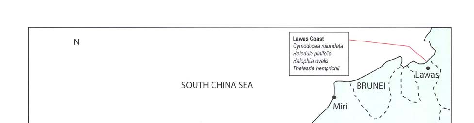
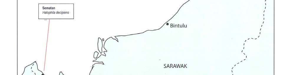
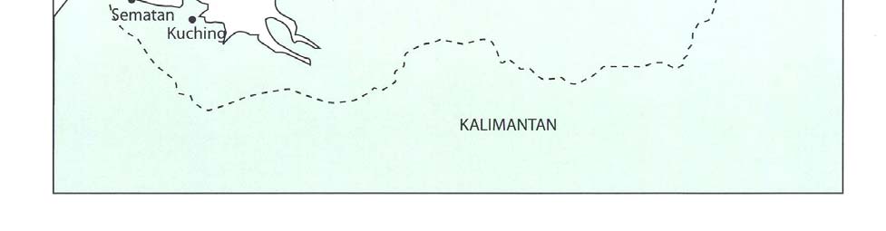
4 NATIONAL REPORT ON SEAGRASS IN THE SOUTH CHINA SEA ş MALAYSIA
Figure 1
Distribution of seagrass species in Sarawak.
Reversing Environmental Degradation Trends in the South China Sea and Gulf of Thailand

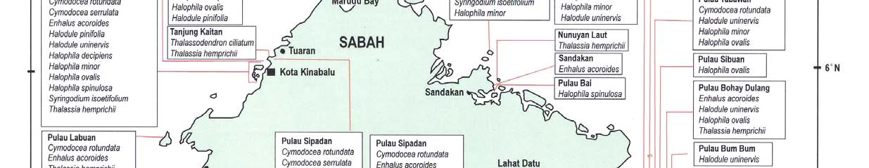
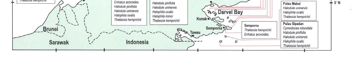
NATIONAL REPORT ON SEAGRASS IN THE SOUTH CHINA SEA ş MALAYSIA 5
nd
aila
h
f
of T
h.
Gul
nd
s in Saba
a Sea a
n
ecie
Chi
sp
t
h
ss
ra
Sou
eag
the
n
s
i
nds
n Tre
bution of
atio
d
Distri
gra
a
l De
ent
v
i
r
onm
Figure 2
g En
v
e
rsin
Re
6
NATIONAL REPORT ON SEAGRASS IN THE SOUTH CHINA SEA ş MALAYSIA
2.2 Biological
Aspects
2.2.1 Associated Marine Biota
The interactions between seagrass, mangrove and coral reef ecosystems are known to exist (Fortes,
1995; Fortes, 1988; Fortes, 1991; UNESCO, 1983; UNEP, 1997). These ecosystems are intricately
linked by physical and nutrient interactions, fish migrations and human impacts.
In Malaysia, many known seagrass beds are associated with either mangrove or coral reef
ecosystems, and sometimes all three ecosystems exists together (Table 4). To a lesser extent,
seagrasses may also associate with seaweed habitat (Gan, 2003; Japar et al. 1999a; Japar et al.
1999b).
Table 4
Seagrass beds and associated coastal and marine ecosystems in Malaysia.
State
Location of Seagrass Beds
Associated Ecosystems
Negri Sembilan
Port Dickson
Coral reefs, mangroves and seaweeds
Kelantan
Kampung Baru Nelayan
Mangroves
Johor
Sungai Pulai estuary, Tanjung Adang
Mangroves and seaweeds
and Merambong shoal
Mersing Islands National Park
Coral reefs and mangroves
Terengganu
Setiu Lagoon
Mangroves
Sungai Redang estuary, Pulau Redang Coral reefs and mangroves
Sarawak
Pulau Talang-talang and Sematan
Coral reefs and mangroves
Kuala Lawas (along the coast)
Mangroves
Sabah
Tunku Abdul Rahman Park
Coral reefs and mangroves
Krambunai, Tanjung Kaitan, Salut and
Mangroves
Mekabong River
Sulaman Lake
Mangroves
Pulau Banggi and Pulau Balambangan Mangroves, coral reefs and seaweeds
Sandakan
Mangroves and coral reefs
Darvel Bay (Semporna, Kunak and
Coral reefs, mangroves and seaweeds
Lahad Datu, and associated islands)
2.2.2 Marine Endangered Species
Dugongs were rarely reported in the Malaysian waters prior to the 1990s and there are no estimates of
the size of dugong population (Marsh et al. 2002). Presently, in Peninsular Malaysia, dugongs are
found in the waters of Johor Straits (Sungai Johor estuary, Pulau Ubin, Pulau Tekong and the Changi
area) (Sigurdson et al. 1990), Sungai Pulai estuary and Pulau Langkawi (Japar and Muta Harah, 2003;
Marsh et al. 2002). The islands off the east coast of Johor, Johor Marine Parks (also known as
Mersing Islands National Park) also support significant of seagrass resources and dugong population.
During the recent survey, dugongs were sighted in the waters of Pulau Besar, Pulau Sibu, Pulau
Tinggi and Pulau Rawa.
There have been numerous sightings of dugongs by researchers from Universiti Malaysia Sabah.
These areas include Kota Kinabalu, Kudat, Pulau Banggi and Pulau Balambangan, Sandakan and
Semporna. The local people also reported the occurrence of dugongs in Sulaman Lake, which support
significant seagrass resources (especially Enhalus acoroides) and mangrove ecosystems (Tan Kim
Hooi, personal observation).
In Sarawak, dugongs are known to occur in Tanjong Datu (Bank, 1931) and Brunei Bay (Lawas and
Limbang districts). The evidence that dugongs are resident in the Brunei Bay and Lawas Bay is
strengthened by the recent sightings by Universiti Malaysia Sabah and recent findings of probably the
largest known seagrass beds in Sarawak (Japar et al. 2004).
For the sea turtles, green turtles (Chelonia mydas) are well-known to use seagrass ecosystem as their
feeding and foraging ground. Green turtles and seagrasses can be found in Pulau Redang, Mersing
Islands National Park, Pulau Talang-talang National Park (Sarawak), Tunku Abdul Rahman Park,
Pulau Banggi and Pulau Balambangan.
Reversing Environmental Degradation Trends in the South China Sea and Gulf of Thailand
NATIONAL REPORT ON SEAGRASS IN THE SOUTH CHINA SEA ş MALAYSIA
7
2.2.3 Associated Fisheries Resources
Seagrass meadows are known to play an important role in providing habitat and food resources for
fish, shellfish and shrimps (Arshad et al. 2001; Fortes, 1995; Aung et al., 1995; Fortes, 1988; Fortes,
1991; Jimmy et al. 2003; Sasekumar et al. 1990 (UNESCO, 1983). From these studies, many species
recorded are commercially important species.
Arshad et al. (2001) recorded 47 fish species (30 families) and 95 invertebrate species from
Merambong shoal, respectively. In another study, 76 species fish species were identified from Sungai
Pulai estuary (Sasekumar et al. 1990). In Sungai Pulai estuary where seagrasses thrives, spotted
seahorse (Hippocampus kuda) was discovered by researchers from KUSTEM. This precious species
are abundant, but their future is uncertain due to port development and expansion, ship navigation,
land reclamation for industrial park and power plant.
In Sabah, 19 species of prawns and shrimps, including 9 species of Penaeid shrimps, were caught in
Sepangar Bay seagrass habitat (Aung et al., 1995). The most abundant and economically important
prawns are Penaeus semisulcatus, P. japonicus, Metapenaeus tenuipes and Heteropenaeus
longimanus.
2.3
Threats to Seagrass Resources
2.3.1 Natural
Threats
The impacts caused by natural processes are the damages of seagrass beds due to typhoon and
storm, coastal erosion, and potential impacts from global warming and sea level rise.
The occurrence of typhoon and storm are very rare in Malaysia. In December 1996, a major storm,
Hurricane Greg struck Kota Kinabalu and Tunku Abdul Rahman Park from the west, having a dramatic
effect upon coral reefs and seagrasses of the park and adjacent areas such as Sepangar Bay and
Menggatal. The northeast monsoon from November to March may also have impacts on seagrass
resources of the islands of the east coast of Peninsular Malaysia. The monsoon also causes severe
coastal erosion along the east coast of Peninsula Malaysia.
2.3.2 Human
Activities
Table 5 summarises various human induced threats to seagrass beds in Malaysia. The current human
activities that affecting the seagrass habitat are:
Nutrient
enrichment
Runoff of sediments
Coastal
reclamation
Sand
mining
Traditional harvesting of fisheries resources
Illegal encroachment of trawlers
Destructive fishing method (fish blasting and cyanide)
Marine
Pollution
Table 5
Threats human activities to selected seagrass beds in Malaysia.
Location of
Conservation
State
Threats
seagrass beds
status
Kedah
Pulau Langkawi
None
Ě Land reclamation for tourism facilities
(Tanjung Rhu
Ě Pollution from cement industry
and Teluk Ewa)
Ě Impacts from boating and recreational activities
Negri Sembilan
Port Dickson
None
Ě Reclamation for tourism facilities
Ě Sand/coral
mining
Ě Pollution from solid wastes and sewage
Ě Uncontrolled tourism and recreational activities
Reversing Environmental Degradation Trends in the South China Sea and Gulf of Thailand
8 NATIONAL REPORT ON SEAGRASS IN THE SOUTH CHINA SEA ş MALAYSIA
Table 5 cont.
Threats human activities to selected seagrass beds in Malaysia.
Location of
Conservation
State
Threats
seagrass beds
status
Johor
Sungai Pulai
Mangrove Forest
Ě Land reclamation for port development and
estuary, Tanjung
Reserves and
expansion (Tanjung Pelepas Port), and industrial
Adang and
RAMSAR site
parks.
Merambong shoal
Ě Massive ship navigation / movement
Ě Ship-based pollution
Ě Potential pollution from petrochemical industries
Ě Heat water and wastes from Tanjung Bin power
plant (coal)
Ě Clearing of mangroves
Ě Impacts from harvesting of fisheries resources
Sungai Johor
Mangrove Forest
Ě Land reclamation (Pulau Tekong, Pulau Ubin and
estuary and
Reserves
Changi area)
adjacent areas
Ě Sand
mining
(Straits of Johor,
Ě Industrial wastes from Pasir Gudang, Tebrau and
Pulau Tekong and
Woodlands (Singapore) Industrial Parks
Pulau Ubin,
Ě Massive ship navigation/movement
Singapore)
Ě Ship-based
pollution
Ě Domestic wastes and sewage
Pulau Sibu, Pulau Johor Marine Parks Ě Sedimentation from the impacts of illegal trawling
Tinggi, Pulau
and Mersing Islands
at marine park
Besar, Pulau Rawa National Park
Ě Impacts from boating and recreational activities
and adjacent
Ě Untreated
wastes
islands
Terangganu
Sungai Paka
Mangrove
Ě Sand
mining
estuary and
Reserve
Ě Impacts from harvesting of fisheries resources
Paka Shoal
Sarawak
Kuala Lawas
Mangrove
Ě Impacts from harvesting of fisheries resources
Reserve
Sabah
Tunku Abdul
National Park
Ě Land reclamation at Kota Kinabalu and adjacent
Rahman Park
areas
Ě Destructive fishing (cyanide and fish bombing)
Ě Direct discharge of wastes from illegal settlement
from Pulau Gaya and mainland of Kota Kinabalu
Ě Impacts from boating and recreational activities
Ě Ship-based pollution
Karambunai,
None
Ě Land clearing for Kota Kinabalu Industrial Park,
Sepangar Bay,
naval base and settlements (Figure 3)
Sungai Salut and
Ě Destructive fishing (cyanide and fish bombing)
Sungai Mekabong
Ě Impacts from boating and recreational activities
pollution from petrochemical industries
Ě Ship-based pollution (Sepangar and Kota
Kinabalu Ports)
Sulaman
Lake
Ě Impacts from boating and recreational activities
Ě Aquaculture
development
Ě Illegal cutting of mangroves
Pulau Banggi and
To be gazetted as Ě Sand and coral mining
Pulau
Tun Mustapha
Ě Destructive fishing (cyanide and fish bombing)
Balambangan
Marine Park and
Ě Illegal
trawling
activities
Mangrove
Ě Illegal clearing of mangroves
reserves
Ě Impacts from harvesting of fisheries resources
Darvel Bay
Mangrove reserves Ě Sand and coral mining
(Lahad Datu, Kunak Ě Destructive fishing (cyanide and fish bombing)
and Semporna) and Ě Illegal
trawling
activities
some islands
Ě Illegal clearing of mangroves
proposed as Tun
Ě Impacts from harvesting of fisheries resources
Sakaran Marine
Park
Reversing Environmental Degradation Trends in the South China Sea and Gulf of Thailand
NATIONAL REPORT ON SEAG RASS IN THE SOUTH CHINA SEA ş MALAYSIA
9
Figure 3
Development of Kota Kinabalu Industrial Park near Sepangar Bay and Karambunai
Lagoon may also pose severe threats (land clearing and sedimentation) to the Seagrass
Beds of Sepangar Bay, Karambunai Lagoon and Kuala Sungai Merkabong.
3.
ECONOMIC VALUATION (IMPORTANCE AND USE OF SEAGRASSES)
Apart from serving as breeding and feeding grounds for many species of fishes, crustaceans,
invertebrates, to larger endangered species such as dugongs and green turtles, there are very few
direct uses of seagrasses to human.
Enhalus fruits/seeds are edible (Burkill, 1935) and is still eaten by the coastal communities of Sungai
Pulai, Johor (Japar and Muta Harah, 2003), Indonesia (Kiswara, 1994) and the Philippines (Fortes,
1993). The nutritional value of the flour derived from Enhalus acoroides is comparable to that of wheat
and rice flour in terms of carbohydrate and protein content and energy values surpass these types of
flour in calcium, iron and phosphorus content (Montana et al. 1999). Burkill (1935) noted that the softer
fibbers from Enhalus acoroides can be made into fishing nets. In Indonesia, the rhizomes of
Cymodoceae are also eaten by the local people (Kiswara, 1994).
4.
INSTITUTIONAL ARRANGEMENTS AND NATIONAL LEGISLATION
4.1 Constitutional
Arrangement
The Federal Constitution of Malaysia defines the jurisdiction, roles and functions of the Federal and
State governments. The division of jurisdiction is enforced through legislative, policy and
administrative arrangements. In summary there are 19 articles in the Constitution which relates to the
protection of the environment, ecosystems and endangered species. The articles cover a wide range
of issues and divide the scope of responsibility into a Federal list, a State list and a Concurrent list.
Four articles from the Federal, State and Concurrent lists impact directly on the conservation of marine
biodiversity:
i) Article 9 (c) of the Federal list which gives the Federal government jurisdiction over marine
fishing and fisheries, except for turtles;
ii) Articles 2 and 3 of the State list which give States jurisdiction over land and land use matters
including forestry and agriculture;
iii) Article 12 of the State list which gives control over turtles and riverine fishing to the States;
and
iv) Article 3 of the Concurrent list which provides for joint responsibility for the conservation of
wildlife and the establishment of National Parks.
Reversing Environmental Degradation Trends in the South China Sea and Gulf of Thailand
10 NATIONAL REPORT ON SEAGRASS IN THE SOUTH CHINA SEA ş MALAYSIA
4.2 National
Legislations
4.2.1 The Fisheries Act, 1985 (Amended 1993)
The Fisheries Act, 1985 is the principal act for the conservation of marine biodiversity. Apart from
providing for the establishment of marine parks and regulating the activities in the marine parks
(Section 41-45), the Fisheries Act also provides the powers for the State governments to enact
legislation for the protection of turtles (Section 38). The latest amendment to the act made in 1999
provides the necessary powers for the Minister of Agriculture to promulgate laws to protect species
deemed to be endangered (Article 61). Prior to this amendment no direct protection was extended to
endangered species such as dugong Dugong dugon.
It is widely acknowledged that the Fisheries Act does not provide full protection to marine ecosystems,
particularly from land-based activities. Indeed the `divorce' between the management of the marine
and the terrestrial components of the marine parks has often been used as an example of problems
created by the Federal-State dichotomy. In order to address this problem, the policy makers and
managers of marine protected areas have often resorted to using other laws such as the
Environmental Quality Act.
The other major point raised about the Fisheries Act is that it is not an act which is intended to protect
marine biodiversity. The protection accorded to ecosystems is by virtue of the ecosystems being inside
a marine park area. Ecosystems outside marine park areas, particularly seagrass beds, are without
any real protection from the Fisheries Act. Indirect protection is provided by the fisheries zoning
procedures which limit the size of boats and gear used in coastal areas where ecosystems such as
seagrass occur.
4.2.2 The Environmental Quality Act, 1974
The Environmental Quality Act, 1974 (EQA) is an umbrella act aimed primarily at pollution control and
management of development activities. Pollution control is carried out through the numerous
regulations under the EQA specifically those related to the discharge of sewage and effluents for
example the Environmental Quality (Sewage and Industrial Effluents) Regulations, 1979.
Development control is achieved through the Environmental Quality (Prescribed Activities)
(Environmental Impact Assessment Order, 1987). Under the provisions of this order there are 19
activities requiring the preparation of, at the very least, a preliminary environmental impact
assessment (EIA). In marine parks the requirements are even more stringent and all tourism
development projects in marine parks would require an EIA. The implementation of the EIA provisions
in as far as the EIA study is concerned is satisfactory. However, concern has been raised about the
monitoring of development activities particularly where compliance with mitigating measures are
concerned. Furthermore the operations of facilities such as hotels and chalets or infrastructure such as
jetties are not subject to continuous monitoring. This brings into picture the need for post EIA or post
development monitoring especially in sensitive areas such as marine parks.
4.2.3 National Forestry Act, 1984 (Amended 1993)
National Forestry Act 1984 (Amended 1993) provides a legal platform for the multiple-use
management of the permanent forest estate (i.e. mangroves). The Act has been endorsed by all the
states in Peninsular Malaysia. In Sarawak and Sabah, the administration and management of
mangroves as forest reserves is governed by Forest Ordinance 1954 and Forest Enactment 1968,
respectively. The area gazetted as mangrove forest reserves includes mangrove forests, rivers/water
bodies and river beds. In many cases, seagrass beds are apparently found in the mangrove reserves.
4.3 State
Legislation
Recently, several states especially Sabah and Sarawak have enacted new legislation related to
coastal and marine environment. Table 6 shows some of the state legislation which is relevant to
seagrass ecosystems.
Reversing Environmental Degradation Trends in the South China Sea and Gulf of Thailand
NATIONAL REPORT ON SEAGRASS IN THE SOUTH CHINA SEA ş MALAYSIA
11
5. MANAGEMENT
PERSPECTIVES
5.1 Management
Efforts
Generally, the conservation and management of seagrasses in Malaysia has received far less
attention. There are no specific management plan, action plan, legislation, policy and guidelines for
seagrasses. Unlike seagrasses, mangrove reserves have been established under National Forestry
Act 1984 and state forest ordinances (i.e. Sabah's Forest Enactment 1968 and Sarawak's Forest
ordinance 1954); and coral reefs are protected under Fisheries Act 1985 (via the Marine Park
Establishment Order 1994 and Fisheries [Prohibited Area] Regulations 1994) and state national park
ordinances (i.e. National Park [Johor] Corporation Enactment 1989, Sabah's Parks Enactment 1984
and Sarawak's National Parks and Reserves Ordinance 1965). At the moment, seagrass beds are
partly protected under the marine parks, state parks, fisheries protected area (i.e. Pulau Talang-talang,
Sarawak), mangrove forest reserves and RAMSAR site (i.e. Sungai Pulai). Many significant areas
such as Paka, Kemaman, Setiu Lagoon, Kuala Lawas and Darvel Bay are not protected. The
associated endangered species such as dugongs and sea turtles are protected under the Fisheries
Act 1985, Protection of Wildlife Act 1972, Sabah's Fauna Conservation Ordinance 1963 and
Sarawak's Wildlife Protection Ordinance 1990.
5.2 National
Policies
Malaysia's overall effort to conserve marine biodiversity is guided by a number of principal policy and
planning documents. Primary among these are the National Policy on Biological Diversity, National
Policy on Environment, and the five yearly Malaysia Plan documents more specifically the Seventh
and Eighth Malaysia Plans. Together, these documents provide the rubric under which biodiversity
conservation work is implemented in the country. This section discusses these documents as well as
other policy documents which impact on the conservation of marine biodiversity in Malaysia.
5.2.1 National Policy on Biological Diversity (NPB)
The Government of Malaysia in 1998 officially accepted the NPB as the primary document to guide
biodiversity conservation effort in the country. This is in response to the recommendation of
Convention on Biological Diversity for countries to
"develop national strategies, plans or programmes for the conservation and sustainable use of
biological diversity ..."
In summary the NPB provides direction in implementing strategies, action plans and programmes for
the conservation of biodiversity with the aim of using this resource in a sustainable manner. At the
core of the NPB is a fifteen point strategy which includes measures such as improving scientific
knowledge, strengthening the institutional framework for biodiversity conservation, integrating
biodiversity conservation into sectoral planning, reviewing legislation, minimising human impact on
biodiversity and enhancing awareness.
In general all the strategies and action plans of the NPB apply to the conservation of marine
biodiversity. However, the NPB made several important observations concerning marine biodiversity
conservation:
i) The lack of consideration given to the landmass adjoining marine parks in the gazettement of
marine park areas. This has indeed caused the perennial problem of marine parks being
adversely affected by development activities on land;
ii) Species conservation efforts focus too much on large and `charismatic' terrestrial species.
Some emphasis should also be given to marine species particularly fish species; and
iii) There is a lack of regional and international cooperation for the protection of transboundary
protected areas.
The implementation of the NPB in the conservation of marine biodiversity however has been patchy
and there is a lack of awareness among marine biodiversity managers as to the NPB and its content.
Similarly, there also appears to be a lack of awareness on marine biodiversity among biodiversity
conservation policy makers, planners and managers in the country. This is reflected in the fact that
most of the NPB related projects carried out during the Seventh Malaysia Plan period were terrestrial
Reversing Environmental Degradation Trends in the South China Sea and Gulf of Thailand
12 NATIONAL REPORT ON SEAGRASS IN THE SOUTH CHINA SEA ş MALAYSIA
biodiversity conservation programmes. The NPB notes that the lack of knowledge and documentation
on seagrass in Malaysia is an issue which needs to be addressed within the broader context of the
strategies and action plans identified in the document. However, no specific programme has been
identified for seagrass conservation and management.
5.2.2 National Policy on the Environment
In November 2002, Malaysia launched its National Policy on the Environment to enhance the national
efforts to protect the environment and promote sustainable development. The objectives of the Policy
are to achieve:
A clean, safe, healthy and productive environment for present and future generations;
Conservation of the country's unique and diverse cultural and natural heritage with effective
participation by all sectors of society; and
Sustainable lifestyles and patterns of consumption and production.
The policy statement sets out the principles and strategies necessary to ensure that the environment
remains productive, both ecologically and economically. The eight principles are:
(1) Stewardship of the environment ş Exercise respect and care for the environment in
accordance with the highest moral and ethical standards.
(2) Conservation of nature's vitality and diversity ş Conserve natural ecosystems to ensure
integrity of biodiversity and life support systems.
(3) Continuous improvement in the quality of the environment ş Ensure continuous improvement
in the productivity and quality of the environment while pursuing economic growth and human
development objectives.
(4) Sustainable use of natural resources ş Manage natural resource utilisation to sustain the
resource base and prevent degradation of the environment
(5) Integrated decision-making ş Integrate environmental dimensions in the planning and
implementation of the policies, objectives and mandates of all sectors to protect the
environment.
(6) Role of the private sector ş Strengthen the role of the private sector in environmental
protection and management.
(7) Commitment and accountability ş Ensure the highest commitment to environmental protection
and accountability by all decision-makers in the public and private sectors, resource users,
non-governmental organisations and the general public, in formulating, planning and
implementing their activities.
(8) Active participation in the international community ş Participate actively and effectively in
regional and global efforts towards environmental conservation and enhancement.
The Green Strategies in the Policy are directed towards the following key areas:
(i) Education and Awareness
(ii) Effective management of natural resources and the environment
(iii) Integrated development planning and implementation
(iv) Prevention and control of pollution and environmental degradation
(v) Strengthening administrative and institutional mechanisms
(vi) Proactive approach to regional and global environmental issues and
(vii) Formulation and implementation of Action Plans
5.2.3 National Marine Parks Malaysia: Policy and Concept
The "National Marine Parks Malaysia: Policy and Concept" document was prepared in 1990 and to
date remains the only document which outlines the philosophy behind the establishment of marine
parks and the broad management objectives for these areas. The document also proposes
management approaches such as zoning for multiple uses. However the document by itself is
insufficient for the purpose of day-to-day management of marine park areas and is in need of updating
considering the changes which have occurred in the marine parks and the areas surrounding it.
Reversing Environmental Degradation Trends in the South China Sea and Gulf of Thailand
NATIONAL REPORT ON SEAGRASS IN THE SOUTH CHINA SEA ş MALAYSIA 13
The updating of the document should among others consider reviewing the objectives of the
establishment of the marine parks to better reflect the important role which marine parks in Malaysia
play in conserving marine biodiversity. In addition, due consideration should also be given to resolving
the quandary over the function of marine parks as a tool for conservation and its role as a venue for
tourism activities. Apart from the document, other documents related to marine parks management
should be reviewed. These would include the Conceptual Plan for Marine Parks Management report
and others.
5.2.4 Malaysia
Plans
The Malaysia Plan documents first noted the need to conserve marine biodiversity in the Sixth
Malaysia Plan (1991-1995) document. During this period of the Malaysia Plan, emphasis was given to
the establishment of Fisheries Prohibited Areas for the conservation of marine biodiversity and the
promotion of tourism and scientific research. The Sixth Malaysia Plan further noted the importance of
coral ecosystems to the conservation of marine biodiversity and warned of the dangers of uncontrolled
sewage discharge, land clearing and clearing of mangroves and the impact these activities have on
the marine environment.
Following-on from the Sixth Malaysia Plan, the Seventh Malaysia Plan (1996-2000) saw the
completion and acceptance of the National Policy on Biological Diversity. Where marine biodiversity is
concerned, a change of status was affected to the Fisheries Prohibited Areas which were gazetted as
Marine Parks, thus according these areas better protection. The Seventh Malaysia Plan also calls for
expansion of the protected area system to include more critical habitats. As part of an overall national
effort to protect coastal zones a draft National Coastal Zone Policy was also completed during this
period. The Government is presently considering this policy. There was also a proposal to establish a
National Islands Development Board to coordinate development on islands and reduce the detrimental
impact of island development on the marine environment. The status of this proposal however is not
known.
The Seventh Malaysia Plan also saw the start of efforts to implement the NPB, although as noted
earlier these were mostly for terrestrial biodiversity. Recognising this problem, the Eighth Malaysia
Plan has called for an expansion of the NPB implementation programme to include all States.
Presumably, this would include marine biodiversity conservation in marine parks as well.
5.2.5 The Third National Agricultural Policy (1998-2010)
The Third National Agricultural Policy recommends the establishment of more marine parks to
conserve marine resources and ensure the sustainability of the fisheries sector, but does not make
any specific mention of the ecosystems that need to be conserved.
5.2.6 Draft National Integrated Coastal Zone Management Policy (NICZM)
In October 2004, the Government of Malaysia through the Economic Planning Unit of the Prime
Minister's Department completed a draft NICZM policy document. The draft policy comprising a Draft
Policy Document and five Technical Annexes envisages a "A healthy and productive coastal zone, rich
in biological diversity, wisely managed, and developed for the equal distribution of benefits for all, now
and in the future." The vision statement is supported by fifteen goals aimed at among others higher
economic growth in the coastal zone; preservation and restoration of environmental health and
biological diversity in the coastal zone; achieve integrated and ecosystems-based management of the
coastal zone; and practice good governance and management of the coastal zone.
While the draft report is yet to be finalised, the completion of the policy study is an important step for
coastal zone management and its implementation, possibly during the 9th Malaysia Plan period of
2006-2010 would contribute significantly to coastal ecosystems conservation in Malaysia.
5.3 Development
Guidelines
5.3.1 Government Circular No. 5/1987 on Control of Development in the Coastal Zone
The Circular 5/1987 establishes a set of regulations for the approval and implementation of projects in
the coastal zone with the primary aim of protecting the coast from coastal erosion. The implementation
of the circular has been quite uniform in all the States in Malaysia and this has contributed to the effort
to address coastal erosion in the country.
Reversing Environmental Degradation Trends in the South China Sea and Gulf of Thailand
14 NATIONAL REPORT ON SEAGRASS IN THE SOUTH CHINA SEA ş MALAYSIA
5.3.2 Guidelines for Erosion Control for Development Projects in the CZ (JPS 1/97)
The guideline JPS 1/97 reinforces the implementation of the Circular 5/1987 by specifying the
technical inputs needed for decision-making in coastal zone development. These inputs include
information such as existing uses, biodiversity, and location of infrastructure and fisheries activities.
More importantly, JPS 1/97 establishes setback limits for backshore development. The recommended
setback limits are:
i) 60 metres for sandy coast from Mean High Water Mark; and
ii) 400 metres for muddy coast measured from the seaward edge of mangrove forest. However,
no development should be allowed where mangrove forest have been gazetted as Permanent
Forest reserve under the National Forestry Act 1984.
Table 6
Selected state legislation related to coastal and marine ecosystems.
State Legislati
on
Agencies
Provisions
Sabah Sabah
Water
Water Resources
Establishment of river and shore
Resources
Council
reserves (i.e. coastal waters, estuary
Enactment 1998
Drainage and Irrigation
and lagoon, seagrass, mangrove
Department
forest, riparian forest, aquatic and
wetland vegetation)
Sabah
Forest
Forestry Department
Establishment of mangrove forest
Enactment 1968
reserves (Class V) ş mangroves and
their water bodies (i.e. associated
ecosystem such as seagrass beds)
Parks
Enactment
Sabah Parks
Establishment, administration, planning
1984
and management of marine protected
areas (MPAs)
Prohibition on removal of vegetation
and animal
Prohibition on fish bombing and coral
exploitation
Wildlife
Wildlife Department
Protection of endangered species
Conservation
associated with seagrasses (i.e.
Enactment 1997
dugongs and turtles)
Environment
Environment Protection
Prescribed activities (i.e. sand mining,
Protection
Department
forest land clearing)
Enactment 2002
Restrictions on activities along coastal
(superseded
area and affecting river bed
Conservation of
Restrictions on discharge of pollutants
Environment
into water
Enactment 1996)
Restrictions on activities affecting
vegetation
Sarawak National
Parks
Sarawak Forestry
Establishment of national parks
and Nature
Department
including MPAs
Reserves
Sarawak Forestry
Administration, planning and
Ordinance 1998
corporation
management MPAs
Forest
Ordinance
Sarawak Forestry
Establishment, administration, planning
1954
Department
and management of mangrove forest
reserves
Wildlife
Protection
Sarawak Forestry
Protection of dugongs and all marine
Ordinance 1998
Department
turtles
Establishment and administration of
wildlife sanctuaries
Natural
Natural Resources and
Conservation and improvement of
Resources and
Environment Board
natural resources
Environment
Prohibition, restriction and control of
Ordinance 1993
pollution
Johor National
Park
Johor National Park
Establishment of national parks
(Johor)
Corporation
Administration, planning and
Corporation
management of parks
Enactment 1989
Research on ecosystems
Reversing Environmental Degradation Trends in the South China Sea and Gulf of Thailand
NATIONAL REPORT ON SEAGRASS IN THE SOUTH CHINA SEA ş MALAYSIA 15
5.3.3 Guidelines for Development Planning in the CZ (JPBD 6/97)
The Town and Country Planning Department guideline on development in the coastal zone
complements the JPS 1/97 guideline on the control of erosion in the coastal zone. Because its scope
covers development activities in general, JPBD 6/97 is able to provide specific guidelines for
development of different types of coastal areas or activities. JPBD 6/97 is divided into two set of
guidelines.
5.3.4 National Ecotourism Plan (NEP)
The National Ecotourism Plan, Malaysia (1997) consists of 25 easy-to-use guidelines for the
management and promotion of ecotourism in Malaysia. The guidelines are divided into four categories
and those which would be of great interest to marine biodiversity managers and policy makers are:
i) Category 1: Guidelines for Categorising Sites and Activities (Guideline 1);
ii) Category 2: Carrying Capacity and Limits of Acceptable Change (Guideline 2);
iii) Category 3: Guidelines according to Ecosystems (Guideline 3: marine park and islands;
Guideline 5: mangrove forests; and Guideline 9: coastal areas); and
iv) Category 4: Guidelines according to Activities (Guidelines 1-25 covering issues such as local
community participation, marketing, visitor behaviour, monitoring and conservation in general.
5.3.5 Other
Guidelines
Other useful guidelines concerning protection of seagrasses are the Guidelines for Island Physical
Development (JPBD 1/96), Integrated Physical Planning Guidelines for the Coastal Zone of Sarawak
(2000), and Code of Practice for Mangrove Production Forest (1997).
6. RECOMMENDATIONS/ACTION
PLAN
6.1
Protected Area for Seagrass Beds
The important seagrass beds in Malaysia should be urgently safeguarded by gazetting as the
"Fisheries Protected Area" using the current legislations such as Fisheries Act 1985. Such instrument
and approach have been used for the coral reefs (i.e. Pulau Talang-talang, Pulau Satang, and
Tanjung Tuan). In Sabah, the Water Resources Enactment 1998 can be used to gazette reserves with
seagrass resources.
6.2
Integrated Management of Seagrass, Mangrove and Coral Reef Ecosystems
Scientific studies and management intervention have mainly focused on single coastal/marine
ecosystem or endangered species, in spite of the fact that interactions between seagrass, mangrove
and coral reef ecosystems are known to exist (Fortes, 1995; Fortes, 1988; Fortes, 1991; UNESCO,
1983). There is no point to conserve and manage seagrass beds where their associated ecosystems
such as mangroves and corals reefs are not protected. Similarly, there is impossible to conserve
dugong population without protecting the seagrass habitat.
There is an urgent need to change the current approach which conserve and manage single
ecosystem or single species, to integrated management and ecosystem approach. In Malaysia, the
important and unprotected seagrass beds and their associated ecosystems and endangered species
that need the integrated approach are seagrass beds in Pulau Banggi and Pulau Balambangan,
Darvel Bay, Karambunai-Sepangay-Mekabong River, Kuala Lawas, Paka, Kemaman, and Tanjung
Adang-Merambong shoal.
6.3
Legislation and Policy
Judging the importance of the seagrass ecosystems and their function on fisheries production, habitat
for endangered species and coastal protection, the development of specific legislation (i.e. through the
amendment of Fisheries Act 1985 and Forestry Act 1984), policy and guidelines should be given due
consideration.
Reversing Environmental Degradation Trends in the South China Sea and Gulf of Thailand
16 NATIONAL REPORT ON SEAGRASS IN THE SOUTH CHINA SEA ş MALAYSIA
6.4
Management Plan and Conservation Programme
As the management issues of seagrasses are critical, priority actions to be taken are the development
of management plan and programmes that focuses on the management issues regarding seagrass
communities and human surroundings that impact them. The management plan and programmes will
be incorporated in the overall management plan (i.e. integrated coastal zone management plan,
marine park management plan, mangrove forest management plan, etc.).
6.5 Research
Priorities
There is a need to prioritise seagrass research in Malaysia due to limited research funding and
experts. Such research programmes should aim at improving current knowledge and management of
seagrass resources, and develop human capacity for future seagrass research. The research areas to
be given top priority the following:
Seagrass resource inventory, mapping, classification and monitoring of significant seagrass
beds;
The interactions between seagrasses and other critical ecosystems, and their role in fisheries
ecology and production;
Seagrass and coastal processes ş nutrient recycling and coastal protection;
Seagrass rehabilitation and restoration, and marine ranching.
6.6
Education and Awareness Programmes
As implementation of management plan, policy and legislations will not be successful without public
participation, especially from local communities and developers, the Government and relevant
agencies have to start initiating education and public awareness programmes targeting all levels of
people. Such programmes should emphasise on the importance of seagrass beds to human and
endangered species (dugongs and sea turtles), linkages of seagrasses to mangrove and coral reef
ecosystems, and the function of fisheries production.
Reversing Environmental Degradation Trends in the South China Sea and Gulf of Thailand
NATIONAL REPORT ON SEAGRASS IN THE SOUTH CHINA SEA ş MALAYSIA 17
REFERENCES
Arshad, A., Japar Sidik, B. and Muta Harah, Z. 2001. Fishes associated with seagrass habitat. pp.151-162. In:
Japar Sidik, B. et al. (eds.). Aquatic Resources and Environmental Studies of the Straits of Malacca ş
Current Research and Review. MASDEC, UPM, Serdang, Malaysia.
Aung, H., Almah, A. and Arbain, H.K. 1995. Shrimp and prawn fauna of some seagrass and mangrove areas on
the west coast of Sabah. pp.92-100. In: Almah, A. et al. (eds.). Proceedings of the Seminar on Marine
Fisheries Resources of Sabah, 8-9 June 1994, Kota Kinabalu, Sabah.
Bank, E. 1931. A popular account of mammals of Borneo. Journal of Malayan Branch of the Royal Asiatic Society
9: 1-139.
Burkill, I.H. 1935. A Dictionary of the Economic Products of the Malay Peninsula. Volume 1 (939p.) and 2
(1954p.). Government of Malaysia and Singapore. Ministry of Agriculture and Co-operatives, Kuala
Lumpur, Malaysia.
Duarte, C.M. 1999. Seagrass ecology at the turn of the millennium: challenges for the new century. Aquatic
Botany 65: 7-20.
Fortes, M.D. 1988. Mangrove and Seagrasses beds of East Asia: Habitats under stress. Ambio 17: 207-213.
Fortes, M.D. 1991. Seagrass-mangrove ecosystems management: A key to marine coastal conservation in the
ASEAN region. Marine Pollution Bulletin 23: 113-16.
Fortes, M.D. 1993. Seagrasses ş their role in marine ranching. pp.131-151. In: Ohno, M. and Critchley, A.T.
(eds.). Seaweed Cultivation and Marine Ranching. Kanagawa International Fisheries Training Centre and
Japan International Cooperation Agency, Japan.
Fortes, M.D. 1995. Seagrasses of East Asia: Environmental and Management Perspectives. RCU/EAS Technical
Reports Series No. 6. UNEP, Bangkok. 79p.
Gan, M.H. 2003. Distribution of Gracilaria Species in Selected Areas in Peninsular Malaysia and its Agar
Evaluation. Unpublished thesis for B. Agrotechnology. Kolej Universiti Sains dan Teknologi Malaysia,
Terengganu. 161p.
Gumpil, J. 1997. A Study on Seagrass Biodiversity, Distribution and Biomass in Tunku Abdul Rahman Park,
Sabah, Malaysia. Final Year Project Report (Unpublished B. Sc. Thesis). Universiti Kolej (UPM)
Terengganu. 149p.
Gumpil, J. 2002. Status, Utilisation and Suggested Management Strategies of Seagrass Beds in Darvel Bay,
Sabah, Malaysia. Unpublished M. Sc. Thesis. Universiti Malaysia Sabah. 287p.
Japar Sidik, B. and Muta Harah, Z. 2003. The Seagrasses of Malaysia. pp.152-160. In: Short, F.T. and Spalding,
M.D. (eds.). World Atlas of Seagrasses. California University Press.
Japar Sidik, B., Arshad, A., Hishamuddin, O. and Muta Harah, Z. 1999a. Seagrass and macroalgal communities
of Sungai Pulai estuary, south-west Johore, Peninsular Malaysia. pp. 3-12. In: Kuo, J. et al. (eds.).
Proceedings of an International Workshop on Seagrass Biology, 25-29 January 1996, Western Australia.
Japar Sidik, B., Arshad, A., Hishamuddin, O. and Shamsul, B. 1995. Halophila decipiens Ostenfeld: a new record
of seagrass for Malaysia. Aquatic Botany 52: 151-154.
Japar Sidik, B., Lamri, A., Muta Harah, Z., Muhamad Saini, S., Mansoruddin, A., Gumpil, J. and Fazrullah Rizal y,
A.R. 1997a. Halophila decipiens (Hydrocharitaceae), a new seagrass record for Sabah. Sandakania 9: 67-
75.
Japar Sidik, B., Muta Harah, Z. and Arshad, A. 2003. The occurrence of Enhalus acoroides fruits, seeds and
seedlings. pp.111-116. In: Japar Sidik, B. et al. (eds.). Aquatic Resources and Environmental Studies of
the Straits of Malacca ş Managing the Straits Through Science and Technology. MASDEC, UPM, Serdang,
Malaysia.
Japar Sidik, B., Muta Harah, Z. and Arshad, A. 2004 (In Press). Comparative morphology of Halophila ovalis-
Halophila minor complex from Malaysia. JSPS Multilateral Cooperative Research 2002-2010.
Japar Sidik, B., Muta Harah, Z. Kanamoto, Z. and Mohd Pauzi, A. 2001a. Seagrass communities of the Straits of
Malacca. pp.81-98. In: Japar Sidik, B. et al. (eds.). Aquatic Resources and Environmental Studies of the
Straits of Malacca ş Current Research and Review. MASDEC, UPM, Serdang, Malaysia.
Japar Sidik, B., Muta Harah, Z. Kanamoto, Z. and Mohd Pauzi, A. 2001b. Responses of Halophila ovalis and
Cymodocea serrulata under the shade of Enhalus acoroides. pp.111-116. In: Japar Sidik, B. et al. (eds.).
Aquatic Resources and Environmental Studies of the Straits of Malacca ş Current Research and Review.
MASDEC, UPM, Serdang, Malaysia.
Japar Sidik, B., Muta Harah, Z. Mohd Pauzi, A. and Madhavan, S. 1999b. Halodule species from Malaysia ş
distribution and morphological variation. Aquatic Botany 65: 33-45.
Japar Sidik, B., Muta Harah, Z., Lamri, A., Francis, L. and Fazrullah Rizally, A.R. 1997b. Halophila spinulosa (R.
Br.) Aschers. ş An unreported seagrass in Sabah, Malaysia. Sabah Parks Nature Journal 2: 1-9.
Reversing Environmental Degradation Trends in the South China Sea and Gulf of Thailand
18 NATIONAL REPORT ON SEAGRASS IN THE SOUTH CHINA SEA ş MALAYSIA
Japar Sidik, B., Muta Harah, Z., Lamri, A., Francis, L., Gumpil, J. and Fazrullah Rizally, A.R. 2000. Halodule
pinifolia (Miki) Den Hartog from Tunku Abdul Rahman Park, Sabah. Sabah Parks Nature Journal 3: 29-39.
Japar Sidik,.B. 1994. Status of seagrass resources in Malaysia. pp. 283-289. In: Wilkinson, C.R. et al. (eds.).
Proceedings of Third ASEAN-Australian Symposium on Living Coastal Resources. Australian Institute of
Marine Science, Townsville.
Jimmy, A., Arshad, A. Japar Sidik, B. and Muta Harah. 2003. The stomach content analysis on several fish
species from seagrass beds of Sungai Pulai, Johore. pp.125-131. In: Japar Sidik, B. et al. (eds.). Aquatic
Resources and Environmental Studies of the Straits of Malacca ş Managing the Straits Through Science
and Technology. MASDEC, UPM, Serdang, Malaysia.
Kiswara, W. 1994. A review ş seagrass ecosystem studies in Indonesia waters. pp. 259-281. In: Wilkinson, C.R.
et al. (eds.). Proceedings of Third ASEAN-Australian Symposium on Living Coastal Resources. Australian
Institute of Marine Science, Townsville.
Marsh, H., Penrose, H., Eros, C. and Hugues, J. 2002. Dugong: Status Report and Action Plan for Countries and
Territories. UNEP, IUCN and WCMC. UNEP/DEWA/RS.02-1. 162p.
Mohd Kushairi, M.R. 1992. The areas and species distribution of seagrasses in Peninsular Malaysia. Paper
presented at the First Symposium on Natural Resources, 23-26 July 1992, Kota Kinabalu, Malaysia. 8p.
Montana, N.N., Bonifacio, R.S. and Rumbaoa, G.O. 1999. Proximate analysis of the flour and starch from Enhalus
acoroides (L.f.) Royle seeds. Aquatic Botany 65: 321-325.
Muta Harah, Z. and Japar Sidik, B. 2004 (In Press). Seagrass communities of Punang-Bt. Sari-Lawas River
Estuary, Sarawak, East Malaysia. Bio-Science Research Bulletin (In Press).
Muta Harah, Z., Japar Sidik, B. and Fazrullah Rizally, A.R. 2003a. Occurrence and morphological description of
seagrasses from Pulau Redang, Terengganu, Malaysia. Jurnal Teknologi 38: 29-39.
Muta Harah, Z., Japar Sidik, B. and Hishamuddin, O. 1999. Flowering, fruiting and seedling of Halophila beccarii
Aschers. (Hydrocharitaceae) from Malaysia. Aquatic Botany 65: 199-207.
Muta Harah, Z., Japar Sidik, B., Law, A.T. and Hishamuddin, O. 2003b. The seagrass, Halophila beccarii
(Hydrocharitaceae) and its distribution in Peninsular Malaysia. pp.165-173. In: Japar Sidik, B. et al. (eds.).
Aquatic Resources and Environmental Studies of the Straits of Malacca ş Managing the Straits Through
Science and Technology. MASDEC, UPM, Serdang, Malaysia.
Norhadi, I. 1993. Preliminary Study of the seagrass flora of Sabah, Malaysia. Pertanika Journal of Tropical
Agricultural Science 16(2): 111-118.
Orosco, C.A. and Amir Sharifudeen, A. 2004. The distribution of the seagrass, Halophila beccarii Aschers., in
Terengganu River estuary. pp.192-195. In: Norhayati, M.Y. et al. (eds.). Proceedings of the KUSTEM Third
Annual Seminar on Sustainability Science and Management, 4-5 May 2004, Kuala Terengganu,
Terengganu.
Orosco, C.A. and Ung, Y.C. 2004. The growth and reproduction of the seagrass, Halophila beccarii Aschers., in
Terengganu River estuary. pp.299-303. In: Norhayati, M.Y. et al. (eds.). Proceedings of the KUSTEM Third
Annual Seminar on Sustainability Science and Management, 4-5 May 2004, Kuala Terengganu,
Terengganu.
Phang, S.M. 1998. The Seaweed Resources of Malaysia. pp. 79-91. In: Critchley, A.T. and Ohno, M. (eds.).
Seaweed Resources of the World. Japan International Cooperation Agency, Tokyo.
Phang, S.M. 2000. Seagrasses of Malaysia. Botanical Monographs No.2. University of Malaya, Kuala Lumpur.
Sasekumar, A. Leh, C.M.U., Chong, V.C., D'Cruz, R. and Audrey, M.L. 1990. The Sungai Pulai (Johor): A unique
mangrove estuary. pp. 191-211. In: Phang, S.M. et al. (eds.). Proceedings of the 12th Annual Seminar of
the Malaysian Society for Marine Science. Malaysian Society for Marine Science, Kuala Lumpur.
Sigurdson, J.B. and Yang, C.M. 1990. Marine mammals of Singapore, pp. 25-37. In:Chou, L.M. and Ng, P.K.L.
(eds.). Essays in Zoology. Department of Zoology, National University of Singapore, Singapore.
UNEP. 1997. Integrated Management of Watersheds in Relation to Management and Conservation of Nearshore
Coastal and Marine Areas in the East Asian Seas Region: Phase 1 ş Assessment of Effects of River
Discharges of Sediments, Nutrients and Pollutants on Coastal Wetlands, Seagrass Beds and Coral Reefs
(A Regional Overview). RCU/EAS Technical Reports Series No.13. UNEP, Bangkok. 143p.
UNESCO. 1983. Coral reefs, Seagrass Beds and Mangroves: Their Interaction in the Coastal Zones of the
Caribbean. Report of a Workshop. UNESCO. 133p.
Wong, C.L., Masuda, M. and Phang, S.M. 2003. Seaweed and seagrass resources along the east coast of
Peninsular Malaysia. Poster presented at the PEMSEA International Conference on the Sustainable
Development of the Seas of East Asia. 4p.
Reversing Environmental Degradation Trends in the South China Sea and Gulf of Thailand
NATIONAL REPORT ON SEAGRASS IN THE SOUTH CHINA SEA ş MALAYSIA
ANNEX 1 PAGE 1
ANNEX 1
Species, depth range, substratum, ambient salinity, temperature and habitat
characteristics of seagrasses along the straits of Malacca.
Depth range
Salinity
Temp.
Habitat
Species
Substratum
(m) MSL
(ppt)
(║C)
characteristics
E. acoroides -1.0 to -2.7
Compact sand, sandy-
24-34 29-34
Intertidal
area,
mud, muddy, soft mud
degraded coral reef,
and calcareous sandy-
subtidal shoal
mud
T. hemprichii -1.0 to -1.8
Calcareous sandy-mud,
24-34
29-34
Degraded coral reef,
sand covered coral and
rocky area, subtidal
muddy
shoal
H. beccarii
-1.8 to -2.0
Calcareous muddy
25-32
30-32
Mudflat of
mangrove, upper
fringes of subtidal
bottom
H. decipiens
-1.5 to -3.1
Sandy-mud and silty-
31-34
31-34
Subtidal area, lower
mud
intertidal area
H. minor
-1.8 to -2.1
Calcareous sandy-mud
28-31
29-30
Subtidal shoal
H. ovalis
-1.0 to -3.5
Calcareous sandy-mud,
24-34
29-34
Degraded coral reef,
soft mud, sand covered
subtidal area and
coral, sandy-mud, silty-
shoal
mud, muddy, calcareous
muddy and sandy
H. spinulosa -1.8 to -2.1
Calcareous sandy-mud
28-31 29-30
Subtidal
shoal
and soft mud
C. rotundata
-1.8 to -2.1
Calcareous sandy-mud
28-31 29-30
Subtidal
shoal
and sandy-mud
C. serrulata
-1.0 to -2.1
Calcareous sandy-mud,
24-34
29-34
Degraded coral reef,
sand covered coral and
subtidal shoal
sandy-mud
H. pinifolia
-1.0 to -2.1
Calcareous sandy-mud,
28-34
29-33
Intertidal area, sub-
sand covered coral,
tidal shoal
sandy-mud, silty-mud,
compact sand and muddy
H. uninervis
-1.2 to -2.1
Calcareous sandy-mud,
28-34
29-33
Intertidal area and
sandy-mud and sandy
subtidal shoal
S.
-1.0 to -2.1
Calcareous sandy-mud
28-34
29-33
Degraded coral reef,
isoetifolium
and sand covered coral
subtidal shoal
Source: Japar Sidik and Muta Harah (2001a).
Reversing Environmental Degradation Trends in the South China Sea and Gulf of Thailand
NATIONAL REPORT ON SEAGRASS IN THE SOUTH CHINA SEA ş MALAYSIA
ANNEX 2 PAGE 1
r
te
mp
1
0
1
2
2
Wa
Te
(║C)
29-3
27-3
29-31
29-30
30-3
30-32
30-31
30-3
30-3
1
2
9
1
1
Salinity
(psu)
28-3
28-3
0-18
28-31
29-31
29-30
30-3
29-3
nge
pth ra
De
(m) HHWS
-4.6 to -12
-5 to - 6
-2.2 to -2.5
-1.8 to -2.1
-2.0 28-2
-1.5 to -2.5
-2.0 to -2.5
-5.0 to - 7.0
e
c
c
a
r
i
i
.
l
e
d
u
hii
nd
i
l
a
B
n
lo
ic
H.
H.
aila
h
Ha
ervis
h
p
mpr
ciatio
e of
n
in
e of
a
l
o
H. spinulosa
and
,
-5.0
f
of T
o
li
a
des
le u
Gul
f
H
asso
d
lassia he
r
esenc
ovalis
c
oroi
odu
Presenc
nd
ha
H. ovalis
H. ovalis
lus a
rm an
it
h
H.
i
t
h
H. pinif
i
t
h
H. ovalis
i
t
h
T
e of
i
t
h
Hal
e of
i
t
h
H. ovalis
o
w
a
pecific
w
w
ha
w
pecific P
w
pecific.
a Sea a
F
n
oli
En
Chi
Mixed
pinif
Monos
Mixed
Mixed
and
Mixed w
Presenc
Mixed
Presenc
Monos
ovalis
Mixed
Monos
ovalis
t
h
a
r
a
c
t
e
r
i
s
t
i
c
s
o
Sou
d
the
n
2
i
t
a
t
c
h
i
y san
X
E
a
b
d
and
dd
coral
b
le
b
le
nds
N
h
d
N
d
s
trate
y
s
b
d
l rub
l rub
n Tre
y san
A
Su
us mu
eo
atio
e
a
n
l
i
ne san
d
d
le
gra
i
t
u
g
Sand, silt
Sand
Sand, mud
Calcar
Coralline sand,
rubb
Sand, cora
Sand
Sand, cora
Coral
a
l De
n
ent
l
o
d
ded
ded
a
l
ded
ded
ed
on
a
l
go
gra
gra
gra
gra
em
v
i
r
onm
e
a
n
ciat
d
o
s
y
st
s
s
al
al
al, sho
al, de
al, de
al, de
al, de
g En
A
oon
Subtid
Subtid
Intertidal, la
Subtid
Subtid
coral
Subtid
coral
Intertidal, coast
lag
Subtid
coral
Subtid
coral
v
e
rsin
,
l
a
t
i
t
u
n
Re
d
n
E
c
a
t
i
o
de
o
N a
L
4.56"N
0.5"N
2.9"N
5.3"N
1.0"N
1.8"N
8.8"N
5.0"N
9
.0"E
gitu
'3
4
'
11.6"E
'3
2
'
12.4"E
'N
9
'E
'5
4
'
0
.05"E
'2
0
'
31.9"E
'1
2
'
30.4"E
'0
7
'
50.4"E
'5
2
'
15.3"E
'2
'
3
titude
Lon
La
05║53
102║4
05║46
103║0
05║01
103║1
01║19
103║3
05║58
116║0
06║00
116║0
06║08
116║0
06║40
117║3
06║10
118║3
003).
i
n
g
una
n
a
n
n
rah et al. (2
ng
a
t
ion
da
a
mb
bonga
da
nuk
ra
li
nga
Loc
ng
g A
a
m
uta Ha
M
u Re
ha
u Ma
Ke
u J
u Se
rc
njun
luk
Pulau Perhentian
Pula
Me
Ta
Pula
Pulau Gay
Te
Pula
Pula
Source:
NATIONAL REPORT ON SEAGRASS IN THE SOUTH CHINA SEA ş MALAYSIA
ANNEX 3 PAGE 1
i
th
ate
w
r
nd to mud
a
t
es
nd
a
t
es
a
t
es
a
t
es
a
t
es
a
t
es
en
i
v
e
Substr
tr
tr
tr
tr
tr
mud
tr
hide
Fine sa
Substrates
Sand to mud
s
u
bs
Fine sa
s
u
bs
Sand to mud
s
u
bs
Sand to mud
s
u
bs
Soft mud
s
u
bs
s
u
bs
hydrog
sulp
a
s
R
Soft
a
w
ter
░
C )
9
7
7
6
6
9
6
a
r
i
-
L
Temp.
(
26-2
25-2
26-2
25-2
25-2
25-2
25-2
t
.
S
-
B
1
5
1
5
0
0
4
g
a
n
pH Wa
n
u
7.43-8.8
7.34-8.0
8.38-8.8
7.50-7.5
6.88-8.5
7.33-7.5
7.56-8.3
nd
y
aila
2
5
2
6
0
0
9
h
(ppt)
Salinit
24-3
24-2
29-3
20-2
18-2
18-2
10-1
f
of T
e
c
i
e
s
a
t
P
Gul
y
sia.
t
h
e
)
nd
r
a
s
s
s
p
(m
Dep
Rang
1.0-2.5
1.5-2.0
1.5-2.5
1.5-2.0
1.5-2.0
1.0-1.5
1.0-1.5
a Sea a
n
Chi
f
s
e
a
g
s
t
h
o
a
k, East Mala
n
s
or
Sou
v
ali
es mixed
rotundata
H. ovali
the
ata
3
C.
n
i
X
c
i
a
t
i
o
nd
E
h
H.o
or
nds
sociation
N
o
tu
N
.
r
es
es
es
A
C
n Tre
a
s
s
o
d
i
x
ed wit
and sometim
or
pinifolia
atio
as mixed with
d
a
n
H.
c
ific and
ata
c
ific
c
ific patch
c
ific patch
c
ific patch
gra
r
m
e
s m
Form and as
spe
i
m
spe
spe
s
well
spe
spe
a
l De
H. ovalis
,
f
o
ach Front, Lawas, Saraw
H. pinifolia
ent
Be
Mono
somet
C. rotund
Mono
with
Mono
Mixed with
Pure a
or
Mono
Mono
v
i
r
onm
s
y
s
t
e
m
g En
s
Estuary
r to
ne
ne
ne
s of the
s of the
s of the
s and
on
y
stem
v
e
rsin
c
i
a
t
e
d
ssi
Re
oral zone.
ng low tide
d pool
oral zone.
ng low tide
d pool
d pool
dflat of sub-
dflat of the
oral zone in
uri
-
littoral zo
uri
-
littoral zo
-
littoral zo
e
p
re
e in pool
ciated s
b-litt
s an
b-litt
s an
s an
s
b-litt
r su
r su
rove mu
rove mu
r su
Asso
nnel
nnel
nnel
nnel
s and d
Flatland of the uppe
lowe
Exposed d
Cha
middle sub
Flatland of the middle to
lowe
Exposed d
Cha
middle sub
Cha
middle sub
Sometimes observed in
mang
littoral zon
cha
Mang
uppe
pool
a
r
a
c
t
e
r
i
s
t
i
c
s
,
a
s
s
o
ecies
olia
rtog
prichii
m
Ha
k
.
f.
a
i
t
a
t
c
h
s
sp
ce
a he
s.
a
b
ata
er
ssi
nb.) Aschers.
H
dule pinif
)
den
odo
Seagras
sch
Halo
(Miki
Halophila ovalis
(R.Br.) Hoo
Cym
rotund
Ehrenb. & Hempr. ex
A
Thala
(Ehre
No.
1.
2.
3.
4.
NATIONAL REPORT ON SEAGRASS IN THE SOUTH CHINA SEA ş MALAYSIA
ANNEX 4 PAGE 1
AN
N EX 4
Macroalgae species at seagrasses meadows Merambong, Tanjung Adang
(Darat and Laut), Teluk Kemang and Port Dickson.
Tanjung
Teluk
Pantai
No. Division/Species Merambong
Adang
Kemang
Dickson
Chlorophyta
1.
Avrainvillea erecta
+ +
2.
Bryopsis plumose
+
3.
Bryopsis sp.
+
4.
U. occidentalis
+ +
+
5.
U. javensis
+
+
6.
Caulerpa lentillifera
+
+
7.
C. manorensis
+
8.
C. microphysa
+
9.
C. prolifera
+
+
10.
C. racemosa
+
+
11.
C. sertularioides
+ +
+
+
12.
Chaetomorpha spiralis
+ +
13.
Chaetomorpha spp.
+
14.
Cladophora fascicularis
+
15.
C. fuliginosa
+
16.
C. patentiramea
+
17.
Enteromorpha clathrata
+ +
18.
Halimeda opuntia
+ +
19.
Ulva spp.
+ +
Phaeophyta
20.
Dictyota dichotoma
+ +
21.
Lobophora variegate
+
22.
Padina tetrastomatica
+
23.
Sargassum cristaefolium
+
24.
S. ilicifolium
+
25.
S. polycystum
+
Rhodophyta
26.
Acanthophora spicifera
+ +
+
27.
Amphiroa rigida
+ +
+
28.
A. fragilissima
+
29.
Ceramium affine
+
30.
Gracilaria coronopifolia
+
31.
G. fisherii
+
32.
G. salicornia
+ +
33.
G. textorii
+
34.
Gracilaria sp.
+
35.
Hypnea cervicornis
+ +
36.
Hypnea esperi
+
37.
Jania decussate-dichotoma
+
38.
Laurencia corymbosa
+
Source: Japar et al. 2001a.
Reversing Environmental Degradation Trends in the South China Sea and Gulf of Thailand
NATIONAL REPORT ON SEAGRASS IN THE SOUTH CHINA SEA ş MALAYSIA
ANNEX 5 PAGE 1
ANNEX 5
Lists of fish and Crustacean species caught within Merambong seagrass shoal.
Family Species
Local
Malay
Name
Fish
Ariidae
Arius sagor
Duri/Pedukang
Balistidae
Alutera monoceros
Kerosok
Balistidae
Abalistes stellaris
Jebong
Belonidae
Tylosurus strongylurus
Todak
Carangidae
Caranx sexfasciatus
Selar
Carangidae
Selaroides leptolepis
Selar
Carangidae
Scomberoides lysan
Talang
Clupeidae
Sardinella fimbriata
Tamban
Clupeidae
Anodontostoma chacunda
Selangat
Drepanidae
Platax teira
Berbaharu
Engraulidae
Setipinna taty
Mempurung
Engraulidae
Stolephorus indicus
Bilis
Gerridae
Gerres abbreviatus
Kapas
Hemiramphidae
Hemiramphus far
Puput
Leiognathidae
Leiognathus equulus
Kekek gedabang
Leiognathidae
Gazza minuta
Kekek
Leiognathidae
Leiognathus spelendens
Kekek
Leiognathidae
Leiognathus brevirostris
Kekek
Lethrinidae
Lethrinus lentjan
Mempinang
Lutjanidae
Psammoperca waigiensis
Gelam
Lutjanidae
Lutjanus argentimaculatus
Ungar
Lutjanidae
Lutjanus vitta
Mentimun
Mugilidae
Valamugil seheli
Belanak angin
Nemipteridae
Nemipterus japonicus
Kerisi
Platycephalidae
Platycephalus indicus
Baji-baji
Plotosidae
Plotosus caninus
Unsat
Plotosidae
Plotosus lineatus
Sembilang
Pomadasyidae
Pomadasys maculatus
Serkut
Pomadasyidae
Pomadasys hasta
Gerut-gerut
Pomadasyidae
Pomadasys argenteus
Gerut-gerut
Polynemidae
Polynemus sextarius
Senangin
Pristigastridae
Ilisha elongata
Beliak mata
Scatophagidae
Scatophagus argus
Kitang
Sciaenidae
Chrysochir aureus
Gelama kuning
Sciaenidae
Otolithes ruber
Gelama
Siganidae
Siganus javus
Dengkis
Siganidae
Siganus canaliculatus
Dengkis
Sillaginidae
Sillago sihama
Bebulus
Sphyraenidae
Sphyraena jello
Kekacang
Stromateidae
Pampus argenteus
Bawal putih
Tetradontidae
Chelanodon patoca
Buntal
Tetradontidae
Ostracion tuberculatum
Buntal kotak
Theraponidae
Therapon jarbua
Kerong-kerong
Triacanthidae
Pseudotriacanthus strigilifer
Barat-barat
Trichiuridae
Lepturacanthus savala
Timah
Trygonidae
Dasyatis uarnak
Pari beting
Trygonidae
Dasyatis zugei
Pari ketukak
Crustacean
Portunidae
Portunus pelagicus
Ketam renjung
Portunidae
Charybdis feriata
Ketam rimau
Calappidae
Matuta lunaris
Ketam ragi
Penaeidae
Penaeus merguiensis
Udang putih
Penaeidae
Penaeus indicus
Udang kaki merah
Squillidae
Oratosquilla quinquedentata
Mentadak laut
Source: Arshad et al, 2001.
Reversing Environmental Degradation Trends in the South China Sea and Gulf of Thailand


United Nations
UNEP/GEF South China Sea
Global Environment
Environment Programme
Project
Facility
NATIONAL REPORT
on
Seagrass in the South China Sea
PHILIPPINES
Dr. Miguel Fortes
Focal Point for Seagrass
Marine Science Institute, University of the Philippines (MSI/UP)
Diliman 1101, Quezon City, Philippines
NATIONAL REPORT ON SEAGRASS IN THE SOUTH CHINA SEA ş PHILIPPINES
Table of Contents
1. INTRODUCTION ..............................................................................................................................1
2. REVIEW OF DATA AND INFORMATION .......................................................................................1
2.1 SEAGRASS DISTRIBUTION ...........................................................................................................1
2.1.1 Geographic Distribution..................................................................................................1
2.1.2 Temporal Distribution .....................................................................................................3
2.2 PHYSICAL/CHEMICAL CHARACTERISTICS .....................................................................................5
2.3 BIOLOGICAL ASPECTS.................................................................................................................5
2.3.1 Seagrass Plants .............................................................................................................5
2.3.2 Associated Marine Biota ................................................................................................8
2.3.3 Marine Animals and Endangered Species.....................................................................9
2.4 THREATS TO SEAGRASS ...........................................................................................................10
2.4.1 Nature of Threats .........................................................................................................10
2.4.2 Causal Chain Analysis .................................................................................................11
3. ECONOMIC VALUATION ..............................................................................................................12
4. INSTITUTIONAL ARRANGEMENTS AND NATIONAL LEGISLATION.......................................12
5. MANAGEMENT PERSPECTIVES (KEY PROBLEMS AND ISSUES) .........................................14
5.1 THE PEOPLE AND THEIR PERCEPTIONS OF THE ENVIRONMENT (ULUGAN BAY) ............................16
5.2 MANAGEMENT PROBLEMS AND ISSUES (ULUGAN BAY) ...............................................................17
REFERENCES.......................................................................................................................................18
List of Tables
Table 1 Initial area estimates of seagrass beds in the Philippines.
Table 2
Elimination functions of seagrass habitats in coastal East Asia.
Table 3 Comparison of species diversity among the major coastal ecosystems in the
Philippines.
Table 4
Seaweeds in Ulugan Bay with known economic value.
Table 5
Coastal environmental problems in the Philippines.
Table 6
Threats at the project sites in the Philippines.
Table 7
Chronology of national and local legislation relevant to the concerns of the seagrass
component.
Reversing Environmental Degradation Trends in the South China Sea and Gulf of Thailand
NATIONAL REPORT ON SEAGRASS IN THE SOUTH CHINA SEA ş PHILIPPINES 1
1. INTRODUCTION
Seagrass beds are a discrete community dominated by flowering plants with roots and rhizomes
(underground stems), thriving in slightly reducing sediments and normally exhibiting maximum
biomass under conditions of complete submergence (Fortes, 1995). In the Philippines, they grow best
near estuaries and lagoons where they are often associated, physically and ecologically, with
mangrove forests and coral reefs, often forming the ecotone between these two divergent ecosystems.
As such the habitat mediates the structural and dynamic components of the neighbouring ecosystems
via control of material, water, and energy flows between them. More importantly, these seagrass
meadows support a rich diversity of species from adjacent systems and provide primary refugia for
both economically and ecologically important organisms. Hence, the plants are sensitive to
fluctuations because species coming from their neighbouring systems encounter `marginal conditions'
and are at the extremes of their tolerance levels to environmental alterations. This sensitivity makes
seagrasses useful indicators of changes not easily observable in either coral reef or mangrove forest
(Heck and McCoy, 1978).
The extensive coastal zone in the country wraps around the islands and peninsulas, making probably
the most exciting and rapidly growing economic section in the region. Of interest is that 75% of
Southeast Asian population of about 500 million lives in coastal villages (World Resources Institute,
1990). This puts pressure on the seagrass resources through both direct effects, like fishing (Pauly
and Chua, 1988), and indirect effects, like pollution and sediment runoff (Chou, 1994). The pressure is
increasing as communities migrate to cities while the latter are now being built along coasts. In
addition, the growth of Southeast Asian coastal tourism market is probably the most rapid in the world.
2.
REVIEW OF DATA AND INFORMATION
2.1 Seagrass
Distribution
2.1.1 Geographic
Distribution
There are large discontinuities in the distribution of seagrasses in Southeast Asia. This observation is
due to the lack of data resulting from unsystematic studies and incidental collections than the true
pattern of distribution of the species (Fortes, 1995). Only three major accounts of seagrass
biogeography in the region exist (Den Hartog, 1970; Fortes, 1988; Mukai, 1993). Using cluster
analysis, Fortes (1988) has shown that the seagrasses in the Indo-West Pacific can be delineated into
7 seagrass `provinces' with the Philippines, belonging to Province A, the area of second highest
number of seagrass species and numerical similarities in the world.
Seagrasses of the Philippines show a pattern that may reflect their ecology. Halophila spinulosa and
Thalassodendron ciliatum were generally found in deeper (2-17m) clearer waters off the eastern coast
of Indonesia and southern and western coasts of the Philippines. Samples of T. ciliatum collected from
Cuyo Island, Philippines (10║ 51' N lat.; 121║ 00' E long.) (Fortes, 1986) represent the northernmost
limit of its distribution in the Pacific.
From ocular surveys, the Philippines has sizeable seagrass areas spread discontinuously along the
shallow portions of its coastlines. The number of species present appears to be largely a function of
the extent of studies made, the length of the coastline, and the emphasis countries give on the
habitats.
The total of 978km2 of seagrass beds in the Philippines have been measured from 96 sites (Table 1).
Of this figure, 343km2 have been estimated using combined satellite images and ground truth surveys.
On the other hand, 635km2 are gross estimates from satellite images only, no ground truth surveys; as
the places are clusters or parts of big islands, and they cannot be delimited by single grids. The areas
of seagrasses reported are estimates from selected study sites, not reflecting the area for the country.
Reversing Environmental Degradation Trends in the South China Sea and Gulf of Thailand
2 NATIONAL REPORT ON SEAGRASS IN THE SOUTH CHINA SEA ş PHILIPPINES
Table 1
Initial area estimates of seagrass beds in the Philippines.
AREA
REGION PROVINCE
LOCATION
LAT LONG (km2)
I Pangasinan Cape
Bolinao
16.40
119.88 25
II
Cagayan
Cape Enga˝o/ Escarpada Point
18.45
122.28
9
II Cagayan
Fuga
18.83
121.33 3
II
Isabela
Divilacan Bay/ Palanan Bay
17.28
122.42
5
IV Marinduque
Calancan
Bay
13.55
121.92 7
IV
Oriental Mindoro
Puerto Galera
13.45
120.95
9
IV Palawan
Bacuit
Bay
10.72
119.50 11
IV Palawan
Bugsuk
Island
8.23
117.40 12
IV Palawan
Malampaya
Sound
11.17
119.40 21
IV
Palawan
Puerto Princesa/ Honda Bay
9.85
118.93
43
IV Palawan
Ulugan
Bay
10.10
118.77 11
IV Quezon
Calauag
Bay
14.02
122.17 9
IV Quezon
Polilio
Island
15.03
121.80 13
IV Quezon
Ragay
Gulf
13.23
122.70 14
V Sorsogon
Sorsogon
Bay
12.77
123.25 17
VI Negros
Occidental
Bais Bay
10.57
123.15
9
VII Bohol
Northern
Bohol
10.15
124.43 19
VII
Negros Oriental
Apo Island
9.02
123.32
7
VIII Samar
Catbalogan
Area
11.73 127.95 11
X Camiguin
Mantigue
9.08
124.78 9
X Misamis
Occidental
Baliangao
8.70
122.63 7
X
Misamis Occidental
Lopez Jaena
8.63
123.77
16
X Misamis
Oriental
Naawan
8.62
124.38 9
XI
Davao
Samal Island
6.88
125.78
17
XI Davao
Oriental Mati
6.83
126.28 17
XIII
Surigao del Norte
Dinagat Sound
9.87 125.68
12
TOTAL
342
(combined satellite images and ground truth surveys)
ADDITIONAL AREAS (gross estimates from satellite images only, no ground truth surveys; as the
places are clusters or parts of big islands, they cannot be delimited by single grids)
1.
Northern
Palawan
89km2
2. Spratlys
22km2
3.
Sulu
Archipelago
167km2
4.
Hundred
Islands
31km2
5.
Tubbataha
Reefs
13km2
6.
Panay
Island
42km2
7.
Southwestern
Palawan
47km2
8. Pacific coast of Sorsogon Province
41km2
9.
Malangas
Bay
17km2
10. Sarangani Islands
19km2
11.
Batanes
Islands
21km2
12.
Calatagan
Peninsula
11km2
13. Rest of Batangas Province
22km2
14. Rest of Marinduque
33km2
15.
Southern
Zamboanga
25km2
16.
Sequijor
21km2
17. Lingayen Gulf (southern and eastern)
14km2
TOTAL
635km2
GRAND
TOTAL 978km2
Reversing Environmental Degradation Trends in the South China Sea and Gulf of Thailand
NATIONAL REPORT ON SEAGRASS IN THE SOUTH CHINA SEA ş PHILIPPINES 3
Spatial and temporally analysis of data from all seagrass study sites in Ulugan Bay indicates that there
was no significant change in the composition of the seagrass from February 1999 to March 2000. All
seven species were found in the Bay throughout the study period. Enhalus acoroides was found in all
the six sites. In Buenavista, all 7 species were found throughout the study period and in March S.
isoetifolium was flowering profusely. During this month, the seagrass were highly epiphytised by the
red seaweed, Liagora farinosa.
In terms of frequency, E. acoroides markedly dominated the sites (frequency range from 12.3%,
February, in Buenavista, to 72.1%, February, in Umalagan). The small often sand-occluded seagrass,
Halophila ovalis, had the lowest (range from 0.2%, October, in Tarunayan, and November in
Buenavista, to 2.1% at the latter site).
Halodule uninervis consistently demonstrated its `pioneer' nature, being present at the shallowest
portions of the sites. Its seasonality was not as pronounced as the other five species, favouring both
the transition period as well as the summer months.
However, it was not found at the more protected sites and at any time during the study. S. isoetifolium
had a very limited distribution, being found only in Tarunayan in October. It was, however, found in
Buenavista throughout the entire period of the study.
Six of the seven species showed distribution patterns that appeared to be dictated both by site
conditions and periods of the year. Hence, C. rotundata appeared to favour the summer months at the
more exposed, coralline sites of Rita-Manaburi and Tarunayan. However, it showed no temporal
variability in Buenavista, occurring throughout the entire period of the study, and with remarkably
consistently high frequency of occurrence. It was not recorded at the three other sites in the Bay.
T. hemprichii and C. serrulata exhibited similar occurrences (throughout the entire period of the study)
and only in sites which are relatively exposed to surf, nearer the mouth of the Bay (Rita/Manaburi,
Tarunayan, Oyster Bay, and Buenavista). Halophila ovalis showed a similar pattern of distribution
except that, with slight site-specific variations, it appeared to favour only periods that were cooler thus
providing a transition to the warmer months. It should be noted, however, that the sampling for
frequency of occurrence focused only on the presence/absence of the species as seen through the
water column and at the surface of the vegetation.
2.1.2 Temporal Distribution
This section gives some highlights of the studies in two types of features of seagrass beds: structural
and dynamic/functional. These parameters are described in relation to their responses to the temporal
and spatial conditions at the study sites.
Structural Features
Distribution ş In Ulugan Bay two distinct types of seagrass communities are present: in the silted
southern part of the Bay the seagrass communities were markedly dominated by only one species
(Enhalus acoroides), a species known to be resistant to high levels of siltation, while in areas with
clearer, less silted waters highly diverse mixed seagrass communities were found (Halodule,
Syringodium, Cymodocea and Thalassia). The relationship found between community structure and
gradient of siltation is in line with results reported by other authors.
It is known that H. ovalis thrives relatively well in the `understories' of the bigger species and even
underground. They are therefore not normally seen by ocular surveys.
From the data, it is interesting to note that the distribution of the seagrass species amongst the sites in
the Bay follows a pattern wherein more protected sites had fewer species. However, their relative
frequencies were much higher. On the other hand, those from more exposed sites had more species,
but their frequencies were much lower. This demonstrates the classical inverse relationship between
diversity and dominance, the latter being represented by relative density (RD).
It appears that the bay, as represented by the seagrass from the six sites, is characterised by varying
stages of ecological development. These stages likewise represent the varying degrees of
perturbation, natural or man-made, to which these sites are being subjected. Hence, the vegetation
progresses from the apparently most stable, highly diverse mixed seagrass community at Buenavista
and Rita/Manaburi to the lowly diverse one at Tarunayan (Enhalus acoroides and Thalassia
Reversing Environmental Degradation Trends in the South China Sea and Gulf of Thailand
4 NATIONAL REPORT ON SEAGRASS IN THE SOUTH CHINA SEA ş PHILIPPINES
hemprichii, Cymodocea serrulata) and Oyster Bay (Cymodocea serrulata, Thalassia hemprichii,
Halodule uninervis, Halophila ovalis), to the even less diverse community at Macarascas and
Umalagan (Enhalus acoroides). It should be noted that Umalagan and Oyster Bay are deeper
indentations of Ulugan Bay, hence, relatively more protected from waves, with substrates, which are
muddier. On the other hand, Tarunayan, Buenavista, and Manaburi are more frequently exposed to
wave action and with coarser sediment substrates.
Percentage cover ş In five quarterly samplings (October 2001 - October 2002), the highest mean
percentage cover for all species was recorded in April 2002, with a mean value of 16%. Conversely,
January 2002 had the least mean value for seagrass cover with 8.48%. There was a general similarity
in the cover values of the species during the rest of the period.
Among the seagrass species, H. uninervis had the highest mean percentage cover of 17.43%, while
H. ovalis had the lowest with 3.98%. In a mixed community of seagrasses, H. ovalis, can be shaded by
the other taller and broad-leaved species, so that the species could be hidden and not sampled. In an
experiment, it was found that H. ovalis has a very limited tolerance to light deprivation when compared
to other species of seagrasses.
Across transects, Transect C (the deeper transect), had the highest observed seagrass cover of
13.36%. Seagrasses along this transect have wider leaves to compensate for reduced irradiance.
Transect A (the shallowest transect), had the lowest mean cover of 9.6%. It can be surmised that
indeed irradiance affects seagrass growth and morphology along a natural depth gradient.
Canopy Height ş Across sampling periods, April 2002 was the month when the highest average
canopy height values for all five species from all three transects were derived with a mean of 11.53
cm. January 2002 had the lowest mean value of 6.90cm.
Among the transects, Transect B (middle depth) consistently had the highest average canopy height
value of 11.82cm, followed by Transect C with 7.81 cm and Transect A, with a lowest value of 6.57
cm. Transect A has always been exposed and subjected to desiccation at varying times of the day,
throughout the year. It can also be observed that seagrass blades in this portion of the bed were
narrower compared to those in Transects B and C. Transect C is home to several species of
herbivores mostly invertebrates, such as sea urchins or fishes. Bite marks from grazing were evident
on the leaves in this part such that during wave surges, leaves are torn off, explaining the rather lower
canopy height of the seagrasses in the area.
Density (using small quadrat) ş Using the small quadrat (100cm2), results across the sampling periods
showed that the highest mean seagrass density occurred in April 2002 with 3.49 shoots/100cm2.
Lowest mean shoot counted 1.82/100cm2. On the other hand, it occurred in October 2002. April is a
summer month when conditions are best for growth e.g. high light and temperature, least sediment
movement, during most parts of the period, facilitating the needed growth for bed expansion through
shoot production. On the other hand, October is a rainy windy month, with low temperature and light
values, and higher degree of sediment movement, reducing light penetration, which could perhaps
explain the relatively lower density in the seagrasses.
Among the seagrass species, H. uninervis had the highest density of 8.79 shoots/100cm2. Enhalus
acoroides has the lowest density with 0.12/100cm2.
Seagrass density (using core sampler) ş Across sampling periods, the highest shoot density using a
core (0.0035m2) was also in April 2002 with 8.15 shoots/.0035m2. However, the lowest density was
recorded in July 2002 with 1.86 shoots/.0035m2.
Above-ground: below-ground biomass ratio ş From October 2001 to October 2002 and with the
exception of E. acoroides, belowground seagrass biomass (dry weight, g) was significantly greater
than aboveground biomass in the same plants. For belowground biomass, Halodule uninervis had the
highest mean biomass with .25g DW m2, with H. ovalis having the lowest with .02g DW m2. Enhalus
acoroides had the highest computed mean aboveground biomass value (dw) for all sampling periods
with 0.14g DW m2, while Halophila ovalis had the least with .01g DW m2 . The above findings are
consistent with those found in the literature.
Belowground parts constitute 50-90% of the total biomass of seagrasses and that aboveground parts
may constitute 10-50% of the total dry weight of most seagrasses. It is interesting to note that below-
ground biomass in all species (except E. acoroides) was consistently higher than aboveground
biomass.
Reversing Environmental Degradation Trends in the South China Sea and Gulf of Thailand
NATIONAL REPORT ON SEAGRASS IN THE SOUTH CHINA SEA ş PHILIPPINES 5
2.2 Physical/Chemical
Characteristics
Sediment properties ş Marine sediment properties in the Philippines were quantified along siltation
gradients and across different habitat types to assess the extent of terrestrial sediment influence and
derive indicators of terrestrial sediment input. The following main habitat types were covered:
mangroves, seagrass beds, coral reefs, mud flats, river mouths and deep channels. Particularly in
Bolinao and El Nido, distinct fronts in siltation were identified at about 7km from the source. Mud
(<63_m), water content, organic matter, total nitrogen, total phosphorus and iron co-varied along the
first axis of a principal components analysis, which correlated negatively with the pattern in medium to
coarse sand (>250_m), total and inorganic carbon as well as calcium. Interstitial ammonia and
phosphate varied with the fine sand fraction along the second axis. Two-way analysis of variance
showed that water depth, distance from silt source, site and habitat type all contributed to the variance,
but site explained most. Linear regressions showed positive correlations between silt and water
content, organic matter, total nitrogen, total phosphorus and iron, but negative correlations with
calcium suggesting iron and calcium as markers for terrigenous and marine origin, respectively. The
composition of the sediment particulate matter groups the habitat types in two clusters: (1) silty types
as river mouths, shallow mud bottoms, deep channels and mangrove stands with high contents of
organic matter and nutrients versus (2) non-silty types as seagrass beds and coral reefs with low
contents of nutrients and organic matter. Median settling velocities of the silt loads varied from 0.6m
d_1 to 27m d_1. Experimentally determined susceptibility to resuspension identified critical water
content of 50%.
At the demonstration sites in Puerto Galera, substrate type ranged from sandy-muddy at the left and
middle portion of Transects A and B, to sandy towards the right marker. Transect C, which is adjacent
to coral reefs, has a fine to coarse sand, which provides a more favourable substrate for seagrass
growth.
Salinity ş Salinity readings were relatively constant for PH4 at 35ppt. This value is known to be
optimum for photosynthetic activities in seagrasses.
Water Quality ş Water quality at the various sampling sites showed no significant difference in
temperature or levels of suspended solids, sulphate, and nitrite/nitrogen. However, significant
differences in the level of dissolved oxygen, colour and turbidity were recorded.
The differing results reflect the basic differences in topography and degree of embayment prevailing at
the sites at the time of sampling. The more protected Bay sites, mainly Umalagan, Bulalakaw, and
Buenavista, displayed lower dissolved oxygen content, higher colour values and higher turbidity in
comparison with the more open sites outside the Bay proper, such as St. Paul and Sabang.
2.3 Biological
Aspects
2.3.1 Seagrass
Plants
2.3.1.1 Diversity of Seagrass Species
The most diverse seagrass flora is found in the Indo-West Pacific, the centre of marine generic
richness and diversity in the world (Heck and McCoy, 1978). The Philippines, with its extensive
coastline of more than 32,000km (World Resources Institute, 1990), is the country with the second
most diverse seagrass flora so far recorded (second to Australia), contributing the greatest number of
species in East Asia (19 or about 55%). Below are the species recorded in the Philippines.
Cymodocea
rotundata
Halophila
beccarii
Cymodocea
serrulata
Halophila
decipiens
Halodule
pinifolia Halophila
minor
Halodule uninervis
Halophila minor var. nov.
Syringodium isoetifolium
Halophila ovalis
Ruppia
maritima Halophila
spinulosa
Thalassodendron ciliatum
Halophila sp.
Enhalus
acoroides
Thalassia
hemprichii
Reversing Environmental Degradation Trends in the South China Sea and Gulf of Thailand
6 NATIONAL REPORT ON SEAGRASS IN THE SOUTH CHINA SEA ş PHILIPPINES
Seven species of seagrass were identified from the study sites in Ulugan Bay. This number comprises
40% of the total number of seagrass species recorded in the Philippines and Southeast Asia, and 18%
of that in the whole world. Species dominance in seagrass was site-specific. Halodule uninervis was
the densest at 875.8 individuals/m2. This was recorded at Buenavista. Syringodium isoetifolium from
the same site followed with 491.3 individuals/m2 Cymodocea rotundata (337.3 individuals/m2) from
Manaburi was third overall in density, followed by Thalassia hemprichii from Umalagan with 4
individuals/m2.
In Puerto Galera, five seagrass species were found in Study Site (PH4.1): Cymodocea rotundata,
Halophila ovalis, Enhalus acoroides, Thalassia hemprichii and Halodule uninervis. This is 0.70% of the
total number of seagrass species (=9) so far reported for the area, and 30% of that found in the
country and for the whole of Southeast Asia (Fortes, 1986). It should be noted that no intensive
taxonomic survey of the site was conducted, as this is not the thrust of the project. In addition, it is
most likely that two other species, Halodule pinifolia and Halophila minor, are present, mixed with their
generic counterparts at the most exposed and shallowest areas. More detailed survey and taxonomic
studies are required to address this need.
In terms of diversity, Buenavista and Tarunayan in Ulugan Bay exhibited the highest number of
species (Fortes, 1986). Rita-Manaburi with six, Oyster Bay with four, Umalagan, with three, and
Macarascas with one followed this.
2.3.1.2 Utilisation of Seagrasses and Seagrass Beds
2.3.1.2.1 Commonly known uses
In the Philippines, the historical and contemporary uses of seagrass ecosystems are fairly well known.
Hence, seagrasses have been used as packing material, children's toys, compost for fertiliser, fodder,
for direct human consumption, the habitat itself is a fishing ground, especially for the juveniles and
small adults of the rabbitfish, an industry base in many parts of coastal Asia; near resort areas, low
tide exposes seagrass beds and their associated organisms which are the object of curiosity of
tourists; as important natural components in marine parks and reserves; and in many typhoon-prone
areas in the region, as effective retainers of sediments, hence, serving as buffer against waves and
storm surges.
The importance of seagrass systems primarily as a source of income and as a livelihood base of
coastal populations in the Philippines resides on the major components of seagrass beds (i.e.,
seagrasses, fish, reptiles and mammals, invertebrates, and seaweeds) which make them useful in the
protection of the coastal environment and which justify sound management of this valuable resource.
Most coral reefs are in developing countries where they are associated with seagrasses. These two
ecosystems potentially could supply more than one fifth of the fish catch in these countries. Five times
as many fish live over seagrass beds as over sea floors made up of mud, shells, and sand. The
importance of fish movement between coastal habitats is currently receiving attention particularly in
the Indo-West Pacific region. This is largely because of its role in defining the ecological interactions
between tropical coastal ecosystems, which has significant implications to coastal resource
management.
The sea turtles at Turtles Islands of the South Sulu Sea, are known to consume both seagrasses and
algae. Sea turtles have been hunted around the world for both subsistence and commercial trade. Its
eggs are used as a protein source for both people and livestock in many coastal regions, the meat is
consumed by humans, the cartilage of the green sea turtle is the source of the green turtle soup, and
the scutes of the carapace, especially those of the hawksbill are the only natural source of 'tortoise
shell' used for jewelry, eyeglass frames, Japanese ceremonial combs, etc. However, as with marine
mammals such as whales and manatees, sea turtles are becoming increasingly valuable alive in a
growing tourism industry based on viewing their nesting and hatching.
In the Aru Islands, South Sulawesi, and in Bangka Island, Indonesia, around 1,000 dugongs are
caught annually in shallow waters, and form an important part of the coastal diet. In Calauit Island,
Palawan, Philippines, more than five dugongs on average were seen per survey day in March and
July, coinciding with seagrass peak biomass. The actual population status of the mammal in the region
is unknown.
Reversing Environmental Degradation Trends in the South China Sea and Gulf of Thailand
NATIONAL REPORT ON SEAGRASS IN THE SOUTH CHINA SEA ş PHILIPPINES 7
The fact that they bear few young and, in general, are slow to reach reproductive age makes dugongs
and sea turtles especially vulnerable to exploitation. Thus they are species of special concern by virtue
of their evolutionary persistence, their values to humans, and their vulnerability and current rarity. As a
result the dugong and sea turtles are listed under the Convention on International Trade in
Endangered Species of Wild Fauna and Flora (CITES).
2.3.1.2.2 Uncommon Uses and Functions
Seagrass beds have other `uncommon' uses. Hence, they have `elimination' functions, i.e., their uses
once they are removed or converted into other uses, and `environmental' uses. These are given below
(Table 2):
Table 2
Elimination functions of seagrass habitats in coastal East Asia.
__________________________________________________________________
Indo.
Mal.
Phil.
Sing.
Thai.
__________________________________________________________________
Aquaculture
fish
L3
L2
L3
X
L2
crabs
X
X
L1
X
L1
prawns
L2
X
L2
X
LW
Rice fields
X
X
X
X
X
Sugarcane
X
X
L1
X
X
Palm plantation
X
X
X
X
X
Other agriculture
X
X
X
X
X
Pasture
X
X
X
X
X
Solar salt
L1
X
L2
X
X
Industrial development L2
L2
W3
W3
W3
Urban development
L2
W2
L3
W3
L3
Ports
X
X
W3
W3
L1
Airports
X
X
L1
L3
L1
Recreation
X
W
W3
W2
L3
Mining
X
L1
L3
X
L2
Waste disposal
X
W
W2
X
X
Flood
run-off
engineering
X
L1
L2
X
X
Boat traffic
L
X
W2
W2
L1
__________________________________________________________________
L, use is localised
1, a minor use
W, use is widespread
2, a moderate use
X, information inadequate
3, a major use
Oatmeal cookies from Seagrass seed flour
The seeds of Enhalus acoroides (L.F.) Royle are known to the coastal people to be edible. Its
proximate composition is similar to rice. It is eaten raw or boiled and tastes like sweet potato when
cooked. Some fishermen believe that it is an aphrodisiac. Further investigations will include nutritional
evaluation of seagrass plant parts to support the protection of the ecosystem.
With the aim to develop seagrass seed as human food in small island systems, researchers from the
University of the Philippines have developed flour made from dried mature seeds of E. acoroides.
Using a standard recipe for oatmeal cookies, seagrass seed cookies were made using seagrass flour
half substituted for half of the usual wheat flour. Responses to a taste test were very positive. Further
development is planned.
Reversing Environmental Degradation Trends in the South China Sea and Gulf of Thailand
8 NATIONAL REPORT ON SEAGRASS IN THE SOUTH CHINA SEA ş PHILIPPINES
2.3.2 Associated Marine Biota
A vast array of plants and animals live in seagrass beds of the Philippines. Seagrasses have high
organic production rates, which probably accounts for the high biodiversity in the ecosystem. Table 3
gives a comparison of species diversity among the major coastal ecosystems in the Philippines. Next
to coral reefs, seagrass beds have the highest biodiversity. As in the whole of Southeast Asia, the
figures may be grossly underestimated due to the paucity of documented information. There are
indications largely through observations and ocular surveys, however, that the species richness in the
habitats, particularly the fish and invertebrates, could be much higher than previously thought.
Table 3
Comparison of species diversity among the major coastal ecosystems in the Philippines.
Taxon
Seagrass Beds
Coral Reefs
Soft Bottoms
Mangroves
Seagrass
18
14
3
5
Algae
154
1,043
0
72
Corals
8
381
0
0
Other inverts
73
1,485
67
39
Fish
218
1,030
2
241
Mammals
1
Reptiles
11
14
16
TOTAL
483
3,967
72
373
Modified from DENR/UNDP 1997
2.3.2.1 Seaweeds
Seaweed communities at the study (demonstration) sites were closely associated with seagrass and
coral reefs, i.e., recorded along transects where these latter habitats were surveyed. From the nine
sites where corals and seagrass were assessed, 13 different species of seaweeds were found at the
seagrass sites, while 8 species were recorded at the coral reef sites. Four species belonging to
Rhodophyceae (red algae) were found. These were Amphiroa fragilissima, Laurencia sp., Liagora
farinosa, and Ceratodictyon spongiosum. On the other hand, six species of Chlorophyta (green algae)
and seven species of Phaeophyta (brown algae) were found. It should be noted that the record of the
seaweeds might not have been complete as seaweeds have different habitat requirements and they
were surveyed at sites dominated by seagrass and corals.
The three studies undertaken within the period May 1999 - March 2000 showed the presence of at
least 56 species of macrobenthic algae in Ulugan Bay. The algae were categorised under the following
groupings: Cyanophyceae (blue green algae), 1 species; Chlorophyceae (green algae), 26 species;
Phaeophyceae (brown algae), 16 species; and Rhodophyceae (red algae), 26 species.
Another site in Oyster Bay was surveyed in March 2000. This was because of the report from the local
inhabitants that indicated that the area is the source of a seaweed delicacy, `lato' (Caulerpa
lentillifera). Indeed, beds of the species were found close to the mangroves. These were highly silted.
Estimated mean frequency was high (62.3% in 10 quadrats).
Interestingly, the results point to a certain degree of seasonality in the occurrence of the macrobenthic
algae. The colder, wetter season represented by November is characterised by the presence of a
significantly lower number of species (Gibbs, 1995) when compared to the warmer, drier months of
May and March (with 47 and 56 species, respectively). While this might be true, the total biomass of
the seaweeds, particularly contributed by the browns, could be more significant during the former
period.
This is consistent with the known seasonal or temporal ecology of the seaweeds from both tropical
and temperate latitudes. Hence, the trend in biodiversity as far as the seaweeds are concerned
suggests a shift to higher dominance by a few well-adapted species (Sargassum spp., Hormophysa,
Padina) as the year approaches the colder, wetter months. True to the tropics, the summer months
from March to April yield the highest biodiversity in most other marine communities.
On a per-site basis, the following sequence of sites with decreasing number of seaweed species
results: Manaburi (51spp.), Buenavista (37spp.), Rita Island (21spp.), Oyster Bay (13spp.), Umalagan
(12spp.), Bulalakaw (3spp.).
Reversing Environmental Degradation Trends in the South China Sea and Gulf of Thailand
NATIONAL REPORT ON SEAGRASS IN THE SOUTH CHINA SEA ş PHILIPPINES 9
As in the case of the seagrass species, the local distribution of seaweeds showed a pattern that
reflected the influence of the natural substrate and the degree of exposure to wind and waves. The
north (western and eastern) sections of the Bay yielded significantly greater number of species when
compared to the southern portions.
Hence, sites with more varied substrates (e.g. sandy, rocky, and coralline) and which are relatively
moderately exposed to waves yield greater number of species. This was true for the Manaburi,
Buenavista, Rita Island sites. On the other hand, sites which are distinctly muddy (hence, affording
little opportunity for seaweeds to attach themselves) and which are relatively more protected yield
smaller number of component species.
This is true for Oyster Bay and Umalagan (12spp.). Bulalakaw, while rocky coralline is a reef
promontory exposed to sun and wind during low tides, could hence support only small cryptic, not
many macrobenthic, and seaweeds.
Some of the seaweeds recorded are known to be of economic importance (Table 4). These point to
their potential in adding income to the coastal population if the resources and their uses are properly
tapped and managed.
Table 4
Seaweeds in Ulugan Bay with known economic value.
Species Economic
Use/Importance
Caulerpa
human food; medicinal antifungal; lowers blood pressure
Caulerpa racemosa
Caulerpa sertularoides
Cadium arabicum
human food
Cadium edule
Dictyospheriae cavernosa
medicine; antimicrobial
Halimeda spp.
with growth regulators (auxin; gibberelin, cytokinin)
Dictyota dichotoma
human food; source of phenols, vitamin, folic and folinicacids
Padina australis
human food; source of alginic acid
Sargassum spp.
human food; source of algin, auxin-like substance; controls heavy metal
(Pb, Cd ) pollution
Turbinaria sp.
human food; source of algin, minerals
Laurencia spp.
human food; source of agar, carbohydrates, medicine, antifungal,
antibacterial
2.3.3 Marine Animals and Endangered Species
Many animals live in seagrass beds of the Philippines where they form a major fishery. This is due to
the rich nutrient pool and diversity of physical structures protecting young marine life from predators.
This fact, in turn, is the basis of the economic usefulness of seagrass beds in these countries where
major commercial fisheries occur immediately adjacent to seagrass beds (Fortes, 1994). Fish and
shrimp are probably the most important components of the beds, although coastal villages derive their
sustenance from other components of the grass beds. The major invertebrates found in the beds are
shrimps, sea cucumbers, sea urchins, crabs, scallops, mussels, and snails, while the major vertebrate
species include fishes, reptiles, and mammals. Some endangered species of sea turtles reported in
seagrass beds include the green sea turtle, the Olive Ridley, the loggerhead, and the flatback. In the
Philippines, as in most parts of the world, the sea cow (Dugong dugon), a mammal, which is almost
completely seagrass-dependent (Fortes, 1995), is an endangered species.
In the Philippines, coral reefs with their associated seagrasses potentially could supply more than 20%
of the fish catch (Talaue-McManus, 2000). A total of 1,384 individuals and 55 species from 25 fish
families were identified from five seagrass sites in the country (Fortes, 1995).
In Ulugan Bay, a total of 3,000 individual fish were recorded at six transect sites. They represented 63
species, 35 of which are of commercial value. Of the 25 families recorded, the highest number of
species with 10, 9 and 8 represented Labridae, Pomacentridae and Chaetodontidae respectively. This
finding is consistent with similar studies performed elsewhere in the Philippines.
Comparing the six sampling sites, Sabang and Rita-Manaburi were the most similar. These sites were
richer in terms of number of species, but had lower species diversity indices when compared with
some of the sites with a lower total number of species, such as St. Paul and Bulalakaw. This indicates
a more even distribution of fish among the various species at the latter sites. At Sabang and Rita-
Reversing Environmental Degradation Trends in the South China Sea and Gulf of Thailand
10 NATIONAL REPORT ON SEAGRASS IN THE SOUTH CHINA SEA ş PHILIPPINES
Manaburi, evenness values were significantly reduced by the dominance of a few species ş in Sabang
Abudefduf, and at Rita-Manaburi Pterocaesio diagramma and Pomacentrus.
Offered the highest degree of protection from waves and wind of all sampling sites, and located
adjacent to thick mangrove vegetation, Umalagan had the lowest number of fish individuals and the
weakest association with the other sites. However, some similarities were noted with neighbouring
Bulalakaw, and comparison of the two sites showed a similarity index of 56%.
Rita-Manaburi had the overall highest species diversity at 34 recorded species, and also the highest
number of individuals: 1,028. This site is the most representative of the Bay as a whole. Species
distribution did not correlate well with the corresponding feeding habits, in that all feeding groups were
found at practically all locations. This implies that limiting factors other than food are shaping the
community structure.
2.4
Threats to Seagrass
2.4.1 Nature of Threats
A significant portion of the coastal habitats of the Philippines is at high risk of being lost in the next
decade. At present about half of its coastal resources have either been lost or are severely degraded
during the past 56 years (5, 10) and the rate of degradation is increasing. Human impacts are the
primary cause for most of these losses and these are increasing as human populations increase.
There is rapid economic and human population growth, with the population doubling in the next 25-35
years (World Resources Institute, 1990). At least 60% of its human population lives close to shallow
bays, lagoons and islands fringed by seagrass beds. Living in poverty, a large percentage of this
population derives basic needs from these coastal resources. With or without conservation they will
use this environment in order to survive. Infrastructure development is doubling at almost decadal
rates. People extract about 68% of the country's animal protein from the sea. These changes are
resulting in greater demands for coastal zone resources, especially quality seafood products and
space. Our experiences in the past show that an explosive population growth, uncontrolled
modification of the coasts, coupled with rapidly dwindling resources, will bring about short-term
economic development mostly at the expense of the environment.
The major long-term threat to seagrass ecosystems around the world is derived from coastal
eutrophication. A particular problem in embayment with reduced tidal flushing, nutrient loading or
eutrophication results from wastewaters which reach the coasts from industrial, commercial and
domestic facilities, inadequate septic systems, boat discharge of human and fish wastes, and storm
drain run-off carrying organic waste and fertilisers. Its direct impact is the enhancement of growth in
many plant forms resulting in reduction of light. Ultimately the cause of nutrient loading along coasts is
people, increased population density increases the problem.
In the last decade the coastal environmental problems perceived as exerting the most severe impact
on the coastal and marine environment in the Philippines are given in Table 5. They are ranked in
order of priority and classified into urgency categories i.e., immediate, short-term or within the next five
years, and long-term or within the next 10 years or more. Problems marked with asterisks are those
which are known to impact heavily on seagrass beds, 3 asterisks indicating severe impact, 2 asterisks,
moderate impact, and one asterisk, slight or no impact.
2.4.1.1 Coastal environmental problems
Table 5
Coastal environmental problems in the Philippines.
PROBLEM
Immediate
Short-term
Long-term
Sewage pollution***
2
2
3
Industrial pollution***
3
3
2
Fisheries overexploitation***
4
4
6
Siltation/sedimentation***
5
5
4
Oil
pollution**
6
6
8
Hazardous
waste*
7
7
7
Agricultural pollution**
8
8
5
Red
tides*
9
9
11
Coastal
erosion**
10
10
10
Natural
hazards*
11
12
12
Sea
level
rise*
12
11
9
_________________________________________________________________________________
Reversing Environmental Degradation Trends in the South China Sea and Gulf of Thailand
NATIONAL REPORT ON SEAGRASS IN THE SOUTH CHINA SEA ş PHILIPPINES 11
On a site basis, the project sites are subjected to the following threats (natural and man-induced):
NATURAL
MAN-INDUCED
Wind
Wave
Sedi
Pollution
Over-
Rem-
Silt Convert
move
harv
oval
Fuga Is.
x
x
Escarpada Pt.
x
x
Cape Bolinao
x
x
x
x
x
Masinloc-Oyon
Bay
x x
x
Puerto Galera
x
x
Malampaya
Sound
x x
Bacuit
Bay
x x
Ulugan
Bay
x
Puerto Princesa/Honda Bay
x
x
x
Bugsuk Is.
x
x
x
x
(UNEP, 1990).
2.4.1.2 Threats at the site level
Below are the threats, given in the order of importance (1, most important; 5, least important) to
seagrass habitats documented at each of the four selected sites in the Philippines. With the exception
of non-transparency, they give observable physical manifestations. While there are similarities, there
are also differences, which are dictated by the nature of the relatively more influential activities at the
sites. Hence, in Ulugan Bay in the province of Palawan, it is the non-transparency of the navy in its
plan to develop a naval base that is of prime importance. In addition, being a deep indentation (the
most `protected' among the four) and without significant disturbance from development, sedimentation
from rivers is the number 2 priority. On the other hand, Puerto Princesa/Honda Bay in the same
province is subjected more to siltation/sedimentation, not from river run-off but from man-influenced
disturbance (e.g. resort and infrastructure development).
The relationships among these threats can be seen in Table 6. Eight threats are documented to affect
the sites. Among those, which occur at all sites, `siltation/sedimentation' remains as the most
important, while `boat scour', the least important. `Unsustainable fishing practices' was intermediate. It
is interesting to note that Transparency and `oil pollution' are an issue in only one site (Ulugan Bay)
and both associated with naval movement and the planned establishment of the naval base.
Infestation by micro-organisms was found to be important only in Cape Bolinao.
Table 6
Threats at the project sites in the Philippines.
Ulugan Bay
Pto. Princesa
Cape Bolinao
Pto. Galera
Siltation/Sediment (8)
2
1
2
3
Unsustainable fishing (13)
3
4
1
5
Boat scour (19)
5
5
5
4
Tourism development
NAP
2
NAP
1
Domestic discharges
NAP
3
4
2
Non-transparency 1
NAP
NAP
NAP
Oil pollution
1
NAP
NAP
NAP
Infestations
NAP NAP 3 NAP
Numbers in parentheses are sums of the priority ranks. The lowest sum would mean that threat is the
highest priority for all sites; NAP, not a problem.
2.4.2 Causal Chain Analysis
An effective way to understand the nature of threats to ecosystems is to subject them into a `causal
chain analysis'. This analysis `regressively' links a threat to an immediate cause of that threat, and the
latter is likewise linked to its immediate cause, and so on. The end point is a few, `root causes'. These
are the ones that need to be addressed effectively if one desires a resolution of the problems.
There is an indicative `causal chain analysis' of siltation/sedimentation as the priority environmental
issue at the selected sites. It is obvious that basic needs (food, shelter) among the coastal inhabitants
are the primary forcing factor which degrade the environment and cause the loss or destruction of the
habitats at the study sites. With slight variation, all four sites have generally similar problems.
Reversing Environmental Degradation Trends in the South China Sea and Gulf of Thailand
12 NATIONAL REPORT ON SEAGRASS IN THE SOUTH CHINA SEA ş PHILIPPINES
With slight variations in the intensity of use and gear or means used, `unsustainable fishing practices'
occur at all four sites. Interestingly, there is co-action among all the factors concerned, indicative of the
tightly coupled system that has evolved in the process. As in the case of `siltation/sedimentation', it is
again the lack of proper education that emerged as the root cause of the problem. This is shown
below:
In all cases, the roots of the problems are basically the same: the inability of the people to meet the
basic needs. This is hand in hand with the lack of proper education, and the desire for a higher quality
of life. In many cases, the roots even touch the most basic `sins' on humankind. The fundamental
demand to survive and to improve the quality of life among the inhabitants is documented to bring forth
unregulated or unplanned activities at the expense of environmental imperatives. This drive is
aggravated by the lack of proper education, the root of most of the problems.
2.4.2.1 Impediments to Addressing the Threats
The major obstacles to solving the environmental problems and issues with regards to the seagrasses
of The Philippines can be summarised below. It should be noted that these impediments were
basically similar to those recorded 6 years ago:
1. Lacks of trained seagrass researchers
2. Limited scope of work
3. The works are largely descriptive, not synthetic
4. There are gaps in basic knowledge i.e., extent, status, and uses of seagrass beds
5. Lack of appreciation of seagrasses resources
6. Limited and uncoordinated research
7. Misguided management efforts
8. Lack of implementation of laws
9. Lack of effective linkages and
10. Non-consideration of the social and cultural dimensions
3. ECONOMIC
VALUATION
No serious attempt has been made to valuate seagrass resources in the Philippines. In an isolated
case (which was not followed up), the Marine Science Institute was requested to convert the
destruction wrought by an oil barge that ran aground in Bolinao due to a typhoon. Initially, the value
estimated for the associated seagrass resources e.g. biomass as feeds, fish, fertilisers, was
US$20,000. On the other hand, it is worthwhile mentioning some cases wherein seagrass resources
have been given monetary value if only to emphasise the point that indeed they are valuable.
Today we are stuck with the notion introduced by Giarini that in economic planning and decision
making, it is an 'objective yardstick' to measure in monetary terms all factors that contribute to
economic development. In the process, however, we should realise that we face the dilemma of
pricing the priceless, of quantifying the unquantifiable, of creating common standards for things
apparently unequatable. Fonseca (personal communication) argued that trying to determine the
monetary value of an obviously rich and biologically diverse resource as a seagrass ecosystem might
be a waste of time, for this will only further delay its development. But until better instruments and
methodologies are found, giving money values to ecosystem functions (where possible) may help
convince decision makers and financiers of development projects of the importance of nature
conservation and the true meaning of environmentally sustainable economic development. In the
valuation process, however, ecologists should be involved more actively with the view that the whole
exercise is purely for the purpose of management. The low values attached to coastal resources are
the principal reason for their continued destruction and degradation.
4.
INSTITUTIONAL ARRANGEMENTS AND NATIONAL LEGISLATION
Among the legislation that has something to do with the marine and coastal environment, only one
explicitly aims to protect seagrass: Executive Order 02-01. It is a local municipal legislation declared
by the mayor of Puerto Galera, as a result of a workshop on SeagrassNet, which is an ongoing project
to assess and monitor the condition of seagrass beds in shallow coastal areas in Asia-Pacific. All the
other laws are either indirectly or directly relating to the protection of the coasts in general, or
protecting the coral reefs, mangroves, or fishery resources of the country.
Reversing Environmental Degradation Trends in the South China Sea and Gulf of Thailand
NATIONAL REPORT ON SEAGRASS IN THE SOUTH CHINA SEA ş PHILIPPINES 13
The chronology of the legislation relevant to the conservation and utilisation of the coastal and marine
resources of the Philippines are given in Table 7.
At least 245 legislations with direct or indirect relevance to the concerns of the Seagrass Component
of the project were reviewed. They are categorised under: Presidential Decrees, Laws Declaring
Marine Protected Areas in the South China Sea side of the Philippines under NIPAS, Major Policies
that Influenced DENR's Role in Coastal Area Management, Key Legislation that Influenced BFAR's
Role in Fisheries Management in the Last 40 Years, Laws providing other National Agencies with
specific and implied mandates for CRM, Selected Administrative Issuances Related to Pollution,
Selected Administrative Issuances Related to Protected Areas, Selected Administrative Issuances
Related to Mangroves, Selected Administrative Issuances Related to Foreshore, Selected
Administrative Issuances Related to Fisheries, Administrative Issuances Related to Coastal Tourism,
Selected Administrative Issuances Related to the Role of Local Government Units, Selected Municipal
Ordinances, Pending Legislative Proposals on Pollution, Pending Legislative Proposals on Protected
Areas, Pending Legislative Proposals on Mangroves, Pending Legislative Proposals on Fisheries, and
Pending Legislative Proposals on Tourism.
It should be noted that only 1 (a local ordinance, Executive Order 01-02, BantayIsay, or
SeagrassWatch) pertained solely to the protection of seagrass habitats. Only a few explicitly
mentioned seagrass habitats and their resources. This is a reflection of the relative `new' recognition of
the habitat in the legal circles. Unlike the coral reefs and mangroves, the documented importance of
seagrasses to fisheries and coastal management and protection has been known in the Philippines
and the region only since the early 80's.
Fortes (1990 and 1995) have reviewed the seagrass resources of East Asia, discussing their status
and potential as a resource, as well as their environmental roles and prospects for management. So
far, 16 species of seagrasses have been identified in Philippine waters (Fortes, 1986). In other parts of
the country where conditions are favourable, seagrass beds can also be extensive, though often less
dense (Soegiarto and Polunin, 1982; ESCAP, 1995). The boundaries of seagrass bed distribution in
the Philippines are uncertain as there have been few detailed studies and only shallow beds can be
seen in satellite and aerial images.
Table 7
Chronology of national and local legislation relevant to the concerns of the seagrass
component.
Legislation Title/Description
Republic Act No. 9003 (2001)
The Ecological Solid Waste Management Act
Republic Act No. 8550 (1998)
Fisheries Code, clarifies jurisdiction of municipalities and cities in the
management of municipal waters to include functions pertaining to enforcement,
legislation, regulation of fishing activities, conservation and planning
Republic Act No. 8435 (1997)
Agriculture and Fisheries Modernization Act, provides extension services to
municipalities and provides for agriculture and fisheries zoning plan irrespective
of political boundaries
Republic Act No. 8371 (1997)
Indigenous Peoples Right Act (IPRA)
Executive Order No. 6 (1996)
Institutionalised the multi-sectoral committee on coastal development plan
Executive Order No. 240 (1995)
Creation of Fisheries and Aquatic Resources Management Committees
(FARMCs) in coastal barangays, cities and municipalities
Republic Act No. 7942 (1995)
The Philippine Mining Act
Republic Act No. 7881 (1994)
Amendments to RA 6657, Comprehensive Agrarian Reform Law, pertaining to
coverage of fishponds
Executive Order No. 117 (1993)
Created the Inter-Agency Task Force on Coastal Environment Protection
(IATFCEP)
Republic Act No. 7586 (1992)
National Integrated Protected Area Systems Act
Republic Act No. 7160 (1991)
Local Government Code
Republic Act No. 7061 (1991)
The People's Small-Scale Mining Act
Republic Act No. 7161 (1991)
Amendments to National Internal Revenue Code of 1977, bans the cutting of
all mangrove species
Republic Act No. 6969 (1990)
The Toxic Substances and Hazardous and Nuclear Wastes Control Act
Executive Order No. 192 (1986)
Establishes the jurisdiction of DENR in the use of all public lands including
foreshore areas
Presidential Decree No. 1151 (1986?)
Philippine Environment Policy declares it a policy of the State to create,
develop, maintain, and improve conditions under which man and nature can
thrive in productive and enjoyable harmony with each other; fulfil the social,
economic, and other requirements of present and future generations of Filipinos,
and ensure the attainment of an environmental quality conducive to life and
well-being. It also laid the basis for requiring Environmental Impact Statement
(EIS) for all projects and programmes that affect environmental quality.
Reversing Environmental Degradation Trends in the South China Sea and Gulf of Thailand
14 NATIONAL REPORT ON SEAGRASS IN THE SOUTH CHINA SEA ş PHILIPPINES
Table 7 cont. Chronology of national and local legislation relevant to the concerns of the seagrass
component.
Legislation Title/Description
Presidential Proclamation No. 2146 (1981)
Identifies environmentally critical projects, heavy industries, resource extractive
industries and infrastructure projects. Also defines environmentally critical areas
including all declared protected areas, critical habitats of wildlife, prime
agricultural lands, mangrove areas and coral reefs, areas of significant
historical, cultural or aesthetic values and areas often hit by natural calamities
Presidential Proclamation No. 1801 (1978)
Puerto Galera Biosphere Reserve
UNESCO's Man and Biosphere Programme (1977)
Presidential Decree No. 354 (1973)
Presidential Decree No. 1067 (1976)
Water Code of the Philippines, establishes recreation/easement zones in banks
of rivers and streams and shores of seas and lakes
Presidential Decree No. 1586 (1976)
The Environmental Impact Statement System
Presidential Decree No. 984 (1976)
The National Pollution Control Law
Presidential Decree No. 979 (1976)
The Marine Pollution Decree
Commonwealth Act No. 141 (1936)
The Public Land Act
A policy document that provides general guidelines for air quality management,
water management, land use management, and natural resources management
and conservation. The water quality management provisions are concerned
mainly with freshwater resources, but the management of these resources is
also of concern to fisheries management since a number of freshwater rivers
and lakes form part of the inland fisheries resources
Republic Act No. 9147
The Wildlife Resources Conservation and Protection Act
Republic Act No. 7611
The Strategic Environmental Plan for Palawan Act, creating a special
environmental management regime for the island-province of Palawan and
sets up the multi-sectoral Palawan Council for Sustainable Development as the
administering authority
Presidential Decree No. 474
The Maritime Industry Development Decree
Presidential Decree No. 825
Penalises the improper disposal of garbage and other forms of uncleanliness
Presidential Decree No. 857
Sharing of port management between the Philippine Ports Authority and the
local government units (LGUs)
Presidential Decree No. 1152
Philippine Environment Code, prescribes environmental quality standards for
air, water, land, fisheries and aquatic resources, wildlife, soil, etc.
Presidential Decree No. 1198
Requires the rehabilitation of damaged foreshore areas to their original condition
Executive Order No. 114
Created the Presidential Committee on Illegal Fishing and Marine Conservation
Executive Order No. 263
Establishes the community-based forest management
Executive Order No. 247
Bioprospecting law
Commonwealth Act No. 383
Prohibits the dumping into any river of any refuse, waste, matter or substances
of any kind whatsoever that may bring about the rise or filling of river beds or
cause artificial alluvial formations
National Marine Policy
Adopts the archipelagic nature of the Philippines in development planning,
implementation of UNCLOS and all maritime and coastal concerns
Philippine Agenda 21
The national agenda for sustainable development for the 21st century
Medium-Term Philippine Development Plan
The blueprint that spells out the development strategy to boost, among others
(MTPDP)
industry, trade and tourism
5.
MANAGEMENT PERSPECTIVES (KEY PROBLEMS AND ISSUES)
Why manage our seagrasses resources? Considering the benefits derived from the natural functions
and resources of seagrass ecosystems, their management is justified. But in East Asia where most of
the countries need to develop, living and non-living coastal resources remain an object to exploit, often
on an unsustainable basis, in the long-term causing the loss of the habitats. As with their natural
functions, the elimination functions of seagrass habitats strongly justify why they should be managed.
The traditional orientation of marine science in Southeast Asia has been to view the ocean as a deep-
water mass, neglecting the shallow coastal fringes where seagrasses abound. Investigators with the
interest on seagrass research are few and priorities for research and developmental activities are
usually directed towards other resources with immediate economic impacts i.e., corals, seaweeds,
animals, or fish that either live in coastal habitats or are associated with them (Fortes, 1989). Ironically,
in Southeast Asia seagrass ecosystem has been a focus of scientific inquiry only in the last 15 years
and, as an object of natural resource management, only in the last 5 years. This is particularly true in
the Philippines. Since the early 1990s, the current rate at which we are gaining information on
seagrasses in the region is lower than the rate the resources are being degraded and lost.
Quantitative data that justify management of seagrass systems are few. These focused mainly on
numerical relationships of certain components, the observed effects of perturbations, patterns of use
of their resources, and their potential to rehabilitate degraded coasts and help coastal economies. The
high similarity in the kinds of seagrasses in East Asia and the comparable values obtained on their
Reversing Environmental Degradation Trends in the South China Sea and Gulf of Thailand
NATIONAL REPORT ON SEAGRASS IN THE SOUTH CHINA SEA ş PHILIPPINES 15
biomass and productivity imply the prevalence of equally similar patterns of local climate and coastal
conditions. In addition, the similarity in the impacts to which the resources are subjected suggests
similar patterns and strategies for regional protection and utilisation of the resource. On the other
hand, the high diversity and abundance of seagrass habitats and their resources in East Asia make
them highly vulnerable and susceptible to both man-induced and natural perturbations. While a
growing awareness on the fundamental ecological and economic potential of seagrass ecosystems
have very recently occurred, there are indications that natural recovery of a significant percentage of
the habitats in the region is improbable within this generation.
If one considers the fundamental functions of seagrass ecosystems and their potential role in coastal
environmental and socio-economic well-being of coastal populations, it becomes imperative to use the
resource on a sustainable basis. Hence, integrated coastal zone management should be the goal. The
strategies to attain this goal include: establishing national plans; fostering cooperation; implementation
of policies for sustainable uses; expanding the resources; legislation and administration; and
adherence to certain appropriate recommendations.
1. There is a low level of environmental awareness among community members. In general,
communities do not sense the need to respond to environmental problems, for as long as their
communities are not affected. Many of those interviewed admitted to know about the
environmental problems in Sabang (e.g. domestic sewage) but for most of them, Sabang's
problem is its own.
2. The field interviews indicated a low awareness about the Man and Biosphere Programme of
UNESCO. When asked if they know the programme, one pointed out the MAB building while
another said it is a refugee centre. It seems that were no chances in the past where MAB was
explained to the community nor used in any planning exercise, either by the local or national
government or non-governmental institution. Some interviews pointed out that the MAB has been
negatively perceived and erroneously understood by the people in Puerto Galera because when it
started in the 1970s, most people are suspicious of any development programmes or initiatives
that may appear to curtail the basic human rights of the people. In the case of MAB, people saw it
machinery of the late President Marcos to seize and grab major land holdings in Puerto Galera for
him and his cronies. Such impressions need to be corrected by providing more information on the
benefits and advantages of having Puerto Galera as a Biosphere Reserve.
3. There is poor enforcement of laws and policies. For example, field observations show the existing
establishments in the foreshore land or the 20-meter setback from the high tide mark. Also, there
are no sufficient septic tanks in Sabang mainly due to the lack of inventory and monitoring of
conditions of building permits. Some people account the non-compliance to laws to the political
connections of those who violate the laws.
4. There is minimal experience among communities to mobilise around specific issues. In the past,
the issue of the power barge in Minolo Bay united and mobilized the people of Puerto Galera.
However, there were allegations that there was an intense political intervention such that some
people were convinced to either keep quiet or support the set up of the power barge. In the end,
the issue that initially united the people of Puerto Galera ended up dividing them.
5. Despite the power barge experience, there are indications that the people can be united around
issues on livelihoods. Community members, for example, expressed their willingness to be part of
an organisation or cooperative that can either collectively or individually manages a livelihood
project. Initial impressions point out that people are generally willing to enhance existing
livelihoods such as fishing and farming but more information is needed to show if they are willing
to shift from their present economic activities.
6. There is a general impression that the people in Puerto Galera have always been at the receiving
end of development. There are no organised community groups and there is an absence of an
active local media and pro-active citizens' group.
7. Stakeholders in tourism like the diver shop owners, tourists, local government, etc. agree on
taxation for tourism. However, there is a conflict on how these taxes should be allocated.
Stakeholders should collectively decide on what would be a fair or equitable distribution of
tourism-related taxes.
8. There is an apparent lack of government support on economic activities other than tourism. The
possibility of making tourism as a core industry but supporting other industries as well should be
carefully considered. Some suggested economic activities include coconut product processing,
backyard vegetable gardening and cogon papermaking.
Reversing Environmental Degradation Trends in the South China Sea and Gulf of Thailand
16 NATIONAL REPORT ON SEAGRASS IN THE SOUTH CHINA SEA ş PHILIPPINES
9. Tourism is generally associated with a change in the lifestyle of the youth, change in basic family
values and a strong tendency to be materialistic. Other factors apart from tourism should be
looked into as possible causes in these perceived social changes.
10. There is a lack of comprehensive database on basic demographic information related to tourism.
To do this, the multiple points of entry should be considered as well as the inclusion of basic
demographic information that relates with tourism.
5.1
The People and Their Perceptions of the Environment (Ulugan Bay)
Five barangays comprise the human communities around the bay. Some population characteristics of
these communities are given below:
Number of Households and Their Population (1995)
Barangay
No. of Households
Total Population
Bahile
330
1,754
Buenavista
109
506
Cabayugan
289
1,516
Macarascas
220
1,334
Tagabinet
195
922
T
O
T
A
L
1,143
6,032
_______________________________________________________________________________
Annual growth rate of the population is 10.4%, higher than that of the city of Puerto Princesa (6.66%)
due to resettlements by some coastal residents. Most of the population does not own lands
(squatters). Only 18% do, and these are located far from where they reside around Ulugan Bay.
In relation to perceived changes in the environment in the last decade, 85% of the households
observed significant changes in the environment. On the other hand, 15% remained unaware of any
such changes in the bay area. This perception is reflected in the table below:
________________________________________________________________________________
Observed Environmental Changes
and the Corresponding Degree of Change (June 1998)
Observed
Changes
Degree
of
Change
Fishing/Shellfish
harvest Lesser
Fishing
grounds
Smaller,
farther
Water
pollution
More
polluted
Factories/Establishments More
Forest
cover
More,
since
1992
Flooding
in
lowlands
Lesser
_________________________________________________________________________________
Among the six perceived changes, those in fishing and fish harvest were the main concern as most of
the people are fishermen. Water pollution was the second major concern, followed by the change in
forest cover. The improvement in forest cover in the last few years was the result of the
implementation of Bantay Gubat (Forest Watch) programme of the City Government, which started in
1992.
98% of the population is well aware of the coastal resources of the bay. About 59% of its residents are
dependent upon these resources for livelihood. The latter is mostly fishing and farming. Fishing boats
enter through the mouth of the bay in the north to trade fish and other domestic and commercial
commodities with the inhabitants. The most popular resources include fish, seaweeds, oysters, crabs,
shrimps, shells, octopus, squid, and lobster. However, only a few are aware of the ecological
significance of mangroves, coral reefs, and seagrass beds. Hence, it is not surprising that people are
more aware only of the resources, which could directly benefit them or can give them cash. Average
monthly income in the area is Philippine Pesos (PHP) 3,900 (roughly US$97.50 at current exchange
rate).
Reversing Environmental Degradation Trends in the South China Sea and Gulf of Thailand
NATIONAL REPORT ON SEAGRASS IN THE SOUTH CHINA SEA ş PHILIPPINES 17
People are very much willing to participate in the effort to protect and conserve the bay. However, they
are not knowledgeable on how exactly to do it. But some have proposed concrete activities that they
can do to help in the effort. These include:
Ě Reporting to the proper authorities any illegal activities;
Ě Abiding by the fishing regulations set by the environment sector and other agencies;
Ě Not cutting mangroves;
Ě Cleaning the coastal area and not dumping waste into the sea;
Ě Disseminating information on protection and conservation to fellow residents.
77% of the population are willing to take the opportunity to have additional sources of income in the
bay at the same time contribute to the sustainable management of the bay resources and eventually
help the community. However, 13% showed no such interest for the reason that they already have
businesses.
The agencies most helpful in the conservation of the bay resources include: Bantay Dagat (Sea
Watch); Ulugan Bay Foundation, Inc.; The Naval Station; Bureau of Fisheries and Aquatic Resources
Monitoring Committee (BFARMC); and the City Government. 89% of the people believe that they all
should continue their missions of helping the people improve their conditions.
5.2
Management Problems and Issues (Ulugan Bay)
The following are the current and perceived problems and issues in Ulugan Bay:
Ě Use of compressor in spear fishing ş there has been a significant decline in the use of hook-
in-line as a fishing method in the bay. This was primarily due to the emergence of the
compressor (hookah diving using compressed air);
Ě Overfishing caused by large commercial trawlers ş the smaller boats of the local fishermen
and their less powerful lights (used to attract fish) are no match to the much bigger boats and
more powerful lights of trawlers. A prohibited activity, this problem trawling at shallow waters
threatens the livelihood base of the coastal inhabitants.
Ě Proposed naval reservation and training facilities ş in the light of the Spratlys controversy (i.e.,
the islands west of Palawan being claimed by at least four countries bordering the South
China Sea), Ulugan Bay is at a very strategic location, most favourable for setting up a naval
station. The huge area to be encompassed by this planned facility (9,080ha) in the bay would
displace a greater portion of the coastal population in the area;
Ě Resettlement of Tarunayan residents ş the planned relocation of the fishermen-residents from
Rita Island to Sitio Manaburi (due to private ownership of large portions of the island) was
opposed by these residents. So they inched their way into the nearby forest, degrading and
cutting them.
Ě Proposed wildlife sanctuary and ecotourism centre ş the proposal to convert the forestland
west of the bay into a Wildlife Sanctuary and Wildlife Research, Rescue and Breeding Centre,
was opposed by the people. They claim that the area cannot support exotic species to be
introduced because of the terrain and type of vegetation. Many fear displacement once an
ecotourism centre is developed.
Ě `Kaingin' ban ş `Kaingin' (`slash-and-burn' agriculture practiced mostly at slopes of mountains)
was banned in the bay area, recognised by the people as a good move by the City
Government. However, the latter did not put in place an alternative livelihood means for the
affected residents. The temporary alternative ş rationing of rice to this people ş is perceived to
be unsustainable.
Ě Declining marine resources due to siltation ş silt was perceived to be the main factor causing
the decline of the corals in the bay. The earth-movements especially from road building and
land-clearing for agriculture, and mining operations at the eastern and southern shores of the
bay have largely been responsible for the siltation (`paglabo ng tubig' or the increase in water
turbidity).
Reversing Environmental Degradation Trends in the South China Sea and Gulf of Thailand
18 NATIONAL REPORT ON SEAGRASS IN THE SOUTH CHINA SEA ş PHILIPPINES
REFERENCES
Chou, L.M. (ed) (1994) Implications of Expected Climate Changes in the East Asian Seas Region: An
Overview. RCU/EAS Technical Report Series No. 2. UNEP.
Den, Hartog C. (1970) Seagrasses of the World. Elsevier, North-Holland, Amsterdam.
Economic and Social Commission for Asia and the Pacific (ESCAP), (1995) State of the Environment
in Asia and the Pacific. United Nations, New York. 638pp.
Fortes, M.D. (1989) Seagrasses: A Resource Unknown in the ASEAN Region. ICLARM Education
Series 5. International Centre for Living Aquatic Resources Management, Manila, Philippines.
46pp.
Fortes, M.D. (1986) Taxonomy and Ecology of Philippine Seagrasses. PhD Dissertation, University of
the Philippines, Diliman, Quezon City, 245pp.
Fortes, M.D. (1988) Indo-West Pacific Affinities of Philippine Seagrasses. Bot Mar 31: 207-213.
Fortes, M.D. (1990) Seagrass Resources in East Asia: Research Status, Environmental Issues and
Management Perspectives. In: ASEAMS/UNEP Proc. First ASEAMS Symposium on Southeast
Asian Marine and Environmental Protection. UNEP Regional Seas Reports and Studies
No. 116. UNEP pp. 135-144.
Fortes, M.D. (1994) Status of Seagrass Beds in ASEAN. In: Clive R. Wilkinson (ed) ASEAN-Australia
Symposium on Living Coastal Resources 3rd October 1994, Bangkok, Thailand. Consultative
Forum. Living Coastal Resources of Southeast Asia: Status and Management Report.
pp. 106-109.
Fortes, M.D. (1995) Seagrasses of East Asia: Environmental and Management Perspectives.
RCU/EAS Technical Report Series No. 6, United Nations Environment Programme, Bangkok,
Thailand. 75pp.
Gibbs, W.W. (1995) Lost Science in the Third World. Scientific American August 1995, pp. 92.
Heck, K.L. and McCoy, E.D. (1978) Biogeography of Seagrasses: Evidence from Associated
Organisms. Proceedings of the International Symposium on Marine Biogeography and Evolution
in the Southern Hemisphere. New Zealand DSIR Information Service, pp. 109-127.
Mukai, H. (1993) Biogeography of Tropical Seagrasses in the Western Pacific. Australian Journal of
Marine and Freshwater Research. 44: 1-17.
Pauly, D. and Chua, T.E. (1988) The Overfishing of Marine Resources: Socio-economic Background
in Southeast Asia. Ambio 17 (3): 200-206.
Soegiarto, A. and Polunin, N.V.C. (1982) The Marine Environment of Indonesia. A report for the
government of Indonesia under sponsorship of IUCN and WWF, 257pp.
Talaue-McManus, L. (2000) Transboundary Diagnostic Analysis for the South China Sea. EAS/RCU
Technical Report Series No. 14, UNEP, Bangkok, Thailand.
UNEP (1990) Report of the Fourth Meeting of Experts on the East Asian Seas Action Plan, Quezon
City, Philippines, 3-6 December 1990. UNEP (OCA)/EAS WG 4/6, UNEP OCA/PAC, Nairobi.
World Resources Institute (1990) World Resources 1990-95. Oxford University Press, New York.
Reversing Environmental Degradation Trends in the South China Sea and Gulf of Thailand


United Nations
UNEP/GEF South China Sea
Global Environment
Environment Programme
Project
Facility
NATIONAL REPORT
on
Seagrass in the South China Sea
THAILAND
Dr. Suvaluck Satumanatpan
Focal Point for Seagrass
Faculty of Environment and Resource Studies
Mahidol University, Salaya Campus
Nakorn Pathom 73170, Thailand
NATIONAL REPORT ON SEAGRASS IN THE SOUTH CHINA SEA ş THAILAND
Table of Contents
1. INTRODUCTION ..............................................................................................................................1
2. REVIEW OF NATIONAL DATA AND INFORMATION....................................................................1
2.1 GEOGRAPHIC DISTRIBUTION .......................................................................................................1
2.2 PHYSICAL AND CHEMICAL CHARACTERISTICS...............................................................................1
2.3 BIOLOGICAL ASPECTS.................................................................................................................2
2.3.1 Seagrass ........................................................................................................................2
2.3.2 Associated Marine Biota ................................................................................................3
2.3.3 Dugong...........................................................................................................................5
2.4 THREATS TO SEAGRASS .............................................................................................................6
3. NATIONAL AND INTERNATIONAL LEGISLATION AND INSTITUTIONAL ARRANGEMENTS .6
3.1 THAI POLICY AND LEGISLATION RELEVANT TO SEAGRASS MANAGEMENT ......................................6
3.1.1 Thailand Policy...............................................................................................................6
3.1.2 National Legislation Relevant to Seagrass Management ..............................................8
3.2 INTERNATIONAL LAWS AND SEAGRASS MANAGEMENT IN THAILAND .............................................13
3.3 INSTITUTIONAL ARRANGEMENTS RELEVANT TO SEAGRASS MANAGEMENT...................................15
3.3.1 Policy Bodies................................................................................................................15
3.3.2 Monitoring Bodies ........................................................................................................15
3.3.3 Coordinating Bodies.....................................................................................................15
3.3.4 Research Bodies..........................................................................................................16
3.3.5 Statutory Bodies...........................................................................................................16
3.3.6 Bodies Responsible to Promulgate Reserved Areas...................................................16
3.3.7 Public Participation.......................................................................................................17
3.3.8 Information Centre .......................................................................................................17
4. MANAGEMENT PERSPECTIVES AND THE DEVELOPMENT OF THE NATIONAL SEAGRASS
ACTION PLAN...............................................................................................................................17
REFERENCES.......................................................................................................................................21
List of Tables
Table 1
Types of fishing gears that have caused dugong mortalities in coastal provinces
of the Gulf of Thailand (N=47).
List of Figures
Figure 1
Seagrass sites in the Gulf of Thailand.
List of Annexes
ANNEX 1
The occurrence of seagrasses in the Gulf of Thailand.
ANNEX 2
Causal chain analysis for Makhampom Bay, Rayong Province.
ANNEX 3
Causal chain analysis for Khung Krabane Bay, Chanthaburi Province.
ANNEX 4
Causal chain analysis for Ao Thung Ka-Sawi, Chumphon Province.
ANNEX 5
Causal chain analysis for Samui, Pha Ngan, and Tan Island, Surat Thani
Province.
ANNE
X 6
Causal chain analysis for Pattani Bay, Pattani Province.
NATIONAL REPORT ON SEAGRASS IN THE SOUTH CHINA SEA ş THAILAND
Abbreviations and Acronyms
DEQP
Department of Environmental Quality Promotion
DIW
Department of Industrial Works
DLD
Department of Livestock Development
DMCR
Department of Marine and Coastal Resources
DMR
Department of Mineral Resources
DNP
National Park, Wildlife and Plant Conservation Department
DoA
Department of Agriculture
DoF
Department of Fisheries
DPT
Department of Public Works and Town & Country Planning
DWR
Department of Water Resources
EIA
Environmental Impact Assessment
LDD Land
Development
Department
MD Marine
Department
MONRE
Ministry of Natural Resources and Environment
MOT
Ministry of Transport
NEB
National Environment Board
NEQA
Enhancement and Conservation of National Environmental Quality Act
NGO
Non Governmental Organization
ONEP
Office of the Natural Resources and Environmental Policy and Planning
PAO Provincial
Administration
Organization
PCA
Pollution Control Area
PCD
Pollution Control Department
PEAP
Provincial Environmental Quality Management Action Plan
RFD
Royal Forest Department
RID
Royal Irrigation Department
SAO Sub-District
Administration
Organization
TAO
Tambon (Sub-District) Administration Organization
UNCLOS
The United Nations Convention on the Law of the Sea


NATIONAL REPORT ON SEAGRASS IN THE SOUTH CHINA SEA ş THAILAND 1
1. INTRODUCTION
Seagrasses occur in Thailand's waters of the Gulf of Thailand and the Andaman Sea. They cover an
approximate area of 10,400 hectares (7,900ha in Andaman Sea and 2,500ha in the Gulf of Thailand)
and are represented by 12 species (Poovachiranon, 2000). Seagrass provides shelter, nursery
grounds, and feeding habitats for marine animals, particularly fish and crustaceans (Poovachiranon,
2000). Sea turtles and dugongs also utilise seagrass beds (Poovachiranon, 2000; Nateekanjanalarp
and Sudara, 1992).
Seagrass beds in Thailand are classified into three types: mangrove-associated beds, shallow sandy-
bottom beds, and coral reef associated beds (Poovachiranon, 2000). Seagrasses are denser and
more abundant in the Andaman Sea than in the Gulf of Thailand (Poovachiranon, 2000).
2.
REVIEW OF NATIONAL DATA AND INFORMATION
2.1 Geographic
Distribution
Seagrasses occur in many locations along Thailand's Gulf of Thailand and Andaman Sea coasts. The
occurrence, community structure, and biomass of seagrasses have been studied at 19 different
provincial locations, with 12 species having been observed (UNEP, 2004). Seagrass is more dense
and abundant in waters of the Andaman Sea (Poovachiranon, 2000). Halophila ovalis is the most
widely distributed, because of its ability to grow in varieties of habitat. Enhalus acoroides, the largest
species, is also common in the major seagrass areas (UNEP, 2004). Seagrass sites are shown in the
map of Figure 1.
Figure 1
Seagrass sites in the Gulf of Thailand.
2.2
Physical and Chemical Characteristics
Seagrasses normally grow in the tidal zone along the shore. Variations in physical and chemical
factors such as salinity, water depth, light penetration, tidal range, water quality, and bottom sediment
can influence seagrass distribution. This chapter summarises available information from studies and
surveys of water quality and bottom sediments in seagrass areas conducted by the Pollution Control
Department (PCD), under the project entitled "Survey of Coastal Water Quality in coastal waters of the
Andaman Sea and the Gulf of Thailand".
Reversing Environmental Degradation Trends in the South China Sea and Gulf of Thailand
2 NATIONAL REPORT ON SEAGRASS IN THE SOUTH CHINA SEA ş THAILAND
General Environmental Characteristics of Seagrass Areas
Substrate Type
Seagrass have similar root systems to terrestrial plants. The appropriate substrate for seagrass growth
and survival should be muddy sand so that the roots can spread out through the substrate and attach
to the small sediment particles. Enhalus acoroides, the large species at Chaweng Beach, Samui Island
grows on medium to coarse-grained sand and coral rubbles. The smaller H. uninervis, H. ovalis, H.
ovata, and H. decipiens thrive on fine to medium sand (Nateekanjanalarp, 1990).
Current
Seagrass distribution and growth are influenced by wave action and currents. Although their roots are
firmly attached to the substrate, strong wave and current action can easily remove the seagrass.
Seagrass can normally be found in areas of low energy and wave action, especially semi-enclosed
bays. The Gulf of Thailand is a semi-enclosed sea in which three sides are surrounded by land: north
and west by Thailand, east by Cambodia and south by Malaysia. It connects with the South China
Sea. The current speed in the Gulf at a depth of 5m is less than 0.07m/s (Wattayakorn et al. 1998).
Water movement in the Gulf is strong and the water mass exchange rate is low. Movement of water
masses in the Gulf can be classified into two patterns. During the southwest monsoon (March to
August), water masses moves in an anticyclonic gyre, while a cyclonic gyre movement occurs during
the northeast monsoon (September to November).
Monsoon Exposure
Seagrass can grow in both tropical and temperate zones. Although seasonal variation is not obvious in
the tropical areas (Hillman et al. 1989), differences between seasons caused by the monsoon can be
noticed in terms of stormwater and run-off in the Gulf of Thailand. River run-off discharges a large
amount of fresh water into the sea during the southwest monsoon. In addition, higher water
temperatures are observed during summer (April to May). This freshwater and high water temperature
influences seagrass distribution and growth. For example, seagrasses in shallow water and exposed
to sunlight during low tides have lower growth rates and higher mortality rates during summer
(Lewmanomont et al. 1991). Large amounts of nutrients from run-off also discharge into the coastal
areas, often resulting in increased seagrass growth. In some areas like Khung Krabane Bay, organic
matter is flushed from aquaculture activities into the bay (Tookwinas and Sangrungruang, 1998).
Tidal Regime
There are two types of tides in the Gulf of Thailand. Diurnal tides occur on the east coast (Rayong,
Chanthaburi, and Trat Provinces), and in Prachuap Khiri Khan Province to Chumphon Province. Mixed
tides occur in the upper Gulf (Chonburi, Chachoengsao, Samut Prakan, Samut Sakhon, Samut
Songkhram and Phetchaburi Provinces), and in the coastal provinces of southern Thailand (Surat
Thani, Nakhon Si Thammarat, Phatthalung, Songkhla, Pattani and Narathiwat Provinces)
(Hydrographic Department, 2001).
Water Depth
The growth of seagrass depends on energy from sunlight for photosynthesis. This factor also
determines their distribution. In deep-water areas, the amount of light that reaches the plants is less
and this inhibits photosynthesis. Water turbidity caused by suspended solids also blocks light
penetration. Therefore, seagrasses are found in deep, but clear water. For example, they are observed
at a depth of 9m adjacent to Kradat Island in Trat Province. If the water is turbid, i.e., a river mouth or
canal outlet, seagrasses grow in the shallow water or in the inter-tidal zone such as Khung Krabane
Bay (Aryuthaka et al. 1992). The distribution of seagrasses in Makhampom Bay, Rayong Province is
600m wide and 5km long at a depth of less than 2m during the lowest tide (Eastern Marine Fisheries
Research and Development Center, 2003 ş Personal Communication).
2.3 Biological
Aspects
2.3.1 Seagrass
Ostenfeld (1902) reported a new species of Halophila decipiens in the Gulf of Thailand, and found 2
more species of Halophila ovalis and Halodule uninervis. Thereafter, den Hartog (1970) found 4
seagrass species, namely Cymodocea rotundata, Thalassia hemprichii, Halophila ovata, and Halophila
decipiens. From 1989 to 1994, the ASEAN-Australia Coastal Living Resources Project encouraged
research on seagrass distribution and seagrass fauna. Finally, Lewmanomont et al. (1991) reported 12
Reversing Environmental Degradation Trends in the South China Sea and Gulf of Thailand
NATIONAL REPORT ON SEAGRASS IN THE SOUTH CHINA SEA ş THAILAND 3
seagrass species from 7 genera of 3 families in Thai Waters. These include 1. Family
Cymodoceaceae (3 genera: Syringodium, Cymodocea, Halodule), 2. Family Hydrocharitaceae (3
genera: Halophila, Thalassia, Enhalus), and 3. Family Potomogetonaceae (1 genus: Ruppia).
Lewmanomont et al. (1996) observed that species of Enhalus, Halophila and Cymodocea were often
associated with mangrove forests.
Lewmanomont et al. (1996) summarised that 10 seagrass species occur in waters adjacent to the 13
Gulf of Thailand coastal provinces of Chonburi, Rayong, Chanthaburi, Trat, Phetchaburi, Prachuap
Khiri Khan, Chumphon, Surat Thani, Nakhon Si Thammarat, Songkhla, Pattani, Phatthalung, and
Narathiwat. The species are:
1) Enhalus
acoroides (L.f.) Royle
2) Thalassia
hemprichii (Ehrenberg) Ascherson
3) Halophila
beccarii Ascherson
4) Halophila
decipiens Ostenfeld
5) Halophila
minor (Zollinger) den Hartog
6) Halophila
ovalis (R. Brown) Hooker f.
7) Halodule
pinifolia (Miki) den Hartog
8) Halodule
uninervis (Forsskal) Ascherson
9) Cymodocea
serrulata (R. Brown) Ascherson and Magnus
10) Ruppia
maritima Linnaeus.
In coastal waters of the Gulf of Thailand, seagrass species Cymodocea rotundata and Syringodium
isoetifolium have only been reported to occur along the Andaman Sea coast, while Ruppia maritima is
observed to only occupy the estuaries of four Gulf of Thailand provinces, namely Chonburi,
Phetchaburi, Songkhla, and Pattani. The waters of several areas, especially those adjacent to islands,
contain a diverse range of seagrass species. For example, eight species (E. acoroides, H. decipiens,
H. minor, H. ovalis, H. pinifolia, H. uninervis, C. serrulata, and R. maritima) have been observed in
Chonburi Province, while Surat Thani Province is home to seven species, including E. acoroides, H.
beccarii, H. decipiens, H. minor, H. ovalis, H. uninervis and T. hemprichii. Mangrove associated
seagrass beds also contain a high number species, with at least six species observed in such beds of
Pattani Province, Chanthaburi Province and Trat Province. This, included H. beccarii, H. decipiens, H.
ovalis, H. pinifolia, H. uninervis, and R. maritime in Pattani; E. acoroides, H. decipiens, H. minor, H.
ovalis, H. pinifolia, and H. uninervis in Chanthaburi; and E. Acoroides, H. beccarii, H. decipiens, H.
ovalis, H. pinifolia, H. uninervis, and C. serrulata in Trat. In Rayong Province, the five species of H.
decipiens, H. minor, H. Ovalis, H. pinifolia and H. uninervis have been observed. While the five
seagrass species namely H. beccarii, H. ovalis, H. pinifolia, H. uninervis, and R. maritima are present
in Songkhla Province. The four species of E. acoroides, H. ovalis, H. uninervis and T. hemprichii are
common in Nakhon Si Thammarat Province. Remaining seagrass beds provide a low number of
species: one species (R. maritime) in Phetchaburi Province; and two species in Prachuap Khiri Khan
Province (H. ovalis and H. pinifolia), Narathiwat Province (H. beccarii and H. uninervis), and
Chumphon Province (E. acoroides, and H. beccarii). H. ovalis, H. uninervis, and H. pinifolia are
common throughout the Gulf of Thailand.
2.3.2 Associated Marine Biota
Marine fauna of four seagrass beds in Khung Krabane Bay, Samui and Pha Ngan Islands, and Pattani
Bay have been studied. They were comprised of meiofauna, nematodes, polychaetes, gastropods,
pelecypods (bivalves), echinoderms, crustaceans (shrimp and crab), and fish.
Seagrasses at Khung Krabane Bay and Pattani Bay are categorised as mangrove associated, while
those of Samui and Pha Ngan Islands are coral associated. Details on animals in each group are as
follows:
1) Nematod
Aryuthaka (1991) showed that the density of mieofauna ranged from 1,472 to 7,539 individuals per
0.10cm2. No clear trend was observed in the mieofauna from the inner to the outer part of Khung
Krabane Bay. The density of mieofauna was lowest in November. There were different groups of
kinorrhynch, ostracod, amphipod, tardigrade, turbellarian, polychaete, halocarid, bivalve, and nauplii of
unidentified crustacean. However, free-living nematodes represented the most dominant group (25%
of the total density). These tiny marine organisms are mainly food for fish and shrimp feeding on the
seafloor.
Reversing Environmental Degradation Trends in the South China Sea and Gulf of Thailand
4 NATIONAL REPORT ON SEAGRASS IN THE SOUTH CHINA SEA ş THAILAND
Munthum (2002) also reported the infaunal species such as nematodes were abundant in the
seagrass bed at Khung Krabane Bay. 78 species belonging to 22 families were recorded.
2) Polychaete
Polychaete was also abundant in the seagrass area. With 27 families reported at Khung Krabane Bay,
27 families at Pattani Bay, 28 families at Samui Island and 19 families at Pha Ngan Island.
3) Gastropod
108 species belonging to 37 families of gastropods were recorded within four different seagrass
locations. The most diverse was 55 species at Samui Island. 35 species were found at Pattani Bay, 25
species at Pha Ngan Island and 5 species at Khung Krabane Bay. Several species of these
gastropods were edible, particularly species of Neritidae, including Nerita polita and Nerita quatiensis,
and those of Potamididae, including Cerithidea cingulata, C. squadrata and C rhizophorarum. Local
people who live along the coast collected C. rhizophorarum. Gastropod, in the family of Strombridae
such as Strombus canarium and Strombus vittatus were collected in seagrasses by fishers. These
shells are usually found for sale in the seafood restaurants. Cuttlefish, Sepiella inermis and squid,
Sepiotuethis lessoniana are in the family of Sepiidae. They were also reported in the seagrass beds.
4) Pelecypod (Bivalve)
112 species, belonging to 35 families of pelecypods, were recorded within four different seagrass
locations. The most diverse of pelecypod was 49 species at Pattani Bay. Pelecypods of only 38
species at Samui Island, 22 species at Khung Krabane and 12 species at Pha Ngan Island. Several
families of the bivalves are quite common for consumption, such as Mytilidae (Modiolus senhousii, M.
margaritaceus, Musculus spp., and Perna viridis). The family Pinnidae, particularly, Pinna bicolor is
harvested from seagrasses. Economic bivalve species such as Pteriidae (Pteria spp.), Anomiiae
(Placuna placenta), Veneridae (Paphia luzonca, Tapes litterata and Tapes variegatus) and Donacidae
(Donax spp.) are commonly found in seagrasses.
5) Echinoderm
Echinoderms were reported at only three locations, including 7 species at Samui Island, 5 species at
Pha Ngan Island, and 3 species at Pattani Bay. No information was available at Khung Krabane Bay.
12 species, belonging to 8 families of echinoderms were recorded within 3 different seagrass
locations. Namely, Astropecten indicus and Astropectin spp. (Family Astropectinidae), Macrophiotrix
spp. and Ophiotrix spp. (Family Ophiorichdae), Ophiothauma heptactis (Family Ophicanthidae),
1 unknown species (Family Ophicomodae), 1 unknown species (Family Ophiodermatidae),
3 Amphiura sp., Amphiura ieucaspis and Amphipholis squamata (Family Amphiuridae), and 1
unknown species (Family Echinilampadidae). Holothuria atra (Family Holothuridae) was the only
economically important sea cucumber reported from the seagrasses at Pha Ngan Island. The brittle
star was found on sand flats. Local fishers usually collected them from the seagrass bed at low tide,
then boil and dry them for selling.
6) Crustacean
Several families of decapodid, amphipodid, and isopodid crustacea predominantly represented
crustaceans. Eighty-seven species belonging to 48 families of crustaceans were recorded within four
different seagrass locations. The crustacean fauna is a very diverse group and a major component of
macrofauna in the seagrass beds. It was numerically abundant, and it contributed to the high biomass
as well. The crustaceans are mostly free swimming. Some others make burrows that protect them
from predators, as well as temperature and salinity stress. Many species of shrimps, including
Peneaus merguiensis, Peneaus monodon, Peneaus semisulcatus, Metapeneaus spp. and Acetes
erythraeus, were caught in seagrasses. They are quite expensive seafood in the market. Swimming
crab (Portunus pelagicus) and mud crab (Scylla serrata), the most popular seafood in Thailand, are
commonly found in seagrass areas.
7) Fish
Fishes of seagrass beds in the Gulf of Thailand were identified from samples collected from four
different areas. 152 species belonging to 58 families were recorded, of which 103 species, 56 species,
44 species and 28 species were reported at Pattani Bay, Khung Krabane, Samui Island and Pha Ngan
Reversing Environmental Degradation Trends in the South China Sea and Gulf of Thailand
NATIONAL REPORT ON SEAGRASS IN THE SOUTH CHINA SEA ş THAILAND 5
Island, respectively. The dominant group of fishes found in seagrasses showed a degree of overlap of
the species pool of inshore fishes, such as Siganus spp. (seagrass dominated species) and mangrove
dominated species such as Ambassis spp., Leiognathus spp. and Secutor spp. (Satapoomin and
Poovachiranon, 1994). Approximately 70% of the economically important species have been recorded
in the seagrass beds of Pattani Bay, Khung Krabane Bay, Samui and Pha Ngan Island, including
catfish (Arius sagor), mullets (Chelon subviridis and Chelon dussumeri), barramundi (Lates calcarifer),
grouper (Epinephelus coioides, E. sexfasciatus, E. tauvina and E. bleekeri), sillago (Sillago sihama),
almaco jack (Seriola rivoliana), snapper (Lutjanus carponotatus), emperor (Lethrinus miniatus),
croaker (Johnieops vogleri), rabbitfish (Siganus javus and Siganus canaliculatus) and short mackerel
(Rastrelliger brachysoma). Although these group of fish were only juveniles or sub-adults.
2.3.3 Dugong
Dugongs are rarely sighted, although they are distributed along coastlines of both the Andaman Sea
and the Gulf of Thailand. According to sightings and strandings of dugong in the Gulf, it is believed that
small populations of dugong inhabit Chonburi, Rayong, Chanthaburi, Trat, Chumphon, Surat Thani
and Pattani provinces. Aerial surveys of dugong conducted during January 2003 confirmed that
dugongs exist in Rayong and Trat waters. Dugongs occasionally become entangled in fishing gears.
Among the various types of gears, gill nets were the main cause of fishing-induced dugong mortalities.
Education and awareness building of dugong and seagrass ecosystems are most important for
conservation and protection of dugong and seagrasses in Thai waters.
2.3.3.1 Distribution of Dugong
In the Gulf, there has been little research conducted on dugong. Nateekanjanalarp and Sudara (1992)
reported that dugongs used to be found at Ao Khung Krabane (Khung Krabane Bay), Chanthaburi
Province, and Ao Makhampom (Makhampom Bay), Rayong Province, and on the east coast of the
Gulf. They also reported evidence of two dead dugongs: one from Laem Singh, Chanthaburi Province
and the other from Ao Makhampom.
Nevertheless, dugongs were occasionally found at Ao Makhampom and Paknam Prasae (mouth of the
Prasae River), Rayong Province. Local people in Chanthaburi informed that dugongs are often seen
feeding on seagrass at Ao Khung Krabane every year from December to January. A trawler or other
fishing gear in Rayong province kills at least one dugong each year. At Chang Island, Trat Province,
one dead dugong was found in 1996, and another five dead dugongs were found at Laem Klat in
1997. A dead calf, of about 30kg in weight, was found at Chong Samae San, Chonburi Province in
April 1999 (Adulyanukosol, 1999).
2.3.3.2 Dugong Strandings and Causes of Death
Phuket Marine Biological Center has collected 61 stranding records of dugong from the Gulf. The
majority of strandings occurred at Rayong Province (22 animals), followed by the provinces of Trat
(13 animals), Surat Thani (8 animals), Chumphon (8 animals), Chonburi (4 animals), Chanthaburi
(3 animals), Songkhla (1 animal), Nakhon Si Thammarat (1 animal), and Pattani (1 animal).
Cause of Death
In the past, local people in Rayong Province killed dugongs and consumed their meat as a protein
source. Fishers would chase dugongs into shallow water or river mouths, and hit or spear them with
harpoons and other instruments. In the southern part of the Andaman Sea coast, fishers chased
dugongs into shallow waters and enclosed them in a net (Adulyanukosol, 1998; Adulyanukosol, 1999).
The killing of dugong for food no longer occurs. However, they are occasionally caught in fishing
gears. Table 1 indicates that fishing-induced dugong mortalities mostly occur due to trawler and gill net
uses. When trapped inside a bamboo stake trap (pound net, set net), dugong mortalities may occur
due to injuries caused by contact with bamboo and netting.
Reversing Environmental Degradation Trends in the South China Sea and Gulf of Thailand
6 NATIONAL REPORT ON SEAGRASS IN THE SOUTH CHINA SEA ş THAILAND
Table 1
Types of fishing gears that have caused dugong mortalities in coastal provinces of the
Gulf of Thailand (N=47).
Barrier
Trawler/Small
Purse
Ray long
Stake
Boat
Province Gill
net
net
trawler
seine
line
trap
strike
Chonburi 2
-
1
-
-
-
1
Rayong 9
-
2
1
-
5
-
Chanthaburi 1
-
1
-
-
-
-
Trat 1
-
9
-
-
-
-
Chumphon 2
-
1
-
-
-
-
Surat Thani
1
3
3
-
1
-
-
Nakhon Si Thammarat
-
-
1
-
-
-
-
Songkhla -
-
1
-
-
-
-
Pattani 1
-
-
-
-
-
-
Total 17
3
19
1
1
5
1
Source: modified from Adulyanukosol, (2002).
2.4
Threats to Seagrass
In the Gulf of Thailand, a number of factors cause destruction and loss of seagrass beds and
associated biota, including:
Ě Fluctuations in freshwater input, mostly due to irrigation and land clearing, cause high salinity
variation. This occurs in areas of enclosed sea such as Pattani Bay, Pattani Province, where
salinity fluctuates significantly throughout the year, causing stress to the seagrass ecosystem.
Ě High sediment load from destruction of mangroves (sediment traps), and coastal
developments, including construction of tourist resorts, ports and roads, channel dredging,
and land reclamation.
Ě Wastewater discharged from shrimp farms and sewage from urban and industrial
developments, with an associated increase of nutrients, resulting in the accumulation of
organic sediments and hypoxia. The direct discharge of wastewater from shrimp farms into
seagrass beds is present at Pattani Bay, Khung Krabane Bay, and Makhampom Bay.
Ě Fishery activities, including scouring of the benthos by push nets and trawls, harvesting of
juveniles, and disturbance of seagrass while gleaning for clams, crabs, and other benthic
burrowers at low tide.
Threats to seagrass in different provinces in the Gulf of Thailand are shown in Annex 2 to Annex 6.
3. NATIONAL AND INTERNATIONAL LEGISLATION AND INSTITUTIONAL
ARRANGEMENTS
3.1
Thai Policy and Legislation Relevant to Seagrass Management
3.1.1 Thailand
Policy
The Policy and Prospective Plan for Enhancement and Conservation of National Environmental
Quality B.E. 2540-2559 (AD 1997-2016)7 is the guideline for the Minister of Natural Resources and
Environment to manage the environment. The present plan supports conservation and rehabilitation of
coastal resources including seagrass. The plan also emphasises that development of coastal areas
should have as little impact as possible on coastal resources. This policy further states in the 9th
National Economic and Social Development Plan B.E. 2545 to 2549 (AD 2002 to 2006) that
encourages the formulation of a master plan for the rehabilitation of the coastal and marine
environment, as well as local participation in natural resources and environmental management.
Therefore, according to the Policy and Prospective Plan for Environment B.E. 2540-2559 and the 9th
Plan, Thai policy is now realise how important of the coastal and marine environment and to manage
it, local participation is needed. However, since there is little recognition of the vital of seagrass area,
the priority of conservation is the lowest, comparing to mangrove, coral reef, or wetland. In addition,
7 The National Environmental Board (NEB) submitted the Policy and Prospective Plan for Enhancement and Conservation of
National Environmental Quality (1997 to 2016) to the cabinet for approval on 26 November 1996. This policy is the
framework for a five year Environmental Quality Management Plan, and annual Provincial Environmental Quality
Management Action Plan.
Reversing Environmental Degradation Trends in the South China Sea and Gulf of Thailand
NATIONAL REPORT ON SEAGRASS IN THE SOUTH CHINA SEA ş THAILAND 7
the 9th Plan sets goals to be achieved in B.E. 2549 (AD 2006), such as having mangrove areas of no
less than 1.25 million rai8 in the last year of the plan.
Nevertheless, the Policy and Prospective Plan for Enhancement and Conservation of National
Environmental Quality (1997-2016) is just a guideline and needs an action plan called "Environmental
Quality Management Plan" for implementation.9 The Environmental Quality Management Plan may be
a short, intermediate, or long-term plan, and should contain work-plans and guidance for action on the
following matters:
1) Management of air, water, and environmental quality and any other area of concern;
2) Pollution control from point sources;
3) Conservation of the natural environment, natural resources, or cultural environment pertaining
to aesthetic values;
4) Estimation of financing to be appropriated from the government budget and allocated from the
fund, which is necessary for implementation of the plan;
5) Scheme for institutional arrangements and administrative orders by cooperation and co-
ordination among government agencies concerned, and between the public service and
private sectors could be further promoted and strengthened, including the determination of a
manpower allocation scheme necessary to implement the plan;
6) Enactment of laws and issuance of regulations, local ordinances, rules, orders, and
notifications necessary for implementation of the plan; and a
7) Scheme for inspection, monitoring, and assessment of environmental quality by which the
results of implementation of the plan and enforcement of law related thereto can be evaluated
objectively10.
After the Environmental Quality Management Plan has been published in the Government Gazette, the
Governor of a Province (Changwat) of an environmentally protected area or a pollution control area is
required, to formulate an action plan for environmental quality management at the Provincial level
(PEAP). This is then submitted to the National Environment Board (NEB) for approval within one
hundred and twenty days from the date on which the Governor of that Province is directed by the NEB
to prepare the PEAP11. The Provincial Governor of a pollution control area must incorporate an action
plan for reduction and eradication of pollution prepared by the local official12 into the PEAP13. The
Governor of a Province, which is not an environmentally protected area or pollution control area, may
prepare a PEAP, within the framework of and in conformity with the requirements of the Environmental
Quality Management Plan, and submit it to the NEB for approval14.
8 1 acre = 2.5 rai (approx.), 1 hectare = 6.25 rai (approx.)
9 Section 35 of the NEQA. All related government agencies have to take actions within their powers and functions that are
necessary for effective implementation of the Environmental Quality Management Plan and in order to ensure that actions
are taken to achieve the objectives and goals as prescribed. It is also the Ministry of Natural Resources and Environment's
duty to give advice to government agencies and state enterprises, which are concerned with the formulation of work-plans or
the taking of any actions to implementing the Environmental Quality Management Plan.
10 Section 36 of the NEQA.
11 If, however, there is a reasonable ground, the said duration may be extended as appropriate by the NEB. Section 41 of the
NEQA. In case any Province, which is required to prepare the action plan, fails or is incapable to evolve such a plan, or has
prepared and submitted the plan as required but failed to get the approval of the NEB for any reason, the NEB must consider
the nature of the problems encountered by that Province and evaluate whether its environmental quality is adversely affected
to such an extent that any action is warranted to rectify the situation. If action is deemed necessary, the NEB must propose to
the Prime Minister to issue an order directing the Ministry of Natural Resources and Environment to prepare the Provincial
Action Plan on behalf of the Province in question.
12 Section 4 of the NEQA. "Local Official" means:
1) President of the Municipal Council within a municipality;
2) President of the Sanitary District Board within a sanitary district;
3) Provincial (Changwat) Governor within a local administration organisation;
4) Governor of the Bangkok Metropolitan Administration within Bangkok Metropolis;
5) Permanent Secretary of Pattaya City Administration within the City of Pattaya;
6) Head of a local administration in the administration of the local administration organisation other than 1) to 5) above,
established under the specific law governing thereof, within such local administration organisation.
13 Section 60 of the NEQA.
14 Section 37 of the NEQA. Currently, all Province have the PEAP, because the PEAP is a channel for receiving the budget
(besides the government agencies located in Province submit an annual plan for budget appropriation) to manage the
Province's environment, especially to build wastewater treatment plants and waste disposal facilities.
Reversing Environmental Degradation Trends in the South China Sea and Gulf of Thailand
8 NATIONAL REPORT ON SEAGRASS IN THE SOUTH CHINA SEA ş THAILAND
The PEAP must be an action plan, which proposes a system of integrated management of
environmental quality in conformity with the guidelines specified in the Environmental Quality
Management Plan, taking into account the severity of the problems and economic, social, and
environmental conditions of that Province, and should address and contain essential elements in the
following matters:
1) Plan for control of pollution from point sources.
2) Plan for procurement and acquisition of land, materials, equipment, tools, and appliances that
are essential for the construction, installation, improvement, modification, repair,
maintenance, and operation of central wastewater treatment plants or central waste disposal
facilities belonging to a government agency or local administration concerned.
3) Plan for collection of taxes, duties, and service fees for operation and maintenance of central
wastewater treatment plants or central waste disposal facilities referred to in sub-Section 2)
above.
4) Plan for inspection, monitoring and control of wastewater and other waste matters that are
discharged from point sources of pollution.
5) Law enforcement plan for the prevention and suppression of violations of infringement of laws
and regulations pertaining to pollution control, conservation of nature, natural resources, and
cultural environment pertaining to aesthetic values.15
3.1.2 National Legislation Relevant to Seagrass Management
3.1.2.1 Regulations Related to Natural Occurrence Affecting Seagrass
Section 9 of the Enhancement and Conservation of National Environmental Quality Act, B.E.
2535 (1992) [the NEQA]
In case there is an emergency arising from a natural disaster which will, if
left without any remedial actions, aggrevatedly (sic) cause damage to the
properties of the State,16 the Prime Minister shall have the power to
order,17 as deemed appropriate, government agencies, states enterprises
or any persons, including persons who are or may be the victims of such
damage, to take prompt action, individually or jointly, in order to be able to
control, extinguish, or mitigate the adverse effects of such damage.
15 Section 38 of the NEQA. In addition, see Section 39. The Provincial Action Plan for environmental quality management to be
given first priority for the consideration by the NEB must propose an estimate of budgetary appropriation and allocation from
the (Environmental) Fund for the construction or procurement for the acquisition of a central wastewater treatment plant or a
central waste disposal facility pursuant to Section 38 (Poovachiranon, 2000). In case any Province is not ready to take steps
for the procurement or acquisition of a central wastewater treatment plant or central waste disposal facility, it may instead
propose a plan to promote private investment in the construction and operation of wastewater treatment or waste disposal
facilities in order to make available such services within its jurisdiction.
16 Section 1304 of the Civil and Commercial Code. The domain public of State includes every kind of State property which is in
use for the public interest or reserved for the common benefit, such as: (1) wasteland and land surrendered, abandoned or
otherwise reverted to the State according to the land law; (2) property for the common use of the people e.g., foreshores,
waterways, highways, lakes; (3) property for the special use of the State e.g., a fortress or other military buildings, public
offices, warships, arms and ammunition.
17 Section 9 of the NEQA. The Prime Minister may delegate the power to give orders to the Provincial Governor to exercise
such power and act on his behalf within the territorial jurisdiction of that Province. The said delegation of power must be a
written order and published in the Government Gazette. When any order is given by the Prime Minister, or by the Provincial
Governor acting on behalf of the Prime Minister, such order must be published in the Government Gazette without delay. In
addition, see Section 98. Any person who violates or refuses to observe the order issued by virtue of Section 9 or obstructs
any act done in compliance with such order shall be punished by imprisonment not exceeding one year or a fine not
exceeding one hundred thousand baht, or both.
Reversing Environmental Degradation Trends in the South China Sea and Gulf of Thailand
NATIONAL REPORT ON SEAGRASS IN THE SOUTH CHINA SEA ş THAILAND 9
3.1.2.2 Pollution Control Regulations Related to Seagrass
1) The Enhancement and Conservation of National Environmental Quality Act, B.E. 2535 (1992)
[the NEQA]
Under Section 4 of the NEQA, "pollutant" means:
Wastes,18 hazardous substances19 and other polluting substances as
well as residues, sediments or the remainder of such matters, which are
discharged from point sources of pollution20 or naturally occur in the
environment,21 that have or are likely to have impacts on environmental
quality22 or to cause conditions poisonous or harmful to the health and
hygiene of the public, and shall mean to include radiation, heat, light,
noise, odor, vibration or other nuisances23 emanated or discharged from
point source pollution.
Pollutant according to the NEQA, therefore, includes the sediment that is the major threat to seagrass.
A. Section 9 of the NEQA
If there is an emergency or public danger arising from pollution caused by contamination and spread of
pollutants which will, if left without any remedial actions, aggrevatedly (sic) cause damage to the
properties of the State-seagrass, the Prime Minister could order,24 as deemed appropriate,
government agencies, states enterprises or any persons, including persons who are or may be the
victims of such danger or damage, to take prompt action, individually or jointly, in order to be able to
control, extinguish, or mitigate the adverse effects of such danger or damage. In case any polluters are
known and can be identified, the Prime Minister is empowered to enjoin such persons from any acts,
which may aggravate the adverse effects of pollution during the occurrence of the incident.
B. Pollution Control Area (PCA)25
A Pollution Control Area, therefore, could be announced if a pollution problem, such as dredging or
wastewater, may adversely affect a seagrass area. Furthermore, after designation by the PCA that the
area is critically affected, the Minister of MONRE could propose protective measures to control and
solve the problem, e.g., prohibiting shrimp farming or reclamation of the sea.
18 Section 4 of the NEQA. "Waste" means refuse, garbage, filth, dirt, wastewater, polluted air, polluting substances or any other
hazardous substances which are discharged or originate from point sources of pollution, including residues, sediments, or
the remainders of such matters, either in the state of solid, liquid or gas.
19 Section 4 of the NEQA. "Hazardous Substance" means explosive substances, inflammable substances, oxidising and
peroxide substances, toxic substances, pathogenic substances, radioactive substances, genetic transforming substances,
corrosive substances, irritating substances, or other substances, whether chemical or not, which may cause danger to
human-being, animal, plant, property, or the environment.
20 Section 4 of the NEQA. "Point Source of Pollution" means any community, factory, building, structure, vehicle, place of
business, activity, or any other thing from which pollution is generated.
21 Section 4 of the NEQA. "Environment" means natural things, which form the physical and biological conditions surrounding
man and man-made things.
22 Section 4 of the NEQA. "Environmental Quality" means the balance of nature, being composed of animals, plants, natural
resources and man-made objects which is for the benefit of subsistence of mankind and the sustenance of human-being and
nature.
23 Section 4 of the NEQA. "Nuisance" means nuisance according to the law on public health.
24 See FN.13 And See Section 98 of the NEQA. Any person who violates or refuses to observe the order issued by virtue of
Section 9 or obstructs any act done in compliance with such order shall be punished by imprisonment not exceeding one
year or a fine not exceeding one hundred thousand baht, or both. In case the person who violates or refuses to observe the
order or obstructs any act done in compliance with such order is the person who has caused danger or damage arisen from
pollution, such person shall be punished by imprisonment not exceeding five years or a fine not exceeding five hundred
thousand baht, or both.
25 Presently, NEB announces the following areas as pollution control areas: Chonburi Province ş Pattaya, Phuket Province,
Krabi Province ş Phi Phi Island, Songkhla Province ş Had Yai and Songkhla 1992; Samut Prakan Province 1993; Pathum
Thani Province, Nonthaburi Province, Samut Sakhon Province, and Nakhon Prathom Province 1994; Phetchaburi Province ş
BarnLaem, Muang, Tayang, Chaaum, Prachuap Khiri Khan Province ş Hua Hin and Parnburi 1995.
Reversing Environmental Degradation Trends in the South China Sea and Gulf of Thailand
10 NATIONAL REPORT ON SEAGRASS IN THE SOUTH CHINA SEA ş THAILAND
Nevertheless, it is the duty of the NEB to designate the PCA. Therefore, the process of promulgation
might be too slow to respond to the pollution problems threatening seagrass. Secondly, there is no
control point to indicate when pollution problems may become health hazards to the public or cause
adverse impacts on environmental quality. Therefore, the response may be too late.
C. Environmental Quality Standards
The NEB has the power to prescribe by notifications, published in the Government Gazettes, the
following environmental quality standards:
1) Water quality standards for river, canal, swamp, marsh, lake, reservoir, and other public
inland water sources according to their use classifications in each river basin or water
catchment;
2) Water quality standards for coastal and estuarine water areas;
3) Environmental quality standards for other matters.
Actually, both Environmental Quality Standards and Effluent Standards under the NEQA could be
utilised to protect seagrass and prevent pollution that might harm seagrass. The related agency may
regulate effluent standards from specific point sources that are known to be harmful to the seagrass
area. In addition, the promulgation of water quality standards for water resources and coastal areas
should set the standard that is suitable for the survival of seagrass.
3.1.2.3 Regulation of Activity in the Seagrass Area
1) The Constitution
A. Public Hearing
The Thai Constitution states that any person has the right to receive information and reasons from
governmental organisations before permission is granted for the starting of a project or activity that
might affect the environmental quality, public health or any interest of such person or other person.
Such person also has the right to express himself or herself according to the law. As described, public
participation even if only by public hearing, could avoid the use of areas that might affect seagrass,
whilst raising the environmental awareness of Thais.
B. Decentralisation in Environmental Management
The power and budget of central government for land restoration has been transferred to the local
administration under the Constitution and the Decentralisation Act B.E. 2542 (1999). The local
administrations have almost full authority to govern themselves, including environmental management
and education. However, critics of the process say that it is too slow, and does not provide the local
administration with knowledge of environment issues. As a result, projects presently funded by the
local administrations are infrastructure oriented, which sometimes cause environmental problems. It is,
therefore, the urgent duty of central government to assist the local administration to understand the
environment. This will benefit coastal resources, which need local authorities to survive.
2) The NEQA
A. Environmental Impact Assessment (EIA)
Most small projects, which may affect seagrass, do not need to complete an environmental impact
assessment. Small projects alone may not affect the environment, but when concentrated in an area,
they could have an environmental impact. Some activities also need to complete an EIA, such as
tourism, but are not regulated under the NEQA. Some activists, therefore, are attempting to
incorporate the Strategic Environmental Assessment (SEA)26 into the EIA process.
26 Proceedings of International Workshop on Public Participation and Health Aspects in Strategic Environmental Assessment,
23 to 24 November, 2000, p. 11, 13. [http://www.rec.org/REC/Publications/SEA/SEAWorkshop] SEA is a process to integrate
environmental considerations into the highest levels of decision-making, including proposed policies, legislation, plans and
programmes. In addition, SEA should be applied early in the decision-making process, before decisions have been made
and when alternatives and options are still open. Within this definition, the boundaries of SEA are only generally drawn in
relation to near-equivalent processes, such as policy appraisal and integrated planning, as well as to emerging approaches
to sustainability appraisal.
Reversing Environmental Degradation Trends in the South China Sea and Gulf of Thailand
NATIONAL REPORT ON SEAGRASS IN THE SOUTH CHINA SEA ş THAILAND 11
B. Conservation and environmental protected areas27
An environmentally protected area is designated by ministerial regulation if it is characterised as:
Ě Watershed area, or
Ě Characterised by unique natural ecosystems which are different from other areas in general,
or
Ě Naturally composed of fragile ecosystems which are sensitive and vulnerable to destruction or
impacts of human activities, or
Ě Worthy of being conserved due to its natural or aesthetic values or amenities, and
Ě Not yet designated as a conservation area.28
The ministerial regulation declares that an environmentally protected area must have one or more of
the following protective measures:
1) Land use prescriptions for preserving the natural conditions of such areas, or for preventing
their natural ecosystems or aesthetic values or amenities, from being adversely impacted.
2) Prohibition of any act or activities that may be harmful, adversely affect or change, the pristine
state of the ecosystems of such areas.
3) Specifying types and sizes of projects or activities to be constructed or operated in such areas
and those undertaken by government agencies, state enterprises or private entities, and
which such entity has the legal duty to submit reports of environmental impact assessment.
4) Determination of management approach and method specific to the management of such
areas, including the scope of functions and responsibilities of relevant government agencies,
for the purpose of cooperation and coordination that are conducive to efficient performance of
work towards the preservation of natural conditions, ecosystems or aesthetic values and
amenities in such areas.
5) Prescriptions of any other protective measures, which are proper and suitable to the
conditions of such areas.29
These measures are also used to control and solve environmental problems, which assume such
critical proportions, that an immediate action has become imperative, and where no action has been
taken by the government agencies concerned to rectify the situation due to a lack of clear legal
authorisation or otherwise failure to do so, in a conservation area, a master town and country plan
area, a specific town and country plan area, a building control area, industrial estate area, and a
pollution control area.30
In the case of seagrass areas, the Minister of MONRE, with the advice of the NEB, could designate
such areas to be Conservation and environmental protected areas. That would accomplish the
objective of protecting seagrass when such areas are not in a conserved area, such as a national
park. It also has more advantages, since the Minister has to establish the preventive measures at the
same time as designating the Conservation and environmental protected area. Such preventive
measures should be more suitable in managing seagrass. However, the process of designating an
area is slow.
3) The Fisheries Act B.E. 2490 (AD 1947)
The objective of the Fisheries Act is to protect the water resources, which are characterised as the
fishing areas.31 According to Section 19, it prohibits any person:
Ě To fish or culture aquatic animals, unless they receive permission from the Director of
Department of Fisheries. They must act according to the law.
27 Currently, there are ministerial regulations announcing the following areas as environmentally protected areas: some parts of
the sea of Pattaya City, a part of Phuket, some parts of the sea of Krabi, and NaChuen in Maha Sarakham Province.
28 Section 43 of the NEQA.
29 Section 44 of the NEQA.
30 Section 45 of the NEQA.
31 Section 4 (5) of the Fisheries Act. "Fishing Area" means beach, the sea that Thailand has the rights to fish in, and area where
there is still water or flowing water such as sea, river, canal and pond etc. including public property. The public property
includes forest and land whether it is public property or not where is flood in the rainy season.
Reversing Environmental Degradation Trends in the South China Sea and Gulf of Thailand
12 NATIONAL REPORT ON SEAGRASS IN THE SOUTH CHINA SEA ş THAILAND
Ě To construct anything in a public fishing area, without official permission
Ě To throw away, discharge, or do anything, which results in a toxic substance (according to the
Government Gazette)32 being present in the fishing area.
Ě Commit an act that causes aquatic animals to be disoriented.
Ě To throw away, discharge, or do anything, which results in the presence of a substance in the
fishing area that may harm the aquatic animal or pollute the fishing area, except for scientific
experiments allowed by the authority.
Finally, in relation to fishing activities, there is a prohibition on the use of certain types of fishing gear
within 3 kilometres of the coastline and a three-month prohibition of fishing during the spawning period
of specific economically important fish species in the Gulf of Thailand.
The Fisheries Act has been the centre of discussion, as to whether seagrass should be regulated as
an "aquatic animal" and therefore protected under this Act. At present, seaweed is an "aquatic animal"
under the Act. There are two sides to the argument. One side says that the Court, when deciding the
case, usually considers according to the definition of the related Act, not the general meaning.
Therefore, seagrass even though it is not an "aquatic animal", could be under this Act.
Shrimp farms, which have a damaging impact on mangroves, and indirectly by sediment to seagrass,
are also regulated by the Ministerial Notification in B.E. 2541 announced under the Fisheries Act. The
Act requires the farmer to:
Ě Register with the authority,
Ě Have a wastewater treatment pond, and
Ě Discharge waste according to the Ministerial Notification.33
4) The National Park Act B.E. 2504 (AD 1961)
Section 16 of the Act stipulates that within the national park, persons are forbidden to change the
course of, overflow, or dry up the water, in a river, creek, swamp or marsh. The Act also bans actions,
which endanger or deteriorate water.34 If the violation causes a change in condition of anything in the
national park, the official has the power to order the offender to restore such thing to its former
condition. The official may take the action by himself, if the offender fails to comply. However, the
offender must pay for such expenses.
In addition, it is prohibited:
Ě To collect, take, or do anything resulting in the deterioration of wood, minerals or other
resources within the National Park.
Ě To ride a vehicle in an area not established for such purpose, except if permission is
given from an official.
5) The Wildlife Preservation and Protection Act B.E. 2535 (AD 1992)
Within the Wildlife Reserve as well as the no-hunting area, it is an offense to change a waterway,
overflow, dry or poison a river, canal, swamp or pond. However, in the no-hunting area, a person can
ask for permission to do such act from the authorities. Violators can be imprisoned for a term not
exceeding seven years or be fined an amount not exceeding one hundred thousand baht or both.
This Act does not include penalties for harm to the habitat of the endangered species, dugong situated
outside the Wildlife Reserve area. It should, since the major cause of extinction is the loss of habitat.
6) The Cabinet's decision
Many of Cabinet's decisions concern coastal resources. However, not much materialises from the
decisions.
32 The Ministerial Notification dated January 20, B.E. 2532 (AD 1989).
33 The Ministerial Notification dated December 21, B.E. 2541 (AD 1998).
34 The violator is liable to imprisonment for a term not exceeding five years or a fine not exceeding twenty thousand baht or
both.
Reversing Environmental Degradation Trends in the South China Sea and Gulf of Thailand
NATIONAL REPORT ON SEAGRASS IN THE SOUTH CHINA SEA ş THAILAND 13
3.2
International Laws and Seagrass Management in Thailand
Thailand became a Member of Ramsar Convention on Wetlands on 13 September 1998 and now has
listed 10 sites as wetlands of international importance.
On 29 January 2004, the Convention on Biological Diversity (CBD) was enforced in Thailand. The Thai
Biodiversity Policy and Plan, which implements the Convention in Thailand, mentions the plan to study
and conserve the seagrass beds in Thailand.
Besides the international agreements, Thailand is also a Party to the Association of Southeast Asian
Nations ş ASEAN, which is a regional organisation.35 The ASEAN agreements that declare to protect
environment are:
Ě Prohibition on construction of anything in a public fishing area, without official permission
Ě Bangkok Declaration on the ASEAN Environment (Bangkok), 29 November 198436
Ě ASEAN Declaration on Heritage Parks37
Ě Agreement on the Conservation of Nature and Natural Resources (Kuala Lumpur), 9 July
198538
Ě Jakarta Resolution on Sustainable Development (Jakarta), 30 October 198739
Ě The Kuala Lumpur Accord on Environment and Development Issued by the ASEAN Ministers
for the Environment at the Fourth ASEAN Meeting of Ministers for the Environment (Kuala
Lumpur), 19 June 199040
35 ASEAN was established on 8 August 1967 by the five original Member Countries, namely, Indonesia, Malaysia, Philippines,
Singapore, and Thailand. Brunei Darussalam joined on 8 January 1984, Viet Nam on 28 July 1995, Laos and Myanmar on 23
July 1997, and Cambodia on 30 April 1999. The highest decision-making organ of ASEAN is the Meeting of the ASEAN
Heads of State and Government. The ASEAN Summit is convened every 3 years. The ASEAN Ministerial Meeting (Foreign
Ministers) is held on an annual basis. Ministerial meetings on several other sectors are also held: agriculture and forestry,
economics, energy, environment, finance, information, investment, labour, law, regional haze, rural development and poverty
alleviation, science and technology, social welfare, transnational crime, transportation, tourism, youth, the AIA Council, and
the AFTA Council. Supporting these ministerial bodies are 29 committees of senior officials and 122 technical working
groups. ASEAN cooperation on the environment began in 1977, when the ASEAN Sub-Regional Environment Programme 1
(ASEP) was drafted with assistance from the United Nations Environment Programme (UNEP). ASEP I was implemented by
the ASEAN Expert Group on the Environment (AEGE) under the purview of the ASEAN Committee on Science and
Technology (COST). The first AEGE meeting was convened in December 1978 for consideration of ASEP I objective.
Subsequently, other ASEPs were developed and implemented annually. [http://www.aseansec.org/]
36 [http://www.aseansec.org/1494.htm] Bangkok Declaration emphasises the desire to strengthen and enhance ASEAN
regional cooperation. In the field of environmental protection, to meet the increasing and challenging environmental problems
of the ASEAN region in the decade ahead, and to this end adopt the objectives and policy guidelines.
37 [http://www.aseansec.org/15524.htm] The Declaration signed on 29 November 1984. It declared Koh Tarutao National Park
and Ao Phangnga, Mu Koh Surin, Mu Koh Similan Marine National Park (among others) to be ASEAN Heritage Parks. As a
result, ASEAN Members agree that common cooperation is necessary to conserve and manage ASEAN Heritage Parks for
the development and implementation of regional conservation and management action plans as well as regional mechanisms
complementary to, and supportive of, national efforts to implement conservation measures.
38 [http://www.aseansec.org/1490.htm] In Article 3, the Agreement requires the Contracting Parties to, wherever possible,
maintain maximum genetic diversity by taking action aimed at ensuring the survival and promoting the conservation of all
species under their jurisdiction and control. To that end, they must adopt appropriate measures to conserve animal and plant
species whether terrestrial, marine and freshwater, and more specifically (a) conserve natural, terrestrial, freshwater and
coastal or marine habitats; (b) ensure sustainable use of harvested species; (c) protect endangered species; (d) conserve
endemic species; and (e) take all measures in their power to prevent the extinction of any species or sub-species.
39 [http://www.aseansec.org/1488.htm] The ASEAN member countries agree to adopt the principle of sustainable development
to guide and to serve as an integrating factor in their common efforts. In addition, the ASEAN cooperative efforts be focused
upon those common resources and issues that affect the common well-being of the people, of ASEAN, including, but not be
limited to:
- The common seas;
- Land-resources and land-based pollution;
- Tropical rain-forces;
- Air quality; and
- Urban and rural pollution.
40 [http://www.aseansec.org/1096.htm] The ASEAN Ministers for the Environment agree to initiate efforts leading towards
concrete steps pertaining to environmental management, including:
a. The formulation of an ASEAN strategy for sustainable development and a corresponding action programme,
b. The harmonisation of environmental quality standards,
c. The harmonisation of transboundary pollution prevention and abatement practices,
d. The undertaking of research and development, and the promotion of the use of clean technologies.
Reversing Environmental Degradation Trends in the South China Sea and Gulf of Thailand
14 NATIONAL REPORT ON SEAGRASS IN THE SOUTH CHINA SEA ş THAILAND
Ě Singapore Resolution On Environment And Development (Singapore), 18 February
199241
Ě Bandar Seri Begawan Resolution on the Environment and Development 26 April 199442
Ě Jakarta Declaration on Environment and Development 18 September 199743
Ě Ha Noi Plan of Action44
Ě Kota Kinabalu Resolution on the Environment (Kota Kinabalu, Sabah, Malaysia) 200045
Ě Yangon Resolution on Sustainable Development46
The ASEAN Ministers also consent to initiate efforts leading towards concrete steps pertaining to natural resource management,
including:
a.
the harmonisation of approaches in natural resource assessment,
b.
the development of joint natural resource management programmes,
c.
the development and harmonisation of procedures aimed at obtaining a better reflection of the state of natural wealth
in the context of the System of National Accounts.
41 [http://www.aseansec.org/1187.htm] ASEAN member countries shall intensify cooperation in environmental management and
protection in their common pursuit of sustainable development. In this regard, member countries shall work collectively
towards the improvement of environmental quality, harmonisation of standards, and jointly promote the application, transfer
and development of appropriate environmental technologies. Moreover, ASEAN shall continue to actively participate in and
support international efforts in promoting the principles of sustainable development.
42 [http://www.aseansec.org/2172.htm] The ASEAN Ministers for the Environment agree to adopt and implement the ASEAN
Strategic Plan of Action on the Environment to (i) respond to specific recommendations of Agenda 21 requiring priority action
in ASEAN; (ii) introduce policy measures and promote institutional development that encourage the integration of
environmental factors in all developmental processes both at the national and regional levels; (iii) establish long-term goals
on environmental quality and work towards harmonised environmental quality standards for the ASEAN region; (iv)
harmonise policy directions and enhance operational and technical cooperation on environmental matters, and undertake
joint actions to address common environmental problems; and (v) study the implications of AFTA on the environment and
take steps to integrate sound trade policies with sound environmental policies. Furthermore, Bandar Seri Begawan
Resolution declare 1995 as the ASEAN Environment Year to highlight ASEAN environmental issues and cooperative
programmes, and to stimulate awareness of these issues among the ASEAN populace; broaden the participatory process in
the area of the environment in ASEAN; and stimulate regional activities in the area of the environment.
43 [http://www.aseansec.org/1910.htm] The ASEAN Ministers for the Environment agree to use, conserve, protect, restore and
manage natural resources and the environment, including the conservation of biodiversity, in ways that help ensure long-term
social, economic, and environmental benefits for current and future generations.
44 [http://www.aseansec.org/687.htm] The Second ASEAN Informal Summit, held in Kuala Lumpur on 15 December 1997,
adopted the ASEAN Vision 2020 which sets out a broad vision for ASEAN in the year 2020: an ASEAN as a concert of
Southeast Asian Nations, outward looking, living in peace, stability and prosperity, bonded together in partnership in dynamic
development and in a community of caring societies. In order to implement the long-term vision, action plans are being drawn
up to realise this vision. The Hanoi Plan of Action (HPA) is the first in a series of plans of action building up to the realisation
of the goals of the vision. The HPA has a six-year timeframe covering the period from 1999 to 2004. The progress of its
implementation shall be reviewed every three years to coincide with the ASEAN Summit Meetings.
45 [http://www.aseansec.org/650.htm] The ASEAN Ministers for the Environment agree to synergise the ASEAN Strategic Plan
of Action on the Environment with the Regional Action Plan for Environmentally Sound and Sustainable Development, 2001-
2005 for Asia and the Pacific Region with a view to (i) optimise the utilisation of limited resources in the implementation of the
planned activities; (ii) accelerate our efforts in the realisation of the Regional Action Plan for the Protection of the Marine
Environment from Land and Sea-based activities by the year 2004; and (iii) sustainably manage and wisely use our diverse
biological resources and to exchange information on biodiversity conservation issues including biosafety and access to
biological and genetic resources.
46 [http://www.aseansec.org/15522.htm] Ministers responsible for environment of the ASEAN member countries agree to work
towards a plan of action with a definite timeframe to harmonise environmental policies, legislation, regulations, standards and
databases, taking into account national circumstances of member countries; as well as agree to pursue the idea of creating
an ASEAN Environment Fund and task the ASEAN Secretariat in consultation with the ASEAN Senior Officials on
Environment to develop the modalities for setting up such a fund.
Reversing Environmental Degradation Trends in the South China Sea and Gulf of Thailand
NATIONAL REPORT ON SEAGRASS IN THE SOUTH CHINA SEA ş THAILAND 15
3.3
Institutional Arrangements Relevant to Seagrass Management
3.3.1 Policy
Bodies
Level Organisations
Duties
National
Office of Natural Resources and
Ě Make Policy and Plans on natural resources and
Environmental Policy and Planning
environmental conservation and management.
(ONEP) [http://www.onep.go.th]
(including seagrass)
Ě Coordinate and make plans on natural
resources and environmental management
according to the Enhancement and Conservation
of National Environmental Quality Act and other
related regulations, including coordination of
regulation implementation.
National
Office of the National of Economic and Advise policy on national economic and social
Social Development Board
development, which incorporates environmental
[http://www.nesdb.go.th/]
management.
National
Department of Marine and Coastal
Make suggestions for policy and planning of marine
Resources [http://www.dmcr.go.th]
and coastal resources conservation, rehabilitation and
management.
National
Pollution Control Department
Suggest policy and plans for the enhancement and
[http://www.pcd.go.th]
conservation of national environmental quality, in
particular pollution control.
National
Department of Environmental Quality
Coordinate and suggest plans and measures for the
Promotion (DEQP)
promotion and dissemination of natural resources and
[http://www.deqp.go.th]
environmental conservation. (supporting seagrass bed
education)
Province
Provincial Administration Organization
Make Provincial Administration Organisation
(Changwat)
(PAO) [http://www.thailocalgov.net/]
development plans and coordinate Province
development plans in accordance with the Cabinet's
regulations. (The plans could include the conservation
of seagrass beds.)
3.3.2 Monitoring
Bodies
ONEP
Monitor and evaluate the implementation of policy, plans and measures, as well as
producing an annual environmental outlook of Thailand. (Report on the seagrass
bed situation every year.)
National
PCD
Monitoring environmental quality and producing pollution reports. (See the trend of
pollution in Thailand.)
3.3.3 Coordinating
Bodies
National ONEP
Ě Coordinate the cooperation between Thai and foreign organisations in
implementing policy and plans of natural resources and environmental
conservation and management.
Ě Coordinate the implementation of international agreements with international
organisations relevant to the Biological Diversity Convention, Ramsar
Convention and other international agreements. (which related to seagrass bed
conservation as stated in section 5.1.2)
National DMCR
Ě Coordinate cooperation with international and foreign organisations on marine
and coastal resources.
National PCD Ě Coordinate and execute the rehabilitation of contaminated sites and halt
pollution occurrence, as well as assess environmental impact.
Ě Coordinate and cooperate with other countries and international organisations
in pollution management.
Province PAO Ě Coordinate and cooperate with other local administration organisations.
Reversing Environmental Degradation Trends in the South China Sea and Gulf of Thailand
16 NATIONAL REPORT ON SEAGRASS IN THE SOUTH CHINA SEA ş THAILAND
3.3.4 Research
Bodies
National
DMCR
Study, research and develop the conservation and rehabilitation
of marine and coastal resources, including threatened and
endangered species.
National
Department of Fisheries
Study and research fisheries and aquatic resources utilisation
[http://www.fisheries.go.th/]
management.
National
Land Development Department Study and research land utilisation for policy making on land
[http://www.ldd.go.th]
utilisation and development.
National
PCD
Develop appropriate methods for treatment of wastes, hazardous
wastes and water quality.
National DEQP
Research,
study,
develop and promote environmental
management, including clean technology.
3.3.5 Statutory Bodies
National DMCR
Ě Submit the amendment of measures and regulations related to
conservation, rehabilitation, management and utilisation of
marine and coastal resources for sustainable development.
Ě Oversee, evaluate and monitor the measures and regulations.
National
Department of Fisheries
Ě Execute the Fisheries Act, the Wildlife Conservation Law and
other related laws.
Ě Establish measures of fisheries and aquatic utilisation, as well as
control and enforce fisheries in freshwater and sea.
National PCD
Ě Suggest environmental quality standards and effluent standards.
Ě Establish measures in control and prevent pollution problems.
Ě Act upon pollution complaints.
Ě Execute the Enhancement and Conservation of National
Environmental Quality Act, in particular the pollution issues, and
other related laws.
National
Department of Mineral
Ě Execute the Mineral Act.
Resources
Ě Suggest amendment of measures and regulations related to
[http://www.dmr.go.th]
mineral resources.
National
Royal Forest Department
Enforce the forest laws, indirectly impacting seagrass beds.
[http://www.forest.go.th/]
& National Park, Wildlife
and Plant Conservation
Department
[http://www.dnp.go.th]
National
Marine Police Division
Enforce the Fisheries Act and Navigation in Thai Waterways Act.
[http://www.police.go.th/]
National
Royal Thai Navy
Enforce:
[http://www.navy.mi.th/]
Ě
the Minerals Act B.E. 2510
Ě
the Fisheries Act B.E. 2490
Ě
the Navigation in Thai Waterways Act B.E. 2456
Ě
the National Park Act B.E. 2504
Ě
the Petroleum Act B.E. 2514 etc.
Province
PAO
Promulgate own regulations.
Local
Pattaya
Promulgate own regulations.
Administration
Local
Municipality
Promulgate own regulations.
Administration
Local
Tambon (Sub-District)
Promulgate own regulations.
Administration
Administration Organisation
3.3.6 Bodies Responsible to Promulgate Reserved Areas
National
ONEP
Study, analyse, coordinate and establish measures for promulgation of conservation
and environmental protected areas.
DMCR
Suggest areas that should be conserved for marine and coastal resources
management.
Reversing Environmental Degradation Trends in the South China Sea and Gulf of Thailand
NATIONAL REPORT ON SEAGRASS IN THE SOUTH CHINA SEA ş THAILAND 17
3.3.7 Public
Participation
National
DMCR
Encourage public participation in conservation and rehabilitation of marine and
coastal resources.
DEQP
Encourage public participation in conservation and utilisation of natural resources
in sustainable way, including being a centre for dispute resolution on
environmental matters.
3.3.8 Information Centre
National
DMCR
Research Centre for national marine and coastal resources.
National
Department of Fisheries
Develop fisheries data system.
National DEQP
Ě Promote and distribute environmental matters.
Ě Be an information centre on the environment.
National Department
of
Develop, encourage and coordinate fisheries and farming knowledge
Agricultural Extension
to farmers.
[http://www.doae.go.th/]
National
Department of Agriculture Ě Advise on soil, water, fertiliser, plant and agricultural related
[http://www.doa.go.th/]
products.
Ě Transfer agricultural technologies knowledge.
4.
MANAGEMENT PERSPECTIVES AND THE DEVELOPMENT OF THE NATIONAL
SEAGRASS ACTION PLAN
Rationales
The resolutions and management interventions for the protection, rehabilitation, and sustainable
utilisation of Thailand's seagrass ecosystem must proceed in accordance with the notion of solving
problems at their roots. The management objectives aim at solving major issues such as the reduction
of sedimentation on seagrass beds, which is the result of oceanographic disturbances, i.e., channel
dredging, construction of breakwaters and ports, coastal developments, and other activities. Moreover,
it is necessary to promote better understanding and recognition of the significance of the seagrass
ecosystem. This can be achieved through integrated research and the application of appropriate
knowledge. All activities must include public involvement, which begins by listening to problems and
comments as well as actual participation in the management processes.
Vision
"Thailand's seagrass ecosystem is protected and rehabilitated to maintain ecological abundance
alongside traditional utilisation and sustainable development."
Mission
1) Solve problems related to the degradation of the seagrass ecosystem.
2) Establish protocols for the management of seagrass beds through public involvement.
Main Objectives
Both the government and public sector will systematically manage Thailand's major seagrass areas.
The objectives are to:
1) Establish a widely accepted and efficient system for the protection and management of
seagrass beds.
2) Conduct scientific research in order to support systematic management of the seagrass
ecosystem.
3) Provide accurate knowledge and proper understanding regarding the seagrass ecosystem to
the general public though effective media.
4) Promote public awareness regarding the importance and significance of the seagrass
ecosystem through effective media.
5) Improve existing law enforcement procedures and establish new regulations in order to
successfully protect and manage Thailand's seagrass ecosystem.
6) Rehabilitate degraded seagrass beds and adjacent ecosystems.
7) Promote alternate fishing methods and occupations in order to reduce the impact of fishery
activities on seagrass beds.
Reversing Environmental Degradation Trends in the South China Sea and Gulf of Thailand
18 NATIONAL REPORT ON SEAGRASS IN THE SOUTH CHINA SEA ş THAILAND
Strategies of Action Plans
According to the action plans, the major component of the protection of seagrass ecosystems is to
solve problems at their root, which will have both direct and indirect impacts, through the involvement
of stakeholders, including the local communities. Such involvement begins with preliminary surveys
and includes the establishment of organisations and suitable management guidelines. This can be
facilitated by providing accurate information on sustainable utilisation and conservation of seagrass
resources.
Strategies and Management Interventions
The strategies to achieve the envisioned outcomes are as follows:
1) Encourage community involvement in the management of seagrass beds.
2) Promote knowledge, understanding, and awareness among citizens and officials.
3) Reduce causes of the degradation of the seagrass ecosystem, resulting from various
activities.
In compliance with the vision, the necessary management interventions are as follows:
1) Promote local assembly and develop the government's capacity in efficiently managing the
seagrass ecosystem.
2) Conduct integrated research to manage the seagrass beds and to evaluate the success of the
programme.
3) Provide knowledge and promote public awareness regarding the values and the importance
of the seagrass ecosystems among communities, local organisations, and government
officials.
4) Apply legal measures for the protection of seagrass beds and environmental quality.
5) Rehabilitate degraded seagrass ecosystems as well as related ecosystems.
6) Promote alternate fishing methods and occupations as sources of income in order to reduce
the impact of fishery activities on seagrass beds.
Management Interventions, Plans, and Projects
To achieve the determined objectives, there are 6 management interventions, which include action
plans and projects. They are as follows:
Intervention 1.
Promote local assembly and develop the government's efficiency in
managing the seagrass ecosystem.
1. Integrated promotion of seagrass resource management.
1.1 Establish national and local seagrass committees.
1.2 Organise public meetings among local residents and officials to provide proper knowledge
and understanding regarding the seagrass ecosystem and to assess and update information
on current conditions.
1.3 Organise annual meeting on the status and management of seagrass beds to revise, adapt,
and determine suitable resource management guidelines, which are consistent with current
conditions.
1.4 Organise training and workshops in order to allow exchange of ideas and experiences among
related personnel from the Andaman Sea, Gulf of Thailand, and South China Sea.
2. Developing efficient human resources for the management of seagrass beds.
2.1 Organise workshops and training on seagrasses and their management, for government
officials, local organisations, and stakeholders.
2.2 Facilitate the involvement of Local Administration Organisations in the management of
seagrass beds.
2.3 Develop and improve seagrass-related knowledge among personnel working on seagrass.
3. Thailand's National Master Plan for the Management of Seagrass Ecosystems 2007 to 2012.
3.1 Prepare the National Master Plan for the Management of Seagrass Ecosystems 2007 to
2012.
Reversing Environmental Degradation Trends in the South China Sea and Gulf of Thailand
NATIONAL REPORT ON SEAGRASS IN THE SOUTH CHINA SEA ş THAILAND 19
Intervention 2.
Conduct integrated research to properly manage seagrass beds.
1. Research into the management of seagrass beds.
1.1 Study the distribution of seagrass and biodiversity on seagrass beds.
1.2 Study the potential of using seagrass in the wastewater treatment processes, both inside and
outside the natural areas.
1.3 Conduct surveys on the number of fishers, fishing gears, and the economy of the fishing
communities in areas with seagrass beds.
1.4 Investigate the impacts of fishery activities on seagrass beds.
1.5 Study the currents and sedimentation rates in areas with seagrass beds.
1.6 Investigate the impacts of aquaculture activities on the seagrass ecosystem.
1.7 Investigate the impacts of coastal developments on the seagrass ecosystem.
1.8 Study the aquaculture of economic species on seagrass beds.
1.9 Investigate the impacts of environmental changes on seagrass.
1.10 Assess the economic values of seagrass resources.
1.11 Conduct research related to the rehabilitation of seagrass beds.
1.12 Conduct surveys on the perceptions and economy of the surrounding communities adjacent
to the seagrass beds.
2. Monitoring environmental quality and problems in areas with seagrass beds.
2.1 Monitor the contamination of heavy metals in the water, sediments, and economically
important species at risk.
2.2 Introduce nutrient and phytoplankton monitoring programmes.
3. Construction and development of seagrass geographical information systems.
3.1 Create a seagrass database using geographical information system and remote sensing.
3.2 Modify seagrass database.
3.3 Launch a seagrass website with data on seagrass, environmental condition, and other
activities.
Intervention 3.
Provide knowledge and promote public awareness regarding the values and
the importance of the seagrass ecosystems among communities, local
organisations, and government officials.
1. Provide proper knowledge and understanding of the seagrass ecosystem.
1.1 Publish informative documents to provide knowledge and promote better understanding of the
seagrass ecosystem.
1.2 Produce plastic keys to the identification of seagrass and seagrass fauna for students and the
public.
1.3 Produce seagrass maps and posters conveying knowledge on seagrass ecosystems.
1.4 Develop teaching aids in seagrass ecology for students and local communities.
1.5 Organise seagrass seminars and workshops for government officials and press personnel.
1.6 Organise seagrass ecology workshops for teachers in schools near seagrass beds.
1.7 Promote knowledge regarding seagrass ecosystems at schools near seagrass beds.
1.8 Organise youth seminars and training courses on the conservation of fishery resources.
1.9 Organise meetings for the marine and coastal resources protection volunteer network.
2. Raise awareness of the value and significance of the seagrass ecosystem.
2.1 Organise brainstorming seminars to gather local knowledge pertaining to seagrass ecology.
2.2 Organise workshops to build positive impressions towards sustainable local fishery practices.
2.3 Organise marine science camps for students.
2.4 Promote and provide information, understanding, and awareness regarding the value and
importance of seagrass ecosystems through national and local media.
2.5 Create signs promoting the value of seagrass, to be installed in different communities.
Reversing Environmental Degradation Trends in the South China Sea and Gulf of Thailand
20 NATIONAL REPORT ON SEAGRASS IN THE SOUTH CHINA SEA ş THAILAND
2.6 Create a campaign discouraging the catching and consuming of gravid individuals during their
reproductive and egg-laying periods.
2.7 Organise drawing, slogan, and essay competitions to raise awareness of the significance and
value of seagrass ecosystems.
Intervention 4.
Apply legal measures for the protection and rehabilitation of seagrass beds
and environmental quality.
1. Improve existing laws, policies, regulations, and rules for the utilisation of seagrass beds.
1.1 Revise the provincial development plans, which are likely to impose impacts on the
environmental qualities of seagrass beds.
1.2 Reconsider the desire of the communities to be involved in the management of coastal
resources.
1.3 Modify existing laws in order to allow communities to be involved in the management of the
seagrass ecosystem.
1.4 Issue guidelines to all projects in the watershed areas, which relate to the seagrass beds, for
the prevention of topsoil erosion and sediment disturbance caused by activities within the
areas.
1.5 Prohibit the use of destructive fishing gears on seagrass beds.
1.6 Establish wastewater standards for aquaculture practices and enforce regulations regarding
wastewater treatment before discharge into the natural environment.
1.7 Designate seagrass resource utilisation zones.
1.8 Advocate for the declarations of watersheds connected with seagrass beds, as environmental
protected areas.
1.9 Advocate for the declarations of major seagrass beds as Ramsar Sites.
2. Solving problems related to wastewater discharge onto seagrass beds.
2.1 Revise the current plans for sewage and treatment systems and propose plans for
improvement.
3. Eradication of activities that have environmental impacts on seagrass beds.
3.1 Monitor all activities, which pose impacts on seagrass beds, through community involvement.
Intervention 5.
Rehabilitate seagrass ecosystems.
1. Rehabilitation of seagrass beds and seagrass resources.
1.1 Rehabilitate degraded seagrass beds.
1.2 Produce aquatic seedlings to replenish the natural stock on seagrass beds.
1.3 Modify or ban destructive fishing gears.
Intervention 6.
Promote alternate fishing methods and occupations in order to reduce the
impact of fishery activities on seagrass beds.
1. Promotion of aquaculture practices.
1.1 Promote aquaculture of marine species and algae that do not negatively impact the seagrass
beds.
2. Promotion
of
ecotourism
in areas with seagrass beds.
2.1 Encourage local communities to be guides for ecotourism in areas with seagrass beds.
2.2 Organise guide training for local residents.
2.3 Publish handbooks to introduce seagrass ecotourism.
2.4 Promote shorebird and migrating bird watching.
2.5 Publish guidebooks of mangrove flora and fauna for tourists.
Executing Period
The proposed action plans will be executed over a period of 5 years. The details of action plans,
projects, and activities under the six proposed management interventions are shown in National Action
Plan for Thailand Seagrass.
Reversing Environmental Degradation Trends in the South China Sea and Gulf of Thailand
NATIONAL REPORT ON SEAGRASS IN THE SOUTH CHINA SEA ş THAILAND 21
REFERENCES
Adulyanukosol, K. 1998. Dugong in Thailand. Phuket Marine Biological Center. Technical paper. 12pp.
(in Thai).
Adulyanukosol, K. 1999. Dugong, Dolphin and Whale in Thai Waters. Proceedings of the first Korea-
Thailand Joint Workshop on Comparison of Coastal Environment: Korea-Thailand. 9-10 Sep,
1999. Seoul, Korea. pp. 5-15.
Adulyanukosol, K. 2002. Status of Dugong in Thailand (2002). Phuket Marine Biological Center.
Technical paper. 28pp. (in Thai).
Aryuthaka, C. 1991. Miofauna Community in Khung Krabane Bay, Chanthaburi, East Thailand. Thai
Mar. Fish. Res. Bull. 2: 47-58.
Aryuthaka, C., Sangthong, S. and Awaiyawanon, K. 1992. Seagrass Beds in Khung Krabane Bay.
Report to Fishery Department Research Conference, 16-18 September, 1992. Fishery
Department, Bangkok. pp. 369-378. (in Thai).
Den Hartog, C. 1970. The Seagrasses of the World. North-Holland Publishing Company, Amsterdam.
275pp.
Hillman, K., Walker, D.I., Larkum, A.W.D. and Mc Comb, A.J. 1989. Productivity and Nutrient
Limitation. In: Larkum, A.W.D., A.J. Mc Comb and S.A. Sheppherd. Biology of Seagrass.
Elsevier. pp. 635-685.
Hydrographic Department. 2001. Tide Tables, Thai Water: Mae Nam Chao Phraya, Gulf of Thailand
and Andaman Sea. Royal Thai Navy. (in Thai).
Lewmanomont, K., Deetae, S. and Srimanopas, V. 1991. Taxonomy and Ecology of Seagrass in
Thailand. Final report submitted to the National Research Council of Thailand, Bangkok. (in
Thai).
Lewmanomont, K., Deetae, S. and Srimanopas, V. 1996. Seagrass of Thailand. In: J. Kuo, R.C.
Phillips, D.I. Walker and H. Kirkman (eds.). Seagrass Biology: Proceedings of an International
Workshop, 25-29 January 1996. Rottnest Is., Western Australia, pp. 21-26.
Munthum, Y. 2002. Free-living Marine Nematodes Community at the Mouth of Canals around Khung
Krabane Bay, Chanthaburi Province. Master of Science (Marine Science). Department of Marine
Science. Kasetsart University. 158pp. (in Thai).
Nateekanjanalarp, S. 1990. Seagrass Communities at Koh Samui, Surat Thani, Thailand. Master of
Science. Department of Marine Science, Graduate School. Chulalongkorn University. 148pp.
(in Thai).
Nateekanjanalarp, S. and Sudara, S. 1992. Dugongs and a Plan for Their Management in Thailand. In:
Chou, L.M. & C.R. Wilkinson (eds.) Third Asean Science and Technology week of Conference
Proceedings, Vol. 6, Marine Science: Living Coastal Resource, 21-23 Sep,1992, Singapore. pp.
459-462.
Ostenfeld, C.H. 1902. Hydrocharitaceae, Lemnaceae, Protederiaceae, Potamogtonaceae,
Gentinaceae (Limnanthemum), Nymphaeaceae. In: J. Schmidt (ed.) 1900-1916 Flora of Koh
Chang, Copenhagen. pp. 363-366.
Poovachiranon, S. 2000. Species Composition and the Depth Distribution of Seagrass Beds along the
Andaman Sea Coast of Thailand. Biol. Mar. Medit. 7(2): 412-416.
Satapoomin, U. and Poovachiranon, S. 1997. Fish Fauna of Mangrove and Seagrass Beds in the
West Coast of Thailand, the Andaman Sea. Phuket Marine Biological Center. Technical Paper
63pp.
Supanwanid, C. and Lewmanomont, K. 2003. The Seagrasses of Thailand. In: E.P. Green and F.T.
Short (eds.). World Atlas of Seagrass. Prepared by the UNEP World Conservation Monitoring
Center. University of California Press, Berkeley, USA. pp. 144-151.
Tookwinas, S. and Sangrungruang, C. 1998. Study on the Impact of Intensive Marine Shrimp Farms
Effluent on Sediment Quality in Khung Krabane Bay, Eastern Thailand. Technical Paper No.
2/2541. Khung Krabane Bay Royal Development Study Center. Chanthaburi Province, p. 21.
(in Thai).
UNEP. 2004. Seagrass in the South China Sea. UNEP/GEF/SCS Technical Publication No. 3.
Wattayakorn, G., King, B., Wolanski, E. and Suthanaruk, P. 1998. Seasonal Dispersion of Petroleum
Contaminants in the Gulf of Thailand. Continental Shelf Research, 18: 641-659.
Reversing Environmental Degradation Trends in the South China Sea and Gulf of Thailand
NATIONAL REPORT ON SEAGRASS IN THE SOUTH CHINA SEA ş THAILAND
ANNEX 1 PAGE 1
)
)
)
(4
(4
(4
e
d
t
c
i
at
sso
Habita
)
)
)
)
A
Associated
(4
(4
(4
(4
-
Coral
Coral
Not Associated
Not Associated
Mangrove
Mangrove
v
i
t
y
)
ti
/d2
(g/m
Produc
-
-
- -
-
Not
- Coral
-
-
-
-
-
- Coral
-
-
-
-
-
-
-
-
-
-
-
ge
ge
)
)
)
)
)
) )
)
(2
(2
nd
v
era
(%
(2
(2
(2
(2
(2
Co
)
(2
aila
.
Percenta
h
d
5-75
5-45
2-40
3-10
2-75
20-70
-
40-50
-
-
-
-
-
20
-
-
-
-
-
-
-
-
-
-
-
f
of T
a
i
l
a
n
) 2
Gul
h
m
f
Each
nd
f
T
y
o
ber/
Species
m
l
f
o
(nu
a Sea a
u
Densit
-
-
-
-
-
-
-
-
-
-
-
-
-
-
-
-
-
-
-
-
-
n
Chi
e
G
h
t
h
t
h
f
Eac
)
)
2
(2
)
) -
Sou
06 (2
(2
ss o
the
1
Species
(g/m
)
)
)
)
n
X
(2
)
(2
(2
(2
i
(2
E
r
a
s
s
e
s
i
n
Bioma
nds
N
30.93-47.
1.14-1.36
6.44
0.0
-
1.88
0.78
-
-
-
-
-
2.41
-
-
-
-
-
-
-
-
-
-
- -
N
,
) ,
A
n Tre
,7
f
s
e
a
g
(1
*
(1,2,3)
) , HP
) , HU
) ,
(1
atio
,7
,3
D (1
d
(1
M ) (2
, H
)
gra
c
e
o
) , HM ) , R
(7
) , HO
Seagrass
Species
) , EA ,2
)
,3
(1
,
2
,3
) )
) )
) 0.42-0.71
) )
,5
)
) ) )
) )
(1,6,7)
,7
) ) )
) ) )
,
8
) ) )
)
(1
(1
, HU (2 (2
(2
(2
(2
(2
(3
(3
(3
(3
(3
(1
(7
(7
(7
(7
(7
(7
(6,7,8)
(7
(8
(8
a
l De
r
r
e
n
(2
(2
(2
) , CS
(6
CS
HD
HO
,7
(1,2,3)
HP
HM
HP
HM
HM
HO
HD
HD
HM
EA
HO
CS
HP
HU
HP
HM (1
HU
HP
CS
HO
HM
HD
HP
HO
HU
HD
HP
ent
c
c
u
e
o
)
)
)
v
i
r
onm
h
e
a
(7
T
(7
(7
Total
Ar
(ha)
g En
-
-
-
-
-
-
-
260
490
970
-
v
e
rsin
Re
e
Mouth
asare River
Seagrass Sit
Pra Island
Sonn
y-Pr
i
n
y
f
Pra Island
n
a
y
Ba
Y
-
rn Part o
g
1,720
y
Ngam
y
o
n
Chonburi
Sattahip Ba
Toe
Northe
Western Part of
Kram Island
Samaesarn Island
Kham Island
Ra
Khao Laem
Bann Phae-Sua
Makhampom Ba
Pak Klong Hua H
NATIONAL REPORT ON SEAGRASS IN THE SOUTH CHINA SEA ş THAILAND
ANNEX 1 PAGE 2
)
(4
e
d
t
ral
c
i
at
sso
Habita
)
)
)
)
)
)
A
(4
(4
(4
(4
(4
(4
Mangrove
Mangrove/Co
-
-
-
Coral
Coral
-
Coral
Coral
Coral
Mangrove
Coral
-
v
i
t
y
)
ti
/d2
(g/m
Produc
-
-
-
-
-
-
-
-
-
-
-
-
-
-
-
-
-
-
-
-
-
-
-
-
-
-
-
-
-
-
ge
ge
)
)
)
(9
(9
nd
v
era
(%
Co
aila
Percenta
h
-
45.82
-
-
-
35.35
-
-
-
-
-
-
-
-
-
-
-
-
-
-
-
-
-
-
-
-
-
-
-
f
of T
) 2
Gul
m
f
Each
nd
y
o
ber/
2
) -
12)
Species
m
(
(1
(
12)
(
12)
(nu
12)
12)
(
(
(
12)
a Sea a
Densit
-
-
-
-
-
-
-
-
-
1,104
192
40
24
995
37
-
-
-
-
-
-
-
-
-
-
-
-
-
30-50
n
Chi
h
t
h
f
Eac
) 2
Sou
ss o
)
(9
)
the
Species
(g/m
(9
n
i
Bioma
nds
- -
328.06
-
-
-
21.77
-
-
-
-
-
-
-
-
-
-
-
-
-
-
-
-
-
-
-
-
,
, ) , ,
n Tre
(1
(
10)
13)
12)
1,
*
D ) , HP ,11)
1,12,
(
6)
atio
(6
1
(
d
, H
(
)
(
15,1
(1
4
) , HO
gra
,11)
, HU
, HO
1
)
1
) , HU
11)
-
Seagrass
Species
2
)
2
)
2)
2
)
HP
, HB
-
)
) , HD 1,12,1
(
1,12)
,1
,1
) )
,1
) -
) -
) ,
) )
(1,9,10
(
10)
10,1
)
) )
(
9
,10,1
(
10)
(
10)
(6
9,10,
(
12)
12)
12)
8
,12)
8
,12)
8
,12)
(
8,12)
(
8,12)
(8
(
8,12)
(8
(8
(8
(
13)
(
8,14)
(8
(8
(8
14)
14)
(
(
(1
(1
(1
(
12)
(
12)
a
l De
(6
(
(1
(
(
(
(
(
(
(8,1
(8
(8
EA
HM (1,6,9,
HP
EA
HD
HM
HO
HP
HB
EA
HP
CS
HU
EA
HP
CS
EA
HU
CS
HU
HO
CS
HD
EA
HD
CS
HP
CS
HD
RM
HO
HO
HP
EA
ent
HD
CS
HU
v
i
r
onm
e
a
EA
(
12)
12)
Total
Ar
(ha)
(
12)
(
(
12)
g En
-
700
12
0.5
-
-
-
1.2
-
-
-
- RM
-
1
v
e
rsin
Re
g Island
e
ng
ri, Chan
The occurrence of seagrasses in the Gulf of Thailand.
a
i
Y
Seagrass Sit
y
Mouth
Ba
Bann Klong Mua
y-Pui Island
s
land
Klad
ann Nont
ont.
c
d I
>700
ne
y-B
ri
y
aem
-
y
,
Ku
y
X 1
y
>13.7
y
Ba
Chanthabu
Pang Rad River
Khung Kraba
Trat
Bann Klong Hin-
Mai Rud Ba
Thammachat Ba
Klua
Kradad Island
Khao Lan-L
Koh Rang
Koh Rad
Sabparod Ba
Phetchaburi
Pak Klong Bang Kra Noi-
Pak Klong Bang Kra
Prachuap Khiri Khan
Manao Ba
Chumphon
Mao Ba
ANNE
NATIONAL REPORT ON SEAGRASS IN THE SOUTH CHINA SEA ş THAILAND
ANNEX 1 PAGE 3
)
(4
)
(4
e
d
t
ral
c
i
at
sso
Habita
)
)
)
)
)
)
)
A
(4
(4
(4
(4
(4
(4
(4
Mangrove/Co
Not Associated
Coral
Coral
Coral
Coral
Coral
Coral
Coral
-
-
-
-
v
i
t
y
)
ti
/d2
(g/m
Produc
-
-
-
-
-
-
-
-
-
-
-
-
-
-
-
-
-
-
-
-
-
-
-
-
-
-
-
-
ge
(17)
ge
17)
)
(
17)
(
00
7
) -
) -
(1
(6
nd
v
era
(%
Co
(
17)
17)
(
aila
Percenta
17)
(
h
-
-
-
-
-
-
-
-
-
-
5.00-6.67
5.00-7.50
41.50-65.
-
-
10
5
23
- -
-
-
-
-
total 15
-
-
f
of T
)
2
(
17)
(
17)
Gul
m
-
f
Each
26
35
(
12)
2
)
-
nd
y
o
ber/
2
) 40-56.8
(1
17)
(
12)
Species
m
(1
(
100
(nu
a Sea a
Densit
-
-
-
-
-
-
-
-
-
-
-
-
-
-
-
-
-
-
0.602-0.9
0.049
80-100
-
-
-
30-50
-
-
-
-
-
n
Chi
h
)
) 50-70
7
7
t
h
(1
(1
total
f
Eac
)
17)
(
17)
(
12)
2
(
Sou
32
08
.616
5.37
ss o
the
Species
(g/m
(
17)
17)
(
n
17)
(
i
Bioma
nds
-
-
-
-
-
-
-
-
-
-
0.053-2.2
0.144-2.3
34.733-64
-
-
0.17
0.012
0.919
- 4.788-6.3
total 413.36
-
-
-
-
-
-
-
,
,
,
n Tre
12)
17)
17)
(
1,
*
(
12,
,12,
atio
(1
)
,
6
) ,
d
,6
(1
(
19)
(1
gra
7
) , TH
U
5)
, TH
, HB
-
-
Seagrass
Species
) , HD
2,17)
229.83-64
,
-
(1
, HO
7
)
) , H
) ) )
(
12,1
(
15)
(
15)
15)
(
1
,12,1
(
1
,1
(
12)
(
12)
12)
(
(
12)
(
12)
12)
12)
(
17)
(
17)
(
17)
(
12)
(
12)
(
17)
(
17)
(
17)
(
12)
(
17)
(1
(
17)
(
12)
(
12)
(
12)
(
12)
(
18)
(
18)
12)
(1
(6
(6
(6
(
19)
(
19)
(
19)
a
l De
(
(
(
(
(1,6)
HB
HB
HB
HB
EA
HB (12,17)
HU
HD
HM
HO
HU
EA
HD
HM
HO
HU
EA
HU
HD
HM
HO
HU
HO
HM
EA
TH
HU
EA
HO
EA
HO
HU
TH
HP
HP
HB
ent
EA
EA
EA
v
i
r
onm
e
a
15)
) EA
(
(
15)
(
15)
(
12)
(
12)
(
12)
(
12)
HU
(6
Total
Ar
(ha)
12)
(
g En
423
302
355
150
500
-
100
20
-
300
-
2
2.2
-
-
v
e
rsin
Re
e
Samui Island
The occurrence of seagrasses in the Gulf of Thailand.
2.2
Seagrass Sit
d
National Park
Samui Island
ad Lang Island,
a
mui Island
a Ngan Island
ha Ngan Island
l
ai Island
marat
ont.
y
y, Samui Island
a
mui Island
M
h
a
c
y
y
,
S
y
,
P
y
>1,072
pe,
Ba
y, S
y-
y
,
Ph
-
uan
ni
Ba
Y
X 1
g Ka Ba
a
i Ba
ee Ba
Y
y
,
Tan Island
w
eng Ba
ang
w
ANNE
Chumphon Islan
- Thun
- Pak Klong Wisai
- Sa
Surat Tha
Samrong Ca
Chon Khram
Pang Ga Ba
Cha
Laem
Nai Wok Ba
Wok Tum Ba
Tok Ba
Tham Island-T
Nakhon Si Tham
Tha Rai Island
Phatthalung
Tha Y
Bann Koh
NATIONAL REPORT ON SEAGRASS IN THE SOUTH CHINA SEA ş THAILAND
ANNEX 1 PAGE 4
e
d
t
c
i
at
sso
Habita
A
-
-
-
-
-
-
-
Mangrove
-
-
-
v
i
t
y
)
ti
/d2
(g/m
Produc
-
-
-
-
-
-
-
-
-
-
-
-
-
ge
ge
-
-
-
)
19)
(
(
19)
(
19)
(
19)
(
19)
nd
v
era
(%
-
-
Co
(
19)
aila
Percenta
(
19)
h
total 10
-
-
5
-
-
-
total 10
-
-
total 72
total 16
39
total 39
f
of T
) 2
Gul
m
f
Each
nd
y
o
ber/
Species
m
(nu
a Sea a
Densit
-
-
-
-
-
-
-
-
-
-
-
-
-
-
-
-
-
-
-
-
-
n
Chi
h
t
h
(
20)
f
Eac
)
(
20)
2
Sou
.6 20)
.07
(
ss o
the
Species
(g/m
n
i
Bioma
nds
-
-
-
-
-
-
-
221.0-254
21.6-86.6
174.6-212
-
-
-
-
-
-
,
n Tre
19)
1,
*
, HU
(
9
) , RM
atio
O
, HO
,
20)
9
)
d
(1
(
19)
(1
20)
(
19
gra
, H
, HU
-
-
(
1,19,
0)
0)
-
Seagrass
Species
-
-
,
20)
, HU
1,19)
9
)
1,19)
19)
19)
(
19)
19)
19)
(
19)
(
19)
19)
0
) , HP 0) , RM 19) (1 19)
(
20)
(
20)
19,2
(
19
(
19,2
19)
(
19)
19)
(
19)
(
19)
(
19)
a
l De
(
(
(
(
(
(
(
(
(
(
(
(
HB
HP ) (1
HU
HB
HB
HB
HU
HB (1,19,2
(
1
,19,2
HO
HU
HU
HO
HB
HO
RM
HU
HU
ent
HP
HB
HO
HB
(
19)
HP
HB
HU
HB
v
i
r
onm
e
a
19)
(
19)
(
19)
(
19)
(
(
19)
19)
19)
19)
Total
Ar
(ha)
(
(
(
g En
1.5
-
-
0.1
-
0.5
150
total
273.6
2.1
0.6
3.3
v
e
rsin
Re
e
ns
i
s
ulata
rr
a
r
ichii
p
r
ch Station
m
i
nor
The occurrence of seagrasses in the Gulf of Thailand.
ariti
Seagrass Sit
odocea se
ab
o
ont.
oo
e
Enhalus acoroides
Halophila beccarii
Halophila decipie
Halophila m
Halophila ovalis
Halodule pinifolia
Halodule uninerv
Cym
Ruppia m
Thalassia hem
c
ach
a
M
Y
3.9
>2.1
Be
y
y
X 1
at
>425.7
hee Cap
w
EA:
HB:
HD:
HM:
HO:
HP:
HU:
CS:
RM:
TH:
Remark :
* Seagrass Species
Songkhla
Sai Kaew
Bann Tai Sor
Chak Cape
Bann Bang Nod
Coastal Aquaculture Resea
Pak Klong Na Th
Pattani
Pak Klong
Pattani Ba
- Ta C
- Bann Bang Po
Chala Lai Beach
Narathi
Manao Ba
Klong Tak Bai
ANNE
NATIONAL REPORT ON SEAGRASS IN THE SOUTH CHINA SEA ş THAILAND
ANNEX 2 PAGE 1
eline
nd
sms
tic
Solution Guid
Loss of
seagrass
beds a
aqua
organi
s
g
strial
yfish
nd
r
om
of cockle
d indu
uatic
aila
c
e
.
r
e
h
i
n
r aq
v
rvest
a
se in sediment
pal an
cultu
r
y activities i.e.
f
of T
r
o
s
, crab traps, lon
nisms
P
stewater f
stewater
Incre
Gul
g
Wa
aqua
Munici
wa
Fishe
push nets, jell
trawl
lines, ha
and othe
orga
nd
n
y
o
a
a Sea a
n
y
,
R
nd
Chi
a
c
ds
nd
m
t
h
B
y)
m
port
aquati
foods a
Ba
Sou
o
f
p
c
osyste
2
the
p
om
n
X
s for
ion o
i
a
m
c
tion of
E
ct
nd
N
r
ces for
rove forests a
rove e
nds
N
a
k
h
r
ces of livelihoo
s
tru
kham
ru
st
A
n Tre
r
M
Dema
resou
sou
Con
(
Ma
De
mang
mang
atio
d
gra
a
l
y
s
i
s
f
o
a
l De
a
n
nd
s
e,
ent
ate
m,
m
a
i
n
ss a
te
uce
te
v
i
r
onm
ys
ys
n the
f
the
ous
adequ
cts on the
cos
s
s for
n
d
land-u
ot prod
cos
g En
s
a
l
c
h
c
e o
e
e
a
u
an
dge o
C
can
v
e
rsin
le
r
a
ss
r
a
ss
w
c
h do n
Re
Lack of awarene
kno
signifi
s
e
ag
effects of vari
activities, and
action pl
Lack of plan
utilization a
whi
negative effe
s
e
ag
ls
s
s
ge
ass
v
e
er
y
,
y
y
and
t
of
y
stem
l
e
d
ement
the
a
ta for
s
y
stem to
Riv
ss on the
e
of the
s
hampom
e
as of
Mouth
c
o
measure
e seagr
olv
ting
er
om Ba
c
o
ting d
t th
a
r
ene
f
Mak
Mouth
ass ar
ass e
v
ide know
w
ass e
legal
e
r Mouth and
y
preliminar
y
,
Prasae
y
stem of Prasae
managemen
in protec
Makampom Ba
Riv
Makhamp
suppor
Pro
significanc
Ba
seagr
Prasae Riv
Stud
seagr
and a
Rehabilitation of the
seagr
personnel at all le
Apply
to protec
areas o
Promote inv
among related partie
ecos
NATIONAL REPORT ON SEAGRASS IN THE SOUTH CHINA SEA ş THAILAND
ANNEX 3 PAGE 1
nd
tic
sms
Loss of
seagrass
beds a
aqua
organi
Solution Guideline
d
quality
r
y
an
i
es
load
ate
activit
Fisher
occupational
Increase sediment
Poor w
e
.
c
v
i
n
r
o
nd
.
r
i
P
tal
s
c
h
s
,
i
.
e
aila
om
hi
e
n
d
r
ap
yond
h
u
t
i
e
m,
t
r
y
i
ng
dging
a
b
r
fr
trim
ab
c
t
i
vi
s an
ate
de
y
s
t
e
cr
f
of T
t
h
g
re
os
n
erosion
e
r
y a
h net
capacity
Gul
a
n
antibiotics
h
chemicals, and
i
s
h
e ec
ich a
pus
i
mmi
nd
Channel dre
from aquaculture
Wastew
F
contains nutrients,
h
th
aquaculture, w
Suspended sediment
w
t
o
s
w
Over-fishing be
the natural car
y
,
C
I
ncrease in suspended
sediment due to land
a
a Sea a
n
e
B
Chi
a
n
t
h
3
r
a
b
Sou
X
E
K
s
tem
d
y
n
y
the
g
osy
Khung
Khung
n
N
n
families
i
N
u
A
h
ention in the
nds
r
K
Krabane Ba
Krabane Ba
n Tre
does not receive
the goals of the
meet the dema
Incomes for
management of
Aquaculture is among
management of
Natural stock does not
atio
The seagrass ec
adequate att
d
gra
a
l
y
s
i
s
f
o
a
l De
a
n
ent
a
i
n
f
nd
s
w
v
i
r
onm
r
chers
s
a
l
c
h
g En
a
u
C
awareness
harvested
Inadequate
Lack of proper
environmental
Limited amount o
aquatic seedlings
Gravid adults are
v
e
rsin
protection la
understanding a
Related resea
are not involved in
Re
voicing their opinions
t
e
y
y
on
m
g
t
e
t
ed
t
ed
d
t
e
n
ds
as
ong
lated
y
s
hun
y
sures, in
i
ficati
s
,
to
a
bilita
m
s
r
iendl
fisher
i
ng
be
d
w
gra
tegra
te
ot
t
e the
terna
e Ba
ons i
nt a
nnel
tal f
ure an
t
of
mea
n
n
e
lt
ted la
e proper
ilita
nd reh
m
ledge and
r
om
u
grass
t
e in
t
em of K
ort al
pati
v
i
d
w
erso
ort i
fisheries
men
egal
t a
v
e
p
researches
y
p
nme
y
s
i
on to mo
b
Kraban
seagrass are
related parties
Rehab
occu
l
y
l
of rela
v
ol
Pro
kno
areness to re
v
i
ro
aquac
Supp
on sea
p
Supp
p
Promo
in
ecos
protec
a
w
Protect the eco
en
replace
A
addit
NATIONAL REPORT ON SEAGRASS IN THE SOUTH CHINA SEA ş THAILAND
ANNEX 4 PAGE 1
nd
tic
sms
Loss of
seagrass
beds a
aqua
organi
u
ideline
Solution G
ds
ass
near-
r
om
d
illing of
seagr
ater f
r
actices in
w
i
th
beds
Increase
e dr
y
p
Waste and
aquaculture
natural gas
aste
w
shor
sedimentation load
onto seagrass be
Fisher
nd
areas w
Exploration an
aila
c
e
.
h
v
i
n
f
of T
r
o
Gul
P
n
e
y
-
nd
o
h
rests
e
ying
p
riate
ater
r
ea
w
r
actices,
m
i
a
y
p
s
tem, i.e.
a Sea a
u
Lack of
h
ich ar
y
ond the
Coastal
n
h
aste
treatment
Saw
w
capacity
approp
Over-fishing
be
regulations for
aquacultural
w
Destruction of
development in
Ao Thung Ka
ecosy
Chi
mangrove fo
leading to lack of
sediment traps
Fisher
detrimental to th
push net fisher
natural carr
t
h
i
,
C
a
w
Sou
the
a
-
S
n
i
K
4
g
nds
X
n
E
u
d
l
ture
local
n
h
project
e
cts of
c
ology
nds for
eas
r
ces
N
zens,
families
n Tre
N
T
uacu
o
nt and
he eff
atio
A
s, citi
d
r
A
owners lack
gra
Trespassing into
mangrove ar
sector
understandings
of seagrass beds
natural resou
meet the dema
Incomes for
areas for aq
Governme
regarding t
projects on the e
Natural stock does not
a
l De
Concession of mangrove
researchers, and
Increase in dema
ent
a
l
y
s
i
s
f
o
a
n
v
i
r
onm
a
i
n
f
g En
d
nd
not
ding
ass
y
g their
,
r
e
gar
v
e
rsin
s
a
l
c
h
u
lations
icin
ledge
Re
a
u
C
areas
know
harvested
s
and reg
opinions and
inspections
Lack of proper
Gravid adults are
Limited amount o
aquatic seedlings
seagrass ecology
w
are insufficient in
Stakeholders an
understanding, a
protecting seagr
researchers a
awareness re
of the communit
La
involved in vo
Traditional occupation
d
y
i
s
ls
t
y
w
w
v
e
sures
ass
t an
la
t
ed
n
ong
v
ities
t
ed
le
f
the
-Sa
t
e
fisher
ds
gr
ti
e
m
o
n
mea
of
gra
nd
be
ac
n
tegra
t
all
tal quali
t
of
nt a
te
n
g Ka
terna
t sea
m
t
ion
tio
e
n
ons i
egal
t
e in
m
e proper
t
em a
hun
men
ilita
grass
nme
otec
fica
v
e
ort i
ledge and
nnel a
T
ort al
l
y
l
y
s
pati
p
v
i
d
w
areness to
o
p
v
ol
v
i
ro
A
A
to pr
areas fro
i.e. reinforcem
modi
Promo
in
related parties
Supp
researches
Pro
kno
a
w
perso
Rehab
ecos
en
of
Supp
occu
replace
on sea
NATIONAL REPORT ON SEAGRASS IN THE SOUTH CHINA SEA ş THAILAND
ANNEX 5 PAGE 1
nd
tic
sms
Loss of
seagrass
beds a
aqua
organi
and
y
d
atic
r
om
ut into
c
e
.
eefs
ater f
r
actices on
w
a
l r
v
i
n
ater inp
the sea
y
p
Waste and
w
destructive
cor
r
o
aste
tourist industr
and change in
Tramping an
organisms on
w
seagrass beds
i
P
municipal district
Increase in sediment
fresh
harvesting of aqu
seagrass beds and
Fisher
a
n
h
nd
aila
h
r
a
t
T
u
ts
s
tic
f
of T
,
S
i
es
d
f
r
om
dging
Gul
a
t
er
nd
ew
I
s
l
a
n
and road
and port
a
st
exotic foods
sustenance
a
n
constructions
constructions
Lack of adequate
various activit
Requirement of
a Sea a
Channel dre
land developmen
Desire to consume
income for dome
n
T
policies for treatment
o
f
w
Removal of topsoil for
d
Chi
t
h
,
a
n
5
Sou
a
n
X
g
E
the
n
N
i
N
a
N
h
ing
y
A
local
project
e
cts of
c
ology
nds
i
,
P
zens,
u
nt and
he eff
n Tre
s, citi
riate eat
a
m
habits
atio
owners lack
d
r
S
sector
understandings
of seagrass beds
of the communit
gra
Governme
Inapprop
researchers, and
regarding t
projects on the e
Traditional occupation
a
l De
ent
a
l
y
s
i
s
f
o
a
n
v
i
r
onm
a
i
n
nd
e
ies
d
ding
g En
ass
not
,
g their
y
s
tem
u
idelines
r
e
gar
icin
ledge
v
e
rsin
s
a
l
c
h
ecos
Re
a
u
areas
know
C
Lack of proper
opinions and
inspections
Lack of proper
Environmental
significance of th
are insufficient in
Stakeholders an
understanding, a
assessment polic
protecting seagr
researchers a
awareness re
seagrass
management g
involved in vo
nt
r
d
y
a
ter
s
ls
f
o
w
and
u
i
f
y
d
, an
t
ed
t
e
n
ong
v
e
t
ed
lated
n
n
le
rd
eatme
ans
related
m
a
fisher
nd
gra
mod
erna
r tr
v
a
r
i
o
ts
on a
s
tegra
licies
t of
nt a
ons i
nda
te
t
all
t
of
me
o
o
nd
n
a Ng
w
e
n
e
nt pl
e proper
s
of
h
cati
e
la
t
e in
m
ledge and
t
e alt
pati
sta
m
t
y
p
ns f
projec
ort i
v
i
d
w
men
inco
em
Tan Isla
v
e
v
e
gem
v
e
researches
nnel a
itio
st
v
i
se a
Modifi
v
ol
related parties
Pro
kno
areness to re
occu
quali
sy
Re
Promo
in
Supp
Promo
a
w
Impro
cond
mana
Samui, P
perso
impro
replace
NATIONAL REPORT ON SEAGRASS IN THE SOUTH CHINA SEA ş THAILAND
ANNEX 6 PAGE 1
nd
tic
sms
Loss of
seagrass
beds a
aqua
organi
d
i
es
y
y
an
ut
y
er
y
om
at
ents
w
r
fr
activit
i
es
Fisher
occupational
ater inp
curr
ate
y
,
fishing
w
fresh
season)
Increase
and other
activit
Fluctuation in
to changes in
a
ter
w
aquaculture,
boats, piers,
occupational
fresh
into Pattani Ba
(low
input during dr
season and high
input during rain
industr
sedimentation due
Wastew
municipal district,
nd
r
al
r
e
aila
h
c
e
.
s
tem, i.e.
y
h
ich a
f
of T
v
i
n
stem
s
w
r
o
ent
cockle farms
Gul
t
sy
e ecosy
ls, purse seines,
yond the natu
r
w
nd
i
P
r
e not
ate
y
i
ng capacit
w
y
activities,
carr
ater for
a
t
t
a
n
a Sea a
w
stems a
functioning
n
irrigation
for some activitie
sy
Demand of
Increase in
suspended
Fisher
Industrial treatm
stake traps, and
Chi
y
,
P
fresh
erosions and
push nets, tra
Over-fishing be
Lack of treatmen
a
Changes in
currents due to
building of dams,
land extensions,
and stake traps
sediments due to
detrimental to th
channel dredging
t
h
i
B
Sou
6
the
n
X
a
t
t
a
n
i
E
N
r
P
c
t
n
d
nds
t
e
n
N
t
ural
nt
i
ous
A
r
n Tre
ces
ernme
atio
d
a
l
y
s
i
s
f
o
of prope
r
e
sour
families
Gov
Increase in
owners do no
Incomes for
gra
understand th
projects on the
communities in
a
n
sectors and proje
effects of var
environment and
addition to the lack
management pla
Natural stock does
not meet dema
demands for na
a
l De
a
i
n
ent
s
a
l
c
h
f
v
i
r
onm
n-
a
u
C
r
e
ct
g En
eness
ar
w
v
e
rsin
s
related to
w
insufficient
harvested
Re
Lack of cor
understanding
and a
not involved in
voicing their
environmental
aquatic seedlings
Stakeholders are
and inspections
La
assessment are
Limited amount o
Gravid adults are
opinions, decisio
making processes,
ledge
ted
ons
t,
ni
ery
s for
w
s
r
ated
t
ed
ong
sures, in
i
ficati
and
rass
g
lish
b
i
tion
f
Patta
a
t
e
f
fish
ed
m
d
protec
a
d
teg
r
n
i
n
les
o
ea
n
n o
t
o
tegra
mea
o
nt a
l
te
d in
e
s
, t
d est
t
io
tions
men
rass b
e proper kno
areness to rela
t
e in
m
egal
ted ru
t
ion
tate s
nd c
w
nnel
orte
stem of Pattani
v
e
l
y
l
i
on to mo
t
ilisa
v
i
d
l
ace
v
ol
p
y
c
upa
seag
p
e
habilitate the
n
Pro
and a
perso
Supp
researches
Promo
in
related parties
A
addit
of rela
regula
rehabili
areas, an
terms a
the u
Ba
R
ecosy
Bay
Support a
oc
rep
o


United Nations
UNEP/GEF South China Sea
Global Environment
Environment Programme
Project
Facility
NATIONAL REPORT
on
Seagrass in the South China Sea
VIET NAM
Ass. Prof. Dr. Nguyen Van Tien
Focal Point for Seagrass
Senior Expert, Chairman of Scientifi c Committee
Institute of Marine Environment and Resources (IMER)
Vietnamese Academy of Science and Technology
246 Da Nang Street, Hai Phong City, Viet Nam
NATIONAL REPORT ON SEAGRASS IN THE SOUTH CHINA SEA ş VIET NAM
Table of Contents
1. INTRODUCTION..............................................................................................................................1
2. REVIEW OF DATA AND INFORMATION ON SEAGRASSES OF VIET NAM ..............................1
2.1 BIOLOGY AND ECOLOGY OF SEAGRASS .......................................................................................1
2.1.1 Species Diversity and Distribution .................................................................................1
2.1.2 Physical Characteristics .................................................................................................3
2.1.3 Biomass..........................................................................................................................4
2.1.4 Growth Rate and Production..........................................................................................5
2.2 ASSOCIATED BIOTA ....................................................................................................................8
2.2.1 Macrobenthos ................................................................................................................8
2.2.2 Algae ..............................................................................................................................8
2.2.3 Crustacean.....................................................................................................................9
2.2.4 Fish...............................................................................................................................10
2.2.5 Molluscs .......................................................................................................................11
2.2.6 Dugong and Marine Turtles..........................................................................................11
2.3 THREATS TO SEAGRASS ...........................................................................................................12
2.3.1 Natural Stress ..............................................................................................................12
2.3.2 Human-induced Stress.................................................................................................13
2.3.3 Causal Chain Analysis of Threats to Seagrasses........................................................13
3. ECONOMIC VALUATION ..............................................................................................................15
3.1 HUMAN USE OF SEAGRASS .......................................................................................................15
3.1.1 Direct Use of Seagrass ................................................................................................15
3.1.2 Use of Associated Biota ...............................................................................................15
3.2 ESTIMATION OF ECONOMIC VALUES OF SELECTED SEAGRASS BEDS IN VIET NAM .......................15
3.2.1 Tam Giang-Cau Hai Lagoon, Thua Thien Hue Province .............................................15
3.2.2 Thuy Trieu Lagoon, Cam Ranh Town, Khanh Hoa Province.......................................17
3.2.3 Bai Bon Site, Phu Quoc Island, Kien Giang Province..................................................19
4. INSTITUTIONAL ARRANGEMENTS AND NATIONAL LEGISLATION.......................................20
4.1 HIERARCHICAL STRUCTURE OF LEGISLATION .............................................................................20
4.1.1 National Policies and Plans..........................................................................................20
4.1.2 National Laws...............................................................................................................21
4.1.3 Enabling Regulations, Ordinances...............................................................................21
4.2 SUBSTANTIVE INSTRUMENTS FOR MARINE ENVIRONMENTAL PROTECTION...................................21
4.2.1 Economic Instruments ş Provisions.............................................................................21
4.2.2 Licensing-permit Systems for Marine Environment Management ...............................22
4.2.3 Certification ..................................................................................................................23
4.2.4 Protected Area Regulations .........................................................................................23
4.3 INSTITUTIONAL ARRANGEMENT/AUTHORITY................................................................................24
4.3.1 National Institutions......................................................................................................24
4.3.2 Provincial/local Institutions ...........................................................................................24
4.3.3 Mechanisms for Stakeholder Involvement ...................................................................24
4.3.4 Community Based Management..................................................................................24
4.4 INTERNATIONAL OBLIGATIONS ...................................................................................................25
4.4.1 Legally Binding Obligations..........................................................................................25
4.4.2 Non-Legally Binding Obligations..................................................................................25
4.5 ANALYSIS AND DISCUSSION ......................................................................................................26
4.5.1 Law...............................................................................................................................26
4.5.2 Compliance and Enforcement......................................................................................26
NATIONAL REPORT ON SEAGRASS IN THE SOUTH CHINA SEA ş VIET NAM
5. MANAGEMENT PERSPECTIVES ş THE DEVELOPMENT OF NATIONAL ACTION PLAN......29
5.1 SOME EXISTING MANAGEMENT ACTIVITIES ................................................................................29
5.1.1 Objectives of the National Seagrass Action Plan 2003 to 2010 ..................................29
5.1.2 Key Actions of the National Seagrass Action Plan ......................................................29
5.1.3 The Implementation of the National Seagrass Action Plan .........................................30
5.1.4 Implementation Arrangements of the National Seagrass Action Plan.........................30
5.2 SEAGRASS AREAS PRIORITISED FOR MANAGEMENT ...................................................................30
6. CONCLUSION................................................................................................................................31
REFERENCES.......................................................................................................................................32
List of Tables
Table 1
Diversity and geographic distribution of seagrass in Viet Nam.
Table 2
Seagrass site codes and areas in hectares.
Table 3
Depth distribution of seagrass species in Ninh Hoa.
Table 4
Seagrass distribution in relation to sediment class and type.
Table 5
Density, biomass, growth rate and leaf production of Enhalus Acoroides and
Thalassia Hemprichii in Dong Ba Thin, Thuy Trieu Lagoon.
Table 6
Density, biomass, growth rate and leaf production of Enhalus Acoroides,
Thalassia Hemprichii and Cymodocea Serrulata in My Giang.
Table 7
Group structure of macrobenthos in seagrass beds of Viet Nam.
Table 8
Variation in density of larvae and juvenile shrimp groups in Dong Ba Thin and My
Giang Areas (unit/m3).
Table 9
Variation in density of ichthyoplankton, juvenile fish, and crab larvae in Dong Ba
Thin and My Giang (unit/m3).
Table 10
Juvenile fish Groups in seagrass and non-seagrass places in Dong Ba Thin and
My Giang, Khanh Hoa Province.
Table 11
Fish egg groups in the Dong Ba Thin and My Giang study sites.
Table 12
Direct values of fisheries production from Tam Giang-Cau Hai Lagoon (2001).
Table 13
Direct use values of Tam Giang-Cau Hai Lagoon.
Table 14
A summary of Tam Giang-Cau Hai Lagoon Resource Valuation.
Table 15
Direct use values of Thuy Trieu Lagoon (2001).
Table 16
A summary of Thuy Trieu Lagoon resource valuation.
Table 17
Direct use values of Bai Bon site (2001).
Table 18
A summary of the Bai Bon site resource valuation.
Table 19
Agencies involved in the national framework for environmental management.
Table 20
Summary of promulgated national legislations and policies related to preventing
degradation of marine environments and protecting marine ecosystems in Viet
Nam.
List of Figures
Figure 1
Causal chain analysis of threats to seagrass in Viet Nam.
Figure 2
Organisational chart of the Viet Nam environment protection agency.
Figure 3
The relationship between MONRE and other environmental agencies.
NATIONAL REPORT ON SEAGRASS IN THE SOUTH CHINA SEA ş VIET NAM 1
1. INTRODUCTION
In Viet Nam, seagrasses are poorly studied compared to other marine flora and fauna, including
macroalgae, mangroves, plankton, invertebrate zoobenthos, fishes, birds, reptiles, and mammals.
There are some reasons for this: (1) resource planners and managers have not regarded seagrasses
as important as other species; (2) seagrasses have a relatively small number of species; and (3) they
are not used directly for human food and are not exploited for commercial trade (Nguyen Van Tien and
Nguyen Chu Hoi 1995).
Historically, no publications on Vietnamese seagrasses have been produced, although some
information has been published in the form of books and newsletters about higher plants or seaweeds.
In 1885, Balansa discovered Halophila ovalis and H. beccarii in the Song Hong Meo River (now part of
the Ruot Lon River) near Quang Yen District, Quang Ninh Province. Balansa also recorded Zostera
japonica in Nha Trang, south central Viet Nam (Den Hartog 1970), although it has not been recorded
in the country since then. This could be due to environmental degradation or uncertain species
identification.
2.
REVIEW OF DATA AND INFORMATION ON SEAGRASSES OF VIET NAM
2.1
Biology and Ecology of Seagrass
2.1.1 Species Diversity and Distribution
Following analysis of more than 100 dried specimens stored at the Hai Phong Institute of
Oceanography and gathered during field surveys at Hai Phong tidal flats (1985), Cat Ba and Long
Chau Islands (1991 to 1992), Bach Long Vy Island and Quang Ha District (1995), Ha Long Bay and
Tam Giang-Cau Hai Lagoon (1994 to 1995), Truong Sa (Spratly) Islands (1995 to 1998), Con Dao
Islands (1996, 1999), and from the central and southern coastal zones of Viet Nam (1997, 1999) and
Phu Quoc Island (2002), we have identified 14 species of seagrasses, falling into 4 families and 9
genera. Some researchers have proposed to exclude the species Ruppia maritima from seagrasses,
however, this study recognises this species as seagrass as it is widely distributed with a high biomass
in Viet Nam.
Table 1 shows the family Cymodoceaceae has the greatest number of species present in Viet Nam
(five species), whilst the two families of Zosteraceae and Ruppiaceae have only one species each.
Table 2 shows codes of seagrass sites.
Table 1
Diversity and geographic distribution of seagrass in Viet Nam.
Species Sites
Fam. Hydrocharitaceae
Halophila beccarii
NM, DV, TC, CH, DL, NS, KT, TL, XH, CG, TG, HE, TB, NP, TT
H. ovalis
HC, DH, QL, TG, LC, TN, CM, OL, VP, HK, NY, MG, NP, NT, TT, MH, PI, CD, PQ
H. minor
VP, MG, NP, NT, TT, PI, CD, PQ
Thalassia hemprichii
LC, CM, VP, HK, NY, MG, NP, NT, TT, MT, MH, PI, CD, PQ
Enhalus acoroides
CM, VP, HK, MG, NP, NT, TT, MT, CD, PQ
Fam. Cymodoceaceae
Halodule pinifolia
TG, LC, CD, PQ
H. uninervis
TN, CM, VP, HK, MG, NP, NT, TT, MT, MH, PI, CD, PQ
Syringodium isoetifolium
PI, CD, PQ
Cymodoceae rotundata
CM, VP, HK, MG, NT, MT, PI, CD, PQ
C. serrulata
MG, CD, PQ
Fam. Zosteraceae
Zostera japonica
HC, DH, QL, CG, NL, TG, HE, TB
Fam. Ruppiaceae
Ruppia maritima
NM, DV, TC, CH, DL, NS, KT, TL, XH, NL, CG, TG, HE, TB, OL, NP, NT, TT
(Sources: Cheung et al, 1994, Lang Van Ken, 1997, Le Thi Thanh, 2002, Nguyen Huu Dai, 2002a and 2002b; Nguyen Huu Dai
and Pham Huu Tri, 2002, Nguyen Huu Dai et al, 1997, 1998; Nguyen Trong Nho, 1994; Nguyen Van Tien and Dam Duc Tien,
1996; Nguyen Van Tien, 1999, Nguyen Van Tien et al, 2002; Nguyen Xuan Hoa, 1998; Nguyen Xuan Hoa, 2002; Nguyen Xuan
Hoa and Tran Cong Binh, 2002; Pham Huu Tri, 2002, Tu Thi Lan Huong, 2002).
Reversing Environmental Degradation Trends in the South China Sea and Gulf of Thailand
2 NATIONAL REPORT ON SEAGRASS IN THE SOUTH CHINA SEA ş VIET NAM
Table 2
Seagrass site codes and areas in hectares.
CODE SEAGRASS
SITES
AREA
(HA)
HC
Ha Coi embayment (Quang Ninh)
150
DH
Dam Ha embayment (Quang Ninh)
80
QL
Quan Lan tidal flat (Quang Ninh)
100
NM
Nha Mac pond (Quang Ninh)
500
DV
Dinh Vu (Hai Phong)
120
TC
Trang Cat (Hai Phong)
60
CH
Cat Hai (Hai Phong)
100
DL
Dong Long (Thai Binh)
150
NS
Ngan sand dune (Nam Dinh)
30
KT
Kim Trung (Ninh Binh)
120
TL
Thanh Long (Thanh Hoa)
80
XH
Xuan Hoi (Ha Tinh)
50
CG
Cua Gianh (Quang Binh)
500
NL
Nhat Le (Quang Binh)
200
TG
Tam Giang - Cau Hai lagoon (Hue)
1,000
LC
Lang Co lagoon (Hue)
120
HE
Han estuary (Da Nang)
300
TB
Thu Bon estuary (Quang Nam)
50
TN
Thi Nai lagoon (Binh Dinh)
200
CM
Cu Mong (Phu Yen)
250
OL
O Loan (Phu Yen)
20
VP
Van Phong (Khanh Hoa)
200
HK
Hon Khoi embayment (Khanh Hoa)
100
NY
Nam Yet island (Spratly islands)
30
MG
My Giang (Khanh Hoa)
80
NP
Nha Phu embayment (Khanh Hoa)
30
NT
Nha Trang Bay (Khanh Hoa)
50
TT
Thuy Trieu lagoon (Khanh Hoa)
800
MT
My Tuong tidal flat (Ninh Thuan)
15
MH
My Hao tidal flat (Binh Thuan)
15
PI
Phu Qui island (Binh Thuan)
300
CD
Con Dao (Ba Ria-Vung Tau)
200
PQ
Phu Quoc islands (including Bai Bon: 2,000ha, Rach Vem:
3,650
900, Da Bac: 200, Trau Nam: 200, Ong Doi: 120, Bai Dam:
100 and five other small sites)
Total 9,650ha
In littoral zones:
The seawaters of coastal littoral zones and around islands are characterised by stable salinity, clear
water and strong wave action. There are approximately 3,000 islands in the coastal and marine zone
of Viet Nam, including some remote islands, such as the Hoang Sa (Paracel) Islands 300km east of
Da Nang in central Viet Nam; the Truong Sa (Spratly) islands 500km southeast of Nha Trang (south
central Viet Nam); and Bach Long Vy Island, 100km east of the port of Hai Phong in the north. In
general, these islands are surrounded by vast tidal flats, on which many seagrass species develop and
show great tolerance to high salinity. The species commonly found are Enhalus acoroides, Thalassia
hemprichii, C. serrulata, C. rotundata, H. ovalis, Halodule uninervis, Halophila minor, H. decipiens and
H. pinifolia, T. hemprichii, C. serrulata and H. ovalis are the most dominant species on sandy coral
substrates in the large coastal areas of Khanh Hoa and Ninh Thuan provinces and around some
remote islands, where they grow densely. In littoral areas, where coral reefs protect seagrasses from
waves, such as at Ninh Hai in Ninh Thuan provinces, seagrasses are diverse with the appearance of
Enhalus acoroides, Cymodocea spp., Halophila spp. and Halodule uninervis. Occasionally these
species are mixed with Halophila ovalis. These beds provide suitable habitat for many valuable
species of marine life.
In estuaries and mangroves:
In estuaries and mangrove areas, fewer species have been recorded than in the littoral zone. Species
such as Halodule uninervis, Halophila ovalis, Halophila beccarii and Cymodocea rotundata are
prevalent. In aquaculture ponds and mangroves, H. ovalis, H. beccarii and R. maritima are abundant,
growing on mud or muddy sand bottoms. In channels and ditches, H. ovalis and H. beccarii cover the
Reversing Environmental Degradation Trends in the South China Sea and Gulf of Thailand
NATIONAL REPORT ON SEAGRASS IN THE SOUTH CHINA SEA ş VIET NAM 3
substratum (maximum density over 10,000 shoots/m2). In particular, the species Zostera japonica is
widely distributed in river mouths of northern and central Viet Nam. Plants of this species are found
along river banks and typically penetrate 3 to 4km upstream. Several beds have been observed up to
7km inland (Nhat Le Rivermouth, Quang Binh Province) (Nguyen Van Tien 1999).
In brackish-water aquaculture ponds:
Along the coasts of Viet Nam, many ponds have been established for aquaculture production
purposes. Ruppia maritima and Halophila beccarii are often prevalent in these ponds.
In bays and lagoons:
In the north of Viet Nam, especially in the small creeks in Dam Ha and Ha Coi, a two-species seagrass
community of Zostera japonica and Halophila ovalis commonly exists. In the higher salinity creek at
Lang Co, three seagrass species were recorded: Thalassia hemprichii, Halodule pinifolia and
Halophila ovalis. The bays and lagoons in Da Nang, Thi Nai (Binh Dinh Province), Cu Mong, O Loan
(Phu Yen Province), Van Phong, Nha Trang and Cam Ranh (Khanh Hoa Province) are very suitable
for the development of seagrass species (Nguyen Huu Dai et al 1997). The best substrate type for
seagrass development is mud or muddy sand bottom.
Almost all seagrass species have been observed in bays and lagoons, and their distribution depends
on their ability to adapt to variable salinity. Species such as Halophila ovalis and Halodule uninervis
are well adapted to salinity variations. These two species can grow in the upper-end of lagoons or
bays, while Thalassia hemprichii occurs only in the middle or the mouth of lagoons. During the rainy
season, when salinity decreases, seagrass leaves die and decompose, but the rhizomes survive and
new shoots quickly grow as salinity increases.
2.1.2 Physical Characteristics
Depth
In the northern region, water transparency is low (0.7 to 3m), particularly in estuaries. Almost all
seagrass species occur from the medium belt of intertidal flats to 3 to 5m deep. In the southern region,
seagrass species occur mainly at depths from 3 to 5m, and only C. serrulata is observed at depths
greater than 15m (Table 3).
Table 3
Depth distribution of seagrass species in Ninh Hoa.
Depth Species
Average
Density
Shoots Biomass
(shoots/m2)
(g dry/m2)
H. ovalis
3,800
40
H. uninervis
4,880
68
Low tide
E. acoroides
75
342
to 3m
T. hemprichii
730
389
C. serrulata
650
C. rotundata
732
3-5m
C. serrulata
460
H. ovalis
2,100
32
H. uninervis
2,600
40
6-12m
H. ovalis
1,800 9
12-15m
H. ovalis
1,400 6,4
Source: Nguyen Huu Dai et al 1997.
In littoral zones, seagrasses grow from the low intertidal level to a depth of 10 to 15m, with the greatest
abundance in the area from the low tide mark to 2 to 3m deep. Transects studied in Ninh Hoa (Khanh
Hoa Province) showed the distribution of some seagrass species according to the depth, as well as
their variation in density and biomass. Studies carried out in 1998 on the distribution of seagrasses in
Con Son Bay (Con Dao Island, Ba Ria-Vung Tau Province) reported that from the low tide level to a
depth of 10 to 15m, the occurrence of seagrass species was: H. pinifolia, H. uninervis, H. ovalis, T.
hemprichii, C. serrulata, S. isoetifolium, H. decipiens, and H. ovalis, respectively. H. decipiens and C.
serrulata are often found at depths of 15 to 20m (Loo 1994).
Reversing Environmental Degradation Trends in the South China Sea and Gulf of Thailand
4 NATIONAL REPORT ON SEAGRASS IN THE SOUTH CHINA SEA ş VIET NAM
Salinity
This study uses the salinity scale defined by A. C. Constantinov (1967). Some distribution patterns of
seagrass in relation to salinity in Viet Nam are as follows:
-
Euryhaline species (5 to 32ppt): Zostera japonica, Halodule pinifolia, Halophila ovalis.
-
Mixohaline species (below 25ppt): Halophila beccarii, Ruppia maritima.
- Euhaline species (over 25ppt): Enhalus acoroides, Thalassia hemprichii, Cymodocea
serrulata, Cymodocea rotundata, Thalassodendron ciliatum, Halodule uninervis, H. decipiens,
H. minor.
Substrata
Differences in seagrass species may be distinguished by their relation to substrata. Zostera japonica
often occurs in sheltered tidal areas, in estuaries, or in brackish water coastal lagoons on fine silt and
soft mud. Halophila ovalis, Halophila beccarii, and Ruppia maritima are common on riverine tidal flats,
in aquaculture ponds with silty clay sediment, and in areas with fine sandy bottoms. In Lang Co Creek
(Thua Thien Hue Province, central Viet Nam) these species grow in the intertidal zone up to the
mangrove fringe. In waters adjacent to the Con Dao islands, Thalassia hemprichii is found on clean
coral sand or coral debris of subtidal flats and dead reef platforms. Cymodocea serrulata has been
recorded on sandy mud and coral sand substrates and develops poorly on coarse sand and gravel.
Table 4 shows the distribution of seagrass in key sites and their corresponding type and class of
sediment.
Table 4
Seagrass distribution in relation to sediment class and type.
Class of
Type of Sediment
Specific Seagrass
Location
Sediments
Species
Muddy
Aleuritic mud
Zostera japonica
Dam Buon (Quang Ninh),
Aleuritic ş pelitic mud
Halophila ovalis
Cat Ba (Hai Phong)
Aleuritic ş pelitic mud
Ruppia maritima,
Xuan Loc (Thanh Hoa),
Halophila beccarii
Kim Trung (Ninh Binh)
Sandy-muddy
Coarse aleuritic fine
Halodule pinifolia
Hon Nom (Quang Binh),
Fine sand
Halodule pinifolia
Tam Giang lagoon, Lang
Co (Hue), Con Dao (Ba
Ria-Vung Tau)
Sandy-muddy
Enhalus acoroides
Cam Ranh (Khanh Hoa)
Phu Quoc (Kien Giang)
Sandy-coralline
Coralline sand
Cymodocea serrulata,
Con Dao (Ba Ria-Vung
Thalassia hemprichii
Tau)
Medium
sand
Syringodium isoetifolium
Phu Quoc (Kien Giang)
Source: Nguyen Huu Dai et al, 1997, Pham Huu Tri, 2002 and Nguyen Van Tien, 1999.
2.1.3 Biomass
The aboveground biomass of eelgrass varies from 16g wet weight/m2 in Gia Luan to 600g wet
weight/m2 in Nhat Le, with a mean value of 239g wet weight/m2. The highest belowground biomass is
observed in Thanh Trach (2,000g wet weight/m2) while the lowest belowground value occurred in Gia
Luan (48g wet weight/m2).
The total biomass of eelgrass Zostera japonica ranged from 144g wet weight/m2 in Gia Luan to 4,400g
wet weight/m2 in the Han River (Da Nang). Thanh Trach and Nhat Le (Quang Binh Province) have
high biomass of this species, both over 4,000g wet weight/m2. The mean total biomass from Quang
Ninh to Da Nang is 2,290.3g wet weight/m2. The lowest total biomass (816g wet weight/m2) for this
species was recorded in Gia Luan (Hai Phong) and the highest (3,492.5g wet weight/m2) in Tam Giang
Lagoon (Thua Thien - Hue).
Ruppia maritima is common in coastal zones in northern Viet Nam. Total biomass varies from 67g
fresh/m2 in Dinh Vu to 3,200g wet weight/m2 in KT3 and Xuan Loc. Leaf biomass ranges from 20g wet
weight/m2 in Dinh Vu to 1,820g wet weight/m2 in Dong Long (Thai Binh Province). The highest
aboveground biomass was recorded in Xuan Loc (400g wet weight/m2) and the lowest value in Quynh
Reversing Environmental Degradation Trends in the South China Sea and Gulf of Thailand
NATIONAL REPORT ON SEAGRASS IN THE SOUTH CHINA SEA ş VIET NAM 5
Long (75g wet weight/m2). This species has the lowest belowground biomass in Dinh Vu (43g wet
weight/m2) and the highest value in Xuan Loc (1,200g wet weight/m2). Cover and biomass of Ruppia
maritima in brackish lagoons has been influenced by human activities. In Dinh Vu, the site with the
lowest biomass, households grow Gracilaria asiatica. This species is replacing Ruppia maritima,
hence the low biomass of this species here. Ruppia maritima was shown to grow rapidly in Dong Long
(Thai Binh), Kim Trung (Ninh Binh), Xuan Loc (Thanh Hoa), Xuan Hoi (Ha Tinh), with an average
biomass of 2,600g wet weight/m2 in Kim Trung (Ninh Binh), 2,266.7g wet weight/m2 in Xuan Loc
Lagoon (Thanh Hoa) and 2,066.7g wet weight/m2 in Dong Long (Thai Binh).
Halophila ovalis is widespread in coastal zones and around islands in north and central Viet Nam. The
leaf biomass of H. ovalis ranges between 51g wet weight/m2 (Lang Co) and 336g wet weight/m2 (Gia
Luan), with a mean value of 160.8g wet weight/m2. Belowground biomass varies from 69g wet
weight/m2 in Lang Co to 640g wet weight/m2 in Gia Luan, with an average value of 271.7g wet
weight/m2. The mean total biomass of H. ovalis is 432.5g wet weight/m2, with the highest value in Gia
Luan (976g wet weight/m2) and the lowest value in Lang Co (120g wet weight/m2).
Halodule pinifolia is particularly prevalent in southern areas of Viet Nam. One site, Lang Co, has both
the highest and lowest leaf biomass values of this species with values of 873g wet weight/m2 and 294g
wet weight/m2, respectively. The mean value is 549.5g wet weight/m2.
The aboveground biomass varies from 60g wet weight/m2 (Hon Nom) to 582g wet weight/m2 (Lang
Co), with an average of 219.7g wet weight/m2. Belowground biomass ranges between 650g wet
weight/m2 in the third site at Hon Nom and 2,425g wet weight/m2 in Lang Co. The average
belowground biomass is 1,094.1g wet weight/m2. This species has the lowest total biomass in Hon
Nom (site 2) at 1,200g wet weight/m2, and a peak value of 3,880g wet weight/m2 at Lang Co (site 2).
The mean value is 1,863.3 g wet weight/m2.
This is a summary of quantitative characteristics of Thalassia hemprichii and Halophila beccarii, which
occur in Lang Co (Thua Thien - Hue Province) and across the country in estuaries and brackish
lagoons. The average leaf biomass is 1003.3g wet weight/m2, while the leaf biomass is highest in Lang
Co7 (1,350g wet weight/m2) and lowest in Lang Co9 (580g wet weight/m2). Aboveground biomass has
an average value of 630g wet weight/m2, ranging from 340 to 900g wet weight/m2. The range of
belowground biomass is 1,080g wet weight/m2 to 4,020g wet weight/m2, with a mean value of 2,700g
wet weight/m2. The total biomass of T. hemprichii ranges from 2,000 to 6,000g wet weight/m2, with a
mean value of 4,333.3g wet weight/m2. Halophila beccarii is widely distributed in estuaries and
brackish lagoons in Quang Ninh, Hai Phong, Thai Binh, Nam Dinh, Ninh Binh, Thanh Hoa, Nghe An,
Ha Tinh, Quang Binh, Thua Thien - Hue and Da Nang. The mean value of aboveground biomass is
56g wet weight/m2, belowground biomass is 150.7g wet weight/m2, and total biomass is 206.7g/m2.
The biomass of Ruppia maritima in the brackish water of Dinh Vu (Hai Phong) is also higher in the dry
season than in the rainy season. Total biomass varies from 227g wet weight/m2 (rainy season) to 463g
wet weight/m2 (dry season).
2.1.4 Growth Rate and Production
Elongated rate of Ruppia maritima: Ten young seagrass plants were measured on 10 October 1996
in Dinh Vu (Hai Phong), with a mean length of 2.15cm. After three months (1 January 1997) they
reached 6.87cm. Analysis showed that the growth rate of Ruppia maritima in brackish water zones in
the dry season was 0.06cm/day.
Elongated rate of Zostera japonica: Twenty-seven seagrass shoots of different sizes were marked
by plastic tape and the shoot length measured over a four-month study period from April 1997. All
seagrass shoots were divided into five experimental quadrats. It highlights the results of this study. In
the first quadrat, the elongated rate ranged from 0.16% to 0.45%/day, from 0.79% to 1.22%/day in the
second quadrat, from 0.54 to 1.43%/day in the third, from 1.05 to 1.36%/day in the fourth and from
1.19 to 1.46%/day in the last quadrat. The mean elongated rate of the five experimental quadrats was
0.98%/day.
Table 5 highlights the growth characteristics of E. acoroides and T. hemprichii at this site, clearly
demonstrating the impact of the rainy season on abundance and growth Dong Ba Thin. Table 6 shows
density, biomass, growth rate and leaf production of Enhalus acoroides, Thalassia hemprichii and
Cymodocea serrulata in My Giang.
Reversing Environmental Degradation Trends in the South China Sea and Gulf of Thailand
6 NATIONAL REPORT ON SEAGRASS IN THE SOUTH CHINA SEA ş VIET NAM
Table 5
Density, biomass, growth rate and leaf production of Enhalus Acoroides and Thalassia
Hemprichii in Dong Ba Thin, Thuy Trieu Lagoon.
Average density
Average biomass
Growth rate
Leaf production
(shoots/m2)
(g dry/m2)
(cm/day)
(g dry/m2/day)
Month
Enhalus
Thalassia
Enhalus
Thalassia
Enhalus
Thalassia
Enhalus
Thalassia
acoroides
hemprichii
acoroides
hemprichii
acoroides
hemprichii
acoroides
hemprichii
6/1998
100
350 305 63 1.36 0.36 3.02 1.71
7/98 82 400 246
*
1.74 0.48 3.86 1.96
8/98
95 410 220 82 1.71 * 4.04 *
9/98
108 420 383 110 1.80 0.66 5.24 3.79
10/98 90
410
168
43
1.12 0.53 2.97 2.61
11/98
120
224 106 36 0.54 * 1.10 *
12/98
57 * 83 * 0.53 * 0.91 *
1/1999
55 * 53 * 0.56 * 0.53 *
2/99
60 * 46 * 0.86 * 1.14 *
3/99
74 * 121 * 1.29 * 1.80 *
4/99
70 48 76 45 1.19 * 1.62 *
5/99 71 140
79
22 1.20 0.47 1.72 0.58
6/99 72
83
133
13 1.12 0.56 1.14 0.49
Source: Nguyen Huu Dai et al (1997, 1998)
Reversing Environmental Degradation Trends in the South China Sea and Gulf of Thailand
NATIONAL REPORT ON SEAGRASS IN THE SOUTH CHINA SEA ş VIET NAM 7
a
ce
ata
odo
*
*
1.27
2.12
3.42
4.73
1.39
1.37
2.89
3.47
3.20
3.11
serrul
)
Cym
tion
/day
a
2
oduc
/
m
ssi
prichii
*
*
3.30
3.27
5.55
5.40
3.56
4.18
5.16
5.27
4.61
3.78
Thala
hem
Leaf pr
(g dry
s
es
in My Giang.
a
r
oid
*
*
4.48
3.36
5.96
3.32
3.24
3.17
5.50
5.60
4.05
4,35
Enhalu
aco
a
a
Serrulat
ce
ata
odo
0.62
0.51
0.47
0.59
0.49
0.50
0.48
0.55
0.50
0.47
odoce
y
)
nd
serrul
Cym
aila
h
Cym
c
m/da
a
ssi
f
of T
i
and
prichii
* *
* *
Gul
0.59
0.61
0.66
0.62
0.54
0.66
0.56
0.62
0.55
0.45
th rate (
Thala
nd
p
richi
w
hem
Gro
s
es
a Sea a
n
r
oid
*
*
1.10
1.14
1.54
1.50
1.02
1.12
1.57
1.40
1.23
1.07
Chi
s
sia Hem
Enhalu
t
h
aco
a
Sou
s, Thala
)
ce
the
2
ata
n
i
r
oide
odo
61
73
37
84
69
y
/
m
121
130
112
107
109
nds
serrul
Cym
s
Aco
n Tre
a
atio
d
ssi
Enhalu
prichii
* *
* *
68
78
gra
149
106
113
148
139
123
133
121
Thala
hem
a
l De
ent
ction of
s
erage biomass (g dr
e
s
r
odu
Av
r
oid
*
*
105
108
154
128
114
130
153
158
132
121
v
i
r
onm
Enhalu
aco
g En
a
)
ce
l
,1998.
v
e
rsin
2
ata
*
*
a
Re
odo
850
et
1100
1050
625
675
915
1250
1120
870
th rate and leaf p
serrul
w
Cym
a
y
(shoots/m
ssi
sit
prichii
*
*
seagrass or flood
guyen Huu Dai
600 700
N
Thala
hem
s
ity, biomass, gro
s
erage den
es
*
*
Den
Av
r
oid 150 112 620 144 925 112 950
120 750
128 875
136 860
138 970
130 1050
108 890
because of dead
Huu Dai, 2002,
Enhalu
aco
data
Month
7/1998
8/98
9/98
10/98
11/98
12/98
1/1999
2/99
3/99
4/99
5/99
6/99
Table 6
Note: * - no
Source: Nguyen
8 NATIONAL REPORT ON SEAGRASS IN THE SOUTH CHINA SEA ş VIET NAM
Primary productivity of seagrasses in Gia Luan (Cat Ba, Hai Phong)
Photosynthetic experiments of Halophila ovalis and Zostera japonica were carried out in May 1998
and June 1999. Experimental seagrass samples were fresh, wet with intact leaves, roots, and
rhizomes. The experiment took place in the intertidal area at Gia Luan at three different times of day (6
to 7am, 1 to 2pm, and 6 to 7pm). Study results indicated that the photosynthetic rate of both species
was highest from 1 to 2pm, and lowest from 6 to 7pm. The studies on both seagrass species (H. ovalis
and Z. japonica) showed a strong correlation between photosynthetic rate and irradiance level, i.e., the
photosynthetic rate of seagrasses increased linearly with increasing light. As irradiance levels
decreased in the evening, photosynthesis rates decreased to a minimum value.
Primary productivity of seagrasses in Lang Co Lagoon (Thua Thien - Hue)
A study of three species (Thalassia hemprichii, Halodule pinifolia, and Halophila ovalis) was conducted
in Lang Co Lagoon in May 1998. Results of this study highlight a positive correlation between
irradiance level and photosynthesis rate, with the greatest photosynthesis rates occurring with the
highest levels of irradiance.
2.2
Associated Biota
2.2.1 Macrobenthos
A review of survey results on species composition of macrobenthos in northern and southern Viet Nam
defined 127 species belonging to 54 families (Polychaeta, Crustacea, and Echinodermata) (Table 7).
Table 7
Group structure of macrobenthos in seagrass beds of Viet Nam.
No Macrobenthos Families Genera Species Rate
(%)
Note
1
Polychaeta
8 16
16 12.5
Survey site:
2
Crustacea
12 20 29 23.5
Northern zones: from
3
Gastropoda
13 18 25 19.5
Quang Binh to Da Nang
4
Bivalvia
14 29 45 35
Southern zones: from
5
Echinodermata
7 9
12 9.5
Khanh Hoa to Ninh Thuan
Total 54
92
127
100
Source: Do Cong Thung, 2000; Nguyen Huu Dai et al, 1997.
2.2.2 Algae
Marine algae: The species composition of algae in seagrass beds of the littoral zones, bays, lagoons,
and estuaries of Viet Nam varies according to a range of environmental conditions. In littoral zones,
and around coral reef fringed islands characterised by clear water with stable salinity levels and strong
wave action, algae are more abundant than in bays, lagoons, and estuaries where water masses are
typically more turbid and subject to variations in salinity levels. Together, seagrasses and algae
provide a diversity of habitats and a source of food for marine life.
Macroscopic benthic algae: 151 species have been collected and identified from seagrass beds. Red
algae are the most abundant, with 73 species (49%), followed by blue algae: 36, blue-green algae: 26,
and brown algae: 16. Benthic algae are often attached to dead coral, stone or dead oyster shells. The
presence of species belonging to the family Corallinaceae contributes to the sedimentation of lime and
provides stability to soft substrata.
Epiphytic algae: Epiphytic algae are a ubiquitous component of seagrasses and important part of the
seagrass ecosystem. Epiphytes are a potentially significant food source for animals living in seagrass
beds. The occurrence and development of algal epiphytes depends significantly on the life-span of
seagrass leaves and varies by seagrass species. This study identified 58 species of algal epiphytes on
seagrasses in Khanh Hoa Province. The most significant is red algae, represented by 24 species
(41%), and 17 species of blue green algae, 11 blue algae species, and 6 brown algae species were
observed. Commonly occurring genera are Hormothamnion, Lyngbya, Ceramium, Acrochaetium,
Polysiphonia, Centroceras, Hypnea, and Cladophora. In Ninh Hoa (Khanh Hoa Province), the biomass
of epiphytic algae on E. acoroides leaves peaked at 10.40g dry/m2 in February, declining to a
minimum of 5.75g dry/m2 in August and September.
Algal epiphytes use seagrasses as a host. The morphology, shape, and life span of seagrass leaves
are important factors for the diversity and colonisation of epiphytes. Different stem and leave
morphologies affect water flow, influencing the ability of epiphyte propagules and larvae to settle. The
life span of various portions of seagrasses also controls epiphyte diversity and biomass. The mean life
span of E. acoroides and T. hemprichii ranges from 1 to 3 months.
Reversing Environmental Degradation Trends in the South China Sea and Gulf of Thailand
NATIONAL REPORT ON SEAGRASS IN THE SOUTH CHINA SEA ş VIET NAM 9
The distribution of epiphytes on seagrass leaves also depends on the relative age of different sections
of leaf surfaces. The diversity and abundance of epiphytic algae decreases from the apical to basal
zone of leaves, and decreases from old to young leaves. The majority of epiphytic algal species are
algal tuft, with the remainder mostly being macroalgae. We can separate epiphytic algae into three
groups according to temporal variations in their occurrence:
Ě Permanent - species found growing throughout the year.
Ě Seasonal - only at certain times of the year.
Ě Transient - intermittently occur, no apparent temporal pattern in their occurrence.
Seagrass beds in the littoral zone of My Giang and Dong Ba Thin Lagoon were selected for case
studies of associated biota. Twenty-four samples of ichthyoplankton were taken from dense seagrass
beds with an abundance of Enhalus acoroides (40 to 110 shoots/m2) and Thalassia hemprichii (120 to
500 shoots/m2) from depths of 1 to 2m during May 1998 to June 1999. Samples were also taken from
the bare substrata zone (area without growth) approximately 2km from the seagrass beds. Ongoing
analysis of the samples indicates that 828 fish eggs, 76 juvenile fishes, 1,378 larvae and juvenile
shrimps, and 1,047 crab larvae were taken from Dong Ba Thin. In the area of My Giang, 1132 fish
eggs, 17 juvenile fishes, 280 larvae and juvenile shrimps, and 26 crab larvae were taken (analysis of
crab larvae data is not yet completed).
2.2.3 Crustacean
Larvae and juvenile shrimps
During the sample period in Dong Ba Thin, the percentage composition of larvae and juvenile
Penaeidae in shrimp samples was 9.00%. Juvenile Penaeidae were absent in samples from areas of
bare substrata, where juveniles of other shrimp groups are found. In the seagrass beds of Dong Ba
Thin, the density of Penaeidae was highest in June and July (7 to 8.5 unit/m3) and there were no
Penaeidae in areas of bare substrata. The density of other shrimp groups is high in February, May,
and June, when the mean value ranges from 38 to 41.25 unit/m3. In the bare substrata, other shrimp
groups have the highest density in May (43.25 unit/m3).
In My Giang, the percentage of larvae and juvenile Penaeidae was marginally higher than at Dong Ba
Thin, with 10.50% of the sample from Penaeidae and 89.50% from other shrimp groups. In the bare
substrata, the percentage of Penaeidae was 6.30%, while other shrimp groups made up 93.70% of the
sample (Table 8).
Table 8
Variation in density of larvae and juvenile shrimp groups in Dong Ba Thin and My Giang
Areas (unit/m3).
Dong Ba Thin
My Giang
Seagrass beds
Bare substrata
Seagrass beds
Bare substrata
Month
Other
Other
Other
Other
Penaeidae
Shrimp Penaeidae Shrimp Penaeidae Shrimp
Penaeidae
Shrimp
groups
Groups
Groups
Groups
May 98
1.0
41.25
0
43.25
*
*
*
*
Jun 98
8.5
40.25
0
0.62
*
*
*
*
Jul 98
7.0
38.00
0
1.63 5.25 28.75 0.62 8.12
Aug 98
*
*
*
0
18.00
0
0.75
Sep 98
0
0
0
7.25
*
*
*
*
Feb 99
0
38.59
0
9.52
*
*
*
*
Mar 99
*
*
*
*
0
0.5
0
0
Apr 99
0
1.8
0
9.68
0
0
0
0
Jun 99
0
1.51
0
0.06
0
0.15
0
0.16
Source: Nguyen Huu Dai et al, 1998 * - No samples.
Crab larvae
Crab larvae occur densely in seagrass beds in Dong Ba Thin in May and September (57.57 and 78
unit/m3). In the bare substrata, crab larvae are reasonably abundant in May (30.5 unit/m3). In My
Giang, abundance is low in both seagrass beds and the bare substrata (Table 9).
Reversing Environmental Degradation Trends in the South China Sea and Gulf of Thailand
10 NATIONAL REPORT ON SEAGRASS IN THE SOUTH CHINA SEA ş VIET NAM
Table 9
Variation in density of ichthyoplankton, juvenile fish, and crab larvae in Dong Ba Thin and
My Giang (unit/m3).
Dong Ba Thin
My Giang
Seagrass beds
Bare substrata
Seagrass beds
Bare substrata
Month
Fish
Juven.
Crab
Fish
Juven. Crab
Fish
Juven. Crab
Fish
Juven
Crab
eggs
fish
larvae
eggs
fish
larvae
eggs
fish
larvae
eggs
fish
larvae
5/98
0.5 1.25 57.57 22.5 0.25 30.5
*
*
*
*
*
*
6/98
0 0 0 0
0.5
1.0 * * * * * *
7/98
0 0.5 0 6.38 0
2.57 0
1.75 0
131.5
0.12
2.75
8/98
* * *
* * * 0
2.0 0 0 0 0
9/98 52.25 0.25 78.0 8.38 0.25 17.12
*
*
*
*
*
*
2/99
7.05 4.57 17.43 50.00 5.00 3.57
*
*
*
*
*
*
3/99
* * * * * * 0 0 0
0.20 0
0.04
4/99
2.40 0.30 0.44 4.00 1.33 1.63 0.73
0 0
2.77
0.05 0
6/99
0.15 0.10
0 1.15 0.12
0 0.20 0
0.10
0.10 0
0.05
Source: Nguyen Huu Dai et al, 1997, 1998 *: No samples.
2.2.4 Fish
Juvenile fish
Table 10 shows the characteristics of juvenile fish stocks in the two sites of Dong Ba Thin and My
Giang. In Dong Ba Thin, the percentage of juvenile Gobridae is 42.31% in seagrass beds and 36% in
areas of bare substrata. Additionally, the percentage of juvenile Clupeidae and Atherinidae is the
same by substrate type (16%). Only a small percentage of other fish species are observed to occur in
these areas. In the seagrass beds of Dong Ba Thin, juvenile fishes are present throughout the year,
with the highest density in May (4.57 unit/m3). In bare areas, juvenile fish density is low. However, data
analysis and species identification is not yet complete for juvenile fish in Dong Ba Thin. In the
seagrass beds of My Giang, Atherinidae and Labridae had the same percentage abundance (40%),
while the family of Balistidae comprised 20% of the samples. In My Giang, juvenile fish density is high
in July and August (mean value of 1.85 unit/m3). As with Dong Ba Thin, density is low in areas of bare
substrata.
Table 10
Juvenile fish groups in seagrass and non-seagrass places in Dong Ba Thin and My
Giang, Khanh Hoa Province.
Dong Ba Thin
My Giang
Species
Seagrass beds
Bare substrata
Seagrass beds
Bare substrata
group
Percentage
Percentage
Percentage
Percentage
Quantity
Quantity
Quantity
Quantity
(%)
(%)
(%)
(%)
Stolephorus 0 0 2 4.00 0
0 0
0
Atherinidae 4
15.38 8 16.00
6 40.00
1 50.00
Theraponidae 2 7.69 3 6.00 0
0 0
0
Gobridae 11 42.31 18 36.00 0
0 0
0
Labridae 0 0 0
0 6 40.00 0
0
Clupeidae 1 3.85 8
16.00 0
0 0
0
Balistidae 0 0 0
0 3 20.00 0
0
Blenniidae 2 7.69 3 6.00 0
0 0
0
Scaridae 0 0 0
0 0
0 1 50.00
Group not yet
6 23.08
8 16.
00
0
0
0
0
identified
Total 26 100 50 100 15 100 2
100
Source: Nguyen Huu Dai et al 1997,1998.
Fish eggs
Observations on the occurrence of fish eggs in the two ecological zones of both sites is summarised in
Table 11. In Dong Ba Thin, the percentage of Stolephorus eggs sampled in seagrass beds was
0.07%, significantly lower than that observed in areas of bare substrata (8.96%). In My Giang, the
percentage of Stolephorus eggs in the bare substrata was 0.18%; however, data analysis is not yet
completed for this site.
Reversing Environmental Degradation Trends in the South China Sea and Gulf of Thailand
NATIONAL REPORT ON SEAGRASS IN THE SOUTH CHINA SEA ş VIET NAM 11
Table 11
Fish egg groups in the Dong Ba Thin and My Giang study sites.
Dong Ba Thin
My Giang
Species
Seagrass beds
Bare substrata
Seagrass beds
Bare substrata
groups
Percentage
Percentage
Percentage
Percentage
Quantity
Quantity
Quantity
Quantity
(%)
(%)
(%)
(%)
Stolephorus 3
1.07
49
8.96
0
0
2
0.19
Atherinidae 2
0.71
0
0
0
0
0
0
Synodontidae 0
0
0
0
0
0
2
0.18
Scaridae 0
0
2
0.67
0
0
0
0
Groups not yet
281
98.12 496
90.67
19
100
1,109 99.64
identified
Total 281
100
547
100
19
100
1113
100
Source: Nguyen Huu Dai et al 1997,1998.
2.2.5 Molluscs
Molluscs account for the highest number of species (37spp.) in the seagrass beds of Khanh Hoa
Province. Among them, common species such as Anadara antiquata (with densities in some areas
ranging from 2 to 10 individuals/m2), Circe scripta (5 to 35 individuals/m2), Katelysia hiantina (3 to 20
individuals/m2), Strombus spp. (8 to 12 individuals /m2 in some concentrated areas) and Pina spp (1 to
4 individuals/m2) were recorded. Anomalocardia squamosa was commonly observed on E. acoroides
leaves (1 to 3 individuals/shoot).
2.2.6 Dugong and Marine Turtles
Dugong
Until recently, it was widely considered that the only remaining population of dugongs in Viet Nam
inhabited areas of Con Dao National Park, an archipelago of 14 islands in the southern province of Ba
Ria-Vung Tau. To date, the only scientific research conducted on dugongs in Viet Nam has been
undertaken in Con Dao National Park (Cox, 2002). Most other information is anecdotal, including
reports of recent sightings in Quang Ninh Province (Bai Tu Long National Park) and Kien Giang
Province (Phu Quoc and Ha Tien districts). Despite the lack of scientific observations of dugongs in
Quang Ninh Province, the area contains habitat capable of supporting small dugong populations. Viet
Nam's offshore island areas are relatively isolated and less intensively fished than coastal areas,
providing areas suitable for the maintenance of dugong populations. Estimates of dugong population
sizes are largely based on observations of local environmental conditions, in particular the state of
seagrass habitats, and anecdotal evidence from local fishers of incidence of sightings. There are
reports from several other locations where dugongs have existed in the past, including sites in Quang
Ninh Province (Co To Islands), Haiphong Province, Khanh Hoa Province, and Binh Thuan Province
(e.g. Phu Quy Island). Extensive seagrass habitats still exist in these areas, but intensive fishing in
seagrass habitats has probably led to localised extinctions of dugongs. There are also reports from
Can Gio Biosphere Reserve (near Ho Chi Minh City) and Bac Lieu Province that dugongs have been
seen in certain seasons, but these reports are unconfirmed and require further investigation.
Con Dao National Park is the only known location in Viet Nam where regular dugong sightings occur.
Dugong movements in Con Dao align with patterns of tidal movements, with individuals regularly seen
in the same locations relative to the tidal cycle. Typically, dugongs graze seagrasses in deeper water
during low tides and move into shallow habitats at higher tides, with feeding mostly occurring in the
shallowest seagrass beds (2 to 3m) during peak high tides. Based on seagrass assessments made by
scientists from the Nha Trang Institute of Oceanography and the National Park, the estimated number
of dugongs in the Con Dao area is around 10 individuals. From 1997 to 2002, 10 dugong mortalities
occurred in Con Dao. Scientists now believe that this population is at a high risk of local extinction
within 5 to 10 years.
Dugong sightings in Phu Quoc range from occasional sightings in the eastern and southern portion of
the island, to frequent sightings in the eastern town of Ham Ninh and the northern village of Bai Thom.
Local fishers have excellent local knowledge of sea conditions, and can accurately set fixed gill nets at
certain times of the month in order to increase the chance of catching a dugong. Based on this
information, and considering the relatively large areas of suitable habitats in Kien Giang Province, the
distribution and frequency of sightings and the frequency of dugong catches, the dugong population in
this area is estimated at approximately 100 to 300 individuals. However, this population is at high risk.
Reversing Environmental Degradation Trends in the South China Sea and Gulf of Thailand
12 NATIONAL REPORT ON SEAGRASS IN THE SOUTH CHINA SEA ş VIET NAM
The major threats to dugongs in Viet Nam are:
Ě Hunting ş not widespread, but still significant, particularly in Phu Quoc, Kien Giang province.
Ě Gill
nets ş fixed nets in shallow seagrass habitats, significant cause of accidental dugong
drowning (Phu Quoc).
Ě
Starvation through habitat destruction ş destructive fishing in seagrass beds, especially in
Kien Giang Province, and sedimentation from coastal development, including Con Dao.
Marine turtles
Five species of marine turtle are found in Viet Nam's marine and coastal zone (Chelonia mydas,
Eretmochelys imbricata, Dermochelys coriacea, Lepidochelys olevacea, and Caretta caretta (Pham
Thuoc et al, 2001), although only green turtles (Chelonia mydas) are known to nest in any significant
numbers, mostly in the southern islands of Con Dao. The diet of marine turtles varies between
species, with the green turtle mostly dependent on seagrass species Thalassia hemprichii and
Halophila ovalis. Marine turtle nesting beach programmes have been carried out in Con Dao National
Park since 1995. This programme has recently been extended to sites in Nui Chua National Park, in
south central Viet Nam, and Bai Tu Long National Park in the north. However, Con Dao remains the
most significant nesting area for marine turtles in the country, with approximately 250 green turtles
nesting each year. No studies have been carried out on migratory patterns of other turtle species
found in Vietnamese waters. The biggest threats to marine turtles are thought to be incidental catch by
fishing vessels and illegal trade in marine turtle products.
2.3
Threats to Seagrass
2.3.1 Natural
stress
Typhoons: In northern Viet Nam's Tonkin Gulf, there is an annual average of 35 typhoons, with a
maximum wind speed of 50m/s. Typhoons, storms, surges or strong winds cause increased wave
action on the sea bottom. Seagrass beds of Thalassia hemprichii around Co To Island and Nam Yet
Island (Truong Sa Archipelago) have been seriously affected by storm waves. In southern Viet Nam,
1997's "Typhoon Linda" is believed to have resulted in the local extinction of Thalassodendron
ciliatum. This typhoon caused serious damage to some seagrass areas in the waters of Con Dao. In
1998, permanent transect lines were established on seagrass beds at five sites in order to monitor
their natural rehabilitation. The results of annual monitoring from 1998 to 2002 indicate that the
rehabilitation of seagrass beds was slow due to the simultaneous impacts of human activities,
including rapid coastal development, the expansion of fishing effort, and associated service activities
for the fishing industry. These factors have disturbed the coastal marine environment, leading to
reductions in the regenerative ability of seagrass beds. Due to the combined influence of "Typhoon
Linda" and human-induced impacts, 20 to 30% of Con Dao's seagrass areas have been lost. The pre-
typhoon density of Halophila ovalis in Con Dao was 2,250 units/m2, this has now declined to 1,551
units/m2 (Nguyen Xuan Hoa and Tran Cong Binh, 2002).
Turbidity and sedimentation: Along the coast of Viet Nam, there are a series of rivers flowing into
the sea. These water masses often contain large quantities of suspended alluvial soil that acts to
increase water turbidity of coastal ocean areas, which often leads to reductions in seaweed and
seagrass growth rates. High turbidity levels during the rainy season will often lead to a reduction in the
photosynthetic ability of seagrass plants. Experiments conducted in Ha Long Bay during 2002 showed
that a 4mm thick layer of sediment on seagrass leaves is lethal for Zostera japonica, while a 6mm
thick layer of sediment is lethal for Halophila ovalis (Nguyen Van Tien and Nguyen Huy Yet, 2001).
Increased turbidity also occurs due to human activities on land, including agriculture, foresty, and
urban development. In waters of Dau Go Cave and Tuan Chau Island, the distribution and abundance
of seagrass has declined significantly over the past 30 years. Prior to 1972, seagrass (Zostera
japonica) grew at a high density and reasonable depth (7 to 8m) at the sites of Hon Soi Co (Hai
Phong) and Bo Hon (Ha Long Bay). However, due to destruction during the Viet Nam-American war,
seagrass beds at these sites have almost all been lost due to strong sedimentation and increases in
water turbidity (Nguyen Van Tien, 1998; Nguyen Van Tien and Nguyen Chu Hoi, 1995).
Increase in freshwater: Seagrass species are adapted to salinity levels ranging from 15 to 30%.
Increases in the quantity of freshwater flowing into coastal water bodies can cause reductions in
salinity levels that do not corresponded with the adapted range of most species, especially those
growing on tidal flats (Zostera japonica, Halophila ovalis and H. beccarii).
Reversing Environmental Degradation Trends in the South China Sea and Gulf of Thailand
NATIONAL REPORT ON SEAGRASS IN THE SOUTH CHINA SEA ş VIET NAM 13
2.3.2 Human-induced
Stress
Destructive fishing methods: In Viet Nam, fishers employ many kinds of destructive fishing methods
and gears, such as fishing with explosives, trawling, gill net, drift net, bottom net, blanket nets, fine
square nets, electro-fishing, and use of cyanide. Destructive fishing practices have devastated
seagrass beds. One set of bottom fishing nets in 4 to 6m of water in Quang Tri Province, resulted in
the incidental removal of 32 species of seaweed and one species of seagrass from the seafloor. The
trampling, gleaning, and digging of animals and plants from intertidal flats in Song Han and Cua Viet
River mouths has severely affected seagrass beds.
Aquaculture ponds: Tidal flats containing seagrasses have been converted to aquaculture ponds.
This is particularly prevalent in Khanh Hoa Province. As a result, the distribution of E. acoroides in
Thuy Trieu Lagoon declined 20 to 30% in 1998 (Nguyen Huu Dai et al, 2002). Furthermore, there were
no seagrass plants bearing flowers and fruits in degraded areas, suggesting that the natural recovery
ability of seagrass is very low. The continued disturbance of the coastal system may ultimately lead to
seagrass communities disappearing. Seagrass meadows in Ha Long Bay, Bai Tu Long, and Tam
Giang-Cau Hai lagoon have been reduced by 45 to 50% due to this kind of reclamation (Nguyen Van
Tien, 1998; Nguyen Van Tien et al, 2000.
Coastal construction: Coastal construction of roads, bridges, houses, ports and fishing effort
increased dramatically. These activities contributed to the degradation of the coastal environment,
which may be linked to seagrass loss. Dredging of canals in Ha Long Bay and Cat Hai District has led
to increases in water turbidity and affected seagrass meadows.
Pollution: Information relating to the impacts of pollution on seagrass is scarce. Wastewater
discharges composed of heavy metals, suspended sediments, nutrients, and oils are probably the
most harmful for seagrasses. Many seagrass beds are located in areas adjacent to boat anchorages
and slipways, and oil spills from ships and fishing boats cause great damage to seagrass beds,
especially younger plants.
Agricultural reclamation: Seagrass ecosystems are under increased stress from the reclamation of
tidal flats for agricultural purposes. In Quang Ninh Province, thousands of hectares of seagrass beds
have been lost due to this kind of reclamation.
2.3.3 Causal Chain Analysis of Threats to Seagrasses
Approximately 45 to 50% of Viet Nam's seagrass habitat has been lost over the past 2 decades (Tu
Thi Lan Huong, 2003). Most losses have been caused by anthropogenic activities (sedimentation,
aquafarms, reclamation, urbanisation, land-based pollution etc.), and natural phenomena such as
storms and typhoons. Poorly planned coastal development is the root cause of seagrass destruction.
The lack of public awareness of the ecological, economic, and social importance of seagrass beds is
also a problem. Consequently, the lack of awareness about this resource amongst coastal dwellers,
users, policy-makers, and managers is a root cause of seagrass habitat loss in Viet Nam. Figure 1
shows causal chain analysis of threats to seagrass in Viet Nam.
Reversing Environmental Degradation Trends in the South China Sea and Gulf of Thailand
14 NATIONAL REPORT ON SEAGRASS IN THE SOUTH CHINA SEA ş VIET NAM
CORE
ROOT
PROBLEM
DIRECT THREATS
CAUSES
Destructive
fishing
methods
Agricultural
reclamation
Lack of
awareness and
education
Turbidity
(sedimentation)
Aquacultural
ponds
The loss of
seagrasses
Unstable
economic
development
Tourism
Oil spills
Navigation and
Natural
ports
disturbance
Monsoon exposure
(The typhoons)
Figure 1
Causal chain analysis of threats to seagrass in Viet Nam.
Reversing Environmental Degradation Trends in the South China Sea and Gulf of Thailand
NATIONAL REPORT ON SEAGRASS IN THE SOUTH CHINA SEA ş VIET NAM 15
3. ECONOMIC
VALUATION
3.1
Human Use of Seagrass
3.1.1 Direct Use of Seagrass
The majority of exploited seagrasses are used as feed for livestock and fertiliser. Coastal communities
from Quang Ninh Province to Thua Thien-Hue harvest seagrasses (mainly Zostera, Ruppia and other
Hydrophytes) for this purpose. Fishers living around Tam Giang-Cau Hai Lagoon (Thua Thien-Hue)
regularly harvest hydrophytes. Annually, harvested production amounts to 100,000 tonnes. Fishers
from the village of Vinh Mi (there are 41 villages around the lagoon) harvested seagrasses and sold
them in the market with a total value of 300 million VND (US$20,000) during a period of six months.
3.1.2 Use of Associated Biota
Algae
Among these species, Gelidiella acerosa, Gracilaria eucheumoides, Gracilaria spp., Hypnea spp.,
Sargassum spp., and Turbinaria spp. are of commercial value and collected at My Giang (Nguyen Huu
Dai and Pham Huu Tri, 2000).
Crustacea
Harvesting of the swimming crabs Portunus pelagicus and P. sanguinolentus takes place throughout
the year. In Thuy Trieu Lagoon (Khanh Hoa Province), the density of juvenile Portunus pelagicus was
observed to range from 5 to 20 individuals/m2 in December, 1997 (Pham Huu Tri, 2002). At this site,
approximately 50 boats harvest crabs every day from seagrass beds during the main fishing season
(from June to July), catching up to 20kg of crab/boat/day.
Echinodermata
Twelve species of Echinodermata were collected from seagrass beds in Khanh Hoa Province. The
density of the commercially important species of Holothuria scabra and Halodeima atra in these beds
was observed to range from 4 to 6 individuals/m2 (juveniles). The species Holothuria scabra has been
harvested intensively in recent years and is now rare.
Fish
Eighty-seven species of fish were recorded, including 34 commercially important species. Important
fish species that are caught throughout the year include Mugil spp., Leiognathus equulus, Sillago
shihama, Apogon spp., Hemiramphus georgii and Siganus fuscescens. Exploitation of at least 67
species of fish occurs in the area around Phu Quoc. These include many Carangids (jacks and
trevallies) such as Carangoides ferdau, Caranx sexfasciatus, Selaroides leptolepis and Atule kalla,
Scombrids (mackerels) Rastrelliger kanagurta and Scomberomorus commersoni , as well as reef-
dwelling genera such as groupers Epinephelus and Cephalopholis, snappers Lutjanus and monocle
breams Scolopsis. The local market value of grouper ranges from 40,000 to 50,000 VND/kg (US$2.6
to 3.3), while Scombrids are valued at approximately 15,000 VND (US$1)/kg. There are large markets
for live groupers in neighbouring countries, especially Hong Kong. Larger quantities of the small
schooling genera of Siganus and Caesio, and the demersal Saurida are traded throughout the year.
Seahorses
Some species of seahorses, including Hippocampus kuda, H. histrix, and H. trimaculatus, inhabit
seagrass beds. In Viet Nam, these species have been heavily exploited. In waters adjacent to Phu
Quoc Islands, fishers employ trawl and gleaning methods to take large quantities of seahorses.
3.2
Estimation of Economic Values of Selected Seagrass Beds in Viet Nam
3.2.1 Tam Giang-Cau Hai Lagoon, Thua Thien Hue Province
Approximately 300,000 inhabitants live around the lagoon earning their livelihoods directly or indirectly
from natural resources. Six species of seagrass are present in the lagoon, and the production of
seagrass is estimated at 190,000 tonnes per year. The seagrass beds occupy an area of
approximately 1,000ha and are located adjacent to the inlets of Thuan An and Tu Hien.
Reversing Environmental Degradation Trends in the South China Sea and Gulf of Thailand
16 NATIONAL REPORT ON SEAGRASS IN THE SOUTH CHINA SEA ş VIET NAM
Extractive use value
An important economic value of seagrass beds in Tam Giang-Cau Hai Lagoon relates to their role in
fisheries production (Table 12). The total annual income from this locally operated fishery is
US$461,869.*
Table 12
Direct values of fisheries production from Tam Giang-Cau Hai Lagoon (2001).
Mugilus Cephalus
Cyprinus Centralus
Other kinds
Direct values
aver. 35,000 VND/kg **
aver. 40,000 VND/kg
aver. 30,000 VND/kg
District
Productivity
Productivity
Productivity
Income VND
Income VND
Income VND
VND US$
(kg)
(kg)
(kg)
Quang Dien
456
15,960,000
0
0
4,812
144,360,000
160,320,000
10,688
Phu Loc
27,432
960,960,000
2,844
113,760,000
88,610
2,931,180,000
4,005,900,000 267,060
Huong Tra
900
31,500,000
720
28,800,000
240
7,200,000
67,500,000
4,500
Phong Dien
2,244
78,540,000
1,380
55,200,000
3,000
90,000,000
223,740,000
14,916
Phu Vang
18,050
631,750,000
11,485
459,400,000
63,157
1,379,430,000
2,470,580,000 164,705
Total 49,082
1,718,710,000
16,429
657,160,000
159,819
4,552,170,000
6,928,040,000
461,869
*Note: US$ ş American dollar, **VND ş Vietnamese Dong, Exchange rate US$1=15,000VND (2001).
Source: Do Nam, (2003).
The lagoon provides many kinds of fishery products, including shrimps (Penaeus monodon and
Metapenaeus ensis), crabs (Scylla Serrata and Portunus sanguinolentus), seaweed (Gracilaria), etc.
The annual production of shrimp and crab is approximately 342 tonnes at an average local market
price of 50,000 VND/kg. This generates an income of 17.1 billion VND (or $1.140 million). Seaweed
production in the lagoon reached a total of 216 tonnes, with an economic value of 110 millions VND
(approximately US$7,400).
To estimate the value of seagrass used directly as fertiliser, the research team conducted a rapid
interview with inhabitants of Vinh My Commune, Phu Loc District (Thua Thien Hue Province) where
seagrasses are used as fertiliser. Fertiliser from seagrass is used for tobacco, chilli, and fruit crops.
Almost 82 hectares of gardens in Vinh My Commune are fertilised with seagrasses. According to
Nguyen Van Tien (1996), seagrass species in Tam Giang-Cau Hai include Halophila beccarii, Zostera
japonica, Ruppia maritima, and Halodule pinifolia. Research by Le Thi Nam Thuan et al (2000)
revealed the total annual value of the direct use of seagrass as fertiliser to be approximately 300
million VND (US$20,000). Research using the contingent valuation method by Tran Huu Tuan (2002)
also gave similar results. A summary of resource direct use value of Tam Giang-Cau Hai Lagoon is
provided in Table 13.
Table 13
Direct use values of Tam Giang-Cau Hai Lagoon.
Productivity (kg)
Income (VND)
US$
Fish 225,330
6,928,040,000
461,869
Prawn and crab
342,000
17,100,000,000 1,140,000
Seaweed 216,000
110,000,000
7,333
Fertiliser N/A
300,000,000 20,000
Subtotal
N/A 24,438,040,000
1,629,203
Source: Do Nam, (2003), Tran Huu Tuan, (2002); Exchange rate US$1=15,000VND.
Non-extractive values
Due to the proximity of the lagoon to both Da Nang and Hue (the two largest cities in the central
region), there is potential for the development of this area as a destination for tourists. The non-
extractive use value for this site is high due to its role in education, training, and tourism potential.
Environmental services
It is known that the Tam Giang-Cau Hai Lagoon provides important spawning, feeding and nursery
grounds for fish and shellfish. Primary productivity in the lagoons is also higher than in adjacent
coastal waters, because of the influx of organic matter from coastal rivers. These factors combine to
support a productive fishery and benthic invertebrate community. In turn, this productivity supports
large numbers of migratory waterfowl and shorebirds, as well as an economically important fisheries
industry.
Reversing Environmental Degradation Trends in the South China Sea and Gulf of Thailand
NATIONAL REPORT ON SEAGRASS IN THE SOUTH CHINA SEA ş VIET NAM 17
Fisheries represent the natural resource use of highest economic value at the Tam Giang-Cau Hai
Lagoon complex. Fishery production was estimated to be around 100 to 150kg per hectare per year in
1997. Marine algae Gracilaria spp. is harvested on a large-scale basis for algae production.
Hydrophytes of various species, including Najas indica, Valisneria spiralis, Hydrilla spp., Paspalum
spp., and some macroscopic algae are harvested for fertilisers and organic matter for crops, including
rice and tobacco, which are grown on the dry, sandy soils nearby.
Biodiversity value
To date, 223 species of fish have been recorded in the lagoon, including one endemic species,
Cyprinus centralis. It is known that the Tam Giang-Cau Hai Lagoon complex supports a range of
wetland habitat types (marshland, mudflats, and sand flats, submerged wetlands supporting
seagrasses). Wetland habitats serve as seasonal habitat for large numbers of migratory waterfowl that
use the lagoons in winter. There are reports of up to 20,000 waterfowl (ducks and geese) using the
lagoon during winter. There are 70 species of seabirds found in the Tam Giang-Cau Hai Lagoon, of
which 21 species are listed in the EU Red List of endangered species requiring strict protection. All
values of Tam Giang-Cau Hai Lagoon, both market and non-market, are summarised in Table 14.
Table 14
A Summary of Tam Giang-Cau Hai Lagoon resource valuation.
Use Values
Non-Use Value
USES
Direct Indirect
Option
Quasi-Option Bequest Existence
EXTRACTIVE USE
Fish 461,869
-
-
Prawn and crab
1,140,000
-
-
Seaweed 7,333
-
-
Fertiliser 20,000
-
-
Medicine N/A
-
-
Handicraft N/A
-
-
NON-EXTRACTIVE USE
Research & Education
VS
-
S
S
S
Aesthetic/culture VS
-
S S
S
Tourism VS
-
S
-
-
ENVIRONMENTAL SERVICES
Shoreline protection
-
VS
-
S
S
Carbon sequestration
-
VS
-
S
S
Water purification
-
VS
-
S
S
Oxygen release
-
VS
-
S
S
Sediment and nutrient
- VS -
S S
retention
Nursery area
-
VS
-
S
S
Waste catchment
-
VS
-
S
S
Erosion prevention
-
VS
-
S
S
BIODIVERSITY SERVICES
Biodiversity -
VS
VS
Note: Marketed value is given in US$; Values can be considered according to how their significance varies; VS ş very
significant, S ş significant, N/A ş not available.
3.2.2 Thuy Trieu Lagoon, Cam Ranh Town, Khanh Hoa Province
Extractive values
Mollusc species are the most significant contributors to the economic value of seagrass beds in Thuy
Trieu lagoon. Twice a year, four tonnes of molluscs per hectare are harvested, including economically
valuable species such as Katelysia hiatina, Anadara antiquate, and Strombus spp. A summary of this
value is provided in Table 15. Fishes and crustaceans are also marketed products from seagrass
beds.
Reversing Environmental Degradation Trends in the South China Sea and Gulf of Thailand
18 NATIONAL REPORT ON SEAGRASS IN THE SOUTH CHINA SEA ş VIET NAM
Table 15
Direct use values of Thuy Trieu lagoon (2001).
Productivity (kg)
Income from 1ha per year
Income (VND)
US$
VND US$
Fish
N/A
38,750,000 2,500 31,000,000,000 2,066,667
Crustacean
20 kg/day/ha
37,200,000 2,400 29,760,000,000 1,984,000
Molluscs
4,000
58,900,000 3,800 47,120,000,000 3,141,333
Others
N/A
18,600,000 1,200 14,880,000,000 992,000
Subtotal
N/A
153,450,000 9,900 122,760,000,000 7,920,000
Source: Nguyen Xuan Hoa and Nguyen Huu Dai (1996, 2001); Nguyen Xuan Hoa,(2003); Exchange rate US$1=15,000VND.
Non-extractive value
Thuy Trieu Lagoon, like Tam Giang Cau Hai Lagoon, is important for education, training, and
possesses a high aesthetic value. There is also potential to develop tourism activities.
Environmental services
Thuy Trieu Lagoon is used for hatching shrimp. Each year, Khanh Hoa Province supplies around 300
million post larvae shrimp for the Vietnamese shrimp farming industry, of which a third is supplied by
Thuy Trieu Lagoon. Commercial shrimp farming is a very important economic activity in the area.
Biodiversity value
The centre of the site supports an estimated 800ha of seagrass beds. These contain 6 species of
seagrass, 15 gastropods, 4 penaeids, 2 urchins, 4 starfishes, 8 holothurians, 12 echinoderms, 13
crustaceans, 2 reptiles, 87 species of fish including 3 siganids, 2 seahorses, and 37 species of
molluscs (Nguyen Huu Dai, 2002; Nguyen Xuan Hoa, 2003). A summary of the resource valuation for
Thuy Trieu Lagoon is presented in Table 16.
Table 16
A summary of Thuy Trieu Lagoon resource valuation.
USES
Use Values
Non-Use Value
Direct Indirect
Option
Quasi-Option Bequest Existence
EXTRACTIVE USE
Fish 2,066,667
-
-
Crustacean 1,984,000
-
-
Molluscs 3,141,333
-
-
Other fishery
992,000
-
-
Medicine N/A
-
-
Fertiliser N/A
-
-
Handicraft N/A
-
-
NON-EXTRACTIVE USE
Research & Education
S
-
S
S
S
Aesthetic/culture S
-
S S
S
Tourism S
-
S
-
-
ENVIRONMENTAL SERVICES
Shoreline protection
-
S
-
S
S
Carbon sequestration
-
S
-
S
S
Water purification
-
S
-
S
S
Oxygen release
-
S
-
S
S
Sediment and nutrient
- S - S S
retention
Nursery area
-
VS
-
S
S
Waste catchments
-
S
-
S
S
Erosion prevention
-
S
-
S
S
BIODIVERSITY SERVICES
Biodiversity -
VS
VS
Note: Marketed value is given in US$; Values can be considered according to how their significance varies; VS ş very
significant, S ş significant, N/A ş not available.
Reversing Environmental Degradation Trends in the South China Sea and Gulf of Thailand
NATIONAL REPORT ON SEAGRASS IN THE SOUTH CHINA SEA ş VIET NAM 19
3.2.3 Bai Bon Site, Phu Quoc Island, Kien Giang Province
Extractive value
Settlement of migrants from other parts of Viet Nam is leading to rapid population growth in Phu Quoc.
The dominant economic sector is fisheries and aquaculture, both Bai Bon and the whole of Phu Quoc
Archipelago in general. The direct use values of this site are presented in Table 17.
Fishing is the most important economic activity of the local population. However, growing populations
in the area are placing high demands on the productive capacity of most marine resources. Although
fisheries production is actually increasing, it is not keeping pace with the number of boats in operation.
Table 17
Direct use values of Bai Bon site (2001).
Income from 1ha per year
Income (VND)
US$
VND US$
Fish 2,000,000
129.00
4,000,000,000 258,000
Crustacean 1,567,000
101.00 3,134,000,000
202,000
Mollusc 167,000
10.75
334,000,000
21,500
Hydrophytes and seaweeds
N/A
N/A
N/A
N/A
Subtotal 3,734,000
240.75 7,468,000,000
481,500
Environmental value has not been estimated; Exchange rate US$1=15,000VND; Valuation conducted for 2000ha.
Source: Nguyen Xuan Hoa, (2002, 2003).
Non-extractive values
Although access to this area is not as easy as that for other seagrass beds along the coastline of
mainland Viet Nam, the area still plays an important role for training and development of the natural
sciences. Coastal and marine biodiversity, geomorphology, sedimentology, environmental chemistry,
and the ecology of the lagoon system are all areas of interest to local and international researchers
and students.
The area is considered one of the most promising eco-tourism sites in the south of Viet Nam, with the
number of tourists visiting this site growing at an alarming rate. The value of international and national
tourism investment in Phu Quoc in January 2004 amounted to 400 billion VND.
Environmental services
The Bai Bon site is a part of the Phu Quoc archipelago. It is considered one of the most important
fishing grounds in southern Viet Nam, for both local communities and fishing communities throughout
mainland Viet Nam. The fishing ground is also used by Thailand. The regional importance of the area
is emphasised by its proximity to Cambodia and Thailand. The use of the area as a marine protected
area may produce successful regional fisheries management outcomes, especially in the conservation
of migratory fish species.
Biodiversity
Bai Bon represents all the biodiversity values of Phu Quoc Islands, which support ecosystems
characteristic of the shallow coastal waters off southwestern Viet Nam, including coral reefs and
wetlands. It includes seven seagrass species and many other species of economic and international
importance. These include three species of penaeids, three species of holothurians, three species of
starfish, three species of urchins, 46 species of gastropods, and one species of siganids. Of these
species 6 are threatened and 2 are indigenous species (Nguyen Xuan Hoa, 2002). A summary of the
resource evaluation at Bai Bon is presented in Table 18.
Reversing Environmental Degradation Trends in the South China Sea and Gulf of Thailand
20 NATIONAL REPORT ON SEAGRASS IN THE SOUTH CHINA SEA ş VIET NAM
Table 18
A summary of the Bai Bon site resource valuation.
USES
Use Values
Non-Use Value
Direct Indirect
Option
Quasi-Option Bequest Existence
EXTRACTIVE USE
Fish 77,420
- -
Crustacean 60,645
- -
Mollusc 6,452
- -
Medicine
N/A
- -
Fertiliser
N/A
Handicraft N/A
-
-
NON-EXTRACTIVE USE
Research & Education
VS
-
VS
VS
VS
Aesthetic/culture VS
-
VS
VS
VS
Tourism VS
-
VS
-
-
ENVIRONMENTAL SERVICES
Shoreline protection
-
S
-
S
S
Carbon sequestration
-
S
-
S
S
Water purification
-
S
-
S
S
Oxygen release
-
S
-
S
S
Sediment and nutrient
- S - S S
retention
Nursery area
-
VS
-
S
S
Waste catchments
-
VS
-
S
S
Erosion prevention
-
VS
-
S
S
BIODIVERSITY SERVICES
Biodiversity -
VS
VS
Note: Marketed value is given in US$; Values can be considered according to how their significance varies; VS ş very
significant, S ş significant, N/A ş not available.
4.
INSTITUTIONAL ARRANGEMENTS AND NATIONAL LEGISLATION
4.1
Hierarchical Structure of Legislation
4.1.1 National Policies and Plans
This section is based on Nguyen Chu Hoi and Nguyen Huy Thu (2002).The most important national
strategies include the National Conservation Strategy (1985), the National Plan on Environment and
Sustainable Development (1991), and the Government of Viet Nam Report for the UN Conference on
Environment and Development (1992).
National Conservation Strategy (1985)
This is a national programme addressing different areas relating to the conservation and appropriate
use of natural resources.
National Plan on Environment and Sustainable Development 1991 to 2000
This document drafts a framework for national plans of action in environment and sustainable
development. The objectives of this plan are to:
1) Provide a comprehensive framework for development in different stages of environmental
management and planning at national and provincial levels, and
2) Guide specific, urgent and short-term actions aimed at addressing priority issues in the 1991
to 2000 period.
Based on the national strategies and plans, the Principle of Chapter 17 of Agenda 21, and
international conventions on prevention of marine pollution, some priority areas for environmental
protection have been identified:
Reversing Environmental Degradation Trends in the South China Sea and Gulf of Thailand
NATIONAL REPORT ON SEAGRASS IN THE SOUTH CHINA SEA ş VIET NAM 21
Ě Strengthen capacity for State environmental management agencies to develop policies for the
marine environment and finalise the Law on Environmental Protection of Viet Nam.
Ě Prevention and control of pollution from the mainland.
Ě Shifting of the fisheries to the orientation of encouraging deep sea fishing and strengthening
the enforcement of the ordinance on protection of seafood resources.
Ě Protection and recovery of coastal ecological systems (lagoons, mangrove forests, tidal areas,
coral reefs, algae-seagrasses, and other water submerged ecosystems).
Ě Development and implementation of national plans for remedial actions against oil spills.
Ě Development and implementation of the plan on protection of marine biodiversity.
Ě Mapping of degradation and sensitivity of coastal zones to identify plans for recovery of
environment and natural resources of the degraded ecological systems.
Ě Establishment and implementation of a comprehensive management programme of the
coastal areas linked with management of the coastal basin areas.
4.1.2 National
Laws
Viet Nam has promulgated the following laws and documents:
Ě The constitution of the Socialist Republic of Viet Nam (1992)
Ě The declaration on the territorial water, the area nearby exclusive economic zone and
continental shelf. In this declaration, the territorial water of Viet Nam extends 12 nautical miles;
the area nearby exclusive economic zone extends 24 nautical miles and the exclusive
economic zone to 200 nautical miles from the baseline that is used for calculating territorial
water width and continental shelf (12/5/1977).
Ě The declaration on the base line for defining length of territorial water of Viet Nam
(12/11/1982).
Ě The promulgation of the environmental protection law (10/2/1994).
Ě Law of water resources.
Ě Law of land (1995).
Ě Law of petroleum (1992).
Ě Law of minerals.
Ě Ordinance for fisheries resource protection, environmental protection (adopted by parliament
in 1993).
Ě Law on fisheries, approved by Vietnamese Parliament in 2003. The Article 6 of the law
focuses on prohibition of devastating seagrass beds.
4.1.3 Enabling Regulations, Ordinances
Ě Ordinance on the protection and development of living aquatic resources.
Ě Ordinance 195/HžBT 1990 on the protection and development of fisheries resources, and
circular 01 TS/TT that provides amendments to Ordinance 195.
Ě Ordinance 86 CP/TTg on fisheries enterprise conditions and circular 02 for implementation.
Ě Instruction 01/CT-TTg 1998 on prohibition of destructive fishing methods such as dynamite,
electricity, and poison for fisheries exploitation.
Ě Regulations to handle administrative violations in destructing seagrass beds, and rare and
valuable animals and plants in ordinance 48 CP/1998 for the fisheries resources protection
sector.
4.2
Substantive Instruments for Marine Environmental Protection
4.2.1 Economic Instruments ş Provisions
Economic instruments for marine environmental protection include:
Reversing Environmental Degradation Trends in the South China Sea and Gulf of Thailand
22 NATIONAL REPORT ON SEAGRASS IN THE SOUTH CHINA SEA ş VIET NAM
1. Regulations regarding rewards and punishments in protection and development of fisheries
resources with different levels (money, disciplinary or administrative treatment following the
regulations, laws).
2. Regulations regarding rewards and punishments at different levels (administrative treatment
or criminal proceedings) for all activities in violation of the environment law passed in 1993.
3. Ordinance by the Finance-Fisheries Inter-Minister for charging licence fees when issuing
permission for fisheries activities (4/3/1993).
4. Regulations that permit fines (from 100,000 to 500,000 VND) and stopping fishing activities if
offenders destroy 20 to 50kg of coral or marine flora, and fines up to 1,000,000 VND for
offenders who destroy 50kg of coral or marine flora (22/11/1993).
5. Regulations in which anyone will be fined an amount of 500,000 to 1,000,000 VND for
disposing of greater than 10 to 20% of the allowable value of toxic water discharge, and fines
of 2,000,000 VND for concentrations of allowable discharge over 20% (22/11/1993).
4.2.2 Licensing-permit Systems for Marine Environment Management
In October 1992, the Government reorganised the State Committee on Science and Technology into
the Ministry of Science, Technology and Environment (MOSTE). Within MOSTE, the Department of
Natural Resources and Environment was transformed to the National Environment Agency (NEA)
following the ratification of the Law of Environmental Protection during December 1993.
A summary of the key environmental protection functions and tasks of the MONRE include:
Ě Formulation of policies and legal documents, including regulations on environmental
protection and sustainable development.
Ě Development of strategies and long-term programmes on environmental protection.
Ě Development of human resources in the environmental sector.
Ě Planning of finance and information management for environmental protection.
Ě Implementation of environmental protection solutions to preserve environmental health.
Ě Surveys of projects and selection and organisation of environmental monitoring systems
across the country.
Ě Organisation and guiding of activities of the masses in environmental protection and
education, training as well as promotion of environmental awareness for communities.
VEPA has the following main functions and tasks (Figure 2):
Ě Develop and submit national policies and draft laws and other legal documents for MONRE,
which make recommendations of comprehensive solutions for environmental protection to
ensure a clean environment, thus contributing to national sustainable development.
Ě Audit organisations and individuals in the implementation of the laws on environmental
protection and legal documents on environmental protection.
Ě Implementation of the National Plan on Environment and Sustainable Development and action
plans for environmental protection of concerned ministries (sectors) and provinces, and report
to ministries/sectors regarding the incorporation of environmental protection activities into the
National Economic Plan.
Ě Appraisal of environmental impact assessment reports for development planning, projects,
and production throughout the country for ministries, sectors, provinces and localities.
Reversing Environmental Degradation Trends in the South China Sea and Gulf of Thailand
NATIONAL REPORT ON SEAGRASS IN THE SOUTH CHINA SEA ş VIET NAM 23
Director General
Scientific
committee
- Environment control
- Administrative office
- Environment policies
- International relations
- Environment education
- Environment appraisal
- Environment auditing
- Environment database
- Environment state
- Nature conservation
Figure 2
Organisational chart of the Viet Nam environment protection agency.
The Law on Environmental Protection defines main environment management functions. However,
it does not clearly define the roles of the VEPA in its implementation. In fact, the existing capacity of
VEPA in this field remains limited, particularly in marine and coastal environment management. VEPA
does not posses a specialised unit responsible for marine environment management.
Marine environment protection requires the coordination of all ministries and sectors. The Law on
Environmental Protection calls for all ministries and government agencies to coordinate with MONRE
for environmental protection in the agencies, organisations, and companies under their management.
Most ministries/sectors have subsequently set up a unit responsible for the environment. These
agencies are under the direct guidance of the provincial/municipal People's Committees. The
relationship between MONRE and other ministries and provinces is shown in Figure 3.
64 provincial/municipal
Other ministries
MONRE
People's committees
DONRE
VEPA
Environment Unit
Other Depts.
Other Depts.
Environment Section
Figure 3
The relationship between MONRE and other environmental agencies.
4.2.3 Certification
Ě Council of Ministers' decisions for issuing certification of water use and solving conflicts
(23/3/1989).
Ě Prime Minister's decision on issuing permission for fishers and fishing gears, including the
issuance of licenses for changing fishing grounds (1/3/1993).
Ě Prime Minister's decision for issuing, registering, and licensing of fishing gear (1/3/1993).
4.2.4 Protected
Area
Regulations
A Prime Ministerial Decree (2/6/1990) defined protected areas under two main categories:
a. Non-exploitation
areas:
1. Areas used by marine creatures for breeding throughout the year.
2. Year-round habitat of non-mature marine creatures.
3. Conservation areas of marine creatures.
Reversing Environmental Degradation Trends in the South China Sea and Gulf of Thailand
24 NATIONAL REPORT ON SEAGRASS IN THE SOUTH CHINA SEA ş VIET NAM
b. Seasonal non-exploitation areas:
1. Areas used by marine creatures for seasonal breeding.
2. Seasonal habitat of non-mature marine creatures.
Based on the characteristics of marine species and actual situations, the decree has assigned areas
under these four categories as follows:
Ě Sea areas of Bach Long Vi, Con Dao, Phu Quoc, and Truong Sa Islands.
Ě Marine areas influenced by the hydrological regime of the Red River and Mekong River.
Ě Mangrove forest areas.
Ě Lakes and reservoirs containing rare and highly valuable species that require protection.
Based on above regulations, the Minister of Fisheries works with other sectors and relevant local
authorities to delineate and announce boundaries. The Minister also coordinates the mapping and
management of protected.
4.3 Institutional Arrangement/authority
4.3.1 National Institutions
Parliament is the highest institution of the state. It has legislative authority, and is responsible for the
approval of new laws, regulations and ordinance, and amending existing laws before submission to
the President for signing and promulgation. The Government is state's highest executive body, with
responsibility for national level management of marine resources and environmental protection. Other
marine management agencies and institutions include the Ministry of Science and Technology,
Ministry of Natural Resources and Environment, Ministry of Fisheries, and Viet Nam Environment
Protection Agency (VEPA).
4.3.2 Provincial/local Institutions
Peoples' Committees in coastal provinces have responsibility for marine activities and management of
the marine environment. Coastal provinces also subject to the administrative activities of the
Department of Fisheries, Department of Science and Technology (DOST), and Department of Natural
Resources and Environment (DONRE).
4.3.3 Mechanisms for Stakeholder Involvement
Other stakeholders become involved in marine management in the following ways:
Ě Urban environmental companies: construction and the operation and maintenance of all
wastewater and solid waste treatment factories.
Ě Enterprises: take responsibility for marine resources and environmental protection in
accordance with existing laws, and apply methods for reducing and treating wastes generated
by their activities.
Ě Community: work under guidelines of the local government to manage marine resources and
form environmental protection groups.
Ě Research
institutes.
Ě Universities and colleges.
Ě NGOs.
4.3.4 Community Based Management
Organisations with responsibility for the general coordination of marine activities include:
Ě The National Space and Marine Search and Rescue Committee.
Ě The Coast Guard (established in 1998) collaborates with other sectors and local organisations
to ensure the security and safety of marine resources and the environment.
Ě Local associations that encourage agricultural and fisheries expansion.
Reversing Environmental Degradation Trends in the South China Sea and Gulf of Thailand
NATIONAL REPORT ON SEAGRASS IN THE SOUTH CHINA SEA ş VIET NAM 25
4.4 International
Obligations
4.4.1 Legally Binding Obligations
The Ministry of Foreign Affairs assists the Minister's Council in the preparation, negotiation, and
ratification of international treaties. Relevant ministries are responsibility for the implementation of Viet
Nam's commitments under international law. Obligations when joining international agreements
include:
Ě Obligation of international cooperation in the field of marine environment,
Ě Obligation for information on marine environment,
Ě Obligation for protection of marine environment,
Ě Obligation for protection of air environment,
Ě Obligation for water environment on mainland,
Ě Obligation for protection of biodiversity, and
Ě Obligation to peacefully solve disputes on marine environment.
International Convention on the Prevention of Pollution from Ships (1973 MARPOL
CONVENTION)
This convention is supplemented by the 1978 protocol banning and limiting pollution causing wastes
associated with the exploration and exploitation of natural resources. The 1973 MARPOL Convention
replaced a 1954 convention and put forth some additional measures to prevent marine oil pollution.
MARPOL came into force in 1983 with an aim of providing the comprehensive guidance required to
prevent marine pollution from ships.
United Nations Convention on Biological Diversity, 1992
The Convention on Biological Diversity is the most comprehensive and important convention for the
protection of biodiversity and contributed greatly to development of the Law on Environmental
Protection in Viet Nam.
Convention on Wetlands of International Importance Especially as Waterfowl Habitat (RAMSAR
Convention) 1971
This convention deals with wetlands of international importance, and was signed on 2 February 1971
and amended according to the Paris Protocol on 3 December 1982. Viet Nam ratified the Convention
on 20 September 1988 and selected Xuan Thuy wetlands in Nam Ha province as the priority area for
protection by RAMSAR. The objective of the Ramsar Convention is to protect wetlands which are
habitats supporting flora and fauna. Parties to the Convention are required to designate at least one
suitable wetland within their territories for inclusion in a list of "Wetlands of International Importance".
4.4.2 Non-Legally Binding Obligations
In June 1992, leaders from many countries participated in the Earth Summit in Rio de Janeiro and
developed Agenda 21. The key objective of the Agenda 21 is to achieve sustainable development in
the 21st century. Governments of nations have to formulate national strategies and action programmes
to secure the integration of economic growth, social development, equity and environment protection.
In September 2002 the World Summit on Sustainable Development (Rio+10) held in Johannesburg,
South Africa. The meeting has assessed the results achieved 10 years after the Earth Summit and
evaluated the obstacles to implementing Agenda 21. In Viet Nam, the Ministry of Planning and
Investment is responsible for the formulation of Viet Nam Agenda 21 (Prime Minister's letter
3143/VPCP-QHQT, 1 Aug. 2000) with the help of UNDP, DANIDA and other international
organisations. The first phase (VIE/01/21project) was finished by the end of the year 2002. Contents of
Viet Nam Agenda 21 consist of detailed proposals for how to protect environment, biodiversity and
resources, reduce wasteful consumption patterns, minimise pollution, promote sustainable agriculture-
forestry-aquaculture, keep ecological balance, combat poverty, grow economy, increase income and
overall quality of life etc. All these actions aimed step by step to achieve sustainable development.
Reversing Environmental Degradation Trends in the South China Sea and Gulf of Thailand
26 NATIONAL REPORT ON SEAGRASS IN THE SOUTH CHINA SEA ş VIET NAM
4.5 Analysis and Discussion
4.5.1 Law
Effectiveness/coverage
Marine and coastal environmental management has been implemented on a sectoral basis in Viet
Nam. Typically, this has resulted in insufficient consideration of the multiple use aspect of these areas.
As a result, marine and coastal resources law and policy have been ineffective in achieving emerging
goals for coastal areas that recognise the need for sustainable development. Marine policy has mostly
focused on national security and sovereignty issues, with little emphasis on marine environmental
protection.
Conflicts/harmonisation
Conflict is common in most coastal and marine areas and may have serious consequences. Stemming
from a lack of awareness of their potential impacts on coastal and marine resources, the policies of a
number of economic sectors have led to unsustainable outcomes in Viet Nam's coastal areas.
4.5.2 Compliance
and
Enforcement
Enforcement actions:
Ě Prohibition of the use of dynamite, electricity, and poison for fisheries exploitation, with
punishments for violation.
Ě Strict action taken against individuals and organisations that causes damage to seagrass
ecosystems.
Ě
Strictly punish all the administrative violations relating to destroy the seagrass ecosystem and
hunt up rare/endangered aquatic species
The Agencies involved in the National Framework for Environmental Management are summarised in
Table 19, and Table 20 provides Summaries of promulgated national legislations and policies related
to preventing degradation of marine environments and protecting marine ecosystems in Viet Nam.
Table 19
Agencies involved in the national framework for environmental management.
Policy making
Communist Party of Viet Nam
Prime Minister
National Assembly
Provincial people's committees
Law making
National Assembly
Prime Minister and Governors
Ministry of Justice
Planning
Ministry of Planning and Investment
Ministries and National committees
Provincial people's committees (Department of Planning and Investment)
Consultancy
Government offices
Ministries, universities and institutes
NGOs
Task forces
MONRE/VEPA and Ministry of fisheries
Ministries/environmental units
Provincial people's committees (DONRE)
National committees (Border Department)
Implementation
Environment units of ministries/sectors, committees
organisations
VEPA, NGOs, DONRE, Institutes of Oceanography and Communities
Reversing Environmental Degradation Trends in the South China Sea and Gulf of Thailand
NATIONAL REPORT ON SEAGRASS IN THE SOUTH CHINA SEA ş VIET NAM 27
Table
20
Summary of promulgated national legislations and policies related to preventing
degradation of marine environments and protecting marine ecosystems in Viet Nam.
Issued
Title Description
Implementating
Targets Constraints
Year
Levels
1993
Environmental Law
General Provisions (The law on the regulations of environmental
National
The components of
Article 8 regulating obligation of financial contribution of
protection)
Environment consists of organisations, individuals using environmental
Preventing, protecting Environmental degradation, pollution and
elements compounding
components for purpose of production, business in the
accidents
environment such as
necessary cases to obligate financial contribution for
Overcoming Environmental degradation, pollution and accidents
atmosphere, water, soil, environmental protection. Until now, these regulations
Governmental Management on environmental protection
sound, light, forest,
have not guided detail by Ministry of Science, Technology
International cooperation on Environmental degradation, pollution
river, lake, sea, biology, and Environment, so that it has not been implemented
and accidents
ecological systems,
actually (except the obligation of natural resources tax
Rewarding and penalty
residents, manufacture
according to ordination of natural resources). The
sector, natural
experiences from some countries in the world has shown
sanctuary, famous
that the regulations on finance has effected in use and
landscapes historic
preservation.
ruins and other physical
status
1989 Ordinance
on
General Provisions
National
Fishery resources
Department for Conservation of Fishery Resources ş
Protection and
Regulations on protection and development of fishery resources
Ministry of Fisheries has been assigned to protect fishery
Development of Fishery
Regulations on management of protection and development of
resources and related issues under this ordinance. Their
Resources
fishery resources
responsibility has been identified carefully but has only
Regulations on International cooperation and coordination in the
been focused on fishing rather than on the other sea
area of protection and development of fishery resources
species such as coral reefs and marine plants.
Without the GOV institutions have been assigned to
take responsibility to manage and protect the marine
sanctuary, the marine diversified biological areas.
1994
The guiding on
This Decree regulates in detail the implementation of Environmental
National
The components of
implementation of
protection.
Environment consists
Environmental protection
Assign to take responsibility of GOV management to protect
of elements
(Decree No. 175 CP)
environment, the responsibility of Organisations and Individuals in
compounding
protection of environment
environment such as
Evaluation of environmental impacts (including the contents as
atmosphere, water,
below: Evaluation of environmental status in the activities of the
soil, sound, light,
project area or location; evaluation of impacts made by the activities
forest, river, lake, sea,
of the project or units on the environment; recommendation of the
biology, ecological
treatment methods of environment)
systems, residents,
Prevention, protection and overcome environmental degradation,
manufacture sector,
pollution and accidents
natural sanctuary,
Regulation of financial source for protecting environment
famous landscapes
historic ruins and other
physical status
1996 Regulation
on
penalising
Regulation on the types and levels of penalising administrative
National
Environment (Includes
As the type of administrative penalty so that the penalty
administrative violation in
violation in protection of environment, the following violations related
diversified biology,
for the administrative breaks in the exploitation of natural
the protection of
the sea:
natural sanctuary,
resources is low (only from 5,000 VND to 100,000,000
environment (Decree No.
+ Violation in preventing pollution and degradation of environment;
rare, precious species
VND according to the Ordinance of administrative
26 ş CP)
+ Violation in protecting diversified biology and natural sanctuary;
of animals, plants, soil,
penalty. At present, the Council of Assembly has been
+ Violation in exploitation, trade of the rare and precious species of
oil, gasoline, waste
conducting amendment of Ordinance on administrative
animals and plants belong to the list issued by the Ministries of
water, waste
penalty and expected to amend the penalty level from
Agriculture and Rural Development and Fisheries;
materials, etc)
5,000 VND to 500,000,000 VND) for ensuring the
+ Violation in the licenses of export and import chemicals of high
stricture and education of legislation, preventing the
toxicity, products of microbiology concerned environmental
persons who have broken the law and are ready to pay
protection;
money for this violation to gain more benefit or make
+ Violation in import and export of waste materials;
penalty become into "the fee for administrative
+ Violation in prevention of environmental accidents in exploring,
violation".
exploitation and transportation of oil;
+ Violation in regulation on pollution of land;
+ Violation in transportation and treatment of sewage and waste
materials).
Regulation on authority levels, procedures of penalty
1998
Regulations on the
General Provisions
National
Fishery resources
Some degrees of penalty are still low so that people have
penalty for administrative
Regulations on the penalty degrees and types for administrative
paid money for this penalty and then they continue to
violation in the protection
violations in the protection of Fishery resources
break the law.
of Fishery Resources
Regulations on the authorities, procedures and measures of
(Decree No. 48/CP)
penalty
1990
On the implementation of
Given some main contents of Fishery Ministry and The people's
National
Fishery resources
This Decree regulating the authority of assigning the
Ordinance of the
Committee at the all levels under their functions to guide.
water areas, licensing certificate of use the water areas
protection and
Given the concept of forbiddance exploitation areas, forbiddance
and resolving the disputation in accordance with the law
development of Fishery
exploitation areas for limited time.
on land. While the law on land assigns the provincial
resources (Decree No.
Basics to consider when assigning water areas.
institutions to take the responsibility for planning, zoning
195/HžBT)
and boundary management of province. The province's
authority has actual y come into efficiency to the limited
shore line, and the boundary of province does not stretch
to sea water, so that the ocean water of Viet Nam has
properly been opened, not belong to management
systems from central level to local level in land.
1995
The approval of " the
The protection status of diversified biology in Viet Nam (utilisation
National
Diversified biology
Some issues of this plan have concerns about general
action plan of the
status of economic valuable species; diversified biology hazards).
degree, have no regulations on responsibilities of the
protection of diversified
Objective of the action plan of the protection of diversified biology
State Institutions, therefore the diversified biology areas
biology in Viet Nam"
in Viet Nam (Protecting rich and precious diversified biology of Viet
have great economic benefit, which are interested by the
(Decision No 845-TTg)
Nam within the sustainable development framework).
Sectors of Fisheries, forest and geology etc, resulting in
(attached the action plan
The main contents of plan as follows:
across-cutting management, ineffectiveness.
of the protection of
+ Policy and legal.
diversified biology in Viet
+ Construction and management of protection areas.
Nam")
+ Improving the public awareness.
+ Strengthening resources, training.
+ Science research.
+ The plan for protection of diversified biology brings the long-
term profit to our country in the field of social economic plan.
+ Development of International cooperation.
1997
Tax preference for fishing
Regulations on tax preference
Vessels
Offshore areas
activities in offshore
Regulations on responsibility of organisations and Individuals to be
conducting
areas. (Decision
taxable preference
exploitation
No358/TTg)
Regulations on responsibility of Ministries of Finance, Defense,
in offshore
Fisheries
areas
1991
Issuing regulations on the
General Provisions
National
Fishery
Article 8 has not concerned the responsibility of Fishery
registration and all kinds
Regulations on the monitoring registration and all kinds of licenses
Resources Conservation Department for registration
licenses related fishery
Regulations on licensing fishery activities
and monitoring technical safety of fishery facilities.
activities (decision No.
407/TS-QD) (attached
regulations)
1992 Technical
management
Regulations on responsibility of Fishery Ministry and Department
National
Fishery
and safety inspection of
for Fishery Resources conservation
fishery facilities (Decision
Regulations on al kind of fishery facilities to be safety
No. 211/TS-QD)
Regulations on responsibility of the sub-Dept. for Fishery
Resources conservation
Regulations on the finance responsibility of owners of facilities
Reversing Environmental Degradation Trends in the South China Sea and Gulf of Thailand
28 NATIONAL REPORT ON SEAGRASS IN THE SOUTH CHINA SEA ş VIET NAM
Table 20 cont. Summary of promulgated national legislations and policies related to preventing
degradation of marine environments and protecting marine ecosystems in Viet Nam.
Issued
Title Description
Implementating
Targets Constraints
Year
Levels
1998 Strengthening
protection
Objective of circular
of environment in the
Basic views
period of the country
Implementation approaches;
industrialisation and
+ Education and propagation
modernisation (Instruction
+ Completion of legal written documents system on environment
No. 36-CT/TW)
+ Active prevention and protection of environmental pollution, and
accidents, prevention of environmental degradation
+ Exploitation, reasonable utilisation, saving of natural resources,
protection of diversified biology, preservation of nature
+ Strengthening and diversifying investment for activity of
environmental protection
+ Strengthening the State management
+ Promotion of science research and technology, training staffs
+ Development of International coordination in environmental
protection
1996
Urgent methods for
Given some urgent methods as follows:
protection and
+ Closely guiding in monitoring, controlling, preventing the shoot
development of wildlife
of the precious, wildlife animals.
animals (Instruction No.
+ All organisations, Individuals making break to be penalty.
359-Tag)
+ Monitoring the previous, wildlife animals to be collected
+ Controlling the shooting facilities
+ Forbidding the special restaurants trading dishes processed
from the previous, rare wildlife animals.
Encouraging in development ofwild life animals culture
Strengthening management of natural sanctuaries.
1998 Forbidding
utilisation
of
Forbidding all organisations and individuals producing, trading,
National
Resources and
dynamite, discharge
storing, transporting and utilising of dynamite, discharge pulse, toxic
habitats for fishery
pulse, toxic products for
products for exploiting fisheries in the whole water bodies.
species
exploiting fisheries
Instructing Ministry of Defense, Home Affair and related Ministries to
(Circular No. 01/1998/CT-
strictly manage sources of dynamite, and pursuing and arresting the
TTg)
persons who trading, keeping dynamite.
Instructions of propagation and education for people to take part in
protection and development of fishery resources and prevention of
fishery exploitation by dynamite, toxic product and discharge pulse.
1998
Guide implementation of
Regulations on fishery activities in the Sea regions of Viet Nam
Sea regions
Ocean and Sea of
Decree No. 49/1998/ND-
Regulations on penalty for violations
of Viet Nam
Viet Nam
CP dated on July 13th,
1998 of Gov. on
management of fishery
activities for Foreigners
and Foreign facilities
operating in Ocean and
Sea regions of Viet Nam
(Circular No. 03/1998/
TT-BTS)
1996
Guide protection of
Detailed regulations on:
Ha Long
Sea regions, space of
environment in Ha Long
+ Strict protection zones
Bay
sea coastal areas,
Bay (Circular No. 2891-
+ Buffer and adjacent zones
islands, ocean
TT/KCM)
Regulation on inspection, reward, penalty and financial contribution
dimension, ecosystems,
Regulation on organisation of implementation
aquatic plants and
aquatic animals and
plants, animals on land,
historic ruins,
architectures, natural
sights belong to strict
protection zones,
adjacent and buffer
zones of Ha Long Bay.
1996 Guide
implementation Regulation on the forms of penalty
of Decree No. 26-CP
dated on April 26, 1996
of Government
regulating on penalty of
breaking administration
of Environmental
Protection (Circular No.
2433-TT/KCM)
1990 Guide
implementation Regulation on habitats for aquatic species
National
Fishery resources
Ministry of Fisheries has immediately forbidden
of Ordinance of Fishery
Regulation on management, protection and development of fishery
level
exploitation in forbidden areas for limited time and
Resource protection
resources
so that what are areas of exploitation forbiddance?
and Decree No.
Regulation on the areas of exploitation forbiddance and areas of
195/HDBT (Circular No.
exploitation forbiddance for limited time
04/TS-TT)
Regulation on international coordination in protection and
development of fishery resources
Regulation on organisation of implementation
1989 Regulation
on
Assigning Ministry of Fisheries to decide temporary regulation on
In the sea of
Marine fishery
investigation, and
areas of investigation and exploitation marine species in the Sea of
Viet Nam
species
exploitation of Marine
Viet Nam
species (Official letter
Ministry of Fisheries in accordance with the law of Viet Nam and
No. 394/NN)
uniting sectors for issuing regulation on activities of Foreign
Vessels conducting investigation and exploitation in the Sea of Viet
Nam
1999
Decree No. 36/1999/ND-
Article 2: The Sea police have authorities for penalty of
National
Marine environment
Difficulty for penalty of violation for marine ecosystem
CP dated on June 9, 1999 Administrative violation in the protection of environment, fishery
level
(Not including to
and grass
of Government: regulation resources, mineral resources etc, in the Sea regions, boundary of
Executive
marine ecosystem
on penalty of
Sea regions and continental shelf of Viet Nam. The professional
Agency :
and grass)
administrative violation in
Agencies of the State management find out violations for penalty and Ministry of
the sea region, boundaries if without authorities, they make the report submitted to the Sea
Defense
of Sea region, special
police for penalty.
Economic Zone and the
Chapter II violation on protection of marine environment
terrace of the Socialist
Article 22: Penalty for violation on discharge of sewage and toxic
Republic of Viet Nam
products:
(Including 5 chapters, 3
+ Into the sea not according with the regulation on environmental
parts, 42 articles)
protection;
+ Exceeding allowable limits in the sea regions;
+ Into the forbiddance zones, limited exploitation zones;
Chapter III. Violation of exploitation and protection of fishery
resources
Article 28: Penalty for violation of habitat protection and fishery
species conservation, management of fishery exploitation, fishing
boats to be applied in Decree No. 48/CP of August 12,1996 of
Government regulating penalty for administrative violation in the
protection of fishery resources.
1999
Decision No. 224/1999/
Chapter II principle instruction
National
ecological
Concerning ecological environment but mainly
QD-TTG of December 8,
Term 1 Article 1 Development of aquaculture toward sustainable
level
environment (not
concerning Environment for fresh farming and brackish
1999 of Prime Minister
development, connection with protection of ecological environment;
executive
concerned marine
farming not much for coastal areas
approving development
ensuring production and stabilisation of people's life
agency
ecology)
programmes for
Fishery
aquaculture in period of
Ministry
1999-2010, including 2
articles
Reversing Environmental Degradation Trends in the South China Sea and Gulf of Thailand
NATIONAL REPORT ON SEAGRASS IN THE SOUTH CHINA SEA ş VIET NAM 29
5. MANAGEMENT
PERSPECTIVES
ş THE DEVELOPMENT OF NATIONAL ACTION PLAN
5.1
Some Existing Management Activities
The local tourism authority (Ha Long Bay Management Authority) has established an anchoring zone
for tourism boats. This is an example of a management activity in a seagrass area.
In Tam Giang-Cau Hai Lagoon (Thua Thien-Hue Province), the local Department of Fishery Resource
Protection has proposed a zoning plan for the lagoon that will provide protection for some areas.
According to the plan, the strict protection zones proposed for Con Dai-Con Noi seagrass beds (in
Tam Giang Lagoon) and Ba Con (in Cau Hai Lagoon) are those with the highest biodiversity and
number of economically important species. Some seagrass species in this lagoon are used daily by
the community for animal feed and fertiliser. In some agricultural areas adjacent to the lagoon, the
local community has created a zone for seagrass protection. Zoning has also been used in Con Dao
National Park, where the park authority has defined an area of 290ha for seagrass and dugong
protection in Con Son Bay.
5.1.1 Objectives of the National Seagrass Action Plan 2003 to 2010
Overall objectives: Protection, restoration, and development of seagrass areas will aim at
contribute to sustainable utilisation of marine and coastal zones in Viet Nam.
Ě Concrete objectives:
+ Increasing people's knowledge in general and raising coastal community awareness of the
protection, restoration and development of seagrass ecosystems.
+ Improving research and investigatory abilities of concerned research and development groups
in Viet Nam. Continue specialised investigation and study in terms of seagrass ecological
features, breeding and growing process, material conversion, environmental balance, trap
accumulation, and erosion resistance ability. Based on this research, determine priority
solutions for protection, restoration, development, exploitation, and effective use of seagrass
ecosystems in Viet Nam.
+ Protect, restore, and develop 33 concentrated seagrass areas with the total area of 9,650ha in
coastal and island areas of Viet Nam. Effectively exploit profits from seagrass ecosystems.
+ Improve the policy system and organisational structure of State management for seagrass
ecosystems.
5.1.2 Key Actions of the National Seagrass Action Plan
The National Action Plan with the proposed objectives will be carried out through a framework of
National Actions, each of which will have one or several prioritised projects.
Action
1:
Increasing people's knowledge in general and raising coastal communities'
awareness in particular of the protection, restoration and development of seagrass
ecosystems.
Targets of the action:
- Raising the communities' knowledge and awareness of the protection, restoration,
exploitation, and target of the action: effective use of seagrass resources.
-
Building a division data bank.
-
Establishing a website for information exchange on seagrass in Viet Nam.
-
Expanding international relations in research, protection, conservation, and restoration of
disturbed seagrass areas in Viet Nam.
Action 2: Capacity building for specialised institutions-offices involved in seagrass research.
Targets of the action:
-
Increase the capacity for research-development divisions on seagrass in Viet Nam, especially
in-terms of improving research processes and building the capacity of research staff.
Reversing Environmental Degradation Trends in the South China Sea and Gulf of Thailand
30 NATIONAL REPORT ON SEAGRASS IN THE SOUTH CHINA SEA ş VIET NAM
-
Widen the scale of basic studies on seagrass ecosystems.
-
Apply technology to study the protection, restoration, and development of seagrass resource.
Action 3: Studies on seagrass protection, restoration, and development in Viet Nam
Targets of the action:
This action will aim to protect, restore, and develop 33 seagrass sites totalling 9,650ha in Viet Nam.
Action 4: Improving policies and State management structures for the management of
seagrass ecosystems.
Target of the action:
-
The action is aimed at enforcing and carrying out policies in protection, restoration,
development, exploitation, and effective use of seagrass ecosystems in Viet Nam.
-
Establish organisational structures for State management functions in protection, restoration,
development, exploitation, and effective use of seagrass ecosystems in Viet Nam.
- There should be special emphasis on the policy system and State management
organisational structure, which requires them to have close contact with the policy system and
management organisation structure in coastal areas.
5.1.3 The Implementation of the National Seagrass Action Plan
In order to achieve effective implementation of this National Action Plan, and to create basic principles
for development after 2010, the following recommendations have been prepared:
+ Government has to play a monitoring role in the implementation of the National Action Plan
for the protection, restoration, and development of seagrass ecosystem on both aspects:
manage the implementation phases and provide funds for high priority projects.
+ Increase the role of the community through extension of information and stimulating activities,
as well as economic incentives (natural resources tax, environment expenditure, and pollution
punishment).
+ Strengthen international relations, stimulate donations, and promote investment in protection,
restoration and development of seagrass ecosystems.
+ Improve the capacity of State management agencies connected with the implementation of
the National Action Plan. Determine clearly the obligation and responsibility of each
management unit.
5.1.4 Implementation Arrangements of the National Seagrass Action Plan
The Ministry of Natural Resources and Environment is the key agency involved in the protection,
restoration, and development of seagrass ecosystems in Viet Nam. Some concerned agencies such
as the Ministry of Fisheries, Ministry of Science and Technology, Vietnamese Academy of Science
and Technology, Ministry of Agriculture and Rural Development, Ministry of Planning and Investment
will collaborate with the MONRE in the implementation of the NAP.
5.2
Seagrass Areas Prioritised for Management
* Biodiversity criteria
- The site selected must have more than 6 species of seagrass, with an average cover of at
least 60%.
- The site selected must be of a large area (more than 500ha) and posses a diversity of
species, genetic resources, and adjacent habitats (coral reefs, mangroves, and wetlands) in
comparison with other sites.
- The site must have a variety of economic, endemic, rare, and endangered species (dugongs,
turtles, seahorses, starfish, gastropods, penaeids, holothurians etc.).
Reversing Environmental Degradation Trends in the South China Sea and Gulf of Thailand
NATIONAL REPORT ON SEAGRASS IN THE SOUTH CHINA SEA ş VIET NAM 31
6. CONCLUSION
In Viet Nam, seagrasses are poorly studied when compared to other marine flora or fauna. There were
no official projects on seagrasses prior to 1995. Since then studies on seagrasses of Viet Nam have
been more widely promoted. At present, fourteen seagrass species have been identified in Viet Nam.
The total area of seagrass in Viet Nam is 9,650ha, with beds occurring from Viet Nam's northern
border with China, through to the south-western border with Cambodia.
Seagrass beds in Viet Nam have suffered serious degradation, with 40 to 50% of their areas lost. Root
causes of seagrass degradation are low awareness and unstable economic conditions. The
Government of Viet Nam urgently needs to implement the National Action Plan to reach the goals and
objectives of the UNEP/GEF project entitled "Reversing environment degradation trends in the South
China Sea and Gulf of Thailand". The data and information presented in this National Report was
gathered from a diverse range of sources. The scarcity of information in a number of areas of
seagrass ecology and management in Viet Nam highlights the need for seagrass research and
development activities in Viet Nam.
Reversing Environmental Degradation Trends in the South China Sea and Gulf of Thailand
32 NATIONAL REPORT ON SEAGRASS IN THE SOUTH CHINA SEA ş VIET NAM
REFERENCES
Cheung, C.P., Vo Si Tuan and Nguyen Huu Phung, 1994. Survey report on the biodiversity, resource
utilisation and conservation potential of Con Dao Islands (South Viet Nam). WWF Viet Nam
marine conservation-VN0011, 93p.
Constantinov, A.C., 1967. Hydrobiologia. Publisher "Higher school", Moscow, 430p.
Cox N., 2002. The current status and conservation of Dugongs in Viet Nam. Presentation to the first
meeting of Vietnamese seagrass committee, Hanoi, 26-28 June, 2002.
Den Hartog C., 1970. Seagrasses of the World. North-Holland, Amsterdam. 275p.
Do Cong Thung, 2000. Zoobenthic community in seagrass beds from Quang Ninh to Da Nang.
Proceed at National Conference on biology, Hanoi, 8-9 Aug, 2000: 465-468p.
Do Nam, 2003. Economic valuation of seagrasses from Tam giang-Cau hai lagoon. Report stored at
HIO.
Lang Van Ken, 1997. Survey report on ecology and marine bioresources of the Condao National Park,
Baria-Vung tau prov. Sci. report stored at HIO, 201p (in Vietnamese).
Le Thi Nam Thuan, Truong Van Tuyen, and Nguyen Hoang Viet, 2000. Freshwater Macrophytes -
their Ecology and Exploitation, Research towards Community Based Coastal Resources
Management in Tam Giang Lagoon, Viet Nam, Edited by Veronika J. Brzeski, Gary F. Newkirk,
Published by Coastal Resources Research Network (CoRR); Dalhouse University; Halifax, Nova
Scotia, Canada, pp 145-167.
Le Thi Thanh, 2002. Reviewing data on seagrasses in the North Viet Nam. Report stored at HIO, 45p.
Loo M.G. 1994. A review of seagrass communities in Singapore. Proc. 3rd ASEAN-Australia sym. On
LCR, V.1. Bangkok, Thailand.
Nguyen Chu Hoi and Nguyen Huy Thu, 2002. Reviewing legislation and policies on marine
ecosystems management in Viet Nam. Data stored at HIO.
Nguyen Huu Dai and Pham Huu Tri, 2002. Reviewing data of seagrasses in the South of Viet Nam,
stored at HIO.
Nguyen Huu Dai, 2002. Characterization of seagrass in the South Viet Nam. Report stored at HIO and
NIO. 32p.
Nguyen Huu Dai, 2002a. Specific seagrass site: Van Phong Bay. Report stored at HIO.
Nguyen Huu Dai, 2002b. Specific seagrass site: Phu Qui island. Report stored at HIO.
Nguyen Huu Dai, Pham Huu Tri, 2000. Distribution of seagrasses and benthic algae in the Ninh Phuoc
littoral zone (Khanh Hoa province) Proceed. Nat. Conf. on biology, Hanoi, 8-9 Aug, 2000: 505-
509p.
Nguyen Huu Dai, Pham Huu Tri, Nguyen Thi Linh and Nguyen Xuan Vi, 2002. The degradation of
seagrass beds in Khanh Hoa province and the ability of restoration of these meadows. Abstracts
of Sci. Conf. "Bien Dong 2002". Nha Trang 16-19 Sep, 2002.
Nguyen Huu Dai, Pham Huu Tri, Nguyen Xuan Hoa, and Nguyen Thi Linh, 1997. Surveys of
seagrasses from the South of Viet Nam. Technical report, stored at NIO (Nha Trang), 65p.
Nguyen Huu Dai, Pham Huu Tri, Nguyen Xuan Hoa, and Nguyen Thi Linh, 1998. Seagrass beds in the
South of Viet Nam. Proceed. 4th Nat. Conf. on Mar. Sci. & Tech. Vol.II: 967-972.
Nguyen Trong Nho, 1994. Characterization of lagoonal ecosystem in Central Viet Nam. Collected
Works on Viet Nam Marine Sciences. Vol. IV: Marine Biological Resources and Ecosystems.
Publ. by National Centre of Science and Technology of Viet Nam (in Vietnamese).
Nguyen Van Tien and Dam Duc Tien, 1996. A study of seagrass beds from some remote Islands in
Viet Nam. Abstract, 3rd Inter. Cong. on the Mar. Bio. of the South China sea, 8 Oct.-1 Nov.
1996, the Univ. of Hong Kong.
Nguyen Van Tien and Nguyen Chu Hoi, 1995. Inventory for seagrass beds in Viet Nam. UNEP/EAS-
35 project report, Bangkok, Thailand.
Reversing Environmental Degradation Trends in the South China Sea and Gulf of Thailand
NATIONAL REPORT ON SEAGRASS IN THE SOUTH CHINA SEA ş VIET NAM 33
Nguyen Van Tien and Nguyen Huy Yet, 2001. A preliminary study on transplantation of seagrasses
and corals in Ha Long Bay. Technical report of Institute level project, stored at HIO, 78p.
(unpublished).
Nguyen Van Tien, 1996. Preliminary study on seagrasses in Thua Thien-Hue coastal zone and
Da Nang Bay "Marine Environment and Resources" Vol.3: 263-270 (in Vietnamese).
Nguyen Van Tien, 1998. Preliminary study on seagrass ecosystem in Viet Nam. J. "Environment".
Research works of Viet Nam Ass. of Conser. of Nature and Env. Vol. II: 41-50pp. Publisher
Science and Technics, Hanoi. (in Vietnamese).
Nguyen Van Tien, 1998. Seagrass resources in Quang Ninh province waters. Proceed. 4th
Nat. Conf. on Mar. Sci. & Tech. Vol. II: 960-966 (in Vietnamese).
Nguyen Van Tien, 1999. Studies on species composition, ecology and distribution of Vietnamese
seagrasses. Technical report of Ministerial Project, stored at HIO, 168p.
Nguyen Van Tien, Dang Ngoc Thanh, and Nguyen Huu Dai, 2002. Seagrasses in Viet Nam. Sci. &
Tech. Publ. House, Hanoi, 167p. (in Vietnamese).
Nguyen Van Tien, Nguyen Luong Hien, and Pham Dinh Trong, 2000. Studies on seagrass beds serve
as breeding and nursery grounds for fishes in Tam Giang lagoon, Thua Thien Hue province.
Survey report, 198p. (unpublished).
Nguyen Xuan Hoa and Nguyen Huu Dai, 1996. Survey on seagrass beds in Khanh Hoa province.
Report of Institute level project, stored at Nha Trang Ins. of Oceanography.
Nguyen Xuan Hoa and Nguyen Huu Dai, 2001. The absorption, accumulation nitrate, phosphate and
the improving ability for eutrophic environment of seaweed Ulva (Chlorophyta-Ulvales). Marine
research works. Vol. XI, Science and Technics Publishing House, Hanoi, 105-114pp.
Nguyen Xuan Hoa and Tran Cong Binh, 2002. Monitoring seagrass beds and investigation of Dugongs
in Con Dao waters 1998-2002. Abstracts of sci. conf. "Bien Dong 2002". Nha Trang 16-19 Sep,
2002.
Nguyen Xuan Hoa, 1998. Distribution and structure of seagrass beds in Con Dao. Proceed. 4th
Nat.Conf.on Mar. Sci. & Tech. Vol. II: 975-979.
Nguyen Xuan Hoa, 2002. Investigation of seagrass beds and dugongs in Phu Quoc waters. Abstracts
of Sci. Conf. "Bien Dong- 2002". Nha Trang 16-19 Sep, 2002.
Nguyen Xuan Hoa, 2003. Economic estimation of seagrasses in Thuy Trieu lagoon, Bai Bon and Phu
Qui island. Report stored at HIO.
Pham Huu Tri, 2002. Review of data and information on seagrasses in Viet Nam. Data stored at HIO.
Pham Thuoc, Dao Van Tu and Pham Ngoc Dang, 2001. Status and protection of sea turtle resources
of Viet Nam. Coll. Works of Mar. fish. Research; Vol. II: 301-334.
Tran Huu Tuan, 2002. The measurement of the conservation value for the Tam Giang-Cau Hai
Lagoon using the contingent valuation method, Individual study for M.Sc. Programme, Faculty of
Economics, Chulalongkorn University, Thailand.
Tu Thi Lan Huong, 2002. Characteristics of specific seagrass sites: Con Dao, Phu Quoc and Gia Luan
- Cat Ba Islands. Data stored at HIO (in Vietnamese).
Tu Thi Lan Huong, 2003. Causal chain analysis of threats to Viet Nam seagrasses. Data stored at
HIO.
Reversing Environmental Degradation Trends in the South China Sea and Gulf of Thailand
Document Outline
- ■
- ■
- ■
- ■
- ■
- ■
- ■
- ■
- ■
- ■
- ■
- ■
- ■
- ■
- ■
- ■
- ■
- ■
- ■
- ■
- ■
- ■
- ■
- ■
- ■
- ■
- ■
- ■
- ■
- ■
- ■
- ■
- ■
- ■
- ■
- ■
- ■
- ■
- ■
- ■
- ■
- ■
- ■
- ■
- ■