


United Nations
UNEP/GEF South China Sea
Global Environment
Environment Programme
Project
Facility
"Reversing Environmental Degradation Trends
in the South China Sea and Gulf of Thailand"
National Reports
on
Mangroves in South China Sea


First published in Thailand in 2008 by the United Nations Environment Programme.
Copyright © 2008, United Nations Environment Programme
This publication may be reproduced in whole or in part and in any form for educational or non-profit
purposes without special permission from the copyright holder provided acknowledgement of the
source is made. UNEP would appreciate receiving a copy of any publication that uses this
publicationas a source.
No use of this publication may be made for resale or for any other commercial purpose without prior
permission in writing from the United Nations Environment Programme.
UNEP/GEF
Project Co-ordinating Unit,
United Nations Environment Programme,
UN Building, 2nd Floor Block B, Rajdamnern Avenue,
Bangkok 10200, Thailand.
Tel.
+66 2 288 1886
Fax.
+66 2 288 1094
http://www.unepscs.org
DISCLAIMER:
The contents of this report do not necessarily reflect the views and policies of UNEP or the GEF. The
designations employed and the presentations do not imply the expression of any opinion whatsoever
on the part of UNEP, of the GEF, or of any cooperating organisation concerning the legal status of
any country, territory, city or area, of its authorities, or of the delineation of its territories or boundaries.
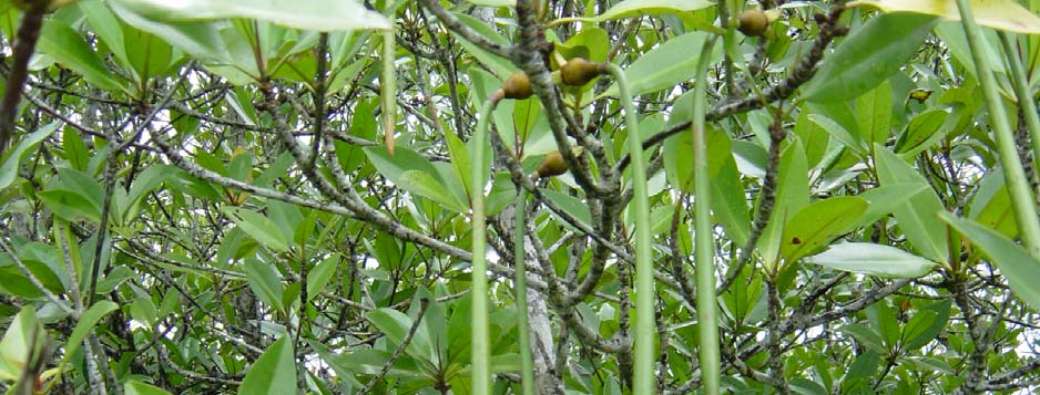
Cover Photo: Propagules of Rhizophora apiculata in Koh Kong Province of Cambodia, by Mr. Ke
Vong Wattana.
For citation purposes this document may be cited as:
UNEP, 2008. National Reports on Mangroves in the South China Sea. UNEP/GEF/SCS Technical
Publication No. 14.


United Nations
UNEP/GEF South China Sea
Global Environment
Environment Programme
Project
Facility
NATIONAL REPORT
on
Mangroves in South China Sea
CAMBODIA
Mr. Ke Vongwattana
Focal Point for Mangroves
Department of Nature Conservation and Protection, Ministry of Environment
48 Samdech Preah Sihanouk
Tonle Bassac, Chamkarmon, Cambodia
Reversing Environmental Degradation Trends in the South China Sea and Gulf of Thailand
NATIONAL REPORT ON MANGROVES IN SOUTH CHINA SEA CAMBODIA
Table of Contents
1. GEOGRAPHIC DISTRIBUTION.....................................................................................................1
1.1 MAPS........................................................................................................................................1
1.2 AREAS ......................................................................................................................................1
2. DISTRIBUTION OF SPECIES AND FORMATION ........................................................................3
2.1 SPECIES DISTRIBUTION..............................................................................................................3
2.2 FORMATION...............................................................................................................................4
3. ENVIRONMENTAL STATE ............................................................................................................5
4. THREATS, PRESENT AND FUTURE............................................................................................5
4.1 HUMAN PRESSURE ....................................................................................................................5
4.1.1 Population Pressure......................................................................................................5
4.1.2 Coastal Development....................................................................................................5
4.2 NATURAL PHENOMENA ..............................................................................................................6
5. SOCIAL USE AND OWNERSHIP ..................................................................................................6
5.1 OWNERSHIP ..............................................................................................................................6
5.1.1 Protected Areas.............................................................................................................6
5.1.2 Communities .................................................................................................................6
5.2 PRESENT USES .........................................................................................................................6
5.3 POTENTIAL USES.......................................................................................................................9
5.4 CURRENT MANAGEMENT REGIME...............................................................................................9
5.4.1 Enforcement of Existing Laws.......................................................................................9
5.4.2 Decision-making Processes..........................................................................................9
5.4.3 Legal Framework...........................................................................................................9
5.4.4 Cambodian Policy and Administrative Frameworks....................................................10
5.4.5 Institutional Frameworks .............................................................................................10
6. ECONOMIC VALUATION ............................................................................................................11
6.1 DIRECT USE VALUES ...............................................................................................................11
6.2 ENVIRONMENTAL SERVICE VALUES ..........................................................................................12
7. CONCLUSION AND RECOMMENDATIONS ..............................................................................12
REFERENCES......................................................................................................................................13
List of Tables, Figures and Annexes
Table 1
Mangrove Forest Coverage in (Ha) in Cambodia.
Table 2
Protected Areas in the Coastal and Marine Zones of Cambodia.
Table 3
Different Kinds of Mangrove Products and Uses.
Figure 1
Map of Mangrove Habitat along the Coastline of Cambodia.
Figure 2
Percentage of Mangrove Areas by province.
Annex 1
List of Mangrove Species in Cambodia.
Annex 2
Different Types of Mangrove Values in Cambodia.
Reversing Environmental Degradation Trends in the South China Sea and Gulf of Thailand
NATIONAL REPORT ON MANGROVES IN SOUTH CHINA SEA CAMBODIA 1
1. GEOGRAPHIC
DISTRIBUTION
1.1 Maps
Map of mangrove is not yet produced for specific mangrove protection and conservation or plan. It is
just in the subcategories of the maps of forest covers or map of land use. This map is in the country
scale as 1:500,000. The maps of forest cover were produced three times such 1993, 1997 and 2000.
However, the method and approaches of interpretation, producing map and definition are different.
Thus, it makes many troubles in the term of time series and spatial analysis for mangrove areas.
Moreover, in the term of the planning and management purposes for mangrove on the specific site, it
needs to be reproduced the new one with the detail scale that may be 1:50,000 or 1:25,000.
A degree of uncertainty surrounds current estimates on Cambodia's mangroves. The data were
derived largely from a 1:25,000 aerial photographs taken in December 1994 that have not been
systematically ground trusted due to safety and security constraints. The GIS land use maps that
have been made by interpreting the 1991 aerial photographs were not systematically ground trusted
either. Reports were based on small scale projects and on on-site reconnaissance of selected areas
that are accessible by boat or road; there are very limited aerial reconnaissance in the vicinity of Koh
Kong province. Figure 1 shows the map of mangrove distribution along the coastline of Cambodia.
Figure 1
Map of Mangrove Habitat along the Coastline of Cambodia.
1.2 Areas
It was estimated in the past that mangrove forest covered only 37,000ha. The Land Cover maps
published by the Mekong River Commission/UNDP/FAO (1994), however, show that in 1992/3, the
mangroves consist of about 85,100ha. Of these land area, 63,700 ha are located in Koh Kong
Province, 13,500ha in Sihanoukville and 7,900ha in both Kampot Province and Kep Resort City in
fringe coastal areas along the Gulf of Thailand. The vast majority (63,700 hectares) are located in Koh
Kong Province. While the total area of mangrove forest in Cambodia is small compared to
Reversing Environmental Degradation Trends in the South China Sea and Gulf of Thailand
2 NATIONAL REPORT ON MANGROVES IN SOUTH CHINA SEA CAMBODIA
surrounding countries in the Gulf of Thailand, these forests have been relatively undisturbed until
recently. However, Cambodia's mangroves are now under intense pressure from competing resource
uses. Two important threats to the mangrove resource are the clearance of mangrove areas for
intensive shrimp farming and charcoal production. Neighbouring countries such as Thailand and Viet
Nam have seen widespread destruction of their natural coastal resources as a result of unmanaged
exploitation. Sound management strategies for Cambodia's mangrove areas are urgently needed to
avoid a similar outcome. Percentage of Mangrove Areas by province is presented in Figure 2.
Mangrove Distribution in Cambodia
Kampot and
Kep
9%
Sihanouk
Ville
16%
Koh Kong
75%
Figure 2
Percentage of Mangrove Areas by Province.
Based on a detailed study CZM-DANIDA (2001) covering of some districts in Kampot province the
following were mapped:
· Kampot
district
- Koh Toch commune: 500 hectares in 4 villages (Prek Ampil, Koh Toch, Prek Chek,
Kilometer No 12)
- Beung Touk commune: 300 hectares in 4 villages (O Roluos, Koh Rokar, Beung Tuok,
Totoeng Thngai)
- Chum Kreal commune: 100 hectares in 3 villages (Kampong Treak, Chum Kreal,
Kampong Kandal)
- Koun Satt commune: 21 hectares in one village (Kampong Nung)
- Trapeng Sangke commune: 71.93 hectares in 2 villages (Trapeng Sangke, Trapeng
Thom)
- Kampong Samrong commune: 5 hectares in a village
- Prek Thanot commune: 275 hectares (Changhoun, Prek Thanoat, Prek Kreng)
- Total area in the district was 1,273ha.
· Kampong Bay district
- Treuy Koh commune: 105 hectares in one village
- Beung Tapream: 105 hectares.
· Kampong Trach district
- Russei Srok Khang Thbong 136 hectares (Thakov, Lork and Koh Sna).
-
Sihanoukville: Mangroves can be found in the estuaries, along the muddy seashore and
on the swamps and river systems and some coastal areas. Based on information from eh
seventies and early nineties there are some indications of changes in the mangrove
distribution.
-
Koh Kong: the information received from local areas indicated that mangrove areas have
decreased over the past few years. Mangroves are a priceless resource, having
important roles inn the fisheries and environment and providing protection of coastal
environment. Mangroves of Koh Kong stretch along the coastal areas covering 637 Km2.
There are 64 species of mangroves.
Reversing Environmental Degradation Trends in the South China Sea and Gulf of Thailand
NATIONAL REPORT ON MANGROVES IN SOUTH CHINA SEA CAMBODIA 3
Table 1 presents different figures of mangrove coverage found by different institutions and
organisations.
Table 1
Mangrove Forest Coverage in (Ha) in Cambodia.
Province/Municipality
Whole Country
Koh Kong
Sihanoukville
Kampot
16,000 3,600
17,400 37,000
63,200 7,300
17,400 83,600
83,700
31,000 3,600
3,700 38,300
31,100 2,300
2,300 37,000
63,700 13,500
7,900 85,100
17,234
63,700 13,500
7,900 85,100
Source: FAO, 1973.
2. DISTRIBUTION
OF
SPECIES AND FORMATION
Mangrove communities can be classified into different types: riverine, basin or fringing. Mangrove
species are generally arranged in zones from sea to land since they have adapted to a slightly
different range of physical conditions. The mangorve zones in Cambodia are categorised into:
a) The Avicennia-Sonneratia zone
b) The Rhizophora zone
c) The Bruguiera-Kandelia-Ceriops zone and
d) The Lumnitzera-Xylocarpus-Bruguiera zone.
In most mangrove forests, different species dominate certain zones. The characteristic zonation
pattern results from differences in the rooting and growth of seedlings and competitive advantages
which each species has along the gradient from mean sea level to above the high water lines. The
dominant species in this forest type belong to the family of Rhizophoraceae, such as Rhizophora
conjugata (Kongkang Nhy), Rhizophora mucronata (Kongkang Chmul), Ceriops spp., Bruguiera spp.,
Caralia sp. and the families of Verbenaceae (Avicennia sp.), Sonneratiaceae, and Palmae (Nypa
fruticans).
The average annual growth rate of Cambodia's mangrove forests was estimated to be 7.2m3/ha. In
some areas, this amount is as large as 9.2-9.9m3/ha. Rhizophora conjugata and R. mucronata.
Rhizophora spp. reach a height of 15 to 20m and diameters measured at 1.3m high from ground vary
from 30-40cm, depending on natural factors (soil condition, location etc.), compared to 30m high with
diameter of 70cm in Viet Nam. Due to illegal logging in mangrove forests, the recent mangrove
inventory shows that the growing stock of all standing trees within DBH greater than 5cm is 98m3/h.
2.1 Species
Distribution
There are reported to be 74 species of plants in the mangrove systems of Cambodia, from 53 genera
and 35 families, however this number has yet to be verified. An initial list of 42 mangrove flora species
belonging to 20 families has been identified during field surveys carried out from October to
December, 1994 (IDRC, 1995). The dominant species belong to the genera Rhizophora (R.
mucronata, R. apiculata) Avicennia, Lumnitzera, Bruguiera, Ceriops and Xylocarpus. In addition to
mangrove trees, other associated species include the mangrove palm, Nypa fruticans.
An initial field study found 42 species of trees and shrubs belonging to 20 families in the mangrove
forest of Koh Kong (DNCP1, 1995). The most dominant species are of the family Rhizophoraceae
(species mucronata and apiculata); family Combretaceae with genera Lumnitora; and, family
Avicenniacae with genera Avicennia.
1 Department of Natural Resource Conservation and Protection, Ministry of Environment.
Reversing Environmental Degradation Trends in the South China Sea and Gulf of Thailand
4 NATIONAL REPORT ON MANGROVES IN SOUTH CHINA SEA CAMBODIA
Mangrove forest zonation in Koh Kong is believed to be similar to plant community structure in
Chattaburi Province, Thailand. The edges of the estuaries and canals are dominated by Rhizophora
apiculata and R. mucronata. Further inland are Avicennia and Bruguiera followed by Xylocarpus,
Ceriops and Lumnitzera. Finally, a combination of Nypa fruticans and others can be found in the
transitional zones between true mangroves at the seaward edge and inland forest (rear mangroves)
which are dominated by Melaleuca trees.
Referred to the research of the CZM-DANIDA (1999) in November 1999 on the "Assessment of
Sustainable Livelihood Alternative to Mangrove Exploitation", the mangrove forests are the prevailing
ecosystem in many coastal zones of Cambodia. They commonly occur in estuarine systems and as
fringing belt on near shore creeks, lagoons, and in marine sheltered bays. A total of some 30 true
mangrove and about one dozen of mangrove associate species were identified during the field
observations conducted by two different groups please see the attached Annex 1.
The Rhizophora apiculata is the predominant tree along most estuaries systems, while a mix of
mangrove species each adapted to the soil and salinity condition forms the inners parts of extensive
mangrove their tallest size (e.g. In Koh Kapik River system, where still some Bruguiera spp. And
Xylocarpus trees remain intact at height of 25-30 meters. Typically, the mangrove vegetation changes
gradually into freshwater riverine vegetation and/or terrestrial forest types, (e.g. Melaleuca or dense
lowland evergreen forest) on the landward side what tidal influence is decreasing. Where infertile
muddy/silt river banks occur in this part of the estuary, extensive stands of Nypa palms frequently
occur, often accompanied by dense growth of mangrove ferns (Acrostichum spp.), which also can
form dense aggregation as undergrowth in the higher portions of the rear mangrove communities, the
so-called backmangal zone.
A part from common pattern of zonation of predominant species parallel to the riverine border, there is
conspicuous variety of patchy distribution of specific stands of the certain mangrove species, e.g.
Ceriops spp. and Excoearia agallocha. In some near shore sandy elevated areas Heritiera develops
in both Koh Kong and in Sihanoukville. It is note that many of these trees are affected by the natural
decay, the so-called top-dying disease.
In coastal flats with highly saline sandy soils, like in areas where extensive slat farm development
takes place (e.g. Kampot Province) the predominant mangrove species are Avicennia on the seaward
side and Lumitzera in the landward side. In the latter environment, fringing mangroves tend to have
stunted growth which is attributed to physiological stress for the vegetation which has to cope with
infertile saline soils, fine sand accumulation and high evaporation rates due to wind exposure.
2.2 Formation
The mangrove communities in Cambodia were classified by the forest classification of the Ministry of
Agriculture, Forestry and Fisheries and it is similar to what Viboth and Aswell classified as four types
as following:
Mangrove: Most of the members of the mangrove community are characteristic of areas which are
inundated only at some high tides and where there is a large degree of freshwater influence. The
islands and creeks are typically fronted by Rhizophora apiculata and Rhizophora mucronata, two of
the most common of the mangrove species present, and stands of Nypa palms. Immediately behind
this fairly narrow strip of Rhizophora is an interesting mixture of other mangrove species, the most
common of which are: Brugiera gymnorrhiza, B. sexangula, Ceriops tagal, Lumnitzera littorea,
Heritiera littoralis, Xylocarpus granatum, Hisiscus tiliaceus, Phoenix palludosa, Acrosthicum
speciosum, Aegialitis sp. and, Acanyus sp.
Rear mangrove' community: On some of the islands and on the mainland between Prek Khlang Yai
and Prek Thnot, the mangrove community forms a narrow band. It is followed by a community above
the high tide mark and probably only subject to freshwater inundation during the wet season. This
community is dominated by Melaleuca leucodendron.
Beach strand vegetation: At the south side of Koh Kapik, and on the sandy areas of some of the
islands, there are small areas of typical beach strand vegetation dominated by Casuarina equisitifolia
with some Terminalia catappa.
Reversing Environmental Degradation Trends in the South China Sea and Gulf of Thailand
NATIONAL REPORT ON MANGROVES IN SOUTH CHINA SEA CAMBODIA 5
3. ENVIRONMENTAL
STATE
As mentioned previously, the coastal areas in Cambodia are formed into two municipalities as Krong
Kep and Sihanoukville, and two provinces Kampot and Koh Kong Province.
These coastal provinces/municipalities under the effect of tropical weather and mosoon winds with all
year around temperature from 24oC to 30oC. The rainy season is from May through October and the
cool season is from November to January and the dry season is from February to April. The average
rainfalls in Kep vary from 1,200mm to 1,875mms or a higher 2,500mms. The moisture level is also
moderately high.
In Koh Kong Province, the Rainfall ranges between 2,000mm and 5,268mm (according to Koh Kong
Water Resource and Meteorological Department). The monthly average temperature is 27oC low and
38oC high. In rainy season, the wind comes from the west or from the sea that can cause storms with
duration of 3 to 7 days rendering travel by sea difficult. During strong winds and storms waves can
reach 2-3.5m in height.
4.
THREATS, PRESENT AND FUTURE
4.1 Human
Pressure
4.1.1 Population Pressure
In 1995, the total population of the three coastal provinces was estimated to be 6.5% (675,000
populations) of the total national population. Topulation densities vary from 7.07 people/km2 in
Kampot province to 138 people/km2 in Sihanoukville with an average density of 37 people/km2.
Average growth rates in 1993 range from 2.7 to 4.6% in Koh Kong and Kampong Som respectively.
4.1.2 Coastal
Development
The Royal Government's goals for Coastal provinces and municipality originally planned for economic
development in Cambodia through the rebuilding of urban growth tourism port expansion and
industry.
Urbanisation
Investment in coastal development will lead to increased urban growth as population from the rural
areas move to tourism and associated services for increased economic opportunities The Urban
environment infrastructure is current insufficient to meet the requirement of even the current urban
population Without appropriate investments the environmental quality of this town will degrade.
Tourism development
Coastal area is a matter of great in importance to the future of Cambodia both in term of economical
and environmental considerations. This development is expected to lead the way for Coast to develop
as commercial centre which would substantially increase its population. The impact from this
development may be affected to coastal inland resources coastal water resources. The number of
tourists in the three coastal provinces has been estimated at 10,206. An approximately 9% growth in
tourism arrivals in Cambodia is Japanese Taiwan and Chinese. This indicated that the positive growth
in the potential tourism Development sector in the country.
Port development
Coastal ports expansions developments can make a contribution to the economy as a main hub for
growth of maritime transport which should in turn attract manufacturing entries but may also have an
adverse impact on the surrounding environment. These effects of new expansion port can be focused
upon location port construction and port operation. These lead to impacts on water quality coastal
hydrology bottom contamination marine ecology air noise waste management and visual quality.
Industrial development
The industrial development zone was established in Sihanoukville called "Stung Hav Sihanoukville
Industrial Zone". This industrial zone include petrochemical production to exploit recently confirmed oil
and gas reserves in the gulf of Thailand food processing based on the local fisheries in the area
timber processing and re manufacturing However these industries pose potential damage to the
environment.
Reversing Environmental Degradation Trends in the South China Sea and Gulf of Thailand
6 NATIONAL REPORT ON MANGROVES IN SOUTH CHINA SEA CAMBODIA
4.2 Natural
Phenomena
Because coastal zones are affected directly and indirectly by the impacts of climate change such as
change in precipitation, hydrological pattern, and frequency and intensity of cyclones, storm surges,
Cambodia's coastal zone is among the most vulnerable areas to global warming and climate change.
5.
SOCIAL USE AND OWNERSHIP
5.1 Ownership
5.1.1 Protected
Areas
Most of the mangrove areas have been designated within the protected areas system under the Royal
Decree Creation and Designation of Protected Areas' signed on November 1, 1993 by King Sihanouk
(Table 2). These protected areas include the Peam Krasaop Wildlife Sanctuary (31,022ha), and
Botum Sakor National Park (171,250ha). In addition, Koh Kapik (12,000ha) and associate islets
situated within Peam Krasaop Wildlife Sanctuary, have been nominated as a wetland of international
importance under the Ramsar Convention (ADB, 1995). All of these areas are under the responsibility
of the Ministry of Environment (MOE). Management plans for these areas are yet to be developed.
Table 2
Protected Areas in the Coastal and Marine Zones of Cambodia.
Name Area
(ha)
Province
National Parks
Phnom Bokor
140,000
Kampot
Kep 5,000
Kampot
Ream (Preah Sihanouk)
15,000
Kompong Som
Botum Sakor
171,250
Koh Kong
Kirirom
35,000
Koh Kong, Kampong Speu
Wildlife Sanctuaries
Peam Krasaop
23,750
Koh Kong
Phnom Samkos
333,750
Koh Kong
Aural
253,750
Koh Kong, Pursat, Kampong Channang,
Kampong Speu
Multiple Use Management Areas
Dong Peng
27,700
Koh Kong
Source: ADB (1995).
5.1.2 Communities
The communities who live in the villages located inside or directly adjacent to the South-West Cluster
Protected Areas come mainly from the Khmer, Cham, Pear, Chong and Sóach ethnic groups. The
majority are Khmer, although there is a significant minority of Cham living in and around Ream and
Bokor National Parks who are engaged in fisheries-related activities and farming. The park-adjacent
and park-dwelling populations include a mix of more recent immigrants (most who came to the area
during or after the Khmer Rouge era), and longer-term settlers.
Actually, the communities' development and the communities of conservation and protection have
popularly been applied throughout the whole country. This term have been used in term of co-
management of Protected Areas and Natural Resources that is adjacent to their communities.
5.2 Present
Uses
Given the multiple use potential of mangrove ecosystems, an integrated approach to mangrove
management is essential and should cover the full range of products and services which can be
obtained from these areas.
The uses and values of the products obtainable from mangroves are many and important. The
importance of the resource stems from the many products taken directly from the mangroves,
including the non-wood products, as well as amenities provided from within and beyond its
boundaries. Wood products range from timber, poles and posts to firewood, charcoal and tannin.
Reversing Environmental Degradation Trends in the South China Sea and Gulf of Thailand
NATIONAL REPORT ON MANGROVES IN SOUTH CHINA SEA CAMBODIA 7
Non-wood products include thatch, honey, wildlife, fish, fodder and medicine. In addition, mangrove
lands are often converted to salt ponds or to agriculture or aquaculture purposes. Table 3 illustrtes
different kinds of mangrove products and uses along the costline of Cambodia.
Table 3
Different Kinds of Mangrove Products and Uses.
Fuel
Textile, leather
Household items
· Firewood
· Synthetic fibers (rayon)
· Glue
· Charcoal
· Dye for cloth
· Hairdressing oil
Construction
· Tannin for leather
· Tool handles
· Timber,
scaffolds
preservation
· Rice mortar
· Heavy
construction
Food, drugs and beverages
· Toys
· Railway
sleepers
· Sugar
· Match sticks
· Mining
props
· Alcohol
· Incense
· Boat
building
· Cooking oil
Other forest products
· Dock
pilings
· Vinegar
· Packing boxes
· Beams and poles
· Tea substitute
· Wood for smoking sheet
· Flooring,
paneling
· Fermented drinks
rubber
· Thatch
or
matting
· Dessert topping
· Medicines
· Fence posts, chipboards
· Condiments (bark)
Other natural products
Fishing
· Sweetmeats (prop gules)
· Fish/Crustaceans
· Fishing stakes
· Vegetables (fruit/leaves)
· Honey
· Fishing boats
Agriculture
· Wax
· Wood for smoking fish
· Fodder
· Birds
· Tannin for net/lines
· Mammals
· Fish attracting shelter
· Reptiles/other fauna
· Services
a. Coastal protection against wave and wind erosion.
b. Moderating the effects of coastal storms and cyclones.
c. Shelter and habitat for diverse wildlife, particularly avifauna.
d. Nutrient sink-effect and reduction in excessive amounts of pollutants.
e. Entrapment of upland runoff sediments thus protecting near shore reefs and reducing water
turbidity.
f. Mangroves also provide opportunities for education, scientific research, recreation and
ecotourism.
· Wood products
Mangrove forests have favorable silvicultural characteristics which lend themselves to intensive forest
management for wood products. Some of these characteristics are as follows:
·
Rapid growth: mature stands under suitable conditions may yield over 270m3/ha within 30
years, equivalent to an MAI of 9-10m3/ha.
·
Good regeneration potential: most mangrove species flower and fruit regularly and the prop
gules are dispersed by tides. Thus, mangrove stands can recover rapidly from natural or
man-made disturbances, including intensive logging.
·
Tendency to form homogeneous/even-aged stands: pure stands of Rhizophora or Avicennia
are not uncommon and even in mixed stands; the principal components are restricted to a
handful of species.
· Diversity of forest products: a wide range of products are produced and as bioenergy
plantations even the smaller thinning may be used as firewood.
· Timber
Under favorable conditions, mangrove trees can grow to large sizes. Rhizophora over 40 m tall are
not uncommon and individuals over 62.5m have been reported. However, large trees are becoming
scarce, especially in South East Asia, as most of them are removed before they can attain such sizes.
Reversing Environmental Degradation Trends in the South China Sea and Gulf of Thailand
8 NATIONAL REPORT ON MANGROVES IN SOUTH CHINA SEA CAMBODIA
Rhizophora spp. are, however, not valuable as timber because of their tendency to split and warp
when dried. The wood is dense and difficult to work. The sapwood is easy to preserve but not the
hardwood. It is resistant to decay but not to marine borers. Its possible uses include agricultural
implements, boat construction (knees and ribs), general heavy construction (rafters, beams, joists),
marine and bridge construction (underwater, non-teredo infested waters), marine and bridge
construction (above water), fence posts and poles.
The wood of Rhizophora is exceedingly heavy with a specific gravity varying from 0.8-1.2. Avicennia,
which has a lower density (about 0.64) and good nail holding qualities, is often used as railway ties.
· Charcoal
Rhizophora spp. is preferred for charcoal making. Their moisture content (MC) when felled is about 40
percent (as percent of oven dry weight) compared to Avicennia wood which ranges from 70-95
percent. Rhizophora wood dries to about 25 percent MC after two months, whereas Avicennia
requires up to six months drying to 35 percent MC. This partly explains the popularity of Rhizophora
wood, as predrying stock can be kept to a minimum. Other species (Bruguiera gymnorhiza and
Ceriops sp.) are also used but in smaller quantities.
Charcoal is the main mangrove product in Cambodia. Industries are well developed at the village and
cottage industry levels in most Asian countries where mangroves still abound. Charcoal is mainly
used for cooking purposes and small-scaled industries.
· Firewood
Rhizophora in Cambodia are favored as fuel wood for domestic purposes and are commercially
removed, or collected by fishermen and villagers.
· Fishing stakes/poles
Actually in Cambodia, there is an established demand for mangrove piling poles used in land
reclamation and the construction industry. Used in wet sites which are not infested by shipworms,
such mangrove piles can outlast non-treated inland hardwoods.
Along the muddy river banks, small fishing stakes are used to support tidal fish nets. Mangrove poles
are also used for scissor nets in housing construction. In countries in South East Asia, fishermen cut
mangroves and dump them into the shallow coastal waters as a way of creating shade and thus
attract fish (fish attraction devices).
· Tannin
Rhizophora bark produces very fine tannin suitable for leather work. Tannin from mangrove species
has also been used for curing and dyeing of fishing nets made of natural fibred to make the nets more
resistant to biological decay.
The production of tannin has declined greatly in recent years, in particular since local demands have
been reduced after the introduction of nylon fishing nets and the use of chrome as the predominant
agent for leather curing.
· Nipa palm
The uses of this palm are many and diverse. It yields an important thatching material, which is used
for the roofs and walls of rural houses. The shingles produced are cheap, light to transport, easy to fix
and can last several years, particularly when used in houses with open stoves. Cigarette wrappers are
also made from the young shoots of Nipa.
· Wildlife
As in other forest types, the wildlife in the mangroves is an important source of protein for the local
community. In addition, some species, especially reptiles, are hunted or reared for their hides.
Examples of traditional utilization of selected wildlife species found in mangroves are described in the
following.
The wild boar (Sus scrofa) is often found marauding in the swamp margin and it is a source of bush
meat in Cambodia.
Reversing Environmental Degradation Trends in the South China Sea and Gulf of Thailand
NATIONAL REPORT ON MANGROVES IN SOUTH CHINA SEA CAMBODIA 9
· Fisheries products
From an economic point of view, mangroves are often far more important for the aquatic production
they support than for the wood production potential. Kapetsky (1985) estimated that the average yield
of fish and shellfish in mangrove areas is about 90kg/ha, with maximum yield being up to 225kg/ha.
According to this author, the total halieutic production of the world's mangroves would be around
1,000,000 tonnes per year (for an estimated area of 83,000km2 of open water in mangroves), which is
slightly more than 1 percent of estimated total world production in all waters per year.
· Fish
In Cambodia, the main commercial fish species caught in or close to mangrove areas include mullets
(Liza subviridis), sea bass (Lates calcarifer), snappers (Lutjanus spp.), tilapia (Tilapia spp.), groupers
(Epinephelus spp.), sea catfish (Arius spp.), threadfins (Eleutheronema spp.) and snake eel
(Ophichthus microcephalus) (Christensen, 1979).
5.3 Potential
Uses
Other animals and plants associated with mangroves. Mangroves help provide for a great diversity of
plant and animal life. They provide essential habitats for aquatic inhabitants such as crabs, shrimp,
fishes, and various invertebrates, as well as other species such as shorebirds and monkeys.
All these resources as mentioned above are very high potential in term of local use and external
demands.
5.4
Current Management Regime
5.4.1 Enforcement of Existing Laws
The environmental protection and natural resources management law is not adequately enforced.
This is largely because of lack of human and financial resources. The fisheries law has many good
provisions for the protection of marine habitats and fisheries resources. For instance, dynamite fishing
trawling in coastal water pushing netting and cutting mangrove occurs daily but are rarely prosecuted.
5.4.2 Decision-making
Processes
The decision making process relating the development in the coastal zone is poorly defined vague
and ambiguous. It appears that whatever the official mechanisms are high ranking individuals can
make decisions without consultation and participation. On the other hand, it appears to be conflict
between provincial and national decision makers with plans and policies developed independently by
the two levels of government.
5.4.3 Legal
Framework
A legal framework does exist for management of the coastal zone. There are laws on protected areas
fishing industrial development land use forestry environmental protection and natural resources
management, environmental impact assessment, water pollution control and other important coastal
zone issues. All governors and departments in all provinces and municipalities identified the lack of a
legal and policy framework for coastal zone management and administrative structure to implement it
as a major constraint on coastal zone management in Cambodia.
Lack of Coastal Zone Planning
All provinces and municipalities are required to prepare Master Plans. Planning has not occurred in
the coastal zone. However, the plan prepared by provincial authorize specifies industrial tourism and
residential zones but does not suggest any guidelines for development standards or further plans.
Unplanned and uncoordinated development is occurring all along the coast but is not yet viewed as a
major problem because the rate of development is slow. However, it is envisaged that this is lack of
planning result in haphazard development and will be a source of serious conflicts in the near future.
Lack of Information about Distribution and Status of Natural Resources
Information on marine habitats such as coral reefs, sea-grasses and endangered species are still
limited. The distribution of such these information and data both national and provincial levels are
limited. Without information about what people are catching, it is not possible to estimate where the
fisheries are over-fishing.
Reversing Environmental Degradation Trends in the South China Sea and Gulf of Thailand
10 NATIONAL REPORT ON MANGROVES IN SOUTH CHINA SEA CAMBODIA
Lack of Public Awareness and Participation and Capacity
Many problems related to public and participation could be addresses. And actions to these should
strengthen laws raising public awareness and doing research associated with this concern is a
serious lack of technical capacity among government staff and minimal resources to prepare and
disseminate information.
Participation is still low priority for most government officials that may be reflecting the historical lack
of community participation in decision making in Cambodia. The lack of participatory planning and
management has meant that some solutions to environmental problems are unsatisfactory.
5.4.4 Cambodian Policy and Administrative Frameworks
The basic emphasis of the Cambodian government at present is to attempt to clarify the lines of
responsibility for activities that currently transcend local, regional and national interests the intent is to
manage and coordinate government actions to clarify ministry attributions and to ensure
administrative effectiveness and propriety. The existing restructuring of administrative tasks is
directed reshaping the civil service reforming the organizational framework for effective management
and reforming the regulatory mechanisms. The effectiveness and efficiency of organizing and
managing planned coastal development and resources use is depending upon this successful
restructuring of the state (reformed administration). The Royal Government of Cambodia is being
emerged to develop Cambodia to become a state with a functional legal and administrative system.
Many Royal decrees laws, sub decrees and other legal instruments have been issued and are being
developed. At the present, a process of making policy and law are done by a combination of national
and international experts. These are law on Environmental Protection and Natural Resources
Management, land law, Royal decree on the Creation and Designation of Protected Areas. Sub
decree on Environmental Impact Assessment and Water control Pollution, Fisheries and Forestry
laws and Law on Land Management Urbanization and construction. On the other hand, Cambodia
became a member of the Coordinating Body of the Seas of East Asia (COBSEA) Association of South
East Asian Nation (1999), MARPOL (1994), Biodiversity convention (1994), CITES convention (1997),
Ramsar convention (1999), and Climate Change convention (1995).
5.4.5 Institutional
Frameworks
The numerous institutions with statutory power or interests in coastal and marine areas give rise to
the problems of overlap gaps in responsibilities and lack of coordination. The government has set up
some organizational institutions in order to ensure overall coordination and cooperation of the
different policies and measures taken by ministry levels of administration. A part from the existing
coastal and marine coordination consists of the Ministry of Environment, Ministry of Agriculture
Forestry and Fisheries, Coastal Coordinating Unit and the National Coastal Steering Committee.
The Ministry of Environment (MoE) was established in 1993 to address issues of environmental
management in the country hold a number of responsibilities with respect to the coastal zone, the
most obvious being the general protection of the environment in the coastal zone. More specific
duties include the planning and management of the protected area system in the coastal zone. And its
strategy is based on the execution of sole and joint responsibilities in conjunction with other ministries
concerned with specific aspects of natural resources and infrastructure management.
The Ministry of Agriculture Forestry and Fisheries (MAFF) is the main ministry responsible for
managing Cambodia' s forests including inundated forests mangrove as well as wildlife and fisheries.
Two departments of MAFF are directly relevant to biodiversity management and protection in
Cambodia. It is clear from the responsibilities of MAFF and MoE that close coordination between the
ministries and departments involved in nature conservation is essential to avoid conflicts and promote
complementary activities towards implementing the coastal protected area plans.
National Coastal Steering Committee (NCSC) is an attempt to deal with the multi sectoral natural of
coastal resource issues. This committee was established in and meet on a quarterly basis Members
of this Committee include the Minister of Environment (Chairman), Under Secretaries of State from
Ministry of Agricultural Forestry and Fisheries (Vice-chair), Ministry of Tourism, Industry Mines and
Energy Public Works and Transport, Rural Development, Women's Affairs Planning, Council of
Reversing Environmental Degradation Trends in the South China Sea and Gulf of Thailand
NATIONAL REPORT ON MANGROVES IN SOUTH CHINA SEA CAMBODIA 11
Development for Cambodia, Governors of coastal provinces and others donors NGOs and related
coastal projects are observers. The NCSC is responsible for the overall direction of coastal projects
and activities. All members are asked to ensure the cooperation of their line ministries and provincial
authorities. The committee assisted by secretariat calls Coastal Coordinating Unit (CCU) was created
in the Ministry of Environment and is responsible for coordination of activities by international
organizations governmental agencies and the private sectors in the coastal area in Cambodia
Provincial working groups have been formed at the provinces and municipalities. These working
groups are supported by Danida coastal zone project in its ongoing technical assistance activities in
the coastal zone.
6. ECONOMIC
VALUATION
6.1
Direct Use Values
Today, 49 Village Fishing Groups and a Village Fisheries Committee work to regulate conserve and
manage marine resources in the Park according to the fisheries management guidelines and
regulations that they have developed.
Analysis of the value of resource use shows that overall; Ream National Park constitutes an
extremely important economic resource for local communities. Up to 84% of households depend on
the Park's resources for their basic subsistence and income, to a net value of some US$1.24 million a
year or an average of US$233 for every household living in and beside the National Park.
In an area where the median family income is only US$316 a year and a third of families earn less
than US$200, and where half of households can barely provide for their own subsistence.
A survey of 90 households was undertaken in three villages within Koh Kapik, the study area and
proposed Ramsar site, in order to provide information on the traditional uses of the mangrove by local
communities. The research focused on the economic valuation of non-timber forest products collected
from the mangrove area by households; these include fuel wood, charcoal, construction materials,
and crabs, shrimp, fish and snails. In addition, the important ecological functions of the mangroves,
such as storm protection and biodiversity maintenance were identified. Eight shrimp farms were
surveyed in order to assess the viability of shrimp farming in the area.
Over 90% of households are dependent on fishing for their livelihood. However, fish productivity has
declined dramatically in recent years due to the increased number of fishers, the loss of mangrove
areas to shrimp farms and water pollution from these farms. 90% of households involved in fishing
claim that it was harder to fish now compared to 5 years ago. Local fishing benefits are estimated to
be US$84 per hectare.
The area of mangrove forest required per charcoal kiln per year is estimated by this study to be
between 0.20-0.40 hectares. Assuming a 30 year cutting cycle, and that only already disturbed
mangrove areas would be allocated for charcoal production, potential returns per hectare per year for
sustainably managed charcoal production are estimated at over US$400.
While 50% of farms made a profit in the past year, overall shrimp farms in the area suffered an
average loss of over US$1,000 per hectare. Largely due to problems with disease associated with
poor water quality management, it is rare for farms to have two successful harvests a year, and in
some cases both harvests have failed. Individual farms have reported losses ranging from US$40,000
- 240,000.
The real costs of shrimp farming are in fact much higher since the analysis does not account for the
environmental costs associated with shrimp farming. Unsustainable shrimp farming is linked to water
pollution and the extensive clearing of mangroves for farm use, preventing accretion and wiping out of
nursery areas. There is also a social linkage: over 90% of local people oppose the shrimp farms. This
could result in social unrest and security problems in the future if not adequately addressed.
The relocation of families out of sensitive mangrove areas is supported by provincial authorities. Land
is available in upland areas in the province where crop cultivation is possible alongside fishing. Some
households in Koh Kapik have expressed an interest in relocation. While an in-depth assessment of
the suitability of relocation sites is lacking, the possibility of voluntary relocation could be considered
as a way of protecting an ecologically valuable resource and improving the living standards of the
local people. Relocation support is estimated around US$2,000 per household to cover the cost of
house construction and living expenses before the first harvest.
Reversing Environmental Degradation Trends in the South China Sea and Gulf of Thailand
12 NATIONAL REPORT ON MANGROVES IN SOUTH CHINA SEA CAMBODIA
Generally the Intensive shrimp farming covered an area of 850ha in 1994 with production of 450
tonnes a year. But disease outbreaks have since reduced the culture area to 20%, with estimate of
national losses amounting to US$28.6 million a year. A moratorium on further licensing of shrimp
farms has been enforced.
6.2
Environmental Service Values
The value of mangrove conservation in Ream National Park
In total there are approximately 1,800ha of mangroves in Ream, with a total volume of 111,645m3. A
simple cost-benefit analysis demonstrates the high value of mangrove conservation in terms of local
socio-economic and environmental benefits. Under realistic recovery and harvesting conditions, clear-
cutting the mangroves would yield a one-time income of less than US$630,000. Although prawn farms
can, under the best conditions, realize a net income of almost US$4,500/ha/yr, few actually do. In Koh
Kong, a similar mangrove area lying to the west of Ream National Park, half of prawn farms are
making a loss at a realistic productivity rate of 3.6 tonnes per harvest, this loss is nearly
US$9,950/ha/yr and in aggregate they show a loss of US$1,103 per ha per year. Yet even if only half
of the forest, fisheries and agricultural production in surrounding villages depend on mangroves in the
Park, their clearance would result in a loss of local income of around US$620,000 a year. It was
confimed that US$344/ha/yr is a realistic one data for similar mangrove areas in Thailand estimate
local use of mangroves to be worth between US$230 (Christensen 1979) and US$1,200 (Sathirthai
1998) a year, and values in Koh Kong Province exceed US$500/ha, including charcoal. In fact many
more economic losses would occur from mangrove clearance, such as the damage to houses,
infrastructure, farmland, employment, markets and general local welfare that result from the loss of
vital environmental functions and ecological services. In Southern Thailand, the economic benefits of
mangroves in terms of coastline protection have been estimated to have a value of between
US$76.5/ha/year and 165/ha/year (Christensen 1979), carbon sequestration benefits US$2.2/ha, and
mangrove storm protection functions have been valued at US$32/ha in Koh Kong Province. Taking
into account these indirect economic benefits increases the annual economic value of conserving
Ream's mangroves to US$900,000 a year. This is far more than the one-off gain (and long-term loss)
of clear-cutting the mangroves and turning them over to prawn farms. The economic costs of
estroying these valuable natural ecosystems, both immediate and long-term, far exceed the benefits
or in other words, biodiversity conservation in Ream National Park is a demonstrably economically
worthwhile activity to engage in.
Net value (US$/ha/yr) Total Value (US$ `000/yr)
Local
use:
344,619,200
Storm protection:
3,257,600
Coastal erosion prevention:
122,219,600
Carbon sequestration:
23,600
Total
Value:
500,900,000
7. CONCLUSION
AND
RECOMMENDATIONS
Refereed to description above, the data and information is still very limited, especially for the specific
issues such as mangrove composition and specie distributions. The most of the supports are likely to
work just in this stage on a very small areas comparing to all the mangrove areas. In other words,
nobody take it care yet for the whole mangrove areas even though the Cambodia is in progress of
green development way. Regarding the local data and information, it is mostly focusing on the socio-
economic and health issues which are the immediate objectives to help people to survive maintain
and develop their own life. The environment issues are the secondary or long term objectives.
In addition, no one institution is responsible for researches neither data and information coordination
and management. Due to there are no research supports and its facilities, lack of financial supports;
and very limited knowledge and skills. On the other hand there is no linking between the independent
researches and project/programme realizations. So the data and information are available unless
there is a project or programme in place.
Regarding the project or programme, it is unsustainable manner. It means some projects/programmes
just for 1 year, 2 years, 3 years or... but no permanent. So when it is not permanent, its data is not
fixed. When the project/programme finished, the data and information are also misplaced and
disappeared.
Reversing Environmental Degradation Trends in the South China Sea and Gulf of Thailand
NATIONAL REPORT ON MANGROVES IN SOUTH CHINA SEA CAMBODIA 13
Therefore the national self-management of the data and information is the key actor. Concerning its
management, there are lack of knowledge and skill in information and data management and its
supported infrastructures. The people are essentially less considered for the data and information for
decision making, planning and monitoring as well as evaluation. The principle causes are lack of
mechanism for data and information sharing among other peoples and lack of its dissemination, which
allows people to understand the important, use effectively and manage it.
In order to maintain and keep records up to date, the key issue is to compile and manage the existing
data and information in a national database system that can be used by other people. As Cambodian
human resources are very limited, thus the capacity building in data and information use and
management is a prerequisite as the immediate objectives.
Gathering and giving data and information are the principle to promote and maximize for its sharing
and dissemination. It needs to establish the coordination for data and information management with
the enhancement of flow mechanism with its free access.
REFERENCES
ADB, 1995. Coastal Zone Management in Cambodia. Ministry of Environment, Phnom Penh.
Christensen, B. 1979. Mangrove resources: their management and utilization for forestry fisheries
and aquaculture near Khlung Chanthaburi Province Thailand. FAO Regional Office for Asia and
the Far East, Bangkok. 62 p. (Ronéotypé).
CZM-DANIDA, 1999. Assessment of Sustainable Livelihood Alternative to Mangrove Exploitation.
Ministry of Environment, Phnom Penh.
CZM-DANIDA, 2001. Management of Coastal Zone in Cambodia. Ministry of Environment, Phnom
Penh.
Department of Geography 1997. Forest Cover. Ministry of Environment, Phnom Penh.
DNCP, 1995. Report of Mangrove Resources in Cambodia. Ministry of Environment, Phnom Penh,
Cambodia.
FAO, 1973. Forestry and Forest Industries Development. Malaysia. A national forest inventory of
West Malaysia. 1970-72. Kuala Lumpur. FO/DP/MAL/72/0D9 TR5. 259p.
IDRC, 1995. Report of Mangrove Survey along the Coastline of Cambodia. Ministry of Environment,
Phnom Penh.
Reversing Environmental Degradation Trends in the South China Sea and Gulf of Thailand
NATIONAL REPORT ON MANGROVES IN SOUTH CHINA SEA CAMBODIA
ANNEX 1, PAGE 1
Annex 1
List of Mangrove Species in Cambodia.
N.
Khmer Name
Scientific Name
Family
1 Trochjiek
cragn
Acanthus ebracteatus
Acanthaceae
slekweng/trochjiekcragn pkapor sar
(shrub)
2 Trochjiek
cragn
Acanthus ilicifolius (shrub)
Acanthaceae
Slekbanla/trochejiekcragn pkapor svay
3
Trochjiek cragn slek-eit banla
Acanthus vulubilis (shrub)
Acanthaceae
4 Brong
Acrostichum aureum (fern) Pteridaceae
5 Brong/Khnagn
Acrostichum speciosum
Pteridaceae
(fern)
6 Smair
Aegialites rotundifolia (tree) Plumbaginaceae
7 ???
Aegiceras corniculatum
Myrsinaceae
(tree)
8 ???
Amoora cucullata (tree)
Meliaceae
9 ???
Atalantia monophylla (tree) Rutaceae
10 Kbagnsor/Sman/Mouroujsrotorb
Avicennia alba (tree)
Verbenaceae
11
Kbagn Sporng/ Mouroujsrotorb
Avicennia marina (tree)
Avicenniaceae
12 Kbagnkmao/Spong
Avicennia officinalis (tree)
Avicenniaceae
13 Dawmtrojiekbres/Pchek
tekbray
Barringtonia racemosa
Lecythidaceae
(tree)
14 ???
Brownlowia tersa (shrub)
Tiliaceae
15 Basac/Omlann
Bruguiera cylindrica (tree)
Rhizophoraceae
16 Basac
Kroahom
Bruguiera gymnorrhiza
Rhizophoraceae
(tree)
17 Basacsor
Bruguiera sexangula (tree) Rhizophoraceae
18 ???
Caesalpinia crista (shrub
Leguminosae-
or climber)
Caesalpinoideae
19 ???
Calycopteris floribunda
Combretaceae
(climber)
20 Dawmcheungtia/Pilpicht/Chompourey Cerbera odollam (tree)
Apocynaceae
21 Smairsor
Ceriops decandra (tree)
Rhizophoraceae
22 Smerkrohorm
Ceriops tagal (tree)
Rhizophoraceae
23 Dawmchheongpurs
Clerodendrum inerme
Verbenaceae
(shrub)
24 ???
Combretum tetralophum
Combretaceae
25 Dyerohatt
Cordia cochinchinesis (tree) Boruginaceae
26 ???
Derris trifoliata (climber)
Leguminosae
Papilionoideae
27 Tatom/Chheu
chhor
Excoecaria agallocha (tree) Euphorbiaceae
28 ???
Finlaysonia maritima (vine) Asclepiadaceae
29 Pdaoondawk/Voirre
Flagellaria indica (climber) Flagellariaceae
30 Kann-kai/Dawmklai/Semornsakmot Heritiera littoralis (tree)
Sterculiaceae
31 Dawm-beus/Kabbaspreyteukbrey
Hibiscus tiliaceus (tree)
Malvaceae
32 Krokosteukpray/Krongnungteukbray
Intsia bijuga (tree)
Leguminosaecae-
salpinoiddeae
33 ???
Kandelia candel (tree)
Rhizophoraceae
34 Krognyeppka
krohom/Krognyep-
Lumnitzera littorea (tree)
Combretaceae
krohom
Reversing Environmental Degradation Trends in the South China Sea and Gulf of Thailand
NATIONAL REPORT ON MANGROVES IN SOUTH CHINA SEA CAMBODIA
ANNEX 1, PAGE 2
Annex 1 cont.
List of Mangrove Species in Cambodia.
N.
Khmer Sound
Scientific Name
Family
35
Krognyep pkasor/Krognyep sor
Lumnitzera racemosa (tree) Combretaceae
36 Chark
Nypa fruticans (palm)
Palmae
37 Peng
Phoenix paludosa (palm)
Palmae
38 ???
Premna obtusifolia (tree)
Verbenaceae
39 Kongkangslektoch
Rhizophora apiculata (tree) Rhizophoraceae
40 Kongkang
slekthom
Rhizophora mucronata
Rhizophoraceae
41 ???
Sapium indicum (tree)
Euphorbiaceae
42 Ampouthmar/Rompea
chheu
Sonneratia alba (tree)
Sonneratiaceae
43 Ampoukrohom
Sonneratia caseolaris (tree) Sonneratiaceae
44 Ampea
Sonneratia griffithii
Sonneratiaceae
45 Ampea
Sonneratia ovata (tree) Sonneratiaceae
46 Porhteukpray
Thespesia populnea (tree) Malvaceae
47 Tabonsor
Xylocarpus granatum (tree) Meliaceae
48 Tabonkmao
Xylocarpus moluccensis
Meliaceae
(tree)
49 Tabann
Xylocarpus rumphii (tree)
Meliaceae
50
Khontrianket sahmot
(fern/herb ??)
51 Voartrohkhuntek
sahmot
(vine)
52 Voarsoandeik
kmouch
(vine)
53 Nonoung
sahmot
(vine)
54 Voartadet
(vine)
55 Rhumjeik
sahmot
Pandanus tectorius
Pandanaceae
(palm/tree)
56 ???
Scaevola taccada (shrub)
Goodeniaceae
57 Vorprieng
(vine)
58 Phut-tria
sahmot
(tree/shrub)
59 Thaw-sai
(Thai)
60
Lambit thalay (Thai)
61 Phosai
62 Thuk-kai
63 Phat-yanman
(Thai)
64 Lang-katsaa
(Thai)
Source: IDRC, 1995.
Reversing Environmental Degradation Trends in the South China Sea and Gulf of Thailand
NATIONAL REPORT ON MANGROVES IN SOUTH CHINA SEA CAMBODIA
ANNEX 2, PAGE 1
Annex 2
Different Types of Mangrove Values in Cambodia.
Average value per
Gross value
Net value
Description
user household
(US$/year)
(US$/year)
(US$/year)
Firewood 125,133
112,062
25
Construction wood
23,659
23,659
18
Medicinal plants
10,788
10,788
11
Food 17,695
17,695
18
Roofing materials
13,397
13,397
84
Sub-total, forest products
190,672
177,601
Crops 316,594
316,594
119
Livestock 203,750
227,702
143
Sub-total, farming
520,344
544,296
Total forest products and farming
711,015
721,897
Reversing Environmental Degradation Trends in the South China Sea and Gulf of Thailand


United Nations
UNEP/GEF South China Sea
Global Environment
Environment Programme
Project
Facility
NATIONAL REPORT
on
Mangroves in South China Sea
CHINA
Dr. Hangqing Fan
Focal Point for Mangroves
Guangxi Mangrove Research Centre
92 East Changqing Road, Beihai City 536000
Guangxi Zhuang Autonomous Region, China
NATIONAL REPORT ON MANGROVES IN SOUTH CHINA SEA CHINA
Table of Contents
1. GEOGRAPHIC DISTRIBUTION............................................................................................................ 1
1.1 MAPS.............................................................................................................................................. 1
1.2 AREA DISTRIBUTION ........................................................................................................................ 1
2. MANGROVE SPECIES DISTRIBUTION AND FORMATION............................................................... 3
2.1 SPECIES DISTRIBUTION.................................................................................................................... 3
2.2 FORMATION..................................................................................................................................... 4
2.2.1 Bruguiera Formation ........................................................................................................... 4
2.2.2 Rhizophora Formation......................................................................................................... 5
2.2.3 Kandelia Formation .............................................................................................................5
2.2.4 Aegiceras Formation ........................................................................................................... 5
2.2.5 Avicennia Formation ........................................................................................................... 5
2.2.6 Sonneratia Formation.......................................................................................................... 5
2.2.7 Nypa Formation................................................................................................................... 5
3. ENVIRONMENTAL STATE................................................................................................................... 5
3.1 PHYSICAL CHARACTERISTIC ............................................................................................................. 5
3.1.1 Macroscopic Factors ........................................................................................................... 6
3.1.2 Microcosmic Factors ........................................................................................................... 7
3.2 CHEMICAL CHARACTERISTIC ............................................................................................................ 8
3.2.1 pH in Mangrove Soil............................................................................................................8
3.2.2 Electric Potential of Oxidation Reduction............................................................................ 8
3.2.3 Organic Matter in the Soil.................................................................................................... 8
3.2.4 The Salt Content of Mangrove Soil ..................................................................................... 8
3.2.5 Nutrients in Mangrove Soil .................................................................................................. 8
3.3 BIOLOGICAL CHARACTERISTIC.......................................................................................................... 9
3.3.1 Phytoplankton...................................................................................................................... 9
3.3.2 Mangrove Trees and Shrubs............................................................................................... 9
3.3.3 Zooplankton......................................................................................................................... 9
3.3.4 Macrobenthos...................................................................................................................... 9
3.3.5 Fish...................................................................................................................................... 9
3.3.6 Reptiles and Amphibians .................................................................................................. 10
3.3.7 Mammals........................................................................................................................... 11
4. AFFORESTATION .............................................................................................................................. 11
4.1 AFFORESTATION ACTIVITIES........................................................................................................... 11
4.2 EVALUATION OF MANGROVE AFFORESTATION................................................................................. 13
5. SOCIAL USE AND OWNERSHIP.......................................................................................................13
5.1 OWNERSHIP .................................................................................................................................. 13
5.2 UTILISATION .................................................................................................................................. 13
5.2.1 Wise Utilization.................................................................................................................. 13
5.2.2 Destructive Utilization........................................................................................................13
5.3 POTENTIAL UTILISATION................................................................................................................. 14
5.4 CURRENT MANAGEMENT REGIME................................................................................................... 14
5.4.1 Current Status ................................................................................................................... 14
5.4.2 Ambiguous Status of Mangrove in China.......................................................................... 15
Reversing Environmental Degradation Trends in the South China Sea and Gulf of Thailand
NATIONAL REPORT ON MANGROVES IN SOUTH CHINA SEA CHINA
6. ECONOMIC VALUATION ................................................................................................................... 16
6.1 DIRECT USE VALUES ..................................................................................................................... 16
6.2 INDIRECT USE VALUES................................................................................................................... 16
6.2.1 Benefits to Inshore Fisheries............................................................................................. 16
6.2.2 Mangrove Values in Tourism ............................................................................................ 16
6.3 VALUE OF MANGROVE'S CONTRIBUTION TO ENVIRONMENT.............................................................. 17
7. THREATS, PRESENT AND FUTURE ................................................................................................ 18
7.1 HUMAN PRESSURE ........................................................................................................................ 18
7.1.1 Reclamation for Paddy Field and Salt Industry............................................................... 18
7.1.2 Conversion of Mangrove Land for Shrimp Farming ........................................................ 18
7.1.3 Building Materials............................................................................................................ 18
7.1.4 Coastal Levee Construction ............................................................................................ 18
7.1.5 Construction of Ports and City Expansion ...................................................................... 18
7.1.6 Grazing............................................................................................................................ 18
7.1.7 Fruit Collecting ................................................................................................................ 19
7.1.8 Firewood.......................................................................................................................... 19
7.1.9 Medicine and Green Manure........................................................................................... 19
7.1.10 Digging ............................................................................................................................ 19
7.1.11 Overfishing ...................................................................................................................... 19
7.1.12 Feed Collecting ............................................................................................................... 19
7.1.13 Poultry Raising and Apiculture ........................................................................................ 19
7.1.14 Tourism ........................................................................................................................... 19
7.1.15 Pollution........................................................................................................................... 20
7.1.16 Engineering Impacts........................................................................................................ 20
7.2 NATURAL PHENOMENA .................................................................................................................. 20
7.2.1 Typhoon ............................................................................................................................ 20
7.2.2 Pest Insects....................................................................................................................... 20
7.2.3 Erosion .............................................................................................................................. 20
7.3 CAUSAL CHAIN ANALYSIS............................................................................................................... 21
REFERENCES............................................................................................................................................ 23
List of Tables, Figures and Annexes
Table 1
Mangrove areas in China.
Table 2
Trees and Shrubs of Mangroves in China and Their Distribution.
Table 3
Temperature Conditions in Some Major Mangrove Areas of China.
Table 4
Degradation of an A. marina Community caused by Digging at Beihai Urban Area.
Table 5
Quantity of Leaf Litter of Different parts of three Mangrove Species.
Table 6
Ecological and Community Values of Mangroves in Guangxi.
Figure 1
Map of Mangrove Distribution in China.
Figure 2
Current Management Regime of Mangrove Ecosystem of China.
Figure 3
The Causal Chain Analysis for China Mangrove Ecosystem.
Annex 1
List of Phytoplankton recorded in Mangroves of China.
Annex 2
List of Zooplankton recorded in Mangroves of China.
Annex 3
List of Macrobenthos recorded in Mangroves of China.
Annex 4
List of Fishes recorded in Mangrove of China.
Annex 5
List of Mangrove Associated Birds in China.
Reversing Environmental Degradation Trends in the South China Sea and Gulf of Thailand

NATIONAL REPORT ON MANGROVES IN SOUTH CHINA SEA CHINA 1
1. GEOGRAPHIC
DISTRIBUTION
1.1 Maps
Natural mangroves in China are found along the coastlines of Hainan, Guangxi, Guangdong, Fujian,
Taiwan, Hong Kong, and Macao. Fuding city (27o20'N) of Fujian province is considered as the northmost
boundary for natural mangroves, but for artificial mangroves, Yueqing (28o25'N) of Zhejiang province is
the northmost border, where Kandelia candel was transplanted successfully in 1950s. Figure 1 shows
Map of Mangrove Distribution in China.
Figure 1
Map of Mangrove Distribution in China.
1.2 Area
Distribution
Generally, in terms of administrative region, mangroves in China mainly occur in three provinces,
Guangdong (9,891ha), Guangxi (8,375ha), and Hainan (3,930.3ha), constituting an area of 22,196ha,
which accounts for 94.67% of the total China mangroves.
Generally, in terms of administrative region, mangroves in China mainly occur in three provinces,
Guangdong (9,891ha), Guangxi (8,375ha), and Hainan (3,930.3ha), constituting an area of 22,196ha,
which accounts for 94.67% of the total China mangroves.
It is believed that the coverage of mangrove in China was around 40, 000ha in 1950s (He, 1999). Now,
the area of existing mangrove, according to some scholars (He, et al. 1995; Fan, 2000; Zhang and Sui,
2001), is estimated to be about 15,000ha. However, the result of an overall survey on mangroves
conducted in 2001 showed that mangrove area in China was 23,445.7ha (Table 1).
Reversing Environmental Degradation Trends in the South China Sea and Gulf of Thailand
2 NATIONAL REPORT ON MANGROVES IN SOUTH CHINA SEA CHINA
The latter figure, though it suggests 8,445.7ha more mangrove area than the widely accepted figure, is
believed to be more accurate, for it was figured out by using remote sensing technology in combination
with field surveys. The difference of the two figures implicates only an underestimate of mangrove area by
the scholars, but not an increase of mangrove area in China. China has seen a sharp decrease in
mangrove area in the past fifty years. To demonstrate this trend, Fan Hangqing estimated (Fan and Li,
1997), based on an analysis on reclamation land along Guangxi coast, that mangrove forest in Guangxi
has been depleted from 24,066ha about 150 years ago to 15,951ha in 1950s and to 5,654ha (scholars'
estimate) or 8,375ha (remote sensing data) in 2001.
With respect to geographical distribution, mangroves in China mainly occur in three regions:
1) North-eastern coast of Hainan Island, including Qiongshan City (1,701ha, including1,572.6ha
mangrove in Dongzhai Harbor Mangrove Nature Reserve) and Wenchang County (1,519ha,
including 1188.8ha mangrove in Qinglan Harbor Mangrove Nature Reserve), where mangrove
area is 3,220ha, making up 13.73% of China mangroves.
2) Leizhou Peninsula of Guangdong province (7,306ha), which making up 31.16% of China
mangroves.
3) Guangxi coast of Beibu Gulf (8,375ha), making up 35.72 % of China mangroves. Mangrove area
in the three regions constitutes 78.66% of total mangrove coverage in China.
Table 1
Mangrove areas in China.
Guangdong Source
Guangxi
Source
Fujian
Source
Grand Total
9890.8 Grand
total
8374.9
Grand total
615.1
Zhanjiang
Beihai
Zhejiang A
Wuchuan City
75.6
A
Hepu County
2595.6
A
Grand total
20.6
Potou District
210.1
A
Haicheng District
28.9
A
Taiwan D
Xiashan District
50.7
A
Yinhai District
448.0
A
Grand total
287.0
Mazhang District
1986.8
A
Tieshangang District
50.8
A
Hong Kong D
Donghai Island
1475.3
A
sub-total
3123.3
Grand total
263.0
Leizhou City
1064.6
A
Qinzhou
Macao E
Xuwen County
726.9
A
sub-total
3057.3
A
Grand total
64.0
Suixi County
354.2
A
Fangchenggang
Lianjiang
City
1361.6 A Dongxing
City
801.8
A
sub-total
7305.8 Fangcheng
District
566.4
A
Maoming
A Gangkou
District
826.1
A
Maokang District
53.0
A
sub-total
2194.3
Dianbai County
159.2
A
sub-total
212.2 Hainan
Yangjiang
A
Grand total
3930.3
A
Yangdong County
24.2
A
Qiongzhou
1701
C
Jiangcheng County
157.0
A
Wencang
1519
C
Hailing County
48.2
A
Chengmai
305
C
Yangxi County
420.7
A
Zhanzhou
274
C
sub-total
650.1 Sanya
77
C
Jiangmen
Lingao
43
C
sub-total 500.5
A
Dongfang
4
C
Enping
Linshui 4
C
sub-total
134.4 A Wangning
2
C
Taishan
Qionghai 1
C
sub-total
366.1 A
Reversing Environmental Degradation Trends in the South China Sea and Gulf of Thailand
NATIONAL REPORT ON MANGROVES IN SOUTH CHINA SEA CHINA 3
Zhuhai
Qi'ao District
74.6
A
Sanhong District
5.7
A
Doumen County
0.0
A
Hengqin District
20.4
A
Whole China
23,445.7
sub-total
100.7
Guangzhou
sub-total
10.0 A
Shenzhen
sub-total
330.0 A
Huizhou
sub-total
170.0 B
Shanwei
sub-total
31.0 B
Chaozhou
sub-total
10.0 B
Shantou
sub-total
70.0 B
Notes:
A: Results from remote sensing and ground surveys in 2001.
B: Cheng Yuansheng, et al., 2001.
C: Data were calculated through the total area of 3930.3ha multiplying the relative proportions given by Mo Yanni et al., 2002.
The current status of Hainan mangrove resources and protection strategies. Tropical Forestry; 30 (1).
D: Fan (2000). Mangroves: Guard for Coastal Environmental Protection. Nanning: Guangxi Sci.&Tech. Press.
E: Leung, (1998). The distribution pattern of mangrove plant populations and its species composition in Macao. Ecologic
Science. 17(1): 25-31.
2.
MANGROVE SPECIES DISTRIBUTION AND FORMATION
2.1 Species
Distribution
36 species of mangrove have been recorded in China; of which 26 species in 13 families are true
mangrove trees and 10 species in nine families are mangrove associates (Table 2). From south to north,
the species of mangrove reduce gradually, with 35 species occurring in Hainan, 19 species in
Guangdong, 18 species in Guangxi, 17 species in Taiwan, 9 species in Fujian, 5 species in Macao, and 1
species in Zhejiang. K. candel is the species occurring in all seven regions, for this species has
developed a cold resistant adaptation. Among all the species, only Sonneratia hainanensis is category 1
protected national plant. Now only five trees of this species exist in China.
Table 2
Trees and Shrubs of Mangroves in China and Their Distribution.
Scientific Name
Family
Distribution
HN
HK
MC
GD
GX
TW
FJ
ZJ
True mangrove
1. Acrostichum aureurm
Acrostichaceae
+ + + + + + +
2. A. speciosum
Acrostichaceae
+
+
+
3. Bruguiera cylindrical
Rhizophoraceae
+
4. B. gymnorrhiza
Rhizophoraceae
+ + + + + +
5. B. sexangula
Rhizophoraceae
+
6. B. s. var. rhynochopetala
Rhizophoraceae
+
7. Ceriops tagal
Rhizophoraceae
+ + + +
8. Kandelia candel
Rhizophoraceae
+ + + + + + + +
9. Rhizophora apiculata
Rhizophoraceae
+
10. r. stylosa
Rhizophoraceae
+ + + + +
Reversing Environmental Degradation Trends in the South China Sea and Gulf of Thailand
4 NATIONAL REPORT ON MANGROVES IN SOUTH CHINA SEA CHINA
Scientific Name
Family
Distribution
HN
HK
MC
GD
GX
TW
FJ
ZJ
11. Acanthus ebracteatus
Acanthaceae
+
+
12. A. ilicifolius
Acanthaceae
+ + + + + + +
13. A. xiamenensis
Acanthaceae
+
14. Lumnitzera littorea
Combretaceae
+
15. L. racemosa
Combretaceae
+ + + + +
16. Excoecaria agallocha
Euphorbiaceae
+ + + + + +
17. Xylocarpus granatum
Meliaceae
+
18. Aegiceras corniculatum
Myrsinaceae
+ + + + + + +
19. Nypa fruticans
Palmae
+
20. Scyphiphora hydrophyllacea
Rubiaceae
+
21. Sonneratia alba
Sonneratiaceae
+
22. S. caseolaris
Sonneratiaceae
+
23. S. hainanensis
Sonneratiaceae
+
24. S. ovata
Sonneratiaceae
+
25. Heritiera littoralis
Sterculiaceae
+
+
+
26. Avicennia marina
Verbenaceae
+ + + + + + +
25 10 5 13 11 10 8 1
Associated mangrove
1. Barringtonia racemosa
Barringtoniaceae
+
2. Cerbera manghas
Apocynaceae
+
+
+
3. Dolichandrone spathacea
Bignoniaceae
+
+
4. Pluchea indica
Compositae
+
+
+
+
5. Hernandia sonora
Hernandiaceae
+
+
6. Pongamia pinnata
Leguminosae
+
+
+
+
7. Pemphis acidula
Lythaceae
+
+
8. Hibiscus tiliscus
Malvaceae
+
+
+
+
+
+
9. Thespesia populnea
Malvaceae
+
+
+
+
10. Premna obtusifolia
Verbenaceae
+
+
+
+
10
1
0
6
7
7
1
0
Note: HN-Hainan, HK-Hong Kong, MC-Macao, GD-Guangdong, GX-Guangxi, TW-Taiwan, FJ-Fujian, and ZJ-Zhejiang.
2.2 Formation
Based on species composition, appearance, and community characteristic, mangrove communities are
grouped into seven formations (Lin, 1988), which are Bruguiera Formation, Rhizophora Formation,
Kandelia Formation, Aegiceras Formation, Avicennia Formation, Sonneratia Formation, and Nypa
Formation.
2.2.1 Bruguiera Formation
Bruguiera Formation refers to as the community dominated by trees of Bruguiera, which is mainly
composed of two communities, B. gymnorrhiza community and B. sexangula community.
B. gymnorrhiza community distributes along coastline to the south of Xiamen city in Fujian province, well
developed in clay loam land near estuaries where are occasionally inundated by high tide. Soil salinities
range from 8% to 20%. Dark green in its community physiognomy, trimness in canopy, coverage degree
70-85%, height of trees 3-7.5 meters, diameter at base 14-25cm, diameter of crown of tree 3.6-4.7 meter.
Associate species are K. candel, A. marina, A. corniculatum, E. agallocha at coast areas in Mainland
China, and Bruguiera sexangula, B. s. var. rhynochopetala and X. granatum in Hainan Island.
Reversing Environmental Degradation Trends in the South China Sea and Gulf of Thailand
NATIONAL REPORT ON MANGROVES IN SOUTH CHINA SEA CHINA 5
B. sexangula community is only found in Hainan province, growing in sandy clay loam soil, salinity 3.26-
14%, fusccpiceous or ruricans in soil colour, dark green in its community physiognomy, scattered with
yellow green patches, 3-8 meter tall, 7-8cm in diameter at breast height, associated species are K. candel
and Ceriops taga.
2.2.2 Rhizophora Formation
This formation consists of two communities, R. apiculata community and R. stylosa community. R.
apiculata communities occurred only in Hainan, growing in muddy soil (salinity 7.1-9.5), inconsistent in
height, dark green or yellow green in its community physiognomy, coverage of canopy 80%-90%, 3-6
meters tall, 8-10 cm dbh, associated with B. sexangula and A. corniculatum. R. apiculata communities are
mostly located in mid tidal or high tidal muddy flats with dark grey soil (salinity 9.26-19.7), consistent in
height, dark green in physiognomy, coverage 70-90%, 3.5-4.5 meters tall, associate species are K.
candel, A. corniculatum, B. gymnorrhiza, and C. tagal.
2.2.3 Kandelia Formation
The formation is composed of K. candel community, distributing widely on all kinds of flats. Trimness in
forest form, grey brown in soil colour, salinity 10-20, yellowish green in physiognomy, 0.6-0.9 in degree
of closeness, tall 1.5-6 meters, 10-30cm dbh, usually form two layers of community with A. corniculatum,
associated with few A. marina and A. ilicifolius.
2.2.4 Aegiceras Formation
The formation is constituted by A. corniculatum community that widely distributes in China. Sandy or clay
loamy soil (salinity 6-27), yellow green in community physiognomy, trimness in canopy, coverage 50-
90%, 4-5 meters tall in Shenzhen and mostly 1-1.5 meters tall, 15cm in diameter at base and 5-10cm
dbh, associated with few K. candel, R. stylosa, and A. marina.
2.2.5 Avicennia Formation
The formation consists of A. marina community, widely distributing at low tidal flats. Soil salinity is
between 5-20% (extremely at 25%), grey green in community physiognomy, 70-95 in degree of coverage,
2-3 meters tall (8 meter the tallest), 8-10cm in diameter at base (23cm the biggest).
2.2.6 Sonneratia Formation
The formation only occurs in Hainan, mostly locating at coast of bay or estuary. Aqueous soil of silt (rarely
sandy clay), 5-20 in salinity, yellow green in community physiognomy, dominated by Sonneratia
association, 10-13 meter tall, trimless in forest form, 60-80% in coverage degree, associated with R.
stylosa and A. marina.
2.2.7 Nypa Formation
The formation is mostly composed of N. fruticans community, mainly distributing at shelter harbor or
alluvial fan at estuary. Aqueous soil of silt, salinity low at 5%, dark green in community physiognomy, 80%
in coverage degree, 3-4 meters tall (5 meters the tallest), dominated by N. fruticans, associated with A.
aureum and Acanthus ebrecteatus.
3. ENVIRONMENTAL
STATE
3.1 Physical
Characteristic
The distribution of the mangrove in China is strongly influenced by two kinds of physical factors,
macroscopic factors and microcosmic factors. Macroscopic factors include the physical factors like
climate, salinity and ocean current, and microcosmic factors contain those of geomorphology, tide,
sediment, and so on.
Reversing Environmental Degradation Trends in the South China Sea and Gulf of Thailand
6 NATIONAL REPORT ON MANGROVES IN SOUTH CHINA SEA CHINA
3.1.1 Macroscopic
Factors
3.1.1.1 Climate
In China, mangrove species and their heights vary with latitude, i.e. mangrove species decrease and
mangrove tress become small as latitude increases. Such latitudinal influence on mangroves implicates,
deduced from the relation between temperature and latitude, that temperature is one of key factors
limiting the occurrence of mangrove. Among the major mangrove areas, Hainan Island is the province
with highest average temperature and lowest latitude, in which 35 species of true mangroves and
associated mangrove occur. Mangrove trees there are well developed, and most of them are less than 10
meters tall. Mangrove communities are comparatively simple, characterised with trim canopy. The highest
tree is the 14-meter tall B. sexangula tree. Guangdong and Guangxi are two neighbouring provinces in
south China at similar latitude, thus in same climatic zone. In Guangxi 11 species of true mangrove and 7
species of associated mangrove occur and in Guangdong 13 species of true mangrove and 6 species of
associated mangrove happen. Research demonstrated that the mangrove forests in Guangxi are better
developed than those in Guangdong, but not as good as those in Hainan. A record shows that in Guangxi
the tallest H. littoralis, E. agallocha and P. pinnata are 15 meters, 13 meters and 13.5 meters in height
and 80cm, 25cm, and 23cm diameter at breast height respectively, and these figures emphasize that the
mangrove in Guangxi is comparatively well-developed. In Taiwan province, where the Kuroshio Current
passes nearby and exerts large influence on the climate, 17 species of mangrove are found even if it is at
higher latitude. However, in Fujian province, which is opposite to Taiwan across the Taiwan Strait,
mangrove communities are less developed, and mangrove species are fewer. Fuding, Fujian province is
considered as the northernmost boundary for the naturally mangrove in China. To the north of Fujian
province, so far, only the species of K. candel has been successfully introduced into Zhejiang province.
Table 3 shows temperature conditions in some major mangrove areas of China.
Table 3
Temperature Conditions in Some Major Mangrove Areas of China.
Qinglan
Jiulong
Major mangrove areas in
Shankou, Beilun Estuary, Futian, Shenzhen,
Fuding,
Harbor,
Estuary,
China
Guangxi
Guangxi
Guangdong
Fujian
Hainan
Fujian
Latitude (N)
19°34 21°28 21°33 22°32 24°54 27°20
Average Temperature( )
24.3
22.4
22.5
22.5
21.0
18.5
Lowest Monthly Average
18.6 15.0 14.1
15.0
12.2 8.4
Temperature( )
Minimum Temperature( )
6.2
0.5
1.0
0.2
0.5
-4.3
Mangrove in China were classified by two Chinese botanists, Zhang and Lin (1984), into three ecotypes
based on their adaptability to temperature, namely cold tolerant polytopic species, thermophilic polytopic
species, and thermophilic stenotopic species, respectively.
Temperature is the key factor controlling the introduction of mangrove from low latitude areas to high
latitude areas. So far, two mangrove transplanting approaches have been successfully conducted in
China, one is the transplantation of mangrove in an area with suitable temperature and another is the
introduction of mangrove with a cold resistant ability into an area in high latitude. To promote such
activities in China, in 1999 Wang at al. (1999) proposed to establish a national mangrove gene bank in
Hainan Island and to transplant mangrove trees from domestic and abroad in the island where the most
favorable temperature prevail, hoping this pilot trial will benefit the similar approaches in other areas of
China.
3.1.1.2 Salinity
The occurrence of mangrove in high salinity intertidal flat can attribute to its physiological adaptation,
such as the salt resistance and salt excretion mechanism, but this adaptation does not support normal
growth of mangrove in any saline environment. The research of two Chinese scientists (Lin & Wei, 1981)
indicated that K. candel trees grown in different saline conditions showed huge differences in growth,
flowering, and fruiting. In the salinity of 7.5-21.2%, the tree could grow well into 1.6-2.0 meter high with
Reversing Environmental Degradation Trends in the South China Sea and Gulf of Thailand
NATIONAL REPORT ON MANGROVES IN SOUTH CHINA SEA CHINA 7
normal flowering and fruiting. However, in the salinity range of 1.04-5.3% and 25.6-37.5%, the growth of
the trees, flowering, and fruiting were hindered. It was concluded (Lin, 1995) that the upper limit of salinity
is the main factor to impact the growth of mangrove.
3.1.1.3 Ocean current
Viviparous propagules are an exclusive ecological adaptation of mangrove. When tide out, the torpedo
shape propagules that drop from mangrove trees can make a penetration into the soft muddy sediment,
and then grow there; when tide in, the propagules that fall from mangrove trees can float in seawater and
be carried away by sea current to other places, where the germination of the propagules may happen
randomly. It was believed that this reproductive mechanism, the ocean current dependent shift of
mangrove seeds, is vital to the gene exchange among mangrove populations. After exploring the gene
structure of the population of K. candel, the most common mangrove in East Asia, by using mtDNA and
cpDNA as genetic labels, a Chinese scientist (Huang, et al. 2001) discovered that the Sarawak population
has a close genetic relation with the Ranong population in the Indian Ocean. But the gene structure of the
Sarawak population differs from that of the population at northern coast of the South China Sea. He also
believed that the tiny differentiation of the gene structure between the K. candel population at northern
coast of the South China Sea and K. candel population in the Ryukyu Archipelago and Taiwan was an
implication of gene exchange between two populations in the form of propagules transfer by sea current
in summer time.
3.1.2 Microcosmic
Factors
3.1.2.1 Geomorphology
Mangrove forest is a typical appearance in tropical and subtropical areas and it occurrence is limited in
the areas with suitable geomorphology. Mangrove is commonly found in sheltered coast, usually
flourishing along creeks and growing on muddy flats of soft sediment comprised of tiny grains.
The accumulation of sediment derived from coasts and riverbanks and the degradation of organic
matters, such as mangrove leaf litter, in mangrove areas creates mangrove soil and alters mangrove
landform as mangrove flat level being raised. It is reported that the ascending rate of mangrove flats is
2.3cm/year in Shankou mangrove area of Guangxi (Mo & Fan, 1999), 1.2-3.6cm/year in Fujian, and
5.7cm/year in Guangdong (Wang, et al. 1991). It is also concluded, deriving from an analysis of the
sections of four mangrove flats in Guangdong and Hainan (Tan, et al. 1997), that the gradients of
mangrove flats are bigger than that of open flats. With regard to mangrove landform, all the four
mangrove flats share a common characteristic, more obvious in well-protected mangrove areas, of a
special formation of the flat with three rises along with adjacent slightly sunken land, and this formation
can be regarded as a result of long lasting process of tide movement, wave action, and deposition in
mangrove areas.
However, mangrove landform, whose formation is hydrodynamic dependent, will undergo a reshape in
response to hydrodynamic change resulted from human activities, such as coastal levee construction. A
typical reshape of mangrove landform was illustrated (Fan, 1996) with the sandy mangroves at
Daguansha, Beihai, Guangxi, where the invasion of sand dune caused by hydrodynamic change arising
from the building of coastal dike has damaged the habitat of a A. marina vegetation belt of 100-300 meter
wide, degrading the mangrove and even killing the mangrove trees.
3.1.2.2 Tide
Mangroves are a diverse group of plants that share a common ability to live in waterlogged soil subjected
to tidal inundation, but differ in the tolerance to inundation. The zonation of mangrove, a regular series of
vegetational bands parallel to the coastline, is the response of the mangrove ecosystem to a number of
external factors. In intertidal mangrove flats, the existence of zones is evident in mangrove environments,
representing a specific occupation of one species of mangrove in certain area.
The harmful impacts of the fouling organisms on mangroves are also controlled by tidal movement, which
can change living conditions of biofouling organisms, such as feed and wetness of the habitat, and hence
the number of attached biofouling organisms. It was pointed out (Fan, et al., 1992; Chen, et al., 1992) that
the comprehensive influences of tidal movement on mangroves reduce in degree from open coast to
estuarial coast to sheltered coast and from seaward forests to middle forests to landward forests.
Reversing Environmental Degradation Trends in the South China Sea and Gulf of Thailand
8 NATIONAL REPORT ON MANGROVES IN SOUTH CHINA SEA CHINA
3.1.2.3 Mechanical composition of sediment
The mechanical composition of sediment of mangrove flats can influence the insertion and germination of
viviparous propagules; soft muddy flats allow easy penetration of propagules, but hard sandy flats
handicap the insertion of propagules. In addition, the mechanical composition of mangrove soil is related
to soil nature and textures. It was suggested (Lan, et al., 1993) that the quantity of tiny glutinous grains
(<0.01mm) of mangrove soil are positively correlated to the amount of organic matter, total N, total P, and
total K in the soil. The cementation and agglomeration of tiny soil grain with organic matter forms
nutritious soil for mangrove forests.
3.2 Chemical
Characteristic
The intensive biological reaction in mangrove soil, which is subject to regular tidal influence, produce a
unique saline environment characterized with acidification, deoxidation, and heavy load of organic matter.
3.2.1 pH in Mangrove Soil
A lasting absorb of SO42- in soil by mangrove trees results in high sulfur content in the trees, and its
concentration usually five times that in terrestrial plants in subtropical region. The degradation of
mangrove leaf litter and other organic matter by bacteria, which produce hydrogen sulphide, results in a
drop of pH value in the soil. It was found (Lan, et al., 1993) that the pH value of mangrove soil is at a
lower level, 3.3-6.9 in surface layer and 3.02-3.8 in the bottom layer.
3.2.2 Electric Potential of Oxidation Reduction
Mangrove soil, influenced by tidal inundation, belongs to deoxidized soil with lower electric potential of
oxidation-reduction. Mangrove soil is moisture saturated soil (air content below 1%), and no oxygen can
infiltrate past the top few horizons, an oxidized layer that can be recognized by its yellow brown color. In
mangrove soil, the content of deoxidized substance, such as active iron, is high, and decreases by the
depth of soil layer (Yang, et al., 1987).
3.2.3 Organic Matter in the Soil
The content of organic matter in mangrove soil is comparatively high at an average rate of 4.48% (Liao,
1995). This higher load of organic matter in the soil can partly attributed to the decomposing of large
mass of leaf litter and rotten roots in the soil. Contrary to higher content of organic matter in mangrove
soil, the content of organic matter in soil of open beach is lower. It is reported (Lan, et al, 1994) that the
average load of organic matter in soil of open beach in Guangxi is only 0.92%.
3.2.4 The Salt Content of Mangrove Soil
The higher salt content (generally above 10%) of mangrove soil can be regarded as a result of salification
of mangrove trees that inhabit in waterlogged soil subjected to tidal inundation. An analysis of top layer of
mangrove soil in Guangxi (Luo, 1986) revealed that the salt content is less than 10% in sandy soil,
10-30% in light clayey soil and above 40% in clayey soil.
In mangrove soil, among the ion of salinity, Cl- is the dominant anion followed by SO42-, and Na+ the
dominant cation. In the soil layer where mangrove litters are buried, the content of SO42- is higher than
that in other layers (Liao, 1995).
3.2.5 Nutrients in Mangrove Soil
Mangrove soil with tiny glutinous grains and rich organic matter contribute to the maintaining of nutrients
in soil. Generally, the soil is higher in content of total K and K2O, average in Total P, and lower in P2O5.
The content of total N, total P and total K in mangrove soil is much higher than that in the soil of open
beach, implicating that intensive bioaccumulation is happening in mangrove area. It was indicated that in
well-developed mangrove area, the nutrient level in mangrove soil is higher (Liao, 1995).
Reversing Environmental Degradation Trends in the South China Sea and Gulf of Thailand
NATIONAL REPORT ON MANGROVES IN SOUTH CHINA SEA CHINA 9
3.3 Biological
Characteristic
3.3.1 Phytoplankton
Phytoplankton is the primary producers in mangrove ecosystem, most of them can be directly fed by
larvae and juveniles of marine animals, and some of them can be used as indicators of marine pollution.
231 species of phytoplankton (see Annex 1) in 62 genera were recorded from mangroves in China, 195
species in 46 genera belonging to Bacillariophyta (account for 84.3% of the total species number), 17
species in 4 genera belonging to Euglenophyta, 3 species in 2 genera belonging to Chlorophyta, 3
species in 1 genera belonging to Cyanophyta, 7 species in 3 genera belonging to Pyrrophyta, 4 species in
4 genera belonging to Cryptophyta, and 2 species in 2 genera belonging to Chrysophyta. Diatoms are the
dominant category in waters of mangrove areas in China, whether their species composition or biomass
are concerned. The genera with more species are Nitzschia, 32 species, Chaetoceros, 25 species,
Rhizosolenia, 25 species, Coscinodiscus, 15 species and Navicula, 14 species, respectively.
3.3.2 Mangrove Trees and Shrubs
36 species of mangrove trees have been recorded from the mangrove trees in China, of which 26 species
in 15 genera of 13 families are true mangroves, and 10 species in 10 genera of 9 families are associated
mangrove. The mangrove communities in China were classified as seven groups in terms of their species
composition and the characteristic of community appearance (Lin, 1988), which are Bruguiera formation,
Rhizophora formation, Kandelia formation, Aegiceras formation, Avicennia formation, Sonneratia
formation, and Nypa formation.
3.3.3 Zooplankton
110 species of zooplanktons (see Annex 2) in 68 genera have been reported occurring in mangroves
area in China, including 1 species in Protozoa, 49 species of Coelenterate in 34 genera (mostly jelly fish);
48 species of Arthropod in 29 genera (2 species in 2 genera belonging to Cladocerans, 2 species in 2
genera belonging to Ostracoda, 35 species in 20 genera belonging to Copepoda, 2 species in 2 genera
belonging to Amphipoda, 2 species of Euphausiid in 1 genera, and 5 species in 2 genera belonging to
Decapod), 9 species of Chaetognath in 1 genera, and 3 species of Urochordata in 3 genera, and as well
as many unidentified larvae, fish eggs, and juvenile fishes.
3.3.4 Macrobenthos
Intensive surveys have been conducted in most mangrove areas in the four provinces of Guangxi,
Hainan, Guangdong, and Fujian in China. A total of 650 species of Macrobenthos (see Annex 3)
belonging to 12 phyla have been identified as inhabiting in these areas (351 species more than the
statistics record of Lin peng (year?)), of which 8 species in 8 genera belong to Coelenterate, 1 species in
1 genera belong to Platyhelminthes, 1 species in 1 genera belong to Nemathelminthes, 2 species in 2
genera belong to Nemertea, 120 species in 72 genera belong to Annelida, 10 species in 5 genera belong
to Sipunculoidea, 3 species in 3 genera belong to Echiura, 231 species in 131 genera belong to Mollusk,
208 species in 88 genera belong to Arthropod, 1 species in 1 genera belong to Brachiopod, 27 species in
18 genera belong to Echinoderm, 3 species in 3 genera belong to Urochordata, and 30 species in 27
genera belong to Chordate.
Lingula anatina, mainly inhabiting in the mangrove flats in Qinglan Harbor and Beilun estuary, is under
protection by the state as an animal at the top list of protected animals. In addition, horseshoe crabs
(Tachypleus tridentatus, Carcinoscorpins routnolicauda, Tachypleus sp) are also national protected
animals.
3.3.5 Fish
Fan Hangqing et al. (1998) recorded 42 species of fishes occurring in the waters 30 meters outside the
fringe of mangrove forests in Yingluo Harbor, of which Stolephorus chinensis, Harengula ovalis,
Stolephorus tri, Ambassis gymnocephalus, Hemirhamphus limbatus, Leiognathus daura, Tylosurus
strongylurus and Atherina bleekeri were abundant. Of the total 42 species, 26 species are mangrove-
associated fishes (7 species highly associated). Most of the fishes are small in size (<10cm), implicating
Reversing Environmental Degradation Trends in the South China Sea and Gulf of Thailand
10 NATIONAL REPORT ON MANGROVES IN SOUTH CHINA SEA CHINA
that small fishes and fish fries are common near mangrove fringe. In this mangrove area, the fish density
was 75, 466/net, and the fish biomass was 39.38kg/net.
In Yingluo Harbor, 54 species in 29 families were observed in tidal creeks (He, et al., 2000), most of them
appearing occasionally or seasonally and only 14.5% of the species occurring in four seasons which are
Ambassis gymnocephalus, Stolephorus chinensis, Leiognathus ruconius, Clupanodon punctatus,
Osteomugil ophuyseni, Zenarchopterus buffoni, Liza carinatus, and Butis butis. With respect to fish
community in this mangrove area, dominant species and the number of species varied seasonally, with
occurring of 30, 30, 26, and 22 species in spring, summer, autumn and winter respectively. The results of
surveys on fishes in the two mangrove sites showed that fish community in tidal creeks was more diverse
than that in waters outside mangrove fringe.
In summer of 1999, 27 species of fishes in 19 families were observed in the tidal waters 10 meters
outside mangrove fringe in Zhenzhu Bay (He, et al., 1995), the fish community in the area can be
categorized as two groups in terms of thermophily, dominated by the species which only occur in warm
waters (92.6%). In this mangrove area, most of the fishes are benthic fishes, with Leiognathus brevirostri
and Harengula ovalis being the dominant species.
With respect to fish standing stock in the waters near mangrove areas, Lin (2001) recorded 141 species
in 96 genera from the waters between Zhangjiang Estuary and Dongshan Bay in Fujian province; the third
Institute of Oceanography, SOA conducted a visual census of 115 species belonging to 59 families from
Quanzhou Bay in Fujian; Jiang Jinxiang et al (1997) recorded 300 species in 90 families in Qinglan
Harbor and 212 species in Dongzhai Harbor in Hainan province. All the species of fishes were observed
in the waters far from mangrove forests; hence their association with mangroves has not been confirmed.
80 species of fishes in 40 genera have been recorded in mangrove areas in Guangxi, all of them belong
to Oteichthyes (Annex 4). 59 species in 59 genera of 36 families were recorded in SMNR (He, et al.,
2001) and 27 species in 23 genera of 19 families were recorded in BEMNR.
3.3.6 Reptiles
and
Amphibians
Few surveys have been conducted in China on the reptiles and amphibians inhabiting in mangrove
forests. So far, only one paper (Wang, et al., 1998) addressing such issue has been published.
3.3.6.1 Reptiles in mangroves forests in China
A total of 38 species of reptiles observed in mangrove forests were identified, of which 8 species in 3
families belong to Testudinata, 5 species in 3 families belong to Sauria, and 25 species in 5 families
belong to Serpentiformes. All these animals were rated as endangered species, for they are targeted as
food and medicine and have reduced to a small number due to over exploitation.
3.3.6.2 Amphibians found in mangroves of China
Few survey focused on amphibians in mangroves of China has been conducted. Only 13 species of
amphibians in 5 families were found inhabiting in mangroves, and all of them are the species belonging to
Salientia. Rana rugulosa is the only one category 2 national protected animals among the animals of
Batrachia.
Mangrove usually occurs at transitional zone from sea to land, where habitats are diverse and complex.
From seaward to landward side, the habitats in this junction zone of water and land can be categorized as
five habitats: seawater zone, tidal flat zone, mangrove forest zone, shrubbery zone, and terrestrial zone.
And practically, the terrestrial zone can then be classified as several kinds of habitats such as paddy field,
shrubbery, sparse shrubbery, forest, and so on. To be high in heterogeneity and perimetery efficiency, the
habitats in the junction zone are endowed with unusual biodiversity and richness in birds.
Most of birds present in mangrove areas are found in not only mangrove but also other habitats near
mangrove. Nidified in mangrove, some birds in the family of Ardeidae are commonly seen foraging in tidal
flats and paddy fields nearby. Some birds have never been found foraging in mangrove forest even if they
nidify in mangrove, such as Streptopelia chinensis, this herbivore bird only forages its food in paddy
fields. Centropus toulou and Centropus sinensis are examples of those birds that nidify outside mangrove
but hunt for food inside mangrove forest when tide is out. Birds in the family of Anatidae are often found
Reversing Environmental Degradation Trends in the South China Sea and Gulf of Thailand
NATIONAL REPORT ON MANGROVES IN SOUTH CHINA SEA CHINA 11
dropping in mangrove forest by tidal creeks when tide is in and foraging on tidal flats beyond mangrove
when tide is out. The frequent in and out of birds among differents habitats in mangrove areas will benefit
the flow of substance and energy inside and among systems.
286 species of birds (see Annex 5) associated with mangroves in Mainland China (including Guangxi,
Guangdong, Hainan, and Fujian) were identified, which belong to 50 families in 19 orders, with 47% (139
species) being water birds. Of these birds, 4 species were rated as category 1 protected bird, and 36
species category 2 protected birds.
3.3.7 Mammals
Mangrove associated mammals are not restricted to the mangrove ecosystem. In China, few survey
focused on mammals in Mangrove forests has been conducted. The species of mammals listed below, in
scientific sense, are not restricted to mangrove.
So far, only 28 species in 24 genera of 15 families of mammals have recorded occurring in mangrove
areas (18 species more than the statistic record of Lin Peng in 1995). Of which, Viverricula indica and
Lutra lutra are category 2 national protected animals. Further understanding of mammals in mangrove
areas in China still relies on more in-depth research on these animals. Mangrove forests, which are
comparatively small and easy to open access duo to their locations in relatively developed coastal areas
in China, are subject to human disturbance that will inevitably disorders the life of mammals in
mangroves. In consequence, mammals are much less abundant in mangroves than in other forests, and
most of the mammals are adaptable animals such as rats and bats. Though these mammals are on top
trophic level of food chains, they are less significant than birds.
4. AFFORESTATION
4.1 Afforestation
Activities
Mangrove afforestation was initiated in the late 1950s in China, interrupted from 1966 to 1979 and
resumed in 1980. At its early stage, only small-scale mangrove afforestation was performed in China. The
only exception was mangrove planting in small area under the classification of "fodder and protection
forest forestation", e.g. the planting of 7ha fodder forest of A. marina at Qinzhou of Guangxi and 100ha
protection forest of R. stylosa at Haikang of Guangdong. Since 1966, land reclamation along the coastline
in Mainland China has not only stopped mangrove afforestation, but also destructed mass mangrove
habitats. During this period, a large number of mangrove forests were logged for salt industry and paddy
fields. Mangrove afforestation was restored in early 1980, and meanwhile several national level mangrove
reserves were created, to prevent existing mangrove resources from being damaged and restore
mangroves. Perceiving the significance of mangroves by scientists, government, and communities of
China has changed the status of mangroves and attracted more attention on it. Afforestation attempts
have gained some momentum in China. Based on the scheme of protection forest project, 60,000ha of
mangroves will be planted at coastal region in South China to establish a mangrove forest system that will
function along the coastline.
With regard to mangrove protection and restoration, the mangrove reserves in China have played a vital
role and achieved recognition for their significant work.
Mangrove afforestation in mangrove reserves has been practiced mainly in small area for scientific
research purpose.
4.1.1.1 Shenzhen Futian Mangrove Reserve
In 1986 the afforestation of mangrove, K. candel, A. corniculatum, was initiated in the reserve, which is
found in 1984. In 1990, a trial of planting two ha mangrove trees with propagules succeeded.
Subsequently, in 1991 about four million mangrove saplings were planted in the reserve, forming 50 ha
mangrove plantation. In 1992, workers in the reserve, assisted by the Tropical Forestry Institute of
Chinese Academy of Forestry, successfully raised over 6 ha demonstration forests of K. candel, B.
gymnorrhiza, which are thriving now (Liu, 1995).
Reversing Environmental Degradation Trends in the South China Sea and Gulf of Thailand
12 NATIONAL REPORT ON MANGROVES IN SOUTH CHINA SEA CHINA
4.1.1.2 Guangdong Zhanjiang Mangrove Nature Reserve
Mangrove forestation was started during the late l990s in this reserve after it was created in 1990. So far
100 ha mangrove trees of B. gymnorrhiza, R. stylosa, K. candel, A. marina and A. corniculatum have
been planted and 50ha second growth of mangrove rehabilitated (Lin, et al., 1990).
4.1.1.3 Guangxi Shankou Mangrove Nature Reserve
The reserve was set up in 1990 under the approval of the State Council of China as a national level
reserve. Mangrove afforestation has been practiced in the reserve since 1992. Mangrove afforestation
attempts started with the foundation of two sapling nursery gardens, where 62,100 propagules of R.
stylosa, R. apiculata, C. tagal, B. gymnorrhiza, K. candel, R. stylosa, C. tagal and B. sexangula have
been raised to saplings at an average survival rate of 63% from 1992 to 1994. From 1994 to 1995,
planting trial of the introduced mangrove species of R. apiculata, C. tagal, B. sexangula and Sonneratia
apetala was carried out in the reserve for the first time, and only the seedlings of S. apetala were
successfully raised. In addition, planting trial of mangrove to their natural regeneration, comparative
afforestation experiment, and mangrove second growth rehabilitation were also successfully conducted in
the reserve.
With the assistance of local government, communities and youth volunteers, SMNR has worked hard on
planting mangrove, increasing mangrove coverage in the reserve from 730ha to present 806.2ha (He, et
al., 1995).
4.1.1.4 Guangxi Beilun Estuary Marine Nature Reserve
The reserve, founded in 1990, is situated at the delta near Beilun estuary, where planting practice of
mangrove has been carried out over a period time. Mangrove afforestation, initiated in 1987 by Qinzhou
Forestry Institute, started with the planting of propagules of K. candel, A. marina, A. corniculatum, B.
gymnorrhiza and R. stylosa at 1.5×1.5m spacing. 90 ha mangrove plantation has been developed in this
way. According to a survey conducted in 2002, the mangrove trees, though comparatively smaller, still in
healthy condition. In 1991 wildlings of A. corniculatum, A. marina were planted at 1×1m matrix on 10ha
flats, and now the trees have grown to an average height of 50cm. Since 1998, Guangxi Mangrove
Research Centre has also conducted trials of planting mangrove trees in the reserve, such as
rehabilitating R. stylosa population, reconstructing second growth of K. candel community, planting B.
gymnorrhiza with seedlings and planting R. stylosa with propagules. The planted B. gymnorrhiza and R.
stylosa survived at a rate 61% and 76% one year later and grew to a height of 37.3cm and 35.8cm
respectively. Four year later, the B. gymnorrhiza and R. stylosa grew to a height of 50cm and 70cm at
survival rate of 56% and 71%. Besides, local communities also have been involved in planting mangrove.
From 1991, the students of local elementary schools started to plant mangrove seedlings at the fringe of
mangrove forests. To date, they have developed four ha new mangrove plantation.
4.1.1.5 Hainan Dongzhai Harbor Mangrove Reserve
The reserve was established in 1980 under the approval of the State Council of China. Mangrove
coverage is 1733ha. In the reserve, the species of K. candel, B. gymnorrhiza, B. sexangula, R. apiculata,
R. stylosa, and X. granatum have been planted on denuded flat at seaward edge, open flat in the forest,
and within second growth shrubs. Low survival and even 100% mortality were observed of the mangrove
sapplings planted on unsuitable spots (high salinity, hard soil). In 1999, Liao et al (1999) reported a low
survival (30%) of B. gymnorrhiza, B. sexangula trees planted at Tashi. Since 1981, mangrove planting,
mangrove introduction, and second growth rehabilitation have been performed in the reserve (Zhen,
1999). So far, 285ha mangrove have been planted and 251ha mangrove have survived. In the reserve,
planting techniques have been developed through mangrove afforestation experiment and practices, and
the pioneer species, such as S. apetala, S. cylindrica, S. abla, K. candel, and A. marina, suitable for
planting in lower intertidal flats have also been screened out.
A five year plan (from 2000 to 2004) of mangrove ecosystem restoration was initiated in 2000, with the
intention of planting 135ha mangrove of B. sexangula, B. gymnorrhiza, B. s. var. rhynochopetala, K.
candel, S. apetala and A. marina in the area. Planted trees will be monitored regularly and replanting will
be conducted if survival is lower than 90%.
Reversing Environmental Degradation Trends in the South China Sea and Gulf of Thailand
NATIONAL REPORT ON MANGROVES IN SOUTH CHINA SEA CHINA 13
To meet the increasing demand on mangrove saplings, a nursery garden (2ha) with an annual capacity of
producing 300,000 seedlings is going to be set up. The nursery will be managed by qualified technicians.
Additionally, a mangrove forestation scheme of planting fast growing mangroves trees, S. apetala and A.
marina, in the areas subject to erosion will be implemented in the reserve. Rare species such as S.
hainanensis, S. alba, S. ovata, Sonneratia paracaseolaris, N. fruticans, L. littorea, X. granatum will be
planted in larger area.
4.2
Evaluation of Mangrove Afforestation
Forestry administration is the government organ in charge of management of mangrove resource,
including mangrove afforestation and appraisement of afforestation practice and outcome (Chen, 1993).
As the afforestation techniques have not yet been standardized, to substantially appraise the results of
mangrove planting require an overall consideration of all aspects of mangrove planting practice. In spite
of this, the outcome of mangrove afforestation can be evaluated simply by measuring the area of
successfully raised mangrove forests.
5.
SOCIAL USE AND OWNERSHIP
5.1 Ownership
According to Chinese law, land is owned by the state, including mangrove land. Even if ownership of land
is unalterable, mangrove forests can be private property. In China, most of mangrove forests belong to
the state; some are in the possession of communities; and few are private forests.
According to the survey data of 2001, 97.5% of China mangrove land is state-owned, 2.5% are
community-owned; 82.7% of China mangrove forests are state-owned, 17.3% are community-owned. As
for the mangroves forests in Guangxi, relevant statistics showed that 66% of mangrove forests belong to
the state, 33% are owned by communities, and 1% are private property.
To encourage private investment in forestry, Chinese government has adopted some policies to allow
private management of state owned forests in the form of contract (lease term 50-70 years), hoping that
the investment in forestry will be increased and the management of forests will be improved. For this
reason, private mangrove forests can be expected to expand in the future.
5.2 Utilisation
5.2.1 Wise
Utilization
Mangrove forest is considered as a component of wind protected forests at the front along coastline in
southeast China. Consequently, Chinese government ranked all mangrove forests in China as non-profit
ecological forests in 2002 for their effective protection and management. So far, 30.6% of mangrove
forests in China have been protected under the form of mangrove reserves. 66.5% of mangrove forests
are designated as wind shelter forests. The remaining 2.9% of the mangroves are used for special
purpose.
5.2.2 Destructive
Utilization
5.2.2.1 Use of mangrove land for construction of shrimp ponds
Illegal encroachment of mangrove land for alternative uses of the land, especially for the production of
shrimp and fish, has converted vast mangrove area to shrimp ponds. Mangroves in Zhuhai, which used to
occur in 25 habitats, have decreased from 93ha to 6.8ha during previous ten years, and the habitats
reduced to six at the same time. In Leizhou Peninsula of Guangdong, mangrove habitats are also
destroyed for construction of shrimp ponds. From 1999 to 2001, in Hepu of Guangxi province, 353ha of
mangroves in intertidal flats were depleted to build shrimp ponds. The so-called "coastal development"
such as shrimp industry has destroyed mangroves in many places in China.
Reversing Environmental Degradation Trends in the South China Sea and Gulf of Thailand
14 NATIONAL REPORT ON MANGROVES IN SOUTH CHINA SEA CHINA
5.2.2.2 Digging eatable invertebrates
Traditionally, mangrove habitats are important seafood providers along the coastline in south China. The
major commercial invertebrates are sea worms of Phascolosoma esculenta within mangroves and
Sipunculus nudus outside mangroves. Shellfish of Anomalocordia flexuosa and Meretrix meretrix are
found both inside and outside mangrove forests.
Eatable benthos digging is the major income-generating practice of the people who live in and around
mangroves or within a reasonable proximity of the mangroves (about 3km). Along the coast of Leizhou
Peninsula, nearly 30% of mangrove habitats suffer from such a situation all year round. In some
mangrove areas, digging happens so often to more than 20 times per year, which not only severely
damages mangrove roots but also destroys the habitats of invertebrates. Fan Hangqing (2000)
demonstrated that digging had degraded the urban mangroves in Beihai (Table 4).
Table 4
Degradation of an A. marina Community caused by Digging at Beihai Urban Area.
Year Mean
Density Mean Height
Mean area of canopy
Coverage
Associate species
Occasional species
(ind./m2)
(m)
(m2/ind)
(%)
1992 0.68
2.05
2.92
96 K. candel, A.
B. gymnorrhiza, R.
corniculatum
stylosa
2001 0.49
0.88
0.35
35 A. corniculatum
None
Decline
27.94%
57.07%
88.01%
63.54%
Lost one species
Lost two species
5.2.2.3 Other destructive utilizations
Fruits of A. marina are traditional foods of the people at Guangdong and Guangxi coast. Mangrove fruits
have become more popular as people adore natural food or green food. Fruits are usually colleted from
June to October, and this will inevitably hinder the growth and reproduction of A. marina. Raising ducks in
mangroves is becoming another problem now. The eggs laid by ducks growing in mangroves are
believed to be more nutritious because of the red colour of egg yolk, and the high price of such eggs has
stimulated raising duck in mangrove forests. This practice will pose some threats to biodiversity in
mangroves. Mangrove forests are also used as anchorage ground for small fishing boats. Besides, city
expansion and industry development will use mangrove land for purposes such as construction of ports,
roads, and urbanization, etc.
5.3 Potential
Utilisation
Fast growing economy and public awareness of the importance of sustainable development may inspire
the utilization of mangrove in following pursuits.
·
Ecotourism in mangrove areas.
·
Mangrove afforestation to make greenbelts and birds sanctuary to cope with city expansion.
·
Wise mariculture in mangrove areas.
·
Mangrove education and technical training.
·
Construction of demonstration zone of mangrove restoration.
·
Material supply for producing foods and medicines.
5.4 Current
Management
Regime
5.4.1 Current
Status
With respect to the conservation of mangrove resources, government regulations and management are
too complicated. The government agencies involved in mangrove management include the
administrations of forestry, ocean, environmental protection, fishery, water resource, and planning, and
this often lead to inefficient management and obscure regulations.
The Forestry Ministry is the government organ in charge of the management of forests in China, including
mangrove forests, which, in terms of wetland, are also managed by the Forestry Ministry, the executive
agency of International Wetland Convention in China. All mangrove resources in China, except SMNR
and BEMNR, are under jurisdiction of the Forestry Ministry of China.
Reversing Environmental Degradation Trends in the South China Sea and Gulf of Thailand
NATIONAL REPORT ON MANGROVES IN SOUTH CHINA SEA CHINA 15
According to the Law of Maritime Space Administration, All the intertidal flats and maritime space below
high tide line are under the jurisdiction of State Oceanic Administration (SOA). As a result, all mangrove
land is placed under SOA for management, and now two mangrove reserves in Guangxi, SMNR and
BEMNR, are under SOA.
Environment Protection Bureau is the organ in charge of the management of environmental resources,
responsible for the assessment of resources and approval of creation of nature reserves, including
mangrove reserves. Fishery department is also involved in mangrove management, for mangroves are
closely linked with fishery resources. Being valuable natural resources capable of functioning as "coast
guard", mangroves are also considered the natural resources managed by water resource department.
Besides, in making city expansion plan, city planning commissions of local governments also take
mangrove into consideration. Figure 2 illustrates Current Management Regime of Mangrove Ecosystem
of China.
State Council
Nati onal Forestry
State Oceanic
M i ni stry
A dministration
M angrov e
M angrove
Forest
I ntertidal Zones
M angrove Ecosystem
Fishery
Environment
Sea Dike
Space
Fi shery
Environment Protection
Water Resource
Economi c Pl anni ng
B ureau
Department
Department
Commi ttee
Current M anagement Regime of M angrove Ecosystem of China
Figure 2
Current Management Regime of Mangrove Ecosystem of China.
Fundamentally, with respect to mangrove management, mangrove land is placed under oceanic
administration, while mangrove forests are under the jurisdiction of forestry administration. Other
government organs are involved by their links with mangrove.
5.4.2 Ambiguous Status of Mangrove in China
In terms of management, the status of mangrove in China is quite ambiguous. This ambiguity, which
arises from the complexity of mangroves, has confused the management of this unique ecosystem. The
following aspects concerned with mangrove management can explain such ambiguity of mangrove
status.
Naturally, mangrove is the unique natural forests occurred in transition zone from land to sea, where the
life of the sea and the life of the land merge in a biological blur. The dynamic properties of mangrove
ecosystem with large biodiversity require a multiple involvement of government agencies for proper
management.
Legislatively, laws and regulations of China are drafted by administrative organs and then passed by the
People Congress before they come valid. Such a law making procedure usually causes dissension
among different government organs that determine their function on their own account. For this reason,
mangrove has become a cross sector management resource.
Reversing Environmental Degradation Trends in the South China Sea and Gulf of Thailand
16 NATIONAL REPORT ON MANGROVES IN SOUTH CHINA SEA CHINA
6. ECONOMIC
VALUATION
6.1
Direct Use Values
Young leaf of certain mangrove plants, A. aureum, H. tiliscus, are edible. The ripe fruits of S. cylindrica
can be directly eaten or used as ingredient of soft drinks. Nypa fruit can be consumed immediately or
used to make chowchow, sugar, vinegar, and alcohol. The fruits of A. marina, termed as "Lanqian" by
local people, are consumed widely at coast areas of Guangxi; the famous dish "Clam and Lanqian Soup"
is so tasty and refreshing that make it one of the top choices of consumers who believe in its function of
purging fire and relieving summer-heat. It was estimated that the annual output of the fruits of one-
hectare A. marina forests could reach 1.2 t and have a worth of 3,600 Yuan (calculated at the market
price of 3.00 Yuan/kg).
6.2
Indirect Use Values
It is believed that both inshore and offshore fishery depends on inshore nursery areas, some of which are
associated with mangrove. On the other hand, being the unique coastal forests at subtropical and tropical
areas, mangrove can be regarded as a tourist attraction for developing ecotourism and recreation
industry.
6.2.1 Benefits
to
Inshore
Fisheries
The average rate of leaf litter production of Bruguiera sexangula forests in Hainan, R. stylosa forests in
Guangxi, and K. candel forests in Fujian are estimated to be 1,255g m-2 year-1, 631.3 g m-2 year-1, and
920.8 g m-2 year-1 respectively, with leaf constituting large parts of leaf litter at a rate of 64%, 89%, and
70%. Table 5 illustrates the quanity of leaf liter in different parts of three mangrove species.
Table 5
Quantity of Leaf Litter of Different parts of three Mangrove Species.
Formation Latitude
(N)
Qu
antity of leaf litter of different parts g/m2
Sources
Leaf Branch Flower Fruit Total
B. sexangula
19°
807.2
46.2
133.4
267.8
1255.0
Lin, et al., 1990
R. stylosa
21°
561.5
23.2
19.4
27.1
631.3
Yin, et al., 1992
K. candel
24°
644.6
140.9
37.5
96.6
920.8
Lu, et al. 1988
The leaf litter production varies seasonally, which is usually high in summer-autumn and low in winter. In
general, leaf litters are decomposed before they are consumed by other consumers; only few of them are
consumed directly. Decomposition rate of leaf litter is an index of the conversion speed of energy and
matter. Research showed that the half decomposition of leaf litter of the species of B. sexangula, R.
stylosa, and K. candel are 20-45d (Lu, et al., 1990), 9-13d (Lu, et al. 1994), and 18-56d (Lu, et al., 1988)
or 20-71d (Fan, et al., 1992).
Inferred from relevant research results, the average leaf litter production rate of mangrove in China is
estimated to be 6,310-12,550kg dry weight ha-1year-1. Being decomposed by microorganisms, leaf litter
will become the important food source of primary level consumers such as mollusks, crabs and worms,
which in turn will be consumed by secondary consumers, including small fish and juvenile predators.
6.2.2 Mangrove Values in Tourism
Measuring mangrove values in tourism is not easy. So far, no assessment on the ecotourism value of
mangrove reserves has been conducted in China. To figure out the value of mangrove reserves in
ecotourism, we can use the income from ecotourism in SMNR as an example. Statistics showed that the
annual revenue of the reserve is 2.72 million Yuan (40,000 visitors at an average spending of 68 Yuan).
In consequence, the total income from ecotourism in seven mangrove reserves of China can be expected
to be 19.04 million Yuan, and this number can be modified to 42.00 million Yuan with exclusion of the
income leakage (usually 55% in developing country in respect of tourism).
Reversing Environmental Degradation Trends in the South China Sea and Gulf of Thailand
NATIONAL REPORT ON MANGROVES IN SOUTH CHINA SEA CHINA 17
6.3
Value of Mangrove's Contribution to Environment
From a scientific perspective, the values of mangroves can be divided into ecological, community and
economic values. Values of mangrove on its contribution to environment include the ecological values
and community values.
So far, four research projects have been conducted with regard to the values of mangrove on its
contribution to environment; they are "Environmental Ecology and Economic Utilization of Mangroves in
China", "Mangroves in Beihai City and Public Participation", "Interactions between Mangrove and People
in Beihai City and Environmentally Friendly Economy", and "Ecotourism in Shankou Mangrove Reserve
and Public Participation".
The approach on mangrove service to environment was started in 1980s (Zhou, et al., 1980). Since then,
some researchers such as Zhang (1993) and Yie & Pang (1987) had also attempted to value mangrove
service to environment qualitatively.
Because of the difficulties of determining the ecological and community values of mangroves, no
quantification assessment of mangrove values on its contribution to environment has been tried until
Dr. Fan Hangqing (1995) attempted to identify the ecological and community values of mangroves in
Guangxi (see Table 6). In Guangxi, if a 100-meter wide green belt of mangrove trees were planted along
the coast, mangrove area in Guangxi would expand from 5,654ha to 9,599.8ha, of which 592.4ha were
rehabilitated from second growth along 59.24km coastline and 3,945.8ha were replanted along 394.6km
coastline, meanwhile, 226.92ha farming ponds would be created within. The environmental contribution of
the green belt of mangrove trees would be 61,900 Yuan/ha year or 1.3102 million Yuan/km/year (Fan,
2000).
Table 6
Ecological and Community Values of Mangroves in Guangxi.
Items
Assessment coefficient
Scope of project
Annual Benefits (million Yuan)
Reduce loss caused by cyclone 60%
/
9,599.8ha
13.8084
Lower coastal levee maintenance70%
/
9,599.8ha
16.7862
Paddy fields protection
14,927.9km/km·year
453.84km
6.7749
Fruits of A. marina 3,600.0
Yuan/ha·year
3,359.9ha
12.0956
Lumber 1,050.0
Yuan/ha·year
9,599.8ha
10.0798
Erosion control
465.0 Yuan/ha·year
9,599.8ha
4.4639
Soil fertility Maintain
200.0 Yuan/ha·year
9,599.8ha
1.9200
Oxygen release
70.0 Yuan/ha·year
9,599.8ha
0.672
Sustain fauna
15,000.0 Yuan/ha·year
9,599.8ha
143.9970
Purify air and water
25,000.0 Yuan/ha·year
9,599.8ha
239.9950
Benefit inshore fishery
15,000.0 Yuan/ha·year
9,599.8ha
14399.70
Total /
594.5898
Han et al. (2000), by using some valuation approaches such as market value approach, shadow project
approach, opportunity cost approach, and substitution cost approach, also tried to identify the service of
13, 646 ha mangrove in the three South China's provinces of Hainan, Guangxi, and Guangdong. He
indicated that the service of the mangrove to environment was worth 2,365.31 million Yuan, of which
biomass value is worth 81.63 million Yuan, coast protection 992.06 million Yuan, soil conservation
1,156.92 million Yuan, CO2 fixation and O2 release 67.06 million Yuan, animal habitat 54.70 million
Yuan, Nutrient accumulation 10.12 million Yuan, pollutant degradation, disease and insect damage
prevention 2.82 million Yuan.
Disease and insect damage prevention value was calculated with substitution cost approach. The
average cost for controlling plant diseases and insect pests in China in 1995 was 3.57 Yuan/ha, so it is
reasonable to calculate the value in controlling plant diseases and insect pests by multiply mangrove area
with estimated prevention cost (5 Yuan/ha, slightly higher than actual cost in 1995). Then the value of
mangrove in controlling plant diseases and insect pests is 70,000 Yuan (5×13,646). It is estimated that
cost in controlling plant diseases and insect pests only accounts for 10% of the cost for comprehensive
prevention of disease and insect damage, so the disease and insect damage prevention value of
mangrove can be quantified to be the sum of both, i.e. 0.77 million Yuan (70,000 +70,000/10%).
Reversing Environmental Degradation Trends in the South China Sea and Gulf of Thailand
18 NATIONAL REPORT ON MANGROVES IN SOUTH CHINA SEA CHINA
7.
THREATS, PRESENT AND FUTURE
7.1 Human
Pressure
Human activities in mangrove area inevitably cause stresses on mangrove ecosystems. To manage
mangrove effectively and protect the unique ecosystem in the world, we are obliged to know these human
activities first (Fan, 2000).
7.1.1 Reclamation for Paddy Field and Salt Industry
From 1949 to 1980, two third mangrove areas in China were depleted due to the land reclamation in
coastal area. Land reclamation used to be the major reason for the destruction of mangroves, but now
such reclamation hardly happens again because of the strict control of government and low price of salt
and rice.
7.1.2 Conversion of Mangrove Land for Shrimp Farming
Rapid expansion of shrimp farming in 1990s has converted vast tracts of mangroves into shrimp ponds.
Illegal encroachment of mangrove land for shrimp farming was encouraged by the high monetary return
of shrimp culture within a short period. In late 1980s, 200 ha mangrove forests in Dongzhai Mangrove
Nature Reserve were destroyed illegally for shrimp farming, and 157 ha mangrove stands in Chengmai
County of Hainan were depleted as well. In early 1990s, 2557 ha shrimp ponds were also constructed in
mangrove area at Guangxi coast. In Qinzhou of Guangxi, many small shrimp ponds have been built in
mangrove area, destructing the mangrove forests near Qinzhou port.
7.1.3 Building
Materials
Mangrove trees, mostly B. gymnorrhiza, A. corniculatum, used to being used as building materials to build
sea wall and dike of shrimp ponds. In 1960s, mangrove trees, exp. B. gymnorrhiza, A. corniculatum were
cut in Fangcheng to build coastal levee. In Qinzhou and Fangcheng, A. corniculatum trees were also cut
for building shrimp pond dikes. It is estimated that every 100 meter long dike will cost 0.38-0.60 ha A.
corniculatum forests. All trees were cut illegally by shrimp farmers.
7.1.4 Coastal
Levee
Construction
The construction of coastal levee in mangrove area may destroy mangrove habitats, resulting in thinning
and second growth of mangroves and shortening of mangrove trees, and hence weakening the role of
mangroves in coastal protection. Southeast coast of China is regularly hit by typhoon every year, mostly
between July and September. Though mangrove has been recognized to be wind protection trees,
effective in combating waves and accelerating deposition, more money is still spent in building coastal
levee instead of planting mangrove. Levee construction, unfortunately, may disturb or even destroy
mangrove trees and habitats, resulting in second growth and sparse and dwarf mangrove trees beyond
coastal levee.
7.1.5 Construction of Ports and City Expansion
As economy is growing fast in China, the use of mangrove land for various purposes such as construction
of ports, industries, urbanization, etc. has become a serious threat to mangroves. Such destruction of
mangrove forests happens consistently. For example, in 1998, 60 ha of mangroves was cleared for the
construction of Qinzhou port; in Fangcheng, the most flourishing A. corniculatum forests were cut to build
a port; In Beihai, Sanya, Shenzhen, Xiamen, large area of mangroves was destroyed or degraded for the
purpose of urbanization, industry and construction of roads and ports.
7.1.6 Grazing
Grazing animals in mangroves is routine practices of villagers in proximity to mangroves. They usually
graze cattle and goats in A. marina and K. candel forests, where buffalos and goats graze young leave
and twigs of mangrove trees. Trampling and herbivory of animals can damages mangroves, killing
saplings mortality, producing sparse communities and dwarf trees, and subsequently hindering mangrove
restoration.
Reversing Environmental Degradation Trends in the South China Sea and Gulf of Thailand
NATIONAL REPORT ON MANGROVES IN SOUTH CHINA SEA CHINA 19
7.1.7 Fruit
Collecting
Fruits of A. marina, which is commonly found along coastline of Beibu Gulf, are consumed widely by the
people in coast area of Guangxi. Fruit collecting is regular practice of local people. However, fruit
collecting causes no damage to mangrove trees unless it is handled improperly.
7.1.8 Firewood
In remote coastal area, mangrove trees (mainly A. corniculatum, A. marina, K. candel) used to be used as
firewood by mangrove dwellers. Such pressure on mangrove is becoming less, as people can find an
alternative in cheaper cost (liquid gas or electricity).
7.1.9 Medicine and Green Manure
Medicine is traditional utilization of mangrove by local people. No serious stresses on mangrove have
been produced by such utilization, except for A. ilicifolius. Use of mangrove trees (A. marina), as green
manure was traditional practice, but seldom conducted now.
7.1.10 Digging
Digging for invertebrates such as bivalve shells and mangrove worms are regular in mangrove forests,
and such practice will inevitably damage mangrove habitats and harm mangrove roots. Mangrove roots
injured frequently by digging cannot function normally to provide mangrove trees enough nutrients, so
that slow growth, sparse forests and dwarf trees occur in disturbed mangrove forests. Digging and
trampling can also kill mangrove saplings, thus will hinder natural regeneration of mangrove forests.
Expanding market demand on mangrove worms and bivalve shells has further intensified such digging.
More and more mangrove habitats have been damaged and the output of marine animals from
mangroves has reduced sharply.
7.1.11 Overfishing
Fishing in mangrove area with small mesh (<2.5mm) net will inevitably reduce fish resource, for
mangroves provide a home for a variety of organisms, including many juvenile species of fish and
prawns. Besides, illegal fishing, such as dynamite fishing, poison fishing, and electric shock fishing, also
happen occasionally in mangrove area. Research showed that from 1990 to 1994 the output of benthos
and fish in mangrove areas of Guangxi had reduced by 60% and 80% respectively.
7.1.12 Feed Collecting
Collecting of barnacles, clams, oysters, and other small snails in mangrove forests for feeding crab and
shrimp also produces some stresses to mangroves. The reduction of these primary level consumers will
result in the decline of secondary level consumers such as small fish, crabs, etc. In consequence, the
productivity of mangrove ecosystem will decrease.
7.1.13 Poultry Raising and Apiculture
Raising poultry, mainly duck and goose, in mangrove forests are at large in coastal villages, where ducks
and geese prey on mollusks, crustaceans, and small fishes. Such practices will reduce the biodiversity of
mangrove and disturb the insertion and sprout of propagules. However, apiculture in mangrove forests
can benefit mangrove through entomophilous pollination by bees.
7.1.14 Tourism
Ecotourism in mangrove initiated in 1992 and developed quickly. However, inadequate manpower and
logistics for the implementation of effective management has caused some damages of mangrove
resource and decline of environmental quality. Tourists' improper behavior, such flower and fruit picking,
has also damaged mangrove trees and reduced the aesthetic value of mangrove; noises generated by
boats have disturbed the birds in mangrove forests; and spill from boat and waste water released from
the restaurants nearby also have polluted the mangrove environment.
Reversing Environmental Degradation Trends in the South China Sea and Gulf of Thailand
20 NATIONAL REPORT ON MANGROVES IN SOUTH CHINA SEA CHINA
7.1.15 Pollution
Heavy pollutants such as spill, industry effluent, etc. may damage mangrove ecosystem, including
mangrove flora and fauna. Even though mangrove ecosystem can resist doses of organic pollution, heavy
organic pollution entering mangroves can be harmful to mangrove trees, for instance, in 1995 in Futian,
Shenzhen, some K. candel trees were burned by waste released from a pig farm nearby. Oil may be
another threat to mangroves. There are four major sources of oil pollution, leakage from vessels,
nearshore bilge, accidental spills and refinery effluent. Oils entering mangroves will damage and even kill
mangrove trees, for oil covers the pneumatophores and leaves, thereby preventing access of oxygen to
the roots and retarding photosynthesis. Compared with mangrove, marine animals are more sensitive to
pollution and vulnerable. Even though the different types of pollutants (sewage, pesticide, spills, heavy
metals, etc) may not be affecting the mangrove growth, they are certainly toxic to animals living in
mangroves and may eventually destroy it. As economy at coastal areas of China is growing fast, pollution
has become a potential threat to mangroves.
7.1.16 Engineering Impacts
The construction of ports and coastal levee may change hydrodynamic conditions, which may be harmful
to mangroves. Hydrology variation may result in sand invasion into mangrove land or slow the flow of
fresh water from mangrove forests after heavy rain, and these disturbances will destroy mangrove and
even kill mangrove trees. For example, between June and July of 1994, heavy rain caused flood at coast
of Guangxi, A. corniculatum forest (5 ha) at Shankou was killed after being submerged for three times at
duration of 5 to 8 days each time. In 1958, several hundred-hectare natural mangrove areas at
Daguansha of Beihai were reclaimed for salt industry, and hydrodynamic conditions were changed.
Subsequently, mangrove trees nearby became sparse and sand invaded duo to such variation.
7.2 Natural
Phenomena
7.2.1 Typhoon
Typhoon's impact on large and sparse mangrove trees is more serious than on small and dense
mangrove trees. In 1996, a strong typhoon broke many large B. gymnorrhiza trees in SMNR of Guangxi.
A study on the effects of typhoon on the mangroves were conducted in Shenzhen Mangrove Nature
Reserve, concluding that only grade 11-12 wind can damage mangrove trees (Chen, et al., 2000). The
damage rate of typhoon to mangrove like Sonneratia species can be high up to 80%. The destruction of
typhoon to mangroves was correlated to the origin, density and age of the mangrove stands: the
Sonneratia plantation was destroyed severely by typhoon, while the natural forests were little influenced;
the sparse Sonneratia plantations were destroyed more seriously than the younger.
7.2.2 Pest
Insects
It was observed that mangrove diseases were increasing in most of China mangrove habitats during the
past decade. Jia Fenglong et al reported in 2001 that there were several pest insects damaging
Shenzheng's mangroves: Oligochroa cantoneella Carad ja and Pseudocatharyll Hampson harm to A.
marina, and Amatissa sp and Zeuzera coffeae harm to K. candel. It was reported that six species of
mangrove trees in Guangxi were infected by Colletotrichum (Huang & Zhou, 1997). It was found that A.
corniculatum in Guangxi estuarine area was infected by pathogenic fungi of sooty mold. The occurrence
of these diseases can be attributed to degradation of coastal environment in China.
7.2.3 Erosion
Erosion is another threat to mangroves. In some places, mangrove forests were eliminated by erosion
resulted from natural coastal changes accelerated by human activities. For instance, there was a smal
mangrove islet about 15×5m2 at SMNR before 1995, and it disappeared by the end of 1998. The possible
reason may be the rise of mean sea level and erosion caused by local people's digging for eatable
benthos.
Reversing Environmental Degradation Trends in the South China Sea and Gulf of Thailand
NATIONAL REPORT ON MANGROVES IN SOUTH CHINA SEA CHINA 21
7.3
Causal Chain Analysis
Direct threats to mangrove include:
-
Conversion of mangroves for shrimp ponds, coastal highway, harbour, industry, urbanization, etc.
Shrimp farming, which is believed to be the major threat, is widespread at coast areas in South
China and hard to control.
-
Mangrove worm digging. Mangrove worm is popular seafood at coast areas in South China.
Since mangrove worm mainly occurs in mangroves, digging for this commercial organism will hurt
mangrove roots, creating extensive second growth and hindering mangrove regeneration.
-
Exotic species introduction. S. apetala has been transplanted extensively at coast areas in
Mainland China since 1995. Now S. apetala is found even thriving in the core zones of some
mangrove reserves. Introducing S. apetala may change original mangrove community and
generate ecological risks.
-
Pollution. As economy is growing fast in China, in particular along the coastline of South China,
more and more pollutants, such as shrimp farm effluents, industry effluents, and domestic
sewage, will find their way into mangroves. Even though organic matter seems to encourage the
growth of mangroves, the transfer of pollutants through food chain cannot be ignored.
The causes for mangrove degradation and destruction in China are diverse. At social economic aspects,
low public awareness on mangroves and pursuit for short-term benefit are two main causes; in addiction,
it is clear that natural resources are shared by all communities, but obscure that who is responsible for
mangrove conservation; economic benefit weights more than ecological benefit when local government is
evaluated; long-term benefit is usually despised and short-term benefit is overweighted; cross sector
management on mangroves hampers coordination; non-profit approach in natural resource conservation
conflicts with profit making economy; etc.
The 11 main causes are listed below:
-
Aquafarming can generate quick money for mangrove residents.
-
No alternative wise use technique and mechanism has been developed to generate more tangible
benefits than shrimp farming.
-
Short of funds for mangrove conservation, management, and research
-
No national criteria and technical norms for planting, monitoring, and evaluating mangroves have
been established.
-
Sometime, marine environment and maritime space use are evaluated without mangrove experts
being involved duo to short of money, which will weaken the conclusion.
-
No special national law has been made for mangrove management. Cross-sector management
often brings about sectorial conflicts.
-
Most of mangroves are state-owned forests, but investment on mangrove development by
government is insufficient. A mechanism to compensate for private investment on mangrove
should be developed to encourage multi-channel investing in ecological maintenance at coastal
areas.
-
Decisions regarding mangroves are usually made by government with few public involvements.
-
Few opportunities have been offered to mangrove staff in mangrove reserves for exchange of
experience.
-
Materials and means for mangrove education are not available.
-
Poor information share among different institutions limits the utilization of mangrove data for
effective management of mangroves. Cooperation is also not common.
-
Improve mangrove education and strengthen exchange and cooperation, so as to promote
mangrove management and research in China.
Figure 3 shows the Causal Chain Analysis for China Mangrove Ecosystem.
Reversing Environmental Degradation Trends in the South China Sea and Gulf of Thailand
22 NATIONAL REPORT ON MANGROVES IN SOUTH CHINA SEA CHINA
INTERVENTIONS
UNDERLYING THREATS
DIRECT THREATS
ECOLOGICAL PROBLEMS
1.Few employment opportunity for local
residents and no alternative livelihood except
Develop technologies and
No alternative
for shimp farming
management patterns for
livelihood and
wise use of mangroves
life style
2. No technologies and patterns for
rational use of mangrove resources
Loss of mangrove areas and habitats
Conversion of mangroves for
3. Short of funds for mangrove conservation,
for marine life and birds; loss of
shrimp farming, road, harbor,
rehabilitation, management, research, and
biodiversity; fragmentation of
industry, and settlement
education
habitats, decrease in coastal
(1, 2, 3, 6, 10)
Limited fund
landscape
Raise more funds,
and capacity for
4. No national criteria for monitoring and
extablish national criteria,
mangrove
evaluating mangrove planting, resources, and
improve monitoring and
evironment
conservation
evaluating system
and evaluation
5. Administrative involvement in mangrove
Col ection of marine benthos
Digging actions constantly hurt
mornitoring and evaluation weakens the
within mangrove forests
mangrove roots and even kil
reliability of results
(2, 3, 4, 6, 7, 10)
mangrove trees
6. No special national laws and local regulation.
Loss and change of mangrove
Poor coordination among government
habitat and biodiversity
institutions
Lobby for legistration,
Unsuitability in
develop a mechanism to
law and
7. No owenership of mangroves is accessible to
Irrational transplantation of
Change structure of original
encourage private
deficiency in
private, compensation for private investment is
exotic mangrove species
mangrove communities and
not clear
investment and public
management
(4, 5, 6, 9, 11)
decrease coastal ecological security
involvement
regime
8. Poor public involvement in
dicision-making concerning mangroves
Increasing pollutants discharged into
9. Few opportunities of exchange among
mangroves from shrimp industry,
Decrease the safety of mangrove
mangrove workers in different reserves
domestic sewage, shrimp farming
food chain and products
(2, 4, 5, 6, 8, 11)
Lack of
Offer more education
exchange of
materials, improve
10. Few mangrove education material
education
exchange, and establish
and means
material, data,
mangrove website
experience
11. Poor information share and
coorperation
Figure 3
The Causal Chain Analysis for China Mangrove Ecosystem.
Reversing Environmental Degradation Trends in the South China Sea and Gulf of Thailand
NATIONAL REPORT ON MANGROVES IN SOUTH CHINA SEA CHINA 23
REFERENCES
Chen Jian, Fan Hangqing, Li Jianling, 1992. Quantity and distribution of macrofauna attaching to
Avicennia marina tree in Daguansha, Beihai, Guangxi. Journal of the Guangxi Academy of Sciences.
9 (2): 67-72.
Chen Xiaolin et al., 2001. Spatial distribution of breeding birds in the family of Ardeidae in Xiamen Egret
Nature Reserve, Journal of Xiamen University (natural) (4).
Chen Yujun et al., 2000. Researches on typhoon damage to mangroves and preventive measures.
Forest Research, 13(5): 524-529.
Chen Zhenyu, 1993. Legislation on mangrove ecosystem conservation in China. Journal of Guangxi
Academy of Sciences, 9 (2): 132-135.
Fan Hangqing, 1995. An ecological pattern of sea dyke maintenance by mangroves and assessment of
its benefits along Guangxi coast. Guangxi Sciences, 2 (4): 48-52.
Fan Hangqing, 1996. Ecological studies on sand beach mangroves along Guangxi coast I: the
movement of coastal sand dunes and their damages to Avicennia marina forest. Guangxi Science.
3 (1): 44-48.
Fan Hangqing, 2000. Mangrove: Guard for coast and environmental protection. Nanning: Guangxi
Science Press, 139-141.
Fan Hangqing, Chen Jian, Li Jianling, 1992. Species composition and distribution of fouling
macrofauna which are attached to mangroves of Guangxi. Journal of the Guangxi Academy of
Sciences. 9 (2): 58-62.
Fan Hangqing, Li Guangzhao, 1997. Effect of sea dike on the quantity, community characteristics and
restoration of mangrove forest along Guangxi coast. Chinese J Applied Ecology, 8 (3): 240-244.
Han Weidong, Gao Xiumei, Lu Changyi, Lin Peng, 2000. The ecological values of mangrove
ecosystems in China, Ecologic Science, 19 (1): 40-46.
He Binyuan, 1999. Comparative study on the ecology of mangrove fishes between two bays of Guangxi.
Marine Science Bulletin. 18 (1): 28-35.
He Binyuan, Fan Hangqing, Liang Shichu, 1995. A preliminary exploration on nursery and
transplantation experiments of Rhizophora stylosa in the sea and its damaging factors. In: Fan
Hangqing & Liang Shichu ed. Research and management on China mangroves. Beijing: Science
press, 153-159.
He Binyuan, Fan Hangqing, Mo Zhucheng, 2001. Study on species diversity of fishes in mangrove area
of Yingluo bay, Guangxi province. Journal of Tropical Oceanography, 20 (4): 74-79.
Huang Sheng, Chen Yanzhen, Lu Guangyang, 2001. The relative geographic research on the
mangrove species Kandelia candel in East Asia. (Abstract). Presented in: third national academic
forum of research and management on mangrove ecosystem, China. Xiamen, Fujian, China.
Huang Zeyu, Zhou Zhiquan, 1997. Anthracnose of mangrove in Guangxi. Guangxi Sciences, 4 (4):
319-324.
Jiang Jinxiang, Li Rongguan, Lu Lin, et al. (1997). A study on the biodiversity of mangrove ecosystem
of Dongzhai harbor in Hainan province. Proceedings of the ECOTONE VI, 161-183.
Lan Fusheng, Mo Quanghui, Chen Peng et al, 1993. Beach soil resource and its correct exploitation
and utilization in Guangxi coast. Natural Resource, 4: 26-32.
Lang Fuseng, Li ruitang, Chen Peng et al, 1994. The relationship of mangrove and beach soil of
Guangxi. Guihaia, 14 (1): 54-59.
Leung, V. A. 1998. The distribution pattern of mangrove plant populations and its species composition in
Macao. Ecologic Science. 17 (1): 25-31.
Reversing Environmental Degradation Trends in the South China Sea and Gulf of Thailand
24 NATIONAL REPORT ON MANGROVES IN SOUTH CHINA SEA CHINA
Liao Baowen, Zheng Dezhang, Zheng Songfa1999. The studies on seeding nursing techniques of
Sonneratia carseolaris and its seeding growth rhythm. In: Zheng Dezhang, Liao Baowen, Zheng
Songfa et al ed. Studies on the techniques of afforestation and management of main mangrove
species. Beijing: Science press, 97-104.
Liao Jinfeng. 1995. The mangrove solonchak of Hainan Island. In: Research and Management on China
mangroves, ed. by Fan Hangqing and Liang Shichu. Beijing: Science Press, 1-5.
Lin Peng (eds.) 2001. Comprehensive scientific report on the Zhangjiang estuarine mangrove wetland
natural reserve. Xiamen: Xiamen University Press.
Lin Peng, 1988. Mangrove vegetation. Beijing: China Ocean Press.
Lin Peng, 1995. Mangrove Ecosystem of China. Beijing: Science Press.
Lin Peng, Lu Changyi, Wang Gongli & Chen Huanxiong, 1990. Study on dynamics of litter fall of
Bruguiera sexangula mangrove in Hainan Island, China. Acta Phytoecologica et Geobotanica Sinica,
14 (10): 69-74.
Lin Peng, Wei Xinmin, 1981. Ecological notes on the mangroves of Fujian, China. Acta Phytoecologica
et Geobotanica Sinica, 5 (3): 177-186.
Liu Zhiping, 1995. A study on the methods and technique of mangroves ecological afforestation.
Ecological Sciences, 2: 100-104.
Lu Changyi and Lin Peng, 1990. Studies on litter fall and decomposition of Bruguiera sexangula (Lour)
Poir. Community on Hainan Island, China, Bulletin of Marine Science, 47 (1): 139-148.
Lu Changyi, Yin Yi, Lin Peng, 1994. Studies on dynamics of litter leaf decomposition in a Rhizophora
stylosa mangrove forest in Guangxi, China. Journal of Xiamen University (Natural Science),
33 (sup): 56-61.
Lu Changyi, Zheng Fengzhong, Lin Peng, 1988. Study on litter production of Kandelia candel
mangrove community in estuary. Journal of Xiamen University (Natural Science), 27 (4): 459-463.
Luo Shun, 1986. The mangrove solonchak and its utilization along Guangdong and Guangxi coast.
Soil Pulletin, 17 (3): 118-121.
Mo Yanni et al. 2002. The current status of Hainan mangrove resources and protection strategies.
Tropical Forestry, 30 (1).
Mo Zhucheng, Fan Hangqing, 1999. Mangrove resources in Guangxi and its coast-protected function.
In: Papers of the academic forum on ecology and sustainable development of Guangxi economy.
88-91.
Tan Xiaolin, Zhao Huanting, Zhang Qiaomin. 1997. The section development of mangrove tide flat.
Nanhai Research and Development. 2: 28-33.
Wang Wenjie, et al. (Eds.) 1991. Modern sedimentation from South China coast and its inshore. Beijing:
Science Press, 142-151.
Wang Wenqing, Chen Jianhai, Zhuang Jinchun, 1999. Introduction and planting of mangrove plants in
China. Forest Science and Technology9: 20-23.
Wang Yongjun et al., 1998. Study on birds in mangrove swamp at Futian, Shenzhen, Wetland Research
and Protection in China, 179-195.
Yang Pinru, He Haijin, Liu Tenghui, 1987. Mangrove and its soil. Journal of natural resources,
2 (1): 32-37.
Yie Weiqiang, Pang Ranjun, 1987. The relationship between mangrove and environment and its
coastline protection, Guangxi. Marine Environmental Science, 6 (3): 32-38.
Yin Yi and Lin Peng, 1992. Study on the litter fall of Rhizophora stylosa community in Yingluo bay,
Guangxi. Guihaia, 12 (4): 359-363.
Reversing Environmental Degradation Trends in the South China Sea and Gulf of Thailand
NATIONAL REPORT ON MANGROVES IN SOUTH CHINA SEA CHINA 25
Zhang Qiaomin, 1993. Efficiency assessment and mechanism of attenuating waves and protecting
coasts of mangroves.
Zhang Qiaomin, Sui Shuzhen, 2001. The mangrove wetland resources and their conservation in China.
J. Natural Resources, 16 (1) 28-36.
Zhang Raoting, Lin Peng, 1984. Studies on the flora of mangrove plants from the coast of China.
Journal of Xiamen University (Natural Science). 23 (2): 232-239.
Zheng Xinren, 1999. A summary on experiences of mangrove afforestation, introduction and restoration
of the dwarf secondary forests. In: Zheng Dezhang, Liao Baowen, Zheng Songfa et al ed. Studies on
the techniques of afforestation and management of main mangrove species. Beijing: Science press,
314-318.
Reversing Environmental Degradation Trends in the South China Sea and Gulf of Thailand
NATIONAL REPORT ON MANGROVES IN SOUTH CHINA SEA CHINA
ANNEX 1, PAGE 1
Annex 1
List of Phytoplankton recorded in Mangroves of China.
No.
Scientific name
No.
Scientific name
No.
Scientific name
Bacillariophyta
79 Diatoma hylina
158 Pleurosigma intermedium
1
Actinocyclus crassus V. Heurck
80 Diatoma vulgare var. capitualta
159 Pleurosigma naviculaceum
2
Amphiprore alata
81 Diploneis bombus Ehr.
160 Pleurosigma normani
3
Amphora coffeaeformis (Ag.) Kutzing 82 Diploneis fusca var.pelagica
161 Pleurosigma rectum
4
Amphora coffeaeformis v.
83 Diploneis papula
162 Pleurosigma salinatum
acutiuscula (Kutz.) Hustedt
5
Amphora exigua
84 Diploneis rutilans
163 Pleurosigma sp.
6
Amphora laevis
85 Diploneis splendica
164 Pseudo - Eunotia doliolus
7
Amphora lineolata
86 Ditylum brightwelli (West) Grun.
165 Pseudo - Nitzschia sicula
8
Amphora lineolata var. chinensis
87 Dylindrotheca gracilis
166 Pseudo - Nitzschia sicula var.
bicuneata
9
Amphora proteus Gregory
88 Eucampia cornuta (Cl.) Grun.
167 Rhizosolenia acuminata
10 Amphora sp.
89 Eucampia zoodiacus Ehr.
168 Rhizosolenia alata f. genuine
11 Astereionella japonica
90 Guinardia flaccida (Castr.) Per.
169 Rhizosolenia alata f. gracillima (Cl.)
Grun.
12 Axhnanthes brevipes
91 Gyrosigma apenerii
170 Rhizosolenia bergonii
13 Axhnanthes brevipes var. angustata 92 Gyrosigma balticum (Ehr.) Rabh.
171 Rhizosolenia calcar-avis Schultz
14 Axhnanthes clevei
93 Gyrosigma fasciola v. arcuata
172 Rhizosolenia clevei Ostf.
(Donk.) Cl.
15 Bacillaria paradoxa Gmelin
94 Gyrosigma fasciola v. tenuirostris
173 Rhizosolenia crassispina Schrod.
(Grun.) Cl.
16 Bacteriastrum comosum v. hispida
95 Gyrosigma macrum (W. Sm.) Gr. et 174 Rhizosolenia fragilissima Berg.
(Castracane) Ikari
Hen.
17 Bacteriastrum cosmosum Pav.
96 Gyrosigma obliquum (Grun) Boyer
175 Rhizosolenia hebetata v. semispina
(Hens) Gran.
18 Bacteriastrum hyalinum Laud.
97 Gyrosigma qasciola
176 Rhizosolenia imbricata Brightw.
19 Bacteriastrum sp.
98 Gyrosigma sp.
177 Rhizosolenia robusta Norm.
20 Bacteriastrum varians Laud.
99 Hemiaulus hauckii Grun.
178 Rhizosolenia sp.
21 Bellerochea malleus
100 Hemiaulus membranaceus Cl.
179 Rhizosolenia stolterfothii Per.
22 Biddulphia aurita
101 Hemiaulus sinensis
180 Rhizosolenia styliformis Brightw.
23 Biddulphia heteroceros Grun.
102 Lauderia borealis Gran
181 Rhizosolenia styliformis v. latissima
24 Biddulphia mobiliensis (Bail.) Grun. 103 Leptocylindrus danicus Cl.
182 Schroederella delicatula
25 Biddulphia obtusa Kutzing
104 Mastogloia inaequalis
183 Skeletonema costatum
26 Biddulphia regia (Schultze) Ostf.
105 Mastogloia pusilla var.subcapitata
184 Stephanopyxis palmeriana (Grev.)
Grun.
27 Biddulphia sinensis Grev.
106 Melosira sulcata (Ehr.) Kutz.
185 Streptotheca thamesis
28 Campylodiscus biangulatus Grev.
107 Navicula dicephala
186 Surirella gemma Ehr.
29 Cerataulina bergonii Per.
108 Navicula directa
187 Surirella qluminensis
30 Cerataulina campacta Ostenfeld
109 Navicula directa var.javanica
188 Thalassionema nitzschioides Grun.
31 Chaetoceros affinis
110 Navicula distans
189 Thalassiosira rotula Meunier
32 Chaetoceros affinis v. willei (Gran)
111 Navicula gracilis
190 Thalassiothrix frauenfeldii Grun.
Hust.
33 Chaetoceros brevis Schutt
112 Navicula lyra v. insignis A. Schmidt
191 Thalassiothrix longissima
34 Chaetoceros compressus Land.
113 Navicula membranacea Cl.
192 Triceralium formosum
35 Chaetoceros constrictus Gran
114 Navicula minima
193 Triceratium favus Ehr.
36 Chaetoceros convolutes
115 Navicula pinna
194 Triceratium gibbosum
37 Chaetoceros costatus Pav.
116 Navicula placentula fo.lanceolata
195 Chaetoceros lauderi Ralfts
Reversing Environmental Degradation Trends in the South China Sea and Gulf of Thailand
ATIONAL REPORT ON MANGROVES IN SOUTH CHINA SEA CHINA
ANNEX 1, PAGE 2
Annex 1 cont.
List of Phytoplankton recorded in Mangroves of China.
No.
Scientific name
No.
Scientific name
No.
Scientific name
38 Chaetoceros curvisetus
117 Navicula salinarum
Euglenophyta
39 Chaetoceros debilis
118 Navicula sp.
196 Colacium cyclopicola
40 Chaetoceros decipiens Cl.
119 Navicula viridula var. slesvicensis
197 Egulenopsis vorax
41 Chaetoceros decipiens f. singulari
120 Nitzschia acuminate
198 Euglena bracilis
Gran
42 Chaetoceros densus Cl.
121 Nitzschia amphbia
199 Euglena caudate
43 Chaetoceros denticulatus Land.
122 Nitzschia closterium Ehr.
200 Euglena deses
44 Chaetoceros didymus Ehr.
123 Nitzschia cocconeiformis
201 Euglena ehrenbergii
45 Chaetoceros distans Cl.
124 Nitzschia delicatissima
202 Euglena geniculata
46 Chaetoceros diversus Cl.
125 Nitzschia dissipata
203 Euglena mutabilis
47 Chaetoceros indicum
126 Nitzschia filiformis
204 Euglena pisciqormis
48 Chaetoceros lorenzianus Grun.
127 Nitzschia frustulum
205 Euglena polymorpha
49 Chaetoceros peruvianus Brightw.
128 Nitzschia granulate
206 Euglena tritella
50 Chaetoceros pseudocurvisetus
129 Nitzschia hungarica
207 Euglena variabilis
Mang.
51 Chaetoceros radians
130 Nitzschia hydrida Grun.
208 Euglena viridis
52 Chaetoceros socialis
131 Nitzschia lanceolata
209 Phacus acuminatus
53 Chaetoceros subsecundus (Grunow) 132 Nitzschia logissimia f. reversa W.
210 Phacus caudatus
Hust.
Smith
54 Chaetoceros sp.
133 Nitzschia longissima (Breb) Ralf
211 Phacus longicauda
55 Cocconeis scutellum Ehr.
134 Nitzschia longissima var.re-versa
212 Phacus spp.
56 Cocconeis scutellum var. varians
135 Nitzschia lorenziana Grun.
Chlorophyta
57 Corethron hystrix Hens.
136 Nitzschia lorenziana v. densestriata 213 Ulothrix aequalis
(Per.) A. Sch.
58 Coscinodiscus argus
137 Nitzschia marina
214 Ulothrix tenerrima
59 Coscinodiscus astromphalus Ehr.
138 Nitzschia navicularis
215 Scenedesmus sp.
60 Coscinodiscus bipartitus
139 Nitzschia obtuse
Cyanophyta
61 Coscinodiscus centralis Ehr.
140 Nitzschia obtusa v. scalpelliformis
216 Oscillatoria lacustris
Grun.
62 Coscinodiscus curvatulus v. Minor
141 Nitzschia panduriformis
217 Oscillatoria tenuis
63 Coscinodiscus divisus
142 Nitzschia punctata
218 Oscillatoria sp.
64 Coscinodiscus exceutricus Ehr.
143 Nitzschia pungens Grun.
PYRROPHYTA
65 Coscinodiscus gigas v. praetexta
144 Nitzschia sigma
219 Ceralium fusus
(Janisch) Hust.
66 Coscinodiscus oculus-iridis Ehr.
145 Nitzschia sigma v. Intercedens
220 Ceralium macroceros
67 Coscinodiscus radiatus Ehr.
146 Nitzschia sigmoidea
221 Ceralium tripos
68 Coscinodiscus reniformis
147 Nitzschia sp.
222 Ceratium fusus (Ehr.) Dujardin
69 Coscinodiscus sp.
148 Nitzschia spectabies
223 Ceratium fusus trichoceros (Ehr.) Kofoid
70 Coscinodiscus spinosus Chin.
149 Nitzschia subtilis
224 Dinophysis caudata Sarille-Kent
71 Coscinodiscus wailesii
150 Nitzschia vitrea
225 Peridinium depressum
72 Cyclotella comta var. oligactis
151 Pinnularia molaris
Chryptophyta
73 Cyclotella stelligera
152 Plagiogramma vanheurckii
226 Cyptomonas salinax.
74 Cyclotella striata
153 Planktoniella sol
227 Hemiselmis cycolpea
75 Cyclotella stylorum Brightw.
154 Pleurosigma pelagicum Per.
228 Nephroselmis olivacea
76 Cymbella gravilis
155 Pleurosigma affine Grun.
229 Protochrysis phaeophycearum
77 Cymbella sp.
156 Pleurosigma angulatum
Chrysophyta
78 Dactyliosolen mediteraneus
157 Pleurosigma formosum
230 Chrysococcus rufescens
231 Mallomonas longiseta
Reversing Environmental Degradation Trends in the South China Sea and Gulf of Thailand
NATIONAL REPORT ON MANGROVES IN SOUTH CHINA SEA CHINA
ANNEX 3, PAGE 1
Annex 2
List of Zooplankton recorded in Mangroves of China.
No.
Scientific name
No.
Scientific name
I PROTOZOA
38
Acrocalanus gibber Giesbrecht
1
Noctiluca miliaris Suriray
39
Acrocalanus gracilis Giesbrecht
II
COELENTERATA 40
Calanopia thompsonis A. Scott
2
Aeginura rgimaldii
41
Calanus sinicus Brodsky
3
Aequorea macrodactyla
42
Candacia bradyi A. Scott
4
Aequorea sp.
43
Canthocalanus pauper (Giesbrecht)
5
Aglaura hemistoma Peron et Lesueur
44
Centropuges tenuiremis Thompson
6
Beroe cucumis Fabricius
45
Eucalanus subcrassus Giesbrecht
7
Bougainvillia britannica
46
Euchaeta concinna
8
Densia subtiloides
47
Euchaeta plana
9
Diphyes chamisonis
48
Labidocera bipinnata
10
Ectopleura dumortieri (Van Beneden)
49
Labidocera euchaeta Giesbrecht
11
Eirene ceylonensis Browne
50
Oithona brevicornis
12
Eirene hexanemalis (Goette)
51
Pontellopsis tenuicauda
13
Eirene menoni
52
Pontellopsis yamadae
14
Eirene sp.
53
Schmackeria poplesia
15
Euphysora bigelowi
54
Sinocalanus tenellus
16
Eutima japonica
55
Temora turbinata (Dana)
17
Eutima modesta
56
Tortanus derjugini
18
Helgicirraha malayensis (Stiasny)
57
Tortanus forcipatus
19
Lensia subtiloides (Lens et van Riensdijk)
58
Tortanus gracilis
20
Liriope tetraphylla
AMPHIPODA
21
Malagazzia carolinae (Mayer)
59
Lestrigonus larva
22
Moerisia inkermanica Paltschikowa- Ostroumova
60 Gammaridea
23
Muggiaea atlantica
EUPHAUSIACEA
24
Obelia spp.
61
Psedeuphausia sinica
25
Phialidium folleatum
62
Pseudeuphausia sp.
26
Physophora hydrostatica
DECAPODA
27
Pleurobrachia globosa Moser
63
Acetes japonicus
28
Podocoryne apicata
64
Lucifer faxonii
29
Turritopsis lata
65
Lucifer hanseni Nobili
30
Zanclea costata Gegenbaur
66
Lucifer intermedius Hansen
III
ARTHROPODA
IV
CHAETOGNATHA
Cladocera
67 Sagitta bedoti Beraneck
31
Evadne tergestina Claus
68
Sagitta delicata
32
Penilia avirostris Dana
69
Sagitta enflata Grassi
OSTRACODA 70
Sagitta larva
33
Cypridina dentata
71
Sagitta nagae
34
Euconchoecia aculeata
72
Sagitta neglecta
COPEPODA 73
Sagitta pulchra
35
Acartia erythraea Giesbrecht
V
UROCHORDATA
36
Acartia pacifica Steuer
74
Oikopleura dioica Fol
37
Acartia spinicauda Giesbrecht
Reversing Environmental Degradation Trends in the South China Sea and Gulf of Thailand
NATIONAL REPORT ON MANGROVES IN SOUTH CHINA SEA CHINA
ANNEX 3, PAGE 1
Annex 3
List of Macrobenthos recorded in Mangroves of China.
No
Scientific name
No
Scientific name
No
Scientific name
No
Scientific name
COELENTERATA
158 Brachidontes variabilis (Krauss)
323 Natica vitellus (Linnaeus)
486
Charybdis hellerii (A Milne-Edwards)
1
Eudendrium racemosum Pallas
159 Hormomya mutabilis (Gould)
324 Natica tigrina Lamarck
487
Charybdis japonica(A.Milne-Edwards)
2
Haliplanella luciae (Verrill)
160 Septifer bilocuakis (Linnaeus)
325 Natica didyma (Ruding)
488
Charybdis variegata (Fabricius)
3
Metridium sp.
161 Modiolus (Modiolus) comptus
326 Natica zebra Lamarck
489
Charybdis vadorum Alcock
Sowerby
4
Cancrisocia sp.
162 Modiolus (Modiolus) metcalfei
327 Phalium strigatum strigatum (Gmelin)
490
Charybdis bimaculata (Miers)
(Hanley)
5
Cerianthus sp.
164 Perna viridis (Linnaeus)
328 Apollon olivator (Fulton)
491
Thalamita danae Stimpson
6
Cavernularia habereri Moroff
165 Musculista senhausia (Benson)
329 Drupa margariticola (Broderip)
492
Thalamita sp.
7
Virgularia gustaviana (Herclots)
166 Musculista japonica (Dunker)
330 Rapana venosa (Valenciennes)
493
Euxanthus exsculptus (Herbst)
8
Pteroeides chinensis Harclots
167 Xenostrobus atrata (Lischke)
331 Thais gradata Jonas
494
Leptodius exaratus (H. Millne-Edwards)
PLATYHELMINTHES
168 Lioderus vagina (Larmarck)
332 Thais clavigera Kuster
495
Parapanope euagora de Haan
9
Planocera sp.
169 Atrina (Servatrina) pectinata
334 Thais carinifera
496
Heteropilumnus subinteger
(Linnaeus)
(Lanchester)
NEMATODA
170 Chlamys nobilis (Reeve)
335 Thais sp.
497
Heteropilumnus sp.
10 Mesacanthion sp.
171 Enigmonia aenigmatica (Holten)
336 Mitrella bella (Reeve)
498
Pilumnopeus makiana (Rathbun)
NEMERTEA
172 Placuna placenta (Linnaeus)
337 Nassarius variciferus (A. Adams)
499
Heteropanope glabra Stimpson
11 Cerebratulina natans Punnet
173 Parahyotissa imbricata (Lamarck) 338 Nassarius festivus (Powys)
500
Xantho distinguendus (de Haan)
12 Procephalathrix sp.
174 Saccostrea cucullata (Born)
339 Nassarius (Zeuxis) succinctus (A.
501
Xantho sp.
Adams)
ANNELIDA
175 Saccostrea echinata (Quoy et
340 Nassarius siquijorensis (A. Adams)
502
Ser fukiensis Rathbun
Gaimard)
13 Phyllodocidaes spp.
176 Dendostrea crenulifera Sowerby 341 Nassarius hepaticus (Pulteney)
503
Typhlocarcinus sp.
14 Lepidonotus sp.
177 Ostrea nigromarginata Sowerby
342 Nassarius thersites (Bruguiere)
504
Typhlocarcinus nudus Stimpson
15 Lepidosthemia sp.
178 Ostrea glomerata Gould
343 Nassarius dealbatus (A. Adams)
505
Typhlocarcinus villosus Stimpson
16 Sigalion sp.
179 Otrea denselamellosa Lischke
344 Nassarius sp.
506
Hexapus anfractus Rathbun
17 Sthenolepis japonica (McIntosh)
180 Alectryonella plicatula Gmelin
345 Semiretusa bomeensis
507
Tritodynamia hainaensis Dai
18 Synelmis albini (Langerhans)
181 Talonostrea pestigris Hanley
346 Conus sp.
508
Neoxenophthalmus obscurus
(Henderson)
19 Ancistrosyllis sp.
182 Anodontes philippinana (Reeve)
347 Inquistor flavidula (Lamarck)
509
Xenophthlmus pinnotheroides (White)
20 Sigambra hanaokai (Kitamori)
183 Anodontia Stearnsiana Oyama
348 Gemmula deshayesii (Doumel)
510
Mortensenella forcepe Rathbun
21 Sigambra sp.
184 Pseudopythina ochetostomae
349 Turricula javana (Linnaeus)
511
Mictyris longicarpus Latreille
Morton et Scatt
22 Ceratonereis burmensis (Monro)
185 Mactra veneriformis Reeve
350 Turricula nelliae spurius (Hedley)
512
Ocypode ceratophthalmus (Pallas)
23 Ceratonereis erythraeensis Fauvel
186 Lutraria (psommophila) maxima
351 Brachystomia vexillum Habe et Kosuge 513
Ocypode cordimana Desmarest
Jonas
24 Dendronereis Pinnaticirris (Grube)
187 Meropesta nicobarica (Gmelin)
352 Cinguloterebra torquiata
514
Ocypode stimpsoni Ortmann
25 Nereis sp.
188 Atactodea striata (Gmelin)
353 Terebra (Noditerebra) dussumieri
515
Uca arcuata (de Haan)
Kiener
26 Namalycastis aibiuma (Muller)
189 Atactodea sp.
354 Tiberia sp.
516
Uca dussumieri H. Milne-Edwards
27 Neanthes glandicincta (Southern)
190 Coecella turgida Deshayes
355 Punctacteon yamamurae Habe
517
Uca marionis Desmarest
28 Neanthes japonica (Izuka)
191 Chion semigranosus (Dunker)
356 Radix auricularia (Linnaeus)
518
Uca nitidus Desmarest
29 Neanthes succinea (Frey et Leuckart)
192 Chion sp.
357 Bullacta exarata (Philippi)
519
Uca uroillei H. Milne-Edwards
30 Nectoneanthes oxypoda (Marenzeller)
193 Donax faba (Gmelin)
358 Melanoides tuberculata (Muller)
520
Uca lacteus de Haan
Reversing Environmental Degradation Trends in the South China Sea and Gulf of Thailand
NATIONAL REPORT ON MANGROVES IN SOUTH CHINA SEA CHINA
ANNEX 3, PAGE 2
Annex 3 cont.
List of Macrobenthos recorded in Mangroves of China.
No
Scientific name
No
Scientific name
No
Scientific name
No
Scientific name
31 Nectoneanthes sp.
194 Angulus vestalis (Hanley)
359 Melanoides sp.
521
Uca vocans(Linnaeus)
32 Ceratonereis sp.
195 Angulus sp.
360 Retusa borneensis (A. Adams)
522
Uca (celuca) annlipes (H.Milne-
Edwards)
33 Perinereis aibuhitensis Grube
196 Merisca diaphana (Deshayes)
361 Pupa sp.
523
Macrophthalmus dilatum (de Haan)
34 Perinereis camiguinoides Augener
197 Arcopaginula sp.
362 Ellobium chinensis (Pfeiffer)
524
Macrophthalmus convexus Stimpson
35 Perinereis nuntia (Savigny)
198 Moerella culter (Hanley)
363 Ellobium aurismidae (Linnaeus)
525
Macrophthalmus crassipes (H.Milne-
Edwards)
36 Tylonereis bogoyawleskyi Fauvel
199 Moerella iridescens (Benson)
364 Ellobium sp.
526
Macrophthalmus botel Tobagoe
37 Tylorrhynchus heterochaetus
200 Moerella jedoensis (Lischke)
365 Melampus triticeus (küster)
527
Macrophthalmus japonicus de Haan
(Quatrefages)
38 Lennates erythraeenis Fauvel
201 Moerella philippinurum (Hanley)
366 Melampus castaneus
528
Macrophthalmus pacificus Dana
39 Leonnates sp.
202 Moerella rutila (Dunker)
367 Auriculastra elongata
529
Macrophthalmus definitus Adams et
White
40 Nicon sinica Wu et Sun
203 Nitidotellina iridella (Martens)
368 Laemodonta punotigera (H.et A.
530
Macrophthalmus erato de Man
Adams)
41 Pareleonnates uschkovi Chlebovitsch et 204 Nitidotellina minuta (Lischke)
369 Laemodonta sp.
531
Macrophthalmus catreillei (Desmarest)
Wu
42 Glycera chirori Izuka
205 Nitidotellina nitidula (Dunker)
370 Cassidula plecotrematoides
532
Macrophthalmus simdentatus Shen
(Möllendorff)
43 Glycera rouxi Audouin et M.-Edwards
206 Fabulina tsichungyeni Scarlato
371 Pythia sp.
533
Macrophthalmus sp.
44 Glycera convolute Keferstein
207 Macoma (Psammacoma) lucerna 372 Onchididum verruculatus Cuvier
534
Camptandrium elongatum Rathbun
(Hanley)
45 Glycera subaenea Grube
208 Macome nobillis (Hanley)
CEPHALOPODA
535
Camptandrium aromaoum Shen
46 Glycera sp.
209 Macome candida (Lamarck)
373 Sepiola birostrat Sasaki
536
Camptandrium sexdentatum Stimpson
47 Glycinde sp.
210 Macome nipponica
374 Octopus variabilis (Sasaki)
537
Cleistostoma dilatatum de Haan
48 Goniada emerita Audouin et M.-
211 Apolymetis sp.
375 Octopus fusiformis Brock
538
Paracleistostoma cristatum de Haan
Edwards
49 Goniada japonica Izuka
212 Pulvinus micans (Hanley)
376 Octopus sp.
539
Paracleistostoma depressum de Man
50 Goniada maculata Oersted
213 Theora lata (Hinds)
ARTHROPODA
540
Ilyoplax dentimerosa Shen
51 Aglaophamus sinensis (Fauvel)
214 Gari reevei Habe
Merostomata
541
Ilyoplax formosensis Rathbun
52 Aglaophamus dibranchis Grube
215 Gari sp.
377 Carcinoscorpins routnolicauda (Latrelle) 542
Ilyoplax tansuiensis Sakai
53 Inermonephtys inermis (Ehlers)
216 Hiatula diphos (Linnaeus)
378 Tachypleus tridentatus Leach
543
Ilyoplax serrata Shen
54 Nephtys californiensis Haitman
217 Soletellina atrata Reeve
379 Tachypleus sp.
544
Ilyoplax ningpoensis Shen
55 Nephtys ciliata (Muller)
218 Hiatula togata (Deshayes)
CRUSTACEA
545
Ilyoplax sp.
56 Nephtys oligobranchia Southern
219 Soletellina acula (Cai et Zhuang) 380 Euraphia withersi Pilsbry
546
Tmethypocoelis ceratophora (Koelbel)
57 Nephtys capensis Day
220 Psammotaena elongata
381 Chirona amaryllis (Darwin)
547
Scapimera tuberculata Stimpson
(Lamarck)
58 Nephtys sp.
221 Psammotaena sp.
382 Chelonibia patula (Ranzani)
548
Scopimera bitympana Shen
59 Haploscoloplos elongatus (Johnson)
222 Solen grandis Dunker
383 Balanus albicostatus Pilsbry
549
Scopimera globosa de Haan
60 Haploscoloplos cf. fragillis Webster
223 Solen strictus Gould
384 Balanus amphitrrite Pilsbry
550
Dotilla wichmanni de Man
61 Scoloplos rubra orientalis Gallardo
224 Solen dunkerianus Clessin
385 Balanus littoralis Ren et Lin
551
Metopograpsus frontalis Miers
62 Scoloplos gracillis Pillai
225 Cultellus attenuatus Dunker
386 Balanus reticulatus Utinomi
552
Metopograpsus quadridentatus
Stimpson
63 Scoloplos dubia Tebble
226 Cultellus scalprum (Gould)
387 Balanus cirratus Darwin
553
Metopograpsus messor (Forskal)
Reversing Environmental Degradation Trends in the South China Sea and Gulf of Thailand
NATIONAL REPORT ON MANGROVES IN SOUTH CHINA SEA CHINA
ANNEX 3, PAGE 3
Annex 3 cont.
List of Macrobenthos recorded in Mangroves of China.
No
Scientific name
No
Scientific name
No
Scientific name
No
Scientific name
64 Scoloplos sp.
227
Siligua minima (Gmelin)
388 Balanus uliginosus Utinomi
554
Metopograpsus sp.
65 Aricidea sp.
228
Sinonovacula constricta
389 Paranthura japonica Richardson
555
Pachygrapsus crassipes Randall
(Lamarck)
66 Cossura dimorpha Hartman
229
Pharella acutidens (Broderip et
390 Cirolana japonensis (Richardson)
556
Hemigrapsus longitarsis (Miers)
Sowerby)
67 Laonice cirrata (Sars)
230
Trapezium liratum (Reeve)
391 Sphaeroma sp.
557
Hemigrapsus peniciillatus (de Haan)
68 Paraprionospio pinnata (Miers)
231
Libitna japonica (Pilsbry)
392 Ligia exotica (Roux)
558
Varuna litterata (Fabricius)
69 Prionspil booki
232
Corbicula fluminea (Muller)
393 Porcellio sp.
559
Gaetice depressus (de Haan)
70 Prionspil malmgreni Claparede
233
Corbicula nitens (Philippi)
394 Corophium sp.
560
Nanosesarma (N.) pontianacensis (de
Man)
71 Magelona cincta Ehlers
234
Gelolna coaxans (Gmelin)
395 Gammarus gregoryi Tattersall
561
Nanosesarma (N.) minutum (de Man)
72 Chaetopterus sp.
235
Callista chinensis (Holten)
396 Gammarus sp.
562
Sesarma (Holometopus) haematocheir
(de Haan)
73 Poecilochaetus serpens All
236
Callista erycina (Linnaeus)
397 Amipithoe sp.
563
Sesarma dehaani H. Milne-Edwards
74 Poecilochaetus tropicus Okuda
237
Dosinia japonica (Reeve)
398 Caprella scaura Templeton
564
Sesarma (Parasesarma) pictum (de
Haan)
75 Poecilochaetus Paratropicus Gallardo 238
Dosinia troscheli Lisckke
399 Atypopenaeus stenodactylus (Stimpson)
565
Sesarma plicata (Latreille)
76 Cirriformia tentaculata (Montaau)
239
Dosinia gibba A.Adams
400 Metapenaeopsis barbata (de Haan)
566
Sesarma bidens (de Haan)
77 Cirratulus sp.
240
Dosinia corrugata (Reeve)
401 Metapenaeus ensis de Haan
567
Sesarma (Sesarmops) sinensis
H.Milne-Edwards
78 Barantolla sculpta
241
Meretrix meretrix (Linnaeus)
402 Metapenaeus joyneri (Miers)
568
Sesarma intermedia (de Haan)
79 Barantolla sp.1
242
Meretrix lusoria (Rumphius)
403 Metapenaeus sp.
569
Sesarma picta (de Haan)
80 Herteromastus filiforms (Claparede)
243
Anomalocordia flexuosa
404 Miyadiella podophthalmus (Stimpson)
570
Sesrama sp.
(Linnaeus)
81 Herteromastus simillis Southern
244
Anomalodiscus squamosus
405 Parapenaeopsis cultrirostris (Alcock)
571
Eriocheir sinensis H. Milne-Edwards
(Linnaeus)
82 Herteromastus sp.
245
Clausinella calophylla (Philippi)
406 Parapenaeopsis hardwickii (Miers)
572
Helice tridens tientsinensis Rathbun
83 Notomastus latericeus Sars
246
Clausinella isabellina (Philippi)
407 Parapenaeopsis hungerfordi Alcock
573
Helice tridens Wuana
84 Notomastus aberans Day
247
Clausinella sp.
408 Parapenaeopsis cornuta (Kishinouye)
574
Metaplax longipes Stimpson
85 Parheteromatus tenuis Monro
248
Gomphina aequilatera (Sowerby) 409 Parapenaeopsis tenella (Bate)
575
Metaplax elegans de Man
86 Euclymene annandalei Southern
249
Gomphina melanaegis (Sowerby) 410 Penaeus orientalis Kishinouye
576
Metaplax sheni Gordon
87 Euclymene sp.
250
Cyclina sinensis (Gmelin)
411 Penaeus merguionsis De Man
577
Metaplax sp.
88 Praxillella praetermissa (Malmgren)
251
Gafrarium divaricatum (Gmelin)
412 Penaeus (Fenneropenaeus) penicillatus
578
Clorida latreillei (Eydoux et Souleyet)
Alcock
89 Armandia lanceolata Willey
252
Marcia rimularis (Lamarck)
413 Penaeus (Marsupenaeus) japonicus Bate 579
Cloridopsis scorpio (Latreille)
90 Armandia leptocirrus Grube
253
Marcia hiantina (Lamarck)
414 Penaeus (M.) latisulcatus Kishinouye
580
Lophosquilla costata (de Haan)
91 Armandia sp.
254
Marcia marmorata (Lamarck)
415 Penaeus monodon Fabricius
581
Oratosquilla interrupta (Kemp)
92 Ophelia acuminata Oersted
255
Tapes literata (Linnaeus)
416 Penaeus semisulcatus De Haan
582
Oratosquilla oratoria (de Haan)
93 Ophelia grandis Pillai
256
Paphia (Paratapes) undulata
417 Penaeus stylyorostris
583
Oratosquilla kempi (Schmitt)
(Born)
94 Traoisia sp.
257
Ruditapes philippinarum (Adams 418 Trachypenaeus cornuta
584
Oratosquilla nepa (Latreille)
et Reeve)
95 Eurythoë parvecarunculata Horst
258
Ruditapes variegata (Sowerby)
419 Trachypenaeus sedili Hall
BRACHIOPODA
96 Eurythoë sp.
259
Glauconme chinensis (Gray)
420 Acetes chinensis Hansen
585
Lingula anatina Lamarck
97 Chloeia parva Baird
260
Mya sp.
421 Acetes japonicus Kishinouye
ECHINODERMATA
Reversing Environmental Degradation Trends in the South China Sea and Gulf of Thailand
NATIONAL REPORT ON MANGROVES IN SOUTH CHINA SEA CHINA
ANNEX 3, PAGE 4
Annex 3 cont.
List of Macrobenthos recorded in Mangroves of China.
No
Scientific name
No
Scientific name
No
Scientific name
No
Scientific name
98 Euphrosine sp.
261
Potamocorbula fasciata (Reeve) 422 Leptochela gracilis Stimpson
586
Leptopentacta imbricata (Semper)
99 Diopatra neapolitana Della Chiaje
262
Potamocorbula laevis (Hinds)
423 Leptochela pugnax de Man
587
Mensamaria intercedens (Lampert)
100 Diopatra sugokai Izuka
263
Bankia carinata (Gray)
424 Exopalaemon annandalei (Kemp)
588
Acaudina molpadioides (Semper)
101 Diopatra amboinesis Audouin et Milne 264
Bankia saullii (Wright)
425 Exopalaemon carinicauda (Holthuis)
589
Protankyra bidentata (Woodward et
Edwards
Barrett)
102 Diopatra sp.
265
Teredo manni (Wright)
426 Palaemon gravieri (Yu)
590
Protankyra sp.
103 Onuphis eremita Audouinet M.-
266
Teredo navalis Linnaeus
427 Palaemon macrodacttylus Rathbun
591
Craspidaster hesperus (Muller et
Edwards
Troschel)
104 Marphysa sanguinea (Montagu)
267
Laternula (Exolaternula) marilina 428 Palaemon serrife (Stimpson)
592
Astropecten monacanthus Sladen
(Reeve)
105 Marphysa sp.
268
Laternula (E.) truncata (Lamarck) 429 Macrobrachium rosenbergii (de Haan)
593
Luidia quinaria von Martens
106 Euniphysa aculeata Wesenberg Lund 269
Laternula nanhaiensis Zhuang et 430 Alpheus bisincisus de Haan
594
Asterina limboonkengi G. A. Smith
Cai
107 Lumbrineris heteropoda (Marenzeller) 270
Laternula anatina Linnaeus
431 Alpheus brevicristatus de Haan
595
Temnopleurus toreumaticus (Leske)
108 Lumbrineris inflata (Moore)
271
Laternula sp.
432 Alpheus distinguenus de Haan
596
Temnopleurus reevesii (Gray)
109 Lumbrineris latreilli Audouinet M.-
272
Trigonothracia jinxingae Xu
433 Alpheus hoplochels Coutiere
597
Arachnoides placenta (Linnaeus)
Edwards
110 L. brevicirra (Schmarda)
GASTROPODA
434 Alpheus japonious Miers
598
Trichaster acanthifer Doderlein
111 L. nagae Gallardo
273
Patelloida sp.
435 Alpheus lobidens de Haan
599
Amphioplus depressus (Ljungman)
112 Lumbrineris sp.
274
Trochus sp.
436 Alpheus stanleyl dearmarus de Man
600
Amphioplus impressus (Ljungman)
113 Driloneris filum (Claparede)
275
Umbonium vestiarium (Linne)
437 Alpheus sp.
601
Amphioplus laevis Lyman.
114 Sternaspis sculata (Renier)
276
Turbo brunneum Roding
438 Ogyrides orientalis (Stimpson)
602
Amphioplus ancistrotus (H. L. Clark)
115 Owenia fusformis Delle Chiaje
277
Lunella coronata granulata
439 Ogyrides striaticauda Kemp
603
Amphioplus lucidus
(Gmelin)
116 Lygdamis indicus Kinberg
278
Nerita polita Linnaeus
440 Lysmata vittata (Stimpson)
604
Amphioplus duplicata
117 Pectinaria conchilega Grube
279
Nerita albicilla Linnaeus
441 Laomedia astacina de Haan
605
Amphioplus praestans
118 Pectinaria papillosa Caullery
280
Nerita striata (Burrow)
442 Upogebia wuhsienweni YU
606
Astrodendrum sagaminum (Doderlein)
119 Pectinaria aegyptia sensu
281
Nerita yoldi Recluz
443 Upogebia sp.
607
Amphiurap achybactra Murakami
120 Isolda pulcholla Muller
282
Nerita achatina (Reeve)
444 Clibanarius clibanarius (Herbst)
608
Amphiura sp.
121 Melinna aberrans
283
Nerita japonica (Dunker)
445 Clibanarius infrasipinatus Hilgendorf
609
Ophiactis affinis Duncan
122 Melinna cristata (Sars)
284
Nerita sp.
446 Clibanarius sp.
610
Ophiothrix exigua Lyman
123 Paramphicteis sp.
285
Dostia violacea (Gmelin)
447 Diogenes avarus Heller
611
Placophiothrix plana (Lyman)
124 Terebellides stroemii Sars
286
Clithon oualaniensis (Lesson)
448 Diogenes edwardsii (de Haan)
612
Ophiocnemis marmorata (Lamarck)
125 Loimia medusa
287
Littoraria articulata (Philippi)
449 Diogenes paracristimanus Wang et Dong
UROCHORDATA
126 Pista cristata (Muller)
288
Littoraria melanostoma Gray
450 Diogenes rectimanus Miers
613
Oikopleura dioica Fol
127 Pista sp.
289
Nodilittorina (N.) radiata (Eydoux 451 Diogenes tomentosus Wang et Dong
614
Styela plicata (Lesueur)
et Souleyet)
128 Streblosoma sp.
290
Littorina (Littoraria) coccinea
452 Diogenes sp.
615
Microcosmus exasperatus Heller
(Gmelin)
129 Potamilla sp.
291
Stenothyra glabrata A.Adams
453 Pagurus dubius (Ortmann)
CHORDATA
130 Pomatoleios sp.
292
Valvata sp.
454 Pagurus geminus Melaughlin
616
Chanos chanos (Forskal)
131 Sabellastarte zebuensis Mcintosh
293
Assiminea latericera H.et
455 Pagurus sp.
617
Clupanodon punctatus (Temminck et
A.Adams
Schlegel)
132 Tubifex sp.
294
Assiminea scalaris Heude
456 Pisidia serratifrons (Stimpson)
618
Anguilla japonica Temminck et Schlegel
Reversing Environmental Degradation Trends in the South China Sea and Gulf of Thailand
NATIONAL REPORT ON MANGROVES IN SOUTH CHINA SEA CHINA
ANNEX 3, PAGE 5
Annex 3 cont.
List of Macrobenthos recorded in Mangroves of China.
No
Scientific name
No
Scientific name
No
Scientific name
No
Scientific name
SIPUNCULA
295 Assiminea violacea Heude
457 Raphidopus ciliatus Stimpson
619
Muraenichthys malabonensis Harre
133 Antillesoma antillarum (Crube et
296 Assiminea brevicula Pfeiffer
458 Hippa adactyla Fabricius
620
Pisoodonophis boro (Ham Buch)
Oersted)
134 Phascolosoma esculenta (Chen et Yeh) 297 Assiminea lutea japonica
459 Dorippe (Neodorippe) japonica von
621
Syngnathus cyanospilus Bleeker
(A.Adams)
Siebold
135 Phascolosoma perlucens Baird
298 Assiminea nitida
460 Dorippe (Neodorippe) callida (Fabricius) 622
Mugil cephalus Linnaeus
136 Phascolosoma scolops (Selenka, De
299 Assiminea sculpta
461 Dorippe polita Alcock et Anderson
623
Epinephelus amblycephalus (Blecker)
Man et Bulow)
137 Phascolosoma similes (Grube et
300 Turritella terebra (Linne)
462 Nursia rhomboidalis (Miers)
624
Epinephelus laurina
Oersted)
138 Themiste spinulum (Chen et Yeh)
301 Turritella bacillum Kiener
463 Nursia sinica Shen
625
Lates calarifer (Bloch)
139 Siphonosoma australe (Keferstein)
302 Architectonica maxima (Philippi)
464 Philyra platycheira de Haan
626
Rhabdosargus sarba (Forskal)
140 Sipunculus mudus Linneaus
303 Architectonica perdix (Hinds)
465 Philyra biprotubera Dai et Guan
627
Sparus latus Houttuyn
141 Sipunculus angasoides Chen et Yeh
304 Cerithidea cingulata (Gmelin)
466 Philyra carinata Bell
628
Petroscirtes kallosoma Bleeker
142 Sipunculus sp.1
305 Cerithidea microptera (Kiener)
467 Philyra pisum de Haan
629
Bostrichthys chinensis (Lac)
ECHIURA
306 Cerithidea sinensis (Philippi)
468 Philyra olivaca Rathbun
630
Perecottus glehni Dyboweki
143 Para-arhynchite nexoronale Chen
307 Cerithidea Rhizophorarum A.
469 Philyra minuta Chen et Türkay
631
Aboma lactipes (Hilgendort)
Adams
144 Listriolobus sp.
308 Cerithidea ornata (A.Adams)
470 Philyra scabra ( Dai )
632
Amblyeleotris caninus (Cuvier et
Valenciennes)
145 Ochetostoma erythrogrammon Leuckart 309 Cerithidea djadjarniensis (K.
471 Matuta planipes Fabricius
633
Amblyeleotris chlorostigmatoides
et Ruppell
Martin)
(Bleeker)
MOLLUSCA
310 Cerithidea largillierti (Philippi)
472 Matuta lunaris Farskal
634
Apocryptodon bleekeri (Day)
BIVALVIA
311 Cerithidea sp.
473 Matuta banksii Leach
635
Chaeturichthys hexanema Bleeker
146 Nucula tenuis (Montagu)
312 Terebralia sulcata (Born)
474 Orithyia siinica Linnaeus
636
Ctenogobius brevirostris (Gunther)
147 Nucula sp.
313 Batillaria zonalis (Bruguiere)
475 Elamenopsis sp.
637
Ctenogobius gymnauehen (Bleeker)
148 Arca binakayanensis Faustino
314 Batillaria cumingi (Crosse)
476 Phalangipus longipes (Linnaeus)
638
Gobius poecilichthy Jord. & Snyd
149 Barbatia decussata Sowerby
315 Cerithium citrinus Sowerby
477 Scylla serrata (Forskal)
639
Bathygobius fuscus (Ruppell)
150 Barbatia sp.
316 Cerithium pfefferi
478 Portunus trituberculatus (Miers)
640
Amoya brevirostris (Gthr.)
151 Scapharca cornea (Reeve)
317 Rhinoclavis sinensis (Gmelin)
479 Portunus pubescens (Dana)
641
Periophthalmus cantonensis (Osbeck)
152 Scapharca gubernaculum (Reeve)
318 Bittium sp.
480 Portunus hastatoides (Fabricius)
642
Boleuphthalmus pectinirostris
(Linnaeus)
153 Scapharca anomala (Reeve)
319 Lunatica gilva (Philippi)
481 Portunus argentatus (White)
643
Scartelaos viridis (Ham & Buch)
154 Tegillaria granosa (Linnaeus)
320 Polinices mammata (Roding)
482 Portunus gracilimanus (Stimpson)
644
Odontamblyopus rubicundus (Hanilton)
155 Tegillaria nodifera (Martens)
321 Polinices macrostoma (Philippi)
483 Charybdis acuta A. Milne-Edwards
645
Trypauchen vegina (Bloth et Schneider)
156 Didimacar tenebrica (Reeve)
322 Sinum incisum (Reeve)
484 Charybdis affinis Dana
157 Brachidontes striatulus (Hanley)
485 Charybdis feriatus (Linnaeus)
Reversing Environmental Degradation Trends in the South China Sea and Gulf of Thailand
NATIONAL REPORT ON MANGROVES IN SOUTH CHINA SEA CHINA
ANNEX 4, PAGE 1
Annex 4
List of Fishes recorded in Mangrove of China.
Elopidae
Lutjanidae
1. Elops saurus Linnaeus
42. Lutjanus johni (Bloch)
Clupeidae
Sparidae
2. Kowala coval (Cuvier) 43.
Pagrosomus major (Temminck et Schlegel)
3. Harengula bulan (Bleeker)
44. Sparus berda Forskal
4. H. ovalis (Bennett)
45. S. latus Houttuyn
5. Sardinella richardsoni Wongratana (Richardson)
Pomadasyidae
6. Clupanodon punctatus (Temminck et Schlegel)
46. Pomadasys hasta (Bloch)
7. Ilisha elongata (Bennett)
Theraponidae
Engraulidae 47.
Helotes sexlineatus (Quoy et Gaimard)
8. Stolephorus chinensis (Gunther)
48. Therapon jarbua (Forskal)
9. S. tri (Bleeker)
Mullidae
10. Thrissa hamiltonii (Gray)
49. Mulloidichthys suriflamma (Forskal)
Chirocentridae
Drepanidae
11. Chirocentrus dorab (Forskal)
50. Drepane longimana (Bloch et Schneider)
Congridae
Scatophagidae
12. Anago anago (Temminck et Schlegel)
51. Scatophagus argus (Linnaeus)
Ophichthyidae
Siganidae
13. Pisoodonophis boro (Hamilton-Buchanan)
52. Siganus oramin (Bloch et Valenciennes)
Atherinidae 53.
S. fuscescens (Houttuyn)
14. Atherina bleekeri (Gunther)
Trichiuridae
Belonidae 54 Trichiurus haumela (Forskal)
15. Tylosurus strongylurus (Van Hasselt)
Eleotridae
Hemiramphidae 55.
Bostrichthys sinensis (Lacepede)
16. Hemirhamphus intermedius Cantor 56.
Butis butis (Hamilton)
17. Hemirhamphus limbatus (Cuvier et Valenciennes)
57. Brionobutis koilomatodon (Bleeker)
18.Zenarchopterus buffoni (Cuvier et Valenciennes)
Gobiidae
Mugilidae 58.
Bathygobius fuscus (Ruppell)
19. Osteomugil ophuyseni (Bleeker)
59. Glossogobius giuris (Hamilton)
20. O. strongylocephalus (Richardson) 60.
Acentrogobius viridipunctatus (Cuvier et Valenciennes)
21. Valamugil seheli (Forskal)
61. A. chlorostigmatoides (Bleeker)
22. Liza carinatus (Cuvier et Valenciennes)
62. Ctenogobius brevirostris (Gunther)
23. L. haematocheila (Temminck et Schlegel)
63. C. gymnauehen (Bleeker)
Ambassidae 64. Synechogobius ommaturus (Richardson)
24. Ambassis gymnocephalus (Lacepede)
65. Apocryptodon malcolmi Smith
Latidae
Periophthalmidae
25. Lates calcarifer (Bloch)
66. Periophthalmus cantonensis (Osbeck)
Serranidae 67.
Boleophthalmus pectinirostris (Linnaeus)
26. Lateolabrax japonicus (Cuvier et Valenciennes)
68. Scartelaos viridis (Hamilton- Buchanan)
Sillaginidae
Taenioididae
27. Sillago sihama (Forskal)
69. Odontamblyopus rubicundus (Hamilton-Buchanan)
Carangidae 70.
Taenioides aguillaris (Linnaeus)
28. Caranx (Carangoides) praeustus Bennett
71. Trypauchen vagina (Bloch et Schneider)
29. C. (Atule) kalla Cuvier et Valenciennes
Synanceiidae
30. C.(A.) mate Cuvier et Valenciennes
72. Inimicus sinensis (Valenciennes)
31. C. (A.) malam (Bleeker)
Platycephalidae
32. Chorinemus hainanensis Chu et Cheng
73. Platycephalus indicus (Linnaeus)
Sciaenidae
Soleidae
33. Umbrina russelli Cuvier et Valenciennes
74. Solea ovata Richardson
Leiognathidae
Cynoglossidae
34. Leiognathus ruconius (Hamilton-Buchanan)
75. Cynoglossus puncticeps (Richardson)
35. L. elongatus (Gunther)
76. C. sinicus Wu
36. L. dussumieri (Cuvier et Valenciennes)
Triacanthidae
37. L. rivulatus (Temminck et Valenciennes)
77. Triacanthus brevirostris Temminck et Schlegel
38. L. brevirostris (Cuvier et Valenciennes)
Tetraodotidae
39. L. daura (Cuvier)
78.Gastrophysus lunaris (Bloch et Scheider)
Gerridae 79.
Gastrophysus spadiceus (Richardson)
40. Pentarion longimanus (Cantor)
80. Fugu alboplumbeus (Richardson)
41. Gerreomorpha japonica (Bleeker)
Reversing Environmental Degradation Trends in the South China Sea and Gulf of Thailand
NATIONAL REPORT ON MANGROVES IN SOUTH CHINA SEA CHINA
ANNEX 5, PAGE 1
Annex 5
List of Mangrove Associated Birds in China.
GAVIIFORMES
(12) Turnicidae
145. Larus argentatus
(42)Oriolidae
(1) Gaviidae
72. Turnix sylvatica
146. Larus schistisagus
209. Oriolus chinensis
1. Gavia stellata 73.
Turnix tanki
147. Larus ridibundus
(43) Sturnidae
PODICIPEDIFORMES
74. Turnix suscitator 148.
Larus saundersi
210. Sturnus sericeus
(2) Podicipedidae
(13) Gruidae
149. Chlidonias hybrida
211. Sturnus nigricollis
2. Tachybaptus ruficollis
75. Grus grus
150. Chlidonias leucoptera
212. Sturnus sinensis
3. Podiceps cristatus
(14) Rallidae
151. Hydroprogne caspia
213. Acridotheres tristis
PELECANIFORMES
76. Rallus aquaticus
152. Sterna dougallii
214. Acridotheres cristatellus
(3) Pelecanidae
77. Ral us striatus
153. Sterna hirundo
215. Sturnus cineraceus
4. Pelecanus philippensis 78.
Rallina eurizonoides
154. Thalasseus bergii
(44) Corvidae
5. Pelecanus crispns 79.
Porzana pusilla
(24) Columbidae
216. Pica pica
(4) Phalacrocoracidae
80. Porzana fusca
155. Streptopelia orientalis
217. Dendrocitta formosae
6. Phalacrocorax pelagicus
81. Amaurornis akool
156. Streptopelia chinensis
218. Corvus torquatus
7. Phalacrocorax carbo 82.
Amaurornis phoenicurus 157.
Oenopopelia tranquebarica
219. Corvus macrorhynchos
CICONIIFORMES
83. Porzana paykullii
158. Treron bicincta
(45)Muscicapidae
(5) Ardeidae
84. Porzana bicolor
PSITTACIFORMES
220. Luscinia calliope
8. Ardea cinerea
85. Gallicrex cinerea
(25) Psittacidae
221. Luscinia svecica
9. Ardea purpurea
86. Gallinula chloropus
159. Psittacula krameri
222. Luscinia cyane
10. Butorides striatus
87. Porphyrio porphyrio
CUCULIFORMES
223. Copsychus saularis
11. Ardeola bacchus
88. Fulica atra
(26) Cuculidae
224. Tarsiger cyanurus
12. Bubulcus ibis
CHARADRIIFORMES
160. Clamator coromandus
225. Phoenicurus auroreus
13. Egretta alba
(15) Jacanidae 161.
Cuculus sparverioides
226. Saxicola torquata
14. Egretta garzetta 89.
Metopidius indicus
162. Cuculus micropterus
227. Saxicola ferrea
15. Egretta eulophotes
90. Hydrophasianus chirurgus
163. Cuculus merulinus 228.
Monticloa cinclorhynchus
16. Egretta sacra
(16) Rostratulidae
164. Cuculus poliocephalus
229. Monticola solitarius
17. Egretta intermedia 91.
Rostratula benghalensis
165. Cuculus saturatus 230.
Myiophoneus caeruleus
18. Nycticorax nycticorax
(17) Haematopodidae
166. Eudynamys scolopacea 231.
Zoothera citrina
19. Gorsachius goisagi
92. Haematopus ostralegus
167. Centropus sinensis
232. Zoothera sibirica
20. Gorsachius melanolophus
(18) Charadriidae
168. Centropus toulou
233. Zoothera dauma
21. Ixobrychus sinensis
93. Vanellus vanellus
STRIGIFORMES
234. Turdus cardis
22. Ixobrychus eurhythmus
94. Vanellus cinereus
(27) Strigidae
235. Turdus merula
23. Ixobrychus cinnamomeus
95. Vanellus duvaucelii 169.
Otus scops
236. Turdus hortulorum
24. Ixobrychus flavicollis
96. Pluvialis squatarola
170. Otus bakkamoena
237. Turdus pallidus
25. Botaurus stellaris 97.
Pluvialis fulva
171. Ninox scutulata
238. Turdus naumanni
(6) Ciconiidae
98. Pluvialis dominica
CAPRIMULGIFORMES
239. Pomatorhinus ruficollis
26. Ciconia nigra
99. Charadrius hiaticula
(28) Caprimulgidae
240. Garrulax perspicillatus
27. Ciconia boyciana 100.
Charadrius placidus
172. Caprimulgus indicus
241. Garrulax chinensis
(7) Threskiornithidae
101. Charadrius dubius
173. Caprimulgus affinis
242. Garrulax canorus
28. Threskiornis aethiopicus
102. C.alexandrinus
APODIFORMES
243. Cettia diphone
29. Platalea leucorodia
103. Charadrius mongolus
(29) Apodidae
244. Cettia robustipes
30. Platalea minor
104. Charadrius leschenaultii
174. Apus pacificus
245. Acrocephalus arundinaceus
ANSERIFORMES
105. Charadrius asiaticus
175. Apus affinis
246. Acrocephalus bistrigiceps
(8) Anatidae
106. Charadrius veredus
CORACIIFORMES
247. Acrocephalus agricola
31. Anser cygnoides
(19) Scolopacidae
(30) Alcedinidae
248. Acrocephalus aedon
32. Anser fabalis
107. Numenius phaeopus 176.
Ceryle rudis
249. Phylloscopus fuscatus
33. Anser anser
108. Numenius arquata
177. Ceryle lugubris
250. Phylloscopus proregulus
34. Anser erythropus
109. Numenius madagascariensis 178. Alcedo atthis
251. Phylloscopus borealis
35. Dendrocygna javanica
110. Numenius minutus
179. Halcyon smyrnensis
252. Phylloscopus inornatus
36. Tadorna ferruginea
111. Limosa limosa
180. Halcyon pileata
253. Phylloscopus trochiloides
37. Tadorna tadorna 112.
Limosa lapponica
(31) Meropidae
254. Cisticola juncidis
38. Anas acuta 113.
Tringa erythropus
181. Merops leschenaulti
255. Orthotomus sutorius
39. Anas crecca
114. Tringa totanus
182. Merops philippinus
256. Prinia subflava
40. Anas formosa
115. Tringa stagnatilis
(32) Coraciidae
257. Prinia flaviventris
41. Anas falcata
116. Tringa nebularia
183. Eurystomus orientalis
258. Ficedula narcissina
42. Anas platyrhynchos
117. Tringa glareola
(33) Upupidae
259. Ficedula mugimaki
43. Anas poecilorhyncha 118.
Tringa ochropus 184.
Upupa epops
260. Ficedula parva
44. Anas strepera
119. Tringa hypoleucos
PICIFORMES
261. Ficedula strophiata
45. Anas penelope
120. Xenus cinereus
(34)Picidae
262. Ficedula cyanomelana
46. Anas querquedula
121. Arenaria interpres
185. Jynx torquilla
263. Muscicapa sibirica
47. Anas clypeata
122. Heteroscelus brevipes
PASSERIFORMES
264. Muscicapa ferruginea
48. Aythya ferina
123. Limnodromus semipalmatus (35)Pittidae
265. Muscicapa muttui
49. Aythya baeri
124. Calidris acuminata
186. Pitta nympha
266. Muscicapa latirostris
50. Aythya fuligula 125.
Philomachus pugnax
(36)Hirundinidae
267. Muscicapa thalassina
51. Nettapus coromandelianus 126.
Tringa guttifer
187. Hirundo daurica
268. Niltava hainana
52. Mergus squamatus
127. Gallinago stenura
188. Delichon urbica
269. Terpsiphone paradisi
53. Mergus serrator 128.
Gallinago megala
189. Hirundo rustica
270. Terpsiphone atrocaudata
54. Mergus albellus
129. Gallinago gallinago
(37) Motacillidae
(46)Paridae
55. Cygnus columbianus 130. Scolopax rusticola
190. Dendronanthus indicus
271. Parus major
FALCONIFORMES
131. Calidris ruficollis
191. Motacilla flava
(47) Nectariniidae
(9) Accipitridae 132.
Calidris subminuta
192. Motacilla cinerea
272. Nectarinia jugularis
56. Milvus migrans
133. Calidris temminckii
193. Motacilla alba
273. Aethopyga christinae
57. Elanus caeruleus
134. Calidris alpina
194. Anthus hodgsoni
(48) Zosteropidae
58. Accipiter soloensis 135.
Calidris tenuirostris 195.
Anthus novaeseelandiae
274. Zosterops japonica
59. Accipiter trivirgatus
136. Calidris ferruginea 196.
Anthus cervinus
(49) Ploceidae
Reversing Environmental Degradation Trends in the South China Sea and Gulf of Thailand
NATIONAL REPORT ON MANGROVES IN SOUTH CHINA SEA CHINA
ANNEX 5, PAGE 2
Annex 5 cont. List of Mangrove Associated Birds in China.
GAVIIFORMES
(12) Turnicidae
145. Larus argentatus
(42)Oriolidae
60. Accipiter nisus
137. Crocethia alba
(38)Campephagidae
275. Passer montanus
61. Accipiter virgatus
138. Limicola falcinellus
197. Coracina melaschistos
276. Lonchura striata
62. Buteo buteo
(20)Recurvirostridae
198. Pericrocotus roseus
277. Lonchura punctulata
63. Butastur indicus 139.
Himantopus himantopus
199. Pericrocotus divaricatus
(50)Fringillidae
64. Pandion haliaetus
140. Recurvirostra avosetta
(39)Pycnonotidae
278. Carduelis sinica
65. Aquila heliaca
(21) Phalaropodidae
200. Pycnonotus jocosus
279. Eophona migratoria
66. Circus aeruginosus
141. Phalaropus lobatus
201. Pycnonotus sinensis
280. Emberiza rutila
67. Circus spilonotus (22)
Glareolidae
202. Pycnonotus aurigaster
281. Emberiza aureola
(10) FaLconidae
142. Glareola maldivarum
(40)Laniidae
282. Emberiza elegans
68. Falco peregrinus
LARIFORMES
203. Lanius cristatus
283. Emberiza spodocephala
69. Falco subbuteo
(23) Laridae
204. Lanius collurioides
284. Emberiza pusilla
70. Falco tinnunculus
143. Larus crassirostris
205. Lanius schach
285. Emberiza fucata
GALLIFORMES
144. Larus canus
(41)Dicruridae
286. Melophus lathami
(11) Phasianidae
206.
Dicrurus macrocercus
71. Coturnix coturnix
207.
Dicrurus leucophaeus
GRUIFORMES
208.
Dicrurus hottentottus
Reversing Environmental Degradation Trends in the South China Sea and Gulf of Thailand


United Nations
UNEP/GEF South China Sea
Global Environment
Environment Programme
Project
Facility
NATIONAL REPORT
on
Mangroves in South China Sea
INDONESIA
Mr. Nyoto Santoso
Focal Point for Mangroves
Indonesian of Institute Mangrove Research and Development
Multi Piranti Graha It 3 JL. Radin Inten II No. 2
Jakarta 13440, Indonesia
NATIONAL REPORT ON MANGROVES IN SOUTH CHINA SEA INDONESIA
Table of Contents
1. INTRODUCTION ............................................................................................................................. 1
2. MANGROVE ECOSYSTEM IN 13 PROVINCES SURROUNDING THE SOUTH CHINA SEA .... 1
2.1 EXTEND OF MANGROVE FOREST ................................................................................................ 1
2.2 MANGROVE FORESTS FOR FORESTRY EXPLOITATION .................................................................. 1
2.3 MANGROVE FOREST TO BE REHABILITATED ................................................................................. 1
3. MANGROVE ECOSYSTEM CONDITION SURROUNDING THE SCS ......................................... 4
3.1 CHARACTERISTICS ..................................................................................................................... 4
3.1.1 Mangrove Zonation........................................................................................................ 4
3.1.2 Habitats.......................................................................................................................... 4
3.1.3 Physical Charatristics .................................................................................................... 5
3.1.4 Environmental Classes of Mangrove Forest ................................................................. 6
3.2 BIODIVERSITY ............................................................................................................................ 6
3.2.1 Flora............................................................................................................................... 6
3.2.2 Fauna............................................................................................................................. 6
3.3 SOCIO-ECONOMIC OF SOCIETIES ................................................................................................ 7
3.4 UTILIZATION OF MANGROVE FORESTS......................................................................................... 7
3.5 PROBLEMS ................................................................................................................................ 9
REFFERENCES...................................................................................................................................... 9
List of Tables, Figures and Annexes
Table 1
Extent, Distribution and Number of Changed Mangrove Forest Area in the South China
Sea (at 13 provinces in Indonesia) in 19821999
Figure 1
Map of Mangrove Distribution in Indonesia
Annex 1
List Species of Mangrove of Indonesia Mangrove Ecosystem in the South China Sea
Annex 2
List Species of Mammals in Indonesia Mangrove Ecosystem in the South China Sea
Annex 3
List Species of Reptile of Indonesia Mangrove Ecosystem in the South China Sea
Annex 4
List Species of Birds of Indonesia Mangrove Ecosystem in the South China Sea
Annex 5
List Species of Fish of Indonesia Mangrove Ecosystem in the South China Sea
Annex 6
List Species of Crustacean of Indonesia Mangrove Ecosystem in the South China Sea
Annex 7
List Species of Gastropods of Indonesia Mangrove Ecosystem in the South China Sea
Annex 8
List Species of Bivalve of Indonesia Mangrove Ecosystem in the South China Sea
Reversing Environmental Degradation Trends in The South China Sea and Gulf of Thailand
NATIONAL REPORT ON MANGROVES IN SOUTH CHINA SEA INDONESIA 1
1. INTRODUCTION
In Indonesia, 13 provinces has been identified bordering directly with the SCS viz. Riau, Jambi, South
Sumatra, Bangka Belitung, Lampung, Banten, DKI Jakarta, West Java, Central Java, East Java, West
Kalimantan, Central Kalimantan, and South Kalimantan. Data collected from all 13 provinces consists
of secondary and primary data. The secondary data will includes distribution areas of mangroves,
geographical information (position, topography, total area of region and mangrove forest, and land-
uses), biological information (flora, fauna, and aquatic biota), utilization, and socio-economic and
socio-cultural aspects. Based on the evaluation of secondary data, primary data will be collected from
selected provinces at the priority sites, e.g., West Kalimantan, DKI Jakarta and Bengkalis. Primary
data will consist of biological, physical and socio-cultural information's, and utilization.
Sources of secondary data will be collected from Faculty of Forestry, Faculty of Fisheries of the Bogor
Agricultural University (BAU) Bogor, the Centre for Marine and Coastal Resources Studies, BAU
Bogor, LPPM Bogor, Birdlife International, Wetland International-Indonesia program, LIPI, Department
of Forestry, Department of Home Affairs, Department of Marine and Fisheries and State Ministry of
Environment.
2. MANGROVE
ECOSYSTEM
IN 13 PROVINCES SURROUNDING THE SOUTH CHINA SEA
2.1
Extend of Mangrove Forest
Data on total area of mangrove forest in Indonesia are very varies from 3,177,700 ha (Bina Program
Kehutanan 1973), 3,707,100ha (UNESCO 1979), 4,251,011 ha (Bina program Kehutanan 1982) to
4,355,553ha (Intag Departemen Kehutanan 1993). This is due to the facts that estimated value of
mangrove forest are differentiated from one to another along with their different definition of the border
zone they used.In 1989 to 1996, the Department of Forestry (1999) by using Landsat Imagery
estimated that the total area of mangroves in Indonesia amounted to be 3,533,660 ha, consisting of
protected forests (424,800ha), Nature Reserve and Recreation Forest (674,600ha), Natural Forest
Production (583,600ha), Production Forest (372,400ha), Production Forest for Conversion
(928,900ha) and Other Forest Land-use (449,300ha).
Inventory of degraded mangrove forest conducted by the Department of Forestry (1999) shows that
the mangrove forests in Indonesia covers an area of about 9,248,039 ha, consisting of state forest
land (3,720,187ha) and non-state forest land (5,527,852ha). From the above figure, about
5,579,116.53ha (60.32% of the total mangrove forest in Indonesia, and 1,877,605.51ha and
3,701,511.02ha belong to state and non-state forest areas, respectively) is found in the provinces at
surrounding the South China Sea (SCS).
2.2
Mangrove Forests for Forestry Exploitation
The area of mangrove forest managed by Indonesian forest concessions (HPH, and HPHTI) at the
surrounding SCS in 1982 amounted to be 226,000ha, and in 2000 it will be 172,143ha and managed
by 9 companies. The mangrove forests managed by HPH used to be exploited for their wood as a raw
material for chip industry. In some locations of West Kalimantan, the holders of HPH concession
having less performance and their permission are terminated by the recent government policy (No log
export regulation).
2.3
Mangrove Forest to be rehabilitated
Rehabilitation activity for mangrove forests commencing since the early of 1960 in Java and
conducted by Perum Perhuani (The State Forestry Corporation). In connection with conserving of the
mangrove forest and referring to needs of the people for agricultural lands, Perum Perhutani has
developed a tambak tumpang sari system or tambak empang parit, call as silvo-fisheries. It was
reported that about 20,000ha of degraded mangrove forests in the northern coast of Java have been
rehabilitated successfully with Rhizophora spp. and Avicennia spp. For Segara Anakan, 105ha of
degraded mangrove forests have been rehabilitated too, with Rhizophora sp. and Bruguiera
gymnorrhiza. DitJen RLPS of the Department of Forestry have been rehabilitating the degraded
mangrove forests in 12 provinces with a total area of 15,830ha.
Table 1 shows Extent, Distribution and Number of Changed Mangrove Forest Area in the South China
Sea (at 13 provinces in Indonesia) during 19821999. Also, Figure 1 illustrates the Map of Mangrove
Distribution in Indonesia.
Reversing Environmental Degradation Trends in the South China Sea and Gulf of Thailand
2 NATIONAL REPORT ON MANGROVES IN SOUTH CHINA SEA INDONESIA
Table 1
Extent, Distribution and Number of Changed Mangrove Forest Area in the South China Sea (at 13 provinces in Indonesia) in 19821999.
EXTENT (Ha)
NON STATE
MUMBER OF CHANGED 1982 1999 (%)
STATE FOREST (SF)
No. PROVINCE
FOREST (NSF)
BIPRAN
PHPA-AWB
INTAG
RePPPRoT
GIESEN
RLPS (1999)
RLPS (1999)
(3) (5)
(5) (8)
(3) (8)
(1982)
(1987)
(1993)
1985-1989
(1993)
(1) (2)
(3) (4) (5) (6) (7) (8) (9) (10) (11) (12)
1. Riau
276,000
470,000 221,050 239,900 184,400 551,747.79 603,373.68
-19.91
+149.6
+99.91
2. Jambi
65,000
50,000
13,450
18,00
4,050 36,703.50 226,645.51
-79.31
+172.9
-43.53
3.
South Sumatera
195,000*
110,000*
363,430*
240,700*
231,025*
458,562.29
429,811.55
+86.37
+61.8
+201.48
4.
Bangka Belitung
0
0
0
0
0
129,317.42
29,205.23
tak hingga
tak hingga
Tak hingga
5. Lampung
17,000
3,000
49,440
31,800 11,000 10,762.07
7,607.91
+190.82
-78.2
-36.69
West Java & DKI
6.
28,608** 5,700**
8,200**
8,200**
55,000**
32,314.40 66,844.41 -71.34 +308.0 +16.94
Jakarta
7.
Banten
0
0
0
0
0
1,139.31
27,999.14
tak hingga
tak hingga
Tak hingga
8. Central
Java
13,576
1,000
18,700
18,700 13,570 18,931.67
76,406.35
+37.74
+1.2
+39.45
9. East
Java
7,750
500
6,900
6,900
500
42.22
97,669.98
-10.97
-99.4
-99.46
10. West
Kalimantan
40,000
60,000
194,300
205,400
40,000
86,918.03
252,907.00
+385.75
-55.3
+117.30
11. Central
Kalimantan
10,000
20,000
48,740
28,700
20,000 474,999.90 1,750,586.90
+387.40
+874.6
+4650.00
12. South
Kalimantan
66,650
90,000
120,780
112,300
66,650
76,166.91
132,453.36
+81.22
-36.9
+14.28
Total
719,584 810,200
1,044,990
892,618
626,195
1,877,605.51
3,701,511.02
Reversing Environmental Degradation Trends in The South China Sea and Gulf of Thailand
NATIONAL REPORT ON MANGROVES IN SOUTH CHINA SEA INDONESIA 3
Figure 1
Map of Mangrove Distribution in Indonesia.
Reversing Environmental Degradation Trends in the South China Sea and Gulf of Thailand
4 NATIONAL REPORT ON MANGROVES IN SOUTH CHINA SEA INDONESIA
3.
MANGROVE ECOSYSTEM CONDITION SURROUNDING THE SCS
3.1 Characteristics
3.1.1 Mangrove
Zonation
In Indonesia the mangrove forests can be divided into two geographical zone, viz. Asia zone and
Oceania zone. Both zones have highest plant, animal and micro-organism diversity than the other
zones in the world. This is primarily due to the nature of the region that the islands have different
characters with each other, even site by site in the same island. The harmonized system between
mangrove forest resource and their specific substrate produce the life characters of heir species.
According to their substrates, mangrove species grow characteristically as zone by zone. And can be
identified as follows: in the seaward edge as Sonneratia and Avicennia zone and followed by
Rhizophora, Bruguiera, Ceriops and Nypa association zones at the inland-ward edge. All zones will be
inundated by tides and at sea edge zone will receive strong wind and wave energies, and different
salinity regimes than the other zones. At the areas in the sea edge zone with high salinity and soft
mud substrate, Sonneratia spp. plays as pioneer species followed by Avicennia spp. as the substrate
more compact. As the distance from the sea edge increased and the soil will be more compacted in
the land ward areas, transition zone will be formed and the species of terrestrial forest occurs as a
marginal species. The species configuration and changes at the sites examined are the response to
the environmental gradients and usually call as succession. Species zonation in the mangrove forests
therefore, is determined by change and period of inundation, soil salinity, sun shine intensity, tides and
freshwater flows. It means that different location will have different zonation. For instance in Rambut
island, 3 zones from sea edge to inland are identified as: Rhizophora mucronata, R. stylosa, and
Scyphyphora hydrophyllacea, and Lumnitzera racemosa.
In Riau province, the mangrove forests usually zoned by R. apiculata and R. mucronata at the sea
edge zone, and than mixed of R. apiculata and Sonneratia alba at the sand sediment substrates, and
with Avicennia marina and A. officinalis at the muddy sediment.
At the upper rivers, Nypa fruticans will be abundance and sometimes associated with single of S.
caseolaris trees. In the inland part of the zone, Bruguiera cylindrica and Xylocarpus granatum are
found and will be followed by B. gymnoorhiza, B. parviflora, X. moluccensis, Ceriops tagal, Heritiera
littoralis, Lumnitzera littorea and Excoecaria agallocha as the common species in the inland zone
running to terrestrial zone, as the species of palm, Oncosperma tigillaria occurs if the area become
freshwater swampy.
In Lampung province, the mangrove forests in the accretion area mostly dominated by both Avicennia
alba and A. marina, and at the estuaries area will be by E. agallocha. Than at upper river by Nypa
fruticans, S. caseolaris, and X. granatum as freshwater effect will more prominent. At the sandy
habitat of the mangroves associated with coral reef, R. stylosa dominates. This is a common feature in
the islands of Lampung Bay and along their coastline.
3.1.2 Habitats
As the transition zone between sea and terrestrial land, the mangrove ecosystems have shape
environmental gradient. Tidal currents in the sites is one factor controlling the changes of water salinity
and temperature, and as a result only the specific plant species and their animals who have tolerant to
that regime will exist and growth and develop in the mangrove forest. Consequently, the biota's of
mangrove have low diversity but have high in number of individual.
Although the mangrove habitat is specific, every marine biota will have an environmental range for
their occurrences and niche. This will caused the form of mangrove community at different sites along
with their species composition. Factors that are play essentially as ecological preference will consist
of: (1). Soil type: hard or soft, sand and clay contents in different ratio, (2). Salinity: daily variation and
average annual value roughly equal to the frequency, depth and period of flooding, (3). Ability of
species cope with current and wave, and (4). Combination of germination and growth of seedling in
related to ecological amplitudes of species in responding the above three factors.
In the following zones, Bruguiera cylindrical present mixed with B. parviflora, Rhizophora apiculata and
R. mucronata and finally in landward side with Xylocarpus granatum (the canopy will reach up to
35-40m tall).
At the deep mud with soft characters, Rhizophora species distributed locally and R. mucronata is the
typical species at the soft mud substrate and R. stylosa at the sandy and coral single substrate while
Reversing Environmental Degradation Trends in The South China Sea and Gulf of Thailand
NATIONAL REPORT ON MANGROVES IN SOUTH CHINA SEA INDONESIA 5
R. apiculata is the species at the transition between both substrates. Mangrove forests at the landward
side, far from sea edge, usually form as pure stands.
There are close relationship with the tide factor, especially in the estuarine and lagoon areas. At the
inland part of both estuarine and lagoon areas, Rhizophora will be replaced by Lumnitzera, a species
of more less salty.
The effect of current velocity can be learned daily along the river, and at the side of river during the
strong current, e.g., in the tributary, usually mangrove found typically mixed with a palm species, Nypa
fruticans.
3.1.3 Physical
Charatristics
a. Soil. In Indonesia, soil types in the mangrove forest can be classified into several land systems as
follows:
a.1-PRT Land System (Rotan island). The land system have a landform of coral islands and reefs
with slope < 2% and relief of < 2m. The soils type is tropopsaments with their parent materials from
young marine sediments, sand and gravel. Tropopsament soils at this land system have a sandy clay
texture with consistency of clay at each layer. Drainage of the soil in this land system generally slightly
buds with brown in color of chroma 4, pH in H2O ranges from 6.0-7.0 and no pyrite at the <100cm
depth can be found (Dephutbun and PT, 1998).
a.2-KHY Land System (Kahayan).The land system have a landform of lower river dikes and alluvial
slope of combination between estuarine and terrestrial areas. KHY system have a slope < 2% and
relief of 2-10m. The soil type is tropohemist with their parent material from peat of medium ripening
(Dephutbun and PT, 1998). In the area free of mangrove forests, tropohemist soils have silty clay up
to clay in texture with high consistency, bud drainage and blackly in color at the chroma 2 and pH of
7-8. Pyrite potential in the amount of 0.19% and 0.85% can be found at a depth of 70-100cm and
100-120cm, respectively. And the decreasing of pH (in H2O) up to 3 degree (with the oxidation of
H2O2) is the form of their identity. The content of pyrite at the different depth layer was 0.23%, 0.75%
and 0.41%, respectively (Dephutbun and PT, 1998).
a.3-PTG Land System. The soil type in this land system belong to tropoquents, with clay texture and
have moderate consistency, bud drainage and grey in color, pH (in H2O) ranges from 5.0-8.0. Pyrite
potential can be found in a depth of 30-50cm and 50-90cm, which indicated by their decreasing of pH
(in H2O) up to 3-4 degree with the oxidation by H2O2. The content of pyrite at the different depth layer
was 1.395 and 1.90%, respectively (Dephutbun and PT, 1998).
a.4-KJP Land System. The soil type in this land system belongs to hydraquents, and found in the
less density of mangrove stands. At that condition, the texture of the soil will be sandy clay up to clay
with moderate consistency, bud drainage, grey in color, pH 9 in H2O) ranges from 6.0-7.0 and no
pyrite can be found at a depth of less than 100 cm (Dephutbun and PT, 1998). Hydraquent soils which
found in the dense mangrove forests have a sandy clay up to silty clay in texture with high
consistency, very bud drainage, grey in color, pH (in H2O) range from 6.0-6.5 and no pyrite can be
found less than 100cm.
a.5-MKS Land System. The soil type in this land system belongs to fluvaquents with their parent
materials from young marine alluvium sediments. The soil type have a silty clay in texture and
moderate to high consistency, bud drainage, grey in color, pH (in H2O) ranges from 7.0-8.0. Pyrite
potential can be found at a depth of 30-50cm, 50-70cm and 70-100cm with 0.03%, 0.06% and 0.05%,
respectively (Dephutbun and PT, 1998).
a.6-UPG Land System. The soil type in this land system belongs to dystropepts with their parent
materials from young marine alluvium sediment and coastal sand. The soil type have a silty clay and
clay in texture, and moderate to high in consistency, bud drainage, grey-brown in color, pH (in H2O)
ranges from 5.5-6.0 and no pyrite can be found at a depth of less than 100cm (Dephutbun and PT,
1998).
b. Water. The water quality of mangrove forests at the SCS region very varies, event up to their
limiting layer for some parameter, e.g., in the Jakarta Bay DKI. The water quality at Muara Angke
mangroves have been polluted by industrial waste and domestic waste. At the bottom sediment of
tambak and their water canal, oil and heavy metals pollutant have been found, e.g. 6.176-10.882
ppm/g for Cu, 6.666-8.000ppm/g for Pb and 0.4000-0.450ppm/g for Hg.
Reversing Environmental Degradation Trends in the South China Sea and Gulf of Thailand
6 NATIONAL REPORT ON MANGROVES IN SOUTH CHINA SEA INDONESIA
Generally, the water quality in the Riau waters in October 2000 shown highest than the standard for
marine biota both for mariculture and marine park, e.g., for Cu, Cd and Pb are less than the value of
quality standard, but the degree Hg (minimum: <1 mg/l) and Cr (minimum: <0.001mg/l) are higher than
the quality standard. In the Riau islands, generally the waters are in good condition, especially for
Batan island groups, Rempang and Batam islands, Senayang, Lingga and Singkep island groups, and
surrounding Bintan Island. Temperature, salinity, pH and DO values indicated of their normal condition
for tropical waters, even thus for upper and lower layers at different sites. At the western side of Riau
islands, e.g., in the south and west parts of Karimun Island and Kundur Island, the waters condition
are more turbid.
Based on the standard criteria of water quality for fishery culture (SK. Menteri Negara KLH No.
02/MENKLH, 19Januari 1988), the water parameter in West Kalimantan waters such as temperature,
turbidity, salinity, DLH, DO, CO2 are in good condition to support the marine biota normally. But pH,
DMA, COD and BOD are poorly in quality for that marine biota.
c. Hidro-Oceanography. In the SCS region, there are some rivers which affected the growth of
mangrove, viz. Siak, Siak Kecil, Mandau rivers in the Riau province, Berbak and Batanghari rivers in
the Jambi province, Mesuji, Lala, Banyuasin and Musi rivers in the South Sumatra province, Mesuji,
Way Seputih, Way Sekampung and Tulang Bawang rivers in the Lampung province, Cisadane,
Cidurian, Cibanten, Cidanau and Cipasuruan in the Banten province,Citarum and Cimanuk rivers in
the West Java province, Brantas, Konto and Kali Madiun rivers in the East Java province, Kapuas
river in West Kalimatan province, Mentaya, Katingan, Sebangau, Kahayan, Kapuas and Barito rivers
in South Kalimantan province. It is therefore, the influence of tides for mangrove species distribution in
Indonesia need to be studies in detail.
3.1.4 Environmental Classes of Mangrove Forest
Based on the environmental setting, the type of mangrove forests can be grouped into 4, viz. (a). Delta
type: Formed in the estuaries of big river, and their sediment load in the river flow are deposited vastly
formed as delta and generally their morphology are as tributary. Such a delta system can be found in
Sumatra (e.g., Musi river delta, Tembilahan delta, Siak river delta). (b). Mudflat. Mudflats are found in
the sea shores, generally typified by vast river flow, high tidal current and distributed sediments which
become terrestrial lands. Widest sedimentation along with the tidal current and river erosion will threat
the mangrove forests. (c). Terrestrial islands. The small island and their substrates consist of
terrestrial sediment and marine carbonate sediment, and usually occupied by water during high tides.
At low tides, the island represent of unique habitat for mangroves, e.g., Seribu islands. (g). Terrestrial
shores. The habitat formed as a narrow strip in the shores, and mostly consists of sand, coral single
and sandy mud. Here, the mangrove growth as a fringing mangrove community, e.g., in east shore of
Lampung and South Sumatra and northern coast of West Java.
3.2 Biodiversity
3.2.1 Flora
70 species of mangrove plants are identified in the world, and 40 species of which are found in SE.
Asia, 15 species in Africa and 10 species in America. It was reported that 15 families along with 18
genera and 41 species, and 116 associated species are to be found in the mangrove ecosystem in
Indonesia. At present, many reports claim that at least 101 species of mangrove plants can be
identified and belonging to several families and life-forms such as, trees (47 species), scrubs (5
species), herbs and grasses (9 species), liana (9 species), epiphytes (29 species) and parasites (2
species). While at the 13 provinces of the SCS region, there will be 36 species of true mangroves, 11
species of associated and 38 species of marginal plants.
Based on the dominant tree species, the mangrove communities found in the SCS region can be
formed as stand associations. Five associations can be identified as Avicennia, Rhizophora,
Sonneratia, Bruguiera and Nypa consocies. Generally, the Bruguiera Rhizophora associations are
commonly found in Indonesia. From biodiversity point of view, at the transition zone between
mangroves and fresh water swamps, there will be more species to be found.
3.2.2 Fauna
In the 13 provinces of the SCS region, there will be 48 species of mammals, 27 species of reptiles,
and 333 species of birds. Marine fauna reported to be 522 species of fish, 116 species of crustaceans,
275 species of gastropods, and 162 species of bivalves.
Reversing Environmental Degradation Trends in The South China Sea and Gulf of Thailand
NATIONAL REPORT ON MANGROVES IN SOUTH CHINA SEA INDONESIA 7
3.3
Socio-economic of Societies
The total area of 13 provinces to be 1,011,148km2 (or 53.48% of the total area of Indonesia) and only
48 districts can be included with a total area of 312,703.25km2 (or 16.54% of the total area of
Indonesia). The population of 13 provinces was 152,244,395 peoples (or 73.81% of the Indonesian
population), and for the 48 district amounted to be 88,475,396 peoples (or 42.89% of the Indonesian
population). The number of district closed to the SCS region amounted only 16.54% with a total
population of 42.89%. This means that most population living in the coastal zone, and represent as
threats for the mangrove forests.
3.4
Utilization of Mangrove Forests
a. Charcoal
In both provinces of Riau and West Kalimantan, mangrove charcoal produced based on the HPHH
permission. This traditional production called as panglong system with Chinese technology,
popularized of about hundreds years ago. The mangrove plants used as the best species for charcoal
materials were Rhizophoraceae (Rhizophora apiculata, R. mucronata and Bruguiera gymnorrhiza).
The production of mangrove charcoal in 1998 was 330,000 tonnes, and mostly exported to Japan and
Taiwan through Malaysia and Singapore. The FOB export price of charcoal was US$1,000.00/10
tonnes, and at the local markets will be varies from Rp350 to Rp950/kg (Batu ampar, West
Kalimantan). The total amount of exported charcoal in 1993 was 83,000,000kg worth at about
US$13,000,000 (Rp105,214,000).
b. Firewood
The mangrove species having a good quality for firewood and produced high heating and permanent,
except for Avicennia spp. and Sonneratia spp. the market price of firewood in the villages in East Java
reach up to Rp 13,000/m3. Every cubic meter of firewood of mangrove plants can be used for cooking
for one month/family (with 3 children's). One peace of firewood pole with 8cm diameter and 50cm
length are enough for cooking rice for 5 persons of one family.
c. Construction materials.
The mangrove species suitable for construction materials are Rhizophora apiculata, R. mucronata and
Bruguiera gymnorrhiza, usually for kaso, pole, and wood plane. The price for kaso with 4-5cm
diameter and 3-4m length is Rp Rp 1,500/pole.
d. Chip
Generally, the mangrove forest allocated for producing chip will be managed under the HPH
concession. Silviculture system adopted for exploiting the mangrove forests for chip was KS. DirJen
Kehutanan No. 60/Kpts/DJ/I/1978: selecting cutting system, 30 years rotation, tree cutting with
diameter >10cm, and 40 trees/ha for mother trees (diameter >20cm), planting system in the
abandoned logging areas, green belt protection along the riverbank/coastlines.
In 1998, the total amount of chip production in Indonesia was 250,000 tonnes, and mostly exported to
Japan and Korea. The production area of chip distributed in the provinces of Riau, West Kalimantan,
East Kalimantan and Irian Jaya. The price of chip in international markets was US$40/tonnes. The
mangrove chips are very comparable to the other chip (Acassia mangium) in the level of price and
quality including the transportation fee (using water transportation facility). For producing chip sustain,
the sizeable of mangrove forests with their good potential of wood are needed.
e. Tannin
Tanning can be produced from the bark of the mangrove species, such as Rhizophora Apiculata, R.
mucronata and Xylocarpus granatum. The liquid concentration of extract called as catch are exported
in the high amount and used for coloring the skin products (bags, shoes etc.). This material are no
longer exported and replaced by chemical synthetic products. In the fishermen community in
Indonesia, mangrove tannin is still useful for coloring the fishing nets.
f. Nipa
Nipa palm (Nypa fruticans) are one of mangrove plants commonly used by local peoples for traditional
materials such as leaf for thatching materials (5 years life), cigarette wrappers, and the young fruits
are for foods (es, manisan, table fruit, wajid), and their nira are source for sugar production. The atap
(shingle) of nipa in Riau markets are Rp200/peace, and the sugar in Cilacap reach up to Rp2,000/kg
(in November 1999).
Reversing Environmental Degradation Trends in the South China Sea and Gulf of Thailand
8 NATIONAL REPORT ON MANGROVES IN SOUTH CHINA SEA INDONESIA
g. Medicinal plants
The mangrove plants are source of medicinal materials at the traditional level. The decoction of R.
apiculata is used as astringent, and bark of R. mucronata are useful for blood purification. The
decoction of Ceriops tagal is useful as antiseptic treatments, and Acanthus ilicifolius for diabetes, and
Xylocarpus granatum fruits mixed with rice powder are for skin repellence and against skin diseases.
h. Fishery
One of the important utilization of mangrove ecosystem in term of fishery is their habitat for supporting
the life of marine biota through producing biomass (litterfall: leaf, branch and twig). The decomposition
of their litter by microorganisms will finally produced detritus suitable for many planktonic organisms,
and will be a source of food for fishes, crabs and shrimp.
Roots systems of the mangrove forest represent a shelter for protecting the marine biota. Those
conditions determine the mangrove forests as a habitat for catching shrimp, fish and crab.
Milkfish culture in the brackish water has been practiced in Indonesia for more than 300 years.
President Decree No.39/1980 issued by the government is concern with the bund of pukat harimau.
Since the time of that effective, tambak develop vastly in the coastal zone along with their high
international demand and increasing price in the market. In 1975, the total area of tambak in Indonesia
was 180,000ha with their production amounted to be 9,600 tonnes, and in 1991 increased to
290,000ha with production of 140,000 tonnes. The tambak distributed in Java (45%), Sulawesi (35%),
Sumatra (17%) and the rest are found in scattered areas in Kalimantan, Maluku and Irian Jaya.
The productivity of tambak with extensive technology will be up to 3-5 year, and with traditional
technology or extensive can be up to 300 years. The extensive tambak consists of silvofisheries (leads
by Perum Perhutani) and tambak traditional. Tambak traditional have been managed by people with
mangrove tree cultured at the dikes, e.g., in Curah Sawo Probolinggo.
There are some of tambak development friendly environment developed in Indonesia, namely: (a).
Empang Parit. This model used by government for rehabilitation program. This is moderate system of
silvofishery or wanamina with their tidal creeks surrounding the Rhizophora stands. At the 8-10 year
old, the thinning production can be harvested as a pole, and the final product will be at 20-30 year as
wood product. The additional product can be found such as shrimp, fish and crabs from the keramba
culture. The area development of mangrove hopefully will be produced shrimp as feeding grounds. At
the design of this model, water canals will be narrow and consequently the tannin content will be
increased and the water volume will be lower for fish and the water will shade by the canopy. The
model recommended as much as 10ha in size per unit with 2ha of tambak in centre and surrounded
by 8ha of Rhizophora plantation. (b). Silvofishery. The model will be used for industrial fishery with
small scale productivity for supporting the mangrove conservation. The goal of the model was to
produce fish, shrimp and to protect the mangrove plantation as vegetation, and no cutting will be
allowed. The ration between tambak and mangrove land will be 20%: 80% up to 50%: 50%. Along the
line of 5-10m wide in the riverbank and/or creeks and in the coastline will be protected as silvofishery
areas. Due to their wide is more than empang parit system, the water supply will much better for the
growth of mangrove plants and so the negative impact of tannin content will be reduced. The model
has been implemented in Subang district by the Perum Perhutani (The State Forestry Corporation).
(c). Wanamina wood model. The model has attractive capacity as the above model, and practiced
for producing wood for firewood, and managed as the surrounding area for tambak. The smaller unit of
land for the model will be 25ha, and zone with 5-10m wide along the coastline, river bank and smal
river will left as protection area. The 0.5ha tambak for fish will separated 100m away from the
mangrove stands. The ration of tambak and mangrove land will 20-80% and the minimum unit for
tambak will be 5ha and 20ha for mangrove plants. The mangrove plantation will managed for wood at
the 20 year rotation. (d). Integrated mangrove culture. The model implemented for supporting the
daily life of people with the diversity product of fish along with their agricultural crops. At the model,
mangrove plays an important role as protected agent, firewood source, foliages for animals and
shading plant for crops. (e). Tambak extensive model with mangrove plants. The management of
tambak extensive has been practiced since a memorial, and technically as a mangrove-friendly
aquaculture. The owner of tambak will planting the mangrove along their dikes, And usually they used
Rhiozophora spp. and Avicennia spp. with 5-10m distance. The mangrove with high canopy and
dense of stands will reduced the sun shine for tambak and finally will affect the growth of shrimps.
Based on those facts, the recommended will be cutting and replanting rotation of 20 year period.
Reversing Environmental Degradation Trends in The South China Sea and Gulf of Thailand
NATIONAL REPORT ON MANGROVES IN SOUTH CHINA SEA INDONESIA 9
i. Agriculture.
The fruits of Nipa (N. fruticans) and pedada (S. caseolaris) are source of edible mangrove plants, and
very often consumed by people for traditional cake. The fruits of tumu (B. gymnorrhiza), api-api
(Avicennia spp.) and bakau (Rhizophora spp.) can be eaten too, but must be processed and cooking
for safely food. The foods recipes of mangrove plants are available at the LPP Mangrove Bogor (26
recipes), and need for further socialization. Honey beetle are common in mangrove forests, and
Pidada flowers (Sonneratia caseolaris) are the plants suitable for producing honey. This is another
minor product from mangrove forests and potentially need to be improved. The mangrove forests play
an important role for wind breaking, protection from erosion and abrasion, and finally very important
barrier for protecting the agricultural land and their settlements. It is therefore, the conversion of
mangrove forest into another land use types such as coconut and oil palm plantations, sawah (rice
field) will adversely affected the coastal zone itself due to salinity and sulfates contexts.
3.5 Problems
Mangroves growth and developed under the optimal condition of inundation and continued water
circulation in the upper layer. The fixed circulation of the tides will increase the input of nutrient and
oxygen for the respiration and production activity of plants. The waters with low salinity will reduce salt
and alkaline materials. It is remembered that salty waters can neutralized the soil acidity. Generally,
mangrove ecosystem has a resistance to the kinds of threats and environmental stress. Unfortunately,
the mangroves are vulnerable to the sedimentation and sediments character, and finally can alter the
oxygen content for respiration, and can cause the mangrove mortality. The change of thus factors
controlled to the salinity pattern in the substrate can cause the species composition, and salinity over
than 90ppt can damaging the mortality of biota in number of amount. The salinity change can be
happen due to the change of hydrological cycle, fresh water flow and leaching by the damp, and
others activity of water treatment. The main problems of digging or stress to the mangrove ecosystem
originally come from the human needs for conversing the mangrove forest into the other areal for
housing, commercial purposes (industrial area, harbors, tambaks) and agricultural lands. On the
otherhand, the increasing demands for wood products cause the over exploitation of mangrove
forests.
Since 1992, Spatial Land-use Planning for provincial and district levels implemented for appropriate
mangrove management status at the some sites. Based on the Spatial Land Use, the mangrove
forests included in both the Protected Area and Culture Area (Forestry culture, Fishery and
Agricultural cultures). At the some sites, the mangrove forest areas included in the protected areas, so
that the position will be debating controversially against the previous policy.
REFFERENCES
Bina Program Kehutanan (1973). The Study of Mangrove Forest in Indonesia. Jarkarta.
Bina program Kehutanan (1982). The Studuy of Mangrove Forest in Indonesia. Jarkarta.
Department of Forestry (1999). Mangorve Forest in Indonesia. Jarkarta, Indonesia.
Dephutbun and PT, 1998. Inventarisasi dan Identifikasi Hutan Bakau (Mangrove) yang Rusak di
Propinsi Sumatera Selatan: Buku IIc/Laporan Akhir. PT. Insan Mandiri Konsultan. Jakarta.
Intag Departemen Kehutanan (1993). Mangrove Forestry Areas in Indonesia. Jarkarta.
UNESCO (1979). Mangrove Inventory along the coastline of Indonesia. Jarkarta.
Reversing Environmental Degradation Trends in the South China Sea and Gulf of Thailand
NATIONAL REPORT ON MANGROVES IN SOUTH CHINA SEA INDONESIA
ANNEX 1, PAGE 1
Annex 1
List Species of Mangrove of Indonesia Mangrove Ecosystem in the South China Sea.
Province
No Vernacular
Name
Scientific Name
Family
Remarks
1 2 3 4 5 6 7 8 9 10 11 12 13
1 Jeruju
putih
Acanthus ebracteatus
Acanthaceae
+
2 Jeruju
hitam
Acanthus ilicifolius
Acanthaceae
+ +
+ +
+
3 Piai
raya
Acrostichum aureum
Pteridaceae
+ +
+ +
+
+
4 Piai
lasa
Acrostichum speciosum
Pteridaceae
+
5 Teruntun
Aegiceras corniculatum
Myrsinaceae
+
+
+
+ +
6 Teruntun
Aegiceras marina
Myrsinaceae
+
7 Api-api
Avicennia aecalyptifolia
Avicenniaceae
+
+
8 Api-api
Avicennia alba
Avicenniaceae
+ + + + + + + +
9 Api-api
Avicennia lanata
Avicenniaceae
+
10 Api-api
Avicennia marina
Avicenniaceae
+ + + + + + + + + + +
11
Api-api daun lebar
Avicennia officinalis
Avicenniaceae
+ + + + + + +
12 Lenggadai
Bruguiera cylindrica
Rhizophoraceae
+ + + + + + + +
13 Tancang
merah
Bruguiera gymnorrhiza
Rhizophoraceae
+ + + + + + + + + + +
14 Langgade
Bruguiera parviflora
Rhizophoraceae
+
+ +
+
+
15 Tancang
sukun
Bruguiera sexangula
Rhizophoraceae
+ +
+
+
+
+
16 Tengal
Ceriops decandra
Rhizophoraceae
+
+
+ + +
17 Wanggo
Ceriops tagal
Rhizophoraceae
+ + + + +
18 Buta-buta
Excoecaria agallocha
Euphorbiaceae
+ + + + + + + + + + + + +
19 Bayur
laut
Heritiera littoralis
Sterculiaceae
+ + + +
20 Teruntum
Lumnitzera llittorea
Combretaceae
+ + + + + +
21
Api- api balah
Lumnitzera racomosa
Combretaceae
+
+ +
22 Nipah
Nypa fruticans
Arecaceae
+ + + + + + + + + + + +
23 Cantigi
Pemphis acidula
Lythraceae
+ +
24 Bakau
minyak
Rhizophora apiculata
Rhizophoraceae
+ + + + + + + + + + + + +
25 Bakau
merah
Rhizophora mucronata
Rhizophoraceae
+ + + + + + + + + + +
26 Bakau
Rhizophora stylosa
Rhizophoraceae
+ + + + + + + + +
27 Cingam
Scyphiphora hydrophyllacea
Rubiaceae
+
+ +
28 Pedada
Sonneratia acida
Sonneratiaceae
+
29 Pedada
Sonneratia alba
Sonneratiaceae
+ + + + + + + + +
30 Pedada
Sonneratia caseolaris
Sonneratiaceae
+ + + + + + + + + + + +
31 Pedada
Sonneratia griffithi
Sonneratiaceae
+
32 Kedabu
Sonneratia ovata
Sonneratiaceae
+
+
33 Nyirih
Xylocarpus granatum
Meliaceae
+ + + + + + + + + +
34 Nyirih
batu
Xylocarpus maluccensis
Meliaceae
+ + + + + + + +
35 Nyirih
Xylocarpus rumphii
Meliaceae
+
+
Reversing Environmental Degradation Trends in the South China Sea and Gulf of Thailand
NATIONAL REPORT ON MANGROVES IN SOUTH CHINA SEA INDONESIA
ANNEX 1, PAGE 2
Annex 1 cont. List Species of Mangrove of Indonesia Mangrove Ecosystem in the South China Sea.
Province
No Vernacular
Name
Scientific Name
Family
Remarks
1 2 3 4 5 6 7 8 9 10 11 12 13
Associate Mangrove Species
1 Bogem
Barringtonia asiatica
Lecythidaceae
+
2 Nyamplung
Callophyllum inophyllum
Guttiferae
+ + + + + + +
3 Biduri
Calotropis gigantea
Aselepiadaceae
+
4
Camptostemon philippensis
Bombaceae
+ +
5
Cemara laut
Casuarina equisetifolia
Casuarinaceae
+
6 Bintan
Cerbera manghas
Apocynaceae
+ + + + + + + +
7 Bintan
Cerbera adollan
Apocynaceae
+ + + +
8 Dadap
laut
Clerodendrum inerme
Verbenaceae
+
9
Combretocarpus fagifer
+
10
Cyperus malaccensis
Cypuaceae
+ +
11
Cyperus javanicus
Cypuaceae
+
12 Teki
Laut
Cyperus maritima
Cypuaceae
+
+
13
Cyperus portulacastrum
Cypuaceae
+
14
Cyperus sp
Cypuaceae
+
15 Ambungan
Derris heptophylla
Leguminosae
+
+ +
+ +
16 Ambungan
Derris trifoliata
Leguminosae
+ + + + + +
17
Dolichondrone spathacea
Bignoniaceae
+
+
18
Flacourtia rukam
+
19 Waru
laut
Hibiscus tiliaceus
Malvaceae
+ + + + + + + + +
20 Batata
pantai
Ipomomea pes-capre
Convolvulaceae
+
21
Oncosperma tigillarium
+
+
22 Pandan
Pandanus odoratissima
Pandanaceae
+
23 Pandan
Pandanus tectorius
Pandanaceae
+
24 Bangkong
Pongamia pinnata
Leguminosae
+
25
Saccharum spontaneum
+
+
+ +
26
Sapium indicum
+
27
Scyrpus grossus
+
28
Sesuvium portulacastrum
Aizoaceae
+
29 Ketapang
Terminalia catappa
Combretaceae
+ + + + + + + +
30 Waru
lot
Thepesia populnea
Malvaceae
+
Reversing Environmental Degradation Trends in The South China Sea and Gulf of Thailand
NATIONAL REPORT ON MANGROVES IN SOUTH CHINA SEA INDONESIA
ANNEX 1, PAGE 3
Annex 1 cont. List Species of Mangrove of Indonesia Mangrove Ecosystem in the South China Sea.
Province
No Vernacular
Name
Scientific Name
Family
Remarks
1 2 3 4 5 6 7 8 9 10 11 12 13
Other Species
1 Akasia
laut
Acacia auriculiformis
Leguminosae
+ + +
2 Saga
pohon
Adenanthera microsperma
+
+
3
Andropogon nardus
+
+
4
Cryptocoryne ciliata
Araceae
+
5
Cynodon dactylon
Poaceae
+
6 Kayu
hitam
Dyospiros maritime
+
+
7 Kedoya
Dysoxylum amooroides
+
+
8
Eichornia crassipes
+
+
9 Beringin
Ficus sp.
Moraceae
+
10
Fimbristylis ferruginea
Cyperaceae
+
11
Fimbristylis scathacea
Cyperaceae
+
12
Fimbristylus globulosa
Cyperaceae
+
13
Imperata cylindrica
+
+
14 Jambu-jambu
Ixora javanica
+
+
15 Rumput
rawa
Laersia hexandra Swartz
+
16 Lebar
daun
Macaranga sp.
+
+
17 Mangga
Mangifera indica
+
18 Gelam
Melaleuca sp.
Myrtaceae
+
19 Mengkudu
Morinda citrifolia
+
+
20 Pisang
Musa sp.
+
21 Sengon
Paraserianthes falcataria
Malvaceae
+ +
22
Plucea indica
Comporitae
+
23 Kesambi
Schleichera oleosa
+
+
24
Sesuvium portulacastrum
Portulaceae
+
25 Kepuh
Sterculia feotida
+
+
26
Thespesia populnea
Malvaceae
+ + +
27 Seruni
Widelia biflora
+
Reversing Environmental Degradation Trends in the South China Sea and Gulf of Thailand
NATIONAL REPORT ON MANGROVES IN SOUTH CHINA SEA INDONESIA
ANNEX 2, PAGE 1
Annex 2
List Species of Mammals in Indonesia Mangrove Ecosystem in the South China Sea.
Province Status
No Vernacular
Name
Scientific Name
Common Name
Family
Gov.
IUCN
IUCN
CITES Remark
1 2 3 4 5 6 7 8 9 10 11 12 13 Policy
1990
1994
1995
Oriental Small-
1 Sero
Ambrang Aonyx cinnerea
Mustelidae
+ +
clawed Otter
A, F
-
- II
2 Banteng
Bos javanicus
+
-
-
-
-
3 Bajing
Kinabalu Callosciurus baluensis Kinabalu
Squirrel
Sciuridae
+
-
-
-
-
4 Bajing
Kelapa
Callosciurus notatus
Plantain
Squirrel
Sciuridae
+ +
-
-
-
-
5 Rusa
Timor
Cervus timorensis
Javan
Rusa Cervidae
+ A,
F -
-
-
6 Rusa Sambar
Cervus unicolor
Sambar
Deer Cervidae
+ + + + + A,
F -
-
-
7
Conilurus sp.
+
-
-
-
-
Southeast Asian
8 Curucut
Gigi
Putih Crocidura fuliginosa
White-toothed
Soricidae
+
Shrew
-
-
-
-
9 Cerucut Kecil
Crocidura monticula
Sunda
Shrew Soricidae
+
-
-
-
-
10 Musang
Air
Cynogale bennetti
Otter-Civet
Viverridae
+
+ C,
F -
E II
Kelelawar Ekor
Lesser Sheath-
11
Embalonura monticula
Emballonuridae
+
Trubus Kecil
tailled Bat
-
-
-
-
12 Kucing Hutan
Felis bengalensis
Leopard
Cat
Felidae
+ + F,
G -
-
I, II
13 Kucing
Bakau
Felis viverrinus
Fishing
Cat
Felidae
+ + + D,
F -
IK
II
14
Gernus sp.
+
-
-
-
-
15 Beruang Madu
Helarctos malayanus
Sun
Bear
Ursidae
+ + + + + A,
F -
V
I
16 Garangan
Jawa Herpectes javanicus
+
-
-
-
-
Hipposideros
Dayak Roundleaf
17 Barong
Dayak
Hipposideridae +
dyacorum
Bat
-
-
-
-
Hydromys
18
+
chrysogaster
-
-
-
-
19
Isodon sp.
+
-
-
-
-
Berang-berang
20
Lutra-lutra
Eurasian
Otter Mustelidae
+ + + + +
Pantai
-
V
-
I
Monyet Ekor
Long-tailed
21
Macaca fascicularis
Cercopithecidae
Panjang
Macaque
-
-
-
II
Monyet Ekor
Long-tailed
22
Macaca fascicularis
Cercopithecidae
+ + + + + + + + +
Panjang
Macaque
-
-
-
-
23 Kera Abu-abu
Macaca irrus
Cercopithecidae
+ +
-
-
- -
24 Beruk
Macaca nemestrina
Piq-tailed
Macaque Cercopithecidae
+ + + + + + +
-
-
-
II
Macroglossus
25
+
lagochilus
-
-
-
-
26 Codot madu kecil Macroglossus minisus
+
-
-
-
-
Trenggiling
27
Manis javanica
Pangolin
Manidae
+ + +
Peusing
A, F
-
-
II
28
Melomys sp.
+
-
-
-
-
29
Mesembriomys sp.
+
-
-
-
-
30 Kijang
Muntiacus muntjak
Red
muntjak Cervidae
+ + + A,
F -
- -
31
Mus musculus
+
-
-
-
-
Musang Kepala
32
Mustela Nudipes
Malay
Weasel Mustelidae
+
Putih
-
-
-
-
Reversing Environmental Degradation Trends in the South China Sea and Gulf of Thailand
NATIONAL REPORT ON MANGROVES IN SOUTH CHINA SEA INDONESIA
ANNEX 2, PAGE 2
Annex 2 cont.
List Species of Mammals in Indonesia Mangrove Ecosystem in the South China Sea.
Province Status
No Vernacular
Name Scientific Name
Common Name
Family
Gov.
IUCN
IUCN
CITES Remark
1 2 3 4 5 6 7 8 9 10 11 12 13 Policy
1990
1994
1995
33 Bekantan
Nasalis larvatus
Proboscis
Monkey Cercopithecidae
+
+
+ A,
F -
V
I
34 Macan
dahan
Neofelis nebulosa
Clouded
Leopard
Felidae
+ + D,
F V V
I
Harimau
Panthera tigris
35
Sumatran
Tiger
Felidae
+ +
Sumatera
sumatrana
C, F
E
E
I
Paradoxurus
Common Palm
36 Musang
Luwak
Viverridae
+ + + +
hermaphroditus
Civet
- - -
III
IN
37
Perameles sp.
+
-
-
-
-
38 Lutung
Kelabu
Presbiytis cristata
Silvered
Langur Cercopithecidae
+ + + + +
-
-
-
-
39 Lutung Simpai
Presbytis femoralis
Banded
Langur Cercopithecidae
+
-
-
-
II
40 Lutung
Merah
Presbytis rubicunda
Red
Leaf
Monkey
Cercopithecidae
+
-
-
- -
41
Pteropus alecto
Pteropidae
+
-
-
- -
42
Pteropus conspicillatus
Pteropidae
+
-
-
- -
43 Kalong
Kecil
Pteropus hypomelanus Island
flying
Fox
Pteropidae
+ +
-
-
- -
44
Pteropus policephalus
Pteropidae
+
-
-
- -
45 Kalong
Besar
Pteropus vampyrus
Large
flying
Fox Pteropidae
+ + + + +
-
-
-
II
46 Tikus Sawah
Rattus argentiventer
Ricefield
Rat Muridae
+ +
-
-
- -
47
Rattus rattus diardii
Muridae
+ +
-
-
- -
48
Rattus sordidus
Muridae
+
-
-
- -
Malaysian Wood
49 Tikus
Belukar
Rattus tiomanicus
Muridae
+ + + + +
Rat
-
-
-
-
50 Tikus
Riul
Ratus norvegicus
Norway
Rat Muridae
+
-
-
- -
51 Tikus
Ratus ratus
Muridae
+
-
-
- -
Kelelawar Ladam
Lesser Woolly
52
Rhinolopus sedulus
Rhinolophidae +
Lapet Kecil
Horseshoe Bat
-
-
-
-
Kelelawar Rumah
53
Scatophilus teminckii
+
Kuning Kecil
-
-
-
-
54 Lumba-lumba
Stenella sp.
Stonidae
+ F
-
-
-
55 Munggis
Rumah Suncus murinus
House
Shrew Soricidae
+ +
-
-
-
-
Tikus Besar
56
Sundamys muelleri
Mul er's Rat
Muridae
+
Lembah
-
-
-
-
57 Babi hutan
Sus barbatus
Bearded
Pig Suidae
+ + + +
-
V
-
-
58 Babi hutan
Sus scrofa
Domestic
Pig Suidae
+ + +
-
-
-
-
59
Tidarida planiceps
+
-
-
-
-
Lesser Mouse
60 Pelanduk
Kancil Tragulus javanicus
Tragulidae
+ + +
Deer
-
-
-
-
61 Napu
Tragulus sp.
Tragulidae
+
-
-
-
-
Trichosurus
62
+
arnhemensis
-
-
-
-
63 Tupai
Bergaris
Tupaia dorsalis
Striped
Treeshrew Tupaiidae
+
-
-
-
II
Common
64 Tupai
Akar
Tupaia glis
Tupai dae
+
Treeshrew
-
-
-
-
65 Tupai
Tana
Tupaia tana
Large
Treeshrew
Tupaiidae
+
-
-
-
II
66
Ursus malayanus
Ursidae
+
-
-
-
-
67
Wallabia bicolor
+
-
-
-
-
Reversing Environmental Degradation Trends in The South China Sea and Gulf of Thailand
NATIONAL REPORT ON MANGROVES IN SOUTH CHINA SEA INDONESIA
ANNEX 3, PAGE 1
Annex 3
List Species of Reptile of Indonesia Mangrove Ecosystem in the South China Sea.
Province Status
No
Vernacular Name
Scientific Name
Common Name
Family
Gov. IUCN IUCN CITES Remark
1 2 3 4 5 6 7 8 9 10 11 12 13
Policy 1990
1994 1995
1
Ular Kadut
Acrochordus granulatus File
Snake
Acrochordidae
+
+
+
- - - -
2
Aipysurus eydouxii
+
- - - -
3 Kura-kura
Batagur baska
Mangrove
Terrapin Bataguridae +
- - - -
4
Ular Cincin Mas
Boiga dendrophilia
Mangrove
Sanke
Colubridae +
+
+
- - - -
5
Ular Cincin Mas
Boiga dendrophilia
Mangrove
Sanke
Colubridae
+
+ - - - -
6 Kodok
Bufo bipurcatus
Bufonidae
+
-
-
-
-
7 Ular
Welang
Bungarus fasciatus
Banded
Krait
Elapidae
+
+
- - - -
8 Penyu
Muara
Callagur borneoensis
Red-headed
Terrapin
Bataguridae +
- E - -
9 Ular
Tambak
Cerberus rynchops
Dog-faced
Water
Snake Colubridae +
+
+
- - -
III
IN
10 Penyu
hijau
Chelonia mydas
Green
Turtle
Chelonidae +
+
F E E
III
IN
11 Buaya
Muara
Crocodilus porosus
Saltwater
Crocodylidae
+ + + + + + + + F V V I,
II
12
Crocodylus siainensis
Crocodylidae
+ - - - -
13 Penyu
Belimbing
Dermochelys coriacea
Leatherback
Turtle Dermochelyidae
+
+
F E E I
14 Bunglon
Draco volans
Blanford's
Gliding
Lizard Agamidae
+
+ - - - -
15 Ular
Daun
Dryophiops rubescens
Keel-bellied
Colubridae +
+
+ - - - -
16 Ular Sapi
Elaphe radiata
Radiated
Rat
Snake Colubridae +
- - - -
17
Enhydris punctata
+
- - - -
18
Ephalophis greyi
+
- - - -
19
Ephalophis mertoni
+
- - - -
20 Penyu
sisik
Eretmochelys imbricata Hawwksbill
Turtle Chelonidae +
+
+
F E E I
Whitebelly Mangrove
21 Ular Bakau
Fardonia leucobalia
Colubridae
- - - -
Snake
+
+
+
+
22
Hydrophis elegans
+
- - - -
23 Penyu
lekang
Lepidochelys olivacea
Olive
Ridley
Turtle Chelonidae +
F E E I
24 Ular
pyton
Liasis fuscus
+
- - - -
25 Ular
pyton
Liasis olivaceus
+
- - - -
Lophognathus
26
- - - -
temporalis
+
27 Kadal
Mabouya multifasciata
Many-lined
Sun
Skink
Scincidae +
+
+
+
+
+
+
+
+
- -
-
-
28
Morelia spilotes
+
- - - -
29
Myron richardsonii
+
- - - -
30 Ular
Kobra
Naja sputatrix
Elapidae
+
+
+
- - - II
31 Ular
Tedung
Ophiophagus hannah
King
Cobra
Elapidae
+
+ - - - II
32
Phyton malans
Boidae
+ - - - -
33 Ular Sawah
Phyton reticulatus
Reticulated
python Boidae
+
+
+
+
+
+
+
- -
-
II
34 Katak
Sawah
Rana cancrivora
+
- - - -
35 Buaya
ikan
Tomistoma scheleglii
Sunda
Gharial
Crocodylidae +
+
+
F E E I
Southeast Asian Soft-
36 Labi-labi
Trionhyx cartilagineus
Trionychidae + + - - - -
shelled Turtle
37 Biawak
Varanus salvator
Water
Monitor
Varanidae
+ + + + + + + + +
+ - - - II
38 Buaya
Rawa
Crocodylidae +
- - - -
39 Buaya Sungai
Crocodylidae +
- - - -
40 Katak
Rawa
+
+
- - - -
41 Ular
Laut
+
- - - -
42
ular
sanca
+
Reversing Environmental Degradation Trends in the South China Sea and Gulf of Thailand
NATIONAL REPORT ON MANGROVES IN SOUTH CHINA SEA INDONESIA
ANNEX 4, PAGE 1
Annex 4
List Species of Birds of Indonesia Mangrove Ecosystem in the South China Sea.
Province Status
No
Vernacular Name
Scientific Name
Common Name
Family
Remark
1 2 3 4 5 6 7 8 9 10 11 12 13 Gov. IUCN IUCN CITES
Policy 1990 1994 1995
1 Julang
Emas
Aceros undulatus
Whreathed
Hornbill Bucerotidae
+ +
-
-
-
II
Migrant
2 Jalak
Ungu
Acridotheres javanicus
Javan
Myna
Sturnidae
+
-
-
-
-
Migrant
3 Kerakbasi
Acrocephalus stentoreus
Clamarous Reed-
Silviidae
warbler
+ + +
- -
-
-
Resident
4 Trinil Pantai
Actitis hypoleucos
Common Sandpiper
Scolopocidae
+
+
+
+
+
+
+
-
-
-
- Migrant
5 Cipoh Kacat
Aegithina tiphia
Common Iora
Chloropseidae
+
+
+
+
-
-
-
- Resident
6 Cipoh
Jantung
Aegithina viridissima
Green
Iora
Chloropseidae
+
- -
-
-
Resident
7 Burung Madu Sepah Raja Aethopyga siparaja
Crimson
Sunbird Nectariniidae
+
+
A,
F
-
-
-
Migrant
8 Burung Madu Ekor Merah Aethopyga temminckii
Temmick's
Sunbirds Nectariniidae
+
A,
F
-
-
-
Migrant
9 Raja Udang Erasia
Alcedo atthis
Common
Kingfisher Acledinidae
+
A, F
-
-
- Migrant
10 Raja Udang
Alcedo caerulescens
Blue Kingfisher
Acledinidae
+
+
+
+
A, F
-
-
- Resident
11 Raja Udang Meninting
Alcedo meninting
Blue-eared Kingfisher Acledinidae
+ +
+ +
A,
F
- -
-
Migrant
12 Burung Wergan Coklat
Alcippe brunneicauda
Brown
Fulvetta
Timalidae
+
- -
- -
Migrant
13 Kareo
Amauromis phoeenicurus
White breaste waterhen Rallidae
+ + +
+
-
-
-
-
Migrant
14 Itik
Benjut
Anas gibberifrons
Sunda
Teal
Anatidae
+ +
-
- -
-
Resident
15
Anhinga glareola
Phalacrocoracidae +
-
-
-
-
n.
i
16 Pecuk Ular Asia
Anhinga melanogaster
Oriental Darter
Anhingidae
+ + + + +
+ +
D,
F
- -
-
Resident
17
Anhinga nebularia
Phalacrocoracidae +
-
-
-
-
n.
i.
18
Anhinga stagnatilis
Phalacrocoracidae +
-
-
-
-
n.
i.
19
Anhinga totanus
Phalacrocoracidae +
-
-
-
-
n.
i.
20
Annideeheres javanicus
+
-
-
-
-
n. i.
21 Burung Enggan Klihingan Anorrhinus galeritus
Bushy-crested
Hornbill
Bucerotidae
+
-
-
-
II
Migrant
22 Kangkareng Perut Putih Anthracoceros albirostris
Oriental Pied Hornbill
Bucerotidae
+
-
-
-
I
Migrant
23 Kangkareng
Hitan
Anthracoceros malayanus
Asian
Black
Hornbill Bucerotidae
+
-
-
-
II
Migrant
24 Burung Madu Kelapa
Anthreptes malacensis
Plain-throated
Nectariniidae
Sunbieds
+ +
+
A,
F
-
-
-
Resident
25 Burung Madu Polos
Anthreptes simplex
Plain
Sunbirds
Nectariniidae
+
A, F
-
-
- Migrant
26 Burung Madu Belukar
Anthreptes singalensis
Ruby-Cheeked
Nectariniidae
Sunbirds
+
A, F
-
-
-
Migrant
27 Perling
Kumbang
Aplonis panayensis
Asian
Glossy
Starling
Sturnidae
+
- - - -
Migrant
28 Kapinis
rumah
Apus affinis
Little
Swift
Apodidae
+
+
-
-
-
-
Resdinet
29 Pijantung
Gunung
Arachnothera affinis
Grey Breasted
Nectariniidae
Spiderhunter
+
+
-
-
-
-
Migrant
30 Pijantung Telinga Kuning Arachnothera chrysogenys
Yellow-eared
Nectariniidae
Spiderhunter
+
-
-
-
-
Migrant
31 Pijantung
Tesmak
Arachnothera flavigaster
Spectacled
Nectariniidae
Spiderhunter
+
-
-
-
-
Migrant
32 Pijantung
Kecil
Arachnothera longirostra
Liitle
Spiderhunter Nectariniidae
+
+
-
-
-
-
Migrant
33 Pijangtung
Besar
Arachnothera robusta
Long-billed
Nectariniidae
Spiderhunter
+
-
-
-
-
Migrant
34 Cangak Abu
Ardea cinerea
Grey
Heron
Ardeidae
+ + + +
+ +
+
A, F
-
-
- Migrant
Reversing Environmental Degradation Trends in the South China Sea and Gulf of Thailand
NATIONAL REPORT ON MANGROVES IN SOUTH CHINA SEA INDONESIA
ANNEX 4, PAGE 2
Annex 4 cont. List Species of Birds of Indonesia Mangrove Ecosystem in the South China Sea.
Province Status
No
Vernacular Name
Scientific Name
Common Name
Family
Remark
1 2 3 4 5 6 7 8 9 10 11 12 13 Gov. IUCN IUCN CITES
Policy 1990 1994 1995
35 Cangak
merah
Ardea purpurea
Purple Heron
Ardeidae
+
+
+
+
+
A, F
-
-
- Migrant
36 Cangak Laut
Ardea sumatrana
Giant Heron
Ardeidae
+
+
+
+
A, F
-
-
- Resident
37 Blekok Sawah
Ardeola speciosa
Javan Pond Heron
Ardeidae
+
+
+
+
+
+
A, F
-
-
-
n. i.
38 Trinil Pembalik Batu
Arenaria interpres
Ruddy
Turnstone Scolopocidae
+
-
-
-
-
Migrant
39 Kuau
Raja
Argusianus argus
Great
Argus
Phasianidae
+
+
B,
F
-
-
I
Migrant
40
Artamus contra
Artamidae
+
-
-
-
- n.
i.
41 Kekep Babi
Artamus leucorhynchus
White-breasted Wood- Artamidae
swallow
+ + +
+
-
-
-
-
Migrant
42
Artamus melanopterus
Artamidae
+
-
-
-
- n.
i.
43
Artamus sturminus
Artamidae
+
-
-
-
- n.
i.
44 Burung Baza Jerdon
Aviceda jerdoni
Jerdon's
Baza
Accipitridae
+
B, F
-
-
I Migrant
45 Pelatuk
Pangkas
Blythipicus rubiginosus
Maroon
Woodpecker
Picidae
+
-
-
-
-
Migrant
46 Beluk Jempuk
Bubo sumatranus
Barred
Eagle-owl Strigidae
+
-
-
-
I
Migrant
47 Kuntul
Kerbau
Bubulcus ibis
Cattle Egret
Ardeidae
+
+
+
+
-
-
-
I I GH Migrant
48 Rangkong
Papan
Buceros bicornis
Great
Hornbill
Bucerotidae
+
+
A -
-
I
Migrant
49 Rangkong Badak
Buceros rhinoceros
Rhinoceros
Hornbill Bucerotidae
+
A,
F
-
-
II
Migrant
50 Kokokan
Laut
Butorides striatus
Striated
Heron
Ardeidae
+ + + + +
+ +
-
-
-
-
Resident
51 Kakatua
Jambul
Cacatua galerita
Sulphur-creasted
Psittacidae
Cocktoo
+ B, E, F -
-
I Migrant
52 Wiwik
Lurik
Cacomantis sonneratii
Banded
Bay
Cuckoo
Cuculidae
+
- - - -
Migrant
53 Kedidi
Golgol
Calindris feruginea
Curlew
Sandpiper Sclolopacidae
+
-
-
-
-
Migrant
54 Kedidi Leher Merah
Calindris ruficollis
Rufous-necked
Stint Sclolopacidae
+ +
-
-
-
-
Migrant
55 Kedidi Kedidi Panjang
Calindris subminuta
Long-toed
Stint
Sclolopacidae
+
-
-
-
-
Migrant
56 Burung Takur Ampis
Calorhamphus fuliginosus
Brown
Barbet
Capitonidae
+
-
-
-
-
Migrant
57 Burung Madi Hijau Kecil Calyptomena viridis
Green
Boradbill Eurylaimidae
+
- - - -
Migrant
58 Burung Cabak Kota
Caprimulgus affinis
Savannah Nightjar
Caprimulgidae
+
+
+
+
+
-
-
-
- Migrant
59
Casmerodius albus
+
60 Bubut
alang-alang
Centropus bengalensis
Lesser
Coucal
Cuculidae
+ + +
+
+ - - - -
Migrant
61 Bubut
Jawa
Centropus nigrorofus
Sunda
Coucal
Cuculidae
+ +
+ - V - -
Resident
62 Bubut
Centropus rectunguis
Cuculidae
+
63 Bubut
Besar
Centropus sinensis
Greater
Coucal
Cuculidae
+
+
+ - - - -
Migrant
64 Delimukan
Zamrud
Chalcophaps indica
Zebra-Dove
Columbidae
+
+ - - - -
Migrant
65 Cerek
Tilil
Charadrius alexandrinus
Kentish
Plover
Charadriidae
+
+
-
-
-
-
Migrant
66 Cerek Kalung Kecil
Charadrius dubius
Little Ringed Plover
Charadriidae
+ +
-
-
-
-
Migrant
67 Cerek Pasir Besar
Charadrius leschenaultii
Greater Sand-plover
Charadriidae
+
+
-
-
-
-
Migrant
68 Cerek Pasir Mongolia
Charadrius mongolus
Mongolian Plover
Charadriidae
+
+
-
-
-
-
Migrant
69 Cerek
Melayu
Charadrius peronii
Malaysian
Plover Charadriidae
+
-
-
-
-
Resident
70 Cerek
Asia
Charadrius veredus
Oriental Plover
Charadriidae
+
-
-
-
-
Migrant
71 Cerek
Besar
Charadus mongolus
Charadriidae
+
+
72 Dara Laut Kumis
Chlidonias hybridus
Whiskered
Tern Sternidae
+
+
A,
F
-
-
-
Migrant
Reversing Environmental Degradation Trends in The South China Sea and Gulf of Thailand
NATIONAL REPORT ON MANGROVES IN SOUTH CHINA SEA INDONESIA
ANNEX 4, PAGE 3
Annex 4 cont.
List Species of Birds of Indonesia Mangrove Ecosystem in the South China Sea.
Province Status
No
Vernacular Name
Scientific Name
Common Name
Family
Remark
1 2 3 4 5 6 7 8 9 10 11 12 13 Gov. IUCN IUCN CITES
Policy 1990 1994 1995
73 Dara Laut Sayap Putih
Chlidonias leucopterus
White-winged
Tern Sternidae
+ +
-
-
-
-
Migrant
74 Burung Cica Daun Kecil Chloropsis cyanopogon
Lesser
Green
Leafbird
Chloropseidae
+
- -
-
-
Resident
75 Burung Cica Daun Besar Chloropsis sonnerati
Greater Green Leafbird Chloropseidae
+
- -
-
-
Resident
76 Burung Kedasi Ungu
Chrysococcyx xanthorhynchus Violet
Cuckoo
Cuculidae
+
- - - -
Resident
77 Pelatuk Tunggir Emas
Chrysocolaptes lucidus
Greater
Goldenback Picidae
+
-
-
-
-
Migrant
78 Bangau Sandang Lawe Ciconia episcopus
Woolly-necked
Stork
Ciconiidae
+
A,
F
-
-
-
Migrant
79 Bangau
Storm
Ciconia stormi
Storm's
Stork
Ciconiidae
+
+
+
A, F
R
-
- Migrant
80 Burung Cici Padi
Cisticola juncidis
Zitting
Cisticola
Silviidae
+
-
-
-
-
Migrant
81 Saeran
Gila
Ciypsirina temia
Silviidae
+
82 Bubut Pacar Jambul
Clamator coromandus
Chesnut-winged
Cuculidae
Cuckoo
+
- - - -
Resident
83 Walet
Sapi
Collocalia esculenta
Glossy Swiftlet
Apodidae
+
+
+
+
+
-
-
-
-
n. i.
84 Walet sarang putih
Collocalia fuchipaga
Edible-nest
Swiftlet Apodidae
+
-
-
-
-
Resident
85 Kucica
Hutan
Copsychus malabaricus
White-rumped
Shama
Turdidae
+
+
-
-
-
-
Migrant
86
Copsychus pyrropygus
Turdidae
+
-
-
-
-
n.
i.
87 Kucica
Kampung
Copsychus saularis
Magpie
Robin
Turdidae
+ +
+
-
-
-
-
Migrant
88 Gagak
Hutan
Corvus enca
Slender-billed
Crow Corvidae
+
+
- - - -
Migrant
89 Gagak
Kampung
Corvus macrorhynchos
Large-billed
Crow Corvidae
+ +
+ - - - -
Migrant
90 Burung Madi Kelam
Corydon sumatranus
Dusky
Broadbill Eurylaimidae
+
- - - -
Migrant
91 Puyuh Batu
Coturnix chinensis
Blue-breasted
Quail Phasianidae
+
-
-
-
-
Migrant
92 Burung Janggut
Criniger bres
Grey-cheeked
Bulbul
Pycnonotidae
+
-
-
-
-
Migrant
93 Empuloh
Leher-Kuning Criniger finschii
Finsch's
Bulbul
Pycnonotidae
+
-
-
-
-
Migrant
94
Criniger phaeocephalus
Pycnonotidae
+
-
-
-
-
n.
i.
95 Tangkar
Centrong
Crypsirina temia
Racket-tailed
Treepie
Corvidae
+
- - - -
Migrant
96 Kangkok
Melayu
Cuculus fugax
Hodgson's Hawk-
Cuculidae
Cuckoo
+
-
-
-
- Migrant
97 Kangkok
India
Cuculus microptelus
Indian
Cuckoo
Cuculidae
+
- - - -
Migrant
98 Burung
Unciung
Cuculus saepulchralis
Cuculidae
+
- - - -
Migrant
99 Sikatan
Kelapa-Abu
Culicicapa ceylonensis
Grey-headed
Muscicapidae
Flycatcher
+
-
-
-
-
Migrant
100 Sempur-Hujan
Sungai Cymbirhynchus
Black-and-red Broadbill Eurylaimidae
macrorhynchos
+
-
-
-
- Migrant
101 Sikatan
bakau
Cyornis rufigastra
Mangrove Blue-
Muscicapidae
flycatcher
+
- -
-
-
Resident
102 Layang-layang
Rumah Delichon dasypus
Asian
House-martin Hirundinidae
+
-
- -
-
Migrant
103 Belibis
Kembang
Dendrocygna arcuata
Wandering Whisthing- Anatidae
Duck
+ +
-
- -
-
Resident
104 Belibis Batu
Dendrocygna javanica
Lesser Whisthing-Duck Anatidae
+
+
+
-
- -
-
Migrant
105 Burung Cabai Rimba
Dicaeum chrysorrheum
Yellow-vented
Dicaeidae
Flowerpecker
+
-
-
-
- Migrant
106 Burung Cabai Polos
Dicaeum concolor
Plain
Flowerpecker Dicaeidae
+
- - - -
Migrant
Reversing Environmental Degradation Trends in the South China Sea and Gulf of Thailand
NATIONAL REPORT ON MANGROVES IN SOUTH CHINA SEA INDONESIA
ANNEX 4, PAGE 4
Annex 4 cont.
List Species of Birds of Indonesia Mangrove Ecosystem in the South China Sea.
Province Status
No
Vernacular Name
Scientific Name
Common Name
Family
Remark
1 2 3 4 5 6 7 8 9 10 11 12 13 Gov. IUCN IUCN CITES
Policy 1990 1994 1995
107 Burung Cabai Bunga-Api Dicaeum trigonostigma
Orange-billied
Dicaeidae
Flowerpecker
+
- - - -
Resident
108 Cabai
jawa
Dicaeum trochileum
Scarlet-headed
Dicaeidae
Flowerpecker
+ +
+
- - - -
Resident
109 Srigunting Gagak
Dicrucus annectans
Crow-billed Drongo
Dicruridae
- - - -
Migrant
110 Srigunting
Hitam
Dicrucus macroceros
Black Drongo
Dicruridae
+ + +
+
+ - - - -
Resident
111 Srigunting Batu
Dicrurus paradiseus
Greater Racket-tailed Dicruridae
Drongo
+
- - - -
Resident
112 Pelatuk
Raffles
Dinopium rafflesii
Olive-becked
Picidae
Woodpecker
+
-
-
-
-
Migrant
113 Pelatuk Ayam
Dryocopus javensis
White-bellied
Picidae
Woodpecker
+
+
-
-
-
I Migrant
114 Pergam
Hijau
Ducula aenea
Green
Imperial-Pigeon
Culumbidae
+
- - - -
Resident
115 Pergam Laut
Ducula bicolor
Pied
Imperial-Pigeon
Culumbidae
+
+
- - - -
Resident
116 Kuntul Besar
Egretta alba
Great
Egret
Ardeidae
+ + + + +
+ + + + A,
F -
-
II
GH Migrant
117 Kuntul Kecil
Egretta garzetta
Little Egret
Ardeidae
+
+
+
+
+
+
A, F
-
-
I I GH Migrant
118 Kuntul
Perak
Egretta intermedia
Intermediate
Egret Ardeidae
+ +
A,
F
-
-
-
Resident
119 Kuntul Karang
Egretta sacra
Pacific
Reef-egret Ardeidae
+ + +
+
+
A, F
-
-
- Resident
120 Elang
Tikus
Elanus caeruleus
Black-winged Kite
Accipitridae
+
+
+
A,
B
- -
I
Resident
121 Emberiza Pundak Putih
Emberiza aureola
Yellow-breasted
Emberitidae
Bunting
+
+
- - - -
Migrant
122 Burung Meninting Besar Enicurus leschenaulti
White-crowned Forktail Turdidae
+
-
-
-
-
Migrant
123 Burung Meninting Cegar Enicurus ruficapillus
Chesnut-naped Forktail Turdidae
+
-
-
-
-
Migrant
124 Tuwur
Asia
Eudynamys scolopacea
Asian
Koel
Coculidae
+ +
- - - -
Migrant
125 Sipinjur
Melayu
Eupetes macroceros
Malaysian Rail-babbler Timalidae
+
-
-
-
-
Migrant
126 Taktarau Melayu
Eurostopodus temminckii
Malaysian Eared-
Caprimulgidae
nightjar
+
-
-
-
- Migrant
127 Sempur-Hujan
Rimba
Eurylaimus javanicus
Banded
Broadbill Eurylaimidae
+
- - - -
Migrant
128 Sempur-Hujan
darat
Eurylaimus ochromalus
Balck-and-Yellow
Eurylaimidae
Broadbill
+
-
-
-
- Migrant
129 Tiong Lampu Biasa
Eurystomus orientalis
Dollarbird
Meropidae
+ +
- -
-
-
Migrant
130 Alap-alap
Kawah
Falco peregrinus
Peregrine
falcon Falconidae
+
- - - I
Migrant
131 Sikatan
Emas
Ficedula zanthopygia
Yellow-Rumped
Muslicapidae
Flycatcher
+
-
-
-
-
Migrant
132 Cikalang
Christmas
Fregata andrewsi
Christmas Frigatebird Fregatidae
+
- - V I
Migrant
133 Cikalang
Kecil
Fregata ariel
Lesser
Frigatebird Fregatidae
+ +
- E - -
Migrant
134 Mandar
Bontod
Gallicrex cinerea
Watercock
Rallidae
+
-
-
-
-
Migrant
135 Mandar Batu
Gallinula chloropus
Common
Moorhen Rallidae
+
-
-
-
-
Migrant
136 Mandar Padi Sintar
Gallirallus striatus
Slaty-breasted
Rallidae
+
-
-
-
-
Migrant
137 Perkutut
Jawa
Geopelia striata
Zebra-Dove
Columbidae
+
+ - - - -
Migrant
Reversing Environmental Degradation Trends in The South China Sea and Gulf of Thailand
NATIONAL REPORT ON MANGROVES IN SOUTH CHINA SEA INDONESIA
ANNEX 4, PAGE 5
Annex 4 cont. List Species of Birds of Indonesia Mangrove Ecosystem in the South China Sea.
Province Status
No
Vernacular Name
Scientific Name
Common Name
Family
Remark
1 2 3 4 5 6 7 8 9 10 11 12 13 Gov. IUCN IUCN CITES
Policy 1990 1994 1995
138 Remetuk
Laut
Gerygone sulphurea
Golden-bellied
Muscicapidae
Gerygone
+ + +
+
- -
-
-
Migrant
139 Terik
Asia
Glareola maldivarum
Oriental
Pratincole Glareolidae
+ +
-
- -
-
Migrant
140 Tiong
Emas
Gracula religiosa
Hill
Myna
Sturnidae
+
B,
F
-
-
III
TH Migrant
141 Jenjang
Grus antigone
Grusdae
+
F,
H
- -
I n.
i.
142 Raja Udang
Halcyon capensis
Stork-billed Kingfisher Alcedinidae
+
143 Cekakak
Halcyon chloris
White-collared
Alcedinidae
Kingfisher
+
+
+
+
+
+
A, F
-
-
- Resident
144 Cekakak
Merah
Halcyon coromanda
Ruddy
Kingfisher Alcedinidae
+
A,
F
- -
-
Resident
145 Raja Udang
Halcyon funebris
Alcedinidae
+
A,
F
- -
-
Migrant
146 Cekakak
Cina
Halcyon pileata
Black-capped
Alcedinidae
Kingfisher
+
+
A, F
-
-
- Migrant
147 Cekakak
Suci
Halcyon sancta
Scared Kingfisher
Alcedinidae
+
+
+
+
+
A, F
-
-
- Migrant
148 Elang Laut Perut Putih
Haliacetus leucogaster
White-billied Fish Eagle Accipitridae
+ + +
+ + +
+ B,
F
- -
I
Resident
149 Elang Bondol
Haliastur indus
Brahminy
Kite
Accipitridae
+ + + +
+
+
+
B, F
-
-
I Resident
150 Burung Luntur Diard
Harpactes diardii
Driad's
Trogon
Trogonidae
+
A, F
-
-
- Migrant
151 Burung Luntur Putri
Harpactes duvaucelii
Scarlet-rumphed
Trogonidae
Trogon
+
A, F
-
-
-
Migrant
152 Burung Luntur Kasumba Harpactes kasumba
Red-naped
Trogon Trogonidae
+
A, F
-
-
- Migrant
153 Caladi
Tikotok
Hemicircus concretus
Grey-and-
Pecidae
buffWoodpecker
+
-
-
-
-
Migrant
154 Tepekong
Jambul
Hemiprocne longipennis
Grey-rumped Treeswift Hemipracnidae +
+
-
- -
-
Migrant
155 Jinjing
batu
Hemipus hirundinaceus
Black-winged
Campephagidae
Flycatcher-shrike
+
-
-
-
- Migrant
156 Kapinis Jarum Gendang Hirundapus giganteus
Brown-backed
Apodidae
Needletail
+
-
- -
-
Resident
157 Layang-layang
Api
Hirundo rustica
Barn Swallow
Hirundinidae
+
+
+
+
-
-
-
- Migrant
158 Layang-layang
Batu
Hirundo tahitica
Pacific
Swallow
Hirundinidae
+ + +
+
+
-
-
-
- Migrant
159 Burung Madu Rimba
Hypogramma hypogrammicum Purpl-naped
Sunbird
Nectariniidae
+
-
-
-
-
Migrant
160 Burung Kehicap Ranting Hypothymis azurea
Black-naped
Monarch
Muscicapidae
+
- -
-
-
Resident
161
Hypsipetes criniger
Pygnonotidae
+
-
-
-
-
n.
i.
162
Hypsipetes malaccensis
Pygnonotidae
+
-
-
-
-
n.
i.
163 Elang Ikan Kecil
Ichthyophaga humilis
Lesser
Fish-eagle Accipitridae
+
B, F
-
-
I Resident
164 Elang ikan kepala kelabu Ichtyophaga icthyaetus
Accipitridae
+
165 Elang Hitam
Ictinaetus malayensis
Black
Eagle
Accipitridae
+ +
B,
F
- -
I
Resident
166 Burung Kacembang
Irena puella
Asian Fairy-Bluebird
Oriolidae
Gadung
+
-
-
-
-
Migrant
167 Bambangan
Merah
Ixobrychus cinnamomeus
Cinnamon Bittern
Ardeidae
+
+
+
+
-
-
-
- Resident
168 Kokokan
Sungai
Ixobrychus flavicollis
Black
Bittern
Ardeidae
+
+
-
-
-
-
Resdient
169 Bambangan
Kuning
Ixobrychus sinensis
Yellow
Bittern
Ardeidae
+ +
-
-
-
-
Resident
170 Bambangan
Coklat
Ixobrychus uerhythmus
Schrenk's
Bittern Ardeidae
+
+
-
-
-
-
Migrant
Reversing Environmental Degradation Trends in the South China Sea and Gulf of Thailand
NATIONAL REPORT ON MANGROVES IN SOUTH CHINA SEA INDONESIA
ANNEX 4, PAGE 6
Annex 4 cont. List Species of Birds of Indonesia Mangrove Ecosystem in the South China Sea.
Province Status
No
Vernacular Name
Scientific Name
Common Name
Family
Remark
1 2 3 4 5 6 7 8 9 10 11 12 13 Gov. IUCN IUCN CITES
Policy 1990 1994 1995
171 Berencet
Loreng
Kenopia striata
Striped wWren-babler Timaliidae
+
-
-
-
-
Migrant
172 Beluk
Ketupa
Ketupa-ketupu
Buffy
Fish-owl
Tytonidae
+
+ -
-
-
I
Migrant
173 Kapasan
Kemiri
Lalage nigra
Pied
Triller
Campephagidae +
+
-
-
-
-
Resident
174 Bentet
Coklat
Lanius cristatus
Brown
Shrike
Laniidae
+
-
- -
-
Migrant
175 Bentet
Kelabu
Lanius schach
Long-tailed
Shrike Laniidae
+ +
+
+
-
- -
-
Migrant
176 Bangau
Tongtong
Leptoptilos javanicus
Lesser Adjutant
Ciconiidae
+
+
+
+
+
+
A, F
V
-
I I GH Migrant
177 Kedidi Paruh Lebar
Limicola falcinellus
Broad-billed sandpiper Scolopacidae
+
-
-
-
-
Migrant
178 Trinil Lumpur Asia
Limnodromus semipalmatus
Asian
Dowitcher Scolopacidae
+ +
+ +
E,
F
R -
-
Migrant
179 Biru Laut Ekor Blorok
Limosa lapponica
Bar-tailed
Godwit Scolopacidae
+
-
-
-
-
Migrant
180 Biru Laut Ekor Hitam
Limosa limosa
Blac-tailed
Godwit Scolopacidae
+ +
+
-
-
-
-
Migrant
181 Bondol
Kalimantan
Lonchura fuscans
Dusky
Munia
Ploceidae
+
- - - -
Migrant
182 Bondol
jawa
Lonchura leucogastroides
Javan Munia
Ploceidae
+
+
+
+
-
-
-
- Migrant
183 Bondol
Haji
Lonchura maja
White-headed
Munia
Ploceidae
+
+ -
-
-
-
Migrant
184 Bondol
Rawa
Lonchura malacca
Black-headed
Munia
Ploceidae
+
+
-
-
-
- Migrant
185 Bondol
Peking
Lonchura punctulata
Scaly breasted Munia Ploceidae
+
+
+
-
-
-
-
Migrant
186
Lophura bulweri
Phasianidae
+
187 Ambang
Lophura erythrophthalma
Crestless
fireback Phasianidae
+
188 Sempidan Biru
Lophura ignita
Crested
Fireback Phasianidae
+
+
-
V V
I I
MY Migrant
189 Serindit
Loriculus exillis
Psitracidae
+
190 Serindit
Melayu
Loriculus galgulus
Blue-crowned Hanging- Psitracidae
Parrot
+
+
-
-
-
I Migrant
191 Serindit
Jawa
Loriculus pusillus
Yellow-throated
Psitracidae
Hanging-Parrot
+
-
-
-
I Migrant
192 Ciung Air Pongpong
Macronous ptilosus
Fluffy-backed Tit
Timaliidae
Babbler
+
-
-
-
-
Migrant
193 Burung Uncal Buau
Macropygia emiliana
Ruddy
Cuckoo
Columbidae
+
+
- - - -
Resident
194 Burung Asi Topi Jelaga Malacopteron affine
Sooty-capped
Babbler
Timaliidae
+
-
-
-
-
Migrant
195 Burung Asi Dada Kelabu Malacopteron albogulare
Grey-breasted Babbler Timaliidae
+
-
-
-
-
Migrant
196 Burung Asi Topi Sisik
Malacopteron cinereum
Scaly-crowned Babbler Timaliidae
+
-
-
-
-
Migrant
197 Burung Asi Besar
Malacopteron magnum
Rufous-crowned
Timaliidae
Babbler
+
-
-
-
-
Migrant
198 Burung Takur Tenggeret Megalaima australis
Blue-eared Barbet
Capitonidae
+
-
-
-
-
Migrant
199 Takur Warna Warni
Megalaima mystacophanos
Red-throated
Barbet
Capitonidae
+
-
-
-
- Migrant
200 Burung Takur Tutut
Megalaima rafflesii
Red-crowned
Barbet
Capitonidae
+
-
-
-
- Migrant
201 Burung Takur Topi Emas Megalaime henricii
Yellow-crowned Barbet Capitonidae
+
-
-
-
-
Migrant
202 Caladi Batu
Meiglytes tristis
Buff-rumped
Picidae
Woodpecker
+
-
-
-
-
Migrant
203 Caladi Badok
Meiglytes tukki
Buff-necked
Picidae
Woodpecker
+
-
-
-
-
Migrant
204 Puyuh
Hitam
Melanoperdix nigra
Black
partridge
Phasianidae
+ +
-
-
-
I I
MY Migrant
205 Kirik-kirik
Laut
Merops philippinus
Blue-tailed Bee-eater
Meropidae
+ + +
+
- -
-
-
Migrant
Reversing Environmental Degradation Trends in The South China Sea and Gulf of Thailand
NATIONAL REPORT ON MANGROVES IN SOUTH CHINA SEA INDONESIA
ANNEX 4, PAGE 7
Annex 4 cont.
List Species of Birds of Indonesia Mangrove Ecosystem in the South China Sea.
Province Status
No
Vernacular Name
Scientific Name
Common Name
Family
Remark
1 2 3 4 5 6 7 8 9 10 11 12 13 Gov. IUCN IUCN CITES
Policy 1990 1994 1995
206 Kirik-kirik Biru
Merops viridis
Blue-throated Bee-
Meropidae
eater
+
-
-
-
-
Resident
207 Alap-alap
Capung
Microhierax fringillarius
Black-thighed Falconet Falconidae
+
B,
F - - I
Migrant
208 Branjangan
Jawa
Mirafra javanica
Australian
Lark
Alaudidae
+
-
- -
-
Migrant
209 Pelatuk Kelabu Besar
Mulleripicus pulverulentus
Great Slaty
Picidae
Woodpecker
+
-
-
-
-
Migrant
210 Bluwok
Mycteria cinerea
Milk
Strok
Ciconiidae
+ + + + +
+ +
A,
F V V
I Migrant
211 Burung Madu Bakau
Nectarinia calcostetha
Copper-throated
Nectariniidae
Sunbird
+
+
A,
F
-
-
-
Resident
212 Burung Madu Sriganti
Nectarinia jugularis
Olive-backed Sunbird Nectariniidae
+
+
+
+
A, F
-
-
- Migrant
213 Burung Madu Pengantin Nectarinia sperata
Purple-throated Sunbird Nectariniidae
+
A,
F
-
-
-
Resident
214 Angsa Kerdil Kapas
Nettapus coromandelianus
Cotton
pygmy-Goose
Anatidae
+ +
A,
F
- -
-
Migrant
215 Punggok
Coklat
Ninox scutulata
Brown
Hawk-owl Strigidae
+
-
-
-
I
Migrant
216 Gajahan Besar
Numenius arquata
Eurasian Curlew
Scolopacidae
+
+
+
+
F, H
-
-
- Migrant
217 Gajahan Pengala
Numenius phaeophus
Whimbrel
Scolopacidae
+ +
+ +
F,
H
-
-
-
Migrant
218 Kowak Malam Kelabu
Nycticorax nycticorax
Black-crowned Night-
Ardeidae
heron
+ + + +
+ +
-
-
-
-
Migrant
219 Cirik-cirik
Kumbang
Nyctyornis amictus
Red-bearded Bee-eater Meropidae
+
-
- -
-
Migrant
220 Kepudang Hutan
Oriolus xanthonotus
Dark-throated
Oriole
Oriolidae
+
-
-
-
-
Migrant
221 Kepudang Kuduk Hitam
Orioulus chinensis
Black-naped
Oriole Oriolidae
+ + +
-
-
-
-
Resident
222 Cinenen Kelabu
Orthotomus ruficeps
Ashy Tailorbird
Silviidae
+
+
+
+
-
-
-
- Migrant
223 Cinenen
Jawa
Orthotomus sepium
Olive-backed Tailorbird Silviidae
+ +
-
-
-
-
Migrant
224 Cinenen
Pisang
Orthotomus sutorius
Common
Tailorbird
Silviidae
+
-
-
-
-
Migrant
225 Kancilan Bakau
Pachycephala grisola
Mangrove
Whistler Pachycephalidae
+
-
-
-
-
Resident
226 Elang
Tiram
Pandion haliaetus
Osprey
Pandionidae
+ +
+
B,
F
-
-
I
Migrant
227 Gelatik Batu Kelabu
Parus major
Great
Tit
Paridae
+ + +
-
-
-
-
Resident
228 Burung gereja erasia
Passer montanus
Eurasian Tree Sparrow Ploceidae
+ +
-
-
-
-
Resident
229 Raja Udang
Pelargopsis capensis
Strok-billed Kingfisher Alcedinidae
+ +
+
A,
F
- -
- n.i
230 Undan Paruh Totol
Pelecanus philippensis
Spot-brilled
Pelicen
Pelecanidae
+
A,
F I -
-
Resident
231 Pelanduk Topi Hitam
Pellorneum capistratum
Black-capped
Babbler
Timaliidae
+
-
-
-
- Migrant
232 Sepah
Tulin
Pericrocotus igneus
Fiery
Minivet
Cumpephagidae
+
- - - -
Migrant
233 Sikep Madu Asia
Pernis ptilorhynchus
Oriental Honey-buzzard Accipitridae
+
B,
F
- -
I
Resident
234 Kadalan Birah
Phaenicophaeus curvirostris
Chesnut-breasted
Cuculidae
Malkoha
+
-
-
-
- Migrant
235 Pecuk Padi Belang
Phalacrocorax melanoleucus Little
Pied
Cormorant
Phalacrocoracidae +
-
-
-
-
Resident
236 Pecuk Padi Kecil
Phalacrocorax niger
Little
Cormorant Phalacrocoracidae + + +
-
-
-
-
Resident
237 Pecuk
Padi
Phalacrocorax pymaeus
Phalacrocoracidae +
-
IK -
-
Resident
238 Pecuk Padi Hitam
Phalacrocorax sulcirostris
Little
Back
Cormorant
Phalacrocoracidae + +
-
-
-
-
Resident
239 Philentoma
sayap-Merah
Philentoma pyrhopterum
Rufous-winged
Muscicapidae
Philentoma
+
-
-
-
-
Migrant
Reversing Environmental Degradation Trends in the South China Sea and Gulf of Thailand
NATIONAL REPORT ON MANGROVES IN SOUTH CHINA SEA INDONESIA
ANNEX 4, PAGE 8
Annex 4 cont.
List Species of Birds of Indonesia Mangrove Ecosystem in the South China Sea.
Province Status
No
Vernacular Name
Scientific Name
Common Name
Family
Remark
1 2 3 4 5 6 7 8 9 10 11 12 13 Gov. IUCN IUCN CITES
Policy 1990 1994 1995
240 Philentoma Kerudung
Philentoma velatum
Moroon-breasted
Muscicapidae
Philentoma
+
-
-
-
-
Migrant
241 Serak Bukit
Phodilus badius
Oriental
Bay
Owl Strigiformes
+
-
-
-
I
Migrant
242 Cikrak
Kutub
Phylloscopus borealis
Arctic
Warbler
Silviidae
+
-
-
-
-
Migrant
243 Caladi Ulam
Picoides macei
Fulvous-breasted
Picidae
macei
+
+
-
-
-
-
Migrant
244 Caladi
tilik
Picoides moluccensis
Sunda
Woodpecker Picidae
+
-
-
-
-
Migrant
245 Pelatuk Kumis Kelabu
Picus mentalis
Checker-throated
Picidae
Woodpecker
+
-
-
-
-
Migrant
246 Pelatuk Sayap Merah
Picus puniceus
Crimson-winged
Picidae
Woodpecker
+
-
-
-
-
Migrant
247 Paok Delima
Pitta granatina
Garnet
Pitta
Pittidae
+
A,
F
-
-
-
Migrant
248 Paok Hujan
Pitta moluccensis
Blue-winged
Pitta Pittidae
+
A,
F
-
-
-
Migrant
249 Tiong Batu Kalimantan
Pityriasis gymnocephala
Bornean
Bristlehead
Corvidae
+
- - - -
Migrant
250 Tangkar Kambing
Platysmurus leucopterus
Black
Magpie
Corvidae
+
- - - -
Migrant
251 Ibis
Rokoroko
Plegadis falcinellus
Glossy
Ibis
Threskiornithidae + +
A,
F
- - -
Migrant
252 Manyar
Jambul
Ploceus manyar
Streaked
Weaver Ploceidae
+ +
-
-
-
-
Migrant
253 Trulek
Kli-it
Pluvialis dominica
Lesser
Golden
Plover
Charadriidae
+ +
-
-
-
-
Migrant
254 Cerek
Besar
Pluvialis squatarola
Grey
Plover
Charadriidae
+
+
-
-
-
- Migrant
255 Cica-Kopi Melayu
Pomatorhinus montanus
Chesnut-backed
Timaliidae
Scimitar-babbler
+
-
-
-
-
Migrant
256 Mandar Besar
Porphyrio porphyrio
Purple
Swamphen Rallidae
+ +
-
-
-
-
Migrant
257 Tikusan Alis Putih
Porzana cinerea
White-browed
Crake
Rallidae
+
-
-
-
-
Migrant
258 Tikusan Merah
Porzana fusca
Ruddy-breasted
Crake
Rallidae
+
-
-
-
-
Migrant
259 Prenjak
Jawa
Prinia familiaris
Bar-winged
Prinia Silviidae
+ + +
-
-
-
-
Resident
260 Prenjak
Rawa
Prinia flaviventris
Yellow-bellied
Prinia Silviidae
+
+
-
-
-
-
Migrant
261 Prenjak Coklat
Prinia polychroa
Brown
Prinia
Silviidae
+
-
-
-
-
Migrant
262 Prenjak Sisi Merah
Prinia subflova
Tawny-flanked
Prinia
Silviidae
+
+ -
-
-
-
Migrant
263 Prenjak
Prinia veaviventris
Silviidae
+
264 Pentis Jawa
Prionochilus maculatus
Yellow-brested
Dicaeidae
Flowerpecker
+
-
-
-
- Migrant
265 Pentis Pelangi
Prionochilus percussus
Crimson-breasted
Dicaeidae
Flowerpecker
+
-
-
-
- Migrant
266 Pentis
Kumbang
Prionochilus thoracicus
Scarlet-breasted
Dicaeidae
Flowerpecker
+
-
-
-
- Migrant
267 Pentis Kalimantan
Prionochilus xanthopygius
Yellow-rumped
Dicaeidae
Flowerpecker
+
-
-
-
- Migrant
268
Pseudibis davisoni
+
269 Betet
Biasa
Psittacula alexandri
Red-breasted Parakeet Psittacidae
+
+
-
-
-
I
Migrant
270 Betet Ekor Panjang
Psittacula longicauda
Long-tailed
Parakeet
Psittacidae
+ +
-
-
-
I
Migrant
271 Nuri Tanau
Psittinus cyanurus
Blue-rumped
Parrot
Psittacidae
+
-
-
-
I
Resident
Reversing Environmental Degradation Trends in The South China Sea and Gulf of Thailand
NATIONAL REPORT ON MANGROVES IN SOUTH CHINA SEA INDONESIA
ANNEX 4, PAGE 9
Annex 4 cont.
List Species of Birds of Indonesia Mangrove Ecosystem in the South China Sea.
Province Status
No
Vernacular Name
Scientific Name
Common Name
Family
Remark
1 2 3 4 5 6 7 8 9 10 11 12 13 Gov. IUCN IUCN CITES
Policy 1990 1994 1995
272 Cucak Kurincang
Pycnonotus atriceps
Black-headed
Bulbul
Pycnonotidae
+
-
-
-
-
Migrant
273 Cucak Kutilang
Pycnonotus aurigaster
Sooty-headed Bulbul
Pycnonotidae
+
+
+
-
-
-
- Migrant
274 Cucak Kelabu
Pycnonotus cyaniventris
Grey-Bellied
Bulbul Pycnonotidae
+
-
-
-
-
Migrant
275 Merbah Kacamata
Pycnonotus erythropthalmos
Spectacled
Bulbul Pycnonotidae
+
-
-
-
-
Migrant
276 Cucak Rumbai Tungging Pycnonotus eutilotus
Puff-backed
Bulbul Pycnonotidae
+
-
-
-
-
Migrant
277 Merbah Cerucuk
Pycnonotus goiavier
Yellow-vented Bulbul
Pycnonotidae
+
+
+
+
+
-
-
-
- Migrant
278 Cucak Sakit Tubuh
Pycnonotus melanoleucos
Black and White Bulbul Pycnonotidae
+
-
-
-
-
Migrant
279 Merbah
Corok-corok
Pycnonotus simplex
Cream-vented
Bulbul
Pycnonotidae
+
-
-
-
-
Migrant
280 Cucak
Besisik
Pycnonotus squamatus
Scaly-breasted
Bulbul
Pycnonotidae
+
-
-
-
- Migrant
281 Cucak Rawa
Pycnonotus zeylanicus
Straw-headed
Bulbul
Pycnonotidae
+
-
-
-
-
Migrant
282 Merbah Mata Merah
Pygnonotus brunneus
Red-eye
Bulbul
Pycnonotidae
+
-
-
-
-
Migrant
283 Pelatuk Kundang
Reinwardtipicus validus
Orange-backed
Picidae
Woodpecker
+
-
-
-
-
Migrant
284 Kapinis Jarum Kecil
Rhaphidura leucopygialis
Silver-rumped
Swift Apodidae
+
-
-
-
- n.
i.
285
Rhapodytes diardi
Cuculidae
+
- - - - n.
i.
286 Sikatan Rimba Dada
Rhinomyias umbratilis
Brown-chested Jungle Muscicapidae
Kelabu
flycatcher
+
- -
-
-
Resident
287
Rhinortha chlorophaea
+
-
-
-
-
n. i.
288 Kipasan Belang
Rhipidura javanica
Pied Fantail
Muscicapidae
+
+
+
+
D, F
-
-
- Resident
289 Kipasan Mutiara
Rhipidura perlata
Spotted
Fantail
Muscicapidae
+
- -
-
-
Resident
290
Rhopodytes diardi
+
291
Rhyticeros corrugatus
Bucerotidae
+
-
V V I
Migrant
292 Rangkong
Rhyticeros undulatus
+
293 Puyuh Sengayan
Rollulus rouloul
Crested
Partridge
Phasiariidae
+
-
-
-
I I
MY Migrant
294 Caladi Tikus
Sasia abnormis
Rufous
Piculet
Picidae
+
-
-
-
-
Migrant
295 Kucica
Batu
Saxicola caprata
Pied
Bushchat
Turdidae
+
-
-
-
-
Migrant
296 Empuloh Paruh Kait
Setornis criniger
Hook-billed
Bulbul Pycnonotidae
+ +
-
-
-
-
Migrant
297 Gelatik
Munguk
Sitta frontalis
Velvet-fronted Nuthatch Sittadae
+
-
-
-
-
Migrant
298 Elang Ular Bido
Spilornis cheela
Crested Serpent Eagle Accipitridae
+ +
B,
F
- -
I
Resident
299 Elang
brontok
Spizaetus cirrhatus
Accipitridae
+
300 Elang
Wallace
Spizaetus nanus
Crested Serpent Eagle Accipitridae
+
- R -
I
Resident
301 Tepus Merbah Sampah
Stachyris erythroptera
Chesnut-winged
Timalidae
Babbler
+
-
-
-
-
Migrant
302 Tepus Tugir Merah
Stachyris maculata
Chesnut-rumpet
Timalidae
Babbler
+
+
-
-
-
-
Migrant
303 Tepus Kaban
Stachyris nigricollis
Black-throated Babbler Timalidae
+
- -
-
-
Migrant
304 Camar Kejar Pomarin
Stercorarius pomarinus
Pomarine
jaeger Stercorariidae
+
-
-
-
- Migrant
305 Dara Laut Kecil
Sterna albifrons
Little
Tern
Sternidae
+
-
-
-
-
Resident
306 Dara Laut Batu
Sterna anaethetus
Bridled
Tern
Sternidae
+
-
-
-
-
Migrant
307 Dara Laut Benggala
Sterna bengalensis
Lesser
Crested-Tern
Sternidae
+
A,
F
-
-
-
Migrant
Reversing Environmental Degradation Trends in the South China Sea and Gulf of Thailand
NATIONAL REPORT ON MANGROVES IN SOUTH CHINA SEA INDONESIA
ANNEX 4, PAGE 10
Annex 4 cont.
List Species of Birds of Indonesia Mangrove Ecosystem in the South China Sea.
Province Status
No
Vernacular Name
Scientific Name
Common Name
Family
Remark
1 2 3 4 5 6 7 8 9 10 11 12 13 Gov. IUCN IUCN CITES
Policy 1990 1994 1995
308 Dara Laut Jambul
Sterna bergii
Great
Crested
Sternidae
+
-
-
-
-
Migrant
309 Dara Laut Biasa
Sterna hirundo
Common
Tern
Sternidae
+
+
A,
F
-
-
-
Migrant
310 Dara Laut Tengkuk Hitam Sterna sumatrana
Black-naped
Tern Sternidae
+ -
-
-
-
Migrant
311 Dederuk Jawa
Streptopelia bitorquata
Island
Collares-Dove
Columbidae
+ +
- - - -
Migrant
312 Tekukur
Biasa
Streptopelia chinensis
Spotted
Dove
Columbidae
+ + +
+
+ - - - -
Migrant
313 Kukuk
Beluk
Strix leptogrammica
Brown
Wood-owl Strigiformes
+
F,
H
-
-
I
Migrant
314 Jalak
Putih
Sturnus melanopterus
Black-winged Starling Strigiformes
+
-
-
-
-
Migrant
315 Kedasi
Hitam
Surniculus lugubris
Drongo-Cuckoo Cuculidae
+
- - - -
Migrant
316 Titihan
Telaga
Tachybaptus rucifol is
Little
Grebe
Podicipedidae
+
-
-
-
-
Migrant
317 Jingjing
Petulak
Tephrodornis gularis
Large
Woodshrike Campephagidae
+
-
-
-
-
Migrant
318 Seriwang
Asia
Terpsiphone paradisi
Japanese
Paradise
Muscicapidae
+
- -
-
-
Migrant
319 Ibis Cucuk Besi
Threskiornis melanocephalus
Black-headed
Ibis Threskiornithidae + +
+
A,
F
-
-
-
Migrant
320 Cekakak Sungai
Todirhampus chloris
Collared
Kingfisher Alcedinidae
+
-
- -
-
Resident
321 Cekakak
suci
Todirhampus sanctus
Cekakak
Suci
Alcedinidae
+
-
- -
-
Migrant
322 Punai
Siam
Treron bicincta
Orange-breasted
Green
Columbidae
+
- - - -
Migrant
323 Punai
Treron capellei
Columbidae
+
324 Punai Lengkuak
Treron curvirostra
Thick-billed Green-
Columbidae
Pigeon
-
-
-
- Migrant
325 Punai Lengkuak
Treron curvirostra
Thick-billed Green-
Columbidae
Pigeon
+
+
326 Punai Bakau
Treron fulvicollis
Cinnamon-Headed
Columbidae
Green- Pigeon
+
- - - -
Resident
327 Punai
Kecil
Treron olax
Little
Green-Pigeon Columbidae
+
+
- - - -
Migrant
328 Punai
Gading
Treron vernans
Pink-necked Green-
Columbidae
Pigeon
+ + +
+
- - - -
Resident
329 Pelanduk
Merah
Trichastoma bicolor
Ferruginous
Babbler Timaliidae
+
-
-
-
-
Migrant
330 Kancilan
Trichastoma malaccense
Timaliidae
+
-
-
-
-
Migrant
331 Kancilan
Sunda
Trichastoma sepiarium
Horsfield's
Babbler Timaliidae
+
-
-
-
-
Migrant
332 Trinil
Semak
Tringa glareola
Wood
Sandpiper
Scolopacidae
+
+
-
-
-
-
Migrant
333 Trinil
Nordmann
Tringa guttifer
Nordmann's Greenshank Scolopacidae
+
+
E,
F I I I
Migrant
334 Trinil Pantai
Tringa hypoleucos
Common
Sandpiper Scolopacidae
+
+
-
-
-
-
Migrant
335 Trinil Kaki Hijau
Tringa nebularia
Common
Greenshank
Scolopacidae
+
+
-
-
-
-
Migrant
336 Trinil Rawa
Tringa stagnatilis
Marsh
Sandpiper
Scolopacidae
+
+
-
-
-
-
Migrant
337 Trinil Kaki Merah
Tringa totanus
Common
Redshank Scolopacidae
+
+
-
-
-
-
Migrant
338
Turnix sylvatica
339 Serak Rawa
Tyto alba
BarnOwl
Strigiformes
+ +
-
-
-
II
Migrant
340 Trinil
Terik
Xenus cinereus
Terek Sandpiper
Scolopacidae
+
+
+
+
-
-
-
- Migrant
341 Burung Anis Merah
Zoothera citrina
Orange-headed
Thrush
Turdidae
+
-
-
-
-
Migrant
342 Burung Kacamata Laut
Zosterops chloris
Lemon-bellied White-eye Zosteropidae
+ +
-
-
-
-
Migrant
343 Burung Kacamata Jawa
Zosterops flavus
Javan
White-eye
Zosteropidae
+
+
-
R -
-
Resident
344 Burung Kacamata Biasa
Zosterops palpebrosus
Oriental
White-eye Zosteropidae
+ +
-
-
-
-
Migrant
Reversing Environmental Degradation Trends in The South China Sea and Gulf of Thailand
NATIONAL REPORT ON MANGROVES IN SOUTH CHINA SEA INDONESIA
ANNEX 5, PAGE 1
Annex 5
List Species of Fish of Indonesia Mangrove Ecosystem in the South China Sea.
Province Status
No
Vernacular Name
Scientific Name
Family
Remark
1
2 3 4 5 6 7 8 9 10 11 12 13
Gov.
Policy IUCN 1990 IUCN 1994 CITES 1995
1
Ikan Betok
Abudefduf coeletinus
Pomacentridae
+
2 Ikan
Julung-julung Acantognathus sp.
Hemiramphidae + -
-
-
-
3 Ikan
Butana
Achanthurus mata
Thenthidae
+ -
-
-
-
4 Ikan
Boso
Actinogobius ommaturus
Bobiidae
+ -
-
-
-
5 Ikan
Piso
Aeoliscus strigatus
Centricidae
+ -
-
-
-
6 Ikan
pari
Aetobatus narinari
Bobiidae
+ + -
-
-
-
7 Ikan
Kuweh
Alectis indica
Carangidae
+ -
-
-
-
8
Alepes jedaba
+ -
-
-
-
9 Ikan
Trubuk
Alosa toli
Clupidae
+ -
-
-
-
10
Altherina temmincki
Centraopomidae + -
-
-
-
11 Ikan
Serinding
Ambassis gymnocephalus
Centraopomidae + + -
-
-
- Migrant
12 Ikan
Serinding
Ambassis interupta
Centraopomidae + -
-
-
- Migrant
13 Ikan
Srinding
Ambassis kopsi
Ambassidae
+ -
-
-
- Migrant
14 Ikan
Serinding
Ambassis nalua
Centraopomidae + -
-
-
- Migrant
15 Ikan
Serinding
Ambassis sp.
Centraopomidae + + -
-
-
- Migrant
16
Amblyglyphidodon aureus
Pomacentridae
+ -
-
-
-
17
Amblyglyphidodon curacao
Pomacentridae
+ + -
-
-
-
18 Ikan
Kelabau
Amblyrhynchichthys truncatus Cyprinidae
+ + + -
-
-
- Migrant
19 Ikan
Giru
Amphiprion ocellaris
Pomacentridae
+ -
-
-
-
20 Ikan
Garu
Amphiprion percula
Pomacentridae
+ -
-
-
-
21
Amphiprion sandaracinos
+ -
-
-
-
22 Ikan Betok
Anabas testudineus
Anabantidae
+ + + + + + -
-
-
- Migrant
23 Ikan Sidat Laut
Anguilla australis
Anguillidae
+ + -
-
-
-
24
Anodontostoma chacunda
+ -
-
-
-
25
Anthias monotoni
Serranidae
+ -
-
-
-
26 Ikan
Belanak
Aplocheilus panchax
Mugilidae
+ -
-
-
-
27 Ikan
Glagah
Apogon poecilopterus
Apongidae
+ -
-
-
-
28
Apogon quinquqlineata
Apogonidae
-
-
-
-
29 Ikan
Glagah
Apogon sealei
Apongidae
+ -
-
-
-
30 Ikan
Glagah
Apogon sp.
Apongidae
+ -
-
-
-
31 Ikan Manyung Duri
Arius argyropleuron
Ariidae
+ -
-
-
- Migrant
32 Ikan Manyung Duri
Arius caelatus
Ariidae
+ + + -
-
-
- Migrant
33 Ikan Manyung
Arius macolatus
Ariidae
+ + + + -
-
-
- Migrant
34 Ikan Manyung Duri
Arius macronotacanthus
Ariidae
+ + -
-
-
- Migrant
35 Ikan manyung duri
Arius maculatus
Ariidae
+ -
-
-
-
36 Ikan Manyung Duri
Arius sagor
Ariidae
+ + -
-
-
- Migrant
37 Ikan Manyung
Arius sp.
Ariidae
+ + + -
-
-
- Migrant
38 Ikan Manyung Duri
Arius stormi
Ariidae
+ -
-
-
- Migrant
39 Ikan
manyung
Arius thalassinus
Ariidae
+ + + + + -
-
-
- Migrant
40 Ikan duri kuning
Arius truncatus
Ariidae
+ + -
-
-
-
41 Ikan Manyung Duri
Arius utik
Ariidae
+ -
-
-
- Migrant
Reversing Environmental Degradation Trends in the South China Sea and Gulf of Thailand
NATIONAL REPORT ON MANGROVES IN SOUTH CHINA SEA INDONESIA
ANNEX 5, PAGE 2
Annex 5 cont. List Species of Fish of Indonesia Mangrove Ecosystem in the South China Sea.
Province Status
No
Vernacular Name
Scientific Name
Family
Remark
1
2 3 4 5 6 7 8 9 10 11 12 13
Gov.
Policy IUCN 1990 IUCN 1994 CITES 1995
42 Ikan duri manyung
Arius venosus
Ariidae
+ + -
-
-
-
43
Atherina temmineki
Atherinidae
+ -
-
-
-
44 Ikan
Gronggong
Atherina valenciennesi
Atherinidae
+ -
-
-
-
45 Ikan
Tongkol
Auxis sp.
Thunnidae
+ + -
-
-
- Migrant
46 Ikan
Tongkol
Auxis thazard
Thunnidae
+ -
-
-
- Migrant
47 Ikan Baung Tikus
Bagrichthys macracanthus
Bagridae
+ + + -
-
-
- Resident
48 Ikan
Gulamah
Bahaba polykladiskos
Sciaenidae
+ -
-
-
-
49 Ikan
Gulamah
Bahaba sp.
Sciaenidae
+ -
-
-
-
50 Ikan
Gulamah
Bahaba taipingensis
Sciaenidae
+ -
-
-
-
51 Ikan
Gulamah
Bahaba taipingensis
Sciaenidae
-
-
-
-
52 Ikan
Paku
Barbichthys laevis
Cyprinidae
+ + -
-
-
-
53 Ikan
Bonun
Barbucca Diabolica
Balitoridae
+ + -
-
-
-
54 Ikan
Lundu
Batrachocephalus mino
Ariidae
+ + -
-
-
- Migrant
55 Ikas
Sepat
Belontia hasselti
Belontidae
+ + + -
-
-
-
56 Ikan
Tangkit
Betta anabantoides
Belontidae
+ + + -
-
-
-
57 Ikan
Tangkit
Betta foerschi
Belontidae
+ -
-
-
-
58 Ikan
Cupang
Betta pugnans
Belontidae
+ -
-
-
-
59 Ikan
Glodok
Boleophthalmus boddarti
Apocrypteidae
+ + + + -
-
-
-
60 Ikan Gelang Gendis
Brachygobius doriae
Gobidae
+ + -
-
-
- Resident
61
Breitensteinia insignis
Akysidae
+ + -
-
-
-
62 Ikan
Beloso
Butis butis
Eleotridae
+ + -
-
-
-
63 Ikan
Beloso
Butis gymnopomus
Eleotridae
+ -
-
-
-
64 Ikan
Beloso
Butis melanostigma
Eleotridae
+ + + -
-
-
-
65 Ikan Ekor Kuning
Caesio erythrogaster
Lutjanidae
+ + -
-
-
-
66
Callionymus sagitta
Callionymidae
+ -
-
-
-
67
Callionymus schaapi
Callionymidae
+ -
-
-
-
68 Ikan
Kuwe
Carangoides chrysophrys
Carangidae
+ -
-
-
-
69 Ikan Kuweh Lilin
Carangoides sp.
Carangidae
+ -
-
-
-
70 Ikan Selar
Caranx boops
Carangidae
+ + -
-
-
-
71 Ikan Selar Bentong
Caranx crumenophthalmus
Carangidae
+ -
-
-
-
72 Ikan Selar Batang
Caranx kalla
Carangidae
+ + -
-
-
-
73 Ikan Selar Kuning
Caranx leptolepis
Carangidae
+ -
-
-
-
74 Ikan Kele Panjang
Caranx nieuhofi
Carangidae
+ -
-
-
-
75 Ikan Selar Kuning
Caranx sexfasciatus
Carangidae
+ -
-
-
-
76 Ikan
Selar
Caranx sp.
Carangidae
+ + + + + -
-
-
-
77 Ikan
Cucut
Carcharias sp.
Carcharhinidae
+ + + + + -
-
-
-
78 Ikan
Buntal
Carinotetraodon lorteti
Tetraodontidae
+ + -
-
-
- Migrant
79
Ceilinus fasciatus
+ -
-
-
-
80 Ikan Baung
Cephalocassis melanochir
Ariidae
+ + -
-
-
-
81 Ikan kerapu karang
Cephalopholis cyanostigma
Serranidae
+ + -
-
-
-
82
Cephalopholis pachycentron
Serranidae
+ + -
-
-
-
Reversing Environmental Degradation Trends in The South China Sea and Gulf of Thailand
NATIONAL REPORT ON MANGROVES IN SOUTH CHINA SEA INDONESIA
ANNEX 5, PAGE 3
Annex 5 cont. List Species of Fish of Indonesia Mangrove Ecosystem in the South China Sea.
Province Status
No
Vernacular Name
Scientific Name
Family
Remark
1
2 3 4 5 6 7 8 9 10 11 12 13
Gov.
Policy IUCN 1990 IUCN 1994 CITES 1995
83 Ikan
kerapu
Cephalopholis sp.
Serranidae
+ -
-
-
-
84 Ikan
Bandera
Chaetodon auriga
Chaetodontidae + -
-
-
-
85 Ikan
Kepe-kepe
Chaetodon melanotus
Chaetodontidae + -
-
-
-
86 Ikan
kupu-kupu
Chaetodon octofasciatus
Chatodontidae
+ -
-
-
-
87
Chaetodon oxyxephalus
Chaetodontidae + -
-
-
-
88
Chaetodon plebesus
Chaetodontidae + -
-
-
-
89
Chaetodon semenion
Chaetodontidae + -
-
-
-
90
Chaetodon trifascialis
Chaetodontidae + -
-
-
-
91 Ikan
kepe-kepe
Chaetodon vagabundus
Chaetodontidae + -
-
-
-
92 Ikan
Runtuk
Channa bankanensis
Channidae
+ + -
-
-
- Migrant
93 Ikan
Judung
Channa lucius
Channidae
+ + + + -
-
-
- Migrant
94 Ikan
Tomang
Channa micropeltes
Channidae
+ + + -
-
-
- Migrant
95 Ikan
Serandang
Channa pleuropthalmus
Channidae
+ + + -
-
-
- Migrant
96 Ikan
Bandang
Channa sp.
Channidae
+ -
-
-
- Migrant
97 Ikan
Arwana
Channa striata
Channidae
+ + + + + -
-
-
- Migrant
98 Ikan
Banden
Chanos chanos
Channidae
+ + + + -
-
-
-
99 Ikan
nuri
Cheilinus fasciatus
Labridae
+ + -
-
-
-
100 Ikan
Seluang
Chela laubuca
Cyprinidae
+ + -
-
-
-
101
Chelmon rostratus
Chatodontidae
+ + -
-
-
-
102
Chelonodon patoca
Tetraodontidae
+ + -
-
-
-
103 Ikan
Parang-parang Chirocentrus dorab
Clopeidae
+ + -
-
-
-
104 Ikan Gigi Anjing
Choerodon anchorago
Labridae
-
-
-
-
105
Choerodon schoewenleini
Labridae
-
-
-
-
106
Chonerchines maritus
Carangidae
+ -
-
-
-
107
Chonerhinos modestus
Tetraodontidae
+ -
-
-
-
108 Ikan Talang-talang
Chorinemus tala
Carangidae
+ + + -
-
-
-
109
Chorinemus toloparah
Carangidae
+ -
-
-
-
110
Chromileptes altivelis
+ -
-
-
-
111
Chromis analis
Pomacentridae
+ -
-
-
-
112
Chrysiptera springeri
+ -
-
-
-
113
Chrysiptera tricincta
+ -
-
-
-
114 Ikan
Napoleon
Cillianus undulatus
+ + -
-
-
-
115 Ikan Keli Panjang
Clarias batrachus
Cloriidae
+ + + -
-
-
-
116 Ikan
Duri
Clarias melanoderma
Cloriidae
+ -
-
-
-
117 Ikan keli panjang
Clarias nieuhofi
+ -
-
-
-
118 Ikan
Kelik
Clarias teijsmanni
Cloriidae
+ + -
-
-
- Resident
119 Ikan Bulu Ayam
Clupea brachysoma
Clupeidae
+ -
-
-
-
120 Ikan
Tembang
Clupea dispolinotus
Clupeidae
+ -
-
-
-
121 Ikan
Tembang
Clupea fimbricata
Clupeidae
+ + + + -
-
-
-
122 Ikan Bulu Ayam
Clupea hypselosoma
Clupeidae
+ -
-
-
-
123 Ikan Lenguru
Clupea leiogaster
Clupidae
-
-
-
-
Reversing Environmental Degradation Trends in the South China Sea and Gulf of Thailand
NATIONAL REPORT ON MANGROVES IN SOUTH CHINA SEA INDONESIA
ANNEX 5, PAGE 4
Annex 5 cont. List Species of Fish of Indonesia Mangrove Ecosystem in the South China Sea.
Province Status
No
Vernacular Name
Scientific Name
Family
Remark
1
2 3 4 5 6 7 8 9 10 11 12 13
Gov.
Policy IUCN 1990 IUCN 1994 CITES 1995
124 Ikan Bulu Ayam
Clupea lile
Clupeidae
+ + -
-
-
-
125 Ikan
Tembang
Clupea platygaster
Clupeidae
+ + -
-
-
-
126 Ikan
Tembang
Clupea spp.
Clupeidae
-
-
-
-
127 Ikan
Tembang
Clupea toli
Clupeidae
+ -
-
-
-
128 Ikan Bulu Ayam
Coillia dussumieri
Clupeidae
+ -
-
-
-
129 Ikan
Ringau
Coius quadrifasciatus
Datnioididae
+ -
-
-
-
130 Ikan
Malung
Congresox talabon
Muraenesocidae + -
-
-
-
131 Ikan
Temperas
Cyclocheilichthys apogon
Caprinidae
+ + -
-
-
-
132 Ikan
Kekulai
Cyclocheilichthys armatus
Caprinidae
+ -
-
-
-
133 Ikan
Kungkum
Cyclocheilichthys janthochir
Caprinidae
+ + -
-
-
-
134 Ikan
Ilat-ilat
Cynoglossus bilineatus
Soleidae
+ + -
-
-
-
135 Ikan
Ilat-ilat
Cynoglossus bomeensis
Soleidae
+ -
-
-
-
136 Ikan
Ilat-ilat
Cynoglossus brachicephalus
Soleidae
+ -
-
-
-
137 Ikan
ilat-ilat
Cynoglossus cynoglossus
Soleidae
+ -
-
-
-
138 Ikan
Lidah
Cynoglossus feldmanni
Soleidae
+ + -
-
-
- Resident
139 Ikan
Ilat-ilat
Cynoglossus kaupi
Soleidae
+ -
-
-
-
140 Ikan
Lidah
Cynoglossus lida
Soleidae
+ -
-
-
-
141 Ikan
Ilat-ilat
Cynoglossus lingua
Soleidae
+ -
-
-
-
142 Ikan
Ilat-ilat
Cynoglossus macrolepidotus
Soleidae
+ -
-
-
-
143 Ikan
Lidah
Cynoglossus puncticeps
Soleidae
+ + -
-
-
-
144 Ikan
Lidah
Cynoglossus spp.
Soleidae
+ -
-
-
- Resident
145 Ikan
jelame
Dangila ocellata
Lutjanidae
+ + -
-
-
-
146 Ikan
Kiu-kiu
Dascyllus carneus
Pomacentridae
+ -
-
-
-
147 Ikan
Pari
Dasyatis sp.
Dastatidae
+ + + + + -
-
-
- Migrant
148 Ikan
Layang
Decapterus kuroides
Carangidae
+ -
-
-
-
149 Ikan Layang Dedes
Decapterus macrosoma
Carangidae
+ -
-
-
-
150 Ikan
Layang
Decapterus russelli
Carangidae
+ + -
-
-
-
151 Ikan Layang
Decapterus spp.
Carangidae
+ -
-
-
-
152 Ikan
Gulamah
Dendrophyssa russelli
+ -
-
-
-
153
Dorosoma chacunda
Clupeidae
+ + -
-
-
-
154 Ikan Kili-kili Buaya
Doryichthys martensii
Syngnathidae
+ -
-
-
-
155 Ikan
Ketang-ketang Drepane puncata
Chaetodontidae + -
-
-
-
156 Ikan
Japuh
Dussumieria acuta
Clupeidae
+ + -
-
-
-
157 Ikan Japuh
Dussumieria hasselti
Clupeidae
+ + -
-
-
-
158
Ecutir insidiator
+ -
-
-
-
159 Ikan
Baju
Eirmotus octozona
Cyprinidae
+ + -
-
-
- Resident
160 Ikan
Kurau
Eleutheronema tetradactylum Polynemidae
+ + + + + -
-
-
- Resident
161 Ikan
Payus
Elops hawaensis
Elorsidae
+ + -
-
-
-
162 Ikan
Bilis
Engraulis grayi
Engraulidae
+ + -
-
-
-
163
Engraulis kammalensis
Engraulidae
+ -
-
-
-
164 Ikan
Bilis
Engraulis malabaricus
Engraulidae
+ -
-
-
-
Reversing Environmental Degradation Trends in The South China Sea and Gulf of Thailand
NATIONAL REPORT ON MANGROVES IN SOUTH CHINA SEA INDONESIA
ANNEX 5, PAGE 5
Annex 5 cont. List Species of Fish of Indonesia Mangrove Ecosystem in the South China Sea.
Province Status
No
Vernacular Name
Scientific Name
Family
Remark
1
2 3 4 5 6 7 8 9 10 11 12 13
Gov.
Policy IUCN 1990 IUCN 1994 CITES 1995
165 Ikan
Bilis
Engraulis mystax
Engraulidae
+ + -
-
-
-
166 Ikan
Kerapu
Ephinephelus boenack
Serranidae
-
-
-
- Resident
167 Ikan
Kerapu
Ephinephelus coioides
Serranidae
+ -
-
-
- Resident
168 Ikan
Kerapu
Ephinephelus nebulosus
Serranidae
+ -
-
-
- Resident
169 Ikan
Kerapu
Ephinephelus sp.
Serranidae
+ + + -
-
-
- Resident
170 Ikan Kerapu
Ephinephelus tauvina
Serranidae
+ + -
-
-
- Resident
171 Ikan
Kerapu
Ephiniphelus boenack
+ -
-
-
-
172
Epinephelus coioides
Serranidae
+ -
-
-
-
173 Ikan Tongkol
Euthynnus affinis
Katanwonidae
+ + -
-
-
- Resident
174 Ikan
Tongkol
Euthynnus spp.
Katanwonidae
+ + -
-
-
- Resident
175 Bawal
hitam
Formio sp.
+ -
-
-
-
176
Gastrophysus lunaris
+ -
-
-
-
177 Ikan Keras Kaki
Gazza minuta
Leioganthidae
+ + -
-
-
-
178 Ikan
Kapas
Gerres filamentosa
Leioganthidae
+ -
-
-
-
179 Ikan
Kapas
Gerres macrosoma
Leioganthidae
+ -
-
-
-
180 Ikan
Kapas
Gerres punctatus
Leioganthidae
+ -
-
-
-
181 Ikan
Kapas
Gerres sp.
Leioganthidae
+ -
-
-
-
182 Ikan Bobosok Hitam
Glossogobius biocellatus
Gobiidae
+ -
-
-
-
183 Ikan Beloso
Glossogobius giuris
Gobiidae
+ + -
-
-
-
184
Glyptothorax major
Sisoridae
+ -
-
-
-
185 Ikan
Tungguliang
Gobiopterus brachypterus
Gobiidae
+ -
-
-
-
186
Gymnothorax lile
Muraenidae
+ -
-
-
-
187 Ikan
Langkung
Hampala macrolepidota
Cyprinidae
+ -
-
-
-
188 Ikan Nomae
Harpadon neherues
Scopelidae
+ + -
-
-
-
189 Ikan
Tembakang
Helostoma temmincki
Anabantidae
+ + + -
-
-
-
190 Ikan Mayang
Hemiarius stormii
Ariidae
+ + + -
-
-
- Migrant
191 Ikan
Duri
Hemipimelodus borneensis
Ariidae
+ + -
-
-
- Migrant
192 Ikan Manyung Duri
Hemipimelodus microcephalus Ariidae
+ -
-
-
-
193 Ikan
Kenyulung
Hemirhamphodon kapuasensis Hemirhamphidae + + + -
-
-
- Migrant
194 Ikan
Julung-julung
Hemirhamphodon
Hemirhamphidae + -
-
-
-
pogonognatus
195 Ikan
Julung-julung
Hemirhamphus sp.
Hemirhamphidae + + +
196 Ikan
Julung-julung
Hemirhamphus unifasciatus
Hemirhamphidae + -
-
-
- Resident
197 Ikan
Tratjas
Hemirhampus dussumieri
Hemirhamphidae + -
-
-
- Resident
198 Ikan
Julung-julung
Hemirhampus georgii
Hemirhamphidae + -
-
-
- Resident
199 Ikan
Terubuk
Hilsa sp.
+ -
-
-
-
200
Illisha kampeni
Pristigasteridae + -
-
-
-
201 Ikan
Gulamah
Johnius belangeri
Scaeniidae
+ + + + -
-
-
- Resident
202 Ikan
Gulamah
Johnius dussumieri
Scaeniidae
+ -
-
-
-
203 Ikan tiang layar
Johnius sp.
Sciaenidae
+ -
-
-
-
204 Ikan
tirus
Johnius trachycephalus
Sciaenidae
+ + -
-
-
-
Reversing Environmental Degradation Trends in the South China Sea and Gulf of Thailand
NATIONAL REPORT ON MANGROVES IN SOUTH CHINA SEA INDONESIA
ANNEX 5, PAGE 6
Annex 5 cont. List Species of Fish of Indonesia Mangrove Ecosystem in the South China Sea.
Province Status
No
Vernacular Name
Scientific Name
Family
Remark
1
2 3 4 5 6 7 8 9 10 11 12 13
Gov.
Policy IUCN 1990 IUCN 1994 CITES 1995
205 Cakalang
Katsuwonus pelamis
Katanwonidae
+ -
-
-
-
206 Ikan
Keting
Ketengus sp.
Ariidae
+ -
-
-
-
207 Ikan
Lais
Kryptopterus apogon
Ariidae
+ + + -
-
-
-
208 Ikan Lais Juaro
Kryptopterus cryptopterus
Ariidae
+ -
-
-
-
209 Ikan
Aur-aur
Kryptopterus macrocephalus
Ariidae
+ + + -
-
-
- Resident
210 Ikan Lais Muncung
Kryptopterus micronema
Ariidae
+ -
-
-
-
211 Ikan Kebali
Labiobarbus fasciatus
Cyprinidae
+ + + -
-
-
-
212 Ikan
Ketulai
Labiobarbus festivus
Cyprinidae
+ -
-
-
-
213 Ikan
Lelemah
Lactarius lactarius
Lactaridae
+ -
-
-
-
214 Ikan
Buntal
Lagocephalus lunaris
Tetraodontidae
+ + -
-
-
-
215 Ikan
Kakap
Lates calcacifer
Centropomidae
+ + + + + + + -
-
-
- Migrant
216 Ikan
Gapi
Lebistes reticulatus
Poecillidae
+ -
-
-
-
217 Ikan
Tikus
Leiocassis fuscus
Bagridae
+ + + -
-
-
- Migrant
218 Ikan Baung Tikus
Leiocassis micropogon
Bagridae
+ + + -
-
-
- Migrant
219 Ikan Baung Tikus
Leiocassis myersi
Bagridae
+ + + -
-
-
- Migrant
220 Ikan Baung Tikus
Leiocassis stenomus
Bagridae
+ + + -
-
-
- Migrant
221 Ikan
Kalangkitu
Leiognathus eguulus
Leiognathidae
+ + -
-
-
-
222 Ikan
Kalangkitu
Leiognathus fasciatus
Leiognathidae
+ -
-
-
-
223 Ikan
Petek
Leiognathus sp.
Leiognathidae
+ + + -
-
-
-
224 Ikan Peperek Cina
Leiognathus spledens
Leiognathidae
+ -
-
-
-
225
Lepidocephalichthys pristes
Cobitidae
+ + -
-
-
-
226 Ikan
Jelawat
Leptobarbus hoeveni
Cyprinsdae
+ + + -
-
-
-
227
Leptosynanceia asteroblepa
Synanceidae
+ -
-
-
-
228 Ikan
Belanak
Liza carinata acrinata
Mugilidae
+ -
-
-
-
229 Ikan
Belanak
Liza macrolepis
Mugilidae
+ -
-
-
-
230 Ikan
Belanak
Liza sp.
Mugilidae
+ -
-
-
-
231 Ikan Kakap Batu
Lobotes surinamensis
Lobotidae
+ -
-
-
-
232 Ikan
Tamparosok
Luciocephalus pulcher
Luciociphalidae + + -
-
-
-
233 Ikan
kerapu
Lutjanus bohar
Lutjanidae
+ -
-
-
-
234 Ikan
semerah
Lutjanus fulvus
Lutjanidae
+ + -
-
-
-
235 Ikan Kakap merah
Lutjanus sanguineus
Lutjanidae
+ + -
-
-
-
236 Ikan
Kakap
Lutjanus sp.
Lutjanidae
+ + + + -
-
-
- Migrant
237 Ikan kakap Putih
Lutjanus sp.
Lutjanidae
+
238
Lycothrissa crocodil us
Clupeidae
+ + -
-
-
- Migrant
239 Ikan Parang
Macrochirichthys macrochirus Cyprinidae
+ + + + + -
-
-
-
240 Ikan
Betutu
Macrognathus aculeatus
Mastocempelidae + + + -
-
-
-
241 Ikan
Tilan
Macrognathus sp.
Mastocempelidae + -
-
-
-
242 Ikan
Tilan
Macrognatus maculatus
Mastocempelidae + + -
-
-
-
243 Ikan
Lundu
Macrones gulio
Bagridae
+ + + -
-
-
- Resident
244 Ikan
Duri
Macrones wolfi
Bagridae
+ -
-
-
- Resident
245 Ikan
Lonjing
Mastacembelus erythrotaenia Mastacembelidae + + -
-
-
-
Reversing Environmental Degradation Trends in The South China Sea and Gulf of Thailand
NATIONAL REPORT ON MANGROVES IN SOUTH CHINA SEA INDONESIA
ANNEX 5, PAGE 7
Annex 5 cont. List Species of Fish of Indonesia Mangrove Ecosystem in the South China Sea.
Province Status
No
Vernacular Name
Scientific Name
Family
Remark
1
2 3 4 5 6 7 8 9 10 11 12 13
Gov.
Policy IUCN 1990 IUCN 1994 CITES 1995
246 Ikan
tilan
Mastacembelus maculatus
Mastocembelidae + + -
-
-
-
247 Ikan
Botua
Megalaspis cordyla
Carangidae
+ + -
-
-
-
248 Ikan
Gulamah
Megalonibea fusca
+ -
-
-
-
249 Ikan
Cengkurengan Melagopsis cordyla
Carangidae
+ + + -
-
-
-
250 Ikan
Muna
Monodactylus argenteus
Monodactylidae + -
-
-
-
251 Belut
Monopterus albus
Synbranchidae
+ + -
-
-
-
252 Ikan
Belanak
Mugil cephalus
Mugilidae
+ + + -
-
-
-
253 Ikan
Belanak
Mugil dussumieri
Mugilidae
+ + + + + + -
-
-
- Resident
254 Ikan Belanak
Mugil sp.
Mugilidae
+ + + -
-
-
-
255 Ikan Belanak
Mugil troscheli
Mugilidae
+ -
-
-
-
256 Ikan Belanak
Mugil viogiensis
Mugilidae
+ -
-
-
-
257 Ikan
Remang
Muraena pardalis
Muraena
+ -
-
-
-
258 Ikan Pucuk Kanipa
Muraenesox talaban
Congridae
+ -
-
-
-
259 Ikan
Baung
Mystus micracanthus
Notopteridae
+ + + -
-
-
- Migrant
260 Ikan
Baung
Mystus nemurus
Notopteridae
+ + + + -
-
-
- Resident
261 Ikan
Baung
Mystus nigriceps
Notopteridae
+ + + + -
-
-
- Resident
262 Ikan Baung
Mystus olyuroides
Notopteridae
+ + + -
-
-
- Resident
263 Ikan Baung
Mystus wyckii
Notopteridae
+ + + -
-
-
- Migrant
264 Ikan Selipi Garam
Nandus nebulosus
Nandidae
+ + -
-
-
-
265
Nedystoma dayii
Ariidae
+ -
-
-
-
266 Ikan
Kurisi
Nemipterus sp.
Notopteridae
+ + -
-
-
-
267
Neopomacentrus cyanomos
Pomacentridae
-
-
-
-
268 Ikan
Gulamah
Nibea soldado
Sciaenidae
+ -
-
-
-
269 Ikan
Belido
Notopterus bornensis Bleeker Notopteridae
+ + + J,
K -
-
-
270 Ikan
Belido
Notopterus chilata
Notopteridae
+ J,
K -
-
-
271 Ikan
Petek
Notopterus notopterus
Notopteridae
+ + J,
K -
-
-
272
Odontamblyopus rubigundus
Gobioididae
+ -
-
-
-
273 Ikan Belanak
Oedalechilus labiosus
+ -
-
-
-
274 Ikan Lais Putih
Ompok leiacanthus
Cyprinidae
+ + -
-
-
-
275 Ikan
Bangko
Ophichthys sp.
Ophichthidae
+ -
-
-
-
276 Ikan
Gabus
Ophiocephalus striatus
Ophiocephalidae + + -
-
-
-
277 Ikan Bulu Ayam
Ophistopterus macrognathus
Pristigasteridae
+ + -
-
-
-
278
Oplopomus oplopomus
+ -
-
-
-
279 Ikan Mujair
Oreochromis mosambicus
Cichlidae
+ + -
-
-
-
280 Ikan
Nila
Oreochromis nilotica
Cichlidae
+
281 Ikan
Kaloi
Osphronemus goramy
Osphronemidae + + -
-
-
-
282 Ikan Kebali
Osteochilus hasselti
Cyprinidae
+ + + -
-
-
- Migrant
283
Osteochilus kappenii
Cyprinidae
+ +
284 Ikan Kelabau
Osteochilus melanopleura
Cyprinidae
+ + -
-
-
- Migrant
285 Ikab
Seluang
Osteochilus spilurus
Cyprinidae
+ + -
-
-
- Migrant
286 Ikan
Kelabau
Osteochilus waandersii
Cyprinidae
+ -
-
-
- Migrant
Reversing Environmental Degradation Trends in the South China Sea and Gulf of Thailand
NATIONAL REPORT ON MANGROVES IN SOUTH CHINA SEA INDONESIA
ANNEX 5, PAGE 8
Annex 5 cont. List Species of Fish of Indonesia Mangrove Ecosystem in the South China Sea.
Province Status
No
Vernacular Name
Scientific Name
Family
Remark
1
2 3 4 5 6 7 8 9 10 11 12 13
Gov.
Policy IUCN 1990 IUCN 1994 CITES 1995
287 Ikan Manyung Duri
Osteogeneiosus militaris
Ariidae
+ -
-
-
-
288 Ikan
Buntel
Ostracion nasus
Ostraciidae
+ -
-
-
-
289 Ikan
Gilingan
Otolithes argenteus
Sciaenidae
+ -
-
-
-
290 Ikan Jarang
Otolithes cuvieri
Sciaenidae
+ + -
-
-
-
291 Ikan Gigi Karang
Otolithes lateoides
Sciaenidae
+ -
-
-
-
292 Ikan Tiga Wajah
Otolithes micradon
Sciaenidae
+ -
-
-
-
293 Ikan
Gulamah
Otolithes pama
Sciaenidae
+ -
-
-
-
294 Ikan
Gulamah
Otolithes ruber
Sciaenidae
+ -
-
-
-
295 Ikan
Blama
Otolithoides brunneuss
Sciaenidae
+ -
-
-
-
296 Ikan
Betutu
Oxyeleotris marmorata
Eleotridae
+ + -
-
-
- Migrant
297 Ikan
Bakut
Oxyeleotris urophthalmoides
Eleotridae
+ + -
-
-
- Migrant
298 Ikan
Bedul
Oxyrichthys micropelis
Gobidae
+ -
-
-
-
299 Ikan Bawal Putih
Pampus argenteus
+ + + -
-
-
- Migrant
300 Ikan Bawal
Pampus chinensis
+ -
-
-
- Migrant
301 Bawal
putih
Pampus sp.
+ -
-
-
-
302 Ikan Kepala Timah
Panchax panchax
Cyprinodontidae + -
-
-
-
303 Ikan Lawang
Pangasius lithosoma
Pangasidae
+ -
-
-
-
304 Ikan
Juaro
Pangasius polyuranodon
Pangasidae
+ -
-
-
-
305 Ikan
Bandeng
Pangasius sp.
Pangasidae
+ -
-
-
-
306 Ikan Seluang
Parachela oxygastroides
Cyprinidae
+ + -
-
-
-
307
Paraglyphidodon nigroris
Pomacentridae
-
-
-
-
308
Parakysis anomalopteryx
Parakysidae
+ + -
-
-
-
309 Ikan
Serinding
Parambassis macrolepis
Centraopomidae + + + + -
-
-
-
310 Ikan Bawal Hitam
Parastromateus niger
+ + -
-
-
-
311 Ikan
Tangkit
Parosphonemus sp.
Belontidae
+ -
-
-
-
312 Ikan Dero
Pellona ditchoa
Clumpeidae
+ + -
-
-
-
313 Ikan
Peperang
Pellona kampeni
Clupeidae
+ + -
-
-
-
314 Ikan Bulu Ayam
Pellona sp.
Clumpeidae
+ -
-
-
-
315 Ikan Bulu Ayam
Pellona xanthoptera
Clumpeidae
+ -
-
-
-
316 Ikan
Tembakul
Periophthalmus chrysospilos
Periophthalmidae + + -
-
-
-
317 Ikan
Blodok
Periophthalmus variabilis
Periophthalmidae + + -
-
-
-
318 Ikan Belodok
Periophthamodon schlosseri
+ + -
-
-
-
319 Ikan
sebelah
Pespodes spp.
+ -
-
-
-
320 Ikan
Baji-baji
Platycephalus crocodilus
Platicephalidae
+ -
-
-
- Resident
321 Ikan
Baji-baji
Platycephalus scaber
Platicephalidae
+ -
-
-
- Resident
322 Ikan
Sembilang
Plotosus canius
Platosidae
+ + + + + -
-
-
-
323 Ikan
Selangan
Plotosus sp.
Platosidae
+ -
-
-
-
324 Ikan
kedepar
Polyacanthus haselti
+ -
-
-
-
325 Ikan
Senangin
Polynemus dubius
Polynemidae
+ -
-
-
-
326 Ikan
Kuro
Polynemus multifilis
Polynemidae
+ -
-
-
-
327
Polynemus sextarius
Polynemidae
+ -
-
-
-
Reversing Environmental Degradation Trends in The South China Sea and Gulf of Thailand
NATIONAL REPORT ON MANGROVES IN SOUTH CHINA SEA INDONESIA
ANNEX 5, PAGE 9
Annex 5 cont. List Species of Fish of Indonesia Mangrove Ecosystem in the South China Sea.
Province Status
No
Vernacular Name
Scientific Name
Family
Remark
1
2 3 4 5 6 7 8 9 10 11 12 13
Gov.
Policy IUCN 1990 IUCN 1994 CITES 1995
328 Ikan
Kepe-kepe
Pomacanthus semicirculatus
Pomacanthidae + -
-
-
-
329 Ikan
Gerot-gerot
Pomadasys hasta
Lutjanidae
+ + + + + + + -
-
-
- Resident
330 Ikan
Ampling
Pomatomus saltator
Pomatomidae
+ -
-
-
-
331
Porochilus obbesi
Plotosidae
+ -
-
-
-
332
Porosoma chacunda
+ -
-
-
-
333 Ikan
Patong
Pristolepis fasciata
Pristoleptidae
+ + + -
-
-
-
334 Ikan
Gulamah
Protonibea diacanthus
+ -
-
-
-
335
Psamoperca waigiensis
Ceutropomidae + -
-
-
-
336 Ikan
Jaingan
Pseudapocryptes lanceolatus Gobiidae
+ + -
-
-
-
337
Pseudomia polystigma
+ -
-
-
-
338
Pseudomugil gertrudae
+ -
-
-
-
339 Ikan
Tigawojo
Pseudosciaena aneus
Sciaenidae
+ -
-
-
-
340 Ikan
Terusan
Pseudosciaena microlepis
Sciaenidae
+ -
-
-
-
341 Ikan
Otot
Pseudosciaena saldado
Sciaenidae
+ -
-
-
-
342 Ikan
Lepu
Pterois ruslii
Scorpaenidae
+ -
-
-
-
343 Ikan Paku
Puntioplites bulu
Cyprinidae
+ + -
-
-
-
344 Ikan Bemba
Puntioplites waandersi
Cyprinidae
+ + -
-
-
-
345 Ikan
Bungkarit
Puntius eugrammus
Cyprinidae
+ + + -
-
-
-
346 Ikan Sari Gantang
Puntius Rhomboocellatus
Cyprinidae
+ + -
-
-
-
347 Ikan Seluang Batang
Rasbora argyrotaenia
Cyprinidae
+ -
-
-
-
348 Ikan
Seluang
Rasbora bankanensis
Cyprinidae
+ + + -
-
-
-
349 Ikan
Seluang
Rasbora cephalotaenia
Cyprinidae
+ + -
-
-
-
350 Ikan
Seluang
Rasbora dorsiocellata
Cyprinidae
+ + -
-
-
-
351 Ikan
Seluang
Rasbora dusonensis
Cyprinidae
+ + -
-
-
-
352 Ikan
Seluang
Rasbora gracilis
Cyprinidae
+ + -
-
-
-
353 Ikan
Seluang
Rasbora kalbarensis
Cyprinidae
+ + -
-
-
-
354 Ika Seluang Padi
Rasbora kalochroma
Cyprinidae
+ + -
-
-
-
355 Ikan
Bahuk
Rasbora pauciperforata
Cyprinidae
+ + -
-
-
-
356 Ikan Seluang Bilis
Rasbora sp.
Cyprinidae
+ + -
-
-
-
357 Ikan Seluang Maram Rasbora tornieri
Cyprinidae
+ + -
-
-
-
358 Ikan
Seluang
Rasbora vaillanti
Cyprinidae
+ -
-
-
-
359 Ikan
Kembung
Rastrelliger brachysoma
Scombridae
+
360 Ikan
Kembung
Rastrelliger kanagurta
Scombridae
+
361 Ikan
Kembung
Rastrelliger neglectus
Scombridae
+ + + + + + -
-
-
- Migrant
362 Ikan Kembung
Rastrellinger brachysoma
Scombridae
+ + -
-
-
-
363 Ikan Kembung
Rastrellinger kanagurta
Scombridae
+ + -
-
-
-
364 Ikan Kembung
Ratrelliger spp.
Scombridae
+ + -
-
-
-
365
Sarda orientalis
Myctopheidae
+ -
-
-
-
366 Ikan Tembang
Sardinella fimbriata
Clupeidae
+ + + + + -
-
-
-
367 Ikan Lemuru
Sardinella lemuru
Clupeidae
+ + + -
-
-
-
368 Ikan Siro
Sardinella siro
Clupeidae
+ -
-
-
-
Reversing Environmental Degradation Trends in the South China Sea and Gulf of Thailand
NATIONAL REPORT ON MANGROVES IN SOUTH CHINA SEA INDONESIA
ANNEX 5, PAGE 10
Annex 5 cont. List Species of Fish of Indonesia Mangrove Ecosystem in the South China Sea.
Province Status
No
Vernacular Name
Scientific Name
Family
Remark
1
2 3 4 5 6 7 8 9 10 11 12 13
Gov.
Policy IUCN 1990 IUCN 1994 CITES 1995
369 Ikan Lemuru
Sardinella sp.
Clupeidae
+ -
-
-
-
370 Ikan
Bloso
Saurida gracilis
+ -
-
-
-
371
Scartelaos viridis
Gobiidae
+ -
-
-
-
372 Ikan
Kakatua
Scarus microrhinus
Scaridae
+ -
-
-
-
373
Scatophagus argus
Chaetodontidae
+ + + + + + -
-
-
-
374 Ikan Kerakot
Sciaena macropterus
Scianidae
+ -
-
-
-
375 Ikan Arwana
Scleropages formosus
Osteoglabsidae
+ + + -
-
-
-
376 Ikan
Tengiri
Scomberomerus commerson Scomberomoridae + + + -
-
-
-
377 Ikan
Tengiri
Scomberomerus guttatus
Scomberomoridae + + + -
-
-
-
378 Ikan
Tengiri
Scomberomorus sp.
Scomberomoridae + + + + + -
-
-
-
379
Secutor ruconius
Leiognathidae
+ -
-
-
- Resident
380 Ikan
Peperek
Secutor sp.
Leiognathidae
+ + -
-
-
- Resident
381 Ikan Selar Betong
Selar crumenophthalmus
Carangidae
+ -
-
-
-
382
Selaroides leptolepsis
Carangidae
+ + -
-
-
-
383
Senentodon conciloidee
+ -
-
-
-
384
Seriolla dumerilli
Carangidae
+ -
-
-
-
385
Seriolla nigrofasciata
Carangidae
+ -
-
-
-
386 Ikan Bulu Ayam
Setipinna breviceps
Clupeidae
+ -
-
-
- Resident
387 Ikan
Bilis
Setipinna melanochir
Clupeidae
+ + -
-
-
- Resident
388 Ikan Bulu Ayam
Setipinna sp.
Clupeidae
+ -
-
-
- Resident
389
Setipinna taty
Clupeidae
+ -
-
-
-
390 Ikan
Tungguliang
Sicyopus zosterophorum
Gobiidae
+ -
-
-
- Resident
391 Ikan
Lingkis
Siganus canaliculatus
Siganidae
+ -
-
-
-
392 Baronang
Siganus corallinus
Siganidae
+ -
-
-
-
393 Ikan Baranong
Siganus javus
Siganidae
+ + + -
-
-
-
394 Ikan
Samandar
Siganus sp.
Siganidae
+ -
-
-
-
395 Ikan Gelih
Silago sihama
Sillaginidae
+ + + -
-
-
-
396 Ikan
Boyor
Sillago sp.
Sillaginidae
+ -
-
-
-
397 Ikan Lais hutan
Silurichthys hasselti
Siluridae
+ + + -
-
-
- Resident
398 Ikan Anak Tapa Hutan Silurichthys phaiosoma
Siluridae
+ + + -
-
-
- Resident
399 Ikan
Lidah
Solea humilis
Pleuronectidae
+ -
-
-
-
400 Ikan
Sumpit
Sphaerichthys
Belontidae
+ -
-
-
- Migrant
osphromenoides
401 Ikan Anak Sepat
Sphaerichthys vaillanti
Belontidae
+ + + -
-
-
- Migrant
402 Ikan
alu-alu
Sphyraena forsteri
Sphyraenidae
+ + + + -
-
-
-
403 Ikan Alu-alu
Sphyraena jello
Sphyraenidae
+ + + -
-
-
-
404
Sporoides oblongus
+ -
-
-
-
405 Ikan
Teri
Stelophorus commersoni
Clupeidae
+ + -
-
-
-
406
Stenogobius genivitatus
Gobiidae
+ + -
-
-
-
407 Ikan
Teri
Stolepharus sp.
Clupeidae
+ -
-
-
-
408 Ikan
Teri
Stolephorus baganensis
Clupeidae
+ -
-
-
-
Reversing Environmental Degradation Trends in The South China Sea and Gulf of Thailand
NATIONAL REPORT ON MANGROVES IN SOUTH CHINA SEA INDONESIA
ANNEX 5, PAGE 11
Annex 5 cont. List Species of Fish of Indonesia Mangrove Ecosystem in the South China Sea.
Province Status
No
Vernacular Name
Scientific Name
Family
Remark
1
2 3 4 5 6 7 8 9 10 11 12 13
Gov.
Policy IUCN 1990 IUCN 1994 CITES 1995
409 Ikan
Teri
Stolephorus commersonii
Clupeidae
+ + -
-
-
-
410 Ikan
Teri
Stolephorus heterolobus
Clupeidae
+ -
-
-
-
411 Ikan Teri
Stolephorus insularis
Clupeidae
+ -
-
-
-
412 Ikan Teri Nasi
Stolephorus sp.
Clupeidae
+ + + -
-
-
-
413 Ikan
Teri
Stolephorus tri
Clupeidae
+ + + + -
-
-
-
414 Ikan Teri
Stolephorus zollingeri
Clupeidae
+ + -
-
-
-
415 Ikan Bawal Hitam
Stromatens niger
Formlidae
+ -
-
-
-
416 Ikan
Bawal
Stromateus cinereus
Formlidae
+ + + + -
-
-
-
417
Synapobranchus brevidorsalis
+ -
-
-
-
418 Ikan
Lidah
Synaptura aspilos
Soleidae
+ -
-
-
-
419 Ikan
Ilat-ilat
Synaputra zebra
Soleidae
+ -
-
-
-
420 Belut Tambak
Synbranchus bengalensis
Soleidae
+ -
-
-
-
421 Ikan
Manyung
Tachysurus sp.
+
422 Ikan Buntal
Takifugu oblongus
Tetraodontidae
+ + -
-
-
-
423
Taniodes cirratus
Gobiidae
+ -
-
-
-
424 Ikan Kekerong
Terapon jabua
Therapenidae
+ + -
-
-
-
425 Ikan
Buntel
Tetraodon fluviatilis
Tetraodontidae + -
-
-
- Migrant
426 Ikan
Buntal
Tetraodon immaculatus
Tetraodontidae
+ -
-
-
-
427 Ikan
Buntal
Tetraodon nigroviridis
Tetraodontidae
+ + -
-
-
- Migrant
428 Ikan
Buntal
Tetraodon palembangensis
Tetraodontidae + + + -
-
-
- Migrant
429 Ikan Manyung
Thachyrus spp.
Ariidae
+ -
-
-
-
430 Ikan bayeman cagal
Thalassoma lunare
Labridae
+ -
-
-
-
431 Ikan Kerong-kerong
Theraphon teraps
Therapenidae
+ -
-
-
-
432 Ikan
Erong-erong
Therapon jarbua
Therapenidae
+ -
-
-
-
433 Ikan Kerong-kerong
Therapon habbemai
Therapenidae
+ -
-
-
-
434 Ikan Kerong-kerong
Therapon jarbua
Therapenidae
+ -
-
-
-
435 Ikan Kerong-kerong
Therapon puta
Therapenidae
+ -
-
-
-
436 Ikan
Kerot-kerot
Therapon sp.
Theraponidae
+ -
-
-
-
437 Ikan Kerong-kerong
Therapon theraps
Therapenidae
+ -
-
-
-
438 Ikan Layur
Thrichiurus haumela
Trichiuridae
+ -
-
-
-
439 Ikan Layur
Thrichiurus savala
Trichiuridae
+ -
-
-
-
440 Ikan Bulu Ayam
Thrissa hamiltonii
Clupeidae
+ -
-
-
-
441 Ikan Madidihang
Thunnus albacares
Scrombridae
+ + -
-
-
-
442 Belut Tambak
Thyrsoidea macrunus
+ -
-
-
-
443 Ikan Sumpit
Toxotes chatareus
Toxotidae
+ + -
-
-
-
444 Ikan
Sumpit
Toxotes jaculator
Toxotidae
+ + -
-
-
- Resident
445 Ikan
Senyumpit
Toxotes microlepis
Toxotidae
+ + -
-
-
-
446 Ikan Susur Wedi
Trachiphalus sp.
+ -
-
-
-
447 Ikan
Sokang
Triacanthus biaculeatus
Carangidae
+ -
-
-
-
448 Ikan
Lowang
Triacanthus blochi
Carangidae
+ -
-
-
-
449 Ikan Kajang
Trichiurus glossodon
Trichiuridae
+ -
-
-
-
Reversing Environmental Degradation Trends in the South China Sea and Gulf of Thailand
NATIONAL REPORT ON MANGROVES IN SOUTH CHINA SEA INDONESIA
ANNEX 5, PAGE 12
Annex 5 cont. List Species of Fish of Indonesia Mangrove Ecosystem in the South China Sea.
Province Status
No
Vernacular Name
Scientific Name
Family
Remark
1
2 3 4 5 6 7 8 9 10 11 12 13
Gov.
Policy IUCN 1990 IUCN 1994 CITES 1995
450 Ikan Kajang
Trichiurus muticus
Trichiuridae
+ -
-
-
-
451 Ikan Laur
Trichiurus savala
Trichiuridae
+ -
-
-
-
452 Ikan Layur
Trichiurus sp.
Trichiuridae
+ + + + + -
-
-
- Migrant
453 Ikan Sesepat
Trichogaster leeri
Anabantidae
+ + + -
-
-
- Migrant
454 Ikan Sepat Rawa
Trichogaster pectoralis
Anabantidae
+ -
-
-
- Migrant
455 Ikan Sepat Jawa
Trichogaster trichopteris
Anabantidae
+ + + + -
-
-
- Migrant
456 Ikan
Layur
Trichuirus haumela
Trichiuridae
+ -
-
-
-
457 Ikan
Kacang-kacang Tylosurus crocodiles leseveur Belonidae
+ -
-
-
-
458 Ikan
Julung-julung
Tylosurus leiurus
Belonidae
+ -
-
-
-
459 Ikan
Julung-julung
Tylosurus sp.
Belonidae
+ + + -
-
-
-
460 Ikan
Cendro
Tylosurus strongilunus
Belonidae
+ + + -
-
-
-
461 Ikan
Gulamah
Umbrina sp.
Sciaenidae
+ + -
-
-
-
462 Ikan Biji Nangka
Upeneus berberinus
Multidae
+ -
-
-
-
463 Ikan
Kunira
Upeneus sulphureus
Multidae
+ + + -
-
-
-
464 Ikan
Kada
Valamugil buchanani
Mugitlidae
+ -
-
-
-
465 Ikan
Kada
Valamugil seheli
Mugitlidae
+ -
-
-
-
466 Ikan
Kada
Valamugil speigleri
Mugitlidae
+ + -
-
-
- Resident
467 Ikan
Tapah
Wallago leerii
Siluridae
+ + + -
-
-
- Resident
468 Ikan
Tapah
Wallago miostoma
Siluridae
+ -
-
-
-
469
Weberogobius amodi
+ -
-
-
-
470 Ikan
Bandera
Zanlus cornitus
Chaetodontidae + -
-
-
-
471 Ikan
Jelung-julung
Zenarchopterus ectuntio
Hemirhamphidae + + -
-
-
-
472
Ikan
Bambangan
+ + -
-
-
-
473 Ikan Bulat
+ -
-
-
-
474
Ikan
Cakalan
+ -
-
-
-
475
Ikan
Kewe
+ -
-
-
-
476 Ikan
Lele
Clarias batracus
Clariidae
+ -
-
-
-
477
Ikan
Patin
+ + -
-
-
-
478 Ikan Rajungan
+ -
-
-
-
479 Ikan
Temang
+ -
-
-
-
480
Ikan
Tuna
+ -
-
-
-
481
Ikan
kecil
+ -
-
-
-
482 Ikan
Sotong
+ -
-
-
-
Reversing Environmental Degradation Trends in The South China Sea and Gulf of Thailand
NATIONAL REPORT ON MANGROVES IN SOUTH CHINA SEA INDONESIA
ANNEX 6, PAGE 1
Annex 6
List Species of Crustacean of Indonesia Mangrove Ecosystem in the South China Sea.
Province Status
No
Vernacular Name
Scientific Name
Family
Remark
1 2 3 4 5 6 7 8 9 10 11 12 13 Gov.
IUCN
IUCN CITES
Policy 1990
1994
1995
1
Acartia
clausi
+
+
-
-
-
-
2
Acartia sp.
+
-
-
-
-
3 Udang
rebon
Acetes sp
+
-
-
-
-
4
Acrocalanus sp.
+
+
-
-
-
-
5
Allochester sp.
+
+
-
-
-
-
6 Udang
duri
Alpheus sp
Alphedidae
+ +
+
- - - -
7
Amphithoe
sp.
+
-
-
-
-
8
Apseudes
+
-
-
-
-
9
Balamus sp.
Balanidae
+ +
- - - -
10 Calana
sp.
+
-
-
-
-
11 Calanus
minor
Cyprididae
+
- - - -
12
Calanus sp.
Cyprididae
+
+
+
- - - -
13 Calathura
sp.
+
-
-
-
-
14 Caprella
sp.
Caprellidae
+
- - - -
15 Caridea
sp.
+
-
-
-
-
16
Centropages sp.
+
+
-
-
-
-
17
Clistocaeloma omuguiansis
Grapsidae
+
- - - -
18 Coenobita
sp.
Coenobitidae
+
- - - -
19 Kepiting
bakau
Cordiosoma sp.
+
-
-
-
-
20
Corycaeus sp.
+
-
-
-
-
21 Crasyonix
sp.
+
-
-
-
-
22
Crycaeus sp.
+
-
-
-
-
23
Cyclop sp.
Cyclopidae
+ +
+
- - - -
24 Cypridina
sp.
+
-
-
-
-
25 Daphnia
sp.
Daphniidae
+
- - - -
26 Dentalium
eboreum
+
-
-
-
-
27 Diastylis sp.
+
-
-
-
-
28
Disarina batavianum
Grapsidae
+
- - - -
29 Doclea
sp.
+
-
-
-
-
30 Ellakatothrix
sp.
+
-
-
-
-
31
Erichthonius difformis
+
-
-
-
-
32
Eucalanus sp.
+
+
-
-
-
-
33 Euchaeta
sp.
+
-
-
-
-
34 Eucypris
sp.
+
-
-
-
-
35 Eugammarus
sp.
+
-
-
-
-
36
Eurytemora sp.
+
-
-
-
-
37
Euterpina sp.
+
+
- - - -
38
Evadne sp.
+ +
+
- - - -
39 Gammorus
sp.
+
-
-
-
-
40 Gamnarellus sp.
+
-
-
-
-
Reversing Environmental Degradation Trends in the South China Sea and Gulf of Thailand
NATIONAL REPORT ON MANGROVES IN SOUTH CHINA SEA INDONESIA
ANNEX 6, PAGE 2
Annex 6 cont. List Species of Crustacean of Indonesia Mangrove Ecosystem in the South China Sea.
Province Status
No
Vernacular Name
Scientific Name
Family
Remark
1 2 3 4 5 6 7 8 9 10 11 12 13 Gov.
IUCN
IUCN CITES
Policy 1990
1994
1995
41 Gnathia
sp.
Paratanaidae
+
- - - -
42
Grapsus tenuirristatus
Grapsidae
+ + + - - - -
43
Helice sp.
+
-
-
-
-
44 Heterotanais
sp.
+
-
-
-
-
45 Hipplyte
varians
+
-
-
-
-
46
Ilyoplax delsinamii
Ocypodidae
+
+
- - - -
47
Ilyoplax Orientalis
Ocypodidae
+
- - - -
48
Lepas sp.
+
-
-
-
-
49
Leptognatha sp.
+
+
-
-
-
-
50
Limulus sp.
+
-
-
-
-
51 Lucaea
sp.
+
-
-
-
-
52
Lucifer sp
+
-
-
-
-
53
Lysiosqailla sp.
+
+
-
-
-
-
54
Macrosetella sp.
+
-
-
-
-
55
Maerophthalimus conucxus
Ocypodidae
+
- - - -
56
Maerophthalimus definitas
Ocypodidae
+
- - - -
57
Maerophthalimus teleseopium
Ocypodidae
+
- - - -
58 Mesopodopsis
sp.
+
-
-
-
-
59 Udang
kuning
Metapenaeus bervicornis
Penaeidae
+ +
- - - -
60 Udang
krosok
Metapenaeus burkenroadi
Penaeidae
+
- - - -
61 Udang
dogol
Metapenaeus elegans
Penaeidae
+
- - - -
62 Udang
dogol
Metapenaeus ensis
Penaeidae
+ +
+
- - - -
63 Udang
dogol
Metapenaeus lysianssa
Penaeidae
+
- - - -
64 Udang
api
Metapenaeus monoceros
Penaeidae
+
+
- - - -
65 Udang
mentil
Metapenaeus sp.
Penaeidae
+ +
- - - -
66
Metaplax elegans
Grapsidae
+
- - - -
67 Metis sp.
+
-
-
-
-
68
Microsetella sp.
+
+
-
-
-
-
69 Udang
satang
Mocrobrachium roserbergii
+
-
-
-
-
70 Naupilus
sp.
+ + +
+
+
- - - -
71
Ocypoda anenaria
Ocypodidae
+
- - - -
72 Kepiting pasir
Ocypoda sp.
Ocypodidae
+
+
- - - -
73
Ocypoda uratophthalima
Ocypodidae
+
- - - -
74
Oithona sp.
+
+
- - - -
75
Oncaea sp.
+
-
-
-
-
76 Oxyurostylis
sp.
+
-
-
-
-
77 Udang
putih
Palaemonetes spp
+
+
-
-
-
-
78 Paracalanus
sp.
+
-
-
-
-
79 Udang
merah
Parapenaeus sp
+
-
-
-
-
80
Parvocalanus sp.
+
-
-
-
-
Reversing Environmental Degradation Trends in The South China Sea and Gulf of Thailand
NATIONAL REPORT ON MANGROVES IN SOUTH CHINA SEA INDONESIA
ANNEX 6, PAGE 3
Annex 6 cont. List Species of Crustacean of Indonesia Mangrove Ecosystem in the South China Sea.
Province Status
No
Vernacular Name
Scientific Name
Family
Remark
1 2 3 4 5 6 7 8 9 10 11 12 13 Gov.
IUCN
IUCN CITES
Policy 1990
1994
1995
81 Udang
dogol
Penaeus indicus
Penaeidae
+ + +
+
- - - -
82 Udang
putih
Penaeus marquensis
Penaeidae
+ +
+ +
+ + + + - - - -
83 Udang
windu
Penaeus monodon
Penaeidae
+
+
+ + + - - - -
84 udang
jerbung
Penaeus orientalis
Penaeidae
+
+
+
+ + +
-
-
-
-
85 Udang
tiger
Penaeus semiculatus
Penaeidae
+
+
- - - -
86 udang
rebon
Penaeus sp.
Penaeidae
+ + +
+
+
- - - -
87 Penaieidae
sp
+
-
-
-
-
88 Phtisica
sp.
Caprellidae
+
- - - -
89 Pinnixa
sp.
+
-
-
-
-
90 Pinnotheres
sp.
Pinnoteridae
+
- - - -
91 Rajungan
Portunus pelagicus
Portunidae
+
+
- - - -
92 Rajungan
Portunus spp.
Portunidae
+
- - - -
93
Pseudocalanus sp.
+
-
-
-
-
94 Saphirella
gamma
+
-
-
-
-
95
Sapparina sp.
Sapphirinaidae +
- - - -
96 Scoleeithricella
abyssalis
+
-
-
-
-
97 Scoleeithricella
ctenopus
+
-
-
-
-
98 Kepiting
Scylla serrata
Potunidae
+ +
+
+ + + + - - - -
99 kepiting bakau
Scylla sp.
Potunidae
+
- - - -
100 Scylla sudata
Portumidae
+
- - - -
101 Scylla transquebarita
Potunidae
+ + + - - - -
102 Sesarma bidens
Grapsidae
+
- - - -
103 Sesarma bocaurti
Grapsidae
+
- - - -
104 Sesarma cumolps
Grapsidae
+
- - - -
105 Sesarma erythmodactylum
Grapsidae
+
- - - -
106 Sesarma fasciatum
Grapsidae
+
- - - -
107 Sesarma longipes
Grapsidae
+
- - - -
108 Sesarma meinerti
Grapsidae
+
- - - -
109 Sesarma onychophora
Grapsidae
+
- - - -
110 Sesarma rousseauni
Grapsidae
+
- - - -
111 Sesarma smithi
Grapsidae
+
- - - -
112 Kepiting
Sesarma sp
+
+
-
-
-
-
113 Sesarma taeniolata
Grapsidae
+
- - - -
114 Udang
ronggeng
Squilla harpax
+
-
-
-
-
115 Lobster
Thalassina anomala
Upogebidae
+
+
- - - -
116 Tigriopus sp.
+
-
-
-
-
117 Uca annulipes
Ocypodidae
+
- - - -
118
Uca bellator bellator
Ocypodidae
+
- - - -
119 Uca cvocans-vocans
Ocypodidae
+
- - - -
120 Kepiting
Uca dussumieri
Ocypodidae
+
+
- - - -
Reversing Environmental Degradation Trends in the South China Sea and Gulf of Thailand
NATIONAL REPORT ON MANGROVES IN SOUTH CHINA SEA INDONESIA
ANNEX 6, PAGE 4
Annex 6 cont. List Species of Crustacean of Indonesia Mangrove Ecosystem in the South China Sea.
Province Status
No
Vernacular Name
Scientific Name
Family
Remark
1 2 3 4 5 6 7 8 9 10 11 12 13 Gov.
IUCN
IUCN CITES
Policy 1990
1994
1995
121 Uca
lactea
Ocypodidae
+
+
- - - -
122 Uca siguatus
Ocypodidae
+
- - - -
123
Uca sp.
Ocypodidae
+
- - - -
124 Uca
tetragonon
Ocypodidae
+
- - - -
125 Uca triangularis
Ocypodidae
+
- - - -
126 Ucaconsobrinus
Ocypodidae
+
- - - -
127
Udang
karang
- - - -
128
Udang
PS
+
- - - -
129
Udang
sandul
+
- - - -
130 Udang
serengkeh
+
-
-
-
-
Reversing Environmental Degradation Trends in The South China Sea and Gulf of Thailand
NATIONAL REPORT ON MANGROVES IN SOUTH CHINA SEA INDONESIA
ANNEX 7, PAGE 1
Annex 7
List Species of Gastropods of Indonesia Mangrove Ecosystem in the South China Sea.
Province
Status
No Scientific
Name
Family
Remarks
1 2 3 4 5 6 7 8 9 10 11 12 13
Gov.
Policy IUCN 1994 CITES 1995
1 Aclis sp.
+
-
-
-
2 Actaeo pyramis
+
-
-
-
3 Acteon tornatilis
+
-
-
-
4 Adiata gracilion
+
-
-
-
5 Afer comungii
+
-
-
-
6 Agatha sp.
+
+
-
-
-
7 Aliculastrum cylindricum
+
-
-
-
8 Allia sp.
+
-
-
-
9 Allopeas sp.
+
+
-
-
-
10 Amaea sp.
+
-
-
-
11 Antemetulla sp.
+
-
-
-
12 Architectonia maxima
Architectonicidae + +
-
-
-
13 Architectonica sp.
Architectonicidae +
-
-
-
14 Architectonica trochlearis
Architectonicidae +
-
-
-
15 Argobuicinum argus
+
-
-
-
16 Assiminea brevicula
+
+
-
-
-
17 Assiminea woodmansoniana
+
-
-
-
18 Astele pulcherrimus
+
+ + + -
-
-
19 Ataetodea alabrata
Mesodosmatidae +
-
-
-
20 Ataxocerithium abnormale
Mesodosmatidae +
-
-
-
21 Australaka sp.
+
-
-
-
22 Babella
+
-
-
-
23 Batillaria sp.
+
-
-
-
24 Bekkochlamys
+
-
-
-
25 Bittium affenuatum
+
-
-
-
26 Bittium sp.
+
-
-
-
27 Blanfordia sp.
+
+
-
-
-
28 Brotia sp.
+
-
-
-
29 Buccirium plectrum
+
-
-
-
30 Bulbus sp.
+
-
-
-
31 Bullia rhodostoma
Nassaridae
+
-
-
-
32 Bullia sp.
Nassaridae
+
+
+
-
-
-
33 Camitia sp.
+
-
-
-
34 Cantarus Coromandelius
Buceinidae
+
-
-
-
35 Cassidula aurisfelis
+
+
-
-
-
36 Cassidula mustelina
+
+ + + -
-
-
37 Cassis cornuta
Buceinidae
+
-
-
-
38 Celeophysis
+
-
-
-
39 Ceratoxanthus
+
+
-
-
-
40 Cerithidae cingulata
+
-
-
-
Reversing Environmental Degradation Trends in the South China Sea and Gulf of Thailand
NATIONAL REPORT ON MANGROVES IN SOUTH CHINA SEA INDONESIA
ANNEX 7, PAGE 2
Annex 7 cont. List Species of Gastropods of Indonesia Mangrove Ecosystem in the South China Sea.
Province
Status
No Scientific
Name
Family
Remarks
1 2 3 4 5 6 7 8 9 10 11 12 13
Gov.
Policy IUCN 1994 CITES 1995
41 Cerithidea obtuse
Potamididae
+
-
-
-
42 Cerithideopsilla djadjarensis
+
-
-
-
43 Cerithidia quadrata
+
-
-
-
44 Cerithidie obtusa
+
-
-
-
45 Cerithiidae cingulata
Cerithiidae
+
-
-
-
46 Cerithiidaei obtusa
Cerithiidae
+
-
-
-
47 Cerithiopsis spongicola
+
-
-
-
48 Cerithium alveolum
Cerithidae
+ +
-
-
-
49 Cerithium articulatum
Cerithidae
+
+
-
-
-
50 Cerithium asper
Cerithiidae
+
-
-
-
51 Cerithium fasciatum
Cerithiidae
+
-
-
-
52 Cerithium kobelti
Cerithidae
+
-
-
-
53 Cerithium lutosum
Cerithidae
+
-
-
-
54 Cerithium nodulosum
Cerithidae
+
-
-
-
55 Cerithium ruppelii
Cerithiidae
+
-
-
-
56 Cerithium serratum
Cerithidae
+
-
-
-
57 Cheritdea sp.
+
-
-
-
58 Cherithidae alata
Potamididae
+
-
-
-
59 Chicoreus adustus
+
-
-
-
60 Cipangopaludina longispira
+
+
+
-
-
-
61 Clathrofenella reticulata
+
-
-
-
62 Clathrofenilla sp.
+
-
-
-
63 Clypeomorus moniliferus
Cerithidae
+
-
-
-
64 Clypeomorus sp.
Cerithidae
+
-
-
-
65 Coleophysis sp.
+
-
-
-
66 Coleophysis minimus
+
-
-
-
67 Coleophysis villicus
+
-
-
-
68 Columbella mecrateria
Comumbellidae
+
-
-
-
69 Conus sp.
+
-
-
-
70 Conus litteratus
+
-
-
-
71 Conus textile
+
-
-
-
72 Conus flavidus
+
-
-
-
73 Corbicula sp.
+
-
-
-
74 Cylichnatys angusta
+
-
-
-
75 Cylichnella culcitella
+
-
-
-
76 Cypeonorus moniliferus
Cerithiidae
+
-
-
-
77 Diniatys sp.
+
+
-
-
-
78 Discus sp.
+
-
-
-
79 Dolicholatirus
+
-
-
-
80 Drupa margaritica
+
-
-
-
81 Drupella cornus
+
-
-
-
Reversing Environmental Degradation Trends in The South China Sea and Gulf of Thailand
NATIONAL REPORT ON MANGROVES IN SOUTH CHINA SEA INDONESIA
ANNEX 7, PAGE 3
Annex 7 cont. List Species of Gastropods of Indonesia Mangrove Ecosystem in the South China Sea.
Province
Status
No Scientific
Name
Family
Remarks
1 2 3 4 5 6 7 8 9 10 11 12 13
Gov.
Policy IUCN 1994 CITES 1995
82 Eichinella cumingi
+
-
-
-
83 Ellobium chinense
+
+
+
-
-
-
84 Engina zonalis
+
-
-
-
85 Eoccylichna sp.
+
-
-
-
86 Epitonium lamellosa
+
+
-
-
-
87 Euchelus quadricarinatus
+
-
-
-
88 Eufenella sp.
+
+
-
-
-
89 Eugina alveolata
+
-
-
-
90 Evalea
+
-
-
-
91 Fossarus elegans
+
-
-
-
92 Gassidula plecotremaides
+
-
-
-
93 Gassidula plecotremaides japonica
+
+
-
-
-
94 Gemmula kinieri
+
-
-
-
95 Gemmula sp.
+
+
-
-
-
96 Granulena margaritula
+
-
-
-
97 Heliacus sp.
+
-
-
-
98 Himia paupua
+
-
-
-
99 Hinia stolata
+
-
-
-
100 Homalopoma sp.
+
-
-
-
101 Ischinocerithium sp.
+
-
-
-
102 Isognomum isognomum
Velsellidae
+
-
-
-
103 Kleinella sp.
Velsellidae
+ +
-
-
-
104 Leptoporna sp.
Stombidae
+
+
-
-
-
105 Leucotina
+
-
-
-
106 Limulatys muscarius
+
-
-
-
107 Limulatys ooformis
+
-
-
-
108 Lineata pintado
+
-
-
-
109 Linella sp.
+
-
-
-
110 Lirularia succincta
+
-
-
-
111 Littorina sp.
+
-
-
-
112 Littorina carinifera
Littorinidae
+
-
-
-
113 Littorina cocinea
Littorinidae
+
-
-
-
114 Littorina kraussi
Littorinidae
+
-
-
-
115 Littorina lineata
Littorinidae
+
-
-
-
116 Littorina littoralis
Littorinidae
+
-
-
-
117 Littorina melanostoma
Littorinidae
+
+
+
-
-
-
118 Littorina pinctata
Littorinidae
+
-
-
-
119 Littorina pintado
Littorinidae
+
-
-
-
120 Littorina scraba
Littorinidae
+
+
+ +
-
-
-
121 Littorina sp.
Littorinidae
+
+
-
-
-
122 Littorina striata
Littorinidae
+
-
-
-
Reversing Environmental Degradation Trends in the South China Sea and Gulf of Thailand
NATIONAL REPORT ON MANGROVES IN SOUTH CHINA SEA INDONESIA
ANNEX 7, PAGE 4
Annex 7cont. List Species of Gastropods of Indonesia Mangrove Ecosystem in the South China Sea.
Province
Status
No Scientific
Name
Family
Remarks
1 2 3 4 5 6 7 8 9 10 11 12 13
Gov.
Policy IUCN 1994 CITES 1995
123 Littorina undulata
Littorinidae
+
+
-
-
-
124 Lymnaea sp.
+
-
-
-
125 Mammilla sp.
Naticidae
+
-
-
-
126 Margates pupullus
+
-
-
-
127 Marginilla sp.
+
-
-
-
128 Melampus bidentatus
+
-
-
-
129 Melampus fasciatus
+
+
+
-
-
-
130 Melampus plecotrematoides
+
-
-
-
131 Melampus plecotrematoides japonica
+
+
-
-
-
132 Melanella major
+
-
-
-
133 Melanoides arctecara
+
-
-
-
134 Melanoides granifera
+
-
-
-
135 Melanoides rustica
+
-
-
-
136 Melanoides sp.
+
+ +
-
-
-
137 Melanoides tuberculata
+
+
-
-
-
138 Melanpus pulchellas
+
-
-
-
139 Melo melo
Volutidae
+
-
-
-
140 Melongena galeodes
Naticidae
+
-
-
-
141 Microglyphis
+
+
-
-
-
142 Mitra cerata
Mitridae
+
-
-
-
143 Mitra mitra
+
-
-
-
144 Modulus modulus
+
-
-
-
145 Monodonta labio
Trochidae
+
-
-
-
146 Mormula
+
-
-
-
147 Morula uva
Thaidinae
+
-
-
-
148 Morula granulata
Thaidinae
+
-
-
-
149 Morula musiva
+
-
-
-
150 Murex sp.
Muricidae
+
-
-
-
151 Murex tibulus
Muricidae
+
-
-
-
152 Murex troscheli
Muricidae
+
-
-
-
153 Musculista senhausia
+
-
-
-
154 Nakamigawaea
+
-
-
-
155 Nasarius
+
-
-
-
156 Nassaria pusilla
Naasariidae
+
-
-
-
157 Nassarius camptus
Buceinidae
+
-
-
-
158 Nassarius sp.
Naasariidae
+
+
-
-
-
159 Natica bicolor
Naticidae
+
-
-
-
160 Natica canrena
Naticidae
+
-
-
-
161 Natica catena
Naticidae
+
-
-
-
162 Natica gaulteriana
Naticidae
+
-
-
-
163 Natica maculosa
Naticidae
+
-
-
-
Reversing Environmental Degradation Trends in The South China Sea and Gulf of Thailand
NATIONAL REPORT ON MANGROVES IN SOUTH CHINA SEA INDONESIA
ANNEX 7, PAGE 5
Annex 7 cont. List Species of Gastropods of Indonesia Mangrove Ecosystem in the South China Sea.
Province
Status
No Scientific
Name
Family
Remarks
1 2 3 4 5 6 7 8 9 10 11 12 13
Gov.
Policy IUCN 1994 CITES 1995
164 Natica sp.
Naticidae
+
-
-
-
165 Natica tigrina
Naticidae
+
-
-
-
166 Natica vittelus
+
-
-
-
167 Nerita abicilla
Neritidae
+
+
-
-
-
168 Nerita chamaeleon
Neritidae
+
-
-
-
169 Nerita costata
Neritidae
+ +
-
-
-
170 Nerita lineata
Neritidae
+
-
-
-
171 Nerita planospira
+
-
-
-
172 Nerita plicata
Neritidae
+
+
-
-
-
173 Nerita undata
Neritidae
+
-
-
-
174 Nerita versicolor
Neritidae
+
-
-
-
175 Neritina violacea
+
-
-
-
176 Neritopsis radula
+
+ + + -
-
-
177 Notocochlis sp.
Naticidae
+
-
-
-
178 Nucella canaliculata
+
-
-
-
179 Nucella lamellosa
+
-
-
-
180 Ocenebra javonica
+
+
+
-
-
-
181 Ocenetora orpheus
+
-
-
-
182 Odostomea
+
-
-
-
183 Odostomia
+
-
-
-
184 Oliva marmorea
Olividae
+
-
-
-
185 Oliva oliva
Olividae
+
+
-
-
-
186 Ovatella myosotis
+
-
-
-
187 Palidinella
+
-
-
-
188 Papyriscala sp.
+
-
-
-
189 Paradrillia sp.
+
-
-
-
190 Phoshirasei
+
+
-
-
-
191 Phytia plitaca
+
-
-
-
192 Pila ampullacea
+
-
-
-
193 Pisania tritonoides
Buceinidae
+
-
-
-
194 Planaxis sulcatus
+
-
-
-
195 Pleuroplaca filamentosa
Fasciolandae
+
-
-
-
196 Pleuroploca trapezium
Fasciolandae
+
-
-
-
197 Polinices tumidus
Naticidae
+
-
-
-
198 Proclava pfefferi
+
-
-
-
199 Prunum roscidum
+
-
-
-
200 Pselligyra sp.
+
+
-
-
-
201 Pugilena cochlidium
+
-
-
-
202 Punctacteon sp.
+
-
-
-
203 Pussionela hifar
Turridae
+
-
-
-
204 Pygmaeorata sp.
+
-
-
-
Reversing Environmental Degradation Trends in the South China Sea and Gulf of Thailand
NATIONAL REPORT ON MANGROVES IN SOUTH CHINA SEA INDONESIA
ANNEX 7, PAGE 6
Annex 7 cont. List Species of Gastropods of Indonesia Mangrove Ecosystem in the South China Sea.
Province
Status
No Scientific
Name
Family
Remarks
1 2 3 4 5 6 7 8 9 10 11 12 13
Gov.
Policy IUCN 1994 CITES 1995
205 Pyramidella acus
+
+
+
-
-
-
206 Pyramidella sp.
+
-
-
-
207 Pyramidella sulcata
+
+ + + -
-
-
208 Pyrene mayor
Comumbellidae
+
-
-
-
209 Pyrene ocellata
Comumbellidae
+
-
-
-
210 Pyrene sripta
Comumbellidae
+
-
-
-
211 Pyrene testudinaria
Comumbellidae
+
-
-
-
212 Pyrunculus phiala
+
-
-
-
213 Pythia pantherina
+
+
+
-
-
-
214 Rhenoclavis aspera
Cerithidae
+
-
-
-
215 Rhenoclavis fasciata
Cerithidae
+
-
-
-
216 Rhenoclavis vertagus
Cerithidae
+ +
-
-
-
217 Rhinoclavis aspera
Potamididae
+
-
-
-
218 Rhinoclavis vertagus
Potamididae
+
-
-
-
219 Rhodopetoma sp.
+
-
-
-
220 Ringicula
+
-
-
-
221 Ringicula doliaris
+
-
-
-
222 Rissoa sp.
+
-
-
-
223 Ritena squamulata
+
+
+
-
-
-
224 Royella sp.
+
-
-
-
225 Salinator fragilis
+
-
-
-
226 Salinator sp.
+
-
-
-
227 Sinum perspectivum
+
-
-
-
228 Siphonofusus sp.
+
-
-
-
229 Smaragolia sp.
+
-
-
-
230 Stenothyra sp.
+
-
-
-
231 Strombus canarium
Strombidae
+
-
-
-
232 Strombus epidermis
Strombidae
+
-
-
-
233 Strombus fasciatus
Strombidae
+
-
-
-
234 Strombus gibberulus
Strombidae
+
-
-
-
235 Strombus plicatus
Strombidae
+
-
-
-
236 Strombus terebelatus
Strombidae
+
-
-
-
237 Strombus urceus
Strombidae
+
+
-
-
-
238 Strombus variabilis
Strombidae
+
-
-
-
239 Sukosa sp.
+
-
-
-
240 Syncera sp.
+
-
-
-
241 Synchera phillipinica
+
-
-
-
242 Taincatella sp.
+
-
-
-
243 Tectonatica sp.
+
-
-
-
244 Telescopium telescopium
Potamididae
+
+
+
+
-
-
-
245 Tellina crasa
Tellinidae
+
-
-
-
Reversing Environmental Degradation Trends in The South China Sea and Gulf of Thailand
NATIONAL REPORT ON MANGROVES IN SOUTH CHINA SEA INDONESIA
ANNEX 7, PAGE 7
Annex 7 cont. List Species of Gastropods of Indonesia Mangrove Ecosystem in the South China Sea.
Province
Status
No Scientific
Name
Family
Remarks
1 2 3 4 5 6 7 8 9 10 11 12 13
Gov.
Policy IUCN 1994 CITES 1995
246 Terebra bifrons.
Terebridae
+
-
-
-
247 Terebra sp.
Terebridae
+
-
-
-
248 Terebralia palustris
+
+
-
-
-
249 Terebralia sulcata
Potamididae
+
+
-
-
-
250 Thais echinata
Thaidinae
+
-
-
-
251 Thais hippocostarum
Thaidinae
+
-
-
-
252 Thais mancinella
Thaidinae
+
-
-
-
253 Thateheria mirabilis
+
+
+
-
-
-
254 Thliostyra albacilla
+
+
+
-
-
-
255 Throcus
+
-
-
-
256 Tiara yagurai
+
-
-
-
257 Tiberia pusilla
+
-
-
-
258 Tonna sp.
Tonnidae
+ +
-
-
-
259 Trivia oryza
+
-
-
-
260 Trochus lineatus
Trochidae
+
-
-
-
261 Trochus niloticus
Trochidae
+
-
-
-
262 Trochus pyramis
Trochidae
+
-
-
-
263 Trochus radiatus
Trochidae
+
-
-
-
264 Trochus sandwichensis
Trochidae
+ + + -
-
-
265 Truncatella sp.
+
-
-
-
266 Truncatella valida
+
-
-
-
267 Turbo imperialis
Turbinidae
+ +
-
-
-
268 Turbo marmoratus
Turbinidae
+
-
-
-
269 Turbo petholatus revii
Turbinidae
+ + + -
-
-
270 Turbo sparverius
Turbinidae
+
-
-
-
271 Turbonella pesa
Turbinidae
+
-
-
-
272 Turbonella sp.
Turbinidae
+
-
-
-
273 Turitella sp.
Turritellidae
+ + +
+
-
-
-
274 Turitella terebra
Turritellidae
+
-
-
-
275 Turricula gemmulaeformis
Turridae
+
-
-
-
276 Turricula granobalteus
Turridae
+
-
-
-
277 Turricula promensis
Turridae
+
-
-
-
278 Turricula waringinensis
Turridae
+
-
-
-
279 Turritela kowinensis
Turritilidae
+
-
-
-
Reversing Environmental Degradation Trends in the South China Sea and Gulf of Thailand
NATIONAL REPORT ON MANGROVES IN SOUTH CHINA SEA INDONESIA
ANNEX 7, PAGE 8
Annex 7 cont. List Species of Gastropods of Indonesia Mangrove Ecosystem in the South China Sea.
Province
Status
No Scientific
Name
Family
Remarks
1 2 3 4 5 6 7 8 9 10 11 12 13
Gov.
Policy IUCN 1994 CITES 1995
280 Turritella terebracerea
+
-
-
-
281 Umbarium vestiarium
+
+
-
-
-
282 Urosalpix anereus
+
-
-
-
283 Vexillum plicarium
Costellaridae
+
-
-
-
284 Vexillum sp.
Costellaridae
+
+
-
-
-
285 Volema myristica
+
-
-
-
286 Volvara sp.
+
-
-
-
287 Volvarinella
+
-
-
-
288 Zebina
+
-
-
-
Reversing Environmental Degradation Trends in The South China Sea and Gulf of Thailand
NATIONAL REPORT ON MANGROVES IN SOUTH CHINA SEA INDONESIA
ANNEX 8, PAGE 1
Annex 8
List Species of Bivalve of Indonesia Mangrove Ecosystem in the South China Sea.
Province Status
No Scientific
Name
Family
Remarks
1 2 3 4 5 6 7 8 9 10 11 12 13
Gov.
Policy IUCN 1990 IUCN 1994 CITES
1995
1 Acanthocerdia tuberculata
+ -
-
-
-
2 Acila diverticata
+ -
-
-
-
3 Acrosterigma elongatum
Cardiidae
+ -
-
-
-
4 Acrosterigma rogusa
Cardiidae
+ -
-
-
-
5 Acteon vertagus
Acteonidae
+ -
-
-
-
6 Amonia sp.
+ -
-
-
-
7 Anadara antiquata
Arcidae
+ + + + + -
-
-
-
8 Anadara cornea
Arcidae
+ -
-
-
-
9 Anadara granosa
Arcidae
+ + + + + -
-
-
-
10 Anadara inflata
Arcidae
+ + + -
-
-
-
11 Anadara maculosa
Arcidae
+ -
-
-
-
12 Anadara multicostata
+ -
-
-
-
13 Anadara sp.
Arcidae
+ + -
-
-
-
14 Anadara transversa
Arcidae
+ -
-
-
-
15 Anisocorbula
+ -
-
-
-
16 Anisodonta
+ -
-
-
-
17 Anomia peruviana
+ -
-
-
-
18 Arca petunculoides
Arcidae
+ -
-
-
-
19 Arca sp.
Arcidae
+ + -
-
-
-
20 Archectectonia sp.
+ -
-
-
-
21 Asaphis violascens
+ -
-
-
-
22 Astarte sp.
+ + -
-
-
-
23 Astropecten
+ -
-
-
-
24 Atactodea striata
+ + + -
-
-
-
25 Atrina vexillum
+ -
-
-
-
26 Barbatia
+ + -
-
-
-
27 Barbatia reveana
Acridae
+ -
-
-
-
28 Bittium reticulatum
+ -
-
-
-
29 Cardium limedo
Cardiidae
+ -
-
-
-
30 Cardium robustum
Cardiidae
+ -
-
-
-
31 Cassis cornula
+ -
-
-
-
32 Cherithidae cingulata
+ -
-
-
-
33 Chicoreus capucinus
+ -
-
-
-
34 Clinicardium sp.
+ -
-
-
-
35 Cokadia
+ -
-
-
-
36 Corbicula sp.
+ + + -
-
-
-
37 Crassatina
+ -
-
-
-
38 Crassostrea sp.
Ostreidae
+ + + -
-
-
-
39 Cyathodonta tumbezensis
+ -
-
-
-
40 Cyclinella ulloana
+ -
-
-
-
Reversing Environmental Degradation Trends in the South China Sea and Gulf of Thailand
NATIONAL REPORT ON MANGROVES IN SOUTH CHINA SEA INDONESIA
ANNEX 8, PAGE 2
Annex 8 cont. List Species of Bivalve of Indonesia Mangrove Ecosystem in the South China Sea.
Province Status
No Scientific
Name
Family
Remarks
1 2 3 4 5 6 7 8 9 10 11 12 13
Gov.
Policy IUCN 1990 IUCN 1994 CITES
1995
41 Donax corneatus
Donacidae
+ -
-
-
-
42 Donax culter
+ -
-
-
-
43 Donax sp.
+ -
-
-
-
44 Donax variabilis
+ -
-
-
-
45 Dosinia biscocta
+ -
-
-
-
46 Dosinia ponderosa
Veneriidae
+ -
-
-
-
47 Elliptotellina
+ -
-
-
-
48 Fimbria fimbriata
+ -
-
-
-
49 Fulvia hungerfordi
+ -
-
-
-
50 Gafrarium divaricatum
Veneriidae
+ -
-
-
-
51 Gafrarium pectinatum
Veneriidae
+ + -
-
-
-
52 Gafrarium sp.
Veneriidae
+ -
-
-
-
53 Gafrarium tumidum
Veneriidae
+ -
-
-
-
54 Gari helenae
+ -
-
-
-
55 Glycimeris violascens
Glycimerididae
+ -
-
-
-
56 Haliotis asinine
+ -
-
-
-
57 Halodekra subtrigosa
+ -
-
-
-
58 Isognomon bicolor
+ -
-
-
-
59 Isognomon epipium
+ -
-
-
-
60 Isognomon isognomum
+ + + -
-
-
-
61 Libitina rostrata
+ -
-
-
-
62 Linulicordia hemicardia
+ -
-
-
-
63 Lopha cristagolli
Ostreidae
+ -
-
-
-
64 Lopha sp.
Ostreidae
+ -
-
-
-
65 Lucina liana
+ -
-
-
-
66 Lutraria incurva
+ -
-
-
-
67 Macoma
+ -
-
-
-
68 Macoma balthica
+ -
-
-
-
69 Mactra antiquata
+ -
-
-
-
70 Malleus albus
Mellidae
+ -
-
-
-
71 Malleus malleus
Mellidae
+ -
-
-
-
72 Mediolus
+ -
-
-
-
73 Meritrix sp.
+ -
-
-
-
74 Mictra chinenasis
+ -
-
-
-
75 Mocoma
+ -
-
-
-
76 Modiolus nipponicus
+ -
-
-
-
77 Modiulus auriculata
+ -
-
-
-
78 Modiulus demissus
+ -
-
-
-
79 Modiulus elongatus
+ -
-
-
-
80 Modiulus modiulus
+ -
-
-
-
Reversing Environmental Degradation Trends in The South China Sea and Gulf of Thailand
NATIONAL REPORT ON MANGROVES IN SOUTH CHINA SEA INDONESIA
ANNEX 8, PAGE 3
Annex 8 cont. List Species of Bivalve of Indonesia Mangrove Ecosystem in the South China Sea.
Province Status
No Scientific
Name
Family
Remarks
1 2 3 4 5 6 7 8 9 10 11 12 13
Gov.
Policy IUCN 1990 IUCN 1994 CITES
1995
81 Murex sp.
+ -
-
-
-
82 Muscullium
+ + + -
-
-
-
83 Musculus japonicus
+ -
-
-
-
84 Mycella bidentala
Montacutidae
+ -
-
-
-
85 Mytilus edulis
+ -
-
-
-
86 Mytilus viridis
Mytilidae
+ + + -
-
-
-
87 Nemocardium bechei
+ -
-
-
-
88 Neocyrena formis
+ -
-
-
-
89 Nereus sp.
+ -
-
-
-
90 Novathaca sp.
+ + -
-
-
-
91 Nuculana sp.
+ + -
-
-
-
92 Ostrea tubulifera
+ -
-
-
-
93 Paphia
+ -
-
-
-
94 Paphia textile
+ -
-
-
-
95 Parricardium ovale
+ -
-
-
-
96 Pecten
+ -
-
-
-
97 Perna viridis
+ + + -
-
-
-
98 Phaxas cultellus
+ -
-
-
-
99 Phlyctiderma japonicum
+ -
-
-
-
100 Pholas orientalis
Pholadidae
+ -
-
-
-
101 Pinctada
+ -
-
-
-
102 Pinctada margaritifera
Pteridae
+ -
-
-
-
103 Pinctada maxima
Pteridae
+ -
-
-
-
104 Pinna muricata
+ -
-
-
-
105 Pitar consainuineus
+ -
-
-
-
106 Pitarina striatum
Veneriidae
+ -
-
-
-
107 Placemen
+ + -
-
-
-
108 Placuna placenta
Placunidae
+ + -
-
-
-
109 Polymesoda coaxans
+ -
-
-
-
110 Psamotreta ephippium
+ -
-
-
-
111 Pteria pinguin
Pteridae
+ -
-
-
-
112 Saccostrea cucul ata
Ostreidae
+ -
-
-
-
113 Sacella confuse
+ -
-
-
-
114 Sarepta speciosa
+ -
-
-
-
115 Semelangulus tokuberii
+ -
-
-
-
116 Senele flavescens
+ -
-
-
-
117 Septa nicobarium
+ -
-
-
-
118 Septiver bilocularis
+ -
-
-
-
119 Siliqua radiata
+ -
-
-
-
120 Siliquaria cumingi
+ -
-
-
-
Reversing Environmental Degradation Trends in the South China Sea and Gulf of Thailand
NATIONAL REPORT ON MANGROVES IN SOUTH CHINA SEA INDONESIA
ANNEX 8, PAGE 4
Annex 8 cont. List Species of Bivalve of Indonesia Mangrove Ecosystem in the South China Sea.
Province Status
No Scientific
Name
Family
Remarks
1 2 3 4 5 6 7 8 9 10 11 12 13
Gov.
Policy IUCN 1990 IUCN 1994 CITES
1995
121 Solemnya sp.
+ -
-
-
-
122 Solen grandis
+ -
-
-
-
123 Solen strictus
Solinidae
+ -
-
-
-
124 Spatperna
+ -
-
-
-
125 Spondylus ducalis
Pectinidae
+ -
-
-
-
126 Strigella sp.
+ -
-
-
-
127 Sunetta alicae
Glossidae
+ -
-
-
-
128 Sunetta concinna
Glossidae
+ -
-
-
-
129 Sunetta menstrualis
Glossidae
+ -
-
-
-
130 Tellina alternata
Tellinidae
+ + -
-
-
-
131 Tellina crassa
Tellinidae
+ -
-
-
-
132 Tellina ovalina
+ -
-
-
-
133 Tellina sp
Tellinidae
+ -
-
-
-
134 Tellina staurella
+ -
-
-
-
135 Tellina thomboides
+ -
-
-
-
136 Tellina versicolor
Tellinidae
+ -
-
-
-
137 Thracia phaseolina
Thraciadae
+ -
-
-
-
138 Thracia villosiuscula.
Thraciadae
+ -
-
-
-
139 Topes sp.
+ -
-
-
-
140 Trachicardium magnum
Cardiidae
+ -
-
-
-
141 Trachycardium subrugosum
+ -
-
-
-
142 Tridacna crocea
+ -
-
-
-
143 Tridacna maxima
+ -
-
-
-
144 Tridacna squamosa
+ -
-
-
-
145 Venericardia sp
+ -
-
-
-
146 Venerupis aurea
Glossidae
+ -
-
-
-
147 Venus meirenaria
Veneriidae
+ -
-
-
-
148 Venus meretrix
Veneriidae
+ -
-
-
-
149 Venus multicostata
Veneriidae
+ -
-
-
-
150 Vepricardium
+ -
-
-
-
151 Veremolpa minuta
+ -
-
-
-
152 Voluta nivosa
Volutidae
+ -
-
-
-
Reversing Environmental Degradation Trends in The South China Sea and Gulf of Thailand


United Nations
UNEP/GEF South China Sea
Global Environment
Environment Programme
Project
Facility
NATIONAL REPORT
on
Mangroves in South China Sea
PHILIPPINES
Mr. Florendo Barangan
Focal Point for Mangroves
Coastal and Marine Management Office
Department of Environment and Natural Resources (CMMO/DENR)
DENR Compound Visayas Avenue
Diliman, Quezon City 1100, Philippines
NATIONAL REPORT ON MANGROVES IN SOUTH CHINA SEA PHILIPPINES
Table of Contents
1. INTRODUCTION .............................................................................................................................1
2. MANGROVE DISTRIBUTION .........................................................................................................1
3. THREATS TO MANGROVES .........................................................................................................3
4. ECONOMIC VALUATION ...............................................................................................................5
5. INSTITUTIONAL ARRANGEMENT AND NATIONAL LEGISLATION ..........................................6
6. MANAGEMENT PERSPECTIVES ..................................................................................................6
7. PROGRAMME OF ACTIONS .........................................................................................................7
REFERENCES........................................................................................................................................8
List of Tables, Figures and Annexes
Table 1
Mangrove forests areas of the Philippines
Table 2
Regions and provinces where concentration of mangrove stands are observed
Table 3 Estimated net annual economic value of Philippine mangrove areas for different levels of
management
Figure 1 Mangrove distribution in the Philippines
Annex 1 Scientific names, family names and some common names of true mangroves and
associates in the Philippines
Annex 2 Mangrove species known to occur in the Philippine Islands (CEP/CMMP Sites including
UNEP/GEF SCS)
Reversing Environmental Degradation Trends in The South China Sea and Gulf of Thailand
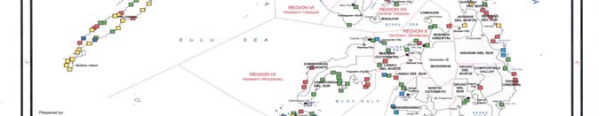
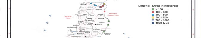

NATIONAL REPORT ON MANGROVES IN SOUTH CHINA SEA PHILIPPINES 1
1. INTRODUCTION
In the Philippines, being the maritime nation, boasts with 7,107 islands with a coastline of 36,289km is
dependent on a major extent on a healthy coastal environment. Indeed, Philippine coastal areas and
seas have served as the lifeblood of communities near and far for hundreds of years if not thousands
of years. The Philippines was said by "experts" to be endowed once upon a time with inexhaustible
coastal resources. However, it is now on the verge of irreversible descent. The public attributes this
condition due to excessive pressures exerted by ever increasing population, unscrupulous
exploitation, industrialization and lack of ecosystem appreciation.
2. MANGROVE
DISTRIBUTION
The Philippines is a large archipelago of approximately 7,107 islands, with a coastline of 36,289km -
third longest in the world, 822 coastal municipalities and 74 coastal cities. These coastal zones are
naturally endowed with resources of great socio-economic and ecological significance, mainly the
reason why historically, cities grow rapidly along these areas. Coastal zones became centres of
social, economic, recreational and other activities, making it vulnerable to man-made pressures.
Coastal zones should have been maintained to sustain its environmental services to include food
source, shoreline stabilizer, wildlife habitat, natural breakwater and spawning/breeding grounds of
aquatic species. Among these major ecosystems, mangroves occupy a highly strategic position in the
economy and ecology of the coastal areas in the country. The largest remaining mangrove areas are
located in Palawan and Quezon in Luzon, Samar provinces in the Visayas, and Zamboanga del Sur,
Zamboanga Sibugay, Surigao del Norte and Sulu provinces in Mindanao as shown in Figure 1 below.
Figure 1
Mangrove distribution in the Philippines.
According to Tomlinson, (1986 as cited in Ong, et al. 2002), 35 of these species (1 hybrid, 1 variety,
and 33 species) and several associate species are found in the Philippines. In term of distribution of
number of marine species among coastal ecosystems, mangrove community has 370 species
including seagrass, seaweeds, corals, other invertebrates, fish, mammals, and reptiles (DENR, 1998).
Reversing Environmental Degradation Trends in the South China Sea and Gulf of Thailand
2 NATIONAL REPORT ON MANGROVES IN SOUTH CHINA SEA PHILIPPINES
Based on the survey conducted, as of 1984 a total area of 232,065ha of mangrove forest in the
Philippines were recorded as cited in Philippine Forestry Statistics with geographical distribution per
major islands shown in Table 1 below.
Table 1
Mangrove forests areas of the Philippines.
Category Luzon
Area
Visayas Area
Mindanao Area
Palawan Area
Total Area
in Hectares
in Hectares
in Hectares
in hectares
in Hectares
Reproductive Bush
2,583
63,893 23,692
22,
915
113,083
Young growth
14,186
1,226 84,471 9,200
109,083
Old growth
-
-
4,582
5,317
9,899
Total 16,769
65,119
112,745 37,432
232,065
Source: (Forest Management Bureau, 1984).
Of the estimated total mangrove forest area, approximately 49% is classified as reproductive bush,
47% as young growth and 4 % as old growth. The major genera are of the Rhizophora, Bruguiera,
Avicennia, Xylocarpus, Sonneratia, Heritiera, Ceriops, Excoecaria and Nypa. Most of these are timber
yielding, while Xylocarpus and Ceriops are used for the extraction of dyes and Nypa is used for
thatching leaves and tapping of juice for brewing alcohol.
In view of the drastic decrease of mangrove forests from 450,000ha in 1920 to 232,065ha in 1984, the
Department of Environment and Natural Resources of the Philippines, adopted few conservation
measures. Presidential Decree No. 705 was promulgated which enforces; (1) a seed tree method of
silvicultural system for mangroves, wherein 20 seed trees per hectare are to be retained; (2)
adaptation of 50year rotation and; (3) regulation of annual allowable cut. Besides these thousands of
hectares of denuded mangrove areas in the form of open mudflats, sandy beaches and mine tailing
areas are available for restoration. Small-scale afforestation with species such as Rhizophora
apiculata, Bruguiera cylindrica, Avicennia officinalis and Ceriops tagal has been undertaken at various
sites of the country.
The forested mangrove area has decreased greatly from an estimated coverage of 450,000ha in 1918
to less than 120,000ha in the late 1990s (DENR 1988, 1998). The most rapid decrease in mangrove
coverage occurred during the 1960s and 1970s when national policies encouraged the expansion of
aquaculture. Today; fishponds cover about 289,000ha; most of which were formerly mangroves thus;
and the culprits of mangrove degradation was due to conversion of mangrove areas into shrimp
farming/aquaculture. It was revealed that for the period of 1967-1988, the average rate of decline was
about 8,000ha annually.
Mangrove stands remaining in the country are mostly found on the southern and western provinces
and islands of Mindanao, eastern island provinces of the Visayas and the whole islands of Palawan.
Less than 5 percent of existing areas in old or primary growth forest is found in Palawan. Most
mangrove forests in the Luzon and Visayas islands are secondary growth or in plantations.
Mangroves are now of much lower quality and cover less than one-third of their original range.
Based on the satellite pictures interpreted by the NAMRIA which had been used as the statistics for
mangroves in the Philippines, the reported total mangrove areas are 248,813 hectares. The major
regions where substantial mangrove areas are found are presented in Table 2 below:
Table 2
Regions and provinces where concentration of mangrove stands are observed.
Regional geographic location
Total regional
Province with most
Mangrove
in the Philippines
mangrove area (ha)
mangrove area in region
forests (ha)
Southwestern Luzon
58,032
Palawan
54,143
Autonomous Region of Muslim
46,218 Sulu
24,701
Mindanao
Eastern Visayas
39,294
Samar
16,337
Northeastern Mindanao
26,731
Surigao del Norte
16,823
(CARAGA)
Western Mindanao
22,328
Zamboanga del Sur
11,681
However, information shows that there is inconsistency in the presentation on the extent of mangrove
forests in the Philippines. It had been reported there were less than 120,000ha in 1998 contrary to
what had been stated in the previous paragraphs.
Reversing Environmental Degradation Trends in The South China Sea and Gulf of Thailand
NATIONAL REPORT ON MANGROVES IN SOUTH CHINA SEA PHILIPPINES 3
With the foregoing result of analysis of the satellite pictures, the DENR is presently validating the
reported mangrove stands in all the 64 coastal provinces of the Philippines. Latest records reveal
there are provinces especially in the coasts facing the South China Sea which were not detected in
the satellite imagery but ground validation shows there are small patches of mangrove stands in such
provinces. These are the provinces of Ilocos Norte, Zambales, Bataan, Pampanga and Bulacan, all in
Luzon. The reported 248,813ha in 2003 can increase to about 300,000ha when the ground validation
is completed. Moreover, the mangrove statistics after 1988 were projections which had been
constantly decreasing due to destructions and on the conversion of some areas to other uses,
specially for prawn/fishpond purposes and for charcoal and fuelwood production.
From 1989 to the present, there had been an increased plantation establishment of mangroves in the
country. There were international supports for reforestation with the assistance of the ADB, JBIC,
USAID, WB, to mention some, other banking institutions, non-government organizations, academe,
people organizations and individuals who had contributed much to the increase in mangrove forests
nationwide.
One documented accomplishment of coastal communities is what had been initiated by an old man in
Banacon Island, Getafe, Bohol (Central Philippines). He started planting in small patches in 1957
which was followed by his neighbours when they observed the good effect in increasing fisheries
production in their area. That small island of Banacon which is about 15ha of land area has now man-
made mangrove forests of about 500 hectares. That old man, because of his initiation to start
mangrove reforestation in that small island, received some awards, one of which he received from the
Food and Agriculture Organization of the UNDP in Bangkok in the mid-90s. The same mangrove area
is now a show window where interested organizations, groups of fisherfolk and individuals often
frequent to see for themselves the successful contribution of an old man who led his neighbours
improved the mangrove ecosystem in a small fishing village.
Species composition of mangroves in various regions of the country
The composition of mangroves in various regions of the country representing sixty four (64) sites
revealed Rhizophora apiculata is the most dominant mangrove species, followed by R. mucronata,
Avicennia marina Sonneratia alba and Ceriops tagal. There are twenty eight (28) true mangroves
species and thirty four (34) mangrove associates. The samples in each region are in the original
Coastal Environmental Programme, or Coastal and Marine Management Programme sites now
including those sampled in the UNEP-GEF SCS Project.
It could likewise be deduced that there are more representative true mangrove species and
associates in Cagayan Valley (Northern Luzon), Quezon, Palawan, Western and Central Visayas.
Because of the limited number of samples in Mindanao, the values were likewise low. Studies on the
composition of other areas especially in the natural stands remaining expectedly can enhance the
information. Another activity which should be undertaken is to gather more information on the
menstruational attributes of mangrove stands to have an indication of the productivity of these stands
based on productivity of timber and other major products derived from mangroves. This, however, is
not an immediate priority since harvesting of timber for lumber is totally banned by the government.
3.
THREATS TO MANGROVES
In the Philippines, mangroves are among the major marine ecosystems, which include seagrass and
coral reefs, which have suffered the extensive damage and greatest degradation because of their
relative inaccessibility and long history of conversion to aquaculture ponds. Estimates of the country's
mangroves were not made until 1918 although ponds were already on record since 1863. The former
comprised not only primary and secondary forests but also vast stands located near Manila of
Rhizophora cultivated for firewood and Nypa shingles.
In recent times, over-exploitation and destruction of mangroves due to human activities have caused
heavy damage to these ecosystems worldwide. Mangrove soil is generally marginal for agriculture,
yet conversion of mangrove land for agriculture is widespread. In several parts of the world
mangroves have been destroyed to create shrimp, ponds which cannot sustain their production over
time due to acid sulphate soils, viral diseases, etc. Mangrove destruction is also due to a variety of
other reasons: the need for fuel wood, oil prospecting and production, conversion to cattle ranching,
salt industry and coastal development everywhere (harbor, urban and industrial development,
airports, power plants and others). International and national demand for mangrove forest resources
and land is at present one of the main causes of the destruction of mangroves. Poor polices and
Reversing Environmental Degradation Trends in the South China Sea and Gulf of Thailand
4 NATIONAL REPORT ON MANGROVES IN SOUTH CHINA SEA PHILIPPINES
legislation (lack of enforcement) also contribute to mangrove destruction and degradation. This is
partly due to the fact that information on mangroves and their importance is often lacking or
inaccessible. During the last decade approximately 1000km˛ of mangroves have been destroyed
annually. Mangroves are not wastelands and their destruction, for whatever purpose, invariably
results in ecological degradation and social impoverishment of local people. The restoration of
degraded mangroves can be extremely costly and time-consuming.
All biotic and abiotic factors acting on mangrove ecosystems vary between and within countries. Over
and above this, anthropogenic factors have induced changes in almost all the mangroves of the
world, predominantly in a negative manner. Significant changes of all sorts became increasingly
damaging during the second half of the 20th century. The changes have affected the distribution,
extent and health of single mangrove species and of the ecosystems as a whole. The coastal zone
everywhere in the world is extremely dynamic. It may be described as a chaotic system where an
infinitely large number of variables are in constant and relentless interaction. The chaotic nature of
coastal zone systems makes the impact of changes hard to anticipate and often dramatic.
Mangroves are home to many marine fishes and provide livelihoods for millions of people, but the
opinions of local residents regarding their management have seldom been sought. Public awareness
regarding mangroves and their conservation is often lacking. Thus, it is an urgent need to bring
people and nations together to apply the knowledge and wisdom of experience to use the mangrove
forest judiciously.
Offshore fisheries are of considerable importance in the Philippines. There have been few studies to
look at the effect on mangrove loss, although anecdotal evidence suggests there have been reduced
yields. Mangrove forests used to be source of tanbark for the tannin extract industry, while now there
is little or no commercial extraction of timber and mangrove wood is widely used locally for fuel,
charcoal and for the manufacture of poles and piles. There has been some mangrove afforestation,
notably in the Sulu Archipelago and the Central Visayas, including Negros, Bohol and Cebu, much of
this carried out at the local and community level. Research into afforestation methods is also
underway. Traditional or non-destructive fishing within mangrove areas is still important, notably in
Bohol, Sulu, Tawi-tawi and Cebu. Target species include shellfish and crabs as well as fish caught by
net or line. The greatest loss of mangrove areas has been caused by the development of large areas
of brackish fishponds, increased from 90,000ha in 1952 to over 210,000ha today. Mangrove
reclamation for agricultural or urban development is significant in some areas. Although some
legislation exists for the protection on mangroves, for example all of the mangroves of Palawan and
other sites have been declared as mangrove forest reserve; there is still evidence that such protection
is not effective on the ground.
Research according to Ong, et al. (2002), a few pristine mangrove areas were re-discovered because
of their relative inaccessibility (e.g., Aurora and Isabela provinces, and Dinagat-Siargao Islands in
Surigao del Norte) and peace-and-order threats (e.g., Western Samar and Sta. Cruz Island in
Zamboanga City). Even a very small forest patch, such as the 75-ha mangroves of Ibajay, Aklan (the
largest contiguous mangrove in Panay Island), can feature as many as 20 mangrove species, a
further confirmation of the country's remarkable mangrove diversity.
Mangrove decline of 120,000ha from 1984 to 1995 maybe traced to exploitation by coastal dwellers
and conversion to agriculture, salt ponds, industry and settlements. However, aquaculture remains
the major causearound the world, half of the 279,000ha of mangrove lost from 1951-1988 were
developed into culture ponds. Ninety-five percent of Philippine brackish water ponds in 1952 up to
1987 were derived from mangroves. Mangrovetopond conversion and its attendant socioeconomic
changes have been documented in detail for the village Lincod in Maribojoc, Bohol and for the
Municipality of Batan, Province of Aklan.
Pond construction was also the culprits of the mangrove degradation; its peak occurred in the 1950s
and 1960s at 4,000 to 5,000 hectares per year with the government incentives in the form of loan. The
Fisheries Decree of 1975 (P.D.704) mandated a policy of accelerated fishpond development and A.O.
125 extended 10-year fishpond permits and leases to 25 years. During the Shrimp Fever of the
1980s, pond development again increased to 4,700 hectares per year.
Reversing Environmental Degradation Trends in The South China Sea and Gulf of Thailand
NATIONAL REPORT ON MANGROVES IN SOUTH CHINA SEA PHILIPPINES 5
Another widespread mechanism by which mangroves have been lost from the public domain is when
local residents or even outsiders stake claim on mangrove areas paying to municipal governments a
real estate tax. Because local government are hard pressed for cash, they accept taxes without
checking whether the status of the given area is forest reserve, protected mangrove or alienable &
disposable (A&D). These claims are generally handed down to family members or "sold" to other
parties. A prerequisite to legal ownership through issuance of titles is having the area declared A&D
by the government, if the interested party has adequate finances. And so many mangrove areas
passed from government jurisdiction to private hands-through de facto (real estate tax) and or legal
means.
According to Dixon's work (1989) as cited by Melana et.al. (2000), valued a complete mangrove
ecosystem at US$500 to 1500 per hectare per year. This represents the minimum monetary value
that would be lost when such mangroves were converted to other land uses.
Various mechanisms both natural and human-induced activities commonly destroyed and degraded
mangrove ecosystem. They are subjected to many biological, physical and chemical stresses
because of public ignorance of the capabilities and limitations of mangrove forests including poor
valuation methods to quantify non-market goods compared to cost accounting available for
residential, commercial and industrial development. The mangrove ecosystems are increasingly
threatened and under various kinds of pressures: increasing population, construction, development,
tourism, aquaculture development, including short-term management policies and programmes.
Apart from the human impacts and natural threats to the mangrove ecosystems they were also
subjected to various land use. The root cause of these threats is failures of existing management
system to include:
-
Information failure- Failure to appreciate the full ecological functions of mangrove ecosystem
as well as their biological basis;
-
Market failures- Failure to correctly value the mangrove ecosystem or where the cost and
benefits do not coincide and where the mangrove ecosystem is sacrificed due to their non-
market valuation;
-
Intervention and/or policy failure- A policy result from ineffective governmental interventions to
correct market failure in the form of subsidies, credit and inter-sectoral policy inconsistency.
4. ECONOMIC
VALUATION
In deciding to maximize economic gain from mangroves, discussions usually focus on the "economic
rent" which should be charged to users for alternative uses of the habitat area. In one research effort
to determine an optimal system for leasing out mangrove areas for fishpond use, three (3)
management scenarios were compared: (i) mangrove plantation; (ii) managed naturally regenerated
mangroves; and, (iii) unmanaged under-stocked stands.
The value of wood products from mangrove plantation generates more revenues than alternatives (ii)
and (iii) but for practical purposes, scenario (ii) was recommended as a basis for economic rent for
mangrove habitats converted to fishpond the higher value in all three options is not the wood products
but the fish products (US$538/ha) dependent on the existence of the ecosystem. This amount can be
considered as a minimum economic gain from a healthy mangrove ecosystem as shown in Table 3
below:
Table 3
Estimated net annual economic value of Philippine mangrove areas for different levels of
management.
Wood products
Fish products
Total
Level of management
(US$/ha)
(US$/ha)
(US$/ha)
i) Mangrove plantation
156 538
694
ii) Managed naturally regenerated
90 538
628
iii) Unmanaged under stocked
42 538
580
stands
Note: wood harvest value based on average price of about US$12/m3 of wood; fish products based on average annual weight
of fish and shrimp/ha associated w/ mangrove areas and an average price of US$0.80/kg; values based on Philippine
pesos. US$ 1 was equal to 25 pesos in 1991.
Reversing Environmental Degradation Trends in the South China Sea and Gulf of Thailand
6 NATIONAL REPORT ON MANGROVES IN SOUTH CHINA SEA PHILIPPINES
5.
INSTITUTIONAL ARRANGEMENT AND NATIONAL LEGISLATION
The DENR has jurisdiction over mangrove resources as provided for in PD 705 or the Forestry Code
of the Philippines. Various issuances enacted pursuant to PD 705 include: DAO 15, s 1990, on
mangrove conversion and conservation; DAO 96-29, s 1990, on awarding of mangrove stewardship
contracts; and DAO 76, s 1987, on establishment of buffer zones in mangrove areas.
The Local Government Units (LGUs) were also given jurisdiction over specific aspects of mangrove
management including that of conversion, as well as implementation of communitybased forestry
projects (including integrated social forestry projects) subject to the supervision, control, and review of
DENR (RA 7160, Sec 71 (2) (i), (ii). The pertinent guidelines to the effect the devolution of these
functions are spelled out in DAO 30, s 1990. Communitybased forestry projects refer to DENR
development projects involving local communities, which include the integrated social forestry
projects, family, and community forestry Programmes, and other similar projects. On the other hand,
the management, protection, and development of all other areas outside communal forest remain with
DENR.
The Communitybased Forest Management Agreement (CBFMA), EO 263, 1995 and its IRR as
outlined in DAO 96-29 provided tenurial instrument available for communities who wish to manage
their mangrove resources. The CBFMA integrates all other forms of tenurial instruments developed by
the DENR including the Mangrove Stewardship Agreement and the Community Forest Management
Agreement (CFMA).
Cutting of all mangrove species is prohibited under RA 7161: "An act incorporating certain sections of
the National Internal Revenue Code of 1977, as amended, to PD 705, as amended, otherwise known
as the `Revised Forestry Code of the Philippines' and providing amendments thereto by increasing
the forest charges on timber and other forest products." The law does not provide any exemption.
There are some incentives provided to people's organization (POs) for participating in CBFM
Programmes. These include (i) exemption from paying rent, (ii) exemption from payment of forest
charges as per RA 7161; (iii) consultation by government on all proposed projects affecting CBFMA
area; (iv) preferential access to DENR financial assistance; and (v) all incomes and proceeds from
sustainable management of forest resources will rebound to the benefit of the CBFMA holder.
6. MANAGEMENT
PERSPECTIVES
The keys for attaining productive and effective mangrove restoration efforts can be effectively
achieved through: (a) understanding of the ecology and morphology of mangroves; (b) environmental
requirements or suitability of species; (c) economic and ecological value of mangroves; and, (d) the
degree to which they are currently damaged by human activities. This particularly done considering
that the management and conservation of mangroves is effected by a need for a variety of policies
and the ways these policies affect the mangrove. They range from indirect (unsustainable exploitation
of mangrove resources) to direct effects. In addition, the laws related to conservation, management
and utilization are not often effectively enforced; hence, coastal law enforcement component should
be strengthened to be an effective tool for implementation of conservation and protection policies. In
general, change in the use of mangrove systems has been undertaken with inadequate consideration
of the goods and services. Over the years, policy changes had shifted continuously. These policies
need to be identified and their implications be fully analyzed so that appropriate adjustment or reforms
can be instituted.
Therefore, this calls for reform of the policy and institutional framework for mangrove management to
create wider participation in the management processes. The implementation of appropriate policy
instrument and mechanisms is needed that could curtail sustainable management that undermines
the efficiency of resource use and development.
At this point in time, we must review and harmonize existing policies and establish new policies that
identify sustainable management as the overall framework across all sectors towards integrated
ecosystem management approach. Intersectoral relationships as well as the economics, social and
biophysical and environmental aspects must be fully recognized and duly considered in any
development activity to minimize mangrove problem or conflict. Hence, policy goals must recognize
the diversity of interests related to the conservation and management of mangroves to include as
follows:
Reversing Environmental Degradation Trends in The South China Sea and Gulf of Thailand
NATIONAL REPORT ON MANGROVES IN SOUTH CHINA SEA PHILIPPINES 7
6.1 Socio-economic
aspect
· Any developmental programmes needed by the coastal inhabitants should be prioritized;
· Need to integrate economic and ecology to quantify the monetary values of mangrove
ecosystem;
· Build on local people's awareness of mangrove conservation;
· Stewardship agreements should be issued primarily to coastal communities;
· Joint-venture program and/or sharing should be promoted as a management scheme.
6.2 Ecological
aspect
· Utilization of mangrove resources should be based on the sustainable limits of particular
mangrove areas;
· All mangrove forests should be brought under sustainable management;
· All management efforts should be focused on the prevention of degradation rather than
restoration;
· More realistic economic valuation of space and resources within mangrove ecosystems;
· Integrated assessments of the environmental and socio-economic costs and benefits of
alternative uses of such systems;
· Research on mangrove ecosystem that is, scientific information and data to include
studies of human habitation and traditional uses of mangrove ecosystem in order to
evaluate actual and potential use of the resources from both the natural and social
science perspectives.
7.
PROGRAMME OF ACTIONS
· Promote public awareness of mangrove forest issues. Public awareness should be
intensified through Information, Education and Communication (IEC) advocacy and
promoting the intrinsic values of mangrove ecosystem to be perceptive on the protection
and conservation program of the government. Its central tenet is to promote the rights of
local coastal peoples, including fishermen, in the sustainable management of coastal
environs.
· Participation in management decisions is essential at all levels. This builds up the
bottom-up model by encouraging local level to form management associations and
become the effective managers of their coastal resources.
· National agencies with jurisdiction over coastal resources need to assist LGUs and
provide technical support. The capacity of local governments to manage their coastal
environments and resources is limited, thus, they need technical guidance to mentor in
order to achieve significant output facilitated by national agencies.
· Collaboration and synergy among agencies is essential. Integration and collaboration
of all institutions with a mandate and concern for coastal resource management.
Partnership management of mangrove resources including local communities and NGOs.
Collective and sustained efforts by government and the people concerned must be
fostered.
· Mangrove policies and LGUs should be based on a comprehensive approach.
Improve legal mechanisms to control mangrove misuse. Develop adequate policy and
legislation to protect mangrove resource and on ensuring adequate enforcement.
· Multi education and communication strategies are required to build a wise base
support for CRM. Management efforts should first be directed towards winning the
hearts of coastal communities people must be oriented first for better understanding the
issues before they will take action to solve them. This could be done through networks of
constituency groups to support initiatives, thus ensuring better sustainability of efforts.
· Proven technical interventions must be pursued and applied appropriately. The
viable coastal management interventions must be pursued, such as integrated planning,
habitat protection and management, improved law enforcement, environmentally
sensitive livelihood options and others.
Reversing Environmental Degradation Trends in the South China Sea and Gulf of Thailand
8 NATIONAL REPORT ON MANGROVES IN SOUTH CHINA SEA PHILIPPINES
REFERENCES
DENR. 1988. Mapping of the natural conditions of the Philippines. Final Report. Swedish Space
Commission, Solna, Sweden
DENR. 1998. Philippine Forestry Statistics of 1995. Forest Management Bureau, DENR.
Forest Management Bureau, 1994. Mangrove Forest of the Philippines. Manila.
Melana, D., J. Atchue III, C. Yao, R. Edwards and E. Melana. 2000. Mangrove management
handbook. DENR-Coastal Resources Management Project. Cebu City. 98 p
Ong, P.S. L. E. Afuang and R. G. Rosell-Ambal (eds) 2002. Philippine Biodiversity Conservation
Priorities: A. Second Iteration of the National Biodiversity Strategy and Action Plan. DENR-PAWB, CI-
P, UP Center for Integrative Development Studies-Biodiversity Conservation Programme and
Foundation for the Philippine Environment, Quezon City, Philippines.
Reversing Environmental Degradation Trends in The South China Sea and Gulf of Thailand
NATIONAL REPORT ON MANGROVES IN SOUTH CHINA SEA PHILIPPINES
ANNEX 1, PAGE 1
Annex 1
Scientific names, family names and some common names of true mangroves
and associates in the Philippines.
Philippine Mangrove Species
No.
Family
Common name
(Tree/Shrub/Vine/Grasses/Fern/Palm)
1
Acacia farnesiana
Mimosaceae
2
Acanthus ebracteatus
Acanthaceae
Tigbau
3
Acanthus ilicifolius
Acanthaceae
Deliuario
4
Acrostichum aureum
Pteridaceae
Lagolo
5
Acrostichum speciosum
Pteridaceae
6
Aegiceras corniculatum
Myrsinaceae
Saging-saging
7
Aegiceras floridum
Myrsinaceae
Tinduk-tindukan
8
Aegiceras lanata
Myrsinaceae
9
Alstonia macrophylla
Moraceae
10 Avicennia eucalyptifolia
Avicenniaceae
11 Avicennnia alba
Avicenniaceae
bungalon puti
12 Avicennia lanata
Avicenniaceae
Piapi
13 Avicennia marina
Avicenniaceae
Bungalon
14 Avicennia marina var. rumphiana
Avicenniaceae
piapi
15 Avicennia officinalis
Avicenniaceae
Api-api
16 Barringtonia asiatica
Lycythidaceae
Butong
17 Barringtonia racemosa
Lycythidaceae
putat
18 Brownlowia lanceolata
Tiliaceae
Maragomon
19 Bruguiera cylindrical
Rhizophoraceae
Pototan lalaki
20 Bruguiera gymnorrhiza
Rhizophoraceae
Busain
21 Bruguiera parviflora
Rhizophoraceae
Langarai
22 Bruguiera sexangula
Rhizophoraceae
Pototan
23 Caesalpinia crista
Fabaceae
kalumbibit
24 Caesalpinia nuga
Fabaceae
sapinit
25 Camptostemon philippinense
Bombacaceae Gapas-gapas
26 Centrosema sp.
Leguminosae
27 Cerbera manghas L
Apocynaceae
baraibai
28 Ceriops tagal
Rhizophoraceae
Tangal
29 Ceriops decandra
Rhizophoraceae
Malatangal
30 Chromolaena odorata
Euphorbiaceae
31 Clerodendrum siphonospathus
Verbenaceae
32 Derris trifoliate
Fabaceae
Mangasin
33 Dolichandrone spathacea
Bignoniaceae
Tui
34 Excoecaria agallocha
Euphorbiaceae
Buta-buta
35 Flagellaria indica
Flagellariaceae
36 Glochidion littorale
Euphorbiaceae Dampol
37 Glochidion mindorense
Euphorbiaceae
38 Heritiera littoralis
Sterculiaceae
Dungon late
39 Heritiera sylvatica
Sterculiaceae
40 Hibiscus tiliaceus
Malvaceae
Malubago
41 Intsia bijuga
Leguminsae
ipil
42 Intsia retusa
Leguminosae
ipil laut
43 Ipomea pes-caprae
Convolvulaceae
lambayong
Reversing Environmental Degradation Trends in the South China Sea and Gulf of Thailand
NATIONAL REPORT ON MANGROVES IN SOUTH CHINA SEA PHILIPPINES
ANNEX 1, PAGE 2
Annex 1 cont. Scientific names, family names and some common names of true mangroves
and associates in the Philippines.
Philippine Mangrove Species
No.
Family
Common name
(Tree/Shrub/Vine/Grasses/Fern/Palm)
44 Kandela candel
Rhizophoraceae
45 Kleinhovia hospita
Sterculiaceae
Tan-ag
46 Lumnitzera littorea
Combretaceae
Tabau
47 Lumnitzera racemosa
Combretaceae
Kulasi
48 Mallotus papillaris
Euphorbiaceae
49 Morinda bracteata
Rubiaceae
50 Nypa fruticans
Palmae
Nipa
51 Oncosperma tigillaria
Palmae
Anibong
52 Osbornia octodonta
Myrtaceae
Taualis
53 Pandanus tectorius
Pandanaceae
54 Pemphis acidula
Lythraceae
Bantigi
55 Phanera integrifolia
Caesalpiniaceae
56 Pluchea indica
Compositae
Kalapini
57 Pongamia pinnata
Fabaceae
Bani
58 Prosopis vidaliana
Legumisae
59 Rhizophora apiculata
Rhizophoraceae
Bakauan lalaki
60 Rhizophora mucronata
Rhizophoraceae
Bakauan babae
61 Rhizophora stylosa
Rhizophoraceae
Bakauan bangkau
62 Rhizopora lamarckeii
Rhizophoraceae
63 Sapium indicum
Rhamnaceae
64 Scyphiphora hydrophyllacea Rubiaceae
Nilad
65 Sesuvium portulacastrum
Aizoaceae
Dampalit
66 Sonneratia alba
Sonneratiaceae
Pagatpat
67 Sonneratia caseolaris
Sonneratiaceae
Pedada
68 Strophantus cumingii
Apocynaceae
69 Teijsmanniodendron hollrungii
Verbenaceae
70 Terminalia catappa
Combretaceae
Talisay
71 Thespesia populnea
Malvaceae
Banalo
72 Thespesia populneoides
Malvaceae
73 Tristellateria australasiae Malphigiaceae
Binusisi
74 Xylocarpus granatum
Meliaceae
Tabigi
75 Xylocarpus moluccensis
Meliaceae
Piagau
76 Xylocarpus rumphii
Meliaceae
Reversing Environmental Degradation Trends in The South China Sea and Gulf of Thailand
NATIONAL REPORT ON MANGROVES IN SOUTH CHINA SEA PHILIPPINES
ANNEX 2, PAGE 1
Annex 2
Mangrove species known to occur in the Philippine Islands (CEP/CMMP Sites
including UNEP/GEF SCS).
Regions
No.
Philippine Mangrove Spp.
Family
Common name
Frequency
(Tree/Shrub/Vine/Grasses/Fern
/Palm)
1 2 3 4A 4B 5 6 7 8 9 10 11 13
1
Acacia farnesiana
Mimosaceae
aroma
1 1
2
2
Acanthus ebracteatus
Acanthanceae
tigbau
6 1 1 3 1 1
13
3
Acanthus ilicifolius
Acanthanceae
deliuario
6 1
1
8
4
Acrostichum aureum
Pteridaceae
lagolo
4 1 1
1
7
5
Acrostichum speciosum
Pteridaceae
1
1
2
6
Aegiceras corniculatum
Myrsinaceae
saging-saging
10 1 1 6 5 1 2 1 1
28
7
Aegiceras floridum
Myrsinaceae
Tinduk-tindukan
9 1 1 7 5 1 3 1 2
30
8
Aegiceras lanata
Myrsinaceae
2 1 1 1
1
6
9
Alstonia macrophylla
Apocynaceae
0
10
Avicennia eucalyptifolia
Avicenniaceae
0
11
Avicennnia alba
Avicenniaceae
bungalon puti
1
1 2
4
12
Avicennia lanata
Avicenniaceae
piapi
1 1
1
3
13
Avicennia marina
Avicenniaceae
bungalon puti
1 10 1 1 7 5 2 9 1 1 2
40
14
Avicennia marina var. rumphiana Avicenniaceae
piapi
1 1
5 1
4
12
15
Avicennia officinalis
Avicenniaceae
api-api
11 2 1 5 5 3 5 1 3 1 1
38
16
Barringtonia asiatica
Barringtoniaceae
butong
11
1
12
17
Barringtonia racemosa
Barringtoniaceae
putat
6
6
18
Brownlowia lanceolata
Barringtoniaceae
maragomon
0
19
Bruguiera cylindrica
Rhizophoraceae
pototan lalaki
1 5 1
6 5 1 3
1
23
20
Bruguiera gymnorrhiza
Rhizophoraceae
busain
1 9 2 7 5 2 2
1
29
21
Bruguiera parviflora
Rhizophoraceae
langarai
5 1 5 2 1 1 2
17
22
Bruguiera sexangula
Rhizophoraceae
Pototan
9 1 6 2 4 2 1 1 1
2
29
23
Caesalpinia crista
Fabaceae
kalumbibit
0
24
Caesalpinia nuga
Fabaceae
sapinit
11 1
1
13
25
Camptostemon philippinense
Bombacaceae
gaps-gapas
4 5 1
1
11
26
Centrosema sp.
Leguminosae
1
1
2
27
Cerbera manghas L
Apocynaceae
baraibai
5
5
28
Ceriops tagal
Rhizophoraceae
tangal
1 12 1 6 4 3 2 1 1 3
2
36
29
Ceriops decandra
Rhizophoraceae
malatangal
11 1 5 5 1 5 1 1 1
31
30
Chromolaena odorata
Euphorbiaceae
1
1
2
31
Clerodendrum siphonospathus Verbenaceae
1
1
32
Derris trifoliate
Fabaceae
mangasin
6 1
7
33
Dolichandrone spathacea
Bignoniaceae
tui
4
1
5
34
Excoecaria agallocha
Euphorbiaceae
buta-buta
1 12 1 1 2 5 1 6
2
1
32
35
Flagellaria indica
Flagellarianceae
1
1
2
36
Glochidion littorale
Euphorbiaceae
dampol
4
4
37
Glochidion mindorense Euphorbiaceae
1
1
38
Heritiera littoralis
Sterculiaceae
dungon late
11 1
2 1 1
16
39
Heritiera sylvatica
Sterculiaceae
2
2
40
Hibiscus tiliaceus
Malvaceae
malubago
9 1
3
13
Reversing Environmental Degradation Trends in the South China Sea and Gulf of Thailand
NATIONAL REPORT ON MANGROVES IN SOUTH CHINA SEA PHILIPPINES
ANNEX 2, PAGE 2
Annex 2 cont.
Mangrove species known to occur in the Philippine Islands (CEP/CMMP Sites
including UNEP/GEF SCS).
Regions
No.
Philippine Mangrove Spp.
Family
Common name
Frequency
(Tree/Shrub/Vine/Grasses/Fern
/Palm)
1 2 3 4A 4B 5 6 7 8 9 10 11 13
41
Intsia bijuga
Leguminosae
ipil
0
42
Intsia retusa
Leguminosae
ipil laut
0
43
Ipomea pes-caprae
Convolvulaceae
lambayong
9 1
2
12
44
Kandela candel
Rhizophoraceae
1
1
45
Kleinhovia hospita
Sterculiaceae
tan-ag
0
46
Lumnitzera littorea
Combretaceae
tabau
2 1
3 5 1 2 1 2
1
18
47
Lumnitzera racemosa
Combretaceae
kulasi
1 1
2 5 1 5
1 1
1
18
48
Mallotus papillaris
Euphorbiaceae
1
1
2
49
Morinda bracteata
Rubiaceae
1 3
1 1
6
50
Nypa fruticans
Palmae
nipa
1 11 1 1 5 5 2 2 1
2 3
34
51
Oncosperma tigillaria
Palmae
anibong
0
52
Osbornia octodonta
Myrtaceae
taualis
2 5 1
3 1 4
1
17
53
Pandanus tectorius
Pandanaceae
1 10 1
12
54
Pemphis acidula
Lythraceae
bantigi
5 1 1 5 1
1
14
55
Phanera integrifolia
Caesalpiniaceae
1
1
2
56
Pluchea indica Linn
Compositae
kalapini
0
57
Pongamia pinnata
Fabaceae
bani
1 8
1
10
58
Prosopis vidaliana
Leguminasae
1
1
2
59
Rhizophora apiculata
Rhizophoraceae
bakauan lalaki
2 11 1 2 8 6 4 10 2 9 1 3 3
62
60
Rhizophora mucronata
Rhizophoraceae
bakauan babae
1 9 2 1 8 4 4 1 8 1 2 2
43
61
Rhizophora stylosa
Rhizophoraceae
bakauan bangkau 1 4 1 5 1 9 2 2 2
27
62
Rhizopora lamarckeii
Rhizophoraceae
0
63
Sapium indicum
Rhamnaceae
0
64
Scyphiphora hydrophyllacea
Rubiaceae
nilad
11 2 2 5 1 1
2
24
65
Sesuvium portulacastrum
Aizoaceae
dampalit
1
1 2
4
66
Sonneratia alba
Sonneratiaceae
pagatpat
8 2 1 7 3 4 1 6
2 2
36
67
Sonneratia caseolaris
Sonneratiaceae
pedada
1 9
4 2 3 2 1 1
1
24
68
Strophantus cumingii
Apocynaceae
0
69
Teijsmanniodendron hollrungii
Verbenaceae
0
70
Terminalia catappa
Combretaceae
talisay
12 1 1 1 1 2
18
71
Thespesia populnea
Malvaceae
banalo
5
5
72
Thespesia populneoides
Malvaceae
1
1
73
Tristellateria australasiae Malphigiaceae binusisi
1
1
74
Xylocarpus granatum
Meliaceae
tabigi
1 9 1 1 6 1 1 1 4 1 1 1
28
75
Xylocarpus moluccensis
Meliaceae
piagau
9
4
13
76
Xylocarpus rumphii
Meliaceae
0
True mangroves2
14 23 15 19 24 17 24 24 13 15 9 20 13
27
Associates
3 17 18 5 22 2 7 7 0 1 1 3
1
34
All Species
17 40 33 24 46 19 31 31 13 16 10 23 14
61
2 The true mangrove species are highlighted by bold.
Reversing Environmental Degradation Trends in The South China Sea and Gulf of Thailand


United Nations
UNEP/GEF South China Sea
Global Environment
Environment Programme
Project
Facility
NATIONAL REPORT
on
Mangroves in South China Sea
THAILAND
Dr. Sonjai Havanond
Focal Point for Mangroves
Department of Marine and Coastal Resources
92 Pollution Control Building, Phaholyothin 7 (Soi Aree)
Phayathai, Bangkok 10400, Thailand
NATIONAL REPORT ON MANGROVES IN SOUTH CHINA SEA THAILAND
Table of Contents
1. GEOGRAPHICAL DISTRIBUTION AT THE HABITAT LEVEL .....................................................1
1.1 MAP..........................................................................................................................................1
1.2 DISTRIBUTION AREAS ................................................................................................................2
2. SPECIES DISTRIBUTION AND FORMATION ...............................................................................3
2.1 SPECIES DISTRIBUTION..............................................................................................................3
2.2 FORMATION...............................................................................................................................5
3. ENVIRONMENTAL STATE.............................................................................................................5
3.1 PHYSICAL..................................................................................................................................5
3.1.1 Climate ..........................................................................................................................5
3.2 BIOLOGICAL ..............................................................................................................................6
3.2.1 Aquatic Fauna ...............................................................................................................6
3.2.2 Terrestrial Wildlife Species............................................................................................7
3.2.3 Threatened species.......................................................................................................8
4. SOCIAL USE AND OWNERSHIP...................................................................................................9
4.1 OWNERSHIP ..............................................................................................................................9
4.1.1 Reserve Forests............................................................................................................9
4.1.2 Private Mangrove Plantation .........................................................................................9
4.1.3 Community Mangrove Forests ......................................................................................9
4.2 PRESENT USES .......................................................................................................................10
4.2.1 Food Items ..................................................................................................................10
4.2.2 Medicine ......................................................................................................................10
4.2.3 Wood Products............................................................................................................11
4.2.4 Artisanal Fisheries.......................................................................................................11
4.2.5 Mariculture...................................................................................................................12
4.3 POTENTIAL USES.....................................................................................................................12
4.3.1 Ecotourism ..................................................................................................................12
4.3.2 Sustainable Forestry ...................................................................................................12
4.4 CURRENT MANAGEMENT REGIME.............................................................................................13
4.4.1 Institutional Structure ..................................................................................................13
4.4.2 Legislation and Regulations relevant to Management of Mangroves .........................14
4.4.3 Thai Government Policy...............................................................................................15
5. ECONOMIC VALUATION OF MANGROVE FORESTS IN THE GULF OF THAILAND..................17
5.1 USE VALUES ...........................................................................................................................17
5.1.1 Direct Use Value .........................................................................................................17
5.1.2 Indirect Use Value.......................................................................................................17
5.2 NON-USE VALUES....................................................................................................................18
6. THREATS, PRESENT AND FUTURE ..........................................................................................18
6.1 THREATS.................................................................................................................................18
6.1.1 Human Pressure .........................................................................................................18
6.1.1.1 Mangrove Forestry ........................................................................................19
6.1.1.2 Conversion for Shrimp Farming ....................................................................19
6.1.1.3 Urbanisation and Coastal Development........................................................20
6.1.1.4 Agriculture .....................................................................................................20
6.1.1.5 Major Infrastructure Projects .........................................................................21
6.1.2 Natural Phenomena ....................................................................................................21
7. PRESENT AND FUTURE STATUS OF MANGROVE ACTION PLANNING...............................21
7.1 PRESENT SITUATION................................................................................................................21
7.2 FUTURE PERSPECTIVES...........................................................................................................22
REFERENCES......................................................................................................................................22
Reversing Environmental Degradation Trends in the South China Sea and Gulf of Thailand
NATIONAL REPORT ON MANGROVES IN SOUTH CHINA SEA THAILAND
List of Tables and Figures
Table 1
Mangrove Areas (Ha) Distribution in Thailand by Region and Province, 19612003.
Table 2
Distribution and Characteristics of Mangrove Trees and Mangrove Shrubs found in the
Gulf of Thailand.
Table 3
Summary of Climatic Conditions in Each of the Three Mangrove Forest Regions of the
Gulf of Thailand.
Table 4
Fish Diversity in the Mangrove Forests of Thailand.
Table 5
Bird and Fish Species at Risk which have been Recorded in Mangrove Areas in the Gulf
of Thailand.
Table 6
Food Items Obtained from Different Mangrove Species.
Table 7
Medicinal Properties of Some Common Mangrove Species.
Table 8
Summary of Thai Government Cabinet Resolutions relating to Mangrove Conservation
and Management.
Table 9
Land Uses in Areas which were originally Mangrove Areas in the Gulf of Thailand.
Table 10
Areas and Percentage of Total Numbers of Shrimp Farms Occupying Conservation and
Economic Zone A Areas along the Gulf of Thailand Coast.
Figure 1
Locations of Mangrove Areas in Thailand.
Figure 2
Areas of Mangroves in the Gulf of Thailand in 1996.
Figure 3
Change in Mangrove Areas in the Gulf of Thailand from 1975-1996.
Figure 4
Change in Mangrove Areas around the Gulf of Thailand Coast from 1975 1996.
Reversing Environmental Degradation Trends in the South China Sea and Gulf of Thailand
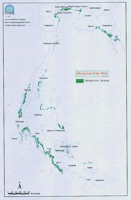
NATIONAL REPORT ON MANGROVES IN SOUTH CHINA SEA THAILAND 1
1. GEOGRAPHICAL
DISTRIBUTION AT THE HABITAT LEVEL
1.1
Map
Thailand covers an area of 512,820 square kilometres of land. The country has 2,614 kilometres of
coastline, about 50% of which is fringed with mangrove forest. The extent of mangrove forestation has
changed dramatically in Thailand over the past 30 years. A recent survey conducted in 1996 by
Charuppat and Charuppat (1997) estimated the total remaining area of mangrove forest to be in the
region of 167,582 hectares. Of this total mangrove area, approximately 80% is located on the
peninsular west coast of the Andaman Sea. The GEF project for which this report has been prepared
will focus on the remaining 20%, which is located at various points along the coastline of the Gulf of
Thailand. Figure 1 represents locations of Mangrove Areas in Thailand.
Figure 1
Locations of Mangrove Areas in Thailand.
Reversing Environmental Degradation Trends in the South China Sea and Gulf of Thailand
2 NATIONAL REPORT ON MANGROVES IN SOUTH CHINA SEA THAILAND
1.2
Distribution Areas
Mangrove forests in the Gulf of Thailand are located on the sheltered muddy shores and low lying
areas in the estuaries of rivers and streams which enter the Gulf. Geographically, mangroves in the
Gulf of Thailand can be divided into three distinct groups (FAO, 1985): a group in the Eastern region,
a Central group, and a group distributed along the Eastern coast of the Southern Thai Peninsula
(Figure 1).
1) Eastern
region: The Eastern region consists of the provinces located on eastern coast of
the Gulf of Thailand - Trat, Chantaburi, Rayong and Chonburi. The coastline of this region
is approximately 502km long.
2)
Central region: The Central region is located around the upper part of the Gulf of Thailand,
to the south of the Chao Phraya central plain. Provinces with coastline within this region are
Chachoengsao, Samut Prakan, Bangkok, Samut Sakhon, Samut Songkhram, Petchaburi
and Prachuab Khiri Khan. The total length of coastline in this region is about 439km.
3)
Southern Thai Peninsula: This region runs south from the province of Chumphon along the
eastern coastline of Surat Thani, Nakhon Si Thammarat, Songkhla and Pattani provinces.
The total length of this coastline is about 932km.
Figure 2 shows a breakdown of the total area of mangroves in the Gulf of Thailand into both Regions
and Provinces in 1996. Significantly larger areas of mangroves are found on the Western side of the
Peninsula in the provinces of Ranong, Phangnga, Phuket, Krabi, Trang and Satun, bordering the
Andaman Sea. These mangrove forests are not discussed in this report as they are not in the South
China Sea region and are thus beyond the scope of the GEF project for which the report has been
prepared. Table 1 shows the distribution of mangroves (Ha) in Thailand by region and province, from
the period of 19612003.
5,449 ha (15.71%)
16,569 ha
Central Region
(47.79%)
12,658 ha
East Region
(36.50%)
Southern Peninsula
Figure 2
Areas of Mangroves in the Gulf of Thailand in 1996.
Table 1
Mangrove Areas (Ha) Distribution in Thailand by Region and Province, 19612003.
Province 1961 1975 1979 1986 1989 1991 1993 1996 2000 2003
Central Region
Samut Prakan
12,616.96
600
1,040
103.04
312
298.88
319.84
519.8
Bangkok 1,908
200
197.76
1,154.5
Samut Sakhon
28,243.84
18,500
14,416
141.92
1,819.04
1,696.32
3,383.04
3,080.4
Samut
10,934.08
8,200
7,648
48.96
924
1,144.96
2,456.16
2,553.1
Songkhram
Petchaburi 11,888
8,800
7,792
576.96
488.96
336
2,068
2,069.76
5,747.04
3,058.5
Prachuab Khir
1,300
400
336
144.96
107.04
70.08
40
43.04
147.52
499.5
Khan
Subtotal 66,890.08
36,500
31,232
1,015.84
596
406.08
5,363.04
5,450.72 12,053.60 10,874.0
Eastern Region
Trat 14,506.08
10,600
9,840
8,817.92
8,637.92
7,750.08
7,668
7,533.92
9,245.92
9,517.1
Chanthaburi 28,188.96
26,100
24,064 14,506.88
8,696
2,663.04
4,072
3,893.12
9,977.60 12,572.8
Rayong 4,424
5,500
4,608
2,417.92
1,757.92
154.08
680
656.48
1,331.52
1,882.2
Chonburi 3,824.96
3,800
3,312
1,497.92
1,048
150.08
92
92
1,043.04
713.7
Chachoengsao 3,900.96
3,000
2,320
740
568.96
367.04
535.68
482.40
1,142.88
1,746.8
Subtotal 54,844.96
49,000
44,144 27,980.64 20,708.80 11,084.32 13,047.68 12,657.92 22,740.96
26,40
Reversing Environmental Degradation Trends in the South China Sea and Gulf of Thailand
NATIONAL REPORT ON MANGROVES IN SOUTH CHINA SEA THAILAND 3
Table 1 cont.
Mangrove Areas (Ha) Distribution in Thailand by Region and Province, 19612003.
Province 1961 1975 1979 1986 1989 1991 1993 1996 2000 2003
Region of Eastern Coast of Peninsula
Chumphon 10,632
7,400
688
3625.92
2,264.96
1,818.08
3,293.44
3,151.84
8,003.84
7,246.7
Surat Thani
11,803.04
3,700
5,808
4,283.84
3,767.04
2,204
3,164
3,133.76
3,532.48
9,300.3
Nakhon Sri 21,616.96 15,485.60
12,832
8,835.84
8,520.96
8,024.96
7,966
8,416.16
9,874.88
9,580.1
Thammarat
Phatthalung 2,531.04
1,900
1,632
104.96
84
60
128
140.96
3,159.52
216.6
Songkhla 6,079.24
5,900
5,184
964.96
688
228.96
548
623.52
4,664.48
3,488.8
Pattani 3,787.04
1,100
1,392
1,828
1,759.04
1,644
1,295.20
1,105.12
3,573.28
4,230.4
Subtotal 56,449.12
35,500
33,776 19,643.52
17,084 13,973.60 16,424.64 16,571.36 32,808.48 34,063.0
Region of Western Coast of Peninsula
Ranong 27,034.08
24,200
22,592 21,613.92 21,230.08 19,470.08
19,308 19,236.64 25,271.68 27,253.6
Phang-nga 43,979.04
51,100
48,716
36,420 35,626.08 33,510.08 30,716.16 30,442.40 39,696.08 42,037.9
Phuket 2,770.08
3,100
2,848
1,935.04
1,786.08
1,554.08
1,548
1,511.68
1,918.40
1,87
Krabi 39,918.08
33,000
31,760
30,312 29,643.04 31,915.04 28,526.72 28,273.44 34,996.32 35,094.0
Trang 39,892.96
34,000
32,864
26,276
25,048 30,848.96
24,328 24,095.52
33,500 35,788.3
Satoon 40,578.28
46,300
55,376
31,238 28,936.16 31,053.44 29,420.32 19,344.32 35,342.40 39,331.5
Subtotal 194,172.32
191,700
194,156147,795.85142,218.24148,351.68133,847.20
132,904170,726.88 181,381.4
Total area of
372,356.48312,700.00303,308.00196,435.84180,607.04173,822.08168,682.56167,584.00238,329.92 252,751.3
country
Source: Royal Forest Department, (2005).
Large areas of mangroves in the Gulf of Thailand have been destroyed as a result of human
settlement, industrialization, and shrimp farming, and mangrove forests along the Gulf coast distribute
mainly as isolated narrow strips. However, substantial mangrove areas remain at the following Gulf
coast locations:
· Trat and Mu Koh Chang National Park, Trat province (11o 45' - 12o 10'N and 102o 15'- 31'E).
· Welu River estuary, Chantaburi province (10o 16'-17'N and 100o 08'-22'E).
· Khung Kraben Bay, Chantaburi province (12o 32'-41'N and 101o 52'- 57'E)
· Don Hoi Lot mudflats and Klong Yeesan and Klong Kone estuaries, Samut Songkhram
province (13o 17 - 25' N and 99o 55'- 100' E).
· Petchaburi River mouth, Petchaburi province (10o 6' N and 99o 7' E)
· Khao Sam Roi Yot National Park, Prachuab Khiri Khan province (12o 05'- 20' N and 99o 52'-
100o 02' E).
· Thung Kha Bay and Savi Bay, Chumphon province (10o 20'- 25' N and 99o 05'- 15'E).
· Ban Don Bay, Surat Thani province (9o 11'-24' N and 99o 13'- 41' E).
· Pak Phanang Bay, Nakhon Si Thammarat province (8o 21'- 34' N and 95o 58' - 100o 15' E).
· Pattani Bay, Pattani province (6o 51' - 58' N and 95o 58' - 100o 16' E).
2. SPECIES
DISTRIBUTION AND FORMATION
2.1
Species Distribution
According to Santisuk (1983) 71 species of trees and shrubs have been recorded from the mangrove
forests of the Gulf of Thailand (Table 2). These species include 27 species which have been classified
as "true mangroves" (species that are bound to saline or brackish water) and 44 species classified as
"mangrove associates" (species of littoral vegetation that regularly occur in the rear, landward zone of
mangrove forests). The most common mangrove species is Rhizophora apiculata while other
common species belong to the families Verbenaceae (Avicennia spp.), Rhizophoraceae (Rhizophora
spp., Bruguiera spp., Ceriops spp.) and Sonneratiaceae (Sonneratia spp.).
Distribution of mangrove species across the Gulf of Thailand is quite uniformed in nature with only
minor differences in species distribution apparent between the groups from the East, the Central
region, and the Southern peninsula (Table 2).
Reversing Environmental Degradation Trends in the South China Sea and Gulf of Thailand
4 NATIONAL REPORT ON MANGROVES IN SOUTH CHINA SEA THAILAND
Table 2
Distribution and Characteristics of Mangrove Trees and Mangrove Shrubs found in the
Gulf of Thailand.
Distribution
Scientific Name
Vernacular Name
Family
Habit
C& S
E
1 Acanthus
ebracteatus
Ngueak Plaamo
Acanthaceae
S
+
+
2 A.
ilicifolius
Ee kreng
Acanthaceae
S
+
+
3 Acrostichum
aureum
Prong thale
Pteridaceae
S
+
+
4 A.
speciosum
Prong nuu
Pteridaceae
S
+
-
5 Aglaia
cuculattaXX
Daeng nam
Meliaceae
T
+
+
6 Aegiceras
corniculatum
Lep mue naang
Myrsinaceae
S
+
+
7 Allophyllus
cobbe
Tosai Sapindaceae
S
+
+
8 Ardisia
elliptica
Raamyai Myrsinaceae
S/ST
+
+
9 Avicennia
alba
Samae khao
Avicenniaceae
T
+
+
10 A.
marina
Samae thale
Avicenniaceae
T
+
+
11 A.
officinalis
Samae dam
Avicenniaceae
T
+
+
12 Barringtonia
asiatica
Chik le
Barringtoniaceae
T
+
+
13 B.
racemosa
Chik suan
Barringtoniaceae
ST
+
+
14 Brownlowia
tersaXX
Nam Nong
Tiliaceae
S
+
+
15 Bruguiera
cylindrica
Thua Khao
Rhizophoraceae
T
+
+
16 B.
gymnorrhiza
Kongkaanghua sum
Rhizophoraceae
T
+
+
17 B.
hainesii
XX
- Rhizophoraceae
T
+
+
18 B.
parviflora
Thua dam
Rhizophoraceae
T
+
+
19 B.
sexangula
Prasak dok khao
Rhizophoraceae
T
+
+
20 Calophyllum
inophyllum
Saraphee thale
Guttiferae
T
+
+
21 Cerbera
manghas
Teepet saai
Apocynaceae
ST
+
+
22 C.
odollam
Teenpet thale
Apocynaceae
T
+
+
23 Ceriops
decandra
Prong khao
Rhizophoraceae
S/ST
+
+
24 C.
tagal
Prong daeng
Rhizophoraceae
T
+
+
25 Clerodendrum
inerme
Sammangaa Verbenaceae
S
+
+
26 Cynometra
iripa
Kaa tong
Leguminosae
S
+
-
27 C.
ramiflora
Maang kha
Leguminosae
T
+
+
28 Cycas
rumphii
Prong thale
Cycadaceae
ST
+
+
28 Dendrolobium
umbellatum
Chamaep Leguminosae
S
+
+
29 Derris
indica
Yee nam
Leguminosae
T
+
+
30 Diospyros
ferrea
Lambit thale
Ebenaceae
S
+
+
31 D.
areolata
Maa plab
Ebenaceae
T
-
+
32 Dolichandrone
spathacea
Khae Thale
Bignoniaceae
T
+
+
33 Excoecaria
agallocha
Taatum thale
Euphorbiaceae
ST/T
+
+
34 Ficus
microcarpa
Sai Yoi bai thuu
Moraceae
T
+
+
35 Glochidion
littorale
- Euphorbiaceae
ST
+
+
36 Guettarda
speciosa
Kangkaang huuchang
Rubiaceae
ST
+
+
37 Heritiera
littoralis
Ngonkai thale
Sterculiaceae
T
+
+
38 Hibiscus
tiliaceus
Po thale
Malvaceae
T
+
+
39 Horsfieldia
irya
Kruai Myristicaceae
T
+
+
40 Intsia
bijuga
Lumpho thale
Leguminosa
T
+
+
41 Kandelia
candel
Rang ka thae
Rhizophoraceae
T
+
+
42 Lumnitzera
littorea
Faat daeng
Combretaceae
ST/T
+
+
43 L.
racemosa
Faat Khao
Combretaceae
S/ST
+
+
44 Melaleuca
cajuputi
Samet Myrtaceae
T
+
+
45 Melastoma
villosum
Khlongkhleng khom
Melastomaceae
S
+
-
46 Myrisine
porteriana
Phrong nok
Myrsinaceae
S
+
+
47 Nypa
fruticans
Chaak Palmae
ST
+
+
48 Oncosperma
tigillaria
Laao cha on
Plamae
T
-
+
49 Pandanus
odoratissimus
Toei thale
Pandanaceae
ST
+
+
50 Peltophorum
pterocarpum
Non see
Legumminosae
T
+
+
51 Pemphis
acidula
Thian le
Lythraceae
S
+
+
52 Phoenix
paludosa
Peng thale
Palmae
T
+
+
53 Planchonella
obovata
Ngaa saai
Sapotaceae
T
+
+
54 Pluchea
indica
Khluu Compositae
S
+
+
55 Premna
obtusifolia
Chaa lueat
Verbenaceae
S
+
+
56 Rhizophora
apiculata
Kongkaang bailek
Rhizophoraceae
T
+
+
57 R.
mucronata
Kongkaang baiyai
Rhizophoraceae
T
+
+
58 Sapium
indicum
Samo thale
Euphorbiaceae
ST/T
+
+
59 Scaevola
taccada
Rak Thale
Goodeniaceae
ST
+
+
60 Scolopia
macrophylla
Takhob Thale
Flacourtiaceae
ST
-
+
61 Scyphiphora
hydrophyllacea
Chee ngam
Rubiaceae
ST
+
+
62 Sonneratia
alba
Paat Sonneratiaceae
T
+
+
63 S.
caseolaris
Lam phu
Sonneratiaceae
T
+
+
Reversing Environmental Degradation Trends in the South China Sea and Gulf of Thailand
NATIONAL REPORT ON MANGROVES IN SOUTH CHINA SEA THAILAND 5
Table 2 cont. Distribution
and
Characteristics of Mangrove Trees and Mangrove Shrubs found in
the Gulf of Thailand.
Distribution
Scientific Name
Vernacular Name
Family
Habit
C& S
E
64 S.
griffithii
Lam phaen hin
Sonneratiaceae
T
+
-
65 S.
ovata
Lam phaen hin
Sonneratiaceae
T
+
+
66 Sueda
maritima
Cha khraam
Chenopodiaceae
US
+
+
67 Terminalia
catappa
Huu kwaang
Combretaceae
T
+
+
68 Thespesia
populnea
Pho thale
Malvaceae
T
+
+
69 Xylocarpus
granatum
Ta buun khao
Meliaceae
T
+
+
70 X. rumphii Ta
buun
Meliaceae
T
+
-
71 X. moluccensis
Ta buun dam
Meliaceae
T
+
+
Source: Modified from Santisuk, 1983.
Notes to Table 2: T = tree, S = shrub, ST = shrubby tree, US = under-shrub, C = Central area, S = Southern peninsula area,
E = Eastern area, xx = classified in the IUCN Red Book as endangered. Shading indicates that the species is
classified as a "true mangrove" bound to saline or brackish water. Unshaded species are mangrove
associates, species of littoral vegetation that regularly occur in the landward zone of mangrove forests.
2.2
Formation
The distribution of mangrove species within mangrove forests across the Gulf of Thailand occurs in
distinct zonation patterns with different species or combinations of species dominating different
zones, resulting from the competitive advantages each species has along the gradient from mean
sea level to above the high water line (corresponding to frequency of inundation) as well as the
influence of other environmental factors at the site including soil type and soil salinity (Santisuk,
1983; Aksornkoae, 1985).
Aksornkoae (1975) studied the dominant species associations of mangrove forests in Eastern
Thailand and summarised the zonation patterns from the river edge to inland sites as follows:
"Rhizophora apiculata and Rhizophora mucronata are the dominant species along river and channel
banks. Avicennia and Bruguiera are associated with Rhizophora along the channels, but form a
distinct zone further inland. Xylocarpus and Excoecaria dominate on sites adjacent to the Avicennia
and Bruguiera zone that have drier soils and are less subject to tidal inundation; Ceriops and
Lumnitzera are also found within this zone. Melaleuca reaches its greatest dominance further inland
on even drier and more elevated sites that are still less subject to tidal flooding".
Eastern Region
In the Eastern region province of Chantaburi, the mangrove forests can be divided into three principal
classes (National Research Council and Royal Forest Department, 1985).
Central region
In Samut Sakhon province the important species have been recorded as Rhizophora spp., Avicennia
spp., Sonneratia spp., Xylocarpus spp., Lumnitzera spp. and Nypa fruticans. Currently only a few
species are found within the mangrove forests along the Tha Chin estuary and the dominant species
are Avicennia marina and A. alba. A greater number of species were observed in mangrove forests
on the river banks, and common species recorded included Avicennia alba, Sonneratia caseolaris,
Xylocarpus granatum, Cerbera odollam and Nypa fruticans (Aksornkoae and Eiumnoh 1988).
Southern Peninsula
At Khanom district in Nakhon Si Thammarat province, where a high species diversity is found, the
most common species are R. apiculata, R. mucronata, X. moluccensis, A. alba, C. tagal, Lumnitzera
sp., E. agallocha, Bruguiera gymnorrhiza, B. cylindrica, Heritiera littoralis, Acrostichum aureum, S.
alba and Phoenix paludosa (Aksornkoae and Eiumnoh 1988).
3. ENVIRONMENTAL
STATE
3.1
Physical
3.1.1 Climate
Thailand's climate is dominated by the influence of the powerful South and Southeast Asian
monsoons which result from the seasonal differences in temperatures between land masses and the
oceanic body, alternately blowing south-westerly and north-easterly over the country. The surrounding
waters and the physiographic terrain contribute much to modifying the monsoon effects on various
localities of the country. Characteristics of the climate in each of the three mangrove forest zones of
the Gulf of Thailand are shown in Table 3.
Reversing Environmental Degradation Trends in the South China Sea and Gulf of Thailand
6 NATIONAL REPORT ON MANGROVES IN SOUTH CHINA SEA THAILAND
Table 3
Summary of Climatic Conditions in Each of the Three Mangrove Forest Regions of the Gulf of
Thailand.
Region Climatic
type
Rainfall
Temperature Humidity
Eastern Rayong-Trat:
Average annual rainfall is
Average annual
Annual average
Tropical monsoon climate.
2,663.7mm. Maximum monthly
temperature is 27.6
relative humidity is
rainfall in September (505.5mm),
C. Highest in April
78.5%. Highest in
Rayong-Chonburi: Tropical
minimum in December (6.1mm).
(29.4 C) and lowest
September (84.7%)
savanna climate.
in December
and lowest in January
(26.1C).
(69.8%).
Central
Tropical savanna climate.
Average annual rainfall is
Average annual
Annual average
1,555.9mm. Maximum monthly
temperature is 27.7
relative humidity is
rainfall in September (378.3mm),
C. Highest in April
76.1%. Highest in
minimum in December (4.6mm).
(29.9 C) and lowest
October (81.4%) and
in January (25.3 C).
lowest in January
(70.0%).
Southern
Petchaburi Prachuab
Average annual rainfall is
Average annual
Annual average
Peninsula
Khiri Khan:
2,003.3mm. Maximum monthly
temperature is 27.6
relative humidity is
Tropical savanna climate.
rainfall in November (409.9 mm),
C. Highest in May
80.7%. Highest in
minimum in March (52.5mm). This
(28.6 C) and lowest
November (84.8%)
Prachaub Khiri Khan -
coastline receives the full impact of
in December
and lowest in April
Surat Thani: Tropical
the northeast monsoon. Provinces
(25.5C).
(77.9%).
monsoon climate.
located along the seashore,
especially Narathiwat, have a
Surat Thani Narathiwat:
maximum annual rainfall of
Tropical rainforest climate.
2,585.3mm.
Source: Meteorological Department (1987).
Notes to Table 3:
- Tropical savannah climate: Little rainfall and severe drought during winter and summer, but forests nevertheless present.
- Tropical monsoon climate: High rainfall throughout the year and a short dry period
- Tropical rainforest climate: High humidity and rainfall throughout the year.
3.2
Biological
3.2.1 Aquatic Fauna
Phytoplankton
Many efforts have been made to study the composition and distribution of phytoplankton in the
mangroves of the Gulf of Thailand (Boonrang, 1985, and Marumo et al., 1985). Suvapepun et al.
(1979) reported on the species composition and distribution of zooplankton communities in the
mangrove forest at Laem Phak Bia in Petchaburi province. Copepod and decapod larvae were the
dominant groups. Marumo et al. (1985) also found that copepods dominated in the epipelagic
zooplankton community at Khung Kraben, Chanthaburi province.
Macrofauna
Mangrove macrofauna have been intensively studied emphasizing the distribution, abundance and
biomass of major species or groups such as crustaceans, molluscs, and polychaetes, and many
reports have been published studying the macrobenthos of mangrove areas in the Gulf of Thailand. It
was described the benthic communities in the mangrove forests at Khlung district, Chantaburi
province, recording thirty-five species of macrofauna, mostly crustaceans and polychaetes annelids.
Total organic content, tidal inundation and salinity were the three factors controlling animal distribution
and species composition and richness. Distribution of mangrove organisms was also related to soil
characteristics. More recently several studies have been completed on the impact of mangrove
reforestation on benthic communities and production (Piyakarnchana, 1988; Paphavasit et al., 1996;
Suzuki et al., 1997 (a) Suzuki et al., 1997 (b)). It was found 116 species of benthic fauna in a long-
term study of a mangrove area in Samut Songkhram.
Crabs
A survey of crabs in mangroves and adjacent areas at Laem Phak Bia, Petchaburi province, was
carried out by Naiyanetr (1979). Seven families with 54 species were recorded. The majority of these
mangrove crabs belonged to the families Grapsidae and Ocypodidae. The genera commonly found
from the Grapsidae family were Sesarma, Parasesarma, Chiromentos, Sarmatium and Metaplax.
Those from the family Ocypodidae consisted mostly of the genera Macrophthalmus, Ilyoplax and Uca.
A few species were found belonging to the families Portunidae, Gecarcinidae, Paguridae,
Coenobitidae and Xiphosuridae.
Reversing Environmental Degradation Trends in the South China Sea and Gulf of Thailand
NATIONAL REPORT ON MANGROVES IN SOUTH CHINA SEA THAILAND 7
Molluscs
Mangrove molluscs in Thailand, both gastropods and pelecypods (bivalves), have been studied by
Isarankura (1976). Molluscs were observed to be either attached to stems, roots and leaves of
mangroves or living on the mangrove soil (floor). The predominant snail species included those from
the genera Littorina, Cerithidae, Telescopium, Terebralis and Nerita, with the latter being the most
abundant. There were 10 species of gastropods and three species of bivalves living on trees and
eight species of gastropods and two species of bivalves living on mangrove soils. Two species of
gastropods (Cassidula aurisfelis and Onchidium sp.) were found at both habitats investigated but only
one species of bivalve (Isognomon ephippium) was observed. Bivalves such as oysters and cockles
are found buried in the mud or attached to the roots and stems of plants. Boring bivalves (Teredo
spp.) live on rotten stems of dead trees. Four species of bivalves are found in mangrove forests, and
of these Crassotrea commercialis is of particular commercial importance.
Shrimps
Chaitiamvong (1983) reported on species of shrimps found in the mangroves in Thailand and
observed that these species mainly belong to the genera Metapenaeopsis, Metapenaeus, and
Parapenaeopsis. About 16 species of shrimps migrate from marine waters to brackish water
mangrove areas and the main genera which do so are Metapenaeus, Penaeus and Acetes. The
species of shrimps most commonly found in the mangrove forests are Macrobrachium equidens,
Palaesnder sp. and Palaemonetes sp. Chaitiamvong recorded few species of shrimp migrating from
fresh water to brackish water mangrove areas but those most commonly doing so were
Macrobrachium rosenbergii and Leptocarpus potamiseus.
Fish
The shallow waterways characteristic of mangrove forests are of immense and traditional importance
for fisheries as they provide food and shelter for many species and serve as nursery areas for juvenile
fish and shrimps. Several studies of mangrove-associated fish populations in Thailand provide
evidence that Thai mangrove forests are used by fish as a) nursery grounds; b) permanent habitats or
c) breeding grounds in the case of some coastal species (Paphavasit 1995). Numerous studies have
been undertaken to assess the diversity of fish species and the results of some of these studies are
summarised in Table 4.
Table 4
Fish Diversity in the Mangrove Forests of Thailand.
Location
Total species recorded
Laem Phak Bia, Petchaburi
More than 30 families of fish larvae of Economic importance such as snappers, Milkfish,
groupers and mullets.
Klong Wan,
31 species of fish larvae with tarpon, lady fish, milkfish, and snappers as dominant groups.
Prachaub Khiri Khan
Klong Klone,
55 species in 32 families with Ambassidae, Clupeidae and Engraulidae as dominant Groups.
Samut Songkhram
Trat Bay, Trat
111 species of fish from 47 families, with Cypridinae, Gobididae, Sigainindae and Engraulidae
as dominant groups.
Sources: Vatanachai (1979) and Singkran and Sudara (1999).
3.2.2 Terrestrial Wildlife Species
Terrestrial fauna inhabiting the mangrove forests in Thailand include birds, amphibians, reptiles and
mammals. Surveys of mangrove vertebrates (excepting fishes) were reported a total of 106 species of
mangrove mammals. Two groups of mammals are found: true mangrove species and other terrestrial
species found at the forest margin. Among the former group are species found in large numbers
which are well adapted to mangrove life, such as rats, squirrels and bats. The latter group consists of
species that enter the forests in search for food, including bandicoot rats, spotted cats, civets, wild
boars, crab-eating macaques, and otters. Nabhitabhata (1982) reported that six amphibian species
are known to occur in mangroves, including the crab-eating frog (Rana cancrivora), but only two of
these species are true residents. Nabhitabhata (1982) in his ecological studies of birds in Songkhla
Lake, Southern Thailand noted that there were 25 families with 90 species of birds in the area. Of
these, 70% and 20% respectively were residents and seasonal migrants. Kongsangchai and
Prayoonsit (1990) found that vertebrates visited mangroves in search of food and/or for residence,
with a total number of 278 species (not including fish) recorded. These included 36 mammals, 204
birds, 32 reptiles and 6 amphibians.
Reversing Environmental Degradation Trends in the South China Sea and Gulf of Thailand
8 NATIONAL REPORT ON MANGROVES IN SOUTH CHINA SEA THAILAND
3.2.3 Threatened species
A number of the species observed in the mangrove forests of the Gulf of Thailand are designated as
endangered species either nationally or globally. Endangered species which have been recorded
during survey work are listed in Table 5.
Table 5
Bird and Fish Species at Risk which have been Recorded in Mangrove Areas in the Gulf
of Thailand.
Scientific name
Common name
Status
Location
Birds
Aquila clanga
Greater spotted eagle
Globally threatened
Khao Sam Roi Yot National Park
Aythya baeri
Baer's pochard
Globally threatened
Khao Sam Roi Yot National Park
Charadrius peronii
Malaysian plover
Globally threatened
Khao Sam Roi Yot National Park Ban
Don Bay, Pattani Bay
Columba punicea
Pale-capped pigeon
Globally threatened
Khao Sam Roi Yot National Park
Eurynorhynchus pygmaeus
Spoon-billed sandpiper
Globally threatened
Khao Sam Roi Yot National Park
Heliopais personata
Masked finfoot
Globally threatened
Ban Don Bay, Pattani Bay
Leptoptilos dubius
Greater adjutant
Globally threatened
Khao Sam Roi Yot National Park
Limnodromus semipalmatus
Asian dowitcher
Globally threatened
Khao Sam Roi Yot National Park
Pak Phanang Bay
Pelecanus philippensis
Spot-billed pelican
Globally threatened
Khao Sam Roi Yot National Park
Tringa guttifer
Spotted greenshank
Globally threatened
Khao Sam Roi Yot National Park
Anous stolodus
Brown noddy
Critically endangered
Mu Koh Chang National Park
Bubo coromandus
Dusky eagle-owl
Critically endangered
Khao Sam Roi Yot National Park
Leptopilos javanicus
Lesser adjutant
Critically endangered
Klong Kone and Klong Yeesan
Pak Phanang Bay
Acrocephalus tangolum
Manchurian reed warbler
Endangered
Khao Sam Roi Yot National Park
Aquila heliaca
Imperial eagle
Endangered
Khao Sam Roi Yot National Park
Ardea cinerea
Grey heron
Endangered
Khao Sam Roi Yot National Park Thung
Kha Bay / Savi Bay, Don Hoi Lot
A. purpurea
Purple heron
Endangered
Khao Sam Roi Yot National Park
Thung Kha Bay / Savi Bay
Ciconea nigra
Black stork
Endangered
Khao Sam Roi Yot National Park
Egretta eulophotes
Chinese egret
Endangered
Klong Kone and Klong Yeesan
Milvus migrans
Black kite
Endangered
Khao Sam Roi Yot National Park
Myeteria leucocephala
Painted stork
Endangered
Klong Kone and Klong Yeesan
Khao Sam Roi Yot National Park
Phalacrocorlax carbo
Great cormorant
Endangered
Klong Kone and Klong Yeesan
Khao Sam Roi Yot National Park
Sterna bergii
Great crested tern
Endangered
Mu Koh Chang National Park
Khao Sam Roi Yot National Park
Threskionis melanocephalus Black-head ibis
Endangered
Khao Sam Roi Yot National Park
Aerodramus fuciphagus
Edible-nest swiftlet
Near-threatened
Mu Koh Chang National Park Khao
Sam Roi Yot National Park Pak
Phanang Bay, Don Hoi Lot
Amandava amandava
Red avadavat
Near-threatened
Khao Sam Roi Yot National Park
Aquila nipalensis
Steppe eagle
Near-threatened
Khao Sam Roi Yot National Park
Botaurus stellaris
Great bittern
Near-threatened
Khao Sam Roi Yot National Park
Buceros bicornis
Great hornbill
Near-threatened
Mu Koh Chang National Park
Burhinus oedicnemus
Eurasian thick-knee
Near-threatened
Khao Sam Roi Yot National Park
Cotunix chinensis
Blue-breasted quail
Near-threatened
Khao Sam Roi Yot National Park
Ducula bicolour
Pied imperial pigeon
Near-threatened
Mu Koh Chang National Park Khao
Sam Roi Yot National Park
Emberiza aureola
Yellow-breasted bunting
Near threatened
Khao Sam Roi Yot National Park
Falco severus
Oriental hobby
Near-threatened
Khao Sam Roi Yot National Park
Thung Kha Bay / Savi Bay
Fiecdula narcissina
Narcissus flycatcher
Near-threatened
Khao Sam Roi Yot National Park
Gallicrex cinerea
Watercock
Near-threatened
Khao Sam Roi Yot National Park
Gallinago megala
Swinhoe's snipe
Near-threatened
Khao Sam Roi Yot National Park
Gorsachius melanolophus
Malayan night-egret
Near-threatened
Thung Kha Bay / Savi Bay
Haliaeestrus leucogaster
White bellied sea eagle
Near-threatened
Mu Koh Chang National Park Khao
Sam Roi Yot National Park Thung Kha
Bay / Savi Bay, Ban Don Bay, Pattani
Bay
Haliastur indus
Brahminy kite
Near-threatened
Welu River Estuary, Mu Koh Chang
National Park Khao Sam Roi Yot
National Park Ban Don Bay, Pattani Bay
Don Hoi Lot
Reversing Environmental Degradation Trends in the South China Sea and Gulf of Thailand
NATIONAL REPORT ON MANGROVES IN SOUTH CHINA SEA THAILAND 9
Table 5 cont.
Bird and Fish Species at Risk which have been Recorded in Mangrove Areas in the
Gulf of Thailand.
Scientific name
Common name
Status
Location
Ixobrychus eurhythmus
Schrenck's bittern
Near-threatened
Khao Sam Roi Yot National Park
Nettapus coromandelianus
Cotton pygmy-goose
Near-threatened
Khao Sam Roi Yot National Park
Numenius madagascariensis
Eastern curlew
Near-threatened
Khao Sam Roi Yot National Park
Ploceas philipinus
Baya weaver
Near-threatened
Khao Sam Roi Yot National Park
Rhyticeros subruficollis
Plain-pouched hornbill
Near-threatened
Mu Koh Chang National Park
Sterna albifons
Little tern
Near-threatened
Khao Sam Roi Yot National Park
Pak Phanang Bay, Don Hoi Lot
Treron bicincta
Orange breasted pigeon
Near-threatened
Khao Sam Roi Yot National Park
Vanellus cinereus
Grey-headed lapwing
Near-threatened
Khao Sam Roi Yot National Park
Aythya nyroca
Ferruginous pochard
Vulnerable
Khao Sam Roi Yot National Park
Garrulax merulinus
Spot-breasted laughing
Vulnerable
Mu Koh Chang National Park
thrush
Ploceas manyar
Streaked weaver
Vulnerable
Khao Sam Roi Yot National Park
Terpsiphone atrocaudata
Japanese paradise-
Vulnerable
Khao Sam Roi Yot National Park
flycatcher
Fish
Hippocampus kuda
Seahorse
Endangered
Welu River Estuary
Anodontostoma chacunda
Chawnda gizzard-shad
Vulnerable
Welu River Estuary
Chiloscyllium burgeri
Bambooshark
Vulnerable
Welu River Estuary
C. indicum
Slender bambooshark
Vulnerable
Welu River Estuary
Clarius batrachus
Walking catfish
Vulnerable
Khao Sam Roi Yot National Park
Pampus argenteus
Silver pomfret
Vulnerable
Welu River Estuary
P. chinensis
Chinese pomfret
Vulnerable
Welu River Estuary
Critically Endangered/Endangered = designated as an critically endangered or endangered species in Thailand.
4.
SOCIAL USE AND OWNERSHIP
4.1
Ownership
4.1.1 Reserve Forests
The great majority of Thailand's mangrove forests are owned by the Thai government and reserved
as National Reserve Forests. Until recently mangrove forests were the responsibility of the Royal
Forest Department and were used for logging for the production of charcoal, but since 2002 the
management and conservation of mangroves has been carried out by the Department of Marine and
Coastal Resources, part of the new Ministry of Natural Resources and the Environment.
4.1.2 Private Mangrove Plantation
Mangrove plantations have been established in some coastal areas by private individuals as well as
the Royal Forest Department. Rhizophora apiculata and Rhizophora mucronata are the two species
most commonly planted on a large scale. Trees are grown for 10 years, after which time they are
harvested and the wood used for production of charcoal (90%) or as posts or firewood (10%). There
are approximately 17,500 rai (2,800 ha) of private mangrove plantations (Havanond, 1994)
predominantly located in the Central region provinces of Samut Sakhon, Samut Songkhram, and
Samut Prakan. Small plantations also exist in the Southern provinces of Chumphon and Pattani,
focusing principally on the production of Bruguiera spp. and Ceriops tagal for stakes used in culturing
mussels. In the past assistance in the establishment and operation of private plantations has been
provided by the Royal Forest Department, particularly in planting, maintenance, and harvesting
techniques.
4.1.3 Community Mangrove Forests
In recent years villages and community groups living inside and adjacent to the mangrove forests of
the Gulf of Thailand have become involved in the planning and implementation of mangrove
rehabilitation projects and the management of mangrove forests close to their villages. These
activities are usually initiated by local NGOs, often with external donor funding and technical support
from academic institutes. Community mangrove forests have proved successful in some areas in
reducing illegal encroachment into these areas for economic activities such as shrimp farming, and in
improving the success of mangrove rehabilitation efforts. Some internationally recognised examples
of community mangrove forestry projects have been associated with the Yadfon Association, a non
government organisation which has assisted villages in establishing community forests to conserve
Reversing Environmental Degradation Trends in the South China Sea and Gulf of Thailand
10 NATIONAL REPORT ON MANGROVES IN SOUTH CHINA SEA THAILAND
the mangroves of Trang on the Andaman Sea and also in the provinces of Surat Thani, Nakhon Si
Thammarat, Songkhla, and Pattani (Charnsnoh, 1999; Erftemeijer & Bualang, 1998). In the Central
region examples of community involvement in the management of mangrove forests can be seen in
Samut Songkhram Province, where local communities at Klong Kone have now successfully
rehabilitated a very large area of mangroves in the vicinity of their village. Key factors leading to the
success of this community forest are a high level of public participation and awareness, strong
community organization, and support from provincial government officers, academics and non
government organisations (Paphavasit, 1999).
The emergence of community forestry in Thailand has led to the drafting of a Community Forestry Bill,
which has been under consideration by the Thai government for several years. Once the Bill is
approved the trend towards community management and ownership of mangrove forests in Thailand
is likely to accelerate.
4.2
Present Uses
Significant numbers of people depend on the wide range of products and services that mangroves of
the Gulf of Thailand provide. Most mangrove dwellers live in houses clustered in small village
communities at the edge of forests or along channels within mangrove estuaries (Aksornkoae, 1985).
4.2.1 Food Items
Mangrove forests in the Gulf of Thailand have traditionally provided a source of food for villagers,
especially in the monsoon season when fishing activity has to be reduced. Food from the mangrove
forests comes in various forms, which are summarised in Table 6.
Table 6
Food Items Obtained from Different Mangrove Species.
Species Local
name Products
Uses
Avicennia spp.
Samae
Fruits Food
Bruguiera spp.
Thoa
Fruits Food
Nypa fruticans
Jaak
Leaves, flowers, fruits
Sugar Production, vinegar alcohol production, foods
Phoenix paludosa
Pang
Young leaves
Food
Sonneratia spp.
Lume-Paan
Young flowers, fruits
Food
Source: Bamroongrugsa and Koaesinaul (1995).
Villagers living close to mangrove areas typically use these areas to collect seaweed. In Pattani Bay,
for example, there is an abundance of sarai-pomnang seaweed which villagers collect in February-
April (Bamroongrugsa and Koaesinaul 1995).
4.2.2 Medicine
Mangrove vegetation with healing properties has been used traditionally by villagers as a source of
medicine. Known medicinal properties of mangrove vegetation are summarised in Table 7.
Table 7
Medicinal Properties of Some Common Mangrove Species.
Species
Local name
Medicinal parts
Medicinal use
Acrostichum spp.
Prong-talae
Rhizomes
Extract from rhizomes is an antiseptic.
Acanthus ebracteatus
Ngueak-Plaamo-
All parts of the plant
Cures skin allergies, treats malaria (mixed
Dokkaw
with ginger), treats abscesses. Extract of
A. ilicifolius
Ngueak-Plaamo-
boiled barks and roots helps to reduce cold
Dokmuang
symptoms.
Avicennia alba
Samae-Kaw
Fruits, heart wood,
Extract from fruits is an antiseptic and
A. officinalis
Samae-Dum
seeds, bark, roots
extract from fresh heart wood sooths
stomach pains, has tonic properties, and
treats abscesses.
Barringtonia racemosa
Chick-Suan
Roots, fruits
Anti-diarrhoeal.
Bruguiera sexangula
Phangka-Huasum-
Bark Anti-inflammatory.
Dokkaw
B. parviflora
Thua-Dum
Cerbera manghas
Teen-Peed
Seeds
Treats heart problems.
Ceriops decandra
Prong-Kaw
Shoots, bark
Anti-diarrhoeal, anti-
C. tagal
Prong-Dang
inflammatory, treats malaria.
Excoecaria agallocha
Taatum-Talae
Roots, latex
Extract from roots treats skin Allergies.
Latex used for treating sea cat fish stings.
Reversing Environmental Degradation Trends in the South China Sea and Gulf of Thailand
NATIONAL REPORT ON MANGROVES IN SOUTH CHINA SEA THAILAND 11
Table 7 cont.
Medicinal Properties of Some Common Mangrove Species.
Species
Local name
Medicinal parts
Medicinal use
Hibiscus tiliaceus
Po-Talae
Roots, leaves, flowers
Laxative. Fresh flowers boiled with fresh
milk can treat ear infections.
Heritiera littoralis
Ngonkai-Talae
Seeds Anti-diarrhoeal.
Phoenix paludosa
Khluu
Leaves Antiseptic.
Phoenix paludosa
Pang
Shoots
Sooths stomach pains.
Rhizophora apiculata
Kong-Kang
Barks, roots
Extract from bark is anti-diarrhoeal and
R. mucronata
extract from roots is provides nourishment.
Scaevola taccada
Rak-Talae
Leaves
Treats colds and headaches.
Xylocarpus granatum,
Taboon-Kaw,
Seeds, bark
Extract from seeds is an antiseptic and
Moluccensis
Taboon-Dum
extract from bark is anti-diarrhoeal.
Source: Aksornkoae (1993).
4.2.3 Wood Products
The traditional uses of mangrove wood in Thailand are for charcoal burning, firewood, use as poles
and construction materials, production of fishing gear, and tannin collection (Aksornkoae, 1985).
Charcoal
The harvest of mangrove wood for the production of charcoal has traditionally been a major industry
in the mangrove forests of the Gulf of Thailand, with 90% of the wood harvested used for this purpose
(Aksornkoae, 1995). The depletion of forest resources and a recent change in government policy
banning the harvesting of mangroves for this purpose has reduced charcoal production greatly
(Havanond, 1994). At the present time only limited production of charcoal occurs using wood from
private mangrove plantations.
Firewood
Wood from Thai mangrove forests is widely used as firewood by local villagers. Species commonly
used are Avicennia, Xylocarpus, Excoecaria, Bruguiera and Lumnitzera (Aksornkoae, 1995).
Building / fishing materials
Wood from mangrove harvesting is commonly used as foundation pilings during construction work.
The species most commonly used to make poles are Rhizophora apiculata, R. mucronata, Ceriops
sp., Bruguiera sp., Excoecaria agallocha and Rhizophora spp. (Aksornkoae, 1993). Nypa palm is also
important as a source of roof shingles and is an important source of income for many coastal villagers
(Bamroongrugsa and Koaesinaul 1995).
Various types of fishing gear are used by mangrove dwellers, and some of this equipment is
constructed from mangrove wood. Most of the mangrove poles from Rhizophora spp. are used for
crab traps. Other types of fishing gear made from mangrove posts are drift gill-nets and the winged
set-bag (Aksornkoae, 1985).
Tannin
In former times the bark of Rhizophora spp., Ceriops spp., Bruguiera spp., and Xylocarpus spp. was
important as a source of tannin and dyes. These products were used in the manufacture of leather
and ink used for dyeing fish nets, ropes, sails and textiles (Aksornkoae, 1993). At the present time
tannin is rarely used for dyeing because the introduction of nylon net fishing equipment has made this
use redundant (Aksornkoae, 1993).
4.2.4 Artisanal Fisheries
The mangroves of the Gulf of Thailand support large numbers of small-scale or subsistence capture
fishermen who use the mangrove forests on a daily basis. Subsistence fishermen take many different
species of fish and invertebrates using numerous fishing techniques such as push nets, barrier nets,
crab net traps, gill nets, winged set-bag nets, hooks and lines, stake nets, cast nets, and hand
picking. The most important species in the fish catch are mullet (Mugil dussumieri), sea bass (Lates
calcarifer), tilapia (Tilapia mossambica), snake eel (Ophichthyus microcephalus), catfish eel (Plotosus
canius), and milk fish (Chanos chanos); the most commonly caught species of shrimp are Penaeus
merguiensis, P. monodon and Metapenaeus spp. There is only one important species of crab in the
catch - Scylla serrata - while important molluscs are Nerita sp., Anadara sp. and Crassostrea
commercialis. Villagers also catch a number of invertebrate species such as bivalve molluscs,
gastropods and brachiopods by hand (Aksornkoae, 1993).
Reversing Environmental Degradation Trends in the South China Sea and Gulf of Thailand
12 NATIONAL REPORT ON MANGROVES IN SOUTH CHINA SEA THAILAND
4.2.5 Mariculture
In addition to capture fisheries, the mangrove forests in the Gulf of Thailand are used by local people
as a location for aquaculture facilities, particularly shrimp farm ponds but also aquaculture cages.
Species typically cultured include shrimp, shellfish and various fish species.
Shrimp culture
Intensive shrimp farming is the main form of coastal aquaculture in the Gulf of Thailand. Shrimp farms
are common in the Central region provinces bordering the Inner Gulf, the Eastern coastal provinces of
Chonburi, Chantaburi, and Trat, and the Southern provinces of Surat Thani, Nakhon Si Thammarat,
and Songkhla. The majority of farms culture the black tiger shrimp (Penaeus monodon), which are
purchased as young post-larval shrimp and stocked in shrimp ponds for a period of four to five months
(Rungreungwudhikrai and Tongdee, 1999). The culture period depends on a variety of factors,
including market price, growth rate, pond water quality, and the prevalence of disease. Shrimp are fed
several times daily with artificial food pellets, and the ponds are usually aerated using paddle wheel
aerators. Lime and dolomite may be added to improve water quality. Issues and threats to mangroves
posed by intensive shrimp farming are discussed in further in section 7.
Shellfish culture
Shellfish, particularly mussels, are often cultured on poles or ropes suspended from rafts floating on
canals within and adjacent to mangrove forests, with the mangroves providing an important source of
dissolved and suspended nutrients for the shellfish (Rungreungwudhikrai and Tongdee, 1999). The
occurrence of shellfish culture is quite limited, being restricted to Rayong, Chantaburi and Chumphon
provinces. The most important species of shellfish cultured in the Gulf of Thailand are the horse
mussel (Modiota senhausenii), green mussel (Perna veridis), blood cockle (Anadara granosa) and
oyster (Crassostrea commercialis).
Fish culture
Groupers (Epinephelus spp.) are the principal species of fish cultured in the Gulf of Thailand
mangrove areas. Fish are raised in floating cages along the canals of the mangrove areas, with work
usually being done by family members rather than hired workers. The fish are harvested when they
reach a marketable size and many live groupers are exported for sale in Hong Kong
(Rungreungwudhikrai and Tongdee, 1999).
4.3
Potential Uses
4.3.1 Ecotourism
The Gulf of Thailand's mangrove forests have the potential to be utilized as locations for ecotourism
activities. Ecotourism activities are commonplace in the mangrove forests of Trang, Krabi, Phangnga
and Phuket on the Andaman sea coast and lessons learnt from experiences in these provinces could
be applied to the mangrove forests of the Gulf of Thailand. Activities could possibly include canoeing,
bird watching tours, fishing, and visits to villages located in mangrove forests to observe traditional
lifestyles. Ecotourism activities could provide benefits to local communities from enhanced
employment opportunities and opportunities to sell local produce and could serve as an incentive for
these communities to protect forest resources.
4.3.2 Sustainable Forestry
Although the Thai experience with mangrove forestry for charcoal and wood production has not
proved sustainable, many examples of mangrove based charcoal/ wood production industries exist
around the world which is able to operate successfully on a sustainable basis. In Matang, Malaysia, a
large mangrove forest area has been continuously harvested for the last 30 years with minimal
impacts on the environment and is lauded as an example of how it is possible to combine economic
harvesting of mangrove timber alongside maintenance of the environmental services that mangrove
forests provide (Chan, 1996). Lessons learnt from Matang and similar experiences from around the
world could be applied by local community leaders with the assistance of Thai government agencies
to develop sustainable mangrove forestry in Thailand.
Reversing Environmental Degradation Trends in the South China Sea and Gulf of Thailand
NATIONAL REPORT ON MANGROVES IN SOUTH CHINA SEA THAILAND 13
4.4
Current Management Regime
4.4.1 Institutional Structure
Department of Marine and Coastal Resources, Ministry of Natural Resources and Environment
The principal responsibility for management of mangroves in Thailand lies with the Department of
Marine and Coastal Resources, part of the newly formed Ministry of Natural Resources and
Environment. Prior to October, 2002, when the Ministry was formed, responsibility for the
management of Thailand's mangroves was with the Royal Forest Department. The Department of
Marine and Coastal Resources is charged with co-operating with other relevant government
departments which have an interest in mangrove management. These departments include the Royal
Forest Department, the National Parks Department, the Office of Environmental Policy and Planning,
and the Fisheries Department.
The management of Thailand's mangrove forests by the Department of Marine and Coastal
Resources is based on the following principles:
1.
To manage mangroves as a renewable resource on a sustainable use basis for production
of direct and indirect products.
2.
In terms of direct products, to manage mangroves as an important and potentially
sustainable source of wood and charcoal to meet increasing needs for domestic use and
export.
3.
In terms of indirect products, to manage mangroves as an important primary food source for
aquatic organisms in estuaries, a habitat for various important fishery species, spawning
grounds and nurseries for marine animals, and a means of protection against coastal
erosion.
4.
To manage mangroves as an integral part of the coastal zone ecosystem rather than as an
isolated ecosystem. Management of mangroves will therefore be conducted on the bases of
sustainable use and maintenance of the ecological balance of coastal resources.
Department of National Parks, Ministry of Natural Resources and Environment
The management of mangrove areas lying within Marine National Parks in Thailand is the
responsibility of the Department of National Parks. Along the coast of the Gulf of Thailand, the only
Marine National Parks containing mangrove areas are Mu Koh Chang National Park, an island off Trat
province, and Khao Sam Roi Yot National Park in Prachuab Khiri Khan Province.
Office of Environmental Policy and Planning (OEPP), Ministry of Natural Resources and
Environment
The Office of Environmental Policy and Planning (OEPP) is responsible for establishing environmental
policies and plans for Thailand in accordance with the Enhancement and Conservation of National
Environmental Quality Act 1992. In undertaking this role, OEPP also co-ordinates the work of various
other environmental agencies, and provides a secretariat to the National Environment Board. OEPP is
responsible for the development of national resource management policies and plans relating to
mangrove forests.
Office of the National Environmental Board (ONEB), Ministry of Natural Resources and
Environment
A further government agency playing an important role in mangrove conservation and development in
Thailand is the Office of the National Environment Board (ONEB). ONEB has a direct responsibility for
examining the directly or indirect affects of development activities on environmental quality along the
coastal zone, including mangrove areas. In the past ONEB has cooperated with the Royal Forest
Department, the Fisheries Department, the Royal Thai Navy, and Provincial Administration
Organisations to develop and implement mangrove conservation initiatives and introduce mangrove
ecology into the educational curriculum at the primary, elementary, and pre-university school levels
and at universities across Thailand.
National Committee on Mangrove Resources (NATMANCOM)
In 1977, the Thai Cabinet adopted a resolution to establish the National Committee on Mangrove
Resources (NATMANCOM) with a membership of 19 organisations with an interest in mangroves,
including non-government organizations. The committee was assigned the following roles:
Reversing Environmental Degradation Trends in the South China Sea and Gulf of Thailand
14 NATIONAL REPORT ON MANGROVES IN SOUTH CHINA SEA THAILAND
1.
Coordinate with the National Committee on Marine Science on matters pertaining to
mangrove resources.
2. Advise the office of the National Research Council of Thailand (NRCT) on the
programming of mangrove research projects.
3.
Provide advice on the planning and implementation of development projects in mangrove
areas and the identification of any problems which might result from such projects.
4.
Identify problems relating to mangrove conservation.
5. Coordinate with other national and international organisations with an interest in
mangrove resources.
Office of the National Economic and Social Development Board (NESDB)
The Office of the National Economic and Social Development Board (NESDB), part of the Office of
the Prime Minister, is responsible for overall national development planning as well as the formulation
national economic and social development policy. NESDB is responsible for setting the direction and
framework of natural resource and environmental policies in Thailand. The framework sets criteria for
budget allocation and investment in all development projects in Thailand
4.4.2 Legislation and Regulations relevant to Management of Mangroves
Enhancement and Conservation of National Environmental Quality Act (NEQA 1992)
The NEQA provides a foundation for the legal framework governing environmental protection and
management in Thailand.
Forestry Act 1960
This Acts regulates the use of timber and forest products in national forests. It provides guidelines for
the Royal Forest Department in supervising the exploitation of forests as well as in supervising
various activities concerning timber forest products, from the time of harvesting to the sale of the final
products. The scope of the act covers mangrove forests, for which a principal use has traditionally
been the harvesting of wood for charcoal production and timber.
National Reserve Forest Act 1964 and predecessor Acts
All mangrove forests are designated as reserve forest areas under this Act (article 6) or earlier
Reserve Forest Acts. The act controls all activities carried out in mangrove forests and other reserve
forests.
National Parks Act 1961
Mangrove forests lying with the boundaries of National Parks are protected by the National Parks Act,
under which all natural resources in park areas are to be strictly conserved.
Regulations and Cabinet Resolutions relevant to mangrove forests
The Thai government has taken steps to address the degradation of mangroves in Thailand through
issuance of a series of Cabinet resolutions (Table 8). These resolutions must be followed by
Government agencies when carrying out their activities.
Table 8
Summary of Thai Government Cabinet Resolutions relating to Mangrove Conservation
and Management.
Date
Summary of Resolution
27 July 1978
Establishment of the National Mangrove Committee (NATMANCOM), with a duty to screen
development projects planned for mangrove areas and to propose policy on mangrove issues to
the government. NATMANCOM and the National Environment Board have the role of reviewing and
screening all development projects proposed by government agencies which relate to mangrove
areas so as to maintain optimum sustainable productivity without degrading the integrity of
ecosystems.
19 August 1980
All development projects planned for mangrove areas must undergo an environmental impact
assessment. Private land holding and the issue of secure land titles in mangrove areas no longer
allowed.
1 May 1984
Mangrove zonation to be clearly implemented following study of the ecosystems involved.
Rehabilitation of degraded mangrove forest by government agencies and private sector to be
encouraged.
15 December 1987
Implementation of a Zonation system for Thailand's mangroves classifying mangroves either as a
conservation Zone, economic zone (type A), or economic zone (type B).
Reversing Environmental Degradation Trends in the South China Sea and Gulf of Thailand
NATIONAL REPORT ON MANGROVES IN SOUTH CHINA SEA THAILAND 15
Table 8 cont. Summary of Thai Government Cabinet Resolutions relating to Mangrove
Conservation and Management.
Date
Summary of Resolution
1 August 1989:
Cabinet approved proposals presented by the Ministry of Science, Technology, and Environment to
undertake rehabilitation and protection of all remaining mangrove areas in Surat Thani and Nakhon
Si Thammarat provinces, with financial support provided for the establishment of additional
mangrove management and protection units.
6 February 1990
In an attempt to curtail problems associated with shrimp farming in mangrove areas, the Cabinet
declared that no further shrimp farming would be permitted within economic zone A of mangrove
forests.
4 June 1991
Five-year action plan approved for recovery and establishment of mangrove areas, together with a
750 million baht (US$30 million) budget. Actions included:
·
Provincial mangrove management plans to be drawn up. Plans to take local conditions and
requirements into account.
·
Mangrove areas to be defined and marked.
·
Remote sensing techniques to be applied.
·
Ground surveys and marking to be conducted every two years.
·
Mangrove propagation to be encouraged through replanting.
·
Degraded forests to be restored and replanted.
·
Privately owned mangrove plantations to be supported.
·
Seed source areas to be developed in conservation forests and plantations.
·
Encroachment into mangrove areas to be reduced.
·
Patrolling to be intensified and public awareness increased.
·
Support to be requested from the Navy and Navy officers designated as additional forestry
officers according to the Forestry Act.
·
Intensive aquaculture to be promoted away from mangrove areas.
·
Programme evaluations to be conducted by inspectors from the Prime Minister's Office.
·
Budget needed for plan implementation to be allocated by the Budget Bureau.
23 July 1991
Permission to convert mangrove forest land into other uses to be no longer given. Committees of
officials from all departments concerned established at provincial level to prevent illegal
encroachment and address mangrove use problems.
2 September 1997
Provincial Mangrove Management Units ordered to:
·
Monitor whether mangrove concessionaires follow conditions of their concessions.
·
Monitor the licensing of land use in mangrove areas granted after 1991.
·
Monitor the licensing of shrimp farm operators in mangrove areas.
·
Persuade concessionaires to surrender their concessions after the expiry date.
10 March 1998
Logging and charcoal concessions in mangrove areas to be permitted to continue only until
concessions expire.
22 August 2000
Cabinet approved recommendations presented by the Ministry of Science, Technology and
Environment and the Ministry of Agriculture and Cooperatives to commit to mangrove conservation
by confirming the cabinet resolution of 23 July 1991. Logging and mining in mangrove forest areas
to continue only until the termination of concessions, with contracts to be strictly enforced.
Remaining forest to be reclassified for conservation or development-related activities. Aquaculture
to be permitted only in areas behind mangrove forests. Department of Fisheries, Royal Forest
Department and Department of Pollution Control to co-operate in promoting sustainable
management of aquaculture operations without detriment to surrounding ecosystems or
mangroves.
4.4.3 Thai Government Policy
Ninth National Economic and Social Development Plan
The Ninth National Economic and Social Development Plan for the period 2002-2006 (NESDB, 2002)
sets the following goals for mangrove conservation in Thailand: Conserve and restore conservation
forests, so that at least 30% of the country is covered by forest, with mangrove forests covering an
area of at least 1.25 million rai (2,000 km2).Protect and restore marine resources and coastal
ecosystems. Preserve, conserve and protect biodiversity in highly diverse areas.
In terms of environmental and natural resource management, the plan sets the following objectives:
Improve the process of strategic environmental and natural resources management, with emphasis on
participation from all parties. Strengthen enforcement and take actions to ensure compliance,
including prescribing legislative measures for the protection of flora and fauna. Preserve the
ecological balance while supporting the basic socio-economic profile of the area. Support a reduction
in waste quantities, support the reuse of waste, and develop technology for pollution management.
Reversing Environmental Degradation Trends in the South China Sea and Gulf of Thailand
16 NATIONAL REPORT ON MANGROVES IN SOUTH CHINA SEA THAILAND
National Environmental Quality Enhancement and Conservation Policy and Plan for 1997 to
2016
In 1997 the Office of Environmental Policy and Planning (OEPP) published its National Environmental
Quality Enhancement and Conservation Policy and Plan for 1997 to 2016. This plan was prepared
under section 13 of NEQA 1992 and includes policies and guidelines on environmental management
looking forward over a 20 year period. The purpose of the plan is the "integration of the management
and enhancement of natural resources and the conservation of national environmental quality with
sustainable economic and social development to maintain the quality of life".
Policies included in the document (and strategies) aim to accelerate the rehabilitation of renewable
resources and address water pollution, air pollution, noise and waste problems. Of particular
relevance to mangroves are policies on natural resources, natural and cultural environments, and
communities and the environment. For each of these policies, the plan lists goals, specific policy
measures, and guidelines for their implementation.
The plan lists the following national targets relating specifically to mangrove management:
1)
Preserve at least 1 million rai (160,000 hectares) of mangrove forest.
2)
Conserve and rehabilitate all type of coastal resources in order to maintain the natural
balance of this ecosystem.
Policies on the protection of mangrove ecosystems
The December 1987 Cabinet Resolution classified mangrove areas into two classes: conservation
zones and economic zones. Economic zones are divided into 2 sub-zones: economic zone A and
economic zone B.
In conservation zones all human utilization and disturbance are prohibited. Conservation zones
include: · Areas for preservation of economic plants and animals.
· Nursing grounds for plant and animals.
· Areas susceptible to damage and erosion.
· Historic
areas.
· Area with unique local characteristics.
· National parks, tourist areas, wildlife sanctuaries, and non-hunting areas.
· Wind
shield
areas.
· Area with significant research importance.
· Area with significant importance for environmental and ecological preservation.
· Areas within 20 meters of natural rivers or streams or within 70 meters of the sea coast.
In economic zone A only sustainable uses of mangrove trees are permitted. This includes:
· Concession
areas.
· Community
forests.
· Mangrove
plantations.
Economic zone B consists of degraded mangrove areas in which other land uses and development
are allowed, although the environmental implications of these uses must be considered. Such
activities include:
· Agriculture (cash crops, husbandry, fisheries, salt farms).
· Industry (mining, factories).
· Urban
areas.
· Trading and commercial areas.
· Piers and harbours.
· Other
uses.
Policies on mangrove rehabilitation
In June 1991 the Thai Cabinet resolved to allocate a budget of approximately 450 million baht to
rehabilitate 40,000 hectares of Thailand's mangrove forest area over the period 1992 - 1996. During
this period 13,569 hectares of mangrove forest were successfully planted. Mangrove restoration
activities have been largely concentrated on the direct planting of nursery grown or elongate
propagules of Rhizophora species on unvegetated mudflats or degraded forest areas. The species
most commonly planted are Rhizophora apiculata and R. mucronata, with some planting of species of
Ceriops and Bruguiera. Mangroves are typically planted at higher levels within forests.
Reversing Environmental Degradation Trends in the South China Sea and Gulf of Thailand
NATIONAL REPORT ON MANGROVES IN SOUTH CHINA SEA THAILAND 17
Coastal areas on the Gulf of Thailand which are suitable for mangrove planting consist of the
landward strip behind tidal mudflat areas, degraded mangrove forest areas, and abandoned shrimp
farms. Efforts to rehabilitate mangroves in Thailand have only been partially successful, with the
exception of cases where a community management approach has been applied. This has largely
been a result of centralized, top-down planning which has failed to recognize local environmental
factors or practical issues at sites selected for replanting. Some of the causes of unsuccessful
replanting schemes are inappropriate choice of species for planting, inappropriate choice of sites, use
of unsuitable planting techniques, monoculture planting, and lack of maintenance and aftercare at
replanting areas. Community based projects which recognize the rights of communities to use forest
projects sustainably provide an important incentive for local people to become involved not just in
replanting but also in maintenance and follow-up schemes.
Policies on education and training
One of the root causes of mangrove depletion and degradation in the Gulf of Thailand is a general
lack of understanding at all levels in society about the importance of mangrove resources.
Recognising this, the Thai government has started encouraging the public to participate in mangrove
restoration programmes and has organized numerous seminars and prepared a wide range of
articles, films, and educational materials to raise awareness about the value of mangroves. Policies
for mangrove area protection and conservation and public awareness campaigns aim to present an
overall positive picture regarding mangroves. In the long term, it is hoped that such initiatives will
contribute to the restoration and sustainable development of mangrove ecosystems.
Policies on mangrove research
Various agencies such as the National Research Council of Thailand, the National Environment
Board, the Royal Forest Department, the Fisheries Department, and Thai universities receive support
by the government to conduct research into mangrove ecosystems and management. A considerable
number of international organizations, including CIDA, AIDAB, USAID, JSPA, RECOFTC, UNDP,
UNESCO and FAO have sponsored research programs on mangrove management and conservation.
Information obtained from these research programs has been instrumental in the formulation of the
government policies outlined above.
5.
ECONOMIC VALUATION OF MANGROVE FORESTS IN THE GULF OF THAILAND
The economic valuation of mangroves has been the subject of a number of studies. For mangrove
forests in Thailand, Sathirathai (1998) has carried out a valuation study of mangroves in Surat Thani
province on the Southern Thai peninsula, which estimated the total economic use value provided by
mangroves to be in the range of 13,339 to 17,122 baht per rai per year (US$2,084 to 2,675 per
hectare). Kantangkul (1997) has calculated the economic values of some aspects of mangrove use in
Trang province on the Andaman sea coast.
5.1
Use Values
5.1.1 Direct Use Value
Direct use values of mangroves relate to the direct benefits that local communities derive from
mangrove forests, for example through collection of timber and mangrove products, gathering of food,
or recreational use. Kantangkul (1997) estimated the value of mangroves in supporting livelihoods of
coastal dwellers as 1,710 baht per rai per year at 1990 prices (US$267 per hectare per year).
5.1.2 Indirect Use Value
Indirect use values of mangrove forests represent the indirect contribution mangroves make in
support of a broader range of economically beneficial activities, including the provision of
environmental services. Examples include the role mangroves play in supporting offshore fisheries,
providing coastal protection and flood control, enhancing water quality, and contributing to carbon
sequestration.
Offshore fisheries
The use value estimated for the role of mangroves in supporting offshore fisheries productivity has
been estimated by Sathirathai (1998) as ranging from 33.5 baht to 187 baht per rai per year (US$5.2
29.2 per hectare per year). Kantangkul (1997) gave a higher figure for the fishery value of
mangroves, estimating the value as 1782 baht per rai per year at 1990 prices (US$278 per hectare).
Reversing Environmental Degradation Trends in the South China Sea and Gulf of Thailand
18 NATIONAL REPORT ON MANGROVES IN SOUTH CHINA SEA THAILAND
Coastal protection
The value of mangroves in acting as a wind break and contributing to erosion control has been
estimated by Sathirathai (1998) by reviewing expenditure by the Thai Harbour Department in
constructing replacement breakwaters in areas where mangroves have been destroyed. The
estimated value provided by mangroves for this purpose was 12,444 baht per rai per year (US$1,944
per hectare per year).
Carbon sequestration
To estimate the monetary value of carbon sequestered by a mangrove forest, Sathirathai (1998)
applied a price of 141.7 baht per tonne of carbon. This figure combined with an estimate of the
amount of carbon sequestered by mangroves each year allows calculation of the indirect value
provided by mangroves through carbon fixation as 342 baht per rai per year (US$53 per hectare per
year).
Nutrient release
Kantangkul (1997) calculated the value of nutrient release from mangrove forests as 798 baht per rai
per year (US$125 per hectare per year).
5.2
Non-use Values
Non-use values relate to the essential nature of a mangrove forest and the value that is placed on it
for qualities such as its biodiversity, cultural and heritage importance, or social significance. The
authors are not aware of any comprehensive studies which have been carried out to date reporting
non-use values for mangrove forests in Thailand.
6.
THREATS, PRESENT AND FUTURE
6.1
Threats
6.1.1 Human Pressure
The mangrove forests of the Gulf of Thailand have been degraded significantly over recent decades
by a number of different human activities, with 86,000 hectares lost since 1975, representing more
than 70% of the original area. As can be seen from Figure 3, the greatest degree of mangrove
clearance occurred over the period 1979 - 1986, when 60,600 hectares (more than 50% of the
original area) were cleared. Comparison of the degree of loss of mangrove areas across different
provinces and regions shows that in some provinces, particularly provinces close to Bangkok and
some of the Eastern provinces, the mangrove area was almost completely lost, while other provinces
have managed to retain a large proportion of their original mangrove area (Figure 4).
Since 1991 the area of mangroves in the Gulf of Thailand has begun to increase as a result of
restoration programs in the Central region of the Gulf of Thailand, greater Government efforts to
control mangrove clearance, and migration of shrimp farmers away from the Gulf of Thailand towards
provinces on the Andaman sea coast.
Area (ha)
140000
120000
100000
80000
60000
40000
Mangrove area
(ha)
20000
0
1975
1979
1986
1991
1993
1996
Year
Figure 3
Change in Mangrove Areas in the Gulf of Thailand from 1975-1996.
Reversing Environmental Degradation Trends in the South China Sea and Gulf of Thailand
NATIONAL REPORT ON MANGROVES IN SOUTH CHINA SEA THAILAND 19
Central
50000
40000
Area of
East
Mangrove 30000
Southern
(ha)
20000
Peninsula
10000
0
1975
1979
1986
1991
1993
1996
Year
Figure 4
Change in Mangrove Areas around the Gulf of Thailand Coast from 1975 1996.
Activities which have resulted in the loss of mangroves include logging for the production of charcoal,
the conversion of mangrove land to shrimp aquaculture ponds, agriculture, salt production, urban
development, and industrial development. The proportion of the total mangrove area cleared for each
of these activities is difficult to estimate, but a study by Charuppat and Charuppat (1997) gives an
indication of the main activities that have led to significant loss of mangrove forest area in the Gulf of
Thailand (Table 9). This chapter discusses the nature of each of these threats and the extent of
mangroves lost through each activity.
Table 9
Land Uses in Areas which were originally Mangrove Areas in the Gulf of Thailand.
Land use type
Region
Total (ha)
1. Central
2. Eastern
3. Southern Peninsula
1. Mangrove
5449
12,658
16,570
34,677
2. Shrimp Farm
15,629
24,295
21,920
61,844
3. Urbanisation
3,100
4,957
1,001
9058
4. Others
42,803
13,935
16,957
73,695
Total 66,981
55,845
56,448
179,274
Adapted from Charuppat and Charuppat (1997).
6.1.1.1 Mangrove Forestry
One of the major causes of the degradation of mangroves along the Gulf of Thailand has been
harvesting for the production of charcoal. In the past, up to ninety percent of the mangrove wood
harvested in Thailand was used for charcoal production (Aksornkoae, 1993), an activity which
continued from the 1960s until 2001 when the Thai government introduced new regulations revoking
charcoal concessions. To support this industry, areas of mangrove were leased to concessionaires for
fifteen year periods under the condition that concessionaires would rehabilitate the forest at their own
expense following specified silviculture management practices. Significant problems arose as a result
of poor practices by concession holders, who seldom operated according to the regulations or
conditions of their concession and often carried out logging in areas outside the concession areas. As
a result of this over-harvesting, former concession areas were often left in a degraded state, depleted
of large trees and dominated by weed species (Tragulkumjai, 1993).
6.1.1.2 Conversion for Shrimp Farming
Significant areas of mangrove forest in the Gulf of Thailand have been lost as a result of conversion
for shrimp aquaculture. Destruction is caused by clear cutting during preparation of land for shrimp
farms, embankment construction, or from the modification of water flows which block saline and fresh
water from reaching the mangrove forests (Aksornkoae, 1993).
Extensive culture of shrimp has been practiced for over 50 years in the Central Region provinces of
Samut Songkhram, Samut Sakhon, and Samut Prakan, all close to Bangkok, while further loss of
mangrove area in these provinces resulted from the adoption of semi-intensive and intensive farming
techniques from the mid-1970s onwards (Jitsanguan et al., 1993). A characteristic of the shrimp
farming industry in the Gulf of Thailand has been its boom and bust nature and transience. In 1990,
for example, shrimp farming in the Central Region suffered a crash in production caused by disease
and other production problems related to acid sulphate soils and water pollution, forcing migration of
Reversing Environmental Degradation Trends in the South China Sea and Gulf of Thailand
20 NATIONAL REPORT ON MANGROVES IN SOUTH CHINA SEA THAILAND
the industry from the Inner Gulf area to the Eastern provinces of Chonburi, Chantaburi and Trat and
the Southern provinces of Nakhon Sri Thammarat, Surat Thani and Songkhla (Flegel 1998; Funge-
Smith 1997). Likewise, disease and production problems in these newly established areas has
subsequently resulted in further movement of the shrimp aquaculture industry from the Gulf of
Thailand to the provinces bordering the Andaman Sea (Plathong and Sitthirach, 1998, Jitsanguan et
al., 1993). In the Gulf provinces where shrimp farming was formerly prevalent, large areas of land
which was until recently covered by mangrove forests lie abandoned as wasteland.
Estimates of the area of mangroves in the Gulf of Thailand lost as a result of shrimp farming vary
significantly. Studies for the whole of Thailand using satellite imaging (Landsat, TM5, 1:50,000) in
1993 concluded that only 17.25% of mangrove areas had been invaded for marine shrimp farming
(Budget Bureau 1990: Kongsangchai (1993): Charuppat and Ongsomwang (1995): Research Council
of Thailand 1995) while other studies (Platong, 1998) claim that a much greater area has been
cleared for this activity. The controversy over the exact area of mangroves in the Gulf of Thailand that
has been cleared for construction of shrimp ponds stems from the fact that in many cases shrimp
farms were developed from areas already cleared for other purposes, e.g. salt farms and rice paddies.
A study by Charuppat and Ongsomwang (1995) has identified that large areas of shrimp farms still
remain in the conservation and economic zone A areas despite the 1987 Cabinet resolution
prohibiting shrimp farming in these zones (Table 10).
Table 10
Areas and Percentage of Total Numbers of Shrimp Farms Occupying Conservation and
Economic Zone A Areas along the Gulf of Thailand Coast.
Region
Identifiable shrimp farms (ha) in
Percentage of identifiable shrimp
conservation and economic zone A areas
farms in zones where shrimp farming
prohibited
Central 927 19
Eastern Coast
18,952
52
Southern Peninsula
3,882
15
Gulf of Thailand Total
23,761
37
Source: Charuppat and Ongsomwang, 1995.
6.1.1.3 Urbanisation and Coastal Development
Loss of mangrove forests in the Gulf of Thailand has resulted from urban expansion and
infrastructure development including the construction of fishing ports, solid waste disposal schemes,
industrial power plant development, road construction, and dredging. Human settlements in the
mangrove areas of the Gulf of Thailand are widespread, covering many provinces but particularly
prevalent in Chonburi, Rayong, and Surat Thani. Human habitation in these areas consists mainly of
permanent fishery villages varying in size from a few houses built on platforms raised on stilts of
mangrove wood to highly urbanised settlements and industrialized cities.
As well as urban development, mangrove areas in the Gulf of Thailand, by virtue of their strategic
coastal location and general reputation as wasteland areas, have also been an easy target for
satisfying the shortage of relatively cheap land for industrial estates and ports. The mangrove forests
of provinces in the Central region such as Samut Prakan, Samut Songkhram, and Samut Sakhon,
and the Eastern region provinces of Chacheongsao, Chonburi, and Rayong have been particularly
impacted by industrial development. In Samut Prakan province, for example, mangrove land was
claimed for the development of various industries such as textiles, chemicals and battery
manufacturing. There are no appropriate waste treatment systems serving the industrial areas and
waste is discharged directly into the mangroves, eventually discharging as a result of tidal action into
the upper Gulf (Piyakarnchana, 1979).
Once such development centres have been constructed, migration of a large rural population soon
follows, resulting in an acute shortage of houses and other urban amenities. This, in turn, creates
additional pressure on the adjacent mangrove areas.
6.1.1.4 Agriculture
Some mangrove areas in the Gulf of Thailand have been converted for agricultural use, including the
cultivation of coconuts, oil palms, and rice, although this is not a common practice because of the
presence of acidic soils which result in low productivity. No estimate of the total area of mangroves
converted to agricultural land is available. In the provinces of Samut Songkhram and Samut Sakhon
construction of salt pans has resulted in widespread mangrove destruction.
Reversing Environmental Degradation Trends in the South China Sea and Gulf of Thailand
NATIONAL REPORT ON MANGROVES IN SOUTH CHINA SEA THAILAND 21
6.1.1.5 Major Infrastructure Projects
The Thai government and private developers are currently considering a number of major
infrastructure development programmes which may have implications for coastal zones or river water
quality. These include:
· Further expansion of the Eastern Seaboard industrial zone in the coastal area of Rayong
province.
· Construction of a major North South highway through the country.
· A coast-to-coast `landbridge' across the Southern Thai peninsular.
· Schemes to divert water from the Mae Klong and Tha Chin catchment basins into the Chao
Phraya basin to meet agricultural and urban needs in the Chao Phraya basin.
Thailand's Prime Minister has promised that no damage will be caused to mangrove areas as a result
of such projects, but as yet no details have been provided as to how impacts will be avoided.
6.1.2 Natural Phenomena
As well as the impacts that humans have on mangrove forests in the Gulf of Thailand, these areas are
also subject to impacts associated with natural phenomena such as cyclones and severe storms. In
recent years, the provinces of Nakhon Sri Thammarat, Surat Thani and Chumphon have been hit by
major tropical depressions resulting in significant damage to mangrove forests in these provinces.
Deforestation in catchment areas has increased the risk of fluvial flooding in recent years, as well as
contributing to higher rates of soil erosion and sedimentation.
Sea level rises caused by global climate change are predicted to have an impact on mangrove forests
in the Gulf of Thailand in the future, pushing the inner and outer margins towards the land, and
shifting mangroves inland. Most mangrove forests in Thailand are now bordered by developed land
on their landward side, and so a rise in sea level will reduce or completely destroy many mangrove
areas.
Severe coastal erosion occurs along major stretches of the coastline in the Inner Gulf of Thailand.
Erosion is in some cases exacerbated by construction work on the shoreline. One of the areas where
erosion is most serious is to the west of the Chao Phraya river mouth, where a length of over 30 km of
coastline and an area of 700 hectares of coastal land was lost as a result of erosion over the period
1967 1987, with a maximum eroded distance of 500 m. Severe erosion has also been recorded at
the area of Ban Bang Kaew in Petchaburi province, where over 135 hectares of land was lost to
erosion with a maximum eroded distance of about 200 metres.
7.
PRESENT AND FUTURE STATUS OF MANGROVE ACTION PLANNING
7.1
Present Situation
Thailand's policies on mangrove forests currently prioritise three main areas for action: rehabilitation,
conservation and sustainable management. Policies on sustainable management emphasise non-
timber productive uses and environmental protection. Wood from mangrove forests can only be used
by communities, and not by industry as previously. In order to meet national objectives on mangroves,
action is planned in the following areas:
Area 1: Conservation and sustainable management
1.
Revision of classification of mangrove land use;
2.
Assessment of existing silvicultural systems;
3.
Assessment of mangrove rehabilitation in different areas: success and failure;
4.
Experimentation with eco-friendly management systems: mangrove conservation and
aquaculture.
Area 2: Mangrove information and awareness
1.
Gathering existing mangrove information and establish a database;
2.
Review of research work for dissemination and application of knowledge to sustainable
mangrove management;
3.
Establishment of a range of effective educational tools and programmes for public
awareness campaigning on mangrove importance.
Reversing Environmental Degradation Trends in the South China Sea and Gulf of Thailand
22 NATIONAL REPORT ON MANGROVES IN SOUTH CHINA SEA THAILAND
Area 3: Socio-economic aspects
1.
Experimentation on community management of mangrove forests;
2.
Assessment of local participation in conserving and utilizing mangrove forest resources;
3.
Experimentation on mangrove plantation management.
Area 4: Mangrove ecosystem function and health
1.
Establishment of a demonstration site for mangrove biodiversity conservation;
2.
Establishment of demonstration sites to assess or monitor specific aspects of mangrove
management, e.g. ecotourism.
Area 5: Cooperation and capacity building
1. National training on strategies for conservation and sustainable management of
mangrove ecosystems;
2.
Review of national cooperation on mangrove ecosystems.
Area 6: Policies and legislation
1.
Review of institutions, laws, and regulations related to conservation and management of
mangrove ecosystems;
2.
Assessment of policies and political initiatives concerning conservation and sustainable
management of mangrove ecosystems: success and failure.
7.2
Future Perspectives
It is envisioned that in future mangrove forests will be managed sustainably and utilized for the
production of non-timber products, with environmental protection as a high priority. Only local
communities will be permitted to use wood from mangrove forests. Community management of
mangrove forests will be expanded, with increased participation of local people in decision making
and implementation of conservation and management initiatives. Mangrove rehabilitation programmes
will be the highest priority for future action.
REFERENCES
Aksornkoae, S, and Euimnoh, 1988. Evaluation of Mangrove Development Potential of Phangnga
and Ban Don Bays for Coastal Zone Management. Final report to ASEAS-US Cooperative
Programme on Marine Science Coastal Resources Management Project.
Aksornkoae, S. 1975. Structure, Regeneration and Productivity of Mangroves in Thailand. Ph. D.
Thesis Michigan State University, USA.
Aksornkoae, S. 1985. `Traditional uses of the mangrove in Thailand'. In: `Mangrove ecosystems of
Asia and the Pacific', ed. C.D. Field and A.J. Dartnall. Proceedings of the Research for
Development Seminar, Australian Committee for Mangrove Research, 18-25 May 1985,
Townsville, Australia.
Aksornkoae, S. 1993. `Ecology and Management of Mangroves'. The IUCN Wetlands Programme.
IUCN Press, IUCN Southeast Asia Regional Office, AIT, Bangkok, Thailand.
Aksornkoae, S. 1995. `Problems of Mangrove Degradation' in `Ecology and Management of
Mangrove Restoration and Regeneration in East and Southern Asia'. Proceedings of the
UNESCO / MAB Ecotone IV Conference, 18-22 January 1995, Surat Thani, Thailand.
Bamroongrugsa, N. and Koaesrinaul, N. 1995. `The utilization of Nypa in Pak Pha Nang Basin,
Nakorn Sri Thammarat province.' Paper presented at the Ninth National Seminar on Mangrove
Ecology - Mangrove Conservation for Thai Society in the Next Decade, 6-9 September 1995,
Phuket, Thailand. National Research Council of Thailand, Bangkok (in Thai).
Boonruang , P. 1985. Preliminary Study of Phytoplankton Composition in Phangnga Bay and the
East Coast of Phuket Island. Paper presented at the Symposium on Fisheries, Department of
Fisheries, Bangkok, Thailand, September 1985 (in Thai)1985 [Page 15 Phytoplankton] should
be Boonruang?
Chaitiamvong, S. 1983. `Shrimps in mangroves and adjacent areas.' Paper presented at the UNDP /
UNESCO Regional Training Course `Introduction to Mangrove Ecosystems'. National Research
Council of Thailand, Bangkok, Thailand.
Chan, H.T. 1996. `Mangrove restoration in Peninsular Malaysia: a case study of Matang'. In: Field, C.
(ed), `Restoration of Mangrove Ecosystems'. Publication of the International Society for
Mangrove Ecosystems (ISME), Okinawa, Japan.
Reversing Environmental Degradation Trends in the South China Sea and Gulf of Thailand
NATIONAL REPORT ON MANGROVES IN SOUTH CHINA SEA THAILAND 23
Charnsnoh, P. 1999. `Promoting a productive coastal marine ecosystem through community
management: Yadfon Association's experience in Trang, Thailand.' In: `Enhancing Coastal
Ecosystem Restoration for the 21st Century'. Proceedings of Regional Seminar for East and
Southeast Asian Countries: Ecotone VIII. Ranong and Phuket provinces, Thailand, 23-28 May
1999. p236 - 240
Charuppat, T. and Ongsomwang, S. 1995. `Standard data and map of mangrove forests'. Paper
presented at the Ninth National Seminar on Mangrove Ecology - Mangrove Conservation for Thai
Society in the Next Decade, 6-9 September 1995, Phuket, Thailand. Part 2, Volume 10. National
Research Council of Thailand, Bangkok (in Thai).
Charuppat, T., and Charuppat, J. 1997. `Application of LANDSAT-5 (TM) for monitoring the changes
of mangrove forest area in Thailand'. In: Proceedings of the Tenth Thai National Seminar on
Mangrove Ecology, 25-28 August 1997, Hat Yai, Thailand. Part 1 Volume 9. National Research
Council of Thailand, Bangkok (in Thai).
Erftemeijer, P.L.A and Bualuang, A. 1998. `Participation of local communities in mangrove forest
rehabilitation in Pattani Bay, Thailand: Learning from successes and failures'. Paper presented at
the 2nd International Conference on Wetlands and Development, Dakkar, Senegal, 8-14
November, 1998.
FAO, 1985. Mangrove Management in Thailand, Malaysia and Indonesia. FAO. Environment Paper
No. 4. Rome.
Flegel, T.W. 1998. Virus Diseases in Asian Shrimp. In: Biotechnology in Shrimp Culture, Thailand,
SCRD and FRC . (in press)
Funge-Smith, S. 1997. `Thailand. World Shrimp Farming 1997.' In: Rosenberry, B., ed., Shrimp News
International, 142-154.
Havanond, S. 1994. `Charcoal production from mangroves in Thailand.' Paper presented at the
Workshop on ITTO Project `Development and Dissemination of Re-afforestation Techniques of
Mangrove Forests'. Bangkok, 18-20 April 1994.
Isarankura, K. 1976. Status Report on Faunatistic Aspects of Mangrove Forest in Thailand. Paper
presented at the First National Seminar on Mangrove Ecosystem held from 10-15 January 1976
at Phuket Marine Biological Centre, Thailand (in Thai).
Jitsanguan, T., Mungkin, N. and Claithong, W. 1993. `Sustainable coastal resource management in
Thailand: the case study of shrimp cultivation at Pak Panang Bay'. Research paper submitted to
Asia Fisheries Social Science Research Network (AFSSRN), Thailand, 106 p.
Kantangkul, P. 1997. An Economic and Environmental Analysis at Southern Thailand's Coastal
Resource Use: A Case Study of Unsustainable Shrimp Mariculture. Paper presented at 10th
National Seminar on Mangrove Ecosystem. Had Yai, Songkhla Province, 25-28 August 1997.
Kongsangchai, J. 1993. `Suitability and policy of mangroves'. Forestry Technology Office, Royal
Forestry Department, Thailand. 24p.
Kongsangchai, J., and Prayoonsit. 1990. Vertebrate Species in the Mangrove Forests of Thailand
(Excluding Fish). Royal Forest Department, Thailand. 37 p.
Marumo, R., S. Laoprasert and C. Kanjanagesorn. 1985. Plankton and Near Bottom (Communities
fo the mangrove Regions in Ao Khung Kraben and the Chantaburi River, Final Report, NRCT,
Bangkok.
Meteorological Department. 1987. Statistics on the Climate of Thailand in Period 30 year (1956-
1985). Ministry of Communication. Bangkok, Thailand.
Nabhitabhata, J. 1982. Ecological Studies of Birds in Mangrove Forests, Songkhla Lake. Paper
presented at the Fourth National Seminar on Mangrove Ecosystems held from 7-11 July 1982 at
Surat Thani, Thailand (in Thai).
Naiyanetr, P. 1979. `Fiddler crabs in Thailand'. In: `Report of the Sixth National Seminar on Mangrove
Ecosystems. National Research Council of Thailand, Bangkok. p. 263-271 (in Thai).
National Research Council and Royal Forest Department. 1985. Remote Sensing and Mangroves,
Thailand. Progress reported submitted to International Development Research Centre, 60 Queen
Street, P.O. Box 8500, Ohawa, Conada K 16 3 H 9. 89 p.
Reversing Environmental Degradation Trends in the South China Sea and Gulf of Thailand
24 NATIONAL REPORT ON MANGROVES IN SOUTH CHINA SEA THAILAND
Paphavasit, N, C. Sudtongkong, and D.J. Macintosh. 1996. `Mangrove macrofauna in different
mangrove plantations at Klong Ngao mangrove forests, Ranong Province, Southern Thailand.'
In: `Tropical Forestry in the 21st Century'. Proceedings of the FORTROP'96 International
Conference, 25-28 November 1996, Kasetsart University, Bangkok, Thailand. Volume 10:
`Mangrove Ecosystems' p104-117
Paphavasit, N. 1995. `Factors maintaining biodiversity of mangrove forest in Thailand.' In `Ecology
and Management of Mangrove Restoration and Regeneration in East and Southern Asia'.
Proceedings of the UNESCO / MAB Ecotone IV Conference, 18-22 January 1995, Surat Thani,
Thailand.
Paphavasit, N. 1999. `Mangrove restoration and coastal fishery productivity: Thailand's experience'.
In: `Enhancing Coastal Ecosystem Restoration for the 21st Century'. Proceedings of Regional
Seminar for East and Southeast Asian Countries: Ecotone VIII. Ranong and Phuket provinces,
Thailand, 23-28 May 1999. p110-119
Piyakarnchana, T. 1979. The Impacts from Development Activities in Mangrove Ecosystem. Paper
presented at National Seminar on Mangrove Ecosystems held from April 8-12, 1976 at Prince
Songkhla University, Hatyai, Thailand. (in Thai).
Piyakarnchana, T. 1998. Some ecological factors limiting the crab and gastropod mollusc population
living on abandoned tin mines and mangrove reforestation soils. Proceedings of the Symposium
on New Perspectives in Research and Management of Mangrove Ecosystems, Colombo, Sri
Lanka. 105-120
Plathong, J., and N. Sitthirach. 1998. `Traditional and Current Uses of Mangrove Forests in
Southern Thailand.' Wetlands International Thailand Project Publication No. 3, Hat Yai, Thailand.
Platong, J. 1998. `Status of Mangrove Forests in Southern Thailand.' Wetlands International Thailand
Project Publication No. 5. Hat Yai, Thailand.
Royal Forest Department, 1997. Forestry statistics of Thailand'. Natural Forest Analysis Section,
Royal Forest Department, Bangkok, Thailand (in Thai).
Rungreungwudhikrai, E., and Tongdee, N. 1999. `Community issues in mangrove aquaculture
management and awareness building: lessons from the Ranong mangrove ecosystem,
Thailand'. In: `Enhancing Coastal Ecosystem Restoration for the 21st Century'. Proceedings of
Regional Seminar for East and Southeast Asian Countries: Ecotone VIII. Ranong and Phuket
provinces, Thailand, 23-28 May 1999. p. 315-319.
Santisuk, T. 1983. Taxonomy and Distribution of Terrestrial Tress and Shrubs in the Mangrove
Formations in Thailand. Natural History Bulletin of the Siam Society, 31:1, p. 63-91.
Satirathai, S. 1998. Economic Valuation of Mangroves and the Roles of Local Communities in the
Conservation of Natural Resources: Case Study of Surat Thani Southern Thailand. Economy
and Environment Program for Southeast Asia Report Series. 51 p.
Singkran, N., and S. Sudara. 1999. `Species composition of fish in mangrove canals as reflected
from coastal land use at Trat Bay.' In: `Enhancing Coastal Ecosystem Restoration for the 21st
Century'. Proceedings of Regional Seminar for East and Southeast Asian Countries: Ecotone
VIII. Ranong and Phuket provinces, Thailand, 23-28 May 1999. p. 133 139.
Suvapepun, S., P. Sribayatta, and V. Vichaengvorakul. 1979. `Zooplankton in mangroves'.
Technical Report No. 3/1979. Marine Fisheries Division, Department of Fisheries, Thailand (in
Thai).
Suzuki, T., M. Nishihira, N. Paphavasit, S. Shikano, A. Piumsomboon, and E. Aumnuch. 1997a.
`Ecological distribution and community structure of benthic animals in Samut Songkhram
mangrove swamps, Thailand'. In: `Benthic Communities and Biodiversity in Thai Mangrove
Swamps (ed. M. Nishihira). Biological Instituto, Tohoku University, Sendai. p 41-78.
Suzuki, T., S. Shikano, Y. Nakasone, N. Paphavasit, A. Piumsomboon, and M. Nishihira. 1997b.
`Effect of deforestation on the benthic communities in Samut Songkhram mangrove swamps,
Thailand. In: `Benthic Communities and Biodiversity in Thai Mangrove Swamps (ed. M.
Nishihira). Biological Institute, Tohoku University, Sendai. p 79 - 98.
Tragulkumjai, K. 1993. `Comparison of mangrove management by government and local
communities in Sikao, Trang province.' Masters thesis, Faculty of Environmental Management,
Prince of Songkla University, Thailand (in Thai).
Vatanachai, S. 1979. Species and abundance of fish eggs and fish larvae of the mangrove swamp at
Laem Pak Bia, Petchburi, 1978-1979. In: `Report of the Third National Seminar on Mangrove.
Reversing Environmental Degradation Trends in the South China Sea and Gulf of Thailand


United Nations
UNEP/GEF South China Sea
Global Environment
Environment Programme
Project
Facility
NATIONAL REPORT
on
Mangroves in South China Sea
VIET NAM
Mr. Vu Tan Phuong
Focal Point for Mangroves [New]
Research Centre for Forest Ecology and Environment (RCFEE)
Dong Ngac, Tu Liem, Hanoi,
VIET NAM
NATIONAL REPORT ON MANGROVES IN SOUTH CHINA SEA VIET NAM
Table of Contents
1. GEOGRAPHICAL DISTRIBUTION OF NANGROVE FOREST IN VIET NAM.............................. 1
1.1 MAPS ........................................................................................................................................ 1
1.2 GEOGRAPHICAL DISTRIBUTION OF MANGROVE AREAS ................................................................. 1
1.2.1 Classification of Mangrove Areas .................................................................................. 1
1.2.2 Geographical Distribution of Mangrove Areas............................................................... 2
1.3 CHANGE IN MANGROVE AREAS................................................................................................... 4
2. SPECIES DISTRIBUTION AND FORMATION ............................................................................... 5
2.1 SPECIES DISTRIBUTION .............................................................................................................. 5
2.2 FORMATION ............................................................................................................................. 10
2.2.1 North East Coastal Region (Quang Ninh Province) .................................................... 11
2.2.2 Coastal Area of the Northern Delta (Red River Delta) ................................................ 11
2.2.3 Coastal Area of the Central North Region................................................................... 11
2.2.4 Central South Coastal Region ..................................................................................... 12
2.2.5 The Coastal Area of Ba Ria - Vung Tau Ho Chi Minh City....................................... 12
2.2.6 Coastal Area of Mekong River Delta ........................................................................... 13
3. ENVIRONMENTAL AND BIOLOGICAL STATES ....................................................................... 14
3.1 PHYSICAL FACTORS ................................................................................................................. 14
3.1.1 Climatic Conditions...................................................................................................... 14
3.1.2 Water Temperature...................................................................................................... 16
3.1.3 Hydrological Characteristics ........................................................................................ 16
3.1.4 Salinity of Coastal Seawater........................................................................................ 19
3.1.5 Suspended solid particles............................................................................................ 19
3.1.6 Particle Composition of High Tidal Flats ..................................................................... 20
3.2 CHEMICAL FACTORS ................................................................................................................ 20
3.2.1 Chemical Characteristics and Nutrient Contents (N, P) .............................................. 20
3.2.2 Percentage of Nutrient Contents (N, P, C ,S).............................................................. 21
3.3 MANGROVE BIODIVERSITY IN VIET NAM..................................................................................... 21
4. SOCIAL USE AND TENURE INFORMATION .............................................................................. 23
4.1 TENURE................................................................................................................................... 23
4.2 PRESENT USE ......................................................................................................................... 25
4.3 POTENTIAL USE ....................................................................................................................... 26
4.4 PRESENT MANAGEMENT STRUCTURE ........................................................................................ 26
4.4.1 Organizational Structure.............................................................................................. 26
4.4.2 Current Management Regime ..................................................................................... 27
5. ECONOMIC VALUATION OF MANGROVE FOREST ................................................................. 28
5.1 NORTH EAST REGION .............................................................................................................. 28
5.2 NORTHERN DELTA REGION ...................................................................................................... 29
5.3 SOUTHERN DELTA REGION....................................................................................................... 30
6. THREATS TO MANGROVES........................................................................................................ 32
6.1 HUMAN PRESSURE................................................................................................................... 32
6.1.1 Effect of Toxic Chemical used during the American War............................................ 32
6.1.2 Reclamation of Mangrove Forest for Agriculture......................................................... 32
6.1.3 Over Exploitation of Mangrove Forest......................................................................... 33
6.1.4 Environmental Pollution............................................................................................... 33
6.1.4.1 Oil pollution .................................................................................................... 33
6.1.4.2 Pollution due to excess pesticide used for agriculture .................................. 33
6.1.5 Reclamation of Mangrove Forest for Shrimp Farming ................................................ 33
6.2 NATURAL PHENOMENA............................................................................................................. 35
7. CONCLUSION ............................................................................................................................. 35
REFERENCES ...................................................................................................................................... 37
Reversing Environmental Degradation Trends in the South China Sea and Gulf of Thailand
NATIONAL REPORT ON MANGROVES IN SOUTH CHINA SEA VIET NAM
List of Tables and Figures
Table 1
Distribution of coastal wetland and mangrove areas by provinces and ties along the
coastal zone of Viet Nam
Table 2
Distribution of "True" Mangroves by Regions
Table 3
List of "Associate" Mangrove Species and Distribution by Regions
Table 4
Annual changes in temperature regime by Regions in Viet Nam
Table 5
Changes in annual rainfall between coastal areas
Table 6
Wind Direction and Speed and Seawave Range in the Red River Delta (Hon Dau
Observation Station)
Table 7
Prevail seawave Direction and Ranges in the Western Part of Ca Mau Peninsula
Table 8
Particle composition of surface sediments of high tidal flats of estuaries in Viet Nam
(Mean value calculated)
Table 9
Chemical characteristics and content of the nutrients of N, P dissolved in water along the
tidal flats of the coastal regions of Viet Nam
Table 10
Biodiversity at different ecological regions along the coastal area of Viet Nam
Table 11
Contracted area of land and mangrove forest in provinces of West South region
Table 12
Utilization of mangrove forest in period from 1975 to 2000
Table 13
Analysis of economic values of 1ha of mangrove forest in Quang Ninh
Table 14
Analysis of economic value of 1ha of mangrove forest in Nam Dinh (Coastal area of Red
River)
Table 15
Analysis of economic value of 1 ha mangrove forest in the estuary of the Cuu Long River
(Ben Tre province)
Table 16
Analysis of economic value of 1 ha mangrove forest in Ca Mau peninsula
Table 17
Area of shrimp pond on mangrove land (salic fluvisols) in Viet Nam from 1994 to1998
Table 18
Farming area of Penaeus monodon in Viet Nam during 1998-1999
Table 19
Change in mangrove areas and shrimp farming areas in Ca Mau from 1983 to 1999
Figure 1
Map of mangrove distribution in Viet Nam
Figure 2
Chart of changes in mangrove area of Viet Nam, 1943 2000
Figure 3
Organizational diagram on the forest management in Viet Nam
NATIONAL REPORT ON MANGROVES IN SOUTH CHINA SEA VIET NAM 1
1.
GEOGRAPHICAL DISTRIBUTION OF NANGROVE FOREST IN VIET NAM
1.1 Maps
The Forest Inventory and Planning Institute is a governmental agency responsible for monitoring and
updating the forest resources inventory for Viet Nam. All maps relevant to forest state and distribution
of forest types are also carried out by Forest Inventory and Planning Institute. The information and
data sources for map production are based on satellite, arial photos and a network of stable sample
plots. Every 5 to 10 years the process of surveying and updating the forest inventory is implemented
nation wide.
The maps of current land use and land use planning were produced in 1997 by the Forest Inventory
and Planning Institute for a number of provinces in the Mekong River Delta such as Tra Vinh, Soc
Trang, Bac Lieu and Ca Mau provinces. These maps were produced at the scale of 1/100,000 based
on SPOT photos taken in 1995 and topographical maps with scale of 1/100,000 and 1/50,000.
During the year 2000 the Forest Inventory and Planning Institute as part of the national forest
inventory programme followed by decree No 286/TTg dated 2nd May 1997 produced up-to-date
mangrove state and distribution maps for 12 coastal provinces. Paper and GIS maps were produced
for the following provinces Quang Ninh, Thai Binh, Nam Dinh, Hai Phong, Ninh Binh, Tien Giang, Long
An, Kien Giang, Dong Thap, Ca Mau, Bac Lieu and Ben Tre provinces. All maps are digitized and
produced at a original scale of 1/100,000.
1.2
Geographical Distribution of Mangrove Areas
1.2.1 Classification of Mangrove Areas
According to researches of Phan Nguyen Hong (1991, 1999) mangrove forest of Viet Nam is classified
into 4 main regions and sub-divisions as follow:
Region I: North-East coastal area, from Ngoc cape to Do Son cape. In this area 3 sub-divisions of
mangrove distribution are identified:
-
Sub-division 1: From Mong Cai to Cua Ong
-
Sub-division 2: From Cua Ong to Cua Luc
-
Sub-division 3: From Cua Luc to Do Son cape
Region II: Costal area of Red River Delta, from Lach Truong cape to Vung Tau cape. This area is
divided into following sub-division:
- Sub-division 1: From Do Son cape to Van Uc estuary
- Sub-division 2: From Van Uc estuary to Lach Truong estuary
Region III: Central costal area, from Lach Truong cape to Vung Tau cape. This area is divided into 3
sub-divisions as below:
- Sub-division 1: From Lach Truong cape to Ron cape
- Sub-division 2: From Ron cape to Hai Van pass
- Sub-division 3: From Hai Van pass to Vung Tau cape
Region IV: Costal area of the South, from Vung Tau cape to Nai cape. In this area 4 sub-divisions for
distribution of mangrove forest are identified as follow:
- Sub-division 1: From Vung Tau to estuary of Soai Rap River (Coast of South-East area)
- Sub-division 2: From Soai Rap estuary to My Thanh estuary (Coast of Mekong River
Delta area)
- Sub-division 3: From My Thanh estuary to Bay Hap estuary (South-West area of Ca Mau
peninsula)
- Sub-division 4: From Bay Hap estuary to Nai cape (Coast of West area of Ca Mau
peninsula)
However as researches of Forest Science Institute of Viet Nam and Forest Inventory and Planning
Institute on classification of distribution of mangrove forest have identified 6 geographical regions for
mangrove distribution corresponding to guidelines on evaluation and inventory of forest resources that
are North-East, Red River Delta, North Central, South Central, South East South and Mekong River
Delta regions.
Reversing Environmental Degradation Trends in the South China Sea and Gulf of Thailand
2 NATIONAL REPORT ON MANGROVES IN SOUTH CHINA SEA VIET NAM
1.2.2 Geographical Distribution of Mangrove Areas
Viet Nam has a total inland natural area of 32,894,398ha, with a 3260km length of coastline, starting
from the North (Mong Cai of Quang Ninh province) from 2205 North latitude, to the South (Ha Tien of
Kien Giang province) to 8033' North latitude. From 102010' East Longitude to 109026' East Longitude.
According to the national forest inventory results as of 31/12/1999, Viet Nam has a total forest area of
10,915,592ha, of which natural forest is 9,444,198ha and plantation forest is 1,471,394ha. Present
forest cover is 33.2%.
Also according to the national forest inventory results conducted by the Forest Inventory and Planning
Institute and Decision No 03/2001 QD/TTg signed by the Prime Minister of the Government of Viet
Nam on 5/1/2001 and promulgated in July 2001, then, the total mangrove area of Viet Nam as of
21/12/1999 is 156,608ha. Of which the natural mangrove area is 59,732ha accounting for 38.1% and
mangrove plantation forest area is 96,876ha accounting for 61.95%.
Out of the total mangrove plantation forest area in Viet Nam, the Rhizophora apiculata plantation
forest accounts for 80,000ha (accounting for 82.6%) and the remaining area of 16,876ha is plantation
forest with species such as: Kandelia obovata, Sonneratia coseolaris and other mangrove species
(accounting for 17.4%) (Forest Inventory and Planning Institute, 1995).
However, according to the data recorded by coastal provinces in December 2000, Viet Nam possess a
total mangrove area of 155,290ha, a reduction of 1,318ha (0.84%) from the data issued in December
1999. Of the 155,290ha, natural mangrove covers only 32,402ha (accounting for 21%) whilst
plantation mangrove area is 122.892ha, accounting for 79% (Forest Science Institute of Viet Nam
2001).
The total coastal wetland area of Viet Nam in 1982 was 494,000ha (General Department of Land
Management frequently salted land). While in 2000, frequently salted land along the coastal area of
Viet Nam remains at 446,991ha, a reduction of 47,009ha, due to a large salted area along the coastal
line having been converted to brackish water shrimp farming areas.
At present, along coastal areas of Viet Nam where the development of blackish water shrimp farming
is being promoted, in many localities of Viet Nam where salted water has been introduced into
waterlogged rice fields for blackish water shrimp farming activities.
According to statistical data compiled by the coastal provinces and Ministry of Fisheries 1999 - 2000
as well as Forest Science Institute 2000, If the coastal brackish water shrimp farming areas included
into coastal wetland (Salic fluvisols) along the coast (permanently salted land affected by high tidal
inundation), then, total area will be 606,782 ha (increased as compared with wetland area in 1982 is
11,2792ha), of which:
+ 155,290ha are coastal mangrove area
+ 225,394ha are coastal wetland (Salic fluvisols) area without mangrove forest; and
+ 226,075ha are coastal brackish water shrimp farming area with dykes and water gates.
The map below shows the distribution of mangrove forest in the coastal areas in Viet Nam (Figure 1).
The detailed data relevant to mangrove areas and distribution in coastal provinces and regions of Viet
Nam is synthesized in Table 1.
Reversing Environmental Degradation Trends in the South China Sea and Gulf of Thailand
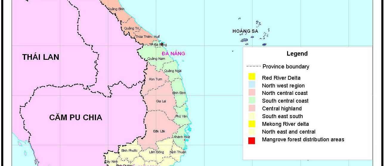
NATIONAL REPORT ON MANGROVES IN SOUTH CHINA SEA VIET NAM 3
Figure 1
Map of mangrove distribution in Viet Nam.
Reversing Environmental Degradation Trends in the South China Sea and Gulf of Thailand
4 NATIONAL REPORT ON MANGROVES IN SOUTH CHINA SEA VIET NAM
Table 1
Distribution of coastal wetland and mangrove areas by provinces and ties along the
coastal zone of Viet Nam.
No Province
Area with
Area without
Brackish water
mangrove forest
mangrove forest
shrimp farming area
Area (ha) %
Area
(ha)
%
Area
(ha)
%
Total
155,290 100 225,394 100
226,075
100
1 Quang Ninh
22,969
14.8 27,194 12.1
14,837
6.6
2 Hai Phong
11,000
7.1 1,000 0.4
5,000
2.2
3 Thai Binh
6,297
4.0 14,526 6.4
2,852
1.3
4 Nam Dinh
3,012
1.9 6,031 2.7
5,800
2.6
5 Ninh Binh
533
0.3
1,084
0.5
200
0.1
6 Thanh Hoa
1,000
0.6
15,848 7.0
1,152
0.5
7 Nghe An
800
0.5
2,137
0.9
1,035
0.4
8 Ha Tinh
500
0.3
8,182
3.6
318
0.1
9 Remaining 10 provinces and
÷
700 0.4
12,368
5.5
cities in the Central part
19
20 Ba Ria - Vung Tau
1,500 1.0 34,360 15.2
1,240
0.5
21 Ho Chi Minh
24,592
15.8 3,180 1.4
2,228
1.0
22 Long An
400
0.2
300
0.1
1,050
0.5
23 Ben Tre
7,153
4.6
9,023 4.0
20,100
8.9
24 Tien Giang
560
0.4
120
0.05
2,148
0.9
25 Tra Vinh
8,582
5.5
22,007 9.8
8,481
3.7
26 Soc Trang
2,943
1.9
6,423 2.8
25,468
11.3
27 Bac Lieu
4,142
2.7 1,411 0.6
20,533
9.1
28 Ca Mau
58,285
37.5
71,718 31.8
92,000
40.7
29 Kien Giang
322
0.2
850
0.4
9,265
4.1
(Source: Ministry of Agriculture and Rural Development, 2001).
1.3
Change in Mangrove Areas
The mangrove area of Viet Nam is recorded in 1943, 1962, 1982 and 2000. During the past 57 years,
the mangrove area of Viet Nam has reduced 253,210ha accounting for 61% of mangrove area in 1943
(Figure 2). The latest data in the year of 2000 shows that the existing mangrove area of Viet Nam is
about 38% compared to mangrove area in 1943. The deforestation of mangrove forest in Viet Nam is
very high. From the recorded data it can be said that average loss of mangrove area during past 57
years is about 4,400ha per year. The chart below shows the changes in mangrove area of Viet Nam.
155,290
2000
1982
252,000
ear
Y
290,000
1962
1943
408,500
100,000 150,000 200,000 250,000 300,000 350,000 400,000 450,000
Area(ha)
(Source: Forest Inventory and Planning Institute, 1995; Forest Science Institute of Viet Nam, 2001)
Figure 2
Chart of changes in mangrove area of Viet Nam, 1943 2000.
Reversing Environmental Degradation Trends in the South China Sea and Gulf of Thailand
NATIONAL REPORT ON MANGROVES IN SOUTH CHINA SEA VIET NAM 5
2. SPECIES
DISTRIBUTION AND FORMATION
2.1
Species Distribution
In a study conducted by Phan Nguyen Hong (1999) on mangrove ecosystems of Viet Nam, 109
mangrove species have been identified belonging to 2 groups:
-
"True" mangrove species group: This group has 37 mangrove species belonging to 20
genuses of 14 families (in 1999, one species added).
-
"Associate" mangrove tree group: This group has 72 species, belonging to 36 genuses of 28
families.
Out of 77 mangrove tree species, "True" mangrove species with wooded stems belonging to
Rhizophoraceae, including 4 genuses: Rhizophora, Buguiera, Ceriops and Kandelia.
For Rhizophora genera, there are 6 tree species in the world, of which 3 species have been found in
Viet Nam:
-
Rhizophora apiculata Bl is widely and naturally distributed in the Southern part, scattered in
south central region, but not naturally distributed in the Northern part of the Central Region,
Red River Delta and North Eastern Part of Viet Nam. Rhizophora apiculata plays a very
important economic and environmental role along the coastal area of the Southern Deltas. Out
of the total mangrove plantation forest area of 96,876ha presently in Viet Nam, then,
Rhizophora apiculata plantation forest occupies 80,000ha (82.6%).
-
Rhizophora mucronata Poir in Lamk only distributed on a limited and scattered area in South
of Viet Nam and not naturally distributed in the North (from 160 North Latitude to 22030 North
Latitude).
-
Rhizophora stylosa Griff most commonly distributed in the North of Viet Nam, but not naturally
distributed or if yes, individual trees are very rarely seen.
For genus of Bruguiera, out of 6 species of Bruguiera found in the world, 4 species existed in Viet Nam
including Bruguiera gymnorrhiza (Lam) distributed widely from the North to the South. There are three
(3) species of Bruguiera genera include:
-
Bruguiera cylindrica (L)
-
Bruguiera sexangula (Lour) Poir in lamk
-
Bruguiera parviflora (Roxb) W. & Am. ex Griff
These three species of Bruguiera are rather commonly distributed in South of Viet Nam, especially
along the coastal areas of Ca Mau peninsular (Mekong River Delta) but not naturally distributed in the
North of Viet Nam.
For genera of Ceriops, 3 species have been found in the world, of which 2 species are present in Viet
Nam and include:
-
Ceriops decandra (Griff)
-
Ceriops tagal (Pers) C.B.Rob. Ding Hou
These species are naturally distributed in a large area along the coastal area of the Delta in the South
and are naturally scattered in the Central Southern part of Viet Nam and not found naturally distributed
in the North of Viet Nam.
For Kandelia genera, there is only one species of Kandelia, i.e. Kandelia obovata (L) Druce. This
species is very commonly and widely distributed in the North of Viet Nam, especially in the North
The Eastern part of Viet Nam and the Northern Delta, but vary rarely distributed naturally in the
coastal area of the Southern Delta.
For Avicenniaceae, there is only one genus of Avicennia distributed worldwide, consisting of 8 species
of Avicennia, of which 4 species are found in mangrove ecosystems of Viet Nam. They play a crucial
role in mangrove ecosystems of Viet Nam after Rhizophoraceae. There are 2 species of Avicennia
which play an important role in sea encroachment, fixing newly built up mud flats along the coastal
area, where deeply inundated with tide and with low tide, i.e.:
-
Avicennia marina (Forsk) Vierh in the North
-
Avicennia abba Bl extensively distributed in the South and in some places where Avicennia
marina exists. This species also contributes to fixation of alluvial sediment and is deeply
inundated during low tide, on the accumulated soil mixed with clay mud.
Reversing Environmental Degradation Trends in the South China Sea and Gulf of Thailand
6 NATIONAL REPORT ON MANGROVES IN SOUTH CHINA SEA VIET NAM
Besides the two above-mentioned species, there existed species of Avicennia lanata Ridl distributed
scatteredly from the South to the North, but not creating into a clear population or association in which
Avicennia lanata Ridl dominated.
Lastly is Avicennia officinalis L. This species is most commonly distributed along the southern coastal
regions in Viet Nam, especially along the Ca Mau peninsular. In addition A. officinalis L has a limited
and scattered distribution within the southern part of the central region. This species is not naturally
distributed in the North of Viet Nam.
Sonneratiaceae has one genera of Sonneratia. There are 6 different genus of Sonneratia in the world,
while 3 of them are present in Viet Nam including:
Sonneratia caseolaris O.K Niedenzu. This species is rather common and widely distributed in the
South, North and Central regions. It grows in bed of alluvial sediment in the estuaries, rich in mud and
clay. This species prefers condition of low salinity, i.e. brackish water whereby the salt level does not
more exceed 20%o and survive in conditions where there is a large annual water salinity variation. For
example salinity in rainy seasons below 5%o and dry seasons up to 20%o.
Sonneratia alba J.Sm in Rees is naturally distributed in the coastal area of the South and South of the
Central region, deposited alluvial bed consisting of rich mud and clay within the estuaries. Water
salinity in these locations has been found to be higher as compared with the distribution of Sonneratia
caseolaris (salinity from 7%o - 27%o).
Sonneratia ovata Backer or Sonneratia acida has a natural distribution scattered along the coastal
areas of the Southern Delta and it is not distributed naturally in the central and the Northern regions.
Myrsinaceae with genera of Aegiceras, of which there are two species of Aegiceras:
- Aegiceras comiculation (L) Bleo is wooded tree in shrub form, usually not exceeding 3 m high.
This species is naturally distributed throughout the North of Viet Nam, especially in the North East
of Viet Nam and in the coastal area of the Red River Delta. According to Le Cong Khanh (Ministry
of Forestry, 1965) Aegiceras comiculation accounts for 54% of the total coastal mangrove area in
the North while in the South it only occupies 2.5% of the total regional mangrove area.
- Aegiceras floridum Roem. et. Schult has highly restrictly natural distribution within Viet Nam.
Recently (1993) Phan Nguyen Hong found a population growing within gravel and sand at Con
Dao in South of Viet Nam.
Finally, there are two genera of mangrove trees belonging to Palmeae or Arecaceae, consisting of 2
genera. Of which Nypa genus has only two species in the world that are Wurmb and Phoenix
paludosa. These two species are also naturally distributed in Viet Nam and have a variety of economic
activities: leaves for house roofing, coconut fruit, and milk for drinking or its liquid for alcohol
production. In addition these species are highly effective at soil erosion and protecting river banks and
canals.
The distribution of Nypa fruticans is concentrated mainly in the Southern Delta with scattered
populations along the southern part of the central region. N. fruiticans is not naturally distributed in the
North of Viet Nam. Details of distribution of "True" mangrove species are shown in Table 2 bellow.
Table 2
Distribution of "True" Mangroves by Regions.
No
True mangroves species
Northern Region
Central Region
Southern Region
Scientific name
Zone I
Zone II
Zone III
Zone IV
Zone V
Zone VI
Family
North
Northern
North
South
East
Mekong
Species
East
Delta
Central
central
South
River Delta
Total "True" Mangrove species
16
14
18
23
32
33
Sonneratiaceae
1
Sonneratia alba J. Sm in Rees
0
0
0
x
x x
x x
2
S. caseolaris OK. Niedenzu
x
x x x
x x
x x
x x
x x x
3
S. ovata Backer 0
0
0
0
X
x
Avicenniaceae
4
Avicennia alba Bl.
0
0
0
x
x x
x x x
5
A. officinalis L.
0
0
0
x
x x
x x x
6
A. marina (Forsk.) Vierh
x x x
0
x x
x
X
x
7
A. lanata Ridl
0 X x x X x
Rhizophoraceae
8
Rhizophora apiculata Bl.
0
0
0
x
x x
x x x
Reversing Environmental Degradation Trends in the South China Sea and Gulf of Thailand
NATIONAL REPORT ON MANGROVES IN SOUTH CHINA SEA VIET NAM 7
Table 2 cont.
Distribution of "True" Mangroves by Regions.
No
True mangroves species
Northern Region
Central Region
Southern Region
Scientific name
Zone I
Zone II
Zone III
Zone IV
Zone V
Zone VI
Family
North
Northern
North
South
East
Mekong
Species
East
Delta
Central
central
South
River Delta
9
R. mucronata Poir. In Lamk
0
0
0
x
X
x
10
R. stylosa Griff
x x x
0
x x
0
X
0
11
Bruguiera gymnorrhiza Lam.
x x x
0
x
x
X
x x
12
B. parviflora (Roxb) W.& Arn. Ex
0 0 0 0 X x
x
Griff
13
B. cylindrica (L.) Bl.
0
0
0
0
X
x
14
B. sexangula (Lour.) Poir. in
Lamk
15
Ceriops decandra (Griff.)
0
0
0
x
X
x x
16
C. tagal (Pers) C.B Rob. Ding
0
0
0
0
x
x x
Hou
17
Kandelia obovata Sheue, Liu &
x x x
x x x
x x x
x
0
x
Yong
18
Kandelia candel (L.) Druce
0
0
0
x
x
x
Myrsinaceae
19
Aegiceras corniculatum L. Blco
x x x
x x x
x x
x
X
x
20
A. floridum Roem.et.Schult 0 0 0 0 0 x
Combretaceae
21
Lumnitzera littorea (Jack.) Voigt.
0
0
0
0
X
x
22
L. racemosa Willd
x x
X
x
x
X
x
23
L. rosea
0 0 x 0 0 0
Euphorbiaceae
TG
24
Excoecaria agallocha L.
x x
x x x
x x
x x
x x
x x x
Meliaceae
25
Xylocarpus granatum Koenig
x X x x X x
x
26
X. mekongensis (Lam) Pierre
0
0
0
0
X
x
27
X. moluccensis (Lamk) Roem
0
0
0
0
X
x
Arecaceae/Palmeae
28
Nypa fruticans Wurmb.
0
0
0
x
x x x
x x x
29
Phoenix paludosa Roxb.
0
0
0
x
x x
x x x
Acanthaceae
30
Acanthus ilicifolius L.
x x x
x x x
x x
x x
x x x
x x x
31
A. ebracteatus Vahl.
x x
x x
x x
x x
x x x
x x
Sterculiaceae
32
Heritiera littoralis Dry and Exh.
x X x x X x
Ait
Rubiaceae
33
Scyphiphora hydrophyllacea Gaertn
x
x
X x x X x
Aizoaceae
34
Seasuvium portulacastrum L.
x X x x X x
Araceae
35
Cryptocoryne ciliata (Roxb.)
0 0 0 0 X x
Scott
Pteridaceae
36
Acrostichum aureum L. xxx
Xx
x
xx
Xx
xxx
37
Acrostichum speciosium
x X x x X x
(Source: Phan Nguyen Hong, 1999; Dang Trung Tan, 2001).
Remarks: 0: Not distributed; x: Distributed; xx: Widely distributed; xxx: Very widely distributed
However it must be noted that the experts of UNEP/GEF of project "Reversing Environmental
Degradation Trends in the South China Sea and Gulf of Thailand" supposed that Xylocarpus
mekongensis was named as Xylocarpus rumphii (Kostel) Mabb and was considered as associate
species.
There are also 2 opinions for Dolichandrone spathacea (L.f) K. Schum belongs to Bignoniacea.
According to Phan Nguyen Hong (1999) this species is considered as true mangrove species. But this
species is considered as associate mangrove species.
For Cynometa ramiflora, Dang Trung Tan (2001) considered as true mangrove species, but in the
second meeting of regional working group on mangroves has agreed that this species is associate
species, therefore Cynometa ramiflora is put into associate species. Acrostichum speciosum is
amended to list of true mangrove species in Viet Nam as research results of Dang Trung Tan (2001).
Reversing Environmental Degradation Trends in the South China Sea and Gulf of Thailand
8 NATIONAL REPORT ON MANGROVES IN SOUTH CHINA SEA VIET NAM
In addition, according to Phan Nguyen Hong Kandelia obovata Sheue, Liu & Yong, Gn has been found
recently in North Central region. As this consequence the total true mangrove species will be 37.
In 1993, Phan Nguyen Hong has made in public a list of "Associate" mangrove species that includes
42 species belonging to 28 families but in recent years, the author and some botanists have added
plant species involving in mangrove forest up to 70 species belonging to 32 families (Phan Nguyen
Hong, 1999).
It has been identified that the development of a set of standard criteria for the addition of new
"Associate" mangrove species should be explored further. Table 3 below shows the list of "Associate"
mangrove species, in which 2 new species are added to.
Table 3
List of "Associate" Mangrove Species and Distribution by Regions.
No Scientific
name
Distribution area
Family
species
Northern region
Central region
Southern region
Total "Associate" mangrove species
36
41
68
Amaryllidaceae
1
Crinum asiaticum L.
xx x
x
Annonaceae
2
Annona glabra L.
xx
x
xx
Apocynaceae
3
Cerbera manghas L.
x x
xx
4
C. odollam Gaertn. x
x
xx
Araceae
5
Aglaodora griffithii (Schott) Schott
0
0
x
6
Lasia spinosa (L.) Thu.
x
0
x
Asclepiadaceae
7
Gymnanthera nitida Wall.
0
0
xx
8
Finlaysonia obovata R. Br
0 0
xx
9
Sarcobolus globosus Wall. 0
x
xx
Asteraceae
10
Pluchea indica (L.) Lees
xxx xxx
xxx
11
P. pteropoda Hemsl x
x
x
12
Wedelia biflora (L.) DC
xxx
xxx
xxx
13
Tridax procumbens L. 0
0
x
Boraginaceae
14
Cordia cochinchinensis Gaertn
0
0
x
Bignoniacea
15
Dolichandrone spathacea
x x
xx
Ceasalpiniacea
16
Cynometra ramiflora
0 0
x
Chenopodiaceae
17
Suaeda maritima
xxx xxx
xxx
Combretaceae
18
Combretum quadrangulare Kurz x
x
xx
19
Terminalia catappa L.
x
x
xx
Convalvulaceae
20
Inpomea pes -caprae (L.) Sw subsp.
xxx xxx
xxx
Brasiliense (L.) Ooststr.
Cyperaceae
21
Cyperus elatus L.
0
0
x
22
C. malaccensis Lam. xxx
xxx
xx
23
C. stoloniferus Vahl. xx
xx
x
24
C. tagetiformis Roxb x
x
x
25
Fimbrystylis ferruginea (L.) Vahl.
0
x
x
26
F. littoralis
0 0
x
27
F. milliacea Vahl. xxx
0
0
28
Scirpus kimsonensis K. Khoi
x
0
0
Euphorbiaceae
29
Glochidion littorale Bl.
x
x
x
Flacourtiaceae
30
Scolopia macrophylla (W.et.A.) Clos.
0
0
x
Flagellariaceae
31
Flagellaria indica L.
xx
xx
xxx
Goodenicaeae
32
Scaevola taccada (Gaertn.) Roxb
xx
x
xx
Reversing Environmental Degradation Trends in the South China Sea and Gulf of Thailand
NATIONAL REPORT ON MANGROVES IN SOUTH CHINA SEA VIET NAM 9
Table 3 cont.
List of "Associate" Mangrove Species and Distribution by Regions.
No Scientific
name
Distribution area
Family
species
Northern region
Central region
Southern region
33
S. hainamense Hance
x
0
0
Guttiferae
34
Calophyllum inophyllum L.
0
0
x
Lauraceae
35
Cassytha filiformis L.
xx
x
x
Lecythidaceae
36
Barringtonia acutangula (L.) Gaertn.
0
0
x
37
B. asiatica (L.) Kurz.
0
0
x
38
B. macrostachya (Jack.) Kurz.
0
0
x
39
B. racemosa (L.) Spreng.
0
0
x
Leguminosae
40
Caesalpinia bonduc (L.) Roxb.
xx
x
xx
41
Instsia bijuga (Colebl.) O. Ktze
0
0
x
42
Canavalia cathartica Du Petit. Thouars
xx
x
x
43
Dalbergia candenatensis (Dennst) Prain.
x x
x
44
Derris trifoliata Lour. xxx
xx
xxx
45
Derris heptaphylla (L.) Merr
0
x
x
46
Pongamia pinnata (L.) Pierre
xx
x
x
47
Canavalia lineata (Thunb.) A.P. de Cand
x
x
x
48
Canavalia maritima (Aubl.) Piper
xx
x
xx
Loranthaceae
49
Dendrophtoe pentandra (L.) Miq
0
x
x
50
Viscum orientale Willd 0
x
x
Malvaceae
51
Hibiscus tiliaceus L.
xxx
xx
xxx
52
Thespesia populnea (L.) Soland.ex.
xx x
xx
Correa
Myoporaceae
53
Myoporum bontioides A. Grey.
x
0
0
Myrtaceae
54
Eugenia jambolana
0 0
x
55
Melaleuca cajuputi Powell
0 x
x
Pandanaceae
56
Pandanus odoratissimus L. xx
xx
xx
Poaceae/Gramineae
57
Cynodon dactylon L. xxx
x
xx
58
Leptochloa fusca (L.) Kunth
x
x
x
59
Paspalum vaginicum Swort
xx
x
x
60
Phramites vallatoria (L.) Vedk.
x
x
x
61
Sporobolus virginicus (L.) Kunth
xxx
xx
xxx
Rubiaceae
62
Guettarda specinosa L.
0
0
x
63
Gardenia lucida Roxb.
0 x
x
64
Psychotria serpens L. 0
x
x
Rutaceae
65
Limnocitrus littorale (Miq.) Sw.
0
0
x
66
Acronychia pedunculata (L.) Miq.
0
0
x
Salvadoraceae
67
Azima sarmentosa (Bl.) Benth. & Hook.
0
0
x
Sterculiaceae
68
Kleinhovia hospita L.
0
0
x
Styracaceae
69
Styrax agrestis (Lour.) G. Don.
0
0
x
Verbenaceae
70
Clerodendron inerme (L.) Gaertn.
xxx
xxx
xxx
71
Premma integritolia L.
xx
xx
xx
Xyridaceae
72
Cayratia trifolia (L.) Domino
0
x
xx
(Source: Phan Nguyen Hong, 1991; Phan Nguyen Hong, 1999; Dang Trung Tan, 1998 & 2001).
Remark: 0: Not distributed; x: Distributed; xx: Widely distributed; xxx: Very widely distributed
Reversing Environmental Degradation Trends in the South China Sea and Gulf of Thailand
10 NATIONAL REPORT ON MANGROVES IN SOUTH CHINA SEA VIET NAM
Research results show that in the North of Viet Nam, there are 17 species of "True" mangrove tree
species out of total 36 "True" mangrove tree species in Viet Nam representing 47% of total "True"
species. While in the South, there are 33 "True" mangrove tree species out of 36 "True" mangrove tree
species in Viet Nam estimating at 92% of total "True" species in Viet Nam.
In the North Eastern coastal area (Quang Ninh province) there are 16 species over 36 species of
"True" mangrove species, accounting for 41.6%, including commonly and very commonly wooded
stem species with important economic value in the region and country such as Rhizophora stylosa,
Bruguiera gymnorrhiza, Kandelia candel. In addition, also there are Aegicennia marina and Aegiceras
comiculatum.
In the coastal area of the Northern Delta there are 14 "True" mangrove tree species out of 36 in total,
representing 36% of total true species, of which there exist wooded stem species which are widely
distributed and of importance in the region and the whole country, i.e.: Sonneratia caseolaris, Kandelia
candel. Besides, there is Aegiceras comiculatum.
In the coastal area of the Northern part of the Central region there are 18 "True" mangrove tree
species out of total 36 species, accounting for 47% of total species, but distributed scatteredly into
small and narrow areas, along river sides, streams, channels along coastal area.
In central South Coastal Region there are 23 "True" mangrove tree species out of total 36 species,
occupying 61% of total species. Although more species are found than three above-mentioned
regions, but scarily distributed in small and narrow areas, along rivers or streams, canals inside
seashores. Here, in some places, the rainfall is very low, less than 1000mm/year, unsuitable for
distribution and growth of "True" mangrove tree species (Ninh Thuan and Binh Thuan provinces).
In the coastal area of Ba Ria - Vung Tau (belonging to the Eastern part of the South), due to
favourable climatic conditions, without winter and alluvial grounds are rather large, therefore, number
of "True" mangrove tree species increases considerably up to 32 species out of 36 species in total,
representing 86%, of which there are wooded stem tree species of large diameter which are of value
for the region and the whole country, i.e. Rhizophora apiculata, Sonneratia caseolaris, Avicennia alba,
Avicennia officinalis and Nypa fruticans .
Attention should be finally given to the coastal area of the Mekong River Delta where existed the
largest mangrove land area of Viet Nam, about 373,305ha, accounting for 61,5% of the total
mangrove land area of Viet Nam with total 82,387ha of existing mangrove area, estimating at 53% of
the total mangrove area in Viet Nam. The climate is warm all year round, no winter, relatively high
rainfall ranging from 1500 mm to 2500 mm/year, with large alluvial grounds and fertile accumulated
alluvium. Here, it is found that number of "True" mangrove tree species is 33 species, representing
nearly 89% of total "True" mangrove tree species of the country. Of which there are wooded stem tree
species, commonly and very commonly distributed, playing an important role in terms of economy and
environment in the Region, such as Rhizophora apiculata, Sonneratia caseolaris, Avicennia alba,
Avicennia officinalis, Avicennia alba, Bruguiera gymnorrhiza, Bruguiera parviflora, Ceriops tagal,
Ceriops decanda, Nypa fruticans, etc.
Regarding respectively to "Associate" mangrove species in Viet Nam up to 72 species belonging to 34
families are found. Their distribution becomes richer and diversified from the North to the South, i.e.:
-
In the Northern region there are 36 species out of 72 species, accounting for 50%;
-
In the Central region there are 41 species out of 72 species, accounting for 56%; and
-
In the Southern region there are 68 species out of 72 species, accounting for 94%.
2.2 Formation
In Viet Nam, Phan Nguyen Hong was recognised as the first person to conduct research on
formations of mangrove communities and his research studies were published in 1970, 1975, 1991
and 1996. Within Viet Nam there is a rich diversity of mangrove communities, of which there are 45
identified communities and 6 distinctive populations. Their regional distributions follow below:
Reversing Environmental Degradation Trends in the South China Sea and Gulf of Thailand
NATIONAL REPORT ON MANGROVES IN SOUTH CHINA SEA VIET NAM 11
2.2.1 North East Coastal Region (Quang Ninh Province)
The main mangrove communities include:
-
Avicennia marina community - pioneer, fixed alluvial flats, deeply inundated when high tide
appears, rich in sand grain, together with grasses of Cynodon deotylon and Suaeda maritima.
-
Aegiceras corniculatum Community - mixed with other species like A. marina and Cyperus
stoloniferus.
-
Bruguiera gymnorrhiza community - dominated by Bruguiera gymnorrhiza mixing with other
species i.e. Rhizophora stylosa, Kandelia candel and Aegiceras corniculatum. They all grow
on the tidally flooded areas when high or medium tides occur.
- Mixed community - codominated species including Rhizophora sylosa, Kandelia candel,
Bruguiera gymnorrhiza, combined with Aegiceras corniculatum. These species naturally
distributed on inundated tidal areas when the tide is at medium level.
-
Excoecaria agallocha community, Lumnitzera racemosa and dominant Xylocarpus grasatum,
combined with Scyphiphora hydrophyllacea, Ileritiera littoralis and Hibiscus tiliaceus, Scaevola
taccada, Cebera odolans, Clerodendrom inerm developed on inundated alluvial areas when
the tidal is high and extremely high within the year, on relatively well developed or fully
developed land.
In addition to the above-mentioned naturally distributed mangrove communities, a number of man-
made communities have been established during recent years along the coastal area of Viet Nam that
include Kandelia candel and Bruguiera gymnorrhiza plantation forest.
2.2.2 Coastal Area of the Northern Delta (Red River Delta)
Main mangrove tree communities include:
-
Sonneratia caseslaris Community - dominated in high layer combining with Acanthus sp,
Cyperus malaensis and Aegiceras corniculatum at lower layer. These species distributed on
rich mud and clay alluvial flats, deeply inundated with high tides raised at estuaries.
- Shrubs
community
-
Aegiceras corniculatum developed and distributed on alluvial flats rich in
sand and mud.
- From estuary of Van Uc (Hai Phong) along the southern coastal line where existed a lot of
tidal mud flats flooded when tide rises, only salt-resisted grasses such as Cyperus
stoloniferus, Cyperus deotylon and Scirpus kimsonensis grow naturally and well develop
attracting many species of water
-
birds like gooses, wild duck, spoon-beaked storks visiting this area for food such as in nature
reserves of Giao Thuy (Nam Dinh province) and Kim Son (Ninh Binh province).
In addition to the above-mentioned naturally distributed mangrove tree communities, in recent years,
in the coastal area of the Northern part of Viet Nam, efforts have been made to establish mangrove
forest in order to protect and prevent from salt water along the coastal area; fix alluvial plains and
encroach further to the South China Sea, i.e.: Man-made Kandelia candel community; Man-made
Sonneratia caseolaris community; Man-made Sonneratia caseolaris community in high layer and
Kandelia candel community in low layer.
2.2.3 Coastal Area of the Central North Region
This region is still affected by the North East monsoon, which carries cold wind from the North. Along
the coastal area where sand dunes are found without mangrove forest distributed. Inundated
communities in the region are only developed along the river banks, near estuaries or inland canals,
streams near the seashores.
Avicennia marina Community combined with salt-resisted grasses like Cyperus stoloniferus, Cynodon
deotylon and distributed naturally on deeply flooded alluvial plains when high tides, along both river
banks near estuaries. This is a permanent and pioneer mangrove tree community on the alluvial plains
with rich sand grains mixed with mud and sand.
Rhizophora stylosa and Kandelia candel codominant community and mixed with some species of
Bruguiera gymnorrihiza and Aegiceras corniculatum on alluvial plains flooded by medium tides.
Reversing Environmental Degradation Trends in the South China Sea and Gulf of Thailand
12 NATIONAL REPORT ON MANGROVES IN SOUTH CHINA SEA VIET NAM
Aegiceras corniculatum dominant community developed on alluvial plains flooded by medium tides.
Aegiceras corniculatum dominated community mixed with some Bruguiera gymnorrhiza and Avicennia
marina distributed on flooded alluvial plains when high tides occur and with less flat topography.
Rhizophora stylosa community distributed on alluvial plains along streams, canals, far from river
mouths, inundated when medium tides take place, and salinity is rather high, less changes in the year
(10 - 25%0) along the coastal area of Quynh Luu district of Nghe An province).
Sonneratia caseolaris community occupies dominantly on high tree layer while at low layer Acanthus
sp and Cyperus malaensis are seen. Community of Sonneratia Caseolaris is in most cases distributed
naturally on alluvial plains, flooded blackish water, near estuaries, even going further to mainland up to
30 - 40km.
2.2.4 Central South Coastal Region
This region extends from the South direction of Hai Van pass up to Ba Ria - Vung Tau belonging to
South of Viet Nam.
This region almost has no winter season, the climate is warm all year round, therefore, number of
mangrove plant species is more abundant than other regions except 2 provinces of Ninh Thuan and
Binh Thuan, and where rainfall is too low, less than 1200mm, unsuitable for distribution of many
mangrove tree species, in the coastal of the Central Southern Part, main communities of mangrove
species are as follows:
- Population
of
Rhizophora mucronata is a pioneer population with fixed alluvial plains, deeply
flooded when high tides and situated in the West of some islands.
- Community
of
Rhizophora mucronata and R. apiculata is dominant, combined with other
species like Bruguiera gymnorrhiza, Bruguiera parviflora and Xylocarpus granatum, distributed
on alluvial areas along the rivers, canals, streams, pretty steep and not flat topography.
- Community
of
Avicennia lanata and Avicennia officinalis developed dominantly mixed with
some secondary species like Scyphiphora hydrophyllaceae, Lumnitzera littoralis, and Ceriops
decandra on alluvial plains flooded when high tides arrive.
- Community
of
Excoecaria agollocha, Xylocarpus sp and Hibiscus tiliaceus, Cerbera manghas
mixed with Scaevola taccada, Heritiera littorallis and Phoenis paludosa, distributed on alluvial
plains to be only inundated by high tides and irregularly high tides in the year.
- Community
of
Sonneratia caseolaris occupies dominantly on high tree layer mixed with
Acanthus sp and Cyperus malaensis, Derris trifoliata, Flagellaria indica on lower layer.
2.2.5 The Coastal Area of Ba Ria - Vung Tau Ho Chi Minh City
This area has been built up by sediments of the system of Dong Nai and Sai Gon rivers, with fairly
large alluvial flats, alluvium with rich mud and clay, warm climate all year round, no winter season, no
typhoons, rather favourable for mangrove trees growing. In this area, the mangrove communities and
populations are identified as follows:
- Population
of
Sonneratia alba is population of pioneer mangrove trees, fixed on new alluvial
grounds, deeply submerged, when high tides, in some places mixed with some trees of
Rhizophora mucronata like along Soai Rap River.
- Community
of
Rhizophora apiculata and Sonneratia alba distributed on alluvial grounds
flooded by tides and with rather sustainable land sources.
- Community
of
Rhrizophora apiculata, Ceriops tagal and Avicennia alba distributed on alluvial
grounds flooded with medium water level when tide rising.
- Community
of
Rhrizophora apiculata, Ceriops tagal and Aegiceras officinalis, Ceriops
decandra. In addition, it is found that Xylocarpus granatum and Xylocarpus moluccensis
distributed on alluvial grounds to be flooded when high tides arrive.
- Community
of
Excoecaria agollocha and Phoenis paludosa, mixed with Xylocarpus
moluccensis, Heritiera littorallis, distributed on alluvial plains to be only inundated by high tides
and irregularly high tides in the year.
Reversing Environmental Degradation Trends in the South China Sea and Gulf of Thailand
NATIONAL REPORT ON MANGROVES IN SOUTH CHINA SEA VIET NAM 13
In the brackish water area of the estuaries in this region where main mangrove tree communities and
populations are seen as follows:
- Population
of
Sonneratia caseolaris is a population of pioneer and permanent mangrove trees
in the alluvial grounds of blackish water estuaries and deeply inundated areas.
- Community
of
Nypa fruticans and Cryptocoryne ciliata, Acanthus sp and Cyperus malaensis
distributed on the alluvial grounds of blackish water estuaries and flooded when tides rise at
medium height.
- Community
of
Dalbergia candenatensis, Hibiscus tiliaceus and Thespesia populnea and
Clerodedron inerme, Pluchea indica distributed on high alluvial plains to be only inundated by
high tides and irregularly high tides in the year.
According to Vien Ngoc Nam (2002), apart from this, in the region, in recent years, many populations
of mangrove trees have been established, especially in the World Biosphere Reserve in Can Gio
belonging to Ho Chi Minh City recognized by UNESCO. Additional plantation forest has also been
established including:
- Population
of
Rhrizophora apiculata planted on an area of 21,000ha;
- Population
of
Rhizophora with area of 68 ha;
- Population
of
Rhizophora candel with area of 3 ha;
- Population
of
Nypa fruticans with area of 28 ha;
- Population
of
Avicennia sp with area of 18 ha;
- Population
of
Xylocarpus granatum with area of 19 ha.
2.2.6 Coastal Area of Mekong River Delta
This area has been created by sediments of Mekong River system, which has the highest water
current and content of alluvium in Viet Nam. Large and fertile alluvial plains, very favourable climate
for the growth and distribution of mangrove trees. In the region there are 33 "True" mangrove tree
species, accounting for 89% of total "True" mangrove tree species of Viet Nam. The followings refer to
the mangrove communities and populations in main estuaries and the Camau peninsula in the
southern region.
In in estuary of Tien River (Ba Lai) there are the following populations and communities:
- Population
of
Sonneratia alba, dominated on alluvial, salty, narrow and mud areas, outside of
the estuaries.
- Community
of
Avicennia alba, Sonneratia alba together with other species like Rhizophora
mucronata, Bruguiera parviflora growing scatteredly. This Community is distributed inside
pioneer population of Sonneratia alba developed on alluvial ground to be flooded when
medium tides arriving.
- Community
of
Lumnitzera racemosa, Xylocarpus granatum occupied dominantly, mixed with
Ceriops tagal, Ceriops decandra, Avicennia lanata and distributed on alluvial flats to be flooded
only when having high tides.
- Community
of
Excoecaria agollocha, Hibiscus tiliaceus, occupied dominantly, mixed with some
species like Thespessia populnea, Phoenis paludosa and Sesuvium portulasstrum distributed
on high alluvial grounds and less flooded by tides.
- Mangrove trees populations and communities in estuaries of Cua Dai, Cua Tieu and Ham
Luong belonging to Tien River (Cuu Long River).
- Mangrove trees populations and communities in estuaries of Co Chien River
The following populations and communities have been identified as bellows:
- Population
of
Avicennia alba develops strongly on weak alluvial ground, with relatively high
salinity and not many changes in the year.
- Community
of
A. alba and A. officinalis
- Population
of
Sonneratia alba as pioneers on alluvial ground with a wide range in salinity
between the dry season and the rainy season.
- Community
of
Rhizophora mucronata mixed with R. apiculata and Ceriops decanda distributed
on alluvial ground, inundated by medium tides.
- Mangrove tree populations and communities in coastal area of Ca Mau Peninsular.
Reversing Environmental Degradation Trends in the South China Sea and Gulf of Thailand
14 NATIONAL REPORT ON MANGROVES IN SOUTH CHINA SEA VIET NAM
This is a sediment area, which operates vigorously in the Mekong River system, with low and large
alluvial flats, rich in mud, clay and nutrients. Salinity of the water is suitable for mangrove trees to be
distributed and growing and salinity has little change in the year. In this region, there are communities
and populations of main mangrove trees as follows:
- Population
of
Avicennia alba as pioneer on permanent alluvial soils with rich mud and clay.
- Community
of
A. alba and Rhrizophora apiculata distributed on alluvial soils flooded by low
tides.
- Population
of
Rhrizophora apiculata distributed on alluvial flats and be inundated by medium
tides.
- Community
of
Rhrizophora apiculata, Bruguiera parviflora distributed on alluvial soils and be
flooded by medium and high tides.
- Population
of
Bruguiera parviflora distributed on alluvial grounds that are flooded when
medium and high tides occur.
- Community
of
Rhrizophora apiculata and Ceripos decanda in low layer, on fairly well
developed alluvial plains and is flooded during having high tides.
- Community
of
Rhrizophora apiculata and Rhizophora mucronata distributed on alluvial flats
along the rivers, deeply flooded with water (not large area).
- Community
of
Lumnitzera racemosa and Ceriops tagal usually grow on high alluvial flats, with
rather tight soil and irregularly flooded by tides.
- Community
of
Excoecaria agollocha mixed with Acanthus ilicifolius, grow on high and well
developed soil and being less flooded by tides.
Besides, there is a community of Avicennia marina mixed with A. officinalis and Excoecaria agollocha,
distributed on alluvial flats with abundant sand and mud, be flooded when tides are high and medium.
Community of Nypa fruticans mixed with Acanthus ilicifolius at lower layer, distributed naturally along
the rivers, canals, channels and interior fields.
In addition to the above natural communities and populations, in Ca Mau peninsular area and Mekong
River Delta where population of mangrove trees have been established by people such as population
of Rhizophora apiculata, population of Sonneratia caseolaris and man made secondary communities,
i.e. community of Phoenix paludosa mixed with Acanthus ilicifolius after exploitation of mangrove
forest.
3.
ENVIRONMENTAL AND BIOLOGICAL STATES
3.1 Physical
Factors
3.1.1 Climatic Conditions
Temperature regime
The coastline of Viet Nam has a length of 3260 km, extending from Ca Mau (South Viet Nam) at 8025'
North Latitude to Mong Cai (North Viet Nam) at 25050' North Latitude, a length of over 14 latitudes.
Generally, the entire coastal area of Viet Nam lies within the tropical belt with annual average
temperature ranging from 22.7 0C (in Mong Cai) to 27.6 0C (in Rach Gia Kien Giang). The climate
within coastal Viet Nam exhibits tropical humid characteristics with two relatively distinctive climatic
zones.
Northern Viet Nam
From the latitude of160 North (North of Hai Van pass) to 22050' North (Mong Cai). This area locates in
the transitional location of two climatic belts, i.e. tropical and sub-tropical, and heavily influenced by
monsoonal regime belonging to the South East Asia where a complicated rotation of atmospheric
pressure from the equator, tropics and North Pole converges. Therefore, there are two distinct
seasons for this area. Summer season is hot with much rain, from May to October. Winter season is
cold with less rain. However, in winter, usually no hoarfrost appears and not seriously lacking of water
for crops) lasting from November to April. Every year, North East wind occurs 20 up to 25 times which
carries cold wind from the North. Averagely in one month of winter, there are 3 up to 5 turns of
appearance of North East moonsoon. When the North East wind arrives that makes the temperature
suddenly drop to about 40 to 50C and sometimes down to 100C.
Reversing Environmental Degradation Trends in the South China Sea and Gulf of Thailand
NATIONAL REPORT ON MANGROVES IN SOUTH CHINA SEA VIET NAM 15
The North Easterly winds blow along the country from the North to the South and significantly
influences the temperature along the coastal areas at different latitudes. This type of weather pattern
differs from that experienced by neighboring tropical countries located on the same latitudes.
South of Viet Nam
Between Hai Van Pass (160 North latitude) to Ca Mau peninsular (8025' North latitude). The climate is
less influenced by the North East monsoon. To the southern Delta the influence of this moonsoon is
minimal and is characterized by monsoon tropics, near equator with total annual average temperature
of 9000-10,0000C and annual average temperature is relatively high, between 26 - 270C.
In the South, there are two distinct seasons: rainy season and dry season. The rainy season begin in
May and last until October whereas dry season commences in November and last until the end of
April. The temperature variation between months is very low ranging from 30C to 50C and the daily
temperature difference is only about 10C. Table 4 shows Annual changes in temperature regime by
Regions in Viet Nam.
Table 4
Annual changes in temperature regime by Regions in Viet Nam.
Number of months in the year have
Part Regions
temperatures
< 200C 20-250C >250C
North East Region (Quang Ninh province)
5 months
2 months
5 months
North Viet Northern Delta
4 months
2 months
6 months
Nam
Central North Region
2-3 months
2-3 months
9-10 months
Central South
0 month
3-5 month
7-9 month
South Viet Ba Ria Vung Tau (South Eastern part of
0 month
0 month
12 month
Nam
the South) Ho Chi Minh City
Mekong River Delta
0 month
0 month
12 month
(Source: General Department of Hydrology and Meteorology, 2000).
Scientists who research on physiology if mangrove trees all have assumed that atmospheric
temperature from 250C to 280C are very suitable for the growth of mangrove trees. Therefore, the
temperature regime in the South of Viet Nam remains through the year round (12 months); it is very
suitable for the growth and distribution of coastal mangrove trees.
Rainfall
Viet Nam is situated along the eastern seaboard of the Asian continent, adjacent to the Eastern Sea
and falling within the tropical belt. The long 3,260km coastline forms a type of ocean influenced
climate where there is high annual rainfall and humidity. Generally, the coastal areas of Viet Nam have
rather high annual average rainfall ranging from 1,800mm to 2,500mm/year (see Table 5). However,
there are also some localities with low rainfall of below 1,500 mm/year like Vung Tau (1,357mm/year)
or with very low rainfall, i.e. under 1,200mm/year, e.g. Ninh Thuan and Binh Thuan provinces (total
annual rainfall is 794mm/year) and Phan Thiet province (total annual rainfall is 1,152mm/year). The
low rainfall influences significantly the distribution of mangrove forest.
Table 5
Changes in annual rainfall between coastal areas.
S.N
Region
Annual rainfall (mm/year)
1
North East (Quang Ninh province)
2016 - 1749
2
Northern Delta
1757 - 1865
3
Central North
1944 - 2867
4
Central South
1152 - 2290
5
Ba Ria Vung Tau (South East South) and Ho Chi Minh City
1357 - 1684
(Vung Tau), (Can Tho)
6
Mekong River Delta
1473 - 2366
(Source: General Department of Hydrology and Meteorology, 2000).
Mangrove trees distributed in the Northern hemisphere develop well in the locations having relatively
high rainfall, from 1,800 to 3,000mm/year. In Viet Nam, there are 3 regions: North East, Northern Delta
and North central where annual rainfall range from 1,757 to 1,867mm which is very favorable for the
growth of mangrove trees. In addition, the Ca Mau Peninsular has annual rainfall varying from 1,800 to
2,366mm also very suitable for the growth and distribution of mangrove trees. Especially, this region
Reversing Environmental Degradation Trends in the South China Sea and Gulf of Thailand
16 NATIONAL REPORT ON MANGROVES IN SOUTH CHINA SEA VIET NAM
with a very suitable temperature, fertile and large coastal wetland area, therefore, it becomes a good
place where many types of mangrove trees distribute and provide a high production of timer i.e.
Rhrizophora apiculata growing in natural Rhizophora forest, at the age of 60, it can reach a diameter
of 1.3m and height of 28m. The timber productivity of Rhizophora apiculata plantation forest averages
between 8m3-12m3/year and occasionally as high as 13,5m3/year. On contrary, in the localities where
the annual rainfall is under 1,200mm. the mangrove forest seem not to be appeared or if any the forest
are in poor growth.
3.1.2 Water Temperature
Coastal North East Region(Quang Ninh)
Water temperature is affected by the cold winter climate. During the winter, the temperature may drop
down to 100C, however along the coast of Quang Ninh, the water surface temperature ranges from 15
to 180C. Seawater temperature e.g. Luc estuary as low as 120C on some days. Seawater temperature
gradually increases from the water surface to deeper water varying between 1 and 20 C. In summer,
average temperature of the surface water ranges from 28-300C and the temperature gradually reduces
from the surface water to deep water level. Its difference is from 2-30C. This justification resulted from
pilot planting of Rhizophora apiculata trees in this area, Rhizophora apiculata trees died after 1 to 2
cold winter seasons.
The Red River Delta
The influence of the above mentioned North East moonsoonal wind is less profound at the Red River
Delta, however, a cold winter wind continues to blow for the three months of December to February.
During this time the average monthly seawater temperature close to the shore is under 20OC, varying
between 17.90C and 19.50C. From the March to November (Remaining nine months) the average
seawater temperature is always higher than 20OC and varies between 21.4 and 28.60C. The coldest
average seawater temperature of about 17.9OC is in the month of January and conversely, the
warmest average seawater temperature is in June, about 28.6OC.
Central North Region
Influence of the North East moonsoonal wind becomes minimal and in this region it is not very cold
during the winter. About 1 or 2 months in the year, normally during December and January, seawater
temperature is lower than 200C.
The Central South Region
There is no distinctive winter climate within this region and the influence of the North East monsoonal
wind is negligible. The average seawater temperature throughout the year is higher than 20OC, which
provides ideal conditions for Rhizophora trees to grow naturally along the coastal mangrove land.
The Ba Ria - Vung Tau and the Mekong River Delta Region.
This region is characterized by a typical tropical equatorial climate where the mean monthly
temperature in all months of the year is higher than 250C, thus, the average seawater temperature is
always higher than 250C, varying from 26.50C (in September) as the lowest water temperature in the
year, to 30.7OC (in March) which has the highest water temperature in the year. Here, different
mangrove types are abundant and grow very well in Viet Nam.
3.1.3 Hydrological Characteristics
River system
The total average annual water rainfall volume of Viet Nam is approximately 630km3 . The network of
rivers and streams is quite dense and if drainage lines whose length has more than 10 km were
considered, Viet Nam would have almost 2,500 streams and rivers. Density of river network varies
from 0.5 to 2km/km2.
The rivers and streams annually discharge between 800-900km3 of water into the South China Sea. If
outside water volume discharges into Viet Nam is not included, then water volume derived from
territory of Viet Nam is about 300km3 of water (Nguyen Viet Pho, 1984).
The two largest rivers in Viet Nam are Mekong and Red Rivers. They discharge approximately 70% of
the country's total water volume from their catchment systems.
Reversing Environmental Degradation Trends in the South China Sea and Gulf of Thailand
NATIONAL REPORT ON MANGROVES IN SOUTH CHINA SEA VIET NAM 17
Tide
The driving force and highly important element in formation of mangrove ecosystem is tide. Along the
coast of the South China Sea of Viet Nam, there are 4 different types of tides i.e. diurnal tide, semi-
diurnal tide, irregular diurnal tide and irregular semi-diurnal tide. Irregular diurnal tide and irregular
semi-diurnal tide is produced by a mixture of diurnal and semi-diurnal tide where either on variety exits
more dominance than other at that location.
Pure diurnal tide area may be clearly observed along the coast from Mong Cai (Quang Ninh province)
to Do Son (Hai Phong). In this area, tide range is the greatest in Viet Nam ranging from 4.0- 4.5m. In
one day and night, there appears one time of leap tide and one time of ebb tide.
In addition, Northern Delta area experiences a diurnal tide regime, however tide range gradually
reduces from Do Son to Ninh Binh, with tide ranging from 3.2 to 3.6m. Within one year there are more
than 165 days where high tide exceeds 3 m. In this region the tide is most active yearly in December,
January, June and July.
In the Central North area tidal patterns are rather complicated. From Thanh Hoa to Ha Tinh an
irregular diurnal tide regime occurs and from Ha Tinh to Hue an irregular semi-diurnal tide regime
appears. From Thanh Hoa to Hue, tide range gradually reduces in height, from 3.0 m to Thuan An (the
lowest tide range in Viet Nam) where there is only 0.5-0.7m range.
In Central South Area, the tidal regime changes from irregular semi-diurnal tide (Quang Nam Da
Nang) to irregular diurnal tide (Nghia Binh-Phu Khanh) and then from Phu Thanh to Thuan Hai returns
to irregular semi-diurnal tide with a gradually increased tide range of 0,7-2,5m
In the South East South (Ba Ria-Vung Tau) and Can Gio (Ho Chi Minh City), tidal regime is semi-
diurnal and has a relatively high tide range, from 3.6- 4.0m. In one day and one night, there are 2
times of leap tides, one incomplete tide and one main tide is higher. In the year the highest tide range
appears in September, October, November and December and the lowest tide range occurs in May
and June.
The Mekong River Delta coastal area experiences semi-diurnal tidal regime where tide ranges from
2.0-3.0m. The speed of tide during leap tide is 6.9m/s. Especially in the Western part of Ca Mau
peninsular, from Bay Hap estuary (Ca Mau province) to Ha Tien (Kien Giang province) the tidal regime
changes its partern to diurnal tide regime with low tide range varying between 0.7 and 1.0m. In
addition, from Dat Mui area to Bay Hap estuary of Ca Mau province where experiences a mixture of
semi-diurnal tide and diurnal tide (transitional area).
The influence of rivers within the North Eastern coastal area (Quang Ninh province) is minimal. During
the rainy season, the volume of water pouring into the sea contributes between 20-40% of the total
volume of water near the shore and during the dry season this drops to between 5-10%. Sediments
derived from river water is low, therefore, the dominant driving force behind the formation of tidal flats
is the daily rise and fall of tides. This process creates the formation of tidal flats with very dense
branched canals perpendicular to the coastline. The influence of the tide has increased 40,000ha of
high tidal flats where mangrove forest have colonized and over 27,000ha of low tidal flats which are
ideal environment for the development of fishery products (i.e. brackish and salty water fishery
farming) of high economic value.
Sea waves
Estuaries and tidal flats along the coastal areas of Viet Nam are strongly affected by coastal sea
waves. Coastal sea waves in Viet Nam tend to be influenced by two seasons in the year: Rainy
season from April to September dominated by North East waves and during the dry season from
October to March dominated by South East waves. Waves from the Sea traveling to the seashore
usually have an average height of 1.5 to 2.5m. During the days of the formidable seas and strong
North East monsoonal wind, the sea waves may reach between 3.0-4.0m. During the typhoons take
place the sea waves along the coastline vary greatly rising between 4 to 6m and even higher than 7m.
In Viet Nam, there are on average between 4-6 storms which more towards the mainland, with wind
speed of 20-40m/s. Storms cause great impact on the existence of coastal mangrove forest and
destroy sea dyke system where no mangrove protection forest exist. Only along the coastal area of
Southern Delta area where storms rarely occur.
Reversing Environmental Degradation Trends in the South China Sea and Gulf of Thailand
18 NATIONAL REPORT ON MANGROVES IN SOUTH CHINA SEA VIET NAM
A notable exception to the above mentioned process is the coastal area of Quang Ninh (North East of
Viet Nam) with a coastal length of more than 250 km. 2077 islands and limestone mountains rise out
of the sea near the seashore and create a closed bay. As a result, the waves arriving on the shoreline
become rather calm while wave height averages at 0.5m. 85.4% of the time the sea conditions are
calm. Table 6 represents Wind Direction and Speed and Seawave Range in the Red River Delta (Hon
Dau Observation Station); and Table 7 shows Prevail seawave Direction and Ranges in the Western
Part of Ca Mau Peninsula.
Table 6
Wind Direction and Speed and Seawave Range in the Red River Delta (Hon Dau
Observation Station).
Month
Wind
Ranges of seawave (m)
Prevail direction
Speed (m/s)
Average Max
Average Max
JAN
North East - East
4.5
24
0.66
1.9
FEB East
4.8
20
0.68
2.2
MAR
East South East
4.1
28
0.65
2.2
APR
East South East
4.9
28
0.72
2.8
MAY
East South East
5.7
40
0.83
2.4
JUN
South South East
5.9
34
0.80
2.2
JUL
South South East
6.1
40
0.92
5.6
AUG
South South East
4.8
45
0.70
5.0
SEP
North East - East
4.8
45
0.66
4.2
OCT
North East - East
5.1
28
0.75
2.3
NOV
North East - East
4.9
24
0.69
2.0
DEC
North East - East
4.8
30
0.65
2.0
Table 7
Prevail seawave Direction and Ranges in the Western Part of Ca Mau Peninsula.
Seawave rangs (m)
Month Prevail
seawave
direction
Average Max
JAN
East North East
0.80
1.80
FEB
East North East
0.95
2.00
MAR North
East
1.10
2.30
APR
East South East
0.80
2.00
MAY
West South West
0.85
3.00
JUN
West South West
0.95
4.00
JUL
West South West
0.95
4.00
AUG
West South West
0.90
3.50
SEP
West South West
0.90
3.50
OCT
West South West
0.85
3.00
NOV North
East
0.92
2.50
DEC
East North East
0.92
2.50
Anunual average
0.91
4.00
Oceanic water current
Currents of water in the Ocean also have a great impact in distribution of mangrove tree species along
the coastal area of Viet Nam.
The South West monsoon brings water currents from Indian Ocean through Indonesia and Malaysia to
the coastal area of South Viet Nam, therefore, the composition of mangrove trees within the Mekong
River Delta is similar to mangrove tree species in South East Asian countries, e.g. Rhizophora
apiculata, Rhizophora mucrosata, Bruguiera parviflora, Bruguiera cylindrica, etc.
The water current along the coast flowing from the South to the North of Viet Nam, up to 12o North
latitude then to the Sea. While in the North where the coastal water current runs from the North to the
South or from the North East to South West and down to 12o North latitude. Therefore, the difference
of the composition of mangrove plant species between two parts of Viet Nam is clearly seen. In
addition to climatic conditions, there is impact of coastal oceanic water current.
Reversing Environmental Degradation Trends in the South China Sea and Gulf of Thailand
NATIONAL REPORT ON MANGROVES IN SOUTH CHINA SEA VIET NAM 19
3.1.4 Salinity of Coastal Seawater
The North East region (Quang Ninh province)
Salinity of coastal seawater is rather high and varies slightly in the year. Salinity of seawater in rainy
season is about 20% and in dry season about 30%. In the locations close to the estuaries, the salinity
may reduce and varies widely, about 10% in rainy season and 25% in dry season. However, this
fluctuation occurs in small area.
The Red River Delta region
Salinity of water in the river mouth areas has a small change. In Van Uc estuary, the salinity varies
between 1.0 % in rainy season and 11% in dry season. In Ba Lat estuary it ranges between 1.1% in
rainy season and 13.8% in dry season.
Salinity of water in coastal alluvial flats varies rather clearly. In Do Son, the salinity changes from
16.4% in rainy season to 27.5% in dry season. In Thuy Anh it fluctuates between 10.5% in rainy
season and 20.7% in dry season. In Van Ly water salinity is between 20% in rainy season and 30% in
dry season.
The Central Coastal Region
Salinity of seawater differs relatively greatly between seasons. Salinity of seawater in Lach Truong
(Thanh Hoa province) ranges from 10.3% in rainy season to 20.4% in dry season. In Thuong estuary
of Thua Thien Hue province it is 13.23% in rainy season and 20.5% in dry season. In Cau Hai
lagoon (Hue) the salinity differs between 5%- 23% in rainy season and 20%o - 33% in dry season.
The Ba Ria Vung Tau Can Gio Region
Coastal seawater has a relatively high salinity and fewer changes throughout the year. In rainy
season, water salinity ranges from 12 to 18% and in dry season, water salinity varies from some 20 to
30%.
The Mekong River Delta Region
Salinity of water has a big difference between seasons. Water salinity in Tien estuary in rainy season
is between 1%- 4% and in dry season it is 18-20%. In the place far from estuary (forest enterprise of Thanh
Phu, Ben Tre province) water salinity is from 7% to 12% in rainy season and from 20% to 24% in dry
season. In Ca Mau peninsular (Ca Mau province) salinity of coastal seawater is fairly high and has a
small fluctuation throughout the year. In rainy season, water salinity ranges between 19% and 23% and
between 26% and 31% in dry season.
3.1.5 Suspended solid particles
North East Region (Quang Ninh province)
All estuaries in this region have low water flow and there are approximately 30 rivers and streams
whose length is over 10km. The annual water flow of these rivers is very low, ranging from 3.07-
23.5m3/s. The distribution of rivers along the coastline is highly dense, in some places a river mouth
may be found every 4 to 5 km along the coastline. However the total volumetric discharge into the sea
within the Quang Ninh province is small, with approximately 6.56 billion m3 of fresh water/year.
During the dry season, the suspended solid particle content is measured at 3.5g/m3 and hence the
water is rather clear. Where as during the rainy season, this content only increases to a maximum of
189g/m3.
The suspended mud and sand content in water at Ha Coi (Tien Yen Quang Ninh) ranges from 5-
10g/m3 in dry season to10 - 50g/m3 in rainy season. At Sa Bach Dang this content is higher with 10-
30g/m3 in dry season and between 50-120g/m3 in rainy season.
The Red River Delta Coastal Region
Water turbidity in Red River estuary varies greatly from that within the North East region. The
suspended solid content in the water at Ba Lat estuary is 44.3g/m3 in dry season and 1,400g/m3 in
rainy season. In the Tra Ly estuary is 30.67g/m3 in dry season and 1,050g/m3 in rainy season. Finally
in the Van Uc estuary this content is 359g/m3 in dry season and 876g/m3 in rainy season.
Reversing Environmental Degradation Trends in the South China Sea and Gulf of Thailand
20 NATIONAL REPORT ON MANGROVES IN SOUTH CHINA SEA VIET NAM
Generally, the suspended solid content along the coastal area of Red River Delta Region in dry
season is between 50-100g/m3 and during the rainy season, this content increases to 200 or
sometimes to as high as 500g/m3.
The Central Coastal Region
Within this region, the suspended solid particle content in the water during the dry season is very low,
about 5-10g/m3. During the rainy season, this content increases to between 20 -100g/m3. As a result,
coastal seawater in Central Region is clear all year round.
The Ba Ria - Vung Tau - Can Gio Region (South Eastern Part of the South)
At Dong Nai River mouth, suspended solid particle content in the water ranges from 10-20g/m3 during
dry season and about 40-100g/m3 in the rainy season. Generally, the suspended solid particle content
at Dong Nai River mouth is not high.
The Mekong River Delta Coastal Region
Within the Mekong estuaries the suspended solid particle content in the water is between 10 -50g/m3
during the dry season and increases to around 80 -150g/m3 in the rainy season. At the Ca Mau
peninsular area (observation at 11 different localities throughout over the region), during dry season
(measured in April 2001), the suspended solid particle content in the water ranges from 200g/m3
(Genh Hao) to 423g/m3 (Bay Hap estuary). During the rainy season, from July to October, this content
at Genh Hao River is 25.6-447g/m3 and at the Cua Lon River is between 342-550g/m3.
So, within the Ca Mau peninsular region, sea water near the seashore is always muddy, the content of
alluvial material in the water is rather high and there is very little difference between the dry season
and the rainy season.
3.1.6 Particle Composition of High Tidal Flats
Other than the Ca Mau peninsula which has the highest clay content of 56-60% in its deposited
sediment. The clay content found in the deposited sediments of the Thai Binh River and the Bach
Dang estuary is about 15 - 30%. This content is between 15-25% in the Dong Nai estuary, in the Cuu
Long River is 12 -22% , in the Red Rriver mouth is10-15% and the lowest clay content found in the
estuaries of Central coastal region, less than 1%.
The rivers of the Central region of Viet Nam have the highest sand content deposited within its
sediments, with between 80-95%, this is followed by the rivers of North East region (Quang Ninh
province), about 12-15%; the Red River, about 6-10/%; the Mekong River, between 5-10%; and the
lowest being the Dong Nai River, about 2.5-10% and the Thai Binh river (Bach Dang estuary) at
between 3-12%. Table 8 shows Particle composition of surface sediments of high tidal flats of
estuaries in Viet Nam.
Table 8
Particle composition of surface sediments of high tidal flats of estuaries in Viet Nam
(Mean value calculated).
Particle class, mm (%)
Areas of estuaries
> 0.05
0.05-0.01 (fine
0.01-0.005
0.005-0.001
< 0.001 (clay)
(sand)
sand)
(silt)
(fine silt)
Tien Yen Ha Coi
12-18
15-25
15-28
20-30
10-25
Bach Dang ( Thai Binh River)
3-12
10-22
20-30
25-32
15-30
Red River
6-10
15-25
15-25
20-25
10-15
Central rivers of Viet Nam
80-95
5-10
1-3
<1
<1
Dong Nai River
2.5-10
12-20
25-30
25-35
15-25
Cuu Long River
5-10
12-25
15-30
20-28
12-22
(Source: State Sea Programme KT03, 1995).
3.2 Chemical
Factors
3.2.1 Chemical Characteristics and Nutrient Contents (N, P)
pH value of water
Generally, water has neutral reaction or almost neutral reaction during the rainy season whereas in
the dry season, pH value of water may increase up to 7 and in some places the pH of water may be
lightly alkaline of pH = 8.04 (Red river estuary). Seawater along the coastal area of the Central region
usually has pH higher than other regions, although not much.
Reversing Environmental Degradation Trends in the South China Sea and Gulf of Thailand
NATIONAL REPORT ON MANGROVES IN SOUTH CHINA SEA VIET NAM 21
Dissolved N (mg/liter)
The location with the highest content of dissolved N is along the coast of Ba Ria - Vung Tau - Can Gio
where there is about 0.585 1.170mg/litre. The most likely explanation for this may be wastewater flowing
downstream from Ho Chi Minh City. Following is the Red River estuary and the lowest content of
dissolved N found along the coast of the Mekong River Delta, ranging between 0.108- 0.284mg/litre.
Dissolved P (mg/liter)
Generally, the content of P dissolved in water is quite low and there is small variation between
regions.
The data from the study of pH, N and P along the coastal region of Viet Nam is described in the Table
9 below:
Table 9 Chemical characteristics and content of the nutrients of N, P dissolved in water along the
tidal flats of the coastal regions of Viet Nam.
Dissolved N
Dissolved P
S.N Regions
pH
(mg/litre)
(mg/litre)
1
North East (Quang Ninh)
6.85-7.33
0.121-0.514
0.008-0.010
2
Red River Delta
7.68-8.04
0.225-0.268
0.001-0.009
3
Central
Coastal
6.90-7.90 0.100-0.320 0.001-0.005
4
Ba Ria - Vung Tau - Can Gio
6.62-7.48
0.585-1.170
0.032-0.073
5
Mekong River Delta
6.80-7.30
0.108-0.284
0.002-0.005
(Source: Forest Science Institute of Viet Nam, 2001; State Sea Programme, 1995).
3.2.2 Percentage of Nutrient Contents (N, P, C ,S)
Content C,% (organic)
It is generally low, some localities in the North West of Viet Nam and Ba Ria Vung Tau record a
medium value of 2.8-3.0%.
Content N,% (total)
Generally, deposited materials along the coast of Viet Nam all have a medium level of N content.
Some localities in the Ba Ria-Vung Tau and North East of Quang Ninh province have a higher content
of Nitrogen, about 0.25%.
Content P2O5, %(total)
Sediments of the Red River have P2O5 total content (%) of highest, followed by those of the Mekong
River. The poorest in P2O5 total content is sediments along the cost of the Ba Ria-Vung Tau and North
East of Viet Nam as the sediments in these regions formed by humid tropical weathered products.
Content Sulfur, %
The percentage content of Sulfur contained within deposited sediment materials of the tidal flats varies
distinctively between regions. The tidal flats in North Eastern Viet Nam and the Ba Ria-Vung Tau have
the highest sulfur content. In these regions the weathered sediments are rich in Fe2O3 and Al2O3 and
accumulated sulfur at levels between 1.0 and 4.5%. Comparatively, the Mekong River Delta and the
Red River Delta have sulfur content between 0.20-1.0%. This characteristic has explained rather
clearly about the forces of formation of potential sulfate mangrove land in the coastal area of Viet
Nam.
3.3
Mangrove Biodiversity in Viet Nam
Viet Nam has so far no systematic researches on bio-diversity of mangrove ecosystems, therefore, the
below summary only derive from separate research documents carried out in individual region or
coastal ecological areas by many authors. As non-identical research methodology used in different
researches, thus, the collected data should be regarded as for references.Table 10 below lists out
biodiversity by geographical distribution areas in Viet Nam.
Reversing Environmental Degradation Trends in the South China Sea and Gulf of Thailand
22 NATIONAL REPORT ON MANGROVES IN SOUTH CHINA SEA VIET NAM
Table 10
Biodiversity at different ecological regions along the coastal area of Viet Nam.
Mangrove
Plankton Zoobenthos
trees
s
n
n
ecies*
n
a
h
Regions
a
t
iles
ankto
imals
ankto
Fis
Birds
t
al sp
r
ue
Rep
An
o
T
T
Associate
oopl
Mollusc
Amphibia
Crustace
Phytopl
Z
North East (Quang
52 355 400
651
194 57 - - -
Ninh)
16 36 185 170
113 65
50 245 136
Red River Delta
428
130 113 10 16 6
14 36 64 181 55 65
64 204 150
Central Coastal
378
150 15 5 3 10
23 41 171 33 16 20
Ba Ria Vung Tau
98 82 116
388
127 130 9 31 19
Can Gio
32 66 63 19 32 52
Mekong River
101 198 82
364
69 171 6 34 28
Delta
33 68 119 79 52 30
(Source: Vu Trung Tang, 1997; Dang Trung Tan, 2001; State Sea Programme, 1995).
Note: *: Total species is calculated for important species groups only that include Mangrove trees; Zoobenthos, Fish and Birds.
Data synthesized from the resaerches on biodiversity of mangrove ecosystem revealed that
biodiversity of mangrove ecosystem is very abundant. The detailed statistical on biodiversity of
mangroves ecosystem is described as follows:
Phytoplankton:
To date 537 species of Phytoplankton have been identified, in which:
-
Bacillariophyta has a largest number of species with 348 species, accounting for 71,5%.
-
Seaweed: 662 species are found, in which there are some species that play an important
role in economic value and are being commonly grown: Gracilaria verrucosa, Gracilaria
arucata, Gracilaria temtstipitata which belong to Rhodophyta with about 309 species.
-
Seagrass: There are 15 species of 9 genus and 3 family.
Zooplankton: It has identified 468 species
Zoobenthos: 450 species are found, which include the main groups as bellows:
-
Crustacea and Mollusca: For shrimp only there are 101 species of 11 different families
found. In teh family of Penaenidae there are 75 species found, in which some important
species for economic values for coastal area that are Penacus merguiensis, Penacus
semisulcatus, Penacus indicus, Penacus erguiensis, Penacus monodon, and Metapenacus
ensis.
-
Crab: It has known about 60 species of crab, of which some crab species with high
economic values are Scylla serrata, Portunus trituberculatus.
-
Mollusca: In class of Bivalvia there are 35 common species and the high economic values
species are Arca antiguata, Arca granosa, Arca subcrenata, Mactra luconica, Meretrix
meretrix, and Meretrix lusoria.
Fish:
There are about 516 species of 97 families found in coastal areas in Viet Nam (Vu Trung Tang,
1997). Of those there are many species with high economic value, for xample Epinephelus
maculatus, Epinephelus awoara, Monodactylus argenteus, Psenopsis anomala, Pangasius
polyuranodon and some endemic species having close relation with mangroves that are:
-
Mugilidea (11 species)
- Lates
calcarifer
- Eleotridae
- Plotosus
anguillaris
Panagasus polyuranodon (The fish eats directly ripe fruit of Avicennia and is very famous for Ca Mau
peninsula).
Reversing Environmental Degradation Trends in the South China Sea and Gulf of Thailand
NATIONAL REPORT ON MANGROVES IN SOUTH CHINA SEA VIET NAM 23
Birds:
In Viet Nam, there are about 386 species found, in which 77 species are migrant and some of those
are rare and endangered species according to IUCN criteria such as: Tringa gutlifer, Limnodromus
semipalmatus, Eurynohynchus pygmeus, Platea minor, Pelecanus philippinensis, Mycteria
leucocephala, Egretta eulophotes.
Tidal flats in estuaries like Red River estuary where provide good and vailable food sources is the
place which attracts about 120,000 waterbirds to live in this area.
Mammals:
With in coastal mangrove ecosystem in Viet Nam, 28 species of mammal have been found, in which 7
species are recorded in Red book of Viet Nam and IUCN.
Reptile:
There are 54 species, in which 11 species are recorded in Red book of Viet Nam and IUCN.
Ambiphian:
It has been identified 10 species of ambiphian related to mangrove ecosystem in Viet Nam.
4.
SOCIAL USE AND TENURE INFORMATION
4.1 Tenure
Viet Nam has promulgated a number of laws relating to land use rights, forest resources and
protection and development of natural resources, including forest resources. Main laws are:
-
Land Law issued in 1993, revised and added in 1998 and 2000 and revised in 2003.
-
Law on Forest Protection and Development in 1991, revised in 2004
-
Law on Environment Protection in 1994.
Under-law documents include important degrees and decisions of the Government such as:
-
Decision 01/CP promulgated in 1995 on the allocation of forest and agriculture land and
aquaculture land within State enterprises.
-
Degree No 163/1999/ND-CP of the Government on land allocation and leasing forest land to
organizations, households and individuals for a long-term and sustainable use for forestry
purposes.
-
Decision No. 661/QD-TTg in 1998 of the Prime Minister on the objectives, tasks, policies and
organization for the implementation of 5 Million Hectare Reforestation Programme.
-
Decision No 08/2001/QD-TTg by the Prime Minister on Regulation of the management of
three natural forest types: Special use forest, Protection forest and Production forest.
-
Decision No 178/2001/QD-TTg of the Prime Minister on beneficiaries, obligations of
households and individuals who are permitted to allocate, lease, receive forest contracting
and forest land.
The local authorities with mangrove forest should be flexible in applying legal documents, regulations
issued by the Government and Prime Minister. The main contents of the laws, decrees and decisions
of the Government in relation to management, protection and development of forest can be
summarized as follows:
Constitution and Land Law states that land belongs in the people's ownership whilst the State
manages land according to the plans and laws to ensure effective use and for the correct purposes.
Land ownership is clearly defined in the Land Law, which has been revised and amended in 1998,
2000 and being revised in 2003. Land is allocated to organizations, households and individuals for
duration of 50 years to use for a long term and correct purposes. After 50 years has elapsed and the
landusers have efficiently used the land according to the terms of the contracts, they may wish to
continue their landuse rights. Their application for further use will be considered and the decision will
be made and. The allocated area depending on the allocated objects and land availability within the
localities. Forestland to be allocated to households and individuals completely depends on local land
availability. The maximum area of forestland allocated to households and individuals is 30ha. Land
users (mainly households and individuals) have 6 rights as stipulated in current Land Law, they
include: (i) Right to change; (ii) Right to transfer; (iii) Right to inherit; (iv) Right to mortgage; (v) Right to
lease and use; and (vi) Right to use the land as a part of contribution to business funds.
Reversing Environmental Degradation Trends in the South China Sea and Gulf of Thailand
24 NATIONAL REPORT ON MANGROVES IN SOUTH CHINA SEA VIET NAM
At present, the Law on Forest Protection and Development is being revised and focusing on forest
ownership by communities, usually it is called village forest.
Forest are classified into three forest types: production forest, protection forest including watershed
protection forest, sand-breaking protection forest, sea wave protection forest..., and special-use forest
including national parks and nature reserves. Ownership and management of three forest types are
also different.
Natural forest is generally managed by the State through State agencies like forest enterprises or
forest management boards, commune people's committees, etc. Presently, discussion on policy is
underway to consider whether natural forest can be allocated to communities or households to
manage.
For protection forest and special use forest (national parks, nature reserves) forest management
boards will be established for management and protection. Certain forest areas, especially protection
forest, will be allocated to households to protect on contractual basis.
For production forest as natural forest will be mainly managed by forest enterprises as forest owners.
In case of plantation forest, if funding has been provided by the state, then tending and protection will
be provided by the state, i.e. state enterprises. In addition, plantation forest may be allocated to either
individuals or households who are responsible for protection through contracts and/or benefit sharing.
If the establishment of plantation forest is funded by households or individuals on their allocated land,
then, its ownership will belong fully to those households and individuals. They have the right to decide
the time of harvesting and sell the products freely on the market.
Forest policy pays much attention to the benefits of the people involved in forest resources protection
and development. Those who sign forest protection contracts receive payment from the State (through
forest enterprises, forest management boards) as stipulated: 50,000 VND/ha/year (about USD 3.4 as
of current rate: 1 USD = 15,000 VND). In addition, they are allowed to collect fuelwood, minor forest
products, thinning products when necessary for protection forest. Upon exploitation of production
forest, benefits will be shared depending on the increase in forest volume. Each locality ha sits own
regulation and depending on the status of the forest, households and individuals may receive 70 -
100% of forest products.
The State concentrates its National budget on protection and rehabilitation of protection and special
use forest, while production forest depends on preferential rate floating capital and credit policy.
People are encouraged to apply the integrated Agriculture-Forestry-Fisheries measures on their land
and enjoy the benefits of these products from these combined agriculture-forestry and fishery
activities.
Statistical data on the area of wetland and mangrove land allocated and contracted during the period
from 1998 2000 (according to degree 02/CP) was 128,741ha, with 32,077 households and 62
organizations involved. Details are given in Table 11 below.
Table 11
Contracted area of land and mangrove forest in provinces of West South region.
Unit:ha
Land and mangrove areas
No. of contracted
No. of contracted
S.N Provinces
contracted
households
organizations
Total
128,741
32,077
62
1 Ca
Mau
88,990
18,232
35
2 Tra
Vinh
17,053
7,102
1
3 Bac
Lieu
2,100
428
16
4 Ben
Tre
11,200
7,780
5
5 Soc
Trang
6,127
2,067
3
6 Kien
Giang
3,271
870
2
In the Northern coastal provinces mangrove forest are mainly designated for coastal protection and
managed by the State. The protection of mangrove forest is undertaken through forest management
boards, local authorities and contracts with households.
Reversing Environmental Degradation Trends in the South China Sea and Gulf of Thailand
NATIONAL REPORT ON MANGROVES IN SOUTH CHINA SEA VIET NAM 25
4.2 Present
Use
Mangrove forest in Viet Nam are used mainly for:
Providing timber and fuelwood, this is especially the case for mangrove forest of the Mekong River
Delta where there is large volume of timber. Whereas, in the North, mangrove forest are poorly
developed and hence timbered. Their main role therefore is of protective function. Timber is mainly
used for house construction and fuelwood for basic survival needs of the local people. Rhizophora
timber is used for charcoal production, as Rhizophora charcoal created is very effective. The bark of
Rhizophora apiculata and R. stylosa is used for tannin production.
All above-mentioned values of mangrove forest occupy a small property compared to indirect values
through mangrove forest. Fishery sources are of great sources of mangrove forest. Mangrove forest
play a great role in protection of environment and development of ecotourism, especially, mangrove
area of Can Gio (Ho Chi Minh City) which has been recognized by UNESCO as a biosphere reserve
and an ecological area of Ho Chi Minh City.
Mangrove forest in Viet Nam are mainly concentrated within Mekong River Delta, mainly in the Ca
Mau province where the largest area of mangrove forest exist and are well developed. The following
data demonstrates the utility of mangrove forest during the period from 1975 to 2000 in Ca Mau
province. Table 12 shows the Utilization of mangrove forest in period from 1975 to 2000.
Table 12
Utilization of mangrove forest in period from 1975 to 2000.
Year
Utilization
Timber (m3) Fuelwood
(stere) Charcoal
(tonne)
1975 25,787
35,011 669
1981 20,662
174,026 2,162
1983 10,826
51,909 2,641
1991 30,903
272,610 830
1993 16,207
176,150 343
1995 15,000
100,000 368
1998 15,911
311
-
2000 17,357 -
-
(Source: Dang Trung Tan, 2001).
Since 1975 there has generally a decline in timber exploitation due to the plantation forest not being at
a suitable age for harvesting. Between 1991 and 1995 volume of fuelwood harvested decreased
significantly.
The value of aquaculture products is related to the mangrove forest in Ca Mau means reference only
because the data collected based on estimation and deduction. According to the research results of
the Forest Science Institute of Viet Nam (Dang Trung Tan, 1998), 1 ha of forest drops into the water
13.5 tonnes of dry matter and it is an important food sources for fisheries. The total area of mangrove
forest at Ca Mau is approximately 64,000 ha (figure of 2000). This forest is estimated to provide the
fishery sector with 205,000 tonnes of shrimp and fish (both aquaculture and fishing) with an estimated
value of US$265 million. In addition, the mangrove forest act as a nursery and provide large numbers
of baby shrimp. The Ministry of Fisheries estimated in 1990 that the Ca Mau forest area annually
produced 8 billions baby shrimps.
The implementation of the silvo-fishery model at Ca Mau province has seen a progressive increase in
shrimp production within mangrove forest:
- In 1986, shrimp production in mangrove forest was 6,000 tonnes, productively is 0.19 tonnes
/ha.
- In 1990, shrimp production in mangrove forest was 24,450 tonnes, productively is 0.41
tonnes /ha.
- In 1995, shrimp production in mangrove forest was 33,600 tonnes, productively is 0.27
tonnes /ha.
- In 1998, shrimp production in mangrove forest was 42,362 tonnes. In 1999, shrimp
production was 46,718 tonnes and in 2000 it was 64,000 tonnes.
However, the increased production of shrimp aquaculture in mangrove forest in some years has
resulted in over-exploitation of mangrove forest for shrimp farming. The models on mangrove
afforestation combining with shrimp farming regulates that the forest percentage ranges from 50-70%
depending on specific conditions.
Reversing Environmental Degradation Trends in the South China Sea and Gulf of Thailand
26 NATIONAL REPORT ON MANGROVES IN SOUTH CHINA SEA VIET NAM
4.3 Potential
Use
In the future, the mangrove forest in Viet Nam will perform the following functions:
- Protect and fix alluvial grounds along the coast and extend the mainland further towards the
sea;
- Prevent sea waves from damaging dykes and prevent saline intrusion along the coastal
area;
- Protect and safeguard aquatic resources and conserve mangrove forest;
- Develop ecotourism especially in some province of Mekong River Delta; and
- Establish plantation forest with diversified tree species of high economic value to provide
raw materials to paper industry, chips production etc.
With its important functions in protection and development of aquatic sources, therefore, in Mekong
River Delta, one project is being implemented entitled "Protection and Development of Coastal
Wetland " in Ca Mau, Bac Lieu, Soc Trang and Tra Vinh provinces, funded by the World Bank with a
total investment capital of US$ 65 million, with a duration of 6 years starting from May 2000 to May
2006.
In Ca Mau province, the establishment of a mangrove national park has been proposed at Ca Mau
cape. The proposed national park will cover an area of 13,401 ha. It is also proposed to protect 14,346
ha of mangrove forest to prevent soil erosion of the coast of the South China Sea and to accelerate
the deposition process for the area extension towards the western part (Gulf of Thailand).
Eco-tourism in the mangrove areas of the Ca Mau province is also being considered and special
attention is now being paid to the development of projects and to existing ecotourism now conducted
in the mangrove area.
4.4
Present management Structure
4.4.1 Organizational Structure
Presently, the Ministry of Agriculture and Rural Development (MARD) is the agency on behalf of the
government takes the responsibility for the protection and development of forest resources. Under the
Ministry, there are two professional forestry departments, i.e. Forestry Department (FD) and Forest
Protection Department (FDP).
At the provincial level, there is Provincial Department for Agriculture and Rural development (DARD) in
which there is Provincial Forestry Department (PFD). In addition, there is a Provincial Forest
Protection Department (PFPD) under direct supervision of Provincial People's Committee. At the
district level, there is district forest protection unit. PFD and PFPD have a close relationship with
Forestry Department and Forest Protection Department at Ministerial level through different projects or
issues relating to management and technical aspects. The organizational structure is described in the
diagram below (Figure 3).
Reversing Environmental Degradation Trends in the South China Sea and Gulf of Thailand
NATIONAL REPORT ON MANGROVES IN SOUTH CHINA SEA VIET NAM 27
Ministry of Agriculture and Rural
development
(MARD)
Department of Forestry
Forest Protection Department
(DF)
(FPD)
Provincial People's Committee
(PPC)
Department of Agriculture and Rural
Provincial Forest Protection Department
Development (DARD)
(PFPD)
Provincial Forestry Department
Forest Protection Unit
(PFD)
(FPU)
State Forest Enterprises
Forest Management Boards
(SFEs)
(FMBs)
Agriculture-Forestry-Fisheries
(ASFD)
Figure 3
Organizational diagram on the forest management in Viet Nam
4.4.2 Current Management Regime
According to general classification of forest, the mangrove forest in the North belong to coastal
protection forest and nature reserves like RAMSAR Xuan Thuy (Nam Dinh province).
In the Mekong River Delta, the mangrove forest are usually divided into three types of forest (mainly in
Ca Mau province), they include Protection forest, nature reserves and production forest.
According to future land use projections in the Ca Mau province, it is expected that by 2005 there will
be 13,737ha of protection forest, 15,941ha of Special use forest and 84,833ha of Production forest.
Mangrove areas of Mekong River Delta have been divided into three zones (according to the World
Bank project).
Strictly protected zone: is an intended length and adjacent to the coastline, mangrove forest is fully
protected. Its width extends hundreds of meters and based on the characteristics of each zone, it will
vary from 500 to 1000m.
Buffer zone: located between the strictly protected zone and economic development zone. The forest
cover here is about 70%. The width of this area may potentially reach thousands of meters.
Reversing Environmental Degradation Trends in the South China Sea and Gulf of Thailand
28 NATIONAL REPORT ON MANGROVES IN SOUTH CHINA SEA VIET NAM
Economic zone: it is situated before the buffer zone in support of sustainable economic and social
development. Protection forest and nature reserves as mentioned earlier are the responsibility of the
forest management boards and mostly managed by silvo-fishery enterprises, provincial protection
forest departments or districts. This area has been allocated to the people for protection on contractual
basis.
Some areas of production forest are managed by forest and fishery enterprises. Some are managed
by households and individuals, when land has been allocated to them for afforestation combined with
aquaculture. Production forest protection contracting and benefit sharing systems are also
implemented and based on the above-mentioned general regulations.
The Ca Mau province has concrete regulations as follows: In 1991, Provincial People's Committee of
Minh Hai province has issued a Decision No.64/QD/UB promulgating policy and measures for
management, protection and use of land, forest and water resources including the following contents:
-
Land allocation of an area of 10ha and forest contacting to people for production purpose;
- People have to reserve 75% of the allocated land for establishing mangrove forest whilst the
remaining area is to be reserved for aquaculture activities; and
- Regulate the rights and obligations of individuals and households when receiving land and
forest area
At present, draft forest land planning includes the following regulation details:
- If Individuals and households are allocated more than 5ha, then 70% of the area should be
used for forest plantation and 30% of the area for fishery and forestry combination activities.
- If Individuals and households are allocated from 3 to 5ha, then 60% of the area should be
used for afforestation and 40% for fishery and agriculture combination.
-
If Individuals and households are allocated less than 3 ha of land, then 50% of the area must
be used for afforestation and 50% for fishery and agriculture combination.
Land and benefit sharing policy states clearly that:
- Issuing
landuse
certificates(Red Book) to households who involve in fishery and forestry
production as stipulated by the policy;
- Forest owners of production forest have the right to decide the time of exploitation and are
free to sell the products on the market and must reforest within 12 months after exploitation.
-
Households who invest in forest plantation on their allocated land are allowed to benefit 95%
of the forestry products from the exploitation.
In brief, management of the three types of mangrove forest has to follow the promulgated laws,
decrees and decisions of the Government. In addition, each locality where mangrove forest is found
has more specific regulations.
At the present, the constraints and problems in management of mangrove forest are mainly the
reclamation of aquaculture development. In some localities where landuse plans for aquaculture
development have been prepared but the destruction of mangrove forest for this activity is still not
controlled.
In actual management of mangrove forest, the community based forest management ha snot yet been
formulated. To date only forest are protected by household groups through contracts. Community
forest and community based forest management are being tested in Viet Nam and this kind of
management model is being started with mountainous and watershed protection forest areas.
5.
ECONOMIC VALUATION OF MANGROVE FOREST
5.1 North
East
Region
Dong Rui commune, Tien Yen district, Quang Ninh province is selected as a typical mangrove area
from the North East region of Viet Nam. The commune has a total area of 5,000ha, of which 4.000ha
are tidal flats and where about 3,000ha of mangrove forest exist. These natural forests include
Bruguiera gymnorhiza, Rhizophora stylosa, Kandelia candel, Avicennia marina and Aegiceras
corniculatum forest. Mangrove trees in this region are normally not higher than 6m with DBH less than
15cm (Forest Science Institute of Viet Nam, National project on Research on integrated economic and
technical solutions for restoration of mangrove and Melaleuca forest in some distribution area in Viet
Nam, 2000 2001).
Reversing Environmental Degradation Trends in the South China Sea and Gulf of Thailand
NATIONAL REPORT ON MANGROVES IN SOUTH CHINA SEA VIET NAM 29
In term of direct values of mangrove forest, in Dong Rui there are 480 households with 1905
inhabitants (2000 - 2002). The people in the commune chiefly use the fuelwood collected from the
mangrove forest. According to the report by the commune people's committee (2002), annually every
person consumes about 1 stere of firewood, therefore about 1,905 steres of firewood per year are
consumed within the commune, valued at 228,600,000VND (Based on local price: 120,000VND/1
stere). This is considerable direct benefit from the mangrove forest which plays a crucial role in
livelihood of the people in the commune.
In the case of indirect values derived from mangrove forest, the people in the commune collect sea
worm in the tidal flats where mangrove forest is present for 5 months of the year. Each month, about
50 tonnes are collected and exported to China with a value of about 3 billions VND per year.
The people also collect clam (Bivalve) all year round such as Meretri and Dodinia. One person can
collect about 8-10kg in one workday, valued at between 48,000 60,000VND/workday. In one year
the commune's total income from clam collection is approximately 3.6 billions and a further 1.2
billions VND from squid and octopus. Thus excluding the value of fishery breeding products and
fishing production (fish, shrimp, and crab). The people in the commune can earn an annual of about
7.8 billion from only Mollusca. This is a great income source compared to the income of 1.5 billion
VND derived annually from agricultural production on the commune's 170ha paddy fields. Table 13
below analyses economic the economic values of mangrove forest in Quang Ninh province.
Table 13
Analysis of economic values of 1ha of mangrove forest in Quang Ninh.
Unit: VND
Benefit sources
Value
Remarks
Timber, fuelwood (bole,
Productivity
Direct value
120,000
branches)
Timber/ha/yr
120,000 (2.6%)
Flowers (bee breeding)
Few people
Sea worm
300,000
Mollusca
Bivalves 480,000
Fisheries
Squid, octopus
130,000
4,510,000
Wild shrimps
Shrimp 3,500,000
(200kg)
Indirect value
Wild crab, fish
Crab, fish
100,000
4,590,000
(2-3kg)
(97.4%)
- Quiet sea wave
Mitigation of typhoons, salt water
0 - No dam
Environment
encroachment, dam protection
- Bumpy seashore
services
Extension of alluvial grounds
0
Tidal flats eroded
Conservation -
-
Eco-tourism Visit,
eco-tourism
-
-
Total economic values
4,630,000
Planting forest
420,000
Investment in plantation
Maintenance, protection
100,000
Total investment in mangrove plantation
Investment value:
520,000
(25 years rotation)
20,800/ha/yr
(Source: Nguyen Ngoc Binh, 2001).
5.2 Northern
Delta
Region
The typical mangrove forest selected in this region is RAMSAR Xuan Thuy of Giao Thuy district (Xuan
Thuy district in the past), Nam Dinh province.
In this area there are a number of rare and precious species of birds recognized by the world that
need to be protected such as Platalea minor, Erynorhynchus pygmeus. This area is also an eco-
tourism and study venue for international and national visitors. Data on the analysis of economic value
of mangrove forest is shown in Table 14 below.
Reversing Environmental Degradation Trends in the South China Sea and Gulf of Thailand
30 NATIONAL REPORT ON MANGROVES IN SOUTH CHINA SEA VIET NAM
Table 14
Analysis of economic value of 1ha of mangrove forest in Nam Dinh (Coastal area of
Red River)
Unit:VND
Value
Benefit source
Low price
High price
Direct value
Timber, fuelwood (bole, branches)
110,313
110,313
229,653
Flower for honey bee
119,340
119,340
(1.4% 0.86%)
Fisheries
Shrimp 200,430
266,220
10,703,000
Crab 801,720
1,604,970
to
Fish 361,080
396,270
21,669,000
Mollusca, bivalve
71,910
143,820
Indirect value
(67.1% - 81.6%) Breeding of Dodinia
9,628,290
19,258,110
15,362,000
Environment
Mitigation of typhoons, salinity
to
3,476,160 3,476,160
service
encroachment, dam protection
26,328,000
3,858,000
Extension of alluvial ground
133,110
133,110
(98.6% - 99.1%) (24.2% - 14.5%) Conservation 249,390
249,390
Tourism
801,720
Visit, tourism
804,720
801,720
(3% - 5%)
Total economic values
15,953,310
26,559,270
Planting 1,224,000
1,530,000
Investment in forest plantation Maintenance, protection
459,000
765,000
Total investment of forest plantation
1,683,000 2,295,000
Notes: * Benefit from breeding; Exchange rate: 1USD = 15,300 VND.
5.3
Southern Delta Region
Three typical mangrove areas in Southern Delta region selected are: (i) Mangrove area of the Ben Tre
province, (ii) Mangrove area of Ca Mau, and (iii) Mangrove area of Can Gio, Ho Chi Minh City.
Mangrove forest in this region grow very well, with the highest timber productivity in Viet Nam.
Excluding the indirect values from fishery production the fishery fishing generates a great benefit
within the region. The direct values of mangrove forest in this region are fuelwood and timber. For
example, the Thanh Phu forest enterprise of Ben Tre province annually harvests 50ha of Rhizophora
apiculata plantation at the age of 12 year established in model of Rhizophora apiculata plantation in
combination with shrimp farming on an area of 700ha (mixture ratio is 70% of the area for Rhizophora
apiculata plantation and 30% of the area for shrimp farming and canals, water drainage, boundaries)
and has gained value of 1 billion and 295 millions VND from selling timber and fuelwood.
In case of the Ca Mau province, Rhizophora apiculata plantation aged between 6 up to 35 years
annually drops 11 - 8 tonnes of litterfall (calculated in dry weight), of which the leaves accounts for
38,3 - 80,9% of the total amount (Dang Trung Tan, 1998). The 80,000ha of Rhizophora apiculata
plantation annually provides about 712,800 tonnes of dry leaves as an important feed source which is
rich in protein to the aquatic species living in coastal areas of the Mekong River Delta.
The Ca Mau province has an estimated area of 2,170 ha of mangrove forest harvested annually. The
harvesting is mainly operated in Rhizophora apiculata plantation. According to Department of
Agriculture and Rural development of Ca Mau province (2001), the average forest production between
1991 and 1995 within the Ca Mau province was as follows:
· Timber: 21,844 m3/year with a total value of 8.737 billion VND (mean price is 400,000
VND/m3).
· Fuelwood:196,990m3/year valued at 23.638 billion VND (average price is 120,00VND/m3)
· Charcoal: 488 tonnes/year
Between 1992 and 1997 the thinning of the mangrove area of Can Gio (Ho Chi Minh City) was
annually undertaken. 1,205 to 1,530 ha of mangrove forest, mostly Rhizophora apiculata plantation
was thinned at 14-15 years of age. These plantations produced 12,972 16,863 steres per year of
fuelwood at a value of 1.556 to 2.23 billion VND (Vien Ngoc Nam, 2002).
Reversing Environmental Degradation Trends in the South China Sea and Gulf of Thailand
NATIONAL REPORT ON MANGROVES IN SOUTH CHINA SEA VIET NAM 31
The Mangrove forest of Can Gio plays a vital role in mitigating influence of typhoons, big winds and
tsunami. For example, in 1981 there were small areas of mangrove forest and the mangrove
plantations were newly established where the mangrove trees were small. Typhoons, big winds and
tsunami damaged approximately 70% of existing houses in the area, causing estimated losses of 10
billion VND. As of 1997, mangrove plantation covered an area of 28,000 ha and by this time mangrove
trees were quite large. Damages to housing caused by typhoons, big winds and tsunami were
estimated at 30% of that during 1981, i.e. 3 billion VND.
Protection forest at Can Gio also plays an important role in fixing sediment and encouraging the
deposition of the suspended mud and sand from the water which in turn results in decreasing the
turbidity of the river water considerably. For example in 1990 7cm of mud and sand was being
deposited on the river bed and passages of Sai gon harbour. Despite there being forest cover of 42%,
the annual costs for dredging the passages and the river bed was 21 billion VND. As of 1998 the
mangrove cover has increased to 78%, since then the thickness of mud and sand layer deposited in
canals, passages and river bed of area of Sai Gon harbour has decreased to 4cm. Consequently the
costs of dredging has been greatly reduced 5 billion VND to 16 billion VND per year. Table 15 and
Table 16 below show the analysis of the economic values of mangrove forest in Ben Tre in estuary of
Cuu Long River and Ca Mau peninsula.
Table 15
Analysis of economic value of 1 ha mangrove forest in the estuary of the Cuu Long
River (Ben Tre province).
Unit:VND
Benefit source
Low price
Remarks
3500 trees
Timber 2,041,700
(7000 VND/tree 12 year
Direct value
old)
2,166,700 (19.3%)
1500trees (30% for fuelwood)
Fuelwood 125,000
(price: 200.000 VND/m3)
353 kg/ha/year
Natural shrimp
6,360,000
(price: 18.000VND/kg)
30 kg/ha/year
Natural crab
1,200,000
Fisheries
(price: 40.000VND/kg)
9,054,500
40 kg/ha/year
Natural fish
200,000
Indirect
(price: 5,000VND/kg)
value
Meretric: 335,500 VND
Mollusca, bivalve
1,294,500
9,054,500
Shell: 959,000 VND
(80.7%)
Mitigation of typhoons, water rising,
- Few typhoons
Environme
salinity encroachment, dam
0
- No dam
nt service
protection
Extension of alluvial ground
Alluvial grounds extended
Conservation -
-
Tourism Visit,
eco-tourism
-
-
Total benefit
11,221,200
250 kg seed of R.
Seed 375,000
apiculata/1 ha
Investment in forest
Vegetation clearing
300,000
10 workday
plantation
Planting 300,000
10
workday
Maintenance, protection
360,000
12 workday
Total investment in forest plantation
Investment level:
1,335,000
(12 years rotation)
112,250 VND/year
(Source: Nguyen Ngoc Binh, 2001).
Reversing Environmental Degradation Trends in the South China Sea and Gulf of Thailand
32 NATIONAL REPORT ON MANGROVES IN SOUTH CHINA SEA VIET NAM
Table 16
Analysis of economic value of 1 ha mangrove forest in Ca Mau peninsula.
Unit:VND
Benefit source
Low price
Remarks
6,3m3/ha/year
Timber 2,520,000
Direct value
(price: 40,000VND/m3)
3,060,000 (28.8%)
2,7m3/ha/year
Fuelwood 540,000
(price: 200,000VND/m3)
317 kg/ha/year
Natural shrimp
6,330,000
(price: 20,000VND/kg)
Fisheries
23,3 kg/ha/year
Natural crab
932,000
7,492,000
(price: 40,000VND/kg)
(70.5%)
46 kg/ha/year
Natural fish
230,000
Indirect
(price: 5.000VND/kg)
value
Mollusca, bivalve
-
-
7,567,000
Mitigation of typhoons, water
- Few typhoon
(71.2%)
rising, salinity encroachment,
-
Environment
- No protection dam
dam protection
service
Alluvial ground deposited
(1.3%)
Extension of alluvial ground
* 75,000
annually
Conservation -
-
Tourism Visit,
eco-tourism
-
-
Total economic value
10,627,000
250 kg seed of R.
Seed 375,000
apicilata/1 ha
Investment in mangrove
Vegetation clearing
300,000
10 workday
plantation
Planting 300,000
10
workday
Maintenance, protection
360,000
12 workday
Total investment in mangrove plantation
Investment level:
1,335,000
( 25 years rotation)
112,250 VND/year
(Source: Nguyen Ngoc Binh, 1999).
Notes:
The price used to calculate the above values are referred to market price at research area.
*: As influence of 1466 ha of Avicennia alba plantation in the West of Ngoc Hien district (Ca Mau province), annually a
area extents toward the South China Sea is about 138 ha (average data recorded for 60 years) and price for land
used for fishery production is 800.000 VND/ha.
6.
THREATS TO MANGROVES
6.1 Human
Pressure
6.1.1 Effect of Toxic Chemical used during the American War
During 1962-1971, the American military used toxic chemical to destroy an area of 104,939ha of
mangrove forest in the Southern region. For example, in the Can Gio mangrove forest, the American
military used 665,666 gallons of orange herbicide plus 343,385 gallons of white toxic and 49,200
gallons of blue toxic to destroy more than 10,000ha of mangrove forest. Since 1975, most of
mangrove areas damaged by toxic chemicals have been reforested and restored.
6.1.2 Reclamation of Mangrove Forest for Agriculture
During the 38 years, between 1954 and 1992, the coastal areas of Hai Phong province and Quang
Yen district Quang Ninh province approximately 6,039ha of tidal flat areas mainly covered by
mangrove forest were converted into paddy fields by dam construction and land reclamation. Some
1,154ha of land has been abandoned due to saline contamination.
From 1976 to 1982(6 years) Minh Hai province (now split into Cau Mau and Bac Lieu provinces)
allocated 26,300ha of mangrove forest land to local people. Many people from Nam Dinh and Ninh
Binh provinces who came to Minh Hai province for their new settlement to take advantage of this
allocation and to undertake agricultural business. As low terrain and soil with low maturity (very loose
mud) thus salty water came out from the center of the field although local people had made a lot of
affords to build bordering edges to control salty water. It was costly. Therefore the reclamation areas
in mangrove forest for agriculture business after using for a short time had to leave abundant again
(Phan Nguyen Hong, 1999). Obviously now deforestation of mangrove forest for agricultural cultivation
no longer happens in Viet Nam.
Reversing Environmental Degradation Trends in the South China Sea and Gulf of Thailand
NATIONAL REPORT ON MANGROVES IN SOUTH CHINA SEA VIET NAM 33
6.1.3 Over Exploitation of Mangrove Forest
Within the Ca Mau province some silvo-fishery enterprises pay a lot of attention to exploitation of
fuelwood and timber to increase economic income. The mangrove forest is therefore significantly
declined in quality and quantity and in some areas no forest remain.
6.1.4 Environmental Pollution
The crucial issue at present and particularly for the future is pollution of water source in tidal flat
including mangrove forest that are of our concern.
6.1.4.1 Oil pollution
Oil pollution has occurred in tidal flats in river estuaries with presence of harbor, i.e. Hai Phong, Sai
Gon, Hon Gai harbors, etc.
At present it has been concluded that in all the coastal areas of river estuaries of Viet Nam there is
evidence of oil pollution in both water and soil. If suitable measures for controlling pollution are not
implemented properly In the future, the pollution caused by the oil extraction industry and through
motor boat transportation will increase.
6.1.4.2 Pollution due to excess pesticide used for agriculture
Viet Nam is an agriculture based country. The production of rice and vegetables is dramatically
increasing within the Delta areas along the coast. Results of research conducted in the estuary of the
Red River revealed five (5) chemical pesticide residues in the water, sediment and Zoobenthos in the
tidal flats, they included Lindane, DDT, Endin, DDE and Hepta chlor.
Only two (2) chemical pesticide residues were found within the water of the Red River estuary that are
Lindane and DDE. Lindane was found to have a concentration of 0.59mg/litre and DDE of
0.176mg/litre.
In the near future, strict measures need to be implemented for the prevention of pesticide pollution
resulting from agricultural cultivation.
6.1.5 Reclamation of Mangrove Forest for Shrimp Farming
In most coastal provinces in Viet Nam (18 provinces) the leaders at all levels, from commune, district
and provincial authorities, as well as the people are well aware that strong development of brackish
water shrimp farming towards commodity production will create job opportunities and eliminate poverty
and hunger.
As calculated only for 8 provinces in the North of Viet Nam, in 1998 production of Penaeus monodon
reached 838 tonnes, was 1612 tonnes in 1999, increasing 200% compared to that in 1998 and was
3,090 tonnes in 2000, going up 368,7% in comparison to the production of 1998.
Production value of Penaeus monodon in 8 provinces in the North for the year of 2000 is 309 billions
VND, although productivity is not high, productivity on average is ranging from 200 to 230 kg/ha/yea
(Sale price of Penaeus monodon is 80.000 - 120.000VND/kg, average is of 100.000VND/kg).
Average interest from shrimp (Penaeus monodon) farming fluctuating between 25 millions and 30
millions VND/ha/year. While the real interest for one hectare of salt production in coastal areas is 8
millions VND maximum. One hectare of Cyperus malaccenisi plantation is 3 - 3,5 millions VND/ha/year
of interest. And interest for one hectare of high quality rive field (i.e. in Rang Dong enterprise of Ninh
Binh province) with 2 crops per year and productivity of 10 tonnes/ha/year, sale price at 1,600
VND/kg, is 16 millions VND/ha/year.
In the year of 2000 government board for price of goods has investigated and evaluated cost price of
rice production in Northern provinces and the cost price is 1.3 millions VND/tonne of rice. Thus the real
interest of one hectare of paddy field with 2 crops per year is only 3 millions VND.
Reversing Environmental Degradation Trends in the South China Sea and Gulf of Thailand
34 NATIONAL REPORT ON MANGROVES IN SOUTH CHINA SEA VIET NAM
In comparison income of mangrove plantation in Northern coastal provinces is only 1%-2.6% of
income of one hectare of fishery production, even fishery farming in this area is extensive farming
(breeding source of shrimp, crab and feed is depend on nature).
In the Southern provinces as climatic condition, water environment and soil are more favorable than
that of the North in brackish fishery in the coastal area, therefore mangrove area used for fishery
development, in particular Penaeus monodonin farming, is much bigger than fishery farming in the
North. Table 17 shows Area of shrimp pond on mangrove land (salic fluvisols) in Viet Nam from 1994
to1998; and Table 18 shows Farming area of Penaeus monodon in Viet Nam during 1998-1999.
Table 17
Area of shrimp pond on mangrove land (salic fluvisols) in Viet Nam from 1994 to1998.
Year
Area (ha)
Production (tonne)
1994 230,000 56,000
1995 243,000 60,000
1996 260,000 65,000
1997 290,000 70,000
1998 295,000 70,000
(Source: Ministry of Fishery, 2001).
Table 18
Farming area of Penaeus monodon in Viet Nam during 1998-1999.
1998 1999
Region
Area
Production
Area
Production
(ha)
(tonne)
(ha)
(tonne)
The North
6,493
838
9,155
1,612
Central 15,000
9,500 16,000 11,200
The South
184,000
42,000 182,000
40,000
Total 205,000
52,000 207,000
53,000
(Source: Ministry of Fishery, 2001).
With the high benefits from shrimp farming, there is therefore a tendency in Viet Nam and provinces
located along the coast to reclaim spontaneously mangrove areas for brackish shrimp farming and
they not follow master planning prepared by the collaboration of forestry, agriculture and fishery
departments. The Table 19 below shows the damatical changes in mangrove area and shrimp farming
area during 1893 and 1999 within the Ca Mau province.
Table 19
Change in mangrove areas and shrimp farming areas in Ca Mau from 1983 to 1999.
Year
Mangrove area
Shrimp farming area
(ha)
(ha)
1983 117,745
3,000
1988 83,637
28,701
1990 67,550
45,701
1991 58,844
47,480
1992 51,129
67,072
1995 51,492
76,036
1999 64,572
92,000
In case of the Quang Ninh province, during 1995 -1996, 14,837 ha of mangrove land area were used
for construction of shrimp farming ponds by deforestation of 8,501ha of mangrove forest. And this
province planned the area for development of fishery farming in brackish and coastal areas till the year
of 2010 is 29,000ha, of which about 13,000ha of mangrove forest will be converted to fishery farming
areas.
The Ca Mau province with coastal mangrove area is up to 222,000ha, in 1983 the estimated area of
117,745ha was mangrove forest, but as of 1999 mangrove areas decreased to 64,572ha, reducing
54,8% compared to mangrove area remained in 1983.
In the coming time (from 2003 to 2010) Ca Mau province plans only 114,507ha of mangrove area of
the province for forestry, accounting 51,6% of mangrove area of the province where mangrove forest
were naturally distributed, reducing 22,863ha compared to that in 2000.
Reversing Environmental Degradation Trends in the South China Sea and Gulf of Thailand
NATIONAL REPORT ON MANGROVES IN SOUTH CHINA SEA VIET NAM 35
In total coastal mangrove areas planned for management and utilization by forestry department in Ca
Mau province are designated for following functions of forest as follows:
-
Protection forest with 13,737ha;
- Special use forest with 15,941ha (Ca Mau cape National park, 2 bird gardens and used for
scientific purpose); and
- Production forest with 84,832ha. For this type of forest people are allowed to carry out
business on forest land by following silvo-fishery models: 60-70% of the area will be used for
mangrove plantation forest (mainly Rhizophora apiculata) and a further 30 - 40% of the area
will used for the canals, bordering edges, culverts (mostly semi-intensive shrimp farming). At
present 76,000ha of mangrove area within the Ca Mau province is utilised as a combination of
shrimp farming and mangrove plantation (Dang Trung Tan, 2001).
At the beginning of August 2002 an interdisciplinary scientific conference was held in Ho Chi Minh City
to discuss the development of economics for the Ca Mau peninsula during the years 2002 to 2005. It
was agreed that:
-
Fisheries account for 72% of total GDP;
-
Agriculture accounts for 22% of total GDP;
-
Forestry accounts for 1,9% of total GDP; and
-
The remainders are from other economic sectors.
Thus, the forestry sector which produces timber, fuelwood and other non-timber products in coastal
areas plays an important role in the local and national economy.
If we do not recognize and understand their importance of mangrove forest in coastal areas, in the
future there will be the increasing pressure on mangrove as the results of population growth, decrease
of land area for production per capital and increasing need for living.
In summary, the main causes for the destruction of mangrove forest by the human is generalized in
order as bellows:
-
The fishery farming in is widely developed in the coastal areas;
-
The high benefits from fishery farming and domestic and internaltional markets available for
the fishery products;
-
Lack of the appropriate and scientific master land use planning for the coastal mangrove land
and forest; and
-
Inadequacy of policies on utilization of the coastal mangrove land and forest.
6.2 Natural
Phenomena
In Viet Nam there are annually, on average, 4 - 6 typhoons which travel from the South China Sea to
the mainland, with wind speed blowing from 20-40m/second. Typhoons have had a large impact upon
coastal mangrove forest and damaged sea protection dam networks where no protective mangrove
forest are present. An exception to this is the southern Delta region where typhoons rarely occur.
Erosion is a considerable problem on the Eastern side of the Ca Mau peninsula i.e. from Rach Goc
village to the estuary of the Genh Hao, a length of 30km. Over a duration of 27 years (1964-1991) an
area of 7,000ha has been eroded, an annual average of over 259ha of erosion. On average the
coast encroaches upon the mainland between 5 to 10m per year and sometimes as high as 15-
20m/year.
In the Northern Delta, however, there is a small area along Van Ly coastal area in has not been
deposited. During 60 years (1936-1996) an area of 650ha was eroded, annually the coast of Van Ly
was eroded towards the mainland over 10ha or 3m/year.
7. CONCLUSION
Based on data and information on mangrove ecosystem collected and analyzed, general conclusions
can be drawn as follows:
Reversing Environmental Degradation Trends in the South China Sea and Gulf of Thailand
36 NATIONAL REPORT ON MANGROVES IN SOUTH CHINA SEA VIET NAM
1. Mangrove forest in Viet Nam, although the mangrove area is not so big compared to other
countries in the region but it plays a significant role in environment, ecology and socio-economic, in
particular in Mekong River Delta. The international and national scientists have indicated the
abundance and diversity of mangrove ecosystem with differently distinct communities and about 109
mangrove species. Out of 109 mangrove species there are 37 true mangrove species and 70
associate mangrove species. Direct use value of mangrove species has been known as: 30 species
for timber and fuelwood; 14 species for tannin; 21 species for medicine; 21 species for bee farming,
etc. Researches have found 516 fish species for brackish water in coastal and estuaries which have
high economic value, about 450 zoobenthos species in which many species of shrimp, crab, shell,
etc, having a close relation with mangrove ecosystem and contribute greatly to coastal economic
development and improvement of local livings.
Bird species in mangrove areas are also diverse and bird grounds have been formed, for example
Xuan Thuy, Bac Lieu, Dam Doi. It has presently recorded 386 bird species; 77 species are migrant
species, in which many of them are rare species. There are 28 mammals, of which 7 species are
recorded in the Red book and there are 54 reptile species found, etc.
Initial economic valuation of mangrove forest showed that indirect use value of mangroves ecosystem
occupied 70 - 90% which is derived from fishery, eco-tourism and environment. Direct use value of
timber and fuelwood is not so high, about 10 30%. Obviously the value of mangrove forest is not
only the mangrove trees but also diverse mangrove ecosystem and the most abundance is fishery
sources. Tow biggest mangrove areas in Viet Nam are Mekong River and Red River Deltas that are
also the habitats for many fishery species and oviparous area and maintenance of shrimp larva.
Besides, mangrove forest also plays an irreplaceable role in coastal protection such as sea wave,
typhoons and floods control. However, to date the research on this value of mangrove forest is still
limited.
2. Although the value of mangrove ecosystem is very big but due to inadequate view and
understanding of this ecosystem, therefore past pressure on mangrove ecosystem was high and it
still shows potential for the coming time. Until 2001, statistical data given by Forest Inventory and
Planning Institute showed that mangrove area was 156.608ha. In comparison with 1943, mangrove
area was 408.500ha, thus loss of mangrove area was about 62% (In 1982 mangrove area was
252.000ha). It can be seen that mangrove area has been always decreasing even though there has
been the affords in protecting and restoring mangrove forest. Major causes for decrease of
mangrove area are: Deforestation of mangroves for agriculture production, use of chemical during
the war and particularly deforestation of mangroves for fishery farming. The third cause is being the
most important. The root cause for that is high benefits from shrimp farming and local people who
live in and vicinity of mangrove area are very poor, therefore all people, organizations, enterprise,
etc want to invest in coastal areas, especially mangroves areas, for shrimp farming.
3. Management of mangrove ecosystem is ineffective and lacks of coordination and/or
incomprehensive cooperation between relevant managing agencies, particularly in local level.
Inappropriate management of mangrove ecosystem led to fishery planning approaching mangroves
areas in many cases. Mangrove forest is one of important elements of wetland. In national wetland
management strategy, it has been indicated the roles of ministries in management of wetland.
Mangrove forest is managed by Ministry of Agriculture and Rural Development. Under Ministry of
Agriculture and Rural Development are Department of Agriculture and Rural Development, Forest
Protection Department, Forest Protection Station, Management Boards for protection and special
use forest. Mangrove forest covers small area compared to other forest types of the country, thus
less attention is paid to with in forest management system except for the provinces with rather big
mangrove area. Knowledge and understanding of managers on mangroves are limited and that
cause ineffective management of mangroves.
4. Over the past few years, Viet Nam has paid the affords to protection of mangrove ecosystem. Some
national parks have been designated and approved, for example Xuan Thuy and Ca Mau headland
national parks, Can Gio protection and nature reserve is approved by UNESCO as biosphere area,
Thanh Phu Natural reserve. Non-governmental Organizations also concern the protection and
restoration of mangroves, for example Red Cross of Japan, Denmark, Swiss, United Kingdom, etc.
Viet Nam is also implementing a project on reforestation of coastal mangroves forest in 4 provinces in
Mekong River Delta including Tra Vinh, Soc Trang, Bac Lieu and Ca Mau. However it must be noted
that these affords can not be the force for tendency of decreasing mangrove areas in Viet Nam.
Reversing Environmental Degradation Trends in the South China Sea and Gulf of Thailand
NATIONAL REPORT ON MANGROVES IN SOUTH CHINA SEA VIET NAM 37
5. To sustainably manage and utilize mangrove ecosystem, there will be three basic aspects need
to be considered as bellows:
Firstly, there will be a need to measure and monitor the changes of mangrove areas to get reliable
data on mangrove area for nation wide. Up to date, statistical data on mangrove area is not realistic
because the Melaleuca forest are also included into mangroves in some places. Furthermore, the
classification of natural and planted forest for statistical is also not feasible as it is difficult to differ
these two types in reality.
Secondly, strengthen researches, basic inventory to get better and more reliable data on biodiversity
of mangrove ecosystem. It is needed to carry out economic valuation for mangrove ecosystem as the
basics for sustainable and effective management of mangrove forest.
Thirdly, reinforce management systems of mangroves for different levels, from central down to local, in
conjunction with wetland management and inter-sectional relation.
There will also be the need to supplement appropriate policies on management of mangrove
ecosystem as the legal foundation for managing agencies and people to take right and responsibilities
in mangrove management.
Protection and development of mangrove ecosystem as well as improve livings of local people and
communities in mangrove areas are the concern of many countries in the region. That is favourable
opportunities for us to cooperate and implement the actions for national and regional objectives.
REFERENCES
Dang Trung Tan, 1998. Effect of tidal flooded regime on Development of Rhizophora plantation,
Scientific report presented in Scientific workshop on Mangrove forest in Ca Mau.
Dang Trung Tan, 2001. Mangrove forest of Ca Mau, Scientific report, Forest Science Institute of Viet
Nam.
Forest Planning and Inventory Institute, 1995. Planning project on forestry economic development
of important ecological regions in Mekong River estuary.
Forest Science Institute of Viet Nam, 2001. Conservation and Management of Intertidal Forest in
Viet Nam, Published. FAO - New York.
General Department for Hydrology (2000). Climate of Viet Nam. Hanoi.
Ministry of Agriculture and Rural Development, 2001. Regulation on natural forest management for
protection, production and special use forest
Ministry of Fishery, 2001. Orientation of fishery development in Southern area for period 1995-2010.
Nguyen Ngoc Binh, 1999. Planting mangrove forest , Agriculture Publishing House, Hanoi.
Nguyen Ngoc Binh, 2001. Scientific report on "Characteristics of mangrove soil (salic fluvisols) under
different coastal mangrove vegetation in Viet Nam", National research project for period of 2000-
2002, Forest Science Institute of Viet Nam.
Nguyen Viet Pho, 1984. Flow of Viet Nam's Rivers, Science and Technique Publishing House, Hanoi.
Phan Nguyen Hong, 1991. Mangrove vegetation of Viet Nam, Ph. D thesis of Biology, Hanoi General
University.
Phan Nguyen Hong, 1999, Mangrove forest of Viet Nam, Agriculture Publishing House, Hanoi.
State Sea Programme KT03, 1995. Research project on rationale utilization of typical ecosystems in
coastal areas in Viet Nam "
Vien Ngoc Nam, 2002. Mangrove ecosystem of Can Gio, Scientific report, Forest Science Institute of
Viet Nam.
Vu Trung Tang, 1997. South China Sea-Natural resources and environment, Technical and science
publishing house, Hanoi 1997.
Reversing Environmental Degradation Trends in the South China Sea and Gulf of Thailand