


United Nations
UNEP/GEF South China Sea
Global Environment
Environment Programme
Project
Facility
Reversing Environmental Degradation Trends
in the
South China Sea and Gulf of Thailand
REPORT
Third Meeting of the Regional Working Group for
the Wetlands Sub-component
Bali, Indonesia, 4th Ł 7th March 2003
___________________________________________________________________________
UNEP/GEF
Bangkok, March 2003
UNEP/GEF/SCS/RWG-W.3/3
Table of Contents
1. OPENING OF THE MEETING................................................................................................ 1
1.1
WELCOME ADDRESS ..................................................................................................... 1
1.2
INTRODUCTION OF MEMBERS .......................................................................................... 1
2. ORGANISATION OF THE MEETING ..................................................................................... 1
2.1
ELECTION OF OFFICERS ................................................................................................ 1
2.2
DOCUMENTS AVAILABLE TO THE MEETING ......................................................................... 1
2.3
ORGANISATION OF WORK ............................................................................................... 2
3. ADOPTION OF THE MEETING AGENDA .............................................................................. 2
4. OPENING REMARKS FROM THE FOCAL POINTS FOR WETLANDS FROM EACH
PARTICIPATING COUNTRY ................................................................................................. 2
5. REPORTS FROM THE PROJECT CO-ORDINATING UNIT (PCU) REGARDING OVERALL
PROGRESS TO DATE.......................................................................................................... 3
5.1
STATUS OF END-YEAR PROGRESS REPORTS, EXPENDITURE REPORTS, AND BUDGETS .............. 3
5.2
STATUS OF PLANNED SUBSTANTIVE OUTPUTS FROM THE NATIONAL LEVEL ACTIVITIES ............... 4
6. REVIEW AND EVALUATION OF COUNTRY REPORTS ........................................................ 5
6.1
PAST AND ON-GOING ACTIVITIES INCLUDING ECONOMIC VALUATION....................................... 5
6.2
REVIEW OF NATIONAL DA TA AND INFORMATION, CREATION OF NATIONAL META-DATABASE
AND NATIONAL INPUTS TO THE REGIONAL GIS DATABASE .................................................... 6
6.3
REVIEW OF NATIONAL LEGISLATION, INSTITUTIONAL AND ADMINISTRATIVE ARRANGEMENTS ....... 7
7. CHARACTERISATION OF NATIONAL WETLAND SITES AND THEIR REGIONAL
PRIORITISATION ................................................................................................................. 7
8. PREPARATION OF SITE SPECIFIC PROPOSALS FOR DEMONSTRATION SITES
INCLUDING THE REVIEW OF THREATS AT SITE LEVEL AND IDENTIFICATION
OF THE PROXIMATE AND ULTIMATE CAUSES OF DEGRADATION ................................. 12
9. REVISION OF THE WORKPLAN AND ACTIVITIES FOR THE REGIONAL WORKING
GROUP ON WETLANDS .................................................................................................... 13
10. DATE AND PLACE OF THE FOURTH MEETING OF THE REGIONAL WORKING
GROUP ON WETLANDS .................................................................................................... 13
11. ANY OTHER BUSINESS..................................................................................................... 14
12. ADOPTION OF THE REPORT OF THE MEETING................................................................ 14
13. CLOSURE OF THE MEETING ............................................................................................. 14
ii
UNEP/GEF/SCS/RWG-W.3/3
List of Annexes
ANNEX 1
List of Participants
ANNEX 2
List of Documents
ANNEX 3
Agenda
ANNEX 4
Tabulation of Raw Data Relating to Identified Wetlands Sites Bordering the
South China Sea
ANNEX 5
Dendrograms Resulting from the Preliminary Cluster Analyses Conducted
During the Third Meeting of the Regional Working Group on Wetlands
ANNEX 6
Ranking Indicators and Weights for Determination of Priority within Clusters of
Potential Demonstration Sites
ANNEX 7
Results of Preliminary Ranking of Wetlands Sites Bordering the South China Sea
ANNEX 8
Schedule of Meetings, Workplan and Timetable for the Wetlands Focal Points,
2003
iii
UNEP/GEF/SCS/RWG-W.3/3
Page 1
Report of the Meeting
1.
OPENING OF THE MEETING
1.1
Welcome address
1.1.1 Mr. Yihang Jiang, Senior Expert, opened the meeting on behalf of the Executive Director of
UNEP, Dr. Klaus T÷pfer, the Director, Division of GEF Co-ordination, Dr. Ahmed Djoghlaf and the
Project Director, Dr. John Pernetta. He provided a brief overview of the outcomes of the second
meetings of the Regional Scientific and Technical Committee (RSTC), the Project Steering Committee
(PSC), and the GEF Assembly, and highlighted the importance of several decisions of these meetings to
the work of the Regional Working Group on Wetlands (RWG-W).
1.1.2 He briefed the meeting on the implementation of the project activities and overall
achievements since the last round of regional working group meetings. He informed the meeting that
presentations of the project were provided to the 2nd International Water Conference of the GEF
(Dalian, China, August 2002), and the GEF Assembly (Beijing, China, October 2002). The design and
implementation of the project activities received strong interest from countries around the world and
from other GEF projects. During the opening session of the GEF Assembly, the representative of
China and UNEP Executive Director expressed their satisfaction regarding the implementation of the
project.
1.1.3 Mr. Jiang noted that there were still some problems in the implementation of agreed project
activities. These problems are mainly delays on the part of the Focal Points in providing outcomes from
the agreed activities according to the deadlines of agreed work plans. He informed the meeting that
according to the agreed workplan there will be new tasks facing the national committees including
preparation of the project proposals for the priority sites to be identified by the regional working groups
during their third meetings.
1.2
Introduction of members
1.2.1 Members and observers were invited to introduce themselves to the meeting and the list of
participants is attached as Annex 1 to this report.
2.
ORGANISATION OF THE MEETING
2.1
Election of Officers
2.1.1 Mr. Jiang reminded the meeting of the Rules of Procedure which state that, the working group
shall elect from amongst the members, a Chairperson, Vice-Chairperson and Rapporteur to serve for
one year. The rules state further that, officers shall be eligible for re-election no more than once. Mr.
Dibyo Sartono, Ms. Marlynn Mendoza and Mr. Narong Veeravaitaya who have served as
Chairperson, Vice-Chairperson and Rapporteur respectively during 2002, are therefore all eligible for
re-election. Members were invited to nominate members as Chairperson, Vice-Chairperson, and
Rapporteur for 2003.
2.1.2 Mr. Dibyo nominated Ms. Mendoza as Chairperson, and Mr. Narong seconded this nomination.
Mr. Narong nominated Mr. Sok Vong as Vice Chairperson, and Dr. Mai Trong Nhuan seconded the
nomination. Mr. Narong proposed Dr. Nhuan as Rapporteur, and Mr. Dibyo seconded the nomination.
Ms. Mendoza, Mr. Vong, and Dr. Nhuan were elected unanimously to the positions of Chairperson,
Vice-Chairperson, and Rapporteur respectively.
2.2
Documents available to the meeting
2.2.1 The Chairperson invited Mr. Jiang to introduce the documentation available to the meeting. Mr.
Jiang referred participants to the document folder, and highlighted the important discussion
documents that would need to be considered during the meeting. He noted that the published reports
of the second round of regional meetings were also made available and that all the documentation for
UNEP/GEF/SCS/RWG-W.3/3
Page 2
the meeting was also available on a CD-ROM. Additional documents tabled by Focal Points at the
commencement of the meeting were noted and added to the list of documents
(UNEP/GEF/SCS/RWG-W.3/INF.2). The revised list of documents is attached as Annex 2 to this
report.
2.3
Organisation of work
2.3.1 Mr. Jiang briefed participants on the administrative arrangements for the conduct of the
meeting, and the proposed organisation of work (UNEP/GEF/SCS/RWG-W.3/INF.3). Formal sessions
of the meeting will be conducted in English and in plenary although it is envisaged that, sessional
working groups will be formed to complete the various reviews and analyses.
2.3.2 Participants were advised that a joint session would be convened with the Regional Working
Group on Mangroves to jointly review the outcomes of work related to site characterisation and
prioritisation and to consider preliminary listings of potential demonstration sites.
3.
ADOPTION OF THE MEETING AGENDA
3.1
The Chairperson invited members to consider the provisional agenda prepared by the Project
Co-ordinating Unit as document UNEP/GEF/SCS/RWG-W.3/1, and to propose any amendments or
additional items for consideration.
3.2
Mr. Dibyo informed the meeting that some change to the schedule might be required to
accommodate a speech from the Deputy Minister for the Environment of Indonesia, who was
expected to arrive on the morning of March 5th. With this proviso, the agenda and programme were
adopted with no changes, and the agenda is attached as Annex 3 to this report.
4.
OPENING REMARKS FROM THE FOCAL POINTS FOR WETLANDS FROM EACH
PARTICIPATING COUNTRY
4.1
The Chairperson invited the focal points from the SEAs to provide a short overview of their
progress subsequent to the second meeting of the RWG-W and to highlight any additional
documentation tabled at the meeting. Presentations were made by all countries on their progress in
relation to the planned outputs anticipated to be prepared during the period between the second and
third meetings of the RWG-W.
4.2
Mr. Dibyo informed the meeting that, several of the outstanding reports from Indonesia, i.e.
the economic valuation, and GIS data for the Indonesian Wetland sub-component will be completed in
conjunction with the outputs of other Indonesian habitat sub-component national committees. Mr.
Dibyo also expressed his belief that there is a need for funds to conduct additional surveys, and not
just for collecting existing data, which may in some cases no longer be valid.
4.3
In reply, Mr. Jiang stated that the purpose of collecting existing data was to identify what kind
of sites exist, so that site characterisation can proceed quickly, and to provide a regional knowledge
base concerning the characteristic habitats and environments bordering the South China Sea.
4.4
Mr. Vong made a brief presentation on behalf of Cambodia. They had made progress on
producing draft reports on the review of past and ongoing activities, the national data and information,
the economic valuation, the national legislation and management regime and finally site identification
and characterisation, and national criteria and priorities. There has also been some progress on
development of a database of socio-economic indicators and some maps have also been produced
and the development of national meta-database is ongoing. Cambodia started the project with limited
data and information, but the experts in the project tried their best, to overcome the difficulties to
achieve the progress made so far.
4.5
Professor Chen Guizhu then gave a presentation on progress made by the Chinese Wetlands
sub-committee since the last meeting. She noted that the sub-committee had submitted four reports to
date, i.e. the review of past and ongoing activities, review of national management and legislation,
UNEP/GEF/SCS/RWG-W.3/3
Page 3
identification and characterisation of sites, and a report on the remote sensing survey and
development of a GIS database of coastal wetlands. The economic valuation report was still
outstanding.
4.6
Dr. Ebil made a brief presentation on the progress of Malaysia, which was attempting to catch
up with other countries involved in the project, following a delayed start due to the late signing of the
MOU by Malaysia.
4.7
Mr. Narong informed the meeting that Thailand has characterised 19 sites, but only fully
translated 2 from Thai into English so far. Others will be translated and included in the very near
future. He further stated that the final GIS report would be given to SEA START, and the NTWG,
before being made available to UNEP, due to the possibility of data sensitivity.
4.8
Dr. Nhuan made a brief presentation on the progress to date in Viet Nam, where 14 sites
have been identified, characterised, and ranked. In addition the majority of the anticipated outputs
were available in final or near final form.
4.9
Mr. Jiang congratulated Mr. Narong and Dr. Nhuan and on their excellent progress, and their
presentations which followed closely the guidance which had been provided in the annotated agenda.
He asked if Dr. Nhuan could share his experiences and outline the approach used in Viet Nam to
achieve such excellent results.
4.10
Dr. Nhuan replied that he had contracted expert groups and they had produced the required
outputs, which had subsequently been shared between the groups, which had facilitated in ensuring
the quality of the end results.
4.11
Mr. Jiang cautioned all participants on investing too much time on initial ranking at the
national level, since the criteria used may differ from those adopted at a regional level. He also asked
if national criteria could be made available for consideration at a regional level, and informed
participants that a causal chain analysis and threat analysis need to be completed as part of the
demonstration site proposals in advance of the next meeting.
5.
REPORTS FROM THE PROJECT CO-ORDINATING UNIT (PCU) REGARDING OVERALL
PROGRESS TO DATE
5.1
Status of end-year progress reports, expenditure reports, and budgets
5.1.1 A summary of the status of budgets and reports from the Specialised Executing Agencies in
the participating countries, contained in Document UNEP/GEF/SCS/RWG-W.3/4, was presented to
the meeting by the Project Director Dr. John Pernetta. The dates of receipt of the 6 monthly progress
reports, expenditure reports, and cash advance requests from each Focal Point are contained in
Table 1 of this document. The Project Director highlighted the difficulties of the PCU and problems
consequent upon the failure of the Focal Points to meet agreed timelines and submission dates. In
particular delays in submission of the reports resulted in their being received by the PCU during the
busy preparatory period for the regional meetings, resulting in delays in response by the PCU.
5.1.2 The attention of members was drawn to the agreement of the Project Steering Committee that
all SEAs would submit their administrative and financial reports within ten working days of the due
dates (30th June and 31st of December) and that the PCU would then undertake to respond within 10
working days of receipt.
5.1.3 Mr. Dibyo apologised for the non-delivery of his 6 monthly reports, and explained that they
had been delayed since he was waiting for the completion of the audit report. He noted however that
he would now send the reports immediately, and not wait for the audit report.
5.1.4 He also noted that in his view the calculated cost per page of outputs was not an adequate
way in which to evaluate the outputs and noted that he had submitted more reports than appeared to
UNEP/GEF/SCS/RWG-W.3/3
Page 4
have been taken into account in the calculation. He expressed the wish that Table 4 of the document
be deleted, as it is not adequate.
5.1.5 In response Dr. Pernetta noted that the cost per page was a crude but simple method of
measuring the quantity of outputs but that the quality was of equal concern as evidenced by the
agreement of the PSC that a review process be initiated. He noted that he would be up-dating this
tabulation based on the reports tabled at this meeting and that due to the sensitivity of the material
this document had not been up-loaded to the project website.
5.1.6 Mr. Vong commented that table 4 was a useful reminder to facilitate report submission, and it
would have been useful to receive, as an internal document to the focal points only, in advance of the
meeting.
5.2
Status of planned substantive outputs from the national level activities
5.2.1 The attention of members was drawn to Annex 8 of the first meeting report
(UNEP/GEF/SCS/RWG-W.1/3) and Annex 5 of the second meeting report (UNEP/GEF/SCS/RWG-
W.2/3) in which the agreements of the Regional Working Group on Wetlands regarding the delivery of
outputs was documented as follows:
1.
Review of past & ongoing activities:
1st draft June; final draft August 2002
The second meeting agreed that the first "final" draft would be produced by October
and the second final by December 2002
2.
Review of national data and information:
No dates specified
3.
Identification & characterisation of "sites" 1st draft September, Final December
The second meeting agreed that first drafts would be produced by December and the
second set by end of January 2003
4.
Review National legislation
1st draft September, Final December
The second meeting agreed to defer the first draft to November, the second to January
and the final document for publication by end March 2003
5.
National Meta-database to be created by February 2003
6
Draft National Priorities by June Final by July 2003
7.
Preparation and revision of National Action Plan 1st draft July final August 2003
5.2.2 Documentation received by the Secretariat from the Focal Points up to the end of January has
been circulated by e-mail, and was included in the documents available to the meeting. Electronic
copies of all reports and documents received from the national level were provided to the meeting,
together with hard copies of the site characterisations for reference of each member.
5.2.3 Dr. Pernetta drew the attention of members to the agreement of the Project Steering
Committee regarding the need for an independent peer review of the outputs to provide a measure of
quality assurance to the GEF Secretariat. He noted that this would be conducted in a manner similar
to the review process for articles submitted to refereed journals and that the reviewers would be
anonymous and would be asked to provide constructive criticism to the authors of the reports as a
mechanism to assist them in improving the reports prior to their being made public.
5.2.4 He also informed the meeting that the Project Steering Committee had further agreed to
establish two Regional Task Forces, one for legal matters and one covering issues relating to
economic valuation of coastal resources. He noted that the reviews of national legislation and
economic valuation would be provided to the Regional Task Forces for their review and consideration
and that these Task Forces would be used to provide consolidated advice and guidance to the
national committees and regional working groups.
5.2.5 The Chairperson asked if any participant required clarification and some minor points of
clarification were sought by Dr. Ebil regarding the timing of production of the outputs, which were
addressed through reference to the agreed work plan and the schedule listed in paragraph 5.2.1
above.
UNEP/GEF/SCS/RWG-W.3/3
Page 5
5.2.6 Mr. Narong stated that all participants were going through a learning process in conducting
this project, and that it was sometimes difficult to assemble the committee members at a time
convenient to everyone. He had managed to overcome many minor difficulties through use of
telephone conversations to clarify difficult issues.
5.2.7 Ms. Mendoza commented that email communication between members of her committee
represented a significant contribution in time by the focal points in addition to the time spent in
meetings. Dr. Pernetta noted that this was originally included in the 25% of the focal points time which
was committed to the project under the Memoranda of Understanding.
6.
REVIEW AND EVALUATION OF COUNTRY REPORTS
6.1
Past and on-going activities including economic valuation
6.1.1 The Chairperson invited the focal points from the SEAs to provide a short overview of the
highlights of their reports.
6.1.2 Mr. Narong presented the review of past and ongoing activities in Thailand. He noted that in
preparing this he had consulted with involving organisations, distributed questionnaires, compiled and
analysed the results, and submitted these to the National Wetland Committee. The results were then
sent back to the respondents for verification.
6.1.3 He noted that there were a total of 72 wetland projects identified, most of which concentrated
on wetlands surveys; of these, 8 were still ongoing and Table 2 of the report, summarises the results
of the analysis. Mr. Narong went on to present the report on economic valuation, which covered use
and non-use values.
6.1.4 Mr. Dibyo asked how the economic value of wetlands had been determined. Mr. Narong
advised that he had provided guidance to the consultant, who had produced the report, and a
document by Barbier et al. (1997), distributed by RAMSAR, had been used as the key reference.
6.1.5 Dr. Ebil asked whether everyone should use standardised methods for economic valuation.
Dr. Pernetta stated that initially the purpose was to assemble a body of empirical data from the
countries rather than conduct new valuation studies. He noted however that the demonstration site
proposals might involve the calculation of economic values in order to determine the cost benefits of
interventions. In addition, the Regional Task Force might consider how such data could be used at a
regional level in providing regional level guidance regarding the economic aspects of sustainable
management of coastal areas and habitats.
6.1.6 Dr. Nhuan made a presentation on economic valuation of wetlands in Viet Nam, as an earlier
presentation had covered past and ongoing wetland activities in Viet Nam. He presented the values
determined for 11 sites, giving high and low estimates for all sites.
6.1.7 During discussion Mr. Narong suggested that aquaculture, and fisheries, should be included in
the category of direct use values rather than indirect use values. Dr. Nhuan noted that he had
followed the recommended methodology of Barbier et al. whilst Dr. Pernetta noted that in one sense it
was not important how one classified the different uses provided that all uses were in fact included in
the total estimate of economic value.
6.1.8 Dr. Nguyen Hoang Tri, expert member of the RWG-M and a specialist in environmental
economics was invited to comment on this matter and suggested that the value of the mangroves as
a nursery ground or spawning ground for fisheries would be considered as an indirect values, whilst
any extractive activity would normally be considered a direct use. He also noted that this was not an
important distinction since one was primarily interested in total economic values, which included
services such as coastal protection in the case of mangroves.
6.1.9 Dr. Ebil informed the meeting that at this stage, he was not able to report on the review of
economic valuation.
UNEP/GEF/SCS/RWG-W.3/3
Page 6
6.1.10 Professor Chen made a brief presentation on the past and ongoing activities and provided the
meeting with details of 13 past and ongoing projects. She noted that to date economic valuation has
not been completed for two sites.
6.1.11 Mr. Vong presented an overview of Cambodia's past and on-going activities, based on the
agreed format. As there was no information specifically related to wetlands in Cambodia, the
compilation included activities that were related to the environment in general.
6.1.12 There followed some discussion on the relevance of some of the activities and projects listed
in the table for Cambodia. It was agreed that if the project or activity were directed specifically towards
the use or management of a wetland environment, then it should be included but that activities, which
were conducted in the coastal zone should not be included. Dr. Pernetta also noted that this table is
identical to the table presented by Cambodia at the mangroves meeting.
6.1.13 The Chairperson suggested that Cambodia look again at the list, and restrict the listing to
those activities directly concerned with wetlands, to which Mr. Vong agreed.
6.1.14 Ms. Mendoza gave a brief presentation, and explained difficulties in locating reports of past
projects in the Philippines, which had resulted in several lessons, learned in order to improve
institutional memory.
6.1.15 Mr. Dibyo asked Ms. Mendoza why the report had not followed the agreed guideline, and also
asked why the economic valuation report was so brief. In response Ms. Mendoza agreed that the
report should be in the agreed format, and that she would proceed to reformat it accordingly. She also
stated that the economic valuation report was very brief since there did not appear to be a site in the
Philippines for which a full economic valuation had been undertaken.
6.1.16 Dr. Pernetta noted that there was probably more data available for the Philippines and other
countries than appeared on the basis of the contents of the reports but that this was unlikely to be
comprehensive and was likely also to be highly sectorial in nature. Data for example on fish landings
and the economic values of fish catches were likely to be fairly common.
6.2
Review of national data and information, creation of national meta-database and
national inputs to the regional GIS database
6.2.1 The Chairperson invited the focal points from the SEAs to provide a short overview of their
reports and the status of the national meta-databases. She noted that presentations should include
information regarding the number of meta-data forms submitted to the SEA START RC, and the
status of the national meta-data and databases. In this regard members should note that although
several of the reports contain map-based data, no submission of these or other Geo-referenced
information has been made to SEA START RC.
6.2.2 Mr. Dibyo said he had submitted his site list of wetlands covering 40 sites at the second
meeting, and they are now focussing on these areas for data and information. There are 27 past
projects and 7 ongoing projects, as well as 12 expected projects, which were covered in his review,
and thes e are listed in the agreed format. Economic valuation has not yet been done, as this will be
done for all habitat sub-components together in Indonesia, under the direction of the NTFP. For GIS
data, they have not yet collected the data, for any sites, and only have site data as a point, not lines or
polygons.
6.2.3 Mr. Dibyo then presented his report on National Legislation, which was tabled at the meeting
and is included in the revised list of documents.
6.2.4 Dr. Nhuan made a presentation of the data and information on 14 wetland sites that had been
assembled according to the criteria agreed in the first meeting. However, he noted that he had been
unable to enter the data into the GIS questionnaires since he had only received the questionnaire in
pdf format. Mr. Passfield made available electronic copies of the MS Word format for the benefit of Dr.
Nhuan.
UNEP/GEF/SCS/RWG-W.3/3
Page 7
6.2.5 Professor Chen made a presentation on the progress on collection of data and information in
China, which had been, categorised into 5 types of wetlands, estuary, intertidal flats, shallow sea
area, lagoon, and rocky coast.
6.2.6 A question was raised on the number of types of wetlands for which data and information
were to be collected. It was noted that the scope of work had been extensively discussed prior to and
during the second meeting of the Regional Working Group on Wetlands at which it had been agreed
to extend the scope beyond the originally agreed three wetland types.
6.2.7 Mr. Vong presented his report on behalf of Cambodia concerning data and information,
followed by the report on the review of national legislation, institutional and administrative
arrangements. He noted that there were no laws specifically concerned with wetlands in Cambodia
and no particular institution with responsibility for wetlands, although both Department of Forestry and
Department of Fisheries of the Ministry of Agriculture, Forestry and Fishery, and the Department of
Nature Conservation and Protection of the Ministry of the Environment were all responsible for
aspects of the planning and management of wetlands.
6.2.8 Dr. Ian Campbell asked whether international conventions and treaties should be included in
the legislation review, to which Sok Vong replied that the focal area of this project is in the coastal and
marine environment. The absence of reference to the Mekong River Agreement was noted by the
meeting.
6.2.9 Mr. Narong presented a report on progress in developing the GIS database in Thailand. He
presented a GIS map showing the location of 109 sites identified around Thailand, of which 19 had
been selected for characterisation, and 2 of these selected were being considered as potential
demonstration sites. The meta-database was still to be completed.
6.2.10 Regarding the review of national legislation, institutional and administrative arrangements, he
explained that there were no specific laws for wetlands, but many laws that could be applied. The
review included international conventions and treaties, some of which still have to be ratified. He also
informed the meeting of the various Government organisations dealing with wetlands in Thailand.
6.2.11 Dr. Ebil had nothing to report at this stage, and Ms. Mendoza proceeded with the report for
the Philippines. She informed the meeting that a GIS map based on data and information is under
preparation. The review of national legislation, institutional and administrative arrangements has been
submitted.
6.3
Review of national legislation, institutional and administrative arrangements
6.3.1 Discussion on this agenda item for most countries had been covered along with the agenda
item 6.2. Dr. Nhuan gave a brief presentation on the review of national legislation, institutional and
administrative arrangements in Viet Nam. Professor Chen then gave a presentation on the review of
national legislation, institutional and administrative arrangements in China.
6.3.2 Members were reminded of the decision of the Project Steering Committee to create a
Regional Task Force on legal matters and were advised to consider the manner in which this group
might assist in finalising these reports.
7.
CHARACTERISATION OF NATIONAL WETLAND SITES AND THEIR REGIONAL
PRIORITISATION
7.1
The Project Director made two presentations, introducing to the meeting the principles and
procedures agreed and approved by the Regional Scientific and Technical Committee and the Project
Steering Committee concerning the nature of proposed demonstration sites, their description and
ranking for determination of regional priorities (UNEP/GEF/SCS/RSTC.2/10/Amend.1 &
UNEP/GEF/SCS/RSTC.2/8).
UNEP/GEF/SCS/RWG-W.3/3
Page 8
7.2
He informed the meeting that the development of full proposals for demonstration sites will
involve considerable effort and it is unlikely that proposals can be properly developed for more than
three to five sites in each country.
7.3
Dr. Pernetta informed the meeting that mid October was the deadline for submission of full
and final proposals for demonstration sites to be considered for approval by the Project Steering
Committee and consideration by a donors meeting held in conjunction with the Regional Scientific
Conference. Some general discussion followed on the indicators that might be adopted as the best for
use in the cluster analysis.
7.4
Mr. Narong suggested that the participants look again at Annex 7 of the first meeting report,
which contained the originally agreed criteria, and indicators and then review their site
characterisation data to see how many of the indicators were represented by concrete data in these
data compilations.
7.5
Following some discussion, a draft table was prepared outlining the data and information,
which should be tabulated for use in a subsequent cluster analysis. Participants agreed to try and
enter data for their sites overnight.
7.6
The tables of site characteristics prepared by the participants overnight were incorporated into
a single table for the purpose of conducting the preliminary cluster analysis (Table 1, Annex 4).
7.7
A question was raised regarding the parameters "migratory species" and "spawning grounds"
and following discussion it was agreed that Mr. Passfield, the Fisheries Expert from the PCU would
circulate electronically, the habitat chapter from the country reports of Fishery component from
Cambodia, Indonesia, and Viet Nam during the week after this meeting. To date no report had been
received from the Philippines, and the Thailand habitat chapter is still being completed, but these
would also be circulated as soon as they were available to the PCU.
7.8
The compilation of national site data resulted in a spreadsheet (Table 2, Annex 4) containing
data for 9 parameters and a total of 37 sites as follows: 13 sites from Thailand; 10 from Viet Nam; 6
from China; 3 from Indonesia; 3 from Cambodia; and 2 from Philippines. Gaps in the data were filled
using estimates based on expert knowledge, and on the understanding that these will be corrected by
the focal points when they return to their own countries. This data table was imported into SPSS and
a number of cluster analyses were completed using the data with and without log transformation of
several parameters, namely area, number of fish species, number of bird species, number of plant
species and number of endemic species (Annex 5).
7.9
The resultant dendrograms and data tables were printed and distributed to the participants for
closer consideration. Participants were asked to examine the dendrograms and based on their
knowledge and experience, determine whether the results reflect reality and were acceptable, or
whether additional analyses should be conducted using additional characters or transformations. For
example, it might be found necessary to weight certain parameters if the group considers them to be
of greater importance in the context of selecting demonstration sites.
7.10
It was suggested that a cluster analysis should be done for each category, e.g. a lagoon
cluster analysis, an estuarine analysis and a mudflat analysis to reflect the different "types" of
wetlands encompassed in the work of the group. It was agreed that initially this would not be done
since the data sets collected had not been specifically tailored to each individual type of wetland. Had
the data sets been different then it would not have been possible to analyse them simultaneously and
such an approach would have been valid.
Joint Meeting of the Regional Working Groups on Wetlands and Mangroves
7.11
On the morning of 5th March a joint session between the Regional Working Groups on
wetlands and mangroves was convened. The Project Director opened the special joint session, and
said that this session had been convened at the request of several members of the regional working
groups who felt there was a need for greater communication between the working groups at the regional
UNEP/GEF/SCS/RWG-W.3/3
Page 9
level. He noted that the programme for the session was flexible and that the purpose was to share
experiences between the two groups and to perhaps discuss the overlap in coverage of site
characterisations at the national level.
7.12
Dr. Pernetta noted that as this was a joint session, and some members of each of the working
groups might not be known to each other. He therefore invited the participants to introduce themselves,
and there followed a "tour de table" in which all participants briefly outlined their experience and
involvement in the project.
7.13
Following this, Dr. Pernetta invited the Chairs of the two regional working groups to co-chair the
session and opened the floor for any suggestions or proposals that members felt required joint
discussion, noting that he felt it would be useful for the group to hear an overview of the experiences of
the mangrove working group with the application of the cluster analysis. It was agreed that any issues
would be dealt with, if and when, they arose.
7.14
Dr. Pernetta then invited, Dr. Gong to present an overview of the results of the exercise
conducted by the mangrove group in undertaking the cluster analysis and developing the criteria that
could be used for the ranking of sites within clusters. The limitation of parameters that, could be used,
was set by, those sites with the least available sets of data and ultimately seven parameters were
identified and used in the initial set of cluster analyses. It was noted by the group however that seven
was not sufficient for the purpose or developing final clusters, and attempts should be made to expand
the number of parameters used including presence or absence data for genera of true mangrove trees.
7.15
The mangrove group felt that it was important to give more weight to the trees, by including the
genera (presence or absence) in the final table although this had not been done at this time. Mr. Jiang
noted that the cluster analysis had also used only data from only 5 countries, as Indonesia had collated
their data by Province rather than by site. Dr. Pernetta noted that the purpose of conducting the initial
cluster analysis was to assist in the process of selection of sites by grouping similar sites that would be
ranked within the finally identified clusters.
7.16
Dr. Tri highlighted the importance of being careful in collecting and entering data in order to
ensure that anomalous results did not result from inaccurate data collection or entry.
7.17
During discussion, the issue of whether the assumption that large size would automatically
mean higher biodiversity, was a reflection of reality. It was noted that this is not always the case, as
some extensive mangrove areas could be close to monoculture systems for example. It was also noted
that, high biodiversity was not necessarily the sole reason for selecting demonstration sites, but sites
could also be selected to demonstrate effective management regimes in low diversity areas. It was also
noted that the cluster analysis was merely the first of three steps in making recommendations for the
choice of demonstration sites.
7.18
Dr. Gong then presented the results of the work of the RWG-M in addressing the second step,
of the process in which the indicators, criteria and weights were to be discussed and decided. She noted
that the starting point for the work of the group had been the Vietnamese national criteria presented by
Dr. Do Dinh Sam.
7.19
A question was raised regarding how the missing data sets were to be addressed in
determining an overall rank for a particular site since there are likely to be a high number of these. Dr.
Gong indicated that this issue had not yet been discussed but would need to be considered by the group
as the tabulation was developed.
7.20
Dr. Sonjai commented that certain key characters of international importance were not covered
by the parameters used for site characterisation and ranking, and cited the example of the work done
with Japanese and Thai scientists, which indicates that mangroves are better for carbon sequestration
than terrestrial forests. Dr. Pernetta alerted the meeting to the fact that there are a number of venture
capital companies investing in reforestation, on the basis of agreements with the governments, which
gave the companies vested rights in the carbon credits. He noted that such considerations might be
UNEP/GEF/SCS/RWG-W.3/3
Page 10
added to the criteria and that private capital might be a possible source of future co-financing restoration
activities.
7.21
Mr. Santoso raised an important question regarding the boundaries of areas designated as
demonstration sites, using as an example Rambut Island, which is a very extensive breeding site for
many bird species which feed in areas quite a long distance from the Island. It was noted that in this
example merely protecting the breeding ground, would be completely ineffective if the feeding grounds
were destroyed, hence management interventions on the island alone would be ineffective. It was vital
therefore that the objectives need to be considered carefully in establishing each demonstration site. In
this example, one would need to manage both the breeding and roosting site (Rambut Island), and the
feeding grounds. This should be addressed in the proposals for demonstration sites, which should be
integrated where required.
7.22
Dr. Fan stated that, there must be a consideration of the types of species present, and not just
the number of species. For example, there are sub-tropical mangroves that do not exist in tropical areas
and these were characterised by different communities of species.
7.23
Dr. Pernetta asked whether the members of the wetlands group had any comments or
observations, which they wished to make on the work of the mangrove group and the value of the
cluster analysis. He noted that perhaps the combined session might wish to discuss how one might
rank sites, which encompassed more than one habitat type in a single demonstration proposal. There
followed a discussion of the relationships between the mangrove and wetland ecosystems, as defined
under the project.
7.24
During the discussion Dr. Sonjai noted that it was very difficult to separate a mangrove
demonstration site from the adjacent mudflats, estuaries and swamp forests and it was generally
agreed that the demonstration sites should encompass all "habitat" types within the defined area of
the demonstration site. This problem was further elaborated in diagrammatic form and it was
suggested that each group might wish to include a criterion reflecting the number of habitat types in
each demonstration site with higher scores going to multiple habitat sites. Dr. Pernetta noted that,
where the same physical location had been considered by the national focal points then, these data
should be ranked independently by the regional working groups but that, at a national level some co-
ordination would be necessary particularly if such a location was identified as a priority for the
development of a demonstration site proposal. It was also agreed that not all sites chosen should be
multiple habitat sites but that this should be used as one criterion to be added to the overall ranking.
7.25
Dr. Gong reminded participants that different demonstrations would have different purposes
but that the overall goal was to select demonstration sites at which it was possible to demonstrate
reversal of environmental degradation trends. In this connection Dr. Pernetta noted that it was
important to not consider demonstration sites as individual sites, but as components of an integrated
framework of demonstration activities that would serve to raise awareness of the problems and
potential solutions at all levels and amongst all stakeholders having interests in the South China Sea.
7.26
Dr. Fan emphasised the importance of the demonstration sites in successful outreach,
coordination and dissemination of lessons that, can be transferred to the rest of the country and to the
region as a whole.
7.27
Dr. Ian Campbell noted that the discussion had shown the importance of the review of past
and ongoing projects, as this review will be extremely useful for information transfer, identifying
potential lessons learned, and hence in deciding on the types of existing demonstration sites that
could be included in the regional framework.
7.28
Dr. Sanit suggested that one might decide to allocate demonstration sites on the basis of for
example; one integrated site, one isolated mangrove ecosystem, and one other type to make up the
three selected.
7.29
Dr. Mai asked about the mechanism for national coordination in demonstration site selection
between the components. Dr. Pernetta indicated that initially this is the responsibility of the NTWG in
UNEP/GEF/SCS/RWG-W.3/3
Page 11
each country and that it was at that level that the consideration of relative importance of
demonstration activities in each component should be decided.
7.30
Ms. Mendoza, Co-Chair, concluded the session with a request for closer collaboration with
the mangrove group in the selection of demonstration sites during the course of this year.
Resumption of the Third Meeting of the Regional Working Group on Wetlands
7.31
The Chairperson asked whether the participants agreed with the outcome of the cluster
analyses, following their consideration overnight. All members found that the analyses agreed with
their perceptions of the similarities between those sites with which they were familiar. However, Dr.
Nhuan expressed some reservations since this analysis had utilised far too many estimates for
missing data, he also noted the need to include other parameters in the analysis since the present
dendrogram was based on too few character sets. Despite the absence of Malaysian data in the
analysis Dr. Ebil stated that, he considered the exercise had demonstrated the utility of the cluster
analysis method to assist in site selection.
7.32
Recognising that the sites represented different types of Wetlands Mr. Jiang suggested that
the participants go through the dendrogram to identify each of the 37 sites on the list, according to the
wetland type they represented and ascertain whether the clusters represented aggregations of similar
wetland types.
7.33
Dr. Pernetta made a brief presentation on the use of cluster analysis as a tool and
emphasised that it is only as good as the data that is put into it. The fewer data sets you put in, the
weaker it is, consequently as Dr. Nhuan had noted the limited data at present meant that this could
only be considered a very preliminary analysis. He therefore suggested that deciding if the cluster
analysis had separated the wetland types would be useful way of ascertaining whether the right types
of data had been included to date.
7.34
The group proceeded to identify the types of wetland represented by each number in the
dendrogram. It was found that the sites fell more into geographical clusters rather than wetland type.
It was agreed that the types of data input to this analysis would not discriminate the wetland type. This
was also possibly due to the fact that so many of the wetland sites were not exclusively of one type,
but included a combination of two or more types. It was also noted that as this exercise relied so
much on estimates, the clusters may have fallen out differently with real data.
7.35
Professor Chen said that it was important that the groups with fewer sites characterised
should not be excluded from the next step of the analysis merely because there were fewer of them.
In China, for example, they have lagoons, which they consider extremely important sites with
significant ecological value.
7.36
It was agreed that separate cluster analyses should be conducted for the estuaries and the
tidal mud flats, as these were the only 2 types with sufficient data sets to run separate analyses. It
was agreed that the column, containing endemic species would be removed from these analyses, as
it contained obvious anomalies.
7.37
While the cluster analysis was being undertaken by, Mr. Jiang, the group began discussion of
the second step, which was how to rank the sites. The discussion was initially based on the ranking
approach used by Thailand, and presented by Mr. Narong, which followed the criteria from Annex 7 of
the first meeting report. Dr. Mai then presented the approach used in Viet Nam for ranking.
7.38
Mr. Jiang suggested that a more objective procedure would be needed for regional ranking.
Considerable discussion followed, where various rankings and weightings were discussed. Criteria
that, had been agreed upon at the first meeting of the working group, and that were included in Annex
7 of the first meeting report, were reviewed in detail, by the participants. Any of these criteria that the
participants now thought were less relevant, or were too difficult to quantify in regards to completing
site characterisations, were discarded.
UNEP/GEF/SCS/RWG-W.3/3
Page 12
7.39
With regard to the overall ranking of the indicators used in the cluster analysis, the meeting
felt that the ranking for biological diversity should be higher than for ot her categories, e.g. area,
transboundary significance, and regional and global significance. On the basis of the range of data
received by the regional working group in some of the required parameters, the ranking range for
each indicator was prepared, discussed and agreed.
7.40
A similar procedure was used in deciding on the weight of the "socio-economic" indicators
during the meeting. The meeting agreed that the national priorities identified in the participating
countries, based on the criteria agreed by the regional working group, should have more weight than
the other criteria.
7.41
The meeting also felt that it was important to include the national commitments to the
international and regional conventions and/or agreements into the ranking procedure. Taking into
account the fact that the wetland sub-component is relevant to most global environmental conventions
and agreement, such as CBD, CITES, etc., it would be practically easier if consideration is given only
with respect to the RAMSAR convention.
7.42
The criteria that were finally agreed were incorporated into two tables, one of environmental
indicators and one for socio-economic indicators. These tables are appended as Annex 6, to this
report.
7.43
It was agreed that participants would enter their data into the tables overnight, and these
completed tables would be considered again at the next session. These tables are appended as
Annex 7, to this report.
7.44
Ms. Mendoza thanked the meeting for their support, and for their confidence in electing her as
Chairperson. She offered her apologies, as she would not be able to attend the final day of the
meeting, as she had to return to Manila and noted that, the final session would be chaired by Mr. Sok
Vong, Vice-Chairperson.
7.45
Mr. Jiang collected all the data, which participants had entered into the tables overnight, and
combined this into a single table including both environmental and socio-economic indicators, for the
consideration of the meeting.
7.46
It was apparent that there was some misunderstanding in relation to the ranking of national
priority. This was corrected by the participants during the session.
7.47
The weighting between the environmental and socio-economic categories of indicators was
then discussed. Various combinations were considered, all with a higher weighting given to the
environmental indicators. A consensus of 70% to environmental and 30% to socio-economic
indicators was finally agreed.
8.
PREPARATION OF SITE SPECIFIC PROPOSALS FOR DEMONSTRATION SITES
INCLUDING THE REVIEW OF THREATS AT SITE LEVEL AND IDENTIFICATION OF THE
PROXIMATE AND ULTIMATE CAUSES OF DEGRADATION
8.1
The Chairperson invited Mr. Jiang to introduce document UNEP/GEF/SCS/RWG-W.3/6, which
included guidance to the focal points for wetlands in the preparation of site specific proposals for
demonstration sites. Also included with this document was a preliminary guide to completing a causal
chain analysis, threat analysis, and management interventions for potential demonstration sites, which
had been presented at the 2nd RSTC meeting. Mr. Jiang advised the meeting that these activities will
comprise the bulk of the work for the RWG leading up to the fourth meeting.
8.2
Mr. Narong asked whether proposed sites, selected for preparation of the project proposal,
could be changed at a later date, for example during the preparation of the site proposal, the site may
secure funding under another project.
UNEP/GEF/SCS/RWG-W.3/3
Page 13
8.3
Mr. Jiang said that if a site was funded by another project, with certain agreements, it would be
beneficial for this project as it could be a self funding demonstration site or a site with more co-financing
resource.
8.4
Mr. Dibyo informed the meeting that in two of their proposed sites, there are already a number
of projects. However environmental problems still exist, and by including these sites it may be possible
to achieve the objectives more effectively.
8.5
With clarifications provided to the meeting, the regional working group accepted the proposed
format prepared by PCU.
9.
REVISION OF THE WORKPLAN AND ACTIVITIES FOR THE REGIONAL WORKING
GROUP ON WETLANDS
9.1
During the first and second meetings of the regional working group a flow chart of activities and
workplan and timetable were developed and agreed. However it is noticeable that some countries have
been unable to meet the deadlines for submission of outputs as planned.
9.2
In the light of the discussion and agreements reached under prior agenda items, the meeting
was invited to review and revise the flow-chart and workplan extending to at least January 2004.
9.3
In this respect members were urged to be realistic in agreeing upon the timelines and schedule
for submission of outputs and subsequently to make every effort to ensure that the deadlines are met,
since outputs from the first phase must be in final form together with any proposals for demonstration
sites, well in advance of the Regional Scientific Conference if they are to be presented to donors in an
acceptable form.
9.4
A revised schedule was discussed for completion of the outstanding reports. A revised work
plan was agreed, and is attached as Annex 8 to this report.
9.5
The meeting expressed its appreciation to the Focal Point for the Wetland sub-component from
Malaysia for his agreement to meet the major deadlines, despite the delay in signing the MOU.
10.
DATE AND PLACE OF THE FOURTH MEETING OF THE REGIONAL WORKING GROUP
ON WETLANDS
10.1
Members were invited to consider and agree upon the proposed time and place for the fourth
meeting of the RWG-W. The schedule of meetings currently has the fourth meeting scheduled for
October 6th to 9th, members were invited to confirm their availability during these dates. No member
identified a conflict between the proposed dates and their other commitments.
10.2
Malaysia and Viet Nam were proposed as meeting venues and both Dr. Ebil and Dr. Nhuan
offered to host the meeting. The meeting agreed that the next meeting will be organised in Malaysia.
The PCU will consult with the focal points for the Wetland sub-component from Malaysia on the venue
of the meeting. Halong Bay in Viet Nam was to be the alternate venue.
10.3
Professor Chen outlined the difficulties involved for her to get a visa, and asked for invitation
letters to be issued 2 months before the date of the meeting. Mr. Jiang noted that assistance from the
local host for making necessary arrangements for the meeting is highly appreciated, especially in the
initial negotiations with the hotels. It would be helpful if the host government could issue original hard
copy invitation letters to the participants at least one month in advance of the meeting.
10.4
Mr. Jiang also reminded the meeting that in order to ensure the success of the fourth meeting,
the site proposals should be received by the PCU at the deadlines agreed by the regional working
group.
10.5
Mr. Dibyo noted that it is also important to keep the host Focal Point in the communication
loop, in case of any difficulties experienced in negotiations between the PCU and the hotel.
UNEP/GEF/SCS/RWG-W.3/3
Page 14
10.6
Members were informed that PEMSEA has, in collaboration with the Government of Malaysia
scheduled a major East Asian Seas Congress during the week commencing 8th December, which
conflicts with the approved dates for the Regional Scientific Conference and fourth meeting of the
Regional Scientific and Technical Committee. Members were invited to discuss potential conflicts and
to consider possible alternative dates for the Regional Scientific Conference.
10.7 It was noted that none of the participants from this working group intended to attend the
PEMSEA meeting, and in fact had not received the information.
10.8
Following an extensive discussion, it was agreed that it would be extremely difficult to change
the dates for the meetings already planned. The meeting asked the Project Director to discuss this
matter with PEMSEA, and find an appropriate solution.
11.
ANY OTHER BUSINESS
11.1
Dr. Nhuan asked about the status of the request for satellite images. Mr. Jiang referred the
meeting to the report of the second RSTC meeting, paragraph 7.1.8 which states:
"Mr. Sudariyono asked about the situation regarding the provision of satellite images
by UNEP to the SEAs of the participating countries. Dr. Pernetta stated that he had
received approval from the highest levels in UNEP to access these satellite images
but that the specific requirements needed to be identified by the Regional Working
Groups, in order that a single request could be made to the GRID centre in Sioux
Falls. To date only a limited number of requests have been received by the PCU."
11.2
It was agreed that Dr. Nhuan would co-ordinate the request by collecting the individual
requests from each participant. Dr. Mai would provide the format to each focal point, and they would
submit the request to him in March, after which the formal request would be forwarded to the PCU.
Any requests not received by the 20th March would not be included in the request.
12.
ADOPTION OF THE REPORT OF THE MEETING
12.1
The Chairperson invited Dr. Nhuan, as Rapporteur, to present the draft report prepared by the
Secretariat.
12.2
The report was considered paragraph-by-paragraph, amended as required, and adopted as
contained in this document.
12.3
Mr. Dibyo moved the formal motion for the adoption of the report of the third meeting of the
Regional Working Group on Wetlands, which was passed by acclamation.
13.
CLOSURE OF THE MEETING
13.1
The Chairperson thanked all members, focal points, experts and the Secretariat for their hard
and constructive work both before and during the meeting. He urged all members to take particular
note of the deadlines and timetable established during the meeting and to do their utmost to ensure
that these were met.
13.2
Mr. Dibyo expressed his pleasure, on behalf of the Government of Indonesia at being given
the opportunity to host this important meeting in Bali, and his hope that the participants had enjoyed
their time on the island.
13.3
Mr. Jiang expressed his appreciation to the Indonesian Government for the arrangements
made for the meeting, and for the field trip. He also thanked the focal points for their hard work before
and during the meeting.
13.4 There being no further business the chairperson closed the meeting at 1810 on the evening of
Friday 7th March 2003.
UNEP/GEF/SCS/RWG-W.3/3
Annex 1
Page 1
ANNEX 1
List of Participants
Focal Points
Cambodia
People's Republic of China
Mr. Sok Vong
Professor Chen Guizhu
Mangrove and Wetland
Institute of Environmental Sciences
Department of Nature Conservation and
Zhongshan University
Protection, Ministry of Environment
135 West Xingang Road
48 Samdech Preah Sihanouk
Guangzhou 510275
Tonle Bassac, Chamkarmon, Cambodia
Guangdong Province, China
Tel: (855 23) 213908; 12 852904; 12 855990
Tel: (86 20) 8411 2293
Fax: (855 23) 212540; 215925
Fax: (86 20) 8411 0692
E-mail: sok_vong@camintel.com;
E-mail: chenguizhu@yeah.net
sokvong@yahoo.com
Indonesia
Malaysia
Mr. Dibyo Sartono
Dr. Ebil Bin Yusof
Wetland International Indonesia Programme
Department of Wildlife and National Parks
JL Jend A Yani 53 BOGOR 16161
Peninsular Malaysia
P.O. Box 254/BOGOR 16002
KM10, Jalan Cheras
Indonesia
56100 Kuala Lumpur
Malaysia
Tel: (62 251) 312 189
Fax: (62 251) 325 755
Tel:
(603) 9075 2872; 16 3807344
E-mail: wi-ip@indo.net.id; Awb@indo.net.id
Fax: (603) 9075 2873
dibyo@wetlands.or.id
E-mail: ebil@wildlife.gov.my
Philippines
Thailand
Ms. Marlynn M. Mendoza
Mr. Narong Veeravaitaya
Protected Areas and Wildlife Bureau
Department of Fisheries Biology
NAPWNC Compound
Faculty of Fisheries, Kasetsart University
North Avenue, Diliman
50 Paholyothin Road, Bangkhen
Quezon City, Philippines 1101
Bangkok 10900, Thailand
Tel:
(632) 925 8950; 9246031; 0919 3247846 Tel: (66 2) 579 5575 ext. 422; 01 741 0024
Fax: (632) 924 0109
Fax: (66 2) 940 5016
E-mail: pacman@pawb.gov.ph
E-mail: ffisnrv@ku.ac.th
mendozapawb@netscape.net
Viet Nam
Dr. Mai Trong Nhuan
Vietnam National University, Hanoi
165 Khuong Trung Street
Thanh Xuan, Hanoi, Viet Nam
Tel:
(844) 834 2015; 853 1142
Fax:
(844) 834 0724
E-mail: nhuanmt@vnu.edu.vn;
mnhuan@yahoo.com
UNEP/GEF/SCS/RWG-W.3/3
Annex 1
Page 2
Project Co-ordinating Unit Member
Mr. Yihang Jiang, Senior Expert
UNEP/GEF Project Co-ordinating Unit
United Nations Environment Programme
9th Floor, Block A, United Nations Building
Rajdamnern Avenue
Bangkok 10200, Thailand
Tel:
(66 2) 288 2084
Fax: (66 2) 281 2428, 288 1094
E-mail: jiang.unescap@un.org
Observer
Dr. Ian Campbell
Senior Environmental Specialist
Environment Division, Mekong River Commission
P.O. Box 1112
364, M.V. Preah Monivong
Phnom Penh, Cambodia
Tel:
(855 23) 720 979
Mobile: (855 12) 990 650
Fax
(855 23) 720 972
Email: Campbell@mrcmekong.org
Project Co-ordinating Unit
Mr. Kelvin Passfield, Expert - Fisheries
Ms. Charuvan Kalyangkura
UNEP/GEF Project Co-ordinating Unit
Administrative Assistant, EAS/RCU
United Nations Environment Programme
United Nations Environment Programme
9th Floor, Block A, United Nations Building
9th Floor, Block A, United Nations Building
Rajdamnern Avenue
Rajdamnern Avenue
Bangkok 10200, Thailand
Bangkok 10200, Thailand
Tel:
(66 2) 288 1116
Tel:
(66 2) 288 1894
Fax:
(66 2) 281 2428, 288 1094
Fax: (66 2) 281 2428, 288 1094
E-mail: passfield@un.org
E-mail: kalyangkura@un.org
UNEP/GEF/SCS/RWG-W.3/3
Annex 2
Page 1
ANNEX 2
List of Documents
Discussion documents
UNEP/GEF/SCS/RWG-W.3/1
Provisional agenda
UNEP/GEF/SCS/RWG-W.3/2
Provisional annotated agenda
UNEP/GEF/SCS/RWG-W.3/3
Draft report of the meeting (to be prepared during the
meeting)
UNEP/GEF/SCS/RWG-W.3/4
Current status of budgets and reports from the
Specialised Executing Agencies in the participating
countries.
UNEP/GEF/SCS/RWG-W.3/5
Preliminary wetland site characterisations for
consideration during the 3rd meeting of the Regional
Working Group on Wetlands.
UNEP/GEF/SCS/RWG.3/6
Guidelines for the preparation of demonstration site
proposals and format for use in their presentation.
UNEP/GEF/SCS/RWG-W.3/7
Schedule of meetings and current workplan for the
Regional Working Group on Wetlands.
CD-ROM
National reports and site characterisations for
mangroves and wetlands (see the Appendix 1 for the list
of mangrove related reports).
UNEP/GEF/SCS/RSTC.2/8
Draft proposal for regional criteria and procedures to be
used in ranking and selecting demonstration sites in the
framework of the UNEP/GEF Project entitled: "Reversing
Environmental Degradation Trends in the South China
Sea and Gulf of Thailand."
UNEP/GEF/SCS/RSTC.2/10/Amend.1
Guidance to the PSC on the nature and types of
potential demonstration sites to be established within the
Framework of the UNEP/GEF Project
Information documents
UNEP/GEF/SCS/RWG-W.3/INF.1
Provisional list of participants
UNEP/GEF/SCS/RWG-W.3/INF.2
Provisional list of documents
UNEP/GEF/SCS/RWG-W.3/INF.3
Draft programme
UNEP/GEF/SCS/RWG-W.2/3
Second Meeting of the Regional Working Group on the
Wetlands Sub-component for the UNEP/GEF Project
"Reversing Environmental Degradation Trends in the
South China Sea and Gulf of Thailand". Report of the
meeting. UNEP/GEF/SCS/RWG-W.2/3 Shenzhen, China,
4 - 7 September 2002.
UNEP/GEF/SCS/RWG-M.2/3
Second Meeting of the Regional Working Group on the
Mangroves Sub-component for the UNEP/GEF Project
"Reversing Environmental Degradation Trends in the
South China Sea and Gulf of Thailand". Report of the
meeting. UNEP/GEF/SCS/RWG-M.2/3 Ho Chi Minh City,
Viet Nam, 10 - 13 September 2002.
UNEP/GEF/SCS/RWG-W.3/3
Annex 2
Page 2
UNEP/GEF/SCS/RWG-LbP.2/3
Second Meeting of the Regional Working Group on the
Land-based Pollution Component for the UNEP/GEF
Project "Reversing Environmental Degradation Trends in
the South China Sea and Gulf of Thailand". Report of the
meeting.
UNEP/GEF/SCS/RWG-LbP.2/3 Batam,
Indonesia, 18 - 21 September 2002.
UNEP/GEF/SCS/RWG-F.2/3
Second Meeting of the Regional Working Group on the
Fisheries Component for the UNEP/GEF Project
"Reversing Environmental Degradation Trends in the
South China Sea and Gulf of Thailand". Report of the
meeting. UNEP/GEF/SCS/RWG-F.2/3 Phuket, Thailand,
7 - 11 October 2002.
UNEP/GEF/SCS/RWG-CR.2/3
Second Meeting of the Regional Working Group on the
Coral Reef Sub-component for the UNEP/GEF Project
"Reversing Environmental Degradation Trends in the
South China Sea and Gulf of Thailand". Report of the
meeting. UNEP/GEF/SCS/RWG-CR.2/3 Sihanoukville,
Cambodia, 23 - 26 October 2002.
UNEP/GEF/SCS/RWG-SG.2/3
Second Meeting of the Regional Working Group on the
Seagrass Sub-component for the UNEP/GEF Project
"Reversing Environmental Degradation Trends in the
South China Sea and Gulf of Thailand". Report of the
meeting. UNEP/GEF/SCS/RWG-SG.2/3 Hue, Viet Nam,
28 - 31 October 2002.
UNEP/GEF/SCS/RSTC.2/3
Second Meeting of the Regional Scientific & Technical
Committee for the UNEP/GEF Project "Reversing
Environmental Degradation Trends in the South China
Sea and Gulf of Thailand". Report of the meeting.
UNEP/GEF/SCS/RSTC.2/3 Nha Trang, Viet Nam, 11 - 13
December 2002.
UNEP/GEF/SCS/PSC.2/3
Second Meeting of the Project Steering Committee for the
UNEP/GEF Project
"Reversing Environmental
Degradation Trends in the South China Sea and Gulf of
Thailand". Report of the meeting. UNEP/GEF/SCS/
PSC.2/3 Hanoi, Vietnam, 16 - 18 December 2002.
UNEP/GEF/SCS/RWG-W.3/3
Annex 2
Page 3
Appendix 1
List of Substantive Reports Relating to the Wetland Sub-component, Received by the Project
Co-ordinating Unit as of February 1st 2003.
Supplied to the Third Meeting of the Regional Working Group on Wetlands,
as pdf files on cd-rom.
Cambodia
Review & develop national data and information for wetland. January 2003. 8pp.
Report of Review of past and ongoing projects and activities January 2003. 10pp.
Cambodia meta-database for wetlands 1.
Excel spreadsheet containing around 500 data fields but no data.
Reports tabled during the meeting
Ę Report of Review of National Legislation and Management Regime for Wetlands, January
2003, 35pp.
Ę Draft Report of Review of National Criteria and Priorities, February 2003, 18pp.
Ę Final Draft Report of Review of National Data and Information for Wetlands, December 2002,
10pp.
Ę Final Draft Report of Review of Past and Ongoing Project and Activities, January 2002, 12pp.
Ę Draft Report of Review Information of Economic Valuation of Wetland in Cambodia, February
2003, 29pp.
China
Review of Past and On-going Activities in China - 3pp.
Summary of National Legislation in China (in Report of Work of the National Committee for
Wetlands of South China Sea. 9pp.)
Identification and Characterisation of Sites for National Prioritisation in China: Huidong Sea Turtle
Preserve and Pearl Estuary Sousa chinensis preserve. 8pp.
Reports tabled during the meeting
Ę Identification and Characterisation of Sites of Wetlands of SCS in China, 46pp.
Ę Review of National Management and Legislation on Wetland of SCS in China, 36pp.
Ę Project Report for Remote Sensing Survey and GIS Database of Coastal Wetland in South
China Sea (China Region)
Ę Review of Past and On-going Activities on Wetland of SCS in China, 9pp.
Indonesia
Review of Past and On-going Activities in Indonesia (First Draft) August 2002. 5pp.
South China Sea Project: Number of wetlands in 9 Provinces bordering the South China Sea -
Site List of "Coastal Wetlands" of Indonesia for the South China Sea Project August 2002. 3pp.
Reports tabled during the meeting
Ę Report on Past-Ongoing Expected Projects Wetlands Sub-component Indonesia, December
2002, 8pp.
Ę Identification and Characterization of Sites for National Prioritization
Ę Review of Legislation in Indonesia Wetlands Sub-component, December 2002, 6pp.
Malaysia
None
Philippines
Review of Past and On-going Activities in the Philippines (First Draft)
National Legislation on Wetlands in the Philippines - Draft list [combined in one document. 15pp.]
1 This document is identical in all respects, except for the title, to the report submitted to the Regional Working Group for
Mangroves, entitled Cambodia meta-database for mangroves.
UNEP/GEF/SCS/RWG-W.3/3
Annex 2
Page 4
Site Characterisations:
Ę Pansipit River
Ę Taal Lake
Ę Balayan Bay
Ę Candaba swamp
Ę El Nido Palawan
Ę Lingayen Gulf
Ę Malampaya sound
Ę Manila Bay
Ę Pangasinan wetlands
Reports tabled during the meeting
Ę Review of Past and Current Projects on Agreed Philippine Wetlands Connected to the South
China Sea, 4pp.
Ę Economic Valuation Studies Done for SCS Wetlands in the Philippines, as of Feb. 2003, 1pp.
Ę List of Past Projects, 10pp.
Ę List of On-going Projects, 14pp.
Ę Minimum Dataset for Wetlands (Philippines), 3pp.
Ę Philippine Wetlands: National Legislation, 14pp.
Thailand
Final Report of Past and On-going Activities in Thailand. January 2003. 21pp.
Review of National Criteria and Priorities: Wetland Sub-component, Thailand. January 2003. 7pp.
Legal aspects and institutional framework regarding coastal wetlands Thailand, Jan. 2003, 46pp.
Site Characterisations:
Ę Ta Chin River
Ę Waru estuary
Ę Mu Koh Chang
Ę Pak Phanang Bay
Ę Mae Klong River
Ę Phru Kan Tulee
Ę Pattani Bay
Ę Ban Don Bay
Ę Thung Kha Bay - Savi Bay
Ę Mu Koh Ang Thong marine national park
Ę Phru to Daeng
Ę Saiburi River
Ę Thale Sap Song Khla Non- hunting Area
Ę Thale Noi Wildlife Non-hunting Area
Ę Khao Sam Roi Yot National Park
Ę The Inner Gulf of Thailand
Ę Bang Pakong River
Ę Chao Phraya River
Ę Don Hoi Lord
Reports tabled during the meeting
Ę Review of National Data and Information & Identification and Characterisation of 2 Potential
Demonstration "Sites" (Draft Report), February 2003, 36pp.
Viet Nam
Six Monthly Report of Vietnam Wetland Component", 14 October 2002. 7 pages plus 8 annexes
Past and On-going Activities in Viet Nam2
Review of National Legislation on Wetland in Viet Nam3
Biodiversity of Selected Sites4 in Vietnam
2 In the document "Six Monthly Report of Vietnam Wetland Component", 14 October 2002.
3 In the document "Six Monthly Report of Vietnam Wetland Component", 14 October 2002.
4 Section 3, "Six Monthly Report of Vietnam Wetland Component", 14 October 2002.
UNEP/GEF/SCS/RWG-W.3/3
Annex 3
Page 1
ANNEX 3
Agenda
1.
OPENING OF THE MEETING
1.1
Welcome address
1.2
Introduction of members
2.
ORGANISATION OF THE MEETING
2.1
Election of Officers
2.2
Documents available to the meeting
2.3
Organisation of work
3.
ADOPTION OF THE MEETING AGENDA
4.
OPENING REMARKS FROM THE FOCAL POINTS FOR WETLANDS FROM EACH
PARTICIPATING COUNTRY
5.
REPORTS FROM THE PROJECT CO-ORDINATING UNIT (PCU) REGARDING OVERALL
PROGRESS TO DATE
5.1
Status of end-year progress reports, expenditure reports, and budgets
5.2
Status of planned substantive outputs from the national level activities
6.
REVIEW AND EVALUATION OF COUNTRY REPORTS
6.1
Past and on-going activities including economic valuation
6.2
Review of national data and information, creation of national meta -database
and national inputs to the regional GIS database
6.3
Review of national legislation, institutional and administrative arrangements
7.
CHARACTERISATION OF NATIONAL WETLAND SITES AND THEIR REGIONAL
PRIORITISATION
8.
PREPARATION OF SITE SPECIFIC PROPOSALS FOR DEMONSTRATION SITES
INCLUDING THE REVIEW OF THREATS AT SITE LEVEL AND IDENTIFICATION OF THE
PROXIMATE AND ULTIMATE CAUSES OF DEGRADATION
9.
REVISION OF THE WORKPLAN AND ACTIVITIES FOR THE REGIONAL WORKING
GROUP ON WETLANDS
10.
DATE AND PLACE OF THE FOURTH MEETING OF THE REGIONAL WORKING GROUP
ON WETLANDS
11.
ANY OTHER BUSINESS
12.
ADOPTION OF THE REPORT OF THE MEETING
13.
CLOSURE OF THE MEETING
UNEP/GEF/SCS/RWG-W.3/3
Annex 4
Page 1
ANNEX 4
Tabulation of Raw Data Relating to Identified Wetlands Sites Bordering
the South China Sea
Background
Focal Points in the Specialised Executing Agencies were requested to assemble data and information
relating to wetland sites bordering the South China Sea in GIS format and/or using the agreed lists of
data and information requirements developed during the first two Regional Working Group meetings.
These were brought to the third meeting of the Regional Working Group for use in the preliminary
cluster analysis and these data are presented in Table 1.
Review of the data
In reviewing the data it became apparent that certain parameters, which had originally been identified
as being necessary for site characterisation were in fact not readily available. Only Viet Nam had
recorded information on migratory pathways, whilst less than half the sites had data relating to
numbers of amphibian and reptiles species. In addition a lack of clarity regarding what was precisely
intended by some parameters, for example number of spawning or feeding species, resulted in many
cells being left blank. These parameters were not used in the subsequent analyses and it was agreed
that certain parameters should not be included in the cluster analysis, these columns are shaded in
grey in Table 1.
A review of the data contained in Table 1 indicates that certain sites in Thailand were not directly
comparable to sites from other countries and it was agreed that the rivers included in the Thai site
characterisation would not be included in the preliminary analysis. These rows are shaded in grey.
Transformations and estimations of data
Table 2 presents the data for those parameters that should be included in the final cluster analysis.
Shaded cells in Table 2, are cells for which empirical data were absent, but for which an expert
estimate was made by the regional working group in order to retain both the parameter and the site in
the initial cluster analysis.
The final set of data used in the analysis involved 9 parameters for 37 sites: 3, Cambodia; 6, China; 3
Indonesia; 2, Philippines; 13, Thailand; 10, Viet Nam.
UNEP/GEF/SCS/RWG-W.3/3
Annex 4
Page 2
Tabulation of Raw Data Relating to Identified Wetland Sites Bordering the South China Sea
Table 1
Raw data compiled from site characterisations and GIS questionnaires for wetland sites bordering the South China Sea. Light shading of
horizontal rows indicates sites, mainly rivers that were discarded, as being inappropriate for consideration as a single wetland. Shaded
vertical columns indicates parameters that were subsequently not included in the analysis due to lack of data
No
No
No
No
No
No
No
No
No
No
No
No
No
No
wetland migratory migratory spawning feeding
No
Value endemic endangered indigenous No rare
Site
Area (ha) Fish birds plants mammals reptiles amphibian types pathways spp.
spp.
spp visitors produced spp.
spp.
spp.
spp.
Thailand
Waru River Estuary
25,000
59
22
32
8
1
1
3
7
1
Mu Koh Chang
National Park
65,000
74
30
12
6
11
2
61
14
Mae Klong River
140 km
120
45
1
3
2
18
Don Hoi Lord
2,409
18
3
1
4
Chao Phraya River
380 km
329
24
2
1
15
Ta Chin River
325 km
69
47
2
3
Bang Pakong River
120 km
106
28
2
11
The Inner Gulf of
Thailand
931,800
36
26
2
6
7
31
Khao Sam Roi Yot
National Park
13,000
25
316
150
14
17
21
6
22
3
10
70,000
23
7
Thale Noi Wildlife Non-
hunting Area
45,700
35
217
260
6
29
12
3
4
12
2,000,000
121
29
Thale Sap Song Khla
Non-hunting Area
36,466
88
216
12
1
6
1
131
28
Saiburi River
184 km
112
55
3
13
Phru To Daeng Wildlife
Sanctuary
34,636
62
217
59
52
19
2
19
1
169
26
Mu Koh Ang Thong
Marine Nat. Park
10,200
36
53
16
5
3
9
35,592
32
6
Thung Kha Bay-Savi
Bay
4,816
50
99
2
1
53
5
Ban Don Bay
120 km
50
75
26
4
18
57
4
Pattani Bay
5,000
32
28
25
4
2
1
28
7
2
Pak Phanang Bay
15,000
50
13
11
3
3
2
7
5
Phru Kan Tulee
140
29
50
36
19
25
7
1
9
Indonesia
Sambilang
205,700
155
318
46
2
5
28
2
8
3
Berbak NP
162,700
116
335
282
57
4
28
3
2
4
Muara Kendawangan
150,000
87
96
29
11
4
UNEP/GEF/SCS/RWG-W.3/3
Annex 4
Page 3
Table 1 continued.
Raw data compiled from site characterisations and GIS questionnaires for wetland sites bordering the South China Sea. Light
shading of horizontal rows indicates sites, mainly rivers that were discarded, as being inappropriate for consideration as a single
wetland. Shaded vertical columns indicates parameters that were subsequently not included in the analysis due to lack of data
No
No
No
No
No
No
No
No
No
No
No
No
No
No
wetland migratory migratory spawning feeding
No
Value endemic endangered indigenous No rare
Site
Area (ha) Fish birds plants mammal reptiles amphibian types pathways spp.
spp.
spp visitors produced spp.
spp.
spp.
spp.
Philippines
Balayan Bay
262
70
10
10
3
7
40
10
300
15
10
50
10
Malampaya Sound
156
40
11
4
5
10
10
10
40
22
1
22
1
Viet Nam
Balat Estuary
26,397
130
207
175
3
5
Tam Giang-Cau
Lagoon
168
2
3
Tien River Estuary
151,500
155
39
4
5
Ca Mau Southwest
Tidal Flat
286,040
147
171
28
34
4
5
54
117
Dong Nai River
Estuary
160,000
131
130
19
31
9
3
5
22
4
Kim Son Tidal Flat
12,620
10
3
Van Uc Estuary
6,989
32
4
15
4
5
Bach Dang Estuary
80,358
32
26
8
5
Tien Yen Estuary
24,738
183
5
5
2
2
Tra O Lagoon
1200
68
23
4
3
2
2
China
Dan zhou lingao
364
105
70
10
4
50
50
50
500 134 mil
2
10
34
Beilun
1,083
105
80
277
20
4
50
50
5,000
2
15
18
39
Hepu
3,951
125
83
229
20
4
50
50
50
10,000
2
16
20
45
Pearl River
22,200
214
189
420
30
7
50
50
50 100,000 6,000 mil
37
22
45
53
Shantou
1,435
183
139
233
20
4
50
50
50
10,000 1,460 mil
30
13
43
35
Wenchang
184
160
120
30
16
3
50
50
50
10,000 103 mil
2
22
5
43
Cambodia
Koh Kapik
13,482
30
3
9
2
3
6
4
5
Beung Kachhang
4,503
17
13
9
2
3
Russey Srok-Tourl
Sragnam
4,890
10
9
19
3
2
UNEP/GEF/SCS/RWG-W.3/3
Annex 4
Page 4
Table 2
Selected data sets used in the preliminary cluster analysis including estimates for
missing data (light shading)
Site
No
No
No
No
No
No
No
No
Site
Area (ha)
No
Fish
birds
plants mammals wetland Migratory endemic endangered
types
spp
spp.
spp.
1
Waru River Estuary
25,000
59
22
32
8
3
10
30
7
2
Mu Koh Chang National Park
65,000
42
74
50
8
6
11
61
14
3
Don Hoi Lord
2,409
20
18
20
5
3
22
1
4
4
The Inner Gulf of Thailand
931,800
70
36
26
2
6
30
7
31
5
Khao Sam Roi Yot National Park
13,000
25
316
150
14
6
22
30
23
Thale Noi Wildlife Non-hunting
6
Area
45,700
35
217
260
6
3
4
121
29
Thale Sap Song Khla Non- hunting
7
Area
36,466
88
216
12
6
1
6
131
28
8
Phru To Daeng Wildlife Sanctuary
34,636
62
217
250
59
2
19
169
26
Mu Koh Ang Thong Marine
9
National Park
10,200
36
53
20
16
3
9
32
6
10 Thung Kha Bay-Savi Bay
4,816
50
99
20
8
2
2
53
5
11 Pattani Bay
5,000
32
28
25
5
4
2
20
7
12 Pak Phanang Bay
15,000
50
13
11
3
3
6
20
5
13 Phru Kan Tulee
140
29
50
36
19
1
1
9
3
14 Sambilang
205,700
155
318
200
46
5
28
2
8
15 Berbak NP
162,700
116
335
282
57
4
28
3
2
16 Muara Kendawangan
150,000
87
96
29
11
4
20
2
2
17 Balayan Bay
97,000
262
70
50
10
7
40
15
10
18 Malampaya Sound
50,000
156
40
50
11
10
10
22
1
19 Balat Estuary
26,,397
130
207
40
9
3
50
25
5
20 Tam Giang-Cau Lagoon
216,000
168
120
25
20
2
40
20
4
21 Tien River Estuary
151,500
155
160
39
25
4
60
30
6
22 Ca Mau Southwest Tidal Flat
286,040
147
171
50
28
4
54
25
6
23 Dong Nai River Estuary
160,000
131
130
25
19
3
22
20
4
24 Kim Son Tidal Flat
12,620
30
90
16
15
10
20
15
2
25 Van Uc Estuary
6,990
32
4
25
15
4
20
15
2
26 Bach Dang Estuary
80,358
32
60
26
15
8
25
20
2
27 Tien Yen Estuary
24,738
183
70
40
20
5
25
15
2
28 Tra O Lagoon
1,200
68
50
23
10
4
10
10
2
29 Dan zhou lingao
364
105
70
365
10
4
50
2
10
30 Beilun
1,083
105
80
277
20
4
50
2
15
30 Hepu
3,951
125
83
229
20
4
50
2
16
32 Pearl River
22,200
214
189
420
30
7
50
37
22
33 Shantou
1,435
183
139
233
20
4
50
30
13
34 Wenchang
184
160
120
300
16
3
50
2
22
35 Koh Kapik
13,482
25
30
25
3
2
6
4
5
36 Beung Kachhang
4,503
17
12
13
3
2
4
1
3
37 Russey Srok-Tourl Sragnam
4,890
10
9
19
3
3
3
2
2
UNEP/GEF/SCS/RWG-W.3/3
Annex 5
Page 1
ANNEX 5
Dendrograms Resulting from the Preliminary Cluster Analyses Conducted During
the Third Meeting of the Regional Working Group on Wetlands
Introduction
The purpose of the cluster analysis is to group sites on the basis of their similarity, thus enabling
ranking and selection of demonstration sites from different groups to ensure that as wide a range of
conditions as possible are included within the final selection of demonstration sites.
Results
Table 2 of Annex 4 presents the data available for inclusion in the preliminary analyses representing
37 sites from 6 countries. The cluster programme from the SPSS package was utilised for these
preliminary analyses and Figure 1 presents the outcome using average between groups linkage, for
the data contained in Table 2 of Annex 4, without transformation.
Figure 1
Dendrogram using average linkage between groups based on the untransformed data
presented in Table 3 of Annex 4
It can be seen that this figure fails to distinguish similarities amongst the majority of the sites and
appears to be strongly influenced by the figures for total area of the site. This results in the majority of
sites (29) falling into one cluster with a second cluster of 7 sites and one outlier. The outlier is the
Inner Gulf of Thailand, which with an area of nearly one million hectares is three times larger than the
next largest site. The small group of 7 sites are all extensive, with areas varying between 150,000 and
286,000 hectares whilst the larger group of 29 sites range in size from 184 to 97,000 hectares.
UNEP/GEF/SCS/RWG-W.3/3
Annex 5
Page 2
The outcome is neither very informative nor helpful for the intended purpose hence it was decided to
transform the data for area of the site, using a logarithmic transformation. The transformed data are
presented in Table 1 and the resultant dendrogram is shown in Figure 2.
Table 1
Logarithmic Transformation of Area. Shaded cells contain estimates agreed by the
RWG-W
No
No
No
No
Site
Area
No
No
No
No
(ha)
Fish
birds plants mammals wetland Migratory endemic endangered
types
spp
spp.
spp.
Waru River Estuary
4.4
59
22
32
8
3
10
30
7
Mu Koh Chang National Park
4.81
42
74
50
8
6
11
61
14
Don Hoi Lord
3.38
20
18
20
5
3
22
1
4
The Inner Gulf of Thailand
5.97
70
36
26
2
6
30
7
31
Khao Sam Roi Yot National Park
4.11
25
316
150
14
6
22
30
23
Thale Noi Wildlife Non-hunting Area
4.66
35
217
260
6
3
4
121
29
Thale Sap Song Khla Non- hunting
Area
4.56
88
216
12
6
1
6
131
28
Phru To Daeng Wildlife Sanctuary
4.54
62
217
250
59
2
19
169
26
Mu Koh Ang Thong Marine National
Park
4.01
36
53
20
16
3
9
32
6
Thung Kha Bay-Savi Bay
3.68
50
99
20
8
2
2
53
5
Pattani Bay
3.7
32
28
25
5
4
2
20
7
Pak Phanang Bay
4.18
50
13
11
3
3
6
20
5
Phru Kan Tulee
2.15
29
50
36
19
1
1
9
3
Sambilang
5.31
155
318
200
46
6
28
2
8
Berbak NP
5.21
116
335
282
57
4
28
3
2
Muara Kendawangan
5.18
87
96
29
11
4
20
2
2
Balayan Bay
4.99
262
70
50
10
7
40
15
10
Malampaya Sound
4.7
156
40
50
11
10
10
22
1
Balat Estuary
4.42
130
207
40
9
3
50
25
5
Tam Giang-Cau Lagoon
5.33
168
120
25
20
2
40
20
4
Tien River Estuary
5.18
155
160
39
25
4
60
30
6
Ca Mau Southwest Tidal Flat
5.46
147
171
50
28
4
54
25
6
Dong Nai River Estuary
5.2
131
130
25
19
3
22
20
4
Kim Son Tidal Flat
4.1
30
90
16
15
10
20
15
2
Van Uc Estuary
3.84
32
4
25
15
4
20
15
2
Bach Dang Estuary
4.91
32
60
26
15
8
25
20
4
Tien Yen Estuary
4.39
183
70
40
20
5
25
15
2
Tra O Lagoon
3.08
68
50
23
10
4
10
10
2
Dan zhou lingao
2.56
105
70
365
10
4
50
2
10
Beilun
3.03
105
80
277
20
4
50
2
15
Hepu
3.6
125
83
229
20
4
50
2
16
Pearl River
4.35
214
189
420
30
7
50
37
22
Shantou
3.16
183
139
233
20
4
50
30
13
Wenchang
2.26
160
120
300
16
3
50
2
22
Koh Kapik
4.13
25
30
25
5
2
6
4
5
Beung Kachhang
3.65
17
12
13
3
2
4
1
3
Russey Srok-Tourl Sragnam
3.69
10
9
19
3
3
3
2
2
UNEP/GEF/SCS/RWG-W.3/3
Annex 5
Page 3
Figure 2 Dendrogram using average linkage between groups based on the data presented in Table 1
It can be seen that the resulting clusters are less dominated by area and that varying degrees of
similarity are apparent between different groups within the two main clusters. Site number 4, the Inner
Gulf of Thailand is no longer an outlier demonstrating close similarity with thirteen other sites in the
larger of the two main clusters. Within this cluster, site number 7 is an outlier whilst in the second
cluster sites 6 and 8 form an isolated outlying pair.
Examination of the data in Table 1 shows that these three sites are reported to have 131, 121 and
169 endemic species respectively. The highest numbers of endemic species recorded at any other
site is 61. It is likely that these numbers are based on lists that are not comparable in terms of the taxa
included. This illustrates the point that species lists for all these parameters must accompany the site
characterisations prior to undertaking the final cluster analysis.
The RWG-W decided therefore to transform the data for a number of the parameters and conduct a
further analysis using logarithmic transformations of: Area of the site; number of fish species; number
of bird species; number of plant species; and number of endemic species. These data are presented
in Table 2 and the resultant dendrogram in Figure 3.
UNEP/GEF/SCS/RWG-W.3/3
Annex 5
Page 4
Table 2
Selected data sets for wetland sites including estimates for missing data. Area of the site,
number of fish species, number of bird species, number of plant species and number of
endemic species have been transformed using a logarithmic transformation
No
No
No
No
Site
Area
No
No
No
No
(ha)
Fish birds plants mammals wetland Migratory endemic endangered
types
spp
spp.
spp.
Waru River Estuary
4.4
1.77
1.34
1.51
8
3
10
1.48
7
Mu Koh Chang National Park
4.81
1.62
1.87
1.7
8
6
11
1.79
14
Don Hoi Lord
3.38
1.3
1.26
1.3
5
3
22
0
4
The Inner Gulf of Thailand
5.97
1.85
1.56
1.41
2
6
30
0.85
31
Khao Sam Roi Yot National Park
4.11
1.4
2.5
2.18
14
6
22
1.48
23
Thale Noi Wildlife Non-hunting Area
4.66
1.54
2.34
2.41
6
3
4
2.08
29
Thale Sap Song Khla Non- hunting Area
4.56
1.94
2.33
1.08
6
1
6
2.12
28
Phru To Daeng Wildlife Sanctuary
4.54
1.79
2.34
2.4
59
2
19
2.23
26
Mu Koh Ang Thong Marine National Park
4.01
1.56
1.72
1.3
16
3
9
1.51
6
Thung Kha Bay-Savi Bay
3.68
1.7
2
1.3
8
2
2
1.72
5
Pattani Bay
3.7
1.51
1.45
1.4
5
4
2
1.3
7
Pak Phanang Bay
4.18
1.7
1.11
1.04
3
3
6
1.3
5
Phru Kan Tulee
2.15
1.46
1.7
1.56
19
1
1
0.95
3
Sambilang
5.31
2.19
2.5
2.3
46
6
28
0.3
8
Berbak NP
5.21
2.06
2.53
2.45
57
4
28
0.48
2
Muara Kendawangan
5.18
1.94
1.98
1.46
11
4
20
0.3
2
Balayan Bay
4.99
2.42
1.85
1.7
10
7
40
1.18
10
Malampaya Sound
4.7
2.19
1.6
1.7
11
10
10
1.34
1
Balat Estuary
4.42
2.11
2.32
1.6
9
3
50
1.4
5
Tam Giang-Cau Lagoon
5.33
2.23
2.08
1.4
20
2
40
1.3
4
Tien River Estuary
5.18
2.19
2.2
1.59
25
4
60
1.48
6
Ca Mau Southwest Tidal Flat
5.46
2.17
2.23
1.7
28
4
54
1.4
6
Dong Nai River Estuary
5.2
2.12
2.11
1.4
19
3
22
1.3
4
Kim Son Tidal Flat
4.1
1.48
1.95
1.2
15
10
20
1.18
2
Van Uc Estuary
3.84
1.51
0.6
1.4
15
4
20
1.18
2
Bach Dang Estuary
4.91
1.51
1.78
1.41
15
8
25
1.3
4
Tien Yen Estuary
4.39
2.26
1.85
1.6
20
5
25
1.18
2
Tra O Lagoon
3.08
1.83
1.7
1.36
10
4
10
1
2
Dan zhou lingao
2.56
2.02
1.85
2.56
10
4
50
0.3
10
Beilun
3.03
2.02
1.9
2.44
20
4
50
0.3
15
Hepu
3.6
2.1
1.92
2.36
20
4
50
0.3
16
Pearl River
4.35
2.33
2.28
2.62
30
7
50
1.57
22
Shantou
3.16
2.26
2.14
2.37
20
4
50
1.48
13
Wenchang
2.26
2.2
2.08
2.48
16
3
50
0.3
22
Koh Kapik
4.13
1.4
1.48
1.4
5
2
6
0.6
5
Beung Kachhang
3.65
1.23
1.08
1.11
3
2
4
0
3
Russey Srok-Tourl Sragnam
3.69
1
0.95
1.28
3
3
3
0.3
2
UNEP/GEF/SCS/RWG-W.3/3
Annex 5
Page 5
Figure 3
Dendrogram using average linkage between groups based on the transformed data
presented in Table 2
The RWG-W was of the opinion, based on their expert knowledge that, this dendrogram represented
a reasonable grouping of sites based on their similarity. Given that sufficiently large numbers of
estuaries and tidal flats had been characterised the RWG-W decided to conduct a cluster analysis for
these two groups of sites independently. The results are presented in Figures 4 and 5.
Figure 4
Cluster diagram using average linkage between groups based on the transformed
data for estuarine sites only
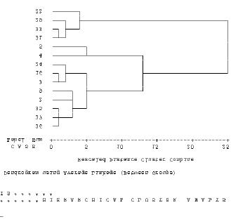
UNEP/GEF/SCS/RWG-W.3/3
Annex 5
Page 6
Figure 5
Cluster diagram using average linkage between groups based on the transformed
data for tidal mudflat sites only
Conclusions
It is apparent that, the data need to be carefully verified prior to the conduct of the final cluster
analysis, and hence full species lists for all the taxa used must be provided for each site.
UNEP/GEF/SCS/RWG-W.3/3
Annex 6
Page 1
ANNEX 6
Ranking Indicators and Weights for Determination of Priority
within Clusters of Potential Demonstration Sites
Background
The Focal Points in each Specialised Executing Agency assembled, in advance of the third regional
working group meeting, data and information required to characterise wetlands sites bordering the
South China Sea. These data and information were based on the needs identified during the first
regional working group meeting and listed in Annex 7 of the meeting report5.
Examination of this table clearly indicates that the range of data and information, envisaged to be
assembled, in characterising wetlands sites, was lacking in detail such that the defined parameters
were generic rather than specific. Hence for example the data requirements for biodiversity are simply
specified as:
"No. of species of plants and animals in the wetland area; No. of individuals per unit area "
without specifying the taxa that were to be covered in this data compilation.
In considering the indicators to be used in ranking the priority of sites within each cluster two major
considerations apply. The first is the over-riding need for transparency in the process of site selection,
and the second, the need to ensure that data are comparable for all sites considered by the focal
points in each country. The necessity for transparency in the process means that the indicators used
in ranking sites must be simple, and non-overlapping in terms of the inherent characteristics covered
by each indicator type.
In addition, to ensure comparability the data covered by each parameter must be interpreted in an
identical manner by each focal point. Numbers of plants therefore is a weak indicator of biodiversity
since it potentially includes a wide variety of taxa other than vascular plants, hence it is important that
full lists of species covered in each category should be included in the site description. The use of any
indicator, however important it might theoretically be, is precluded if data cannot be supplied for the
majority of sites.
Choice of Indicators
Discussion of the choice of indicators was based on the preliminary sets of data and information
assembled for 37 wetland sites and made available to the third meeting of the Regional Working
Group on Wetlands. These data are presented in Table 1 of Annex 4.
As noted in Annex 4, data and information for some parameters had not been assembled for most
sites and such parameters were excluded from the cluster analysis. In some cases these have also
been excluded from the choice of indicators used in the ranking process. Table 1 lists the indicators
selected by the Regional Working Group as being indicative of biological diversity, transboundary,
regional and global significance.
The weighting to be assigned to the classes of indicator reflects the consensus view of members
concerning the relative importance of each class. Hence within the category of environmental
indicators the indicators of biological diversity were considered to merit the greatest weight overall, 60
% of the total. It should be recognised that in reality the indicators of transboundary, regional and
global significance are in fact also indicators of biological diversity, hence the environmental set of
indicators is strongly weight ed towards the biological characteristics of the sites concerned.
5 UNEP, 2002. Report of the First Meeting of the Regional Working Group for the Wetland Sub-component of the Project
Reversing Environmental Degradation Trends in the South China Sea and Gulf of Thailand. UNEP GEF/SCS/RWG-W.1/3
Phuket, Thailand, 24 Ł 26 April 2002.
UNEP/GEF/SCS/RWG-W.3/3
Annex 6
Page 2
Table 1
Environmental Indicators and Scores for wetlands bordering the South China Sea that will
be used in the Ranking of Wetlands Sites within each cluster
Environmental Indicators
Area (ha)
Area 10%
100 - 10,000 10,000-50,000 50,000-100,000 100,000-150,000 > 150,000
2%
4%
6%
8%
10%
Biological diversity
Number of Fish species 18%
1 - 50
51 - 100
101 - 150
151-200
> 200
4%
7%
11%
15%
18%
Number of bird species 18%
1 - 50
51 - 100
101 - 150
151-200
> 200
4%
7%
11%
15%
18%
Number of plant species 6%
1- 100
101-200
201-250
251-300
> 300
1%
2%
3%
5%
6%
Number of mammal species 6%
1-10
11- 20
21 - 30
31-50
> 50
1%
2%
3%
5%
6%
Wetland types 12%
1
2
3
4
> 5
2%
4%
6%
10%
12%
Transboundary Significance
Number of migratory Species 15%
1 - 10
11- 20
21 - 30
31-40
> 40
3%
6%
9%
12%
15%
Regional/Global Significance
Number of endemic species 7%
1
2
> 3
2%
4%
7%
Number of endangered. species 8%
1 - 6
7 -10
> 10
3%
5%
8%
Within each class of indicator a series of one or more specific indicators were identified on the basis
of the outcome of the initial site characterisations, hence indicators were not included when it was
apparent that the information and/ or data were difficult to assemble as evidenced by the frequency of
missing data in the preliminary set. The regional working group considered at length the number of
divisions and weighting that would be appropriate to assign to any individual site value.
Table 2 lists the indicators selected by the regional working group as being indicative of socio-
economic conditions including indicators of national priority, stakeholder involvement and threats. As
in the case of the environmental indicators the regional working group discussed and agreed the
comparative weight that should be assigned to each class of indicator, then the weight to be assigned
to individual indicators within each class. Finally the divisions within each indicator and the weights
that should be assigned to the observed values at any one site were discussed and agreed.
It was noted that a number of the indicators listed in Table 2 were highly subjective and it is clear that
the proposals for demonstrations sites will need to present quite detailed reasoning as to why
particular scores have been assigned.
UNEP/GEF/SCS/RWG-W.3/3
Annex 6
Page 3
Table 2
Socio-economic Indicators and Scores for wetlands bordering the South China Sea
Socio-Economic indicators
Threats 20%
External sources of change, 10%
Low
Medium
High
2%
6%
10%
Internal source of change, 10%
Low
Medium
High
2%
6%
10%
National significance 40%
Identified as a national priority, 25%
1
2
3
10%
15%
25%
Level of direct stakeholder involvement in management, 10%
Low
Medium
High
2%
6%
10%
Commitments to RAMSAR, 5%
no
planned
yes
0
3%
5%
Financial considerations 20%
Potential for cofinancing (% of potential project budget), 20%
25
50
100
5%
10%
20%
Local stakeholder involvement 20%
Local stakeholder/community involvement
low
medium
high
2%
12%
20%
Conclusion
The regional working group agreed on the use of this selection of indicators in a two tier process with
the indicators in Table 1 being used as the primary means of ranking regional importance of sites
within the clusters, and the indicators in Table 2 being applied at a later stage when final decisions
regarding the choice of sites are being made.
UNEP/GEF/SCS/RWG-W.3/3
Annex 7
Page 1
ANNEX 7
Results of Preliminary Ranking of Wetlands Sites Bordering the South China Sea
Background
The second meetings of the Regional Scientific and Technical Committee and the Project Steering
Committee agreed to a three-step process of selecting demonstration sites based on:
Ę an initial clustering of similar sites followed by;
Ę ranking and determination of priority among sites within clusters.
Having agreed upon the nature of the indicators and the weight to be assigned to them the site
characterisations available to the third meeting of the Regional Working Group on Wetlands were
scored according to the agreed indicators and weights, presented and discussed in Annex 6 of this
report.
Results
Table 1 presents the outcome of this exercise for all thirty-seven, wetland site characterisations with
respect to the environmental and socio-economic indicators. Due to the incomplete nature of the data
sets, together with differences in the definitions of the indicators used by each focal point it is not
possible to combine the outcome of the ranking at a regional scale, at this time. Within each national
set of data relating to the environmental indicators however, the comparative ranking reflects the
regional importance of each site.
Table 1 presents two summary columns headed sub-total, the first representing the score with respect
to the indicators of biological diversity, and the second the sub-total for the socio-economic,
indicators. Where the data set for a particular site is incomplete then the rank score will be
automatically lower, however for this exercise scores were assigned for all indicators including
estimated values by the focal points.
The socio-economic scores were assigned, based on expert opinion of the focal points and generally
without quantitative information to support the scores allocated. This is not unsurprising since at this
stage the details of proposed interventions have still to be finalised. As a consequence these scores
must be considered merely preliminary estimates that will be refined as concrete proposals for
demonstration activities are developed.
Conclusions
The assignment of rank according to the agreed classes of indicators and their respective weighting
can be finalised promptly provided that the focal points submit the missing data to the PCU.
UNEP/GEF/SCS/RWG-W.3/3
Annex 7
Page 2
Table 1
Results of Preliminary Ranking of Wetland Sites Bordering the South China Sea, with both objective and subjective criteria
70%
30%
Wet
Sub total
Sub
Area Fish
Bird
Plant Mammal
Migratory Endemic Endangered
External Internal Nat'l. Stake
Total
Spp. Spp. Spp.
Spp.
land
types
Spp.
Spp.
Spp.
change Change Priority holder RAMSAR Co-
Finance Community
China
Danzhou Lingao
2
11
7
6
6
10
15
4
5
66
6
6
0
6
0
5
12
35
Beilun
2
11
7
5
2
10
15
4
8
64
6
6
0
10
5
5
12
44
He Pu
2
11
7
3
2
10
15
4
8
62
6
6
10
6
0
5
2
35
Peral R. delta
4
18
15
6
3
12
15
7
8
88
10
10
25
10
0
20
75
Shantou
2
15
11
3
2
10
15
7
8
73
10
10
15
10
0
5
12
62
Wang Cheng
2
15
11
5
2
6
15
4
8
68
10
10
0
6
3
5
12
46
Indonesia
Sembilang
10
15
18
2
5
12
9
4
5
80
10
10
25
2
3
20
12
82
Berbak NP
10
11
18
5
6
10
9
7
3
79
10
10
15
6
5
20
20
86
Muara Kendawangan
8
7
7
1
2
10
6
4
3
48
10
10
10
2
0
10
12
54
Philippines
Balayan Bay
6
18
7
1
1
12
12
7
8
72
10
10
15
10
0
20
12
77
Malampaya
6
15
4
1
2
12
3
7
3
53
10
10
0
6
3
20
12
61
Cambodia
Russey Srok-Tourl
Sragnam Estuary
2
4
4
1
1
4
3
4
3
26
6
10
10
10
3
10
20
69
Beung Kachhang Mudflat
2
4
4
1
1
4
3
2
3
24
6
10
15
6
3
20
20
80
Koh Kapik
4
4
4
1
1
4
3
7
3
31
10
10
25
10
5
20
20
100
UNEP/GEF/SCS/RWG-W.3/3
Annex 7
Page 3
Table 1 continued.
Results of Preliminary Ranking of Wetland Sites Bordering the South China Sea, with both objective and subjective criteria
70%
30%
Sub
Fish
Bird Plant Mammal Wet Migratory Endemic Endangered Sub total External
Internal
Nat'l.
Stake
Co-
Area
Total
Spp. Spp. Spp. Spp. land
Spp.
Spp.
Spp.
change
Change
Priority holder RAMSAR Finance Community
types
Vietnam
Balat Estuary
8
11
18
1
1
6
15
7
3
70
10
10
15
10
5
20
20
90
Tam Giang-Cau
Lagoon
10
11
15
1
3
10
15
7
5
77
10
6
10
10
3
10
20
69
Tien River Estuary
10
11
11
1
2
10
15
7
5
72
10
10
0
6
3
20
20
69
Ca Mau Southwest
Tidal Flat
4
4
7
1
2
12
6
7
3
46
10
6
0
2
0
5
12
35
Dong Nai River Estuary
10
15
11
1
2
10
12
7
3
71
10
10
25
10
3
20
20
98
Kim Son Tidal Flat
10
15
15
1
3
10
15
7
8
84
10
10
0
6
3
10
12
51
Van Uc Estuary
6
15
7
1
2
12
9
7
3
62
10
10
0
10
0
10
12
52
Bach Dang Estuary
4
15
7
1
2
10
9
7
3
58
6
6
0
6
3
10
12
43
Tien Yen Estuary
2
7
4
1
1
10
9
7
3
44
2
10
0
6
0
10
20
48
Tra O Lagoon
2
4
4
1
2
10
12
7
3
45
10
6
0
2
0
5
2
25
Thailand
Weru River Estuary
4
7
4
1
1
6
3
2
5
33
6
10
0
6
0
5
12
39
Pattani Bay
2
4
4
1
1
10
3
2
5
32
10
10
0
2
0
5
20
47
Thung Kha Savi
2
4
7
1
1
4
3
2
3
27
6
2
0
2
0
5
2
17
Mo Koh Ang Thong
4
4
7
1
2
6
3
2
3
32
0
10
5
5
2
22
Phu To Daeng
4
7
18
3
6
4
6
2
8
58
10
10
0
10
5
10
2
47
Thale Sap Songkla
6
7
18
1
1
2
3
2
8
48
10
6
15
6
0
10
2
49
Thale Noi
4
4
18
5
1
6
3
2
8
51
6
10
25
10
5
10
12
78
Khao Sam Roi Yod
4
4
18
2
2
12
9
2
8
61
6
10
0
10
3
10
2
41
The Inner Gulf of
Thailand
10
7
4
1
1
12
9
2
8
54
10
10
10
6
0
5
2
43
Don Hoi Lord
2
4
4
1
1
6
9
2
3
32
10
6
0
5
5
20
46
Pak Phanang Bay
4
4
4
1
1
6
3
2
3
28
10
2
0
10
0
5
12
39
Mu Koh Chang
6
4
7
1
1
12
6
2
8
47
10
2
0
6
0
10
2
30
UNEP/GEF/SCS/RWG-W.3/3
Annex 8
Page 1
ANNEX 8
Schedule of Meetings, Workplan and Timetable for the Wetlands Focal Points, 2003
Table 1
Schedule of meetings for 2003
M T W T F S S M T W T
F
S
S M T
W T
F
S
S
M T
W T
F
S
S
M T
W T
F
S
S
M
January
1
2
3
4
5
6
7
8
9
10
11
12 13
14
15
16
17 18
19
20
21
22 23
24
25
26
27 28
29
30
31
February
1
2
3
4
5
6
7
8
9
10
11
12
13
14 15
16
17
18
19 20
21
22
23
24 25
26
27
28
Chinese N.Y.
March
1
2
3
4
5
6
7
8
9
10
11
12
13
14 15
16
17
18
19 20
21
22
23
24 25
26
27
28
29 30
31
RWG-M-3
RWG-S-3
RWG-W-3
RWG-C-3
April
1
2
3
4
5
6
7
8
9
10
11
12
13 14
15
16
17
18 19
20
21
22
23 24
25
26
27
28 29
30
RWG-F-3
Thai N.Y.
RWG-LbP-3
May
1
2
3
4
5
6
7
8
9
10
11 12
13
14
15
16 17
18
19
20
21 22
23
24
25
26 27
28
29
30
31
June
1
2
3
4
5
6
7
8
9
10
11
12
13 14
15
16
17
18 19
20
21
22
23 24
25
26
27
28 29
30
RSTC-3
July
1
2
3
4
5
6
7
8
9
10
11
12
13 14
15
16
17
18 19
20
21
22
23 24
25
26
27
28 29
30
31
August
1
2
3
4
5
6
7
8
9
10 11
12
13
14
15 16
17
18
19
20 21
22
23
24
25 26
27
28
29
30 31
RWG-LbP-4
September 1
2
3
4
5
6
7
8
9 10
11
12
13
14 15
16
17
18
19 20
21
22
23
24 25
26
27
28
29 30
RWG-F-4
RWG-S-4
RWG-C-4
October
1
2
3
4
5
6
7
8
9
10
11
12 13
14
15
16
17 18
19
20
21
22 23
24
25
26
27 28
29
30
31
Cont.
RWG-W-4
RWG-M-4
Ramadan
November
1
2
3
4
5
6
7
8
9
10
11
12
13
14 15
16
17
18
19 20
21
22
23
24 25
26
27
28
29 30
Ramadan
December
1
2
3
4
5
6
7
8
9 10
11
12
13
14 15
16
17
18
19 20
21
22
23
24 25
26
27
28
29 30
31
Regional
Sci. Mtg
RSTC-4
PSC-3
Xmas
UNEP/GEF/SCS/RWG-W.3/3
Annex 8
Page 2
Table 2
Workplan and Timetable for completion of agreed activities in the Wetlands
Sub-component: 2003
Tasks
Deadline
Malaysia
Others
Review of past & ongoing project
15-Apr
31-Mar
independent review
20-Apr
finalisation
15-Jun
Review of national data & info.
30-Apr
15-Apr
input to GIS database
15-May
Creation of national meta database
30-May
Identification and character of sites
30-Apr
National criteria & Priorities
30-Apr
Economic valuation
30-Apr
Review National legislation
15-May
30-Apr
review by the Regional Task Forces
mid/late 2003
Site data
submit data
15-Apr
Cluster analysis
30-Apr
feedback to SEAs
01-May
Demonstration site proposal
01-Oct
01-Sep