PEMSEA E-UPDATES Vol. VII Issue 07 2006
29th Session of the APFIC Paves the Way for PEMSEA-APFIC Information
Sharing
KUALA LUMPUR, MALAYSIA -- The 29th Session of the Asia-Pacific Fishery
Commission (APFIC) was hosted and co-organized by the Department of Fisheries of
Malaysia on 2123 August. The session addressed key concerns regarding responsible
and sustainable fisheries and aquaculture, including: co-management, governance and
institutional arrangements, and policy challenges; illegal, unreported and unregulated
(IUU) fishing; and food safety, quality and trade.
The Asia-Pacific Fishery Commission acts as a consultative forum, providing technical
advice, coordinating activities, and facilitating the sharing of knowledge in fisheries and
aquaculture in the Asia-Pacific region. The members of APFIC include Australia,
Bangladesh, Cambodia, PR China, France, India, Indonesia, Japan, RO Korea, Malaysia,
Myanmar, Nepal, New Zealand, Pakistan, Philippines, Sri Lanka, Thailand, Vietnam,
United Kingdom and USA.
The Session was attended by 43 participants from government delegates of 14 Member
Countries of the Commission, and by observers from nine intergovernmental,
international and regional organizations, including PEMSEA.
Dr. Jihyun Lee, PEMSEA Senior Programme Officer, briefed the Meeting on PEMSEA
programme activities relevant to fishery management, and introduced emerging
initiatives on building a regional mechanism for the implementation of SDS-SEA.
The Meeting resulted in strengthened collaboration and information sharing between
PEMSEA and APFIC, initially with website linkages. The APFIC website
(http://www.apfic.org) was officially launched during the Seventieth Session of the
APFIC Executive Committee and aims to become a portal for all forms of relevant
fishery information.
Bangkok Port Moves Closer towards Greater Operational Efficiency through Its
Port Safety, Health and Environmental Management System
BANGKOK, THAILAND -- An external audit conducted by the PEMSEA Regional
Programme Office has concluded that the Port of Bangkok has made considerable
progress with regard to the implementation of its Port Safety, Health and Environmental
Management System (PSHEMS). The port, after establishing documented management
procedures, was able to demonstrate the effectiveness of its system in addressing the
inherent risks in its port operations, and specifically, the handling of Dangerous Goods
Cargoes.
Conducted on 2123 August, the audit verified the proper implementation and
maintenance of the documented management system, which was reviewed for adequacy,
suitability and effectiveness during an earlier audit in December 2005.
With the implementation of various activities related to its PSHEMS development and
implementation, Bangkok Port is confident that the integrated approach to port
management will greatly contribute to operational efficiency of the port. The Port of
Bangkok is one of the first two ports in the East Asian region to implement a PSHEMS
that is PSHEM Code compliant. Along with the Port of Tanjung Pelepas in Johor,
Malaysia, the two ports will receive PEMSEA recognition during the East Asian Seas
(EAS) Congress in December 2006 in Haikou City, Hainan, China.
The main objective of PEMSEA's PSHEM Code is to enable port authorities, port
operators or any public or private organizations engaged in port operations to establish an
integrated management system that will improve port operational performance. The
management system employs a comprehensive and coordinated approach to safety in port
operations, protection of human life, property and the environment by using the
fundamental principles of three prevailing International Standards: ISO 9001 (Quality
Management System), ISO 14001 (Environmental Management Systems) and OHSAS
18001 (Occupational Health and Safety).
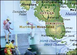
Bataan to Organize Oil Spill Contingency Team
BATAAN, PHILIPPINES -- The Province of Bataan headed by Gov. Enrique "Tet"
Garcia, Jr. will organize an oil spill contingency team as part of preparedness efforts in
the event of an oil spill in its provincial waters.
Engr. Butch Baluyot, officer-in-charge of the Project Management Office (PMO) of the
Bataan Integrated Coastal Management Program, said the team to be formed will
formulate a local oil spill contingency plan that is suited to the province, and at the same
time, in line with the Manila Bay Oil Spill Contingency Plan (MBOSCP). The plan will
outline the multisector arrangement in responding to oil spills in the province.
The PMO has been involved in the development of the MBOSCP, together with the
Philippine Coast Guard, Department of Environment and Natural Resources, oil
companies and other national government agencies and local government units. A table-
top exercise was conducted on 21 September to test the MBOSCP as well as provide the
various stakeholders with a practical, hands-on experience on oil spill response (see
related story).
The province has several oil depots, namely: Petron depot in Limay; Total depot in
Mariveles; Unioil depot in Lucanin, Mariveles; Bataan Petroleum Terminal Incorporated
in Limay; and Total Liquigaz in Barangay Alas-asin, Mariveles.
From February 1998 to December 2004, nine oil spills have occurred in the province,
with a total volume of 789,751 L. The total volume accounts for 50 percent of the total
oil spill occurrences in Manila Bay during the same period, thus including the Port of
Lamao and Port of Mariveles in Bataan among the high-risk areas in Manila Bay.
- Reports from the Bataan Provincial Information Office.
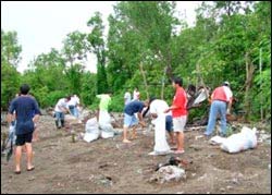
Volunteers Clean Bataan Shorelines and Rivers
BATAAN, PHILIPPINES -- Thousands of volunteers comprised of government staff and
private sector employees, women and senior citizen groups, high school and college
students, and environment-oriented individuals trooped to Bataan shorelines, rivers and
creeks on 23 September for the observance of the International Coastal Cleanup Day.
Governor Enrique Garcia Jr. and other local officials led the cleanup of the 188-km
Bataan coastline. Gov. Garcia was at the shoreline of Orion town while Vice Governor
Benjamin Alonzo was in Hermosa. Simultaneously, some volunteers also planted
mangroves in the towns of Pilar and Orion.
The Bataan Coastal Care Foundation, Inc., composed of private companies operating in
the province, supported the cleanup. The Foundation, led by the Petron Refinery in
Limay, provided PhP72,000 ($1,500) for the activity. The Provincial Government
provided the equipment and supplies.
The Provincial Government started the coastal cleanup activity in 1998 and, since then,
has become a coastal care model. The province has also reaped numerous awards and
citations on its environmental activities.
Gov. Garcia aims to integrate the caring for coastlines and bodies of water to everyday
living of the local residents.
The Province of Bataan also embarked on a massive mangrove planting last April in
observance of Earth Day.
- Reports from the Bataan Provincial Information Office
Bataan to Implement Integrated Land- and Sea-use Zoning Plan
BATAAN, PHILIPPINES -- Starting November, Bataan will be implementing a Coastal
Use Zoning Plan (CUZP) to protect the coastal and marine ecosystems and ecological
processes within the provincial waters. The CUZP will be integrated with each
municipality's Comprehensive Land-Use Plans (CLUPs) and the Provincial Physical
Framework Plan to provide an ecosystem-based management approach and blueprint for
the sustainable development of the province. The zoning plan was developed as part of
the Bataan Integrated Coastal Management Program (BICMP).
The proposed CUZP was presented on 5 October to the Program Coordinating
Committee (PCC). According to Engr. Butch Baluyot, officer-in-charge of the Bataan
ICM Program Management Office (PMO), the members of the PCC suggested some
inputs that can be integrated to the draft CUZP. The PCC, composed of local officials led
by Governor Enrique Garcia Jr., mayors, the business sector, civil society groups and
other stakeholders, is the approving body of the proposed zoning plan. The Sangguniang
Panlalawigan (Provincial Board) is expected to officially adopt the Bataan CUZP in a
month, to be implemented in ten towns and one city.
The Bataan CUZP was developed to effectively confront the major environmental
problems in the province, such as pollution, overfishing and destructive fishing, siltation,
proliferation of informal settlers and habitat degradation. The CUZP also contains policy
and institutional arrangements for its effective implementation.
In 2005, Gov. Garcia issued an executive order forming and activating a Technical
Working Group (TWG) to develop the CUZP. The TWG is a multisectoral team of
specialists from the province and municipalities who have experience in land use
planning, socioeconomic planning, environmental planning and other development
planning. They have in-depth knowledge on the habitat and ecosystem of Bataan's
coastal area and the legislations and regulations on environment and resources
management. During the consultations, various stakeholders played the key tasks of
providing salient information to contribute to the completion of the plan.
The groundwork for the development of the blueprint of the Bataan coastal use zoning
plan started in 2003, with the participation of representatives from the PMO and the
Bataan Provincial Planning and Development Office (PPDO) in the Regional Training
Workshop on the Development and Implementation of Coastal Use Zoning Plan and
Institutional Framework, which was conducted by PEMSEA. From 20032005,
municipal consultations were conducted for the identification of problems and existing
uses, proposed zones and uses, strategies and objectives, which were used as inputs to the
initial draft of the CUZP.
The Bataan CUZP will be presented to the Manila Bay PCC headed by Secretary Angelo
T. Reyes on 13 November to serve as model for possible replication in other provinces,
cities and municipalities surrounding Manila Bay, and to address multiple-use conflicts
and enhance effective management of the area.
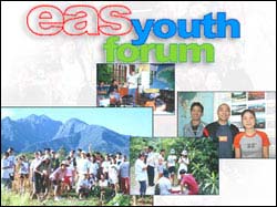
Empowering Young Leaders to Secure the Future of the East Asian Seas
"The only safe ship in a storm is leadership."
- Faye Wattleton
With the recent oil spill in Guimaras, Philippines, the rising concern on land reclamation
and the possible extinction of valuable marine resources, can the youth in the region be
relied on to take stronger leadership in securing the survival of the East Asian seas?
During the search for participants in the upcoming East Asian Seas (EAS) Youth Forum,
more than 200 young people answered "yes" and expressed their concern for the
environment and interest to take a lead role in protecting the environment and the marine
heritage of the East Asian region.
The search, which started in June and concluded last September 22, has encouraged a
total of 244 students and young professionals between 18 to 25 to pre-register and apply
for the EAS Youth Forum. The highest number of pre-registration came from the
Philippines, followed by Cambodia, Indonesia and Singapore. More than 80 percent of
the applicants are students pursuing their bachelor's degree and postgraduate studies in
universities, while the remaining percentage consist of young professionals in
environmental organizations and the media. Majority of the applicants have expertise in
environmental and life sciences.
Thirty-eight (38) applicants were chosen to be part of the roster of sponsored participants
for the Youth Forum, consisting of: four (4) from Cambodia; five (5) from China; four
(4) from Indonesia; two (2) from Japan; three (3) from Malaysia; six (6) from the
Philippines; three (3) from the Republic of Korea; five (5) from Singapore; three (3) from
Thailand; and three (3) from Vietnam.
Xiaohuan Tang of China and Go Noguchi of Japan were among the invited youth leaders
in the 4th World Water Forum held in Mexico, while Waranya Roekpooritat of Thailand
serves as Adviser for UNEP's Tunza Youth Advisory Council for Asia and the Pacific.
All the selected participants are actively involved in their communities and organizations,
have demonstrated strong leadership potential and have taken concrete steps in advancing
their capacity and advocacy for the environment. Their united visions and voices for the
seas of East Asia will be amplified when they form the Youth Agenda during the Youth
Forum, which will be presented in the overall reporting on the International Conference
outcomes.
The first EAS Youth Forum, which will be held on 11-15 December in Haikou, PR China,
as one of the features for the EAS Congress 2006, will highlight the significant role of the
youth in securing the sustainability of the seas. Key features of the Youth Forum,
including the exhibition of collaborative works, interview with international experts and
authorities and the Youth Jam with CEOs, policymakers and experts, are aimed at
empowering the youth and enabling them to understand the dynamics of the coastal and
marine management.
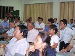
Danang Gears towards Efficient Sharing of Information among Concerned
Agencies and Stakeholders
DANANG CITY, VIETNAM -- The Danang National ICM Demonstration Project is
gearing up to further promote efficient sharing of information on the management of its
coastal area, beginning with a training workshop on Web-based Integrated Information
Management System for Coastal and Marine Environment (IIMS). The training
workshop involved 22 participants from concerned departments of Danang City and the
various districts, and was conducted on 26-27 October at Softech in Danang City by
PEMSEA staff. The training workshop was co-organized by the Project Management
Office (PMO) of the Danang National ICM Demonstration Project under the Department
of Natural Resources and Environment and PEMSEA.
The training workshop supplements the previous trainings conducted in Danang City on
the Windows-based version of the IIMS. The IIMS is a relational environmental database
intended to support a variety of information needs of coastal managers and
decisionmakers. Danang ICM Site has established the IIMS and has been using it to
support a variety of applications in coastal management.
The importance of a web-based IIMS as a complementary version to the Windows-based
IIMS was appreciated by the participants as a faster means of sharing data or information
among agencies and institutions. The web-based IIMS was temporarily uploaded into the
Intranet of Danang City, from where participating agencies can access and exchange
information.
A Tieng Viet version of IIMS is being finalized by PEMSEA and PMO staff to promote
wider use of the IIMS among agencies and stakeholders and enhance the effectiveness
and efficiency of information sharing in Danang.
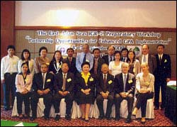
IGR-2 Preparatory Workshop Focuses on Partnership Opportunities for Enhancing
GPA Implementation
BANGKOK, THAILAND -- East Asian countries and regional organizations participated
in the East Asian Seas Second Intergovernmental Review Meeting (IGR-2) of the Global
Programme of Action for the Protection of the Marine Environment from Land-based
Activities (GPA) Preparatory Workshop, held on 4-5 September in Bangkok, Thailand.
The Preparatory Workshop, entitled Partnership Opportunities for Enhancing GPA
Implementation, was co-organized and co-sponsored by the United Nations Environment
Programme (UNEP) East Asian Seas Regional Coordinating Unit (EAS/RCU) and
PEMSEA.
The workshop, chaired by Ms. Monthip Sriratana Tabucanon, Deputy Permanent
Secretary, Ministry of Natural Resources and Environment, Thailand, was attended by
representatives from six countries of the region, namely: Cambodia, PR China, Malaysia,
Philippines, Thailand, and Vietnam. Representatives from the following regional
organizations were also in attendance: Coordinating Body on the Seas of East Asia
(COBSEA); Asia-Pacific Economic Cooperation (APEC) Marine Resource Conservation
Group; Association of Southeast Asian Nations (ASEAN) Working Group on Coastal
and Marine Environment; United Nations Development Programme (UNDP)/Global
Environment Facility (GEF) South China Sea Large Marine Ecosystem project;
UNEP/GPA; UNEP EAS/RCU; and PEMSEA.
Each of the participating countries presented a status report on their respective
achievements with regard to GPA implementation. The workshop also discussed major
challenges in moving forward with the GPA program at the country level including:
· institutional overlaps and gaps;
· competing and conflicting uses of limited coastal and marine resources;
· necessary scientific, technical and management skills, especially at the local
government level; and
· access to adequate and affordable financing.
The workshop concluded with an agreement among countries and regional programmes
and projects to prepare a regional policy brief for presentation to the IGR-2 Meeting,
identifying challenges and opportunities for the implementation of the GPA over the next
five years.
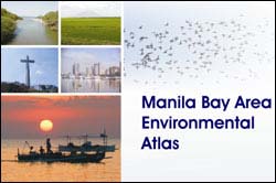
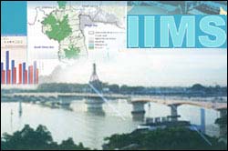
MBIN Completes the Manila Bay Environmental Atlas
QUEZON CITY, PHILIPPINES -- The Manila Bay Area Information Network (MBIN)
and PEMSEA have completed the Manila Bay Area Environmental Atlas, a compilation
of relevant information and basic maps that can be used in planning and management in
the area. The Atlas describes the physical, biological and socioeconomic characteristics
of the area, including issues and problems that affect its sustainable management. Some
examples of Atlas applications are also presented in the document.
The Atlas was prepared as an application of the Integrated Information Management
System for Coastal and Marine Environment (IIMS) in the Manila Bay area. It is also a
manifestation of commitment among network members concerning data/information
sharing in order to come up with a very useful document for use by stakeholders. The
document is one of a kind, as it provides comprehensive spatial information about the
Manila Bay area.
The Department of Environment and Natural Resources, particularly in the three regions
covered by the Manila Bay area, has started using the Atlas to implement the Manila Bay
Coastal Strategy and other government programs. The Atlas and the IIMS were also used
in the development of the coastal use zoning of Bataan and Cavite, and in the
development of the Manila Bay Oil Spill Contingency Plan.
The Manila Bay Area Network is one of the outputs of the Manila Bay Environmental
Management Project and consists of national and local agencies, the academe and the
private sector. The Atlas is a product of the MBIN and was spearheaded by the Technical
Working Group composed of various agencies.
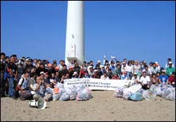
Beach Cleanup Organized by NOWPAP
As part of a new NOWPAP project Marine Litter Activity (MALITA) an
international beach cleanup was organized on 30 September in Sakata City (Yamagata
Prefecture, Japan). More than 100 people from China, Japan, Korea and Russia
participated in the beach cleanup and the workshop held the previous day.
Representatives from government agencies, research and education institutions,
nongovernmental organizations (NGOs) and local citizens shared their experiences in
organizing the International Coastal Cleanup (ICC) and similar events in their countries.
The 2006 NOWPAP ICC event was sponsored by the Japanese Ministry of Foreign
Affairs. A representative from the Ministry of Maritime Affairs and Fisheries of the
Republic of Korea indicated that a similar event might be hosted and financially
supported by the Korean Government in September 2007.
Participants of the beach cleanup and associated workshop agreed that raising public
awareness is one of most important activities in dealing with the marine litter problem.
Representatives of both China and Russia confirmed their willingness to join the ICC in
the future.
Flying around the Globe on a Time Machine, UNEP Partners with Google Earth
Nairobi 'Flying' around a virtual planet earth, zooming in on environmental hotspots
and comparing today's crisis zones with yesterday's areas of natural beauty: All this has
become a reality today thanks to a partnership between the United Nations Environment
Programme (UNEP) and Google Earth.
Images of retreating glaciers and melting ice in polar and mountain areas, explosive
growth of cities such as Las Vegas, forest loss in the Amazon, rapid oil and gas
development in Wyoming and Canada, forest fires across sub-Saharan Africa and the
decline of the Aral Sea in Central Asia and Lake Chad in Africa: this and much more is
being presented in a series of 'before and after' satellite images of our changing
environment to over 100 million Google Earth users worldwide.
Since September, Google Earth Google's 3D virtual world browser features UNEP:
Atlas of Our Changing Environment, offering satellite images of 100 environmental
hotspots from around the world. The project builds on the success of UNEP's very
popular hardcover release One Planet, Many People: Atlas of our Changing Environment.
UNEP's Executive Director Achim Steiner said: "These satellite pictures are a wake-up
call to all of us to look at the sometimes devastating changes we are wreaking on our
planet. Through spectacular imagery, Google Earth and UNEP offer a new way of
visualizing the dangers facing our planet today. By tapping into the global Google
community, we are able to reach out to millions of people who can mobilize and make a
difference."
The printed Atlas One Planet, Many People: Atlas of our Changing Environment was
produced in cooperation with the National Aeronautics and Space Administration
(NASA), the United States Geological Survey (USGS) and the University of Maryland,
and launched on World Environment Day in June 2005.
UNEP: Atlas of our Changing Environment uses images from the 2005 publication
together with satellite depictions of changes in African Lakes, along with several new
images and updates, and brings them into the virtual world of Google Earth. Each
location features multiple satellite images which are overlaid directly on Google Earth.
Most of the locations feature imagery from almost 35 years of global coverage produced
by the Landsat programme. Using this invaluable record of our planet's recent past,
UNEP: Atlas of our Changing Environment documents hotspots of environmental change
around the world.
Google Earth enables users to put each image into a rich geographical context. In the
Trang Estuary along Thailand's western shoreline, an explosion in shrimp farming can be
seen cutting into the disappearing mangrove forests between January 1990 and October
2001. Mangrove forests in Kuala Lumpur, Malaysia, can be seen as being lost to
agricultural conversion and urban expansion, as the surrounding population spreads from
40 km inland in January 1974, west to the coastal mangrove forests in January 2005.
Shenzhen, China, can be seen growing from a small city in the coastal forest in October
1979 to a sprawling industrial city with a population approaching 5 million in the greater
metropolitan area by September 2004.
For more information, visit
http://www.unep.org/Documents.Multilingual/Default.asp?DocumentID=487&ArticleID
=5350&l=en.
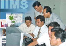
PEMSEA Enhances IIMS Capacities in DPRK through Nampho Training
Workshop
NAMPHO, DPR KOREA -- Twenty participants from Nampho's IIMS Network Team
attended a training workshop on the Integrated Information Management System (IIMS)
for coastal and marine areas and IIMS Networking, held in Nampho from 4-7 September.
Participants learned how to establish IIMS, generate reports from IIMS database using
the SQL builder and predefined query, link IIMS with a geographic information system
(GIS), and network IIMS across sites.
During the training workshop, the team was able to develop an action plan for the IIMS
network taking into account: improving the IIMS Korean version; establishing IIMS at
member agencies; data sharing among national agencies; applications of IIMS and the
IIMS network; maintenance of hardware and update of software; sustainability of the
network, including capacity building; and role of the IIMS network in ICM scaling-up.
As a support to the IIMS Network, the Nampho ICM National Demonstration Project and
PEMSEA developed the Korean version of the IIMS. The Korean version of IIMS is
expected to improve understanding and appreciation of the IIMS and promote wider
applications of the system, including sharing and use in decisionmaking for the
sustainable development of Nampho.
Scientists, experts and managers from Nampho provided inputs in the translation, while
PEMSEA staff provided the programming needs.
IIMS is a decision-support system that transforms data into information to help
policymakers and managers arrive at well-informed solutions to environmental problems.
The IIMS enables the storage, retrieval and analysis of various data on habitats and
biological resources, demography, institutional profiles, socioeconomic activities,
pollution sources, environmental quality and physiographic characteristics.
Networks using IIMS as a common database platform are being developed at PEMSEA
sites to promote information sharing and application among stakeholders.
The IIMS Network established in Nampho consists of 18 agencies and institutions from
local and national governments.
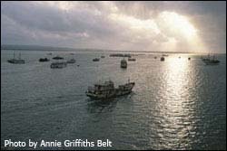
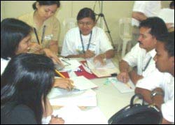
Stakeholders Participate in Tabletop Exercise for the Manila Bay Oil Spill
Contingency Plan
MANILA, PHILIPPINES -- PEMSEA, in collaboration with the Philippine Coast Guard
(PCG), organized a tabletop exercise for the Manila Bay Oil Spill Contingency Plan
(MBOSCP) on 21 September at the PCG-National Capital Region (NCR) and Central
Luzon (CL) District Headquarters. More than 30 individuals from key government
agencies, local government units and private oil companies participated in the tabletop
exercise.
During the exercise, the participants were assigned tasks that were consistent with their
respective roles and responsibilities as indicated in the MBOSCP. Commodore Ramon
Liwag, District Commander, served as the Exercise Director and was assisted by a team
from the Marine Environment Protection Command (MEPCOM) and NCR-CL.
The activity enabled the PCG personnel from the NCR-CL District to discuss the key
elements of the Plan, specifically the response structure and the interface between the
MBOSCP and the NCR District Plan. The PCG personnel also identified the capabilities
of respective organizations with regard to oil spill response. Likewise, the tabletop
exercise allowed the key personnel of relevant government agencies, oil companies and
local government units, who have concerns and responsibilities for emergency situations,
to clarify their roles during oil spill incidents and identify areas that could be improved in
the MBOSCP.
A Memorandum of Understanding among the concerned agencies will be signed on 13
November to support the effective implementation of the MBOSCP.
COPYRIGHT © PEMSEA