


Global International
Waters Assessment
Regional assessments
Other reports in this series:
Barents Sea GIWA Regional assessment 11
Caspian Sea GIWA Regional assessment 23
Patagonian Shelf GIWA Regional assessment 38
Brazil Current GIWA Regional assessment 39
Amazon Basin GIWA Regional assessment 40b
Guinea Current GIWA Regional assessment 42
Lake Chad Basin GIWA Regional assessment 43
Indian Ocean Islands GIWA Regional assessment 45b
East African Rift Valley Lakes GIWA Regional assessment 47
Pacifi c Islands GIWA Regional assessment 62


Global International
Waters Assessment
Regional assessment 27
Gulf of California/Colorado River Basin
GIWA report production
Series editor: Ulla Li Zweifel
Report editor: Matthew Fortnam
Editorial assistance: Johanna Egerup
Maps & GIS: Niklas Holmgren
Design & graphics: Joakim Palmqvist
Global International Waters Assessment
Gulf of California/Colorado River Basin, GIWA Regional
assessment 27
Published by the University of Kalmar on behalf of
United Nations Environment Programme
© 2004 United Nations Environment Programme
ISSN 1651-940X
University of Kalmar
SE-391 82 Kalmar
Sweden
United Nations Environment Programme
PO Box 30552,
Nairobi, Kenya
This publication may be reproduced in whole or in part and
in any form for educational or non-profi t purposes without
special permission from the copyright holder, provided
acknowledgement of the source is made. No use of this
publication may be made for resale or for any other commercial
purpose whatsoever without prior permission in writing from the
United Nations Environment Programme.
CITATIONS
When citing this report, please use:
UNEP, 2004. Arias, E., Albar, M., Becerra, M., Boone, A., Chia, D.,
Gao, J., Muńoz, C., Parra, I., Reza, M., Saínz, J. and A. Vargas. Gulf
of California/Colorado River Basin, GIWA Regional assessment 27.
University of Kalmar, Kalmar, Sweden.
DISCLAIMER
The views expressed in this publication are those of the authors
and do not necessarily refl ect those of UNEP. The designations
employed and the presentations do not imply the expressions
of any opinion whatsoever on the part of UNEP or cooperating
agencies concerning the legal status of any country, territory,
city or areas or its authority, or concerning the delimitation of its
frontiers or boundaries.
This publication has been peer-reviewed and the information
herein is believed to be reliable, but the publisher does not
warrant its completeness or accuracy.
Contents
Preface 9
Executive summary
11
Acknowledgement 14
Abbreviations and acronyms
16
Regional defi nition
19
Boundaries of the region
19
Physical characteristics
21
Socio-economic characteristics
25
Assessment 32
Freshwater shortage
32
Pollution
39
Habitat and community modifi cation
46
Unsustainable exploitation of fi sh and other living resources
50
Global change
56
Priority concerns for further analysis
57
Causal chain analysis
59
System description
60
Key players
61
Causal chain analysis
65
Conclusions
70
Policy options
71
Short-term policy options
72
Medium-term policy options
76
Long-term policy options
79
Identifi cation of the recommended policy options
80
Conclusions
81
References 82
Annexes 91
Annex I List of contributing authors
91
Annex II Detailed scoring tables
92
Annex III List of important water-related programmes in the region
95
Annex IV List of conventions and specifi c laws that aff ects water use in the region
96
The need for a global international waters assessment
i
The GIWA methodology
vii
CONTENTS
Preface
The GIWA region 27 covers the Gulf of California and its drainage basins.
The Global International Water Assessment (GIWA) and the World Wildlife
This report focuses on the Colorado River Basin with emphasis on the
Fund (WWF), Gulf of California Program Project Number QQ98, funded
delta area. The report presents the results of research, information
the research.
development and policy analysis. The methodology covers issues
such as water availability, regional imbalances, relationships between
The information herein is believed to be reliable, but the assessors and
water use and water quality, and alternative low-cost natural systems
their institutions do not warrant its completeness of accuracy. Opinions
for treating wastewater. The papers range from addressing fundamental
and estimates are the judgments of the research team. The sole purpose
scientifi c questions regarding the linkages between land use and water
of this research is to provide information to the many stakeholders and
quality, to the ecological impacts of excessive water consumption, to
jurisdictions of the region regarding issues, strategic planning choices,
the feasibility of applying alternative treatment options.
and their possible consequences related to the sharing of international
waters.
The GIWA region 27 Task team, integrated from personnel of WWF Gulf
of California Program, the Berkeley Public Policy team and personnel
While the scientifi c community still debates the meaning of international
from the Instituto Nacional de Ecología (Mexico, City), conducted the
water management, the concerns of environmental institutions still rely
research described in this report. During the GIWA workshops for the
on how to interact with the environmental impacts with scarce water
Scaling and Scoping held August 21-23, 2002 in Hermosillo, Son, Mexico
resources of an unsustainable urban development.
and the Causal chain analysis and Policy options (April 7-9, 2003) the
main thematic was based on problems concerning transboundary
issues in international waters and how to apply the results from scientifi c
assessments to manage water resources.
The study makes use of the work of others, especially in its descriptions
of the region and the issues that it faces. We are grateful for the
cooperation and permission that have been granted by the region's
planning agencies, the Instituto Nacional de Ecología (INE), Mexico
City Offi
ce, the Comisión Nacional del Agua (CNA), Gerencia Regional
Peninsula de Baja California, Mexicali, and the Instituto del Medio
Ambiente del Estado de Sonora (IMADES). We also appreciate the many
persons from the study area who participated in the GIWA workshops,
and those who provided invaluable guidance throughout the project.
PREFACE
9
10
GIWA REGIONAL ASSESSMENT 27 GULF OF CALIFORNIA/COLORADO RIVER BASIN
Executive summary
In regions where water demand approaches or exceeds the limit of
780 000 ha). The delta ecosystems are important for migratory
available supplies, competition intensifi es amongst various users,
shorebirds travelling along the Pacifi c Flyway; serve as a breeding
turning water scarcity into a potential source of confl ict. This report
ground for marine species of the Gulf of California; support a number
applies an analytical methodology developed by the GIWA programme,
of endangered species; improve the quality of water that fl ows in
that consists of: (i) the regional defi nition, based on its main physical,
from various sources and out to the Gulf; deliver a steady fl ow of
socio-economic and legal framework; (ii) an assessment which identifi es
freshwater to near-shore marine (brackish) environments in the Gulf,
and prioritises fi ve predefi ned GIWA concerns based on the magnitude
improving breeding and nursery grounds for the endangered vaquita;
of their impacts on the environment and societies in the region; (iii) a
and produce important vegetation utilised by indigenous peoples.
causal chain analysis to identify the root causes of these problems; and
In addition to these environmental services, the delta has historically
(iv) the analysis of policy options that address these root causes in order
been a source of income for riparian communities, supporting lucrative
to reverse negative trends in the aquatic environment.
fi sheries and ecotourism activities.
The Gulf of California, GIWA region 27 has its limits to the north of the
The Colorado River Basin is extremely dynamic with expanding
Pacifi c and extends to the southeast of the Pacifi c, and comprises a
economies and increasing industrialisation, especially in the
portion of the American Southwest and Mexico's Northwest. The
California and Baja California border regions. The population of the
region includes land surrounding the river systems that feed the Gulf
Basin is growing rapidly and urban areas are sprawling, often in an
of California, also known as Sea of Cortez. The largest of them is the
uncoordinated manner. Unmanaged growth in the Basin has produced
Colorado River Basin, which is almost entirely located in the United States,
serious transborder environmental problems and concerns, for example,
while the oceanic component of the region (Upper Gulf of California)
the impact of urban development on the fauna and fl ora of already
and small tributaries (e.g. San Pedro and partly Santa Cruz rivers) are in
sensitive ecosystems. The principle demand for water in the basin arises
Mexico. Within the GIWA Gulf of California region, the Colorado River
mainly from agriculture; 80 to 90% of all water resources are used to
Basin is the system with the most prominent transboundary character.
irrigate agricultural lands. Considering that the region is characterised
The Colorado River Basin is of great signifi cance considering that the
mainly by arid and semiarid zones, the problem of freshwater shortage
River supplies more water for consumptive use than any other river
is accentuated in the Lower Basin.
in the U.S and supports not only a booming economy but also a vast
number of terrestrial and marine species. Therefore, the analysis in this
The assessment focused on the Colorado River Basin and the Upper
report has been focused on the Colorado River Basin.
Gulf of California and was conducted based on the fi ve GIWA concerns.
The assessment conducted through a participatory process and based
From an environmental point of view the Colorado River Delta and
on concepts and criteria developed by the GIWA Task team, ranked the
Upper Gulf of California is of great importance to the region, and
concerns in the following order:
correspondingly was declared an International Biosphere Reserve in
1. Freshwater
shortage
1993. Today the delta consists of 60 000 ha of wetlands and riparian
2. Pollution
forests (prior to the construction of dams the delta maintained
3. Habitat and community modifi cation
EXECUTIVE SUMMARY
11
4. Unsustainable exploitation of fi sh and other living resources
riverbank salinity and other alterations to riparian zones have favoured
5. Global
change
the establishment of invasive, salt tolerant species (e.g. Tamarix
ramosissima), occupying great extensions of modifi ed habitat.
Freshwater shortage was the most signifi cant GIWA concern for the
region. The modifi cation of stream fl ow by dams, the canalisation of
Various forms of human activity (shrimp trawls, pollution and freshwater
riverbeds, and the alteration of riparian zones by agricultural activities in
shortage) are modifying the ecosystems of the Upper Gulf of California,
the Colorado River Basin have resulted in major environmental changes
which ultimately aff ect local fi sheries. The semi-enclosed nature of the
causing loss of fi sh, wildlife, and native fl ora, particularly in the Colorado
Upper Gulf serves to magnify the impact of these activities. By-catches
River Delta region. The main impacts on the hydrological cycle include
and discards, as well as habitat destruction by trawling nets, have been
changes in the seasonal hydrology, water temperature and sediment
important factors in altering these ecosystems, although studies have
loads of the Lower Colorado River. In the absence of suffi
cient sediment
demonstrated that overexploitation and the reduction of freshwater
discharges, the deltaic basin has transformed from an estuarine setting
fl ows to the Upper Gulf have been the main reasons for the commercial
to a hypersaline, anti-estuarine and erosive one.
collapse of some fi sheries.
Since the construction of major dams along the Colorado River, the
The causal chain analysis addressed the following problem: too little
Delta is sustained only by fl ood fl ows and, during dry years, groundwater
water is being allocated for ecosystem maintenance or restoration in
seepage, agricultural drainage water and tidewater are its only sources.
the Colorado River Delta. The immediate causes of freshwater shortage
Presently, the economic impacts of freshwater shortage are largely
in the Colorado River Delta were primarily associated with increased
associated with silt accretion and salinisation of agricultural lands,
diversion, reduced peak fl ows and changes in return fl ows.
which today account in the U.S. for approximately 700 million USD per
year. Programmed reductions of water to California, the rising costs of
The most important sectors responsible for these immediate causes
water treatment, and the high cost of restoring degraded water sources
are:
are prominent socio-economic issues that could potentially initiate
Agriculture;
confl icts over freshwater resources in forthcoming years.
Urbanisation;
Industry;
Pollution of water resources in the Colorado River was considered
Energy
production.
a major concern aff ecting the ecology and population, since heavy
metals, arsenic, lead pesticides, uranium, and other toxins have all
The root causes focused primarily on the agricultural sector, since from
been found in excessive levels in the soils and waters resources of
a historic point of view many of the changes made throughout the 19th
the Basin. Salinity is considered as a signifi cant and continuous issue,
century were infl uenced by agriculture, both in the U.S. and Mexico .
historically aff ecting U.S.-Mexico relations since the early 1940s. Stream
fl ow modifi cation has resulted in increased cases of water pollution by
Some of the root causes behind these immediate causes were identifi ed
salts and selenium, which occur naturally in the Colorado River. The
as:
reduction of freshwater fl ows has diminished the dilution capacity of
Demographic: Migration policies and incentives carried out during
the region's water bodies, consequently increasing water pollution in
the 1940s in the U.S. Western states and Mexico.
the Lower Colorado River. Economic impacts associated with pollution
Technological: Increased development in irrigation technology
were assessed as moderate, particularly due to increases in water
throughout the Colorado River Basin.
treatment costs. There is also considerable evidence of impacts on
Economic: The existence of historical subsidies and the lack of
health from chemical pollution, especially from contamination of the
economic valuation of water resources.
regions aquifers.
Legal: Inappropriate legal framework to adequately manage water
use, due to a lack of eff ective legal instruments.
The construction and operation of dams has modifi ed riparian habitats
and changed seasonal fl ow patterns. As a result, large extensions of
It is proposed that the following options could secure freshwater resources
riparian habitat, wetlands and marshes have declined drastically. The
for the Colorado River Delta in the short, medium and long-term:
reduction in native forest vegetation has led to a decline in the value of
Lease water rights in the Mexicali and San Luis Rio Colorado Valleys
riparian habitats for native species. In the U.S., as in Mexico, increases in
and transfer associated water to the delta ecosystem;
12
GIWA REGIONAL ASSESSMENT 27 GULF OF CALIFORNIA/COLORADO RIVER BASIN
Convert electricity subsidies for Mexican farmers to cash subsidies,
and eliminate price subsidies to municipal water users in Mexico as
preliminary measures to ensure at least minimal fl ows of freshwater
reach the delta;
Increase
the
effi
ciencies of water use in Mexico through market
mechanisms, thereby "freeing up" water potentially available for
the delta;
Amendment of a Minute to the 1944 Water Treaty to specifi cally
stipulate water deliveries for the delta.
Presently the Colorado River Delta and the Upper Gulf ecosystem only
receive fl ows of freshwater whenever a surplus of water exists in the
River in excess of the amount of water necessary to supply the U.S. base
fl ows and periodic fl ows should be consistent to the delta despite the
1944 Treaty stipulations, due to the river ecosystem survival does not
depend on treaties or political factors.
In order to implement eff ective conservation programme more water
fl owing directly into the delta is needed. Economic and technical
support from the U.S. will however be necessary, and realistically, the
Lower Colorado River Basin states will probably not agree to allow more
water to reach Mexico. Therefore the preservation of the Colorado River
Delta ecosystem will remain a complex task. To maintain suffi
cient
stream fl ows in the River, the alignment of numerous institutions,
agreements, and organisations will be required. As a transboundary
representative, the International Boundary and Water Commission
(IBWC) still remains as the most eligible institution to achieve this goal
in the long-term, although it remains cautious in its jurisdiction over
environmental problems relating to the Colorado River Delta; therefore
the criticism of the way it operates and manages problems concerning
to the environment.
EXECUTIVE SUMMARY
13
Acknowledgement
This report for the Global International Water Assessment is the result
Francisco Oyarzabal, Jorge Ramírez, Erick Mellink, Saúl Alvarez-Borrego,
of two workshops and background desk research. We gratefully
Eugenio A. Aragón-Noriega, Jaqueline García-Hernandez, Miriam Reza,
acknowledge the support of the World Wildlife Fund-Gulf of California
Mary Albar, Ivan Parra, Gerardo Castillo and Luis G. Alvarez.
Program, the Instituto Nacional de Ecología (INE) México City Offi
ce,
the Comisión Nacional del Agua (CNA), Gerencia de la Peninsula de Baja
We would like to thank Juan Carlos Barrera, the formerly Program Leader
California in Mexicali, the Instituto del Medio Ambiente del Estado de
of WWF Gulf of California Program and now working for PRONATURA
Sonora (IMADES) and the Berkeley Team of Public Policies.
Noreste, for the support obtained during the entire programme. We also
would like to thank the following people for their wide range of advice,
We also gratefully acknowledge the considerable contributions and
guidance, and assistance to the two previous workshops (see Table):
guidance in obtaining and interpreting data throughout this process
off ered by:
Name
Institutional affiliation
Country
Field of Work
Amy Boone
University of California, Berkeley
United States
Policy analysis
Jie Gao
University of California, Berkeley
United States
Policy analysis
Arturo Vargas Bustamante
University of California, Berkeley
United States
Policy analysis
Daniel A. Chia
University of California, Berkeley
United States
Policy analysis
Francisco Bernal
Comisión Internacional de Limites y Aguas (CILA)
Mexico
Public Service in International Water Management
Francisco Oyarzabal
Conservation Internacional (CI) Mexico
Mexico
Water management, irrigation and drainage
Jennifer Pitt
Environmental Defense Fund
United States
Environmental policy research
Jaime Sainz
Instituto Nacional de Ecología (INE)
Mexico
Environmental policy analysis
Jesús Roman Calleros
Universidad Autónoma de Baja California (UABC)
Mexico
Urban water management in the USA-Mexico border
Urban water management in Mexican border cities
Jose Luis Castro
Colegio de la Frontera Norte (COLEF)
Mexico
Transboundary water management along the U.S.-Mexico border
CONAMP/SEMARNAT
Jose R. Campoy
Mexico
Natural Protected Areas and aquatic resources management
Reserva de la Biosfera de Alto Golfo y Desierto de Altar
Mariana Becerra
Instituto Nacional de Ecología (INE)
Mexico
Environmental Policy analysis
Michael Cohen
Pacific Institute
United Status
Environmental policy research
Stephen Mumme
Colorado State University
United Status
Environmental policy analysis
Steve Cornelius
Sonoran Institute
United States
Large-landscape scale conservation planning and program development
14
GIWA REGIONAL ASSESSMENT 27 GULF OF CALIFORNIA/COLORADO RIVER BASIN
Marcia Marques
Universidade do Estado do Rio de Janeiro (UERJ)
Brasil
Environmental assessment and water policy management
Juan Carlos Belasteguigoitia
UNEP/GIWA
Sweden
Carlos Muńoz Pińa
Instituto Nacional de Ecología (INE)
Mexico
Environmental policy analysis
Ivan Parra
World Wildlife Fund (WWF) Mexico
Mexico
Terrestrial Ecology and Coastal Zone management
Miriam Reza
World Wildlife Fund (WWF) Mexico
Mexico
Coastal zone management, GIS applications to natural resource management
Evaluation, Prospection and Environmental Assessment of groundwater in semiarid regions and
Jorge Ramírez
Universidad Autónoma de Baja California (UABC)
Mexico
transboundary waters management
Centro de Investigación Científica y de Educación Superior de
Eric Mellink
Mexico
Terrestrial Ecology and Coastal Zone management
Ensenada (CICESE)
Centro de Investigación en Alimentación y Desarrollo, A.C.
Pablo Wong
Mexico
Economics of Regional development
(CIAD)
Roberto R. Enríquez
Universidad Autónoma de Baja California (UABC)
Mexico
Economics of marine and coastal conservation
Edward Glenn
University of Arizona
United States
Environmental biology, saline agriculture, marine agronomy, algae, aquatic plants
Udall Center for Studies in Public Policy, University of
Water resources and human impacts of climate variability and change (Southwest U.S. and U.S.-
Robert Meridith
United States
Arizona
Mexico border region).
Udall Center for Studies in Public Policy, University of
Robert G. Varaday
United States
Environmental policy and water-management policy research in the U.S.-Mexico border region.
Arizona
Instituto del Medio Ambiente y Recursos Naturales de
Remote sensing for estimating hydrologic variables at the watershed scale. Assessment of the
Christopher Watts
Mexico
Sonora (IMADES)
impacts of climate change and human activity on water resources.
Coastal zone management, GIS applications to natural resource management, Colorado River
Jose F. Zamora
Sonoran Institute
United States
Delta,
Richard Brusca
Arizona- Sonora Desert Museum
United States
Research Scientist and Administrator: biology, ecology, natural systems.
Centro de Investigación en Alimentación y Desarrollo, A.C.
Jaqueline García-Hernández
Mexico
Environmental toxicology
(CIAD)
Mary Albar
World Wildlife Fund (WWF) Mexico
Mexico
Natural Protected Areas and marine and coastal conservation
Héctor Arias
World Wildlife Fund (WWF) Mexico
Mexico
Watershed management in arid zones
Gerardo Castillo
Centro Regional (CREDES)
Mexico
Natural Protected Areas and marine and coastal conservation
Centro de Investigación Científica y de Educación Superior de
Luis G. Alvarez
Mexico
Sediment dynamics and oceanographic processes
Ensenada (CICESE)
Centro de Investigación Científica y de Educación Superior de
Saúl Alvarez-Borrego
Mexico
Remote sensing and plankton ecology
Ensenada (CICESE)
Centro de Investigaciones Biológicas del Noroeste, S.C.
Eugenio A. Aragon
Mexico
Ecology of shrimp postlarvae and aquaculture of Penaeid shrimp
(CIBNOR)
Juan C. Barrera
PRONATURA Noreste
Mexico
Natural Protected Areas and marine and coastal conservation
ACKNOWLEDGEMENT
15
Abbreviations and acronyms
AAC
All American Canal
MWD
Metropolitan Water District of Southern California
AUM
Animal Unit Months
NADBank North American Development Bank
BECC
Border Environment Cooperation Commission (Comisión de
NAFTA
North American Free Trade Agreement
Cooperación Ecológica Fronteriza)
NGO
Non Governmental organisation
CNA
National Water Commission, Mexico City Offi
ce (Comisión
NEPA
U.S. National Environmental Policy Act
Nacional del Agua)
NIB
Northerly International Boundary
CVWD
Coachella Valley Water District
NWL
National Water Law
DBCP Dibromochloropropane
OECD
Organisation for Economic Co-operation and Development
DOF
Federal Offi
cial Gazette, Mexico (Diario Ofi cial de la
PES
Payment for Environmental Services
Federacion)
PROCAMPO Program for Direct Assistance in Agriculture
DWA
Desert Water Agency
PVID
Palo Verde Irrigation District
EIS
Environmental Impact Statement
SAGARPA Secretariat of Agriculture, Livestock, Rural Development,
EPA
U.S. Environmental Protection Agency
Fisheries and Food, Mexico (La Secretaría de Agricultura,
ESA
U.S. Endangered Species Act
Ganadería, Desarrollo Rural, Pesca y Alimentación)
FWS
U.S. Fish and Wildlife Service
SEDESOL Secretariat of Social Development (Secretaría de Desarrollo
GEF
Global Environment Facility
Social)
GIWA
Global International Waters Assessment
SEMARNAT Department of Environment and Natural Resources
IBWC
International Boundary Water Commission
(Secretaría del Medio Ambiente y Recursos Naturales)
IID
Imperial Irrigation District
SIB
Southerly International Boundary
IMADES State of Sonora Institute for the Environment and Sustainable
SLRC
San Luis Rio Colorado
Development (Instituto del Medio Ambiente del Estado de
TDS
Total dissolved solids
Sonora)
TSH
Thyroid Stimulating Hormone
INE
National Institute of Ecology, Mexico (Instituto Nacional de
TSS
Total Suspended Solids
Ecología)
UGC
Upper Gulf of California
INEGI
National Institute of Statistics, Geography and Information,
UNEP
United Nations Environment Programme
Mexico (Instituto Nacional de Estadística, Geografía, e
USBR
United States Bureau of Reclamation
Informática)
USGS
United States Geological Survey
ISC
Interim surplus criteria
WMIDD Wellton-Mohawk Irrigation and Drainage District
LCRB
Lower Colorado River Basin
WWF
World Wildlife Fund
LROC
Long Range Operating Criteria
MEXUS Mexico-United
States
MODE
Main Outlet Drain Extension Canal
MTBE
Methyl tertiary-butyl ether
16
GIWA REGIONAL ASSESSMENT 27 GULF OF CALIFORNIA/COLORADO RIVER BASIN
List of figures
Figure 1
The Gulf of California region. . . . . . . . . . . . . . . . . . . . . . . . . . . . . . . . . . . . . . . . . . . . . . . . . . . . . . . . . . . . . . . . . . . . . . . . . . . . . . . . . . . . . . . . . . . . . . . . . . . . . . . . . . . . . . . . . . . . . . . . . . . . . . . . . . . . 19
Figure 2
The Colorado River Basin . . . . . . . . . . . . . . . . . . . . . . . . . . . . . . . . . . . . . . . . . . . . . . . . . . . . . . . . . . . . . . . . . . . . . . . . . . . . . . . . . . . . . . . . . . . . . . . . . . . . . . . . . . . . . . . . . . . . . . . . . . . . . . . . . . . . . . 20
Figure 3
Colorado River annual flow. . . . . . . . . . . . . . . . . . . . . . . . . . . . . . . . . . . . . . . . . . . . . . . . . . . . . . . . . . . . . . . . . . . . . . . . . . . . . . . . . . . . . . . . . . . . . . . . . . . . . . . . . . . . . . . . . . . . . . . . . . . . . . . . . . . . . 21
Figure 4
Water consumption along Colorado River.. . . . . . . . . . . . . . . . . . . . . . . . . . . . . . . . . . . . . . . . . . . . . . . . . . . . . . . . . . . . . . . . . . . . . . . . . . . . . . . . . . . . . . . . . . . . . . . . . . . . . . . . . . . . . . . . . . . . . 30
Figure 5
Flow of the Colorado River below Hoover Dam 1905-2003. . . . . . . . . . . . . . . . . . . . . . . . . . . . . . . . . . . . . . . . . . . . . . . . . . . . . . . . . . . . . . . . . . . . . . . . . . . . . . . . . . . . . . . . . . . . . . . . . . . . . 33
Figure 6
Elevation of the static levels of the Mexicali Aquifer from 1957-1994. . . . . . . . . . . . . . . . . . . . . . . . . . . . . . . . . . . . . . . . . . . . . . . . . . . . . . . . . . . . . . . . . . . . . . . . . . . . . . . . . . . . . . . . . . . . 35
Figure 7
Concentrations of total dissolved solids in the Mexicali Aquifer with and without lining of the All American Canal. . . . . . . . . . . . . . . . . . . . . . . . . . . . . . . . . . . . . . . . . . . . . 36
Figure 8
Re-initiation of the commercial harvest for the Gulf curvina (Cynoscion othonopterus) in the Upper Gulf of California. . . . . . . . . . . . . . . . . . . . . . . . . . . . . . . . . . . . . . . . . 48
Figure 9
Rafting in the Colorado River.. . . . . . . . . . . . . . . . . . . . . . . . . . . . . . . . . . . . . . . . . . . . . . . . . . . . . . . . . . . . . . . . . . . . . . . . . . . . . . . . . . . . . . . . . . . . . . . . . . . . . . . . . . . . . . . . . . . . . . . . . . . . . . . . . . 49
Figure 10
Totoaba fishery in the late 1940s. . . . . . . . . . . . . . . . . . . . . . . . . . . . . . . . . . . . . . . . . . . . . . . . . . . . . . . . . . . . . . . . . . . . . . . . . . . . . . . . . . . . . . . . . . . . . . . . . . . . . . . . . . . . . . . . . . . . . . . . . . . . . . . 50
Figure 11
Escalation of fishing vessels for the shrimp industry in the Upper Gulf of California 1965-1998.. . . . . . . . . . . . . . . . . . . . . . . . . . . . . . . . . . . . . . . . . . . . . . . . . . . . . . . . . . . . . . . . . 50
Figure 12
Totoaba fishery annual yield and Colorado River flows to Mexico 1930-1975. . . . . . . . . . . . . . . . . . . . . . . . . . . . . . . . . . . . . . . . . . . . . . . . . . . . . . . . . . . . . . . . . . . . . . . . . . . . . . . . . . . 51
Figure 13
Pangas fishing in the Upper Gulf of California.. . . . . . . . . . . . . . . . . . . . . . . . . . . . . . . . . . . . . . . . . . . . . . . . . . . . . . . . . . . . . . . . . . . . . . . . . . . . . . . . . . . . . . . . . . . . . . . . . . . . . . . . . . . . . . . . . 51
Figure 14
Specific and total catches of shrimp landed in the Port of San Felipe, Baja California, in the seasons from 1976/1977 to 1995/1996. . . . . . . . . . . . . . . . . . . . . . . . . . . . . 51
Figure 15
Shrimp fleet in San Felipe. . . . . . . . . . . . . . . . . . . . . . . . . . . . . . . . . . . . . . . . . . . . . . . . . . . . . . . . . . . . . . . . . . . . . . . . . . . . . . . . . . . . . . . . . . . . . . . . . . . . . . . . . . . . . . . . . . . . . . . . . . . . . . . . . . . . . . 55
Figure 16
Linkages between GIWA concerns.. . . . . . . . . . . . . . . . . . . . . . . . . . . . . . . . . . . . . . . . . . . . . . . . . . . . . . . . . . . . . . . . . . . . . . . . . . . . . . . . . . . . . . . . . . . . . . . . . . . . . . . . . . . . . . . . . . . . . . . . . . . . . 58
Figure 17
The Colorado River Delta.. . . . . . . . . . . . . . . . . . . . . . . . . . . . . . . . . . . . . . . . . . . . . . . . . . . . . . . . . . . . . . . . . . . . . . . . . . . . . . . . . . . . . . . . . . . . . . . . . . . . . . . . . . . . . . . . . . . . . . . . . . . . . . . . . . . . . . 60
Figure 18
Peak flows of the Colorado River near Grand Canyon. . . . . . . . . . . . . . . . . . . . . . . . . . . . . . . . . . . . . . . . . . . . . . . . . . . . . . . . . . . . . . . . . . . . . . . . . . . . . . . . . . . . . . . . . . . . . . . . . . . . . . . . . . 66
Figure 19
Hoover Dam. . . . . . . . . . . . . . . . . . . . . . . . . . . . . . . . . . . . . . . . . . . . . . . . . . . . . . . . . . . . . . . . . . . . . . . . . . . . . . . . . . . . . . . . . . . . . . . . . . . . . . . . . . . . . . . . . . . . . . . . . . . . . . . . . . . . . . . . . . . . . . . . . . . 68
Figure 20
Causal chain diagram illustrating the causal links of Freshwater shortage in the Colorado River Delta. . . . . . . . . . . . . . . . . . . . . . . . . . . . . . . . . . . . . . . . . . . . . . . . . . . . . . . . . 69
Figure 21
Colorado River Delta and the Upper Gulf of California. . . . . . . . . . . . . . . . . . . . . . . . . . . . . . . . . . . . . . . . . . . . . . . . . . . . . . . . . . . . . . . . . . . . . . . . . . . . . . . . . . . . . . . . . . . . . . . . . . . . . . . . . 72
Figure 22
Irrigation system, California, U.S. . . . . . . . . . . . . . . . . . . . . . . . . . . . . . . . . . . . . . . . . . . . . . . . . . . . . . . . . . . . . . . . . . . . . . . . . . . . . . . . . . . . . . . . . . . . . . . . . . . . . . . . . . . . . . . . . . . . . . . . . . . . . . . 75
List of tables
Table 1
International rivers in the Gulf of California region. . . . . . . . . . . . . . . . . . . . . . . . . . . . . . . . . . . . . . . . . . . . . . . . . . . . . . . . . . . . . . . . . . . . . . . . . . . . . . . . . . . . . . . . . . . . . . . . . . . . . . . . . . . . . 20
Table 2
Sediment delivery for the Colorado River. . . . . . . . . . . . . . . . . . . . . . . . . . . . . . . . . . . . . . . . . . . . . . . . . . . . . . . . . . . . . . . . . . . . . . . . . . . . . . . . . . . . . . . . . . . . . . . . . . . . . . . . . . . . . . . . . . . . . . . 22
Table 3
Annual water applied for irrigation in the Colorado River Delta region's major irrigation districts. . . . . . . . . . . . . . . . . . . . . . . . . . . . . . . . . . . . . . . . . . . . . . . . . . . . . . . . . . . . . . 24
Table 4
Livestock grazing on public lands. . . . . . . . . . . . . . . . . . . . . . . . . . . . . . . . . . . . . . . . . . . . . . . . . . . . . . . . . . . . . . . . . . . . . . . . . . . . . . . . . . . . . . . . . . . . . . . . . . . . . . . . . . . . . . . . . . . . . . . . . . . . . . 25
Table 5
Gross domestic product by sector in United States and Mexico 1999. . . . . . . . . . . . . . . . . . . . . . . . . . . . . . . . . . . . . . . . . . . . . . . . . . . . . . . . . . . . . . . . . . . . . . . . . . . . . . . . . . . . . . . . . . . . 26
Table 6
Change in real gross state product by sector in the Colorado River Basin 1999-2000. . . . . . . . . . . . . . . . . . . . . . . . . . . . . . . . . . . . . . . . . . . . . . . . . . . . . . . . . . . . . . . . . . . . . . . . . . . . 26
Table 7
Water resources and dams in the Colorado River Basin. . . . . . . . . . . . . . . . . . . . . . . . . . . . . . . . . . . . . . . . . . . . . . . . . . . . . . . . . . . . . . . . . . . . . . . . . . . . . . . . . . . . . . . . . . . . . . . . . . . . . . . . . 27
Table 8
Water withdrawals and uses in the Colorado River Basin. . . . . . . . . . . . . . . . . . . . . . . . . . . . . . . . . . . . . . . . . . . . . . . . . . . . . . . . . . . . . . . . . . . . . . . . . . . . . . . . . . . . . . . . . . . . . . . . . . . . . . . 28
Table 9
Water allocations in the Colorado River Basin. . . . . . . . . . . . . . . . . . . . . . . . . . . . . . . . . . . . . . . . . . . . . . . . . . . . . . . . . . . . . . . . . . . . . . . . . . . . . . . . . . . . . . . . . . . . . . . . . . . . . . . . . . . . . . . . . . 29
Table 10
Scoring table for the Colorado River Basin region. . . . . . . . . . . . . . . . . . . . . . . . . . . . . . . . . . . . . . . . . . . . . . . . . . . . . . . . . . . . . . . . . . . . . . . . . . . . . . . . . . . . . . . . . . . . . . . . . . . . . . . . . . . . . . 32
Table 11
Estimated Colorado River budget. . . . . . . . . . . . . . . . . . . . . . . . . . . . . . . . . . . . . . . . . . . . . . . . . . . . . . . . . . . . . . . . . . . . . . . . . . . . . . . . . . . . . . . . . . . . . . . . . . . . . . . . . . . . . . . . . . . . . . . . . . . . . . 33
Table 12
Salinity in the delta region. . . . . . . . . . . . . . . . . . . . . . . . . . . . . . . . . . . . . . . . . . . . . . . . . . . . . . . . . . . . . . . . . . . . . . . . . . . . . . . . . . . . . . . . . . . . . . . . . . . . . . . . . . . . . . . . . . . . . . . . . . . . . . . . . . . . . 34
Table 13
Changes in relative abundance of penaeid postlarvae during a 5 year period in the Upper Gulf of California. . . . . . . . . . . . . . . . . . . . . . . . . . . . . . . . . . . . . . . . . . . . . . . . . . . 34
Table 14
Water balance in the Mexicali Aquifer with and without lining of the All American Canal. . . . . . . . . . . . . . . . . . . . . . . . . . . . . . . . . . . . . . . . . . . . . . . . . . . . . . . . . . . . . . . . . . . . . . 35
Table 15
Saturation rates for softeners, dispensed and filtered water usage at different TDS levels, as well as the incremental costs per additional mg/l of TDS in southern California. 36
Table 16
Increased leaching for ornamental crops, economic impact and equivalent crop salinity relationships. . . . . . . . . . . . . . . . . . . . . . . . . . . . . . . . . . . . . . . . . . . . . . . . . . . . . . . . 37
Table 17
Total consumption and electrical costs of pumping 158 wells operating in the area of the All American Canal.. . . . . . . . . . . . . . . . . . . . . . . . . . . . . . . . . . . . . . . . . . . . . . . . . 37
Table 18
Variables considered in the effect of lining the All American Canal. . . . . . . . . . . . . . . . . . . . . . . . . . . . . . . . . . . . . . . . . . . . . . . . . . . . . . . . . . . . . . . . . . . . . . . . . . . . . . . . . . . . . . . . . . . . . 37
Table 19
Annual phosphorus and nitrogen load of the Salton Sea. . . . . . . . . . . . . . . . . . . . . . . . . . . . . . . . . . . . . . . . . . . . . . . . . . . . . . . . . . . . . . . . . . . . . . . . . . . . . . . . . . . . . . . . . . . . . . . . . . . . . . . 40
Table 20
Concentrations of selenium in biota in the Colorado River Delta. . . . . . . . . . . . . . . . . . . . . . . . . . . . . . . . . . . . . . . . . . . . . . . . . . . . . . . . . . . . . . . . . . . . . . . . . . . . . . . . . . . . . . . . . . . . . . . 40
Table 21
Salinity impacts on crop yields. . . . . . . . . . . . . . . . . . . . . . . . . . . . . . . . . . . . . . . . . . . . . . . . . . . . . . . . . . . . . . . . . . . . . . . . . . . . . . . . . . . . . . . . . . . . . . . . . . . . . . . . . . . . . . . . . . . . . . . . . . . . . . . . . 42
Table 22
Costs associated with treatment of process water. . . . . . . . . . . . . . . . . . . . . . . . . . . . . . . . . . . . . . . . . . . . . . . . . . . . . . . . . . . . . . . . . . . . . . . . . . . . . . . . . . . . . . . . . . . . . . . . . . . . . . . . . . . . . . 42
Table 23
Volume of sediment and estimated cost of dredging operations 1997. . . . . . . . . . . . . . . . . . . . . . . . . . . . . . . . . . . . . . . . . . . . . . . . . . . . . . . . . . . . . . . . . . . . . . . . . . . . . . . . . . . . . . . . . . 43
Table 24
Fishes of the Colorado River in the Grand Canyon, and their status. . . . . . . . . . . . . . . . . . . . . . . . . . . . . . . . . . . . . . . . . . . . . . . . . . . . . . . . . . . . . . . . . . . . . . . . . . . . . . . . . . . . . . . . . . . . . 47
Table 25
Estimated by-catch in the Upper Gulf of California. . . . . . . . . . . . . . . . . . . . . . . . . . . . . . . . . . . . . . . . . . . . . . . . . . . . . . . . . . . . . . . . . . . . . . . . . . . . . . . . . . . . . . . . . . . . . . . . . . . . . . . . . . . . . 52
Table 26
Trash species caught and discarded in the shrimp industry. . . . . . . . . . . . . . . . . . . . . . . . . . . . . . . . . . . . . . . . . . . . . . . . . . . . . . . . . . . . . . . . . . . . . . . . . . . . . . . . . . . . . . . . . . . . . . . . . . . . . 52
Table 27
Average annual catches by fishery 1994-2000. . . . . . . . . . . . . . . . . . . . . . . . . . . . . . . . . . . . . . . . . . . . . . . . . . . . . . . . . . . . . . . . . . . . . . . . . . . . . . . . . . . . . . . . . . . . . . . . . . . . . . . . . . . . . . . . . 53
Table 28
Economic value and capture by species in Baja California and Sonora. . . . . . . . . . . . . . . . . . . . . . . . . . . . . . . . . . . . . . . . . . . . . . . . . . . . . . . . . . . . . . . . . . . . . . . . . . . . . . . . . . . . . . . . . 54
Table 29
Spatial distribution of fishing capture by economic importance in the Upper Gulf of California 1998. . . . . . . . . . . . . . . . . . . . . . . . . . . . . . . . . . . . . . . . . . . . . . . . . . . . . . . . . . . 54
Table 30
Population growth in the Colorado River Delta region. . . . . . . . . . . . . . . . . . . . . . . . . . . . . . . . . . . . . . . . . . . . . . . . . . . . . . . . . . . . . . . . . . . . . . . . . . . . . . . . . . . . . . . . . . . . . . . . . . . . . . . . . . 61
Table 31
Cost, use and value of water in the Imperial and Mexicali Valleys.. . . . . . . . . . . . . . . . . . . . . . . . . . . . . . . . . . . . . . . . . . . . . . . . . . . . . . . . . . . . . . . . . . . . . . . . . . . . . . . . . . . . . . . . . . . . . . 63
ABBREVIATIONS AND ACRONYMS
17
Table 32
Electrical costs for pumping water for agricultural uses. . . . . . . . . . . . . . . . . . . . . . . . . . . . . . . . . . . . . . . . . . . . . . . . . . . . . . . . . . . . . . . . . . . . . . . . . . . . . . . . . . . . . . . . . . . . . . . . . . . . . . . . 65
Table 33
Freshwater shortage in the Colorado River Delta: percentage contribution of issues and immediate causes of the impacts. . . . . . . . . . . . . . . . . . . . . . . . . . . . . . . . . . . . . 65
Table 34
Major dams in the Lower Colorado Basin and Mexico. . . . . . . . . . . . . . . . . . . . . . . . . . . . . . . . . . . . . . . . . . . . . . . . . . . . . . . . . . . . . . . . . . . . . . . . . . . . . . . . . . . . . . . . . . . . . . . . . . . . . . . . . . 65
Table 35
Annual water use in the Lower Colorado Basin 1990-1996. . . . . . . . . . . . . . . . . . . . . . . . . . . . . . . . . . . . . . . . . . . . . . . . . . . . . . . . . . . . . . . . . . . . . . . . . . . . . . . . . . . . . . . . . . . . . . . . . . . . . . 66
Table 36
Average annual population growth rates, Imperial Valley and Mexicali, 1940-1995. . . . . . . . . . . . . . . . . . . . . . . . . . . . . . . . . . . . . . . . . . . . . . . . . . . . . . . . . . . . . . . . . . . . . . . . . . . . 67
Table 37
Price of leasing compared to purchasing rights . . . . . . . . . . . . . . . . . . . . . . . . . . . . . . . . . . . . . . . . . . . . . . . . . . . . . . . . . . . . . . . . . . . . . . . . . . . . . . . . . . . . . . . . . . . . . . . . . . . . . . . . . . . . . . . . 78
Table 38
Sensitivity analysis of purchase/lease allocation in the Wellton-Mohawk and Mexicali/San Luis Rio Colorado districts.. . . . . . . . . . . . . . . . . . . . . . . . . . . . . . . . . . . . . . . . 78
List of boxes
Box 1
Human impacts in the Gulf of California. . . . . . . . . . . . . . . . . . . . . . . . . . . . . . . . . . . . . . . . . . . . . . . . . . . . . . . . . . . . . . . . . . . . . . . . . . . . . . . . . . . . . . . . . . . . . . . . . . . . . . . . . . . . . . . . . . . . . . . 56
Box 2
Recently approved reforms to the Mexican Water Law. . . . . . . . . . . . . . . . . . . . . . . . . . . . . . . . . . . . . . . . . . . . . . . . . . . . . . . . . . . . . . . . . . . . . . . . . . . . . . . . . . . . . . . . . . . . . . . . . . . . . . . . . 64
18
GIWA REGIONAL ASSESSMENT 27 GULF OF CALIFORNIA/COLORADO RIVER BASIN
Regional defi nition
Arias, E., Albar, M., Parra, I. and M. Reza
This section describes the boundaries and the main physical and
Boundaries of the region
socio-economic characteristics of the region in order to defi ne the
area considered in the regional GIWA assessment and to provide
The Gulf of California region
suffi
cient background information to establish the context within
The Gulf of California GIWA region 27, has limits to the north of the
which the assessment was conducted.
Pacifi c and extends to the southeast of the Pacifi c, and comprises
territories in the American Southwest and northwestern Mexico. In the
United States it includes the states of Utah, Wyoming, Colorado, Nevada,
New Mexico, California and Arizona, meanwhile in Mexico, it contains
0
200 Kilometres
Wyoming
the states of Baja California, Baja California Sur, Sonora, Sinaloa, Nayarit
United States
and partly Chihuahua, and Durango (see Figure 1).
26. California
Current
The Gulf of California region is situated between GIWA region 2 Gulf of
Nevada
Utah
Colorado
Mexico, 26 California Current and 65 Eastern Equatorial Pacifi c, and diff ers
from them in terms of water temperature: in the North Pacifi c the upper
ocean layers are much colder, with large-scale monthly mean ocean
Colorado
California
temperatures remaining below 21°C throughout the year and in the
River
Basin
southeast with temperatures averaging above 30°C (Talley et al. 1998).
2. Gulf of Mexico
Arizona
New Mexico
The oceanic component of the region is exclusively the Gulf of California,
also known as the Sea of Cortez. The Gulf of California opens into the
Delta region
Pacifi c at its southern end and is long and narrow (1 500 km long and
Upper Gulf of California
Baja California
175 km wide). There are approximately 100 islands within the Gulf, each
Sonora
with its own diff erentiating characteristics. The Gulf of California is one
Mexico
of the youngest ocean bodies and was formed by the separation of the
Chihuahua
North American Plate and the Pacifi c Plate by tectonic movement.
There are four hydrological units in the region considered as
Baja California Sur
Durango
transboundary waters; Colorado River, Tijuana River, Santa Cruz River
Sinaloa
and San Pedro River (Table 1). Despite these last three drainage basins
having international implications, their importance is essentially
Nayarit
regional and only contributes water to small cities with less than
© GIWA 2004
65. Eastern Equatorial Pacific
200 000 inhabitants, with the exception of the Tijuana River Basin,
Figure 1
The Gulf of California region.
which provides water to over 3 million inhabitants.
REGIONAL DEFINITION
19
Table 1
International rivers in the Gulf of California region.
The Colorado River Basin region
Water
Average
The Colorado River and its tributaries fl ow through the Great Basin,
Drainage area Length
Population
River
discharge
discharge
(km2)
(km)
served
(km3/year)
(m3/s)
the Sonoran and the Mojave Deserts, providing the vital lifeline to the
Colorado
632 000
2 330
20.1
4 900
25 000 000
arid American Southwest (Figure 2). The Colorado River is born about
Tijuana
4 484
500
0.33
100
3 939 000
3 048 m above sea level in the Rocky Mountains of Colorado and fl ows
Santa Cruz
1 380
360
0.35
1 300
199 000
southwest to the Gulf of California in Mexico. It is the international
San Pedro
1 919
240
0.80
2 500
152 000
boundary between the United States and Mexico for 27 km. Before
(Source: CILA 2000, U.S. Census Bureau 2000, INEGI 2001)
the construction of a number of dams along its route, it fl owed 128 km
through Mexico to the Gulf of California.
Wyoming
Flaming Gorge
United States
Strawberry
reen
G
rado
Colo
Utah
Colorado
Blue Mesa
Nevada
Glen Canyon
Navajo
Lees Ferry
Colorado
r a n d C a n y o n
Hoover
G
Little Colora
do
Davis
Colorad
Elevation/Depth (m)
o
California
4000
Los Angeles
Parker
Alamo
2000
Theodore Roosevelt
Arizona
1000
Phoenix
Salton Sea
500
Salt
100
Coolidge
Imperial Dam
Gila
0
Mexicali
San Diego
Yuma
Painted Rock
-50
-200
San Luis Rio Colorado
-1000
-2000
Delta region
Dam
Mexico
© GIWA 2004
Figure 2
The Colorado River Basin.
20
GIWA REGIONAL ASSESSMENT 27 GULF OF CALIFORNIA/COLORADO RIVER BASIN
The 2 330 km of its route in the United States makes it the nation's fi fth
rivers. Principal tributaries between Glen Canyon and Hoover Dams
longest river. It drains a large portion of the North American continent
include the Paria, Virgin, and Little Colorado Rivers. Downstream from
covering 632 000 km2 in the United States and 5 200 km2 in Mexico. The
Hoover Dam are the Bill Williams and Gila rivers.
Colorado River and its tributaries drain southwestern Wyoming and
western Colorado, parts of Utah, Nevada, New Mexico and California,
The two principle reservoirs in the Colorado River are Lake Mead and
and almost all of Arizona. Three quarters of the Basin is federal land
Lake Powell, each with a usable capacity greater than 30 km3. Numerous
devoted to national forests and parks and Indian reservations.
smaller reservoirs include Flaming Gorge, Mohave, Strawberry Reservoir,
Lake Havasu, Roosevelt Lake, Taylor Park Reservoir, Blue Mesa Reservoir,
McPhee Reservoir, Vallecito Reservoir, and Navajo Reservoir.
Physical characteristics
Historically, the annual fl ows of the Colorado River at Lee's Ferry have
exceeded 29.6 km3 and have been less than 4.6 km3 (USGS 2004a)
Physiography and geology
(Figure 3). Most of the fl ow for the Colorado originates in the Upper
The terrain of the Colorado River is very unique. It consists of wet upper
Basin, which encompasses some 284 400 km2. About 86% of the annual
slopes, irregular transition plains and hills, deep canyon lands, and dry
run-off originates within only 15% of the area, in the high mountains
lower plains. The wet upper slopes consist of numerous streams that
of Colorado.
feed into the Colorado River from stream cut canyons and small fl at
fl oored valleys, often occupied by alpine lakes and adjacent steep
30
walled mountain peaks. These areas are heavily forested and contain
25
)3
swiftly fl owing streams, rapids, and waterfalls.
m 20
(k
w
l
o 15
The Rocky Mountains of Wyoming and Colorado have altitudes
10
oscillating between 4 270 and 1 520 m above sea level. Canyons and
Annual F
LaRue (1925)
5
Lees Ferry
plateaus are located in Utah, Colorado, New Mexico, Arizona and
Lake Powell inflow
Wyoming, where the elevation varies between 1 830 and 1 220 m,
0
1890
1900
1910
1920
1930
1940
1950
1960
1970
1980
1990
2000
and fi nally the lower and upper zone of the Nevada, New Mexico and
Year
California with minor altitudes of 1 220 m above sea level (González-
Figure 3
Colorado River annual fl ow.
(Source: USGS 2004a)
Casillas 1991).
Hydrology
By examining river sediments, scientists have determined that on a
Great quantities of sediment are washed into the rivers and for many
number of occasions over the past 4 000 years the River reached peak
years (since the last glacial period, approximately 140 000 years) have
fl ow rates of over 7 080 m3/s (Andrews 1990). The natural fl ow of the
been deposited in the lower reaches of the Basin forming marginal sand
Colorado followed a distinct seasonal pattern, with more than 70%
bars and terraces. These have been accumulating at the river mouth
occurring in the months of May, June, and July (Harding et al. 1995).
in the Upper Gulf of California, forming what today is known as the
Historically, the fl oods of May and June peaked at over 2 435 m3/s
Colorado River Delta, and constituting the Mexicali and Imperial Valleys.
(Collier et al. 1996). Since the construction of several major dams that
The accumulated sediments formed a land elevation, cutting one arm
now regulate the stream fl ows, peak fl ows have been signifi cantly
of ocean in the Gulf and created the old Lake Cahuilla. This ancient
reduced. After the construction of the Glen Canyon Dam (1961), peak
lake, according to botanical studies and geologists, dried up during
daily discharges at Lee's Ferry average at only 567m3/s in May and
the Spanish conquest (16th century). Although, due to the derivation of
729 m3/s in June (USGS 1996).
return fl ows from the Imperial Irrigation District and fl ooding periods
in 1905, the Lake was fi lled again, forming what today is known as the
The River contains alternating sections of rapids and calm sections. The
Salton Sea.
depth of the River varies from 1.8 m to 27 m, averaging about 6 m. The
rapids are the shallow sections and the calm sections tend to be the
Principal tributaries to the Colorado River upstream of Glenn Canyon
deepest parts. Some deep holes have also formed at the base or foot of
Dam include the Green, San Juan, Escalante, Gunnison, and Dolores
some of the major rapids. The rapids represent only 10% of the River's
REGIONAL DEFINITION
21
Table 2
Sediment delivery for the Colorado River.
southwesterly direction. In the other direction, it fl ows from the northern
Water
Sediment load
Sediment yield
border of the crest of the delta, heading southwest to the Cucapah Hills,
Gauging
Years of
Source
discharge
(million tonnes/
(tonnes/km2/
station
data
(m3/s)
year)
year)
then rotates northwest towards the basin of Salton Sea.
Paria River
1947-1976
Andrews 1991
0.72
2.7
820
Colorado River
1947-1957
Andrews 1991
450
59.8
220
Aquifer recharge depends on returning water from irrigation and
at Lee´s Ferry
1948-1962 USGS*
ND
58.9
ND
infi ltration processes back to the Colorado River. In this desert area, rain is
1925-1940
Smith et al. 1960
ND
176
ND
practically non-consistent , and annual precipitation averages 65 mm, and
1941-1957
Andrews 1991
472
77.9
204
Colorado River
completely dry years have been known to occur (Dowd 1956 in Roman &
1941-1957
Smith et al. 1960
ND
59.9
ND
near Grand
1948-1962 USGS* ND
76.2
ND
Ramirez 2003). The ratio of precipitation to evaporation is 1 to 40.
Canyon
1970-1989
Andrews 1991
ND
9.9
ND
1984-1998 Webb et al. 2000
ND
2.8
230
Geohydrological studies have estimated that original aquifer recharge
Notes: * Data was obtained from Webb et al. 2000. ND = No Data.
(Source: Webb et al. 2000, Andrews 1991, Smith et al. 1960)
came from the Colorado River infi ltration. Today recharge is directly
related to infi ltration from irrigation channels, return of irrigation water,
total length through the Grand Canyon, but are responsible for more
and infi ltration from the Colorado River. In the Mexicali Valley, three
than half of the total drop in altitude.
fronts of horizontal underground recharge can be identifi ed. The fi rst
one comes from the All American Canal (AAC) infi ltration, the second
Before construction of the Glen Canyon Dam the River would carry
comes from the Arizona-Sonora border toward the San Luis sandy table,
an average of 176 million tonnes of sediment per year through
and the third comes along the bed of the Colorado River on the border
the Grand Canyon (Andrews 1990). The sediment load is presently
between Arizona and Baja California.
2.8 million tonnes per year, the numbers vary depending on the source
and year as seen in Table 2. The primary purpose for the construction of
The Colorado River Delta's depositional process was infl uenced directly
the Glen Canyon Dam was energy generation and to prevent silt from
by the chemical water quality. The Colorado River created an aquifer
building up behind Hoover Dam, at the head of Lake Mead, on the other
with low saline concentrations. Nevertheless, the gradual decrease in
side of the Grand Canyon.
water volume and quality of the recharge has increased the water's
salt concentration. For that reason, it is possible to fi nd wells with salt
The water temperature, which used to reach 26.6°C, is now because it
concentrations between 800 and 2 200 ppm.
is drawn from deep within Lake Powell, icy-cold all year and averages
at approximately 5.5°C (Carothers & Brown 1991, Schmidt et al. 1998).
This geologic formation has characteristically high permeability
The constant temperature of the water released from the cold bottom
because the sandy-textured soils surpass the basic infi ltration speed
of Lake Powell limits the types of plants and aquatic animals that can
of 7.6 cm per hour, which is the technically recommended maximum
survive and reproduce in the water. As a result of changes in water
level for gravity irrigation methods in agricultural uses (Roman 1990 in
temperature some native fi sh, such as the Bonytail (Gila elegans),
Roman & Ramirez 2003). In the dunes area, most of the fi ltered water
Roundtail chub (Gila robusta) and Colorado pikeminnow (Ptychocheilus
fl ows underground naturally toward the south and becomes a very
lucius), have become extinct, whilst others, for example the Humpback
important part of the water recharge of the Mexicali Valley aquifer.
chub (Gila cypha) and Razorback sucker (Xyrauchen texanus), are
endangered (USBR 2000b).
Imperial Valley groundwater basin
The Imperial Valley groundwater basin is located in the southwestern
Aquifers
part of California at the international border with Mexico. The Basin
Mexicali Aquifer
lies within the southern part of the Colorado Desert hydrologic region,
The aquifer, situated in the central part of Mexicali Valley, is more than 5 km
south of the Salton Sea. The physical groundwater basin extends across
thick (Roman & Ramirez 2003). The Mexicali Aquifer is conceptualised in
the border into Baja California where it underlies a contiguous part of
its fi rst 120 m as an unconfi ned aquifer, non-homogeneous and isotropic,
the Mexicali Valley (CDPW 1954). Major hydrologic features include the
over a regular impermeable fl oor, with horizontal fl ow in stationary
New and Alamo rivers, which fl ow toward the Salton Sea.
and transitional regime. Regional fl ow in the aquifer shows two main
directions. One fl ows northeast of the Mexicali Valley to the entrance
The Basin has two major aquifers, separated at depth by a semi-
of the Colorado River, and then moves toward the Gulf of California in a
permeable aquitard that averages 18 m thick and reaches a maximum
22
GIWA REGIONAL ASSESSMENT 27 GULF OF CALIFORNIA/COLORADO RIVER BASIN
thickness of 85 m. The aquifers consist mostly of alluvial deposits of
Surface drainage is southeast towards the Colorado River (CDPW 1954).
late Tertiary and Quaternary age. The average thickness of the upper
The water-bearing material within the Basin is alluvium, which includes
aquifer is 60 m with a maximum thickness of 137 m. The lower aquifer
the unconsolidated younger quaternary alluvial deposits and the
averages 115 m thick with a maximum thickness of 457 m. As much as
underlying unconsolidated to semi-consolidated older Tertiary to
24 m of fi ne-grained, low permeability prehistoric lake deposits have
Quaternary alluvial deposits (CDPW 1954, 1975).
accumulated on the early fl at valley fl oor and cause locally confi ned
aquifer conditions (Montgomery Watson Inc. 1995).
Natural recharge to the basin is derived mainly from sub-surface infl ow
from the Ogilby groundwater basin on the west and infi ltration of
Recharge is primarily from irrigation return. Other recharge sources
surface run-off through alluvial deposits at the base of the bordering
are deep percolation of rainfall and surface run-off , underfl ow into the
mountains. Additional recharge comes from the seepage loss from the
basin, and seepage from unlined canals which traverse the valley (CDPW
All American Canal and other unlined canals and from the percolation
1954). Principal areas of recharge from surface run-off are in the east and
of irrigation return fl ows. In the eastern portion of the basin along
west Mesa, where the surface deposits are more permeable than in
the Colorado River, high groundwater levels and fl uctuations in the
the central valley (Loeltz et al. 1975). Another source of groundwater
elevation of the water table are in direct response to various stages
recharge occurs along the lower reaches of the New River, near Calexico
of the River. Groundwater moves southeast and is discharged to the
(Montgomery Watson Inc. 1995).
Colorado River (CDPW 1954, 1985). Groundwater storage capacity is
estimated to be about 5.6 million m3 (Loeltz et al. 1975). Natural recharge
Groundwater levels remained stable within the majority of the basin
is estimated to be 494 m3/year.
from 1970 to 1990 because of relatively constant recharge and an
extensive network of sub-surface drains (Montgomery Watson Inc.1995).
Climate
The total storage capacity for the basin is estimated to be 0.0172 km3
The temperatures in the Colorado River Basin vary from -45°C in the
(CDPW 1975). A large portion of this groundwater is undesirable because
mountains, to 54°C in the deserts of California and Arizona (González-
of high TDS (Total Dissolved Solids) concentrations (Montgomery
Casillas 1991). Over 95% of the Colorado River Basin is classifi ed as
Watson Inc. 1995). TDS content ranges from 498 to 7 280 ppm (Loeltz
arid or semiarid. The medium annual temperature is 22.5°C with an
et al. 1975). Department of Health Services data from fi ve public supply
extreme warm period, that lasts from June to September with medium
wells show an average TDS concentration of 712 ppm and a range from
temperatures of over 30°C. July is the hottest month with an average
662 to 817 ppm.
temperature of 32.3°C and a maximum average of 41.8°C; January is
generally the coldest month with an average of 12°C. The annual
The All American Canal
average precipitation varies spatially, from 63.5 mm to 1 524 mm in the
The All American Canal (AAC) originates at a reservoir behind the
mountains in the form of rain or snow (USGS 1996). The annual average
Imperial Dam on the Colorado River. The AAC is the main conduit for
precipitation in the U.S. portion of the Basin is of 762 mm; of which
delivering water and energy to the region that includes the agricultural
560 mm are evapotranspirated directly to the atmosphere and the rest
valleys of Coachella and Imperial. The 128 km canal carries two-thirds of
forms part of the surface and groundwater fl ow (USGS 1996).
the 6.4 km3/year of water that California has recently been drawing from
the Colorado River. Besides being the main vein of water supply, the
Marine part of the region the Upper Gulf of
AAC is important because of the water volume fi ltered to the aquifers
California
in the region.
The Upper Gulf of California is the shallow, northernmost part of the Gulf
of California, also known as Sea of Cortez. It has unique oceanographic
Yuma Valley groundwater basin
characteristics because its long axis and the Baja California Peninsula
Yuma Valley groundwater basin underlies a southeast trending valley in
limit moderating infl uences from the Pacifi c Ocean circulation. Strong
southeast Imperial County. The elevation of the valley fl oor ranges from
winds, tidal action and upwelling characterise the Gulf. It has mixed
about 30 m above sea level at the Colorado River near Winterhaven to
semi-diurnal tides and one of the greatest tidal ranges on earth.
about 182 m along the northwest and southwest margins. Low-lying
Maximum registered spring tidal range at San Felipe is 6.95 m (Gutierrez
alluvial drainage divides form boundaries on the northwest and
& González 1999), with even larger amplitudes at the entrance to the
southwest, and the Colorado River bounds the Basin on the south and
delta. Depth is less than 30 m, with shallower waters at the Baja California
east. Annual average precipitation ranges from about 25 to 76 mm.
side than at the Sonora side. The northern Gulf of California has three
REGIONAL DEFINITION
23
main natural fertilisation mechanisms: wind-induced upwelling, tidal
and parks and Indian reservations. Approximately 19% of the watershed
mixing and thermohaline circulation.
is privately owned. 2% of the Basin is in Mexico.
East of the Gulf of California is an important mountain range called
Approximately 80% of the river supply is used for agriculture. Of the
the Sierra Madre Occidental which gives origin to important rivers in
0.2 million ha irrigated in the upper basin, feed for livestock is raised on
the Mexican portion of the region. The Sierra Madre Occidental enters
88% of the irrigated land. In the lower basin states, California, Arizona,
through the state of Sonora and crosses the states of Sinaloa and
and Nevada, 85% of water is utilised for agricultural purposes, with a
Nayarit, ending in the state of Jalisco in Mexico. This mountain range has
signifi cant but slightly less percentage going to grow feed for livestock.
an average height of 2 100 m. A large proportion of these rivers fl ow into
Of the 45 million ha in the lower basin, 27 million ha are rangeland or
to the Gulf of California (Yaqui, Mayo, Fuerte, Sinaloa and Culiacan).
pasture, while only 202 350 ha are classifi ed as urban (Brown 1995).
The only river in the Upper Gulf of California is the Colorado. The fl uvial
The largest user of agricultural water is the Imperial Irrigation District (IID)
channel of the Colorado River widens, forming a 50 km long estuarine
in southern California, which alone accounts for approximately 3.5 km3
basin. For most of the rivers length it is 2-8 km wide and widens to
annually (1964-1996 average), or almost 20% of the River's average
16 km wide at its mouth. High turbidity levels are a permanent feature
annual fl ow (Pontius 1997). Other major agricultural users include Palo
of the Upper Gulf due to the constant re-suspension of Colorado silt
Verde Irrigation District, the Coachella Valley Water District, and the
(Alvarez-Borrego et al. 1975). However the amount of suspended
Mexicali and San Luis Rio Colorado Irrigation Districts (Table 3).
sediment in this area varies geographically, seasonally, and during
tiding cycles. Due to sediment re-suspension, the water in the estuary
There are roughly 45 million ha of irrigated cropland and 22 million ha
is brownish in appearance.
of dry cropland in the Basin. This land use is expected to decline as
residential and commercial development, associated with population
In the absence of freshwater fl ows from the Colorado River, the delta
growth, increases over the next 20 years. Grazing is a signifi cant form
is an inverse or negative estuary, in which salinity levels are higher
of land use in the drainage basin (see Table 4). The number of animal
in the north (39) than in the south (35.5) (Alvarez-Borrego et al.
unit months (AUM) is a measure of the consumed forage for a 362 kg
1975). However, in years of very high precipitation and/or abnormal
grazing animal over a 1-month period. As of the midd-1990s, there were
snowmelts in the upper river basin salinity is then lower in the north
estimated almost 10 million AUMs in the Basin.
(32) than in the south (35.4) (Lavín & Sánchez 1999).
Table 3
Annual water applied for irrigation in the Colorado
River Delta region's major irrigation districts.
Despite the ecological impact caused by the construction of dams, life
Colorado surface water
Groundwater
in the estuary is abundant, even during the long periods without surface
(million m3)
(million m3)
Diverter
Non-flood
Non-flood
freshwater input. The Gulf of California has one of the most diverse
Flood year
Flood year
year
year
biological communities in the world constituted by 4 852 species of
Arizona
invertebrates (excluding copepods and ostracods), 767 endemic to
North Gila Irrigation District
55.5
53
-
-
the Gulf, 891 species of fi sh (88 endemic to the Gulf), and 222 species
Yuma Irrigation District
67.8
65
13.3
13.3
of non-fi sh vertebrates (4 endemic to the Gulf) (Findley et al. 2001).
Yuma Valley Irrigation District
308.3
298
32.3
36
The American Fisheries Society's offi
cial list of marine fi sh at risk of
Other irrigators
66.1
70
-
-
extinction notes 6 species from the Gulf of California (4 endemic); all
Arizona total
497
486
45.6
49.3
are large serranids and sciaenids, sensitive to overharvesting because
California
of late maturity and the formation of localised spawning aggregations
Coachella Valley Water District
340
343
79.8
80
(Musick et al. 2000).
Yuma Project, Reservation Division
101
95
26.1
30.2
Imperial Irrigation District
3 180
3 070
-
-
Soils and land use
California total
3 620
3 510
106
110
Over 56% of the land area in the Colorado River drainage basin is owned
Mexico
and managed by federal government agencies, 8.5% is state owned
District 014
1 670
2 250
949
777
land and an additional 16.5% is occupied by Indian reserves. Three
Total Colorado River Delta region
5 790
6 240
1 100
937
quarters of the 56% federal owned land is devoted to national forests
(Source: CNA unpublished data, USBR 1996)
24
GIWA REGIONAL ASSESSMENT 27 GULF OF CALIFORNIA/COLORADO RIVER BASIN
Table 4
Livestock grazing on public lands.
highest percentage of persons of Hispanic/Latino origin (Arizona 25.3%,
Total estimated
California 32.4% and New Mexico with 42.1%) (USCB 2000, INEGI 2001).
Area grazed
value of
Annual generated
State
AUM1
(ha)
livestock
(USD/year)
(USD/year)
The western states within the Basin in the United States (Nevada, Utah,
Arizona
4 537 000
681 000
54 501 000
1 342 000
Arizona, New Mexico, Wyoming and Colorado) are considered the
California
3 161 000
380 000
30 384 000
748 000
fastest growing states in the country, with a 20% population increase
Colorado
3 128 000
800 000
64 032 000
1 474 000
between 1990 and 2000 (U.S. Census Bureau 2000). Nevada has been
Nevada
18 955 000
2 736 000
218 856 000
5 389 000
the fastest growing state in the nation (10.64%) for the past several
New Mexico
5 063 000
1 911 000
152 866 000
3 764 000
years. Population growth in rural areas has been far less dramatic, and
Utah
8 934 000
1 331 000
106 483 000
2 622 000
in some areas has shown a decline.
Wyoming
7 041 000
2 010 000
160 768 000
3 959 000
Mexicali
59 000
76 000
50 000
ND
Concerning population densities, the northern states of the
Total
50 878 000
9 925 000
787 940 000
19 298 000
Mexican portion surrounding the River Basin are not very dissimilar
Note: 1Animal Unit Months (AUM) is a measure of the consumed forage for a 362 kg grazing
animal over a 1-month period. (Source: Holechek 1993, INEGI 1992, based on U.S. Dept. of the
to those states of the U.S. For example, the states of Baja California,
Interior 1990 land- and AUM statistics, and Torell and Doll's economic evaluations)
Chihuahua, Sonora and Sinaloa each have a population of over
2 million inhabitants (INEGI 2003). Problems such as overcrowding,
health hazards, pollution, poor housing and unsanitary conditions, that
Socio-economic characteristics aff ect the population's quality of life, are magnifying both poverty and
socio-economic gaps. The increase in marginal urban settlements is a
The Colorado River Basin and Upper Gulf of California contribute to
consequence of an unsustainable development applied model that
the local economies of the area and enhance the quality of life for the
limits new opportunities for rural inhabitants and is the origin of major
inhabitants. The Colorado River provides a valuable habitat for fi sh and
environmental problems, especially in the U.S.-Mexico border region.
wildlife, and supports one of the leading trade centres on the West
Approximately 84.1% of the states of the Colorado River Basin had
Coast. There are increasing human population pressures in the Basin,
access to drinking water services in 1999. In the same year 78% of the
especially in southern California. In the Gulf, an increase in the demand
Basin's population had access to sanitation and waste disposal services
for oil, gas, and mineral resources has stimulated an exploration of the
(U.S. Census Bureau 2000, INEGI 2001).
non-living resources of the Exclusive Economic Zone.
Socio-economic development is greater in the U.S. states than in
Population
Mexico (Peach & Williams 2003). Regarding the percentage of the
The population increased in the Colorado River Basin by 45% between
population living below the national poverty line, the Colorado River
1970 and 1980, according to the U.S. Bureau of the Census (USCB 1996).
Basin countries have a large disparity: U.S. 12.7% (1999) and Mexico 27%
(1998) (Bishaw & Iceland 1999, INEGI 1999b). Most of the households
The population in 2000 surrounding the Colorado River Basin was
living in poverty in the Basin were in rural areas. The infant mortality
approximately 62.8 million (USCB 2000, INEGI 2001). The United States
rate for the Basin countries is an average of 7 per 1 000; in the U.S it
has the majority of this total population with 49.8 million (79%). The
is 6.76 per 1 000, and for Mexico 25.36 per 1 000 (USCB 2000, INEGI
states that comprise the Colorado River Basin have high population
2001). The literacy rates (age 15 and over) are in U.S. 97% and in Mexico
densities: the U.S. part has an average population density of about
89.6%.
30 per km2, whereas in the Mexican part the average population
density is 22 per km2. During the last two decades urban centres have
Economy
become increasingly crowded; in 2000, the U.S. population was 77%
Although the industrial sector largely contributes to Gross State Product,
urban and 23% rural, and Mexico 75% urban and 25% rural (USCB 2000,
agriculture in the southwestern states (Wyoming with 2.4%, New
INEGI 2001). Three of the 30 urban centres are cities with more than
Mexico 1.9%, California 1.8% and Arizona 1.4%) is a major contributor
4 million inhabitants, and 11 are cities with over 300 000 inhabitants.
to the Colorado River Basin economy (Beemiller & Woodruff III 2000).
The rural migration to urban areas in the Mexican portion has created
The agricultural sector has a major economic importance at national,
huge marginal areas on the outskirts of the cities without infrastructure
regional and international levels. Although agriculture, cattle and the
and zoning service. The states in the American Southwest have the
fi sheries are now the main exportation activities of the entire Basin, the
REGIONAL DEFINITION
25
Table 5
Gross domestic product by sector in United States and
the largest component of Wyoming's agriculture, accounting for over
Mexico 1999.
70% of all cash receipts. Cattle also led the way in 2001 in terms of value
United States
Mexico
Sector
production at 545 million USD.
(% of GDP)
(% of GDP)
Agriculture
2
5
Since mid-1999 there has been some growth in industrial production
Industry
18
27
in both countries. However, regional output grew at a very slow pace
Services
80
68
(Source: Beemiller & Woodruff III 2000, INEGI 2000a)
(0.5%) in 2001 (Panek & Downey 2002). This situation was directly linked
to the global economic crisis and the events of September 11th 2001,
Table 6
Change in real gross state product by sector in the
which has aff ected the Basin primarily through a disruption of trade
Colorado River Basin 1999-2000.
links in the midst of unstable world fi nancial markets. However, given
Agriculture,
Mining
Manufacturing
Services
the scope of these adverse external factors the Basin's economies have
State
forestry and
(%)
(%)
(%)
fishing (%)
succeeded in averting serious domestic or external disequilibria.
Arizona 1.9
-6.4
14.4
6.4
New Mexico
1.2
-12.7
25.5
3.3
The U.S. states in the years 1994-2000 witnessed solid increases in real
Colorado
0.4
-15.5
5.1
9.6
output, low infl ation rates, and a drop in unemployment to below
Utah
6.9
-6.6
6.4
5.6
5% (Beemiller et al. 2000) Long-term problems include inadequate
Wyoming
2.3
-9.5
8.9
3.2
investment in economic infrastructure, rapidly rising medical costs of
California 6.3
-11.0
10.1
9.5
an aging population, sizable trade defi cits, and stagnation of family
Nevada
10.3
-7.0
7.1
4.4
income in the lower economic groups. On the other hand, the existing
Baja California
-1.0
-0.5
-0.1
0.3
economic situation for the Mexican states has been less positive. Mexico
has a free market economy with a mixture of modern and outmoded
Sonora
-4.8
-9.4
2.2
0.1
(Source: Panek & Downey 2002, INEGI 2000a,b)
industry and agriculture, increasingly dominated by the private sector.
Private consumption became the leading driver of growth in 2000,
timber and mining industry continues to play an important role in the
accompanied by increased employment and higher real wages.
Basin economy through domestic and international exportation. Finally,
Mexico still needs to overcome many structural problems as it strives to
tourism, though not easily identifi able as a separate economic sector, is
modernise its economy and raise living standards. Income distribution
an important economic activity in the Basin. Both the U.S. and Mexican
is very unequal, with the top 20% of income earners accounting for
economies are shifting to services (Table 5).
55% of income.
Maquiladora (industries)-related development is occurring within the
California the seventh largest economy in the world is by far the largest
states of Arizona and New Mexico, especially in the southern part of the
exporting state in the River Basin, generating some 107 billion USD
states. The rapid growth of the industry south of the border is due to
per year in exports. The state by itself receives more foreign direct
the close proximity to the Mexican border. The contribution of Arizona
investment than any other state of the Basin. It also tops the tourism and
and New Mexico's industrial activities has become a key element for the
travel category, with 68 billion USD in sales in 1999. California has been
regions economy (Table 6).
the number one food and agricultural producer in the Basin. California's
agricultural output is nearly 25 billion USD per year and produces over
The economic development in the Mexican portion of the Colorado
350 diff erent crops.
River Basin is distinctively agricultural and industrial. Tijuana, Mexicali
and San Luis R.C. constitute the urban use of the Colorado River
Colorado has the second largest economy in the Basin. Its economy is
waters. Agriculture once the economic stronghold in Mexicali and San
not dependent on any single sector, but has a strong base of diverse
Luis represents a decreasing share of the state's total output. Mexicali,
businesses especially in high-tech durable goods and traditional
Tijuana and San Luis Rio Colorado all have experienced a dramatic
industries. In 2001, Colorado ranked fi fth in the nation for venture capital
growth in the industrial sector, although in 2001 the manufacturing
investment, with 1.5 billion USD invested in 111 Colorado companies.
industry experienced a declivity in the physical production volume.
Nevada's primary source of investment is in the casino and tourism
The value of the agricultural output in Wyoming annually approaches
industry, although agriculture provides a cornerstone to the economies
or exceeds 1 billion USD with cash income. The cattle industry is by far
of many of Nevada's rural communities.
26
GIWA REGIONAL ASSESSMENT 27 GULF OF CALIFORNIA/COLORADO RIVER BASIN
Border region towns have experienced an average annual population
Table 7
Water resources and dams in the Colorado River Basin.
growth of 38% per year over the last 5 years (Ganster 1996), largely
Upper Colorado
Lower Colorado
Total
associated with the maquiladora industries and trade with the U.S.
Total area (km2)
290 364
360 346
650 710
The largest are Tijuana and Mexicali in Baja California, but there has
Total number of dams
4
19
23
also been rapid growth in a number of smaller border towns in B.C.
Total storage (km3)
57 168
59 644
116 812
(Ensenada) and Nogales (Sonora).
Total annual run-off (km3)
18 574
23 406
41 980
Tijuana and Los Angeles are located outside the Colorado River Basin
Population
714 000
5 318 000
6 032 000
but are still important water users of the Colorado River Basin due to
Area/Dam (km2)
248
810
basin transfers. There are 183 maquila plants operating in Mexicali,
Storage/Area (km3/km2)
1.072
0.429
which puts Mexicali as the second most important city with direct
Storage/Run-off (m3/s) 3.08
2.55
capital investment in the Mexican portion of the River. Regardless
The year storage>Run-off
1950
1936
of the economic growth in the maquila industry, the agricultural
sector represents an important income to the rural areas of the
Persons/Dam
613
11 924
Colorado River and provides employment for thousands of workers
Storage/Person (km3)
0.08007
0.01122
(Braceros).
(Source: USFWS 2002)
Water resources
water volume of 6.4 km3 per year, some 3.7 km3/year is now applied to
The primary source of water supply in the Colorado River Basin states
farmland in the Imperial Valley. Imperial Valley agricultural activities total
comes from the Colorado River. Groundwater is also an important
more than 1.4 billion USD every year.
resource, accounting in some states (e.g. Arizona, California, Baja
California and San Luis) for up to 37% of total water use. As the West's
As a partial solution to the reduction of California's water volume, the
population and need for water have grown, the Colorado River has been
U.S. government is seeking to line the nearby All American Canal to
tapped through a system of dams and diversions that begin close to
reduce seepage into the U.S. and the Mexicali aquifers. The U.S. loss is an
its source in the mountains of Colorado and Wyoming (Table 7). More
estimate of 100 million m3 per year of water, from which 80% infi ltrates
than 60 major diversions carry water away from the River for agriculture
into Mexican territory (Mexicali Valley) (CNA 2000b).
and other uses.
There are more than 1.5 million ha of irrigated land (including Mexico)
The majority of water diverted at Morelos Dam in Mexico is used by the
throughout the Colorado River Basin that produce about 15% of the
irrigation districts in the Mexicali Valley. In total, including groundwater
nation's crops, 13% of its livestock, and agricultural benefi ts of more
(the second main source of water in the region), there is about 2 740 km3
than 1.5 billion USD per year in the United States.
of water available to the region annually. Groundwater about 197 km3
annually, is used in the San Luis Region (23 million) and for urban areas
While irrigated agriculture tops the list of Colorado River water
like San Luis Rio Colorado, Mexicali (82 million), Tecate 3.3 million),
uses (Table 8) in the United States and Mexico, the second largest
Ensenada (9 million) and Tijuana (80 million). Agriculture also uses
consumption of water is evaporation from reservoirs. Diversions out
groundwater (about 500 km3 annually), 200 million km3 of which are
of the Colorado Basin, such as water piped through the California
for private use (CNA 2000b).
Aqueduct to Los Angeles, San Diego and Tijuana are the third largest
draw, and are followed by municipal and industrial uses. Hydroelectric
Due to confl icts between agricultural and urban uses, industries prefer
plants along the Colorado River generate about 16 960 GWh of
establishing themselves in places where groundwater sources are
electricity annually (Solley et al. 1998). Due to various economic factors
available for their use, causing investment losses to cities like San Luis
such as urbanisation, past federal set-aside programmes and increasing
Rio Colorado (Cambio 2004), where ground water resources are scarce.
energy and water costs, agricultural water use has declined in the U.S.
The urban region of the Colorado River Delta includes seven cities in
Probably the single most important contributing factor in this decrease
the Imperial Valley, and Mexicali and San Luis Valley, which are located
is a reduction in planted hectares.
193 km east of San Diego. The region has 1.2 million inhabitants and
nearly more than 0.5 million ha of agricultural land. Of California's total
REGIONAL DEFINITION
27
Table 8
Water withdrawals and uses in the Colorado River Basin.
Surface water withdrawals
Surface water uses
Thermal
Region
Public supply
Irrigation
Livestock
Industrial
Mining
Thermal
power
Population
Area irrigated
Hydropower
(million m3/
(million m3/
(million m3/
(million m3/
(million m3/
Total
power
(million m3/
served
(ha)
(GWh)
year)
year)
year)
year)
year)
(GWh)
year)
Upper Colorado
146
9 660
69
5.5
4.8
200
146
407 000
1 813 300
94 000
7 220
Lower Colorado
964
5 800
9.4
7.6
36
23
964
2 510 000
1 157 000
62 400
9 740
Total
1 110
15 470
78.4
13.1
40.8
223
2 917 000
2 970 300
156 400
16 960
(Source: Solley et al. 1998)
Legal framework
ownership and management of waste treatment facilities), inspections
United States
and monitoring are carried out by CNA and other federal, state and
In the United States, water allocation is controlled by state law, with the
municipal entities.
western and southern states generally relying on prior appropriation
systems for surface water allocations, and the northern and eastern
According to Mexican National Water Law and its regulations, river basin
states relying mainly on riparian rights systems. Groundwater allocation,
councils (Consejos de Cuenca) coordinate federal, state, and municipal
which is also under state jurisdiction, is often managed separately from
dependencies and entities, and negotiate with water users. Their main
surface water - a perpetual problem in water resources management,
objectives include the formulation and execution of programmes and
given the pervasive interactions between groundwater and surface
actions to improve regional water management, support of hydraulic
water.
works development and related services, and the preservation of river
basin resources.
The federal Environmental Protection Agency implements laws to
protect the environment, including water quality and aquatic habitat,
In modern water management, river basin councils play a basic
for which many states have assumed administrative responsibility.
role since they are plural, open forums where existing problems are
Through the U.S. Bureau of Reclamation and the U.S. Army Corps of
ventilated, and actions to be carried out are agreed upon for the benefi t
Engineers, the federal government has participated in the development
of river basins and their population, according to a previously accepted
of large water projects.
water agenda or, conveniently, an orthodox master water plan.
Mexico
Interstate commissions administer water
In recent years, the government has shifted toward decentralisation
compact agreements between state
of federal water management, particularly in the area of sewage and
governments
water infrastructure. The 1992 National Waters Act, administered by
Apportionment of water from the Colorado River within the United
the National Water Commission (Comisión Nacional del Agua, CNA),
States and Mexico is governed by a series of agreements constituting
is the main institutional framework for water management in Mexico.
the "Law of the River". The Law of the River is the legal and institutional
CNA, whose responsibilities are primarily operational, oversees the
framework for managing the River and defi ning the states and individual
development and use of Mexico's water resources. Since its creation
entitlement holders' rights and obligations (see Annex III and IV).
in 1989, CNA has sought to reduce the level of federal centralisation
in water resources management by conceding more operational
The Colorado River Compact of 1922
functions to states, municipalities and private fi rms.
Seven western states (Arizona, California, Colorado, Nevada, New
Mexico, Utah, and Wyoming) and Mexico have interests in the Colorado
The Department of Environment and Natural Resources (Secretaría del
River Basin. Each state is party to the Colorado River Compact entered
Medio Ambiente y Recursos Naturales, SEMARNAT) is directly charged
into Santa Fe, New Mexico, on November 24, 1922.
with implementing federal environmental laws. By law, SEMARNAT is
the leading agency responsible for protecting water quality, which it
The Colorado River Compact divided the Colorado River Basin into
does by setting standards and enforcing compliance with regulatory
the Upper Basin and the Lower Basin. The division point is Lee's Ferry,
requirements. Its authority in this area, however, is largely administrative
Arizona, a point in the main stem of the Colorado River about 48 river-
rather than operational. Most operational functions (for example,
km south of the Utah-Arizona boundary. The Upper Basin includes
28
GIWA REGIONAL ASSESSMENT 27 GULF OF CALIFORNIA/COLORADO RIVER BASIN
those parts of the states of Arizona, Colorado, New Mexico, Utah,
Table 9
Water allocations in the Colorado River Basin.
and Wyoming within and from which waters naturally drain into the
Apportionment
Entity
Authority
(million acre-
Colorado River system above Lee's Ferry, and all parts of these states
(km3/year) feet/year)
that are not part of the River's drainage system but may benefi t from
1922 Colorado River Compact. (The Upper Basin has the
right to use 9.251 km3 only if that quantity is available after
water diverted from the system above Lee's Ferry. The Lower Basin
Upper Basin
9.251
7.5
it has satisfied its delivery requirements of 9.251 km3/year
includes those parts of the states of Arizona, California, Nevada, New
to Lower Basin plus the amount required to satisfy the
Mexican Treaty obligation.)
Mexico, and Utah within and from which waters naturally drain into the
Arizona
0.06
0.05
1948 Upper Colorado River Compact.
Colorado River system below Lee's Ferry, and all parts of these states
1948 Upper Colorado River Basin Compact. (Colorado is
that are not part of the River's drainage system but may benefi t from
Colorado
4.76
3.85
apportioned 51.75% of the remaining flows after the Upper
Basin's delivery requirements have been met.)
water diverted from the system below Lee's Ferry.
1948 Upper Colorado River Compact (New Mexico is
New Mexico
1.03
0.84
apportioned 11.25% of the remaining flows after the
Upper Basin's delivery requirements have been met.)
The Colorado River Compact apportioned to each basin the exclusive,
1948 Upper Colorado River Compact (Utah is apportioned
benefi cial consumptive use of 9.251 km3 of water per year from the
Utah
2.10
1.71
23% of the remaining flows after the Upper Basin's
delivery requirements have been met.)
Colorado River system in perpetuity. In addition, the Compact gave the
1948 Upper Colorado River Compact (Wyoming is
Lower Basin the right to increase its annual benefi cial consumptive use
Wyoming
1.28
1.04
apportioned 14% of the remaining flows after the Upper
Basin's delivery requirements have been met.)
of such water by 1.233 km3 (Table 9.
Lower Basin
9.25
8.5
1922 Colorado River Compact.
Arizona
3.45
2.8
1963 U.S. Supreme Court decision Arizona vs. California.
The Water Utilization Treaty of 1944
California
5.43
4.4
1963 U.S. Supreme Court decision Arizona vs. California.
The 1944 Treaty Relating to the Utilization of Waters of the Colorado
Nevada
0.37
0.3
1963 U.S. Supreme Court decision Arizona vs. California.
and Tijuana Rivers and of the Rio Grande, also known as the 1944
Mexico
1.85
1.0
1944 Mexican Water Treaty.
Water Utilizations Treaty (IBWC 1944), is considered the centrepiece of
Additional
1.20
1.5
Article III (b) of 1922 Colorado River Compact.
the U.S.-Mexico legal framework for managing transboundary waters.
(Source: Pontius 1997)
It established the bi-national International Boundary Water Commission
(IBWC), which has many responsibilities including oversight of
transboundary water allocation (as established in the 1944 Treaty and
The Upper Colorado River Basin Compact of 1948
subsequent agreements), management of reclamation works, and
On October 11, 1948, the Upper Basin states entered into the Upper
development of joint sewage and sanitation facilities.
Colorado River Basin Compact, which apportioned use of the Upper
Basin waters among them. The compact permits Arizona to use
The Treaty guarantees Mexico 1.85 km3 of Colorado River water annually,
0.061 km3 of water annually from the Upper Colorado River system,
equivalent to roughly 10% of the average annual fl ow, but was silent on
and apportioned the remaining water to the Upper Basin states in the
the quality of water to be delivered. As a result, serious problems have
following percentages: Colorado 51.75%, New Mexico 11.25%, Utah
arisen, the most important of which is the increased salinity caused by
23%, and Wyoming 14% (Table 9).
upstream irrigation. This problem was addressed in 1973 by Minute 242
to the 1944 treaty, but it continues to be a concern for Mexico.
The U.S. Supreme Court Decision Arizona vs. California of 1963
The Lower Basin states of Arizona, California, and Nevada were not
The 1944 Water Utilization Treaty has permitted IBWC's administration
able to reach agreement. In 1952, Arizona fi led suit in the United States
role to evolve in response to emerging needs and circumstances. The
Supreme Court to determine how the waters of the Lower Basin should
commission has assumed responsibility for addressing the persistent
be divided. In October 1963, the Court ruled that of the fi rst 9.25 km3
problem of high salinity in waters fl owing from the United States to
of main stem water in the Lower Basin, California is entitled to 5.43 km3,
Mexico, particularly the Colorado River. "In the event of extraordinary
Arizona 3.45 km3, and Nevada, 0.370 km3 (Table 9 and Figure 4). The
drought or serious accident to the irrigation system in the United States,
United States has contracted with the states of Arizona and Nevada
thereby making it diffi
cult for the United States to deliver the guaranteed
and with various agencies in Arizona and California for the delivery
quantity of 1 500 000 acre-feet (1 850 234 000 cubic meters) a year, the
of Colorado River water. These contracts make delivery of the water
water allotted to Mexico under subparagraph (a) of Article 10 of the
contingent upon its availability for use in the respective states under the
1944 Mexican Water Treaty will be reduced in the same proportion as
Colorado River Compact and the Boulder Canyon Project Act.
consumptive uses in the United States are reduced" (IBWC 1944).
REGIONAL DEFINITION
29
Nevada
Arizona
2.0
4.0
ear
1963 U.S. Supreme Court decision Arizona vs. California
/y3
1963 U.S. Supreme Court decision Arizona vs. California
km 0.0
2.0
ear
1920 1930 1940 1950 1960 1970 1980 1990 2000
/y3
km 0.0
1920 1930 1940 1950 1960 1970 1980 1990 2000
Nevada
Powell
California
Glen Canyon, Volume: 33.30 km3
Built: 1963
6.0
1963 U.S. Supreme Court decision Arizona vs. California
Mead
Colorado
4.0
Grand Canyon
Hoover, Volume: 34.85 km3
ear
Built: 1936
/y3
km 2.0
California
Davis, Volume: 2.24 km3
Built: 1949
0.0
Parker, Volume: 0.70 km3
1920 1930 1940 1950 1960 1970 1980 1990 2000
Alamo, Volume: 0.54 km3 Arizona
Built: 1938
Built: 1968
Theodore Roosevelt, Volume: 1.70 km3
Los Angeles
Built: 1911
C
B
o
la
l
c
o
k
ra
Phoenix
Salt
do
Salton Sea
Imperial Reservoir
Painted Rock, Volume: 3.07 km3
Gila
Built: 1959
San Diego
Mexicali
Yuma
Coolidge, Volume: 1.49 km3
Built: 1928
San Luis Rio Colorado
Mexico
10.0
Puerto Penasco
San Felipe
8.0
Mexico
6.0
ear
/y3
km 4.0
2.0
1944 Mexican Water Treaty
0.0
1920 1930 1940 1950 1960 1970 1980 1990 2000
Figure 4
Water consumption along Colorado River.
(Source: ESRI 1996, USBR 2003)
For decades, California used approximately 6.63 km3 annually from
This situation obligated the U.S. Bureau of Reclamation to implement
the Colorado River. This was allowed because California was the fi rst
diverse actions of technical and political character, among them the
state to have a water distribution system. In recent years, however,
Colorado River Interim Criteria strategy. This strategy consists of criteria
three signifi cant events greatly altered California's favourable position.
under which surplus water volume in the Lower Basin of the Colorado
First, under the 1963 decision of the U.S. Supreme court, California's
River could be declared during the next 15-year period (USBR 2000 in
entitlement was set at 5.43 km3 annually (Table 9). Second, Arizona is
Roman & Ramirez 2003). Interim surplus criteria (ISC) are used annually
approaching its full entitlement because of the completion in the late
to determine the conditions under which U.S. Department of Interior
1980s of the fi rst phase of the massive Central Arizona Water Project.
may declare the availability of "surplus" water for use within the states
Third, Nevada reached its allotment in 2000.
of Arizona, California and Nevada.
30
GIWA REGIONAL ASSESSMENT 27 GULF OF CALIFORNIA/COLORADO RIVER BASIN
The Long Range Operating Criteria (LROC) for the Colorado River
defi ne a normal year as one in which annual pumping and release
from Lake Mead is suffi
cient to satisfy the 9.20 km3 of consumptive use
in accordance with the decree. A surplus year is defi ned as per year in
which water in quantities greater than normal (9.20 km3) is available for
pumping and release from Lake Mead.
Under Article 10 (b) Mexico may schedule up to an additional 0.246 km3
when a surplus of water exists in the Colorado River in excess of the
amount necessary to supply the United States. As a result of current
operating experience, particularly during recent years when there has
been an increase in demand for surplus water, the U.S. Department of
Interior has determined that there is a defi nite need for specifi c surplus
criteria. The ISC could help implement the specifi c provisions.
The United States-Mexico Border Environmental Cooperation
Agreement of 1983
Growing concerns about environmental quality in the border region
have fostered the creation of several recent bi-national institutions
with responsibilities for transboundary water management. The
United States-Mexico Border Environmental Cooperation Agreement
(the La Paz Agreement) of 1983 established a process to reduce and
prevent various forms of pollution in the border area. Working groups
under the La Paz process have collaborated with IBWC to address
specifi c problems, such as sewage and the discharges of hazardous
substances into transboundary waters.
The Border Environment Commission
The Border Environment Cooperation Commission (BECC) is a bi-
national commission established in 1994 to address shortcomings
in environmental infrastructure along the U.S.-Mexico border. The
Commission was created at the same time as the North American
Development Bank (NADBank), and both grew out of the North
American Free Trade Agreement (NAFTA). BECC and NADBank
have been particularly active in providing technical assistance to
border communities for water and sanitation projects that meet
strict environmental criteria. Another recent bi-national initiative,
the Integrated Border Environmental Plan, or Border XXI, promotes
intergovernmental cooperation and public involvement in sustainable
development in the border region.
REGIONAL DEFINITION
31
Assessment
Arias, E.
Table 10
Scoring table for the Colorado River Basin region.
This section presents the results of the assessment of the impacts
Assessment of GIWA concerns and issues according
The arrow indicates the likely
of each of the fi ve predefi ned GIWA concerns i.e. Freshwater
to scoring criteria (see Methodology chapter)
direction of future changes.
T
T
C
C
Increased impact
shortage, Pollution, Habitat and community modifi cation,
A
A
0 No known impacts
2 Moderate
impacts
IMP
IMP
T
T
No changes
C
C
Unsustainable exploitation of fi sh and other living resources,
A
A
1 Slight
impacts
3 Severe
impacts
IMP
IMP
Decreased impact
Global change, and their constituent issues and the priorities
i
t
y
Colorado River
a
c
t
s
n
t
a
l
p
*
*
identifi ed during this process. The evaluation of severity of each
a
c
t
s
u
e
n
p
m
m
i
c
i
m
m
Score
issue adheres to a set of predefi ned criteria as provided in the
Basin
n
i
m
o
y
*
*
*
c
t
s
m
o
c
t
s
v
i
r
o
n
e
r c
o
a
l
t
h
t
h
erall
chapter describing the GIWA methodology. In this section, the
En
impa
Ec
He
O
impa
Ov
Priorit
Freshwater shortage
2.6*
1.8
1.0
2.3
2.0
1
scoring of GIWA concerns and issues is presented in Table 10.
Modification of stream flow
3
Pollution of existing supplies
1
Changes in the water table
2
Pollution
1.1*
2.3
2.2
2.4
2.0
2
T
C
A
Freshwater shortage
IMP
Microbiological pollution
1
Eutrophication
1
Chemical
2
Before 1936 a sizable freshwater fl ow reached the mouth at the Upper
Suspended solids
1
Gulf of California, which replenished the delta with silt and delivered
Solid waste
1
Thermal 0
nutrients to fi sh and other marine life. Tides that typically reached 30 m
Radionucleid
1
or more in amplitude extended the tidal estuary 56 km upriver. From
Spills
1
1936 to 1980, the River became a trickle and the delta dried up following
Habitat and community modification
3.0*
1.8
0
1.6
1.5
3
the impoundment of the river's water in huge reservoirs behind the
Loss of ecosystems
3
Modification of ecosystems
3
Hoover and Glen Canyon dams. During this period, water rarely fl owed
Unsustainable exploitation of fish
2.9*
1.4
0
1.6
1.3
4
all the way to the Gulf. In the past century, river fl ows into the delta have
Overexploitation
3
been reduced by nearly 75%. The lack of freshwater fl ows has had far-
Excessive by-catch and discards
3
reaching impacts. Today, native populations of species like the Colorado
Destructive fishing practices
3
Decreased viability of stock
2
pikeminnow (Ptychocheilus lucius) are extinct in the Lower Colorado
Impact on biological and genetic diversity
3
River, and several others are on the brink of extinction. The Cucapá
Global change
0*
0
0
0
0
5
people have inhabited the delta for a millennium, depending on its
Changes in hydrological cycle
0
natural resources for their survival. They numbered about 20 000 at the
Sea level change
0
Increased UV-B radiation
0
arrival of the Spanish in the 16th century, but today only 200-300 remain.
Changes in ocean CO source/sink function
0
2
Freshwater shortage is considered by the GIWA Assessment to be severe
*
This value represents an average weighted score of the environmental issues associated
to the concern.
and the most critical issue in the Colorado River Basin.
** This value represents the overall score including environmental, socio-economic and
likely future impacts.
*** Priority refers to the ranking of GIWA concerns.
32
GIWA REGIONAL ASSESSMENT 27 GULF OF CALIFORNIA/COLORADO RIVER BASIN
Environmental impacts
and location of major dams in the Colorado River (Hoover Dam and
Modifi cation of stream fl ow
Glen Canyon Dam) had the most drastic impact upon the amount
Although at times the Colorado River is considered an abundant
of freshwater fl ow that reaches the Colorado River Delta due to their
source of freshwater, the signifi cant changes in the hydrologic regime
reservoir capacity (CNA 1999).
throughout the River Basin has provoked the diminishment of the
River's natural fl ow, and has consequently caused an accentuated
Before the fi lling of Hoover Dam in the 1930s (creating Lake Mead), the
problem in the Mexican borderland.
delta experienced a perennial discharge from the Colorado River (USGS
2002a). By the time Glen Canyon Dam was completed in 1962, regular
Prior to development, the Colorado River fl owed unimpeded for
input of Colorado River water to the delta and Upper Gulf of California
2 735 km. Although the Colorado River Basin drains 632 000 km2,
had completely ceased with the exception of allotments to Mexico
including 5 200 km2 in northern Mexico, it is estimated that no more
stated in the 1944 Water Treaty (Cohen & Henges-Jeck 2001)
than 25% of Colorado waters reach Mexican territory (Lueck et al.
1999). The estimated total water demand for the Colorado River Basin
Sediment carried by the Colorado River was originally transported to
is 24.5 km3/year (USBR 2000b). The average fl ows between 1906 and
the Gulf of California, with a calculated sediment load of approximately
1930 were almost 22.1 km3/year, but this average reduced to only
160 million tonnes per year- (Carriquiry & Sánchez 1999). Upon
17.5 km3/year during the last 70 years (1930 to 1998) (Table 11 and
completion of the Hoover Dam however, much of the River's sediment
Figure 5). Today the Colorado River Delta is sustained by only fl ood fl ows
was deposited in the quiet waters of Lake Mead (USGS 2002a). It
and, during dry years, its only supply is from groundwater seepage,
has been estimated that this human intervention has led to a 99.5%
agricultural drainage and tidewater (Glenn 1998). The construction
reduction of the original sediment discharge to the Colorado River
Delta; the deltaic basin having transformed from an estuarine setting
Table 11
Estimated Colorado River budget.
to a hyper saline, anti-estuarine and erosive environment (Daesslé
Quantity
et al. 2001). In the absence of new sediment supply from the River, the
Water demand
(km3/year)
delta has become subject to destructive processes such as strong tidal
Upper Basin (9.25 km3) Lower Basin (9.25 km3) 1922 Colorado River Compact
18.5
currents and wind waves (Carriquiry & Sánchez 1999).
Central Arizona Project (rising to 3.48 km3) 1922 Colorador River Compact
1.2
Mexican allotment 1944 U.S. Mexico Water Treaty
1.8
Pollution of existing supplies
Evaporation from reservoirs
1.8
The most critical concern for the Lower Basin is salinity and is
Bank storage at Lake Powell
0.6
consequently the only water-quality parameter studied under
Phreatophytic losses (water demanding plants)
0.6
this issue. Other water quality issues are discussed in the Pollution
Budgeted total demand
= 24.5
concern assessment. Even in the best-case scenario salinity criteria are
1930-1998 average flow of the River
17.5
consistently exceeded at all points in the Lower Basin for most years.
(Source: USBR 2002)
Decreases in run-off of only 5% cause salinity criteria to be exceeded
in virtually all years. Even if average fl ows were to increase by 20%,
3 960
ll
e
salinity criteria are exceeded continuously for long periods (Nash &
3 680
ead
w
o
ll fills
e
ead fills
3 400
w
o
Gleick 1993).
3 120
ins Lake M
i
ns Lake P
2 830
/s) 2 550
3
Groundwater beneath the River Basin is in general unusable for
2 270
orage beg
July 1941 Lake M
orage beg
(m
June 1980 Lake P
1 980
domestic and irrigation purposes without treatment. TDS values
1 670
Flow
y 1935 st
1 420
r
ch 1963 st
typically exceeding 2 000 ppm are reported from a limited number of
a
bruar
M
1 130
F
e
test wells drilled in the western part of the Basin. Groundwater in areas
850
570
of the Basin has higher than recommended levels of fl uoride and boron
280
0
(Loeltz et al. 1975). In addition to salinity, the Basin has also experienced
1905
1910
1915
1920
1925
1930
1935
1940
1945
1950
1955
1960
1965
1970
1975
1980
1985
1990
1995
2000
2005
groundwater quality problems related to the intensive use of pesticides
Years
by farmers. In 1979, a private well near Yuma Arizona registered the
Figure 5
Flow of the Colorado River below Hoover Dam
highest levels of DBCP (dibromochloropropane) ever recorded in U.S.
1905-2003.
(Source: USBR 2002)
drinking water. Subsequent tests indicated widespread contamination
ASSESSMENT
33
by this pesticide, which is used to control root parasites in citrus
Table 13
Changes in relative abundance of penaeid postlarvae
during a 5 year period in the Upper Gulf of California.
orchards (Arizona Daily Star 1982, U.S. GAO 1984).
Average postlarvae
Average river flow
Year
relative abundance
Standard error
(km3)
In general, salinity in the Colorado River is inversely related to stream
(larvae/m3)
1993
312.01
43.6 a
13.6
fl ow. Salinity tends to be higher when stream fl ows are low and lower
1994
67.28
11.63 b
1.35
when there are high stream fl ows. However, the eff ects of stream fl ow
1995
76.25
11.20 b
2.25
on salinity might depend to some degree on the time of year. In 1971,
1996
71.42
16.01 b
3.37
the Environmental Protection Agency (EPA) concluded that nearly half
1997
115.65
33.32 c
8.06
(47%) of the salinity concentration arriving at Hoover Dam was from
Notes: a Relative abundance of postlarvae was high; b Abundances were the lowest;
natural sources (EPA 1971).
c High abundance. (Source: Aragón-Noriega & Calderón-Aguilar 2000)
The Colorado's salinity increases as it fl ows downstream (Table 12)
relative to the patterns of river fl ow (Table 13) with a high and signifi cant
due to upstream evaporation and return fl ows from agricultural use.
correlation (r=0.8815; p<0.05). It is important to mention that shrimps
Mueller and Osen (1988), in a report submitted to the United States
are a species whose short life cycle requires only one year to complete.
Geological Survey, estimated that the natural salt load of Colorado River
Furthermore, strong variations in reproductive success shown in the
at Lee's Ferry, Arizona is 4.8 million tonnes per year. The U.S. Bureau of
recruitment of the exploited population are greatly determined by
Reclamation (USBR 1995b) has determined that the salt load currently
environmental variables.
entering Lake Mead is about 8.1 million tonnes annually. In addition to
the salinity of the aquifers, the most serious problem today is that the
In the years 1994 and 1996 the salinity in the Upper Gulf of California
diversions of the Colorado River water for urban and industrial uses
was higher than marine water. Presence of postlarvae was still observed
exceeds 6.25 km3 per year; 72.3 times more than the 1944 treaty allotted
during this period, but at a lower concentration than in those years
to Tijuana and Tecate.
when the Colorado River discharged water. During low rainfall years in
the Colorado Basin, there is insuffi
cient water for optimal agricultural
Table 12
Salinity in the delta region.
production in the Mexicali Valley, given current water use practices.
Total Dissolved Solids (TDS)
In addition to the increased levels of suspended solids, including salts,
Sample point
Non-flood year
Flood year
there is some evidence of agricultural chemicals and pesticides (DDT,
(ppm)
(ppm)
DDE and DDD) entering surface streams through the sewage systems
Colorado River at Hoover Dama
723
-
and through urban run-off . In the Mexicali and Imperial Valleys there
Colorado River at Parker Dama
747
-
is considerable concern about contamination of surface streams and
Colorado River at Imperial Damb
784
713
aquifers by these chemicals (CNA 1999).
Colorado River at Northerly International Boundaryb
906
760
Other deliveries near Southerly International Boundaryb
1 274
1 222
In 2000 García-Hernández (2001) found only DDT-family insecticides
Main Outlet Drain Extension canal (MODE)b
2 838
2 045
in the Basin. Concentrations of pp-DDE were detected in 26 out
New River at borderc
2 836
2 583
of 30 samples (86%) collected from the delta. Values ranged from
Hardy Riverc
1 810
560
<0.01 µg/g to 0.34 µg/g wet weight. The lowest dietary concentration
Ciénega de Santa Clarac
3 000
5 000
of DDE that resulted in critical eggshell thinning and decreased
Salton Seab
42 271
43 304
(Source: a MWD/USBR 1998, b IBWC 1991-1998, c Valdés-Casillas et al. 1998)
production in the peregrine falcon (Falco peregrinus) was estimated by
Blus (1996) at 1.0 µg/g wet weight. None of the samples from the delta
The increase of Total Dissolved Solids (TDS) is detrimental to fl ood plain
however exceeded this value (García-Hernández et al. 2001).
ecosystems and local fi sheries. Studies have investigated the eff ect of
salinity on the growth rate of penaeid postlarvae. During 1993 and
Changes in water table
1997, increases in the amount of freshwater discharged by the River
In addition to sediment problems, the changes in the water table
decreased the salinity of the Upper Gulf of California. This possibly
have provoked a considerable diminishment of water supplies to the
expanded shrimp postlarvae habitat, as low salinity environments
base of the rivers in the semiarid lands. The fl uctuations registered in
are preferred by Litopenaeus stylirostris (Aragón-Noriega & Calderón-
groundwater static levels in the Mexicali Aquifer are due to the variations
Aguilar 2000). The relative abundance of postlarvae was shown to be
in magnitude and distribution of recharge and pumping (Díaz-Cabrera
34
GIWA REGIONAL ASSESSMENT 27 GULF OF CALIFORNIA/COLORADO RIVER BASIN
2001). The Mexicali Aquifer recharge depends greatly on the availability
Table 14
Water balance in the Mexicali Aquifer with and without
lining of the All American Canal.
and management of surface waters (Colorado River).
Without lining AAC
With lining AAC
(million m3/year)
(million m3/year)
In general, the records of 49 wells show that water levels have remained
Inflow (Recharge)
largely unchanged in those areas within the Colorado River fl oodplain
All American Canal (AAC)
100
20
south and east of the All American Canal. The water table remains
Sub-terranean
Arizona
70
220
70
140
shallow and ranges from about 1.5 to 6 m below the surface. In the few
San Luis R.C.
50
50
Drains
442
442
wells that exist north or west of the canal records show water levels
Artificial
899
Return flow
457
457
have also remained mostly unchanged or have increased slightly over
Superficial
Colorado River
7.8
8
7.8
the period of record. Depth to water in these areas varies greatly, but
Inflow total
1 127
1 047
generally ranges from about 12 to 73 m below the surface. In general,
Outflow (Discharge)
the groundwater is marginal for domestic and irrigation uses because
Well extraction
Pumping extraction average 1957-1994
894
894
of elevated levels of TDS, chloride, sulphate, and percent sodium. TDS
Sub-terranean
North Frontier
25
25
levels range from about 600 to as much as 14 700 ppm (CDPW 1954,
Superficial
New River agricultural drainage
221
221
Outflow total
1 140
1 140
1975).
Change in aquifer Storage (S )
-13
-92.8
a
Note: To calculate the change in aquifer storage S = [Inflow] [Outflow].
a
Because the water volume assigned to Mexico was not enough to
(Source: Díaz-Cabrera 2001)
irrigate all the agricultural lands in Mexicali Valley, in 1955 the Mexican
government established a programme to drill wells. As a result of these
mounds in certain locations, with adverse eff ects on plant life and urban
events the aquifer presented a progressive depletion between 1953-
uses. Protective drainage undertaken by the Bureau of Reclamation in
1979, a regional recovery during the period 1980-1987, depletion in the
the United States during the 1960s was the source of the salinity crisis.
interval 1988-1994 and a recovery during the lapse 1995-1999 (Figure 6).
These changes respond to fl ood events in the Colorado River from 1980
Mexican concerns consist mainly of future conditions in the Mexicali
to 1993 due to abnormal snow melts (CNA 2000b).
Aquifer and of an increased defi cit in the water balance following the
lining of the All American Canal (AAC) and a reduction of excess fl ows
(Table 14). This immediately aff ect the geohydrological conditions of
20
the aquifer, and lead to economic impacts on urban and agricultural
19
sectors of the states of Baja California and Sonora. About 197 million m3
18
of groundwater is used annually in the San Luis region (23 million m3)
17
es
and for urban areas like San Luis Rio Colorado, Mexicali (82 million m3),
16
Metr
Tecate (0.33 million m3), Ensenada (9 million m3) and Tijuana
15
14
(80 million m3). Seepage from the All American Canal has created
13
a series of wetlands totalling over 6 200 ha along the U.S.Mexico
12
border. Over half of these are in Mexico, east of the portion of the canal
1957
1960
1963
1966
1969
1972
1975
1978
1981
1984
1987
1990
1993
that is proposed for lining, and will therefore be aff ected by the lack of
Year
seepage in the future. The Andrade Mesa Wetlands are extensive and
Figure 6
Elevation of the static levels of the Mexicali Aquifer
provide high-quality bird habitat in an isolated part of the northern
from 1957-1994.
(Source: CNA 1998)
Colorado River Delta where replacement habitat is non-existent.
The loss of this critical habitat should be considered in assessing the
The most visible and controversial groundwater problems are found in
potential environmental impacts of the canal-lining project (Hinojosa-
the lush irrigated delta of the Colorado River. The San Luis and Mexicali
Huerta et al. 2003).
valleys of Mexico and the adjoining Yuma and Imperial valleys of the
United States form one of the world's most productive agricultural
Wastewater from the U.S. contains an annual average of 1 850 ppm
zones. Groundwater is abundant in the delta area, replenished by the
of total dissolved solids, while water from the Mexicali Valley has an
Colorado River and its radiant canals. Quality ranges from good to
annual average of 950 ppm. Consequently, the mixed water in the
highly saline. Heavy irrigation has resulted in the build-up of saltwater
Colorado River has an average salinity 1 300 ppm higher than its natural
ASSESSMENT
35
selenium and TDS. Based on an economic impact study by Lohman
2 450
(Lohman 1988 in MWD/USBR 1998), damages by TDS in 1995 were
With lining
Without lining
estimated to be about 750 million USD per year in the United States.
2 300
Major relevance is given to the size of sectors aff ected and to the
2 150
severity of cases, due to immediate consequences in the regional and
ppm
local economies.
2 000
1 850
Table 15
Saturation rates for softeners, dispensed and fi ltered
0
1
2
3
4
5
6
7
8
9 10 11 12 13 14 15 16 17 18 19 20
water usage at diff erent TDS levels, as well as the
Years after lining the AAC
incremental costs per additional mg/l of TDS in
southern California.
Figure 7
Concentrations of total dissolved solids in the Mexicali
Aquifer with and without lining of the All American Canal.
Consumer salinity damages
(Source: Navarro 1998)
Softeners
Dispensed and filtered
Household
Predicted Household
Predicted
TDS
Change
Predicted
Predicted
cost
cost
cost
cost
concentration. Currently salts are leached from farmland on the left
(%/added
use
use
(USD/added
(USD/
(USD/added
(USD/
mg/l)
(%)
(%)
bank of the River. The lack of water recharge would induce a drawdown
mg/l)
household)
mg/l)
household)
of the piezometric level of the Mexicali Aquifer and consequently lead
100
0.0076
0.025
7.49
24
0.002 61.96
38
to an increase in the salinity of its waters (Figure 7).
250
0.0086
0.028
8.70
28
0.002 61.96
38
500
0.0102
0.033
11.04
36
0.002 62.65
39
In 1972, in response to the salinity problem, Mexico constructed a fi eld of
750
0.0119
0.039
13.80
45
0.002 63.42
39
63 wells along the border of San Luis, Sonora, pumping 197.4 million m3
1 000
0.0137
0.044
17.00
55
0.002
64.26
40
(Source: MWD/USBR 1998)
of water annually. The location of the Mexican wells alarmed Arizona
water authorities who feared they would draw down groundwater
stock beneath Yuma Mesa, Arizona. Consequently, groundwater was
Salinity requires expensive clearing systems (demineralisation,
incorporated into the bi-national discussions on salinity. Under the
softening, etc.) that have direct economic impacts on industrial,
settlement, Minute 242, signed in 1973, each nation was permitted
residential, and agricultural water users, mostly in Mexico (no data
to pump up to but not in excess of 197.4 million m3 of groundwater
available) and California (Table 15). The annual cost for owning
annually at San Luis-Mesa Yuma (IBWC 1973).
and operating a self-regeneration softener in southern California is
324 USD per year. The median cost among households for dispensed
Approximately 8 600 m3 per year of groundwater is estimated to
and fi ltered water purchases was 62 USD per year, based on cost
recharge the Colorado Basin from the New River which drains the
estimates and survey responses (MWD/USBR 1998). Industrial users
Mexicali Valley (Montgomery Watson Inc. 1995). This groundwater
are likely to have to intensify their treatment practices with increased
is related to surface fl ow from the highly polluted New River and
chemical and energy costs to handle higher TDS levels. Higher TDS
negatively aff ects groundwater quality in the Basin (Setmire 1979).
levels also aff ect residential consumers and agriculture.
Metropolitan water authorities from Los Angeles and San Diego are
To compensate for the high salinity of Colorado River waters, the
constantly working to fi nd extra volumes of water for their expanding
agricultural sector has to constantly leach soils and invest in soil
populations. Gary Wyatt, supervisor of district 4 of the Imperial Valley,
recovery, thus incurring additional costs during production (Table 16).
affi
rms that San Diego will have to indemnify farmers of this region,
The limited amount of surface water both in quantity and quality
with over 50 million USD for those that are willing to lay down their
has forced farmers to abstract more groundwater resources with a
lands and let their water be transferred to San Diego Metropolitan
consequential lowering of the water table. To extract suffi
cient water
Water District.
deeper wells were needed, with greater consumption of electricity to
power the pumps. As a result of this, farmers have seen a signifi cant
Socio-economic impacts
decrease in the profi tability of many of their activities.
Economic impacts
There have been widespread economic impacts from the contamination
In December 1989, the Imperial Irrigation District (IID) and Metropolitan
of Colorado water with pollutants such as DDT, and increased levels of
Water District authorities signed an agreement for the sale of
36
GIWA REGIONAL ASSESSMENT 27 GULF OF CALIFORNIA/COLORADO RIVER BASIN
Table 16
Increased leaching for ornamental crops, economic
Table 17
Total consumption and electrical costs of pumping 158
impact and equivalent crop salinity relationships.
wells operating in the area of the All American Canal.
Equivalent crop salinity yield
Present
Year 6
Year 10
Year 20
Increased
Economic impact (%)
relationship
Salinity
application
Energy consumption (kWh)
35 940
38 160
39 920
41 800
(mg/l)
of water
Crop value2 Crop
value2
(m3/year)1
Pumping cost (USD/m3)
0.0023
0.0023
0.0025
0.0026
8 100 USD/ha
20 200 USD/ha
8 100 USD/ha
20 200 USD/ha
Total cost (USD)
587 000
611 000
640 000
657 000
200
0.0
0.0
0.0
100.0
100.0
Additional cost (%)
4.1
9.0
15
300
0.0
0.0
0.0
100.0
100.0
(Source: Navarro 1998)
400
0.041
0.5
0.2
99.5
99.9
500
0.076
0.9
0.4
99.1
99.7
Table 18
Variables considered in the eff ect of lining the All
American Canal.
600
0.107
1.2
0.5
98.8
99.4
Present
Year 1
Year 6
700
0.150
1.7
0.7
98.3
99.2
Quantity
%
Quantity
%
Quantity
%
800
0.198
2.3
0.9
97.7
99.0
Aquifer concentration
1 880
0.8
2 000
6.7
2 100
6.8
(ppm)
900
0.251
2.9
1.2
97.1
98.7
Crop production
115 300
100
108 400
94.0
107 700
93.4
1 000
0.312
3.6
1.5
96.4
98.5
(tonnes)
Crop production value
1 100
0.384
4.4
1.8
95.6
98.2
32 560 000
100
29 660 000
91.1
29 350 000
90.2
(USD)
1 200
0.463
5.3
2.1
94.7
98.0
Net-benefit
21 150 000
100
18 250 00
86.3
17 950 000
84.8
Note: 1 Data from Joe Brummer, soil scientist for the U.S. Bureau of Reclamation. These
(USD)
calculations are based on roses. Crop irrigation requirements use is assumed to be 61 m3/year.
Utility
2Two values were assumed for ornamentals; 8 100 USD/ha and 20 200 USD/ha, respectively.
1 300
100
1 100
86.3
1 100
84.6
(USD/ha)
(Source: MWD/USBR 1998)
Marginal water productivity
83
100
72
86.3
70
84.9
(USD/m3)
Required potency
123 million m3 for 34.5 USD per m3 for a 55 year period, with an option
70
100
70
105.3
(kW)
to renew the agreement (IID/MWD 2003). The water volume sold was
Energy necessary
35 900
100
38 100
106.2
(kWh)
determined in light of expected water savings that would be achieved
Electric energy cost
587 000
100
611 000
104.1
via the concrete lining of most of its irrigation channels and the lining
(USD)
Energy cost
of the AAC over 48 km of its course. In 1998, a new agreement between
2 300
100
2 400
104.2
(USD/m3)
IID and the San Diego County Water Authority allowed the transfer of
(Source: Navarro 1998)
as much as 246 million m3 of conserved water from agricultural users
to the authority.
Health impacts
In a regional context, the health of the people aff ected by the freshwater
If the work is to be completed, the Mexicali Aquifer would lose
shortage concern is presently slight. For example, 90% of the population
80 million m3 per year of water, that is currently extracted for mainly
in the Mexican region has free access to relatively potable water (INEGI
agricultural purposes, leaving 1 200 ha of agricultural land unproductive
2002). Major health concerns are related to the lack of water for cleaning
(Cortéz-Lara 1999). The aquifer supplies 400 wells for lands where
duties and during the summer season when human demands increase.
1 000 farmers operate. This plan would also leave 2 000 Mexican
The frequency of water related health problems due to water shortage
Braceros (day labourers) unemployed in the U.S., and considerable
is still considered as occasional.
economic costs in agricultural lands in Mexicali, Tijuana and Sonora.
Considering that 80% of the recharge volume of the Mexicali Aquifer
Other social and community impacts
comes from the All American Canal, a reduction in groundwater levels
Although only a small proportion of the community faces severe
would also signifi cantly increase costs as a result of deepening wells and
freshwater shortage, in certain localities and during dry periods there
increased pumping (CNA 1991).
can be acute adversities for communities due their dependence
on water resources. The eff ects of impounding and diverting large
As salinity increases in the Mexicali Aquifer, the potency required in
amounts of Colorado River water is felt particularly heavily in the delta
pumping systems, kWh consumption, total cost in energy, and cost of
region. Prior to these water developments, the native Cucapá cultivated
extraction per m3 increases. On the contrary, and inversely proportional,
an endemic plant - Palmer's salt grass (Distichilis palmeri) - that thrives in
there is a decrease in productivity, production value, net-benefi t, utility
the intertidal marshes and was harvested for its protein content. Other
per ha and marginal water productivity (Tables 17 and 18).
crops in their fl ood-irrigated fi elds included corn, beans and pumpkin.
ASSESSMENT
37
Their diet included numerous fi sh species, waterfowl, small mammals
The primary Mexican tributary of the Rio Grande is the Rio Conchos,
and large game such as mule deer, wild boar and big horn sheep. Native
which fl ows out of the high desert of Mexico and fi lls the reservoirs that
plants and trees provided materials for tools, housing and canoes to
provide water for Texan farmers. Under the 1944 Treaty, Mexico must
navigate the landscape, a labyrinth of wetlands. The degree of impact is
send about 432 km3 water annually into the Rio Grande. The United
considered severe, and the limitation in water supplies is almost chronic
States, in turn, releases 1.85 km3 of Colorado River water to Mexico. Since
for the regional society.
1992, Mexico has fallen more than 1.8 million m3 of water in arrears, due
to a severe drought in the Basin, escalating into an international standoff
In the U.S. portion of the Basin, Indian tribes are currently in the process
(Yardley 2002). The implication of these new regulations will have a
of having previously unrecognised water rights granted and quantifi ed.
tremendous impact on socio-economic terms in both sides of the
One of the most signifi cant problems for all the stakeholders of the
border. A slow readjusting time is envisioned due to the bureaucracy
Colorado River is the complicated nature of the quantifi cation process
of political agreements. However there are important ongoing political
(Morrison et al. 1996). There has been considerable disagreement
processes in the Basin, as is the case of California, which is expected to
over both the quantity of water and the manner in which control
present a water restructure by the end of the year .
should be balanced between the federal government and the Indian
tribes themselves. Therefore, any Colorado River management plan
Imperial Valley Aquifer is not used for two reasons. Firstly, the low quality
developed with the U.S. Bureau of Reclamation's participation will
makes it unsuitable for agricultural uses. Secondly, the growers receive
have to address the water needs and rights of Indian tribes in the Basin
enough Colorado River water for their 250 000 ha of agricultural land.
(Morrison et al. 1996).
Therefore, aquifer water in this region is the only reliable contributor to
water volume, which is why the Mexicali Aquifer is the most important
Conclusions and future outlook
source of local water available to Baja California. Consequently, any
The GIWA Assessment identifi ed freshwater shortage as the most severe
actions that aff ect aquifer recharge water volumes, such as the lining
concern in the Colorado River Basin. The magnitude of the concern is
of All American Canal (AAC) or a decrease in Colorado River natural run-
expected to be exuberated over the next 20 years by rising demand,
off (e.g. reduced frequencies of excess fl ows), will directly impact the
from an increase in uses and production, and population growth. In
availability of water to the Basin.
general terms, most of the experts associate the agriculture sector
crisis to this concern, and state and local governments claim that
The lining of the AAC would cease 80% of the infi ltrations and produce
water availability is an essential condition for the loss or attraction of
the dropping of the water table, causing depletion in groundwater
investment to their territories.
levels in Mexican territory during the next 10 to 15 years, in addition to
those caused by the exploitation of the aquifer in the Mexicali Valley.
However, there is potential to use available water resources more
This should induce a drawdown of the piezometric level of the aquifer
effi
ciency and reverse freshwater shortage trends; the challenge is set
and result in the need for deeper wells; therefore increasing pumping
for the improvement of water services, reducing the pressure on the
costs for the agricultural sector.
resource and increasing its profi tability,
The lining of the All American Canal could indirectly reduce the Colorado
The reduction in water supplies has not been shown to coincide with
River Delta's water allocation. Mexico relies on groundwater pumped
health issues. Instead, trends show a low impact on society in general.
from the border region to augment its supplies. Groundwater coming
The water distribution schemes for the next 20 years seem complicated,
from the seepage of the AAC presently irrigates 1 200 ha agricultural
and considering the challenges to establish a water balance for the
land in the Mexicali and a San Luis Valleys. Mexico´s concern consist
water re-assignation, more and more confl icts between Mexico and the
of an immediate reduction of seepage into these aquifers, that would
U.S can be expected. Water issues concerning Indian American tribes
consequently put more pressure over water resources in the Mexican
and local communities (Cucapá) must be resolved as a fundamental
portion, which will ultimately reduce any possible source of water for
part of any long-term management strategy for the Colorado River
ecological purposes. In addition to the canal lining a reduction of
Basin.
surplus water due to the USBRs Interim Surplus Water Criteria will be
detrimental to the economy, environment and population of the Salton
Due to the Rio Grande crisis, both governments are now urged to take
Sea and the Colorado River Delta.
some decisions, which include radical changes in their legal framework.
38
GIWA REGIONAL ASSESSMENT 27 GULF OF CALIFORNIA/COLORADO RIVER BASIN
Under Minute 242, paragraph 6 of the International Boundary and Water
The Gunnison River is subject to increased selenium levels;
Commission "the United States and Mexico shall consult with each other
Previous mining activities have also impacted tributaries to the San
prior to undertaking any new development of either the surface or the
Pedro, Gila, San Juan, White and Yampa Rivers.
groundwater resources, or undertaking substantial modifi cations of
present developments, in its own territory in the border area that might
Salinity above all other pollutants in the Colorado River Basin is
adversely aff ect the other country" (IBWC 1973). Therefore the lining of
considered as a continuous issue and historically signifi cant to U.S.-
the AAC requires the approval of both countries; the project should
Mexico relations since the early 1940s. The salinity of waters delivered
not be carried out until the Mexican section of the IBWC can identify
to Mexico increased markedly in the winter of 1961-1962, from less than
proper measures that minimises or reduces the eff ects in Mexico of
1 000 mg/l in prior years to 2 600 mg/l. Mexico protested against the
lining the AAC.
increase (Hundley 1966). In 1962, the presidents of the United States and
Mexico agreed to fi nd a mutually satisfactory solution. An agreement
While surface water salinity is monitored and controlled in the U.S., and
was reached and approved by the two Presidents in August 1973; the
a desalinisation plant in Yuma, Arizona, was constructed to remove
agreement was formalised as Minute 242 (IBWC 1973). As a result of
salt from water travelling to Mexico, groundwater does not currently
Minute 242 a variety of salinity control programmes (e.g. Colorado River
face similar constraints and regulations, which makes groundwater
Basin Salinity Control Act, Clean Water Act and Colorado River Water
regulation a complex matter for both sides of the border.
Quality Program) have been implemented in the Colorado River Basin
in response to Mexico's concerns over salinity and salinity standards
within the U.S. states (MWD/USBR 1998).
T
C
A
Pollution
IMP
Salinity varies from season to season in the Mexican borderland since
water deliveries stipulated in the 1944 U.S.-Mexico water treaty are
The quality of water in the Colorado River Basin is a major component
divided in two seasons (IBWC 1944):
aff ecting the ecology and population, since heavy metals, arsenic, lead,
During the months of January, February, October, November and
pesticides, uranium, etc., have all been found in excessive levels in soils
December the prescribed rate of delivery shall be not less than
and source waters on the region. Due to signifi cant public health and
19.1 m3/s nor more than 113.3 m3/s.
ecological impacts, the areas of high priority for control include the
During the remaining months of the year the prescribed rate of
U.S. cities of Los Angeles, San Diego, Phoenix and the Mexican cities
delivery shall be not less than 31.9 m3/s nor more than 113.3 m3/s.
of Tijuana, Mexicali and Nogales. In addition to domestic and industrial
Should deliveries of water be made at a point on the land boundary
wastes, run-off from agricultural practices contributes signifi cant
near San Luis, Sonora, as provided for in Article 11, such deliveries
levels of toxic compounds and nutrient overload to already stressed
shall be made under a sub-schedule to be formulated and
ecosystems. The shortage of freshwater in the arid regions of the border
furnished by the Mexican Section. The quantities and monthly
often correlates with a lack of proper hygiene and sanitation practices.
rates of deliveries under such sub-schedule shall be in proportion
to those specifi ed for Schedule I, unless otherwise agreed upon by
Federal and State agencies are concerned of pollutants being
the Commission.
transported by aqueducts (e.g. Colorado River Aqueduct) from
reservoirs such as Lake Havasu to cities outside the drainage basin (e.g.
Due to high evaporation in the Lower Colorado Basin, the summer
Los Angeles, San Diego and Tijuana), since most of this water present
season tend to concentrate pollutants, leaving the winter season with
high levels of contaminants (USDOI/BLM 2002).
better water quality standards (CNA 1999).
Water quality in the Basin is generally satisfactory, although run-off from
In an ecological context, one of the major threats in the Colorado River
agricultural areas, abandoned mines, and naturally occurring saline
wetlands is selenium and pesticides (García-Hernández et al. 2001).
groundwater discharges cause localised problems (USGS 2000):
Selenium can be bioaccumulated to levels toxic for wildlife and causes
The Eagle River has metals contamination in some reaches;
high rates of embryonic mortality and deformity. Selenium is a naturally
The Colorado River main stem and Gila River is subject to elevated
occurring element originated from cretaceous formations in the Upper
salinity levels due to naturally occurring springs and agricultural
Colorado River and, due to its high solubility, is distributed along the
drainage through saline deposits;
Colorado River waters. Since the early 1970s, there have been concerns
ASSESSMENT
39
about the possibility of pesticide transport from the Mexicali Valley
Table 19
Annual phosphorus and nitrogen load of the Salton Sea.
into the Upper Gulf of California. Pesticide levels have been found in
Phosphorus
Nitrogen
Load
(mg/l)
(mg/l)
organisms of the Mexicali Valley irrigation canals as well as the Upper
Permissible*
0.1
1.5
Gulf of California (García-Hernández et al. 2001).
Dangerous*
0.2
3.0
Salton Sea
1.19
15.4
Environmental impacts
Note: *According to Wetzel 1983. (Source: Primary data collection by CRWQCB 1980-1992. Data
The Colorado River is considered as a major water pollutant
compiled by Richard Thiery, CVWD, in Cagle 1998)
distributor since it carries a considerable quantity of contaminants
Table 20
Concentrations of selenium in biota in the Colorado
such as selenium, TDS, pesticides and the intensive contamination
River Delta.
by chemical (perchlorate, chromium 6, and MTBE) and radionuclide
Selenium
Species
(ppm dry weight)
wastes (thorium-230, radium-226 and radon-222) from industrial and
Double-breasted cormorant (Phalocrocorax auritas)
16.7
agricultural activities.
Cattle egret (Bubulcus ibis)
4.6
Red Winged blackbird (Agelaius phoeniceus)
5.1
Microbiological
Great-tailed grackle (Quiscalus mexicanus)
5.3
The New River in south central California fl ows in from Mexico where it
Mourning dove (Zenaida macroura)
2.3
receives a variety of wastewater effl
uents. Each year Mexicali, a Mexican
Tilapia (Tilapia zilii)
6.8
border city, discharges about 49 400 m3 of effl
uent into the international
Largemouth bass* (Micropterus salmoides)
5.1
boundary which fl ows north through Mexicali, crossing the border into
(Source: Mora & Anderson 1995, *García-Hernández 1998)
California's Imperial Valley. About 70 km to the north, it empties into
California's Salton Sea. Although some of Mexicali's effl
uent is treated,
located in the extensive alluvium and residuum of the Cretaceous Mancos
raw sewage and industrial waste often fl ow directly into the New River
shale (Presser et al. 1994). The bioaccumulation of selenium has created
through storm drains and other outlets. The New River is considered
toxicity problems for wildlife in the Ciénega de Santa Clara, in the east side
one of the most polluted rivers in the United States (Lueck et al. 1999).
of the Colorado River Delta (García-Hernández 1998) (Table 20).
Semi-annual sampling of the New River at the Calexico gauge near
Concentrations in water ranged from 5-19 mg/l, increasing along a
the border by the California Regional Water Quality Control Board
salinity gradient. Although water levels of selenium exceeded EPA
since 1994 shows consistently high levels of faecal coliform (130 000 to
criterion (0.73 µg/g wet weight) for the protection of freshwater aquatic
2 200 000 per 100 ml) and TDS (>2 400 mg/l) and low concentrations
life, selenium levels in sediments (0.8-1.8 mg/g), plants (0-0.17 mg/g) and
of dissolved oxygen (Varady & Mack 1995). In short, the New River is not
fi sh (2.5-6.4 mg/g) from the Ciénega de Santa Clara do not exceeded
an acceptable raw water source for drinking water, but is likely used by
background levels found along the Lower Colorado River ecosystems.
for example Colonias (underdeveloped residential subdivisions), at least
in Mexico, that are not currently served by a community water system
In 1971, 230 tonnes of DDT was used in the Mexicali Valley, Mexico, which
(Mroz et al. 1996).
left residual concentrations of DDE in wildlife (García-Hernández et al.
2001). DDT was banned in Mexico for agricultural use in 1978 due to its
Eutrophication
persistence in the environment and to the rejection by other countries
The nutrient rich-infl ows that reach the Salton Sea facilitate extremely
of DDT contaminated products (Canseco-González et al. 1997).
high biomass production, but have also created eutrophic conditions (see
Table 19). Eutrophication is responsible for the deaths of millions of fi sh in
Even though such pesticides have been banned, DDE, DDT and
the Salton Sea, and may have created a vector for avian diseases (Setmire
DDD were detected in fi sh and invertebrate sampled from the delta
et al. 1993, USGS 1996, Costa-Pierce 1997, USBR 1997, USFWS 1997).
wetlands. The DDE:DDT ratio was lower than 50, which is thought
to indicate recent exposure to the parent compound (Mora 1997
Chemical
in García-Hernández 2001). Nevertheless, under unknown exposure
Selenium and salinity are considered as the two major contributors to
conditions, these ratios may not be indicative of recent DDT use but of
the regional water pollution. Extremely high concentrations of selenium,
long persistence and heavy use of DDT in the past, as pesticides, like
1 300 µg/l, were found in water from shallow wells sampled in the
selenium, tend to bioaccumulate. A pesticide study on cattle egrets
upstream reaches of the Colorado and Uncompahgre River valleys,
(Bubulcus ibis) from the Mexicali Valley concluded that hatching success
40
GIWA REGIONAL ASSESSMENT 27 GULF OF CALIFORNIA/COLORADO RIVER BASIN
was not signifi cantly aff ected by DDE or other organo chlorines (Mora
Most are in Los Angeles, Riverside and San Bernardino counties, where
1997 in García-Hernández 2001). However, more studies are required
dozens of aerospace factories operated during the Cold War (Waldman
to determine if organochlorine, organophosphates or carbamates
2002).
pesticides as well as herbicides, are aff ecting the density of insects in
the delta wetlands, which could potentially impact the habitat quality
To date, the EPA has identifi ed 75 perchlorate releases in 22 states,
for insectivorous migratory birds.
including Arizona, Texas, Nebraska, as well as California . The Colorado
River, contains perchlorate at roughly 7 ppb, seven times the level that
The Atlas uranium mill near Moab, Utah, has leaked ammonia and other
the EPA's National Centre for Environmental Assessment says is safe.
poisonous contaminants into the Colorado River for the past 40 years.
The USGS (2000) study confi rms that ammonia levels are far too high
The leading cause of non-attainment on Colorado's waters is high
for the fi sh to survive. According to the report, ammonia levels in a
concentrations of metals. The source of metals in the waters is from
stretch of the Colorado River about 4.8 km north of Moab are as high
historic contamination contained within impounded sediments with
as 1 500 mg/l, greatly exceeding the 12 mg/l that the fi sh can tolerate.
the exception of mercury in fi sh tissue in lakes (e.g. Lake Powell). Acidic,
When researchers put experimental fi sh into the River below the waste
metal rich discharges, originate from abandoned and inactive mines or
site, most of them died in less than one hour. The same area has been
run-off from old mining piles.
designated as critical habitat for the recovery of the endangered
Colorado pikeminnow (Ptychocheilus lucius), the Razorback sucker
Solid waste
(Xyrauchen texanus), the Humpback chub (Gila cypha) and the Bonytail
The solid waste issue was assessed as having a slight impact in the Basin.
chub (Gila elegans).
However, as the population in urban centres keeps on growing, the solid
wastes pollution is becoming a principal issue for the Basin.
Other sources of contamination in the Colorado waters such as
perchlorate, uranium and methyl tertiary-butyl ether (MTBE) are
Radionuclide
becoming increasingly signifi cant. MTBE is a fuel oxygenate added
Uranium ore was mined and milled in the Colorado River Basin
to gasoline to reduce pollution and increase octane ratings. However,
beginning in the late 1940s and continued through the 1950s at an
MTBE is a highly toxic chemical, linked to cancer and neurological
ever-increasing rate. When production fi nally reached its peak in
problems that spreads rapidly in groundwater (Squillace et al. 1996).
1958 nearly 8 960 tonnes of uranium ore were being milled each day
The source of MTBE releases is mainly from leaking underground fuel
in the Colorado Plateau. Waste left from the Atlas uranium mill near
tanks and it is a frequent and widespread contaminant in shallow
Moab, Utah, is threatening endangered fi sh that live in the Colorado
groundwater from urban areas throughout California. A minimum
River (USGS 2000). The USGS study conducted from August 1998 to
estimate of the number of MTBE-impacted sites in California is greater
February 2000 shows that 9.5 million tonnes of waste left from the mill
than 10 000 (Happel et al. 1998).
are poisoning four endangered fi sh species in the Colorado River.
Due to the combination of its elements (chlorine and oxygen)
Concentrated in mill tailing piles are a number of heavy metals including
perchlorate (CIO -) - a man made chemical that is used in the manufacture
arsenic, barium, cadmium, lead, vanadium and selenium. In addition to
4
of rockets, missiles and fi reworks, among other products - can persist for
these contaminants the piles contain radioactive materials not removed
many decades under typical groundwater and surfacewater conditions,
in the production process. In fact, 85% of the radioactive material in ore
because of its resistance to reaction or degradation. In 1997, the state of
remains after the milling process. Radionuclides concentrated in tailings
California developed a method with detection of down to 4 µg/l. Much
piles include thorium-230, radium-226 and radon-222 (USGS 2000).
to the surprise of water offi
cials, perchlorate was detected in numerous
The mining and milling wastes pose serious threats to groundwater
water systems including the entire Lower Colorado River, mostly in Lake
from radionuclide contamination. High radium concentrations occur
Mead (EPA 1998, Batista et al. 2003).
in shallow aquifers in Montrose County in association with uranium
mining and milling operations. Many streams in the Basin tend to have
The single largest source of contamination of perchlorate is a former
higher pH values than in the state of Colorado, therefore strict un-
Kerr-McGee Corp. rocket fuel plant outside Las Vegas. The site still
ionised ammonia standards have been required of wastewater facilities
leaches as much as 408 kg of perchlorate per day, which drains into the
in order to protect cold-water aquatic life (Driver 1994).
Colorado River. Across California, nearly 300 wells are contaminated.
ASSESSMENT
41
Table 21
Salinity impacts on crop yields.
Salinity damage to agriculture compared to full yield1 (%)
TDS (mg/l)
Strawberry
Misc. vegetables
Nursery2
Cut flowers2
Citrus
Avocados
Vineyards
Pasture/Grains
Deciduous
Field
200
100
100
100
100
100
100
100
100
100
100
300
100
100
100
100
100
100
100
100
100
100
400
100
100
99.9
99.5
100
98.8
100
100
100
100
500
94.4
100
99.7
99.1
100
93.3
99.4
100
98.9
100
600
86.7
100
99.4
98.8
97.2
87.8
96.4
100
93.2
100
700
79.0
98.0
99.2
98.3
92.2
82.3
93.4
100
87.6
100
800
71.3
94.7
99.0
97.7
87.2
76.8
90.4
100
81.9
98.0
900
63.6
91.4
98.7
97.1
82.2
71.3
87.4
99.2
76.3
95.3
1 000
55.9
88.1
98.5
96.4
77.2
65.8
84.4
97.5
70.6
92.6
1 100
48.2
84.8
98.2
95.6
72.2
60.3
81.4
95.8
65.0
90.0
1 200
40.5
81.5
98.0
94.7
67.2
54.8
78.4
94.1
59.3
87.3
Summary of agricultural value (USD/ha)
Total value
40 620
12 860
105 700
46 860
9 260
10 850
3 840
660
6 250
2 610
Notes: 1Prepared for use in Salinity Impact Model in Metropolitan's service area. Crops are grouped into the main categories in Metropolitan's service area. 2Values adjusted to reflect costs to growers of
using additional higher salinity waters for leaching to maximise yields. (Source: MWD/USBR 1998)
Socio-economic impacts
Table 22
Costs associated with treatment of process water.
Economic impacts
Water use for process
Cost for 1 mg/l increase in salinity
Need of treatment
(%)
(USD/million m3)
The region faces considerable saline problems. The United States has
Demineralisation
12
1.14
invested more than 300 million USD in the prevention and restoration
Softening
12
0.47
of saline soils and both Mexico and the U.S. require continuous
No treatment
21
--
investments to improve water quality (MWD/USBR 1998). The
Total 45
0.44
economic impact suff ered on the regional sectors by the pollution
(Source: MWD/USBR 1998)
of water sources is becoming a grave issue, particularly for agriculture
(Table 21).
700 mg/l to 600 mg/l is about 114 USD/million m3 or 1.14 USD/million m3
per mg/l increase in salinity (Table 22) (MWD/USBR 1998).
Industrial water users have diff erent requirements for water quality
depending upon the purpose for which the water will be used; process,
Water, which is traditionally softened, will probably continue to
boiler feed, cooling, or sanitation and irrigation. Process water makes up
be softened, as it costs less than demineralisation. Commercial
about 45% of industrial use and, in most cases, is used by industry as it
units, including salt and operation and maintenance will cost
is received. Impacts from increased salinity and hardness are minimal.
65 USD/million m3 to 122 USD/million m3, depending upon salinity and
Of the industrial water use, 12% require demineralisation and 12% some
initial salinity of 600 mg/l, with a 200 mg/l reduction, apportioning
sort of softening (MWD/USBR 1998).
the cost would indicate a cost of about 0.47 USD/million m3 per mg/l
change salinity (MWD/USBR 1998).
The cost of treating process water with reverse osmosis at a
level of about 700 mg/l varies from about 570 USD/million m3 to
Many industries require water with very low salinity and treatment is
810 USD/million m3 for industries. Using 570 USD indicates that the cost
required regardless of the salinity of the supplied water. These include
of reducing salinity from 700 mg/l to 600 mg/l is 84 USD/million m3, as
pharmaceutical, biotech, electronics and microchip manufacturers.
only 14.7% of the water treated. Also, as additional water is lost because
Salinity and hardness create additional problems including higher
of a brine stream, an additional 20% of the treated water is required or
operating costs and capital equipment requirements such as an
2.94% of the total. The estimated cost to obtain the additional water is
increase in the amount of water used in cooling systems.
about 570 USD/million m3 (retail cost) and the disposal cost is about
490 USD/million m3 resulting in a net cost increase of 31 USD/million m3
For cooling water, increases in salinity result in decreased cycles of use
of product water. Thus, the total unit cost of changing salinity from
and an increased requirement for make-up water. A major impact from
42
GIWA REGIONAL ASSESSMENT 27 GULF OF CALIFORNIA/COLORADO RIVER BASIN
higher salinity concentrations is the incremental costs of additional
Health impacts
water, added chemicals, and further disposal requirements. The extra
Perchlorate (CIO -) has migrated from disposal sites in Nevada into
4
water required is approximately 0.0004 times the increase in salinity,
Lake Mead, and the Colorado River system, which supplies drinking
500 g/l to 600 mg/l. Thus, a 100 mg/l increase in salinity would represent
water for about 20 million people in the Lower Colorado River Basin
a 4% increase in cooling water use. For a typical user, the cost per m3 of
and has forced the shutdown of hundreds of wells in California. State
added cooling water is about 1.18 USD (MWD/USBR 1998).
and federal offi
cials are still debating how much risk perchlorate poses
when ingested and what limits should be set for the chemical, a process
Problems related to siltation have occurred during the Gila River
slowed partly by lawsuits fi led by defence contractors such as Lockheed
fl ood control releases of 1997-1999. Large amounts of sediment were
Martin Corp. that are concerned they may be liable for billions of dollars
moved to Morelos Dam and accumulated, impeding the operation
in clean-up costs (Waldman 2002).
of the diversion gates on both the U.S and Mexican sides (Table 23).
Contracted dredging operations began in March 2000 to remove
When the Metropolitan Water District of Southern California found the
approximately 0.764 km3 of material from in front of both diversion
chemical in taps in Los Angeles, scientists traced the plume 643 km up
works and across the face of the overfl ow weir. The dredging operation
the Colorado River to Lake Mead, above Hoover Dam. From there, they
was completed in June 2000.
tracked the plume 16 km westward, up a desert riverbed called the Las
Vegas Wash, to Kerr-McGee Corp.'s giant ammonium perchlorate plant
Table 23
Volume of sediment and estimated cost of dredging
in Henderson, Nevada.
operations 1997.
Sediment
Estimated cost
Section
(km3)
(USD)
Kerr-McGee is spending roughly 70 million USD to extract perchlorate,
United States: Between the confluence of Gila and Colorado rivers
5.50
12 000 000
and the Northerly International Boundary.
but it is catching only about half the 408 kg per day seeping into the
In Mexico: Northerly International Boundary (NIB) and Morelos Dam.
0.91
2 200 000
Las Vegas Wash, EPA offi
cials say. The company, which has fi led a lawsuit
International section (NIB-SIB).
1.03
2 280 000
seeking Pentagon reimbursement for the clean-up costs, says it is
Irrigation District 14.
0.55
950 000
adding new systems to capture much more of the perchlorate. Still, so
Southerly International Boundary (SIB) and the mouth of Colorado
much perchlorate has already entered Lake Mead that the levels below
4.50
6 820 000
River.
Hoover Dam - all the way out to Los Angeles - have hardly budged in
Total
12.49
24 250 000
fi ve years, ranging from 5 to 10 ppb (EPA 2003).
(Source: CNA 1999)
The New River has long been the subject of negotiations between the
Most communities that comprise the River Basin are serviced by large
United States and Mexico regarding waste treatment. Recently, Mexico
water systems. These residents receive high quality water for domestic
and the United States agreed to construct a bi-national wastewater
use and are in no immediate health danger. But on the other hand
treatment plant to be called Mexicali II. On completion in 2015, the plant
the provision of safe drinking water is the most critical health issue in
will treat more than 1 645 l/s and serve a projected population of more
low-income areas along the U.S.-Mexico border that are still unserved
than 0.5 million people (IBWC 1996).
or underserved by potable water and sewerage services. On Mexico's
northern border, 30% of the residents do not have access to running
However, the economic impact on local economies in the Salton Sea
water and sewerage services. The problem is not limited to Mexico,
and Imperial Valley areas by the pollution of the New River has been
however. In the United States, the poorest residents of the border region
quite severe. The Salton Sea area has a 76 million USD tourist industry.
live in underdeveloped residential subdivisions called Colonias which
Bird watchers alone contribute 3.1 million USD to the local economy
also lack water and/or wastewater services.
annually. The pollution generated by the farmers and the maquiladoras
decreases the species diversity and abundance of the sea; as a result, its
Colonias are home to many people who work in maquiladora industries
aesthetic value is adversely aff ected. For this reason, between 1986 and
that have developed along the border. High population densities
1993, the number of tourists visiting the Salton Sea State Recreation Area
combined with inadequate infrastructure result in deplorable living
dropped by 66% (Pauw 1994). In Imperial County, the unemployment
conditions. Colonia residents live in conditions that would be
rate was 30% as of March 1994, whereas, at that time, the nation as a
unacceptable anywhere else in the country, but residents are poor and
whole was experiencing an economic boom.
have few options. Health problems in colonias are many and varied,
but environmental contamination often permeates the developments.
ASSESSMENT
43
Water supply contamination is an especially signifi cant health risk.
of systemic lupus erythematosus (SLE) (an autoimmune disease) was
Inadequate wastewater treatment and improper disposal of solid and
reported several years ago (1996) in Nogales, Arizona and Rio Rico, a
liquid wastes have contaminated many surface water and shallow
nearby community. The report showed that the prevalence of SLE in
groundwater supplies. Areas without drinking water systems are
Nogales is higher than the reported prevalence in the U.S. population and
particularly vulnerable, but the potential for contamination threatens
that both cases and controls had past exposure to chlorinated pesticides
water sources for public water systems as well. Mroz et al. (1996)
and has ongoing exposure to organophosphates (Balluz et al. 2001).
indicated that many Colonia residents get water from garden hoses
or by truck delivery, but have "no electricity, sewer systems, garbage
From the sampled sites in the Colorado River Delta, García-Hernández
collection or waterlines."
et al. (2001) found that none of the edible fi sh (e.g. Micropterus salmoides,
Cyprinus carpio, Ictalurus punctatus, Mugil cephalus, Lepomis macrochirus
A long-term solution to these problems will require the investment
and Tilapia zilli) collected from the Colorado River Delta wetlands
of billions of dollars to provide the necessary infrastructure for water
exceeded the selenium threshold level of 6.5 µg/g dry weight that
delivery systems and for water and wastewater treatment plants. Until
warrants advisories by the U.S. Health Department, recommending
such services can be provided, intermediate steps can be taken to ensure
limited fi sh consumption by humans (Scorupa et al. 1996).
that impacted populations have access to appropriate techniques that
will make a diff erence to the quality of water consumed.
Uranium is leaking from an abandoned uranium mill near Moab,
Utah into the Colorado River at 530 times the federal radiation limit,
As it fl ows north from Mexico into California's Imperial Valley, the New
threatening the drinking water of more than 25 million people, serving
River not only brings with it more than 75 700 m3 of raw sewage daily,
mainly people in Las Vegas, Los Angeles, Phoenix and Tucson.
but also a human cargo of illegal immigrants that may host bacteria
and pollutants that cause communicable diseases. Public health offi
cials
Heavy metals and radioactive materials in tailings piles are introduced to
along the border worry about this toxic, infested river and the people
human contact through a number of pathways. Continued radioactive
who use it as a route into the United States.
decay through alpha and gamma particle emissions, inhalation of
windblown particles, and inhalation of radon gas, a daughter product
A report by the federal Centers for Disease Control (Herrera et al. 1993)
of radon-222, are all potential contaminant exposure pathways. These
noted that California had double the rate of infections of two food-
exposure pathways can be eff ectively mitigated and eradicated by
borne pathogens associated with human sewage, campylobacter and
capping the piles with a layer of impermeable material (USGS 2000).
shigella, than any other state and it has been discussed if there are any
connections between the immigrants and these diseases (Herrera et al.
The most threatening exposure pathway is contamination of ground
1993, Hearn 1993).
and surface water with heavy metals and radionuclides. Preventing
contamination of ground and surface water is a more complicated
Hayes et al. (1999) conducted a study in which sample results indicate
problem than mitigating the other exposure pathways. Mitigation of
there was not a widespread water quality or human health problem
this pathway usually involves relocating the tailings to an off site disposal
in the Lower Colorado River Basin. During the Gila River fl ood, levels
cell. Due to the large volume of most tailings piles this procedure is both
of bacteria, total suspended solids (TSS) and nutrients increased
complicated and costly (USGS 2000).
signifi cantly, but dropped quickly after the fl ooding had stopped.
Faecal coliform bacteria counts of 200 colonies per 100 ml were found,
The USGS (2000) study showed that the radiation and toxins are
compared to EPA standard levels of less than 10 colonies. However,
entering the River at 25.3 litres per minute from the Atlas uranium mill.
testing showed that few of the samples that tested positive originated
The radiation already exceeds Utah standards and the state has called
from human wastes. Of the 154 water wells and lake pump potable
for an extensive study of groundwater.
water samples taken, 64 tested positive for bacteria or showed elevated
levels of total dissolved solids, total organic carbon or nitrates (CNA
According to Brechner et al. (2000), drinking water that has been
2000a).
contaminated with small amounts of perchlorate may be the reason
behind higher-than-normal thyroid hormone levels being identifi ed in
Pesticide contamination in the Lower Colorado has caused some
some newborns in Arizona. The study found that mothers who drink
localised health problems in the border region. An elevated prevalence
water with detectable levels of perchlorate gave birth to babies with
44
GIWA REGIONAL ASSESSMENT 27 GULF OF CALIFORNIA/COLORADO RIVER BASIN
elevated levels of thyroid stimulating hormone (TSH), an indicator of
Conclusions and future outlook
the thyroid disorder known as hypothyroidism.
The GIWA Assessment considered pollution to have a moderate impact.
The increasing salinisation of freshwater resources in the California
The drinking water from Lake Mead has perchlorate levels of 11 ppb,
River Basin is reducing the available water suitable for industrial and
and the EPA currently recommends that drinking water contain no more
agricultural activities, and domestic water supply. Many sectors require
than 18 ppb. No standards have been clearly established regarding safe
water with very low salinity and treatment is required regardless of the
levels of perchlorate exposure for humans. By late 2000, however, the
salinity of the supplied water, and thus in the short-term all industries
EPA is expected to issue regulations regarding whether there are any
and sectors will be obligated to treat their waters within established
acceptable levels of perchlorate in drinking water (Batista et al. 2003).
regulations.
In addition to the direct eff ects of perchlorate in drinking water,
In general, industries prefer purveyor-supplied water for in-house
there is also concern over harm to human health through foodstuff s.
potable supplies because it meets requirements under health
Across the Southwest, the Colorado River water irrigates 95% of
codes. This implies direct consequences not only for the industry
America's winter lettuce crop, grown in Yuma, Arizona, and California's
that will increase their costs, but also for the general public who will
Imperial Valley. The EPA says it still does not know if lettuce and
inevitably pay for the improved treated water they consume. Salts are
other vegetables accumulate perchlorate from irrigation water, but
commonly leached in agricultural lands, a reduction of water supplies
preliminary indications are not good. Tests on several vegetable
to the agriculture and a lack of water recharge to the aquifers, would
samples from a perchlorate-contaminated farm in Redlands found
consequently lead to an increase in the salinity of the aquifer, making
the plants concentrated perchlorate from local irrigation water by an
costs for soil recovery even higher.
average factor of 65, according to calculations by Renee Sharp of the
Environmental Working Group in Oakland, California, one of the few
In addition, aquifers have had salinity problems due to reduced surface
non-profi t groups focused on perchlorate contamination. That means
water and as a result of groundwater recharge from imported water
the perchlorate dose in the vegetables was 65 times the amount in the
(e.g. Colorado River Aqueduct), recycled water as well as by incidental
water (Waldman 2002).
recharge from wastewater discharges (MWD/USBR 1998). This situation
is particularly acute in southern California and northern Mexico.
Although health problems related to water pollution are considered
to have moderate severity because of the characteristics of the cases
Groundwater is one of Mexico's, California's and Arizona's greatest
known to date, the problem has been present for a long time, so it has
natural resources. In an average year, groundwater meets about 30%
a continuous impact on society. The severity and duration of impacts
of California's urban and agricultural water demand. In drought years,
are extremely important not only from an environmental perspective
this percentage increases to more than 40% (CDWR 1998). In 1995, an
but also from a social point of view, in order to call for government
estimated 13 million Californians (nearly 43% of the state's population)
attention.
used groundwater for at least a portion of their public-supply needs
(Solley et al. 1998). In Arizona, 400 million m3 of groundwater is removed
Other social and community impacts
annually which is about double the amount being replaced by recharge
Although the Colorado's river water is highly polluted, people accept
from rainfall (UNEP 2003), even though Arizona has become the fi rst
the poor quality of water, since the River is to some the only reliable
state to limit the pumping of groundwater (Wolman 1987).
surface water source in the Basin (e.g. in Mexicali and San Luis Rio
Colorado). Pollution of water sources for the purpose of human water
Aquifer exploitation has increased in southwestern California and
consumption is of no threat, considering that 90% of the Basin employs
Mexico, following the reduction of California's water supply from the
purifi ed water instead of potable water, which comes directly via
Colorado River. However, water pollution is expected to decrease in this
municipal sources. Geographically, almost the entire region is aff ected
region, due to the implementation of improved technologies and water
by water quality issues, as well as the productive sectors (agriculture and
treatments such as the Mexicali II wastewater treatment plant.
industry). Despite the many people dependent on the Colorado River
that are aff ected by poor quality water, radical changes have not been
The impact of natural and non-natural pollution in the Basin will have
made to improve the situation.
a strong impact on the community's water culture. Diminishing water
supplies and increasing demand for water will force society to become
ASSESSMENT
45
more conscientious regarding its use and quality. Conservation of this
mudfl ats. Once the Colorado River Delta was lush with vegetation; it
precious resource is essential and it is expected recycling will play
supported some 200-400 plant species, along with numerous birds, fi sh,
an increasingly important role. Without appropriate mitigative and
and mammals (Glenn et al. 1992), of which many are native.
preventative measures population growth, urbanisation, and industrial
development, will increase pollution and threaten available supplies
Many of these species are on the brink of extinction or are already
of usable water.
extinct in the area, such as jaguars (Felis onca), Mule deer (Odocoileus
hemionus) and otters (Lutra canadensis) (Mellink 1996). Much of the
upper delta has been converted to irrigated farmland, and levees
and channels have changed the physical delta signifi cantly. Dam
T
C
A
Habitat and community
IMP
construction among other factors has provoked permanent changes
modification
to the natural ecosystems.
Water management practices have caused dramatic changes in the
Prior to dam construction the Colorado River Delta covered 780 000 ha
Colorado River and resulted in a loss of nearly 76% of the historic
and supported plant, bird and marine life. The River's fl ow reaching
wetland areas in the Colorado River Delta in the last century, with severe
the delta supplied freshwater, silt, and nutrients, which helped create
consequences for wildlife and local communities. The delta has shrunk
a complex system of wetlands that provided feeding and nesting
to approximately 60 000 ha, 5% of its historic size. In the 1970s and 1980s
grounds for birds, and spawning habitat for fi shes and crustaceans
no water from the River reached the Upper Gulf of California. From 1980
(Glenn et al. 1996).
to 1998, total water releases to the delta have amounted to an estimated
20% of the Colorado's total fl ows (Lueck et al. 1999), permitting a partial
In the 1970s and 1980s the delta was considered as a "dewatered" or
revegetation of wetlands and riparian forests. Although most of the
"dead ecosystem" because the water from the River did not fl ow out
fl ows are either fl oodwater, which is extremely unreliable and irregular,
to the ocean (Spamer 1990). Since 1981, the delta has been partially
or agricultural and municipal wastewater, which is high in salinity and
revegetated by the discharge of fl oodwaters (abnormal snow melts in
pollutants, these waters are proving benefi cial and have begun to
the Upper Colorado River) and agricultural drainwater from the United
restore some areas of the delta.
States to Mexico. These current conditions have allowed wetlands and
riparian vegetation to fl ourish on about 60 000 ha.
Up to the early 20th century, the delta region had a vegetation pattern
clearly associated with the River. Plant communities in this area
Although there exists a relative number and distribution of native
were probably similar to those currently found immediately north
species, non-native species have comprised the ecological health
of the U.S.-Mexico border. Today, most of the vast riparian forests
of much what remains of the delta wetlands. Increases in riverbank
have disappeared, replaced by alien salt cedar (Tamarix ramosissima),
salinity and other alterations of the riparian zone have favoured the
although some patches and isolated trees remain.
establishment of invasive, salt tolerant species (Glenn 1998). Along
most of the River the native gallery forests of cottonwoods (Populus
The 150 km stretch of river in Mexico contains twice as much native
fremonti) and willow (Salix goodingii) have been replaced by the
riparian forest and wetland habitat as the upstream stretch in the U.S.,
introduced shrub, salt cedar (Tamarix ramosissima), with a resulting loss
as a result of fl ood and agricultural discharge waters over the past 20
in habitat for native fauna, occupying great extensions of modifi ed
years. However, even this modest regeneration of habitat is under treat
habitat (USBR 2000b).
from U.S. Bureau of Reclamation initiatives to eliminate this "slack" in the
system and capture water fl owing to Mexico for U.S. water users.
Salt cedar (Tamarisks) has four main impacts on the local environment
once they become established: (i) increased soil salinity; (ii) increased
Environmental impacts
water consumption; (iii) increased wildfi re frequency; and (iv) increased
The modifi cation and loss of habitat in the Basin is assessed as having
frequency and intensity of fl ooding (Wiesenborn 1996). In general, as
a severe impact. Due to decades of dam construction and water
fl oodplains become more desiccated with age, salt cedar assumes a
diversions in the United States and Mexico along the Colorado River
greater dominance due to its high drought tolerance compared with
Basin, the Colorado River Delta's vast wetlands and riparian zones, has
the native phraetophytes. This results in an ability to produce high
been greatly altered to a remnant system of small wetlands and brackish
density, monospecifi c stands (Cleverly et al. 1997).
46
GIWA REGIONAL ASSESSMENT 27 GULF OF CALIFORNIA/COLORADO RIVER BASIN
Due to their high evapotranspiration rate tamarisks can dry out smaller
Table 24
Fishes of the Colorado River in the Grand Canyon, and
their status.
water bodies, aff ecting fi sh such as the endangered Desert pupfi sh
Common name
Scientific name
Status* Status of native species
(Cypranodon macularius). Also, due to its aggressiveness, they out
Threatened with extinction; listed as
compete cottonwoods and willows, reducing the value of the habitat
endangered under the Endangered Species
Humpback chub
Gila cypha
N
for several animals including the endangered Yuma clapper rail (Ralus
Act (ESA) in 1967; a reproducing population
exists in the Little Colorado River.
longirostris yumanensis) (Mellink & Luevano 1998)
Threatened with extinction; listed as
endangered under ESA in 1980; no natural
Bonytail chub
Gila elegans
N
reproduction; only a small number of older
The drastic decline in native forest vegetation has reduced the habitat
fish remain.
value of the riparian zone for the native species. The Southwestern
Classified as a "species at risk" of being listed
Roundtail chub
Gila robusta
N
as endangered under ESA.
willow fl ycatcher (Empidonax traillii extimus), as well as many other
Colorado
Appears extirpated in lower Colorado; listed
Ptychocheilus lucius
N
species, has become endangered in the U.S-Mexico border region
squawfish
as endangered under ESA in 1967.
Classified as a "species at risk" of being listed
due to the reduction of its habitat. The Willow fl ycatcher breeding area
Speckled dace
Rhinichthys osculus
N
as endangered under ESA.
formerly included the Lower Colorado River and its delta. It now appears
Flannelmouth
Classified as a "species at risk" of being listed
Catostomus latipinnis
N
sucker
as endangered under ESA.
that the birds found in the delta were migrants (García-Hernández et
Classified as a "species at risk" of being listed
Bluehead sucker
Catostomus discobolus
N
al. 2001). Many species of native fauna have not been able to adapt to
as endangered under ESA.
Threatened with extinction; listed as
the actual conditions.
Razorback sucker
Xyrauchen texanus
N
endangered under ESA in 1967.
Common carp
Cyprinus carpio
I
Recent studies indicate that populations of many neotropical migrant
Red shiners
Cyprinella lutrensis
I
land bird species are in decline probably due to human development
Golden shiner
Notemigonus crysoleucas
I
and land management practices along the Colorado River corridor.
Fathead minnow
Pimephales promelas
I
These human activities have modifi ed or eliminated large amounts of
Redside shiner
Richardsonius balteatus
I
potential stopover habitat for neotropical migrant land birds (Moore
Threadfin shad
Dorsoma petenense
I
et al. 1995). At the continental scale, the delta plays an important
Apache trout
Oncorhynchus apache
I
ecological role, functioning as a rest area within the Pacifi c bird corridor
Cutthroat trout
Oncorhynchus clarki
I
used by 75% of North American migratory birds each year (Pitt et al.
Silver salmon
Oncorhynchus kisutch
I
2000). The delta presently plays a critical role because of the extensive
Rainbow trout
Oncorhynchus mykiss
I
loss of wetlands and riparian habitat throughout the southwest and
Brown trout
Salmo trutta
I
northwest of America.
Brook trout
Salvelinus fontinalis
I
Channel catfish
Ictalurus punctatus
I
The introductions of invasive fi shes to the hydrological system and
Mosquitofish
Gambusia affinis
I
the changes within the habitat conditions have resulted in a drastic
Green sunfish
Lepomis cyanellus
I
reduction of native fi sh communities (Table 24). Four of the native "big
Bluegill sunfish
Lepomis macrochirus
I
river fi sh" of the Colorado River are now close to extinction (Gila cypha,
Largemouth bass
Micropterus salmoides
I
Gila elegans, Gila robusta and Ptychocheilus lucius). Of these, only the
Striped bass
Morone saxatilis
I
Humpback chub (Gila cypha) has a suffi
cient population to reproduce
Note: * N = Native, I = Introduced. (Source: Minckley 1991, Wigiington & Pontius 1995)
successfully in the lower basin. In addition, marine fi sh species have
been found with major frequency in the River (e.g. Eleoteris picta, Mugil
shrimp (Farfantepenaeus californiensis) (Aragón-Noriega & Calderon-
cephalus and Elops affi
nis), due to the eff ects of tides from the Gulf of
Aguilera 2000). The Upper Gulf is the nursery area for the Blue shrimp
California, many of them turning into predators or competing with
Litopenaeus stylirostris, the most profi table fi shery in this region.
native fi shes (USBR 2000b).
The Gulf curvina is an endemic fi sh of the Gulf of California that annually
The damming of the Colorado River has modifi ed the environment
migrates to the spawning and nursing grounds in the Upper Gulf of
of the Upper Gulf of California. The reduction in freshwater fl ow has
California and Colorado River Delta. Between 1917-1940 it was fi shed on
cut the infl ux of nutrients to the sea and reduced critical habitats for
a small-scale, along with Totoaba. The Gulf curvina apparently ceased its
nursery grounds for many commercially important species: Totoaba
annual migration in the early 1960s, probably due to changes in habitat
(Cynoscion macdonaldi), Gulf curvina (C. othonopterus) and Brown
conditions, but its commercial harvest was reinitiated in the early 1990s
ASSESSMENT
47
In addition, the invasion of tamarisks has caused signifi cant economic
4 500
600
L
o
impacts from the costs incurred by control management, which
w
Gulf of Santa Clara
4 000
onnes)
e
500
r C
C
requires a combination of herbicide, burning, and mechanical control
(t
a 3 500
San Felipe
a
o
t
lor
c
h S
techniques, One source claimed that tamarisk clearing costs from 750 to
3 000
400
Lower Colorado River
ado R
an F
t
a Clar 2 500
1 300 USD per ha (Taylor & McDaniel 1998).
n
a
300
2 000
i
e
v
lipe &
e
1 500
200
r
(t
onnes)
Livestock grazing results in the replacement of native grasses and
1 000
100
500
forbs by Juniper (Juniperus spp.), Rabbit brush (Chrysothamnus spp.),
t
ch Gulf of S
a
C
0
0
Russian thistle (Salsola kali), and other shallow-rooted vegetation
1987
1989
1991
1993
1995
1997
1999
2001
2003
Year
that are less adapted for soil stabilisation, thereby increasing sheet
Figure 8
Re-initiation of the commercial harvest for the Gulf
erosion. This erosion and the accompanying heavy and frequent
curvina (Cynoscion othonopterus) in the Upper Gulf of
fl ood events destroy trout habitat by fi lling pools with silt, uprooting
California.
(Source: Román-Rodríguez et al. 2003)
trees and other riparian vegetation, widening and aggrading stream
channels, and lowering water tables (Bock et al. 1992). The Glen
(Figure 8), coinciding with the presence of "surplus" water fl ows recently
Canyon rainbow trout fi shery, located in the fi rst 26 km downstream
released into Mexico, which have reached the mouth of the Colorado
of Glen Canyon Dam, is one of only two blue-ribbon stream fi sheries
River (Román-Rodríguez et al. 2003).
in Arizona and is used by over 19 000 anglers each year (NRC 1996),
resulting in a regional economic impact in excess of 3 million USD
Socio-economic impacts
(Bishop et al. 1989).
Economic impacts
It is important to mention that the economic value of natural resources
Health impacts
has not been taken into account in this assessment. Without a prior
There are no known health impacts related to habitat and community
establishment of environmental goods and services it is diffi
cult to
modifi cation.
establish economical values on habitat modifi cation. There is still an
absence of an eff ective environmental valuation system to analyse,
Other social and community impacts
in cost-eff ective terms, habitat loss and ecosystem modifi cation.
There has been a pervasive and systematic failure to assess and account
Economic impacts of the Colorado River Basin have included costs
for the range of negative social impacts from habitat modifi cation on
from maintenance and restoration of river banks following increased
displaced and resettled people as well as on downstream communities.
bank erosion and siltation, control of alien species, recovery costs after
The livelihood of the indigenous people has been signifi cantly aff ected,
the occurrence of fl oods, reduction of fi sheries and loss of revenues
but there has been a failure to recognise associated impacts, and
from tourism.
mitigation, compensation and resettlement programmes were often
inadequate.
Sediment deposits along the Colorado River in the Grand Canyon serve
as campsites for rafting trips. Since the completion of Glen Canyon
Further attention should be given to the eff ects on local communities
Dam in 1963, there has been a noticeable loss of suitable campsites,
(e.g. Cucapá) by the infestation of tamarisks along the Colorado River
principally due to erosion, lack of sandbar replacement by incoming
drainage basin, as many of them depend on riparian vegetation for
sediments, and vegetative succession. This is a concern because of
their day-to-day activities. The tamarisks dry up springs, wetlands, and
intense rafting trip use (Figure 9). Over 22 000 river runners use the
riparian areas by lowering water tables.
system each year (Kearsley et al. 1994), resulting in an annual regional
economic impact in excess of 20 million USD (Bishop et al. 1989).
The natural hydrodynamics of the Colorado River Basin have been
structurally modifi ed to improve water conveyance and supply to
The total economic impact of commercial river rafting in the Colorado
cities including San Diego, Los Angeles, Tijuana and Mexicali. This
River was estimated to be approximately 70 million USD in 1991. This
water-related infrastructure constructed for electricity generation and
estimate is based on 410 000 user days with an average expense of 65.80
irrigation expansion, has allowed the major urban areas of the region
USD per day per user, using an economic multiplier of 2.56 (Colorado
to expand. This associated urban development has caused habitat
River Outfi tters Association 1992).
modifi cation and ecosystem degradation, although these changes
48
GIWA REGIONAL ASSESSMENT 27 GULF OF CALIFORNIA/COLORADO RIVER BASIN
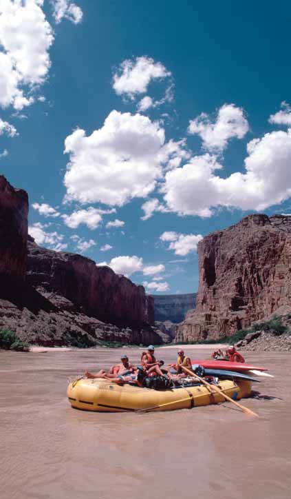
Conclusions and future outlook
Habitat modifi cation has provided some positive economic benefi ts to
the region's communities. It is expected that water infrastructure trends
will continue to stimulate economic development. The U.S. Bureau of
Reclamation has proposed new regulations and projects, including
off stream storage of water and privatisation of the Wellton-Mohawk
Irrigation District, which are likely to reduce fl ows to the Colorado River
Delta, with consequences for delta ecosystems (USBR 1998).
The Yuma desalting plant is a 260 million USD water treatment plant
built by the U.S. Bureau of Reclamation in Yuma, Arizona, about 32 km
from the international border. The plant was built to treat agricultural
drainage from the Wellton-Mohawk Irrigation District in Arizona.
Under the original plan, this treated water would be delivered to
Mexico as part of Minute 242. The plant was completed in 1992 but
has never been operated. The USBR is analysing options for operating
the plant and exploring possible markets, including California and
the Middle East via super tanker. The city of Yuma has the right of
fi rst refusal on the water. A decision to operate the Yuma desalting
plant and divert Wellton-Mohawk drain water from the Main Outlet
Drain Extension (MODE) canal could have disastrous consequences for
the Ciénega de Santa Clara wetland. The reduction in infl ow would
shrink the wetland by 40%, aff ecting both wildlife populations and
the residents of the nearby farming community Johnson ejido. If
water were diverted from this important wetland in the core zone
of the biosphere reserve, the immediate eff ects would fall on two
endangered species (Desert pupfi sh, Cyprinodon macularius; and Yuma
clapper rail, Rallus longirostris yumanensis) that depend greatly on these
wetlands for their survival.
In addition, the lining of the All American Canal would aff ect the
6 200 ha of wetlands along the border between Mexico and the
Figure 9
Rafting in the Colorado River.
United States, that was created by the infi ltrations of the All American
(Photo: Corbis)
Canal. Hinojosa-Huerta et al. (2003), from studies of satellite images,
detected six groups of wetlands in the dunes of the Mesa de Andrade,
have also provided social benefi ts related to economic growth and
south of the All American Canal and suggest that these have possibly
social prosperity.
provided services to birds of the Pacifi c Corridor since 1940, and since
1901 when the Álamo Canal was completed. In these lagoons they
The present trend is to gradually transfer water that was designated
identifi ed the presence of 43 bird species, among which are species
for agricultural activities to urban purposes. Since agriculture uses over
that are endangered and under special protection.
90% of water resources at a low cost, urban water transfers would allow
greater revenues to be received from water resources, thus increasing its
In positive terms, society will become more aware of the potential
economic value. It is believed that the social implications of this would
detrimental eff ects of water developments, and take into consideration
be a change in water culture and perceptions towards the conservation
environmental protection during planning and implementation of
of water resources.
water projects. It is expected that water recycling in the future will
fi gure more prominently as a conservation technique. The wastewater
ASSESSMENT
49
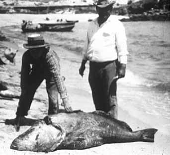
treatment employed for Mexicali (Mexicali II Project), has already
upstream reservoirs and revitalised wetlands such as the Ciénega de
demonstrated how new sources of water can be provided for the
Santa Clara. The Gila River fl oods in 1993 produced similar results.
Colorado River Delta.
The Totoaba fi shery declined dramatically since 1970 due to declining
populations and to restrictions imposed (in 1975) when catch levels
threatened the population. Despite closures, Totoaba gill net fi sheries
T
C
A
Unsustainable exploitation
IMP
continue on a small-scale and they remain a threat to the Marine vaquita
of fish and other living
populations. Juvenile Totoaba have also been caught and killed in
resources
substantial numbers of shrimp trawls, which further endangers the
Totoaba population.
Historically the Upper Gulf of California has supported numerous
Environmental impacts
fi sheries and commercially valuable species, providing important
Overexploitation
spawning and nursery habitat for shrimp, fi sh and other species in the
The overexploitation of fi sh resources is a considerable problem in the
Upper Gulf food chain. Various forms of human activity (shrimp trawls,
Colorado River Delta and the Upper Gulf of California. A large number
pollution, and freshwater shortage) may be altering the ecosystem of
of invertebrates (e.g. Penaeus stylirostris and Penaeus californiensis),
the northern Gulf, which ultimately aff ect local fi sheries, and the semi-
mammals (e.g. Tursiops truncatus) and commercial species of fi shes
enclosed nature of the Upper Gulf may serve to magnify the impact of
such as Totoaba (Cynoscion macdonaldi) and the Gulf curvina (Cynoscion
these activities.
othonopterus) are under critical conditions and some of them like the
endemic porpoise (Phocoena sinus) are on the verge of extinction (there
In the Upper Gulf, the once prolifi c Totoaba (Cynoscion macdonaldi), a
is a count of less than 600 vaquitas in the Upper Gulf of California)
highly prized commercial and sport fi sh (Figure 10), is nearly extinct,
(Jaramillo-Legorreta et al. 1999).
as is the Marine vaquita (Phocoena sinus), the world's smallest porpoise
and most rare mammal. In the late 1980s and 1990s the shrimp catches
Catches from the Upper Gulf shrimp fi shery dropped off steeply during
dropped by over 50%, signalling a virtual collapse in the shrimp fi shery.
the late 1980s and early 1990s by over 50%, signalling a virtual collapse
However, this activity noticeably improved when fl oodwaters reached
in the shrimp fi shery. Although the damming of the Colorado River may
the Gulf, such as in 1983-1988, when several km3 of water spilled from
have been the principle cause of the decline in the shrimp fi shery, the
escalation in the number of fi shing vessels and fi shing gear types could
have also infl uenced its collapse (Figure 11). As stocks have declined in
abundance, fi shermen have moved to the use of more effi
cient gear
(All 2002).
a 600
70
Guaymas
t
a Clar
Puerto Peńasco
60
500
n
a
Santa Clara
,
S
50 S
o 400
San Felipe
a
n F
40
ńasc
e
e 300
lipe
P
30
t
o 200
er
20
u
,
P 100
10
mas
y
0
0
Gua
1965-1966
1967-1968
1969-1970
1971-1972
1973-1974
1975-1976
1977-1978
1979-1980
1981-1982
1983-1984
1985-1986
1987-1988
1989-1990
1991-1992
1993-1994
1995-1996
1997-1998
Season
Figure 11 Escalation of fi shing vessels for the shrimp industry in
the Upper Gulf of California 1965-1998.
Figure 10 Totoaba
fi shery in the late 1940s.
(Source: Román-Rodríguez et al. 2003)
50
GIWA REGIONAL ASSESSMENT 27 GULF OF CALIFORNIA/COLORADO RIVER BASIN
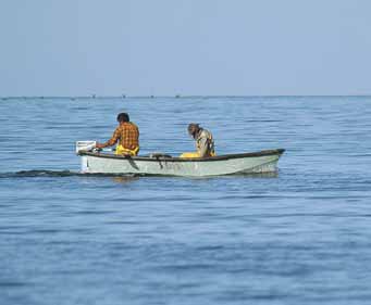
25
2 500
800
Catch
Blue shrimp
700
Flow
20
2 000
Brown shrimp
600
ear)
Total catch
Catc
onnes) 500
per y 15
1 500
(t
3
h
h 400
m
(t
(k
onnes)
Catc 300
w 10
1 000
o
Fl
200
5
500
100
0
0
0
1929
1931
1933
1935
1937
1939
1941
1943
1945
1947
1949
1951
1953
1955
1957
1959
1961
1963
1965
1967
1969
1971
1973
1975
1976-1977
1977-1978
1978-1979
1979-1980
1980-1981
1981-1982
1982-1983
1983-1984
1984-1985
1985-1986
1986-1987
1987-1988
1988-1989
1989-1990
1990-1991
1991-1992
1992-1993
1993-1994
1994-1995
1995-1996
1996-1997
1997-1998
Years
Season
Figure 12 Totoaba
fi shery annual yield and Colorado River fl ows
Figure 14 Specifi c and total catches of shrimp landed in the
to Mexico 1930-1975.
Port of San Felipe, Baja California, in the seasons from
(Source: Flanagan & Hendrickson 1976 with data obtained from Arvizu & Chavez 1974)
1976/1977 to 1995/1996.
Note: Rosas-Cota et al. 1998 states that as of the 1996/1997 season, artisanal
fishing reaches almost 50%. (Source: Rosas-Cota et al. 1996)
Some endemic species that reside in the Colorado River Delta have
a commercially and environmental importance in the Colorado River
Delta like the Totoaba. Although diverse studies suggest that overfi shing
Mexico (2003) estimated that there are 9 000 to 18 000 pangas active
had played the most signifi cant role for the decline in Totoaba stock
in the Gulf. In the three main communities of the Upper Gulf, the small-
during the pre-1958 catch period (Flanagan & Hendrickson 1976). The
scale fi shing fl eet now exceeds 800 boats, which exploit over 70 species
reduction of annual fl ow to the Colorado River Delta could have been
of fi shes, molluscs, and crustaceans on a regular basis (Cudney-Bueno
another strong factor in its decline, based on the fact that the alteration
& Turk-Boyer 1998).
of its environment aff ected its area of spawning and nursery ground
(Román-Rodríguez et al. 2003) (Figure 12).
Fish populations in the Gulf are also infl uenced by annual catch rates
that are related to the size of the fi shing fl eet; during the mid 1980s
Government policies have consistently encouraged the expansion of
several years of extremely heavy fi shing may have infl uenced the
both the industrial and small-scale fi shing sectors. Large artisanal fl eets
reductions in the shrimp population. Catch per unit eff ort has been
operating in the Gulf also contribute to overharvesting. In Sonora alone,
declining for decades, while fuel and export subsidies artifi cially sustain
there are an estimated 7 000 small boat fi shers (pangas) (Figure 13)
overcapacity of industrial fi shing fl eets.
(Arizona Daily Star 2001). A recent survey by Conservation International
From the beginning to the mid-1970s, shrimp boats made 9 trips on
average per season, each of which lasted from 17 to 20 days, with an
average catch of 115 kg/day (Rodríguez de la Cruz 1981). The number of
trips per season was maintained until the 1980s, and, on the other hand,
the average duration of each increased to 23 days, whereas the average
production decreased to 80 kg/day (Ehrhardt 1980). At the beginning
of the 1990s, fi shing trip length decreased to 20 days per season, with
an average of 5 trips per boat; the average catch per vessel decreased
from 52 and 35 kg/day in 1990 and 1991, respectively (Rodríguez de
la Cruz & Chávez-Ortiz 1996). Shrimp catch in the Port of San Felipe is
shown in Figure 14.
Excessive by-catch and discards
By-catch and discards was assessed as having a severe impact in the
Upper Gulf of California. In the industrial shrimp fi shery for example,
Conservation International Mexico (2003) estimated that for each kg of
Figure 13 Pangas
fi shing in the Upper Gulf of California.
(Photo: G. Ybarra)
shrimp, there are at least 10 kg of by-catch (Table 25). Of those 10 kg of
ASSESSMENT
51
Table 25
Estimated by-catch in the Upper Gulf of California.
Destructive fi shing practices
Volume
Relation
There have been drastic changes in benthic communities produced
Catch
(kg)
Shrimp:Type of catch
by the indiscriminate use of trawling nets (Mathews 1974), which for
Total 263
1:10
example in the Upper Gulf of California pass some areas more than
Shrimp 26
-
10 times per year. Most attention is given to the excessive by-catch and
Fish 164
2:10
the destructive fi shing practices because it is assumed that if fi shing
Invertebrate 72
4:10
techniques can be improved and discards and by-catch levels can be
(Source: Conservation International Mexico 2003)
reduced, the activity will become more sustainable.
Table 26
Trash species caught and discarded in the shrimp
industry.
Gill net fi
shing from pangas set for sharks, rays, mackerels
Common name
Scientific name
(Scomberomorus sierra and S. concolor), Chano (Micropogon megalops)
Longjaw
Oligoplites altus
(a croaker), and shrimp (Penaeus spp.); and occasionally in commercial
Corvina
Menticirrhus nasus
shrimp trawls, also incidentally captures the highly endangered
Yellowfin croacker, chano
Micropogon megalops
Vaquita porpoise (Phocoena sinus) and sea turtles. Between March
Orangemouth corvina
Cynoscion xanthulus
1985 and January 1994, 76 vaquitas were confi rmed to have been
Shortfin corvina
Cynoscion parvipinnis
killed incidentally in Totoaba gill nets (D'Agrosa et al. 1995). Although
Striped corvina
Cynoscion reticulatus
mortality rates are apparently greatest in gill nets with large mesh (0.25-
Blue crab
Callinectes spp.
0.30 m), shrimp trawling may also impact the Vaquita through the direct
Striped mullet
Mugil cephalus
depletion of an existing food source (shrimp) and by disrupting the
Paloma pompano
Trachinotus paitensis
benthos and associated food web.
Roosterfish
Nematistius pectorales
Bonefish
Albula vulpes
The total estimated incidental mortality caused by the fl eet of El Golfo de
Pacific sierra
Scomberomorus sierra
Santa Clara was 39 Vaquitas per year, over 17% of the most recent estimate
Gulf sierra
Scomberomorus concolor
of population size (D'Agrosa et al. 2000). All the porpoises taken in shrimp
Spanish mackerel
Caranx hippos
fi sheries were referred to as "very small", probably calves or juveniles.
Sicklefin smoothhound
Mustelus lunulatus
The Vaquita population are counted to be of less than 600 (Jaramillo-
Totoaba
Totoaba macdonaldi
Legorreta et al. 1999), therefore, considering normal replacement rates
(Source: Tapia-Landeros 2001b)
(maximum rate of population growth for cetaceans is of 10% per year),
this incidental loss can not be sustained by the population.
by-catch, there are juveniles of at least 16 species diff erent to those of
shrimp (Table 26). Only a few of these species have an economic value
Poaching of sea turtles is a problem throughout western Mexico,
(e.g. Mustelus lunulatus, Callinectes spp.) as they are caught in their early
although turtle-excluder devices are mandatory (though commonly
stages of growth (Conservation International Mexico 2003).
not employed) for industrial fi shing vessels. Sea turtles have been
essentially extirpated from the Upper Gulf.
In these operations, many species regarded as "trash" fi sh are killed and
discarded, along with associated invertebrates. Furthermore, species
Mathews (1974) estimated that an average shrimp net passed over
like dolphins (Tursiops truncatus), turtles (Dermochelys coracea), rays
every m2 of the Mexican Pacifi c shrimp grounds about seven times
(Gymnura marmorata), and vaquitas (Phocoena sinus) occasionally die
each year. In the Upper Gulf this rate may be signifi cantly greater than
in trawling and gill nets usually disposed for other target species.
elsewhere. This constant bottom trawling damages fragile benthic
habitats, although data to substantiate this contention are lacking.
SEMARNAP (1998) estimated the total value of by-catch as approximately
Silber (1990) counted more than 50 shrimp trawlers in a 6 km2 area and
1.32 million USD for the Gulf of California region. These revenues earned
several times over 80 boats were counted during a single visual scan
from by-catch are very small when considering that the total value for
of the horizon. It has been calculated that in a single shrimp season,
the states of Baja California and Sonora in the same year for the shrimp
the shrimp fl eet had reached over 1 100 boats, these shrimp trawlers
fi shery alone is 251 million USD. It is therefore argued that the ecological
annually rake an area of sea fl oor equivalent to four times the total size
costs of by-catch far exceed the economic value of by-catch.
of the Gulf (Brusca et al. 2001).
52
GIWA REGIONAL ASSESSMENT 27 GULF OF CALIFORNIA/COLORADO RIVER BASIN
Impact on biological and genetic diversity
Table 27
Average annual catches by fi shery 1994-2000.
The alteration on biological and genetic diversity is considered the
Volume
Species
(tonnes)
result of the introduction and release of alien species employed for
Sardine (Sardinops sagax)
46 021
commercial purposes like Catfi sh (Ictalurus punctatus) and Tilapia
Yellow fin tuna (Thunnus albacares)
21 166
(Tilapia zilli), and in some cases by the introduction of laboratory stock
Barrilete (Katsuwonus pelamos)
110 489
trying to increase their natural population, as is the case of the Totoaba
Anchoveta (Cetengraulis mysticetus)
7 803
(Cynoscion macdonaldi). It is important to mention that the problem
Macarela (Scomberomorus concolor)
7 143
is more accentuated in the freshwater habitats than in the marine
Blue fin tuna (Thunnus maccoyii)
1 560
environment; most of the fi shes of the Arizona Rivers for example, have
Blue (Litopenaeus stylirostris) and Brown (Litopenaeus californiensis) shrimp
437
been aff ected.
(Source: Secretaría de Desarrollo Económico 2000)
The pollution of water has aff ected various species (Tilapia zilli,
fi sh, although there also exists minor tonnage fi sheries with important
Micropterus salmoides, Mugil cephalus and Cyprinus carpio) all along the
economic revenue, such as the shrimp fi shery (Table 27).
Colorado River mostly due to an increase in selenium concentrations.
In the marine area, species like the Blue shrimp (Litopenaeus stylirostris)
From the beginning of the 1930s to the 1960s, shrimp fi shing grew
and White shrimp (Litopenaeus vannamei) have presented viruses and
exponentially in the area of the Upper Gulf of California. In the 1960s
species like Tilapia and other stocks have suff ered impacts by polluted
shrimp trawling fi shery was the country's most important sector;
waters (García-Hernández et al. 2001).
Golfo de Santa Clara, Puerto Peńasco and San Felipe have been and
still are the Upper Gulf's main fi shing communities. During the 1970s,
Socio-economic impacts
the sales price of shrimp increase considerably and a large portion of
Economic impacts
the population of San Felipe and Puerto Peńasco that was engaged in
Three groups are exploiting the fi shing resources in the Upper Gulf of
other activities (i.e. tourism), started getting involved in shrimp fi shing.
California, all markedly diff erent among each other: the industrial or
Simultaneously, there was a large migration from central Mexico to
major fl eet sector; the artisan or minor fl eet sector; and the national and
coastal communities in which shrimp were abundant. This was the age
foreign tourist sector. The former generally uses larger vessels for shrimp
of the "pink gold" rush, as it is known locally.
trawling and catching diverse fi sh species, whereas the second group,
also known as the small-scale riparian or bay fi shery sector, uses smaller
Until the end of the 1980s, the shrimp industry generated the majority
boats or pangas. This sector is characterised by its low investment in
of revenues for the fi sheries sector in this region. Besides increasing
equipment in comparison to the major fl eet and its high dynamics.
and industrialising the major fl eet, shrimp engendered the growth and
This type of fi shing activity takes place in the ocean, the Santa Clara
boom of the artisan or riparian fi shing sector. Although other fi sheries
marsh and the area known as El Zanjon or main fl ow of the Colorado
continued developing throughout the years, shrimp were the Basin's
River. The riparian fl eet exploits approximately 70 species. The tourist
main fi shery (Cudney-Bueno 2000).
sector partakes in sports fi shing activities, mainly provided by sports
fi shing service providers in Puerto Peńasco, San Felipe, to a limited
When shrimp fi shing in the Upper Gulf declined abruptly in the late
degree in the Golfo de Santa Clara and the Ejido Luis Encinas Johnson,
1980s to early 1990s, many cooperatives closed because of banks
within the Santa Clara Marsh (Cudney-Bueno & Turk-Boyer 1998). To a
seizing boats due to fi shers failing to make repayments on loans.
lesser degree, but not of lesser importance, the artisan fi shery sector
In Puerto Peńasco alone, the trawler fl eet decreased from 220 to
catches molluscs, such as octopus, squids and collects some bivalves. In
100 vessels (Cudney-Bueno & Turk-Boyer 1998). In view of this shrimp
summary, in the case of the three communities that comprise the Upper
crisis, a good portion of the commercial sector of pangas (small
Gulf of California, fi shery has experienced growth, which, by itself can
skiff s powered by outboard motors) diversifi ed activities, with some
only be translated as a partial recovery of the former production levels
permanently engaged in sports fi shing whilst others alternate between
existing prior to the great crisis observed at the end of the 1990s, before
commercial and sports fi shing, especially in San Felipe.
the establishment of the Biosphere Reserve.
The adoption of sports fi shing by some pangas fi shers has proved
The Upper Gulf of California is renowned for the volume of capture
profi table. For example, an average curvina weights 2 kg, at a price of
by its commercial fi shing of sardine, pacifi c sierra, anchoveta and tuna
0.45 USD/kg; the curvina has a value price of 1.09 USD in the seafood
ASSESSMENT
53
market. Pangas charge between 80 USD and 100 USD per half day
recommended to provide added value to the product, so that it may be
fi shing trip to sport fi shers, making the conversion to Mexican pesos,
feasible to catch a lesser number of individuals whilst obtaining a greater
the equivalent is 900 MXN. It is quite common, that a single panga takes
profi t margin. Excess fi shing has caused a decrease in the size of the fi sh
4 sport fi shers per trip, obtaining each an average of 4 to 5 curvinas. This
that are being caught, which suggests that species such as the Sicklefi n
way, the 20 curvinas caught during the trip generates a total income of
smoothhound (Mustelus lunulatus) are being overexploited (Table 28).
900 MXN to the fi shing guide and divided into a total weight of 40 kg,
gives an economic profi ciency of 2.45 USD/kg of curvina obtained with
Commercial fi shing resources in the Upper Gulf are exploited by the
a sport fi sh hook. Whereas, the curvinas captured with gillnet, would
industrial and artisan fl eet sectors. The industrial fl eet includes around
only have given an economic profi ciency of 0.54 USD/kg, and in the
114 shrimp and/or scale boats at Puerto Peńasco and 16 shrimp boats at
best of cases a profi t of 22 USD for the 20 curvinas (Tapia-Landeros
San Felipe. The remaining fl eet of middle-size or large boats for sports
2001a). With this example it can be deduced that the curvina sport
fi shing is 71 for Puerto Peńasco and 10 at San Felipe. There are also an
fi shery is 78% more profi table than the commercial fi shery of the same
undetermined and variable number of shrimp boats from other ports,
species. This example can be applied to the majority of the cases of
such as Guaymas, La Paz, Yavaros or Topolobampo that work in the
species that use bait.
Upper Gulf for some time during the shrimp season. The distribution of
fi shing capture by economic importance is shown in Table 29.
Due to the insuffi
cient control of catches, some fi shermen sell their
product to purchasers who come to fi shing camps. This generates an
Although certain species in the Upper Gulf of California and the
excess supply of the product, drastically decreasing prices. It is common
Colorado River Basin are under threat from unsustainable exploitation
to fi nd during the fi rst trimester of the year, piles of rotting curvinas on
by the fi sheries sector (e.g. Smoothhound, shark, Totoaba, Gulf curvina
the outskirts of San Felipe, Baja California, as fi shermen prefer to discard
and shrimp), in general this concern's impacts are not severe. The
them, rather than settle for an unacceptably low price. Therefore, it is
economic impact of a declining fi shery is minor due to the dominance
of the other productive sectors of the Basin's economy. However in
Table 28
Economic value and capture by species in Baja California
specifi c localities, such as in the Upper Gulf where fi shing is important
and Sonora.
to the local economy, this concern is persisting with considerable
Baja California
Sonora
severity.
Species
Catch (tonnes)
Value 1998
Catch (tonnes)
Value 1998
(USD)
(USD)
1993
1998
1993
1998
Shrimp
290
900
4 580 000
4 566
6 299
103 289 000
The shrimp fi shery in Baja California has an average annual catch of
Barrilete (Katsuwonus spp.)
9 669
4 665
4 225 000
ND
ND
91 000
437 tonnes (average 1994-2000, in 1982 it reached a maximum catch
Curvina (Cynoscion spp.)
124
422
441 000
195
2 496
2 386 000
of 1 800 tonnes), generating over 30 000 direct and indirect jobs and
Smoothhound (Mustelus spp.)
114
ND
213 000
682
94
121 000
economic revenues of over 132 million USD per season.
Shark
1 226
884
ND
960
1 283
241 000
Sierra
162
3 372
188 000
1 090
1 976
1 704 000
Sonora ranks fi rst in fi shing production at the national level. At the
By-catch
422
100
38 000
ND
ND
920 000
state level, crustaceans rank second in production, shrimp ranking fi rst
(Source: SEMARNAP 1998, INEGI 1999a)
Table 29
Spatial distribution of fi shing capture by economic importance in the Upper Gulf of California 1998.
Value
Volume
Species
Vessels and fisherman employed
Fishing zone
(USD)*
(tonnes)
1 133 vessels. Average of 6 fishermen per vessel Upper Gulf of California (Bahia San Jorge and Punta Radar) northeast of Isla Pajaros and south and west of
Shrimp (Litopenaeus spp.)
258 846 000
39 822
and 3 fishermen in small-scale vessels.
Topolobampo.
Baja California (west of Isla Cedros), Sonora (south of the Upper Gulf and Yavaros, north of Guaymas) Baja
Shark
6 306 000
5 842
ND
California Sur southeast of Los Cabos.
Mojarra (Diplodus spp.)
3 816 000
5 101
ND
Sinaloa (Topolobampo and El Castillo) and Sonora (Puerto Peńasco and Guaymas).
Corvina (Cynoscion spp.)
3 638 000
3 947
Fished by fin fishers and shrimpers.
Upper Gulf of California.
Sierra (Scomberomorus spp.)
2 632 000
3 275
15 vessels of 3 fishermen.
Upper Gulf of California and east to Huatabampo.
Berrugata (Menticirrhus spp.)
2 519 000
4 860
Fished by fin fishers and shrimpers.
South of the Upper Gulf and southeast and east of Topolobampo.
Baqueta (Epinephelus spp.)
2 505 000
1 201
Minor vessels of 3 fishermen.
Upper Gulf of California, between Guaymas and Huatabampo.
Bagre (Ictalurus spp.)
775 000
982
ND
South of P. Peńasco and east of El Novillero (Sinaloa).
Note: *Prices of 1998. (Source: SEMARNAP 1998)
54
GIWA REGIONAL ASSESSMENT 27 GULF OF CALIFORNIA/COLORADO RIVER BASIN
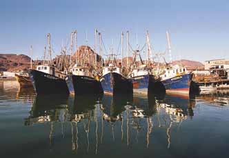
among crustaceans, with an average production of 12 000 tonnes from
trends is expected, enhancing the conditions of all marine habitats and
1990 to 1999. In 1999, Sonora contributed 26.6% of all national catches,
ecosystems.
increasing its total income to 249 million USD dollars, considering only
exported products (Ayala-Herrera 2001). The total population that works
In 1993 the Mexican Government declared the Colorado River Delta
in shrimp fi sheries amounts to 21 190 persons and, the shrimping sector
and the Upper Gulf of California a Biosphere Reserve. A moderate
alone employs 19 290 persons. With respect to the national total and
positive change can be expected, if the fi shery industry and local
that of the Pacifi c, the fi gures are 8.2 and 14.9% respectively, without
fi sherman respect the close seasons, spawning and nursery grounds
considering the large amount of indirect jobs this activity generates
in the Biosphere Reserve and replace trawling nets for more effi
cient
(Ayala Herrera 2001). Over 60% of the Mexican production is exported
gear. It can be optimistically considered that the impact from the
to the United States through Ocean Garden, a marketing company.
fi shery sector will be reduced and the fi shing communities will be
become less dependent on these activities through diversifi cation
Health impacts
of the local economy. Examples include low impact oyster farms and
In general terms, the existence of health issues related with
non-intensive closed aquaculture, ecotourism, and the use of natural
unsustainable exploitation of fi sh is unknown.
habitats for science education. These activities have been proved to
be minimally destructive to the environment whilst still providing
Other social and community impacts
substantial economic benefi ts.
The number of people aff ected by the unsustainable exploitation
of natural resources is limited and predominantly focused on the
Estero Morua is a coastal lagoon near the town of Puerto Peńasco that
fi shery. Social confl icts are related to the disputes for fi shery resources
is being developed as a model for sustainable wetland management.
between: the artisan and the industrial (commercial) fi shermen; the
Since the 1980s, this lagoon has been used by a women's oyster farm
environmental sector and the entire fi shery sector; and the sport fi shing
cooperative, "Unica de Mujeres del Mar". Despite diffi
culties in acquiring
and the artisan community. However, it is important to mention that
capital to initiate the oyster farm, the operation has become a great
due to the complexity and the permanent social problems generated
success and has led to two additional oyster farms in Estero Morua, and
in this activity, many people are looking for new economic alternatives
others are being planned. Today several dozen families depend on this
in the Basin. The resurgence of the Gulf curvina (Cynoscion othonopterus)
activity (Brusca et al. 2001).
fi shery has provoked several confl icts as most catches take place within
the Biosphere Reserve's core zone (Román-Rodríguez et al. 2003). The
If the fi shing industry continues with its indiscriminating fi shing
main problem is that the existing landing points (Golfo de Santa
practices, it has been suggested that funds from multilateral donors
Clara, San Felipe and Rio Colorado Camp) are considered as the most
such as the Global Environment Facility (GEF) be used to buy out the
productive and important fi nfi sh artisanal fi shery in both the Upper Gulf
older part of the shrimp fl eet (Figure 15). The estimated cost to purchase
of California and Colorado River Delta Biosphere Reserve.
400 boats and fi shing licenses would be about 60 million USD (Packard
Conclusions and future outlook
At the end of the 1980s and beginning of the 1990s, the economic
crisis, together with the low volume of catches, along with the
overexploitation of certain species, resulted in a 50% decline in catch
(Hernan 1997). Although there has been a partial recovery of the
fi shery sector, the overexploitation of natural resources is exhausting
commercial stocks and in some cases making them economically
unviable to fi sh (e.g. shark, smoothhound, and curvina fi sheries).
The current eff orts of national and international NGOs (e.g. Conservation
International, PRONATURA, WWF, Sierra Madre) in cooperation with
coastal communities and local and national authorities are yielding
solid results in conserving the natural resources upon which a large
Figure 15 Shrimp fl eet in San Felipe.
number of people depend. Therefore, an improvement in the present
(Photo: WWF/Gustavo Ybarra)
ASSESSMENT
55
Box 1
Human impacts in the Gulf of California.
The shrimp, commercial, and sport fi sheries, that were once thriving,
During the late 1950s, the Gulf of California began to show the first signs of
have steadily declined, but noticeably improved when fl oodwaters
deterioration by human activity, with the declining and almost extinction of the
Totoaba (Totoaba macdonaldi) fishery. Annual yield began to increase rapidly in
reached the Gulf, such as in 1983-1988 period. Although the amount
1934 and catch peaked at 2 261 tonnes in 1942 (Arvizu & Chavez 1972). After 1942,
despite intensified fishing effort and increased gear efficiency, the annual yield
of fl ow that would be needed to restore a small endangered species
exhibited erratic fluctuation to the all time minimum catch of approximately
58 tonnes in 1975.
habitat such as the Colorado delta clam (Mulinia coloradoensis) at
This endemic fish of the Gulf of California was initially exploited for the export of
the mouth of the River would be very large (Rodriguez et al. 2001).
its dried air bladders (known as buche) to the Orient market as an ingredient of a
gourmet soup (Conal 1993). Afterwards, its flesh was also highly commercialised
Restoration of shrimp habitat would require a vastly larger volume
mainly to the U.S. and Asian markets and used in international gourmets. The
Totoaba was also very popular among sport fishers mainly coming from the south
(308 million m3/year) of freshwater to double shrimp production in
of California and northern Mexico.
the Upper Gulf (Galindo-Bect et al. 2000) and this is not likely to be
Fishing pressure in the Gulf is extreme. The Basin's fisheries are operating under
practically open-access conditions, existing fishing regulations are not enforced,
released with the current pressures upon southwestern water supplies.
federal subsidies support overcapacity in industrial fleets, the biology of
commercial species is poorly known (or unknown), and monitoring programmes
Glenn (1998) estimated that the minimum water requirements (annual
measuring the ecological impact of Mexico's fishing operations are almost non-
maintenance fl ow + 4 year, overbank fl ood fl ow) to help restore the
existent.
The reduction of freshwater inflow, chemical pollution from agriculture and
Colorado River Delta ecosystem, is calculated to be of 520 million m3
urban areas, and coastal habitat destruction have combined with overfishing,
use of non-selective fishing gear, and lack of reliable scientific data to drive such
over four years, or an average of 130 million m3/year, which is much less
high-visible species as the Totoaba and vaquita porpoise (Phocoena sinus) to near
than 1% of the annual base fl ow of the River (20 km3/year).
extinction, cause local extirpation of five species of sea turtles, and substantially
reduces the Gulf's important commercial finfish and shrimp populations.
Cisneros-Mata et al. (1995) estimated that at least 120 800 juvenile Totoabas
were killed by shrimp vessels every year (from 1979 to 1987). In a research taken
The tremendous diversity of fi shing activities taking place within the
place by the Autonomous University of Baja California (Siri-Chiesa & Moctezuma-
Upper Gulf of California, the cultural diff erences between communities,
Hernández 1989), it was reported that in a single catch, 267 juveniles of Totoaba
were extracted from a shrimp vessel. This example helps to understand why the
the complexity of the fi shery, and the large-size of the Basin makes it
Totoaba is on the border of extinction.
Recent studies developed mainly by the U.S. have shown that a species of
a diffi
cult area to manage. This is aggravated by the lack of suffi
cient
sea clam (Mulinia coloradoensis) of the Upper Gulf has demonstrated to be an
resources for implementing and enforcing management decisions and
excellent indicator of the decadence of life in these waters. Before the dams, the
Colorado delta clam ranged as far as 60 km from the River's mouth and densities
federal laws, inadequate or lack of knowledge about the ecology of
reached 46 individuals per m2. Today, the species typically occurs within 30 km of
the River's mouth and at densities of only 0.15 individuals per m2 (Rodriguez et al.
exploited species, and insuffi
cient past eff orts to actively involve fi shing
2001). Life represented by this mollusc has been reduced to only 10% since the
construction of dams in the U.S. portion of the Colorado River in 1935.
communities in management decision-making (Cudney-Bueno 2000).
The dramatic decline of the Colorado delta clam since upstream diversion
of freshwater is most likely the result of the increased salinity of its habitat
(Rodriguez et al. 2001). Evidence for the importance of freshwater mixing in
the clam's habitat comes from the isotopic geochemistry of the clam's shell.
In addition, most, if not all, serranids are protogynous (female-first sequential
T
C
hermaphrodites), and the sciaenids require estuarine habitats in the rapidly
A
diminishing Colorado River Delta for spawning and nursery grounds.
Global change
IMP
Foundation 1999). International ecological organisations could also try
Several considerations were made regarding the impact from global
to impose extreme measures such as the tuna embargoes.
climate changes. Due to the lack of data and references the concern
was omitted. The GIWA assessment was reluctant to confuse normal
Declines in shrimp landings, mainly Litopenaeus stylirostris, have been
cyclic variations with human induced global climate changes. Specifi c
attributed to overexploitation and reductions of freshwater discharge in
impacts from ENSO (El Nińo Southern Oscillation) events were agreed
the Upper Gulf. The U.S. is responsible for 90% of the loss of freshwater
upon, but it was felt that there was insuffi
cient evidence to suggest
fl ows to the delta and the Upper Gulf of California, but on the other
that the intensity or frequency of these events in the Colorado River
hand overexploitation is due to ineffi
cient enforcement of Mexican
Basin and the Upper Gulf of California have been outside of normal
regulations over fi shery resources. The restoration and conservation
fl uctuations.
of the delta and Upper Gulf lies in both sides of the border. If the
government could manage to contend the commercial fi shery of these
species during the months of February and April, for example, the fi shes
could reproduce, take care of the small fry's and return to the Middle
Gulf to develop. These proposals are quite reasonable considering that
the fi shes with a commercial and sporting value are the ones of greater
size, leaving the ones of small-size, of very little or no value.
56
GIWA REGIONAL ASSESSMENT 27 GULF OF CALIFORNIA/COLORADO RIVER BASIN
Priority concerns for further
The impacts on the regions ecosystem were some of the most
analysis
important and potentially negative aspects of the analysis. Important
environmental consequences of the modifi cation of stream fl ow are the
Based on the GIWA assessment, it was concluded that the most severe
eff ects on riparian forests, anadromous fi sheries, wetland and marsh
concern for the region was Freshwater shortage due to its linkages and
area reductions, and substantial damage from elevated salinities in the
synergies with all of the other concerns. The concerns were ranked in
Upper Gulf of California. The delta wetlands and marine ecosystems
descending order of severity:
provide unique and valuable habitats to a large number of invertebrates,
1. Freshwater
shortage
mammals, birds and commercial species of fi shes that are under threat
2. Pollution
or on the verge of extinction (Alvarez-Borrego 1999).
3. Habitat and community modifi cation
4. Unsustainable exploitation of fi sh and other living resources
There are those who believe market forces will solve the problem, for
5. Global
change
example, by allowing farmers, who have a legal right to the river water
to sell water to cities. There are those who believe the answer lies in a
Freshwater shortage
continuation of the dam era, with bigger, bolder, more effi
cient water
The environmental issue of modifi cation of stream fl ow was considered
projects. And there are even those who believe the Colorado River
as the most important issue of the freshwater shortage concern.
should simply be set free, the Glen Canyon Dam torn down.
The dispute over the distribution of the Colorado River embodies critical
Pollution
issues in the region: the over-appropriation of water and the rapidly
Linked closely to the loss of freshwater fl ows, pollution is subject to
changing face of southwestern United States and northern Mexico
further analysis, considering that freshwater shortage has increased
compounded by population growth and ecological needs. The water
pollution by diminishing the dilution capability of the water bodies.
plan update for the Lower Colorado Basin presents two water supply
Although the main issue is salinity, the aff ects of pollutants such as
and demand scenarios that best illustrate the overall demand and water
selenium, methyl tertiary-butyl ether (MTBE), perchlorate and uranium,
supply availability. Currently the demands on the rivers water are by far
in the Colorado River Basin are expected to increase in severity in future
greater in the Lower Basin, exceeding the 9.25 km3 that the Colorado
years. Programmes that have undertaken extensive investigation and
River Compact of 1922 apportions to the Lower Basin states. On the
environmental analysis point out pollution (especially pollution of
other hand, by some calculations, unquantifi ed Indian water claims
groundwater supplies) as an important concern.
in Arizona alone could be as high as 3.8 km3 per year an amount
exceeding the average annual surface fl ow of the state (2.8 km3/year)
Annual reductions in total water supply for urban and agricultural uses
and almost half of the state's 1990 total water demand (Eden & Wallace
in southern California and northern Mexico could increase pollutants in
1992). Shortages shown under present average fl ow conditions are
the entire Basin. As a result of these shortages, groundwater recharge
chronic shortages indicating the need for additional long-term and
in most areas will be subject to detrimental hydrogeological changes,
short-term measures.
which result in increased salinity and pollution in most aquifers
(Navarro 1998).
In addition, reductions of surplus water programmed by the U.S.
Bureau of Reclamation (USBR 2000a) will result in negative impacts
Recommended actions follow the implementation of a bi-national
to the Colorado River Delta and Upper Gulf of California ecosystem.
water quality control programme along the U.S.-Mexico border in order
Most of the water that today enters the delta ecosystem is fl ood and
to improve the quality of water for the next 20 years. Implementation
wastewater. Surplus water in the Lower Colorado Basin has been proved
of these actions must be undertaken as part of a long-term water
to be benefi cial for the environment and most economic sectors. As
resource management program to restore the health of the Colorado
seen in the assessment, surplus water has had three main functions in
River and Upper Gulf of California, while making our water supplies
the Lower Basin of the Colorado: (i) leach salts and pollutants from the
more reliable.
Colorado River; (ii) revitalise wetlands and riparian vegetation along
the river watershed and the Upper Gulf of California; and (iii) provide
As population growth continues to escalate, pollution continues
additional supplies of water to the agricultural and urban sectors.
to increase in serenity, and will become a principal issue for urgent
government attention. The New River has already been a subject of bi-
ASSESSMENT
57
national negotiations concerning pollution. The ecology of the Salton
Canada in the North American Waterfowl Management Plan, and listed
Sea has been seriously threatened, with mortality of aquatic species
the delta as continentally important habitat. In 1996, delta wetlands
near discharges, as a consequence of agricultural, industrial and urban
were listed as a Ramsar site when Mexico became a party to the
effl
uents entering the river system.
Convention on Wetlands (also known as the Ramsar Convention) and
thereby agreed to place a high priority on wetland conservation.
Choice of the Colorado River Delta for Causal
chain and Policy options analysis
Delta ecosystems harbour migratory shorebirds travelling along the
In the United States use of the Colorado River has had transboundary
Pacifi c Flyway; serve as a breeding ground for marine species in the
implications due to water abstraction and diversion reducing fl ows
Gulf of California; provide habitat for a number of endangered species;
and increasing salinity before it reaches the Mexican border. As a
improve the quality of water that fl ows in from various sources and out
consequence of the western water policy a series of distribution and
to the Gulf; deliver a steady fl ow of freshwater to near-shore marine
pollution generated confl icts over the use of the Colorado River, has
(brackish) environments in the Gulf, improving breeding and nursery
brought Mexico and the United States repeatedly to disputes over the
grounds for the endangered vaquita; and produce important vegetation
rivers water resources. In addition, freshwater management plans during
to indigenous peoples. In addition to these environmental services,
the last decade, which have emphasised the importance of controlling
the delta historically has been a source of income for surrounding
pollution, usually failed to address the increasingly important problem
communities, supporting lucrative fi sheries and ecotourism activities.
of freshwater resource depletion in the U.S.-Mexico border region.
The Colorado River delta is clearly an international water system that
The Colorado River Delta region is the subject of increasing bi-national
is threatened by anthropogenic activities by both the U.S. and Mexico.
attention. Much of this interest focuses on the wetland and riparian areas
Given the intertwined diverse issues and complexities that have all
of the remnant delta, although the entire Colorado River border region
contributed to the environmental degradation of the Colorado River
are of interest, this area is the focus of water transfers, a quantifi cation
delta, as well as the interventions that have been initiated in order to
agreement, water conservation eff orts, a proposed aqueduct and new
address and mitigate the environmental degradation, the Colorado
turnout, channel modifi cation, habitat conservation and restoration
River delta stands out as prime choice for the Causal chain and Policy
plans, and wastewater treatment eff orts.
options analysis.
Confl icts and problems surrounding the delta region in Mexico have
I. Freshwater
arisen following the reduction of stream fl ows to the delta region, as
shortage
a result of unsustainable resource exploitation, inappropriate policies,
poverty, population growth, and marginalisation of the local population.
The Colorado River water fl ows are extremely important freshwater
resources to the rivers delta, without such fl ows the riparian and
III. Habitat and
II. Pollution
community
wetland ecosystems would certainly disappear, aff ecting permanently
modification
the livelihood of the people surrounding the delta.
In 1993, the delta and the Upper Gulf were declared a Biosphere
Reserve by the Mexican government giving it a special status to
IV. Unsustainable
the international community. This designation, sanctioned by the
exploitation of living
V. Global change
United Nations, is designed to protect world-class ecosystems while
resources
encouraging continued sustainable economic activity in surrounding
Figure 16 Linkages between the GIWA concerns.
buff er areas. Since then public interest groups on both sides of the
border have joined in partnership for the restoration of the delta and
Upper Gulf of California.
In addition, the delta was recognised as part of the Western Hemisphere
Shorebird Reserve Network in 1992. In 1994, Mexico joined the U.S. and
58
GIWA REGIONAL ASSESSMENT 27 GULF OF CALIFORNIA/COLORADO RIVER BASIN
Causal chain analysis
Arias, E., Becerra, M., Muńoz, C. and J. Saínz
This section aims to identify the root causes of the environmental
concerned with agricultural interests to urban and industrial
and socio-economic impacts resulting from those issues and
requirements. California consumes about 1/6 of the Colorado River's
concerns that were prioritised during the assessment, so that
water by way of the Colorado River Aqueduct. Lake Mead presently
appropriate policy interventions can be developed and focused
provides water for all uses for Las Vegas, and the Central Arizona
where they will yield the greatest benefi ts for the region. In order
Project aqueduct provides water for irrigating agriculture and human
to achieve this aim, the analysis involves a step-by-step process
consumption for the Phoenix Metro/Maricopa County.
that identifi es the most important causal links between the
environmental and socio-economic impacts, their immediate
In addition maquiladoras1 have thrived in cities like Tijuana, Mexicali
causes, the human activities and economic sectors responsible
and San Luis Rio Colorado, all of which are dependent on Colorado
and, fi nally, the root causes that determine the behaviour of those
River water. Maquiladoras have priority over water intended for urban
sectors. The GIWA Causal chain analysis also recognises that,
uses, and with their high profi ts these industries can aff ord to pay for
within each region, there is often enormous variation in capacity
water (Calbreath 1998). Some industries have even bought water from
and great social, cultural, political and environmental diversity.
treatment plants in the U.S., while others are trying to buy agricultural
In order to ensure that the fi nal outcomes of the GIWA are viable
water rights from the Mexicali Valley (Coronado 1999). These events
options for future remediation, the Causal chain analyses of the
mark the beginning of a new period where agricultural activities are
GIWA adopt relatively simple and practical analytical models and
being replaced by industrial activities on the border.
focus on specifi c sites within the region. For further details, please
refer to the chapter describing the GIWA methodology.
The management of water resources in the Colorado River Basin is
strongly infl uenced by the 1922 Colorado River Compact and the
Socio-economic forces drove many of the changes made throughout
1948 Upper Colorado River Basin Compact. With the exception of
the 20th century in the Colorado River Basin region. In the past, the
the Mexican Water Treaty of 1944, Mexico was practically left out of
economics of the Colorado River Basin were dominated by mining
the water equation in the Colorado River Basin, and have very limited
and agriculture, and social attitudes were highly infl uenced by
powers over the management of the Colorado's water resources.
the developments and decisions related to these industries. The
hydroelectric demands of the southern California metropolitan areas
Already under the present water-use scenario, the Colorado River
and the agricultural demands of California, Arizona, and Mexico have
Basin's water resources have been over-allocated. During the last
been the fundamental forces driving Colorado River water storage
fi ve years, water demands of the lower Colorado River Basin states
and release policies since the construction of Hoover Dam in the
have increased from the "normal" year supply of 9.2 km3 to more than
1930s. These demands are consistently present and will continue
10.1 km3. Considering that the estimated total demand in the Colorado
to grow.
River budget is of 24.5 km3/year and the average fl ow of the River
between 1930-1998 was of 17.5 km3/year (USGS 2004a), it is clearly
As the U.S. western state's population and need for water have grown,
that the situation is out of balance. There is not enough discharge to
the Colorado's water priorities have shifted from being predominantly
maintain present and most importantly future demands, without even
1Maquiladoras are in-process assembly plants owned by transnational corporations; they operate primarily for the export market.
CAUSAL CHAIN ANALYSIS
59
considering water rights to U.S. Native Americans and the minimum
water requirements to maintain the Colorado River's ecosystems.
ado
lor
o
er C
w
Lo
Salton Sea
At the time the Hoover and Glen Canyon dams were being constructed
the negative externalities2 that they would create were not recognised.
Imperial Reservoir
In the United States as in the rest of the world the purpose of the dams
Yuma
Lower Gila
was to improve human quality of life by providing drinking water and
Mexicali
to support economic growth by diverting water for power, navigation,
fl ood control, and irrigation. Water, like most other natural resources,
San Luis Rio Colorado
was viewed solely as a resource for humans. Economic evaluations did
Landcover
not incorporate the potential costs of environmental degradation and,
Barren
Forest
in turn, the costs would be borne by producers and consumers (Kenyon
Developed
Grassland
College 2002).
Savannah
Shrubland
Dry Cropland
and Pasture
Among all the users of the Colorado River, the Colorado River Delta has
Canal
Nonperennial
had to contend with the highest economical and ecological costs. The
Puerto Penasco
inland water.
River's delta once covered over 8 000 km2 of riparian-wetland habitat,
0
50 Kilometres
which supported over 400 species of plants and animals (Lueck et al.
San Felipe
© GIWA 2004
Figure 17 The Colorado River Delta.
1999). A sizable freshwater fl ow reached the mouth at the Upper Gulf,
(Source: based on USGS 2002b)
which replenished the delta with silt and delivered nutrients to fi sh
and other marine life. Now only 10% of the fl ow reaches the border,
and is completely consumed by municipal, industrial, or agricultural
River wetlands are northwest of the levee on the right bank, and the
users in Mexico.
Cienega de Santa Clara (4 200 ha) and El Indio (1 900 ha) and El Doctor
(750 ha) wetlands are east of the levee on the left bank. The delta also
The creation of wetlands and the recovery of riparian forests in the
commonly includes the intertidal zone along the fi nal 19 km of the River,
delta throughout the last 25 years however have brought attention to
encompassing 440 ha (Lueck et al. 1999) (Figure 17)
the region. Together with important local eff orts to exert control over
resources, international conservation interventions in the area off er
Physiography and geology
some hope of slowing the loss of reliable freshwater resources to the
Structurally the delta occupies the Salton Trough, a small section of
Colorado River Delta.
the dynamic junction or `crack' between the North American and
Pacifi c tectonic plates. The kilometre-deep soils and sediments of the
The following causal chain analysis will be focused on modifi cation of
Coachella, Imperial and Mexicali valleys and the lower delta region
stream fl ow in the Colorado River Delta.
represent materials ground out of the Rocky Mountains, the Grand
Canyon, and elsewhere by the Colorado River and its tributaries and
delivered into the tectonic crack. These are the delta deposits of the
Colorado River. Their area is roughly 8 600 km2, not including the
System description
underwater portion in the Gulf of California. The delta is not merely
the few hundred square kilometres of plains along the lower river
Physical characteristics
channel near the Gulf of California. The western boundary of the delta
The Delta extends from the Cahuilla Mountains south to the Gulf
basin is marked by large normal faults that create an abrupt transition
of California, and west from the edge of the Imperial and Mexicali
from the Sierra de Juarez of the Peninsular Ranges (a Mesozoic plutonic
Valleys to the Wellton-Mohawk Valley. The delta ecosystem is located
complex) to the basin fl oor. Three other mountain ranges of lesser
downstream of Morelos Dam and encompasses a land area of roughly
importance extend into the basin. All of these ranges are located to
600 km2 along the border of the Mexican states of Baja California
the left or west of an imaginary dividing line up the centre of the Gulf
and Sonora. It is characterised by low precipitation (52 mm/year)
of California.
and high evaporation rates (2 058 mm/year) (CILA 2000). The Hardy
2 Negative externalities are the costs of an action that accrue to someone other than the people directly involved in the action (Coase 1960).
60
GIWA REGIONAL ASSESSMENT 27 GULF OF CALIFORNIA/COLORADO RIVER BASIN
Hydrology
remained above the state level, but not by a suffi
cient margin to reduce
Hydrologically the region consists of two principal entities. One is the
the unemployment rate or to prevent a further divergence between
watershed of the Salton Sea, a terminal saline lake that receives infl ows
county and state incomes.
from an area that extends from Mount San Gorgonio in the north to the
Mexicali valley in the south. The other is the watershed comprised of the
During the last 30 years in Mexicali, the level of employment from
southern, exclusively Mexican part of the delta and adjacent uplands
agriculture, which had been the main employer, was reduced from
and mountains. What little surface water fl ows there are in this region
35.7% in 1969 to only 11.9% in 2000. Industrial employment, which
travel mostly via old channels of the Colorado to the Gulf of California. A
includes mining, manufacturing, construction and utilities, increased
third but much smaller watershed is that containing the terminal saline
its share from 22.3% to 35.0%, thanks largely to a rise in the maquiladora
lake Laguna Macuata (Laguna Salada) and bounded by the Sierra de los
industry from 1980 to 2000. The trade and services sector however
Cocopah and the Sierra de Juarez.
provided most of the employment opportunities, rising from 42.1% in
1969 to 53.1% in 2000.
Socio-economic characteristics
Population growth
Real wages during the last 30 years in Mexicali have behaved erratically.
The population growth in the Colorado River Delta region is shown in
Daily minimum wages rose in dollar terms from 1970 to 1980, only to fall
Table 30. On the eastern end of the California and Baja California border,
in 1990. The changes in minimum wages can be attributed to Mexico's
Mexicali is a great urban area, but has numerous small populations
economic instability during this period, which included high rates of
dispersed throughout the fertile Mexicali Valley agricultural area. Across
infl ation and devaluation.
the border, the Imperial Valley is characterised by a number of rapidly
growing communities, including the border town of Calexico (27 100),
The annual agricultural output of Yuma County reached 693 million USD
Imperial (7 600), Brawley (22 100), Holtville (5 600), and the centre of the
in 1998 (Gerber et al. 2002). Just as the agricultural output of Yuma
county government, El Centro (37 800) (U.S. Census Bureau 2000).
County dwarfs the production of farms in San Luis Rio Colorado, the
manufacturing output of San Luis Rio Colorado surpasses that of Yuma
Table 30
Population growth in the Colorado River Delta region.
by a wide margin. In neighbouring San Luis Rio Colorado, explosive
District
1990
2000
growth in the manufacturing sector has far outpaced the growth
Lower Coachella Valley
84 140
126 180
of agriculture in recent years. Nevertheless, agricultural production
Imperial County
110 750
142 360
still represents an important component of the economic output
Mexicali
601 940
764 600
of the municipalities of both San Luis Rio Colorado and Mexicali
San Luis Rio Colorado
111 510
148 690
(Gerber et al. 2002).
Yuma County
78 800
160 030
Total
875 630
1 341 860
(Sources: U.S. Census Bureau 2000, INEGI 2001)
Key players
The Yuma and San Luis Rio Colorado counties have experienced
tremendous population growth associated with industrial development
Agriculture
in the area, which has resulted in an increasing number and intensity
Major agricultural users of the Colorado River water are Coachella
of environmental problems related to wastewater pollution
Valley Water District, Palo Verde Irrigation District, Imperial Irrigation
(Gerber et al 2002).
District, Yuma Project (Reservation Division), and the Mexicali and San
Luis Valleys.
Economics
Imperial County is one of the poorest counties in the state of California.
In 1931 the U.S. Secretary of Interior asked California parties using
Contrary to what is probably common belief, its relative poverty cannot
Colorado River water draw up a priority agreement. Because agricultural
be attributed to agriculture and its large number of seasonal agricultural
users had been the fi rst users and were continuing consumers, they
workers. Agriculture, taken as a whole and combining both farm income
were given fi rst priorities to the water. The agreement is known as the
and farm worker income, actually generates above average incomes
Seven Party Water Agreement because of the participants: Palo Verde
on a per capita basis. Since 1985, county employment growth has
Irrigation District, Imperial Irrigation District, Coachella Valley Water
CAUSAL CHAIN ANALYSIS
61
District, Metropolitan Water District of Southern California, City of San
maintains the infrastructure necessary to provide Colorado River water
Diego, City of Los Angeles and the County of San Diego.
to irrigate 25 293 ha of prime agricultural land. The fertile agricultural
land is located along both sides of the Gila River for a distance of about
Coachella Valley Water District
96 km.
The Coachella Valley Water District (CVWD) was formed in January 1918
under the state water code provisions of the County Water District Act.
Palo Verde Irrigation District
Nearly 259 008 ha are within the district boundaries. Most of this land
The Palo Verde Irrigation District (PVID) is a privately developed district
is in Riverside County, but the district also extends into Imperial and
located in Riverside and Imperial Counties, California. Water for irrigation
San Diego counties. The district delivers approximately 0.345 km3 of
is diverted from the Colorado River at the Palo Verde Diversion Dam
Colorado River water to Coachella Valley farms annually. The district is
and is conveyed through 407 km of main canals and laterals to serve
involved in six water-related fi elds of service: irrigation water, domestic
approximately 36 423 ha of cultivated land. The irrigation return fl ows
water, stormwater protection, agricultural drainage, wastewater
are collected in a 240 km drainage system and returned to the Colorado
reclamation and water conservation. Recreation and generation of
River.
energy have become by-products of some of these services.
Mexicali Irrigation District 14 (Distrito de Riego 14)
Imperial Irrigation District
Mexicali Irrigation District 14 accounts a total water volume (including
The Imperial Irrigation District (IID), a community-owned utility,
groundwater) of 2.75 km3 per year. Water is distributed from Morelos
provides irrigation water and electric power to the lower southeastern
Dam, through a complex system and channels and levees that provide
portion of California's desert. IID interacts with many related water
water to the agricultural lands in Mexicali and San Luis. The Mexicali
and power associations as well as provides many community services.
Irrigation District system serves in excess of 207 965 ha under cultivation
The Imperial Irrigation District's canal and drainage system serves in
each year (181 318 ha Mexicali and 26 647 San Luis).
excess of 202 350 ha of irrigated farm land within its district boundary.
The Imperial Valley's region has an agriculture-based economy
Urban
that produces nearly 1 billion USD in crops annually and provides
Metropolitan Water District of southern California (MWD)
over 1 000 jobs in the Imperial and Coachella Valleys (IID 2000).
The Metropolitan Water District (MWD) of southern California is a
consortium of 26 cities and water districts that provides drinking water
Yuma Project
to nearly 18 million people in parts of Los Angeles, Orange, San Diego,
The Yuma Project provides water to irrigate 27 556 ha in the vicinity of
Riverside, San Bernardino and Ventura counties. MWD currently delivers an
the towns of Yuma, Somerton, and Gadsden in Arizona, and Bard and
average of 6.4 million m3 of water per day to a 13 468 km2 service area.
Winterhaven in California. The project is divided into the Reservation
Division, which consists of 5 939 ha in California, and the Valley Division,
Through the State Water Project it imports approximately half of all the
which consists of 21 617 ha in Arizona. The Reservation Division is
water used from the Colorado River to northern California. The water is
further subdivided into the 2 881 ha Bard Unit and the 3 057 ha Indian
distributed wholesale to 27 members of agencies and more than 140
Unit. The original features of the project include Laguna Dam on the
sub-agencies that delivers it to homes, business, and a few farms in the
Colorado River, the Boundary Pumping Plant, one power plant, and a
MWD's 13 468 km2 service area (MWD 2002).
system of canals, laterals, and drains. Laguna Dam has not been used
as a diversion structure since 1948.
International agencies and actors
International Boundary and Water Commission
Wellton-Mohawk Irrigation and Drainage District
Since the International Boundary and Water Commission (IBWC) has
The Wellton-Mohawk Irrigation and Drainage District (WMIDD) in
authority to operate and invest capital on both sides of the border,
Wellton, Arizona provides irrigation water, power, drainage and fl ood
the agency is often involved with domestic agencies dealing with
protection for the residents and lands in the Wellton-Mohawk Valley.
transboundary sanitation issues. IBWC has limited its activities on
WMIDD is part of the Gila Project authorised by U.S. Congress in 1947
border environmental matters to sewage related issues and water quality
to be built by the Bureau of Reclamation. The project was completed
concerns. A variety of programmes and treaties have been implemented
and transferred to WMIDD in 1951. Located along the Gila River in
over the past 50 years to address border issues, but none have dealt
southwestern Arizona, approximately 48 km east of Yuma, operates and
specifi cally with the delta region. The Border XXI Program and North
62
GIWA REGIONAL ASSESSMENT 27 GULF OF CALIFORNIA/COLORADO RIVER BASIN
American Free Trade Agreement are two examples of major bi-national
1994. River Basin Councils (Consejos de Cuenca) began to be formed
agreements that include environmental provisions, but neither has the
at the national level starting in 1992. The objective was to create
authority to allocate more Colorado River water for the delta.
irrigation districts with 5.8 million ha to be administered by users. The
National Water Commission (CNA) gives administrative responsibility
National, Federal and State agencies
to users of irrigation districts because the districts were too expensive
Many agencies of both federal governments are active in the border
to manage.
region, but in recent years the U.S. Environmental Protection Agency
(EPA) and Mexico's Department of Environment and Natural Resources
An irrigation module is legally constituted as a civil association of
(SEMARNAT, Secretaría del Medio Ambiente y Recursos Naturales) have
agricultural growers. They give their water and land rights to managers
taken the lead for their respective country on border environmental
of the association who administers the available resources for their
issues.
partners benefi t. Today, the Mexicali Valley has 22 irrigation modules.
In Mexico, water rights are assigned directly to each producer.
U.S. federal agencies have duties that involve border environmental
issues, including the Department of Commerce, the Department of
Agricultural water use effi
ciency
the Interior, the Department of Housing and Urban Development, the
Of the total water available in the valleys, most of it is used for
Attorney General, the Department of the Treasury, the Department
agriculture. Some 90% of the water in Mexicali and 98% of the water
of Defence, the Department of Health and Human Services, the
in the Imperial Valley is used for agricultural purposes. Unfortunately,
Department of Energy, and the Department of Agriculture.
effi
ciency of water use in both cases is very low; only 50% in Mexicali
and 55% in Imperial Valley (Roman & Ramirez 2003). In spite of high-
On the Mexican side, entities such as the National Water Commission,
tech agricultural developments in the Imperial Valley, agricultural use
the Secretariat of Health, the Secretariat of Agriculture, the Secretariat
of water is the main cause of increasing soil salinity. Sprinkler irrigation
of Energy, and the Secretariat of the Treasury are all involved in some
systems are the most-often recommended solutions, however in most
way with border environmental issues.
cases; these systems are used only in the fi rst stage of cultivation. After
that, gravity watering is used in an open furrow mode.
Water transfers
In 1963 the Coachella Valley Water District (CVW) and Desert Water
In the Mexicali Valley, gravity irrigation systems are used most often
Agency (DWA) entered into contracts with the state for entitlements
despite the variety of irrigation systems available. Only vegetable
to state project water. To avoid the estimated 150 million USD cost of
cultivation uses sprinkler and drip irrigation systems, and they do
constructing an aqueduct to bring state project water directly to the
so over a minimal surface area. In both valleys the cost of water is
Coachella Valley, CVWD and DWA entered into an exchange agreement
lower than the other costs of the productive process, including seeds,
with the Metropolitan Water District of Southern California (MWD).
fertilisers, machinery, and equipment. Cost use, and value of water diff er
MWD's Colorado River Aqueduct crosses Coachella Valley to carry water
signifi cantly across the border (Table 31).
to serve MWD's 26 agencies along the southern California coast. MWD
also is the major State Water Project contractor.
Table 31
Cost, use and value of water in the Imperial and
Mexicali Valleys.
Cultivated
Production
In April 1998, the IID and the San Diego County Water Authority signed
Cost
Water need
Revenues
land
coefficient
(USD/m3)
(km3)
(million USD)
(ha)
(USD/m3)
a historic water transfer agreement. Due to this agreement, disputes
Imperial Valley
0.01
202 500
3.07
1 400
0.45
have arisen between Coachella Valley Water District and the IID. The
Mexicali Valley
0.01
208 000
2.55
4.25
0.16
dispute has been long standing but has come to the forefront as the
(Source: Roman & Ramirez 2003)
result of IID's proposed transfer of Colorado River water to the San Diego
County Water Authority and Imperial Irrigation District over Colorado
Water in the in the Imperial Valley is priced at 0.01 USD per m3. In
River water
Mexicali, water is sold by 24-hour rates. Farmers pay 6.35 MXN for every
litre per second delivered during 24 hours, a total of 86.4 m3 per day.
Irrigation modules in Mexico
The cost of this water translates into 0.007 USD per m3. When comparing
A new form of water and land management was created with the
the cost of water to the revenues generated, it is clear that the water
National Water Law in 1992 and the National Water Law Regulation in
appreciates substantially in value based on its rate of return. Water
CAUSAL CHAIN ANALYSIS
63
Box 2
Recently approved reforms to the Mexican Water Law.
and fi nancing a water project among the various groups of users. In so
On April 24 2003 the Mexican Congress approved important reforms to the
doing, the Bureau must determine both the percentage of the costs
National Water Law (NWL) (the reforms were approved on April 29, when the
attributable to each use and then, given the allocation of the total costs,
Chamber of Deputies voted the reforms previously proposed and approved by
the Senate on April 24). These changes will improve the institutional framework
the actual amount it will charge each user group. Both calculations tend
of Mexico's existing water market and may lead to the provision of water toward
environmental purposes (Comisión de Recursos Hidráulicos 2003). Mexican
to be highly favourable to agriculture (Weinberg 1997).
authorities have recognised that the main problem of water distribution in
Mexico is institutional more than technical or geographic.
Under the previous water law National Water Commission (CNA) had most of the
For multipurpose projects; those whose purposes may include fl ood
responsibilities in setting the national water policy. State and local governments
and even regional representatives of CNA were unable to design specific
control, recreation, hydropower production, and municipal and
policies to improve the efficiency of water use and management according to
the specific needs, characteristics and resources of each region. Local proposals
industrial uses in addition to agriculture, the Reclamation Projects Act
were required to go through a time-consuming approval process of central
of 1939 directs the Secretary of the Interior to allocate costs to each of
authorities, leaving state and local governments with just a marginal role. During
the 1990s the federal government tried to decentralise CNA so states and local
the uses based on the proportion of the benefi ts each use receives
governments could manage water resources and find innovative solutions to
water scarcity. However, opposition from CNA and farmers blocked the effort.
from the project. However, it is rarely clear exactly what portion of a
In 2000, a new federal administration identified that a more decentralised system
could be an effective strategy to reduce water inefficiencies such as leaks, illegal
project's costs or benefi ts is attributable to a given use, and the ultimate
diversions, and avoidance of payment in urban areas (CNA 2001). Under the new
calculation is somewhat subjective (Weinberg 1997).
water law, CNA has greater autonomy to coordinate national policy while its
regional representatives, renamed Regional Water Basin Organisations, are now
the ones in charge of distributing, monitoring and charging for water in each
state. State and local governments can also enter into new agreements with the
Thus, even if agriculture receives 90% of the water developed by
federal government to administer the revenues from water fees coming from
their own jurisdictions (Comisión de Recursos Hidráulicos 2003).
that project, its share of the costs may be much smaller. Project costs
The recently approved water law establishes new rules to simplify the transfer
associated with public purposes are not allocated to any user group; the
of water rights and defines key terms and concepts that were previously
subject to misinterpretations. Farmers and industries will receive incentives to
government pays the costs. Such uses include fl ood control, recreation,
implement technological improvements to reduce water consumption (CNA
2001). Moreover, the law guarantees farmers that they will continue to receive
fi sh and wildlife, and Native American uses.
the same allocation of water they are currently receiving even if they reduce
their overall consumption (Comisión de Recursos Hidráulicos 2003). With this
guarantee, farmers will hopefully be motivated to reduce their total consumption
The formula for allocating the costs of fi nancing construction also
of water and sell or lease their surpluses without the threat of losing their original
allocation from CNA.
benefi ts agriculture. The government pays the interest charges on the
The new legal framework allows the President of Mexico to declare as a "disaster
portion of costs allocated to irrigation, but electricity users and urban
zone" a specific region where an ecosystem is threatened by natural or human
modifications. In this case, the federal government would have special powers
water users must pay interest charges on their portion of the cost of
(e.g. condemnation, special funds) to solve the problem. More importantly,
using water for environmental purposes will be considered a "beneficial use" of
constructing the project. In addition, all users benefi t from being able
water. Following domestic and urban use of water, which has the highest priority,
fisheries and environment, are the second in line for water allocations (Comisión
to spread repayment over a long period. The terms of that fi nancing
de Recursos Hidráulicos 2003). This represents a fundamental reordering of
beneficial use priorities.
typically allow 40 years to repay the project's costs, and they delay the
start of the repayment period up to 10 years from the date the project
profi tability in the Imperial Valley is 45 times the cost of water because
is completed. For farmers, that is analogous to a 50-year interest-free
a farmer is able to generate 0.45 USD for every 0.01 USD spent per m3.
loan for building irrigation projects (Weinberg 1997).
Although less extreme than in the Imperial Valley, water profi tability
in Mexicali is also high at 22 times the cost of water. Mexicali farmers
Finally, in addition to being relieved of the obligation to pay interest
generate revenues of 0.16 USD for every 0.007 USD spent per m3 of
charges, farmers may be obligated to reimburse the federal government
water. Thus the ratio of water productivity of Imperial County to Mexicali
for only a portion of their share of a project's construction costs. If the
is 0.45 USD to 0.16 USD or 2.8:1 for each cubic metre (Roman & Ramirez
Bureau determines that the portion of costs allocated to farmers will
2003). Under these circumstances, it is clear that agricultural water use
result in a price that exceeds the farmers' ability to pay, that is, the
in the region, when compared with domestic and industrial uses, has
amount farmers can pay and still realise a minimal profi t, the repayment
an extremely low index of economic productivity.
obligation is reduced to the amount the Bureau calculates that farmers
can pay. Electric power users must pay the diff erence between the
Subsidies
amount of project costs allocated to agricultural uses and the amount
United States
that agriculture will pay (based on the reduced repayment obligation)
The Bureau of Reclamation supplies water to agricultural water districts
(Wahl 1989).
with which it has long-term contracts. The contracts specify subsidised
prices and fi xed water allotments. The Bureau determines water prices
Substantial federal subsidies for irrigation-related construction costs
based on a complicated formula for allocating the costs of building
arose from that combination of pricing policies. The present value of
64
GIWA REGIONAL ASSESSMENT 27 GULF OF CALIFORNIA/COLORADO RIVER BASIN
federal outlays made between 1902 and 1986 for such projects was
Causal chain analysis
22 billion to 23 billion USD (in 1986 dollars) (Wahl 1989). The present
value of the money repaid by irrigators over that same period was
Immediate causes
2 billion USD. The repayment fi gure may ultimately increase by
Water use in the region over the last 50 years has signifi cantly reduced
another 1 billion USD, based on existing contracts. Thus, the federal
the fl ows of water in the Colorado River. Increased diversion, reduced
government's contribution to the cost of constructing and fi nancing
peak fl ows and changes in return fl ow were identifi ed as the immediate
irrigation projects amounts to about 85% to 90% of the total cost
causes for the modifi cation of stream fl ow (Table 33).
allocated to irrigation.
Increased diversion
Mexico
The hydrology of the Colorado River has been altered through a system
The four main types of social assistance programmes currently used by
of dams and diversions (Table 34) that deliver water for agriculture,
the Mexico government include food subsidy programmes, generating
urban use and hydroelectric power. Increased diversions by the various
programmes, credit programmes, cash transfer programmes and
states for inter-basin water transfers, urbanisation, and agriculture have
electrical subsidies.
all diminished the supply of water to the delta. The network of reservoirs
supply cities including Phoenix, Salt Lake City, Denver, Albuquerque, San
Agriculture in this part of the region mainly employs cash and electrical
Diego, Rock Springs, Las Vegas, Los Angeles and many others, which are
subsidies. The Program for Direct Assistance in Agriculture (PROCAMPO)
all experiencing rapid growth (Table 35).
is a cash transfer programme that the federal government confers
through the Secretariat of Agriculture, Livestock, Rural development,
Reduced peak fl ows
Fisheries and Food (SAGARPA). The primary objective of cash transfer
Prior to the construction of Glen Canyon Dam, between 4.9 and
programmes like PROCAMPO is to raise income (SAGARPA 1998). The
7.4 km3 of Colorado River water still inundated Mexico's wetlands
programme consists of cash payments to farmers based on their
historical production; to receive payments, farmers must farm the
Table 33
Freshwater shortage in the Colorado River Delta:
percentage contribution of issues and immediate
land, or put it into an environmental reserve. Transfers are on a per-
causes of the impacts.
hectare basis, decoupled from current land use, and fi xed across the
Issue
%
Immediate cause
%
whole country. PROCAMPO payments are about 85 USD per ha, and
Increased diversion
70
were 128 million USD in 2001 covering and average of 14 million ha per
Modification of stream flow
70
Reduced peak flows
20
year (OECD 2002).
Changes in return flow
10
Agricultural run-off
70
In accordance to the Diario Ofi cial de la Federacion (DOF 2003), the
Pollution of existing supplies
15
Evaporation induced concentration
30
agreement over the modifi cation of electrical water rates establishes
Excessive pumping
40
two types of electrical tariff s (Tarifa 9-CU and Tarifa 9-N) for pumping
Changes in the water table
15
Reduced recharge
60
water for agricultural uses in low and medium tension. It has been
estimated that the real price per kWh consumption in electrical costs
Table 34
Major dams in the Lower Colorado Basin and Mexico.
for pumping water is around 1.15 USD. Under present applicable rates
Reservoir
Elevation
price per kWh is in 0.15 USD (Table 32), although tariff s are established in
Dam
River
Country
Operation date
capacity (km3)
(m above sea level)
two-hour rate periods (diurnal and nocturnal) varying in costs. The tariff
Morelos
Colorado Mexico
Diverter
33
1950
establishes two hour rate periods applicable from Monday to Sunday.
Imperial
Colorado U.S.
Diverter
55
1938
Parker
Colorado U.S.
0.80
138
1938
Table 32
Electrical costs for pumping water for agricultural uses.
Davis
Colorado U.S.
2.24
197
1952
Diurnal time
Nocturnal time
Year
(USD/kWh)
(USD/kWh)
Hoover
Colorado U.S.
35.20
372
1935
2003
0.15
0.30
Glen Canyon
Colorado
U.S.
34.54
1 131
1963
2004
0.16
0.32
Painted Rock
Colorado
U.S.
5.96
212
1959
2005
0.17
0.33
Roosevelt
Gila U.S.
1.71
651
1911
2006
0.18
0.34
Total
80.45
(Source: DOF 2003)
(Source: CNA 1999)
CAUSAL CHAIN ANALYSIS
65
Table 35
Annual water use in the Lower Colorado Basin 1990-1996.
Water use (km3)
Apportionment
State
(km3)
1990
1991
1992
1993
1994
1995
1996
Arizona
3.45
2.78
2.29
2.35
2.77
2.65
2.73
3.33
California
5.43
6.43
6.17
5.60
5.96
6.45
6.07
6.55
Nevada
0.370
0.219
0.222
.219
0.251
0.281
0.267
0.307
Mexico
1.85
2.02
2.04
2.07
6.48
2.03
2.26
Unmeasured returns1 0.287
0.263
0.249
0.272
0.313
0.349
0.328
Notes: 1Estimates of unmeasured return flows are for the Colorado River diversions portions of Las Vegas Wash (Nevada) surface water discharge of Lake Mead, as found in decree accounting. Total
unmeasured return flows in 1991-1993 for Arizona and California are estimated to be 0.246 km3 and were proportioned on the basis of irrigated agriculture diversions.
(Source: Harkins 1997)
in a normal water year. The peak flow rate before its completion
Changes in return fl ows
would normally be around 2 410 m3/s for the month of June
The extensive use of the Colorado River water has led to a considerable
(Collier et al. 1996). The peak flow rate through the Grand Canyon
reduction in return fl ows to the river and provoked consternation from
after construction of the dam was reduced to 1 420 m3/s on rare
downstream users dependent on these fl ows. Since 1970, augmentation
occasions and is normally around 850 m3/s (USGS 2004a). Today,
plans have been required to replace water withdrawn by wells to satisfy
flows only reach the delta in very wet years. El Nińo created a
senior, downstream water rights holders (Mumme 1988). Augmentation
succession of these wet years between 1983-1987, allowing the
replaces the water extracted by irrigation wells.
reinundation of the delta and floodplains, dispersing tree and plant
seeds, and submerging land for the first time in nearly two decades
Substantial quantities of water diverted from the lower Colorado River
(Figure 18).
in the Yuma area, Arizona and California, return to a reach of the river
as groundwater fl ow. The average annual return fl ow for 1975-1978
9 000
was estimated to be 54.2 km3 from lands on the Arizona side of the
8 000
Below Hoover dam
river and 46.8 km3 from lands on the Californian side (Loeltz & Leake
7 000
/s)
Grand Canyon
3
1983). At Parker Valley, Arizona the annual return fl ow that discharged
6 000
(m
w 5 000
directly to the Colorado River in 1981 resulted in an estimate of 19 km3
r flo 4 000
of groundwater (Leake 1984).
t
e
a 3 000
W
2 000
1 000
Presently all return fl ows in the Lower Colorado River are mainly
0
wastewater and agricultural run-off s. From 1990-1996 return fl ows
1880
1900
1920
1940
1960
1980
2000
Year
have accounted to be higher than the apportionment given to the
Figure 18 Peak
fl ows of the Colorado River near Grand Canyon.
State of Nevada in the Lower Colorado River (Table 35). Eventually
(Source: USGS 2004b)
these return fl ows have been important sources of water to the delta,
the Salton Sea and the aquifers of the region, although these changes
The peak fl ows of the Colorado River at Lee's Ferry typically occur in May
have had localised negative eff ects on the water quality of the River
or June and have a broadly based shape. Statistical analysis revealed that
(García-Hernández 2001).
the 100-year peak fl ows are about 4 390 m3/s, the 20-year peak fl ows
are about 3 540 m3/s, and the average peak fl ows are about 1 840 m3/s.
Sector activities
This means that the river bypass tunnels probably could pass all but
Freshwater loss around the Colorado River Delta region is driven
about 10% of the fl ows in all years. Only years such as 1952, 1957, 1983,
primarily by the construction of dams, withdrawal of water for
and 1984 would there be more water than the tunnels could pass. In
agricultural purposes and the heavy reliance of urban centers on natural
those cases, there would be some fi lling (3 to 6 m) of the reservoir,
resources, particularly of freshwater resources. Underlying these driving
creating some head on the tunnel resulting in river fl ows of about 3 400
factors is the failure to resolve the problems surrounding the water
to 3 680 m3/s.
administration of the region. Population growth in the delta region is
attributed to the economical attractions of the region, considering that
66
GIWA REGIONAL ASSESSMENT 27 GULF OF CALIFORNIA/COLORADO RIVER BASIN
the southwestern part of the U.S. and northern portion of Mexico is the
Root causes
most dynamic region in the U.S.-Mexico frontier.
Demographic
The root causes identifi ed begin with the demographic aspects, which
The sector activities that infl uenced the modifi cation of stream fl ow in
refer to migration policies and incentives carried out during the 1940s
order of importance were:
in the U.S. Western states and Mexicali. The 1940 to 1960 period marked
1. Agriculture
the beginning of extensive spontaneous and planned immigration to
2. Urbanisation
the region. Offi
ces of the agrarian reform agency actively promoted
3. Industry
migration to the delta area (Table 36) (Gamboa 1990).
4. Energy
production
Table 36
Average annual population growth rates, Imperial
However, the analysis is only focused on the agricultural sector, since
Valley and Mexicali, 1940-1995.
Annual growth rate (%)
from a historic point of view many of the changes made throughout
1940-1950
1950-1960
1960-1970
1970-1980
1980-1990
1990-1995
the 19th century were infl uenced by agriculture, both in the U.S. and
Imperial Valley
0.53
1.36
0.31
2.2
1.78
5.09
Mexico (Worster 1985).
Mexicali
10.85
8.51
3.49
2.57
1.66
2.94
(Source: U.S. Census Bureau 2000, INEGI 1995)
Agriculture
In 1936, the Mexican president Cardenas stressed the need to develop
the resources of Baja California. Central to this was the exploitation of
The two nationalistic economic revolutions that collided in the
water from the Colorado River. Finally, Cardenas wanted to increase
Colorado River Delta not only created agricultural strains on the water
the population in Baja California and construct highways and
supply, but also encouraged large-scale immigration to the region.
railways between the peninsula and central Mexico as a defence
Viewed as an economic frontier by people of all classes throughout
against American economic and political hegemony through the
both nations, farmers, labourers, and their families descended on the
implementation of federal and local initiatives (Muńoz 1976). The
region in a chaotic frenzy. Immigration was heaviest in the Mexican
unparalleled success of these objectives contributed to the rapid
Delta, clearly refl ecting the asymmetric politic-economic relationship
depletion of water resources in the Mexican Delta and the concomitant
between the two nations. With the decline of agribusiness growth in
decline of ecological conditions in the region.
the region during the 1960s (Lorey 1999), the maquiladora factories
renewed U.S. corporate and Mexican working-class interest in heading
Extensive irrigation projects carried out in the 1940s and 1950s greatly
to the delta.
expanded Mexico's cropland, especially in the north (Betanzos 1988).
The government created areas of intensive irrigated agriculture by
Presently two features characterise the local population dynamics in
constructing storage dams across the Imperial and Mexicali Valleys
the Colorado River Delta: rapid population growth, due to high fertility
by controlling the Lower Colorado River, and by tapping the regions
rates and migration, and rapid turnover of the population. To date the
aquifers. These water-control projects allowed Mexico and the U.S. to
annual population growth rate for the main cities is calculated at about
expand rapidly its total land area under cultivation. Between 1950 and
4%, implying that there are more inhabitants in the area, increasing the
1965, the total area of irrigated land in Mexico more than doubled, from
demand over water resources in the region.
1.5 million to 3.5 million ha (Betanzos 1988).
Technological
In an eff ort to resolve Mexico's long-standing confl ict between
Increased development in irrigation technology throughout the
promoting agricultural production for export and for domestic
Colorado River Basin in the United States, as well as in the delta area,
consumption, the government followed a dual strategy between
infl uenced Mexican eff orts to develop the Mexicali Valley in the early
1940 and 1965; it promoted large-scale commercial agriculture
1930s (López-Zamora 1977). The construction and operation of the
while redistributing land to the rural poor (Hewitt de Alcantara
All American Canal and Boulder, Parker, and Imperial dams during
1978). Government policy favoured large producers because
the 1930s and 1940s boosted food production, but greatly disrupted
export agriculture provided foreign exchange needed to fi nance
the natural fl ow regimes of the Colorado River downstream. Instead
industrialisation. Extensive public investment in irrigation projects
of being controlled primarily by precipitation and natural run-off , the
primarily benefi ted northern areas (Benítez 1978).
river was regulated by American dams upstream. Depending on the
CAUSAL CHAIN ANALYSIS
67
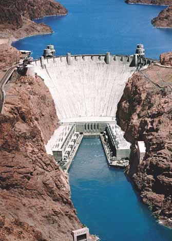
barriers and price subsidies. The stated purpose of the PROCAMPO
programme is to induce more market-based decision-making among
small farmers: they are expected to move from traditional crops to more
profi table forms of land use (SAGARPA 1998).
Farmers not only receive subsidies in electricity in order to pump out
groundwater (DOF 2003), but the use of water for agriculture is essentially
free of charge (Oritiz et al. 1997). These two elements provide an incentive
to overconsume water and they also create asymmetries in water
transfers. The obstacles to local resource management and successful
participation in markets are the result not only of legal arrangements,
but also of institutional arrangements that foster poor access to markets,
enforcement failures, corruption, and political manoeuvring. Economic
instruments, such as charging for water, have not been implemented in
the delta. This has encouraged the ineffi
cient use of water.
The lack of real economic alternatives to using land for agriculture is
equally important in shaping resource use. The political and economic
marginalisation of the Colorado River Delta has made it diffi
cult to
improve local socio-economic conditions of the native population
(Cucapá) or support resource use. Recent far-reaching changes in laws
and policies that shape markets and land tenure may have important
eff ects on the region in the long-term, but for the moment have limited
infl uence on local resource use patterns.
Figure 19 Hoover
Dam.
(Photo: Corbis)
Socio-cultural
Regarding socio-cultural aspects, agricultural development in the
needs of users and power companies throughout the American West,
Lower Colorado was induced by the need to produce food and other
USBR engineers either increased or decreased releases from these dams
agricultural products in semi-desert and desert zones. Through the
(Dowd 1951).
years the idiosyncratic diff erences molded the institutions and laws in
diff erent ways between the two nations.
Economic
Concerning economic aspects, the existence of historical agricultural
Legal
subsidies and the lack of economic valuation of water encouraged its
The Legal framework at both the national and international level is
use. Agriculture in the U.S. and Mexico has received extensive support
inappropriate for the current water use scenario and is inadequate in
from state and federal agencies. The local agricultural cooperatives
addressing freshwater shortage issues, due to a lack of eff ective legal
in Mexico have provided important assistance to producers , but still
instruments. The Law of the River has resulted in a very rigid system of
suff er from management and marketing problems. Through the 1970s,
water rights allocation in the U.S. and Mexico. Nearly every drop of water
government policy in Mexico aimed for self-suffi
ciency in agricultural
is accounted for in this allocation.
production (Aguirre-Avellaneda 1976). Under the recent liberalisation
programme, much of the support for domestic agriculture has been
The Law of the River has two inherent problems. The 1922 Colorado
reformed. The aim of current policy is to promote the competitiveness
River Compact, while successful in its time, is antiquated by today's
and productivity of the sector (Fritscher 1993). Until recently, staple crops
standards and usage. The Compact and the 1944 Water Treaty
were supported by guaranteed prices. This system has been replaced
allocates at least 18.5 km3 from the River. However, when the Compact
with the Program of Direct Rural Support or PROCAMPO programme,
was signed in 1922, the annual fl ow of the River past Lee's Ferry was
which was intended to cushion the impact of the removal of trade
estimated at 22.2 km3, based on fl ows from 1914-1923. Another study
68
GIWA REGIONAL ASSESSMENT 27 GULF OF CALIFORNIA/COLORADO RIVER BASIN
Issues
Immediate causes
Sectors/Activities
Root causes
Increased diversion
Agriculture
Modification of
Demographic
streamflow
Reduced peak flows
Technological
Economic
Changes in return flows
Socio-cultural
Legal
Knowledge
Governance
Political
Figure 20 Causal chain diagram illustrating the causal links of Freshwater shortage in the Colorado River Delta.
based on 1930 to 1998 calculated average fl ows of 17.5 km3, and fl ows
discarded. On the other hand there are also restrictions to access
over the past 400 years averaged only 15.2 km3 (USGS 2004a). Thus, the
offi
cial public information, although this improved after 2002 when
River is over allocated by almost 30%.
the Mexican Federal Government approved the Law of Administrative
Transparency and Access to Public Information (DOF 2002). The lack of
Comprehensive reform in the management of the Colorado River is
public awareness of the necessities, benefi ts and opportunities from
urgently needed. Getting California to live within its allotment, which it
conserving the Colorado's River Delta can be attributed, in part, to these
has regularly exceeded for decades, is the fi rst step toward sustainable
knowledge defi ciencies.
and equitable use of this vital international river.
Governance
Another problem with the Law of the River framework is that when the
The U.S. and Mexican governments continue to promote the
1944 Water Treaty was signed, the delta ecosystem was not considered
overexploitation of water resources through the provision of subsidies
as a benefi cial user of the water. Because the Law of the River stipulates,
for water use (e.g. PROCAMPO), rather than incentives to conserve
"use it or lose it", people are encouraged to overconsume the water.
water. It has been demonstrated that regular subsidies have not been
Article 3 of the Treaty outlines the following benefi cial uses of water in
eff ective in enabling effi
cient use of the resource. On the contrary, they
order of preference (IBWC 1944):
have been counter-productive in terms of conservation, as they have
Domestic and municipal uses;
created a situation where water essentially has no price in agriculture,
Agriculture and stock rearing;
allowing farmers to use as much water as they desire.
Electric
power;
Other
industrial
uses;
Another important aspect concerning governance is the inadequate
Navigation;
consideration of environmental services, which can be conserved
Fishing
and
hunting;
through a payment for environmental services.
Any other benefi cial use determined by IBWC.
Finally, the lack of effi
ciency occurs for several reasons: (i) lack of
Knowledge
suitable resources assigned to public, state and federal institutions; (ii)
There are considerable gaps in information, data, and knowledge about
economic power of some stakeholders; and (iii) low commitment from
the quantity, quality and temporality of water fl ows needed to maintain
River Basin Councils to fulfi l the recommendations that are discussed
the delta ecosystem. At the same time, the lack of information about
at their meetings.
the conditions of groundwater represents a problem in both countries
(USBR 1995a). One aspect that concerns both countries in the decision
Political
making process is that studies and investigations are not ratifi ed by
Ongoing disputes between the United States and Mexico over the
the governments, which makes these reports unoffi
cial and therefore
allocation of Colorado River water have lasted for almost a century
CAUSAL CHAIN ANALYSIS
69
rendering it diffi
cult for the two countries to agree on any amendments
Morrison et al. (1996) in their report "The Sustainable Use of Water in
to the 1944 Treaty. Within Mexico and the U.S., farmers are a politically
the Colorado River Basin" indicates that the Mexicali Valley is suff ering
powerful lobby. In the past 40 years their interests have dominated the
from a groundwater overdraft of roughly 118 million m3 per year. The
allocation of water to the detriment of the delta's ecosystem (Cortez &
overdraft could become even greater with the added lining of the All
Whiteford 1996).
American Canal north of the border; a source of groundwater recharge
for Mexico.
Presently about 80-90% of water is used by agriculture in both the
United States and Mexico (Pontius 1997). Farmers use the water
Seepage from the All American Canal has created a series of wetlands
essentially free of charge (El caso del agua dulce en Mexico 2003). The
totalling over 6 200 ha along the U.S.-Mexico border. Over half of these
only cost to farmers is that of pumping the water to their farmlands,
are in Mexico, east of the portion of the canal that is proposed for lining,
which in the Mexican case is also highly subsidised (Tarifa 09 and Tarifa
and will therefore be impacted by lack of further seepage. The Andrade
09-cu) (DOF 2003). This has encouraged farmers to grow water intensive
Mesa Wetlands are extensive and provide high-quality bird habitat in an
crops, such as alfalfa and asparagus in an arid climate.
isolated part of the northern Colorado River Delta where replacement
habitat is non-existent. The loss of this critical habitat should be
considered in assessing the potential environmental impacts of the
canal-lining project (Hinojosa-Huerta et al. 2003)
Conclusions
Mexico has a considerable interest in insuring that additional fl ows
It is very unlikely that any surplus water from the Colorado River is to be
reach the delta. This has given rise to fears that increased fl ows to
used for riparian restoration projects in the Colorado River Delta, due
Mexico would be used to recharge groundwater overdraft or to irrigate
to the exceedingly high demand of water in the U.S. western states.
fi elds in Mexico instead of as in stream fl ows for the environment. These
Although the Colorado River Delta is maintained by the discharge of
concerns may be incorrect for a least two reasons. The fi rst is that
fl oodwaters and agricultural drain water from the United States to
Mexico currently lacks the capacity to divert and store additional fl ows,
Mexico, it is known that even this source of water is to be questioned.
and second a Minute would obligate Mexico, under international law,
to release increased fl ows to the delta. The fact is that Mexico actively
The U.S. Bureau of Reclamation has proposed new regulations and
wants additional Colorado River water for the delta, not for other
projects, including off stream storage of water and privatisation of the
municipal or agricultural uses in the Mexicali region.
Wellton-Mohawk Irrigation District which are likely to reduce such fl ows,
without considering the impact on the delta ecosystems (USBR 1998).
The Colorado River provides water for agriculture, municipal and
industrial needs as well as electricity generation in the Lower Colorado
The Department of Interior, and the states of California, Nevada and
Basin. Major issues such as water rights to Native Americans, ecological
Arizona have developed along the Colorado River from Lee's Ferry
and urban water resources, as well as the question of how to allocate
in Arizona to the southerly international boundary, a multispecies
the shortage between actual fl ows and 21.5 km3 in allocations, have
conservation programme, with the purpose to remediate some of the
not been addressed.
damage to the riparian zone in the United States portion of the River. Yet
no offi
cial recognition is given to the delta ecosystems in Mexico.
Even if it were determined that more water should be given for the
delta, state interests and the United States government may remain
cautious about supplying more water to Mexico. "We don't have any
jurisdiction over how Colorado River water is used once it crosses over
the border into Mexico" said Robert Johnson, regional director for the
Bureau's Lower Colorado Region (Newcom 1999). The question still
remains, as to how to increase allocations to Mexico without revising the
Law of the River, which is considered by many to be a major undertaking
and one that could involve massive litigation.
70
GIWA REGIONAL ASSESSMENT 27 GULF OF CALIFORNIA/COLORADO RIVER BASIN
Policy options
Arias, E., Boone, A., Chia, D., Vargas, A., Gao, J., Becerra, M., Muńoz, C. and J. Saínz
This section aims to identify feasible policy options that target
Finally, for the long-term, the implementation of water markets to
key components identifi ed in the Causal chain analysis in order
increase the effi
ciencies of water use in Mexico is proposed, and the
to minimise future impacts on the transboundary aquatic
elimination of electricity subsidies to farmers in order to motivate them
environment. Recommended policy options were identifi ed
to use less water, thereby "freeing up" water potentially available for the
through a pragmatic process that evaluated a wide range of
delta. At the same time, farmers would benefi t from these changes by
potential policy options proposed by regional experts and
being able to market their water savings. Deep-seated institutional and
key political actors according to a number of criteria that were
political obstacles may very likely challenge any attempt to push these
appropriate for the institutional context, such as political
options forward. Thus, a long-term horizon is an appropriate way to
and social acceptability, costs and benefi ts and capacity for
frame their potential implementation.
implementation. The policy options presented in the report
require additional detailed analysis that is beyond the scope
Any solution to secure a guaranteed fl ow of water for the delta must
of the GIWA and, as a consequence, they are not formal
come from existing users in the United States and Mexico. This is due
recommendations to governments but rather contributions to
to the fact that the River is already over-allocated; there is simply no
broader policy processes in the region.
more water to allocate. However, getting this water will undoubtedly
be challenging considering the fact that agricultural interests, the
This report recommends four options to secure at least a portion of
largest users of water, are powerful and politically well connected,
the annual fl ow requirements for the delta ecosystem. The options
as are municipal users. Moreover, since existing users are not likely to
have been categorised into short-term (less than 5 years), medium-
voluntarily give up water for the good of the delta, any non-voluntary
term (5-10 years), and long-term (greater than 10 years) periods. The
eff ort must involve a reallocation of water under the auspices of the Law
short-term option is to lease water rights from farmers in the Mexicali
of the River, an eff ort that is almost certainly doomed to fail.
or San Luis Rio Colorado Valleys (District 14). Since existing Mexican
laws and regulations allow for the lease and transfer of water rights for
Moreover, it is strongly emphasised that any strategy to obtain a
conservation purposes, this is the most expedient method to secure a
guaranteed source of water must be bi-national; that is, both countries
guaranteed water supply for the delta.
should bear the ultimate responsibility of restoring the delta ecosystem.
As eloquently stated by Glennon and Culp (2002):
The medium-term proposal is to buy or lease water rights in the United
States and transfer the water to the delta. Since signifi cant legal barriers
"The historical context must inform any solution to the Delta problem.
(e.g. the 1944 U.S.-Mexico Treaty) exist to prevent the transfer of this
Mexico has seen one of its largest rivers, wealthiest agricultural districts,
water to Mexico, it may not be feasible to implement this option in
and most important fi sheries dried up, or salted up, by U.S. development
the near-term. However, there are serious equity concerns regarding
upstream. From a Mexican perspective, the Mexico-U.S. Water Treaty-
the exclusive purchase and leasing of water in Mexico, therefore the
-negotiated during a period of U.S. dominance and relative Mexican
amendment of a Minute to the 1944 Water Treaty is recommended.
weakness--was substantively unfair. In the intervening years, the U.S.
has consistently denied responsibility for the harsh environmental,
POLICY OPTIONS
71
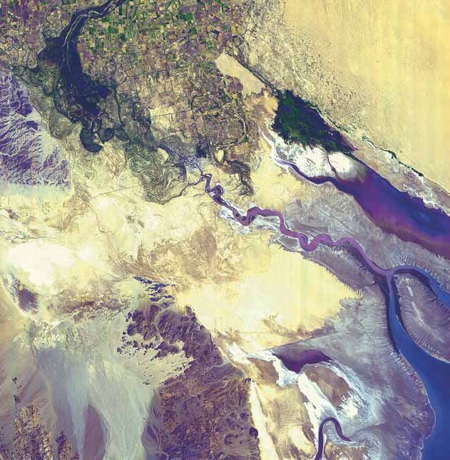
Figure 21 Colorado River Delta and the Upper Gulf of California.
Irrigation and urban sprawl now prevent the River from reaching the Gulf, which can be seen in solid blue at the lower right hand corner of the image.
(Photo: NASA)
social, and economic impacts to Mexico of its development policies
Short-term policy options
on the Colorado...Of the 17.5 maf of Colorado River water that is
allocated...the U.S. claims 16 maf--around 92 percent...To use only
Lease water rights in the Mexicali and San Luis
Mexico's apportionment to save what little is left of the Delta heaps
Rio Colorado Valleys and transfer associated
insult upon injury. Equity requires that the burden of water needed for
water to delta ecosystem
restoration be shared between the two countries."
This option involves the leasing of water rights in District 14 as the
Consistent with this perspective, options that can be implemented in
primary mechanism in Mexico to secure a guaranteed annual water
both Mexico and the U.S. are proposed. Below each option is described
source for the delta. This option can be implemented immediately as
and general steps to implement each option are further discussed.
existing Mexican laws currently allow water transfers for conservation
72
GIWA REGIONAL ASSESSMENT 27 GULF OF CALIFORNIA/COLORADO RIVER BASIN
purposes. Other mechanisms to secure water include permanently
Thus, if a farmer grows a more water-intensive crop, he receives a greater
purchasing water rights or land with associated water rights. However,
amount of water.
as explained below, at this point, the most expedient and economical
option is to lease water rights since farmers are reportedly opposed
This system reportedly operates eff ectively while minimising illegal
to selling their land and by extension, their water rights. This section
water diversions (Carrillo 2002). However, Clark et al. (2001) recommends:
briefl y describes the legal basis for leasing and transferring water
"If the CNA canal system and delivery ditches within the modules are to
rights and the steps that generally should be taken to implement this
be used to deliver water to the Delta ecosystem, it is imperative that an
option.
advocate for delivery of the Delta water be an active participant in the
governance of the participating module or modules".
Legal basis for leasing water rights
Essentially all the water available in District 14 is defi ned as national
Step 1: Inventory available water
waters, falling under the jurisdiction of the Mexican Water Commission
Initially, it is recommend that an inventory of available water supplies
(Comisión Nacional de Aguas, CNA). The Mexican government fi rst
for lease in District 14 should be conducted. The Sonoran Institute of
allocated water rights in this district in 1938 (Clark et al. 2001). These
Arizona is currently carrying out this task by focusing on those parcels
rights are tied to the land and allocated commensurate with the size of
that have not been under production for three to fi ve years (Zamora-
the parcel. In most cases, a water rights holder receives enough water to
Arroyo pers. comm.). According to the Institute, if farmers do not use
irrigate a 20 ha parcel. However, depending on the availability of water,
their land or water rights for agricultural purposes for four consecutive
this amount can vary from year to year (IBWC 1944).
years, they may lose their water rights. Therefore, the above timeframe
should provide a rough estimate of the total amount of water potentially
In 1992, the Mexican government passed a National Water Law (NWL)
available for lease.
to legalise the purchase or lease of water between private parties.
Water rights may be converted from an agricultural use to other
Step 2: Lease water rights from willing farmers
uses (e.g. ecological purposes) as long as CNA approves the change
After this inventory is available, individual farmers can then be approached
and law permits the new use. When approved, a water (or irrigation)
to gauge their interest in leasing all or some of their water allotment.
right is converted into a concession title and is valid for a period of
Alternatively, where appropriate, advertisements could be placed in
5 to 50 years. The concession title must then be registered in the Public
newspapers or in the offi
ces of CNA or modules. The price of water may
Registry of Water Rights, created by the NWL as a way of legally proving
be determined through three methods: (i) a standing off er; (ii) individually
the existence and status of a title. As of May 2001, CNA has never been
negotiated contracts; or (iii) through an auction (Pitt et al. 2002).
requested to approve the transfer of water for ecological purposes.
However, Clark et al. (2001), and Carrillo (2002) report that CNA offi
cials
Carrillo (2002) surveyed farmers within and outside District 14 to assess
in Mexicali generally would approve such transfers assuming the
their attitudes and willingness to lease their water rights or retire their
requirements of all laws and regulations are fulfi lled.
land for delta conservation purposes. For this reason, the survey was
limited to farmers owning land adjacent to the River or its levees; that is,
The Mexican National Water Commission
land which is the most suitable for riparian or wetland restoration. The
Mexico's National Water Law (NWL) serves as the basis for the
results of the survey indicated that 87% of the farmers surveyed with
management of national waters. The National Water Commission (CNA)
water rights are willing to lease them for purposes of maintaining and
is the federal agency designated to implement the policies of the NWL
enhancing native riparian vegetation. Of 663 ha of irrigated land owned
and develop associated regulations. To manage water allocations, CNA
by these farmers, the water rights associated with about 214 ha could
has divided water management districts into geographic modules. Each
be available for leasing. This amount of water is approximately 2.14 km3
module is governed by a local government entity that is responsible for
and the cost to lease this water is between 54 and 271 USD/ha/year
the management, operation, and maintenance of the module's water
or approximately between 8 210 and 41 400 USD/m3/year. Thus, using
distribution canals. Each module submits its water order to CNA who
these fi gures, the cost to secure an annual fl ow of 39 million m3 of water
then delivers the order to the external boundary of each module. The
would range between 213 100 and 1 073 600 USD.
module employs zanjeros (ditch riders) who make the fi nal delivery of
water to individual parcels. In District 14, CNA allocates water rights
Purchasing water rights or land with water rights attached is another
based on the assignment of regional and national cropping patterns.
option to secure water for the delta. Based on preliminary estimates,
POLICY OPTIONS
73
the cost to permanently purchase water rights in District 14 is
programme off ers a leasing price high enough to encourage farmers to
approximately 1 000 USD/ha or 152 000 USD/m3 (Zamora-Arroyo pers.
stop farming, there could be adverse economic consequences.
comm.). Thus, the total cost to purchase 39 million m3 of water would
be 3 950 700 USD. While a signifi cantly greater upfront payment is
Moreover, this option does not address the documented need for
necessary, purchasing water rights would be the most cost-eff ective
periodic fl ood fl ows in order to inundate the fl oodplain and produce
approach as benefi ts can be permanently guaranteed. Compared to
responses in native riparian vegetation. Zamora et al. (2001) recommend
leasing water rights, one would break-even by purchasing water rights
that when surpluses arrive in the River, they be delivered as fl ood fl ows
after approximately the fourth year of leasing (using the upper end
to the delta. The U.S. Department of Interior (Bureau of Reclamation)
of leasing costs). However, according to the survey by Carrillo (2002),
and the International Boundary and Water Commission (IBWC) would
almost all farmers contacted (96%) would be unwilling to sell their
likely be the most appropriate entities capable of addressing this need.
land "...because it is the only legacy they could leave to their children"
More specifi cally, new surplus criteria should be developed to allow
(Carrillo 2002). With this in mind, high resistance to purchasing water
environmental considerations to be taken into account when deciding
rights may also be encountered assuming farmers wish to leave a legacy
how annual surplus fl ows are allocated.
that involves the use of water. Nonetheless, because of it is more cost-
eff ective than leasing water rights; this option should not be dismissed,
The results of Carrillo's (2002) survey indicate that Mexican farmers
as some farmers may be willing to sell their water rights.
realise the importance of in-stream fl ows and are willing to participate in
water leasing or land retirement programmes that would provide these
Further steps
fl ows to the delta ecosystem. In addition to fi nancial gain, farmers also
With adequate funding from the Global Environmental Facility (GEF), a
understand that healthy riparian forests minimise the loss of farmland to
NGO could implement a water rights leasing programme in Mexico. As
erosion during fl ood events by providing stabilising riverbanks. Other
discussed above, the Sonoran Institute is initiating such a programme
farmers acknowledge that by converting their land to wetland or marsh
by inventorying available agricultural water supplies in District 14. After
habitat, they could, with expert advice, also explore other uses of their
leasing water rights, the NGO is expected to monitor the delivery of
land such as small-scale aquaculture operations or ecotourism activities
leased water to the delta through the local CNA offi
ce, the responsible
such as bird watching and camping (Carrillo 2002). This willingness
entity for delivering water to the delta. As recommended by Clark et
holds much potential for a water leasing or land retirement programmes
al. (2001), representatives of the NGO should also establish relationships
that could ultimately be expanded to a greater level with community,
with the leaders of the module(s) in which the water rights were leased
NGO, and government support and funding. At the same time, eff orts to
(Clark et al. 2001). Considering the precedent-setting nature of such a
assist farmers in developing economically viable alternatives to farming
programme, it is important that the NGO gain the trust of the leaders
should also be encouraged.
of the module and the community at large.
Sub-category: Grant subsidies to farmers in
Unresolved concerns
the U.S. and Mexico for implementing water
Assuming the actual amount of water available for lease in District 14 is
conservation measures
consistent with that which Carrillo (2002) identifi ed (2 million m3); this
In exchange for subsidies farmers could dedicate rights to water saved.
amount represents only 5% of the estimated 39 million m3 in annual
This water could be diverted into the delta.
fl ow needs. In order to meet this need, the balance would have to
be made up from U.S. or other sources. Nonetheless, even limited
Mexico is experiencing a serious problem of water waste, especially
guaranteed fl ows to the delta could benefi t existing riparian or wetland
in the agricultural sector. According to CNA (2001) 83% of the water
habitat during periods of drought (Carrillo 2002).
in Mexico is dedicated to the agricultural sector. Of this, water loss
fl uctuates between 30% and 50%. One of the explanations for this water
Although this report does not address the potential economic eff ects
waste is the lack of resources to implement conservation measures.
of this option, they should not be ignored. It is expected that farmers
This is one of the reasons farmers get less water for their production
would participate in a water-leasing programme if they expect to
activities, especially in areas where scarcity prevails. Implementing
receive greater economic benefi ts than those received from farming.
water conservation measures could help increase the quantity of water
Farmers with water rights that are currently not farming would likely
received in the agricultural sector, and thus farmers could divert water
be most interested in participating. However, to the extent that the
into the delta for conservation purposes.
74
GIWA REGIONAL ASSESSMENT 27 GULF OF CALIFORNIA/COLORADO RIVER BASIN
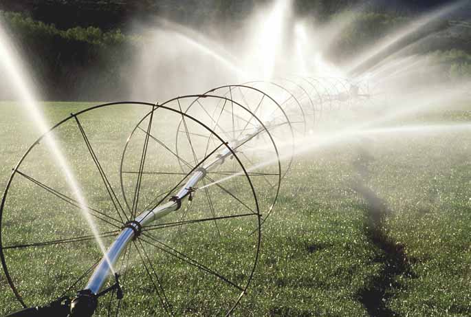
Figure 22 Irrigation system, California, U.S.
(Photo: Corbis)
Potential for water conservation in the agricultural sector
practices stipulated in a contract. This programme has been used
According to Pontius (1997), water conservation is the most eff ective
mainly to provide incentives for forest conservation, oriented to the
tool in demand management and often the cheapest source of new
production of environmental services such as improvement of water
water supplies. Water conservation measures are one of the least
quality, and biodiversity conservation or carbon capture (SAGARPA
expensive methods to provide water for growth and to assure an
1998). Other subsidies of this kind would be payment in exchange of
adequate supply for the future. Evidence suggests that there is much
PES, where individuals voluntarily refrain from certain uses that impact
potential in the Lower Colorado River Basin (U.S. and Mexico) for
the environment in his property.
eff ective water conservation in the agricultural sector. Farmers would
also save money from reduced water pumping costs.
The importance of technological measures
It is very important to balance available water resources between users,
Payment of environmental services
especially if the demand for water is increasing. The technological
PROCAMPO operates through direct payments to communities that
methods that can be used to improve the conservation of water in
participate in the conservation of the environment. That is not to say
the agricultural sector are as follow: better maintenance of existing
that every subsidy produce negative eff ects. Subsidies could be a good
irrigation systems, information management techniques, altered tillage
government option if they cover three criteria: (i) increase income levels
and soil management, or changes in cropping patterns (e.g. reduce
of poor people (equity); (ii) do not distort the market (effi
ciency); and
acreage, switch to less water intensive crops).
(iii) incentive environment protection. These three aspects could
be covered under a scheme of Payment for Environmental Services
The structural methods for the same purpose are: replacing open
(PES), where farmers get a payment if they follow the conservation
ditches with underground pipe, lining ditches, use of gated pipe, fi tting
POLICY OPTIONS
75
gated pipe systems with surge-fl ow devices, conversion from furrow
lease of water represents an economically feasible way to ensure water
to sprinkler irrigation or drip irrigation, upgrading existing sprinkler
for the delta.
systems, and installation of tail water recovery systems.
Legal basis and needed changes for the purchase or lease of
Morrison et al. (1996) suggested that approximately 1.73 km3 of water
water in the U.S.
savings could be achieved by the agricultural sector by investment in
Existing law establishes a strong foundation for this policy option.
irrigation effi
ciency and retiring marginal land. The California State Water
Under current U.S. law, water rights may be purchased or leased
Resources Control Board found that the Imperial Irrigation District could
without buying the property to which the rights are assigned. However,
save up to 0.49 km3/year with irrigation effi
ciency improvements.
property owners who have weak or junior water rights (those which
have legal standing after water allocation to senior rights holders have
Water transfers
been fulfi lled) may be at a disadvantage to those with more secure
Water transfers of this kind are becoming more common in California
rights and may receive a lower price for their water.
including a proposed agreement by the San Diego County Water
Authority and Imperial Irrigation District to "free up" 620 million m3 of
Despite this foundation, there are legal challenges to the transfer of
water. However, in order to transfer water to Mexico, a Minute to the
water between the Upper and Lower Basin states and between the U.S.
1944 Mexico- US Treaty would have to be executed.
and Mexico. The Colorado River Compact of 1922 allocates 9.25 km3 of
water to both the Upper (Colorado, Wyoming, Utah, and New Mexico)
Political feasibility
and Lower Basin states (Nevada, Arizona and California). If water is to
In order for the farmers to dedicate water to the delta and not keep
be transferred from the Upper Basin for restoration of the delta, the
the water for their own use, they have to have the right incentives. As
Compact may need to be amended in order to overcome political
previously discussed, the leasing of water rights is an incentive to save
opposition from Lower Basin states.
water. For example, the IBWC (2003) through Minute 309, has given
approval for the technifi cation project of Delicias Irrigation District in
Lease or purchase rights from willing farmers
Mexico, which is presently under way to transfer volumes of water saved
Agricultural production in the Colorado River Basin is often of low value
(396 million m3/year) that will eventually be incorporated waters down
and consists of water intensive crops such as wheat and upland cotton
of the Rio Conchos to Delicias Irrigation District and afterwards sent to
which return approximately 35 USD and 40 USD per million m3 of water,
the Rio Bravo in the U.S. (COCEF 2002).
respectively (Pitt et al. 2002). A recent report has estimated the cost of
leasing water in the Wellton-Mohawk Irrigation and Drainage District
in Arizona as 53 USD per million m3 plus an incentive payment. It would
cost approximately 2 million USD per year to provide the delta with an
Medium-term policy options
estimated annual fl ow of 39 million m3 (Lueck et al. 1999). The cost for
purchasing water in the Wellton-Mohawk is estimated to be about 10
Purchase or lease water rights in the United
times the cost of leasing it or about 530 USD per million m3, excluding
States in order to use the water for ecological
incentive payments (Pitt pers. comm.). Therefore, the estimated
purposes in the Colorado River Delta
cost to purchase water rights equivalent to 39 million m3 would be
Water transfers, or the purchase or lease of water, are an important
17 million USD. It is believed that securing permanent water rights will
and successful tool to redistribute water between geographic areas
be signifi cantly more diffi
cult than leasing because it limits the options
or between user groups. Water transfers such as those between the
for agricultural production on the property.
Central Arizona Project and other southwestern states have allowed
for the redistribution of water that would have otherwise not been
Institutional capabilities
feasible because of the rigidity of the Law of the River. The purchase or
With adequate funding a non-profi t or governmental entity could be
lease of water rights in the U.S. may provide a signifi cant portion of the
charged with identifying available water to purchase or lease in the
annual fl ow needs of the delta, although there exists legal challenges
U.S. This entity would purchase/lease, hold, and monitor the delivery
to transfer the water between the Lower and Upper River basins and
of the water to the delta. The proper price of water may be determined
between the U.S. and Mexico. Because agricultural production in this
through three methods: (i) a standing off er; (ii) individually negotiated
region is of low value and uses water ineffi
ciently, the purchase or
contracts; or (iii) auctioning (Pitt et al. 2002)
76
GIWA REGIONAL ASSESSMENT 27 GULF OF CALIFORNIA/COLORADO RIVER BASIN
In the Upper Basin, it is impossible to quantify how much water each
interested in selling water, the District itself is on record as opposing
farmer uses because of a lack of gauging stations at individual parcels.
the sale or lease of its water and, under Arizona law, it has a veto power
The use of water is determined by comparing historic outfl ows (as a
over sales by individual farmers to parties outside the district.
proxy of current infl ows) to present-day outfl ows. Overall, Upper Basin
usage is determined by what is used downstream, severely limiting
Despite the political and legal barriers to voluntary water transfers
the extent to which water rights purchased in the Upper Basin may
from the U.S. to the delta, this policy option represents a way in which
be enforced.
water can be transferred to the delta without the need to renegotiate
the Law of the River. Due to ineffi
ciencies in agricultural production in
At the Mexican border, the IBWC would be responsible for ensuring
the Colorado River Basin and the opportunity for farmers to benefi t
that the purchased amount of water reaches the delta. A stream gauge
fi nancially, a water transfer programme could address the needs of the
station should be located near or at the delta to aid in monitoring. The
delta ecosystem and water interests in both countries.
IBWC has recently asserted its interests in ecological issues through
Minute 306, passed in 2000 (IBWC 2000), that provides a framework for
Sub-category: Amendment of a Minute to the
bi-national cooperation in carrying out scientifi c research on the delta
1944 Water Treaty for ecological purposes
ecosystems. The Minute establishes a "framework for cooperation"
Minute 242 to the 1944 Water Treaty already addresses the problem of
to address ecological concerns of the delta and suggest possible
salinity, while Minutes such as 261, 264, 270, 273, 295 and 298 already
alternatives for restoring the delta. The process would include the
deal with various border sanitation issues. What is needed, more
"formulation of recommendations for cooperative projects" (IBWC
specifi cally, is an ecological Minute to the 1944 Treaty that addresses
2000). The Minute represents a substantial leap forward towards the
the full water cycle of the Lower Colorado River Basin as it relates to the
restoration of the delta.
native fl ora and fauna of this massive riparian ecosystem.
The entity holding the water rights must have the institutional
Legal basis for amending a Minute for ecological purposes
capability to ensure, by checking stream gauge readings and water
The U.S. National Environmental Policy Act (NEPA) requires all federal
records, that IBWC is delivering the appropriate amount of water to the
agencies to prepare an environmental impact statement (EIS) for all
delta. In addition, experts believe that independent observers may be
actions that signifi cantly aff ect the environment.
necessary to ensure unbiased monitoring (El caso del agua dulce en
Mexico 2003).
The U.S. Fish and Wildlife Service (FWS) and all other federal agencies
must ensure that their actions do not jeopardise the continued
Political feasibility
existence of or adversely modify the critical habitat of all listed species
Despite the fact that the water transfers are voluntary and economically
under the U.S. Endangered Species Act (ESA).
feasible, there may be political opposition to this policy option because
of the enormous pressure on the Colorado River's resources. The Upper
Particularly relevant to Mexico is the ESA requirement that federal action
Basin states may oppose water transfers because it would signal that
agencies such as the U.S. Bureau of Reclamation must consult with the
they are not using their entire allocation of water for "benefi cial
FWS on any action that might jeopardise a listed species; the Totoaba,
consumption", opening up the possibility of a reallocation between
Vaquita porpoise, Desert pupfi sh, Yuma clapper rail, and Southwestern
basins. In addition, the Lower Basin states may oppose the transfer
willow fl ycatcher are among the Mexican resident or migratory species
because they currently benefi t from water that the Upper Basin does
listed under the U.S. Endangered Species Act.
not use and therefore fl ows into their states. Water transfers would
eff ectively mean that the Lower Basin states would have to pay for
In addition, the Colorado River is governed by the Law of the River;
the water they are now receiving for free (Culp 2001). However, it is
Mexico is an integral component of the Law of the River itself, through
conceivable that water transfers for ecological purposes, as public
the 1944 U.S.-Mexico Water Treaty. In this way Mexico, entitled user of
goods, would not cause the political opposition that other water
the Colorado River under International Law, has the right to negotiate
transfers may provoke.
over water resources of the Colorado River if the upper riparian state
(U.S.) aff ects in any way the natural resources of the lower basin state
On the other hand Glennon and Culp (2002) note that, while individual
(Mexico), in which case the construction of dams in the U.S. has aff ected
farmers within the Wellton-Mohawk Irrigation District might be
the natural conditions of the Colorado River Delta and its ecosystem.
POLICY OPTIONS
77
The Treaty of 1944 would need to be amended through a Minute of
Comparative water transfer costs
the IBWC to allow water to fl ow from the U.S. into Mexico in excess of
The cost of permanently acquiring water rights in the U.S. is expensive,
the 1.85 km3 currently provided through the Treaty. For example, the
ranging from 10 to 20 times the price of leasing water rights. The cost of
Treaty of 1944 could be amended through a "congressional-executive"
leasing water in Mexico will become more expensive than permanently
agreement that would accomplish the same results as a full-fl edged
purchasing water rights after 3-18 years, based upon the range of leasing
amendment to the Treaty of 1944. However, it would be more politically
prices. In the U.S. the cost of leasing will exceed the cost of permanently
feasible as it only requires a majority of both the U.S. House and Senate
purchasing rights after 10 years. However, one must consider that
rather than a two-thirds vote required of the Senate for a treaty
leasing costs will decrease in the future due to discounting.
amendment. The minute will be able to overcome legal challenges
raised by individual states because it is an executive agreement and as
In addition, the cost of leasing water in the Wellton-Mohawk district is
such, supersedes any confl icting state laws.
two to seven times the price of leasing water in Mexicali and San Luis Rio
Colorado. The cost of purchasing water in Wellton-Mohawk is roughly
Political feasibility
4.3 times the price to purchase water rights in Mexicali and San Luis Rio
Although many states will oppose the amending of a Minute to the
Colorado (Table 37).
Water Treaty regarding additional supplies of water for ecological
purposes, it is quite comprehensible that actions to restore the delta
Table 38 analyses the cost of providing one-half (19.5 million m3),
consist of cooperation between both countries. In this way the U.S.
three-fourths (29 million m3) and the full amount of annual fl ows
in part should proportion part of the solution that is needed for
(39 million m3) needed for the delta based on preliminary estimates. In
restoration and maintenance of the delta.
addition, it analyses the diff erence between providing the amount of
water exclusively within Mexico, exclusively within the U.S., and shared
Salinity increases as possible alternatives to increase water
equally between the two countries.
fl ows to the delta
Glennon and Culp (2002) considered that salinity increases in the
The lowest cost option for leasing or purchasing water over all amounts
Lower Colorado Region could be a factor of new negotiations of water
is to obtain the water from the Mexicali/San Luis Rio Colorado district.
deliveries in the short-term, due to the adoption of the new Colorado
Table 37
Price of leasing compared to purchasing rights .
River Surplus Criteria. The Environmental Impact Statement of the
Location
USBR regarding Colorado River Surplus Criteria, completely ignored
Mexicali and San Luis Río Colorado,
Wellton-Mohawk, Arizona, U.S.
the salinity eff ects on Mexican water users, and failed to provide an
Mexico
estimate of increased river salinity below Imperial Dam. Because Minute
Price
Price
Total cost (USD)1
Total cost (USD)1
(USD/ million m3)
(USD /million m3)
242 requires an exact proportion between the levels at Imperial and
Lease
6.66-33.55
213 120-1 073 6002
53
1 696 0002
Morelos dams (a diff erence of no more than 115 ppm ±30 ppm), the
Purchase
123.46
3 950 720
530
16 960 000
salinity levels at Morelos are far more signifi cant than the levels at
Note: 1 Total cost to provide 39 million m3. 2 Total cost per year.
(Source: With data from Pitt et al. 2002, Carrillo 2002, Zamora-Arroyo pers. comm.)
Imperial Dam. The Basin states alternative would increase the fl ows
that reach Imperial Dam but reduce them below the dam. Therefore,
Table 38
Sensitivity analysis of purchase/lease allocation in the
the salinity levels at Imperial and Morelos will likely diverge, which could
Wellton-Mohawk and Mexicali/San Luis Rio Colorado
districts.
easily result in violations of Minute 242.
Amount of
50% lease/
Location of
100% lease
100% purchase
water
50% purchase
purchase
(USD)
(USD)
(km3)
(USD)
On this basis, if salinity exceeds the salinity levels stipulated in Minute
19.5
342 000
1 220 000
2 099 000
242, the USBR may be forced to re-open the Yuma Desalting plant
100% Mexico
29
503 000
1 795 000
3 087 000
facility. Due to elevated operational costs, Glennon and Culp (2002)
39
643 000
2 297 000
3 951 000
suggest that Mexico off er the U.S. an alternative and cheaper means of
19.5
621 000
3 088 000
5 554 000
50% Mexico/
reducing salinity to an acceptable level based on increasing the fl ow
29
914 000
4 541 000
8 168 000
50% U.S.
39
1 170 000
5 813 000
10 455 000
of the River, thereby generating water for the delta as an incidental by-
19.5
901 000
4 956 000
9 010 000
product (Glennon & Culp 2002).
100% U.S.
29
1 325 000
7 288 000
13 250 000
39
1 696 000
9 328 000
16 960 000
(Source: With data from Pitt et al. 2002, Carrillo 2002, Zamora-Arroyo pers. comm.)
78
GIWA REGIONAL ASSESSMENT 27 GULF OF CALIFORNIA/COLORADO RIVER BASIN
However, the exclusive purchase and leasing of water in Mexico has
In addition, according to the OECD (2002), "Decoupling refers to the
serious equity concerns. It is frequently asserted that Mexico lacked
eff ects of a measure, or a set of measures", a policy is decoupled if it
bargaining power during the 1944 Treaty negotiations and thus,
has no or only very small eff ects on production and trade. A decoupled
was under-allocated its fair share of water (Culp 2001). Therefore it is
policy should not aff ect either production or consumption decisions
recommended that the U.S. and Mexico share purchase or lease of water
(OECD 2002). Contrary to the decoupled subsidies, ordinary subsidies
rights to some degree.
do not necessarily contribute to a more effi
cient way of production.
They lack the incentives to use effi
cient ways of production, and the
misuse of resources such as water or electricity is greater. It has been
demonstrated that decoupled subsidies work better because there is
Long-term policy options
compensation to the price increase, in which it is calculated how much
payment is needed in order to raise the price of electricity for instance.
Institutionalise the market for water in Mexico
and convert electricity subsidies
As discussed above, it is natural to believe that there will be opposition
This policy option aims at institutionalise the market for water in Mexico,
coming from the agricultural sector, especially because water price
convert the electricity subsidy in the agricultural sector through a cash
has not been an issue in their production decisions. However, with a
subsidy or decoupled subsidy in order to approximate to the real price
decoupled subsidy this burden can be diminished. In the European
of water, as well as eliminating the price subsidies of domestic users
Union one of the most important forms of support to the agricultural
of water.
sector has been cash payment. Experts argue that these payments
are more secure than a price support system, with a better guarantee
Currently, farmers receive water at a highly subsidised rate - essentially
behind them (Frawley & Keeney 2000). This option may be politically
it is free. Not only does this provide an incentive to overconsume water,
feasible if the cash payments can indeed improve production in the
but it also distorts the water market. The estimate of the real price of
agricultural sector. Therefore, this option would be more feasible in the
water could be useful to reduce information asymmetries in water
long-term, giving an opportunity to the farmers to adjust to the idea
transfers. The diff erent prices of water that have been negotiated by
that water has a price.
farmers do not always refl ect the "real" cost of water; in economic
terms, the market price does not equal the marginal cost of providing it.
As far as water price is concerned, it is proposed that the elimination
Authorities estimate that most transactions are below the marginal cost.
of price subsidies to domestic users of water. Subsidies to export-
Currently water rights sold in the Mexicali Valley range between 700 and
oriented crops are diffi
cult to modify given the possible reduction in
1 200 USD per ha. The "real" costs of water are estimated between 3 000
competitiveness for agricultural products in the international markets.
and 4 000 USD (Oyarzabal pers. comm.).
Similarly, modifying water subsidies for industry can aff ect the
competitiveness of Mexico as a main recipient of foreign investment.
Farmers currently receive subsidies in the price of electricity to pump
out groundwater. These subsidies give farmers the incentive to
In order to minimise political opposition to this proposal the
overexploit this source of water. Though eliminating this subsidy may
government can lower taxes to the general population and increase
not be politically feasible, converting it into a cash subsidy could lead to
cash subsidies to the low-income population. Currently the low-income
greater effi
ciencies in use. Currently, most farmers receive cash subsidies
population is very well identifi ed through a cash subsidy programme
to compensate price subsidies elimination in agricultural inputs (e.g.
called OPORTUNIDADES. This programme targets the poorest families
seeds, fertiliser) through the Program for Direct Assistance in Agriculture
in the country off ering cash grants if they met certain conditions (e.g.
(PROCAMPO). With a cash subsidy, farmers could choose if they prefer
sending their children to school, go to clinics for regular check ups)
to consume other goods and reduce or eliminate their consumption of
(SEDESOL 2003). To meet these conditions without enhancing current
underground water. In other words, farmers may be able to fi nd cheaper
disparities in water distribution, a parallel increase of water distribution
sources of water thereby reducing or eliminating their consumption
to underserved areas would be necessary. The recently approved
of groundwater while using the money they save for other purposes.
changes obligate CNA and local and state governments to expand the
Therefore, this policy can lead to the reduction of market distortions,
distribution of water to underserved areas and increase price subsidies for
overexploitation of groundwater, and save public resources without
low-income groups. Approximately, 10% of urban population does not
harming the interests of farmers.
have access to water. Most of this population lives in poverty or extreme
POLICY OPTIONS
79
poverty in Mexico. However, they are forced to pay the highest prices for
Identification of the
water, which they purchase from mobile tanks (Roemer 1993).
recommended policy options
However, this increase in price subsidies might be the wrong strategy to
This report addressed the following problem: too little water is being
follow because it generates incentives for overconsumption and would
allocated towards ecosystem maintenance or restoration in the
probably represent an expensive burden to public fi nances. Like the
Colorado River Delta. In fact, neither the United States nor Mexico
farmers using groundwater, low-income groups might prefer increased
offi
cially allocates any water to the delta. As a result, it has suff ered
cash subsidies to buy other goods while at the same time being able to
considerable environmental degradation and aff ected the lives that
cover their water needs by paying the "real" price of water.
depend on it for survival. Though it still supports diverse plant and
animal life, including threatened and endangered species, its expanse
Sub-category: Volumetric allocation
has shrunk from approximately 7 770 km2 to only 600 km2; and only 5%
Volumetric allocation is the quantity of water per hectare that
of its original wetlands still remain (Lueck et al. 1999).
corresponds to each user registered in the user's census (Padron de
usuarios). Each association is responsible for determining the quantity;
Therefore, the short-term policy option: Lease water rights in the Mexicali
on basis of the irrigated surface rights of their associates and the volume
and San Luis Rio Colorado Valleys and transfer associated water to the
of water that corresponds to its release point, deducing loss from canal
delta ecosystem, and the long-term policy option: Institutionalise the
seepage and dividing surplus volumes among the irrigated surface of
market for water in Mexico and convert electricity subsidies, are proposed
all the users that conform the (Guillen et al. 1999).
as preliminary measures to assure minimal fl ows of freshwater into the
delta. Additionally, also proposed are the long-term policy option that
Potential for water conservation in the agricultural sector
attempts to increase the effi
ciencies of water use in Mexico through
As have been described above, one of the main problems of highly
market mechanisms, thereby "freeing up" water potentially available for
subsidised water prices is that subsidies give farmers the incentive
the delta, and the medium-term policy option: Amendment of a Minute
to waste large amounts of water due to a lack of control of federal
to the 1944 Water Treaty in which it specifi cally stipulates water deliveries
agencies (CNA). A possible way to reduce water waste from agricultural
for the delta as a bi-national solution to compensate for freshwater loss
use, without reducing the farmer's share of water or changing crop
to the delta ecosystem. The recommendations are in priority order:
patterns, is to allocate water portions volumetrically. This way every
Lease water rights in the Mexicali and San Luis Rio Colorado Valleys
farmer or consumptive user gets a quantifi ed measure of water and uses
and transfer associated water to the delta ecosystem. In addition,
it effi
ciently, relying on the fact that they won't be able to acquire any
grant subsidies to farmers in Mexico for implementing water
more water than that designated or at least at a low cost, unless they
conservation measures.
buy water rights from another stakeholder.
Convert electricity subsidies for Mexican farmers to cash subsidies,
and eliminate price subsidies to municipal water users in Mexico.
Political feasibility
Increase
the
water
use
effi
ciency in Mexico through market
Despite the fact that there may be political opposition to this policy
mechanisms, thereby potentially "freeing up" water for the delta.
option because of the enormous pressure of farmers who already
Amend a Minute to the U.S.-Mexico Water Treaty, to stipulates
have "stipulated" quantities of water, on the other hand there are
minimum fl ow rates for the delta.
new demands to give new concessions of water of an already over-
apportioned river. The only way of obtaining more water for agricultural
Analysing the future tendencies of water use in the Lower and Upper
purposes is to reduce wastewater and make distribution more effi
cient.
Basin of the Colorado River, the most viable way to obtain surplus water
This could be a solution, although many farmers may oppose to
for ecological purposes is to change agricultural water use patterns
volumetric allotments because it would signal that they are not using
without aff ecting present deliveries to water stakeholders and farmers
their entire allocation of water for "benefi cial consumption".
in the Mexican part of the delta. This implies changes in the actual
Mexican National Water Law, regarding the time and quantity of
If a price is placed on water used in agriculture, farmers will begin to
deliveries of water for agricultural purposes.
question the economic viability of growing water intensive crops, which
may lead to a change in crop types.
Although there are alternatives to water surplus deliveries like the
Mexicali II Project, the implication of this alternative has negative
80
GIWA REGIONAL ASSESSMENT 27 GULF OF CALIFORNIA/COLORADO RIVER BASIN
impacts for the U.S. portion of the Colorado River Delta. Each year
fl ooding will not always solve this problem. In order to implement
Mexicali discharges about 49 million m3 of effl
uent into the International
eff ective conservation programmes more water fl owing directly into
Boundary Drain, which empties in the New River. The New River
the delta is needed. However, economic and technical support from
originates 35 km, south of the international boundary and fl ows north
the United States will be necessary, and realistically, the Lower Colorado
through Mexicali, crossing the border into California's Imperial Valley.
River Basin states will probably not agree to allow more water to reach
About 70 km to the north, it empties into California's Salton Sea, a closed
Mexico.
basin, where evaporation tends to concentrate pollutants.
Therefore the preservation of the Colorado River Delta ecosystems will
To reduce pollutants that are diverted to the New River and eventually
remain a complex task. To maintain suffi
cient stream fl ows in the River,
the Salton Sea, the U.S. and Mexico, agreed to build a bi-national
the alignment of numerous institutions, agreements, and organisations
wastewater treatment plant to be called Mexicali II. The projects
will be required. As a transboundary representative, the International
objective is to treat more than 1 645 litres per second and serve a
Boundary and Water Commission (IBWC) still remains as the most
population of more than 0.5 million people (IBWC 1996). The negative
eligible institution to achieve this goal in the long-term, although
implication to the U.S. is a change in the plants design, since it could
it remains cautious in its jurisdiction over environmental problems
discharge in the New River (U.S.) or in the Hardy River (Mexico).
relating to the Colorado River Delta; therefore the criticism of the way
it operates and manages problems concerning to the environment.
If the treated water is discharged to the New River, this could possibly
improve water quality conditions in the Salton Sea. But if the treated
Mexico has actively attempted to conserve the delta region through
water were to be emptied in the Hardy River Basin, a considerable
initiatives such as the Upper Gulf of California and Colorado River Delta
amount of water would no longer reach the Salton Sea, creating more
Biosphere Reserve (Reserva de la Biosfera Alto Golfo de California y Delta
environmental problems than it already has. On the other hand disposal
del Rio Colorado). This has demonstrated the federal government's
in the Hardy River wetlands would help maintain important ecosystems
commitment to conserving this vital ecosystem..
in the Colorado River Delta.
Considering the transboundary implications of the Colorado River
Delta as a shared watershed, the responsibility for its protection relies
on both riparian states. To date, both Mexico and U.S. state and federal
Conclusions
government agencies have resisted active bi-national cooperation
to restore the health of the Colorado River Delta ecosystem. These
Under international law individual states are endowed with the right
agencies instead point to the absence of any formal agreement
to control territorial resources. Consensus, however, is diffi
cult to reach
between the federal governments of the United States and Mexico
on what constitutes an equitable and reasonable utilisation and when
regarding allocation of Colorado River water for delta conservation.
another state is adversely aff ected by such utilisation.
There is extensive legal precedent for protection of the delta region.
Although the two countries cooperate as good neighbours in developing
There exists between Mexico and the United States a signifi cant history
the vital water resources of the shared river in which each has an equitable
of cooperation in the conservation of shared natural resources, including
interest, there is the obligation to notify projects related to transboundary
water, vegetation and wildlife. As evidenced by a substantial number of
water, considering that any change in the water balance aff ects both
organisations, there exists broad international support for restoration
sides of the border. Presently the Colorado River Delta and the Upper
and long-term protection of Mexico's Colorado River Delta region.
Gulf ecosystems only receive fl ows of freshwater whenever a surplus of
water exists in the River in excess of the amount of water necessary to
It is believed that the restoration of the Colorado River Delta comes
supply the U.S. Base fl ows and periodic fl ows should be consistent to the
down to all water consumptive users in the Colorado River Basin. There
delta despite the 1944 Treaty stipulations, due that the rivers ecosystem
must be a continuity of public participation in policy and management
survival does not depend on treaties or political factors.
decisions and recommends coordination among the various involved
organisations to ensure that eff orts are not duplicated.
The long-term problem for the delta is the decline in stream fl ow of
the River and its fl ooding regime. Changing the patterns of controlled
POLICY OPTIONS
81
References
Aguirre-Avellaneda, J. (1976). La política ejidal en México. Instituto
Balluz, L., Philen, R., Ortega, L., Rosales, C., Brock, J., Barr, D. and Kieszak,
Mexicano de Sociología. (In Spanish)
S. (2001). Investigation of systemic lupus erythematosus in Nogales,
All, J. (2002). International utilization of shared water resources: a case
Arizona. American Journal of Epidemiology; 54(11):1029-1036.
study of the Colorado River Delta and the Upper Gulf of California,
Batista, J.R., Papelis, L., Pepper, D., Luke, B. Amy, P. S. and James, D. S.
Mexico. Ph.D. Thesis Dissertation. Department of Geography and
(2003). The Fate and Transport of Perchlorate in a Contaminated
Regional Development. The University of Arizona.
Site in the Las Vegas Valley. Part A: Investigation of the Infl uence of
Álvarez Borrego, S. (1999). Physical and biological linkages between
Biological Degradation and Sorption on the Fate of Perchlorate. Part
the upper and lower Colorado Delta. 15-20 August. Sacramento,
B: Modeling of the Transport of Perchlorate in the Las Vegas Wash.
California. USA. International Congress on Ecosystem Health.
University of Nevada, Las Vegas. Report submitted to EPA.
Managing for Ecosystem Health. (ceecq9921).
Beemiller, R. M., and Cliff ord H. Woodruff III. (2000). Gross State Product
Álvarez-Borrego, S., Flores-Báez, B.P. and Galindo-Bect, L.A. (1975).
by Industry, 1977-1998. Survey of Current Business 80 (October
Hidrología del Alto Golfo de California II. Condiciones durante
2000): 69-90.
el invierno, primavera y verano. Ciencias Marinas 2 (1): 21-36. (In
Benítez, F. (1978).Lázaro Cárdenas y la revolución mexicana: El
Spanish)
cardenismo. Fondo de Cultura Económica, México. (In Spanish)
Andrews, E. D. (1990). Sediment Transport in the Colorado River Basin.
Betanzos, Oscar (ed.) (1988). Historia de la cuestión agraria mexicana,
Colorado River Ecology and Dam Management: Proceedings of a
tomo 3. Siglo XXI. (In Spanish)
Symposium May 24-25, Santa Fe, New Mexico.
Bishaw, A. and Iceland, J. (1999). Poverty. U.S. Department of Commerce,
Aragón-Noriega, E.A. and Calderón-Aguilera L.E. (2000). Does damming
Economics and Statistics Administration. U.S. Census Bureau.
of the Colorado River aff ect the nursery area of blue shrimp
Bishop, R. C., Brown, C. A., Welsh, M. P., and Boyle, K. J. (1989). Grand
Litopenaeus stylirostris (Decapoda: Penaeidea) in the Upper Gulf
Canyon recreation and Glen Canyon Dam operations: An economic
of California? Tropical Biology, 48(4):867-871.
evaluation. In: Boyle, K. J. and T. Heekin (eds.) Benefi ts and costs in
Arizona Daily Star (1982). Groundwater-pollution Outlook Grim. May 2.
natural resource planning. Interim Report 2, W-133. Department of
Arizona Daily Star (2001). Shrimped out in Sonora. Front page story,
Agricultural and Resource Economics, University of Maine, Orono,
March 9.
Maine, USA.
Arvizu, J. and Chavez, H. (1972). Sinopsis sobre la biología de la Totoaba
Blus, L.J. (1996). DDT, DDD and DDE in birds. In: Beyer, W.N., Heinz, G.H.
(Cynocion macdonaldi) Gilbert, 1890. FAO. Fish Synop. 108.
and Redmon-Norwood, A.W. (eds.) Environmental Contaminants
(In Spanish)
in Wildlife, Interpreting Tissue Concentrations,. Boca Raton, FL. CRC
Ayala-Herrera, G. C. (2001). Estructura e impacto de los subsidios en la
Lewis Publishers. p 49-71.
Pesquería Industrial de Camarón en el Golfo de California: El caso
Bock, C. E., Saab, V. A., Rich, T. D., and Dobkin, D. S. (1992). Eff ects of
de la pesquería de camarón en el Puerto de Guaymas. Tesis de
livestock grazing on neotropical migratory landbirds in western
Maestría. Colegio de Sonora. Programa de Maestría en Ciencias
North America. USDA Forest Service Gen. Tech. Rep. RM-229. Rocky
Sociales. (In Spanish)
Mountain Forest and Range Experiment Station, Fort Collins, CO.
82
GIWA REGIONAL ASSESSMENT 27 GULF OF CALIFORNIA/COLORADO RIVER BASIN
Brechner, Ross J., Parkhurst, Gregory D., Humble, William O., Brown,
Cisneros-Mata, M.A., Montemayor-López, G., and Román-Rodríguez,
Morton B., Herman, William H. (2000). Ammonium Perchlorate
M.J. (1995). Life history and conservation of Totoaba macdonaldi.
Contamination of Colorado River Drinking Water is Associated
Conservation Biology, 9:806-814.
with Abnormal Thyroid Function in Newborns in Arizona. Journal
Clark, J., Clinton, M., Cunningham, P., Getches, D.H., Lopezgamez, J.L.,
of Occupational & Environmental Medicine, 42(8):777-782.
Hathaway, M., Morales, L.O., Bogada, B., Palafox, J. and Valdes-
Brown, J. H. (1995). Livestock grazing and conservation on southwestern
Casillas, C. (2001). Immediate options for augmenting water fl ows
rangelands. Conservation Biology, 9:1644-1647.
to the Colorado River delta in Mexico. Prepared for The David and
Brusca, R.C., Campoy-Fabela, J., Castillo-Sánchez, C., Cudney-Bueno, R.,
Lucile Packard Foundation, May 2001.
Findley, L.T., Garcia-Hernández, J., Glenn, E., Granillo, I., Hendrickx,
Cleverly, J.R., Smith, S.D., Sala, A., and Devitt, D.A. (1997). Invasive
M.E., Murrieta, J., Nagel, C., Román, M. and Turk-Boyer, P. (2001). A
capacity of Tamarix ramosissima in a Mojave desert fl oodplain: the
case study of two Mexican biosphere reserves: the Upper Gulf of
role of drought. Ecologia 111:12-18.
California/Colorado River Delta and Pinacate/Gran Desierto del
CNA, Comisión Nacional del Agua (1991). Efectos por el revestimiento
Altar biosphere reserves.
del Canal Todo Americano sobre territorio mexicano. Comisión
Cagle, F. (1998). Geomedicine in the Salton Basin. In: Lowell, L. (ed.)
Nacional del Agua. Gerencia Estatal de Baja California, Subdirección
Geology and geothermal resources of the Imperial and Mexicali
General Técnica. (In Spanish)
Valleys. San Diego Association of Geologists. p 169-187.
CNA, Comisión Nacional del Agua (1998). Resumen Ejecutivo: Acuífero
Calbreath, D. (1998). Maquiladora Industry in Baja California. Union
BC-10 Valle de Mexicali. Gerencia Regional Península de Baja
Tribune, San Diego. (In Spanish)
California, Subgerencia Regional Técnica. (In Spanish)
Cambio (2004). Reportan sobreexplotación de mantos acuíferos en
CNA, Comisión Nacional del Agua (1999). Problemática del Río Colorado,
San Luis Río Colorado. Sección Estatal, Domingo 18 de Enero. (In
documento central y anexos, Gerencia Regional Península de Baja
Spanish)
California, Subgerencia Regional Técnica. (In Spanish)
Canseco-Gonalez, S., Castro-Diaz, J., Christián-Frías, A., Loredo-Medina,
CNA, Comisión Nacional del Agua (2000a). Informe de Calidad del
O.L., Prieto-Muńoz, E.C. and Ruiz-Ruiz, F. (1997). Programa de Gestion
Agua de la Red Primaria de Aguas Superfi ciales en la Península
Ambiental de Sustancias Tóxicas de Atención Prioritaria. México,
de Baja California. Gerencia Regional Península de Baja California,
D.F.: Instituto Nacional de Ecología. (In Spanish)
Subgerencia Regional Técnica, Jefatura de Proyecto de Saneamiento
Carothers, S.W. and Brown, B.T. (1991). The Colorado River through Grand
y Calidad del Agua. (In Spanish)
Canyon. The University of Arizona Press.
CNA, Comisión Nacional del Agua (2000b). Documentación relativa
Carrillo, Y. (2002). Wetland restoration in private and ejido land in the
al proyecto de revestimiento del canal Todo Americano, en
Colorado River delta, Mexico. Report prepared for the Sonoran
California, Estados Unidos, y su impacto sobre territorio mexicano.
Institute, Tucson, AZ.
Subdirección Regional Técnica Península de Baja California,
Carriquiry, J.D. and Sánchez, A. (1999). Sedimentation in the Colorado
Gerencia de Aguas Subterráneas. (In Spanish)
River delta and Upper Gulf of California.after nearly a century of
CNA, Comisión Nacional del Agua (2001). Programa Nacional Hidráulico
discharge loss. Marine Geology, 158:125-145.
2000-2006. México DF, Presidencia de la República. (In Spanish)
CDPW (California Department of Public Works) (1954). Groundwater
CNA, Comisión Nacional del Agua (unpublished data). Gerencia
occurrence and quality, Colorado River Basin Region. Water Quality
Regional de la Península de Baja California. Distrito de Riego 014,
Investigations Report No. 4.
Río Colorado. Jefatura de Operación. (In Spanish)
CDPW (California Department of Public Works) (1975). California's
Coase, R. (1960). The Problem of Social Cost. Journal of Law and
Groundwater. Bulletin No. 118.
Economics, 3:1-44.
CDPW (California Department of Public Works) (1985). Investigation
COCEF (2002). Modernizacion y tecnifi cación en los distritos de riego
of high groundwater problem in the Bard/Winterhaven area,
del Rio Conchos. Documento para la Certifi cación del Proyecto por
California. Letter Report.
la COCEF. (In Spanish)
CDPW (California Department of Public Works) (1998). The California
Cohen, M.J., and Henges-Jeck, C. (2001). Missing Water: The uses and
Water Plan Update. Bulletin 160-98. Volumes I, II and III. Publisher by
fl ows of water in the Colorado River delta region. Pacifi c Institute,
the California Department of Water Resources, Sacramento.
Oakland, California.
CILA (2000). Boletín Hidrométrico del Río Colorado. Comisión
Colorado River Outfi tters Association (1992). River Use in the State of
Internacional de Limites y Aguas, No. 41. (In Spanish)
Colorado. Buena Vista, Colorado. November.
REFERENCES
83
Collier, M., Webb, R.H. and Schmidt, J.C. (1996). Dams and rivers. Tucson,
D'Agrosa, C., Lennert-Cody, C.E. and Vidal, O. (2000). Vaquita by-catch
Arizona. USGS Circular 1126.
in Mexico's artisanal gillnet fi sheries: driving a small population to
Comisión de Recursos Hidráulicos/Comisión de Estudios Legislativos.
extinction. Conservation Biology 14(4):1110-1119.
(2003). Decreto que reforma, adiciona y deroga diversas
DOF, Diario Ofi cial de la Federación (2002). Ley Federal de Transparencia
disposiciones de la Ley de Aguas Nacionales. México, DF. Congreso
y Acceso a la Información Publica Gubernamental. Secretaria de
de la Unión.
Gobernación. (In Spanish)
Conal, D.T. (1993). Historia de un caldo de buche de totoaba. Rev.
Díaz-Cabrera, P. (2001). Simulación numérica del acuífero superior
Divulgare, UABC, Mexicali, B.C., Marzo. (In Spanish)
del Valle de Mexicali, Baja California, México. Tesis de Maestría.
Conservation International Mexico (2003). Región Golfo de California:
CICECE. División de Ciencias de la Tierra, Ensenada B.C., México.
Estrategia de Conservación. In press. (In Spanish)
(In Spanish)
Coronado, I. (1999). Confl icto por el agua en la region fronteriza.
DOF, Diario Ofi cial de la Federacion (2003). Acuerdo que autoriza la
Borderlines, 76:2-4. (In Spanish)
modifi cacion y reestructuracion a las tarifas para suminstro y venta
Cortéz, L.A. and Whiteford, S. (1996). Confl ictos urbano-rurales sobre
de energia electrica. Secretaria de Hacienda y Credito Publico,
el agua del Rió Colorado en el ámbito internacional, en Agua:
Viernes de Agosto. (In Spanish)
desafíos y oportunidades para el siglo XXI, Gobierno del Estado de
Dowd, M. J. (1951). The Colorado River fl ood-protection works of
Aguascalientes, Ags., México. (In Spanish)
Imperial Irrigation District: History and cost. El Centro, California.
Cortéz-Lara, A. (1999). Efectos socio-ambientales y productivos del
Driver, N.E. (1994). National Water-Quality Assessment Program - Upper
revestimiento del All American Canal: percepción y participación
Colorado River Basin Study. U.S. Geological Survey Open-File Report
de los usuarios del agua en el Valle de Mexicali. Paper presented at
94-102.
the Binacional Conference on Groundwater Management, La Paz,
Eden, S. and Wallace, M.G. (1992). Arizona Water: information and
Baja California Sur, Mexico. (In Spanish)
issues. Water Resources Research Center. University of Arizona.
Costa-Pierce, B. (1997). Tilapias of the Salton Sea, a marine lake in
Tucson, Arizona.
California. In: Fitzsimmons, K. (ed.) Tilapia Aquaculture: Proceedings
Ehrhardt, N. M., Ramirez, E.M., Arenas, P., Carranza, A., De la Garza,
of the Fourth International Symposium on Tilapia in Aquaculture.
C., Jacauemin, P., Prado, P.,and Solis, A. (1980). Evaluación de los
Ithica, New York: Northeast Regional Acuaculture Engineering
recursos demersales accesibles a redes de arrastre de fondo en el
Service Publication No. NRAES-106. p 584-589.
Golfo de California (Mar de Cortés), México, durante 1979. Programa
Cudney-Bueno, R. and Turk-Boyer, P.J. (1998). Pescando entre mareas del
de Investigación y desarrollo pesquero integrado México-PNUD-
alto Golfo de California. Una guia sobre la pesca artesanal, su gente
FAO. (In Spanish)
y sus propuestas de manejo. CEDO Tech. Ser. No. 1. (In Spanish)
El Caso del Agua Dulce en México. (2003). Segundo Taller Sub-Región
Cudney-Bueno, R. (2000). Management and Conservation of benthic
XXVII Golfo de California, Hermosillo, Son., April 7-9, mimeo.
resources harvested by small-scale hookah divers in the northern
EPA, Environmental Protection Agency (1971). The Mineral Quality
Gulf of California, Mexico: the black murex snail fi shery. M.Sc. Thesis.
problems in the Colorado River Basin, Summary Report.
The University of Arizona.
EPA, Environmental Protection Agency (1998). Perchlorate
Culp, P.W. (2001). Feasibility of purchase and transfer of water for the
Environmental Contamination: Toxicological Review and Risk
instream fl ow in the Colorado River Delta, Mexico. Tucson, Arizona.
Characterization Based on Emerging Information (External Review
Udall Center for Studies in Public Policy, University of Arizona.
Draft). U.S. Environmental Protection Agency, Offi
ce of Research
Daesslé, L.W., Ramos, S.E., Carriquiry, J.D. and Camacho, V.F. (2001). On
and Development, National Center for Environmental Assessment,
how the erosion of the Colorado River Delta aff ects the sediment
Washington, DC, NCEA-1-0503. Available at: http://cfpub.epa.gov/
geochemistry of the Northern Gulf of California. Earth System
ncea/cfm/recordisplay.cfm?deid=23292
Processes Global Meeting, Edinburgh, Scotland, Geological Society
EPA, Environmental Protection Agency (2003). Safe drinking water
of America and Geological Society of London.
information system. Available at: http://www.epa.gov/enviro/
D'Agrosa, C., Vidal, O. and Graham, W.C. (1995). Mortality of the vaquita
html/sdwis/sdwis_ov.html.
(Phocoena sinus) in gillnet fi sheries during 1993-1994. In: Bjorge, A.
ESRI (1996). Dams in the region. Retrieved June 2003 from: http://
and Donovan, G. (eds.) Biology of Phocoenids. Special Issue 16, IWC,
geodata.grid.unep.ch
Cambridge. p 283-291.
84
GIWA REGIONAL ASSESSMENT 27 GULF OF CALIFORNIA/COLORADO RIVER BASIN
Findley, L.T., Hendrickx, M.E., Brusca, R.C., Van der Heiden, A.M., and Torre,
Glenn E.P. (1998). Impacts of Water Flows from the United States on
J. (2001). Marine Macrofauna of the Gulf of California, Mexico. CD-
riparian, wetland and marine ecosystems. Defenders of Wildlife.
ROM version 1.0. Proyecto Macrofauna Golfo. (In Press)
Available at: http://www.swcenter.org/swcbd/Programs/watersheds/
Flanagan, C.A. and Hendrickson, J.H. (1976) Observations on the
lcr/glenn.pdf
commercial fi shery and reproductive biology of the Totoaba,
Glenn, E.P., Felger, R.S., Burquez, A., and Turner, D.S. (1992). Cienega
Cynoscion macdonaldi, in the Northern Gulf of California. Fishery
de Santa Clara: endangered wetland in the Colorado River delta,
Bulletin, 74(3):531-544.
Sonora, Mexico. Natural Resources Journal 32:817-824.
Frawley, J.P., and Keeney. M. (2000). Production eff ects and policy
Glennon, R.J and Culp, P.W. (2002). The last green lagoon: how and
implications of direct payments to farmers. Conference paper.
why the Bush administration should save the Colorado River Delta.
Fritscher, Ma. (1993). La reforma agrícola del Salinismo, en Pedro Castro,
Ecology Law Quarterly, 28(4):948-953.
cood., Las Políticas Salinistas: Balance a mitad de sexenio (1988-1991).
González-Casillas, A. (1991). Contaminación salina del Río Colorado. Rev.
Universidad Autónoma Metropolitana-Iztapalapa. (In Spanish)
Travesia 24:12-21. (In Spanish)
Galindo-Bect, M.S., Glenn, E. P., Page, H. M., Galindo-Bect, L. A.,
Guillen, G.J.A., Velasco, V.I. and Palacios, V.E. (1999). Dotación
Hernandez-Ayón, J. M., Petty, R. L., and Garcia-Hernandez, J. (2000).
Volumétrica. Colección Manuales de Capacitación Técnica del
Analysis of the penaeid shrimp catch in the northern Gulf of
IMTA. Jiutepec, Morelos, Mexico. (In Spanish)
California in relation to Colorado River discharge. Fishery Bulletin,
Gutiérrez, G. and González, J.I., (1999). Predicciones de mareas de 1990:
98:222-225.
estaciones mareográfi cas del CICESE. Informe Técnico OC-89-01,
Gamboa, E. (1990). Mexican Labor and World War II: Braceros in the
available from CICESE, Ensenada, B.C., México. (In Spanish)
Pacifi c Northwest, 1942-1947. University of Texas Press.
Holechek, J.L. (1993). Policy Changes on Federal Rangelands: A
Ganster, P. (1996). Environmental Issues of the California-Baja California
Perspective. Journal of Soil and Water Conservation, 48:166-74.
Border Region. Border Environment Research Reports No. 1, San
Happel, A.M., Beckenbach, E.H., and Halden, R.U. (1998). An evaluation
Diego State University.
of MTBE impacts to California Groundwater Resources. Report to
GAO, United States General Accounting Offi
ce (1984). Federal and
the California State Water Resources Control Board Underground
State Eff orts to Protect Grondwater. Report to the Chairman,
Storage Tank Program. University of California, Berkeley.
Subcommitee on Commerce, Transportation and Tourism,
Harding, B.L, Sangoyami, T.B. and Payton, E.A. (1995). Impacts of a
Committee on Energy and Commerce, House of Representatives.
severe drought in the southwestern United States. Report to the
Washington, D.C.: General Accounting Offi
ce, Comptroller General
U.S. Department of State, Man and Biosphere Program.
of the United States, February 21.
Harkins, J. (1997). Faxogram, Comments on Draft Colorado River Basin
García-Hernández, J. (1998). Bioaccumulation of Selenium in the Cienega
Study. From Jayne Harkins, Manager, River Operations, Lower
de Santa Clara wetland, Sonora, Mexico. M.Sc Thesis dissertation.
Colorado Region, BOR. May 7.
Department of Soil, Water and Environmental Sciences. University
Hayes, D.F., Wu, P.Y., Heimdal, T. and Frear, M. (1999). Drinking water
of Arizona.
quality in the U.S./Mexico border region: assessment of water
García-Hernández, J. (2001). Selenium, selected inorganic elements, and
Supplies, treatment, and distribution. SCERP Project Number:
organochlorine pesticides in bottom material and biota from the
WQ95-8. Department of Civil & Environmental Engineering,
Colorado River delta. Journal of Arid Environments, 49:65-89.
University of Utah.
García-Hernández, J.O. Hinojosa-Huerta, V. Gerhart, Y. Carrillo-Guerrero
Herrera, J. L., Hill S., Shaw, J., Fleenor, M., Bader,T. and Wolfe, M. S. (1993).
and Glenn, E.P. (2001). Willow Flycatcher (Empidonax traillii) surveys
Hepatitis E among US travelers, 1989-1992 (From the Centers for
in the Colorado River delta: implications for management. Journal
Disease Control and Prevention). The Journal of the American
of Arid Environments. 49: 161-169.
Medical Association, 269(7):845-846.
Gerber, J. Noriega-Verdugo, S., Schmaedick, G.L and Owen, V. (2002).
Hearn, W. (1993). Borderline risks: At the U.S.-Mexico border, the caldron
Economics in the Imperial Valley, Mexicali, and Yuma-San Luis
of poverty, pollution and neglect threatens to spill its toxic brew
Rio Colorado regions. CCBRES workshops, SDSU, Imperial Valley
nationwide. American Medical News 36(35):11-13.
Campus.
Hernan, A. (1997). Morphologic and genetic characterization of wild
Glenn, E.P., Lee, C., Felger, R. and Zenegal, S. (1996). Eff ects of water
populations of shrimp of the genus Penaeus within the Gulf of
management on the wetlands of the Colorado River delta, Mexico.
California, Mexico: new social, political and management dilemmas
Conservation Biology, 10:1175-1186.
for the Mexican shrimp fi shery. University of Arizona, Tucson, AZ,
REFERENCES
85
Hewitt de Alcantara, C. (1978). La modernización de la agricultura
INEGI, Instituto Nacional de Estadística, Geografía, e Informática (1999b).
mexicana 1940-1970. Siglo XXI. (In Spanish)
Anuario Estadístico de Baja California. Mexico.
Hinojosa-Huerta, O., Nagler, P.L., Carrillo-Guerrero, Y., Zamora-
INEGI, Instituto Nacional de Estadística, Geografía, e Informática (2000a).
Hernández, E., García-Hernández, J., Zamora-Arroyo, F., Gillon, K.
Anuario estadístico de Baja California. México. (In Spanish)
and Glenn, E.P. (2003). Andrade Mesa Wetlands of the All-American
INEGI, Instituto Nacional de Estadística, Geografía, e Informática (2000b).
Canal. Natural Resources Journal, 42(4):899-914.
Anuario estadístico de Sonora. México. (In Spanish)
Holeman, J.N. (1968). The Sediment Yield of Major Rivers of the World.
INEGI, Instituto Nacional de Estadística, Geografía, e Informática (2001).
Water Resources Research, 4:737-47.
Anuario estadístico por Entidad federativa. México. (In Spanish)
Hundley, N.Jr. (1966). The Divided Waters, A Century of Controversy
INEGI, Instituto Nacional de Estadística, Geografía, e Informática (2002).
Between Mexico and the USA. University of California. Los Angeles,
Anuario Estadístico por Entidad Federativa. Mexico.
California.
Jaramillo-Legorreta, A.M., Rojas-Bracho, L. and Gerrodette, T. (1999). A
IID/MWD. (2003). IID Water transfer agreement. Imperial Irrigation
new abundance estimate for vaquitas: First step for recovery. Marine
District. Available at: http://www.iid.com/water/transfer.html
Mammal Science 15:957-973
IID, Imperial Irrigation District (2000). Imperial Irrigation District Annual
Kearsely, L. H., J. C. Schmidt, and K. D. Warren. (1994). Eff ects of Glen
report 1999. Imperial, California.
Canyon Dam on sand deposits used as river campsites in the Grand
IBWC, International Boundary and Water Commission (1944). Treaty
Canyon of the Colorado River, U.S.A. Regulated Rivers: Research and
between the United States of America and Mexico relating to the
Management 9:137-149.
utilization of the Waters of the Colorado and Tijuana Rivers and of
Kenyon College (2002). Large dams in the Western United States:
the Rio Grande. Department of State, United States of America.
What's good, what's bad, what's next? Available at: http://
IBWC, International Boundary and Water Commission (1973). Minute 242:
www2.kenyon.edu/Projects/Dams/class.html
Permanent and defi nitive solution to the international problem of
Lavín, M.F. and Sánchez, S. (1999). On how the Colorado River aff ected
the salinity of the Colorado River. Department of State, United
the hydrography of the Upper Gulf of California. Continental Shelf
States of America.
Research 19:1545-1560.
IBWC, International Boundary and Water Commission (1996). Fact sheet
Leake, S.A. (1984). A method for estimating ground-water return fl ow
on the Mexicali Sanitation Project, November 7, 1996.
to the Colorado River in the Parker area, Arizona and California: U.S.
IBWC, International Boundary and Water Commission (2000). Minute
Geological Survey Water-Resources Investigations Report 84-4229.
No.306: Conceptual framework for United States-Mexico, studies
Loeltz, O.J., Irelan, B., Robison, J.H., and Olmsted, F.H., 1975, Geohydrologic
for future recommendations concerning the riparian and estuarine
reconnaissance of the Imperial Valley, California: U.S. Geological
ecology of the limitrophe section of the Colorado River and its
Survey Professional Paper 486-K.
associated Delta. Department of State, United States of America.
Loeltz, O. J. and Leake, S. A. (1983). A method for estimating groundwater
IBWC, International Boundary and Water Commission (1991-1998).
return fl ow to the Lower Colorado River in the Yuma area,
Western Water Bulletin: Flow of the Colorado and other Western
Arizona and California. U.S. Geological Survey Water-Resources
boundary streams and realted data. Department of State, United
Investigations Report 83-4220.
States of America. Unpuplished data.
López-Zamora, E. (1977). El agua, la tierra: los hombres de México. Fondo
IBWC, International Boundary and Water Commission (2003). Minute
de Cultura Económica, México. (In Spanish)
No. 309: Volumes of water saved with the modernization and
Lorey, D.E. (1999). The US-Mexican Border in the Twentieth Century.
improved technology projects for the irrigation districts in the
Wilmington, DE: SR Books.
Rio Conchos Basin and measures for their conveyance to the Rio
Lueck, D., Pitt, J., Congdon, C., Glen, E.P., Valdés-Casillas, C. and Briggs, M.
Grande. Department of State, United States of America.
(1999). A delta once more: restoring riparian and wetland habitat in
INEGI, Instituto Nacional de Estadística, Geografía, e Informática (1992).
the Colorado river delta. Environmental Defense Fund.
Anuario Estadístico de Baja California. Mexico.
Mathews, C.P. (1974) Cuánto resistirá el camarón? Ciencias Marinas 1:
IINEGI, Instituto Nacional de Estadística, Geografía, e Informática (1995).
86-91. (In Spanish)
Anuario estadístico por entidad federativa, Mexico. (In Spanish)
Mellink, E. (1996). Mamíferos no marinos de la Península de Baja
INEGI, Instituto Nacional de Estadística, Geografía, e Informática (1999a).
California; versión electrónica. Departamento de Ecología. CICESE,
IV Censo de Pesca. Censos Económicos, Mexico. (In Spanish)
Ensenada, B.C. (In Spanish) Available at: http://www.cicese.mx/
~emellink/guia-mam.htm
86
GIWA REGIONAL ASSESSMENT 27 GULF OF CALIFORNIA/COLORADO RIVER BASIN
Mellink, E. and Luévano, J. (1998). Status of beavers (Castor canadensis)
MWD (2002). Member agency profi les. Metropolitan Water District
in Valle de Mexicali, México. Bulletin of the Southern California
of Southern California. Available at:http://www.mwd.dst.ca.us/
Academy of Sciences, 97(3):115-120.
mwdh2o/pages/memberag/member02.html
Miller, R.R. (1959). Origin and affi
nities of the freshwater fi sh fauna
Nash, L. L., and Gleick, P. H. (1993). The Colorado River basin and climatic
of western North America. In: Hubbs, C.L. (ed.) Zoogeography.
change: The sensitivity of streamfl ow and water supply to variations
American Association for the Advancement of Science, 51:509. p
in temperature and precipitation. EPA report no. 230-R-93-009.
187-222.
Washington, D.C.: U.S. Environmental Protection Agency, Offi
ce of
Minckley, W.L. (1991). Native fi shes of arid lands: A dwindling resource of
Policy, Planning and Evaluation.
the desert southwest.General Technical Report RM-206. U.S. Forest
Navarro, U.J. (1998). Impacto del revestimiento del Canal Todo
Service, Rocky Mountain Forest and Range Experiment Station,
Americano en el distrito de riego 014, Rio Colorado, Baja California
Fort Collins, CO.
y Sonora. Tesis de Maestria , ICA-UABC. Mexicali, B.C., Mexico. (in
Montgomery Watson Inc. (1995). Imperial County groundwater study.
Spanish)
Consultant's report prepared for County of Imperial.
Newcom, J. (1999). Deciding About the Colorado River Delta. River
Moore, F. R., Gauthreaux, S. A., Kerlinger, Jr.P. and Simons, T.R. (1995).
Report, Water Education Foundation, Spring 1999, p 1,4-9,11
Habitat requirements during migration: important link in
NRC, National Research Council (1996). River resource management in the
conservation. Ecology and Management of Neotropical Migratory
Grand Canyon. National Academy Press, Washington, D.C., USA.
Birds: A Synthesis and Review of Critical Issues. Oxford University
OECD (2002). Agricultural Policies in OECD Countries. Monitoring and
Press.
Evaluation 2002. Organization for Economic Co-operation and
Mora, M.A. and Anderson, D.W. (1995). Selenium, Boron, and heavy metals
Development. Paris.
in birds from the Mexicali Valley, Baja California, Mexico. Bulletin of
Ortiz, G., Cruz, F. and Valencia, J.C. (1997). Aspectos relevantes de la
Environmental Contamination and Toxicology, 54:198-206.
política de agua en México, en el marco de desarrollo sustentable.
Morrison, J.I., Postel, S.L. and Gleick, P.H. (1996). The sustainable use of
Retrieved Aug 2004 from: http://www.oieau.fr/ciedd/contributions/
water in the Lower Colorado Basin. Pacifi c Institute.
at2/contribution/rendon.htm (In Spanish)
Mroz, R. C. Jr., Morales, L. L. and Van Derslice, J. (1996). Health and
Packard Foundation. (1999). A strategic focus for the Mexico Program.
hygiene in the colonias: water and disease. Family & Community
David and Lucile Packard Found. Conservation Program.
Health, 19(1):49-58, April.
Panek, S.D. and George K.D. (2002). Gross State Product by Industry,
Mueller, D.K. and Osen, L.L. (1988). Estimation of natural dissolved solids
19982000. Survey of Current Business 82, June 2002:57.
discharge in the Upper Colorado River Basin, Western United States.
Pauw, T. (1994). New River Pollution in Mexico. TED Case Studies, June:
U.S. Geological Survey Water Resources Investigations Report 87-
3(2).
4069.
Peach, J. and Williams J. (2003). Population and Economic Dynamics
Mumme, S. (1988). Apportioning groundwater beneath the U.S.-Mexico
on the U.S.-Mexican Border: Past Present and Future. SCERP
border: obstacles and alternatives. Research report series 45, Center
Monograph 1:37-74.
for U.S.-Mexican Studies USCD.
Pitt, J., Luecke, D. F., Cohen, M. J., Glenn, E. P., Valdes-Casillas, C. (2000).
Muńoz, H. (1976). Lázaro Cárdenas: síntesis ideológica de su campana
Two Nations, One River: Managing Ecosystem Conservation in the
presidencial. Fondo de Cultura Económica, México. (In Spanish)
Colorado River Delta. Natural Resources Journal, 40(4), 819-865.
Musick, J.A., Harbin, M.M., Berkeley, A, Burgess, G.H., Eklund, A.M., Findley,
Pitt, J., Fitzer, C.W and Force, L. (2002). New Water for the Colorado
L.T., Gilmore, R.G., Golden, J.T., Ha, D.S., Huntsman, G.R., McGovern,
River: Economic and Environmental Considerations for Replacing
J.C., Parker, S.J., Poss, S.G., Sala, E., Schmidt, T.W., Sedberry, G.R.,
the Bypass Flow. Denver, Colorado, University of Colorado.
Weeks, H., & Wright, S.G. (2000). Marine, estuarine and diadromous
Pontius, D. (1997). Colorado River Basin Study. Final Report to the
fi sh stocks at risk of extinction in North America (exclusive of pacifi c
Western Water Policy Advisory Commission. Western Water Policy
salmonids). Fisheries 25 (11): 6-30.
Advisory Commission.
MWD/USBR (1998). Salinity Management Study, fi nal report and
Presser, T.S., Sylvester, M.A., and Low, W.H. (1994). Bioaccumulation of
technical appendices, prepared by Bookman-Edmonston
selenium from natural geologic sources in western states and its
Engineering, Inc. Metropolitan Water District/U.S. Bureau of
potential consequences. Environment Management, 183:423-436.
Reclamation. Available at: http://www.awra.org/state/socal/
Rodríguez de la Cruz, C. (1981). Estado actual de la pesquería de camarón
salinity_mgmt/TechnicalAppendices1.pdf
en el Pacífi co mexicano. Ciencia Pesquera, 1(1):53-60. (In Spanish)
REFERENCES
87
Rodríguez de la Cruz, C., and Chávez-Ortiz, E. (1996). La pesquería
Setmire, J.G. (1979). Water quality conditions in the New River, Imperial
de camarón en alta mar: Pacífi co de México, en et al. Pesquerías
County, California. U.S. Geological Survey Water-Resources
relevantes de México. XXX Aniversario del INP: SEMARNAP, INP,
Investigations Report 79-86.
México. (In Spanish)
Setmire, J.G., Shroeder, R.A., Densmore, J.N., Goodbred, J.L., Audet, D.J.,
Rodriguez, C.A., Flessa, K.W., and Dettman, D.L. (2001). Eff ects of
and Radke, W.R. (1993) Detailed study of water quality, bottom
upstream diversion of Colorado River water on the estuarine bivalve
sediments, and biota associated with irrigation drainage in the
mollusc Mulinia coloradoensis. Conservation Biology, 15:249-258.
Salton Sea area, California, 1988-90: U.S. Geological Survey Water
Roemer, A. (1993). Derecho y economía: Políticas públicas del agua.
Resources Investigations Report 93-4014.
Mexico DF, CIDE-Miguel Angel Porrúa. (In Spanish)
Silber, G.K. (1990). Distributional relations of cetaceans in the northern
Roman C.J., and Ramirez, H.J. (2003). Interdepent border water suply
Gulf of California, with special reference to the vaquita, Phocoena
issues: The Imperial and Mexicali Valleys. In: Michel, S. (ed.) The
sinus. Ph.D. thesis dissertation, University of California, Santa Cruz.
U.S.-Mexican border environment Binational Water Management
Siri-Chiesa, M. and Moctezuma-Hernández, P. (1989). Pesca en Baja
Planning. SCERP Monograph 8:95-144.
California, UABC, Mexicali, B.C., México. (In Spanish)
Román-Rodríguez, M., Castro-Longoria, R. and Campoy, F.J.R.. (2003).
Smith, W.O., Vetter, C.P. and Cummings, G.B. (1960). Comprehensive
Observations on the biology and fi shery of the Gulf Curvina
survey of sedimentation in Lake Mead, 1948-49: U.S. Geological
(Cynoscion othonopterus) in the northern Gulf of California.
Survey Professional Paper 295-254 p.m
Unpublished.
Solley, W.B., Pierce, R.R., Perlman, H.A. (U.S. Geological Survey). (1998).
Rosas Cota J. A., García Tirado, V. M. and Gonzalez Camacho, J. R. (1996).
Estimated use of water in the United States in 1995. Denver, U.S.
Análisis de la pesquería de camarón de altamar en San Felipe, B. C.
Geological Survey. Report No. 060790075X.
durante la temporada de pesca 1995-1996. Boletín CRIP Ensenada
Spamer, E. E. (1990). Bibliography of the Grand Canyon and Lower
INP - SEMARNAP 2, 23-30.
Colorado River from 1540. Publication of the Grand Canyon Natural
Rosas-Cota, J.A., Garcia-Tirado, V.M. and Gonzalez-Camacho, J.R. (1998).
History Association, Grand Canyon, Arizona.
Analisis de la pesqueria del camaron de altamar en San Felipe, B.C.
Squillace, P.J., Zogorski, J.S., Wilber, W.G. and Price, C.V. (1996).
durante la temporada de pesca 1996-1997. Secretaria de Medio
Environmental Science and Technology, 30(5):1721-1730.
Ambiente Recursos Naturales y Pesca, Instituto Nacional de Pesca,
Talley, L.D., Gerard, F. and Lumpkin, R. (1998). Geography of the Pacifi c
Centro de Investigaciones Pesqueras de Ensenada, Boletín 2, 23-30
Islands. In: Rapaport, M. (ed.) Physical Oceanography of the
(In Spanish)
tropical Pacifi c. Bess Press, Honolulu, Hawaii. Available at: http://
SAGARPA (1998). Procampo, 1994-1998. Claridades Agropecuarias 64
sam.ucsd.edu/papers/talley_tropical_pacifi c.html#section_3
(December).
Tapia-Landeros, A. (2001a). Destruyendo la proteina del futuro. Revista
Schmidt, J.C., Webb, R.H., Marzolf, R.G., Valdez, R.A. and Stevens L.E.
Divulgare 34:55-58
(1998). Science and values in river restoration in the Grand Canyon.
Tapia-Landeros, Alberto. (2001b). La pesca del camarón, żqué tan buena
Bioscience 48:735-747.
es en el Mar de Cortés? Revista Divulgare 36:60-63
Scorupa, J.P., Morman, S.P and Sefchick-Edwards, J.S. (1996). Guidelines
Taylor, J. P. and McDaniel, K. C. (1998). Restoration of saltcedar (Tamarix
for interpreting selenium exposures of biota associated with
sp.) - infested fl oodplains on the Bosque del Apache National
nonmarine acuatic habitats. U.S. Fish and Wildlife Service, prepared
Wildlife Refuge. Weed Technology, 12:345-352.
for: The National Irrigation Water Quality Program. Sacramento,
UNEP (2003). UNEP urges action to better manage globe's groundwaters.
California.
World Environment Day. Water-Two billion people are dying for it,
Secretaria de Desarrollo Económico. (2000). La economía de Baja
June 5.
California en cifras. Gobiernos del Estado de Baja California,
USBR, United States Bureau of Reclamation (1995b). Quality of Water:
Mexicali, B.C., México. (In Spanish)
Colorado River Basin, Progress Report No. 17. Report for the
SEDESOL (2003). Programa Oportunidades. Secretaria de Desarrollo
Department of the Interior.
Social. Available at: http:/www.sedesol.gob.mx/logros/
USBR, United States Bureau of Reclamation (1995a). Lower Colorado
oportuniades.htm (In Spanish)
River Accounting System: demonstration of technology. Lower
SEMARNAP (1998). Indicadores de la producción pesquera. Direccion
Colorado Regional Offi
ce, Boulder City, Nevada. Available at: http:
general de estadística e informática, Semarnap, dic. (In Spanish)
//www.usbr.gov/lc/region/g4000/lcras_rpt.html#contents
88
GIWA REGIONAL ASSESSMENT 27 GULF OF CALIFORNIA/COLORADO RIVER BASIN
USBR, United States Bureau of Reclamation (1996). Description and
USGS, United States Geological Survey (2002a). Sediment Studies in Lake
assessment of operations, maintenance, and sensitive species
Mead. Coastal and Marine Geology Program. Available at: http://
of the lower Colorado River. U.S. Bureau of Reclamation, Boulder,
woodshole.er.usgs.gov/project-pages/LakeMead/mapping.htm
Nevada.
USGS, United States Geological Survey (2002b). Global GIS database:
USBR, United States Bureau of Reclamation (1997). Salton Sea Area Study:
Global Land Cover Characteristics. CD-rom. US Department of the
Alternative Evaluation Appraisal Report: Final Draft. Prepared by
Interior, US Geological Survey, Flagstaff , USA.
Lower Colorado Region, Bureau of Reclamation, September.
USGS, United States Geological Survey (2004a). Climatic Fluctuations,
USBR, United States Bureau of Reclamation (1998). Memorandum of
Drought, and Flow in the Colorado River. USGS Fact Sheet 3062-
Agreement between the United States Department of Interior,
04, June 2004.
Bureau of Reclamation Lower Colorado Region Yuma Area Offi
ce
USGS, United States Geological Survey (2004b). Peak Streamfl ow for the
and Wellton-Mohawk Irrigation and Drainage District to Transfer
Nation. Retrieved Aug. 2004 from: http://nwis.waterdata.usgs.gov/
Title Works, Facilities and Lands in the Wellton-Mohawk Division of
nwis/peak
the Gila Project, Arizona. Agreement No. 8-AA-34-WA014. Available
USFWS, United States Fish and Wildlife Service (2002). Southwestern
at: http://www.usbr.gov/lc/yuma/pdf%20fi les/14_appendix_a.pdf
Willow Flycatcher Recovery Plan. Prepared By Southwestern
USBR, United States Bureau of Reclamation (2000b). Biological
Willow Flycatcher Recovery Team Technical Subgroup, Annex J.
Assesment. U.S. Bureau of Reclamation, Boulder, Nevada. Available
Albuquerque, New Mexico.
at: http://www.lc.usbr.gov/g2000/assess/toc.htm
Valdés-Casillas, C., Hinojosa-Huerta, O., Munoz-Viveros, M., Zamora-
USBR, United States Bureau of Reclamation (2000a). Final Environmental
Arroyo, F.,Carrillo-Guerrero, Y., Delgado-Garcia, S. Lopez-Camacho,
Impact Statement for the Colorado River Interim Surplus Criteria.
M., Glen, E.P., Garcia, J. Riley, J., Baumgartner, D., Briggs, M., Lee, C.T.,
Federal Register 65 (242).
Chavarria-Correa, E., Congdon, C., and Lueck, D. (1998). Manejo
USBR, United States Bureau of Reclamation (2002). Estimated Flows
y restauración de humedales en el delta del Río Colorado: los
of the Colorado River across the International Border. Bureau of
primeros pasos. North American Wetlands Conservation Council.
Reclamation, Lower Colorado Regional Offi
ce. Available at: http:
(In Spanish)
//www.lc.usbr.gov/
Varady, R. G., and Mack, M. D. (1995). Transboundary Water Resources
USBR, United States Bureau of Reclamation 2003. Bureau of Reclamation
and Public Health in the U.S.-Mexico Border Region. Journal of
Lower Colorado Regional Offi
ce. Annual Colorado River water use
Environmental Health, 57(8):8-4.
since 1920. Retrieved May 2004 from: http://usbr.gov/lc/region/
Wahl, R.W. (1989). Markets for federal water: subsidies, property rights,
lcrivops.html
and the Bureau of Reclamation. Washington, D.C.: Resources for the
USCB, United States Census Bureau (1996). Statistical abstract of
Future, Chapter 2.
the United States: 1996. Washington, DC. U.S. Department of
Waldman, P. (2002). Perchlorate runoff fl ows to water supply of millions:
Commerce, Bureau of the Census.
a fuel of cold war defenses now ignites health controversy. Wall
USCB, United States Census Bureau. (2000). Retrieved from: http://
Street Journal, December 16.
www.census.gov
Wigington, R. and Pontius, D. (1996). Toward range-wide integration of
USDOI/BLM (2002). Resource management plan. U.S. Department of
recovery implementation programs for the endangered fi shes of
the Interior/Bureau of Land Management. Scoping Report, Lake
the Colorado River. In: The Colorado River workshop: Issues, ideas,
Havasu Field Offi
ce.
and directions. Grand Canyon Trust, Flagstaff , AZP. p 43-75.
USFWS, United States Fish and Wildlife Service (1997). Wildlife
Webb, R. H., Griffi
ths, P.G., Melis, T.S. and Hartley, D.R. (2000). Sediment
Mortality Estimates, 1987-1996, Salton Sea. Available at: http://
delivery by ungaged tributaries of the Colorado River. Water
www.rl.fws.gov/news/salt-mort.htm
Resources Investigations Report 00-4055, U.S. Geological Survey.
USGS, United States Geological Survey (1996). Daily mean discharge
Weinberg, M. (1997). Water use confl icts in the west: implications of
data, station name: Colorado River at Lees Ferry, Arizona. Retrieved
reforming the Bureau of Reclamation's water supply policies. Diane
from: http://water.usgs.gov/
Publishing Company.
USGS, United States Geological Survey (2000). National Water-Quality
Wetzel, R. G. 1983. Limnology. (2nd Edition; Complete Revision). Saunders
Assessment Program - Upper Colorado River Basin Study Unit. From
College Publishing, Philadelphia, U.S.
URL site: h20.usgs.gov.
Wiesenborn, W.D. (1996). Saltcedar impacts on salinity, water, fi re
frequency, and fl ooding. Saltcedar Management Workshop 3.
REFERENCES
89
Wolman, M.G. (1987). Land transformation in agriculture. NewYork: John
Wiley & Sons.
Worster, D. (1985). Rivers of Empire: water, aridity, and the growth of the
American West. Oxford University Press.
Yardley, J. (2002). Water Rights War Rages on Faltering Rio Grande. New
York Times, Late Edition (East Coast), April 19, 2002, p. A.16.
Zamora, F., Nagler, P. L., Briggs, M., Garcia, J., Glenn, E. P., Huete, A., Radtke,
D., Rodriquez, H., Valdes, C. (2001). Regeneration of native trees in
response to fl ood releases from the United States into the delta of
the Colorado River, Mexico. Journal of Arid Environments, 49(1):
49-64.
Personal communication:
Oyarzabal, F. (2003). Comisión Internacional de Limites y Aguas, Mexicali.
May.
Pitt, J. (2003). Environmental Defense Fund, Boulder Co. May.
Zamora-Arroyo, F. (2003). The Sonoran Institute, April.
90
GIWA REGIONAL ASSESSMENT 27 GULF OF CALIFORNIA/COLORADO RIVER BASIN
Annexes
Annex I
List of contributing authors
Name
Institutional affiliation
Country
Field of Work
Edgar Arias
World Wildlife Fund (WWF) Mexico
Mexico
Environmental assessment and policy analysis
Amy Boone
University of California, Berkeley
United States
Policy analysis
Jie Gao
University of California, Berkeley
United States
Policy analysis
Arturo Vargas Bustamante
University of California, Berkeley
United States
Policy analysis
Daniel A. Chia
University of California, Berkeley
United States
Policy analysis
Jaime Sainz
Instituto Nacional de Ecología (INE)
Mexico
Environmental policy analysis
Mariana Becerra
Instituto Nacional de Ecología (INE)
Mexico
Environmental Policy analysis
Carlos Muńoz Pińa
Instituto Nacional de Ecología (INE)
Mexico
Environmental policy analysis
Ivan Parra
World Wildlife Fund (WWF) Mexico
Mexico
Terrestrial Ecology and Coastal Zone management
Mary Albar
World Wildlife Fund (WWF) Mexico
Mexico
Natural Protected Areas and marine and coastal conservation
ANNEXES
91
Annex II
Detailed scoring tables
I: Freshwater shortage
II: Pollution
Weight
Weight
Environmental
Environmental
Environmental issues
Score
Weight %
averaged
Environmental issues
Score
Weight %
averaged
concern
concern
score
score
1. Modification of stream flow
3
70
Freshwater shortage
2.6
4. Microbiological
1
10
Pollution
1.1
2. Pollution of existing supplies
1
15
5. Eutrophication
1
10
3. Changes in the water table
2
15
6. Chemical
2
20
7. Suspended solids
1
20
Criteria for Economic impacts
Raw score
Score
Weight %
8. Solid wastes
1
10
Size of economic or public sectors
Very small
Very large
2
40
9. Thermal
0
10
affected
0 1 2 3
Degree of impact (cost, output changes
Minimum
Severe
2
40
etc.)
0 1 2 3
10. Radionuclide
1
10
Occasion/Short
Continuous
Frequency/Duration
1
20
0 1 2 3
11. Spills
1
10
Weight average score for Economic impacts
1.8
Criteria for Health impacts
Raw score
Score
Weight %
Criteria for Economic impacts
Raw score
Score
Weight %
Very small
Very large
Number of people affected
1
30
Size of economic or public sectors
Very small
Very large
0 1 2 3
2
30
affected
0 1 2 3
Minimum
Severe
Degree of severity
1
40
Degree of impact (cost, output changes
Minimum
Severe
0 1 2 3
2
40
etc.)
0 1 2 3
Occasion/Short
Continuous
Frequency/Duration
1
30
Occasion/Short
Continuous
0 1 2 3
Frequency/Duration
3
30
0 1 2 3
Weight average score for Health impacts
1.0
Weight average score for Economic impacts
2.3
Criteria for Other social and
Raw score
Score
Weight %
community impacts
Criteria for Health impacts
Raw score
Score
Weight %
Number and/or size of community
Very small
Very large
1
10
Very small
Very large
affected
0 1 2 3
Number of people affected
1
20
0 1 2 3
Minimum
Severe
Degree of severity
2
50
Minimum
Severe
0 1 2 3
Degree of severity
2
40
0 1 2 3
Occasion/Short
Continuous
Frequency/Duration
3
40
Occasion/Short
Continuous
0 1 2 3
Frequency/Duration
3
40
0 1 2 3
Weight average score for Other social and community impacts
2.3
Weight average score for Health impacts
2.2
Criteria for Other social and
Raw score
Score
Weight %
community impacts
Number and/or size of community
Very small
Very large
3
20
affected
0 1 2 3
Minimum
Severe
Degree of severity
1
30
0 1 2 3
Occasion/Short
Continuous
Frequency/Duration
3
50
0 1 2 3
Weight average score for Other social and community impacts
2.4
92
GIWA REGIONAL ASSESSMENT 27 GULF OF CALIFORNIA/COLORADO RIVER BASIN
III: Habitat and community modification
IV: Unsustainable exploitation of fish and other
living resources
Weight
Weight
Environmental
Environmental
Environmental issues
Score
Weight %
averaged
Environmental issues
Score
Weight %
averaged
concern
concern
score
score
Habitat and community
Unsustainable
12. Loss of ecosystems
3
60
3.0
14. Overexploitation
3
15
2.9
modification
exploitation of fish
13.Modification of ecosystems or
15. Excessive by-catch and
3
30
ecotones, including community
discards
3
40
structure and/or species
composition
16. Destructive fishing practices
3
30
17. Decreased viability of stock
2
5
through pollution and disease
Criteria for Economic impacts
Raw score
Score
Weight %
18. Impact on biological and
3
20
genetic diversity
Size of economic or public sectors
Very small
Very large
1
20
affected
0 1 2 3
Degree of impact (cost, output changes
Minimum
Severe
1
40
etc.)
0 1 2 3
Criteria for Economic impacts
Raw score
Score
Weight %
Occasion/Short
Continuous
Frequency/Duration
2
40
0 1 2 3
Size of economic or public sectors
Very small
Very large
1
40
affected
0 1 2 3
Weight average score for Economic impacts
1.8
Degree of impact (cost, output changes
Minimum
Severe
1
40
etc.)
0 1 2 3
Criteria for Health impacts
Raw score
Score
Weight %
Occasion/Short
Continuous
Frequency/Duration
3
20
0 1 2 3
Very small
Very large
Number of people affected
0
34
Weight average score for Economic impacts
1.4
0 1 2 3
Minimum
Severe
Degree of severity
0
33
0 1 2 3
Criteria for Health impacts
Raw score
Score
Weight %
Occasion/Short
Continuous
Frequency/Duration
0
33
0 1 2 3
Very small
Very large
Number of people affected
0
34
0 1 2 3
Weight average score for Health impacts
0
Minimum
Severe
Degree of severity
0
33
0 1 2 3
Criteria for Other social and
Raw score
Score
Weight %
Occasion/Short
Continuous
community impacts
Frequency/Duration
0
33
0 1 2 3
Number and/or size of community
Very small
Very large
2
20
Weight average score for Health impacts
0
affected
0 1 2 3
Minimum
Severe
Degree of severity
1
40
Criteria for Other social and
0 1 2 3
Raw score
Score
Weight %
community impacts
Occasion/Short
Continuous
Frequency/Duration
2
40
0 1 2 3
Number and/or size of community
Very small
Very large
1
40
affected
0 1 2 3
Weight average score for Other social and community impacts
1.6
Minimum
Severe
Degree of severity
2
30
0 1 2 3
Occasion/Short
Continuous
Frequency/Duration
2
30
0 1 2 3
Weight average score for Other social and community impacts
1.6
ANNEXES
93
V: Global change
Weight
Environmental
Environmental issues
Score
Weight %
averaged
concern
score
19. Changes in the hydrological
0
Global change
0
cycle
20. Sea level change
0
21. Increased UV-B radiation as a
0
result of ozone depletion
22. Changes in ocean CO 2
0
source/sink function
Criteria for Economic impacts
Raw score
Score
Weight %
Size of economic or public sectors
Very small
Very large
0
affected
0 1 2 3
Degree of impact (cost, output changes
Minimum
Severe
0
etc.)
0 1 2 3
Occasion/Short
Continuous
Frequency/Duration
0
0 1 2 3
Weight average score for Economic impacts
0
Criteria for Health impacts
Raw score
Score
Weight %
Very small
Very large
Number of people affected
0
0 1 2 3
Minimum
Severe
Degree of severity
0
0 1 2 3
Occasion/Short
Continuous
Frequency/Duration
0
0 1 2 3
Weight average score for Health impacts
0
Criteria for Other social and
Raw score
Score
Weight %
community impacts
Number and/or size of community
Very small
Very large
0
affected
0 1 2 3
Minimum
Severe
Degree of severity
0
0 1 2 3
Occasion/Short
Continuous
Frequency/Duration
0
0 1 2 3
Weight average score for Other social and community impacts
0
Comparative environmental and socio-economic impacts of each GIWA concern
Types of impacts
Environmental score
Economic score
Human health score
Social and community score
Overall
Concern
Priority
score
Present (a)
Future (b)
Present (c)
Future (d)
Present (e)
Future (f)
Present (g)
Future (h)
Freshwater shortage
2.6
2.4
1.8
2.3
1
1
2.3
2.7
2.0
1
Pollution
1.1
1.2
2.3
2.5
2.2
2.0
2.4
2.6
2.0
2
Habitat and community
3.0
2.5
1.8
1.6
0
0
1.6
1.4
1.5
3
modification
Unsustainable exploitation of fish
2.9
2.0
1.4
1.2
0
0
1.6
1.6
1.3
4
and other living resources
Global change
0
0
0
0
0
0
0
0
0
5
94
GIWA REGIONAL ASSESSMENT 27 GULF OF CALIFORNIA/COLORADO RIVER BASIN
Annex III
List of important water-related
programmes in the region
Binational Programmes
1889 International Boundary and Water Commission
1944 Water Utilization Treaty
1983 The United States-Mexico Border Environmental Cooperation
Agreement (The la Paz Agreement)
1994 The Border Environment Cooperation Commission (BECC)
1994 North American Development Bank (NADbank)
United States
Programmes
The Colorado River Basin Salinity Act
The Federal Clean Water Act
The National Environmental Policy Act (NEPA)
The Safe Drinking Water Act
The Federal Endangered Species Act
The Fish And Wildlife Coordination Act
The Wild and Scenic Rivers Act
The Pacifi c Northwest Power Planning and Conservation Act
Institutional Framework
Environmental Protection Agency (EPA)
Council of Environmental Quality (CEQ)
Department of Agriculture (USDA)
Department of Energy (DOE)
Department of the Interior (DOI)
US Coast Guard
Interstate Compact Commissions
Colorado River Commission
Native American Government
Mexico
Programmes
National Water Act
Institutional Framework
Secretaria del Medio Ambiente y Recursos Naturales (SEMARNAT)
Comisión Nacional del Agua (CNA)
ANNEXES
95
Annex IV
International Flood Control Measures, Lower Colorado River Act of
List of conventions and
August 10, 1964.
specific laws that affects water Southern Nevada (Robert B. Griffi th) Water Project Act of October 22,
1965.
use in the region
The Colorado River Basin Act of September 30, 1968.
The National Environmental Policy Act of 1969.
Criteria for the Coordinated Long Range Operation of the Colorado
Major components of the Law of the River
River Reservoirs, June 8, 1970.
The River and Harbor Act, March 3, 1889.
Supplemental Irrigation Facilities, Yuma Division, Act of September
The Reclamation Act of June 17, 1902.
25, 1970.
Reclamation of Indian Lands in Yuma, Colorado River, and Pyramid Lake
Minutes 218, March 22, 1965; 241, July 14, 1972 (replaced 218); and 242,
Indian Reservations Act of April 21, 1904.
August 30, 1973, (replaced 241) of the International Boundary and
Yuma Project authorised by the Secretary of the Interior on May 10, 1904,
Water Commission, Pursuant to the Mexican Water Treaty.
pursuant to section 4 of the reclamation Act of June 17, 1902.
The Endangered Species Act of 1973.
Protection of Property Along the Colorado River Act of June 25, 1910.
The Colorado River Basin Salinity Act of June 24 1974.
Warren Act of February 21, 1910.
The Federal Water Pollution Control Act, as amended by the Clean
Patents and Water-Right Certifi cates Acts of August 9, 1912 and August
Water Act of 1977.
26, 1912.
United States Supreme Court Supplemental Decrees, Arizona vs.
Yuma Auxiliary Project Act of January 25, 1917.
California, January 9, 1979, and April 16, 1984.
Availability of Money for Yuma Auxiliary Project Act of February 11.
Hoover Power Plant Act of August 17, 1984 (98 Stat. 1333).
Sale of Water for Miscellaneous Purposes Act of February 25, 1920.
The Grand Canyon Protection Act of 1992
Federal Power Act of June 10, 1920.
The Numerous Colorado River Water Delivery and Project Repayment
The Colorado River Compact of Santa Fe, 1922.
Contracts with the States of Arizona and Nevada, cities, water
The Colorado River Front Work and Levee System Acts of March 3, 1925;
districts, and individuals.
June 21, 1927.
Hoover and Parker-Davis Power Marketing Contracts.
The Boulder Canyon Project Act of December 21, 1928.
The California Limitation Act of March 4, 1929.
The California Seven Party Agreement of August 18, 1931.
The Rivers and Harbors Act of August 30, 1935.
The Parker Dam Power Project Appropriation Act of May 2, 1939.
The Reclamation Project Act of August 4, 1939.
The Boulder Canyon Project Adjustment Act of July 19, 1940.
The Mexican Water Treaty, February 3, 1944.
Gila Project Act of July 30, 1947.
The Upper Colorado River Basin Compact of October 11, 1948.
Consolidate Parker Dam Power Project and Davis Dam Project Act of
May 28, 1954.
Palo Verde Diversion Dam Act of August 31, 1954.
Change Boundaries, Yuma Auxiliary Project Act of February 15, 1956.
The Colorado River Storage Project Act of April 11, 1956.
Water Supply Act of July 3, 1958.
Boulder City Act of September 2, 1958.
Report of the Special Master, Simon H. Rifkind, Arizona v. California, et
al,. December 5, 1960.
United States Supreme Court Decree, Arizona vs. California, March 9,
1964.
96
GIWA REGIONAL ASSESSMENT 27 GULF OF CALIFORNIA/COLORADO RIVER BASIN
The Global International
Waters Assessment
This report presents the results of the Global International Waters
Adequately managing the world's aquatic resources for the benefi t of
Assessment (GIWA) of the transboundary waters of the Gulf of
all is, for a variety of reasons, a very complex task. The liquid state of
California/Colorado River Basin. This and the subsequent chapter off er
the most of the world's water means that, without the construction
a background that describes the impetus behind the establishment
of reservoirs, dams and canals it is free to fl ow wherever the laws of
of GIWA, its objectives and how the GIWA was implemented.
nature dictate. Water is, therefore, a vector transporting not only a
wide variety of valuable resources but also problems from one area
to another. The effl
uents emanating from environmentally destructive
activities in upstream drainage areas are propagated downstream
The need for a global
and can aff ect other areas considerable distances away. In the case of
international waters
transboundary river basins, such as the Nile, Amazon and Niger, the
assessment
impacts are transported across national borders and can be observed
in the numerous countries situated within their catchments. In the case
of large oceanic currents, the impacts can even be propagated between
Globally, people are becoming increasingly aware of the degradation of
continents (AMAP 1998). Therefore, the inextricable linkages within
the world's water bodies. Disasters from fl oods and droughts, frequently
and between both freshwater and marine environments dictates that
reported in the media, are considered to be linked with ongoing global
management of aquatic resources ought to be implemented through
climate change (IPCC 2001), accidents involving large ships pollute public
a drainage basin approach.
beaches and threaten marine life and almost every commercial fi sh stock
is exploited beyond sustainable limits - it is estimated that the global
In addition, there is growing appreciation of the incongruence
stocks of large predatory fi sh have declined to less that 10% of pre-
between the transboundary nature of many aquatic resources and the
industrial fi shing levels (Myers & Worm 2003). Further, more than 1 billion
traditional introspective nationally focused approaches to managing
people worldwide lack access to safe drinking water and 2 billion people
those resources. Water, unlike laws and management plans, does not
lack proper sanitation which causes approximately 4 billion cases of
respect national borders and, as a consequence, if future management
diarrhoea each year and results in the death of 2.2 million people, mostly
of water and aquatic resources is to be successful, then a shift in focus
children younger than fi ve (WHO-UNICEF 2002). Moreover, freshwater
towards international cooperation and intergovernmental agreements
and marine habitats are destroyed by infrastructure developments,
is required (UN 1972). Furthermore, the complexity of managing the
dams, roads, ports and human settlements (Brinson & Malvárez 2002,
world's water resources is exacerbated by the dependence of a great
Kennish 2002). As a consequence, there is growing public concern
variety of domestic and industrial activities on those resources. As a
regarding the declining quality and quantity of the world's aquatic
consequence, cross-sectoral multidisciplinary approaches that integrate
resources because of human activities, which has resulted in mounting
environmental, socio-economic and development aspects into
pressure on governments and decision makers to institute new and
management must be adopted. Unfortunately however, the scientifi c
innovative policies to manage those resources in a sustainable way
information or capacity within each discipline is often not available or
ensuring their availability for future generations.
is inadequately translated for use by managers, decision makers and
GLOBAL INTERNATIONAL WATERS ASSESSMENT
i
policy developers. These inadequacies constitute a serious impediment
The Global Environment Facility (GEF)
to the implementation of urgently needed innovative policies.
The Global Environment Facility forges international co-operation and fi nances actions to address
six critical threats to the global environment: biodiversity loss, climate change, degradation of
international waters, ozone depletion, land degradation, and persistent organic pollutants (POPs).
Continual assessment of the prevailing and future threats to aquatic
The overall strategic thrust of GEF-funded international waters activities is to meet the incremental
ecosystems and their implications for human populations is essential if
costs of: (a) assisting groups of countries to better understand the environmental concerns of
their international waters and work collaboratively to address them; (b) building the capacity
governments and decision makers are going to be able to make strategic
of existing institutions to utilise a more comprehensive approach for addressing transboundary
policy and management decisions that promote the sustainable use of
water-related environmental concerns; and (c) implementing measures that address the priority
transboundary environmental concerns. The goal is to assist countries to utilise the full range of
those resources and respond to the growing concerns of the general
technical, economic, fi nancial, regulatory, and institutional measures needed to operationalise
public. Although many assessments of aquatic resources are being
sustainable development strategies for international waters.
conducted by local, national, regional and international bodies, past
United Nations Environment Programme (UNEP)
assessments have often concentrated on specifi c themes, such as
United Nations Environment Programme, established in 1972, is the voice for the environment
biodiversity or persistent toxic substances, or have focused only on
within the United Nations system. The mission of UNEP is to provide leadership and encourage
partnership in caring for the environment by inspiring, informing, and enabling nations and
marine or freshwaters. A globally coherent, drainage basin based
peoples to improve their quality of life without compromising that of future generations.
assessment that embraces the inextricable links between transboundary
UNEP work encompasses:
freshwater and marine systems, and between environmental and
Assessing global, regional and national environmental conditions and trends;
Developing international and national environmental instruments;
societal issues, has never been conducted previously.
Strengthening institutions for the wise management of the environment;
Facilitating the transfer of knowledge and technology for sustainable development;
Encouraging new partnerships and mind-sets within civil society and the private sector.
International call for action
University of Kalmar
University of Kalmar hosts the GIWA Co-ordination Offi ce and provides scientifi c advice and
administrative and technical assistance to GIWA. University of Kalmar is situated on the coast of
The need for a holistic assessment of transboundary waters in order to
the Baltic Sea. The city has a long tradition of higher education; teachers and marine offi cers have
been educated in Kalmar since the middle of the 19th century. Today, natural science is a priority
respond to growing public concerns and provide advice to governments
area which gives Kalmar a unique educational and research profi le compared with other smaller
universities in Sweden. Of particular relevance for GIWA is the established research in aquatic and
and decision makers regarding the management of aquatic resources
environmental science. Issues linked to the concept of sustainable development are implemented
was recognised by several international bodies focusing on the global
by the research programme Natural Resources Management and Agenda 21 Research School.
environment. In particular, the Global Environment Facility (GEF)
Since its establishment GIWA has grown to become an integral part of University activities.
The GIWA Co-ordination offi ce and GIWA Core team are located at the Kalmarsund Laboratory, the
observed that the International Waters (IW) component of the GEF
university centre for water-related research. Senior scientists appointed by the University are actively
suff ered from the lack of a global assessment which made it diffi
cult
involved in the GIWA peer-review and steering groups. As a result of the cooperation the University
can offer courses and seminars related to GIWA objectives and international water issues.
to prioritise international water projects, particularly considering
the inadequate understanding of the nature and root causes of
environmental problems. In 1996, at its fourth meeting in Nairobi, the
causes of degradation of the transboundary aquatic environment and
GEF Scientifi c and Technical Advisory Panel (STAP), noted that: "Lack of
options for addressing them. These pro cesses led to the development
an International Waters Assessment comparable with that of the IPCC, the
of the Global International Waters Assessment (GIWA) that would be
Global Biodiversity Assessment, and the Stratospheric Ozone Assessment,
implemented by the United Nations Environment Programme (UNEP) in
was a unique and serious impediment to the implementation of the
conjunction with the University of Kalmar, Sweden, on behalf of the GEF.
International Waters Component of the GEF".
The GIWA was inaugurated in Kalmar in October 1999 by the Executive
Director of UNEP, Dr. Klaus Töpfer, and the late Swedish Minister of the
The urgent need for an assessment of the causes of environmental
Environment, Kjell Larsson. On this occasion Dr. Töpfer stated: "GIWA
degradation was also highlighted at the UN Special Session on
is the framework of UNEP´s global water assessment strategy and will
the Environment (UNGASS) in 1997, where commitments were
enable us to record and report on critical water resources for the planet for
made regarding the work of the UN Commission on Sustainable
consideration of sustainable development management practices as part of
Development (UNCSD) on freshwater in 1998 and seas in 1999. Also in
our responsibilities under Agenda 21 agreements of the Rio conference".
1997, two international Declarations, the Potomac Declaration: Towards
enhanced ocean security into the third millennium, and the Stockholm
The importance of the GIWA has been further underpinned by the UN
Statement on inter action of land activities, freshwater and enclosed
Millennium Development Goals adopted by the UN General Assembly
seas, specifi cally emphasised the need for an investigation of the root
in 2000 and the Declaration from the World Summit on Sustainable
ii
REGIONAL ASSESSMENTS
Development in 2002. The development goals aimed to halve the
International waters and transboundary issues
proportion of people without access to safe drinking water and basic
The term "international waters", as used for the purposes of the GEF Operational Strategy,
sanitation by the year 2015 (United Nations Millennium Declaration
includes the oceans, large marine ecosystems, enclosed or semi-enclosed seas and estuaries, as
well as rivers, lakes, groundwater systems, and wetlands with transboundary drainage basins
2000). The WSSD also calls for integrated management of land, water and
or common borders. The water-related ecosystems associated with these waters are considered
living resources (WSSD 2002) and, by 2010, the Reykjavik Declaration on
integral parts of the systems.
The term "transboundary issues" is used to describe the threats to the aquatic environment
Responsible Fisheries in the Marine Ecosystem should be implemented
linked to globalisation, international trade, demographic changes and technological advancement,
by all countries that are party to the declaration (FAO 2001).
threats that are additional to those created through transboundary movement of water. Single
country policies and actions are inadequate in order to cope with these challenges and this makes
them transboundary in nature.
The international waters area includes numerous international conventions, treaties, and
agreements. The architecture of marine agreements is especially complex, and a large number
The conceptual framework
of bilateral and multilateral agreements exist for transboundary freshwater basins. Related
conventions and agreements in other areas increase the complexity. These initiatives provide
and objectives
a new opportunity for cooperating nations to link many different programmes and instruments
into regional comprehensive approaches to address international waters.
Considering the general decline in the condition of the world's aquatic
the large-scale deforestation of mangroves for ponds (Primavera 1997).
resources and the internationally recognised need for a globally
Within the GIWA, these "non-hydrological" factors constitute as large
coherent assessment of transboundary waters, the primary objectives
a transboundary infl uence as more traditionally recognised problems,
of the GIWA are:
such as the construction of dams that regulate the fl ow of water into
To provide a prioritising mechanism that allows the GEF to focus
a neighbouring country, and are considered equally important. In
their resources so that they are used in the most cost eff ective
addition, the GIWA recognises the importance of hydrological units that
manner to achieve signifi cant environmental benefi ts, at national,
would not normally be considered transboundary but exert a signifi cant
regional and global levels; and
infl uence on transboundary waters, such as the Yangtze River in China
To highlight areas in which governments can develop and
which discharges into the East China Sea (Daoji & Daler 2004) and the
implement strategic policies to reduce environmental degradation
Volga River in Russia which is largely responsible for the condition of
and improve the management of aquatic resources.
the Caspian Sea (Barannik et al. 2004). Furthermore, the GIWA is a truly
regional assessment that has incorporated data from a wide range of
In order to meet these objectives and address some of the current
sources and included expert knowledge and information from a wide
inadequacies in international aquatic resources management, the GIWA
range of sectors and from each country in the region. Therefore, the
has incorporated four essential elements into its design:
transboundary concept adopted by the GIWA extends to include
A broad transboundary approach that generates a truly regional
impacts caused by globalisation, international trade, demographic
perspective through the incorporation of expertise and existing
changes and technological advances and recognises the need for
information from all nations in the region and the assessment of
international cooperation to address them.
all factors that infl uence the aquatic resources of the region;
A drainage basin approach integrating freshwater and marine
systems;
A multidisciplinary approach integrating environmental and socio-
The organisational structure and
economic information and expertise; and
implementation of the GIWA
A coherent assessment that enables global comparison of the
results.
The scale of the assessment
Initially, the scope of the GIWA was confi ned to transboundary waters
The GIWA builds on previous assessments implemented within the GEF
in areas that included countries eligible to receive funds from the GEF.
International Waters portfolio but has developed and adopted a broader
However, it was recognised that a truly global perspective would only
defi nition of transboundary waters to include factors that infl uence the
be achieved if industrialised, GEF-ineligible regions of the world were
quality and quantity of global aquatic resources. For example, due to
also assessed. Financial resources to assess the GEF-eligible countries
globalisation and international trade, the market for penaeid shrimps
were obtained primarily from the GEF (68%), the Swedish International
has widened and the prices soared. This, in turn, has encouraged
Development Cooperation Agency (Sida) (18%), and the Finnish
entrepreneurs in South East Asia to expand aquaculture resulting in
Department for International Development Cooperation (FINNIDA)
GLOBAL INTERNATIONAL WATERS ASSESSMENT
iii
1
15
11
16
14
12
28
10
13
25
17
29
9
18
19
30
23
22
8 6 7
20
24
31
26
35
33
2
27
5
21
34
50
51
36
32
37
41
52
4
49
53
43
65
55
3
48
54
42
56
46
62
40b 40a
47
57
62
45b
39
59
45a
58
60
64
44
61
38
63
66
1 Arctic
12 Norwegian
Sea
(LME)
24 Aral
Sea
36 East-China
Sea
(LME)
46
Somali Coastal Current (LME)
58
North Australian Shelf (LME)
2
Gulf of Mexico (LME)
13 Faroe
plateau
25
Gulf of Alaska (LME)
37
Hawaiian Archipelago (LME)
47
East African Rift Valley Lakes
59 Coral
Sea
Basin
3
Caribbean Sea (LME)
14
Iceland Shelf (LME)
26
California Current (LME)
38
Patagonian Shelf (LME)
48
Gulf of Aden
60 Great
Barrier
Reef
(LME)
4 Caribbean
Islands
15
East Greenland Shelf (LME)
27
Gulf of California (LME)
39
Brazil Current (LME)
49
Red Sea (LME)
61 Great
Australian
Bight
5
Southeast Shelf (LME)
16
West Greenland Shelf (LME)
28
East Bering Sea (LME)
40a Brazilian Northeast (LME)
50 The
Gulf
62
Small Island States
6 Northeast
Shelf
(LME)
17
Baltic Sea (LME)
29
West Bering Sea (LME)
40b Amazon
51 Jordan
63 Tasman
Sea
7
Scotian Shelf (LME)
18
North Sea (LME)
30
Sea of Okhotsk (LME)
41
Canary Current (LME)
52
Arabian Sea (LME)
64 Humboldt
Current
(LME)
8
Gulf of St Lawrence
19
Celtic-Biscay Shelf (LME)
31
Oyashio Current (LME)
42
Guinea Current (LME)
53
Bay of Bengal S.E.
65 Eastern
Equatorial
Pacific
9
Newfoundland Shelf (LME)
20 Iberian
Coastal
(LME)
32
Kuroshio Current (LME)
43 Lake
Chad
54 South
China
Sea
(LME)
66 Antarctic
(LME)
10
Baffin Bay, Labrador Sea,
21 Mediterranean
Sea
(LME)
33
Sea of Japan/East Sea (LME)
44 Benguela
Current
(LME)
55 Mekong
River
Canadian Archipelago
22 Black
Sea
(LME)
34 Yellow
Sea
(LME)
45a Agulhas Current (LME)
56
Sulu-Celebes Sea (LME)
11
Barents Sea (LME)
23 Caspian
Sea
35 Bohai
Sea
45b Indian Ocean Islands
57 Indonesian
Seas
(LME)
Figure 1
The 66 transboundary regions assessed within the GIWA project.
(10%). Other contributions were made by Kalmar Municipality, the
Considering the objectives of the GIWA and the elements incorporated
University of Kalmar and the Norwegian Government. The assessment of
into its design, a new methodology for the implementation of the
regions ineligible for GEF funds was conducted by various international
assessment was developed during the initial phase of the project. The
and national organisations as in-kind contributions to the GIWA.
methodology focuses on fi ve major environmental concerns which
constitute the foundation of the GIWA assessment; Freshwater shortage,
In order to be consistent with the transboundary nature of many of the
Pollution, Habitat and community modifi cation, Overexploitation of fi sh
world's aquatic resources and the focus of the GIWA, the geographical
and other living resources, and Global change. The GIWA methodology
units being assessed have been designed according to the watersheds
is outlined in the following chapter.
of discrete hydrographic systems rather than political borders (Figure 1).
The geographic units of the assessment were determined during the
The global network
preparatory phase of the project and resulted in the division of the
In each of the 66 regions, the assessment is conducted by a team of
world into 66 regions defi ned by the entire area of one or more
local experts that is headed by a Focal Point (Figure 2). The Focal Point
catchments areas that drains into a single designated marine system.
can be an individual, institution or organisation that has been selected
These marine systems often correspond to Large Marine Ecosystems
on the basis of their scientifi c reputation and experience implementing
(LMEs) (Sherman 1994, IOC 2002).
international assessment projects. The Focal Point is responsible
for assembling members of the team and ensuring that it has the
Large Marine Ecocsystems (LMEs)
necessary expertise and experience in a variety of environmental
Large Marine Ecosystems (LMEs) are regions of ocean space encompassing coastal areas from river
and socio-economic disciplines to successfully conduct the regional
basins and estuaries to the seaward boundaries of continental shelves and the outer margin of the
major current systems. They are relatively large regions on the order of 200 000 km2 or greater,
assessment. The selection of team members is one of the most critical
characterised by distinct: (1) bathymetry, (2) hydrography, (3) productivity, and (4) trophically
elements for the success of GIWA and, in order to ensure that the
dependent populations.
most relevant information is incorporated into the assessment, team
The Large Marine Ecosystems strategy is a global effort for the assessment and management
of international coastal waters. It developed in direct response to a declaration at the 1992
members were selected from a wide variety of institutions such as
Rio Summit. As part of the strategy, the World Conservation Union (IUCN) and National Oceanic
and Atmospheric Administration (NOAA) have joined in an action program to assist developing
universities, research institutes, government agencies, and the private
countries in planning and implementing an ecosystem-based strategy that is focused on LMEs as
sector. In addition, in order to ensure that the assessment produces a
the principal assessment and management units for coastal ocean resources. The LME concept is
also adopted by GEF that recommends the use of LMEs and their contributing freshwater basins
truly regional perspective, the teams should include representatives
as the geographic area for integrating changes in sectoral economic activities.
from each country that shares the region.
iv
REGIONAL ASSESSMENTS
The GIWA is comprised of a logical sequence of four integrated
components. The fi rst stage of the GIWA is called Scaling and is a
Steering Group
process by which the geographic area examined in the assessment is
defi ned and all the transboundary waters within that area are identifi ed.
GIWA Partners
IGOs, NGOs,
Core
Thematic
Once the geographic scale of the assessment has been defi ned, the
Scientific institutions,
Team
Task Teams
private sector, etc
assessment teams conduct a process known as Scoping in which the
66 Regional
magnitude of environmental and associated socio-economic impacts
Focal Points
of Freshwater shortage, Pollution, Habitat and community modifi cation,
and Teams
Unsustainable exploitation of fi sh and other living resources, and Global
Figure 2
The organisation of the GIWA project.
change is assessed in order to identify and prioritise the concerns
that require the most urgent intervention. The assessment of these
predefi ned concerns incorporates the best available information and
In total, more than 1 000 experts have contributed to the implementation
the knowledge and experience of the multidisciplinary, multi-national
of the GIWA illustrating that the GIWA is a participatory exercise that
assessment teams formed in each region. Once the priority concerns
relies on regional expertise. This participatory approach is essential
have been identifi ed, the root causes of these concerns are identifi ed
because it instils a sense of local ownership of the project, which
during the third component of the GIWA, Causal chain analysis. The root
ensures the credibility of the fi ndings and moreover, it has created a
causes are determined through a sequential process that identifi es, in
global network of experts and institutions that can collaborate and
turn, the most signifi cant immediate causes followed by the economic
exchange experiences and expertise to help mitigate the continued
sectors that are primarily responsible for the immediate causes and
degradation of the world's aquatic resources.
fi nally, the societal root causes. At each stage in the Causal chain
analysis, the most signifi cant contributors are identifi ed through an
analysis of the best available information which is augmented by the
expertise of the assessment team. The fi nal component of the GIWA is
GIWA Regional reports
the development of Policy options that focus on mitigating the impacts
of the root causes identifi ed by the Causal chain analysis.
The GIWA was established in response to growing concern among the
general public regarding the quality of the world's aquatic resources
The results of the GIWA assessment in each region are reported in
and the recognition of governments and the international community
regional reports that are published by UNEP. These reports are designed
concerning the absence of a globally coherent international waters
to provide a brief physical and socio-economic description of the
assessment. However, because a holistic, region-by-region, assessment
most important features of the region against which the results of the
of the condition of the world's transboundary water resources had never
assessment can be cast. The remaining sections of the report present
been undertaken, a methodology guiding the implementation of such
the results of each stage of the assessment in an easily digestible form.
an assessment did not exist. Therefore, in order to implement the GIWA,
Each regional report is reviewed by at least two independent external
a new methodology that adopted a multidisciplinary, multi-sectoral,
reviewers in order to ensure the scientifi c validity and applicability of
multi-national approach was developed and is now available for the
each report. The 66 regional assessments of the GIWA will serve UNEP
implementation of future international assessments of aquatic resources.
as an essential complement to the UNEP Water Policy and Strategy and
UNEP's activities in the hydrosphere.
UNEP Water Policy and Strategy
The primary goals of the UNEP water policy and strategy are:
(a) Achieving greater global understanding of freshwater, coastal and marine environments by
Global International Waters Assessment
conducting environmental assessments in priority areas;
(b) Raising awareness of the importance and consequences of unsustainable water use;
(c) Supporting the efforts of Governments in the preparation and implementation of integrated
management of freshwater systems and their related coastal and marine environments;
(d) Providing support for the preparation of integrated management plans and programmes for
aquatic environmental hot spots, based on the assessment results;
(e) Promoting the application by stakeholders of precautionary, preventive and anticipatory
approaches.
GLOBAL INTERNATIONAL WATERS ASSESSMENT
v
References:
AMAP (1998). Assessment Report: Arctic Pollution Issues. Arctic
Monitoring and Assessment Programme (AMAP), Oslo, Norway.
Barannik, V., Borysova, O. and Stolberg, F. (2004). The Caspian Sea Region:
Environmental Change. Ambio, 33:45-51.
Brinson, M.M. and Malvárez, A.I. (2002). Temperate freshwater wetlands:
types, status, and threats. Environmental Conservation, 29:115-133.
Daoji, L. and Daler, D. (2004). Ocean Pollution from Land-based Sources:
East China Sea, China. Ambio, 33:98-106.
FAO (2001). Reykjavik conference on responsible fi sheries in the marine
ecosystem. Iceland, 1-4 October 2001.
IOC (2002). IOC-IUCN-NOAA Consultative Meeting on Large Marine
Ecosystems (LMEs). Fourth Session, 8-9 January 2002, Paris,
France.
IPCC (2001). Climate Change 2001: The Scientifi c Basis. Contribution
of Working Group I to the Third Assessment Report of the
Intergovernmental Panel on Climate Change. In: Houghton,
J.T., Ding, Y., Griggs, D.J., Noguer, M., van der Linden, P.J., Dai, X.,
Maskell, K. and Johnson, C.A. (eds). Cambridge University Press,
Cambridge, United Kingdom and New York, NY, USA.
Kennish, M.J. (2002). Environmental threats and environmental future of
estuaries. Environmental Conservation, 29:78-107.
Myers, R.A. and Worm, B. (2003). Rapid worldwide depletion of predatory
fi sh communities. Nature, 423:280-283.
Primavera, J.H. (1997) Socio-economic impacts of shrimp culture.
Aquaculture Research, 28:815-827.
Sherman, K. (1994). Sustainability, biomass yields, and health of coastal
ecosystems: an ecological perspective. Marine Ecology Progress
Series, 112:277-301.
United Nations conference on the human environment (1972). Report
available on-line at http://www.unep.org
United Nations Millennium Declaration (2000). The Millennium
Assembly of the United Nations, New York.
WHO-UNICEF (2002). Global Water Supply and Sanitation Assessment:
2000 Report.
WSSD (2002). World Summit on Sustainable Development.
Johannesburg Summit 2002. Key Outcomes of the Summit,
UN Department of Public Information, New York.
vi
REGIONAL ASSESSMENTS
The GIWA methodology
The specifi c objectives of the GIWA were to conduct a holistic and globally
The assessment integrates environmental and socio-economic data
comparable assessment of the world's transboundary aquatic resources
from each country in the region to determine the severity of the
that incorporated both environmental and socio-economic factors
impacts of each of the fi ve concerns and their constituent issues on
and recognised the inextricable links between freshwater and marine
the entire region. The integration of this information was facilitated by
environments, in order to enable the GEF to focus their resources and to
implementing the assessment during two participatory workshops
provide guidance and advice to governments and decision makers. The
that typically involved 10 to 15 environmental and socio-economic
coalition of all these elements into a single coherent methodology that
experts from each country in the region. During these workshops, the
produces an assessment that achieves each of these objectives had not
regional teams performed preliminary analyses based on the collective
previously been done and posed a signifi cant challenge.
knowledge and experience of these local experts. The results of these
analyses were substantiated with the best available information to be
The integration of each of these elements into the GIWA methodology
presented in a regional report.
was achieved through an iterative process guided by a specially
Table 1 Pre-defi ned GIWA concerns and their constituent issues
convened Methods task team that was comprised of a number of
addressed within the assessment.
international assessment and water experts. Before the fi nal version
of the methodology was adopted, preliminary versions underwent
Environmental issues
Major concerns
an extensive external peer review and were subjected to preliminary
1. Modification of stream flow
testing in selected regions. Advice obtained from the Methods task
2. Pollution of existing supplies
I Freshwater shortage
3. Changes in the water table
team and other international experts and the lessons learnt from
preliminary testing were incorporated into the fi nal version that was
4. Microbiological
5. Eutrophication
used to conduct each of the GIWA regional assessments.
6. Chemical
7. Suspended
solids
II Pollution
8. Solid
wastes
Considering the enormous diff erences between regions in terms of the
9. Thermal
10. Radionuclide
quality, quantity and availability of data, socio-economic setting and
11. Spills
environmental conditions, the achievement of global comparability
12. Loss of ecosystems
required an innovative approach. This was facilitated by focusing
III Habitat and community
13. Modification of ecosystems or ecotones, including community
modification
structure and/or species composition
the assessment on the impacts of fi ve pre-defi ned concerns namely;
Freshwater shortage, Pollution, Habitat and community modifi cation,
14. Overexploitation
15. Excessive by-catch and discards
IV Unsustainable
Unsustainable exploitation of fi sh and other living resources and Global
16. Destructive fishing practices
exploitation of fish and
change, in transboundary waters. Considering the diverse range of
17. Decreased viability of stock through pollution and disease
other living resources
18. Impact on biological and genetic diversity
elements encompassed by each concern, assessing the magnitude of
19. Changes in hydrological cycle
the impacts caused by these concerns was facilitated by evaluating the
20. Sea level change
V Global change
impacts of 22 specifi c issues that were grouped within these concerns
21. Increased uv-b radiation as a result of ozone depletion
22. Changes in ocean CO source/sink function
(see Table 1).
2
THE GIWA METHODOLOGY
vii

political boundaries but were instead, generally defi ned by a large but
T
r
ansboundar
The GIWA approach
discrete drainage basin that also included the coastal marine waters into
which the basin discharges. In many cases, the marine areas examined
1
Scaling
st
W
orkshop
Detailed
during the assessment coincided with the Large Marine Ecosystems
y
D
(LMEs) defi ned by the US National Atmospheric and Oceanographic
iagnostic
A
ssessment
Scoping
Administration (NOAA). As a consequence, scaling should be a
relatively straight-forward task that involves the inspection of the
Analy
boundaries that were proposed for the region during the preparatory
Causal Chain
2
sis
nd
Analysis
phase of GIWA to ensure that they are appropriate and that there are
W
orkshop
no important overlaps or gaps with neighbouring regions. When the
Policy Option
proposed boundaries were found to be inadequate, the boundaries of
Analysis
the region were revised according to the recommendations of experts
from both within the region and from adjacent regions so as to ensure
that any changes did not result in the exclusion of areas from the GIWA.
Once the regional boundary was defi ned, regional teams identifi ed all
SAP
the transboundary elements of the aquatic environment within the
SAP
region and determined if these elements could be assessed as a single
Figure 1
Illustration of the relationship between the GIWA
coherent aquatic system or if there were two or more independent
approach and other projects implemented within the
systems that should be assessed separately.
GEF International Waters (IW) portfolio.
The GIWA is a logical contiguous process that defi nes the geographic
Scoping Assessing the GIWA concerns
region to be assessed, identifi es and prioritises particularly problems
Scoping is an assessment of the severity of environmental and socio-
based on the magnitude of their impacts on the environment and
economic impacts caused by each of the fi ve pre-defi ned GIWA concerns
human societies in the region, determines the root causes of those
and their constituent issues (Table 1). It is not designed to provide an
problems and, fi nally, assesses various policy options that addresses
exhaustive review of water-related problems that exist within each region,
those root causes in order to reverse negative trends in the condition
but rather it is a mechanism to identify the most urgent problems in the
of the aquatic environment. These four steps, referred to as Scaling,
region and prioritise those for remedial actions. The priorities determined
Scoping, Causal chain analysis and Policy options analysis, are
by Scoping are therefore one of the main outputs of the GIWA project.
summarised below and are described in their entirety in two volumes:
GIWA Methodology Stage 1: Scaling and Scoping; and GIWA Methodology:
Focusing the assessment on pre-defi ned concerns and issues ensured
Detailed Assessment, Causal Chain Analysis and Policy Options Analysis.
the comparability of the results between diff erent regions. In addition, to
Generally, the components of the GIWA methodology are aligned
ensure the long-term applicability of the options that are developed to
with the framework adopted by the GEF for Transboundary Diagnostic
mitigate these problems, Scoping not only assesses the current impacts
Analyses (TDAs) and Strategic Action Programmes (SAPs) (Figure 1) and
of these concerns and issues but also the probable future impacts
assume a broad spectrum of transboundary infl uences in addition to
according to the "most likely scenario" which considered demographic,
those associated with the physical movement of water across national
economic, technological and other relevant changes that will potentially
borders.
infl uence the aquatic environment within the region by 2020.
Scaling Defining the geographic extent
The magnitude of the impacts caused by each issue on the
of the region
environment and socio-economic indicators was assessed over the
Scaling is the fi rst stage of the assessment and is the process by which
entire region using the best available information from a wide range of
the geographic scale of the assessment is defi ned. In order to facilitate
sources and the knowledge and experience of the each of the experts
the implementation of the GIWA, the globe was divided during the
comprising the regional team. In order to enhance the comparability
design phase of the project into 66 contiguous regions. Considering the
of the assessment between diff erent regions and remove biases
transboundary nature of many aquatic resources and the transboundary
in the assessment caused by diff erent perceptions of and ways to
focus of the GIWA, the boundaries of the regions did not comply with
communicate the severity of impacts caused by particular issues, the
viii
REGIONAL ASSESSMENTS
results were distilled and reported as standardised scores according to
Table 2
Example of environmental impact assessment of
Freshwater shortage.
the following four point scale:
Weight
0 = no known impact
Environmental
Environmental issues
Score
Weight %
averaged
concerns
1 = slight impact
score
2
=
moderate
impact
1. Modification of stream flow
1
20
Freshwater shortage
1.50
3 = severe impact
2. Pollution of existing supplies
2
50
The attributes of each score for each issue were described by a detailed
3. Changes in the water table
1
30
set of pre-defi ned criteria that were used to guide experts in reporting
Table 3
Example of Health impacts assessment linked to one of
the results of the assessment. For example, the criterion for assigning
the GIWA concerns.
a score of 3 to the issue Loss of ecosystems or ecotones is: "Permanent
Criteria for Health impacts
Raw score
Score
Weight %
destruction of at least one habitat is occurring such as to have reduced their
Very small
Very large
surface area by >30% during the last 2-3 decades". The full list of criteria is
Number of people affected
2
50
0 1 2 3
presented at the end of the chapter, Table 5a-e. Although the scoring
Minimum
Severe
Degree of severity
2
30
0 1 2 3
inevitably includes an arbitrary component, the use of predefi ned
Occasion/Short
Continuous
Frequency/Duration
2
20
0 1 2 3
criteria facilitates comparison of impacts on a global scale and also
Weight average score for Health impacts
2
encouraged consensus of opinion among experts.
The trade-off associated with assessing the impacts of each concern
After all 22 issues and associated socio-economic impacts have
and their constituent issues at the scale of the entire region is that spatial
been scored, weighted and averaged, the magnitude of likely future
resolution was sometimes low. Although the assessment provides a
changes in the environmental and socio-economic impacts of each
score indicating the severity of impacts of a particular issue or concern
of the fi ve concerns on the entire region is assessed according to the
on the entire region, it does not mean that the entire region suff ers
most likely scenario which describes the demographic, economic,
the impacts of that problem. For example, eutrophication could be
technological and other relevant changes that might infl uence the
identifi ed as a severe problem in a region, but this does not imply that all
aquatic environment within the region by 2020.
waters in the region suff er from severe eutrophication. It simply means
that when the degree of eutrophication, the size of the area aff ected,
In order to prioritise among GIWA concerns within the region and
the socio-economic impacts and the number of people aff ected is
identify those that will be subjected to causal chain and policy options
considered, the magnitude of the overall impacts meets the criteria
analysis in the subsequent stages of the GIWA, the present and future
defi ning a severe problem and that a regional action should be initiated
scores of the environmental and socio-economic impacts of each
in order to mitigate the impacts of the problem.
concern are tabulated and an overall score calculated. In the example
presented in Table 4, the scoping assessment indicated that concern III,
When each issue has been scored, it was weighted according to the relative
Habitat and community modifi cation, was the priority concern in this
contribution it made to the overall environmental impacts of the concern
region. The outcome of this mathematic process was reconciled against
and a weighted average score for each of the fi ve concerns was calculated
the knowledge of experts and the best available information in order
(Table 2). Of course, if each issue was deemed to make equal contributions,
to ensure the validity of the conclusion.
then the score describing the overall impacts of the concern was simply the
arithmetic mean of the scores allocated to each issue within the concern.
In some cases however, this process and the subsequent participatory
In addition, the socio-economic impacts of each of the fi ve major
discussion did not yield consensus among the regional experts
concerns were assessed for the entire region. The socio-economic
regarding the ranking of priorities. As a consequence, further analysis
impacts were grouped into three categories; Economic impacts,
was required. In such cases, expert teams continued by assessing the
Health impacts and Other social and community impacts (Table 3). For
relative importance of present and potential future impacts and assign
each category, an evaluation of the size, degree and frequency of the
weights to each. Afterwards, the teams assign weights indicating the
impact was performed and, once completed, a weighted average score
relative contribution made by environmental and socio-economic
describing the overall socio-economic impacts of each concern was
factors to the overall impacts of the concern. The weighted average
calculated in the same manner as the overall environmental score.
score for each concern is then recalculated taking into account
THE GIWA METHODOLOGY
ix
Table 4
Example of comparative environmental and socio-economic impacts of each major concern, presently and likely in year 2020.
Types of impacts
Environmental score
Economic score
Human health score
Social and community score
Concern
Overall score
Present (a)
Future (b)
Present (c)
Future (d)
Present (e)
Future (f)
Present (g)
Future (h)
Freshwater shortage
1.3
2.3
2.7
2.8
2.6
3.0
1.8
2.2
2.3
Pollution
1.5
2.0
2.0
2.3
1.8
2.3
2.0
2.3
2.0
Habitat and community
2.0
3.0
2.4
3.0
2.4
2.8
2.3
2.7
2.6
modification
Unsustainable exploitation of fish
1.8
2.2
2.0
2.1
2.0
2.1
2.4
2.5
2.1
and other living resources
Global change
0.8
1.0
1.5
1.7
1.5
1.5
1.0
1.0
1.2
the relative contributions of both present and future impacts and
should be regarded as a framework to guide the analysis, rather than
environmental and socio-economic factors. The outcome of these
as a set of detailed instructions. Secondly, in an ideal setting, a causal
additional analyses was subjected to further discussion to identify
chain would be produced by a multidisciplinary group of specialists
overall priorities for the region.
that would statistically examine each successive cause and study its
links to the problem and to other causes. However, this approach (even
Finally, the assessment recognises that each of the fi ve GIWA concerns
if feasible) would use far more resources and time than those available
are not discrete but often interact. For example, pollution can destroy
to GIWA1. For this reason, it has been necessary to develop a relatively
aquatic habitats that are essential for fi sh reproduction which, in turn,
simple and practical analytical model for gathering information to
can cause declines in fi sh stocks and subsequent overexploitation. Once
assemble meaningful causal chains.
teams have ranked each of the concerns and determined the priorities
for the region, the links between the concerns are highlighted in order
Conceptual model
to identify places where strategic interventions could be applied to
A causal chain is a series of statements that link the causes of a problem
yield the greatest benefi ts for the environment and human societies
with its eff ects. Recognising the great diversity of local settings and the
in the region.
resulting diffi
culty in developing broadly applicable policy strategies,
the GIWA CCA focuses on a particular system and then only on those
Causal chain analysis
issues that were prioritised during the scoping assessment. The
Causal Chain Analysis (CCA) traces the cause-eff ect pathways from the
starting point of a particular causal chain is one of the issues selected
socio-economic and environmental impacts back to their root causes.
during the Scaling and Scoping stages and its related environmental
The GIWA CCA aims to identify the most important causes of each
and socio-economic impacts. The next element in the GIWA chain is
concern prioritised during the scoping assessment in order to direct
the immediate cause; defi ned as the physical, biological or chemical
policy measures at the most appropriate target in order to prevent
variable that produces the GIWA issue. For example, for the issue of
further degradation of the regional aquatic environment.
eutrophication the immediate causes may be, inter alia:
Enhanced nutrient inputs;
Root causes are not always easy to identify because they are often
Increased
recycling/mobilisation;
spatially or temporally separated from the actual problems they
Trapping of nutrients (e.g. in river impoundments);
cause. The GIWA CCA was developed to help identify and understand
Run-off and stormwaters
the root causes of environmental and socio-economic problems
in international waters and is conducted by identifying the human
Once the relevant immediate cause(s) for the particular system has
activities that cause the problem and then the factors that determine
(have) been identifi ed, the sectors of human activity that contribute
the ways in which these activities are undertaken. However, because
most signifi cantly to the immediate cause have to be determined.
there is no universal theory describing how root causes interact to
Assuming that the most important immediate cause in our example
create natural resource management problems and due to the great
had been increased nutrient concentrations, then it is logical that the
variation of local circumstances under which the methodology will
most likely sources of those nutrients would be the agricultural, urban
be applied, the GIWA CCA is not a rigidly structured assessment but
or industrial sectors. After identifying the sectors that are primarily
1 This does not mean that the methodology ignores statistical or quantitative studies; as has already been pointed out, the available evidence that justifies the assumption of causal links should
be provided in the assessment.
x
REGIONAL ASSESSMENTS
responsible for the immediate causes, the root causes acting on those
The policy options recommended by the GIWA are only contributions
sectors must be determined. For example, if agriculture was found to
to the larger policy process and, as such, the GIWA methodology
be primarily responsible for the increased nutrient concentrations, the
developed to test the performance of various options under the
root causes could potentially be:
diff erent circumstances has been kept simple and broadly applicable.
Economic (e.g. subsidies to fertilisers and agricultural products);
Legal (e.g. inadequate regulation);
Global International Waters Assessment
Failures in governance (e.g. poor enforcement); or
Technology or knowledge related (e.g. lack of aff ordable substitutes
for fertilisers or lack of knowledge as to their application).
Once the most relevant root causes have been identifi ed, an
explanation, which includes available data and information, of how
they are responsible for the primary environmental and socio-economic
problems in the region should be provided.
Policy option analysis
Despite considerable eff ort of many Governments and other
organisations to address transboundary water problems, the evidence
indicates that there is still much to be done in this endeavour. An
important characteristic of GIWA's Policy Option Analysis (POA) is that
its recommendations are fi rmly based on a better understanding of
the root causes of the problems. Freshwater scarcity, water pollution,
overexploitation of living resources and habitat destruction are very
complex phenomena. Policy options that are grounded on a better
understanding of these phenomena will contribute to create more
eff ective societal responses to the extremely complex water related
transboundary problems. The core of POA in the assessment consists
of two tasks:
Construct policy options
Policy options are simply diff erent courses of action, which are not
always mutually exclusive, to solve or mitigate environmental and
socio-economic problems in the region. Although a multitude of
diff erent policy options could be constructed to address each root
cause identifi ed in the CCA, only those few policy options that have
the greatest likelihood of success were analysed in the GIWA.
Select and apply the criteria on which the policy options will be
evaluated
Although there are many criteria that could be used to evaluate any
policy option, GIWA focuses on:
Eff ectiveness (certainty of result)
Effi
ciency (maximisation of net benefi ts)
Equity (fairness of distributional impacts)
Practical
criteria
(political
acceptability,
implementation
feasibility).
THE GIWA METHODOLOGY
xi
Table 5a: Scoring criteria for environmental impacts of Freshwater shortage
Issue
Score 0 = no known impact
Score 1 = slight impact
Score 2 = moderate impact
Score 3 = severe impact
Issue 1: Modification
No evidence of modification of stream
There is a measurably changing trend in
Significant downward or upward trend
Annual discharge of a river altered by more
of stream flow
flow.
annual river discharge at gauging stations
(more than 20% of the long term mean) in
than 50% of long term mean; or
"An increase or decrease
in a major river or tributary (basin >
annual discharges in a major river or tributary Loss of >50% of riparian or deltaic
in the discharge of
40 000 km2); or
draining a basin of >250 000 km2; or
wetlands over a period of not less than
streams and rivers
There is a measurable decrease in the area
Loss of >20% of flood plain or deltaic
40 years (through causes other than
as a result of human
of wetlands (other than as a consequence
wetlands through causes other than
conversion or artificial embankment); or
interventions on a local/
of conversion or embankment
conversion or artificial embankments; or
Significant increased siltation or erosion
regional scale (see Issue
construction); or
Significant loss of riparian vegetation (e.g.
due to changing in flow regime (other than
19 for flow alterations
There is a measurable change in the
trees, flood plain vegetation); or
normal fluctuations in flood plain rivers);
resulting from global
interannual mean salinity of estuaries or
Significant saline intrusion into previously
or
change) over the last 3-4
coastal lagoons and/or change in the mean
freshwater rivers or lagoons.
Loss of one or more anadromous or
decades."
position of estuarine salt wedge or mixing
catadromous fish species for reasons
zone; or
other than physical barriers to migration,
Change in the occurrence of exceptional
pollution or overfishing.
discharges (e.g. due to upstream
damming.
Issue 2: Pollution of
No evidence of pollution of surface and
Any monitored water in the region does
Water supplies does not meet WHO or
River draining more than 10% of the basin
existing supplies
ground waters.
not meet WHO or national drinking water
national drinking water standards in more
have suffered polysaprobic conditions, no
"Pollution of surface
criteria, other than for natural reasons; or
than 30% of the region; or
longer support fish, or have suffered severe
and ground fresh waters
There have been reports of one or more
There are one or more reports of fish kills
oxygen depletion
supplies as a result of
fish kills in the system due to pollution
due to pollution in any river draining a
Severe pollution of other sources of
point or diffuse sources"
within the past five years.
basin of >250 000 km2 .
freshwater (e.g. groundwater)
Issue 3: Changes in
No evidence that abstraction of water from Several wells have been deepened because Clear evidence of declining base flow in
Aquifers are suffering salinisation over
the water table
aquifers exceeds natural replenishment.
of excessive aquifer draw-down; or
rivers in semi-arid areas; or
regional scale; or
"Changes in aquifers
Several springs have dried up; or
Loss of plant species in the past decade,
Perennial springs have dried up over
as a direct or indirect
Several wells show some salinisation.
that depend on the presence of ground
regionally significant areas; or
consequence of human
water; or
Some aquifers have become exhausted
activity"
Wells have been deepened over areas of
hundreds of km2;or
Salinisation over significant areas of the
region.
Table 5b: Scoring criteria for environmental impacts of Pollution
Issue
Score 0 = no known impact
Score 1 = slight impact
Score 2 = moderate impact
Score 3 = severe impact
Issue 4:
Normal incidence of bacterial related
There is minor increase in incidence of
Public health authorities aware of marked
There are large closure areas or very
Microbiological
gastroenteric disorders in fisheries product
bacterial related gastroenteric disorders
increase in the incidence of bacterial
restrictive advisories affecting the
pollution
consumers and no fisheries closures or
in fisheries product consumers but no
related gastroenteric disorders in fisheries
marketability of fisheries products; or
"The adverse effects of
advisories.
fisheries closures or advisories.
product consumers; or
There exists widespread public or tourist
microbial constituents of
There are limited area closures or
awareness of hazards resulting in
human sewage released
advisories reducing the exploitation or
major reductions in the exploitation or
to water bodies."
marketability of fisheries products.
marketability of fisheries products.
Issue 5:
No visible effects on the abundance and
Increased abundance of epiphytic algae; or
Increased filamentous algal production
High frequency (>1 event per year), or
Eutrophication
distributions of natural living resource
A statistically significant trend in
resulting in algal mats; or
intensity, or large areas of periodic hypoxic
"Artificially enhanced
distributions in the area; and
decreased water transparency associated
Medium frequency (up to once per year)
conditions, or high frequencies of fish and
primary productivity in
No increased frequency of hypoxia1 or
with algal production as compared with
of large-scale hypoxia and/or fish and
zoobenthos mortality events or harmful
receiving water basins
fish mortality events or harmful algal
long-term (>20 year) data sets; or
zoobenthos mortality events and/or
algal blooms; or
related to the increased
blooms associated with enhanced primary
Measurable shallowing of the depth range
harmful algal blooms.
Significant changes in the littoral
availability or supply
production; and
of macrophytes.
community; or
of nutrients, including
No evidence of periodically reduced
Presence of hydrogen sulphide in
cultural eutrophication
dissolved oxygen or fish and zoobenthos
historically well oxygenated areas.
in lakes."
mortality; and
No evident abnormality in the frequency of
algal blooms.
xii
REGIONAL ASSESSMENTS
Issue 6: Chemical
No known or historical levels of chemical
Some chemical contaminants are
Some chemical contaminants are above
Chemical contaminants are above
pollution
contaminants except background levels of
detectable but below threshold limits
threshold limits defined for the country or
threshold limits defined for the country or
"The adverse effects of
naturally occurring substances; and
defined for the country or region; or
region; or
region; and
chemical contaminants
No fisheries closures or advisories due to
Restricted area advisories regarding
Large area advisories by public health
Public health and public awareness of
released to standing or
chemical pollution; and
chemical contamination of fisheries
authorities concerning fisheries product
fisheries contamination problems with
marine water bodies
No incidence of fisheries product tainting;
products.
contamination but without associated
associated reductions in the marketability
as a result of human
and
catch restrictions or closures; or
of such products either through the
activities. Chemical
No unusual fish mortality events.
If there is no available data use the following
High mortalities of aquatic species near
imposition of limited advisories or by area
contaminants are
criteria:
outfalls.
closures of fisheries; or
here defined as
If there is no available data use the following
Some use of pesticides in small areas; or
Large-scale mortalities of aquatic species.
compounds that are
criteria:
Presence of small sources of dioxins or
If there is no available data use the following
toxic or persistent or
No use of pesticides; and
furans (e.g., small incineration plants or
criteria:
If there is no available data use the following
bioaccumulating."
No sources of dioxins and furans; and
bleached kraft/pulp mills using chlorine);
Large-scale use of pesticides in agriculture
criteria:
No regional use of PCBs; and
or
and forestry; or
Indications of health effects resulting
No bleached kraft pulp mills using chlorine Some previous and existing use of PCBs
Presence of major sources of dioxins or
from use of pesticides; or
bleaching; and
and limited amounts of PCB-containing
furans such as large municipal or industrial Known emissions of dioxins or furans from
No use or sources of other contaminants.
wastes but not in amounts invoking local
incinerators or large bleached kraft pulp
incinerators or chlorine bleaching of pulp;
concerns; or
mills; or
or
Presence of other contaminants.
Considerable quantities of waste PCBs in
Known contamination of the environment
the area with inadequate regulation or has
or foodstuffs by PCBs; or
invoked some public concerns; or
Known contamination of the environment
Presence of considerable quantities of
or foodstuffs by other contaminants.
other contaminants.
Issue 7: Suspended
No visible reduction in water transparency; Evidently increased or reduced turbidity
Markedly increased or reduced turbidity
Major changes in turbidity over wide or
solids
and
in streams and/or receiving riverine and
in small areas of streams and/or receiving
ecologically significant areas resulting
"The adverse effects of
No evidence of turbidity plumes or
marine environments but without major
riverine and marine environments; or
in markedly changed biodiversity or
modified rates of release
increased siltation; and
changes in associated sedimentation or
Extensive evidence of changes in
mortality in benthic species due to
of suspended particulate No evidence of progressive riverbank,
erosion rates, mortality or diversity of flora
sedimentation or erosion rates; or
excessive sedimentation with or without
matter to water bodies
beach, other coastal or deltaic erosion.
and fauna; or
Changes in benthic or pelagic biodiversity
concomitant changes in the nature of
resulting from human
Some evidence of changes in benthic or
in areas due to sediment blanketing or
deposited sediments (i.e., grain-size
activities"
pelagic biodiversity in some areas due
increased turbidity.
composition/redox); or
to sediment blanketing or increased
Major change in pelagic biodiversity or
turbidity.
mortality due to excessive turbidity.
Issue 8: Solid wastes
No noticeable interference with trawling
Some evidence of marine-derived litter on
Widespread litter on beaches giving rise to
Incidence of litter on beaches sufficient
"Adverse effects
activities; and
beaches; or
public concerns regarding the recreational
to deter the public from recreational
associated with the
No noticeable interference with the
Occasional recovery of solid wastes
use of beaches; or
activities; or
introduction of solid
recreational use of beaches due to litter;
through trawling activities; but
High frequencies of benthic litter recovery
Trawling activities untenable because of
waste materials into
and
Without noticeable interference with
and interference with trawling activities;
benthic litter and gear entanglement; or
water bodies or their
No reported entanglement of aquatic
trawling and recreational activities in
or
Widespread entanglement and/or
environs."
organisms with debris.
coastal areas.
Frequent reports of entanglement/
suffocation of aquatic species by litter.
suffocation of species by litter.
Issue 9: Thermal
No thermal discharges or evidence of
Presence of thermal discharges but
Presence of thermal discharges with large
Presence of thermal discharges with large
"The adverse effects
thermal effluent effects.
without noticeable effects beyond
mixing zones having reduced productivity
mixing zones with associated mortalities,
of the release of
the mixing zone and no significant
or altered biodiversity; or
substantially reduced productivity or
aqueous effluents at
interference with migration of species.
Evidence of reduced migration of species
noticeable changes in biodiversity; or
temperatures exceeding
due to thermal plume.
Marked reduction in the migration of
ambient temperature
species due to thermal plumes.
in the receiving water
body."
Issue 10: Radionuclide No radionuclide discharges or nuclear
Minor releases or fallout of radionuclides
Minor releases or fallout of radionuclides
Substantial releases or fallout of
"The adverse effects of
activities in the region.
but with well regulated or well-managed
under poorly regulated conditions that do
radionuclides resulting in excessive
the release of radioactive
conditions complying with the Basic Safety
not provide an adequate basis for public
exposures to humans or animals in relation
contaminants and
Standards.
health assurance or the protection of
to those recommended under the Basic
wastes into the aquatic
aquatic organisms but without situations
Safety Standards; or
environment from
or levels likely to warrant large scale
Some indication of situations or exposures
human activities."
intervention by a national or international
warranting intervention by a national or
authority.
international authority.
Issue 11: Spills
No evidence of present or previous spills of
Some evidence of minor spills of hazardous Evidence of widespread contamination
Widespread contamination by hazardous
"The adverse effects
hazardous material; or
materials in small areas with insignificant
by hazardous or aesthetically displeasing
or aesthetically displeasing materials
of accidental episodic
No evidence of increased aquatic or avian
small-scale adverse effects one aquatic or
materials assumed to be from spillage
from frequent spills resulting in major
releases of contaminants
species mortality due to spills.
avian species.
(e.g. oil slicks) but with limited evidence of
interference with aquatic resource
and materials to the
widespread adverse effects on resources or
exploitation or coastal recreational
aquatic environment
amenities; or
amenities; or
as a result of human
Some evidence of aquatic or avian species
Significant mortality of aquatic or avian
activities."
mortality through increased presence of
species as evidenced by large numbers of
contaminated or poisoned carcasses on
contaminated carcasses on beaches.
beaches.
THE GIWA METHODOLOGY
xiii
Table 5c: Scoring criteria for environmental impacts of Habitat and community modification
Issue
Score 0 = no known impact
Score 1 = slight impact
Score 2 = moderate impact
Score 3 = severe impact
Issue 12: Loss of ecosystems or
There is no evidence of loss of
There are indications of fragmentation Permanent destruction of at least one
Permanent destruction of at least one
ecotones
ecosystems or habitats.
of at least one of the habitats.
habitat is occurring such as to have
habitat is occurring such as to have
"The complete destruction of aquatic
reduced their surface area by up to 30
reduced their surface area by >30%
habitats. For the purpose of GIWA
% during the last 2-3 decades.
during the last 2-3 decades.
methodology, recent loss will be
measured as a loss of pre-defined
habitats over the last 2-3 decades."
Issue 13: Modification of
No evidence of change in species
Evidence of change in species
Evidence of change in species
Evidence of change in species
ecosystems or ecotones, including
complement due to species extinction
complement due to species extinction
complement due to species extinction
complement due to species extinction
community structure and/or species
or introduction; and
or introduction
or introduction; and
or introduction; and
composition
No changing in ecosystem function
Evidence of change in population
Evidence of change in population
"Modification of pre-defined habitats
and services.
structure or change in functional group
structure or change in functional group
in terms of extinction of native species,
composition or structure
composition or structure; and
occurrence of introduced species and
Evidence of change in ecosystem
changing in ecosystem function and
services2.
services over the last 2-3 decades."
2 Constanza, R. et al. (1997). The value of the world ecosystem services and natural capital, Nature 387:253-260.
Table 5d: Scoring criteria for environmental impacts of Unsustainable exploitation of fish and other
living resources
Issue
Score 0 = no known impact
Score 1 = slight impact
Score 2 = moderate impact
Score 3 = severe impact
Issue 14: Overexploitation
No harvesting exists catching fish
Commercial harvesting exists but there One stock is exploited beyond MSY
More than one stock is exploited
"The capture of fish, shellfish or marine
(with commercial gear for sale or
is no evidence of over-exploitation.
(maximum sustainable yield) or is
beyond MSY or is outside safe
invertebrates at a level that exceeds the
subsistence).
outside safe biological limits.
biological limits.
maximum sustainable yield of the stock."
Issue 15: Excessive by-catch and
Current harvesting practices show no
Up to 30% of the fisheries yield (by
30-60% of the fisheries yield consists
Over 60% of the fisheries yield is
discards
evidence of excessive by-catch and/or
weight) consists of by-catch and/or
of by-catch and/or discards.
by-catch and/or discards; or
"By-catch refers to the incidental capture
discards.
discards.
Noticeable incidence of capture of
of fish or other animals that are not the
endangered species.
target of the fisheries. Discards refers
to dead fish or other animals that are
returned to the sea."
Issue 16: Destructive fishing
No evidence of habitat destruction due Habitat destruction resulting in
Habitat destruction resulting in
Habitat destruction resulting in
practices
to fisheries practices.
changes in distribution of fish or
moderate reduction of stocks or
complete collapse of a stock or far
"Fishing practices that are deemed to
shellfish stocks; or
moderate changes of the environment;
reaching changes in the environment;
produce significant harm to marine,
Trawling of any one area of the seabed
or
or
lacustrine or coastal habitats and
is occurring less than once per year.
Trawling of any one area of the seabed
Trawling of any one area of the seabed
communities."
is occurring 1-10 times per year; or
is occurring more than 10 times per
Incidental use of explosives or poisons
year; or
for fishing.
Widespread use of explosives or
poisons for fishing.
Issue 17: Decreased viability of
No evidence of increased incidence of
Increased reports of diseases without
Declining populations of one or more
Collapse of stocks as a result of
stocks through contamination and
fish or shellfish diseases.
major impacts on the stock.
species as a result of diseases or
diseases or contamination.
disease
contamination.
"Contamination or diseases of feral (wild)
stocks of fish or invertebrates that are a
direct or indirect consequence of human
action."
Issue 18: Impact on biological and
No evidence of deliberate or accidental Alien species introduced intentionally
Measurable decline in the population
Extinction of native species or local
genetic diversity
introductions of alien species; and
or accidentally without major changes
of native species or local stocks as a
stocks as a result of introductions
"Changes in genetic and species diversity No evidence of deliberate or accidental
in the community structure; or
result of introductions (intentional or
(intentional or accidental); or
of aquatic environments resulting from
introductions of alien stocks; and
Alien stocks introduced intentionally
accidental); or
Major changes (>20%) in the genetic
the introduction of alien or genetically
No evidence of deliberate or accidental
or accidentally without major changes
Some changes in the genetic
composition of stocks (e.g. as a result
modified species as an intentional or
introductions of genetically modified
in the community structure; or
composition of stocks (e.g. as a result
of escapes from aquaculture replacing
unintentional result of human activities
species.
Genetically modified species
of escapes from aquaculture replacing
the wild stock).
including aquaculture and restocking."
introduced intentionally or
the wild stock).
accidentally without major changes in
the community structure.
xiv
REGIONAL ASSESSMENTS
Table 5e: Scoring criteria for environmental impacts of Global change
Issue
Score 0 = no known impact
Score 1 = slight impact
Score 2 = moderate impact
Score 3 = severe impact
Issue 19: Changes in hydrological
No evidence of changes in hydrological Change in hydrological cycles due
Significant trend in changing
Loss of an entire habitat through
cycle and ocean circulation
cycle and ocean/coastal current due to
to global change causing changes
terrestrial or sea ice cover (by
desiccation or submergence as a result
"Changes in the local/regional water
global change.
in the distribution and density of
comparison with a long-term time
of global change; or
balance and changes in ocean and coastal
riparian terrestrial or aquatic plants
series) without major downstream
Change in the tree or lichen lines; or
circulation or current regime over the
without influencing overall levels of
effects on river/ocean circulation or
Major impacts on habitats or
last 2-3 decades arising from the wider
productivity; or
biological diversity; or
biodiversity as the result of increasing
problem of global change including
Some evidence of changes in ocean
Extreme events such as flood and
frequency of extreme events; or
ENSO."
or coastal currents due to global
drought are increasing; or
Changing in ocean or coastal currents
change but without a strong effect on
Aquatic productivity has been altered
or upwelling regimes such that plant
ecosystem diversity or productivity.
as a result of global phenomena such
or animal populations are unable to
as ENSO events.
recover to their historical or stable
levels; or
Significant changes in thermohaline
circulation.
Issue 20: Sea level change
No evidence of sea level change.
Some evidences of sea level change
Changed pattern of coastal erosion due Major loss of coastal land areas due to
"Changes in the last 2-3 decades in the
without major loss of populations of
to sea level rise has became evident; or
sea-level change or sea-level induced
annual/seasonal mean sea level as a
organisms.
Increase in coastal flooding events
erosion; or
result of global change."
partly attributed to sea-level rise
Major loss of coastal or intertidal
or changing prevailing atmospheric
populations due to sea-level change or
forcing such as atmospheric pressure
sea level induced erosion.
or wind field (other than storm
surges).
Issue 21: Increased UV-B radiation as No evidence of increasing effects
Some measurable effects of UV/B
Aquatic community structure is
Measured/assessed effects of UV/B
a result of ozone depletion
of UV/B radiation on marine or
radiation on behavior or appearance of
measurably altered as a consequence
irradiation are leading to massive loss
"Increased UV-B flux as a result polar
freshwater organisms.
some aquatic species without affecting
of UV/B radiation; or
of aquatic communities or a significant
ozone depletion over the last 2-3
the viability of the population.
One or more aquatic populations are
change in biological diversity.
decades."
declining.
Issue 22: Changes in ocean CO
No measurable or assessed changes
Some reasonable suspicions that
Some evidences that the impacts
Evidences that the changes in
2
source/sink function
in CO source/sink function of aquatic
current global change is impacting the
of global change have altered the
source/sink function of the aquatic
2
"Changes in the capacity of aquatic
system.
aquatic system sufficiently to alter its
source/sink function for CO of aquatic
systems in the region are sufficient to
2
systems, ocean as well as freshwater, to
source/sink function for CO .
systems in the region by at least 10%.
cause measurable change in global CO
2
2
generate or absorb atmospheric CO as a
balance.
2
direct or indirect consequence of global
change over the last 2-3 decades."
THE GIWA METHODOLOGY
xv
o