
LOICZ/R&S/95.3
Land-Ocean Interactions in the Coastal Zone (LOICZ)
CORE PROJECT OF THE
INTERNATIONAL GEOSPHERE-BIOSPHERE PROGRAMME: A STUDY OF GLOBAL CHANGE
(IGBP)
LOICZ TYPOLOGY: Preliminary version for discussion
SECOND LOICZ OPEN SCIENCE MEETING,
QUEZON CITY, PHILIPPINES
24 - 27 APRIL, 1995
LOICZ Reports & Studies No. 3
LOICZ CORE PROJECT OFFICE.
NETHERLANDS INSTITUTE FOR SEA RESEARCH (NIOZ).
TEXEL, THE NETHERLANDS
TABLE OF CONTENTS
Page
1. Introduction
1
2. Objectives
1
2.1 Overall Objectives
2.2 Specific Objectives
3. The LOICZ typological approach
2
4. Review of previous coastal classification schemes
4
5. Major issues in developing the LOICZ typology
5
5.1 Definition of spatial boundaries for units in the LOICZ typology
5.2 Selection of variables
5.3 Representation of boundaries
6. Regional divisions used in the cluster analaysis
7
7. Preliminary cluster analysis
9
8. Conclusions
16
9. Continued development of the LOICZ typology
16
10. References
17
APPENDIX I. LOICZ Regional Descriptions
19
1. Introduction
1.1 The global scope of LOICZ and the constraints of human and financial resources, necessitate the
development of an objective typology of coastal units to serve as a sampling framework and to determine the
appropriate weighting for preparing global syntheses, scenarios and models on the basis of limited spatial and
temporal research data.
1.2 Financial and human resources to carry out LOICZ are finite and those available can be used more
efficiently if they are focused in key geographic coastal regions. It is not necessary to conduct empirical
studies in every coastal area of the world to develop global scenarios and models since large areas of the
coastal zone have similar properties. One of the most important initial tasks for LOICZ is to establish a global
coastal zone typology based upon available scientific information, both descriptive and dynamic. Such a system
will group the World's coastal zone into several clusters of discrete, scientifically valid units based on both
natural and socio-economic features and processes. Such a grouping is vital if the global syntheses which form
a long-term goal of LOICZ are to adequately encompass the spatial and temporal heterogeneity of the World's
coastal areas. Since not all areas can be sampled with the resources available, a rational approach to LOICZ
studies must involve identifying the major categories of coastal units and ensuring that each grouping is
adequately represented in the data sets used for preparing global syntheses. In addition the typology will be
used as the basis for encouraging new research projects in coastal types that are under-represented in current
research activities and for analysing and reporting results on a regional and global basis.
2. Objectives
2.1 Overall objectives
2.1.1 The overall objective of this framework activity is to categorise the World's coastal zone on the basis of
both natural and socio-economic features, into a realistic number of geographic units, which will serve as a
framework for:
Overall co-ordination and planning of LOICZ research activities;
Organisation of data bases;
Selection of regions for extensive studies (remote sensing, long-term monitoring);
Selection of appropriate sites for new local and regional coastal zone field and modelling studies;
Scaling local to regional and regional to global models;
Analysis, compilation and reporting of LOICZ results in the form of regional and global syntheses; and,
Interfacing with the regional research nodes.
2.1.2 The result of this exercise will be a hierarchical system that will provide a basic framework for accessing
and compiling local information that can be generalised at regional and global scales.
2.2 Specific Objectives
2.2.1 Short-term
Develop a framework global coastal zone typology based upon existing scientific information; and,
Use the typology to guide the development of the LOICZ Core Project.
2.2.2 Long-term
Refine and develop the typology according to the evolving needs of the Project and the individual Foci;
and,
Apply the typology in preparing regional and global syntheses, and in developing scenarios and models
3. The LOICZ typological approach
3.1 This task was initiated early in 1995 and makes full use of recent advances in Geographic Information
Systems (GIS) technology. The first step was to review existing coastal classification schemes and to decide
the best approach to meet the LOICZ objectives.
3.2 While the priority areas for LOICZ research will be identified partly on the basis of initial results, this
activity must be considered as on-going, dynamic and subject to evolution in terms of both methodology and
output. The process of developing the typology will proceed on an iterative basis and the boundaries between
different coastal units and the definition of representative types of coastal units will probably change as the
project evolves and more data become available. The results of the typology exercise will be used to determine
the organisation of LOICZ data bases and according to the specific requirements of each LOICZ Focus. For
example, the typology will provide the basis for selection of specific coastal zone units in which empirical and
modelling studies of carbon flows are needed to ensure global coverage of the variability displayed by the
World's coastal subsystem. Without a rational framework for grouping the World's coastal zones, the
appropriate weighting for data from each coastal type cannot be determined and accurate global syntheses of
the role of coastal sub-system in the Earth system cannot be prepared.
3.3 The primary goal of LOICZ activities is to develop global syntheses of, for example, the role of the coastal
ocean as a source or sink for organic carbon. All LOICZ activities will address the need to arrive at such global
estimates. These estimates will be constructed at two general geographic scales that will be explicitly
identified in the LOICZ typology: local and regional. Information and data collected at these scales will be used
to refine existing global estimates and to generate new estimates of the role of coastal areas in global
processes. In the short term global estimates of the extent, and rates of change, in coastal habitat types should
be possible. In the longer term global estimates of the rates of change in biogeomorphological and socio-
economic processes in the coastal zone should also be possible.
3.4 The local geographic scale is the one most commonly addressed by current scientific research, and
generally involves site-specific studies in a particular watershed, estuary, bay or stretch of coastline. Such
research provides very detailed, specific information for a limited geographic area, and tends to generate
precise, accurate information that is best understood by local investigators. Information at this scale, will form
the basis of LOICZ empirical research and studies. At this level efforts will be made to arrive at estimates of
total coastal area and the proportion of the area identifiable by habitat type such as intertidal, marsh, coral reef,
mangrove swamps, etc. Building on the local expertise it should be possible to arrive at accurate estimates for
these variables. Efforts will be required to access this information and combine it with similar information for
other areas to generalise upwards to the regional and global level.
3.5 The regional geographic scale will form the basic unit of the LOICZ typology. It will cover wider
geographic areas associated with coastal units that will include estuaries, watershed areas and continental shelf
areas for identifiable sections of the World's coastal zones. Although some research is carried out at this
geographic scale much of the information for this scale will have to be generalised from the more detailed
local studies. Using the typology it should be possible to generalise the detailed data to the larger, regional
geographic scale and also to extrapolate from well studied areas to those of similar properties that are not as
well studied.
3.6 The general approach to this task involves five steps: initial identification of regional level units; data
selection and compilation; statistical analysis for similarity; review and revision; and review and update.
i) The initial identification of regional level units has been carried out by the LOICZ Core Project Office
(CPO) with input from the LOICZ Scientific Steering Committee (SSC). An initial division of the World's
coastal zone into regional units has been generated based on a limited set of general geographic
characteristics. In an effort to promote discussion and input from the network of LOICZ corresponding
scientists, a map of the regions has been produced here for comment and critical review (Figure 1).
ii) Concurrent with the circulation and review of the initial typology, the CPO is proceeding to select, acquire
and compile global databases on which to improve and revise the typology.
iii) An initial statistical analysis has been carried out as an example of a possible methodology for identifing
similarities among and differences between the defined areas. The results of this analysis are presented
here for comments and review. Following comments from the LOICZ Research Network, and the results
of step ii) additional analyses will be carried out. In time these analyses will allow useful aggregation of
areas into groupings with similar biological, physical, chemical and socio-economic properties.
iv) The review and revision of the LOICZ typology is seen as a critical step in that it will allow experts in each
area to apply their local knowledge to issues such as the homogeneity, or otherwise of the regional units,
and the nature and coverage of the required data sets, their suitability and relevance. This iterative revision
process will continue throughout the life of the project. This document provides the first opportunity for
broad discussion, exchange and input on the structure and further development of the typology for use in
the LOICZ Project. Following a reasonable period for review and comment, the CPO will publish the
results of the discussions as the 1st version typology, towards the end of 1995.
v) It is expected that during the ten years of LOICZ research, comments will be received based on on-going
LOICZ research concerning the applicability and usefulness of the established typology. At appropriate
points in time, the CPO will update the typology and publish revised versions throughout the lifetime of
the LOICZ project. The typology will evolve from this initial draft for use in organising research efforts to
provide in later years a framework for production of global syntheses.
4. Review of previous coastal classification schemes
4.1 There exist many different coastal classification systems devised for different purposes and covering
various sections of the World's coastline. LOICZ will attempt to build on these existing approaches to
generate a broadly based typology for the World's coastal areas.
4.2 In general there are two main types of data used in classifying coastal areas:
detailed analyses of restricted areas based on selected local variables such as substrate type, habitat and
wave climate (Anon, in press; Anon, 1992a); and
global approaches based on one or two types of data such as the distribution of ecosystem types
(Wilkinson and Buddemeier, 1994; UNEP, 1994) or geomorphology (Jelgersma et al., 1993). The LOICZ
typology will attempt to incorporate both types of data.
4.3 There exist two basic approaches to the process of classification, the first of which is based on the
recognition of differences, the second on similarity. The first approach relies on the identification of key
variables separating the units to be classified, and in the case of coastlines for example, might include an initial
division into eroding and accreting shorelines. Such an approach often results in a heterogeneous category of
dissimilar units somewhere within the classification hierarchy, and essentially serves only to distinguish
individual coastal units one from the other. Such a scheme is used in biological keys for the identification of
particular organisms and is termed an "artificial classification". The second approach, based on similarity,
groups the units to be classified according to shared characteristics and gives rise to groups within the
hierarchy that display varying degrees of similarity. This approach is the one used in modern biological
classification and the methods of numerical taxonomy can be applied to the problems of classifying coastal
environments. Such an approach has been under utilised in classical attempts at classifying coastal
environments and should allow LOICZ to identify regions of varying degrees of similarity, permitting the use
of empirical data from one region as analogue data for other similar regions in the preparation of global
syntheses.
4.4 Two examples of the application of the tools of numerical taxonomy to the classification of shorelines are
the work of Jelgersma et al. (1993) and Kuroda and Nanaura (1993). These papers also provide examples of a
global classification that include a number of different types of variables such as wave climate, tidal
characteristics, morphology and population density. In both cases the authors established defined areas,
collated the data and then carried out the classification. Given the quantity and quality of global data presently
available for LOICZ, this type of approach seemed appropriate for preparing the first draft typology.
4.5 Through the review process outlined in Section 3, experts from each region will be encouraged to provide
guidance on existing local and regional classification schemes and the appropriate way in which the LOICZ
typology can be harmonised with existing data and approaches, into a truly global typology.
5. Major issues in developing the LOICZ typology
5.1 Definition of spatial boundaries for units in the LOICZ typology
5.1.1 As part of the typology exercise, it will be necessary to define landward and seaward boundaries to define
the area of study for LOICZ. For the purpose of LOICZ research the ocean boundary is taken as the continental
shelf edge, delinated by the 200 m isobath. The landward boundary is more difficult to establish and is likely to
vary from region to region. Pernetta and Elder (1992) discuss the difficulties of establishing a landward
boundary for the World's coastal zones and note that processes and activities occurring at considerable
distance inland from the shore may have major impacts on the scale and direction of processes occurring in
coastal environments. They cite as examples, shoreline recession and erosion in the Mississippi and Nile deltas
as a consequence of inland dam construction and water flow regulation changing the sediment nutrient and
freshwater budget of the deltas. To extend the definition of the coastal zone to the upper limits of the
catchment basin or watershed is unrealistic within the framework of a single system or programme. Thus it is
necessary to define the primary area of interest of LOICZ in a more restricted manner with the landward
boundary occuring in closer proximity to the land-water interface.
5.1.2 It is important to recognise that within the coastal zone the landward boundaries between the fresh and
saline water systems do not correspond to the boundaries between the ocean influence and land. In the case of
the aquatic environment the limit of penetration of saline water influence in estuaries extends further inland
than the penetration of extreme high tides on land, but rarely corresponds to the landward limit of marine
influence in terms of atmospheric transfer of salts inland. The penetration of saline water influence in the
aquatic environment is less than the extent of inland penetration of tidal energy in the form of tidal bores for
example. Hence the inland limits of the coastal zone may be quite different in the context of the aquatic
environment from those identified in the terrestrial environment.
5.1.3 Four definitions of the landward boundary are being considered:
i) Use of a land based system comparable to the marine 200 m isobath, the 200 m elevation could be used.
This definition gives rise to large variations in the relative amount of terrestrial land mass to be studied in
the different areas. In some regions of the world, there are extensive terrestrial coastal areas at very low
elevation while in other regions mountains rise steeply in close proximity to the shore, resulting in very
narrow bands of low-lying land close to the ocean. In itself this is not a reason for abandoning such a
boundary since similar considerations apply in terms of the width of the continental shelf.
ii) Defining the inland boundary at a specified distance inland from the high tide mark. This method is often
the basis for coastal zone management regimes but is too arbitrary and may exclude areas that are of
interest to LOICZ, or include areas external to the coastal zone.
iii) A third alternative definition of the landward boundary for LOICZ could be developed on the bases of the
major break in slope. Although such a definition may be more difficult to identify, it may give a better
estimate of the coastal land mass that directly influences, and is itself influenced by, the coastal ocean.
iv) The limits of saline water intrusion into estuarine areas may be taken as another definition. Such inland
limits may or may not correspond in particular areas to the limits of consequence of tsunami or storm
surges and may not reflect the inland limit at which impacts resulting from changes on the coast may be
felt. Nevertheless, swamp forests backing mangroves on tropical coastlines or salt marshes elsewhere for
example, are particularly sensitive to small changes in saline water intrusion.
5.1.4 Due to the presently limited availability of an electronic database in the CPO for defining elevation and
bathymetry, a detailed analysis of this issue is not possible at this time. The acquisition of such data in the near
future will enable LOICZ to carry out this analysis in the next version of the typology.
5.1.5 In this initial discussion document regions are identified as rough "boxes" within which LOICZ will be
interested in the processes and dynamics of change occuring within the area between 200 m above and below
present mean sea level. Within the identified LOICZ regions (outlined in Figure 1) much of the area will be too
far off shore or too far inland to be of direct interest to LOICZ. Research in these areas will be carried out by
other IGBP Core Projects such as the Land Use and Cover Change (LUCC) or Biospheric Aspects of the
Hydrological Cycle (BAHC) Core Projects, or by coordinated research among two or more IGBP Core
Projects (JGOFS/LOICZ, 1994). A certain amount of LOICZ research will be required to understand the
interactions across the landward and seaward boundaries.
5.2 Selection of variables
5.2.1 There are many variables that could be used to generate a coastal typology and an important consideration
in the selection of variables is the need for worldwide data coverage. Although high quality data are available
for some limited areas, such data are not applicable for the initial task of dividing the World's coastal zones
into major regional units. Although there are difficulties in using data of varying quality from different areas of
the world, the need for global coverage overrides such concerns. Over the lifetime of LOICZ, it is expected
that variance in data quality will be reduced as LOICZ research is carried out. New and more accurate data over
larger geographic areas will be included as it becomes available and will be incorporated during the review and
revision of the typology.
5.2.2 For the initial development of the LOICZ typology a series of general qualitative variables have been
estimated (see Annex 1). Of these only six of these variables have been estimated for all regions:
i) freshwater runoff (Ludwig et al. , in press);
ii) shelf width from general maps of the world;
iii) tidal range based on assorted data sources;
iv) phytoplankton concentration based on interpretated coastal zone colour scanner images (CZC);
v) June sea surface temperature from Seawifs Mosaic Internet home page; and
vi) December sea surface temperature from Seawifs Mosaic Internet home page.
5.2.3 Qualitative class values for each of these six variables has been assigned to all regions as detailed in
Appendix 1. The purpose of these test data is to demonstrate the application of statistical methods to a cluster
analysis of the initial regional divisions selected for use in this typology.
5.2.4 At present there are several additional variables supported by existing electronic databases that are being
considered by the CPO for inclusion in the next version:
coastal topography from the Digital Chart of the World (Defense Mapping Agency);
coastal bathymetry from GEBCO Bathymetry (International Oceanographic Commision;
chlorophyll concentration Coastal Zone Colour Scanner (SeaWifs - Feldman et al. , 1989);
catchment area and river runoff GLORI database (GEMS/LOICZ);
coastal physical oceanography CPO/SSC;
socio-economic variables World Data Base (Anon., 1992b);
With these databases it is anticipated that a more rigorous statistical analysis than that illustrated here, can be
undertaken. Additional databases on global geomorphology, land use, shoreline uplift or subsidence,
sedimentation rates etc. will also be used, as they are acquired. One of the major limitations of the present
application of the approach taken in this document is the lack of socio-economic information that will be
required for LOICZ Focus 4 activities (Pernetta and Milliman, 1995). The identification of additional data
required for the typology will be carried out in conjunction with the development of the LOICZ Data System
Plan.
5.2.5 One of the early steps in developing the typology will be to compile a listing of variables that need to be
taken into consideration for detailed examination of areas and their boundaries. It should be noted that the
variables used in this initial analysis relate mainly to the coastal ocean, hence the groupings identified in the
cluster analysis reflect similarities based largely on oceanic conditions and not on the terrestrial and socio-
economic environments.
5.3 Representation of boundaries
There exist several ways of representing the spatial boundaries of geographical areas. Each methodology has
strengths and weakness for use in LOICZ.
i) lines can be drawn perpendicular to the shoreline delineating the boundaries. The strength of this system is
that is draws attention to the actual shoreline. The weakness is that it really does not represent the 2- and 3-
dimensional nature of the coastal zone that includes both aquatic and terrestrial areas.
ii) complex smooth curves such as those used within the Large Marine Ecosystem Programme (Sherman,
1994). The strength of this system is that it can accurately represent the areas by following the isobaths
and land features. The difficulty with this representation is that the actual line drawn on a 2-dimensional
map will depend on the projection variables of that particular map. Although this is easily handled by the
GIS, in cases were hard copy maps are to be used, it is a difficult process to accurately represent the
boundaries.
iii) straight line polygons, having boundary lines of latitude and longitude, with accurately defined corner
points. The seaward boundary and landward boundaries would be made explicit within each box depending
on an accepted LOICZ definition (see Section 5.1). The main limitation of this system is that it does not
follow the actual physical boundaries of a coastal zone such as bathymetry or topography. An additional
concern is that if squares are used to represent large areas, much of the area enclosed in the defined area
will be open ocean or inland areas. The strength of this method is that it provides the most accurate way for
scientists to plot the areas on a hardcopy map, so long as latitude and longitude are displayed. This is a
significant advantage for many hard copy images and applications that will be used where a GIS is
unavailable or inappropriate and where applications will have to use hard copy maps. Whereas every effort
should be made to have boundary lines running north/south or east/west, in areas where this is not
appropriate, it would be necessary to define both the end points and the map projection for accurate
plotting.
5.3.1 Based on the need to use this typology globally with a variety of electronic and hard copy products, it is
recommended that the third method of representing boundaries is probably the most useful. This is the method
used here for the intial development of the typology described in the remainder of this document.
6. Regional divisions used in the cluster analysis
6.1 Figure 1 shows the regional units identified as described in the first step in section 3.6. The Large Marine
Ecosystem (LME) divisions of the coastal ocean (Sherman, 1994) were taken as a basic starting framework.
Sherman (1994) identifies 49 Large Marine Ecosystems in the coastal ocean, on the basis based on a variety of
considerations including stress on biological populations, topography and bathymetry, EEZ limits and physical
oceanography. Although the LME approach is primarily directed toward the management of living marine
resources and in particular the major fisheries of the world, it provides a useful initial classification for testing
the LOICZ approach.
6.2 The second step makes use of general information concerning physical, chemical, biological and human
variables. Thirty additional coastal regions were added to the 49 LME's and together with three oceanic regions
(Pacific, Indian and Atlantic Oceans) all the World's coastal zones are included in the 81 regional units used in
the first analysis (Figure 1). Table 1 lists the regions by number and name while Appendix 1 provides a listing
for each region of the latitudinal and longitudinal co-ordinates of the corner points and the basic data used in
this analysis.
6.3 As discussed in section 5.3, attempts were made to define all regions by lines following latitude and
longitude so that regional maps can be easily generated on hard copy base maps of different projection using
the co-ordinates for the corner points. In some cases this was not possible, for example, regions 32 and 33 for
Greenland. In these instances, straight lines connecting corner points drawn on maps with projections other
than the geographic projection used here will not accurately define the regions.
6.4 In two cases a single LOICZ region is presented as two distinct areas, (region 5, the Bering Sea; region 78,
the Pacific) in Figure 1, although in the cluster analysis they are treated as a single unit.
Table 1. List of LOICZ Regions by number and name
Number
Name of the Regional Area
Number
Name of the Regional Area
1
Arctic Ocean
42
Mediterranean Coast
2
Beaufort Sea
43
Black Sea
3
Canadian Archipelago
44
Morocco Coast
4
Hudson Bay
45
Sahara-Mauritania Coast
5
Bering Sea
46
Drowned Coast
6
Aleutian
47
Gulf of Guinea
7
Alaska Coast
48
Congo Basin
8
West Coast of Canada
49
Namibia-Angola Coast
9
West Coast of United States
50
South African Coast
10
Gulf of California
51
Zambezi-Limpopo
11
West Central American Coast
52
Madagascar
12
Colombia Coast
53
Tanzania-Kenya Coast
13
Ecuador-Peru Coast
54
Somali Coast
14
North Chile Coast
55
Arabian Sea
15
Central Chile Coast
56
Gulf of Aden
16
South Chile Coast
57
Red Sea
17
South Argentine Coast
58
Persian Gulf
18
Central Argentine Coast
59
Bay of Bengal
19
South Brazilian Bay
60
Adaman Sea
20
Abrolhos-Campos Coast
61
Indonesia
21
East Coast of Brazil
62
Northern Australian Shelf
22
North East Brazil Coast
63
West Coast of Australia
23
Amazon Shelf
64
Great Australian Bight
24
Caribbean
65
South East Coast of Australia
25
Gulf of Mexico
66
New Zealand Shelf
26
South-Atlantic Bight
67
Coral Sea
27
Mid-Atlantic Bight
68
Micronesia-Papua New Guinea
28
Gulf of Maine
69
Philippines Sea
29
Scotian Shelf
70
Sulu-Celebes Seas
30
Gulf of St. Lawrence
71
South China Sea
31
Newfoundland Shelf
72
East China Sea
32
West Greenland Coast
73
Yellow Sea
33
East Greenland Coast
74
Sea of Japan
34
Iceland Coast
75
Oyashio Current
35
Barents Sea
76
Sea of Okhotsk
36
Norwegian Coast
77
Kara-Laptev-Siberian Sea
37
Faro� Plateau
78
Pacific Ocean
38
North Sea
79
Atlantic Ocean
39
Baltic Sea
80
Indian Ocean
40
Celtic-Biscay Coast
81
Antarctic
41
Iberian Coast
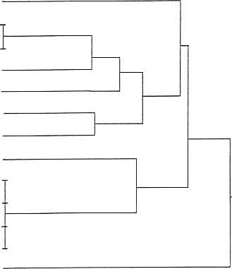
7. Preliminary cluster analysis
7.1 Data for the six test variables described in section 5.2.2 for all regions were used in a trial cluster analysis
to examine similarities between regions. Systat for Windows (version 5.04) was used to carry out average-
weighted eigenvalue cluster analysis (see Jelgersma et al., 1993; Kuroda and Nanaura, 1993). The analysis
suggests that the 81 initial regional units can be grouped in 5 major clusters. The results are presented in the
dendrograms in Figures 2-7. Figures 2-6 present clusters of the most closely related regional units whilst
Figure 7 provides an overview of the relationships between the seven groups illustrated in Figures 2-6
inclusive.
7.2 Figures 2-6 illustrate the relative distance between LOICZ regions based on their similarity with respect to
the six input variables. The degree of difference between regions is represented by the length of the line
extending from the region name to its point of junction with a neighbouring line. The shorter the line the more
similar the region is to its nearest neighbour, for example, the Central and South Argentine regions have
identical eigenvalues suggesting that for the purposes of the test variables they should be combined into a
single unit. Similarly the West Coast of Canada, Aleutian, Alaskan and South Chile units have identical values
and whilst the Canadian West Coast, Aleutian and Alaskan units are geographically contiguous and might be
combined in a subsequent analyses, the South Chile region could not be combined with the other three. For
purposes of future syntheses however, data from any one of these regions might be used as analogue data for
the others in the event that empirical data are not available for all units.
7.3 Areas in close geographic proximity such as the Central and South Argentina regions in group 1 tend to be
more closely linked, reflecting in part the highly restricted type of input data and possibly also real similarity
in respect of the input variables. In many of these cases the regions are likely to be distinguished when more
quantitative data and a wider range of variables are used. It is interesting to note that some regions separated by
large geographic distances are identified as closely similar with respect to present data set. One such example
is the similarity of the Newfoundland and North Sea regions in Group 6. This type of result demonstrates the
usefulness of this approach to LOICZ data management and the analyses that will be required to generate global
estimates of coastal processes.
7.4 It should be noted that group one (Figure 2) consisting of 13 regional units forms the most distinct cluster,
separated from the remaining 68 regions by the largest euclidean distance, of these the East China Sea region
represents an outlier to the rest of the group. The 21 regions included in Figure 4 fall into two distinct groups
of which group 3 shows greatest similarity to group 2. The Red Sea, Persian Gulf and Mediterranean regions
form a distinct cluster with greater similarity to the combined cluster of groups 2 and 3 than with any other
group. Group 6 (Figure 6) contains two outliers with the Black and Baltic Seas form one outlying cluster and
the Antarctic showing slightly greater similarity to this combined grouping than to group 5. the Kara, Laptev
and Siberian Seas and the Arctic Ocean, identified as group 7 in Figure 6 form a distinct outlying group with
marginally greater similarity to groups 5 and 6 than to groups 2, 3 and 4. This anomalous result probably
reflects the absence of Coastal Zone Colour Scanner data for these regions.
7.5 Finally Figure 7 provides an diagrammatic overview of the relationships between the groups identified in
Figures 2 - 6 and includes a qualitative description of the major characteristics of each of the groups or
clusters with respect to the input variables.
- 9 -
8 Conclusions
8.1 In all cases the usefulness of these results are dependent on the limited amount of semi-quantitative data
that were used in the analysis. The purpose of this test was only to investigate the technique as a method for
generating measures of similarity and dissimilarity among the regions. The conclusion is that with sufficient
data, the technique does provide a useful means of grouping regions.
8.2 It should be pointed out that the present analysis does not provide any indication of why the regions are
similar or dissimilar from a statistical perspective. The reasons for the degree of similarity can be determined
using a discriminate function analysis which identifies the comparative weight given to each variable in the
cluster analysis. Such statistical analyses do not however identify the causal relationships which give rise to the
statistical relationships, hence the interpretation of the validity of the relationships identified will depend on an
understanding of the underlying processes. Understanding the underlying relationships is essential before
LOICZ can proceed to use research results from one region as analogue data for another. As noted above the
Canadian West Coast, Aleutian and Alaskan regions and the South Chile Coast are revealed in the present
analysis as being of very similar characteristics. The analysis does not distinguish whether they are similar
because of the large range of sea surface temperature from summer to winter or whether they all have similar
levels of phytoplankton density as interpreted from the Coastal Zone Colour Scanner image or whether both
these characteristics are important. Additional analyses, such as principal component analysis, and discriminate
function analysis are essential to answer these questions (see Gabriel et al. 1982; Krzanowski, 1988; and
Seber, 1984). The next iteration of the typology will include some of these necessary analyses.
8.3 As the quantity and quality of available data increase, separate analyses of the type presented here could be
carried out, based on the major variables of importance for each of the four LOICZ Foci. This will allow
similarities to be identified within foci independently of the constraints of the other focus. That is, areas that
are similar on the basis of biogeomorpology may not have any similarities on the basis of their socio-
economic characteristics. A full multivariate analysis based on all parameters for all four foci will be needed
for the preparation of global syntheses and will be of considerable value in identifying the likely driving forces
of coastal change at regional and global scales.
9. Continued development of the LOICZ typology
9.1 The LOICZ CPO would like to encourage the scientific review of the ideas and concepts described in this
document. Concurrently with the on-going compilation of additional data and information on which to further
develop the typology the LOICZ Research Network is therefore invited to provide review and comment.
LOICZ Core Project Office
Netherlands Institute for Sea Research
P.O. Box 59
1790 AB Den Burg - Texel
The Netherlands
- 10 -
10. References
Anon. in press. Marine Ecological Classification System for Canada. Marine Environmental Quality Advisory
Group. Environment Canada.
Anon. 1992a. North Sea Atlas for Netherlands Policy and Management, (Interdepartmental Co-ordinating
Committee for North Sea Affairs) ICONA, 1992, Stadsuitgeverij, Amsterdam.
Anon. 1992b. U.S. Government World Data Bank Social Indicators of Development (SID) 1990 database as
published in ArcWorld 1:3M. 1992. A comprehensive GIS database for use with ARC/INFO and
ArcView. Environmental Systems Research Institute, Inc.
Gabriel, K.R. 1982. Biplot. In: Kotz, S. and N.L. Johnson (ed.) Encyclopaedia of Statistical Sciences. Wiley,
New York.
Feldman, G.C., N.A. Kuring, C. Ng, W.E. Esaias, C.R. McClain, J.A. Elrod, N. Maynard, D. Endres, R. Evands, J.
Brown, S. Walsh, M. Carle and G. Podesta. 1989. Ocean Color: Availability of the Global Data Set.
EOS 70: 634-641.
Jelgersma, S., M. Van de Zijp and R. Brinkman. 1993. Sealevel rise and the coastal lowlands in the developing
world. Journal of Coastal Research. 9(4).
JGOFS/LOICZ. 1994. Report on the JGOFS/LOICZ Task Team on Continental Margin Studies. JGOFS
Report No. 15.
Krzanowski, W.J. 1988. Principles of Multivariate Analysis. Clarendon Press. Oxford.
Kuroda, K. And T. Nanaura. 1993. Classification of Coastal Zone by multivariate Analysis. in Y. Nagao (ed).
1993. Coastlines of Japan II. American Society of Civil Engineers. New York, New York.
Ludwig W., J-L Probst and S. Kempe. In press. Predicting the oceanic input of organic carbon by continental
erosion.
Pernetta, J.C. and J.D. Milliman. (ed.) 1995. Land-Ocean Interactions in the Coastal Zone Implementation
Plan. IGBP Report No. 33. Stockholm Sweden. pp. 215.
Pernetta, J.C. and D.L. Elder. 1992. Climate, sea level rise and the coastal zone: management and planning for
global changes. In: Ocean & Coastal Management. Elsevier Science Publishers Ltd. England. vol. 18
pp. 113-160.
Seber, G.A.F. 1984. Multivariate Observations. Wiley. New York.
Sherman, K. 1994. Sustainablity, biomass yields and health of coastal ecosystems: an ecological perspective.
Mar. Eco. Prog. Ser. Vol 112:277-301.
UNEP. 1994 Assessment and monitoring of climatic change impacts on mangrove ecosystems, UNEP
Regional Seas Reports and Studies No. 154.
Wilkinson, C.R. and R.W. Buddemeier. 1994. Global Climate Change and Coral Reefs: Implications for
People and Reefs, Report of the UNEP-IOC-ASPEI-IUCN Global Task Team on the Implications of
Climate Change on Coral Reefs. IUCN, Gland, Switzerland. 124 pp.
- 11 -
APPENDIX I
LOICZ Regional Descriptions
This appendix provides a tabular description of each of the LOICZ regions defined in this draft typology. Each
region is identified by a name, a number, and a list of co-ordinates that define the region in a geographic
reference system. Negative values are to the west of 0o Longitude or south of 0o latitude. Each region can be
created on a map by connecting the nodes with lines running along lines of latitude and longitude. Attempts
have been made define all regions with lines running north/south or east/west. Where this is not possible, the
nodes should be connected using a geographic reference system consisting of latitude and longitude.
The values in this table are general qualitative data for the region conditions. With time these estimates will be
made more quantitative and many more variables will be added.
The following variables are those used in the cluster analysis presented here:
Runoff (Ludwig et al., in press):
low = 1; medium = 2; high = 3.
Tidal range in cm (LOICZ CPO/SSC):
1 = 0-25; 2 = 25-50; 3 = 50-75; 4 = 75-100; 5 = > 100.
Shelf width (LOICZ CPO/SSC):
enclosed = 1; narrow = 2; and wide = 3.
June SST (June sea surface temperature from
SeaWIFS Mosaic Home Page interpreted
by CPO (Feldman et al., 1989) )
cold = 1; cool = 2; warm = 3; hot = 4.
Dec SST (December sea surface temperature
from SeaWIFS Mosaic Home Page
interpreted by CPO)
cold = 1; cool = 2; warm = 3; hot = 4.
CZC (Coastal Zone Colour Scanner
SeaWIFS Home Page)
low = 1; medium = 2; high = 3.
The listing below provides examples of some of the variables currently being examined for future inclusion.
Major habitats:
e.g. mangrove, mangrove/coral, mangrove/salt marsh,
salt marsh.
Sediment Flux (LOICZ CPO/SSC):
small = 1; moderate = 2; large = 3.
Boundary current strength (LOICZ CPO/SSC):
weak = 1; strong = 2.
Marginal Sea (LOICZ CPO/SSC):
shallow = 1; deep = 2.
Upwelling Strength (LOICZ CPO/SSC):
weak = 1; strong = 3.
Ice Cover (LOICZ CPO/SSC):
never = 1; in winter = 2; always = 3.
- 12 -