


December 2004
www.loicz.org
No. 33
various resolutions and covers all the
A global database for coastal
world's coastline, excluding Antarctica.
vulnerability analysis
Given the linear nature of the coast, all
(DINAS COAST)
the data in the DIVA database are refe-
renced to linear coastal segments and are
A.T. Vafeidis1, Nicholls, R.J.2, Boot G.3,
expressed as attributes of five main
Cox J.4, Grashoff, P.5, Hinkel, J.6,
geographic features:
Maatens, R.3, McFadden L.1,
(a) coastline segments,
Spencer, T.4 and R.S.J. Tol7
(b) administrative units,
(c) countries,
1. Introduction
(d) rivers,
The global extent of the effects of rising
(e) tidal basins.
sea-levels on coastal regions and the
The LOICZ Newsletter is produced
This gives a fundamentally different data
increased vulnerability of the coastal
quarterly to provide news and information
structure compared to the more common
zone due to the high concentration of
regarding LOICZ activities
raster datasets used in global studies.
natural and socio-economic resources
highlight the need for regional to global
CONTENTS
2. Representation of coastal infor-
assessment. Consistent long-term and
A global database for coastal
mation and database design
broad-scale assessments of potential
vulnerability analysis (DINAS COAST)
Information representation is a funda-
impacts and responses can significantly
mental factor for the organisation and
Groundwater and Nutrient Inputs into
assist the formulation of effective climate
the Upper Gulf of Thailand
reliability of a database. The data model
and coastal policies. Global vulnerability
and structure have been identified as the
assessment (GVA) studies have been the
Meeting reports on:
major concerns of developers of coastal
main sources of quantitative information
SCOR Meeting on Marine Project
information systems, with the selection
Coordination, 23-24 September,
on potential impacts of sea-level rise.
of an appropriate model of coastal space
Venice, Italy
One of the principal limitations however
being most important. Due to the dynamic
ELOISE, 15-18 November,
of GVAs, which has compromised their
Portoroz, Slovenia
nature of the coast and to the multi-
reliability and consistency, has been the
UNEP-DEWA AEO-2 workshop,
dimensionality of information associated
lack of appropriate data sources.
21-23 October, Nairobi, Kenya
with it, representation of coastal space
has always been a complex issue. This
IPO Notes:
Access to reliable and timely data, which
presents a challenge in determining
New Regional IPO Node in Sri Lanka
are available in a suitable form, can sub-
appropriate data structures to construct
Publications,
stantially enhance and facilitate analysis.
Announcements & Meetings
coastal databases.
However, available data do not usually
comply with this principle as they are
As it is one of the most distinct features
usually in a fragmented and non-coherent
To fill a significant gap in coastal
on earth's surface, the coastline has been
form that compromises the consistency
research, a new global coastal database
one of the most widely-used data ele-
and reliability of evaluations. Merging
has been developed within the frame-
ments when representing coastal space.
different data types, datasets and data-
work of the DINAS-COAST project.
Some form of shoreline delineation is
bases makes this information available to
(also see NL No. 27 June 2003). The
used in most examples of coastal or
non-specialized users and policy makers
database forms an integral part of the
ocean resource mapping. While there are
and facilitates integrated assessment. This
DINAS-COAST system and provides the
disadvantages, the common perception
enhances the potential of existing data
input data for the Dynamic Interactive
of the coast as a fundamentally linear
and tools in assisting the coastal science
Vulnerability Analysis (DIVA) tool,
entity makes it attractive to model the
community. The importance of reliable
which is the main product of the project.
coast in one dimension. Linear models of
data-pro
Initiall
vision mechanisms and of
y developed within a Geographic
the coast have been employed on several
organized, planned and coherent coastal
Information System (GIS), the DIVA
occasions for representing coastal infor-
databases as prerequisites for coastal database has been designed to include
mation. Recent advances in GIS and data
analysis and management has been data on physical, ecological and socio-
collection techniques have facilitated the
emphasized by many researchers.
economic characteristics of the coast at
development of such models, although
A core project of the
International Geosphere-Biosphere Programme and the
International Human Dimensions Programme on Global Environmental Change
page 2
LOICZ NEWSLETTER
their use is restricted to those with access
Publicly Available
to specialised hardware and software.
However, the DIVA database is available
in an easily-accessible form and its use
Coastline
does not require specialized software and
EXTERNAL
DIVA Tool
segmentation
hardware, thus rendering it accessible to
DATA
DINAS-COAST
a wider range of coastal scientists. This
SOURCES
geodatabase
Database,
Integrated modules,
is largely due to the effective data model
Geo-processing
Graphical User Interface.
that has been employed in the developed
database.
2.1. The DINAS-COAST data model
Data pre-processing
Based on the concept of linear represen-
tation of the coastline, the DINAS-
COAST project has created a model of
USER
coastal space where geographic infor-
mation is represented as a collection of
geographic features and is referenced to
coastal segments of variable length. As
Figure 1 The central role of the geodatabase within DINAS-COAST, including feeding data
DINAS-COAST is focused on coastal
to the DIVA database (adopted from Vafeidis et al., 2003).
vulnerability, coastal space in the DIVA
database has been structured to represent
coastal objects and phenomena, and the
3. The database
longshore variability in vulnerability.
handling of the temporal and dynamic
Compilation of the database has been
Thus, the coastal segments represent
properties of coastal properties. However,
based on a series of primary and secon-
reasonably homogenous units in terms of
GIS still offers significant advantages
dary data sources included in the contents
potential impacts and vulnerability to sea
such as the ability to handle large data-
of the vast archives of existing datasets.
level rise. The boundaries of the coastal
bases and to integrate and synthesize
Secondary data sources have been exten-
segments were decided according to a
data from a wide range of sources (e.g.
sively used for the generation of digital
series of physical, administrative and
remote sensing, cartography, etc.) and
datasets in those cases where data were
socio-economic parameters. As DINAS-
also the potential to convert and model
not available or where existing data were
COAST is focused on sea-level rise, the
data. They have been extensively used as
not deemed adequate for the require-
range of critical values that define a medium for storing, displaying and
ments of DINAS-COAST. According to
vulnerability within the coastal zone
analyzing coastal data.
Rhind and Clark the integration of
should reflect the impacts and responses
primary and secondary data offers the
of the coastal system to this factor. Based
In order to provide a lean and well-
most promising approach to develop
on the assumption that variations in structured database which would not
globally coherent, up-to-date and scien-
vulnerability within the coastal zone are
compromise the execution time of the
tifically valid databases. Nevertheless,
controlled by primary variations in the
tool, all the operations necessary for
the integration of datasets from such a
human and physical coastal interchange
converting the primary and secondary
large variety of data sources constituted
several meaningful and available para-
input data into the form for the DIVA
a major challenge as the spatial-data
meters were identified to use for seg-
database were performed within the
"inheritance" of DINAS-COAST una-
mentation purposes. These parameters
DINAS-COAST Geodatabase externally
voidably presented massive variations in
were (i) the geomorphic structure of the
to DIVA. Therefore, the GIS Geodatabase
quality, timeliness and coverage. All the
coastal environment, (ii) the potential for
occupies a central role within the project
digital datasets that were acquired and all
wetland migration, (iii) the locations of
(figure 1). This reflects its role as the
the analogue ones that were converted
major rivers and deltas, (iv) population
medium for storing, processing and
to digital form were processed and
density classes and (v) administrative
exporting the acquired data in a format
customized to a standard format in order
boundaries. Based on these parameters,
suitable for the DIVA database.
to overcome the inherent variations.
the world's coast was divided into 12,148
segments. These provide spatial reference
Dataset
Format
Source
units for the DIVA database, integrated
modules and graphical user interface
Gridded Population of the World
Raster
CIESIN
(figure 1).
World Elevation and Bathymetry
Raster
NGDC
Geomorphic type
Analogue map
McGill, 1958
Landform type
Analogue map
Valentin, 1952
2.2. The role of the database in
Tidal Range
Raster
IGBP-LOICZ
DINAS-COAST
Second Level Admin. Boundaries
Polygon
DCW, ESRI
The DINAS-COAST database has been
Uplift/Subsidence
Raster
Peltier, 2000
initially developed within a GIS due to
GDP per capita
Tabular
CIA (2002), WRI (2003)
the explicit spatial nature of the data.
Dominant Religion
Tabular
CIA (2002)
Wetlands
Tabular/polygon
CCRU
Coastal GIS is often described as a
Sea Level Change
Raster
CLIMBER
"tough issue" due to numerous funda-
mental problems such as the lack of
Table 1 Characteristic datasets, originating from different sources and in different formats,
effective conceptual and data models of
that were included in the database.
page 3
LOICZ NEWSLETTER
different structure to most commonly
3. Eberhart RC, Dolan TJ. 1980.
used global datasets as it has been
Chesapeake Bay Development Pressures:
designed for the needs of coastal vulne-
Rams Database Analysis. Presented at
rability assessment and in that sense
Second Symposium on Coastal and
aims to better serve the current informa-
Ocean Management (Coastal Zone '80),
tion needs and priorities of coastal New York
scientists working in this field. At the
4. Gilbert T, Baxter T. 2002.
same time, it has been designed for
Development of an Integrated Marine and
application specific needs and in that
Coastal GIS for Oil Spill Response in
sense reflects the priorities and perspec-
Australia. In Marine Geography: GIS for
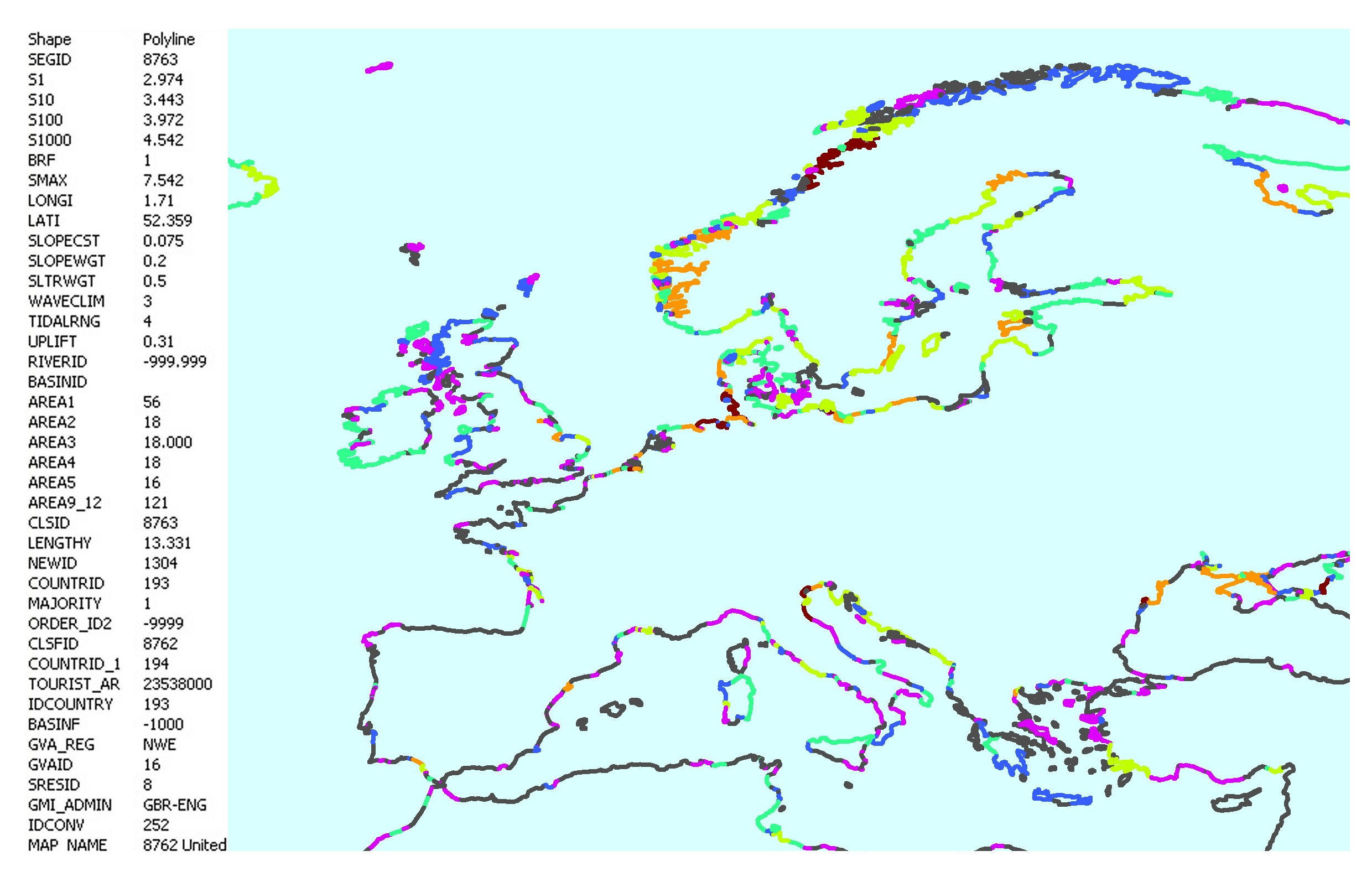
Figure 2 An example of the coastline segmen-
tives of the DINAS-COAST project.
the Oceans and the Seas, ed. J Breman,
tation. Coastline segments for Europe and
Nevertheless, the methodological and
pp. 143-52. Redlands, California: ESRI
associated information.
structural advances achieved and the
Press
interdisciplinary character of the database
5. Hinkel J, Klein RJT. 2003. Develo-
One of the most important aspects of are expected to impact a wider range of
ping a method and a tool for dynamic and
this work has been the geographical applications. In this context, commit-
interactive vulnerability assessment.
integration of the datasets that were ment to the adopted data structure in
LOICZ Newsletter No. 27
collected or generated as georeferencing
future versions and updates of the data-
6. Hoozemans FMJ, Marchand M,
constitutes a major problem even in large
base is deemed essential for the use of
Pennekamp HA. 1993.
scale (i.e. small area) studies. For this
the database in a consistent and coherent
A Global Vulnerability Analysis: Vulnera-
purpose a series of global projections
manner through time and space.
bility Assessment for Population, Coastal
were employed, for projection-dependent
Wetlands and Rice Production on a
calculations, depending on the processing
Acknowledgments:
Global Scale.
needs of the individual datasets and after
This work was supported by the DINAS-
The Netherlands: Delft Hydraulics
pre-processing was completed all data
COAST Project which received funding
7. Lockwood M, Fowler C. 2000.
were referenced to a geographic (latitude/
from the EU under contract number
Significance of Coastal and Marine
longitude) reference system.
EVK2-2000-22024.
Geographic Information Systems within
the Context of the United States National
Using the storage and analytical powers
Contact details:
Geospatial Data Policies. In Marine and
of GIS, the spatial data were referenced
1 Flood Hazard Research Centre,
Coastal Geographical Information
to the coastline segments (figure 2) and
Middlesex University,
Systems, ed. DJ Wright., DJ Bartlett,
were exported in the form required by
Enfield EN3 4SA, UK
pp. 261-78. London: Taylor and Francis
the data model of DIVA, where all data
2 School of Engineering and the Environ- 8. McFadden L, Nicholls RJ, Vafeidis
are presented as properties of the five
ment and Tyndall Centre for Climate
AT, Tol RSJ. 2004. A methodology for
geographic features defined earlier. The
Change Research, University of modelling coastal space for global
database in its final form includes Southampton, Highfield, Southampton
assessment. Journal of Coastal Research
information on more than 50 physical and
SO17 1BJ, UK
In Review
socio-economic parameters of the coast
3 WL | Delft Hydraulics, P.O.Box 177, 9. Millard K, Brady A. 2000.
(table 1). The database is associated to
2600 MH Delft, the Netherlands
The contribution of technology in
extensive descriptive metadata informa-
4 Cambridge Coastal Research Unit, supporting data exchange in integrated
tion which contain detailed information
Department of Geography, University of
coastal zone management.
on the data properties including infor-
Cambridge, Downing Place, Cambridge
In Coastal Management: Integrating
mation on the underlying data sources,
CB2 3EN, UK
science, engineering and management,
processing methods and data coverage.
5 Demis, Kluyverweg 2a 2629 HT Delft ,
ed. CA Fleming, pp. 97-106. London:
The Netherlands
Thomas Telford
4. Conclusions
6 Potsdam Institute for Climate Change 10. Mounsey H, Tomlinson RF. 1988.
A new global coastal database has been
Research (PIK), P.O. Box 601203
Building Databases for Global Science.
developed within the context of the
D-14412 Potsdam, Germany
London: Taylor and Francis. 419 pp.
DINAS-COAST project the DIVA
7 ZMK, University of Hamburg,
11. Mueller M, Meissner B, Weinrebe W.
database (figure 1). It merges data of Bundesstrasse 55, 20146 Hamburg,
2002. TerraMarIS - Terrestrial and Marine
different types and from various sources
Germany
Information System.
to create a consistent and coherent source
In Marine Geography: GIS for the
of information on coastal physical and
Related literature
Oceans and the Seas, ed. J Breman, pp.
socio-economic parameters that covers
1. Bartlett D, Devoy R, McCall S,
97-102. Redlands, California: ESRI Press
the entire globe. It has to be noted that
O'Connor I. 1997. A Dynamically Seg-
12. Nicholls, R.J. 2004. Coastal flooding
since DINAS-COAST is focused on mented Linear Data Model of the Coast.
and wetland loss in the 21st Century:
climate policy analysis, the resolution of
Marine Geodesy 20: 137-51
Changes under the SRES climate
the DIVA database is too coarse for more
2. Bartlett DJ. 2000. Working on the
and socio-economic scenarios. Global
detailed coastal management purposes.
Frontiers of Science: Applying GIS to the
Environmental Change, 14, 69-86.
Therefore its contents should be Coastal Zone. In Marine and Coastal
13. Nicholls, R.J., Lowe, J.A., 2004.
evaluated considering all the limitations
Geographical Information Systems, ed.
Benefits of Mitigation of Climate Change
that are associated with global datasets.
DJ Wright, DJ Bartlett, pp. 11-24. for Coastal Areas. Global Environmental
The DIVA database has a fundamentally
London: Taylor and Francis
Change, 14, 229-244.
page 4
LOICZ NEWSLETTER
14. Sherin AG, Edwardson KA. 1996.
A coastal information system for the
Atlantic Provinces of Canada. Marine
Technology Society Journal 30: 20-7
15. Shupeng C. 1988. The coastline as a
base for global databases: A pilot study in
China. In Building Databases for Global
Science, ed. H Mounsey, R Tomlinson,
pp. 202-15. London: Taylor and Francis
Groundwater and Nutrient
Inputs into the Upper Gulf of
Thailand
William C. Burnett
(Florida State University, USA),
Makoto Taniguchi (Research Institute
for Humanity and Nature, Japan),
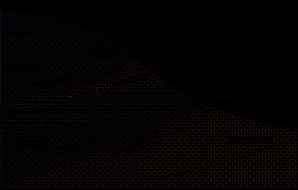
Figure 1 Diagrammatic cross-sectional view of a coastal zone, illustrating the types and path-
and Gullaya Wattayakorn
ways of fluid movements that may result in interactions between groundwater and surface waters
(Chulalongkorn University, Thailand)
(diagram courtesy of Peter Swarzenski, USGS Open File Report 2004-1369).
Introduction
Southeast Asia. One conclusion of this
Resistivity measurements were also
We hypothesize that many water quality
review was that groundwater transport
made to investigate the fresh water
and associated problems influencing
could be particularly important in seawater interface.
coastal environments around the world
Southeast Asia because of the wet humid
today are related to past and on-going
climate and excessive limestone terrains
Nutrient inputs via SGD
contamination of terrestrial ground-
that are conducive to rapid underground
We assessed the potential importance of
waters because those groundwaters are
flow. We have just completed an initial
SGD for nutrient inputs into the Upper
now seeping out along the world's shore-
study of groundwater inputs into the
Gulf by combining results from our data
lines. Such inputs contribute to the Upper Gulf of Thailand a few high-
sets from the Chao Phraya River-Estuary
increased occurrences of coastal hypoxia,
lights of that study are presented here.
with the seepage measurements made in
nuisance algal blooms, and associated
Sri Racha and Hua Hin. Complete sets of
ecosystem consequences. A complete
Study area and methods
nutrient measurements were made in all
understanding of the marine budgets of
We focused this investigation on the
cases, together with our estimates for
carbon, nutrients, and other key biogeo-
Chao Phraya Estuary and near-shore
SGD based on seepage meter and isotopic
chemical species should thus include
areas of the Upper Gulf of Thailand just
measurements. We calculated fluxes
consideration of groundwater inputs.
to the east (Sri Racha) and west (Hua
from the Chao Phraya River by multi-
Hin) of the estuary. The Chao Phraya is
plying the average nutrient concentration
The direct discharge of groundwater into
the largest river located in the northern
by the river discharge as recorded at the
the coastal zone, called "submarine
and central part of Thailand. It accounts
Chao Phraya Dam during the same
groundwater discharge" (SGD) is now
for about half of the riverine flow to the
period. The nutrient concentrations were
recognized as a significant, but poorly
Gulf of Thailand. Continued deterioration
measured repetitively at one downstream
quantified, pathway between land and
of the water quality of the Chao Phraya
location (~18 km from river mouth)
sea (figure 1). As such, SGD acts as a
and groundwater in the region could
monitored over several days during both
source of inorganic and organic carbon,
have important implications for the the January and July surveys. This
nutrients, and other dissolved species to
biogeochemistry of the Gulf of Thailand.
provides a river flux estimate for each
coastal waters and ecosystems. Unfortu-
nutrient in moles per day. We next
nately, the process is very difficult to
We had two sampling campaigns in
assessed an estimate of the seepage
quantify because of its diffusive nature
2004, one in January (dry season) and
inputs by multiplying integrated seepage
this is one of the reasons the process has
the other during July (wet monsoon).
fluxes by the average concentrations of
been ignored by coastal scientists for so
Transects in the river, estuary, and out to
each nutrient measured in waters
long. A few years ago, SCOR and
about 50 km in the Gulf were made using
collected directly from the seepage
LOICZ brought together an expert team,
the R/V Chula Vijai from Chulalongkorn
chambers. This provides estimates of
which has now made significant
University. Inorganic and organic nutrient
nutrient fluxes via seepage per unit width
progress in advancing our understanding
species, carbon, radioisotopes (radon and
of shoreline (moles m-1 d-1). Since the
of the forces and components of SGD radium isotopes), CTD profiles were
seepage estimates are per unit width of
as well as advances in measurement
made at over 60 stations during these
shoreline while the river estimates are in
techniques and protocols that can be
field studies. In addition, groundwater
absolute terms, we may compare the two
applied elsewhere. A recent review of all
seepage was measured in the coastal
by dividing the river flux (moles d-1) by
SGD research performed to date showed
areas of Sri Racha and Hua Hin using
the seepage flux per shoreline width
that there is a significant lack of data for
both manual and automated seepage
(moles m-1 d-1) to derive an "equivalent
regions in Africa, South America, and
meters (vented benthic chambers).
shoreline length" (figure 2).
page 5
LOICZ NEWSLETTER
Looking ahead
SCOR Meeting on Coordination
Based on the measurements and insights
of International Marine
made during this project, we suggest that
future research be directed to making
Research Projects,
additional groundwater seepage measure-
Venice/Mestre, Italy,
ments in the coastal Gulf of Thailand.
23-24, September 2004
Our estimates of nutrient delivery via
seepage are based solely on measure-
Discussing common opportunities, issues,
ments in one river and two coastal sites.
and problems is critical to generate colla-
A few additional sites, together with a
boration and cooperation among the
Figure 2
Estimates of the approximate
typological approach towards extra-
multiple international ocean research and
amount of shoreline that would provide
polation, would result in much more
observation projects and programs inclu-
nutrient fluxes to the Upper Gulf of Thailand
reliable estimates.
ding the ESSP, UN frameworks amongst
equivalent to that from the Chao Phraya River
others. Supported by the Alfred P. Sloan
in the dry (black) and wet (grey) seasons,
The Gulf of Thailand borders on Foundation, the Scientific Committee on
respectively. Nitrate levels are off scale at
Cambodia, Vietnam, and Malaysia as
Oceanic Research (SCOR) convened a
about 16,000 km (dry) and 38,000 km (wet).
well as Thailand. In order to provide meeting "Coordination of International
better Gulf-wide estimates of the impor-
Marine Research Projects" bringing
In other words, this is length of shoreline
tance of groundwater inputs to the together representatives from virtually all
along the upper Gulf of Thailand that
carbon and nutrient budgets, it would international marine research projects
would have groundwater seepage inputs be preferable to work together with
and programmes (CLIVAR, CoML,
equivalent to the nutrient delivery of the
scientists from these neighboring GEOHAB, GLOBEC, iAnZone,
Chao Phraya River.
countries. The investigators of this IMAGES, InterRidge, IMBER, LOICZ,
project have recently received a grant
and SOLAS). Profs. John Field and
While we recognize that these calcula-
from the Asia-Pacific Network (APN) to
Laurent Labeyrie convened the meeting
tions have many uncertainties (e.g., only
hold an international workshop on SGD
on behalf of the SCOR Executive
two stations assessed for groundwater
in Thailand in February 2005. Experts in
Committee. The agenda included several
inputs) and are thus crude estimates, the
hydrology and coastal oceanography
specific topics determined by question-
results are still compelling in terms of
from several Southeast Asian countries
naires prior to the meeting to be important
illustrating the significance of ground-
will participate in this workshop. This
inter-project issues, including data
water inputs. During the dry season, it
should provide an excellent opportunity
management, interactions of projects
would only require seepage inputs over
to plan for future coordinated efforts.
with the Global Ocean Observing System
shoreline lengths on the order of
(GOOS), project coordination in the area
400-500 km to equal the inputs of the
Acknowledgements
of Southern Ocean research and partici-
Chao Phraya River for ammonia and
The investigators thank SARCS, the
pation in the International Polar Year,
phosphate. Inputs of silica from seepage
Southeast Asia Regional Committee for
project needs for time-series stations, and
would require less than 800 km of shore-
START (the global change SysTem for
future project contributions to global
line. The results for the wet season
Analysis, Research, and Training) for the
environmental assessments. The agenda
showed greater seepage fluxes although
financial assistance that made this
also provided an opportunity for projects
less impact relative to the Chao Phraya
research possible. Henrieta Dulaiova,
to raise and discuss other issues of inter-
because the river discharge (and thus the
Pramot Sojisuporn, Sompop Rungsupa,
project collaboration and promoted a
nutrient fluxes) is so much higher at that
and Tomoshi Ishitobi assisted in the field
range of bilateral discussions. Informa-
time. Still, the shoreline length required
and laboratory. We also thank the crew of
tion about the meeting is available on the
for an equivalent flux of phosphate is still
the R/V Chula Vijai for their helpful activity Web page (see www.jhu.edu/
less than 600 km and just over 1000 km of
assistance during the river-estuary scor/ProjCoord.htm).
shoreline is required for ammonia.
cruises. W. Burnett acknowledges the
additional support from the National
Recommendations that resulted from the
These results suggest that nutrient inputs
Science Foundation (Award No. OCE-
meeting and which aim to develop and
via seepage are comparable to one of the
0350514) that allowed his participation
enhance Mechanisms for Interactions
most important rivers draining into the
and supported much of the analysis
Among Projects include:
Gulf of Thailand. These results are even
costs. Makoto Taniguchi acknowledges
· more attention should be given to
more impressive when one considers that
the additional support from Japan
project coordination based on partici-
the Chao Phraya is a very contaminated
Society for the Promotion of Science
pation by establishing multi-project
river with extremely high nutrient (Award No. 13304036).
SSC membership, or at least liaison
concentrations from industrial and
structures across the various SSCs
domestic activities in Bangkok. Thus,
Contact
including mechanisms for regular
had we made a comparison of nutrient
wburnett@mailer.fsu.edu
reporting,
inputs via groundwater seepage to a less
· regional communication structures
contaminated or pristine river, the
should be established in which regional
equivalent shoreline lengths would have
project Nodes could take a leading role,
been considerably shorter, i.e., the
· SCOR will explore options to establish
relative importance of groundwater
a regular platform for this type of inter-
seepage would be much greater.
national coordination Meetings,
page 6
LOICZ NEWSLETTER
· Project Data Management should be
synthesis centres on four major topics:
scientific agendas of the Earth System
standardised, and long-term main-
1. Climate change and coastal
Science Partnership (ESSP) of the IGBP,
tenance and updating platforms be
management
IHDP, WCRP and DIVERSITAS so that
established to guarantee continued use
2. Nutrient dynamics
they can support the further development
and development of the various data-
3. Habitat dynamics at the coast-
of European coastal change research. A
bases in the projects. A small subgroup
catchment interface
key future aspect will be the applicability
met to develop specific recommen-
4. Contaminant budgets in the coastal
of scientific information to both, a) the
dations on project data management, to
zone
immediate and upcoming decision
follow up on the results of the Liver-
support needs (e.g., EU-Marine Strategy,
pool meeting sponsored by SCOR and
The 6th meeting showed that ELOISE has
ICZM Strategy, EU WFD), and b) the
IGBP in December 2003 (see http://
undergone considerable evolution. In
emerging broad themes of interdiscipli-
www.jhu.edu/scor/DataMgmt.htm).
particular in recent years it has not only
nary global change science for which
Long-term actions should include easy
contributed to Global Change Sciences
LOICZ II provides an emerging peer
access to data through the Web, training
in coastal zones as part of IGBP/LOICZ,
reviewed frame. The ELOISE cluster has
in accessing and using the data and but evolved from a curiosity driven set of
been able to contribute a considerable
utilities for intercomparison, and
individual projects into a focused effort
scientific basis for the future, e.g., in
quality control,
that has started to generate an information
form of integrated modelling and
· projects should determine their terms
flow that has had an impact on European
participatory approaches in the context
of interaction with GOOS including for
policy. In doing so the ELOISE commu-
of the highly variable temporal and
example participatory structures within
nity has become more focused on the
spatial scales of the coastal zone, and it
the SSCs. In the case of LOICZ, and
needs of process oriented ecosystem
has an increasing relevance for the
building on the long track record of
sciences, the needs to develop integrated
further development of LOICZ II.
close collaboration and involvement in
modelling approaches and to find ways
the design and development of the
to communicate the results of its science
Further information on the ELOISE
Coastal GOOS, immediate action will
to stakeholders and policy makers.
cluster and synthesis can be found at
include the drafting of a white paper
http://www.eloisegroup.org/.
between their Coastal Observation
Among the key findings is that consider-
Panel (COOP) and LOICZ.
able parts of the European coast are
UNEP-DEWA AEO-2 workshop,
· projects should ensure continued affected at least as much as by catchment
Nairobi, Kenya,
contributions to Global Environmental
based processes than by oceanic and
21-23 October 2004
Assessments (e.g., IPCC and MA) to
atmospheric influences. This has influ-
build awareness of their data needs enced the scale and scope of ELOISE
LOICZ was represented by Russell
so to enable the development of science helping to identify and visualize
Arthurton at the UNEP-DEWA AEO-2
standardized indicators that can result
the different views of stakeholders (incl.
preparation workshop held between
in future improvement of the coming
scientists) on their "role" within the catch-
21 and 23 October attended by about 40
assessments.
mentcoast water continuum. Taking a
participants. The brief of the workshop
holistic perspective of this water was to report on the Coastal and Marine
continuum requires understanding of
environment including Wetlands. The
ELOISE on final? - 6th European
how the multitude of individual elements
workshop and UNEP-DEWA has strong
Conference on Coastal Zone
interacts in the delivery of goods and relevance to LOICZ in terms of the
Research: an ELOISE Approach.
services in support of human life for
natural science and its human dimen-
Portoroz, Slovenia
sustainable development of coastal
sions. The workshop highlighted the
15 - 18 November, 2004
societies. There is an obvious mismatch
problems of reconciling the research/
in information needs and the way knowledge needs of the broader coastal
The 6th meeting of the European Land-
knowledge is provided. This is probably
zone with the boundaries imposed by the
Ocean Interaction Studies (ELOISE)
one main reason why, in contrast to
policy frameworks of Regional and
marked the sunset of more than two years
assessments such as the IPCC, coastal
International programmes and geography
of intensive synthesis. The meeting,
zone research has not had a comparable
that often prescribe an inflexible sectorial
organized by the Norwegian Institute for
impact on policy making. Coastal science
approach to environmental assessment.
Air Research and Jozef Stefan Institute
and stakeholders are challenged to This despite attempts to overcome such
in Ljubljana, reported and discussed
provide and exchange the information
fragmentation through instruments such
results, future relevance and outreach of
needed in the policy process and as the UNEP Nairobi and Abidjan
the cluster of 60 projects in this frame-
decision making.
convention. However, the workshop
work. The cluster largely focused on how
did successfully turn the assessment
land-ocean interactions operate and the
In conclusion, at the onset of the EC 7th
emphasis from the sectorial inventory and
influence of human activities. It aimed to
Framework Programme and shortly
`doomsday' approach' to identifying
coordinate and facilitate communication
before launching a final 6th FP call, the
development opportunities in the light of
and integration, among related projects
meeting affirmed that the EC should
environmental threats and other issues.
and their end-users. The ELOISE continue with a contribution to coastal
LOICZ, through Russell, will continue to
program to date has run for some seven
sustainability science in the context of
further this progression and development
years and is one of the largest regional
global change and human dimensions.
of the concept of a water cascade or
coastal research program in the world. The
This should be linked closely to climate
continuum by assisting in the peer review
focus of the current integration and change research and recognize the of the sub-regional assessment reports.


page 7
LOICZ NEWSLETTER
Obituary
IPO NOTES
Prof. Nuruddin Mahmood, Director of the Institute of Marine Sciences affiliated to
the University of Chittagong in Bangladesh, passed away on the 18th October without
Contribute to LOICZ recovering from a coma he fell into after meeting with a motor car accident.
Born in November 1948, Prof. Mahmood received his higher education at Universities
Your scientific article in the LOICZ
in Bangladesh, Pakistan and Japan. He specialized in Biological Oceanography/
Newsletter? If you want to submit a Limnology and was team leader in Bangladesh for the highly successful APN funded
scientific article for review and publica-
South Asia regional project on Coastal Fluxes which was carried out in association
tion in the LOICZ Newsletter please send
with LOICZ between 2001 and 2004. He prepared two budgets, one for Meghna
it to loicz@nioz.nl. The article should be
estuary and the other for Karnaphuli estuary using LOICZ methodologies.
relevant to LOICZ related research and of
Prof. Mahmood was very supportive towards the recently established South Asia IPO
a maximum of three printed pages inclu-
Node of LOICZ and we were very much looking forward to work with him in the
ding figures, tables and references.
coming years. We are sorry indeed for not having that opportunity.
If you would like to submit notification
Janaka Ratnasiri
of an up-coming meeting/workshop for
Principal Investigator, APN Coastal Flux Project
inclusion in the LOICZ newsletter
and/or on our website please contact the
Relationship to Human Activities" from
(IOGOOS), to develop regional coastal
LOICZ IPO.
2001 to 2004 (www.nsf.ac.lk/slaas/cfweb).
modules for the new Earth System
These activities were organized in asso-
Science Partnership (ESSP) integrated
Third LOICZ Regional IPO
ciation with LOICZ and SASCOM and
studies.
Node established in Sri Lanka
funded by APN, START and LOICZ.
The third Regional IPO Node of LOICZ
NSF as a host of the South Asia Regional
II covering the South Asian region has
IPO Node of LOICZ is hosted in Sri
been established at the National Science
Lanka by the National Science Founda-
Foundation, Sri Lanka (NSF) in
tion (NSF) that is part of the Ministry of
Colombo, Sri Lanka. The Memorandum
Science and Technology. Its functions
of Understanding between the LOICZ
include the initiation, facilitation and
Central IPO and the NSF was signed in
support of basic and applied research,
Dr Nalin
Dr
November. As with other Regional IPO
fostering the exchange of scientific infor-
Wikramanayake
Janaka Ratnasiri
Nodes, the Node in Sri Lanka will mation among scientists, maintaining a
represent a national and institutional
database of scientific and technical The official inauguration of the Regional
commitment to support the implemen-
personnel and resources and the populari-
Node is planned to be held in early 2005
tation of the LOICZ II programme.
sation of science. The NSF liases with
in Colombo. The Node's contact is:
many international scientific organiza-
In terms of land-ocean interactions, South
tions, is member of the ICSU from Sri
Dr Nalin Wikramanayake
Asia presents many research challenges
Lanka and coordinates the Sri Lankan
Chairman, Sri Lankan National
for LOICZ. The Ganges-Brahmaputra
activities of the Man and the Biosphere
Committee on LOICZ
river system ranks highly amongst the
programme of UNESCO.
National Science Foundation
world's rivers in terms of freshwater flux
47/5 Maitland Place
and sediment flux. The majority of the
The South Asian Regional IPO Node
Colombo 7, Sri Lanka
1.4 billion population of the region
will be under the direction of a national
Tel: +94-11-2696771
(approx. a fifth of the World's population)
committee appointed by the NSF
Fax: +94-11-2694754 / 2691691
live within the coastal zones, contributing
chaired by Dr Nalin Wikramanayake
E-mail: tomwiks@yahoo.com
significantly to the global nutrient flux (tomwiks@yahoo.com), who is currently
to the oceans. They are also highly a member of the LOICZ SSC. It is
PUBLICATIONS
vulnerable to the present extreme events
planned to expand this committee into a
such as floods, storm surges and cyclones
regional committee with representation
with millions affected annually, as well
from the wider scientific community of
Keep an eye on the LOICZ website for
as to any future impacts of climate
other South Asian countries. The Node
news on new LOICZ R&S reports that
change induced sea level rise.
will play a regional coordinating role and
will soon be available as hard copy and
help develop regional funding proposals
electronic download.
The establishment of the Node is a to implement the science agenda of
culmination of coastal related activities
LOICZ including links with other
Dennis Swaney held meetings with
organized by the Sri Lankan National
regional programmes and intergovern-
Gianmarco Giordani, Pierluigi Viaroli
Committee of the IGBP, led by Dr Janaka
mental networks including the South
and members of the Italian Lagoon
Ratnasiri. These included two Regional
Asia Committee (SASCOM) of START,
Observational Network (LaguNet) to
Workshops in 1999 and 2000 and a
South Asia Cooperative Environmental
revise preliminary nutrient budgets
Regional Project on "An Assessment of
Programme (SACEP) , IUCN Regional
toward publication in the LOICZ R&S
Nutrient, Sediment and Carbon Fluxes to
Coastal Programme and Indian Ocean
series. Revisions of individual budgets
the Coastal Zone in South Asia and their
Global Ocean Observation System
were discussed and recommendations

page 8
LOICZ NEWSLETTER
made toward final presentation. Final
Further expressions of intent for IPY to
9-13 October 2005, Bonn, Germany:
editing has now been completed by Jan
the IPY International Programme Office
Open Meeting of the Human Dimensions
Crossland and the printing and publica-
(IPO) are due by 14 January 2005, via
of Global Environmental Change
tion as hard copy and electronically is
www.ipy.org or by e-mail: jcel@bas.ac.uk
Research Community, "Global Environ-
nearing completion. The budgets are to
or by fax: +44 1 223 221 270.
mental Change, Globalization and
be posted on the LOICZ budget website
Full proposals will be due in June 2005
International Security: New Challenges
by Dennis Swaney.
for the 21st Century".
http://openmeeting.homelinux.org
MEETINGS
Russell Arthurton and Martin le Tissier
have been editing the outputs from the
25-29 October 2005, Kusadasi, Turkey:
AfriCat studies that with a synthesis
For a complete list of future meetings
7th International Conference on the
paper will be published as hardcopy and and regular updates visit our web-site at
Mediterranean Coastal Environment-
electronically early in the New Year.
www.loicz.org
Medcoast '05. Deadline for abstract
submission: 31 January 2005.
24-29 April 2005, Vienna, Austria:
www.medcoast.org.tr
ANNOUCEMENTS
Assembly of the European Geosciences
Union. Special session on Coastal biogeo-
Wishing you all
ICSU and WMO propose an Inter-
chemistry and its response to anthropo-
national Polar Year 2007-2008 (IPY).
genic perturbations: inputs, gasexchange,
a Merry Christmas and
carbon and nutrient and other elements
a fantastic New Year!
The fundamental concept of the Inter-
cycling:
Biogeochemistry section
Hartwig, Martin and Hester
national Polar Year (IPY) 2007-2008 is
BG3.01. www.copernicus.org/EGU/ga/
of an intensive burst of internationally
egu05/index.nl
coordinated, interdisciplinary, scientific
For address or subscription changes
research and observations focused on the
16-21 May 2005, Victoria, Canada:
please contact the LOICZ IPO by
Earth's polar regions. The official obser-
GLOBEC Symposium on Climate
regular or e-mail (loicz@nioz.nl)
ving period of the IPY will be from Variability and Sub-Arctic Marine Eco-
indicating you wish to receive
1 March 2007 until 1 March 2009, the
systems, Victoria. www.globec.org
the newsletter:
International Council for Science (ICSU)
takes the lead in organizing the IPY.
6-9 June 2005, Brest, France: 4th Euro-
A. by an e-mail alert when it is posted
As a coastal component of the IPY, the
GOOS Conference-European Opera-
on the LOICZ website
Arctic Coastal Working Group of the 2nd
tional Oceanography: Present & Future.
B. by receiving an e-mail with the
International Conference on Arctic
www.eurogoos2005.org
newsletter as PDF file attached
Research Planning (ICARP II) and Arctic
C. by hard copy
Coastal Dynamics (ACD), which is a 19-24 June 2005, Santiago de Compo-
D. unsubscribe
project of the International Arctic Science
stela, Spain: ASLO summer meeting-A
Committee (IASC), the International Pilgrimage Through Global Aquatic
Permafrost Association (IPA) and
Sciences. Special sessions:
IPO STAFF
LOICZ, will be submitting a proposal for
SS08-Carbon and carbonate fluxes in
the establishment of a network of circum-
the coastal ocean: a tribute to Roland
Arctic coastal observatories, including
Wollast. Organisers:Jean-Pierre Gattuso
Hartwig Kremer
long-term ecological research areas
(gattuso@obs-vlfr.fr) & Fred T. Macken-
Executive Officer
(LTER). Coastal issues will be considered
zie (fredm@iniki.soest.hawaii.edu)
Martin Le Tissier
from three major systemic perspectives:
SS42-Hydrology-related Downstream-
physical, ecological, and anthropological.
effects on Lakes. Organisers: Alfred
Deputy Executive Officer
Sensitive sites with different levels of
Wüest (wuest@eawag.ch) and S. Geof-
Hester Whyte
human impact will be selected in coordi-
frey Schladow (gschladow@ucdavis.edu)
Office Manager
nation with local communities.
and Kenneth I. Ashley
(ken.ashley@gems5. gov.bc.ca)
http://aslo.org/meetings/santiago2005/
LOICZ International Project
FINAL CALL
Office
7-9 July 2005,
Amsterdam,
the Royal Netherlands Institute
LOICZ II
Netherlands: People and the Sea III:
for Sea Research
Inaugural Open
New Directions in Coastal and Maritime
PO Box 59
Studies. www.marecentre.nl or e-mail
Science Meeting
1790 AB Den Burg - Texel
Iris Monnereau at
imonnereau@marecentre.nl
The Netherlands
27-29 June 2005,
Phone: +31-222 369404
Egmond aan Zee, Netherlands
4-9 October 2005, Klaipëda, Lithu-
Fax: +31-222 369430
www.loicz.org/conference
ania: 2nd European Lagoon Conference:
European lagoons and watersheds: func-
E-mail: loicz@nioz.nl
Deadline for abstract submission:
tion and biodiversity. http://artiom.home.
14 February 2005
www.loicz.org
mindspring.com/gumilev/ch4.htm