June 2001
http://www.nioz.nl/loicz
No. 19
scientist is on these three approaches, con-
Marine typology
ceptual models and classification are
down-under
sometimes more appropriate from an eco-
nomic and management point of view.
Terry Hume and Ton Snelder
Conceptual models distil complex ideas
into simple pictures. The best conceptual
Typology projects are underway in order
models and classifications are underpin-
to provide a framework for the assess-
ned by science. Classification can stan-
ment and management of New Zealand's
dardise, or `codify' this understanding so
estuarine and continental seas. The
that we approach estuary management
Estuarine Environment Classification
from the same fundamental understan-
(EEC) groups estuaries on the basis of
ding and point of view. Classifications
their major controlling physical factors
are a general sense tool, and will not
into domains of broadly similar physical
explain the details of cause and effect, or
and ecological properties and manage-
replace the need for detailed and site-
ment implications. The outputs are a
specific investigations in some cases.
database/inventory, conceptual models,
Our `environmental factor' approach to
and a classification tool for addressing
This is the nineteenth
classification is a high level summary of
management questions. The project is at
newsletter of the Land Ocean
our understanding of the main properties
the stage of classification design and
Interactions in the Coastal Zone
and functioning of estuaries.
database building. A complementary
(LOICZ) International Project of
project, the Marine Environment Classi-
the IGBP. It is produced quarterly
Our approach to estuary classification
fication (MEC), is also underway.
to provide news and information
Estuaries come in many shapes and sizes
regarding LOICZ activities
and are dynamic environments contai-
Issues and background
ning many different habitats. They have
New Zealand has about 350 estuarine
New Zealand that could be considered in
been variously defined by their geograp-
systems spread along 11,000 kilometres
pristine condition.
hic location, geomorphology, and the
of open coast. The largest is Kaipara
physical, chemical and biological pro-
Harbour (74,000 ha) but most are less
Choosing appropriate science tools to
perties therein. Confusing to the public is
than 1,700 ha. The diversity of estuary
assist environmental management
the fact that on New Zealand maps they
types and habitats are a function of New
Science assists management by provi-
are named variously as: estuary, creek,
Zealand's active margin and headland
ding knowledge (field studies and case
firth, inlet, gulf, cove, river, bay, lagoon,
dominated coastal setting, diverse geolo-
studies) and tools (numerical models,
harbour, stream, sound, port, arm and
gic past and catchment sediments, varia-
conceptual models, and classification
retreat.
ble wave climate and rainfall. This situ-
systems). The challenge for scientists is
A broad working definition that covers
ation poses a wide range of issues and
to select the tools that best suit the pro-
the wide-range of estuaries is:
challenges for regional and territorial au-
blem, select an appropriate scale and
"a partially enclosed coastal body of
thorities that manage the coast (Healy &
convey the important elements of the
water that is either permanently or
Kirk 1982, Hume & Herdendorf 1988).
issues to the general public.
periodically open to the sea in which the
Although New Zealand's population is
From field studies we learn how systems
aquatic/ecology environment is affected
small (3.3 million), the pace of change
work and are able to parameterise the
by the physical and chemical characte-
accompanying the arrival of Europeans
key drivers in systems. Case studies are
ristics of both runoff from the land and
has been very dramatic. Anthropogenic
valuable to understand how estuaries
inflow from the sea"
effects stem from ports and marine
behave under different circumstances,
This definition recognises the role of
farms, reclamation of intertidal areas
particularly under different land use and
catchment and ocean forcings in determi-
and marshlands, and suspended sedi-
land use management in their catch-
ning estuary properties. It includes drow-
ment and siltation effects accompanying
ments. Numerical models give us a pre-
ned river and tectonic valleys, barrier-
catchment runoff from forestry, roading
dictive capability, information over wide
enclosed tidal lagoons, coastal lagoons,
and subdivision, which remain arguably
spatial scales, and readily digestible
tidal rivers, coastal embayments, structu-
the biggest threat to estuarine ecosys-
information as pictures with a geogra-
rally and tectonically influenced estuaries,
tems. There are probably few estuaries in
phic reference. While the focus for the
and glacially excavted valleys or fjords.
A CORE PROJECT OF THE
I
G
B
P
INTERNATIONAL GEOSPHERE-BIOSPHERE PROGRAMME
page 2
LOICZ NEWSLETTER
The EEC uses conceptual models and a
these tools in reporting the health of their
variables and factors for both catchments
database/inventory and classification
estuaries (e.g., WQMST 1998).
and estuaries. The coastline was mapped
tool for addressing management
using the New Zealand 1:50,000 Digital
questions.
Topographic Database. Catchment
boundaries were defined as polygons
and derived from a NIWA database.
Factors generated for the EEC include:
Ę Tide range is a proxy for tidal forcing,
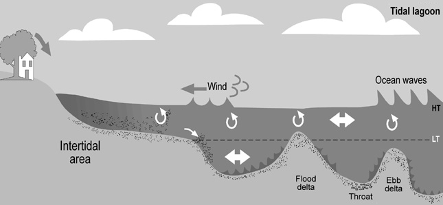
Figure 4. A conceptual model of processes in
predicted at the mouth of each estuary
a tidal lagoon.
using the NZ Tidal Model (Walters et
al. in press, Bell et al. 2001).
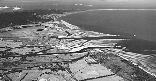
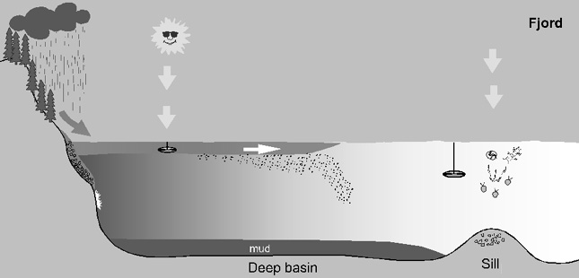
Figure 1. A tidal lagoon.
Ę Mean annual runoff (mm/yr) to an
estuary is estimated by overlaying the
catchment boundary on a runoff grid
for New Zealand (500 m pixels) to
provide an areally weighted figure.
Ę A wind wave resuspension factor
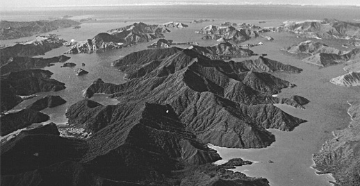
Figure 5. A conceptual model of processes in
describes the relative likelihood of
a fjord.
estuary waters being made turbid by
Figure 2. Drowned valley estuaries.
waves stirring the seabed. It is com-
The database and classification tool
puted from fetch, wind rose data, and
A constraining issue in building a
estuary depth data for intertidal areas
classification is the lack of data for New
using a combination of numerical
Zealand estuaries, particularly ecolo-
models. Wind-driven waves are deve-
gical data. To overcome this we chose to
loped under restricted fetch conditions
use an `Environmental Factor' approach,
inside estuaries and their orbital
which uses data representing physical
currents resuspend sediment.
components of the environment (e.g.,
Ę A rain power factor was generated as
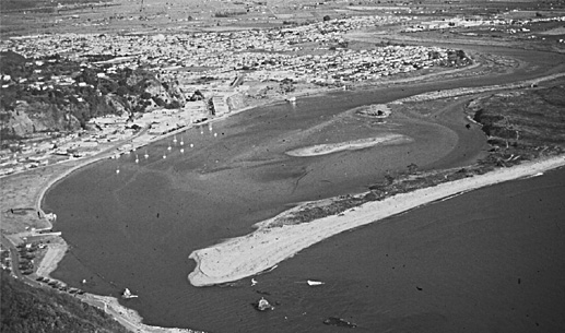
Figure 3. A tidal river.
climate, tides, and geology) to produce
the areally weighted mean of the
hierarchical classification systems. It is
product between mean annual rainfall
Conceptual models
based on the principle that physical
(mm) and slope (degrees) for the NZ
The EEC began by building conceptual
components of the environment interact
Land Resource Inventory elemental
models of different estuary types using an
to `drive' ecosystems. Drivers of the
areas. It describes the erosive strength
`expert knowledge' approach as a starting
pelagic and benthic ecosystems in
of the rainfall and the generated runoff
point to help shape ideas and a tool to use
estuaries are: light, water mass, fresh-
for a given catchment geology.
while we developed a more sophisticated
water inputs, wind mixing of the water
Our basic management unit and starting
classification. These models will be
column, tidal mixing and stratification,
point was a single estuary, which provi-
reshaped as our knowledge improves and
flushing, and wind wave stirring of the
des a means for comparing one estuary
as they are tested. The cartoon illustra-
seabed. Spatial and temporal variation in
with another. This approach becomes
tions for a tidal lagoon and a fjord high-
drivers is expected to be related to spatial
less useful as estuaries get larger. Large
light the differences in processes in these
and temporal patterns in ecosystem
(or compound) estuaries contain many
different estuary types. In tidal lagoons
properties (such as biotic distribution),
different environments and `estuaries
catchment runoff is dumped in the head-
and capture broad patterns in the pelagic
within estuaries' (component estuaries).
waters and carried seawards by the tides.
and benthic environment. The environ-
And are best dealt with by mapping at a
On the shallow intertidal flats wind waves
mental factors are structured into a
larger scale by subdividing them into
resuspend sediment and tides transport it
classification using a `rule-based appro-
geomorphological units (e.g., arms and
in the channels. Bars protect the estuaries
ach' to map estuarine systems on the
bays in which different processes
from ocean swell. In comparison, fjords
basis of knowledge of the cause of
operate). An alternative approach is to
are deep and the bed is not disturbed by
differences in ecosystem structure.
use a regular grid, which is the method
waves. Runoff is transported as a surface
For each estuary, a `set of factors' was
proposed for the MEC. The end-product
layer by tides and density flows away
generated that represent, or are a proxy
of the work is not a `static' classification.
from the shore. In New Zealand fjords
for, the drivers of the ecosystem. Factors
By linking the database with a classif-
runoff drains through heavily forested
are generated from data describing
ication engine (algorithims that opera-
catchments producing a tannin stained
spatial variation in both environmental
tionalise rule-based decisions), manage-
layer of freshwater on top of the seawater
variables, including `static' variables
ment questions can be addressed. For
that reduces light penetration and
(e.g., bathymetry, catchment land cover
instance, the system can be used to
attenuates phytoplankton growth.
and geology) and dynamic variables
manage public expectation for water cla-
Such cartoons provide a framework for
(e.g., wind, solar radiation, air tempera-
rity in estuaries by identifying those
explaining processes to managers and the
ture, runoff), and patterns in the physical
estuaries where the water is likely to be
public - for instance, why an approach
environment that express the effect of
turbid due to river inputs or wind waves
used for monitoring in one estuary type is
drivers (e.g., modelled tidal data, model-
stirring the tidal flats. It can also be used
not appropriate in another type. The
led swell data). Models, coupled with
to select representative estuaries for
Australians have made excellent use of
GIS, were used extensively to generate
monitoring and selecting appropriate
page 3
LOICZ NEWSLETTER
Environmental Performance Indicators.
Links and contributions to LOICZ
Walters, R.A., Goring; D.G. & Bell, R.G.
Unique habitats/environments such as
typology
(in press). Tides around New Zealand.
estuaries of pristine quality can be iden-
LoiczView provides a web-based soft-
New Zealand Journal of Marine &
tified and set aside for reserves. The
ware tool to classify and extrapolate
Freshwater Research.
database will provide a much-improved
coastal characteristics (Buddemeier &
national picture of New Zealand's
Maxwell 2000). It uses a geospatial clus-
Author address list
estuarine resources and the environment
tering algorithm to generate classes. It
Dr Terry M Hume
and identify `gaps' in our knowledge.
draws on a global database with climatic,
NIWA, National Institute of Water &
So far we have developed the factors to
catchment, oceanic and other variables
Atmospheric Research
be incorporated into the database for the
at 0,5 degree cell structure. LoiczView
P.O. Box 11-115, Hamilton,
North Island estuaries and built the data-
provides a tool to compare New Zealand
New Zealand
base. The South Island database will be
estuaries at a global scale. It can also be
t.hume@niwa.cri.nz
completed next year and we will
used to analyse the EEC and MEC datas-
Ton Snelder
generate some trial classifications for all
ets in an alternative manner to our lar-
NIWA, National Institute of Water &
New Zealand estuaries.
gely rule-based approach. The EEC, and
Atmospheric Research
particularly the MEC, will be useful to
P.O. Box 8602, Christchurch,
The Marine Environment Classification
test how adequately the LOICZ dataset
New Zealand
A MEC has been designed to classify
(0,5 degree cell resolution) discriminates
s.snelder@niwa.cri.nz
New Zealand's large EEZ. This covers an
classes in small, elongate, and mountai-
area of approximately 10.9 million km2.
nous landmasses with spatially variable
The MEC is being approached in a
rainfall like New Zealand. Factors gene-
LOICZ/CZMC
slightly different way to the EEC,
rated in the EEC and MEC are useful in
Delta Project: Improving the
although the two classifications will be
LOICZ typology. LOICZ typology and
Planning and Management of
`operationally seamless'. MEC classi-
the `typology down-under' are pretty
Modified Mega-Deltas
fication will be carried out at two levels
much in-step for this purpose.
of resolution. First, a `national scale'
A new river deltas project is being initia-
classification will be based on spatial
Acknowledgements
ted jointly by LOICZ and the Coastal
coverage or `factor layers' of environ-
The EEC is part of a NIWA programme
Zone Management Centre of RIKZ, in
mental factors developed for a 1 km grid.
called `Effects of suspended sediment on
The Hague, the Netherlands. This
This relatively coarse grid will show
coastal and estuarine ecosystems' that is
project extends from earlier LOICZ acti-
limited detail in complex coastal areas
funded by New Zealand's Foundation for
vities on delta science by building a
like estuaries. A second and higher reso-
Research Science and Technology
network of scientists, engineers and
lution `regional scale' classification will
(FRST contract C01X0024). New
environmental managers to collate and
cover the area from the shore to the inner
Zealand's Ministry for the Environment
synthesise lessons learned from case
continental shelf with 100-200 m cells.
is funding the MEC.
studies. This delta project concept evol-
The MEC is being designed to capture
ved from the Conference on Sustainable
broad patterns in environmental and eco-
References
Development of Deltas (1998) and the
system properties in the pelagic and
Bell, R.G., Goring, D.G. & Walters,
World Water Forum (2000).
benthic marine environments. It is based
R.A. 2001. Advances in understanding
Deltas are the centre of gravity of the
on an environmental factors approach to
sea-level variability around New Zea-
watersheds or drainage basins. In most
classification. The draft MEC design is
land. Pp 1490-1500 in Edge, B.L. (ed.)
deltas fresh and salt water meet, creating
based on 18 environmental factor layers,
Proceedings of 27th International Con-
gradients that are very important for the
selected to represent spatial variation in
ference on Coastal Engineering, Sydney.
existence of a variety of ecosystems.
large-scale physical process that `drive'
American Society of Civil Engineers,
Deltas attract economic activities such as
marine ecosystems. Extensive use will
New York.
industry, transport and agriculture, but
be made of numerical models and
Buddemeier, R.W. & Maxwell, B.A.
also people. This results in increased
remotely sensed data (e.g., SST from
2000. Typology: Low-budget remote
pressure on the delta, its adjacent river
satellite imagery) to develop factor
sensing. LOICZ Newsletter 15:1-4.
basin, the coastal zone and the sea.
layers. The factor layers will be mapped
Healy, T.R. & Kirk, R.M. 1982.
Growth of economic interests and popu-
individually by `linking' the data to the
Coasts pp. 81-104 in Soons J.M. and
lation increases the deltas' vulnerability
grid using GIS. Classifications will be
Selby, M.J. eds. `Landforms of New
to pollution and natural hazards. Climate
made by `combining' the factor layers
Zealand'. Longman Paul, Auckland.
change and other external factors also
using two types of `classification
Hume, T. M. & Herdendorf, C.E. 1988.
have impacts. These pressures require
procedure': rule-based and multivariate.
A geomorphic classification of estu-
adaptive planning and management. In
The MEC will evolve through (1) a test
aries and its application to coastal
the past, measures were taken and
stage on a small data set, (2) collating
resource management - a New Zea-
structures were built for human use of
physical and biological factor databases,
land example. Journal of Ocean and
deltas. Not all of these were successful;
(3) generating initial trial classifications
Shoreline Management 11: 249-274.
some, such as armouring the deltaic
and (4) final testing. The MEC regional
MBWQMST 1998. The crew member's
coast of the Netherlands have caused
classification complements the EEC
guide to the health of our estuaries.
problems for both the population and the
approach by providing greater resolution
Moreton Bay Catchment Water Quality
environment.
in large estuaries containing many diffe-
Strategy Monitoring Team, Brisbane,
The aim of the modified mega-deltas
rent environments.
Australia. 97p.
project is to learn from the experiences
page 4
LOICZ NEWSLETTER
of development within deltas and from
In June 2000, the European Workshop
the planning and management of deltas
SURVAS
was held in Hamburg, Germany.
to see how we can develop deltas in a
Most coastal European countries
sustainable manner with respect to both
Synthesis and Upscaling of
were represented (see project web-site
nature and human occupation. The
Sea-level Rise Vulnerability
http://www.survas.mdx.ac.uk/). This
initial phase of the project, Improving
Assessment Studies
Workshop was a catalyst for a number of
the Planning and Management of
countries to initiate work on national
Deltas, divides the world's deltas into
The SURVAS project is developing a
vulnerability assessment for sea-level
three categories: unmodified mega-
global assessment on vulnerability of the
rise (e.g., Norway, Turkey, and to a
deltas (e.g. Amazon, Congo, and Lena),
coastal zone to sea-level changes, using
certain extent, Portugal). Another out-
modified mega- deltas (e.g. Rhine,
a common assessment methodology.
come is the establishment of closer aca-
Mississippi, Nile, and Niger) and
Led from the UK by Dr Robert Nicholls,
demic links and exchanges.
non-mega-deltas. Worldwide, there are
it had a busy and successful implemen-
approximately 21 modified mega-
tation in 2000.
In November 2000, the African Work-
deltas.
SURVAS focussed on the development
shop was held in Cairo, Egypt. 15 coun-
The project will develop a website as an
of a network of international experts
tries from all major African regions were
information and archive tool and,
interested in vulnerability and adap-
represented. A group of African experts
initially, use a questionnaire to build
tation studies and the organisation of
on sea-level rise (chair: Dr. Isabelle
information and encourage global
four workshops on these issues:
Niang-Diop, Senegal) was established to
participation in the assemblage of case
Ę The Methodological Workshop,
further efforts to understand the poten-
studies and discussion among
January 2000, Trent Park, Middlesex
tially serious implications of sea-level rise
contributors. The preliminary website
University, London, UK;
for Africa. Most of the participating coun-
can be found on http://www.netcoast.nl/
Ę The European Regional Workshop,
tries have produced or initiated vulnerabi-
projects/netcoast/delta/index.htm.
June 2000, ZMK, Hamburg Univer-
lity assessment studies and the data will
sity, Germany;
be added to the final SURVAS database.
Questions to be answered include:
Ę The African Regional Workshop, No-
A Proceedings will be placed on the
Ę What are or will be the most important
vember 2000, NARSS, Cairo, Egypt;
SURVAS Web page in spring 2001
changes in deltas?
Ę The APN/SURVAS/LOICZ Joint
Ę How are the fluxes of nutrients and
Conference on Asia/Pacific, Novem-
In November 2000 the APN/SURVAS/
sediment in deltas altered by human
ber 2000, Kobe, Japan.
LOICZ Joint Conference was held in
interventions?
Kobe, Japan. The event combined
Ę What information is available about
The Methodology workshop (January
national perspectives on vulnerability
best management practices in deltas?
2000) identified key indicators for the
and adaptation to impacts of sea-level
Are they being evaluated? What can
assessment of coastal natural susceptibi-
rise with state-of-the-art research on
we learn from these?
lity and socio-economic vulnerability
coastal zone issues in the Asia-Pacific
Ę Which concepts and tools are available
and resilience to impacts of climate
region. Important data for the SURVAS
for supporting delta management?
change, particularly accelerated sea-
database were identified.
Have they been applied?
level rise (ASLR). It also considered the
Ę What research is needed for further
practical implementation of the ideas
Ongoing SURVAS activities include:
elaboration on delta management
embraced by the SURVAS package,
Ę The theme issue of the Journal of
practices?
which was sent to all participants at the
Coastal Research.
Links are being established with
three regional workshops.
Ę Preparation of the Proceedings of the
LOICZ and the DPSIR framework, the
Cairo Workshop and the APN/SUR-
LOICZ typology, and the CZMC
This resulted in:
VAS/LOICZ Joint Conference.
project on the evaluation procedure for
Ę a first appraisal of data available
Ę Preparation of a brochure on using the
assessment of Integrated Coastal Zone
through a range of global datasets
SURVAS Matrix of indicators of
Management (ICZM).
obtained via on-line sources, and
vulnerability and adaptation to
The project contributes to Focus 4
Ę the improvement of the SURVAS
impacts of sea-level rise.
of LOICZ. Evaluation of coastal zone
package. This included modification of
Ę Synthesis of national data and con-
management practices in deltas is
a number of tables and questionnaires
struction of the SURVAS database.
of interest to the Netherlands'
on the nature and the use of the coas-
Ę Preparations for the Overview Mee-
Coastal Zone Management Centre
tal zone, current coastal management
ting which will take place in London,
(see http://www.netcoast.nl); outcomes
problems and potential impacts.
in June/July 2001.
of the project are expected to contribute
The SURVAS package was sub-
Ę Preparation for the Americas
to the identification of relevant issues
sequently tested and further improved
Regional Workshop, to be held late
for the Third World Water Forum, to be
using three national case studies
2001 or 2002.
held in Japan in 2003. A network of
with contrasting situations
scientists is being built, case studies are
(Germany, Poland and India).
GIWA News
being collected and the first workshop,
Through each regional workshop the
The Planning and Management of
SURVAS network has been growing,
The acronym GIWA (Global Inter-
Modified Mega-deltas, is planned for
and more than 200 international
national Waters Assessment) will be
the end of September 2001 in the
experts in a variety of fields are now
familiar to most LOICZ scientists, some
Netherlands.
involved.
of whom will be increasingly involved in
page 5
LOICZ NEWSLETTER
this global program. The GIWA metho-
Plateau through numerous drainage
graphic context of coastal biogeo-
dologies have been developed and are
basins to the coastal shelf seas. Huge
chemical budgets, catchment forcing
available from their web-site
areas of coastline are dominated by
conditions and thematic topics such as
(www.giwa.net), and the implementation
small but numerous catchments.
calcification and coral reef distribution.
of the regional research and capacity
Rapid demographic change and eco-
Synthesis work on the biogeochemical
building workshops are in full swing.
nomic development is an outstanding
models database and its scaling from
Recently a capacity-building workshop
feature of much of East Asia. More than
local to global assessment continued to
was held in Kharkiv, Ukraine, gathering
50% of fertiliser production and
make progress, especially in relation to
experts constituting the GIWA network
damming activities occur in Asia.
the Americas region. New attributes
in the Black Sea, the Caspian Sea and the
Catchment-based coastal impacts are
were developed for the LOICZView
Aral Sea sub-regions (Azerbaijan,
increasing rather than decreasing. There
tools, adding features that extended the
Bulgaria, Georgia, Iran, Kazakhstan,
are also large water management
statistical evaluation to the user and
Romania, Russia, Turkey, Ukraine,
activities such as damming to satisfy
providing manipulative features such as
and Uzbekistan). Participants were
future power and water demands, for
overlays, supervised clustering and
introduced to the GIWA methodology,
instance in the Yellow and Yangtze River
enhanced visual-comparison access.
and jointly conducted the first part of the
catchments.
Products from the workshop and the
assessment: the scaling and scoping
These were some of the agenda items at
upgrade of LOICZView has been
exercise. This involved group work and
the LOICZ East Asia BASINS regional
incorporated into the Typology web-site,
plenary sessions, where the assessment
assessment workshop, held in Hong
and will be included in the combined
was performed and methodological
Kong 26-28 February, supported by the
workshop report and CD-ROM to be
aspects of the work were discussed.
Asia Pacific Network for Global
published following the Africa-Europe
Because of the complexity of the sub-
Change, APN, and START, and hosted
regions workshop scheduled for The
regions to be studied, a two- dimensional
by the Hong Kong Baptist University. 18
Hague in early July.
structure was suggested; expert co÷r-
scientists used the DPSIR-based LOICZ
Two other workshops were held in
dinators of each sub-region will work
Basins Regional Assessment Tables
association with the typology activity.
closely with the regional team, and local
to derive a set of qualitative or
Training in the LOICZ biogeochemical
focal points will ensure sound locally-
semi-quantitative indices of driver
approach was given to additional
based expertise. The Kharkiv workshop
importance and state change for river
researchers from Mexico and South
was the first major GIWA activity in the
basin/coastal sea interaction. Comparis-
America who contributed a further
regions of the Black Sea, the Caspian
ons on various scales provide a link to
20 budget sites to the geographical
Sea and the Aral Sea.
other regional Basins assessments and
coverage of the region. These are being
Similar successful GIWA training work-
to LOICZ typology development. Three
incorporated into LOICZ publications
shops were held in Bangkok, Moscow,
working groups were formed: the
and the Biogeochemical Modelling
Beijing, Tashkent and Tallinn earlier in
sub-tropical south (Vietnam and Gulf of
web-site. Scoping and database develop-
2000. Additional workshops are planned
Tonkin), the central area (Yellow and
ments to support typologies for the wider
for Bangkok and Townsville. The first
Bohai seas) and the north, with (Sea of
ocean regions were subject of a small
GIWA General Assembly is scheduled to
Japan. Taiwan and Japan.
workshop to support the OBIS project
be held at Kalmar, Sweden 9-11 October,
This workshop will contribute to a
that is allied to LOICZ. Follow-up
2001. Further information about the
LOICZ Reports and Studies volume,
research and activities are continuing to
GIWA program and activities can be
provide input for the first LOICZ
expand the successful outcomes from
found on their web-site or obtained from
global synthesis in 2002 and contribute
the workshops.
the GIWA Coordination Office:
to peer-reviewed journals.
info@giwa.net.
3. SAmBas II Workshop
2. The Americas: Biogeochemistry
and Typology Workshop
Supported by the Universidade Federal do
LOICZ WORKSHOPS
Cearß and UNESCO/IOC, the South
1. East Asia Basins
A set of workshops addressing
American Basins study, SamBas, held a
Regional Assessment
biogeochemical estuarine models and
second workshop in Fortaleza, Brazil,
and Analysis Workshop
the typologies of coastal forcing and
2-5 May, with 20 participants including
environmental settings for the Americas
representatives of the LOICZ Basins task
East Asian coastal seas are influenced by
was hosted by Victor Camacho at
group and IOC. Key questions were
the most important rivers on earth. The
the Universitad Autonoma de Baja
addressed using the LOICZ Regional
sediment loads from Asian river systems
California in Ensenada, Mexico,
Assessment Tables (see Newsletter 18).
are estimated to contribute about 70% of
29 April - 4 May 2001. This extended the
Two working groups (Pacific and Atlantic
the 1.35x10¹⁰ t total. Of the 17 major
LOICZ-UNEP project on coastal
coasts) refined the regional SamBas
global deltas, 11 are located in Asia and
biogeo-chemical assessment to the
synthesis and filled gaps, addressing
5 of those in East Asia.
Americas region.
rivers and coastal issues along the
The climate varies from sub-arctic
The 30 scientists from North, Central
Pacific coast and better assessing the
through temperate and subtropical to
and South American coastal nations,
"human dimensions" of river-based flux
tropical zones. The Western Pacific,
gained familiarity with the use of the
changes to the coastal ocean. A qualitative
ENSO and North Pacific cycles
LOICZ typology tools and developed
index system for between-site and sub-
influence the transport of water and
typologies at national, regional and
regional comparison of issues was set up.
materials mainly from the Tibetan
global scales for climatic and oceano-
Attention was paid to critical loads of
page 6
LOICZ NEWSLETTER
riverine material flows for environ-
and to investigate potential funding on
in combination with human stewardship
mental and social system functions.
national and international levels.
and related management issues.
Approximations were made of distances
The regional co-ordinators of SAmBas
of current system states and fluxes from
are Prof. L. Drude de Lacerda (Fortaleza)
LOICZ will assist in identifying appro-
"critical thresholds" with implications
and Dr. Giovanni Daneri (Valparaiso).
priate key scientific questions, templates
for sustained provision of coastal goods
While LOICZ and IOC will continue to
for project design as applied in the
and services. The workshop also consi-
support SamBas, key work on sites must
global LOICZ Basins assessment pro-
dered human development indicators as
come from the regional scientific com-
ject, and participatory approaches. The
approximations for observed biogeo-
munity.
current EUROCAT project (see News-
chemical coastal change. The focus was
A LOICZ Reports & Studies volume
letter 18) on catchment-based forcing of
on links between nutrient fluxes and
including a refined regional assessment
coastal change in Europe could serve as
human development e.g., through biolo-
and suggestions for a future SamBas will
a template for the design. If the project is
gical oxygen demand. Demographic
be published, posted on the LOICZ web-
realized it will contribute to the global
data such as poverty indices, per capita
site and contribute to the first global
Basins effort with a perspective beyond
income, family structure and size and
LOICZ synthesis book. It will also
the current LOICZ programme. LOICZ's
education levels were found to relate to
underpin a regional proposal by the
involvement underlines the increasing
water quality, coastal impact and change.
SAmBas network.
relationship with IOC and will enable
Studies are currently underway in south-
new options for collaboration in the
east Brazil and the approach being used
OTHER WORKSHOPS
broader "water" field.
there could become an integral part of
Volga-Caspian Basin
future scientific work in SAmBas and
A Planned UNESCO Pilot Project
LOICZ IPO NOTES
other LOICZ Basins projects.
on Sustainable Development
The group recommended investigation of
historical demographic developments and
The VolgaŁCaspian Basin has an unu-
The LOICZ SSC
will meet in
resource use along river Ł coast systems.
sually high number of endemic species. It
Amsterdam 7-8 July to consider the
Combined with information about natural
provides goods and services to the most
performance and direction of the
goods and services, this can throw some
populated parts of the former Soviet
programme. In addition to general
light on former triggers of social choice
Union and is subjected to numerous trans-
operations, the development of the
that generated developments and the
boundary resource use and management
LOICZ Synthesis book and the
potential for the future.
issues. The five scientific programmes/
questions and plans for the future of
UNESCO/IOC expressed interest in this
commissions under UNESCO: IOC, IHP,
LOICZ will be main topics for decision.
approach, to find and apply effective indi-
MAB, IGCP and MOST are considering
Key research questions for a second
cators of change in the frame of Coastal-
a joint demonstration project on the
phase of LOICZ (2003-2012) as part of
GOOS and to provide tools for scenario
sustainable development of this basin.
IGBP II, will be outlined by the SSC.
simulation in coastal management. The
LOICZ was invited to contribute to the
These will form a base for extension and
IOC representative, Julian Barbiere,
ICEF Great Rivers 2001 Forum, held in
discussion by wider consultation within
underlined a strong rationale for links
Nizhny Novgorod, Russian Federation,
the LOICZ and broader community.
noted that training needs could also bene-
15-18 May 2001.
fit from the LOICZ/IOC relationship.
IGBP is in full preparation for its Global
The gaps and hot spots identified during
Embedded in the UN World Water
Change Open Science Conference
the two SAmBas workshops provided a
Assessment Programme (WWAP),
(Amsterdam 10-13 July). LOICZ people
set of key study areas/catchments
offspring of the World Water Forum, the
are involved in presentations, organi-
covering the Pacific and Atlantic coasts: project will focus on the achievement of
sation and attendance at the Congress
Ę San Juan and Patia, two high sediment
long-term sustainable development in
which promises to be a grand affair Ł
yielding rivers in Colombia
the VolgaŁCaspian basin. Key elements
show-casing the fascinating and often
Ę Magdalena River, the largest continen-
will include: catchment issues; links into
unique findings about how the Earth
tal contribution to Caribbean Colombia
the marine coastal zones, principal sinks
systems interact and change. The broad
Ę Guayas River - Gulf of Guayaquil,
for land-based sources of pollution and
implications of, for example, tele-
Ecuador
sedimentation and areas where flooding
connections, temporal context of
Ę Biobio River - Concepcion/
events and sea-level rise affect people.
changes and spatial patterns of process
Talcahuano Bay, northern Chile
The pilot project will obtain inventories
shifts, often in unexpected ways due to
Ę Jaguaribe and Cearß rivers, north-
of regional and local change under
human pressures and natural causes will
eastern Brazil
natural and human forcing and establish
be key points of debate.
Ę ParaĒba do Sul River/Sepetiba/Guana-
geo-referenced meta-databases. Existing
Opportunities for collaboration between
bara bays, south-eastern Brazil
projects such as the Volga Revival and
LOICZ and a number of other agencies
Ę Patos Lagoon, southern Brazil
the Caspian Environmental Programme
and programmes continue to be pursued.
Ę La Plata River estuary including the
and information from the Hydro-meteo-
LOICZ is involved with the design phase
Uruguayan and Argentinean coasts
rological Services will be carefully
of the Millennium Ecosystem Assess-
Ę Negro River, Patagonia, Argentina
evaluated. A broad risk-assessment of
ment and anticipates continued associa-
The sites provide a good coverage of the
the surface, subsurface and coastal water
tion during implementation over the next
climatic and geographic sub-regions. Key
systems and boundary conditions is
4 years. Our fruitful and vital association
persons in the SAmBas network agreed to
expected to provide further insight into
with UNESCO's Intergovernmental
develop proposals for the case-study sites
systems' resilience and will be evaluated
Oceanographic Commission is taking
page 7
LOICZ NEWSLETTER
another significant step forward with the
disturbing phenomenon is considered in
(active or lack of) within the regions to
development of a co-sponsorship arran-
concluding chapters.
management, conservation and
gement by the IOC for LOICZ. Our com-
protection. The extent and impact of the
bined work, for example in the area of
Oceanographic Processes of Coral
recent coral reef bleaching events that
ICAM and support for Coastal GOOS,
Reefs. Physical and Biological Links
have affected this global ecosystem is
will be further and more obviously exten-
in the Great Barrier Reef.
apparent, and is ascribed to global tem-
ded as the new IOC issues-based structure
Ed. Eric Wolanski, 356 pp., 2000. CRC
perature climate change and associated
comes into play. LOICZ is a participant in
Press LLC, Boca Raton, Florida USA.
large-scale phenomena influencing local
the Global Conference on Oceans and
environments.
Coasts at Rio+10 that IOC is staging in
A collected volume of synthesis, assess-
December 2001. It will assess scientific
ment and research papers dealing with
Pilot Analyses of Global Ecosystems
progress and continuing and new challen-
the wider coastal zone (land, land-sea
(PAGE).
ges in the marine realm for reporting to
interface, reef systems) dynamics of
World Resources Institute, Washington
the World Summit on Sustainable Deve-
processes. The physics Ł scaling, inter-
DC. Available on line at
lopment in Capetown, South Africa in
connectivity, linkages Ł and interactions
http://www.wri.org/wr2000.
2002.
of human pressures on tropical eco-
The IPO has been very active this year in
systems systems are clearly portrayed
A series of overview reports has been
coordinating a large number of regional
from current research. A snapshot and
prepared to date addressing the global
workshops addressing coastal biogeo-
opinion on reef management and the
state of 5 earth ecosystems: Coastal Eco-
chemical modelling, river basins and
political climate are provided. An
systems, Agro-ecosystems, Freshwater
typology issues in different regions of
accompanying CD-ROM graphically
Ecosystems, Grassland Ecosystems,
the world. While brief reports are given
supports the text, to provide a picture of
Forest Ecosystems. Each report, by
in the LOICZ Newsletter, the science is
the land-ocean system interaction of the
design, is a first attempt to "take stock of
described in detail in a continued stream
GBR, and this is applicable to coral reefs
[the ecosystem] extent, its condition, and
of publications Ł LOICZ R&S Reports
in general.
its capacity to provide goods and servi-
and peer-reviewed journals. These are
ces we will need in years to come". The
listed in each Newsletter and are
Science and Integrated Coastal Mana-
reports result from wide ranging colla-
available from the IPO. Importantly,
gement. Dahlem Workshop Report 85.
boration between researchers, institutes
these regional assessments of materials
Eds. B. v. Bodungen & R.K. Turner, 2001,
and agencies to give an initial appraisal
flux and human dimensions underpin the
378 pages. Contact: Dahlem University
of the earth systems, providing a vital
current work of integration and synthesis
Press (dahlemup@zedat.fu-berlin.de).
datum point for further global asses-
by LOICZ. The much promised
A comprehensive report of the 85th sments such as the Millenium Eco-
revamping of the LOICZ web-site is
Dahlem Workshop, held in December
system Assessment, and research
underway and should now provide an
1999 addressing integrated coastal zone
programs such as IGBP.
up-to-date service to everyone, giving
management. Coastal management issues
access to research findings, publications
and problems are identified through a
Coastal Marine Ecosystems of Latin
and LOICZ developments.
series of global case studies. Importantly,
America. Eds U. Seeliger, B. Kjerfve,
the applicability of knowledge and the
2001, Ecological Studies Vol. 144,
certainties and uncertainties of the rele-
Springer, ISBN 3540672281, 360 pages.
HAVE YOU SEEN
vant natural and socio-economic science
are highlighted and discussed by leading
Coastal communities have a vital stake in
Some recent publications describing
experts from wide-ranging fields within
nearshore ocean and coastal resource use.
advances in coastal science, with great
the Dahlem Workshop forum. Various
Increasing socio-economic demand for
relevance to LOICZ, particularly in the
coastal management processes and insti-
coastal goods and services is counterac-
local case studies of systems processes,
tutional settings are assessed and form the
ted by decreasing revenues due to degra-
changes due to human pressures and the
basis for the deliberations and recom-
dation of coastal forests and mangroves.
inter-connectivity of processes and
mendations integrating science, manage-
This leads to considerable money flows
pressures.
ment and decision-making.
for mitigation and restoration, but to
achieve sustainable management, funda-
Coastal Hypoxia: Consequences for
Status of Coral Reefs of the World:
mental understanding of coastal system
Living Resources and Ecosystems.
2000.
functioning and organization is needed.
Eds. Nancy N. Rabelais & R. Eugene Tur-
Ed. Clive Wilkinson, 2000, 363 pages.
Seeliger and Kjefve provide a compre-
ner, June 2001, 463 pages. Contact: AGU
Australian Institute of Marine Science
hensive description of 22 major coastal
Customer Service (orders@agu.org).
(see www.aims.gov.au)
ecosystems in Latin America where
natural and anthropogenic-driven change
The establishment of anoxic conditions
An update on the state of global coral
has increased considerably during the last
in the Gulf of Mexico is described.
reefs from the Global Coral Reef
century. Systems under pressure and
Topics dealt with include the effects of
Monitoring Network. A comprehensive
areas exhibiting nearly pristine conditions
this periodic environmental condition on
report of regional coral reefs
are discussed, ranging from the lagoons of
plankton, physiology and behaviour of
assessments is provided by the array of
northern Mexico to the bays of Patagonia.
communities, benthic organisms, fish
task groups around the world, describing
The book focuses on ecological features
and fisheries, food webs and ecosys-
current pressures and states, changes and
and energy fluxes and provides sugge-
tems. The wider global nature of this
threats, and institutional responses
stions for management.
page 8
LOICZ NEWSLETTER
Water: Quantity Ł Quality Perspective
Euresco CLIVAR/PAGES Conference
LOICZ CALENDAR
in South Asia; V. Subramanian, 2000,
on Abrupt Climate Change Dynamics.
256 pages. Kingston International
10-15 November 2001, Castelvecchio
Publishers, England; surreykt@aol.com
LOICZ UNEP Africa and Europe
Pascoli, Italy. Contact PAGES IPO
thematic workshop on upscaling and
(pages@pages.unibe.ch).
Subramanian synthesizes decades of
assessment of nutrient fluxes in coastal
Global Conference on Oceans and
data from monitoring programs and
estuarine systems. 2-5 July 2001.
Coasts at Rio+10: Assessing Progress,
literature to provide an extensive over-
RIKZ- CZMC, The Hague, The Nether-
Addressing Continuing and New Chal-
view on water related issues under
lands (by invitation).
lenges. 3-7 December 2001, UNESCO,
natural and man-made change in South
Contact: LOICZ IPO.
Paris. Contact IOC Secretariat, Paris.
Asia. This area contributes 9% of the
IAS/SEPM Environmental Sedimen-
global river runoff and drains to the
LOICZ Scientific Steering Committee
tology Workshop: Continental Shelves
Arabian Sea and the Gulf of Bengal.
Meeting. 7-8 July 2001, Amsterdam.
Ł Processes, Record, Utilization and
While the focus is mainly on the
Contact: LOICZ IPO.
Management. 7-10 January 2002,
freshwater end of the water cascade,
Hong Kong. Contact Wyss Yim
discussions provide a variety of biogeo-
AfriBasins II workshop on African river
(wwsyim@khu.hk).
chemical and water quality information
catchments/coastal fluxes and human
International Symposium on Low-
including groundwater resources and
dimensions. November 2001.
Lying Coastal Areas: Hydrology and
reveal the catchment-based pressures
Nairobi, Kenya (by invitation).
Integrated Coastal Zone Management.
that affect South Asian coastal zones.
Contact: LOICZ IPO.
9-12 September 2002, Bremerhaven,
The book points out that regardless of
Germany. Contact Alicia Aureli,
the susceptibility of the hydrological
LOICZ-UNEP Polar regions work-
UNESCO (a.aureli@unesco.org).
cycle in this region to larger natural
shop on biogeochemical modelling of
11th International Biennial Confe-
triggers such as ENSO and the monsoon
estuarine systems. 9-11 September,
rence on Physics of Estuaries and
system, human water use and manage-
2001, Stockholm, Sweden.
Coastal Seas (PECS). 17-20 September
ment contribute considerably to the avai-
Contact LOICZ IPO or Prof. Fred Wulff..
2002, Hamburg, Germany.
lability of water and to protection against
See (http://www.pecs-conference.org).
flooding and drought. It is an important
LOICZ-UNEP global thematic work-
source of information about a region
shop on upscaling and assessment of
IPO STAFF
which hasn't received broad scientific
nutrient fluxes in coastal estuarine sys-
attention, but which is undoubtedly a
tems. 11-14 November, 2001, Lawrence,
crucial piece in a global basins jigsaw.
Kansas USA. Contact LOICZ IPO.
CHRIS CROSSLAND
Executive Officer
LOICZ "Synthesis" and Open Science
HARTWIG KREMER
LOICZ PUBLICATIONS
Meeting 5, 22-25 May 2002, Miami,
Deputy Executive Officer
Florida, USA. Contact LOICZ IPO.
HESTER WHYTE,
[available as printed copies or from the
Office Manager
LOICZ web-site: www/nioz.nl/loicz]
MILDRED JOURDAN,
OTHER MEETINGS
Office Assistant
Estuarine Systems of sub-Saharan
MAARTEN SCHEFFERS
Africa: C, N and P Fluxes. LOICZ
IGBP Open Science Conference.
Liaison Officer
UNEP workshop report. Eds. V. Dupra,
10-14 July, 2001, Amsterdam, The
S.V. Smith, J.I. Marshall Crossland and
Netherlands. Contact: igbp@congrex.nl,
C.J. Crossland. LOICZ R&S 18, 2001.
www.sciconf.igbp.kva.se
FOR MORE INFORMATION,
3rd International Conference on
SARCS-WOTRO-LOICZ:
Biogeo-
Land Degradation and Meeting of the
PLEASE CONTACT:
chemical and human dimensions of
IUSS Sub-commission C Ł Soil and
coastal functioning and change in South-
Water Conservation. 24-28 September
LOICZ INTERNATIONAL PROJECT
East Asia. Eds L. Talaue-McManus,
2001, Rio de Janeiro, Brazil. More infor-
OFFICE
H.H. Kremer and J.I. Marshall Cross-
mation on www.cnps.embrapa.br/ICLD
NETHERLANDS INSTITUTE FOR
land. LOICZ R&S 17, 2001.
General Assembly, Global Interna-
SEA RESEARCH
LOICZ Web Site: Biogeochemical
tional Water Assessment (GIWA).
PO BOX 59
Budgets and Modelling Ł new sites and
9-11 October 2001, Kalmar, Sweden.
1790 AB DEN BURG - TEXEL
tutorial materials
Contact GIWA Coordination Office
THE NETHERLANDS
(http://data.ecology.su.se/MNODE/).
(info@giwa.net).
Joint IAPSO-IABO Assembly and XII
PHONE: 31-222 369404
LOICZ Web Site: Typology
Colloquium: 2001
F
(http://water.kgs.ukans.edu:8888/public
An Ocean Odyssey. 21-28 October
AX:
31-222 369430
/Typpages/index.htm)
2001, Mar del Plata, Argentina. Contact:
E-MAIL: LOICZ@NIOZ.NL
Also (www.kgs.ukans.edu/Hexacoral/
gmperill@criba.edu.ar or
WWW HOME PAGE:
Workshops)
iado@criba.edu.ar
HTTP://WWW.NIOZ.NL/LOICZ/
A CORE PROJECT OF THE
I
G
B
P
INTERNATIONAL GEOSPHERE-BIOSPHERE PROGRAMME