LAND-OCEAN INTERACTIONS IN THE COASTAL ZONE
March 2000
No. 14
LOICZ NEWSLETTER
to the sea is considered by some to
The threat mud poses to
be of the most threatening impacts
on coastal reefs of the Great Barrier
the Great Barrier Reef
Reef (Bell and Elmetri 1995).
of Australia.
HISTORICAL CHANGES
Eric Wolanski1 and Norman Duke2
1Australian Institute of Marine Science,
The impact of man on this sector of
e.wolanski@aims.gov.au
the coastline of the Great Barrier
2 University of Queensland
Reef has been dramatic. Old pho-
n.duke@mailbox.uq.edu.au
tographs of the Cairns waterfront
suggests that the Cairns beach was
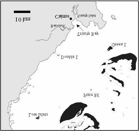
The Cairns coast (Figure 1) of the
sandy at the end of the 19th century,
Great Barrier Reef of Australia has
it is now muddy and the bed is 1.5
been severely impacted by man-
to 2 m higher. This is affirmed by
induced erosion. Over the last 100
oral accounts gathered from people
years in this area much of the forest
living in Cairns through 1930 to the
and natural coastal vegetation and
1950s. The consensus is clear and
wetlands have been modified to
uniform, namely there was a sandy
permit urban, port, industrial and
beach before, the Esplanade was
agricultural development (Wolanski
This is the fourteenth newsletter
used as a swimming and picnicking
1994, Larcombe et al. 1996,
of the Land Ocean Interactions
recreational area and there was
Wachenfeld et al. 1997). The
in the Coastal Zone (LOICZ)
even an open saltwater swimming
coastal rivers have become drains
International Project of the
enclosure at the mouth of Trinity
bringing eroded mud to settle in the
IGBP. It is produced quarterly
Inlet - now a mud bank.
estuaries, in the coastal shallows
to provide news and information
and on the inshore reefs. Additional
regarding LOICZ activities.
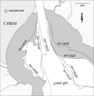
Further evidence for this very rapid
mud from dredging Cairns port is
accumulation of mud comes from a
dumped in coastal waters. The re-
comparison of the navigation charts
sulting addition of nutrient-rich mud
from 1878 and 1972 (Figure 2).
Figure 1: Map of the coast of the Great Barrier Reef near Cairns
Figure 2: Chart of Trinity Bay showing the 0 and 2 depth contours
(at low spring tides) in 1878 and 1972.
page 2
LOICZ NEWSLETTER
This suggests that on the wave- Before European settlement, the tion. This pioneer study was mostly
sheltered eastern side of Trinity Bay holocene deposition rate of mud in carried out near Low Isles offshore
the intertidal flat has prograded was about 6 m in 6000 years, ie 1 Port Douglas. The scientists mea-
seaward by up to 1 km (see the metre/1000 year (P. Larcombe sured visibility weekly and found
changes in the 0 m depth contours). pers. com.). In the 20th century, clear water (mean visibility ~ 11 m)
Also the 1878 chart refers to the man apparently increased this de- during the South East trade wind
tidal flat as a sandy mud bank that position rate to 1 to 2 metres/100 season (the windy, dry season
dries at low water spring tides. In years, resulting in: the 1897 sandy when river runoff is negligible). In
1999 this tidal flat dries at 1.5 m beach now buried by 1-2 m of mud; 1997, for the same dry season and
above low spring tides and is soft the establishment of new man- distance offshore, the visibility off-
mud. The 1878 chart refers to the groves on the western coast of Trin- shore from Double Island was only
Cairns beach as a white sand ity Bay since 1952; a wider mud flat 50% of what it was 70 years ago
beach barely covered at high water. over the western side of Trinity Bay; near Low Isles (Wolanski and
In 1999 the only sand there is a and shallower water by 1-2 m on Spagnol submitted). Assuming the
strip of sand a few meters wide and the eastern side.
1927 data are an indicator of natu-
dumped there by man to beautify
ral conditions, these data suggest
the area, everything else is mud. THREATS TO THE GREAT BAR- mud is increasingly being exported
Thus a 1.5 m thick layer of mud has RIER REEF
from Trinity Bay toward the Great
apparently accumulated in the last Mud from Trinity Bay is readily re- Barrier Reef.
100 years and covered the original suspended by wind and is exported
beach. This increased siltation has northward alongshore in a turbid Long-term effects of low-level sedi-
also apparently resulted in the re- coastal band during southeast trade mentation on coral reefs include
cent (since 1952) colonisation of winds. This season lasts six tissue lesions and diseases, de-
mangroves along the coast be- months of the year. Wolanski and creased calcification, net productiv-
tween the airport and the city Spagnol (submitted) collected ity and growth, and shifts in abun-
(Figure 3).
oceanographic data to assess the dances and species composition
offshore extent of the dispersion of (Dodge et al. 1974, Cortķs and Risk
the mud along the coast north of 1985, Peters and Pilson 1985,
Cairns. For six weeks in August Rogers 1990). Mud in suspension
and September 1997, five oceano- as muddy marine snow also physi-
graphic moorings were maintained cally smothers coral reef organisms
in a cross-shelf transect just north (Fabricius and Wolanski, 2000).
of Double Island from the coast to Along this coast, muddy marine
Pixie Reef. The moorings logged snow is probably enhanced by
data every 10 min on currents and runoff from farms and pastures,
turbidity.
and appears to be the norm rather
than the exception.
In coastal waters the suspended
solid concentration fluctuated THE PROTECTIVE ROLE OF
widely, peaking at 1,000 mg l-1 (1 kg MANGROVES
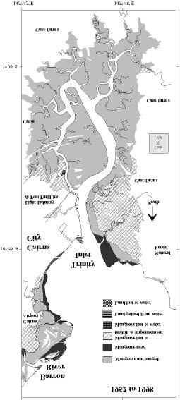
m-3) on windy days, at which time The mangrove forests in the Cairns
the visibility was zero (the divers area are located mainly along the
could not see their hand against the Barron River and Trinity Inlet, and
face mask). Terrigenous mud was they have been measurably re-
also found to be exported to off- duced since 1952 (Figure 3); de-
shore in a near-bottom muddy layer spite some local increases there
a few metres thick (a nepheloid has been a net loss of 15% for the
layer). In these offshore waters Barron River mouth, and a net loss
events of high suspended solid of 24% for Trinity Inlet. Mangrove
concentration (>50 mg l-1 peaking in losses are due to the expansion of
one event at 200 mg l-1) occurred the airport, urban areas, industry,
occasionally. This suggests that the port facilities and land reclaiming
mid-shelf reefs of the Great Barrier for sugar cane farms. In particular
Reef in the Cairns area are also a bund wall has destroyed a large
ultimately threatened by mud.
area of mangroves along the east-
ern shore of Trinity Inlet. These
Mud in suspension decreases the losses have occurred mainly in
visibility, an indicator of the ability of downstream areas, where man-
light to be transmitted through the groves best trap mud they capture
water. Without light there can be no from suspension in coastal waters
photosynthesis and plants cannot (Furukawa & Wolanski 1986).
survive, neither can they sustain Based on studies of sedimentation
other species which depend on the in mangroves near Cairns airport
plants for their food. Knowledge of (Furukawa et al. 1997), the 8.22
Fig 3 Changes to mangroves of Trinity Inlet and
the past visibility is derived from the km2 of mangroves that have been
the mouth of the Barron River (1952-1998).
1928-1929 British Museum Expedi- lost would have trapped about 12-
page 3
LOICZ NEWSLETTER
25,000 tonnes of sediment per grove plants compared to upstream Inlet, beginning with the removal of
year, or 0.5-1 million tonnes over stands, but they are the sites of the bund wall in Trinity Inlet. In this
the last 40 years since the man- dominant biomass and widest spa- latter case, however, tis would have
groves were destroyed. This mud tial extent. The reason for this to be done in a controlled manner to
is now polluting coastal waters of occurrence is related to the supply avoid large-scale contamination by
the Great Barrier Reef. This esti- of nutrients with seasonally reduced acid sulfates formed since the bund
mate is approximate. However salinities, but the main reason is the walls were constructed. Finally, the
even if it was too high by a factor of supply of sediment. Mangroves, mud dredged from Cairns port
2 or 3, it still shows the vital role of particularly Rhizophora species, should be readily used to help man-
mangroves in protecting Great Bar- readily colonise mud banks and by groves colonise muddy intertidal ar-
rier Reef waters from excessive tur- doing so, they can trap and bind-up eas, instead of dumped at sea
bidity (see also Duke 1997).
sediments for thousands of years. where it pollutes coastal waters. In
These areas may remain stable this way mangroves can be used to
Historically these mangrove-fringed provided the processes of recruit- protect this and other areas along
estuaries have undergone dramatic ment and tree replacement are not the Great Barrier Reef from excess
changes also prior to European set- interrupted. In this way, established mud.
tlement (Duke 1997). Trinity Inlet mangrove forests act to regulate
was once the mouth of the Mul- and improve water quality. Without CONCLUSIONS
grave River before volcanic activity, mangroves, these sediments would The Great Barrier Reef region is
many thousands of years ago, redi- be readily flushed further offshore justly inscribed on the World Her-
rected this large river to join the during both seasonal and episodic itage list because it is one of the
Russell River which enters the sea incidents of increased land catch- mega-biodiverse prime natural as-
much further south. More recently ment runoff and severe coastal sets of Australia. Our generation
the Barron River mouth has shifted wave action. Mangrove detritus has the opportunity to enjoy this
dramatically to its present location. also helps in generate mangrove immense and wonderful asset but
In 1876 when the first Europeans flocs, thereby protecting seagrass there is an incumbent responsibility
arrived in Cairns, the Barron River beds in coastal waters. Mangroves not to adversely affect its natural
opened into the bay where the therefore act directly to buffer and qualities and its enormous range of
Cairns airport is now located (see reduce water turbidity in the Great habitats and species. Mud from
Figure 3). Since then the mouth has Barrier Reef lagoon. Throughout man-made erosion in the catch-
shifted north in at least two steps past times, the mangroves have ment areas is a serious threat to the
(QH&M 1981). The mouth at the responded naturally in unison with Great Barrier Reef. Inshore reefs
easterly point of land (Ellie- geological and geomorphic of the Great Barrier Reef cannot be
Casuarina Point) closed after 1939 changes to help stabilise mud sustainably managed without man-
when the sand ridge north of the banks. A delicate balance has been aging the adjacent land. Careful,
point was breached. The river's maintained allowing the creation of understanding and coordinated
potential to change its course re- the Great Barrier Reef as we know land care in the catchments drain-
mains today with the continued it.
ing into the Great Barrier Reef is
widening of the Thomatis-Richters
imperative together with careful
channel (a previously small deltaic With the recent removal of man- consideration of the impacts of
tributary to the north), and the erod- groves, this balance has been dis- dredging, land clearing, stream
ing banks opposite accreting banks rupted and the Great Barrier Reef modification, wetland destruction
of river meanders.
has lost some of the protective role and mangrove removal.
of mangroves in trapping mud. The
Sediments in the Barron River waters now leave these estuaries There is an additional way to com-
mouth and Trinity Inlet today are a much dirtier than ever before. This bat pollution by mud, namely by
mixture of silt, clay and organic process is exacerbated with the in- planting mangroves and encourag-
residues (Bird 1972, 1973). Fine creased sediment loads in the land ing natural recruitment. Mangroves
grain sediment settles in quieter drainage systems from vegetation planted over the new mud banks
waters. The pulsing of depositional cleared further up in the catchment. and reclaimed mangrove land re-
events has created a series of To protect the Great Barrier Reef, turned to mangroves, would go a
roughly parallel sandy ridges built the area of mangroves should be long way toward protecting the
up over and between earlier tidal increased to stabilise the excess Great Barrier Reef from mud pollu-
mudflats. This topography typifies mud. In the Cairns area, this can tion.
those found across the Cairns be done by encouraging the coloni-
coastal plain and relic formations, sation by mangroves of the mud REFERENCES
to around 6,000 years before pre- banks in Trinity Bay and by actively Bell, P.R. and I. Elmetri 1995.
sent, are now dissected and trun- planting seedlings where the rate of
Ecological indicators of large-
cated by tidal creek meandering.
colonisation is too slow. The cur-
scale eutrophication in the Great
rent practice of removing naturally-
Barrier Reef lagoon. Ambio
In the Barron and Trinity estuaries, recruited mangrove seedlings
24:208-215.
Bird, E. C. F. 1972. Mangroves and
mangroves have taken advantage fronting the Cairns muddy beach is
coastal morphology in Cairns Bay
of the extensive depositional plain, encouraging pollution by mud of
, North Queensland. Journal
particularly in downstream loca- coastal waters. Mangroves should
Tropical Geo-graphy, 35:11-16.
tions. These places usually have be restored along all undeveloped Bird, E. C. F. 1973. Depositional evi-
relatively low biodiversity of man- sections of the Barron and Trinity
dence of fluvial sediment yield:
page 4
LOICZ NEWSLETTER
an example from North Queens-
component in coastal budgets not
land. Australian Geography
SURVAS holds successful
only of water but also of chemical
XII:250-253.
workshop
constituents. The problem coastal
Cortķs, N.J. and Risk, M.J. 1985. A
zone managers face is: (1) they
reef under siltation stress:
Robert Nicholls and Anne de la
Cahuita, Costa Rica. Bulletin of
Vega-Leinert of Flood Hazard Re- may not be fully aware of the the
Marine Science 36:339-356.
search Centre, Middlesex Univer- importance of SGD; (2) if they are
Dodge, R., R. Aller and J. Tomson
sity, UK, hosted the first of a series aware, they may not know how to
1974. Coral growth related to re- of workshops of the SURVAS Pro- decide whether or not SGD is rele-
suspension of bottom sediments. ject (S
ynthesis and U
pscaling of vant to their situation; and (3) if they
Nature 247:574-577.
sea-level R
ise V
ulnerability A
ssess- do decide this is important to them,
Duke, N. C. 1997. Mangroves in the
they may not know how to quantify
Great Barrier Reef World Her-
ment S
tudies). This was held in it.
itage Area: current status, long-
Trent Park Campus, North London
term trends, management impli-
on 17/18th January 2000.
cations and research. In D.
The joint SCOR-LOICZ-IOC-IHP
Wachenfeld, J. Oliver and K.
Twenty-six invited experts attended working group meeting at the Inter-
Davis (ed.), State of the Great
this workshop from a range of aca- governmental Oceanographic
Barrier Reef World Heritage Area demic and governmental organisa- Commission, Paris, in accordance
Workshop, pp. 288-299. Great
tions in Europe, the Americas, with an earlier IOC Assembly deci-
Barrier Reef Marine Park Author- Africa and Asia. The major goal sion, aimed to formulate a program
ity, Townsville.
to address these three issues. An
Fabricius, K and E. Wolanski 2000.
was to provide the international del- important aspect of the method-
Terrestrial muddy marine snow
egates the opportunity to comment ological intercalibration project was
smothers coral organisms. Estu- upon the proposed SURVAS
arine, Coastal & Shelf Science
methodology, and discuss relevant ability to disseminate the results
50:115-120.
ways of improving it. Three cri- widely in the hopes that national
Furukawa, K. and E. Wolanski 1996.
tiques covering four major aspects authorities will encourage the scien-
Sedimentation in mangrove
of the methodology were the basis tific community to investigate this
forests. Mangroves & Salt
of dynamic group debates.
phenomena properly, in all likely
Marshes 1:3-10.
locations. Such information could
Furukawa, K., E. Wolanski and H.
ultimately be compiled into a
Mueller 1997. Currents and sedi- These were :
database and/or an atlas.
ment transport in mangrove
Ę physical and ecological aspects The crucial design objectives were
forests. Estuarine, Coastal &
(Dr. M. Capobianco, Tecno-
Shelf Science 44:301-310.
mare, Italy),
to gain ability to better define and
Larcombe, P., Woolfe, K.J. and Pur-
Ę socio-economic aspects (Dr. N. test the SGD measurement tools.
don, R.G. (ed.). Terrigenous
Adger, University of East Anglia, While it is relatively easy to produce
sediment fluxes and human im-
UK), and,
numbers, it is very difficult to as-
pacts. CRC Reef Research Cen- Ę end-users' needs (Dr. T. Down- sess the quality of these estimates.
tre, Current Research,
ing, University of Oxford, UK).
Townsville, Australia, 174pp.
To meet the growing consensus
Peters, E. and M. Pilson 1985. A com-
within the scientific community
prehensive study of the effects of A number of key actions were de- working on SGD that some type of
sedimentation on symbiotic and
cided upon during the workshop,
asymbiotic colonies of the coral
including more focus on indicators intercalibration program is needed
Astrangia danae. Journal of Ex-
of Adaptive Capacity. The revised to resolve the measurement issues,
perimental Marine Biology and
methodology is presently being the workshop addressed: (1) the
Ecology 92: 215-220.
tested by five country case studies site selection; and (2) the selection
QH&M. 1981. Barron River delta in-
(Germany, India, Poland, Senegal of techniques and the experimental
vestigation. The Report of the
design of the actual intercompari-
Barron River Delta Investigation
and UK). The improved SURVAS son. For example, while some sites
Steering Committee. Department methodology will be first applied at may have lower flows, the impact of
of Harbours and Marine, Queens- the European workshop in Ham- SGD may be greater because of
land, 440 pp.
burg in June 2000.
Rogers, C. 1990. Responses of coral
high nutrient concentrations. About
reefs and reef organisms to sedi- For more information on SURVAS four to five sites that span a broad
mentation. Marine Biology
goals, methodology & work pro- range of conditions were identified,
Progress Series 62:185-202.
gramme, please either log onto emphasising the need for the in-
Wachenfeld, D., J. Oliver, J. and K.
http://www.survas.mdx.ac.uk or volvement of local expertise (both
Davis (ed.) 1997. State of the
scientific and managerial) and
Great Barrier Reef World Her-
contact Dr. Anne de la Vega-Leinert some provision for training be made
itage Area. Workshop, Great
at survas@mdx.ac.uk
part of the dissemination effort.
Barrier Reef Marine Park Author-
ity, Townsville.
Wolanski, E. 1994. Physical Oceano-
Submarine Groundwater
The proposal will be delivered to
graphic Processes of the Great
Discharge Ł intercalibration IOC in time for consideration by its
Barrier Reef. CRC Press, Boca
Executive Committee which meets
of methods
Raton, 194 pp.
in May, 2000. The first intercalibra-
Wolanski, E. and S. Spagnol. Pollu-
(IOC-SCOR-LOICZ initiative; 2-4
tion study is proposed for Pert,
tion by mud of Great Barrier Reef
February 2000)
Western Australia in December
coastal waters. Submitted to
D
irect discharge of groundwater 2000.
Journal of Coastal Research.
into the ocean can be an important
page 5
LOICZ NEWSLETTER
seem to encompass the most are to make a first assessment of
prominent drivers of environmental global changes in material fluxes
Global Change and
changes rather than climate. The and the coastal system responses
Continental Aquatic Systems cumulative changes observed in across the salinity interface. The
Olasumbo Martins GKSS,
the hydrological cycle at a global recent support from UNEP with
Geesthacht, Germany
scale are significantly driven by GEF funding has provided a major
damming, water diversions and impetus to this LOICZ effort, provid-
(IGBP Synthesis Workshop, Stock- withdrawals. These modify the ing for training and evaluation work-
holm, Sweden, 7-9 February, 2000) physical components of aquatic en- shops across most regions.
The workshop, which was orga- vironments, particularly in river sys-
nized in conjunction with the Royal tems in terms of, for example, sedi- The recent workshop in India was
Swedish Academy of Sciences and ment retention and reduction of wa- generously hosted by the National
the Swedish Agricultural University, ter flow. Land-use changes Institute of Oceanography in Goa
was also supported by the Mille- through engineering, constructions, and addressed ecosystems in the
nium Committee of Sweden and the deforestation and agriculture, which South Asia region. Representa-
Foundation for Strategic Environ- have been of increasing influence tives from India, Bangladesh and
mental Research, Sweden.
for over the last 2000 years, now Sri Lanka joined in the workshop of
are proceeding at an accelerated tutorial and plenary activities to train
Focusing on global change and rate and leading, for example, to and use a variety of recently devel-
continental aquatic systems (CAS) severe deforestation in the humid oped modelling tools, and to de-
i.e., fluvial pathways, groundwater tropics and desertification in the velop coastal site models using ex-
transport through the catchments arid tropics. Increasing water de- isting data. Relatively unimpacted
and the coastal zones, the work- mand for irrigation is expected and to highly polluted systems were
shop sought to answer the leading has been seen to cause severe considered as working examples.
question: "Are the changes ob- drops in water quality through salin- The strong achievement and out-
served in continental aquatic sys- ization of surface and ground wa- puts will be reported in a LOICZ
tems over the last 50 years and ters.
R&S report and placed on the
foreseen for the next 50 years
LOICZ web site. It is expected that
caused by global climate change or In conclusion, global climate participants will continue to make
by anthropogenic drivers?" Empha- change therefore might not be the contribution to this wider LOICZ ef-
sis was plavced on the multiple most immediate critical issue, partly fort by further assessments of nutri-
impacts on land and water use gen- because it follows a moderate time- ent transfer and fluxes in additional
erated through changes of physical, line compared to human-induced coastal systems from the region.
hydrological, chemical and biologi- changes. However, it cannot be
cal processes affecting the occur- neglected that in areas where spe-
rence and fluxes of water re- cific geomorphologic settings are
Caribbean "Data Mining"
sources.
more sensitive to changes in the
(IOCARIBE-GODAR project)
In four working groups (Water water balance, global climate
Paul Geerders,
Quality, Biogeochemical Cycles, change exerts a major pressure
Regional Project Co-ordinator,
Suspended Sediment Fluxes, and is the primary cause for system
IOCARIBE-GODAR.
Global Changes), the 20 partici- function and services changes.
(email:pgcons@wxs.nl)
pants from the wider IGBP commu- Such areas include the coastal
nity and projects such as HELP, zones where salt water intrusion will Historical ocean and coastal data
ORSTOM (IRD), and IHP ad- affect the coastal aquifers following form an essential basis for research
dressed 5 subset questions:
sea-level rises.
on processes in the coastal zone
such as carried out in the frame-
Ę How have water resources A full report of the workshop shall work of LOICZ. Such datasets
evolved since the develop- be published in Science journal in serve to build time series of vari-
ment of agriculture?
April/May, 2000.
ables which can be used to detect
Ę How have water resources
changes and trends, they provide
been modified by human
an insight in the
activities?
Nutrient budgets and
behaviour of variables which in turn
Ę How have these changes
affected the coastal zone?
modelling in South Asia
can form a basis for the develop-
ment of models, and the behaviour
Ę How will climate change
(LOICZ UNEP biogeochemical of variables in the past contributes
and anthropogenic
workshop, 14-17 February 2000)
to the tuning of the characteristics
changes affect future water
of measurement and monitoring
resources?
LOICZ has developed over 100 site systems for an improved efficiency
Ę How have biogeochemical budgets describing the net of these.
cycles been, and how will
metabolism and models of nutrient
they be affected by
flux in estuarine and coastal lagoon GODAR stands for Global Oceano-
changes of river and
systems globally, using the LOICZ graphic Data Archeology and Res-
groundwater fluxes?
approach developed earlier in the cue Project, a project initiated by
life of LOICZ. The target of an IOC at its Seventeenth Session,
Major findings of the meeting array of settings, in excess of 200 March 1993. It was observed that
pointed out that human activities site descriptions, is needed if we many of the historical data sets of
page 6
LOICZ NEWSLETTER
the region are still in manuscript No argument, Water, is important. will be a priority item on the agenda
form or some analogue form, often Thus it did not really surprise that a of the new IGBP science communi-
there are no backups available and relatively small piece of frozen wa- cator and for improved web based
there are no established proce- ter seems to show the way into an by core projects.
dures for their management. As a
IGBP II future. The Vostok ice core
consequence, historical data sets provided a major thrust for the dis- What are the issues and how
may easily be lost due to deteriora- cussions on an evolution of the will LOICZ respond?
tion of the carrier or media, calami- IGBP programme. The main theme Earth System Science will have to
ties or accidental erasure. In sev- taken from the ice was Ł we have to deal with interfaces and the bound-
eral cases it is even doubtful respond to the earth as a system ary conditions set by people. The
whether the required hardware still and enter into integrative "Earth drivers of systems change and
exists to read the digital or ana- System Science". This means a change itself will have to be re-
logue media of the past.
future IGBP will follow a systemic viewed in a dynamic context: i.e.
approach to earth system function- what are the uncertainties, the non-
Institutions and organisations in the ing and effects of global change.
linearity and the teleconnections we
IOCARIBE region hold a wealth of
see when applying a truly global
historical ocean and coastal data However, while there was broad perspective. No longer can we ne-
sets, while other datasets on this agreement on the importance of glect the extent of human interfer-
region are kept in archives outside interfaces such as water-land- ence with the earth system Ł realiz-
the region. A part of these was atmosphere, the strength of a con- ing that it is a crucial part, the term
identified at the IOC Regional tinued IGBP is to come out of a "anthropocene" was developed dur-
Workshop for Member States of the compartmented structure address- ing the meeting to best describe the
Caribbean and South America, ing the three spheres. "Futures" current geological age.
GODAR-V, held in October 1996 in meetings for each compartment in
Cartagena de Indias, Colombia.
2000 will provide a road map for the LOICZ neeeds to account for the
scientific community, guiding ques- effects of changes and their inher-
In view of the importance of histori- tions and necessary links between ent value in coastal systems func-
cal ocean and coastal data for re- the compartments.
tions, goods and services. The
search and other activities in the
various foci will continue to provide
IOCARIBE region, such as for While this may be indicative of a the scientific information to de-
LOICZ, the IOCARIBE-GODAR shift to a more holistic perspective scribe the fluxes and state changes
project was initiated in April 1999. into the biogeochemical IGBP but additional efforts will concen-
This project will have the following world, the point was frequently trate on the drivers of change and
Terms of Reference:
made that "people" are central to the potential responses. We see
the global providing the major forc- the life support function of the
- identify historical marine and
ing function of the interfaces. The coastal resource system as a cru-
coastal data sets in the IO-
urgent need for closer operational cial outcome from Focus 4 activities
CARIBE countries,
agendas with IHDP and WCRP was and integrating the other Foci.
- compile and publish an inven- emphasised.
Evaluations of environmental goods
tory of these data sets on CD-
and services will thus become a
ROM and on a Web Site,
Scientifically, the most appropriate further target of LOICZ integrative
- set priorities for recuperation
response for "holistic thinking" for modeling efforts.
of data sets taking into account
the moment seems to be the "cross
current and on-going activities
cutting activities" addressing car- Increased collaboration with other
in the IOCARIBE region, and
bon, food and fibre (LOICZ made a projects (BAHC, LUCC, GLOBEC)
- carry out recuperation of spe-
clear point here that "fin" has to be will help address the water contin-
cific data sets, taking into ac-
included) and water. Thus, these uum as a whole, to describe the
count the priorities defined and
activities will be crucial issues for pathway of material transport and
the availability of funding.
presentation in the IGBP Open Sci- how changes and affect the sys-
ence Conference in Amsterdam in tems. LOICZ Typology efforts have
During a short workshop of experts July 2001 www.sciconf.igbp.kva.se. already started to enable this col-
from the region 21-23 February There, insights into the achieve- laboration. Jointly with PAGES,
2000, again in Cartagena de Indias, ments of IGBP's synthesis and the LOICZ is trying to differentiate the
a Project Plan has been developed. integrative activities will provide an anthropogenic influence on sea
This Plan defines in more detail the "historical" perspective on which to level rise phenomena on global
Terms of Reference of the envision the future needs and scales. This will contribute to the
IOCARIBE-GODAR project and its strategies. The recent Stockholm discussions of coastal vulnerability,
Implementation Plan, and also meeting on "WATER" allows an im- management and protection. The
identifies possible funding sources. portant glimpse of how far we have continuing work on typology ques-
progressed.
tions Ł identifying the similarity and
The Way Ahead Ł
dissimilarity features of coastal set-
towards an IGBP II &
A key to bringing the Programme tings and allow for use of secondary
implications for LOICZ
message across will be an IGBP data for upscaling Ł may provide a
SC IGBP and IPO Meeting Cuer- wide Communication providing for vital tool in development
navaca, Mexico, February 2000.
dissemination of results, applicable of management response options.
products and perspectives. This
page 7
LOICZ NEWSLETTER
Announcing a Symposium on
LOICZ, with other core projects,
Nutrient Over-enrichment in Coastal Waters:
has agreed to contribute to the
Global Patterns of Cause and Effect
overall IGBP efforts towards
stronger internal and external
October 11-13, 2000
communications. Here we are
The National Academy of Sciences,Washington DC, USA
trying to improve communication
not only among the scientific com-
munity and clients (IGBP) but to
This symposium, which is co-convened by the U.S. National Committee
pursue stronger engagement with
to the Scientific Committee on Oceanic Research (SCOR), the Ameri-
the user community, particularly
can Society of Limnology and Oceanography (ASLO), and the Estuarine
acting as a "broker" to relate sci-
Research Federation (ERF), will be hosted by the Ocean Studies Board
entific work with interest groups.
of the National Academies.
Through two and one-half days of plenary discussion, highlighted by
presentations from distinguished scientists from around the world, this
symposium will explore a number of recent investigations into the role of
HAVE YOU SEEN.......
nutrient over-enrichment in the declining environmental quality of the
world's coastal regions. Topics to be covered include recent expansion
of our understanding of the sources of nutrients, fate and effects of ex-
Impacts of Populations & Markets
cess nutrients in coastal environments, patterns of temporal response
on the Sustainability of Ocean &
to enrichment and abatement, and political and social aspects of nutri-
Coastal Resources Ł Perspec-
ent control. Results of national and international efforts to assess, un-
tives of developing and transition
derstand, and mitigate this growing problem (e.g., International SCOPE
economies of the North Pacific.
Nitrogen Project, Coastal GOOS, GEOHAB, U.S. Clean Water Action
2000. Collection of Papers from
Plan) will be presented in an effort to facilitate the exchange of under-
the International Conference, 3-4
standing and experience between scientists and managers working in
June 1999, Seattle, 277pp. Eds.
coastal areas around the world.
Vlad M. Kaczynski and Dave L/
Fluharty, School of Marine Af-
For more information about this event, please contact Dr. Dan Walker, Symposium
fairs, College of Ocean & Fishery
Director, by email at dwalker@nas.edu, by telephone at (202) 334-2714, or by mail
Sciences, University of Washing-
at the National Research Council, HA 470, 2101 Constitution Ave., NW,
Washington, DC, U.S.A., 20418.
ton, Washington, USA.
SCIENTIFIC COMMITTEE ON OCEANIC RESEARCH
EXECUTIVE DIRECTOR
The Scientific Committee on Oceanic Research (SCOR) is seeking an Executive Director. SCOR is an interdis-
ciplinary committee of the International Council for Science and is the leading non-governmental organization
for the promotion and coordination of international oceanographic activities. Scientists from thirty-nine member
countries participate in SCOR activities that include working groups addressing tightly focused scientific prob-
lems. SCOR has also proposed and planned large international collaborative efforts such as the Joint Global
Ocean Flux Study (JGOFS) and Global Ocean Ecosystem Dynamics (GLOBEC). SCOR often works in associa-
tion with intergovernmental organizations such as the Intergovernmental Oceanographic Commission and the In-
ternational Council for the Exploration of the Sea.
The duties of the Executive Director include i) the daily operation of the SCOR Secretariat, raising funds, and ad-
ministration of the budget; ii) liaison with national SCOR committees; iii) liaison and support of working groups
and scientific committees of large programs; iv) organization of the annual meeting of SCOR; v) representation
and promotion of SCOR and the ocean sciences at meetings of other international research organizations; vi)
preparation of reports of SCOR meetings and other publications.
The successful candidate will i) preferably have a Ph.D. or the equivalent in a field of Marine, Earth and Environ-
mental Sciences; ii) have a proven interest and involvement in oceanic or global environmental change re-
search; iii) be well acquainted with international scientific collaboration in general; iv) excellent English oral and
written communications skills are essential (knowledge of other languages is an advantage); v) have a proven
record of writing successful grant proposals; and vi) possess some understanding of basic accounting and finan-
cial management practices.
The position should preferably continue to be based in the Department of Earth and Planetary Science, Johns
Hopkins University in Baltimore. The initial appointment period is three years.
Letters of application, a curriculum vitae, and the names of three referees should be sent no later than 15 May
2000 to the SCOR Secretariat, Department of Earth and Planetary Science, Johns Hopkins University,
Baltimore, MD 21218, USA. Tel. 410-516-4070, Fax. 410-516-4019, E-mail: scor@jhu.edu,
Web page: http://www.jhu.edu/~scor/
page 8
LOICZ NEWSLETTER
Margin Flux in the East China Sea
shop on Integrated Coastal
(MAFLECS) 1999. Eds Dunxin Hu
LOICZ CALENDAR
Area Management and its
and Shizuo Tsunogai, 247pp.
integration with Marine
China Ocean Press, Beijing.
Sciences. 25-30 September,
LOICZ-UNEP workshop on
St. Petersburg, Russia.
The Adriatic Sea. Ecosystem Re-
estuarine systems of East Asia
search Report No 32. 1999. Pro-
June 2000, TBA. (by invitation)
IEP 2000: Issues in Global
ceedings of the workshop "Physical
Change. 16-18 October 2000,
and biochemical processes in the
AfriBasins I workshop on
Lisbon, Portugal.
Adriatic Sea, Portonovo Italy 23-27
catchment/ coastal fluxes and
April 1996. Eds T.S. Hopkins, A.
human dimensions. July 2000,
9th International Coral Reef
Artegiani, G. Cauwet, D. Degobbis
Nairobi or Mombassa (by invi-
Symposium. 23-27 October
and A. Malej. Directorate-General
tation)
2000, Bali, Indonesia.
for Research, European Commis-
sion. EUR 18834, 638pp.
South American Basins on
The Third World Fisheries
catchment/ coastal fluxes and
Congress. 31 October-3
Web site: Integrated Coastal Zone
human dimensions SAMBAS II.
November 2000, Beijing, P.R.
Management. (www.nos.noaa.gov/
September 2000, Caracas,
of China.
Venezuela. (by invitation)
icm/). A global web service on in-
IGBP Open Science Confer-
tegrated coastal management Ł a
LOICZ-UNEP Africa workshop
ence. 10-14 July, 2001, Ams-
cooperative undertaking of the In-
on estuarine systems.
terdam, The Netherlands.
tergovernmental Oceanographic
September 2000, Zanzibar.
Commission (IOC), the National
(by invitation)
Detecting Environmental
Ocean Service of NOAA, the Cen-
Change: science and society.
tre for the Study of Marine Policy at
LOICZ SSC Meeting,
16-20 July 2001, London, UK.
the University of Delaware, and the
2-5 October 2000, Arcachon,
World Bank.
France. (by invitation)
Joint IAPSO-IABO Assembly,
Mar del Plata, Argentina,
Meditteranean, Black Sea,
21-28 October 2001.
LOICZ PUBLICATIONS
North Africa workshop on es-
tuarine systems. November
IPO STAFF
2000, Athens, Greece.
(Available as printed copies or
(by invitation)
from the LOICZ web site
(www.nioz.nl/loicz/)
LOICZ
CHRIS CROSSLAND
OSM4. 1999. Conference Pro-
Executive Officer
OTHER MEETINGS
ceedings of Open Science Meet-
HARTWIG KREMER
ing, Bahia Blanca, Argentina,
Deputy Executive Officer
JGOFS 2nd Open Science
November 1999. Eds. C.J. Cross-
CYNTHIA PATTIRUHU,
Conference. 13-17 April,
land, H. Kremer and J.I. Marshall
Office Manager
2000, Bergen, Norway.
Crossland.
MILDRED JOURDAN,
Office Assistant
Sustainable use of estuaries
Estuarine Systems of the South
MAARTEN SCHEFFERS
and mangroves: challenges
China Sea Region: C, N, P Fluxes
Liaison Officer
and prospects. 22-28 May
2000. LOICZ UNEP workshop re-
2000, Recife, Brasil.
port. Eds. V. Dupra, S.V. Smith,
FOR MORE INFORMATION,
J.I. Marshall Crossland and C.J. 5th Congress on Marine Sci-
PLEASE CONTACT:
Crossland. LOICZ R&S no. 14.
ences Marcuba. 19-23 June,
2000, Havana, Cuba.
LOICZ INTERNATIONAL
Estuarine Systems of the South
PROJECT OFFICE
American Region: C, N, P Fluxes
Large Deltas and their impact
NETHERLANDS INSTITUTE FOR
2000. LOICZ UNEP workshop re-
on coastal zones. 5-7 July
port. Eds. V. Dupra, S.V. Smith,
S
2000, Ispra, Italy.
EA RESEARCH
J.I. Marshall Crossland and C.J.
PO BOX 59
Crossland. LOICZ R&S no. 15.
1790 AB D
6th Annual CERCI Confer-
EN BURG - TEXEL
ence on Marine Environment:
THE NETHERLANDS
LOICZ Web site: Typology (http://
Science and Law. 10-13 July
water.kgs.ukans.edu:8888/public/
2000, Scarborough, UK.
PHONE: 31-222 369404
Typpages/index.htm)
FAX:
31-222 369430
Coastal Zone Canada 2000.
LOICZ Web site: Biogeochemical
E-
17-22 September, New
MAIL: LOICZ@NIOZ.NL
Budgets and Modelling - new
Brunswick, Canada.
WWW HOME PAGE: HTTP://
sites and tutorial materials (http://
WWW.NIOZ.NL/LOICZ/
data.ecology.su.se/MNODE/)
International training work-