


Land-Ocean Interactions in the Coastal Zone
INPRINT
18. LOICZ SSC Meeting in Vancouver, Canada, 29 MayŁ1 June, 2007
Ę Elucidate and assess the role of scientific information for governance and governance baselines
in the context of coastal land and sea use
Ę Evaluate science and stakeholder perspectives in socio-ecological systems
Ę LOICZ Priority Topics will be operated each in form of sub-projects
Ę The sensitive interplay between human and global climate change drivers as expressed is
rapidly changing Asian megadeltas is shown by Saito et al. It underlines the need for coupled
socio-ecological system research.
Ę Cabri Volga demonstrates the scale of coastal and delta management needs and the complexity
of catchment-coast governance issues.
Contents
LOICZ People
2
Scientific Reports
Shrinking Megadeltas in Asia: Sea-level Rise
and Sediment Reduction Impacts from Case
Study of the Chao Phraya Delta
3
CABRI-Volga and the Volga Delta:
Recommendations for an Integrated River
Basin Management
9
LOICZ News
15
LOICZ Nodes
New LOICZ Regional Node East Asia and
LOICZ-Yantai International Seminar
17
IPO Notes
19
LOICZ IPO received visitors from China
19
18th LOICZ SSC Meeting in Vancouver,
Canada, 29 MayŁ1 June, 2007 explores
new ways
19
Lecture "Who Speaks for the Oceans,
and what are they doing about it?"
20
Publications
The Role of Physical Processes in Mangrove
Environments
21
The Dynamics of Integrated Coastal
Management
21
Estuarine Ecohydrology
22
Have you seen
25
Job opportunity
25
New on the Web
26
Calendar
27
www.loicz.org
2007/2
LOICZ PEOPLE
LOICZ Scientific Steering Committee
Dennis P. Swaney Ł USA
Department of Ecology and Evolutionary Biology
Jozef M. Pacyna (Chair) Ł Norway
Cornell University
Center for Ecological Economics (CEE)
Norwegian Institute for Air Research NILU
LOICZ Regional IPO Nodes
Felino P. Lansigan (Vice-chair) Ł Philippines
South Asia Regional Node Ł Sri Lanka
School of Environmental Science and
Nalin Wikramanayake
Management (SESAM) and
Department of Civil Engineering
Institute of Statistics (INSTAT)
Open University of Sri Lanka
University of the Philippines Los Banos (UPLB)
Southeast & East Asia Regional Node Ł Singapore
Nancy N. Rabalais (Vice-chair) Ł USA
Beverly Goh
LUMCON - Louisiana Universities Marine
National Institute of Education
William C. Dennison Ł USA
Nanyang Technological University
Center for Environmental Science
University of Maryland
Regional Node West Africa
(Associated: START / PACOM)
Anthony T. Forbes Ł South Africa
Chris Gordon
Prof A.T. Forbes
Centre of African Wetlands
P.O. Box 417, Hyper by the Sea 4053, Durban,
University of Ghana
South Africa
Legon Accra, Ghana
Juan D. Restrepo Ł Colombia
East Asia Regional Node Ł Yantai
Department of Geological Sciences
Cheng TANG
EAFIT University
Yantai Institute of Coastal Zone Research for Sustainable
John Parslow Ł Australia
Development (YIC)
CSIRO Marine Research
LOICZ IPO
Eva Roth Ł Denmark
Department of Environmental and Business Economics
Hartwig H. Kremer
University of Southern Denmark
Chief Executive Officer
hartwig.kremer@loicz.org
Alice Newton Ł Portugal
Faculty of Science and Technology
Juergen Weichselgartner
University of Algarve
Senior Science Coordinator, Executive Officer
j.weichselgartner@loicz.org
Alison Gilbert Ł Netherlands
Institute for Environmental Studies (IVM)
Barbe Goldberg
Free University Amsterdam
Office and Communications Manager
loicz.ipo@loicz.org
Bernhard Glaeser Ł Germany
Research Center Berlin (WZB)
Christiane Hagemann
Office Administration
Weigen Huang Ł China
c.hagemann@loicz.org
Second Institute of Oceanography
State Oceanic Administration
Christoph Sebald
Project Assistant - GIS and Typology
Isao Koike Ł Japan
christoph.sebald@loicz.org
Ryukyu University, Okinawa
G÷tz Fl÷ser
Laurence Mee Ł UK
Contributing Scientist, Polar Activities
Marine Institute
Institute for Coastal Research
University of Plymouth
GKSS Research Center GmbH
floeser@gkss.de - http://coast.gkss.de/loicz
Stephen B. Olsen Ł USA
Coastal Resources Center
For full contact details of the SSC Members, Regional IPO
University of Rhode Island
Nodes and LOICZ IPO staff, please visit www.loicz.org
Ramesh Ramachandran Ł India
Address updates and subscription
Institute of Ocean Management
Anna University
Please use the LOICZ online database for address updates and
subscription to the LOICZ newsletter. If you have any questions,
Yoshiki Saito Ł Japan
please contact the IPO at loicz.ipo@loicz.org.
Institute of Geology and Geoinformation
This newsletter is also available online at www.loicz.org
Geological Survey of Japan
2
INPRINT
2007/2
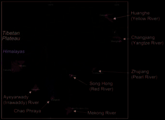
River), the Song Hong (Red River), the Mekong River, the
Scientific Reports
Chao Phraya, and the Ayeyarwady (Irrawaddy) River
(Figure 1).
Shrinking Megadeltas in Asia: Sea-level Rise and
Sediment Reduction Impacts from Case Study of the
Chao Phraya Delta
Yoshiki Saito 1, Niran Chaimanee 2, Thanawat
Jarupongsakul 3, James P.M. Syvitski 4
1 Geological Survey of Japan, AIST. Central 7, Higashi 1-1-1, Tsukuba
305-8567, Japan. E-mail: yoshiki.saito@aist.go.jp
2 CCOP Technical Secretariat. E-mail: niranch@ccop.or.th
3 Department of Geology, Chulalongkorn University. E-mail:
thanawatjrp@yahoo.com
4 INSTAAR, University of Colorado. E-mail:
james.syvitski@colorado.edu
Continental large rivers in Southeast and East Asia,
which together supplied ~2.5 x 10⁹ t yr-1 (Gigatonnes
per year) of suspended sediment in the past, are deliver-
ing less than 1 x 10⁹ t yr-1 currently because of human
activities. In the past, more than 40 km2 of new land was
Figure 1: Megadeltas in Southeast and East Asia.
formed annually by these rivers as delta plains; at pres-
Modified after Woodroffe et al. (2006)
ent new land formation has come to a standstill, and
some deltas are even shrinking. The megadeltas of Asia
In the past, these rivers together (Ganges System not in-
are thus at risk of destruction because of the reduction of
cluded) supplied ~2.5 x 10⁹ tonnes (Gigatonnes, Gt) of
sediment supply and relative sea-level rise caused by
suspended sediment annually, accounting for signifi-
human activities.
cantly more than 10% of global sediment discharge
(Milliman and Syvitski, 1992). However, the annual sedi-
ment discharge has decreased to less than 1 Gt recently
1. Introduction
as a result of human activities. During the last 2000
Coastal erosion is a crucial ongoing problem along most
years, these rivers together deposited more than 40 km2
Asian coasts. Human activities in drainage basins and on
of new land annually as delta plains along the Southeast
coastal plains have led to a decrease of sediment supply
and East Asian coasts. At present new land formation
to the coasts, caused mainly by dam construction, sand
has reached a standstill; some deltas are even shrinking.
mining, and irrigation, and to a relative sea-level rise (i.e.,
land subsidence), caused by excess groundwater extrac-
The Huanghe provides a good example of the reduction
tion. These activities, together with the destruction of
in sediment load caused by human activities. The river
coastal ecosystems, such as mangrove deforestation
delivered to the sea more than 1 Gt of sediment annually
(e.g., Syvitski and Saito, 2007) have resulted in the pres-
for the past 1000-2000 years, up until the 1960s.
ent severe coastal erosion of the megadeltas of Asia.
However, since then, the amount of sediment delivered
has decreased stepwise with the successive completion
The Fourth Assessment Report of the Intergovernmental
of reservoirs and the use of water for irrigation:
Panel on Climate Change (IPCC 2007) identified Asian
Sanmenxia Reservoir (in 1960), Liujiaxia Reservoir
megadeltas as one of the environments most vulnerable
(1968), and Longyangxia Reservoir (1985), and finally
to future global changes. However, megadeltas are al-
down to only about 150 million tonnes (Mt = 106 t) per
ready experiencing acute environmental problems as a
year after the completion of the Xiaolangdi Reservoir in
result of human activities. To address these issues an in-
1999 (Wang et al., 2007). Soil conservation practices, af-
ternational workshop on ,,Coastal Erosion and Geological
forestation, and a decrease in precipitation have also
Assessment for Deltas in Southeast and East Asia," was
tended to reduce the amount of sediment delivered by
held in Bangkok, Thailand, on 24Ł25 May 2007. Here, we
the Huanghe to the sea.
review some of the workshop findings, on the coastal
erosion problem.
The amount of sediment supplied to the East China Sea
by the Changjiang, ~0.5 Gt of sediment annually for the
2. Reduction of Sediment Discharge
last 2000 years (Saito et al., 2001), has been decreasing
since the middle 1980s, mainly because of the construc-
There are many large, well-known rivers in the Southeast
tion of numerous dams and reservoirs in the drainage
and East Asia region, including the Huanghe (Yellow
basin. Since water began to be stored in the Three
River), the Changjiang (Yangtze River), the Zhujiang (Pearl
Gorges Reservoir in 2003, the river delivers only 150-200
3
Mt of sediments annually (Yang Z et al., 2006; Yang et al.,
built a cuspate delta on the western shore of the Yellow
2007). The Zhujiang shows a similar reduction of sedi-
Sea, formed during 1128Ł1855, and a huge lobate or
ment delivery. The annual sediment discharge from the
bird's foot delta on the western shore of the Bohai Sea,
Zhujiang has declined from 80 Mt to 54 Mt on average
formed after 1855. In 1976, the river again shifted its
since 1995. As a result of the steady decline since the
course, abandoning its mouth on the north side of the
early 1990s, in 2004 the annual sediment discharge was
present lobate delta to debouch on the east side, and
about one-third the mean pre-1990s discharge (Zhang et
since then, the area of the former river mouth on the
al., 2007).
northern side of the delta has been obviously eroding.
The Song Hong and Mekong rivers show similar patterns
The shoreline there retreated more than 7 km during
of reduced sediment discharge. After the construction of
1976Ł2000, for a mean net erosion rate of 0.29 km yr-1;
the Hoa Binh Dam on the upper reaches of the Song
conversely, at the new river mouth, the delta has pro-
Hong in 1989, sediment delivery decreased by more than
graded more than 20 km, for a mean net accretion rate of
30%, from an average of 114 Mt annually during
0.83 km yr-1 (Chu et al., 2006; Yang and Wang, 2007;
1959Ł1985 to an annual average of 79 Mt during
Syvitski and Saito, 2007). Nevertheless, the reduction of
1986Ł1997 (Thanh et al., 2004). Moreover, it decreased
the sediment load of the Huanghe has affected delta for-
to 51 Mt annually during 1992Ł2001, on average.
mation at the new river mouth. Although the total delta
Sediment supply to the river mouth of the main distribu-
area increased until 1995 owing to rapid progradation at
tary (Ba Lat) of the Song Hong decreased from about 26
the new river mouth, it has been decreasing since 1996
Mt yr-1 in 1949 to 11 Mt yr-1 in 2000 (van Maren, 2004).
(Chu et al., 2006). Moreover, since the Xiaolangdi
Reservoir began to fill in 1999, the shoreline has been
The Mekong River has also been affected by dams, par-
generally retreating even in the area of the new river
ticularly dams constructed in China. After the completion
mouth (Wang et al., 2005). Thus, the Huanghe delta,
of the Manwan Dam on the upper reaches of the
which in the past was the largest delta in the world with
Mekong River in China in 1993, the annual sediment load
a delta plain formation rate of 20Ł25 km2 yr-1, is now
was reduced from 71 Mt to 31 Mt at Chiang Saen in
shrinking.
northern Laos and from 133 Mt to 106 Mt at Pakse in
southern Laos (Kummu and Varis, 2007). A slight reduc-
The Changjiang delta prograded more than 200 km into
tion of sediment load has also been recorded in the lower
the East China Sea during the last 6000 years (Saito et al.,
reaches of the Mekong in Vietnam (Lu and Siew, 2006).
2001), and the Shanghai megacity has grown up on the
southern part of the delta plain. Sediment load reduction
Sediment discharge of the Chao Phraya, in Thailand, has
of the Changjiang since middle 1980s has also affected
also been affected by dam construction. For example,
coastal sedimentation. Though shoals have been trans-
the sediment load at Nakhon Sawan, about 300 km up-
formed into tidal flats by delta progradation, the rate of
stream from the mouth, decreased markedly after the
progradation of intertidal wetland has been decreasing
completion of the Bhumipol Dam in 1965 and the Sirikit
for the last 40 years (Yang SL et al., 2006), and the sedi-
Dam in 1972. The sediment load at Nakhon Sawan, more
ment accumulation rate on the delta front slope has also
than 30 Mt annually before 1965, had fallen to less than
clearly decreased for the last 20 years (Wei et al., 2007).
5 Mt yr-1 by the 1990s (Winterwerp et al., 2005).
After the start of water storage of the Three Gorges Dam
Moreover, construction sand exploitation from the Chao
since 2003, sediment discharge of the Changjiang has
Phraya at Nakhon Sri Ayuthaya, about 120 km upstream
been decreasing significantly from originally 480 Mt yr-1
from Bangkok, during the last 30 years has cause further
down to 150Ł200 Mt yr-1 (e.g., Yang Z et al., 2006; Yang
reduction of the sediment load .
SL et al., 2007), it could be impacting sediment deposi-
tion along the deltaic coast.
3. Coastal Erosion of Megadeltas
The Song Hong delta has prograded approximately 100
Reduction of river sediment load impacts sediment
km over the last 6000 years. In particular, sediment dis-
deposition in coastal zones and causes shoreline
charge increased during the last 2000 years because of
changes. Some Asian megadeltas are clearly shrinking
deforestation in the drainage basin (Li et al., 2006), with
and shorelines are retreating as a result of coastal ero-
the result that the river formed a huge delta plain of 2500
sion and other phenomena, such as land subsidence.
km2 during that time (Tanabe et al., 2006). The delta plain
accretion rate increased to 3.6 km2 during 1958Ł1995
The Huanghe delta, which historically received more
along the whole deltaic coast. However, the sediment
than 1 Gt of sediment annually, prograded into the Bohai
discharge of the main distributary of the Song Hong has
Sea for the past 1000-2000 years, for a land growth rate
recently decreased from 20Ł25 Mt yr-1 to ~10 Mt yr-1,
of 20Ł25 km2 yr-1, (Saito et al., 2001). This progradation
and the delta has been seriously affected as a result.
4
INPRINT
2007/2
Along a 30 km-long stretch of the Vanly coast southwest
Suphawajruksakul, 2005; Rokugawa et al., 2006). In the
of the present river mouth, the mean rate of coastal ero-
upper Gulf of Thailand, where the Chao Phraya de-
sion increased from 8.6 m/y during 1965Ł1990 to 14.5 m
bouches, the area of accretion was 8.9 km2 and that of
yr-1 during 1991Ł2000, following the completion of the
erosion was 4.5 km2 during 1969Ł1976, for a net accre-
Hoa Binh Dam in the Song Hong catchment at the end of
tion rate of 0.62 km2 yr-1; during 1976Ł1987, they were
1989 (Thanh et al., 2004, 2005).
4.9 km2 and 10.3 km2, respectively, for a net accretion
rate of Ł0.49 km2 yr-1, and during 1987Ł1997, they
The Mekong River delta has formed a new delta plain of
were 7.4 km2 and 4.5 km2, respectively, for a net ac-
18,000 km2 during the last 3000 years (Ta et al., 2005).
cretion rate of 0.25 km2 yr-1 (Jarupongsakul and
The average accretion rate is 6 km2 yr-1. Coastal progra-
Suphawajruksakul, 2005). A total of only 1.5 km2 of new
dation occurs mainly around the mouths of the Mekong
land formed during the entire 28 years from 1969 to
River distributaries and on the western side of the
1997; that is an amount equal to the area of land that pre-
Camau Peninsula. This peninsula expanded westward at
viously formed annually under natural conditions.
a rate of 1.2 km2 yr-1 between 1885 and 1985, but the
60-km-long shoreline on the eastern side of the penin-
Though several causes of coastal erosion have been
sula is mainly eroding. The rate of shoreline retreat is
identified (e.g., subsidence, decrease in sediment sup-
30-50 m yr-1 on average, and a land area of 1.1 km2 yr-1
ply, deforestation for shrimp farms), the main cause on
was lost during 1885-1992 (Nguyen et al., 1999).
this coast is coastal subsidence. Around 1980, subsi-
dence was rapid, at about 5 cm yr-1, reaching a total of 20
cm within 3Ł4 years (Haq, 1994; Nutalaya et al., 1996),
4. Coastal Erosion of the Chao Phraya Delta, Thailand
and this subsidence was accompanied by significant
Along with a reduction of sediment supply, a relative sea-
coastal erosion, accounting for the net erosion in the
level rise resulting from human activities can also be an
upper Gulf of Thailand during 1976Ł1987. Sediment re-
important cause of coastal erosion. The Chao Phraya
duction, on the other hand, has occurred gradually,
delta prograded into the Gulf of Thailand with an average
particularly in the 1960s and early 1970s, as a result of
accretion rate of ~1.5 km2 yr-1 during the past 2000
dam construction (Winterwerp et al., 2005); thus, a close
years (Tanabe et al., 2003), but has experienced serious
relationship cannot be identified between sediment re-
coastal erosion over the last 40 years (Figure 2)
duction and coastal erosion around 1980.
(Vongvisessomjai, 1992; Vongvisessomjai et al., 1996;
Rokugawa et al., 2006).
The area of mangrove forest has decreased drastically in
the lower Chao Phraya delta. During the last 40 years,
more than 140 km2 of man-
grove forest has decreased to
less than 20 km2. However,
more than 90% of the decrease
in the 1980s occurred at Samut
Sakhon, in the western part of
the delta, where no serious ero-
sion has occurred. The area of
mangrove forest in the river
mouth area and neighboring
coastal zones (Bangkok, Samut
Prakarn) did not significantly
decrease during that period,
because already, by the early
1960s, the area was very small
there as a result of the con-
struction of salt farms and fish
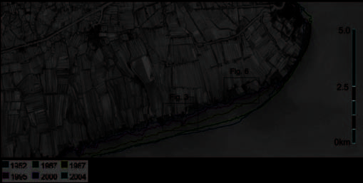
Figure 2: Shoreline changes of the Chao Phraya delta west of the river mouth in 1952, 1967, 1987, 1995,
ponds, charcoal production,
2000, and 2004 (modified after Rokugawa et al., 2006). The shoreline retreated overall more than 1 km.
agricultural development, port
expansion, and urbanization (Szuster, 2003). Therefore,
Since the 1960s, the coast around the river mouth and
only rapid subsidence can explain the severe coastal ero-
the neighboring coastal zones has been eroding, mainly
sion that occurred around 1980.
because of land subsidence due to excess groundwater
extraction and changes in land use. The shoreline had re-
An approximately 60 cm relative sea-level rise occurred
treated 700 m by the early 1990s, and a maximum of
during the 1960s to 1980s as a result of land subsidence
more than 1 km by 2005 (Jarupongsakul and
in the river mouth area and neighboring coastal zones
5

(Emery and Aubrey, 1991; Haq, 1994). Though ground-
water extraction in Bangkok is regulated, subsidence is
still continuing, particularly in the areas surrounding the
city. During 1992Ł2000, there was subsidence of more
than 20 cm along the coast, with a maximum subsidence
of more than 30 cm, which is equivalent to a relative sea-
level rise of 2Ł4 cm yr-1 (Winterwerp et al., 2005). During
the last 10 years, ongoing subsidence and coastal ero-
sion have been severe. Total subsidence during the last
50 years has been more than 1 m at the river mouth,
where the shoreline has retreated more than 1 km.
The main mechanisms of the erosion and shoreline re-
treat that result from subsidence are submergence and
an increase of wave energy in the subsidence-deepened
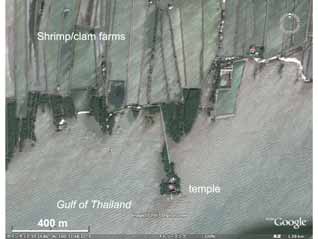
Figure 3: with kind support of Google EarthTM mapping service
intertidal to nearshore zones, particularly the latter. The
Satellite image of coastal erosion of the Chao Phraya delta near
slope of the nearshore zone of the Chao Phraya delta is
the Wat Khun Samutchin (after Google Earth). Approximate lo-
very gentle, with a gradient of 1 m/km. Therefore, subsi-
cation is shown in Figure 2.
dence of 10 to 20 cm causes an increase in water depth
of 10% to 20% at a point 1 km offshore, and of 5% to
10% 2 km offshore. The mean tidal range here is about
1.2 m, and the maximum tidal range is about 2.5 m. One
meter of subsidence means roughly that the previous
mean sea-level position becomes the level of the lowest
tide, and the level of the highest tide becomes the new
mean sea level, assuming that sediment accumulation is
negligible.
As most of the mangrove ecosystem develops in the
upper part of the intertidal zone, between mean sea level
and the level of the highest tide, 1 m of subsidence
should cause the mangrove zone to shift landward.
However, such a shift has not been observed, though
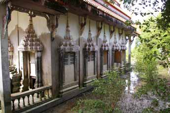
Figure 4: Wat Khun Samutchin. Photograph taken by Ms. Vareerat
some landward expansion of mangrove vegetation has
Unwerawattana on 24 May 2007. Location is shown in Figure 2.
occurred because of saltwater intrusion. Erosion and a 1
km retreat of the mangrove zone represent a serious
problem, but only 1 km of the 20 km-wide mangrove
zone was submerged, abandoned, and finally eroded.
This is far smaller than the retreat distance estimated
from the topography to result from simple inundation as-
sociated with a 1-m sea-level rise.
Subsidence has also led to rapid sediment accumulation
in the intertidal zone of the Chao Phraya delta , particu-
larly in the upper part of the gulf. The temple Wat Khun
Samutchin used to be located on the shore. However, it
is now on an artificially protected headland (Figures 2 &
3).
The temple is partially inundated, and the floor of the
temple building has been elevated by about 1 m (Figure
4).
An approximately 40 to 50cm-thick layer of sediment has
Figure 5: Wat Khun Samutchin. Three steps are buried
below the present ground level. Photograph taken by Ms
been deposited on the temple grounds, burying three
Vareerat Unwerawattana on 24 May 2007. Location is
steps leading into the building (Figure 5).
shown in Figure 2.
6
INPRINT
2007/2
Thus, rapid sediment accumulation has also occurred in
the Port of Bangkok and the Chao Phraya river mouth.
the intertidal zone in response to the rapid relative sea-
The siltation volume decreased from 4.4 million m3 yr-1
level rise. In addition to this natural response of sediment
during 1981Ł1985 to 3.1 million m3 yr-1 in 1993
accumulation in an intertidal zone, banking of roads and
(Vongvisessomjai, 2007). Dredging and sand mining in
ridges in aquaculture ponds has also raised the ground
the rivers also cause a reduction of sediment supply to
level. These mechanisms, along with the physical pro-
the coast. We need more precise data on these sedi-
tection of the mangrove forest, are protecting the
ment removals.
shoreline against retreat.
One of the lessons from the Chao Phraya delta is that a
The currently observed 1 km retreat caused by the 1 m of
relative sea-level rise of only 10 cm can induce coastal
subsidence means that a 1-km-wide strip of the intertidal
erosion along muddy coasts. During the initial phase of
zone has changed into an offshore slope environment
subsidence from 1969 to 1973, the total area of coast
(delta front slope), because the subsidence/shoreline re-
lost to erosion was 1.8 km2 (Vongvisessomjai, 1992).
treat ratio is the same as the offshore gradient of 1 m
The future sea-level rise predicted by the IPCC will surely
km-1. If enough sediment is supplied to fill the accom-
cause inundation and erosion of some vulnerable muddy
modation space in the intertidal zone, the amount of
coasts. Subsidence resulting from human activities, as in
shoreline retreat will be controlled by a new equilibrium
Thailand, has more serious impacts than natural sea-level
profile offshore (delta front slope) and by the related land-
rise because the rate of relative sea-level rise due to sub-
ward migration of the offshore break.
sidence is usually large. The knowledge gained by
studying the Chao Phraya example suggests that man-
Aquaculture ponds for clam and shrimp have also accel-
grove forests will be important mechanisms of physical
erated coastal erosion. Once the frontal mangroves are
protection and also sediment trapping for the preserva-
destroyed, the ocean encroaches into the shrimp ponds,
tion or restoration of shorelines when relative sea level
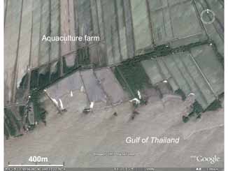
exposing the next mangroves to face the sea (Figure 6).
rises.
5. Conclusion
Megadeltas are characteristic coastal features in Asia.
The huge delta plains of Asian megadeltas are important
areas in which people live, carry on economic activities,
and grow or collect food. The formation of these delta
plains took several thousands of years, during which they
expanded by more than 40 km2 annually because of the
huge sediment supply from the rivers of Southeast and
East Asia. However, most of these megadeltas are cur-
rently at risk of destruction and collapse because of
human activities in the river drainage basins and on the
delta plains.
There is sufficient evidence that human induced relative
sea level rise due to intensive land use change is overar-
Figure 6: with kind support of Google EarthTM mapping service
ching climate related pressures. Natural system
Satellite image of coastal erosion of the Chao Phraya delta near the river
mouth. Mangrove collapse at the ocean front has led to a landward
response reflects in resilience mechanisms such as
shoreline shift to beyond the aquaculture ponds. Approximate location
mangrove system development/changes but holistic
is shown in Figure 2 (after Google Earth).
knowledge of their interplay with increasing pressures is
still lacking.
The reduction of sediment discharge and the decrease of
water discharge caused by dam construction have also
Therefore we need more integrated data and knowledge
led to coastal erosion. If the submergence of coastal
about the drainage basins and coastal zones taking an
zones is to be prevented, sediment must accumulate in
ecosystem-based perspective so that we can maintain
the intertidal zone to maintain the ground level. However,
and manage these megadeltas.
the sediment supply from rivers has already been re-
duced during the last 40 years.
Acknowledgements
This reduction of sediment supply to the coastal zones is
This review is based on research conducted as part
also recorded by the measured annual siltation volume in
of the CCOP DelSEA project and the Asian Delta Project.
the 18-km-long Bangkok Navigation Channel between
We are grateful to the CCOP Technical Secretariat,
7
especially Petcharat Sarawisutra and Vareerat
Syvitski, J.P.M. and Saito, Y., 2007. Morphodynamics of deltas
Unwerawattana for their support for the international
under the influence of humans. Global and Planetary Change,
workshop and CCOP project.
57, 261-282.
Szuster, B.W., 2003. Shrimp farming in Thailand's Chao Phraya
References
River delta: boom, bust and echo. Report, International Water
Management Institute, 53 pp.
Chu, Z.X., Sun, X.G., Zhai, S.K. and Xu, K.H., 2006. Changing
pattern of accretion/erosion of the modern Yellow River
Ta, T.K.O., Nguyen, V.L., Tateishi, M., Kobayashi, I., and Saito,
(Huanghe) subaerial delta, China: Based on remote sensing im-
Y., 2005. Holocene delta evolution and depositional models of
ages. Marine Geology, 227, 13-30.
the Mekong River delta, southern Vietnam. In L. Giosan and J.P.
Bhattacharya, eds., River Deltas-Concepts, Models, and
Emery, K.O. and Aubrey, D.G., 1991. Sea levels, land levels,
Examples, SEPM Spec. Publ. no. 83, pp. 453-466.
and tidal gauges. Springer, 237p.
Tanabe, S., Saito, Y., Sato, Y., Suzuki, Y., Sinsakul, S.,
Haq, B.U., 1994. Sea Level Rise and Coastal Subsidence. Land,
Tiyapairach, N., and Chaimanee, N., 2003. Stratigraphy and
Water and Natural Habitats Division, Environment Department,
Holocene evolution of the mud-dominated Chao Phraya delta,
The World Bank, 34 pp.
Thailand. Quaternary Science Reviews, 22, 789-807.
Jarupongsakul, T., and Suphawajruksakul, A., 2005. Post-sym-
Tanabe, S., Saito, Y., Vu, Q.L., Hanebuth, T.J.J., and Ngo, Q.L.,
posium Excursion Guidebook of the 7th Kyoto University
2006. Holocene evolution of the Song Hong (Red River) delta
International Symposium on Coexistence with Nature in a
system, northern Vietnam. Sedimentary Geology, 187, 29-61.
'Globalizing' World-Field Science perspectives. Department of
Thanh, T.D., Saito, Y., Huy, D.V., Nguyen, V.L., Ta, T.K.O., and
Geology, Chulalongkorn University, Bangkok, 68 pp.
Tateishi, M., 2004. Regimes of human and climate impacts on
coastal changes in Vietnam. Regional Environmental Change,
Kummu, M. and Varis, O., 2007. Sediment-related impacts due
4, 49-62.
to upstream reservoir trapping, the lower Mekong River.
Geomorphology, 85, 275-293
Thanh, T.D., Saito, Y., Dinh, V.H., Nguyen, H.C., and Do, D.C.,
2005. Coastal erosion in the Red River Delta, Vietnam: current
Li, Z., Saito, Y., Matsumoto, E., Wang, Y., Tanabe, S., and Vu,
status and response. In Chen, Z., Saito, Y., Goodbred, S.L., Jr.,
Q.L., 2006. Climate change and human impact on the Song
eds., Mega-Deltas of Asia: Geological Evolution and Human
Hong (Red River) delta, Vietnam, during the Holocene.
Impact, China Ocean Press, Beijing, pp. 98-105.
Quaternary International, 144, 4-28.
van Maren, D.S., 2004. Morphodynamics of a cycle prograding
Lu, X.X. and Siew, R.Y., 2006. Water discharge and sediment
delta: the Red River, Vietnam. Ph.D. Thesis, Nederlandse
flux changes over the past decades in the lower Mekong River:
Geografische Studies 324, Utrecht University, 167 pp.
possible impacts of the Chinese Dams. Hydrology and Earth
System Sciences, 10, 181-195.
Vongvisessomjai, S., 1992. Coastal erosion in the Gulf of
Thailand. Research and Development Journal of the
Milliman, J.D. and Syvitski, J.P.M., 1992. Geomorphic/tectonic
Engineering Institute of Thailand, 3(1), 38-58.
control of sediment discharge to the oceans: the importance of
small mountainous rivers. Journal of Geology, 100, 525-544.
Vongvisessomjai, S., 2007. Chao Phraya Delta: Paddy field irri-
gation area in tidal deposits. Thaicid Rept 10.1,
Nguyen, V.L., Ta, T.K.O., Tateishi, M., and Kobayashi, I., 1999.
http://www.rid.go.th/Thaicid/text/10-1ChaoPhraYadelta.pdf
Coastal variation and saltwater intrusion on the coastal low-
lands of the Mekong River Delta, southern Vietnam. In Saito, Y.,
Vongvisessomjai, S., Polsi, R., Manotham, C., Srisaengthong,
Ikehara, K., Katayama, H., eds., Land-sea link in Asia, STA (JIS-
D., and Charulukkana, S., 1996. Coastal erosion in the Gulf of
TEC) and Geological Survey of Japan, Tsukuba, pp 212-217.
Thailand. In J.D. Milliman and B.U. Haq, eds., Sea-Level Rise
and Coastal Subsidence, Kluwer, Dordrecht, 131-150.
Nutalaya, P., Yong, R.N., Chumnankit, T., and Buapeng, S.,
1996. Land subsidence in Bangkok during 1978-1988. In J.D.
Wang, H.J., Yang, Z.S., Bi, N.S. and Li, H.D., 2005. Rapid shifts
Milliman and B.U. Haq, eds., Sea-Level Rise and Coastal
of the river plume pathway off the Huanghe (Yellow) River
Subsidence, Dordrecht, 105-130.
mouth in response to water-sediment regulation scheme in
2005. Chinese Science Bulletin, 50, 2827-2884.
Rokugawa, S., Suzuki, H., Kazama, Y. and Okubo, Y., 2006.
Consideration on management of coastal environment at
Wang, H.J., Yang, Z.S., Saito, Y., Liu, J.P., Sun, X.X., and Wang,
deltas in Thailand. Research Report, UOT/AISt-CCOP-
Y., 2007. Stepwise decrease of the Huanghe (Yellow River) sed-
DMR/DMCR Joint Program, CCOP Technical Secretariat,
iment load (1950-2005): impacts of climate change and human
Bangkok, Thailand, 64 pp.
activities. Global and Planetary Change, 57, 331-354.
Saito, Y., Yang, Z., Hori, K., 2001. The Huanghe (Yellow River)
Wei, T.Y., Chen, Z.Y., Duan, L.Y., Gu, J.W., Saito, Y., Zhang,
and Changjiang (Yangtze River) deltas: a review of their charac-
W.G., Wang, Y.H., and Kanai, Y., 2007. Sedimentation rates in
teristics, evolution and sediment discharge during the
relation to sedimentary processes of the Yangtze Estuary,
Holocene. Geomorphology, 41, 219-231.
China. Estuarine, Coastal and Shelf Sciences, 71, 37-46.
8
INPRINT
2007/2
Winterwerp, J.C., Borst, W.G., and de Vries, M.B., 2005. Pilot
CABRI-Volga and the Volga Delta: Recommen-
study on the erosion and rehabilitation of a mangrove mud
dations for an Integrated River Basin Management
coast. Journal of Coastal Research, 21, 223-230.
Woodroffe, C.D., Nicholls, R.J., Saito, Y., Chen, Z., and
Elena Nikitina 1 and Frank Wefering 2
Goodbred, S.L., 2006. Landscape variability and the response
of Asian megadeltas to environmental change. In Harvey, N.,
1
ed., Global Change and Integrated Coastal Management: the
Dr. Elena Nikitina is the Director of EcoPolicy Research and
Asia-Pacific Region. Coastal Systems and Continental Margins,
Consulting in Moscow and Scientific Coordinator of CABRI-Volga.
Vol. 10. Springer, pp. 277-314.
2 Frank Wefering is a Senior Consultant at Rupprecht Consult
Forschung & Beratung GmbH in Cologne and Project Manager of
Yang, S.L., Li, M., Dai, S.B., Zhang, J., and Ding, P.X., 2006.
CABRI-Volga.
Drastic decrease in sediment supply from the Yangtze River
3 Partners from the EU: Rupprecht Consult Forschung und Beratung
and its challenge to coastal wetland management. Geophysical
GmbH, Germany (project coordinator); Institute for Water
Research Letters, 33, L06408, doi:10.1029/2005GL025507.
Resources Management of the University of Karlsruhe, Germany;
United Nations University-Institute for Environment and Human
Yang, S.L., Zhang, J., and Xu, X.J., 2007. Influences of the
Security, Germany; Aristotle University of Thessaloniki, Greece;
Three Gorges Dam on downstream delivery of sediment and its
Centro di Cultura Scientifica "Alessandro Volta", Italy;
environmental implications, Yangtze River. Geophysical
International Ocean Institute, Malta; Compagnie Nationale du
Rh¶ne, France; The Regional Environmental Center for Central
Research Letters, 34, L10401, doi:10.1029/2007GL029472.
and Eastern Europe, Hungary; Wageningen University,
The Netherlands.
Yang, Z. and Wang, H., 2007. The coast of China. In Mimura, N.
(ed.), Asia-Pacific Coasts and Their Management: The states of
Partners from Russia: Environmental Policy Research and
Consulting, Moscow (scientific coordinator); Caspian Marine
Environment. Coastal Systems and Continental Margins, Vol.
Scientific and Research Center, Astrakhan; Ecological Projects
11. Springer, in press.
Consulting Institute, Moscow; Nizhny Novgorod State University
of Architecture and Civil Engineering; Research Innovation
Yang, Z., Wang, H., Saito, Y., Milliman, J.D., Xu, K., Qiao, S., and
Projects Institute "Cadaster", Yaroslavl; Saratov State Socio-
Shi, G., 2006. Dam impacts on the Changjiang (Yangtze River)
economic University; UNESCO Moscow Office; Ammophos,
sediment discharge to the sea: the past 55 years and after the
Cherepovets.
Three Gorges Dam. Water Resources Research, 42, W04407,
doi:10.1029/2005WR003970.
About CABRI-Volga
Zhang, S., Lu, X.X., Higgitt, D.L., Chen, C.-T.A., Han, J., and
Sun, H., 2007. Recent changes of water discharge and sedi-
CABRI-Volga (Cooperation Along a Big River) is a LOICZ-
ment load in the Zhujiang (Pearl River) Basin, China. Global and
affiliated international coordination project to facilitate
Planetary Change, doi: 10.1016/j.gloplacha.2007.04.003.
cooperation and to coordinate research in environmental
risk management in large river basins in the EU, Russia
Figure Captions
and the New Independent States (NIS). It is based on a
partnership of seventeen partner organisations from
Fig. 1. Megadeltas in Southeast and East Asia. Modified after
Russia and seven EU countries, including universities,
Woodroffe et al. (2006)
private research institutes, industry, NGOs and interna-
tional organizations dealing with a variety of aspects in
Fig. 2. Shoreline changes of the Chao Phraya delta west of the
environmental risk management 3. The project focus is
river mouth in 1952, 1967, 1987, 1995, 2000, and 2004 (modi-
on the Volga Basin (Figure 1) which comprises 40 per-
fied after Rokugawa et al., 2006). The shoreline retreated
cent of the population of Russia, 45 percent of the
overall more than 1 km.
country's industry and 50 percent of its agriculture.
Fig. 3. Satellite image of coastal erosion of the Chao Phraya
delta near the Wat Khun Samutchin (after Google Earth).
The key objectives of the project are to:
Approximate location is shown in Fig. 2.
Ę Mobilise people and institutions to cooperate interna-
Fig. 4. Wat Khun Samutchin. Photograph taken by Ms. Vareerat
tionally
Unwerawattana on 24 May 2007. Location is shown in Figure 2.
Ę Enhance joint research on environmental risk manage-
ment in large river basins
Fig. 5. Wat Khun Samutchin. Three steps are buried below the
present ground level. Photograph taken by Ms Vareerat
Ę Follow an integrative approach in environmental risk
Unwerawattana on 24 May 2007. Location is shown in Figure 2.
reduction and sustainable river basin development
Fig. 6. Satellite image of coastal erosion of the Chao Phraya
Ę Exchange of scientific knowledge and good practices
delta near the river mouth. Mangrove collapse at the ocean
of various stakeholders in river basins in Europe;
front has led to a landward shoreline shift to beyond the aqua-
culture ponds. Approximate location is shown in Fig. 2 (after
Ę Strengthen links between scientific community, policy-
Google Earth).
makers, and society.
9
Figure 1:
The Volga River Basin
Source: Ruprecht
Consult, Cologne
Following more than two years of close cooperation, ex-
CABRI-Volga: Integrated river basin management
perience and knowledge exchange between experts
from Russia, the European Union, America and Asia on
The project supports the integrated river basin manage-
issues related to environmental risk management in
ment approach. CABRI-Volga recognizes that good water
large river basins the CABRI-Volga project is coming to an
governance needs to be based upon integrated water
end in February 2007.
management at the river basin level. Coordination and
cooperation within a water basin becomes a powerful
During the course of the project, three expert fora were
tool for this purpose. It includes institutional coordination
held by the project consortium in the Russian CABRI-
(horizontal and vertical) between various government
Volga cities of Nizhny Novgorod, Kazan and Cherepovets
bodies as well as partnerships, dialogue and joint actions
providing a still unique opportunity in Russia to bring to-
of multiple stakeholders within water basin.
gether for joint discussions experts from various
scientific disciplines and institutional backgrounds such
CABRI-Volga regards the entire river basin in its integrity
as academia, politics, business, industry, and NGO's.
including its sub-basins, river-tributes, other water bod-
Out of the more than 150 experts, the majority (about
ies and coastal areas. It also calls for a combination of
2/3) were from Russia.
social, ecological and economic priorities within an entire
basin. It suggests that coordination of actions across
CABRI-Volga kept close relations with policy-makers and
various thematic areas is essential for sustainable de-
organised an informative meeting at the Russian State
velopment in the basin: win-win situations become
Duma as well as a policy roundtable in Moscow to pres-
possible as problem-solving in one area contributes to
ent and validate its policy recommendations.
positive results within others. Thus, project activities and
expert discussions are organized within five closely in-
CABRI-Volga research and networking is rooted in the
terlinked thematic areas:
earlier UNESCO initiative "Volga Vision"4.
4 The Volga Vision. UNESCO Interdisciplinary Initiative for
Ę Water quality, including drinking water and sanitation
Sustainable Development of the Volga-Caspian Basin. UNESCO,
Paris, 2004.
Ę Water related risks and human security
10
INPRINT
2007/2
Ę Sustainable management of water resources and
The Volga Delta and adjacent coastal areas of the
biodiversity conservation
Caspian Sea require special care and attention. At the
same time, the socio-economic situation in the Volga
Ę Economic development and sustainable transport in
Delta with its coastal regions is much more desperate
the Volga basin
than in most other Russian regions (GDP per capita is
Ę Institutional cooperation and stakeholder participation.
lower than the Russian average); the situation is charac-
terized by a level of urbanization which is lower than the
Among one of the CABRI-Volga conclusions is that, both
national average, by social problems and a predominant
the integrated water management and coordination at a
agricultural economy, in particular, in Kalmykia and
basin level are not yet effectively applied in practical
Dagestan. Oil and gas, including the development of the
terms in Russia's Volga Basin. There are significant loop-
Caspian Sea deposits provide the potential for the future
holes in the system of water resources management at
economic development in the region, posing at the same
the basin level, and enhancing domestic institutional ca-
time additional ecological risks.
pacities for water related risks reduction is at the top of
the Volga Basin agenda. CABRI-Volga recommends pro-
The major current environmental problems in the Volga
moting further cooperation in integrated water-related
Delta as identified by CABRI-Volga experts include:
risk management between various administrative re-
water quality, with a particular focus on drinking water
gions of the Volga Basin and for coordination of actions of
quality, loss of biodiversity, loss of coastal habitats and
stakeholders within each of its four sub-basins Ł the
degradation of coastal landscapes, decline in commercial
Lower Volga, the Upper Volga, the Oka and the Kama.
fish stocks. Experts agree that the main cause for these
problems is ineffective water basin management.
The Volga Delta and adjacent coastal areas of the
5
Caspian Sea are part of the Lower Volga sub-basin. The
The Volga Delta is in and surrounded by the Astrakhan oblast,
Dagestan, Kalmykia republics of the Russian Federation.
Integration of local decision-making and actions which
take into account the specifics of the Delta and coastal
Biodiversity
areas with the Volga Basin management schemes is cru-
cial for this region's sustainable development.
The biodiversity of the Volga Delta is of global impor-
tance. Its wetland habitat is considered to be the best
The Volga Delta
conserved in Europe. A part of the Volga Delta is the
Astrakhan Biosphere Reserve and approximately half of
The Volga Delta the largest river delta on the European
the estuary zone is designated as a protected wetland
continent. With its adjacent coastal areas, the Volga
site under the Ramsar Convention (800,000 ha). About
Delta provides the link between the Volga River and the
fifteen rare bird species are registered in the region and
Caspian Sea5. The Volga carries 80 percent of the fresh
listed in the Red Book of the Russian Federation. Three
water inflow to the Caspian Sea with the usual nutrients
globally significant bird migration routes cross over the
and polluting substances. About 23 species of the
Volga Delta, serving millions of waterfowl of many
Caspian Sea spawn in the Volga River. The Volga Delta is
dozens of species. It is estimated that seven to ten mil-
the unique region of the Volga Basin and its environmen-
lion water birds use the area in spring and fall. In the
tal health serves as an indicator for the situation in the
Delta area are spawning grounds of four threatened stur-
entire basin. The biodiversity of the Volga Delta is of
geon species included in the Red List of the World
global importance. It has intact ecosystems, relict plant
Conservation Union (IUCN).
species and about twenty endemic fish sub-species.
CABRI-Volga recognises the necessity to enhance the
The Delta is famous worldwide as breeding grounds for
system of protected areas and natural reserves. It is rec-
sturgeon. The Delta along with the part of the Lower
ommended to consider the need for habitat preservation
Volga (downstream from Volgograd) is the only segment
and normal eco-system functioning in decision-making
of the Volga where the river flow is not regulated by the
processes. Improvements in ecological knowledge and
cascade of the Volga artificial reservoirs. It is dependent
user-friendly information dissemination are essential.
on the upper flow areas not only for polluted waters in-
Regular local public education about biodiversity conser-
flow, but for the level of water supply as well: the highly
vation is equally important.
regulated level of water flow is usually lower than re-
quired for the normal functioning of water eco-systems.
Fisheries
The role of the Volga Delta is highly valuable because it
serves as a natural purification filter where upstream pol-
The river provides significant commercial fishing. The
luted waters undergo physical, chemical and biological
Lower Volga and the Northern Caspian are among the
purification flowing through its natural ecosystems.
largest fishing areas of the country accounting for about
11
a half of domestic inland water fish catches, including
Lower Volga the level of water discharges is about three
about 70 percent of sturgeons. The area from Volgograd
times less. The main sources are municipal and industrial
to the Northern Caspian provides nutrition sources for
discharges, agricultural runoff, shipping and oil and gas
the majority of migratory and semi-migratory fish of the
extraction. Although current levels of surface water pol-
Caspian Sea and the Volga River, including globally
lution are not a major ecological risk in the Delta, the
threatened and highly valuable sturgeon species.
forecasts suggest that an increase in economic activities
in coming years may result in water pollution growth.
Construction of the reservoir cascade on the Volga re-
sulted in a loss of spawning grounds, and its stocks
Among the problems is the lack of reliable scientific
are supported now only through artificial breeding6.
knowledge on the interrelation between pollutants and
Spawning grounds of sturgeons are conserved with-
biodiversity, and monitoring results of current pollution
in the Volga-Akhtuba floodplain and in the Delta. The
levels are insufficient. There are also gaps in the system
presence of natural spawning grounds is a necessary
of regulatory rules and methods for biodiversity assess-
condition for conservation of the gene pool of these fish
ment within existing procedures of environmental
species. Effectiveness of fish reproduction depends on
impact assessments, and so far there are no approved
the size of flooded areas and the flood regime. The area
ecological limitations on hydrocarbon exploration and ex-
of the spawning grounds in the Volga Delta has been re-
traction in the Northern Caspian and the Volga-Akhtuba
duced by about twenty five percent (525,000 ha) from
floodplain.
mid-twenty century when they were completely flooded
by the Volga in spring and summer. According to official
The most serious problem for the Delta and coastal re-
statistics, annual sturgeon catches declined from 11,000
gions is the drinking water quality. The quality of water
tons (1910Ł1930) to 1,800 tons by the end of the twenti-
supplied to households meets neither the existing na-
eth century, and total commercial catches declined by
tional standards nor the WHO regulations. Main reason is
almost five times due to loss of spawning grounds, and
the poor state of water supply system and distribution
disturbance of the fish food bases7. Over-fishing and
networks. For example, in Dagestan, the drinking water
poaching has become a significant threat to fish re-
supply system is unsatisfactory; the water treatment ca-
sources. Moreover, the genetic diversity of the sturgeon
pacity is about one half of the necessary volume. In
species is declining due to the choice of standard fishes
Astrakhan oblast, which is characterised by higher level
for artificial reproduction.
of economic development compared to other Delta and
Caspian regions, only 30 percent of households are sup-
CABRI-Volga recommends a combination of measures
plied with water, sewage and central heating, and that
for the problem-solving in conservation and restoration
figure drops to less than ten percent in the coastal zone.
of fish biodiversity in the Delta and the Caspian Sea.
As a result, public health is under threat. For example,
Among them is a set of special technical innovations to
the epidemiological situation is serious in Dagestan,
increase effectiveness of fish elevators to ensure pas-
where the occurrence of typhoid fever is fifteen times
sage of migratory fish species upstream the Volgograd
higher than in Russia as a whole.
reservoir. Special efforts are essential to protect and re-
store the spawning areas, especially upstream of the
CABRI-Volga recommendation highlight the need for
dams as 80 percent of them had been destroyed. Further
building modern water processing plants and urban
support for artificial reproduction is needed. Strict control
wastewater treatment facilities, for modernization of
over poaching and punishment of violations is essential.
drinking water distribution systems. The speed-up of ad-
ministrative reforms in water services communal sector
6 Artificial reproduction of fish is widespread (hatcheries, fish farms,
is suggested as a part of enhancing the supply of safe
etc.). These hatcheries produce over 50 million fry of sturgeons
drinking water to consumers. It also underlines the need
and semi-migratory fish each year. However, only about one per-
cent of fry survives due to their high vulnerability.
for inventory and regular monitoring of drinking water
sources and possible risks they pose for human health.
7 The decline of the sturgeon population in the Caspian Sea was
caused by the disappearance of 80 percent of the spawning areas
upstream of the dams, the changes in the level of the Caspian Sea,
Oil and Gas
the reduction from 120 million to 70 million sturgeon fly through
artificial reproduction.
The importance of the lower Volga region is growing due
to recent developments in oil and gas sector, including
Water Pollution
the offshore production in the Caspian Sea and in the
coastal areas near the Volga Delta (The Volga Vision,
Sources of water pollution in the Delta are located both
2004). Gas reserves in the Astrakhan oblast are esti-
within the Lower Volga region and upstream. The main
mated at six trillion cubic meters, condensate Ł 1.2 billion
pollutants originate from the Middle Volga, while in the
tons, oil Ł seven million tons8. At current rates of extrac-
12
INPRINT
2007/2
tion, the largest Astrakhan gas condensate deposit may
tion of water basin management is provided through the
be exploitable for 100-150 years. The rapid growth of oil
basin water management authorities and the newly es-
and gas sector has a variety of implications for sustain-
tablished basin councils (four basin councils in the Volga:
able development of the region. It provides a large
for the Lower Volga, the Upper Volga, the Oka, and
potential for development of the regional infrastructure
the Kama). The law also encourages cooperation and
and jobs in the region, which would help to reduce the
partnerships between multiple stakeholders and water-
unemployment and social tension. At the same time, it is
users; while efforts in regular monitoring and inventories
associated with additional ecological risks to marine and
are envisioned among priority issues.
delta ecosystems and might result in water pollution.
CABRI-Volga emphasizes the need for regular enforce-
CABRI-Volga underlines that it is of utmost importance to
ment, verification and control over the step-by-step
find means to decouple the economic growth (based on
implementation of the Water Code by all regions in the
energy production) in the region from environmental
Volga Basin allowing to transparently enforce its provi-
pressures. The recent good news are that, for example,
sions and to ensure accountability before the civil
the leading off-shore producer LUKOIL is developing a
society. It supports the formation of the new system of
corporate strategy based on "zero discharge"; besides it
basin councils as coordination tool in river basin manage-
is actively involved in implementation in the Astrakhan
ment and for enhancing participation of all stakeholders
oblast of the so-called Compensatory Action Programme
in decision-making, and particularly for enhancing local
aiming at support for research in ecology and sustainable
public participation which is still weak. It recommends
development and for local education and training and
enhancing strategic planning and coordination at the
ecological knowledge dissemination.
basin level, including the application of sustainable de-
velopment approaches.
8 At present, about ten percent of oil and condensate and approxi-
mately six percent of the total gas production in the Russian
Federation is extracted here.
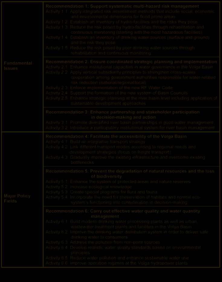
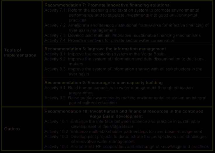
CABRI-Volga Recommendations Overview
New Russian Water Code
CABRI-Volga has provided a still unique opportunity in
In 2007, the new Russian Water Code entered into force.
Russia to bring together for joint discussions national and
This national law establishes the new legislative context
international experts from various scientific disciplines
enabling sustainable development and water resources
and institutional backgrounds such as academia, politics,
conservation in the Volga Delta and the coastal areas of
business, industry, and NGO's.
the Caspian Sea. It is the framework law regulating the
water resources use and water protection in Russia.
The derived policy recommendations are directed prima-
Similarly to the EU Water Framework Directive it intro-
rily at decision-makers in Russia and the Volga Basin, but
duces the basin management approaches and envisages
are also intended to provide suggestions and ideas to
comprehensive basin management schemes to be
other stakeholders in the Volga Basin as well as in other
developed for the purposes of integrated water manage-
river basins.
ment in the basins of rivers and seas. It calls for
integrated management of all water resources within the
CABRI-Volga developed ten policy recommendations
same water basin, including rivers, lakes and coastal
and thirty-eight concrete activities (see table below)
waters of the seas. For example, the unified basin man-
structured according to fundamental issues (multi-
agement principles within the Volga Basin are applied to
hazard risk management, water governance, and stake-
all four Volga sub-basins, including to the Volga Delta and
holder participation), major policy fields (socio-economic
adjacent coastal areas of the Caspian Sea.
development, conservation of natural resources and
biodiversity, and water management), tools of imple-
The new Russian Water Code introduces tools for strict
mentation (financing, information management, and
regulations and control in water use and water protec-
human capacity building) and, finally, future perspectives
tion, including innovations such as agreements between
of a further development of the Volga Basin.
water users and government authorities as well as es-
tablishing the special water conservation zones. The
9
Twenty-three federation subjects are situated in the Volga Basin.
Water Code envisages tight coordination of water poli-
cies within the same river basin between the federation,
10
The Water Code establishes twenty basin okruigs in Russia,
the federation subjects9 and the municipalities. For the
including four in the Volga Basin (the Upper-Volga, the Oka, the
purposes of coordination and application of water basin
Kama and the Lower Volga); the design of the basin okruigs is
management principles, it establishes basin okruigs10
based on the combination of two factors: the existing adminis-
(basin districts) which serve as a water governance unit
trative structure in Russia and geographical and hydrological
within a river basin. Under the Water Code the coordina-
regimes within a particular basin area.
13
14
INPRINT
2007/2
LOICZ News
LOICZ DISCO and LOICZ View Typology Tool links
have changed URL
Since Bruce A. Maxwell - who is one of the major parents
LOICZ Biogeochemical Budgets Website has changed URL
of the LOICZ typology tools has taken up a new chal-
lenge at Colby College - Dept. of Computer Science Ł the
URLs for the typology clustering and visualization tools
Due to changes in administration, personnel, and pro-
DISCO and VIEW (WLV) moved with him. The new links
grams at the Department of Systems Ecology and the
are:
Baltic Nest Institute (now physically housed in the new
Resilience Center), the LOICZ biogeochemical budget
website has been moved and is now available at:
DISCO: http://fangorn.colby.edu/disco-devel
http://nest.su.se/mnode/
WLV http://palantir.cs.colby.edu
15
The backbone of LOICZ: Affiliated Projects
and person interested in the activities affiliated to
LOICZ is invited to register and then view full con-
LOICZ has a mandate to address key issues of coa-
tact details and be able to submit and edit own pro-
stal change and use in the context of scenarios of
jects. As the database is linked to the LOICZ con-
future human activity and environmental change.
tact database, all newsletter recipients are already
LOICZ endorses and seeks to support both funda-
recorded. If you wish to receive your login name
mental coastal zone research and research that syn-
and password for the database, please do not use
thesises and up-scales results for dissemination
the form as shown in figure 1, but send us an email
within the scientific community, and outreach to po-
to loicz.ipo@loicz.org
licy makers and the public. An important part of this
research is carried out by scientists who affiliate
Do we hold your current contact details?
their projects to LOICZ thereby becoming part of
the global network of LOICZ. These projects build
To receive LOICZ INPRINT it is sufficient that we
the backbone for up- and down-scaling of LOICZ re-
know your email address, or if you receive the
sults and the LOICZ synthesis.
newsletter in hardcopy your postal address. But
there is much more information available at the
LOICZ provides a forum to assimilate, integrate and
LOICZ IPO that does not make it into the newslet-
synthesise the outputs of its affiliated projects.
ter, for various reasons.
Additionally, it provides an opportunity to communi-
cate and disseminate these outputs making them
If you are interested in receiving information tar-
available not only to other scientists, but also the
geted to your field of expertise, please request
public, decision-makers and managers. Information
your login details from us and update your pro-
on affiliated projects is held in a central database
file online.
that is accessible online through the LOICZ websi-
te. It makes basic information and regular updates
available to the wider community as well as to
LOICZ for its reporting requirements.
Once a project has been entered to the database by
its Principle Investigator (PI), it will be reviewed by
the IPO and the coordinator of the theme/topic it is
contributing to most. As soon as the project is ac-
cepted it will appear in the public part of the databa-
se. This lean procedure allows LOICZ to maintain an
up-to-date record of global research activity that re-
lates to the LOICZ Science Plan as well as ensure
that affiliated projects are given opportunity to fully
participate in LOICZ activities such as workshops
and joint projects.
Moreover, the database accomplishes an essential
element that applies for all LOICZ interdisciplinary
studies within and beyond the project namely data
sharing and exchange. To facilitate this exchange
LOICZ has developed a Data Policy to help affiliated
projects and LOICZ to fully benefit from each other.
Both documents, the Terms of Reference for affilia-
ted activities and the Data Policy, can be found on
Figure 1: Registration form of the LOICZ database. Recipients of
the LOICZ website.
LOICZ INPRINT and other active or formerly active members of
the LOICZ community should contact the IPO for registration.
LOICZ protects its community members by restric-
Everybody else is invited to fill in this form.
ting access to contact details in the public part
of the database. But every community member
16
INPRINT
2007/2
LOICZ Notes
Call for research proposals concerned with Land-
Ocean Interactions in the Coastal Zone
New LOICZ Regional Node East Asia and LOICZ-
Yantai International Seminar
LOICZ seeks to expand its network of scientists by en-
dorsing research activities concerned with any of its pri-
On 23 September, 2007, a new LOICZ
ority topics on a global, regional or national level. Within
Regional Node East Asia will be estab-
these topics LOICZ strives to develop:
lished at Yantai, China. Accompanying
the opening of the Regional Node, a first
Ę methodologies or models that allow data assimilation,
LOICZ-Yantai International Seminar on
processing and synthesis, including up and/or
down scaling;
,,Tackling Land Ocean Interactions on Regional Scale",
will be held at the Yantai Institute of Coastal Zone
Ę scenarios of change and/or response to change in
Research for Sustainable Development (YIC), China,
socio-ecological systems;
from 23Ł25 September, 2007. A main objective of the
Ę scientific context for the evaluation of existing policies
seminar is the identification of priority questions on re-
and structures;
gional scale that need immediate scientific attention
Ę globally applicable tools for scientific synthesis, deci-
within the following topics: ecosystem functioning and
sion support and structure development; and
socioeconomic impacts in changing coastal zones, mate-
Ę dissemination interfaces to provide information and
rial fluxes and ecosystem response, and governance
assist sustainable coastal development on appropri-
frameworks for ecosystem-based management, among
ate scales.
others. More information can be obtained from the local
host, Professor Ping Shi (e-mail: pshi@yic.ac.cn), and
To achieve this, LOICZ is calling for proposals to bring
from Mr. Cheng Tang at the secretariat (e-mail:
high quality research activities into the LOICZ cluster
of Affiliated Projects. As well as fundamental science
ctang@yic.ac.cn).
projects, LOICZ also seeks projects that have a multidis-
ciplinary perspective, especially combining natural and
Objectives of the new East Asia LOICZ Node
social sciences. Projects can have global, regional or local
scales and be focused on coastal sciences and/or coastal
The 18,000 Km coastlines of China are home to almost
management. Projects that collaborate with other Earth
60 percent of the total China population. China's coasts
Science System Partnership (ESSP) projects, especially
host a variety of industrial and business activities, fish-
with other Core Projects of IHDP and IGBP, are sought in
eries, energy facilities, marine transportation and
particular, as well as projects that synthesise and analyse
recreation that contribute tens of billions of dollars to the
research outcomes already available or involve dissemi-
economy per year. As the coastal population continues
nation and outreach that will lead to better public knowl-
edge. Details about projects already affiliated to LOICZ
to increase, there are many competing demands for
can be found in the LOICZ Project database accessible
limited coastal areas and resources. Increasing pres-
through the LOICZ website. Although LOICZ cannot offer
sures from pollution, habitat degradation, over-fishing,
funding to Affiliated Projects, its endorsement provides
invasive species, and coastal hazards, including hurri-
the following benefits:
canes and sea-level rise start become problems to the
Ę support in proposing for funding;
Ę promotion of the project and associated activities, its
contributing team, outputs and outcomes through the
LOICZ website and/or newsletter;
Ę contribution to workshops, conferences and meetings
organised by LOICZ and hence establish linkages to
other projects operating in similar fields and/or
addressing similar issues; and
Ę access to a wide circle of information related to funding
and the science community that is available through
the LOICZ database.
Researchers whose work fits into the LOICZ portfolio are
encouraged to submit proposals to the LOICZ IPO as
soon as possible. The required form is accessible after
registration to the LOICZ project database and additional
information can be obtained from the LOICZ website or
via contacting the LOICZ IPO.
Fishing farming at the coast of Yantai area (Cheng TANG, Sept. 2006)
17
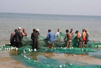
Fishing farming at the coast of Yantai area-2 (Cheng TANG, Sept. 2006)
Yangma Island, Yantai (Cheng TANG, Sept. 2006)
China coast. The increasing coastal population can also
edge, understanding and prediction to allow coastal com-
create conflicts between of competing coastal uses:
munities to assess, anticipate and respond to the
beach goers, commercial and residential, commercial, in-
interaction of global change and local pressures in deter-
dustrial and port development. The challenges of coastal
mining coastal change", it is definitely necessary for YIC
zone management face balancing coastal uses while
to join such community, to get involved into the hot top-
protecting valuable coastal resources are mounting.
ics and resolve the local problems with the help of the
Fishing farming at the coast of Yantai area-3 (Cheng TANG, Sept. 2006)
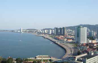
Yantai City coast (Cheng TANG, Sept. 2006)
Yantai Institute of Coastal Zone Research for Sustainable
Development (YIC) is a new institute which focuses on
coastal resource recycling utilizing, environment protec-
tion, ecology process, and integrated management
under the supervision of the Chinese Academy of
Sciences (CAS). The main objectives of the institute will
encourage new multidisciplinary research collaborations
and to bring together an extended community of re-
searchers and end-users of research.
Yantai is a beautiful city which located in the north China
close to the boundary of Bohai sea and Huanhai sea. The
establishment of the Node is a culmination of coastal
related activities organized by the YIC of the CAS, led by
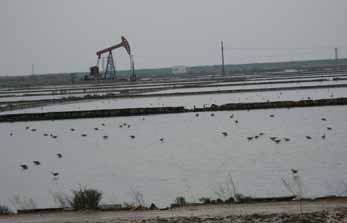
Yellow River Delta (Qianguo XING 2007)
Prof. Dr. Ping SHI. Its functions include the initiation, fa-
cilitation and support of basic and applied research,
global communities. The Node will play a regional coordi-
fostering the exchange of scientific information among
nating role in East Asia and help develop regional funding
scientists, maintaining a database of scientific and tech-
proposals to implement the science agenda of LOCIZ
nical personnel and resources and popularization of
including links with other regional programmes and inter-
science. As the main goal of LOICZ: ,,to provide knowl-
governmental networks.
18


INPRINT
2007/2
18th LOICZ SSC Meeting in Vancouver, Canada, 29
IPO Notes
May - 1 June, 2007, explores new ways
IPO staff changes
SSC Chair Jozef Pacyna welcomed the twenty-two par-
I am Christiane Hagemann and am a new colleague at
ticipants to the Simon Fraser University, Vancouver, and
the LOICZ IPO.
thanked local organisers and IPO. Moreover, he con-
During the last nearly two years
veyed apologies, expressed gratitude to past Chair Liana
I have worked in the administra-
Talaue McManus for her substantial contribution to the
tion of the International Projects
LOICZ transition, and dedicated a warm farewell and
Department of GKSS-Forschungs-
welcome to former and new SSC members and IPO
zentrum Geesthacht GmbH. The
team colleagues, respectively. After the welcome note
principal task of this department is
of Franciscus Colijn on behalf of the LOICZ IPO host, the
giving support to the scientists
GKSS Research Center, the Chair introduced the agenda
with the administrative handling of
EU-proposals, contract prepara-
tion and handling of current
EU-Projects.
From starting September 2007 I am a member of the
LOICZ IPO staff. I will assist the small and dynamic team
of the LOICZ International Project Office with the admin-
istration. I am looking forward to communicate to coastal
scientists all over the world.
With the background of a professional training as a clerk
in an industrial company and with my additional profes-
sional experience in several business and financial
service companies I am ready for action to support the
IPO and I am pleased to be part of the LOICZ community.
Christiane Hagemann
The third day and still in a good temper: (almost all) participants of the
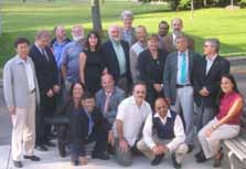
LOICZ IPO received visitors from China
18. SSC Meeting in front of the Vancouver Aquarium (Photo: B.
Goldberg)
In March 2007, Professor Shi Ping, leader of the prospec-
and underlined the major objective of this SSC Meeting:
tive LOICZ Regional Node East Asia in Yantai, visited the
clarification of the LOICZ organization, structures, scien-
LOICZ IPO and its host, the Institute for Coastal
tific foci, and responsibilities in order to conclude with a
Research at the GKSS Research Center.
well-elaborated and approved business plan for 2007/08.
Progress reports from the Chair, Scientific Theme
Coordinators, Priority Topic and Cross-Cutting Activity
Leaders, as well as Regional Node Coordinators and IPO
were presented and discussed. A dinner at the Fish
House Restaurant in Stanley Park, hosted by NILU, and a
dinner in the Aquarium hosted by LOICZ plus a public lec-
ture given by former Minister of Fisheries, Canada, John
A. Fraser, provided extra room for casual discussions and
of course energy. A detailed description of the 18. SSC
Meeting can be found in the Meeting Report which will
be available soon.
Following the good experiences from SSC 17 in
Germany in 2006 which for the first time had a scientific
Mini-Symposium associated the Simon Fraser Center for
Coastal Studies and the SSC had organised such a Mini-
Symposium here in Canada again. On the second day,
From left to right: Jindong ZHANG, Ping SHI, J. Pacyna, H. Kremer,
J. Weichselgartner, Cheng TANG, V. Dzaak (Photo: D. Hoffmann)
the SSC members joined a workshop on ,,Applying the
19
Best Available Science to Policy, Decision Making and to
Lecture ,,Who Speaks for the Oceans, and what are
Changes in Societal Behaviour". Various case studies Ł
they doing about it?"
ranging from cruise ship tourism to linking sustainable
livelihoods to coastal policy Ł were presented by
On 31 May, 2007, the SSC Meeting participants joined
Canadian scientists, offering an excellent opportunity to
the Canada Ocean Lecture ,,Who speaks for the oceans,
exchange and discuss different ideas (see below for de-
and what are they doing about it?", held at the Vancouver
tail).
Aquarium. A legendary advocate of ocean conservation
in Canada, John A. Fraser (former Speaker of the House
of Commons, former Minister of Fisheries, and currently
As a second rather new approach taken in this years SSC
Chair of the Pacific Salmon Forum), has given a talk in cel-
members divided into three working groups according to
ebration of Oceans Day 2007 drawing on his unique
the LOICZ Priority Topics. Discussions focused on how
experience as both government insider and policy critic.
each Priority Topic will proceed; on the milestones and
products; and on the identification of work items. This
His lecture described the insights into ocean issues
provided a solid basis for the development of a mid-term
arising from new global sources of information and envi-
strategy (until 2009/10, i.e. the first half of LOICZ antici-
ronmental awareness. In this light, Mr. Fraser gave a
pated lifetime at GKSS) and a detailed business plan for
critical review of how Canada, as a signatory of the UN
2007/08. Both are currently in a final iteration and editing
Convention on Law of the Sea, has performed on its in-
state and will be made public in autumn 2007.
ternational and national commitments to action and also
spoke to the implementation of Canada's Oceans Act.
Key points are that LOICZ will run the Priority Topics as
individual subprojects and that a synthesis should be pro-
Finally he showed how leadership is being displayed in
vided before the end of the first phase of the second
community-based coastal initiatives, with special atten-
LOICZ term. The focus remains on Socio-Ecological
tion to British Columbia. If you are interested in listening
Systems analysis, on Material Fluxes in context of
to the lecture, please visit:
change and ecosystem goods and services and on
Governance. Modelling and further development of typo-
http://www.sfu.ca/cstudies/science/fraser.mov
logical approaches remain key cross cutting activities
and all levels will be supported and in return feed into the
LOICZ capacity building efforts. The business plan will
provide a tangible record of current and future activities
and should serve as a transparent workplan allowing tar-
geted personnel and financial policy in the overall LOICZ
management.
SSC-Mini-Symposium ,,Applying the Best Available
Science to Policy, Decision Making and to Changes
in Societal Behaviour"
This year's Mini-Symposium was designed around a set
of case studies that illustrate a diversity of initiatives in
Canada and elsewhere that are applying the best avail-
able science to issues posed by coastal ecosystem
change. The primary focus was upon bridging between
the generation and interpretation of science and policy
and decision making. But the big question was to exam-
ine how policy and decision making can in turn engender
the changes in behaviour (in government, in civil society
and in markets) that signal the implementation of a plan
of action. The case studies and subsequent dialogue
worked to identify enablers and resistors of progress to-
wards ecosystem stewardship and ecosystem-based
management of coastal and oceans resources.
20

INPRINT
2007/2
The Dynamics of Integrated Coastal Management
Publications
Chua, Thia-Eng. 2006. The Dynamics of Integrated
The Role of Physical Processes in Mangrove Environ-
Coastal Management: Practical Applications in the
ments Ł Manual for the preservation and utilization
of mangrove ecosystems
Sustainable Coastal Development in East Asia. Global
Environment Facility/United Nations Development Pro-
Authors: Yoshihiro Mazda, Eric Wolanski and
gramme/International Maritime Organization Regional
Peter V. Ridd
Programme on Building Partnerships in Environmental
Management for the Seas of East Asia (PEMSEA),
Quezon City, Philippines. 468 pp.
ISBN: 978-971-812-018-7 (Softbound);
ISBN: 978-971-812-019-4 (Hardbound)
This book
Ę highlights the importance of physical processes to the
researchers and engineers in the developing countries,
who are endeavoring to maintain the mangrove envi-
ronment,
Ę makes coastal physical and biological researchers rec-
ognize the peculiarity of mangrove physics and the link
between physics and biology to maintain environmen-
tal health, and
Ę provides a manual for preserving and utilizing the man-
grove environment.
Total pages: 617 pages
Distribution: without charge
Publication: March 2007
Publisher: Terra Scientific Publishing Company
Contact: Professor Y. Mazda
This 16 chapter-book shares the author's 20 years of
practical experience in addressing issues related to the
Department of Marine Science, School of Marine
integrated management on the coasts and oceans. This
Science and Technology, Tokai University
book makes clear the rationale underlying the use of the
E-mail: mazda@scc.u-tokai.ac.jp
integrated management approach, and the practices
Edited by
used to apply sustainable development principles and
international environmental instruments when underta-
Yoshihiro MAZDA
king ICM programs. It also provides a basic framework
School of Marine Science and Technology, Tokai University
within which various problem-solving, management-
Eric WOLANSKI
oriented activities can be developed, and outlines the
Australian Institute of Marine Science
processes that can be used to guide their planning and
and
implementation.
Peter V. RIDD
School of Mathematics, Physics and I.T., James Cook
The Dynamics of ICM can be purchased online at
University
http://www.pemsea.org/ecomm/onlinestore_new.htm.
21

Ecohydrology
,,[This book] is particularly valuable because its perspec-
tives are truly global in nature, encompassing different
Ecohydrology is a multidisciplinary science that integra-
views from the developed world as well as from develo-
tes disciplines such as hydrology, ecology and mathema-
ping economies." (Hartwig Kremer, CEO, Land Ocean
tical modeling with the aim of generating solutions for
Interactions in the Coastal Zone)
the worldwide water crisis. This book, appropriate for
use as a textbook and as a reference, focuses on the
,,Wolanski brings vast experience in estuarine and coa-
principal components of an estuary, including the river,
stal seas research in Oceania and its neighboring re-
gions. The book makes a most valuable contribution to
the estuarine waters, the sediment, the nutrients, the
our international activities for coastal seas environ-
wetlands, the estuarine food web, and the coastal ocean.
ments." (Masahiko Inatsugi, Adviser on External
Although each chapter contains rigorous specialist know-
Relations, International Center for the Environmental
ledge, it is presented in an accessible way that encoura-
Management of Enclosed Coastal Seas)
ges collaboration between aquatic, marine and wetland
biologists, ecologists, oceanographers, geologists, geo-
,,This book provides a deep understanding of the dyna-
morphologists, chemists, and ecosystem modelers.
mical processes through an ecohydrological approach ac-
ting on estuaries." (Gerardo M.E. Perillo, Co-Chair,
Scientific Committee on Oceanic Research-Land
Ocean Interactions in the Coastal Zone Working
Group 122)
1.Special issue on "Monsoon Rivers of Asia"
Geomorphology
Volume 85, Issues 3-4, Pages 129-316 (30 March 2007)
Edited by Z. Chen, A. Gupta and H. Yin
http://www.sciencedirect.com
2.Special issue on "Sedimentological and ecohydro-
logical processes of Asian deltas: The Yangtze
and the Mekong"
Estuarine, Shelf and Coastal Science
Volume 71, Issues 1-2, Pages 1-358 (January 2007)
Edited by Zhongyuan Chen, Masataka Watanabe and
Eric Wolanski
http://www.sciencedirect.com
3.Special issue on "Morphodynamics of the Red
Estuarine Ecohydrology demonstrates how, based on an
River Delta, Vietnam"
understanding of the processes controlling estuarine
Journal of Asian Earth Sciences
ecosystem health, one can quantify its ability to cope
Volume 29, Issue 4, Pages 505-584 (15 February 2007)
with human stresses. The theories, models, and real-
Edited by P. Hoekstra and Tj.C.E. van Weering
world solutions presented will serve as a toolkit for desi-
gning a management plan for the ecologically sustaina-
http://www.sciencedirect.com
ble development of an estuary.
Praise for Estuarine Ecohydrology
,,...a brilliant synthesis of the state of the art in estuarine
ecohydrology...it opens the perspective for new solu-
tions toward achieving restoration and sustainable deve-
lopment of habitats most intensively used by humanity."
(Maciej Zalewski, Director, UNESCO's European
Regional Centre for Ecohydrology)
22
INPRINT
2007/2
Update us so we can update you
LOICZ INPRINT informs you about the LOICZ Project and its activities. But LOICZ has access to much more
information and wants to make this information available to you as effectively as possible. To be able to provide you with
LOICZ information that fits your expertise and interests most, we need input from your side telling us what your inter-
ests in LOICZ are and how we can contact you.
Please complete the following form where applicable and return by fax, post or e-mail to the LOICZ IPO.
(An electronic version of this form can also be found on www.loicz.org under Newsletter.)
First name:
Last name:
Organization/Institution:
Address:
Place:
Postal code:
Phone (include country code):
Fax (include country code):
e-mail:
(Organization's) website:
Field of expertise:
Please indicate which LOICZ theme(s)* you are contributing to:
Theme 1
Theme 2
Theme 3
Theme 4
Theme 5
Please indicate which LOICZ key topic(s)** you are interested in:
Topic 1
Topic 2
Topic 3
other
How do you want to receive the LOICZ Newsletter in the future?
hardcopy
pdf-file via e-mail
e-mail alert
not at all
*
More detailed information on the LOICZ Research Themes is available in the Science Plan on the
LOICZ website (www.loicz.org)
** Detailed descriptions of the topics are featured in first issue of INPRINT and on the website
Please return this form by:
Ę
e-mail loicz.ipo@loicz.org
Ę
fax
+49 4152 87 2040
Ę
mail
LOICZ IPO Ł GKSS Research Center
Institute for Coastal Research
Max-Planck-Strasse 1
D-21502 Geesthacht, Germany
23
24
INPRINT
2007/2
Coping with Global Change in Marine Social-Ecological
Have you seen
Systems
4th IGBP Congress, ,,Sustainable Livelyhoods in
FAO, Rome, Italy, July 2008.
a Changing Earth System" to be held in Cape Town,
South Africa from 5Ł9 May 2008
The central goals of the symposium are to share experiences
across disciplines and to identify key next steps and common
(http://igbp2008.co.za
elements and approaches that promote resilience of marine so-
Goals of the 4th IGBP Congress
cial-ecological systems in the face of global changes. This in-
volves:
Ę To develop ways for IGBP to apply Earth System science and
improve IGBP relevance to civil society, the private sector and
1. exploring conceptual issues relating to social-ecological respons-
the policy community;
es in marine systems to global changes;
Ę To provide a forum for cross-project interaction and integration
2. analysing case studies of specific examples of social-ecological
across the breadth of the programme.
responses in marine systems to significant environmental
Ę To identify where IGBP work can better contribute to addressing
changes manifested locally;
mitigation and adaptation, large-scale pilot projects on sustain-
3. synthesising the work of natural and social scientists and build-
ability science and institutional networking.
ing comparisons of social-ecological responses in marine
Ę To suggest pathways to sustainable solutions, including mitiga-
ecosystems subjected to major environmental variability;
tion, innovation and adaptation.
4. developing innovative approaches to the use of science and
Ę To address the challenges of Global Environmental Change and
knowledge in management, policy and advice;
development in Africa (e.g. climate change as a stress factor to
African development, water systems)
5. identifying lessons for governance for building resilient social-
Ę To develop a lasting network linking the scientific, political and
ecological systems.
private enterprises, collectively engaged in developing a closer
global-scale environmental management collaboration.
Important dates
1 January 2008 Abstract submission deadline
IHDP 7th Open Meeting, ,,Social Challenges of Global
1 January 2008 Deadline for financial support
Change", New Delhi, 16Ł19 October, 2008
requests
http://www.openmeeting2008.org
15 February 2008 Notification of abstract acceptance
International Science Conference of the Human Dimensions on
1 April 2008 Early registration deadline
Global Environmental Change will take place in New Delhi from
8Ł11 July 2008 Symposium
October 15-19, 2008. The Energy Resources Institute (TERI) is
30 September 2008 Deadline for submission of manus-
the co-organizer and local host. The conference will be prece-
cripts to publication
ded by a series of short capacity-building workshops.
Information on both will be included on the IHDP website; the
call for sessions is set to open up in August 2007.
Venue and dates
The call to submit abstracts for the IHDP Open Meeting 2008,
"Social Challenges of Global Change"- the 7th International
The symposium will be held at the FAO Headquarters in Rome,
Science Conference on the Human Dimensions of Global
Italy, from 8Ł11 July 2008. The symposium will end by mid-day
Environmental Change - opened up on August 31st, 2007. We
on 11 July.
will be accepting abstract submissions for sessions, oral pre-
More information:
sentations, and posters until November 30th this year on the
http://www.peopleandthesea.org
new Open Meeting website.
Contact:
Elisabeth Mullin
Cold-water eddy phenomena
Programme Officer
Institutional Relations and Event Coordination
The cold-water eddy phenomena will be one of a wide range of
I H D P
issues to be discussed during a meeting which began in Hobart
UN Campus
today of nearly 200 European, US and Australian scientists
Hermann-Ehlers-Str. 10
working with satellite altimetry -Ł instruments that measure
53113 Bonn, Germany
the height of the ocean to detect cold and warm water.
Tel.: +49 228 815 0623
Fax.: +49 228 815 0609
A satellite image of the cold water eddy can be found at:
e-mail: mullin@ihdp.unu.edu
website: www.ihdp.org
http://www.marine.csiro.au/remotesensing/
Craig Macaulay, CSIRO Marine and Atmospheric Research
Job opportunity
03 6232 5219, 0419 966 465
PhD position in Marine Ecological Modelling
Bill Stephens, CSIRO Media Liaison
Universitķ Libre de Bruxelles
02 6276 6152, 0408 817 066
Ecologie des SystĶmes Aquatiques
More details : www.loicz.org - News
www.csiro.au
25
Climate Change View Clearer With New Oceans
members within the group by e-mail. The "MAIRS Updates" can
Satellite
also been downloaded on the MAIRS Google Group website.
Please register by yourself and if there is any problem, please
Australian scientists will have access to the most detailed me-
do not hesitate to contact:
asurements of ocean circulation and global sea level variations
Yang Ying
following the launch next year of a multinational ocean-obser-
Information Officer
ving satellite - Jason-2.
MAIRS-IPO
"The success of next year's launch will be critical for the main-
c/o Institute of Atmospheric Physics
tenance of the global ocean-observing system," says oceano-
Chinese Academy of Sciences
grapher, Dr David Griffin, of CSIRO's Wealth from Oceans
P.O.Box 9804, Beijing 100029
Research Flagship.
P.R.China
Tel: +86-10-82995162
"The continuation of the Jason observations is absolutely vital
Fax: +86-10-82995161
to gaining a better understanding of, and having ability to pre-
E-mail: yangying@mairs-essp.org
dict, changes that are occurring in the climate system."
sec@tea.ac.cn
Dr Griffin said the satellite's data are used to study ocean dyna-
mics, with many applications including:
You may get copies of the following recent publications
Ę Global warming and climate prediction
in Climate Change online:
Ę Monitoring of mean sea level
Rockel, B., and K. Woth, 2006: Extremes of near-surface wind
speed over Europe and their future changes as estimated from
Ę El Ni±o and La Ni±a events
an ensemble of RCM simulations, Climate Change,
Ę Ocean circulation
10.1007/s10584-006-9227-y
Ę Tides and waves.
http://dx.doi.org/10.1007/s10584-006-9227-y
Dr Griffin said ocean and climate science is taking full advanta-
Dķquķ, M, D.P. Rowell, D. L³thi, F. Giorgi, J. H. Christensen, B.
ge of new monitoring technologies such as Jason-1 and Jason-
Rockel, D. Jacob, E. Kjellstr÷m, M. de Castro, and B. van den
2 and the Argo robotic profilers, providing near real-time infor-
Hurk, 2006: An intercomparison of regional climate simulations
mation on ocean behaviour. "When delivered in near-real time,
for Europe: assessing uncertainties in model projections,
these data form the basis of operational oceanography Ł in ot-
Climate Change, 10.1007/s10584-006-9228-x
her words, forecasting ocean currents and temperatures," he
http://dx.doi.org/10.1007/s10584-006-9228-x
said.
Further Information:
EAS Congress Secretariat
Visit NASA's website:
http://sealevel.jpl.nasa.gov/mission/ostm-fact-sheet.html
The EAS Congress Secretariat is thankful to all who participated
and contributed in making the East Asian Seas Congress 2006
http://sealevel.jpl.nasa.gov/newsroom/newsroom.html
a success. As a means to share the highlights of the Congress,
Media Assistance:
we are pleased to inform you that a compilation of speeches,
Bill Stephens, CSIRO Media Liaison
presentations, pictures and other documents/materials during
02 6276 6152, 0408 817 066
the Congress can now be accessed thru:
Craig Macaulay, CSIRO Marine and Atmospheric Research 03
http://www.pemsea.org/eascongress/
6232 5219, 0419 966 465
www.csiro.au
FIRST AFRICAN MARINE ATLAS IN AFRICA LAUNCHED
http://iodeweb2.vliz.be/omap/OMAP/index.htm
What`s new on the web
The first African Marine Atlas was officially launched at the
New Links for LOICZ Budgets WebsiteCluster Tool
Project Office of the International Oceanographic Data and
Disco (DISCO) und Web-LoiczView (WLV)
Information Exchange (IODE) in Ostend, Belgium. The Atlas
was developed by the Ocean Data and Information Network for
Budgets Website: http://nest.su.se/mnode/
Africa (ODINAFRICA) with support from the Intergovernmental
DISCO: http://fangorn.colby.edu/disco-devel
Oceanographic Commission's (IOC) of UNESCO and the
WLV http://palantir.cs.colby.edu
Government of Flanders, Belgium.
The African Marine Atlas provides substantial maps, images,
Monsoon Asia Integrated Regional Study (MAIRS)
data and information to coastal resource managers, planners
www.mairs-essp.org
and decision-makers from various administrative institutions
MAIRS-IPO has set up a webpage of MAIRS Group and you are
and specialized agencies in Africa. The Atlas will be of immen-
invited to become a member. By working with "googlegroups",
se benefit to national institutions and a variety of users such as
you have to register first with your e-mail address. You may al-
environmentalists, local administrators, park managers, scienti-
so find that the webpage provides a "forum". Any comments
fic community, fishing cooperatives, tourists, hotel keepers,
and new messages post on the forum will be also sent to all the
teachers, NGOs, the general public, and any other interested
26
INPRINT
2007/2
persons. It has over 800 downloadable data products derived
9th Conference of Meteorology-Climatology and Atmos-
from the fields of marine geo-sphere, hydrosphere, atmosphe-
pheric Physics, Thessaloniki (Greece) in May 2008
re, biosphere, geopolitical and the human socio-economic di-
http://icemte08.geo.auth.gr
mensions.
Contact:
Barbara Zinecker
Assistant to Prof. Dr. Martin Claussen
Update us so we can update you
Max Planck Institute for Meteorology
LOICZ INPRINT informs you about the LOICZ Project and its
Bundesstrasse 53
activities. But LOICZ has access to much more
D-20146 Hamburg
information and wants to make this information available to
Phone: +49-(0)40-41173-226
you as effectively as possible. To be able to provide you with
Fax: +49-(0)40-41173-350
LOICZ information that fits your expertise and interests
Email: barbara.zinecker@zmaw.de
most, we need input from your side telling us what your in-
web: www.mpimet.mpg.de
terests in LOICZ are and how we can contact you. Please
complete the form on page 23.
4th IGBP Congress, ,,Sustainable Livelyhoods in a
Changing Earth System", Cape Town, South Africa,
5Ł9 May, 2008
(http://igbp2008.co.za
Calendar
UNESCO-ERCE Floodplain Ecohydrology Conference,
2007
May 19Ł23, 2008
http://www.erce.unesco.lodz.pl
LOICZ-IASC-AMAP-IHDP
Contact
Workshop ,,Arctic Coastal Zones at Risk",
Dr. Eric Wolanski
Tromso, Norway, 1Ł3 October, 2007
Australian Institute of Marine Science
Info: w3k.gkss.de/events/arctic07
PMB No. 3
Townsville MC, Queensland 4810, Australia
Ph: 07-47534243 Fax: 07-47725852
8. International Conference on the Mediterranean Coastal
E-mail: e.wolanski@aims.gov.au
Environment (MEDCOAST 07),
http://www.aims.gov.au/ibm
Alexandria, Egypt, 13Ł17 November, 2007
Info: http://www.medcoast.org.tr
Coping with Global Change in marine-social ecological
system FAO, Rome, Italy, July 2008
DELTA 2007
http://www.peopleandthesea.org/
MANAGING THE COASTAL LAND-WATER INTERFACE IN
TROPICAL DELTA SYSTEMS
31. International Conference on Coastal Engineering
Bang Sean, Thailand, 7Ł9 November, 2007
(ICCE 2008) / Hamburg, 30 August Ł 5 September, 2008
Info: http://delta07.iwmi.org
http://icce2008.hamburg.baw.de
Contact:
ICES Symposium on Environmental Indicators, London,
Dr.-Ing. Holger Sch³ttrumpf
UK, 20Ł23 November, 2007
Bundesanstalt f³r Wasserbau (BAW)
Info: http://envind2007.benthos.be
Federal Waterways Engineering and Research Institute
Wedeler Landstr. 157
22559 Hamburg
Tel.: (+49)-40-81908-332
2008
Fax.: (+49)-40-81908-373
E-Mail: schuettrumpf@hamburg.baw.de
Institute on "The Asian Monsoon System: Prediction of
Change and Variability"
IHDP 7th Open Meeting, ,,Social Challenges of Global
The global change SysTem for Analysis, Research and Training
Change", New Delhi, 16Ł19 October, 2008
(START) and the Asia Pacific Network for Global Change
http://www.openmeeting2008.org
Research (APN) invite applications to the Institute on "The
Monsoon System: Prediction of Change and Variability"
to be held at The East-West Center and the University of Hawaii
at Manoa in Honolulu, Hawaii from 2Ł12 January, 2008.
Complete announcement and application download may be
For more meetings and regular updates please
found on the START webpage: http://www.start.org/curfi-
also visit the LOICZ website www.loicz.org
nopp.html
27


Publication details
LOICZ in brief
The LOICZ Newsletter is produced three times per
LOICZ aims to provide science that contributes
year to provide news and information regarding LOICZ
towards understanding the Earth system in order to
activities. The views and opinions in this newsletter do
inform, educate and contribute to the sustainability of
not necessarily represent the position of LOICZ or its
the world's coastal zone. LOICZ is a core project of the
sponsoring organizations.
International Geopsphere-Biospere Programme
(IGBP) and the International Human Dimensions
Programme on Global Environmental Change (IHDP).
Published and edited by:
The Land-Ocean Interactions in the Coastal Zone
The LOICZ IPO is hosted by the Institute of Coastal
International Project Office
Research at GKSS Research Centre which is part of
the Helmholtz foundation.
Design:
LOICZ research as outlined in the science plan and im-
Hester Whyte
plementation strategy is organised around five
themes:
Printing and lay-out:
Ę Vulnerability of coastal systems and hazards to
GKSS-Hausdruckerei, Geesthacht, Germany
society
Ę Implications of global change for coastal eco-
Photographs and illustration:
systems and sustainable development
The illustration of the coastal zone on the front page is
made by the artist Glynn Gorick, UK, 2005 and com-
Ę Human influences on river-basin-coastal zone inter-
missioned by LOICZ/IGBP. The photographs on the
action
front and back page of this newsletter are copyright to
Martin Le Tissier.
Ę Biogeochemical cycles of coastal and shelf waters
Contact:
Ę Towards coastal system sustainability by managing
land-ocean interactions
GKSS Research Center, LOICZ IPO
Institute for Coastal Research
Max-Planck-Str. 1
The Science Plan and Implementation Strategy is
21502 Geesthacht, Germany
available electronically on the LOICZ website and in
phone: +49-4152-872009 Ę fax: +49-4152-872040
hard copy at the LOICZ IPO.
e-mail: loicz.ipo@loicz.org Ę internet: www.loicz.org
Get involved
If you wish to contribute to LOICZ INPRINT please send an e-mail to: loicz.ipo@loicz.org or visit the LOICZ
website www.loicz.org for article requirements.
If you have a project you would like to affiliate to LOICZ please go to www.loicz.org and click on research
for detailed information.