


Land-Ocean Interactions in the Coastal Zone
INPRINT
LOICZ gains momentum at new location Ł Cutting edge coastal science was pre-
sented during a one day national symposium LOICZ held at the new GKSS host
Institute for Coastal Research. The international SSC met in parallel and engaged
closely with the German colleagues. Read further about international LOICZ re-
search, new global models and capacity building and our steps towards better
public relations and science dissemination. New also from LOICZ Ł UNEP/GEF:
The role of the Coastal Ocean in the disturbed and undisturbed nutrient and car-
bon cycles Ł A Management Perspective.
Contents
LOICZ IPO at, GKSS Research Centre Ł Radio Hydrography
3
Geology, geography and humans battle for dominance
over the delivery of fluvial sediment to the coastal ocean
5
LOICZ News:
Linkages between German Coastal Research
and global LOICZ: Joint LOICZ SSC Ł
Institute for Coastal Research Minisymposium,
GKSS Research Centre, Geesthacht, 14 June 2006
6
Results of the LOICZ SSC Ł
national Minisymposium on Coastal Science
7
Arctic coastal monitoring sites: a proposed network
to monitor impacts of climate change at community,
regional, and circum-Arctic scales - ACCO-Net
8
Distribution sites for the analyses of Delivery Systems
in the Mediterranean and Black Sea. A new regional
network on land-based material fluxes Ł
joint outcomes for the C-GTOS and LOICZ
9
The LOICZ workshop at the LITTORAL conference in Gdansk,
Poland, 18-20 September 2006
12
Sub-aerially exposed continental shelves since the
Middle Pleistocene climatic transition INQUA/IGCP 464
field meeting, 13-18 August 2006, Exmouth, WA, Australia
15
Global Coastal Changes and Coastal Zone Management;
Joint session of LOICZ and CMRC Cork, Ireland, held as
part of the international summer school on Diversity of
Coastal Habitats, Sylt 13.09.2006
16
LOICZ booth at theGKSS Open Day Ł
painted visions of the coast
17
The backbone of LOICZ:
affiliated projects & call for research proposals
18
IPO Notes; What's on the wwweb
19
Publications of general relevance to
LOICZ and Have you seen
20
Calendar
23
www.loicz.org
2006/2
LOICZ PEOPLE
LOICZ Scientific Steering Committee
Yoshiki Saito Ł Japan
Geological Survey of Japan, AIST
Jozef M. Pacyna(Chair) Ł Norway
Dennis P. Swaney Ł USA
Center for Ecological Economics (CEE)
Department of Ecology and Evolutionary Biology
Cornell University
Norwegian Institute for Air Research NILU
Nalin Wikramanayake Ł Sri Lanka
Felino P. Lansigan (Vice-chair) Ł Philippines
Department of Civil Engineering
University of the Philippines Los Banos (UPLB)
Open University of Sri Lanka
School of Environmental Science and Management
(SESAM) and Institute of Statistics (INSTAT)
Nancy N. Rabalais (Vice-chair) Ł USA
LOICZ Regional IPO Nodes
LUMCON Ł Louisiana Universities Marine
South Asia Regional Node Ł Sri Lanka
William C. Dennison Ł USA
Nalin Wikramanayake Ł tomwiks@yahoo.com
University of Maryland
www.nsf.ac.lk/loicz
Center for Environmental Science
European Regional Node Ł Germany
Anthony "Ticky" Forbes Ł South Africa
G÷tz Fl÷ser Ł floeser@gkss.de
Marine & Estuarine Research
http://coast.gkss.de/loicz
Biomonitoring, Research and Environmental management
Juan D. Restrepo Ł Colombia
Southeast & East Asia Regional Node Ł Singapore
Department of Geological Sciences
Beverly Goh Ł bgoh@nie.edu.sg
EAFIT University
John Parslow Ł Australia
CSIRO Marine and Atmospheric Research
LOICZ IPO
Eva Roth Ł Denmark
Hartwig H. Kremer Ł Chief executive officer
Department of Environmental and Business Economics
University of Southern Denmark
Martin Le Tissier Ł Projects and workshops
Alice Newton Ł Portugal
Faculty of Science and Technology
Hester Whyte Ł Office manager and communica-
University of Algarve
tions (until 21. Sep. 2006)
Alison Gilbert Ł Netherlands
Institute for Environmental Studies (IVM)
Maike Paul Ł Project assistant
Free University Amsterdam
For full contact details of the SSC members,
Bernhard Glaeser Ł Germany
Regional IPO Nodes and LOICZ IPO staff please go
Social Science Research Center Berlin (WZB)
to www.loicz.org
Weigen Huang Ł China
Second Institute of Oceanography
State Oceanic Administration
Address updates and subscription
Isao Koike Ł Japan
For address updates and subscription to the LOICZ
Ocean Research Institute, University of Tokyo
newsletter please contact the IPO at
loicz.ipo@loicz.org.
Laurence Mee Ł UK
Marine Institute
If you want to receive the newsletter electronically or
University of Plymouth
if you wish to unsubscribe please let us know.
Stephen B. Olsen Ł USA
This newsletter is also available online at
Coastal Resources Center
www.loicz.org
Graduate School of Oceanography
University of Rhode Island
2
INPRINT
2006/2
LOICZ IPO at GKSS Research Centre Ł featuring of
events with increased current velocities as well as ed-
the hosting Institute for Coastal Research continued
dies and with breaking waves acting as local amplifiers of
bottom erosion. The radar system was adapted to detect
In newsletter 1/2006 we introduced key research groups
the small scaled current features interacting with the
and topics of the new LOICZ hosting institute, the
local sand regime and it will be adapted also to observe
Institute for Coastal Research at GKSS in Geesthacht,
local wave breaking allowing to assess the flow of mo-
Germany. In this volume we continue this series of fea-
mentum extending from breaking waves into the
ture articles introducing the department of Radar
bottom.
Hydrography. A final one is planned for the next volume
displaying the work of the ecosystem modelling group.
For more detailed information on the GKSS, the Institute
Within the chain of radar observations the example given
for Coastal Research and the different departments and
here shows the mapping of the permanent current
their staff please also visit www.gkss.de.
regime. For this purpose, we acquire geo-coded current
maps by ship based scanning. On board a ship two radars
with fixed antenna view directions are synchronised to
acquire the two orthogonal components of sea surface
Radar Hydrography
currents during a single ship track. As the setup is aimed
to scan horizontal current profiles we named the system
Friedwart Ziemer
Radar Doppler Current Profiler (RDCP). Used simultane-
Department of Radar Hydrography (KOR)
ously with a vertical current scanner like the Acoustic
e-mail: friedwart.ziemer@gkss.de
Doppler Current Profiler (ADCP), a three dimensional cur-
Based on intensive world wide research during the last
rent observation can be carried out easily. Whereas the
three decades, radar remote sensing has reached a level
technique of coherent data acquisition was solved about
of operability that establishes it among the tools routinely
three years ago, keeping accurate track of the antenna's
used in earth observation. Depending on the instrument
position and view direction relative to the moving ship
platform Ł satellite, airplane, ship or coastal station Ł
was a particular challenge. In cooperation between the
radar-based products provide area coverage on global,
Electrotechnical University St. Petersburg, Russia, and
regional or local scales. Concerning the ocean and
IfK / GKSS, the hardware of a coherent radar system
coastal application, the most reliable information that can
was developed on the basis of nautical X-band radar.
be deduced from radar data is on wind, waves and cur-
Significant changes were necessary to allow the detec-
rents. In addition, radar maps provide basic information
tion of the phase shift of the received radar pulse for
for surveys of pollution and ice coverage; it also supports
each range cell and to steer the antenna to acquire sig-
the detection of local dynamic features in the upper
nificant complex radar data along the radial scans.
ocean. Beyond these direct observations, indirect field
Alternating the operation of the two radars, each is trig-
parameters such as bathymetric maps or water flow
gered to transmit and receive 1000 coherent pulses per
rates through cross sections in rivers or coastal inlets are
second. In order to avoid interferences, one of the radars
deduced by inverse modelling from radar products.
is switched as master interlacing every second pulse
from a common trigger. The scan angle between the two
However, further improvement of the operational use of
antenna directions is 90░, with one antenna looking 45░
radar still needs the investigation of basic scientific ques-
ahead and the other one looking 45░ aft. The range reso-
tions. At the GKSS Institute for Coastal Research
lution of each system is about 7.5 m. Storing 250 range
operational radar observation systems have not only
bins the full range is about one nautical mile (1852 m).
been developed for 20 years, but brought into operation
Using the Doppler relation, we calculate the radial veloc-
to detect ocean surface wave and current fields or the
ities from the backscattered signal for each range bin. As
bathymetry in shallow water areas. Here we present an
we integrate during 1 s over 1000 pulses the radial ve-
example of current work of the "Radarhydrography" de-
locities are detected with an accuracy of 0.03 m s-1
partment focussing on the development of cost effective
covering the range of ▒7.5 m s-1. By automatic quality
radar tools for the operational observation of small scaled
control, invalid data are rejected.
dynamic processes in coastal waters.
During the acquisition, a PDGPS navigation system pre-
The method of simultaneous observation of near shore
cisely tracks the ship's position and its North orientation
current dynamics is of fundamental importance in re-
to collocate the two current components in a post pro-
search looking at coastal protection. Particularly in
cessing step. Additionally, the navigation data are
shallow water regions with sandy grounds, the dynamic
needed to correct the instantaneous antenna move-
change reflecting the interplay of erosion, transport and
ments. Another correction is necessary to minimise
deposition of sand processes is permanently controlled
movements directly impacted by the wind. Each result-
by an invariant current regime. It is overlaid by episodic
ing component is written into a geo-coded grid. The last
3
step in the post processing procedure is to compose the
guided by the bathymetry, meeting the northward
full surface current vector by merging the two compo-
going flow within the main gully. A bit south of the North-
nents into a common grid.
East end of the island, the gully becomes shallow and
the current is accelerated. Further to the north, where
The figure shows a surface current map that was com-
the tidal current has passed the island, the cross section
posed as described above. Data were acquired during
is deepening and the speed decreases considerably.
a 20 minutes ship's cruise from North to South. The
At the islands edge, the northern current meets an east
radars scanned towards west producing a stripe of
going return flow, and locally strong eddies were ob-
about 500 m width. The current situation is ebb tide.
served. The current features and eddies were verified by
Thus the water flows out of the bight west of the track,
ADCP observations.
Figure 1: Map featuring radar deduced surface currents at the North Eastern tip of the German Island of Sylt. The current field was composed as
described in the text. The data were acquired at May 11th, 2006 during a 20 minutes ship cruise from North to South along the main gully. The dis-
played situation is ebb tide. The water flows out of the bight, which is seen west of the track, guided by the bathymetry meeting the northward going
flow within the main gully.
4
INPRINT
2006/2
Geology, Geography and Humans Battle for
ume of sediment being trapped is much greater when
Dominance over the Delivery of Fluvial Sediment
one considers that much sediment would be stored in al-
to the Coastal Ocean
luvial fans and flood plains, and not normally reach the
coastal zone. Developed countries are decommissioning
1James P. M. Syvitski and 2John D. Milliman
dams, but the number of decommissioned dams re-
1Environmental Computation and Imaging Facility, INSTAAR,
mains small.
U. Colorado, Boulder, CO, USA, e-mail: Syvitski@colorado.edu
2School of Marine Science, William & Mary, Gloucester Point, VA, USA,
e-mail: milliman@vims.edu
Humans also disturb the global landscape through com-
peting influences, e.g. urbanization, deforestation,
A newly developed BQART model (Syvitski and Milliman,
agricultural practices, and mining activities, but distur-
in press) predicts sediment flux (Q ) to the coastal zone
s
bance is a moving target with each decade bringing a
with accuracy equivalent to observations. When applied
new environmental situation. Past methods that incor-
to a database of 488 rivers, the BQART model shows no
porate human disturbance on sediment erosion (e.g.
ensemble bias across 6 orders of magnitude in observa-
RUSLE) are designed for plot scales, or at best small
tional values, and accounts for 96 % of the between-river
catchments, and are not easily adapted to predict the E
variation on the long-term (▒ 30 y) sediment load or yield
h
factor for global rivers. BQART uses a simple, a priori
of 488 test rivers. The model captures geomorphic and
method based on population density and GNP per capita.
tectonic influences (basin area, A; relief, R), geography
For basins with a high PD > 200 km-2, and a GNP/capita
(temperature, T; discharge, Q), geology (lithology, L, ice
>$15K y-1, E
is set to 0.3. This identifies rivers from
cover, I), and human activities (reservoir trapping, soil
h
Europe and the eastern U.S. that are well regulated and
erosion, urbanization) with:
are contained by stop-banks hardened by raft and con-
crete. For basins with a low human footprint (PD <50
Q =
s
B.Q0.31A0.5 R .T for
T 2░ C
km-2) or a mixture of the competing influences of soil
Q = 2
s
B.Q0.31A0.5 R
for T< 2░ C
erosion and conservation, E =1. For basins where the
h
population is high (PD >200 km-2),but GNP/capita is low
where Q
has dimensions of M/T
s
( =0.02 for units of kg/s, =0.0006
for units of MT y-1), Q is in km3 y-1,
A is in km2, R is in km (Relief is the
topographic elevation difference
between the highest point in the
drainage basin and the gauging sta-
tion where observations are made),
T is in ░C, and B defines unique
basin attributes with B = I.L.(1-T )
E
E , where I captures glacier ero-
h
sion, L is basin lithology, T
is the
E
trapping efficiency of lakes and
reservoirs, and E
captures human
h
influences on soil erosion. The gla-
cier erosion factor is simplified to
depend on the basin area occupied
by active glaciers. Six lithology types
are identified, ranging from basins
strongly influenced by hard, acid plu-
tonic and/or high-grade metamor-
phic rocks (L= 0.5), to basins with
extremely weak substrate (L= 3 for
crushed rock or loess deposits).
Figure 1: Top: Global map of the world's drainage basins in terms of
Reservoirs behind dams trap approximately 26 % of the
their basin-averaged lithology factors used in the BQART model, shown
at 0.5░ x 0.5░ resolution.
global sediment delivery to the coastal ocean (Syvitski et
Bottom: Global map of the world's drainage basins represented at
al., 2005a), although this magnitude appears to be
0.5░ x 0.5░ resolution, showing human influenced erosion factors used
steadily increasing (Liquette et al., 2004). The actual vol-
in the BQART model. (after Syvitski and Milliman, in press).
5
(<$1K y-1), E =2.0. Such basins are located in parts
into ongoing research projects with national and regional
h
of Asia, Africa, the Philippines and Indonesia, where
focus - some of them even with global outreach. Prior to
basin deforestation remains near historical peaks, or
the conference day the three scientific Priority Topics
farming practices are resource limited, or open-pit
that LOICZ has derived from its Science and Implemen-
mining can be intense. The socio-economic impacts of
tation Plan were circulated to the participants forming
humans on soil erosion or reservoir trapping continue
the frame for discussions. Since not all potential contri-
to change. It is truly unfortunate that observational
butions found a slot for oral presentation coffee and
data on fluvial sediment loads are largely no longer col-
lunch breaks provided ample opportunity to review the
lected, when the earth is undergoing such dramatic
various posters and other material that was displayed.
surface dynamic changes.
Following more detailed introductory key notes of these
Global application of BQART suggests geological para-
Priority Topics by LOICZ SSC members the symposium
meters (basin area, relief, lithology, ice erosion) explain
participants split up in three working groups to review
65 % of the between-river sediment load. Climatic fac-
and discuss the scientific questions and issues covered
tors (precipitation and temperature) account for an
under each of the three topics and to explore ways for
additional 14 %, and the anthropogenic factors account
interaction and collaboration with the global LOICZ com-
for an additional 16 % of the between-river loads. BQART
munity.
determines the delivery rate of sediment for a river
measured at or near sea level. The model does not pro-
LOICZ SSC Chair, Jozef Pacyna, addressed the plenary
vide within-basin details on sediment erosion and trans-
with conclusions from the working groups, thanked
port, or information on sediment retention in floodplain,
everyone and invited all participants to a reception for
deltas and estuaries. A complete global source-to-sink
further informal discussion and social interactions. The
surface dynamic model remains to be constructed and
lively exchange and enthusiasm that emerged during the
tested.
day immediately provided new opportunities for future
collaboration between the national research community
References
and LOICZ in multiple activities. In consideration of this
fruitful combination of SSC and national science confer-
Liquette, C.; Canals, M.; Arnau, P.; Urgeles, R. and Durrier de
ence it was decided that this concept will be applied as
Madron, X., 2004. The impact of humans on strata formation
well to following SSC Meetings. We are grateful to our
along Mediterranean margins. Oceanography 17: 42Ł51.
hosts but in particular, to all the participating scientists
Syvitski, J. P. M. and Milliman, J. D., in press, Geology, geogra-
who made this positive experience a reality.
phy and humans battle for dominance over the delivery of
sediment to the coastal ocean. J. Geology.
Key results are presented below and more detailed out-
Syvitski, J. P. M.; V÷r÷smarty, C.; Kettner, A. J. and Green, P.,
comes of the minisymposium can be found under
2005a. Impact of humans on the flux of terrestrial sediment to
www.loicz.org where all the presentations and a full
the global coastal ocean. Science 308: 376Ł380.
conference report are available.
LOICZ News
Linkages between German Coastal Research and
global LOICZ
Joint LOICZ SSC Ł Institute for Coastal Research
Minisymposium, GKSS Research Centre, Geesthacht,
14 June 2006
This years 17th LOICZ Scientific Steering Committee
(SSC) meeting, the first one at the new host location,
was combined with a one-day minisymposium to explore
the linkages between German Coastal Research and
LOICZ. The symposium was held at the Geesthacht
Innovation and Technology Centre (GITZ). With 77 na-
tional participants representing 17 different institutions
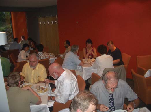
Figure 1: The conference day ended with a reception in the GITZ
the response was encouraging including also govern-
building Ł starting from left: LOICZ SSC members: B. Glõser,
mental bodies and it provided comprehensive insight
F. Lansigan, W. Huang, I. Koike, Y. Saito, J. Pacyna.
6
INPRINT
2006/2
Results of the LOICZ SSC Ł national Minisymposium
Ę Humans are an integral part of the coastal domain
on Coastal Science
functioning as drivers of change but also under the
impact of change.
Hartwig Kremer (CEO LOICZ IPO), Jozef Pacyna
(Chair LOICZ SSC), Franciscus Colijn (Director IfK,
Ę The River-Coast continuum is the scale that needs pri-
GKSS)
ority attention.
Ę Scenarios considering both climate change driven
For the Land-Ocean Interactions in the Coastal Zone
impact on the social and ecological coastal systems as
(LOICZ) project the next years will be particularly chal-
well as anthropogenic forcing can be exploited to pro-
lenging. In its role as a core project of both, the IGBP and
mote better informed decision making.
IHDP, its task is not only to integrate land, ocean and at-
mospheric sciences but also to bring in the human
Ę Long time series of data can provide invaluable historic
dimensions science in a truly interdisciplinary fashion re-
information for model development and valuation.
lating to global environmental change (GEC) in coastal
Ę Modeling and prediction of coastal change needs to go
zones. This translates to a comprehensive transition
across multiple spatial and temporal scales and can
from an originally rather biogeochemistry oriented global
benefit considerably from tailored remote sensing
research cluster looking primarily at the role of coastal
techniques.
zones in the carbon cycle into an interdisciplinary re-
Ę Typological approaches to assist up and downscaling
search project and network aiming to also provide
and covering data poor areas and those with no primary
knowledge products for better informed decisions in
information are a critical tool and should be comple-
the realm of integrated management. In the context of
mented by overlaying information on governance and
the Earth System Science Research, LOICZ is the only
social choice.
global effort with a natural and social science focus on
coastal change, its processes and its societal, manage-
Ę In terms of impact, adaptation, thus social and ecologi-
ment and policy implications. The mission statement of
cal response, and governance coastal communities
LOICZ therefore reads as follows:
need to be involved with appreciation of their complex
composition.
'to provide the knowledge, understanding and prediction
Ę The best meaningful way to bring coastal research into
needed to allow coastal communities to assess, antici-
management is still work in progress and needs future
pate and respond to the interaction of global change and
scientific attention across the disciplines.
local pressures which determine coastal change.'
This sets the stage to review and discuss ongoing
In conclusion to fulfill the LOICZ mandate mentioned
coastal research on global but also on national and re-
above the project needs to promote, facilitate and en-
gional scales against political commitments to
gage with two aspects of Global Environmental Change
conventions and directives. It also implies that LOICZ is
science:
expected to generate continuous iterative discourse
within and beyond the science community as to find out
Ę Fundamental research that addresses key issues of
where future science needs to go to address key socie-
coastal change and use in the context of future scenar-
tal information needs. The minisymposium was meant to
ios of human activity and environmental state change,
kick-off this dialogue in the new host country, Germany,
and
in awareness of the high and diverse range and capacity
in national coastal research.
Ę applied research that synthesises and up-scales scien-
tific measurements both for dissemination within the
scientific community and outreach of research out-
With the selection made for oral and poster presenta-
comes into 'science - policy - public' fora.
tions the objective was to provide a reasonable overview
of the multiple highlights featuring current national re-
search on coastal change, dynamics and processes. It
With a focus on the national research activities the con-
was also meant to get insight into new high end scientific
ference was perceived as a valuable platform promoting
approaches and to provide a platform for exchange and
exchange and collaboration. Therefore LOICZ was en-
discussion about the science priorities and topical direc-
couraged to facilitate the establishment of a national
tions of LOICZ. Discussion outcomes were picked up
research umbrella that will enable continued exchange of
internally by the international Scientific Steering Com-
this kind in the future. For the global implementation of
mittee which held its 17th annual Meeting associated to
the LOICZ project the Symposium has provided a num-
the Minisymposium at GKSS. Symposium findings can
ber of very useful, exciting and encouraging contacts,
be summarized as follows:
new impressions and potential for collaboration.
7
In the subsequent SSC meeting impressions from
cluding habitation, transport and industry, occurs.
the symposium discussions were reflected and it
Currently observed changes in the north include sea
was decided that a slight rephrasing of the LOICZ
level, storm frequency, permafrost temperature, sea ice,
Priority Research Topics would add clarity to the project
coastal erosion and species distribution and they all
profile and nice. This would be beneficiary for the sci-
have the potential to increasingly affect northern peoples
ence community and science users. The final and
and their ways of life (Ford et al. 2005). In addition
approved wording of these three Priority Topics that de-
Hinzman et al. 2005 provide an overview of terrestrial
rive from the LOICZ Research Themes as shown in the
changes. In conclusion, the Arctic coastal zone is the
Science and Implementation Plan read as follows (see
most relevant location to be capturing change from a
Newsletter 1/2006 for detailed Topic description):
human point of view. There is no current observational
network to standardize monitoring efforts or measure
Topic 1: Linking Social and Ecological Systems in the
the changes in the Arctic coastal zone (Committee on
Coastal Zone
Designing an Arctic Observing Network, 2006). There
exists a need for a network of sites at which standardized
Topic 2: Assessing and predicting Impact of Environ-
measurements of environmental parameters can be ob-
mental Change on Coastal Ecosystems
tained which capture the most likely changes and their
Topic 3: Linking Governance and Science in Coastal
potential relevance to humans.
Regions
As part of the International Polar Year (IPY), a circum-
Arctic network of standardized monitoring sites is being
planned to measure and track coastal processes in order
to better understand how these sites will respond to fu-
ture environmental changes. These observatories will
examine not only physical changes that can affect com-
munity and industry infrastructure or historical sites, but
also ecological changes that can affect species' habitat
or biological diversity. The proposal for this observatory
network originates in the Arctic Coastal Dynamics (ACD)
project of the International Arctic Science Committee
(IASC) and the International Permafrost Association
(IPA). ACD is affiliated with the IGBP/IHDP Land-Ocean
Interactions in the Coastal Zone (LOICZ) and is led by
a joint German-Canadian secretariat. It leads the IPY
Coastal Margins Cluster of projects with its proposal for
an Arctic Circumpolar Coastal Observatory Network
(ACCO-Net).
Figure 2: The LOICZ SSC dinner took place on site and the members
had the pleasure to be the first guests on the "maiden voyage" of the
new GKSS-Casino restaurant.
The current composition of the ACCO-Net cluster in-
cludes proposals for national-level IPY projects in
Canada, Denmark, England, Germany, the Netherlands,
Norway, Russia, Sweden and the United States. ACCO-
Net is seeking out ties with global observatory networks,
Arctic coastal monitoring sites: a proposed network
including the US-led Arctic Observatory Network (AON),
to monitor impacts of climate change at community,
the Circumpolar Environmental Observatory Network
regional, and circum-Arctic scales Ł ACCO-Net
(NEON) and the network of IPA-IPY projects, which in-
cludes the circumpolar networks: Circumpolar Active
1Pier Paul Overduin and 2Nicole Couture
Layer Monitoring (CALM), Carbon Pools in the Perma-
1Alfred Wegener Institute for Polar and Marine Research,
frost (CAPP), the Tundra-Taiga Interface (TTF), and
Telegrafenberg A43, 14473 Potsdam, Germany, +49-331-288-2174,
e-mail: poverduin@awi-potsdam.de
Thermal State of Permafrost (TSP).
2Department of Geography, McGill University, Montreal, Canada,
+1-514-398-5416, e-mail: nicole.couture@mail.mcgill.ca
Arctic Coastal Dynamic's first five-year phase was char-
acterized by a focus on physical sciences and in
Climate change and its consequences are expected to be
particular, on geomorphodynamic processes directly as-
most dramatic in the polar regions and marginal environ-
sociated with coastal erosion. In recent years, extending
ments are particularly sensitive to change. The margin
the focus of investigations to include the human dimen-
between the terrestrial and marine environments in the
sions of change in the coastal zone has been identified as
Arctic coastal zone is also where most human activity, in-
an important goal. This extended direction was rein-
8
INPRINT
2006/2
forced by the Coastal Working Group report of the sec-
provide a chance for adjustment of plans partway
ond International Conference on Arctic Research
through the International Polar Year. An ACCO-Net meet-
Planning (ICARP) in November 2005, which set the
ing is planned to take place in parallel with the Ninth
course for the next decade of research in the Arctic, and
International Conference on Permafrost in Fairbanks,
by the goal of interdisciplinarity that forms a corner-
Alaska on June 29 to July 3, 2008.
stone of IPY activities. The second phase of ACD begins
concurrently with LOICZ II, and has adopted this shift in
References
focus, putting it more closely in line with the three LOICZ
Committee on Designing an Arctic Observing Network, 2006,
priorities.
Toward an integrated arctic observing network, Polar Research
Board, National Research Council of the National Academies,
Selection of observatory sites will account for commu-
The National Academies Press, Washington, DC.
nity research needs, the location of sensitive eco-
Hinzman, L.D.; Bettez, N.D.; Bolton, W.R.; Chapin, F.S.;
systems and harvesting areas, recent environmental
Dyurgerov, M.B.; Fastie, C.L.; Griffith, B.; Hollister, R.D.; Hope,
changes, historical data records and logistical require-
A.; Huntington, H.P.; Jensen, A.M.; Jia, G.J.; Jorgenson, T.;
ments. A draft template for monitoring activities is
Kane, D.L.; Klein, D.R.; Kofinas, G.; Lynch, A.H.; Lloyd, A.H.;
expected to result from a workshop in October 2006.
McGuire, A.D.; Nelson, F.E.; Oechel, W.C.; Osterkamp, T.E.;
Racine, C.H.; Romanovsky, V.E; Stone, R.S.; Stow, D.A.; Sturm,
Monitoring will include compilation of existing geologi-
M.; Tweedie, C.E.; Vourlitis, G.L.; Walker, M.D.; Walker, D.A.;
cal, geotechnical, bathymetric and ecological data to
Webber, P.J.; Welker, J.M.; Winker, K.S.; Yoshikawa, K.; 2005,
synthesize current knowledge and assess what new in-
Evidence and Implications of Recent Climate Change in
formation is required. Detailed surveys and mapping of
Northern Alaska and Other Arctic Regions, Climatic Change,
topography, bathymetry, ice dynamics and shoreline
72(3), DOI: 10.1007/s10584-005-5352-2.
change will be conducted using conventional and emerg-
Ford, J.D.; Smit, B.; Wandel, J.; 2006, Vulnerability to climate
ing technologies (including panchromatic and radar
change in the Arctic: A case study from Arctic Bay, Canada,
imagery). Shore zone processes will be monitored using
Global Environmental Change, 16(2): 145Ł160.
meteorological stations. Offshore and onshore perma-
frost will be characterized with geophysics, boreholes,
temperature measurements and laboratory analyses.
The current roster of observatory sites has been adopted
from ACD's key study sites, and includes sites in
Distribution sites for the analyses of Delivery
Greenland, Svalbard, Russia, Alaska and Canada.
Systems in the Mediterranean and Black Sea. A new
Observatory characterization will include identification of
regional network on land-based material fluxes Ł
stakeholders for each site and their potential contribu-
joint outcomes for the C-GTOS and LOICZ a)
tions to and benefits from monitoring activities.
1Gianmarco Giordani, 2Robert B. Christian,
3Stefano Mazzilli and John Latham, Pierluigi Viaroli,
The timeline for development is tied to meetings of
4JosĶ Manuel Zaldņvar, 5Nicholas C. Murray
representatives and stakeholders from existing and po-
1University of Parma, Italy
tential observatory sites. The first meeting, in October
2East Carolina University, USA
3SDRN, FAO, Rome, Italy,
2006, is the 6th ACD Workshop at the Arctic Centre,
4JRC, EU Commission
University of Groningen in the Netherlands. A goal of this
5NetSEA,LaguNet
meeting is to define and characterize the initial roster of
observatory sites, including an assessment of current
A pilot project is proposed to select a network of sites
monitoring activities. A draft monitoring template will
across a range of geographical, socio-economic and en-
result. In November 2006, two important workshops
vironmental conditions in the Mediterranean and Black
continue the process: the Discovery, Access, and
Sea to analyse the delivery of nutrients, pollutants and
Delivery of Data for the International Polar Year (DADDI)
sediments from land to coastal waters. It will provide fo-
workshop in New York and the ICARP II follow-up work-
cused assessment and synthesis for the implementation
shop at the Alfred Wegener Institute in Potsdam,
of the Coastal Global Terrestrial Observing System (C-
Germany.
GTOS) and regional efforts to promote the global topics
of LOICZ. The activity will jointly develop the common
In 2007, implementation will begin with the first IPY
objectives of both organizations for the region, and thus
Arctic summer field season. Current plans include the es-
contribute to the broader goals of the global change com-
tablishment of a Canadian observatory network of core
munity.
and satellite sites. An August 2007 Arctic coastal work-
shop in Troms° is in the planning stages by LOICZ and
The network will take advantage of existing national and
IASC. ACD will be involved as a LOICZ-affiliated project.
regional initiatives, including previous biogeochemical
The 7th ACD meeting is planned for the fall of 2007 to
and pollutant investigations (e.g. Giordani et al 2005).
evaluate results from the summer field season, and will
Resulting data will be used to enhance integration of
9
efforts by researchers and practitioners and to identify
themes from the LOICZ science and implementation
and fill information gaps. The pilot project will focus on
plan (Kremer et al 2005):
the Mediterranean region, including participants and
Ę
Vulnerability of ecosystems (Theme 1);
sites from countries bordering the Mediterranean, the
Atlantic Ocean within a Mediterranean climate (i.e.,
Ę
Identification of anthropogenic influences on chang-
Portugal) and Black Sea. The project is largely being lead
ing fluxes to the coast (Theme 3);
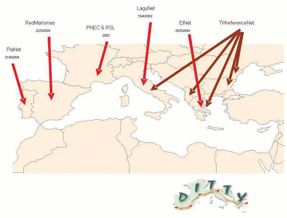
by representatives of the LaguNet Network of Italy, in
Ę
Biogeochemical cycles in coastal and shelf waters
collaboration with Joint Research Centre Ispra (European
(Theme 4).
Commission), other participating EU networks (French Ł
PNEC-RSL, Greek (ElNet), Portuguese (PlaNet), and
Spanish Ł RedMarisma) and researchers from regional
For the development of the C-GTOS observing network
projects such as DITTY and TWReferenceNet (Fig.1).
this pilot project proposes to:
Steps have been taken to formalize the development of
Ę
identify a selected number of sites among those that
the northern regional component of this network as
are available in existing monitoring networks, project
"Net-Sea-L" Ł Southern European Arc Lagoon Observa-
networks, core projects, etc.;
tional Network.
Ę
assess the suitability of the selected sites for distin-
guishing and monitoring variables that depend upon
In the southern Mediterranean region, only a small num-
(i) local factors and impacts within the coastal zone;
ber of country initiatives exist that can currently support
(ii) watershed-based factors and impacts, and (iii)
this network. The parallel development of this regional
global issues;
component of the network, and collaboration on techni-
cal transfer activities with NetSea-L participants from
Ę
promote common approaches, methodologies and
the north, will significantly aid the development of
techniques for monitoring the delivery through the
Mediterranean wide network. C-GTOS and the Food and
coastal system;
Agriculture Organization of the United Nations (FAO), in
Ę
implement a guidance document for carrying out
coordination with LaguNet personnel, will take the lead
studies and monitoring of the delivery system in the
in developing this component of the project. The activi-
coastal zone;
ties of the expanded network for the northern and
southern regionb) will address identified priority issues
Ę
develop a common and harmonized database of
of monitoring in an operational context, including:
water quality and quantity parameters that supports
assessment and management of system delivery
(i)
EU Water Framework Directive (for relevant coun-
and inherent policy applications;
tries) and some common standards for all countries,
Ę
promote availability of scientific information to appro-
to enable comparable classification of coastal-lagoon
priate user groups;
systems;
(ii) Development of a regional Early Warning System for
A number of steps have been taken towards this. An in-
onset of rapid proliferation of algal species of poten-
ventory of the international projects on coastal systems
tial risk to natural resource use, aquaculture and
in the area has been produced. Project coordinators and
human health;
local researchers were contacted to be involved in the C-
(iii) Provision of data to international science programmes
GTOS activities and participate in the production of a
such as LOICZ; and
special issue on the Med coastal systems and develop-
ment of the coastal section of TEMS (the public GTOS
(iv) Provision of data and support of regional and global
meta database). C-GTOS has begun a list and assess-
observing system initiatives including GTOS, GOOS,
ment of Ramsar sites within the Mediterranean region, a
Global Monitoring for Environment and Security
number of which are within other networks.
(GMES) and Global Earth Observation System of
Systems (GEOSS);
Collaboration between LOICZ and GTOS towards a com-
(v) Provision of data to appropriate international conven-
bined network in the northern and southern Mediter-
tions, including the Ramsar Convention on Wetlands
ranean regions will be of mutual benefit to both, and to
and the Convention on Biological Diversity.
the wider global change community. Links with regional
C-GTOS pilot projects and partners provide an opera-
tional context for LOICZ research through improved
Further value can be gained from this initiative through
access to capacity building capabilities, new sites and
participation of all collaborators in the relevant cross
collaborators; and remotely sensed and in situ data
theme activities for LOICZ and pilot projects of C-GTOS.
sources. LOICZ's contribution in return will provide sci-
For LOICZ this can potentially address the following
entific expertise and research tools including continued
10
INPRINT
2006/2
further development and review of flux modelling and
validation efforts and typology tools that will assist up-
a)This summary was extracted from the full project pro-
scaling and integration of socio-economic data, as well as
posal detailed in section 4.6 (pages 67 Ł76) of the Coastal
GTOS Strategic design and phase 1 implementation plan
access to ongoing collaborations and capacity building
and from the LOICZ Science Plan? (REF):
within the region and globally.
FAO. 2005. Coastal GTOS strategic design and phase 1
implementation plan. By Christian, R.R.; Baird, D.; Bowen,
References:
R.E.; Clark, D.M.; DiGiacomo, P.M.; de Mora, S.,;Jimķnez,
J.; Kineman, J.; Mazzilli, S.; Servin G.; Talaue-McManus,
G. Giordani, P. Viaroli, D.P. Swaney, C.N. Murray, J.M. ZaldĒvar
L.; Viaroli, P. & Yap, H.. GTOS Report No. 36, Environment
and J.I. Marshall Crossland. 2005. Nutrient fluxes in transitional
and Natural Resources Series No. 9. Rome, FAO. 93 pp.
zones of the Italian coast. LOICZ Reports & Studies No. 28,
Also available at http://www.fao.org/gtos/doc/pub36.pdf.
ii+157 pages, LOICZ, Texel, the Netherlands
b)The northern Mediterranean region includes a subset of
Kremer, H.H., Le-Tissier, M.D.A.; Burbridge, P.R. and C.J.
European countries participating in Net-Sea-L and con-
Crossland 2005: Land-Ocean Interactions in the Coastal Zone,
tributing to the C-GTOS regional priority product. The
LOICZ, Science Plan/Implementation Strategy for the second
southern Mediterranean region includes non-European
decade 2003-2012 of LOICZ, a core project of the IGBP and
countries.
IHDP, Texel/Stockholm, The Netherlands/Sweden, pp 78 (see
www.loicz.org)
Figure 1: NetSEA-L Networks of Southern European Arc & other regional activities.
11
The LOICZ workshop at the LITTORAL conference in
cluded Conceptual Diagrams, presented by Jane
Gdansk, Poland, 18Ł20 September 2006
Thomas and Bill Dennison; LOICZ nutrient budgets,
presented by Gianmarco Giordani; LOICZ typology, pre-
Alice Newton
sented by Bob Buddemeier, and the ASSETS screening
Faculty of Science and Technology, University of Algarve, Campus de
model for eutrophication, presented by Alice Newton,
Gambelas, 8000-062 Faro, Portugal, e-mail: Anewton@ualg.pt
Joao Gomes Ferreira and Suzanne Bricker.
It is planned to make presentations available from the
LOICZ website. Summaries of the presentations of the
LOICZ tools follow below:
What are Conceptual Diagrams and where to find out
more?
Jane Thomas and Bill Dennison
University of Maryland, Center for Environmental Science,
P.O.Box 775, Cambridge, MD 21613-0775, USA,
e-mail: thomas@umces.edu, dennison@umces.edu
Conceptual diagrams or "Thought Drawings" are an ef-
fective tool to communicate complex messages in a
simple and informative manner. They depict essential
attributes of the system, depict processes at different
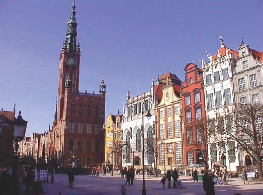
Figure 1: Gdansk City Hall and market place Ł an impressive architec-
tural feature of this old hanseatic City (Foto: Hartwig Kremer).
scales and evolve to capture an increasing understanding
of the system. Key elements of a conceptual diagram are
The LITTORAL conference cycle is jointly held by EURO-
consistent symbols and a comprehensive legend.
COAST (www.eurocoast.org) and the EUCC-coastal
Symbols are very powerful communication tools that are
union, (www.eucc.nl). The conferences bring together a
information rich and common in everyday life. They are
community of coastal researchers and managers, mainly
universal and language independent. The size, color,
from Europe but they also attract participants worldwide
shape, and position of the symbols can all convey mean-
as in this case from Australia, the USA, Canada, Pakistan
ingful information. A comprehensive legend makes the
and the Middle East.
diagram 'stand alone' and self contained so that there is
no need to read accompanying explanation.
This year the conference was hosted by the Gdansk
Technical University in the beautiful historic city of
Conceptual diagrams help to clarify thinking and avoid
Gdansk in Poland, on the shores of the Baltic Sea. The
ambiguity and they provide a communication interface.
LOICZ national contact in Poland helped to organize a
They combine current scientific understanding with com-
specific LOICZ workshop at the conference. The pur-
munity priorities and environmental values and they
pose of the workshop was to present the new LOICZ
provide an approachable representation of the system
science plan and products.
thereby allowing a shared vision to be created. Such dia-
grams are useful for integration and application to
LOICZ knowledge products were displayed at the booth
identify gaps, to establish priorities and to provide a syn-
in the conference atrium and included posters, pam-
thesis.
phlets, LOICZ reports (these can also be downloaded
There are numerous applications for Conceptual
from www.loicz.org), the new LOICZ science plan as
Diagrams including setting research agendas, develop-
well as two synthesis books "Coastal Fluxes in the
ing scientific syntheses, setting up monitoring pro-
Anthropocene" and "Managing European Coasts".
grammes, identifying management priorities, critical
There was also a questionnaire about LOICZ, which has
choke and switch points for system adaptation and inter-
been developed recently to explore the visibility of the
vention and they can be included in scientific literature,
project and its outside perception. This questionnaire will
including peer reviewed journal articles but are particu-
be available also from the LOICZ website at a later stage.
larly strong also in easy language publication reaching
out to a wider and usually non scientific audience. An ex-
The workshop was well attended. After an initial brief
ample on the multiple features and scales of a coastal
presentation of LOICZ prepared by Alice Newton and
zone is given hereunder.
Jozef Pacyna, the LOICZ tools were presented in a
"hands on, how to" approach. The tools presented in-
http://ian.umces.edu/conceptualdiagrams_page.php
12
INPRINT
2006/2
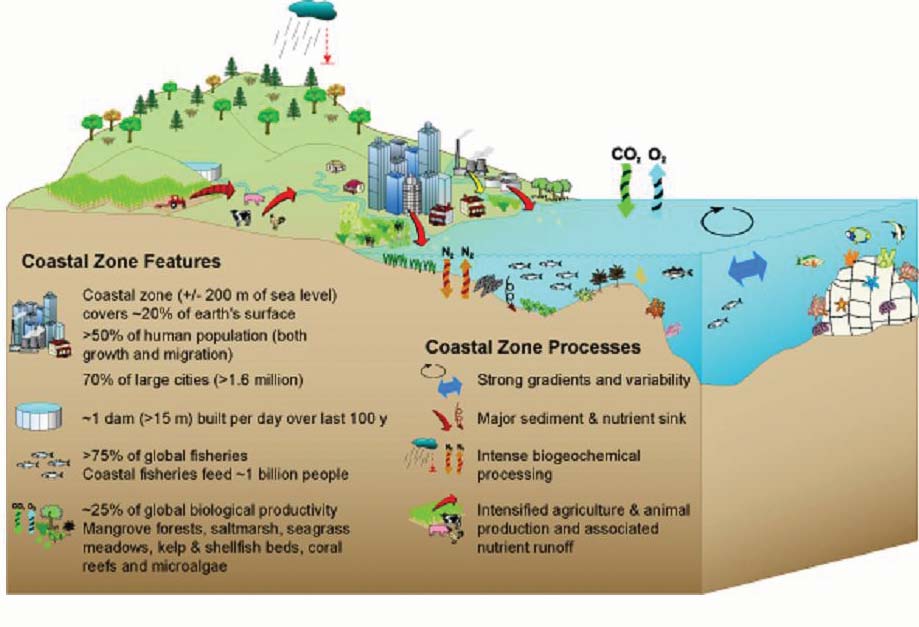
Figure 2: conceptual
diagram displaying key
natural and anthropogenic
features and goods and
services of the coastal
zone including the river
catchment Ł shelf scale.
What are LOICZ Budgets and where to find out more?
lenged to provide a global picture which means that
much of the assessment takes place in rather data-lim-
1Gianmarco Giordani, 2Dennis Swaney,
1Pierluigi Viaroli
ited areas of the world the approach attempts to do this
1Department of Environmental Sciences, University of Parma,
using a minimum of data, but permitting richer datasets
Via Usberti, 33/A, I-43100 Parma Italy, e-mail: giordani@nemo.unipr.it
to be used when available. An example of some collec-
2Department of Ecology and Evolutionary Biology, Cornell University,
tive results of the work to date can be found in chapter 3
E309 Corson Hall, Ithaca, NY 14853, USA, e-mail: dps1@cornell.edu
of Coastal Fluxes in the Anthropocene (Crossland et al
The original methodology of the LOICZ budgeting ap-
(eds), 2005) and on
proach can be found at pp 23Ł43 of the LOICZ Reports
http://data.ecology.su.se/mnode/methods/
and Studies Series no. 5 available in pdf format at
review%20material/smith%20et%20al%202005.pdf
http://data.ecology.su.se/mnode/methods/
review%20material/report5.pdf
Several tools were developed to assist the application of
this budgeting approach. Most of them are available in
Several case studies follow the statement of methodolo
the LOICZ budget website
gy in this report, and many others can be found in the
LOICZ budget website
http://data.ecology.su.se/mnode
http://data.ecology.su.se/mnode
and some others were developed by the LaguNet group
and can be downloaded from
and in the LOICZ R&S series volumes
http://www.dsa.unipr.it/lagunet
http://www.loicz.org
and from
which can be considered an extended discussion of the
methodology. The essence of the approach is to infer net
http://www.ecology.unibo.it/LOICZ-Calculator/
sources and sinks of nitrogen and phosphorus in coastal
loicz_calculator.htm.
ecosystems (estuaries, lagoons, bays, etc) using a mass-
balance approach (of water, salinity and nutrients), gen-
Details of these tools are reported in the respective web-
erally making the assumption of steady-state, and to
pages. A summary of the former LOICZ biogeochemical
further infer whether the system is autotrophic or het-
budgeting project supported by UNEP GEF has recently
erotrophic, and whether N-fixation outweighs denitrific-
been prepared with a focus on management implications
ation in the system. For reasons of LOICZ being chal-
and is introduced later in this newsletter.
13
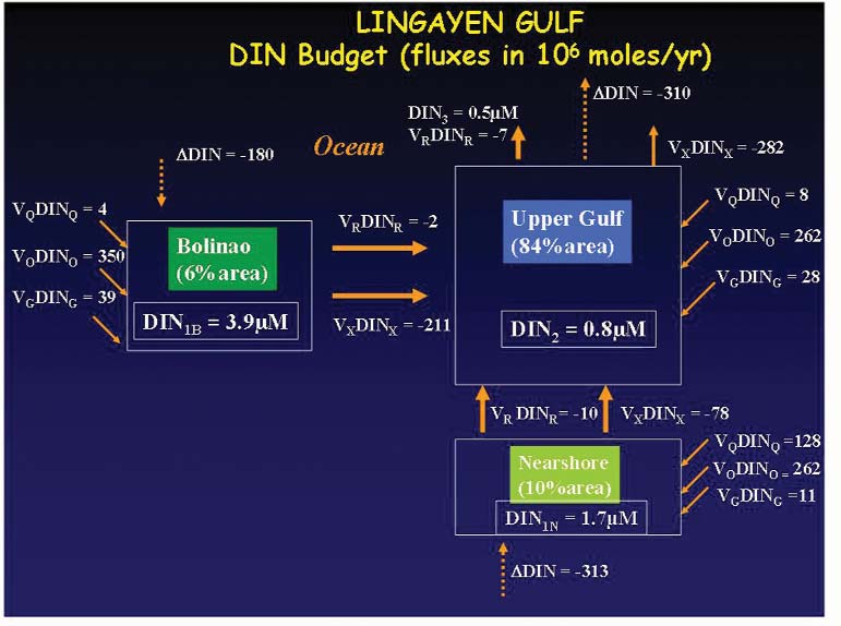
Figure 3: an ex-
ample of a LOICZ
biogeochemical
flux box model
showing calcula-
tions for dissolved
inorganic nitrogen
(DIN) fluxes in
Lingayen Gulf
(Philippines).
What is the LOICZ Typology and where to find out more?
grid cell database (incl. LOICZ budget site data), which
can be found at
Bob Buddemeier
Kansas Geological Survey, University of Kansas, 1930 Constant
http://hercules.kgs.ku.edu/hexacoral/envirodata/hex_mod-
Avenue, Lawrence, KS 66047 USA, e-mail: buddrw@ku.edu
filt_firststep3dev1.cfm.
Typology is the process of classifying objects Ł most
often natural systems or environmental entities Ł accord-
Also developed were two successive generations of
ing to their degree of similarity with regard to multiple
geospatial clustering tools, WebLOICZView
variables. "A typology" is a specific classification sys-
http://palanir.swarthmore.edu/loicz and DISCO
tem which can be used to infer other characteristics of
http://narya.engin.swarthmore.edu/disco.
the systems classified, to deduce controlling variables or
forcing functions, or to facilitate prediction, planning, and
The typology approach has been adopted by many or-
management. The techniques used to develop a typol-
ganizations for a variety of purposes, as a literature or
ogy can range from qualitative and descriptive to formal
internet search will reveal. Selected links and literature
quantitative statistical analysis, and even to modeling.
items are accessible at
The results are not unique or restrictive, but are depend-
http://geoportal.kgs.ku.edu/estuary/resources.cfm
ent on the problem addressed and the data/information
available; one of the strengths of the approach is the abil-
which is a component of two websites supporting the
ity to develop and use multiple concurrent typologies to
US National Estuarine Eutrophication Assessment
address different aspects of the systems.
http://ian.umces.edu/neea/
and
Initial efforts at a global scale during the first decade of
LOICZ led to the development of a modified half-degree
http://geoportal.kgs.ku.edu/estuary/.
14
INPRINT
2006/2
What is the ASSETS Eutrophication Screening Model and
Canada, China, Japan, Italy, Sri Lanka and USA.
where to find out more?
It was the second year meeting of INQUA project 0419
and the extension year meeting of IGCP 464 Continental
1Alice Newton, 2Joao Gomes Ferreira and
3Suzanne Bricker
shelves during the last glacial cycle. The main focus is on
1Faculty of Science and Technology, University of Algarve, Campus de
the evolution of Tertiary to Quaternary carbonate shelves
Gambelas, 8000-062 Faro, Portugal, e-mail: Anewton@ualg.pt
and to examine their role in the global carbon cycle when
2IMAR - Centro de ModelańŃo Ecol¾gica, Dept. CiĻncias e Engenharia
they became sub-aerially exposed during glacial periods
do Ambiente, Faculdade de CiĻncias e Tecnologia, Quinta da Torre,
2829-516 Monte de Caparica, Portugal, e-mail: joao@hoomi.com
in the Quaternary.
3Program Manager: National Estuarine Eutrophication Assessment,
National Centers for Coastal Ocean Science, Center for Coastal
Karstification and/or soil development was identified on
Monitoring and Assessment, 1305 East West Highway, Floor 9,
SSMC-IV, N/SCI-1, Silver Spring, MD 20910,
the sub-aerially exposed continental shelf of Western
e-mail: Suzanne.Bricker@noaa.gov
Australia where the windier conditions have led to the
formation of aeolianites. In contrast to the glacial periods,
ASSETS is a Eutrophication screening model built in co-
marine terraces were formed during the interglacial peri-
operation between NOAA's National Centers for Coastal
ods. A total of five marine terraces including the present
Ocean Science http://www.nccos.noaa.gov/ and IMAR,
(Holocene/MIS 1), Tantabiddi (MIS 5e), Jurabi (MIS 7?),
the Portuguese Institute of Marine Research,
Milyering (MIS 9?) and Muiron (MIS 11?) can be identi-
http://www.imar.pt/.
fied. (MIS stands for Marine Isotope Stage Ł from
oxygen isotope measurements of forams)
ASSETS stands for Assessment of Estuarine Trophic
Status, and builds on the U.S. National Estuarine Eutro-
Scientific presentations (oral and poster) covered various
phication Assessment (NEEA) developed by NOAA.
aspects on the Western Australian coastal region,
ASSETS is a highly aggregated model for eutrophication
Antarctic ice core chemistry, human migration, Quaternary
assessment, and has been applied in many parts of the
climates and sea levels, karstification, shelf and deltaic
world including the USA, Europe and China. It is based on
sediments, tectonics and geochronology.
a PSR framework, and has been proposed as a method-
ology compliant with the EU Water Framework Directive,
The project members are planning to present highlights
for the evaluation of Environmental Quality Standards
of results in 2007 at the 17th INQUA Congress in Cairns.
(EQS).
New members are welcome and should contact Wyss
Yim.
With adaptations for more localised use at the aquacul-
ture farm scale, ASSETS is a potentially valuable tool for
the assessment of the interactions between eutrophica-
tion and aquaculture and for the valuation of nitrogen
trading. The model has been extensively tested, and is a
potentially valuable tool for informing an ecosystem
approach to sustainable aquaculture development
(http://www.eutro.org). The next newsletter will feature
the ASSETS approach in an extended scientific article.
Sub-aerially exposed continental shelves since the
Middle Pleistocene climatic transition INQUA/IGCP
464 field meeting, 13Ł18 August 2006, Exmouth, WA,
Australia
1Wyss Yim, 2Lindsay Collins
1Department of Earth Sciences, The University of Hong Kong,
Pokfulam Road, Hong Kong SAR, China, e-mail: wwsyim@hku.hk
2Applied Sedimentology and Marine Geoscience Group, Department
of Applied Geology, Curtin University of Technology, GPO Box U1987,
Perth 6845 Western Australia
This field meeting, held in the Cape Range region and
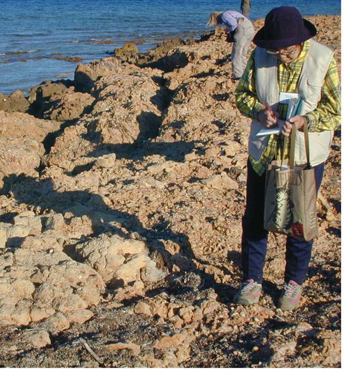
Figure 1: Prof. Yoko Ota note taking on the MIS 5e marine terrace cut
Ningaloo Reef, northwest Australia was attended
into older alluvial fan deposits, Pebble Beach, North West Cape,
by 25 participants from 7 countries including Australia,
Western Australia.
15
Global Coastal Changes and Coastal Zone
In groups of 3-4 the participants identified themselves
Management
with their roles quickly and developed arguments for
their positions that were presented in form of a fictitious
Joint session of LOICZ and CMRC Cork, Ireland, held as
public hearing. During the plenary discussion it became
part of the international summer school on Diversity of
evident how difficult it is to argue against feelings like
Coastal Habitats, Sylt 13.09.2006
fear and how important a serious appearance is.
Maike Paul and G÷tz Fl÷ser
Furthermore the role play made clear how essential good
Institute for Coastal Research, GKSS Research Centre,
quality data and hence the role of science for such a plan-
Max Planck Strasse 1, 21502 Geesthacht, Germany,
ning process is.
e-mail: maike.paul@loicz.org,
e-mail:goetz.floeser@gkss.de
The challenge is to inform a process which is trying to
From 6. to 19. September 2006, a summer school on
satisfy a so called triple bottom line approach for sustain-
Diversity of Coastal Habitats was held on the German is-
able development. This means to balance between
lands Sylt and Helgoland. It was jointly organised by the
ecological, economic and social quality and development
Alfred-Wegener-Institute for Polar and Marine research
targets and in doing so to bridge between the different
(AWI), GKSS, the Institute for Baltic Sea Research (IOW)
competing interests and cultural backgrounds and ex-
and the University of Gdansk. LOICZ introduced the 16
pectations of the parties involved. In the end, a variety of
participants from 11 countries to Integrated Coastal Zone
management options emerged. This was in some way
Management (ICZM), and Maike Paul from the LOICZ
even surprising since in this case participation was intro-
IPO and Valerie Cummins (CMRC, Cork) representing the
duced rather reactively. Major dicisions in favour of the
LOICZ affiliated project COREPOINT held a morning ses-
project had already been made elsewhere on the political
sion on ICZM and the role of scientific information in the
level. They were thoroughly discussed and there was
management process.
consensus in the group about the outstanding signifi-
cance for proactive planning and early stakeholder
Following a brief introduction to the terminology, the
involvement as opposed to the example used here.
basic principles and needs of ICZM the participants, who
mainly had a background in Biology, learned about stake-
holder participation as one tool of ICZM. In an interactive
role play they were asked to take on different stake-
holder positions and to defend and promote their
position. The role play was based on the real scenario of
the Corrib Gas field case off Western Ireland. Here a high
pressure undersea gas pipeline is being planned which
will go through a special area of conservation according
to the Habitat Directive and on land it will be located in
the direct vicinity of people's homes.
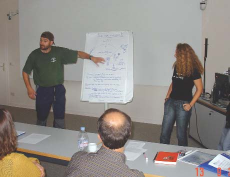
Figure 2: "Environmentalists" make their case of serious concern re-
garding conservational values of the affected off and onshore
ecosystems.
All in all it was a very lively and productive session and
the students used the afternoon field trip to detect man-
agement needs and dilemmas on the island of Sylt and
hence transfered some of their new impressions and
knowledge they gained in the morning.
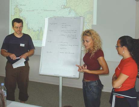
Figure 1: The "private sector (Investor)" group enthusiastically pres-
ents the case of the underwater gas pipeline to the multi stakeholder
audience.
16


INPRINT
2006/2
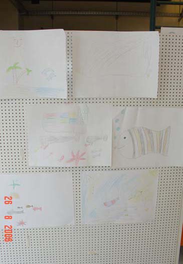
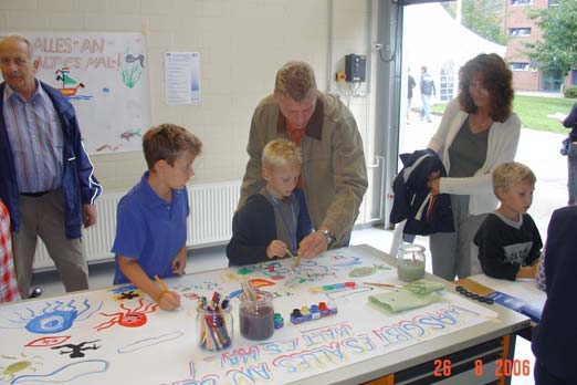
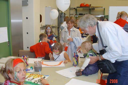
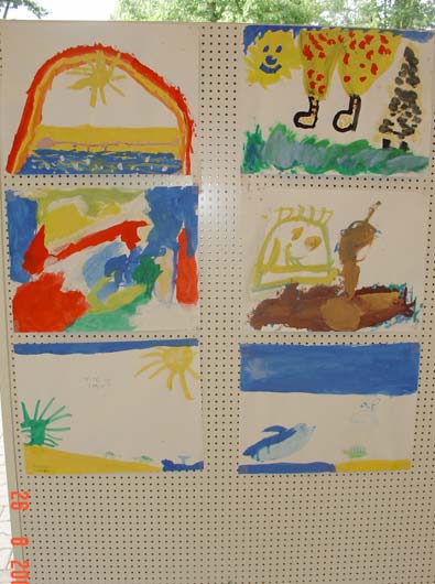
LOICZ booth at the GKSS Open Day Ł painted visions of the coast
Painting activity at
GKSS open day, 26th
August 2006
During the open day at GKSS, which in total
saw more than 6000 visitors, the LOICZ
booth invited to active participation. Young
and old visitors were asked to paint their
view upon the coast. On large sheets of
paper collective paintings were generated.
And thanks to Grandpa`s support even the
smallest guests showed great enthusiasm.
Hester, Hartwig and Martin from the LOICZ
Team had lots of fun during the day and
The following ,,LOICZ
would like to thank Luisa and Linus for their
youngsters" joined in:
great help and all visitors for taking part.
Babett Funk, Christiane
Hartkopp, Christoph Howe,
Cora-Katja Kerkommer, Felix
Howe, Finja-Marie Urbschat,
Franklin, Hendrik Wedderien,
Janne Rottluff, Jonas
Stapelfeldt, Kai-Peter Grasse,
Katharina Schardt, Katrin
Ganzow, Linus Kremer, Lisa
Kr³ger, Luisa Kremer, Maik
D÷hring, Marie-Charlot Gerau,
Markus Hartkopp, Markus
Schardt, Moos Peereboom,
Moritz Gerau, Odett Funk, Ole
Kr÷ger, Raphael Funk, Sarah
Henning, Sarah Schmidt, Sem
Peereboom, Svenja Roering,
Swantje Fuhr Ken, Timo
Schmeling, Tobias D÷hring,
Tordis Kindt
17
Call for research proposals concerned with
The backbone of LOICZ: affiliated projects
Land-Ocean Interactions in the Coastal Zone
LOICZ has a mandate to address key issues of
As described earlier in this issue, LOICZ has devel-
coastal change and use in the context of scenar-
oped three key topics that will form the focus of
ios of future human activity and environmental
research interest in the coming years. Within all three
change. LOICZ endorses and seeks to support
topics, LOICZ seeks to expand its network of scientists
both fundamental coastal zone research and re-
by endorsing research activities concerned with any of
these topics on a global, regional or national level.
search that synthesises and up-scales results for
Within these topics LOICZ strives to develop:
dissemination within the scientific community,
and outreach to policy makers and the public.
Ę methodologies or models that allow data assimila-
tion, processing and synthesis, including up and/or
down scaling;
This research is partly carried out by groups of
scientists, aided and supported by the LOICZ
Ę scenarios of change and/or response to change in
IPO, Regional Nodes and/or SSC, with funds that
socio-ecological systems;
LOICZ has secured from external funding agen-
Ę scientific context for the evaluation of existing policies
cies. Another important part of the LOICZ project
and structures;
is carried out by researchers who affiliate their
Ę globally applicable tools for scientific synthesis,
projects to LOICZ thereby becoming part of the
decision support and structure development, and
global network of LOICZ. These projects build
Ę dissemination interfaces to provide information and
the backbone for up- and down-scaling of LOICZ
assist sustainable coastal development on appropriate
results and the LOICZ synthesis. LOICZ has re-
scales.
cently restructured the affiliation process so that
applications for affiliation will be reviewed by the
To achieve this, LOICZ is calling for proposals to bring
IPO and the coordinator of the theme/topic they
high quality research activities into the LOICZ cluster
of affiliated projects. As well as fundamental science
are contributing to most. This new procedure will
projects, we also seek projects that have a multidisci-
allow LOICZ to maintain an up-to-date record of
plinary perspective, especially combining natural and
global research activity as relates to the LOICZ
social sciences. Projects can have global, regional or
Science Plan as well as ensure that affiliated proj-
local scales and be focussed on coastal sciences
ects are given opportunity to fully participate in
and/or coastal management. Projects that collaborate
LOICZ activities such as workshops and joint
with other Earth System Science Partnership (ESSP)
projects.
projects, especially with other Core Projects of IHDP
and IGBP, are sought in particular, as well as projects
LOICZ provides a forum to assimilate, integrate
that synthesise and analyse research outcomes al-
and synthesise the outputs of affiliated projects.
ready available or involve dissemination and outreach
that will lead to better public knowledge. Examples of
Additionally, it provides an opportunity to com-
projects already affiliated to LOICZ can be found on
municate and disseminate these outputs making
the LOICZ website under Projects.
them available not only to other scientists, but
also the public, decision-makers and managers.
Although LOICZ cannot offer funding to affiliated proj-
Information on affiliated projects is held on a cen-
ects, its endorsement provides the following benefits:
tral database that will in the near future be made
Ę support in proposing for funding;
available on-line so that basic information and
Ę promotion of the project and associated activities, its
regular updates are available to the wider com-
contributing team, outputs and outcomes through
munity as well as to LOICZ for its own reporting
the LOICZ website and/or newsletter;
requirements.
Ę contribution to workshops, conferences and meet-
ings organised by LOICZ and hence establish link-
ages to other projects operating in similar fields
An essential element that applies for all LOICZ in-
and/or addressing similar issues; and
terdisciplinary studies within and beyond the
Ę access to a wide circle of information related to
project is data sharing and exchange. To facilitate
funding and the science community that is available
this exchange LOICZ has developed a Data
through the LOICZ database.
Policy to help affiliated projects and LOICZ to
fully benefit from each other. Both documents,
Researchers whose work fits into this LOICZ portfolio
are encouraged to submit proposals to the LOICZ IPO
the Terms of Reference for affiliated activities
as soon as possible. The required form and additional
and the Data Policy, can be found on the LOICZ
information can be obtained from the LOICZ website
website.
or via contacting the LOICZ IPO.
18
INPRINT
2006/2
to find a job equally challenging and interesting as work-
IPO Notes
ing for the LOICZ project office. It's been an experience
IPO staff changes
and I will be taking home some great memories. Cheers
& doei
Since June 2006 the IPO has the pleasure to have Jian
Hester.
Su as an intern from China in the team.
A warm goodbye from the IPO and SSC
Jian Su aims to calculate the water and nutrient budgets
in Ria Formosa lagoon with respect to eutrophication
We all sincerely regret Hester's departure. We will not
problems. In this investigation he is using the LOICZ
only lose a great colleague but also an inspiring team
biogeochemical budget method and database. Jian Su
member who through her optimistic and innovative
participated in the ERASMUS MUNDUS Ł Water and
thinking has helped LOICZ and us as a team a lot in pass-
Coastal Management Masters Programme. He first fol-
ing various "mountains". Without her the transition of
lowed lectures at the University of Bergen, in the main
the last few years would not have been as smooth as it
subjects Integrated Costal Zone Management, Water
finally was. However, Hester also was a good friend t o all
History and Nature of Water. After finishing all the mod-
of us as well as to the outside LOICZ community. This is
ules, he began to study coastal management of a lagoon
something we all hope will not come to an end. The IPO
in the south of Portugal.
and SSC wish Hester a bright and fulfilling future and we
hope that in one way or the other we will stay in touch.
Jian Su is a post-doc
from the Ocean
University of China.
He received the "He
Congben Award",
(named by the father
What's on the wwweb
of Oceanography in
China), for the excel-
IGOS Coastal Theme Report is available for
lence of his graduate
downloading at:
work. His PhD fo-
www.igospartners.org/docs/theme_reports/IGOS%20COAST
cused on cross-front water exchange in the shelf ocean
AL%20REPORT%20midrez.pdf
of the South China Sea and Yellow Sea.
School on coastal dynamics modelling.
More information at:
http://lseet.univ-tln.fr/ecoleete/ecole25eng.html
Hester Whyte leaves the IPO Ł Parting is such sweet
The East Asian Seas (EAS) Congress 2006:
sorrow
http://pemsea.org/eascongress/participation_prereg.hm
The ACCCA project website is now on-line:
After having worked at the LOICZ IPO for almost 6 years
www.acccaproject.org.
I am leaving. I would like to take this opportunity to say
Please visit the site to learn about the ACCCA project.
goodbye to the people I have come across, live as well as
via e-mail, during my time in the IPO. I also would like to
Newly revamped UNEP/GPA website:
say thanks to the LOICZ SSC, current and past members,
www.gpa.unep.org/
as well as the wider LOICZ community who I've had the
Find a wealth of information about the Global Programme of
pleasure to work and interact with. I wish everyone suc-
Action for the Protection of the Marine Environment from Land-
cess in the future and hope that the new faces that will
based Activities including: latest information and news about
become part of the IPO will enjoy working for the LOICZ
the GPA Programmes, advanced search feature and a docu-
project as much as I have. To my colleagues in the IPO I
ments library.
just want to say I will miss you. It's been a pleasurre and
The Researcher's Mobility Portal:
sometimes a chal-
http://europa.eu.int/eracareers/
lenge working with
you and I wish you
DIVERSITAS Science Plan and Implementation Strategy:
all the best now
www.diversitas-international.org
and for the future.
My plans & future
Programme ESSP Congress, Beijing,
are pretty much un-
09Ł12 November 2006, and 2nd International Young
known
at the
Scientists Conference (START) 7Ł8 November:
moment but I hope
http://www.essp.org/ESSP2006/index.html
19
In the same context the NEW UNEP/GEF-LOICZ Publication:
Publications
The role of the coastal ocean in the disturbed and undisturbed
nutrient and carbon cycles Ł A management perspective
For coastal managers presentation of information in a format they can
A Guide to the Management of Freshwater Inflows to Estuaries.
use is of crucial importance. Information needs to be assimilated and
The guide is a tool to further the integration of the planning and science
synthesised from original scientific data. The Global Environment
of Integrated Water Resources Management (IWRM) with the planning
Facility of the United Nations Environmental Programme funded the
and science of Integrated Coastal Management (ICM) jointly issued by
project Ł "The role of the disturbed and undisturbed nutrient and carbon
Nature Conservancy, US AID and Coastal Resources Centre CRC, Univ.
cycles" Ł which was implemented by the Land-Ocean Interactions in
Rhode Island.
the Coastal Zone project (LOICZ).
(The completed Methods Guide will be available November 2006. To or-
The project outcomes show the link between human dimensions and
der a copy please contact Diedre Paterno-Pai, The Nature Conservancy
coastal nutrient dynamics and gives direction for future studies.
dpaterno-pai@tnc.org.
This publication translates the scientific findings from the research car-
A PDF version will be available online at nature.org/freshwaters
ried out in the context of this project into their management implica-
For information on this and other projects related to "Impacts of alte-
tions.
red freshwater flows to estuaries", see www.crc.uri.edu)
This publication is available as a PDF on the LOICZ website under
Products
Optional: Those interested can request a hard copy version from the
Ecosystem Based Management: Markers for Assessing Progress
IPO (available Nov. 2006)
This publication should be considered a practical tool for assessing pro-
Have you seen
gress in integrated coastal and river basin management. It highlights
the needs and benefits of integrated management, while at the same
time providing guidance in establishing the management link.
Upcoming Meetings with LOICZ sessions:
The paper offers a framework for disaggregating the goal of sustainable
Estuarine Research Federation meeting
development into a sequence of tangible levels of achievement. The fo-
Providence, Rhode Island, USA, November 4Ł8, 2007
cus is on outcomes rather than management processes. Sets of mar-
(More info about the conference can be found at the ERF website, www.erf.org)
kers or indicators are offered that can be used to assess progress in in-
tegrated management of river basins, coasts or large marine ecosy-
Title of Session: Nutrient budgets for coastal waters: methodolo-
stems and in programmes that link across these systems.
gies and applications
UNEP/GPA 2006 Ł ISBN 92-807-2707-9
LOICZ session specifically targeted at nutrient budgets of coastal systems
The Hague, The Netherlands, gpa@unep.nl, www.gpa.unep.org
Organizer/session leader: Dennis Swaney
Type: Scientific session, combined oral and poster
Summary: Nutrient budgets have been fundamental tools for the ana-
A Handbook on the Governance and Socioeconomics of Large
lysis of estuarine ecosystem dynamics for many years. At least one
Marine Ecosystems
major international project, Land Ocean Interactions in the Coastal
Zone (LOICZ) has used a budget approach to infer the global distribu-
(University of Rhode Island 2006) Ł WWW: http://www.crc.uri.edu/
tion and regional variation of coastal ecosystem metabolism based on
The primary purpose of this Handbook written by Stephen B. Olsen,
analysis of N & P budgets of individual coastal ecosystems around the
Jon G. Sutinen, Lawrence Juda, Timothy M. Hennessey, Thomas A.
world. Other methodological approaches have been used by estuarine
Grigalunas, is to serve as a practical guide to innovators of governance
scientists for a variety of purposes. Application of the budget approach
and socioeconomics in Large Marine Ecosystem (LME) projects. Based
to address coastal ecosystem management has been less common.
on a Global Environmental Facility IW:LEARN-sponsored workshop for
This session aims to bring together scientists and managers to report
11 LME programs, the Handbook is designed to be used in short cour-
on current approaches to nutrient budgeting, new methodologies, and
ses and workshops on governance and socioeconomics science to
applications to management questions.
support the ecosystem approach to marine resources management.
Potential Participants: Broad participation is expected, including members of the LO-
Information on the workshop can be found at
ICZ community and other interested scientists and managers
http://www.iwlearn.net/abt_iwlearn/pns/learning/b2-2lme
Title of Session: Watershed-based nutrient accounting: coupling
Marine Eutrophication in Perspective Ł On the Relevance of
catchments to coastal waters
Ecology for Environmental Policy
LOICZ session is targeted at estimating nutrient fluxes to the coast from waters-
Jong, Folkert de, 2006, XII, 336 p., 20 illus., Hardcover, ISBN: 3-540-
heds, and specifically at hydrological modelling and nutrient accounting in wa-
33647-8, Springer Ł Berlin, Heidelberg, New York.
tersheds
Organizer/session leader(s): Bob Howarth and Dennis Swaney
Is ecological knowledge relevant for environmental policy and if so, to
Type: Scientific session, combined oral and poster
what extent and in what way? These are some of the critical questions
Summary: Over the last 10 years, relatively simple methods have been
addressed in this book. The book critically reflects the role of scientists
developed for relating nutrient sources in watersheds to their delivery
and scientific information as well as civil servants in the formulation of
to coastal waters. Several lines of research are converging, including
the political decision to reduce nitrogen and phosphorus inputs into the
the accounting methodology for nitrogen inputs to watersheds develo-
North Sea. This decision was the response on several hypoxia events in
ped under the Scope Nitrogen Program (cf. Howarth et al., 1996; Boyer
the 1980ies and approved by the North Sea states.
et al., 2002) and the budgeting methodology of the Mid-Atlantic
Regional Water Program (http://www.agnr.umd.edu/users/waterqual/).
These and similar accounting approaches, together with large catch-
The identification of 100 ecological questions of high policy rele-
ment models, (e.g., Johnes and Butterfield, 2002; Billen and Garnier,
vance in the UK
2000; Garnier et al., 2000), and spatially-referenced and other regres-
William J. Sutherland et al,.2006, Journal of Applied Ecology 43, 617-
sion models (e.g., Alexander et al., 2001; McIsaac et al., 2001; Turner et
627 (® 2006 The Authors.Journal compilation, ® 2006 British
al., 2001; Smith et al., 2003; Howarth et al., 2006) improve our under-
Ecological Society)
standing of nutrient loading and how climate and land use change af-
fect the resulting loads to coastal waters. Presentations in this session
This list of questions which has been through a process of intensive
will report on progress to date on methodologies currently under deve-
discussion by hundreds of scientific experts will potentially nourish any
lopment, and recent applications of such approaches.
debate on ecosystem approaches in coastal zones and sustainable use.
It reflects critical issues at the interface between science and policy.
Potential Participants: Researchers involved in nutrient accounting and coastal
catchment modelling, as well as other interested scientists and managers
20
INPRINT
2006/2
Update us so we can update you
LOICZ INPRINT informs you about the LOICZ Project and its activities. But LOICZ has access to much more
information and wants to make this information available to you as effectively as possible. To be able to provide you with
LOICZ information that fits your expertise and interests most, we need input from your side telling us what your inter-
ests in LOICZ are and how we can contact you.
Please complete the following form where applicable and return by fax, post or e-mail to the LOICZ IPO.
(An electronic version of this form can also be found on www.loicz.org under Newsletter.)
First name:
Last name:
Organization/Institution:
Address:
Place:
Postal code:
Phone (include country code):
Fax (include country code):
e-mail:
(Organization's) website:
Field of expertise:
Please indicate which LOICZ theme(s)* you are contributing to:
Theme 1
Theme 2
Theme 3
Theme 4
Theme 5
Please indicate which LOICZ key topic(s)** you are interested in:
Topic 1
Topic 2
Topic 3
other
How do you want to receive the LOICZ Newsletter in the future?
hardcopy
pdf-file via e-mail
e-mail alert
not at all
*
More detailed information on the LOICZ Research Themes is available in the Science Plan on the
LOICZ website (www.loicz.org)
** Detailed descriptions of the topics are featured in first issue of INPRINT and on the website
Please return this form by:
Ę
e-mail to loicz.ipo@loicz.org
Ę
fax to
+49(0)4152 87 2040
Ę
mail to
LOICZ IPO Ł GKSS Research Centre
Institute for Coastal Research
Max-Planck-Strasse 1
D-21502 Geesthacht, Germany
21
22
INPRINT
2006/2
The International Conference The Humboldt Current
Calendar
System: Climate, ocean dynamics, ecosystem
processes, and fisheries
Call for Papers and Announcement:
organized by IMARPE (Peru), IRD (France) with the
technical support of FAO and sponsored by CNES
Remote Sensing of the Marine Environment (AE103)
(France), CPPS, GLOBEC, ICES/CIEM, IMBER, NASA
Part of SPIE's Fifth International Symposium on
(USA), PICES, SIMRAD,
Asia-Pacific Remote Sensing, November 13Ł17, 2006,
will be held in Lima (Peru),
Marriott
November 27 to December 1, 2006.
Hotel, Panaji, Goa, India
Contact: hcsconference@amauta.rcp.net.pe or
Conference web site:
http://irdal.ird.fr/hcs-conference.imarpe.fao.ird.php3
http://spie.org/conferences/calls/06/ae/
Arctic Frontiers Science conference:
SPICE/LOICZ/SEACORM South-East Asia Coastal
Balancing Human Use and Ecosystem Protection
Governance and Management Forum:
Arctic Marine Ecosystem Research Network (ARCTOS)
Science Meets Policy for Coastal Management and
Ocean. January 21Ł26, 2007, Tromso, Norway.
Capacity Building, 14thŁ16th November 2006, Bali,
www.arctic-frontiers.com
Indonesia
ERF 2007, November 4Ł8, 2007, in Providence,
Rhode Island, USA. The Estuarine Research Federation
Call for papers:
is currently accepting proposals for scientific sessions
and workshops for this meeting.
2006 Berlin Conference on the Human Dimensions
http://www.erf.org/newsletter/Sp06-ERF07-CFS.html
of Global Environmental Change:
(details for LOICZ see also under Ł have you seen)
Resource Policies: Effectiveness, Efficiency, and Equity.
November 17Ł18, 2006, Berlin, Germany.
http://web.fu-berlin.de/ffu/akumwelt/bc2006
Sediment key-issues between the river and the sea.
SedNet Conference on 23Ł24 November 2006,
For more meetings and regular updates please
Hosted by UNESCO at the Palazzo Zorzi in Venice, Italy
also visit the LOICZ website www.loicz.org
http://www.sednet.org
23


Publication details
LOICZ in brief
The LOICZ Newsletter is produced three times per
LOICZ aims to provide science that contributes
year to provide news and information regarding LOICZ
towards understanding the Earth system in order to
activities. The views and opinions in this newsletter do
inform, educate and contribute to the sustainability of
not necessarily represent the position of LOICZ or its
the world's coastal zone. LOICZ is a core project of the
sponsoring organizations.
International Geopsphere-Biospere Programme (IGBP)
and the International Human Dimensions Programme
on Global Environmental Change (IHDP).
Published and edited by:
The Land-Ocean Interactions in the Coastal Zone
The LOICZ IPO is hosted by the Institute of Coastal
International Project Office
Research at GKSS Research Centre which is part of
the Helmholtz foundation.
Design:
LOICZ research as outlined in the science plan and
Hester Whyte
implementation strategy is organised around five
themes:
Lay-out and print:
Ę Vulnerability of coastal systems and hazards to
GKSS-Hausdruckerei, Geesthacht, Germany
society
Ę Implications of global change for coastal eco-
Photographs and illustration:
systems and sustainable development
The illustration of the coastal zone on the front page is
Ę Human influences on river-basin-coastal zone inter-
made by artist Glynn Gorick, UK, 2005, and commis-
action
sioned by LOICZ/IGBP. The photographs on the front
and back page of this newsletter are copyright to
Ę Biogeochemical cycles of coastal and shelf waters
Martin Le Tissier.
Ę Towards coastal system sustainability by managing
Contact:
land-ocean interactions.
GKSS Research Centre, LOICZ IPO
Institute for Coastal Research
Max-Planck-Strasse 1
D-21502 Geesthacht, Germany
The Science Plan and Implementation Strategy is
phone: +49-4152-872009 Ę fax: +49-4152-872949
available electronically on the LOICZ website and in
e-mail: loicz.ipo@loicz.org Ę internet:www.loicz.org
hard copy from the LOICZ IPO.
Get involved
If you wish to contribute to LOICZ INPRINT please send an e-mail to: loicz.ipo@loicz.org and/or visit
the LOICZ website www.loicz.org for article requirements.
If you have a project you would like to affiliate to LOICZ please go to www.loicz.org and click on projects
for detailed information.