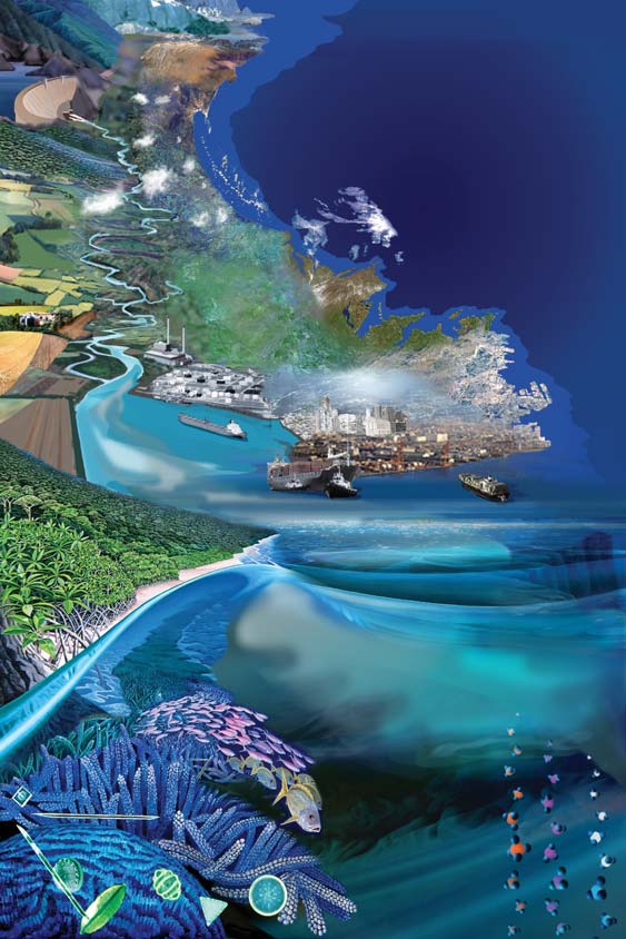


Land-Ocean Interactions in the Coastal Zone
INPRINT
Key topics identified for implementation of LOICZ future research ¡ The broad scientific
frame given by the LOICZ Science Plan articulates the breadth and diversity of issues and
problems that exist in the coastal zone for which society looks to science to provide solu-
tions. LOICZ has identified 5 scientific themes that represent a continuum of science
research that is needed to address these issues/problems. To help facilitate the imple-
mentation of LOICZ, the project has focused on some key topics to which all of the themes
outlined in the science plan are pertinent. Read all about it on page 15.
Contents
LOICZ IPO
at Institute for Coastal Research,
GKSS Research Centre
3
Dynamics and change of beach
erosion, accretion and nourishment
in Rio Grande do Sul, Brazil
14
Key topics identified for implementation
of LOICZ future research
15
News from the LOICZ Regional Nodes
17
LOICZ at the Earth System Science
Partnership Global Environmental
Change Open Science Conference,
9¡12 November 2006, Beijing, China
18
The backbone of LOICZ:
affiliated projects &
call for research proposals
19
What's on the wwweb, Publications
and Have you seen
20
Calendar
23
www.loicz.org
2006/1
LOICZ PEOPLE
LOICZ Scientific Steering Committee
Yoshiki Saito ¡ Japan
Geological Survey of Japan, AIST
Dennis P. Swaney ¡ USA
Jozef M. Pacyna(Chair) ¡ Norway
Department of Ecology and Evolutionary Biology
Center for Ecological Economics (CEE)
Cornell University
Norwegian Institute for Air Research NILU
Nalin Wikramanayake ¡ Sri Lanka
Felino P. Lansigan (Vice-chair) ¡ Philippines
Department of Civil Engineering
University of the Philippines Los Banos (UPLB)
Open University of Sri Lanka
School of Environmental Science and Management
(SESAM) and Institute of Statistics (INSTAT)
William C. Dennison ¡ USA
LOICZ Regional IPO Nodes
University of Maryland
Center for Environmental Science
South Asia Regional Node ¡ Sri Lanka
Nalin Wikramanayake ¡ tomwiks@yahoo.com
Anthony "Ticky" Forbes ¡ South Africa
www.nsf.ac.lk/loicz
Marine & Estuarine Research
Biomonitoring, Research and Environmental management
European Regional Node ¡ Germany
G÷tz Fl÷ser ¡ floeser@gkss.de
Juan D. Restrepo ¡ Colombia
http://coast.gkss.de/loicz
Department of Geological Sciences
EAFIT University
Southeast & East Asia Regional Node ¡ Singapore
Beverly Goh ¡ bgoh@nie.edu.sg
John Parslow ¡ Australia
CSIRO Marine and Atmospheric Research
Eva Roth ¡ Denmark
LOICZ IPO
Department of Environmental and Business Economics
University of Southern Denmark
Hartwig H. Kremer ¡ Chief executive officer
Alice Newton ¡ Portugal
Faculty of Science and Technology
University of Algarve
Martin Le Tissier ¡ Projects and workshops
Alison Gilbert ¡ Netherlands
Hester Whyte ¡ Office manager and communica-
Institute for Environmental Studies (IVM)
tions
Free University Amsterdam
Bernhard Glaeser ¡ Germany
Maike Paul ¡ Project assistant
Social Science Research Center Berlin (WZB)
For full contact details of the SSC members,
Weigen Huang ¡ China
Regional IPO Nodes and LOICZ IPO staff please go
Second Institute of Oceanography
to www.loicz.org
State Oceanic Administration
Isao Koike ¡ Japan
Ocean Research Institute, University of Tokyo
Address updates and subscription
Laurence Mee ¡ UK
For address updates and subscription to the LOICZ
Marine Institute
newsletter please contact the IPO at
University of Plymouth
loicz.ipo@loicz.org.
Stephen B. Olsen ¡ USA
If you want to receive the newsletter electronically or
Coastal Resources Center
if you wish to unsubscribe please let us know.
Graduate School of Oceanography
University of Rhode Island
This newsletter is also available online at
www.loicz.org
Nancy N. Rabalais ¡ USA
LUMCON ¡ Louisiana Universities Marine
2
INPRINT
2006/1
LOICZ IPO at Institute for Coastal Research,
This work is part of the MARCOPOLI Research Pro-
GKSS Research Centre
gramme, which is being implemented under the
auspices of the "Earth and Environment" research field
Since the beginning of this year, the LOICZ IPO is housed
of the Helmholtz Association. Here, GKSS is working
in the Institute for Coastal Research at GKSS, Geesthacht,
closely on coastal issues with the Alfred Wegener
Germany. To give you an impression of our new hosting
Institute (AWI). We enter into such partnerships with
institute the following information will give a brief intro-
other research centres to improve our understanding of
duction on the Institute for Coastal Research, the
the earth system. The IfK focuses on the vulnerability of
departments within the institute and the research that is
coastal environments within the context of global
carried out by the several research groups. For more de-
tailed information please also visit www.gkss.de.
change. Key issues in the IfK's investigation include the
following:
Knowledge and understanding ¡ the Institute for Coastal
¡ How does global change affect coastal regions?
Research
¡ What is the present state of the coast and how is it
Coastal systems are under constant pressure from short
changing?
and long term natural influences, including erosion or sea
level rise due to climate change, and from human en-
¡ How can we monitor reliably and cost-effectively the
deavours, for example, transportation, land use patterns,
state of the coast and control coastal processes?
tourism, etc. As a means to identify the potential for
change, sustainability, and adaptation coastal research
Answers to these questions should create a scientific
provides the tools, assessments and scenarios for man-
basis to assess observed environmental changes with
aging this vulnerable landscape.
respect to their future consequences, and to identify an
intelligent and sustainable usage of ecosystems by hu-
The Institute for Coastal Research (IfK) was formed in
mans.
2001. It is divided into two sections, "System Analysis
and Modeling" (KS) and "Development of Operational
On the national level the IfK belongs to the German
Systems" (KO). Research activities span both the natural
Marine Research Consortium (KDM). On the interna-
and human dimensions of coastal dynamics, analysing
tional level it participates in the Land-Ocean Interactions
the coastal system in global and regional contexts, con-
in the Coastal Zone (LOICZ) project.
ducting assessments of the state and sensitivity of the
coastal system to natural and human influences and de-
veloping scenarios of future coastal options.
The research
The move of the LOICZ IPO to GKSS provides opportunity
At the GKSS Research Centre in Geesthacht near Hamburg,
for close collaboration between LOICZ and researchers
150 employees of the Institute for Coastal Research (IfK)
of the Coastal Institute who are engaged in a wide range
investigate the scientific foundations of sustainable
of projects many of which share much in common with
coastal management.
the questions and science direction articulated in the
LOICZ Science Plan. The following series of articles serve
to illustrate the range of current science activity engaged
by the scientists of the GKSS Coastal Institute.
The series of articles starts with an article that reflects on
the background of modelling in the context of mecha-
nisms for coastal management. This is followed by a
series of articles that look at programmes within the
Coastal Institute with a focus on measuring and observa-
tion of coastal parameters. Work is on-going looking at
tools for continual coastal and shelf observation and
monitoring including, remote sensing, surface/atmos-
phere interactions; pollution; bio-toxins in the context of
global change and health.
As well as being relevant for LOICZ science, many of
these research programmes are also relevant and con-
tribute to the wider ESSP science such as ecosystem,
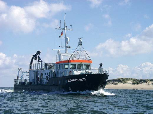
The GKSS research vessel Ludwig Prandtl was designed specifically for
use in shallow coastal waters.
society and health.
3
Social Science and Coastal Management,
a noun, the collective body of those who manage or di-
Mechanisms and Models
rect, those skills necessary for "stimulating broad
debate". Management and control are not within the
Dennis Bray
typical scope of science. The focus of science should
Department of Modelling for the Assessment of Coastal Systems (KSS)
emphasize the study of ICZMech and the subsequent
e-mail: dennis.bray@gkss.de
development of ICZMod, to be presented as ICZMan
The EU defines integrated coastal zone management as
tools.
"... a continuous process with the general aim of imple-
menting sustainable development in coastal zones and
As an analytical concept "the coast" can be defined ac-
maintaining their diversity. To this end, it aims, by more
cording to its specific properties: geo-physical specificity;
efficient management, to establish and maintain opti-
ecological specificity; existing and potential resources;
mum (sustainable) levels of use, development and activity
and the interaction of these with humans, in the forms of
in coastal zones, and eventually to improve the state of
dwellers, visitors and users. These could be referred to
the coastal environment.".
as analytical coastal segments. The human segment, for
(http://europa.eu.int/comm/environment/iczm/pdf/themf_ex.pdf)
the purpose of disciplinary based analysis, can be further
divided into the sub-segments of economy and society.
Among the problems facing coastal zones, the EU
The interaction amongst and between all segments con-
Communication (COM(95)511) lists the following:
stitute mechanisms.
,,demographic pressure, re-
Most coastal research has
duction of biodiversity,
tended to focus on biologi-
pollution of water resour-
cal and physical systems in
ces, the impoverishment
isolation from human influ-
of the landscape, competi-
ence, or has considered
tion for space and resour-
humans and their activities
ces, and the complexity
as external perturbations
of relationships between
to the functioning of bio-
human activities and the
physical systems. Most
coastal environment."
social science research on
coastal systems has fo-
The Communication
cused on social, economic
(COM(95)511) suggests ad-
and political systems in iso-
dressing these problems in
lation from the bio-physical
two ways:
context or, at best, consid-
"providing concrete techni-
ered the coastal environ-
cal information about factors
ment as a mere back-
and mechanisms which ei-
ground for the functioning
ther encourage or discourage
of the social system.
sustainable management
Furthermore, coastal re-
of coastal zones [...] evalu-
search, be it descriptive or
ated in a wide range of
statistical, often only demon-
physical, cultural and socio-
strates that a relationship is
economic conditions."
likely to exist, but provide
no clue as to why this is
This short discussion ad-
likely to be the case indicat-
dresses Integrated Coastal
ing a failure to stipulate
Zone Management (here-
the mechanisms linking the
after ICZMan), Integrated
explanans and the ex-
Coastal Zone Mechanisms
planandum (The explan-
(hereafter ICZMech) and
andum is the event or phe-
Integrated Coastal Zone
nomenon or thing which is
Models (hereafter ICZMod).
supposed to be explained.
Figure 1: Example of Decision Maker Model Interface.
It proposes that ICZMan is
The explanans is the series
an inappropriate conceptual reference for the undertaking
of statements which is supposed to do the actual explain-
of scientific activities. Definition of management include
ing). The mechanism must be specified so as to provide an
management as a verb, which refers to the act of admin-
acceptable explanation if we wish to understand why we
istration or controlling, or the application of skills in the
observe what we observe. What the social sciences
manipulation, use or control of things or persons; and as
should be able to contribute to coastal analysis is a sys-
4
INPRINT
2006/1
tematic explanation of the social mechanisms that gen-
user friendly interactive model format, the ICZMod (see
erate and explain observed associations between
Figure 1). Models, for ICZMan should be constructed so
humans and the coast.
as to be modular in design allowing for modification as
new knowledge become available or new interests be-
What have most often been offered are conceptual or
come the focus. The philosophy behind such a model is
sensitizing schemes that lack in explanation and explana-
to construct a tool that is easily useable by decision mak-
tory theory. To rectify this tendency and to provide a
ers and to provide an easy assessment of the results of
useful social science contribution to our understanding
the decisions they might make, advancing an integrated
of human interaction with coastal regions it would be
understanding of the coastal segments, and the spatial,
beneficial to turn investigation towards an analysis of
temporal and decision making components of coastal
mechanisms, not suggesting a mere description that ac-
change.
counts for a chain of events leading from one situation to
another, but rather that there is an ensemble of mecha-
References
nisms that are time and context specific.
Bunge, M. 1967. Scientific Research. Vol. 3 in Studies of the
Foundations, Methodology and Philosophy of Science. Berlin:
Bunge (1967) provides a simple schematic that demon-
Springer Verlag.
strates mechanisms. Observations are made of a system-
atic, non-random relationship between two events, 1 and 0.
European Union. EU Communication (COM(95)511)
The link between the two events is expressed as a mech-
Hedstr÷m, Peter and Peter Swedberg (eds.) 1998. Social
anism M.
Mechanisms: An Analytical Approach to Social Theory (Studies
in Rationality and Social Change). Cambridge University Press.
1 M 0
This explanation is characterized by the link between input
and output. This is often precisely the missing link in
coastal research. According to Hedstr÷m and Swedberg
Remote Sensing of Coastal Waters and tidal flats
(1998) typically, M is assumed to be devoid of structure,
Roland Doerffer
or the structure is assumed to be of no inherent interest,
Department of Remote Sensing (KOF)
possibly because it cannot be easily observed, measured
e-mail: roland.doerffer@gkss.de
or calculated, or perhaps because 0 can be predicted
without consideration for M. Yet, it is precisely at M
Monitoring of coastal zones has become an important
where management takes place. Typically, M is a human
task for environmental science and coastal zone man-
component, i.e. subsidies, prohibitions, market, etc. In
agement. Due to the high temporal and spatial variability,
the tradition of statistical causal modelling, M, the ex-
and limited available resources, scientists and adminis-
planatory mechanism, is simply a statistical coefficient
trators are looking for remote sensing techniques to both
linking 1 and 0, and this coefficient is supposed to de-
reduce effort and increase information flow. However,
scribe the causal influence.
the development of optical remote sensing techniques
for coastal waters such as those of the southern shallow
Management to bring about change, however, is about
part of the North Sea is a big challenge. Due to its complex
the actions and behaviours of people, not coefficients.
composition of substances with different optical proper-
Management needs to address a deeper problem: how
ties special algorithms are required not only for the
(i.e. through what process) was this brought about and
retrieval of their concentrations but also for correction of
through what process could it be changed? It is neces-
the influence of the atmosphere.
sary not only to describe the magnitude of occurrence
but also to explain why this is likely to occur. A satisfac-
The optical remote sensing laboratory at the GKSS
tory explanation requires that those things that brought
Institute for Coastal Research is working on this problem,
the relationship into existence be specified. Oddly
principally in conjunction with the Medium Resolution
enough, this is the component often missing in the natu-
Imaging Spectrometer MERIS operated on board the
ral science of coastal-environmental issues, while the
earth observing satellite ENVISAT of the European Space
social science contributions have been devoid of input
Agency ESA, and for which our group is part of the
and output, resulting in an inexplicit discursive analysis of
Expert Support Laboratory and the validation team.
process. Essentially then, a mechanism is part of an an-
swer to a question about why something occurs, the
MERIS is a unique instrument that was developed to
equivalent of the mathematical operations of the func-
meet not only the requirements for blue water remote
tion transforming variables, distinguished on the basis of
sensing but also for those of turbid coastal waters. With
functional form and parameter values.
a spatial resolution of 300 meters, a revisit period of 2¡3
days and its 15 narrow spectral bands with a high radio-
After identifying the mechanisms, for the purpose of
metric performance it fulfills the needs for coastal water
management use, it is applicable to present them in a
remote sensing.
5
The development of proper retrieval algorithms requires
what the remote sensor sees: the light spectrum re-
expertise from various disciplines, so our group of 10¡14
flected from the coastal sea. These simulations in turn
people includes physicists, geophysicists, biologists,
are computed to train an artificial neural network that is
geographer and instrumental and chemical engineers.
used to solve the inverse problem, i.e. to determine the
concentrations or optical properties from the reflectance
Over the past years we have been working on measuring
spectrum.
the inherent optical properties, i. e. the absorption and
scattering spectra of various substances, on modeling ra-
One important issue is that the reliability of remote sens-
diative transport in the water, at the surface and in the
ing data of coastal waters is not constant over the
atmosphere, and on solving the inverse problem, i.e. to
scanned area, but may vary from pixel to pixel. However,
derive the concentrations of different substances from
information about the error or confidence range is not
the reflectance spectrum as measured by the remote
properly communicated to the user of remotely sensed
sensor. The derived algorithms have been implemented
data. Presently only a system of different flags indicates
in the MERIS data processor at ESA.
when data are suspicious and should be treated with
caution for various reasons. For the future we will try to
improve this kind of information by providing confidence
maps along with the product so that the user can better
decide when he can accept the data with a certain error
for his application.
One major application, besides monitoring water quality
variables, is the determination of primary production in
coastal waters. In turbid areas, available light is often the
main limitation for primary production by phytoplankton.
Since the turbidity is mainly controlled by the distribution
of suspended matter, remote sensing can provide some
key information to determine primary production in such
areas. For this purpose we have developed a model that
integrates remotely sensed fields of light attenuation of
Figure 1: A cast is being prepared to take water samples and to make
phytoplankton concentration, water temperature and
measurements of optical properties of phytoplankton and suspended
water depth together with measured P-I curves to map
matter in the North Sea.
the distribution of daily water column production.
For measuring optical properties of the atmosphere we
have set up an automatic sun photometer station on the
Another important task of our group is the development
island of Helgoland. It is part of the worldwide AERONET
and application of monitoring techniques for tidal flats.
(Aerosol Robotic Network), which is coordinated by
With an area of more than 10 000 km2 the Wadden Sea
NASA. The data of this instrument are the basis for set-
with its tidal flats is an unique ecosystem, which has
ting up a proper atmospheric correction procedure.
been protected in form of a National Park. It is the birth-
Other optical instruments are used in water from a re-
place for many marine organisms and a key refuge for
search vessel, such as a profiler for measuring vertical
millions of migrating birds. During the past years we
transects of downwelling irradiance and upwelling radi-
have been mainly engaged in establishing a map of the
ance spectra. Another set of spectrometers is used for
sensitivity of the German Wadden Sea against oil pollu-
determining water leaving (backscattered sunlight) radi-
tion. The German coastguard requires preparation of
ance reflectance spectra, and in situ instruments are
such a map for protection measures in case of a ship ac-
integrated into a water sampling frame to measure the
cident. By combining remote sensing and extensive
absorption and backscattering properties of different
ground work, a system of new GIS maps have been cre-
water constituents. Along with these optical measure-
ated showing the sensitivity distribution as derived from
ments, we run a chemical laboratory to analyze the
some twenty variables per point for different seasons.
phytoplankton pigments and the concentration and com-
position of suspended particles, as well as the absorption
New technologies for tidal flat monitoring were also de-
spectra of humic organic compounds.
veloped in the EU funded project HIMOM. With partners
from the Netherlands, UK, Ireland and Portugal, a hier-
All these data are used primarily for setting up bio-optical
archy of methods were compiled and tested. All
models, which describe the relationship between water
techniques are documented in protocols together with
constituents and the absorption and scattering of light,
tutorials and the results of case studies along with an
and to validate remote sensing data. These models are
atlas showing the properties of different tidal flat areas in
then used in radiative transfer calculations to simulate
Europe.
6
INPRINT
2006/1
One technical result was a video based multispectral
Existing observations mostly lack the spatial coverage
camera system (MUVI Multispectral Video Imager),
and temporal resolution required to determine the state
which is operated from light aircrafts such as a Cessna
of the marine environment and changes therein. The lack
172. Based on measurements of reflectance spectra of
of monitoring systems that provide continuous observa-
different tidal flat objects such as sandy and muddy sed-
tions of the marine environment in the coastal areas and
iments, sea grass and benthic diatoms, the cameras
shelf seas of Europe is a serious hindrance to understand
were equipped with different interference filters to
these systems.
match the spectral properties of these targets. The ad-
vantage of such a system is that it can be prepared and
In the "FerryBox-Project" supported by the European
operated on short notice whenever low tide and weather
Union and coordinated by GKSS eleven groups worked
conditions permit a flight. Good results can be achieved
together in order to enhance the use of Ships of
also when flying under a homogeneous cloud cover.
Opportunity (SoO) for operational monitoring of the ma-
rine environment (Petersen et al., 2006a). SoO on regular
routes offer a cheap and reliable measuring platform to
obtain continuous and spatial high resolution observa-
tions of near surface water parameters. Such systems
are able to measure a whole set of oceanographic and bi-
ological parameter. The principal design of the FerryBox
developed by GKSS and now also commercially available
by a German company (4H-Jena) is shown in Figure 1.
Figure 2: Distribution of macro alga (in red) in a tidal flat area derived
from the MUVI (airborne MUlti spectral Video Imager).
For the future, remote sensing has to be combined with
other observational techniques and models to utilize the
synergy of different methods. One example is to combine
Figure 1: Schematically view of the FerryBox flow-through system.
with the FerryBox System that provides detailed infor-
mation along a transect with a high temporal resolution
The FerryBox continuously measures oceanographic
of variables which cannot be monitored using remote
parameters (temperature, salinity, turbidity) as well as
sensing.
bio-chemical variables such as chlorophyll-a fluores-
cence, nutrient and oxygen and pH. The main features of
the system are the modular concept which is easily ex-
pandable for other sensors, the debubbling device for
Monitoring of Coastal and Shelf Sea Ecosystems by
removal of air-bubbles and its self-cleaning feature. The
in-situ FerryBox Observations
latter ensures long-term stability and accuracy of the sys-
tem by preventing biofouling. Controlled by GPS position
Wilhelm Petersen and Friedhelm Schroeder
the FerryBox automatically stops before reaching the
Department of In Situ Measurements (KOI)
e-mail: wilhelm.petersen@gkss.de and friedhelm.schroeder@gkss.de
harbour and the flow-through system will be flushed with
acidified tap-water in order to clean the tubes and probes.
Monitoring of highly dynamic systems such as coastal
waters requires dense sampling in space and time in order
As an example of the results of the FerryBox measure-
to catch short-term events which might have a strong
ments along one transect the development of the algal
impact on the coastal ecosystem, such as exceptional
bloom in spring 2005 detected by chlorophyll-a fluores-
phytoplankton blooms or changes caused by storms.
cence, oxygen and pH of the FerryBox is shown (Figure 2).
7
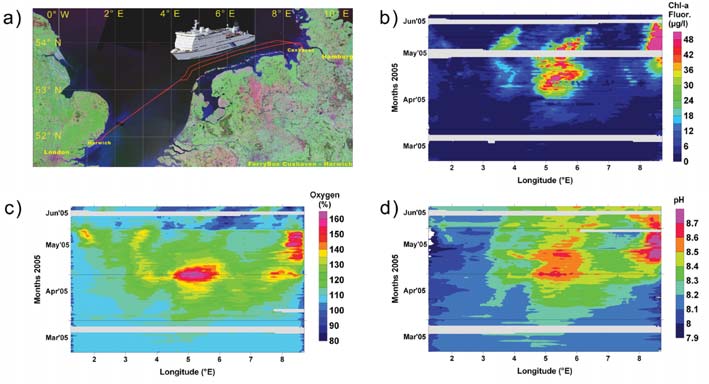
A weak spring bloom started in late March off the Dutch
coast (between 5.5░E and 6.5 ░E).
coast (4.5¡6.2 ░E). The bloom in the water mass reaching
Consistent with the algal blooms are the observed pH
the ferry transect from the English Channel between
data along the transect as shown in Figure 2d. The pH
3.2░E and 4.2░E initiated at mid of April and lasted until
increases significantly along the Dutch coast during the
June with a drift to the Dutch coast.
plankton bloom in May and pH values up to 8.8 have
been found
Figure 2:
along the
a) Route of the
German coast in
FerryBox in the
water masses
Southern North Sea;
Contour plots along
influenced by the
the transect from
Elbe estuary (8 ¡
March to June 2005,
8.7 ░E).
b) in-vivo chlorophyll-a
fluorescence,
The restriction of
c) oxygen saturation,
FerryBox data to
d) pH.
the transect can
be overcome for
those variables
which can also
A second bloom
be observed by
appeared later in
satellites (e.g.
water masses that
temperature,
reached the ferry
chlorophyll, tur-
transect from the English Channel between 3.2░E and
bidity, yellow sub- stances). Thus, the spatial distribution
4.2░E. It started in mid-April and continued until June
of the blooms at the locations observed by the FerryBox
with a drift to the Dutch coast. Both blooms disappeared
in 2005 can be extracted from remote sensing images
at the end of May and at the beginning of June 2005, re-
and compared to the data of the FerryBox (Petersen et
spectively. A further intensive bloom was observed in
al., 2006b).
the German Bight off the Elbe estuary starting in May
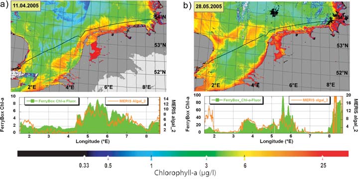
Figure 3 shows the distribution of derived chlorophyll-a
and disappearing mid-June 2005. This bloom was char-
acterised by very high chlorophyll concentrations.
concentrations by MERIS on 11th of April and on 28th of
In Figure 2c the dynamics of the oxygen saturation val-
May. In addition to each image the comparison of the
ues along the transect are shown. The major patterns of
MERIS chlorophyll-a concen- trations along the track of
chlorophyll fluorescence correspond well with the oxygen
the ferry with the FerryBox chlorophyll-a fluorescence are
dynamics. However, at certain times and on certain parts
shown. The FerryBox positions were drift corrected for
of the transect
the time the
high oxygen satu-
satellite passed
ration can be
the North Sea by
seen without cor-
a numerical hy-
responding high
drodynamic
chlorophyll val-
model (BSH).
ues. In particular,
this was the case
Figure 3:
at the German
Calibrated infrared
coast near the
surface temperature.
Elbe estuary
Photo taken from
(7.5░E¡8.4░E) at
the Tornado aircraft
over a small part of
the end of April
the LITFASS area on
until beginning of
June 17, 2003.
May and near
(Picture by J. Bange,
the English coast
TU Braunschweig)
between 1░E and
2░E at the end of May. Most likely, these findings are
In general the comparisons showed a good agreement
caused by primary production from algae below the water
of main features between remote sensed data and
intake of the ferry and diffusion of the produced oxygen
FerryBox measurements. Some drawbacks are visible.
towards the surface. At the beginning of June the algal
For instance, at higher turbidities (English coast and Elbe
break down was accompanied by oxygen depletion with
Estuary) the estimated chlorophyll concentrations from
saturation values of only 80 % along the eastern Dutch
the satellite image are too high. The algorithms used to
8
INPRINT
2006/1
produce the remote sensed standard coastal data are not
sensible heat flux over a heterogeneous land surface is a
yet tuned to their optimum and the quality flags of the
major issue of the Evaporation at Grid and Pixel Scale
satellite images (e.g. disturbances by glint etc.) were not
project EVA-GRIPS. EVA-GRIPS is funded under cluster 3
obeyed.
"Regional Process Studies in the Baltic Sea Area (BALTEX)"
of the current Climate Research Programme (DEKLIM)
The results obtained in this investigation show that the
of the German Federal Ministry of Education and
combination of FerryBox data along a transect with satellite
Research. The spatial scale considered in EVA-GRIPS
observations increases the information value compared
corresponds to the grid scale of a regional atmospheric
with the use of either of the two individual information
NWP or climate model (here in particular the "Lokal-
sources. By using FerryBox systems on more lines cross-
Modell", LM, of the Deutscher Wetterdienst, DWD, and
ing the area of interest on different tracks the information
the model REMO of the BALTIMOS group), but also to
density about the water quality could be significantly im-
the pixel scale of currently available satellite images.
proved. In addition, by including the information about
Through a combination of near-surface and boundary
many other water quality parameters measured by the
layer observations, the analysis of satellite data and nu-
FerryBox (e.g. nutrients etc.) a much deeper insight in
merical simulations EVA-GRIPS aims at testing and
the processes controlling the water quality of coastal wa-
implementing concepts for the description of area-aver-
ters can be obtained.
aged turbulent fluxes into land surface schemes namely
TERRA (Majewski, 1991) and TOPLATS (Beven and
Since both methods used in this investigation are re-
Kirkby, 1979) as part of LM, SEWAB (Mengelkamp et al.,
stricted to the water surface conventional monitoring
1999) as part of an hydrological model and the land sur-
methods by buoys and research vessels are still neces-
face scheme of REMO.
sary at strategic locations. This will be necessary, for
instance, to get information about change of water con-
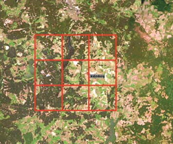
Experiment and modelling activities focus on an area of
stituents within the depth profile.
roughly 20 x 20 km2 around the Meteorological Obser-
vatory Lindenberg (MOL) of DWD. The continuous meas-
urement program of the MOL ¡ a CEOP reference site
References
(Beyrich, 2003) ¡ formed the basis for a major field ex-
Petersen, W.; Colijn, F.; Dunning, J.; Hydes, D. J.; Kaitala, S.;
periment (the LITFASS-2003 experiment) in May and
Kontoyiannis, H.; Lavin, A. M.; Lips, I.; Howarth, M.J.;
June, 2003.
Ridderinkhof, H., Pfeiffer, K.; S°rensen, K. (2006a): European
FerryBox Project: From Online Oceanographic Measurements
to Environmental Information. Proceedings Forth International
Conference on EuroGOOS, Elseverier Oceanography
Publication series, Amsterdam, Netherlands, in press
Petersen, W.; Wehde, H.; Krasemann, H.; Colijn, F.; Schroeder,
Figure 1:
F. (2006b): FerryBox and MERIS ¡ Assessment of Coastal and
Arial view of the ex-
Shelf Sea Ecosystems by Combining In-situ and Remote
perimental site and
Sensed Data. Submitted to Estuarine Coastal and Shelf
LM grid boxes.
Science.
(Photo taken from
CD "Deutschland
aus dem All" 1997,
Herold Business
Data AG)
Current Research in the Department of
Hydrometeorology
Eddy correlation instruments were placed at 13 sites over
different land use types and vertical profiles in the bound-
Heinz-Theo Mengelkamp
ary layer were sampled by lidar and radar. A set of
Department of Hydrometeorology (KSH)
e-mail: heinz-theo.mengelkamp@gkss.de
scintillometers, a helicopter borne turbulence probe Helipod
(Bange et al., 1999) and an infrared camera for surface pho-
Coastal areas represent a significant change in surface
tography on board a Tornado aircraft as well as satellite
conditions. The representation of surface-atmosphere
images completed the set of instruments. The spatial sam-
exchange processes in weather forecast and climate
pling and footprint scales of this suite of measurement
models influences the simulation of mesoscale coastal
systems covered five orders of magnitude (10-1..104 m for
circulations. The investigation of turbulent exchange
the sampling scale) and three orders of magnitude
processes at the land surface through field experiments
(101..104 m for the footprint scale), respectively.
and numerical studies is a major focus of the depart-
ment.
Pronounced differences in surface characteristics (e.g.
surface temperature) can be found over the different
The determination of the area-averaged evaporation and
types of land use in the LITFASS area (Figures 2 and 3).
9
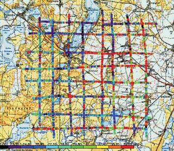
Figure 2:
ences (Figure 4). Area averages of grid-size represent-
Regional distribution
ative fluxes will be derived from the surface observations
of surface tempera-
over various land use types by a suitable averaging strat-
ture in the LITFASS
area meas- ured by
egy and will be compared to the fluxes determined from
the Helipod during a
area-averaging measurement systems (Helipod, scintil-
grid flight pattern on
lometers, lidar-radar combination).
June 17, 2003.
(Picture by J. Bange,
TU Braunschweig)
Participants in EVA-GRIPS:
À GKSS-Forschungszentrum Geesthacht GmbH,
À Deutscher Wetterdienst (DWD) ¡ Meteorologisches
Observatorium Lindenberg (MOL),
À Meteorologisches Institut der Universitõt Bonn,
À Institut f³r Geophysik und Meteorologie der Universitõt
Figure 3:
K÷ln,
Calibrated infrared
À Technische Universitõt Dresden, Institut f³r Hydrologie,
surface tempera-
À Universitõt Hannover, Institut f³r Meteorologie und
ture. Photo taken
Klimatologie,
from the Tornado air-
craft over a small
À Universitõt Bayreuth, Abteilung Mikrometeorologie,
part of the LITFASS
À Technische Universitõt Braunschweig, Institut f³r Luft-
area on June 17,
und Raumfahrtsysteme,
2003.
À Max-Planck-Institut f³r Meteorologie, Hamburg,
(Picture by J. Bange,
TU Braunschweig)
À University of Wageningen, The Netherlands.
References
Bange, J. and R. Roth, 1999: Helicopter-borne flux measure-
ments in the nocturnal boundary layer over land ¡ a case study.
Boundary-Layer Meteorol. 92, pp. 295¡325
These differences in land use and surface characteristics
Beven, K. J., 1997: Distributed hydrological modelling, applica-
result in significant evaporation differences both in nu-
tions of the TOPMODEL concept. Adv. Hydrol. Proc., Wiley &
Sons, pp. 348
merical models and estimates from satellite data. The
direct intercomparison of LM results and NOAA images
Beyrich, F., 2003: Lindenberg: One of the BALTEX reference
sites for CEOP. BALTEX-Newsletter 5, pp. 5¡8
does not only reveal spatial patterns due to surface het-
erogeneity but also differences in magnitude and in the
Majewski, D.,1991. The Europa Modell of the Deutscher
spatial distribution of evaporation which have to be in-
Wetterdienst,. ECMWF Seminar Proceedings on Numerical
Methods in Atmospheric Models, 16¡18 Sept. 1991, VOL. II.,
vestigated in detail.
pp. 147¡190
EVA-GRIPS will therefore combine model and satellite
Mengelkamp, H.-T., K. Warrach, E. Raschke, 1999: SEWAB ¡ a
data with in-situ measurements to finally analyse the rep-
parameterization of the surface energy and water balance for
resentativeness and validity of the evaporation para-
atmospheric and hydrologic models, Adv. Water Res, 23, 2
meterisation in atmospheric models.
Occurence and air/sea-exchange of novel organic
pollutants in the coastal and marine environment
Ralf Ebinghaus
Department of Environmental Chemistry (KSC)
e-mail: ralf.ebinghaus@gkss.de
The pressure on coastal and marine ecosystems caused
by anthropogenic substances is subject to short-term
and long-term alteration due to changes in industrial
production pathways, environmental awareness and leg-
islation, consumer demands and the development of
Figure 4: Diurnal cycle of latent heat flux over various land use types
for June 7, 2003. (Figure by M. Mauder, University of Bayreuth, includ-
novel chemicals. The joint application of sophisticated
ing data by GKSS, DWD and TU Braunschweig)
numerical models and analytical measurement tech-
niques enables assessment of the present state and
Locally measured water vapour fluxes over different
future scenarios for hazardous chemicals in the coastal
types of land use were found to show significant differ-
and marine environment.
10

INPRINT
2006/1
The Department for Environmental Chemistry focuses on
(FTOHs) are possible precursors of PFOS and PFOA,
novel organic pollutants that are of future concern for the
being neutral and volatile, therefore having the potential
coastal and marine environment because of their
for long-range atmospheric transport. High-volume air
À persistence, bioaccumulation and toxicity (pbt-sub-
sampling and determination by GC-CI-MS has been de-
stances) and/or
veloped, including full method validation. The method is
À endocrine disrupting potential.
presently applied to air samples taken during two cruises
of RV Polarstern to the Northeast Atlantic and the
For the latter group a number of studies have been car-
European Arctic (ARK-XX/1 & 2) and during the Atlantic
ried out in different compartments of the North Sea
transfer from Bremerhaven, Germany to Cape Town,
using ship-borne air and water samples.
South Africa (ANT-XXIII/1). Results will be available soon.
Figure 1:
The application of advanced numerical models to simu-
Ship-borne air-sampling.
late the atmospheric transport and fate of POPs is
another essential tool for estimating the risk these sub-
Concentrations of
stances display to humans and ecosystems. Computer
alkylphenols (namely:
models, once validated, can be used to assess the effect
tertiary-octylphenol,
that different emission or climate scenarios can have on
nonylphenol and ) were
concentrations of POPs in the air or their depositions to
determined in North Sea
the ground and possible enrichment in certain areas. In
water and were found
this way, they allow for validating the impact of past and
to be three orders of
future regulatory measures such as banning or reducing
magnitude lower than
certain substances and, thus, serve as a decision support
those determined in
tool for regulatory authorities. Instead of building a model
the River Elbe, Rhine
from scratch the Department for Environmental Chemistry
and their estuaries.
has adapted the well established US-EPA Community
Concentration gradients
Multiscale Air Quality modelling System (CMAQ) to han-
from the coast-line to
dle semivolatile POPs like polycyclic aromatic hydro-
the central North Sea
carbons (PAHs) over Europe at different temporal and
indicated that rivers are the main input sources for this
spatial resolutions. PAHs are of particular concern for
group of endocrine disruptors (Xie et al., 2006). Atmos-
coastal ecosystems because they arise from, among
pheric concentrations over the North Sea were in the
others, fuel combustion in ship engines. Ship traffic in
lower ng/m-3 range and comparable to those found in
the North Sea follows mainly the coast line. It is likely to
rural areas of Southeastern Germany.
increase within the coming decades and is highly variable
For phthalates, another group of substances with en-
in terms of engine type and fuel qualities used. Thus,
docrine disrupting potential, it was shown that the
PAH emissions from ship traffic suggests the construc-
atmosphere is an important input pathway into the North
tion of different emission scenarios and the application of
Sea (Xie et al., 2005). The air-sea exchange is significant
an advanced air quality modelling system to assess the
and the modelled net fluxes based on measurement data
adverse effects the ship traffic in the North Sea can have
indicate that the North Sea, the open sea and even polar
on its coastal ecosystems. Currently, model runs of
areas will be extensive sinks for phthalates. Since phtha-
Benzo(a)Pyrene (B(a)P) ¡ one of the most harmful PAHs ¡
lates are continually produced and consumed in huge
for 2001 are being carried out and the results are com-
amounts worldwide and since they tend to become par-
pared to ground measurements, where available, for a
titioned within the suspended matter fraction after atmos-
first validation of the model. The first results are promis-
pheric deposition (slowing down photo- or biodegradation
ing so that we will shortly carry out simulations for a
processes), they are supposed to be a relatively persistent
longer time period to assess a trend in PAH concentra-
form of marine pollution (Xie et al., 2005).
tions and depositions.
(Figures 2 and 3 on page 12.)
Present field research activities are very much related to
polyfluorinated organic compounds (PFCs) that are of
References
growing concern due to their extremely high persistence
and potential for bioaccumulation. PFCs represent a di-
Zhiyong Xie; Ebinghaus, R.; Temme, C.; Caba, A.; Ruck, W.
(2005): Atmospheric concentrations and air-sea exchange of
verse class of chemicals produced in large amounts
phthalates in the North Sea (German Bight), Atmospheric
since the 1950's. Perfluorooctane sulfonate (PFOS) and
Environment, 39, 3209¡3219
perfluorooctanoic acid (PFOA) have been determined
Xie, Z., Lakaschus, S.; Ebinghaus, R.; Caba, A.; Ruck, W. (2006):
in remote marine and polar ecosystems although they
Atmospheric concentrations and air-sea exchange of nonylphe-
are almost non-volatile and hardly water-soluble. Per-
nol, tertiary octylphenol and nonylphenol monoethoxylate in
fluorooctane sulfonamides and fluorotelomer alcohols
the North Sea, Environmental Pollution, on-line available
11

The integration and close collaboration of areas of expert-
ise, such as Chemistry, Biology, Ecology and Veterinary
Medicine within our department allows us to determine
not only the concentrations of anthropogenic substances,
but also to investigate the functional significance of both
anthropogenic and natural substances in coastal ecosys-
tems. The focus is on the molecular and biochemical
processes in the course of coastal ecosystem function,
its status and causes of change. Current research areas
are:
À marine toxins from micro algae and jelly fish, which can
synthesize and discharge a cocktail of poorly or even
uncharacterized substances. They can damage micro-
bial associations and cause ecological imbalances in
marine habitats,
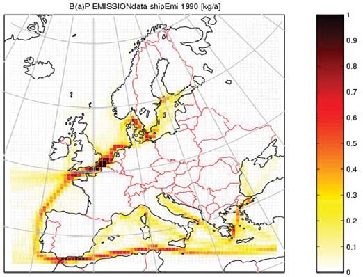
Figure 2: B(a)P Emissions from ship traffic within Europe in kg/y. The
À biochemical indicators of immune-modulatoric processes
reference year is 1990.
for early diagnosis of the health status of marine mam-
mals, such as harbour seals and harbour porpoises.
Marine mammals are top predators in the marine food
web and may serve as indicators of ecosystem status
and change.
Species under investigation represent groups of organ-
isms of regional relevance in temperate coastal zones,
such as the North Sea.
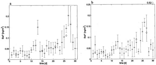
Figure 3: Comparison of daily mean atmospheric concentrations cal-
culated from simulations (asterisks) with available measured daily
means (rhombs) in September 2001 at Bornhoeved, DE (a) and
Zarrentin, DE (b). The error bars show the standard deviation of the cal-
culated means with n = 24.
Chemical interactions: ecological function and
effects
Andreas Prange
Department for Marine Bioanalytical Chemistry,
Institute for Coastal Research, GKSS Research Centre
Max-Planck-Str. 1, 21502 Geesthacht, Germany
e-mail: andreas.prange@gkss.de
Figure 1: For the harbour seals (Phoca vitulina) in the North Sea, a rela-
Current research activities in the department for
tion between the metal load (white bar = concentration in blood) and
metal-specific proliferation of the immune cells (black points = in-
Marine Bioanalytical Chemistry are an integral part of
creased irregular proliferation) has been observed for example for the
the Topic "Coastal Dynamics and Causes of Change" of
element nickel. The increased proliferation indicates a hypersensitivity
the MARCOPOLI Programme within the research field
with respect to nickel and suggests an immunomodulation induced by
the metal. (Foto: Antje Kakuschke, GKSS)
"Earth and Environment" of the Helmholtz Association of
German National Research Centres (HGF). The mission of
our department is to determine the nature, extent and
The habitats that comprise the Coastal zones as treas-
function of chemical interactions in coastal ecosystems,
ured habitats are characterized as regions of high
including the cause and effect relationships between
productivity, sustaining both high biomass and biodiver-
naturally occurring bioactive compounds or anthro-
sity. This in turn yields a multitude of natural compounds
pogenic trace substances, respectively, and marine
involved in critical inter and intra-specific responses such
organisms. The present investigations form the basis for
as prey and predator relationships. However, anthro-
future effect-orientated monitoring tasks with respect to
pogenic stressors, such as hazardous substances can
Ecosystem Health.
adversely affect marine organisms, species interactions,
12
INPRINT
2006/1
and ecosystem functions via acute toxicity or sub-lethal
structure. To date, two different Cyanea species col-
inhibitory effects on immune systems. Key questions in
lected at the Scottish Orkney Islands and the Hebrides
this context are:
are under investigation. They are being compared to
those collected around the Island of Helgoland in the
À How do natural and anthropogenic compounds interact
German Bight, a more anthropogenically influenced area.
with and influence coastal biota?
The cytoxic and hemolytic activities of the venoms from the
À What tools and methods are required for functional
toxigenic organs, the oral arms and the fishing tentacles
diagnostics of the coastal ecosystem?
are being determined. A multidimensional purification
process has been developed in order to isolate and char-
À What are the consequences of the propagation of toxic
acterize the causative toxins. The Research on their
chemicals in the food web on ecosystem function and
mode of action is being accomplished with the help of
the health of humans and marine mammals?
purified compounds and finally their ecological functions
will be revealeddisclosed.
Figure 2:
The research on marine toxins is being performed in
The toxic cnidaria
close collaboration with the Marine Ecological Chemistry
e.g. Jellyfish con-
tain specialized cell
Group at the Alfred Wegener Institute in Bremerhaven
organelles (cnido-
and Helgoland.
cysts) as functional
units. The Raster
Electron Microscopic
The second research topic of our department concerns
picture shows two
the health status of marine mammals. Harbour seals
discharged cnido-
(Phoca vitulina) represent one important biological pa-
cysts. Cnidocysts
contain a cocktail of
rameter of the Trilateral Monitoring and Assessment
different toxins,
Program (TMAP) in the Wadden Sea within which their
which play an im-
health status is of particularinterest.
portant role for prey
capture and de-
fense. The toxin
The focus of the research is on the immune system of
mixture is purified
the animals as an early indicator of anthropogenic influ-
by liquid chromato-
ences. Important parameters of the investigations are
graphy and protein-
aceous toxins can
the lymphocyte function, and the cytokine expression as
be detected and cha-
well as parameters of the acute phase reaction. With
racterized by mass
special particular regard to the influence of pollutants, we
spectrometry as demonstrated by the protein ion spectrum (A) of a
42kDa protein as example.
have started with investigations on the immunosuppres-
(Foto: Michael Gedde AWI, Heike Helmholz, GKSS)
sive and stimulating effects of metals. First results show
clear evidence for metal-specific hypersensitivity in free-
With regard to marine toxins, the objects of investigation
living animals and suggest a relationship between levels
are marine protists, such as Alexandrium spec.p. and
of metals in the blood and immunological dysfunction in
Prymnesium spec.p., which are prominent representa-
marine mammals.
tives in algal blooms in the North Sea. These are known
to be potent producers of lytic and ichthyotoxic, probably
The influence of organic pollutants on marine mammals
small molecular weight toxins. Unidentified substances
is being investigated with the help of primary cell cul-
with proven ecological effects on competing micro-algae
tures obtained from tissue samples of seals (Phoca
are being isolated and chemically and functionally char-
vitulina), which are then exposed to relevant pollutants,
acterized.
such as PCBs and PCDDs. Protein expression profiling of
samples from these incubation experiments should iden-
In contrast to the unicellular protists, higher organisms
tify up and down-regulated proteins as potential bio-
such as cnidarians, e.g. the Lions Mane jellyfish Cyanea
markers. The proteins or protein sequences identified
specp., have developed highly specific release mecha-
and characterized should contribute to the development
nisms for complex, toxic venoms. With the help of this
of effect monitoring on the influence of pollutants on ma-
potent toxin cocktail they exhibit successful foraging be-
rine mammals.
haviour and a proven stinging capacity. Proteinaceous
toxins with lytic and electrophysiological cellular effects
The research on marine mammals is being performed in
are expected to be found.
close collaboration with the Ecology of Birds and
Mammals Group at the Research and Technology Centre
The substances of interest are separated from their natural
in B³sum as well as with the Seals' Station in
matrix and are characterized according to their chemical
Friedrichskoog.
13
Dynamics and change of beach erosion, accretion
alignment implying that there is a block in the longshore
and nourishment in Rio Grande do Sul, Brazil
transport (Toldo et al., 2004). These descriptions indicate
a coupling between the net longshore balance and the
Luiz R. S. Martins and ElÝrio E. Toldo Jr.
spatial change on the shoreface. Analyses of satellite im-
CECO-UFRGS, CP.15001, 91509.900 Porto Alegre RS, Brazil,
ages in this area reveal the presence of short-term
e-mail: luiz.martins@ufrgs.br and toldo@ufrgs.br
coastal current circulations overtopping the shoreface
that has not been studied in detail before, but suggests
Introduction
that in some instances this current can lead to more sus-
A study on erosion and accretion along the coastline of
pended sediment diffusion outward from the surf zone.
the Rio Grande do Sul (southern Brazil, Figure 1) was de-
A strong alongshelf jet characterizes this coastal current
veloped in liaison with mapping of sand deposits
(Figure 3). The occurrence and evolution of this jet is
occurring in the adjacent inner continental shelf. The
closely related to the passage of cold fronts, which are
beach line established by DGPS in 1997 was compared
formed early in the winter.
with that reproduced from Brazilian Army Charts collec-
tion from 1965/1966. The temporal analysis among these
studies was accomplished through geoprocessing tech-
niques.
The results of these 33 years of temporal analysis (1964¡
1997), show that the beach line is characterized by ero-
sive and accretionary conditions, showing 442 km of
beaches in retreation, 173 km under progradation condi-
tions and 6 km without significant variations. The erosive
processes with rates larger than 80 m extends for 257 km,
while the accretional areas present smaller values.
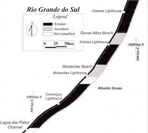
Figure 1:
Location of the study area
in southern Brazil.
Figure 2:
Map of the central coast of Rio
Grande do Sul showing the
general pattern of erosion and
accretion areas (modified from
Results
Toldo et al., 1999).
To illustrate erosional and depo-
sitional aspects of the coast-
Final Remarks
line, results from the area be-
tween Lagoa dos Patos inlet
The serious problems of erosion registered along the
to Cidreira beach are presented. The shoreface topography
southern Brazilian and Uruguay coastlines, stimulated a
of the central coast of Rio Grande do Sul consists of a
detailed study of sand occurrence from the area for
broad area of smooth bottom surface with mean slopes
beach nourishment along the inner continental shelf.
of 1:100. The 10 m isobath was used as the shoreface
There sand deposits must be close enough to the eroded
seaward limit as presented in the Brazilian Navy bathy-
beach, to be economically viable and have a mean grain-
metric map. The mean shoreface width changes from
size compatible with the replenishment area. Beach
less than 1 km along the coast with erosion process and
nourishment usually is not a permanent answer for the
3 km along the accretion areas at Mostardas and Dunas
restoration of beaches and sometimes represents a
Altas beach (Figure 2). Measurement of changes in
short-term solution, requiring repeated renourishment.
shoreline position and beach system morphology show
However, the method is useful to restore beach profiles.
extensive shore retreat along areas where there is an in-
Agencies like the Coastal Engineering Research Center ¡
crease of the longshore flux energy, e. g., where the
CERC, Mineral Management Service ¡ MMS (USA) and
shoreline alignment is more exposed to the southerly
others prefer this approach to solve coastal erosion prob-
wave action. The resultant energy flux into the surf zone
lems, rather than by conventional man-made structures.
and related longshore transport decreases to the north,
from 2.9 million m3/yr-1 south at Mostardas beach to 2.3
In the present study area, research on sand resources of
million m3/year between Mostardas and Dunas Altas
the inner continental shelf was developed with the pur-
beach, and 1.5 million m3/yr-1 to the north of Dunas Altas
pose of a) to map areas with occurrence of quartzose
beach (Fig. 2). Along the central coast a reduction in
sand and bioclastic sand down to a limit of the 30 meters
transport flux is evident due to changes in the shoreline
isobath, using a detailed analysis of the seismic sono-
14
INPRINT
2006/1
graphic and bathymetric profiles, geological cores and
Impacts must be eliminated or minimized through care-
surface samples, and b) to indicate the main potential tar-
ful planning, environmental impact assessment to avoid
get areas in terms of sand concentration with physical
ecologically sensitive areas and maintaining monitoring
and chemical requirements for beach nourishment. Four
programmes for both seafloor and water the column.
lithofacies were identified based on sediment character-
ization by grain-size, mineralogy, special framework and
Acknowledgments
energy level of the environment of deposition. Of these,
two were deemed to have the highest potential source
This research was sponsored by
for beach nourishment ¡ quartzose sand and quartzose
CNPq and OEA-CECO/IG/UFRGS Project.
sand with carbonate shell fragments. Another area of
bioclastic gravel and sand were considered as a resource
References
itself.
Martins LR, Martins IR, Wolf IM. 1999. Sand Deposits along Rio
Grande do Sul (Brazil) Inner Continental Shelf. In: Martins, L.R.
and Santana, C.I. (eds.). Non Living Resources of the Southern
Brazilian Coastal Zone and Continental Margin. Editora CECO-
IG-UFRGS, pp. 26¡38.
Toldo Jr. EE, Almeida LES, Barros C, Martins LR. 1999. Retreat
of the Rio Grande do Sul coastal zone, Brazil. In: Martins, L.R.
and Santana, C.I. (eds.). Non Living Resources of the Southern
Brazilian Coastal Zone and Continental Margin. Editora CECO-
IG-UFRGS, pp. 62¡68.
Toldo Jr. EE, Nicolodi JL, Almeida LESB, CorrÛa ICS, Esteves
LS. 2004. Coastal Dunes and Shoreface Width as a Function of
Longshore Transport. Journal of Coastal Research, SI 39
(Proceedings of the 8th International Coastal Symposium),
ItajaÝ, SC ¡ Brazil.
LOICZ News
Key topics identified for implementation of LOICZ
future research
The broad scientific frame given by the LOICZ Science
Plan articulates the breadth and diversity of issues and
problems that exist in the coastal zone for which society
looks to science to provide solutions. LOICZ has identi-
fied 5 scientific themes (see back page) that represent a
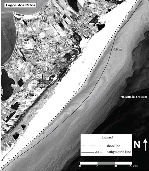
Figure 3: Satellite image highlighting dynamics and changes in the
continuum of science research that is needed to address
shoreline alignment in Mostardas beach and the presence of alongshelf
jet and shoreface accretion. This image focuses on an episodic event in
these issues/problems. To help facilitate the implemen-
May 20th 2000, at that time the characteristics of the circulation pattern
tation of LOICZ, the project has focused on some key
over the shoreface consisted of the northward alongshelf current in-
topics to which all of the themes outlined in the science
tensified by the south and southeast winds and a wide plume
clockwise-rotating gyre (Toldo et al., 2004).
plan are pertinent.
Each topics forms a cohesive science question that can
run within and between the themes and have been iden-
The sediments were analyzed and interpreted according
tified to provide the scientific frame in which LOICZ aims
to the late Quaternary paleogeographic evolution of the
to be value adding to individual research projects as well
continental margin and the modern hydraulic conditions
as to broader scale initiatives and organisations. The topics
actually found from the beach to the 30 meter isobath.
are:
Studies were conducted in the area potentially suitable
À What are the implications of ecological and economic
for beach nourishment. An amount of 9.6 billions of cubic
change for patterns of land and sea use?
meters of sand for beach replenishment was mapped
along this portion of the inner continental shelf (Martins
À What are the effects of changes to the flows of fresh-
et al., 1999). The impact from dredging of the sand must
water and materials to estuaries and shelf seas?
be analyzed in terms of circulation of the continental
À How can comparative analysis inform the improve-
shelf, as well as in terms of economic and touristic activ-
ment of the governance of human activities in changing
ities such as fishing and considering the local biota.
coastal ecosystems?
15
LOICZ will engage in these topic areas through the fol-
ural environment, and similarly large numbers of models
lowing operational mechanisms:
dealing with human social systems. However, there have
À Clustering existing or proposed scientific research
been very few attempts to couple them together into a
activities on local, national regional and global scale pri-
single socio-ecological system that consider the system to
marily through the network of affiliated projects.
consist of an assemblage of interdependent life forms ¡
including humans ¡ and their non-living habitats and re-
À Designing and implementing targeted or open scien-
source base, the integrity of which is highly dependent
tific workshops and congresses to work on a specific
upon human decisions.
question or a subset of those along the LOICZ scien-
A number of conceptual models have been employed to
tific priorities.
describe coupled socio-ecological systems, but such an
À Designing and promoting targeted LOICZ research
interrelated and interdependent system poses a major
activities.
challenge to the modeller who is always forced into mak-
À Encouraging and promoting as well as co sponsoring,
ing some assumptions in order to understand the
scientific synthesis.
system. This leads to models with a large range of com-
plexity, from the huge mechanistic models used by many
À Dissemination, and communication, capacity building
natural scientists to the probabilistic formulations em-
and training.
ployed to describe human decision making (e.g. game
theory) or "market mechanisms". It is the difference be-
A more detailed outline of each of the three topics follows:
tween the approaches taken by humans observing
nature and humans observing humans that make it diffi-
cult to model socio-ecological systems.
Work within this topic will focus on:
Conceptual modelling
LOICZ will explore how models can incorporate dynamic
interpretations of data and source empirical data to pop-
ulate models.
Quantitative models
Mechanistic or stochastic models operate at various
different scales and levels of complexity and this topic
will explore how scale affects system properties require-
ments for data as well as mixed methodology
approaches to accommodate the entire scale of sys-
tems.
Scenario-building and decision support models
One of the most exciting challenges for system models
is to gain insights on the likely future state of the marine
environment through their application in various eco-
nomic and social scenarios.
The objective of the topic is to gain insights on the likely
future state of the marine environment in various eco-
nomic and social scenarios.
Topic 2:
Topic 1:
What are the effects of changes to the flow of freshwater
What are the implications of ecological and economic
and materials to estuaries and shelf seas?
change for patterns of land and sea use?
This topic encapsulates much of the content of themes 3
This topic encapsulates much of the content of Themes
and 4 of the LOICZ science plan,
1, 2 and 5 of the LOICZ science plan. The ecosystem ap-
1. examining the changes in loads associated with
proach (underlying "ecosystem based management')
human activities in coastal watersheds as well as
regards humans to be an integral part of current natural
other human-induced effects, and
systems. There are large numbers of deterministic and
2. examining the response of coastal and shelf ecosys-
stochastic models that examine various facets of the nat-
tems to these changes.
16
INPRINT
2006/1
To the extent that we can extend or develop LOICZ ap-
News from the LOICZ Regional Nodes
proaches to apply to coastal governance, activities under
this topic will also address theme 5 of the LOICZ science
The first major activity of the LOICZ SEasia/Asia Regional
plan.
Node shall commence this 2006 with the project entitled
Integrated vulnerability assessment of coastal areas in the
Runoff, groundwater flows, nutrient and sediment loads
Southeast and East Asian region (IVA-SE/EAsia).
are all affected by human activity and especially human-
induced changes in climate and landuse. These may be
The project was one of 27 proposals short-listed for fund-
addressed using a variety of relatively simple analytical
ing at the 2nd stage of the APN's 2005 Annual Regional
tools, including nutrient accounting approaches and
Call for Proposals (ARCP) Process. Only 30 % of the
short-listed proposals were eventually selected to re-
large-scale hydrologically based models. Several activi-
ceive funding support from APN in 2006/2007.
ties are proposed to extend existing approaches either
geographically or methodologically, to permit estimation
The focus of the project shall be on:
of nutrient loads, their uncertainty and variation.
À Capacity building: Training of regional scientists, analy-
The response of coastal and shelf systems has been ad-
ses and synthesis workshops, meetings; and
dressed in LOICZ I by estimating the metabolism of
À Data acquisition and research for qualifying countries.
coastal and shelf ecosystems using the LOICZ budget
methodology. This methodology will be refined and ex-
With the overall goal to:
tended under LOICZ II, and specifically in an attempt to
address issues of coastal sustainability and governance.
À Determine vulnerability gradients across the coastal
areas of the SEA-EA region considering the coupled
The use of additional modeling approaches will be evalu-
human and ecological systems;
ated to determine whether such approaches are more
À Understand multi-scale dimensions and inputs on the
appropriate to address particular coastal management
adaptive capacities of human communities toward the
questions.
vulnerability of coasts, of conflicts and competition
over lands, sea areas, and resources in the region; and
Topic 3:
À Determine efficient and effective strategies to link
GEC research results with policy making, governance
How can comparative analysis inform the improvement of
and conflict resolution.
the governance of human activities in changing coastal
ecosystems?
This project is spearheaded as a collaborative effort
This question integrates across the five themes of the
of the Marine Science Institute, University of the
LOICZ Science Program. It addresses the primary goal of
Philippines at Diliman (L. David), the Institute of
LOICZ II: "to provide knowledge, understanding and pre-
Statistics, INSTAT & The School of Environmental
diction to allow coastal communities to assess,
Science and Management SESAM, University of the
anticipate and respond to the interaction of global change
Philippines at Los Ba±os (F. Lansigan), the Southeast
and local pressures in determining coastal change". A
Asian START Regional Centre, Chulalongkorn University
coastal community is defined to include policy makers,
(A. Snidvongs & A. Pomsagun) and SEA LOICZ II Node
managers and stakeholders. The term "coastal eco-
(c/o Natural Sciences and Science Education, National
systems" embraces large marine ecosystems (LMEs),
Institute of Education, Nanyang Technological University)
coasts and their associated watersheds.
(B. Goh).
The approach will be to select sites for an analysis of suc-
Another proposal that has been successful in getting
cess factors in bridging between ecosystem science and
funded by APN is of LOICZ SSC member and co-ordinator
governance. The analysis will focus upon successes and
of the South Asia Regional Node in Sri Lanka, Nalin
failures in instigating the changes in human behaviour
Wikramanayake,entitled:
(institutions, markets and civil society) that mark the im-
plementation of a coastal ecosystem management
Implementation of the LOICZ II Science Plan through
initiative. In all cases the analysis will examine coastal
Regional and National Workshops, Synthesis and Policy
governance within the context of the next larger system ¡
Assessment, Gap-filling Studies, Capacity Building and
a watershed, a Large Marine Ecosystem or geographic
Networking in the South Asian Region
region. The analysis will address three central questions:
The goal is to support the implementation of the LOICZ II
1. How are overviews of ecosystem condition being
Science Plan in the South Asian region by the established
developed and trends being communicated?
Regional Node of LOICZ. The overall thrust of the activi-
2. How can coastal ecosystem governance initiatives
ties is to assess current policies using the LOICZ
affect the behavior of societies more effectively?
framework, support integrated, interdisciplinary studies,
3. What are the resulting outcomes and how can we
assess the policy and management implications and
improve upon them?
communicate them to planners and decision-makers
17
using a regional network and regional and national work-
and plan out activities of mutual interest pertaining to the
shops. Supplementary funds to integrate on-going
global water system and the coastal zones. These topics
research, regional gap-filling studies and capacity build-
include (1) governance of freshwater and the coastal sys-
ing are integral components of the project.
tems, (2) saltwater intrusion in coastal aquifers, (3)
environmental flows of freshwater and estuarine sys-
For more information on these projects please visit the
tems, (4) effects and impacts of river diversions, growth
APN website http://www.apn-gcr.org or get in touch with
of megacities, and climate change on the coastal pro-
the LOICZ Regional Nodes.
cesses, and (5) characterizing large scale nutrient cycles,
among others. The session aims to define strategies and
to initiate the development of collaborative studies and
partnership among interested researchers and research
LOICZ at the Earth System Science Partnership
groups in the scientific community as well as the re-
Global Environmental Change Open Science
source managers and institutions involved in freshwater
Conference, 9¡12 November 2006, Beijing, China
and coastal regions/systems.
At the ESSP OSC there will be a strong LOICZ presence
through joint sessions and a special session. The call for
NOAA/WCRP/IOC/LOICZ:
abstracts has already passed but here below a short
Sea-level Rise, Vulnerability and Impact
overview of the sessions and their contents. For regis-
Sea-level rise and variability is a global issue impacted by
tration and more information on these and other
the breadth of the Earth sciences ¡ including not just
sessions in the ESSP OSM visit the conference web-site:
changes within the oceans, but also the ice caps and gla-
www.essp.org/ESSP2006/
ciers, terrestrial water storage, and land movement. At
the same time, sea-level rise and variability is an issue
Joint sessions:
that cuts across the full disciplinary scope of the Earth
sciences in the global coastal regions ¡ and challenges
GECHS/ LOICZ/ UGECH:
the research community to truly integrate a focus on
Global Environmental Change, Natural Disasters,
coastal people, infrastructure, ecosystems and their
Vulnerability and their Implications for Human Security
goods and services. This special session will feature re-
in Coastal Urban Areas
sults from the WCRP/COPES workshop (June 2006),
The catastrophic events that have affected societies
"Understanding Sea-level Rise and Variability". Factors
around the world in recent years underscore the close
contributing to observed sea level rise and variability, and
linkages between global environmental change, human
the error budget for each, will be identified, as well as the
security and urbanization, as well as the marginal attention
associated requirements for new and/or augmented re-
to multidimensional perspectives capable of providing
search, technical developments, and the collection of
comprehensive and integrated approaches to better un-
sustained, systematic observations needed to reduce
derstand those events and the alternatives to adapt and
the associated uncertainties. The special session will
minimize their negative consequences.
also address consequences of present uncertainties in
In response to these challenges, three IHDP projects,
sea-level rise and variability and expected impact scenar-
Global Environmental Change and Human Security
ios, to be facilitated by LOICZ. Through global and
(GECHS), Land Ocean Interactions in Coastal Zones
regional synthesis and initial modeling efforts including
(LOICZ), and Urbanization and Global Environmental
the examination of case studies, it will look at global
Change (UGECH) are jointly organizing a panel for the
change factors that determine vulnerability of the socio-
ESSP Open Science Conference. The panel focuses on
ecological coastal systems and ways for adaptation and
Global Environmental Change, Natural Disasters, Vulner-
new responses to avoid and/or mitigate impact of sea
ability and their Implications for Human Security in Coastal
level rise on our coasts.
Urban Areas. Rather than presenting research results of
projects on natural disasters, panelists are invited to re-
LOICZ Special Session at ESSP:
flect on the interactions between biophysical and social
variables of global environmental change that lead to
Young scientists in LOICZ Projects
risks for human security in coastal urban areas from mul-
LOICZ will be hosting a special workshop session at the
tidimensional perspectives.
ESSP conference. The details of the workshop are still
being organised but there will be a focus on participation
of Young scientists and exploring opportunities for Young
GWSP/LOICZ:
scientists to become involved in LOICZ projects. Anyone
Coastal zone ¡ global water system interfaces
interested in taking part in this workshop should contact
Global Water System Project (GWSP) and LOICZ are jointly
the LOICZ IPO (loicz.ipo@loicz.org) to be kept informed
organizing a session to provide a forum to discuss topics
of developments.
18
INPRINT
2006/1
Call for research proposals concerned with
The backbone of LOICZ: affiliated projects
Land-Ocean Interactions in the Coastal Zone
LOICZ has a mandate to address key issues of
As described earlier in this issue, LOICZ has devel-
coastal change and use in the context of scenar-
oped three key topics that will form the focus of
ios of future human activity and environmental
research interest in the coming years. Within all three
change. LOICZ endorses and seeks to support
topics, LOICZ seeks to expand its network of scientists
both fundamental coastal zone research and re-
by endorsing research activities concerned with any of
these topics on a global, regional or national level.
search that synthesises and up-scales results for
Within these topics LOICZ strives to develop:
dissemination within the scientific community,
and outreach to policy makers and the public.
À methodologies or models that allow data assimila-
tion, processing and synthesis, including up and/or
down scaling;
This research is partly carried out by groups of
scientists, aided and supported by the LOICZ
À scenarios of change and/or response to change in
IPO, Regional Nodes and/or SSC, with funds that
socio-ecological systems;
LOICZ has secured from external funding agen-
À scientific context for the evaluation of existing policies
cies. Another important part of the LOICZ project
and structures;
is carried out by researchers who affiliate their
À globally applicable tools for scientific synthesis,
projects to LOICZ thereby becoming part of the
decision support and structure development, and
global network of LOICZ. These projects build
À dissemination interfaces to provide information and
the backbone for up- and down-scaling of LOICZ
assist sustainable coastal development on appropriate
results and the LOICZ synthesis. LOICZ has re-
scales.
cently restructured the affiliation process so that
applications for affiliation will be reviewed by the
To achieve this, LOICZ is calling for proposals to bring
IPO and the coordinator of the theme/topic they
high quality research activities into the LOICZ cluster
of affiliated projects. As well as fundamental science
are contributing to most. This new procedure will
projects, we also seek projects that have a multidisci-
allow LOICZ to maintain an up-to-date record of
plinary perspective, especially combining natural and
global research activity as relates to the LOICZ
social sciences. Projects can have global, regional or
Science Plan as well as ensure that affiliated proj-
local scales and be focussed on coastal sciences
ects are given opportunity to fully participate in
and/or coastal management. Projects that collaborate
LOICZ activities such as workshops and joint
with other Earth System Science Partnership (ESSP)
projects.
projects, especially with other Core Projects of IHDP
and IGBP, are sought in particular, as well as projects
LOICZ provides a forum to assimilate, integrate
that synthesise and analyse research outcomes al-
and synthesise the outputs of affiliated projects.
ready available or involve dissemination and outreach
that will lead to better public knowledge. Examples of
Additionally, it provides an opportunity to com-
projects already affiliated to LOICZ can be found on
municate and disseminate these outputs making
the LOICZ website under Projects.
them available not only to other scientists, but
also the public, decision-makers and managers.
Although LOICZ cannot offer funding to affiliated proj-
Information on affiliated projects is held on a cen-
ects, its endorsement provides the following benefits:
tral database that will in the near future be made
À support in proposing for funding;
available on-line so that basic information and
À promotion of the project and associated activities, its
regular updates are available to the wider com-
contributing team, outputs and outcomes through
munity as well as to LOICZ for its own reporting
the LOICZ website and/or newsletter;
requirements.
À contribution to workshops, conferences and meet-
ings organised by LOICZ and hence establish link-
ages to other projects operating in similar fields
An essential element that applies for all LOICZ in-
and/or addressing similar issues; and
terdisciplinary studies within and beyond the
À access to a wide circle of information related to
project is data sharing and exchange. To facilitate
funding and the science community that is available
this exchange LOICZ has developed a Data
through the LOICZ database.
Policy to help affiliated projects and LOICZ to
fully benefit from each other. Both documents,
Researchers whose work fits into this LOICZ portfolio
are encouraged to submit proposals to the LOICZ IPO
the Terms of Reference for affiliated activities
as soon as possible. The required form and additional
and the Data Policy, can be found on the LOICZ
information can be obtained from the LOICZ website
website.
or via contacting the LOICZ IPO.
19
Coast Map News is back, all electronic and monthly with
What's on the wwweb
the same mission, providing news and articles about ma-
IGOS Coastal Theme Report is available for downloading at
rine and coastal data and information, but in a new, all
http://www.igospartners.org/Coastal.htm
electronic, format.
If you used to receive the paper version, or are a new sub-
School on coastal dynamics modelling
scriber, please send a blank e-mail to:
subscribe@coastmapnews.mailer1.net.
More information at:
http://lseet.univ-tln.fr/ecoleete/ecole25eng.html
IOP launches new open-access environmental science
The East Asian Seas (EAS) Congress 2006
journal
The Institute of Physics (IOP) proudly presents the world's first
http://pemsea.org/eascongress/participation_prereg.hm
open-access journal to cover the whole of environmental sci-
ence. Environmental Research Letters (ERL) will serve the
The ACCCA project website is now on-line:
entire environmental science community, bringing together the
www.acccaproject.org.
research, policy and business communities concerned with en-
Please visit the site to learn about the ACCCA project.
vironmental change and management. The journal will offer a
stimulating combination of research Letters, commentaries,
Newly revamped UNEP/GPA website
job and other advertisements, reviews and news items cover-
ing topics across the whole of environmental science.
www.gpa.unep.org/
All journal content will be completely free to read at
Find a wealth of information about the Global Programme of
http://erl.iop.org.
Action for the Protection of the Marine Environment from Land-
based Activities including: latest information and news about
the GPA Programmes, advanced search feature and a docu-
ments library.
Have you seen
The Researcher's Mobility Portal:
COST Open Call for Proposals to support Scientific and
http://europa.eu.int/eracareers/
Technical Collaboration in Europe
COST (European Co-operation in the Field of Scientific
Note that the freshwater BIODIVERSITY Science Plan
and Technical Research) is inviting researchers through-
and Implementation Strategy of is now online to be
out Europe to submit proposals for research networks.
downloaded at: www.diversitas-international.org
This open call invited researchers throughout Europe
to submit proposals for research networks and use
this unique opportunity to exchange knowledge and to
embark on new European perspectives. The proposals
Publications
are for new COST Actions contributing to the scientific,
economic, cultural or societal development of Europe.
Special COAST volume available
A first collection date for preliminary proposals is 31 May
17-paper COAST Special Section in the Journal of Geo-
2006.
physical Research.
This volume is available for purchase through COAST for $65. If
A two stage process will be followed to assess proposals.
you are interested in purchasing a copy please contact Pat
Preliminary Proposals should provide a brief overview of
Wheeler at pwheeler@coas.oregonstate.edu.
the proposal and its impact. A pre-selection will rank the
remaining Preliminary Proposals of which some 75 per
Rybski, D., A. Bunde, S. Havlin, and H. von Storch, 2006:
collection date will be invited to submit a Full Proposal.
Long-term persistence in climate and the detection
Details are available on the COST website:
problem
http://www.cost.esf.org/index.php?id=721
Geophys. Res. Lett. 33,
L06718, doi:10.1029/2005GL025591
Update us so we can update you
pdf available for download at:
http://w3g.gkss.de/staff/storch/pdf/rybski-etal.2006.pdf
LOICZ INPRINT informs you about the LOICZ Project
and its activities. But LOICZ has access to much more
LUCC Synthesis volume, Springer/IGBP series:
information and wants to make this information avail-
Land-Use and Land-Cover Change ¡ Local Processes
able to you as effectively as possible. To be able to pro-
and Global Impacts.
vide you with LOICZ information that fits your expert-
ise and interests most, we need input from your side
Lambin, Eric F.; Geist, Helmut J. (Eds.). 2006, XVIII, 222 p.,
telling us what your interests in LOICZ are and how
44 illus., 19 in colour, Hardcover. ISBN: 3-540-32201-9.
we can contact you. Please complete the form on the
http://www.springer.com/uk/home/generic/search/results?SG
next page.
WID=3-40109-22-126972716-0
20
INPRINT
2006/1
Update us so we can update you
Please complete the following form where applicable and return by fax, post or e-mail to the LOICZ IPO.
(An electronic version of this form can also be found on www.loicz.org under Newsletter.)
First name:
Last name:
Organization/Institution:
Address:
Place:
Postal code:
Phone (include country code):
Fax (include country code):
e-mail:
(Organization's) website:
Field of expertise:
Please indicate which LOICZ theme(s)* you are contributing to:
Theme 1
Theme 2
Theme 3
Theme 4
Theme 5
Please indicate which LOICZ key topic(s)** you are interested in:
Topic 1
Topic 2
Topic 3
other
How do you want to receive the LOICZ Newsletter in the future?
hardcopy
pdf-file via e-mail
e-mail alert
not at all
* The LOICZ Research Themes are listed on page 2 of INPRINT and more detailed information on the themes
is available in the Science Plan on the LOICZ website (www.loicz.org).
**Detailed descriptions of the topics are featured in this first issue of INPRINT.
Please return this form by:
À e-mail to loicz.ipo@loicz.org (electronic version on www.loicz.org)
À fax to +49(0)4152 87 2040
À mail to:
LOICZ IPO ¡ GKSS Research Centre
Institute for Coastal Research
Max-Planck-Strasse 1
D-21502 Geesthacht, Germany
21
22
INPRINT
2006/1
Call for Papers and Announcement:
Calendar
Remote Sensing of the Marine Environment (AE103)
LOICZ 17th SSC meeting, June 13 & 15, 2006,
Part of SPIE's Fifth International Symposium on Asia-
Geesthacht, Germany
Pacific Remote Sensing, November 13¡17, 2006, Marriott
Hotel, Panaji, Goa, India
LOICZ-GKSS joint Minisymposium ¡ Linkages between
Conference web site:
German Coastal Research and LOICZ, 14 June 2006,
http://spie.org/conferences/calls/06/ae/
Geesthacht, Germany
SPICE/LOICZ/SEACORM South-East Asia Coastal
NERC Earth Observation Conference 2006 Dynamic
Governance and Management Forum: Science Meets
Earth, June 21, 2006, Edinburgh, Great Britain
Policy for Coastal Management and Capacity
This conference aims to bring together scientists actively en-
Building, 14th¡16th November 2006, Bali, Indonesia.
gaged in research into environmental sciences using Earth
Observation, and to promote cross-disciplinary research.
Call for papers:
THEME: Biodynamics: Modelling and Observation of the
2006 Berlin Conference on the Human Dimensions of
Biosphere
Global Environmental Change: Resource Policies:
For further details please go to:
Effectiveness, Efficiency, and Equity. November
http://www.nerc.ac.uk/funding/earthobs/conference or
17¡18, 2006, Berlin, Germany.
http://www.geos.ed.ac.uk/research/eeo
http://web.fu-berlin.de/ffu/akumwelt/bc2006
Summerschool on Biodiversity and Ecosystem
The International Conference The Humboldt Current System:
Services: Ecological and Socio-economic Aspects,
Climate, ocean dynamics, ecosystem processes, and fish-
August 27 to September 8, 2006, Peyresq, Alpes-de-
eries
Haute-Provence, France. More information can be
organized by IMARPE (Peru), IRD (France) with the technical
found at: http://portal.pik-potsdam.de/education/alter-net
support of FAO and sponsored by CNES (France), CPPS,
GLOBEC, ICES/CIEM, IMBER, NASA (USA), PICES, SIMRAD,
Summer School on Biodiversity of Coastal Habitats,
will be held in Lima (Peru), November 27 to December 1, 2006.
September 6¡14, 2006, Island of Sylt, Germany and
Contact: hcsconference@amauta.rcp.net.pe or
September 14¡20, 2006, Island of Helgoland, Germany
http://irdal.ird.fr/hcs-conference.imarpe.fao.ird.php3
http://www.awibremerhaven.de/Benthic/CoastalEco/
Abstract submission deadline: June 10th, 2006
guests/summer-school_2006/first-announcement.htm
Young Scientist Network meeting, September 9¡10,
Arctic Frontiers Science conference on Food web dy-
2006, Mexico City, Mexico
namics and biogeochemical fluxes in the Arctic
Ocean. January 21¡26, 2007, Tromso, Norway.
organized by Analysis, Integration and Modeling of the Earth
www.arctic-frontiers.com
System (AIMES) project of the International Geosphere-Bio-
sphere Project (IGBP).
The meeting will focus on urbanization interactions with bio-
ERF 2007, November 4¡8, 2007, in Providence, Rhode
geochemistry and climate.
Island, USA. The Estuarine Research Federation is
For more information see
currently accepting proposals for scientific sessions
http://www.cgd.ucar.edu/tss/staff/mahowald/ysn
and workshops for this meeting.
http://www.erf.org/newsletter/Sp06-ERF07-CFS.html
5th International Human Dimensions Workshop 2006:
Institutional Dimensions of Global Environmental
Change: Water, Trade, and the Environment, October
For more meetings and regular updates please
13¡26, 2006, Chiang Mai, Thailand.
also visit the LOICZ website www.loicz.org
More information on http://www.ihdp.org
23


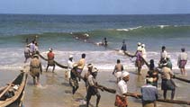
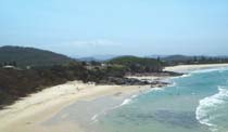
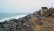
Publication details
LOICZ in brief
The LOICZ Newsletter is produced three times per
LOICZ aims to provide science that contributes
year to provide news and information regarding LOICZ
towards understanding the Earth system in order to
activities. The views and opinions in this newsletter do
inform, educate and contribute to the sustainability of
not necessarily represent the position of LOICZ or its
the world's coastal zone. LOICZ is a core project of the
sponsoring organizations.
International Geopsphere-Biospere Programme (IGBP)
and the International Human Dimensions Programme
on Global Environmental Change (IHDP).
Published and edited by:
The Land-Ocean Interactions in the Coastal Zone
The LOICZ IPO is hosted by the Institute of Coastal
International Project Office
Research at GKSS Research Centre which is part of
the Helmholtz foundation.
Design:
LOICZ research as outlined in the science plan and
Hester Whyte
implementation strategy is organised around five
themes:
Lay-out and print:
À Vulnerability of coastal systems and hazards to
GKSS-Hausdruckerei, Geesthacht, Germany
society
À Implications of global change for coastal eco-
Photographs and illustration:
systems and sustainable development
The illustration of the coastal zone on the front page is
À Human influences on river-basin-coastal zone inter-
made by artist Glynn Gorick, UK, 2005, and commis-
action
sioned by LOICZ/IGBP. The photographs on the front
and back page of this newsletter are copyright to
À Biogeochemical cycles of coastal and shelf waters
Martin Le Tissier.
À Towards coastal system sustainability by managing
Contact:
land-ocean interactions.
LOICZ IPO at GKSS Research Centre
Institute for Coastal Research
Max-Planck-Strasse 1
D-21502 Geesthacht, Germany
The Science Plan and Implementation Strategy is
phone: +49-4152-872009 À fax: +49-4152-872949
available electronically on the LOICZ website and in
e-mail: loicz.ipo@loicz.org À internet:www.loicz.org
hard copy from the LOICZ IPO.
Get involved
If you wish to contribute to LOICZ INPRINT please send an e-mail to: loicz.ipo@loicz.org and/or visit
the LOICZ website www.loicz.org for article requirements.
If you have a project you would like to affiliate to LOICZ please go to www.loicz.org and click on projects
for detailed information.