


Lakeside
Vol. 1 No. 4: 1999
The Quarterly Newsletter of the
Lake Tanganyika Biodiversity Project
UNDP/GEF/RAF/92/G32
Table of Contents -
Foreword
2
LTBP Visits Lake Malawi
3
Wrap-Up Conference
by Gaspard Ntakimazi &
Muderhwa Nshombo
Pollution in the Tanzanian
4
Waters of Lake Tanganyika
by Francis M. M. Chale
BIOSS Training in Taxonomy
5
by Alexis Bashonga
BIOSS Team Surveys Mahale
6
Mountains National Park
by Bakari Mnaya
LTBP's MTE & TPR: Summary 8
of Main Conclusions &
Recommendations
LTBP's MTE & TPR:
9
Project Co-ordinator's
Comments
by Andy Menz
LTBP's MTE & TPR:
9
UNOPS' Response
by Margaret Chi
Space - The Final Frontier:
10
The Role of GIS in LTBP
by Alan Mills
World Environment Day
12
in Burundi
by Cécile Gakima
LTBP News
13
Calendar of Progress &
14
Upcoming Events
`Pollution Control & Other Measures to Protect Biodiversity in Lake Tanganyika'
`Lutte contre la pollution et autres mesures pour
UNDP/GEF/RAF/92/G32
protéger la biodiversité du lac Tanganyika'

Foreword
Throughout the last months we have been busy analysing the report of the mid-term evaluation (MTE)
of LTBP. The report was carefully considered at all levels of the project, namely: the technical special
studies, the national working groups, the LTBP management consortium, the Steering Committee and
finally, the donors and executing agency. Representatives from all these groups met in Nairobi from 25-27
May 1999 for a Tripartite Review to discuss their findings. These discussions are summarised in this issue of
Lakeside, in reports from the Project Co-ordinator and UNOPS, together with a summary of the principle
recommendations from the MTE report that were accepted by the meeting.
Other articles in this issue deal with regional project activities, including: a report from the LTBP delegation
sent to Malawi to attend the wrap-up conference of the Lake Malawi/Niassa Biodiversity Project; the pollution
special study activities in Kigoma Bay; biodiversity special study activities carried out by a regional team,
including an intensive taxonomic training course and a survey of Mahale Mountains National Park in Tanzania;
news about the GIS which will be installed in the region in November, and finally, an account of Burundi's
efforts to commemorate World Environment Day.
Finally, please do not hesitate to forward articles for the next edition of Lakeside to the Project Co-ordination
Unit. We look forward to receiving your input!
-Andy Menz
Project Co-ordinator
This Newsletter is published by the Project Co-ordination Unit of the Lake Tanganyika Biodiversity Project
UNDP/GEF/RAF/92/G32
`'Pollution Control and Other Measures to Protect Biodiversity in Lake Tanganyika'
P. O. Box 1119, Bujumbura, Burundi
Tel: + 257 21.99.60
Fax: + 257 21.99.61
Email: ltbpbuja@cbinf.com
Internet: http://www.ltbp.org
Edited by the LTBP Project Co-ordination Unit
Layout & Design: Jerod Clabaugh
Translation: Pierre-Claver Nzimpora
The ideas represented herein do not necessarily represent those of the United Nations Development Programme or Global
Environmental Facility. The designations employed and the presentation of material in this newsletter do not imply the expression of
any opinion on the part of UNDP or GEF concerning the legal status of any country, territory, city or area, or concerning the determination
of its frontiers or borders.
2


LTBP Visits Lake Malawi for
within the riparian communities to promote conservation of the
Wrap-Up Conference
biological riches of the lake, in order to fight poverty and promote
tourism.
by Gaspard Ntakimazi and Muderhwa Nshombo
The scientific presentations that followed were grouped into five
themes:
A delegation from the Lake Tanganyika Biodiversity Systematics and Taxonomy of Fishes (8 presentations).
Project (LTBP) participated in a conference from 4-5
It was revealed that about 300 species of fish have been
March 1999 organised by its sister project on Lake
identified and studied to date, but that an enormous
Malawi/Nyassa. The delegation, led by Dr A. Menz, LTBP Co-
amount of work remains, as the lake is expected to host
ordinator, also included Dr K. West, LTBP Scientific Liaison
about 600 species.
Officer; Dr F. Chale, PSS Co-ordinator for Tanzania; Dr M.
Nshombo, BIOSS Co-ordinator for DR Congo; Dr G. Ntakimazi,
Ecology of Coastal and Benthic Fishes (4 presenta-
BIOSS Co-ordinator for Burundi; and Mr L. Mwape, PSS Co-
ordinator for Zambia.
tions). Current knowledge, again, covers only a limited
area ofthe lake and only the most common species in
Called Nyassa in Tanzania and Niasa in Mozambique, Lake
the captures. Much work remains to be done.
Malawi has its largest area in the country which bears its name.
Formed under similar conditions as Lake Tanganyika, i.e., as a
Education and Implication of Riparian Communities
part of the East African Rift, Lake Malawi is also a centre of
(4 presentations)
interest for both the riparian populations and the international
scientific community because of the extraordinary diversity of
Limnology and Water Quality (11 presentations).
its fauna.
Researchers from the Canadian Centre forInland
Waters conducted many of the studies in this theme.
The SADC/GEF Project for Conservation of Biodiversity in Lake
One result of particular interest was the noted change in
Malawi started in 1995 and ended in July 1999. Before winding
the composition of algal communities toward a less
up, the Project Management organised an international confer-
desirable species indicative of a reduction in water
ence on the present state of knowledge about the lake. This was
quality.
an opportunity to publicise project results and outputs and include
a larger group in the deliberations over future projects for Lake
Geography and GIS Applications (6 presentations).
Malawi.
This theme received most of its contributions from
researchers belonging to the Centre for Earth
Observation Science of Canada.
After the scientific presentations, the delegation from Lake
Tanganyika was able to visit the project laboratories, library,
and fish collections. The Biodiversity Conservation Project for
Lake Malawi has different objectives than those of our Lake
Tanganyika Project. While LTBP essentially aims at establishing
a regional programme for long term management of the lake by
formulating a legal framework and a Strategic Action Programme
(SAP) to conserve and maintain biodiversity in the lake, the Lake
Malawi Project has consisted mainly of carrying out scientific
research for a better knowledge of its resources.
Whereas LTBP contracts national institutions to execute work
programs, the majority of work in the Malawi project was
conducted by teams of expatriate researchers with African
Drs. Gaspard Ntakimazi, Kelly West, and Muderhwa Nshombo
counterparts. The African counterparts were receiving on-the-
at Senga Bay, Malawi
job training and in many cases conducting research for graduate
degrees.
After the opening ceremony chaired by the Malawian Minister
for Forests and Fisheries, the Project Co-ordinator, Mr Tony
In discussions on the objectives for a second phase of the Lake
Ribbink, presented an overview of Lake Malawi and the main
Malawi Project, it was noted that, similar to LTBP, they will
research activities carried out so far within the project.
move more towards targeting local stakeholders in the manage-
ment and conservation of the lake's resources.
Using varied means such as sampling surveys on the lake for
different studies, aerial observations, and remote sensing, the
Dr. Gaspard Ntakimazi is a professor of biology at the Univer-
project completed a tremendous amount of research, and
sity of Burundi. Dr. Muderhwa Nshombo is Directeur Général of
presented unique results in the fields of fish taxonomy and
the Centre de Recherche en Hydrobiologie at Uvira. They are
systematics, ecology of coastal and benthic fishes, and limnology
the National Co-ordinators for the Biodiversity Special Study in
and lake water quality. Activities were also undertaken in the
Burundi and Congo, respectively.
fields of `training and awareness' and environmental education
3


Pollution in the Tanzanian Waters of
annually between 1995 and 1997. Studies on bottom-dwelling
Lake Tanganyika
organisms in the dock area showed the presence of oil in the
sediments and, probably as a direct result of this, the absence of
live macro-invertebrates, such as snails, which are very sensitive
by Francis M. M. Chale
to oil pollution.
Pollution can be defined as the anthropogenically Power generation : For a long time, it has been observed that
accelerated inputs of plant nutrients, organic compo-
waste oil from the Tanzania Electricity Supply Company
nents of sewage, heavy metals, pesticides, and compounds
(TANESCO) has been flowing into the lake. It is not uncommon
likely to stem from oil exploitation and shipping. The LTBP
for a substantial oil slick to be seen covering extensive areas
Pollution special study sets out to identify the sources, trends,
including the town's water intake. In several areas, there are
and impacts of such inputs.
permanent pools of oil on the shore.
Owing to its large size and volume, one might not expect Lake
Human settlements : Kigoma town has a population of about
Tanganyika's water quality to be affected by human activities.
ninety thousand people. These people depend on the lake as a
However, the increasing pace of agricultural activities in the lake
source of domestic water, fishing and bathing. Also, for many
catchment, the tendency to cultivate on steep slopes bordering
people, Kigoma bay is used as a recipient of their domestic wastes
the lakeshore and the inflowing rivers, and the use of fertilisers
including sewage. The current levels of plant nutrients
and pesticides, all contribute to the deterioration of the lake's
(nitrogen and phosphorus) in the bay is higher compared to the
water quality. Shipping and industrial activities in the catchment
open waters. For example, nitrogen and phosphorus levels in the
also represent potential sources of pollution to the lake.
bay average 54 µg/l and 16 µg/l, respectively. In the open waters
Pollution studies in Tanzania have centered on Kigoma Bay. The
bay is shallow and on its eastern side are located ship docks, oil
storage facilities and an oil jetty. The TANESCO power plant is
situated on the south-western side of the bay. These industries
and others have been shown to be having a significant effect on
the water quality of Kigoma Bay.
Agro-chemicals : The amount of the agro-chemicals used in the
lake's catchment on the Tanzania side is little. Rukwa Region,
for example, used an average of 4963 tonnes of fertilisers
annually between the 1991/92 and 1996/97 growing seasons, 5.40
tonnes of pesticides and herbicides, and about 3160 litres of
chemicals,per year. Most of the chemicals (between 43% in 1991/
92 and 92% in 1996/97 growing seasons) were used in Mpanda
District which is not a part of the lake's catchment. Kigoma Re-
gion uses far less agro-chemicals than Rukwa Region. It can there-
Dr. Francis Chale preparing water samples for analysis at the
fore be safe to say that there is hardly any pollution in the lake
Kigoma Station, Tanzania
coming from agricultural run-off.
the levels for the two nutrients average 47 µg/l and 7.1 µg/l,
respectively. Similarly, plant biomass in the bay is higher (2.20
µg/l chlorophyll a) compared to the open water (1.59 µg/l
chlorophyll a). In the bay, the water is green, leading to a low
water transparency (average 4.54 m), while the open waters are
much more transparent (average 11.14 m).
From the above, it can be concluded that for the Tanzanian
coastline, agriculture currently poses little threat to Lake
Tanganyika. The only place which can be considered to be
polluted is Kigoma Bay, which is heavily impacted by oil, oil
by-products and domestic wastewater. The use of untreated water
from the bay may thus be considered a health hazard.
Dr. Francis Chale is the LTBP Pollution Special Studies Co-
Stanislaus Muhoza working with pollution samples
ordinator for Tanzania.
at the Kigoma Station, Tanzania
Shipping and Harbour oil spills : Kigoma town is at the terminus
of the Central rail line. It handles goods for Burundi and the
eastern part of the Democratic Republic of Congo. Mixed dry
cargo and oil products pass through the harbour. Between 1992
and 1997 there were an average of 345 ships and 556 wooden
boat rotations, respectively, per year. The amount of oil products
exported through the harbour averaged 18,520 cubic metres
4
BIOSS' Training in Taxonomy
by Alexis Bashonga
The Biodiversity Special Study (BIOSS) teams from the
four Tanganyika riparian countries participated in a
regional training course in fish and mollusc taxonomy
organised by the Lake Tanganyika Biodiversity Project in Kigoma,
Tanzania from 10-18 March 1999.
The taxonomic training course directly followed a SCUBA dive
training course in which eight new divers, two each from Burundi,
DR Congo, Tanzania, and Zambia, joined the BIOSS team to
reinforce its existing capacity. All BIOSS team members then
participated in the taxonomic training course designed to improve
their skills in identifying fishes and molluscs. The course was
Anceya giraudi, one of Tanganyika's many snail species that resembles
co-ordinated by Richard Paley, the BIOSS facilitator, and taught
marine species.
by Drs. Gaspard Ntakimazi, Muderhwa Nshombo, and Kelly
West.
Students also became familiar with Lake Tanganyika's bivalve
and gastropod molluscs, their taxonomy, diagnostic features,
habitat, and distribution through lecture and laboratory sessions.
Generally speaking, Lake Tanganyika consists of a mosaic of
biotopes containing at least 294 fish species, including 111 non-
cichlid species distributed among 45 genera and 18 families and
183 cichlid species distributed among 56 genera in the single
family Cichlidae. The lake also hosts 86 species of molluscs,
including 15 bivalve species distributed among 10 genera and 5
families and 71 gastropod species representing 8 families and 32
genera. Like Tanganyika's fishes, much of the mollusc diversity
Synodontis multipunctatus, a parasitic mouthbrooding catfish
is concentrated in a single family, Thiaridae, which includes 20
(after Coulter, 1991)
genera and 50 species of gastropods, most of which are found
only in Lake Tanganyika.
The course began with a general introduction to Lake
Tanganyika's history, geography, biotopes, and fauna. Students
were then introduced first to the overall taxonomy of Tanganyika's
fishes and then to each family, genus, and species of fish in the
lake. Lectures emphasised the diagnostic features, habitat, and
distribution of each species. Slide shows and books on aquarium
fish were used as teaching aides in lecture. In addition to physical
descriptions, students used diagnostic keys and specialist literature
to identify fish. Fishes were gill-netted or purchased at the market
for students to practise their identification skills in laboratory
sessions. However, as a dead fish in one's hand may look very
different than a live fish in the lake, students also refined their
identification skills by snorkelling and diving.
Cyphotilapia frontosa, a highly sought after aquarium cichlid
(after Coulter, 1991).
BIOSS team members practised and reinforced their taxonomic
expertise immediately following the training course with an
aquatic survey of Mahale Mountains National Park, along the
southern Tanzanian coast (see page 6).
Alexis Bashonga is a researcher at the Centre de Recherche en
Hydrobiologie - Uvira and a member of D. R. Congo's BIOSS
team.
Tiphobia horei, one of Lake Tanganyika's most ornate snail shells.
5


BIOSS Team Surveys Mahale Mountains
National Park
by Bakari Mnaya
The LTBP BIOSS teams from Burundi, D. R. Congo,
Tanzania, and Zambia united together for a special under-
water biodiversity survey at Mahale Mountains National
Park from 23rd March to 07th April 1999. This Park was officially
gazetted in 1980, and it is situated 120 km south of Kigoma,
Tanzania. It lies on a peninsula that extends into the lake and
covers an area of 1613 km2. To the West, the Park extends its
boundary into the Lake, protecting the adjacent 1.6 km wide strip
of coastal waters of Lake Tanganyika. The terrain of the Park is
mostly rugged and hilly, dominated by the Mahale Mountain chain
running roughly north-west to south-east across the middle of
the Park. Owing to its remote location, the park normally receives
less than 300 tourists per year.
Vegetation of the Park
Mahale Mountains National Park is one of the few places in the
Tanganyika basin where one can see original primary forest.
About three quarters of the Park is covered by Miombo woodland,
mainly the Brachystegia, Isoberlinia and Julbernadia species.
The mountain range imposes its effects on the types of vegetation
present and their distribution. Rainfall data indicate that the
Western slopes of the mountain get more rain than elsewhere;
Kansyana, in the West receives 1870 mm per year compared to
Bilenge in the North which receives only 1400 mm of rainfall.
This accounts for why the western vegetation is composed of
lowland forest while that in the North is miombo woodland.
Where the mountain chain converges with the lake, there is a
broad blanket of lowland forest up to about 1300 m. Above 1800
m, there is a mixture of bamboo bushland and montane forest
including trees such as Podocarpus, Bersana, Macaranga and
Croton megalocarpus which live in similar forests on Kilimanjaro
and Meru mountains, and Ngorongoro Conservation Area. Above
2300 m, the forest gives way to montane grassland.
Mammals of the Park's Terrestrial Habitats
Due to its great size and variety of habitats, the park hosts many
different mammal species. In the eastern woodlands of the Park,
mammals like elephants, warthogs, giraffes, zebras, roan
antelopes, and buffaloes can be found along with their predators
including lions, spotted hyenas, and wild dogs. In the lowland
forests, bushbucks and some mammals more typical of West
Africa can be found (e.g. Brush-tailed Porcupine and Giant Forest
Squirrel). Chimpanzees and other primates are also found in the
Park.
The Bioss Survey At Mahale Mountains National Park
As a general rule of conservation biology, before setting your
goals on conserving or managing any kind of natural resource,
one should know in detail what the resource consists of in both
biotic and abiotic forms. The LTBP aquatic survey of the Mahale
Coastline will assist Tanzanian National Park Authorities
(TANAPA) to understand and make informed decisions regarding
conservation and management strategies for the aquatic sector
of the park.
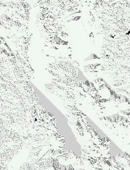
Distribution of habitats in the northern portion of Mahale N. P. determined
On arrival at Mahale, the Park Warden In-Charge, Mr. Mbaga,
from `Manta board' surveys.
gave a welcome speech to the team members. The survey began
6


with team members doing manta surveys along the 60 kilometres
of park coastline. This provided a description of the lake's
substrate characteristics, e.g. inclination, percentage composition
of sand, gravel, rocks, boulders and bed rock; coast line
characteristics. Based on the distribution of habitats established
through the manta survey, the team established which sites would
be surveyed in detail. Though the initial plan was to survey 30
sites, due to weather, illnesses, and other complications, the team
was only able to thoroughly survey 27 sites, which is 90%; and
still a great success.
The surveys were divided into four components: habitat profile,
mollusc census, and two different methods to census fishes.
The regional group divided into 3 different teams which each
Richard Paley (BIOSS Facilitator) and Reuben Shapola
worked a different site each day. At each site, the first pair of
(Dept. of Fisheries, Mpulungu, Zambia) discuss survey preparations.
divers conducted the habitat profile, descending to 25 m depth
and recording the characteristics of the substratum (e.g .,
The second pair of divers conducted the mollusc survey, following
percentage of rocks and sand and their characteristics) and fauna
the transect line set by the previous team. The divers worked at
at 10 m intervals along an 80 m transect. This was done using a
25 m, 15 m, 5 m and snorkelled at 0-2 m. At each depth, divers
marked reel which remained underwater throughout the other
tried to note all the gastropod and bivalve species present. Search
surveys.
times and techniques varied depending on the nature of the
substrate. On rocky substrates, both divers searched on, under,
in and among rocks for gastropods and bivalves. On mixed or
sandy substrates, one diver used a sieve to collect micromolluscs
from the sediment while the other followed a wider search pattern
for larger molluscs. Representatives of each species were brought
to the surface for definitive identifications.
Three different methods were used to survey fishes, the Stationery
Visual Census (SVC), Rapid Visual Census (RVC) and Gill-
netting. In the SVC, a pair of divers descended to 15 m and
remained there for 15 minutes recording all the fish species they
encountered. The divers then repeated the same technique at 10
m and 5 m depths. In the RVC, a pair of divers descended to 15
m depth and swam parallel to the shore for 15 minutes, recording
each species of fish they encountered at 3 minute intervals (species
were recorded only once). The technique was repeated at 10 m, 5
m and 0-2 m depths, the latter using snorkel technique. Finally,
gill nets were set every day at the end of the diving activities and
recollected the following morning. At this point, species were
identified and the number of each species present was recorded.
Gill-netting offered a glimpse of the nocturnal fish fauna, and
was a great teaching tool for all who were not familiar with various
species of fish.
The regional BIOSS teams are currently analysing the survey
data and compiling a report of the Mahale Mountains National
Park Survey. This report will be of great interest to TANAPA
and other conservationists, for it will provide a baseline study of
the Park's aquatic fauna and hence provide data for decision-
makers on the proper ways of conservation and management.
The regional BIOSS teams would like to express their heartfelt
and sincere gratitude to the Director General Mr. G. Bigurube
and the Chief Ecologist Mr. E. Gereta, of TANAPA, for their
permission to conduct this survey and also the Mahale Mountains
National Park Management for all their efforts to provide a
comfortable stay for all the team members.
Bakari Mnaya is Park Ecologist for Gombe Stream and
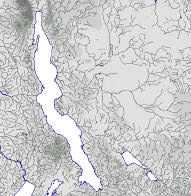
Location of Mahale N. P. (orange) on Lake Tanganyika (modified from sketch
Mahale Mountains National Parks and a member of the BIOSS
by Coulter and Lowe-McConnell, November 1995).
team in Tanzania.
7


SECOND PROJECT TRIPARTITE REVIEW MEETING
Nairobi, Kenya, 25-27 May 1999
SUMMARY OF THE MAIN CONCLUSIONS AND RECOMMENDATIONS:
1.
For the remainder of the project, UNOPS should reinforce its role of technical control according to the decisions that would have been taken
at the next Regional Steering Committee meeting; (point 4.7 para 118)
2.
UNOPS should present a summary table at the next Steering Committee meeting, indicating the present situation as well as the expenses that
have been undertaken but still not settled, among these the UNOPS costs; (point 4.7 para 123)
3.
The project should identify which institutions are (or will be) mandated to fulfil each of the follow-up/evaluation functions that are planned
for the future; (point 4.7 para 133)
4.
The project should involve the nationals further in the definition of the work programmes; (point 4.7 para 134)
5.
The project should make the best qualified national experts at the regional level, work in close relation with the recently recruited facilitators;
(point 4.7 para 136)
6.
The mission expenses (for expatriate or national experts) for project meetings should be limited to the minimum compatible with the achievement
of expected outputs; (point 4.7 para 139)
7.
Any charging of time to expatriate experts on the project budget should be limited to tasks carried out in the region, tolerating, however,
(according to the agreement to be made between UNOPS and the NRI Consortium) the time spent on preparing and writing reports, if
necessary; (point 4.7 para 141)
8.
The project should complete the databases regrouping the existing data and install them in the appropriate institutions;
(point 4.7 para 149a)
Drs. Kelly West (Scientific Liaison Officer), Andy Menz (Project Co-ordinator), and Mr. Jean-
Berchmans Manirakiza (Burundi National Co-ordinator and Chairman of the Meeting)
9.
The project should make a synthesis of all the pertinent scientific knowledge acquired until now, which is necessary for the definition of the
special studies and for the elaboration of management tools for the Lake; (point 4.7 para 149b)
10.
The project should treat, as a major problem, the question of verifying (or invalidating) the basic hypothesis concerning the environmental
impacts that are threatening the Lake; (point 4.7 para 155)
11.
Maximum effort should be exerted by the project in a timely implementation of all the special studies and the overall planning of activities
shall assure that they can provide the necessary background for the Strategic Action Plan; (point 4.7 para 156)
12.
The project should prepare a document (as a supplement to the present `standing instructions' concerning the sampling and the laboratory
work) on the overall technical approach and on the way the collected data may contribute to a better knowledge of the problems and to the
development of the future management tools; (point 4.7 para 157)
13.
The project should prepare and implement, before the end of the project, sustainable mechanisms/procedures for professional exchanges
between the national experts in order to meet from now on the future needs for exchange of information, of experiences and of continuous
harmonisation; (point 4.7 para 158)
14.
The project should target the training towards the identified needs for the post-project phase; (point 4.7 para 216)
15.
The project should target the equipment of the national structures towards the needs of the monitoring post-project as well as against the
intercalibration and the exchange of data; (point 4.7 para 221)
8


LTBP's MTE and TPR:
LTBP's MTE and TPR:
Project Co-ordinator's Comments
UNOPS' Response
by Andy Menz
by Margaret Chi
After some delay owing to the difficulty of finding a time
slot when all parties were available and the need to move
the venue from Bujumbura to Nairobi related to the
UNOPS was pleased to note that at the TriPartite Re-
view and Steering Committee Meeting, 25-28 May 1999
in Nairobi, all national teams were represented and that
unstable security situation in eastern DR Congo, the Second
consensus was reached on several priority issues.
Tripartite Review and the 4th meeting of the projects regional
Steering Committee (SC) were held in Nairobi from 25-27 May
The mid-term evaluation, on the basis of which the TPR was
1999.
conducted, offers an overall forward-looking approach in calling
our attention to project elements that require accelerated efforts
Present were representatives from the four countries, GEF, UNDP,
during the remaining project period, including increased national
UNOPS, the PCU and a number of resource persons from the
capacity building and participation, increased collaboration
NRI consortium. All representatives were present at both the TPR
among the national teams, and the development of a Lake
and SC meetings, the meetings being held consecutively.
Tanganyika Convention including the definition of a Convention
Although the meetings were undoubtedly very fruitful, it is
Secretariat. UNOPS (with and through NRI) will strive during
unfortunate that once again the majority of countries were not
the next 3-4 months to develop a workplan, which will focus on
represented at the Principal/Permanent Secretary level as called
priority activities for the remaining project period as agreed upon
for by the agreed composition of the Steering Committee.
during the TPR, incorporating as well, activities that will be nec-
essary to ensure a smooth bridging between the current and a
The meetings analysed the Mid-Term Evaluation report and
possible future project phase. It is expected that the project will
discussed the future of the project in detail. All the key issues
need to be extended beyond 31 July 2000 to achieve the goals of
concerning project implementation were raised as the meeting
this phase. The workplan will be presented and discussed at the
assessed each of the MTE recommendations in turn. Of particular
extraordinary meeting of the SCM, to be held in Arusha,
importance to delegates were matters related to national capacity
tentatively scheduled for November 1999.
building and participation in project planning. In addition, the
crucial question of what happens beyond August 2000, the current
end date of the project, was addressed. While it was made clear
by UNOPS that some additional funds remain from the original
total allocation and would be made available to the project to
complete its work, this would not be sufficient to extend the
current time frame of the project. UNOPS and NRI were asked
to clarify the final amount of funds available and, taking account
of the resolutions of the meeting, draw up a final workplan and
budget to take the project to the end of its current phase. This
workplan would also make provision for a strategy to secure
funds for a second project to build on the current one. In this
respect it was stressed by the representative from GEF that
"process indicators" would be crucial to improving chances of
obtaining funds from GEF for a second project. These are
indicators that clearly demonstrate country commitment in terms
of allocation of country resources albeit modest to the goal and
purpose of the project. It was agreed that the revised budget and
workplan would be presented and discussed at an extraordinary
meeting of the Steering Committee, tentatively scheduled for
November 1999.
The project is thus in its final year of implementation and
Ingolf Scheutz-Mueller & Margaret Chi (UNOPS) at
notwithstanding setbacks, a sound and successful conclusion is
Rusizi National Parc, Burundi
well within our grasp. It is, however, entirely dependent on
Following the TRP/SCM, Mr. Ingolf Schuetz-Mueller and Ms.
everyone working on the project, in whatever capacity, doing all
Margaret Chi travelled to Burundi to meet with the Minister of
they can to support and facilitate in whatever way possible the
the Environment, review the status of the project, and discuss
activities of the project during this crucial period.
the location of a possible future Lake Convention Secretariat.
This meeting was followed by a visit to the Scientific Liaison
Andy Menz is the Project Co-ordinator for LTBP.
Office of the Project and to the lakeshore, which has certainly
deepened their appreciation of Lake Tanganyika.
UNOPS is the Executing Agency for the Lake Tanganyika
Biodiversity Project.
9
Space - The Final Frontier:
which you can select individual tools to answer specific
The Role of GIS in LTBP
questions, such as:
What is where? where you point at a place on a map and
by Alan Mills
find its location, its soil resources, its population.
Estate agents say that the three most important things when
buying a house are location, location and location. The
Where is what? This could be where you want to know
same is true of the activities of the Lake Tanganyika
all the locations of certain Cichlid fishes. These questions
Biodiversity Project (LTBP). They are all played out on the
can be more sophisticated and, because GIS contains
world's surface; pollution occurs in the same bays as the fish live
spatial data, can combine data from disparate sources.
and the fishermen work. These activities have both their own
(i.e., where Neolamprologus sexifaciatus is located on
absolute location and relate spatially to all other phenomena. We
boulders within 50 km of Uvira.)
can map all this information and work out these relationships,
where there are conflicts and where there are not.
What happens if..? This is where you might integrate data
on slope, land cover and vegetation with rainfall to
Traditionally, we used maps and charts to plan out or record these
predict erosion rates, both totally across the catchment
activities. These were useful, but rather static representations of
and between regions.
the world's surface. Now we use Geographical Information
Systems (GIS) to do this. They provide a much more dynamic
LTBP is capitalising on the utility of GIS to assist the project.
environment in which data can be organised and spatial
NRI is assisting in this in several ways. First, we have developed
problems solved. They tend to be computerised systems
a simple interface to allow people to view, interrogate and present
consisting of facilities to enter map data (such as digitising), store
all the data very easily. We call this `TANGIS'.
and manipulate data, and present results in maps, charts or tables.
GIS is a very powerful tool to answer spatial questions, but it
Data can come in many different forms. It can occur in vector or
does not work properly without accurate data. The projects'
raster format (see box `Understanding the Jargon') and all kinds
Special Studies are now generating large datasets (e.g. the
of data can be mapped. These could be common features such as
Biodiversity Survey and Literature Databases, the Pollution
heights above sea level, roads and rivers, or specialist
monitoring data, the reports from Fishing Practices, the
information like surveying data, satellite imagery and even
Sedimentation surveys in the lake and rivers). Our second role
statistics (e.g., district populations).
is to integrate these data with others; maps of administrative
boundaries, roads, a digital elevation model, satellite data and
Many people have the wrong impression of what GIS is or can
socio-economic statistics.
do. Some believe it is a "black box" that you can throw at a
problem and solve all ills. Others believe it is just a computer-
We want people to be able to get access to this data easily, and
mapping package. These are rather simplistic views. GIS also
we catalogue it all using a metadatabase. Metadata are data about
allows you to interact with your data, pan around or zoom into
data. The metadata we create includes geographical information
different scales of data. Most importantly, GIS is a toolbox from
(the dataset's location in space, its original scale), their attribute
Understanding the Jargon
Query - Asking questions of the data.
GIS - Geographical Information Systems - Usually applied to Digitizing - Using an electronic drawing board to transfer vector
the computer hardware or software, or the entire database system. data from a map to the computer, It is one of the most popular
Sometimes it means the processes used to model spatial data.
(but time consuming) ways of entering new data into GIS.
Vector - One way in which to store map data in a GIS - it involves Projection - A way of representing the curved surface of the
identifying features in terms of points (e.g. survey sites or earth on a flat map or GIS screen. The project uses two; Platte
landings), lines (e.g. rivers or roads) or areas (e.g. Lakes or Carre which references latitude and longitude as equal distances,
National Parks).
and Universal Transverse Mercator, Zone 35, a metre-bases
system that is the standard for many maps in the region.
Raster - Another way to store map data in a GIS. It involves
dividing up the earth into equal sized squares (called pixels) and Scale - The relative ratio between the earth's surface and its
assigning data to them. They are useful data layers for satellite representation on a map or in a GIS. A scale of 1:50 000 means
information, digital elevation models or other environmental data that one cm on a map equals 50 000 or 0.5 km on the ground.
where information is continuous. These can be useful for data Data from the project are represented at different scales. Some
such as soils where every piece of land can be classified.
such as rivers cover the whole region (1:1Million or above), some
Digital Elevation Models - these are pixel maps showing height survey data are best represented at a local scale (1:25 000).
information. They are more useful in a GIS than traditional
contours because of the watershed and slope modelling you can Attributes - These are the associated data for each feature in
do with them (see Modelling with GIS).
your dataset. For example if a point represents a landing site,
the associated attributes might be its daily catch, number of boats,
Pixel - a square in a raster grid that contains data (for example number of fish species, the name of the site.
from a satellite image).
10
details, copyright restrictions and size. We publish catalogues of
metadata on the LTBP website & CD-ROM, which is updated
every 3 months.
As well as the 300 digital datasets stored in TANGIS, we have
also catalogued 100 non-digital datasets, such as paper maps held
by the project and some references to other sources.
The GIS should not only be seen as a tool to solve spatial
problems. Up-to-date data are necessary to support the Strategic
Action Plan, and the current GIS framework will make it easy to
allow future updates. The datasets and interface will be
distributed to key sites in the following months.
How can you help us?
If you know of good sources of data or if you require data, contact
Anne Jackson (ja06@greenwich.ac.uk).
Alan Mills is a Geographer in the GIS & Remote Sensing
Department at the Natural Resources Institute, UK.
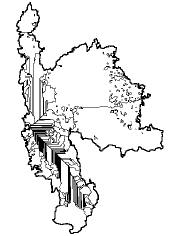
Modelling with GIS
GIS is not just about maps. The three maps above demonstrate
how GIS can be used to make new information. The first shows
the digital elevation model with heights above sea level (dark =
high). The second map shows how GIS has been used to calculate
direction of flow from one pixel to another. White areas are
where water flows south and grey areas where water flows north.
The third map is derived from these two layers. It has
automatically defined the lake's sub-catchments, including the
straight areas where the water from the rivers "extends" into the
lake. The GIS has assisted in defining the lake's true catchment.
11


World Environmental Day
in Burundi
by Cécile Gakima
In Burundi, celebration of World Environmental Day has
become a habit. This year, many activities were organised
under the theme suggested by the United Nations
Environmental Programme (UNEP): "The Earth is our future :
save it !"
Many activities were organised for the event, including:
A cultural evening organised in Gitega by local
Environment Clubs; the aim of this event was to raise
Local Gitaza fisherman (left) recieve awards for winning the boat race from
members of the Ministry of Land Planning and Environment, including M.
awareness among schoolchildren, teachers and civil
Gabriel Hakizimana (PSS Co-ordinator for Burundi), His Excellency the
servants in Gitega
Minister, and Jean-Berchmans Manirakiza (National Co-ordinator for Burundi).
A clean-up campaign organised by a women's
association from the Kinama zone of Bujumbura called
Upon their arrival, guests were welcomed by a large crowd and
"Women and Environment"
many cultural groups (farmers, schoolchildren, secondary school
students, etc.). The cultural groups were supervised by project
A symposium on the Environment to popularise the
staff and local administration, exploiting the theme of the day.
National Strategy for Burundi. All officials of the
Sketches, skits and songs presented by different cultural groups
Ministry for Land Planning and Environment as well as
were carrying messages about protecting biodiversity in Lake
other partners took part in the symposium
Tanganyika. The messages were addressed to the local population,
to the administration and to political decision makers. In order to
A day for raising awareness among the local population
encourage fishermen (an important target group in environmental
education matters) to widely participate, the project also organised
and administration.
a boating competition on Lake Tanganyika. This was also meant
to demonstrate to the population that the lake can be used for
In this issue, I will discuss the latter activity which was organised
recreation. Prizes were distributed to the best boatmen.
by the Lake Tanganyika Biodiversity Project, under the patronage
of the Minister for Land Planning and Environment.
In his welcome address, the administrator of Muhuta Commune,
Province of Bujumbura Rural, expressed his thanks to the Ministry
for Land Planning in general as well as the Lake Tanganyika
Biodiversity Project and the National Institute for the Environment
and Conservation of Nature (INECN) in particular, for having
celebrated World Environment Day in his commune. He also
asked for many education sessions for the local population on
environmental themes in general and on topics regarding the
protection of Lake Tanganyika in particular, as most of the
population living in Muhuta Commune make their living from
the exploitation of the lake's resources.
In his speech, the Minister for Land Planning and Environment
first clarified the intended objective in organising the celebration
under the theme "The Earth is our future: save it!" He then
described the major threats facing biodiversity in Lake
A dance troop from the Muhuta Commune, Burundi, performs for the
World Environment Day celebrations.
Tanganyika. He also explained to the population how they can
contribute to the protection of Lake Tanganyika in using
The aim of the day was to raise awareness among decision makers,
appropriate mesh sizes, controlling erosion in the hills surrounding
local administrators and the population on threats facing
the lake and in controlling all forms of pollution. He ended his
biodiversity in Lake Tanganyika. This was also the occasion to
speech by inviting everyone to become active in the protection
officially launch environmental education activities that will be
of the lake for sustainable use.
carried out, in collaboration with partners, along the lakeshore
within the Lake Tanganyika Biodiversity Project.
Groups of dancers, drummers and schoolchildren from the
commune continued to perform songs, dances and skits with
Ceremonies begun with a tour of Lake Tanganyika aboard the
environmental messages for the guests throughout the morning.
R/V Tanganyika Explorer. From this vantage point, participants
observed for themselves the state of deforestation in the
Cécile Gakima is the Director of the Environmental Education
catchment. This tour also demonstrated to the local population
Department of INECN and the LTBP Training, Education and
that Lake Tanganyika can be used for tourism purposes.
Communications Co-ordinator for Burundi.
12


LTBP News
Karen Zwick
Robert H. Lindley
LTBP is pleased to welcome two new field-based facilitators to its team. Ms. Karen Zwick joins us from Uganda, where she worked
on an environmental project for Frontier. She is based in Bujumbura, Burundi and will be co-ordinating field activities for the
Socio-economics special study. With considerable experience documenting fishing practices around the world, Mr. Robert H.
Lindley will be co-ordinating field activities for the fishing practices special study. He is also based in Bujumbura, Burundi.
Keith E. Banister
1941-1999
It is with great sadness that we report that Dr. Keith Banister
died on 27 June 1999 after a prolonged illness. Keith was the
LTBP Scientific Liaison Officer from August 1995 to July 1997.
All who knew him on the project will recall his engaging
personality and his boundless enthusiasm for the lake and its
inhabitants, especially the fishes! Our sincere condolences to
his family.
13
Calendar of Progress & Upcoming Events
01-04 March 1999 LTBP hosts an environmental education
20 June 1999
Ms. Karen Zwick joins LTBP as the
workshop led by Monique Trudel in
Socio-economics facilitator. She is based
Kigoma, Tanzania.
in Bujumbura, Burundi.
08-18 March 1999 Intensive taxonomic training course for
30 June -
IWACO, a Dutch environmental
the regional BIOSS teams in Kigoma.
12 July 1999
consulting company, completes a clean-
up and environmental impact assessment
of TANESCO, the Tanzanian power
19 March 1999
Renovation of the Centre de Recherche
station, in Kigoma.
(CRH) Uvira, DR Congois reinitiated after
delays due to insecurity in the region.
05 July -
Twelve African students (three each from
13 August 1999
Burundi, DR Congo, Tanzania and
Zambia) participate in the Nyanza
22 March -
Regional BIOSS teams survey Mahale
Project, an intensive training course for
08 April 1999
Mountains National Park, Tanzania.
university students designed to give
classroom, laboratory and field training in
the geology, limnology and biology of large
15-16 April 1999
Project management meeting in UK to
tropical lakes.
discuss the recommendations of the Mid-
Term Evaluation.
07 July -
LTBP hosts a "Training of Trainers"
17 July 1999
workshop in Bujumbura. Led by Ms.
18-21 May 1999
Vicki Cowan represents LTBP at the LTR
Rachel Roland and Ms. Monique Trudel,
Project meetings in Lusaka, Zambia.
four participants from each riparian
country, attended, representing NGOs and
national institutions charged with
25-27 May 1999
LTBP holds its Tripartite Review
environmental education.
(riparian countries, NRI consortium and
donor/executing agencies) in Nairobi,
Kenya
22 August 1999
LTBP celebrates the completion of
renovations and the installation of new
equipment in the Centre de Recherche en
28-29 May 1999
UNOPS representatives, Mr. Ingolf
Hydrobiologie in Uvira, DR Congo.
Schuetz-Mueller and Ms. Margaret Chi,
visit Bujumbura and meet with the
Minister of Land Planning and the
24 August 1999
Mr. Robert H. Lindley joins LTBP as the
Environment, the National Co-ordinator
Fishing Practices Facilitator. He is based
for Burundi, and members of the LTBP
in Bujumbura, Burundi.
Bujumbura Station.
28 May -
David Silverside, LTBP Project Manager
05 June 1999
for NRI, visits Bujumbura and Uvira
Stations.
05 June 1999
Ms. Cecile Gakima in Burundi and Mr.
Bartholomew Tarimo in Tanzania
co-ordinate activities in their respective
countries to commemorate World
Environment Day.
01-18 June 1999
Alan Mills, GIS specialist, visits
Bujumbura, Kigoma, Dar es Salaam and
Lusaka in a mission to evaluate existing
GIS capacity in the region and prepare
for the transfer of the LTBP GIS to the
region.
14