

�q��oJ �e�f�dG ᣰ�fCG �EG .�eӰSE'G ��dG �Hh �ī�d I���YG �C'G �e�f�Hh �F�E'G I���YG �C'G �e�f�Hh
of Aden. This project is funded by UNDP, UNEP, The World Bank and The Islamic Development
QOɰ��d G���YG G���SE'G ,...���dG ��dGh �M�YG �W�fl �J ,�ī�dG �GQ�b �YO :��f
Bank (IDB). The SAP is being carried out through seven complementary components:
q
�e �ѰS �Y
institutional strengthening, reduction of navigation risks and marine pollution, sustainable use
IQGOEG ֫dɰSC' �YO ,�q��fi �j��H W��Y �ɵѰT ����SC�J ,...�G ���dGh ��ī�dG Y �a��G ,�q�G �j���dG
of living marine resources, conservation of habitats and biodiversity, the establishment of a
.�ѩ��dG �cQɰ�YGh �ī�dG �Y�dGh �Mɰ�dG W��d �eɵ�e
network of marine protected areas, support for integrated coastal zone management, and the
enhancement of public awareness and participation.
k
Ih�Y ��bE'�H �� �dG �j���dG ᣰ�fC'Gh �ī�dG Y �a���H �U��G ��e�Y�H �c�jh�J g �jQ��NE'G �dɰS�dG �g �e ��dG �EG
�ī�d Q��J hCG TM�Vh IQh��d�H ����J ' �jQ��NE'CG I����dG ��j�fi �EG .ɩdG ɪ�gE'G �GP �j���dG ��Y�VY�H �U��G �'�YG Y
hCG Oh�M ,�W�e ,�dhO ...C' �f�dG TM�Vd�H ����j ɪ�a �ī�dG �e ��W ...CG ...CGQ �Y �ѩ�dG ����J ' ɡfCG ɪc ,�j���dG ��> hCG
The aim of the newsletter is to provide information on conservation and development activities taking place in the region
.�N��e Oh�M
together with articles on marine issues of general interest. The contents of the newsletter do not necessarily represent the
position or views of PERSGA or the editorial board, nor do they imply the expression of any opinion on the part of PERSGA
:I����dG �g ��j�� TMѣdG �M
concerning the legal status of any country, territory, frontier or border.
.Q��YG ���VJ I�YG�e TMe ɡJ�j�fi �e ...CG hCG I����dG �g G���SEG IO�YEG R�j
All non-copyright material may be freely reproduced. Al-Sanbouk cordially requests that due reference is made to the source if
any news/articles/pictures are reprinted in other publications.
�j���dG �īg
���f QG��V .O
���dG
:�j���dG ���FQ
�ī�dG ���e
ɩdG �G��TE'G
...Ra �fi .O
Al-Sanbouk
Editorial Board
Dr. Dirar Nasr
�aJ QG�f .O.CG
�櫪�a jQOhQ ��dG
�Yɰ�YG ɩdG �eC'G
is under the patronage of
Chief editor:
PERSGA/SAP Coordinator
�ī�d ɩdG �eC'G
�j��,E'G �dG Q�fi
Dr. Mohammed Fawzi
Dr. Nizar Tawfiq
:AɰYC'G
Deputy Secretary General
Mr. Roderick Fleming
PERSGA Secretary General
��aɫdG S �ɣ�dG
<�G �S .O
English Language Editor
�W�fl �e ��dG �Fɰ�NCG
Members:
�h���YG �j�e
...���dG ��dGh �M�YG
Dr. Saiyed Al-Khouli
Captain Saeed Al-Yafai
Project Manager
NRMP Specialist
:<��dG �G�d�H ɰ�JE'CG A�L�dG �aɰVEG ��f ��SE' hCG �j�j�dG �F�d �EG ɪ�fE�d
.�jO���dG �H��dG ᵪYG - 21583 I�L ,53662 �.�U ,��Y �Nh ��MC'G ���dG �īH Y �a��d �bE'G �ī�dG
The editors encourage you to submit articles, reviews, and photographs for publication but cannot guarantee that they will be used.
+966 2 657 3224 :J�g
To join our mailing list or to receive additional copies please contact:
+966 2 652 1901 :��c�a
The Regional Organization of the Environment of the Red Sea & Gulf of Aden, P.O. Box 53662, Jeddah 21583, Kingdom of Saudi Arabia.
information@persga.org :�hεdE'G �j�dG
Tel.: +966 2 657 3224 Fax: +966 2 652 1901
http://www.persga.org :�e ɡ�Y ��G ��� ���dG �e �Hɰ�dG OG�YC'G
Email: information@persga.org http://www.persga.org
This newsletter is printed on 100% recycled paper.
%100 �`Ѱ��H �``����J IO�`YEG q" �Qh Y �`jQ�`�NE'G I����dG �g �`Y�`�W �`q"
1
1


�īH Y �a��d �bE'G �ī�dG �c
A Word from
��Y �Nh ��MC'G ���dG
PERSGA Editorial
,A...Q�dG ...�j�Y
Dear reader,
��H ,�bE'G �ī�dG ��Wɰ�f ����J ��dG �jOɫ�Y'G OGYG �EG �aɰVE'�H ,O�dG G�g ��d
Welcome to Al Sanbouk 15. In addition to our regular items describing the activities of PERSGA this
q
�j .���dG �e 15 O�dG ` H k��M�e
edition of Al Sanbouk introduces to you some of the important work that is being carried out to make
��c��Th ɡcq�oeh �ذ�dG Y k�H��jEG �����j � ,k��eCG �cCG ɡ�Lh �q�dh�dG �M�YG ����J LCG �e �g���J q��j ��dG �qeɡdG ɪYC'G
international shipping safer, giving benefits to the vessels, ship owners, insurance companies and,
'
' ��`�dG �`e �`N �`j�`bdG' ' Iҡ��dG �`d`YG �EG kGO���SGh .�e�dG �bRQ ` ɡ�Y ��j �e qch �j���dG �ī�dG q�gCG ���Hh �eC��dG
most importantly the environment and all who gain their livelihood from it. Following the maxim that
�OGM ɪ�MG ���J �EG <��d�Hh ��bE'G ` �M�YG �W�fl �J �EG ��JGΰS'G ��dG �e�f�H �e ���dG �q�YG ��j
"prevention is always better than cure", Component 2 of the Strategic Action Programme, aims to
.�Zh ��dG �e ɡ�Y �L��dG �bG�dGh �ذ�dG
reduce navigation risks within the region and therefore to decrease the probability of shipping
accidents and their inevitable polluting consequences.
��ذS 20^000 �e �Q�j �e Q��HEG ��j � ,�YɩdG IQ���dG �e %7
The Red Sea and Gulf of Aden carry around 7% of global maritime trade. This translates into a huge
�ذ�dG �g ��J ' ,��V�G �bdG ` .i�NC'G �q���G �W�iG ��Hh ,��V �c�eCGh ,Q�U ,�dh��e Q�L ɡ�e I�j�Y
number of vessels, 14,000 a year or more, traversing the narrow waterways with their coral reefs,
�d�Y IQ�N �GP ��e ��MC'G ���dG ��L �e ��YG �g ��J d�dh .���YG ��H ��e R��OE �CG �H �櫩e k�b�W
submerged shoals and hidden dangers. In many parts of the world the International Maritime
��dG �ذ�dG �H ���d �
Organization (IMO) has established routes that separate vessels travelling in different directions, a
q
�M�e ��W ,/ɩdG A��fCG �e ��c ` ,�j���dG �YɩdG ᪶�YG �O�M �d .�j���dG �MӪd �Ѱ��d�H
simple technique and one that has undoubtedly prevented a large number of accidents over the
.�e�dG q�e Y �OGG �e ��dG TM�e ` ��YɰS �G ` ɡq�d ᣫ��H �j�W �gh ,���fl �g��qJ�H ���J
years. Traffic passing through the Bab el Mandeb, and sailing east or west of the Hanish Islands do
ɡqfCG �e �qcC��d ���dG �d Ѱ�e ���e AG�LEG k'hCG ����j ,kɫdhO �d�eh �ذ�dG �GQɰ�e �H ɡ�a ���oj �q�M�e ��W ����SC��d
not have to follow any prescribed routes and this area is, as a direct consequence, one with a high
�j�h `G�ZhQ�dG ���YG ɪYCG a kG��c kGQhO �bE'G �ī�dG �ѩd �dh .ɡ���J �CG �j�J ��dG �ذ�d �ɰUh �feC�e
navigational risk. To establish internationally accepted routes with traffic separated into lanes
requires that these lanes are surveyed in advance to guarantee that they are safe from underwater
:�G�Y � O�dG G�g a �檰YG �d�YG ` ���e g ɪc ��Y �Nh ��MC'G ���dG ` �M�YG ���d �HG�J
obstructions. PERSGA has been extensively involved in hydrographic surveying and the identification
.' �SaC
'
G I��U h '
���dG ��L ` `G�ZhQ�dG ���YG'
of new routeing measures as described in the articles "Hydrographic Surveying and Charting in the
.�ī�dG �jɪM �ѰS ` i�NCG �qe�g �gɰ�e ��J ��dGh AfGYG ` �dh�dG �q�� ɶ�d I�qMe �b��JG ���d O�L kɫd�M ...�OEh
Southern Red Sea" and "The Avocet Rock".
TMq��J �ذ�dG �g q�CG �e �cC��d ɡ�����Jh �j���dG �fGY�H �ذ�dG �EG O���dG �HqQ�e ڰ���Y q�j ,�b��J'G �g �ѣJ �Hh
A second important contribution to environmental protection is being made through efforts to
�j�LG�YG IQ�q��dG �EG �aɰVEG ,ɡ�a �eӰ�dG I��LCGh ,�g�Jh ,Q��HE�d ɡ�q�MӰU �M �e dPh kɫdhO ɡH �ΩYG ���j�Y�H
establish a uniform Port State Control agreement within the region. Once implemented, trained
�e kɫd�M ��Y �Nh ��MC'G ���dG ��jh .��bE'G �fG� �S�dG hCG Q��HE'G �e ���j�YG �H TM��J ' ��dG �ذ�dG TM�" �bh .ɡ�a
inspectors have the power to board vessels visiting the port and inspect them to ensure that they meet
�b ��dGh �dh�dG ���j�YG �hO ���b �ذS ɡ�a ���J �b ,d�d k���fh .ɡH ��e �b��JG ɡ�a �LJ ' ��dG /ɩdG ` �dG W��YG
internationally accepted standards of seaworthiness, construction, safety equipment, and crew. Vessels
d��e �ذ�dG �g �e ���UCG ���j �bh ,ɡ��e Y �gDe �Z IQ�q�H OLd hCG Q��HE�d ɡ�q�MӰU �d kG��f ���dG ` ��OE hCG ���J
not meeting the standards may be prevented from sailing, or banned from visiting the port. Currently the
.ɡ�Y �eC��dG �M�f �e ɡfG�a ��Y I��c
Red Sea is one of the few areas in the world where no agreements have been made. As a result, old,
substandard vessels with poorly trained crews can be used and they may sink or run aground because they
�jDh�dG q�CG q'EG ,�GQGOG�dGh TMbGYG �j� I��LCG OLh �e �Z�d�Hh .��Y �Nh ��MC'G ���dG ` �jDh�dG Y ��ѰdGh �e�dG �UG�dG �KDJ
are unseaworthy, badly manned, or even because they are worth more as an insurance loss.
��H ` (��e) ��H I�j�L ` IQ��e A��H q" �bh ,QG�fEG Sc �qe�g k�ehO �GQ��YG �f�ch .TMbGYG �j���d ����F�dG Q�G �J �j����dG
The Red Sea and Gulf of Aden are areas where haze and dust storms often lower the captain's visibility.
�EG ��� ɡ�d ɡ�e ��dG ֫c�J �eC'G �eh I����e �fɫ�U �EG ��� �qjC'G �g ` �MӪd I�Yɰ�YG I��LC'G q�EG .1860 �Y �b ���YG
Despite the advent of GPS and radars, we rely heavily on visual clues for determining our position. This explains
i�j ,�g �j���dG ���dG ` q�" ��dG ���dG �ɫ�Y �e k�j�S Q'hO Qɫe I����dG �Q�j �e �Ѱ��j �ذ�dG q�oe �CG �EG kG��fh .j" QOɰ�e
why lighthouses have always been so important as warning signs; as long ago as 1860 a lighthouse was
Y TMLΰ�J �CG h�d ��� ���a ,�G�b'G G�g ���J q" GPEGh .�M�YG �G�Yɰ�YG j��d I�j�L ��W Y ��G ��� �fCG ���dG �q�YG
established on Perim Island (Mayyun) in the strait of Bab el Mandeb. The current aids to navigation need continual
.�M�YG �G�Yɰ�YG I��LCG �a�d ɡd��J ��dG �dɵ�dG ��H bC'G
maintenance, and more should be installed. However the ships that pass through the region without stopping at
any port escape paying any contribution towards their upkeep. With an estimated USD 10 billion per year in ocean
Y �q�L �FG�H O��Sh ��bE'G ` �ī�dG �jɪM i��e TMaQ ` ��c ���H �gɰ�J ��S
.�q��Gh �bE'Gh �q�dh�dG ��j��YG
expected from all ships.
....���dG ��dGh �M�YG �W�fl �J �> a �ī�dG �H J �
'
���dG' �e O�dG G�g ���j �CG eC�f ,�Q�dG ...�j�Y
q
�Y IQ�U
This work, funded by the World Bank, will make a significant contribution to the level of environmental protection within
the region conferring benefits at the global, regional and national levels.
We hope you enjoy learning more about our work for the protection of the marine environment.
��aɫdG �dG��Y S /�ɣ�dG
�j���dG ��dGh �dG �jRh
Captain\ Saeed Abdulla Al-Yafai
Minister of Transport & Maritime Affairs
ᣰSGH ��J �Ѱ�N �cG�e Y ���dG ��SG �j
Al-Sanbouk is the name given to wooden vessels
powered by sail and engine that have taken
�Gh �e TMFɰ�dG �� ��dGh �G��Th q�fi
goods to and from most ports in the
��Y �Nh ��MC'G ���dG ` AfGYG ���e
Red Sea and Gulf of Aden
.���dG ���e i�e Y
for hundreds of years.
2
2


P E R S G A
��Wɰ�f
Activities
��Y �Nh ��MC'G ���dG �īH Y �a��d �bE'G �ī�dG
Regional Fisheries Stock Assessments
�bE'G �jɰ��d �h�iG ���J
The third Regional Living Marine Resources Working Group meeting was held in Hurghada
�H �```e I�``�dG ` (�`��e) �``bO��dG �``�j�e ` �`q`�G �``j�`��dG OQG`YG `�Y �``Y�� �`d�``�dG ��``�`�`L'G �`Y
(Egypt) from 30 June - 4 July and included a Workshop on Sustainable Management of Living
��bEG ` �
'
q
�G �j���dG OQG�d �eG���YG IQGOE'G M �Y �TQh �ɪ�L'G �q��J �bh ,2001 �dj 4 - �fj 30
Marine Resources in the Red Sea and Gulf of Aden. The main areas identified for co-operation
ɪ�SC�d ΰ�YG �h�iG ���J ΰ�YG �hɩ�d �g�j�
.
'
q
" ��dG �q��YG �'��G �eh ��Y �Nh ��MC'G ���dG
included the assessment of shared fisheries stocks and their sustainable management. The
Q���dG �d �edG d �H��dG �fG�YG �Bɰ��YGh ��iG IQ�jR �q" ɪc .ɡ�Y �a��Gh ɡJQGOEG �
laboratory and field facilities of the National Institute for Oceanography and Fisheries (NIOF)
q
�ثch
in Suez were visited.
.��j��d�H �jɰ�YGh
The LMR Lead Specialist, together with six colleagues from the Ministry of Agriculture and
(ɪ�SC'G IQGOEG) ɫYGh �YGQ�dG IQGRh �e �j�NBG A�eR ��S h �q�G �j���dG OQG�d ...OɫdG �Fɰ�NC'G �SEG
Water (Fisheries Department), joined a fishing vessel working along the coastline of Gizan,
�b ,��ذ�dG ��X Y �gOLh A��KCGh .�jO���dG �H��dG ᵪY�H �G��L MG�S W Y ɪ�SC'G ��d �Q�b
Saudi Arabia. While onboard they conducted a bottom-trawl survey to collect data on
�GfCG �j��dh �h�iG ���J �V��H �ɫH�dG �Y ��e�e TM�� dPh �Y�dG q��G �Ѱ�d ���� �hQc�YG
shrimp for stock assessment purposes and to assess the variety and numbers of fish species
ɪ�SC'G �j��Jh ,�j�h ,���q�Y �NCG q" �dh .IO��e �Z �j��H ɡ��b q��j ��dG ɪ�SC'G OG�YCGh
caught in the by-catch. Shrimp and fish species were sampled, identified, photographed and
specimens taken for measurement in the laboratory.
.��iG ` ɡ�Sɫd �ɫH�dGh
The trip established valuable contacts and agreements for cooperation in data transfer from
.ɪ�SC'G IQGOEGh �ī�dG �H ��e�YG O��J �> ` �hɩ�d �e�g �ɫb��JGh �'ɰ�JG ��W Aɰ�f
q
E
G �M�dG �g �Y ��fh
the Department to PERSGA. The new Arabic version of the Field Guide to Sharks was
.�T�dG ɪ�SC' �G�YG �d�dG �e �H��dG ����dG ����H ɪ�SC'G IQGOEG ` �ɫFɰ�ME'G Gdİ�e �b �dh
evaluated by the enumerators at the Fisheries Department.
Standard Survey Methods for Habitats and Species
�WGYGh �GfC�d SɫdG ���YG ֫dɰSCG
Two training courses for regional specialists were carried out from 24 June - 5 July at the
�j���dG �dG ��� 2001 �dj 5 - �fj 24 �H�e I��dG ` ګ��bE'G ګFɰ�NC�d �jQ�J q�JQhO �Y q"
Aqaba Marine Science Station. The first course covered "Standard Survey Methods for Coral
'
�f��dG IQh�dG ��Veh , �f�L�YG �ɩ��d SɫdG ���YG ֫dɰSCG' �hC'G IQh�dG ��Ve ��ch .�OQC'�H �ѩdG `
Reefs" and the other "Standard Survey Methods for Seagrasses and Seaweeds". Sixteen
.��bE'G hO �e �Q��e 16 �JQh�dG �J�g ` QɰT �bh .' �j���dG �d��dGh �ɰ�YC�d SɫdG ���YG ֫dɰSC ' G
regional participants attended the courses.
�H��dG ᵪY�H Iq�L ��j�e ` ...�G �q��dGh �ѣdG �WGYG ��U �Y �Y�� TMHG�dG �ɪ�L'G �oY
The fourth Regional Habitats and Biodiversity Conservation Working Group meeting was held
���YG ɪYC' �����dGh �����dG q" ,�ɪ�L'G G�g A��KCGh .2001 Ȫ�ѰS 23 - 22 �H �e I��dG ` �jO���dG
in Jeddah from 22-23 September. During this meeting, planning and coordination took place
(Regional ReefCheck Surveys)
�`�d �dh�`�Gh ,��`��S �H �`d�`N ���SDe TMe
�f�L�YG ��`���dG ����d ���b'G
for the regional ReefCheck surveys with the Khaled bin Sultan Foundation, which are currently
scheduled for next April. Sets of equipment for turtle survey work have been prepared and
��a ����J ��Sh ,MӰ�dG ���e ɪYC' I��LC'G �e �Y��� ��bE'G hO �e �dhO qc �jh�J q"h .�YG j�HG ���T `
distributed to each country in the region. The monitoring teams will use these when work is carried
.2002 �Y �e �dj �Mh j�e ���T �e kAG��HG ��dG ���J q��j �e��Y I��LC'G �g ��bG�YG
out from May to July next year.
Public Awareness, Social Marketing and Micro-Grants Programs
���fG�L-h��j�eh ,�Yɪ�LE'G j���dG ,�eɩdG �Y�dG �eG�H
A Social Marketing survey is an activity that determines people's attitudes and their level of
�a��G �e �櫩e d ����a i�eh �S��dG ��Y�ѣfEG �����j �ɰ�f g �Yɪ�LE'G j���d ���YG Y q�EG
understanding of a particular issue, such as marine conservation or resource awareness, and
��q���dG ���fEG ��L �M �e �ѰS��e �ɫ�JGΰS�H U�dG �K �eh ,OQGY�H �eɩdG �Y�dG hCG �j���dG �ī�dG Y
then recommends the strategies that are the most appropriate in terms of the target audience
hO ��H ` �Yɪ�L'G j���dG ���� ɫdG q" �dh .�d�G ��Y�ѣfE'G ҫ��d �jQh��dG �aGG Nh
and in terms of creating the necessary motivation to alter behaviour patterns. A Social
k
ɰVG���SEG ,�H�cCG ���T ` Iq�L ` ⪫bCG �Y �TQh �N �e ɡ�V�Y q" ��dG ,�F���dG �檰J �bh .��bE'G
Marketing survey has been conducted in several countries of the region. The results,
.�eɩdG �Y�d �M�YG ��Yh���YGh ,�ɫ�UJ ,SɰSC'G �G��dG �ɫFɰ�MEG ,�S�YG �ī�dG cɰ��d
presented at a workshop in Jeddah last October, included a brief on the perceived
environmental problems, basic country statistics, recommendations, and proposed projects for
�G��TDe ,�����J �ɫH ��SQ �e ֫�dG G�g �q�J �bh .i����dG ��YG �eG�H �Y ֫�c OG�YEG q" dP �EG �aɰVEG
public awareness.
.�G�b'G Y d�ch Qɫ�N'G �jɩe ,����S'G �jɩe ,���bE'G �e�f�dG ���eh �bE'G ���dG ɡe ,��dG
In addition, a manual on Micro-Grant Programs has been prepared. This includes an organizational chart, progress indicators,
.�q��dG ` k�M�e k�Wɰ�f �K�Kh �fɪK �GQOEG "h
duties of the regional committee and regional program coordinator, eligibility criteria, selection criteria as well as the proposal
AG�LEG �
process. Thirty-eight proposed Micro Grant activities are included in the manual.
q
�ثc Y �cQɰ�YG �jQ�J q" ,2001 �H�cCG 10 - 1 �H�e I��dG ` Iq�L ` �oY ...�dGh ,�cQɰ�YGh �qeɩdG �Y�dG �q�e �Y �Y�> �ɪ�LEG A��KCGh
.kɫѰ�f IҨ�U TMjQɰ�e �f i����dG ��d ��M�e ��Jh OG�YEG �q�ثch �q�G �Yɪ�L'G j���d�H ��J �ɰSGQO
3
3

During the Public Awareness and Participation (PAP) Working Group meeting in Jeddah, held from
,�qeɩdG �Y�dG �M �e A��c dPh , �e��dG ���T ɪ�T a �qeɩdG �Y�d�H ��e I�j�Y ��Wɰ��H ɫdG q"
1-10 October, members were trained on how to conduct local social marketing studies and how
.�`�d�`e��dGh �`j��,E'Gh �`�`H��dG �ɨd�H �fɫH ��e�SQh �GQɩ�Th �ɡ�LJ �� ��Md �Ѱ�of �V��dG G�dh
to identify and prepare proposals for Micro-Grants towards small relevant projects.
�e ��q��dG q" �M �SɰSH ����H AWɰ�d ���J Y hCGh ����aEG ��M ⪫bCG ,�G �g �ɫdɩa ���Vh
Many public awareness activities have been carried out in NE Somalia as part of the Public
�jQ�J QG�UEG TMe ᩰSGh �e�YEG ��H �G �g ⫶Mh .�d���e �jCG �K�K �N ��j���dG �e ���WCG TM�H
Awareness campaign. Message boards with slogans were erected on appropriate sites
.�G ����e �b �e ���U
carrying illustrations and slogans in Arabic, English and Somali. The opening ceremony and a
,�`�`�dG �`e c ` dPh �``ī`�dG Y �`�a��G �
first beach clean-up were held east of Bosaso where several tons of garbage were removed
q
``�ثc ` ڰSQ�d �``���SQ �Z �``jH�J �``��jQ�J �GQhO ⪫boCG
over a period of three consecutive days. Media coverage was extensive with several press
,Q�``W'G G�g `h .�`��SQ�e �īH mOGf Aɰ�fEG q" ɪc ,�e��dG ��Z ɪ�Th ,�e��dG ���T ɪ�Th ,�GO��dGh
releases.
�jQ�J �q�ثc ,�H�YG �ӫ����dGh �Bɰ��YG ,SQ�e mOGf Aɰ�fEG �q�ثc :�d��dG �'��G �q��j �q��c �j�� "
Non-formal Environmental Education training courses have been conducted for teachers in
�``qeɩdG �``�Y�dG �q`�e �Y �Y�> �ɪ�LG OɩfEG A��KCGh .SQ�YG �ī�dG �j�fC�d �bEG �ѰTh ,ڰSqQ�YG
Yemen, Sudan, NE Somalia and NW Somalia and environmental school clubs (ESC) have been
�```H `�d ��```�``fG�`�eh �```�q��e `�`Y �```�N OG�`YE�H G`e�`bh ��`W�`���dG �g �``cQ�`��YG ��```b�f ,�``cQ�`��YGh
established. A manual has been written which includes: Mechanisms for establishing school
.��bE'G �G�H �e
clubs, facilities required, mechanisms for teacher training, and regional ESC networking.
At the PAP Working Group meeting participants discussed these activities and prepared
detailed work plans and budgets for each country.
��dG j��d ���dG �ɪ�L'G ,�Mɰ�dG W��d �eɵ�YG IQGOE'G
Y �a��d �bE'G �ī�dG �H �cΰ�e �j�Y�Hh ��Y �Nh ��MC'G ���d �JGΰS'G ��dG �e�f�H Q�WEG `
ICZM Third Working Group Meeting
��`�dG ��`��L'G �`Y q" �ī�dG �`j�`� �qe�`�dG �`ī�dGh �``M�`���dGh �`ī�dG IQGRhh ,��`Y �Nh �`�MC'G �`��dG �``īH
Under the joint sponsorship of PERSGA/SAP, the Ministry of Tourism and Environment, and the
�`H �`e I�`�dG �`N ,�`�`��dG �`jQ``�`��G ,��``Y ` �`�`M�`��dG `W�`�`�`d �``e�``�`�YG IQGOE'G �q``�`Y `�`�dG �`Y`�`�
General Agency for Environment Protection in Aden, Yemen hosted the Third Integrated Coastal
.2001 Ȫ�ѰS 12-9
Zone Management (ICZM ) Working Group (WG) meeting. The WG meeting was held between the
9th and the 12th of September 2001.
W��d �eɵ�YG IQGOE'G �q�� i�NCGh �bE'G �ī�d�H ��j��J ��L ��q��J �G��V�fi �Y �ɪ�L'G �N ` q"
�W�iG �Yh ��bE'G ` �Mɰ�dG W��d �eɵ�YG IQGOE'�H ��e ��
The meeting spread over 4 days and included an introductory session about PERSGA and another
q
��e �jɰb �Y �G��V�fi �檰J ɪc .�Mɰ�dG
about the ICZM component, several presentations about particular ICZM issues in the region, and one
` �Mɰ�dG W��d �gG�dG TM�Vd �dqhC'G �SGQ�dG �F��f �VG���SG �ɪ�L'G �G�gCG �e ��ch ....���dG ��dG h �M�YG
concerning navigation risks and marine pollution. It also included several workshops, a presentation on
W��d �fG�e IQ�j�H ��dG �Y�> �e�b �bh .�jQ��d IOq��e �Y �TQh I�Y �Y q" dP �EG �aɰVE'�H .��Y �a�fi
the results of the ICZM Pre-Assessment Survey conducted in Aden, and a field trip to a local
.��Y �a�fi ` �Mɰ�dG
coastal area.
Reduction of Navigation Risk and Maritime Pollution Second Working Group Workshop,
,AiQG�dG ��Nh �M�YG �eӰS M �M�YG �Y�> �Y �TQh
Djibouti (1st - 4th July 2001)
(2001 �dj 4-1) �JѫL
The purpose of the workshop was to discuss the activities of the SAP Navigation Risk and Maritime Pollution
GYC�d ��dG �q�N Y �aGYGh ' ' ...���dG ��dGh �M�YG �W�fl �J' ' �q�e �GR�,G Y �bdG ��dG �TQh �G�gCG �e ��c
component, to approve the Indicative Workplan for 2001-2003, to hold a
.�FQɣdG �'�G a �dO���YG �G�Yɰ�YG �c�� �U��G �j��dG ��b��eh AiQG�dG ��N M ��a���dGh 2003-2001
discussion on the Marine Emergency Mutual Aid Centre (MEMAC) study
carried out in May 2001 and to review its recommendations.
���YG �F��f �V��H �d��dG �ɰ��G �CG��HG �M���a'G ���G �H :�U��Gh �F���dG
��dG �Y�> ��dEG �UJ �eh I�j�L �FG�N QG�UE' �Y�VYG ���Gh `G�ZhQ�dG
Outcome and Conclusions: After the opening session the subsequent
IqO`��e �`��b��e �q" �K .�`�MC'G �`��dG �`�L ` �GQ�`��YG ��a �`��H ��`��j ɪ�a
sessions reviewed the results of the hydrographic survey and future
��aɵe �c�� ��b�Yh �FQɣdG �'�G a �dO���YG �G�Yɰ�YG �c�� �U��G �`j�``�dG
plans, survey results, data analysis, traffic separation schemes, and
contingency planning. The MEMAC Study Report and its relation to the
ɶf TMe ɡ�Z��Jh ��WdG AiQG�dG ��N M �'hG�YG ��Lh ;JѫL a ��dG
Djibouti Stockpile Centre was carefully reviewed and suggested
�bOɰ�e beh HQ�e �b��JG ��ѣ�e �EG �ɪ�L'G �Vq��J d�c .�bE'G AiQG�dG
amendments to the report were made. The meeting also discussed
��`Y �`�Nh �`�MC'G ���dG �`�bEG ��`YEG �EG �q�YG �`L�`Gh �ī�dG a AɰYC'G h�dG
MARPOL requirements, and the need for its ratification by PERSGA
AiQG�dG ��� �Y �q�N IqO��e OG�YEG q" ɪc .HQ�e �b��JG ah �q�U�N �`��e
Member States so that the Red Sea and Gulf of Aden Region can be
.ɡ�Y �aGYGh �bE'G
declared a Special Area. A draft `Action Plan for Regional Contingency
Planning' was prepared and agreed upon.
4
4

The Fifth PERSGA Council Meeting, Cairo: 27 October 2001
2001 �H�cG 27 : I�g�dG ,�ī�dG ��� ��e��G �ɪ�LE'G
After the approval of the proposed Agenda, the meeting reviewed the recommendations of the
��``�``�LG ��``��U``Jh �j�``J Y ��`�G TM``qWG �``K ��``YG �``�YC'G h�``L Y �``aG`Y�H ��`��L'G �`�YCG �CG�H
Preparatory Meeting and the two statements presented by the Secretary General on:
IO�``��S �e �``��eq�``YG �``J�``qc�``YG ``Y ��````�G TM``qWG ɪc .(�`j�`��`��dG/�`j�`���dG �`��dG) �cΰ�YG ���dG
1. The SAP Special Review report.
:�`�`gh �`�dG �`eC'G
2. The report on the Marine Emergency Mutual Aid Centre (MEMAC) and the Djibouti
.�j�j��G AG��G j�a ɡH �b ��dG �JGΰS'G ��dG �e�f�H �h���Y �U��G �LG�YG �j�J �
q
C
c�e -1
q
ɰ�H I�
Stockpile Centre.
.�JѫL a ��dG ��aɵe �G�e TM��OE �c�e �
q
C
c�e -2
q
ɰ�H I�
The most important decisions taken by the Council were:
:��e��G �JQhO a ���G �g��JG ��dG �GQG�dG �gCG �e ��ch
A. Approval of the Secretary General's report.
B. With regard to the Special Review report: the continuation of the Chief Technical Advisor
.ɩdG �eC'G �j�J ��
" -
q
��J �e Y �aGYG �
C
G
(CTA) position in addition to the new Technical Advisory Group if considered necessary;
TMbe Y A�HE
q
U�`�G �`�LG�YG �j��H ����j ɪ�a -�
'G Q�J �a ,�`�JGΰS'G `��dG �`e�`f�H ��`�Jh �`�
and the preparation of new Terms of Reference for the CTA position and their approval
I�`j�`L �`�`�L�e �h�`�T OG�`YE
�aɰV
q
Gh ,�`L�G �`�Y �`
E
q
��dG Qɰ���YG
G AG�`�H �fɩ�S'G TMe ����F�dG �
by Member Countries before an announcement for the position.
.�ثXdG �Y ��YE'G �b ɡ�Y �aG�d h�d ɡdɰSQEGh �ثXd
C. With regard to the MEMAC Study and the Djibouti Stockpile Centre: Member Countries
�S
should designate part of their compensation funds from oil spill accidents to Environment
q
��aɵe �cG�eh �dO���YG �G�Yɰ�YG �c�Y ��� D
�Y
YG Q�W'G �Y AG��G �g CG ��dG �SGQ�d�H ����j ɪ�a -�
Funds; and PERSGA should do its best to attract funds from donor agencies (such as the
�������H AɰYC'G h�dG J �C
" ,�JѫL a �G�YG TM��OE �c�e dP ` �� �
q
�H U�dG �
q
�dG
World Bank, EU, the Norwegian Government and oil producing companies) to fund the
q
�dG �e �ɰj��dG �F�Y �e A�L
��`� �gO`�L �`H ��`��dG �e �`�dGh ,�ī�dG �h���d ...���dG �
reactivation of the Djibouti Stockpile Centre as stated in the Report.
��`�fEG ��`c��Th �jh�dG �`e�Mh �HhQh'G Oɭ'Gh
The Third Meeting of the Task Force for the Implementation of the Strategic
Action Programme for the Red Sea and Gulf of Aden (SAP)
��Y �Nh ��MC'G ���d ��JGΰS'G ��dG �e�f�H �Y j��d �d��dG �ɪ�LE'G
The third Task Force meeting for the Strategic Action Programme for the Red Sea and Gulf of Aden
was held from 16-17 September 2001 in the Conference Room of the Meteorology and Environmental
���Y �H��dG �G�"DYG �Y�b ` ��Y �Nh ��MC'G ���d ��JGΰSE'G ��dG �e�f�H �Y j��d �d��dG �ɪ�LE'G �Y
Protection Administration, Jeddah.
�L ��j�e ` �ī�dG �jɪMh OɰUQ
q
.2001 Ȫ�ѰS 17 - 16 I��dG ` I
C
'G
The meeting was attended by representatives from the PERSGA Member Countries, UNDP Riyadh and
I���YG �C'G �e�f�Hh �V�j�dG/�F�E'G I���YG �C'G �e�f�d ��h �ī�dG ` AɰY
q
C
'G h�d �� �ɪ�L'G ` QɰT �bh
q
UNEP on behalf of the GEF Implementing Agencies, the Islamic Development Bank, and invited guests
E
G �`dh�d q� �ɪ�L'G ` QɰT ɪc ,��d �eӰSE'G ��dGh �ī�d
including a delegate from the Government of Eritrea. Representatives from the World Bank (Washington)
and UNDP (New York) were unable to attend in person due to the disruption in airline services following the
bJ �
q
E
O
q
G � CG ��dG Ȫ�ѰS 11 �G�MCG �Ѱ�H k�jQ�M �ɪ�L'G ` �cQɰ�YG �e (Qj�f) �F�E'G I���YG �C'G �e�f�Hh (���TGh)
incidents of 11 September but were linked to the meeting via telephone-conference.
.��J�g �"De j�W �Y �ɪ�LE'G ` �cQɰT ɪ�fCG q'EG �j�G ��M�dG
Dr. Saiyed Al Khouli (SAP Project Manager) gave a PowerPoint presentation in Arabic and English on the current
�H��dG ��d�H �V�Y ���H ,��Y �Nh ��MC'G ���d ��JGΰS'G ��dG �e�f�H �h���e �j�e ,<�G �S /Q�c�dG �b
state of SAP execution and the achievements made since the last Task Force Meeting. Professor Mustafa Tolba
��W أ��e Q�c�dG P��SC'G �b ɪc .��dG j��d �NC
" ��dG �GR�,
q
'G �ɪ�L'G ��e �
E
'Gh �h����d <�G TM�VdG �Y �j��,'Gh
gave a presentation on the Special Review Report, an independent analysis of the current progress of the SAP
.' ' �NGO ���J �Kc' ' OG�YEG " �h���YG �Y Ұ�d
q
q
��e �� �Y IQ��Y gh ,' ' �U��G �LG�YG �j�J' ' �V��H
prepared as an internal appraisal document.
�H��jE'G �G���H ֫M�dG q" �U���G �Lh Yh .�h���YG �Y ҰS �U���H �jO��fG i�NCGh �ѫM�J �ɶM�e �Q�U �ɪ�L'G A��KCG
A number of both complementary and critical remarks were made concerning the progress of the SAP. In particular,
notice was taken of the significant positive steps taken by PERSGA since 1996 through the establishment and
��Y`�> A�`��fEG `d�`ch ,��`Y �`�Nh �`�`MC'G �`��d ��JGΰS'G `�`�dG �`e�`f�H �`���Jh OG�`YEG �ѰS ` 1996 �Y ��e �ī�dG ɡH �e�b ��dG
implementation of the SAP, creation of the regional Working Groups and initiation of the plans. It became clear that
�h�`��YG �`e �`�S`�YG �`F�`�`�dGh ��`�`qb`�dG �`j�`� IQh�`�V ��`��L'G A��KCG ��JG �NBG �f�L �eh .�bөdG �GP `��dG ��N TM�Vhh �`���bE'G ��dG
there is a need to clarify the expectations of the stakeholders and the tangible benefits that they expect to realise from
��YG h�d �Ѱ��d�H
.�q
the programme.
.�bE'G �ѰT �f �Y�H k�Y�ѣfG ���J �e�f�dG �LhCG ��H �C
q
L�YG �G�g
Gh ,�h���YG �e I
C
��dG a �M�YG A��dG ɫM dG ��H AG�H
q
'G �f
E
G q"h
Some concern was raised about the rate of progress towards the targets, and that some aspects of the programme give the
���e) ���M QG��V /Q�c�dG �b �bh
q
�`j�`�`�dG AiQG`�d �``dO�``��YG �G�`Y�`��YG �c�`e `M �jQ�`����YG �`j�`J Y ���e �V�Y ��`�H (�``ī�dG TM`jQ�`��e
appearance of having a sub-regional slant.
(MEMAC)
.(1982) I�L �b��J�H �YG cJh�dG a ��Y �U���e �j���dG AiQG�d �dO���YG �G�Yɰ�YG �c�e
q
�C�H ��dG j�a AɰYCG �c�J "h .
q
5
5


` AG��G �ɪ�LG OɩfEG A��KCG dPh �j���YG �e�G �aG� �bO��dG a �c�YG G�g Aɰ�fEG Y �aGYG �"h
Dr. Dirar Nasr (PERSGA-SAP Co-ordinator) delivered a presentation based on the consultants'
report on the Marine Emergency Mutual Aid Centre (MEMAC). The Task Force were reminded
` �`�Ve ``g �`�c ,�``c�YG QhO �``���Sh .�``c�`Y�H �U�`�G A�``�`�dG �`����J kɫd�`M ...�`�jh .1989 �`Y ` �`jQ�浰SE'G
that the establishment of a MEMAC was stipulated in the Protocol to the Jeddah Convention
` �``e�`�dG ...�`jC'G �`j`�Jh ,�`jQ�`�dG �`eG�`H TM`�Vhh ,�GQ�`dG �`j��Jh ��`e`�YG `�`���J ,Q`c�`YG `c`Jh�`dG
of 1982. At the 1989 Expert meeting in Alexandria the meeting accepted the offer made by
.�j�dG ��H���J ��aɵe �eɡe �e ��j �dh .AɰYC'G h�`dG
the Government of Egypt to host the MEMAC at a site in Hurghada. The building is currently
under construction. The role of the MEMAC centre, as stated in the Protocol, will be
�e ����SC�J Y �ī�dG �Yɰ�J �bh .���dG ��H���J ��aɵY �bEG �cG�e �ѰT Aɰ�fEG �EG �L�G GQOEG " �dh
for information co-ordination and capacity building, the establishment of training
,�����dG �dİ�e �NCG �ī�dG TM�SH ���d ��dh (�����dG ���jQ�J �YOh j��dG QOɰ�e �j���H) �cG�YG �g
programmes, and manpower development in the Member Countries. It will not have an
.���dG ��H���J ���J ɪYC�H ɫdG hCG ,�fɫ��dGh
oil spill combating function.
:��F�dG ��M�YG �j ɪ�ah ,�ɪ�LE'G �e �ɫ�U�dG ��H �����SEG "h
The need for a network of subregional centres for combating oil spills was recognised.
PERSGA may assist in their establishment (identify sources of funding, support for
.�eɡdG F�KdG TM��� �f��dG �d�H ...���J ���e �j��
operational training) but cannot take responsibility for operations, maintenance, or the
�EG �`d�`e �`�`��f TM`aQh �`J ��dG ��`��``b�`�YG A`�V ` ``��dG `j�`�d �`��L�YG �h�`��dG �`�LG�e
conduct of oil spill clean-up activities.
.ɡ�Y �aG�d ��`�G
A number of recommendations were drawn from the meeting. Some of the key ideas are
�eG�dG NG�J ...O���d �`�JG�`�S'G `��dG �e�`f�H �`N �`e �`j�c�`e �jQ�`�dG �`eG�d `�����dG �`���S
listed below:
�EG �jQɰ���YG �jQ�Jh �jQ��dG OGe ɰSQEG ��j ɪc .�Hɰ�dG ���jQ��dG �`F��f �`�LG�Yh �`��jQ��dG
All major documents should have an Executive Summary in French.
.�g�aJ �M AɰYC'G h�dG
The Task Force Terms of Reference will be reviewed in light of the discussions held and
a revised version submitted to the Council for their approval.
The coordination of training programmes will be centralised within the SAP to prevent
overlaps and to review the benefits accrued. Training materials and consultant reports
should be circulated to the Member Countries as soon as they are available.
�e ��bE'G hO �e �dhO c �e �HQ��YG OG�YG
Number of trainees from each of PERSGA's member countries,
��JGΰSE'G ��dG �h���e / �ī�dG ��Wɰ�f �N
who received training through PERSGA / SAP activities
���dG
���e �e��dG �GO��dG �jO���dG �JѫL �OQC'G
Jordan Djibouti Saudi Arabia Sudan Somalia Egypt Yemen
10 5 8 6 6 13 42
42 13
6
6
8 5 10
6
6

Reduction of Navigation
�W�fl �J
Risk and Maritime Pollution
...���dG ��dGh �M�YG
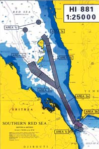
Hydrographic Surveying and Charting in the Southern Red Sea
��MC'G ���dG �H�L ` �FG��G ��SQh `G�ZhQ�dG ���YG
In December 1998, Dr. Steven Lintner of the World Bank and Captain Saeed Yafai, Chairman
�eɩdG �ī�dG ���FQ ,��aɫdG S �ɣ�dGh
��fJ ��j�e ` I���YG ᵪY�H �j���dG �Mɰ�YG ��Y IQ�j�H ,���d�H �j���dG �hD��d
Kingdom Hydrographic Office (UKHO) in Taunton. The aim of the visit was
�bE'G �ī�dGh �j���dG �Mɰ�YG ��e �H �hɩ�dG �fɵeEG ��H ��H ,�fɣj�dG
to determine whether it would be possible for UKHO and PERSGA to work
�H�L ` ...���dG �dG �eӰS �j��J �> ` ��Y �Nh ��MC'G ���dG �īH Y �a��d
together to enhance shipping safety in the southern Red Sea, specifically
by carrying out a hydrographic survey of the hazardous area around the
Q��H ᣫ�G I���G W��d `G�ZhQ�g ���e AG�LEG j�W �Y kɰU��Nh ,��MC'G ���dG
Hanish Islands. The area had not been properly surveyed for over 120
;k�e�Y 120 �e �cCG ��e ����dG �LdG Y k���e ��J / ��YG �g �CG �M ,����M
years. It was vital for new surveys to be completed before a planned Traffic
���d �`�e�YG �`��G �`�`�`�J `�b I�`j�L �`�Mɰ�e ��``�`�Y �"EG ...Qh�`�dG �e �ѰUCG �bh
Separation Scheme could be introduced. UKHO, which is "responsible"
' k'hD
'
��e ' �j ...�dG ,I�``�`�YG �``��Y�H �``j�``��dG �``M�``��YG �`�e `aGhh .�`�M�`YG �GQ�``��YG
internationally for the production of navigation charts for the Red Sea,
�G�Yɰ�YG ��J Y ,��MC'G ���d �M�YG �FG��G QG�UEG �Y
O��dG G�g ` �H�YG
.
PERSGA was, and is, very aware that this enclosed body of water remains
relatively undisturbed ecologically, but is under ever increasing danger
,�B'G �M G�J 'h ,��Y �Nh ��MC'G ���dG �īH Y �a��d �bE'G �ī�dG �f�ch
from the threat of pollution from tank washing, bilge cleaning, garbage
��dh ,�ī�dG ��HG���V'G �Y kɫѰ�f kG�H GR �e �YG �F�YG ����G G�g �CG Q�J
disposal and oil spills from ships. The Red Sea and Gulf of Aden form part
A�YG ��fh ,��b��dG ��Z �ɫ�Y �Ѱ�H ��dG �e ���JQG ` ��j �jG��e ��� �V���j
of a major shipping route that carries over 7% of total world trade,
��MC'G ���dG ��h .ɡ�e �j�dG ����Jh ,ɡJ�j��f �e ����dGh ,�ذ�dG ��b ` ��SB'G
including numerous oil tankers. The two streams of traffic, which travel
northbound to the Suez Canal and southbound from it, are forced together
,�YɩdG IQ���dG <ɪLEG �e %7 �e �cCG ��j ����FQ �M�e j�W �e GkA�L ��Y �Nh
by the Gulf of Suez in the north and by the Hanish Islands and the Straits
I��b �EG k'ɪ�T ���YG �M�YG j��dG �CG �M�jh .���dG ��b�f �e �j�dG dP ` ��
of Bab el Mandeb in the south. Apart from the extensive and well-charted
����M Q�Lh k'ɪ�T ��j��dG �N ��Y IQh��d�H �ɫ�j ɡ�e k�H�L ���YG j��dGh ��j��dG
separation scheme in the Gulf of Suez, traffic in the Red Sea is for the most
Y �VH IO��Gh ᩰSGdG �M�YG ���dG �GQɰ�e A����S�Hh .k�H�L ���YG ��H ��eh
part unregulated and the southern end of this 1,200 mile route is considered
,�YC'Gh �ZC'G ` ᪶�e �Z ��MC'G ���dG ` �M�YG �c�M �E�a ,��j��dG �N ` �FG��G
a high-risk zone for navigational accidents. A collision, grounding or other
incident involving a large tanker is a statistical probability and one that would seriously
�OG�d k�M���e ��J �CG ��� �W�i�H �a�fi ��e �e 1200 �dW d��dG ��YG G�d �H��G ���dG ��jh
damage the seagrass beds, mangrove forests and coral reefs in the area.
�d ����S � ,I�ѵdG ��b��d �OGG �e �g�Z hCG ��L hCG Oɰ�J �OGM �bh kɫFɰ�MEG ���G ��a .�M�YG
.��YG J ` �f�L�YG �ɩ��dGh iQ��dG Q��TCG ��H�Zh �j���dG ��Fɰ�G ��룰�e Y IңN Q�KBG
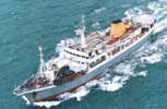
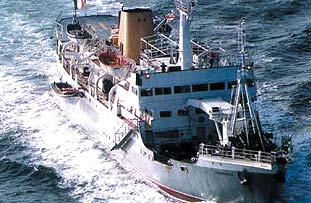
Work was formally initiated in April 1999. Terms of reference for the survey contract were prepared
and World Bank procedures followed for selecting a company. Gardline Surveys, which has extensive
��dG �GAG�LE'G ��tJGh ,���YG OY O�Hh �ɰUɰ��NG �j� ��a ;�h���YG G�g ` �SQ IQ��H ��dG CG�H 1999 �ɰ��f/j�HCG `h
experience in hydrographic work for nautical charting purposes, was contracted and mobilized its vessel
�Mɰ�YG ɪYCG ` ᩰSGh I��H TM��J ��dG ' ' ��aҰS �j'OQ�Z' ' �c��T TMe �bɩ�dG "h .�ѰS��YG �c���dG Qɫ�N'
.2000 ���dG �j���J/Ȫaf ` ' ' A���dG ��SY' ' ' ' ����S ��ThCG' ' ɡ��ذS �����H �e�bh ,�M�YG �FG��G ��SQ �VG�ZC' �j���dG
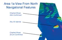
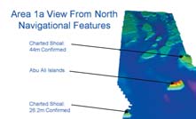
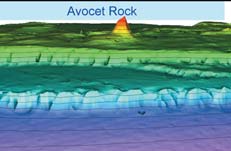
Since then the Ocean Seeker has surveyed an area of over 750 square nautical miles between the Avocet
'
, ' ⫰SaCG' ' I��U �H TMJ kɩH�e k�j��H kӫe 750 Y ɡ�Mɰ�e H�J ��e ���� ' ' ����S ��ThC ' G' ��ذ�dG �e�b �G dP ��eh
Rock, north of the Abu Ali Islands, the proposed route passing south and west of the Hanish Islands, and the
connecting routes to the south through Bab el Mandeb into the Gulf of Aden. Surveys have been carried out to
AG�LEG "h .��Y �N �EG ���YG ��H �Y k�H�L �H�dG ��Wh ,����M Q�L ��Zh ��L �� ...�dG ��YG j��dGh ,�Y HCG Q�L <ɪ�Th
the highest international standards, as demanded by the International Maritime Organization (IMO). Echo
i��H �ɪYC'G �Sɫb �GhOCG �e���SGh .�dh�dG �j���dG ᪶�YG ��ѣ�e ְ�M �dh�dG �jɩYG YC' k�ah �Mɰ�YG �ɫ��dG �g
soundings, side-scan sonar, magnetometry and sea-bed sampling have all been used to build up a picture of the
��jQɰJ �Y �e�c IQ�U �j��d ���dG ��b �e IPNC�YG ��櫩dG ���ah ,����YG �'��G I�T �Sɫbh ,Q�f��d�H ��f��G ���YGh ,��dG
underwater topography, while tides and currents have been monitored at key points in the area.
.��Y�H ��FQ TMbGe ` �j���dG �GQɫ�dGh Q��Gh �YG �UQ " ɪ�H ,�ɪYC'G
The work was hampered by unexpectedly adverse weather during the period between December 2000 and
�CG �G ��� ��dh .2001 Q�jCG/j�e �EG 2000 hC'G �f�c/Ȫ��jO �e I��dG ` �b�YG �Z �j�G �h��dG A�S �Ѱ�H ��J ��dG �CG 'EG
May 2001, but fortunately the ship was built to continue working under these rougher conditions. A fully equipped
survey launch, kept on-board, was able to take advantage of the brief periods of calmer weather to carry out
��dG IҰ�dG �G��dG Ө�SG �e �浪�a ;S�dG �j�G �h��dG �g ` ��dG �UGe �e ɡ�� �f Y ᪪��e ' ' ����S ��ThC ' G' ��ذ�dG
investigations closer inshore.
.ɡ��e Y �fih k�e�c kG���OE ��> ����d ���d G���S�H ��HɫdG �EG ��bC'G W��YG ` ���dG AG�LE' ���dG ɡ�a ����
Results have been impressive. The ship has steamed over 21,000 kilometres and recovered around 900 sea-bed samples, most
` �B'G ��fi ɡ���e ���dG ��b �e ��Y 900
.���d�H Aɩ�U �e�L
7
7


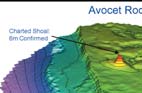
�Wh�fl �ӫ���Jh ,A�YG � IQ��e �룰�e ��b �GP �J OLh ���dG ��d ��ذ�dG ɡJ�NCG ��dG OɩHC'G �K�K Q��dG ��Jh
Three-dimensional pictures of the sea-bed reveal flat-topped submerged hills, cone-shaped
I�`e hC' ���X ��dG �gOɩHC
G eɵH I���G ' ⫰SaC ' G I��Uh ,Q�L �īg Y h���d ���dG ��b �e IO�M �jGh�H TM�J�J ���dG
structures rising steeply from the floor to appear as islands, the full extent of the dangerous
Avocet Rock - seen for the first time as a plateau 400 m x 400 m and just six metres below the
�e �j�dG ɣMh ,���dG ���S � Q��eCG ��S Y �j�j ' �Y Y TMJh ,400 * 400 �`�`�Mɰ�e �`Ѱg IQ`�U Y
surface of the water, and several wrecks that had not previously been recorded.
.�b �e s��oJ / ��dG �ذ�dG
One regional surveyor was able to spend a month on board the Ocean Seeker benefiting
Y TMsWG �M ' ����S ��ThC 'G ��ذ�dG �e Y ���T Aɰd ګ��bE'G ���YG AG�N �MC' �U��dG ��JCG �bh
from exposure to modern survey equipment and methods, and at the same time
.��ذ�dG ᪡e ���J ` �jɨd kɫH��jEG k�eɡ�SEG �b �bdG ���f `h ,��j�G ���YG FɰShh �G�e
contributing very positively towards the work of the vessel.
�����S ...�dG �eC'G ,W��YG TM��L ` �M�YG ���dG �GQɰ�Y ��UC'G ������dG �eӰS ���KCG ���HC'G �CG �Z
In all areas, however, the original design of the traffic separation scheme has been
Oɪ�Y' �dh�dG �j���dG ᪶�d ���J �e ��Y �Nh ��MC'G ���dG �īH Y �a��d �bE'G �ī�dG
confirmed as sound, and this will enable PERSGA to present it to IMO for adoption as an
"international routeing measure". The new routeing measures will be presented in 2002
QɰS GPE
'
Gh ,2002 ` �M�YG ���dG �j���H �U��G I�j��G �jɩYG ��J ����YG �eh ;
'
.2003 ɩdG ����e �H �gOɪ�YG ��j ���a G�j �e Y A��T c
This is a `first' that PERSGA can be rightly proud to have been able to implement.
�CG ��Y �Nh ��MC'G ���dG �īH Y �a��d �bE'G �ī�d �j �Yf �e R�,EG ' hC 'G ��dG G�g ��h
.����H ���J
* Pictures:
Ocean seeker the survey vessel, Chart showing the area surveyed and proposed new routes for shipping
*
:Q��dG �ɫ�J
�M�YG I�j��G �M�YG ���dGh ɡ��e " ��dG ��YG ��J �j�N , ' ����S ��ThC G' ���YG ��ذS
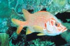
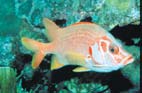
The Avocet Rock
During the early years of the 19th Century the Red Sea and Gulf of Aden were relatively quiet
' ⫰SaC ' G I��U
waterways. The movement of ships between ports was confined to local or regional trade within
the `enclosed' body of water. Exports from the region to Europe or the Americas could go north
�c�M �fɵa .kɫѰ�f �FOɡdG �M�YG ���dG �e ��Y �Nh ��MC'G ���dG ��c ���Y TM�S��dG ��dG �e �hC'G �G��dG `
to the Gulf of Suez and then overland to the Mediterranean coast, or take the much longer
�g �GQOɰU �f�ch ;'
�YG' �F�YG ��dG J NGO �bE'G hCG ��G IQ���dG Y ����J �fGYG �H ɪ�a �ذ�dG
passage south around the Cape of Good Hope. Ships were driven mainly by wind, with a small
k
�j�W ��J hCG ,��S�YG ���dG MɰS �EG kG�H �J �K ��j��dG �N �EG k'ɪ�T ���J �eEG ��j�eC'Gh �HhQhCG �EG ��YG
number of rather inefficient steamships just beginning to appear.
�bdG ` ��j�dG IH Ұ�J �dɨdG ` �ذ�dG �f�ch .�dɰ�dG A�L�dG �SCGQ M Qh��d k�H�L Q��HE'�H ��H dP �e WCG
With the opening of the Suez Canal in 1869 and the development of the much more efficient
.IA�صdG IOh�fi O�dG �b G�J ' �H �f�c �EGh Q��dG ` �jQ���dG �ذ�dG ��a �CG�H ...�dG
triple-expansion steam engines, the situation changed. Steamships became faster, with greater range
and size, able to carry more cargo. Coaling stations were established at Aden and on Perim (Mayyun)
;�ɰVhC'G �ҨJ ,IA�صdG �e YCG Q�H ����J ��dG O��dG �K�K �jQ���dG ��c��G Qɵ�HGh ,1869 �Y ��j��dG I��b ����aG TMeh
Island at the southern entrance to the Red Sea. By the 1880's a lighthouse had been built on Perim Island
��Y ` ���d�H �j��dG �ɣfi �İ�fCGh .��VCG �'�M f Y Q�bCGh ,kɪ�M �cCGh k�Y�J �cCGh ,���SCG �jQ���dG �ذ�dG ��ѰUC�a
and maritime nations were discussing the urgent need for lighthouses or light vessels at Jabal At
,��H I�j�L ` IQ��e A��H " ,���Y TM�S��dG ��dG �e �ɫ�fɪ�dG �Hh .��MC'G ���d �H��G N�YG ��Y (�j�e) ��H I�j�Lh
Tair, Zubair, and Abu Ali islands, as well as at Cape Gardafui, and on Socotra Island.
...aGOQ�L �SCGQ �f�L �EG �Y HCGh �HRh ңdG �L Q�L ��Y �FɩdG �F��YG hCG �F��YG �e�bEG �EG ��YG �L�G ���J �Mɰ�dG h�dG �CG�Hh
In the 1870's, extensive hydrographic surveys were carried out in the Red Sea between Bab
.i���S I�j�L Yh
el Mandeb and Jabal At Tair, with depths and positions measured using lead lines and
��H �H ��MC'G ���dG ` �ɣ�dG ᩰSGh ...��H ���e �ɫ�Y �j�LCG ,���Y TM�S��dG ��dG �e �ɫ櫩Ѱ�dG `h
sextants, the standard methods used up to the 1950's. Positions and coastlines of islands
were determined and hazards such as the 3-foot rock south of Hanish Al Kubra were marked
֫dɰSC'G �gh ,�ɫ�S��dGh Q�dG ȰS ��M G���S�H TMbGYGh �ɪYC'G �Sɫb ɡd�N " ңdG �Lh ���YG
on the new charts. With greater knowledge of water depths and underwater topography,
ɡW�Nh Q��G TMbGe �j� "h .�j����dG ��dG �e �ɫ櫰���G �M �e����e �X ��dG SɫdG
ships could sail with confidence through the hazardous waters of the southern Red Sea - or so
G�bCG �K�K ɡY��JQG �j ��dG I���dG �e ,I�j��G �FG��G Y �j���dG �W�iG �j�h ,�Mɰ�dG
it appeared.
�CG �ذ�dG �Yɣ�SG �ɪYC'G ��jQɰJh ɫYG �ɪYC�H �a��YG �jG�J TMeh .iȵdG ����M I�j�L ��L �bGdGh
A `rock reported' notice was inserted in the February 1886 edition of chart GB143, published by the United Kingdom
.�M ...CG Y �eC'G G�H G�g hCG ` ��MC'G ���dG �H�L ` I���G ɫYG �Y ��H ���J
Hydrographic Office (UKHO ) following reports of a new danger discovered in the general area between 14� 21'N, 42� 38'E
and 14� 23'N, 42� 43'E. A year later, in March 1887, the SS Avocet reported striking a rock in position 14� 21'N, 42� 38'E,
GB143
��dG ,
�bQ �j���dG �j��G �e 1886 ��ѰT/�jG�a ��W ` ' ' I��U �Y ��Z�H' ' �X�e �OQh �a
and the UK Admiralty recorded that "there appeared to be 24 feet of water on this rock". It certainly seemed that something
42� 38'
,k�`b��T
14� 21'
h ,k'ɪ�T
�H �bGdG �eɩdG ��YG ` �j�L ��N �ɰ��c�H ��J ��Z�H OhQh ��YCG ` I���YG ᵪY�H �j���dG �Mɰ�YG ��e �gQ�UCG
was down there. On the other hand, in April, the HMS Flying Fish found depths in excess of 100 fathoms (600 feet) while
42� 43'
14� 23'
�`�``Y I�`��H �`�eG�UG �Y ' ' ⫰SaCG' ' �jQ���dG ��ذ�dG �HCG ,1887 QGPBG/�SQ�`e ` �j���d�Hh ,���H dP �Hh .k�b��T
h ,k'ɪ�T
�Hh
investigating the reported shoal.
42� 38'
14� 21'
G�H �e k�ī�T �CG �cDYG �eC'Gh ;' ' k�e�b 24 �j I���dG �g �a ɫYG �Y �CG h��j' ' �fCG �fɣj�dG �dG�eC'G ��Sh ,k�b��T
h ,k'�`��T
TM`�V``YG
.TM�VYG G�g ` kGOLe
8
8

The existence of a serious danger to shipping was dramatically confirmed when, on 9 June 1887,
A��KCG ` (�b 600) �e�b 100 Y �j�J �ɪYCG Y �ɰ��f/j�HCG ` ��Y ' ���a �j�a' �fɣj�dG ��ذ�dG ��d
the 2,017 tons SS Teddington hit an underwater obstruction and sank near the Avocet Rock's
.ɡ�Y �YG ��dG ��YG �d ɡFɰ��SG
marked position. The new "Teddington Rock" was inserted on the chart in position 14� 23'N,
42� 42.5'E. It appeared that two rocks might exist in this area, but with hazy conditions making
�e�UG �e��Y 1887 �G�j�M/�fj 9 ` ��L��e IQ��H �ذ�dG �c�M �eCG ����L �M�e ��N OLh �cC�J �K
navigation out of sight of land uncertain at best, no one could be sure.
O�``�G TM�V``YG ��``b �``b�`�a ,A�``YG �``� �``e `F�`�H k�`�W 2017 ɡ`�d�M ``�J ��dG '
�`�`��j�J' �jQ���dG ��ذ�dG
42� 42.5'
Later in 1887, HMS Sylvia carried out a survey to search for Avocet and Teddington Rocks. She
14� 23'
h ,k'ɪ�T
�f ��Y �FG��G Y I�j��G ' ���j�J I��U' �`LQOCGh .' �`��SaCG' I�``��d
ran over the reported position of the Avocet Rock and found depths of about 100 fathoms,
�M�YG �OE ��dG �H�ѰdG �h��d kG��f ��dh ,��YG �g ` ��J��U ��g ��J �CG ���G �e G�Hh .k�b��T
then over the position of the Teddington Rock and found depths in excess of 30 fathoms.
.dP �e ��d �ѰS �K ��j �a ,��YG J ` �j�J �aCG Y �bG�dG �eC�e �Z kG�eCG ��HɫdG �jDhQ �hO
However, in 1888 HMS Stork while searching for Avocet Rock determined a least-depth of
15 feet in position 14� 22.13'N, 42� 34.5'E, some miles from the positions reported by both
�J��U �Y ���d k���e ' '
ɫث�S ' �fɣj�dG ��ذ�dG ��LCG ,1887 �Y ` �H ɪ�ah
the SS Avocet and the SS Teddington!
��dG �C
G ��Lhh ,' ⫰SaC
G ' I���d Qc�YG TMbYG �a ���a , ' ���j�J'
h ' ⫰SaCG'
�j�j ��dG ��La ' ���j�J' I��U TMbe �a ��e �K ,�e�b 100
`absolutely necessary' for the southern Red Sea and should be built at
''
Q�S' ' �``�f�``�j�dG �``�`�ذ�dG ��``Lh ,1888 �```Y ` �`�dh .�``e�`b 30 Y
Abu Ali, Mokha, Jabal Zubair and Jabal At Tair. Germany
TM`�V`YG �`�`Y k�``e�`b 15 ``�j ``�Y ``bCG �CG ' ⫰SaC ' G I��U �Y �``�`��H �`N
recommended that a light should also be placed on the Avocet Rock.
42� 34.5'
14� 22.13'
ک�V`YG �`e ɫeCG �`�H �H Y ...CG ,k�b��T
h ,k'�`��T
The costs of the lights would have to be met by levies on ships
!
' ���j�J ' h ' ⫰SaCG' ���jQ���dG ����`ذ�dG ɪ��Y �`�`HCG �j�`dG
passing through the Suez Canal and paid to the Government of
Egypt.
�gQ���Y�H �F��YG Aɰ�fE�H ��UJ �j���dG h�dG �f�c �M 1888 �Y �j /h
In April 1894 the mystery deepened. A survey was carried out by HMS
�iGh �`Y HCG ` �`�`F�`�H IQh�`�Hh ,�`�MC'G �`��dG �H`�L ` ' ' `�M IQh�`�V' '
Egeria in the vicinity of a shoal reported by HMS Yarra in December
.kɰjCG ' ⫰SaCG' I��U Y IQ��e �e�bE�H ɫf�YCG �UhCG ɪc ;ңdG �Lh �HR �Lh
1892. The search, centred on 14� 19.6'N 42� 34.5'E with an
I��b ` IQ�YG �ذ�dG Y �V��oJ �SQ �e �GQ��YG �g �dɵJ �j��J Q�YG �e ��ch
approximate radius 2 nautical miles, revealed depths of over 210 feet.
.�j���YG �e��d TMa�oJh ��j��dG
The story then moves forward 100 years when, on 17th October 1990,
UKHO was sent details of the grounding of the US reserve force vessel SS
�``�V ��H ᣫ�G ��d k���e ' ' �j��jEG' ' �fɣj�dG ��ذ�dG ��LCG PEG ;1894 �ɰ��f/j�HCG ` kɰV�Z �eC'G OGORGh
William J Callagham in position 14� 22'N, 42� 37'E, i.e. 5 miles west of
42� 34.5'
14� 19.6'
h ,k'ɪ�T
�f Y ���dG �`c�Jh ;1892 hC'G �``f�c/�`���jO ` ' GQ�j' �`�fɣj�dG ��ذ�dG ɡ�Y �HCG
where Teddington Rock was thought to be. But the Egeria survey in 1894 had
��dG ����SGh .G�bCG 210 Y �j�J k�bɪYCG ' ' GQ�j' ' ��ذ�dG ��La ,k��j�J �j��H ګe �g��b ��f �j I�FGO ` ,k�b��T
recorded depths of over 450 feet within a 1-mile radius of the position given by the
��ذS ��L �Y ��U��J 1990 hC'G �j���J/�H�cCG 17 ` I���YG ᵪY�H �j���dG �Mɰ�YG ��e J �e��Y ��S �F�� dP �H
William J Callagham!
42� 37'
14� 22'
���dG �EG ɫeCG ���N �H Y ...CG ,k�b��T
h ,k'ɪ�T
TM�VYG ��Y ' ' �g'�c .� ɫjh' ' j�eC'G �ɫ�M'G �Gb
A navigation warning was issued on 19th October 1990 for an "unknown obstruction" in position 14� 22'N,
�S �b ��c 1894 �Y ' ' �j��jEG' ' ��ذ�dG �J�LCG ...�dG ���YG ��d .��Y TMJ ' ' ���j�J' ' I��U �CG ��YG �e ��c ...�dG TM�VYG �e
42� 38'E, about a mile east of the Callagham position. Examination of satellite pictures revealed no visible
!' ' �g'�c .� ɫjh' ' ��ذ�dG ��Y �HCG ...�dG TM�VYG �g�c�eh ,kG�MGh kӫe �g��b ��f �j I�FGO ` k�e�b 450 Y �j�J k�bɪYCG
rock in either the position of Avocet Rock or in the position of the reported grounding of the SS Callagham. In
December 1991 UKHO received a comment from the HMS Tristen that she had passed over the position of the
42� 38'
14� 22'
h ,k'ɪ�T
TM`�VYG ��`Y ' ' `�> `F�Y' ' O``Lh �Y �``M�``e �``j�``� QG�``�UEG " 1990 hC'G �j�``��J/�``H``�cCG 19 `h
reported rock "several times without grounding". The only `definite' was the uncertainty.
AG�S �ɫ�d �F�e I��U ...CG OLh ���j / �Y���dG QɪbC'G Q�U ����Hh .' �g'�c' TM�Ve �e ����dG �EG �e
�j���dG �Mɰ�YG ��e J ,1991 hC'G �f�c/Ȫ��jO `h .��a ' �g'�c' ��ذ�dG ��L �Y HCG ...�dG TMbYG ` hCG ' ⫰SaCG' I��U TM�Ve `
presence, or absence, of other rocks or shoals had not been disproved. In 1995, concerned about this rock, UKHO
�CG ...CG .' ' ��OE �CG �hO �G�e I�Y' ' ɡ�Y �YG I���dG TM�Ve �a ��Y ɡfCG O��e ' ' ���j�J' ' �fɣj�dG ��ذ�dG ��SQCG kɫ�J I���YG ᵪY�H
researched the matter and asked USS Littlehales to locate Avocet Rock. This they did, finding a least depth of 4.6 metres
.A��T ...CG �e �cC��dG �Y g ' ' �cDYG' ' �MdG A���dG
over the rock. However the survey only consisted of a few lines of soundings in the area of and over the rock, and it did
not prove conclusively the extent of the obstruction or whether other shoals existed nearby.
s
����j /h ,�b�dG �EG ���j TMbG�d �g�j� ��ch ,Q�dG ȰS ��M G���S�H ��J ��dG ���dG Aɰ��SG �ɫ�Y c �f�c �G dP �Mh
In 1999 the UKHO worked with PERSGA to define the area to be surveyed for a new traffic separation scheme passing east
�dCɰ�YG ��H ��a ,I���YG ᵪY�H �j���dG �Mɰ�YG ��e b I���dG �g �Q�KCG ,1995 �Y `h .i�NCG ��V ��H hCG Q�U ...CG OLh ��f hCG ���KEG
and west of the Hanish Islands and down through the Bab el Mandeb. Tracks from the separation scheme were designed to
4^6 �j I���dG �g �a ɫ�d �Y bCG �C
G ��Lhh ɡડ� ��ذ�dG �e�a .' ⫰SaCG' I��U TMbe ګ�J '
����d' j�eC'G ��ذ�dG �e k��d�W
take ships well clear of obstructions such as the Avocet Rock, but a number of important isolated patches were recommended
�f�c GPEG �e hCG FɩdG ��M TMW�b �f Y ���j /h ;ɡbah I���dG ��e ` Q�dG Ȱ�d ��M ᩰH G�fEG �Y O�j / �J�LCG ...�dG ���YG ��d ;Q��eCG
for investigation, including a definitive survey of this particular underwater hazard.
.TMbYG G�g �e �H�e Y i�NCG ��V ��H ��g
9
9

��MC'G ���dG �īH Y �a��d �bE'G �ī�dG TMe I���YG ᵪY�H �j���dG �Mɰ�YG ��e ΰTG 1999 �Y `h
Hence the first comprehensive survey of this area, using high precision echo sounders and tidal
data, side scan sonar and satellite-based position-fixing equipment was initiated. It was carried
����dG �EG I�j��G �M�YG ���dG �GQɰ�e ګ��d ɡ��e ...�髰S ��dG ��YG �j���d ����dG ` ��Y �Nh
out by Gardline Surveys Ltd. with financial support from the World Bank. On 17th April 2001 a
FG�dG �Y �ذ�d�H iC��j �f Y �GQɰ�YG �g ⪪�U �bh .���YG ��H �M k�H�L I��YGh ����M Q�L �e ���dGh
message was received from Gardline advising that the survey had confirmed the existence of a
�LH ɡ�eh ,����YG �eɡdG ��Mɰ�YG ��H ��H �M�bG �ɫ�U�dG ��H ��dh ,' ⫰SaC G' I��U �e ���iG
serious navigational hazard in the form of a rocky shoal some 400m x 400m in extent, with an
.A�YG ���S � TMbGdG �M�YG ���G d�d ��S�M ���e AG�LEG �U�N
average depth of only 6 metres.
i��H Qɩ���S'G I��LCG G���S�H ��YG �d eɰT ���e hCG CG�H ��g �eh
The impressive results cover an area of radius 2.5 nautical miles
I��LCGh ,Q��Gh �Y�H �U��G ��fɫ�dGh ,I�j��dG �b�d�H ����J ��dG ��dG
around the Avocet Rock. It is clearly shown as a hill rising steeply
from a plateau, with submarine cliffs taking the sea bed down to
.�Y���dG QɪbC'G G���S�H TMbGYG �j� �G�eh ,��f��G ����d Q�f��dG
a second and a third plateaux lying to the west of the rock. In May
��dG �e <�e �Y�H '
�૪�d ��aҰS �j'OQ�L' �c��T ���YG G�g AG�LE�H �bh
the survey vessel MV Ocean Seeker sent UKHO a Hydrographic
' �c��T �e �dɰSQ �Uh 2001 �ɰ��f/j�HCG �e ���Y TMHɰ�dG `h .
�H �īg Y kGңN kɫM�e k�F�Y ��g �CG ��KCG ���YG �C
G ��J ' ' �j'OQ�L'
12.42"N, 42� 41' 57.29"E with a minimum depth of 5.9 metres.
ɫYG �Y �j�j 'h kɰV�Yh k'W �e �Fɪ�HQCG
�e 2^5 �g��b ��f ��e ��g�YG �F���dG �g ���Jh .Q��eCG 6 Y ɡba
without harm before 1886. But with tankers now sailing with
QG��f'G �j�T k�J �Ѱ�J I���dG �g �C
G ��JGh ' ⫰SaC G' I��U M ...��H
draughts of 22 metres, or even more, separation schemes and
Y Q���J ���dG ���S � IQ��e �h�L ɡ�e ���dG �EGh ,�Ѱg �a j
other `safe routes' need to provide guaranteed depths that would
have seemed incredible to mariners 150 years ago. The action taken
���YG ��ذS �SQCG Q�jCG/j�e ���T `h .��dG �f ��d�K �Ѱg �K �f�K �Ѱg �īg
by PERSGA has enabled international charting authorities to remove
��Y I�MGh ��V �H OLh �cDJ I���YG ᵪY�H �j���dG �Mɰ�YG ��e �E
G �aG�ZhQ�g �dɰSQ ' ����S ��ThC ' G
the doubt over the location and extent of a shoal close to the main shipping route through the
42� 41' 57.29''
14� 22' 12.42''
.Q��eCG 5^9 �Y j ' ��Hh ,
h ,k'�``��T
TM`�VYG
Red Sea, a shoal with a history stretching back over 130 years and the cause of several maritime
accidents.
�bh �B'G �eCG ;1886 �Y �b iPC' �V���J �CG �hO I���dG �g �a ��e IҨ��dG �ذ�dG �e �c :A�YG Aɰ��j �bh
�C
G ��j ' ��eB
'
'G �G��YG �e �g�Zh ���dG �GQɰ�e �E�a ,�cCG hCG kG�e 22 �EG ɡ��W�Z ��j IQ�YG ��b��dG ��ѰUCG
* United Kingdom Hydrographic Office carries primary responsibility for charts in this area. PERSGA gratefully
acknowledges the assistance of UKHO in providing archive records of the charting history of the Avocet Rock.
��e G�gh .�e k�e�Y 150 ��e �MӪd ����e h���S �T �H �f�c OɩHCG �gh ,�f��e �ɪYCG Y ���J
�FG��G ��S�d �dh�dG �ɣ��dG ��Y �Nh ��MC'G ���dG �īH Y �a��d �bE'G �ī�dG ɡJ��JG ��dG �G��G
J ,��MC'G ���dG �Y ����F�dG �M�YG ��YG �e ��j�dG ��dG ��dG ��Mh TM�V� ���G ��dG �dGREG �e �M�YG
.�j��H �OGM I�Y ` ��Ѱ�J ��dGh ,k�e�Y 130 �e �cCG i�e Y ɡ�jQ�J ��� ��dG ��YG
*
���dG �īH Y �a��d �bE'G �ī�dG �L�Jh .��YG �g �FG�N OG�YEG �Y �hC'G �dhD��YG I���YG ᵪY�H �j���dG �Mɰ�YG ��e ��j
'
. ⫰SaC ' G I���d �FG��G ��SQ �jQ�J �Y �ث�TQCG ���S OG�YE' ɡd ɡe�b ��dG I�Yɰ�YG Y �൪d ����d�H ��Y �Nh ��MC'G
10
10

F U T U R E
��Wɰ��dG
Activities
�``�``�`��YG
Habitat and Biodiversity Conservation (HBC)
...�G ���dG h �ѣdG �WGYG ��U
During March 02 a regional training course on Standard Survey Methodology for Mangroves
SSM
���T �N �JѫL ` �j ��S �h��f�YG �ī�H �U��G
��e�YG TM�L �MJ M ��jQ�J �TQh
will be conducted in Djibouti. Sixteen regional specialists are expected to attend.
.��bE'G �e �Fɰ�NCG 16 Q�M TMb�YG �eh 2002 �SQ�e
On the 18th of March 02, and lasting for two days, a Working Group meeting will be held
.�JѫL ` 2002 �SQ�e 18 ` ��Y�H �U��G ��dG j�a AɰYC' �Y �TQh �J ��S
in Djibouti.
Living Marine Resources (LMR)
�j���dG OQGYG IQGOEG
During January & February 02 the 1st and 2nd Sub-Regional Training and Research
�jG�ah �j��j ...���T �N I�L h ��Y �e c ` ���dGh hC'G ���HC'Gh �jQ��dG ...�c�e �j�J �૰S
Centers in Aden and in Jeddah will be upgraded with new equipment.
.�eR�dG �G�Y�H �g�jh�J �૰S �M 2002
A regional training course for fish enumerators will be conducted in March 02 and
�jQ�`�dG �૰S �M 2002 �SQ�e ���T ` ���dG Aɰ�ME�H ڰ�����d �bEG ��jQ�J IQhO ��S
will cover the following topics: data collection, standardization of fisheries statistics.
.��Y�H ���dG �Fɰ�ME'G ��fɫ�dG �U�d I�Me Sh �G���SGh ��e�YG TM�L Y
The component will be participating in the development of the structure and contents
Y ����J ��dGh �ī�d�H �U��G �fɫ�dG �YGd �bEG ��fɫH I�Mh Aɰ�fEG ` �cQɰ�YG �૰S
of the Regional Database, which will be developed for PERSGA by CEDARE, and will
CEDARE
���UC'Gh �QGdG O�J TMe ְS���j �� ��fɫH I�Mh TMj�J ��G G�g ` �૰S ɪc
�g���J
develop standards relating to boat/gear categories and species sub-areas.
In cooperation with the Public Awareness and Participation (PAP) component, as part
.��Y�H �j���dG
of the Micro-Grants Program, lobster traps will be distributed for fisheries in Yemen,
�jh�J �૰S IҨ��dG ��YG �e�f�H �N �e �ѩ��dG �cQɰ�YG h �eɩdG �Y�dG ��e TMe �hɩ�d�H
Djibouti and Somalia to substitute for fishing gear currently in use.
��dG ��W fi ��d �e��dGh �JѫL h ���dG �e IQ��fl W��e ` GRc��SE�d ...h��S �jOɫ��dG
In preparation for the workshop, which will be conducted in April 02, the purchase of
.�ī�dG Y �Ѱ�dG �KC��dG �GP �d�G
elasmobranch samples will take place. These samples will be stocked in the Sub-Regional
kGOG��SG ��Yh I�`L �`e c ` �jQ�``�dG ...�`c�`e ` �`�YG�``jEGh �Th�``dG �`��SC' ��`�`�Y AG�`�T �`૰S
training centers. The training course will be about "Population dynamics and stock
ɪ�SC' �h�iG �`��J ��`W h �ɩ���dG �`���e��jO �SGQ�H �U��Gh 2002 j�HG ` �`�jQ��dG IQh�dG �d
assessment methods for elasmobranch".
.ᡫѰ�dG ɪ�SC'Gh �T�dG
Marine Protected Areas (MPA)
A Train-Sea-Coast training course on MPA management will be conducted between the
�G �j���dG W��YG
6th and 13th of January 02.
Train Sea Coast
I�``�dG `
�```N �``e �`�`�`�G �`j�```�`�dG ``W�``�`YG IQGOEG ```M �`�``jQ�``J �``�TQh �``Y �`૰S
The first surveys of the proposed MPA will take place in Dongonab Bay in January 02, this work
.2002 �`j�`�j 13-6 �`�H �`e
will be conducted through the National Wildlife Conservation General Administration under the
�EG �j��j 20 �H �e I��dG ` ��`�fO �N �`��e ` �`M�YG �`�`��G �j�`��dG `W�`�d ��`M`��e hC�H ɫdG �૰S
management of the MPA component.
.�GO��dG ` �j�dG IɫG �jɪ �eɩdG �edG IQGOE'G TMe �hɩ�d�H 2002 �jG�a 20
Integrated Coastal Zone Management (ICZM)
�Mɰ�dG W��YG IQGOEG
Issuing of the special arrangements needed for ICZM in Aden.
Appointment of specialists in Somalia, Djibouti and Sudan to prepare pre-assessment reports about
.��Y ��e ` �Mɰ�dG W��YG IQGOE�H �U��G �GAG�LE'G QG�UEG �૰S
coastal zones in their countries.
.h�dG J ` �Mɰ�dG W��YG TM�Vh M �dhC'G �jQ��dG OG�YE' �JѫLh �GO��dGh �e��dG �e ګFɰ�NCG ګ�J �૰S
Preparations for the Establishment of Dongonab Bay and Mukkawar Island
���fO �N ` ��j��H �૪fi Aɰ�fE' �GOG��SE'G
Marine Protected Area, Sudan
�GO��d�H Q�e I�j�Lh
A Steering Committee has been formed made up of the primary government stakeholders that will be concerned with
���fO �N ` �hC'G ���YG ɪYCG ...���Sh .�M�YG �j���dG �ɫ���H ګ�YG ګ���F�dG ګe�G �j����YG �e �f�e ҫ��J ��� ����J "
this proposed marine protected area. The first surveys will take place in Dongonab Bay in January 2002. The work will be
overseen by and will be conducted through the national Wildlife Conservation General Administration, which is taking the
.��F�dG �dİ�YG ɡJ�Y Y �NC�J ��dGh �j�dG IɫG �jɪ �eɩdG IQGOE'G �b �e ɪYC'G �g Y �G��TE'Gh ����dG �૰Sh ;2002 �j��j ���T `
lead responsibility. The core team for survey implementation has been identified and arrangements made to ensure their
�EG �aɰVEG .ְS��YG �bdG ` ��dG TMbe ` �g�LGJ �ɪ�d �eR�dG ��ѫJ�d�H ɫdG " ɪc ��dG G�g ...OD�S ��dG SɰSC'G �b��dG ګ�J " �dh
availability. The necessary equipment for underwater work has been located or purchased and includes diving kits, air
.������d �jQh��V �G�eh �F�H��c �deh ,(Q�ShȪc) AGg �ZɰVh ,�UZ I��LCG ���J ��dGh ɫYG � ��d �eR�dG �G�YG AG��Th �j� " ,dP
compressor, generator and camping materials. A GIS consultant will conduct the preparatory work for the littoral and sublittoral
.�Y���dG QɪbC'G Q�U G���S�H dPh �Mɰ�dG �h �Mɰ�dG W��YG a �j�" ɪYC�H �aG���G ��e�YG ɶf ` Qɰ���e ��Sh
ground-truthing using satellite imagery.
dPh �U`�dG �G�`�e G�`��S�H �U�dG M �JѫL ` ��jQ�J IQhO �e�bEG �" ,�G �j���dG W��YG
.�JѫLh �e��dG ��Z ɪ`�Th ,�`e`��dG ��`�T �`��T �e �HQ�`�Y
representatives from NE and NW Somalia, and from Djibouti.
11
11