


INTEGRATED MANAGEMENT OF LAND BASED ACTIVITIES
IN THE SÃO FRANCISCO RIVER BASIN PROJECT
ANA/GEF/UNEP/OAS
Activity 1.5 The Impact of Agriculture on Groundwater Resources in the
Verde/Jacaré River Basin
Executive Summary
IMPACT OF AGRICULTURE ON GROUNDWATER
RESOURCES IN THE VERDE/JACARÉ RIVER BASIN
U F B A
Salvador - BA
INTEGRATED MANAGEMENT OF LAND BASED ACTIVITIES
IN THE SÃO FRANCISCO RIVER BASIN PROJECT
ANA/GEF/UNEP/OAS
Activity 1.5 The Impact of Agriculture on Groundwater Resources in the
Verde/Jacaré River Basin
Executive Summary
IMPACT OF AGRICULTURE ON GROUNDWATER
RESOURCES IN THE VERDE/JACARÉ RIVER BASIN
Coordinators
Heraldo Peixoto da Silva
Agricultural Engineering Department
Bahia Federal University
Collaborators
Heraldo Peixoto da Silva
UFBA
Everardo Chartuni Mantovani
UFVUFS
Haroldo Silveira Dória
LAVAL
José Llamas
Universidade Jaune I
Ignácio Morell Evangelista
Universidade del País Vasco
Iñaki Antigüedad
SRH/BA
Ricardo de Souza Rodrigues
UFBA
Ari Medeiros Guerra
UFBA
José Alberto Sampaio
UFBA
Mário Jorge Gonçalves
UFBA
Antônio Mário Coutinho
UFBA
Semara de Morais Andrade
UFBA
Roberto Bonfim
SRH/BA
March 2003
IMPACT OF THE AGRICULTURE OVER GROUNDWATER RESOURCES IN THE
BASIN OF THE VERDE/JACARÉ - BA - RIVER
EXECUTIVE SUMMARY
INTRODUCTION
The Activity 1.5 is part of the Component 1 The Analysis of the Basin and the Coastal Zone
of the São Francisco River, managed by the Integrated Management of Land Based Activities
Developed in the São Francisco Basin. (ANA/GEF/PNUMA/OEA).
With the small impact of the agriculture in the hydric groundwater resources in the basin of
the river Verde/Jacaré, the activity had as its objectives to make a participative diagnose, with
emphasis in the technical and scientific aspects of karstic hydrodynamics that is a
characteristic of the region, to define criteria and start the establishment of a model
monitoring system in the areas of the hydrographic basin occupied by the irrigated
agriculture in order to evaluate the impacts over the quantity and quality of the groundwater
and the superficial water and identify the main causes and recommend the relieve measures to
be taken.
The adopted methodology, the activities already done and the ones that are still being done
allow that the presented conclusions and recommendations can be adopted as a contribution
and reference information for the elaboration of the Integrated Management Program IMP
of the basin of the São Francisco river by the National Water Agency ANA and the Water
Resources Management Program of Bahia State. This is because this basin, study object of the
Activity 1.5 is inserted in the Water Management Region # 6, considered a model by the
Water Resources Bureau SRH of Bahia State
The execution of the activity allowed that Bahia Federal University, as an education and
research institution, through the association of the post-graduate programs in Geochemistry
and Environment of the Geosciences Institute (Hydrogeologic and Environmental Study
Nucleus - NEHMA) and in the Agricultural Engineering, identified, defined and prioritize the
research lines and training for the generation of the karstic systems, applied to the monitoring
and to the management of the quantity and quality of the water resources.
It stands out the importance and the need for the development of studies/researches applied to
the comprehension of the dynamics of hydrogeologic systems considering the interaction
between the aquifer/river and the soil use for the generation of referential information as a
support base to the integrated management of the natural resources of water and soil.
In this sense, Activity 1.5 brings subsidy for the establishment of the Integrated Management
Program IMG of the São Francisco River Basin, through monitoring systems with adequate
methods for the identification of the impact indicators, the main cause and the relieve
measures as a management strategic instrument for the sustainable use of the water and soil
natural resources, all this considering that farming activity is the biggest user of these
resources in the basin
It is important to emphasize that the agriculture is a vital and important factor in the
generation of jobs, income and hunger fighting. Because of its nature, agricultural activity
causes great impact in the use of the water and soil natural resources and inevitably generates
i
negative impacts, also being able to change significantly the hydrological, hydrogeologic and
environmental dynamics in the hydrographical basins where it happens.
The implementation of the actions of the Activity 1.5 were accomplished through meetings,
seminars, workshops and field campaigns with the local technicians' involvement,
professors/researchers, consultants, users, associations of producers, public organisms, public
companies, private companies and Non-Governmental Organizations, resulting in a
participative diagnosis. There were identified negative impacts caused by the intensive
irrigated farming in the water resources of the basin, with the increase and the systemization
of every available information on geoenvironmental aspects, characterization of the water and
soil natural resources uses and the risks of contamination.
The analysis and treatment of the data obtained allowed the identification of the impacts and
its causes; relieve measures and the need for generating of specific information about the
unsaturated and saturated zone of the water bed. Through researches it was possible the
definition of parameters that regulate the hydrogeologic dynamics (recharge, discharge,
reserves, vulnerability) of the karstic water bed, considering the exploration regime that it is
submitted to allow the calibration of the flow and transport model(s) as a support tool for
decision-making on the management of the demands and for the water quality protection.
The area of the object of study of the Activity 1,5 is located in the mesoregion Center-north
on the territory of the State of Bahia, the micro-region is named Irecê, with a code number
135. It is inserted in the Northern Diamantina Plateau on the right border of the lake formed
by the Sobradinho Hydroelectric Power Plant.
The georeferenced location defines the embracing area of the Activity in the central part of
the State of Bahia, between the coordinates 9o56´ and 12o28´ of latitude South and 40o47´and
42o53´of West longitude, the area includes the cities of América Dourada, Barra do Mendes,
Brotas de Macaúbas, Gentio do Ouro, Ibipeba, Ibititá, Ipupiara, Itaguaçu da Bahia, João
Dourado, Jussara, Lapão, São Gabriel, Xique-Xique, Barro Alto, Cafarnaun, Canarana,
Central, Irecê, Presidente Dutra, e Uibaí. These cities are totally or partially on the basin of
the Verde/Jacaré Rivers.
Under the coordination of the professor/researcher Dr. Heraldo Peixoto da Silva of the
Federal University of Bahia, the actions, studies and researches supported by the Project GEF
São Francisco were made by a multidisciplinary team with Brazilian, Spanish and Canadian
specialists with various universities of their countries involved. The Superintendence of
Water Resources of the State of Bahia was also involved.
The results are presented in 9 chapters and 9 annexes. The chapters are about the
characterization physiographical, social, economical and also the agriculture of the area
studied. It is enclosed the hydrogeologic aspects, identifies impact indicators of the
agricultural activity over the quality and quantity of the water resources, defines criteria and
technical method procedures to guide the establishment of a water quality monitoring system.
Reference information is presented to guide the establishment and development of a
hydrogeologic concept model to be validated as a decision support tool for the management of
the demands.
ii
Considering the great demand of consumptive use of water by irrigation, it was introduced a
Support System Decision-making on Agricultural Matters SISDA as a computer tool with
enough resources to guide the optimized management of water demands and also gauging the
volume of water to be extracted from the aquifer, all this considering its location and the
seasonal demand pressure.
It was defined the location of a network of reference wells and it was started the measurement
of the piezometric levels for the evaluation of the recharge volume, lowering levels and the
definition of the influence area between the wells. These are basic information for the
mathematical modeling to be used to support for the decision of technical analysis of the
water use licenses and the risk of conflicts between the users.
The applied methodology in the development of the studies and researches allowed, from
careful analysis results, to diagnose, make conclusions and suggest recommendations to be
implemented and broadened, defining the procedures and the costs.
Method procedures were defined by the consultants and professors/researchers of the Federal
University of Bahia, with the effective participation of the technicians from the responsible
government body for water resources management of the state, the SRH-BA, and also post-
graduate students participated. Field researches for collecting data were done and are still
being developed for the formation of the data bank necessary to make possible the calibration
and validation of the modeling procedures.
The activities developed and the resulting products of the consults were put in the system and
integrated. They made possible to identify the impact indicators of the agriculture in the
hydrographical basin, to know the dynamics of the weather elements and to understand the
concept of the complexity of the river/aquifer system for the structure and to start the
establishment of a modeling system for supporting the participative management of the water
resources in situations were the irrigation plays a big role on water consumption.
The stimulated activity brought close the Superintendence of Water Resources and the
Federal University of Bahia, a very important relation. It resulted in the celebration of an
important partnership that allowed the integration, the broadening of the actions and the
continuity of the activities of monitoring, modeling and staff training.
A process of mobilization of the water users, public administrators, public companies, private
companies, non-governmental organizations and schools was accelerated through the
accomplishment of technical meetings, seminars, workshops and training sessions.
It allowed integration and it brought close the local government, the society and the
university.
1. PHISIOGRAPHIC CHARACTERIZATION OF VERDE/JACARÉ SUB-BASIN
1.1. Location
The Verde/Jacaré Rivers are tributaries on the right margin of the São Francisco River, their
hydrographical basins include all the SanFranscican Depression, the Irecê Plateau and the
Diamantina Plateau, its total area corresponds to 18.150 sq.km.
iii
Taking as a reference the State Capital, Salvador, it can be reached through the Federal
Highway BR- untill the city of Feira de Santana and from there it is necessary to continue
through the State Highway BA-052 (Beans Highway) until Irecê and/or through the Highway
BR-242 (Salvador-Brasília). The Figure 1 shows the location of the Activity 1.5 in the map of
the State of Bahia divided in Water Management Regions.
SUB
PROJETO
. 1.5
ÁREA SUBPROJETO 1.5
Figure 1. Map of subdivision of administrative regions of water and hydrographic
basins of Bahia state, standing out the area of Sub-project 1.5
1.2. Geomorphologic Characteristics.
The geomorphologic characteristics of the region are marked by the following units: Morro do
Chapéu Plateaus, Northern Block Plateaus, Chains of Mountains in the western border and
pediplan in the center. The limestone plateau of Irecê is a geomorphologic unit well
characterized for its table form softly wavy and with the altitude ranging around 700 meters
(GUERRA, 1986).
The valleys usually present themselves asymmetrically, with a plain bottom, well fitted
channels and sudden slopes. They are constituted of limestone walls that can reach up to 50
iv
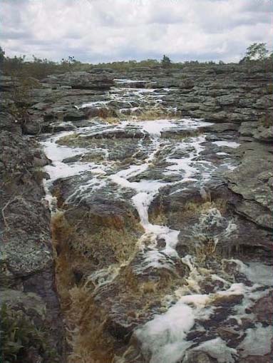
meters (BAHIA, 1995). Sudden walls can be observed all along the Jacaré River, the only
significant drainage system that exists in the area (GUERRA, 1986).
The Irecê Plateau is constituted a plateau full of discontinuities in which the altitude varies
from 600 to 800 meters, being characterized by its topography lightly wavy, with soft
elevations and without the formation of cliffs, eventhough it locally presents considerable
amplitudes with some altitude variation from the top to the base (BAHIA, 1995).
The Romão Gramacho Path is characterized by an area drained by the Jacaré river in a space
formed by cenozoic deposits. In the surface, these deposits are mixed with more recent
formed debris, the ones that composed a mixture of water sediments, sands and lumps with
the limestone favored by the climate conditions. The declination of the river bed is very small,
sometimes even inverted, and it forms ponds where the water accumulates for all the dry
season (BAHIA, 1995).
Figure 2 presents an plain-altimetric image that expresses topographically the relief in the
water dividers of the basin.
Figure 2. Representation (3D and 2D) of topography, where can be identified,
with more clarity, the highest points of Verde/Jacaré Rivers Basin..
1.3. Hydrometeorological Characteristics
The weather of the region is determined partly by the atmosphere general dynamics. These
dynamics act sometimes in the direction of reducing the regional variations of the weather
elements and sometimes increasing these differences such as temperature and precipitation,
these have an enormous influence in the agricultural activities of the basin.
The rain behavior is characterized for presenting a more intense rain period from November
to March, rain can happen on the months of April and October, varying between 40 mm and
50 mm per month, in an average.
v
From May to September the precipitation rates are insignificant. They vary in the average
from 4 mm to 14 mm per month. In August the lower average precipitation value of 4.3 mm is
reached. The total precipitated volume is about 700.6 mm.
Due to the importance of the dynamics comprehension of the hydrological cycle and its
tendencies, for applications in the studies of recharge, hydrodynamics, and the calibration of
the Support System for Decision-Making on Agricultural Matters for the optimized
management of the water use by the irrigation users, the spatial and temporal variabilities with
the analysis of the consistency of the climate elements obtained a detailed study that is on the
Annex I.
The climatologic characterization of the studied area was done based on the data of the Irecê´s
Meteorological Station, with the reference of the historical series of 1944/1994 found in the
study of BARBOSA (1998). According to the weather classification of Köppen the climate of
the region is the Bsw"h'(very hot and semi-arid, steppe kind) (BAHIA,1995).
The significant spatial and temporal variability of the precipitation associated to the low
yearly pluviometric rates over the basin is one of the main factors for the occurrence of water
shortages in the region. It is characterized by a significant reduction in the precipitation in the
periods of May to September in Irecê (central basin part) and from June to September in
Xique-Xique (northern basin part).
Eventhough a total seasonal reduction on the basin precipitations can affect the water granting
criteria, the management of the water resources and the irrigation handling are much more
affected directly by the variations in the inter-seasonal space and time scale, they also affect
the society in a much stronger manner.
For example, a year on which the total pluviometric overcomes the average can be a year with
severe restrictions for the agriculture and also be an excellent year for water storage. In this
way, the intra-seasonal pluviometry has an extreme importance in the scope of these
applications (agriculture and water resources management).
Even in years (months) in which the annual pluviometric totals (monthly) are next to the
historical average, the time distribution over the rainy season can substantially affect the
water resources and also the agriculture. The high variability of the rains observed in the
basins of the rivers Verde/Jacaré, during all year long is a determining factor for quantifying
the needs for irrigation of the diverse cultures and other needs.
The measures taken for a long period of time in the basins of the rivers Verde/Jacaré show a
year average of about 630 mm and standard deviation of 52% characterize this region as a
semi-arid one.
The time series analysis of the precipitations (mm) and its tendencies on the years from 1911
to 1983 in the Verde/Jacaré rivers basin show that in all the observation period the
precipitations were not below 300 mm and also have not gone above 1200 mm. These cycles
represent the climatic behavior on the basin , these cycles seem to be linked to the events of
the El Niño/ Southern oscillation, these occur in intervals of four and/or seven years, its
intensity is variable.
vi
Eventhough this phenomenon occur in the Pacific , its consequences are sensed in all the
planet. The occurrence of four events of the El Niño considered strong (1918, 1932,1932 and
1882) are indicated in the figure 3. Other events of rain scarcity also appear in this figure.
Years with abundant rains are alternated by years that have a minor rain occurrence in a
compensatory manner, reaching the average precipitation that characterize the basin climate.
The high dispersion rates of the precipitation correspond to another characteristic of the rains
in the semi-arid climate. The yearly average standard deviation has a value of 154 mm being
almost 25 % of the yearly average precipitation of 626,9 mm. The tendency line presented in
Figure 3 was obtained through the square minima method where X represents the time in
years.
The tendency curve describes an oscillation of the precipitations between 1911 and 1983
followed by stabilization in the fifties. This description can obey two interpretations: one
corresponds to the long term cycle typical of the El Niño weather system; the other is a
manifestation of changes in the precipitations, mainly because of the deforestation of the
native vegetation for instance.
Figure 3. Average temporal series of precipitations (mm) and its tendency in the
long run within Verde/Jacaré Rivers Basin, between 1911 and 1983. The
red line indicates the tendency obtained through the method of minimal
squares.
Figure 3 shows the average behavior of the total annual of the precipitations in the basins of
the rivers Verde/Jacaré. In this Figure it can be observed average totals above 800 mm,
considered rainy areas, the higher regions of the basin close to the water dividers that are the
limits of the hydrographical basin. While in all the other sectors of the region these average
totals are inferior to 700 mm per year, mainly in its central part where other values will not
even overcome 600 mm per year.
vii
The present evolution of the average precipitation on the basin studied shows a certain
definition of the existence of a "rainy season", that is, in a certain period of the year the rains
are abundant and as a consequence of that, there is a well defined "dry season".
The main rainy season of the basin is included between the months of November and
February (NDJF), with a rain peak in December. The second season includes the months from
December to March (DJFM), with a peak in March. The permanence of the frontal systems is
a main mechanism caused of precipitation.
The study allows the conclusion that the seasonal variations (monthly and yearly) affect all
the meteorological variables that generally are mutually dependant. This is valuable
information for the strategic planning of the irrigated agriculture allowing the view of a
detailed hydrological balance sheet.
The information generated by the historical series serves as a fine adjustment in the
understanding of the recharge periods of aquifer and the seasonal variations of the demands
and availability of the mathematical modeling of the system river/aquifer and in the
calibration of the Support System for Decision-Making on Agricultural Matters SISDA as a
tool for optimum management of the irrigation.
1.4. Geological Characteristics
From an area of about 8,500,000 sq. km. of the Brazilian Territory about 213,006 sq.km. are
constituted by outcrops of carbon rocks. From this total the State of Bahia has about 65,163
sq.km. of carbon outcrops, out of its 567,296 sq.km. of its total territory.
It is estimated that the São Francisco River Basin has 150,575 sq.km. of outcrops out of a
total area of 645,067 sq.km., reaching about 23.34% of the basin. It is highlighted the fact that
mainly the carbon rocks occur in the region of the springs, in the state of Minas Gerais up to
the city of Juazeiro in the state of Bahia going all the way to the Vale do Salitre (Saltpeter
Valley) and the Microregion of Irecê, it also possible to see the occurrence in other
hydrographical basins in the state of Bahia. The carbon sequence in the Bambuí Group, in the
Irecê Plateau, Central Bahia region, covers an area of about 15,000 sq.km.
The hydrographical basins of the rivers Verde/Jacaré are inserted in the geological context of
the Diamantina Plateau Central Bahia Region. From the paleographical point of view, three
units stand out: the crystal substratum (Caraíba Group), the quartz substratum (Diamantina
Plateau Group) and the cover (Bambuí Group), (MARINHO, 1977).
In the microregion of Irecê the lithologies of the Bambuí Group dominate, constituted by old
rocks, with the age of about 500-630 million years from the Pre-Cambrian Superior
(RIBEIRO, 1985).
According to GUERRA (1986), the denomination Bambuí comes from the city with the same
name that is located in the south of Minas Gerais, RIMMAN (1917) named the carbon
sequences that outcrop there, writing this name in the Brazilian Geological History. The
Bambuí Group defines and characterizes a long sequence of clastic and carbon sediments that
occur in the east-center portion of Brazil in the domains of the Hydrographycal Basin of the r
São Francisco River .
viii
The geology of the region is predominantly composed by the Sete Lagoas Formation,
constituted by calcite limestone, dark grey finely stratified with milky calcite and quartz
dikes.
The mineral composition shows a predominance of calcium carbonate, superior to 90%,
followed by a small magnesium quantity (<2%). Low contents of aluminum-silicates (1,5%)
and quartz, also 2% of carbon and small quantities of sulfates that along with the organic
matter is responsible for the black color of the rock (SILVA,1977).
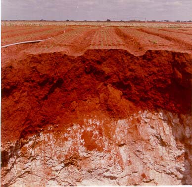
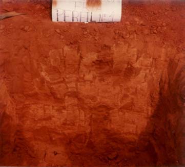
1.5. Soil Characteristics
Accordingly to BAHIA (1995), eventhough the region presents other kinds of soils,
predominantly occur the Latosols and Cambisols.
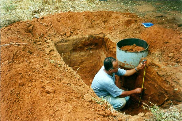
Picture 1. Cambisol Profile
Picture 2. Oxisol Profile (Latosol)
1.6. Plant Cover
The region presents the largest part of the area occupied by the caatinga (savanna), also
having transition areas in a smaller scale.
On the margins of the Jacaré River the main physiognomy is the Dense Arboreal Steppe,
forming also paths. These are vegetable formations with the presence of grasses and sedges,
like the rush and the "taboa" plant, and also common species of the caatinga, like the
itapirucu, mulungu and the Carnauba Palm Tree (Copernicia cerifera). These paths are plant
formations over alluvial terrains (BAHIA, 1995).
According to studies made by COUTINHO, in sites with the predominance of Cambisols
(limestone), it is common to find the following species: "barriguda-lisa" "Barriguda Tree"
(Cavanillesia arbórea), "Embiratanha" (Pseudobombax sp.), "Inharé" (Brosimum sp),
"Angico" (Anadenanthera macrocarpa) and "Quiabenta" (Quiabentia zehntyeri).
2. SOCIOECONOMICAL CHARACTERIZATION AND AGRICULTURE OF THE
SUB-BASIN
2.1. Socioeconomic Characteristics
ix
According to the last demography census in Bahia State made by the IBGE in the year 2000
the population of the region of Irecê corresponds to a percentage of about 3% of the total
state. There are 372,944 inhabitants occupying an area of about 4.6% of the total state
territory, 26.155 sq.km., including 19 cities.
The school regional system is structured in four levels: pre-school, elementary school,
high school and college, all distributed in schools supported by the state, the cities and
private institutions.
The public health system is characterized by two basic services, hospitals and clinical,
distributed in 23 hospital units with 944 beds, 14 of them are supported by the cities, 8 of
them are private and one of them is liked to the Federal Government. The clinical service is
structured in a network of 108 units, distributed in all the cities, with "health clinic posts",
"health centers" and policlinics.
The infra-structure of the region of Irecê does not give a complete support for the economical
activities, it is specially noted the limitations of the water resources and other basic systems
that allow the overcoming of the natural restrictions that affect the production process.
The average energy consumption is about 149,147 thousands of kWH, 20% of these are
consumed by the agriculture, mainly the irrigation.
It is estimated that 65% of the population has access to the water supply systems. The region
has available water supply systems managed by the Water and Sanitation Bahia State
Company EMBASA, the Autonomous Water and Sanitation System SAAE, the National
Health Fund FNS, a body of the Health Ministry and also various simplified systems
(fountains of water supplied by tubular wells), maintained in the rural areas by the City Halls,
these occur in an isolated way, or in a participative one, in a partnership with associations of
small rural producers or workers.
The environmental sanitation involving the collection of sewage and solid waste is precarious,
it can be concluded that it almost does not exist the rain water collection network in the cities
neither systems for proper technical destination of the solid urban waste. In all cities, the
cleaning of the urban trash is done by sweeping, collection and the use of various
transportation kinds: dumpcart, truck, tractor or coach.
The transportation net is characterized by the predominance of the roads, the hydroways are
non significant, there are only a few number of paved airplane landing sites and there are no
railroads. The main road axis is the BA-052, it crosses the region in the direction east-west,
allowing the national integration through the highway BR 116.
The integration in the regional scope is done by secondary roads paved and concreted,
connecting the cities in the grain producer's area. The tertiary road network is very
precarious, but it still plays an important role connecting small rural villages and also
allowing the access of the equipments in the urban zone.
The telecommunication services available in the region are the ones made available by
TELEMAR; they have 7,433 phones and communications via internet. It also stands out as
communication vehicles the TV, the radio, newspapers, the postal services and telegraphs.
x
2.2. Production Activities
All productive activities responsible for the generation of jobs and income are centered in the
agricultural and livestock, specially the irrigated agriculture, and also the induced commercial
activities.
The Microregion of Irecê constitutes the economical region # 11 of the Bahia State, its
agricultural structures are going through significant changes, specially in the last decades,
where there has been a passage from a traditional economy basically constituted by the
extraction of natural resources to an agriculture much more technical. There are from the most
traditional farming up to modern and technical agricultural practices, such as the use of
irrigation equipments, machines, implements and inputs.
The main economical activity of the region is the agriculture and as a consequence of that it is
the one that absorbs most of the working force and generating the most significant values of
income. The vast majority of the areas that are cultivated is used with the dry agriculture,
taking advantage of the rainy season, the irrigation is expanding in a fast way with the use of
the groundwater on the Irecê Plateau and also the superficial waters of the rivers Verde and
Jacaré (CODEVASF, 1993).
After the eighties an intense and growing process of implementation of the vegetable
(legume) irrigation crops, centered in the plantation of carrots, onions and beet took this
region to the first place of the production of the Northeast of Brazil and also the biggest
continuous production area of carrots in Latin America. There is also a small explored area
with fruit plantation.
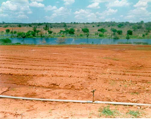
Regarding the use of the water resources, considering the soil potential and the agricultural
tradition of the region there has been a significant raise in the water demand for irrigation.
This can critically compromise the water availability on the basin (CODEVASF, 1993) in
case the support capacity of the aquifer is not respected and/or the recharge dynamics is
affected by the negative impacts over the water flows in the saturated and in the unsaturated
zones.
According to studies made in the region, on the Irecê Plateau there are approximately
320,000 hectares of soils available for the irrigation, however the potential of the underground
water for exploration is only able to irrigate 26,000 hectares (BAHIA, 1995). Data of the
Superintendence of Irrigation of the Secretary of Agriculture of the State of Bahia SEAGRI
estimate the existence of more than 6,083 irrigated hectares and 10,000 drilled wells in the
Microregion of Irecê.
It was made a careful evaluation of the efficiency of the irrigation through the use of the
Support System for Decision-Making on Agricultural Matters- SISDA , a computer tool with
resources to assess and guide about the water demands and to generate technical
recommendations to avoid the indiscriminate use of water and energy. The complete study is
in Annex 2. The areas evaluated are under exploitation through intensive irrigated agriculture,
using the center-pivot irrigation method and localized irrigation, with a low efficiency on the
water use.
xi
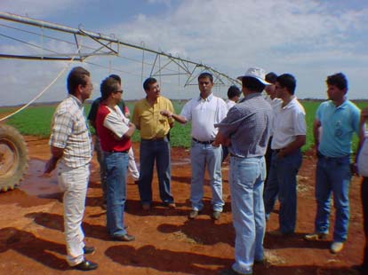
Picture 3. Implantation and training for Picture 4. Evaluation of the efficiency of
the use of the support system
water use and of irrigations
of decision-making- SISDA
handling
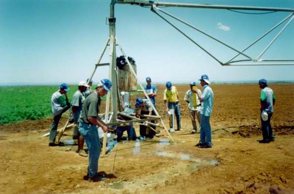
Picture 5 Installation of structure of data collect
to feed SISDA for the optimized
management of hydric demands in pilot
area
3. HYDROGEOLOGIC ASPECTS OF VERDE/JACARÉ SUB-BASIN
3.1. Hydrogeologic and Hydrodynamic Characteristics
The hydrogeologic and hydrodynamic characteristics of the water formations define their
capacity for water storage and transmission. Appropriated for each lithological kind or aquifer
formation, the storage capacity (porosity) and water transmission (permeability) is the result
of the relation of geological factors of a rocky body, from its formation.
The hydrogeology of the karstic water bed of the Bambuí group is characterized by karstic
sediments that form inter-grain porosity ways or continuous ways, in an opposite way the
crystal rocks form porosity ways through the cracks or the discontinuity. In the karstic the
porosity is called primary, in the other ones it is called secondary or acquired porosity. Still in
this formal division in two great groups, it stands out because of its unique behaviors the
extrusive rocks and the limestones.
xii
Its main characteristics, however, the dominating presence of secondary porosity in the
processes of carstification. These processes, associated with the crack porosity whenever it is
present, make this group the one with the most special and complex behavior for the
development and validation of the modeling.
The karstic water beds represent many peculiarities and the characterization of the hydraulic
system of this kind of water bed is one of great complexity, considering its
hydrological/hydrogeological parameter, where the storage and the flow of the underground
waters are related to de dissolution or the fracture of the carbon rocks.
From the hydrogeological point of view the karstic system can be represented as an
underground network of tubes (karst network) and a very high hydraulic conductivity (K>10-1
m/s) built in a rocky matrix of low permeability (cracked limestone) with K values ranging
from 10-3 m/s to 10-7 m/s, depending on the cracking and stratification degree.
The storage in the karstic system is low because of the low permeability cracked limestone.
The logic of underground flows in the karstic network is, usually, always linked to the exits
(springs) of the system (GRASSO & JEANNIN, 2002).
The biggest hydrogeological challenge is the characterization of the hydrodynamic
underground flow laws that rule the different kinds of porosity that happen in the karstic water
beds for the dynamical recharge modeling (diffuse or concentrated), storage and underground
flow (channel or dispersed).
The management of the water resources in the karstic areas requires specific studies and
special proper planning, in the specific case of Irecê, the semi-arid conditions and the
exploration pressure that the aquifer is under. The method of the natural and artificial tracers,
the use of the rain simulator are the most efficient resources among other experimental
resources to make possible the knowledge or estimate hydrodynamic parameters for the
modeling of the karstic system.
NEGRÃO, 1987, established boundary conditions for the study of the aquifer, defined flow
lines and isolines of the aquifer level considering the exploitation level and the available
information on that moment.
GUERRA, 1986 presents and discusses the data of a piezometric campaign made in the period
of 1980-1982, with a monthly frequency in some wells placed in the plateau of Irecê.
Considering the exploitation conditions and the hydrodynamics of the aquifer, in the studied
period it was observed a yearly variation from 8 meters in some wells to 2 meters in others,
resulting in an yearly average of 3.3 meters.
These information are valuable as a reference data, starting data, for the adjustment in the
development process of the concept model and as a comparison basis with the present
exploitation conditions of the groundwater, to assess and quantify the lowering tendency.
xiii
Jussara
600
BA - 052
600
787
Central
662
725
725
787
600
São Gabriel
816
Presidente Dutra 662
Irecê
Joao Dourado
América
725
Dourada
Ibitá
787
725
Ibipebá
725
Canarana
Cafarnaum
725
Barra do
Mendes
Barro Alto
Rio Jacaré
787
818
787
Linhas de fluxo
Isolinhas do nivel
Souto Soares
725
freático (m.s.n.m.)
662
Iraquara
30 Km
Cochó do Moleiro
Figure 4. Phreatic level's isolines and flow lines.
Source: Negrão, 1987.
xiv
3.2. Well Inventory Largest Concentration Areas
BACIA HIDROGRÁFICA DOS RIOS VERDE E JACARÉ - BA.
41 o
11o
11 o
ITA
IT GUAÇU
DA BAHIA
JUSSARA
R
~
a
c
h
o
CENTRAL
SAO GABRIEL
IE
m
G
r
a
PRESISDENTE DUTRA
~
a
o
E
^
E
IRECE
JOAO DOURADO
m
D
~
D
'
o
FAZ.
Z CURR
R AL
A VELH
L O
R
UIBAI
R
E
GENTIO
V
FAZ.
Z BA
B IXA
d
o
DO O
DO U
O RO
FAZ.
Z ÁGUA
U F
RIA
O
LAPA
LAP O
~
B
rra a g e m
DA PEDRA
d e M
ri o r ' o s
AME'RICA
DOURADA
O
IBITITA '
ITA
Vereda
Vered
I
R
o u
'
R
c
h
c are
.
Jac are
G r
edn
a
IBIPEBA
CAFA
CAF RNAU
A M
R io
R i
CANARA
R NA
BARRA
R DO
MEND
N ES
BARRO ALTO
S
BARRO ALT
S
o
l
d
a
MULUNGU
d
a
DO MORRO
c
h
.
R
12 o
12 o
41o
o
LEGENDA
BAHIA
LIMITE DA BACIA
SALVADOR
RIO PERMANENTE
RIO INTERMITENTE
15Km
0
15
30 Km
ESCALA 1:1 500.000
Figure 5. Location of the major concentration of wells exploited in the Verde/Jacaré
River Basin.
According to information of local companies, NGOs and users, it is estimated that a number
close to 10,000 drilled wells are exploiting the aquifer, most of them were drilled without any
licensing, without any study of the interference radius between wells by the management
government body, the Superintendence of Water Resources SRH, with all the conflict risks
and the compromising of water quality.
During the development of the Activity 1,5, it was possible to make a preliminary inventory
of wells investigating the registers of the Rural Electricity of Bahia CERB, the
Superintendence of Water Resources -SRH and local companies of well-drilling. The biggest
concentration of wells is in the municipality of Lapão, where there are concentrated 60 % of
xv
the wells, followed by América Dourado in second place, João Dourado in third and Irecê in
fourth.
In an universe of approximately 5,000 registered identified wells, the vast majority presents
only information about the drilling (profile or lithological description, pumping test and some
parameters in the water quality such as nitrates, chlorides and phosphates) they are not
georeferenced and even those which present the coordinates have low precision on them.
All the gathered information of the well inventory with coordinates, representing an amount
of 807 wells, were organized and put in the system in a chronological growing order by
drilling year in the period of 1962 to 1999, a scenery of 37 years, to observe the signals of
contamination risks of nitrates, chlorides and the lowering tendency. The inventory of the
wells can be found in Annex 6.
3.3. River/Aquifer system and the Availability of Underground Water and Superficial
Water
The recharge of the aquifer is basically done by the precipitation; however, it should also be
considered the contribution of the irrigation, due to the extension of the irrigated area and the
frequency and intensity of the irrigations. Another possible contribution hypothesis is the
vertical upward recharge made by the cracked lower water bed.
The global water availability for the system river/aquifer can be estimated around 200-250
cubic hectometers per year, considered the uncertainty because it was determined from the
available elements of existing the water balance. In the year of 1976 it was exploited 1 cubic
hectometer, this value passed to 12,8 in 1986 and 22.6 in 1991.
The discharge of the aquifer is also significant, in the direction of Jacaré River, but the
possibility of the occurrence of deeper flows in the north direction with no relation to Jacaré
riiverbed in the direction of the Verde river is not discarded, according to previous affirmation
and also because of pumping.
The study of the surface water availability defined reference criteria to guide the granting of
the surface water and the development of a model to help the decision for the management of
surface waters on the basin.
As an estimate base for availability of water resources, it was mainly used the available data
of fluvial historical series. In Annex 1 it is described all the methodology for analysis and
treatment of the resulted information, considering a period long enough (22 years).
The most important contribution of this part of the study was the definition of a model of
administration of the surface waters, based on a balance function among the water total
availability, considering the relationship rain-flow. The model can serve as base in the
decisions for granting, for as it can quantify the acceptable risk and the maximum flows that
they can be granted, with a certain warranty, depending on the established priorities for the
manager body or committee of the basin.
In this first stage a monthly scale of availability was considered, however it would be more
necessary and appropriate to reduce this period to ten days or one week, above all, in the
xvi
critical periods where the demands are more urgent and necessary and the availability even
more reduced.
3.4. Surface Water and Underground Resources Use
The pressure of the uses over the rare surface and underground water resources available in
the Verde/Jacaré Rivers is characterized by the strong demand of intensive irrigated
agriculture, already approached in previous chapters, followed by the human supply of some
municipal districts that do not have access to the supply through the Mirorós reservoir water
line that supplies most of the cities on the Microregion of Irecê.
The lack of precise knowledge of the hydrodynamics of the waterbed and consequently the
criteria for the analysis and granting considering the interaction between the river/aquifer and
the inexistence of a effective governing body on the basin, are all risk factors of a possible
overexploitation and lowering of the quality of the water resources in the basin, what is being
confirmed through statements of water users about existing conflicts.
Because it is an experimental basin, defined reference by the policies of the Water Resources
Management Program PGRH of the State of Bahia, the studies, the participative
troubleshooting, the seminar, the workshop and the technical meetings confirmed the need of
strategic actions/inteventions instigated by its management body and participation of the
water users, the public bodies and the university, to structure colectively a model of
sustainable management and water quality protection on the hydrographical basin, these bases
were defined in the Activity 1.5.
4. DIAGNOSIS SYNTHESIS AND INDICATIVE OF IMPACTS OF THE INTENSIVE
AGRICULTURE OVER THE QUANTITY AND QUALITY OF GROUNDWATER
AND SUPERFICIAL WATER
According to the experimental methodology developed for the Activity 1.5 it was made
possible to make the diagnosis through the quantifiable indicators (infiltration, piezometric
level measurement, analysis of water samples) to identify the physical degradation signs of
the soil and the analysis of the landscape.
The synthesis diagnosis was centered in the perception of the provoked modifications by the
human activity over the natural resources, soil, water, vegetation, that are part of the physical
environment of the hydrographical basin, in consequence of the conventional agricultural
model that is traditionally used in the basins of the Verde/Jacaré Rivers.
The users of the water resources of the region, in statements, affirm that the most perceptive
impacts, in which the main cause can be associated to the implementation of the intensive
irrigated agriculture on the basin is the reduction of water quantity and the degradation of
water quality.
This evidence is a consequence of the land occupation process, the appropriation and the use
of the natural resources, soil, water and vegetation, that transformed the natural environment
of the region (caatinga) to an agrosystem characterized by the dry agriculture, livestock and
later the irrigated cultivations of vegetables, most of the times the management system is not
proper and there is no adoption of water or soil conservation.
xvii

The withdrawal with no orientation of the plant cover in regions close to water springs and
also aquifer recharge and the margin of the rivers associated to the effects of the degradation
of the physical-chemical soil characteristics as a consequence of the intensive mechanization
without considering the management of the water and soil principles, the water dynamics of
the system the intensive and abusive use of pesticides, fertilizers and herbicides and the lack
of sanitation are the main causes of the impacts known by the community, diagnosed and
measured by Activity 1.5.
As a continuation it is presented images that show some signs of degradation observed in the
of the Verde/Jacaré River Hydrographical Basin and details of some activities developed in
the field.
Picture 6. Soil degradation and instability
Picture 7. Soil mechanization and soil use
of the aquifer structure.
up to the river shore, causing
Compression of the "dolina" as
sedimentation and degradation
consequence of over-
of the basin.
exploitation.
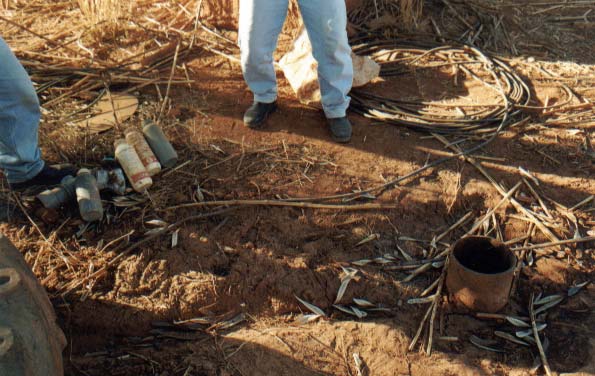
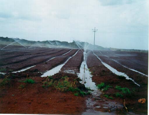
Picture 8. Pesticide recipients discarded in Picture 9. Waste of water due to
the environment besides a open
unefficient irrigation and soil
well.
management.
xviii
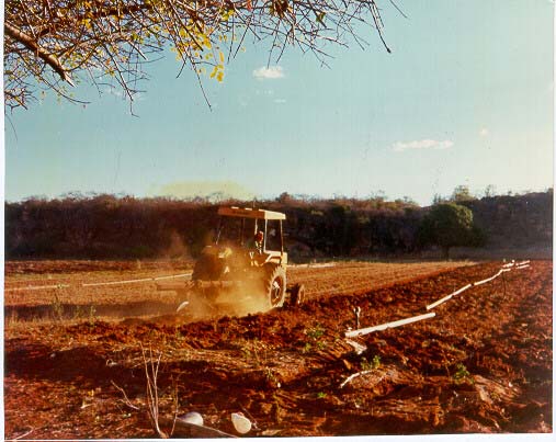
Picture 10. Intensive mechanization
Picture 11. Evaluation of physic and
causing physical-hydrical soil
chemical degradation process
degradation
in the aquifer unsaturated
area (irrigated soil)
5. EXPERIMENTAL SYSTEM OF CONTROL AND MONITORING
Analysis studies of the degradation risks of water quality in the rural zones or basins where
the activity of agricultural production is intense consider as a main causes of pollution/diffuse
contamination the use of chemical products such as pesticides, fertilizers and the lack of basic
sanitation.
It is evident the need to discipline, reduce and monitor the use of such products, the release of
the sewages and the disposal of solid waste for the reduction of the natural resources
contamination of water and soil.
The intense and not careful use of these chemical products, its mass production, the ease of
getting them with no prescription or inspection and also the careless in the use and knowledge
of the persistency of it in the soil and in the water after its application is an unquestionable
risk for the environment and the public health.
This problem turns even bigger when it deals with short term crops (vegetables,) and the ones
with a great susceptibility, for instance the tomato culture. Due to this particularity, the
irrigated agriculture practiced in the hydrographical basin of the Verde/Jacaré Rivers and the
sub-basins of the São Francisco River, require special attention because traditionally it has
been practiced a traditional agriculture model with great use of herbicides, pesticides and
chemical fertilizers, in the majority of the time it is used not obeying the use limits as
established by the laws and it is not used any prescription for the product.
The results of this stage of the completed diagnose and the object of Activity 1.5 in a
partnership with the Federal University of Bahia and the Superintendency of Water Resources
SRH of the Bahia State, about the study of environmental impacts of the agriculture in the
water resources of the basins of the Verde/Jacaré Rivers allows the conclusion that the
Microregion of Irecê can be considered a diffuse contamination risk zone of the water and the
soil.
According to the Superintendence of Water Resources (1995), the diagnosis made through the
Direction Plan indicates that the zone named Plateau of Irecê uses about 10% of its water
reserves to supply water for humans and animals, and even with the risks of contamination by
xix
the massive use of chemical products (pesticides, fertilizers and herbicides) there is no
monitoring and using criteria established.
Considering the present condition and the increase of the irrigated agriculture in the basin of
Verde/Jacaré Rivers, with a continuous and growing application of fertilizers and pesticides, it
has been made necessary the implantation and systematic use of a monitoring and controlling
program of diffuse contamination risks of the toxic waste in the environment, determining its
effects and pollution risks of the water bed, of the surface waters and the population;
The diagnosed situation recommends the continuity of the mapping of the risks, the
implementation of proper public strategic policies for the decrease of the identified impacts
through the mobilization and education of the communities, the participation of research
institutions and the systematic presence of the public body responsible for the management
and conservation of the natural resources of water and soil.
The environmental meaning of the presence of these chemical wastes in the region is almost
unknown since little is known of its nature, effects, composition, biodegradability, how toxic
it is and the cumulative nature of the used products, also how difficult it is the detection by the
conventional methods, that can underestimate the total load of pesticides in the waters, soils
and foods.
Research results conclude that the greates part of the majority of the applied products in the
agriculture remains in the soil, a percentage from 50% to 70% approximately can hit the
water. What represents a loss of pesticides and also the fertilizers for the agriculture engineers
it represents a real risk of the toxic waste to reach the water bodies, with all the known
consequences for the public health and animals when the body of water is used for the supply
of the animals.
With the objective of characterizing the use of pesticides in the agricultural production system
in the Microregion of Irecê and the water contamination risks, it was applied a questionnaire
and field campaigns were made to study the pesticide diffusion dynamics in the saturated
zones of the aquifer and also the analysis of the presence of toxic waste in water samples
from wells and the river.
Among the gathered information through the questionnaires, in an universe of participants of
about 350 rural producers, more that 100 answered the questions made about the use and the
management of the soil, use of fertilizers, pesticides, herbicides and a management system for
the irrigation. It was made the identification of the chemical group, the active principle,
composition, formulation, concentration and toxicology of the pesticides more used by the
rural producers.
Collections of the water samples in the unsaturated zone were made. This stage has as an
objective the withdrawal of the infiltration/percolation, these are the waters that come from
precipitation or irrigation and they move in the surface flows and/or it is found between the
pores of the soil.
Besides tracking pesticides listed by the rural producers, it was made an option of increasing
the research with the objective of tracking the waste of non listed products. The pesticide
tracked groups are in the consultant report Annex 2.
xx
A second step in the risk analysis consisted in taking water samples from the saturates zones
in the aquifer and the river to define the risk indicators of the presence of pesticide waste in
the aquifer to serve as support parameters to the decision and guidance of strategic actions of
interventions with measures to protect water quality and public health.
The diagnosed situation recommends the realization of a sample planning that is more
detailed and that monitors not only the waters of wells and river but also the ones that
are in the houses of the population that use the river and the aquifer of the region, other
environmental compartments such as the soil and sediments and also the food that is
found in the commerce.
The diagnosis made with the actions of Activity 1.5 supported by the GEF and completed
with the studies and researches that are being developed by the Federal University of Bahia,
funde by the Superintendence of Water Resources SRH of the state, created a package of
basic reference information that allowed the development of the structure and the design of a
monitoring and information system proper to the exploration conditions of the natural
resources of the water and soil, oriented by a mathematical model of flow and transport that
allows the simulation with an acceptable degree of precision of the hydrodynamics of the
system river/water bed.
5.2. Selection of the Points for the Establishment of the Underground Water Monitoring
System
Chart 1. Definition of the observation well and piezometer network
CITY NUMBER
OF
WELLS
Jussara 08
Central 15
Presidente Dutra
15
São Gabriel
12
Irecê 15
Lapão 15
João Dourado
15
América Dourada
15
Ibititá 12
Ibipeba 06
Barra do Mendes**
04
Canarana** 03
Carfanaum** 02
Uibai 12
Barro Alto**
04
Morro do Chapéu**
06
** Wells close to the river, on their margins.
Considered criteria in the definition of the well and piezometric network of monitoring.
· Integrated management of the surface water and the underground recharge (quantity) and
contamination (quality);
· Agricultural activity as the biggest user of water and soil natural resources (irrigated
agriculture in the semi-arid);
xxi
· Knowledge and registration of the network of water wells, the intensity and forms of use
demanded by the agricultural activity;
· Establishment of piezometers and water level readers ranging three depths for the
sampling and determination of the water level.;
· Hydrodynamical characterization of recharge and discharge;
· Determination of the direction of the water flows in the system river/aquifer;
· Identification of the homogeneous and heterogeneous hydrodynamical behavior zones;
· Identification of the situations of overexploitation of the influence areas between the wells
to avoid conflicts;
· Definition of volumes in the recharge season;
· Well that is not under exploration situated at a range of about 400 meters of an
exploration well;
· To have the known coordinates and depths;
· To make the data annotation weekly during the recharge season and monthly during the
dry season.
Areas that have a priority for exploitation and higher density of wells: Lapão, João Dourado,
América Dourado, Irecê, São Gabriel, where the observation network can be more dense. It is
also necessary to extend it for the regions/cities that do not have an intense exploitation of the
underground water.
The non existence of accumulated piezometric data, measured in a systematic form, of quality
parameters for the classification and a georeferenced register of the wells under exploration
are limitations that make it hard the modeling of the aquifer.
As a strategy to obtain reference information in a manner that is more immediate, for a
preliminary evaluation of the tendency of the situation of exploitation that it has been
submitted the aquifer, it was identified wells that were monitored systematically through a
period and are part of the network observed by GUERRA (1987).
Monitoring campaigns were re-started with systematical water level measurements in the
wells from the beginning of the rainy season (referent of the recharge volume) of the year
2002, these recently collected data are in Annex 6.
Once concluded the already started works in the inventorying of the wells (registration),
which is a crucial information to visualize the space distribution and the distance between the
wells, boundary conditions will be defined and the well net monitored will have its number
broadened, that is when the piezometers will be installed in some essential points, considering
the criteria previously presented in the definition of the monitoring net.
xxii
Variação de nível estático de poço
(Avaliação Preliminar)
50.000
)
40.000
SALOBRO
30.000
UMBURANINHA
20.000
ALTURA
10.000
ACHADO
PIEZOMÉTRICA(mm
0
AMÉRICA DOURADA
1981/12
2002/1
2003/0
ANO/MÊS
Figure 6. Variation of the static level of wells in the regions of Salobro, Umburaninha,
Achado and América Dourada.
6. HYDROGEOLOGICAL MODEL
The simulation or modeling of the dynamics of piezometric variations is a complex procedure
that involves the multi-variation model resources, it requires a number of specific information
about parameters that regulate the flow dynamics and the saturated and the unsaturated zone
in the hydrogeological system.
To avoid conflicts and guarantee the sustainable exploration and the rational management of
the demands of the water resources of the karstic formations, it is absolutely essential the
characterization of the hydrodynamical laws that rule the different kinds of porosities that
occur in the karstic water beds. Various approaches and methods are used in the quantitative
study of a karstic system.
6.1. Unsaturated Zone Characterization
The evaluation of impacts in the unsaturated zone was made through the characterization
physical, chemical and also of the flow water dynamics and the diffusion of pollutants, always
comparing the intensive zone of cultivations with zones that were never used as a plantation.
The physical properties more affected with the intensive use of the irrigated soils were the
porosity, the density, the hydraulic conductivity, the infiltration rates and the water retention
capacity in the soils.
The negative effect of the culture in the porosity of the irrigated soils occurred with a higher
intensity in the soil layer of depth between 10 and 30 centimeters, in which there was a
significant reduction in the macroporosity and in the total porosity, confirmed by the presence
of the compacted layer in this depth.
xxiii
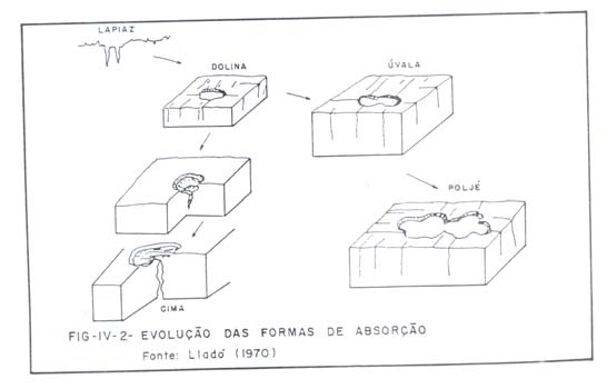
Chart 2 . Reduction in the hydraulical conductivity (cm per hour) of the non-saturated
zone due to the agricultural mechanization effect.
Hydraulic Coductivity
Depth (cm)
0 10
10 20
20 30
30 40
Irrigated Area
25,73 a
6,92 b
2,89 b
6,85 b
Reference Àrea
13,10 b
15,80 a
18,85 a
22,31 a
OBS: In each coli\umn, the averages followed by the same letter do not differ among
themselves through the SNK test at 5% of probability.
6.2. Recharge Areas
The karsts, because of its special recharge forms, circulation and storage are distinguished
from the other water system being, probably, the most complex of them.
According to LLADÓ, (1970) mentioned by GUERRA, (1986) the karstic forms of
absorption depending on how the water penetrates can be classified in open or closed forms.
Some denominations were adapted from the Spanish because there were no corresponding
words in Portuguese.
Between the closed forms these stand out: the lapiás that are embrionary forms, the dolinas,
úvalas, poljés and the blind valleys. The dolina is the most classical form of a karst and results
in the settlement of the rocky mass caused by the dissolution of the limestone. Its most
internal and external form varies according to climatic and geological factors. The blind
valleys are valleys that interrupt suddenly the karstic landscape. Generally it indicates ground
drainage.
The open forms are those that allow the free penetration of the water, passing from the surface
to underground suddenly. Among these are the tops and the drains.
The Figure below exempifies the structural forms of drainage/recharge.
Figure 7. Evolution of absorption forms
Source: Lladó (1970)
xxiv
6.3. Flow conditions
As consequences of the decrease on the size of the macropores due to the compactation, it can
be observed and quantified significant alterations in the physical-hydrical properties of the
soil, mainly in the water flows, with the decrease in the hydraulic conductivity and the
infiltration rate of water in the soil being able to compromise and/or limit the aquifer
recharge, because it changes the natural hydrogram, i.e., the relation between rain, infiltration
and runoff is changed, also there are risks of erosion and silt depositing causing it to decrease
its depth and make is wider.
The hydraulical conductivity decreased critically in the irrigated areas, the observed values
indicated reductions of 56%; 84% and 69% in the hydraulic conductivity in the respective
irrigated areas.
Figures 8 and 9 show the behavior and the modifications in the flow dynamics of the
unsaturated zone.
T a x a s d e I n f ilt r a ç ã o M é d ia e I n s t a n t â n e a
M é d ia ( c m /h )
In s ta n tâ n e a ( c m /h )
3 0 0
2 5 0
2 0 0
1 5 0
filtração em cm/h
V Im = 2 1 5 ,0 2 T -0 ,2 8 2 8
R 2 = 0 ,8 7 8 6
e
in
1 0 0
Taxas d
5 0
V I = 1 5 4 ,2 1 T -0 ,2 8 2 8
0
0
5 0
1 0 0
1 5 0
2 0 0
2 5 0
3 0 0
3 5 0
T e m p o e m m in u t o s
Figure 8. Behavior and modifications in the dynamics of water flow
xxv
T a x a s d e I n f iltr a ç ã o M é d ia e I n s ta n tâ n e a
M é d ia (c m /h )
In s ta n tâ n e a (c m /h )
3 5 0
3 0 0
2 5 0
2 0 0
1 5 0
1 0 0
Taxas de infiltração em cm/h
V Im = 2 3 1 ,3 3 T -0,4925
V I = 1 1 7 ,4 T -0,4925
R 2 = 0 ,8 9 9 8
5 0
0
0
5 0
1 0 0
1 5 0
2 0 0
2 5 0
3 0 0
3 5 0
4 0 0
4 5 0
5 0 0
T e m p o e m m in u t o s
Figure 9. Behavior and modifications in the dynamics of water flow
The studies and researches allow the conclusion that the dynamics of the macrodrainage of
the karstic areas result of the active geomorphologic and hydrogeological processes, it stands
out the presence of the extensive nude areas (without vegetation) without currents of surface
waters, the occurrence of depressions with underground drainage; the existence of conduits
and cavities in the underground by them the currents of groundwater circle and there is a very
reduced superficial drainage.
These geomorphologic units allow the classification different stages of the karstification
starting with a fluvial landscape and finishing in a landscape fluviokarstic with no superficial
drainage. The fluvial landscape is marked by composed depressions. Like this the
geomorphologic process of the genesis of a karstic basin is characterized starting from a
drainage basin that drains in areas of carbonatic rocks. (Illustraton 10).
There are a great heterogeneity and vertical and horizontal structural differences; it leads to a
great variability in the permeability that favors a punctual and zonal infiltration of the currents
of surface waters. The direction of the underground flow is determined by the tectonic
structure of the karstic forms, regulated by the areas where the recharge and discharge occur.
xxvi
Figure 10. Conceptual model of the flow in the conduits of karstic aquifers
Source: Leibundgut et. al., 1997.
6.4. Discharge Areas
The sources of great punctual discharges are common. A special kind is the one that works
with a siphon; they work in an intermittent way.
Through studies GUERRA (1986), evaluating the hydrodynamic of the karstic watery of
Irecê, observed the variation of the hydrostatical levels in the observation wells and it was
verified that the fall of the levels, because of the effect caused by the underground drainage,
in the dry period, is approximately linear. It should be considered that the even during the
rainy months, when there is a relative ascent of the levels because of the effect of the
recharge, there would be a relative fall to a corresponding rate to the one observed in the dry
period.
xxvii
7. SUPPORT SYSTEM TO DECISION-MAKING ON AGRICULTURAL MATTERS
SISDA APPLIED TO THE OPTIMIZED MANAGEMENT OF HYDRIC
DEMANDS FOR IRRIGATION USES
SISDA is a software, an useful tool to give subsidies demands for the use of water in
irrigation on the basis of simulations of the hydric needs of the exploited crops, making
available indicators of technical efficiency, adapted to edaphic and climatic conditions of the
region, an experience that have been being used successfully in different irrigated regions of
Brazil.
As a computer resource, SISDA (Support System to Decision-Making on Agricultural
Matters) is an alternative that allows the systematic monitoring of reasonable use of water by
irrigation users. It integrates a larger package of software named IRRIGA, aiming at
integrating activities handling with equipment handling (AVALIA).
Starting from climatic information, the program calculates the present demand of water for
crops, supplying reports, graphics and standards as well as personalized orientations.
Considering a historical basis of climatic data available in the program, the system allows
building a historical climatic data basis available in the program, the system allows making
rain forecasts and it guides users about the moment to irrigate and the water sheet to be
applied, decreasing, thus, chances for waste of water by unnecessary applications.
The system generates a data base corresponding to the consumption of water, hydric deficit
throughout crops cycle, which is an important information for management of demands.
Utilizes daily meteorological data base of about 700 stations belonging to National
Meteorology Institute, allows studies of viabilities (various levels of probability).
Knowing accurately the volume of hydric demands on a monthly and daily scale is
fundamental and must be considered in the balance of entrances and exits of water in the
procedure of modeling of the aquifer, as well as evaluating the dimensions of wasteful use of
water and decisions on demands for granting. The general methodology of work and the
results obtained can be found in the consultant's complete report in Annex 3.
It is worth emphasizing that having defined the strategies and programs of ordering of the use
of hydric resources it is important to have instruments that guarantee its applicability. If, in
the one hand, it is important to create systems of supervision and control, in the other hand, it
is fundamental that irrigation users (small, medium and large) dispose of a management tool
applied to hydro-agricultural projects, so that they can optimize the use of water in their
production unities.
7.1. Pilot Unities of Consumption Monitoring of Water by Irrigation
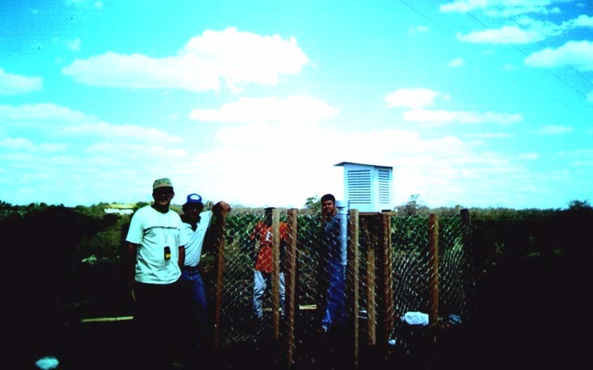
The following pilot areas, were set up: Nova Esperança Ranch, Jota 5 Ranch and Estância do
Curral Velho Ranch, located in the region of the project's encompassment. In each of the
unities it was installed a meteorological station, composed of a meteorological shelter,
thermometer of maximum and minimum and a pluviometer. Each of the irrigation systems
was evaluated in order to determine the uniformity of water application, losses by evaporation
and wind dragging (aspersion).
xxviii
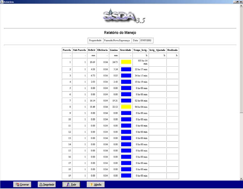
Figure 11 shows a basic exit of the program that accurately indicates the moment for
irrigating and the quantity of water to be applied in each field parcels.
Figure 11. Basic Exit of the program SISDA to one of the Pilot Unities. It informs a
water deficit on the ground, efficiency of irrigation, time of irrigation and
color scale to indicate smaller or greater urgency of irrigation (blue, yellow
and red).
Various indicators are necessary for planning the reasonable use of hydric resources in
irrigative agriculture, activity that is responsible for the consumption of approximately 80% of
freshwater.
The net and gross irrigation sheets are among the most important technical indicators from the
point of view of dimensioning of the irrigation system.
By using SISDA, were carried out simulations for two boarder-line situations of hydric needs,
involving a region of larger demand, Irecê, in the altitude of 722m, and another of smaller
demand, Morro do Chapéu, altitude 1012, utilizing for this SISDA/IRRIGA's climatic data
bank, with historic climatic series of minimum 15 years of daily data.
For the city of Irecê, it was obtained values of gross sheet of project varying 7,6 to 9.6
mm/day, depending on the culture, irrigation equipment, time of planting and probability of
rain. It can be observed that the hydric demand of the atmosphere, represented by ETo,
showed values quite close to the two studied times of planting, with differences of the order of
xxix
6%; These results indicate stability in the consumption of water throughout the year for
Irecê's region.
As for the city of Morro do Chapéu, also located in the region of encompassment of Sub-
project 1.5, under distinct climate conditions, it could be observed that it is a region of smaller
hydric demand, claiming smaller sheets of project (mm) and applications of water in smaller
quantity. These differences show once more the importance of implanting control systems to
obtain reliable levels of control of grants concession.
The simulated results of water consumption for crops of carrot, onion and beet can be used to
guide studies of water granting, from the point of view of those who request, as well as from
the point of view of those who manage the process of water granting.
Studies on the documentation on the region and visits in the irrigated area indicate that there
is not any system of technical management of irrigation, making difficult any conclusion on
the efficient use or not of hydric resources on the part of irrigation users. The lowering of the
water level in various wells is an indicator of a lack of organization in the process of wells-
drilling and use of groundwater.
The simulated values such as gross sheet of dimensioning (mm/day) for crops of carrot, onion
and beet varied from 7,5 to 9,6 for Irecê's county (high demand), and from 4,6 to 6,7
mm/day, in Morro do Chapéu, are technical indicators to subsidize the planning of hydric
resources in irrigation projects.
Determining the uniformity of application of water at field level, for the irrigation systems,
indicated CUC (CCU)(Christiansen Coefficient of Uniformity) values of 77,6% per center-
pivot and 77,9% for leaking. These values are quite bellow those recommended for this
systems, which are of 85 to 90% for center-pivot and 90 to 95% for leaking.
Once defined suitable sceneries it is feasible the utilization of SISDA for simulation of hydric
need and water granting. The simulated results for water consumption for crops of carrot,
onion and beet are subsidies to guide decision-making on the quantity of water to be granted.
It is necessary a continued program of training to make available the information,
methodologies and implemented products.
xxx
8. CONCLUSIONS
8.1. General Conclusions
· The adopted methodologies, the accomplished and ongoing activities allowed that the
conclusions hereby presented serve as subsidy and reference information for the
elaboration of the Integrated Management Program PGI of the São Francisco river by the
Brazilian National Water Agency ANA, for the Program of Management of Hydric
Resources PGRH of Bahia State and for the post-graduation program in Geochemistry
and Environment of the Institute of Geosciences of Bahia Federal University, define and
prioritize lines of research applied for the Nucleus of Hydrogeologic and Environmental
Studies NEHMA;
· The analysis and treatment of colleted data indicated the need for generating specific
information about the unsaturated and saturated area, through research, for the definition
of parameters that regulate the hydrogeologic dynamics (recharge, discharge, reserve,
vulnerability) of the karstic aquifer, considering the exploitation regime to which it is
submitted, to allow the calibration of the model (s) of flow and transport as a support tool
to decision-making for the management of the demands and protection of the quality of
the water;
· Allowed the evaluation, identification and measuring of the risks of contamination of the
water by pesticides and fertilizers residues, of the compromised mechanisms of the
hydraulic dynamics and flows of transmission of water in the unsaturated area in large
areas where is practiced intensive irrigated agriculture in the basin;
· The activities developed and the outcomes from systematized and integrated
consultancies, allowed diagnosing and identifying the indicators of impacts in the
agriculture in the river basin; knowing the dynamics of the elements of the climate and
conceptually understanding the complexity of the river/aquifer system for structuring and
implementing a system of support to decision-making for the participative management
of the water resources, in situations where the irrigation has been established as a large
user;
· The Subproject stimulated and catalyzed important partnership with the State Managing
Organism SRH-BA and with Bahia Federal University, resulting in the celebration of an
important agreement that allowed integrating , amplifying actions, continuing monitoring
activities, modeling and personnel training;
· Data collecting and systemization of existing and generated information through field
campaigns, allowed building up a body of knowledge on specific aspects of the
hydrogeologic dynamics characteristic of the karstic systems, to guide the structuring of a
monitoring program and the evaluation of the impacts of irrigated agriculture on the
quality and quantity of superficial water resources and groundwater in the Verde/Jacaré
River Hydrographic Basin, applicable to similar situations on the São Francisco River
Basin;
xxxi
· Allowed catalyzing a process of mobilization of users, state's power, public and private
companies, NGOs and schools by having technical meetings, seminars, workshops and
training;
· Allowed the integration and the strengthening of the relationship university/civil society
as well as the one with local state power.
8.2. Specific Conclusions
8.2.1. Hydrogeologic aspects characteristic of the Verde/Jacaré River Sub-basin.
· Defined criteria and hydrogeologic points adequate for the implantation of a monitoring
net of dams and the beginning of systematic campaigns of data collect in order to study
the recharge ;
· Defined and started specific researches to generate the characteristic hydrogram (rain x
infiltration x drainage) and valuation of the hydraulic parameters, hydrologic,
hydrogeologic and physical-hydric that regulate the dynamics of water flows, in the
system aquifer/river, which is a fundamental information for modeling the hydrogeologic
system being studied;
· It was estimated a referential hydric availability as hydric storage available in the aquifer
of the order of 200-250 H3/year, this information will have to be accurately gauged,
starting from the quantification of recharge and the full annual hydric balance, considering
historical series of rain data, flows, piezometric levels and extracted volumes to meet crop
demands;
· The compiled information on the evolution of hydric demands reveal that during the
periods 1976, 1986 and 1991 it was exploited approximately 1Hm3/year, 12,8Hm3/year
and 22,6Hm3/year, respectively, this information will have to be up dated and gauged for
the present scenario of exploitation of the aquifer;
· It was executed a study about the regime of pluviometric precipitation in the Verde/Jacaré
River Hydrographic Basin, starting from the historical significant series that allowed, to a
detailed level, the identification of the spatial and temporal dynamics variation of the
distribution of precipitations identifying rainy and dry periods;
· The temporal distribution of rains, corresponding to the monthly average totals, highlights
the existence of two pluviometric regimes, with the smallest variability observed in the
months of November and December, as well as, in February and March;
· The main rainy season in the basin is between the months of November and February,
with a pick in December; and the second rainy period is between the months of December
and March, with a pick in March;
· The months from April to September are less rainy. The months from May to October are
considered transitory;
xxxii
· It can be observed in the basin high levels of rain dispersion, characterizing it as a semi-
arid region, with a Standard deviation of 29% of the annual average value of the total of
precipitation, which is approximately 734 mm;
· While analyzing the pluviometric totals, it was verified the existence of different cyclic
movements, that obey two interpretations: one corresponding to the very specific climate
system (El Niño/La Niña) and the other a manifestation that can be related to the effects of
the evolution of deforestation in the basin;
· It can be observed that the distribution of rain in the basin does not diverge, in complexity,
to the other semi-arid areas of the North-East of Brazil, presenting discrepancies as far as
the general tendency of decrease of the pluviometric heights, with values higher than 800
mm in the highest regions and values lower than 700 mm in the other areas of the basin;
· The contribution for the recharge of the basin springs is more significant in the highest
regions, where pluviometric totals reach easily above 800 mm;
· The detailed study of the spatial-temporal dynamics of distribution of regime of rains in
the basin is a valuable information to establish the conditions of contour of the conceptual
model of entrances of water in the system, as well as to guide the installation and
suitability of the hydrometric reference network to build a data bank that will be utilized
in the study of recharge moments and hydric deficit, to subsidize hydrologic/
hydrogeologic modeling to support decision-making for the management of the hydric
demands;
· The interdependent meteorological variables (rain, temperature, evaporation and relative
humidity) experience seasonal variations that are co-related. The variations demonstrate
changes of direction in the dry season (in the middle of the year) and of the rain (at the
end and beginning of the year). There is a strong joining among the meteorological
phenomena in the region, with interdependence of tendencies and variations in the long
run, mainly, in the case of precipitations and temperatures, and the continued increase of
evaporation observed in the period between 1961 and 1970;
· It was carried out an analysis of consistency of the pluviometric and fluviometric
information, starting from existing historical, developed and guidance model of support
for decision-making in the management of demands of superficial waters, on the basis of a
function of balance between hydric availabilities and granting availabilities, considering
the risks. The model developed also will be able to serve as a reference when deciding
about dimensioning of works of regularization of the rivers flows.
8.2.2. Impacts of the Intensive Agriculture Irrigated on the Quantity and Quality of the
Water in the Basin.
· The general absence of riparian woods as well as in important drainage sectors of the
hydrographic basin, which were identified as important recharge areas or as producing
flowing, is a key factor to be taken into consideration as responsible for the reduction of
hydric availabilities because of damaged recharge and silt depositing of the rivers;
· The degradation of the physic and hydric characteristics of the ground was diagnosed and
measured through the increase in the apparent and porosity reduction, as indicators of
xxxiii
generalized compacting in large areas submitted to intensive irrigated agriculture, without
the adoption of suitable flow techniques or ground and water preservation;
· The degradation of the physic and hydric characteristics of the ground in the unsaturated
area is reflected in the hydraulic conductivity and the rates of water infiltration in the
unsaturated area of the aquifer, reaching a reduction of the order of 84%, thus
contributing to the damage of the recharge area of the aquifer and of its irrigation
efficiency;
· The results of wells and river water analysis detected residues of pesticides
organochlorated and/or piretroids in concentrations above acceptable limits, which put at
risk people's and animal's health, in case spring water will be used for thirst-quenching;
· According to Brazilian legislation, the waters of the three sampled springs have
concentration values above what is allowed for potability purposes for aldrin and
endosulfan. The values for aldrin are 84 times higher than what is allowed in the samples
of América Dourada, meanwhile Endosulfan shows values 20 to 26 times higher than
what is allowed in the samples of water of the three counties where it was sampled;
· Among all the spectrum of pesticides traced in the samples of water extracted from the
profile of ground for the study of diffusion of pesticides in the unsaturated area, only
carbendazir was detected in increasing concentration, expressed in the order 0,40 µg/L for
the depth of 15cm, increasing in an increment of 130% in the depth of 35cm reaching the
concentration of 0,92µg/L;
· The persistency and mobility of carbendazir in the samples of water and the increase
in the concentration in depth is and indicator of contamination risk for the saturated
area of the aquifer;
· It was also proceeded to the evaluation of the evolution of nitrate concentrations in wells
water in the area by observing an increasing augmentation, throughout time, reaching
concentrations above limits, which put a risk public health, in case that water will be used
for human consumption.
8.2.3. Pilot System of Controlling and Monitoring
· Were identified, by municipalities, the areas submitted to a larger pressure of use of the
natural resources water and ground by irrigated agriculture, as a criteria for finding wells
of observation, piezometers and points of water collect for analysis of the parameters of
framing and presence of pesticide residues;
· On the basis of the information obtained on the conceptual model of the hydrogeologic
framework of the aquifer and in an estimation of spatial distribution of the density of wells
under a regime of exploitation, were previously defined the criteria for establishing
network for monitoring the wells and the installation of piezometers, to be ratified in the
period after the wells were registered, when it will be amplified and defined the permanent
collect network of information that will feed the data bank for modeling of recharge
purposes, evaluation of the lowering, ray of interference and quality of groundwater;
xxxiv
· As a strategy, in the short run, to generate information to allow preliminary interferences
over recharge and lowering, was identified a network of wells for observation that were
monitored from 1980 to1981, georeferenced and taken again systematic campaigns of
level measuring, as from the rainy season of 2002;
· Comparing the levels or piezometric heights measured in the same wells in December
1981, December 2002 and January 2003, it can be observed signs of lowering of the order
13 meters, 11 meters and 6,0 meters respectively for three studied points;
· The preliminary detected results, knowing that organophosphorated pesticides have
been being used in the region, recommend that it should be carried out a more
detailed sampling plan in order to get a more complete and funded diagnostic,
monitoring not only wells and river waters, that serve for human supplying, but also
waters that are at homes;
· The identified situation of existing rural communities supplied with wells, suggests
urgency and priority in the execution of a more detailed study, with a longer monitoring
time and more rigorous control over environmental parameters, evaluating co-relations
between the latter and illnesses that attack the population;
· Considering the high vulnerability to contamination risks, characteristic of karstic
aquifers, it is prudent that tracking should be amplified including other possible sources of
contamination, such as effluents, accumulated garbage and gasoline stations, besides
pesticides, considering all the parameters of the resolution CONAMA 20/86 as well as the
presence of hydro-carburets for wells used for human supplying.
·
8.2.4. Hydrogeological Model
· From a hydrogeologic point of view, karstic system can be understood as a waterground
net of conduits with a very high hydraulic conductivity (K > 10-1 m/s), characteristic of a
low permeability rocky matrix (fissured calcarium) with K values in the range 10-3 m/s to
10-7 m/s, depending on the degree of fracturing and stratifications. The storage capacity in
the karstic conduit system is low and because of the fractured calcarium is also of low
permeability. The karstic net is, generally, always connected to the exiting springs of the
system;
· According to the interpretation of hydrogeologists, Dr. Iñaki Antiguedad and Dr Ignácio
Morell Evangelista, the possible vertical hydraulic relations existing between the
hydrogeologic system of Irecê´s Plateau are not well known, and this justifies the lack of
clarity reflected on the available information in the executed studies. However, it allows to
affirm that the aquifer system drains to both borders of Irecê's Plateau, with discharge to
Verde River West bound and to Jacaré River East bound. The latter characterized
direction flow is the most important discharge area of the Plateau;
· The recharge of the aquifer is fed, fundamentally, by precipitation waters; however, it
must be considered the possible contribution of irrigation, given the extension of irrigated
area and the frequency and intensity of irrigations. Another possible hypothesis for the
contribution of the recharge is the vertical ascending feeding from the fissured lower
aquifer.
xxxv
· Aquifer's discharge is significant, mainly in Jacaré River, though, it cannot be rejected the
hypothesis of occurring deeper flows North bound in relation to Jacaré river's bed and
also by pumping effects.
·
8.2.5. Support to Decision-making on Agricultural Matters SISDA Applied to the
Optimized Management of Hydric Demands for Use in Irrigation
· SISDA has proven to be a useful tool to estimate, with an accurate degree, volumes of
demands for the use of water on the basis of simulations of annual hydric needs for the
main exploited crops in the region, making available technical indicators of deficiency,
adapted to edaphic and climate conditions of the region. This information is fundamental
and must be taken into consideration in the balance of entrances and exits of water in the
modeling proceeding of the aquifer, as well as to evaluate the dimension of the wasteful
use of water;
· As a computer resource, SISDA (Support to decision-making on agricultural matters) is an
alternative that allows the systematical monitoring of the reasonable use of water by
irrigation users;
· Considering a historical climatic data basis available in the program, SISDA allows the
forecast of rain and guides users about the moment to irrigate and about the water sheet to
be applied, decreasing chances of water wasting because of unnecessary applications;
· There was a significant manifestation of interest, involvement and demand of training on
the application and use of the SISDA software on the part of irrigation users of the region;
· The events that were carried out: seminars, workshops, training, through statements, allow
to conclude on the existence of risk already installed of conflicts among users,
recommending the definition of strategies and programs of ordering the use and
participative management of demands of hydric resources, making available tools that
ensure its applicability;
· It can be observed that to equationate or mitigate the risks of eminent conflicts in the
region, on the one hand, it is important to create inspection and control systems, on the
other hand, it is fundamental that irrigation users (small, medium and large) have access to
information as well as to technical and management training in order to promote culture-
change regarding the wasteful use of water and wells-drilling in their producing units;
· A program of activities was developed aiming at avoiding, in the medium to the long run,
conflicts between the availability of water and the needs for irrigation in Irecê's region,
through the popularization, organization and implantation of a managing system,
referenced in technical indicators gauged on a level of irrigation users' properties
· The simulated results of water consumption for the crops of carrot, onion and beet will be
used to estimate the volume of hydric demands extracted annually from the aquifer. This
information will be integrated to the data/information bank and will be used as a reference
in the proceedings of modeling, as well as to guide decisions on the granting of water;
xxxvi
· With SISDA resources, values of gross dimensioning sheet (mm/day) for irrigated crops
were generated and made available as technical indicators to subsidize the planning of the
use of hydric resources in the irrigation projects;
· Determinations of the uniformity of application of water at field-level, for the irrigation
systems, indicated CUC values (Christiansen's Coefficient of Uniformity) of 77,6% for
center-pivot and 77,9% for leaking. These values are much lower than the recommended
values for these systems, which are from 85 to 90% to central pivot and 90 to 95% to
leaking.
9. RECCOMENDATIONS
9.1. Recommendations of Structuring Character for the Use and Conservation of the
Natural Resources Water and Ground in the Sub-basin.
· Generation of digital cartographic basis in scale 1:25:000 including the Verde and Jacaré
River Hydrographic Basin and contour of the aquifer with all the wells, main springs,
recharge and discharge georeferenced areas;
· With the cartographic basis on scale 1:25.000, to build equipotentials, lines of flows, to
define conditions of contour for modeling and shaping an information system to support
decision-making on the control of granting through management of demand, in the precise
definition of monitoring points for the generation of a data bank to accumulate historical
series of the dynamics of seasonal and spatial variation of the quantity and quality of
water throughout a hydrologic year;
· Acquisition of automatic mediators of wells-level, linygraphs and meteorological stations
with datalog to enable the assembling of a daily collecting information net on a static
basis, river flows and element of the climate to enable the definition of the ray of
influence between wells and the full hydric balance, considering all the entries and exits of
water in the system (rain, evaporation, evapotranspiration, extractions and applications by
irrigation) ;
· Acquisition of a special probe to measure parameter of monitoring of water quality for
monitoring and framing purposes;
· Installation, in the municipality that exercise the greatest pressure of exploitation in the
aquifer, of a support basis of data geoprocessing and processing with server in net to
systematize all information, calibrate and validate hydrogeologic model and make
available information to irrigation users, associations, basin's committee, universities,
companies and anyone interested;
· Amplification of the pilot areas to implant the bases and training for optimizing the
efficiency of water use in the irrigated agriculture by using SISDA - (Support to decision-
making on agricultural matters) as a tool to support the strategic management of irrigation;
· To define and validate optimal levels of hydric demands for irrigated cultivations as
reference information for the efficient use and/or non conflictive management of the
demands for hydric resources as a subsidy for users, basin's organisms and public
managers;
xxxvii
· It is necessary a continued program of training to make available information,
methodologies and resources of optimized management of water use in the irrigated
agriculture as the main demand for water in the basin;
· It is recommended to carry out training for technicians and mobilizing region's users to
demonstrate and disseminate the economic and environmental advantages of the efficient
water use in irrigation ;
· Some aspects were perceived as priorities, such as the need for detailing and/or fine
adjusting in the comprehension of the hydrologic year in Verde/Jacaré River
Hydrographic Basin, consistently and accurately defining the significant moments of
entries and exits of water, the shortage periods, considering spatial-temporal dimensions
and the possibility of amplifying the study up to the passage of the São Francisco Basin
that is inserted in the territory of the Bahia State;
· The follow up of climatic variations is an activity that depends on the availability of
information collected in networks of meteorological observations. The absence of reliable
historical series and the insufficiency in meteorological stations, in number and in
uniformity in the periods of operation, do not allow the evaluation of climate variations
and, thus, the evaluation of the regional hydrology;
· To increase the number of automatic meteorological stations of long autonomy and install
linygraphs;
· The collecting network of hydrometeorological data must be coherently installed and
operated according to the World Meteorological Organization OMM standards, such as:
- Maximum spacing between the stations must be approximately 100 Km, allowing the
efficient use of information such as initial conditions for global and regional models of
whether and climate forecast;
- The distribution of stations must comply with the different regional climatic behaviors, as
well as the variations of relief and vegetation along the basin;
- The choice of locals that present a certain degree of security should be a requirement to
designate the location of the data collecting station.
· Making use of the above criteria and taking into consideration infra-structure, road access
conditions and the homogeneous regions of the São Francisco Basin, were identified 20
(twenty) places within the basin to compose the net of automatic Data Collecting
Platform (PCD). However, due to the high costs of PCD's it was chosen to install only 11
(eleven) Platforms;
· Each station must be provided with, at least, sensors of atmospheric pressure,
precipitation, wind direction and speed, solar radiation, air temperature and humidity.
Other sensors can be added to the stations to complement the observations, destined to
assist sectors such as agrometeorology, climatology and others;
· The implantation of this PCDs net will allow the monitoring of climatic and hydrologic
conditions, besides to contributing for maintain the Hydrometeorological Data Bank of
xxxviii
Bahia state - BDRH, which shall serve as the base in the management of hydric
resources, in the granting processes, electric power sector, sectors linked to agriculture, to
the environment, civil defense, leisure and tourism, scientific research and others;
· Amongst the main products that can be available, stand out: 1) weather forecast emission
with forecasts up to five days and tendency of the climatic behavior three months
beforehand; 2) emission of alert bulletins of severe whether and of occurrences of climatic
adversities; 3) agrometeorogical zoning for the main cultivations of the Basin, 4) system
of hydric availability for the agriculture and hydrologic data gathering of the hydrographic
micro-basins for the agriculture in the São Francisco River Basin;
· To establish interactions on the global and regional level, as well as to evaluate the
consequences of global climatic changes and the use of hydric resources in the basin;
· That the developed methodology and the recommendations of Sub-project 1.5 be applied
in the whole course of the São Francisco River in the territory of Bahia state, wherever be
practiced intensive irrigated agriculture and wherever it exists evidences of a narrow
interaction between superficial water and groundwater;
· Mobilization for spreading out all the information obtained by Sub-project 1.5 , by the
agreement SRH/UFBA and to form the basis's committee.
9.2. Recommendations of Specific Character
· The stages of fundamental basic necessary studies on the system aquifer/river of the
Verde/Jacaré Rivers Basin, so that the hydrogeological model is used as support tool to
the decision-making, they are the following ones:
· Estimate and validate the volumes of hydric storages of the karstic aquifer;
· To carry out and interpret results of experiments with natural and artificial trackers;
· Proceed to the analysis of hydrograms in springs exits (analysis of the recession and
separation of its components);
· To carry out whole hydric balances characterizing the hydrologic year;
· Statistic analysis between dependent variable in function of the independent variables of
entries and exits (auto-correlation and crossed correlation);
· Study of the mechanism of infiltration and recharge concentrated in drains and diffuse in
the fissured calcareous area;
· Collecting water from rain, wells and rivers for isotopic analysis with oxygen 18,
deuterium, other markers and building up-to-date maps with equi-potentials and resulting
lines of direction of the flow is necessary to validate the hypothesis;
· To define and implement an environmental monitoring program for controlling the risks
of contamination and use of pesticides through a sampling plan, defining frequency and
xxxix
number of samples, starting from data carefully gathered and according to the availability
of resources, interests on the part of society and on the public organ in charge of the
management and preservation of the hydric resources of the state;
· To increase the number of pesticides to be analyzed, going up to 20 composts. Thus,
besides those which were already traced, it must be imported patterns of pesticides that
have a significance on national and international legislation, but, mainly those pesticides
that are important for the studied region, such as: methamidophos, mancozeb, benomil
(carbendazim e thiabendazole), linuron, dieldrin, DDT, endrin, 2,4D, lindano and
permetrina ;
· For the 20 points to be established, as initial hypothesis, the minimal number of samplings
to be collected during each period (6 months) for water, ground and sediment is of 120
samplings. For reliability and results, samplings will be duplicated;
· Sampling points must be in number enough to allow the interpretation of the results. To
take out at least 6 samples for appropriate characterization of a cycle of fluctuation or a
period of high or low concentration of residues;
· To determine residues of pesticides in food, mainly carrot, with field samples, which have
been being traded;
· The desirable time for the study to characterize the quality of food as far as the presence
of pesticides is concerned is of 2 years. During this period, it can be done a monthly
sampling plan, collecting samples from products traded and/or consumed;
· To carry out rehearsals with ground columns in laboratory, establishing a bank prove and
increasing the doses of the most used pesticides, considering persistency and mobility. To
proceed to the analysis and study of the correlation among applied doses, time and
detection level on the ground and in the water, evaluating risks of residues transference to
the aquifer, trough diffusion or vertical percolation of water;
· To establish experimental parcels, in the field, with suction lisymeters for the collect of
samples of water in different depths, until reaching the aquifer's saturated area.
9.3. Proposals of Terms of Reference and Associated Costs
The adopted methodologies and the activities accomplished by Subproject 1.5 allow that the
conclusions and presented recommendations serve as subsidies and reference information for
the elaboration of the Integrated Management Program PGI of the São Francisco River
Basin. In this sense, the following synthesis of terms of reference are presented:
xl
Chart 3. Detail of the necessary resources (in US$) to the continuity of the project.
Specification Products/Length
Value
(U$)
Digitalization of map of hydrographic basin Cartographic and planialtimetric 20.000
in scale 1:25:000 integrating the system base in scale 1:25:000, digital
aquifer/river, georeferencing all the wells and model of the site, map of grounds,
points of superficial water capitation to isohyets, uses, hydrometric network
establish the condition of contour for the and homogeneous areas/10 months.
mathematic modeling.
Developing researches using rain simulator, Installation of equipment and
50.000
linygraphs, automatic level measuring,
experimental parcels of monitoring
isotopes and other markers to determine and control of diffusion of polluting
parameters that regulate the hydrodynamics matters, presenting and making a
of flows (entrances and exits) and transport of map of the vulnerability and quality
polluting matters for calibration and
of the waters, calibration of the
validation of mathematic model for
mudflow and other models as tools
management of karstic systems.
of management of the waters / 12
months.
To implement a program of environmental Map with the specification of the 80.000
monitoring and mitigation of risks on public georeferenced monitoring network
health. To install monitoring network, carry and reports with results, conclusion
out systematic sampling, and carry out and indication of measures that
analysis for tracing pesticide residues in may mitigate risks of
waters of sources used for human supply and contamination /2years.
agricultural products .
Amplification of the hydrometric network Assembling and operation of
250.000
and observation wells in the passage of the hydrometric network during a year.
São Francisco River in Bahia State.
Presentation of map of hydrometric
network and technical report on the
implantation and data collected and
consisted during a year/2 years.
Campains of systematic data collect in the Implantation of pilot unities,
130.000
field, formatting of a system of information, calibration and training for
calibration and validation of the
irrigating producers using the
hydrogeologic model and implantation of the system of support of decision-
system to support decision-making on making to optimize the efficiency
agricultural matters in the large irrigated and use of water in the irrigation.
perimeters in the passage of the São Presentation of reports with
Francisco Basin in Bahia State.
technical indicators of reference
for sustainability of
hydroagricultural projects/ 2 years.
.
Mobilization and training of users, formation Formation of a Committee of the 70.000
of a committee of the basin active in the Verde/Jacaré Rivers Basin /1 year
participative and systematized by computers and a half
management of the waterground and
superficial resources in the basin, starting
from sceneries strategically drawn.
TOTAL
600.000
xli
· Terms of Reference - 01
Objectives:
Digitalization of cartographic base of the basins of Verde and Jacaré Rrivers in scale 1:25:000
integrating the system river/aquifer georeferencing all drilled wells and points of capitation of
superficial water, adding to the maps karstic areas as well as connection areas with the
system aquifer/river, of occurrence out of the water divisors of the basins, in order to establish
homogeneous areas and conditions of contour for the mathematic modeling.
Value of the Contract: U$20.000
Working Area:
Geoprocessing, Geomatic, Hydrogeology, Hydrology and Geostatistics.
Main Specific Activities:
Proceed to the vectorial digitalization of the area, area of inclusion defined in the objectives,
through the photo-restitution technique using aerial photographs in scale 1:60:00, satellite
images, gathering referential network points in the field using a GPS of accuracy and
registering wells and grantings conceded in the Verde and Jacaré Rivers. To elaborate
thematic maps of grounds, present uses, precipitation regime, hydrometric net.
General methodology of Work:
Proceed to the gathering and systemization of all the information (cartographic, data bank of
georeferenced wells and hydric resources users, aerial photographs and satellite images)
existing on the area. To carry out campaigns in the field to gather referential network points
with a GPS and identify occurring types of ground. To use the photo-restitution technique and
build up cartographic base in scale 1:25:000 and thematic maps of ground, uses and
homogeneous areas.
Products:
Planialtimetric cartographic base in the scale 1:25:000, digital model of the site, maps of
grounds, isohyets, uses, hydrometrics and homogeneous areas.
Detailed Timetable:
The stages of field work and the evaluation and approval of the products will be accomplished
under the supervision of the coordination of the sub-project with the participation of
teachers/researchers of the Department of Agricultural Engineering - DEA of the School of
Agronomy and the Nucleus of Hydro-geologic and Environmental Studies - NEHMA of the
Institute of Geosciences of UFBA. The execution of activities/goals will be seized as an
opportunity for personnel training as well as involving students of Post-graduation and
Graduation in Agronomy, Geography and Geology.
Length and Headquarter:
The development of the activities will last eight months. Works will be carried out in the
field, in Irecê's micro-region, in the Nucleus of Hydrogeologic and Environmental - NEHMA
and at the company specialized in geoprocessing that will win the bid to carry out the work.
Reports and Payment Conditions:
·
Payments against products and final payments of 35% of the value of contract after the
approval of the final product;
xlii
·
Partial and final reports presented in two originals and a disk - Word 6.0 or above
(Final Report with executive summary in Portuguese and English, with conclusions and
recommendations).
· Terms of Reference - 02
Objectives:
Developing researches using rain simulators, linygraphs, automatic level meters, isotopes and
other markers to determine parameters that regulate the hydrodynamics of flows (entries and
exits) and installation of experimental parcels and executing campaigns to control water
quality for purposes of framing and modeling of transport of pollutants for calibration and
validation of the mathematic model for management of demands and protection of water
quality in karstic systems.
Activity Costs: U$50.000
Working Area :
Hydrogeochemistry and Hydrology
Main Specific activities:
Acquisition of automatic level meters, linygraphs, TDR, extractor of solution of the soil,
collects of the soil and column assembly for simulation of transport of pollutants. Collecting
water and carrying out isotopic analyses. Simulation of the dynamics of transport of pollutants
in the unsaturated area with use of the rains simulator.
Metodologia Geral do Trabalho:
Acquisition and installation of equipments, monthly collections of water of wells and of the
rivers to analyze parameters of quality of water, accomplishment of rehearsals of diffusion of
pollutants in field conditions with use of the simulator of rains, installation of experimental
portions for systematic monitoring and validation of the dynamics of diffusion of pollutants.
Calibration of the modflow and framing of aquifer and superficial waters.
Products:
Installation of equipments and experimental portions of monitoring and control of diffusion of
pollutants, making and presentation of vulnerability map and quality of the waters, calibration
of the modflow as a tool of management of water quality
.
Detailed timetable:
The accomplishment of the activities is foreseen for a period of two years The stages of field
work and the evaluation and approval of the products will be accomplished under the
supervision of the coordination of the sub-project with participation of the
teachers/researchers of Department of Agricultural Engineering - DEA of the School of
Agronomy and the Nucleus of Hydro-geologic and Environmental Studies - NEHMA of the
Institute of Geosciences of UFBA. The execution of activities/goals will be seized as an
opportunity for personnel training as well as involving students of Post-graduation and
Graduation in Agronomy, Geography and Geology.
xliii
Length and Headquarter:
The length of work will be monitoring at least two complete hydrologic years, ideally three.
Works will be carried out in the field, in Irecê's micro-region, in the Nucleus of
Hydrogeologic and Environmental - NEHMA , at the laboratory of nuclear physic of UFBA.
Reports and Payment Conditions:
· Payments against products and final payments of 35% of the value of contract after the
approval of the final product;
· Partial and final reports presented in two originals and a disk - Word 6.0 or above
(Final Report with executive summary in Portuguese and English, with conclusions
and recommendations).
· Terms of Reference - 03
Objectives:
To implement a program of environmental monitoring and mitigation of risks about public
health through the contamination of the water and foods by pesticides residues, nitrates,
chlorates and metals. To install monitoring network and to carry out systematic samplings,
and execution of analyses for tracking of pesticides residues in spring waters used for human
storage and also to analyze residues of pesticides in agricultural products
Cost: U$80.000
Working Area :
Chromatography and Statistics.
Main Specific activities:
To carry out systematic collects of samples of water during one complete hydrologic year and
chromatographic analysis to proceed to tracking residues of pesticides, concentrations of
nitrate, chlorates and elements lines, in the water of wells and rivers. To collect sampling of
food and carry out analysis of pesticides residues.
General Methology of Work:
To apply statistical analysis to define points, frequency and number of water samples to be
collected. Proceed to collecting samples with adequate techniques, packaging at low
temperature and chromatographic analysis for residues of pesticides. Analysis of water
samples, collected in wells and in the residences, used for human storage. Tracking of
pesticides residues in samples of carrot, onion and beet.
Products:
Map with specification of the georeferenced monitoring network and reports with results,
conclusions and indication of mitigating measures of risks of contamination.
Detailed Timetable:
The stages of field work, the evaluation and approval of the products will be accomplished
under the supervision of the coordination of the sub-project with participation of the
teachers/researchers of Department of Agricultural Engineering - DEA of the School of
Agronomy and the Nucleus of Hydro-geologic and Environmental Studies - NEHMA of the
xliv
Institute of Geosciences of UFBA.. The execution of activities/goals will be seized as an
opportunity for personnel training as well as involving students of Post-graduation and
Graduation in Agronomy, Geography and Geology.
Length and Headquarter:
Works will be carried out in the field, in Irecê's micro-region, in the Nucleus of
Chromatography of Sergipe Federal University during a whole hydrologic year.
Reports and Payment Conditions:
· Payments against products and final payments of 35% of the value of contract after the
approval of the final product;
· Partial and final reports presented in two originals and a disk - Word 6.0 or above
(Final Report with executive summary in Portuguese and English, with conclusions
and recommendations).
· Terms of Reference - 04
Objectives:
Amplification of the hydrometric network, including observation of wells, in the passage of
the São Francisco Basin in Bahia state, to feed data bank for modeling of the basin hydro
dynamics.
Cost: U$250.000
Working Area :
Hydrometrics and Meteorology
Main Specific Activities:
To define adequate points and install hydrometric network with meteorological stations and
linygraphs.
General Methodology of Work:
Starting from the defined criteria for the World Organization of Meteorology (OMM) to
define the number and place of installation of meteorological stations and according to
hydrologic criteria to define the number and place of the linygraphs installation for the
collection of data for the calibration of hydrological modeling of the basin.
Products:
Assemblage and operation of a hydrometric network during a year. Presentation of map the
hydrometric network and technical report of implantation and data collected and consisted
during a year.
Detailed timetable :
It is estimated a period of two years for the acquisition of the equipments, installation of the
net and operation during a period of one hydrologic year. The stages of field work, the
evaluation and approval of the products will be accomplished under the supervision of the
coordination of the sub-project with participation of the teachers/researchers of Department of
Agricultural Engineering - DEA of the School of Agronomy and the Nucleus of Hydro-
geologic and Environmental Studies - NEHMA of the Institute of Geosciences of UFBA..
The execution of activities/goals will be seized as an opportunity for personnel training as
xlv
well as involving students of Post-graduation and Graduation in Agronomy, Geography and
Geology.
Length and Headquarter:
Works will be carried out during a period of one and a half year, in the field, in the region
defined on the objectives.
Reports and Payment Conditions:
· Payments against products and final payments of 35% of the value of contract after the
approval of the final product;
· Partial and final reports presented in two originals and a disk - Word 6.0 or above
(Final Report with executive summary in Portuguese and English, with conclusions
and recommendations).
· Term of Reference - 05
Objectives:
Campaigns of systematic collects of data in the field, formatting an information system,
calibration and implantation of a system of support to decision-making on agricultural matters
in the large irrigated perimeters of the São Francisco Basin in the passage in Bahia State.
Cost: U$130.000
Work Area :
Agricultural Engineering and Hydrocomputer studies.
Main Specific Activities:
Evaluation and efficiency of the irrigation systems of the main irrigated perimeters in Bahia,
inserted in the São Francisco river's basin.
General Methodology of Work:
Technical meetings with irrigating producers and technicians in the main irrigated perimeters
of Bahia inserted in the São Francisco Basin, installation of pilot units for calibration trainings
of users for application of the System of Support to Decision-making for the management of
demands and optimization of the efficiency of application of the water in the irrigated
cultivations as the most expressive demand of consumptive use of water.
Products:
Implantation of pilot units, calibration and training for irrigating producers using the System
of Support to Decision-making to optimize the efficiency of use of water for irrigation.
Presentation of reports with technical indicators of reference to sustainability of
hydroagricultural projects.
Detailed Timetable:
The activities will be accomplished during a period of 2 years. The stages of field work, the
evaluation and approval of the products will be accomplished under the supervision of the
coordination of the sub-project with participation of the teachers/researchers of Department of
Agricultural Engineering - DEA of the School of Agronomy and the Nucleus of Hydro-
xlvi
geologic and Environmental Studies - NEHMA of the Institute of Geosciences of UFBA. The
execution of activities/goals will be seized as an opportunity for personnel training as well as
involving students of Post-graduation and Graduation in Agronomy, Geography and Geology.
Length and Headquarter:
The activities will be accomplished during a period of 2 years, in the field, in the region
defined on the objectives, in the Department of Agricultural Engineering - DEA of the School
of Agronomy and the Nucleus of Hydro-geologic and Environmental Studies - NEHMA of
the Institute of Geosciences of UFBA
Reports and Payment Conditions:
· Payments against products and final payments of 35% of the value of contract after the
approval of the final product;
· Partial and final reports presented in two originals and a disk - Word 6.0 or above
(Final Report with executive summary in Portuguese and English, with conclusions
and recommendations).
· Term of Reference - 06
Objectives:
Mobilization and users' training for the formation of the Basin Committee and/or consortium
of active irrigation users in the participative management and computerized of the
waterground and superficial hydric resources in Verde/Jacaré Rivers Basin.
Cost: U$70.000
Work Area :
Sociology, Hydrology, Agronomy, Education.
Main Specific Activities:
Execution of diagnostic on the level of existing organization in the basin (associations,
cooperatives, unions, NGOs, multiple uses of water, public power actors, and gathering of
information on problems related to the management of demands and water quality with
identification of the root-causes. Formal constitution of the committee.
General Methodology of Work:
Users' mobilization through meetings, seminars, workshops carried out in all the
municipalites that integrate the hydrographic basins of Verde and Jacaré Rivers, the activities
will be carried out, coordinated and evaluated together with professors/researchers of UFBA
and NGOs.
Products:
Formation of the Committee of Verde/Jacaré Rivers Basin
Detailed Timetable:
Activities will be carried out during a period of 2 years, with monthly meetings in all the
municipalities and quarterly integrative inter-municipalities meetings with the participation of
representatives of users of all the municipalities.
Length and Headquarter:
xlvii
Works will be carried out during a period of one and a half year, finalizing with the formation
of the basin's committee and the implantation of a model of computerized management as a
tool of support to decision-making in the integrated management of superficial and ground
water.
Reports and Payment Conditions:
· Payments against products and final payments of 35% of the value of contract after the
approval of the final product;
· Partial and final reports presented in two originals and a disk - Word 6.0 or above
(Final Report with executive summary in Portuguese and English, with conclusions
and recommendations).
TOTAL COST: U$ 600.000
xlviii
IMPACT OF THE AGRICULTURE OVER GROUNDWATER
RESOURCES IN THE BASIN OF THE VERDE/JACARÉ
RIVER
SUMMARY
INTRODUCTION
1
1. PHISIOGRAPHIC CHARACTERIZATION OF VERDE/JACARÉ SUB-
BASIN
3
1.1. Location
3
1.2. Geomorphologic Characteristics
5
1.3. Hydrometeorological Characteristics
6
1.4. Geologic Characteristics
18
1.5. Ground Characteristics
19
1.6. Vegetable Coverage
21
2. SOCIOECONÔMIC CHARACTERIZATION AND AGRICULTURE OF
THE SUB-BASIN
22
2.1.Socioeconomic Characteristics
22
2.1.1. Demography 22
2.1.2. Education 22
2.1.3. Health
22
2.1.4. Infra-structure
23
2.2. Productive Activities
24
2.3. Agriculture in the Verde/Jacaré Sub-basin
25
2.4. Existing Irrigation Projects
26
3. HYDROGEOLOGIC
ASPECTS
OF
VERDE/JACARÉ SUB-BASIN
29
3.1. Hydrogeologic and Hydrodynamic Characteristics
29
3.2. Inventory of Wells Areas of Major Concentration
33
3.3. System Aquifer/River and Waterground and Superficial Water 34
Availability
3.4. Use of Hydric Waterground and Superficial Resources
41
3.5. Preliminary Estimation of the Average Production Capacity of the 42
Explored Wells
3.6. Waterground Quality
43
3.7. Analysis Results
53
4. DIAGNOSTIC SINTHESIS AND INDICATORS OF IMPACT OF 60
INTENSIVE AGRICULTURE ON THE QUANTITY AND QUALITY OF
GROUNDWATER AND SUPERFICIAL WATER
5. PILOT SYSTEM OF CONTROL AND MONITORING
62
5.1. Definition of Criteria and Basic Procedures for the Implantation of a 62
Monitoring System of Impacts of Agriculture on Hydric Resources
5.2. Selection of the Points to the Establishment of a Monitoring System of 63
Waterground
xlix
6. REFERENCIAL INFORMATION FOR THE STRUCTURATION OF A 66
HYDROGEOLOGICAL MODEL FOR THE KARSTIC AQUIFER OF
IRECÊ-BA.
6.1. Characterization of the Unsaturated Area
66
6.2. Recharge Areas
67
6.3. Flow Conditions
69
6.4. Discharge Areas
72
7. SUPPORT SYSTEM TO DECISION-MAKING ON AGRICULTURAL 74
MATTERS SISDA APPLIED TO THE OPTIMIZED MANAGEMENT OF
HYDRIC DEMANDS FOR IRRIGATION USE
7.1. Pilot Unities of Water Consumption Monitoring by Irrigation
74
8. CONCLUSIONS
81
8.1. General Conclusions
81
8.2. Specific Conclusions
82
8.2.1. Hydrogeologic Characteristic Aspects of Verde/Jacaré River Sub-basin
82
8.2.2. Impacts of Intensive Irrigated Agriculture on the Quantity and Quality of 83
Water in the Basin
8.2.3. Pilot System of Controlling and Monitoring
84
8.2.4. Hydrogeologic Model
85
8.2.5. Support System to Decision-Making on Agricultural Matters SISDA 86
Applied to the Optimized Management of Hydric Demands for Irrigation Use
9. RECCOMENDATIONS
87
9.1.Reccomendations of Structuring Character for the Management of the Use and 87
Conservation of the Natural Resources Water and Ground in the Sub-basin
9.2. Recommendations of Specific Character
89
9.3. Proposals of Terms of Reference and Associated Costs
90
10. BIBLIOGRAPHIC REFERENCES
97
10.1. Specific References on the Sub-basin
97
10.2. General References
97
11. ACTORS
99
11.1. Entities Involved with Waterground in the Sub-basin
99
11.2. Personnel that Participated Directly and Indirectly in the Sub-project
100
ANNEXES
1. ANALYSIS OF THE CONSISTENCY OF FLUVIOMETRIC AND
PLUVIOMETRIC DATA AS FROM THE EXISTING HYSTORICAL
SERIES IN TWO STATIONS LOCATED IN THE VERDE/JACARÉ RIVER
BASIN.
2. SYSTEM OF MONITORING AND ANALYSIS WATER, GROUND AND
FOOD CONTAMINATION RISK BY PESTICIDES.
3. APPLICATION OF SUPPORT SYSTEMS TO DECISION-MAKING ON
AGRICULTURAL MATTERS FOR THE OPTIMIZED MANAGEMENT OF
l
HYDRIC DEMANDS TO USE IN IRRIGATION: IMPLANTATION OF
PILOT UNITIES OF MANAGEMENT AND STUDY OF HYDRICAL
NEEDS OF THE MAIN CULTIVATIONS.
4.
ANALYSIS OF CONSISTENCY OF CLIMATOLOGIC DATA,
QUANTIFICATION AND STUDY OF SPATIAL-TEMPORAL
VARIABILITY OF THE ELEMENTS OF THE CLIMATE, AS FROM
EXISTING HYSTORICAL SERIES.
5. CHARACTERISTICS OF THE FAVORABLE POINTS FOR THE
CONTROL OF MONITORING NETWORK OF WELLS.
6. INVENTORY OF WELLS
7. II SEMINÁRY: USE AND MANAGEMENT OF RESOURCES OF THE
NATURAL RESOURCES WATER AND GROUND IN THE
VERDE/JACARÉ RIVERS BASIN-IRECÊS MICRO-REGION
8.
WORKSHOP: INTERINSTITUTIONAL INTEGRATION AND
TECHNICAL LEVELING ON THE BASIS OF INFORMATION AND
METHODOLOGIES ON GEF-SÃO FRANCISCO PROJECT AND
SRH/UFBA AGREEMENT.
9. COURSES: BASICS ON THE USE OF GPS AND PROBES. MONITORING
OF GROUND AQUIFERS.
LIST OF FIGURES
1 Map of subdivision of administrative regions of water and hydrographic basins 3
of Bahia state, standing out the area of Sub-project 1.5
2 Map of hydrogeologic domains of Bahia State.
4
3 Map of location of study areas.
5
4 Representation (3D and 2D) of topography, where can be identified, with more 6
clarity, the highest points of Verde/Jacaré Rivers Basin.
5 Extract of the hydric normal balance by Thornthwaite & Mather, (1955).
10
6 Monthly average values and vulnerability of precipitations for the location of Irecê 12
(11°18' S; 41°52' W) within the basin being studied. Rainier months and periods
show a smaller variability.
7 Monthly average values and variability of precipitations for the location of 12
Xique-Xique (10°50' S; 42°43' W) within the basin being studied. Rainier
months and periods show a smaller variability.
8 Average temporal series of precipitations (mm) and its tendency in the long run 13
within Verde/Jacaré Rivers Basin, between 1911 and 1983. The red line indicates the
tendency obtained through the method of minimal squares.
9 Annual average behavior of rains for the period 1911 to 1983 in the 15
Verde/Jacaré rivers basin.
10 First rainy quarterly of the Basin (November, December, January) within the 16
Verde/Jacaré Rivers Basin. This quarterly is considered the Basin's main rainy
period.
11 Behavior of rains for the quarterly (February, March, April) values between
16
100 and 600 mm.
12 Behavior of rains for the quarterly (May, June, July) values between 30 and 300 mm 17
li
13 Behavior of rains for the quarterly (August, September, October) values 17
between 10 and 210 mm
14 Isolines at phreatic level and flow lines
31
15 Location of the greatest concentration of exploited well in the Verde/Jacaré 33
river basin
16 Comparative values of monthly flows in Verde
36
17 Comparative values of monthly flows in Verde
36
18 Volume curve required to guarantee some monthly flow with a pre-defined 37
probability (95%) Verde River station 47236000
19 Volume curve required to guarantee some monthly flow with a pre-defined 37
probability (95%) Verde River station 47236000
20 Curves of maximum monthly availability and of maximum monthly flow guaranteed 38
Verde River station 47236000
21 Expenses curves. Verde River station 47236000
38
22 Expenses curves. Verde River station 47249000
39
23 Expenses curves. Verde River station 47480000
39
24 Monthly average flows Verde River station 47249000
40
25 Monthly average flows Verde River station 47480000
40
26 Monthly average flows Verde River station 47480000
41
27 Variation of the static level in wells drilled in the Verde/Jacaré River Basin
43
28 Evolution of nitrate contents in the waters of Irecê's karstic aquifer
46
29 Temporal Variation of concentrations of chlorates in Irecê's karstic aquifer
46
30 Details for the proceedings for extraction of water from the ground
51
31 Evolution of Absorbing Forms
69
32 Behavior and changes in the dynamics of water flows.
70
33 Behavior and changes in the dynamics of water flows.
70
34 Flow Conceptual model in the conduct of karstic aquifers
72
35 Basic Exit of the program SISDA to one of the Pilot Unities. It informs a water 76
deficit on the ground, efficiency of irrigation, time of irrigation and color scale to
indicate smaller or greater urgency of irrigation (blue, yellow and red).
LIST OF CHARTS
1 Monthly average value and standard deviation of maximum (a) and minimum (b) 7
temperatures in ºC, to the location of Remanso in the periods between 1961 to 1970.
2 Local climatic indicators Irecê County 1944/1994
8
3 Normal Hydric Balance by Thornthwaite & Mather, (1955). Latitude 11º18' - 9
Longitude 41º52' - Altitude 747mm. Period 1944/1994
4 Calculation of Effective Precipitation Method SCS\USDA The USA Service of 10
Conservation of Grounds
5 Annual average rains (mm) in the Verde/Jacaré Rivers Basin, as a whole, for the 13
period of 1912 to 1983.
6 Monthly average and standard deviation (mm) in the Verde/Jacaré rivers basin, as a 15
whole
7 Presents the average percentile of enrollments per teaching level
22
8 Data of variation of piezometric levels of Irecê karstic aquifer (1980-1982).
32
9 More utilized pesticides in de Irecê-BA Micro-region.
47
10 Characteristics of more utilized by rural producers
48
11 Characterization of analysis results
53
lii
12 Data of field samples.
56
13 Results of the analysis of pesticides in water samples.
57
14 Results of the analysis of pesticides in water samples.
57
15 Results of the analysis of pesticides in water samples.
58
16 Definition of a network of wells of observation and piezometers
63
17 Average values of Cambissolos' physical properties submitted to an irrigated flow
67
For a period of 15 years, compared to reference profiles, in different depths Irecê's
- Bahia Micro-region.
18 Summary of the characteristics of pilot areas
75
19 Simulated values of evapotranspiration of reference (Eto) and of crops of carrot, 78
onion and beet (Etc), pluviometric precipitation, net and gross sheet for project of
irrigation system, for the two planting periods (first and second semester) and two
levels of precipitation probability, 50% (average) and 75% (normal values of the
project), for IRECÊ.
20 Simulated values of evapotranspiration of reference (Eto) and of cultivations of 79
carrot, onion and bet (Etc), pluviometric precipitation, net and gross sheet for
project of irrigation system, for the two planting periods (first and second
semester) and two levels of precipitation probability, 50% (average) and 75%
(normal values of the project), for the city of Morro do Chapéu.
LIST OF PICTURES
1 Cambissolo's
profile
19
2 Latossolo´s
profile
19
3 Implantation and training for the use of the support system of decision-making- 27
SISDA
4 Evaluation of the efficiency of water use and of the flow handling
27
5 Installation of structure of data collect to feed SISDA for the optimized management 27
of hydric demands in pilot area.
6 Opening of trenches for soil collect
49
7 Detail of Field Sample Collect
49
8 Detail of soil sample storage in a Refrigerated Chamber
49
9 Manual
Driller
50
10 Trado Stainless steel
50
11 Suction Lysimeter
50
12 Solution Extractor
50
13 Application of suction with mini-pump in vacuum of syringe type
51
14 Application of suction with mini-pump in vacuum of syringe type
51
15 Amber type flask
52
16 Storage in Refrigerated Chamber
52
17 Evidences of soil degradation and destabilization of the aquifer's structure.
61
Washout of dolina because of overexploitation
18 Mechanization and soil use up to the margins of the river, implicating in silt 61
depositing and degradation of the hydrographic basin.
19 Discarded packing of pesticides in the environment beside an open well.
61
20 Wasteful use of water due to the low efficiency in the application and handling 61
of irrigation and ground.
21 Intensive mechanization provoking physical-hydric degradation of the soil
61
22 Evaluation of process of physic and chemical degradation in the aquifer unsaturated 61
area (irrigated ground)
23 Characteristics of the meteorological station installed in the Pilit Areas, 75
liii
meteorological shelters with thermometers of maximum and minimum (A) and detail
of pluviometer (B).
24 General view of the irrigated area with carrot cultivation by center-pivot (A) and by 75
leaking-sprinkler (A).
LIST OF ACRYNOMS AND ABREVIATTIONS
ANA -
Agência Nacional de Águas/Brazilian National Water Agency
CEE -
Comunidade Econômica Européia/European Economic Community
CETESB - Companhia de Tecnologia de Saneamento Ambiental de São Paulo/
Company of Technology of Environmental Sanitation of São Paulo
CNPq -
Conselho Nacional de Desenvolvimento Científico e Tecnológico
National Council of Scientific and Technological Development
CONAMA - Conselho Nacional do Meio Ambiente/ National Council of the
Environment
DL50 -
Dose Letal 50/Lethal Dose 50
EPA -
Agência de Proteção Ambiental dos Estados Unidos/
The United States Agency of Environmental Protection
FAO/OMS - Organização Mundial para Alimentação /World Food Organization
Organização
Mundial
de
Saúde/World Health Organization
GC/MS -
Cromatografia m Fase Gasosa acoplada a Espectrometria de Massas/
Chromatography
m
Gaseous
Phase
joined to Masses Spectrometry
GEF -
Fundo para o Meio Ambiente Mundial/ Fund for the World Environment
LCP -
Laboratório de Análise de Combustíveis e Poluentes Orgânicos
Laboratory
of
Analysis
of
Fuels and Organic Pollutant
LD -
Limite de Detecção/Detection Limit
LQ -
Limite de Quantificação/Quantification Limit
MAA - Ministério
da
Agricultura e do Abastecimento/
Ministry of the Agriculture and of the Provisioning
MS -
Ministério da Saúde/Ministry of Health
NBR -
Norma Brasileira/Brazilian Norm
OEA -
Organização dos Estados Americanos/ Organization of the American
States
(OAS)
P&D -
Pesquisa e Desenvolvimento/Research and Development
PNUMA -
Programa das Nações Unidas para o Meio Ambiente
United Nations Program for the Environment
POP -
Poluente Orgânico Persistente/ Persistent Organic Pollutant
SIM -
Monitoramento do Íon Selecionado/Monitoring of Selected Ion
SUDENE -
Superintendência de Desenvolvimento do Nordeste
Superintendency of Development of the Northeast
USGS -
United States Geological Survery"
ANP -
Anomalias da Precipitação Normalizadas/ Anomalies of the Normalized
Precipitation
TSM
Temperatura da Superfície do Mar/ Temperature of the Surface of the
Sea
VCAS
Vórtices Ciclônicos de Ar Superior/ Cyclonic vortexes of Superior Air
ZCAS
Zona de Convergência do Atlântico Sul/ Area of Convergence of
South Atlantic Ocean
ENSO
El Niño/Oscilação Sul / El Niño/ South oscillation
liv
OMM
Organização Mundial de Meteorologia/ World Meteorology
Organization
BDRH
Banco de Dados de Recursos Hídricos/ Database of Hydric Resources
PCD
Plataforma de Coleta de Dados/ Platform of Data Collection
INPE
Instituto Nacional de Pesquisas Espaciais / National institute of Space
Researches
SRH
Superintendência de Recursos Hídricos/ Superintendency of Hydric
Resources
lv