Annex 1
Towards a River Basin Management Plan for the Tisza river
supporting sustainable development of the region
Memorandum of Understanding
Analysis of the Tisza River Basin - Annex 1
Towards
a River Basin Management Plan
for the Tisza river supporting
sustainable development of the region
Memorandum of Understanding
On the basis of the outlined related earlier activities and objectives indicated in the
Annex and encouraged by a dialogue initiated by the EU Presidency of the
International Commission for the Protection of the River Danube (ICPDR), the
countries sharing the Tisza River Basin, Republic of Hungary, Romania, Serbia and
Montenegro, Slovakia Republic, and Ukraine (subsequently called the Tisza countries),
on the occasion of the 1st ministerial meeting of the ICPDR held in Vienna on 13
December 2004 agree on the following:
The Tisza countries
Ě ARE COMMITTED towards an international integrated Tisza River Basin
cooperation development ş in line with the objectives and provisions of the
relevant international and regional environmental obligations, conventions
and programmes, including EU policies ş supporting sustainable
development in the region;
Ě AGREE to co-operate more closely in the framework of the ICPDR in order
to produce a Tisza River Basin Management Plan by 2009 aiming at the
objectives set by the EU Water Framework Directive as implemented
through the Danube River Protection Convention and the ICPDR Flood
action Programme and thereby complementing the efforts of the ICPDR,
the bilateral co-ordination and the national level;
Ě AGREE to start immediately, as a first step, with the preparation of a Tisza
Analysis Report with the aim to present it to the ICPDR Ordinary Meeting in
2006. Such a report shall include, inter alia, aspects on water quality,
review of human activities and water uses, water quantity and flood risk
management;
Ě WELCOME the intentions of the European Commission to facilitate this
process;
2
Analysis of the Tisza River Basin - Annex 1
Ě WELCOME the intentions of UNDP GEF to actively support this initiative by
launching a new Tisza project whose activities would be closely co-
ordinated with the ICPDR and the competent authorities of the countries
and strengthen the Tisza countries in their activities to achieve sustainable
river basin management;
Ě INVITE the ICPDR to express their support to this initiative and take the
necessary steps to ensure that this initiative is fully embedded in the
ICPDR, in particular, by setting up an appropriate group and allowing this
initiative to use structures and mechanisms of the ICPDR.
Done in Vienna on 13th day of December 2004.
Istvßn ri ş Permanent State Secretary
Ministry of Environment and Water
Republic of Hungary
Liliana Bara ş State Secretary
Ministry of Environment and Waters Management
Romania
Ivana Duli - Markovi ş Minister
Ministry of Agriculture, Forestry and Water Management
Republic of Serbia
Serbia and Montenegro
Peter Stanko ş State Secretary
Ministry of the Environment
Slovak Republic
Vyacheslav Kruk ş First Deputy Minister
Ministry for Environment Protection
Ukraine
3
Analysis of the Tisza River Basin ş Annex1
ANNEX
1. The Tisza countries are committed to an international integrated Tisza River Basin
cooperation under the umbrella of the ICPDR. It should be built on and developed
taking into account the achievements and experiences of existing relevant activities
as well as earlier international initiatives in this area, especially regarding
environmental protection and flood control.
2. The Tisza countries welcome the initiative ,,Towards a Sub-basin Management Plan
for the Tisza River" of the EU, initiated by the ICPDR Presidency in 2004, and are
ready to actively participate in its further development and realisation as outlined in
the minutes of the related consultation held in Bucharest (15 July 2004).
3. We are strongly interested in a well established Tisza River Basin cooperation which ş
focusing on specific common interests - integrates national activities and bilateral
activities in line with the Danube River Basin level cooperation.
4. In this context we emphasize the necessity of sub-basin approach in the WFD
implementation process for the Tisza River Basin.
5. The challenge is to establish effective cooperation supporting sustainable
development in the Tisza River Basin - the largest sub-basin of the Danube catchment
ş which is shared by five countries with specific economic and social conditions.
6. We fully agree with the outlined integrative approach, that in line with the relevant
EU policies and the provisions of the Danube River Protection Convention to step-by-
step develop:
Ě coordinated river basin management planning;
Ě measures for protection and sustainable use of water resources;
Ě harmonised flood management:
Ě measures for reduction of environmental risks, prevention of transboundary
pollution, increase of environmental safety;
Ě provide good quality of life all of the people living in that large region of the
Tisza River Basin.
7. We appreciate the readiness of the EU and ICPDR to take part in launching and
developing this process. The Tisza Dialogue initiated by the EU has to be continued
with the involvement of all the riparian countries and the EU and the ICPDR.
8. We accept the proposal that at this developing phase the ICPDR provides framework
for the Tisza cooperation development activities making use of existing structures.
We would suggest to set up an ad hoc expert group for the work. In this process
relevant initiatives and cooperation achievements (i.e. the Tisza River Basin Forum on
Flood Control/Tisza Water Forum, the Tisza Environmental Program) should be taken
into account. Proper cooperation, exchange of information and coherence of work
should be ensured with the Tisza Water Forum. Better coordination and avoiding
duplication should be ensured also with the other relevant initiatives (i.a. the
"Initiative on sustainable spatial development of the Tisza/Tisa River Basin"). To
achieve this, establishment of suitable mechanisms is necessary.
9. Taking into account the specificities of the Tisza region, and the complexity of the
tasks for the Tisza countries deriving from the EU and other obligations,
establishment at a later stage of appropriate legal framework for the Tisza River
ICPDR / International Commission for the Protection of the Danube River / www.icpdr.org
Analysis of the Tisza River Basin ş Annex1
Basin cooperation should be considered. When developing this, provisions of the
relevant international legal instruments including ECE conventions and protocols as
well as the multilateral regional agreements should be analysed and adopted.
10. Cooperation with partners being interested and active in the Tisza region (e.g. UNDP,
GEF, FAO, UNEP) should be reinforced and with other potential international
professional and financial institutions developed.
11. The EU has a significant role in the Tisza cooperation development. The relevant EU
policies i.e. water policy, flood policy, cohesion policy, neighbourhood policy and
related initiatives are extremely important and have implications to the Tisza River
Basin, ensuring the region's benefit from the EU's enlargement. We consider as most
relevant:
a) Realisation of EU policy conform
Ě achievement of good status and sustainable use of water resources as well as
protection of water related ecosystems in the Tisza River Basin (as required
by the WFD)
Ě WFD based river basin management planning in the Tisza River Basin,
Ě sustainable flood management at Danube and Tisza basin levels,
in line with the related activities in the Danube river basin.
b) Joint efforts to make use of EU funds, such as
Ě EU pre-accession funds
Ě EU regional funds (CBC, Interreg, LIFE etc.)
Ě EU cohesion policy (accession to funds available for development support in
eligible countries)
Ě EU research funds (submission of joint projects)
ICPDR / International Commission for the Protection of the Danube River / www.icpdr.org
Analysis of the Tisza River Basin ş Annex2a
Annex 2a
Bilateral Agreements Between the Tisza River Basin
Countries
ICPDR / International Commission for the Protection of the Danube River / www.icpdr.org
Analysis of the Tisza River Basin ş Annex2a
Bilateral (transboundary) agreements
Ukraine - Romania
o Agreement between the Government of Romania and the Government of Ukraine about co-
operation in the field of water management on transboundary watercourses was signed in
Galati, Romania, on October 30, 1997 (valid from January 28, 1999)
Ukraine ş Slovak Republic
o Agreement between the Government of Slovak Republic and the Government of Ukrainian on
Water Management on Transboundary Water courses was signed in Bratislava, Slovak
Republic, on June 14, 1994(valid from December 15, 1995).
Ukraine - Hungary
o Agreement between the Government of the Republic of Hungary and the Government of
Ukraine on water management issues related to frontier waters was signed in Budapest,
Hungary, on November 11, 1997 (valid from August 6, 1999).
o Agreement between the Government of the Republic of Hungary and the Government of the
Ukraine on cooperation in the field of environmental protection and regional development.
Entry into force: 1993
Romania - Hungary
o The Agreement between the Government of the Republic of Hungary and the Government of
Romania on water management issues related to waters forming the boundary and
transboundary waters (signed in Bucharest, Romania, on June 25, 1986 valid from November
20, 1986) was updated and the new "Agreement between the Government of the Republic of
Hungary and the Government of Romania on the collaboration for the protection and
sustainable use of the transboundary waters (signed in Budapest, September 2003) enetered
into force on May 5, 2004.
o Agreement between the Government of the Republic of Hungary and the Government of the
Romania on Cooperation in the field of environmental protection. Entry into force: 2000
Romania ş Serbia
o Agreement between the Government of Romania and the Government of the Federal Republic
of Yugoslavia on hydrotechnical issues from the hydrotechnical systems and watercourses on the
boundary or crossing the state boundary was signed in Bucharest, Romania, on April 7, 1955
(valid from June 17, 1955).
Slovak Republic - Hungary
o Agreement between the Government of the Czechoslovak Socialist Republic and the
Government of the Hungarian People's Folk Republic on regulation of water management
issues related to frontier waters was signed in Budapest, Hungary, on May 31, 1976 (valid
from July 31, 1978).
o Agreement between the Government of Republic of Hungary and the Government of
Republic of Slovakia on Cooperation in the field of environmental protection and Nature
Conservation. Entry into force: 1999
Hungary ş Serbia
o Agreement between the Government of the People's Republic of Hungary and the
Government of Federal People's Republic of Yugoslavia in the field of water management
issues was signed in Belgrade, Serbia, on August 8, 1955 (valid from May 19, 1956).
ICPDR / International Commission for the Protection of the Danube River / www.icpdr.org
Analysis of the Tisza River Basin ş Annex2a
Other bilateral agreements:
Agreement on co-operation and mutual assistance between the Government of the Republic of
Hungary and the Government of the Republic of Slovakia in the case of disasters;
Agreement on co-operation and mutual assistance between the Government of the Republic of
Hungary and the Government of Ukraine for the prevention of disaster and grave accident and
the elimination of the consequences of those (signed in Budapest on October 27, 1998.);
Agreement between the Cabinet of Ministers of Ukraine and the Government of Slovak
Republic on co-operation and mutual aid in cases of emergencies (December 2000);
Agreement between the Cabinet of Ministers of Ukraine and the Government of the Federal
Republic of Yugoslavia on co-operation in the field of prevention of emergency situation and
elimination of their consequences (October 2001).
ICPDR / International Commission for the Protection of the Danube River / www.icpdr.org
Analysis of the Tisza River Basin ş Annex 2b
Annex 2b
International Agreements relevant to the Tisza River
Basin
ICPDR / International Commission for the Protection of the Danube River / www.icpdr.org
Analysis of the Tisza River Basin ş Annex 2b
International Agreements relevant to the Tisza River Basin
Name
Hungary
Romania
Serbia
Slovakia
Ukraine
Water Convention
P
P
P
P
The Convention on the Protection and Use of Trans-
boundary Watercourses and International Lakes,
Adopted: in Helsinki, on 17 March, 1992
Entered into force: October 6, 1996
Espoo Convention
P
P
P
P
Convention on Environmental Impact Assessment in
Transboundary Context
Adopted: in Espoo, 25 February 1991
Entered into force: 10 September, 1997
Convention on the Transboundary Effects of P
P
P
Industrial Accidents
Adopted: in Helsinki, on 17 March, 1992
Entered into force: 19 April, 2000
Danube Convention
P
P
P
P
P
Convention on Cooperation for the Protection and
Sustainable Use of the River, adopted in Sofia, 29
June, 1994
Entered into force: 22 October, 1998
Aarhus Convention
P
P
P
P
Convention
on
Access
to
Information,
Public
Participation in Decision-making and Access to Justice
in Environmental Matters,
Adopted: in Aarhus on 25 June, 1998
Entered into force: 30 October, 2001
Protocol on Water and Health
P
P
P
P
Adopted: in London on 17 June, 1999
Entered into force: August 4, 2005
Carpathian Convention
P
P
P
P
P
Framework
Convention
on
the
Protection
and
Sustainable Development of the Carpathians
Adopted: in Kyiv, May 2003
Entered into force on: January 4, 2006
Protocol on Civil Liability
P
S
S
Adopted: in Kyiv, 21 May, 2003
Protocol on Strategic Environmental Assessment S
S
S
S
S
(SEA Protocol)
Adopted: in Kyiv, 21 May, 2003
Protocol on Pollutant Release and Transfer Registers S
S
S
S
(PRTR Protocol)
Adopted in Kyiv, 21 May, 2003
Abbreviations:
P: Party
S: Signatory
ICPDR / International Commission for the Protection of the Danube River / www.icpdr.org
Analysis of the Tisza River Basin ş Annex 2c
Annex 2c
The Competent Authorities for WFD Implementation in
the Tisza River Basin
ICPDR / International Commission for the Protection of the Danube River / www.icpdr.org
Analysis of the Tisza River Basin ş Annex 2c
The competent authorities for WFD implementation are designated by the states. The link between
these on the basin-wide level is ensured through the ICPDR and its Contracting Parties. The
competent authorities are listed in the Table.
List of competent authorities in the TRB
Tisza Countries
Competent authorities
State Committee of Ukraine for Water
www.scwm.gov.ua
Management
8, Chervonoarmyiska str., Kyiv, Ukraine;
Ukraine
Ministry for Environmental Protection of
www.menr.gov.ua
Ukraine
35, Uritskogo str. UA-03035 Kyiv
Ministry of Environment and Sustainable
www.mmediu.ro
Development
12 Libertatii Blvd., Sector 5
RO-04129 Bucharest
Romania
National Administration "Apele Romane"
www.rowater.ro
6 Edgar Quinet St., Sector 1
RO-010018 Bucharest
Ministry of the Environment
www.enviro.gov.sk
Slovak Republic
Nßmestie L' St˙ra 1
SK-81235 Bratislava
Ministry of Environment and Water
www.kvvm.hu
Hungary
Fi utca 44-50
H-1011 Budapest
Ministry of Agriculture, Forestry and
www.minpolj.sr.gov.yu
Water Management of the Republic of Serbia
Serbia
Directorate for Water
Bulevar umetnosti 2a
RS-11070 New Belgrade
ICPDR / International Commission for the Protection of the Danube River / www.icpdr.org
Analysis of the Tisza River Basin ş Annex 2c
Short introduction of the national authorities
The Ukrainian water management system is fairly complex as main responsibilities for water
management are shared between two government institutions, namely Ministry of Environment
Protection (MEP) and State Committee for Water Management (SCWM) that operate extensively on
both national and regional levels. Each of them has numerous functions: MEP is a regulatory body
and also involved in monitoring, while oblast branch of SCWM executes regulatory, hydrochemical
and radiological monitoring, development and engineering functions. Main responsibility for water
management lies with SCWM, which is responsible for construction and maintenance of irrigation,
water and flood protection infrastructure, thus acting as a water utility. It is also responsible for
keeping records of the state water usage and for the state water cadastre of surface waters. Records
and water cadastre for underground waters is the responsibility of the State Geological Service.
In Romania, the responsibility for water resources management is with the Ministry of Environment
and Sustainable Development, which establishes the strategy in the water management field. The
National Administration "Apele Romane" has a main object of activity the unitary application of the
national strategy in the field of water management (surface and groundwater, both from quantitative
and qualitative point of view).
The Ministry of Agriculture, Forestry and Rural Development (MAFRD) is responsible for the
drainage and irrigation, but also for issues of forest and soil management.
Romania has adapted its legislation and regulations to the EU WFD and other EU Water legislation
through the issuing of the Water Law 310/2004 which amends and supplements the Water Law
107/1996". For the implementation of the EU Water legislation, the Interministerial Council of Water
has been established, and at the level of National Administration " Apele Romane" a co-ordinating
team and 11 river basins teams have been established as well.
In Slovak Republic the responsibility for water resources management is with the Ministry of
Environment (MoE). The MoE is the central state authority in the field of development and protection
of the environment, including the water management, water quality protection and protection related
to amount of waters, rational use of waters, as well as fishing excluding breeding of fish. Passing of
Water Act No.364/2004 Coll concluded transposition of EU legislation into national legislation.
In Hungary, water management in the sense of the management of the natural resource water is the
responsibility of the Ministry of Environment and Water (MoEW). However, the Centre for
Environment and Water is responsible for the operative control of water related tasks across the
country except for rural water management (drainage and irrigation), being the competence of the
Ministry of Agriculture and Rural Development, and coordinates the elaboration and reporting of
RBMP. Regional implementation is the task of the district water and environment directorates with
the involvement of the regional environmental, nature conservation and water inspectorates and the
national park directorates.
Hungary has adapted its legislation and regulations to the EU WFD and other EU water legislation
and has recently adopted decrees on the delineation of river basins, etc. An intergovernmental
national co-ordinating body exists, dealing with water management issues (Water Framework
Strategic Coordination Inter-ministerial Committee).
The main ministry responsible for water management in the Republic of Serbia is the Ministry of
Agriculture, Forestry and Water Management (MAFWM), Directorate for Water. Two major Public
Water Enterprise Companies, `Srbijavode`and `Vode Vojvodine`are responsible for operation and
maintenance of water structures and water regime. The Serbian part of the Tisza basin is under
responsibility of the PWEC `Vode Vojvodine`.
ICPDR / International Commission for the Protection of the Danube River / www.icpdr.org
Analysis of the Tisza River Basin ş Annex 2d
Annex 2d
Public Participation in the Tisza River Basin ş related
informtion (projects, list of NGOs)
ICPDR / International Commission for the Protection of the Danube River / www.icpdr.org
Analysis of the Tisza River Basin ş Annex 2d
Annex 2d
1
1 Public Participation Related Projects
3
2 NGOs Active on Tisza issues
6
ICPDR / International Commission for the Protection of the Danube River / www.icpdr.org
Analysis of the Tisza River Basin ş Annex 2d
1 Public Participation Related Projects
International projects:
Support for the Institutional Development of NGOs and Community Involvement: Developing
the DEF, Danube Regional Project 3.1, funded by the Global Environmental Facility (GEF) and the
UNDP, 2002 ş 2007, implemented by Danue Environmental Programme, See: results at:
http://www.undp-drp.org/drp/en/activities_3-1_ngo_network_reinforcement_fr.html
Danube Small Grants Programme, Danube Regional Project 3.2, funded by GEF/UNDP, 2002 ş
2007, First and Second Rounds, implemented by the REC (See results at:
http://www.undp-drp.org/drp/en/activities_3-2_small_grants_programme_fr.html
http://www.rec.org/REC/Programs/NGO_Support/Grants/RegionalDanubeGrants/Default.html)
Enhancing Public Access to Information and Public Participation in Environmental Decision-
making, Danube Regional Project 3.4, funded by UNDP/GEF, 2004-2007, implemented in 5
countries including Romania and Serbia by REC in coopperation with Resources for Future and
NYU School of Law, See results at: (See more information at:
http://www.undp-drp.org/drp/activities_3_public_participation.html
http://www.rec.org/REC/Programs/PublicParticipation/DanubeRiverBasin/)
Management of the Bug, Latorica and Uzh basins, Project of the European Union, implemented
by RODECO, Verseau and WRC Consortium in Ukraine 2004-2006.
Risk Assessment and Flood Management in Zakarpatska oblast, Ukraine, Project of the
European Union, implemented by Mott MacDonald and Arcadic Euroconsult, 2003-2006 (See more
information at http://www.povini.uz.ua/)
NeWater: new approaches to Adaptive Water Management under Uncertainity, Integrated
Project in the 6th EU framework programme. (See more information at: http://www.newater.info)
Bilateral projects:
Transboundary River Basin Management of the K÷r÷s/Crisuri River, implemented by the
Ministry of Environment and Water, Hungary and Ministry of Environment and Water Management,
Romania and the Ministry of Ecology and Sustainable Spatial Planning, France, funded by French
Global Environmental Facility, 2005-2007 (www.icpdr.org)
Protection and Promotion of the Meadows of Mures River, funded by PHARE CBC, 2001,
implemented by by the Ministry of Environment and Water, Hungary and Ministry of Environment
and Water Management, Romania
Development of Hungarian-Romanian Borderland Water Course Relations in the Maros/Mures
Valley, funded by PHARE CBC, 2003-2006, implemented by the Lower Tisza Environmental and
Water Directorate in cooperation with Mures Water Directorate of National Administration "Apele
Romane".
ICPDR / International Commission for the Protection of the Danube River / www.icpdr.org
Analysis of the Tisza River Basin ş Annex 2d
Implementation of the Water Framework Directive in a transboundary context. Transboundary
river basin management planning regarding the Hernßd/Hornad River, 2004-2006, funded by the
Netherlands PPA, imlemented by the consortium of Ameco, Tauw and REC
(See: http://www.euvki.hu/euwfd/index.html and www.rec.hu/husk )
National Projects
Hungary
Support to the implementation of the WFD, Phase II, 2004 -2007, funded by the Ministry of
Environment and Water, implemented by a consortium led by Íko Rt. (Component on developing a
Stakeholder Involvement Strategy was implemented by WWF Hungary)
(See: http://www.euvki.hu/euwfd/index.html)
Technical Assistance for the Elaboration of the Zagyva-Tarna River Basin Management Plan,
2005-2006, funded by the Ministry of Environment and Water, implemented by WS Atkins
International Ltd / DHV Water BV (See: www.zt-euvki.hu/work/hu and
http://www.euvki.hu/euwfd/index.html)
Slovakia
Improvement of Flood Management System, Slovakia, Hungary, Ukraine, Romania, Germany ş
pilot activities, 2005-2008, funded by Interreg CADSES, implemented by the Slovak
Hydometeorological Institute and Slovak Water Management Enterprise
Integration of Ecosystem Management Principles and Practices into Land and Water
Management of Laborec-Uh region, 2007 ş 2012, funded by UNDP/GEF, implemented by the
Slovak Water Management Enterprise and other partners
Ukraine
Improvement of the Readiness of the Regional Organizations, related to Flood protection in
Bereg region", Tacis project, 2005-2007.
Development of Ukrainian-Hungarian Intergrated Plans of Flood Protection, Water
Management Development and Restoration of Floodplains in Bereg region and Borzhava basin,
Neighbourhood
program
Hungary,
Slovakia,
Ukraine
INTERREG
IIIA/TACIS
(See:
http://www.bereg.vodhosp.uzhgorod.ua)
NGO Projects
Floodplain management on the Tisza, Tisza LIFE Nature, 2001-2007, funded by LIFE ,
implemented by WWF Hungary
Project for the Living Tisza (Tisza Biodiversity Project), 2005- 2008, funded by the GEF-
UNDP, implemented by the alliance for the Living Tisza
(See: http://www.elotisza.hu/bovebben.php?id=260)
ICPDR / International Commission for the Protection of the Danube River / www.icpdr.org
Analysis of the Tisza River Basin ş Annex 2d
Transboundary river basin management in Upper Tisza region with regard to floodplain and
waste management, 2006-2008,
Funded by the German Ministry for Environment and WWF Germany, implemented by WWF
Germany in cooperation with WWF Hungary
(Contact: Georg Rast (rast@wwf.de )
ICPDR / International Commission for the Protection of the Danube River / www.icpdr.org
Analysis of the Tisza River Basin ş Annex 2d
2 NGOs Active on Tisza issues
This list has been prepared by the Regional Environmental Center for Central and Eastern Europe
(REC) based on information NGO projects at national and regional level in the Tisza River Basin,
implemented in the framework of the Danube Small Grants Programme funded by the UNDP GEF
Danube Regional Project and managed by the REC as well as on information gathered from the REC
Country Offices in the Tisza RB countries on active NGOs as well as from former projects
implemented by REC.
The purpose of the list is to provide information on NGOs carrying out activities on Tisza issues and
can be used as a basis for identifying NGO stakeholders during the river basin planning at different
levels to provide information to them and to invite them to get involved in the Tisza RBM planning at
different levels.
The list is open and any NGO wishing to get on the list may do so. This list will be regularly updated
and made available on the ICPDR web site and the REC website.
Hungary
NGOs receiving Danube National and Regional Grants (1st and 2nd Round)
NGO Name: CSEMETE
Contact Person: Gy÷rgy Ilosvay
Arany Jßnos u.1, 6720 Szeged, Hungary
Tel/Fax: 0036 62 424392
csemete@csemete.com
www.csemete.com
Danube National Grant: Water Quality Protection in South Great Plane region
Project leader: Janos Antal
Project Summary: The project examined the best and worst practices of the agricultural sector related to
living waters, awareness raising and technology transfer facilitation.
ICPDR / International Commission for the Protection of the Danube River / www.icpdr.org
Analysis of the Tisza River Basin ş Annex 2d
NGO Name: Green Action Association
Kossuth u. 13, 3525 Miskolc, Hungary
Tel: 0036 46 508 700
Fax: 0036 46 508 701
info@greenaction.hu
www.greenaction.hu
Danube National Grant: Toxic and Nutrient Reduction in Sajo River Valley
Project Leader: Zoltan Demeter
Project Summary: The project conducted awareness raising forums in the Tisza-Sajo river valley,
produced publications and promoted alternative agriculture methods.
NGO Name: Hungarian Alliance of Conservationists
▄llii ˙t 91/b, 1091 Budapest; 1450
Budapest, Pf.: 123, Hungary
Tel: 0036 1 2167297
Fax: 0036 1 2167295
info@mtvsz.hu
www.mtvsz.hu
Danube National Grant: Awareness Raising about IPPC Directive
Project leader: Tibor Dragos
Project Summary: The project activities included a 20-page brochure, three workshops, public
relations and media work, and visits to pollution sources along the Danube.
NGO Name: Magosfa Foundation
Pf. 184, 2600 Vßc, Hungary
Tel:0036 27 512 043
Fax: 0036 27 512 040
marta@zpok.hu
Danube National Grant: Pollution Spots along Ipoly River - Unveil and Map Them Al
Project leader: Marta Kurucz
Project Summary: The project spotted and conducted a research on industrial pollution spots along the
Ipoly River, raised public awareness, and displayed on the Internet and in local newspapers steps
towards mapping them and reducing the pollution.
NGO Name: Makk Foundation
MÚszßros u.18, 1016 Budapest, Hungray
Tel: 0036 1 2126775
Fax: 0036 1 2126778
makk@zpok.hu
http://makk.zpok.hu
Danube National Grant: Bio-agriculture in Bodrog-koz Floodplains
Project leader: Peter Kajner
Project Summary: The project conducted studies in cooperation with local farmers on how they could
shift from intensive land use towards extensive, quality products. It included concrete planning and
awareness raising activities.
ICPDR / International Commission for the Protection of the Danube River / www.icpdr.org
Analysis of the Tisza River Basin ş Annex 2d
NGO Name: Pangea Association
Ilona u. 3, 2600 Vac, Hungary
Tel: 0036 27 304-484
Fax: 0036 27 304-483
E-mail:
Danube National Grant: Trans-Danubian Creeks and Small Rivers Pollution Monitoring
Project Leader: Laszlo Breuer
Project Summary: The project involved the monitoring of small creeks and rivers in trans-Danubian hill
areas, and the education of municipalities on ways to reduce pollution.
NGO Name: WWF Hungary
Contact Persons: Ferenc Mßrkus Ferenc, Viktˇria Siposs
NÚmetv÷lgyi ˙t 78/B, 1124 Budapest, Hungary
Tel: 0036 1 2145554
Fax: 0036 1 2129353
panda@wwf.hu
viktoria.siposs@wwf.hu
ferenc.markus@wwf.hu
www.wwf.hu
Danube National Grant: Chemical-Free Agriculture on Floodplains
Project leader: Laurice Ereifej
Project Summary: The project included promotion of alternative (i.e. chemical free) agriculture in
floodplains, including concepts, best practices, lobbying and awareness raising.
NGO Name: HOLOCEN Nature Protection Organisation
3525 Miskolc
Kossuth u. 13. Hungary
Tel: +36 46 508 944
Fax: +36 46 352 010
E-mail: holocen@holocen.hu
Regional Danube Grant(1st Round): Networking the River Coalitions for Healthy Watershed
Partners: SOSNA, Slovakia; Ecological Association Green Osijek, Croatia; Transylvanian Carpathia
Society Satu Mare (EKE), Romania
Project Leader: Stefan Szabo, Slovakia
Project Summary: The aim of the project was to support better environmental management and more
effective cooperation in watershed protection among different stakeholders and subjects through river-
based networks, focused on reducing river pollution and improving its quality. Its main activities included
establishing river coalitions, transfer know-how among the partners, and identification and
implementation of concrete activities in river protection.
Regional Danube Grant (2nd Round): "Barriers and Bridges": Barriers to Waste, Nutrients and
Chemicals Bridges for Communities, Sectors and Information
Project Leader: Laszlo Stoll, HOLOCEN
Partners: SILVANUS Ecological Association, Romania
Dialogue for the Communities Public Welfare Association, Hungary
ICPDR / International Commission for the Protection of the Danube River / www.icpdr.org
Analysis of the Tisza River Basin ş Annex 2d
Other NGOs active on Tisza RB issues
Tisza Platform:
Dialogue for the Communities Public Welfare Association
Hungary
E-mail: dialogegyesulet.@chello.hu
NGO Name: E-missziˇ EgyesŘlet (Association E-mission)
Contact Person: Tamßs Cselˇszki
His÷k tere 9.
NyÝregyhßza, Hungary
Tel/Fax: +36 42 402 107
emisszio@zpok.hu
NGO Name: Magyar DenevÚrkutatˇk Barßti K÷re (Hungarian Friendship Circle of Researchers of
Bats)
Contact Person: Denes Dobrosi
Szabadsßg ˙t 13.
5452 Mesterszßllßs, Hungary
Tel/Fax: +36 56 313 239
batsave@externet.hu
NGO Name: Magyar Madßrtani Ús TermÚszetvÚdelmi EgyesŘlet (MME) (Hungarian
Ornithological and Nature Conservation Association)
K÷lti u. 21.
1121 Budapest, Hungary
Tel/Fax: +36 1 209 1829
Mobile: +36 30 969 2781
szabo.balazs@mme.hu
NGO Name: MME Jßszkun TermÚszetvÚdelmi Szervezet (MME Jaszkun Nature Conservation
Organization
Contact Person: Sßndor Urbßn
5001 Szolnok
Pf. 188, Hungary
Tel: +36. 56 429 623
+ 36 20 960 6355
janca@mail.externet.hu
NGO Name: Magyar Íkolˇgusok Tudomßnyos EgyesŘlete (MÍTE) (Scientific Association of
Hungarian Ecologists)
Contact Person: Lßszlˇ GallÚ and Gßbor Bakonyi
6701 Szeged
Pf. 51, Hungary
Tel/Fax: +36 62 420 319 (GallÚ)
Tel:+36 28 522085 (Bakonyi)
margoczi@bio.u-szeged.hu
bakonyi@fau.gau.hu
ICPDR / International Commission for the Protection of the Danube River / www.icpdr.org
Analysis of the Tisza River Basin ş Annex 2d
Name of NGO: NIMFEA TermÚszetvÚdelmi EgyesŘlet (NIMFEA Environment and Nature
Conservation Association)
Contact Person: Rˇbert Sallai
5421 T˙rkeve
Pf. 33, Hungary
Tel/Fax: +36 56 361 505
nimfea@externet.hu
info@nimfea.hu
www.nimfea.hu
NGO Name; Tisza Klub
Contact Person: Dr. Jˇzsef Hamar
Szapßry u. 19.
5000 Szolnok, Hungary
5001 Szolnok Pf 148.
Tel/Fax: +36 56/375-497
tiszaklub@externet.hu
www.tiszaklub.hu
NGO Name: Felsi-Tisza AlapÝtvßny (Upper-Tsza Foundation)
Contact Person: Miklˇs Tˇth
Damjanich u. 4-6. I. em.
4400 NyÝregyhßza, Hungary
Tel/Fax: + 36 42 421 237
utfutf@elender.hu
www.felsotisza.hu
NGO Name; TermÚszet Ús K÷rnyezetvÚdik Csongrßd Vßrosi EgyesŘlete (Csongrad Society of
Environmentalists and Nature Lovers)
Contact Person: Jˇzsef Deßk
Szenthßromsßg tÚr 14.
6640 Csongrßd, Hungary
Tel: +36 60 327 275
kornyezetvedok@deltav.hu
NGO Name: VßsßrosnamÚnyi TermÚszetbarßt Dißkk÷r (VßsßrosnamÚny Student Circle of Nature
Protection)
Contact Person: Zoltßn Toldi
Kossuth u. 19.
4800 VßsßrosnamÚny, Hungary
Tel: +36 45 470-372
+36 60 470 521
toldiz@egon.gyaloglo.hu
NGO Name: AlapÝtvßny a VidrßkÚrt (Foundation for Otters)
Contact Person: Pßl Gera
NyÝrpalota u. 60. VII. em. 29.
1156 Budapest, Hungary
Tel: + 36 30 258 3637
ICPDR / International Commission for the Protection of the Danube River / www.icpdr.org
Analysis of the Tisza River Basin ş Annex 2d
NGO Name: ╔letfa (Tree of Life)
Contact person: Ferenc Bßrdos
Bajcsy Zs. ut 9.
3300 Eger, Hungary
Tel: +36 411-036
eletfa@mail.agria.hu
National level NGOs
NGO Name: GWP Hungary Water Partnership
Contact Person: Gyula Reich
Etele ut. 59-61
H 1119 Budapest,
Hungary
Tel: +36 1 3711 333
Fax: +36 1 3711 333
E-mail: gwpmo@gwpmo.hu
Website: www.gwpmo.hu
NGO Name: BITE-Baja / DEF Hungary
Contact Person: Eniko Anna Tamas
Petofi sziget 11.
H-6500 Baja
Hungary
Tel/Fax:+36 79 427 031
Mobile: +36 30 565 1747
http://def.baja.hu
et@baja.hu
skype: et-baja-hu
ICPDR / International Commission for the Protection of the Danube River / www.icpdr.org
Analysis of the Tisza River Basin ş Annex 2d
Romania
NGOs receiving Danube National and Regional Grants (1st Round)
NGO Name: Speo-Alpin MH Mountain Tourism and Ecology Association
Crisan 25, 220012 Drobeta Turnu Severin, Mehedinti, Romania
Tel: 0040 722 355559
Fax: 0040 252 317999
atme_ro@yahoo.co.uk
Danube National Grant: Promoting Measures to be Undertaken for the Reduction of Agricultural-
Originated Nutrient Pollutants in the Mehedinti County Danube Basin.
Project Leader: Eduard Faier
Project Summary: The project aimed to reduce nutrient pollution of the Danube basin waters of Mehedinti
County. The main activities related to: elaboration of an action plan on the nutrient water pollution at
county level; organising training sessions for 40 local farmers on best practices in organic farming, and a
public promotion campaign on the benefits of ecological farming and the importance of two natural
protected local areas.
NGO Name: BIOTECH Foundation
Grivitei 46, sector 1, Bucuresti, RO
Tel: 0040 722 798338
Fax: 0040 21 2129955
mteodorescu@fundatie-biotech.ro
Danube National Grant: Promoting and Implementing Organic Farming Practices, for the Reduction of
Chemical-Farming Substances in the Low Danube Basin
Project Leader: Maria Elena Teodorescu
Project Summary: The project promoted organic farming practices in the Lower Danube Basin and
included the following activities: organising training sessions for farmers in four counties in the target
region, elaborated and distributed for free a set of informative materials, broadcasted a series of radio/TV
shows and conducted field monitoring of the evolution of agro-chemical waste pollution.
NGOs Receiving Danube Regional Grants (1st Round):
NGO Name: Eco Counselling Center Galati
Contact Person: Patruta Moisi
Basarabiei Street no. 2.
800201 Galati
Romania
Tel: +40 236 499 957
Fax: +40 236 312 331
E-mail: eco@cceg.ro
www.cceg.ro
Danube Regional Grant: The Prut Basin Wide Approach for Nutrient Reduction And Cross Border
Cooperation (PBWA)
Project Leader: Mirela Leonte, Romania
Project Summary: On the borders of Central and Eastern European countries such as between Romania,
Moldolva and Ukraine, problems of cross-border pollution, managing natural resources (especially
affecting rivers and lakes straddling the borders) require a wide range of actions concerned with
ICPDR / International Commission for the Protection of the Danube River / www.icpdr.org
Analysis of the Tisza River Basin ş Annex 2d
developing new approaches at different levels, including studies to assess current conditions and
resources, environmental education, awareness raising; information in schools, enterprises, community
organisations, and within the community; pilot actions in conservation, waste management, etc.;
development of new environmental friendly production techniques and products; promoting actions to
reduce waste and find new ways to recycle waste; joint planning and coordination of services to deal with
emergencies, such as spillage; harmonisation of the targets and basic principles, based on which
transboundary water management is developed; and involving the public in the development of water
protection policy.
NGO Name: Transylvanian Carpathia Society Satu Mare (EKE)
3900 Satu Mare
Str. I. Budai Deleanu nr. 2.
Romania
Tel: + 40 261 711050
Fax: + 40 261 714580
E-mail: eke@xnet.ro
www.eke.ro
Danube Regional Grant: Networking the River Coalitions for Healthy Watershed
Project Leader: SOSNA Civic Association, Slovakia
Partners: Transylvanian Carpathia Society Satu Mare (EKE), Romania,
HOLOCEN Nature Protection Organisation, Hungary; Ecological Association Green Osijek, Croatia;
Project Summary: The aim of the project was to support better environmental management and more
effective cooperation in watershed protection among different stakeholders and subjects through river-
based networks, focused on reducing river pollution and improving its quality. Its main activities were to
establish river coalitions, transfer know-how among the partners, and define and complete concrete
activities in river protection.
NGOs involved in Pilot projects under DRP 3.4
Name of NGO: Focus Eco Center
Contact Person: Zoltan Hajdu
4300 Tg. Mures
Str. Crinului 22
Romania
Tel: 00 40 265 262170
Fax: 00 40 265 262170
E-mail: focuseco@rdslink.ro
DRP 3.4 Pilot Project: Taking care of the river together with its beneficiaries: Improving the flow of
information and public involvement in water management through the capacity building of diverse
interest groups
Project Leader: Zoltan Hajdu
Project Summary: In order to create a better integrated model for NGO participation in River Basin
Committees (RBCs), the project will develop and propose approaches to increase public participation
within RBCs in order to improve NGOs participation and Water Framework Directive implementation as
well as it will assist the Mures RBC in improving the access to information and public participation
process and will share the experiences with other RBCs.
ICPDR / International Commission for the Protection of the Danube River / www.icpdr.org
Analysis of the Tisza River Basin ş Annex 2d
Other NGOs Active in the Tisza RB Issues:
NGO Name: Asociatia Agora - Grup de Lucru pentru Dezvoltare Durabila (Association Agora -
Working Group for Sustainable Development)
Bld Independentei nr. nr. 28, ap.
8 Odorheiu Secuiesc 535600
Romania
Tel/Fax: +40 266 219 549
office@green-agora.ro
agora@kabelkon.ro
NGO Name: Unesco Pro Natura
Bucharest
Plevnei st.61
NGO Name: Ecotur Sibiu
Dr. I. Ratiu str. 7-9
2400 Sibiu
Romania
Tel: +40 269 215 898
Fax: +40 269 422 661
ecotours@yahoo.com
NGO Name: Ecotop Oradea
Piata Independentei nr. 39 Cetatea Oradea corp I.
Oradea
Romania
Tel/fax: + 40 259 441 681,
Office@ecotop.sbnet.ro
ecotop@rdslink.ro
NGO Name: Asociatia pentru Protectia Liliecilor din Romania (Association for the Protection of
Bats in Romania)
str. I. B. Deleanu, nr. 2,
Satu Mare
Romania
Tel/Fax: +40 261 711 395
Tel: +40 722 689 369,
batprotection@datec.ro
www.datec.ro/batprotection
NGO Name: Asociatia Aurarilor "Alburnus Maior"
Contact Person: Stephanie Danielle Roth
Str. Berk Nr. 361,
Rosia Montana
Romania
Tel/Fax:+ 40 258 859 328
alburnusmaior@ngo.ro
www.rosiamontana.org
ICPDR / International Commission for the Protection of the Danube River / www.icpdr.org
Analysis of the Tisza River Basin ş Annex 2d
NGO Name: Asociatia Ecosilva Retezat
Bd.Rusca nr.4 bl.17 ap.1
Hunedoara -2750
Romania
Tel: +40 254 716 451
calin@retezat.ro
NGO Name: Asociatia Otus (Association for Otters)
Str. Calugareni 6/12, 535600
Odorheiul Secuiesc
Romania
Tel: +40 266 218 897
jozsef@birdingdelta.com
NGO Name: Asociatia pentru Protectia Pasarilor si Naturii "Grupul Milvus" (Association for the
Protection of Birds and Nature)
str. Crinului nr. 22,
Tg.Mures
Romania
Tel/fax: +40 265 264 726
milvus@fx.ro
tamas.pap@milvus.ro
attila.nagy@milvus.ro
www.milvus.ro
NGO Name: Asociatia Sighisoara Durabila (Association of Sustainable Development)
Str. Bastionului. Nr. 11.
Sighisoara, jud. Mures
Romania
sighisoara@durabila.ro
NGO Name: Eco-Breite Sighisoara
str. Gh. Lazar nr. 10.
545400 Sighisoara
Romania
Tel: +40 265 771 454
office@eco-breite.org
sadjoy@eco-breite.org
alex.gota@gmail.com
NGO Name: Mihai Eminescu Trust
Str. Andrei Saguna nr. 29,bloc Z2, ap. 9.
Sighisoara 545400
Romania
lholban@mihaieminescutrust.org
NGO Name: Centrul pentru Arii Protejate si Dezvoltare Durabila Bihor
(Center for Protected Areas and Sustainable Development of Bihor)
Piata 1 Decembrie nr. 6 et. I, camera 8,
410068 Oradea
Romania
Telefon:+40 359 410 556
Fax: +40 259 472 434,
ICPDR / International Commission for the Protection of the Danube River / www.icpdr.org
Analysis of the Tisza River Basin ş Annex 2d
lifeapusebi@rdsor.ro
www.apuseniexperience.ro
NGO Name: Asociatia Green Cross Romania (Green Cross Association Romania)
str. NufŃrului. Nr. 80 bl. B80 et.
V ap. 24 sc. A ap. 8.
Oradea
Romania
Tel/Fax:+40 21 3111 950
blumera@rdslink.ro
office@gcr.ro
www.gcr.ro
NGO Name: Centrul Regional de Supraveghere Ecologica "Muntii Apuseni" Center for the
Eclogical Supervision of "Apuseni Mountains")
Piata 1 Decembrie nr. 6 et. I.
Oradea, 410068
Romania
Telefon/Fax:+40 259 472 434
contact@oradeaverde.ro
NGO Name: Romanian Ornithological Society
Gh. Dima st. 29/2
3400 Cluj-Napoca
Romania
Tel: +40 264 438-086
Fax:+40 264 438-086
E-mail: office@sor.ro
NGO Name: Albamont Association
Vanatorilor st, 26
2500, Alba Iulia
Romania
Tel: +40 258 813 947
albamont@apulum.ro
NGO Name: Pro Ruralis Association
Unirii bd. 23
3400, Cluj Napoca
Romania
Tel: +40 264 544 408
apr@mail.dntcj.ro
NGO Name: Transilvanian Ecological Club (CET)
Sindicatelor st.3.
3400, Cluj-Napoca
Romania
Tel: + 40 264 431 626
cetcluj@internet.ro
ICPDR / International Commission for the Protection of the Danube River / www.icpdr.org
Analysis of the Tisza River Basin ş Annex 2d
NGO Name: Eco Center Maramures
Al.Odobescu Str.
4800, Baia Mare
Romania
NGO Name: Ecological Society Maramures
Luptei str. 15
4800 Baia Mare
Romania
NGO Name: Association for Multidisciplinary Research in Western Area of Romania
Mihai Viteazu str.30
1900, Timisoara
Romania
NGO Name: Fundatia de Ecologie si Turism "Potaissa" (Foundation of Ecology and Turism
"Potaissa")
Turda
Romania
Tel: +40 264 316 385
potaissa@rdslink.ro
NGO Name: Societatea Carpatina Ardeleana - Filiala Banat
Timisoara
Romania
Tel: +40 256 431 087
ekeban@home.ro
National Level NGOs
NGO Name: GWP Romania Water Partnership
Contact Person: Liviu N. Popescu
Alea Fizicienilor No 4
Bl. 3C, Ap. 16, Sector 3
032113 Bucharest, Romania
Tel: +40 21 3480 947
Fax: +40 21 2215 684
lipopesc@icim.ro ;
lipopesc@b.astral.ro
NGO Name: Prietenii Pamantului (Earth Friends)
Contact Person: Camelia Zamfir
Galati
Romania
earthsfriends@rdslink.ro
ICPDR / International Commission for the Protection of the Danube River / www.icpdr.org
Analysis of the Tisza River Basin ş Annex 2d
NGO Name: Center for Environmentally Sustainable Economic Policy (CESEP)
Bvd. Magheru 7
Sector 1 Bucharest
Romania
Tel: +40 21 4120 069
Fax:+40 21 4120 069
otortolea@yahoo.com
Serbia and Montenegro
NGOs receiving Danube Regional and National Grants (1st Round)
NGO Name: Terra's Healthy Nutrition Society
Trg cara Jovana Nenada 15,
24000 Subotica, SCG
Tel: + 381 24 554 600
Fax: + 381 24 553 116
terras@terras.org.yu
Danube National Grant: Organic Agriculture: The Step Towards Danube River Basin Preservation
Project Leader: Nenad Novakovic
Project Summary: The main activities of the project focused on reducing the usage of chemical substances
in agriculture which are polluting the Danube River directly or through underground water. With this
project, for the first time on the national level, possibilities were presented to protect the Danube basin.
Principles of organic agriculture were advocated, a significant factor for environmental protection. Direct
effects of the project included the reduction of nutrients and other toxic materials through media and
public campaigns and educational activities for raising public awareness.
Danube Regional Grant: The Support and Promotion of Ecological Agriculture in the Production Areas
Located in The Danube Basin
Project Leader: PRO BIO Association of Organic Farmers, Czech Republic
Partners: Terra's, Serbia and Montenegro; Information Centre for the Development of Moravske
Kopanice, p.b.c., Czech Rep.; Ekotrend, Slovakia
Project Summary: The Danube Basin is a traditional area of intensive farming. The original agriculture in
all the relevant countries has been converted into intensive industrial farming (conventional agriculture),
with an extended use of industrial fertilisers and chemical pesticides. Conventional farming causes
erosion and is a large source of pollution of both groundwater and surface water. It is impossible to
reduce the amount of these polluting substances without a change in the farming practices. One solution
can be the expansion of ecological farming (EA) into production areas in the Danube basin. The aims of
this project was to disseminate EA in the significant agricultural areas of the Danube basin, promote EA
among farmers and teachers, students, university management, advisors, state administration officials and
consumers, and acquaint these target groups with the risks involved in conventional agriculture from the
point of view of damaging the environment (especially in view of water pollution)
NGO Name: Danube Environmental Forum ş DEF, Serbia and Montenegro
Contact Person: Mirjana Bartula
Andricev venac 2, 11000 Beograd, SCG
Tel/Fax: 011 3231374
defyu@eunet.yu
Danube National Grant: DEF Serbia and Montenegro Network towards EU Water Directive
Implementation
Project Leader: Mirjana Bartula
Project Summary: he aim of the project promoted water ecosystems through raising public awareness of
ICPDR / International Commission for the Protection of the Danube River / www.icpdr.org
Analysis of the Tisza River Basin ş Annex 2d
key elements of the EU Water Directive (WFD). The project was realised through education of NGO
representatives, local governments, and water management companies about basic principles of WFD,
and forming a strategy for the NGO sector in Serbia and Montenegro on the process of WFD
implementation with emphasis on its role in creating plans for the management of water basins (RBMP).
As one of the goals of WFD is improving the chemical and biological status of groundwater and
underground water, activities realised through this project had an indirect influence on pollution reduction
of the Danube watershed.
NGO Name: Green Network of Vojvodina
Pasiceva 24,
21000 Novi Sad, SCG
Tel/Fax: 381 21 611 484
djnatasa@yahoo.com
Danube National Grant: Towards Pollution Reduction of Upper Stream
Project Leader: Natasa Djreg
Project Summary: The project included environmental education in Upper Stream (Vojvodina) about the
point and non-point pollution of water habitats from agriculture and ways of its reduction with the aim of
creating local possibilities for addressing the problems of nutrient reduction and filling the gaps of local
authorities, NGOs and the wider public about problems of pollution and water management in general.
The impact of the project was estimated to be more increased wetland areas, a cross-border and national
project related to pollution reduction, improvement of the state of water habitats and vegetation,
introduction and usage of organic methods of production and a reduction of pesticide usage.
NGO Name: Association for Nature Protection "Tisa", Municipality Novi Becej
Contact Person: Branislav Stojancev
Zmaj Jovina 23/a
23272 Novi Becej
SCG
Tel:+ 381 23 772 219
NGO Name: Inter-Municipal Commission for Monitoring State of Tisza River
Contact Person: Milan Knezev
Zarka Zrenjanina 8
23272 Novi Becej
SCG
Tel:+ 381 23.772 320 or 771 486
NGO Name: Fishery Association "Saran"
Contact Person: Svetozar Sekuli
21220 Becej
SCG
Tel: +381 21 817356
NGO Name: Scouts "Ivo Lola Ribar"
Radarska stanica
21220 Becej
SCG
Tel: +381 021 812 011
(Sanja Milici
S. Markovia 16
Becej, Tel: 391 21 816 170)
ICPDR / International Commission for the Protection of the Danube River / www.icpdr.org
Analysis of the Tisza River Basin ş Annex 2d
NGO Name: Sporting Fishery Association "Tisa"
JNA 82
24430 Ada
SCG
Tel:+381 24 851560 or 853111/ext. 620
NGO Name: Eco Movenent "Zeleno ostrvo"
Marsala Tita 43
24 430 Ada
SCG
Tel:+381 24 851 424
Fax: + 381 24/862 109
skautady@ptt.yu
Ecological Society "Tisa klub"
Contact Person: Zoltan Balint
M. Tita 32
24420 Kanjiza
SCG
Tel/Fax:+ 381 24 871025
theater@cnesa.org.yu
NGO Name: Scouts "Kanjiza"
Bogdana Ljutice 1
24420 Kanjiza
SCG
Fax 381.24.872344
abelmiki@yunord.net
NGO Name: Fishery Association "Keciga"
Contact Person: Stevan Barisi
Lenjinova 39
Backo Petrovo Selo
SCG
Tel: +381 21 803052
NGO Name: Ecological Society "Jegricka"
Sasa zigurski
S. Markovia 32
Zabalj
SCG
Tel:+381 21 831 386
ICPDR / International Commission for the Protection of the Danube River / www.icpdr.org
Analysis of the Tisza River Basin ş Annex 2d
NGO Name: Ecological Society "Rihard Cornai"
Contact Person: Gergelj Jozef
Senta
SCG
Tel:+381 24 811 384
gergely@pyrotherm.co.yu
NGO Name: Sporting Fishery Association "Senta"
Madac Imrea broj 20
24400 Senta
SCG
Tel:+381 24 811408
NGO Name: Nature Friends' Association Senta
Kara˝or˝eva 37
24 400 Senta
SCG
Tel: +381 24 814 900
rannika@pyrotherm.co.yu
Researchers' Club "Natura"
Contact Person: Korimanjos Robert
Svetozara Miletia 23
24 400 Senta
SCG
Tel:+ 381 24 811 752
natura@sksyu.net
NGO Name: Sporting Fishery Association Coka
ure Danicia 7
23 320 Coka
SCG
Tel:+381 23 71 592
NGO Name: Ecological Association Coka
Contact person: Mesaros Katalin
Potiska 27/a
23 320 Coka
SCG
Tel:+381 230 72 039
NGO Name: Blue Tisza
Contact Person: Atila Agoston
N. Tesle 20
23 330 Novi Knezevac
SCG
Tel:+381 638144 040
ICPDR / International Commission for the Protection of the Danube River / www.icpdr.org
Analysis of the Tisza River Basin ş Annex 2d
NGO Name: Sporting Fishery Association ╗Proleterź Horgos
Proleterska 55
24 410 Horgos
SCG
Tel: +381 24 792 405
+381 63 80 555 02
NGO Name: Association for Environment Protection "Okanj" ş Elemir
Zarka Zrenjanina 49
23208 Elemir
SCG
Tel:+381 23 737 481
Fax: +381 23 738 329
okanj@ptt.yu
NGO Name: Ecological Movement "EKO san"
Contact Person: Cordi Branislav
M.Z. Doplja - Crni Sor
Tomieva 47a
23 000 Zrenjanin
SCG
NGO Name: Ecological Movement ╗Panonska Zoraź
Narodne omladine 1
23000 Zrenjanin
SCG
Tel: +38123 566 888
panonskazora@yahoo.com
NGO Name: Eco Club "Eko cas" Zrenjanin
Cpontact Person: Stevanka Puti-Migles
Ive Lole Ribara 34
23000 Zrenjanin
SCG
Tel:+381 23 37 779
NGO Name: Scouts Movement Zrenjanin
Contact Person: Rade Krasnovi
Kulturni centar
23000 Zrenjanin
SCG
Tel:+381 23 836 961
NGO Name: Association "Zrenjan Initiative - our City"
Contact Person: Vojislav Cveji
Narodne omladine 15
23000 Zrenjanin
SCG
Tel:+381 23 /30235, 30 125
ICPDR / International Commission for the Protection of the Danube River / www.icpdr.org
Analysis of the Tisza River Basin ş Annex 2d
NGO Name: Civil Association "Zdrav zivot" (Healthy Life), Zrenjanin
Contact Person: Vojin Turinski
Ruze Suman 29/18
23000 Zrenjanin
SCG
Tel:+381 23 41477; 66908
NGO Name: Sporting Fishery Association "Karas"
M. Oreskovia 6
Novo Milosevo
SCG
Tel:+381 23 781 647
NGO Name: Association for the Water Law
Contact Person: Slavko Bogdanovic
Novi Sad
Tel.: + 381 21 458153
Mobile: + 381 63 888 3619
NGO Name: Initiative for Democratic Transition
Contact Person: Emilijan Mohora
Belgrade
Tel. + 381 11 3067784,
Mobile: + 381 63 7599 130,
emilijan_mohora@yahoo.com
Slovakia
NGOs Receiving Danube National and Regional Grants (1st Round)
NGO Name: TATRY Civic Association
Kemi 627/5,
03104 Liptovsky Mikulas
Slovakia
Tel/Fax: +421 44 5531027
wolf@mail.viapvt.sk
Danube National Grant: Watercourses are not Sewage!
Project Leader: Rudolf Pado
Project Summary: The goal of the project was to involve various stakeholders (schools, local authorities,
the Nature Protection Authority and the Slovak Environmental Inspectorate) and local citizens in
improving the water quality of the Liptov region. The TATRY Civic Association carried out an
information campaign, published and sold "water certificates," and set up a Water Coalition. Seven
groups of volunteers cleaned up illegal dumpsites and streams to reduce municipal waste pollution,
revitalise riparian forest buffers and monitor water quality in five rivers of the Liptov region. TATRY
organised an exhibition entitled, "Watercourses are not Sewage" at Liptov elementary and high schools.
NGO Name: Society for Sustainable Living in the Slovak Republic
Starotursky chodnik 1,
81101 Bratislava,
Slovakia
ICPDR / International Commission for the Protection of the Danube River / www.icpdr.org
Analysis of the Tisza River Basin ş Annex 2d
Tel: 02 54410647
stuz@nextra.sk
Danube National Grant: Proposal For Participatory Strategy to Decrease Water Sources Pollution in
the Myjava River Basin
Project Leader: Vladimir Ira
Project Summary: The goal of the project was to assess Myjava River basin legislative, conceptual,
institutional and environmental aspects that influence the level of water course pollution caused by
nutrients and toxics, identify point and non-point hotspots and prepare proposals for improving its current
state for relevant decision makers. The assessment was based on a set of agreed criteria and indicators
prepared for decision makers (river basin authorities, state authorities, municipalities, nature protection
groups, local interests and community groups) that would ensure the improvement of Myjava River water
quality in the long term.
NGO Name: Bird Life Slovakia
Mlynske nivy 41,
82109 Bratislava,
Slovakia
Tel: +421 2 5542 2185
rybanic@sovs.sk
Danube National Grant: Revitalisation of Meadows and Nitrogen Reduction in Zitava Basin
Project Leader: Rastislav Rybanic
Project Summary: The long-term goal of the project was to contribute to the decease of Danube River
pollution and the protection of wetlands. The project revitalised part of Zitava River basin and introduce a
new flood regime and management of wetlands in the Zitavsky luh nature reserve (70-80 hectares). Bird
Life Slovakia revitalised 30 hectares of wetland meadow in arable land of the Zitava basin, and involved
local partners and at least 40 volunteers in wetlands protection. The new flood regime was embedded in a
plan for saving Zitavsky luh and in the Zitava river basin management plan. The project was expected to
contribute to the removal of roughly 7.8 tonnes of nitrogen per year from the Luh meadow and 10-15
tones of nitrogen per year from the Zitavsky luh.
NGO Name: Nature Protection and Cultural Association of Poiplie ş Ipel Union
Hlavne namestie 1
93601 Sahy
Slovakia
Tel: +421 36 7410 451
Fax: +421 36 7410 321
ipelunion@stonline.sk
Danube National Grant: Martonka is Living Again
Project Leader: Silvia Nozdrovicka
The project's goal was to remove the source of surface water and groundwater pollution from the
Martonka flood area of the Ipel River in close cooperation with local municipalities, NGOs and citizens.
Plant succession and illegal dumping of municipal waste are threatening the Martonka nature reserve (3.4
hectares). Ipel Union was implementing clean-up actions, information meetings with local citizens and
public relations activities. The project fostered partnerships among local municipalities, citizens and
NGOs.
NGO Name: SOSNA
Zvonarska 12
04001 Kosice
Slovakia
ICPDR / International Commission for the Protection of the Danube River / www.icpdr.org
Analysis of the Tisza River Basin ş Annex 2d
Tel/Fax: +421 55 6251903
Mobil: +421 904 951 139
pacenovsky@changenet.sk
sosna@changenet.sk
Danube National Grant: River Coalitions: Cross-Sectoral Partnerships in Three Danube Sub-Basins in
Slovakia
Project Leader: Samuel Pacenovsky
Project Summary: The project supported cooperation in decreasing water pollution in three Slovak
regions through the formation of cross-sectoral partnerships. SOSNA shared experiences gained from
setting up the cross-sectoral River Coalition, which focused on water and environment protection in the
southern part of the Hornad River basin to parts of the Povazie and Poddunajska lowlands. A guide was
published on how to establish a river coalition, along with information leaflets, organised trainings for
project partners (UMBRA and TATRY) and clean-up actions. Project activities encouraged active
participation from the public.
Danube Regional Grant: Networking the River Coalitions for Healthy Watershed
Leader: SOSNA Civic Association, Slovakia
Partners: HOLOCEN Nature Protection Organisation, Hungary; Ecological Association Green Osijek,
Croatia; Transylvanian Carpathia Society Satu Mare (EKE), Romania
Stefan Szabo, Slovakia
Project Summary: The aim of the project was to support better environmental management and more
effective cooperation in watershed protection among different stakeholders and subjects through river-
based networks, focused on reducing river pollution and improving its quality. Its main activities included
establishing river coalitions, transfer know-how among the partners, and defined and completed concrete
activities in river protection.
NGO Name: Creative
Irkutska 15
04012 Kosice
Slovakia
Tel: + 421 905 654 535
Fax: +421 55 6441419
robozvara@yahoo.com
Danube National Grant: Small Reed Bed Wastewater Treatment Plant
Project Leader: Robert Zvara
Project Summary: The project constructed a pilot reed bed wastewater treatment plant that would serve as
a model for the treatment of wastewaters from small communities in other parts of the Danube River
Basin. The project increased public awareness through a web page and an information leaflet. It also
promoted the construction of new reed bed wastewater treatment plants and also provided a valuable
input into updating the Slovak Technical Standard.
NGO Name: DAPHNE - Centre for Applied Ecology
Podunajskß 24
821 06 Bratislava
Slovakia
Tel: +421 2 455 240 19
Fax: +421 2 455 240 19
Email: daphne@changenet.sk
Danube Regional Grant: Addressing Nutrient and Toxic Pollution in the Sub-basins of the Morava, Mura
and Ogosta rivers
Leader: DAPHNE - Centre for Applied Ecology, Slovakia
Partners: Centre for Environmental Information and Education, Bulgaria; Ecological Centre of Pomurje,
ICPDR / International Commission for the Protection of the Danube River / www.icpdr.org
Analysis of the Tisza River Basin ş Annex 2d
Slovenia
Project Leader: Andrea Vicenikova, Slovakia
Project Summary: The main goal of the project was to raise awareness on water pollution and its
consequences in three selected river basins -- Morava River (Slovakia), Mura River (Slovenia) and
Ogosta River (Bulgaria) -- and to contribute to the reduction of nutrient pollution. The project promoted
the sub-basin approach to dealing with pollution problems and will serve as a model for addressing
problems in a river basin, including both technical issues and public participation. The project was
targeted at local people, local stakeholders (local authorities, farmers, water authorities and local NGOs)
and on school children in the three target basins.
National and Local Level NGOs:
NGO Name: Ekosvinka
Obecnř ˙rad,
Obisovce
Slovakia
Tel:+421 55 699 1272
obisovce@ke.telecom.sk
NGO Name: Society for Sustainable Living in the Slovak Republic
Starotursky chodnik 1,
81101 Bratislava,
Slovakia
Tel: 02 54410647
stuz@nextra.sk
NGO Name: Friends of the Earth Slovakia
976 33 Poniky
Ponicka Huta 65.
Tel: +421 48 4193 324
Fax: +421 48 4193 324
E-mail: foe@changenet.sk
NGO Name: SOVS (Society of Birds Protection in Slovakia)
Contact Person: Rastislav Rybanic
Mlynske Nivy 41
821 09 Bratislava
Slovakia
Mobil: +421 905-476779
rybanic@sovs.sk
NGO Name: Slovak Republic Water Partnership
Contact Person: Dr. Peter Roncak
Slovak Hydrometeorological Institute
JesÚniova 17
833 15 Bratislava
Slovakia
Tel: + 421 2 5941 5233
Fax: + 421 2 5941 5393
E-mail: peter.roncak@shmu.sk
www.gwpceeforum.org
ICPDR / International Commission for the Protection of the Danube River / www.icpdr.org
Analysis of the Tisza River Basin ş Annex 2d
Ukraine
NGOs Receiving Danube National Grants (1st Round)
NGO Name: WETI Journalist Environmental Public Organization
PO Box 6685, Lviv-5, 79005 UA
Tel/Fax: 00380 322 723552
weti@lviv.gu.net
Danube National Grant: Carpathians without Pesticides ş Clean Danube
Project Leader: Peslyak Volodymyr
Project Summary: The project aimed to increase awareness and knowledge of water pollution issues in the
area caused by pesticides, and to improve management instruments for pollution reduction and pollution
prevention in the area of pesticide and insecticide storages. In order to address the issue, the public
network "Carpathian Ecopulse" was created in the area of Tisa, Prut and Seret Danube basin rivers. The
following activities were envisaged within the scope of the project:monitoring of pesticide storages
conditions; creation of brigades that would reveal uncontrolled storage; disseminating environmental
information; holding public hearings and educational field trips; compiling and printing informational
booklets; systematically raising related issues in the mass media; and developing recommendations for
local administrations and municipalities.
NGO Name: New Generation All-Ukrainian Public Association
PO Box 134, 03150 Kiev, UA
Tel/Fax: 00380 44 461969
newgen@tehnova.com.ua
Danube National Grant: School of Environmental Leadership
Project Leader: Miroshnychenko Sophia
Project Summary: The aim of the project was to give environmental leaders the skills and knowledge
needed to systematically address nutrient and toxic pollution. To this end, the project organised a series of
trainings aimed at improving water quality according to the following topics: developing inter-sectoral
cooperation; conducting lobbying and campaigning; and preparing legal acts and statements at the local
level. The project had a direct and indirect impact on the reduction of nutrient pollution, namely:
established cooperation between the representatives of local authorities, the public and manufacturers;
and proposed recommendations on the solution of the existing problems in the town of Snyatyn, with
nutrient emissions from poultry farms and food processing plants, that could serve as a basis for the
development of legal act projects.
Other NGOs
NGO Name: All Ukrainian NGO 86/ Yaremche
V. Stusa str., 6
Yaremche,
Ivano-Frankivska oblast
Ukraine
Tel.: +380 3434 2 20 01
mama86@jar.if.ua
NGO Name: Environment-People-Law (EPL)
(formerly: Charitable Foundation "Ecopravo-Lviv")
Krushelnytska Str., 2
Lviv 79000
Tel.: +380 322 722 746
l./Fax: +380 322 971 446
ICPDR / International Commission for the Protection of the Danube River / www.icpdr.org
Analysis of the Tisza River Basin ş Annex 2d
epac@mail.lviv.ua
www.ecopravo.lviv.ua
www.epl.org.ua
NGO Name: Eco Centre "Tysza"
Address: Zagorska Str., 126
Uzhgorod 88017
Ukraine
l.: +380 312 616 674/615 315
Fax: +380 312 231 233
E-mail: ruthenia@cec.uzhgorod.ua
NGO Name: Environmental Association of Teachers "Eco-Ex"
Minajska str., 5, app. 4
Uzhgorod 88294
Ukraine
Tel.: +380 3122 3-12-33
Fax: +380 3122 2-98-98
zoenc@mail.uzhgorod.ua
NGO Name: Zakarpattia Environmental Club "Edelweiss"
Universytetskyj lane, 6, app. 28
Uzhgorod 88017
Ukraine
Tel./Fax: +380 3122 42228
mvlep@mvlep.uz.ua
NGO Name: Environmental Club "Karpaty"
P.O.Box 10, 90600
Rakhiv
Ukraine
Tel.: +380 3132 2 26 28
Fax: +380 3132 22632
ecoclub@rakhiv.ukrtel.net
NGO Name: Carpathian Ecological Club "Rutenia"
Address: P.O.Box 11,
Uzhgorod 88018
Tel.: +380 3122 32354
Fax: +380 3122 32014
ruthenia@cec.uzhgorod.ua
potish@komp-as.com
ICPDR / International Commission for the Protection of the Danube River / www.icpdr.org
Analysis of the Tisza River Basin - Annex 3
Annex 3
History of the Construction of the Danube ş Tisza ş
Danube Canal System
ICPDR / International Commission for the Protection of the Danube River / www.icpdr.org
Analysis of the Tisza River Basin - Annex 3
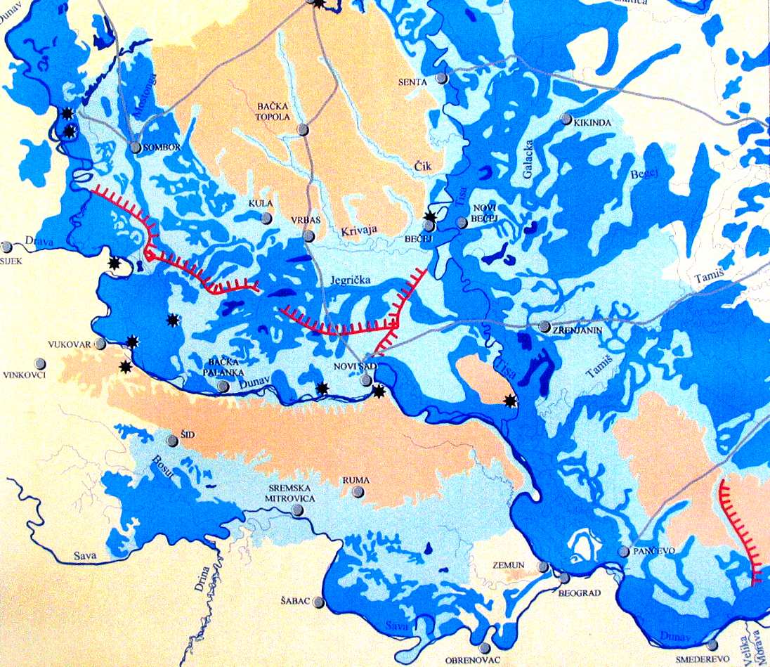
From the ancient times people in the Vojvodina area made great efforts to protect their properties
from frequent flooding and prevent water-related diseases. Organized works started in the eighteenth
and nineteenth century. The DTD System is divided into two practically independent parts, in the
Backa and in the Banat region.
Creation of AWB in the Vojvodina province of Serbia
At the end of 17th century, Vojvodina was a region covered
with marshes, swamps and bogs full of mosquitoes (Fig. 1),
with 2-3 inhabitants/sq. km. That was the time when great
efforts to drain swamps, protect properties from frequent
flooding, and prevent water-related diseases started.
Fig 1: Wetlands in Vojvodina, 16th-17th century (dark blue-
marsh, light blue ş occasionally flooded terrain, yellow ş
high terrace, star ş settlements)
Canals were excavated to drain swamps and enable navigation: the Bega Canal for the drainage of the
Central marsh (4,000 km2), the Teresia Canal in the Banat region, and the Danube-Tisza Canal in the
Backa region. After the Second World War, the existing canals were connected into a multipurpose
water management system. Its design started in 1947 and the project was finished in 1977 with the
completion of the dam on the Tisza. These developments changed Vojvodina from a swampy and
uninhabited area to a densely populated and developed part of the Republic of Serbia.
Fig. 3: The Timis and Begej Rivers, with levees, sluices
and locks (18th century)
Fig. 2: Swamps and rivers in the Banat Region (1740)
Hydro-technical works commenced in Banat region,
the part of Vojvodina that was extremely exposed to
floods (Fig. 2). In the Middle Banat, the Begej and
Timis rivers repeatedly flooded some 3,000 sq. km of
land. Excavation of 70 km long Begej Canal started in
1718, but the navigation begun in 1756 when it was
linked with River Timis by a supply and a bypass canal
(Fig 3). During the subsequent period, works on the
Canal were carried out in several stages, and the Canal
attained its present size between 1902 and 1913.
ICPDR / International Commission for the Protection of the Danube River / www.icpdr.org
Analysis of the Tisza River Basin - Annex 3
The major structure of the DTD System is the dam constructed on the 63rd km of the Tisza River.
According to its operating rules, the Dam increases only the levels of low and average waters, when
the backwater stretches beyond the Serbian border.
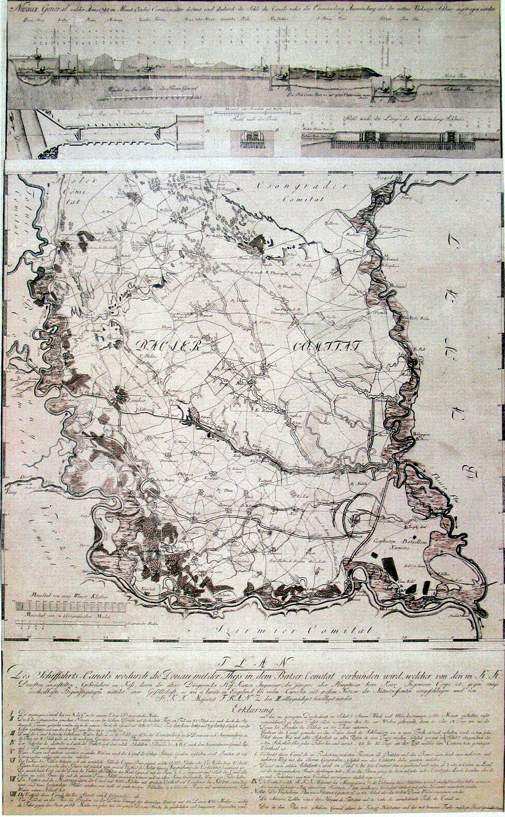
At the beginning of the 18th century, 2.670 sq. km or
30% of the Backa region was inundated (2 160 sq.
km being in its south part). The first significant water
engineering works were done under direction of Mr.
Joseph Kish, and encompassed excavation of two
large drainage canals. The success of this works led
to the construction of the Great Backa Canal (or
Francis Canal), from the Danube to the Tisza river,
according to design of Mr. Kish (Fig. 4). Works were
done between 1793 and 1801, and the exploitation of
new navigable route between the Danube and Tisza
rivers started in 1802
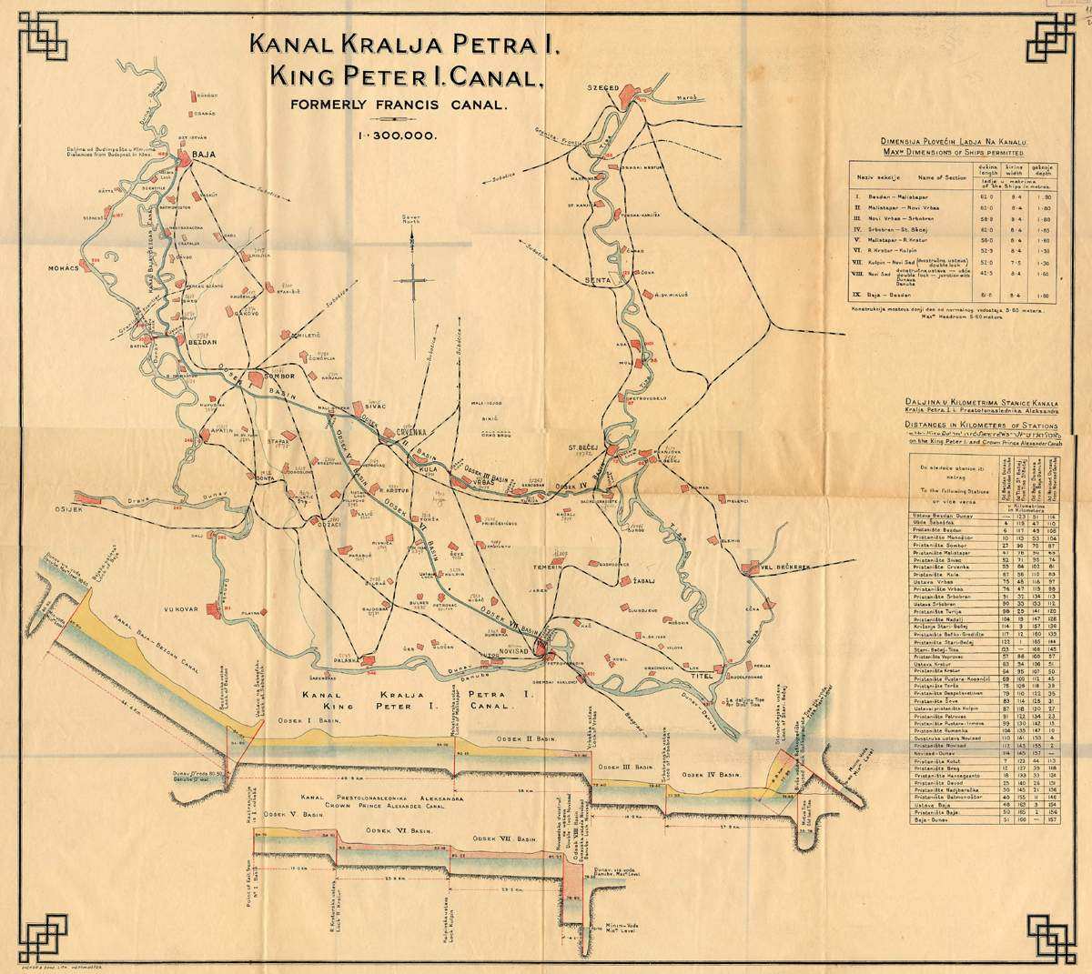
Fig 5: Map of the Backa canals, with distances and
dimensions of vessels
After Second World War, the existing Canals were
connected into multipurpose water management Danube-
Tisza-Danube system. Its design started in 1947, and in
1977 the Project was finished with the completion of the
dam on the Tisza. About 900 km of new canals were
excavated, 126 million m3 in total, and numerous new
ship-locks, weirs, bridges, pump-stations, levees and
other structures. This, final solution of water
management problems changed Vojvodina from swampy
Fig 4: Map of Backa with the Great Backa Canal
and uninhabited to densely populated and developed part
(1792)
of Serbia.
ICPDR / International Commission for the Protection of the Danube River / www.icpdr.org
ANNEX 4 - Reservoirs of the Tisza River BASIN
Reservoirs in the Tisza River Basin
Category
Location
Reservoir
(capacity
River
Catchment
Volume
Surface
range)
Country
River Basin
Name
upstream of
Purpose
Name
Mm3
km2
Mm3
ha
Somes
Apatiu
Manic
72
0.070
84.51
fish farming
Somes
Archiud
Budurleni
40
1.4
112
fish farming
Somes
Somesul Mic
Gilau
947
4.20
68
multipurpose
Somesul
Somes
Somesul Cald
530
7.00
78
water supply; hydropower
Cald
Fancica
Crisuri
(Valea
Salacea
17
1.21
53
irrigation
repede)
RO
Crisuri
Almas
Fegernic
40
2.86
54
fish farming
Crisuri
Fancica
Crestur
68
4.03
86
flood retention; fish farming
Gut
Crisuri
Rovina (Ineu)
27
3.66
56
flood retention; fish farming
(Condratu)
Mures
Strei
Subcetate
1,533
5.07
80
hydropower
Mures
Raul Mare
Paclisa
447
7.90
99
hyropower; water supply
Mures
Raul Mare
Ostrovul Mic
421
8.60
89
hyropower; water supply
Mures
Aries
Mihoesti
414
6.30
71
hydropower; water supply
Bega
Magherus
Murani
108
6.20
192
multipurpose
Klenovskß
drinking water production, flood
Slanß
VN Klenovec
88.8
8.43
71
Rimava
protection
SK
<10
VN Teplř
irrigation, flood protection, fishing,
Slana
Blh
105.1
5.28
105
Vrch
recreation
Tarna
Gy÷ngy÷s-p.
Viszneki
na
4.5/3.027
555
flood retention
HU
Tarna
Bene-p.
Ludasi
na
5/1.91
162
flood retention
Tisza
Roman
Gorbok
50
7.4
246
flood retention, seasonal flow regulation
UA
Tisza
Fornosh
Fornosh
24
5.2
285
flood retention, seasonal flow regulation
Tisza
Mochila
Mochila
23
3.95
160
flood retention, seasonal flow regulation
Tisza
Boronyava
Boronyavske
14
1.75
89
seasonal flow regulation, fish farming
Latoritsia
Poluy
Bobovyschanske
31
1.6
31
seasonal flow regulation
Tisza
Salva
Vinogradivske
23
1.38
101
seasonal flow regulation, fish farming
Latoritsia
Stara
Andriyivtsi
84
1.35
62
seasonal flow regulation
Tisa
K-23
Moravica
na
1.35
70
Irrigation, Drainage
Tisa
Cik
Svetievo
na
3.97
na
Irrigation, Drainage
Tisa
na
Tavankut
na
1.8
63.3
Irrigation, Drainage
Tisa
Krivaja
Zobnatica
na
4.8
230
Irrigation, Drainage
RS
Tisa
K-18-2
Sava
na
0.47
17
Irrigation, Drainage
Tisa
K-8
Conoplja
na
0.84
54
Irrigation, Drainage
Canal
Tisa
Adorjan-
Velebit
na
na
100
Irrigation, Drainage
Velebit
Tisa
Tur
Calinesti Oas
375
29.000
382
multipurpose
Somes
Firiza
Stamtori
212
16.60
113
multipurpose
Crisuri
Barcau
Salard
1,686
15
700
flood retention
Crisuri
Crisul Negru
Tamasda
3,503
22.12
507
flood retention
Crisuri
Cigher
Taut
165
32.8
300
multipurpose
Crisuri
Iad
Lesu
89
28.0
143
multipurpose
RO
Mures
Ighis
Ighis
23
13
102
water supply; recreation
Mures
Cusmed
Bezid
148
31.0
250
multipurpose
Tarnava
Mures
Zetea
352
44.0
234
multipurpose
mare
Mures
Sebes
Tau
401
21.0
81
hydropower
Mures
Cerna
Cincis
301.0
43.00
260
multipurpose
Bega
Gladna
Surduc
135
50.00
532
multipurpose
VN
10-50
Hornad
Hnilec
Palcmanskß
84.5
10.36
85
electricity production, recreation, fishing
SK
Masa
VN Bukovec
drinking water production, flood
Bodva
Ida
55.4
23.4
102
II
protection
K÷r÷s÷k
╔r
╔r-menti
na
12.2
1.352
flood retention
Zagyva
Zagyva
Jßszteleki
na
13
1.800
flood retention
ANNEX 4 - Reservoirs of the Tisza River BASIN
Bodrog
Bodrog
Ronyva-zugi
na
14.6
968
flood retention
Tarna
Tarna
Borsˇhalmi
na
24/23.5
20.06
flood retention
HU
K÷r÷s÷k
FehÚr-K÷r÷s
Kisdelta
na
25.5
580
flood retention
Berettyˇ
Berettyˇ
Halaspuszta
na
35
21.700/2.175
flood retention
Berettyˇ
Beretyˇ
Kutas
na
36.5
39.200/3.896
flood retention
UA
Tisza
Tereblya Tereblya- Rikske
438
24
155
hydropower
Somesul
Somes
Tarnita
491
74.000
220
hydropower
Cald
Somes
Bistrita
Colibita
113
90.000
314
water supply; hydropower
RO
Crasna
Crasna
Varsolt
345
50.200
652
multipurpose
Crisul
Crisuri
Tileagd
1,846
52.9
605
multipurpose
Repede
Crisul
Crisuri
Lugasu
1,736
65.4
640
hydropower; water supply
Repede
VD RuzÝn I a
electricity production, recreation, fishing,
50-100
Hornad
Hornßd
1,906.7
51.95
390
RuzÝn II
flood protection, industry water supply
VD RuzÝn I a
electricity production, flood protection,
Hornad
Hornßd
1,932.8
4.55
64
SK
RuzÝn II
fishing
Bodrog
Laborec
Polder Besa
4,522.5
53
1,568
flood protection
drinking water production, flood
Bodrog
Cirocha
VN Starina
125.8
56.95
283
protection
Fekete-K÷r÷s Fekete-K÷r÷s
Mßlyvßdi
4,644
75
3,684
flood retention
HU
Kettis-K÷r÷s Kettis-K÷r÷s
MÚrgesi
10,384
87.2
1,823
flood retention
Sebes-K÷r÷s Sebes-K÷r÷s
MÚrgesi
8,985
87.2
1,823
flood retention
Crisuri
Dragan
Dragan
159.0
112
292
multipurpose
RO
Mures
Sebes
Oasa
187
136.0
401
multipurpose
VD Vekß
electricity production, recreation, fishing,
Bodrog
Ondava
Domasa a
827
178.28
1,510
flood protection, industry water supply,
Malß Domasa
irrigation
SK
VD Vekß
Bodrog
Ondava
Domasa a
852
0.93
54
electricity production, fishing
Malß Domasa
RS
Tisa
Tisa
Tisa
na
160
na
Irrigation, Flood Protection
Mures
Raul Mare
Gura Apelor
235.000
210
411.000
hydropower
RO
Somesul
Somes
Fantanele
325
225.00
826.000
hydropower; flood protection
Cals
200-500
VN
Laborec-
recreation, fishing, irrigation, industry
SK
Bodrog
ZemplÝnska
1,567.3
297.32
3,280.000
bocnß nßdrz
water supply, flood production
SÝrava
HU
Tisza
Tisza
Kisk÷re
65,670
253
12,700
multipurpose
unknown
HU
Tisza
na
Tiszal÷k
na
??
na
na
Analysis of the Tisza River Basin - Annex 5
Annex 5
List of Surface Water Bodies Evaluated in Part II (Water
Quality Part) of the ` Analysis of the Tisza River Basin
2007`
ICPDR / International Commission for the Protection of the Danube River / www.icpdr.org
Analysis of the Tisza River Basin - Annex 5
Present tables list water bodies of the Tisza River and its tributaries, analysied in the following
chapters (based on data from the Tisza Countries collected in templates for the purposes of the
report):
Ě Chapter 4.1. ş Identification of surface water categories
Ě Chapter 4.2. ş Surface water types and reference conditions
Ě Chapter 4.3. ş Identification of surface water bodies
Ě Chapter 4.6. ş Provisional heavily modified surface waters
Ě Chapter 4.9. ş Risk of failure to reach environmental objectives
Main Tisza River ş List of Water bodies
Country
Code
Name of WB (if available)
RS
CS_TIS_1
CS_T26
RS
CS_TIS_2
CS_T27
HU
HU_RW_AAA506_0160-0243_S
Tisza
HU
HU_RW_AAA506_0243-0402_S
Tisza
HU
HU_RW_AAA506_0402-0521_S
Tisza
HU
HU_RW_AAA506_0521-0569_S
Tisza
HU
HU_RW_AAA506_0569-0679_S
Tisza
SK
SK_WB_35
Tisza
HU
HU_RW_AAA506_0679-0724_S
Tisza
UA
UA_TT_05
Tisza (Szolovka-Zahony/ Chop)
HU
HU_RW_AAA506_0724-0745_S
Tisza
UA
UA_TT_04
Tisza (Tyachiv- Batar/Vilok)
UA
UA_TT_03
Tisza (Shopurka-Tyachiv)
RO
RO_I_1.WB1
Tisa
UA
UA_TT_02
Tisza (Viseu- Shopurka)
UA
UA_TT_01
Tisza (source-Viseu)
ICPDR / International Commission for the Protection of the Danube River / www.icpdr.org
Analysis of the Tisza River Basin - Annex 5
Tisza Tributaries ş List of Water Bodies
Country
Code
Name of WB (if available)
RS
CS_BEG
Canal Begej
RS
CS_PLBEG
Navigable Begej
RS
CS_STBEG
Old Begej
HU
HU_RW_AAB197_0000-0074_S
Berettyˇ
HU
HU_RW_AAA614_0000-0051_S
Bodrog
HU
HU_RW_AAB755_0000-0047_S
Bˇdva
HU
HU_RW_AAB755_0040-0062_S
Bˇdva
HU
HU_RW_AAA593_0000-0015_S
Dong-Úri-focsatorna
HU
HU_RW_AAA593_0015-0070_S
Dong-Úri-focsatorna
HU
HU_RW_AAB815_0000-0009_S
╔r-focsatorna
HU
HU_RW_AAA510_0000-0010_S
FehÚr-K÷r÷s
HU
HU_RW_AAA250_0000-0020_S
Fekete-K÷r÷s
HU
HU_RW_AAA582_0000-0091_S
Hßrmas-K÷r÷s
HU
HU_RW_AAA532_0000-0094_S
Hernßd
HU
HU_RW_AAA532_0094-0113_S
Hernßd
HU
HU_RW_AAA160_0000-0079_S
Hortobßgy-Berettyˇ
HU
HU_RW_AAB724_0000-0014_S
Hortobßgy-focsatorna
ICPDR / International Commission for the Protection of the Danube River / www.icpdr.org
Analysis of the Tisza River Basin - Annex 5
Country
Code
Name of WB (if available)
HU
HU_RW_AAB724_0014-0065_S
Hortobßgy-focsatorna
HU
HU_RW_AAB724_0065-0093_S
Hortobßgy-focsatorna
HU
HU_RW_AAA745_0008-0029_S
Kßllˇ-Úr
HU
HU_RW_AAA875_0000-0091_S
Keleti-focsatorna
HU
HU_RW_AAA875_0091-0098_S
Keleti-focsatorna
HU
HU_RW_AAA198_0000-0037_S
Kettos-K÷r÷s
HU
HU_RW_AAA754_0000-0046_S
Kraszna
HU
HU_RW_AAA134_0000-0044_S
Lˇnyai-focsatorna
HU
HU_RW_AAA835_0000-0032_S
Maros
HU
HU_RW_AAA835_0032-0050_S
Maros
HU
HU_RW_AAA887_0000-0008_S
Nagyari-T˙r ßg
HU
HU_RW_AAB056_0000-0052_S
Nagy-Úr
HU
HU_RW_AAB056_0052-0084_S
Nagy-Úr
HU
HU_RW_AAB659_0000-0069_S
Sajˇ
HU
HU_RW_AAB659_0069-0125_S
Sajˇ
HU
HU_RW_AAB680_0000-0015_S
Sebes-K÷r÷s
HU
HU_RW_AAB680_0015-0058_S
Sebes-K÷r÷s
HU
HU_RW_AAA856_0000-0050_S
Szamos
ICPDR / International Commission for the Protection of the Danube River / www.icpdr.org
Analysis of the Tisza River Basin - Annex 5
Country
Code
Name of WB (if available)
HU
HU_RW_AAA746_0000-0043_S
Tarna
HU
HU_RW_AAA746_0043-0085_S
Tarna
HU
HU_RW_AAA746_0085-0101_S
Tarna
HU
HU_RW_AAB763_0012-0030_S
T˙r
HU
HU_RW_AAB141_0000-0065_S
T˙r-BelvÝz-focsatorna
HU
HU_RW_AAA036_0000-0012_S
Vajai-(III.)fofolyßs
HU
HU_RW_AAA036_0012-0048_S
Vajai-(III.)fofolyßs
HU
HU_RW_AAB074_0000-0063_S
Zagyva
HU
HU_RW_AAB074_0063-0127_S
Zagyva
HU
HU_RW_AAB074_0127-0163_S
Zagyva
HU
HU_RW_AAB074_0163-0177_M
Zagyva
RO
RO_IV-2_WB1
Aranca/Zlatica
RO
RO-IV_1.81WB1
ARIES
RO
RO-IV_1.81WB2
ARIES
RO
RO-IV_1.81WB6
ARIES
RO
RO-IV_1.81WB5
ARIES
RO
RO-IV_1.81WB4
ARIES
RO
RO-IV_1.81WB3
ARIES
ICPDR / International Commission for the Protection of the Danube River / www.icpdr.org
Analysis of the Tisza River Basin - Annex 5
Country
Code
Name of WB (if available)
RO
RO_3.1.44.33_WB5
Barcau
RO
RO_3.1.44.33_WB4
Barcau
RO
RO_3.1.44.33_WB3
Barcau
RO
RO_3.1.44.33_WB2
Barcau
RO
RO_3.1.44.33_WB1
Barcau
RO
RO_V-1_WB47
Bega Veche/Stari Begej
RO
RO_V-1_WB48
Bega Veche/Stari Begej
RO
RO_V-1_WB4
Bega/Begej
RO
RO_V-1_WB3
Bega/Begej
RO
RO_V-1_WB2
Bega/Begej
RO
RO_V-1_WB1
Bega/Begej
RO
RO_II_2.WB3
Crasna
RO
RO_II_2.WB2
Crasna
RO
RO_II_2.WB1
Crasna
RO
RO_3.1_WB6
Crisul Alb
RO
RO_3.1_WB5
Crisul Alb
RO
RO_3.1_WB4
Crisul Alb
RO
RO_3.1_WB3
Crisul Alb
ICPDR / International Commission for the Protection of the Danube River / www.icpdr.org
Analysis of the Tisza River Basin - Annex 5
Country
Code
Name of WB (if available)
RO
RO_3.1_WB2
Crisul Alb
RO
RO_3.1_WB1
Crisul Alb
RO
RO_3.1.42_WB5
Crisul Negru
RO
RO_3.1.42_WB4
Crisul Negru
RO
RO_3.1.42_WB3
Crisul Negru
RO
RO_3.1.42_WB2
Crisul Negru
RO
RO_3.1.42_WB1
Crisul Negru
RO
RO_3.1.44_WB6
Crisul Repede
RO
RO_3.1.44_WB5
Crisul Repede
RO
RO_3.1.44_WB4
Crisul Repede
RO
RO_3.1.44_WB3
Crisul Repede
RO
RO_3.1.44_WB2
Crisul Repede
RO
RO_3.1.44_WB1
Crisul Repede
RO
RO_3.1.44.33.28_WB2
Ier
RO
RO_3.1.44.33.28_WB1
Ier
RO
RO_I_1.WB6
Iza
RO
RO_I_1.WB5
Iza
RO
RO_II_1.WB14
Lapus
ICPDR / International Commission for the Protection of the Danube River / www.icpdr.org
Analysis of the Tisza River Basin - Annex 5
Country
Code
Name of WB (if available)
RO
RO_II_1.WB13
Lapus
RO
RO_II_1.WB12
Lapus
RO
RO-IV_1WB13
MURES
RO
RO-IV_1WB12
MURES
RO
RO-IV_1WB11
MURES
RO
RO-IV_1WB10
MURES
RO
RO-IV_1WB9
MURES
RO
RO-IV_1WB8
MURES
RO
RO-IV_1WB7
MURES
RO
RO-IV_1WB6
MURES
RO
RO-IV_1WB5
MURES
RO
RO-IV_1WB4
MURES
RO
RO-IV_1WB3
MURES
RO
RO-IV_1WB2
MURES
RO
RO-IV_1WB1
MURES
RO
RO-IV_1.102WB3
SEBES
RO
RO-IV_1.102WB2
SEBES
RO
RO-IV_1.102WB1
SEBES
ICPDR / International Commission for the Protection of the Danube River / www.icpdr.org
Analysis of the Tisza River Basin - Annex 5
Country
Code
Name of WB (if available)
RO
RO_II_1.WB11
Sieu
RO
RO_II_1.WB10
Sieu
RO
RO_II_1.WB9
Somes
RO
RO_II_1.WB8
Somes
RO
RO_II_1.WB7
Somes
RO
RO_II_1.WB6
Somes
RO
RO_II_1.WB5
Somes
RO
RO_II_1.WB4
Somes Mare
RO
RO_II_1.WB3
Somes Mare
RO
RO_II_1.WB2
Somes Mare
RO
RO_II_1.WB1
Somes Mare
RO
RO_II_1.31.WB7
Somesul Mic
RO
RO_II_1.31.WB6
Somesul Mic
RO
RO_II_1.31.WB5
Somesul Mic
RO
RO_II_1.31.WB4
Somesul Mic
RO
RO_II_1.31.WB3
Somesul Mic
RO
RO_II_1.31.WB2
Somesul Mic
RO
RO_II_1.31.WB1
Somesul Mic
ICPDR / International Commission for the Protection of the Danube River / www.icpdr.org
Analysis of the Tisza River Basin - Annex 5
Country
Code
Name of WB (if available)
RO
RO-IV_1.117WB3
STREI
RO
RO-IV_1.117WB2
STREI
RO
RO-IV_1.117WB1
STREI
RO
RO-IV_1.96WB7
TARNAVA
RO
RO-IV_1.96WB6
TARNAVA
RO
RO-IV_1.96WB5
TARNAVA
RO
RO-IV_1.96WB4
TARNAVA
RO
RO-IV_1.96WB3
TARNAVA
RO
RO-IV_1.96WB2
TARNAVA
RO
RO-IV_1.96WB1
TARNAVA
RO
RO-IV_1.96.52WB3
TARNAVA MICA
RO
RO-IV_1.96.52WB2
TARNAVA MICA
RO
RO-IV_1.96.52WB1
TARNAVA MICA
RO
RO_I_1.WB11
Tur
RO
RO_I_1.WB10
Tur
RO
RO_I_1.WB9
Tur
RO
RO_I_1.WB8
Tur
RO
RO_I_1.WB7
Tur
ICPDR / International Commission for the Protection of the Danube River / www.icpdr.org
Analysis of the Tisza River Basin - Annex 5
Country
Code
Name of WB (if available)
RO
RO_I_1.WB4
Viseu
RO
RO_I_1.WB3
Viseu
RO
RO_I_1.WB2
Viseu
SK
SK_WB_42
Bodrog
SK
SK_A0002
Bodva
SK
SK_A0001
Bodva
SK
SK_WB_47 + SK_WB_48
Hornßd/Hernßd
SK
SK_WB_46
Hornßd/Hernßd
SK
SK_WB_45
Hornßd/Hernßd
SK
SK_WB_44
Hornßd/Hernßd
SK
SK_WB_43
Hornßd/Hernßd
SK
SK_B0006
Laborec
SK
SK_B0004 + SK_B0005
Laborec
SK
SK_B0003
Laborec
SK
SK_WB_36
Latorica
SK
SK_B0018 + SK_WB_41
Ondava
SK
SK_WB_40
Ondava
SK
SK_WB_39
Ondava
ICPDR / International Commission for the Protection of the Danube River / www.icpdr.org
Analysis of the Tisza River Basin - Annex 5
Country
Code
Name of WB (if available)
SK
SK_B0015a + SK_WB_38
Ondava
SK
SK_WB_37
Ondava
SK
SK_S0015
Rimava
SK
SK_S0014
Rimava
SK
SK_S0013
Rimava
SK
SK_WB_51
Slanß/Sajˇ
SK
SK_WB_50
Slanß/Sajˇ
SK
SK_WB_49
Slanß/Sajˇ
SK
SK_B0026
Topla
SK
SK_B0024+ SK_B0025
Topla
SK
SK_B0023
Topla
SK
SK_H0017
Torysa
SK
SK_H0016
Torysa
SK
SK_H0015
Torysa
SK
SK_B0012
Uh/Uzh
UA
UA_ CT_01
Chona Tisza
UA
UA_ CT_02
Chona Tisza
UA
UA_BT_01
Bila Tisza
ICPDR / International Commission for the Protection of the Danube River / www.icpdr.org
Analysis of the Tisza River Basin - Annex 5
Country
Code
Name of WB (if available)
UA
UA_BT_02
Bila Tisza
UA
UA_ TE_01
Teresva
UA
UA_TE_02
Teresva
UA
UA_RI_01
Rika
UA
UA_RI_02
Rika
UA
UA_BO_01
Borzhava (Borsova)
UA
UA_BO_02
Borzhava (Borsova)
UA
UA_LA_01
Latorica
UA
UA_LA_02
Latorica
UA
UA_LA_03
Latorica
UA
UA_UZ_01
Uzh
UA
UA_UZ_02
Uzh
UA
UA_UZ_03
Uzh
UA
UA_UZ_04
Uzh
ICPDR / International Commission for the Protection of the Danube River / www.icpdr.org
Analysis of the Tisza River Basin ş Annex 6
ANNEX 6
Overview of all Types for Relevant Rivers with Catchment
Size bigger than 1,000 km▓ in the Tisza River Basin
ICPDR / International Commission for the Protection of the Danube River / www.icpdr.org
Analysis of the Tisza River Basin ş Annex 6
Country
Code
Name of river type
UA_ 2A
Small rivers, calcareous, low-mountain
UA_ 3A
Small rivers, calcareous, mid-mountain
UA_ 2B
Medium rivers, calcareous, low-mountain
Ukraine
UA_ 3B
Medium rivers, calcareous, mid-mountain
UA_ 1C
Large rivers, lowland
UA_ 2C
Large rivers, low-mountain
UA_ 1D
Very large river, lowland
RO_01
Mountain stream - Ecoregion 10
RO_02
High plateau or piedmonts stream - Ecoregion 10
RO_03
Stream sector in piedmont or high plateau area - Ecoregion 10
RO_04
Stream sector in hilly or plateau area - Ecoregion 10
RO_05
Stream sectors in intramountain depression - Ecoregion 10
RO_06
Stream sector with wetlands in hilly or plateau area - Ecoregion 10
Romania
RO_08
Stream sector in hilly or plateau area - Ecoregion 10
RO_10
Stream in plain area - Ecoregion 11
RO_11
Stream sector in plain area (1,000-3,000 km▓) - Ecoregion 11
RO_12
Stream sector in plain area (>3,000 km▓) - Ecoregion 11
RO_13
Stream sector with wetlands in plain area - Ecoregion 11
RO_32
Temporary stream in plain area - Ecoregion 11
HU-Type 2
Small calcareous mountainous stream
HU-Type 5
Medium calcareous hilly stream
HU-Type 6
Large calcareous hilly stream
HU-Type 13
Large calcareous lowland stream
HU-Type 14
Very large calcareous lowland stream
Hungary
HU-Type 15
Small calcareous lowland brook
HU- Type 16
Small with low slope calcareous lowland stream
HU- Type 17
Medium with low slope calcareous lowland stream
HU-Type 18
Middle calcareous lowland stream
HU-Type 19
Large calcareous lowland streams
HU-Type 20
Very large calcareous lowland river
P1V - B1
Large streams, < 200 m, in Hungarian lowland
K2V - H1
Large streams, 200-500 m, Carpathians
K2V - H2
Large streams, 200-500 m, Carpathians
Slovak Republic K2M
Small streams, 200-500 m, Carpathians
K3M
Small streams, 500-800 m, Carpathians
K2S
Middle size streams, 200-500 m, Carpathians
K3S
Middle size streams, 500-800 m, Carpathians
CS_Typ1.1
Very large rivers, lowland, siliceous, fine sediments
Serbia
CS_V1_P4_SIL
Large rivers, lowland, siliceous
CS_V1_P3_SIL
Medium rivers, lowland, siliceous
ICPDR / International Commission for the Protection of the Danube River / www.icpdr.org
Analysis of the Tisza River Basin - Annex 7
Annex 7
General Criteria as a Common Base for the Definition of
Reference Conditions
ICPDR / International Commission for the Protection of the Danube River / www.icpdr.org
Analysis of the Tisza River Basin - Annex 7
General criteria for defining reference conditions (harmonised basin-wide)
Basic statements
Reference conditions must be reasonable and politically acceptable.
Reference sites have to include important aspects of "natural" conditions.
Reference conditions should reflect no or minimum stress.
Land use in catchment area
Influence of urbanisation, land use and forest management should be as low as possible.
Stream and habitats
Reference sites should be covered by natural climax vegetation or unmanaged forests.
No removal of coarse woody debris.
No bed or bank fixation.
No obstructions that hinder the migration of organisms or the transport of bed material.
Only minor influence due to flood protection measures.
Bank and floodplain vegetation
Bank and floodplain vegetation should be present to allow lateral migration.
Hydrology and water management
No alteration of natural discharge regime.
No or only minor alteration of hydrology by dams, reservoirs, weirs, or sediment retaining
structures affecting the site.
No alteration of regime due to water diversion, abstraction, and no pulse releases.
Physico-chemistry
No point source of organic pollution.
No point source of nutrient pollution.
No sign of diffuse pollution inputs.
No acidification.
No liming.
No alteration of natural thermal regime.
No salinisation.
Biology
No significant impairment of the indigenous biota by introduction of animals and plants (e.g. in
the frame of fish farming).
Stream morphology
Morphological alterations do not influence biodiversity and ecological functioning.
Biomanipulation
No biomanipulation (e.g. in lakes).
Recreation uses
No intensive recreational use.
ICPDR / International Commission for the Protection of the Danube River / www.icpdr.org
Analysis of the Tisza River Basin - Annex 8
Annex 8
Possible Impacts Related to Different Pressures
ICPDR / International Commission for the Protection of the Danube River / www.icpdr.org
Analysis of the Tisza River Basin - Annex 8
Pressures*
Possible Impacts*
A. Interruption of the longitudinal continuum of
rivers )
Hydromorphological alteration
Ě Obstacle for fish migration
Ě Reduction of naturally reproducing fish
A. Interruption of the longitudinal continuum of
populations
rivers (Hydropower, Navigation, Flood defence)
Ě In impounded sections sediment retention,
B. Interruption of the lateral connectivity of rivers
reservoir flushing, clogging of the river
(Hydropower, Navigation, Flood defence,
bed/floodplain with fine sediments and reduced
Urbanisation and agricultural land use)
transport of sediments
Ě Loss of species habitats with a subsequent loss of
C. Hydrological alterations (Hydropower generation -
typical species
intermittent hydropower generation in the case of
Ě Erosion ş degradation of the river bed
hydropeaking - , Agriculture (irrigation), Industry,
(downstream of dams, weirs, etc.), decrease of
Water supply (reservoirs), Flood protection
surface and ground water levels
(retention reservoirs)
Ě Adaptive changes in biodiversity ş loss of species
due to habitat changes (adjacent shallow water
bodies).
Ě Adaptive changes in species composition of the
riverine vegetation.
Ě Overall change of species composition not typical
for the given ecosystem.
Ě Alteration of flow regime ş reduced flow
velocities, hydropeaking, residual water below
interruption of longitudinal continuum (for details
see 4.3)
Ě Change of species composition from riverine to
lake populations
Ě Species loss due to regular artificial flood pulse
effects (hydropeaking)
Ě Species loss due to habitat loss (insufficient
residual water)
B. Interruption of the lateral connectivity of rivers
Ě If floodplains/wetlands are disconnected from the
main river course the consequences can result in
Ě loss of habitats
Ě loss of species
Ě alteration of natural flow regime and sediment
dynamics ş change of populations
C. Hydrological alterations
Ě Species loss/alterations due to regular artificial
flood pulse effects (hydropeaking)
Ě Species loss/alteartions due to habitat loss
(insufficient residual water and migration barriers)
ICPDR / International Commission for the Protection of the Danube River / www.icpdr.org
Analysis of the Tisza River Basin - Annex 8
Pressures*
Possible Impacts*
Nutrient Pollution
A + B)
A.
Point sources of pollution from Settlements,
Ě Risk of eutrophication
Industry and Agriculture
Ě Loss of habitat
Ě
B.
Diffuse sources of pollution (Households,
Increased oxygen depletion
Industry and Agriculture)
Ě Limiting use of waters (e.g. recreation, etc.)
Organic pollution
A + B)
A. Organic pollution from point sources (Urban
Ě Increased oxygen depletion
development, Industry, Agriculture)
Ě Changes in species composition (benthic
B. Organic pollution from diffuse sources
invertebrates)
Ě
(Households, Industry and Agriculture)
Decline of species biodiversity
Ě Reduction of fish population or fish mortality
Hazardous substances pollution
A + B)
A. Hazardous substances from point sources (
Ě Toxicity
from industry - including mines ş agriculture,
Ě Bioaccumulation
urban development )
Ě Persistence
B. Hazardous substances from diffuse sources
(from agriculture, old contaminated sites
(including abandoned mining sites)
* Information based on Significant Water Management Issues in the Danube River Basin, prepared by:
ICPDR River Basin Management Expert Group with support of the PM EG, MA EG and GW TG.
ę ICPDR 2007
ICPDR / International Commission for the Protection of the Danube River / www.icpdr.org
Analysis of the Tisza River Basin - Annex 9
ANNEX 9
Delineation Methods of Provisional Heavily Modified
Surface Waters Bodies in Hungary, Slovakia and Romania
ICPDR / International Commission for the Protection of the Danube River / www.icpdr.org
Analysis of the Tisza River Basin - Annex 9
Specific national methods and criteria for the provisional identification of HMWB
Hungary
As regards rivers, the provisional identification of HMWBs was based on the river sections heavily
influenced by hydromorphological alterations, also taking into account information concerning human
intervention. The impact of human activity is significant, if GES cannot be achieved for this reason.
A water body is provisionally identified as heavily modified, where any of the following significant
hydrological or morphological changes affected more than 50% of the water body:
Ě The storage space of mountainous or hill-country barrage reservoirs,
Ě The impounded section of large lowland rivers,
Ě Water transfer for power generation.
Significant changes in the biological population of water bodies classified here can be verified and
human activity cannot be replaced with any other solution which is environmentally more
advantageous and feasible at cost effective level.
A water body is identified as possibly heavily modified, where any of the following significant
hydrological or morphological changes affect more than 50% of the water body:
Ě The tailwater sections of rivers heavily impacted by reservoirs,
Ě Impoundment on hill-country rivers, small lowland rivers, brooks and runnels causing a
significant degree of channel filling,
Ě Regulation which has heavily modified riverbed sizes and velocity conditions (mean velocity
atypical for the type and/or lack of flow areas of different velocity).
For water bodies classified here, significant change in the biological population of the water is
assumed and, in certain cases, human activity can be modified or replaced to attain good status.
For lakes, Hungary applied the "possibly heavily modified" category, when identifying provisional
heavily modified water bodies due to the lack of biological validation. Provisional identification was
made in accordance with the following criteria:
Ě Over 50% of the shoreline is pitched,
Ě The form of the bed has heavily changed (water depth exceeds 150% of the original or/and
surface exceeds 150% of the original),
Ě Water residence time in the lake exceeds the original residence time by over 20%.
All in all, the definition of the heavily modified character was made along with the definition of
hydromorphological risk and, therefore, certain methodological issues of the provisional identification
are addressed in the chapter on risk assessment.
Further tasks:
As regards water bodies provisionally identified as heavily modified or possibly heavily modified, the
first stage is the validation of type against the ecological status and actual causal validation (i.e. to
which human activity the degradation experienced in the status of biological communities can be
linked). This will be attained partly in the biological status survey program to be carried out with
PHARE assistance, which is required to be continued and complemented with the assessment of
hydromorphological effects.
In the case of heavily modified water bodies, the execution of detailed technical and economical
analysis for each heavily modified water body.
ICPDR / International Commission for the Protection of the Danube River / www.icpdr.org

Analysis of the Tisza River Basin - Annex 9
Slovakia
In order to identify hydromorphological changes and their quantity related to significant impacts we
defined impacts to morphological changes (1-8) and to discharge regime (9-10). Point and diffuse
sources for the needs of HMWB are not denoted as significant impacts, however they should be
considered in complex assessment of impacts.
1. Covered river sections
Significance criterion:
Ě If the covered section is longer than 100 m, it is a significant change.
Ě If any sequence of changing shorter covered and open sections of water course, where cumulative
length of covered parts is at least 150 m and which makes more than a half of the overall length of
the sequence, then the whole part of such course is considered a covered section.
Data availability: SVP (Slovak water management enterprise); project of the river regulation or river
training, maps, aerial photographs.
Consulting: SVP.
2. Channel straightening
Significance criterion:
If the overall cumulative length of all straightened sections is higher than 8% of the total course
length (Fig. 1).
Data availability: existing digital river routes (SHM┌, V┌VH), project of the river regulation or river
training, historical maps - archives, River authorities, aerial photos, visual examination.
Consulting: River authorities - SVP; V┌VH.
Figure 1
Example of channel straightening - modification of Morava river, - new river
course (indicated in red), - original river course (indicated in blue)
ICPDR / International Commission for the Protection of the Danube River / www.icpdr.org
Analysis of the Tisza River Basin - Annex 9
3. Section backwaters
Significance criterion:
Ě Backwater length (at low discharge 1) is higher than 1500 m for B/H > 15; 1000 m for B/H <15;
600 m for B/H < 8.
Ě Total length of all backwater sections at low discharge is higher than 10% of the total length of
water courses at water body.
Data availability: project of the river regulation or river training, and technical documentation
available at river basin authorities, for a very rough estimation also water management maps.
Consulting: River authorities - SVP; V┌VH.
4. Length and bank lining
Significance criterion:
Total length of all sections with stabilized banks is higher than 10% of total watercourse length2 at
water body.
Data availability: river authority, project of the river regulation or river training, technical
documentation to the objects on the rivers - available at River basin authorities.
Consulting:: river basin authorities ş SVP.
5. Flood protection
Significance criterion:
Distance of flood dikes (Bi) from the course is smaller than 3B (3 times the width of the river channel
- fig. 2) on the course in length of 5B3.
Data availability: river authority, project of the river regulation or river training, technical
documentation to flood protection measures - available at River basin authorities.
Consulting: river basin authorities ş SVP.
Figure 2
Diagram for evaluation of the river dams impact (B - channel width, Bi şdike
distance)
1 low discharge = Q355
2 total watercourse length is considered as 2 times the length of watercourse axis
3 B - is the course width in terms of mean water level width at channel discharge in 1 km section of monitored
part of the course
ICPDR / International Commission for the Protection of the Danube River / www.icpdr.org
Analysis of the Tisza River Basin - Annex 9
6. Urbanization
Significance criterion:
Urban area is in the distance of 5 m from the edge of river channel in length of more than 15% of the
total length of river stretches in the frame of water body.
Data availability: maps in scale 1 : 5000, 1:10 000, river authority; local authorities and
municipalities.
Consulting: local authorities and municipalities.
7. Composite assessment
From the assessment summary of points 4, 5 and 6, it follows that the quantification of some above
mentioned parameters and criteria is rather difficult in practice and their differentiation is not always
useful. Therefore it is possible to use an auxiliary criterion - composite assessment of course
modification, which integrates the above mentioned criteria ,,bank lining" (4), ,,urbanization" (5) and
,,flood protection"(6).
Table 1 presents 6 classes describing the degree of course modification regarding its ecological status.
Table 1 shows an example of course classification.
Data availability: technical documentation to the performed course modifications - available at River
basin authorities.
Consulting: river basin authorities - SVP; for the assessment make use of practical and personal
experience of the River basin authorities staff.
Table 1 Course classification based on modification level
Class No.
Description of the assessed course section
Water course is in its natural state and no significant channel modifications were
1
carried out;
,,Nature-like" modifications were carried out on the water course, built of
2
ecological materials;
Significant bank modifications were carried out on the water course ; partly
3
course straightening; the course still has certain potential for its natural evolution;
,,Heavy" bank (eventually bottom) modifications were carried out on the water
4
course from ecologically unsuitable materials; also smaller objects are present in
the channel (low weirs, sills, bridges), which allow for fish migration;
,,Heavy" bank and bottom modifications were carried out on the water course;
smaller objects obstruct fish migration; significant course shortening;
5
modifications and objects have significantly negative impact on natural evolution
potential;
,,Heavy" bank eventually bottom modifications were carried out on the water
courses; larger objects are present (obstructing fish migration, causing substantial
6
backwaters, producing areas with bottom degradation); significant course route
straightening; covered course sections ;
Significance criterion: mean index of water course change is > 2
(Note: it is only an auxiliary criterion, which is not set in the directive)
ICPDR / International Commission for the Protection of the Danube River / www.icpdr.org
Analysis of the Tisza River Basin - Annex 9
8. Change in cross section profile
Significance criterion:
a) Significant channel widening: if channel width after modification B is 20% higher (compared to
the original state) on a section longer than 1 km.
b) Significant channel narrowing: if profile area S is 25% smaller (compared to the original state) on
a section longer than 1 km.
On navigable courses there is another criterion of aerial change of cross section profile: if present area
of cross section profile (area of cross section profile to the water level of channel discharge) is more
than 25% smaller on a section longer than 1 km.
Data availability: project of the river regulation or river training, technical documentation to the
performed course modifications - usually older data available at River basin authorities, newer data in
V┌VH are digitised and were obtained (surveyed) in frame of different projects.
Consulting: department of hydrology and hydraulics in V┌VH; river basin authorities ş SVP.
9. Dikes and weirs
Significance criterion:
-
Obstruction height > 0.5 m (provided that it is not a barrier to fish migration).
Data availability: river authority, project of the river regulation or river training, technical
documentation of the object on the courses available at River basin authorities, objects can be located
from watermanagement maps or aerial photographs.
Consulting: department of hydrology and hydraulics in V┌VH; river basin authorities ş SVP.
10. Intakes
Significance criterion:
- Individual intakes with quantifiable recirculation > 50 l/s (150 l/s in case of intakes without
recirculation or with incalculable recirculation).
- Individual intakes with quantifiable recirculation > 10% of mean low discharge5, (30% in
case of intakes without recirculation or with incalculable recirculation 6 ).
- Total intake for the water body > 50 % of mean low discharge7.
Data availability: all necessary data are available at river authority; Q355 values are available at
SHM┌ within the monitoring network profiles.
5 low discharge in the intake site
6 recirculation - intake and disposed (treated waste waters) amounts within the water body
7 cumulative low discharge of water body (low discharge at the end point of downstream of water body)
ICPDR / International Commission for the Protection of the Danube River / www.icpdr.org
Analysis of the Tisza River Basin - Annex 9
DETERMINATION OF INDEX OF CHANGE:
Step 1: examination of significance
The above mentioned parameters (in points 1 to10 - except 9) will be quantified in scale 1 to 10,
where:
1 - is the smallest change
10 - is the most significant change over the whole water course within the water body
During the examination of significance of discharge regulation (weirs and barriers - point 9) it is
possible to use quantification of continuum interruption (migration), which is caused by these
obstacles on the course. The more downstream the migration obstacle is, the bigger is the upstream
section, which is not open for migration. Calculation of migration length:
Lmigr = (Lmigr-pod + Lmigr-nad) / 2L
Lmigr - dimensionless free migration length
Lmigr-pod - section length with free migration in downstream section
Lmigr-nad - section length with free migration in upstream section
L - total length of course section
Step 2: Combinations of different impacts
After Step 1, each water body is assigned 5 parameters in scale from (0) 1 to 10. The resulting
parameter is retrieved after each of 5 parameters is assigned its weighted parameter.
Each assessed parameter has in terms of significance a different impact on final assessment of the
state of the water body. To at least partly consider the significance of individual parameters in the
total average, we proposed to assign each assessed parameter its weighted value (percentage of
representation). Example of assigning impact values to individual parameters is shown in Table 2.
Final point assessment, which will also consider the weight of parameters will result from relation:
V = 3 (0,06) + 8 (0,2) + 4 (0,15) + 7 (0,17) + 5 (0,2) + 7 (0,22)
= 0,18+1,6+0,6+1,19+1+1,54 = 6,11 6
Table 2 Example of assigning level of influence (1-10) of water bodies
Significance
Point evaluation of individual impacts
Parameter
of impacts
1
2
3
4
5
6
7
8
9
10
(%)
1
0,06
x
2
0,20
x
3
0,15
x
(4, 5, 6)= 7
0,17
x
8
0,20
x
9
0,22
x
Lmigr
ICPDR / International Commission for the Protection of the Danube River / www.icpdr.org
Analysis of the Tisza River Basin - Annex 9
Step 3 Water body classification
The above mentioned quantification of impacts significance level can result in preliminary
classification.
I.
Water bodies indicating only low level of overall impact (total result in range 0-3)ş
natural to slightly impacted water body
II.
Water bodies indicating medium level of overall impact (total result in range 4-7) -
candidate - on the basis of detailed testing can be re-classified to natural or heavily modified
III.
Water bodies showing high level of overall impact (total result in range 8-10) - heavily
modified water bodies
Weighted means of the results of different impacts can in some cases lead to significance
undervaluation. If the water body has a high impact degree of one specific impact, but other impacts
are not represented or their impact level is low, then the high level of one of the assessed impacts
need not to be found in the weighted mean at all. Therefore we suggest the following method: if one
of the assessing impact reaches value 8 and higher, water body should be classified as moderate (4-7)
although the total average is less than 4.
Hydromorphological changes classification criteria need to be supplemented with other impacts,
which consider water usage and qualitative parameters.
Due to the fact, that data availability for morphological changes assessment is different on individual
streams (no up-to-date data, incomplete or on small courses no data at all), it is essential to have the
course assessment done by experts with theoretical and practical experience in this field. Required
data and information as well as actual course specification need to be prepared in close cooperation
with river basin authorities. Final classification is then a result of assessment based on above
mentioned criteria and expert judgement in harmony with the basic scheme of heavily modified water
bodies assessment (basic methodology).
Romania
The identification and designation of HMWBs and AWBs has been made according to the definition
provided by the WFD and European Guidance on "Identification and designation of HMWBs and
AWBs". The methodology for the provisional identification of HMWBs is presented in the following
table.
ICPDR / International Commission for the Protection of the Danube River / www.icpdr.org
Analysis of the Tisza River Basin - Annex 9
Abiotic criteria for the preliminary HMWB designation in Romania
N
Hydraulic works
Effects
Abiotic criteria
Pressure / Surface water bodies
o
classification
(Hydro - morphological
(Parameters
alterations)
reflecting the
Low
Med.
High
pressure)
pressure /
pressur
pressure /
Candidate to
e /
Non-HMWB
HMWB
HMWB
Transversal river works
1
on hydrological regime,
Sills density (no. / km)
< 1
2
> 3
on sediment transport
1.1 dams / weirs / sills
and migration of biota1)
Height of the structure (cm)
< 20
20 ş 50
> 50
1.2 reservoirs -
Low flow in river bed /
on the low flow and
>100
100 - 50
< 50
hydropeaking
biota
Q*2) (%)
Water level gradient (cm) /
on hydrological
< 50
50 - 100
> 1003)
hour
regime, bank stability
Longitudinal river works
Length of dikes / Length of
2
on lateral
< 30
30 - 70
> 70
water body (%)
2.1 embankments,
connectivity,
agricultural/fish farming
floodplain vegetation
Flood protected surface /
< 30
works, etc
30 - 70
> 70
and spawning habitat
Floodplain surface (%)
2.2 bank regulation /
Length of hydraulic works /
on longitudinal river
< 30
30 - 70
> 70
consolidation works,
Length of water body (%)
profile, on substrate
cutt-meandering works
structure and biota
Navigation channels
(Dredged) channel
3
on bed stability and
< 20
20 - 50
> 50
width/river bed width(%)
biota
Water intakes,
Abstracted or returned
4
on the low flow, bed
< 10
10 - 50
> 50
discharges, river
discharge / Multiannual
stability and biota
derivation
average flow (%)
Low flow rate in river bed /
> 100
100 - 50
< 50
Q*2) (%)
1) only the migratory biota;
2) Q* = Q95% (m3/s)+ 0,1 for Q95% > 200 l/s ; Q* = 1,25 x Q95% (m3/s)+ 0,05 for Q95% < 200 l/s
Q95% - Minimum monthly multiannual discharged with 95% probability (mc/s);
3) frequency > 1 / zi
ICPDR / International Commission for the Protection of the Danube River / www.icpdr.org
Analysis of the Tisza River Basin ş Annex 10
Annex 10
Details on National Methods of Risk Assessment and
Criteria
ICPDR / International Commission for the Protection of the Danube River / www.icpdr.org
Analysis of the Tisza River Basin ş Annex 10
National approaches for the risk assessment on surface water in Hungary, Romania and
Slovakia
Hungary
When designating surface water bodies that are at risk in terms of water pollution, Hungary classified
according to three pollution types:
Ě Organic substances;
Ě Nutrients;
Ě Hazardous substances.
Organic substances were characterised by the biochemical oxygen demand (BOD5) and dichromate
chemical oxygen demand (CODd), while nutrients were characterised by total phosphorus and total
inorganic nitrogen based on representative concentrations measured or estimated by modelling
(calculations).
The thresholds used for the classification of water body risk are listed in Table 1 below. The
following classification features have been used:
Ě The category "possibly at risk" was introduced as an uncertain group between the categories
"not at risk" and "at risk";
Ě For the general indices of organic substances and nutrients, thresholds were assigned to the
90% frequency test results and mean values. The thresholds corresponding to the 90%
frequency test results were applied for water bodies for which regular test results have been
obtained. Thresholds belonging to the average value were assigned to the average
concentration estimated from the average load.
Ě The thresholds pertaining to the 90% frequency test results were taken from the standard
MSZ 12749 "Quality of surface waters, quality characteristics and rating" with the thresholds
of "good" and "bearable" water;
Ě For hazardous substances, the thresholds pertaining to the 90% frequency test results were
assigned to the components for which regularly measured results were available. For other
hazardous substances, the highest admissible concentration (HAC) was designated as
threshold of the "at risk" category.
ICPDR / International Commission for the Protection of the Danube River / www.icpdr.org
Analysis of the Tisza River Basin ş Annex 10
Table 1 Limit values applied for risk assessment of water bodies
Risk
Parameter
Not at risk
Possibly at risk At risk
category
90 %
< 6
6-10
> 10
BOD5 (mg/l)
organic
average
< 4
4-7
> 7
matter
90 %
< 22
22-40
> 40
CODd (mg/l)
average
< 16
16-30
> 30
90 %
total N (mg/l)
average
< 4
4-7,5
> 7,5
total P
90 %
< 200
200-400
> 400
nutrients
(rivers) (Ág/l)
average
< 130
130-250
> 250
total P
90 %
< 100
100-200
> 200
(lake waters) (Ág/l)
average
< 65
65-125
> 125
Alachlor (Ág/l)
MAC
< 0,57
0,57-1,15
> 1,15
Antracen (Ág/l)
MAC
< 0,005
0,005-0,01
> 0,01
Atrazin (Ág/l)
MAC
< 1
1-2
> 2
Benzene (Ág/l)
MAC
< 0,85
0,85-1,7
> 1,7
Bromed difenileters, Pentabrom difenileter (Ág/l)
MAC
< 0,7
0,7-1,4
> 1,4
Cadmium (Ág/l)
90 %
< 1
1-2
> 2
C10-13 chloroalcanes (Ág/l)
MAC
< 0,41
0,41-0,82
> 0,82
Chlorofenvinfos (Ág/l)
MAC
< 0,15
0,15-0,3
> 0,3
Chloropirifos (Ág/l)
MAC
< 0,005
0,005-0,001
> 0,001
1,2-dichloroethane (Ág/l)
MAC
< 590
590-1180
> 1180
Dichloromethane (Ág/l)
MAC
< 81
80-162
> 162
Di(2-etilhexil)phtalate (Ág/l)
MAC
< 0,33
0,33-0,66
> 0,66
Diuron (Ág/l)
MAC
< 0,9
0,9-1,8
> 1,8
Endosulphane
MAC
< 0,002
0,002-0,004
> 0,004
(alfa-endosulphane) (Ág/l)
Fluoranthene (Ág/l)
MAC
< 0,45
0,45-0,9
> 0,9
Hexachloro-benzol (Ág/l)
MAC
< 0,025
0,025-0,05
> 0,05
Hexachloro-butadiene (Ág/l)
MAC
< 0,29
0,29-0,59
> 0,59
hazardous
Hexachloro-ciklohexane (Ág/l)
MAC
< 0,45
0,45-0,9
> 0,9
substances
(gamma izomer lindane) (Ág/l)
MAC
< 0,02
0,02-0,04
> 0,04
Izoproturon (Ág/l)
MAC
< 0,65
0,65-1,3
> 1,3
Lead (Ág/l)
90 %
< 20
20-50
> 50
Mercury (Ág/l)
90 %
< 0,2
0,2-0,5
> 0,5
Naphtalene (Ág/l)
MAC
< 40
40-80
> 80
Nickel (Ág/l)
90 %
< 30
30-50
> 50
Nonil-phenoles (4-p-nonilphenole) (Ág/l)
MAC
< 1,05
1,05-2,1
> 2,1
Oktil-phenoles (p-terc-oktil-phenole) (Ág/l)
MAC
< 0,067
0,067-0,133
> 0,133
Pentachloro-benzol (Ág/l)
MAC
< 0,5
0,5-1
> 1
Pentachloro-phenole (Ág/l)
MAC
< 0,5
0,5-1
> 1
Polyaromatic hydrocarbons
Benz(a)pirene (Ág/l)
MAC
< 0,025
0,025-0,05
> 0,05
Benz(b)fluorantene (Ág/l)
MAC
< 0,03
0,03-0,06
> 0,06
Benz(g,h,i)perilene (Ág/l)
MAC
< 0,016
0,016-0,032
> 0,032
Benz(k)fluorantene (Ág/l)
MAC
< 0,03
0,03-0,06
> 0,06
Indeno(1,2,3-cd)pirene (Ág/l)
MAC
< 0,016
0,016-0,032
> 0,032
Simazin (Ág/l)
MAC
< 1,7
1,7-3,4
> 3,4
Tributil-tin compounds (Tributil-tin cathions) (Ág/l)
MAC
< 0,00075
0,00075-0,0015 > 0,0015
ICPDR / International Commission for the Protection of the Danube River / www.icpdr.org
Analysis of the Tisza River Basin ş Annex 10
The risks have been defined as follows:
Ě The loads for each water body (and the constituent catchment area belonging to them) were
summarised and the total load was then divided with the flow rate of the recipient water body.
Flow rates were calculated from the measurement data of the 1998-2002 period or, where
there was no measurement, from the map database of the specific runoff;
Ě For rivers where foreign sources might influence concentration, the following approach was
applied:
Ě The concentration was calculated as if no load arrived from beyond the frontier;
Ě The calculated value was compared to the measured value (average of 1998-2002) and the
difference was the foreign impact.
Ě When defining risk, Hungary compared the calculated or, where available, the measured
concentrations, to the thresholds stated in Table 1;
Ě For water bodies where Hungary had measurements, Hungary accepted the measurement
results to define the risk if the measurement and the calculation resulted in different
classifications;
Ě In order to establish the cause of the risk, Hungary calculated separately concentrations from
diffuse and point load sources. Where a water body crossed a class limit value only with
combined (diffuse + point source) load, Hungary used the load component with the higher
absolute value as reference;
Ě For water bodies that were classified in the same area when designating the catchment area
(i.e. no separate catchment areas were assigned), the concentration was considered to be
identical.
Owing to their hydrological and/or morphological status, water bodies were considered at risk if
considerable alterations affected over 50% of the water body. If such rate was caused by a
modification whose ecological impact is uncertain for the time being, the classification is "possibly at
risk".
The hydrological and morphological alterations of rivers have been classified according to whether
the good ecological status of these rivers can be achieved if the alterations remain in their present
condition. The assessment should have been based on biological data, but there are no databases
available in Hungary for such an assessment. To make up for this lack of information, we have carried
out a survey expedition involving the quick analysis of the ecological status of 60 river sections, on
the basis of which the ecological significance of hydrological and morphological alterations has been
assessed, and a degree of influence has been established for each area of activity where the
achievement of good ecological status is probably no longer possible (this has been termed as
"significant degree of influence"). The following activities were surveyed:
Ě The effects of reservoirs with a barrage dam on the upper and lower sections;
Ě The effects of impoundment on the upper and lower sections;
Ě The effects of water flow regulation on riverbed and velocity conditions;
Ě The effects of dykes on the high-water river bed and the floodplain;
Ě The effects of bank reinforcement and sealing on the riparian zone;
Ě The effects of abstractions and water transfers on velocity conditions and water level
fluctuations.
We have considered water bodies to be at risk because of their hydrological and/or morphological
status if more than 50% of their total length was under a significant degree of influence. If this was
caused by an alteration whose ecological effect was not yet known for certain, then the water body
was classified as "possibly at risk". In the case of such water bodies, further assessment based on data
from surveillance monitoring is needed in order to determine whether good status can be achieved
without taking any intervention.
ICPDR / International Commission for the Protection of the Danube River / www.icpdr.org
Analysis of the Tisza River Basin ş Annex 10
Natural lakes (like rivers) have been classified as possibly at risk because of their hydromorphological
status if the achievement of their good ecological status was found to be uncertain by unchanged
conditions. Risk assessment was based on two criteria:
Ě whether the morphology of shore areas was greatly altered, leading to a significant
deterioration of the living conditions of the various communities (e.g. in the case of
establishing bath, or dredging, where delving affected more than 50% of the shoreline);
Ě Whether water level regulation activities led to an alteration in the natural water resource
fluctuation in excess of +/-20%.
The GIS database on human activities influencing the hydromorphological status of rivers includes
reservoirs, transversal barrages, longitudinal flow regulation works, flood-levees, paved sections,
dredging and water abstractions.
In preparing the analyses, Hungary made use of the data and descriptions obtained during on-site
surveys carried out on the sections under influence.
The available hydromorphological information is not entirely reliable, especially in the case of water
bodies on rivers with small or medium-sized catchments and on lakes.
Further assessment based on data from surveillance monitoring is needed in order to determine
whether the human activities causing hydromorphological alterations really have significant effects on
the ecological status.
Romania
For the water body classification, Romania uses the risk classes "at risk", "possibly at risk", and "not
at risk". Water bodies classified as "possibly at risk" need further characterisation, analysis or
investigative monitoring by end 2006 to finally classify the risk.
For the risk categories named according to related significant pressures, criteria of WB risk
assessment were defined as follows:
Ě Organic pollution (ICPDR and national criteria): Saprobic index: 2.25 ş upstream water courses
and 2.40 ş downstream water courses;
Ě Nutrient pollution (ICPDR and national criteria): Limit of 2nd class of National quality standard
and eutrophication aspects for lakes and reservoirs;
Ě Hazardous substances pollution (ICPDR and national criteria): Limit of 2nd class of National
quality standard;
Ě Hydromorphological alterations: the existence of hydraulic works which have impact on river
morphology and hydrological regime.
ICPDR / International Commission for the Protection of the Danube River / www.icpdr.org
Analysis of the Tisza River Basin ş Annex 10
Slovakia
Three risk classes were distinguished: 1 "water body not at risk", 2 "water body maybe at risk", 3
"water body at risk".
Preliminary objectives - quantitative limits of good status of general physico-chemical and chemical
parameters were mostly overtaken from Governmental Decision about general objectives for surface
waters No.491/2002 Coll. (limits relate to 90% frequency) and from EU draft of EQS for priority
substances (maximum and average value). See Table 2.
The analysis is based on a combined approach which considers significant pressures and impacts ş
qualitative data from monitoring results of WBs. Used risk categories are :
Ecological status
organic pollution (used parameters : dissolved oxygen; BOD5; CODCr; and benthic
invertebrates - Saprobic index)
nutrient pollution ş eutrophication risk (used parameters : N-tot, N-NH4, N-NO3, P- tot, P-
PO4; chlorophyle-a)
hydro-morphological changes ş water body was classified at risk when it was designated as
HMWB candidate.
Chemical status
pollution caused by priority substances
pollution caused by other substances relevant for SR
Water body was designated in risk, when monitoring results exceeded the preliminary objective, or in
case no monitoring data were available when significant pressure was influencing the water body.
The assessment of risk analysis was performed for each category of risk independently. The results
obtained were used as the basis for designating the resultant risk. It is set by the risk category with the
most unfavourable assessment.
The current status is represented by data from the period 2001-2002.
ICPDR / International Commission for the Protection of the Danube River / www.icpdr.org
Analysis of the Tisza River Basin ş Annex 10
Table 2 Provisional objectives for chemical status
Type of
Statistical
CAS
Chemical substance
CODE
Symbol
Unit
Limit
element
value
Criterion of objective selection
Volatile organic substances
Aromatic hydrocarbons
R, A
71-43-2
benzene
K22
BENZEN
541-73-1
1,3-dichlorobenzene
K28
1,3-DCB
Ág/l
1
max
limit - GD No.491/2002 Coll.
106-46-7
1,4-dichlorobenzene
K29
1,4-DCB
Ág/l
1
max
limit - GD No.491/2002 Coll.
95-50-1
1,2-dichlorobenzene
K30
1,2-DCB
Ág/l
1
max
limit - GD No.491/2002 Coll.
R
108-88-3
toluene
K23
TOLUEN
Ág/l
50
max
limit - GD No.491/2002 Coll.
108-90-7
chlorobenzene
K25
CHLORBENZEN (CB)
Ág/l
10
max
limit - GD No.491/2002 Coll.
Halogenic hydrocarbons
74-34-3
1,1-dichloroethane
L41
1,1-DCEAN
Ág/l
75-35-4
1,1-dichloroethene
L22
1,1-DCEEN
Ág/l
R, A, B 67-66-3
trichloromethane
L23
CHLOROFORM
Ág/l
270/12
max/mean limit - EQS EU
R, A, B 107-06-2
1,2-dichlorethane
L24
1,2-DCEAN
Ág/l
1180/10
max/mean limit - EQS EU
71-55-6
1,1,1-trichloroethane
L25
TCEAN
Ág/l
R
79-00-5
1,1,2-trichloroethane
L26
1,1,2-TCEAN
Ág/l
1
max
limit - GD No.491/2002 Coll.
B
56-23-5
tetrachloromethane
L27
CCL4
Ág/l
12
max
limit - GD No.491/2002 Coll.
R, B
79-01-6
1,1,2-trichloroethylene
L28
1,1,2-TCE
Ág/l
10
max
limit - GD No.491/2002 Coll.
R, B
127-18-4
1,1,2,2-tetrachloroethylene
L29
pCE
Ág/l
10
max
limit - GD No.491/2002 Coll.
683-53-4
bromodichloromethane
L30
Ág/l
124-48-1
chlorodibromomethane
L31
Ág/l
75-25-2
tribromomethane
L32
Ág/l
78-87-5
1,2-dichloropropane
L36
Ág/l
A
75-09-2
dichloromethane
L37
DCM
Ág/l
1900/20
max/mean limit - EQS EU
540-59-0
1,2-dichloroethylene
L40
1,2-DCEEN
Ág/l
0,4
max
limit - GD No.491/2002 Coll.
10061-01-5
cis 1,3-dichloropropene
L42
Ág/l
ICPDR / International Commission for the Protection of the Danube River / www.icpdr.org
Analysis of the Tisza River Basin ş Annex 10
Type of
Statistical
CAS
Chemical substance
CODE
Symbol
Unit
Limit
element
value
Criterion of objective selection
10061-02-6
trans 1,3-dichloropropene
L43
Ág/l
79-34-5
1,1,2,2-tetrachloroethane
L44
Ág/l
10
max
limit - GD No.491/2002 Coll.
A,N
85535-84-8
C10-C13 chloroalcanes
Polyaromatic hydrocarbons
M21
PAU
R, A
206-44-0
fluoroanthene
M23
FLUORANTEN
Ág/l
0,9/0,09
max/mean limit - EQS EU
R
85-01-8
phenanthrene
M24
FENANTREN
Ág/l
0,03
mean
limit - PNEC CZ
86-73-7
fluorene
M25
FLUOREN
Ág/l
R,A
120-12-7
anthracene
M26
ANTRACEN
Ág/l
0,4/0,1
max/mean limit - EQS EU
129-00-0
pyrene
M27
PYREN
Ág/l
208-96-8
acenaphthylene
M28
Ág/l
83-32-9
acenaphthene
M29
Ág/l
218-01-9
chryzene
M30
CHRYSEN
Ág/l
polyaromatic hydrocarbons
R, A
50-32-8
benzo (a) pyrene
M22
B-A-PYREN
Ág/l
0,05
mean
limit - EQS EU
R, A
205-99-2
benzo (b) fluoroanthene
M32
B-B-FLUORANT
Ág/l
0,03
mean
limit - EQS EU
R, A
191-24-2
benzo (g,h,i) perylene
M36
B-GHI-PERYL
Ág/l
0,016
mean
limit - EQS EU
R, A
207-08-9
benzo (k) fluoroanthene
M33
B-K-FLUORANT
Ág/l
0,03
mean
limit - EQS EU
R, A
193-39-5
indeno (1,2,3-cd) pyrene
M37
IN-123-CDPYREN
Ág/l
0,016
mean
limit - EQS EU
56-55-3
benzo (a) anthracene
M31
B-A-ANTRACEN
Ág/l
benzo (c) fluoroanthene
M34
B-C-FLUORANT
Ág/l
R, A
91-20-3
naphtalene
M35
NAFTALEN
Ág/l
80/2,4
max/mean limit - EQS EU
53-70-3
dibenzo (a,h) anthracene
M38
DIB-AH-ANTR
Ág/l
Halogenic aromatic hydrocarbons
A,N
bromed diphenyletheres
Chlorinated pesticides
76-44-8
heptachlor
P28
R,B
DDT (sum P36 - P39)
mg/l
25
max
limit - GD No.491/2002 Coll.
ICPDR / International Commission for the Protection of the Danube River / www.icpdr.org
Analysis of the Tisza River Basin ş Annex 10
Type of
Statistical
CAS
Chemical substance
CODE
Symbol
Unit
Limit
element
value
Criterion of objective selection
R, B
50-29-3
p,p-DDT
P37
p,p-DDT
Ág/l
10
max
limit - GD No.491/2002 Coll.
R, B
53-19-0
o,p-DDD
P36
o,p-DDD
limit - GD No.491/2002 Coll.
R, B
3424-82-6
o,p-DDE
P38
o,p-DDE
limit - GD No.491/2002 Coll.
R, B
789-02-6
o,p-DDT
P39
o,p-DDT
limit - GD No.491/2002 Coll.
72-43-5
methoxychlor
P35
R, A, B 118-74-1
hexachlorobenzene
P22
HCB
Ág/l
0,05/0,0004 max/mean limit - EQS EU
R, A, B 608-73-1
hexachlorocyclohexane (sum P23-P26)
HCH
Ág/l
0,04/0,02
max/mean limit - EQS EU
58-89-9
lindane (gamma-
G-HCH
R, A
hexachlorocyclohexane)
P25
Ág/l
A
319-84-6
alfa-hexachlorocyclohexane
P23
A-HCH
Ág/l
A
319-85-7
beta-hexachlorocyclohexane
P24
B-HCH
Ág/l
319-86-8
delta-hexachlorocyclohexane
P26
D-HCH
Ág/l
B
309-00-2
aldrin
P29
ALDRIN
Ág/l
10
max
limit - GD No.491/2002 Coll.
B
60-57-1
dieldrin
P32
DIELDRIN
Ág/l
10
max
limit - GD No.491/2002 Coll.
B
72-20-8
endrin
P33
ENDRIN
Ág/l
5
max
limit - GD No.491/2002 Coll.
A
115-29-7
endosulphane
P52
ENDOSULFAN
Ág/l
0,01/0,005
max/mean limit - EQS EU
959-98-8
alfa-endosulphane
A-ENDOSULFAN
Ág/l
0,01/0,005
max/mean limit - EQS EU
B
465-73-6
isodrin
P53
ISODRIN
Ág/l
0,005
max
limit - GD No.491/2002 Coll.
A, B
87-68-3
hexachlorobutadiene
P54
HCBD
Ág/l
0,6/0,003
max/mean limit - EQS EU
B
12002-48-1
trichlorobenzenes
P55
TCB
Ág/l
50/0,4
max/mean limit - EQS EU
R, A, B 120-82-1
1,2,4-trichlorobenzene
P56
1,2,4-TCB
Ág/l
50/0,4
max/mean limit - EQS EU
B
108-70-3
1,3,5-trichlorobenzene
P57
1,3,5-TCB
Ág/l
50/0,4
max/mean limit - EQS EU
A
608-93-5
pentachlorobenzene
P59
PENTACBENZEN
Ág/l
1/0,003
max/mean limit - EQS EU
R
1336-36-3
Polychlorinated biphenyles
Q21
PCB
Ág/l
0,01
max
limit - GD No.491/2002 Coll.
R
Delor 103
Q22
Delor 103
Ág/l
R
Delor 106
Q23
Delor 106
Ág/l
R
PCB No. 8
Q24
PCB8
Ág/l
ICPDR / International Commission for the Protection of the Danube River / www.icpdr.org
Analysis of the Tisza River Basin ş Annex 10
Type of
Statistical
CAS
Chemical substance
CODE
Symbol
Unit
Limit
element
value
Criterion of objective selection
R
PCB No. 28
Q25
PCB28
Ág/l
R
35693-99-3
PCB No. 52
Q26
PCB52
Ág/l
R
37680-73-2
PCB No. 101
Q27
PCB101
Ág/l
R
31508-00-6
PCB No. 118
Q28
PCB118
Ág/l
R
35065-28-2
PCB No. 138
Q29
PCB138
Ág/l
R
35065-27-1
PCB No. 153
Q30
PCB153
Ág/l
R
35065-29-3
PCB No. 180
Q31
PCB180
Ág/l
R
PCB No. 203
Q32
PCB203
Ág/l
Triazine herbicides
7287-19-6
prometryn
R23
Ág/l
886-50-0
terbutryn
R28
TERBUTRYN
Ág/l
A
1912-24-9
atrazin
R22
ATRAZIN (ATZ)
Ág/l
2,9/0,6
max/mean limit - EQS EU
834-12-8
ametryn
R24
Ág/l
R, A
122-34-9
simazin
R27
SIMAZIN
Ág/l
3,4/0,7
max/mean limit - EQS EU
Aniline herbicides
R, A,N 15972-60-8
alachlor
ALACHLOR
Dinitroaniline herbicides
R, A,N 1582-09-8
trifluralin
TRIFLURALIN
Urea herbicides
A,N
330-54-1
diuron
R, A,N 34123-59-6
izoproturon
MOCOVINA
Organophosphate insecticides
R, A,N 2921-88-2
chloropyrifos
CHLORPYRIFOS
A,N
470-90-6
chlorofenvinfos
Metals
R, A, B 7439-97-6
mercury and its compounds
D01
HG
Ág/l
0,2
c90
limit - GD No.491/2002 Coll.
R, A, B 7440-43-9
cadmium and its compounds
D02
CD
Ág/l
5
c90
limit - GD No.491/2002 Coll.
ICPDR / International Commission for the Protection of the Danube River / www.icpdr.org
Analysis of the Tisza River Basin ş Annex 10
Type of
Statistical
CAS
Chemical substance
CODE
Symbol
Unit
Limit
element
value
Criterion of objective selection
R, A
7439-92-1
lead and its compounds
D03
PB
Ág/l
20
c90
limit - GD No.491/2002 Coll.
R
7440-38-2
arsenic and its compounds
D04
AS
Ág/l
30
c90
limit - GD No.491/2002 Coll.
R
7440-50-8
copper and its compounds
D05
CU
Ág/l
20
c90
limit - GD No.491/2002 Coll.
R
7440-47-3
total chrome and its compounds
D06
Cr-celk.
Ág/l
100
c90
limit - GD No.491/2002 Coll.
R, A
7440-02-0
nickel and its compounds
D09
NI
Ág/l
20
c90
limit - GD No.491/2002 Coll.
R
7440-66-6
zinc and its compounds
D10
ZN
Ág/l
100
c90
limit - GD No.491/2002 Coll.
7440-39-3
barium
D25
BA
Ág/l
7429-90-5
aluminium
D26
AL
Ág/l
200
c90
limit - GD No.491/2002 Coll.
Chlorinated phenoles
H21
A, B
87-86-5
pentachloropfenol
H25
PCP
Ág/l
1/0,2
max/mean limit - EQS EU
Phtalates
R, A
117-81-7
di(2-ethylhexyl)phthalate
N21
DEHP
Ág/l
1,3
mean
limit - EQS EU
R
84-74-2
dibutylphtalate
N22
Ág/l
1
mean
limit LOQ
Phenoles
R, A,N 25154-52-3
nonylpfenoles
104-40-5
4-(para)-nonylpfenol
R, A,N 1806-26-4
oktylpfenoles
140-66-9
para-tert-oktylpfenol
Organo-metallic compounds
A,N
688-73-3
tributyltin compounds
A,N
cations
Legend:
R ş Dangerous substance ş relevant for SR
A ş Substance from the list of priority substances - WFD 2000/60/EC, Annex X
B - Substance of Annex IX WFD 2000/60/EC (Annex 7 GD No. 491/2002 Coll.)
N ş Non monitored parameters
sum PCB - congeners PCB No.8,28,52,101,118,138,153,180
ICPDR / International Commission for the Protection of the Danube River / www.icpdr.org
Analysis of the Tisza River Basin ş Annex11
ANNEX 11
Water Uses and Sources of Water Used for Different
Water Users
Background Information for Chapter 6 ş Water Uses of the ` Analysis of the Tisza River
Basin ş 2007`
ICPDR / International Commission for the Protection of the Danube River / www.icpdr.org
Analysis of the Tisza River Basin ş Annex11
Water uses in the Tisza River Basin
The water resources of the Tisza River Basin are mainly used for public water supply, irrigation and
industrial purposes, but also for other agricultural uses, such as fishery, and recreation.
Analyses were made in the framework of the ICPDR Tisza Group on the present water uses of the
public water supply for agriculture irrigation or other agricultural use, as well as for industrial
purposes where the average value for three years (2002-2004) was analysed. Annex includes detailed
background information on the water quantity used by various users as well as figures on the sources
of water related to water uses based on the collected data.
Based on the `average total water quantities annually used by the given users` and the `percentage of
the estimated consumptive use1` initial calculations were done by the Tisza Group experts, which
gave the estimated consumptive uses by the various water users (million m3 ).
1 Consumptive use : Water abstracted which is no longer available for use because it has evaporated, transpired, been incorporated into
products and crops, or consumed by man or livestock. Water losses due to leakages during the transport of water between the point or points
of abstraction and the point or points of use are excluded. Definition source Joint OECD/Eurostat questionnaire 2002 on the state of the
environment, section on inland waters.
ICPDR / International Commission for the Protection of the Danube River / www.icpdr.org
Analysis of the Tisza River Basin ş Annex11
The present table gives background information related to Figure III.1a.
Water use (106 m3)
Water
Other
Public
Cooling
Total
supply
Irrigation
agricultural
water
of
water
of
use
supply
plants
use
industry
1,652.8
Total water used
252.81
452.91
749.84
2,343.33
0
5,451.70
Consumptive use*
250.00
50.00
110.00
230.00
80.00
720.00
1,433.1
Surface water
196.39
382.75
337.73
1,876.95
1
4,226.93
1,253.1
Rivers
65.27
194.28
331.20
1,592.48
0
3,436.32
t
e
r
a
Canals
112.68
177.85
3.76
204.60
178.92
677.81
f
w
Reservoirs
18.44
10.62
2.77
79.88
1.09
112.81
r
c
e
s
o
Groundwater
56.42
70.16
412.12
466.38
219.69
1,224.77
u
o
S
Springs
0.07
2.03
17.89
26.31
0.00
46.30
Alluvial aquifers
8.33
15.41
146.35
26.56
0.91
197.57
Deeper aquifers
48.03
52.72
247.88
413.50
218.78
980.90
*Expert judgement
ICPDR / International Commission for the Protection of the Danube River / www.icpdr.org
Analysis of the Tisza River Basin ş Annex11
Irrigation
Table on Quantity of water used for irrigation
Country
UA
RO
HU
SK
RS
Total
Areas under irrigation systems
15
249,000
142,201
40,907
64,552
496,675
(ha)
Average areas annually
13
10,880
76,881
15,086
31,280
134,140
irrigated in last 3 years (ha)
Average water quantity
annually used for irrigation in
7,333
1,811
1,142
113
2,200
12,599
last 3 years per hectare (m3 per
ha)
Average total water quantities
annually used for irrigation in
0.11
19.7
163
1.2
68.8
252.81
last 3 years (106 m3)
Calculation
Estimation of consumptive use
90
100
85-90
100
80-85
with
(%)
100%*
*Expert judgement
Groundwater
22%
Surface water
78%
Sources of water used for irrigation
ICPDR / International Commission for the Protection of the Danube River / www.icpdr.org
Analysis of the Tisza River Basin ş Annex11
Other agricultural use (livestock farms, fish production, etc.
Table on Quantity of water used for other agricultural use
Country
UA
RO
HU
SK
RS
Total
Average water quantities annually
used for livestock farms for last 3
2.7
5.9
15
2.9
18.2
44.24
years (106 m3)
Estimation of consumptive use (%)
80
67
-
23
12
Average water quantities annually
used for fish production for last 3
10.5
125.4
117.0
-
142.2
395.1
years (106 m3)
Estimation of consumptive use (%)
4
16
-
-
5
Average water quantities annually
used for other agricultural uses for last
0.1
-
13
-
-
13.1
3 years (106 m3)
Estimation of consumptive use (%)
90
-
80
-
-
Calculation
with 10%*
*Expert judgement
Groundwater
15%
Surface water
85%
Figure on Sources of water used for other agricultural purposes
ICPDR / International Commission for the Protection of the Danube River / www.icpdr.org
Analysis of the Tisza River Basin ş Annex11
Public water supply
Table on Quantity of water used for public water supply
Country
UA
RO
HU
SK
RS
tal
Total capacity of public water supply
1.6
42.1
9.0
5.8
4.7
63.2
systems (m3/s)
Average water quantities annually used
for public water supply for last 3 years
25.0
388.7
187.0
91.1
58.1
749.9
(106 m3)
Calculation
Estimation of consumptive use (%)
20
11.7
15
14
20
with 15%*
*Expert judgement
Surface water
45%
Groundwater
55%
Figure on Sources of water for public water supply
ICPDR / International Commission for the Protection of the Danube River / www.icpdr.org
Analysis of the Tisza River Basin ş Annex11
Water supply of industry - including thermal power plant cooling
Table on Quantity of water used for water supply of industry
Country
UA
RO
HU
SK
RS
tal
Total capacity of industrial water
0.2
185.8
5
21.3
0.6
212.9
supply systems (m3/s)
Average water quantities annually
used for industrial water supply for
2.0
1,380.0
628
315.0
19.9
2,345
last 3 years (106 m3)
Estimation of consumptive use (%)
Calculation
43
8
10
7
10
with 10%*
*Expert judgement
Groundwater
15%
Surface water
85%
Figure on Sources of water used for industry
ICPDR / International Commission for the Protection of the Danube River / www.icpdr.org
Analysis of the Tisza River Basin ş Annex11
Table Quantity of water required for cooling of plants
Country
UA
RO
HU
SK
RS
Total
Average water quantities annually used
for thermal power plant cooling for last
-
909.0
497
246.8
-
1,652.8
3 years (106 m3)
Estimation of consumptive use (%)
Calculation
-
4.7
4.8
5.0
-
with 5%*
*Expert judgement
Groundwater
13%
Surface water
87%
Figure on Sources of water used for cooling of thermal power plants
ICPDR / International Commission for the Protection of the Danube River / www.icpdr.org
Analysis of the Tisza River Basin ş Annex11
Scenario for 2015 ş water demand
The present table gives background information related to Figure III.1b.
Water use (106 m3) scenario 2015
Other
Public
Water
Cooling
Total
Irrigation agricultural
water
supply of
of plants
water use
use
supply
industry
Estimated total
water use
1.214,43
980,00
1.000,40
10.699,16
1.668,80
15.562,80
Consumptive use*
950,00
100,00
140,00
120,00
80,00
1.390,00
Surface water
1.107,99
901,48
488,71
5.560,51
1.443,22
9.501,90
Rivers
492,12
599,84
438,89
4.603,67
1.257,06
7.391,59
Canals
579,76
294,94
25,42
941,27
185,04
2.026,43
t
e
r
Reservoirs
36,10
6,69
24,40
15,56
1,13
83,88
a
f
w
Groundwater
106,45
78,52
511,69
5.138,66
225,58
6.060,90
r
c
e
s
o
Springs
0,05
2,60
22,02
81,03
0,00
105,71
u
o
S
Alluvial
aquifers
48,92
37,33
33,47
89,87
0,91
210,50
Deeper
aquifers
57,47
38,59
456,20
4.967,75
224,67
5.744,69
*Expert judgement
ICPDR / International Commission for the Protection of the Danube River / www.icpdr.org
Analysis of the Tisza River Basin ş Annex 12
Annex 12
PAI Index in Hungary, Romania and Slovak Republic
ICPDR / International Commission for the Protection of the Danube River / www.icpdr.org


Analysis of the Tisza River Basin ş Annex 12
PAI ş Hungary
PAI ş Romania Map of the areas with different drought intensities established on the basis of the Palfay
index, corrected according to the characteristics of the soil, relief and phreatic water layer for the
ICPDR / International Commission for the Protection of the Danube River / www.icpdr.org
Analysis of the Tisza River Basin ş Annex 12
PAI ş Slovakia (2003)
For the evaluation of Slovak part of the Tisza river basin according to Palfai Aridity index (PAI), by
means of which the extent of draught can be evaluated, the data from 12 climatological stations from
period 1994 ş 2005 were used. Based on the evaluation it can be concluded that from the evaluated period
the most unfavourable year was agricultural year 2003. PAI values were in range from 4.4 to 10.4. The
most of the Slovak Tisza river basin territory was classified as "moderate draught", with exception of
stations Somotor (situated in vicinity of Bodrog river) with value of 10.4 which means "severe draught"
and Michalovce (Laborec valley) with value of 8.41 as "medium draught".
Return periods were not calculated.
ICPDR / International Commission for the Protection of the Danube River / www.icpdr.org
Analysis of the Tisza River Basin ş Annex 13
Annex 13
Territorial Distribution, National Distribution of Mean
Elevations and Surface Gradients, Amount of Water
Transfer among Tisza Countries
ICPDR / International Commission for the Protection of the Danube River / www.icpdr.org
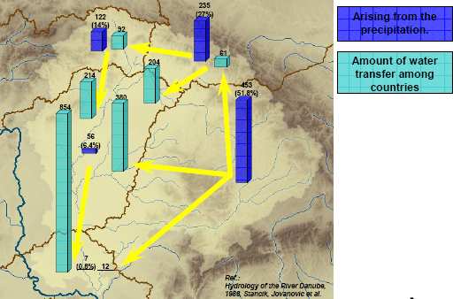
Analysis of the Tisza River Basin ş Annex 13
Territorial distribution, national distribution of mean elevations and surface gradients, amount of water
transfer among Tisza countries
Mean elevation and mean surface gradient (slope) indicate dissection of the terrain and thus give the source of
natural hazards, especially floods. The higher values imply sources of a higher risk.
Not only the elevation and the surface slope but also the average surface water resources budget was analysed along
the river Tisza based on data of "Hydrology of the River Danube, 1988" (Stancik, Jovanovic et al.). Results of the
referred source were controlled by up-to-date modelling tool, the DIWA distributed rainfall runoff model (Szabˇ,
2007) and were found correct with some slight deviation.
Below the national water balance for the Tisza catchment is summarized. The rate of runoff from the contributing
catchments varies substantially along the route of the Tisza. A significant proportion of the rainfall contributing to
this runoff falls on the upper catchment (Upper-Tisza).
(Figures/data, introduced in the present BOX are not correlated with other parts of the Report)
Information based on data of Szabˇ, J. A. (2007): Decision Supporting Hydrological Model for River Basin Flood Control.
ICPDR / International Commission for the Protection of the Danube River / www.icpdr.org
Analysis of the Tisza River Basin ş Annex 14
ANNEX 14 - List of Hydropower Plants in the Tisza River
Basin
ICPDR / International Commission for the Protection of the Danube River / www.icpdr.org
Analysis of the Tisza River Basin ş Annex 14
Overwiew of hydropover industry with installed capacity
Country
Name
River
Installed
Installed
Production in
Remark
capacity
discharge
year 2005
(MW)
(m3/s)
(GWh/year)
Tereblya,
Ukraine
Tereblya-Ritska
27
6
107.259
Rika
Ukraine
Onokivska
Uzh
2.65
22
2.601
Ukraine
Uzhgorodska
Uzh
1.9
22
2.466
Started to
Ukraine
Bilyn
Il'min
0.5
-
-
operate from
June 2006
Romania
Tarnita
Somesul Cald
45
66
105
Romania
Mariselu
Somesul Cald
220
60
497
Romania
Galceag
Sebes
150
40
260
Romania
Somesul Cald
Somesul Cald
12
70
26.6
Romania
Sugag
Sebes
150
51.6
260
Romania
Remeti
Dragan
100
40
200
Romania
Ostrovu Mic
Raul Mare
15.9
90
22.8
Romania
Retezat
Raul Mare
335
70
605
Romania
Clopotiva
Raul Mare
14
70
24.5
Romania
Sasciori
Sebes
42
52
80
Romania
Carnesti I
Raul Mare
15.9
90
23
Romania
Carnesti II
Raul Mare
11.5
90
16.7
Romania
Colibita
Bistrita
21
15.5
40.2
Romania
Munteni I
Dragan
58
49
115.4
Romania
Paclisa
Raul Mare
15.9
90
23.3
Romania
Totesti I
Raul Mare
15.9
90
23.1
Romania
Ostrovul Mare
Raul Mare
15.9
90
23.1
Romania
Tileagd
Crisul Repede
18
90
35.2
ICPDR / International Commission for the Protection of the Danube River / www.icpdr.org
Analysis of the Tisza River Basin ş Annex 14
Country
Name
River
Installed
Installed
Production in
Remark
capacity
discharge
year 2005
(MW)
(m3/s)
(GWh/year)
Romania
Lugasu
Crisul Repede
18
90
35
Romania
Totesti II
Raul Mare
15.9
90
22.8
Romania
Hateg
Raul Mare
15.9
90
21.5
Romania
St. Maria Orlea
Raul Mare
11.5
90
15.4
Romania
Fughiu
Crisul Repede
10
90
20.5
Romania
Sacadat
Crisul Repede
10
90
20.5
Romania
Bacia
Strei
14.5
100
22.5
Romania
Bretea
Strei
16
100
31.7
Romania
Blidari - Firiza
Firiza
8.7
21.6
20.3
Romania
Ruieni
Bistra Marului
140
55.4
264
Slovakia
Domasa
Ondava
12.4
50.0
11.85
below dam
Slovakia
PVE RuzÝn
Hornßd
60.0
134.0
54.2
Pumped
storage plant
Pumped
Slovakia
PVE Dobsinß
Hnilec
24.0
9.0
62.03
storage plant
Hungary
Tiszal÷k
Tisza
11.5
300
56,0
Hungary
Kisk÷re
Tisza
28
560
100,0
Hungary
KesznyÚten
Hernßd
4,4
40
22,8
ICPDR / International Commission for the Protection of the Danube River / www.icpdr.org
Analysis of the Tisza River Basin ş Annex 15
ANNEX 15 ş Interannual Distribution of Monthly
Discharges
ICPDR / International Commission for the Protection of the Danube River / www.icpdr.org
Analysis of the Tisza River Basin ş Annex 15
Figure1 presents the interannual distribution of monthly discharges at 8 stations on the Tisza
river, where significant changes of river discharge are present due to input from tributaries:
Ě Rahiv (UA),
Ě Tiszabecs (HU),
Ě Vasarosnameny (HU),
Ě Zahony (HU),
Ě Tiszalok (HU),
Ě Kiskore (HU),
Ě Szeged (HU), and
Ě Senta (RS)
Similar data for 6 stations at the main tributaries are given at Figure 2:
Ě Chop (UA, Latorica river),
Ě Satu Mare (RO, Somes river),
Ě Streda nad Bodrogom (SK, Bodrog river),
Ě Felsozholca (HU, Sajo river),
Ě Gyoma (HU, Harmas-Koros river), and
Ě Mako (HU, Maros river).
ICPDR / International Commission for the Protection of the Danube River / www.icpdr.org
Analysis of the Tisza River Basin ş Annex 15
g.s Vilok (UA)
g.s Tiszabecs (HU)
800
800
600
/
s
600
/
s
3
400
3
400
m
m
200
200
0
0
I
II
III IV
V
VI VII VIII IX
X
XI XII
I
II
III IV
V
VI VII VIII IX
X
XI XII
2000
g.s VßsßrosnamÚny (HU)
2000
g.s Zßhony (HU)
1600
1600
1200
/
s
1200
/
s
3
3
m
m
800
800
400
400
0
0
I
II
III IV
V
VI VII VIII IX
X
XI XII
I
II
III IV
V
VI VII VIII IX
X
XI XII
g.s Tiszalˇk (HU)
g.s Kiskˇre (HU)
2400
2400
2000
2000
1600
1600
/
s
/
s
3
1200
3
1200
m
m
800
800
400
400
0
0
I
II
III IV
V
VI VII VIII IX
X
XI XII
I
II
III IV
V
VI VII VIII IX
X
XI XII
3600
g.s Szeged (HU)
3600
g.s Senta (CS)
3200
3200
2800
2800
2400
2400
2000
/
s
2000
/
s
3
3
m
m
1600
1600
1200
1200
800
800
400
400
0
0
I
II
III IV
V
VI VII VIII IX
X
XI XII
I
II
III IV
V
VI VII VIII IX
X
XI XII
Figure 1: Interannual distribution of monthly mean, minimum and maximum discharges of the
Tisza River (reference period 1955-2000)
ICPDR / International Commission for the Protection of the Danube River / www.icpdr.org
Analysis of the Tisza River Basin ş Annex 15
river: Somes/ Szamos (RO)
600
g.s Satu Mare
500
river: Latorica (UA)
g.s Chop
400
/
s3 300
m
200
200
/
s3 100
100
m
0
0
I
II
III IV
V
VI VII VIII IX
X
XI XII
I
II
III IV
V
VI VII VIII IX
X
XI XII
river: Bodrog (SK)
700
g.s Streda nad Bodrogom
600
river: Sajˇ (HU)
500
g.s Felsˇzsolca
/
s 400
3 m 300
300
200
/
s 200
3
100
m 100
0
0
I
II
III IV
V
VI VII VIII IX
X
XI XII
I
II
III IV
V
VI VII VIII IX
X
XI XII
1200
1100
river: Maros (HU)
g.s Makˇ
1000
900
river: Hßrmas-K÷r÷s (HU)
800
g.s Gyoma
700
/
s
600
3
600
m
500
500
400
400
/
s3 300
300
m 200
200
100
100
0
0
I
II
III IV
V
VI VII VIII IX
X
XI XII
I
II
III IV
V
VI VII VIII IX
X
XI XII
Figure 2: Interannual distribution of monthly mean, minimum and maximum discharges at
selected gauging stations for the selected tributaries (reference period 1955-2000)
ICPDR / International Commission for the Protection of the Danube River / www.icpdr.org
Analysis of the Tisza River Basin ş Annex16
ANNEX 16
Flood risk assessment and management strategy for the
development of flood action plans in the Tisza River
Basin (version January 2008)
Prepared by Tˇth Sßndor chairman of the ICPDR Flood Protection Expert Group
1
ICPDR / International Commission for the Protection of the Danube River / www.icpdr.org
Analysis of the Tisza River Basin ş Annex16
Flood risk assessment and management strategy for the development of
flood action plans in the Tisza River Basin1
1 Introduction
3
2 Preliminary flood risk assessment
4
3 Flood hazard and risk mapping
6
4 Preparation of flood action/flood risk management plans
13
4.1
Setting objectives of flood risk management
13
4.2
Selection and determination of the measures of flood risk management
14
4.2.1
Measures related to preventive land use
14
4.2.2
Measures related to providing technical flood protection (structural defences)
17
4.2.3
Measures related to the improvement of flood forecasting and warning
19
4.2.4
Measures related to capacity building
24
4.2.5
Measures related to water pol ution prevention and mitigation with respect to floods
26
4.2.6
Multicriteria analysis (MCA) of the measures
27
5 Proposed time table for the implementation of the TRB strategy on the development of flood action
plans
28
References
29
1 Document is prepared in the frame of the `TISAR ş 2007` - EU Grant
2
ICPDR / International Commission for the Protection of the Danube River / www.icpdr.org
Analysis of the Tisza River Basin ş Annex16
1 Introduction
In December 2004, the ICPDR Ministerial Meeting adopted the ICPDR Action Programme on
Sustainable Flood Protection in the Danube River Basin (DRB FAP). The DRB FAP laid down the
basic principles, set the major targets of flood prevention, protection and mitigation for the entire
Danube River Basin supplemented by some specific targets for its sub-basins. According to the DRB
FAP the flood action plans are to be developed in the sub-basins, in cooperation of the countries
sharing the given sub-basin, `preferably by 2009'. Content, structure as well as elements and
influencing factors to be taken into account during the preparation of the action plans are defined by
the DRB FAP. Implementation of the DRB FAP is ongoing, however, the activities related to the
preparation of flood action plans are in delay in comparison with the deadline.
In the meantime the European Commission launched the European Flood Risk Management
Planning Action Programme in 2004, which is based on three pillars, namely:
- co-ordination of information exchange and the promotion of best practices on flood prevention,
protection and mitigation2;
- ensuring that all relevant EU policies contribute to flood protection;
- development and implementation of a legal tool on the assessment and management of flood risks.
The Directive 2007/60/EC on the assessment and management of flood risks (EFD) has been prepared
and entered into force on 26 November 2007.
With respect to the newly adopted Directive, the 10th Ordinary Meeting of the ICPDR held on 04-05
Dec 2007 in its Resolution 3.6. i) `encourages the FP EG to finalize the technical upgrade of the
ICPDR Action Programme on Sustainable Flood Protection in the Danube River Basin to ensure its
full harmonization with the new EU Directive on the assessment and management of flood risks. Until
its formal adoption possibly at the ICPDR Ministerial Meeting in 2010 the upgraded Action
2 Under this pillar three important exchange platforms were established:
EXCIFF ş (Exchange Circle on Flood Forecast), lead by France and ECşJRC main objective is to enable and
facilitate the exchange of knowledge and experiences on flood forecasting, in Europe. Main objective is to enable
and facilitate the exchange of knowledge and experiences on flood forecasting, in Europe. URL:
http://exciff.jrc.it Publication: Good Practice for Delivering Flood-related Information to the General Public.
May 2007.
EXCIMAP ş (Exchange Circle on Flood Mapping), lead by France and Switzerland, with the aim of
compilation of a Handbook on good practices of flood mapping in Europe to support the implementation of the
EU proposal on the Floods Directive. The handbook will be disseminated in early 2008.
EXCLUP ş (Exchange Circle on Landuse Planning), lead by Norway and the Netherlands, with the aim of
assessment and dissemination of good practices in the reduction of flood risks by adequate land use and spatial
planning. The activity started in January 2007.
3
ICPDR / International Commission for the Protection of the Danube River / www.icpdr.org
Analysis of the Tisza River Basin ş Annex16
Programme will be used as a working document giving guidance to the flood prevention, protection
and mitigation activities under the ICPDR.'
Nevertheless, the flood action plans (in the terminology of the EFD: flood risk management plans)
are result of a strict sequence of deliverables, namely
- a preliminary flood risk assessment shall be undertaken with the aim of identifying those areas
which are prone to flooding and where the consequences of flooding represent potential
significant risk to human life and health, economic activity and the environment, taking into
account the impacts of climate change and land uses on the occurrence of floods;
- preparation of flood hazard and risk maps for the areas defined above;
- based on the evaluation of the distribution of flood risk, appropriate objectives of flood risk
management are to be set;
- based on the objectives determined and on the topographic, hydromorphological, land use, etc.
conditions, a good combination of non-structural and structural measures of flood risk
management are to be defined, their impacts, cost-benefit ratio are to be assessed and finally, the
measures have to be prioritised.
These are the building blocks of the flood action plan; none of them can be skipped or left out.
From among the above tasks, especially the flood hazard and risk mapping is quite a costly exercise
while the European Territorial Cooperation Programme (former INTERREG) in the South-East
European Space (SEES) programme area, covering the Tisza River Basin, for the period of 2007-2013
will only be launched in March 2008 and followed by a two-step evaluation the start of the first
selected projects cannot be expected before 2009.
In the following, an overview of the details of the above tasks and a proposal for the development of
the flood action plans aiming at the implementation of a sustainable flood risk management strategy
in the Tisza River Basin will be given, with the view of serving as a key input to the flood-related
aspects of the final Integrated River Basin Management Plan of TRB to be delivered by the end of
2009.
2 Preliminary flood risk assessment
Flood risks in certain areas, which are either not subject to flood hazard (no, or no significant
inundation occur) or the consequences of inundation are limited, especially in thinly or unpopulated
areas, also, where economic assets or ecological value are limited, could be considered not to be
significant.
Therefore the EFD prescribes in Article 4 the elaboration of the preliminary flood risk assessment for
each river basin district, or unit of management referred to in Article 3(2)(b), or portion of an
international river basin district with the aim formulated in Article 5, e.g. to identify those areas where
potential significant flood risks exist or might be considered likely to occur.
The assessment of potential flood risks is to be based on available or readily derivable information,
such as records and studies on long term developments, in particular impacts of climate change on the
occurrence of floods.
4
ICPDR / International Commission for the Protection of the Danube River / www.icpdr.org
Analysis of the Tisza River Basin ş Annex16
History of remarkable floods of only the past 100-120 years proves to be very rich; in average every
5th-6th year brought significant floods in different parts or sometimes across the Tisza River Basin. A
non-exhaustive list of significant floods of the past 120-150 years is given in page 96 of the
Preliminary Analysis Report of the Tisza River Basin 2007 prepared by the ICPDR. Available
information on these events are of course different concerning the details, however, can serve as a
good basis to describe and to draw conclusions of the most remarkable past floods which had
significant adverse impacts on human lives, health, cultural heritage, economic activity and the
environment.
The task will be to select from among the past significant floods those which are documented in
historic and professional records as extreme events from the point of view of
- hydrometeorological characteristics,
- flood stages,
- extension and, if available, depth of inundation and
- the consequences they caused
in different parts of and/or across the TRB.
Historical maps, if available, flood marks, historical records and professional reports, etc. will be
collected and analysed to identify the flood extent and the conveyance routes of the historical
floods. Information on flood victims, damaged and destroyed houses, roads, railroads, bridges, etc.
will be collected and analysed to identify the consequences of the given floods. Information related
to the adverse impacts of floods on the environment will most probably be available in case of the
most recent floods only.
An assessment of the likelihood of similar future events, taking also into consideration the
expectable impacts of climate change, relying on estimations derived from the available information
of the related IPCC research output, will be made. Flood conveyance routes and the extension of
inundation of the expectable future extreme floods will be estimated based on the experiences of
past floods, as well as relying on topography and the network of watercourses, their general
hydrological and geo-morphological characteristics. Special attention will be paid to open and
restorable floodplains as natural retention areas. The effectiveness of existing man-made flood
defence infrastructures will also be examined, including their height, freeboard, and stability
(safety) based on the recorded behaviour of these structures during extreme floods.
Concerning the potential future consequences of these floods not only the recent conditions of
settlements, industrial, commercial and transport area, sensitive infrastructures and hot spots, but
also the available information on long term development plans will be taken into account.
As a result of the above work, which will be done in close cooperation of the partners involving
flood managers and spatial planners of the countries sharing the TRB, areas where potential
significant flood risks exist or might be considered likely to occur will be identified and shown on
uniform map of the river basin in digital format (to fulfil reporting formats of the EU WISE system)
at appropriate scale enabling identification of potential flood area, indicating also topography and
land use (utilising CORINE Land Cover) and the borders of the river basins, sub-basins.
These potential floodplains will be subject of flood hazard and risk mapping.
It is important to emphasize that preliminary flood risk assessment is the only element in the sequence
of development of the flood action plan which can solely be based on available or readily derivable
information, therefore the preparation of which does not presume extreme costs and efforts.
5
ICPDR / International Commission for the Protection of the Danube River / www.icpdr.org
Analysis of the Tisza River Basin ş Annex16
As the Common Position of the ICPDR Workshop on Flood Risk Mapping in the Danube River
Basin held in Budapest, Hungary on September 12-13, 2007 formulates: `Fast, cheap overview, ...
No high accuracy needed.'
3 Flood hazard and risk mapping
In order to have available an effective tool for information, as well as a valuable basis for priority
setting and further technical, financial and political decisions regarding flood risk management, the
EFD prescribes in Article 6 paragraph 1 the preparation of flood hazard maps and flood risk maps
showing the potential adverse consequences associated with different flood scenarios, including
information on potential sources of environmental pollution as a consequence of floods.
Flood maps are indispensable tools to show information about hazards, vulnerabilities and risks in a
particular area, thus contributing to
- raising of the awareness and preparedness of the general public regarding flood hazards on sub-
basin-wide and local scale;
- promotion of appropriate land uses across the river basin to slow down run off and in the flood
prone areas to reduce damage potential, enabling a sustainable flood risk management strategy
supported by adequate land use and spatial planning practice..
Flood hazard maps and flood risk maps have to be prepared at the most appropriate scale for the areas
identified as a result of preliminary flood risk assessment. Requirements of these maps as outlined in
paragraphs 3, 4 and 5, together with the Common Position of the ICPDR Flood Mapping Workshop
are summarized in the following table:
Artic
Topic
Common position on minimum requirement
le
6
3. Flood hazard maps shall cover the
High resolution digital map with the thematic
geographical areas which could be
content of 1:10.000 maps, recommended scales for
flooded according to the following
local/regional/national maps and different purposes
scenarios:
in EXCIMAP Handbook of good practices for
flood mapping in Europe
(a)
floods with a low probability,
return period =1000 years;
or extreme event scenarios;
extreme event: case by case
(b)
floods with a medium
return period =100 years;
probability (likely return period 100
years);
(c)
floods with a high probability,
Relevant mostly in case of open floodplains,
where appropriate.
return period: to be determined case by case
Remark: determination of the synthetic flood hydrographs of 0,1% and 1% probability based on
harmonised methodology is needed, they cannot be derived from records of past events, being the
available data inhomogeneous due to different morphological and flood propagation conditions!
6
4. Elements to be shown for each scenario:
(a) the flood extent;
Recommendations concerning tools:
6
ICPDR / International Commission for the Protection of the Danube River / www.icpdr.org
Analysis of the Tisza River Basin ş Annex16
Ě
DEM derived from high accuracy
topographical survey (see
recommendations in GEODIS
presentation);
Ě
hydrodynamic modelling tools:
FLOODsite Task 8 presentation (Karin de
Bruijn) on comparison of different tools /
purposes to take into account.
(b) water depths or water level, as
Depth step to be shown: 0,5 m or suitable
appropriate;
multiplies of 0.5 m where appropriate, based at
map purpose and user requirements.
(c) where appropriate, the flow velocity or
Case by case ş (for good practice see
the relevant water flow.
EXCIMAP Handbook)
5. Flood risk maps ş potential adverse consequences expressed in terms of the following:
(a) the indicative number of
Statistically recorded inhabitants, affected in each separate
inhabitants potentially
flood area, by CORINE Land Use categories
affected;
(b) type of economic
Simplified classification (based on CORINE categories ş
activity of the area
except for elements in italics):
potentially affected;
Ě Urban fabric (residential area)
Ě Continuous urban fabric (metropolitan area,
historical centre)
Ě Discontinuous urban fabric (garden city, suburb,
rural, resort/recreation and special)
Ě Sport and leisure facilities
Ě Sensitive social hot spots (kindergarten, school,
hospital, elderly home)
Ě Industrial, commercial and transport
Ě Industrial or commercial units
Ě transportation infrastructure (road and rail network,
port, airport) and associated land
Ě essential services and infrastructure (water supply,
sewer, wastewater treatment, gas, electricity,
communication)
Ě agricultural
Ě arable land,
Ě permanent crops,
Ě pastures,
Ě heterogeneous areas
Ě forest
Ě wetland
Ě water
Ě flood defences and infrastructure of emergency
services
(c)
installations as referred to in Annex I to
Task of Accidental Pollution WG
Council Directive 96/61/EC of 24 September 1996
of ICPDR
concerning integrated pollution prevention and
control which might cause accidental pollution in case
of flooding and potentially affected protected areas
Protected areas to be identified
identified in Annex IV(1)(i), (iii) and (v) to
by River Basin Management EG
7
ICPDR / International Commission for the Protection of the Danube River / www.icpdr.org
Analysis of the Tisza River Basin ş Annex16
Directive 2000/60/EC;
of ICPDR
(d)
other information which the MS considers
useful such as areas where floods with a high content
Pollution sources:
of transported sediments and debris floods can occur
and information on other significant sources of
Task of Accidental Pollution WG
pollution.
of ICPDR
The EXCIMAP Handbook of Good Practices for flood mapping in Europe serves with optional
solutions beyond the minimum requirements.
Outputs of the workshop
Beyond some recommendations mentioned among the minimum requirements, concerning
methodologies in flood risk assessment several presentations (A. Thieken, V. Meyer, P. Stepankova,
A. Stegmaier) served with details; as a general recommendation, macro- and mezoscale assessment
methodologies are to be taken into account primarily.
The presentations delivered are available on the DANUBIS www.icpdr.org in the internal area
(password needed!): Expert groups\FPEG Working Area\ ICPDR Flood Action Programme\Flood risk
mapping\ICPDR Flood Risk Mapping Workshop\Presentations.
Complexity of the preparation of flood hazard and risk maps is clearly visible from the above table
and of course, requires the clarification and harmonisation (sometimes even standardisation) of
further details. Nevertheless, it also has to be beard in mind that, derived from the definition of
`flood' in Article 2 paragraph 1 of the EFD and from the reference to groundwater flooding in Article
6 paragraph 7, the Directive covers all kind of inundations of natural origin consequently excess
water (undrained run off) as well.
It is advisable to establish specialised task groups to deal with the following issues, parallel with
the preparation of the preliminary flood risk assessment, in order to prepare for a harmonised,
effective, objective oriented flood mapping:
Mapping and GIS applications
- Methodological issues and requirements, including quality, sensitivity and cost efficiency
analysis of different applications of different accuracy and resolution, to support the
preparation/acquisition/selection of digital maps and digital elevation models (DEM) of required
accuracy;
- Methodological issues and requirements, including quality, sensitivity and cost efficiency
analysis of supplementary survey of breaklines (different linear constructions including the flood
defences, confinement dikes, canals, roads and railroads capable to convey or control the
spreading of inundation);
- Tasks related to the establishment of harmonised (uniform, standardised) guidelines in mapping
and GIS applications (standards, scales, resolution and accuracy, joint datum and projection
system, thematic content, legend, etc. to be applied, coordinated with the ICPDR GIS Expert
Sub- group as necessary).
Hydrometeorological-hydraulic foundation
- acquisition and procession of hydrometeorological, hydrological and river hydraulic data;
- determination of (design) flood parameters of different probability along the rivers;
= analysis and determination of probable maximum precipitation (PMP), design precipitation of
different probability and the synthetic flood hydrographs of probable maximum floods (PMF)
8
ICPDR / International Commission for the Protection of the Danube River / www.icpdr.org
Analysis of the Tisza River Basin ş Annex16
and selected design floods as well as excess water inundation scenarios generated by those
precipitations in recent climatic, land use and morphological conditions;
= analysis and determination of probable maximum precipitation (PMP), design precipitation of
different probability and the synthetic flood hydrographs of probable maximum floods (PMF)
and selected design floods as well as excess water inundation scenarios generated by those
precipitations taking into consideration expectable climate change and land use alterations;
- 1D-quasi 2D-2D modelling methodologies of flood propagation and inundation ş selection of
appropriate methods for different cases;
- methodologies for the determination of the extent, depth and, as appropriate, velocity
distribution of inundations of different probability in case of
= neglecting existing flood defence structures (assumption of open floodplain, indication of
protected flood area by special legend, for example, hatching);
= taking the effect of existing flood defence structures into consideration, in this case failure of
the defences can be assessed by
o
expert judgement
- on the location of failure leading to the possible largest inundation of the protected flood
area;
- on the width and depth of possible breach based on prevailing soil conditions and
experience (transformation of the synthetic flood hydrograph of given probability to the
breach point and modelling flow through the breach and inundation of the protected flood
area by coupling the river flow, outflow and inundation models);
o
probabilistic methods (based on the analysis of the failure probability of flood defence
structures).
Assessment of the capacity of the defence system (optional, subject to agreement of TRB countries)
- explanation of the load of flood defence systems;
- resistance of flood defences;
- analysis of the failure probability of flood defence structures3;
- resistance raising effect of traditional flood emergency operation (flood fighting);
- resistance raising effect of flood retention and detention;
- assessment of probability of inundation of protected floodplains taking confinement possibilities
into consideration.
Investigations related to flood risk receptors
- methodologies of assessment of affected population and their vulnerability;
- methodologies of assessment of economic activities, land uses and their vulnerability;
- development of aggregated depth-damage functions associated to different types of economic
activities, land uses;
3 Allsop William: Failure Mechanisms for Flood Defence Assets. T04-06-01. FLOODsite Project Report, 2007
Mark Morris: Breaching Processes: A state of the art review. T06-06-03. FLOODsite Project Report, 2007
Kanning Wim: Analysis and influence of uncertainties on the reliability of flood defence systems. T07-07-03.
FLOODsite Project Report, 2007
9
ICPDR / International Commission for the Protection of the Danube River / www.icpdr.org
Analysis of the Tisza River Basin ş Annex16
- methodologies to take flood duration into account;
- methodologies of assessment of potential pollution sources, contaminated sites prone to
inundation, protected sites and their vulnerability;
- cultural and historical heritage and their vulnerability;
- other relevant information such as area prone to mud- and debris flow, land slide;
- combination of GIS layers containing the above information on flood risk receptors with those of
flood hazards, modelling flood risk.
Further specialised tasks
- decision support systems (DSS)
- digital design support
- informatics.
The preparation of flood hazard maps and flood risk maps for flood areas identified by the
preliminary flood risk assessment, which are shared with other countries of the TRB (e.g. where
mapping of transboundary floodplains take place) shall be subject to prior exchange of information
between the countries concerned. Good experiences on transboundary flood mapping are provided by
the EXCIMAP Handbook on flood mapping in Europe.
Methodological proposal for the evaluation of the impacts of climate change on flood hazards and risks
There is increasing evidence that global climate is changing and the observed changes and their
magnitude in sea level, snow cover, ice extent and precipitation patterns are consistent with the
current scenario of higher temperatures. The assessment reports published by the IPCC, particularly
its third assessment report (TAR) led the IPCC to the conclusion that the average global temperature
over land surfaces has risen by 0.6 ▒ 0.2░C in the period from 1861 to 2000. Based on different
scenarios of future greenhouse gas emissions projections of climate models indicate another 1.4 to
5.8 oC of warming over the next century (TAR: The Scientific Basis).
The Preliminary Analysis Report of the Tisza River Basin 2007, on page 121 publishes Figure IV.2.
`Change of HQ100 river discharge due to climate change (SRES A2 scenario) (EU, JRC)', based on
the DMI-HIRHAM A2 scenario (12km) with 5km LISFLOOD model. According to the published
results, decrease of extreme flood events in the Tisza River Basin can be expected. This hardly
explainable result, especially its details along some tributaries as shown in the referred figure are
not in harmony with the predictions of the Slovak, Hungarian and Romanian studies. The only
acceptable statement is that `reduced average water flow, increase in extreme events and significant
regional and local variations are to be expected'.
Intuitively we expect that evaporation would increase with increasing temperatures, and, in fact, all
atmospheric general circulation models predict enhanced evaporation of water. Also an increase in
atmospheric moisture has been predicted by models and confirmed by many observations. Increased
evaporation must obviously be balanced by increased precipitation. Also the observation that
atmospheric moisture is increasing leads to the expectation that precipitation will increase.
Changes in the mean value of climate variables such as temperature or precipitation may also be
associated with a change in their distribution as well. The projected change in climate will
significantly impact the hydrological cycle. Furthermore, it is expected that the magnitude and
frequency of extreme weather events will increase, and that hydrological extremes such as flash-
floods, floods and droughts will likely be more frequent and severe.
10
ICPDR / International Commission for the Protection of the Danube River / www.icpdr.org
Analysis of the Tisza River Basin ş Annex16
Based on the well established current trends of the global climate changes and its regional scale to
the Carpathian Basin, it is reasonable to assume that the hydrologic cycle will be accelerated along
the River-Tisza basin as well, with greater event variability and extremes. Therefore, in order to
mitigate consequences, the assessment of the impacts of climate change on the key elements of the
hydrological cycle as well as on the risk of the different type of weather driven natural hazards
(such as flash-floods, floods, droughts, excess water, etc.) in the Tisza valley is essential point.
The aim of the methodology development project proposal is to develop and harmonise knowledge,
scientific tools and sustainable act alternatives in support multi-governmental climate change
strategy along the Tisza-Valley. In view of this, one of the most important research topics of the
project is to assess the impact of climate change on:
1.
Spatially-distributed mean-annual water balance for all important element of the hydrologic
cycle;
2.
Spatially-distributed mean-annual snow duration and total snow accumulation;
3.
Frequency and magnitude of floods including flash-floods;
4.
Frequency and duration of droughts;
5.
Design flood values.
This could be accomplished by developing an integrated modelling framework that combines
regional climate predictions for the Carpathian Basin with an efficient hybrid model-system of
physically-based large-scale high resolution distributed hydrological model DIWA (Distributed
Watershed)4 and the hydraulic software package HEC-RAS.
Some information on the DIWA model
DIWA (Distributed Watershed) is a physically-based large-scale high resolution distributed parameter
hydrological model capable for rainfall-runoff (RFRO) modelling, flood events analysis, real-time
hydrological forecasting and control, and for the determination of the different hydrological scenarios for
flood risk mapping.
The DIWA model is based on the distributed rainfall-runoff model philosophy. According to this
approach the catchment is divided into basic elements, cells where the basin characteristics, parameters,
physical properties, and the boundary conditions are applied in the centre of the cell, and the cell is
supposed to be homogenous between the block boundaries. The neighbouring cells are connected to each
other according to runoff hierarchy (local drainage direction). Applying the hydrological mass balance
and the adequate dynamic equations to these cells, the result is a 3D distributed description of the runoff.
The fundamental processes simulated by the model include interception of precipitation, snow-
accumulation and snow-melting, infiltration, water intake by vegetation and evapotranspiration, vertical
and horizontal distribution of soil moisture, unsaturated and saturated flow of water in soil, surface flow,
and flow through river channels.
There is no limitation for the horizontal and the vertical resolution. The recommended horizontal
resolution is 1x1 km. The vertical resolution should depend on the vertical structure of the soil texture.
DIWA is one of the model engines of an earlier developed program-system for analysing rainfall-runoff
processes on large river basins model (ARES) which has been distributed by the Hungarian Ministry of
Environment and Water in the frames of Tisza Water Forum in 2002 among the partner countries. DIWA
has further been developed and runs daily as an operational tool in the elapsed period.
HEC-RAS 1D flood routing hydrodynamic model is used in RS, RO, and among other models also in SK.
Extension in UA is in progress.
4 DIWA model is offered by Hungary for this impact assessment but without the intention of exclusivity;
Hungary is convinced that the methodology and tool development for the impact assessments in the TRB are to
be based on cooperation of the affected countries and final conclusions are proposed to be derived from the
scientific evaluation and comparison of the results of different methodologies and tools.
11
ICPDR / International Commission for the Protection of the Danube River / www.icpdr.org
Analysis of the Tisza River Basin ş Annex16
According to the basic concept of DIWA, the following data are used in the model:
-
Time-series data:
=
Hydrological;
=
Meteorological;
-
Spatial distributed data (with 1x1 km resolution):
=
Meteorological (derived from gauge data and/or radar information);
=
Digital elevation model and its derivates;
=
Land-use;
=
Vegetation density (NDVI, LAI);
=
Network of the local drainage direction;
=
Soil texture and its hydraulic properties;
=
Soil-depth;
-
River- and reservoir data:
=
Cross-section geometry and its derivates: hydraulic characteristic curves (wetted area,
perimeter, hydraulic radius);
=
Characteristic curves of reservoirs (Storage capacity, wetted area of water)
=
Sub-basin belonging to the reservoirs.
In recent years, under the umbrella of several EU funded projects (e.g., PRUDENCE, STARDEX
(FP5) and ENSEMBLES (FP6)), a series of regional climate change scenarios have been and are
being (CLAVIER şClimate Change and Variability: Impact on Central and Eastern Europe (FP6))
developed for Europe. The spatial resolution of these regional climate model projections ranges
from 50 to 12 km. This resolution does not explicitly capture the fine-scale climatic structures
needed for climate change impact studies and policy planning at the catchment or basin scale, which
are typically based on DIWA model with a grid spacing of 1 km. To enhance regional detail and
introduce fine-scale structures in climate data that force the DIWA model a downscaling interface
between the regional climate model output and the hydrological model will be developed.
The integrated modelling framework will be used to assess the impact of climate change on topics 1
to 5 highlighted above for the Tisza-Valley and for a quantitative assessment of the basin's
vulnerability to changes in hydrological extremes. This will contribute through the determination of
design precipitations, probabilistic (cross correlation) analysis of the coincidence of the floods of
different tributaries to the determination of design flood parameters as the loads to assess flood
risks, thus to the formulation of spatial planning policy options for adaptation to the potential
increase in weather driven natural hazards and to the assessment of the effectiveness of adaptation
measures and instruments.
Extension of the analysis of the impact of climate change on runoff for the whole TRB is already possible
using the DIWA model, majority of the data needed are available but of course further check, gap
analysis and verification of those, plus additional data (on river cross sections, defence structures,
especially those of planned, data on the operation of the reservoirs, etc.) are still needed.
Evaluation of the impacts of land use alternatives on flood hazards and risks
Distributed rainfall-runoff models such as DIWA, as the data set they handle demonstrate, capable to
analyse different scenarios, among them scenarios related to land use alternatives. The input data related
to the prevailing land use, vegetation, soil characteristics of different regions and their spatial distribution
can be tailored to recent conditions and, if available, to the conditions of foreseeable long term
developments. Thus, for instance, impacts of changes in forest coverage or in paved/sealed surface on
runoff conditions thus on the flood parameters can be modelled.
12
ICPDR / International Commission for the Protection of the Danube River / www.icpdr.org
Analysis of the Tisza River Basin ş Annex16
It is even possible to analyse scenarios of forest coverage in the upper catchments and the impact on
floods, low water conditions and on water balance, or the impact of different forest conditions in lowland
areas on the groundwater conditions.
Evaluation of the impact of different scenarios on flood risk in potentially flood prone areas is possible by
flood risk mapping, the upper boundary conditions of fluvial hydrodynamic models (1D, coupled with
quasi 2D, 2D as necessary) can be generated by the RFRO models (DIWA, for example).
4 Preparation of flood action/flood risk management
plans
4.1 Setting objectives of flood risk management
Based on the evaluation of the distribution of flood risk along different river reaches and different
parts of the floodplains, appropriate objectives of flood risk management are to be set.
Throughout the Tisza River Basin different types of floods occur, such as
- flash floods along the watercourses in the mountainous regions, and along the upper courses of the
rivers, with special attention to areas sensitive for mud- and debris flow and erosion;
- slow rising but high and durable river floods along the middle and lower course of the rivers as a
result of superposition of multipeak floods arriving from different tributaries;
- groundwater floods in karstic regions;
- excess water: extensive inundation in the lowland areas of the Tisza River Basin originating from
unfavourable meteorological, hydrological and morphological conditions on saturated or frozen
surface layers as a result of sudden snow melting or heavy precipitation, or groundwater flooding,
or as a result of the combination of the above phenomena.
Majority of the fluvial floodplains are protected by flood embankments, however, their design flood
parameters and level of protection is also different. The consequences caused by the above different
flood events may also vary across the TRB. Hence, objectives regarding the management of flood
risks should be determined by the countries sharing the TRB themselves and should be based on local
and regional circumstances.
However, when setting objectives, the countries have a special coordination responsibility to ensure
that the risk management objectives of flood areas shared should be harmonised, further, the proper
selection of objectives and the flood risk management measures should contribute to the achievement
of the environmental objectives laid down in the TRB River Basin Management Plan (RBMP) as
much as possible.
Diversity of factors, disciplines (including environment protection and water management, regional
development, agriculture, disaster management, etc.) to be taken into consideration indicate that the
task of setting objectives of flood risk management cannot be solely done by flood managers;
preparation for decision requires the cooperation of representatives of all relevant authorities on
local, regional and national level and of course, stakeholders and public participation.
13
ICPDR / International Commission for the Protection of the Danube River / www.icpdr.org
Analysis of the Tisza River Basin ş Annex16
Decision on the objectives of flood risk management or on the level of services in the different
protected flood areas can even be different, depending on
- the magnitude of flood hazard (flood extent, depth, duration, velocity),
- the adverse consequences to the
= affected population and their vulnerability, with special regard to sensitive hot spots and
infrastructure,
= economic activities, properties, assets and their vulnerability,
= cultural heritage and ecological values endangered,
- the frequency of the events,
especially if flood risk management is based on or is combined with spatial planning regulation, and
is recommended to be made after careful and thorough decision preparatory process as mentioned
above by political decision making bodies relevant on the given (local/regional/national) level.
Some of these objectives may extend to the whole or significant parts of the river (sub-)basin(s),
while some may be focussed to particular flood areas.
4.2 Selection and determination of the measures of flood risk management
The most important overall task is to reduce the adverse impact and the likelihood of floods in the
Tisza River Basin through the development and maintenance of an agreed long-term flood prevention,
protection and retention strategy and methodology, based on a good combination of non-structural
and structural measures of flood risk management.
Chapter 5.2 of the ICPDR Action Programme on Sustainable Flood Protection in the Danube River
Basin (DRB FAP) provides detailed list of elements and factors of sustainable flood risk management.
Without repeating these, an overview of the potentially effective measures and actions to be
considered will be given.
4.2.1 Measures related to preventive land use
When speaking about preventive land use practices, three different targets can be formulated:
4.2.1.1 Land use regulation to preserve and enhance natural retention across the river basin
The purpose of this type of intervention is to promote land uses and cultivation methodologies capable
to enhance natural retention and infiltration of the precipitation across the river basin, especially in the
mountainous and hilly catchments to reduce flood volumes to be drained and to prevent rapid runoff.
Considering the relevant local characteristic and requirements, the opportunities and necessities of
flood retention, protection and drainage among the affected regions and countries will have to be
co-ordinated giving priority to the principle that water has to be retained by appropriate land use
(forests, wetlands, proper agricultural methods like contour tillage, etc.) or structural measures
(retention reservoirs and detention basins) across the drainage basin to decrease run off.
The possibilities for water retention have to be considered on each planning level, local, regional
and supra-regional. Therefore changes in actual land use as well as retention measures should be
agreed on between the riparian states in the frames of development of the Action Plans on flood risk
management on sub-basin level.
14
ICPDR / International Commission for the Protection of the Danube River / www.icpdr.org
Analysis of the Tisza River Basin ş Annex16
Conserve, protect effectively and, where possible, restore vegetation and forests in mountainous
areas, riparian woodland and meadows.
Maintain and expand the forest population in the river basin by semi-natural reforestation, particularly
in mountain and hilly ranges.
Conserve, protect effectively and, where possible, restore degraded wetlands and floodplains, including
river meanders, oxbows, and especially reconnect rivers with their floodplains. The maintenance of the
vegetation edging a waterway is however necessary in a way that is both respectful of the wealth,
biodiversity of these environments, and effective against the risk of flood damage.
Beyond the basic principles and approaches described above and in the DRB FAP under subheading
3.4.1 the followings are recommended for consideration.
The storage effect of vegetation and soil especially in forested area provides not only substantial
retention possibilities but even in case of exhausting of the retention capacity there always remains
protection against erosion.
Wetlands can reduce floods by temporary storing (large) amount of floodwater and subsequently
releasing it, thus reducing flood peaks. Such flood desynchronisation may contribute to evacuation
of people, livestock and goods in areas under imminent danger of flood disasters by slowing down
water level rise and thus extending the available time and helps to provide sufficient water
resources over a long dry period.
Flood water retention by restoration of wetlands and reactivation of protected floodplains by
relocating dikes as upstream as possible and along the higher rank tributaries are considered to
reduce most efficiently the future flood hazard for the downstream areas or neighbours.. However,
regional and trans-national means for compensation have to be achieved to enhance the
development of retention in upstream communities even for the benefit in flood hazard reduction in
downstream communities. In this context a new form of `permit trading for retention volume' could
be considered i.e. a reduction of flood retention volume is only permitted if the same amount will be
created preferably within the same sub-basin.
4.2.1.2 Spatial and physical planning regulation to reduce damage potential in flood prone areas
The land use in the potential flood plains has to correspond to the risk, moreover, has to contribute
to the reduction of the risk potential. While structural measures still remain an important tool of
flood protection, spatial planning on the different levels of administration has to follow the overall
goals of non-structural flood measures to mitigate the effects of flooding.
15
ICPDR / International Commission for the Protection of the Danube River / www.icpdr.org
Analysis of the Tisza River Basin ş Annex16
D.5. Immediate flood plains should be identified and designated by law as priority sites for flood retention
or to restore, as far as reasonable, mobility to waterways. The purpose is to discourage protective bank
construction, embankments, impoundment and undermining, constructions or installations and, in
general, any construction or works likely form an obstacle to the natural flow of waterways that cannot
be justified by the protection of densely populated areas.
D.6. Stopping building development in the immediate areas at risk of floods, landslides or dam failures if
an unacceptable risk to human lives or material damage exists, should be regulated. Exceptions should be
restricted to those uses which are of stringent necessity. Adapt uses to the hazards in the potential flood
plains (dyke or dam-protected areas) in order to minimise the damage potential. Monitoring the building
development in these areas and publishing the results in comparison with the former situation should be
realised regularly.
B.5. Information about special measures required and restrictions on construction in flood areas should
be easily accessible and easily understood. Competent authorities should therefore provide information
on natural risks to be used in the context of real estate transactions, whether for sales or rentals.
With the tools of spatial and regional planning land use and zoning policies can be introduced
which facilitate
- the differentiation of parts of the floodplain at different risks
- spatial and physical planning rules attributed to the different hazard/risk zones (prohibitions,
restrictions, limitations, etc.)
- the identification of potential retention areas
- the measures to reduce flood risk of the effected community and the downstream areas and/or
neighbours.
Restoration and reconnection of floodplain wetlands to watercourses has to go alongside with the
zoning of the floodplain areas, identifying areas needing greatest protection and those can be best
used for flood storage.
4.2.1.3 Appropriate floodplain and landscape management to explore the benefits of flooding
Rehabilitation of ancient floodplain management based on the retention of abundant water and
utilize its benefits in the different levels of micro relief accompanying the rivers by establishing a
water system that can retain the abundant water of flood periods and to supply small, landscape-
level water cycles is possible. Such a water system should be integrated into a changed land use,
creating a diverse, more natural landscape structure.
Elements of such a landscape would play an active role in water retention and would effectively
serve the interests of nature protection and biodiversity. Landscape diversity derives from the fact
that 0,5 m differences in elevation levels can provide habitats for different plant associations in a
landscape with regular water supply. It is the availability of water that brings diversity into such a
landscape.
In a flood plain farming basin we can find spots of permanent and temporary water covers, wetland
habitats, meadows and pastures, extensive orchards, plough lands and different types of forests
according to the elevation levels and farming practices of these spots. Water distribution in the area
would enable farmers to influence water supply within a certain range, thus dominant plant covers
and related farming benefits can be adapted to demands.
16
ICPDR / International Commission for the Protection of the Danube River / www.icpdr.org
Analysis of the Tisza River Basin ş Annex16
A very important element of the program is the elaboration and introduction of land use and farming
practices. Land use would maintain optimal landscape structures through farming activities and
would offer decent income for the local population. This land use is mostly extensive and avoids the
use of chemicals, therefore its competitiveness in terms of yields is lower than that of the intensive
agriculture. Nonetheless, in the long run there is a great advantage in flood plain farming, namely
that its typical landscape is very close to a natural pattern, therefore, if the system is well-designed,
it requires very low external inputs of energy or other resources (chemicals, irrigation, water
pumping), which is not the case in intensive agriculture today.
The new type land use and the maintenance of such mosaic landscapes is in line with the agro-
environmental system of the EU, also called eco-social agriculture as this scheme should greatly
contribute to a prosperous rural livelihood. Adaptation to `living with flood' principle needs
incentives and training programmes to help recognizing how the benefits of flooding can be
explored.
Finally, an important remark related to the above issues: adequate land-use is a key interlinking factor
for flood risk management and river basin management ş those land use patterns which serve the
reduction of runoff are equally advantageous for the environmental objectives of river basin
management since they also contribute to the reduction in diffuse pollution, e.g. nutrient and pesticide
input into rivers. Reactivation of former wetlands and floodplains where feasible can contribute
besides flood mitigation, to ecological benefits in the form of maintaining biodiversity, frequent
recharging underground aquifers and availability of cleaner water.
4.2.2 Measures related to providing technical flood protection (structural defences)
Maintenance, restoration and if necessary improvement of the capacities of the structural flood
defences, or if appropriate, the construction of new ones to protect human life, health as well as
economic activities, properties and valuable goods, should be planned here in accordance with the
design criteria and safety regulations of the countries.
It is advisable to develop cooperation between public and private sector to use hydropower operation
for flood protection.
Taking into consideration that floods don't recognise national borders, to ensure proper functioning of
flood prevention and protection, harmonisation of design criteria and safety regulations along and
across border sections must be addressed on a supra-regional and trans-national level, utilising
existing bi- and multilateral frameworks (e.g., trans-boundary water commissions, Tisza Water
Forum, ICPDR Tisza Group).
Assessment of the efficiency of national flood retention / protection projects and their interactions
In the period of 1998-2001 four extreme floods occurred in the Tisza River Basin. Those in 1998
and 2001 proved to be catastrophic in the Upper-Tisza region in Transcarpathia, Ukraine and in the
north-eastern parts of Hungary, while the spring floods in the years 1999 and 2000 created
unprecedented floods both in ever higher flood crests and in enormous duration in the Middle-Tisza
region in Hungary as a result of multipeak floods arriving from the Tisza and tributaries.
The UA national flood retention plan
In order to reduce flood damages and consequences in the region, the Ukrainian government has
accepted a complex plan of flood prevention and control ("Scheme of integral flood protection in
17
ICPDR / International Commission for the Protection of the Danube River / www.icpdr.org
Analysis of the Tisza River Basin ş Annex16
the River Tisa basin in Zakarpatska District"), some more details of which are presented in the
Preliminary Analysis Report of the Tisza River Basin 2007, on page 103-105 and on Map 18.
This scheme, among others, envisages construction of 42 unregulated, flow-through type flood
retention reservoirs with a total capacity of 288 Mm3 on the mountainous tributaries of the river and
additional 22 detention basins with regulated outflow in the flatland with a total capacity of 234
Mm3 to reduce the flood discharge Q1% to Q10%
With regard to this plan, it is indispensable to analyze the influence of the planned flood retention
measures on some extreme flood events. Therefore the two most extreme flood events of November
1998 and March 2001 will be simulated using the physically based, distributed rainfall-runoff
model DIWA. The different scenarios will also include following the implementation phases of the
reservoir installation.
Specific questions to be analyzed:
- how the relatively small individual capacity and the territorial distribution of the numerous flood
retention reservoirs in the mountainous region contribute to the reduction of flood peaks along
the tributaries and also along the recipient;
- while flood peaks reduced, the flood volume due to the temporary retention with the unregulated
flow-through type reservoirs remains unchanged, as a consequence of which flood propagation
downstream slows down and the duration of flood waves will increase ş it is important to
quantify these effects;
- modelling is also needed to fine tune operation - to avoid superposition of flood waves of
significant tributaries downstream
Results of simulation based analysis of the effect of planned flood retention reservoirs in the Upper-
Tisza basin on extreme flood events will be reported. First the elaborated methodology and results
of geospatial data preparation (to create a 10 m grid DTM using SRTM data) and analysis for the
purpose of simulation will be presented. Then a characterisation of the DIWA model, presentation
of the results of the calibration-validation on the target region will be given. Finally results of the
simulations through different scenarios and conclusions will be presented.
The HU national flood retention plan
The Upgrade of the Vßsßrhelyi Plan (VTT) more details of which are presented in the Preliminary
Analysis Report of the Tisza River Basin 2007, on page 105-107 and on Maps 19 and 20` is a room
for rivers'-type project, in the frame of which there are three main elements concerning flood
hazard reduction:
- development (heightening and strengthening) of the existing dikes where they do not comply
with the 1 in 100 year floods;
- improvement of the flood conveyance capacity of the river by setting back the dikes at
bottlenecks, creating a hydraulic corridor in the floodway with low resistance by minimising
obstacles of flow;
- reactivation of protected floodplains with controlled inundation by creating 11-12 flood
detention basins with a total volume of 1.5 billion m3 to cut the flood peaks
In its current structure, the database of the model includes the 740 km long river section between
Tiszabecs (Hungarian-Ukrainian border) and Titel (conjunction to Danube River), as well as 8 main
tributaries (Szamos, Kraszna, Bodrog, Sajˇ-Hernßd, Zagyva, Hßrmas-K÷r÷s, Maros rivers) from
their mouth as far as the national border. Another three tributaries (River Borzhava, River T˙r and
Lˇnyai Canal) are taken into consideration as concentrated load. The total length of streams
involved into calculations exceeds 1.500 km.
18
ICPDR / International Commission for the Protection of the Danube River / www.icpdr.org
Analysis of the Tisza River Basin ş Annex16
Cross sections between Kisk÷re and the southern border of the country have been extracted from the
digital terrain model of the river section composed from ortophotos made by Eurosense Ltd. in
2001-2002, low water cross sections surveyed by Raab Ltd. by GPS controlled ultrasonic depth
measurements and completing geodetic and GPS surveys to connect the measurements made on
land surface and under water. Cross sections of the river between the southern boundary of Hungary
and the mouth to the Danube were made available by the Serbian water management. The section
between the Hungarian-Ukrainian border and Kisk÷re was structured mainly on the base of
measurement results accomplished after 1999 but within this river reach also some old cross
sections measured in 1976 were used. The stream system of the River Tisza and its tributaries has
been described by more than 1.550 cross sections, 84 bridges and 11 flood reducing structures are
also installed into the model.
After careful and successful calibration and verification of the model, effectivity and efficiency of
several variations of planned measures including individual and combined effects of floodplain
interventions to improve flood conveyance capacity of the flood bed and different flood detention
scenarios have been simulated by the HEC-RAS 1D hydrodynamic model. The development of the
implementation plans are based on the results of simulation.
Methodological proposal for the extension of the investigation to the whole TRB
There is no technical limit of the extension of the applications to the whole territory of the TRB: the
DIWA rainfall-runoff model recently covers the whole TRB, majority of the necessary data are
available and used in the daily operation. Flood propagation along the rivers and tributaries and the
effects of different measures can be simulated with any 1D hydrodynamic model. Coupling them
with the DIWA can serve the automatic generation of the upper boundary conditions.
The modular extension of the available HEC-RAS could be an obvious solution, however, this is
not the exclusive solution since the known and widely spread 1D models (HEC-RAS, MIKE,
SOBEK, etc.) can also be connected and they can work from the same database.
Obviously, the simulations can be performed not only for any kind of flood management measures
but also both for the current situation and for future climate change scenarios, serving the
determination of the `loads' even for future flood hazard and risk mapping.
4.2.3 Measures related to the improvement of flood forecasting and warning
Tasks related to flood forecast and warning have two main different level, basin wide and sub-basin
wide level. In the flood action plans we deal with the latter, suited to local and regional needs as
necessary.
The demands on the quality of predictions as well as warning times are strongly dependent on the
extent, shape, topography etc. of the considered catchment area.
The very short response time of the headwater (upper course) sections requires the increase of the
quality and reliability of early meteorological warnings, downscaled local weather forecasts and
now-casting of the rainfall-runoff conditions.
The reliability of models has to be improved and adapted to the needs for different times and levels
of advanced warnings in light of the potential consequences for the downstream section. The quality
of the outcome and forecast by hydrological and/or meteorological models depends directly also on
the quality and consistency of the used input data. That is why important target is to improve trans-
boundary infrastructure for
Hydrological data collection and exchange
19
ICPDR / International Commission for the Protection of the Danube River / www.icpdr.org
Analysis of the Tisza River Basin ş Annex16
The hydrological data from different sources and catchments should be standardised as much as
possible. This relates to the type of measurement, the instrument itself5, the interval of
measurement and the format of storing and protocol of data transfer.
This has to be adapted or the interfaces have to be created to utilise efficiently the data as input in a
general system of hydrological models. Therefore it will be necessary to define more accurately the
existing standards for the interfaces respectively to standardise the different methods and standards
of data acquisition, editing, storing and transmission. In addition the format of recording of data will
have to be standardised as far as possible. On the one hand to enable a simple data exchange of data
and on the other hand to ensure data consistency. The question of data ownership or associated
costs has to be solved on a basin-wide level. This means e.g. if the hydro-meteorological data are
only available for the immediate forecast model run and have to be discarded afterwards or if data
provided by third parties can be stored at the model centres.
Collection and exchange of meteorological data
For the purpose of the improvement of database, interpretation and supra-regional exchange, the
cooperation with the meteorological departments will have to be further improved. In addition the
norms of recording, storing, etc. of data will have to be standardised as far as possible. Data
exchange for a large number of meteorological stations exists worldwide; however the number of
necessary stations to be introduced in a hydrological forecast model on a basin wide level will
clearly increase. The question of data ownership has to be also addressed for the meteorological
data.
Improvement of the monitoring network and methods
Availability of a basin-wide, effective flood warning and forecasting system based on reliable, real
time hydrometeorological data and other information provided by an automated data collection and
transmission system is a pre-requisite of successful flood management. The expanded lead time a
proper forecasting and information system can offer is a key element for the organisation of
emergency operation and intervention.
The automation of hydrometeorological and hydrographical measurements has been started 30-40
years ago in the Tisza-valley. The main goal was to speed up data collection and to raise the
frequency of observation. There are different development programmes realized and are still in
progress in the Tisza River Basin.
It is high time to have a joint review of the national development plans of automated monitoring in
the Tisza River Basin. Harmonisation of these developments to secure compatibility and the
possibility of their interconnection is indispensable.
- principles and programme of development of a common monitoring system
In an automated remote monitoring system which extends to several countries it is of utmost
importance ş beside the organic system approach in the whole river basin ş to take into
consideration the aspects, the characteristics of existing systems and the results of started
developments of the countries concerned. At this point the prime goal is to accept uniform
principles in the field of informatics and data transmission, application of which secures the
cooperation of the parts of the network even if the elements of the system are of different products
and origin.
5 Best available technology in using satellite images, radar images, automatic rain gauging stations (heated, data
logger, on-line communication permanently powered if possible), automatic stream gauging stations
(improvement and stabilisation of the cross section, power supply, data logger, on-line communication, calibrated
rating curve), Doppler current meter, GPS, US profiler, etc.
20
ICPDR / International Commission for the Protection of the Danube River / www.icpdr.org
Analysis of the Tisza River Basin ş Annex16
The main goal must be to lay down these common principles because failure in doing so can lead to
a lot of situation when the new or extant stations couldn't be integrated into the remote monitoring
system of the whole catchment area.
The Hungarian-Ukrainian flood hydrological monitoring system might be considered as a sample to
the development of automated hydrographical monitoring in the Tisza-valley because:
- this is the first transboundary hydrographical remote monitoring system interconnecting two
countries and their systems,
- elements and the operational principles of the Transcarpathian and that of the Hungarian system
are the same so the run of the system is smooth,
- from informatics and data transmission point of view it matches all standards therefore the
extension has neither technological nor informatics limits.
Sharing and utilisation of these experiences can contribute to the harmonized developments in the
whole catchment area. Cooperation between the countries sharing TRB is the most important
precondition.
- Information (inquiry) centres
In the Tisza-valley we can form several inquiry centres. The number of these centres depends on the
structures of the user organization. Decision requires international coordination and joint planning
programmes.
The suggested elements of the centres:
- central data acquisition system
- central process control computer
- process control software, complementary database management software, data processing and
visualisation software
- communicator computer for the attendant of the external and internal connections
Based on the above, the following steps are proposed:
1. Review the location of the existing hydrometeorological monitoring stations for relevance,
efficiency and effectivity with the latest advanced methodologies to identify gaps6
2. Elaboration of uniform principles of information technologies and data transmission to secure
harmonisation and integration of existing systems and further developments by a common
expert group which contains the expert of the concerned countries.
3. International exchange (on-line) and integration of the radar data of the stations in the TRB,
production of integrated composite images, development the methods of calibration
4. Prepare a common hydrometeorological and hydrographical monitoring development
programme and its conceptual plan with respect to the agreed uniform principles, with the aim
of producing and operating a virtual centre with GIS-based system visualised on a web page,
serving real time on line data
5. Preparation for the implementation of the plan in the frame of INTERREG IVA project.
6 Bˇdis, K. - Szabˇ, J. A. (2004): Potential uncertainty of forecast estimated by spatial analyses of operative
gauging network. In: Book of Abstracts of the "2nd European Flood Alert (EFAS) Workshop" (Ispra, Italy, 10-
12 November 2004), pp.: 78-82.
21
ICPDR / International Commission for the Protection of the Danube River / www.icpdr.org
Analysis of the Tisza River Basin ş Annex16
Regional flood information and management platforms (SDSS)
The responsibility for flood prevention, protection and mitigation is always at policy level. In order
to reduce damaging impacts of floods the decision-makers should consider and weigh many
different circumstances and factors. For the purpose of analyzing the numerous alternative
strategies of effective, river basin based flood risk management one of the most powerful tools is an
up-to-date Real-time Spatial Decision Support System (RSDSS). Development of RSDSS on flood
management is rapidly progressive. Numerous RSDSS applications have been developed in the past
several years all over the world to support emergency managers to respond quickly to heavy rainfall
and/or snowmelt and subsequent flooding events. The various applications of RSDSS have been
certified to work successful in real environments.
A Spatial Decision Support System (SDSS) is a special kind of DSS with strong spatial components
and incorporating spatial data, models and spatial analysis to assist the user in arriving at a
solution. For these reasons, the most advanced SDSSs incorporate GIS.
A well-designed SDSS assumes that the user is NOT an expert in database management and/or
hydrologic/hydraulic/environmental/economic/etc. modelling. Furthermore, an SDSS does not
replace the decision-makers. An advanced SDSS application rather places the decision makers at the
centre of the decision-making process so that information and timely assistance can be effectively
utilized. As such, an SDSS should allow people to combine personal judgment with the results of
analysis.
Development of a user-friendly RSDSS for the Tisza basin will allow local users/decision makers to
evaluate and compare alternative flood management schemes based on numerous model-
simulations, numerical forecasts and their own subjective judgment, goals and objectives in an
interactive learning and decision-making process that makes extensive use of computer-generated
real time spatial information, data and maps. Maps are an excellent way for decision makers to
visualize and understand the spatial relationships among landscape elements as well as the spatial
economic and environmental impacts of alternative flood management.
The components or systems of the RSDSS are as follows:
- Integrated data management system
= Input data management is a collection of data rules, link control protocols and computer-
programs that handles and feeds all kind of necessary input data into the "family" of the
databases. Input data management sub-system must provision for two basic groups of the
input tracks:
o Real-time data tracks:
- Data arriving from the integrated monitoring system (ground stations, remote sensors,
etc.);
- Data arriving from other system (model-results like forecasted weather conditions, etc.)
o Non-real-time data tracks: Master (meta-) -data, historical ground station data, model data,
model-parameters, satellite land-data, etc.
= Family of databases is a distributed database that is under the control of a central database
management system in which storage devices are not all attached to a common CPU. A part of
it will be stored in multiple computers located in the same physical location, and another part
will be dispersed over a network of interconnected computers.
The data components to be stored in the databases are (must be specified later):
o Infrastructure: structural defences, roads, railroads, bridge and culvert, drains, critical
facilities.
22
ICPDR / International Commission for the Protection of the Danube River / www.icpdr.org
Analysis of the Tisza River Basin ş Annex16
o Terrain/Environmental: DEM (Digital Elevation Model); slope; LDD (Local Drainage
Direction); land use; soil (texture, hydraulic characteristics); wetlands; monthly average
NDVI (Normalised Differential Vegetation Index); monthly average LAI (Leaf Area
Index).
o Hydro-meteorological data: High-water marks (flood extent); X-sections; outlet location of
reservoirs; characteristics of reservoirs; hydrological and meteorological sites/network
(gauge locations); precipitation, snow, temperature, dew point or relative humidity; stage
and discharge data (for reservoir as well); discharge rating curve; Ice.
o Geographic data: political boundaries (country, county, province); river reach; lakes and
reservoirs.
o Imagery data: satellite imagery; aerial photographs.
= Data harmonization and data pre-analysis sub-system is a set of computer algorithms and
models that developed for preparing data for the models to be used by decision makers.
This sub-system will attend to:
o data-flow process between the units (databases-models-graphical interface);
o synchronize the raw data before use (e.g.: to common unit of measurement system, to
common coordinate-system, etc.);
o harmonize the spatially/timely different resolution raw data to common one as it necessary
for the model to be executed (up-scaling, down-scaling, interpolation on time series data,
etc.);
o create spatial data form point data using spatial interpolation techniques (e.g.: precipitation,
temperature, relative humidity, etc.).
- Model management system: it offers a comprehensive support to the decision-makers to analyze
the numerous alternative strategies of effective flood protection based on model simulations.
Basin-scale models that simulate the behaviour of various hydrologic, hydraulic, reservoir
operation, economic, or other variables will be embedded under model management shell.
Models to be used in RSDSS for the aims of the project range from fully data oriented models to
fully process oriented models. The choice depends on the quantity and quality of data available.
Data oriented models are represented by regression (or other statistically-based) models,
empirical models, or black box models. Process oriented models are represented by models
which have detailed representations of processes, but require more or less site specific data (i.e.,
1-2D hydraulic models, distributed hydrological models, etc.).
The list of models to be used will be specified later, following a consultative expert meeting on it.
- Advanced interactive graphical user-interface for an up to date RSDSS is of key importance.
For that very reason, an advanced interactive graphical user-friendly computer programme will
be investigated and developed to manage and display real-time decision aids in user-displays.
The displays will allow the integration of spatial information for spatial reference along with the
real-time rainfall and stage information. The use of this sub-system will allow not only the
common graphical display of this information, but the ability to animate the information in a
synchronized fashion.
Among other things, the application to be developed will display of:
= A real-time map of the rain-gauges;
= Spatial distribution of real-time weather conditions (precipitation, snow-water equivalent,
temperature and relative humidity, etc.);
= Animated display with history of the spatial distribution of the weather conditions
(precipitation, snow-water equivalent, temperature and relative humidity, etc.);
23
ICPDR / International Commission for the Protection of the Danube River / www.icpdr.org
Analysis of the Tisza River Basin ş Annex16
= Animated display with radar images, thunderstorm size and movement and accumulating
rainfall amounts;
= Colour coded drainage basins in a map display showing flooding potential;
= Real-time decision aids showing current flooding and potential problem areas;
= Hydrographs of stream gauges.
The RSDSS platform is proposed to be created as a web-based tool with different level of access:
public info layers, password protected expert layers for authorities responsible for flood defence
and system info layers.
Satisfying local demands of flood forecasting and warning
The very short response time of the headwater (upper course) sections requires the increase of the
quality and reliability of early meteorological warnings, downscaled local weather forecasts and
now-casting of the rainfall-runoff conditions.
Satisfying local demands is typically needed to warn on the development of storms triggering flash
floods in fast responding smaller catchments and its tool is "now-casting" of the rapidly developing
meteorological conditions including quantitative precipitation predictions that is typically the task
of meteorological services. However, automated data collection including radar and satellite images
as well as the now-casting models and results can be incorporated into the above mentioned
RSDSS. Further simulation of the effects of now-casted and additional scenarios can be done within
the RSDSS platform.
Development of dissemination of flood forecast and warnings
An effective and reliable system of flood forecasting and warning dissemination should be set up to
inform, at respective level, authorities responsible for flood defence and citizens in threatened areas.
Classical and new media such as syrens, formal warnings, state and private broadcasting services,
satellite-based communication system, alarm calls on the radio (switching on radios by remote
control), mobile telephones, the Internet and teletext etc should be used, tested and performed
according to technological progress. Alarm and action plan must be adapted to local conditions.
Such secondary services and channels of information fed regularly by the responsible authorities
may also separate them from direct inquiries of the public enabling them to concentrate on the
mitigation activities.
The dissemination of information to authorities responsible for flood defence can best be solved by
the RSDSS as mentioned above. Information for the public on the internet and mobile phones can
be driven by the public info layer of the same system.
For more information on the dissemination of flood forecasts and warnings for the general public
see URL: http://exciff.jrc.it Publication: Good Practice for Delivering Flood-related Information to
the General Public. May 2007.
4.2.4 Measures related to capacity building
A non-exhaustive list of recommendable and considerable measures is given below:
- raising preparedness of the organisations responsible for flood mitigation
24
ICPDR / International Commission for the Protection of the Danube River / www.icpdr.org
Analysis of the Tisza River Basin ş Annex16
= upgrading contingency and emergency operation plans in digital format, enabling digital
archiving and the utilisation of their information and data base in digital decision support system
(DSS)
= planning and implementation of informatics system supporting the planning process and
utilisation of digital contingency and confinement plans in DSS
= upgrading confinement planning in digital format, enabling digital archiving and the utilisation
of their information and data base in DSS
= contingency, confinement and possibly evacuation plans of trans-national flood areas
(floodplain basins) should be worked out by the interested countries jointly
Integrated flood defence plans (contingency and emergency operation plans) are the collection of
all important technical and other relevant data on the floodplain and the defence structures recorded
in appropriate forms and system.
Recommended content: technical description (incl. the brief history of the development of the
defence structure, summary of experience gained during previous floods, singular spots and sections
of special attention etc.), general plan, detailed layout, long- and cross sections, data on
geotechnical survey of the embankment and the foundation soil, geotechnical cross- and long
profiles, evaluation of stratification of the foundation soil, examinations on the stability factors,
plans of structures crossing the embankment, etc.
Such plans are essential for the engineering assessment of the conditions and capacity of the
defences not only during emergency but they serve basic information for the justification and
prioritization for development planning as well.
Confinement plans are to be prepared in advance in each separate floodplain basin for the
contingency of a breach in the defences. The confinement plan contains information on the morp-
hology of the floodplain basin (DEM), technical parameters of the built or designated
confinement defence lines, incl. roads and railways, volume-stage functions of the floodplain
basin and that of its well defined cells will be derived from DEM. Confinement plan contains also
information on the land uses, settlements, historical monuments and environmental and natural
values, facilities, infrastructure of special importance, potential sources of pollution in case of
inundation, etc. The confinement plan is to give proposals of possible localisation of inundation on
the base of predicted possible locations of dike failures.
Confinement plan developed on the above technical basis in case of emergency may forecast the
flow and storage processes in the floodplain of the water flow in through a breach using the actual
data of a breach and of the flood hydrograph, supporting the organization and control of rescue-,
evacuation- and confinement activity.
The plans and databases are recommended to be developed under GIS using AutoCAD. The
topographical content, morphology of rivers and floodplains and the geometry of the defences,
breaklines, plans of structures crossing the embankment, land use data etc. is the same as in case of
flood hazard and risk maps.
= development of methodologies on the monitoring of the condition of the flood defence
structures incl. remote sensing techniques
= technology development to improve the efficiency of emergency interventions to raise the
capacity of the defences during floods
= development and strengthening emergency organisations and their cooperation
25
ICPDR / International Commission for the Protection of the Danube River / www.icpdr.org
Analysis of the Tisza River Basin ş Annex16
= organise defence exercises on regular basis on local, regional, national and trans-national level
to test preparedness and co-operation between water authorities, disaster and rescue services,
leaders of public administration and local governments, police, road administration, military
forces, hydropower companies and local industry
= establish, maintain and update of agreements upon procedures for mutual assistance among
riparian countries in critical situations, including arrangement of formalities to facilitate the
travel of flood response personnel from abroad and interoperability of emergency services'
equipment (whether by plane, boat or on land) during flood events.
- raising awareness and preparedness of the general public
= information dissemination based on flood hazard and risk assessment and mapping
= information dissemination concerning how to prepare for flood events, promotion of self help,
etc.
The above information can be disseminated in different forms including brochures, leaflets, media
communications, and recommended to be made available on the internet as well.
4.2.5 Measures related to water pollution prevention and mitigation with respect to floods
The impact of floods has considerable environmental and health consequences, in particular given the
very specific vulnerability of domestic water supplies and the physical infrastructure necessary for
sanitation. The disruption of water distribution and sewage systems during floods contribute greatly to
severe financial and health risks. Preventive measures should be taken to reduce possible adverse
effects of floods on these infrastructures. Alternative solutions should be planned and implemented to
guarantee the operation of water distribution and sewage systems.
In flood-prone areas, preventive measures should also be taken to reduce possible adverse effects of
floods on aquatic and terrestrial ecosystems, such as water and soil pollution: i.e. minimise diffuse
pollution arising from surface water run-off, minimise the amount of surface water runoff and
infiltration entering foul and surface water sewerage systems, and maintaining recharge to
groundwater subject to minimising the risk of pollution to groundwater.
Stocked goods in industry areas, but also in housing areas (oil, sewerage, septic tank) and in
agriculture (pesticides, fertilisers), must be judged by their toxicity, their inflammability and
explosiveness as well as their ecotoxicity. The best precautionary measure is to stock hazardous
substances outside the flood risk area or to elevate stocking areas. All depending on the type and
amount of substances concerned and the conditions of operation, individual solutions must be sought
for. Experience shows that oil-fuelled heating systems tend to pose a considerable threat when not
installed in a flood-proof manner. In quite a number of cases, this proved to be a major problem for
re-establishing sound living conditions in flood-stricken buildings.
Emergency management planning and operation against the harmful impacts of water pollution on
ecosystems during minor and major floods should be properly prepared in due time and maintained in
operational status, particularly to support effective measures and evacuation plans to secure or remove
hazardous materials where appropriate. The co-ordination of information systems and existing forms
of assistance, i.e. mainly authorities, fire services, and aid organisations is needed, regular training
should be implemented.
26
ICPDR / International Commission for the Protection of the Danube River / www.icpdr.org
Analysis of the Tisza River Basin ş Annex16
Code of construction, licensing of hazardous material and industrial and/or agricultural activity, best
practise documents should be developed for potentially flood-prone areas. Implementation of legal
measures is not enough: law enforcing is necessary to prevent water pollution.
Evacuation and/or localization of hazardous material from flood plains should be planned before
flood strikes. During floods these measures can help reducing risks of water pollution.
Post flood clean-up is necessary to prevent water pollution from previously contaminated soil.
International and regional monitoring, reporting and warning specific systems should be put into
operation and aimed at ensuring timely warning in case of transboundary pollution (like AEWS) in
the same case that floods and ice formation.
4.2.6 Multicriteria analysis (MCA) of the measures
The DRB FAP as well as the EFD prescribes the cost-benefit analysis as well as prioritisation of the
measures. In the frames of the FLOODsite Integrated Project under the 6th FP of the EU a
"Methodology for ex-post evaluation of pre-flood measures and instruments" (ex-post EFM) has been
developed for the investigation of (side-)effects, effectiveness, efficiency, robustness and flexibility of
physical measures and policy instruments.
The methodology aims at providing a framework for the evaluation of measures and instruments
after their implementation. The framework is laid out to be generically applicable with all measures
and instruments at project level. By applying the methodology, information about existing measures
and instruments shall be made available for the planning of future flood risk reduction.
The Methodology addresses pre-flood and flood event measures and instruments at project level
aimed at the reduction of flood risk respectively flood damage. Interventions in all elements of the
Source-Pathway-Receptor-Consequences model are considers. Interventions of interest for ex-post
evaluation are single measures and instruments or strongly connected combinations of those seen in
the context of selected natural and societal conditions.
The Methodology mainly consists of criteria and methods for the evaluation of physical measures
and policy instruments. These aim at exploring effects (incl. side-effects), effectiveness, cost
effectiveness, robustness and flexibility of existing interventions in to the flood risk system under
reverting to experiences from recent flood events. The overall performance of the interventions is
investigated under consideration of hydrological, ecological, social and economic aspects.
Corresponding to the multiple criteria approach of the methodology a wide range of methods is used
including quantitative as well as qualitative approaches.
Natural and societal conditions are defined as part of the methodology and facilitate the case
specific selection of criteria. The selection methodology enables a quick and systematic selection of
appropriate criteria based on a partly formalised two step approach.
A wide range of measures and instruments (19 different types of interventions and 94 different
measures or instruments listed in Appendix 5 of the methodology). are identified and classified as
basis for the methodology. These are presented in a newly developed classification system.
Classification and the identified types of intervention are presented in a web-based information
system
http://www2.ioer.de/floods/html/floodsitedb-ioer.php.
The methodology combined with the criteria selection tool offering in some typical cases over 40-
45 criteria to be taken into consideration is a strong instrument giving a very broad scale of
27
ICPDR / International Commission for the Protection of the Danube River / www.icpdr.org
Analysis of the Tisza River Basin ş Annex16
possibilities for the ex-post evaluation of flood hazard and risk mitigation measures and
instruments.
5 Proposed time table for the implementation of the TRB
strategy on the development of flood action plans
Based on the presented elements and in line with the Preliminary Analysis Report of the Tisza River
Basin, the following schedule is proposed.
Item
2008
2009
2010
2011
2012
Preliminary flood risk assessment
Preparation for flood hazard / risk mapping
Topography (digital map, DEM, breakline survey)
Flood hazard mapping
Flood risk mapping
Setting objectives of flood risk management
Flood risk management planning
Item two of the above bar chart covers the establishment and activities of the specialised task groups
described on pages 5-6 of this document.
28
ICPDR / International Commission for the Protection of the Danube River / www.icpdr.org
Analysis of the Tisza River Basin ş Annex16
References
(all references are in English except for No. 8 which is in Hungarian)
1.
ALLSOP W. ş KORTENHAUS A. ş MORRIS M: Failure Mechanisms for Flood Defence
Assets. T04-06-01. FLOODsite Project Report, 2007
2.
BAKONYI P.- TËTH S. (2005), River Tisza Basin. Pilot Study. FLOODsite Interim report
Theme 4. Delft, 15 February 2005.
3.
BAKONYI, P. ş TËTH, S. (2006), Hungarian National Report on the floods of 2006 for the
ICPDR
4.
BLÍCH H.ş CAMPHUIS N. C. şDEKKER R. şMALEK O. ş RETHORET H. ş RIVAUD J.
P.şSAR A. v. D.ş TËTH S. (2003), EU Best Practice Document on Flood Prevention,
Protection and Mitigation - Brussels-Athens
5.
BËDIS, K. - SZABË, J. A. (2004): Potential uncertainty of forecast estimated by spatial
analyses of operative gauging network. In: Book of Abstracts of the "2nd European Flood
Alert (EFAS) Workshop" (Ispra, Italy, 10-12 November 2004), pp.: 78-82.
6.
HOUGHTON J.T. ET AL. (2001): Climate Change 200. The scientific basis (Contribution of
Working Group 1 to the Third Assessment Report of the Intergovernmental Panel on Climate
Change), Cambridge University Press, Cambridge, 2001.
7.
KANNING WIM: Analysis and influence of uncertainties on the reliability of flood defence
systems. T07-07-03. FLOODsite Project Report, 2007
8.
KOV┴CS, S. ş V┴RIN╔ SZÍLLSI I. (2003), Results of hydrological and hydraulic
investigations of the flood conveyance for the scientific foundation of the Update of the
Vßsßrhelyi Plan. SZOLNOKI MHELY pp. 31-39 Szolnok, 2003.
9.
MAATEN R. et al. (2007): Review of flood event management Decision Support Systems.
T19-07-01FLOODsite Project Report
10.
MEYER, V (2007): National Flood Damage Evaluation Methods, T09-07-02 FLOODsite
Project Report
11.
MEYER, V (2007): GIS-based Multicriteria Analysis as Decision Support in Flood Risk
Management, T10-07-06 FLOODsite Project Report
12.
MORRIS M.( 2007): Breaching Processes: A state of the art review. T06-06-03. FLOODsite
Project Report
13.
NAGY, L. ş TËTH, S. (2002), Study on the Tisza River Flood Management in Hungary -
(HEURAqua, on the commission of Japan Institute for Construction Engineering), Szentendre
14.
OLFERT A ş SCHANZE J (2006), Report on the Methodology for Ex-Post Evaluation of
Measures and Instruments, Leibniz Institute for Ecological and Regional Development
(IOER), FLOODsite Report T12-06-02, Dresden.
15.
OLFERT A (2007), Guideline for ex-post evaluation of measures and instruments in flood
risk management, Leibniz Institute for Ecological and Regional Development (IOER),
Dresden.
29
ICPDR / International Commission for the Protection of the Danube River / www.icpdr.org
Analysis of the Tisza River Basin ş Annex16
16.
SCHANZE J, SAUER A, Mc GAHEY C, SAYERS P, DUNNING P, LUMBROSO D,
HOOIJER A, DE BRUIJN K (2007), Development of DSS for Long-term Planning -
Reviewing Existing Tools, T18-06-01. FLOODsite Project Report
17.
SZABË, J. (2005): Estimation of high resolution meteorological fields based on geostatistical
approaches. In: Book of Abstracts of the "European Geosciences Union (EGU) General
Assembly" (Vienna, Austria, 24-29 April 2005).
18.
SZABO, J.A. - KALAS, M. (2005): Influence of uncertainty of interpolated meteorological
inputs for distributed hydrological models. In: Book of Abstracts of the "European
Geosciences Union (EGU) General Assembly" (Vienna, Austria, 24-29 April 2005).
19.
SZABË, J. A. (2007): Decision Supporting Hydrological Model for River Basin Flood
Control. In R. J. Peckham and G. Jordan (eds): "Digital Terrain Modelling: Development and
Applications in a Policy Support Environment", Springer-Verlag, Berlin (In Press). ISBN:
978-3-540-36730-7
20.
TËTH, S. ş KOV┴CS, S. (2006), River capacity improvement and partial floodplain
reactivation along the Middle-Tisza ş Scenario analysis of intervention options (HEURAqua),
FLOODsite Report T22-2007-02, Szentendre
21.
TËTH, S. (2007), Analysis of the content of the EU Floods Directive (second reading text
PE-CONS 3618/07) and the ICPDR Flood Action Programme. Report for the ICPDR
22.
WOODHEAD, S. ş ASSELMANN, N. ş ZECH, Y ş SOARES-FRAZAO, S ş BATES, P -
KORTENHAUS A. (2007), Evaluation of Inundation Models, FLOODsite Project Report
T08-07-01
23.
*** (2002), Joint Ukraine-NATO Project on Flood Preparedness and Response in the
Carpathian Region. Bruxelles.
24.
ICPDR (2004), Action Programme on Sustainable Flood Protection in the Danube River
Basin
25.
*** (2007), Directive 2007/60/EC on the assessment and management of flood risks
26.
EXCIFF (2007), Good Practice for Delivering Flood-related Information to the General
Public. May 2007.
27.
ICPDR (2007), Common Position of the ICPDR Workshop on Flood Risk Mapping in the
Danube River Basin
28.
ICPDR (2007), Preliminary Analysis Report of the Tisza River Basin
29.
EXCIMAP (2007), Handbook on good practices of flood mapping in Europe
30
ICPDR / International Commission for the Protection of the Danube River / www.icpdr.org
Analysis of the Tisza River Basin ş Annex16
This document has been produced with the financial assistance of the
European Union. The views expressed herein can in no way be taken to
reflect the official opinion of the European Union
31
ICPDR / International Commission for the Protection of the Danube River / www.icpdr.org