15
Integrated Management of the
Benguela Current Region
A Framework for Future Development
M.J. O'TOOLE,1 L.V. SHANNON,2 V. DE BARROS NETO,3
and D.E. MALAN4
1 Ministry of Fisheries and Marine Resources, Private Bag X13355, Windhoek, Namibia
2 Oceanography Dept., University of Cape Town, Cape Town, South Africa
3 Instituto de Investigacao Pesqueira, Ministerio das Pescas, Luanda, Angola
4 Chief Directorate: Marine and Coastal Management, Dept. of Environmental
Affairs and Tourism, Cape Town, South Africa
ABSTRACT
Recent initiatives have been developed jointly by Angola, Namibia, and South Africa, three countries
bordering on the Benguela Current Large Marine Ecosystem (BCLME), to address the legacy of
fragmented management -- a consequence of the colonial and political past -- and to ensure the
integrated sustainable management of the marine and coastal regions in the Southeast Atlantic.
Examples of some of these activities and the processes followed are provided. Science and technology
are recognized as fundamental building blocks underpinning the management process and, at all levels,
the development of capacity -- both human and material -- is an overarching objective. Some recent
successes of a regional fisheries-environment science and technology program BENEFIT are
highlighted and serve to demonstrate the commitment of the three governments to collaboration in this
area. At a country level, brief details are provided about coastal policy development by way of showing
how South Africa proposes to correct some of the wrongs of the past and sustainably utilize one of its
most valuable resources, i.e., the coast itself. At the regional ecosystem management level, information
is given about an embryonic initiative, the BCLME Programme, which will provide a sound basis for
the integration of science, technology, socioeconomics, and management to ensure a sustainable future
for the Benguela Current as an ecosystem and the utilization of its coastal and marine resources.
Transboundary issues feature high on the agenda.
Science and Integrated Coastal Management
Edited by B. von Bodungen and R.K. Turner Ó 2001 Dahlem University Press
230
M.J. O'Toole et al.
It is the view of the authors that the actions taken jointly by Angola, Namibia, and South Africa can
serve not only as a blueprint for the application of science and technology in the southern African
context, but also for the integrated sustainable management of marine and coastal systems which are
shared by two or more countries elsewhere in the developing world.
BACKGROUND AND INTRODUCTION
The Benguela: A Unique Environment
The Benguela Current region is situated along the coast of southwestern Africa, stretching
from east of the Cape of Good Hope in the south northwards to Cabinda in Angola and en-
compassing the full extent of Namibia's marine environment (see Figure 15.1). It is one of the
four major coastal upwelling ecosystems of the world which lie at the eastern boundaries of
the oceans. Its distinctive bathymetry, hydrography, chemistry, and trophodynamics com-
bine to make it one of the most productive ocean areas in the world, with a mean annual pri-
mary productivity of 1.256 g C m2 y1 (Brown et al.1991) -- about six times higher than the
North Sea ecosystem. This high level of primary productivity of the Benguela supports an im-
portant global reservoir of biodiversity and biomass of zooplankton, fish, seabirds, and ma-
rine mammals, while near-shore and off-shore sediments hold rich deposits of precious
minerals (particularly diamonds), as well as oil and gas reserves. The natural beauty of the
coastal regions, many of which are still pristine by global standards, have also enabled the de-
velopment of significant local tourism initiatives. Pollution from industries, poorly planned
and managed coastal developments as well as near-shore activities are, however, causing a
rapid degradation of vulnerable coastal habitats in some areas.
The Namib Desert, which forms the landward boundary of the greater part of the Benguela
Current system, is one of the oldest deserts in the world, predating the commencement of per-
sistent upwelling in the Benguela (12 million years before present) by at least 40 million
years. The upwelling system in the form in which we know it today is about 2 million years
old. The principal upwelling center in the Benguela, which is situated near Lüderitz in south-
ern Namibia, is the most concentrated and intense found in any upwelling regime. What also
makes the Benguela upwelling and adjacent coast system so unique in the global context is
that it is bounded at both northern and southern ends by warm-water systems, i.e., the tropi-
cal/equatorial Western Atlantic and the Indian Ocean's Agulhas Current, respectively (Shan-
non and Nelson 1996). Sharp horizontal gradients (fronts) exist at these boundaries of the
upwelling system, but these display substantial variability in time and in space -- at times
pulsating in phase and at others not. Interaction with the adjacent ocean systems occurs over
thousands of kilometers. For example, much of the Benguela marine environment, in particu-
lar off Namibia and Angola, is naturally hypoxic -- even anoxic -- at depth as a consequence
of subsurface flow southwards from the tropical Atlantic (cf. Bubnov 1972: Chapman and
Shannon 1985; Hamukuaya et al. 1998). This is compounded by depletion of oxygen from
more localized biological decay processes. There are also teleconnections between the
Benguela and processes in the North Atlantic and Indo-Pacific Oceans (e.g., El Nińo). More-
over, the southern Benguela lies at a major choke point in the "Global Climate Conveyor
Belt," whereby on longer time scales, warm surface waters move from the Pacific via the
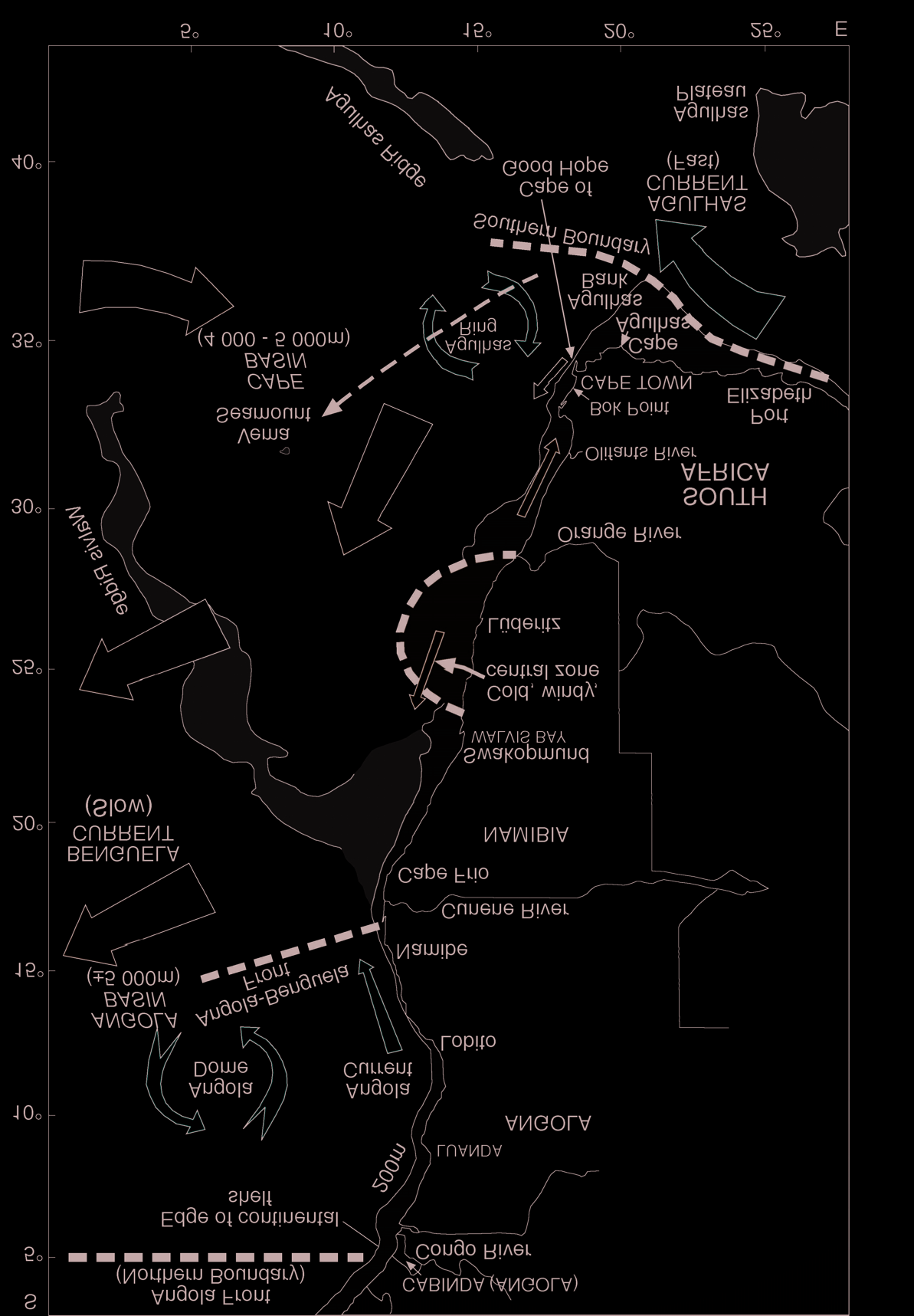
Integrated Management of the Benguela Current Region
231
Figure 15.1 External and internal boundaries of the Benguela Current Large Marine Ecosystem,
bathymetric features, and surface (upper layer) currents.
Indian Ocean through into the North Atlantic. (The South Atlantic is the only ocean in which
there is a net transport of heat towards the equator!).
As a result, not only is the Benguela at a critical location in terms of the global climate sys-
tem, but its marine and coastal environments are also potentially extremely vulnerable to any
future climate change or increasing variability in climate -- with obvious consequences for
long-term sustainable management of the coast and marine resources.
232
M.J. O'Toole et al.
Fragmented Coastal and Marine Resource Management: A Legacy of the
Colonial and Political Past
Following the establishment of European settlements at strategic coastal locations where
victuals and water could be procured to supply fleets trading with the East Indies, the poten-
tial wealth of the African continent became apparent. This subsequently resulted in the great
rush for territories and the colonization of the continent -- mostly during the nineteenth cen-
tury. Boundaries between colonies were hastily established, often arbitrary and generally
with little regard for indigenous inhabitants and natural habitats. Colonial land boundaries in
the Benguela region were established at rivers (e.g., Cunene, Orange). The languages and
cultures of the foreign occupiers were different (Portuguese, German, English, Dutch) and so
were the management systems and laws which evolved in the three now independent and
democratic countries of the region -- Angola, Namibia, and South Africa. Moreover, not
only were the governance frameworks very different, but a further consequence of European
influence was the relative absence of interagency (or interministerial) frameworks for man-
agement of the marine environment and its resources and scant regard for sustainability. To
this day, mining concessions, oil/gas exploration, fishing rights, and coastal development
have taken place with little or no proper integration or regard for other users. For example, ex-
ploratory wells have been sunk in established fishing grounds and the wellheads (which stand
proud of the sea bed) subsequently abandoned. Likewise, the impact of habitat alterations due
to mining activities and ecosystem alteration (including biodiversity impacts) due to fishing
have not been properly assessed.
Prior to the United Nations Convention on the Law of the Sea in 1982 (United Nations
1983) and declaration and respecting of sovereign rights within individual countries'exclu-
sive economic (or fishing) zones (EEZs), there was an explosion of foreign fleets fishing off
Angola, Namibia, and South Africa during the 1960s and 1970s -- an effective imperialism
and colonization by mainly First World countries of the Benguela Current Large Marine Eco-
system (BCLME) and the rape of its resources. This period also coincided with liberation
struggles in all three countries and associated civil wars. In the case of Namibia, over whom
the mandate by South Africa was not internationally recognized, there was an added problem
in that prior to independence in 1990, an EEZ could not be proclaimed. In an attempt to con-
trol the foreign exploitation of Namibia's fish resources, the International Commission for
the South-east Atlantic Fisheries (ICSEAF) was established, but this proved to be relatively
ineffectual at husbanding the fish stocks. In South Africa prior to 1994, there was generally a
scant regard for environmental issues or sustainable environmental management. Moreover,
colonialism, civil wars, and the apartheid legacy have resulted in a marked gradient in capac-
ity from south to north in the region. Another consequence of the civil wars has been the pop-
ulation migration to the coast and localized pressure on marine and coastal resources (e.g.,
destruction of coastal forests and mangroves), severe pollution of some embayments, and de
facto impossibility of any form of integrated coastal zone management along large stretches
of the Benguela coast.
While mineral exploration and extraction and developments in the coastal zones obvi-
ously occur within the geographic boundaries of the three countries, i.e., within the EEZs, and
can to a large degree be independently managed by each of the countries, mobile living ma-
rine resources do not respect the arbitrary geographic borders. This has obvious implications
Integrated Management of the Benguela Current Region
233
for the sustainable use of these resources, particularly so in the case of straddling and shared
fish stocks.
Thus the legacy of the colonial and political past is that the management of resources in the
greater Benguela area has not been integrated within countries or within the region. The real
challenge will be to develop a viable joint and integrative mechanism for the sustainable man-
agement of the coast and marine resources of the Benguela as a whole.
Regional Self-help: Joint Action by Three Developing Countries for a
Sustainable Future
This historical scenario poses almost insurmountable problems for the countries bordering on
the Benguela. Notwithstanding this, Angola, Namibia, and South Africa have, over the past
three years, made substantial progress to address the science and management issues in a
pragmatic, cost-effective manner. In this chapter we provide details about some of the joint
(regional) and individual country actions which have been taken to overcome the difficulties,
highlight some recent successes, and outline plans which the three countries collectively have
to ensure that the greater Benguela Current region is sustainably used and managed through
the proper application of science and technology. This approach could well serve as a blue-
print in other parts of the world for the integrated management of marine and coastal systems
which are shared between two or more developing countries.
At the regionallevel the approach has been somewhat different, however, from that which
would normally be taken in developed countries and coastal areas with "concave coastlines"
for the following reasons: First, much of the coast in the Benguela region is relatively pristine
and/or inaccessible -- except for small pockets of urban development. Second, many of the
"coastal" issues concern the marine rather than the terrestrial system. Third, the
transboundary problems which are amenable to management action are those relating to ma-
rine systems, e.g., shared fish resources. (It is just not feasible to attempt to address
transboundary issues associated with, for example, the Congo River and its drainage basin).
Fourth, (natural) environmental variability and change are major factors influencing natural
resources and the way in which these are managed in an open "convex" system, such as the
Benguela. While this cannot be controlled, cost-effective environmental monitoring and ap-
propriate science for better predictability can improve marine and coastal resource utilization
and management. Finally, but perhaps most important, is the need throughout the region to
develop human and infrastructure capacity and to share available knowledge and skills. What
better way to proceed than through the application of the appropriate science and technology!
This is in keeping with the philosophy so well articulated by Sherman (1994).
A REGIONAL MARINE SCIENCE SUCCESS STORY -- "BENEFIT"
In April, 1997, a major regional cooperative initiative was launched jointly by Angola,
Namibia, and South Africa together with foreign partners "to develop the enhanced science
capacity required for the optimal and sustainable utilization of living resources of the
Benguela ecosystem by (a) improving knowledge and understanding of the dynamics of im-
portant commercial stocks, their environment and linkages between the environmental
234
M.J. O'Toole et al.
processes and the stock dynamics, and (b) building appropriate human and material capacity
for marine science and technology in the countries bordering the Benguela ecosystem"
(BENEFIT 1997). The BenguelaEnvironmentFisheriesInteractionTraining Programme
(BENEFIT) evolved out of a workshop/seminar on "Fisheries Resource Dynamics in the
Benguela Current Ecosystem" held in Swakopmund in mid-1995 and hosted by the
Namibian Ministry of Fisheries and Marine Resources in partnership with the Norwegian
Agency for Development Cooperation (NORAD), the German Organization for Technical
Cooperation (GTZ), and the Intergovernmental Oceanographic Commission (IOC) of
UNESCO. BENEFIT has attracted substantial incremental support from overseas countries
and international donor agencies. It remains, however, essentially a regional "self-help" ini-
tiative and has been endorsed by the Southern African Development Community (SADC)
and accepted as a SADC program. It is providing a unique opportunity for development of
partnerships within and beyond the southern African region in science and technology to pro-
mote optimum utilization of natural resources and thereby greater food security in the region.
BENEFIT has been planned in two five-year phases (19972002, 20022007). The sci-
ence and technology component of BENEFIThas three foci: resource dynamics, the environ-
ment (of the resources), and linkages between resources and the environment. These foci are
increasing knowledge of resource dynamics through improved research on the resources and
their variable environment. The capacity development component of the program is being ad-
dressed through a suite of task-oriented framework activities to (a) build human capacity, par-
ticularly in areas of greatest need and greatest historical disadvantage, (b) develop, enhance,
and maintain regional infrastructure and cooperation, and (c) to make the countries in the re-
gion and the region as a whole more self-sufficient in science and technology. The linkages
between the three science foci and the suite of framework activities are illustrated schemati-
cally in Figure 15.2. BENEFIT has a Secretariat based in Namibia, while management meet-
ings are held on a rotating basis in Angola, Namibia, and South Africa.
The launch of BENEFIT in April 1997 coincided with two major research cruises/surveys
of the AngolaBenguela Front focusing on fisheries and environmental issues. (This front is
situated west of Angola and is thought to play an important role as a permeable "boundary"
between the tropical Atlantic and the upwelling region of the Benguela). During the past two
years, BENEFIThas increasingly gathered momentum: funding for priority projects has been
allocated and real progress in human capacity development has been made. Some recent
achievements are briefly:
· Several reports and scientific/technical papers have been published on the results of the
1997 AngolaBenguela Front surveys, and several regional scientists and technicians
received hands-on training at sea, in the laboratory, and in data analysis.
· A German-sponsored BENEFIT training course was conducted in Namibia in 1997,
and a number of regional scientists received further training subsequently in Germany
and in Norway.
· Fifteen fisheries and fisheries-environment projects were approved for funding in
1999.
· Two training workshops have taken place (1998 and 1999) and a BENEFIT Training
Plan to complement the Science Plan is under development.
Integrated Management of the Benguela Current Region
235
SCIENCE AND TECHNOLOGY FOCI
FOCUS 1
FOCUS 2
FOCUS 3
Fish Resource
FishEnvironment
Environment
Dynamics
Interactions
Capacity Development
B E N E F I T
and Training
Networking
Science and
and
Data and
Modeling
Technology
Communications
Information
and
Transfer
Systems
Analysis
FRAMEWORK ACTIVITIES
Figure 15.2 Schematic of the BENEFIT structure showing the interlinking science and technology
foci and framework activities.
· In the first half of 1999, over 50 persons from the broad SADC region (i.e., including
East African nations) have been trained during three BENEFIT cruises, including a
40-day survey of resources and the environment which extended between Cape Town
and Luanda, primarily funded by the African Development Bank and the World Bank.
BENEFITand related activities provide clear evidence of the desire and capability of Angola,
Namibia, and South Africa to work together to solve common marine/fisheries science prob-
lems in the Benguela region in partnership with the international community.
A COUNTRY-BASED APPROACH TO ICM: SOUTH AFRICA
AS AN EXAMPLE
The Need
In comparison with many other countries, South Africa's coastal areas have a low overall
population density and large areas that are relatively underdeveloped, particularly in terms of
opportunities for the poorer sections of the community. This is a result of a number of factors,
including migrant labor, apartheid planning policies, and historical population movements.
The coastal population is now growing as a result of recent political and economic changes in
South Africa. These changes include the removal of barriers to movement, a decline in inland
236
M.J. O'Toole et al.
extractive industries, and increasing opportunities associated with coastal resources, such as
tourism and port development. Future economic growth in South Africa is likely to concen-
trate along the coast and the pace of development in coastal areas is already accelerating. For
example, five out of the eight Spatial Development Initiatives are linked to the coast and the
direct contribution of coastal areas and resources to the gross domestic product of South Af-
rica is estimated as 37%. This presents a unique management challenge for government, in-
dustry, and civil society.
Coastal Management Policy Programme in South Africa
The Department of Environmental Affairs and Tourism initiated the Coastal Management
Policy Programme (CMPP) to promote integrated management of the coast as a system, in or-
der to harness its resources for sustainable coastal development. An extensive process of pub-
lic participation, supported by specialist studies, began in May, 1997, guided by a policy
committee representing the interests of national and provincial government, business, and
civil society. ACoastal Policy Green Paper was published in September, 1998, followed by a
Draft White Paper for Sustainable Coastal Development in March, 1999 (Draft White Paper
1999).
The Draft White Paper advocates the following shifts in emphasis:
· In the past, the value of coastal ecosystems as a cornerstone for development was not
sufficiently acknowledged in decision making in South Africa. The policy outlines the
importance of recognizing the value of the coast.
· In the past, coastal management was resource-centered rather than people-centered and
attempted to control the use of coastal resources. The policy stresses the powerful
contribution that can be made to reconstruction and development in South Africa
through facilitating sustainable coastal development. Maintaining diverse, healthy,
and productive coastal ecosystems will be central to achieving this ideal.
· In the past, South African coastal management efforts were fragmented and
uncoordinated, and were undertaken largely on a sectoral basis. The policy supports a
holistic approach by promoting coordinated and integrated coastal management,
which understands the coast as a system.
· In the past, a "top-down" control and regulation approach was imposed on coastal
management efforts. The policy proposes introducing a new facilitatory style of
management, which involves cooperation and shared responsibility with a range of
stakeholders.
However, the institutional capacity to support the integrated approach required to manage
coastal development is currently weak, and there is little awareness of the issues among key
stakeholders. This both limits the opportunities associated with the coast and threatens the
sustainability of development. An action plan to address these issues is presented in the Draft
White Paper and centers on four key themes:
1. Developing and supporting an appropriate (integrated) institutional and legal frame-
work across government.
2. Awareness, education, and training programs for government, the private sector, and
civil society.
Integrated Management of the Benguela Current Region
237
CEC
CEC Sub-Committee Coastal Management
(Chaired by DEAT)
KZN
EC
WC
NC
Provincial Working Groups
For each province:
Lead Provinical Government Department
Other Departments
Provincial Coordinator
Local Demonstration
Provinical Projects
Projects Coordinators
Local Demo Projects
Figure 15.3 Proposed institutional structure for implementation of the Draft White Paper (1999) for
sustainable coastal development in South Africa. CEC: Committee for Environmental Coordination
(national body); DEAT: Dept. of Environmental Affairs and Tourism; KZN: Kwa-Zulu Natal; EC: East-
ern Cape; WC: Western Cape; and NC: Northern Cape.
3. Information provision in the form of decision support for provincial and local govern-
ment, monitoring programs, and applied research.
4. Local projects to demonstrate the benefits of effective coastal management and to ad-
dress national and provincial priority issues.
Acyclical process of review and revision underpins the coastal policy. This allows successive
implementation generations to reflect evolving priorities, visions, and institutional capacity.
Figure 15.3 represents the institutional structures through which the coastal policy will be
implemented.
Context of the Coastal Policy Within the Benguela Current Region of South Africa
The Draft White Paper provides a brief overview of South Africa's coast to sketch the context
of the policy in relation to the thirteen coastal regions defined for the purposes of the policy
formulation process. The two sections applicable to the Benguela Current region study are
the Namaqualand and West Coast coastal divisions. These are bounded by the Orange and
Olifants Rivers, and the Olifants River and Bok Point, respectively. The following extracts
are lifted from the Draft White Paper.
Namaqualand
The Northern Cape province is comprised of only a single coastal region, the Namaqualand
coastal region. Some 390 km long, the Namaqualand region is a sparsely inhabited area,
238
M.J. O'Toole et al.
much of which is semi-desert and is largely undeveloped. Alack of physical access to coastal
resources and isolation from the center of provincial administration contribute to high pov-
erty levels in the coastal communities.
Although dominated by large mining and fishing companies, the Namaqualand region has
the second lowest economic growth rate in South Africa and unemployment has more than
doubled since 1980. Challenges include declining fish stocks, poor road infrastructure, lack
of sheltered bays for ports, and limited agricultural potential. The closure of many land-based
diamond mining operations provides an opportunity for extensive rehabilitation programs to
be carried out -- to rehabilitate the natural environment and to create alternative livelihoods
for people.
Potential exists for the harvesting of underutilized coastal resources, such as mussels and
limpets, for small-scale industries that add value to fishing and agriculture, and for
small-scale mining. Other natural assets, such as the annual wildflower display, a high diver-
sity of succulent plant species, and the stark beauty of the area offer potential for nature-based
tourism with community participation. More equitable distribution of mining and fishing
concessions and the development of value-added activities could contribute to retaining reve-
nue in local communities.
West Coast
The West Coast region has displayed significant growth and a relatively strong economy, al-
though rural areas remain poor. Impetus for growth has come from the deep-water port of
Saldanha and the proximity of the region to the Cape Metropolitan area. Despite the limited
supply of freshwater, substantial investment has been attracted to the region for mariculture,
shipping, industrial, manufacturing, tourism, and recreational activities. Much of the area is
arid, which limits agricultural potential. The region is, however, well known for its strandveld
and fynbos vegetation, which attracts many visitors to the region each spring. The region is at
the center of South Africa's fishing industry, with rich fishing grounds supporting capi-
tal-intensive industries.
Economic development through industrialization, property development, and tourism has
brought challenges for the management of the coast, including air and water pollution,
salination of the coastal aquifer, restricted access to coastal resources, ribbon development,
and inappropriate land use. Economic development is also attracting many job seekers to the
region, increasing the need for infrastructure and government services. Potential exists in the
region for the development of small-scale industries that add value to fishing, floriculture,
and mariculture, and for tourism promotion initiatives, including the development of rail and
air links.
Implementing the Coastal Policy in South Africa
Concurrent with the process of formal ratification of the Draft White Paper, the Department
of Environmental Affairs and Tourism has translated the "Plan of Action" into a preliminary
five-year implementation proposal. This is being used to seek implementation finance to en-
sure a reduced lead-in time between policy adoption and policy implementation. Once pro-
ject funds are secured, detailed design will follow, involving provincial government,
Integrated Management of the Benguela Current Region
239
appropriate stakeholders, and specialist individuals and organizations. This process was
completed in 2000, and it is hoped that the coastal policy will become government policy.
Meanwhile, to maintain momentum of the CMPP, an interim phase program is underway to
bridge the gap between the policy formulation and implementation phases. Activities in-
clude: specialist advice on an appropriate legislative framework, preparing for the appoint-
ment of National and Provincial Coordinators, initiating a needs assessment for public
awareness and education programs, preparing and distributing a newsletter to coastal stake-
holders, and developing a coastal management web site to better disseminate information.
AN INTEGRATED REGIONAL APPROACH TO THE SUSTAINABLE
MANAGEMENT OF THE BENGUELA CURRENT AS A LARGE
MARINE ECOSYSTEM: THE BCLME PROGRAMME
In a large marine ecosystem (LME), such as the Benguela Current System, sustainable man-
agement at the ecosystem level under conditions of environmental variability and uncertainty
is a regional issue. The mobile components of the BCLME do not respect arbitrary
geopolitical (country) boundaries. Several fish stocks straddle or are shared between the
countries or otherwise migrate through the Benguela. Actions by one country, e.g.,
overexploitation or habitat destruction of their part of a migrating or shared resource, could in
effect negatively impact on one or both neighboring countries. Joint management and protec-
tion of shared stocks is one of the few available options to the countries bordering the
Benguela Current. In this manner, a better sense of ownership of the regions'resources can be
attained, as "owners" tend to protect their property more than those enjoying a free service.
There is thus a strong need for harmonizing legal and policy objectives and for developing
common strategies for resource surveys, and investment in sustainable ecosystem manage-
ment for the benefit of all the people in the Benguela region. Only concerted regional action
with the enablement from the international community to develop regional agreements and
legal frameworks and assessment/implementation strategies will in the longer term protect
the living marine resources, biological diversity, and environment of the greater Benguela.
While shared living resources present the most obvious case for comanagement, there are
many examples of nonshared "resources" that can benefit from sharing of expertise and man-
agement structures developed and implemented in individual countries. These include inter
alia mining, declining coastal water quality (pollution abatement and control, oil spill
clean-up technology), oil/gas extraction, coastal zone development, tourism and eco-tourism
development, mitigation of the effects of introduced species (exotics), and harmful algal
blooms, which can also have system-wide impacts.
Whereas the governments of Angola, Namibia, and South Africa have made excellent
progress in partnership with members of the international community in addressing the sci-
ence and technology needs for fisheriesin the region through the BENEFITProgramme, a vi-
able regional framework for management for shared fish resources and the ecosystem as a
whole, including the coastal zone, is lacking. Building on BENEFIT and on the success of
LME initiatives elsewhere in the world (e.g., Black Sea; see Black Sea 1996), whereby incre-
mental funding is made available by the Global Environmental Facility (GEF) of the World
240
M.J. O'Toole et al.
Bank for the development of management structures that address transboundary problems
(and which structures become self-funding after 35 years), Angola, Namibia, and South Af-
rica with GEF assistance are in the process of developing a LME management initiative for
the Benguela Current: the BCLME Programme. This program is a broad-based multisectoral
initiative aimed at sustainable integrated management of the Benguela Current ecosystem as
a whole. It focuses on a number of key sectors, including fisheries, impact of environmental
variability, sea-bed mining, oil and gas exploration and production, coastal zone manage-
ment, ecosystem health, and socioeconomics and governance. Transboundary management
issues, environmental protection, and capacity building will be of primary concern to the pro-
gram. It builds on existing regional capacity and goodwill, and could serve as a blueprint for
the design and implementation of LME initiatives in other upwelling regions and elsewhere
in the developing world. Moreover, the BCLME Programme will address key regional envi-
ronmental variability issues that are expected to make a major contribution towards under-
standing global fluctuations in the marine environment, including climate change.
The BCLME Programme provides an ideal opportunity for the international community
to assist the three countries in the region to develop appropriate mechanisms that will ensure
the long-term sustainability of the ecosystem. In 1998 a small grant was made by the GEF via
the United Nations Development Programme (UNDP) to facilitate the development of a
comprehensive proposal. The process involved, which is lengthy and complex, follows pre-
scribed procedures. In essence it is a participatory process involving all key stakeholders in
the private and public sectors of the participating countries. Two regional workshops involv-
ing over 100 regional and international experts were held (Croll 1998; Croll and Njuguna
1999), consensus was built, a set of six comprehensive thematic reports or integrated over-
views were commissioned (fisheries, environment, mining, coast, oil and gas,
socioeconomics), an exhaustive Transboundary Diagnostic Analysis (TDA) was undertaken,
a Strategic Action Programme (SAP) is being developed, and, finally, a Project Brief formu-
lated. At first appearance the process appears overly bureaucratic and unwieldy, but having
gone through the various stages it is clear that the process is rigorous, necessary, and logical.
For example, the integrated overviews provided essential input into the subsequent TDA
whereby the essential elements were formulated and prioritized through (consensus) group
work as per the path issues ® problems ® causes ® impacts ® uncertainties ® socioeco-
nomic consequences ® transboundary consequences ® activities/solutions ® priority ®
outputs ® costs.
Key aspects of the TDAand SAP follow the next section, which considers BCLME exter-
nal boundaries.
Geographic Scope and Ecosystem Boundaries
Conducting a comprehensive TDA is only possible if the entire LME, including all inputs to
the system, is covered in the study. In the case of the Benguela, which is a very open system
where the environmental variability is predominantly remotely forced, this should then in-
clude the tropical Atlantic sensu latu, the Agulhas Current (and its link with the Indo-Pacific),
the Southern Ocean, and the drainage basins of all major rivers which discharge into the
greater Benguela Current region, including the Congo River. Clearly, such an approach is
Integrated Management of the Benguela Current Region
241
impracticable, and more realistic and pragmatic system boundaries must be defined to de-
velop and implement a viable ecosystem management framework. The principal external and
internal system boundaries are shown in Figure 15.1.
Landward Boundary
With the exception of the Congo River, the main impact of discharges from rivers flowing
into the South East Atlantic tends to be episodic in nature, i.e., in terms of significant
transboundary concerns, these are limited to extreme flood events. (Their drainage basins
nevertheless do include a major part of the southern African hinterland.) The Congo River,
however, exerts an influence that can be detected over thousands of kilometers of the South
Atlantic and drains much of Central Africa. From a practical point of view, it is quite beyond
the scope of the BCLME to attempt to include the development of any management structures
for a river such as the Congo. With respect to land sources of pollution in the BCLME (ex-
cluding the Congo River area), these are only really significant in the proximity of the princi-
pal port cities (e.g., Cape Town, Luanda, Walvis Bay), and the effects are generally very
localized. Nevertheless, some of the problems experienced in these areas are common in na-
ture and could be addressed through similar remedial actions. Like coastal development, their
impacts generally do not have a transboundary character. (By contrast, pollution from ships,
major oil spills, introduction of exotic species, and associated harmful algal blooms, for ex-
ample, are transboundary concerns). From a BCLME perspective, the landward boundary
can thus, for all practical purposes, be taken as the coast. Specific allowances can be made in
some areas on a case-by-case basis (e.g., during episodic flooding from the Orange and
Cunene Rivers, which are situated at the country boundaries of South AfricaNamibia and
NamibiaAngola, respectively).
Western Boundary
The Benguela Current is generally defined as the integrated equatorward flow in the upper
layers of the ocean in the South East Atlantic between the coast and the 0° meridian. The
BCLME Programme will accordingly use 0° as the western boundary. For practical manage-
ment purposes, however, the focus will be on the areas over which the three countries have
some jurisdiction, i.e., their EEZs which extend 200 nautical miles seawards from the land.
Southern/Eastern Boundary
The upwelling area of the BCLME extends around the Cape of Good Hope, seasonally as far
east as Port Elizabeth. This extreme southern part of the ecosystem is substantially influenced
by the Agulhas Current, its Retroflection (turning back) and leakage of Indian Ocean water
into the Atlantic south of the continent. As the variability of the BCLME is very much a func-
tion of the complex ocean processes occurring in the Agulhas CurrentRetroflection area,
this will be taken as the southern boundary with 27°E longitude (near Port Elizabeth), being at
the extreme eastern end.
242
M.J. O'Toole et al.
Northern Boundary
While the AngolaBenguela Front (Shannon et al. 1987) comprises the northern extent of the
main coastal upwelling zone, upwelling can occur seasonally along the entire coast of An-
gola. There are, in any event, strong linkages between the behavior of the AngolaBenguela
Front (and the oceanography of the area to the south of it) and processes occurring off Angola,
especially the Angola Dome and the Angola Current. Unless these are considered as an inte-
gral part of the BCLME, it will not be feasible to evolve a sustainable integrated management
approach for the Benguela. Moreover, there is a well-defined front at about 5°S, viz. the An-
gola Front (Yamagata and Iizuka 1995), which is apparent at subsurface depths. This front is
the true boundary between the Benguela part of the South Atlantic and the tropical/equatorial
Gulf of Guinea system. Anorthern boundary at 5°S would thus encompass the Angola Dome,
the seasonal coastal Angola Current, and the area in which the main oxygen minimum forms,
and the full extent of the upwelling system in the South East Atlantic. A pragmatic northern
boundary is thus at 5°S latitude, which is close to the northern geopolitical boundary of An-
gola (Cabinda).
Issues and Perceived Main Transboundary Problems, Root Causes, and Areas
Where Action Is Proposed: The TDA
Through the participatory TDA process involving regional stakeholders and international
LME experts, seven major transboundary problems were identified, their root causes estab-
lished, and suites of action formulated (BCLME TDA1999). These are summarized concep-
tually in Figure 15.4 and expanded in the accompanying synthesis matrix (see Table 15.1).
The latter is a "logistical map" which encapsulates the essence of the TDA.
Regional action is clearly required in three main areas: (a) sustainable management and
utilization of resources, (b) assessment of environmental variability, ecosystem impacts and
improvement of predictability, and (c) maintenance of ecosystem health and management of
pollution. Within each of these areas is a suite of subactions. Each of these is examined more
fully in the next level of the TDAto determine causes (of the relevant subproblem), likely im-
pacts, risks and uncertainties, socioeconomic consequences, transboundary consequences,
proposed activities/solutions, their priority and incremental costing (i.e., cost over and above
costs presently spent by national governments), and anticipated outputs. By way of illustra-
tion we have extracted one of the several subtables from the BCLME TDA document (Table
15.2). This table is in reality only a summary of the comprehensive information and assess-
ment which comprised the TDAprocess. It does, however, illustrate how transboundary con-
cerns can be addressed through the application of a logical analysis framework, i.e., the TDA,
which in turn provides essential input into the compilation of a SAP.
Strategic Action Programme for the BCLME
The Strategic Action Programme being developed (BCLME SAP 1999) is in essence a con-
cise document that outlines regional policy for the integrated sustainable management of the
BCLME as agreed by the governments of Angola, Namibia, and South Africa. The SAP
spells out the challenge (regional problems), establishes principles fundamental to integrated
Integrated Management of the Benguela Current Region
243
GENERIC ROOT CAUSES
Inadequate capacity
Poor legal
Poor legal
Inadequate
Inadequate
Inadequate planning
Inadequate
Insufficient public
Insufficient
development
Inadequate
framework at the
framework at
implementation of
implementation
at all levels
planning at all
involvement
capacity develop-
public
(human and
regional and
available regulatory
the regional
of available
levels
involvement
infrastructure) and
ment (human &
national levels
and national
instruments
regulatory
training
infrastructure)
and training
levels
instruments
Complexity of
Inadequate financial
MAJOR TRANSBOUNDARY PROBLEMS
ecosystem and high
Complexity of
mechanisms and
Inadequate
degree of variability
ecosystem and
support
financial
· Decline in BCLME commercial fish stocks
high degree of
mechanisms
and nonoptimal harvesting of living resources
variability
and support
· Uncertainty regarding ecosystem status and
yields in a highly variable environment
· Deterioration in water quality: chronic and
catastrophic
· Habitat destruction and alteration, including
inter alia modifications of seabed and coastal
zone and degradation of coastscapes
· Loss of biotic integrity and threat to
biodiversity
· Inadequate capacity to assess ecosystem
health
· Harmful algal blooms
Sustainable
Assessment of
Assessment of
Maintenance of
management and
Sustainable
environmental
Maintenance
environmental
ecosystem health
utilization of
management
variability
of ecosystem
variability
,
, eco-
and management of
resources
and utilization
ecosystem impacts
health and
system impacts,
pollution
of resources
and improvement of
management
and improvement
predictability
of pollution
of predictability
AREAS WHERE ACTION IS REQUIRED
Figure 15.4 Results of the Transboundary Diagnostic Analyses (TDA): Overview of major
transboundary problems, generic root causes, and areas requiring action in the BCLME.
management in the region, specifies the nature, scope, and timetable for deliverable manage-
ment policy actions (based on TDAinput), details the institutional arrangements (structures)
necessary to ensure delivery, elaborates on wider cooperation (i.e., cooperation between the
BCLME region and external institutions), specifies how the BCLME Programme will be fi-
nanced during the start-up and implementation phase (five years), and outlines approaches to
ensure the long-term self-funding of the integrated management of the BCLME.
Key details of the BCLME SAP are briefly as follows.
The Challenge
The legacy of fragmented management -- inadequate planning and integration, poor legal
frameworks and inadequate implementation of existing regulatory instruments, insufficient
public involvement, inadequate capacity development, and inadequate financial support
mechanisms -- superimposed on a complex and highly variable environment have mani-
fested themselves, for example, in the decline of fish stocks, nonoptimal utilization of
244
M.J. O'Toole et al.
Table 15.1 Synthesis matrix.
Perceived Major Problems
Transboundary Elements
Major Root
Activity
Causes*
Areas**
Decline in BCLME commercial
Most of region's important harvested
1, 2, 3, 4, 5, A, B, (C)
fish stocks and nonoptimal
resources are shared between countries, or
6, 7
harvesting of living resources
move across national boundaries at times,
requiring joint management effort.
Uncertainty regarding ecosystem
Environmental variability and change
1, 2, 3, 7
A, B, C
status and yields in a highly
impacts on ecosystem as a whole, and poor
variable environment
predictive ability limits effective
management. The BCLME may also be
important to global climate change.
Deterioration in water quality:
While most impacts are localized, the
2, 3, 4, 5, 7
C
chronic and catastrophic
problems are common to all three countries
and require collective action to address.
Habitat destruction and alteration, Uncertainties exist about the regional
2, 3, 5, 6, 7
A, C, (B)
including inter alia modification of cumulative impact from mining on benthos
seabed and coastal zone and
and ecosystem effects of fishing.
degradation of coastscapes
Degradation of coastscapes reduce regional
value of tourism.
Loss of biotic integrity (e.g.,
Fishing has altered the ecosystem, reduced
1, 3, 5, 6
A, C, (B)
changes in community
the gene pool, and caused some species to
composition, species diversity,
become endangered/threatened.
introduction of alien species) and
Introduced alien species are a global
threat to biodiversity, endangered
transboundary problem.
and vulnerable species
Inadequate capacity to monitor/
There is inadequate capacity in the region to 1, 2, 5, 7
A, B, C
assess ecosystem (resources,
monitor the resources and the environmental
environment, and variability
variability, and unequal distribution of the
thereof)
capacity between countries.
Harmful algal blooms (HABs)
HABs are a common problem in all three
1, 2, 3, 6, 7
A, B ,C
countries and require collective action to
address.
*Main Root Causes:
1. Complexity of ecosystem and high degree of variability (resources and environment)
2. Inadequate capacity development (human and infrastructure) and training
3. Poor legal framework at the regional and national levels
4. Inadequate implementation of available regulatory instruments
5. Inadequate planning at all levels
6. Insufficient public involvement
7. Inadequate financial mechanisms and support
**Area Where Action Is Proposed:
A. Sustainable management and utilization of resources
B. Assessment of environmental variability, ecosystem impacts, and improvement of predictability
C. Maintenance of ecosystem health and management of pollution
resources, increasing pollution, habitat destruction, threats to biodiversity, all of which have
transboundary implications. The challenge is to halt the changing state of the BCLME and,
where possible, reverse the process through the development and implementation of sustain-
able integrated management of the ecosystem as a whole. More specifically:
Integrated Management of the Benguela Current Region
245
· Overexploitation of commercial fish stocks and the nonoptimal harvesting of living
resources in the ecosystem are causes of concern, particularly as most of the important
harvested resources are shared between countries and overharvesting in one country
can lead to depletion of that species in another and changes to the ecosystem as a whole.
· Inherent high environmental variability in the marine system and associated
uncertainty and poor predictability limits the capability to manage resources
effectively. The challenge is to improve predictability of "events" and their
consequences.
· Deterioration of water quality in the BCLME and associated problems are common to
all three countries and require collective action to address. Catastrophic events (e.g.,
major oil spills, system-wide anoxia) can impact across geopolitical boundaries
requiring sharing of expertise and technology.
· Habitat destruction, alteration and modification to the seabed and coastal zone, and
degradation of coastal areas is accelerating. The regional cumulative impacts are
unknown and need addressing to ensure sustainable resource utilization and tourism.
· Increased loss of biotic integrity and the introduction of alien species (e.g., ballast
water discharges) threatens vulnerable and endangered species and biodiversity of the
BCLME and impacts at all levels, system wide.
· There is inadequate institutional, infrastructural, and human capacity at all levels to
monitor, assess, and manage the BCLME. Moreover, there is an unequal distribution of
existing capacity.
· Harmful algal blooms occur in coastal waters of all three countries and all face similar
problems in terms of impacts, monitoring, and management. Collective regional action
is necessary.
Principles Fundamental to Cooperative Action
The following principles are being proposed for consideration by the three governments:
· Application of the precautionary principle.
· Promote anticipatory actions (e.g., contingency planning).
· Stimulate use of clean technologies.
· Promote use of economic and policy instruments that foster sustainable development
(e.g., polluter-pays-principle).
· Include environmental and health considerations in all relevant policies and sectoral
plans.
· Promote cooperation among states bordering the BCLME.
· Encourage the interests of other states in the southern African region.
· Foster transparency and public participation within the BCLME Programme.
· The three governments will actively pursue a policy of cofinancing with industry and
donor agencies.
Institutional Arrangements (Structures)
It has been suggested that an Interim Benguela Current Commission (IBCC) be established to
strengthen regional cooperation. Its Secretariat and subsidiary bodies could be fully
246
and
capacity
to
disposal
1999).
data
Angola
in
waste
TDA
standards
relationship
mechanism
zones
baseline
period
peace
no
commitment
fect
to
hazardous
or
recovery
BCLME
Few Performance thresholds National building Cause-ef
Recovery Cost Return
Accumulation Illegal
from
Risks/Uncertainties
· ·
·
·
· · ·
· ·
(taken
and
quality
dominance
fauna
impacts equipment
ganisms
or
water
species
coastal
fishing
of
yields
in
degradation of
aesthetic to
health
edible
mortality
Public Reduced Unsafe Changes
Coastline Mortality flora
Faunal Negative Damage
Impact
· · · ·
· ·
· · ·
Improvement
recycling
incentives
pollution:
of
oil settlement
few
and
and vessels
development
waste informal
vessels/equipment
settlements
communities
on
of
from
management
coastal pollution
awareness
pollution
coastal
coastal management
coastal
and
oil
pollution
policy in
conflict
error
of
of
discards
public disposal
fishing
pollution
of
worthiness
waste
health
Unplanned Chronic Industrial Sewage Air Mariculture Lack Growth
Sea Military Sabotage Human
Growth Poor Little Illegal Poverty Ghost Fishing
Causes
· · · · · · · ·
· · · ·
· · · · · · ·
or
vol- the
ecosystem
and
pol- aggra-
and
the
of
water
cities,
it, contami-
major
pollution treatment
through
of fragile
a
serious
unforeseen
substantial
within
of from straddling
is
coastal
coastal
water inadequate
A
risk
to infrastructure.
in developments of was created
and
throughout
and
areas
transported
There
Maintenance
has Aging
spills: is
ge
damage coastal
Coastal
which
problem.
oil
lar
oil region
litter: problem
expansion of
the
of environments
and
of
a
significant
15.2
is
Deterioration quality: rapid much unplanned, "hotspots." infrastrucure icy/monitoring/enforcement vates
Major ume BCLME this nation coastal accidents, stocks
Marine
C1.
C2.
growing BCLME.
T
able
Problems
C3.
247
re-
pack-
on
manage-
available
quality
legislation
agreements
agreements
water
plan
and
and control
and
for
uplift
plans
incentives
policies
Outputs
protocols pollution
contingency
protocols
material/documents
solutions
resources
beaches
Shared ment Regional Improved Socioeconomic
Regional Shared Rehabilitation Regional
Cleaner Education gionally Standardized aging/recycling
Anticipated
·
· · ·
· · · ·
· ·
·
1
1
2
1
1
2
2
3 1
3
3
2 3
1 1 2 2 1
Priority
con-
de-
plan
recovery
notification
environmental
working
pollution
pollution
enforcement
pollution
of
of
packaging
on
of
facilities
policies
marine
regional framework fective
enforcement
standard
regional
ef
control contingency
indicators/criteria
in
education
projects prevention
awareness
recycling
awareness
and surveillance
state
reception
Develop quality Establish groups Training control Plan/adapt monitoring Establish agencies Demo trol Joint
Port Regional velopment Research/modeling periods Public procedures
Litter Harmonization legislation Public Port Regulatory Standardized Seafarer
Activities/Solutions
·
·
·
·
·
·
·
· ·
·
·
· ·
· · · · ·
gan-
(bor-
or
strad-
solu-
contain-
on
for rehabili-
pollutant
pollutant
transport
Consequences
marine
of seals
common
protection
impacts
sharing
site
e.g.,
stocks spots"
surveillance, etc.
wetlands)
T
ransboundary transport Migration isms, Negative dling "Hot tions
Resource ment, tation, Ramsar der Transboundary transport
T
ransboundary
T
ransboundary
·
·
·
·
·
·
·
·
pro-
quality
life
of
(e.g. salt
quality
costs
income
informal
costs
in
Consequences
impacts
impacts
tourism
quality
health yields resource
employment
fisheries,
yields resource
fishing
costs tourism
continued
of
of
of health
of creation
Loss Higher Altered Reduced Aesthetic Lowered Loss
Opportunity tourism, duction) Altered Reduced Aesthetic
Loss Public Cleanup Loss Job sector
15.2
· · · · · · ·
·
· · ·
· · · · ·
Socioeconomic
T
able
C1
C2
C3
248
M.J. O'Toole et al.
functional by January, 2001. Meanwhile, the three governments have signed the SAPand the
GEF Council recently approved the funds for the BCLME Programme (approximately US$
15 million). As envisaged, the IBCC will be implementing the organization for the BCLME
SAP and will be supported by advisory groups as necessary. The following initial advisory
groups are likely to be:
· Advisory Group on Fisheries and Other Living Resources,
· Advisory Group on Environmental Variability and Ecosystems Health,
· Advisory Group on Marine Pollution,
· Advisory Group on Information and Data Exchange,
· Advisory Group on Legal Affairs and Maritime Law,
· Advisory Group on Industry and the Environment.
It is anticipated that the IBCC would regularly review the status and functions of the above
advisory groups and also establish ad hoc groups to help implement the SAP. Within the
IBCC, a Project Coordination Unit would play a key role in coordination, networking, com-
munication and information exchange for the BCLME Programme. It has been proposed that
three activity centers (one per country) be established to facilitate coordination within the
partner countries and to serve as centers for specialist BCLME actions (e.g., resource assess-
ment, methodology and calibration, regional environmental monitoring and networking, ma-
rine pollution, etc.).
Policy Actions
The policy actions by and large build on and give effect to (with deadlines) the actions speci-
fied in the TDA that are necessary to address the suite of identified priority transboundary
problems and issues. As full coverage of these is beyond the scope of this paper, we present
here a few examples which still need to be agreed and approved by the three governments:
· Joint surveys and assessment of shared stocks of key species will be undertaken
cooperatively between 20012005 to demonstrate benefits of this approach. The three
countries endeavor to harmonize the management of the shared stocks.
· A regional mariculture policy to be developed by December, 2002.
· The three governments commit themselves to compliance with the FAO (Food and
Agriculture Organisation of the United Nations) Code of Conduct for Responsible
Fisheries (FAO 1995).
· A regional framework for consultation to mitigate the negative impacts of mining be
developed by December, 2002, and mining policies relating to shared resources and
cumulative impacts to be harmonized.
· A regional network for reporting harmful algal blooms to be implemented in 2002.
· Wastewater quality criteria for receiving waters to be developed by June, 2002, for
point source pollution.
· Astrategy for the implementation of MARPOL73/78 in the BCLME region be devised
by December, 2000.
· Existing data series and material archives to be used to establish an environmental
baseline for the BCLME.
Integrated Management of the Benguela Current Region
249
· Aregional biodiversity conservation management plan and framework to be developed
by December, 2003.
· A comprehensive regional strategic plan for capacity development and maintenance
for the BCLME to be finalized by June, 2001.
Wider Cooperation
The three countries, individually and jointly, would encourage enhanced cooperation with
other regional bodies such as BENEFIT, SADC (Southern African Development Commu-
nity), the future South East Atlantic Fisheries Organization (SEAFO), NGOs, UN Agencies,
donors, and other states with an interest in the BCLME.
CONCLUDING REMARKS
We have attempted to illustrate the joint approach taken by Angola, Namibia, and South Af-
rica in partnership, where appropriate, with the international community to manage the ma-
rine and coastal resources of the Benguela Current region sustainably through the application
of science and technology. Examples have been provided of a fisheries science initiative,
BENEFIT, country-based ICM, and holistic approach to regional marine and coastal man-
agement using the emerging BCLME Programme as the catalyst. These are some of the build-
ing blocks, but there are others. For example, at the science and technology level, strong links
have been built with a number of parallel, but distinctly different, initiatives. These include
(a) South Africa's established and internationally acclaimed Benguela Ecology Programme
(BEP) (see Siegfried and Field 1982), which has resulted in the publication of thousands of
publications on the Benguela ecosystem since 1982 (see, e.g., Payne et al. 1987, 1992; Pillar
et al. 1998), (b) the ENVIFISH Programme (Environmental Conditions and Fluctuations in
Distribution of Small Pelagic Fish Stocks), which is a three-year European Union funded pro-
ject between seven EU states and Angola, Namibia, and South Africa focusing primarily on
the application of satellite data in environmentfisheries research and management, and
which commenced in October, 1998, and (c) VIBES (Variability of Exploited Pelagic Fish
Resources in the Benguela Ecosystem in Relation to Environmental and Spatial Aspects), a
bilateral FrenchSouth African initiative focusing on the variability of pelagic fish resources
in the Benguela and the environmental and spatial aspects of the system, which also com-
menced in 1998. At the socioeconomic and management levels, bilateral arrangements be-
tween the three Benguela countries and various overseas states have materially assisted the
development and application of sustainable management policies, while enhanced regional
cooperation at all levels across disciplines is actively promoted by SADC. In the fisheries
context, the future SEAFO is likely to play a pivotal role in the sustainable management of
living marine resources.
In Figure 15.5 we have attempted to show how the various science and management initia-
tives fit together, both at the country level and regionally in the Benguela. Clearly, appropri-
ate science and technology are the cornerstones of the integrated sustainable management. At
all levels and in all disciplines and functions, strong emphasis has been placed on capacity
development.
250
M.J. O'Toole et al.
INTEGRATED
SUSTAINABLE MARINE AND
COASTAL MANAGEMENT
IN THE BENGUELA
CURRENT REGION
Management
BCLME
at country level
Programme
Angola
Namibia
Other regional
S. Africa
Socioeconomics
science &
at country
technology (e.g.,
level
ENVIFISH
BENEFIT
VIBES, etc.)
Science &
Science &
technology
technology
& capacity
at country
building
level
Figure 15.5 Schematic showing the interlinking of science, technology, and management in the
BCLME at country and regional levels.
The collaborative approach by Angola, Namibia, and South Africa is highly relevant
within a broader regional context, i.e., within SADC, as it provides an example how member
states with very different resource bases (human, infrastructure, financial) can work together
using science and technology as a unifying factor to underpin responsible management of a
complex system. Taken one step further it can help convert the vision of an African Renais-
sance into reality. More than that, we suggest that the approach and action by the countries
bordering on the Benguela Current could serve as a blueprint in other parts of the developing
world for the integrated sustainable management of marine and coastal systems which are
shared between two or more countries.
ACKNOWLEDGMENTS
What we have attempted to synthesize in this paper represents the collective wisdom and vision of a
large number of local, regional, and international experts, and an example of the commitment by the
governments of three southern African states to sustainable development and wise management of the
region and its natural resources. In preparing this manuscript, we have drawn on published and
unpublished documents as well as from the BCLME TDAand SAP and an article by L.V. Shannon and
M.J. O'Toole entitled "The Benguela: Ex Africa Semper Aliquid Novi," which has been drafted for a
book on large marine ecosystems edited by G. Hempel. We acknowledge permission given by the
Windhoek Office of the United Nations Development Programme to use information from the TDA
developed for the BCLME Programme and the invaluable input by Mr. C. Davis of the U.K. Department
for International Development into the section dealing with ICM in South Africa.
REFERENCES
BCLME SAP (Benguela Current Large Marine Ecosystem Strategic Action Plan). 1999. Strategic
Action Plan for the Integrated Management and Sustainable Development and Protection of the
Integrated Management of the Benguela Current Region
251
Benguela Current Large Marine Ecosystem. Windhoek: UNDP (United Nations Development
Programme).
BCLME TDA. 1999. Benguela Current Large Marine Ecosystem Programme (BCLME)
Transboundary Diagnostic Analysis (TDA). Windhoek: UNDP.
BENEFIT (Benguela-Environment-Fisheries-Interaction-Training Programme). 1997. BENEFIT
Science Plan. Swakopmund: BENEFIT Secretariat.
Black Sea. 1996. Strategic Action Plan for the Rehabilitation and Protection of the Black Sea. Istanbul:
Global Environmental Facility/UNDP Black Sea Environmental Programme.
Brown, P.C., S.J. Painting, and K.L. Cochrane. 1991. Estimates of phytoplankton and bacterial biomass
and production in the northern and southern Benguela ecosystems. S. Afr. J. Mar. Sci. 11:537564.
Bubnov, V.A. 1972. Structure and characteristics of the oxygen minimum layer in the South-eastern
Atlantic. Oceanology 12:193201.
Chapman, P., and L.V. Shannon. 1985. The Benguela ecosystem. 2. Chemistry and related processes. In:
Oceanography and Marine Biology: An Annual Review, vol. 23, ed. M. Barnes, pp. 183251.
Aberdeen: Aberdeen Univ. Press.
Croll, P. 1998. Benguela Current Large Marine Ecosystem (BCLME). First Regional Workshop, United
Nations Development Programme, 2224 July 1998, Cape Town, South Africa. Report prepared for
Global Environmental Facility/UNDP Benguela Current Large Marine Ecosystem Programme.
Windhoek: UNDP.
Croll, P., and J.T. Njuguna. 1999. Benguela Current Large Marine Ecosystem (BCLME). Second
Regional Workshop, United Nations Development Programme, 1216 April 1999, Okahanja,
Namibia. Report prepared for Global Environmental Facility/UNDP Benguela Current Large
Marine Ecosystem Programme: Windhoek: UNDP.
Draft White Paper. 1999. Draft White Paper for Sustainable Coastal Development in South Africa.
Pretoria: Dept. of Environment Affairs and Tourism.
FAO (Food and Agriculture Organisation of the United Nations). 1995. Code of Conduct for
Responsible Fisheries. Rome: FAO.
Hamukuaya, H., M.J. O'Toole, and P.M.J. Woodhead. 1998. Observations of severe hypoxia and
offshore displacement of Cape hake over the Namibian shelf in 1994. S. Afr. J. Mar. Sci19:5759.
Payne, A.I.L., K.H. Brink, K.H. Mann, and R.H. Hilborn, eds. 1992. Benguela Trophic Functioning. S.
Afr. J. Mar. Sci. 12:11108.
Payne, A.I.L., J.A. Gulland, and K.H. Brink, eds. 1987. The Benguela and Comparable Ecosystems. S.
Afr. J. Mar. Sci. 5:1957.
Pillar, S.C., C.L. Moloney, A.I.L. Payne, and F.A. Shillington, eds. 1998. Benguela Dynamics: Impacts
of Variability on Shelf-sea Environments and Their Living Resources. S. Afr. J. Mar. Sci.19:1512.
Shannon, L.V., J.J. Agenbag, and M.E.L. Buys. 1987. Large- and meso-scale features of the Angolan
Benguela Front. S. Afri. J. Mar. Sci. 5:1134.
Shannon, L.V., and G. Nelson. 1996. The Benguela: Large scale features and processes and system
variability. In: The South Atlantic: Past and Present Circulation, ed. G. Wefer, W.H. Berger, G.
Siedler, and D.J. Webb, pp. 163210. Berlin: Springer.
Shannon, L.V., and M.J. O'Toole. 2000. The Benguela: Ex Africa semper aliquid nov, ed. G. Hempel, in
press.
Sherman, K. 1994. Sustainability, biomass, yields, and health of coastal ecosystems: An ecological
perspective. Mar. Ecol. Prog. Ser. 112:277301.
Siegfried, W.R., and J.G. Field, eds. 1982. A Description of the Benguela Ecology Programme
19821986. South African National Scientific Programmes Report No. 54. Pretoria: CSIR (Council
for Scientific and Industrial Research).
United Nations. 1983. United Nations Convention on the Law of the Sea 1982. New York: United
Nations.
Yamagata, T., and S. Iizuka. 1995. Simulation of tropical thermal domes in the Atlantic: A seasonal
cycle. J. Phys. Oceanogr. 25:21292140.