FEATURE ARTICLE #4
SEAMOUNTS AND PELAGIC FISHERIES INTERACTIONS UNDER STUDY
By Valerie Allain,
Fisheries Scientist (Ecosystem Analyst)
Secretariat of the Pacific Community
ValerieA@spc.int
In October 2005, SPC's Oceanic Fisheries Programme, in collaboration with the Forum Fisheries
Agency (FFA), started a five-year endeavor called the Pacific Islands Oceanic Fisheries
Management Project (OFM project). The OFM project is funded by the Global Environment
Facility (GEF), and the Scientific Assessment and Monitoring Enhancement Component of the
project (including ecosystem analysis) is implemented by SPC.
One of the objectives of the OFM project is to obtain an enhanced understanding of the ecology
of seamounts, in particular their influence on the aggregation and movement of pelagic fish
species, and also the impact of fisheries on seamount ecosystems.
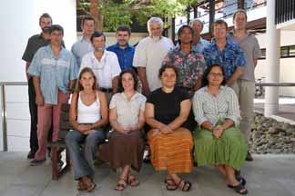
To organise this specific activity, a seamount research planning workshop, gathering 14
seamount and benthic and pelagic fisheries experts, took place at SPC headquarters in Noumea
on 20 and 21 March 2006.
From left to right
Back row: Malcolm Clarck (NIWA-New Zealand), Bruno Leroy*, Adam Langley*, Bertrand
Richer de Forges (IRD-New Caledonia), Alex Rogers (IOZ-United Kingdom/IUCN
representative), Steve Beverly*, David Itano (University of Hawaii-Hawaii), Jock Young
(CSIRO-Australia), John Hampton*, David Kirby*
Front row: Julie-Anne Kerandel*, Philippa Cohen (Ministry of Fisheries-Tonga), Valerie Allain*,
Barbara Hanchard (FFA-Solomon Islands).
* SPC - New Caledonia
The objective of this workshop was to review existing knowledge about seamounts in the Pacific
in relation to pelagic fisheries, and plan activities within the timeframe of the OFM project to
gather more information on the ecology of seamounts and pelagic fisheries.
The workshop began with participants' presentations of work conducted around seamounts in the
Pacific and future projects under development. Afterwards, many topics relating to seamounts
and pelagic fisheries were discussed, and some of these are summarized below.
What is a seamount?
A seamount is generally defined as an isolated underwater mountain that rises more than 1000 m
above the seafloor. However, workshop participants agreed that an operational definition of
seamounts, and one that is particularly relevant to pelagic fisheries, should include underwater
features less than 1000 m above the sea floor, and having different geologic features such as
terraces, ridges, banks, plateaux, and shelves.
Only those seamounts that extend up into the euphotic zone1 and the lower level of the deep
scattering layer (DSL)2 will have an influence on pelagic fish species.
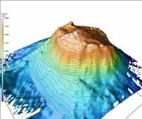
Three dimensional diagram of the Bear Seamount in the Atlantic Ocean whose summit reaches
about 1000 m depth (source: National Oceanic and Atmospheric Administration:
http://www.oceanexplorer.noaa.gov/explorations/deepeast01/logs/sep13/media/bear_seamount.ht
ml).
How many seamounts are in the Pacific Ocean?
The number of potential seamounts in the Pacific Ocean could be 30,000, although less than 1000
have been properly identified and less than 150 have been explored. There is a critical need to
gather accurate, fine-scaled bathymetric data to properly identify the seamounts. Bathymetric
1 Sea surface waters where enough light penetrates for photosynthesis to occur (i.e. down to about 80 meters or
more). The depth of the euphotic zone varies with the water's extinction coefficient, angle of incidence of sunlight,
length of day, and cloudiness. (FishBase Glossary).
2 A horizontal zone of living organisms, usually schools of fish, occurring below the surface in many ocean areas.
The zone derives its name from the layer of water scatters or reflects sound waves, causing echoes in depth sounders.
The DSL tends to rise towards the surface at night, and to descend during daytime. (Encyclopedia Britannica;
FishBase Glossary).
data on the location of seamounts comes from two major sources: ship-derived data and satellite-
derived data.
Ship-derived data are generally very detailed and are of high resolution, but these data only cover
small oceanographic areas. This kind of data allows for locating seamounts, but can also provide
very detailed topographic maps of seamounts. Satellite-derived data provide the potential location
of seamounts, offering complete coverage of an ocean. Resolution depends on the dataset used,
but no detailed topographic information on seamounts is available. Considerable work is still
required to obtain an accurate and precise list of seamounts in the Pacific Ocean.
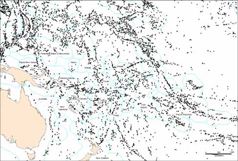
Position of potential seamounts based on analysis of 2-minute gridded global relief (ETOPO2)
satellite data. Data from Kitchingman A. and Lai S 2004. Inferences on potential seamount
locations from mid-resolution bathymetric data. Fisheries Centre Research Reports. 12(5):7�12.
What is the influence of seamounts on pelagic species and fisheries?
Fishermen are well aware that seamounts attract pelagic fish; Capricorn Seamount in Tonga, for
example, is a particularly productive fishing area.
A commonly stated hypothesis to explain the aggregation of pelagic fish around seamounts is the
unique water circulation around seamounts, and the existence of enhanced phytoplankton
production,3 which in turn supports a rich ecosystem. Large amounts of small fish, crustaceans,
and squids feeding on large quantities of phytoplankton and zooplankton will attract pelagic fish
such as tuna. However, the enhanced production hypothesis has not been observed in many
3 A flora of freely floating, often minute organisms that drift with water currents. Like vegetation, phytoplankton
uses carbon dioxide, releases oxygen, and converts minerals to a form that animals can use when feeding on
phytoplankton. Phytoplankton constitute the base of the food chain, and are consumed by zooplankton that are in
turn consumed by small fish that constitute the food of larger fish. (Encyclopedia Britannica).
explored seamounts. A new idea is that the DSL is trapped by seamounts and will act as the
feeding source, thus attracting predatory species.
Seamounts probably have different roles for different life-history stages of some species (e.g.
spawning grounds, feeding grounds, nursery areas).
Because fish aggregate around seamounts, they became a target for fishermen. Two examples of
fisheries that have developed around seamounts include the tuna fishery around Capricorn
Seamount in Tonga, and Cross Seamount in Hawaii. Already some dramatic depletion of resident
fish populations around seamounts has been observed (e.g. the swordfish fishery around Brittania
Seamount in Australia).
Do pelagic fisheries have an impact on seamounts?
Seamounts are very fragile and specific ecosystems mainly unknown but characterized by a very
particular fauna. Each time a new seamount is explored, a high percentage of the species
collected are new to science, and the fauna often show a high degree of endemism4. Hence,
seamounts constitute ecosystems of very special interest for conservation and it is important to
evaluate the impact of human activities on them in order to prevent destruction and damage to
these poorly known and unexplored features.
Heavy bottom trawling fishing gear dragged on the top or on the slopes of seamounts can cause
significant damages to seamount fauna. However, some pelagic fisheries (e.g. purse seine,
longline) are operated from the surface, and if the lines hang above the seamount (i.e. they do not
touch it), it is suspected that pelagic fisheries in surface waters are unlikely to impact the fauna
living directly below on the seamounts. But, removing large quantities of pelagic predators could
cause disequilibrium of the ecosystem around seamounts.
The general lack of knowledge about seamount ecosystems (location, and geological, biological,
oceanographical characteristics) shows the importance of implementing studies on their ecology
to acquire a better understanding of their potential impact on pelagic fisheries and vice versa.
Analysing existing data
The OFM project's first task will be to obtain an accurate list of seamounts. This will be done by
reanalysing the Kitchingman and Lai dataset to remove any false identification of seamounts and
to identify submarine banks relevant to fisheries.
This dataset of seamounts will be examined in reference to fisheries catch and effort data
provided by SPC member countries and distant water fishing nations, and compiled by SPC's
Oceanic Fisheries Programme. In addition, there are data from onboard observers for a small
percentage of the fleet. These data are on a much finer scale and include bycatch species
4 A species whose distribution is confined to a given area is said to be endemic to that area. For example, some
particular species of sponges or crabs are only found on a specific seamount, therefore, they are said to be endemic to
this seamount and not found anywhere else.
composition. The OFM project will try to determine if there is any apparent connection between
fisheries data (catch per unit of effort, species composition, size of fish caught) and seamount
presence/absence or other characteristics. Datasets from previous large-scale tagging programmes
will also be reanalysed to investigate whether there is any obvious site fidelity for fish tagged in
the vicinity of seamounts.
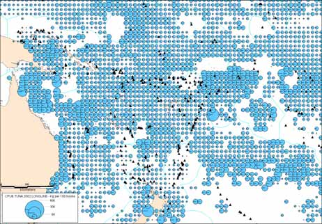
Capricorn
seamount
Catch per unit of effort (CPUE in kg per 100 hooks) of the longline tuna catch in 2002 per 1
degree square. Black triangles represent potential seamounts whose summits are between 50 and
1000 m depth. In the circle is shown the high catches around Capricorn Seamount. Data from
SPC's Oceanic Fisheries Programme.
Acquiring new data
In addition to analysing existing data, new field work will be undertaken during the OFM project
to enhance our understanding of seamount ecosystems in relation to pelagic fisheries.
Several sampling cruises are already planned for the first part of the project.
The Papua New Guinea (PNG) tagging project will focus on the Bismarck Sea/Solomon Seas and
adjacent areas, and will visit some seamounts. This is the first phase of a larger regional tuna
tagging project, and one of the objectives is to tag tunas around seamounts to investigate the
behaviour of fish and their site fidelity. Biological sampling, particularly of stomach contents,
will be carried out during the tagging cruises to gain a better understanding of the trophic impact
of seamounts on the fish.
The Seamount Planning Workshop allowed experts to share their views on the ecology of
seamounts and to plan research efforts for the coming years. Another meeting will be organised
in two to three years' time to review the work undertaken thus far, and future studies to be
undertaken.