

« Management of the Hydrogeologic Risks
of the Iullemeden Aquifer System (IAS) »
Scientific Report
Mars 2008
CONTENTS
CONTENTS......................................................................................................................................2
I - INTRODUCTION .........................................................................................................................4
II - OBJECTIVES AND RESULTS EXPECTED BY THE PROJECT.............................................4
III- SCIENTIFIC RESULTS AND PRODUCTS OF THE PROJECT...............................................5
III.1- IMPROVEMENT OF THE KNOWLEDGE ABOUT THE IAS .............................................5
III.1.1- REALIZATION OF THE COMMON CARTOGRAPHIC SUPPORT................................6
III.1.2. TRANS. BRODER DIAGNOSTIC ANALYSIS ................................................................7
III.1.3- DATA BASE AND GEOGRAPHIC INFORMATION .......................................................9
III.1.4- THE MATHEMATICAL MODEL ......................................................................................9
III.1.5- FOLLOW UP OF THE TRANS BORDER AQUIFERS .................................................11
III.1.6- THE REMOTE SENSING CONTRIBUTION IN THE MANAGEMENT OF THE
GROUNDWATERS....................................................................................................................12
III.2- IMPROVEMENT OF THE TECHNICAL CAPACITIES IN WATER RESOURCES
MANAGEMENT .........................................................................................................................14
IV- PROSPECTS FOR THE IMPROVEMENT OF THE MANAGEMENT ....................................15
CONCLUSION ...............................................................................................................................17
2
LISTE DES ACRONYMES
ADT/PAS
Analyse Diagnostique Transfrontičre / Programme d'Action Stratégique
AEP
Alimentation en Eau Potable
AIEA
Agence Internationale de l'Energie Atomique
APT
Analyse Prospective Transfrontičre
Ci Continental
intercalaire
CT Continental
Terminal
CNCS
Comités Nationaux de Coordination et de Suivi des activités
ESA
European Spatial Agency
ETH de Zurich
Ecole Polytechnique Fédérale de Zurich
FAO
Organisation des Nations Unies pour l'Alimentation et l'Agriculture
GEF Global
Environment
Facility
GIS / SIG
Geographical Information System / Systčme d'Information Géographique
IRD
Institut pour la Recherché et le Développement
MNT Modčle
Numérique
de
Terrain
OSS
Observatoire du Sahara et du Sahel
PNUE
Programme des Nations Unies pour l'Environnement
SAI
Systčme Aquifčre d'Iullemeden
SAT
Systčme Aquifčre de Taoudeni
SASS
North-Western Sahara Aquifer System
UNEP MSP
United Nation Environment Program Medium Size Project
3
I - INTRODUCTION
As part of the project initiated by the OSS and called « Management of the Hydro geological
risks in the Iullemeden Aquifer System (IAS) » shared by Mali, Niger and Nigeria, a first meeting
of the scientific comity of the project held in February 20061, helped to evaluate the advance of
activities of the project and to orientate the some of its actions towards operational options in
order to reach the end of the project with concrete results, for the benefit of the countries.
The identification of the hydrogeological risks was focused on the process of Transboundary
Diagnostic Analysis / Strategic Action Program (DTA/SAP) recommended by the FEM for the
International Waters adapted to the IAS subterranean waters. This process helped identify the
risks. The Transboundary Diagnostic Analysis was enriched by the improvement of the scientific
knowledge of the aquifer system water resources, to quantify the threatening risks, ensure a
good evaluation of the IAS water resources and their exploitation, in order to implement the
consultation mechanism on a solid basis. .
Hence the OSS is committed-among other things- to the construction of a common database,
the development of the Geographic Information System and the elaboration of the IAS model, in
order to ensure an edifying knowledge about the water resources and their uses in the basin.
This report aims at presenting the major scientific activities undertaken in the scope of this
project and the results obtained.
II - OBJECTIVES AND RESULTS EXPECTED BY THE PROJECT.
The overall objective is to set the collective capacity to identify and reduce the transboundary
risks linked to changes in the way lands and waters are used and to the climatic changes in the
Iullemeden Aquifer System.
The results expected are::
- Elaborated mechanisms for the identification of transboundary risks in the IAS.
- Elaborated elements to reduce the transboundary risks in the IAS.
- Elaborated elements of preservation and development strategy for the IAS.
- An institutional and legal tripartite structure adopted for the IAS.
- Elaborated elements of sensitization, participation and inter gouvernemental
communication
The products expected are:
- Adopted document of the transboundary Diagnostic Analysis.
- Elaborated Data base and Geographical Information System.
- Elaborated mathematical model of the IAS
- Elaborated elements for the setting of a policy of reduction of the transboundary risks.
- Elaboration of Elements for the setting of a preservation and development strategy for
the IAS.
- An elaborated follow up mechanism of the transboundary IAS.
1 UNESCO (2006) : GEF-IW/UNEP MSP, Managing Hydro geological Risk in the Iullemeden Aquifer System.
Scientific Supervision, Dagnostic Suervision Reort. 13p
4
To achieve these results, the activities initially programmed are broken down according to
the following constituents:
Constituent 1 : transboundary Diagnostic Analysis.
- Préparation et harmonisation du rapport commun sur l'ADT
- Evaluation of the state of knowledge of the water resources.
constituent 2 : Reinforcement of the knowledge about the IAS de la connaissance du SAI
- Compilation of the existing data.
- Actualisation of the existing data.
- Elaboration of the data base of the Geographic Information System of the IAS.
- Elaboration of the IAS model.
- Study of risks in the pilot zones by the isotopic techniques (IAAE).
- Contribution of the remote detection to improve the knowledge about the aquifer.
Constituent3: Sensitization, Participation, Communication
- Elaboration of elements of risks reducing policy and of a strategy of development
and preservation for the IAS.
- Development of a tripartite structure of legal and institutional structure of the IAS
(FAO),
- Mechanism for the follow up of the transboundary aquifers.
constituent 4 : Sensitization, Participation, Communication
- Collective Programme of participation and sensitization.
- Intergovernmental communication tools..
III- SCIENTIFIC RESULTS AND PRODUCTS OF THE PROJECT
The major scientific activities of the IAS project meeting the following concerns:
- The improvement of the knowledge of the water resource as well as its uses , and the
quantization of the transboundary water resources
- The improvement of the technical capacities of the administrations in charge of the water
resources in order to ensure a better management of the IAS.
III.1- IMPROVEMENT OF THE KNOWLEDGE ABOUT THE IAS
The improvement of the knowledge of the IAS was first tackled following the transboundary
Diagnostic Analysis ( BDA) recommended by the World Environment Fund.(WEF) The
transboundary Diagnostic Analysis (TDA) consists of a synthesis of the state of knowledge
based on the available and verified technical and scientific information existing, to study the
environment and the causes if its deterioration in order to identify the transboundary risks which
are threatening the IAS water resources and their different uses.
Right from the beginning of the project, a digitized topographic map including the whole basin
was necessary in order to be used as a support for all the information available. This map
became afterwards a basic element for the harmonization of the validation of varied data.
Through this diagnostic analysis of the water resource and its uses, the availability of this
resource as well as the impact of the different uses were evaluated, and the risks threatening
this resource were highlighted.
5
This analysis also highlighted the homogeneity of the knowledge about aquifers from one
country to another, the insufficiency of the hydrological and hydrogeological information to
quantify the water resource satisfactorily, in order to set elements for the planning. Hence, the
dynamics of the groundwater flows were not wel perceived the transboundary Diagnostic
Analysis was elaborated only for quality reasons, mainly the identification of the Trans. Border
risks. .
During the second meeting of the piloting comity, the OSS hence proposed to reinforce this TDA
to quantify the identified trans. Border risks, in order to improve the knowledge about the IAS
water resource and its uses by:
- The implementation of a common data base including all the scientific elements
necessary to the quantifying of the resource and the evaluation of the impacts of the
different uses.
- The elaboration of a mathematical hydrogeological model to help clarify the IAS water
assessment, and to simulate its performance, under the influence of the withdrawls.
These two activities were achieved thanks to the OSS processing of the data collected in the
countries, as well as training sessions for the technical executives organised and hosted by the
OSS at its headquarters
Beside, the IAS state of knowledge was also tackled by the elaboration of a guide book for the
follow up of the transboundary aquifers and the appliance of the remote detection..
Finally, this chapter dedicated to the state of knowledge of the is subdivided into five parts::
1) The common cartographic support
2) The transboundary Diagnostic Analysis.
3) The Data base and the Geographical Information System
4) The hydrogeologic model.
5) The transboundary aquifers follow-up
6) The contribution of the remote detection in the management of the subterranean
waters.
III.1.1- Realization of the common cartographic support
The two major digitized maps provided within the IAS project are the topographic and the
geologic maps.
The digitized surface of the digital topographic map set at a scale of 1/1.000.000, is of 2.219.000
km˛. This map includes, besides the IAS, part if the Lake Tchad and of the Gao strait in order to
help the verification of the hypotheses about the hydraulic communication with the bordering
basins, during the modelling of the hydrodynamic performance of the aquifer system.
This topographic map was also used as a support to the digitized geologic map issued later in
order to set the limits to the aquifer system and to undertake its digitized modelling. Within the
framework of the GIS, these two maps were used as a support for the thematic representation of
all the other information concerning the water resource and its use. It is as a basic document
that these two cartographic funds issued from the synthesis of the data of the three countries,
were used to bind the hydrological pouring basin, the extension of each aquifer level and the
6
definition of the different hydro geological layers taken into consideration in the modelling of the
aquifer system.
This reference topographic map revealed later to be a basic element for the harmonization and
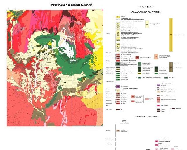
the validation of the data of diverse origins. This geological map (fig.1)-associated to it- was also
elaborate to define and represent the natural limits of the Iullemeden Aquifer System and to
integrate the information and data collected. A Digitized Plot Model of plot (DPM) was issued
and covers the totality of the basin.
Figure 1 : geological map of the basin
III.1.2. Trans. Broder Diagnostic Analysis
The identification and the evaluation of the transboundary risks were carried out through the
process of the TDA/SAP (transboundary Diagnostic Analysis/Strategic Action Program) adapted
to the transboundary groundwaters of the IAS. The TDA is a technical and scientific process of
study of the facts (or of diagnosis) of the state and the treats to international waters. Its
objectives are:
· Identify, quantify and set the priorities to the environmental problems with a transboundary
characteristic
·
Identify their immediate, sub jacent and real causes.
The identification of the causes includes: the practices, the sources, the places and the human
activity sectors cause the environmental deterioration
When possible, the national comities of coordination and follow up of activities and the experts
of the countries concerned must do the job but the regional experts are frequently sought to
7
highlight the use of a better available independent expertise. This analysis is carried out in a
trans. Sectary way focusing on the problems handled in a transboundary way without ignoring
the national concerns and priorities. This analysis would be more efficient and durable if it
includes the detailed analysis of the governance which studies the local institutional, legal and
political.
At the end of the national comities' activities supported by the contributions of the consultants
and the organisation of the national workshops, three major transboundary risks were identified2:
1. The reduction in the water resources availability: this is about the the drop or the rarity in
the potential of the groundwater resources, resulting from the combined effects of the
progressive abstraction and the drop in the aquifers recharge caused by the drop in the
rainfall, the sanding up of the water infiltration surfaces, and the sanding up of the river
Niger hydrographic net which is supplied by the IAS groundwater aquifers and some
places- supplies the aquifers in periods of high waters.
2. The deterioration of the water quality: it is identified to the pollution of the groundwater
due to the wastewater disposal and-locally- and to the aquifers highly mineralized
(Fluorides).
3. The variability and/or climatic changes: this major concern, frequently defined as
<<climatic change/variability>>, is at the same time the cause and the consequence of
certain situation.
The countries and the national experts supported by the OSS team, focused on these three
major concerns through national workshops. This led, for each of the three major risks, to the
identification of its environmental impacts on its socio economic consequences, and to the
identification and analysis of its causes (immediate or primary and fundamental.) integrating the
analysis of the water governance.
However, after identification, analysis and evaluation of these major risks, the transboundary
Diagnostic Analysis, at this stage, does not equip the countries with elements to help better plan
the use of their common water resources.
The transboundary Diagnostic Analysis is a dynamic process which requires an improved
specific knowledge of the aquifer system hydrodynamic functioning, in order to:
- Clearly quantify the availability of the geographically well-identified water resources and
the conditions of their uses.
- Have indicators to help follow the evolution of the resource as to the changes it
undergoes.
Some management tools are necessary for the analysis of data and its processing. We need:
- A data base including the specific information necessary to quantify the water resources
and its uses.
- A Geographic Information System to provide a geo referenced representation of the
available information as well as its different varying states in time.
- A hydrogeologic model to quantify the water resource of the aquifer system and to
undertake prospective simulations.
2 OSS (Trans border Giagnostic Analysis of the Iullemeden aquifer system (IAS): Mali Niger Nigeria. OSS- Tunis,
March 2007, 97p
8
III.1.3- Data base and Geographic Information
The data collected within the limits of the system were processed, analysed, harmonized and
filed in a Data base common to the three countries. These data concern the characteristics of
the water sources capturing the Continental Intercalaire and Continental Terminal aquifers as
well as the rainfall, hydrometric, piezometric, and geological records and abstractions etc....
The Data base includes around 17 200 inventoried water points, with: 740 in Mali (4%), 16 170
in Niger (94%) and 300 in Nigeria (2%).
The IAS Geographic Information System (GIS), elaborated by the OSS, is linked to this Data
base. It is used for the processing and analysis of data and the elaboration of thematic maps in
order to visualize the information. This is the case among others of ten-yearly evolution
maps of the number of water sources, of piezometric maps, of transmissivity maps and maps to
situate the geological sections..
The collected data helped, on the basis of formulated hypotheses (concerning the demographic
growth, the livestock number and irrigated surfaces), to estimate the IAS overall withdrawls
(fig.2). these estimates show that the over exploitation line was exceeded in 1995, year when
the exploitation (152 millions m3) started to exceed the annual average recharge ( red line)
estimated at 150 millions m3/year by the mathematical model.
These estimates achieved with the help of the countries, are to be corroborated by exhaustive
and detailed inquiries of the exploitation of each of these works tapping the different IAS aquifer
levels.
III.1.4- The mathematical model
The IAS hydro geologic model of this project simulates the hydro dynamic functioning of the
system and quantifies its exchanges with the exterior. Before the modelling, the litho-
stratigraphic correlations were achieved and helped to define and characterize the geometry of
the system (fig. 3).the IAS was assimilated to a bi layer system (Continental intercalaire covred
by the Continental Terminal ).
Figure 2: Evolution of the abstractions in the IAS
9
The model was elaborated on the basis of these conceptual hypotheses, but also on those
relative to the withdrawls operated in the sources. The model correctly calibrated, reproduces
the hydrodynamic performance of the system.
Figure3: N-S section illustrating the depression structure of the SAI
The major results of this hydrodynamic modelling are the following:
· The IAS water assessment accuracy as to its equilibrium state (chart. 1). This assessment
shows that the renewable sources of the system are of 5 m3/s
(150 millions of m3/year). The majority of the support comes from the direct infiltration (3.29
m3/s at the level of the CT and 0.55 m3/s of the CI). The river Niger constitutes one of the
major natural outlets of the system draining about 120 millions m3/year, which represents
almost 80% of the IAS recharge. The leakage within the aquifer system between the CI the
CT, is relatively weak. The same inflow to the bordering basins (contribution of the northern
border: 0.29 m3/s)
· Highlighting and quantification of the exchanges between the aquifers and the
hydrogeographical courses (river Niger, Rima, Dallols). Hence, the river Niger receives
about 46 millions m3/year from the Continental Intercalaire and 79 millions m3/year from the
Continental Terminal ; or a yearly total of 125 millions m3. The Goulbi of Maradi, tributary of
Niger, contributes with almost 20 millions m3/to the Continental Intercalaire and receives
about 12 millions m3/tear from the Continental Terminal.
· Stressing the overexploitation of the water reserves of the aquifer system starting from
1995, year when the abstractions estimated a 152 millions m3/year exceeded the average
annual recharge of 150 millions m3/year (steady state, 1970).
· The evaluation of the piezometric drops resulting from the exploitation of the aquifer system
between 1970 and 2004 (34 years). During this period, the reduction of the piezometry was
10
of only 5m for the CT, which is relatively weak for this free, sub-confined aquifer. On the
other hand, at the level of the Continental intercalaire confined aquifer, the reduction of the
piezometry is more significant with 62m in 35 years.
Tableau 1: Assessment of the system in a permanent regime
Continental terminal
Entrances (m3/s)
Exits (m3/s)
Direct Infiltration of rainfall
3.29
River Niger
2.50
CI Drainage
0.013
Dallols
0.45
River Rima
0.35
TOTAL Entrances
3.30
TOTAL exits
3.30
Continental intercalaire
Entrances (m3/s)
Exits (m3/s)
Direct Infiltration of rain
0.55
River Niger
1.60
Northern Border Contribution
0.29
Drainage CT
0.013
River Rima
0.77
TOTAL Entrances
1.61
TOTAL exits
1.61
The results of the model helped us understand the complexity of the system, the necessity to
collect complementary data to refine the results in order to improve the knowledge of the
hydrodynamic functioning of the system and to understand the difficulties which were not clear
at the beginning and during the execution of the project.
On the basis of these results, the hydrodynamic performance of the system was simulated over
the period 2004 2025 by adopting "the hypothesis zero" which stipulates the constant
maintenance of the aquifer system exploitation equal to that of 2004 (180 millions m3/year). This
hypothesis is inescapable to estimate the additional reduction relative to the exploitation
increase expected after 2004. The results of this simulation show an additional reduction over
the period of 2004 2025, of 2m in the Continental Terminal and 10m in the Continental
intercalaire.
The simulation of several development hypotheses of the exploitation highlighted, for the same
period, the most vulnerable zones characterised by high reductions.
III.1.5- Follow up of the Trans border aquifers
The follow up of the IAS transboundary aquifers aims at characterising the regime of these
subterranean waters in the three countries concerned in order to provide the evolution of risks
which threaten these resources. The follow up is mainly about:
- The study of interconnection between surface and subterranean waters,
- The evolution of the exploitation in order to help the evaluation of its impact on the
decrease of the water resource availability,
- The evolution of the chemical quality changes of the water as to the anthropological
activity, changes and climatic variations.
11
In order to make this follow up an efficient operation basis, an evaluation of the current state of
the available net in these countries was undertaken. This revealed that the monitoring of the
aquifers is only partially ensured in Mali, as to the piezometry. This relatively recent monitoring,
was implemented after the 1970-1988 periods of droughts, within different projects of creation of
boreholes. This net concerning mainly the river Niger basin, could not be managed by the
administration to ensure the continued existence of the measures.
In Niger, the piezometric monitoring net is relatively well structured and ensured by the Hydraulic
regional services. This net is characterised by the variability of the frequency of the measures.
The interpretation of the data is only undertaken for certain studies.
In Nigeria, there is a lack of the groundwater monitoring net. The inventory of the water points is
conditioned by the activities of drilling creations within the project including several towns or
natural regions.
On the whole, the IAS aquifers benefit from only a circumstantial monitoring which does not
ensure a good evaluation neither of the exploitation nor of the piezometric drop, or of the quality
changes of the water.
One of the major tasks of the consultation mechanism to be implemented between the three
countries concerned by the IAS management is to implement, at the best delays, a monitoring
net to ensure the following:
- The monitoring of the piezometric evolution and the water quality.
- The periodic quantification of the water abstractions in order to actualise the model's data
and the impact of the transboundary risks.
The document issued by the OSS for the organization of the regional workshop on the IAS3
aquifer monitoring (Niamey, 8-10- February.2008), can be used as a basis for this follow up. To
ensure the restructuring of the follow up net in the basin parts of each of the three countries we
can refer to the hydrogeologic4 modelling results which present piezometric reference points
used for the wedging of the model.
We really need to reinforce the monitoring of these aquifers in order to actualise and refine the
management model of the Iullemeden aquifers. It is vary important to ensure a better evaluation
of the exploitation of each aquifer level and to classify this exploitation as to the aquifers (CT1,
CT2, CT3, Cs, Ci1, Ci2,...), of the type of water sources (wells, drilling, conter-well, spring,...) and
of the water use (water supply, livestock, irrigation, industry...).
III.1.6- the remote sensing contribution in the management of the groundwaters
Within the initiative TIGER and with the incentive of the OSS, the ESA chose the bith basins:
NWSAS (Algeria, Tunisia, Libya) and Iullemeden Aquifer System (Mali, Niger, Nigeria) (fig.4) to
concretise its engagement to support the implementation of the Johannesburg action plan. After
call for tender, the ESA selected the GAF for the implementation of the project, the OSS being a
technical partner and ensuring the coordination between the final users.
3 OSS (2007): Trans border follow up of the aquifers: methodological Guide Book, OSS-Tunis, DEC.2007,32p
4 OSS (2007): Hydro geologic model of the IAS. OSS-Tunis, DEC.2007 74p
12
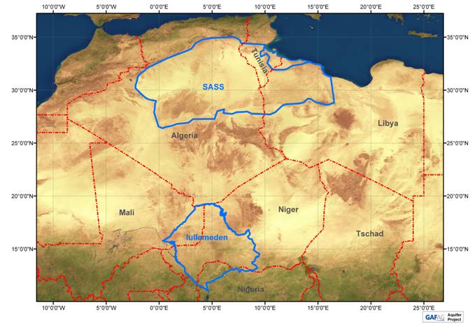
Figure 4: situation of the NWSAS and IAS basins
The general objective of the aquifer project is to show the importance of the products or services
based on the data issued by the observation satellites which help national and regional
organisms in the monitoring and transboundary management of water resources of the shared
aquifers.
The activities of this project dealt with the use of the satellite imaging for the elaboration of a
series of thematic maps and a Plot Digitised Model (PDM). The major maps issued concern:
- The map of occupation of plots on the pilot sites with the help of Landsat and Alsat
images,
- The map of surface water dynamics on pilot sites from ERS/SAR and ENVISAT/ASAR
radar images,
- The Plot Digitised Models, first on a pilot site (Banibangou) then on the scale of the IAS
basin from ERS/SAR radar images,
- The map of the IAS water assessment (aquifer recharge) issued from the evapo-
transpiration map and that of the IAS rainfalls for the year 2005 (fig. 5).
All of these maps were perfectly integrates to those issued by the GIS and the database and
constitute complementary information about the physical environment and the IAS climatic
parameters.
These maps adapt to the study of the Transboundary problems by bringing together the data of
the three countries. However, this cartographic approach which was adequate for the
highlighting of the different Transboundary situations, require land data in the countries to grade
the results obtained. It is highly recommended that this cartographic activities based on satellite
imaging be developed and integrated into the GIS of the IAS.
13
Figure 5: Water system assessment
#
S
#
S
đ
#
S
#
S
đ
đ
đ
đ
đ
đ
#
S
#
S
đ
#
S
#
S
đ
N
đ
#
S
#
S
#
S
#
S
0
100
200
300 Kilometer
#
S
đ
#
S
đ
III.2- IMPROVEMENT OF THE TECHNICAL CAPACITIES IN WATER RESOURCES
MANAGEMENT
The improvement of the technical capacities of the national specialists related to the national
institutions of the three countries in charge of the IAS water resources management aims at
reinforcing their planning and follow up methods and approaches of these resources in the
future. This reinforcement was undertaken by the OSS through:
- The reinforcement of the computing equipment,
- The provision of new management tools (software, digitised maps, GIS, Database and
hydrodynamic model),
- Te reinforcement of the human capacities to use these news tools through training and
recycling.
The effort was mainly focused on the reinforcement of the management capacities of the
national teams. This reinforcement activity should be more supported in the future. Indeed, the
technical executives concerned on the central administration scale as well as that of the
departments, have only a basic knowledge of the tools developed and the protocol of inventory
or of the groundwaters follow up. There is a strong need here to quantify the water abstractions,
ensure the piezometric monitoring of the groundwater and be able to answer questions relative
to the exploitation of these aquifers.
The new management tools of the groundwaters provided to the countries, mainly the database,
the GIS and the hydrodynamic model, need to be perfectly controlled by the uses, to be efficient.
The training given in the first stage of the IAS project was limited and did not ensure this
complete knowledge or its expansion to the technicians of the departments and other partners
concerned by the management of these water resources.
14
IV- PROSPECTS FOR THE IMPROVEMENT OF THE MANAGEMENT
The evaluation of the Transboundary risks which threaten the IAS water resources is an
operation which helped understand the complexity and the importance of these variable risks
from one country to another. However, the appreciation of these risks is, at this stage, relatively
global and necessitates complementary information through investigations in the national
archives, and a collecting of data, to improve the aquifer system follow up and the different uses
of the water resources. Indeed:
The IAS hydro geological model within the project is global. It needs to be improved by taking
into consideration all the IAS aquifers to clarify the water assessment terms and provide the
evolution of its parameters. On the conceptual level, the aquifer system structure was simplified
and reduced to two major aquifers: the Continental Intercalaire (CI) and the Continental Terminal
(CT). Each of these is made up of several aquifers and expands in the taoudeni-tanezrouft
basin. But the current state of the available data does not help to undertake a finer modelling of
the aquifer system's structure. It is clear that the needs of these countries necessitate a more
detailed modelling structure of the aquifer system which can be undertaken only on the basis of
new data.
Besides, the study of the IAS Transboundary risks show the close link between this IAS and the
river Niger and one of its tributaries. The main stream of the river Niger plays the role of a
natural release of the IAS which it covers on almost 600km. this river also crosses in its
upstream, the Taoudeni basin on almost 1700km where it forms an interior delta in its plain of
flood. This close hydraulic bond is largely influenced by the variation of the hydraulic regime of
the surface waters as well as that of the rainfalls in the region. These two regimes underwent,
during these last decades, significant variations which had an effect on the aquifer system
recharge, by the increase of the piezometric drop. The tendencies of this evolution for the next
years, are the basis of the appreciation of the aquifer system water availability.
Consequently, the IAS studied domain must be extended to the Taoudeni-Tanzrouft basin to
improve the state of knowledge of this expanse largely covered by the watershed of the river
Niger and meet the expectations of the countries. This superimposition ensures a better
integrated management of the surface and ground waters and provides the developed
management tools with consolidation elements making them more performing. This study can be
undertaken only in the scope of a second phase of the program.
This document elaborated by the OSS and called "integrated and joint management of the IAS
water resources, Taoudeni and river Niger (Algeria, Mali, Mauritania, Niger and Nigeria5)", give
the OSS vision to start phase II of the IAS project. It will help to improve the acquisitions of the
previous stage and to start a Strategic Action Program (SAP) in order to control the Trans border
risks. This study will help:
· update the data and information on the Taoudeni aquifers through the development of a
common database which will first be used in the countries concerned, then in the inter
systems problems.
· Clarify the hydraulic relations between the river Niger with its interior delta and the
Taoudeni aquifers.
· Clarify the conditions to limits of the IAS model already elaborated and which entrances
need to be refined.
5 OSS (2008) : Joint Management of the IAS water resources, Taoudeni and River Niger (Algeria, Mali, Mauritania,
Niger, Nigeria). OSS-Tunis, April 2008, 16p
15
· Elaborate local models in the IAS to show the capacities of each aquifer within the
Continental Intercalaire and the Continental Terminal.
· Evaluate the exploitable water resources from the common database and a geographical
information system to elaborate a model of the whole Taoudeni-Iullemeden-River Niger.
· Provide a Trans border Diagnostic Analysis of the Taoudeni aquifer systems according to
the TDA and SAP of the FEM process "International Waters" while improving the TDA of
the IAS so as to elaborate a TDA then a SAP of all the systems.
· Start the socio economic studies and the studies of environmental impacts which will
help show the zones vulnerable to the risks identified and quantified.
16
CONCLUSION
At the end of the activities achieved over the period 2006-2008, both the scientific and technical
results and products expected were obtained.
This is about the Transboundary Diagnostic Analysis, the common management tools
(Database, Geographic Information System, and Hydro geologic Model), of the document for
the monitoring for the Transboundary aquifers, the characterisation of the aquifers by means of
hydrochemistry and isotopic hydrology by maps obtained through remote detection. Moreover
the capacities of the technical executives of the national institutions in charge of the water
resources management were reinforced, mainly, in hydro geologic modelling.
These results and products helped us to understand the complexity of the Iullemeden aquifer
system, its close hydraulic relations with the river Niger and the Taoudeni basin on one part,
and the necessity to move to a second stage of the project to improve the knowledge by
integrating the Taoudeni-Tanerouft aquifer system and the river Niger and meet the
expectations of the countries by an optimum management of their common resources, on the
other. An identification document of the project of phase 2 was elaborated by the OSS by
responding to the needs of the countries to ensure a better completion of the activities
undertaken.
17