Nubian Sandstone Aquifer System (NSAS)
Technical Baseline Meeting
May 8- 12, 2006
Vienna, Austria
IAEA RAF/8/036
in the frame of the
IAEA/UNDP/GEF Nubian Sandstone Aquifer System Medium Sized
Project
April 13, 2007
1
TABLE OF CONTENTS
1. Introduction
2. THE MEETING
3. Country Reports
3.1. Chad
3.2 Libya
3.3 Sudan
3.4 Egypt
4. REVIEW OF CURRENT TECHNICAL KNOWLEDGE OF
THE NSAS AND IDENTIFICATION OF KNOWLEDGE GAPS
4.1. Introduction
4.2. Hydrogeology of the NSAS
4.3. Review of past isotope hydrological studies on the NSAS
4.4. Recent studies of the Nubian Aquifer (Western Desert, Egypt)
4.5. Recent 14C results on the NSAS in Libya and in Egypt
References
5. Overview of Data Gaps and Strategy for Fil ing Them
6. COMPILATION OF THE NATIONAL WORK PLANS SET
UP DURING THE MEETING
6.1. NATIONAL ACTION PLAN CHAD
6.2. NATIONAL ACTION PLAN LIBYA
6.3. NATIONAL ACTION PLAN SUDAN
6.4. NATIONAL WORK PLAN EGYPT
7 Nubian Shared Aquifer Diagnostice Analysis
8 CONCLUSIONS AND RECOMMENDATIONS
8.1. Conclusions
8.2. Recommendations
Annex 1 Agenda of the meeting
Annex 2 List of participants of the meeting
2
1. Introduction
At the Second Coordination Meeting, held within the Regional Project RAF/8/036 on Sustainable
Development of the Nubian Aquifer in December 2005 in Cairo, Egypt, it was emphasized that
"one chal enge in developing an adequate management strategy is to gain suf icient knowledge
about the aquifer to develop a rational use of the resources that can benefit the four countries". It
was pointed out that there are stil critical data and subsequently knowledge gaps of the NSAS.
Consequently, it was requested to col ect and assess al existing data and information to clarify the
"baseline" situation of what is known and what is not known. Thus, a technical meeting was
recommended to be organized by the IAEA in Vienna in May 2006, to establish the "baseline"
technical knowledge and design isotope investigations aimed at fil ing the data and knowledge
gaps. The participating countries were asked to continue with col ecting samples to be delivered for
isotope and chemical analyses and to provide necessary background information for the database
and the assessment of the available data to the Agency as essential input to the technical baseline
meeting.
In preparing the meeting, the four participating countries were requested to provide in advance a
national report that includes a synthesis of al relevant technical information at the national level
and a copy of the national part of the NARIS information system. Furthermore, the participating
countries were informed that the technical baseline meeting would pursue the fol owing objectives:
Review and synthesize cur ently available technical information, with a focus on isotopic
data, as a basis for updating the "baseline" knowledge of NSAS system;
Determine important information gaps that need to be fil ed in order to bet er understand
and assess transboundary issues;
Consider strategies (sampling, monitoring etc.) that could ef ectively and ef iciently lead
towards fil ing these gaps;
Develop concrete next steps for fil ing gaps in the frame of the IAEA's co-funded activities
for isotope analysis in the IAEA/UNDP/ GEF Nubian Aquifer and in particular to support
the development of a "Shared Aquifer Diagnostic Analysis (SADA)"
Final y it was highlighted that the fol owing results/outcomes of the meeting were expected:
Enhanced technical understanding of the NSAS, increased knowledge on both determined
and potential transboundary issues;
Bet er understanding of important knowledge gaps as wel as needed activities e.g.
sampling/ monitoring to fil the gaps;
Agreement on approach for synthesizing and managing data in the frame of the project;
Clear approach for isotope studies to support the development of the SADA.
Sampling strategies for inclusions into 2006/07 work plan(s).
The meeting succeeded in clarifying the cur ent baseline knowledge of the NSAS. The important
knowledge gaps were identified and strategies for fil ing the gaps were discussed. This led to
sampling plans for the respective countries for 2006- 2007. Some preliminary discussions were
held concerning the approach for data management in the project as wel as developing necessary
links to past activities and existing databases (NARIS.) Discussions were begun on how future
3
sampling campaigns could be used to support the SADA (Shared Aquifer Diagnostic Analysis) and
SAP (Strategic Action Programme) processes. Unfortunately, Egyptian representatives were not
able to at end the meeting. However, information was subsequently provided and included in this
report.
Discussions related to the Nubian Baseline were subsequently continued during the Nubian
Inception Meeting that was held in Tripoli, Libya July 16-20, 2006. The sampling strategies were
also presented by each country again, in some cases updated since the Baseline Meeting in May.
These updated sampling strategies are at ached.
Final y, it is clear that continuous ef orts must be made to improve the baseline of information and
the participants underlined their commitment to undertake technical investigations necessary to
improve the knowledge base needed for ef ective management of the NSAS. The added
information along with renewed analysis ef orts (model ing, SADA process etc.) wil improve the
baseline thereby providing a bet er basis for sound management.
2. THE MEETING
The meeting was opened by welcoming remarks of Mr. A. Boussaha, Director of Division for
Africa, Department of Technical Cooperation, and Mr. P. Aggarwal, Head of the Isotope
Hydrology Section, IAEA. They highlighted major objectives and expected outcomes of the
meeting and informed that the Egypt counterpart was unable to at end the meeting. After adopting
the revised Agenda of the meeting, the participants elected Mr. Mohamed Al Hassan Ibrahim,
Sudan, as Chairman, Mr. Yves Travi, IAEA Expert, Co-Chairman, and Mr. K. Froehlich, IAEA
Expert, as Rapporteurs for the meeting. The Final Agenda and List of Participants of the meeting
are given in the Annexes of this report.
Fol owing detailed background information on the IAEA/ UNDP/GEF Nubian Project Preparation
and on the scope and objectives of the meeting given by Mr. A. Garner, Technical Of icer and Task
Manager for the project, the cur ent technical knowledge of the NSAS was reviewed by
presentations and discussions of national reports. These reports were presented by Mr. Lotfi A.
Madi, Libya, Mr. Noe Reouebmel, Chad, and Mr. Mohammed El Hassan Abu Buker, Sudan and
are highlighted in Section 3 of the report. Fol owing these country presentations, Mr. K.Froehlich
presented a "Review of cur ent technical knowledge of the NSAS and identification of knowledge
gaps" to which Mr. S. Kebebe, IAEA, contributed GIS figures and data from the ISOHIS. Based
on both the national presentations as wel as these subsequent technical presentations and the
ensuing discussions and additional information provided, the cur ent technical baseline has been
summarized in Section 4 of this report.
During the second half of the meeting, special technical aspects were discussed; in particular an
overview of NARIS was given by Mr. Lotfi A. Madi, Libya. Gaps in knowledge as wel as
strategies for addressing gaps were discussed. Mr. Garner presented the approach for developing
Nubian Shared Aquifer Diagnostic Analysis (SADA) as wel as the Nubian Shared Action
Programme (SAP.)The national work plans focusing on transboundary issues and on fil ing
respective data and knowledge gaps were set up in working groups, fol owed by plenary
discussions.
3. Country Reports
4
The country reports have been given in form of power-point presentations; a copy of these
presentations is available from the technical of icer of the project. Here aspects relevant for the
fol ow-up activities in the countries are summarized.
3.1. Chad
In the area of north-eastern Chad, there are "several lakes and areas of shal ow groundwater
with palm tree exploitation and a high biodiversity. A severe water table decline could provoke
environmental and agricultural problems as already observed in the Kufra oases. The cur ent
project together with the MSP could help to address these issues and provide options for how
best to manage these areas in a sustainable way for future generations without further damage.
At the regional level, isotopic investigations could determine the role of the Tibesti Mountains
in recharging both the Chad and Libya parts of the Nubian Aquifer. In the same way, the
hydrodynamic connection between the two sub-basins could be studied. It was also pointed out
that 18 boreholes, dril ed by Libya, could be sampled in the first instance. ....... it would be
necessary for Chad to start car ying out an accurate inventory of the wel s and the boreholes
which are available for sampling. Libya wil provide some information on boreholes dril ed
along the transboundary road." (the above three paragraphs have been taken from the report of
the Cairo meeting in December 2006, because they give the background for the further
activities including the forthcoming missions and sampling campaign to fil gaps.)
Chad only recently joined the IAEA as a member state and cannot refer to previous isotope
studies in the area near the Libyan, Egyptian and Sudanese borders. They need substantial
support by the IAEA and participating countries, particularly from Libya with regard to
delineating and establishing transects along infer ed hydraulic gradients from Chad, crossing
the border to Libya and further north in Libya.
Near the border between the two countries there is supposed to be a watershed. This subject
deserves special at ention and ef orts, in particular a more detailed geological cross section and
maps of the piezometric head distribution should be made available.
3.2 Libya
An overview on the activities car ied out within the ongoing project has been given and the
results of the sample analyses presented. Reference was also made to past German and Libyan
isotope studies including 14C and noble gases. From these studies it was concluded that
(1) deep groundwater in Al Kufra and Sirt Basins is mostly older than 15 kyr B.P.;
(2) the ages of shal ow groundwater range from a few kyr. To 14 kyr. B.P.;
(3) 14C ages do not show a clear trend of increase in age northwards;
(4) palaeo-temperatures infer ed from noble gases appear to be about 1 to 2 ░C below the
present annual averages.
The figures shown by the presentation included a 2H - 18O plot of the samples taken within
the framework of the ongoing project, geological cross sections and logs from boreholes in the
Kufra basin. One of these geological cross sections is the fol owing:
5
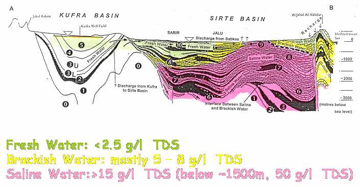
Groundwater salinity in the Kufra and Sirt basins
Libya has the logistics available for selecting and sampling wel s for transects along hydraulic
gradients from the border to Chad towards north, from the border to Egypt in west-east
direction, and towards Sudan as wel as from Uweinat (recharge area) to north or north-west.
Sampling from wel defined depths in the NAS and PNAS can be car ied out using available
wel s that tap dif erent parts of the respective aquifers.
Libya is planning to car y out sampling of soil profiles for determining present-day recharge (if
any!) in suitable areas (e.g. Uweinat). The assistance requested from the IAEA is particularly
related to this soil sampling since so far no experience in this field is available in the country.
3.3 Sudan
There have been several projects in the past on the use of isotope techniques in the water resources
of Sudan. The report presented to the meeting focused on the NSAS in the region of North Western
Sudan, re-emphasized the objectives and planned activities of the Sudanese part of the ongoing
project and addressed briefly some basic technical aspects of the NSAS in Sudan. In this
connection, some remarks on the evolution of the Sahara Basins and the Nile River were made, and
an overview of the groundwater quality and results of the environmental isotope application in
groundwater studies was provided. General y, the groundwater quality in the Nubian aquifer has
been considered to be good. The majority of the analysed groundwater was characterized as Ca +
Mg HCO3 and Ca SO4 water; a few samples have found to represent Na (SO4+Cl) water. Since the
start of the technical cooperation with the International Atomic Energy Agency, many water
samples have been analysed for stable isotopes (2H & 18O) and radioactive isotopes (3H & 14C).
An example of these isotope studies has been demonstrated. It was shown that the mixing between
Nile water and pluvial groundwater near Dongola could be studied applying the isotopes 3H, 18O
and 2H. It was found that the infiltration of Nile water to adjacent groundwater is limited to a
distance of about 35 km from the Nile River. Furthermore, diagrams of 2H versus 18O for water
samples col ected during the years 2002, 2003 & 2005 were shown, which demonstrated that there
are two end-members of the mixing: the Nile water with highly enriched (upper right) and the old
water highly depleted in stable isotopes. Between these two end-members water of various degrees
of mixing exist. 14C analysis on some groundwater samples indicated old water with ages of 23
kyr. B.P. (Mehala 2) and 27 kyr. B.P. (Mehala1). Nubian aquifer water of younger ages has also
been found.
6
Apart from the recharge by the Nile River, also recharge at the southern boundary of the NSAS
(Umm Kedada Basin) has been addressed in the report. These studies have been car ied out within
a German-founded project ( A. Suckow et al. (1992). The long-term averages of the recharge rate
estimated from the measured isotope data were found to be 25mm/yr and 1.5 mm/yr., respectively.
Concerning the ongoing project, there has been sent to the IAEA which is already included in the
IAEA `s ISOHIS database. However, like in the other NSAS countries, isotope data is missing so
far in the transboundary areas. The working groups have identified necessary sampling sites and
sampling activities (see Annex). The geographic coordinates for the sampling sites have been
included in an excel file which is available from the IAEA Technical Of icer upon request.
3.4 Egypt
Egyptian col eagues were not able to participate directly in the meeting. Their inputs were provided
in discussions after the meeting.
Review of available isotope data
Isotope techniques and their applications in hydrological studies have been used in Egypt since the
early 1960's. During this time many investigations have been car ied out covering the dif erent
fields of isotope applications (groundwater recharge, evaporative discharge, surface water-
groundwater relationships, lakes studies, salinisation and pol ution studies). Recently, with IAEA
and national authorities assistance, an isotope hydrology laboratory has been established where the
dif erent isotopes (O-18, D, T, C-14, C-13, N-15) are measured and analyzed. This is routinely
evaluated by IAEA. Most of the investigations car ied out using isotopes in Egypt were
concentrated around the Nile val ey and Delta. However, the NSAS which is the target of this
meeting was subject of some studies which are il ustrated in the presentation as case studies,
Sonntag et al. 1987 and 1983, Aly et al. 1988, Awad et al. 1988, Swailem et al., 1998, Taher et al.,
2000, Sadek et al. 2001, Abd El-Samie et al. 2000, Aggour et al. 2001).
The isotope studies on NSAS refer to the main recharge of the NSAS during the late Pleistocene
and early Holocene. The radiocarbon ages indicated that the groundwater col ected from Kharga,
Dakhla, Farafra, Bahariya Oases, as wel as Darb El-Arbaen and Toshka area, vary in the range
between 20 to 50 kyr. B.P. Groundwater from Uweinat area is of Holocene age. The seepage of
surface water from Lake Nasser (High Dam Lake) is indicated in the adjacent area of the Western
Desert to a distance of from 10 to 50 km depending on the structural and hydrogeological
conditions. Evaporation trends af ect this palaeowater where the water table is shal ow. There is a
possibility of finding deeper zones of recent recharge that mix with the whole volume of the water
under pressure.
The groundwater of the NSAS in the Eastern Desert and Sinai is general y more enriched in heavy
isotopes than in Western Desert. In the Eastern Desert and Sinai the aquifer system receives cur ent
recharge from precipitation on the aquifer outcrop areas and the sur ounding hil s. In some places
of Sinai and the Eastern Desert where structural, geomorphologic, or stratigraphic elements stop
recent rain from reaching the aquifer, the isotope values are lower and thus similar to the ones
observed in the Western Desert.
Within the program of the project RAF/8/036, two sampling campaigns have been undertaken; the
first took place in December 2003 at Toshka where 44 groundwater samples were col ected. During
7
the second campaign in December 2004, 26 groundwater samples were col ected from Darb El
Arbien and East Uwienat. To date, a total of 60 samples have been analysed for chemical elements
(major and trace elements) and stable isotopes. (see Annex 5)
Information gaps
Further investigations are needed using the radioactive isotope (14C). Sometimes there are
only a few samples for an area that has been investigated. Future sampling must be co-
ordinated at the regional scale to obtain transects along infer ed hydraulic gradients.
Groundwater stratification has practical y not been tackled although new multi-level
observation wel s (8 in Uweinat, 5 in Darb Elarbien and 25 in Toshka) are available. The 3rd
sampling campaign wil cover these multilevel wel s in Southern Egypt (50 samples for 14C
& 13C) in the period from August to September 2006; and the 4th sampling campaign wil
cover these multilevel wel s at the northern Oases Kaharga, Dakhla, Farafra, Baharya and
Siwa (50 samples for 14C & 13C).
Estimation of the evaporation from the NAS especial y at natural discharge areas (shal ow
groundwater level) south Darb El Arbien, Toshka and El Qat ara depression at the Northern
region of the Western Desert.
4. REVIEW OF CURRENT TECHNICAL KNOWLEDGE OF
THE NSAS AND IDENTIFICATION OF KNOWLEDGE
GAPS
4.1. Introduction
This review is based on the reports presented at the meeting and considerations in preparation of
the meeting.
The present knowledge on the NSAS is to a great extent based on extensive geological,
hydrogeological and isotope-geochemical studies car ied out in the 1970s and 1980s, including
those conducted within the long-term German-funded SFB-project (TU Berlin) in Egypt (Toshka,
Dakhla, Bahariya, Farafara) and Sudan (Darfur and East Kordofan) and by the BGS in Libya in the
Sarir and Kufra basin in Libya (Brinkmann et al., 1987; Wright and Edmunds, 1971). Also, a more
recent compilation of the knowledge on the NSAS by CEDARE (2001a) is based on these studies.
The focus of these previous studies was dif erent from the one of the present project, and thus, the
knowledge of the geology and hydrogeology of the aquifers crossing the borders between the four
countries needs to be improved for a shared use of the groundwater resources of the NSAS. The
fol owing brief overview of the geology and hydrogeology of the NSAS is based on these earlier
studies summarized in the CEDARE led project (2001a).
4.2 Hydrogeology of the NSAS
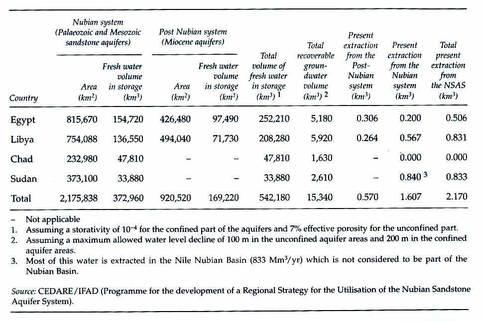
The NSAS covers an area of about 2.2 mil ion square kilometres and is shared by the countries
Chad, Egypt, Libya and Sudan. Table 1 and Fig.1 summarize and respectively demonstrate recent
data and features characterizing the system. A three-dimensional schematic diagram of the Nubian
8
is shown in Fig.2 il ustrating the mountainous areas, depressions and the stratification of the
system.
Table 1: Essential data of the Nubian Sandstone Aquifer System (From Salem and Pal as, 2001)
There are two aquifer systems to be considered under the term NSAS, the Nubian Aquifer System
(NAS) and the Post Nubian Aquifer System (PNAS). The NAS (extended over Egypt, Eastern
Libya, Northern Sudan and Northern Chad) consists of clastic sediments (mainly sandstone)
forming aquifers, confining layers and aquicludes and is of Cambrian to Cenomanian age. It
overlies the Pre-Cambrian basement complex. The PNAS extends over North Eastern Libya and
the northern region of the Western Desert of Egypt and is represented by marine sediments (mainly
clay, marl and limestone) overlain by clastic sediments. The age of the PNAS ranges from Upper
Cenomanian to recent.
The two parts (NAS and PNAS) are separated by low permeability layers of Upper Cretaceous to
Lower Tertiary. The contact between the two parts is characterized by local discordances with open
windows between the sedimentary sequences (either due to non-deposition or Tectonic structures)
and reduced thickness of the Upper Cretaceous-Lower Tertiary deposits, which facilitates a direct
connection between the two aquifer systems. In the northern part the aquifer system becomes very
saline. South of 26░N the aquifer is unconfined.
A typical geological cross section through the Nubian aquifers from the outcrop at the basement of
Uweinat through the Kufra to the Sirte basin in Libya is shown in Fig.3, upper part. The lower part
of Fig.3 is a cross section through the Post-Nubian in Northern Libya. The main geological
formations and the cor esponding stratification of the Nubian and Post-Nubian are indicated in this
figure.
9

10


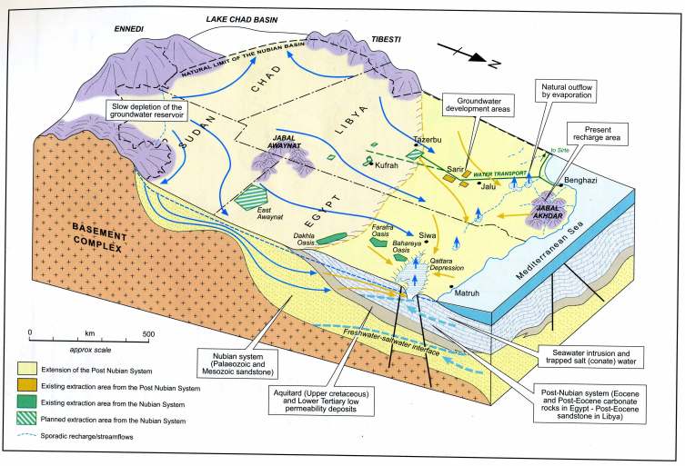


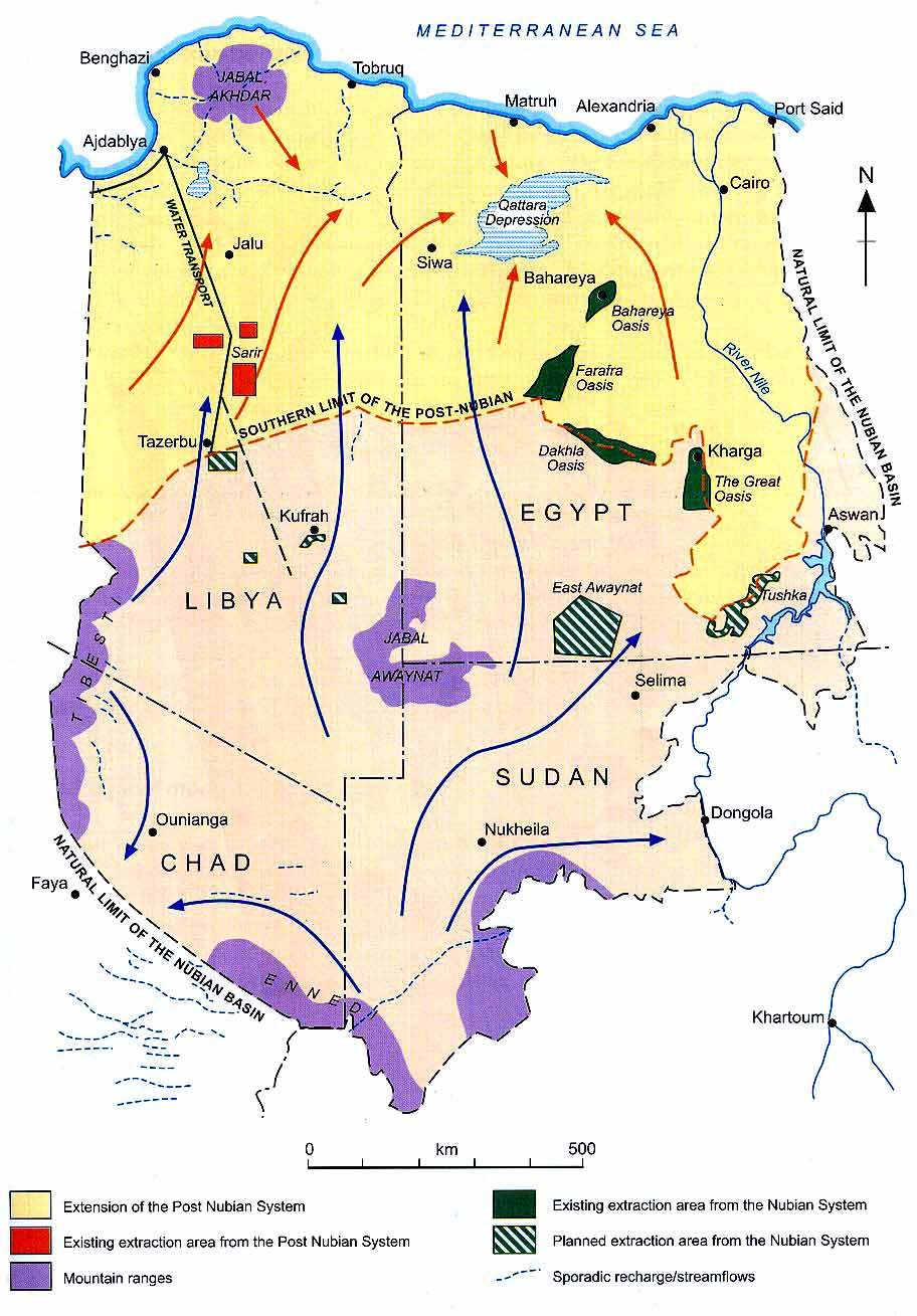
Fig.1: The Nubian Sandstone Aquifer System (From Salem and Pal as, 2001)
Fig.2: 3D-Diagram of the Nubian (From Salem and Pal as, 2001)
11
Fig.3: Simplified geological cross section through Kufra and Sirte basin in Libya (From Wright et al., 1982)
The NSAS has been recharged by local
rainfal during the past pluvial phases,
which are wel -known from palaeo-
climatic studies. The rainfal originated
from air moisture transported by west-
wind drift from the Atlantic source
regions to the eastern Sahara. The wet
episodes in the Sahara during the last 150
000 years are indicated in (Fig.4). The
major pluvial phase ended about 8000
years before present (B.P.) and was
fol owed by an about 4000 years semi-
arid phase. Since about
Fig.4: Global climate changes (indicated by the atmospheric
concentration of the greenhouse gas methane) over the last 150
kyr, and the pluvial phases in the Sahara. (After Petit-Maire, 1993)
3500 years B.P. a hyper-arid phase has been prevailing. Recent recharge by rain is virtual y absent,
although it is speculated that there is some present-day recharge by rain in the mountain regions of
Tibesti and Uweinat. This question of
present-day recharge by rainfal in these
areas (including southern area of Sudan)
constitutes one of the knowledge gaps
and thus is subject to detailed isotope
studies to be car ied out within the
ongoing project.
On the basis of this climate scenario, the
groundwater balance of the NSAS and
its groundwater flow regime have been
simulated for the first time by a
numerical model developed at the end of
the 1970s at the TU Berlin, Germany
(Brinkmann et al., 1987). Fig.5 shows
the calculated regional pat ern of the
groundwater flow regime before
intensive groundwater development took
place (about 1960.) There is a general
trend in the flow direction from southern
Sudan to the north of the region with
areas of convergence (discharge) at
depressions (oases) in Egypt and Libya
and of divergence (recharge) in
mountain regions (Uweinat and Tibesti).
Fig.5: Model ed groundwater flow directions (after Brinkmann
et al., 1987)
12
On the basis of this mode,l a new model was developed in the frame of the CEDARE led project,
which is presently used to predict future changes in the water balance and water quality of the
NSAS on both the regional and the local scale (CEDARE, 2001b). To further improve the
performance of the model, environmental isotope and geochemical data have shown specific
potential in constraining boundary conditions of the model and verifying model results in terms of
recharge and flow regime, mixing between aquifers and changes in groundwater quality.
4.3 Review of past isotope hydrological studies on the NSAS
Isotope and geochemical studies have been an integral part of earlier studies of the NSAS such as
the German SFB-Project (see e.g. Thorweihe and Schandelmeier, 1993) and work car ied out by
the BGS (Edmunds and Wright, 1978). The IAEA conducted the fol owing projects related to the
NSAS:
Project
Date
Project Title
Project site
SUD/8/002
Early 1970s Radioisotopes in Hydrology
East Kordofan; Darfur;
El Geizira
Kordofan; El Geizira,
SUD/8/004
Early 1980
and 1990s
Isotopes in Hydrology
Nile val ey between
Khartoum and Dongola
SUD/8/005
Early 1990s Use of isotopes in groundwater
Nile River and El
assessment
Geizira
EGY/8/016
1999 - 2003 Using isotope techniques to study Farafra and Bahariya
water resources
Oases
RAF8/010
1990s
Water resources in the Nile
The Nile Val ey in
Val ey
Sudan and Egypt
RAF8/022
Late 1990s Isotopes in groundwater resources The Nile val ey in
development
Sudan and Egypt
Sustainable Development and
The Nile Val ey in
RAF8/037
Ongoing
Equitable Utilization of the
since 2003 common Nile Basin Water
Sudan and Egypt and
Resources
up stream countries
The isotope and geochemical data as
wel as the related/relevant
hydrogeological information are being
col ected and included in the IAEA's
ISOHIS database. This database
presently comprises data from more
than 1000 samples from various
sampling sites. The distribution of al
sampling sites selected by the various
projects for isotope and chemical
analyses (Fig.6) clearly shows that a
considerable part of these sites are
Fig.6: Sites selected by previous IAEA and non-
IAEA projects, for which isotope and
geochemical data are available and which are
included in the IAEA-ISOHIS database (black
stars). Sites included in the NARIS data base of
CEDARE are marked by white points; sampling
sites of RAF/8/036 are represented by points in
pink.
13
located near the river Nile. The isotope and geochemical data of these sites have been useful for
studying Nile ş adjacent groundwater interaction, such as the possibility of river water infiltration
to the Nubian (with the risk of groundwater contamination) and, vice versa, discharge of Nubian to
the Nile. Although these investigations are important for understanding the flow-discharge-
recharge regime at the eastern boundary region of the Nubian, their relevance for specific
transboundary issues is comparatively limited. Some of the previously sampled sites/wel s are
suf iciently close to the border between Egypt - Sudan and Egypt ş Libya, especial y the ones at the
southern rim of the Dakhla basin. But in general there appears to be a gap in sampling sites
(production and/or observation wel s) to address transboundary issues.
The fol owing figures have been drawn to indicate gaps in this data to be fil ed by further sampling
and isotope and geochemical analyses within the
ongoing project.
Fig.7 points to the specific potential of 18O (and
2H) to address origin and mixing of
groundwater. The higher 18O values (larger
black circles) indicate surface water (e.g. Nile)
or mixing between surface and old groundwater.
In the northern part of Libya and Egypt, higher
18O values can also be due to mixing between
groundwater and saline water (including water
from the Mediter anean Sea). Low 18O values
indicate palaeowater, i.e. groundwater recharged
during last pluvial phases.
Fig.7: Distribution of 18O values (the size of the black
circles indicates the range of the 18O values).
Chloride and 18O values of groundwater from various sites in Egypt are compiled in Fig.8. The
chloride concentration of the groundwater ranges over three orders of magnitude. The low values
10000
below a few tens mg/l appear to characterize
recharge water; higher values are due to
leaching of salt deposits since most of them
are associated with about the same 18O
1000
content of the water. However, there are also
higher salinity values accompanied by
C
l
(
m
g
/
l
)
higher 18O values, indicating mixing with
100
saline water including Mediter anean Sea
water.
Among the various environmental isotopes,
10
radiocarbon (14C) is the most powerful in
-12
-11
-10
-9
-8
-7
-6
-5
-4
Oxygen-18 (o/oo)
studying recharge and flow of groundwater
Fig.8: Chloride concentration versus 18O of groundwater in Egypt.
14
within a time scale up to about 40 kyr. A vertical gradient of 14C can be interpreted in terms of
present and past recharge, and a 14C gradient in groundwater flow direction can be used to estimate
the groundwater flow rate. The knowledge of both recharge and flow rate is indispensable for a
rational management of the groundwater resource. Given the past and present climatic conditions in
the study area, the average recharge and flow rates are assumed to be rather low and, consequently,
the use of 14C requires a proper selection of the sampling sites, i.e. vertical profiles and transects
close to regions of major (past) recharge (e.g. Uweinat, Tibesti, Enneni ...).
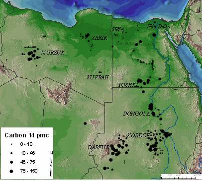
The spatial distribution of al 14C data presently included in the ISOHIS database (Fig.9) reveals
some regions with younger groundwater (higher 14C values), especial y in the southern part of
Sudan (Darfur, Kordofan) and Egypt (Toshka) and near the Nile. Whether this is an indication of
some present-day recharge remains to be assessed by further sampling and analysis of 14C.
Fig.9: Spatial distribution of 14C in groundwater of the NSAS (data
included in ISOHIS).
Fig.10 is a plot of al 14C values (included in ISOHIS) of the NSAS in Egypt versus depth. In many
1000
cases "depth" is the maximum depth of the
borehole and the groundwater sample can
assumed to be a mixture of portions from
various (unknown) depth intervals.
100
Notwithstanding this deficiency in knowledge
8 kyrs B.P.
of the depth interval from which the sample
has been taken, Fig. 10 al ows some useful
C
(
p
m
c
)
conclusions.
14
10
20 kyrs B.P.
(1) The 14C concentration is in many wel s
above the detection limit of about 1 pmC
Depth (m) (percent modern Carbon), even wel s more
1
than 1000 m deep. Thus, if sampling sites and
0
200
400
600
800
1000
1200
depths are appropriately selected, 14C data
ca Bahariya Kharga Dakhla Abu Munkar Farafra Western Desert Toshka
can provide unique information related
Fig. 10: Radiocarbon versus depth in groundwater of the NSAS in
Egypt (data included in ISOHIS)
15
to the recharge and flow regime in the NSAS.
(2) There is no systematic trend between 14C and depth, which suggests that the samples represent
mixtures between portions from dif erent depths. Assuming unconfined conditions with local
recharge during pluvial phases, the average (long-term) recharge rate (R) can be estimated by the
relationship: R = pH/T, where p = porosity, T = 14C age, H = thickness of the aquifer (depth of the
wel ). Assuming a depths between 500 and 1000 m and a porosity of 10%, a 14C age of >20 kyr.
(see dot ed line in Fig.10) would cor espond with an recharge rate of < 2.5mm/a (H = 500 m) or
twice this value if H = 1000 m is assumed. This simple estimation demonstrates the potential of 14C
in studying groundwater recharge (and flow) in the NSAS. To make ful use of this potential,
ef orts must be taken to select appropriate sampling sites and wel s, from which groundwater
samples from wel defined depths (regions) can be col ected.
(3) The assumption of distributed recharge over the region from Kharga to Bahariya is supported
by the fact, that in al these areas 14C above the detection limit has been found. Also this aspect
would be highly relevant for improving the knowledge about the NSAS and its rational
management.
(4) In some areas, especial y in Toshka, 14C has been found indicating late Holocene or even recent
recharge. This finding is relevant for the objectives of this project and deserves fol ow-up activities.
The few selected examples based on data included in the ISOHIS have shown that this database is
of invaluable significance for this project, in particular in connection with fol ow-up sampling and
analysis the to fil the gaps in data and information indicated above. In this context it should also be
noted that the NSAS, one of the world's largest aquifer systems, has been used to demonstrate the
application of a mix of isotope and chemical tracers to provide historical records of hydrological
and climate change before, during and after the LGM. In combination with stable isotopes (2H, 18O,
13C) and cosmogenic radionuclides (especial y 14C), noble gases and their isotopes (e.g. 3He, 4He)
have been measured in groundwater of this system to derive information an past climate changes
and its implications for the groundwater formation in the NSAS (e.g. Sonntag et al. ). Therefore, it
is suggested to consider integrating noble gases as a palaeowater indicator, if questions related to
such aspects may arise. Since the sampling of noble gases requires special techniques and
experience, such activities could be planned for a later stage in the project implementation.
Considering a groundwater velocity in the order of magnitude of 1 m/a, a groundwater parcel
would need 100 kyr. for a flow path length of 100km. Thus, the age of a major part of the
groundwater within the NSAS can assumed to be far beyond the upper limit of the 14C dating range
(about 40 to 50 kyr.). Therefore, more recently some at empts have been made to use radio isotopes
with half lives in the order of more than 100 kyr., in particular 234U/238U (half life of 234U = 245
kyr.), 36Cl (half life = 301 kyr.) and 81Kr (half life = 100 kyr.). In the fol owing section, the results
of these studies are briefly discussed.
4.4 Recent studies of the Nubian Aquifer (Western Desert, Egypt)
Dabous and Osmond (2001) found distinctive uranium isotopic signatures among the water masses
of the NSAS in the Western Desert of Egypt. They conclude that at Bahariya and Farafra Oases,
the Nubian artesian water that is migrating from the south has been augmented by local recharge
during pluvial times. At Dakhla, Kharga and Baris Oases, the main source is suggested to be water
moving from southeast Uweinat Upland and Sudan. From uranium isotopic mixing diagrams it is
concluded that "deep aquifer sources predominate; however, the pluvial contributions are
16
significant, ranging from about 5% at south-eastern Baris Oasis to about 26% at the more northerly
Farafra Oasis."
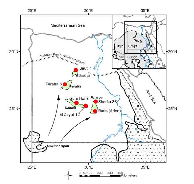
Sturchio et al. (2004) measured 81Kr/Kr ratios in deep groundwater from NSAS in Egypt by
extracting Kr gas from about 2-ton groundwater samples and applying a new laser-based atom-
counting method. The determined 81Kr groundwater ages range from about 200 kyr. to 1000 kyr.
(Fig.11) and cor elate with ages derived from 36Cl/Cl ratios of the same wel s. The authors
conclude that the determined ages are consistent with a lateral groundwater flow from a recharge
area near the Uweinat Uplift in SW Egypt.
In the same study area, the
radioactive chlorine isotope 36Cl,
the stable chlorine isotopes and
radiogenic noble gases (4He and
40Ar) were measured (Pat erson et
al., 2005) to determine the
residence time (age) of
10
groundwater in the Nubian
Aquifer of the Western Desert in
3.3
Egypt and to complement the
81Kr/Kr application (Sturchio et
2.1
6.8
al., 2004). From the 36Cl/Cl ratios
apparent residence times were
3.9
4.9
derived for deep groundwater
(600 to 1200 m) assuming
constant chloride concentration.
The obtained values range from
about 200 to 1200 kyr. For
shal ow groundwater (<600 m)
with higher chloride values the
estimated groundwater age has
Fig. 11: Sample locations (red circles) in relation to oasis areas (shaded
green), Precambrian basement outcrops (pat erned), and other regional
feature. Groundwater flow in Nubian Aquifer is toward northeast. Red
numbers = 81Kr age in 105 years. (After Sturchio et al., 2004)
been found to be about 160 kyr. The various unknowns
in calculating 36Cl groundwater ages in the Nubian
Aquifer (initial 36Cl/Cl ratio, Cl- content of recharging
waters, extent of the recharge area, and subsurface 36Cl
production) have been estimated making "informed
assumptions". For the subsurface and initial 36Cl/Cl
ratios reasonable estimates have been used. The
unknowns with respect to the Cl- concentration of the
groundwater could, to a large extent, be addressed
evaluating the measured distribution of the Br/Cl ratio,
the stable chlorine isotopes (17Cl) and the Cl-
concentration.
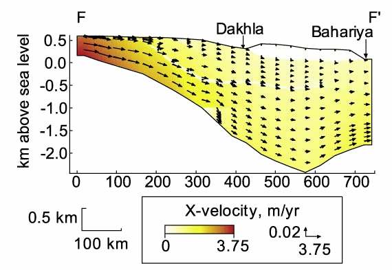
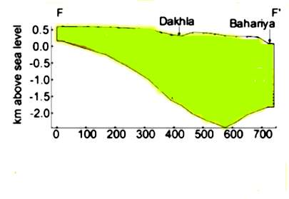
Fig.12: Model ed transect F-F' and groundwater flow directions
(ar ows) in the Nubian Aquifer. (From Pat erson et al., 2005)
17
The distribution of these parameters suggest that
"deep, dilute and up-gradient (Dakhla, Farafra,
Baris) samples demonstrate the predominance
of wel -flushed Cl-; shal ow samples show the
ef ects of evaporative concentration and
possible dif usion of Cl-; and where subsurface
addition of Cl- occurs, it is localized in areas
with thick shale beds or increased clay
percentage in the aquifer matrix.", respectively.
Radiogenic 4He accumulation was found to be
qualitatively consistent with the age progression
indicated by the 36Cl/Cl ratio. The production
Fig.13: The model ed groundwater flow velocities
(From Pat erson et al., 2005)
and accumulation of 40Ar within the aquifer was found to be minimal; the 40Ar/36Ar values do not
exceed the atmospheric ratio.
A two-dimensional numerical hydrodynamic model of the aquifer was constructed for a transect
from the area of the Uweinat Uplift to the northern Bahariya Oasis (Fig.12). The model assumes
that the flow regime is under a steady state condition, recharge enters the transect as base flow
through the left boundary and discharge occurs through the right boundary (Fig.13). Possible
recharge distributed over the (unconfined
part) of the aquifer has been disregarded.
Therefore, the simulated groundwater ages
are mainly a function of the distance along
the flow, and vertical age stratification is
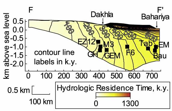
negligible (Fig. 14). Model parameters
(aquifer properties) have been estimated by
fit ing the measured 36Cl/Cl ratios to the
model ed ratios. In this way a reasonably
good agreement
Fig.14: Groundwater ages (residence times) predicted by the
model. Black squares indicate locations of wel s proximal to the
model ed transect. (From Pat erson et al., 2005)
between the ages calculated by the model and the ones derived from the measured 36Cl/Cl ratios
was reached (Fig.15). The authors conclude that "by mutual y calibrating multiple methods
(hydrodynamic, 36Cl, and 4He), a consistent picture of the Nubian Aquifer has emerged in which
lateral flow from a southern recharge area dominates the deep horizons, while shal ow horizons
contain younger, autochthonous recharge."
In summary, the recent at empts in dating groundwater in the Nubian Aquifer of the Western
Desert in Egypt, appear to have confirmed that groundwater in the NSAS reaches ages of hundreds
of thousand years covering several glacial and interglacial periods and respective pluvial and arid
periods. Nevertheless, these studies also leave gaps in understanding the flow and recharge regime
18
of the NSAS, especial y in the studied area in
Egypt. In particular, Pat erson et al. (2005)
assume, in their (conceptual) model, a rather
localized recharge area (Uweinat) in the south and
disregard distributed recharge along the transect.
This is in disagreement with the model developed
by the TU Berlin (Brinkmann et al. 1987) and the
upgraded version used by CEDARE. It is thus
suggested to consider an alternative approach in
addressing the NSAS' recharge and flow regime,
especial y in the Western desert of Egypt. The
fol owing simplified conceptual model may be
taken as an il ustration of such an approach.
Fig.15: Map of the Western Desert showing hydrodynamic
ages (black numbers) and 36Cl ages (red numbers). (From
Pat erson et al., 2005)
Recharge
Assuming that the geometry of the aquifer is
approximated by a triangle (Fig.16) and that
75 ka
porosity and permeability of the aquifer are
150 ka
constant within the aquifer, it can be shown by
225 ka
simple hydraulic considerations that the age of
Depth d/m
300 ka
the groundwater is a function of depth (Fig.
16), which appears to be in contrast to the
model used by Pat erson et al., (2005).
Age (depth) = porosity
depth/ recharge rate
porosity = 0.15, recharge rate = 1 mm/year
Fig.16: Simplified conceptual model with distributed recharge
along the transect selected by Pat erson et al. (2005)
The age values given in Fig.16 have been calculated assuming a porosity of 15%, which is typical
for the NSAS, and a recharge rate of 1 mm/yr. The order of magnitude of these ages cor espond
with the one of the values calculated with the measured 81Kr/Kr and 36Cl/Cl ratios by Sturchio et al.
(2004) and Pat erson et al. (2005), respectively. This shows that the assumed average recharge rate
represents a realistic figure, and the assumption of distributed recharge appears to be justified.
Recognizing that pluvial phases covered about 30% of the last 150 kyr. (Fig.4), the average
recharge rate during pluvial periods appears to be about 3 mm/yr., a value suf icient to top up an
aquifer in the order of 1000 years.
The model represented by Fig.16 has also important implications for the applicability of 14C to
determine groundwater recharge (and flow) rates. For an upper limit of the 14C dating range of 40
kyr., the above relationship yields a depth of about 300 m cor esponding with the detection limit of
14C.
19
Ě Therefore, samples for 14C determination (together with 13C and other relevant chemical
parameters) should be taken at various depths between 0 and a few hundred metres.
Ě In addition to depth specific sampling, also samples should be taken along transects
established on the basis of conceptual models.
4.5 Recent 14C results on the NSAS in Libya and in Egypt
The data obtained so far within the ongoing project
RAF/08/036 for the study area in Libya give further
evidence for the conclusions presented in section 3.4.
34.8/
34.8/10
1 0
00
Furthermore, the data facilitate a comparison with
earlier 14C data published by Edmunds and Wright
5.4/16
1 00
600
1.2/
1.2/6 14.5/
14
70
670 .5/100
100
(1978).
4.0/13
1 8
38
2.3/
.3/063
063
37
3 .6/
7.6/084
084 32.1/
32.1/100
100
48
4 .0/
8.0/003
003
Ě Between Kufra in the NAS and Sarir in the
2.5/
2.5/308
308
0.7/94
94
PNAS only a slight change has been found in
3.2
3 /
.2/292
the 14C concentration of groundwater at
2.9/
2.9/400
400
comparable depths. This result encourages
further 14C studies in (and between) these
areas to consolidate conceptual models about
5.0
5 /
.0/352
5.3/436
4360.9/
0.9/200
200
the recharge regime in this area and hydraulic
interconnections between the NAS and the
PNAS.
Ě Further north in the PNAS (Jalo, Aujla,
Ajdabia) the groundwater is of more recent
age (Holocene) indicated by the higher 14C
values. etc.).
Fig.17: Distribution of 14C in the NAS and PNAS in
Libya. First number ş 14C (pmC), second number ş depth
of sampling. Red colour ş recent data from RAF/8/036,
blue colour ş data by Edmunds and Wright, 1978.
100
Ě At Aljghbough a rather negligible change
of 14C with depth was found, similar to
findings in Egypt (Fig.10).
10
Ě Figs. 17 and 18 reveal a remarkable
change in the 14C values of the
groundwater in these areas of Libya since
1
4 C (pmC)
1
the 1970s. Also this result indicates the
potential of 14C (in combination with 13C
and other environmental isotopes and
0.1 0
500
1000
1500
geochemistry) to study the long-term
Depth (m)
response of the aquifer system to
Kufra 73
Sarir 73
PostNubian 73 Jaghbou 05
groundwater abstraction. Therefore, the
Kufra 05
Sarir 05
Tazerbo
PostNubian 05
Fig.18: Plot of 14C versus depth of sampling in the NAS and
PNAS in Libya. Comparison between the values published
by Edmunds and Wright (1978) and values obtained
recently within RAF/8/036.
network of sampling sites should be extended, especial y towards the boundaries.
20
Egypt car ied out extensive sampling campaigns between 2001 and 2003 at sites at East Uweinat,
Darb Elarbien, Toshka, Farafra and Bahariya. The numbers of col ected and analysed samples are
as fol ows: stable isotopes = 301, tritium = 14, 14C = 31, 13C = 8. Like in other countries, there is a
considerable deficit on 14C and accompanying 13C determinations. None of the tritium values was
found to be above detection level. Therefore, either the detection level for tritium should be further
improved or the tritium level in groundwater can be considered too low for any meaningful
evaluation and hydrogeological interpretation. In the lat er case, tritium sampling and analysis can
be left out. (For surface water studies tritium appears to stil be a useful environmental tracer.) The
14C values of Bahariya samples taken in 2003 show a similar pat ern (Fig.19) to the ones found in
earlier studies in Egypt as wel in Libya (see Figs.10, 17 and 18), namely 14C values wel above the
14
12
C detection limit (< 1 pmC) in
very deep groundwater, and
10
only slight (ir egular) changes
over the vertical depth profile.
8
For
Bahariya
deep
groundwater,
however,
6
Pat erson et al. (2005)
4
determined a 36Cl age of more
than 500000 years which is ten
R
a
d
i
o
c
a
r
b
o
n
(
p
m
C
)
2
times higher than the 14C dating
limit. In fact, in some of the
0
samples taken in Farafra and
0
200
400
600
800
1000
1200
1400
Depth (m)
El H iez R 3
El H ara R 3
Other wells
Fig.19: Plot of 14C versus depth of sampling in the NAS and PNAS in Libya.
Bahariya area 14C was found to be below the detection limit.
This finding and the discrepancy between the 14C results on the one hand and the 36Cl and 81Kr
results (Sturchio et al., 2004) on the other hand appear to be one of the major chal enges for the
forthcoming sampling and analysis campaign in Egypt and the other countries. The forthcoming
work should include some methodological studies with regard to the potential contamination by 14C
from atmospheric CO2 during sampling or other sources, as wel as a reconsideration of the
conceptual hydrogeological model(s) for the evaluation of the 36Cl and 81Kr as wel as the 14C
measuring values. A suitable 36Cl depth profile and transect should be considered in this regard.
Given the recent 36Cl and 81Kr studies, the region from Uweinat towards Bahariya in Egypt could
be most suitable for this study.
A review of the chemical data of the study regions in Egypt shows that there are some
inconsistencies demonstrated by unacceptably high dif erences between the sum of anions and the
sum of cations, between repeated 18O and pH measurements. This issue of precision and reliability
of chemical and other data applies also to the other countries, thus ef ort has to be taken towards
analytical quality control. Otherwise the subtle questions related to recharge and flow in such a
complicated system as the NSAS can hardly be answered.
21
References
Brinkman, P.J., Heinl, M., Hol ander, R., Reich, G. (1987), Retrospective simulation of
groundwater flow and transport in the Nubian Aquifer System, Berliner Geowiss. Abh. (A) 75 (2)
465-519 Berlin.
CEDARE (2001a), Regional Strategy for the Utilization of the Nubian Sandston Aquifer System ş
Hydrogeology, Volume I . Cairo, Egypt.
CEDARE (2001b), Regional Strategy for the Utilization of the Nubian Sandston Aquifer System ş
Groundwater Model, Volume I I. Cairo, Egypt.
Dabous, A.A. and Osmond, J.K. (2001). Uranium isotopic study of artesian and pluvial
contributions to the Nubian Aquifer, Western Desert, Egypt. Journal of Hydrology 243, 242-253.
Edmunds, W.M. and Wright, E.P. (1979), Groundwater recharge and paleoclimate in the Sirte and
Kufra basins, Libya. Journal of Hydrology 40, 215 ş 241.
Pat erson, L.J. et al. (2005). Cosmogenic, radiogenic, and stable isotopic constraints on
groundwater residence time in the Nubian Aquifer, Western Desert of Egypt. Geochemistry
Geophysics Geosystems, VOL. 6, Q01005, doi:10.1029/2004GC000779.
Salem, O. and Pal as, P. (2001). The Nubian Sandstone Aquifer System (NSAS). In: Puri, S.
(editor): International Shared (Transboundary) Aquifer Resources Management ş Their
significance and sustainable management. IHP-VI, IHP Non Serial Publications in Hydrology.
UNESCO, Paris
Sturchio, N.C. et al. (2004). One mil ion year old groundwater in the Sahara revealed by krypton-
81 and chlorine-36. Geophysical Research Let ers 2004
Wright, E.P. and Edmunds, W.M. (1971), Hydrogeological studies in Central Cyrenaica, Libya. In:
Symposium on the Geology of Libya. 522 p.
22
5. Overview of Data Gaps and Strategy for Filing Them
After reviewing the baseline of information, key data gaps became apparent. An at empt was made
to document the data gaps and then to determine the appropriate strategy for fil ing them. The
fol owing list of issues related to the strategy for fil ing the data and knowledge gaps has been
developed during plenary discussions of the workshop (Tab.2).
Table 2: Review of Data Gaps, Relation to Transboundary Aspects and Potential Strategy
"Shared"
Gaps in
What wil we
Strategy
Sampling
Management Knowledge
learn?
points
Issues
Definition of Defined areas of Literature review
hydrological interest in the
boundaries
project;
Potential
Natural
Potential changes Sampling of
Chad and
changes in
transboundary in conditions
isotopes, chemistry Libya
conditions
flow
and trace elements
conditions
Depth to water
along selected
Sudan and
and spatial extent transects;
Libya
of change
Re-sample where
samples exist from
the past
Pol ution and Recharge
Soil Profiles,
Tibesti,
water quality (localized or
sampling along
Uweinat,
changes
widespread)
short transects
Darfur and
(stable isotopes,
Kordofan,
C14, tritium)
Nile(?)
(Sample potential
recharge areas
Land
Discharge
Source of the
Sampling in
Bezima
degradation
water is coming springs, lakes
lake (L),
and ecosystem
from and rate of oases, and sabkhas Ounianga
services
discharge
(or wel s to get
(C), Oases
samples before
(S)
evaporation),
Literature review
including Eastern
Deserts Project
Constraints to Flow and
To understand
Depth-oriented
Border
development stratification age distribution to samples at the
areas
(yes or no)
depth and bet er same location at
depending
understanding of appropriate bore on
recharge and flow holes
availability
conditions
of wel s
Storage volume? Literature review,
thickness and
porosity
Constraining By calculating
Using the isotope
23
the
flow velocity you data obtained in
hydrogeologic can also estimate the other sampling
al parameters hydraulic
conductivity
using the
radiometric data
Cross-
Understanding
See above for
Border
formational
upward and
stratification, core areas
flow
downward
sampling, related depending
leakage
to new dril ing
on
availability
of wel s
Flow through Direction and
Paral el transects Tibesti
palaeo-
connection
in the channel and
channels
between recharge outside (chemistry,
(related to
and discharge
stable isotopes and
issue of dual
radiocarbon)
porosity)
Identify Risk
Indicators and
places to
monitor
6. COMPILATION OF THE NATIONAL WORK PLANS SET
UP DURING THE MEETING
Based on the previous sections, workplans were developed to respond to gaps in line with the
suggested strategy for fil ing gaps. These plans were later discussed again and slightly revised in
the frame of the Nubian Inception Meeting held in Tripoli, Libya from July 16-20, 2006.
6.1. NATIONAL ACTION PLAN CHAD
Advantages:
Selecting of water points from:
- Data base of Direction of Hydraulics;
- Reports of hydraulic projects in the area from 1992 ş 2000;
- Libyan boreholes.
Actions to be carried out:
Ě Inventory of al water points in the area;
Ě Select by giving priority to water points with technical and lithological
characteristics available ;
Ě Sampling planning.
Characterization of aquifer:
Sampling maximum water points for chemistry and isotope analysis;
Delimitation of recharge zone and possible stratification of aquifer (*)
24
Fol owing up of minimum one transect by 14C and probably 36Cl analysis
with selecting few boreholes for its technique equipment and depth.
Determination of Nubian Sandstone aquifer discharge zone
Sampling spring water feeding lakes and lakes for isotope analysis and
at empting isotope balance (input = spring water, output = evaporation)
quantification of aquifer discharge;
Measurements of lakes water level.
(*) Working with Libyan part (transect) for determining divided water flow.
Preliminary conditions:
1) Logistics
- Car :must be negotiated
Ě Cars PNUD projects;
Ě Location ;
Ě Cars of French Development Agency projects;
Ě Cars of European Union projects,
Ě Petrol and maintenance budget.
- Materials for sampling and in situ analysis ;
2) Training on sampling (chemistry and isotope) and on basic isotope hydrology concepts.
25
NATIONAL WORK PLAN (Chad)
Issue to be
investigated
Activity
Inputs
Where
When
Availability of Selecting of water points from
Project staf Chad
From Jun to July
water points for Data base of Direction of
2006
sampling
Hydraulics; Reports of hydraulic
projects in the area implemented
(1992 ş 2000) and Libyan
boreholes.
Capacity
Training on sampling (chemistry Project staf , ?
October/November
building
and isotope) and on basic isotope IAEA
2006
hydrology concepts
Expert mission for helping project Project staf , Chad
November/December
staf on preparing field operations IAEA
2006
Characterization Sampling operations in maximum Project staf , Chad
During 2007
of aquifer
water points and chemistry and IAEA
Vienna
isotope analysis.
Sampling through one transect for
14C and probably 36Cl analysis in
few boreholes selected for its
technique equipment and depth
Determination Sampling operations and isotope Project staf ,
of Nubian
analysis and at empting isotope IAEA
Chad
During 2007
Sandstone
balance of springs and water
Vienna
aquifer
feeding lakes and lakes.
discharge zone
Measurements campaign of lakes Project staf Chad
During 2007
water level
26
6.2. NATIONAL ACTION PLAN LIBYA
1.
General aspects
What is available?
1. Pre-project data, reports, papers and open files available for Kufra and Sasrir basins. The
work was car ied out since the 1970s up today, specifical y dril ing activities, water
sampling for chemical and isotope analyses and monitoring for changes in water level and
water quality.
2. Ongoing activities on the use of isotopes are related to Garyounis University that is located
in Beghazi, jointly with German expertise/experts (academic activity). Results obtained by
this group are being made available.
3. Relevant information (cross section, lithology, aquifer parameter, water quality of the
aquifer, hydraulic parameters) is available for the dril ings/wel s from which samples are
(wil be) taken.
Gaps identified?
In addition to the results already obtained under the ongoing IAEA project for selected
locations, more sampling should be car ied out at dif erent depths and locations for determining
stratification and establishing transects.
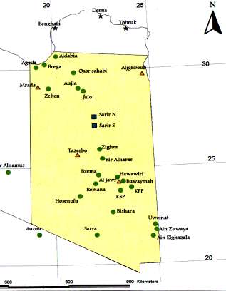
Ě SR-3 (on the Libyan-Chad border) at 450 m depth in Nubian) ş near borderS12-D (deep
aquifer 1200m)
Ě S4-S (shal ow ca. 150m)
Ě S4-M ( GMMR already results available, medium depth ca 415m)
Ě SR2 (SW-2) shal ow wel already taken, 70m), 18O,2H available, 14C not yet
Ě SR2-M (depth about 400m)
Ě 2 Springs in Aouinet region: Ain Zuwaya, Ain Elghazal
The remaining sampling locations as listed in the table below should be continued.
Soil sampling for recharge investigation:
Ě for NAS in Oweinat region (wadi area near the two springs, identified) and in Kufra area;
Ě for the PNAS in two other sites in Tazerbo and Mrada area.
Planning for sampling campaigns
The sampling fof the wels/sites is scheduled for the period June to October. The sampling wil
be car ied by GWA, the field measurements during sampling and the chemistry wil be done by
GWA staf and laboratory. The samples for isotopes wil be sent to IAEA (or any
recommended laboratory within the region). Experience and logistics requested from the IAEA
include
Ě Hand auger and related equipment for soil sampling;
Ě expert service for this kind of sampling.
Ě Expert service requested for water retention also needed.
27
These expert services should be scheduled for July/August 2006. Further details are given in
the table below.
Issue To be
Activity
Inputs
Where
When
investigated
Completion of Col ecting the remaining General water GWA Zone From June. To
programmed samples (14 locations as authority
Five (Kufra Aug 2006
sampling
in at ached table)
(GWA)
Sarir Branch)
course for the
purpose of the
NSAS study
Estimating the Col ection of water &
GWA
GWA Zone From June. To
impact of
Soil samples (about 5)
IAEA
Five (Kufra Aug 2006
ir igation
Sarir Branch)
return
Issues related Col ection data from
GWA
GWA Zone From June. To
to MSP
natural lakes
Five (Kufra Aug 2006
(estimation of
Sarir Branch)
Evaporation
rates)
Re-updating
col ecting of the PZ
General water GWA Zone From June. To
the data base of wel s data , Chemistry
authority (GWA Five (Kufra Aug 2006
NSAS
and the hydrogeological
Sarir Branch)
data
Water samples -Chemistry
-GWA
-GWA
From June. To
analyses
- Trace Elements
- IAEA
- IAEA
Oct 2006
-Radio active isotope
-IAEA
-IAEA
Procurements - Rain gauges (4)
IAEA
IAEA
From June to
- Books and Software
Dec. 2006
- Field computer (1)
Training for 3- 2-3 personnel
IAEA
IAEA
During 2006
6 months for
isotope
hydrology
Missions:
1- Expert
To assist in data
July, 2006
Mission (1)
evaluation &
IAEA
GWA
Interpretations
2- Scientific
Mission (1)
Nov., 2006
Regional
evaluation &
IAEA
?????
During 2006
Workshop
Interpretations and
discuss the preliminary
results
28
Table 2: List of remaining sample locations
Site Name
X Longitude E
Y Latitude N Remarks
S. No.
1
Brega
19 34 50.4
30 15 46.8
2
Aqeila
19 09 40.8
30 07 52.8
3
Qasr Sahabi
21 05 48.0
29 50 31.2
4
Marada
19 13 33.0
29 07 54.0
5
Zighen
22 17 25.2 25 55 15.6
6
Bir Al Harash 22 25 09.6
25 26 50.4
7
Buwaymah
23 25 09.6
24 15 47.4 Kufra
8
Bzema
22 11 36.6
24 36 18.6
9
Rebiana
22 01 55.8
24 09 28.2
10
Waw Alnamus 17 38 42.0
24 48 57.0
11
Zelten
19 46 27.0
29 03 09.6
12
Hosenofu
21 13 33.0
23 31 43.8
13
Bishara
22 50 19.8
22 41 03.0
14
Ain Zuwaya
24 54 11.4
22 00 00.0 Uwienat
15
Ain Elghazal
24 46 27.0
21 25 15.6
Uwienat
16
Uwienat
24 58 03.0
21 44 12.6
17
Assara
21 50 39.7
21 39 56.6 Site 2
18
GMRA Wel field 22 28 02.91
23 33 01.71 Kufra
29
6.3. NATIONAL ACTION PLAN SUDAN
National Work-Plan 2006 - 2007 (Sudan)
No Issues to be
Activity
Inputs
Target area/staf
Where
when
investigated
1 Age & origin of
Third sampling
Field trip / National Oases + Oweinat wel s Near
Sept.
groundwater
campaign
boarders
2006
2 Aage & origin of
Fourth sampling
Field trip / National Wadi Muggadam * El
Centre & east Dec.
groundwater
campaign
Milk + Merawi project
of project
2006
observ. wel s
area
3 Aage & origin of
Fifth sampling
Field trip / National Nukheila and Atron
Dar Fur
March
groundwater
campaign
Oases + Wadi Hawor
Region
2007
wel s
4 Analysis of samples for Shipment of w samples National / IAEA
Khartoum / Jan 2007
isotopes
Vienna
5 Analysis of water
Chemical analysis
National / IAEA
Lab.staf
Khartoum
Oct.2006
samples
7 Jan.
2007
6 Training (on the job)
Instal TRI-CARB
Expert mission
Chemists of isotope lab. Isotope lab. ???
scintil ation apparatus IAEA
7 Training
Isotope hydrology
IAEA
Hydrologists / geologists Abroad
8 Capacity building
Procurement of TRI-
IAEA
Isotope lab. Staf
Isotope lab.
CARB scintil ation
(Khartoum)
apparatus
9 Capacity building
Fel owships (isotope
IAEA
Trained hydrogeologists Abroad
hydrology)
10 Capacity building
Scientific visits
IAEA
Project staf
Abroad
12 Determine groundwater Monitoring G W level + Field trip /National Dongola Area + Qaab Dongola Area
flow
quality
Depression + Merawi
+ Qaab
Observation Wel s
Depression +
30
6.4. NATIONAL WORK PLAN EGYPT
The National Work Plan is compiled in the table below. It is based on the work plan original y
drafted at the 2nd Coordination Meeting in Dec. 2005 held in Cairo, Egypt, and then revised based
on discussions with Dr. Taher Hassan in the frame of his Scientific visit to Vienna, Austria, IAEA
Headquarters, June 2006. Egyptian representatives presented a revised version at the Nubian
Inception Meeting in July 2006.
Procurements
The fol owing items are requested for procurement, in accordance with the priority needs for the
project implementation:
For the already delivered compressor the accessories are needed: flexible 1" hoses and 4 to
8 inches adaptors, Qt. 120 m.
Two inches submersible pump yield 3m3/h from head 100m, with the accessories, generator
and flexible hoses Qt. 2.
Multi parameters meter for measuring water level, temperature, EC, pH and dissolved
oxygen; length of the cable 100 m ş Qt. 2
Complete Set for CFC sampling
Model ing Software (GMS Ver 9, WMS and GIS Imagine other for Geochemical and
Isotope interpretations (Chem5, Solmineq).
Bot les and chemicals for sampling
Analytical services
Analytical service for isotope analyses wil be provided by the EAEA laboratory in Cairo, Egypt,
except for 14C AMS and for CFCs.
31
Objective 1: Compilation of historical data about the aquifer system
Issue to be
Activity
Inputs
Where When
investigated
Ě Transboundary 3rd Sampling Campaign
Ě Int. Expert
RIGW Nov.
Issues
Col ecting 100 samples for Mission.
EAEA 2006
O18 & H2, 50 samples for
C13&C14, 10 samples for Ě Delivery of air
H3
Compressor
accessories.
Ě Discharge/
4th Sampling Campaign
Ě Analytical
RIGW Feb. 2007
Extraction
Col ecting 50 samples for Cl Services,
EAEA
Zones
profiles, H3, CFC and
IAEA Labs
IAEA
Nobel Gasses from south
Egypt, Kharga, Dakhla,
Farafra, Bahariya, Siwa and
N Western Desert.
Ě NSAS
5th Sampling Campaign
Ě Analytical
RIGW May 2007
Boundary
Selective sampling from
Services
EAEA
Conditions
new observation wel s (50
IAEA
samples for O18 & H2 and Ě IAEA Labs
20 samples for H3 and C13
& C14).
Ě Fresh / Saline 6th Sampling Campaign
Ě Analytical
RIGW Sept.
Boundary Area Selective sampling from
Services
EAEA 2007
relevant observation wel s
IAEA
(Cl, H3, CFC and C13).
Ě IAEA Labs
32
7 Nubian Shared Aquifer Diagnostice Analysis
Based on the presentation made by Mr. Andy Garner, Technical Of icer for the Nubian project,
discussions were held on the approach for car ying out the Nubian SADA. The SADA process wil
work to identify al transboundary issues, threats, risks etc. that are shared by the respective NSAS
countries. Therefore future sampling ef orts should be geared towards improving the status of
knowledge of the transboundary aspects of the Nubian as wel as cause and ef ect relationships to
Nubian activities. The Nubian SADA wil form the basis for developing the a joint management
programme for the Nubian (Nubian Strategic Action Programme- SAP.)
8 CONCLUSIONS AND RECOMMENDATIONS
8.1. Conclusions
The objective of the meeting was to gather and enhance baseline knowledge on the NSAS in terms
of hydrology and dynamics (recharge and flow regime) of the system, with special emphasis on the
transboundary regions. The presentations and discussions focused on the use of isotopes in past and
present studies of the NSAS, on the identification of gaps in the databases and on set ing up a work
plan to fil these gaps through sampling campaigns, sample analyses and joint evaluation of the
data as soon as feasible.
1. The meeting succeeded in updating the baseline knowledge, in identifying gaps as wel as in
defining measures/strategies to fil the gaps.
2. Fil ing the gaps wil facilitate a more comprehensive evaluation of the isotope data in
combination with data from other hydrogeological studies for a bet er understanding of the
dynamics of the system.
3. In particular, the data are expected to help bet er validate and constrain the models used for
managing the shared groundwater resources of the NSAS.
4. There are two databases on the NSAS, the NARIS (major emphasis on hydrogeological
parameters, wel data, piezometric levels etc.) that is operated by CEDARE, and the ISOHIS
(focusing on isotope and related data) operated by the IAEA. Both databases appear to have
significant gaps. The meeting worked to identify gaps in the ISOHIS.
Ě First of al , there is an imbalance between stable isotopes, 3H (for earlier studies) and
chemistry on the one hand, and 14C and 13C on the other hand. The lat er isotopes are
indispensable to study past recharge regime and flow regime in the upper part of the
aquifers.
Ě There are many gaps in parameters indispensable for the hydrogeological evaluation of
the isotope data. These parameters include depth (depth range) from which the samples
have been taken, characteristics of the wel s/boreholes used for sampling, geographic
coordinates of the wel s etc.
Ě The meeting highlighted that the sampling sites covered by previous studies are un-
equal y distributed over the NSAS, and in particular there are only a few sites (in South
Egypt, North Sudan, South Libya) that can be used for addressing transboundary issues.
Ě So far, there are only three studies, car ied out under purely scientific goals that use long-
lived radioisotopes to specifical y address the very old groundwater within the NSAS.
Two studies (in the Dakhla basin in Egypt) are on the potential of 36Cl and 81Kr in
33
characterizing the age and dynamics of groundwater in the system, and another one is on
the use of uranium isotope disequilibrium for characterizing mixing of the very old
part/component with the component infiltrated more recently, especial y during pluvial
phases of the Holocene.
5. A discrepancy appears to exist between the apparent (model) ages of the deep groundwater
indicated by recent 36Cl and 81Kr determinations and the 14C data obtained by recent and past
isotope studies in the Bahariya region (and elsewhere). To resolve this discrepancy is one of
the major chal enges for the forthcoming work within the project.
34
8.2. Recommendations
1. Concerning the databases the meeting strongly recommended to establish close links
between the two databases NARIS and ISOHIS, to make them compatible and accessible by
the concerned countries and organizations.
2. A number of measures have been agreed upon to fil the gaps through Shared Aquifer
Diagnostic Analyses (SADA). These are the fol owing:
Ě Implementation of sampling campaigns in cooperation between the countries and by
support of the IAEA
Ě Major aspects to be taken into account in selecting sampling sites for the
forthcoming sampling campaigns: (1) sampling must be co-ordinated at the regional
scale to obtain transects along infer ed hydraulic gradients and crossing the borders
of the neighbouring countries; (2) this approach requires concerted actions in
sampling between the concerned countries; (3) groundwater stratification has
practical y not been tackled so far; therefore wel s/boreholes have to be selected that
enable depth-oriented sampling.
Ě Major aspects in selecting the isotopes and other parameters to be measured in the
groundwater of the NSAS: (1) place special emphasis on 14C (plus 13C) to resolve
the imbalance between the various isotopic tools (note that 14C wil be below the
detection limit in very deep groundwater, i.e. the best way would be to sample at
various depths from about 0 meter down to a few hundred meter at given sites; (2) in
selected regions sample for 36Cl and/or uranium isotopes to address the mixing/flow
of very old groundwater; (3) consider that isolated/single measurements of these
isotopes hardly can provide conclusive results; they need establishing evolutionary
trends along transects and depth profiles and data from complementary isotopes and
chemistry.
Ě The analytical quality control should be strengthened to avoid inconsistencies in the
data (including chemical data) and improve the precision of the measurements.
3. Important questions to be answered in case of Libya are (1) whether there is an
inter elationship between the Kufra and Sirte basin; (2) possible exchange between PNAS
and NAS.
4. One question for Chad and Libya to be addressed by the forthcoming activities: Is there a
water divide near the Chad border to Libya.
5. The deficit of wels in the Tibesti area as a potential present-day recharge zone should be
overcome by establishing wel s and sampling available springs.
6. The question of present-day recharge by rainfal in Southern Sudan deserves also special
at ention. In this context, al available data (with preliminary interpretations included in
reports) must be plot ed on the same graph. This includes the data of groundwater close to
the Nile, on the one hand, and the data of the Darfur and Kordofan areas on the other hand.
This evaluation/interpretation requires a bet er knowledge of the input signal of the Nile
water and its variation in time, especial y due to flooding. The mixing of Blue and White
Nile downstream of their confluence has also to be taken into account.
7. Recent modeling of the groundwater dynamics in the Western Desert of Egypt (Paterson
et al., 2005) assumes a localized recharge area (Uweinat) disregarding distributed recharge
35
along the transect. This is in disagreement with the model developed at TU Berlin
(Brinkmann et al. 1987) and the upgraded version used by CEDARE. It is thus suggested to
set up appropriate sampling networks for 14C and 36Cl sampling (transects, depth profiles)
from Uweinat region towards north-east in Egypt and north-west in Libya, if feasible also
towards neighbouring Chad and Sudan regions.
8. The question of potential 14C contamination by 14C from atmospheric CO2 during sampling
or other sources should be addressed by, among other things, applying alternative sampling
techniques and comparing 14C values of a given sites (and depths) measured by AMS with
those measured by conventional decay counting technique.
9. For a closer comparison of the various dating techniques a suitable 36Cl (and 14C) depth
profile and transect should be considered in this regard. Given the recent 36Cl and 81Kr
studies, the region from Uweinat towards Bahariya in Egypt could be most suitable for this
study.
36
Annex 1
Agenda of the meeting
37

Nubian Sandstone Aquifer System (NSAS) Technical Baseline Meeting
IAEA/UNDP/GEF Nubian Aquifer Project (RAF8/036)
May 8- 12, 2006
IAEA Headquarters, Vienna, Austria
Room (F0579)
Day 1: Monday, 8 May 2006
Opening Session
10:00 ş 10:30
Opening of the Meeting and Welcome Remarksş
A. Boussaha &
P. Aggarwal
Introduction of Participants
L. Abdul-Malik
Ě Selection of the Chairperson and Rapporteur
Ě Adoption of the Agenda
Ě Objectives of Meeting
Session 1:
Review of Technical Component of the IAEA/UNDP/GEF Nubian Project
10:30- 11:00
Overview of the IAEA/ UNDP/GEF Nubian Project Components and Improving the Technical
Understanding Of the NSAS
A. Garner, IAEA
11:00 -11:15
Coffee Break
Session 2:
Review of Cur ent Technical Knowledge of the NSAS
11:15- 12:00
National Reports: Presentation of National Baseline- Sudan
12:00- 12:45
National Reports: Presentation of National Baseline- Libya
12:45 - 14:00 Lunch
14:00- 14:45 National Reports: Presentation of National Baseline- Chad
14:45:15:30
Discussion
15:30-16:00
Coffee Break
16:00- 16:45
Discussion of what is known
16:45- 17:15
Review of Results/ information from Day 1and Plan for Day 2
Close for the day
38
Day 2: Tuesday, 9 May 2006
Session 3:
Review of Gaps in the Technical Knowledge of the Aquifer
9:00- 10:30
Summary of Information Available in order to identify gaps K. Froehlich
10:30- 11:00
Coffee Break
11:00- 12:30
Discussion about identification of gaps
12:30 - 14:00 Lunch
14:00- 15:00
Discussion of transboundary aspects in relation to fil ing in gaps of technical knowledge of
the aquifer
15:00-15:45
Developing a Strategy for Fil ing in the Gaps, P. Aggarwal
15:45-16:15
Coffee Break
Session 4:
Isotopic Investigations to Build a Bet er Technical Understanding of the NSAS
16:15- 17:00
Discussion on Strategy for Isotopic Investigations to Fil Information Gaps
17:00- 17:30
Review of Results/ information from Day 2 and Plan for Day 3
Social Event
Day 3: Wednesday, 10 May 2006
Session 5:
Data/ Information Management for the NSAS
9:00- 9:30
Introduction of ISOHIS
09:30-10:15
NARIS Information System, . L. Madi, Libya
10:15- 10: 45
Discussion on Information Management for NSAS Cooperation
10:45-11:00
Coffee Break
11:00- 12:30
Integrating Data to Complete National Data Sets- Working Groups (led by P. Aggarwal)
- Chad (facilitated by Yves Travi)
- Sudan (facilitated by A. Herczeg)
- Libya (facilitated by K. Froehlich)
12:30- 14:00
Lunch
Session 6:
Work planning to Fil in Data Gaps
14:00- 14:30
Administrative aspects of IAEA Nubian Activities, Lameen Abdul- Malik,
14:30- 15:00
Review of cur ent work plans and new sampling at the national level, Andy Garner
15:00- 17:00
Working Groups (led by P. Aggarwal)
- Chad (facilitated by Yves Travi)
39
- Sudan (facilitated by A. Herczeg )
- Libya (facilitated by K. Froehlich)
16:30 ş 17:00
Review of Results/ information from Day 3 and Plan for Day 4
Close for the day
40
Day 4: Thursday, 11 May 2006
9:00- 9:30
National Workplans and Review of Relevance and Feasibility, Time frame etc. P. Aggarwal
and K. Froehlich
9:30- 12:00
Working Groups on National Workplans
12:00- 13:30
Lunch
13:30 15:30
National Presentation of Sampling Plans
15:30-16:00
Coffee Break
16:00-17:00
National Presentation of Sampling Plans- continued
17:00- 17:30 National Inputs into Regional Work Plan ş What wil SADA Look Like ? A. Garner
17:30- 17:45
Review of Results/ information from Day 4and Plan for Day 5
Close for the day
Day 5: Friday , 12 May 2006
Session 7:
Nubian Technical Baseline Report and Workplan
9:00- 10:45
Final review and adoption of the Technical Baseline Report and new Workplan and
consideration of how it wil contribute to the overal IAEA/UNDP/GEF Nubian Aquifer
Programme
10:45- 11:15
Coffee Break
11:15- 12:00
Review of Meeting report, Technical Baseline report including Workplans/ Sampling Plans
12:00- 14:00
Review of Next Steps and National Commitments, Time lines etc.
Closing of the Meeting, Ali Boussaha, Pradeep Aggarwal IAEA
41

Nubian Sandstone Aquifer System (NSAS) Technical Baseline Meeting
May 8- 12, 2006
IAEA Headquarters, Vienna, Austria
Objectives of the Meeting
Review and synthesize cur ently available technical information, with a focus on isotopic
data, as a basis for updating the "baseline" knowledge of NSAS system;
Determine important information gaps that need to be fil ed in order to bet er understand
and assess transboundary issues;
Consider strategies (sampling, monitoring etc.) that could ef ectively and ef iciently lead
towards fil ing these gaps;
Develop concrete next steps for fil ing gaps in the frame of the IAEA's co-funded activities
for isotopic analysis in the IAEA/UNDP/ GEF Nubian Aquifer and in particular to support
the development of a "Shared Aquifer Analysis (SADA)"
Desired Results/ Outcomes
Enhanced technical understanding of the NSAS, increased knowledge on both determined
and potential transboundary issues;
Bet er understanding of important knowledge gaps as wel as needed activities e.g.
sampling/ monitoring to fil the gaps;
Agreement on approach for synthesizing and managing data in the frame of the project.
Clear approach for isotopic studies to support the development of the SADA.
Expected Outputs
Nubian Baseline Technical Report
Sampling strategies for inclusions into 2006/07 workplan (s)
Approach for information management
Necessary Inputs- Background Information Needed Before the Meeting
4 National Reports that provide a synthesis of al relevant technical information at the
National level. (see separate guidelines for the reports
Copy of the NARIS information system (its contents)
42
Annex 2
List of participants of the meeting
RAF8036/9003/01
Technical Baseline Meeting
Austria, Wien
2006-05-08 - 2006-05-12
List of Participants
(as of 2006-05-11)
1 IAEA
Mr Muhammed Lameen Abdul-Malik- IAEA, TCAF
2 IAEA
Mr Pradeep Kumar Aggarwal- IAEA, NAPC
3 IAEA
Mr Wil iam Andrew Garner- IAEA, NAPC
4 IAEA
Mr Seifu Kebede Gurmessa- IAEA, NAPC
5 IAEA
Mr Andrew Leslie Herczeg- IAEA, NAPC
6 IAEA
Mr. Ali Boussaha
7 IAEA
Mr. Mokdad Maksoudi
8 France
M. Yves Marie Travi
9 Tunisia
M. Kamel Zouari
10 Chad
Mr Djirab Alifei Mbodou
11 Chad
Mr Noe Reouebmel
12 Libyan Arab Jamahiriya Mr Hamza Hamza
13 Libyan Arab Jamahiriya Mr Lotfi A. Madi Farag
14 Sudan
Mr Mohammed El Hassan Abu Buker
15 Sudan
Mr Abd Al a Mohamed Kheir Fadl El Moula
43