MEDIUM-SIZED PROJECT BRIEF
PROJECT SUMMARY
|
Project Identifiers |
|
1. Project name:
Protection of the North West Sahara Aquifer System (NWSAS) and related humid zones and ecosystems |
2. GEF Implementing Agency: UNEP
|
|
3. Country/ies in which the project is being implemented:
Algeria, Tunisia, Libya |
4. Country eligibility:
Tunisia, Algeria & Libya are eligible for GEF funding |
|
5. GEF Focal Area:
International Waters |
6. Operational Programme/short-term measure:
Operational Programme # 9 on Integrated Land and Water |
|
7. Project linkage to national priorities, action plans and programmes:
A significant increase of water extractions in Algeria and Tunisia since 1982, unlike the former period (1970 - 1981) during which the water extractions were relatively nnumerous has resulted in the NWSAS Aquifer system being considered a high national priority. This interest has grown owing to the grave consequences seen to date on the use of these groundwaters, which includes the running dry of the Tunisian springs and decreases in the free flowing discharge from the artesian wells. In addition, there has been significant water level decline both in Algeria and Tunisia, and deterioration in water quality in some areas serving as important water extraction areas.
Libya has expressed a willingness to participate in the joint updating of the water resources information base shared with Algeria and Tunisia, and in this framework, to offer the community a huge amount of new data regarding the two aquifer systems of the Continental Intercalaire and the Terminal Complex.
The management model to be developed in this project should determine the best scenario for exploiting the water resources in a manner that ensures sustainable water utilization in both quantitative and qualitative terms, particularly focusing on the protection of the recharge areas and the humid zones.. Information from this management model will help inform water utilization in the agricultural sector and in broader water utilization processes in each country. |
|
8. GEF national operational focal point and date of country endorsement:
Submitted: Acknowledged: Endorsed:
The project was designed with the assistance of experts appointed by the three countries and was officially approved by the Directors General of Water Resources in each country and their line ministries. Letters of endorsement from GEF focal points are attached. |
|
Project Objectives and Activities |
|
9. Project rationale and objectives:
The NWSAS (North-Western Sahara Aquifer System) covers well over 1,000,000 km² of which 700,000 are in Algeria, 80,000 in Tunisia and 250,000 in Libya. It is composed of sedimentary deposits which, from bottom upwards, includes the Intercalary Continental and the Terminal Complex, the two main aquifers level.
In the Algerian and Tunisian parts of the Sahara, groundwaters from these two aquifers have been harvested more and more intensively for over fifty years already. Offtake in Libya is more recent, but interest in these resources is
growing as a result of population growth and lack of sufficient levels of renewable waters.
At present estimates of annual water extraction from this basin amount to 540 hm³ in Tunisia, 1,100 hm³ in Algeria and 250 hm³ in Libya.
Efforts to intensify offtake are likely to be continued in the coming years with over 90% of the water being used for agriculture. This situation is likely to cause deep changes in the characteristics of the groundwaters from both quantitative and qualitative viewpoints. This requires the best utilization of the knowledge of the aquifer and its recharge areas for optimum and rational management. Such management has to result from an integrated study at the basin scale in order to enable management of water resources in a sustainable fashion.
The present project for the transboundary Aquifer System of the Northern Sahara- sharing countries (Algeria, Libya and Tunisia) has as its objective the protection of water quality and of the recharge areas, humid zones and ecosystems related to the aquifer. It is made up of two elements closely complementary: updating the evaluation of the NWSAS water resources and implementing a consultation mechanism at the basin level.
In the three countries concerned - Algeria, Libya and Tunisia - the management of the NWSAS water resources will cover arid and semi-arid areas that are presently affected by desertification. This project thus addresses the strategic priorities identified by the GEF for Phase III by facilitating implementation of strategic actions agreed by the three countries through prior actions carried out in the last several years. The GEF Business Plan 03-05 states that these actions should include policy and legal measures, institutional arrangements, resource mobilization, mainstreaming environment into the relevant sectors, and monitoring and evaluation which this project specifically focuses on and which are outlined in the sections below. |
Indicators:
1. A management model covering the shared aquifer will be developed with a particular emphasis on protection of the recharge areas and the humid zones;
2. Observatory of trends in water quantity and quality;
3. Permanent group for exchange and actualization of data; |
|
10. Project outcomes:
The overall outcome will be the move towards a more sustainable exploitation of the NWSAS aquifer.
More direct outcomes of the project are:
- Completion of a study on the NWSAS;
- Analysis of the legal and institutional issues surrounding management of this shared resource;
- Completion of a management model which encompasses the following:
q Protection of the recharge areas and the humid zones;
q Provides the best possible scenario for sustainably exploiting water resources;
q identifies indicators on sustainable resource use, both in terms of water quality and quantity;
q Defines a water policy for the arid and semi-arid zones of the three countries that promotes protection of the recharge areas and the humid zones and sustainable use of the shared water resource.
-Establishment of a consultation mechanism to ensure sustained monitoring of water resources in the shared basin following completion of GEF project funding, with funding becoming committed from non-GEF sources for the continued existence of this mechanism.
In addition to monitoring, the consultation process will address reforms in policies and institutional framework at the national level that would be needed to foster sustainability, including the environmental aspects. |
Indicators:
- Agricultural plans being made in each country taking into consideration sustainable rates of exploitation of water resources from the NWSAS aquifer;
More direct indicators include:
- National reports describing for each country the databases used (format, fields, etc) and the geographical information systems (type of data used, expected products, users, softwares used, equipment , human capabilities, etc);
- National reports on the analysis of legal and institutional aspects affecting management of the NWSAS;
- Agreement reached on the data to be included in the common information base and modalities to harmonize the database;
- National reports on methods to assess water extraction;
- Minimum network defined and approved guide on methods to rapidly assess water extraction;
- Updated data available and included as data entry in the common base;
- Synthesis report of geological information;
- Conceptual model and groundwaters simulation software approved;
- Grid of the models and mapping;
- Communication programme GIS-models;
- terms of reference available for the calibration of the model plus calibrated models available;
- Exploitation scenarios plus reports on simulation scenarios;
- Report on results of socio-economic evaluations of the simulation scenarios;
- Exploitation programmes on the groundwaters;
- Permanent group for exchange and actualization of data; |
|
11. Planned activities to achieve outcomes:
- Environmental analysis of North Wes Sahara Aquifer System (NWSAS) ;
- Analysis of legal and institutional issues;
- Development of a management model for the sustainable use of shared water resources;
- Establishment of consultation mechanism for the management of the NWSAS aquifer system. |
Indicators:
- Workshop held on data sets for the common base and the modalities to harmonize the database;
- two-week training per country on harmonization of database;
- Validation workshop held on data quality;
- Workshop held to present and approve the observation wells network and the methods to rapidly assess water extraction;
- Analysis carried out of oil and water probes data (well logs, geophysical logs, geophysics) necessary for modeling characterization of aquifer formation, and understanding of the hydrological functioning of aquifer levels;
- Piezometric account for each underground waterbody;
- Assessment of legal and institutional issues affecting management of the NWSAS aquifer;
- Workshop held together with meeting of the Project Steering Committee to assess the conceptual model proposed; software to be selected and possible modifications decided upon which will be added in case of cartographic deformations;
- Definition of the grid of models and tracing on GIS;
- Implementation of GIS-models links; programme for the automatic definition of water extraction;
- Creation of future exploitation scenarios of groundwater;
- Socio-economic evaluations of the simulation results;
- Workshop held in line with the last meeting of the Project Steering Committee to: prepare the results of the simulations of scenarios;
- Setting up the models in the countries;
- Consultation mechanism established for the NWSAS aquifer. |
|
12. Estimated budget (in US$ or local currency): |
|
PHASE I (July 99 – June 02) |
PHASE II (July 02 – June 04) |
Total budget
|
1.738.000,00 US$ |
1.300.000,00 US$ |
Other sources
|
IFAD 1.065.000,00 US$
DDC-Switzerland 380.000,00 US$
FAO 293.000,00 US$ |
DDC-Switzerland 400.000,00 US$
FFEM (France) 300.000,00 US$
In country contributions 116,000 US$ |
GEF
|
NO
|
600.000.00 US$
|
PHASE II
|
|
PDF : None (preparation of project was carried out with non-GEF resources)
GEF : US$ 600.000,00
Co-financing : FFEM US $300,000
DDC-Switzerland US$ 400,000
In country contributions US $116,000 |
|
13. Information on project proposer:
OSS + (Algeria - Libya - Tunisia) |
|
14. Information on proposed executing agency (if different from above): |
|
Observatoire du Sahara et du Sahel (Sahara and Sahel Observatory - OSS) was created in Paris in May 1992 (inaugural conférence). It serves to provide an international framework for partnership and consultation, and to contribute to the development and exchange of information of use in efforts to combat desertification and the attenuation of the effects of drought (Article 1 of the OSS Statutes).
In March 2000 it became independent of UNESCO as an international organization based in Tunis. Its headquarters agreement was signed in June 1999 with the Tunisian Government and ratified by law no. 2000/12 of 7 February 2000. The OSS statutory bodies are:
- the General Assembly which meets every four years,
- the Executive Board which meets once a year,
- the Scientific and Technical Council (STC), appointed by the Executive Board, meets every two years. It deals with scientific and technical issues related to the OSS activities programme.
Its Executive Secretary is Chedli Fezzani. OSS membership is composed of African and European countries, regional and international organizations, and representatives of civil society.
OSS has been developing a programme to facilitate technical and scientific cooperation between the countries sharing the basin. Through its “Aquifers of the Major Basins” Programme, OSS is providing a framework for scientific and technical dialogue designed to favour the updating and harmonization of knowledge needed in the preparation of efficient management strategies. OSS has carried out preparatory activities and previous research on the NWSAS aquifer system. This work has included, for example, previous workshops and meetings on the basin, such as meeting, held in Cairo in May 1994, which gave representatives of the northern Sahara and Nubian basins (Algeria, Tunisia, Libya, Egypt, Sudan and Chad), UNESCO and FAO, France and Germany an opportunity to use the results of OSS’ studies to define the common knowledge base needed to concretely define liaison structures. |
|
Date of initial submission of project concept: August 1999 |
|
15. Project Identification number: tbd |
|
Implementing Agency contact person: Ahmed Djoghlaf, Director, Division of GEF Co-ordination, UNEP; Sheila Aggarwal-Khan, GEF Medium sized projects, UNEP Email:gefinfo@unep.org |
|
18. Project linkage to Implementing Agency program(s): UNEP together with UNESCO are undertaking a ‘Development Account’ project on ‘Urban pollution of Surface and Groundwater Aquifers vulnerability in Africa.’ The launching meeting of this project took place in Bamako, Mali at the Water Resources Headquarters from 11-14 December 2000. The project includes Benin, Burkina Faso, Cote d’Ivoire, Guinea, Mali, Niger, Senegal. The project has agreed on methodologies to be adopted for the assessment of groundwater pollution. It is a joint activity between UNEP-DEWA, as the lead agency of the project and UNESCO-IHP. The specific objectives of the project contribute to:
- Setting up the background activities to be undertaken on urban pollution and developed as a technical framework to the embryonic network on urban groundwater vulnerability in Africa; Developing methodologies for optimal monitoring of the contamination of surficial and groundwater aquifers in
African urban areas; Policy options for better safeguarding surficial and groundwater aquifers in African urban areas, including pollution and health problems mitigation; Establishment of an early warning network for possible water supply contamination; Hydrogeological modeling of groundwater vulnerability in African urban areas; and capacity building development.
This experience will be shared with the OSS in its activities focused towards the NWSAS aquifer. |
|
|
|
|
PROJECT DESCRIPTION
PROJECT RATIONALE AND OBJECTIVES
I.A - Background
1. Within the arid and semi arid zones of Northern Africa and Sahel, the geography of water resources does not usually coincide with the political geography: the territorial frameworks of the resources system often extend across several countries and their natural limits cross the boundaries.
EXTENTION OF THE LIMIT OF THE SEPTENTIONAL SAHARA AQUIFER BASSIN | |
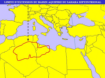
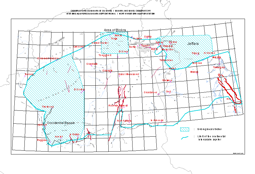
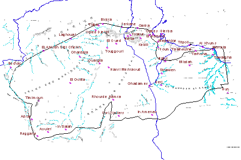
2. One of the major basins in the North-West Sahara Aquifer system, which covers a large surface, spread through the territories of Algeria, Libya and Tunisia. The North-West Sahara Aquifer System (NWSAS) covers an area of over a million square kilometers in the western part of the North African Sahara: approx. 700,000 Km2 in Algeria, 80,000Km2 in Tunisia and in Libya 250,000 Km2. The NWSAS is essentially composed of continental deposits which includes the Continental Intercalary, equivalent to the Nubian sandstone of North-East Africa extending from Morocco to the centre of Libya, the Terminal Complex which occupies the centre of the Basin, and the coastal groundwaters, which extends to the coastal plains of Tunisia and Libya (see attached map). Within this basin occur two aquifer systems: Terminal Complex to the top and the Continental Intercalaire to the bottom. Many semi-permeable layers separate these two aquifers. The Continental Intercalaire extends over the total area of the basin “i.e. 1,000.000 km²”while the Terminal Complex extends over an area of 500.000 km²
.
3. The subterranean reservoir was filled with freshwater during the wet Quaternary Period (the last one dates back 8,000 years). As these groundwater tables were filled, water flowed to the depressions (Sebkhan, chotts) located along the northern edges of the Sahara, towards major sources, some of which are still exploitable. These natural outlets slowly emptied the reservoir (a few millimeters per year); this explains the present underground flow, which is mainly South to North. Episodic surface runoff along the Atlas foothills in Algeria and Tunisia contributes to feeding the groundwater tables, but the inflow is minor compared to the current offtake and, more importantly is the enormous volume that is stored in the subterranean. The impression may have been that this sizeable groundwater reserve was unlimited. Actually only part of the volume that is stored in the aquifer system is - physically and economically - accessible. The key to optimal utilization of this vast subterranean resource needs to be sought in the elaboration and implementation of development strategies that maximize foreseeable benefits and minimize deleterious effects.
Map illustrating the geographic distribution of the North West Sahara Aquifer
4. The NWSAS is partly a renewable resource. Concerning the groundwater recharge, the North Sahara
Aquifers are often considered as fossil aquifers because of their considerable reserves which is supposedly not the result of the present day water recharge flux. Although this qualification is usually admitted, it is no doubt inappropriate. This is mainly because the average annual recharge amounts of water are, nevertheless, important and are estimated to average 1 billion m³/year (TR/UNESCO/UNDP (SF), REG-100, Report 2:39, Report 3:46, April 1972; NWSAS – MODEL, June 2000)
These amounts of water recharge which, at the present time are under examination with more precision by the SASS Project, occur for nearly 90% along the southern flanks of the Saharan Atlas (ibid.)
The recharge areas are important and well distributed between the different basin compartments.
To the northern basin, the recharge occurs along the Saharan Atlas and the Tuniso-Libyan Dahar mountain range.
To the southern part of the basin, the recharge areas are represented by outcrops located at the Tadmait and Tinhert shelves. The western Erg is itself a very dynamic recharge area. (ibid.)
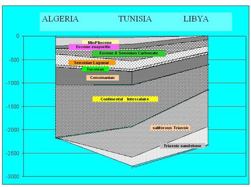
Schematic representation of the North Western Sahara Aquifer System
Legend
 Mio Pliocene -
Eocene & Senonian carbonate - Complexe Terminal (CT)
Turonian
Continental Intercalaire Continental Intercalaire
Unlike oil accumulations which are certainly the only ones to be qualified as fossils, the main objective from underground water production is not to recover the whole water reserves in place, but is rather to extract quantities that equals renewable flux; i.e. the average of the inter annual recharge amounts.
When the water reserves in place are important, it is permitted to extract a part more or less important of the reserves depending primarily on pumping costs. This usually results in the decrease in water levels within the aquifer. Fortunately, owing to their geological setting, the aquifers are mostly artesian and such characteristics may considerably delay the need for water pumping over wide areas. Until the nineties, amounts of water extracted from the aquifer system were equivalent to the recharge volume i.e.: 1 billion m³/year (UNDP, RAB/80/011, FINAL REPORT: Page 6 and Page 30, June 1983; Actualisation of the Septentrional Sahara water resources and NWSAS - Model, June 2000)
In the subsequent years, the volume extracted from the system, has increased and was higher than the recharge volume. Such a situation is common to many aquifers, especially those located in arid or semi-arid zones. In the future, any water extraction must take into account the renewable water volume in order to better control the decrease in the water level within the aquifer as well as changes in water quality. However, in such a basin the total discharge of the aquifer or of a continual decrease of the water level, are options which are not taken into account, thus for three main reasons:
- In order to avoid a reverse water flow which would considerably alter the water quality;
- The continuous decrease of the water level may lead to the performance of deep water pumping which would enhance considerably the production costs (pumping is performed in deep wells instead of aerial wells) and make more difficult the socio-economic situation of the oasis Saharan populations;
- Soil irrigation may contribute in some cases to the alteration of the water quality. This is due to the return and mixing of saline water with water in the aquifer. Increases in salinity have been noticed notably in the Nefzaoua on both sides of Chott Djerid.: 1g/l to 3.5 g/l (NWSAS - 2001 - report on data analyses)
In conclusion, and in addition to the fact that part of the water reserves in the SASS is reserved for water production, this system needs to be managed in a way that preserve the quality water. This is necessary for:
- preserving the environment by avoiding a demand that can outstrip the recharge of the aquifers;
- maintaining the oasis areas and not compromising the sustainable development of the area, which includes, for example, the ancestral/ traditional irrigation systems such as the foggaras.
Within this context of the need to save this natural resource, anticipated actions are to be carried out preferentially. This is the main objective of the SASS project, which is setting up the necessary tools that would help enhance the knowledge of the system and monitor its evolution over a long-term period.
5. The first study was one made by UNESCO in 1968-1971 with the participation of only two countries, viz. Algeria and Tunisia (study on water resources in north-western Sahara ERESS, financed by the UN Special Fund). It was based on a simulation model that included various minimalist hypotheses, and in particular, some arbitrary conditions to represent the Libyan part of the aquifer system. In 1982-1983, with assistance from UNDP (RAB project), the model was updated, but here again, there was no real data from Libya. New hypotheses on water offtake were simulated to support agricultural development plans under study in Algeria and Tunisia.
6. As of 1992, the Sahara and Sahel Observatory (OSS) started working with national experts on NWSAS and were able to bring together interested national and international partners. OSS organized various consultative meetings, technical studies, data reviews and analyses and syntheses in order to increase the involvement of the countries concerned and create conditions that could ensure the success of much-needed common actions. This mainly involved two workshops in Cairo (November 1992 and May 1994) which adopted the principle of "basin awareness" and the need to "establish a mechanism for consultations" at the basin level.
7. Further, as part of the Aquifers of the Major Basins programme, OSS, together with FAO, thoroughly examined the legal and institutional aspects of sustainable management of the deep groundwaters in the NWSAS. Since the three countries share the basin waters, the countries national and international laws on the management and utilization of water resources, particularly groundwaters, were examined.
8. On the basis of the above, an OSS workshop in Tunis, in May 1997, adopted the outline of a project document. Thereafter, again in Tunis, another workshop was held (September 1997) to finalize the project document on updating the evaluation of NWSAS water resources and establishing a mechanism for consultations at the basin level. This is the basis for this medium sized project. OSS and IFAD held the third and last meeting in Rome (29-30 April 1998) for the countries concerned, FAO, UNESCO, Switzerland and Germany to detail the foreign-financed budget and the institutional framework for implementing the programme.
I.B - Environmental aspects of the basin
The SASS basin will be composed of a population of 8 millions of inhabitants at the horizon 2030 with conspicuous agricultural development.
This will require a more drastic mobilisation of water resources of which we aim to measure the multiple risks that are:
- The salinisation of the aquifers from the chotts and sebkhas
- The risk for the aquifers to be in contact with salted horizons where there are faults
- The presence and quality of the OASIS ecosystem and foggaras
- the deterioration of soils
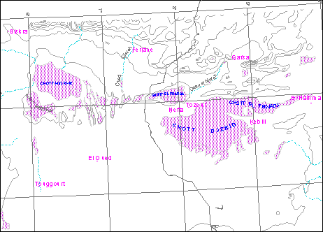
Salinisation risk close to chotts and sebkhas:
Chotts are Saharan depressions that constitute the natural outlet where waters streaming accumulate and/or of drainage coming from neighbouring areas and notably from oases. These depressions are generally saline and gypseous which is what makes them practically unproductive. However on their borders one finds a cortege of halophile plants that play an important role in the nitrogen fixation of soil and filtration of water. Some among them can be consumed by the wild fauna (reptiles, mammals, arthropods, migrant bird species) or domestic animals (e.g.dromedaries)
Among the plants, the most notable are Haloenemum Strabilaceum, Limonium Tunatenum, Sueeda softens, Artheomenum indicum, Aeloropus Littoralis, Salsola tetragonal, etc…
The main chotts located in the North part of basins are: Melrhir - Merouane Ghasa - Djerid and Fedjaj (see map below):
The present abstraction should drag from here to 2050 a significant drawdown within the water tables (measured by reference to levels in year 2000) in all the low -algéro - Tunisian Sahara.
In Algeria, drawdown by 2050 will exceed 30m in all the valley of the Rhir Oued to the North of Toggourt.
In Libya, the maximum drawdown (of about 60 ms) is found in the Southeast, around the Soknah, Hammams and Ferjans.
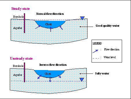
On the other hand, piezometric maps of water levels and depths point to the disappearance of the artesian in the region of the Algero-tunisian chotts by 2050. There is the risk that the chotts Merouane, Melrir and Djerids could be completely disconnected from the CT aquifer. This particular situation was not observed before and could increase the risk of recharge of salt water of the chart to the CT aquifer. It is necessary for the limitation of abstraction to the present level.
Taking into account this possible phenomenon, the potential source of saline contamination of the aquifer of the CT, is constituted in priority, by the Algerian and Tunisian Chotts. A precise modelling of links between the aquifer of the CT and chotts, requires a fine analysis of effects of exploitation taking into account the mechanisms governing exchanges between these two entities.
The chotts constitute a major risk of salinisation of the CT aquifer, if a big drawdown appears near the chotts regions. These phenomena must introduce saline water into the aquifer and cause irreversible deterioration of the quality of water resources.
Salinisation of water of the aquifer also leads to soil salinisation, which in turn will impact the fragile arid ecosystem.
The proposed model permits calculations of the precise moment of discharge from the chotts. The first indicator enabling a valuation of the possibilities of such risks is provided by the position of piezometric levels of the aquifer relative to the Chott.
The simple growth of the present abstraction constitutes a major potential danger to the aquifer and soils above ground as a result of the risk of salinisation.
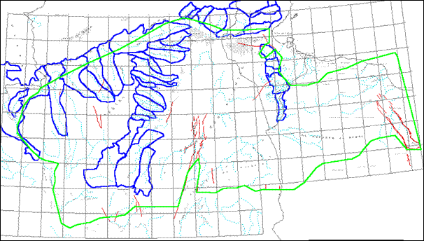
Preservation of the Foggaras system.
Foggaras are traditional underground water channels for water collection. (ex.Oasis of Adrar below the Tadmait plateau).
|
Losing zone by infiltration | |
|
Piezometric line before
foggara execution | |
|
Functioning scheme of a foggara | |
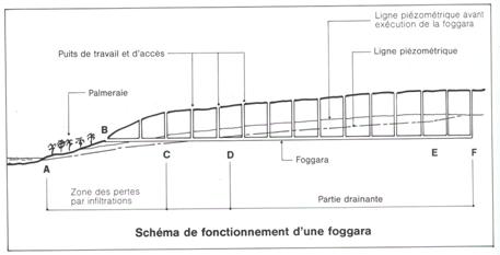
Water repartition from Foggaras
The system of traditional irrigation of foggaras is ancestral and it permitted a socio-economic development well adapted to the Sahara. Thus, this system of aquifer exploitation assured:
- the increase in populations around palm groves
- the balance between the use of water and natural drainage following irrigation
- the preservation of soil quality by hydromorphism.
The maintenance of foggaras flow is assured naturally by the recharge coming from infiltration on outcrops. The change from Foggaras exploitation to pumped wells has increased the drawdown.
With this situation of competition between boreholes (modern system) and foggaras (traditional system), the development of sub-models must define more precise options for better management of water that would answer the following questions:
-Should we abandon the traditional system and evaluate the socio-economic cost (notably the impact of those harnessing water in this manner)?
-Should we develop drillings and intensify the enhancement?
-What would impacts be on the soil and the ecosystem as a whole?
-Is the quality of water being affected?
Preservation of the Ecosystem oasis
It is an agro-ecosystem that permits the recharge and subsequent utilization of water in the Sahara environment while exploiting a group of plants and animals particularly adapted to this environmental conditions. The emblematic plant species of this agro ecosystem is the date palm (Phénix dactyliferia). This species presents a big genetic diversity (variety, ecotypes, cultivars) that has to be preserved in order to be able to benefit from the agronomic quality bound to this diversity (feature of fruits, resistance to salinity, resistance to disease, among others).
Other fruit species are generally associated to this species (pomegranates, apricot tree, peach tree, etc) cereals (wheat, barley) fodder crops (Lucerne) and market gardens constituting an agriculture complex system composed of three levels of cultures. The first level is constituted by date palm that in addition to its production, contributes to creating the microlevel characteristic climate of the oasis. The fruit trees constitute the second level whereas the non-ligneous low plants constitute the third level. The GEF’s Operational Programme on agrobiodiversity indeed notes “the genetic variability of landraces and wild relatives of domesticated plants and animals are essential breeding sources”.
The oases also shelter domestic animals belonging to particular races like the bovine race well known as Demman for its prolificity.
Ecosystem oasis actually covers several thousand of hectares through Algeria, Tunisia and Libya. This ecosystem located in the Sahara has for centuries witnessed a human presence with cultural and social interconnections.
The reduction of water and the changes in living conditions impact the ecosystem oasis. This is in turn affected by an increase in the population and in agricultural development.
However, within the ecosystem, problems of water salinisation and decrease in flow are affecting the ecosystem as a whole. The need to reduce the actual abstraction of water to maintain and to preserve the ecosystem is critical. This objective addresses the GEF Operational Programme objectives on agrobiodiversity which include “assessing the impact of natural disturbances and the compound effect of anthropogenic stress” and “identifying processes and categories of activities which have or are likely to have significant adverse impacts on the conservation of biodiversity.”
This project will develop detailed simulations to determine influences on the ecosystem and to search for the optimal script permitting conservation of the oasis.
Protection of Coastal aquifer of the Djeffara (Tunisia and Libya)
The Tunisian Djeffara aquifer is largely recharged by the Continental Intercalaire whose outlet underwent a decrease of flow owing to additional abstraction (Algeria and Tunisia).
This aquifer is already in a state of advanced exploitation. If we consider the reduction of its recharge, the risk of salinisation by seawater intrusion looms larger.
The development of a sub-model will permit adjustment of an exploitation program that takes into account this negative impact and specifies the scale of risk.
With regard to the Libyan Djeffara aquifer, the situation is more complex since all the area of Tripoli is already polluted by seawater intrusion. The additional contributions of fresh water from the South (Great Man Made river) permitted some relief but without fully solving the problem of salinisation.
A detailed study giving a precise assessment of the present abstraction using satellite imagery, the forecasting of the future demand and effects of the supplementary abstraction with the help of a mathematically model will give a better orientation of development policy in this important area in the Libyan economy.
II Programme Justification
9. The Sahara groundwaters have been intensively exploited by Algeria and Tunisia for fifty years and now more recently by Libya. Growing population pressure and absence of renewable water sources in the Sahara have heightened interest in the NWSAS. At present total annual withdrawals there are estimated at 540 hm3 in Tunisia, 1,100 hm3 in Algeria and 250 hm3 in Libya.
10. Water harvested from the NWSAS groundwaters have more than doubled between 1980 and 1992 when the last inventory was made that covered all of the Algerian and Tunisian Sahara. A larger percentage (85-90%) of the water drawn from these tables is used for agriculture, a sector the three governments slate for further intensification in the coming years, yet have stated their keen interest in ensuring its sustainable development if the relevant information for decision-making is available.
q In Algeria, large investments in hydraulic structures for agriculture are scheduled for the central area (Oued Rhir) and eastern area (Souf) of the Algerian Sahara, impelled by private investments during the last ten years, has been growing rapidly.
q In Tunisia, the population growth rate is increasing with attendant increases in demand for food especially along the coast where agricultural production has to cope with serious problems of seawater intrusion and drops in the water level. Attention is turning to the urban-cum-industrial development of the western part of the Jeffara which requires additional water to be drawn from the NWSAS in the Ghamandes region. The development of irrigated zones, and the transportation of water to the coasts could lead Libya to a doubling of its current level of withdrawals from the NWSAS.
11. There is another factor that will seriously affect the NWSAS in the future: a sizeable portion of the aquifer's waters comes from Paleozoic sandstone tabled in the south (Jabal Fezzan-Jabal Hassouna), where the boreholes that supply waters to the transport system of the Great Manmade River Project are located. This artificial river is composed of five phases:
Phase 1: Eastern System
SARIR-TAZERBO transfer to Libyan Eastern coast between BENGHAZI and SYRTE Gulf. The water volume transfer was of 700 million m³ /year. At this time, this system is functioning at only 15% of its capacity. It is mainly destined to provide cities along the Benghazi coast with drinking water.
Phase 2: Western System
Transfer from Djebel Hasaouana to the coastal plain of the Djeffara. The transferred water volume is 900 million m³/year. This system is functioning at only 12% of its capacity to provide Misratah and Tripoli cities with drinking water.
Phase 3: Kufra System
This transfer is destined to reinforce and provide the eastern system (Phase 1) with an additional water volume of 600 million m³/year. This system is still under study.
2 additional transfer systems are still under study.
Phase 4: Jaghbub-Tobrouk
The volume to be transferred is not determined yet. The technical feasibility analysis of this system at Jaghbub is still under study.
Phase 5: Ghadames
The estimated water volume transfer towards the coastal plain of the Djeffara is 90hm³/year. This phase is still under study.
Among the 5 phases of the artificial river, one may observe that:
- Phases 1, 3 and 4 are located outside SASS Basin
- Phase 2 is interconnected to SASS Basin and should be evaluated for its degree of influence on the water supply to the SASS Basin.
- Phase 5 relates to water transfer to Tripoli city from the SASS Basin
- Concerning phase 5 the model will integrate the planned water volume transfer and will determine the impacts on Libya as well as on the transboundary interferences in Algeria and Tunisia.
- For Phase 2, the impact of this transfer on the SASS System should be evaluated.
- There are some risks, which have never been measured or calculated.
12. The unique transfer phase from the NWSAS is still under study. The other transfer phases are not under concern by the SASS. Within the SASS model, the Ghadames transfer (90Hm³/year) is considered and its impact evaluated (Ghadames Project. Water resources final report. BRL - Engineer - Nîmes – France). The results deduced from the model will be subject to discussion and meetings between the three countries in order to come up with an optimum scenario. It is not too late to initiate such discussion as the three countries have now started seriously discussing, at the present day, the setting up of scenario for the next 50 years.
13. Although the man-made river has been built and may be seen as a lack of political commitment to more sustainable use of the groundwaters, reality shows that there is a new high level tri-governmental commitment to see what changes are needed to reduce water usage from the aquifer. This commitment has been demonstrated by the consultations the three countries have been having on the use of the groundwater and this project would build on this commitment. TCP support from LEGN/FAO over the last 8 years means that the critical, high risk and most time-consuming activity, to develop a cooperative framework for the NWSAS has already established a background data on legal and institutional arrangements in the countries and most importantly established an important level of international confidence and cooperation. The results of the model will be valuable in terms of impact indicators and will provide useful data for decision-makers for planning. The consultation mechanism initiated by the FAO has as its objectives, the permanent study of the resource so the states can determinate the optimum volume of sustainable exploitation. Furthermore, OSS, the executing agency, is a sub regional organization enjoying strong support from the three countries, and participation and contributions of specialist and senior officials with water ministries and lead scientific institutions in the three countries.
14. In 1972, the report UNESCO presented at the end of the ERESS project recommended the creation of a joint Algero-Tunisian commission "……whose role would be to co-ordinate the groundwaters exploitation programmes in the Sud (Algeria) and Djerid (Tunisia).” During Commission meetings, it was agreed that sharing information on previous exploitation and short term withdrawal plans and the utilization of models would make it possible to constantly monitor the consequences of further withdrawal on both sides of the border and lead to bilateral agreements on possible programmes for the future.
15. This recommendation was never carried out despite the growing need for consultation between countries that share this resource not only in order to manage transborder effects but also to ensure optimal management within each country.
OBJECTIVES OF THE PROJECT
16. The project will improve management of the NWSAS aquifer system shared by Algeria, Libya and Tunisia through protection of water quality and of the recharge areas and humid zones and ecosystems related to the aquifer. This will involve:
· the updating of the evaluation for the NWSAS water resources in order to define sustainable exploitation modalities;
· the implementation of a consultation mechanism at the basin level for the three participating countries with a view to ensuring a homogenous management of these common water resources.
III Current Situation
17. At present each country draws up its own development programmes and its own plans, without any co-ordination with the other countries that share the same water resource, the NWSAS aquifer. However, it is recognized that development plans, especially in agriculture, that draw on this shared resource should be based on an evaluation of the volume of water that may be exploited that is as precise as possible. Evaluations conducted to date have not been precise since studies have not covered the three countries concerned with the basin. Since 1980, a number of boreholes and studies have been established in each country. This constitutes a large amount of data and information to develop a precise management model.
18. Synthesis studies providing valuable information for the understanding of the Saharan groundwaters functioning include the following:
§ In Libya, a wide study of the water resources of the Western part of the country undertaken at the beginning of the 80's which has been subjected to a very complex multilayer model, including among others the two underground waters of the CT (Miada aquifer) and the CI (Chicla aquifer); local studies in line with the Saharan groundwaters of Algeria and Tunisia (areas of Ghadamès and Northern side lf Jabal Hasawna in particular) (See Annex I);
§ In Algeria, studies of Oued Mya, Oued Rhir and Illizi-Ghadames basins;
§ In Tunisia, structural and stratigraphical studies of the South of Tunisia conducted by oil companies (ETAP 1983, AMOCO 1983, MOBIL 1976), hydrogeological synthesis from the Direction des Ressources en Eau (Water Resources Management), (Mamou A., 1976, 1986, 1987, 1988, 1990) and continuous monitoring of the aquifers (water extraction and piezometry) (see Annex II);
19. The analysis of this data and information would enable the provision of information on the use of water from this shared resource from each country. This project would be designed therefore to analyze this information with the view of implementing a common database for the three countries (TAR), which would then lead to the implementation of a more permanent mechanism and process to manage and monitor the use of these resources.
20. In addition, the following developments have recently taken place:
§ A significant number of new wells have been established (especially in Algeria) in poorly known areas in 1970 that bring essential data to improve the models representativity;
§ The results for the former studies, ERESS (UNESCO) and RAB (PNUD), as well as the reflection activities conducted by OSS revealed that the Northern Sahara basin-sharing countries have their national institutions and laws capable of ensuring the proper management of water resources in general and fostering the implementation of a consultation mechanism at the basin level/
IV Expected Project Outcomes
21. The results of the project will be:
- Completion of a study on the NWSAS, based on its natural boundaries taking into consideration the geographical limits and the availability of information from existing and completed studies;
- Completion of a management model which encompasses the following:
q Protection of the recharge areas and the humid zones;
q Provides the best possible scenario for sustainably exploiting water resources;
q identifies indicators on sustainable resource use, both in terms of water quality and quantity;
q Defines a water policy for the arid and semi-arid zones of the three countries that promotes sustainable use of the shared water resource.
22. This model would make it possible to:
- base development on sustainable resource use of the NWSAS, particularly agricultural development which is placing a high strain on the water resources of this shared aquifer;
- have the three countries meet to share data and implement mechanisms for monitoring and evaluating impact and ongoing experiences which would have been developed in this project.
23. The first assessment of water concerned only Tunisia-Algeria and needs to be completed and updated with information on that part of the basin located in Libya. Also during the past twenty years, a large amount of data has been collected and studies completed in each country. The participation of Libya and the analysis of data and results of studies available in each country will ensure the viability for transboundary assessment and model development and future implementation.
24. Prior to the preparation of the management model, the next step in this project will be the analysis of the legal and institutional issues surrounding management of this groundwater. Lastly, more permanent consultation mechanisms will be established for the sustained monitoring of water resources in this shared basin following culmination of GEF project funding once this project is fully implemented.
25. In summary, the project will result in the following:
- Study completed on the NWSAS, based on its natural boundaries, including an analysis of legal and institutional issues surrounding management of this groundwater resource;
- Management model prepared that encompasses the following:
§ the protection of the recharge areas and the humid zones;
§ the best possible scenario for exploiting water resources sustainably;
§ indicators on sustainable resource use of the NWSAS, both in terms of water quality and quantity;
§ ensures the sustainability of the economic and social environment in the context of water use from the NWSAS;
§ defines a water policy for the arid and semi-arid zones to promote sustainable use of water from the NWSAS.
- permanent consultation mechanism established to ensure sustained monitoring of water resources in the shared basin following completion of GEF project funding, with funding becoming committed from non-GEF sources for the continued existence of this mechanism.
In addition to monitoring, the consultation process will address reforms in policies and institutional framework at the national level that would be needed to foster sustainability, including the environmental aspects.
V. PROJECT ACTIVITIES
26. The project will be carried out with the following sequence of activities:
A. Environmental analysis of North Western Sahara Aquifer System (NWSAS) encompassing:
- Data collection and analysis of the geological and hydrogeological information acquired since 1970;Data collection and analysis on the humid areas, ecology of the region, fragile areas which are vulnerable to exploitation and socio-economic situation of the basin and in these areas in particular;
- harmonization of the hydrogeological databases, geodesic data and new data noted in the bullet point above;
- setting up of an homogeneous observation network at the basin scale, based on the existing national networks, designed to monitor the groundwater's behaviour and check the models reliability and assess the impact of the exploitation programmes;
- Quantification of water use (agriculture, industry and water supply);
- Exchanging information, data and experiences in each country for the monitoring and management of the shared water resources;
B. Analysis of legal and institutional issues (funding committed by FAO)
An analysis of the legal and institutional issues surrounding and affecting management of the shared water resources will be analyzed. These analyses will be important in understanding how best to improve the management of the shared resource and the arrangements needed for ensuring a strong consultation mechanism at the NWSAS scale. The regulations defined by the three countries shall be gathered in order to harmonize the national actions for a common resource management, which will represent the first step forward a sub-regional approach for a long-term efficient management of this scarce resource.
Regarding the internal legislation level, and on the basis of the available comparative studies on water legislation and institutions of the three countries, the project shall draw up the specific regulations aforementioned. This includes regulations relating to efficient water control, the definition and adoption of validated indicators for the evaluation and monitoring of the quantitative and qualitative state of the resource; the strengthening of existing institutional capabilities.
These shall be submitted for approval from the concerned authorities and simultaneously adopted in each country. Regarding the sub-regional level, the project aims at developing a concerted approach to management of the shared resource though appropriate proposals for institutional arrangements expressed by the countries themselves.
C. Development of a management model for the sustainable use of shared water resources
A management model will be prepared based on the analysis carried out in the preceding activities A and B above. This management model will encompass the following:
§ The protection of the recharge areas and the humid zones;
§ the best possible scenario for exploiting water resources sustainably;
§ indicators on sustainable resource use of the NWSAS, both in terms of water quality and quantity;
§ ensuring the sustainability of the economic and social environment in the context of sustainable water use from the NWSAS;
- defining a water policy for the arid and semi-arid zones to promote sustainable use of water from the NWSAS and for the protection of the recharge areas and the humid zones.
The elaboration of new management models will be based on the analysis of the information identified above from the three countries, that will enable forecasting simulations in accordance with development plans in each country in order to ensure a concerted management of the water resources. The digital management model with scenarios will be based on socio-economic data for the 2050 timeline.
Further, regarding the international and sub-regional level, the project shall analyze the existing consultation frameworks (joint commissions) that exist and assess their positive aspects for the systematic exchange of information with regard to the basin. The preparation of the first proposals for a tripartite agreement specifically devoted to the Northern Sahara Basin shall follow this activity. The permanent consultation mechanism described below between Algeria, Libya and Tunisia shall ensure systematic information exchange, on the one hand, and set up a reflection framework for the strengthening of the consultation on the other hand.
D. Establishment of consultation mechanism for the management of the NWSAS aquifer system (funding committed by FAO)
A consultation mechanism will be established to ensure the continued management of the shared water resources once GEF project funding is over (details provided in Annex III). This will constitute an “Observatory for the Aquifer-Basin” shared by the three countries and will be responsible for scientific and technical issues relating to the management of the shared water resources, information exchange and consultation between the three countries, joint elaboration of simulation models, etc. It will further perform the following tasks:
- On-going collection of data;
- Organization of periodic consultations between the three countries to ensure improved management of the shared water resources;
- Publication of relevant documents, synthesis of data analysis on exploitation of water resources and its implications;
- Public awareness raising activities;
- Coordination between countries, water users in the private and public sectors (particularly in the agriculture sector), national agencies dealing with water resource management and use.
The described activities shall last 36 months. Specific attention will be paid to determining how best the consultation mechanism will handle the results and recommendations from the model and how this will tangibly influence national and regional decision making and action.
Chart 1 - Activities, products and necessary human means (evaluation updating of the NWSAS water resources).
|
Phases |
|
Activities |
Products |
International Expert valuation in hr/month |
Experts and national teams |
|
Phase 1.a. Harmonization of hydrogeological data bases, geodesic data, socio-economic and environmental data (6 months)
|
1
|
Preparation of national reports describing each country the databases used (format, fields, etc) and the geographical information systems (type of data used, expected products, users, softwares used, equipment , human capabilities, etc); |
National reports |
1 |
1Mx1E |
1Mx1E |
1Mx1E |
2
|
Workshop led by an Expert to define the minimum data set for the common base et the modalities to harmonize the database. Attention will be given to data collection, integration and validation of data that focuses on the environmental aspects with particular attention to data on the humid areas, ecology of the region, fragile areas which are vulnerable to exploitation and socio-economic circumstances. ;
|
Agreement on the data to be included in the common base and modalities to harmonize the database |
0,25 |
0,25Mx1E |
0,25Mx1E |
0,25Mx1E |
3
|
Organization of further training (a two-week training per country); |
Engineers and trained technicians |
1,5 |
0,5Mx2E |
0,5Mx2E |
0,5Mx2E |
4
|
Programmes of format conversion between the databases and assistance to the countries for the right functioning of the developed GIS; |
Programmes of format conversion |
1,5 |
2Mx2E |
2Mx2E |
2Mx2E |
5
|
Validation workshop; |
Validated prog. |
0,25 |
0,25Mx1E |
0,25Mx1E |
0,25Mx1E |
6
|
Harmonization of geodesic, environmental and socio-economic data between the 3 countries. |
Conversion of prog. of the geodesic data. |
0,5 |
1Mx1E |
1Mx1E |
1Mx1E |
|
Sub total 1.a. |
5 HM |
7,5 HM |
7,5 HM |
7,5 HM |
|
Phase 1.b.
* Achieved activities of phase I (IFAD and DDC Swiss) | | Choice of observation network and measurement campaigns (11 months, with overlap on phase 1.a.) |
7 |
Choice in each country of observation wells that shall serve as a minimum observation network of the whole basin; |
Minimum observation network defined |
0,75 |
0,5Mx1E |
0,5Mx1E |
0,5Mx1E |
|
8 |
Preparation of national reports on the methods to assess the water extraction and the impacts on the humid areas, ecology of the region, fragile areas which are vulnerable to exploitation and the socio-economic impacts felt by the local communities particularly on traditional livelihoods; |
National Reports on the recharge areas and humid zones and their interactions with groundwater;
National reports on methods to assess water extraction |
0,5 |
0,5Mx2E |
0,5Mx2E |
0,5Mx2E |
|
9 |
Workshops to:
· present and approve the observation wells network and their frequency
· recommended the methods to rapidly assess the water extraction and the impacts on the humid areas, ecology of the region, fragile areas which are vulnerable to exploitation and the socio-economic impacts felt by the local communities particularly on traditional livelihoods; |
Minimum network defined and approved guide on the methods to rapidly assess water extraction and its associated socio-economic impacts and the environmental impacts of fragile areas and the recharge areas. |
0,25 |
0,25Mx1E |
0,25Mx1E |
0,25Mx1E |
|
10 |
Measurement campaigns to decide on an updated situation of water extraction, piezometry and water chemical unit and the impacts on the humid areas, ecology of the region, fragile areas which are vulnerable to exploitation and the socio-economic impacts felt by the local communities particularly on traditional livelihoods; |
Updated data |
0 |
9MxHgTm |
3MxHgTm |
6MxHgTm |
|
11 |
Data entry in the common base |
Data entry in the database |
0 |
6Mx1E |
6Mx1E |
6Mx1E |
|
Sub total 1.b. |
1,5 HM |
7,75 HM
+ 9MHbTm |
7,75 HM
+ 3HMgTm |
7,75 HM
+ 6MHgTm |
|
|
|
|
|
|
|
|
|
* Achieved activities of Phase I (IFAD and DDC Swiss)
Chart 1 continuation - Activities, products and necessary human means (evaluation updating of the NWSAS water resources).
|
Phases |
|
Activities |
Products |
International Expert valuation in hr/month |
Experts and national teams |
|
Phase 2
Geological and hydrogeological, environmental and socio-economic information collection and analysis of acquired after the synthesis of 1970
(13 months, with overlap on phases 1.a. and 1.b.) |
12
|
Analysis of oil and water probes data (well logs, geophysical logs, geophysics) necessary for the modeling characterization of aquifers formation, and the understanding of hydraulic functioning of the aquifers levels;
Analysis humid areas, ecology of the region, fragile areas which are vulnerable to exploitation and the socio-economic situation particularly focusing on traditional livelihoods; |
Synthesis of geological information
Synthesis of environmental and socio-economic information |
0,5
(termes de réf.)
+ 1 (Algérie) |
8Mx1E |
8Mx1E |
8Mx1E |
13
|
Data and information collection with respect to water extraction, piezometric levels and water quality that have been gathered since 1979; chronological account of the water extraction and levels;
Analysis of impacts on the humid areas, ecology of the region, fragile areas which are vulnerable to exploitation and the socio-economic impacts felt by the local communities particularly on traditional livelihoods; |
Synthesis of hydrogeological information
Synthesis of information outlining the environmental and socio-economic impacts of water abstractions and of management actions in the recharge and fragile surrounding ecosystems. |
0,25 |
3Mx1E |
3Mx1E |
3Mx1E |
14
|
Leveling with GPS if needed |
Leveled water wells |
- |
2Mx1TpTm |
2Mx1TpTm |
2Mx1TpTm |
15
|
Information collection with respect to test pumping and hydrodynamic characteristics of the aquifers; if possible, several test pumping; |
Synthesis of hydro-dynamic characteristics |
- |
2Mx1HgTm |
2Mx1HgTm |
2Mx1HgTm |
16
|
Integration of data collection in the project's geographic database; |
Updated database |
- |
3Mx1E |
3Mx1E |
3Mx1E |
17
|
Drawing piezometric maps related to relevant time periods of the aquifers development; |
Piezometric account for each underground water |
1,5 |
4Mx1E |
4Mx1E |
4Mx1E |
18
|
Preparation of a conceptual model for each aquifer system showing hydrodynamical functioning and inter-relations, the inter-relations with the recharge areas and the fragile ecosystem, the inter-relations with socio-economic parameters and that will serve as the basis for the creation of the mathematical model. It will be necessary to place the emphasis on the boundary conditions, the aquifer system functioning (permanent or consistent draining system…..), the recharge areas, the fragile ecosystem, …. |
Conceptual model |
1,5 |
1Mx1E |
1Mx1E |
1Mx1E |
19
|
Workshop in line with a meeting of the Project Steering Committee to:
· assess the conceptual model proposed;
· choose the software and decide on the possible modifications to be added in case of cartographic deformations. |
Conceptual model and groundwaters simulation software approved |
0,25 |
0,25Mx1E |
0,25Mx1E |
0,25Mx1E |
|
Sub total 2. |
5 HM |
19,25 HM
2M TpTm
2M HgTm |
19,25 HM
2M TpTm
2M HgTm |
19,25 HM
2M TpTm
2M HgTm |
* Achieved activities in Phase I (IFAD + DDC Swiss)
Chart 1 continuation - Activities, products and necessary human means (evaluation updating of the NWSAS water resources).
|
Phases |
|
Activities |
Products |
International Expert valuation in hr/month |
Experts and national teams |
|
Phase 3
Implementation and calibration of new models and simulation of exploitation scenario and other related land use that affect the recharge areas and the fragile ecosystem
(18 months, start-up after completion of phase 2) |
20
|
Further synthesis in the aforementioned identified fields in order to implement simulation models; |
Collected and processed data necessary for the models |
0,5 |
3Mx1E |
3Mx1E |
3Mx1E |
21
|
Definition of the grid of models and tracing on GIS |
Grid of the models and mapping |
0,5 |
0,5Mx1E |
0,5Mx1E |
0,5Mx1E |
22
|
Implementation of GIS-models links; programme for the automatic definition of water extraction by grid……. The GIS models will include data related to the recharge areas and humid zones, fragile areas of the ecosystem and socio-economic parameters; |
Communication programme GIS-models |
1 |
1Mx1E |
1Mx1E |
1Mx1E |
23
|
Preparation of the terms of reference for he calibration of the model; |
Terms of reference |
0,25 |
|
|
|
24
|
Calibration of the models; |
Calibrated models |
6 |
4Mx1E |
4Mx1E |
4Mx1E |
25
|
Creation of future exploitation scenarios of groundwaters and future land management scenarios particularly in the recharge areas, humid zones and other fragile areas of the ecosystem; |
Exploitation and Land Management scénarios |
0,25 |
0,25Mx1E |
0,25Mx1E |
0,25Mx1E |
26
|
Exploratory simulations of scenarios; |
Reports on simulation scenarios |
3 |
3Mx1E |
3Mx1E |
3Mx1E |
27
|
Socio-economic evaluations of the simulation results; |
Report on results evaluation |
1 |
1Mx1E |
1Mx1E |
1Mx1E |
28
|
Workshop in line with the last meeting of the Project Steering Committee to: prepare the results of the simulations of scenarios |
Exploitation programmes on the groundwaters |
0,5 |
0,5Mx1E |
0,5Mx1E |
0,5Mx1E |
29
|
Setting up the models in the countries which will involve specific attention to be paid to determining how best the consultation mechanism will handle the results and recommendations from the model and how this will tangibly influence national and regional decision making and action. |
Set up models and initiating consideration of changes needed in in land management and groundwater extraction at the national and local levels in each country. |
1,5 |
0,5Mx2E |
0,5Mx2E |
0,5Mx2E |
30
|
Final report of the project |
Report |
1 |
- |
- |
- |
|
Sub total 3 |
15,5 |
13,75 |
13,75 |
13,75 |
|
Total |
27 |
48,25
11M HgTm
2M TpTm |
48,25
5M HgTm
2M TpTm |
48,25
8M HgTm
2M TpTm |
* Achieved activities (IFAD + DDC Swiss)
Notes: E = Engineer or Consultant M = Month C = Country
TpTm = Topographic Team including 1 engineer, 1 technician, 1 worker, 1 driver, 1 car TT and gasoil
HgHm = Hydrogeological Team including 1 engineer, 2 technicians, 2 workers, 2 drivers, 2 cars TT and gasoil
The Project Coordinator is not mentioned in the chart; but will take part in every activity of the project (36 months) to which s/he provides his/her expert valuation.
Phase II which comprises this medium sized project, encompasses the following activities:
Regional models component
Although the overall model that was completed in June 2002 provided results concerning the basin as a whole and created dynamic exchange and cooperation (the three participating countries transmitted all their documents and data on both the hydraulic and oil wells), it will be necessary to make three sub-models to cover intensely exploited regions, which need to be covered at a larger scale in order to detail results from the general model which covers one million square kilometres. The results of these sub-models will provide the decision-makers and the politician with decision-support information that must be very precise. They will cover zones shared by the three countries with high vulnerability as concerns their population, agricultural activity and exploitation. These results will be decisive and will serve as basic elements for decision-makers and politicians wishing to intensify their concerted efforts.
The environmental component
Up to now, system operations has only been considered from the strictly hydraulic angle. But there are other constraints connected to basin-related environmental protection. They have never been taken into account because revealing them could mean having to reduce abstraction or even abandon the site. In certain regions where such measures are needed, it is difficult to convey the message if it is not supported by concrete data and impact information.
The environmental component concerns
1. The quality of water
The presence of chotts and sebkhas constitutes a very serious risk for water resources; in some places salinization has already begun. A diagnostic of the current situation should make it possible to reduce abstraction or even abandon certain sites and, further, to define an optimal system to be shared by the three countries; this will require regular monitoring and data-sharing
2. Salinisation and land degradation
Even in zones where the water quality is still acceptable for irrigation, land salinization has started, and in time could jeopardize the survival of the existing oases, in other words, the elimination of a whole ecosystem.
The inventory of degraded zones or zones in the process thereof would provide the decision-makers and the politicians with valid data and, more importantly, would convince them to accept proposed solutions or alternatives.
The inventory would include identification of the most vulnerable zones and define a protective strategy.
3. Contribution to shallow aquifers
Traditionally, the shallow aquifers are exploited by shallow wells that provide drinking water for the local population and irrigation for the small palm groves in Algeria, known as "Ghout". But the deep well that have drawn water in the NWSAS system has created so much outpouring that these aquifers are saturated with water, and the oases or "Ghouts" or pal grooves have disappeared and large cities are threatened with soil subsidence.
Less water should be taken from the aquifers if we are to reduce the risks and avoid threats to other regions. The survival of a whole eco-system is at stake.
Recharge zone
The basin is recharged either through direct infiltration or from the catchment basin in the north. The idea is to make a more thorough study of these catchment basins which carry large amounts of water to the subterranean system and to identify possible wadi constructions (dams, bunds, etc.) that could compromise recharge. In this part of the study we would work out an investigation and prevention strategy.
Furthermore, as part of our project, the International Atomic Energy Agency is preparing a plan to study recharge by infiltration more thoroughly.
The humid zones
The Sahara has many humid zones, in particular, the chotts and the sebkhas which provide the region with a precious, even vital ecological heritage for certain flora and fauna. The zone is subject to many threats and risks:
- outflow of nitrate-rich irrigation waters
- deposit of wastewaters.
In our project, these zones will be mapped and efforts will be made to create awareness about the need to protect them. This will include emphasis on the importance of reducing abstractions near these humid zones. In the final analysis, lack of protection of these zones will lead to a situation that will be dangerous for:
§ the water resources
§ the oases
§ areas where people live.
The socio-economic component
The socio-economic component is designed to evaluate the current situation, prepare alternatives to ensure sustainable development and evaluate the vulnerable, risk-prone zones:
- the cost of various types of degradation connected to land and waters;
- the cost of risks of damage to the environment.
Alternatives will be proposed , e.g. :
- the advantage of reduced abstraction for the resources and the environment;
- the cost of relocating certain agricultural activities;
- replacing certain risky crops;
- the cost and benefit of introducing new irrigation technologies;
- a water economy policy.
-
A consultation mechanism
The consultation mechanism is in the first in the region for a shared groundwater basin with substantial resources, that covers over a million square kilometres. This type of mechanism exists for surface waters (rivers, streams) and connected to some small aquifers with surface areas of about 20km2, particularly with regard to pollution.
In the approach used by the project, this mechanism is to be active and is to be used throughout all phases. The management of this shared basin is to be based on hydraulic, socio-economic and environmental data that the decision-makers and politicians need in order to work out a common management strategy. The hydraulic results in the regional models identify the most vulnerable zones where abstractions need to be reduced or brought to a halt and zones that require constant monitoring.
At that juncture, the decision-makers will have sound data on the future state of water abstractions. At the same time, even in zones where hydraulic conditions are favourable, attacks on the environment (land degradation, salinisation, etc.) should guide them in deciding how to cope with the constraints, over and above the ones shown in the hydraulic results.
Finally, since we are dealing with a zone with a population that is expected to reach 8 million by the year 2030 and with considerable agricultural and ecological assets, a study on converting agricultural activities and replacing certain crops or cropping systems should guide the politicians and decision-makers in developing an integrated, basin-wide management plan.
This explains how the three components (technical, environmental, socio-economic) contribute to producing the data politicians and decision-makers need for making decisions. They should be taken up in the consultation mechanism which will receive and amalgamate the results of these three components
This mechanism will serve as the framework for:
- carrying out the policy on building up awareness and strengthening cooperation;
- taking important decisions;
- finalizing and signing agreements among the three countries;
- defining the consultation policy
Since certain decisions have immediate and major consequences for the three countries, they need to be dealt with throughout the project. This should be done through the consultation mechanism by applying a sound preparation and sensitization policy.
Further, it is very important to remember that:
- the three components involve all the basin’s partners, decision-makers and users of water resources, agriculture and environment;
- The consultation mechanism is most appropriate for involving them, creating awareness among them and bringing them together throughout the life of the project in order to rally them to decisions, choices and the best way to manage the basin. This is one of the strengths of the mechanism.
The share of the consultation mechanism may not seem very big. This is because the substantial mass of data to be acquired in the field will be coming from the technical, socio-economic and environmental components. These three components, thus, work to supply data to the consultation mechanism which then is to translate these data into the form needed to make the decision-makers and politicians aware of the most fitting decisions.
PARTNERS AND DONOR CONTRIBUTIONS
27. To achieve the project objectives and the activities mentioned above, it is assumed that the following services shall be necessary:
· Personnel
- one (1) international consultant specialized in water legislation;
- one (1) international consultant specialized in international water legislation;
- national consultants;
- three (3) national legal experts, 36 man/month in total (or 12 man/month per country)
- mission of technical assistance, 3 per country or 9 missions in total.
The international consultations might be conducted in part by specialists from one of the three countries concerned.
· Official travel
Official travel relates to the travel expenses within the three countries for all the national consultants or legal experts (excluding the international travels of international consultants).
· Operating expenses
These expenses relate to the functioning expenses of the project (communications, duplication and mal of documents etc).
· Training
- seminars to discuss the proposals for application regulations, 1 per country, or 3 seminars in total;
- a regional seminar to discuss the proposals for the trilateral agreements (s);
- possibly, study travel for one executive per country to the joint commission for inter- states shared water management.
· Reports
The international consultants and national executives shall draw up technical reports required by the Terms of Reference of their respective mandates.
28. Considering the active co-operation already set up between OSS and the Bureau Juridique du Service Driot et Developpement (Legal Bureau of the Development and Legislation Department) of the FAO, and taking into account that the institutional and legal aspects of this project is essentially based on expert valuation, analysis and proposal capabilities, OSS, together with FAO, shall directly handle the management of actions to be conducted according to modalities agreed by common consent.
THE GOVERNMENTS CONTRIBUTION
29. The three countries shall provide the project with appropriate technical and logistic contribution. They shall especially offer the project offices and local transport facilities. They shall make contact with the civil servants and the personalities concerned, and access to the available documentation easier. They shall deliver visas and any other facilities necessary for the proper achievement of the project.
30. The governments shall also appoint the civil servants in counterpart to the project staff especially the national coordinators, and shall be responsible for their salarys in this framework. They shall appoint their representatives for the steering committee who could become, in the end, the core for any future inter-state collaboration.
31. These means are organized as follows:
ü  national executives and staff members
These executives, working in their respective administration, shall be asked to devote a part of their work time for the achievement of the project. They are listed as follows par each country:
 -experienced hydrogeologist 17,75 MM
 -field hydrogeologist 6 MM
 -geophysicist 8 MM
 -computer scientist specialized in underground flows 8,5 MM
 -computer scientist specialized in database management and GIS 8 MM
 total 48,25 man month per country
to be added to:
 - topographic team per country 2 MM
 - hydrogeological team for the field measurements Algeria 11MM
 Tunisia 5 MM
 Libya 8 MM
PARNERS AND DONORS CONTRIBUTION
32. To achieve the project objectives and the activities above mentioned, it is assumed that the following services will be necessary, to be financed by external donor support.
Personnel
ü  international expert
-  1 international expert, project coordinator who shall be selected in the sub-region 36 MM
ü  international consultants
- 1 computer scientist specialized in simulation models of
 groundwaters (pts 23 à 26 et 29) 11 MM
- 1 experienced hydrogeologist skilled
in modeling a large aquifers systems
 management (pts 7 à 11, 13, 18 à 20, 21, 27, 8 et 30) 7,75 MM
- 1 experienced geophysicist in map
processing and elaboration of geophysics
 sections (pts 12 et 17) 1,5 MM
- 1 computer scientist specialized in GIS
and cartography (pts 1 à 6 et 22) 6,0 MM
 total 27-man month
Equipment
The following equipment is necessary:
· Further measurement campaigns (per country):
- field vehicle;
- portable laboratory
- hydrogeological measurement equipment (probes, pressure gauges, instruments to measure conductivity and pH, etc);
- GPS rental;
- Maps and aerial photos, images, etc.
· Creation of databases and models, and GIS functioning (per country):
- powerful computer processing unit (Printers and tracing tables);
- processing softwares (for models and GIS);
- 2 portable computers for the regional teams.
· Coordination of the project:
- secretariat equipment (computer, fax, modem etc);
- vehicle.
Sustainability analysis and risk assessment
33. After completion of the project, OSS will ensure that monitoring of water utilization of the NWSAS is continued as per the agreed processes and mechanisms established during this project. In this context, the following mechanisms have been built into the project to promote the sustainability of the benefits emanating from the project:
- a permanent consultation mechanism composed of relevant persons (including relevant scientific and social expertise) working in the water sector from the three countries will be set up to monitor the use of resources covered by the project;
- permanent programmes for preparing updates and periodically making simulations will be created, with funding secured from other donors;
- working groups based in the Sahara (agricultural sector) will be established to collect and update data;
- the three countries have already established post-project teams;
- awareness raising activities will be carried out by the project monitoring institutions comprised of all three countries to promote more conservative use of water.
INCREMENTAL COST ASSESSMENT
- The total project budget is in the order of US $ 1.300.000,00 US$ with GEF funds only required to meet less than half of the costs (US$ 600.000,00).
The objective of the project is to improve management of the NWSAS aquifer system shared by Algeria, Libya and Tunisia through protection of water quality and of the recharge areas and humid zones and ecosystems related to the aquifer. This will involve:
· the updating of the evaluation for the NWSAS water resources in order to define sustainable exploitation modalities;
· the implementation of a consultation mechanism at the basin level for the three participating countries with a view to ensure a homogenous management of these common water resources.
Baseline Situation. The first study on the NWSAS was one made by UNESCO in 1968-1971 with the participation of only two countries, viz. Algeria and Tunisia based on a simulation model that included various minimalist hypotheses, and in particular, some arbitrary conditions to represent the Libyan part of the aquifer system. In 1982-1983, with assistance from UNDP (RAB project), the model was updated, but here again, there was no real data from Libya. New hypotheses on water offtake were simulated to support agricultural development plans under study in Algeria and Tunisia. As of 1992, the Sahara and Sahel Observatory (OSS) started working with national experts on NWSAS and were able to bring together interested national and international partners.
OSS organized various consultative meetings, technical studies, data reviews and analyses and syntheses in order to increase the involvement of the countries concerned and create conditions that could ensure the success of much-needed common actions. This mainly involved two workshops in Cairo (November 1992 and May 1994) which adopted the principle of "basin awareness" and the need to "establish a mechanism for consultations" at the basin level. Further, as part of the Aquifers of the Major Basins Programme, OSS, together with FAO, examined the legal and institutional aspects of sustainable management of the deep groundwaters in the NWSAS. Since the three countries share the basin waters, the countries national and international laws on the management and utilization of water resources, particularly groundwaters, were examined. An OSS workshop in Tunis, in May 1997, adopted the outline of a project document. Thereafter, again in Tunis, another workshop was held (September 1997) to finalize the project document on updating the evaluation of NWSAS water resources and establishing a mechanism for consultations at the basin level. This is the basis for this medium sized project. OSS and IFAD held the third and last meeting in Rome (29-30 April 1998) for the countries concerned, FAO, UNESCO, Switzerland and Germany to detail the foreign-financed budget and the institutional framework for implementing the programme.
Meanwhile, the exploitation rate of the aquifer has been intensified, more than doubling between 1980 and 1992 when the last inventory was made. The Section on Programme Justification in this project brief provides more details on the exploitation of the aquifer. Without a thorough understanding of the stock and flow rates of these transboundary groundwaters from all three countries, it will not be possible to effectively protect water quality nor the recharge areas and humid zones and ecosystems related to the aquifer. Current rates of exploitation will continue to take place in an unsustainable manner while any management interventions will focus on a less than comprehensive knowledge base of the stocks and flows affecting this transboundary aquifer.
GEF Alternative Scenario. The alternative scenario consists of the implementation of those actions needed to understand better how to protect water quality and the recharge areas and humid zones and ecosystems related to the aquifer. The actions are designed to achieve global/transboundary environmental benefits by providing a framework for the sustainable development and management of groundwater resources which will entail a much more comprehensive gathering of data and its analysis and a consultation mechanism to effect management changes.
Global Benefits. The global benefit arising from the GEF intervention will be the formulation of a programme to protect water quality and the recharge areas and humid zones and ecosystems related to the aquifer. The incremental cost matrix below provides an analysis of the costs of the baseline and that of the alternative project (the GEF funded scenario) in an effort to show an understanding of domestic versus global benefits of this project.
Incremental Cost Matrix (US $)
|
Baseline
|
Alternative
|
Increment
|
|
Global Environmental Benefits |
§ Agreement made on the part of countries to proceed to a complete survey of the Basin, to accept to exchange documentation as well as information and to proceed to long term consensual scheduling of sustainable abstraction. Not enough data to move towards adequate protection of water quality and of recharge areas and humid zones and ecosystems related to the aquifer. |
§ Realization of trilateral data base and of information system on NWSAS aquifer;
§ realization of model to the scale of the Basin on water abstraction;
§ Development and agreement on strategy for sustainable abstraction of water in transboundary aquifer;
§ Agreement made on the part of the participating countries on strategy for protecting water quality in recharge areas and humid zones related to transboundary aquifer. |
§ Protection of water quality and of recharge areas and humid zones relating to the transboundary aquifer; |
|
Domestic Benefits |
§ Information on the quality and availability of groundwater resources in participating country from the NWSAS, although not up to date and not comprehensive in nature. |
§ Prevention of conflicts on water resource use;
§ Long term sustenance of water supply;
§ Local livelihoods protected owing to sustainable supply of water of high quality. |
§ Improvement in water resources management;
§ Improved awareness of local stakeholders on fragility of water and soil resources, with less likelihood for salinisation. |
Costs (US$)
|
§ Limited level of data and information available on NWSAS;
§ Limited level of analysis done on legal and institutional issues pertaining to NWSAS;
§ Consultative workshops held that agreed on needs of countries for "basin awareness" and the need to "establish a mechanism for consultations" at the basin level. |
§ Environmental analysis of North Western Sahara Aquifer System (NWSAS)
§ Analysis of legal and institutional issues (funding committed by FAO)
§ Development of management model for protection of water quality and sustainable use of shared water resource;
§ Establishment of consultation mechanism for the management of NWSAS aquifer system (funding committed by FAO)
Cost of alternative:
US$ 1.300.000 |
PHASE I
July 99 – JUNE 2002
Total budget : 1.738.000,00 US$
Other sources:
IFAD : 1.065.000,00 US$ DDC -
Switzerland: 380.000,00 US$
FAO : 293.000,00 US$ GEF : NONE
PHASE II
July 2002 – June 2004
Total budget : 1.300.000,00 US$
Other sources: DDC -
Switzerland.: 400.000,00 US$
FFEM (France) : 300.000,00 US$
GEF : 600.000,00 US$ |
Funding from GEF will be used for the following:
Personnel
- Project team
- Experts
v Numerical Models in Hydrogeology.
v Database, GIS and Information System.
v Economics and Social Aspects.
v Data popularisation for uses (agriculture,…).
v Consultation Mechanism
Travel :
- Experts in each country for collecting data, analysis and support National Teams.
- Tickets (National Team ) for:
· workshops
· shorts training course
- Meeting for decision-makers (presentation of results)
- Mission of team project in the three countries.
Monitoring and Evaluation:
The evaluation of the project will consist of :
- Scientific evaluation on results of Models and Information System implemented by the project.
- Validation of different scenarios for development.
- Evaluation of final results of the project.
- Independent evaluation supervised by UNEP and based on GEF project objectives and activities outlined in this project.
|
Project outcomes |
Expenses |
IFAD |
DDC |
|
-realization of a model to the scale of the Basin, complementary studies and under-models.
Realization of a database and of an information system.
-Setting up of a steady strategy and scheduling of abstraction. |
Project team and expertise |
579 900 |
207 000 |
|
|
|
Travelling
|
84 000 |
30 000 |
|
|
|
|
Helping the countries in the collection, the capture and the conservation of data and facilitating the treatments. |
Computers,
field Equipment Vehicles
|
78 100
135 000
213 100 |
76 000
0
76 000 |
|
Training of engineers to software used in the model and the S.I.
To master the tool and to assure that post project, the 3 countries will use the tool.
Data validation Workshops
Workshop of result presentation to the decision markers. |
Training, workshops and presentation of the results to the countries |
0 |
0 |
Support O.S.S.
|
|
100.000 |
35.000 |
|
Operating Expenses |
|
88 000 |
32 000 |
|
|
|
|
|
TOTAL
|
1.445.000 |
BUDGET (Unit $ US): PHASE I (completed) (July 99 – June 2002)
SASS: PHASE 1
The phase I of the SASS that lasted three years, (July 99 - June 2002 with extension until October 2002) enabled the acquisition of the results shown in the table below.
SASS: RESULTS OF THE PHASE 1
|
SITUATION BEFORE SASS PROJECT |
SASS PROJECT RESULTS |
|
Heterogeneous data |
Coherent and in-built data base |
|
Absence of GIS |
Constitution of a GIS standardized to the scale of the SASS |
|
BD link - GIS - MODEL not ensured |
BD link - GIS - MODEL ensured |
|
 Models 2 monocoucheses Models 2 monocoucheses
Truncated (Algeria + Tunisia)
& Incomplete 1 multilayer (Libya) |
1 Multilayer to natural limits of the basin |
|
CASUAL DEVELOPMENT SCENARIOS WITH DEVELOPMENT PROGRAMS THAT are NEGLIGENT OF THE IMPACTS |
SCENARIOS OF CONSENSUAL DEVELOPMENT BASED ON COUNTRIES DEVELOPMENT PROGRAMS |
The distribution of the cooperation partners countries contribution is indicated below in the table.
|
Budget of the SASS - Phase I in US $ |
|
Nature of expenses |
Participating Countries contributions |
FIDA |
SWITZERLAND |
|
v Actualisation of the SASS water resource assessment |
|
|
|
|
- Personnel and Travel Costs
- Equipment
Additional logistical and administrative support |
517.500
75.000
- |
763.900
213.100
88.000 |
272.000
76.000
32.000 |
|
–TOTAL |
592.500 |
1.065.000 |
380.000 |
|
|
|
|
|
FAO |
|
v Consultation Mechanism |
119.000 |
293.000 |
|
711.500 |
1.738.000 |
Phase I (July 99 - June 2002) has been financed by the FIDA and DDC-Switzerland as well as the the analyses components. The FAO acts as an agency of execution by its contribution of 293.000 $ intended to finance the first approach of the Consultation Mechanism. This FAO project will end in December 2002 and is centred on the first reflections of the Mechanism to be put in place.
Countries accepted in the first phase to proceed to the comparative analyses concerning:
- managements modalities of the basin
- irrigation data and analyses
- modalities for data exchanges
SASS: PHASE II
Technical aspects
The dimensions which had been elaborated in the general model above did not permit answers to certain questions. Indeed, zones of strong concentrations of abstraction and sources of influences at the transboundary level , that constitute real risks and stakes, must be treated in a more regionalized manner. This would entail having available more reliable and precise results that would be put at the disposition of decision-makers and planners.
In addition, these regionalized studies are recommendations of results of the general model. The passage to a larger scale is necessary. The implementation of the 3 regional models has been programmed as follows: Djeffara, North of the Chotts and Western Basin.
- the Chotts Region
about the model would be specifying the relation of the aquifers with chotts, which risk becoming a source of deterioration in water quality by salinisation. A real program of follow-up (network) must be settled. Besides, the region of Biskra-Tolga was previously considered to be disconnected from the CT and of a very weak potential. However, data acquired more recently (from more than 11,000 water points) impose a hydrogeological revision of the system, its integration to the CT and treatment to a bigger scale by a model.
- Tuniso - Libyan Djeffara
The Djeffara is nourished in part by the Continental Intercalaire of which it constitutes an outlet to the uncertain future and where the risk of water salinisation by saline intrusion (coastal aquifer) is very high.
- Western Basin
In this region where the competition between drilling (modern system) and foggaras (traditional system) is already started, the development of models must define in a more precise manner choices to come for this region and to predict impacts on soils and the quality of water.
Besides these models, it is foreseen to strengthen the database by the integration of other parameters. This, in the double objective:
- to integrate the socio-economic data, to enrich the database and not to confine it to strictly hydrological aspects
- to reinforce its permanent status while carrying out dynamic information exchange and consultation.
In the frame of the general model development (SASS: Phase I), the socio-economic aspects have not been studied in depth. However, the strictly hydraulic results do not permit scenarios that offer alternatives for sustainable development of the basin. Besides, the first scheduling of presented abstraction by the countries, generated some catastrophic results in terms of drawdown and water quality. The analysis of results permitted a consensus between countries for a revision of planned scenarios as well on the volume of abstraction, the objective being to assure a protection of the water quality close to chotts, to maintain the artesianism and to minimize depths of pumping.
However, all these criteria must be quantified and translated in the soci-economic plan. If the link to the chotts is clear, we must review what the alternatives are:
- Economy of water
- interregional transfers
- Agricultural activities
- New culture introduction,….
- Desalinisation, demineralization,….
It is about putting forward some realistic alternative solutions and to conceive a development that is sustainable based on the the future scenarios.
Consultation Mechanism
Concerning the Consultation Mechanism , the countries accepted in the first phase financed by the FAO to proceed to the comparative analyses concerning:
- management mode of the basin
- existing legislation, datamaps
- The institutional framework for consultation.
During Phase II of the SASS, the Consultation Mechanism will have the following objectives:
- to establish the institutional framework for the consultations and initiate functioning of this mechanism,
- to integration its consideration for the other sectors (agriculture, environment,…)
- to define modalities for follow-up and exchanges,
- to define indicators and their utilization in decision making and planning
- to put in place indicators of assessment for application in management decisions
- to proceed to adjustments coming from the application mechanism during the first months.
In conclusion phase II will enable decision-makers of the three countries to have:
- precise results on impacts and various scenarios risks
- the alternative scenarios to the present situation on the basis of elaborate socio-economic indicators
- elements for a concerted management of the basin
- an institutional framework of follow-up and for producing data and indicators for consensual decisions.
|
TECHNICAL ASPECTS |
ACTIVITIES |
PROJECT OUTCOMES |
|
Implementation of three sub-regional models:
- Chotts region
- Djeffara
- Western basin of NWSAS basin |
1. Data collection and analysis. Geological synthesis |
- Elaboration of sub-regional models with most precise results for the decision-makers and politics
- Set up models and initiating consideration of changes needed in land management and groundwater extraction at the vulnerable and sensitive shared areas.
- Prior to a better consultation mechanism |
|
2. Selection of a network and field data |
|
3. Elaboration of an information system |
|
4. Conceptual Model |
|
5.Construction of the simulation model |
|
6. Final report |
PROGRAM PHASE 2 - October 2002 - December 2004
PHASE II.1 : TECHNICAL ASPECTS : October 2002 - December 2004
PROGRAM PHASE 2 - October 2002 - December 2004
PHASE II.2 : ENVIRONMENTAL AND SOCIO-ECONOMIC ASPECTS
|
ENVIRONMENTAL ASPECTS |
ACTIVITIES |
PROJECT OUTCOMES |
|
- Water Quality |
-Data collection on quality water and analysis and choice of observation network
-Diagnostic on salt origin and irrigation |
- Report on water quality |
|
- soil salinization, hydromorphy and degradation assessment |
-Inventory of salinized soils and diagnostic analyses |
- Report on impacts and costs assessment |
|
- Environmental risk assessment |
- Inventory of fragile and vulnerable areas |
- Protection strategy |
|
- Risks for phreatic aquifer |
- Inventory of phreatic aquifers and evaluation of risks from irrigation water infiltration |
- Report on strategy for protection |
|
- Recharge areas |
- Inventory or area and estimations of recharge rates (see map) planned program dams) and study of impacts |
- Impact assessment |
- Humid areas
|
- Evaluation of state of humid areas and risks
- Inventory (waste water, extension, reduction,…) |
- Protection strategy |
|
SOCIO ECONOMIC ASPECTS: ANALYSIS AND ALTERNATIVES FOR SUSTAINABLE DEVELOPMENT |
ACTIVITIES |
PROJECT OUTCOME |
|
- ASSESSMENT OF THE ACTUAL METHOD OF IRRIGATION |
- Identification of types and methods of irrigation and impacts on salinization and production |
- Impact and costs assessment |
|
- COSTS AND BENEFITS OF INTRODUCTION OF NEW IRRIGATION TECHNOLOGY |
- Analysis of different types of cultures and costs of each case with environmental impacts |
- Financial analysis report |
|
- ALTERNATIVES FOR SOME AGRICULTURAL ACTIVITIES
- Tourism
- Water Transfers,…. |
- Identification of alternative solutions to conversion (foragriculture, tourism, among others) or investment to mobilize water with less salinity (demineralisation, transfers, …) |
- Social and economic analysis
- Recommendations for alternatives activities with environmental benefits |
- The International Atomic Energy Agency has stated its interest in the NWSAS and has elaborated a special project RAF/2003-2004 to support this project (letter from IAEA on 07/08/02 from Africa division (Dr. A. Boussaha)
| |
ROGRAM PHASE 2 - October 2002 - December 2004
|
|
PHASE II.3 : CONSULTATION MECHANISM - October 2002- December 2004 | |
CONSULTATION MECHANISM |
ACTIVITIES |
PROJECT OUTCOMES |
|
- Management mode of Basin |
- Identification of areas with high vulnerability shared by the three countries |
- Permanent monitoring network |
|
- Data exchange |
- Identification of types of data to be exchanged |
- Modes of exchange |
|
- Consensual planning of exploitation |
- Exchange programme |
- Meetings on impact assessment |
|
- Sustainable development of the basin |
- Analysis of modes of information exchange and cooperation |
- Institutional Framework agreement to ensure permanent cooperation |
|
|
|
* The consultation mechanism is the first in the region on shared groundwater. Up to now, this type of mechanism has been only used for management of shared surface waters.
|
Phase II - Budget - October 2002 - December 2004 | | |
CONTRIBUTION |
DISTRIBUTION OF THE PARTNER CONTRIBUTION in € |
|
|
ACTIVITIES |
COUNTRY |
€
PARTNER OF COOPERATION |
Governments
(in kind) |
GEF |
FFEM |
DDC-Switzerland |
|
- Technical aspects (Regional models)
- Environmental aspects
- Socio-economic aspects |
|
|
|
|
|
|
|
International expertise |
|
400.000 |
- |
170,000 |
|
|
|
Validation and training workshops
Equipment and software acquisition |
|
60.000
60.000 |
15,000 |
30,000
30,000 |
|
|
|
Data and treatment Collection |
|
100.000 |
20,000 |
60,000 |
|
|
|
French and English Final report |
|
20.000 |
6,000 |
10,000 |
|
|
|
OSS follow-up and assessment |
|
60.000 |
6,000 |
50,000 |
|
|
|
Sub-total/1 |
400.000 |
700.000 |
47,000 |
340.000 |
130.000 |
230.000 |
Satellite picture, validation of data for the two basins and cartography[1] |
|
|
|
|
|
|
|
Under-total /2 |
80.000 |
200.000 |
15,000 |
100.000 |
50.000 |
50.000 |
|
INFORMATION SYSTEM ( TECHNICAL AND SOCIO ECONOMIC ASPECTS) |
|
|
|
|
|
|
|
Complementary data -integration
-validation and funding of the data base
-shops (formation and validation)
-installation in the concerned countries |
|
|
|
40,000 |
|
|
Sub-total /3 |
20.000 |
100.000 |
18,000 |
40.000 |
30.000 |
30.000 |
|
Scientific Audit and financier of the project |
|
100.000 |
6,000 |
40.000 |
30.000 |
30.000 |
Mechanism of Dialogue (working) |
|
200.000 |
30,000 |
80.000[2] |
60.000 |
60.000 |
|
|
|
|
|
|
|
|
|
TOTAL COST:
|
500.000 |
1300.000 |
116,000 |
600.000 |
300.000 |
400.000 |
|
PARTNERS |
FINANCING STATE IN US$ |
|
DDC
SWITZERLAND
Granted |
400.000 |
|
FFEM-MINISTRY OF SPATIAL PLANNING AND ENVIRONMENT
waiting for Agreement |
300.000 |
|
GEF / PNUE
Request in progress |
600.000 |
|
Total US$ |
1.300.000[3] |
Watershed for runoff and recharge in NWSAS
PROJECT IMPLEMENTATION PLAN
|
Time plan Oct 2002 Dec 2004
0 5 10 15 20 25 27 |
|
Technical aspects
Socio-economic aspects
Environnemental aspects
Consultation Mechanism |
|
|
|
|
|
|
|
|
|
|
|
|
|
|
|
|
|
|
|
|
|
|
|
|
|
|
|
|
|
|
|
|
|
|
|
|
|
|
|
|
|
|
|
|
|
|
|
|
|
|
|
|
|
|
|
|
|
|
|
|
|
|
|
|
|
|
|
|
|
|
|
PUBLIC INVOLVEMENT PLAN
35. National Coordinators will be appointed in each country. Their job will include:
- Data collection and analysis;
- Information compilation (and synthesis);
- Active participation in the project and close co-operation with the central unit of the project and the international experts.
36. Participation will be in the hands of water sector decision-makers in the three countries. They will form a type of board of directors working via director generals in each country.
37. The outcome of the model will be set out in summary presentation that is accessible not only to decision-makers and planners, but also to users.
38. An awareness programme will be implemented.
MONITORING AND EVALUATION PLAN
39. The internal financial evaluation shall be directly conducted by the executing agency that shall set up the control and audit procedures defined in the answer to the limited consultation. The actual monitoring and evaluation of the project shall be conducted by the OSS with the help of the Steering Committee and shall develop a specific system of financial audit. The external monitoring and evaluation of the project shall include a periodical evaluation of actions conducted by the Executing Agency and the internal Co-ordinator, especially by the means of local missions and specific technical and scientific expert valuation as well as annual meeting of the Steering Committee and preparation of an annual external audit report.
40. A group of scientists selected by the three countries will be established by OSS in order to:
- Validate the data;
- Formulate the performance indicators;
- Evaluate the mid-term results and ensure that these results feed into the management of the project.
Further, a report will be made to the project committee, which will be composed of the three countries, OSS, and the funders, viz. IFAD-DDC Switzerland and UNEP.
INSTITUTIONAL FRAMEWORK FOR THE IMPLEMENTATION
41. Main contractor:
In accordance with the concerned countries' willingness, OSS is the main contractor. It is for this reason project leader and is directly in charge of the monitoring and evaluation of the project on the scientific and technical aspect on the one hand, and for the audit by experts in financial management and use of the allotted funds on the other hand. To fulfill this task, OSS will set up a Steering Committee and an adapted system for scientific and financial audit.
42. Steering Committee:
The Steering Committee shall be composed of:
· the OSS representative;
· the countries' representatives;
· the financial partners' representative(s);
· a representative of the national executing agency;
that shall make up the group of the decision-makers based on the options of:
· high level experts form the OSS's Scientific and Technical Council or acknowledged for their capability, specialists of technical fields;
· the international coordinator of the project and the national Coordinators;
· Scientific or international organisms’ representatives with activities or capabilities related to this field (UNESCO, ACSAD, BGR…)
Its duties shall include:
· The monitoring of the project activities;
· The evaluation of the validity and quality of technical outputs;
· The elaboration of the project financial evaluation on the basis of a scientific and financial audit report that shall be provided to the steering committee members by OSS one week before the meeting;
· The discussion and approval or adjustment of the activity programmes of the future work phases, as well as the expenses programmes proposed by the co-ordination team and the executing agency and described in reports that shall be provided to the steering committee members two weeks at least before the meeting.
This committee shall meet every year and shall be co-ordinated by the project manager, assisted by the executing agency.
43. Executing agency:
The project implementation and operation function are entrusted to an operator acting as the executing agency and who handles:
· The project management delegated by OSS for the credits management, the executing agency suggesting the control modalities and the internal audits that enable the monitoring of commitments and paying out according to the rules drawn up by OSS and the financial partners;
· The project functioning: programming, co-ordination, management, logistic organization and actions monitoring of the project at the different levels;
· The necessary means provided by the international Co-ordinator (office space – with the support of the country hosting the co-ordination team-, secretariat etc) for the scientific and technical actions of the project and the methods definition, the elaboration of products, workshop organization…
Its role, with the internal Co-ordinator, consists of:
· Organizing and handling the project’s functioning and represent it;
· Co-ordinating the countries participation and actions as well as the exchanges;
· Handling every contacts for the right functioning of the project;
· Following up and handling the work methods application;
· Playing a major role in the conception of the products planned by the different phases and according to the terms of the project;
· Purchasing the equipment and facilities necessary for the project;
· Attending meetings with the financial partners and representing the project;
· Constantly evaluating the project and taking the appropriate initiatives for the project;
· Favoring audits decided by OSS.
The executing agency shall resort in priority to capacity building from the concerned countries.
The method for the choice of the operator shall consist in a limited consultation of organisms able to develop the project under satisfying conditions and as described in the present document. The choice criteria of the executing agency shall include:
· A three-year involvement corresponding to the lead time of the project;
· The harmonization between the missions of the execution agency and that of the project;
· Its capabilities to capitalize the functioning method and the OSS’s experiences in the best deadline;
· Its capabilities to lead and co-ordinate the national levels;
· To benefit from facilities or a legal statute allowing it to manage the currency funds, to take advantage of specific conditions in the countries concerned (exemption from tax, free tax purchase and other particular facilities), and handle the functioning of the project during 3 years (36 months);
· Its capabilities for administrative and financial management and procedures implementation for control and audit;
· Its capabilities for gathering scientists and technicians that could be involved in the project’s objectives;
· Its capabilities for creating or initiating the creation of products, for editing and disseminating the project’s results;
· Its contribution with respect to the means of the project’s functioning: complementary staff members, equipment, offices located preferably in one of the three countries concerned by the project and will benefit from the support of the country hosting the co-ordination team.
Every element aforementioned shall be indicated in the Terms of Reference of the limited consultation undertaken by the OSS in keeping with its partners. The choice of the operator is decided by the OSS in consultation with the Steering Committee.
44. Co-ordination team:
The Co-ordination team will be composed of:
· One (1) permanent project co-ordinator (project manager who shall be responsible, under the executing agency control, for the project functioning, the delegated project management, the maitrise dóeuvre of relationship and transfers with the countries and external relationship;
· A secretariat made up of one or two assistants (technicians or secretaries) responsible for the logistic organization and the operation management, the monitoring of the work programmes, the secretariat.
The co-ordination team shall have to co-ordinate the project’s activities and the experts’ missions within the executing agency, to organize tripartite meetings and training workshops, and to provide coherence of the project’s results in accordance with the steering committee’s recommendations.
The Co-ordinator shall have the profile of an experienced hydrogeologist. He shall come from one of the countries concerned by the project with a proven experience (15 to 20 years) and a thorough knowledge of the NSAS and the previous projects. He shall be necessary bilingual (French-Arabic or French-English or Arabic-English) with organizational and management skills for important projects. He shall be selected on accurate terms of reference by the group of decision-makers of the Steering Committee.
45. National teams:
The national level is under the responsibility of the national co-ordinator appointed in each country with scientific and technical skills adapted to the project and belonging to the national organization involved in the project. This Co-ordinator shall fulfill his mission in the framework of the present project with the help of a national team directly concerned by the national activities accomplishment. The national co-ordinator's mission shall officially be one of his professional tasks; he shall have enough time (half time at least) for achieving his mission, on the decision of the authority tutelage. The national organization to which the national co-ordinator belongs, shall provide full responsibility for the contract agreement and the management funds allotted in the project framework. It shall be in charge of facilitating audits, and scientific and technical evaluation initiated by the OSS.
With the help of the executing agency and the international Co-ordinator, the national coordinator should:
· Plan, co-ordinate and follow up the national actions;
· Contribute to the co-ordination and optimization of the project knowledge at the national level;
· Centralize, process data and participate in the elaboration of products at the national level;
· Foster executives mobilization and training in fields related to the project;
· Foster the information circulation of the project and the results through the country;
· Develop partnership between the different national organisms or administrations connected to the project;
· Be linked to the general co-ordination level and be able to respond to the general solicitations specific to the project.
The national Co-ordinator shall conduct a one-week minimum mission every two months to the headquarters of the international Co-ordinator.
Annex I
DEVELOPMENT OF WATER RESOURCES IN SAHARAN AREAS IN LIBYA
· Present development
The North-Western Sahara Aquifer System (NWSAS) inn Libya covers most of the north-western quarter of the country, including the Hamada el Hamra in its centre, the southern flank of Jabal Nefusa, the Sawf el Jin basin and Tawurgha Spring area in the North, the Hon graben in the East and Ghadames,-Derj area in the West. Agricultural development started in the oasis of Ghadames, based on the water supplied by the springs and in the valleys of Sawf el Jin basin where occasional floods allowed flood spreading the recession agriculture. The drilling of deep wells which started in the years 70s made it possible to develop permanent irrigation in the dry valleys running eastward from Hamada el Hamra (wadi Zamzam, Wadi Bay el Kebir, Wadi Nina..), in the valleys of the Sawf el Jin, particularly in Mizdah and Bni Walid areas, and in Ghadames-Derj-Sinwan area. The current rate of extraction from the NWSAS in the order of 250 hm3/yr including the two main aquifer systems (Continental Intercalaire and Complex Terminal).
In the NWSAS territory in Libya, more than 90% of the water abstracted from the ground is used for agriculture, usually in state implemented projects, operated by farmers to whom pieces of land, from 1 to 2 ha, have been allocated. The only exception concern the oasis of Ghadames where the traditional land and water allocation system has been preserved. The total present irrigated area depending on the NWSAS in the order of 10 to 15,000 ha.
· Future development prospects
Growing population pressure and resulting food demand in Libya, mostly along the coast where agricultural production is facing serious difficulties due to seawater intrusion an dropping water level, are leading to an increasing attention on the groundwater potential represented by NWSAS. Moreover the urban and industrial development of the western part of the Jefara Plain requires and additional water supply which is planned to be provided by the NWSAS from Ghadames area. Increased irrigated areas and water transport to the coast are likely to double the present extraction from the NWSAS in Libya.
Another important factor will seriously affect the NWSAS in the future: a significant part of the water flowing in the aquifer is recharged from the Paleozoic Sandstone aquifer in the South (Jabal Fezzan-Jabal Hasouna) where the well fields supplying water to the western conveyance system of the Great Manmade River Project are located. The Planned extraction of 2.5 hm3/day (approx. 900hm3/yr) from the Paleozoic aquifer will dramatically reduce the recharge of NWSAS and may completely change its behaviour.
Annex II
DEVELOPMENT OF THE WATER RESOURCES IN THE SOUTH OF TUNISIA
· Human Geography
The South Tunisia, whose surface is 85,000 Km2 (53% of the surface of Tunisia), is subdivided into six administrative departments called "the gouvernorat". This area is inhabited by about 14% of the country's population distributed in the different "gouvernorat" is the following:
|
GOUVERNORAT |
POPULATION |
HOUSEHOLDS |
Gafsa
|
304,665 |
3.5% |
54,418 |
3.2% |
Tozeur
|
89,008 |
1.0% |
16,589 |
1.0% |
Kébili
|
131,661 |
1.5% |
21,319 |
1.2% |
Gabès
|
310,643 |
3.6% |
56,449 |
3.3% |
Medénine
|
382,699 |
4.4% |
70,456 |
4.2% |
Tataouine
|
133,676 |
1.5% |
22,520 |
1.3% |
Total
|
1,218,756 |
13.9% |
241,751 |
14.2% |
Out of the total population, about 46% is active (over 15 years old). The last census shows a
demographic decrease that lowered under 2% from 1990 to settle today around 1.7%.
The future perspectives show that this downward trend of the demographic decrease will continue to reach 1.3%, 1.1% and 0.9% respectively in 2005, 2015, and 2030 due especially to fecundity and natality decrease.
· Current use of water resources
In the South of Tunisia the current use of water resources is mainly based on the groundwaters and more especially on the shallow aquifers which meet the needs of the different economic sectors.
Current use of water resources (in mm3/year)
of groundwaters in South of Tunisia (1996)
|
GOUVERNORAT |
IRRIGATION |
DRINKING WATER SUPPLY |
INDUSTRY |
Gafsa
|
34,76 |
58.1% |
10,00 |
16.7% |
15,04 |
25.2% |
Tozeur
|
129,51 |
91.8% |
3,71 |
2.6% |
7,90 |
5.6% |
Kébili
|
353,04 |
98.5% |
5,32 |
1.5% |
- |
- |
Gabès
|
90,37 |
76.0% |
17,53 |
14.7% |
11,04 |
9.3% |
Medénine
|
7,76 |
27.2% |
16,72 |
58.6% |
4,04 |
14.2% |
Tataouine
|
2,23 |
20.2% |
1,17 |
10.7% |
7,61 |
69.1% |
Total
|
617,67 |
86% |
54,45 |
7.6% |
45,63 |
6.4 |
The agricultural use appears thus to be predominant in the mobilization of water resources in the South of Tunisia (86%), and drinking water supply as well as industry needs share the rest in close proportions 7.6% et, 6.4%). The contribution of the two groundwater extractions is the following:
|
Groundwater |
Gouvernorat |
Total |
|
Continental Interclaire
Complex Terminal |
-
7,98 |
6,64
131,79 |
0,9
327,41 |
22,6
- |
8,42
- |
68,56
467,18 |
|
Total (mm3) |
7,98 |
138,43 |
358,31 |
22,6 |
8,42 |
535,74 |
As a result the main part of the water resources exploited in the shallow aquifers of the South of Tunisia (75%) are extracted from both aquifers of the Northern Sahara system. These water extractions are mainly carried out on the reserves of the groundwater of the Complex Terminal (97%) and meet firstly the agricultural needs of the chotts area (Tozeur et Kébili).
· Water demand
While the demography is expanding in South of Tunisia, the water needs of the three main sectors (irrigation, drinking water supply and industry) are expected to increase in order to provide the population with employment and life conditions enabling the population to settle in its homeland. In the future, the water needs are especially expected to increase in the sectors of irrigation and drinking water supply.
- Irrigation
The surface currently cultivated in the South of Tunisia is about 25,00 ha. in the oasis of Tozeur and Kébili irrigated by the groundwaters of the North-Western Sahara Aquifer system.
The irrigated surfaces of this area are expected to increase by 5,000 ha. every ten years between 2000 and 2020, which would require the mobilization of further resources at the end of each decade between the years 2000 and 2020, ranging from 120 to 150 mm3/year.
- Drinking water supply
The water quantity currently mobilized from the Saharan groundwaters for the drinking water supplies in south of Tunisia are 55 mm3/year. Considering that the population is increasing, the tourist activity is developing and the urbanization is expanding, the drinking water needs are expected to reach the equivalent of 70mm3/year in 2010 and 100mm3/year in 2020 in this area.
[1] GEF financing for the data collection and information system will include data collection, integration and validation of data focusing on the environmental aspects with particular attention to data on the humid areas recharge, ecology of the region, fragile areas which are vulnerable to exploitation, social and economics aspects
*DDC-Swiss contribution confirmed
[2] GEF financing will go towards brining in the necessary stakeholders and data so as to garner specific attention towards determining how best the consultation mechanism will handle the results and recommendations from the model and how this will tangibly influence national and regional decision making and action.
[3] Figure here does not include Government in kind contribution of US $116,000