
New frontiers of
remote sensing for reef management
Remote sensing provides valuable information that resource managers can use at all stages of
coral reef conservation. The Remote Sensing Working Group of the Coral Reef Targeted Research
& Capacity Building for Management (CRTR) Program has been working to enhance remote
sensing tools to better enable coral reef management.
ch Update
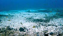
Measuring stress on coral reefs
Detecting coral bleaching events
Satellite-based measures of sea surface temperature (SST) can be used to
predict the occurrence of bleaching events. The methods used to predict
bleaching are currently being improved by adding measures of sunlight
that should provide better prediction of coral mortality in the near future.
Direct observation that reefs have bleached might be possible from space
in areas of high coral cover (>40%) and during severe bleaching events.
Photo: Kathryn Rosell
Resear
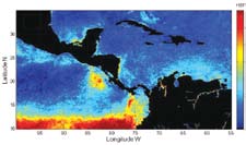
Upwelling areas as refuge from coral bleaching
The cool waters generated by coastal upwel ing have been heralded as
possible refugia from bleaching. However, an analysis of major upwel ing
systems in the Americas reveals that opportunities for managing
bleaching threats are limited. Upwel ing tends to occur from January to
March which does not coincide with the summer period of major thermal
The Coral Reef Targeted Research &
stress in the Caribbean. A few exceptions occur, such as in Colombia
Capacity Building for Management
Program (CRTR) is a leading
where a second period of upwelling occurs in summer. Bleaching-like
international coral reef research
initiative that provides a coordinated
conditions can occur at any time of year in the eastern Pacific which
approach to credible, factual and
Image: Iliana Chollett
means that winter upwelling is unlikely to be a reliable mitigator of
scientifically-proven knowledge for
improved coral reef management.
thermal stress.
The CRTR Program is a proactive
Mapping effects of coral bleaching
research and capacity building
partnership that aims to lay the
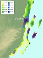
The level of warming reefs experience during a coral bleaching event
foundation in filling crucial knowledge
gaps in the core research areas of Coral
varies from one reef to another. These patterns can be mapped and
Bleaching, Connectivity, Coral Diseases,
included in the design of marine reserves. For example, areas that usual y
Coral Restoration and Remediation,
Remote Sensing and Modeling and
experience warm conditions in summer but relatively weak warming
Decision Support.
during bleaching events are likely to fare better in the future and can
Each of these research areas are
be located by analysing satellite measures of sea surface temperature.
facilitated by Working Groups
Satel ite-derived global maps of such bleaching refugia wil be available
underpinned by the skills of many of the
Image: Ian Elliott
world's leading coral reef researchers.
by the end of 2010.
The CRTR also supports four Centres of
Excellence in priority regions, serving as
Forecasting disease events
important regional centres for building
confidence and skills in research,
Understanding the relationship between both summer and winter ocean
training and capacity building.
temperatures may allow us to provide managers and decision makers
The CRTR Program is a partnership
between the Global Environment
with an advance indication that major outbreaks of coral disease are
Facility, the World Bank, The University
either likely or unlikely. Using satellite monitoring of ocean temperatures,
of Queensland (Australia), the
United States National Oceanic and
new warning products should become available from NOAA's Coral Reef
Atmospheric Administration (NOAA) and
Watch (http://coralreefwatch.noaa.gov) in the near future.
approximately 50 research institutes and
Photo: Ernesto Weil
other third parties around the world.
May 2009
Product code: CRTR 001/2009
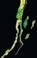
Mapping reefs and spatial decision making
Mapping reef habitats
In other words, field data on reef fish diversity
Relatively subtle differences in reef habitats
are reasonably representative of the wider reef
can be mapped by combining traditional
diversity for Caribbean marine systems.
satel ite or airborne remote sensing with
Designing marine reserves for coral
boat-based towed sonar systems. Sonar
systems discriminate the roughness and
bleaching and larval connectivity
depth of the seabed and help distinguish
The design of marine reserves is often aided
reef habitats that differ in their structural
by reserve selection software such as Marxan
complexity such as branching coral
(www.ecology.uq.edu.au/marxan.htm). New
habitats, massive coral heads (e.g. Porites
algorithms have been developed for use
bommies), Montastraea-dominated reefs,
in Marxan that al ow potential networks of
and gorgonian plains. These methods
reserves to be identified based on the likely
can improve the detail of habitat maps,
response of reefs to future coral bleaching,
particularly for deeper forereef areas (to a
levels of larval connectivity among reefs,
maximum depth of about 15 metres).
and the degree to which the reserve system
Image: Peter Mumby
supports fisheries production or biodiversity
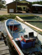
Monitoring reef complexity
conservation.
Boat-based sonar systems can be used to
map and monitor the structural complexity
Spatial patterns of reef resilience
(also known as "rugosity") of reefs rapidly
Reef algae tend to grow more slowly in areas
and over large areas. Areas of high rugosity
that are sheltered from waves because they
tend to have higher biodiversity and declines
receive lower nutrient supply. Ecological
in rugosity (caused by forces like coral
models predict that reefs located in such
mortality or increased bioerosion) pose a
environments are less likely to experience
problem for the recruitment of many reef
blooms of macroalgae, providing that
species as wel as their ability to live within
herbivores are managed wisely. Areas with
the reef structure.
higher wave energy are potential y more
vulnerable to algal blooms, especial y if
Finding good habitat for reef fish
herbivores are depleted and/or coral cover
Maps of rugosity and microhabitat
Photo: Ian Sotheran
drops to low levels. Wave energy can be
distribution from boat-based sonar systems
model ed on reefs using two remote sensing
provide sufficient detail so that the quality
products: (1) free Landsat TM imagery that
of habitat for juvenile and smal -bodied reef
al ows the fetch to be calculated for a reef
fish can be mapped in both the Caribbean
(i.e. the distance over which waves can build
and Indo-Pacific. These maps can be
up before breaking on a reef), and (2)
used to locate areas likely to have high
QuikSCAT data on wind direction and speed.
fish recruitment and help in the design of
monitoring programs so that similar habitats
Easy access to data &
are compared among sites (e.g. between
reserve and non-reserve areas).
new training products
Mapping reef biodiversity
An online directory of satellite data products
Further Information
Marine reserves often aim to include
relevant to reef management is now available
representative portions of each habitat
at http://coralreefwatch.noaa.gov/satellite/
Remote Sensing Working Group
Image: Peter Mumby
Chair: Prof. Peter J Mumby
as part of a strategy to conserve marine
education/index.html. All satellite data
University of Exeter
biodiversity. Studies from the Caribbean
involved in predicting coral bleaching events
Email: p.j.mumby@exeter.ac.uk
have quantified the biodiversity of various
can now be downloaded directly over the
Co-Chair: Dr Laura T David
reef types and found that they differ
University of the Philippines
dramatical y in their overal biodiversity. For
Internet and products can be viewed on
Email: ldavid@upmsi.ph
example, Montastraea reefs can harbour
Google Earth. Training lessons on using
Project Executing Agency:
around 70% of all fish and macrobenthic
remote sensing for habitat mapping and
Coral Reef Targeted Research
coral bleaching prediction are available for
& Capacity Building for
species on Caribbean reefs, and are a
Management Program
priority for inclusion in reserves. To represent
use with the free software Bilko for Windows.
C/- Centre for Marine Studies
100% of reef fish species, the reserve
The University of Queensland
Produced by the CRTR Remote Sensing
St Lucia QLD 4072
network should include representative
Working Group with col eagues in the Coral
Australia
portions of al reef, mangrove and lagoon
Disease, Coral Bleaching and Connectivity
Telephone: +61 7 3346 9942
habitats. Patterns of reef fish diversity
Facsimile: +61 7 3365 4755
among habitats are easy to measure in the
and Large-Scale Ecological Processes
Email: info@gefcoral.org
field and form a reasonable surrogate for
Working Groups.
other (benthic) species in the system.
For further details see: www.gefcoral.org
Photo: Peter Mumby