


March 2007
Field and Policy Action for Integrated Land
Use in the Danube River Basin Methodology
and Pilot Site Testing with Special Reference
to Wetland and Floodplain Management
phase 2 of project output 1.4:
Integrated Land Use Assessment and Inventory
of Protected AREAS

AUTHORS
PREPARED BY:
WWF Danube-Carpathian-Programme Office
AUTHORS:
Michael Baltzer,
Christine Bratrich,
Darko Grlica,
Orieta Hulea,
Andreia Petcu,
Gyongyi Ruzsa,
Jan Seffer,
Susanna Wiener,
WWF International
Danube-Carpathian-Programme Office
Mariahilfer Str. 88a/3/9
A-1070 Vienna

PREFACE
This report has been produced to conclude the activities undertaken as part of the project
output 1.4: Integrated Land Use Assessment and Inventory of Protected Areas of the UNDP/GEF
Danube Regional Project Strengthening the Implementation Capacities for Nutrient Reduction
and Transboundary Cooperation in the Danube River Basin.
The report is aimed to provide a summary of the activities and recommendations resulting from
an analysis of both Phase I and Phase II of the project focused on Field and Policy Action for
Integrated Land Use in the Danube River Basin Methodology and Pilot Site testing with special
reference to wetland and floodplain management. The report has been written to provide a
technical record for those considering wetland restoration activities related to changing of land
use.
Integrated Land Use Assessment and Inventory of Protected Areas
page 5
TABLE OF CONTENTS
1.
Introduction .......................................................................................................15
1.1. Aims & Objectives ............................................................................................17
1.1.1.
overall aims ..............................................................................................17
1.1.2.
Specific purpose and objectives of project phase 2..........................................17
1.2. Structure of this report .....................................................................................17
2.
Project Site Descriptions ......................................................................................18
2.1. The Olsavica valley, Tisza sub-basin, Slovakia ......................................................18
2.2. Lower Elan valley, Prut sub-basin, Romania .........................................................20
2.3. The Zupanijski canal, near Budakovac village, Drava sub-basin Croatia....................22
3.
Implementation of Activities in Phase 2 ..................................................................24
3.1. Summary of Activities.......................................................................................24
3.2. Activities related to the application of the methodology for assessing land use ..........26
3.2.1.
Applying the methodology in the selected three pilot sites................................26
3.2.2.
Lessons learned from applying the methodology at the three different pilot
sites 27
3.2.3.
Assessment of applicability, usefulness, and assignability of the methodology .....34
3.3.3
Implementation of action plans in each site ..................................................39
3.3. Activities related to the implementation of proposed restoration measures,
communication, and policy action at the three selected pilot sites:....................................41
3.3.1.
Activities implemented in Slovakia (Olsavica Valley):.......................................41
3.3.2.
Lessons learned from the Slovakian pilot site .................................................44
3.3.3.
Activities implemented in Romania (Lower Elan Valley): ..................................45
3.3.4.
Lessons learned from the Romanian pilot site.................................................49
3.3.5.
Activities implemented in Croatia (Zupanijski canal):.......................................50
3.3.6.
Lessons learned from the Croatian pilot site ...................................................52
3.3.7.
Lessons learned on how to use the methodology to influence policy decision
makers in the three pilot sites (synthesis) ..................................................................53
4.
Conclusions and recommendations ........................................................................57
4.1. General lessons learned ....................................................................................57
4.1.1.
Setting goals and objectives ........................................................................57
4.1.2.
Applying the methodology ...........................................................................58
4.1.3.
Implementing restoration measures on the ground .........................................59
4.1.4.
Using pilot sites for influencing policy decision makers.....................................60
UNDP/GEF DANUBE REGIONAL PROJECT
page 6
LIST OF TABLES
Table 1:
Assessment of the applicability, usefulness and assignability of the
methodology. Data collected at three different pilot sites in the Slovak Republic
(upper Tisza basin), Romania (Elan river), and Croatia (Drava river). .................... 36
LIST OF PICTURES AND GRAPHS
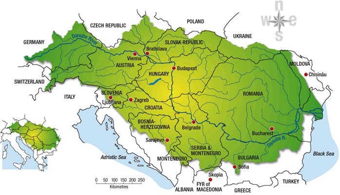
Figure 1: The Danube River Basin and locations of the selected three pilot sites in the
Slovak Republic (Olsavica); Romania (Elan Valley), and Croatia (Virovitica). ........... 18
Figure 2: Olsavica river basin is located in Levocske vrchy Mts. (Hornad Tisza Basin)
with total area 13 km2. ................................................................................... 19
Figure 3: Location of the pilot project site in Romania (3300 ha total, 382 hectares
represent wetlands) in the Elan River Basin, with a total area of 601 km2............... 21
Figure 4: Location of the pilot study site in the Drava river basin southeast of the city of
Virovitica with total area of 2350 ha................................................................. 23
Figure 5: Romania example for GIS mapping: (top left) project location in Romania,
(bottom left) current land-use; (right) proposed alternative landuse to halt
ongoing soil erosion along the hills. .................................................................. 28
Figure 6: Principle overview on how to find / define the optimal status of wetlands
(example from the Slovakian pilot case). ........................................................... 31
Figure 7: Real (top) and optimal (bottom) status for of wetlands in Olsavica Village
(Slovakia). The image illustrates a possible optimal and realistic occurrence of
wetlands in the Olsavica basin. The maps are based on four sources of
information: (1) a geo-botanical map incl. predicted potential vegetation, (2)
an aerial photo from 1949 showing detail land-use situation and delineated
wetlands, (3) the comparison of wetland types in well preserved down stream
parts, and (4) a 3D model of the terrain used for defining erosive sections of
the channels. ................................................................................................ 32
Figure 8: Technical implementaion of measures to improve the situation of wetlands in
the Slovakian pilot site building small dams to control channel erosion (a,b)
and re-opening of small meanders to improve ecological integrity of the
canalized river and to lower discharge velocity (c,d)............................................ 42
Figure 9: Technical implementation of measures to improve the situation of wetlands in
the Slovakian pilot site mulching of wet grasslands. ......................................... 43
Figure 10: Technical implementation of measures to improve the situation of wetlands in
the Slovakian pilot site planting of native species on stream banks to control
soil erosion organized in close cooperation with local NGOs and authorities. ........... 43
Figure 11: Lower Elan situation under normal flow conditions (a) and during increasing
flood in spring 2006 (b, c, d). The floods reconnected some of the old
meanders and destroyed dikes on the left site of the river course. However,
the originally planed restoration work had to be postponed. ................................. 46
WWF DANUBE-CARPATHIAN-PROGRAMME / BALTZER ET AL.
Integrated Land Use Assessment and Inventory of Protected Areas
page 7
Figure 12: Original plans to re-connect the old meander system along the Lower Elan with
the main river course. Parts of the meanders were naturally reconnected
through the breach of the left bank dike of the Elan River. Current negotiations
with local land-owners aim to maintain the improved situation that has been
caused by the floods....................................................................................... 47
Figure 13: Typical situation of traditional land use on the slopes along the Elan river. 85%
of the total area is split into excessively small plots. Each site is smaller than 1
ha and arraigned in uphill- downhill directions causing massive problems with
soil erosion. .................................................................................................. 48
Figure 14: Technical implementaion of measures to improve the situation of wetlands in
the Romanian pilot site mechanical gully filling by bulldozers along the river
slopes. ......................................................................................................... 48
Figure 15: Proposed Natura 2000 site along the floodplains of the Elan River (Mata-
Radeanu). The site has already been validated at national level. ........................... 49
Figure 16: Map to illustrate technical measures to improve the situation of wetlands at the
Croatian pilot site reconnecting old oxbow system with the main river
channel. Original plans (top) and reviewed situation after finalisation of the
topographic survey (bottom). .......................................................................... 52
UNDP/GEF DANUBE REGIONAL PROJECT
page 8
ABBREVIATIONS
CAP
Common Agricultural Policy
CIS
Common Implementation Strategy of the EU Water Framework Directive
DRB
Danube River Basin
DRP
Danube Regional Project
EC European
Commission
ECO EG
Ecological Expert Group of ICPDR
EU European
Union
GEF
Global Environment Facility
GIS Geographical
Information
System
ICPDR
International Commission for the Protection of the Danube River
IRBM
Integrated River Basin Management
ISPA
EU pre-accession instrument for structural measures
LIFE
The EC financial instrument for the environment
UNDP
United Nations Development Programme
RBM EG
River Basin Management Expert Group of ICPDR
SAPARD
EU pre-accession instrument for agriculture and rural development
measures
WFD
Water Framework Directive (2000/60/EC)
WWF
World Wide Fund For Nature
WWF DANUBE-CARPATHIAN-PROGRAMME / BALTZER ET AL.
Integrated Land Use Assessment and Inventory of Protected Areas
page 9
EXECUTIVE SUMMARY
Objective 1 of the UNDP/GEF Danube Regional Project offers support to policy development
favouring the creation of sustainable ecological conditions for land use and water management.
Within Objective 1, Integrated Land Use Assessment and Inventory of Protected Areas (Output 1.4)
was one of eight project outputs. The project was implemented in two phases: Phase 1 was
conducted between December 2001 and November 2003. Phase 2 started in June 2005 and ended
in December 2006. This report covers only the Integrated Land-use Assessment element of Output
1.4 (the Inventory of Protected Areas is the subject of a separate report).
Overall aim and specific project objectives of Output 1.4:
The overall aim of Output 1.4 was to assist Danube River Basin countries to prepare new land-use
and wetland rehabilitation/protection policies and legislation in line with existing and emerging
legislation, particularly the EU Water Framework Directive.
The specific objectives of this component of Phase 1 of Output 1.4 were to:
(a) develop a straightforward, yet rigorous, land-use assessment methodology that could be
tested and adapted if necessary for use across the region;
(b) select three pilot sites on which the methodology could be tested by implementation of
specific site-based activities including the holding of a workshop at each location to ensure
stakeholder involvement and wider public participation in the identification and assessment
of various future land-use alternatives;
(c) according to the results of the test phase, develop specific proposals for final land-use
concepts at each pilot site, including recommendations for the actions and measures
required to implement the concepts in practice; and
(d) develop a communications strategy to ensure the dissemination of conclusions and
recommendations, including the final land-use assessment methodology, throughout the
Danube River Basin.
The specific objectives of this element of Phase 2 of Output 1.4 were to:
(a) implement technical mitigation measures and alternative concepts that have been
developed in the first phase to achieve integrated land use management at each pilot site
(practical restoration work, regulatory issues, economic fines and incentives, compensation
payments etc.);
(b) mainstream wetland conservation and restoration activities into rural development plans
and policy on local, regional and national levels and securing governmental commitments
to implement the newly proposed concept for integrated land use in the selected case
studies;
(c) demonstrate mechanisms for sustainable wetland use and disseminating project results in
the Danube basin.
UNDP/GEF DANUBE REGIONAL PROJECT
Executive Summary
page 10
Activities completed successfully by the project Output 1.4 include:
(a) Activities related to the application of the methodology for assessing land use:
1. The methodology was applied in the selected three pilot sites Olsavica valley, Tisza sub-
basin, Slovakia; Lower Elan valley, Prut sub-basin, Romania; and Slovakia Zupanisjski
canal, near Budakovac village, Drava sub-basin Croatia;
2. An assessment was completed of the applicability of developing sustainable land-use
concepts at each pilot site that aim at reducing nutrient inputs into water bodies,
particularly through wetland and floodplain rehabilitation and/or restoration;
3. An assessment was completed of the applicability to find practical and policy measures
required to move towards more sustainable land use patterns at each pilot site.
(b) Activities related to the implementation of proposed restoration measures, communication, and
policy action at the three selected pilot sites:
The following activities have been completed during the second project phase.
In Slovakia (Olsavica Valley):
1. Construction of small dams on selected streams to control channel erosion;
2. Reopening of small meanders on a canalised stream;
3. Restoration of wet grasslands to act as a buffer zone between agricultural land
and the stream;
4. Blockage of an underground drainage system to restore water tables;
5. Planting of trees on steep stream banks to control soil erosion;
6. Springs were fenced off to prevent damage from grazing; and
7. Restoration promoted more widely through public awareness information.
In Romania (Lower Elan Valley):
1. A feasibility study and rehabilitation measures of the lower Elan floodplain downstream of
the confluence with Sarat Creek through meander restoration were conducted. (Activities
were only partly completed because of two major flood events in the region that hindered
the full implementation of activities. The activities will be completed immediately after the
project termination. See also below: `constraints and unexpected events');
2. Parts of the Elan river channel were partly reprofiled (activities have been partly completed
because of two major flood events in the region, they will be continued after project
termination, see also below: `constraints and unexpected events');
3. Control of soil erosion on hill slopes through changed land-use, implementation of better
agricultural practices, land reclamation and afforestation;
4. Declaration of the Lower Elan floodplain as a protected area; and
5. Improvement of public awareness and the training of civil society organisations especially
those in local communities and schools.
WWF DANUBE-CARPATHIAN-PROGRAMME / BALTZER ET AL.
Integrated Land Use Assessment and Inventory of Protected Areas
page 11
In Croatia (Zupanisjski canal):
1. Geographical survey of the area to investigate most suitable measures to reconnect the
Drava river to adjacent Podravski Sokolac wetland and Budakovac oxbow and consequently
raise local water tables;
2. Feasibility study to implement the most suitable measure to reconnect water from the
Drava river to adjacent Podravski Sokolac wetland and Budakovac oxbow and consequently
raise local water tables;
3. Dissemination of the findings, conclusions and recommendations from these activities.
Conclusions, lessons learned and implementation constraints
General conclusions
·
The methodology for assessing land use was successfully applied in all three pilot sites.
Other potential users including national and local authorities in the Danube River Basin,
NGOs and international organisations such as the Ramsar Secretariat are encouraged to
make use of this methodology.
·
The technical work and stakeholder involvement during the first phase and at each site was
successful in producing outline action plans for the second project period.
·
The project supplied evidence that by carefully planned landuse changes, it is possible to
provide a significant contribution to wetland restoration and wise management of wetland
resources and services.
·
It also provided evidence that building the capacity of local people on EU policy and the
opportunities that EU policy offer can provide a signification platform for success even for
far-off rural areas in new member states and even in proposed new accession states such
as Croatia.
·
Many of the actions recommended at each pilot site are in line with, and could be more
widely encouraged by, existing policy drivers. Four policy measures and socio-economic
trends in particular were found to support sustainable land-use and wetland restoration
measures:
·
Wetlands are an integral part of the EU Water Framework Directive (WFD);
·
Agriculture is changing across Europe:
·
Wetlands can help to safeguard against floods; and
·
Public participation is now a legal necessity
UNDP/GEF DANUBE REGIONAL PROJECT
Executive Summary
page 12
Lessons learned
The lessons learned from the project indicate clearly that it is important that the key policy drivers
and opportunities described above are promoted at all levels, especially by the European
Commission, the ICPDR, national governments and statutory authorities within the Danube River
Basin and regional authorities. The project supplied evidence that:
·
landuse changes are able to provide a significant contribution to wetland restoration and
wise management;
·
capacity building with local people on EU policy can trigger major success even at far-
off rural areas in the new EU member states;
·
capacity building on the ground will be key for sustainable management solutions in
these areas;
On the other hand, the lessons learned from the project also illustrate the constraints of the
selected policy goals:
·
Policy goals on national or international scale might have been too ambitious. The
project received very good feedback on local scales by demonstrating successful impacts
on local landuse planning and local landuse techniques. It also received positive feedback
on regional scales provided that activities were imbedded in existing structures or concepts
(e.g. the Lower Danube Green Corridor initiative). However, the input on national or even
international level was only weak or impossible. This would require a longer and more
intensive project design.
·
The principle of using "bottom up models" to influence top down decision-making is
important but not entirely sufficient. A pure focus on "bottom up" activities will not show
significant large-scale impact unless activities are not coordinated with ongoing "top down
elements" (e.g. river districts that are preparing WFD implementation processes,
authorities that are working on agri-environmental measures or N2000 designation etc.).
·
With regard to this, the selection of the case study locations was perhaps not
completely appropriate. While the sites provided very adequate opportunities to test and
demonstrate restoration activities related to land-use change, all of the selected regions
were far-off from central decision makers and only the Slovakian and Romanian pilot case
managed to demonstrate a significant footprint on the regional and small footprint on the
national level.
·
The aim "to assist `Danube River Basin countries' to prepare new land-use and wetland
policies and legislation in line with existing and emerging legislation" was also too
ambitious. To aim to assist "Danube River Basin Districts" would have been the more
realistic objective with hindsight.
·
Due to administrative delays at UNDP/GEF concerning the set up of the second tender
process the policy work during the second project phase was facing major temporal
constraints and original goals had to be implemented in too tight a timeframe (see
below).
WWF DANUBE-CARPATHIAN-PROGRAMME / BALTZER ET AL.
Integrated Land Use Assessment and Inventory of Protected Areas
page 13
One overarching policy finding of Output 1.4 is that information on the policy drivers (i.e.
wetlands as integral part of the EU WFD, EU CAP reform, EU Flood Directive, Natura 2000
Directive) is still lacking locally. At local site levels there is still a chronic shortage of information
and knowledge about recent, new and emerging policies and the opportunities associated with
them, including financial instruments, for promoting sustainable land use. To work with local
communities to overcome such serious shortcomings represented the most promising part of
Output 1.4.
·
In terms of "hard" policy findings, many European or Danube-wide policies already
support the actions suggested for each pilot site. For instance, the WFD and other EU and
international instruments such as the Natura 2000 directives and Bern Convention clearly
support wetland restoration as a contribution to Integrated River Basin Management
initiatives. However, implementation is still lacking. Similarly, the ongoing reform of the
Common Agricultural Policy, SAPARD and Rural Development Directive will offer a range of
supportive instruments, although knowledge and uptake of these remains low. The
Horizontal Guidance on Wetlands in principle offers guidance on how wetland restoration,
protection and sustainable management can actively contribute to achieving the WFD
objectives. However, implementation of measures is also quite often lacking.
·
Analysis of "soft" policy aspects from Output 1.4 showed that there are often different
realities in rural areas and at national level possibly as a result of a bottleneck in
administrative capacity at local or regional levels. Access to information on many policy
instruments should also be improved and there is an urgent need to improve the active
involvement of the public, in line with Article 14 of the WFD. The three pilot sites all
highlighted the need for immediate capacity building of governmental institutions and
administrations at regional and local levels for WFD and other types of policy and
programmatic information provision, public awareness and implementation. Such capacity
building actions should also be extended to include NGOs and other stakeholders who can
play a constructive role in implementation of the WFD and other policy instruments.
Implementation constraints
The implementation of proposed practical rehabilitation work at each pilot site, however, faced
several constraints and unexpected events during the second project phase that led to delays in
the implementation and highlight a number of the constraints that restoration projects may face:
a. Adverse weather conditions. The project region was affected by very hard weather
conditions during the second project period between 2005 and 2006: The winter 2005/2006
brought a lot of snow and very low temperatures (down to minus 20 degree) and both years
were hit by major flood events (with a flood probability of more than 100 years). Some of the
planned restoration measures in Croatia and Romania were influenced or delayed due to these
unexpected events.
b. Loss of local project leader. Furthermore, project work in Croatia was affected by the
dramatic fatality of our local project manager David Reeder, who died completely
unexpectedly in September 2006.This caused major delay in the implementation of the work
programme in Croatia since the project management was not able to find an adequate
substitute for David Reeder within the remaining project period. With support of the DRP
headquarters in Vienna, but already with a significant delay, the management team of Output
1.4 succeeded to establish a new coordination team for implementing the remaining measures
UNDP/GEF DANUBE REGIONAL PROJECT
Executive Summary
page 14
at Zupanijski canal in Croatia. This team will be managed directly by Mr. Danko Biondic of
Croatian Waters representing a successful integration of the project in national administrative
structures.
c. Administrative delays under the project management: the start of the second project
phase was delayed due to administrative problems at the coordinating office of the Danube
Regional Project (UNDP/GEF office in Vienna) to set up the tender process. In consequence the
project faced a significant loss of continuity creating partly losses of credibility at the local
scale and lack of institutional memory at all levels of project management (caused by staff
changes). To reactivate former contacts more time was required than expected. This also
triggered some project delays, particularly in Romania. Nevertheless, delayed implementation
of individual measures is still ensured due to existing contracting agreements with local
consultants.
Delayed activities to be completed under the Output 1.4 by spring 2007:
In Croatia:
·
Installing a second hydraulic structure or providing an equivalent solution to raise surface
water levels in the channel and adjacent Marcina jama reed beds; if possible realise a
solution to reconnect the system with a semi-natural channel and without hydraulic
structures.
·
Constructing a 150m channel to rehabilitate reed beds around Zanos or providing an
equivalent solution.
·
A workshop for local stakeholders to review the technical steps described above was
postponed until the implementation of the measures by Croatian Waters.
In Romania
·
The work on re-profiling the Elan river channel was partly conducted by the natural flood
events. In summer 2006, part of the dikes was broken and the old meander system was
flooded and re-connected with the Elan river system. Further negotiation is needed to
maintain this situation.
·
The work to improve hydrological conditions at Mata Radeanu fish farm (at confluence of
Elan and Prut rivers) was delayed as the fishpond was completely flooded in summer 2006.
·
The planting of native Salix and Populus saplings along the Elan river had to be postponed
due to very high water levels.
WWF DANUBE-CARPATHIAN-PROGRAMME / BALTZER ET AL.
Integrated Land Use Assessment and Inventory of Protected Areas
page 15
1. INTRODUCTION
This report covers activities within the framework of the UNDP/GEF Danube Regional Project (DRP),
the long-term development objective of which is "to contribute to sustainable human development
in the Danube River Basin through reinforcing the capacities of participating countries to develop
effective mechanisms for regional cooperation in order to ensure protection of international waters,
sustainable management of natural resources and protection of biodiversity".1
The DRP was designed in two independent phases. The goal of the first phase was to prepare and
initiate basin-wide capacity-building activities. These initiatives then should be implemented and
tested during second phase of the project (December 2001 to November 2003), for further
consolidation during DRP Phase 2 (June 2005 to December 2006). The DRP comprises 20 Project
Outputs, together covering more than 80 separate activities, which are grouped into four
immediate objectives:
Objective 1: Support for policy development favouring creation of sustainable ecological
conditions for land use and water management;
Objective 2: Capacity building and reinforcement of transboundary cooperation for the
improvement of water quality and environmental standards in the Danube River Basin;
Objective 3: Strengthening of public involvement in environmental decision-making and
reinforcement of community actions for pollution reduction and protection of
ecosystems;
Objective 4: Reinforcement of monitoring, evaluation and information systems to control
transboundary pollution, and to reduce nutrients and harmful substances.
The present study covers Phase 2 activities within Project Output 1.4 Integrated Land Use
Assessment and Inventory of Protected Areas, one of eight Project Outputs under the overall
umbrella of Objective 1. In particular, this report provides findings and recommendations designed
to support sustainable, integrated land-use patterns. These land-use patterns were planned to be
capable of delivering multiple socio-economic and ecological benefits, including nutrient reduction
in streams and rivers.
The report also introduces an overview of the implementation of floodplain and wetland restoration
and management measures, including rehabilitation and/or restoration where appropriate. This
report deals only with implementation measures related with the Integrated Land Use element of
Project Output 1.4. In this respect, it is important to underline that certain activities and outputs
under other Project Outputs are of particular relevance to the issues dealt with in this report.
1 Source: DRP Project Implementation Plan, available at http://www.icpdr.org/undp-drp/
UNDP/GEF DANUBE REGIONAL PROJECT
1. INTRODUCTION
page 16
These include the following:
·
Policy development river basin and water resource management, and agriculture
Project Output 1.1
Development and implementation of policy guidelines for river
basin and water resources management (Activities within this
Output have been developed to mirror the development of
guidelines in the framework of the Common Implementation
Strategy (CIS) of the EU Water Framework Directive (WFD). Of
particular note is Activity 1.1-11 which has been instrumental in
producing a Draft Public Participation Strategy for the DRB,
reflecting the emphasis of the WFD on public participation as a key
cross-cutting issue. The results of this Output should be seen in
the light of the CIS Horizontal Guidance on Wetlands and the
WFD, published in November 2003);
Project Output 1.2
Reduction of nutrients and other harmful substances from
agricultural point and non-point sources through agricultural policy
changes;
Project Output 1.3
Development of pilot projects on reduction of nutrients and other
harmful substances from agricultural point and non-point sources
through agricultural policy changes.
·
Public participation
Project Output 3.1
Support for institutional development of NGOs and community
involvement (notably through establishment of the Danube
Environment Forum);
Project Output 3.3
Organization of public awareness-raising campaigns on nutrient
reduction and control of toxic substances.
These two Outputs have also contributed to preparation of the
Public Participation Strategy for the Danube River Basin, (see
Output 1.1).
·
Monitoring and assessment
Project Output 4.3
Monitoring and assessment of nutrient removal capacities of
riverine wetlands. (Activities under this Project Output have also
been implemented in both phases by WWF, involving the
development of a draft assessment methodology for testing at
pilot sites and monitoring the effect of wetland restoration of Lake
Katlabuh in the Ukrainian part of the Danube Delta).
The outputs of all of the above Project Outputs will need to be taken into consideration to support
to sustainable development in the Danube Basin. Effective mechanisms for regional cooperation to
ensure the protection of international waters should reflect the lessons learned from all different
project components.
WWF DANUBE-CARPATHIAN-PROGRAMME / BALTZER ET AL.
Integrated Land Use Assessment and Inventory of Protected Areas
page 17
1.1. Aims & Objectives
1.1.1. overall
aims
The DRP Project Implementation Plan and the Terms of Reference for Project Output 1.4 identify
the following overall aims:
·
The primary focus is to assist DRB countries to prepare new land use and wetland
rehabilitation/protection policies and legislation in line with existing and emerging
environmental legislation.
·
The Project Output shall address common inappropriate land uses and subsequent impacts
on ecologically sensitive areas and wetlands including the effects of transboundary pollution
with particular attention to nutrients and toxic substances.
·
While targeting action at a high policy level, the Output is also directed towards
demonstrating pragmatic implementation of appropriate land use management on the
ground in pilot activities.
1.1.2. Specific purpose and objectives of project phase 2
Based on the results of project phase 1, the purpose of phase 2 (July 2005 December 2006) was
the implementation of identified approaches for integrated land use assessment, policy concepts,
and mitigation measures. Phase 2 aimed to test the outputs of phase 1 in the context of the three
selected pilot sites and tried to demonstrate its feasibility. It also aimed to magnify the pilot study
results to support Danube River Basin countries in implementing the WFD on a broader scale.
This comprises the following objectives:
·
Implementing of proposed technical mitigation measures and alternative concepts for
achieving integrated land use management at each pilot site (including practical restoration
work, regulatory issues, economic fines and incentives, compensation payments etc.);
·
Mainstreaming of wetland conservation and restoration activities into rural development
plans and policy on local, regional and national levels and securing governmental
commitments to implement the newly proposed concept for integrated land use in the
selected case studies, and
·
Demonstrating mechanisms for sustainable wetland use and disseminating project
results in the Danube Basin.
1.2. Structure of this report
The structure of the report has been designed to present the project results and analysis according
to the structure of the projects objectives and their relation to the separate phases of the project.
Section 2 sets out the aims and objectives of activities under the integrated land-use part of
Project Output 1.4, with reference to the Terms of Reference established by UNDP/GEF. This is
followed by a section providing a description of the project sites and activities undertaken, in three
different DRP Pilot Sites in Croatia, Romania and the Slovak Republic, respectively. The final
chapter sets out the findings and lessons learned which are relevant at a range of different levels
(e.g. field and policy; local, national and international) and for a range of different actors (e.g. Pilot
Site stakeholders, national authorities, ICPDR, EC etc).
UNDP/GEF DANUBE REGIONAL PROJECT

2. PROJECT SITE DESCRIPTIONS
page 18
2. PROJECT
SITE
DESCRIPTIONS
Olsavi
Olsav ca pilot site
Elan Valley p
y ilot
Vir
Vi o
r vi
v tica
ti pilot site
ca
Figure 1:
The Danube River Basin and locations of the selected three pilot sites in
the Slovak Republic (Olsavica); Romania (Elan Valley), and Croatia (Virovitica).
2.1. The Olsavica valley, Tisza sub-basin, Slovakia
Activities in Slovakia were focused on the Olsavica valley which is located in Levoca district of
Presov county and lies within the Hornad Basin (Tisza sub-basin, Figure 2). The whole district is
on the border between Central and Eastern Slovakia, and located in the eastern part of the
Levocske vrchy hills, which are part of the Carpathian Mountain range (720920 m above sea
level).
·
Project area
The total area of the pilot site is 1367 ha. The border was defined on the catchment area of
Olsavica stream, which is a tributary and one of the spring systems of the Torysa River.
According to the regional geomorphological division (Mazur, Luknis 1980) Levocske vrchy
belongs to the Western Carpathians. Levocske vrchy (Levoca Hills) is a mountainous area of
north-eastern Slovakia built of flysch rocks with a central ridge. The central part of the area is
the Levocska vysocina. The central ridge is huge with forks separated by deep valleys. The
highest hill is Cierna hora at 1,289 m above sea level. The Levocska vysocina borders the
Levocska vrchovina in the west and the Levocske planiny in the south. The relief has an upland
character, but also has plateau characteristics.
WWF DANUBE-CARPATHIAN-PROGRAMME / BALTZER ET AL.
Integrated Land Use Assessment and Inventory of Protected Areas
page 19
·
Land-cover
The most dominant land-cover types are spruce forests, grasslands, extensive pastures with
European larch (Larix decidua) and arable land. The regional geological structures mean that
the area has an abundant groundwater supply, with the sandstone yielding a number of fissure
springs. Wetlands are represented by fragments of submontane and montane floodplain forests,
fens, tall sedges and wet grasslands, though these are much reduced due to human impacts
(see below).
Figure 2:
Olsavica river basin is located in Levocske vrchy Mts. (Hornad Tisza
Basin) with total area 13 km2.
·
Major threats
The village Olsavica has been subjected to significant flooding with consequent property and
personal damage, since the mid-1980s. The flooding is thought to be largely the result of
agricultural intensification, during the late 1970s and early 1980s. Intensification measures
included installation of a dense network of subsurface and surface drainage canals, and removal
of the historical terraces and grassland buffers. Springs and wetlands in upper part of Olsavica
valley have been drained and subjected to intensive agriculture, fertilizer and manure use.
In addition to local flooding, the area suffers from massive soil erosion, which, together with
excessive runoff, contributes to sediment and nutrient loading of watercourses. These factors
together are likely to have a negative impact on downstream water quality and to increase the
risk of flooding elsewhere in the basin. Soil erosion has led to a decrease in the area of land
available for arable cultivation.
·
Conservation values
The area has high nature conservation value, but Olsavica valley is not included within any
formally recognised protected area, although a significant part of it is designated as a water
supply protection area. Zone A, established in 1983 should positively influence some 1,062 ha
of agricultural land, while Zone B, established in 1993 by a decision of the District Environment
Department in Presov, should apply to a further 562 ha of farmland. In practice, the farming
UNDP/GEF DANUBE REGIONAL PROJECT
2. PROJECT SITE DESCRIPTIONS
page 20
cooperative does not strictly respect the water supply protection areas, because there is no
compensation/incentive for doing so.
·
Socio-economical situation
Olsavica depends on farming and has suffered from rural depopulation in recent years. The
principal economic stakeholder is the agricultural enterprise `OlsavicaBrutovce' which farms
some 2,290 ha, of which approximately 1,936 ha is grassland. The remaining c.350 ha are
located mainly in the upper part of the valley and subject to intensive arable production. The
process of land (re-)privatization in Olsavica Valley was initiated several years ago but is still
incomplete. Most private landowners rent their land to the agricultural cooperative.
2.2. Lower Elan valley, Prut sub-basin, Romania
Activities in Romania were concentrated on the Elan River, a tributary of the Prut River, in
Vaslui and Galati Counties (Figure 3). The Elan basin lies within the Moldavian Plateau of
eastern Romania. The total surface of the basin is of 601 km2. The local topography shows
typical features of a range of "rolling hills".
·
Project area
The `Lower Elan' Basin pilot site comprises an area of almost 3,300 hectares being situated
immediately upstream of the confluence between the Prut and Elan Rivers. The main village of
Murgeni within the Lower Elan basin lies 35 km east of the city of Barlad (Vaslui County) and 90
km north of the city of Galati (Galati County) as measured by road distance. Within the pilot
project site, about 620 hectares represent the floodplain, out of which permanent wetlands
cover 382 hectares (divided into 364 hectares of reed swamp and 18 hectares of water bodies).
·
Major threats
The natural Elan ecosystem has been disrupted in several ways. Upstream, the Posta Elan
Reservoir was intended to fulfill combined flood protection and water supply functions. However,
due to construction of the reservoir, dike-building along the right bank of the Elan River, and
canalisation of the main channel, this side of the floodplain is no longer flooded and large areas
were developed for agricultural use during the Ceaucescu period. The land was leveled and
extensive drainage systems were installed. After the political changes of the 1990s the collective
farms were broken up and ownership was reclaimed by local inhabitants. The former floodplain
drainage system collapsed and the land is now cultivated by the landowners. The left-bank
floodplain has effectively acted as a sedimentation basin, with a rapid build-up of sediment.
Excessive hillside erosion is recognized as a major environmental threat throughout the
Moldavian Plateau of eastern Romania. In 1950, the traditional hillside agricultural system of
cultivation up and down slopes (i.e. across, not with, the contours) prevailed. Most of the land
was split into excessively small plots, each of less than one hectare in size. Except in a few
localised areas, there were no concerns about the threat from soil erosion and a minimum
awareness of conservation practices. After 1950, theses areas were incorporated into collective
farms. Many innovative research studies on soil erosion control were initiated and conservation
practices were considered a national priority. By the end of 1989, up to 30 percent of the
agricultural land with erosion potential had been ameliorated. To make things worse, during the
last decade, the state has ceased funding for soil erosion control and such investment does not
represent a priority for landowners.
WWF DANUBE-CARPATHIAN-PROGRAMME / BALTZER ET AL.
Integrated Land Use Assessment and Inventory of Protected Areas
page 21
Figure 3:
Location of the pilot project site in Romania (3300 ha total, 382
hectares represent wetlands) in the Elan River Basin, with a total area of 601 km2.
·
Conservation values
The Lower Elan wetlands are extremely important, for both people and biodiversity because of
their functions for flood peak mitigation, agriculture, water supply, fisheries, and habitats for
flora and fauna: The Lower Elan wetlands also help to reduce flood peak mitigation, provide
agriculture support, water supply, fisheries support and habitat provision for flora and fauna.
Although damaging floods are far less prevalent than formerly (due to dam construction
upstream) the Lower Elan Floodplains may still have a vital role to play during exceptional
rainfall events.
·
Socio-economical situation
The local commune, Murgeni, has around 8,660 inhabitants and an area of 13,240 hectares.
Because there is very little industry in the area the inhabitants use their land for livestock
rearing (sheep and cattle) and extensive cultivation of crops (especially maize and sunflower
but also some vineyards) without any assistance from irrigation. Cattle are allowed to graze in
certain areas throughout the year, and, after the hay crop is cut, graze the whole floodplain. In
case of severe drought (as in 2003) the reed beds are used as food for cattle. There is a
fishpond complex close to the confluence of the Elan and Prut, but collapse of the retaining dike
means that there is insufficient water for fish production and biodiversity values have also
decreased.
The resource functions of the floodplain are also significant. Drinking water for people and
livestock, small-scale irrigation and groundwater replenishment is desperately needed in the
area given that the average water deficit is about 200 mm/year. Provision of potable water is a
UNDP/GEF DANUBE REGIONAL PROJECT
2. PROJECT SITE DESCRIPTIONS
page 22
major challenge given that the water from the three groundwater boreholes in the area cannot
be used for drinking purposes without treatment.
The Lower Elan wetlands also support the deposition of nutrient-rich sediments carried by the
river. This brings important benefits further downstream to the Prut and Danube Rivers, through
the reduction of nutrient loads, mainly nitrogen and phosphorous from agricultural sources, but
also from human wastes and industrial discharges. Some of these nutrients are taken up by
wetland/floodplain vegetation and reed harvesting in winter effectively removes them from the
system, as well as providing important raw materials for local villagers.
2.3. The Zupanijski canal, near Budakovac village, Drava sub-
basin Croatia
Activities in Croatia were focused on the Budakovac wetlands. They lie on the old floodplain of
the River Drava in Croatia, southeast of the city of Virovitica (Figure 4). Before river regulation,
drainage and land reclamation works were carried out, from the late Eighteenth Century
onwards. This was a flood-prone region where the river meandered extremely, creating an
extensive pattern of oxbow lakes, river branches and islands on both sides of the river.
·
Project area
The entire study-area, extending laterally towards the river, covers some 18 km2 and contains
four villages. The pilot site is 2350 ha in extent in a section of the River Drava, which forms the
basis of the border between Hungary and Croatia. Some oxbows remain, although atrophied,
but the meander scars are clearly evident on modern maps through land-use variation and
particularly on multi-band satellite images. Many of these oxbows, both in Hungary and Croatia,
are suitable for rehabilitation. This section is a classic expression of European lowland, lower-
course rivers.
·
Major threats
River regulation and drainage works since the Nineteenth Century have lowered the river-level
and the water-table, such that the wetlands are now much reduced. This has been exacerbated
in 2002 by the deepening of the Zupanijski canal, a canalized river, which runs alongside the
wetlands, in such way that the level of the Budakovac oxbow lake has fallen by one meter, as
has the groundwater, and many old oxbows and branches have almost dried out.
Where the treated mix of municipal and industrial wastewater enters the Zupanijski canal, the
presence of nitrates and phosphates remains so high that the water is Category V in quality.
Further downstream the canal passes several villages and the quality drops, presumably
indicating that untreated wastewater from these settlements reaches the canal. None of the
villages benefits from a piped water supply or from any form of wastewater treatment. The
result is that by the time the canal reaches the Drava River, the water is Category II in terms of
nitrate and phosphate content. Under certain circumstances, water quality entering the Drava
is thought to be significantly lower. For example, during annual maintenance at the Viro facility,
municipal wastewater is fed directly into the Zupanijski canal without treatment. Furthermore,
though nutrient concentrations are theoretically diluted in wet periods, the fact that storm water
and sewage are not separated in the municipality of Virovitica makes treatment difficult due to
the excessive volumes involved.
WWF DANUBE-CARPATHIAN-PROGRAMME / BALTZER ET AL.
Integrated Land Use Assessment and Inventory of Protected Areas
page 23
Figure 4:
Location of the pilot study site in the Drava river basin southeast of the
city of Virovitica with total area of 2350 ha.
·
Conservation values
The Zupanijski Canal and the former floodplain wetlands show a high potential for bio-
remediation and therefore also a high potential for raising the average quality of water reaching
the Drava-Danube system. This triggers additional conservation benefits, including improved
fishery production and a general improvement in wetland habitat extent and quality. The most
effective bio-remediation is on a stretch where the canal could not be straightened because of
inaccessibility to machinery, so it follows the curve of the old natural oxbow for a few hundred
metres. Here, water quality reaches Category I.
·
Socio-economical situation
Most people living in the villages within the pilot site make their livings from agriculture and
some from forestry. Rural development is urgently needed so that people in the region can
share the same opportunities as those elsewhere in Europe, with provision of piped drinking
water and adequate sanitation being a basic step. The area is environmentally rich and a path of
sustainable development has great potential; the development of long-term environmental
management schemes and peaceful transboundary co-operation are fundamental. Following the
fall of the former Socialist Federative Republic of Yugoslavia and the establishment of the
Croatian Republic in 1990, land (re-)privatization began in 1995. As elsewhere in Central and
Eastern Europe, this process has been very complex; many owners failed to claim back their
land or could not substantiate their claims. As a result, some land is now owned privately, some
by the state; some is owned privately but used by the state, and vice-versa. In addition,
Hrvatske vode (Croatian Waters) owns all waterways and some six metres of bank on either
side.
UNDP/GEF DANUBE REGIONAL PROJECT
3. IMPLEMENTATION OF ACTIVITIES IN PHASE 2
page 24
3. IMPLEMENTATION OF ACTIVITIES IN PHASE 2
3.1. Summary of Activities
In line with the aims and objectives described in Section 2, the activities set out in the Terms of
Reference were planned to be implemented primarily between September 2005 and June 2006. A
project team was formed by WWF International's Danube-Carpathian Programme to coordinate this
work at international level and to ensure field-level implementation at the selected Pilot Sites. The
methodology for assessing land use was successfully applied at all three pilot sites and other
potential users including national and local authorities in the Danube River Basin, NGOs and
international organisations such as the Ramsar Secretariat are encouraged to make use of this
methodology.
In summary the following activities have been completed successfully by the project Output 1.4:
(a) Activities related with the application of the methodology for assessing land
use:
1. Application of the methodology at the selected three pilot sites Olsavica valley, Tisza sub-
basin; Lower Elan valley, Prut sub-basin, Romania; and Slovakia Zupanijski canal, near
Budakovac village, Drava sub-basin Croatia;
2. Assessment of the applicability of the methodology to develop sustainable land-use
concepts at each pilot site and to find practical and policy measures required to move
towards more sustainable land use patterns at each pilot site.
(b) Activities related with the implementation of proposed restoration
measures, communication, and policy action at the three selected pilot sites:
In Slovakia (Olsavica Valley):
1. Building of small dams on selected streams to control channel erosion;
2. Reopening of small meanders on canalised stream;
3. Restoring wet grasslands to act as a buffer zone between agricultural land and the stream;
4. Blocking of underground drainage system to restore water tables;
5. Planting trees on steep stream banks to control soil erosion;
6. Fencing of springs to prevent damage from grazing; and
7. Promoting restoration more widely through public awareness information.
In Romania (Lower Elan Valley):
1. Conducting a feasibility study and rehabilitation measures of the lower Elan floodplain
downstream of the confluence with Sarat Creek through meander restoration (activities
have been partly completed because of two major flood events in the region, they will
continue after project termination, see also below: `constraints and unexpected events');
2. Re-profiling of parts of the Elan river channel (activities have been partly completed
because of two major flood events in the region, they will continue after project
termination, see also below: `constrains and unexpected events');
3. Control of soil erosion on hill slopes through changed land-use, implementation of better
agricultural practice, land reclamation and afforestation;
WWF DANUBE-CARPATHIAN-PROGRAMME / BALTZER ET AL.
Integrated Land Use Assessment and Inventory of Protected Areas
page 25
4. Declare Lower Elan floodplain a protected area; and
5. Improve public awareness and train civil society organisations especially those in local
communities and schools.
In Croatia (Zupanijski canal):
1. Geographical survey of the area to investigate most suitable measures to reconnect the
Drava river to adjacent Podravski Sokolac wetland and Budakovac oxbow and consequently
raise local water tables;
2. Feasibility study to implement the most suitable measure to reconnect water to reconnect
the Drava river to adjacent Podravski Sokolac wetland and Budakovac oxbow and
consequently raise local water tables;
3. Dissemination of the findings, conclusions and recommendations from these activities.
Some of the activities to implement restoration measures, however, had to be postponed due to
the following unexpected events:
·
In both years 2005 and 2006 the Danube basin was affected by very hard weather
conditions. In summer 2005 and in spring 2006 the lower Danube region was hit by
extreme flood events. More than 80 people were killed and more than 40,000 people had
to be evacuated in the region of the Lower Danube Green Corridor alone. In addition, the
winter 2005/2006 was very hard and brought a lot of snow and very low temperatures.
Some of the planned restoration measures in Croatia and Romania were influenced or
delayed due to these unexpected weather events. It was agreed with the coordinator of the
DRP coordinator to postpone some of the activities to ensure their successful
implementation. The results of the final project output needs to be evaluated in the context
of these adverse weather circumstances.
·
Furthermore, project work in Croatia was affected by the fatality of our local project
manager David Reeder who died in September 2006. This caused a major delay in Croatia
since the project management was not able to find an adequate substitute for David within
the remaining project period. With support of the DRP headquarters in Vienna, the project
team of the Output 1.4 managed to establish a new coordination group for implementing
the remaining measures at Zupanijski canal in Croatia. This team will be managed directly
by Mr. Danko Biondic of Croatian Waters. This represents a successful integration of the
project in national administrative structures. The final implementation of the project
activities is contractually terminated in Spring 2007.
·
Finally, the start of the second project phase was delayed due to administrative problems
at the coordinating office of the Danube Regional Project (UNDP/GEF office in Vienna). In
consequence the project faced a significant loss of continuity creating partly losses of
credibility at the local scale and lack of institutional memory at all levels of project
management (caused by staff changes). To reactivate former contacts more time was
required than expected. This also triggered some project delays, particularly in Romania.
Nevertheless, implementation of individual measures is still ensured due to existing
contracting agreements with local consultants.
UNDP/GEF DANUBE REGIONAL PROJECT
3. IMPLEMENTATION OF ACTIVITIES IN PHASE 2
page 26
(c) The following specific activities of the Output 1.4 are delayed and will be completed
by spring 2007:
In Croatia:
1. Installing a second hydraulic structure or providing an equivalent solution to raise surface
water levels in the channel and adjacent Marcina jama reed beds; if possible realise a
solution to reconnect the system with a semi-natural channel and without hydraulic
structures;
2. Constructing a 150m channel to rehabilitate reed beds around Zanos or providing an
equivalent solution;
3. A workshop at which local stakeholders have to review the technical steps described above
was consequently postponed until Croatian Waters will implement the measures.
In Romania
1. The work on re-profiling the Elan river channel was partly conducted by the natural flood
events. In summer 2006, parts of the dikes were broken and the old meander system was
flooded and re-connected with the Elan river system. Further negation is needed to remain
this situation.
2. The work to improve hydrological conditions at Mata Radeanu fish farm (at confluence of
Elan and Prut rivers) was delayed after the fish pond was permanently flooded in summer
2006;
3. also the planting of native Salix and Populus saplings along the Elan river had to be
postponed due to very high water levels.
In Slovakia:
No significant project delay occurred.
3.2. Activities related to the application of the methodology for
assessing land use
3.2.1. Applying the methodology in the selected three pilot sites
In the first project period (2001-2003) WWF's project coordination team together with its partners
produced a methodology consisting of seven stages:
1. GIS mapping of the pilot site, including key water and wetland features;
2. Identifying
all
strategies, plans and policies that relate to activities undertaken in and
around the pilot site and the threats, impacts and pressures to wetlands and floodplains at
the pilot site;
WWF DANUBE-CARPATHIAN-PROGRAMME / BALTZER ET AL.
Integrated Land Use Assessment and Inventory of Protected Areas
page 27
3. Assessing
the
ecologically optimal conditions for wetland management and nutrient
reduction at the pilot site2.
4. Undertaking
a
gap analysis to assess the difference between current and `ecologically optimal'
land-use for wetlands and nutrient reduction in the area as a step towards generating options
for appropriate land-use;
5. Organising
participatory stakeholder workshops to generate appropriate land-use options
including a vision and objectives for the catchment;
6. Undertaking
a
policy analysis to identify the policy and funding obstacles or opportunities for
each of the management options;
7. Selecting options and developing action plans to take the work forward.
This methodology has been applied in three pilot sites in the Slovak Republic (Olsavica valley, in
the uppermost Tisza basin), in Romania (Lower Elan Basin, Prut River Basin) and in Croatia,
Romania (Drava floodplain, near Virovitica; see Figure 1). It is important to bear in mind that the
application of the methodology was not a strictly chronological sequence and many of the stages
were developed simultaneously. Indeed, the need to treat the methodology as a flexible tool and
not as a prescriptive, step-by-step, strictly controlled `recipe' was a key point that underlined in the
findings of the first project phase.
3.2.2. Lessons learned from applying the methodology at the three different
pilot sites
3.2.2.1. GIS mapping - a crucial starting point
For each pilot site, GIS maps were prepared showing the theoretical `ecological optimum' for land
cover/land use, taking into account the former distribution and extent of wetlands based on field
evidence (e.g. geomorphology/topography, pedology and surviving natural/semi-natural vegetation
and habitats), historical maps/documents, and discussions with local people. The `ecological
optimum' was then used to defining feasible and appropriate alternatives for future land use and
other inputs including the constraints inherent to working in the `real world' (see Romanian
example in Figure 5). At all three pilot sites GIS mapping was considered to be the most successful
tool to support an ecological assessment and to provide potential restoration alternatives. This
approach was appreciated at all three pilot sites. However, it was also emphasised that a
successful use of the mapping tool requires qualified institutions, equipment and experts. This
might create difficulties if the methodology was to be transferred to other distant rural regions.
2 Note that the terminology of "ecological optimum" does not imply that this is necessarily the desired state of
land-use. Rather, it is the land-use that would, if no other factors were operating, provide the best ecological
conditions. Socio-economic factors may mean that, while the ecologically optimal conditions are not
themselves realistically achievable, land-use that incorporates some elements of the ecological optimum might
be appropriate.
UNDP/GEF DANUBE REGIONAL PROJECT
3. IMPLEMENTATION OF ACTIVITIES IN PHASE 2
page 28
Figure 5:
Romania example for GIS mapping: (top left) project location in
Romania, (bottom left) current land-use; (right) proposed alternative landuse to halt
ongoing soil erosion along the hills.
3.2.2.2. Data availability the essential baseline
At all three pilot sites good maps and data were available. Detailed studies, however, had to be
produced according to the needs of each pilot site. In Slovakia, e.g. the Slovak Technical
University, Department of Water Management carried out four studies for the Grassland Medium
Sized GEF project oriented for flood prevention and soil erosion. In Romania, good maps of the
project site were available both at the local and regional levels. The project team was able to
gather all key socio-economic and biodiversity data required. Local authorities were extremely
cooperative, providing the requested maps at suitable scales and all needed information. The most
useful was the information on the local agriculture conditions and landownership. In Croatia data
access was very good at local scale but rather difficult on regional scales. Support by national
authorities was weak. At all three pilot sites it was stressed that success and failure of applying the
WWF DANUBE-CARPATHIAN-PROGRAMME / BALTZER ET AL.
Integrated Land Use Assessment and Inventory of Protected Areas
page 29
methodology depends on sound data availability and therefore indirectly on the power of existing
personal networks. Future wetland restoration projects should therefore focus on establishing a
well-linked and well-coordinated network of scientists, authorities and project staff, which can
guarantee continuity on the ground. The main gap was identified as the difficulty to receive
detailed information e.g. on precise position, contours and slopes of small streams or on the
hydrological functioning of the site. Since this information is essentially needed to design sound
restoration measures the temporal project frame was sometimes too strict. Further projects in
other regions should therefore include already a "buffer" in the project proposals to ensure that the
compilation of reliable background information will be feasible.
3.2.2.3. Visible information material a key to create convincing arguments
At all three pilot sites the importance of visible and communicative information material was
demonstrated. Translating administrative, cadastral, topographic, soil and vegetation information
into GIS based overview maps to demonstrate the differences between historical and current land
use practices created a lot of stakeholder support. In particular GIS mapping proved to be a very
helpful tool to integrate various information, especially for land use assessment. The maps
produced served as a very good basis to select the necessary measures in order to improve land
and water resources and management techniques at each pilot sites. They also played a key role
during the various stakeholder meetings to educate local participants. Visible information (photos,
maps, animations) have been considered to be key to create convincing arguments on local
stakeholder level. However, it is very important that the information material will be used in a
simple language without including too many scientific data. Therefore, the comparison between
historical maps, images or data with current situation should be applied whenever the methodology
would be used in other regions or river basins.
3.2.2.4. The influence of individuals - "go or no go" for project success
Key for gathering successful baseline data and general project support was the fact that local
consultants are closely connected with the local, regional and if possible national administration
(e.g. as the Romanian project consultant was employed by `Romanian Waters'). Unless, there is no
such direct link to relevant authorities, the impact of individual projects on a larger scale is very
much restricted. Our lessons learned from Croatia clearly indicate that information has been
available at county level. Copies of the maps of the study area and detailed satellite maps were
provided for free. However, within the central government, it was very difficult to gain information
more abstracted from the project site. At the ministerial level, personal contacts were helpful to
receive specific information. Support and follow-up activities were also more difficult to maintain at
the central government level.
Given the fact that this project was implemented under the umbrella of the UNDP/GEF Danube
Regional Project some of the project activities might have been implemented under unusually
advantaged conditions. In contrast, the applicability of the methodology in other regions could be
rather difficult unless prominent donor support was provided. Finding the right contact person on
the ground who will be able to connect authorities, institutions and highly recognised partners (e.g.
donors, VIPs, international organizations) will be key for success or failure of future projects.
UNDP/GEF DANUBE REGIONAL PROJECT
3. IMPLEMENTATION OF ACTIVITIES IN PHASE 2
page 30
3.2.2.5. Identifying strategies, plans & policies necessary but not sufficient
During this project phase one of the biggest challenges was getting in contact with the Croatian
Waters Company (HV), who holds all of the technical data, which were needed for the
implementing the second project phase. The physical planning of this study area was entirely
within the jurisdiction of the county authorities. Lack of access to the right key persons at national
administrative level caused therefore significant project delays. This constraint marks a critical
lesson learned from the project. It is vital to the success of the project to identify individuals within
the local and national government that will remain in their position over a long period of time that
will support the restoration activities and feel responsible for the successful implementation of the
project. A "system-inherent ambassador" has to be found who will ensure that the suggested
alternatives will be also implemented in practice. Sufficient buy-in with key stakeholders is required
to ensure smooth access to resources and decision-makers.
3.2.2.6. Gap analysis to assess the difference: current state & `ecologically
optimal'
The assessment of the ecologically optimal conditions for wetland management and nutrient
reduction was designed to portray the ecological conditions that are best suited to the site.
However, this does not imply that this is necessarily the desired state of land-use and therefore a
blueprint for restoration. This part of methodology was important to identify root causes of
biodiversity loss and the consequences of ignoring those causes.
It was also essential to help plan the future restoration measures. All three case studies found it a
very useful tool and supported discussions with stakeholders. The principle of this part of the
methodology is shown in Figure 6. However, at all three pilot sites it was shown that the `ecological
optimum' concept can be an unwanted distraction, since even with most careful explanation it is
likely to be misinterpreted by some stakeholders as the `target scenario' for environmentally
oriented organizations such as WWF and its partners. It seems to be the use of the word
`optimum' that generates this misunderstanding, so an alternative, such as `former land-cover
situation' may be more appropriate. However, it is also important to carefully stress that `former'
means prior to the most adverse land-use changes, rather than to a theoretical situation before
humans were present at all. A very successful application of this part of the methodology was
provided by the Slovakian pilot site, in Olsavica Village, one of the oldest settlements in the Spis
region. This region is an historical territory of Eastern Slovakia, which was constituted as an
independent territorial and administrative unit at the end of the 12th century. At the beginning of
the 19th Century, the land was owned by two farmers, but in the second half of the century local
farmers bought the land to set up small properties. The main source of livelihood was agriculture
and crafts. A cooperative farm was established in 1959 and the majority of local people are
economically dependent on it. This agricultural enterprise Olsavica-Brutovce is located in the
mountainous region, which is not very favourable for intensive agricultural production. The daily
life of local people is connected with farming. During the recent decades, the village has
experienced a considerable decrease in the number of inhabitants. Due to lack of possibility for
getting jobs, many young people left to find jobs in neighbouring cities.
WWF DANUBE-CARPATHIAN-PROGRAMME / BALTZER ET AL.
Integrated Land Use Assessment and Inventory of Protected Areas
page 31
Pote
Po nc
te ia
nc l
ia
Ve
V ge
e ta
ge t
ta i
t o
i n
o from
r
Cu
C rre
rr n
e t v
n ege
e ta
ge t
ta i
t on
o
3D mo
3D m del of
veget
vege atio
a n
tio
1949
194
terr
r ain
Analys
y is and
syn
sy thes
he i
s s
i
Optima
tim l sta
t tus
t
of
wetl
we a
tl n
a ds
Analys
y is and
n
synt
y hesi
hes s
Re
R st
s oratio
at n plan
Impl
Im ement
em
atiton
i
of restorat
of restora i
t on
o
Figure 6:
Principle overview on how to find / define the optimal status of
wetlands (example from the Slovakian pilot case).
Since erosion is a persistent problem for farming in Olsavica and because the proportion of arable
land has decreased as a consequence, the discussion about implementation of new environmentally
friendly management techniques has been received positively by the staff of the enterprise, in spite
of the fact that this new type of farming is more complicated. The gap analysis and GIS based
demonstration of "optimal state of wetlands" (Figure 6, Figure 7) provided a lot of helpful support
to convince farmers to try to switch to another type to cultivate their lands. In particular the
habitat map was an essential part of the restoration plan. It was used as a baseline information
layer to compare old aerial photos with the potential vegetation of an ecologically optimal status.
UNDP/GEF DANUBE REGIONAL PROJECT
3. IMPLEMENTATION OF ACTIVITIES IN PHASE 2
page 32
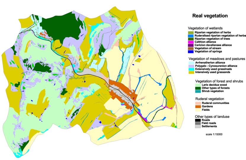
Figure 7:
Real (top) and optimal (bottom) status for of wetlands in Olsavica
Village (Slovakia). The image illustrates a possible optimal and realistic occurrence of
wetlands in the Olsavica basin. The maps are based on four sources of information:
(1) a geo-botanical map incl. predicted potential vegetation, (2) an aerial photo from
1949 showing detail land-use situation and delineated wetlands, (3) the comparison
of wetland types in well preserved down stream parts, and (4) a 3D model of the
terrain used for defining erosive sections of the channels.
WWF DANUBE-CARPATHIAN-PROGRAMME / BALTZER ET AL.
Integrated Land Use Assessment and Inventory of Protected Areas
page 33
3.2.2.7. Participatory stakeholder workshops for appropriate land-use options
At all three pilot sites, most of the key stakeholder groups were generally supportive of any efforts
to reduce pollution, flooding or to take efforts to improve groundwater levels and revive fishponds.
Key stakeholders generally the majors of the village - were strongly supportive to the projects
and all public stakeholder events turned out to be a success, in particular on local scale. During
recent years water relevant stakeholders have learned more about environmental protection and
its advantages. Mainly through collaboration between farmers and agricultural and environmental
institutions the proposed measures could be achieved.
However, timing and project continuity are extremely crucial parameters for successful and fruitful
participation of stakeholders. In Slovakia, a long-term cooperation between local stakeholders and
our consultation institute have already been built up before the project started. This helped a lot to
ensure that all restoration measures were implemented according to the original planning. The
participation was used to identify the design of implementation measures but also to ensure a
sustainable grassland management afterwards. This actually created an even better relationship
between the different partners.
On contrary, public participation in Croatia and Romania was suffering significantly from the long
project delay and the long break between phase one and two3. During the first phase of this
project, many expectations were raised by the project team and stakeholders were enthusiastically
participating in the process. Key stakeholders from national, regional and local levels were involved
right from the start of the project. In particular these stakeholders became frustrated after the
second project phase started so lately. Based on the lessons learned from this period, we would
strongly recommend to apply this part of the methodology only if continuity (in human and
financial resources) can be ensured over an entire project period. In Croatia both, the project delay
and the death of our local project manager caused scepticism on all project scales. More then two
years without any project input turned out to be a major stumbling block and threatened to kill off
the activities entirely. Credibility and trust are essential elements for successful project outcomes
the loss of credibility may cause failure.
3.2.2.8. Policy analysis to identify the policy and funding obstacles or
opportunities
This part of the assessment methodology gained quite different results in the three pilot study
areas. In Slovakia, the Ministry of the Environment (division of Nature and Conservation), the
Ministry for Agriculture, the State Nature Conservancy (SNC) of the Slovak Republic (that ensures
the implementation of nature and landscape protection measures) and the Administration of the
National Park Slovensky Raj (`Slovak Paradise'; responsible for protection of the National Park) plus
the local Water Management Authorities of Bodrog and Hornad Rivers were involved in the project.
Specifically, the involvement of the lower Water Management Authority was crucial for the approval
of planed wetland restoration measures. In general, the policy analysis in Slovakia was well
supported and successful integration of the project work and ongoing policy was ensured. Even the
preparation of Rural Development Plan was influenced by this project and the Ministry of
Agriculture accepted the proposal of our local consultant for the re-designing of the agri-
environmental measure for the conservation of semi-natural and natural grasslands.
3 This delay was caused by administrative problems at the UNDP/GEF to set up the tender of the second phase
of the DRP.
UNDP/GEF DANUBE REGIONAL PROJECT
3. IMPLEMENTATION OF ACTIVITIES IN PHASE 2
page 34
In Croatia, the area was part of a proposed UNESCO Danube-Drava-Mura Biosphere Reserve. First
nominated in 1997 as a transboundary reserve and accepted at a river-basin level, lack of support
at national level halted progress. The new nomination (2003) was for Croatian territories only. So
far, the application has been delivered to the Croatian MAB Committee. In the Biological and
Landscape Diversity Strategy of Croatia (Ministry of Environment, 2000), the Drava was declared a
priority ecosystem; however, implementation lags significantly behind such proposals.
The physical planning of this study area, as already mentioned, was entirely within the jurisdiction
of the county authorities, who were in the process of re-drafting their development plans to take
greater account of nature protection and sustainable development. Although they could see the
rural development potential in this rehabilitation scheme the final decision was made by Croatian
Waters (HV) who postponed the final decision until a leading staff member took over responsibility
late in 2006. The two examples demonstrate that individual contacts, continuity and well
established networks are as important as detailed theoretical analyses. Defining opportunities and
obstacles should be a subject of private contacts, wherever possible.
3.2.3. Assessment of applicability, usefulness, and assignability of the
methodology
Table 1 provides an overview about the applicability, usefulness and assignability of the applied
method for integrated land use. In the following most important lessons learned are briefly
summarized.
Overall, the project methodology was judged to be applicable, useful and also in principle
assignable to other river basins or regions. The following advantages and challenges of the concept
have been recognized:
·
GIS mapping was an important element that supports both the ecological assessment to
find and optimal land use status and communication with different stakeholder groups.
Historical data and aerial photos are very helpful to create optimal conditions. Sound and
visible information material is therefore key to create convincing arguments, in particular
for the information of stakeholders.
·
The strong emphasis on promoting public awareness of the project's overall aims and
objectives amongst local people and provision of participation opportunities was a strong
element of the first phase of the project. Although time-consuming, it helped a lot to find
appropriate and well-accepted land use measures.
·
Practical experience from the different pilot sites underlines the important key role of local
project mangers. Their skills need to include good communication, interpersonal skills, and
very effective local co-ordination. The unexpected loss of our highly skilled local co-
ordinator in Croatia meant the halt of further implementation measures and the project
was significantly delayed.
·
Approaching local and regional authorities is relatively easy and the partnership has been
acknowledged by all pilot sites. Good contacts with local majors are crucial elements for
successful project implementation.
·
Gathering information on relevant policies and plans is time-consuming and likely to
require the establishment of working relations with relevant ministries and other
national/regional authorities at a very early stage if a complete picture is to be obtained.
WWF DANUBE-CARPATHIAN-PROGRAMME / BALTZER ET AL.
Integrated Land Use Assessment and Inventory of Protected Areas
page 35
·
Successful approach of national authorities, however, requires well established (personal)
networks. Even a sound analysis about planned programs and projects can not compensate
personal contacts to develop broadly accepted management plans.
·
The use of standardised table format for reporting is useful for summarising and generating
of products that are broadly comparable from one site to another. However, the need for
such standardization should not prevent the preparation and submission of additional,
sites-specific supporting materials.
·
Credible relations request long-term involvement and governments are changing frequently
in some countries
·
Timing and project continuity are extremely crucial for project success. As soon as
institutional memory gets lost the influence becomes significantly weaker.
UNDP/GEF DANUBE REGIONAL PROJECT
3. IMPLEMENTATION OF ACTIVITIES IN PHASE 2
page 36
Table 1:
Assessment of the applicability, usefulness and assignability of the methodology. Data collected at three different pilot
sites in the Slovak Republic (upper Tisza basin), Romania (Elan river), and Croatia (Drava river).
low value / specification
1)
Assessment of applicability of methodology at the pilot site
medium value / specification
2)
Assessment of usefulness according to the experiences at the pilot site
high value / specification
3)
Estimation on how easy/difficult the applicability in other regions could be
applicability1) usefulness2)
Assign-
ability3) Comments
Tisza Elan Drava
Tisza Elan Drava
1. GIS mapping of the pilot site,
including key water and wetland
·
GIS mapping was the most successful tool for ecological
features
assessment and communication;
·
all 3 pilot sites appreciated approach
·
requires qualified institution, equipment and experts what might
create difficulties in far rural areas
2. Identifying strategies, plans &
policies and threats, impacts &
·
personal contacts are essential to receive sufficient documents
pressures
·
consultants should be based locally to ensure regular contact
·
local/regional level was easy to identify national level difficult
without "system-inherent ambassadors".
WWF DANUBE-CARPATHIAN-PROGRAMME / BALTZER ET AL.
Integrated Land Use Assessment and Inventory of Protected Areas
page 37
applicability1) usefulness2)
Assign-
ability3) Comments
Tisza Elan Drava
Tisza Elan Drava
3./4. Assessing ecologically
·
historical data and aerial photo material is very helpful to create
optimal conditions at the pilot site
optimal conditions
and gap analysis to assess
·
gathering sound information is time consuming (ecological,
difference: current state &
historical, and socio-economical information)
`ecologically optimal'
·
the outputs are very supportive for stakeholder discussions and
convincing farmers to shift to an other mode of land cultivation
·
if GIS mapping or aerial photo material is lacking the applicability
in other regions might be less successful
·
in this case all three pilot sites considered the method as useful
5. Participatory stakeholder
·
To identify and work with as many key stakeholders as possible
workshops for appropriate land-use
from the beginning of the process at national, regional and local
options
levels was a very successful tool during the first phase in all 3
pilot sites.
·
Among the key stakeholders local majors played a crucial role.
·
The usefulness of the methodology, however, depends strongly
on continuity. Due to the delay of the 2nd project phase, many
expectations got lost and were turned into scepticism.
·
This part of the methodology should only be applied if continuity
(in human and financial resources) can be ensured over the entire
project period. In Croatia both, the project delay and the death of
our local project manager caused perhaps more scepticism on all
project scales than trust.
UNDP/GEF DANUBE REGIONAL PROJECT
3. IMPLEMENTATION OF ACTIVITIES IN PHASE 2
page 38
applicability1) usefulness2)
Assign-
ability3) Comments
Tisza Elan Drava
Tisza Elan Drava
6. Policy analysis to identify the
·
gathering information is very time-consuming
policy and funding obstacles or
·
requires working relations with relevant ministries and
opportunities
national/regional authorities
·
weakest point of the methodology in terms of assignability:
credible relations request long-term involvement and
governments are changing frequently in some countries
·
the experience from the case study sites underlines importance of
personal relationships: As soon as institutional memory gets lost
(e.g. in Croatia) the influence becomes significantly weaker.
7. Developing action plans to take
·
The identification of alternative land-use concepts was successful
the work forward.
in each of the case studies.
·
All of the suggestions were technically feasible and locally
acceptable and appropriate
·
However, adaptive management is key for implementaion success
·
Successful implementaion of project measures depends strongly
on well established contacts with local and regional authorities
·
Therefore, the usefulness of the methodology, depends also
strongly on project continuity.
·
Due to the delay of the 2nd project phase, some of the planned
measures had to be changed or could not fully be implemented (in
case of Croatia and Romania).
WWF DANUBE-CARPATHIAN-PROGRAMME / BALTZER ET AL.
Integrated Land Use Assessment and Inventory of Protected Areas
page 39
3.3.3
Implementation of action plans in each site
In all three case studies, measures resulting from application of the methodology were successfully
defined during the first project period. In each case, the land-use proposal was briefly described at
the end of the first project period and an indication of the corresponding spatial and temporal
scales was given. In summary the following actions were supposed to be implemented during the
second phase to help to increase wetland conditions in the individual pilot areas.
IN SLOVAKIA:
Building of small dams on selected streams
As a consequence of the intensification of agriculture resulting in low retention capacity of the
areas, the main channel of Olsavica was deeply eroded. The geological substrate was sensitive to
erosion and during heavy rains water was not retained and runoff speed was high. It was proposed
to build a small dam, 2-3 m high. In addition two smaller dams in another valley were constructed
to restore wetland habitats. This was supposed to create small sedimentation pools with
surrounding saturated zones suitable for wetland restoration.
Reopening of small meander on the canalized stream
Upstream of Olsavica village is the main canalized stream, which collects surface water from the
adjacent sub-basin and underground drainage. Before a comprehensive regulation was undertaken
in 1987, there was a meandering stream and one of the larger former meanders is still visible, but
water was flowing directly through the canal and not via the meander. It was suggested to close
the canal by small dikes to guide the water back to old meander. In addition it was planned to
deepen the upstream section of meander was to secure the dike against the press of the water
during bigger floods.
Restoration management of wet grasslands
Former wet grasslands have been degraded through drainage and fertilization. Some remnants are
still left along small streams or around the sites of former springs, where they are in direct contact
with arable land. They create a buffer zone between the arable land and streams or springs.
Application of high amounts of fertilizers and manure caused degradation and had an adverse
impact on biodiversity. Wet grasslands have not been managed for at least 20 years. Mulching of
biomass was suggested to be applied in the first year and the cooperative farm was supposed to
continue with the management measure (mowing) in subsequent years.
Blocking of underground drainage system
The total area of agricultural land, which is influenced by underground drainage, is 183 ha.
Information about the functionality and efficiency of drainage network was lacking. It was planned
to block certain parts of the drainage system to create small scale wetlands. Soil erosion control
by planting of wood species on the steep banks of streams will support the measure.
Fencing of springs to prevent damage from grazing
In the lower and central part of Olsavica valley, some well-developed spring wetlands are still
present. The area is used by cattle grazing and springs are used as a source of water. Cattle are
causing damage to the wetlands. Simple wooden fences will be built to protect these wetlands.
UNDP/GEF DANUBE REGIONAL PROJECT
3. IMPLEMENTATION OF ACTIVITIES IN PHASE 2
page 40
IN ROMANIA:
Soil erosion control on slopes by land reclamation works and afforestation of the most
degraded agricultural lands
Excessive hillside erosion has been recognized as being a major environmental threat throughout
the Moldavian Plateau of eastern Romania. Being bordered by eroded hillsides the Lower Elan
floodplain is often affected by erosion from the surrounding hills. Most of the land, accounting for
roughly 85 percent of agricultural area, was split into excessively small plots, each of them less
than one hectare in size and being oriented up-to-down the slope. The project aimed to set up and
perform an anti-erosion works and afforestation of the eroded and/or salinized areas, as well as to
implement the best agricultural practices on those affected slopes. These measures were supposed
to contribute to the decreasing of runoff and soil loss on slopes.
Planting of native Salix species along the current course of Lower Elan River and fencing
of the planted area
The Prut River represents an important Bird Area and fly-route for many migratory bird species on
their way to the Danube Delta. The project aimed to plant native Salix species along the current
way of Lower Elan River to contribute to the conservation and improving of biodiversity in the area.
Increasing of water storage capacity up to the original designed level of the Mata
Radeanu fishpond
Two fishponds have been established in the project area for a long time (situated exactly at the
confluence of the Elan with the Prut River). The Galati County Association of Hunters and
Fishermen own them. The project aimed to increase the water storage in the reservoir by repairing
and increasing the elevation of the existing dam.
IN CROATIA
Installation of sluices on the Zupanijski canal
Groundwater data from official monitoring of wells and piezzometric meters at several locations
around the canal showed a fall of more than one meter in the period since the canal was deepened
by 1 2 meters in 2000. Thus it was anticipated that by raising the level of the canal's waters
upstream of a sluice will raise groundwater levels through existing underground connections.
Increase water quality in the main channel of Drava river
Water quality data from Phase 1 showed that where the Zupanijski canal was not straightened
because of access problems, the slower flow and abundance of aquatic vegetation at this place
improved the quality of the water to Category 1. Subsequently, untreated water from settlements
and agricultural runoff reduced this to Category 2, a situation that would be improved by diverting
part of the canal's flow through the wetlands.
Measures for improved fish migration and fish breeding
Species whose natural habitat is the main river-course have been found in the canal, and the
assumption was that their presence results from ovipositing. It is known that many fish species
need conditions such as shallow waters, slow flows, limited water-level fluctuations and aquatic
vegetation to be successful in this activity. These factors are present in the canal but not in the
main stream. The canal also provides migration routes between the river and the wetlands that are
currently blocked as the canal is isolated by dikes. Thus the project recommendations included
provision of fish-passes beside the proposed sluices to allow fish to migrate freely along the canal,
and into the wetlands via our restored stream-channels.
WWF DANUBE-CARPATHIAN-PROGRAMME / BALTZER ET AL.
Integrated Land Use Assessment and Inventory of Protected Areas
page 41
Increase mosaic effect of habitats
The wetlands have been drying since the canal was deepened in 2000. Succession was taking
place, reducing the variety of habitats in the area. The planned restoration measures were
supposed to provide more open water in the restored channels and the revitalized oxbows: raising
the level of shallow waters increases their surface area and that of the related ecotones. The
degree of biodiversity is directly related to the diversity and complexity of habitats, as well as their
overall size: thus the project team felt confidently that these restoration measures would increase
biodiversity in the area.
Introduce extensive grazing
In the region of the pilot site there was scope for investigating extensive grazing. Only one local
farmer was practicing semi-extensive grazing and he was satisfied with its economic result. The
project aimed to increase the number of entrepreneurs who will change their production mode.
Traditional hardy breeds were being successfully introduced across the river in Hungary and should
also be established along the Drava.
3.3. Activities related to the implementation of proposed
restoration measures, communication, and policy action at
the three selected pilot sites:
3.3.1. Activities implemented in Slovakia (Olsavica Valley):
To improve the situation of the wetlands along the Slovakian pilot site all planned six technical
measures were implemented successfully during the second phase of the project (Figure 8-Figure
10). These measures included the following:
a) small dams on selected streams were built to control channel erosion;
b) small meanders on canalized streams were re-opened;
c) wet grasslands were restored to act as a buffer zone between agricultural land and
the stream;
d) underground drainage systems were blocked to restore water tables;
e) native trees on steep stream banks were planted to control soil erosion and;
f) springs were fenced to prevent damage from grazing.
As a consequence of intensive agriculture the main channel of the village Olsavica was deeply
eroded. This caused several major impacts for both the aquatic ecosystem and flood protection
measures. To solve these problems, the original project design included the construction of three
to four small dams (about 2 m height). Building small dams, however, creates always a trade-off
situation between reduced soil erosion and reduced stream connectivity. Therefore, the projected
team decided to change to original plan. Additional revitalization work along the stream plus the
implementation of one single small dam would lead to a higher ecological standard and also to
improved technical results. In September 2006 both measurers were implemented without any
major constrains. The dam has already increased the water table and serves as sediment trap.
Since the dam was only finalized in September 2006 detailed ecological monitoring will be available
after the first next vegetation period.
Before comprehensive river regulation work took place in 1987, the river section upstream the
village Olsavica was meandering in small arms through agricultural land. After the intensive land
regulation work took was finalized the original stream was canalized to collect surface waters from
UNDP/GEF DANUBE REGIONAL PROJECT
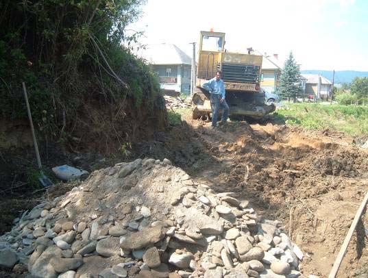
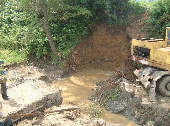
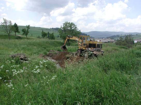
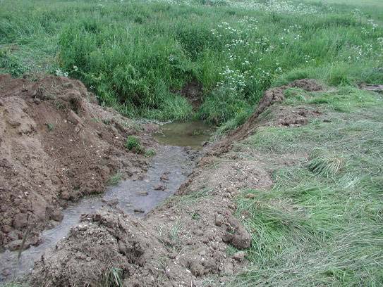
3. IMPLEMENTATION OF ACTIVITIES IN PHASE 2
page 42
adjacent sub-basins and underground drainage systems. One of the larger former meanders,
however, was still visible, blocked by small dams and water flow was diverted to the canalized
section or subsurface canal system. During spring and autumn 2006, this meander was opened
along about 100 m and at the same time the former drainage canal was blocked. Additionally, 250
m the drainage canal was filled up with solid material and the entire terrain was adapted for
restored stream. In summary a total section of 350 m of drainage canals were revitalized and
retransformed into a natural like stream system. It represents the first revitalization of drainage
system in Slovakia and includes about 30% of original drainage canal.
(
(a)
b)
(c)
(d)
Figure 8:
Technical implementaion of measures to improve the situation of wetlands
in the Slovakian pilot site building small dams to control channel erosion (a,b) and re-
opening of small meanders to improve ecological integrity of the canalized river and to
lower discharge velocity (c,d).
Between June and September 2006 the project team organized mulching activities of wet
grasslands to act as a buffer zone between agricultural land and the stream. These activities were
implemented together with the Olsavica municipality and covered a total area of approximately 1.5
ha. Mulching represents an essential tool for the restoration of degraded wetland habitats. It
induces the removal of ruderal species and improves the original species composition. In Slovakia,
former wet grasslands have been degraded because of drainage activities and fertilization. Some
remnants, however, are still left along small streams or around the sites of former springs, where
they are in direct contact with arable land. This creates buffer zones between the arable land and
streams or springs. Application of high amounts of fertilizers, on contrary, has an adverse impact
on biodiversity. In the Slovakian pilot site, wet grasslands have not been managed over the least
20 years. As a result of this project the cooperative farm will continue with the mulching of
biomass as, applied during the second project phase, and with other regular management
measures (e.g. mowing).
WWF DANUBE-CARPATHIAN-PROGRAMME / BALTZER ET AL.
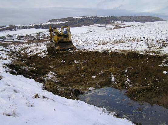
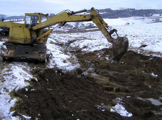
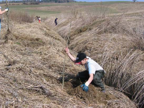
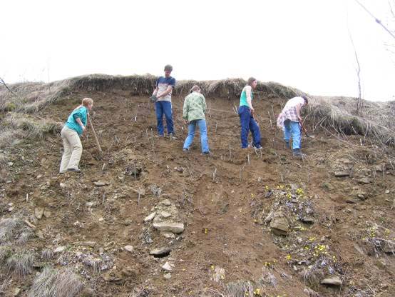
Integrated Land Use Assessment and Inventory of Protected Areas
page 43
(a)
(b)
Figure 9:
Technical implementation of measures to improve the situation of
wetlands in the Slovakian pilot site mulching of wet grasslands.
In April 2006, more than 3200 specimens of native tree and shrub species were planted manually
on steep stream banks to control soil erosion and several packages of waste and litter were
collected from the wetland area. These activities were organized together with the local NGO ZLM
in cooperation with two other local NGOs - Letanovsky Mlyn and OZ Tatry. In total, 54 participants
(mainly school kids) were participating in a three days youth camp - the first youth camp for
students and citizens to support the "Revitalisation of the Olsavica 2006". This part of the project
aimed to reach two goals: Measures to protect wetland restoration should be integrated in a
broader public awareness and communication program with local stakeholders. The tree days event
was held between April 21 23, 2006 and received broad support form the Major and citizens of
Olsavica village. All 54 participants were accommodated in private homes to trigger intensive
discussions about wetland restoration with local people. The entire event received a lot of positive
feedback and was broadly presented in the daily newspapers. To prepare the next event, a
cooperation with a local journalist has been set up to prepare a short TV documentary including
interviews with local authorities and people to promote the idea even broader.
Finally, with the support of the Olsavica agriculture cooperative farm, also the last technical
measure was successfully implemented in September 2006. A spring area of about 0.2 ha in the
pasture was fenced to prevent further habitat degradation caused by cattle grazing
(a)
(b)
Figure 10:
Technical implementation of measures to improve the situation of
wetlands in the Slovakian pilot site planting of native species on stream banks to
control soil erosion organized in close cooperation with local NGOs and authorities.
UNDP/GEF DANUBE REGIONAL PROJECT
3. IMPLEMENTATION OF ACTIVITIES IN PHASE 2
page 44
3.3.2. Lessons learned from the Slovakian pilot site
·
Local, regional and national support from administrations
In general, the Slovakian project received a broad support from various administrative bodies. The
strongest support, however, was been given from Olsavica municipality, which implemented
restoration measures under the supervision of our local partner `Daphne' the Institute of Applied
Ecology. In this combination the 1.4 component of the DRP was able to implement e.g. the first
revitalization of a drainage system in Slovakia. The only obstacle relates to the administrative
process to gain construction permission.
A crucial element for the successful implementation was the long-term and active involvement of
DAPHNE in both on regional and national scale. Due to this, it was possible to maintain a credible
relationship between the partners although the previous project phase was delayed and the
implementation of measures started significantly later than expected. Furthermore, DAPHNE was
able to organize a parallel campaign to raise awareness about the importance of wetlands in river
basin management (RBM) in Slovakia. This campaign was targeted on regional and local decision-
makers and water managers and from October to November 2006 ten seminars throughout
Slovakia were held as part of an overall information strategy. These seminars covered all major
river basins of Slovakia and provided knowledge transfer from nature conservationists (DAPHNE
and the State Nature Conservancy staff) and the water managers (Slovak Water Management
Enterprise and regional and local environment officers). In the seminars water managers were
trained on values and functions of wetlands and their particular presence in the certain river basins
of Slovakia.
Participants gained basic information about the current schedule and development of the Water
Framework Directive implementation in particular with regard to the development of the River
Basin Management Plans. The Olsavica case study was largely presented during the series of
workshops to underline the importance of wetlands in implementation of WFD as example of
integrated management of river basin.
In total, 289 participants joined 10 workshops. This includes 41 participants from SNC, 122
representatives from Slovak Water Management Enterprise and 82 local decision-makers.
·
"buy-in" from key players on the ground
Another key element for the successful project implementation in Slovakia was the "buy-in" form
several key players on local scale. If the cooperative farm Olsavica-Brutovce had not changed its
production mode from intensive land use towards more extensive system the whole project
implementaion would have been at risk to meet the original objectives. Implementing alternative
concepts for landuse and wetland protection requires a trustful and close cooperation with such key
players.
In the Slovakian pilot case this cooperation has been set up during the first project phase and
continued throughout the second phase. Our local partner DAPHNE assisted the Agriculture
Cooperative Olsavica to prepare a successful application for the national Agricultural Paying Agency
to receive subsidies for agri-environmental measures as mentioned in the national Rural
Development. The proposal has received a positive approval for the next five years and in 2006,
first measures with focus on the appropriate management of grasslands (including wet meadows)
were implemented. This means in other words: the DRP in this pilot site triggered the magnification
of measures and includes now a total area of 15 ha grasslands under sustainable management in
the Olsavica basin and 676 ha of grassland in its adjacent valley.
WWF DANUBE-CARPATHIAN-PROGRAMME / BALTZER ET AL.
Integrated Land Use Assessment and Inventory of Protected Areas
page 45
·
cooperation with other NGOs
The last lessons learned from Slovakia concerns the integration of important local and regional
supporters. Successful land use changes and wetland restoration requires scientifically sound and
technically applicable planning and implementation at each individual project side. This, however,
is not sufficient to magnify the results and to promote the lessons learned from one site to another.
In the current pilot site, the close cooperation with the local NGO ZLM and the cooperation with two
other local NGOs (Letanovsky Mlyn and OZ Tatry) created the "critical mass" to attract a broader
audience. As a result of this, more than 50 school children were interested to participate at the
youth camp and this again served as a hook for the local and regional newspapers and the national
TV. Both, the number of planted trees in the pilot area and the public feedback on the project
activities exceeded the original project expectations by far. We assume this was triggered by the
set up of an NGO coalition.
3.3.3. Activities implemented in Romania (Lower Elan Valley):
To improve the situation of the wetlands along the Romanian pilot site parts of the five planned
technical types of measures were successfully implemented and parts of them were postponed to
2007 because of unexpected weather conditions (details: see below and Figure 11). These
measures included the following:
a) A feasibility study and rehabilitation measures were conducted to restore the lower Elan
floodplain downstream of the confluence with Sarat Creek through meander restoration to
increase water circulation;
b) parts of the Elan river channel were prepared to become re-profiled;
c) improvements of hydrological condition of Mata-Radeanu fishpond were planned to
increase water storage capacity but has been modified due to flood events in summer
2005 and spring 2006
d) soil erosion on hill slopes was mitigated through the introduction of different land-use
techniques, demonstration of better agricultural practice, and afforestation measures;
finally,
e) the Lower Elan floodplain at the confluence with Prut River has been declared as a
protected area (SPA).
During the second project period the Romanian pilot site was hit twice by serious flood events.
Long and unexpected strong rain events inundated large parts of Romania in summer 2005. The
project area, as much as most parts of the lower Danube catchment area, was severely affected by
these floods. Several measures of the planned restoration work had to be postponed because of
the long duration of the flood events in this year.
Unfortunately, the situation did not change and became even worse in the next year. Already in
spring 2006 caused by rapidly increased snowmelt and rain - the pilot area was hit by the next
flood event (see Figure 11). In April, the Danube River hit its highest level in Romania in the last
111 years, swamping thousands of hectares of land. On the Prut River, the levels were also very
high due to backwater. The levels on the Prut affected water discharges of the tributaries, such as
the Elan River. At that time, the technical team made visits in the field in order to take
measurements for the topographical map but it was simply impossible. A maximum discharge of
580 m3 s-1 was recorded for the Prut river at the hydrological station in Falciu (upstream the
confluence of the Elan river and Prut river) in June 2006. The surface of the project area was
completely flooded (100%) between April 10 and July 23, 2006. Half of the project area (59%) was
UNDP/GEF DANUBE REGIONAL PROJECT
3. IMPLEMENTATION OF ACTIVITIES IN PHASE 2
page 46
already inundated between March 16 and April 10, 2007 and still 25% were covered until
November 21, 2006. Due to such these long-lasting flood events the soil maintained humid over
more than half a year and access to the project area was practically impossible.
(a)
(b)
(c)
(d)
Figure 11:
Lower Elan situation under normal flow conditions (a) and during
increasing flood in spring 2006 (b, c, d). The floods reconnected some of the old
meanders and destroyed dikes on the left site of the river course. However, the originally
planed restoration work had to be postponed.
Although the feasibility study for reactivating the old meander system along the Elan river was
ready before the second flood events in 2006, the implementaion was planned to start afterwards.
The new meander should follow the course of the old meander over a length of 2.5 km and should
start about 7 km upstream the confluence of Elan and Prut rivers. As positive side effect the floods
actually worked with the project and not against it. A breach of the left bank dike of the Elan River
reconnected parts of the old meanders and parts of the protected areas of Mata-Radeanu fishpond
through natural inlets. The original plan was to re-connect the meanders and fishponds with tubes
(Figure 12) and not by dike removal. Increased water flow in the meanders system and enlarged
storage capacity in Mata Radeanu fishponds should be regulated on technical instalments not by
natural re-connection. Based on the new situation the project is currently and continuously
lobbying to maintain the newly created situation. So far, however, it is not clear if this situation will
have a chance. It might also be likely that the owners of the fish farm will request to repair the
dikes.
WWF DANUBE-CARPATHIAN-PROGRAMME / BALTZER ET AL.
Integrated Land Use Assessment and Inventory of Protected Areas
page 47
Figure 12:
Original plans to re-connect the old meander system along the Lower
Elan with the main river course. Parts of the meanders were naturally reconnected
through the breach of the left bank dike of the Elan River. Current negotiations with
local land-owners aim to maintain the improved situation that has been caused by
the floods.
Also the work on soil erosion control on the slopes along the river was affected by unexpected
weather conditions. Though some land reclamation works on the originally selected demonstration
field of 27 ha and afforestation on the demonstration field of 32 ha (on the slopes and along the
river course) started in 2005. Parts of the work, however, had to be postponed due to snow and
frost in winter and the flood in 2006 (coldest winter since years with degrees below minus 20 and
largest flood since 111 years, see above). Some detailed topographical measurements for the
evaluation and design of the works were also delayed but will be finished in spring 2007.
Nevertheless, and despite harsh weather conditions, restoration activities on land reclamation and
afforestation started in April 2006: The tree material to be planted was selected and species
suitable for the project area were selected with the in-kind participation of the Vaslui County
Forestry Directorate. The composition included 30,000 saplings (or 75 %) of black locust (Robinia
pseudacacia) and 10,000 saplings (25 %) of other species (Fraxinus excelsior, Fraxinus ornus,
Prunus cerasifera, Elaeagnus angustifolia), plus additional 3,000 saplings of Glaeditschya
triacanthos.
Also first land reclamation work started in April 2006. The first measures taken into account were
land filling measures (smoothing) by bulldozers. In particular the areas round "Vulparia" (5.6 ha)
UNDP/GEF DANUBE REGIONAL PROJECT
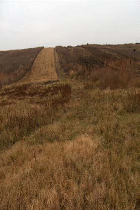
3. IMPLEMENTATION OF ACTIVITIES IN PHASE 2
page 48
and "Lutaria" (2.4 ha) have been selected since the two landscapes were severely gullied and the
rate of soil erosion was very high (Figure 14). Here, the land is divided in very small up and down
hill private plots most of them averaging 0.50 ha in size and involving quite a number of land
owners (Figure 13).
In this region, restoration work was needed on almost one-third of the entire project area in order
to level significant uneven (corrugated) land, namely small depressions, rills and some gullies.
Therefore, land filling was defined as important preparation to fieldwork, allowing for the layout of
conservation practices. In this context GIS mapping proved to be a very useful tool to integrate
various information, especially for land use assessment.
Digging on the on the most degraded agricultural lands (on the hills) started in early May. Since
then a total volume of 7,000 cubic meters were dug and transported 20-30 m away. This work was
finished by December 2006.
Figure 13:
Typical situation of
traditional land use on the slopes
along the Elan river. 85% of the
total area is split into excessively
small plots. Each site is smaller
than 1 ha and arraigned in uphill-
downhill directions causing
massive problems with soil
erosion.
Figure 14: Technical
implementaion of measures to
improve the situation of wetlands
in the Romanian pilot site
mechanical gully filling by
bulldozers along the river slopes.
In spite of several harsh and unexpected conditions, the Romanian pilot study represents a
successful project. Over the project period the cooperation among the technical team on the
ground, the coordination team in Bucharest and Vienna and the Basin Committee in its role as
water authority increased significantly. The water authority coordinates activities of 20,267 square
WWF DANUBE-CARPATHIAN-PROGRAMME / BALTZER ET AL.
Integrated Land Use Assessment and Inventory of Protected Areas
page 49
km and 15 members represent different stakeholders from the entire basin. The presentation of
the component 1.4 of the DRP prepared the opportunity to publish an article in the Prut Directorate
magazine "Arual Albastru" and to put a project documentary on the web page of the Prut Water
Directorate. Based on this, the Elan DRP 1.4 model site was discussed in a much broader context of
the Lower Danube Green Corridor region. This again helped that the Prut Water Directorate
proposed the Mata-Radeanu area as Natura 2000 site (SPA). The site has already been validated at
national level (see Figure 15).
Figure 15:
Proposed Natura 2000 site along the floodplains of the Elan River
(Mata-Radeanu). The site has already been validated at national level.
3.3.4. Lessons learned from the Romanian pilot site
·
Temporal framework of project design
The most important "lesson learned" from the Romanian pilot site concerns the overall project
design, planning and implementation. In retrospect it became clear that only 15 months are very
short to implement both, sound restoration work on the ground and major changes on policy level.
Unpredictable and stochastic events (e.g. like harsh weather conditions) are likely to occur in any
river basin.
In the case of the Romanian pilot site two major flood events caused several delays and severe
pressure for the technical team on the ground. Also the policy goals might have been too ambitious
for the proposed project period. Although the improvement of public awareness and training of
local landowners on best agricultural practices was very successful and reached more then 50 local
people, the project team still had to deal with about 400 additional landowners. Taking the
previous communist expropriation into account many people reacted sceptically with regard to new
land use interventions. To ensure a successful implementation on a larger scale in other regions, a
project extension phase of about at least five to ten years seems to be more suitable. It seems to
UNDP/GEF DANUBE REGIONAL PROJECT
3. IMPLEMENTATION OF ACTIVITIES IN PHASE 2
page 50
be almost impossible to introduce new mechanisms without long term support and long term
involvement of key contact persons. This relates also to the issue of credibility and well-established
local contacts (discussed below).
·
Credibility needs continuity and well established local contacts
Due to administrative delays at UNDP/GEF to set up the tender process of the second project phase
the project team was facing significant loss of institutional memory (internally) and loss of contacts
with external partners. The key advantage at the Slovakian pilot site (continuity in the project
team) was not ensured in the Romanian case. Staff members had to start building up new personal
relationships with key project partners and personal networks. If the local mayor had not been a
strong and continuous supporter and key driver of the project, most of the measures would have
failed to be implemented under the harsh weather and constrained project conditions. The lessons
learned out of this experience underline that continuity in project design and continuity in the
implementation process should be ensured. On contrary, long delays between two project phases
should be avoided.
·
Attraction of regional and national support from administrations
"Increasing the support of the Water Framework Directive implementation" represents the most
interesting but also challenging part of this project component. With regard to this, only the
Romanian pilot case managed to demonstrate a significant footprint on the regional and a small
footprint on the national level. The key element for this success was the attraction of the regional
Prut-Barlad basin committee that signifies a great project success. The Basin Committee represents
different stakeholders from the entire basin. They have presented the Elan project as a
demonstration project that could set a landmark for the management in the entire region of the
Lower Danube Green Corridor. Based on this cooperation the article in the Prut Directorate
magazine "Aurul Albastru" was produced and leading persons of the administrative body were
starting to "sell the idea" on a boarder scale. Based on this dynamic the Prut Water Directorate
proposed the Mata-Radeanu as Natura 2000 site (SPA). As mentioned above, the site has already
been validated at national level.
However, the overall aim of the project "to assist `Danube River Basin countries' to prepare new
land-use and wetland policies and legislation in line with existing and emerging legislation" was
perhaps too ambitious right from the beginning of the project. In retrospective, we would suggest
to aim to assist "Danube River Basin Districts" might have been a more realistic objective.
3.3.5. Activities implemented in Croatia (Zupanijski canal):
To improve the situation of the wetlands along the Croatian pilot site the originally planned
measures had to be revised and the following technical measures were implemented successfully
during the second phase of the project:
a) A geographical survey of the area to investigate most suitable measures to
reconnect the Drava river to adjacent Podravski Sokolac wetland and Budakovac
oxbow has been conducted and consequently raise local water tables small dams
on selected streams were built to control channel erosion;
b) a feasibility study to implement the most suitable measure to reconnect water to
reconnect the Drava river to adjacent Podravski Sokolac wetland and Budakovac
oxbow and consequently raise local water tables has been elaborated, and
WWF DANUBE-CARPATHIAN-PROGRAMME / BALTZER ET AL.
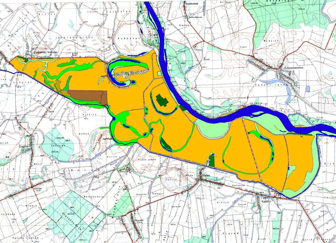
Integrated Land Use Assessment and Inventory of Protected Areas
page 51
c) the dissemination of the findings, conclusions and recommendations from these
activities has been .
Because of the death of David Reeder, our local project coordinator, the following activities were
delayed and will be implemented by end of April 2007:
A joint inspection of the condition of the meander of the old Drava riverbed has been conducted
and according to an agreement, a complete section of Sarovka and Marcina jama has been
surveyed. The first phase encompasses 2920 meters long section of Sarovka- Marcina jama with
excavation for minor-riverbed restoration alongside the route of the first phase within the old
riverbed of the River Drava. A juncture with Zupanijski Canal will be completed at the mouth
Breznica Canal so that the elevations of the bottom of minor riverbed are below the minimal water-
level in Zupanijski Canal. This solution enables water inflow into the meander of the Old Drava
even at lower water-levels in Zupanijski Canal. Marcina jama will also join in this system and form
a unique river surface of the first phase.
Furthermore, pipe culverts with a diameter of 120 cm should be implemented at the intersections
of the Old Drava and public earth paths. Plants on the route can be removed (reed and scrub) in
the width that is necessary for machines maneuver, excavations and disposing of dug material.
Individual trees will be left (both in the riverbed and on the bank) according to the agreement with
a representative of the Natural Society ,,Drava" from Virovitica (Mr. Grlica).
As an important detail for a full-functioning habitat, it is suggested to build barrier at a junction
with Zupanijski Canal. It is planned that the elevation of the fill crest where water would overflow
is 98 meters above the sea level so that water decantation from the Old Drava riverbed would be
prevented even if the water level in Zupanijski Canal is lower than 98 meters above the sea level.
UNDP/GEF DANUBE REGIONAL PROJECT
3. IMPLEMENTATION OF ACTIVITIES IN PHASE 2
page 52
Figure 16:
Map to illustrate technical measures to improve the situation of
wetlands at the Croatian pilot site reconnecting old oxbow system with the main
river channel. Original plans (top) and reviewed situation after finalisation of the
topographic survey (bottom).
3.3.6. Lessons learned from the Croatian pilot site
·
success or failure depends on individual project managers and "administrative
ambassadors"
The project work at the Croatian pilot site was suffering from the dramatic fatality of our local
project manager David Reeder. We had to conclude on the sad experience that success and failure
are strongly (if not ultimately) dependent on the quality and dedication of local project managers.
Despite the fact that the technical work was coordinated by local experts none of them were able
to push the project after David's death. Neither were they able to establish relevant contacts with
the national water administration. In consequence, the project was significantly delayed. After
several months without any respond from official Croatian partners, the project coordination team
was almost approaching the point to make the decision to step out of Croatia and declare the
project officially to be failed.
In this specific situation, however, Mr. Danko Biondic, Director of Development at Croatian Waters,
stepped in and committed his personal interest in this project. This moment represented the
tipping point in the entire process. From then on - although delayed - the project created a new
dynamic. Measures that have been delayed for months were implemented within weeks and a new
workplan was set up to restore the entire oxbow region.
WWF DANUBE-CARPATHIAN-PROGRAMME / BALTZER ET AL.
Integrated Land Use Assessment and Inventory of Protected Areas
page 53
In summary this experience identified three key issues for successful project implementation: (a)
wetland restoration in EU accession countries or new member state countries still seem to require a
very close connection among local, regional and in the case of Croatia also national
administration. On national or even ministerial level, only personal contacts were helpful to receive
rather important information. Local activities tend to fail, if they are not supported on higher
administrative levels.
(b) Support and follow-up activities were even more difficult to maintain on these high level and a
"internal ambassador" seems to be essential to drive successful project implementation that has
not been developed by the national authority itself.
(c) Individuals on each site of the project (project management or administration) are essential for
the project success. Finding the right manager and contact person on the ground to connect
authorities, institutions and highly recognised partners (e.g. donors, VIPs, international
organizations) is essential for the success of future projects.
3.3.7. Lessons learned on how to use the methodology to influence policy
decision makers in the three pilot sites (synthesis)
·
Role of experts and scientific institutes was crucial
All three project areas represent far-off rural areas. With regard from an "objective observer's point
of view" it became quite evident that farming practices and landscape structure should be changed
in all three cases. However, changing the minds of a local community (in particular farmers' minds)
is not an easy task. Many farmers still believe that all the technical measures, which were
implemented on their land decades ago, are useful and represent progress and development. The
strategy of this project - to cooperate with water and soil management specialists - turned out to
be quite successful. These experts represent authorities that are not only accepted and respected
by local people, but also by regional governmental institutions (water management, agriculture,
land cadastre etc.). In this context the project was successful in shaping policy decision processes
although predominantly on a local scale. In particular the cooperation with Technical Universities
or institutes was crucial for convincing of stakeholders to implement new restoration plans.
·
Proper use of existing regulatory framework is essential for project success
At least at the Romanian and Slovakian case study sites the following political tools have been
identified to significantly contribute to sustainable wetland management. These tools include Rural
Development Plans, the Water Framework Directive (WFD) and Natura 2000 sites, but also some
activates related with the upcoming EU Flood Directive.
Over the last decades, profound changes in agriculture use have been observed in all three pilot
areas. The impact on rural European landscapes and communities was also recognized in these far-
off regions of this project. Wetland and floodplain restoration and sustainable use were encouraged
by applying agri-environmental, rural community development measures etc. from the EU CAP
reform, including measures necessary for better water or river basin management under the WFD.
The contribution of the project for the preparation of Rural Development Plans for the period
between 2004-2006 was mainly focusing on the sustainable management of grasslands (including
of wetland types) in the framework of Measure 5 the horizontal measure on agri-environment
support. In Slovakia, e.g. a submitted proposal was based on the expertise with sustainable
management and knowledge gained from the project implementaion. During the period of 2004-
2006 certificates for more then 100,000 hectares of semi-natural grassland types were provided.
UNDP/GEF DANUBE REGIONAL PROJECT
3. IMPLEMENTATION OF ACTIVITIES IN PHASE 2
page 54
In this case, the Slovakian Ministry of Agriculture accepted the proposal for re-designing agri-
environmental measures to support the conservation of semi-natural and natural grasslands. Now,
the follow up activities of the project will focus on requirements for the management of wet and fen
meadows. These activities will focus on the new Rural Development Plan 2007-13. As one project
outcome the management plans for Slovakia suggest e.g. that sensitive wetland types of
grasslands should be mown only by hand or by light machinery and the payment should rise
significantly to cover the costs of such precise management.
The Slovakian project site also managed to magnify the project outcomes on a much broader scale.
Motivated by the project outcomes, our local partners organized a meeting with the head of the
Rural Development Department on Ministry of Agriculture, participants from Agricultural Paying
Agency, State Nature Conservancy and from Soil Conservation Institute. At this meeting it was
agreed to prepare a national register of semi-natural grassland habitats to be incorporated in the
official Land Parcel Information System (LPIS). Farmers could check such register on the web and
the register would help with the administration and implementation of agri-environmental
measures.
·
Support wetlands as integral part of the EU Water Framework Directive is not an
easy but feasible task
Although the WFD does not define wetlands or set specific objectives for them, it does include
important provisions that will assist their protection. In addition, within the WFD Common
Implementation Strategy process, a `Horizontal Guidance' document on wetlands and the WFD has
been jointly developed by all EU Member State, the EC, and water stakeholders from across the
continent. This document attempts to ensure that the links between WFD ecological objectives and
wetland values and functions will be fully considered by Member States during the implementation
process. In particular, the sustainable management including rehabilitation and restoration of
wetlands should be included among the basic and supplementary measures included in the
Programme of Measures necessary for reaching the ultimate WFD goal of good ecological and
chemical status of all waters in each River Basin District.
At all three pilot sites the Water Framework Directive represented a relatively new piece of
legislation (at least during the first project period) that has been considered to have great potential
for sustainable wetland management. In Romania and Slovakia on-the-ground implementation is
closely linked with the preparation and implementation of River Basin Management Plans, which
could include and synthesize all aspect of land-use in the basin. In both countries, we observed a
long-term tradition in preparing sound management plans on different spatial and land-use scales.
The practical realization, however, failed in many cases. With regard to this, in particular the
Olsavica pilot case was able demonstrate very useful examples on how to prepare realistic and
feasible management plans that have already been tested and proven during the second phase of
this project. The convincing argument to receive respect from different authorities was the
involvement of highly educated and well accepted experts in the planning phase. Restoration
activities e.g. in the Olsavica basin were prepared and planned by a team of ecologists from our
local partner `Daphne' in close cooperation of water engineers from the Slovak Technical University.
Both organisations are well recognised by state administrations. This again, created a very good
starting point to influence policy decision making processes - in this case not only on local but also
on regional and national levels. Without such a close and well established network of experts, the
influence on the WFD implementation would haven been impossible.
In addition to this, our Slovakian partner `Daphne' also organized a campaign to raise awareness
about the importance of wetlands in river basin management (RBM) in 2006. This campaign was
linked to the "International Wetlands Campaign" of the Danube Environmental Forum (DEF) and
targeted on regional and local decision-makers and water managers. It began with an evaluation of
WWF DANUBE-CARPATHIAN-PROGRAMME / BALTZER ET AL.
Integrated Land Use Assessment and Inventory of Protected Areas
page 55
current perception of wetlands within specific target groups. The survey showed that 93% of
respondents were aware of any importance of wetlands, however only a minority was aware of any
socio-economic importance of wetlands (except nature protection). The majority of respondents
were not able to refer to any concrete example where wetlands help to solve problems within RBM.
Based on this outcome, the ten seminars were organized throughout Slovakia to cover all river
basins and to train water managers about values and functions of wetlands and their particular
presence in the certain river basins of Slovakia (see also above). The seminars succeeded to
identify some barriers in better incorporating wetlands into RBM. Among other issues, conflicts
within legislation, lack of communication and coordination between relevant actors within the river
basins, complicated landownership and insufficient funding were identified.
·
Natura 2000 Network demonstrate to be a successful tool for wetland protection
in particular in the New EU Member States
In 1992, in response to the significant and ongoing deterioration of many habitat types and the
growing number of threatened or rare species, EU Member States adopted the Directive on the
Conservation of Natural Habitats and of Wild fauna and Flora, also known as `Habitats Directive'.
The Habitats Directive aims to contribute to the protection of biodiversity by setting up a European
wide network of protected areas called Natura 2000 and by protecting threatened species in their
natural range. It complements the 1979 Bird Directive, which establishes protected areas for
threatened bird species. In this combination the Directive was also useful to include most important
wetland sites into a protected area system. In order to join the European Union, also new EU
Member States have dad to transpose the requirements of the Birds and Habitat Directive into their
national legislation. This includes submitting their lists of proposed sites of Community Importance
(pSCI) to the EC.
In Romania and Slovakia, this project has prepared a scientific proposal of pSCIs which was taken
by the Ministry of Environment as a basis for governmental proposal. In Romania, the Prut Water
Directorate proposed the Mata-Radeanu as Natura 2000 site (SPA) and the project received already
national approval. Whereas substantial parts of the scientific proposal in Slovakia were cut (about
30%) during the process of approval of SCIs. In order to improve the situation the Slovakian team
used bio-geographical seminars (organized by EC) to propose missing sites. Due to fact that our
local partners hold an extensive data base on occurrence of non-forest habitat types and species,
they were able to prepare a sound analysis of (un)sufficiency of the Natura 2000 network for
particular habitat types and species. Finally, many of the Slovakian arguments were picked up by
the EC and the Slovak government. They are now obliged to prepare proposals for additional sites.
Summarized it can be stated that in Romania and Slovakia the impulses coming form this project
were quite successful to shape the discussion about the integration of wetland areas into the
Natura 2000 network.
·
Wetlands demonstrated to be able to help to mitigate flood risks in the Danube
River Basin
Central and Eastern Europe indeed most of the continent has recently suffered greatly from
catastrophic flood events which have resulted in loss of life and damages to health, property, and
businesses in and around former floodplains. In particular our Romanian pilot site suffered
dramatically even during the implementation period of this project (see above). Now a new
consensus is emerging on how more ecologically balanced approaches to flood risk management
contribute to lower risk and upstream preventative measures, driven by governments (such as
UNDP/GEF DANUBE REGIONAL PROJECT
3. IMPLEMENTATION OF ACTIVITIES IN PHASE 2
page 56
Romania, Germany and Hungary) who recognise this necessity, and who together with the EC
have started working on integrating flood management.
Although the new Floods Directive is still under preparation, some of the ecologically balanced
approaches that rely heavily upon the natural capacity of wetlands are well accepted. To use
floodplains to minimise, absorb and buffer the effects of flood events becomes more and more an
issue of public and political debate. Wetland restoration both for enhanced storage capacities
downstream in floodplains and for increased retention capacity or sponge effect upstream - is
therefore becoming recognised as a tool for preventative, flood minimisation. In particular the
Slovakian and Romanian pilot site were able to demonstrate the positive effect of floodplains during
the latest flood events. As a reaction on the severe flood damage in Romania in 2005 and2006, the
government has recently launched a feasibility study to investigate the overall potential of former
Romanian floodplains in the Lower Danube region to contribute to sustainable flood risk mitigation.
Restoration work within the floodplains and re-connection of former floodplain areas has been
considered to be an essential part of the overall plan for sustainable flood risk management. The
lessons learned from this project are able to provide helpful support for such a planning process
and our Romanian team (national WWF staff members) have already started to discuss these
issues with the Romanian Ministry of Environment.
WWF DANUBE-CARPATHIAN-PROGRAMME / BALTZER ET AL.
Integrated Land Use Assessment and Inventory of Protected Areas
page 57
4. CONCLUSIONS
AND
RECOMMENDATIONS
4.1. General lessons learned
4.1.1. Setting goals and objectives
This project component set out to achieve the development of a methodology for planning wetland
restoration in a landuse context and to test the methodology including implementation of the direct
restoration activities at three pilot sites over the period of June 2005 to December 2006. The goal
of the project was to use this pilot work to help refine wetland and wetland restoration policy at
different scales within the Danube basin. The following general conclusions and recommendations
were made:
·
The project supplied evidence that through carefully planned landuse changes , it is
possible to provide a significant contribution to wetland restoration and wise management
of wetland resources and services.
·
It also provided evidence that building the capacity of local people on EU policy and the
opportunities that EU policy offer can provide a signification platform for success even for
far-off rural areas in new member states and even in proposed new accession states such
as Croatia.
The project finally provided evidence that capacity building on the ground is key for
sustainable management solutions in these areas.
·
The policy goals of the project, however, were too ambitious: The project received very
good feedback on local scales by demonstrating successful impacts on local land use plans
and local landuse techniques. It also received good feedback on regional scales when
activities were imbedded in existing structures or concepts (e.g. the Lower Danube Green
Corridor idea). However, the input on national or even international level proved to be
difficult within the scope of the project activities. The benefits of wetland restoration were
not considered at the national level and therefore interest in the activities and results of the
project was largely confined to the local authorities and other stakeholders.
·
The principle of using "bottom up models" to influence top down decision makers is
important but not sufficient. The limited focus on bottom up activities will not show any
significant large-scale impact unless activities are not coordinated with ongoing "top down
elements" (e.g. river districts that are preparing WFD implementation processes,
authorities that are working on agri-environmental measures or N2000 designation etc.).
·
With regard to this, the selection of the case study locations was perhaps not
appropriate according to goals. All regions were far-off from central decision makers and
only the Romanian pilot case managed to demonstrate a significant impact on the regional
and small impact on the national level.
·
The aim "to assist `Danube River Basin countries' to prepare new land-use and wetland
policies and legislation in line with existing and emerging legislation" was also too
ambitious. To aim to assist "Danube River Basin Districts" would have been the more
realistic objective in hindsight.
UNDP/GEF DANUBE REGIONAL PROJECT
4. CONCLUSIONS AND RECOMMENDATIONS
page 58
·
The achievement of the goals and objectives particularly those under Phase II proved to be
too ambitious due to the significant gap between Phase I and Phase II, severe weather
conditions during the field implementation phase and the tragic loss of one of the local
coordinators.
4.1.2. Applying the methodology
A key activity of the project under phase I was the design and testing of a methodology for
undertaking landuse changes to support wetland restoration. This methodology may well be
applied in the Danube and in order river basins in the world.
·
The methodology to assess land-use practice works in the frame of river basin
management. In particular the GIS mapping was supported as the most useful tool for
any further activities. The maps served as a key decision making tool but also as an
important communication tool for stakeholder and public participation processes.
·
The identification of strategies, plans and policies that relate to activities undertaken
around the pilot sites and threat analysis worked also quite well although the quality
depends strongly on the local situation and the expertise and commitment of local
partners. Historical data and in particular historical maps turned out to be an essential and
important part to support the analysis and the further public participation processes.
·
The level of detail related with the "gap analysis" of the assessment methodology" was
not precisely defined. In consequence, the quality of the different case study results varies
and depends on available data (based on existing land use plans, technical capacity at local
authorities, key player at local/regional authorities etc). The involvement of local
authorities (i.e. mayors) seems to be essential to provide a sound gap analysis.
·
The organization of participatory stakeholder workshops turned out to be as important
and helpful as the GIS mapping. These meetings were clear tipping points for the local
implementation process of the project. In general, the learning curves of local participants
were steep, the commitment very high, and people felt strongly supported as "they have
been selected" for an international project. Cooperation with local and regional authorities
helped to translate theoretical ideas into "understandable" languages. "Strategic alliances"
with local, regional or national authorities that were formed during the workshops turned
out to be key for the entire project success.
·
At all pilot sites most of the "local leaders" and "local supporters" were selected during the
workshops. Together with these partners (e.g. mayors as organizations, water
management authorities, individual hydraulic engineers) technical plans,
implementation concepts, and funding opportunities were discussed, developed and
finally implemented. This approach worked quite well. However, there was also a downside
of the applied procedure. The workshops and accompanying conceptual discussions
created a lot of expectations. During the first phase, most success outcomes were
based on private relations and trust of individual key players. Therefore, the project lost a
significant amount of credibility and major opportunities since the start of project phase II
was so delayed. More then two years without any project input was a major stumbling
block in some of the project areas. Credibility and trust are essential elements for
successful project outcomes and the loss of credibility might cause failure.
·
In summary the project provided evidence that the methodology works and can be applied
to different river basins and different landuse plans. Identifying and evaluating alternative
land-use scenarios, with special attention to the multiple benefits of floodplain
WWF DANUBE-CARPATHIAN-PROGRAMME / BALTZER ET AL.
Integrated Land Use Assessment and Inventory of Protected Areas
page 59
rehabilitation and restoration is key and should involve stakeholders and public
participation right from the beginning. The organization of workshops is key since the
quality will not only define the program of measures but is also likely to attract local
leaders. The methodology, however, should only be applied if the implementation process
could start within a reasonable period of time or expectations are not raised unrealistically.
·
A weak point of the methodology concerns the missing monitoring or evaluation concept.
Monitoring or evaluation measures are not included in the planning process and not
explicitly requested by the procedure. In general, the pilot project managers tend to like to
implement projects and declare the ongoing project realization process as project success.
However, the implementation of measures is not identical with a successful ecological
effect of the measures. We recommend using the methodology to support other
river basin management plans but to extend it with a systematic monitoring and
evaluation tool.
4.1.3. Implementing restoration measures on the ground
A significant component to the project was the practical active implementation of the action plans
in partnership with the local leaders and supporters identified during the planning process under
Phase I.
·
Key player on the ground are essential: The critical factor for successful
implementation is to ensure that there is a least one local person to maintain the
management of the process and maintain the support and participation of the various
actors and stakeholders. This/these person/s must be able to commit to the process on a
long-term basis (see next point) and must be able to nominate a "successor" should the
key person not be able to continue.
·
A long-term process: When resources are limited and the activities rely on the
participation and support of a wide variety of stakeholders the process from site
identification to completed restoration project will be long. The period provided in this
project proved to be far too short.
·
Field conditions considered in workplan: The project experienced a number of
setbacks due to adverse weather conditions including flooding and freezing winters. These
factors have to be included and considered in the development of the implementation plan
and will impact the length of time that the project will require implementation.
·
Remote sites need significant support: Remote, rural sites proved to have some
advantages and some significant disadvantages. Local enthusiasm for projects that support
the improvement of their living conditions can be a very powerful force for achieving land
use changes that support wetland restoration. However the intensity of support and input
that the local actors require to ensure the long-term successful implementation of the
project should not be under-estimated. Very often the changes are quite significant. The
methodology new and the approaches alien to local communities so the process needs
careful, intensive management.
UNDP/GEF DANUBE REGIONAL PROJECT
4. CONCLUSIONS AND RECOMMENDATIONS
page 60
4.1.4. Using pilot sites for influencing policy decision makers
The project aimed to use the results of the field implementation and the use of the methodology to
influence the development of policy at several levels from the local to the national and to the river
basin as a whole.
·
At local, pilot site level, there is a chronic shortage of information and knowledge
about recent, new and emerging policy drivers and the opportunities associated with them,
including financial instruments, for promoting sustainable land-use.
·
Questions relating to CAP, WFD, Natura 2000 and so on are asked by few stakeholders
and there are even fewer people generally in `faraway' capital cities or international
bodies who might be able to provide the answers.
·
Agriculture is particularly important and is seen by many as the greatest challenge to
WFD implementation. Reflecting this, promoting best agricultural practice towards
achieving good ecological status in line with the WFD is an essential task for wetland
restoration.
·
In particular in Slovakia, the future implementation of the Rural Development Directive
demonstrated to offer a range of instruments for such work, whether through agri-
environment or through diverse rural development programming. The problem in other
regions remains low awareness and uptake and implementation of these options.
·
The WFD is not consistent in its references to wetlands. Article 1 says that the aim
of the WFD is to encourage action that prevents further deterioration and protects and
enhances the status of aquatic ecosystems and, with regard to their water needs,
terrestrial ecosystems and wetlands directly depending on the aquatic ecosystems.
However the rest of the WFD refers to "water bodies", i.e. rivers, lakes, transitional waters
and coastal waters, without any inclusion of other wetland areas that are hydrologically or
ecologically linked to these water bodies. This has not been overcome, although the
Horizontal Guidance on the role of wetlands in WFD implementation exists since 2003.
Further lobby work in working groups on high policy level is still urgently required.
·
There seems to be sufficient legislation already in place to ensure and promote the nature
conservation aspects of water management. However, problems lie with enforcement,
especially as a result of insufficient funds being made available to nature conservation
activities. There is a huge gap between plans and policies developed or transposed at the
national level and what is happening in the rural areas, especially when the rural area in
question is markedly peripheral, as these pilot sites each undoubtedly are.
·
Magnification: With very little interest shown from the national level in the individual
project sites and the activities of the project, the chance of spontaneous replication and
magnification of the project activities is unlikely. Local success may lead to further
extensions or copy cat activities in vicinity of the pilot sites. There may also be some
reflection of the approach in connected wetland restoration activities such as in the
Romanian case where the pilot site is linked to a larger process such as the Lower Danube
Green Corridor Initiative and the Lower Prut Directorate. However, wider magnification will
require a specific intervention to promote and publicize the results of the project to
interested parties. This report would be a useful contribution to that process and visits to
the sites would be a useful tool.
WWF DANUBE-CARPATHIAN-PROGRAMME / BALTZER ET AL.
Integrated Land Use Assessment and Inventory of Protected Areas
page 61
In conclusion, the activities undertaken in the three pilot sites under this component of the
UNDP/GEF project have provided a very valuable contribution to the development of wetland
restoration activities in the Danube basin. The activities have shown that it is certainly possible to
restore wetlands by changing the landuse and creating win-win-win solutions for local people, local
economies and nature including the restoration of the natural functions of the river Danube. The
project has also highlighted a number of constraining factors and shown the limitations of activities
without stakeholder support. This report and the living examples of wetland restoration created
under this project will hopefully prove to be a critical stepping stone to large scale restoration in
the Danube and other rivers basin.
UNDP/GEF DANUBE REGIONAL PROJECT