


Methodology for the Pre Assessment of Suspected Contaminated Sites in Flood
Risk Areas in the Danube River Basin
Prepared by:
in the
Berlin, March 5th 2004
Methodology for the Pre Assessment of Suspected Contaminated Sites in Flood Risk Areas in the Danube River Basin
2
Background
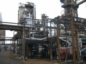
Contaminated sites caused by former industrial activities like in figure 1 pose a potential danger for
the environment; especially contaminated sites containing hazardous substances which could lead to
a significant contamination of water bodies, if the substances will be mobilised (e.g. floods). During
the last years the dramatic floods at Elbe, Danube and Oder have shown that the toxic impact of those
contaminated sites could cause a significant harm to water bodies in Europe. For that reason the
ICPDR decided to draw up a basin wide inventory of contaminated sites (CS) in flood risk areas in
the Danube river basin.
Figure 1: Oil contamination in an industrial area
Methodology for the Pre Assessment of Suspected Contaminated Sites in Flood Risk Areas in the Danube River Basin
3
Problem to be Solved
For the Danube river basin recommendations are necessary, which enable the competent authorities
of the riparian countries to maintain the following activities:
· Establishment of a methodology for a preliminary risk assessment of the CS reported in the
inventory of the Danube countries
· Drawing up recommendations for respective safety measures which could serve as regulatory
guidelines.
· Drafting a Measure catalogue for the exemplary implementation of these safety guidelines.
Objective of the Project
The major goal of the project is to develop in a first step a methodolo gy for an initial risk assessment
of contaminated sites in flood risk areas, based on the data of the inventory of contaminated sites in
the Danube river basin. The reported sites where a high risk potential has to be assumed can be
screened by an preliminary assessment.
This methodology will serve as a guide for the elaboration of safety recommendations and a concrete
measure catalogue in the next steps. For the assessment an agreed procedure has to be developed in
accordance to the inventory of accidental risk spots (ARS inventory).
In the next step the detailed analysis of the exemplary hot spots will lead to the elaboration of safety
recommendations for CS. Together with a detailed measure catalogue these recommendations will
serve for a checklist which allows the competent authorities to improve the safety of the CS and
respectively to reduce the risk of contamination of the Danube.
Selection of Suitable Proceedings as a Basis for the Methodology Development
Assessing the risk of the reported sites based on the existing data is associated with the following
difficulties:
-
The delivered data vary in quality and are partly incomplete
-
The amount of the toxic substances and sometimes even the type of substances in the
contaminated soil is often not kno wn.
-
Degradation process may have started, so metabolites (some of them toxic) and breakdown
products may present.
The estimation of the contaminants is therefore difficult and linked with a high inaccuracy. Because
of this, the use of water risk classes was proved to be difficult and didn't show suitable results.
Hence, in a first approach a method was suggested that is based on the practical experience gained by
an initial risk assessment of more than 25.000 potentially contaminated sites in the German Federal
State of Saxony. This method, simplified and adapted to the needs of the special situation at the
Danube, was discussed in the small working group and affirmed by the 27th APC Group. It is
explained in the following.
Methodology for the Pre Assessment of Suspected Contaminated Sites in Flood Risk Areas in the Danube River Basin
4
Description of the First Draft of the Methodology
The adapted methodology allows the initial risk assessment of CS by applying the following
parameters:
· The toxic potential of soil or waste according to the harmful substances to be expected in a
type of waste or in a specific industrial branch is expressed as a risk value.
· The size of the contaminated volume or area.
For each waste type of the EUROPEAN WASTE CATALOGUE (examples given in table 1) and
each branch of the BRANCH CATALOGUE OF GERMANY (examples given in table 2) a risk-
value r0 was developed in classes from 1 until 5. This risk factor r0 is derived by experience gained
in several German Federal States (e.g. Saxony) and takes into account the toxic potential of soil or
waste that can be expected from a branch or waste specific contamination.
For some wastes or branches a range of risk is given (e.g r0 from 3-5). The first figure corresponds to
the lowest class of risk to be expected, the higher figure indicates the highest class of risk ("worst
case") to be expected. This opens up the possibility for an expert judgement to adjust the r0 value if
further information about the site is available (e.g. if the contaminants are known). In this case the
liability of the assessment is improved. In the other cases, the average risk value is calculated and
rounded up. The risk values r0 should be between 1 and 5.
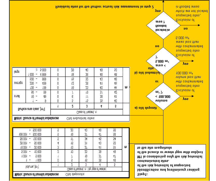
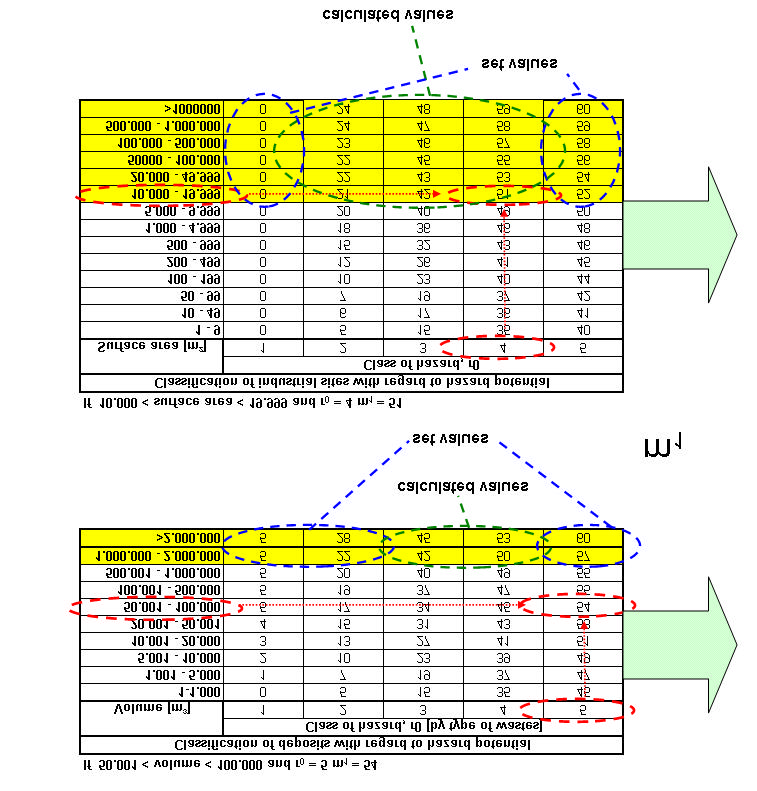
The risk values are linked with the site magnitude (specified in case of old deposits as volume [mł] or
in case of old industrial sites as surface area classes [m˛]) to an "initial risk factor" m1, which gives
an information about the potential risk of each site (see example in figure 2).
For example:
· A site with a contaminated volume of 200.000 mł (> 100.001 mł and < 500.000 mł) with a
risk value of 5 receives an m1-value of 55.
· A site with a contaminated area of > 5.000 m2 with a risk value of 4 receives an m1-value of
49.
Not all of the detected contaminated sites in the Danubian Region could be assessed. So the
assessment was concentrated only at those sites, which are potentially impacted by floods.
Additionally only those sites should be investigated, which include more than 100.000 mł of
contaminated volume or cover an area larger than 5.000 m˛ (see illustration of the exclusion criteria
in figure 3).
Methodology for the Pre Assessment of Suspected Contaminated Sites in Flood Risk Areas in the Danube River Basin
5
.
m < volume <
.
m and r =
m =
Old deposits
m
Old industrial sites
area >
mđand r =
m =
Figure 2 : Illustration of the determination of the m1-value
Methodology for the Pre Assessment of Suspected Contaminated Sites in Flood Risk Areas in the Danube River Basin
6
Table :
List of wastes pursuant to Article (a) of Council Directive /
/EEC on waste
(EUROPEAN WASTE CATALOGUE).
e.g.
WASTE RESULTING FROM EXPLORATION, MINING, DRESSING AND
FURTHER TREATMENT OF MINERALS AND QUARRY
CODE WASTE TYPE
r VALUE
Average (Min,Max )
Waste from mineral excavation
.
( - )
Waste from mineral metalliferous excavation
.
( - )
Waste from mineral non-metalliferous excavation
.
( - )
Waste from mineral dressing
.
( - )
Waste from the dressing of metalliferous minerals
.
( - )
Waste from the dressing of non-metalliferous minerals .
( - )
Waste from further physical and
chemical processing of metalliferous minerals
.
( - )
The r values " " and " " are both considered as beeing " "
Table :
Branch related hazard classifying of industries
(Branch catalogue of Germany)
(e.g.)
MANUFACTURING AND PROCESSING INDUSTRIES
BRANCH
BRANCH
Class of Hazards r
No
NAME
Min and Max
Gas, mining, related products
-
Gas production (town gas)
-
Coal mining
-
Brown coal mining and briquette production
-
Ferrous ores mining
-
Production of non-ferrous metals
-
Potassium and rock salt mining
-
Petroleum and natural gas extraction
-
Cocking
-
Briquettes coal production
-
Methodology for the Pre Assessment of Suspected Contaminated Sites in Flood Risk Areas in the Danube River Basin
7
Figure 3: Exclusion criteria used in the first draft of the m1-methodology
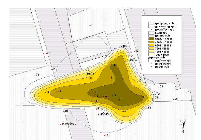
On this basis the Danubian countries reported till now 261 CS in potentially flooded areas of the
Danube. For these CS a ranking list according to the m1-methodology was drawn up and priority
spots of further investigation were detected.
Results of the first Ranking and Interpretation Problems
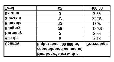
The inventories of each country, assessed by m1-methodology, as described above resulted to 103
evaluable sites of total 261 sites, which represented a degree of 39,5%.
Nearly 50 sites reached an m1-value of equal or more than 45, corresponding to high risk value and
90 sites have an m1-value of more than 37, which still indicates a relevant risk potential.
Methodology for the Pre Assessment of Suspected Contaminated Sites in Flood Risk Areas in the Danube River Basin
8
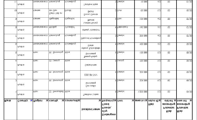
The first 67 sites, which were classified by contaminated volume (waste deposits), are shown in the
following table:
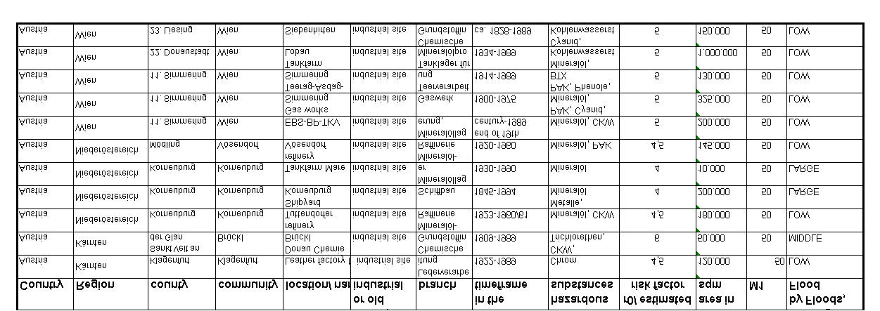
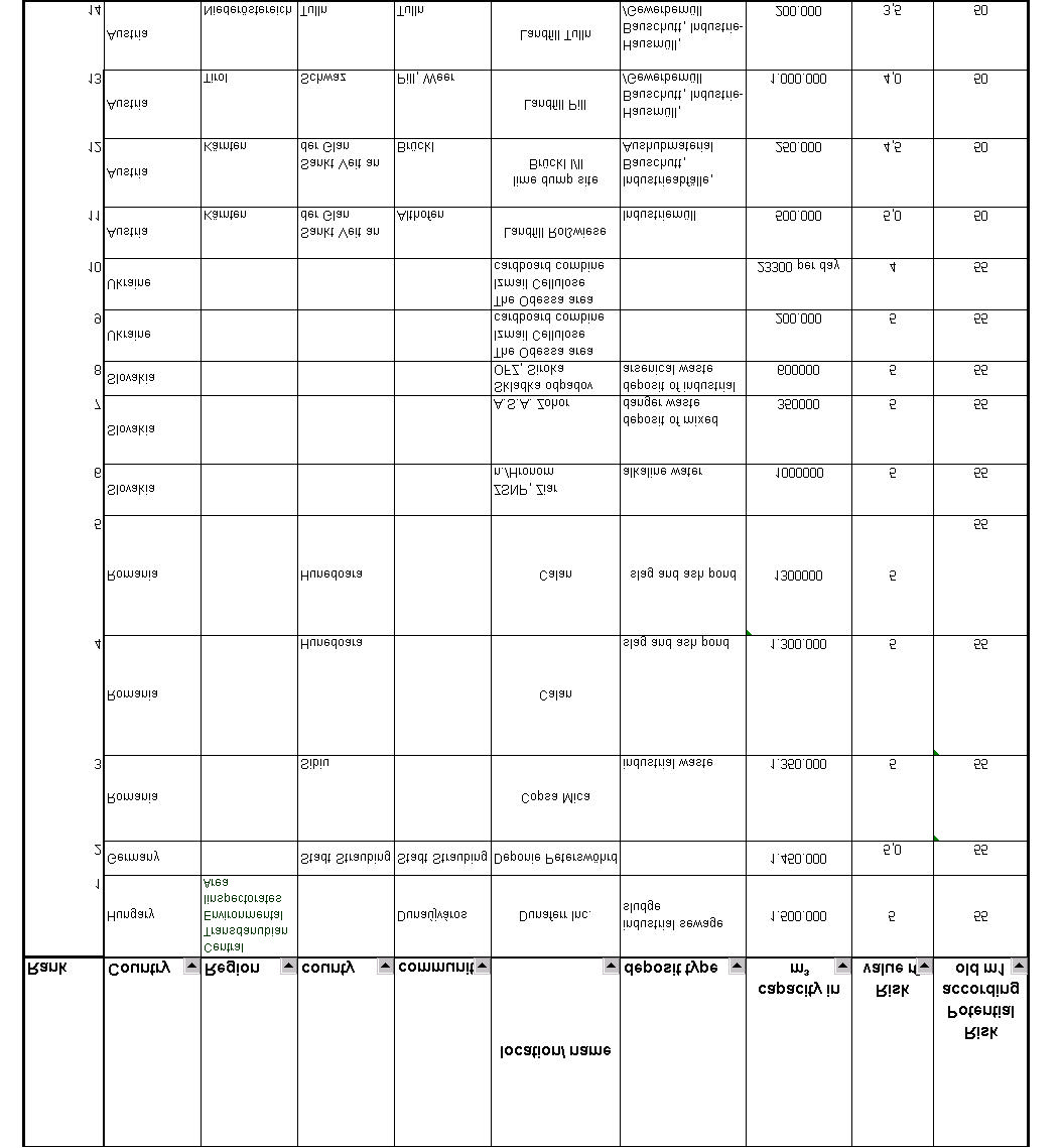
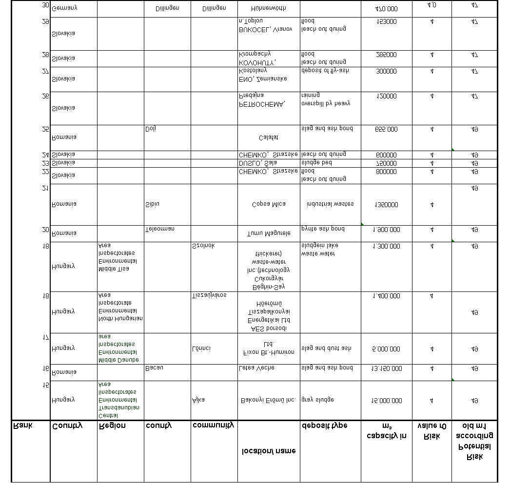
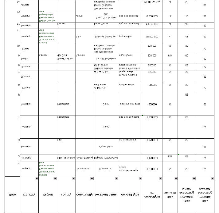
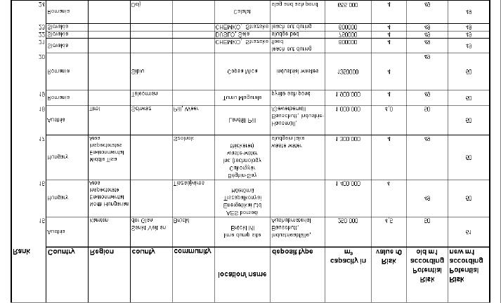
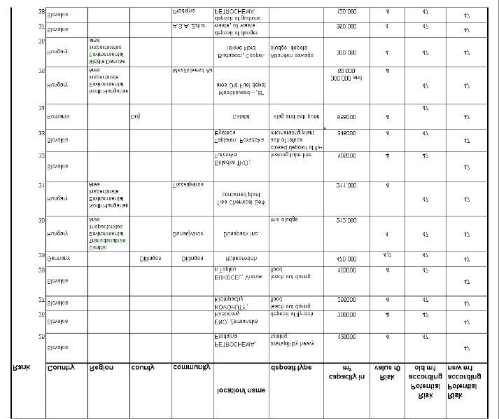
Table 3: Result of the first ranking of CS in the Danube Region*
* The list does not include the 11 contaminated industrial sites, which were additionally listed by the Austrian experts.
At least the use of this methodology for the site assessment led to the following problems as stated
by the expert group:
· Because of missing data like the amount of contaminated volume or a missing classification
of the risk value the evaluation and interpretation of the data was difficult. So in some cases
the risk values were estimated It has to be considered that the estimated data have a high
inaccuracy which could lead to a wrong evaluation of the sites, but are sufficient for a
screening.
· Waste deposits and abandoned industrial sites: Apart from the Austrian data, the inventories
from all other countries did report waste deposits where the size is classified as a volume.
Austria also reported properties of abandoned industrial sites (for example mineral oil
refinery) classified by surface area. A conversion into contaminated volume is not possible,
because contamination is concentrated in hot spots and normally not evenly distributed over
the whole site. We therefore decided to leave those sites in a separate table.
· 7 sites (3 sites in Romania and 2 sites in Slovakia and 1 site each inHungary and in the Czech
Republic) reached the m1 values higher or equal 47, but with contaminated volumes lower
than 100.000 mł.. This emphasises the fact that also smaller sites but with highly toxic
substances can represent a hazard for the environment.
A lot of screened sites with a contaminated volume larger than 100.000 mł could not be further
differentiated with the present tables in figure 2. The example of the Austrian sites should be
emphasised (see appendix 1), where the pre-selection and screening of the sites made by the Austrian
Federal Agency led already to sites with very similar high hazard potentials. A further differentiation
of those sites is not possible with the given data and this methodology.
Methodology for the Pre Assessment of Suspected Contaminated Sites in Flood Risk Areas in the Danube River Basin
9
As a result of the expert group meeting in Ljubljana, it was stated the following:
· The "m1-methodology" is the first step of the assessment as shown in figures 2 and 3. It is a
tool for a first screening step . For the present methodology the expert group suggested to
extend and to divide the categories of the large sites (> 100.000 mł and > 5.000 m˛) to an
open score, which allows a better differentiation of the large sites.
The expert group amendments led to the following consequences for the m1-methodology:
· With the demand for an open score for the site categories, maximum values of 55 and 50 like
in the first approach of the m1-methodology could not be used any longer. The range of the
tables should be extended.
· For improving the assessment, it was also discussed that in the future a parameter concerning
the flood probability should be integrated. The attempt to get data concerning the flood
probability of each sites did not succeed. It was agreed, that a harmonised approach for the
Danubian Countries is needed.
Methodology for the Pre Assessment of Suspected Contaminated Sites in Flood Risk Areas in the Danube River Basin
10
Resulting Methodology according to the Amendments of the Expert Group
New evaluation tables were elaborated according to the formulated requirements of the expert group,
where the range of site magnitudes was extended aiming at a better differentiation of the sites which
are larger than 1.000.000 mł or 10.000 m˛.
At first it was intended to calculate the m1-values of the extended size classes by interpolation based
on the value of the old table. The result is shown in figure 4.
interpolated values
M1
r =
Y
Yo
Y
M1
r =
r =
x = x + (x -x )*(Y -Y )/Y -Y )
r =
r =
x
x
x
Area in mđ
Figure 4: Results of the first attempt to calculate the values according to the extended Range of
the evaluation table.
The interpolation led to m1-values, which were not consistent in the different classes of risk values
(r0 = 3 and r0=4). So this approach failed for the table extension.
Alternatively we fixed the table values in the column of r0=5 until to the maximum value of 60 and
calculated the other values according the rule of proportion or the average value. It led to a better
result as to be seen in the next figure 5.
Methodology for the Pre Assessment of Suspected Contaminated Sites in Flood Risk Areas in the Danube River Basin
11
Figure 5: Evaluation table with extended size classes
Methodology for the Pre Assessment of Suspected Contaminated Sites in Flood Risk Areas in the Danube River Basin
12
With the revised evaluation table a new ranking of CS was performed, which led to the following
results (see appendicies 3 and 4):
· For sites classified by surface area like the Austrian sites (see appendix 3) it was possible to
differentiate between some of the sites which had before the same initial risk value m1. A
further differentiation is not reasonable with the given data. Only the flood probability could
be used as a further criterion, because the Austrian experts defined it for their sites.
· The sites classified by volume could be slightly more differentiated. Additional data and
criteria would be necessary for allowing a finer ranking. the table has to be seen as a first
screening of those sites, which have to be preferably visited and investigated further. All sites
with an initial risk value equal or higher than 50 should be inspected to perform a risk
assessment by using the checklist. Also the criterion of flood probability should be discussed
for those sites in view to a better differentiation .
The methodology is not an optimised tool for the ranking of CS, but it is a sufficient tool for a site
screening which should be the preliminary step. A deeper ranking is not possible at this investigation
stage, because the inaccuracy of the data is very high. Therefore the extension of the table score did
not achieve a detailed ranking. Such a more detailed ranking is possible after a site visit where data
about the contaminated surface/volume and the risk class could be concretised. Based on that secured
data base a further ranking of CS can be performed.
Appendix 1: Result of the ranking of the site classified by surface area (Austrian sites)
Methodology for the Pre Assessment of Suspected Contaminated Sites in Flood Risk Areas in the Danube River Basin
14
Appendix 2:
Result of the ranking of the sites classified by contaminated volume (All Danubian sites))
Methodology for the Pre Assessment of Suspected Contaminated Sites in Flood Risk Areas in the Danube River Basin
15
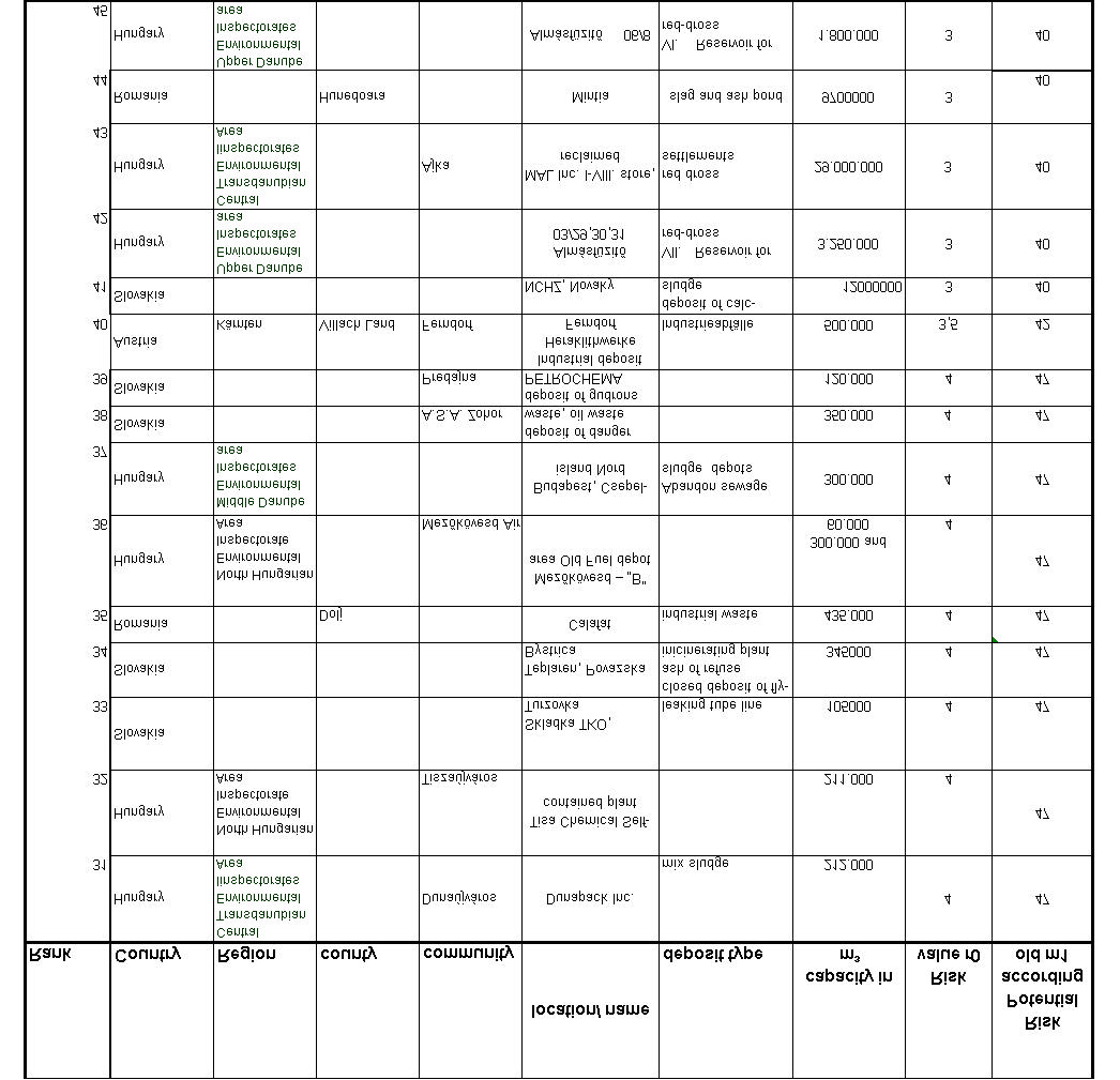
Methodology for the Pre Assessment of Suspected Contaminated Sites in Flood Risk Areas in the Danube River Basin
16
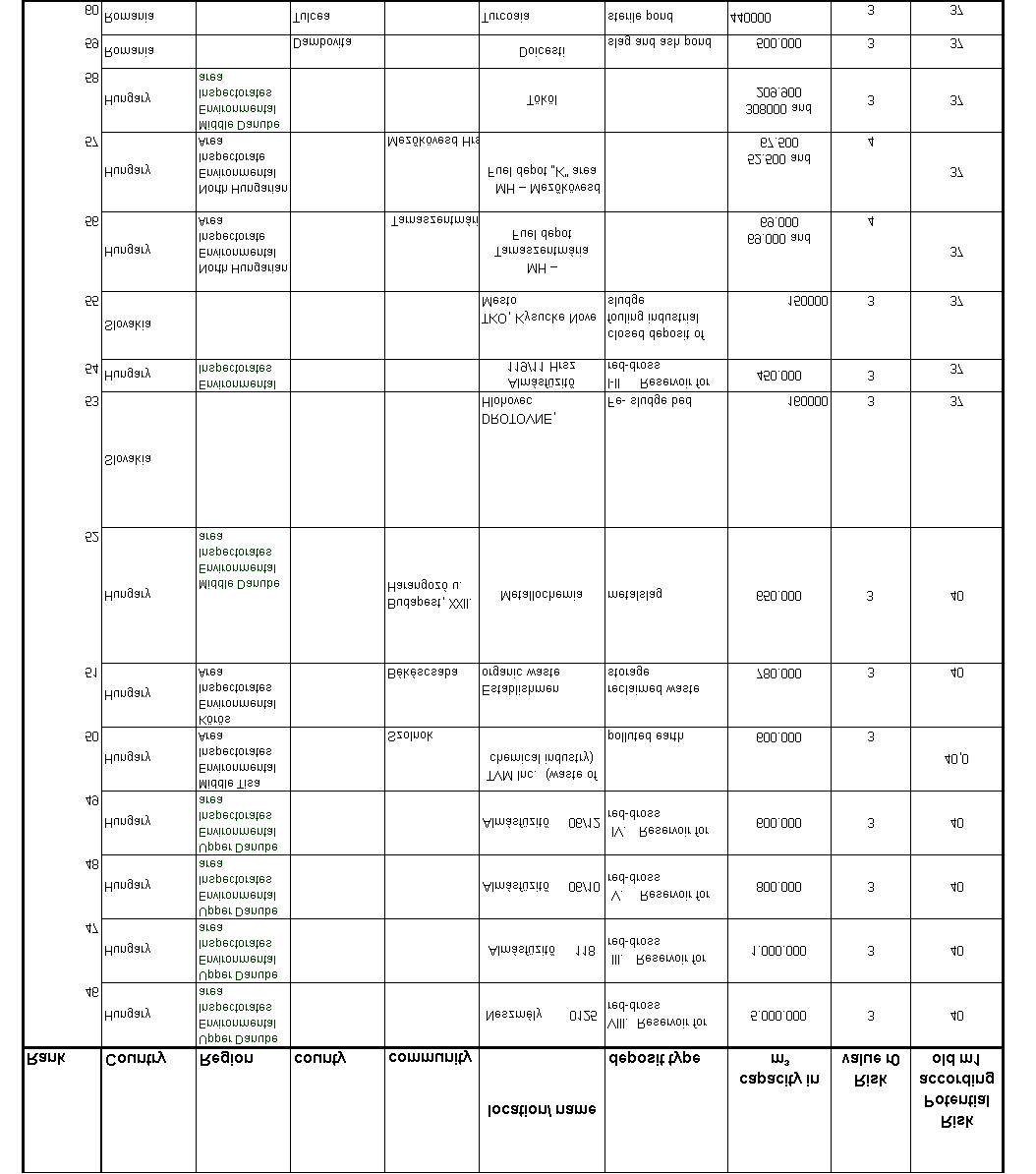
Methodology for the Pre Assessment of Suspected Contaminated Sites in Flood Risk Areas in the Danube River Basin
17
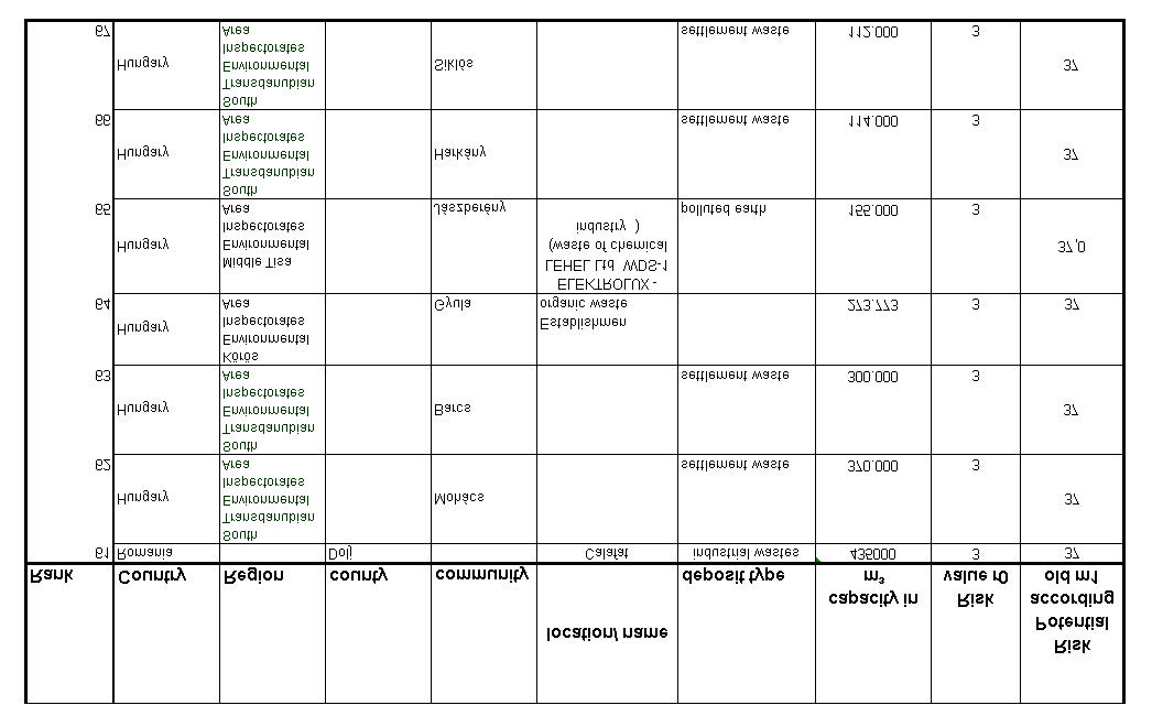
Methodology for the Pre Assessment of Suspected Contaminated Sites in Flood Risk Areas in the Danube River Basin
18
Methodology for the Pre Assessment of Suspected Contaminated Sites in Flood Risk Areas in the Danube River Basin
19
Appendix 3: Result of the ranking of the Austrian sites classified by surface area using the
adapted methodology
Methodology for the Pre Assessment of Suspected Contaminated Sites in Flood Risk Areas in the Danube River Basin
20
Appendix 4: Result of the ranking of the sites classified by volume using the adapted
methodology
Methodology for the Pre Assessment of Suspected Contaminated Sites in Flood Risk Areas in the Danube River Basin
21
Methodology for the Pre Assessment of Suspected Contaminated Sites in Flood Risk Areas in the Danube River Basin
22