|
 | |||
| |||
| |||
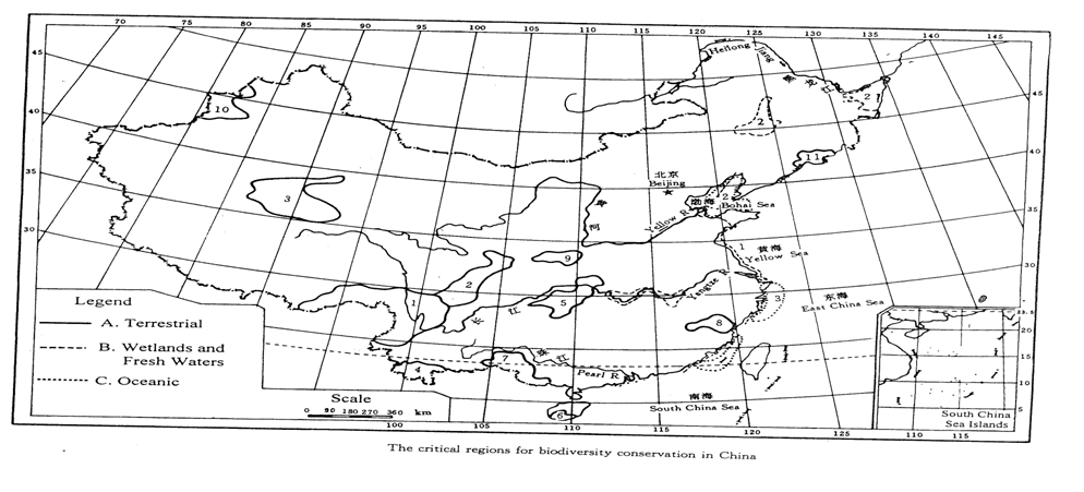 | |||
2. Plateau and mountains region between Xinjiang, Quinghai and Tib
3. 1. Southern part of Hengduan Shah
4. Northern part of Hengduan Shan
5. 5. Mountain region between Hunan, Guizhou, Situan and Hubei
|
UNITED NATIONS ENVIRONMENT PROGRAMME
GLOBAL ENVIRONMENT FACILITY (GEF) BLOCK B GRANT REQUEST
Project Title: Nature Conservation and Flood Control in the Yangtze River Basin
Implementing Agency: United Nations Environment Programme (UNEP)
Executing Agency: The project will be executed by the State Environmental Protection Administration (SEPA) of the Government of China in collaboration with the Chinese Research Academy of Environmental Sciences and the other academic institutes. Relevant local governments in the upper and middle reaches of the Yangtze River will be involved mainly in the execution of demonstration projects.
Requesting Country: People’s Republic of China
GEF Focal Area: Multiple Focal Areas: Biodiversity, International Waters, and Climate Change.
GEF Operational Program: The Project falls under the Integrated Ecosystem Management Operational Programme (OP 12) of the GEF. The project will achieve multiple benefits. The project will promote rehabilitation and conservation of degraded ecosystem functions in the upper and middle reaches of the Yangtze River as a part of integrated catchment basin management. The project will concurrently address conservation and sustainable use of biological biodiversity as well as increased storage of greenhouse gases in the terrestrial ecosystems.
Total Cost of PDF B: $ 544,000
Requested From GEF: $ 350.000
PDF B Co-funding: $ 194,000: Cash $ 80,000 ( UNEP: $60,000, and SEPA: $20,000), In-kind : $ 114,000 ( UNEP: $ 55,000, UNCHS: $15,000, and SEPA and other Executing Agencies: $ 44,000)
Block A Grant Awarded: No
Estimated Start Date of PDF B: December 2001
Estimated Duration of PDF B: 15 months
Estimated Starting
Date of Full Project: May 2003
Estimated Total Cost
of Full Project: 10 million US dollars (This figure is of indicative nature, and the actual budget will be determined during the PDF phase.)
for Full Project: 5 million US dollars GEF, 5 million US dollars Co-financing
Project Duration: 3 years
1. BACKGROUND AND CONTEXT
1.1 Environmental Context
1. China is one of the countries with the richest biodiversity in the world. It shelters more than
3,000 species of higher plants, and 6,347 species of vertebrae, accounting for 10% and 14% respectively the world total. The vertebrate consist of 581 species of mammals, 1,244 species of birds, 280 species of amphibians, and 376 species of reptiles. China’s biodiversity is rich not only in number but also in the level of endemism. The number of higher plant species endemic to China has reached 17,300, 57% of the total in China. The percentage of vertebrate species endemic to China has come to 10.5% of the national total. It is estimated that China contains more than 10% of all living species on the earth.
2. The Yangtze River is the largest in China and the third largest in the world, which originates from the Qinghai –Tibet Plateau flows across 11 provinces and provincial cities, and reaches Shanghai discharging into the East China Sea. The Yangtze River basin consists of about 85% of plateaus, mountains and hilly areas, 11% of plain and 4% of rivers and lakes. Total estimated land use and land cover of the basin is distributed as follows: arable lands 23.2 million ha (13.4%), forests 47.7 million ha (26.4%), grasslands 31.3 million ha (17.3%), water areas 7.5 million ha (4%), unused lands 19.8 million ha (11%), and others 50.3 million ha (27.9%).
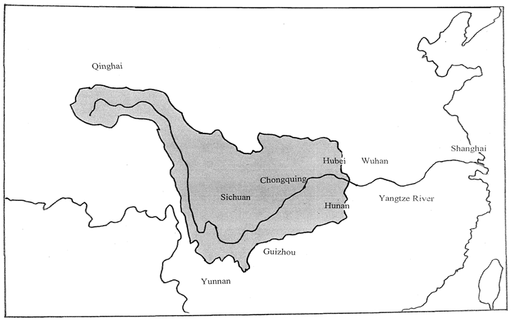
3. Natural ecosystems of the basin are well known world wide for its rich species, various habitats and enormous productivity. They are among the most biodiversity rich areas in China. This is particularly true in the upper and middle reaches of the Yangtze River, which in this paper refer to the catchment areas of the Yangtze River system in Qinghai, Yunnan, Sichuan, Guizhou, and Chongqing provinces and western part of Hubei and Hunan provinces (See Appendix 1).
4. Of eleven most critical terrestrial regions for biodiversity conservation in China identified by the China’s Biodiversity Country Study (May, 1997), four are at least partly located in the upper and middle reaches of the Yangtze River. These four regions were included in the China Biodiversity Action Plan as critical areas for conservation. They are (i) the plateau and mountain region between Xinjiang, Quinghai, and Tibet, (ii) the southern part of Hengduan Shan, (iii) the northern part of Hengduan Shan, and (iv) the mountain region between Hunan, Guizhou, Sichuan, and Hubei (See Appendix 2).
5. The eastern part of the plateau and mountain region between Xinjiang, Quinghai and Tibet is the headwater area of the Yangtze River. The area is characterized by rich species of flora and fauna unique to this region. They include, for example, the wild yak, the white-lipped deer and the Tibetan gazelle. 15-20 % of the species in this area are at present being threatened or on the verge of extinction. Very high endemism is an outstanding feature of the southern part of Hengduan Shan. For instance, the total number of insect species recorded in this area is estimated to be 3,080, of which about 40% are endemic. The same is true with northern part of Hengduan Shan. This area provides main habitats for the giant panda. A nature reserve in this region alone accommodates 28 national priority protection species. The mountain region between Hunan, Guizhou, Sichuan, and Hubei also has rich species with high endemism. Badagong Shan area alone, for example, has 1,846 species of vascular plants, 146 species of vertebrates, and 2,483 species of insects.
6. A large number of plants and animals found in the upper and middle reaches of the Yangtze River are endangered species listed as national priority protection species. Most famous ones include the dove tree Davidia involucrata), the single-leafed grass (Kingdonia uniflora), the Minjiang cypress (Cupressus chengiana), the giant panda (Ailuropoda melanoleuca), the golden monkey (Rhinopithecus spp), and the lesser panda (Ailurus fulgens).
7. The Yangtze River is endowed with rich aquatic biodiversity as well. The river and its associated wetlands are the habitat for the Yangtze River Dolphin (Lipotes vexillifer), the Yangtze (Alligator, Alligator sinensis), and the David Deer, (Elephaurus davidianus). Migratory bird species, whose seasonal habitats lie in wetlands within the Yangtze basin, include the white crane (Gru- leucogeramus), and the white-naped cranes (Grus vipis). These migratory species are of regional significance, protected under bilateral migratory birds protection agreements.
8. Against this background a number of protected areas have already been established in the basin (See Appendix 3). In Sichuan Province alone, a total of 52 forest, wildlife, and wetland nature reserves have been set up. The areas covered by such nature reserves amount to 6.9 % of the Province. Among them 10 are protected areas at the national level. In addition several nature reserves in the basin are recognized of international importance, being included in UNESCO’s “Man and Biosphere” reserve network, the World Nature Heritage Sites and the Ramsar wetlands. Forest nature reserves such as Wolong, Tangjia River, Wanglang, Jiuzhaigou, and Huanglong Temple, and wetland nature reserves such as Poyang Lake, and Dongting Lake are among those internationally recognised. On top of this most of the 17 existing panda nature reserves are located in the Yangtze River mountain areas.
9. Furthermore, the upper and middle reaches of the Yangtze River particularly in Sichuan and Yunnan have a number of minority groups. Although these ethnic groups in general do not have large population, they have their distinct cultures including those related to how they associate themselves with the surrounding natural environment. Nature conservation of minority peoples is embodied, for example, in their traditional religions, and lifestyles such as rotating fallow. Their unique cultural characteristics are a significant heritage of China and the world, which should be respected in planning and implementation of nature conservation measures.
10. Environmental priorities are also accorded to the conservation of biological diversity in the Yangtze River basin. The China Biodiversity Action Plan was developed in 1994. The Plan set out a number of goals and objectives directly related to the upper and middle reaches of the Yangtze River. The Plan advocated, inter alia, adoption of forestry practices consistent with biodiversity conservation, and protection of major habitats outside nature reserves and strict conservation of grasslands and wetlands. The State Council issued in 1998 the National Ecological Environmental Restoration Plan, which identified the same part of the river as key areas for conservation to address deforestation, land degradation, desertification and loss of biodiversity. China’s National Report on Implementation of the Convention on Biological Diversity prepared in 1998 also listed the upper and middle reaches of the river among priority conservation areas.
11. The Yangtze River is the largest in China and indeed in Asia, with the total length of over 6,300 kilometers and the total drainage area of 1.8 million km2. The number of people inhabiting the basin amounts to one third of the total Chinese population and the economic activities in the basin occupy a significant portion of the total GDP in China as elaborated in the paragraph 15 below. The amount of water discharged by the Yangtze River is so huge (about 960 billion cubic meters per annum) that the river has had significant impacts on the East China Sea and coastal areas in central China. In addition the river has extremely rich aquatic biodiversity as outlined in the paragraph 7 above. Thus conservation and sustainable use of the Yangtze River and its basin are considered of international importance. However the Yangtze River and its watershed have been suffered from various stresses created by expanding human activities. In relation to management of the upper and middle catchment areas, the increasing level of turbidity is the most serious problem. This problem was the result of massive land degradation caused by deforestation and overgrazing in the upper and middle watershed areas. The gravity of the problem has been such that it has affected not only the aquatic biodiversity associated with the river system, but local water use, fishery and even safety of the local inhabitants. There is a great potential to address this problem through soil management measures in the upper and middle reaches of the river.
12. The Yangtze River basin has great potential to sequester greenhouse gases. Reforestation and conservation of protected areas will contribute to reducing net greenhouse gases emissions from China on a long-term basis. Although estimates are still incomplete, the amount of carbon to be sequestered by vegetation and soil through sound management of forests and grasslands is considered significant. Also conservation of wetlands within the basin will increase the amount of carbon stored in wetland ecosystems. In addition reforestation and soil conservation of the Yangtze watershed areas will alleviate vulnerability to extreme climate events likely to be associated with climate change. Indeed such efforts will contribute to enhancing adaptation capacity of the Yangtze River basin to changes brought about by global warming.
1.2 Threats and root causes to globally important environments
13. Despite the global importance of natural ecosystems in the upper and middle reaches of the Yangtze River, the areas have suffered from serious degradation over decades. Such environmental degradation has taken place even in protected areas.
(i) Deforestation: Significant deforestation in the Yangtze River basin, particularly in the middle catchment areas, started in the 1950s. Deforestation at the expense of natural forests further exacerbated since mid-60s. As a result the total forest area was halved since 1950s. For example low hills in the eastern part of the upper and middle watershed areas and tropical evergreen broadleaf forests in the southwest mountain area of Sichuan Province were significantly destroyed. Consequently forest coverage of those areas dropped from 20-30% in the 50s to around 10% or in some areas even to 1-5% in the 80s. Deforestation had been a continuing trend in China for hundred of years until logging bans introduced after the 1998 floods. However, the rate of deforestation accelerated considerably in recent years. For example, forest coverage of the upper reaches of the Minjiang River, one of the tributaries of the Yangtze fell from 50% in early Ming Dynasty to 30% in the 50s. Today only about 10% of the basin is forested, although degraded forest areas are considered recovering after the 1998 logging bans.
(ii) Grassland Degradation: Overgrazing is one of the major causes of grassland degradation in the upper catchment areas of the river. Indeed erosion associated with grassland degradation in the headwater areas amounts to 106,000 km2, 27.4% of the total land area, of which 42,300 km2 suffers from the erosion of high degrees, and 1,100 km2 is categorized under the erosion of extremely high degrees. In the case of the Mengzonggou basin in Qinghai province, a total of 11.865 km2 suffers from soil erosion, which occupies as much as 59.19% of the basin. Even desertification is in progress in some part of Qinghai province. Today 19,000 km2 has been desertified and desertification is expanding at the annual rate of 2.2 %.
(iii) Soil erosion: Ecologically damaging human activities such as deforestation and overgrazing have caused serious soil erosion in mountain areas of the Yangtze River basin. Most cultivated lands in mountain areas exist on steep slopes (more than 25 degrees). About 60% of cultivated lands on slopes have no soil conservation measures. In the 50s soil erosion areas were about 299,500 km2. Today degraded land areas amount to 393,000 km2. As a result sediment transport in Jinsha River, for example, increased by more than 100% in 15 years (130 million t/a in 1958, and 290 million t/a in 1974).
(iv) Loss of lakes and wetlands: In the early 1950s as many as 4,033 lakes and wetlands existed in the Yangtze River basin. By 1995 approximately 1,100 lakes disappeared. In 1949, 22 relatively large lakes in the basin had a total of 17,198 km2 of surface area. About two thirds of this surface area was lost by 1980. This massive loss of lakes and wetlands in particular down stream areas of the Yangtze River basin has been a result of large-scale conversion to farmlands.
14. Root causes of nature degradation in the upper and middle reaches of the Yangtze River are considered as follows:
(i) Most deforestation and soil erosion were caused by encroachment of cultivated areas, commercial logging and uncontrolled tree cutting for timber and firewood, and overgrazing. Aside from large scale commercial logging, these practices have been conducted mainly by local populations, who have no other means but to exploit environmental resources surrounding them to accommodate increasing demands for natural resources associated with population growth. In other words poverty amongst increasing number of local populations has been a root cause to the serious environmental deterioration in the basin. Due to the low agricultural productivity and the subsistence nature of local agriculture, income levels of farmers are very low. Markets are underdeveloped and prices of agricultural products are discouraging. In order to break the vicious cycle of poverty and environmental degradation, the living standards of local populations need to be improved on a sustainable basis.
(ii) Another cause of the environmental degradation is inappropriate governance of nature conservation activities in this region. Land use planning has taken no heed to environmental consequences. Also implementation of conservation measures has been weak. Many protected areas have existed only on paper. About thirty eight per cent (38 % ) of protected areas in China have no management regime and 32 % have no management staff. As a result encroachment by the local populations on ecologically important areas has not been effectively prevented.
1.3 1998 Floods of the Yangtze River
15. Over 400 million people, about one-third of the total population of China, live in the Yangtze River basin. The population density of the basin is 220 persons/km2. The Yangtze River basin is the economic center of China, and one of the most developed areas in terms of agriculture, fishery, industry and transportation. The basin has 23.3 million ha of arable lands, about 24.3% of the China's total. Agricultural output from the region amounts to about 32 % of the China’ s total agricultural production, and about 35% of the total grain production. Major agricultural products include rice, cotton, sesame, fibre, tea, and tobacco. Tai Lake, Dongting Lake, Poyang Lake and the Jianghan Lake Group are nationally important fishery grounds. Shanghai, Jiangsu, Hubei and Sichuan are not only economic centers for the basin but also for the whole country.
16. The 1998 floods in the Yangtze River caused severe damage to human life, property and the natural environment. The damage estimated across the country (including the Northern Provinces) indicated affected area of 25.78 million km2, damaged area of 15.85 million km2, affected population of 230 million people, 3,656 dead, urgently relocated population of 13.8 million people, 5.66 million swept houses, 12.05 million damaged houses, and the total direct economic loss of 248 billion RMB1. Indeed, the scale and frequency of floods in the Yangtze River reached levels where sustainable development of the basin is directly threatened.
17. The floods were directly caused by long and persistent rain, but as the Report of the UNEP Scoping Mission to the Yangtze River Basin (January, 1999) pointed out there were three main ecological causes: (i) sharp decline in water retaining capacity of forest and grass lands due to deforestation and overgrazing, (ii) decrease in water storage capacity in the middle and lower reaches of the Yangtze River due to loss of lakes and wetlands, and (iii) siltation of the rivers and wetlands in the Yangtze basin due to serious soil erosion.
18. The 1998 catastrophic floods of the Yangtze River system prompted the Chinese Government to formulate the Guiding Principles for flood control and damage mitigation. The Guiding Principles recommended various measures to be taken immediately. These include logging bans, re-conversion of cleared lands to forests, prohibition of cultivation on steep slopes, re-conversion of reclaimed agricultural lands to wetlands to recover the level of the 1950 surface water area, relocation of populations living in vulnerable areas, strengthening river banks, and dredging river channels. The Great Western Development Strategy approved by the Peoples’ Congress in early 2000 also included, among other things, the restriction of cultivation on steep slopes.
19. In response to these central government instructions, actions were taken swiftly in the field. For example, Sichuan Province lost no time in introducing a logging ban on natural forests in September 1998. Logging companies were transformed quickly into afforestation management companies, and loggers were re-employed as tree planters or forest ranchers.
______________________________________________________________________________________________________________________________________
1Ren-min-bi (RMB) is the Chinese currency, which is equivalent to Chinese yuan. The exchange rate was one United States dollar equaled to 8.2 – 8.3 RMB in the last 2-3 years.
In October 1999 Sichuan Province took an initiative to implement a program to convert cultivation areas on steep slopes into forest/grass lands. Compensation was paid in various forms to farmers affected. The original target of the conversion (i.e. about two thousand km2) was achieved within one year.
20. As elaborated above high priority has been attached to rehabilitation and conservation of natural ecosystems in the upper and middle reaches of the Yangtze River, as emergency flood control measures. Indeed nature conservation of the region has never been grappled with as seriously as today. However measures currently undertaken are not necessarily considered sustainable. Logging bans or prohibition of cultivation on steep slopes have not squarely dealt with root causes of environmental degradation, because the poverty alleviation and other local socio-economic needs have not been fully taken into account. Thus effectiveness of the current emergency flood control measures could be potentially short lived. In addition current measures have not generated significant global environmental benefits, because at the moment only little attention, if any, has been paid to implications of these measures for biodiversity loss, land degradation or climate change. Afforestation, for example, tends to be conducted using fast growing or fruit bearing tree species partly for economic purposes, although majority of areas are simply enclosed for natural restoration. In addition areas where such conservation measures are taken do not necessarily correspond to biodiversity rich areas.
1.4 Project Context
21. The 1998 floods could be attributed at least in part to the environmental degradation of the upper and middle catchment areas of the Yangtze River, as outlined above. In other words, the floods were caused partly by the decline of key “ecosystem functions”1 of the basin. Of direct relevance are water and soil retention functions of local natural ecosystems. Thus major government interventions are directed toward rehabilitating and strengthening such key ecosystem functions of the region in view of effective flood control and damage mitigation.
22. There are a number of deferent measures to deal with the Yangtze River flood problem as enumerated in the Government Guiding Principles mentioned above. There is a tendency to put higher priority on quick fix measures such as dredging and embankment. However, such engineering oriented measures could have adverse environmental impacts. In addition, such measures could require more investment than other measures, as the cost-effectiveness of engineering oriented measures has become less and less clear. In contrast, conservation oriented measures such as afforestation, logging bans, and protection of natural forests potentially have favorable environmental impacts and are considered more conducive to long-term sustainable development of the region.
23. Yet current conservation oriented measures have paid little attention to their sustainability. One of the root causes of the serious environmental degradation of the basin is poverty associated with local population increase. Thus unless proper poverty alleviation measures are taken together, any flood control measures could be rendered ineffective in the long run. The proposed project will address this problem taking fully into account socio-economic needs (such as food, shelter and energy) of local populations.
24. Also of concern is lack of attention being paid to global environmental problems in implementing flood control measures. Strong possibility exists to reforest degraded areas with a limited number of fast growing or fruit bearing tree species. In addition most conservation measures are likely to be taken in areas where global environmental benefits are insignificant. The proposed project will address these potential problems by positively linking conservation oriented flood control measures to global environmental concerns.
___________________________________________________________________________________
1The term “ecosystem functions” is used to indicate hydrological, geo-chemical and biological functions of a specific ecosystem that can be utilized for human life and productive activities. These functions include: water retention, water purification, carbon sink, nutrient cycling, transfer and accumulation of pollutants, biodiversity maintenance, etc., and in this proposal, such benefits as fisheries, agriculture, hunting and collection of herbs are not included in the “ecosystem functions”. In some literature, these functions are classified as ecosystem attributes, functions and benefits. UNEP/Wetlands International publication “Wetlands and Integrated River Basin Management – Experiences from Asia and the Pacific” in 1997 endeavored to classify these from the perspective of incorporating the functions of wetland ecosystems into river basin management schemes to achieve multiple management objectives.
25. To sum up rehabilitation and conservation of ecosystem functions of the basin could form an important part of flood control measures. However, as outlined above, the current measures have three potential problems, (i) to what extent conservation oriented measures will be undertaken in relation to engineering oriented measures is not clear, (ii) no clear guidance is provided on how conservation oriented measures are to be implemented, and (iii) long-term sustainability of flood control measures has not yet been systematically considered. The proposed project will attempt to shift the overall focus of flood control measures more toward conservation, to make flood control measures more beneficial to the global environment, and to ensure long-term sustainability of such measures by addressing root causes of environmental degradation in the region. In short, the proposed project will look at synergies between flood control and global environmental benefits.
1.5 Past and on-going projects related to the proposal
26. In 1995 the World Bank initiated a GEF project (China Nature Reserve Management project) with approximately 18 million US dollars, for improvement of 5 nature reserves in China (Xishuangbanna, Qinling, Shennongjia, Wuishan and Poyang Lake) and capacity building for administrative bodies of the selected nature reserves under the jurisdiction of the Ministry of Forestry (now the State Forestry Administration). None of these five nature reserves are located within the areas envisaged under the proposed project. However, the World Bank project has generated a significant demonstration impact, by producing, inter alia, a protected area management guide, a staff training curriculum, and community co-management and education guidelines. Such materials will be fully utilized in the course of project implementation.
27. The ADB/WB/GEF project on Songhua River flood and biodiversity aimed at the protection of Sanjiang Plain from flood and other threats. While the Songhua project has a focus on structural flood control measures, the proposed project takes a different approach to flood impacts mitigation: i.e. through conservation of ecosystems functions. Although the project areas are different, lessons learned from the Songhua project will be fully utilized, in case a wetland is selected as a demonstration site of the proposed project.
28. UNDP has started the Wetland Biodiversity Conservation and Sustainable Use project (about 12 million US dollars) to remove barriers to effective conservation of global wetland biodiversity at four demonstration sites (Sanjian Plain, Ruoergai Marshes, Yangcheng Coarst, and Dongting Lake). None of these demonstration sites are located within the areas envisaged under the proposed project. In addition, this UNDP project also aimed at assisting the State Forestry Administration for improvement of wetland protected areas under their jurisdiction. In case a wetland is selected as a demonstration site for the proposed project, lessons learned from this UNDP project will be fully utilized.
29. UNDP also initiated early 2001 a medium sized project (MSP) in the Yangtze River basin titled “ Multi-Agency and Local Participatory Cooperation in Biodiversity Conservation in Yunnan Upland’s Ecosystem”. The objective of the project is the protection and sustainable use of the upland biodiversity of Wulingshan (Yunnan Province), with the full cooperation and collaboration of different stakeholders. This MSP project focuses on the Wulingshan Reserve and the Quinshan watershed. However the proposed project will not include areas covered by this MSP project. However a good coordination will be maintained with the MSP project so that experience and lessons learned should be shared to each other.
30. The UNDP/ADB PDF-B project titled “Yunnan Comprehensive Agricultural Development and Biodiversity Conservation Project ” aims at sustaining Yunnan’s agricultural growth to alleviate rural poverty while protecting its rich biodiversity and agrobiodiversity. The project includes interventions at 12 nature reserves in the Yunnan Province. However the proposed project will not select those nature reserves covered by this UNDP/ADB project. However a good coordination will be maintained with the UNDP/ADB project so that experience and lessons learned should be shared to each other.
31. In the light of clear priority attached to the flood control of the Yangtze River by the Government of China, UNEP and UNCHS initiated in 1998 technical assistance by fielding two scoping missions. Based on the recommendations of these missions, an Expert Working Group on Flood Events and Their Impacts in the Yangtze River Basin was set up by UNEP, UNHCS and SEPA. The Expert Working Group met twice and proposed a vulnerability assessment on the natural environment and the human settlement in relation to potential damage to be caused by future floods. UNEP took the lead in assessing environmental causes of the floods and in conducting preliminary vulnerability assessment. It is this joint work undertaken by the Expert Working Group that has culminated in the preparation of the proposed project, which will more squarely address a top-priority national concern: the integrated catchment basin management by means of improved environmental conservation in the upper and middle reaches of the Yangtze River.
32. Consultations were made with a recent initiative taken by ADB, which is intended to assist the Government of China to develop the Country Programming Framework for projects and activities coming under OP12. It was agreed that this proposed project is different in many respects from the ADB’s initiative (PDF B project), “Partnership on Land degradation in Dryland Ecosystems.” But progress achieved under the proposed project should be reported to the forum to be established under the ADB initiative, in which the country programming framework will be continuously discussed and developed.
2. SUMMARY AND PROJECT OBJECTIVES
2.1 Project Objectives
33. The overall context in which the project has been formulated is a need to mitigate flood events through rehabilitation and conservation of ecosystem functions, while simultaneously enhancing conservation and sustainable use of biological resources of global importance and strengthening sequestration of greenhouse gases. The objectives of this project are: (i) to develop methodologies to promote sustainable use of natural resources in areas critical to global environment conservation and flood control, and (ii) to develop methodologies to promote rehabilitation and conservation of ecosystem functions in degraded protected areas where the globally significant environment is at stake. At the same time the project will strengthen capacity of the central as well as local government bodies concerned to enable them to apply developed methodologies to the region as a whole in a flexible and sustainable manner. Emphasis will be placed upon sustainability of the project by fully taking into account socio-economic needs of local populations. It should be stressed that this project will only initiate introduction of new conservation approaches in China, which, if proved effective, will be applied to other areas in the Yangtze basin as well as other parts of China and other Asian countries.
34. The first objective is to be addressed through the introduction of “Ecosystem Functions Conservation Areas (EFCAs)”, a new approach to nature conservation. Details of EFCAs are provided in the National Ecological Conservation Guidelines, drafted by the State Environmental Protection Administration and approved by the State Council at the end of November 2000. Inter-ministerial agreement exists on this new approach as all central ministries and agencies concerned were fully consulted in the legislation process.
35. This new regulation aims at introducing EFCAs to maintain a sound ecological balance in areas essential for ensuring environmental safety, and those critical for alleviating and preventing natural disasters. More specifically EFCAs are to be established in the following areas: important headwater areas, natural areas essential for flood control, important water conservation and soil erosion conservation areas, critical areas to prevent damage caused by hurricanes, and vulnerable coastal ecological regions. In essence, EFCAs are areas where key ecosystem functions should be conserved to prevent natural disasters such as floods.
36. The Tenth Five Year Plan covering the period of 2001-2005, approved by the People’s Congress of China in March 2001, includes as a major conservation activity the establishment of 10 national as well as 100 local EFCAs. The Plan gives high priority to headwater areas and critical wetlands of the Yangtze River basin.
37. The EFCAs are a new conservation system in China. Development activities detrimental to key ecosystem functions can be prohibited, population growth exceeding the local carrying capacity can be curtailed, and inappropriate production activities such as agriculture, animal husbandry, and mining could be modified, when deemed necessary. But the intention of EFCAs is not to prohibit human activities altogether in the designated areas, but to encourage and promote environmentally friendly activities which are essential particularly for poverty alleviation of local populations. Since this is a new conservation approach to be managed by the leading Chinese conservation authority taking into account needs of local populations, there are a number of technical challenges to be dealt with for the effective implementation of this new system in the field: what kind of management criteria should be applied to ensure the integrity of key ecosystem functions, to what extent various human activities in the EFCAs should be allowed, how can key ecosystem functions be harmonized with other important environmental attributes including global environmental concerns, and what kind of capacity building is necessary for effective management of EFCAs? The proposed project will address these key questions. In the upper and middle reaches of the Yangtze River, EFCAs are to be introduced in areas critical to flood mitigation, where sustainable use of natural resources will be pursued within carrying capacity of the natural ecosystems.
38. At the same time sound management of existing protected areas will be promoted (second objective). This has also been listed as a priority flood mitigation measure in the draft “Tenth Five Year Plan”. Focus is placed on rehabilitation and conservation of degraded protected areas considered significant both in terms of promotion of flood control and conservation of the global environment. At the moment a large part of protected areas do exist only on paper and little management, if any, is practiced. Technical challenges are again numerous as follows: identification of root causes of environmental deterioration, consultation with local populations, technical details of nature restoration, harmonization between ecosystem functions essential to flood control and other environmental concerns, and capacity development. In particular, institutional capacity of relevant government bodies needs to be significantly enhanced for sound management of protected areas. In order to address root causes, poverty alleviation of local and indigenous populations will be properly taken into account. Also indigenous conservation methodologies/practices will be fully respected, where applicable, in strengthening conservation practices.
2.2 Project Components
39. The proposed project consists of three major components: (i) Assessment and Planning for Conservation of Ecosystem Functions, (ii) Ecological Monitoring and Early Warning System, and (iii) Demonstration Projects. The component 1 is basically “planning” for the future expansion of EFCAs, the component 2 is the “monitoring” of environmental and other key indicators at demonstration areas and future EFCAs, and the component 3 is the “implementation” of the new conservation approaches such as EFCAs at demonstration areas to establish detailed methodologies for the new conservation practices. The component 1 provides priority areas to be monitored under the component 2, while the component 2 feeds back essential information to the component 1 for sound future planning. The component 2 generates regular monitoring data for the component 3 for flexible management of the demonstration areas. In return the component 3 gives back ground truth data to verify monitoring results collected under the component 2. The component 3 produces on-the-ground lessons to be taken into account in the future expansion of EFCAs to be proposed by the component 1, while the component 1 identifies further demonstration sites for the next phase of the project.
40. Details of the three components are as follows:
(i) Assessment and Planning for Conservation of Ecosystem Functions
The first component will address a long-term need for ecological planning of the basin particularly for identifying future potential locations of EFCAs, taking into consideration local ecosystem functions. This component consists of two parts: assessment of ecosystem functions of the upper and middle catchment areas and broad ecological planning based upon the assessment.
The focus of the assessment will be on flood related ecosystem functions, since areas have to be selected based on the level of local flood mitigation capacity. The assessment will examine implications for the global environment as well to enable estimation of potential global benefits of the project. In addition, information concerning local socio-economic conditions will be collected for identifying root causes of environmental degradation. This assessment will provide a basis for subsequent ecological planning.
The purpose of the ecological planning is to have ecosystem functions of the local natural environment integrated more properly into land use plans. The current land use plans in the basin have paid only little attention to ecological functions, which is considered one of the root causes of the catastrophic floods in 1998. Concrete ecological planning will provide the ministries and local governments concerned with sound guidance on how existing land use plans are to be modified to incorporate essential ecological services and functions of the local natural environment. This could result in future expansion of EFCAs, which will lay a basis for the second phase (investment stage) of the proposed project. The assessment and the subsequent ecological planning form a long-term basis for the implementation of the National Ecological Conservation Guidelines.
(iii) Ecosystem Functions Monitoring and Early Warning System
This is aimed at addressing a capacity development need for the conservation authorities concerned within the government. Lack of information particularly on remote protected areas is a serious impediment to sound management. Early detection of critical environmental changes will enable the government authorities concerned to take necessary conservation actions in a flexible and timely manner. The proposed monitoring and early warning system will provide an effective and economic surveillance tool for strengthened conservation management of ecologically critical areas in the upper and middle catchment areas. The system will focus upon periodic monitoring of key local ecosystems to timely detect critical changes in ecosystem functions therein. Key local ecosystems subject to the periodical monitoring include current protected areas and EFCAs identified under the first component above. This system will further serve to monitor progress and problems brought about by new conservation approaches to be introduced by demonstration projects. The proposed monitoring system will be mainly composed of remote sensing technologies and the GIS (geographic information system).
(iv) Demonstration Projects
The third component will attempt to introduce new conservation approaches such as EFCAs on a demonstration basis in a few critical natural habitats in the basin, fully incorporating poverty alleviation and other socio-economic needs of local populations. EFCAs will be set up and managed in a few locations in the upper and middle reaches of the Yangtze River. In addition a few degraded protected areas will be selected for rehabilitation and improved management. These demonstration projects are considered essential to confirm effectiveness and to identify drawbacks of these new conservation approaches to be introduced in the basin. It should be emphasized that the new conservation approaches seek a sound balance between conservation of key ecological functions and local economic activities. Lessons will be drawn from these demonstration projects to establish detailed methodologies to be applied to integrated management of future EFCAs and protected areas, which will be proposed under the component 1. Actual sites for demonstration projects will be decided during the PDF B phase, taking into account the following factors: (a) ecological parameters (forests, wetlands, grasslands etc.), (b) threats to the ecosystem (deforestation, soil erosion, conversion to agricultural lands, etc.), (c) local populations and socio-economic conditions (minority groups, subsistent farmers, etc.), (d) conservation systems (EFCAs or existing or new protected areas), and (e) global environment benefits.
2.3 Project Activities
41. Following activities are planned to produce the three main outcomes mentioned above.
(i) Overall Activities: (a) Establishment of the Steering Committee composed of central government ministries and provincial governments concerned, as well as UNEP, UNCHS and other interested international organizations to enable sound coordination and effective implementation of the project, and (b) Organization of at least one regional workshop on integrated catchment basin management.
(ii) Activities Concerning Assessment and Planning for Conservation of Ecosystem Functions: (a) Establishment of a working group consisting of domestic and international experts to oversee the assessment of ecosystem functions and to provide expert advise on the ecological planning, (b) Development of details of ecosystem functions indicators such as those concerning water retention, surface run-off, and soil erosion as well as socio-economic indicators such as land use plans, population size and distribution, to be adopted in the assessment in consultation with the working group, (c) Broad selection of areas in the upper and middle reaches of the Yangtze River for the assessment by overlaying critical water conservation areas and important biodiversity conservation areas, (d) Analysis of spacious and chronological data and information to be provided by the component 2, utilizing to the extent possible up-to-date technologies such as satellite imagery and GIS, (e) Development of draft ecological plans for future expansion of EFCAs according to objective criteria prepared by the working group, (f) Coordination with other ministries and local governments concerned on draft ecological plans including broad conservation guidelines to be applied to each of the future EFCAs proposed, and (g) Training/workshops on integrated ecological planning and expert decision making technologies.
(iii) Activities for the Ecological Monitoring and Early Warning System: (a) Establishment of an expert group consisting of specialists on environmental information, remote sensing and GIS, (b) Determination of specifications of data and information necessary to be collected, including monitoring items, geographic scales, and frequency, (c) Examination of the existing environmental monitoring systems to identify gaps to be filled, (d) Examination of the use of satellite images and remote sensing technologies for the effective detection of critical ecological changes in the basin and introduction of a suitable monitoring system, (e) Introduction of a suitable Geographical Information System (GIS) for better management and analysis of data/information collected, (f) Collection, processing, and analysis of data and information using the system introduced, (g) Collation with ground truth data collected by the component 3, and (h) Training/workshops for environmental data and information management.
(iv) Activities for Demonstration Projects: (a) Collection and analysis of data and information of demonstration project areas already selected by the PDF-B study concerning ecosystem functions, threats and root causes of the environmental degradation, as well as social and economic conditions of the local communities concerned, (b) Development of a draft demarcation plan for each of the demonstration areas, (c) Development of draft management and conservation guidelines for each demonstration area, (d) Coordination of a draft demarcation plan and a draft management guidelines with the ministries, local governments and local communities concerned, (e) Establishment of a local environment coordination body to ensure sound participation of local stakeholders throughout the project implementation, (f) Promotion of alternative or compensatory livelihoods for local populations, which could include improvements in agricultural productivity, terracing and contour hedgerow intercropping, environmentally sound animal husbandry, improved forestry practices, eco-tourism, local micro-credit schemes, energy substitution projects, training and awareness raising, (g) Continuous monitoring of key ecological and other indicators on the ground, (h) Capacity building activities for the government bodies concerned for proper management and monitoring of demonstration projects, and (i) Analysis of the result of each demonstration project to draw lessons for future improvements in new conservation approaches such as EFCAs in the region through sound ecological planning under the component 1 and for replication of similar approaches in other areas both inside and outside China.
2.4 Stakeholders involved in the project:
42. Aside from the executing agency (i.e. the State Environmental Protection Administration), a collaborating agency (i.e. the Chinese Research Academy of Environmental Sciences) and the Implementing Agency of this project (UNEP), full participation of various individuals and organizations concerned will be promoted to the extent possible. Stakeholders to be involved in the project include: (a) Central government ministries and agencies concerned, including, but not limited to, the State Forestry Administration, the Ministry of Agriculture, the State Planning Commission, the Yangtze River Water Resources Commission: consultations will be made with these government bodies concerned to develop basic strategies and plans for the project, (b) Local government bodies: provincial and municipal governments concerned particularly those departments responsible for planning, finance, environmental protection, water resources, agriculture, poverty alleviation and forestry, are expected to play a central role in formulation and implementation of demonstration projects; (c) Local communities: a local environment coordination body will be established and those likely to be affected by demonstration projects will be involved closely throughout planning and implementation stages, and (d) Private companies and NGOs: private companies and NGOs interested in new conservation approaches to be practiced under the proposed project will be encouraged to participate in various activities of this project. In addition multilateral, bilateral and other financial institutions will be encouraged to take part in this project.
3. Eligibility
43. China is eligible under Paragraph 9 (b) of the GEF Instrument. China ratified the Ramsar Convention in January 1992 and the Convention on Biological Diversity in January 1993, the United Nations Framework Convention on Climate Change in January 1993 and the United Nations Convention to Combat Desertification in February 1997.
4. Global Significance
44. The Yangtze River basin ecosystems are well known world wide for its unique and rich species, various habitats and enormous productivity, as detailed in the section of the “Environmental Context”. The Yangtze River is also endowed with rich aquatic biodiversity. The river is largest in Asia and its huge impacts transcend not only the rich aquatic biodiversity therein but safety and economic activities of huge number of inhabitants of the basin and even the East China Sea. In addition the Yangtze River basin has great potential to sequester greenhouse gases. Such sequestration will be realized if the deforestation trend is to be halted and reclaimed wetlands are to be rehabilitated.
45. However this globally significant environment associated with the Yangtze River and its basin is under serious threat by decades of deforestation, land degradation, loss of wetlands and overgrazing. The serious floods of the Yangtze River in 1998 made the Government aware of the dire consequences of such extensive environmental degradation. This has created an enabling environment to pursue win-win solutions to address concurrently both flood control and conservation of the globally important environment in the upper and middle reaches of the Yangtze River.
5. Incremental Costs
46. Although a national priority is given to conservation and sustainable use of natural resources in the basin in the context of flood control, there is no guarantee that the global environment at stake in the region will be automatically conserved. The proposed project will promote, in a synergistic manner, global environmental benefits potentially generated through conservation oriented flood control measures. The proposed project will create multiple global benefits in relation to biodiversity, international waters, and climate change. Costs for activities generating such global benefits would be regarded as incremental costs.
47. More specifically incremental costs of the project may cover (a) assessment and monitoring of global environmental benefits to be created by project activities, (b) rehabilitation and sound management of EFCAs and damaged protected areas to the extent that they will create positive impact on biodiversity both terrestrial and aquatic, address soil conservation to contribute to reducing turbidity of the river, and contribute to carbon sequestration in restored vegetation, soils and wetlands, and (c) evaluation of needs of local communities and their integration into new conservation schemes to ensure long-term global environment benefits. Also reduction in carbon emissions resulting from promotion of alternative energies to local communities, if such a component is included in demonstration projects, would be considered in the calculation of the incremental costs. Detailed estimate of the incremental costs will be conducted by the PDF B feasibility study.
6. National Level Support
48. The catastrophic floods of 1998 in the Yangtze River triggered the Government to take a number of urgent flood control measures including ban on clearing forests, tighter restrictions on upland development, and protection and rehabilitation of wetlands. Against this background the 1998 National Ecological Construction Plan issued by the State Council identified the upper and middle reaches of the Yangtze River as a key area for integrated flood management and decided to take measures addressing deforestation, loss of soils and grasses. Further the Great Western Development Strategy approved in early 2000 advocates a harmonized approach to environmental protection, disaster prevention and socio-economic development, which is applied to the upper and middle reaches of the Yangtze River. Such policies are further extended by the Tenth Five Year Plan in advocating a new conservation approach (i.e. Ecosystem Functions Conservation Areas).
7. Sustainability and Replication
49. In view of the catastrophic impacts of the floods in 1998, the Government is strongly committed to the promotion of sound environmental conservation in the upper and middle reaches of the Yangtze River as an essential part of integrated catchment basin management. This clear commitment of the Government has resulted in strong policy measures including logging ban, rehabilitation of wetlands, and introduction of a new conservation approach, the Ecosystem Function Conservation Areas. These policy measures are going to create an enabling environment to sustain appropriate conservation efforts conducted in the river basin. In addition the proposed project aims at initiating new conservation approaches in the region, while paying enough attention to socio-economic needs of local populations. The favorable policy environment and the envisaged full participation of local populations in planning and implementation of demonstration projects will ensure long-term sustainability of the proposed project.
50. Devastating floods are not limited to the Yangtze River basin. Other parts of China suffer from the same problem. Also many countries in Asia have experienced similar flood problems in recent years, as indicated by the joint UNEP/UNCHS initiative on flood mitigation and preparedness for South Asia. One of the root causes of such floods has been in many cases environmental degradation particularly in the upper and middle catchment areas. Thus new approaches taken in the Yangtze River basin will set a sound precedent for other regions to follow. To replicate similar approaches in other parts of the country is considered highly feasible, given the enabling policy environment being created in China. Furthermore the approaches to be adopted by this project could be replicated in other countries in Asia, if this project is successfully implemented by addressing simultaneously both flood control and global environmental concerns.
8. Justification for PDF B
51. As detailed above UNEP, UNHCS, and SEPA have over the last two years collected information, conducted analysis on the environmental causes of the 1998 floods of the Yangtze River, and attempted to work out effective measures to address both conservation and flood mitigation concerns. Thanks to these joint efforts conducted so far, there is no need to apply for PDF-A funds. However the execution of the PDF B is considered essential for development of a full project brief. The PDF B will initiate a preliminary assessment of local ecosystem functions related to flood control. The assessment at the PDF B stage will lead to a full review of existing information on biodiversity resources as well as a detailed analysis of the threats and root causes to biodiversity loss and land degradation. In addition the carbon sequestration potential of the proposed project will be estimated. These analyses and estimates will enable an incremental costs analysis for the proposed project. The PDF B grant will also be used for reviewing existing water and ecological monitoring systems in China in order to design an ecosystem functions monitoring and early warning system. Identification of demonstration sites in the basin for testing new conservation practices will be made at the PDF-B stage, in consultation with the local governments and communities concerned. This preliminary stakeholder involvement will lay a basis for much wider participation of those concerned at all levels during the full project implementation phase.
9. Description of PDF B Activities
52. Activities to be conducted under the PDF B study could be grouped into seven large categories: (i) establishment of management and advisory structures, (ii) establishment of the project office, (iii) engaging local and international experts for specific studies and analyses, (iv) coordination with other ministries and local governments concerned, (v) involvement of local populations, (iv) field trips, and (vii) a concluding workshop. These activities are carried out to produce the four major outputs detailed in the subsequent section.
(i) Establishment of Management and Advisory Structures
Formulation of a Steering Committee (SC) of the study to be composed of participating central ministries and provincial governments, as well as UNEP, UNCHS and other interested international organizations. SC will meet three times: at the inception stage, the intermediate stage, and the final stage. At the same time an internal Science Advisory Group (SAG) will be established, drawing resources from the Chinese Research Academy of Environmental Sciences and other research institutes. Expertise to be covered by SAG will include plant ecology, animal ecology, aquatic ecology, hydrology, geomorphology, sociology, economics, agriculture and forestry. SAG will be responsible for the scientific and technical aspect of the study.
(ii) Establishment of the Project Office
A project office will be set up within SEPA. Sound communication systems by way of telephone, fax and the Internet will be established. This office will be lead by a project manager, who is supported by one technical staff and one administrative staff. The project office will provide necessary support to SC and SAG. Office equipment and office space will be provided by SEPA (in-kind contribution).
(iii) Engaging Local and International Experts for Specific Studies and Analyses
A few short-term local experts will be hired to conduct a preliminary assessment of ecosystem functions and a design of the environment monitoring and early warning system. In addition an international consultant will be employed to conduct the incremental costs analysis and prepare the full project brief.
(iv) Coordination with other Ministries and Local Governments Concerned
Coordination with other ministries and local governments concerned will be conducted officially through SC. But day-to-day coordination will be conducted by the project office.
(v) Involvement of Local Populations
Involvement of local populations will be a key to the eventual success of demonstration projects. Preliminary involvement will be conducted during the PDF B stage. A series of community-based meetings will be held in each of the demonstration project areas with assistance from provincial as well as municipal governments concerned.
(vi) Field Trips
A field visit is planned for the SAG members after the SC inception meeting. This field visit will help the SAG members understand problems confronting the region and raise local interests in this project. In view of the fact that areas to be visited are huge, the members will be split into two or three groups.
(vii) A Concluding Workshop
An international workshop will be held back-to-back with the SC final meeting. This workshop aims mainly at agreeing on a draft project brief to be developed by the international consultant, and facilitating co-financing arrangements necessary for a full project approval and implementation. Prior coordination and consultation with potential donors will be conducted by the project office. Due attention should be paid to a possibility to associate this project with a meeting of the China Council for International Cooperation on Development and the Environment.
10. PDF Block B Outputs
53. The PDF B phase of the project is expected to produce the following four outputs: (i) preliminary assessment of ecosystem functions, (ii) design of the ecological monitoring and early warning system, (iii) selection of demonstration project sites and preparation of basic management guidelines for each site, and (iv) development of the full project brief including identification and quantification of global environmental benefits and incremental costs analysis.
(i) Preliminary Assessment of Ecosystem Functions: The PDF B will collect existing data and information relevant to a wide range of ecosystem functions of the basin, particularly those related to (a) water retention, (b) soil erosion, (c) agricultural, forestry and fishery productivity, (d) biodiversity, and (e) sequestration of greenhouse gases. Other data to be collected will cover socio-economic indicators including land use situations, land use plans, and population distribution. Also preliminary examination of threats to and root causes of deforestation and other environmental degradation will be conducted. Based on these preliminary analyses a detailed plan to conduct a full assessment of ecosystem functions of the upper and middle reaches of the Yangtze River will be developed. The initial work plan for this component will be discussed at the SC inception meeting and a draft final report of this component will be examined at the intermediate SC meeting.
(ii) Design of the Ecological Monitoring and Early Warning System: The PDF B will design a cost-effective monitoring and early warning system appropriate for periodical surveillance of changes in key ecosystem functions parameters. The system design will take into account, among other things, determination and specifics of monitoring parameters (monitoring items, monitoring scale, frequency, accuracy, and technical methodologies etc.), coordination with existing monitoring systems, requirements for monitoring and analytical equipment, human resources requirements and training needs. Emphasis should be placed on the use of remote sensing techniques, in view of the fact that the areas to be covered will be huge and the cost-effectiveness is a primary concern. Also a need to set up on-the-ground monitoring stations will be scrutinized, considering existing stations. A possibility of attaching some additional functions such as training and awareness raising to such monitoring stations will be examined. The initial work plan will be discussed at the SC inception meeting and a draft final report of this component will be submitted to the intermediate SC meeting for review.
(iii) Selection and Overall Design of Pilot Project Sites: Identification of pilot demonstration sites for testing new conservation approaches will be made during the PDF-B stage. The initial site selection will be conducted, taking into account agreed criteria such as ecological features, threats to ecosystems, local populations and conservation systems to be introduced. The final decision on the selection of sites will be made through a series of stakeholder consultations. Clear geographical areas to be covered by demonstration projects will be defined. Subsequently basic management principles will be developed by SAG and local experts for each project site ensuring full participation of local communities and others concerned. Based upon the agreed principles more detailed guidelines and project activities will be worked out. The initial work plan for this component will be discussed at the SC inception meeting and progress will be reported and discussed at the intermediate SC meeting. Sites and other details of demonstration projects will be decided at the final SC meeting.
(iv) Incremental Costs Analysis and Development of the Full Project Brief: Based upon
detailed design of the full project, an analysis will be conducted to identify and quantify global environment benefits to be generated by the proposed project. Unquantifiable factors will be clearly indicated in this analysis. Biodiversity loss to be prevented by this project will be approximated, carbon sequestration potentials through rehabilitation and restoration of natural ecosystems will be estimated, and international waters related benefits to be generated through the integrated catchment basin management will be analyzed. These analyses/estimates will form the basis for calculating incremental costs of the proposed project. A full Project Brief of this project will be prepared incorporating all the detailed design of the project developed under the items 1-3 above and the incremental costs analysis. In particular the draft Brief will address the following: (i) clear documentation of components generating benefits regarding biodiversity conservation, climate change, and international waters, (ii) clear identification of the specific areas of intervention of manageable size and activities in accordance with the requested resources, (iii) information of how the activities envisaged would contribute directly to ecosystem integrity as well as sustainable
development, (iv) an elaborated plan for financial sustainability of the activities to be introduced, (v) clear elaboration of elements of replicability, taking into account the experience of other relevant GEF activities, (vi) a clear plan for stakeholder involvement with appropriate budget to support it, (vii) a monitoring and evaluation plan including identifying verifiable indicators, (viii) elaboration of co-finance arrangements, and (ix) development of a plan to coordinate with related on-going GEF activities in China. This component of work will start after the intermediate SC meeting, in order to benefit from findings of other components. The draft report of this component will be discussed at the final SC meeting.
54. TABLE 1 Cost Table - Framework Budget by Activity (US $)
|
Main Activity |
GEF |
China |
UNEP |
UNCHS |
TOTAL | |
|
01 Steering Committee and Science Advisory Group * |
81,000 |
6, 000 |
12,000 |
99,000 | ||
|
02 Project office |
61,500 |
10,000 |
71,500 | |||
|
03 National Expert Group on assessment and monitoring ** |
70,000 |
5 000 |
88,000 |
10,000 |
173 000 | |
|
04 Coordination |
5,000 |
5 000 | ||||
|
05 Stakeholder involvement *** |
15 000 |
20,000 |
35 000 | |||
|
06 Field Visits **** |
37,500 |
8 000 |
10,000 |
55,500 | ||
|
07 International Workshop ***** |
40,000 |
10,000 |
5,000 |
5,000 |
60,000 | |
| 08 Evaluation |
15,000 |
15,000 | ||||
|
09 Incremental cost analysis and project brief |
30,000 |
30,000 | ||||
| Grand Total |
350,000 |
64,000 |
115,000 |
15,000 |
544,000 | |
|
Of the above, cash |
350,000 |
20,000 |
60,000 |
0 |
430,000 |
* The Steering committee meetings are estimated to cost US$18,000 per meeting and the SAG meetings cost half of that for the SC meetings. The contribution of the Government of China is in-kind at the level of US$1,000 per meeting (staff time and participation). UNEP contribution covers staff time and participation (in-kind).
** National experts (consultancy: US$5,000 per person plus travel and DSA 2,000) will be recruited. US$7,000 is budgeted per person, totaling US$70,000 for 10 experts. UNEP’s contribution is from their ongoing vulnerability assessment (US$60,000 in cash) and their in-kind contribution (UNEP: US$28,000, UNCHS: US$10,000) will cover staff time and participation.
*** US$2,500 per one stakeholder consultation is budgeted for GEF contribution. Two meetings per one demonstration site are planned. The total GEF budget is calculated as US$15,000 (US$2,500*two meetings*three sites). The Chinese contribution is participation of staff of central, provincial, municipal and local government officials and technical coordination.
**** Per participant, US$1,000 for travel and US$150/d of DSA for10 days are budgeted. The total GEF contribution for this Activity is US$37,500 (US$2,500 per person* 15 persons). UNEP contribution is directed toward staff time and participation.
***** The GEF budget is for national participants (US$600 for DSA and US$ 300 for travel per participant times 30 participants): US$27,000, plus international participants (US$150/d*4 days plus average travel cost of US$2,000 per person). When 5 international experts are invited, the budget for international consultants is calculated at US$ 10.000. The UNEP and UNCHS contribution are, respectively, their staff time and participation (in-kind). The other local cost (local transport and communication, etc.) will be covered by the government of China.
|
Indicative Costs of SC Meetings |
Break down of costs of Activity 2 |
||
|
Hotel costs for 15 participants for 4 days @ US $ 100/d |
6,000 |
Salary of National Coordinator @ US $ 2,000/m x 15 |
30,000 |
|
DSA costs for 15 participants for 4 days @ US $ 50/d |
3,000 |
Salary of support staff @ US $ 500/m x 15 |
7,500 |
|
Averaged Travel cost for 15 participants @ US $ 300/p |
4,500 |
Computers with modems(2) printers and UPS (lump sum) |
7,000 |
|
Communication & Meeting Materials |
500 |
Stationary & Communications (telephone, courier, internet) |
7,000 |
|
Conference Package for 20 participants @ US $100/p |
2,000 |
National Co-coordinators Travel and DSA |
10,000 |
|
Local transport |
1,000 |
Total |
61,500 |
|
Contingency |
1,000 |
||
|
Total |
18,000 |
12. Work Plan
Expected date of PDF-B completion is 15 months from PDF-B approval. A preliminary timetable is provided in Table 2.
Table 2: Preliminary Work plan and Timetable for PDF-B Activities
|
Project months |
1 |
2 |
3 |
4 |
5 |
6 |
7 |
8 |
9 |
10 |
11 |
12 |
13 |
14 |
15 |
|
PDF B Activities |
|||||||||||||||
|
01 Steering Committee and Science Advisory Group |
|||||||||||||||
|
02 Project Office |
|||||||||||||||
|
03 Group of National Experts on Assessment and Monitoring |
|||||||||||||||
|
04 Coordination with other ministries |
|||||||||||||||
|
05 Stakeholder consultation |
|||||||||||||||
|
06 Field visit |
|||||||||||||||
|
07 International workshop and donor roundtable |
|||||||||||||||
|
11 Evaluation Plan |
|||||||||||||||
| 12 PDF Brief |
|
| |||
| |||
| |||
| |||
2. Plateau and mountains region between Xinjiang, Quinghai and Tib
3. 1. Southern part of Hengduan Shah
4. Northern part of Hengduan Shan
5. 5. Mountain region between Hunan, Guizhou, Situan and Hubei
|
|
of the Yangtze River Basin
|
Province |
Name of Nature Reserve |
Area(ha) |
Main Protection Objects |
Type |
||||||||||||||||
|
Qinghai |
Kekexili |
4500000 |
Wild yak etc wild animal and plateau ecosystem |
Wild animal |
||||||||||||||||
|
Longbao |
10000 |
Black neck crane etc water fowl and habitat |
Inland swamp |
|||||||||||||||||
|
Sichuan |
Longxi-Hongkou |
34000 |
Semitropical upland forest ecosystem |
Forest ecosystem |
||||||||||||||||
|
Anzihe river |
10100 |
Giant panda and forest ecosystem |
Wild animal |
|||||||||||||||||
|
Heishuihe river |
31800 |
Giant panda and forest ecosystem |
Wild animal |
|||||||||||||||||
|
Panzhihuasutie |
1400 |
Panzhihuasutie |
Wild plant |
|||||||||||||||||
|
Xiaozhaizigou |
7700 |
Giant panda and forest ecosystem |
Wild animal |
|||||||||||||||||
|
Piankou |
83 |
Giant panda and antelope etc |
Wild animal |
|||||||||||||||||
|
Qianfeshan |
17700 |
Giant panda, canary and antelope etc |
Wild animal |
|||||||||||||||||
|
Xiaohegou |
13800 |
Giant panda, canary and antelope etc |
Wild animal |
|||||||||||||||||
|
Province |
Protection Area Name |
Area(Ha) |
Main Protection Objects |
Type |
||||||||||||||||
|
Sichuan |
Si er |
26000 |
Giant panda, canary and antelope etc |
Wild animal |
||||||||||||||||
|
Tangjiahe |
40000 |
Giant panda and forest ecosystem |
Wild animal |
|||||||||||||||||
|
Nuoshuihe river |
25000 |
River ecosystem |
Inland swamp |
|||||||||||||||||
|
Daxiaolangou |
3333 |
Spindle tree fern and it's habitat |
Wild plant |
|||||||||||||||||
|
Daoxugou |
8 |
Spindle tree fern and it's habitat |
Wild plant |
|||||||||||||||||
|
Labahe river |
23400 |
Giant panda and antelope etc |
Wild animal |
|||||||||||||||||
|
Jiuzhaigou |
64300 |
Giant panda and forest ecosystem |
Wild animal |
|||||||||||||||||
|
Baihe river |
26200 |
Canary etc |
Wild animal |
|||||||||||||||||
|
Hongba |
36000 |
Antelope and leopard etc |
Wild animal |
|||||||||||||||||
|
Gexigou |
8000 |
Golden carve and leopard etc |
Wild animal |
|||||||||||||||||
|
Value fish in Ynagtze upriver |
11100 |
Value fish |
Wild animal |
|||||||||||||||||
|
Province |
Protection Area Name |
Area(Ha) |
Main Protection Objects |
Type |
||||||||||||||||
|
Sichuan |
Wawushan mountain |
16000 |
Giant panda, canary and antelope etc |
Wild animal |
||||||||||||||||
|
Yunnan |
Dianchi |
229000 |
Plateau lake and showplace |
Inland swamp |
||||||||||||||||
|
Meishu village |
580 |
Zhendan -hanwuxi borderline plane of China |
Geologic historical remains |
|||||||||||||||||
|
Shuanghe river and Monande waterhead |
31667 |
Conserveing waterhead forest and waterhead |
Forest ecology |
|||||||||||||||||
|
Songhuaba |
63000 |
Watering place |
Inland swamp |
|||||||||||||||||
|
Puduhe river |
11 |
Cycad ecosystem |
Wild plant |
|||||||||||||||||
|
Sanjiangkou |
680 |
Virgin broad-leaved forest and value Emei oar |
Forest ecology |
|||||||||||||||||
|
Zhujiang river waterhead |
2050 |
Conserving waterhead forest |
Forest ecology |
|||||||||||||||||
|
Wailangtan |
667 |
red stink tree |
Wild plant |
|||||||||||||||||
|
Mofanghe river |
3259 |
Waterhead forest |
Forest ecology |
|||||||||||||||||
|
Hongshiyan waterhead |
655 |
Waterhead forest |
Forest ecology |
|||||||||||||||||
|
Province |
Protection Area Name |
Area(Ha) |
Main Protection Objects |
Type |
||||||||||||||||
|
Yunnan |
Hudiequan |
500 |
Butterfly and it's habitat |
Wild animal |
||||||||||||||||
|
Wangxiangtai |
4672 |
Forest and wild animal |
Forest ecology |
|||||||||||||||||
|
Watershed |
42027 |
South oriental evergreen forest, upland moss and monkey |
Forest ecology |
|||||||||||||||||
|
Xiaoqiaogou |
1893 |
South oriental evergreen forest, value shuttle fruit tree |
Forest ecology |
|||||||||||||||||
|
Ruzhadu |
21600 |
Forest and wild propagation |
Forest ecology |
|||||||||||||||||
|
Laiyanghe river |
7035 |
Mossback etc value animal and forest ecosystem |
Wild animal |
|||||||||||||||||
|
Weiyuanjing river |
7653 |
Simao pine wildwood and value sloth monkey |
Forest ecology |
|||||||||||||||||
|
Niuluohe river |
4825 |
Forest ecosystem and wild animal |
Forest ecology |
|||||||||||||||||
|
Nabanhe river |
26067 |
Forest and wild propagation |
Forest ecology |
|||||||||||||||||
|
Xueshanhe conserving watershed forest |
1000 |
Crude broad-leaved forest |
Forest ecology |
|||||||||||||||||
|
Cangshanerhai |
79700 |
Faultage lake, ancient glacier vestige and arching fish |
Inland swamp |
|||||||||||||||||
|
Province |
Protection Area Name |
Area(Ha) |
Main Protection Objects |
Type |
||||||||||||||||
|
Yunan |
Nangunhe river |
7082 |
Asia elephant and tropic monsoon forest |
Wild animal |
||||||||||||||||
|
Luguhu lake |
8133 |
Plateau lake, alpine forest and water fowl |
Inland swamp |
|||||||||||||||||
|
Tianchi |
6630 |
Yunnan pine crude forest, plateau lake and value animal |
Forest ecology |
|||||||||||||||||
|
Luopingniaodiaoshan mountain |
900 |
migrant |
Wild animal |
|||||||||||||||||
|
Cibihu |
800 |
Lake, water plant and aquatic |
Inland swamp |
|||||||||||||||||
|
Mangjiu reservoir waterhead |
3170 |
Congserving water forest |
Forest ecology |
|||||||||||||||||
|
Ruilijiang basin |
9000 |
Forest and river |
Forest ecology |
|||||||||||||||||
|
Yongde jokul |
15864 |
Semi-tropical broad-leaved forest and wild animal |
Forest ecology |
|||||||||||||||||
|
Haba jokul |
21908 |
alpine forest and value canary monkey |
Forest ecology |
|||||||||||||||||
|
Bitahai |
14181 |
Alpine conifer, Plateau lake and wild animal |
Forest ecology |
|||||||||||||||||
|
Detanghoushan conserving water forest |
6667 |
Semi-tropical evergreen broad-leaved forest |
Forest ecology |
|||||||||||||||||
|
Province |
Protection Area Name |
Area(Ha) |
Main Protection Objects |
Type |
||||||||||||||||
|
Yunan |
Napahai |
2400 |
Black neck crane etc water fowl habitat |
Wild animal |
||||||||||||||||
|
Guizhou |
Aha reservoir |
19000 |
Water resource and conserving waterhead forest |
Forest ecology | ||||||||||||||||
|
Qiangyan oil fir |
80 |
Qiangyan oil fir |
Wild plant | |||||||||||||||||
|
Yezhongheiye monkey |
1698 |
Yezhongheiye monkey and forest ecosystem |
Wild animal | |||||||||||||||||
|
Yaoshang reservoir |
1700 |
Water resource and conserving waterhead forest |
Forest ecology | |||||||||||||||||
|
Chongqing |
Simianshan mountain |
28000 |
Evergreen broadleaf |
Forest ecology | ||||||||||||||||
|
Huangshui Metasequoia |
1235 |
Metasequoia and forest vegetation |
Wild animal | |||||||||||||||||