


Caribbean WaterWays
Newsletter of the GEF IWCAM Project
Volume 2, Issue 3
September 2008
In this issue:
Feature Article:
GIS Training Workshop for
Antigua & Barbuda Demonstration Project:
·
GEF-IWCAM Countries
Feature: Antigua
& Barbuda Demon-
Mitigation of Groundwater and Coastal Im-
stration Project:
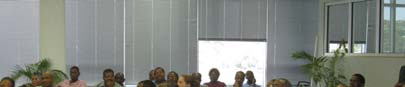
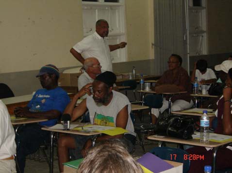
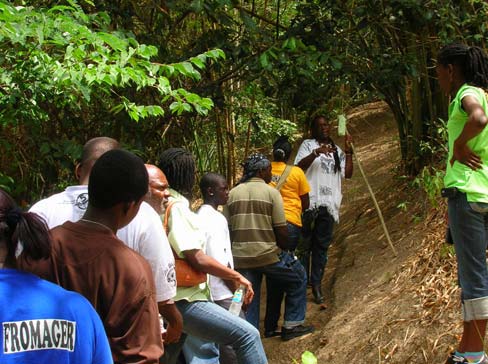
The GEF-IWCAM Project held a Geographic
Information Systems Training Workshop for
pacts from Sewage Discharges from St.
Mitigation of
Groundwater and
Participating Countries from 9 12 July 2008,
John's
Coastal Impacts
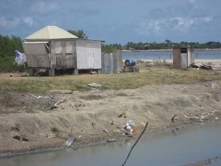
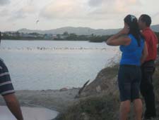
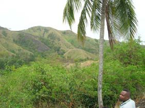
McKinnon's Pond, north of the capital St. John's and in
from Sewage Dis-
the same parish, is site of the GEF-IWCAM Antigua and Barbuda
charges from St.
Demonstration Project.
John's (pgs. 1,2,3)
St. John's has an urban population of 45,000, sixty per-
· GIS Training Work-
cent of the country's total population. There are inadequate sew-
shop (pgs.1, 8)
age handling and treatment systems in place. While the majority
of households use septic tanks, these are not pumped regularly.
· St. Lucia IWRM
This often results in septic failure and overflow, causing untreated
Inception Work-
effluent to go directly into drains. Most of this effluent eventually
shop (pg.2-3)
drains into the St. John's Harbour
and impacts on nearby McKinnons
City of St. John's
· Antigua & Barbuda
Pond causing high levels of marine
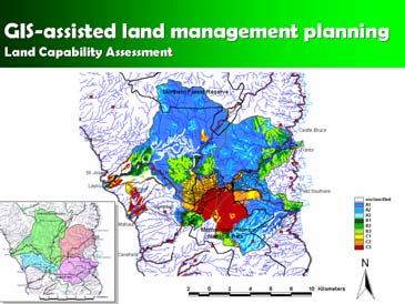
GIS-assisted land management planning;
benefits from tech-
pollution.
Dominica Land Capability Assessment map
nical cooperation
with Cuba (pg. 3)
in Cienfuegos, Cuba.
· Demonstration
Project High-
This was the first GIS `hands-on' training of-
lights--Farmer's
fered under the GEF-IWCAM Project and fol-
Training Day, Ja-
lowed the Capacity Assessment of GIS Capa-
This coastal wetland, used to
maica; Rainwater
bilities in Participating Countries and resulting
be an important site for migrating birds,
Harvesting Sub-
Road Map completed in 2007. All 13 countries
resident birds and waterfowls and an
Project, St. Lucia;
participated. Participants all had some back-
important spawning habitat and nurs-
Community Refor-
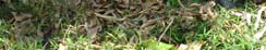
ground in GIS and were afterward expected to Fish kill, McKinnon's Pond
ery area for juvenile fish and shellfish.
estation Effort,
apply this training to IWCAM at either the
In 1968 a road was constructed to link
Trinidad & To-
Demonstration Project or at the national level.
hotels and entertainment facilities at the northern and southern
bago; Gardette
ends of the Pond. This resulted in an embankment that eliminated
Community Chil-
The objectives of the Training Workshop were:
the natural link and connection of the Pond with the sea, impacting
dren's Summer
To introduce GIS concepts relevant to water-
the wetland significantly. There was a loss of flora including man-
Workshop, St,.
shed and coastal areas management; to pro-
groves and decreased populations and diversity of bird species.
Lucia (pgs. 4--5)
vide training in Pollutant and Erosion Modeling,
and; to further strengthen the regional network
Currently, McKinnon's Pond is an open area of stagnated
· IWCAM Indica-
of GIS practitioners (through an Informal GIS water lined by sparse live and dead mangrove trees. The Pond
tors--an update
Working Group).
itself is devoid of vegetation and in some areas has been physi-
(pg. 6)
cally altered and enhanced to provide roosting sites for birds and
Dr. Christopher Cox, Ag. Programme Director, bank stabilization/fortification to address flooding. It is polluted by
· GEF-IWCAM at
CEHI, stressed the importance of participants an influx of wastewater discharges and sediment loads from point
CEF-4 (pg. 7)
considering their roles in the creative applica-
and non-point sources, posing a threat not only to surrounding
tion of GIS to IWCAM. In terms of support for communities but also to the water table and ground water quality.
· Staffing Updates
decisions of a technical nature, Demonstration In addition, the Pond has become infested with mosquitoes and is
(pg. 7)
Projects could possibly assemble archives of a health threat to adjacent communities.
data specific to their respective watersheds
(Continued on page 8)
(Continued on page 2)
www.iwcam.org

2
IWCAM Caribbean WaterWays Newsletter
(Continued from page 1)
St. Lucia Integrated Water Resources Man-
The Demonstration Project aims to address the
agement (IWRM) Inception Workshop
issue of coastal pollution caused by sewage and wastewa-
ter discharge from the parish of St. John's. It precedes an
As part of the GEF-IWCAM Regional Activities, the
overall plan to identify a cost effective solution to this prob-
lem for the St. John's watershed, and eventually the entire
Caribbean Environmental Health Institute and the GEF-IWCAM
country, through the design and development of street-
PCU are working together to hold Integrated Water Resource
Management Planning Workshops in the 13 Participating Coun-
tries. To date, IWRM Workshops or related activities have taken
place in:
· Antigua and Barbuda
· Barbados
· Dominica
· Grenada
· Saint Lucia
· Saint Vincent & the Grenadines (Union Island)
The most
recent
workshop,
which took
Lower income, unregulated housing located along the
place on
edge of McKinnon's Pond
12 August
level or other appropriate systems to handle primarily do-
2008 in
mestic wastes.
Castries,
St. Lucia,
The main barriers to better control and manage-
was very
ment of sewage handling, treatment and discharges are:
Participation was excellent;
well at-
discussions were lively
· Lack of adequate domestic handling and holding facili-
(Continued on page 3)
ties within the parish of St. John's
· Lack of treatment facilities prior to discharge
· Inappropriate waste disposal mechanisms for septic
tank sludge
BACKGROUND ON THE GEF-IWCAM
· Inadequate legislative control and lack of capacity for
PROJECT:
enforcement
· Poor incentives/disincentives for appropriate construc-
The Global Environment Facility-funded Integrating Watershed
tion and use of effective septic tanks
and Coastal Areas Management in Caribbean Small Island De-
· Inadequate monitoring of water quality to guide policy-
velopment States (GEF-IWCAM) Project was approved by the
makers and legislators.
Global Environment Facility (GEF) in May 2004. Implementing
The main anticipated outcome of the Demonstra-
agencies are the United Nations Environment Programme
tion Project is the general improvement in quality of the
(UNEP) and the United Nations Development Programme
land and marine environment which represents a renew-
(UNDP). Executing agencies are the Secretariat of the
able natural resource and is critical in maintaining ecosys-
Cartagena Convention (UNEP-CAR/RCU) and the Caribbean
tem functions.
Environmental Health Institute (CEHI) and the UN Office of Pro-
ject Services (UNOPS). The thirteen participating SIDS are:
The Project Management Unit is located at the
Antigua and Barbuda, The Bahamas, Barbados, Cuba, Grenada,
Environment Division of the Ministry of Tourism, Civil Avia-
Dominica, Dominican Republic, Haiti, Jamaica, Saint Kitts and
tion, Culture and the Environment. Local partners/
stakeholders include the Antigua Public Utilities Authority
Nevis, Saint Lucia, Saint Vincent and the Grenadines, and Trini-
(APUA), the Central Board of Health (CBH), the Public
dad and Tobago. The length of the Project is 5 years and com-
Works Department (PWD) and the St. John's Development
menced in the second quarter of 2005. The Project Coordinating
Co-operation.
Unit is located at the CEHI, as agreed by the Implementing and
Executing Agencies and the participating countries.
(Continued on page 3)
www.iwcam.org
3
IWCAM Caribbean WaterWays Newsletter
(Continued from page 2)
Antigua & Barbuda benefits from
Project activities thus far have included:
technical cooperation with Cuba
· Providing information regarding the project to the commu-
The GEF-IWCAM Project arranged for the Government
nity
of Cuba's Centro de Estudios Ambientales de Cienfuegos
(CEAC) to provide technical assistance to the Government of
· A range of public awareness activities, including the crea-
Antigua and Barbuda for environ-
tion and airing on local radio stations of an IWCAM jingle and
mental modeling of the north-west
production of a brochure and flyers
coast of Antigua. The Government
· Regular meetings of the Technical Advisory Group (TAG)
of Antigua and Barbuda is seeking to
·
develop a comprehensive, holistic,
Commissioning of data collection exercises and a legisla-
and multisectoral management plan
tive review
for the North-West Coast of Antigua.
· Technical cooperation with the Government Laboratory to
enable the analysis of samples
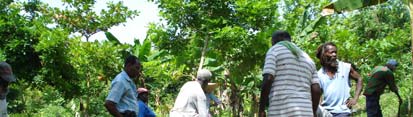
Three Cuban experts Cuban experts visit McKinnons Pond
· Lobbying relevant government agencies to establish policy
from CEAC, along with
and legislative documents on sewage management for Antigua
the GEF-IWCAM RPC and representatives of CEHI, visited Anti-
and Barbuda.
gua during the week of July 28th to collect data on the North-
West coast of Antigua. The Cuban team is working directly with
In a related initiative, CEHI and a team from Cuba, at
the Environment Division of the Ministry of Tourism, Civil Avia-
the request of the Government of Antigua and Barbuda, recently
tion, Culture and The Environment. The integrated approach
completed an Environmental Scoping Exercise on McKinnon's
being taken also relies on inputs from the APUA and the Minis-
Pond (see article, pg. 3). Four possible courses of action were
try of Health, given the importance of the area to the major eco-
identified: marina development with supporting amenities; reha-
nomic sector, tourism, as well as the health of the population.
bilitation; land filling and reclamation, and; no-action. Whichever
course of action is eventually taken, the issue of pollution of the
This work will focus on environmental characterization
Pond and nearby coastal area as a result of sewage and waste-
of coastal zones, examination of
water discharge is a fundamental problem which must be dealt
sedimentation processes and mathe-
with first.
matical modeling of marine currents
and accidents (such as oil spills) in
The support of the local community is key to the suc-
coastal zones. The studies are be-
cess of the GEF-IWCAM Demonstration Project. A public con-
ing conducted specifical y to recom-
mend solutions to the pollution prob-
lems affecting McKinnons Pond and
also solutions to the beach erosion
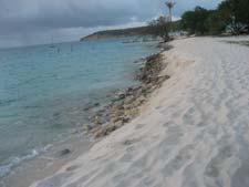
Beach erosion at
and periodic flooding experienced in
Buccaneer Cove
the area.
CEAC will prepare models based on data and informa-
tion gathered during this visit, returning to Antigua later this year
to share their findings and provide training in analysis.
Complementing this is a scoping exercise conducted
by CEHI in order to identify further work needed towards devel-
opment of the management plan.
(Continued from page 2)
Antigua & Barbuda's Minister of Health, John
tended, with stakeholders from government, the private sector, and
Maginley, answers questions from the group.
community groups. Participants discussed the IWRM approach and
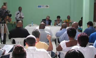
sultation was held on 17 June 2008, to coincide with activities
what needs to be done in order to adopt it as a standard management
marking World Day to Combat Desertification and Drought, at
practice in Saint Lucia. Of particular interest and relevance, and vigor-
the Wesleyan Junior School. About 40 people representing
ously discussed, were the potential privatization of the water utility
villagers, the hotel sector, a local NGO - the Environment
(WASCO) and the establishment of the Water Resources Manage-
Awareness Group, the Ministry of Public Works, the Environ-
ment Agency within the Ministry of Agriculture, Fisheries, and Forestry.
ment Division, and the Antigua Public Utilities Authority at-
tended. Also on hand to answer questions were the Health
CEHI, under the auspices of the GEF-IWCAM Project, will continue to
Minister, John Maginley, Environment Minister Harold Lovell,
work with St. Lucia to help with the development of a "roadmap" for
Former Chief Town and Country Planner Charlesworth Davis
and GEF-IWCAM Project Coordinator, Melesha Banhan.
IWRM Planning, an approach similar to that which has been taken in
other countries, and also on the implementation of IWRM activities.
www.iwcam.org


4
IWCAM Caribbean WaterWays Newsletter
Demonstration Project Highlights
Jamaica:
St. Lucia:
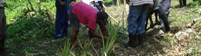
Farmers Training Day at Horses Savannah,
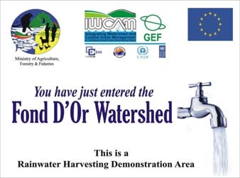
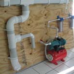
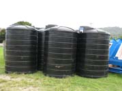
Rainwater Harvesting Sub-Project
Drivers River Watershed
launched in Dennery
One of the major challenges faced by the Drivers
In order to dem-
River Watershed is that the area is steep and soils are easily
onstrate rainwater
eroded. To combat this, the GEF-IWCAM Demonstration Pro-
harvesting (RHW) as
ject, through its Livelihood and Sanitation Committee, en-
a simple and low-cost
gaged the Hectors River Jamaica Agriculture Society Farm-
water supply technol-
ers Group on August 13, 2008 to provide training to farmers
ogy which can provide
in the Drivers River area.
water at an accept-
able quality standard,
A total of twenty male and female farmers partici-
the St. Lucia Demo Launch attended by PCU, Project Im-
pated. The training was focused on the stabilization of soils
Project launched a plementing Agencies- UNEP CAR/
using pineapple and vetiver barriers. Using an integrated
Rainwater Harvesting RCU and CEHI, and other partners
approach, a number of the Demonstration Project's partner
(RWH) sub-project in
agencies were also pre-
May 2008 which is funded by the GEF-IWCAM Project and
sent to impart their ex-
the EU. It aims to complement the current water scheme and
perience and expertise.
enhance reliability of water supply within the Fond D'or water-
shed, particularly during the dry season and periods of in-
The
demonstra-
duced and natural drought.
tion took place on ap-
proximately quarter of an
Before the advent of a centralized water delivery service,
acre of land, on one of
these communities relied solely on the harvesting of rain wa-
the farmer's holdings.
ter therefore, although its use has declined over time and is
Demonstrating use of A-frame
Using sticks found on the
practically non-existent today, it is not entirely new.
property, an "A-frame"
was made. In addition three pieces of sticks of equal length
With the application of best practices, most water quality
(2 feet) were used to make a triangle; illustrating to those
standards can be met. It has the additional advantage of
present the use of indigenous material. The "A-frame" was
being a relatively simple and low-cost water supply technol-
then used to delineate the con-
ogy which is generally easy to install and maintain.
tour which was pegged and
lined.
Sub-project activities include:
· Adopting an appropriate design,
To ensure that pineap-
· Training potential contractors in
ple sets were placed 2 feet apart
construction of the system,
the triangle was then used. This
· Constructing 20 systems in visi-
was followed by the cleaning
ble locations within each of the
and planting of two hundred and
settlements,
fifty pineapple sets and approxi-
mately 2 lengths of vetiver
· Constructing complete RWH
grass. To ensure maximum un-
units at 10 public institutions; (6
derstanding each farmer was
schools, 2 Health Centres, 1
then given the chance to repeat
Police station, and the Dennery
the process, corrected and com-
hospital (3000 gallons each),
Using the triangle
mended by other participants as
· Estimating water supply impacts
the training continued.
(quantity, quality, preferences) and economic bene-
fits, and
Men prepare holes; women plant
· Conduct-
ing com-
munity
awareness
program in
support of
RWH.
www.iwcam.org
5
IWCAM Caribbean WaterWays Newsletter
Demonstration Project Highlights
Trinidad & Tobago:
St. Lucia:
Community group becomes involved in
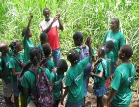
Gardette Community Children's Summer
watershed reforestation effort
Workshop
The Courland watershed, site of the Trinidad and
Students from the community of Gardette were
Tobago Demonstration
treated to a fun-packed and educational summer workshop
Project is ravaged by
organised by the Gardette Development Committee in col-
bush fires annually. A
laboration with the GEF-IWCAM St. Lucia Demonstration
local community group,
Project.
the Anse Formager Eco-
logical Environmental
The Workshop aimed, among other things, to help
Protection Organisation
the children understand the concept of a watershed, water
(AFEEPO), was formed
quality, how water quality is measured, and why it is impor-
in 2006 by Lyndon Glas-
tant to maintain good water quality. They were shown that
gow and Anthony Cord-
certain domestic and farming practices can impact negatively
ner. Their original con-
upon water quality and were encouraged to think about how
cern was the rapid dete-
they dispose of garbage.
AFEEPO President,
rioration of the Anse Formager Beach.
Lyndon Glasgow,
The
workshop
shows area for refor-
Lyndon and Anthony em-
was conducted mainly by
estation in watershed
barked on a project to restore the
three committee members,
beach to its former glory by ridding it of piles of garbage that
with input from the Demon-
had accumulated at the mouth of the river and to restore the
stration Project's Liaison
bare, rain battered, hillsides which fringed the beach. A call
Officer, Cecil Henry as well
for other members of the community to assist in the refores-
as the Forestry Officer
tation effort received an overwhelming response, motivating
responsible for water-
the two men to consolidate interested participants into pur-
sheds, Alfred Prospere.
suing a bigger vision. As a result, a core group of 18 dedi-
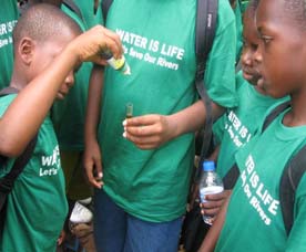
Water sampling exercise
cated members is now functioning with an expanded mis-
Over a two-week
sion: that of bringing a halt to the degradation of the Cour-
period from 28th July 8th August 2008, thirty children be-
land watershed and empowering the community towards
tween eight and ten years old participated in a number of
more sustainable ways of living by rehabilitating the forest
presentations and fieldtrips including:
and restoring
more traditional
· A water quality testing exercise at the CARDI bridge
agricultural prac-
at La Resource, Dennery;
tices.
· A visit to the Latille Falls in Micoud where they were
treated to a demonstration on the generation of hy-
With
the
dro-electricity with the use of a hydro-ram device
support of the
which was installed in the waterfall.
GEF-IWCAM
Trinidad and To-
The keen interest shown and eager participation of
bago Demonstra-
the children in both indoor and outdoor activities clearly dem-
tion Project, a
onstrated the value of the Workshop. Response to quizzes
visit by AFEEPO
and evaluation exercises was excellent a clear indication
to the Fondes
Members of AFEEPO tour Fondes
that they had learned about the Project, the Fond D'Or water-
Amandes Commu-
Amandes with Akilah Jaramogi
shed and many issues related to water.
nity Re-Forestation
Project (FACRP) in the northern range of Trinidad was or-
Listening to lecture on
On the last day
ganized in May 2008. The visions and missions of these
"Life in the River"
brochures and posters
two community groups are very similar. Visiting members of
produced by the Project
the AFEEPO were inspired as they saw the success of the
were distributed to stu-
FACRP which faces challenges many times larger than
dents and facilitators. They
theirs.
all pledged to use the
Future AFEEPO /IWCAM plans include training in
messages and lessons
fire prevention and detection, and disaster management in
learned over the two week
the forest. It is envisioned that AFEEPO will eventually func-
period for the benefit of
tion as a core fire fighting and conservation unit within the
their peers and community
Courland watershed.
as a whole.
www.iwcam.org
6
IWCAM Caribbean WaterWays Newsletter
IWCAM Indicators - an update
discuss the way forward for implementation of the indicators tem-
plate.
This article summarizes Project work to date in the area of IWCAM indi-
cators:
The consensus of this workshop was that the following next
Indicators Assessment
steps should be taken to further build on the indicators activities al-
ready conducted:
In 2007 the GEF-IWCAM Project conducted an indicators
assessment as part of a larger assignment on IWCAM indicators
· Pilot testing of a suite of indicators in one of the participating
mechanisms. The objective of this study was to assess indicators
countries;
mechanisms and capacity in the countries to utilize and monitor indi-
· More focused training for the PCs on indicators (with IABIN)
cators for the IWCAM approach, and to develop an indicators tem-
using existing data and case studies;
plate based on GEF International Waters indicators (Process, Stress
· Establishment of an IWCAM Indicators Working Group;
Reduction, and Environmental Status Indicators). Data and informa-
· GEF-IWCAM to conduct laboratory assessment to support moni-
tion sources included published and unpublished documents and
toring efforts;
reports, internet searches, and a questionnaire distributed among the
· Dissemination of lessons learned and best practices of manage-
countries. In order to validate the findings of the desk study, ground-
ment effectiveness, time-bound performance indicators, and
truthing was conducted in Barbados, Dominican Republic, and St.
synergies between the IABIN and GEF-IWCAM projects with a
Vincent and the Grenadines. This report has been reviewed and
view towards a follow up workshop in early 2010.
finalized and now is located on the GEF-IWCAM web-site at http://
www.iwcam.org/information/gef-iwcam-and-iabin-indicators-mechanism-
A workshop report is located at http://www.iwcam.org/information/gef-
workshop/gef-iwcam-indicators-assessment-report-final-may-2008/view
iwcam-and-iabin-indicators-mechanism-workshop/gef-iwcam-and-iabin-
indicators-mechanism-workshop-final-report-april-2008/view
Template
The indicators template constituted the second component
Application
of the indicators work. The major objective of this component was to
Based on the aforementioned recommendation to pilot test
develop an indicators template to monitor changes in the state of the
a suite of indicators in a Participating Country, the GEF-IWCAM Pro-
watershed and coastal environments, monitor the trends in socioeco-
ject Coordinating Unit developed criteria used to determine the ap-
nomic pressures and conditions in watershed communities and
propriate country in which to undertake this work. Criteria included
coastal towns, and to assess the efficacy of IWCAM in addressing
government commitment to centralizing environmental indicators,
these issues and mitigating harmful impacts, both during the project
ongoing monitoring of watersheds and coastal areas, and sufficient
and in the post-project period. In the longer term, the selected indica-
human and technical capacity to sustain the work after the interven-
tors would be adopted and tracked by the participating countries,
tion of the project. Based on this criteria, and in consultation with
according to their particular circumstances or needs. Each country
potential partners, it was determined that Barbados would be an ap-
would need to determine the baselines and benchmarks for each
propriate country to pilot test the indicators template. The GEF-
indicator, since these would vary among countries and issues.
IWCAM Project, together with CEHI, then held a one-day consultation
in Barbados in July 2008 to discuss IWRM approaches and the pilot
A template was developed, based on the three types of
testing. Following this meeting, the PCU is working with key stake-
indicators recommended by GEF for use in its International Waters
holders in Barbados to implement this approach.
Projects: Environmental Status/Water Resources Indicators, Stress
Reduction Indicators, and Process Indicators. The template was thor-
The pilot project is in its earliest phases at this point, but
oughly reviewed by GEF-IWCAM participating countries and partners
some potential activities could include:
and a final version can be found at http://www.iwcam.org/information/gef-
· Design of a database that could be used collaboratively by a
iwcam-and-iabin-indicators-mechanism-workshop/gef-iwcam-indicators-
number of government agencies to store key indicators
template-final-may-2008/view
·Creation of specialized queries and reports (decision support
system)
Workshop
· Training for government officials in the use of the database
In March 2008, a GEF-IWCAM Indicators Workshop was
· Public awareness campaign to sensitize public servants as to
held in Ocho Rios, Jamaica to present the revised assessment report
the use and value of the database
and indicators template to representatives of the 13 participating
countries. The Workshop was held in collaboration with the GEF-
The results of this pilot activity will be shared with the other
funded Inter-American Biodiversity Information Network (IABIN), with
GEF-IWCAM participating countries to assist them with their future
joint and parallel sessions. The major objectives of GEF-IWCAM for
utilization of IWCAM indicators. In addition to this work, the PCU is
the workshop were to present the findings of the IWCAM indicators
working with the nine demonstration projects to help them identify
mechanisms and capacity assessment in the participating countries
indicators, establish baselines, and conduct regular monitoring.
for discussion, inputs and feedback from participants; present the
draft indicators template for discussion and obtaining consensus; and
For more information contact: sgottlieb@cehi.org.lc
www.iwcam.org


7
IWCAM Caribbean WaterWays Newsletter
GEF- IWCAM at the Caribbean Environmental
Forum and Exhibition (CEF 4)
Parallel Session:
The GEF-IWCAM Project sponsored Parallel Session 4 of the Caribbean
Environmental Forum and Exhibition which took place at St. George's University in
Grenada, June 23rd 27th.
It was titled: "Integrated Water Resources Management Concepts and Prac-
tices: Integrated Watershed and Coastal Areas Management SIDS". It consisted of
the following presentations, each followed by discussion.
·Water Policy Development in the Caribbean and the Impacts of Climate Change
Dr. Adrian Cashman, CERMES, UWI, Cave Hill, Barbados
·Drought and Precipitation monitoring for enhanced Integrated Water Resources
Management in the Caribbean Adrian Trotman, Caribbean Institute for Meteor-
ology and Hydrology, Barbados
·Design of a Storm water system to support aquifer recharge: The Vaucluse
Waste Management Centre, Barbados Dwight Smikle, J. Burnside Interna-
tional, Canada
·A Review of Water Information Systems in the English-Speaking Caribbean:
Challenges and Lessons Learnt Lystra M. Fletcher-Paul, Food and Agriculture
Organization of the United Nations, Bridgetown, Barbados
·Geographic Information System for Integrating risk by Inter-Relating Scores (GI)
SIRIS Alex S. Ifill, Barbados Water Authority
Presentations were well received. The review of Water Information Sys-
tems, presented by Dr. Lystra Fletcher-Paul, in part, is serving as a catalyst for ongo-
ing work in indicators in IWCAM in Barbados, one of the Project's Participating Coun-
tries.
Exhibition:
The GEF-IWCAM Project was one of fourteen exhibitors. The exhibit fo-
cused upon partnerships and progress in four of its Demonstration Projects: Cuba,
Jamaica, St. Lucia and Trinidad and Tobago and was manned by representatives of
those countries and the PCU. It was set-up in conjunction with UNEP's Caribbean
Environment Programme.
Plenary:
The GEF-IWCAM Regional Project Coordinator also chaired the Plenary
Technical Session at the CEF-4, which included panelists from the WSSCC, USEPA
and the Austrian government.
Presentations made at CEF-4 can be found at: http://www.cehi.org.lc/Website/
pres.htm
STAFFING UPDATES
Dominican Republic: Ms. Mercedes Socorro Pantaleon has been appointed the Demonstration Project Manager for the Dominican
Republic's Demo, effective June 2008.
St. Kitts and Nevis: Mr. Ian Liburd has been appointed the Demonstration Project Manager for the St. Kitts and Nevis Demo, effective
August 2008.
The Bahamas: Mr. Sherlin Brown has been appointed the Demonstration Project Manager for the Bahamas Demos, effective Septem-
ber 2008.
www.iwcam.org


8
IWCAM Caribbean WaterWays Newsletter
(Continued from page 1)
and use this for basic analysis. Countries without demonstration
projects could consider replicating analysis for `hot-spot' water-
sheds. In terms of support for decision making of a political na-
ture, GIS could be used to demonstrate relationships / cause and
effect to National Intersectoral Committees, senior administration
personnel and ministers.
Jean-Nicolas Poussart, Junior Programme Officer,
UNEP, focused on the use of GIS as a tool to promote the imple-
mentation of the Protocol Concerning Pollution from Land-Based
Sources and Activities (LBS Protocol) which was adopted in 1999
but which had, to date, been ratified by only 5 countries. The
estimation or characterization of both point and non-point sources
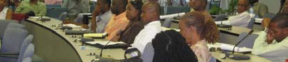
GIS Training Workshop Participants
of pollution is key to this Protocol. Annex 4 deals with the single
largest non-point source of pollution, agricultural runoff.
· While any number of applications may be possible, the
major criteria for deciding which one to use should be
Vijay Datadin, GIS Officer, Buccoo Reef Trust and Trini-
the urgency of the management issue to be addressed
dad and Tobago's Demonstration Project, who had taken part in
by decision-makers.
N-SPECT training at CATHALAC in February 2008, in a series of
hands-on training sessions introduced participants to the following
· The importance of ground truthing should not be under-
free and open source types of GIS software:
estimated and needs to be planned and budgeted for.
·
Quantum GIS Vers. 0.10
· Some countries, such as Cuba and Haiti, are develop-
· Integrated Land and Water Information System IL-
ing national GIS databases.
WIS 3.4 Open, developed by the International Institute
for Aerospace Survey and Earth Sciences (ITC), En-
· GIS is part of an information gathering, management
schede, the Netherlands.
·
and dissemination system - as such, serious thought
RUSLE (Revised Universal Soil loss Equation)
should be given to the inputs (including types of data)
needed when designing a project as well as to what will
Data from the Trinidad & Tobago Demonstration Project
be done with the outputs/results.
was used for most of the exercises.
· There is a need for standardization of data and data
Several important points were raised during discus-
sions. These included:
integration issues, given the different reference grids
·
used. The relationship between indicators and GIS is
Although GIS is currently used directly by only one
also a priority issue to be addressed. In building data-
GEF-IWCAM Demonstration Project (Trinidad & To-
bases attention should be given to supporting the re-
bago), several of the Projects have access to the ser-
quirements of the LBS Protocol as well as IWCAM and
vices of a GIS department (e.g. Jamaica and NEPA) or
IWRM.
specialist.
· A strategy is needed for getting the results of analysis
· In the context of watershed and coastal areas manage-
using GIS out, particularly to decision makers.
ment, the GIS technician/specialist ideally works as part
of a team which includes specialists, e.g. soil scientists,
The Final Workshop Report is available at:
who are able to provide guidance as well as needed
http://www.iwcam.org/information/gef-iwcam-geographic-information-systems-
inputs.
training-workshop-9-12-july-2008-cienfuegos-cuba/final-report-gef-iwcam-gis-
training-workshop-9-12-july-2008-cuba/view
Participating Country Focal Points, Demonstration Projects and others are invited to submit articles. Please contact
Donna Spencer at dspencer@cehi.org.lc
Contact Information:
IWCAM Project Coordination Unit
P.O. Box 1111, The Morne, Castries, Saint Lucia
Tel: (758)-452-2501/1412; Fax: (758)-453-2721
E-mail: dspencer@cehi.org.lc
www.iwcam.org