GEF PROJECT BRIEF
1. Identifiers
Project Number
Implementing Agency Project Number not yet assigned
Combating living resource depletion and coastal area degradation
Project Title
in the Guinea Current LME through ecosystem-based regional
actions
Duration
Five years, beginning June 2004
United Nations Development Programme (UNDP) /
Implementing Agencies
United Nations Environment Programme (UNEP)
Executing Agency
United Nations Industrial Development Organization (UNIDO)
Regional: Angola, Benin, Cameroon, Congo, Democratic
Republic of the Congo, Côte d'Ivoire, Gabon, Ghana, Equatorial
Requesting Countries
Guinea, Guinea, Guinea-Bissau, Liberia, Nigeria, Sao Tome and
Principe, Sierra Leone and Togo
The countries are eligible under paragraph 9(b) of the GEF
Instrument. The Strategic Action Programme is consistent with
Eligibility
the relevant provisions of regional and global Conventions
relating to International Waters to which the countries are
signatories and/or contracting parties.
GEF Focal Areas
International Waters with relevance to Biological Diversity
GEF Programming Framework OP #9: Integrated Land and Water Component
2. Summary:
This project proposal "Combating Living Resources Depletion and Coastal Area Degradation in the
Guinea Current LME through Ecosystem-based Regional Actions" has a primary focus on the priority
problems and issues identified by the 16 GCLME countries that have led to unsustainable fisheries
and use of other marine resources, as well as the degradation of marine and coastal ecosystems by
human activities. The long-term development goals of the project are: 1) recover and sustain depleted
fisheries; 2) restore degraded habitats; and 3) reduce land and ship-based pollution by establishing a
regional management framework for sustainable use of living and non-living resources in the
GCLME. Priority action areas include reversing coastal area degradation and living resources
depletion, relying heavily on regional capacity building. The project focuses on nine demonstration
projects, designed to be replicable and intended to demonstrate how concrete actions can lead to
dramatic improvements. Sustainability will derive from this improved capacity, strengthening of
national and regional institutions, improvements in policy/legislative frameworks, and the
demonstration of technologies and approaches that will lead to improved ecosystem status. The
priority problems of resource depletion, loss of biodiversity (including habitat loss and coastal
erosion), and land- and sea-based pollution are all addressed through the interventions proposed here.
The project has five main components with associated objectives identified by the root cause analysis
carried out during the project preparation process: i) Finalize SAP and develop sustainable financing
mechanism for its implementation; ii) Recovery and sustainability of depleted fisheries and living
marine resources including mariculture; iii) Planning for biodiversity conservation, restoration of
degraded habitats and developing strategies for reducing coastal erosion; iv) Reduce land and sea-
based pollution and improve water quality; and v) Regional coordination and institutional
sustainability. The activities to be undertaken will complement other projects in the region to provide
a strong foundation for the long-term sustainable environmental management of the GCLME. A
Transboundary Diagnostic Analysis (TDA) and preliminary Strategic Action Programme (SAP) have
been prepared, serving as the basis for preparation of this project proposal. The full Global
Environment Facility (GEF) project will update the TDA as part of a continuing process, and will
endorse a regionally agreed SAP, following clarification of some aspects of the environmental status
of the region, and initiate SAP implementation.
3. Costs and Financing (Million US $)
US$
GEF:
Project:
:
$20.812
PDF B
:
$ 0.637
Subtotal GEF
:
$21.449
Co-Financing:
Governments (cash and in-kind)
$30.356
US
NOAA
:
$0.6
UNDP (in cash and kind)
:
$0.1
UNEP (in cash and kind)
:
$0.13
Norway
:
$2.085
*Private
Sector :
$0.6
Subtotal Co-financing
$33.871
:
Total Project Cost
$55.321
4. Associated Financing (Million US $):
Government
baseline
:
$799.986
TOTAL : $855.307
* Discussions still ongoing with Oil Companies in Nigeria and other Private Sector Organizations for co-funding
of the Nigeria and Ghana demonstration projects. UNIDO-ICS will inform of its financial contributions.
5. Operational Focal Point Endorsement(s):
Angola: Mrs. Armindo M. Gomes da Silva
29 September 2003
GEF Focal Point, Ministry of Energy and Water, Luanda
Benin: Mr. Pascal ZOUNVEOU YAHA, GEF OFP
12 August 2003
Ministere de l'Environnement, de l'Habitat et de l'Urbanisme,
Cotonou
Cameroon : Ms. Justin NANTCHOU NGOKO
12 September 2003
Ministry of Environment and Forestry, Yaounde
Congo: Mr. Joachim OKOURANGOULOU, Directeur Général de
4 August 2003
l'Environnement, Ministčre de l'Economie Forestičre et de
l'Environnement, Brazzaville
Congo Dem. Rep.: Mr. Vincent KASULU SEYA MAKONGA
15 August 2003
Directeur de Developpement Durable, Ministčre des Affaires
Foncičres, Environnement et Tourisme, Kinshasa/Gombe
Cote d'Ivoire: Mrs. Alimata KONE, Directress Adjoint
10 September 2003
Caisse Autonome d'Amortissement, Abidjan
Gabon: Mr. Chris MOMBO NZATSI, Directeur Général de
8 August 2003
l'Environnement, Ministčre de l'Economie forestičre, des
eaux, de la pęche, chargé de l'environnement et de la
protection de la nature, Libreville
Ghana: Mr. Edward OSEI NSEKYIRE, Chief Director
31 July 2003
Ministry of Environment, Science and Technology, Accra
Guinea Bissau: Mme. Matilde da Conceicao Gomes Lopes
11 September 2003
Directrice Général de l'Environnement, Ministčre des
Resources Naturelles et de l'Environnement
ii
Guinea: Mme. Kadiatou N'DIAYE, GEF Focal Point
6 August 2003
Manager, National Environment Directorate, Conakry
Guinea Equatorial: HE Don Fortunato OFA MBA
09 April 2003
Ministro, Ministro de Pesca y Medio Ambiente, Malabo
Liberia: Mr. Fodee KROMAH, Executive Director
30 July 2003
GEF Focal Point, National Environmental Commission of
Liberia, Monrovia
Nigeria: Mr. Ayodele Adekunle OLOJEDE, GEF Focal Point
8 August 2003
Federal Ministry of Environment, Abuja
Sao Tome & Principe: Mr. Lourenco MONTEIRO DE JESUS
13 August 2003
GEF Focal Point, INDES, Sao Tome
Sierra Leone: Mr. Stephen Syril James JUSU, Director
12 August 2003
GEF Focal Point, Environment Protection Department
Ministry of Lands, Country Planning and the Environment,
Freetown
Togo: Mr. Yao Djiwomu FOLLY, Ing. Des Travaux des Eaux et
7 August 2003
Forets, Directeur de la Protection et du Controle de
l'Exploitation de la Flore, Ministčre de l'Environnement et
des Ressources, Lome
6. IA Contact:
(a) Mr. Frank Pinto, Executive Coordinator UNDP/GEF
(b) Mr. Ahmed Djoghlaf, Director & Assistant Executive Director, UNEP/GEF Co-ordination
Office, UNEP, Nairobi, Tel: 254-20-624166; Fax: 254-20-624041; Email:
Ahmed.Djoghlaf@unep.org
iii
ACRONYMS
ACOPS
Advisory Committee for the Protection of the Seas
AfDB
African
Development
Bank
APR
Annual
Programme/Project
Report
BCLME Benguela
Current Large Marine Ecosystem
CBD
Convention
on
Biological
Diversity
CBO
Community
Based
Organization
CCLME
Canary Current Large Marine Ecosystem
CECAF
Fishery
Committee
for the Eastern Central Atlantic
CEDA
Centre for Environment and Development in Africa
COMARAF
Training
and
Research
for
the Integrated Development of African
Coastal
Systems
CPUE
Catch
per
Unit
Effort
CTA
Chief
Technical
Advisor
DIM
Data
and
Information
Management
EIA
Environmental
Impact
Assessment
EQO
Environmental
Quality
Objective
ESI
Environmental
Status
Indicator
FAO
Food and Agriculture Organization of the United Nations
FEDEN
Foundation for Environmental Development and Education in
Nigeria
GCC
Guinea
Current
Commission
GCLME
Guinea Current Large Marine Ecosystem
GEF
Global
Environment
Facility
GIS
Geographic
Information
System
GIWA
Global
International
Waters
Assessment
GOG-LME
Gulf of Guinea Large Marine Ecosystem
HAB
Harmful
Algal
Bloom
IA
Implementing
Agency
ICAM
Integrated
Coastal
Areas
Management
ICARM Integrated
Coastal
Area and River Basin Management
ICS-UNIDO
International Centre for Science and High Technology - UNIDO
ICZM
Integrated
Coastal
Zone
Management
IGCC
Interim
Guinea
Current
Commission
IMC
Inter-Ministerial
Committee
IMO
International
Maritime
Organization
IOC-UNESCO
Intergovernmental Oceanographic Commission of UNESCO
IUCN
The
World
Conservation
Union
IW:LEARN
International Waters (IW) Learning, Exchange and Resource
Network Program
LBA Land-Based
Activities
LME Large
Marine
Ecosystem
LOICZ
Land-Oceans Interactions in the Coastal Zone
M&E Monitoring
and
Evaluation
MOU Memorandum
of
Understanding
MPPI
Major Perceived Problems and Issues
NAP
National
Action
Plan
NEAP
National
Environmental
Action
Plan
NEPAD
The New Partnership for Africa's Development
NFP
National
Focal
Point
NGO
Non-governmental
Organization
NPA/LBA National
Programme
of Action/Land-Based Activities
NOAA
National
Oceanic
and
Atmospheric
Administration
iv
OP
Operational
Program
PCU
Project
Coordination
Unit
PDF
Project
Development
Facility
PI
Process
Indicator
PIR
Project
Implementation
Review
PPER
Project
Performance
and
Evaluation
Review
PSC
Project
Steering
Committee
RCU
Regional
Coordination
Unit
RPA/LBA
Regional Programme of Action/Land-Based Activities
SAP
Strategic
Action
Programme
TDA
Transboundary
Diagnostic
Analysis
UNDESA
United Nations Department of Economic and Social Affairs
TPR
Tri-Partite
Review
UNDP
United Nations Development Programme
UNEP
United Nations Environment Programme
UNESCO
United Nations Educational, Scientific and Cultural Organization
UNIDO
United Nations Industrial Development Organization
USAID
United States Agency for International Development
WACAF
West and Central African Action Plan
WHO
World
Health
Organization
WSSD
World
Summit
on
Sustainable
Development
v
TABLE OF CONTENTS
BACKGROUND AND CONTEXT BASELINE COURSE OF ACTION.......................2
INTRODUCTION........................................................................................................................2
GEF PROGRAMMING CONTEXT .....................................................................................8
REGIONAL PROGRAMMING CONTEXT ......................................................................12
NATIONAL PROGRAMMING CONTEXT ......................................................................15
SYSTEM BOUNDARIES ...................................................................................................16
MAJOR PERCEIVED PROBLEMS AND ISSUES ...........................................................16
RATIONALE AND OBJECTIVES (ALTERNATIVE COURSE OF ACTION) ...........20
PROJECT OUTCOMES/COMPONENTS ........................................................................23
END OF PROJECT SITUATION (EXPECTED RESULTS) ...........................................30
TARGET BENEFICIARIES ................................................................................................38
RISKS AND SUSTAINABILITY .........................................................................................39
GEF ELIGIBILITY ...............................................................................................................40
STAKEHOLDER PARTICIPATION..................................................................................40
PROJECT IMPLEMENTATION, INSTITUTIONAL FRAMEWORK AND
NATIONAL AND REGIONAL INSTITUTIONS ..............................................................41
INCREMENTAL COSTS AND PROJECT FINANCING................................................43
MONITORING AND EVALUATION.................................................................................44
LESSONS LEARNED AND TECHNICAL REVIEWS.....................................................46
LIST OF ANNEXES ..............................................................................................................48
ANNEX A INCREMENTAL COST ANALYSIS
49
ANNEX B
LOGFRAME MATRIX
83
ANNEX C
STAP ROSTER TECHNICAL REVIEW
104
vi
LIST OF FIGURES
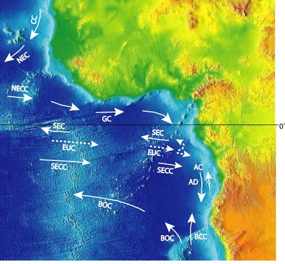
Figure 1. Location map for the GCLME, indicating major currents .............................................2
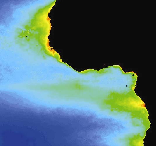
Figure 2. Satellite productivity map of GCLME/ Benguela LME region..................................................... 3
Figure 3. Location map for the GCLME....................................................................................................... 3
Figure 4. Map of distribution of mangroves in the Niger Delta.................................................................... 4
Figure 5. MPPI to SAP Linkage ................................................................................................................. 21
Figure 6. SAP to Project Brief Linkage ...................................................................................................... 23
LIST OF TABLES
Table 1: Ongoing or planned GEF regional projects related to the GCLME ............................................ 10
Table 2. MPPIs and Their Impacts in the GCLME.................................................................................... 18
Table 3: Components and Phases of the Project ......................................................................................... 32
Table 4. Workplan and Timetable............................................................................................................... 35
Table 5: Summary of Project Financing (US$ million) ............................................................................. 43
Table 6: Summary of Baseline and Incremental Costs and Domestic Environmental Benefits ................ 43
Table 7. M&E Activities, Timeframes and Responsibilities ...................................................................... 46
1
BACKGROUND AND CONTEXT BASELINE COURSE OF ACTION
INTRODUCTION
1.
The shared transboundary waters off the coast of western Africa are defined by the Guinea
Current Large Marine Ecosystem (GCLME) that extends from Bissagos Island (Guinea Bissau) in the
north to Cape Lopez (Gabon) in the south. The oceanography of the waters of the Democratic Republic of
Congo, Republic of Congo and Angola is influenced to a considerable extent by the Guinea Current thus
giving ample justification for including the three countries in the Guinea Current Large Marine
Ecosystem (GCLME). Figure 1 shows the area of the Project, along with the major oceanographic
features. The south equatorial current (SEC) forms a logical boundary between the Benguela Current
LME to the South and the GCLME to the north. A similar diagram based on averaged satellite-derived
ocean productivity estimates similarly demonstrates the SEC as the logical boundary between the two
LMEs.
Figure 1 : Location map for the GCLME, indicating major currents
2.
Therefore, the GCLME stretches from the coast of Guinea Bissau to Angola, covering sixteen
countries (Angola, Benin, Cameroon, Congo, Democratic Republic of the Congo, Côte d'Ivoire, Gabon,
Ghana, Equatorial Guinea, Guinea, Guinea-Bissau, Liberia, Nigeria, Sao Tome and Principe, Sierra
Leone and Togo: see Figure 3). It embodies some of the major coastal upwelling sub-ecosystems of the
world and is an important center of marine biodiversity and marine food production. Characterized by
distinctive bathymetry, hydrography, chemistry, and trophodynamics, the Guinea Current System
represents a Large Marine Ecosystem (LME) ranked among the most productive coastal and offshore
waters in the world with rich fishery resources, oil and gas reserves, precious minerals, a high potential
for tourism and serves as an important reservoir of marine biological diversity of global significance. The
Guinea Current therefore represents a distinct economic and food fish security source with the continuum
of coastal and offshore waters together with the associated near shore watersheds. Over-exploitation of
fisheries, pollution from domestic and industry sources, and poorly planned and managed coastal
developments and near-shore activities are, however, resulting in a rapid degradation of vulnerable
2
coastal and offshore habitats and shared living marine resources of the GCLME putting the economies
and health of the populace at risk (see Transboundary Diagnostic Analysis, Annex E).
Figure 2 : Satellite productivity map of GCLME/ Benguela LME region
Figure 3 : Location map for the GCLME
3
3.
The GCLME is rich in biodiversity. The fisheries resources of the ecosystem includes a diverse
assemblage of fishes including small pelagics, (sardinellas shad), large pelagics (tuna and billfish),
crustaceans and molluscs (shrimp, lobster, cuttlefish, and demersal species (sparids and croakers). The
presence of invertebrates such as intertidal molluscs (Anadara sp. Crassostrea g.,etc.), reptiles (turtles,
crocodiles), marine mammals such as the West African manatee (Trichechus senegalensis), and some
shark species demonstrate the variety of the species in the GCLME (World Bank Report, 1994). The
remarkable collection of migratory birds, millions of which seasonally visit the West African coast and
mainland regions, illustrates the importance of preserving and maintaining the existing wetlands in this
part of Africa (UNEP Regional Seas Reports and Studies No. 171). Large concentrations of seabirds are
found seasonally in and around Guinea Bissau: these include Larus genei, Geochelidon nilotica, Sterna
maxima lbididorsalis, etc. The Gulf of Guinea islands, near Principe and Sao Tome also have sizeable
sites with colonies of terns, noddies and boobies. It is because of this species diversity and fauna richness
that conservation and preservation policy has been or is being undertaken by some GCLME countries
through the creation and implementation of marine and coastal protected areas
4.
The coastal area also includes important terrestrial flora. Mangroves, typically Rhizophora sp,
Conocarpus sp, Avicennia sp, Mitragyna inermis, Laguncularia sp, occur almost everywhere along the
coasts in the GCLME and are dominant in certain places, such as the Niger Delta of Nigeria which has
Africa's largest and the world's third largest mangrove forests (Figure 4). Mangrove forests provide the
nutritional inputs to adjacent shallow channel and bay systems that constitute the primary habitat of a
large number of aquatic species of commercial importance. The importance of mangrove areas as
spawning and breeding grounds for many transboundary fish species and shrimps is well known.
Presently the mangrove forests are under pressure from over-cutting (for fuel wood and construction
timber) and from other anthropogenic impacts (e.g. pollution), thereby jeopardising their roles in the
regeneration of living resources and as reservoirs of biological diversity (see TDA).
Figure 4: Map of distribution of mangroves in the Niger Delta
5.
The densely populated coastal region is heavily dependent upon the biological resources of the
GCLME. Approximately 40% of the region's 300 million people (more than 1/2 of the population of the
African continent) live in the coastal areas of the GCLME, many of whom are dependent on the lagoons,
4
estuaries, creeks and inshore waters surrounding them for their food security and well being. Rivers,
lagoons, and inshore and offshore waters of the GCLME serve as important sources of animal protein in
the form of fish and shellfish, as well as provide significant income through the coastal fisheries. The
Food and Agriculture Organization of the United Nations (FAO) estimates the total potential fisheries
yield of the entire region to be in the neighborhood of 7.8 million tons per year. The rich fishery
resources are of both local and transboundary importance with stocks supporting artisanal fisheries and
offshore industrial fisheries from many nations. Most of these straddling and migratory stocks have
attracted large commercial fishing fleets from around the world, especially from the former Soviet Union,
European Union, Eastern Europe, Republic of Korea, and Japan. This wealth of estuaries, deltas, coastal
lagoons and the nutrient-rich upwelling cold waters make a major contribution to the diversity of fish life
in the GCLME region with an estimated 239 fish species, including Sardinella aurita and maderensis,
Thunnus albacares, etc. as pelagic species; Arius sp., Pseudotolothus typus and senegalensis, Dentex sp.,
Octopus vulgaris, Cynoglossus sp., and others as demersal species. Pelagic tuna fishing also constitutes
an important industry in the GCLME region.
6.
These marine and coastal areas, including their upstream freshwater regions, are at present
affected by a number of anthropogenic activities: over-exploitation of fishery resources, impacts from the
land-based settlements and activities from industrial, agricultural, urban and domestic sewage run-off and
other mining activities such as oil and gas (in particular, off the coasts of Angola, Cameroon, Gabon and
Nigeria). The depletion of living resources, uncertainty in ecosystem status (including climate change
effects), deterioration of water quality, and loss of habitats (including coastal erosion) have been
identified as significant transboundary environmental problems in the GCLME region (see section on
major perceived problems and issues).
7.
The region's fish stocks are under threat from overfishing. Since the 1960s, the offshore
commercial fishing efforts have exerted extreme pressures on the resources, placing the fisheries at risk of
collapse. This is exacerbated by the presence of local industrial fleets, predominantly nationally-owned or
part of joint ventures operating in each other's waters under bilateral agreements, as well as the existence
of a large artisanal sector with strong traditional roots and powerful social and political impacts. Pelagic
and demersal fisheries within the region are fully exploited with evidence showing that the landings of
many species are currently declining. The decline in fish availability in the subsistence sector has led to
the adoption of destructive fishing practices such as use of undersize meshes and blast fishing. Based on
present consumption patterns and population growth rates, most of the countries, especially the large
coastal cities of Lagos, Abidjan, Accra and Douala, will need significantly more fish by 2010 just to meet
domestic demand. Despite nutritional requirements and current population growth rates, the industrial
(commercial) fisheries sector in the countries surrounding the GCLME generally exports the trawl
fisheries products to generate foreign exchange, exacerbating the food security situation in the region.
Pressure on the coastal resources is therefore likely to increase significantly in the immediate future, but
Catch per Unit Effort (CPUE) is already exceeding sustainable yields in some countries (Ajayi, 1994, The
Status of Marine Fishery Resources of the Gulf of Guinea: In : Proc. 10th Session FAO, CECAF, Accra,
Ghana, 10-13 October 1994) while species diversity and average body total lengths of the most important
fish assemblages have declined. The GCLME project support from the GEF and other partners will assist
the region to meet the WSSD target for maintaining and restoring fish stocks to levels that can "on an
urgent basis and, where possible, no later than 2015" produce maximum sustained yields.
8.
Uncertainty in ecosystem status makes it impossible to manage the natural resources effectively.
Lack of national budget, inadequate regional capacity, and the general low socio-economic conditions in
much of the region are responsible for this uncertainty in ecosystem status. Ecosystem knowledge is not a
high priority in many of these countries; even if it were, capacity and institutions are lacking. The
possible effects of climate change are also unknown; lacking knowledge of climate change impacts,
effective management and establishment of sustainable development goals are clearly impossible.
5
9
Oil and other industrial activities have been identified as threats to the sensitive GCLME
environment. Some of the countries in the region are oil producers and a few (e.g., Angola, Cameroon,
Gabon and Nigeria) are net exporters. The increasing number of offshore platforms, pipelines, and
various export/import oil terminals means an inevitable exposure to oil pollution. According to the World
Bank (1995), oil producing companies in Nigeria Leone discharge an estimated 710 tons of oil yearly into
the coastal and marine environment. An additional 2100 tons originate annually from oil spills, on
average. The patterns of onshore-offshore winds and ocean currents mean that oil introduced from any of
the offshore or shore-based petroleum activities translates easily into a regional problem. Most of the
countries also have important refineries on the coast, only a few of which have proper effluent treatment
plants, thereby adding to the threat of pollution from oil. Pipelines are at risk, given the unsettled coastal
populations in some of the countries, where frequent pipeline breaches have occurred.
10.
In addition to oil pollution, water quality in the coastal and marine areas is being degraded,
largely as a result of land-based activities such as agriculture. Agriculture is an important activity in all
the countries of the region. The use of chemical fertilisers and pesticides has markedly increased with the
development of commercial agriculture and the advent of large plantations and the need to improve food
production and protect human health against insect-borne diseases. Although organochlorine-based
pesticides are still used, awareness of their danger has spread so the majority of pesticides are now
organo-phosphorous and carbamate based. Run-off of these chemicals may reach surface or groundwater,
where they may persist for long periods. Inorganic, especially nitrate and phosphate-based, fertilisers are
being used on an increasing scale. Substantial quantities of nutrients originating from domestic and
agricultural effluents, which are used in primary production, are carried to the sea through river outflows.
It has been estimated that approximately 30% of fertilizers applied are actually utilised by the plants while
the remainder finds its way into the atmosphere or into surface waters. These nutrients, when coupled
with sewage pollution, are a serious threat increasing levels of eutrophication in near coastal waters and
especially to lagoons and causing harmful algal blooms. The lagoons, as sensitive and significant habitats
supporting biodiversity and inshore fisheries, are therefore being threatened by agricultural pollution.
These excess nutrients, other pollution and sediments are transported to the GCLME via the rivers in the
region, including the ten major rivers: Congo (Congo), Niger (Nigeria), Volta (Ghana), Wouri
(Cameroon), Comoe, and Bandama (Côte d'Ivoire).
11.
The physical destruction of coastal habitats, including critical wetlands, causes the loss of
spawning and breeding grounds for most living resources in coastal waters and the loss of the rich and
varied fauna and flora of the region including some rare and endangered species. Much of the destruction
is related to often-haphazard physical development, which exerts phenomenal pollution pressures on this
international body of water (WACAF Intersecretariat Co-ordination Meeting, Rome, 1993). Nearly all
major cities, agricultural plantations, harbours, airports, industries as well as other aspects of the socio-
economic infrastructure in the region are located at or near the coast. Results obtained during the Pilot
Phase GOG-LME Project showed that in Ghana, 55 percent of the mangroves and significant wetlands
around the greater Accra area have been decimated through pollution and overcutting. In Benin, the
figure is 45 percent in the Lake Nokoué area, in Nigeria, 33 percent in the Niger Delta, in Cameroon, 28
percent in the Wouri Estuary, and in Côte d'Ivoire, about 60 percent in the Bay of Cocody. Urbanization
and industrialization place increasing pressure on coastal habitats, both through direct physical pressure,
and indirectly through pollution and declining water quality.
12.
Alterations to river flow regimes from dam construction (for irrigation and power generation)
together with high wave action have led to severe coastal erosion problems, issues of which are expected
to be addressed in part in parallel GEF projects in the Volta and Niger River basins. These factors are
combining to cause displacements of structures, people and economies of coastal communities and urban
centres. Harbour construction activities have altered longshore current transport of sediments and in
6
many cases have led to major erosion and siltation problems. Erosion rates caused by port structures in
Liberia, Togo, Benin and Nigeria sometimes reach a staggering 15-25 m per year and threaten
infrastructure and services (Ibe and Quelennec, 1989). Actions to control erosion around these ports are
critically important to maintaining their vitality as sites for growing tourist, recreational, commercial, and
defence needs.
13.
Many of the water-related environmental threats identified in the region are transboundary in
nature. The GCLME Transboundary Diagnostic Analysis (Annex E), formulated by the countries, fully
lists the various transboundary environmental issues/problems, major root causes, transboundary impacts
and consequences and possible measures to contain the threats. Some of these threats are already cause
for concern. A few are already being addressed jointly between nations. Others are likely to grow in
importance with human population growth and increased urbanisation and industrialisation in the
stakeholder countries. These transboundary threats to ecosystem health are caused by human activities
and natural variations which are part of the ecosystems, and some threats could be mitigated through
efficient early warning systems.
14.
Many transboundary threats (e.g., untreated waste) are also of local (national) importance.
Actions in response to local pressures to reduce local impact will often serve also to reduce transboundary
impact. Other actions at national levels, if not integrated with actions of neighboring countries, may
merely displace the problem and even increase the overall transboundary impact. Other transboundary
threats are more widely distributed and may be of a cumulative nature.
15.
The sustainable use and management of the commonly shared resources of the GCLME poses a
great challenge to the bordering countries. Concerted actions by the sixteen participating nations are
absolutely essential to change present unsustainable use of these resources by introducing an ecosystem-
based assessment and management system for sustainable use and management of resources at risk. One
source of stress on the marine environment which is of growing international concern is the impact from
capture fisheries, hence the need to develop, promote, and implement ecologically sound assessment and
management practices in the marine fisheries sector so as to prevent loss of biodiversity and reduce
habitat degradation. Available data suggest that, in addition to the obvious catches of fish for human
needs, by catches have a significant ecological impact and cause mortality amongst fin-fish (particularly
the juveniles of commercial fish species), as well as amongst benthic invertebrates, marine mammals,
turtles and birds. These by-catches need to be controlled. Mariculture offers the possibility of providing
a food source that releases fishing pressure in the capture fisheries and provides livelihoods for rural
coastal areas when fishing effort is reduced. However ecologically unsound mariculture practices can
negatively impact wild resources. Development must proceed in a sound ecological manner to have
fishery and food security benefits.
16.
Recognizing the continuous negative changes in the health and productivity of the GCLME
shared waterbody resulting from human impact and appreciating that living marine resources and
pollutants in coastal and marine environments respect no political boundaries and few geographical ones,
the countries resolved to work together to address their common concerns through suitable management
options. Through various assessments carried out, the countries realized that the traditional sectoral
approach to management had failed in bringing about the needed changes in environmental and living
resource uses and resolved to adopt a holistic and multisectoral approach embodied in the large marine
ecosystem concept. In so doing, the countries, through the Committee of Ministers of the six-country
pilot phase Gulf of Guinea LME project with subsequent endorsement by the 10 new project countries,
sought the assistance of UNIDO, UNDP, UNEP and GEF in implementing an LME project to cover the
natural limits of the Guinea Current. The GEF made available two project preparation and development
facility grants (PDF-B) to enable countries to prepare the necessary analyses and reviews. In accordance
with the GEF Operational Strategy a Transboundary Diagnostic Analysis (TDA) and preliminary
7
Strategic Action Programme (SAP) were prepared through national and regional stakeholder
consultations.
17.
More specifically, the PDF project was responsible for:
· identifying overexploited fish stocks, biodiversity issues, degraded and threatened habitats, and
point and non-point pollution sources;
· undertaking a comprehensive review, synthesis, and analysis of existing data and information
concerning the sources and fate of transboundary pollution as a building block on which to design
appropriate actions;
· reviewing existing national and regional fisheries and environmental legislation relating to the
GCLME and its surrounding environment; and
· providing a framework to support an ecosystem-based approach for the assessment and
management of the GCLME fisheries and coastal zone based on scientific, institutional, legal, and
regulatory structure needed to achieve and sustain the marine resources of the GCLME.
GEF PROGRAMMING CONTEXT
18.
The programming context of this project is the GEF Operational Programme No. 9 "Integrated
Land and Water Multiple Focal Area". This OP lists as an expected outcome "the reduction of stress to
the international waters environment in selected parts of all five development regions across the globe
through participating countries making changes in their sectoral policies, making critical investments,
developing necessary programs and collaborating jointly in implementing ... water resources protection
measures (para 9.10)." The OP also states that "the goal is to help groups of countries utilise the full
range of technical, economic, financial, regulatory, and institutional measures needed to operationalize
the sustainable development strategies for international waters (para 9.2)."
19.
This project is thus in conformity with the GEF Operational Strategy and Operational
Programmes, in particular with the above-mentioned OP #9 - International Waters: Integrated Land and
Water Multiple Focal Area, where there is a focus on an integrated management approach to the
sustainable use of [land and] water resources on an area-wide basis. It will also have relevance to OP #2 -
Biodiversity in coastal and marine ecosystems, and specifically to aspects of eco-system management
including elements of: targeted research, information-sharing, training, institutional-strengthening,
demonstrations, and outreach (or `extension').
20.
The GEF International Waters Operational Programme referred to above emphasizes the need to
introduce and practice ecosystem-based assessment and management action while supporting
"institutional building ... and specific capacity-strengthening measures so that policy, legal and
institutional changes can be enacted in sectors contributing to transboundary environmental degradation."
This project supports institutional capacity building for long-term regional cooperation as well as helping
to strengthen regional capacities in environmental management, monitoring of priority pollutants, public
awareness, and preservation of transboundary living resources.
21.
Under OP 9 several outputs from IW projects are envisaged. These include:
a.
a comprehensive transboundary environmental analysis identifying top priority multi-
country ecosystem-based resource and environmental concerns (already in hand);
b.
a strategic action programme consisting of expected baseline and additional actions
needed to implement an integrated approach to land and water resources assessment and
management (a draft is available; the SAP will be updated during the full project);
c.
documentation of stakeholder participation to determine expected baseline and additional
actions to be implemented as well as community involvement in the project; and
8
d.
implementation of measures related to integrated management of land and water
resources that have incremental costs and that can generate global environmental benefits
in several focal areas.
22
The project preparation process has addressed several of these issues (as indicated above). The
proposed project will satisfy all of the above points. Ministries of environment, ministries with control of
land and water resources, as well as new institutions created by the project will play a key role in the
implementation of project activities, thus enhancing capacity within the institutions as well as
complementing and strengthening existing national efforts to address environmental issues.
Implementation of the final SAP will assist in the systematic assessment and conservation of natural
resources and assist the countries in complying with their national and regional obligations under various
international conventions. At a global level, the project and its SAP will have molded disparate regional
and national activities into a coherent ecosystem-based assessment and management program for the
globally important resources of the GCLME.
23.
The present project also is consistent with the recent Draft GEF International Waters Focal Area-
Strategic Priorities in Support of WSSD Outcomes for FY 2003-2006. The document lists various
priorities, including:
Priority A. Catalyze financial resource mobilization for implementation of reforms and stress reduction
measures agreed through TDA-SAP or equivalent processes for particular transboundary systems
Priority B. Expand global coverage of foundational capacity building addressing the two key program
gaps and support for targeted learning.
Priority C. Undertake innovative demonstrations for reducing contaminants and addressing water
scarcity issues.
24.
The present project contributes significantly to the WSSD targets for 1) introducing ecosystem-
based assessment and management practices by 2010, and 2) recovering depleted fish stocks to maximum
sustainable yield levels by 2015. It will directly assist in addressing key International Waters gaps, with a
focus on ecosystem-based approaches to management of Large Marine Ecosystems (LMEs) that include
fisheries resources and habitat. The project will also assist in achieving the targets for these priorities for
addressing African Transboundary waters.
25.
This project also is consistent with the "Action plan to respond to the recommendations of the
Second GEF Assembly, the policy recommendations of the Third Replenishment, the Second Overall
Performance Study of the GEF and the World Summit on Sustainable Development" as discussed and
agreed at the May 2003 GEF Council Meeting. It is also consistent with the document "Strategic
Business Planning: Direction and Targets," also discussed and agreed at the May 2003 GEF Council
Meeting. The following internal specific targets are consistent with the GCLME project:
Under Strategic Priority IW-1:
(b) By 2006, GEF will have catalyzed a Strategic Partnership among African coastal nations,
implementing agencies, and global development partners aimed at reversing the depletion of fisheries
resources in the Large Marine Ecosystems (LMEs) of Sub-Saharan Africa as a contribution to WSSD POI
sustainable fisheries target.
Under Strategic Priority IW-2:
9
(a) By 2006, GEF will have increased by at least one-third the global coverage of representative
water bodies (an additional 9-10) with country-driven, science based joint management programs with
GEF assistance.
(c) By 2006, almost one-half of the 27 Large Marine Ecosystems (LMEs) located near developing
countries will have country-driven, ecosystem-based management programs developed with GEF
assistance that contribute to the WSSD POI "sustainable fisheries" target with a view to those programs
being under implementation by 2010.
26.
The GCLME project will both benefit and benefit from other GEF projects being undertaken in
the region and on the global level. Table 1 shows the ongoing GEF regional activities related in some
manner to the GCLME LME. Efforts will be made to ensure synergies among the projects and minimize
duplication of work, by setting aside funds in this project to achieve project integration for these GEF
activities. Examples of these projects include: A global GEF project on "reduction of environmental
impact from tropical shrimp trawling through the introduction of by-catch reduction technologies and
change of management" executed by FAO and implemented by UNEP is already assisting two countries
(Cameroon and Nigeria) in the GCLME region in minimizing the impacts on fisheries of use of wrong
mesh-sizes. The GCLME project would establish linkages with this GEF project in order that some of the
best practices and innovative techniques learned could be replicated in the other GCLME countries. For
coastal erosion, living resource management, conservation of biodiversity in coastal ecosystems and
community management close linkages and coordination with the Volta River GEF project as well as the
World Bank/GEF Coastal Biodiversity Management programme in Guinea Bissau and the World
Bank/GEF Coastal Zone Integrated Management Programme in Benin Republic will help assure
consistency in approaches, cohesiveness of GEF support and optimal use of GEF resources and avoid
duplication efforts in these countries. Strong linkages and coordination will also be achieved with other
upcoming GEF projects, through constant dialogue and communication, notably the World Bank/GEF
Strategic Partnership to promote the sustainable governance of fisheries in African countries and the
World Bank Guinea Coastal Zone Management programme. Under the World Bank "Strategic
Partnership" regional project, country-level investments in sustainable fisheries will be implemented in
concert with the GEF LME projects in Sub-Saharan countries. The initiative will work with the LME
projects (the GCLME for part of the West and Central Africa region) to support the coastal countries in
meeting the targets for sustainable fisheries set by the WSSD, including country-level monitoring,
surveillance and enforcement of national laws and regulations with regard to fisheries and other marine
and coastal resources. In essence, the "Strategic Partnership" would coordinate with and build upon the
GCLME project to facilitate collaboration between national players for country-level fisheries
investments and existing/planned sub-regional fisheries management bodies supported by GCLME
project.
Table 1: Ongoing or planned GEF IW, BD, POPs & MFA projects related to the GCLME
Project GEF
GEF
Countries Est'd. Est'd.
Total
Status
Focal
IA(s)
GEF
Co-
Financing
Area
Financing financing
Addressing
IW UNEP
Benin, $5.7 m.
$10.4 m.
$16.1 m.
Approved
Transboundary
Burkina Faso,
Concerns in the Volta
Côte d'Ivoire,
River Basin and its
Ghana, Mali
Downstream Coastal
and Togo
Area
Reduction of
IW UNEP
Cameroon, $4.8 m.
$4.4 m.
$9.2 m.
Approved
Environmental Impact
NIgeria (part
from Tropical Shrimp
of global)
10
Trawling through
Introduction of By-
catch Technologies and
Change of
Management
Reducing Reliance on
IW UNEP
Benin,
$3.4 m.
$4 m.
$7.4 m.
Pdf-b
Agricultural Pesticide
Guinea et al.
Use and Establishing a
Community Based
Pollution Prevention
System in the Senegal
and Niger River Basins
Development and
IW UNEP
Cote
d'Ivoire,
$0.75 m.
$0.97 m.
$1.72 m.
Approved
Protection of the
Ghana,
Coastal and Marine
Nigeria et al.
Environment in Sub-
Saharan Africa
Reversing Land and
IW UNDP/
Benin,
$13 m.
$16.7 m.
$29.7 m.
Approved
Water Degradation
WB
Cameroon,
Trends in the Niger
Cote d'Ivoire,
River Basin
Guinea,
Nigeria et al.
Reduction of
IW UNEP
Cote
d'Ivoire,
$6 m.
$7.5 m.
$13.5 m.
Pipeline
Environmental Impact
Ghana,
from Coastal Tourism
Nigeria
through Introduction of
Policy changes and
strengthening public-
private partnerships
Review of the Existing
IW UNEP
Guinea, TBD TBD TBD Pdf-a
Agreements on River
Nigeria,
Basins in West Africa
Benin,
and development of a
Cameroon,
regional water protocol
Cote d'Ivoire
Benin ICARM Coastal
BD
WB
Benin
$5 m.
$25 m
$30 m.
Pdf-b
Area Management
Control of Exotic
BD
UNDP
Cote d'Ivoire
$3 m.
$1.9 m.
$4.9 m.
Approved
Aquatic Weeds in
Rivers and Coastal
Lagoons to Enhance
and Restore
Biodiversity
Coastal Wetlands
BD
WB
Ghana
$7.2 m.
$1.1 m.
$8.3 m.
Approved
Management
Guinean Coastal Zone
BD
WB
Guinea
$5 m.
$25 m.
$30 m.
Pdf-b
Integrated Management
and Preservation of
Biodiversity
Coastal and
BD WB
Guinea-
$5.1 m.
$4.4 m.
$9.5 m.
Pdf-b
Biodiversity
Bissau
Management Program
Conservation of
BD UNEP
GCLME $0.75 m.
$0.75 m.
$1.5 m.
Pipeline
Marine Turtles and
countries
their Habitat in the
11
Atlantic Coast of
Africa
POPs Enabling
POPs UNEP
Benin,
$2 m.
----
$2 m.
Approved
Activity Preparation
Cameroon,
of National
Cote d'Ivoire,
Implementation Plan
Guinea
POPs Enabling
POPs UNIDO
Gabon,
$3.5 m.
----
$3.5 m.
Approved
Activity Preparation
Ghana,
of National
Guinea-
Implementation Plan
Bissau,
Liberia,
Nigeria,
Togo, Sao
Tome &
Principe
Enhancement and
MFA UNEP
Cameroon, TBD TBD TBD Pdf-a
Conservation of
Benin, Ghana
Ecosystem Functions
for River Basins and
Associated Coastal
Areas in Central Africa
Strategic Partnership IW WB
Countries
of
TBD TBD TBD PDF-b
for Sustainable
Sub-Saharan
Fisheries Management
Africa
in the LMEs of SSA
GRAND TOTALS
---- ----
----
$57.2 m.
$94.1 m.
$151.3 m. ----
REGIONAL PROGRAMMING CONTEXT
27.
The outstanding accomplishments of the Pilot-Phase GEF Gulf of Guinea Large Marine
Ecosystem (GOG LME) Project (1995 - 1999), as verified in Tri-Partite Review Reports and the Final In-
Depth Evaluation, are ample proof of the catalytic and defining roles that GEF incremental funding can
play. Some of the results achieved are included here. Annex K provides a more in-depth review of the
pilot phase.
· adoption of Ministerial level ACCRA DECLARATION(1998) aimed at institutionalising a new
ecosystem-wide paradigm consistent with GEF operational guidelines for joint actions in
environmental and living resources assessment and management in the Gulf of Guinea and
beyond;
· substantial progress in building regional and national water quality, productivity and fisheries
assessment and management capabilities based on standardised methodologies;
· planning and implementation of two co-operative surveys( first in the western gulf in July/
August, 1996 and second in the entire Gulf, in Feb/March, 1999) of demersal fish populations
conducted by the six countries . The data, albeit limited, have served already as the basis for
certain common national regulatory actions for the co-ordinated management of the fish stocks
of the Gulf;
· definition of regional effluent standards based on a detailed survey of industries and
recommendations made for the control and significant reduction of industrial pollution;
· deriving from the detailed industrial survey, a successful campaign for reduction, recovery,
recycling and re-use of industrial wastes based on the concept of the <<waste stock exchange
management system >> was launched in Ghana as a cost-effective waste management tool and
will be extended to other project countries;
12
· initiation of co-operative monitoring of the productivity of the LME using ships of opportunity.
The results give indications of the carrying capacity of the ecosystem which enables projections
on food security and by extension, social stability in the sub- region;
· preparation of coastal profiles for the six project countries, followed by the development of
national Guidelines for Integrated Coastal Areas Management (ICAM) and the preparation of
draft national ICAM plans which were in different stages of adoption by the end of the Pilot
Phase Project;
· establishment of cross-sectoral LME committees in the participating countries consistent with the
cross sectoral approach implied in integrated management;
· accelerating the creation of national and regional data-bases, using harmonised architecture, as
decision making support tools;
· facilitating the establishment of a functional non-governmental organisation (NGO) regional
network;
· promoting active grassroots and gender participation in discussion, decision-making and
interventions in environmental and resources management;
· active collaboration arrangements with other projects and organisations in the region;
· initiation of community-based mangrove restoration activities in all six project countries;
· successful completion of 41 training workshops with 842 participants ,416 in regional workshops
and 426 in National ICAM workshops resulting in the setting up of a regional network of over
500 contactable specialists linked by electronic mail; and
· development of a preliminary Transboundary Diagnostic Analysis (TDA) for the Gulf of Guinea.
28.
The Pilot Phase project, although limited to six countries, initiated the work of mitigating
pollution pressures on International Waters of the Gulf of Guinea and stemming the loss of biological
diversity and fisheries overexploitation by fostering regional co-operation predicated policies and
strategies as well as joint institutional mechanisms. An Executive Summary of the Final In-Depth
Evaluation is attached as Annex K.
29
Eager to preserve the gains of the pilot phase, the Ministers adopted "The Accra Declaration" (see
Annex L) which aimed at institutionalising a new ecosystem-wide paradigm consistent with the GEF
Operational Guideline for joint actions in the environmental and natural resources assessment and
management in the Gulf of Guinea. The Ministers called for initiation of a second phase of an expanded
project to include 10 additional countries to coincide with the natural limits of the Guinea Current Large
Marine Ecosystem. The Ministers also addressed a letter to the UNDP Administrator requesting him to
intervene with the GEF Secretariat for a substantial grant of US$ 20 million for an expanded Second
Phase Project (Annex M).
30.
The environmental goals of the project are consistent with of the Abidjan Convention for Co-
operation in the Protection, Management and Development of the Marine and Coastal Environment of the
West and Central African Region adopted in March 1981. The Abidjan Convention and its Protocol on
Cooperation in Combating Pollution in Cases of Emergency constitute the legal components of the West
and Central African (WACAF) Action Plan. The Convention expresses the decision of the WACAF
Region (from Mauritania to Angola at the time of adoption) to deal individually and jointly with common
marine and coastal environmental problems. The Convention also provides an important framework
through which national policy makers and resource managers can implement national control measures in
the protection and development of the marine and coastal environment of the WACAF Region. The
Emergency Protocol was designed with an orientation towards combating and operationally responding to
massive pollution in case of marine accidental oil and chemical spills.
31.
At its first meeting (Abidjan, 20-22 July, 1981), the newly constituted Steering Committee of the
Convention defined the following priorities:
13
· Development of oil spill contingency plans
· Combating coastal erosion
· Prevention, monitoring and control of marine pollution
· Rational development of coastal zones
· Capacity building particularly in the areas of documentation and legislation on coastal and
marine management.
32.
Since its entry into force in August 1984, Parties to the Abidjan Convention have, with UNEP's
assistance, undertaken a number of activities including:
· development of programmes for marine pollution prevention, monitoring and control in
cooperation with IMO, FAO, UNIDO, IOC-UNESCO, WHO, IAEA, etc.
· development of programmes for monitoring, controlling and combating coastal erosion
dominantly with UNESCO and UNDESA.
· development of national environmental impact assessment programmes for particular coastal
sites
· development of national environmental legislation in cooperation with FAO and IMO.
33.
As originally envisaged in the provisions of the Convention, the WACAF Regional Coordination
Unit, was to co-ordinate the implementation of the West and Central African Action Plan and was to
ensure the most efficient use of the regional sea through concerted actions by Member States and the
optimal utilisation of their shared living resources. It was to co-ordinate regional (as opposed to national)
development of the coastal and marine environment and to assist in the prevention and resolution of
disputes that might arise between and among the Parties to the Convention. However, lack of resources
for the Regional Coordination Unit (RCU) has adversely affected the implementation of the above-
mentioned projects.
34.
These weaknesses in the Abidjan Convention and its RCU are being addressed in a companion
project, "Implementation of the NEPAD Partnership Programme as it relates to land-based pollution in
the West and Central African -Regions as a contribution to the Abidjan Convention." This project,
submitted for funding to the Government of Norway by the Coordination Office of the Global Program of
Action for the Protection of the Marine Environment from Land-based Activities, will go hand-in-hand
with the present project to develop increased capacity in the region. This project has five major
components:
· COMPONENT 1: STRENGTHENED WEST & CENTRAL AFRICAN REGIONS (WACAF/RCU)
· COMPONENT 2: NATIONAL PROGRAMMES OF ACTION FOR THE PROTECTION OF THE MARINE
ENVIRONMENT FROM LAND-BASED ACTIVITIES (NPA)
· COMPONENT 3: INTEGRATED COASTAL AREA &-RIVER BASIN MANAGEMENT (ICARM)
· COMPONENT 4: PHYSICAL ALTERATIONS AND DESTRUCTION OF HABITATS (PADH)
· COMPONENT 5: COORDINATION AND SUPPORT
With a total budget of U.S. $2.075 million, this project complements the proposed GEF project by
addressing specific areas of the GEF project (IIg, IIIC, IVb, IVc, and Va).
35.
There is an encouraging history of co-operation between the countries bordering the GCLME
even if the results, outputs and impacts have been variable. Examples of collaborative activities under the
Abidjan Convention include "Control of Coastal Erosion in West and Central Africa (WACAF/3)",
"Manual on Methodologies for Monitoring Coastal Erosion in West and Central Africa (WACAF/6)",
"Assessment and Control of Pollution in the Coastal and Marine Environment of West and Central Africa
(WACAF/2 phases I and II)", and WACAF/11 on " Integrated Watersheds and Coastal Area Management
14
Planning and Development in West and Central African Region". The countries in the GCLME sub-
region also participated in the continent wide UNDP/UNESCO Regional Project (RAF/87/038) on
Training and Research for the Integrated Development of African Coastal Systems (COMARAF) and
have experience of joint programming in the context of the Fishery Committee for the Eastern Central
Atlantic (CECAF) under the aegis of FAO which has been trying to promote joint actions on living
resource evaluation and fishery statistics.
36.
Such activities have created a new awareness of mostly domestic issues and engendered a certain
sense of urgency on environmental matters. However, their overall impact has been impaired by a lack of
success in focusing on transboundary ecosystem-wide International Waters problems and the need to
strengthen environmental and resource stewardship at both national and regional levels. This lack of
focus has been exacerbated by the absence of a mechanism for funding incremental costs in the existing
Regional Seas Programmes, and a lack of resources for an effective co-ordination Secretariat. A
proposed strategy for revitalising both the Abidjan and Nairobi Conventions exists and was embodied in
the GEF funded Medium Sized Project implemented by Advisory Committee for the Protection of the
Seas (ACOPS) and which ended with a "Partnership Conference" in September 2002 on the sidelines of
the World Summit on Sustainable Development (Rio + 10 Conference) in South Africa. There is little
direct evidence that the strategy was successful.
37.
Most of the new projects in the region under GEF funding including those of its co-operating
Agencies (UNDP, World Bank and UNEP), such as the Canary and Benguela Currents LME Projects, the
Niger, Senegal and Volta River Basins Projects, the Congo Basin Data and Information Management
Project, the Control of Aquatic Weeds Project in Cote d'Ivoire, etc., have sought to draw attention to
current inadequacies of national and regional institutions and programmes to address the large scale and
complex transboundary problems that characterise International Waters. These institutions are
consequently helping, through Incremental funding, the countries involved in these projects to resolve
such problems by augmenting their capabilities and promoting collaboration to achieve regional
institutionalisation of joint mechanisms for comprehensive and durable ecosystem wide management.
NATIONAL PROGRAMMING CONTEXT
38.
The participating countries are at various stages of industrialization and various levels of socio-
economic development. The rapid economic development that has occurred in this region over the last
decade has taken place largely at the expense of the living marine resources and the environment. A
significant barrier to planning for more ecosystem-based and-sustainable modes of development has been
the absence of adequate ecological and economic evaluation of habitats and the goods and services they
provide, resulting in development decisions being made on the basis of short-term economic gains.
Numerous actions are taking place at the national and regional levels to address the environmental
problems that have resulted from the rapid pace of development and industrialization, which have
occurred over the last decade. Nigeria, for example, has a national mangrove reforestation programme,
and all countries have activities and programmes related to the conservation of significant biological
diversity including wetlands. Many of the actions at a national level are undertaken outside the
framework of integrated or coordinated joint programmes of action for the GCLME transboundary issues
resulting in either significant duplication and overlap, or no action at all.
39.
The lack of a regionally coordinated approach to preventive and remedial actions significantly
reduces their effectiveness, and recognizing this the countries bordering the GCLME have initiated a
number of joint programmes involving two or more countries within the region in the past including joint
programming in the context of the Fishery Committee for the Eastern Central Atlantic (CECAF) under
the aegis of FAO which has been trying to promote joint actions on living resource evaluation and fishery
15
statistics. The pilot phase Gulf of Guinea LME project further facilitated the strengthening of regional
collaboration among some of the countries. There is an encouraging history of co-operation between the
countries bordering the GCLME even if the results, outputs and impacts have been variable. Examples of
collaborative activities under the Abidjan Convention 1981 include "Control of Coastal Erosion in West
and Central Africa (WACAF/3)", "Manual on Methodologies for Monitoring Coastal Erosion in West and
Central Africa (WACAF/6)", "Assessment and Control of Pollution in the Coastal and Marine
Environment of West and Central Africa (WACAF/2 phases I and II)", and WACAF/11 on " Integrated
Watersheds and Coastal Area Management Planning and Development in West and Central African
Region".
40.
In the absence of a GEF intervention, it is probable that the present types of sectoral-based
interventions which have been demonstrated during the past twenty years as being ineffective in halting
the pace of environmental degradation will continue. Without a concerted ecosystem-based regional
approach to environmental management it is unlikely that the present rates of habitat degradation and
living marine resources depletion will be slowed. The likely consequence of such a scenario is the loss of
globally significant biological diversity during the next century, combined with collapse of fish stocks
and food security in the region.
41.
Unresolved territorial disputes are a source of sensitivity in the region. During the last several
years the countries have demonstrated a willingness to co-operate in matters relating to environmental
management, and there is an increasing recognition that the benefits resulting from co-operative
environmental management actions are not dependent on the resolution of such sensitive issues.
Recognizing the sensitivities of the area, however, it has been agreed that no activities shall be undertaken
under this project in disputed areas of the GCLME, nor shall issues of sovereignty be addressed directly
or indirectly through project activities.
SYSTEM BOUNDARIES
42.
The Guinea Current is the dominant feature of the shallow ocean off the coast of countries in
western Africa stretching from Guinea Bissau in the north to Angola in the south. The distinctive
bathymetry, hydrography, productivity and trophodynamics of this shallow ocean qualify it as a Large
Marine Ecosystem (LME) and is indeed recognised as one of the sixty-four LMEs delineated globally.
43.
The boundaries of the Guinea Current area can be defined geographically and oceanographically.
Geographically, the GCLME extends from approximately 12 degrees N latitude south to about 16 degrees
S latitude, and variously from 20 degrees west to about 12 degrees East longitude. From an
oceanographic sense, the GCLME extends in a north-south direction from the intense upwelling area of
the Guinea Current south to the northern seasonal limit of the Benguela Oceanographic Current (Figure
1). In an east-west sense, the GCLME includes the drainage basins of the major rivers seaward to the GC
front delimiting the GC from open ocean waters (a time- and space-variable boundary).
MAJOR PERCEIVED PROBLEMS AND ISSUES
44.
The process of developing the sixteen-country Transboundary Diagnostic Analysis and
preliminary Strategic Action Programme (TDA/SAP) included the formation of National committees in
each participating country to prepare comprehensive, country-based analyses of water-related
environmental problems and concerns. The assessments conducted included analyses of ecosystem-wide
issues of environmental and resource sustainability from the perspective of system: 1) productivity, 2)
16
fish and fisheries, 3) pollution and ecosystem health, 4) socio-economics, and 5) governance in an effort
to identify the most important transboundary natural resource management problems.
45.
The first drafts of the national reports were submitted and evaluated at the Stocktaking workshop
in May 2001, which prepared a comparative weighting of all identified major issues. On the basis of the
national reports, a Transboundary Diagnostic Analysis (TDA) was prepared, reviewed and updated by
country and regional experts in two subsequent meetings in April and June 2003. The results of the TDA
provide the scientific, technical and socio-economic bases for the choice of priority actions proposed in
this project and which served as the basis for development of a preliminary Strategic Action Programme
(SAP) that would provide greater long-term, system wide, environmental and socio-economic benefits to
the countries. Governments, NGO'S, economic sector operatives, the public and all other affected
stakeholders participated in TDA formulation thus fostering broad based involvement and support for the
project.
46.
The TDA identifies the regional priorities among water-related problems and concerns, their
socio-economic and sectoral root causes, and the extent to which the problems are transboundary in either
origin or effect. The four major transboundary environmental problems/issues (MPPI) identified in the
TDA are:
1.
Decline in GCLME fish stocks and unsustainable harvesting of living resources;
2.
Uncertainty regarding ecosystem status, integrity (changes in community composition,
vulnerable species and biodiversity, introduction of alien species) and yields in a highly
variable environment including effects of global climate change;
3.
Deterioration in water quality (chronic and catastrophic) from land and sea-based activities,
eutrophication and harmful algal blooms;
4.
Habitat destruction and alteration including inter-alia modification of seabed and coastal
zone, degradation of coastscapes, coastline erosion.
47.
Table 2 outlines the major transboundary elements of the four major perceived problems
identified in the GCLME, as well as their environmental and socio-economic impacts.
17
Table 2. MPPIs and Their Impacts in the GCLME
MPPI
Transboundary
Environmental Impacts
Socio-economic Impacts
Elements
I. Decline in GCLME fish · Loss of income from · Loss of biodiversity
· Reduced income
stocks and unsustainable
regional and global · Changes in food web
· Loss of employment
harvesting of living trade of marine products · Changes in community · Population migration
resources
· Region-wide decrease structure due to over- · Conflicts between user
in biodiversity of the
exploitation of one or
groups
marine living resources
more key species
· Loss of recreational
including the
· Increased vulnerability
opportunities
disappearance of high-
of commercially- · Decline in protein
quality critical natural
important species
· Loss of income from
resources
· Long-term changes in
regional and global
· Region-wide destructive
genetic diversity
trade in coastal
fishing techniques
· Stock reduction
products
degrading mangrove
· Loss of predators
habitats
· Habitat degradation
· Increasing catch effort
due to destructive
on pelagic species such
fishing technique
as tuna, sardinella
· Non-compliance with
the FAO Fisheries Code
of Conduct
· Region-wide pollution
II. Uncertainty regarding · The major causes of · Major change in
· Lost earnings
ecosystem status, integrity
climate change are ecosystem production
· Disruption of way of
(changes in community global
· Changed ocean
life
composition, vulnerable · Harvested fish species
currents
· Destruction of property
species and biodiversity,
are shared between · Changed ocean
and lives
introduction of alien countries
temperature structure
· Reduced crop yields
species) and yields in a · Exotic species have · Diminished role of
· Loss of tourism
highly variable
been introduced into the
ocean as co2 sink
environment including the
GCLME from other · Increased natural
effects of climate change
regions
hazards
· Increased droughts
· Changes in upwelling
frequency, location and
intensity
III. Deterioration in water · Many of the rivers · Reduced productivity
· Economic loss
quality (chronic and flowing into the
· Much altered
· Disruption of
catastrophic) from land GCLME are
biodiversity
communities
and sea-based activities,
transboundary
· Red tides and algal
· Increased sickness and
eutrophication and
· Sea-based pollution can
blooms
death
harmful algal blooms
be transported across · Invasion of water
· Aesthetic loss and lower
borders
weeds
quality of life
· Loss of regional tourism · Permanently changed
· Biodiversity loss
revenue
LME
· Reduced fishery yields
· Introduction of exotic · Loss of recreational
species.
value
· Eutrophication
· Population migration
· Bioaccumulation of
toxics
· Increased turbidity
18
IV. Habitat destruction · Marine living resources · Loss of spawning
· Loss of global heritage
and alteration including
are often migratory
breeding grounds
· Decimation of life
inter-alia modification of · Coastal zone habitats · Loss of rich and varied
support systems
seabed and coastal zone,
are the backbone for the
fauna and flora
· Forestry loss
degradation of
productivity of marine
including endangered
· Economic and aesthetic
coastscapes and coastal
and coastal habitats
species
loss
erosion
· The coastal habitats · Loss of CO2
· Increased pollution
provide feeding and
sequestration
· Increased flood and
nursery grounds to · Loss of pollution buffer
erosion risk
migratory species
· Loss of flood and storm · Loss of agricultural
· The coastal habitats are
surge protection
lands
accumulating
· Depletion of
· Loss of cultural heritage
transboundary pollution
mangroves
· Reduction in income
· Degradation of coastal · Loss of natural
from fisheries
habitats contribute to
productivity
· Loss of recreational
the overall decline of
areas
regional and global
biodiversity
· Impact to migratory
species and their
habitats
48.
The identified Root Causes of the four transboundary environmental problems include:
· Complexity of ecosystem and high degree of variability (resources and environment),
· Lack of an ecosystem-wide funded and coordinated assessment and management system
for the productivity of coastal and marine living resources of critical importance to the
nations bordering the GCLME,
· Inadequate capacity development (human and infrastructure) and training,
· Poor or ineffective legal framework at the regional and national levels; inadequate
implementation of national regulatory instruments; lack of regional harmonization of
regulations,
· Inadequate implementation of available regulatory instruments,
· Inadequate planning at all levels,
· Lack of regional agreements;
· Insufficient or inappropriate institutional structures;
· Insufficient public/stakeholder involvement,
· Inadequate financial mechanisms and support,
· Poverty,
· Insufficient financing mechanisms and support,
· Lack of political will;
· Inadequate monitoring, control, and surveillance; and
· Absence of economic instruments for sustainability of environmental interventions.
49.
The Transboundary Diagnostic Analysis provides more comprehensive information on the root
causes and sources of the problems identified above. This document gives an initial iteration of the
various actions and interventions to be taken under the headings of three overarching Ecosystem Quality
Objectives supported by concrete targets, which are given below, to address the major perceived problems
and issues through mitigation and/or elimination of the root causes.
19
RATIONALE AND OBJECTIVES (ALTERNATIVE COURSE OF ACTION)
50.
The overall development goals of this project are to 1) recover depleted fish stocks, 2) restore
degraded habitat, and 3) reduce land and ship-based pollution and 4) create an ecosystem-wide
assessment and management framework for sustainable use of living and non-living resources in the
GCLME. Priority action areas rely heavily on regional capacity building. Sustainability will derive from
this improved capacity, strengthening of national and regional institutions and improvements in
policy/legislative frameworks.
51.
The TDA identified the major perceived problems and issues (MPPI) in the region and then
analyzed the root causes based on this analysis. The preliminary SAP lists three overarching Ecosystem
Quality Objectives as a possible basis for long-term action to improve the GCLME environment. The
following EQOs with their associated targets serve as the priority areas of intervention in the GCLME
project:
1) Sustainable Fisheries
Preliminary
Targets
· Populations of threatened species stabilized and/or recovering by 2010
· Fish populations restored to levels of mid-1970s by 2015 (based on the quality of
available data)
· All commercially important fish species being fished sustainably with minimum by-catch
and habitat impacts by 2015.
2) High Quality Water to Sustain Balanced Ecosystem
Preliminary
Targets
· Reduce annual inputs of all priority land and sea-based pollutants to the marine
environment by at least 10% by 2015
· Measurably improve water quality in two priority coastal hotspots in each country by
2010
3) Balanced Habitats for Sustainable Ecology and Environment
Preliminary
Targets
· Zero net loss of mangroves by 2015
· Reduced areal coverage of eutrophied lagoons by 50% by 2015
· Measurably reduced coastal erosion at five sites by 2010
52.
Each of the three over-arching EQOs addresses more than one of the MPPIs identified in the
TDA. As such, implementing actions to achieve these EQOs will address the GCLME's MPPIs.
1) Achieve Sustainable Fisheries
Addresses the following MPPIs:
· Decline in GCLME fish stocks and non-optimal harvesting of living resources;
· Uncertainty regarding ecosystem status and yields in a highly variable environment including the
effects of global climate change;
·
Loss of biotic (ecosystem) integrity (changes in community composition, vulnerable species and
biodiversity, introduction of alien species, etc.).
20
2) High Quality Water to Sustain Balanced Ecosystem
Addresses the following MPPIs:
· Decline in GCLME fish stocks and non-optimal harvesting of living resources;
· Deterioration in water quality (chronic and catastrophic) due to pollution from land and sea-based
activities, eutrophication and harmful algal blooms;
· Habitat destruction and alteration including inter-alia modification of seabed and coastal zone,
degradation of coastscapes and coastline erosion;
· Loss of biotic (ecosystem) integrity (changes in community composition, vulnerable species and
biodiversity, introduction of alien species, etc.).
3) Balanced Habitats for Sustainable Ecology and Environment
Addresses the following MPPIs:
· Decline in GCLME fish stocks and non-optional harvesting of living resources;
· Deterioration in water quality (chronic and catastrophic) due to pollution from land and sea-based
activities, eutrophication and harmful algal blooms;
· Habitat destruction and alteration including inter-alia modification of seabed and coastal zone,
degradation of coastscapes and coastline erosion;
·
Loss of biotic (ecosystem) integrity (changes in community composition, vulnerable species and
biodiversity, introduction of alien species, etc.).
·
Figure 5. Map of linkages between Major Perceived Problems and Issues with the Areas of Intervention (EQOs) identified in
the SAP.
M P P I T O S A P L IN K A G E
M P P I
A R E A S O F
1 .
D E P L E T E D
IN T E R V E N T IO N
F IS H E R IE S
1 .
A C H IE V E
2 .
E C O S Y S T E M
S U S T A IN A B L E
U N C E R T A IN T Y
F IS H E R IE S
3 .
D E T E R IO R A T E D
2 .
H IG H Q U A L IT Y
W A T E R Q U A L IT Y
W A T E R F O R
B A L A N C E D
4 .
H A B IT A T
E C O S Y S T E M
D E S T R U C T IO N
3 .
B A L A N C E D H A B IT A T
5 .
L O S S O F B IO T IC
F O R S U S T A IN A B L E
IN T E G R IT Y
E C O L O G Y
53.
To satisfy the broad development goal and begin to achieve the identified EQOs with their
targets, the project has five major components:
1)
Finalize SAP and develop sustainable financing mechanism for its implementation
2)
Recovery and sustainability of depleted fisheries and living marine resources including
mariculture
21
3)
Planning for biodiversity conservation, restoration of degraded habitats and developing
strategies for reducing coastal erosion
4)
Reduce land and sea-based pollution and improve water quality
5)
Regional Coordination and Institutional Sustainability
54.
Each of the above components includes activities that will lead to the achievement of at least one
of the EQOs identified in the TDA and SAP, as follows:
22
Figure 6. Graphic linkages between the Areas of Intervention of the SAP (EQOs) and the Full Project Components.
SAP TO PROBRIEF LINKAGE
AREAS OF INTERVENTION (EQOs)
PROJECT COMPONENTS
1) ACHIEVE
SUSTAINABLE
FISHERIES
1) SAP/SUSTAINABLE
FINANCING
2) HIGH QUALITY WATER FOR BALANCED
ECOSYSTEM
2) RECOVERY
OF
FISHERIES
3) BIODIVERSITY
3) BALANCED HABITAT FOR SUSTAINABLE
CONSERVATION/HABITATS
ECOLOGY
4) REDUCE
POLLUTION/IMPROVE
WATER QUALITY
5) REGIONAL COORDINATION
PROJECT OUTCOMES/COMPONENTS
55.
The project is divided into five major components reflecting the priority ranking determined at
the regional level by the Regional Scientific and Task Team. These five principal components offer the
greatest potential project benefits in terms of environmental protection from both national and
transboundary perspectives over the project's lifespan. The five principal components and their
associated objectives were developed for the project based on the areas of threats identified by the TDA,
and areas of intervention identified in the SAP. These major components have associated objectives,
activities and results, which are listed below in summary form.
56.
As a follow-on to the Pilot Phase GGLME project, this project is in the phase of early SAP
implementation. Clearly identified in the process leading to this phase has been the need for regional and
national demonstration projects to advance SAP implementation. A list of priority demonstration projects
was developed, and then the demonstrations were assigned either to a single country, or for regional
execution. The demonstration projects identified by this process are nine in number:
1. Fisheries: introduction and maintenance of an assessment and management system to
achieve and support the long-term sustainability of the Fish and Fisheries of this
ecosystem: regional execution
2. Environmental Information Management: regional execution
3. Marine productivity assessment: regional execution
4. Nypa Palm Clearance and Mangrove restoration: Nigeria
5. Waste Stock exchange management system: Ghana
6. Reduction of nutrient discharges: Togo
7. ICAM for Kribe-Limbe Lagoon: Cameroon
8. Low-cost protection from coastal erosion: Cote d'Ivoire
9. Protected area management: Benin
23
57.
These nine demonstration projects all address key issues identified during the Pilot Phase and
Preparatory Phase of the GCLME project. These demonstration projects are nested within the major areas
of intervention as described below. Each demonstration project has an associated budget, regional or
national management mechanism, and incremental cost analysis. Each demonstration project has
significant co-financing from various sources, including the private sector.
Demonstration Project
MPPI Addressed
EQO Addressed
Components
Fisheries: introduction and · Decline in GCLME
COMP. I: Finalize TDA,
maintenance of an
1) Sustainable Fisheries
fish stocks
SAP and NAPs
assessment and
· Uncertainty regarding
COMP. II: Recovery and
management system to
ecosystem status
Sustainability of Depleted
achieve and support the
Fisheries
long-term sustainability of
the Fish and Fisheries of
this ecosystem
management
Environmental
· Decline in GCLME
COMP. I: Finalize TDA,
Information Management
1) Sustainable Fisheries
fish stocks
SAP and NAPs
· Uncertainty regarding 2) High Quality Water to COMP. II: Recovery and
ecosystem status
Sustain Balanced
Sustainability of Depleted
· Deterioration in water Ecosystem
Fisheries
quality
COMP. III: Planning for
3) Balanced Habitats for
· Habitat destruction
biodiversity conservation;
Sustainable Ecology and
and alteration
restoration of degraded
Environment
habitats
COMP. IV: Reduce land-
and sea-based pollution
and improve water quality
COMP. V: Regional
coordination and
institutional stability
Marine productivity
· Decline in GCLME
COMP. I: Finalize TDA,
assessment
1) Sustainable Fisheries
fish stocks
SAP and NAPs
Uncertainty regarding
3) Balanced Habitats for COMP. II: Recovery and
ecosystem status
Sustainable Ecology and Sustainability of Depleted
· Habitat destruction
Environment
Fisheries
and alteration
Nypa Palm Clearance and · Uncertainty regarding
COMP. III: Planning for
Mangrove restoration
3) Balanced Habitats for
ecosystem status
biodiversity conservation;
Sustainable Ecology and
· Habitat destruction
restoration of degraded
Environment
and alteration
habitats
Waste Stock exchange · Deterioration in water
COMP. IV: Reduce land-
management system
2) High Quality Water to
quality Habitat
and sea-based pollution
Sustain Balanced
destruction and
and improve water quality
Ecosystem
alteration
Reduction of nutrient · Deterioration in water
COMP. IV: Reduce land-
discharges
2) High Quality Water to
quality Habitat
and sea-based pollution
Sustain Balanced
destruction and
and improve water quality
Ecosystem
alteration
3) Balanced Habitats for
Sustainable Ecology and
Environment
24
ICARM for Kribe-Limbe · Deterioration in water
COMP. II: Recovery and
Lagoon
3) Balanced Habitats for
quality Habitat
Sustainability of Depleted
Sustainable Ecology and
destruction and
Fisheries
Environment
alteration
COMP. III: Planning for
biodiversity conservation;
restoration of degraded
habitats
COMP. IV: Reduce land-
and sea-based pollution
and improve water quality
Low-cost protection from · Habitat destruction
COMP. III: Planning for
coastal erosion
3) Balanced Habitats for
and alteration
biodiversity conservation;
Sustainable Ecology and
restoration of degraded
Environment
habitats
Protected area
· Decline in GCLME
COMP. III: Planning for
management
3) Balanced Habitats for
fish stocks
biodiversity conservation;
Sustainable Ecology and
Uncertainty regarding
restoration of degraded
Environment
ecosystem status
habitats
· Deterioration in water
quality
· Habitat destruction
and alteration
Annex P provides more detailed written description of the Demonstration Projects.
COMPONENT I: FINALIZE TDA, SAP and NAPs AND DEVELOP SUSTAINABLE
FINANCING MECHANISMS FOR SAP/NAP IMPLEMENTATION
58. Objective:
Undertake strategic planning for concrete actions to develop sustainable fisheries,
restore habitats and improve water quality in the GCLME, including the formulation of economic
arrangements that will assure the sustainability of the action program.
59.
Subcomponents: Establish and maintain an ecosystem-wide pollution monitoring,
assessment, and management system.
Sub-Component: Fill data gaps and Update TDA
1.1 Identify and fill gaps for the TDA, including biodiversity (using existing Biodiversity National
Action Plans, where available), socio-economic conditions, legal/regulatory review, stakeholder
analysis, hot spots, contaminant levels, etc.
1.2 Fill gaps in regional pollution monitoring methods/standards/etc. e.g. by training and at-sea
demonstrations for contaminant levels in water, sediments, and biota (must be done to support
task 1.1 above)
1.3 Update TDA following filling of gaps
Sub-Component: SAP/NAP Finalization
1.4 Prepare and endorse National Action Plans (NAP) to fully operationalize SAP interventions at
national level in each GCLME country
25
1.5 Finalize and endorse regional Strategic Action Programme
Sub-Component: SAP Financing and Sustainability
1.6 Hold a donors' conference to mobilize commitments to SAP implementation
1.7 Formulate arrangements for sustainable financing of environmental management of the GCLME,
including economic instruments and incentives to promote preventive measures to decrease both
land and sea-based sources of pollution as well as adequate environmental and living marine
resources management in the region
60.
The activities under Component I focus on filling priority gaps in technical knowledge of the
transboundary problems in the GCLME, completing a concrete regional SAP, and formulating sustainable
financing arrangements. The TDA will be updated as part of this component. A targeted SAP will also be
developed and endorsed as a part of this component and commitments for its implementation will be
obtained. However, Component I cannot be viewed as an independent activity, as Components II through
V will support Component I by providing the institutional arrangements and the concrete actions required
to provide information, data, and guidance to the TDA and SAP. Component I as written above merely
establishes the overall framework for TDA/SAP/NAP development, but this process will be fed with
concrete outcomes from Components II through V below.
61. Outcomes:
· TDA updated and widely disseminated
· NAPs and Regional SAP developed and endorsed
· Commitments to SAP implementation obtained
· Sustainable financing arrangements formulated
· Economic instruments and incentives developed
COMPONENT II: RECOVERY AND SUSTAINABILITY OF DEPLETED FISHERIES AND
LIVING MARINE RESOURCES INCLUDING MARICULTURE
62. Objective: Establish an ecosystem-wide fisheries/LMR monitoring, assessment, and
management system, fill technical gaps in understanding the current status of fisheries and take actions to
aid in the recovery and sustainable use of living marine resources including development of mariculture
in the GCLME (to support the TDA and SAP process)
63.
Subcomponents:
2.1 Demonstrate regional stock assessment methods including regional surveys (Regional
Demonstration Project on Fisheries)
2.2 Identify best methods and estimates for maximum sustainable yields for dominant commercially
important fisheries species
2.3 Evaluate productivity with regards to its carrying capacity for living marine resources of the
ecosystem (Regional Demonstration Project on Productivity)
26
2.4 Develop Regional Agreements and Regional Fisheries Commission
2.5 Assess and draft modifications to the National Legal Frameworks to achieve sustainable fisheries
2.6 Develop Fisheries Management Plans for at least three fisheries
2.7 Assess existing coastal aquaculture and mariculture and determine environmentally sustainable
capacity for future development, including identification of investments and legislation for SAP
64.
Activities under this component focus on sustainable development of the GCLME fisheries and
living marine resources. Methods to assess regional stocks and evaluate productivity will be
demonstrated in order to gain a better understanding of the current status of the GCLME fisheries and
living marine resources. The legal capacity for addressing the problem of over-exploitation of fisheries
will be addressed through the drafting of modifications of national legal frameworks and the development
of regional agreements and establishment of a GCLME Commission. The development of coastal
aquaculture and mariculture will be facilitated through the identification of investments.
65. Outcomes:
· Regional surveys demonstrated and stock assessment mechanism developed
· Maximum sustainable yields estimated
· Capacity for conducting carrying capacity analyses developed and analyses conducted
· Regional agreements and Regional Fisheries Commission developed
· Modifications to National Legal Frameworks to achieve sustainable fisheries drafted
· Fisheries Management Plans developed for at least three fisheries
· Environmentally sustainable capacity for aquaculture and mariculture determined
COMPONENT III: PLANNING FOR BIODIVERSITY CONSERVATION, RESTORATION OF
DEGRADED HABITATS AND DEVELOPMENT OF STRATEGIES FOR REDUCING
COASTAL EROSION
66.
Objective: Undertake strategic planning for conserving biodiversity and integrated coastal
management, demonstrate activities to restore priority degraded habitats, and develop strategies for
reducing coastal erosion in the GCLME region (to support the TDA and SAP process)
67.
Subcomponents:
3.1 Develop Regional Biodiversity Action Plan, including Protected Areas based on Biodiversity
Action Plans (National Demonstration Project on Protected Areas), building on existing and
ongoing work of National Biodiversity Action Plans, where applicable.
3.2 Demonstrate restoration of priority mangrove areas (National Demonstration Project on
mangrove restoration)
3.3 Demonstrate use of Integrated Coastal Area and River Basin Management (ICARM) and assess
Physical Alteration and Destruction of Habitat (PADH) for habitat protection (National
Demonstration Project on ICARM)
3.4 Assess status of introduced species and their threats to the biodiversity of the GCLME region;
develop legal/regulatory mechanisms for their control
27
3.5 Perform gap analysis of national legislation and draft improvements to legislation regarding key
elements of biodiversity identified in the TDA, introduced species and habitats, etc.
3.6 Develop cost-effective mitigation strategies for restoring natural littoral sediment flow/budget for
protection of shorelines and critical coastal habitats, including studies, investments for SAP, and
legal/regulatory mechanisms (National Demonstration Project on shoreline erosion)
68.
The activities in this component focus on undertaking strategic planning for and taking actions to
conserve regional biodiversity and restore priority-degraded habitats. Under this component, a Regional
Biodiversity Action Plan will be developed identifying priority biodiversity areas of concern. Marine and
coastal biodiversity elements of already existing National Biodiversity Action Plans funded through GEF
Enabling Activities will be utilized to avoid duplication. Priority mangrove areas, degraded critical
habitats, will be restored as a national demonstration project. The legal basis for combating introduced
species and for conserving biodiversity will be strengthened at the national level. Cost effective methods
for addressing coastal erosion will be developed.
69. Outcomes:
· Regional Biodiversity Action Plan developed which builds on and complements existing
NBSAPs
· Demonstration of restoration of priority mangrove areas completed
· Use of ICARM and PADH demonstrated
· Status of introduced species and their threats to the region's biodiversity assessed
· Modifications to national biodiversity laws drafted
· Mitigation strategies for restoring eroded coastal areas developed
COMPONENT IV: REDUCE LAND AND SEA-BASED POLLUTION AND IMPROVE WATER
QUALITY
70. Objective:
Develop strategic programmes for reducing land and sea-based sources of
transboundary pollution and enhance regional ability to address wastes, oil spills, and other major
marine pollution incidents (to support the TDA and SAP process).
71.
Subcomponents:
4.1 Facilitate development of regionally-integrated and consistent National Programmes of Action for
Land-Based Activities in the GCLME region, including updating inventories of pollution and
habitat hot spots
4.2 Develop and implement a Regional Programme of Action for Land-Based Activities in the
GCLME region
4.3 Develop and promote region-wide adoption of a protocol on LBA for the Abidjan Convention
4.4 Conduct a regional assessment of maritime pollution prevention measures, contingency planning,
and spill response capabilities
4.5 Develop regional systems for cooperation in cases of major marine pollution incidents (customs,
communications, response, liability, and compensation)
4.6 Facilitate process to reform legislation in selected countries to adopt and implement international
conventions (e.g., MARPOL, OPRC) as related to oil and gas activities
28
4.7 Strengthen, improve, and demonstrate methods to reduce nutrient influx to the marine
environment (National Demonstration Project on Nutrient Reduction)
4.8 Develop investment opportunities for the SAP to reduce ecosystem threats identified in the
updated TDA (National Demonstration Project on Waste Stock Exchange)
72.
The activities under this component focus on improving the regional ability to conduct strategic
planning for and undertake actions to address the major transboundary problem of land and sea-based
pollution and thereby improve water quality in the GCLME. This component will enhance national and
regional abilities to address land-based sources of pollution through the creation of strategic programmes
of action for implementation of the GPA at the national and regional level. The legal basis for addressing
land-based sources of pollution will be improved through the formulation and adoption of a Protocol on
Land-Based Activities for the 1981 Abidjan Convention. The regional ability to address marine-based
sources of pollution will be enhanced through a review of current pollution prevention measures and spill
response capabilities. Additionally, a regional system for cooperation in cases of marine pollution
incidents will be created. Investment opportunities for implementing priority SAP activities related to
land and sea-based sources of pollution will be developed.
73. Outcomes:
· Regional monitoring training and demonstrations conducted
· Regionally-integrated and consistent National Programmes of Action for Land-Based Activities
developed
· Regional Programme of Action for Land-Based Activities developed and implemented
· LBA Protocol for the Abidjan Convention developed and adopted
· Regional assessment of marine pollution prevention measures, contingency planning and spill
response capabilities completed
· Regional system for cooperation in cases of major marine pollution incidents created
· Legislative reforms in selected countries to adopt and implement international conventions
related to oil and gas activities facilitated
· Investment opportunities for the SAP to reduce ecosystem threats developed
COMPONENT V: REGIONAL COORDINATION AND INSTITUTIONAL SUSTAINABILITY
74. Objective:
Create a regional network with broad stakeholder participation and a sustainable
institutional structure for addressing identified threats in the GCLME, including the development of a
regional ecosystem commission and information system (this component will support the TDA and SAP
process by providing the institutional arrangements for carrying out the project).
75. Subcomponents:
5.1 Develop regional project coordination mechanisms
5.2 Develop effective Steering Committees
5.3 Establish Intersectoral/ Interministerial/ Ministerial Coordination
5.4 Identify, strengthen and involve stakeholders
29
5.5 Develop Ecosystem Information System (EIS) for GCLME, including cooperation with other
available regional EIS (Regional Demonstration Project on Environmental Information Systems)
5.6 Project Monitoring and Evaluation (M&E)
5.7 Develop regional coordination mechanism through the establishment of an Interim Guinea
Current Commission, followed by a full-time Commission
5.8 Provide capacity building for the IGCC
76.
This component will create a functioning network of institutions and individuals to address the
GCLME environmental issues and root causes; identify the process for evolving institutional
arrangements from the support of the GEF to ownership by Region; and develop strategies to sustain the
effective network of institutions and individuals to address the GCLME environmental issues and root
causes. The Programme Coordinating Unit (PCU) will be instrumental in coordinating the
implementation of all project activities as well as in securing the requisite amount of transnational and
cross-institutional collaboration (international and regional organizations and donors) necessary to the
success of the Project. It is envisaged that a Guinea Current Commission (GCC) would be constituted
and adopted by the countries during the process of completion of the full SAP. Recognizing that
negotiations leading to a legal entity such as the GCC will take time, the immediate creation of an Interim
Guinea Current Commission (IGCC) would be explored as soon as implementation of the full project
begins. The IGCC would have clearly defined roles and responsibilities to be described in the SAP. As
the IGCC matures, it will increasingly take leadership of the project and, eventually, the PCU of the
project will become the coordinating unit of the IGCC (later the GCC). The IGCC will be expected to
play the key role in updating, as necessary, the agreed SAP as the project is implemented. This updating
will be completed towards the end of the full project.
77.
Outcomes:
· Regional project coordination mechanism
· Steering Committee developed
· Intersectoral/ Interministerial/ Ministerial Coordination established in each country
· Stakeholders actively involved in project activities
· GCLME Environmental Information System established
· Project monitoring and Evaluation conducted
· Regional coordination mechanism developed
· Capacity developed for the IGCC
· GEF Process, Stress Reduction and Environmental Status Indicator Framework
END OF PROJECT SITUATION (EXPECTED RESULTS)
78.
The major expected results from completing the above five components and activities can be
summarized as follows:
· Improved institutional structure to address priority regional issues, including a Guinea
Current Commission, a Regional Fisheries Commission, and other regional and national
bodies for conducting effective regional interventions for fisheries and biodiversity
conservation and pollution prevention.
30
· Improved legal/management structure for addressing the priority regional issues, including a
Protocol on Land Based Activities for the Abidjan Convention, a regional Biodiversity
Action Plan, as well as legislative reforms for fisheries, land-based activities, and biodiversity
· Nine successful demonstration projects will serve as a basis for replication in the region and
outside the region, as concrete steps towards achieving agreed environmental quality
objectives.
· Nationally endorsed Strategic Action Program and NAPs with accompanying sustainable
financing plan will lead the way towards continued incremental improvement to the GCLME
based on a solid foundation of regional commitment and consensus
79.
In addition to the major expected results above, the project will also result in:
· Improved knowledge assessment and actions toward recovery and sustainability of the
current ecological status of the GCLME, including fish stocks and the priority transboundary
concerns
· Enhanced regional political and stakeholder commitment to address priority transboundary
problems through the development and preliminary implementation of a regional SAP
· Improved public participation in planning for and implementing activities to address the
priority transboundary problems in the GCLME
· Increased ability to sustainably harvest living marine resources in the GCLME through
improved legal basis, the development and implementation of fisheries monitoring,
assessment and management plans, strengthened institutional capacity, and the assessment of
mariculture carrying capacity
· Improved conservation of biodiversity and condition of priority habitats in the GCLME
region through the development of a Regional Biodiversity Action Plan, demonstration
projects, strengthened institutional capacity and an enhanced legal basis
· Enhanced regional capacity to mitigate eroded coastal areas
· Improved regional capacity to address land and sea-based pollution in the GCLME and
thereby improve water quality through coordination, strategic planning, demonstration
projects and an enhanced legal basis
· Effective coordination of project activities and preliminary SAP implementation through the
establishment of a Regional Coordination Unit, Steering Committee and the development of a
GCC
· Enhanced national and regional data and information acquisition, exchange and management
systems to support decision-making
80.
In order to achieve these results this project will be carried out in three major phases. First,
assessments will be conducted to more accurately determine the current ecological status of the GCLME
and its primary transboundary threats. This phase will be comprised of capacity building, assessments,
and reviews of existing knowledge, combined with judicious and limited filling-in of the major gaps in
knowledge and will result in an updated Transboundary Diagnostic Analysis. During the second phase,
the Strategic Action Programme will be finalized. This phase will include development of management
plans, agreements and strategies. The final phase of the project will include initial implementation of the
agreed-upon SAP. An important part of the project is the implementation of identified regional and
country demonstration projects that will facilitate early implementation of the SAP. It is understood that
a consolidated effort undertaken in these initial six countries selected for the national demonstration
projects will generate lessons that can be rapidly transferred and replicated throughout the region.
81.
The TDA/NAP/SAP process, when completed will include the formulation of National (part of
the NAP process) and Regional (part of the SAP process) Programmes of Action Land Based Activities.
These NPAs and the RPA therefore will not be developed as a separate process, but rather as part of the
31
TDA/NAP/SAP process. The SAP will fully assess the impact of economic growth in the region, map out
alternative development scenarios that protect global environmental resources, and enable the sixteen
member states to reach a consensus on priorities, targets, programmes, and projects to protect the shared
resources of the GCLME. The SAP will include an estimation of the required financial resources and a
strategy to mobilize these resources. GEF investment project proposals to implement selected
transboundary elements of the SAP will be prepared using the incremental cost approach. The SAP is
expected to play a key role in ensuring that global environmental benefits are provided in tandem with the
facilitation of sustainable and environmentally-sound economic development in the area over the coming
decades. The process for the completion of the SAP will be designed to ensure that the SAP is action-
oriented, locally owned, government supported, sustainable, and responsive to the local conditions. This,
and the close attention to be paid to mobilizing resources for implementation of the SAP, will assure that
it is implemented and not stored on shelves.
82.
Leading to the completion and endorsement of the SAP, this Project will build on the concrete
activities of Components II through V to provide information, data, and facilitation to the TDA/NAP/SAP
process.
83.
Table 3 outlines under which phases of the project the different subcomponents and their
associated activities are included.
Table 3: Components and Phases of the Project
Component/Sub-Component Update
SAP
SAP
TDA
Develop-
Implemen-
ment
tation
I. Finalize SAP and develop sustainable financing mechanisms for its
implementation
Ia. Fill gaps in regional monitoring methods/standards/etc. by training and at-
sea demonstrations for contaminant levels in water, sediments, and biota.
Ib. Identify and fill gaps for the TDA, including biodiversity, socio-economic
conditions, legal/regulatory review, stakeholder analysis, hot spots,
contaminant levels, etc.
Ic. Update TDA following filling of gaps.
Id. Prepare and endorse National Action Plans.
Ie. Finalize and endorse regional Strategic Action Programme.
If. Hold a donors' conference to mobilize commitments to SAP
implementation.
Ig. Formulate arrangements for sustainable financing of environmental
management of the GCLME.
Ih. Develop and recommend economic instruments and incentives to promote
preventive measures to decrease both land and sea-based sources of pollution as
well as adequate environmental management in the region.
II. Recovery and sustainability of depleted fisheries and living marine resources
including mariculture. (supporting Component I)
IIa. Demonstrate regional stock assessment methods, including regional
surveys (Regional Demonstration Project)
IIb. Identify and utilize optimal methods and estimates for maximum
sustainable yields for dominant commercially important fisheries species.
IIc. Evaluate productivity with regards to its carrying capacity for living
marine resources of the ecosystem (Regional Demonstration Project).
IId. Develop Regional Agreements and Regional Fisheries Commission
IIe. Assess and draft modifications to the national legal Frameworks to achieve
sustainable fisheries.
IIf. Develop Fisheries Management Plans for at least three fisheries.
IIg. Assess existing coastal aquaculture and mariculture and determine
environmentally sustainable capacity for future development, including
identification of investments and legislation for SAP.
32
Component/Sub-Component Update
SAP
SAP
TDA
Develop-
Implemen-
ment
tation
III. Planning for biodiversity conservation, restoration of degraded habitats and
development of strategies for reducing coastal erosion. (Supporting Component I)
IIIa. Develop Regional biodiversity Action Plan, including Protected Areas
based on Biodiversity Action Plans (National Demonstration Project).
IIIb. Demonstrate restoration of priority mangrove areas (National
Demonstration Project).
IIIc. Demonstrate use of Integrated Coastal Area and River Basin Management
(ICARM) and assess Physical Alteration and Destruction of Habitat (PADH)
for habitat protection (National Demonstration Project).
IIId. Assess status of introduced species and their threats to the biodiversity of
the GCLME region; develop legal/regulatory mechanisms for their control.
IIIe. Perform gap analysis of national legislation and draft improvements to
legislation regarding key elements of biodiversity identified in the TDA,
introduced species and habitats, etc.
IIIf. Develop cost-effective mitigation strategies for restoring natural littoral
sediment flow/budget for protection of shorelines and critical coastal habitats,
including studies, investments for SAP, and legal/regulatory mechanisms
(National Demonstration Proejct).
IV. Reduce land and sea-based pollution and improve water quality (supporting
Component I)
IVa. Facilitate development of regionally integrated and consistent National
Programmes of Action for Land-Based Activities, including updating
inventories of pollution and habitat hot spots.
IVb. Develop and implement a Regional Programme of Action for Land-
Based Activities.
IVc. Develop a protocol on LBA for the Abidjan Convention
IVd. Conduct a regional assessment of maritime pollution prevention
measures, contingency planning, and spill response capabilities.
IVe. Develop regional systems for cooperation in cases of major marine
pollution incidents (customs, communications, response, liability, and
compensation).
IVf. Facilitate process to reform legislation in selected countries to adopt and
implement international conventions (e.g., MARPOL< OPRC) as related to oil
and gas activities.
IVg. Strengthen, improve, and demonstrate methods to reduce nutrient influx
to the marine environment (national Demonstration Project).
IVh. Develop investment opportunities for the SAP to reduce ecosystem
threats identified in the updated TDA.
V. Regional coordination and institutional sustainability. (supporting Component
I)
Va. Develop a regional project coordination mechanism.
Vb. Develop effective Steering Committee.
Vc. Establish Intersectoral/Interministerial/Ministerial Coordination.
Vd. Identify, strengthen and involve stakeholders.
Ve. Develop Environmental Information System (EIS) for GCLME, including
cooperation with other available regional EIS (Regional Demonstration
Project).
Vf. Monitoring and Evaluation (M&E)
Vg. Develop regional coordination mechanism (an Interim Guinea Current
Commission, followed by a full-time Commission).
Vh. Provide capacity building for the IGCC.
84.
The project approach will thus extend the introduction of ecosystem-based assessment and
management from the areas adjacent to the countries that participated in the Pilot Phase, to the full extent
of the influence of the Guinea Current LME, from Guinea-Bissau in the northwest, to Angola in the
33
south. The proposed demonstration projects will contribute directly to the implementation of the Pilot
Phase Project modular approach to ecosystem: 1) productivity, 2) fish and fisheries and other living
resources, 3) pollution and ecosystem health, 4) socio-economics, and 5) governance. The projects will
also contribute and facilitate the NEPAD's Environmental Action Plan implementation as well as
contribute to the revitalization of the Abidjan Conventions by bringing harmonized environmental
management efforts in combination with economic development and poverty alleviation. The project will
maintain close linkages with mechanisms developed to address land and water-related environmental
issues in the major river basins draining to the LME (Volta, Niger) and the neighboring GEF International
Waters projects (Canary Current, Benguela Current). It will support the regional implementation of the
Global Programme of Action for Protection of the Marine Environment from Land-Based Activities,
relevant components of the Abidjan Convention and those of the Accra Ministerial Declaration.
85.
The Workplan for these Components and Activities is presented below in Table 4. A full
implementation plan will be developed by the staff of the Regional Coordination Unit immediately upon
beginning its operation and will be submitted to the project Steering Committee for adoption.
34
Table 4. Workplan and Timetable
GCLME Project Implementation
Component / Sub-Component
Year 1
Year 2
Year 3
Year 4
Year 5
I. Finalize SAP and develop sustainable financing mechanisms for its
implementation
Ia. Fill gaps in regional monitoring methods/standards/etc. by training and at-
sea demonstrations for contaminant levels in water, sediments, and biota.
Ib. Identify and fill gaps for the TDA, including biodiversity, socio-economic
conditions, legal/regulatory review, stakeholder analysis, hot spots,
contaminant levels, etc.
Ic. Update TDA following filling of gaps.
Id. Prepare and endorse National Action Plans.
Ie. Finalize and endorse regional Strategic Action Programme.
If. Hold a donors' conference to mobilize commitments to SAP
implementation.
Ig. Formulate arrangements for sustainable financing of environmental
management of the GCLME; Develop and recommend economic instruments
and incentives to promote preventive measures to decrease both land and sea-
based sources of pollution as well as adequate environmental management in
the region
II. Recovery and sustainability of depleted fisheries and living marine resources
including mariculture.
IIa. Demonstrate regional stock assessment methods, including regional
surveys (Regional Demonstration Project)
IIb. Identify and utilize methods and estimates for maximum sustainable yields
for dominant commercially important fisheries species.
IIc. Evaluate productivity with regards to its carrying capacity for living
marine resources of the ecosystem (Regional Demonstration Project).
IId. Develop Regional Agreements and Regional Fisheries Commission
IIe. Assess and draft modifications to the national legal Frameworks to achieve
sustainable fisheries.
IIf. Develop Fisheries Management Plans for at least three fisheries.
IIg. Assess existing coastal aquaculture and Mariculture and determine
environmentally sustainable capacity for future development, including
identification of investments and legislation for SAP.
III. Planning for biodiversity conservation, restoration of degraded habitats and
development of strategies for reducing coastal erosion.
35
GCLME Project Implementation
Component / Sub-Component
Year 1
Year 2
Year 3
Year 4
Year 5
IIIa. Develop Regional biodiversity Action Plan, including Protected Areas
based on Biodiversity Action Plans (National Demonstration Project).
IIIb. Demonstrate restoration of priority mangrove areas (National
Demonstration Project).
IIIc. Demonstrate use of Integrated Coastal Area and River Basin Management
(ICARM) and assess Physical Alteration and Destruction of Habitat (PADH)
for habitat protection (National Demonstration Project).
IIId. Assess status of introduced species and their threats to the biodiversity of
the GCLME region; develop legal/regulatory mechanisms for their control.
IIIe. Perform gap analysis of national legislation, and draft improvements to
legislation regarding key elements of biodiversity identified in the TDA,
introduced species and habitats, etc.
IIIf. Develop cost-effective mitigation strategies for restoring natural littoral
sediment flow/budget for protection of shorelines and critical coastal habitats,
including studies, investments for SAP, and legal/regulatory mechanisms
(National Demonstration Proejct).
IV. Reduce land and sea-based pollution and improve water quality
IVa. Facilitate development of regionally integrated and consistent National
Programmes of Action for Land-Based Activities, including updating
inventories of pollution and habitat hot spots.
IVb. Develop and implement a Regional Programme of Action for Land-Based
Activities.
IVc. Develop a protocol on LBA for the Abidjan Convention
IVd. Conduct a regional assessment of maritime pollution prevention
measures, contingency planning, and spill response capabilities.
IVe. Development of regional systems for cooperation in cases of major marine
pollution incidents (customs, communications, response, liability, and
compensation).
IVf. Facilitate process to reform legislation in selected countries to adopt and
implement international conventions (e.g., MARPOL< OPRC) as related to oil
and gas activities.
IVg. Strengthen, improve, and demonstrate methods to reduce nutrient influx
to the marine environment (national Demonstration Project).
IVh. Develop investment opportunities for the SAP to reduce ecosystem
threats identified in the updated TDA.
36
GCLME Project Implementation
Component / Sub-Component
Year 1
Year 2
Year 3
Year 4
Year 5
V. Regional coordination and institutional sustainability.
Va. Develop a regional project coordination mechanism.
Vb. Develop effective Steering Committee.
Vc. Establish Intersectoral/Interministerial/Ministerial Coordination.
Vd. Identify, strengthen and involve stakeholders.
Ve. Develop Environmental Information System (EIS) for GCLME, including
cooperation with other available regional EIS (Regional Demonstration
Project).
Vf. Monitoring and Evaluation (M&E)
Vg. Develop regional coordination mechanism (an Interim Guinea Current
Commission, followed by a full-time Commission).
Vh. Provide capacity building for the IGCC.
37
TARGET BENEFICIARIES
86.
The primary target beneficiary of this project is the population of the Guinea Current countries, in
particular the fishing communities with an emphasis on women (as reflected by the Stakeholding process). The
project will contribute to the reduction of poverty in the region, by providing a roadmap to sustainable coastal
riparian fisheries, and therefore to continued availability of a primary food source for the coastal population. The
coastal zone population should benefit from each of the success criteria, which are expected to be rehabilitation
of the fishery resources, sustainable aquaculture/mariculture, improved biodiversity protection, protected/restored
habitats, improved water quality, and reduced rates of coastal erosion. Successful implementation of the
GCLME should have direct benefits in terms of the improvement and protection of public health, of livelihoods
of the local communities, and of the general quality of the coastal zone. Through these achievements, tourists in
the region will enjoy clean and aesthetically pleasing recreational facilities. In the short-term, governments and
institutions will benefit from institutional strengthening as a result of networking, training programmes, the
provision of key items of equipment, and in particular from the development of GCLME SAP. Proper
environmental assessments and pre-investment studies should facilitate the release of vital credits for improving
waste management and for stimulating the development of key sectors.
87.
The direct recipients of the project objectives will be:
· People of the region
· Governments of the region;
· National Focal Points;
· regional scientific and technical organizations;
· national, local and municipal governments in cooperating countries;
· technical organizations, universities, research institutes and private sector organizations (tourism,
agriculture, fisheries, oil and gas industry, environmental consultancy firms, etc. in coastal states); and
· non-governmental organizations concerned with environmental management and conservation of natural
resources.
88.
The target beneficiaries will be:
· the resident population, and especially women, of the Guinea Current coastal zone, who will benefit from
enhanced fishery resources (both as food and income supply), improved water quality, recreational
opportunities (both at personal as well as income generating levels) and strengthened protection and
management of natural habitats, improved basic access to food, sustainable income and livelihoods, and
enhanced condition of and opportunities for women;
· fishermen whose livelihoods will benefit from the improved environmental quality as the result of the
reduced transport of pollutants to the sea following implementation of new policies and investments; in
addition, they will benefit from the sustainable management of the GCLME fisheries;
· regional tourists who visit the GCLME coastal zone and adjacent areas for a wide range of purposes;
· future generations of the human population both within and beyond region who will benefit from the
opportunities created by the conservation of biodiversity in the region - the present project enables the
present generations to respect the rights of future ones instead of transferring the consequences of
irrational development to them; and
· the world population at large will benefit through the direct contribution made to the improvement of an
important international water body and the demonstration effect which this project will have for other
regional seas.
38
RISKS AND SUSTAINABILITY
89.
The long-term success of regional-scale marine ecosystem management programs, such as the one
proposed here depend, inter alia, on the political willingness of the participating countries to cooperate, their
willingness to continue project programs and approaches after the life of the GEF intervention, and the extent to
which activities successfully engage system users of the resources that are the subject of intervention. For the
long-term sustainability of the GCLME Program, it will be necessary for governments to have a clear vision that
the benefits they will derive from the GCC and their own further investment in the project will be far greater than
the costs which would accrue to them if these mechanisms were not in place.
90.
In relation to political willingness, the level of project risk is seen as low/moderate in all of the countries.
It might well have been expected that civil strife in Congo Democratic Republic, cote d' Ivoire and Liberia would
have resulted in an uneven commitment of these countries to this project. This has not been the case, however.
Interministerial involvement on the part of Congo Democratic Republic, Cote d' Ivoire and Liberia have been
strong at every major meeting of the GCLME. There is a growing realization on the part of the countries that
ecosystem sustainability is inextricably linked to food production, tourism, sanitation, population movements, and
thus regional stability. The countries recognize that their ability to craft an integrated approach to the GCLME is
therefore crucial to the development and maintenance of regional stability. The explicit commitment made by the
sixteen countries through the contributions to the GEF MSP within the NEPAD environmental action plan in
raising political awareness in the region, as well as actions already undertaken at the country levels, are the best
indicators of the sound foundation for this project. Another strong indicator for regional commitment is regional
participation in other initiatives including UNEP regional seas programme West and Central African Action Plan,
the NEPAD coastal and marine environmental action plan and the FAO Central Eastern Atlantic Fisheries
Commission (CECAF).
91.
In addition to working closely with the regional initiatives discussed above, the present project will
maintain close linkages with mechanisms developed to address land and water-related environmental issues in the
major river basins draining into the LME (Volta, Niger) and the neighboring GEF International Waters projects
(Canary Current, Benguela Current). It will support the regional implementation of the Global Programme of
Action for Protection of the Marine Environment from Land-Based Activities, relevant components of the
Abidjan Convention and those of the Accra Ministerial Declaration.
92.
The risk of this GEF-initiated program and activities related to it ending after the life of the project are
also seen as low. Country completion of the TDA, a jointly undertaken interministerial exercise characterized by
strong cooperation and openness, led to the creation of the preliminary SAP. It is recognized that negotiations
necessary to create the permanent Guinea Current Commission will take some time, perhaps as long as the project
itself. Recognizing this, the countries have pledged themselves to immediately create the Interim Guinea Current
Commission (IGCC) that will have specified functions and responsibilities. The countries will seek to adopt,
through their appropriate national mechanisms, country specific policy/ institutional/legal reforms necessary to
implement the agreed-upon recommendations of the IGCC.
93.
Sustainability will also be enhanced by a progressive transfer of project leadership, overall project
management and outcome production directly to the country-formed IGCC and, later, the GCC. The IGCC and
eventually the GCC will assume the leadership role for the project as those institutions are formed and mature.
The existing PCU would at that time become the Commission core Secretariat, with additional staff resources
being provided by the countries themselves as deemed necessary by the Commission and the countries.
94.
As a further demonstration of the regional commitment, the third meeting of the Steering Committee of
GCLME, held in Abuja, Nigeria in June 2003, provided agreement on the following:
39
· The Meeting accepted the conclusions and recommendations of the 2nd Regional Technical and
Scientific Task Team Workshop, including the Project Brief, TDA, preliminary SAP and the Project
Budget, as modified during the Workshop and Meeting.
· The Meeting requested a one-page summary of the Interministerial Coordination process within each
country.
· The Meeting agreed that this GEF project will provide a basis for a sustainable Regional Coordination
Mechanism, for which the countries agreed to take financial responsibility at an appropriate time.
· The Meeting agreed that the Countries should proceed expeditiously towards a decision on the location of
the PCU and the Chairs of the Working Groups.
95.
The countries' ownership of the project is also shown by the endorsement of the GEF Project Brief. The
countries have committed significant financial resources in support of the project, including in-kind contributions.
The governments will also provide necessary scientific expertise to the GCLME Project from the national
organizations, at-sea facilities for data collection, ship time, and meeting space as required.
GEF ELIGIBILITY
96.
All 16 participating countries are eligible for GEF assistance under paragraph 9b of the Instrument for the
Restructured GEF. GEF's Operational Programme No. 9 "Integrated Land and Water Multiple Focal Area", states
that "the goal is to help groups of countries utilise the full range of technical, economic, financial, regulatory,
and institutional measures needed to operationalize the sustainable development strategies for international
waters. (para 9.2)" Further, this OP lists as an expected outcome "the reduction of stress to the international
waters environment in selected parts of all five development regions across the globe through participating
countries making changes in their sectoral policies, making critical investments, developing necessary programs
and collaborating jointly in implementing ... water resources protection measures (para 9.10)".
97. The
proposed
project will help the riparian countries of the GCLME to overcome institutional and other
barriers to collaboration. The proposed project coordinates among implementing agencies, regional development
banks, countries, and other stakeholders, and generates programmatic benefits for the global environment that
would not otherwise be achievable. GEF funds will support completion of the SAP. The process for completing
the SAP will involve international donors, national and local governmental institutions, industries, and other key
stakeholders that have important actions to take in restoring and protecting the GCLME environment.
STAKEHOLDER PARTICIPATION
98.
Stakeholder involvement has been recognized as an integral part of the development phase of the
GCLME Program and will continue to be emphasized during the implementation of the Program. The seed for
the GCLME Program was sown at the first Symposium of the Gulf of Guinea LME project in Abidjan, Cote
d'Ivoire in 1998 and later endorsed by the Council of Ministers meeting in June 1998 in Accra Ghana. This
endorsement paved the way for the development of a PDF Block B Grant Proposal to GEF, and its subsequent
approval and implementation in 2001 to 2003. In May 2001 the First Regional GCLME Stocktaking Workshop,
attended by approximately 100 stakeholders and regional and international experts, was held in Accra, followed
by a formal meeting of key stakeholders. The attendance and proceedings of this workshop are attached to this
document as Annex N.
99.
A stakeholder participation plan for the GCLME Program is attached as Annex F. It indicates how the
various stakeholders will be involved and at what stages. In order to attain sustainability, the activities are
designed to address interests of large groups of stakeholders, and a significant portion of the budget is designed
for this task. Major stakeholders in this project include: public sector, local government authorities, non-
governmental organizations, professionals, civil society and the public including fisher-folk.
40
PROJECT IMPLEMENTATION, INSTITUTIONAL FRAMEWORK AND NATIONAL AND REGIONAL INSTITUTIONS
100.
Project Implementation. This project will be jointly implemented by UNDP and UNEP. This
arrangement has been made in order to benefit from the comparative advantages of both organizations,
each of which has large GEF International Waters portfolios utilizing the TDA/SAP approach to the
protection and remediation of transboundary waterbodies. Specifically, UNDP will serve as IA for
components: II (all); III-B, D, F; V-A, B, C, D, F. UNEP will serve as IA for components: I (all); III-A,
C, E; IV (all); V-E, G, H. The resultant financial allocations for each agency, by Tranche, are as follows:
Implementing
Total
Agency
UNDP $11,712,705
UNEP $9,099,699
Total
$20,812,404
101.
The United Nations Industrial Development Organization (UNIDO) will be the Executing Agency for the
project and in this capacity will seek to ensure that the sixteen GCLME countries work in concert with the
regions' other GEF projects, as well as other bilateral and multilateral donor agencies in the region to define and
address transboundary priority environmental issues within the framework of their existing responsibilities under
the Abidjan Convention and relevant components of NEPAD.
102. The host country for the PCU will be determined based on criteria adopted by the Project Steering
Committee. This process will begin once the Project Brief is accepted, and prior to the completion of the Project
Document.
103.
UNIDO, in consultation with UNDP and UNEP, will competitively recruit a full-time Chief Technical
Advisor and other Senior Project Staff consistent with standard UNDP/UNEP procedures. The CTA will
facilitate the successful execution of project activities. He/She will be responsible for the co-ordination of the
day-to-day project activities and will assist governments of participating countries to provide expeditiously their
respective inputs to the project.
104.
UNIDO will explore the possibility of developing an MOU with IW: LEARN to assist the GCLME in
accessing GEF LME experiences and information and for dissemination of lessons learned to the wider GEF
community. Under the MOU, IW: LEARN will develop a Technical Support Facility to provide knowledge
products and distance learning tools to serve the GCLME and other GEF IW projects in the region. Joint
Operational Agreements specifying workplan, sustainability, implementation and cost-sharing arrangements will
be developed as necessary for execution of identified joint pilot demonstration activities.
105.
UNEP will continue to support the GCLME project through the Secretariat of the Abidjan Convention
and the Chair of the Steering Committee of the Abidjan Convention. With regard to the Convention, UNEP will
ensure complementarity between the specific targets of the project and the wider objectives of the WACAF
Action Plan, especially as it concerns the updating of elements of the Abidjan Convention in line with recent
realities (e.g. new International Conventions, new memberships, etc) and the development of additional Protocols
in support of the Convention. UNEP and UNDP will, in addition, ensure effective liaison among the GCLME,
CCLME and BCLME Projects, which together provide coverage for the geographic area defined by the Abidjan
Convention. UNEP and UNDP will also be responsible for ensuring complementarity between, and leveraging
necessary inputs from, pertinent ongoing GEF, World Bank, UNDP, UNEP, bilateral and multilateral regional
and national projects within the GCLME, including those being executed by NGO's and the private sector.
41
106.
US-NOAA will contribute scientific and technical assistance to the project in partnership with UNIDO,
UNDP and UNEP. Participating US-NOAA staff will be sharing their considerable experience in ecosystem-
based assessment and management practices with key persons from the recipient countries.
107. Institutional arrangements for this project are presented as Annex I. This schematic illustrates the
participation of the Project Steering Committee, the Stakeholders, the PCU, and other parties in the Project.
108.
The Regional Project Steering Committee which was formed during the Block-B Process and consists of
one high-level official country representative from each of the sixteen countries, one representative each from AU
(STRC) and AfDB, US-NOAA, the Centre for Environment and Development in Africa, Benin, (CEDA) and the
Foundation for Environmental Development and Education in Nigeria (FEDEN) (representing NGO's, CBO's
and the Civil Society), and representatives of the Implementing/Executing Agencies (UNDP, UNEP, UNIDO),
will oversee the implementation of the full project. The Steering Committee will meet once a year to, inter alia,
constitute and define TOR's for regional and national Scientific/Technical Advisory Committees, define
modalities for setting up the country Inter-ministerial Committees, and formulate a Work Plan and Timetable for
the Activities scheduled during the year. There will also be a ministerial level, inter-agency and institutional
coordinating committee (Council of Ministers) which will meet annually to ensure that maximum use is made of
the combined resources of the agencies and institutions with associated projects and to minimize duplication of
effort. Participating agencies will include as invitees, among others, the signatories to the SAP.
109.
Project Co-ordination and Management are concerned with regional co-ordination of the implementation
of the project and related activities. Initial actions include: appointment of project staff; nomination of
Government representatives to the Project Steering Committee and convening of the first meeting to agree on the
framework master plan for project management and execution; appointment of National Focal Points to Chair the
National Inter-ministerial Steering Committees and initial country visits by the regional co-ordination staff to
meet with the National Steering Committees to prepare national workplans and budgets. In addition, particular
attention will be paid to establishing strong linkages with the GEF BCLME and GEF Volta Basin and Niger
Basin projects, among others.
110.
The country Inter-ministerial Committees, whose main task is to promote and give validity to the cross-
sectoral approach implied in the LME concept at the national level, will meet on an as-needed basis to be
informed of the work of the Regional Steering Committee, to review the progress of national Scientific/Technical
Advisory Committees charged with the implementation of project activities at the country level, and to facilitate
important country political level commitment to the implementation of the project including sourcing for donor
support.
111.
The composition and functioning of the regional and national Scientific/Technical Advisory Committees
is crucial to the success of the project. The demonstration projects for national execution in the six pilot phase
countries will be placed under the supervision of the national Inter-ministerial Committees while the 3 regional
demonstration projects will be ecosystem-wide, embracing all sixteen GCLME countries and guided by the
Regional Project Steering Committee. The Regional Project Steering Committee will also maintain oversight of
the implementation of the national demonstration projects.
112.
Direct and ongoing oversight of project activities will be the responsibility of the PCU, with a planned
transition of Steering Committee and Secretariat (PCU) to the IGCC and, upon ratification of a formal legal
mechanism, the GCC. The Staff of the PCU will be responsible for maintaining a regional "flavour" in all
country-level demonstration projects. The PCU will be comprised of a Chief Technical Advisor, four senior level
technical experts, and requisite administrative and secretarial support. Consultants will be retained as necessary
and priority will be given to the recruitment of consultants from the participating countries, as available.
42
INCREMENTAL COSTS AND PROJECT FINANCING.
113.
The overall cost of the project is US$55.321 million. GEF financing is in the amount US$21.449 million.
Co-finance from National Governments, private industry, US-NOAA ($600k), Partner UN Agencies, and the
Government of Norway ($2.084 million) are in the amount US$33.871 million. The amount disbursed within
each country will be dependent on a number of factors including competitive bidding for contracts and the
availability of qualified consultants required for specific project activities. Full details of the cost of the project,
including information related to the baseline, are to be found in Annex G.
Table 5: Summary of Project Financing (US$)
Project Components
Co-
Co-
financing
financing
GEF
Govts'
other source Financing
1: Finalize SAP and develop sustainable
1,408,500 0
2,491,995
financing mechanisms for its
implementation.
2: Recovery and sustainability of depleted 5,235,532 645,200 3,671,669
fisheries and living marine resources
including mariculture.
3: Planning for biodiversity conservation,
9,994,900 45,200
4,253,482
restoration of degraded habitats and
development of strategies for reducing
coastal erosion.
4: Reduce land and sea-based pollution 11,846,110
1,826,050 2,711,181
and improve water quality.
5. Regional coordination and institutional 1,376,400
998,400
6,693,009
sustainability.
TOTALS
30,356,442
3,514,850
19,821,336
PDF (B)
637,000
UNIDO Support Costs (5%)
991,067
Total Project Financing
30,356,442
3,514,850
21,449,404
114.
The incremental costs analysis is presented in summary in Table 6 below, and is based on the component
costs and the discussion contained in Annex A. Annex A discusses the baseline activities, the alternative scenario,
the domestic and global benefits of each, and provides the level of funding.
Table 6: Summary of Baseline and Incremental Costs
Component
Baseline (B) Alternative Country co-
Other co-
GEF
(A)
finance
finance
finance
1: Finalize SAP and
develop sustainable
financing mechanisms for
7,076,000
10,976,496
1,408,500
0
2,491,996
i i
l
i
2: Recovery and
sustainability of depleted
fisheries and living marine
resources including
mariculture.
13,598,551
23,150,952
5,235,532
645,200
3,671,668
43
3: Planning for
biodiversity conservation,
restoration of degraded
habitats and development
552,266,237 566,559,819
9,994,900
45,200
4,253,481
4. Reduce land and sea-
based pollution and
improve water quality.
220,773,112 237,156,453
11,846,110
1,826,050
2,711,180
5. Regional coordination
and institutional
sustainability.
6,272,200
15,340,009
1,376,400
998,400
6,693,008
PDF-B
637,000
UNIDO
991,067
TOTAL PROJECT
$799,986,100 855,300,796
30,356,442
3,514,850
21,449,404
MONITORING AND EVALUATION
115.
Monitoring and Evaluation include a series of linked activities, including a complete Project Document,
Project Implementation Review (PIR), Tripartite Reviews, Annual and Quarterly Project Reports (and thence to
the GEF Project Implementation Review Process), Work Plan, and independent mid-term and final project
Evaluations (see Table 7). Monitoring and evaluation begins with preparation of the Project Document, complete
with logical framework matrix (LogFrame) developed according to strict M&E procedures, including clear
indicators of implementation progress and means of verification. This Project Brief includes the required
LogFrame matrix with progress indicators and verifiers.
116.
Project objectives, outcomes and emerging issues will be regularly reviewed and evaluated annually by
the PSC. Reporting (annual and quarterly) will be done in accordance with UNDP, UNEP and GEF rules and
regulations. The annual programme/project report (APR) is designed to obtain the independent views of the main
stakeholders of a project on its relevance, performance and the likelihood of its success. The APR form has two
parts. Part I asks for a numerical rating of project relevance and performance as well as an overall rating of the
project. Part II asks for a textual assessment of the project, focusing on major achievements, early evidence of
success, issues and problems, recommendations and lessons learned. The APR will be prepared by the Chief
Technical Adviser, after consultation with the relevant Stakeholders, and will be submitted to the UNIDO for
certification and the Principal Project Representative (PPR), the UNDP Resident Representative in the PCU host
country, for approval. Quarterly progress reports will be prepared in the same procedures. The Stakeholder
review will focus on the logical framework matrix and the performance indicators. Stakeholders could include a
letter to the PPR that they have been consulted and their views taken into account.
117.
The project will be subject to the various evaluation and review mechanisms of the UNDP and UNEP,
including, the Tri-Partite Review (TPR), and an external Evaluation and Final Report prior to termination of the
Project. The project will also participate in the annual Project Implementation Review (PIR) of the GEF. The
PIR is mandatory for all GEF projects that have been under implementation for at least a year at the time that the
exercise is conducted. Particular emphasis will be given to emerging GEF policy with regard to monitoring and
evaluation in the context of GEF IW projects. Relevant Process Indicators, Stress Reduction Indicators, and
Environmental Status Indicators will be developed that will serve to inform the M&E process and be adopted by
the participating countries as tools for long-term monitoring of SAP implementation. These three indicators will
be more explicitly identified and incorporated into the project as project outcomes during year one of the project,
44
and completion of the negotiations necessary to form the GCC would be a Process Indicator at the end of the
project. Another especially important Process Indicator will be the updated SAP that will be created towards the
end of the project. The project logframe has been specifically designed in a way that lends itself to the
straightforward identification of Process, Stress Reduction, and Environmental Status Indicators.
118.
During year one of the project, the PCU will identify the relevant Process Indicators (PIs), Stress
Reduction Indicators (SRIs) and Environmental Status Indicators (ESIs) relevant to the SAP/EQOs and
these would be used to monitor the project and SAP implementation starting in year two. These indicators
will be reviewed, as part of the initial monitoring and evaluation exercise and upon their adoption will
become a basis for the ongoing SAP monitoring and evaluation process. The Logframe Analysis
incorporated into the Project Brief and this Project Document shall be used in significant measure to assist in the
identification of the relevant indicators. It is expected that as with many other GEF IW projects, many of the
indicators to be employed during the life of the project will be PIs. These would include, inter alia, such
indicators as the establishment and successful functioning of the IGCC, active negotiations leading to the
eventual GCC, State of the Ecosystem Reports, the establishment and effective functioning of Inter-Ministerial
Committees (IMCs), and work to assess the extent and condition of non-harvested species (e.g. policy, legal,
institutional reforms etc). SRIs might include, inter alia, implementation of recommendations and agreements
regarding the harvesting levels of specific stocks, improved forecasting techniques with resulting positive
environmental, economic and social benefits for the participating countries, explicit measures for the protection
of vulnerable species, and improved predictability of the GCLME resulting in decreased levels of uncertainty of
management decisions taken both nationally and regionally. While ESIs are likely to become more apparent after
the life of the GEF project, there are likely to be some ESIs that are likely to be realized during implementation.
These ESIs would include, inter alia, the establishment of protected areas, reduced pressure on, and documented
healthier stocks of vulnerable species and measurable improvement of water quality in those areas selected for
pilot activities in identified hotspots (e.g. cleaner waters/sediments, restored habitats, sustainably managed
fisheries etc). The development of indicators is part of the GCLME Strategic Action Programme (SAP) Process.
The project would also develop by year three a baseline illustrating activities completed from which the progress
towards achieving the stated Environmental Quality Objectives would be measured.
119.
In addition to the monitoring and evaluation described above, independent monitoring of the project will
be undertaken by a contracted supervision firm, using a balanced group of experts selected by UNIDO, UNEP
and UNDP. The extensive experience by UNIDO, UNEP and UNDP in monitoring large programs will be drawn
upon to ensure that the project activities are carefully documented. There will be two evaluation periods, one at
mid-term and another at the end of the Program.
120. The mid-term review will focus on relevance, performance (effectiveness, efficiency and timeliness),
issues requiring decisions and actions and initial lessons learned about project design, implementation and
management. The final evaluation will focus on similar issues as the mid-term evaluation but will also look at
early signs of potential impact and sustainability of results, including the contribution to capacity development
and the achievement of global environmental goals. Recommendations on follow-up activities will also be
provided.
121. Approximately
US$300,000 will be allocated for monitoring and evaluation (M&E) and Tri- partite
Reviews (TPRs) that will be undertaken by independent experts and UNDP & UNEP. This figure will be the
subject of ongoing review and budgetary adjustments will be made as necessary. The evaluation process will be
carried out according to standard procedures and formats in line with GEF requirements. The process will include
the collection and analysis of data on the Program and its various projects including an overall assessment, the
achievement of clearly defined objectives and performance with verifiable indicators, annual reviews, and
description and analysis of stakeholder participation in the Program design and implementation. Explanations will
be given on how the monitoring and evaluation results will be used to adjust the implementation of the Program if
required and to replicate the results throughout the region. As far as possible, the M&E process will be measured
45
according to a detailed workplan and a Logical Framework Analysis approach developed and tabulated in the
project document.
122.
In addition to the standard UNIDO, UNDP, UNEP and GEF procedures outlined above, the project will
benefit from (at minimum) annual Project Steering Committee Meetings (PSC). The PSC is the primary policy-
making body for the GCLME project. The CTA will schedule and report on the Steering Committee Meetings.
123.
Meetings can also be organized ad hoc at the request of the CTA and/or on request by a majority of the
participating countries. The Steering Committee will approve the final results of such meetings.
124.
In summary tabular form, the M&E Process for the GCLME will be as follows:
Table 7. M&E Activities, Timeframes and Responsibilities
Activity Responsibilities
Timeframes
1. Drafting Project Planning
UNIDO, UNDP, UNEP staff and During project design stage
Documents: Prodoc, LogFrame
consultants and other pertinent
(including indicators), M&E Plan
stakeholders
2.
M&E
Plan
UNIDO, UNDP, UNEP, project During project design stage
development specialists
3. Work Plan
CTA, with UNIDO, UNEP and UNDP
Annually (first year: inception report)
4. Quarterly Operational Reports UNIDO and PPR
Quarterly
(QORs)
5. Annual Programme/ Project Reports The Steering Committee, working Annually
(APRs)
closely with UNIDO and the CTA in
consultation with Project stakeholders
6. Tripartite Review (TPR)
Governments, UNIDO, UNDP, UNEP, Annually
project team, beneficiaries and other
stakeholders
7. Project Implementation Review UNIDO, UNDP, UNEP, project team, Annually, between June and
(PIR)
GEF's M&E team
September
8. Mid-term and Final evaluations
UNIDO, UNDP, UNEP, project team, At the mid-point and end of project
independent evaluators
implementation.
9. Terminal Report
UNDP Country Office, CTA
At least one month before the end of
the project
LESSONS LEARNED AND TECHNICAL REVIEWS
125. Just as in the pilot phase project, the GCLME project will be involved from the start in the GEF
International Waters Learning Exchange and Resources Network Program (IW: LEARN). IW: LEARN is a
distance education program whose objective is to strengthen the management of International Waters by
facilitating information sharing and learning among Transboundary Waters Management (TWM) constituencies.
IW: LEARN will improve GEF IW projects' information base, replication efficiency, transparency, stakeholder
ownership and sustainability of benefits through:
A. Facilitation of access to information on transboundary water resources among GEF IW projects
B. Structured learning among GEF IW projects and cooperating partners
C. Biennial International Waters Conferences
D. Testing innovative approaches to strengthen implementation of the IW portfolio
E. Fostering partnerships to sustain benefits of IW: LEARN and associated technical support
Many of the ideas presented in this Project Brief have benefited from lessons learned from past GEF
International Waters projects. These ideas cover project implementation modality, the M&E Process, the
identification of objectives and tasks, and the public participation component. The project would seek (and also
46
fund) assistance of IW: LEARN in the development of a standard website following the IW: LEARN listed
criteria as well as an information dissemination tool based on the Distance Learning Information Sharing Tool
(DLIST) methodology developed by IW: LEARN/World Bank and ECOAfrica.
47
LIST OF ANNEXES
Required Annexes:
Annex A.
Incremental Cost Annex
Annex B.
Logframe Matrix
Annex C.
STAP Roster Technical Review
Annex C1.
Implementing Agency Response to STAP/IA Comments
Optional Annexes:
Annex D
Detailed List of Activities
Annex E
Preliminary Transboundary Diagnostic Analysis
(Separate document.)
Annex F
Public Involvement Plan Summary
Summary of how various Stakeholders will be involved in the GCLME, including governance,
management, and implementation, along with reference to the major Objectives/Components
where their participation is identified.
Annex G
Baseline Activities and Co-financing
Based on input from the countries, as well as UNIDO, UNEP and UNDP, the baseline and co-
financing were identified to assist in the Incremental Cost Analysis.
Annex H
List of Publications Prepared During the PDF-B
Published materials available describing the process and steps taken to develop the Preliminary
TDA and the Project Brief.
Annex I
Institutional Arrangements
Schematic of the Implementation Structure for the GCLME, including governance, management,
regional activities, and national activities.
Annex J
Copies of GEF Operational Focal Point Endorsement Letters
Annex K
Summary of Final Review of Pilot Phase GGLME
Annex L
Accra Declaration
Annex M
Ministers' letter to GEF requesting full project support
Annex N
Accra Meeting participants and conclusions
Annex O
Copies of Government, UN and other donor co-financing commitments
Annex P
Demonstration project summaries
48
ANNEX A
INCREMENTAL COST ANALYSIS
Broad Development Goal
A1.
The countries bordering the Guinea Current LME face strong coastal area degradation and living
resources depletion. Though possessing different socio-economic conditions and being on differing
development paths, the threats to their common environment provide the glue that sustains a strong
dialogue amongst these states. Based on the Preliminary TDA process, the major perceived problems and
issues the countries face were determined to be:
5.
Decline in GCLME fish stocks and unsustainable harvesting of living resources;
6.
Uncertainty regarding ecosystem status, integrity (changes in community composition,
vulnerable species and biodiversity, introduction of alien species) and yields in a highly
variable environment including effects of global climate change;
7.
Deterioration in water quality (chronic and catastrophic) from land and sea-based activities,
eutrophication and harmful algal blooms;
8.
Habitat destruction and alteration including inter-alia modification of seabed and coastal
zone, degradation of coastscapes, coastline erosion.
The identified Root Causes of the four transboundary environmental problems include:
· Complexity of ecosystem and high degree of variability (resources and environment;
· Inadequate capacity development (human and infrastructure) and training
· Poor or ineffective legal framework at the regional and national levels; inadequate
implementation of national regulatory instruments; lack of regional harmonization of
regulations,
· Inadequate implementation of available regulatory instruments
· Inadequate planning at all levels
· Insufficient public involvement
· Inadequate financial mechanisms and support
· Poverty
· Insufficient financing mechanisms and support
· Lack of political will
A2.
The overall development goal of this project is to create a regional management framework
for sustainable use of living and non-living resources in the GCLME. Priority action areas include
reversing coastal area degradation and living resources depletion, relying heavily on regional
capacity building. Sustainability will derive from this improved capacity, strengthening of national
and regional institutions and improvements in policy/legislative frameworks.
Baseline
A3.
The GCLME is an important global resource. The GCLME, ranked among the most productive
coastal and offshore waters in the world, includes vast fishery resources, oil and gas reserves, precious
minerals, a high potential for tourism and serves as an important reservoir of marine biological diversity
of global significance. The Guinea Current therefore represents a distinct economic and food fish security
source with the continuum of coastal and offshore waters together with the associated near shore
watersheds. These habitats and the living resources are threatened by anthropogenic activities including
49
overexploitation of fisheries resources, pollution from land-based sources of pollution and degradation of
coastal areas including through erosion. Each country has its own legal/regulatory structure to address
these issues, but none has a National Programme of Action and there is no Protocol for the Abidjan
Convention. Global benefits can be optimized by incremental improvements to the national approaches.
A4.
The GCLME countries are signatories to many, but not all, international environmental
conventions and agreements. The countries are often weak in complying with the conventions that they
do participate in, however; the present activities would assist the countries in meeting compliance with
several international conventions.
A5.
Regional monitoring and collaboration in the area of transboundary issues is weak-to-non-
existent. Missing are mechanisms to provide regional collaboration on transboundary issues in the form
of a regional coordination unit, regionally agreed environmental quality standards, regionally agreed
environmental monitoring protocols and methods, and the like. Effective and quantitative regional
assessments of these transboundary issues have not been possible because of this lack of coordination.
A6.
In spite of the lack of a sub-regional environmental framework among the GCLME countries, the
countries participate in numerous bodies that work together on various aspects of coastal degradation and
protection of living marine resources (e.g., Abidjan Convention and the WACAF Action Plan), though
none has specific authority on the areas addressed in this project. This national willingness to participate
in sub-regional affairs provides a strong foundation for further successful regional cooperative efforts.
A7.
A substantial proportion of the assured co-financing by governments is derived from the existing
staff and recurrent budgets of the involved ministries and government departments. It is anticipated that
project activities will strengthen the influence of these ministries at a national level and hence encourage
substantial increases in the recurrent budgets of the departments concerned in the future. The countries
already contribute financially to regionally coordinated actions and such contributions are anticipated to
increase as a consequence of this project.
Global Environmental Objectives
A9.
This project is a result of the participating countries' commitment to address land-based and sea-
based threats to prevent further damage to the GCLME's transboundary environmental resources. The
global environmental objective being pursued is to improve sectoral policies and activities that are
responsible for the most serious root causes of priority transboundary environmental concerns of the
GCLME.
A10. The establishment of a GCLME-wide cooperative regime for land and sea-based activities will
contribute to environmentally sustainable economic development in and around the region. An ad hoc
system of national level measures to manage land and sea-based sources will be unsuccessful when
applied to a contiguous natural system such as the GCLME unless a regional coordination mechanism
exists. This project will strengthen that mechanism and develop measures to assure long-term
sustainability of that mechanism.
A11. The rich biodiversity of mammals, corals, turtles, birds, and other marine species in the GCLME
represents a major contribution to the overall global biodiversity. In order to avoid further losses of
biodiversity in the GCLME, the health of this degraded ecosystem must be improved, and a Strategic
Action Programme must be agreed upon and implemented.
50
A12. By providing a framework for the reduction and mitigation of coastal degradation and the
sustainable use of living and non-living marine resources, the project will contribute to an improved
global environment.
A13. This project will create the necessary conditions and framework for concerted actions to protect
globally important environmental resources. The present project is consistent with the GEF Operational
Strategy of April 1996, specifically with the GEF's strategic emphasis on International Waters and
Biodiversity, as well as the GEF Operational Programme No. 9 "Integrated Land and Water Multiple
Focal Area". The project will incorporate the priorities delineated in the relevant environmental
agreements to which any or all of the participating countries are involved. The present project also is
consistent with the recent Draft GEF International Waters Focal Area- Strategic Priorities in Support of
WSSD Outcomes for FY 2003-2006, as discussed under "GEF Programming Context."
GEF Project Activities
A14. Under the alternative GEF scenario, the development processes and forces are re-shaped in order
to safeguard the globally important environment. This would be accomplished by GEF provision of
catalytic support for incremental costs associated with the revision and upgrading of the Transboundary
Diagnostic Analysis (TDA) and preparation and endorsement of a Strategic Action Programme (SAP) for
the GCLME. The SAP will consist of a set of legal, policy and institutional reforms and investments,
together with capacity building and institutional strengthening, to address the priority transboundary
concerns of land and sea-based sources of pollution, depletion of marine resources and degradation of
coastal areas as identified in the preliminary TDA (optional Annex E).
A15. In particular, the project will provide technical assistance to strengthen both national and regional
capacities for the implementation of the SAP. The SAP will rely on the cost-effectiveness of joint efforts
made by the participating countries. In addition, cooperative programmes in data sharing and legislative
reforms will be conducted to enhance regional collaboration to implement the SAP.
A16. The incremental cost of the alternative activities of this project will ensure that plans and
investments will be designed with global (transboundary) environmental considerations in mind.
A17. The GEF alternative would support a regionally led initiative to promote the management and
conservation of the coastal and marine resources of the GCLME. It would greatly facilitate the abilities
of co-operating countries to address transboundary environmental issues and common natural resources
management concerns at the regional level. The GEF alternative would allow for the realization of a
dynamic action-oriented work programme for the successful implementation of the SAP, to be undertaken
on an accelerated basis with support from a variety of sources. These goals would be realized through
support for the following specific immediate project components:
1)
Finalize SAP and develop sustainable financing mechanism for its implementation
2)
Recovery and sustainability of depleted fisheries and living marine resources including
mariculture
3)
Planning for biodiversity conservation, restoration of degraded habitats and developing strategies
for reducing coastal erosion
4)
Reduce land and sea-based pollution and improve water quality
5)
Regional Coordination and Institutional Sustainability
A18. This project has leveraged approximately US$32.136 million (29,861,442 from countries, plus
2,075,000 from Norway, UNEP and UNDP) to finance the activities of GEF/SAP focal points, provide
logistical support and personnel, set-up institutional arrangements, provide sourcing of information, and
51
support consultations, meetings and missions. The participating states, agencies, private sector and other
donors have provided estimates of their co-financing commitments (see Annex O) to the project as
follows:
Angola
US$
1,096,000
Benin
US$
550,000
Cameroon
US$ 1,965,500
Congo
US$ 211,850
Cote d'Ivoire
US$ 964,500
Dem. Rep. of Congo
US$ 184,500
Equatorial Guinea
US$ 495,000
Gabon
US$ 362,000
Ghana
US$ 5,860,000
Guinea
US$ 2,626,000
Guinea Bissau
US$ 2,205,500
Liberia
US$ 164,092
Nigeria
US$ 11,210,000
Sao Tome & Principe US$ 496,000
Sierra Leone
US$ 1,443,000
Togo
US$ 522,500
NOAA
US$
600,000
UNEP/UNDP
US$
230,000
Norway
US$ 2,084,850
Alpha Filtration
US$
600,000
TOTAL US$
33,871,292
System Boundary
The area of intervention is defined as follows:
A20. The countries of the GCLME: Belize Angola, Benin, Cameroon, Congo, Democratic Republic of
the Congo, Côte d'Ivoire, Gabon, Ghana, Equatorial Guinea, Guinea, Guinea-Bissau, Liberia, Nigeria,
Sao Tome and Principe, Sierra Lone and Togo
A21.
The boundaries of the Guinea Current study area can be defined geographically and
oceanographically. Geographically, the GCLME extends from approximately 12 degrees N latitude south
to about 16 degrees S latitude, and variously from 20 degrees west to about 12 degrees East longitude.
From an oceanographic sense, the GCLME extends in a north-south direction from the intense upwelling
area of the Guinea Current south to the northern seasonal limit of the Benguela Oceanographic Current
(Figure 1). In an east-west sense, the GCLME includes the drainage basins of the major rivers seaward to
the GC front delimiting the GC from open ocean waters (a time- and space-variable boundary).
52
ANNEX A
INCREMENTAL COST MATRIX
Cost
Component Sub-Component Cost
Category
Domestic Benefits
Global Environmental Benefits
(USD$)
I) Finalize SAP and
Ia) Fill gaps in regional
Baseline
1,858,000 Each country at present has its
Regional benefits cannot be accrued from existing
develop sustainable
monitoring methods/
own approach to monitoring
piecemeal monitoring programs, which vary from country
financing
standards/etc. by training
and standards are not uniform
to country.
mechanisms for its
and at-sea demonstrations
throughout the region. There are
implementation
for contaminant levels in
many gaps in monitoring water,
water, sediments and biota
sediments and biota.
Alternative
2,458,240 Filling the gaps in regional
Regional assessments of water and sediment quality and
monitoring methods/ standards
biota will be possible only with a complete and
will allow effective monitoring
standardized approach to monitoring and standards.
and ease cross-border exchange
of data and information.
Increment
GOV Co-finance
349,000
GEF Co-Finance
251,240
Private Sector Co-
Finance
Others Co-Finance
Ib) Identify and fill gaps
Baseline 1,349,500
The
countries
continue
to
There is no integration across countries, so global benefits
for the TDA, including
collect data that will benefit the
are not recognized..
biodiversity (using
updated TDA.
NBSAPs where available),
socio-economic
conditions,
legal/regulatory review,
stakeholder analysis, hot
spots, contaminant levels,
etc.
Alternative
2,288,230 The TDA process is a useful
The TDA will provide an understanding and ranking of the
framework for understanding the transboundary (global) environmental problems, and
relative effects and impacts of
recommend interventions to optimize the global
human activities on the
environmental benefits. This process is highly participatory,
environment, and helps focus
and allows funds and interventions to focus on priority
interventions to the most critical
transboundary areas.
pathways. Domestic benefits
53
Cost
Component Sub-Component Cost
Category
Domestic Benefits
Global Environmental Benefits
(USD$)
will ensue by focusing
interventions in those critical
areas.
Increment
GOV Co-finance
247,500
GEF Co-Finance
691,230
Private Sector Co-
Finance
Others Co-Finance
Ic) Update TDA
Baseline 730,000
The
countries
continue
to
There is no integration across countries, so global benefits
following filling of gaps
collect data that will benefit the
are not recognized..
updated TDA.
Alternative
1,190,054 The TDA process is a useful
The TDA will provide an understanding and ranking of the
framework for understanding the transboundary (global) environmental problems, and
relative effects and impacts of
recommend interventions to optimize the global
human activities on the
environmental benefits. This process is highly participatory,
environment, and helps focus
and allows funds and interventions to focus on priority
interventions to the most critical
transboundary areas.
pathways. Domestic benefits
will ensue by focusing
interventions in those critical
areas.
Increment
GOV Co-finance
111,500
GEF Co-Finance
348,554
Private Sector Co-
Finance
Others Co-Finance
Id) Prepare and endorse
Baseline
975,500 The absence of funding has
The absence of funding has hampered the ability of
National Action Plans
hampered the ability of
GCLME countries to consider National Action Plans.
GCLME countries to consider
National Action Plans.
Alternative
1,781,304 A National Action Plan will
National Action Plans will serve to operationalize national
serve as a blueprint for the
level activities towards addressing priority transboundary
country to improve both its
water resource issues.
local marine/coastal
environment and the broader
54
Cost
Component Sub-Component Cost
Category
Domestic Benefits
Global Environmental Benefits
(USD$)
GCLME..
Increment
GOV Co-finance
195,500
GEF Co-Finance
610,304
Private Sector Co-
Finance
Others Co-Finance
Ie) Finalize and endorse
Baseline
757,500 A regional SAP will not be
A regional SAP will not be completed and endorsed under
regional Strategic Action
completed and endorsed under
baseline conditions.
Programme
baseline conditions.
Alternative
1,164,158 A Strategic Action Programme
The SAP is an integral part of the GEF process, building on
represents a regionally agreed
the TDA outcome to focus interventions to those issues
programme of action for
having a dominant Transboundary nature. The SAP process
improving the environment and
fosters regional consensus-building, and commitments of all
reducing man-made stresses on
countries and external partners to improve the environment
the environment. The process of
in a prioritized, coordinated fashion.
broad stakeholder inclusion will
strengthen sustainability, and
focus efforts on priority areas.
Increment
GOV Co-finance
116,500
GEF Co-Finance
290,158
Private Sector Co-
Finance
Others Co-Finance
If) Hold a donors'
Baseline
313,000 Limited national finance for
Insufficient finance for SAP implementation
conference to mobilize
SAP implementation, targeting
commitments to SAP
primarily domestic issues.
implementation
Alternative
499,379 Funding of SAP activities will
Donor commitments to funding SAP implementation will
be secured, leveraging national
benefit the regional and global environment because
contributions to SAP
priority protection efforts will be undertaken.
implementation and improving
the GCLME environment.
Increment
GOV Co-finance
93,500
GEF Co-Finance
92,879
55
Cost
Component Sub-Component Cost
Category
Domestic Benefits
Global Environmental Benefits
(USD$)
Private Sector Co-
Finance
Others Co-Finance
Ig) Formulate
Baseline
1,092,500 National budgets are stressed
There currently is no GCLME-wide regional financing
arrangements for
and adequate budget is not
mechanism for regional land-based and sea-based pollution
sustainable financing of
provided for environmental
prevention, control and monitoring.
environmental
matters.
No application of economic instruments to address
management of the
Minimal application of
transboundary environmental issues in GCLME
GCLME
economic instruments in
addressing priority water-related
issues in the GCLME
Alternative
1,595,131 New and innovative financing
Global benefits will ensue from provision of sustainable
arrangementspermit countries to
financing relatively secure from the vicissitudes of
finance national commitments to
fluctuations in national budgets. Sustainability will help
the NAPs/SAP; Economic
assure long-term improvements to global environmental
instruments will help alleviate
resources.
national budget shortfalls in the
Sustainability is the key to maximizing global environmental
area of environmental
benefits. By exploring new economic instruments and
intervention. Alternative
incentives, a solid financing package may result.
economic instruments can
provide fresh revenue sources to
encourage sustainability
Increment
GOV Co-finance
295,000
GEF Co-Finance
207,631
Private Sector Co-
Finance
Others Co-Finance
I) Finalize SAP and
Total Angola
GOV Co-finance
3,500
develop sustainable
Total Benin
GOV Co-finance
0
financing
Total Cameroon
GOV Co-finance
288,500
mechanisms for its
Total Congo
GOV Co-finance
197,500
implementation
Total Democratic
GOV Co-finance
52,000
Republic of the Congo
Total Cote d'Ivoire
GOV Co-finance
126,000
Total Gabon
GOV Co-finance
161,000
Total Ghana
GOV Co-finance
0
56
Cost
Component Sub-Component Cost
Category
Domestic Benefits
Global Environmental Benefits
(USD$)
Total Equatorial Guinea
GOV Co-finance
0
Total Guinea
GOV Co-finance
0
Total Guinea-Bissau
GOV Co-finance
350,500
Total Liberia
GOV Co-finance
0
Total Nigeria
GOV Co-finance
0
Total Sao Tome and
GOV Co-finance
0
Principe
Total Sierra Leone
GOV Co-finance
166,500
Total Togo
GOV Co-finance
63,000
Total Objective
GOV Co-finance
1,408,500
II) Recovery and
IIa) Demonstrate regional
Baseline
5,048,066 Current knowledge of regional
Current knowledge of regional stocks is incomplete. There
sustainability of
stock assessment methods
stocks is incomplete. Stock
is a lack of reliable statistics on the regional stocks of major
depleted fisheries
including regional surveys
assessment information is
commercial fishes.
and living marine
(Regional Demonstration
lacking, limited or outdated in
resources, including
Project)
most countries. Only irregular
Mariculture
trawl and acoustic surveys exist
in national waters.
Alternative
9,014,022 Improving national capabilities
Improved regional capacity for assessing and monitoring
for assessing fish stocks will
fish stocks will assist in preserving priority transboundary
enable national governments to
species and promoting sustainable fisheries in the GCLME.
set more appropriate fishing
limits and thereby improve fish
stocks.
Increment
GOV Co-finance
2,631,532
GEF Co-Finance
1,034,424
Private Sector Co-
Finance
NOAA
300,000
IIb) Identify and utilize
Baseline
2,034,000 Few activities have been done
No tools for estimating maximum sustainable yields of
optimal methods and
at the national level to estimate
shared fish stocks available/in use.
estimates for maximum
maximum sustainable yields.
sustainable yields for
dominant commercially
important fisheries species
Alternative 2,785,737
Estimating
maximum
Determining sustainable yields will improve regional
sustainable yields for dominant
efforts to protect transboundary fish stocks and promote
57
Cost
Component Sub-Component Cost
Category
Domestic Benefits
Global Environmental Benefits
(USD$)
commercially important species
sustainable fisheries in the GCLME.
will improve national capacity
to establish and monitor fishing
limits, thereby creating
sustainable fisheries.
Increment
GOV Co-finance
332,000
GEF Co-Finance
119,737
Private Sector Co-
Finance
NOAA
$300,000
IIc) Evaluate productivity
Baseline
1,928,635 Few national activities of this
Few national activities of this sort take place under baseline
with regards to its carrying
sort take place under baseline
conditions. Knowledge of productivity with regards to its
capacity for living marine
conditions. There are only
carrying capacity is incomplete. There are only limited
resources of the ecosystem
limited capabilities for
capabilities for assessing the carrying capacity of the
(Regional Demonstration
assessing the carrying capacity
GCLME.
Project)
of the GCLME.
Alternative 3,903,835
Improved
knowledge
of
Improved knowledge of productivity with regards to its
productivity will assist national
carrying capacity will assist in the regional protection and
governments to set limits for
sustainable use of transboundary living marine resources of
and monitor the sustainable use
the ecosystem.
of living marine resources of
the ecosystem.
Increment
GOV Co-finance
334,200
GEF Co-Finance
1,641,000
Private Sector Co-
Finance
Others Co-Finance
IId) Develop Regional
Baseline
262,500 Few bilateral and multilateral
Bilateral and multilateral fisheries agreements are not
Agreements and Regional
fisheries agreements exist and
complete. No regional fisheries agreements are in place.
Fisheries Commission
there currently is no regional
There region lacks a fisheries management mechanism.
fisheries commission. Majority
of fisheries management being
done at national level without
regional coordination.
Alternative 675,081
Developing regional Regional agreements and a regional management
58
Cost
Component Sub-Component Cost
Category
Domestic Benefits
Global Environmental Benefits
(USD$)
agreements and a regional
mechanism will improve regional capacity for establishing,
commission will assist in the
monitoring and enforcing sustainable yields of
improved capacity for
transboundary stocks.
monitoring and enforcement of
fisheries yields, thereby
enhancing sustainable domestic
use of fish resources.
Increment
GOV Co-finance
56,500
GEF Co-Finance
356,081
Private Sector Co-
Finance
Others Co-Finance
IIe) Assess and draft
Baseline 1,033,200
National
fisheries
legislation
National fisheries legislation exists in all GCLME
modifications to the
exists in all GCLME countries,
countries, but is inconsistent, sometimes incomplete and
National Legal
but is inconsistent, sometimes
enforcement is lacking.
Frameworks to achieve
incomplete and enforcement is
sustainable fisheries
lacking.
Alternative
1,556,575 An assessment of the national
Regional benefits will accrue from knowing comparability
legal/ regulatory regime will
and extent of harmonization of laws so interventions can
assist the country in focusing
focus on improving those weaknesses to assure global
improvements to the regime in
benefits. Improved and consistent national fisheries
those areas where the gaps are
legislation based upon enhanced fish stock assessments will
the widest. An improved
increase regional capacity for sustainable management of
national legal basis for fisheries
regional stocks.
management will improve
capacity for monitoring and
enforcing the development of
sustainable fisheries.
Increment
GOV Co-finance
223,000
GEF Co-Finance
300,375
Private Sector Co-
Finance
Others Co-Finance
IIf) Develop Fisheries
Baseline
1,175,000 Only limited application of
No coordinated fisheries management planning for shared
Management Plans for at
fisheries management planning
fish stocks.
59
Cost
Component Sub-Component Cost
Category
Domestic Benefits
Global Environmental Benefits
(USD$)
least three fisheries
to few domestic stocks
Alternative
2,729,700 Demonstrations of fisheries
The development of fisheries management plans will
management plans for at least
improve management of regional and transboundary fish
three fisheries will improve
stocks.
national capacities for the
management of sustainable
fisheries.
Increment
GOV Co-finance
1,397,000
GEF Co-Finance
157,700
Private Sector Co-
Finance
Others Co-Finance
IIg) Assess existing
Baseline
2,117,150 Poorly planned and
There is not regional approach to mariculture and no
coastal aquaculture and
unsustainable mariculture exists regional regulations or agreements on mariculture
Mariculture and determine
in the countries. Existing
development. There is a lack of data on the transboundary
environmentally
mariculture regulations contain
effects of mariculture in the GCLME.
sustainable capacity for
insufficient environmental
future development,
safeguards.
including identification of
investments and
legislation for SAP
Alternative 2,486,002
Environmentally
sustainable
Environmentally sustainable coastal aquaculture and
coastal aquaculture and
mariculture will reduce pressure on transboundary fish
mariculture will provide
stocks by improving regional food security and providing
improved national food security
an alternative source of revenue.
and alternative forms of
employment for coastal
populations.
Increment
GOV Co-finance
261,300
GEF Co-Finance
62,352
Private Sector Co-
Finance
Norway co-finance
$45,200
Others Co-Finance
II) Recovery and
Total Angola
GOV Co-finance
375,000
60
Cost
Component Sub-Component Cost
Category
Domestic Benefits
Global Environmental Benefits
(USD$)
sustainability of
Total Benin
GOV Co-finance
85,000
depleted fisheries
Total Cameroon
GOV Co-finance
280,000
and living marine
Total Congo
GOV Co-finance
14,350
resources, including
Total Democratic
GOV Co-finance
82,000
Mariculture
Republic of the Congo
Total Cote d'Ivoire
GOV Co-finance
227,000
Total Gabon
GOV Co-finance
47,000
Total Ghana
GOV Co-finance
0
Total Equatorial Guinea
GOV Co-finance
0
Total Guinea
GOV Co-finance
2,050,000
Total Guinea-Bissau
GOV Co-finance
508,000
Total Liberia
GOV Co-finance
30,182
Total Nigeria
GOV Co-finance
100,000
Total Sao Tome and
GOV Co-finance
200,000
Principe
Total Sierra Leone
GOV Co-finance
1,167,000
Total Togo
GOV Co-finance
70,000
Total Objective
GOV Co-finance
5,235,532
Norway
Co-Finance
$45,200
NOAA
Co-Finance
600,000
III) Planning for
IIIa) Develop Regional
Baseline 8,680,500
Basic
regulations
for
There currently is no regional agreement or management
biodiversity
Biodiversity Action Plan,
biodiversity protection exist at
framework for biodiversity protection in the GCLME.
conservation,
including Protected Areas
the national level, but are
restoration of
building on existing
inconsistent and lack
degraded habitats
Biodiversity Action Plans
enforcement.
and development of
(National Demonstration
strategies for
Project)
reducing coastal
erosion
Alternative 10,408,891
A
Regional
Biodiversity
Action
A regional plan will signal strong regional commitment to
Plan will serve as a blueprint
biodiversity protection and will help to ensure that priority
for the national governments to
global and transboundary species and their habitats are
preserve priority regional
protected.
biodiversity and habitats in the
GCLME.
Increment
GOV Co-finance
662,500
61
Cost
Component Sub-Component Cost
Category
Domestic Benefits
Global Environmental Benefits
(USD$)
GEF Co-Finance
1,065,891
Private Sector Co-
Finance
Others Co-Finance
IIIb) Demonstrate
Baseline
15,877,800 Few activities of this sort take
Limited restoration activities and only at national level,
restoration of priority
place at the national level under
with little regard for broader threats to and needs of
mangrove areas (National
baseline conditions. Only
ecosystem.
Demonstration Project)
Nigeria has a significant
program.
Alternative
18,004,800 Each country will benefit from
The Regional Biodiversity Action Plan will benefit from
knowledge gained from
having demonstrated methods of habitat restoration.
demonstration projects in the
Important breeding and nursing grounds for transboundary
region as the information will
fish stocks will have been restored
be widely shared and can assist
countries in making investment
decisions on habitat restoration
activities.
Increment
GOV Co-finance
1,237,000
GEF Co-Finance
890,000
Private Sector Co-
Finance
Others Co-Finance
IIIc) Demonstrate use of
Baseline
18,847,000 ICARM principles and PADH
ICARM principles and PADH not currently being applied
Integrated Coastal Area
not currently being applied in
in the region.
and River Basin
countries in the region.
Management (ICARM)
and assess Physical
Alteration and Destruction
of Habitat (PADH) for
habitat protection
(National Demonstration
Project)
Alternative
22,581,200 Each country will benefit from
The LBA protocol to the Abidjan Convention will benefit
knowledge gained from the
from having demonstrated methods of integrated
demonstration project in the
management of river basins and coastal zones.
region and experiences shared
62
Cost
Component Sub-Component Cost
Category
Domestic Benefits
Global Environmental Benefits
(USD$)
with other freshwater-coastal
cases in sub-Saharan Africa as
the information will be widely
available and shared. This can
assist countries in making
policy decisions on the
integrated management of river
basin and coastal zone under the
National Action Plans.
Increment
GOV Co-finance
2,865,000
GEF Co-Finance
824,000
Private Sector Co-
Finance
Norway co-finance
$45,200
Others Co-Finance
IIId) Assess status of
Baseline
55,531,500 Status of introduced species and Status of introduced species and their threats to broader
introduced species and
their threats to national coastal
GCLME is poorly understood. Regional legal/regulatory
their threats to the
resources is poorly understood.
mechanisms for their control non-existent.
biodiversity of the
The national legal/regulatory
GCLME region; develop
mechanisms for their control
legal/regulatory
are weak.
mechanisms for their
control
Alternative
56,673,958 An assessment of the status and
An assessment will help to clarify the transboundary threats
threats posed by introduced
posed by introduced species. A regional legal/regulatory
species will enable countries to
control mechanism will help to mitigate these threats.
make policy and investment
decisions regarding the
management and mitigation of
introduced species to their
national waters. An enhanced
legal/regulatory mechanism will
help to control the spread of
introduced species.
Increment
GOV Co-finance
852,000
63
Cost
Component Sub-Component Cost
Category
Domestic Benefits
Global Environmental Benefits
(USD$)
GEF Co-Finance
290,458
Private Sector Co-
Finance
Others Co-Finance
IIIe) Perform gap analysis
Baseline
716,500 In sufficient understanding of
No Transboundary, regional view of pertinent legislation
of national legislation and
key gaps in national legislation
has taken place.
draft improvements to
and reforms needed.
legislation regarding key
elements of biodiversity
identified in the TDA,
introduced species, and
habitats, etc.
Alternative
1,061,054 An independent review of the
Regional benefits will accrue from knowing comparability
national legal/ regulatory regime
and extent of harmonization of laws and drafting of reforms
will assist the countries in
that focus on improving the identified weaknesses to assure
focusing improvements to the
global benefits.
regime in those areas where the
gaps are the widest. Policy,
legal, and regulatory reform will
benefit domestic environmental
objectives.
Increment
GOV Co-finance
96,000
GEF Co-Finance
248,554
Private Sector Co-
Finance
Others Co-Finance
IIIf) Develop cost-
Baseline 452,612,937
Countries
investing
sizeable
National erosion control and habitat protection activities
effective mitigation
sums in erosion control and
don't take into account transboundary issues such as cross-
strategies for restoring
habitat protection but with
border sediment flows,effects of river modification on
natural littoral sediment
insufficient integration of
downstream sediment budgets, and spawning/nursing
flow/budget for protection
biodiversity elements.
grounds for transboundary fish stocks.
of shorelines and critical
coastal habitats, including
studies, investments for
SAP, and legal/regulatory
mechanisms (National
64
Cost
Component Sub-Component Cost
Category
Domestic Benefits
Global Environmental Benefits
(USD$)
Demonstration Project)
Alternative
457,829,916 Each country will benefit from
The SAP will benefit from having standardized and
knowledge gained from
demonstrated methods for protecting coastlines and coastal
demonstration projects in the
habitats. Increased availability of spawning and nursery
region, as the information will be habitat for migratory fish species.
widely available and widely
shared, and can assist in
countries making investment
decisions for protecting
coastlines and coastal habitats.
Increment
GOV Co-finance
4,282,400
GEF Co-Finance
934,579
Private Sector Co-
Finance
Others Co-Finance
III) Planning for
Total Angola
GOV Co-finance
240,000
biodiversity
Total Benin
GOV Co-finance
70,000
conservation,
Total Cameroon
GOV Co-finance
1,132,000
restoration of
Total Congo
GOV Co-finance
0
degraded habitats
Total Democratic
GOV Co-finance
30,000
and development of
Republic of the Congo
strategies for
Total Cote d'Ivoire
GOV Co-finance
352,000
reducing coastal
Total Gabon
GOV Co-finance
59,000
erosion
Total Ghana
GOV Co-finance
0
Total Equatorial Guinea
GOV Co-finance
0
Total Guinea
GOV Co-finance
90,000
Total Guinea-Bissau
GOV Co-finance
359,000
Total Liberia
GOV Co-finance
24,400
Total Nigeria
GOV Co-finance
7,510,000
Total Sao Tome and
GOV Co-finance
40,000
Principe
Total Sierra Leone
GOV Co-finance
54,000
Total Togo
GOV Co-finance
34,500
Total Objective
GOV Co-finance
9,994,900
Norway
Co-finance
$45,200
65
Cost
Component Sub-Component Cost
Category
Domestic Benefits
Global Environmental Benefits
(USD$)
IV) Reduce land
IVa) Facilitate
Baseline
153,884,750 Limited planning and
Transboundary pollutant emissions by GCLME countries
and sea-based
development of
implementation of GPA-LBA
continue to increase in parallel with national development.
pollution and
regionally-integrated and
by participating countries;
improve water
consistent National
continued pollution and
quality
Programmes of Action for
degradation of coastal waters.
Land-Based Activities,
including updating
inventories of pollution
and habitat hot spots
Alternative
158,248,022 A National Programme of
National Programmes of Action signal individual country
Action will serve as a blueprint
commitments to controlling land-based activities
for the country to improve its
contributing to transboundary water degradation.
marine and coastal environment
by controlling land-based
sources. Countries can benefit
from pollution hot spot and
habitat analysis by prioritizing
budget expenditures on the
basis of real knowledge.
Increment
GOV Co-finance
3,831,285
GEF Co-Finance
531,987
Private Sector Co-
Finance
Others Co-Finance
IVb) Develop and
Baseline 974,447
Countries
currently
address
National efforts do not take into consideration the
implement a Regional
land-based activities in a piece-
Transboundary impacts of land-based activities originating
Programme of Action for
meal fashion, lacking a National from their country.
Land-Based Activities
GPA-LBA Plan of Action.
Alternative
1,779,047 Regional Programme of Action A Regional Programme of Action will globalize the
ensures coordination and
benefits of National Programmes of Action by setting
harmonization of National
common standards, common activities of concern, common
GPA-LBA Action Plans
levels of commitment and common activities among all
countries.
Increment
GOV Co-finance
$256,550
GEF Co-Finance
0
66
Cost
Component Sub-Component Cost
Category
Domestic Benefits
Global Environmental Benefits
(USD$)
Private Sector Co-
Finance
Norway co-finance
$548,050
Others Co-Finance
IVc) Develop a protocol
Baseline $795,280
Country
commitments
under
No legal commitment of GCLME countries to protection of
on LBA for the Abidjan
Abidjan Convention continue
GCLME through GPA-LBA implementation.
Convention
not to include commitments to
GPA-LBA.
Alternative 1,702,170
Countries
legally
obligated
A protocol on LBA for the Abidjan Convention will
under Abidjan Convention to
globalize the benefits of National Programmes of Action by
implement GPA-LBA.
setting common standards, common activities of concern,
common levels of commitment and common activities
among all countries.
Increment
GOV Co-finance
$228,890
GEF Co-Finance
0
Private Sector Co-
Finance
Norway co-finance
$678,000
Others Co-Finance
IVd) Regional assessment
Baseline
$62,952,130 Limited country capacity to
Continued threat of transboundary maritime pollution
of marine maritime
prevent, plan for and respond to
events.
pollution prevention
maritime pollution.
measures, contingency
planning, and spill
response capabilities
Alternative
70,309,907 By conducting a regional
Improved understanding of regional threats from maritime
assessment, each country will
pollution and needed reforms and capacity building.
develop a more accurate idea of
maritime pollution risks to its
coastal environment as part of
the prioritization process for
SAP interventions
Increment
GOV Co-finance
6,967,470
GEF Co-Finance
390,307
Private Sector Co-
67
Cost
Component Sub-Component Cost
Category
Domestic Benefits
Global Environmental Benefits
(USD$)
Finance
Others Co-Finance
IVe) Development of
Baseline 455,500
National
networks
for
Under baseline conditions, the region does not have adequate
regional systems for
emergency response exist in
capacity to address major transboundary marine pollution
cooperation in cases of
some countries, but funding is
incidents.
major marine pollution
lacking and implementation is
incidents (customs,
poor. No regional cooperation
communications,
mechanism exists.
response, liability, and
compensation)
Alternative
750,000 The development of regional
The GCLME countries will be better able to protect globally
systems for cooperation will
significant biodiversity and habitats from major marine
minimize duplication of efforts
pollution incidents.
at the national level and enable
countries to better control and
cleanup spills that impact their
marine/coastal natural resources.
.
Increment
GOV Co-finance
114,500
GEF Co-Finance
180,000
Private Sector Co-
Finance
Others Co-Finance
IVf) Facilitate process to
Baseline 193,510
Limited
national Continued threats of transboundary maritime pollution
reform legislation in
implementation of key maritime incidents due to lack of or weak implementation of key
selected countries to adopt
environmental conventions.
maritime conventions.
and implement
international conventions
(e.g., MARPOL, OPRC)
as related to oil and gas
activities
Alternative 373,471
Legal, and regulatory reform
Reduced risk of transboundary maritime pollution events due
will benefit domestic
to adoption and improved implemenetation of key maritime
environmental objectives.
conventions.
Reduced risk to national marine
and coastal resources from
68
Cost
Component Sub-Component Cost
Category
Domestic Benefits
Global Environmental Benefits
(USD$)
maritime pollution
Increment
GOV Co-finance
44,280
GEF Co-Finance
135,681
Private Sector Co-
Finance
Others Co-Finance
IVg) Strengthen,
Baseline
979,495 Continued problems with
Ongoing threat of transboundary nutrient
improve, and demonstrate
coastal eutrophication in many
pollution/eutrophication. Continued degradation of
methods to reduce nutrient
GCLME countries. Existing
globally significant lagoon habitat.
influx to the marine
national capacities for effective
environment (National
marine contaminant reduction
Demonstration Project)
and mitigation are usually weak
and poorly focused.
Alternative
2,541,530 Each country will benefit from
The Regional Programme of Action will benefit from
knowledge gained from
having demonstrated methods to reduce nutrient influx to
demonstration projects in the
the marine environment. Adoption and replication of
region as the information will
effective nutrient control strategies will reduce the longer-
be widely available and shared,
term risk of broader GCLME-wide eutrophication.
and can assist in countries
making investment decisions
for reducing nutrient influx to
the marine environment.
Environmental conditions
improved in at least one
demonstration area.
Increment
GOV Co-finance
226,135
GEF Co-Finance
1,335,900
Private Sector Co-
600,000
Finance
Others Co-Finance
IVh) Develop investment
Baseline
Limited national focus on
Insufficient finance to implement SAP actions addressing
opportunities for the SAP
538,000 resource mobilization for
priority transboundary issues.
to reduce ecosystem
SAP/NAP implementation.
threats identified in the
updated TDA
69
Cost
Component Sub-Component Cost
Category
Domestic Benefits
Global Environmental Benefits
(USD$)
Alternative
852,306 Finance mobilized to implement
Global benefits will ensue from the development of
SAP/NAPs protects and restores
investment opportunities for reducing ecosystem threats
selected national coastal and
identified in the TDA. Sustainability will help assure long-
marine resources.
term improvements to global environmental resources.
Increment
GOV Co-finance
177,000
GEF Co-Finance
137,306
Private Sector Co-
Finance
Others Co-Finance
IV) Reduce land
Total Angola
GOV Co-finance
477,500
and sea-based
Total Benin
GOV Co-finance
315,000
pollution and
Total Cameroon
GOV Co-finance
208,000
improve water
Total Congo
GOV Co-finance
0
quality
Total Democratic
GOV Co-finance
7,000
Republic of the Congo
Total Cote d'Ivoire
GOV Co-finance
207,000
Total Gabon
GOV Co-finance
60,500
Total Ghana
GOV Co-finance
5,800,000
Total Equatorial Guinea
GOV Co-finance
0
Total Guinea
GOV Co-finance
411,000
Total Guinea-Bissau
GOV Co-finance
473,000
Total Liberia
GOV Co-finance
105,610
Total Nigeria
GOV Co-finance
3,500,000
Total Sao Tome and
GOV Co-finance
156,000
Principe
Total Sierra Leone
GOV Co-finance
25,500
Total Togo
GOV Co-finance
100,000
Total Objective
GOV Co-finance
11,846,110
Norway
Co-finance
1,226,050
Private Sector
Co-finance
600,000
V) Regional
Va) Develop a regional
Baseline
2,725,200 Countries in the region have
No effective regional project coordination mechanism now
coordination and
project coordination
some form of institutional
exists; this effort will provide an exchange and cooperation
institutional
mechanism
framework for coastal and
mechanisms to address transboundary problems.
sustainability
marine resources protection, but
no effective regional project
70
Cost
Component Sub-Component Cost
Category
Domestic Benefits
Global Environmental Benefits
(USD$)
coordination mechanism
currently exists.
Alternative 7,935,074
Existing
national
mechanisms
A GEF project unit will catalyze and coordinate the GCLME
will be strengthened by regional countries towards reduction of land-based and marine
cooperation and focus. A GEF
sources of pollution, biodiversity and habitat loss, and
project unit will bring
sustainable use of marine living resources.
additional resources and
capacity to the region.
Increment
GOV Co-finance
633,900
GEF Co-Finance
3,807,574
Private Sector Co-
Finance
Norway co-finance
$768,400
Others Co-Finance
Vb) Develop effective
Baseline
361,500 Most interactions are bilateral,
No regional mechanism in place for government, donor and
Steering Committee
not GCLME-wide..
other stakeholder coordination, consultation, strategic
planning and M&E in promoting multi-country integrated
sustainable management of the GCLME.
Alternative
659,092 An effective Steering
Effective mechanisms exist to ensure broad stakeholder
Committee will ensure better
involvement in the development and implementation of
utilization of scarce GEF
SAP/NAPs for the GCLME..
resources.
Increment
GOV Co-finance
79,000
GEF Co-Finance
218,592
Private Sector Co-
Finance
Others Co-Finance
Vc) Establish
Baseline 313,500
Limited
interministerial
Limited interministerial coordination exists in the country,
Intersectoral/
coordination exists in the
but needs to be improved upon for project execution and
Interministerial/
country, but needs to be
SAP implementation.
Ministerial Coordination
improved upon for project
execution and SAP
implementation.
Alternative 612,000
Intersectoral/
Interministerial/
Ensures that a coordinated multi-sectoral approach is taken
Ministerial Coordination will
in addressing the priority transboundary environmental
71
Cost
Component Sub-Component Cost
Category
Domestic Benefits
Global Environmental Benefits
(USD$)
help to ensure effective multi-
problems of the GCLME.
sectoral approach to developing
and implementing SAP/NAPs at
national level.
Increment
GOV Co-finance
98,500
GEF Co-Finance
200,000
Private Sector Co-
Finance
Others Co-Finance
Vd) Idendify, strengthen
Baseline 796,000
Existing
stakeholders
at
Lack of uniformity of stakeholder participation in
and involve stakeholders
national level are not well
environmental decision-making generates disparate public
identified or organized for
buy-in for environmental actions. Little evidence for multi-
addressing priority GCLME
country stakeholder bodies/mechanism nor those that focus
issues.
on transboundary issues.
Alternative 1,774,505
Regional
stakeholder
Identification and involvement of appropriate stakeholders
strengthening will increase
in TDA/SAP/NAP processes in transboundary context
national impact of stakeholder
inputs to national environmental
issues.
Increment
GOV Co-finance
135,000
GEF Co-Finance
843,505
Private Sector Co-
Finance
Others Co-Finance
Ve) Develop
Baseline
893,000 Countries in the region have
Countries in the region have national environmental data
Environmental
national environmental data
centres, but there is no regional information system and
Information System (EIS)
centres, but there is no regional
only limited sharing of data.
for GCLME, including
information system and only
cooperation with other
limited sharing of data.
available regional EIS
(Regional Demonstration
Project)
Alternative
2,082,600 The creation of a regional
The data and information management system will provide
environmental information
transboundary (global) benefits through developing technical
system will provide domestic
capacity to collect regional environmental information and
72
Cost
Component Sub-Component Cost
Category
Domestic Benefits
Global Environmental Benefits
(USD$)
benefits through development of
assist in the .prioritization of threats and the interventions to
technical capacity and protocols
mitigate these threats.
for the collection and sharing of
environmental data.
Increment
GOV Co-finance
194,000
GEF Co-Finance
995,600
Private Sector Co-
Finance
Others Co-Finance
Vf) Monitoring and
Baseline
430,000 Not a part of the baseline
Not a part of the baseline program.
Evaluation (M&E)
program.
Alternative
1,048,580 Effective and timely project
More effective use of GEF resources will help maximize
monitoring and evaluation will
global environmental benefits by minimizing overlap and
ensure better utilization of
fostering adaptive project management.
scarce GEF resources.
Increment
GOV Co-finance
90,000
GEF Co-Finance
298,580
UDNP Co-Finance
100,000
UNEP Co-Finance
130,000
Vg) Develop regional
Baseline 150,000
Coordination
principally
occurs
No regional coordination mechanism currently exists so
coordination mechanism
only at the national level.
very limited opportunity to address transboundary and
(an Interim Guinea
biodiversity issues using an ecosystem approach..
Current Commission,
followed by a full-time
Commission)
Alternative
416,258 A regional coordination
A GCC will serve to institutionalize and sustain monitoring
mechanism will help countries
and implementation of the SAP/NAPs and other
to harmonize policies and
commitments made under the project to ecosyste-based
legislation and to share
management of the GCLME. Establishing linkages with
experiences and best practices
the Abidjan Convention and other LME projects, resources
in protecting their coastal and
will be used more effectively, helping to maximize global
marine resources.
environmental benefits by minimizing overlap.
Increment
GOV Co-finance
29,500
GEF Co-Finance
236,758
73
Cost
Component Sub-Component Cost
Category
Domestic Benefits
Global Environmental Benefits
(USD$)
Private Sector Co-
Finance
Others Co-Finance
Vh) Provide capacity
Baseline
603,000 Not a part of the baseline
Not a part of the baseline program.
building for the IGCC
program.
Alternative 811,900
Improved
capacity
for
the
Improved capacity for the regional coordination
regional coordination
mechanism will help to ensure that its actions are effective
mechanism will help to ensure
and provide the most regional benefits.
that its actions are effective and
provide the most national and
regional benefits.
Increment
GOV Co-finance
116,500
GEF Co-Finance
92,400
Private Sector Co-
Finance
UNDP Co-Finance
0
UNEP Co-Finance
0
V) Regional
Total Angola
GOV Co-finance
0
coordination and
Total Benin
GOV Co-finance
80,000
institutional
Total Cameroon
GOV Co-finance
57,000
sustainability
Total Congo
GOV Co-finance
0
Total Democratic
GOV Co-finance
13,500
Republic of the Congo
Total Cote d'Ivoire
GOV Co-finance
52,500
Total Gabon
GOV Co-finance
34,500
Total Ghana
GOV Co-finance
60,000
Total Equatorial Guinea
GOV Co-finance
0
Total Guinea
GOV Co-finance
75,000
Total Guinea-Bissau
GOV Co-finance
515,000
Total Liberia
GOV Co-finance
3,900
Total Nigeria
GOV Co-finance
100,000
Total Sao Tome and
GOV Co-finance
100,000
Principe
Total Sierra Leone
GOV Co-finance
30,000
Total Togo
GOV Co-finance
255,000
Total Objective
GOV Co-finance
1,376,400
74
Cost
Component Sub-Component Cost
Category
Domestic Benefits
Global Environmental Benefits
(USD$)
Norway
Co-finance
768,400
UNDP
Co-finance
100,000
UNEP
Co-finance
130,000
75
ANNEX A SUMMARY INCREMENTAL COST MATRIX
Baseline
Alternative
Component Sub-Component
Increment (A-B)
(B)
(A)
Gov'ts
Other
GEF
I) Finalize SAP and
Ia) Fill gaps in regional monitoring methods/
1,858,000
2,458,240
349,000
251,240
develop sustainable
standards/etc. By training and at-sea demonstrations for
financing mechanisms
contaminant levels in water, sediments, and biota
for its implementation
Ib) Identify and fill gaps for the TDA, including
1,349,500
2,288,230
247,500
691,230
biodiversity, socio-economic conditions, legal/regulatory
review, stakeholder analysis, hot spots, contaminant
levels, etc.
Ic) Update TDA following filling of gaps
730,000
1,190,054
111,500
348,554
Id) Prepare and endorse National Action Plans
975,500
1,781,304
195,500
610,304
Ie) Finalize and endorse regional Strategic Action
757,500
1,164,158
116,500
290,158
Programme
If) Hold a donors' conference to mobilize commitments
313,000
499,379
93,500
92,879
to SAP implementation
Ig) Formulate arrangements for sustainable financing of
1,092,500
1,595,131
295,000
207,631
environmental management of the GCLME
Angola
12,500
3,500
Benin
0
0
Cameroon
1,150,000
288,500
Congo
2,170,000
197,500
Democratic Republic of the Congo
496,000
52,000
Cote d'Ivoire
621,000
126,000
Gabon
690,000
161,000
Ghana
0
0
Equatorial Guinea
0
0
Guinea
0
0
Guinea-Bissau
1,558,000
350,500
Liberia
0
0
Nigeria
0
0
Sao Tome and Principe
0
0
76
Baseline
Alternative
Component Sub-Component
Increment (A-B)
(B)
(A)
Gov'ts
Other
GEF
Sierra Leone
211,500
166,500
Togo
167,000
63,000
Total Objective
7,076,000
10,976,496
1,408,500
0
2,491,966
II) Recovery and
IIa) Demonstrate regional stock assessment methods
5,048,066
9,014,022
2,631,532
300,000
1,034,424
sustainability of
including regional surveys (Regional Demonstration
depleted fisheries and
Project)
living marine resources,
IIb) Identify and utilize optimal methods and estimates
2,034,000
2,785,737
332,000
300,000
119,737
including Mariculture
for maximum sustainable yields for dominant
commercially important fisheries species
IIc) Evaluate productivity with regards to its carrying
1,928,635
3,903,835
334,200
1,641,000
capacity for living marine resources of the ecosystem
(Regional Demonstration Project)
IId) Develop Regional Agreements and Regional
262,500
675,081
56,500
356,081
Fisheries Commission
IIe) Assess and draft modifications to the National Legal
1,033,200
1,556,575
223,000
300,375
Frameworks to achieve sustainable fisheries
IIf) Develop Fisheries Management Plans for at least
1,175,000
2,729,700
1,397,000
157,700
three fisheries
IIg) Assess existing coastal aquaculture and Mariculture
2,117,150
2,486,002
261,300
45,200
62,352
and determine environmentally sustainable capacity for
future development, including identification of
investments and legislation for SAP
Angola
1,180,000
375,000
Benin
170,000
85,000
Cameroon
1,175,000
280,000
Congo
2,743,000
14,350
Democratic Republic of the Congo
440,000
82,000
Cote d'Ivoire
1,080,000
227,000
Gabon
344,000
47,000
Ghana
0
0
Equatorial Guinea
0
0
Guinea
2,275,000
2,050,000
77
Baseline
Alternative
Component Sub-Component
Increment (A-B)
(B)
(A)
Gov'ts
Other
GEF
Guinea-Bissau
2,070,000
508,000
Liberia
23,051
30,182
Nigeria
650,000
100,000
Sao Tome and Principe
1,000,000
200,000
Sierra Leone
125,500
1,167,000
Togo
323,000
70,000
Total Objective
13,598,551
23,150,952
5,235,532
645,200
3,671,669
III) Planning for
IIIa) Develop Regional Biodiversity Action Plan,
8,680,500
10,408,891
662,500
1,065,891
biodiversity
including Protected Areas building on existing national
conservation, restoration Biodiversity Action Plans (National Demonstration
of degraded habitats and
Project)
development of
IIIb) Demonstrate restoration of priority mangrove areas
15,877,800
18,004,800
1,237,000
890,000
strategies for reducing
(National Demonstration Project)
coastal erosion
IIIc) Demonstrate use of Integrated Coastal Area and
18,847,000
22,581,200
2,865,000
45,200
824,000
River Basin Management (ICARM) and assess Physical
Alteration and Destruction of Habitat (PADH) for habitat
protection (National Demonstration Project)
IIId) Assess status of introduced species and their threats
55,531,500
56,673,958
852,000
290,458
to the biodiversity of the GCLME region; develop
legal/regulatory mechanisms for their control
IIIe) Review and update national legislation and draft
716,500
1,061,054
96,000
248,554
Perform gap analysis of national legislation, and draft
improvements to legislation regarding on key elements of
biodiversity identified in the TDA, introduced species,
and habitats, etc.
IIIf) Develop cost-effective mitigation strategies for
452,612,937
457,829,916
4,282,400
934,579
restoring natural littoral sediment flow/budget for
protection of shorelines and critical coastal habitats,
including studies, investments for SAP, and
legal/regulatory mechanisms (National Demonstration
Project)
Angola
510,000
240,000
Benin
320,000
70,000
78
Baseline
Alternative
Component Sub-Component
Increment (A-B)
(B)
(A)
Gov'ts
Other
GEF
Cameroon
2,630,000
1,132,000
Congo
805,500
0
Democratic Republic of the Congo
545,000
30,000
Cote d'Ivoire
1,990,687
352,000
Gabon
233,000
59,000
Ghana
0
0
Equatorial Guinea
0
0
Guinea
850,000
90,000
Guinea-Bissau
1,500,000
359,000
Liberia
24,550
24,400
Nigeria
542,500,000
7,510,000
Sao Tome and Principe
200,000
40,000
Sierra Leone
40,500
54,000
Togo
117,000
34,500
Total Objective
552,266,237
566,559,819
9,994,900
45,200
4,253,482
IV) Reduce land and
IVa) Facilitate development of regionally-integrated and
153,884,750
158,248,022
3,831,285
531,987
sea-based pollution and
consistent National Programmes of Action for Land-
improve water quality
Based Activities, including updating inventories of
pollution and habitat hot spots
IVb) Develop and implement a Regional Programme of
974,447
1,779,047
256,550
548,050
0
Action for Land-Based Activities
IVc) Develop a protocol on LBA for the Abidjan
795,280
1,702,170
228,890
678,000
0
Convention
IVd) Regional assessment of marine maritime pollution
62,952,130
70,309,907
6,967,470
390,307
prevention measures, contingency planning, and spill
response capabilities
IVe) Development of regional systems for cooperation in
455,500
750,000
114,500
180,000
cases of major marine pollution incidents (customs,
communications, response, liability, and compensation)
79
Baseline
Alternative
Component Sub-Component
Increment (A-B)
(B)
(A)
Gov'ts
Other
GEF
IVf) Facilitate process to reform legislation in selected
193,510
373,471
44,280
135,681
countries to adopt and implement international
conventions (e.g., MARPOL, OPRC) as related to oil and
gas activities
IVg) Strengthen, improve, and demonstrate methods to
979,495
3,141,530
226,135
600,000
1,335,900
reduce nutrient influx to the marine environment
(National Demonstration Project)
IVh) Develop investment opportunities for the SAP to
538,000
852,306
177,000
137,306
reduce ecosystem threats identified in the updated TDA
Angola
2,937,600
477,500
Benin
870,000
315,000
Cameroon
955,000
208,000
Congo
2,000,000
0
Democratic Republic of the Congo
100,000
7,000
Cote d'Ivoire
1,232,000
207,000
Gabon
319,500
60,500
Ghana
6,580,000
5,800,000
Equatorial Guinea
0
0
Guinea
2,575,000
411,000
Guinea-Bissau
2,185,000
473,000
Liberia
91,512
105,610
Nigeria
200,000,000
3,500,000
Sao Tome and Principe
645,000
156,000
Sierra Leone
30,500
25,500
Togo
252,000
100,000
Total Objective
220,773,112
237,156,453
11,846,110
1,826,050
2,711,181
V) Regional
Va) Develop a regional project coordination mechanism
2,725,200
7,935,074
633,900
768,400
3,807,574
coordination and
Vb) Develop effective Steering Committee
361,500
659,092
79,000
218,592
institutional
sustainability
Vc) Establish Intersectoral/ Interministerial/ Ministerial
313,500
612,000
98,500
200,000
Coordination
80
Baseline
Alternative
Component Sub-Component
Increment (A-B)
(B)
(A)
Gov'ts
Other
GEF
Vd) Idendify, strengthen and involve stakeholders
796,000
1,774,505
135,000
843,505
Ve) Develop Environmental Information System (EIS)
893,000
2,082,600
194,000
995,600
for GCLME, including cooperation with other available
regional EIS (Regional Demonstration Project)
Vf) Monitoring and Evaluation (M&E)
430,000
1,048,580
90,000
230,000
298,580
Vg) Develop regional coordination mechanism (an
150,000
416,258
29,500
236,758
Interim Guinea Current Commission, followed by a full-
time Commission)
Vh) Provide capacity building for the IGCC
603,000
811,900
116,500
92,400
Angola
0
0
Benin
170,000
80,000
Cameroon
290,000
57,000
Congo
0
0
Democratic Republic of the Congo
205,000
13,500
Cote d'Ivoire
323,000
52,500
Gabon
199,500
34,500
Ghana
346,000
60,000
Equatorial Guinea
0
0
Guinea
1,170,000
75,000
Guinea-Bissau
2,585,000
515,000
Liberia
4,700
3,900
Nigeria
550,000
100,000
Sao Tome and Principe
180,000
100,000
Sierra Leone
78,000
30,000
Togo
171,000
255,000
Total Objective
6,272,200
15,340,009
1,376,400
998,400
6,693,009
Total Project Costs
799,986,100
30,356,442
3,514,850
19,821,337
UNIDO
991,067
991,067
81
Baseline
Alternative
Component Sub-Component
Increment (A-B)
(B)
(A)
Gov'ts
Other
GEF
PDF-B
637,000
637,000
Total Project Budget
799,986,100
855,300,796
30,356,442
3,514,850
21,449,404
82
ANNEX B
LOGFRAME MATRIX
Component
Intervention Logic
Objectively Verifiable Indicators
Sources of Verification
Assumptions and Risks
Long-term Regional coordination office established by
Steering Committee (SC) annual
Assumes continued national commitment to
Development/Environment
end of year 1;
reports; Project files and documents;
the regional program at each sector level,
Objective: To create a regional Updated TDA available and agreed upon;
Working group and technical reports;
including offer of national resources. The
management framework for
Revised SAP available and endorsed at
Annual project review; Country
ability of SC and RCU to formulate and
sustainable use of living and
Ministerial level;
Interministerial Coordinating
implement community-based solutions
non-living resources in the
Agreed set of environmental indicators to
Committee reports
relies on the support of national agencies
GCLME.
monitor progress of SAP implementation;
through coordinated (but independent)
Protocol to the Abidjan Convention of land-
actions. The GEF project will create a
based activities;
model that can be adopted in the future as a
National Plans of Action completed;
permanent activity of the individual
Establishment of IGCC
national sectors. Broad stakeholder
participation will be essential to achieve
sustainability.
Project Purpose: Updating of
TDA published and broadly
Remedial actions can be costly and/or
Transboundary Diagnostic
disseminated;
unpopular in some sectors. A well-
Analysis (TDA) and
Countries endorse SAP;
designed monitoring and evaluation
formulation of a Strategic
National and donor commitments to
program will provide objective technical
Action Programme (SAP).
financing SAP;
information with which to assess the
Facilitation of the initial steps
Project files and working group reports
success (or failure) of specific management
implementing SAP to manage
actions and can be used to adjust future
shared coastal and marine
actions.
resources and achieve
sustainable development for
the GCLME. Develop a
mechanism to objectively
measure effects of
management actions.
83
Component 1: Finalize SAP and develop sustainable financing
Objectively Verifiable
Sources of Verification
Assumptions and Risks
mechanisms for its implementation
Indicators
OUTCOMES
·
Regional monitoring capacity developed
·
TDA updated and widely disseminated
·
NAPs and Regional SAP developed and
Completion of TDA
Existence of TDA, Project files
endorsed
·
Commitments to SAP implementation
Endorsement of NAPs and
Letters of endorsement, Project files
obtained
Regional SAP
·
Sustainable financing arrangements
formulated
Sustainable financing
Working group reports, Project files
·
Economic instruments and incentives
arrangements report
developed
Economic instruments report
Working group reports, Project files
ACTIVITIES
Ia) Fill gaps in regional monitoring
Assumes countries will allow monitoring of
methods/standards/etc. by training and at-sea
their coastal waters.
demonstrations for contaminant levels in water,
sediments, and biota.
·
Develop and implement regional training
Training courses completed
RCU files, training course curricula
courses in monitoring methods for coastal
and at least 5 training sessions
and marine pollution (oceanography,
held.
chemistry)
·
Perform regional at-sea sampling for
At-sea sampling conducted and
RCU files, sampling completion reports
practical training in acquisition of
priority pollutants characterized
sediment, water-column, and biota
samples for characterization of priority
pollutants
Ib) Identify and fill gaps for the TDA,
Assumes additional data are available to fill
including biodiversity, socio-economic
in gaps from initial TDA.
conditions, legal/ regulatory review,
stakeholder analysis, hot spots, contaminant
levels, etc.
·
Develop work plan for filling gaps based
Work plan completed
RCU files
on initial TDA, after reviewing and
refining the gaps
·
Develop regional working groups to fill
Regional working groups
Working group reports
gaps
developed
·
Acquire new data through targeted field
Targeted field sampling and
Working group reports
sampling and analysis
analysis conducted
84
Component 1: Finalize SAP and develop sustainable financing
Objectively Verifiable
mechanisms for its implementation
Sources of Verification
Assumptions and Risks
Indicators
Ic) Update TDA following filling of gaps
Assumes additional data are available to fill
·
Establish regional TDA working group
Working groups established
Working group reports
in gaps from initial TDA.
·
Using new data from project and other
TDA updated
Project files
sources, update TDA
·
Widely disseminate TDA to stakeholders,
TDA disseminated
Project website, project files
governments, and other regional project
Id) Prepare and endorse National Action Plans
Assumes countries use NAP money wisely
·
Develop training modules for development
and develop NAPs.
of National Action Plans
Training modules developed
Training materials, project files
·
Implement national and regional training
on National Action Plans
Training implemented
Training meeting reports, project files
·
Establish national teams to develop NAPs
Project files
·
Perform internal consensus-building for
Teams established
NAP through broad stakeholder,
Project files, APR
intersectoral and Interministerial processes Consensus-building performed
·
Obtain national endorsement of NAP at
highest level
National endorsement obtained
Endorsement letters
Ie) Finalize and endorse regional Strategic
Assumes continued national commitment to
Action Programme
the project.
·
Develop regional working group for SAP
Regional working group
Working group meeting notes, project
following development of draft NAPs
developed
files
·
Through national and regional workshops,
develop consensus on elements of updated
National and regional
Workshop reports, project files
SAP
workshops held
·
Finalize SAP
·
Obtain endorsement of SAP at highest
SAP finalized
Project files
levels in each country
SAP endorsement obtained
SC meeting minutes, endorsement
letters
If) Hold a donors' conference to mobilize
Assumes continued donor and national
commitments to SAP implementation
commitment to implementing SAP
·
After SAP is endorsed, organize and host a Donors' meeting held
Meeting notes, project files
activities.
donors' meeting to mobilize commitments
to SAP implementation
·
Formalize SAP commitments through
SAP commitments obtained
Memoranda or agreements, project files
appropriate memoranda, agreements, etc.,
at national or regional level as appropriate
85
Component 1: Finalize SAP and develop sustainable financing
Objectively Verifiable
mechanisms for its implementation
Sources of Verification
Assumptions and Risks
Indicators
Ig) Formulate arrangements for sustainable
Financial and motivational means must be
financing of environmental management of the
identified to develop national institutions
GCLME
and the private sector into sustainable
·
Develop consultation process to determine
Consulting process determined
TORs, Project files
contributors of the project.
costs for long-term environmental
and suggestions for payments
management, who pays, how it is paid,
of costs made
and legal and operational aspects (links
with Interim Guinea current Commission)
·
Develop linkages with existing
institutional arrangements (regional and
Linkages established with
Letters of intent/commitment by
supra-regional, such as the Abidjan
existing institutional
relevant institutions and authorities
Convention), and international
arrangements
collaborations (such as with IMO)
Develop and recommend economic instruments
Assumes economic incentives will lead to
and incentives to promote preventive measures
reductions in pollution.
to decrease both land and sea-based sources of
pollution as well as promote adequate
environmental management in the region
·
Identify tools such as conservation
easements, land-use zoning, property
Economic incentives identified
Project files; Final report
rights, and other types of incentives to
control pollution and encourage the
adoption of less polluting technologies
·
Identify incentives for private sector
Private sector incentives
participation in monitoring and prevention
identified
Project files; Final report
of pollution
·
Identify and assist in the improved
Economic benefits identified
quantification of economic benefits of
and quantified
Project files; Final report
land-based and maritime pollution
prevention, including, for example,
reduced insurance costs, protection of
tourism assets, fisheries resources, etc.
86
Component 2: Recovery and sustainability of depleted fisheries
Objectively Verifiable
Sources of Verification
Assumptions and Risks
and living marine resources including Mariculture.
Indicators
OUTCOMES
·
Regional surveys demonstrated and
Regional stock assessment
Demonstration project completion
stock assessment mechanism developed
demonstration project
report, Project files
·
Maximum sustainable yields estimated
completed
·
Capacity for conducting carrying
Report on maximum
Working group report, Project files
capacity analyses developed and
sustainable yields
analyses conducted
Carrying capacity analyses
Working group report, Project files
·
Regional agreements and Regional
completed
Fisheries Commission developed
·
Modifications to National Legal
Establishment of Regional
Existence of Regional Fisheries
Frameworks to achieve sustainable
Fisheries Commission
Commission
fisheries drafted
Legal modifications drafted
Working group report, Project files
·
Fisheries Management plans developed
for at least three fisheries
·
Environmentally sustainable capacity
Management plans in place
Working group report, Project files
for aquaculture and Mariculture
determined
Report on aquaculture capacity
Working group report, Project files
completed
ACTIVITIES
IIa) Demonstrate regional stock assessment
Assumes the countries will agree to perform
methods including regional surveys
a joint stock assessment. The risk is low
(Regional Demonstration Project)
since this is one of the priority actions
·
Review of existing data and diagnosis of Fisheries stocks status reports
Status reports, Project files
identified during the PDF-B phase.
condition of stocks
Common methodology
·
Develop common methodology for joint
developed
Stock assessment, Project files
regional stock assessment and perform
initial joint regional stock assessment.
·
Perform demonstration of a Regional
Regional Survey demonstrated
Survey, including oceanography,
Project files
ecological, and introduced species
sampling
Mechanism for on-going stock
·
Determine a mechanism for an on-going assessment determined
1-2 year stock assessment
Project files
IIb) Identify and utilize optimal methods and
Assumes countries will agree on
estimates for maximum sustainable yields for
methodology for estimating maximum
dominant commercially important fisheries
sustainable yields for dominant fisheries
species
Workshops held, Draft methods Workshop notes, Project files
and that countries will agree to implement
·
Through workshops, identify
developed
and adhere to fishery yields.
87
Component 2: Recovery and sustainability of depleted fisheries
Objectively Verifiable
and living marine resources including Mariculture.
Sources of Verification
Assumptions and Risks
Indicators
appropriate methods for estimating
maximum sustainable yields for
dominant fisheries
Maximum sustainable yields
Working group reports, Project files
·
Based on demonstration of regional
estimated
stock assessment, estimate maximum
sustainable yields for dominant fisheries
·
Through the Guinea Current Fisheries
Maximum sustainable yields
GCFC reports, project files
Commission (see Component II,
estimated annually or every
subcomponent 4), perform annual or
two years
every-two-year estimates of maximum
sustainable yields for purposes of setting
fisheries quotas no commercial
important species in the region
IIc) Evaluate productivity with regards to its
Relies on political will to fund ongoing
carrying capacity for living marine resources
regional efforts for conducting studies on
of the ecosystem (Regional Demonstration
living marine resources.
Project)
·
Perform iterative series of analysis of
Analyses completed and
TORs, Demonstration project
carrying capacity (productivity
published
completion report, Project files
assessments and plankton surveys
regional demonstration project)
·
Review existing state-of-knowledge and
Analysis completed and gaps
Project files
preliminary carrying capacity analysis
defined
(retrospective) and define gaps
IId) Develop Regional Agreements and
Assumes that countries are willing to ratify
Regional fisheries Commission
and adhere to regional fisheries agreements.
·
Develop, negotiate, endorse and ratify
Regional agreement ratified
SC meeting minutes, ratification of
The risk is low since this is one of the
regional agreement for sustainable use
regional agreement
priority actions identified during the PDF-B
of fisheries resources
phase.
·
Establish a Guinea Current Fisheries
GCFC established
Existence of GCFC
Commission and explore mechanism for
sustainability
IIe) Assess and draft modifications to the
Assumes that countries are willing to revise
National legal Frameworks to achieve
and harmonize national legal frameworks.
sustainable fisheries
·
Review existing national laws and
Review completed
Report completed, Project files
regulations on fisheries and Mariculture
88
Component 2: Recovery and sustainability of depleted fisheries
Objectively Verifiable
and living marine resources including Mariculture.
Sources of Verification
Assumptions and Risks
Indicators
and pertinent international agreements
such as FAO Code of Conducts
(various), straddling stocks, WSSD
fisheries agreements, etc.
·
Draft modifications to national laws and
regulations on fisheries
Legal modifications drafted
Legal review and modifications
·
Facilitate the approval of new or
completed, Project files
reformed laws and regulation in
Approval of legal changes
Project files
fisheries
facilitated
IIf) Develop fisheries Management Plans for
Maintenance of sustainable fish populations
at least three fisheries
will require the reduction of system
·
Develop and facilitate Regional
Fisheries management plans
Working group reports, Project files
stresses, including chemical contamination
fisheries management plans, including
developed including regional
and fishing pressure. Such remedial actions
regional recovery programme for at
recovery programme
directly affect individuals or organizations
least three single or multi-species stock
now doing business in the region and
using adaptive approach fisheries.
identification/ education of stakeholders
·
Through the Guinea Current Fisheries
Fisheries management plans
will be necessary for compliance with these
Commission, conduct adaptive
implemented; status report
Project files
actions.
management of these fisheries
published
IIg) Assess existing coastal aquaculture and
Implementation of best environmental
Mariculture and determine environmentally
practices requires the full participation of
sustainable capacity for future development,
stakeholders.
including identification of investments and
legislation for SAP
·
Review existing status and trends and
environmental impact of coastal
Status and trends report
Working group reports
aquaculture and Mariculture
completed
·
Determine maximum practical limits on
coastal aquaculture and Mariculture
Maximum limits determined
Working group reports, Project files
based on analysis of environmental
effects of such activities
·
Develop guidelines for best
environmental practices as they relate to
aquaculture and Mariculture
Guidelines for best
Working group reports, Project files
·
At national levels, assure laws and
environmental practices
regulations governing coastal
developed
aquaculture and Mariculture reflect the
89
Component 2: Recovery and sustainability of depleted fisheries
Objectively Verifiable
and living marine resources including Mariculture.
Sources of Verification
Assumptions and Risks
Indicators
limits developed under this project and
Modifications to coastal and
Legal analysis, Project files
best environmental practices
aquaculture laws drafted.
·
Component 3: Planning for biodiversity conservation, restoration
Objectively Verifiable
of degraded habitats and development of strategies for reducing
Sources of Verification
Assumptions and Risks
Indicators
coastal erosion
OUTCOMES
·
Regional Biodiversity Acton Plan
Project files, Existence of Regional
developed, building on NBSAPs where
Biodiversity Action Plan
available
Demonstration projects
Demonstration project completion
·
Demonstration of restoration of priority
completed
reports, Project files
mangrove areas completed
·
Use of ICARM and PADH
demonstrated
Status of introduced species
Working group reports, Project files
·
Status of introduced species and their
better understood
threats to the region's biodiversity
assessed
Working group reports, Project files
·
Modification to national biodiversity
laws drafted
Mitigation strategies developed
Working group reports, Project files
·
Mitigation strategies for restoring
eroded coastal areas developed
ACTIVITIES
IIIa) Develop Regional Biodiversity Action
Assumes national commitment to adopting
Plan, including Protected Areas building on
a regional biodiversity strategy and
National Biodiversity Action Plans (National
willingness to endorse regional biodiversity
Demonstration Project)
agreements.
·
Organize a workshop to identify the
Workshop held and report
Workshop meeting notes, Project files
elements for a regional Biodiversity
completed on biodiversity
Action Plan, including National Activity
1. Review existing national practices of
coastal habitat use, conservation, and
restoration, protected areas, list of rare
and endangered species, etc.
·
Elaborate a draft regional Biodiversity
SC meeting minutes, Project website,
Action Plan and carry out a broad
Draft regional Biodiversity
Project files
regional consultation on the proposed
Action Plan completed and
regional Biodiversity Action Plan.
disseminated
90
Component 3: Planning for biodiversity conservation, restoration
Objectively Verifiable
of degraded habitats and development of strategies for reducing
Sources of Verification
Assumptions and Risks
Indicators
coastal erosion
Using National Biodiversity Action
Plans and other sources, identify priority
biodiversity areas and issues of regional
concern
·
Promote the endorsement and
Working group reports, Project files
implementation of the regional
Regional Biodiversity Action
Biodiversity Action Plan. Review
Plan promoted and regional
existing and proposed protected areas,
protected areas strategy
and develop regional strategy for
developed
protected areas
·
Review existing and proposed rare and
Working group reports, Project files
endangered species, and develop
List of rare and endangered
regional list of rare and endangered
species completed
species requiring special protection
·
Through a participatory process,
National letters of endorsement, SC
develop, review and nationally endorse
Regional Biodiversity Action
meeting minutes, Project files
Regional Biodiversity Action Plan
Plan nationally endorsed
IIIb) Demonstrate restoration of priority
Assumes that the restoration project
mangrove areas (National Demonstration
completed in Nigeria could be replicated in
Project)
other coastal countries.
·
Identify priority mangrove areas in the
Priority mangrove areas
Demonstration project progress reports,
region (Nigeria for restoration, based on
identified
Project files
ecosystem approach
·
Finalize adaptive management and
Restoration plan completed
Demonstration project progress reports,
implementation plan for restoration of
Project files
mangrove areas, including clearing,
cleaning, planting, monitoring, and
annual review of restoration approaches
·
Monitor, evaluate, and disseminate
results of Demonstration Project
Results widely disseminated
Demonstration project completion
report, Project website, Project files
IIIc) Demonstrate use of Integrated Coastal
Assumes country willingness to implement
Area and River Basin Management (ICARM)
ICARM principles
and assess Physical Alteration and
Destruction of Habitat (PADH for habitat
protection (National Demonstration Project)
91
Component 3: Planning for biodiversity conservation, restoration
Objectively Verifiable
of degraded habitats and development of strategies for reducing
Sources of Verification
Assumptions and Risks
Indicators
coastal erosion
·
Using ICARM and PADH
methodology, finalize approach for
Demonstration project
Demonstration project progress reports,
demonstration project on Integrated
approach completed
Project files
Coastal Management
·
Implement demonstration project.
Monitor, evaluate and disseminate
Demonstration project
Demonstration project completion
results of Demonstration Project
completed and results
report, Project website, Project files
disseminated
IIId) Assess status of introduced species and
Proposals for regulation and control of
their threats to the biodiversity of the
exotic species must be agreed upon and
GCLME region; develop legal/regulatory
implement by all countries in order for
mechanisms for their control
them to be effective due to the inherent
·
Prioritize national and regional risks and Risk prioritization completed
Working group reports, Project files
transboundary nature of exotic species.
threats from introduced species by
researching the numbers, ecological
niches, and spread of introduced
species, as well as their method of
introduction (based in part on results of
regional survey of Component II)
·
Working with IMO and GloBallast,
determine extent of introduction of alien Extent of species introduced
Working group reports, Project
species in ballast water, through
through ballast water
website, Project files, Regional task
cooperation with regional task force,
determined and mitigation
force MOU
communication and public awareness,
measures implemented
training, port biota baseline surveys
(part of national activities and regional
survey in demonstration project of
Component I), risk assessment and
incorporation into National Regional
Action Plans
IIIe) Perform gap analysis of national
Effective environmental resource protection
legislation and draft improvements to
derives from a combination of regulatory
legislation regarding key elements of
and non-regulatory actions. Before
biodiversity identified in the TDA,
recommendations for effective regulatory
introduced species, and habitats, etc.
changes can be made, a survey of existing
·
Review existing national laws and
Legal and regulatory review
Working group reports, Project files
national and international regulations needs
92
Component 3: Planning for biodiversity conservation, restoration
Objectively Verifiable
of degraded habitats and development of strategies for reducing
Sources of Verification
Assumptions and Risks
Indicators
coastal erosion
regulations on biodiversity
completed
to be performed.
·
Draft modifications to national laws and
Legal modifications drafted
Working group reports, Project files
regulations on biodiversity
·
Facilitate the approval of a new or
New laws and/or regulations
Copies of approved laws/regulations,
reformed laws and regulation in
approved
Project files
biodiversity
·
Relying on existing information such as
Gap analysis completed
Working group reports, Project files
National Environmental Action Plans
and other previous documents,
determine gaps in laws of each of the 16
GCLME countries, concerning land-
based activities, marine-based pollution,
introduced species, fisheries, and related
areas of concern
IIIf) Develop cost-effective mitigation
Assumes country and/or donor willingness
strategies for restoring natural littoral
to fund mitigation strategies for restoring
sediment flow/budget for protection of
natural littoral sediment flow. In some
shorelines and critical coastal habitats,
cases, sediment flow is disrupted by critical
including studies, investments for SAP, and
national infrastructure such as dams and
legal/regulatory mechanisms (National
ports so there is a risk that action will not be
Demonstration Project)
taken. Countries have identified coastal
·
As part of filling gaps in TDA, review
Regional sediment budgets
TDA, Project website, Project files
erosion as a priority issue, however, and
regional littoral sediment budgets and
reviewed and included in TDA
have expressed willingness to address the
evaluate changes to sediment budget
problem so the risk is minimal.
arising from human activities (damming
rivers, interrupting littoral sediment
drift, sand mining, etc.)
·
Based on priorities of human impacts on Recommendations for cost
littoral sediment budgets, recommend
effective mitigation strategies
Working group reports, Project files
cost-effective mitigation strategies for
completed
restoring littoral transport and sand
resources (e.g., dredging in reservoirs
and restoring sediment to rivers;
redesign and modification of major
shoreline structures interrupting littoral
transport such as in ports, harbors,
93
Component 3: Planning for biodiversity conservation, restoration
Objectively Verifiable
of degraded habitats and development of strategies for reducing
Sources of Verification
Assumptions and Risks
Indicators
coastal erosion
breakwaters, etc.; elimination of beach
and near-shore sand mining
·
Review existing incidences and baseline
information on coastal erosion and
National demonstration project
develop strategies for coastal erosion
completed and results
Demonstration project completion
control (National Demonstration
disseminated
reports, Project files, Project website
Project: Cote D'Ivoire)
Component 4: Reduce land and Sea-based pollution and improve
Objectively Verifiable
Sources of Verification
Assumptions and Risks
water quality
Indicators
OUTCOMES
·
Regionally-integrated and consistent
National and Regional
Existence of National and Regional
National Programmes of Action for
Programmes of Action focus on Programmes of Action; Project files
Land-Based Activities developed
priority land-based sources
·
Regional Programme of Action for
Land-Based Activities developed and
implemented
Existence of LBA Protocol
·
LBA Protocol for the Abidjan
Convention developed
Regional pollution prevention
·
Regional assessment of marine pollution measures assessed and
Working group reports; Project files
prevention measures, contingency
cooperation system in place
planning and spill response capabilities
completed
·
Regional system for cooperation in
Project files
cases of major marine pollution
Legal modifications drafted
incidents created
·
Legislative reforms in selected countries
Working group reports, Project files
to adopt and implement international
conventions related to oil and gas
activities facilitated
·
Investment opportunities for the SAP to
Workshop reports, Project files
reduce ecosystem threats developed
ACTIVITIES
IVa) Facilitate development of regionally-
Assumes countries will use the NPA money
integrated and consistent National
wisely and will develop NPAs.
Programmes of Action for Land-Based
Activities, including updating inventories of
94
Component 4: Reduce land and Sea-based pollution and improve
Objectively Verifiable
Sources of Verification
Assumptions and Risks
water quality
Indicators
pollution and habitat hot spots
·
Assist countries in developing realistic
and regionally-integrated National
Programmes of Action from land-based
sources of pollution and activities
·
Determine and address training needs in
Contracts to countries to
Existence of NPAs, SC meeting
the region for LB sources of pollution
develop NPAs, NPAs
minutes, APR, Project files
and activities and sources
developed
·
Develop Regional/ Governmental/
Private Sector partnerships on LB
activities and sources of pollution
·
Identify, strengthen, and involve
Stakeholders in LBS issues in the
Region, including their involvement in
Workshop curricula, Workshop reports,
Monitoring and Evaluation, as well as
Training needs assessed and
Project files
development of performance indicators
curricula developed; Training
·
Develop and implement a West and
workshops held
Central African regional node of the
GPA Clearinghouse Mechanism
MOU letters on partnership, Project
files
Partnerships developed on
land-based activities
Existence of Public Participation Plan,
Project files, Project website
Public participation plan
developed and implemented,
stakeholders fully involved
Existence of GPA Clearinghouse
Mechanism, Clearinghouse materials,
newsletter, website
GPA Clearinghouse
95
Component 4: Reduce land and Sea-based pollution and improve
Objectively Verifiable
Sources of Verification
Assumptions and Risks
water quality
Indicators
Mechanism established
IVb) Develop and implement a Regional
Assumes willingness of private sector and
Programme of Action for Land-Based
civil society to partner with governments
Activities
and regional organizations to promote the
·
Based on National Programmes of
Regional Programme of Action
Existence of Regional Programme of
Regional Programme of Action. The
Action, develop a Regional Programme
developed
Action, Project files
private sector and civil society have already
of Action for Land-Based Activities
participated in the beginning stages of this
facilitating partnerships between
project to some degree so the risk of their
national governments and regional
not participating is low.
organizations in the private sector and
civil society
·
Work with governments and
stakeholders to obtain broad support for
Support garnered for Regional
Letters of support and partnership
Regional Programme of Action and
Programme of Action
agreements between governments and
NPAs
private sector, Project files
·
Promote the Regional Programme of
Regional Programme of Action
Action and broadly distribute RPA
broadly disseminated
Project website, Project files
through public awareness campaign
IVc) Develop a protocol on LBA for the
None
Abidjan Convention
·
Identify, strengthen and involve key
Stakeholder and legal and
Meeting notes, Project files
stakeholders in preparation and
technical expert meetings held
development of protocol through sub-
regional and regional stakeholder
workshops as well as legal and technical
expert meetings
Legal/regulatory gaps reviewed
·
Review gaps in National regulatory/
and ratification of Abidjan
Legal/regulatory report; Ratification of
legislative framework including the
Convention assisted
Abidjan Convention by all GCLME
review of the status of the appropriate
countries, Project files, Convention
regional/ international convention by
Secretariat
GCLME participating countries, and
assist in developing plans for those that
have not yet ratified the Abidjan
Convention
Protocol drafted, distributed
·
Develop, negotiate, ratify and obtain
and ratified
Project files, Convention Secretariat
approval for the Protocol to the Abidjan
Convention with Annexes on Land-
96
Component 4: Reduce land and Sea-based pollution and improve
Objectively Verifiable
Sources of Verification
Assumptions and Risks
water quality
Indicators
Based Activities and sources of
Pollution
IVd) Regional assessment of marine
Assumes willingness on part of port
maritime pollution prevention measures,
owners/authorities and national/regional
contingency planning, and spill response
maritime authorities to enact modifications,
capabilities
harmonize guidelines and cooperate to
·
Conduct a survey of the existing
Marine waste management
Working group reports, Project files
prevent/mitigate spills.
integrated approach/ system for the
survey completed
management of all types of marine
wastes in port cities and towns
·
Conduct a survey/ study on port
Survey on port reception
Working group reports, Project files
reception facility requirements and costs facility requirements completed
in some of the countries
Review of maritime
·
Review the region's maritime
infrastructure completed
Working group reports, Project files
infrastructure with particular regard for
survey and inspection requirements as
set out in IMO Conventions
·
Assess marine pollution, preparedness
Assessment of oil spill
and response system for oil spill, and
response completed
Working group reports, Project files
spill-combating equipment needs in
each of the countries
·
Provide advisory services to address
specific maritime safety and marine
Advisory services provided by
environmental problems on the request
technical working group and
Technical working group reports on
of the countries of the region and for the
countries requesting assistance
requests from countries for assistance,
organization and implementation of
Project files
activities related to Prevention of
Pollution from Shipping Activities-
Implementation of MARPOL 73/73;
Port State Control (PSC); Marine
Pollution Preparedness and Response;
assist with the development/ completion
of National Contingency Plans
·
Implement training through global/
regional/ national seminars, workshops,
Global/regional/national
etc., and individual fellowships; provide
seminars and workshops held,
assistance in developing the national
National systems for oil spill
Seminar and workshop reports, Project
97
Component 4: Reduce land and Sea-based pollution and improve
Objectively Verifiable
Sources of Verification
Assumptions and Risks
water quality
Indicators
systems for oil spill response
response developed
files, Report on national system for oil
(institutional capacity building)
spill response
·
Assess equipment, facilitating the
provision of pollution response
equipment, and production and
Assessment equipment
dissemination of training materials, etc.
completed and training
·
Create public awareness regionally on
materials developed
Existence of training materials, Project
certain aspects of the project activities
files
Public awareness raised
Project website, Public awareness
materials, Project files
IVe) Development of regional systems for
Assumes countries will agree to cooperate
cooperation in cases of major marine
on joint emergency preparedness and
pollution incidents (customs,
response
communications, response, liability, and
compensation)
·
Evaluate need for and duties of regional
Emergency response center
Project files
emergency response centers
evaluation completed
·
Develop sub-regional/ regional
Contingency plan and
Existence of cooperation agreements,
contingency plans and agreement for
cooperation agreements
Project files
cooperation
completed
·
Develop sub-regional/ regional/ inter-
Cooperation systems developed Working group reports, Project files
regional systems for cooperation in
cases of major marine pollution
incidents
IVf) Facilitate process to reform legislation
Assumes commitment of countries to
in selected countries to adopt and implement
reform legislation and implement
international conventions (e.g., MARPOL,
international conventions.
OPRC) as related to oil and gas activities
·
Hold high-level meeting of government
officials and parliamentarians with IMO
Meeting held to discuss
Meeting notes, Project files
and other personnel to discuss
conventions
conventions related to oil and gas sector,
including their benefits and obligations
·
If requested, provide technical
98
Component 4: Reduce land and Sea-based pollution and improve
Objectively Verifiable
Sources of Verification
Assumptions and Risks
water quality
Indicators
assistance to countries in translating the
provisions of the Conventions into their
national legislation
Technical assistance provided
Technical working group files, Project
files
IVg) Strengthen, improve, and demonstrate
Assumes that capable and responsible
methods to reduce nutrient influx to the
parties will execute the projects.
marine environment (National Demonstration
Project)
·
Based on an identified priority nutrient
Demonstration project on
Demonstration project reports, Project
input, conduct demonstration project on
controlling nutrient fluxes
files
controlling nutrient fluxes to the coastal
completed
environment
·
Monitor, evaluate and broadly
disseminate the results of the
Results broadly disseminated
Project website, Project files
Demonstration Project throughout the
region
IVh) Develop investment opportunities for
Assumes country/donor/private sector
the SAP to reduce ecosystem threats
willingness to make investments in
identified in the updated TDA
reducing ecosystem threats.
·
Based on demonstration projects, and
Workshops held and
Workshop reports, Project files
through broad stakeholder involvement,
investment opportunities
conduct two regional workshops to
developed
develop ideas for investment
opportunities for the SAP to reduce
ecosystem threats
·
Based on priority investments identified
Three investments developed
Project files
through the public participation process,
develop at least three of these
investments for the SAP process
Component 5: Regional coordination and institutional
Objectively Verifiable
Sources of Verification
Assumptions and Risks
sustainability
Indicators
OUTCOMES
·
Regional project coordination mechanism
RCU, Steering Committee and
Project files, SC meeting minutes
·
Steering Committee developed
Intersectoral/Interministerial/
·
Intersectoral/Interministerial/ Ministerial
Ministerial Coordination
Coordination established
mechanism in place
99
Component 5: Regional coordination and institutional
Objectively Verifiable
Sources of Verification
Assumptions and Risks
sustainability
Indicators
·
Stakeholders actively involved in project
activities
Public participation plan
Stakeholder plan and report
·
GCLME Environmental Information
implemented
System established
EIS in place
Project website, Project files,
·
Monitoring and Evaluation conducted
Existence of EIS
·
Regional coordination mechanism
Monitoring reports, Project files
developed
Effective IGCC in place
IGCC meeting minutes
·
Capacity developed for the IGCC
ACTIVITIES
Va) Develop a regional project coordination
The program must effectively
mechanism
communicate the issues and the suggested
·
Staff, equip, and start a Regional
Coordination office opened and
SC meeting minutes
remedies to the national sectors and be
Coordination Unit (RCU)
staff hired, 8 regional coordination
responsive to national real and perceived
·
Develop national project coordination
meetings held by end of year 4
SC meeting minutes, Project files
needs.
structures in each country, and linkages
National project coordination
with the RCU
structures developed
Vb) Develop effective Steering Committee
The program must effectively
·
Demonstrate value of project to high
communicate the issues and the suggested
National Officials to assure continued
remedies to the national sectors and be
project support at high levels
responsive to national real and perceived
·
Conduct once or twice-yearly Steering
5-10 Steering Committee meetings SC meeting minutes
needs.
Committee meetings for Governance of
held by end of year 4
Project and Project M&E
·
Include broad stakeholder participation in
Stakeholders involved in SC
SC meeting minutes
Steering Committee activities to assure
meetings and SC activities
project clarity and transparency through
providing observer status to civil society
and NGOs
Vc) Establish Intersectoral/ Interministerial/
The program must effectively
Ministerial Coordination
communicate the issues and the suggested
·
Determine appropriate national
Coordination requirements
SC meeting minutes, Project files
remedies to the national sectors and be
Intersectoral, Interministerial, and/or
determined
responsive to national real and perceived
Ministerial coordination requirements to
needs.
assure broad participation in project
·
Establish clear communications
Clear communications established
SC meeting minutes, Project files
procedures nationally and regionally to
track, monitor and facilitate project
execution
100
Component 5: Regional coordination and institutional
Objectively Verifiable
Sources of Verification
Assumptions and Risks
sustainability
Indicators
Vd) Identify, strengthen and involve
Routine and effective involvement by
stakeholders
stakeholder in planning, management and
·
Develop a public participation and
PPA workplan developed and
SC meeting minutes, UNDP/UNEP
decision-making can only be
awareness (PPA) workplan for the project approved by SC and UNEP/UNDP review reports
accomplished by on-going
·
Implement the PPA workplan involving
PPA committee established and
encouragement, strengthened capacities
national experts, private sector, NGOs
holds 8 meetings
PPA committee meeting reports,
and financial commitment by donors and
and other interested parties
Stakeholders' participation reports
countries.
·
Establish regional information networks
and information exchange mechanisms to
Country-based and regional
Barriers to broaden stakeholder
disseminate information in West and
workshops held
Workshop meeting notes, Project files participation must be removed.
Central Africa through newsletters, a web
page, and publications on the progress of
Website developed and online
Existence of website
the project in order to enhance the
replication of successful experiences
Newsletters and publications
Existence of public awareness
(within the framework of the Abidjan
created and distributed to 400
materials
Convention)
stakeholders
·
Integrate private sector involved in
GCLME development (industry,
shipping, fisheries, tourism) into activities Private sector actively
Workshop reports, Working group
of this project, as appropriate as sub-
participating in project in
reports, SC minutes
The project assumes support of the private
contractor, consultant or co-sponsor of
workshops and working groups
sector in funding and carrying out
specific activities
and as co-sponsor of activities
activities.
·
Promote international support and
networking for the action program
including a mechanism for periodic
independent reviews and reporting of
Independent reviews conducted
Project files
results; this should include a role for IMO and results reported
·
Develop and conduct training workshops
for stakeholders
Training workshops held
Reports from training courses
Ve) Develop Environmental Information
Assumes that capable and responsible
System (EIS) for GCLME, including
parties will execute the projects.
cooperation with other available regional EIS
(Regional Demonstration Project)
·
Building on existing institutional
DIMS established
Existence of DIMS, Demonstration
arrangement where feasible, establish a
project completion report
Data and Information Management
System for the GCLME to facilitate the
101
Component 5: Regional coordination and institutional
Objectively Verifiable
Sources of Verification
Assumptions and Risks
sustainability
Indicators
updating of the TDA and data sharing
with other regional projects
·
Develop mechanisms for the sharing of
Data sharing mechanisms
Project files
data and information for input into the
developed and in place
Data and Information Management
System for the GCLME
·
Create standards and protocols for the
Standards and protocols created
Working group reports, Project files
collection, processing, analysis and
compilation of data and GIS information
·
Develop a centralized system for access
Demonstration project completion
and distribution of the data to the
Data distribution system
reports, Project files
organizations involved in the GCLME
developed
project, as well as other stakeholders
·
Support all aspects of the GCLME project
in their data and information requirements
Project files
Project data needs supported
Vf) Monitoring and Evaluation (M&E)
None.
·
Perform annual TPR, APR, PIR
Reviews completed
Project files, UNDP/UNEP/UNIDO
·
Perform mid-term and final evaluations
Evaluations completed
reports
·
Develop GEF IW indicators and
monitoring system to evaluate progress
Indicators and monitoring system
Project files, UNDP/UNEP/UNIDO
on achieving indicators
developed
reports
Vg) Develop regional coordination
Financial and motivational means must be
mechanism (an Interim Guinea Current
identified to develop national institutions
Commission, followed by a full-time
and/or the private sector into sustainable
Commission)
contributors to the project.
·
Develop regional consensus on the
Regional consensus developed
Agreement on GCC, Project files, SC
responsibilities, duties, structure, and
meeting minutes
authorities of a GCC and linkages to the
Abidjan Convention and other LME
projects (e.g., BCLME)
·
Through a regional agreement, formally
GCC established
Regional agreement signed, SC
establish the GCC
meeting minutes, Project files
·
Develop sustainable financing
Sustainable financing mechanism
Project files, SC meeting minutes
mechanisms for the GCC
developed
Vh) Provide capacity building for the IGCC
Assumes country support for a regional
102
Component 5: Regional coordination and institutional
Objectively Verifiable
Sources of Verification
Assumptions and Risks
sustainability
Indicators
·
Once the responsibilities, duties and
coordination mechanism.
authorities of the GCC are established
Training modules developed
Project files, GCC reports
and agreed upon, develop training
modules to enhance capacities of this
body
·
Facilitate the start-up of the GCC through
technical assistance, transfer of
Technical assistance, equipment
Project files, GCC reports
equipment and communications facilities
and communications facilities
provided
103
ANNEX C
STAP REVIEW AND RESPONSE
C: REVIEW:
Combating living resource depletion and coastal area degradation in the Guinea
Current LME through ecosystem-based regional actions
Dr. Gullaya Wattayakorn
Department of Marine Science, Chulalongkorn University, Bangkok, Thailand.
Basis for the proposal:
The Guinea Current Large Marine Ecosystem (GCLME), the shared
transboundary waters off the coast of western Africa, is an important reservoir of rich
marine biological diversity of global significance and an important world fishery.
Due to increasing urbanization and industrialization in the region, this marine
ecosystem has been threatened by a number of anthropogenic activities such as over-
exploitation of fishery resources, impacts from the land-based settlements and
activities from industrial, agricultural, urban and domestic sewage run-off and other
mining activities. The depletion of living resources, uncertainty in ecosystem status
(including climate change effects), deterioration of water quality, and loss of habitats
(including coastal erosion) have been identified as significant transboundary
environmental problems in the GCLME region. Hence, there is an increasing
recognition among the countries in this region that co-operation in establishing a
regional management framework for sustainable use of living and non-living
resources in the GCLME is urgently needed.
Goals and expected outcomes:
The overall development goal of this project is to create a regional
management framework for sustainable use of living and non-living resources in the
GCLME. Priority action areas include reversing coastal area degradation and living
resources depletion, relying heavily on regional capacity building. Sustainability will
derive from this improved capacity, strengthening of national and regional institutions
and improvements in policy/legislative frameworks. This project proposal aims to
build at the regional level an environment of collaboration and partnership, in which
stakeholders at all levels can join hands to address environmental problems of the
GCLM. An important outcome of this project proposal is a strategic Action
Programme (SAP) to be agreed on at an intergovernmental level. A Transboundary
Diagnostic Analysis (TDA) and preliminary Strategic Action Programme (SAP) have
been prepared, serving as the basis for preparation of this project proposal and will
further elaborated in this project. The SAP shall encompassing targeted and costed
action programmes, as well as recommended legal framework for improved regional
co-operation in managing marine environmental concerns.
The project is divided into five main components, namely, i) Finalise SAP and
develop sustainable financing mechanism for its implementation; ii) Recovery and
sustainability of depleted fisheries and living marine resources including mariculture;
iii) Planning for biodiversity conservation, restoration of degraded habitats and
developing strategies for reducing coastal erosion; iv) Reduce land and sea-based
pollution and improve water quality; and v) Regional co-ordination and institutional
sustainability. The activities to be undertaken will complement other projects in the
104
region to provide a strong foundation for the long-term sustainable environmental
management of the GCLME.
Comments:
The project design focuses around a development objective that is " to create a
regional management framework for sustainable use of living and non-living
resources in the GCLME in order to protect and restore the health of the GCLME and
its natural resources". The Project Brief Document, with its objectives and outcomes,
has 5 components and a total of 37 activities encompassing all elements to effectively
assess and manage the resources of the GCLME. The main objective of each
component is clearly stated and outcomes clearly identified. The nine demonstration
projects designed to be replicable and intended to demonstrate how concrete actions
can lead to dramatic improvements. The intended users of the project outcomes are
clearly identified, and the direct beneficiaries of the project include government
authorities and their affiliated institutions, private sector and NGOs. The ultimate
beneficiaries of the project are the populations dependent on the GCLME.
This project is foreseen as being useful in building institutional capacity in the region.
The enthusiasm and strong support of the various stakeholders, especially of the
Governments themselves, are very much needed in order to foster a regional approach
to finding solutions to their common problems. In addition, co-operation among
international organisations is foreseen as necessary for the development and co-
ordination of the project. Hence, a consortium of entities, both inter- and non-
governmental, will be involved in its execution and thus ensuring quality outcomes.
The outstanding accomplishments of the Pilot-Phase GEF Gulf of Guinea Large
Marine Ecosystem (GOG LME) Project (1995 - 1999), and the history of co-
operation between the countries bordering the GCLME under the Abidjan
Convention, indicate the existence of important on-going national and regional
initiatives and collaboration. Hence, the collaborative actions initiated by this
proposal should be able to be sustained once the stakeholders realize the significant
benefit from such incremental actions. Finally, the SAP to be elaborated in this
proposal is certainly quite comprehensive and effective. Overall, my review
concludes that the immediate objectives and the outcomes and activities of the project
can be successfully achieved with co-operation among all stakeholders involved.
C1: RESPONSE: NO RESPONSE TO THE STAP REVIEW IS REQUIRED.
105
ANNEX D
DETAILED LIST OF ACTIVITIES
Component
Sub-Component
Activities
I) Finalize SAP and develop
Ia) Fill gaps in regional
i) Develop and implement regional training courses in
sustainable financing
monitoring methods/
monitoring methods for coastal and marine pollution
mechanisms for its
standards/etc. By training and
(oceanography, chemistry)
implementation
at-sea demonstrations for
contaminant levels in water,
sediments, and biota
ii) Perform regional at-sea sampling for practical training
in acquisition of sediment, water-column, and biota
samples for characterization of priority pollutants
Ib) Identify and fill gaps for
i) Develop work plan for filling gaps based on initial
the TDA, including
TDA, after reviewing and refining the gaps
biodiversity, socio-economic
conditions, legal/regulatory
review, stakeholder analysis,
hot spots, contaminant levels,
etc.
ii) Develop regional working groups to fill gaps
iii) Acquire new data through targeted field sampling and
analysis
Ic) Update TDA following
i) Establish regional TDA working group
filling of gaps
ii) Using new data from project and other sources, update
TDA
iii) Widely disseminate TDA to stakeholders,
governments, and other regional project
Id) Prepare and endorse
i) Develop training modules for development of national
National Action Plans
Action Plans
ii) Implement national and regional training on National
Action Plans
iii) Establish national teams to develop NAPs
iv) Perform internal consensus-building for NAP through
broad stakeholder,intersectoral and Interministerial
processes
v) Obtain national endorsement of NAP at highest level
Ie) Finalize and endorse
i) Develop regional working group for SAP following
regional Strategic Action
development of draft NAPs
Programme
ii) Through national and regional workshops, develop
consensus on elements of updated SAP
iii) Finalize SAP
iv) Obtain endorsement of SAP at highest levels in each
country
If) Hold a donors'
i) After SAP is endorsed, organize and host a donors'
conference to mobilize
meeting to mobilize commitments to SAP implementation
commitments to SAP
implementation
ii) Formalize SAP commitments through appropriate
memoranda, agreements, etc., at national or regional level
as appropriate
Ig) Formulate arrangements
i) Develop consultation process to determine costs for
for sustainable financing of
long-term environmental management, who pays, how it is
environmental management
paid, and legal and operational aspects (links with Interim
of the GCLME; Develop and
Guinea Current Commission)
recommend economic
instruments and incentives to
1
Component
Sub-Component
Activities
instruments and incentives to
promote preventive measures
to decrease both land and sea-
based sources of pollution as
well as adequate
environmental management
in the region
ii) Develop linkages with existing institutional
arrangements (regional and supra-regional, such as the
Abidjan Convention), and international collaborations
(such as with IM)
iii) Identify tools such as conservation easements, land-use
zoning, property rights, and other types of incentives to
control pollution and encourage the adoption of less
polluting technologies
iv) Identify incentives for private sector participation in
monitoring and prevention of pollution
v) identify and assist in the improved quantification of
economic benefits of land-based and maritime pollution
prevention, including, for example, reduced insurance
costs, protection of tourism assets, fisheries resources, etc.
II) Recovery and
IIa) Demonstrate regional
i) Review of existing data and diagnosis of condition of
sustainability of depleted
stock assessment methods
stocks
fisheries and living marine
including regional surveys
resources, including
(Regional Demonstration
(Question? Devine the stock)
Mariculture
Project)
ii) Develop common methodology for joint regional stock
assessment and perform initial joint regional stock
assessment.
iii) Perform demonstration of a Regional Survey,
including oceanography, ecological, and introduced
species sampling
iv) Determine a mechanism for an on-going, 1-2 year
stock assessment
IIb) Identify optimal
i) Through workshops, identify optimal methods for
methods and estimates for
estimating maximum sustainable yields for dominant
maximum sustainable yields
fisheries
for dominant commercially
important fisheries species
ii) Based on demonstration of regional stock assessment,
estimate maximum sustainable yields for dominant
fisheries
iii) Through the Guinea Current Fisheries Commission
(see Component II, sub-component 4), perform annual or
every-two-year estimates of maximum sustainable yields
for purposes of setting fisheries quotas on commercial
important species in the region
IIc) Evaluate productivity
i) Perform iterative series of analysis of carrying capacity
with regards to its carrying
(productivity assessments and plankton surveys-regional
capacity for living marine
demonstration project). Review existing state-of-
resources of the ecosystem
knowledge and preliminary carrying capacity analysis
(Regional Demonstration
(retrospective) and define gaps
Project)
ii) Review existing state-of-knowledge and preliminary
carrying capacity analysis (retrospective) and define gaps
IId) Develop Regional
i) Develop, and negotiate endorse and ratify regional
Agreements and Regional
agreement for sustainable use of fisheries resources.
Fisheries Commission
ii) Establish a Guinea Current Fisheries Commission and
explore mechanism for sustainability
2
Component
Sub-Component
Activities
IIe) Assess and draft
i) Review existing national laws and regulations on
modifications to the National
fisheries and Mariculture and pertinent international
Legal Frameworks to achieve
agreements such as FAO Code of Conducts (various),
sustainable fisheries
straddling stocks, WSSD fisheries agreements, etc.
ii) Draft modifications to national laws and regulations on
fisheries
iii) Facilitate the approval of new or reformed laws and
regulation in fisheries
IIf) Develop Fisheries
i) Develop and facilitate Regional fisheries management
Management Plans for at
plans, including regional recovery programmes for at least
least three fisheries
three single or multi-species stock using adaptive approach
fisheries
ii) Through the Guinea Current Fisheries Commission,
conduct adaptive management of these fisheries
IIg) Assess existing coastal
i) Review existing status, and trends and environmental
aquaculture and Mariculture
impact of coastal aquaculture and Mariculture
and determine
environmentally sustainable
capacity for future
development, including
identification of investments
and legislation for SAP
ii) Determine maximum practical limits on coastal
aquaculture and Mariculture based on analysis of
environmental effects of such activities
iii) At national levels, assure laws and regulations
governing coastal aquaculture and Mariculture that reflect
best environmental practices.
iv) Develop guidelines for best environmental practices as
they relate to aquaculture and Mariculture. At national
levels, assure laws and regulations governing coastal
aquaculture and Mariculture reflect the limits developed
under this project
III) Planning for biodiversity IIIa) Develop Regional
i) Organize a workshop to identify the elements for a
conservation, restoration of
Biodiversity Action Plan,
regional Biodiversity Action Plan, including National
degraded habitats and
including Protected Areas
Activity 1. Review existing national practices of coastal
development of strategies for
based on Biodiversity Action
habitat use, conservation, and restoration, protected areas,
reducing coastal erosion
Plans (National
list of rare and endangered species, etc.
Demonstration Project)
ii) Elaborate a draft regional Biodiversity Action Plan and
carry out a broad regional consultation on the proposed
regional Biodiversity Action Plan. Using National
Biodiversity Action Plans and other sources, identify
priority biodiversity areas and issues of regional concern
iii) Promote the endorsement and implementation of the
regional Biodiversity Action Plan. Review existing and
proposed protected areas, and develop regional strategy for
protected areas
iv) Review existing and proposed rare and endangered
species, and develop regional list of rare and endangered
species requiring special protection
v) Through a participatory process, develop, review and
nationally endorse Regional Biodiversity Action Plan
IIIb) Demonstrate restoration i) Identify priority mangrove areas in the region (Nigeria)
of priority mangrove areas
for restoration, based on ecosystem approach
(National Demonstration
Project)
ii) Finalize adaptive management and implementation plan
for restoration of mangrove areas, including clearing,
cleaning, planting, monitoring, and annual review of
restoration approaches
3
Component
Sub-Component
Activities
restoration approaches
iii) Monitor, evaluate, and disseminate results of
Demonstration Project.
IIIc) Demonstrate use of
i) Using ICARM and PADH methodology, finalize
Integrated Coastal Area and
approach for demonstration project on Integrated Coastal
River Basin Management
Management
(ICARM) and assess Physical
Alteration and Destruction of
Habitat (PADH) for habitat
protection (National
Demonstration Project)
ii) Implement demonstration project
iii) Monitor, evaluate and disseminate results of
Demonstration Project
IIId) Assess status of
i) Prioritize national and regional risks and threats from
introduced species and their
introduced species by researching the numbers, ecological
threats to the biodiversity of
niches, and spread of introduced species, as well as their
the GCLME region; develop
method of introduction (based in part on results of regional
legal/regulatory mechanisms
survey of Component II)
for their control
ii) Working with IMO and GloBallast, determine extent of
introduction of alien species in ballast water, through
cooperation with regional task force, communication and
public awareness, training, port biota baseline surveys (part
of national activities and regional survey in demonstration
project of Component I), risk assessment and incorporation
into National and Regional Action Plans
IIIe) Review and update
i) Review existing national laws and regulations on
national legislation and draft
biodiversity
Perform gap analysis of
national legislation, and draft
improvements to legislation
regarding on key elements of
biodiversity identified in the
TDA, introduced species, and
habitats, etc.
ii) Draft modifications to national laws and regulations on
biodiversity
iii) Facilitate the approval of a new or reformed laws and
regulation in biodiversity
iv) Relying on existing information such as National
Environmental Action Plans and other previous
documents, determine gaps in laws of each of the 16
GCLME countries, concerning land-based activities,
marine-based pollution, introduced species, fisheries, and
related areas of concern.
IIIf) Develop cost-effective
i) As part of the TDA filling gap, review regional littoral
mitigation strategies for
sediment budgets and evaluate changes to sediment budget
restoring natural littoral
arising from human activities (damming rivers,
sediment flow/budget for
interrupting littoral sediment drift, sand mining, etc.)
protection of shorelines and
critical coastal habitats,
including studies, investments
for SAP, and legal/regulatory
mechanisms (National
Demonstration Project)
ii) Based on priorities of human impacts on littoral
sediment budgets, recommend cost-effective mitigation
strategies for restoring littoral transport and sand resources
(e.g., dredging in reservoirs and restoring sediment to
rivers; redesign and modification of major shoreline
4
Component
Sub-Component
Activities
rivers; redesign and modification of major shoreline
structures interrupting littoral transport such as in ports,
harbors, breakwaters, etc.; elimination of beach and near-
shore sand mining
iii) Review existing incidences and baseline information
on coastal erosion and develop strategies for coastal
erosion control (National Demonstration Project: Cote
D'Ivoire)
IV) Reduce land and sea-
IVa) Facilitate development
i) Assess countries in developing realistic and regionally-
based pollution and improve
of regionally-integrated and
integrated National Programmes of Action from land-
water quality
consistent National
based sources of pollution and activities
Programmes of Action for
Land-Based Activities,
including updating
inventories of pollution and
habitat hot spots
ii) Determine and address training needs in the region for
LB sources of pollution and activities and sources
iii) Develop educational programs at all levels on LB
sources of pollution and activities and sources
iv) Develop Regional/Governmental/Private Sector
partnerships on LB activities and sources of pollution
v) Identify, strengthen, and involve Stakeholders in LBS
issues in the Region, including their involvement in
Monitoring and Evaluation, as well as development of
performance indicators
vi) Develop and implement a West and Central African
regional node of the GPA Clearinghouse Mechanism
IVb) Develop and implement i) Based on Regional Programme of Action, develop a
a Regional Programme of
Regional Programme of Action for Land-Based Activities
Action for Land-Based
facilitating partnerships between national governments and
Activities
regional organizations in the private sector and civil
society
ii) Work with governments and stakeholders to obtain
broad support for Regional Programme of Action and
NPAs
iii) Promote the Regional Programme of Action and
broadly distribute RPA through public awareness
campaign
IVc) Develop a protocol on
i) Identify, strengthen and involve key stakeholders in
LBA for the Abidjan
preparation and development of protocol through sub-
Convention
regional and regional stakeholder workshops as well as
legal and technical expert meetings
ii) Review gaps in National regulatory/legislative
framework including the review of the status of the
appropriate regional/international convention by GCLME
participating countries, and assist in developing plans for
those that have not yet ratified the Abidjan Convention
iii) Develop, negotiate, ratify and obtain approval for the
Protocol to the Abidjan Convention with Annexes on
Land-Based Activities and Sources of Pollution
IVd) Regional assessment of
i) Conduct a survey of the existing integrated
marine maritime pollution
approach/system for the management of all types of marine
prevention measures,
wastes in port cities and towns
contingency planning, and
spill response capabilities
ii) Conduct a survey/study on port reception facility
requirements and costs in some of the countries
iii) Review the region's maritime infrastructure with
particular regard for survey and inspection requirements as
set out in IMO Conventions
5
Component
Sub-Component
Activities
set out in IMO Conventions
iv) Assess marine pollution, preparedness and response
system for oil spill, and spill-combating equipment needs
in each of the countries
v) Provide advisory services to address specific maritime
safety and marine environmental problems on the request
of the countries of the region and for the organization and
implementation of activities related to Prevention of
Pollution from Shipping Activities-Implementation of
MARPOL 73/73; Port State Control (PSC); Marine
Pollution Preparedness and Response; assist with the
development/completion of National Contingency Plans.
vi) Implement training through global/regional/national
seminars, workshops, etc., and individual fellowships;
provide assistance in developing the national systems for
oil spill response (institutional capacity building)
vii) Assess equipment, facilitating the provision of
pollution response equipment, and production and
dissemination of training materials, etc.
viii) Create public awareness regionally on certain aspects
of the project activities
IVe) Development of
i) Evaluate need for and duties of regional emergency
regional systems for
response centers
cooperation in cases of major
marine pollution incidents
(customs, communications,
response, liability, and
compensation)
ii) Develop sub-regional/regional contingency plans and
agreement for cooperation
iii) Develop sub-regional/regional/inter-regional systems
for cooperation in cases of major marine pollution
incidents
IVf) Facilitate process to
i) Hold high-level meeting of government officials and
reform legislation in selected
parliamentarians with IMO and other personnel to discuss
countries to adopt and
conventions related to oil and gas sector, including their
implement international
benefits and obligations
conventions (e.g., MARPOL,
OPRC) as related to oil and
gas activities
ii) If requested, provide technical assistance to countries in
translating the provisions of the Conventions into their
national legislation
IVg) Strengthen, improve,
i) Based on an identified priority nutrient input, conduct
and demonstrate methods to
demonstration project on controlling nutrient fluxes to the
reduce nutrient influx to the
coastal environment
marine environment
(National Demonstration
Project)
ii) Monitor, evaluate and broadly disseminate the results
of the Demonstration Project throughout the region
IVh) Develop investment
i) Based on demonstration projects, and through broad
opportunities for the SAP to
stakeholder involvement, conduct two regional workshops
reduce ecosystem threats
to develop ideas for investment opportunities for the SAP
identified in the updated TDA to reduce ecosystem threats
ii) Based on priority investments identified through the
public participation process, develop at least three of these
investments for the SAP process
6
Component
Sub-Component
Activities
V) Regional coordination
Va) Develop a regional
i) Staff, equip, and start a Regional Coordination Unit
and institutional sustainability project coordination
(RCU)
mechanism
ii) Develop national project coordination structures in
each country, and linkages with the RCU
Vb) Develop effective
i) Demonstrate value of project to high National Officials
Steering Committee
to assure continued project support at high levels
ii) Conduct once or twice-yearly Steering Committee
meetings for Governance of Project and Project M&E
iii) Include broad stakeholder participation in Steering
Committee activities to assure project clarity and
transparency through providing observer status to civil
society and NGOs
Vc) Establish Intersectoral/
i) Determine appropriate national intersectoral,
Interministerial/ Ministerial
Interministerial, and/or Ministerial coordination
Coordination
requirements to assure broad participation in project
ii) Establish clear communications procedures nationally
and regionally to track, monitor and facilitate project
execution
Vd) Idendify, strengthen and
i) Develop a public participation and awareness (PPA)
involve stakeholders
workplan for the project
ii) Implement the PPA workplan involving national
experts, private sector, NGOs and other interested parties
iii) Establish regional information networks and
information exchange mechanisms to disseminate
information in West and Central Africa through
newsletters, a web page, and publications on the progress
of the project in order to enhance the replication of
successful experiences (within the framework of the
Abidjan Convention)
iv) Integrate private sector involved in GCLME
development (industry, shipping, fisheries, tourism) into
activities of this project, as appropriate as sub-contractor,
consultant or co-sponsor of specific activities
v) Promote international support and networking for the
action program including a mechanism for periodic
independent reviews and reporting of results; this should
include a role for IMO
vi) Develop and conduct training workshops for
stakeholders
Ve) Develop Environmental
i) Building n existing institutional arrangement where
Information System (EIS) for
feasible, establish a Data and Information Management
GCLME, including
System for the GCLME to facilitate the updating of the
cooperation with other
TDA and data sharing with other regional projects
available regional EIS
(Regional Demonstration
Project)
ii) Develop mechanisms for the sharing of data and
information for input into the Data and Information
Management System for the GCLME
iii) Create standards and protocols for the collection,
processing, analysis and compilation of data and GIS
information
iv) Develop a centralized system for access and
distribution of the data to the organizations involved in the
GCLME project, as well as other stakeholders
v) Support all aspects of the GCLME project in their data
and information requirements
Vf) Monitoring and
i) Perform annual TPR, APR, PIR
Evaluation (M&E)
7
Component
Sub-Component
Activities
ii) Perform mid-term and final evaluations
iii) Develop GEF IW indicators and monitoring system to
evaluate progress on achieving indicators
Vg) Develop regional
i) Develop regional consensus on the responsibilities,
coordination mechanism (an
duties, structure, and authorities of a GCC and linkages to
Interim Guinea Current
the Abidjan Convention and other LME projects (e.g.,
Commission, followed by a
BCLME)
full-time Commission)
ii) Through a regional agreement, formally establish the
GCC
iii) Develop sustainable financing mechanisms for the
GCC
Vh) Provide capacity
i) Once the responsibilities, duties and authorities of the
building for the IGCC
GCC are established and agreed, develop training modules
to enhance capacities of this body
ii) Facilitate the start-up of the GCC through technical
assistance, transfer of equipment and communications
facilities
8
ANNEX F
PUBLIC INVOLVEMENT PLAN SUMMARY
F1. Categories of stakeholders who will be involved in the project include the national
and local governments in the participating countries, the private sector, the scientific
community, non-government [al ] organizations, environmental advocacy groups, local
communities, local fishermen (artisanal) and business organizations. The participatory
approach is the guiding principle to ensure transparency in the planning execution of
project activities. The stakeholders are the direct beneficiaries of the project.
F 2. Within the project, activities for public involvement are included under several
components, including under Component Vd. Here several specific subcomponents are
directed at stakeholder involvement and public education and outreach, including:
i.
Develop a public participation and awareness (PPA) workplan for the project;
ii.
Implement the PPA workplan involving national experts, private sector,
NGOs and other interested parties;
iii.
Establish regional information networks and information exchange
mechanisms to disseminate information in West and Central Africa through
newsletters, a web page and publications on the progress of the project in
order to enhance the replication of successful experiences (within the
framework of the Abidjan Convention);
iv.
Integrate private sector involved in GCLME development (industry, shipping,
fisheries, tourism) into activities of this project, as appropriate as sub-
contractor, cons ultant or co-sponsor of specific activities;
v.
Promote international support and networking for the action program
including a mechanism for periodic independent reviews and reporting of
results; this should include a role for IMO.
Much of these activities will be carried out by regional specialists, although some
international experts may be involved. There will be annual reviews by an independent
consultant on the progress in implementing the Stakeholder / Public Involvement Plan.
In addition to the Public Involvement anticipated under Component Vd (above),
Stakeholder involved is included specifically in the Demonstration Projects, and in other
activities, including monitoring and assessment, carrying out project activities,
participating in Steering Committee meetings, etc.
The specific involvement of stakeholders throughout the project is given below.
STAKEHOLDER
INVOLVEMENT
National governments
Consultation, implementation, [ regional ]
steering committees, international
conventions, policy, legislation,
investment, capacity building, public-
private partnership, institutional reform
9
STAKEHOLDER
INVOLVEMENT
Local governments
Consultation, implementation, coastal
management, capacity building,
investment, public-private sector
partnerships, national steering committees
Private sector including fishermen, fishing Consultation, technology and financial
companies, oil and gas sector, shipping, investment, public-private partnership,
marine transport industry, etc
steering committee and management
advisory committee membership,
participation in SAP process, post-SAP
implementation phase
Scientific community
Consultation, research, information
technology, risk assessment, monitoring,
training
Non-governmental organizations
Consultation, implementation,
public
awareness, steering committee and
management advisory committee
membership, training, participation in TDA
/ SAP process
Community-based organizations, youths Consultation, monitoring, training,
and women
community mobilization
Environmental advocacy group
Workshops, training, seminar, public
awareness
F3. Since the purpose of the project is to build partnerships, relevant stakeholders will
need to be integrated into the project formulation and implementation activities as early
as possible. The idea is to identify and develop the role and specific contribution to be
made by each interest group within the project framework.
10
ANNEX G
BASELINE ACTIVITIES AND CO-FINANCING
ANGOLA and BENIN
Component
Sub-component
Angola
Benin
Baseline
Co-Financing
Total
Baseline
Co-Financing
Total
I. Finalize SAP and
Ia. Fill gaps in monitoring methods
0
develop sustainable
Ib. Identify and fill gaps for TDA
0
financing mechanisms for
its implementation
Ic. Update TDA
0
Id. Prepare and endorse NAP
0
Ie. Finalize and endorse SAP
0
If. Hold donors' conference
0
Ig. Arrange for sustainable financing
12,500
3,500
16,000
Mixed-sub-components
TOTAL COMPONENT:
12,500
3,500
16,000
0
0
0
II. Recovery and
IIa. Review existing data
200,000
75,000
275,000
60,000
30,000
90,000
sustainability of depleted
IIb. Maximum sustainability yields
0
90,000
20,000
110,000
fisheries and living marine
resources including
IIc. Evaluate productivity
0
20,000
20,000
Mariculture
IId. Regional Agreements
0
0
IIe. Draft modifications to NLF
210,000
75,000
285,000
0
IIf. Fisheries Management Plans
650,000
175,000
825,000
20,000
15,000
35,000
IIg. Assess for future development
120,000
50,000
170,000
0
Mixed-sub-components
TOTAL COMPONENT:
1,180,000
375,000
1,555,000
170,000
85,000
255,000
11
Component
Sub-component
Angola
Benin
Baseline
Co-Financing
Total
Baseline
Co-Financing
Total
III. Planning for
IIIa. Develop RBAP
0
180,000
20,000
200,000
biodiversity conservation,
IIIb. Restore mangrove areas
175,000
85,000
260,000
15,000
15,000
restoration of degraded
habitats and development of IIIc. ICARM & PADH
110,000
50,000
160,000
140,000
35,000
175,000
strategies for reducing
IIId. Status of introduced species
0
0
coastal erosion
IIIe. Update national legislation
0
0
IIIf. Cost-effective strategies
225,000
105,000
330,000
0
Mixed-sub-components
TOTAL COMPONENT:
510,000
240,000
750,000
320,000
70,000
390,000
IV. Reduce land and sea-
IVa. National Programmes of Action
198,000
73,500
271,500
640,000
215,000
855,000
based pollution and improve IVb. Implement NPA
29,000
9,000
38,000
140,000
40,000
180,000
water quality
IVc. Develop protocol on LBA
0
90,000
60,000
150,000
IVd. Regional assessment
2,370,600
285,000
2,655,600
0
IVe. Regional systems
175,000
55,000
230,000
0
IVf. Reform legislation
0
0
IVg. Reduce nutrient influx
165,000
55,000
220,000
0
IVh. SAP investment opportunities
0
0
Mixed-sub-components
TOTAL COMPONENT:
2,937,600
477,500
3,415,100
870,000
315,000
1,185,000
V. Regional coordination Va. Regional project coordination
150,000
60,000
210,000
and institutional
Vb. Effective Steering Committee
0
sustainability
Vc. Establish coordination
0
Vd. Involve stakeholders
0
12
Component
Sub-component
Angola
Benin
Baseline
Co-Financing
Total
Baseline
Co-Financing
Total
Ve. Develop EIS
20,000
20,000
40,000
Vf. Monitoring & Evaluation
0
Vg. Interim Current Commission
0
Vh. Capacity building for IGCC
0
Mixed-sub-components
TOTAL COMPONENT:
170,000
80,000
250,000
TOTAL
4,640,100
1,096,000
5,736,100
1,530,000
550,000
2,080,000
CAMEROON and CONGO
Component
Sub-component
Cameroon
Congo
Baseline
Co-Financing
Total
Baseline
Co-Financing
Total
I. Finalize SAP and develop
Ia. Fill gaps in monitoring
250,000
50,000
300,000
700,000
125,000
825,000
sustainable financing mechanisms for methods
its implementation
Ib. Identify and fill gaps for
300,000
70,000
370,000
300,000
25,000
325,000
TDA
Ic. Update TDA
25,000
7,500
32,500
330,000
14,000
344,000
Id. Prepare and endorse
150,000
45,000
195,000
315,000
17,500
332,500
NAP
Ie. Finalize and endorse
25,000
6,000
31,000
300,000
7,500
307,500
SAP
If. Hold donors' conference
10,000
20,000
30,000
10,000
1,000
11,000
Ig. Arrange for sustainable
390,000
90,000
480,000
215,000
7,500
222,500
financing
Mixed-sub-components
TOTAL COMPONENT:
1,150,000
288,500
1,438,500
2,170,000
197,500
2,367,500
13
Component
Sub-component
Cameroon
Congo
Baseline
Co-Financing
Total
Baseline
Co-Financing
Total
II. Recovery and sustainability of IIa. Review existing data
325,000
100,000
425,000
1,250,000
12,000
1,262,000
depleted fisheries and living marine IIb. Maximum sustainability
400,000
90,000
490,000
453,000
1,000
454,000
resources including Mariculture
yields
IIc. Evaluate productivity
200,000
40,000
240,000
40,000
350
40,350
IId. Regional Agreements
75,000
15,000
90,000
0
0
0
IIe. Draft modifications to
75,000
15,000
90,000
0
0
0
NLF
IIf. Fisheries Management
25,000
5,000
30,000
0
0
0
Plans
IIg. Assess for future
75,000
15,000
90,000
1,000,000
1,000
1,001,000
development
Mixed-sub-components
TOTAL COMPONENT:
1,175,000
280,000
1,455,000
2,743,000
14,350
2,757,350
III. Planning for biodiversity
IIIa. Develop RBAP
75,000
15,000
90,000
800,000
0
800,000
conservation, restoration of degraded IIIb. Restore mangrove
100,000
20,000
120,000
0
0
0
habitats and development of strategies areas
for reducing coastal erosion
IIIc. ICARM & PADH
1,995,000
1,000,000
2,995,000
0
0
0
IIId. Status of introduced
75,000
10,000
85,000
5,500
0
5,500
species
IIIe. Update national
35,000
7,000
42,000
0
0
0
legislation
IIIf. Cost-effective strategies
350,000
80,000
430,000
0
0
0
Mixed-sub-components
TOTAL COMPONENT:
2,630,000
1,132,000
3,762,000
805,500
0
805,500
IV. Reduce land and sea-based
IVa. National Programmes
245,000
50,000
295,000
0
pollution and improve water quality of Action
IVb. Implement NPA
55,000
12,000
67,000
0
14
Component
Sub-component
Cameroon
Congo
Baseline
Co-Financing
Total
Baseline
Co-Financing
Total
IVc. Develop protocol on
80,000
17,000
97,000
0
LBA
IVf. Reform legislation
20,000
4,000
24,000
0
IVg. Reduce nutrient influx
55,000
11,000
66,000
0
IVh. SAP investment
5,000
1,000
6,000
0
opportunities
Mixed-sub-components
TOTAL COMPONENT:
955,000
208,000
1,163,000
2,000,000
0
2,000,000
V. Regional coordination and
Va. Regional project
50,000
10,000
60,000
0
institutional sustainability
coordination
Vb. Effective Steering
25,000
5,000
30,000
0
Committee
Vc. Establish coordination
15,000
3,000
18,000
0
Vd. Involve stakeholders
40,000
7,000
47,000
0
Ve. Develop EIS
70,000
14,000
84,000
0
Vf. Monitoring &
15,000
3,000
18,000
0
Evaluation
Vg. Interim Current
0
Commission
Vh. Capacity building for
75,000
15,000
90,000
0
IGCC
Mixed-sub-components
TOTAL COMPONENT:
290,000
57,000
347,000
0
0
0
7,718,500
211,850
7,930,350
TOTAL
6,200,000
1,965,500
8,165,500
15
COTE d'IVOIRE and DEMOCRATIC REPUBLIC OF CONGO
Democratic
Republic of
Component
Sub-component
Cote d'Ivoire
Congo
Baseline
Co-Financing
Total
Baseline
Co-Financing
Total
I. Finalize SAP and develop
Ia. Fill gaps in monitoring
140,000
20,000
160,000
266,000
17,000
283,000
sustainable financing mechanisms for methods
its implementation
Ib. Identify and fill gaps for
180,000
35,000
215,000
110,000
15,000
125,000
TDA
Ic. Update TDA
55,000
2,000
57,000
0
Id. Prepare and endorse
90,000
35,000
125,000
100,000
10,000
110,000
NAP
Ie. Finalize and endorse
31,000
7,000
38,000
0
SAP
If. Hold donors' conference
15,000
15,000
20,000
5,000
25,000
Ig. Arrange for sustainable
110,000
27,000
137,000
5,000
5,000
financing
Mixed-sub-components
TOTAL COMPONENT:
621,000
126,000
747,000
496,000
52,000
548,000
II. Recovery and sustainability of
IIa. Review existing data
390,000
125,000
515,000
0
depleted fisheries and living marine IIb. Maximum sustainability
210,000
40,000
250,000
150,000
15,000
165,000
resources including Mariculture
yields
IIc. Evaluate productivity
320,000
35,000
355,000
0
IId. Regional Agreements
40,000
7,000
47,000
10,000
2,000
12,000
IIe. Draft modifications to
45,000
9,000
54,000
30,000
10,000
40,000
NLF
IIf. Fisheries Management
20,000
3,000
23,000
50,000
5,000
55,000
Plans
IIg. Assess for future
55,000
8,000
63,000
200,000
50,000
250,000
development
16
Democratic
Republic of
Component
Sub-component
Cote d'Ivoire
Congo
Baseline
Co-Financing
Total
Baseline
Co-Financing
Total
Mixed-sub-components
TOTAL COMPONENT:
1,080,000
227,000
1,307,000
440,000
82,000
522,000
III. Planning for biodiversity
IIIa. Develop RBAP
70,000
9,000
79,000
0
conservation, restoration of degraded IIIb. Restore mangrove
100,000
15,000
115,000
0
habitats and development of strategies areas
for reducing coastal erosion
IIIc. ICARM & PADH
700,000
180,000
880,000
0
IIId. Status of introduced
40,000
7,000
47,000
150,000
10,000
160,000
species
IIIe. Update national
25,000
6,000
31,000
395,000
20,000
415,000
legislation
IIIf. Cost-effective strategies
1,055,687
135,000
1,190,687
0
Mixed-sub-components
TOTAL COMPONENT:
1,990,687
352,000
2,342,687
545,000
30,000
575,000
IV. Reduce land and sea-based
IVa. National Programmes
190,000
33,000
223,000
50,000
2,000
52,000
pollution and improve water quality of Action
IVb. Implement NPA
40,000
6,000
46,000
0
IVc. Develop protocol on
52,000
13,000
65,000
50,000
5,000
55,000
LBA
IVd. Regional assessment
725,000
117,000
842,000
0
IVe. Regional systems
45,000
8,000
53,000
0
IVf. Reform legislation
45,000
10,000
55,000
0
IVg. Reduce nutrient influx
115,000
18,000
133,000
0
17
Democratic
Republic of
Component
Sub-component
Cote d'Ivoire
Congo
Baseline
Co-Financing
Total
Baseline
Co-Financing
Total
IVh. SAP investment
20,000
2,000
22,000
0
opportunities
Mixed-sub-components
TOTAL COMPONENT:
1,232,000
207,000
1,439,000
100,000
7,000
107,000
V. Regional coordination and
Va. Regional project
75,000
10,000
85,000
1,000
1,000
institutional sustainability
coordination
Vb. Effective Steering
30,000
6,000
36,000
1,500
1,500
Committee
Vc. Establish coordination
25,000
6,000
31,000
5,000
1,000
6,000
Vd. Involve stakeholders
40,000
5,500
45,500
200,000
10,000
210,000
Ve. Develop EIS
38,000
7,000
45,000
0
Vf. Monitoring &
15,000
1,000
16,000
0
Evaluation
Vg. Interim Current
0
0
Commission
Vh. Capacity building for
100,000
17,000
117,000
0
IGCC
Mixed-sub-components
TOTAL COMPONENT:
323,000
52,500
375,500
205,000
13,500
218,500
TOTAL
5,246,687
964,500
6,211,187
1,786,000
184,500
1,970,500
18
GABON and GHANA
Component
Sub-component
Gabon
Ghana
Baseline
Co-Financing
Total
Baseline
Co-Financing
Total
I. Finalize SAP and develop
Ia. Fill gaps in monitoring
200,000
70,000
270,000
0
sustainable financing mechanisms for methods
its implementation
Ib. Identify and fill gaps for
180,000
39,000
219,000
0
TDA
Ic. Update TDA
80,000
35,000
115,000
0
Id. Prepare and endorse
110,000
7,000
117,000
0
NAP
Ie. Finalize and endorse
90,000
4,000
94,000
0
SAP
If. Hold donors' conference
10,000
2,000
12,000
0
Ig. Arrange for sustainable
20,000
4,000
24,000
0
financing
Mixed-sub-components
TOTAL COMPONENT:
690,000
161,000
851,000
0
0
0
II. Recovery and sustainability of
IIa. Review existing data
204,000
21,000
225,000
0
depleted fisheries and living marine IIb. Maximum sustainability
40,000
8,000
48,000
0
resources including Mariculture
yields
IIc. Evaluate productivity
50,000
5,000
55,000
0
IId. Regional Agreements
10,000
1,000
11,000
0
IIe. Draft modifications to
0
0
NLF
IIf. Fisheries Management
0
0
Plans
IIg. Assess for future
40,000
12,000
52,000
0
development
Mixed-sub-components
TOTAL COMPONENT:
344,000
47,000
391,000
0
0
0
19
Component
Sub-component
Gabon
Ghana
Baseline
Co-Financing
Total
Baseline
Co-Financing
Total
III. Planning for biodiversity
IIIa. Develop RBAP
45,000
8,000
53,000
0
conservation, restoration of degraded IIIb. Restore mangrove
35,000
6,000
41,000
0
habitats and development of strategies areas
for reducing coastal erosion
IIIc. ICARM & PADH
137,000
41,000
178,000
0
IIId. Status of introduced
5,000
1,000
6,000
0
species
IIIe. Update national
0
0
legislation
IIIf. Cost-effective strategies
11,000
3,000
14,000
0
Mixed-sub-components
TOTAL COMPONENT:
233,000
59,000
292,000
0
0
0
IV. Reduce land and sea-based
IVa. National Programmes
55,000
13,000
68,000
110,000
30,000
140,000
pollution and improve water quality of Action
IVb. Implement NPA
50,000
10,000
60,000
0
IVc. Develop protocol on
20,000
4,500
24,500
0
LBA
IVd. Regional assessment
87,500
12,000
99,500
5,960,000
5,590,000
11,550,000
IVe. Regional systems
20,000
6,000
26,000
0
IVf. Reform legislation
12,000
3,000
15,000
0
IVg. Reduce nutrient influx
65,000
10,000
75,000
110,000
30,000
140,000
IVh. SAP investment
10,000
2,000
12,000
400,000
150,000
550,000
opportunities
Mixed-sub-components
TOTAL COMPONENT:
319,500
60,500
380,000
6,580,000
5,800,000
12,380,000
V. Regional coordination and
Va. Regional project
60,000
7,000
67,000
0
institutional sustainability
coordination
20
Component
Sub-component
Gabon
Ghana
Baseline
Co-Financing
Total
Baseline
Co-Financing
Total
Vb. Effective Steering
1,000
500
1,500
0
Committee
Vc. Establish coordination
5,000
1,000
6,000
0
Vd. Involve stakeholders
17,500
4,500
22,000
0
Ve. Develop EIS
38,000
8,500
46,500
346,000
60,000
406,000
Vf. Monitoring &
0
0
Evaluation
Vg. Interim Current
15,000
3,000
18,000
0
Commission
Vh. Capacity building for
63,000
10,000
73,000
0
IGCC
Mixed-sub-components
TOTAL COMPONENT:
199,500
34,500
234,000
346,000
60,000
406,000
TOTAL
1,786,000
362,000
2,148,000
6,926,000
5,860,000
12,786,000
GUINEA and GUINEA BISSAU
Component
Sub-component
Guinea
Guinea Bissau
Baseline
Co-Financing
Total
Baseline
Co-Financing
Total
I. Finalize SAP and develop
Ia. Fill gaps in monitoring
0
250,000
50,000
300,000
sustainable financing mechanisms for methods
its implementation
Ib. Identify and fill gaps for
0
250,000
50,000
300,000
TDA
Ic. Update TDA
0
220,000
44,000
264,000
Id. Prepare and endorse
0
123,000
48,000
171,000
NAP
Ie. Finalize and endorse
0
230,000
51,500
281,500
SAP
If. Hold donors' conference
0
230,000
56,000
286,000
0
255,000
51,000
306,000
21
Component
Sub-component
Guinea
Guinea Bissau
Baseline
Co-Financing
Total
Baseline
Co-Financing
Total
Ig. Arrange for sustainable
financing
Mixed sub-components
TOTAL COMPONENT:
0
0
0
1,558,000
350,500
1,908,500
II. Recovery and sustainability of
IIa. Review existing data
900,000
1,900,000
2,800,000
520,000
137,500
657,500
depleted fisheries and living marine IIb. Maximum sustainability
15,000
15,000
30,000
450,000
105,000
555,000
resources including Mariculture
yields
IIc. Evaluate productivity
660,000
65,000
725,000
480,000
111,500
591,500
IId. Regional Agreements
0
110,000
22,000
132,000
IIe. Draft modifications to
350,000
35,000
385,000
90,000
18,000
108,000
NLF
IIg. Assess for future
150,000
15,000
165,000
220,000
44,000
264,000
development
Mixed-sub-components
TOTAL COMPONENT:
2,275,000
2,050,000
4,325,000
2,070,000
508,000
2,578,000
III. Planning for biodiversity
IIIa. Develop RBAP
150,000
15,000
165,000
340,000
68,000
408,000
conservation, restoration of degraded IIIb. Restore mangrove
250,000
25,000
275,000
170,000
44,000
214,000
habitats and development of strategies areas
for reducing coastal erosion
IIIc. ICARM & PADH
70,000
10,000
80,000
195,000
39,000
234,000
IIId. Status of introduced
0
210,000
49,500
259,500
species
IIIe. Update national
150,000
15,000
165,000
95,000
41,000
136,000
legislation
IIIf. Cost-effective strategies
230,000
25,000
255,000
490,000
117,500
607,500
Mixed-sub-components
TOTAL COMPONENT:
850,000
90,000
940,000
1,500,000
359,000
1,859,000
22
Component
Sub-component
Guinea
Guinea Bissau
Baseline
Co-Financing
Total
Baseline
Co-Financing
Total
IV. Reduce land and sea-based
IVa. National Programmes
1,565,000
161,000
1,726,000
560,000
112,000
672,000
pollution and improve water quality of Action
IVb. Implement NPA
250,000
60,000
310,000
290,000
66,500
356,500
IVc. Develop protocol on
145,000
25,000
170,000
195,000
59,000
254,000
LBA
IVd. Regional assessment
315,000
105,000
420,000
620,000
131,500
751,500
IVe. Regional systems
0
170,000
34,000
204,000
IVf. Reform legislation
0
90,000
18,000
108,000
IVg. Reduce nutrient influx
300,000
60,000
360,000
160,000
32,000
192,000
IVh. SAP investment
100,000
20,000
120,000
opportunities
Mixed-sub-components
TOTAL COMPONENT:
2,575,000
411,000
2,986,000
2,185,000
473,000
2,658,000
V. Regional coordination and
Va. Regional project
1,100,000
60,000
1,160,000
600,000
120,000
720,000
institutional sustainability
coordination
Vb. Effective Steering
0
285,000
57,000
342,000
Committee
Vc. Establish coordination
0
150,000
30,000
180,000
Vd. Involve stakeholders
0
445,000
89,000
534,000
Ve. Develop EIS
70,000
15,000
85,000
265,000
53,000
318,000
Vf. Monitoring &
0
370,000
74,000
444,000
Evaluation
Vg. Interim Current
0
120,000
22,000
142,000
Commission
Vh. Capacity building for
0
350,000
70,000
420,000
IGCC
Mixed-sub-components
TOTAL COMPONENT:
1,170,000
75,000
1,245,000
2,585,000
515,000
3,100,000
TOTAL
6,870,000
2,626,000
9,496,000
9,898,000
2,205,500
12,103,500
23
EQUATORIAL GUINEA and LIBERIA
Equatorial
Component
Sub-component
Guinea
Liberia
Baseline
Co-Financing
Total
Baseline
Co-Financing
Total
I. Finalize SAP and develop
Ia. Fill gaps in monitoring
sustainable financing mechanisms for methods
its implementation
Ib. Identify and fill gaps for
TDA
Ic. Update TDA
Id. Prepare and endorse
NAP
Ie. Finalize and endorse
SAP
If. Hold donors' conference
Ig. Arrange for sustainable
financing
Mixed-sub-components
TOTAL COMPONENT:
0
0
0
II. Recovery and sustainability of
IIa. Review existing data
7,066
10,032
17,098
depleted fisheries and living marine IIb. Maximum sustainability
5,500
5,500
resources including Mariculture
yields
IIc. Evaluate productivity
8,635
4,350
12,985
IId. Regional Agreements
0
IIe. Draft modifications to
4,200
6,500
10,700
NLF
IIf. Fisheries Management
0
Plans
IIg. Assess for future
3,150
3,800
6,950
development
TOTAL COMPONENT:
23,051
30,182
53,233
24
Equatorial
Component
Sub-component
Guinea
Liberia
Baseline
Co-Financing
Total
Baseline
Co-Financing
Total
III. Planning for biodiversity IIIa.
Develop RBAP
0
conservation, restoration of degraded IIIb. Restore mangrove
4,800
5,000
9,800
habitats and development of strategies areas
for reducing coastal erosion
IIIc. ICARM & PADH
0
IIId. Status of introduced
5,500
3,500
9,000
species
IIIe. Update national
0
legislation
IIIf. Cost-effective strategies
14,250
15,900
30,150
Mixed-sub-components
TOTAL COMPONENT:
24,550
24,400
48,950
IV. Reduce land and sea-
IVa. National Programmes
based
21,750
54,785
76,535
pollution and improve water quality of Action
IVb. Implement NPA
10,447
14,050
24,497
IVc. Develop protocol on
14,780
9,390
24,170
LBA
IVd. Regional assessment
29,030
14,470
43,500
IVe. Regional systems
0
IVf. Reform legislation
9,510
5,280
14,790
IVg. Reduce nutrient influx
5,995
7,635
13,630
IVh. SAP investment
0
opportunities
Mixed-sub-components
TOTAL COMPONENT:
91,512
105,610
197,122
25
Equatorial
Component
Sub-component
Guinea
Liberia
Baseline
Co-Financing
Total
Baseline
Co-Financing
Total
V. Regional coordination and
Va. Regional project
4,700
3,900
8,600
institutional sustainability
coordination
Vb. Effective Steering
0
Committee
Vc. Establish coordination
0
Vd. Involve stakeholders
0
Ve. Develop EIS
0
Vf. Monitoring &
0
Evaluation
Vg. Interim Current
0
Commission
Vh. Capacity building for
0
IGCC
Mixed-sub-components
TOTAL COMPONENT:
4,700
3,900
8,600
TOTAL COMPONENT:
143,813
164,092
307,905
TOTAL
495,000
NIGERIA and SAO TOME AND PRINCIPE
Sao Tome and
Component
Sub-component
Nigeria
Principe
Baseline
Co-Financing
Total
Baseline
Co-Financing
Total
I. Finalize SAP and develop
Ia. Fill gaps in monitoring
0
sustainable financing mechanisms for methods
its implementation
Ib. Identify and fill gaps for
0
TDA
Ic. Update TDA
0
26
Id. Prepare and endorse
0
NAP
Sao Tome and
Component
Sub-component
Nigeria
Principe
Baseline
Co-Financing
Total
Baseline
Co-Financing
Total
Ie. Finalize and endorse
0
SAP
If. Hold donors' conference
0
Ig. Arrange for sustainable
0
financing
Mixed-sub-components
TOTAL COMPONENT:
0
0
0
0
0
0
II. Recovery and sustainability of
IIa. Review existing data
650,000
100,000
750,000
500,000
100,000
600,000
depleted fisheries and living marine IIb. Maximum sustainability
0
0
resources including Mariculture
yields
IIc. Evaluate productivity
0
100,000
20,000
120,000
IId. Regional Agreements
0
0
IIe. Draft modifications to
0
200,000
40,000
240,000
NLF
IIf. Fisheries Management
0
0
Plans
IIg. Assess for future
0
200,000
40,000
240,000
development
Mixed-sub-components
TOTAL COMPONENT:
650,000
100,000
750,000
1,000,000
200,000
1,200,000
III. Planning for biodiversity
IIIa. Develop RBAP
7,000,000
500,000
7,500,000
0
conservation, restoration of degraded IIIb. Restore mangrove
15,000,000
1,000,000
16,000,000
0
habitats and development of strategies areas
for reducing coastal erosion
IIIc. ICARM & PADH
15,500,000
1,510,000
17,010,000
0
27
IIId. Status of introduced
55,000,000
750,000
55,750,000
0
species
Sao Tome and
Component
Sub-component
Nigeria
Principe
Baseline
Co-Financing
Total
Baseline
Co-Financing
Total
IIIe. Update national
0
0
legislation
IIIf. Cost-effective strategies
450,000,000
3,750,000
453,750,000
200,000
40,000
240,000
Mixed-sub-components
TOTAL COMPONENT:
542,500,000
7,510,000
550,010,000
200,000
40,000
240,000
IV. Reduce land and sea-based
IVa. National Programmes
150,000,000
3,000,000
153,000,000
229,000
pollution and improve water quality of Action
175,000
54,000
IVb. Implement NPA
0
85,000
70,000
15,000
IVc. Develop protocol on
0
129,000
LBA
110,000
19,000
IVd. Regional assessment
50,000,000
500,000
50,500,000
358,000
290,000
68,000
IVe. Regional systems
0
0
IVf. Reform legislation
0
0
IVg. Reduce nutrient influx
0
0
IVh. SAP investment
0
0
opportunities
Mixed-sub-components
TOTAL COMPONENT:
200,000,000
3,500,000
203,500,000
645,000
156,000
801,000
V. Regional coordination and
Va. Regional project
550,000
100,000
650,000
80,000
50,000
130,000
institutional sustainability
coordination
Vb. Effective Steering
0
0
Committee
Vc. Establish coordination
0
100,000
50,000
150,000
Vd. Involve stakeholders
0
0
28
Ve. Develop EIS
0
0
Vf. Monitoring &
0
0
Evaluation
29
Sao Tome and
Component
Sub-component
Nigeria
Principe
Baseline
Co-Financing
Total
Baseline
Co-Financing
Total
Vg. Interim Current
0
0
Commission
Vh. Capacity building for
0
0
IGCC
Mixed-sub-components
TOTAL COMPONENT:
550,000
100,000
650,000
180,000
280,000
100,000
496,000
TOTAL
743,700,000
11,210,000
754,910,000
2,025,000
2,521,000
SIERRA LEONE and TOGO
Component
Sub-component
Sierra Leone
Togo
Baseline
Co-Financing
Total
Baseline
Co-Financing
Total
I. Finalize SAP and develop
Ia. Fill gaps in monitoring
27,000
8,000
35,000
25,000
9,000
34,000
sustainable financing mechanisms for methods
its implementation
Ib. Identify and fill gaps for
9,500
5,500
15,000
20,000
8,000
28,000
TDA
Ic. Update TDA
20,000
9,000
29,000
0
Id. Prepare and endorse
38,500
16,000
54,500
49,000
17,000
66,000
NAP
Ie. Finalize and endorse
51,500
30,500
82,000
30,000
10,000
40,000
SAP
If. Hold donors' conference
15,000
7,500
22,500
3,000
2,000
5,000
Ig. Arrange for sustainable
50,000
90,000
140,000
40,000
17,000
57,000
financing
Mixed-sub-components
TOTAL COMPONENT:
211,500
166,500
378,000
167,000
63,000
230,000
30
Component
Sub-component
Sierra Leone
Togo
Baseline
Co-Financing
Total
Baseline
Co-Financing
Total
II. Recovery and sustainability of
IIa. Review existing data
32,000
17,000
49,000
10,000
4,000
14,000
depleted fisheries and living marine IIb. Maximum sustainability
8,000
4,500
12,500
218,000
28,000
246,000
resources including Mariculture
yields
IIc. Evaluate productivity
25,000
15,000
40,000
45,000
18,000
63,000
IId. Regional Agreements
7,500
4,500
12,000
10,000
5,000
15,000
IIe. Draft modifications to
19,000
9,500
28,500
10,000
5,000
15,000
NLF
IIf. Fisheries Management
1,100,000
1,100,000
10,000
4,000
14,000
Plans
IIg. Assess for future
34,000
16,500
50,500
20,000
6,000
26,000
development
Mixed-sub-components
TOTAL COMPONENT:
125,500
1,167,000
1,292,500
323,000
70,000
393,000
III. Planning for biodiversity
IIIa. Develop RBAP
5,500
22,500
28,000
15,000
5,000
20,000
conservation, restoration of degraded IIIb. Restore mangrove
13,000
8,000
21,000
30,000
14,000
44,000
habitats and development of strategies areas
for reducing coastal erosion
IIIc. ICARM & PADH
0
0
IIId. Status of introduced
5,500
14,000
19,500
35,000
7,000
42,000
species
IIIe. Update national
6,500
4,000
10,500
10,000
3,000
13,000
legislation
IIIf. Cost-effective strategies
10,000
5,500
15,500
27,000
5,500
32,500
Mixed-sub-components
TOTAL COMPONENT:
40,500
54,000
94,500
117,000
34,500
151,500
IV. Reduce land and sea-based
IVa. National Programmes
4,000
4,000
75,000
29,000
104,000
pollution and improve water quality of Action
IVb. Implement NPA
4,000
4,000
40,000
20,000
60,000
31
Component
Sub-component
Sierra Leone
Togo
Baseline
Co-Financing
Total
Baseline
Co-Financing
Total
IVc. Develop protocol on
8,500
4,000
12,500
30,000
13,000
43,000
LBA
IVd. Regional assessment
10,000
5,500
15,500
90,000
34,000
124,000
IVe. Regional systems
5,500
3,500
9,000
0
IVf. Reform legislation
0
17,000
4,000
21,000
IVg. Reduce nutrient influx
3,500
2,500
6,000
0
IVh. SAP investment
3,000
2,000
5,000
0
opportunities
Mixed-sub-components
TOTAL COMPONENT:
30,500
25,500
56,000
252,000
100,000
352,000
V. Regional coordination and
Va. Regional project
5,500
4,000
9,500
50,000
208,000
258,000
institutional sustainability
coordination
Vb. Effective Steering
5,500
3,000
8,500
15,000
6,000
21,000
Committee
Vc. Establish coordination
13,500
5,500
19,000
2,000
2,000
Vd. Involve stakeholders
8,500
4,000
12,500
45,000
15,000
60,000
Ve. Develop EIS
15,000
4,500
19,500
31,000
12,000
43,000
Vf. Monitoring &
0
30,000
12,000
42,000
Evaluation
Vg. Interim Current
15,000
4,500
19,500
0
Commission
Vh. Capacity building for
15,000
4,500
19,500
0
IGCC
Mixed-sub-components
TOTAL COMPONENT:
78,000
30,000
108,000
171,000
255,000
426,000
TOTAL
486,000
1,443,000
1,929,000
1,030,000
522,500
1,552,500
32
ANNEX H
PUBLICATIONS ON THE GUINEA CURRENT LARGE MARINE ECOSYSTEM
USED FOR THE TDA AND PROJECT BRIEF PREPARATION
·
·
Perspectives in Integrated Coastal Areas Management in the Gulf of Guinea,
UNIDO/UNDP/GEF. CEDA, 1998 (91pp).
·
The State of the Coastal and Marine Environment of the Gulf of Guinea, CEDA,
1999 (160pp)
·
Integrated Environmental and Living Resources Management in the Gulf of
Guinea. Proceedings of the First Regional Symposium for the Gulf of Guinea Large
Marine Ecosystem, January 1998 (approx 300pp)
·
Nearshore Dynamics and Sedimentology of the Gulf of Guinea,
UNIDO/UNDP/GEF/IOC-UNESCO. CEDA 1998 (211pp).
·
State of the marine environment: West and Central Africa Region: UNEP Regional
Seas Report and Studies No. 108, UNEP 1989 (34pp).
·
National Reports of the countries represented at the PDF B/1 Regional Stakeholders
Workshop in Accra, Ghana, 14-18 May 2001.
·
Regional Synthesis Report on the PDF B/1 Regional Stakeholders Workshop,
UNEP/UNIDO/UNDP/GEF Report, Accra, Ghana, 14-18 May 2001.
·
Sectoral/Thematic Reports in Eleven areas prepared by regional experts for the PDF
B/1 Regional Stakeholders Workshop, Accra, Ghana, 14-18 May 2001.
·
Report of the First Working Group Workshop of the GCLME PDF B/1, Accra,
Ghana 14-15 May 2001.
·
Report of the First Stocktaking Workshop of the GCLME PDF B/1, Accra, Ghana
16-17 May 2001.
·
Report of the First Steering Committee Meeting of the GCLME PDF B/1, Accra,
Ghana 14-16 May 2001.
·
Overview of Land-Based Sources and Activities affecting the Marine, Coastal and
associated Freshwater Environment in the West and Central African Region, UNEP
1999 (111pp).
·
The Gulf of Guinea Large Marine Ecosystem, Environmental Forcing and
Sustainable Development of Marine Resources, Elsevier 2002 (392pp).
·
Integrated Water Pollution Assessment in Data- and Resource- Poor Situations:
Lake Victoria and the Gulf of Guinea Case Studies. P.A.G.M, Scheren (2003),
Eindhoven: Teschnische Universiteit Eindhoven, 2003 (216pp).
·
Benin Coastal Profile, MEHU/UNIDO/UNDP/GEF, 1998. CEDA, Cotonou (93pp).
34
·
Cameroon Coastal Profile, MINEF/UNIDO/UNDP/GEF, 1999. CEDA, Cotonou
(102pp).
·
Cote d'Ivoire Coastal Profile, MLCVE-CI/UNIDO/UNDP/GEF, 1998. CEDA,
Cotonou (87pp).
·
Ghana Coastal Profile, MEST/UNIDO/UNDP/GEF, 1998. Royal Crown Press,
Accra (111pp).
·
Nigeria Coastal Profile, FEPA/UNIDO/UNDP/GEF, 1998. CEDA, Cotonou (93pp).
·
Togo Coastal Profile, MERF/UNIDO/UNDP/GEF, 1999. Presses de l'Universite de
Benin, Lome (80pp).
·
Developing countries and the Restoration of Large Marine Ecosystems: Industrial
Globalized Fisheries and the North-South Divide. Report prepared by UNIDO for
the World Summit on Sustainable Development, Johannesburg 2002 (12pp).
35
ANNEX I
PROJECT INSTITUTIONAL ARRANGEMENTS
GCLME
GOVERNMENTS
ABIDJAN CONVENTION
SECRETARIAT
INTERMINISTERIAL
COORDINATION
NATIONAL
UNDP
FOCAL POINTS
UNEP
UNIDO
STEERING
COMMITTEE
NATIONAL EXPERTS
PARTNERS:
NAT'L INSTITUTIONS
ADB, IMO,
IOC, NOAA,
STAKEHOLDERS
NGO, private
REGIONAL
sector
COORDINATION UNIT
INT'L CONSULTANTS
36
ANNEX J
COPIES OF GEF OPERATIONAL FOCAL POINT ENDORSEMENT LETTERS
(Separate Document)
ANNEX K
SUMMARY OF FINAL REVIEW OF PILOT PHASE GCLME
This report presents the FINAL IN-DEPTH EVALUATION of the Project "Water
Pollution Control and Biodiversity Conservation In the Gulf of Guinea Large Marine
Ecosystem (LME)"; EG/RAF/92/G34", funded by GEF through the UNDP
"Implementing Agency" and executed by UNIDO with the technical co-operation of
NOAA and UNEP. The purpose of this In-Depth Evaluation is to enable the Government
bodies, UNDP, UNIDO and UNEP and the donor to assess progress and to take decisions
on the future orientation and emphasis.
Participating countries in the project were Benin, Cameroon, Côte d'Ivoire, Ghana,
Nigeria and Togo. The evaluation was conducted during November - December 1999.
The In-Depth Evaluation Report follows assessment of project conceptual design,
implementation and results followed by conclusions, recommendations and lessons
learned.
The project design focuses around a development objective that is "to protect and restore
the health of the Gulf of Guinea Large Marine Ecosystem and its natural resources" and
bears directly on the relationship between industrial and coastal development activities
and the environment.
The Project Document of 1994, with its immediate objectives and outputs, had 85
activities encompassing all elements to effectively assess and manage the resources of the
Gulf of Guinea Large Marine Ecosystem The majority of these Outputs are not only Gulf
of Guinea specific but they are specific to the holistic Large Marine Ecosystem approach,
and its drainage basins, which can be applied to any tropical or sub tropical developing
region of the world. The main objectives were clearly stated and outputs clearly
identified. In some cases objectives were achievable but others were more difficult to
achieve. Excellent progress has been made in many of the outputs but a few were far too
ambitious for a four years project with a limited budget We have endeavoured to make
clear in the text of this Final Evaluation which of the outputs were achieved, which were
not, and the reasons pertinent to the extent of successful implementation or lack of same.
37
We have also endeavoured to assess the outputs of this Project with more realism and
commented on the success and problems, having observed and understood the limitations
within the Region.
Overall, our assessment concludes that many of the immediate objectives and many of
the outputs and activities have been successfully achieved, and in some cases the
expected outputs have been surpassed, e.g. publication of country coastal profiles and
draft Integrated Coastal Areas Management Plans. Our general conclusion is that the
many positive accomplishments of the project are particularly encouraging when assessed
in the context of pre-project conditions in the individual countries of the project and the
project region generally.
We have also concluded that changes of Governments, Ministers, National Programrne
Project Directors and Assistants have caused many problems for the project. These
changes, more serious in some countries than in others, could have had disruptive
impacts on the Project but for the stabilising efforts of the Regional Co-ordination Centre.
Stability in the staffing of such a project as the GOG LME is a fundamental condition for
success and should be nurtured in any subsequent phases of this and similar GEF
projects.
Co-operation among international organizations was foreseen as necessary for the
development and co-ordination of the project. This was achieved at the level of Regional
Co-ordination.
On the national level the co-operation could have been stronger between UN agencies in
some of the countries visited more specifically, Cameroon and Togo. In Ghana, strong
co-operation was observed and could be taken as a template for good and close co-
operation within this project. Other international organizations (either UN or other
agencies) co-operated on bilateral or multilateral levels with the project. It is suggested
that co-operation among sectors, including the non-government and private sectors, needs
further strengthening and enhancement.
The project was successful in building institutional capacity in the region (see Annex 10).
Reasons for success include the enthusiasm and strong support of the various
stakeholders, especially of the Governments themselves, which have demonstrated strong
political will to foster a regional approach to finding solutions to their common problems
e.g. overfishing, coastal erosion, oil and chemical spills. Secondly, 416 scientists,
managers and supervisors from Government regulatory agencies, as well as numerous
representatives of NGOs participated in 35 regional training activities, besides 426
participants attending National ICAM Workshops.
The project had clear impacts on the policy and strategies of the countries; this was
reflected in the development of management-oriented actions in most of the countries,
such as the Integrated Coastal Area Management National Action Plans.
The intended users of the project outputs were clearly identified, and the direct
38
beneficiaries of the project included government authorities and their affiliated
institutions, private sector and NGOs. The ultimate beneficiary of the project are the
populations dependent on the Gulf of Guinea Large Marine Ecosystem Thus capacity
building was an important focus of the project since the first immediate objective of this
project was ' Strengthening regional institutional capacities to prevent and remedy
pollution of the Gulf of Guinea LME and associated degradation of critical habitats".
Our review has determined that the level of commitment to the project demonstrated by
the responsible governments and/or non-government national institutions has been one of
the biggest successes of the GOG LME, together with the involvement of the GOG LME
NGO Network. There was complete support expressed from all the Government
Ministries involved at the First Meeting of the Committee of Ministers in Accra (Ghana)
in July 1998, and this support has continued throughout the project timeframe and was
repeatedly expressed during our interviews as part of this evaluation.
The Ministerial Committee has adopted the Accra Declaration as an expression of
common political will for the environmentally sustainable development of marine and
coastal areas of the Gulf of Guinea, and furthermore has called for the development of a
Strategic Action Plan (SAP) including a full Trans-Boundary Diagnostic Analysis
(TDA), leading to an expanded second phase to include all the 16 countries between
Guinea Bissau in the north to Angola in the south, which are influenced fully or partly by
the Guinea Current LME. A letter signed from the Ministers was addressed to the UNDP
which strongly reflects the above, and called for the speedy approval of the submitted
PDF Block B Proposal for the development of a SAP/TDA for the Gulf of Guinea LME.
The Governments and Institutions agreed to provide local facilities administrative and
other support services to ensure effective implementation of the specific activities,
although this was more forthcoming in some countries than in others. Based upon our
assessment this level of support continues to be expressed by the participating countries.
There were notable funding gaps in the project, which allowed only token funding to be
made in most of the project activities, particularly in GIS, pollution and living resources
monitoring programme and the participation of NGOs (see for e.g. Boxes 2 and 3). Funds
allocated to these activities did not correspond to country expectations, a discrepancy in
part corrected by funds from the six countries, co-operating UN and non-UN agencies
and the private sector. This example of co-finance secured during project implementation
displayed not only country commitment but provided an indication that the project
commanded the confidence of other donors. Based upon our review, this level of country
commitment and donor participation is likely to continue should there be a phase 2.
The Regional Co-ordination Centre (RCC), Abidjan, served to enhance regional co-
operation and co-ordination as well as achieving cohesion between the various inputs,
including training of personnel, outlined in the project document or modifications
thereof. The Regional Coordination Centre (RCC) / Project Steering Committee managed
the project efficiently, especially considering that the RCC was, in our judgment, under-
staffed. UNIDO was aware of some of these shortcomings and contributed by placing
extra manpower from its own resources in the RCC, thus increasing the level of co-
39
finance from the Executing Agency.
Co-operation among sectors in the areas of environmental management and protection,
including the non-government and private sectors, has been facilitated by the project.
Nevertheless, our review concludes that the level of co-operation needs further
strengthening and enhancement because of its importance to the sustainability of a project
of this magnitude.
In addition to progress that resulted from project activities, additional positive effects
have occurred during project implementation, particularly in areas of enhancement of
national and regional capabilities (Training) and areas of environmental management
such as Marine Debris and Waste Management.
Procedures for Monitoring and Assessment of project progress have included periodic
meetings of the governing bodies of the project, and through the use of independent
consultants to assess project performance and impacts. Results of these evaluations and
assessments are available upon request from the Executing Agency of the project, the
UNIDO.
The sustainability of project outcomes for the immediate future will largely depend on
funding made available from funding agencies and/or donors, since the participating
countries do not appear to have sufficient finances to sustain many of the activities begun
by the project.
The participating countries have made it clear to the reviewers that they wish the GEF to
consider positively a second phase of the project "Water Pollution Control and
Biodiversity Conservation in the Guy of Guinea Large Marine Ecosystem (LME)", based
on the progress made in the project, on the strong national political and community will,
on the recommendation of the Second and Third Project Steering Committee meeting
(Cotonou, 1112 March 1997, 8 July 1998) and the decision of the Interagency Meeting
between UNDP GEF and UNIDO (Vienna, 8-9 September 1997). This Meeting
concluded that a proposal would be developed for the preparation of a Strategic Action
Plan (SAP), including a Transboundary Diagnostic Analysis (TDA), as a basis for a
second phase of the project, with expanded coverage to include countries within the
natural limits of the Guinea Current LME. This was endorsed by the First meeting of the
Committee of Ministers (see Accra Declaration), Accra, Ghana 9-10 July, 1998.
The countries have also made it clear that they wish to proceed as quickly as possible to
the PDF Block B proposal so that enthusiasm and capacity are not lost.
40
ANNEX L
THE ACCRA DECLARATION
ON THE ENVIRONMENTALLY SUSTAINABLE DEVELOPMENT OF THE
LARGE MARINE ECOSYSTEM OF THE GULF OF GUINEA
The first meeting of the Ministerial Committee of the Gulf of Guinea Large Marine
Ecosystem (GOG-LME) Project took place in Accra, Ghana, on 9th and 10th July, 1998.
The meeting was attended by the five Ministers with responsibility for the environment in
Benin, Cameroon, Côte d'Ivoire, Ghana and Togo and the Director General/Chief
Executive of the Federal Environmental Protection Agency of Nigeria.
Basing their deliberations on extensive and substantive preparations, the Committee of
Ministers has adopted the Accra Declaration on Environmentally Sustainable
Development of the Large Marine Ecosystem of the Gulf of Guinea.
PREAMBLE
We, the Ministers of Environment of Benin, Cameroon, Côte d'Ivoire, Ghana and Togo
and the Director General/Chief Executive of the Federal Environmental Protection
Agency of Nigeria responsible for the GOG-LME Project, Conscious of the fundamental
importance of the health of the Gulf of Guinea Large Marine Ecosystem, including its
coastal areas, to the well-being of the coastal communities, the economies and food
security of the coastal states and the socio-cultural life of the Gulf of Guinea Region;
Recognising the transboundary nature of the marine environmental and living resource
management problems confronting the Gulf of Guinea Region;
Concerned about the severe rates of coastal erosion, the threat of flooding, the
seriousness of pollution, loss of biological diversity and depletion of fishery resources;
Conscious of the necessity to adopt a standardised regional approach in a cooperative
effort to their control;
Conscious of the importance of having the means to combat the problem of coastal
erosion;
Convinced of the validity of the integrated and sustainable management of the Large
Marine Ecosystem to the resolution of problems, including strengthening regional
cooperation and development, as well as establishing proper linkages between local,
national, regional and global decision-making, and which is in fact unachievable without
these said linkages;
Aware of the need to strengthen project implementation and to integrate more countries
bordering the Guinea Current Large Marine Ecosystem and the necessity to enlarge the
partnership notably with the inclusion of the private sector and other bilateral and
multilateral donors;
Believing, therefore, that regional networking is an essential component of the system of
ocean and coastal governance for the next century and beyond;
Noting and fully supporting the important achievement by the UNDP-GEF funded GOG-
LME Project over the past three years, in the context of project execution by the project
41
countries assisted by UNIDO, UNEP and US-NOAA, especially in forging a regional
approach to ecosystem management;
Cognisant of the coming into force of the UN Conventions on the Law of the Sea, of the
Framework Convention on Climate Change, of the Biodiversity Convention and the
Abidjan Convention on Cooperation for the Protection and Development of Marine and
the Coastal Zones of West and Central Africa (WACAF, 1981);
Determined to prevent, control and reduce coastal and marine environmental degradation
in our respective countries, with a view to improve living conditions and productivity,
DECISIONS
Have agreed that:
· The countries within the Gulf of Guinea should as soon as possible, establish
appropriate institutional mechanisms for the planning, implementation and
evaluation of Integrated Coastal Areas Management (ICAM) plans;
· Management plans and strategies, which may vary from country to country,
should follow general guidelines adopted at the regional level. They should
balance economic development with environmental protection and living
resources conservation concerns and harmonise long-term ecosystem
requirements with short-term political and economic interests;
· Efforts shall be made to initiate, encourage and work synergistically with current
and/or programmed national and international programmes on integrated coastal
zone management in the region. The national concerns of flooding, and pollution
caused by hydrocarbons, toxic chemical products, fisheries productivity and over-
exploitation and, above all, coastal erosion call for the special attention of donors;
· Data and information networking between the GOG-LME countries should be
improved. National and Regional databases on the coastal and marine
environment should be established using the Geographical Information System
(GIS) to support decision-making, to be available to all users;
· Transfer of knowledge and experiences among the countries of the GOG-LME,
through the consolidation of networks for joint monitoring, research and capacity
building in the field of marine environmental and natural resource management,
should be enhanced;
· Adequate and timely material and financial resources should be provided by Our
Governments with support from UNDP/GEF, UNIDO as well as our private
sector, bilateral and multilateral partners to the GOG-LME Project to ensure its
efficient implementation and harmonious development;
· Implementation of programmes should be monitored and rigorous and objective
evaluations should be conducted on a periodic basis to determine the effectiveness
of programmes and the efficiency of the system in achieving the goals and
objectives of the GOG-LME Project;
· The existing networks of non-governmental organisations (NGOs) in and among
countries should be consolidated and expanded to ensure efficient and effective
grassroots community involvement and information dissemination;
· The development of a Strategic Action Plan including a full Transboundary
Diagnostic Analysis leading to the second phase of the Project to include all the
42
countries bordering the Guinea Current Large Marine Ecosystem, should be
accelerated.
THE GULF OF GUINEA LARGE MARINE ECOSYSTEM
COMMITTEE OF MINISTERS OF ENVIRONMENT,
Accra, Ghana, the 10th of July 1998
HE Mr. S.A. AKINDES
Minister of Environment, Habitat and Urban Development of Benin
HE Mr. S. NAAH ONDOA
Minister of Environment and Forests
of Cameroon
HE Mr. A. KAKOU TIAPANI
Minister of Housing, Quality of Life and Environment of Côte d'Ivoire
HE Mr. J.E. AFFUL
Minister of Environment, Science and Technology of Ghana
HE Mr. K.S. ADADE
Minister of Environment and Forest Production of Togo
Dr. R.O. ADEWOYE
Director General / Chief Executive
Federal Environmental Protection Agency of Nigeria
43
ANNEX M
MINISTERS' LETTER TO GEF REQUESTING FULL PROJECT SUPPORT
44
45
46
47
ANNEX N
ACCRA MEETING PARTICIPANTS AND CONCLUSIONS
Transboundary Diagnostic Analysis
Review Task Team Meeting
Report
5-6 April, 2003, Accra, Ghana.
48
Day one
1. OPENING :
The GCLME TDA Review Task Team Meeting was held on the 5-6 April, 2003, at the
Conference Room of UNDP, Accra, Ghana.
The meeting started by 11h30 am, on the 5 April, by the sharing of copies of the 3rd draft
of the TDA, to the participants. Mr. Ukwe, Industrial Development Officer
(International Waters), Water Management Unit PTC/PEM Branch, UNIDO,
opened the meeting by thanking the participants for making time available to attend the
meeting. He also apologised for the delay encountered in the starting, explaining that it
was due to the fact that some participants who arrived earlier due to flight availability had
worked on the Draft TDA, till a very late hour, the previous day.
He then briefed the meeting on the expected outcomes of the meeting. The meeting then
broke for lunch.
2. SETTINGS :
On the return, each participant introduced him/herself. The list of participants reflects this
step.
Discussions went on about the way the TDA document should be presented. Two options
were debated. The first suggested by Dr. Korenteng was that only the changes made to
the former version of the Draft TDA should be presented, for time gain. Prof. Alo
defended the option that the entire TDA Document be presented, arguing that due to the
nature of the changes that were both formal and deep, it would be more efficient to
present the entire Document. This second option was adopted.
Some preliminary issues were also discussed.
The first was about the accuracy of issues mentioned in the TDA document. This was
answered by Prof. Ibe Who stated that, being linked to a dynamic environment and for an
efficient scientific approach, no point or issue sho uld be waived or ignored, and rather, it
should be the opportunity for updating knowledge.
The second was about the definition, or the difference, the boundary between a TDA and
a SAP. The Meeting agreed that a SAP should be a policy Document, a government
intent or guidelines as per actions and outputs or results, drawn from the TDA, that is
more technical and detailed.
The third was about the natural limits or boundaries of the GCLME. Explanation was
given and accepted that the actual defined limits (Guinea-Bissau in the north and Angola
in the south) should remain, as this limit countries are really influenced by the Guinea
Current.
49
3. PRESENTATION OF THE NEW VERSION OF THE DRAFT TDA AND
DISCUSSIONS:
Mr. Ukwe then went on with the Document's presentation. He started explaining the
reasons for the changing of format, from the former one to the Benguela Current TDA
model. He stated that the Benguela model has been adopted by GEF and had wider scale
and is more detailed than the previous GCLME Draft TDA. He highlighted eleven areas
falling under the five-module approach for the study of an LME.
After his presentation, the floor was opened to the participants for comments and
amendments.
The first amendment was on the cover page. It was noted that it should reflect the change
from six countries to sixteen countries, by bearing a more significant Logo. This task was
assigned to Mr. Ndubuisi the IT Specialist/Editorial Assistant of the Project.
Before closing for the day, Profs. Afolabi and Ibe gave some guidelines for the
contributions that should consider the accuracy and the appropriateness of information.
The information were to be adapted to the GCLME while aligning on the Benguela
Document. They suggested an analysis of the listed issues, causes and of the three broad
headings. Dr Korenteng, as the former Task Manager to the Project under the former
PDF-B, was asked to have an overview of the Document and state what he felt was to be
added or to be removed from the Document.
DAY TWO :
4. DISCUSSIONS ON THE NEW VERSION OF THE DRAFT TDA (CONTINUED) :
The next day, the meeting resumed at 2 PM, as convened, with the response of Dr.
Korenteng to the previous day's request..
Mr. Ndubuisi presented 4 proposals and the current Document cover page was adopted.
All the participants contributed highly, amending the TDA Document to be submitted to
the Regional Scientific and Technical Task Team. All the changes agreed on are reflected
in the TDA Document.
5. CLOSURE :
Mr. Ukwe in is closing address thanked the participants to the meeting for their time and
efforts in making the meeting a success. The meeting was adjourned at about 19:00hrs.
50
Regional Technical and Scientific
Task Team Meeting
Report
8-10 April, 2003, Accra, Ghana.
51
INTRODUCTION
The Regional Technical and Scientific task team meeting of the Guinea Current Large
Marine Ecosystem Project (PDF-B) thematised "Combating coastal area degradation and
lying resources depletion in the Guinea Current Large Marine Ecosystem through
regional actions" was hosted by the Ghana Ministry of Environment and Science in
collaboration with the UNIDO office in Accra from 8 10 April, 2003 at the Conference
Room of the Bay View Hotel in Accra, Ghana. The Regional Technical and Scientific
task team meeting was the first of two meetings held back to back, the second being the
Steering Committee meeting.
The Regional Technical and Scientific Task Team meeting was attended by participants
from countries bordering the GCLME, invited experts who participated in the Gulf of
Guinea Large Marine Ecosystem pilot project, representatives from UN and non-UN
International Organizations, US-NOAA and a number of observers. There were also
representatives from GOOS-Africa, Odinafrica project, Volta River Basin project and
non-Governmental Organizations. The list of participants is given in Annex B.
OPENING
The Regional Technical and Scientific Task Team meeting was opened at 9.30 a.m. by
Mr. E.O. Nsenkyire, Chief Director, Ghana Ministry of Environment and Science.
ELECTION OF RAPPORTEURS:
The Chairperson, Mr. E.O. Nsenkyire proposed Mr. Jacques Abe (Cote d'Ivoire), Mr.
Blivi Togo) and Mr. E.A. Ajao (Nigeria) as rapporteurs. This was unanimously accepted
by the task team.
ADOPTION OF THE AGENDA
The annotated agenda Appendix A) was adopted.
OBJECTIVES OF THE MEETING
The Chairperson introduced the Agenda item and requested Mr. Chika Ukwe, UNIDO
Industrial Development Officer (International Waters) to present the objectives of the
meeting, motivated by the fact that we share the same resources.
The presentation examined the background/Brief History of the Project and progression
from PDF-B1 to PDF B2. He mentioned the Working Group and Stocktaking meetings
held at Accra in May 2001 and the draft Regional Report on Transboundary priority
issues. He enumerated as output from the meeting the six national and three regional
demonstration projects for simultaneous implementation.
He noted that the objectives of the task team meetings are as follows:
52
a)
To complete a full Transboundary Diagnostic Analysis (TDA) for the entire
16 country region and a stakeholder involvement plan;
b)
To define Environmental Quality objectives (EQO's) that will provide the first
step in an adaptive management strategy for the GCLME to be encapsulated
in a preliminary Strategic Action Programme (SAP) to be fully developed
within the first six months of the full sized project;
c)
To fully define and formulate a set of nine country identified replicable and
sustainable national and regional projects and complete an analysis of their
benefits, incremental costs and co-funding. These projects would facilitate
early implementation of selected elements of the preliminary SAP;
d)
To develop a regional approach for a Regional Programme of Action on Land
Based Activities (RPA/LBA) to facilitate the preparations of National Action
Plans that will lead to the formulation and endorsement of a new Protocol of
LBA for the Abidjan Convention, in conformance with an ecosystem
approach to the assessment and management of the GCLME; and
e)
To enable the commencement of preparation of the Project Brief.
The Working documents for the meeting were made available to participants.
PRESENTATIONS BY UN ORGANIZATIONS:
Presentations were made by invited experts from UN organizations. These focused
on Formulation of the RPA/LBA (Mr. Osborn); TDA/SAP and Incremental Cost
Analysis (Mr. Hudson, UNEP/GPA, Andrew, GEF); GOOS Africa (Mr. Justin
Ahanhanzo, (IOC-UNESCO); odinafrica (Mr. Cisse Sekou, IOC-IOCEA); linkages
between the GCLME and other IWs projects in Africa within the NEPAD Coastal and
Marine Environment Action Plan (Mr. Mamaev Vladimir, UNEP). In discussions of
the presentations delegates asked questions and obtained answers from the presenters.
PRESENTATION OF 3 DRAFT REGIONAL DEMONSTRATION PROJECTS:
Three presentations on the draft regional demonstration projects were made as follows:
Productivity (Mr. Wiafe/Anurigwo); EIMS (Mr. Ngundam) and Fisheries (Mr. Ajayi).
PRESENTATION OF 6 DRAFT NATIONAL DEMONSTRATION PROJECTS
Six Draft National Demonstration projects were presented by National project
Country experts as follows:
1)
Establishment of a Marine and Coastal Protected Area in the Republic of
Benin (Mr. Djiman);
2)
Integrated Management of Kribi-Limbe coastal areas in Cameroon (Mr.
Folack).
3)
Application of low cost technology to combat coastal erosion in Cote d'Ivoire
(Mr. Abe);
4)
Establishment of a Waste Stock Exchange Management System in Ghana
(Mr. Asamoah-Manu, MAMSCO);
53
5)
Nypa Palm Clearance/Mangrove Restoration Scheme in South-eastern Nigeria
(Mme Ogolo); and
6)
Reduction of Industrial Phosphate waste by decantation in Togo (Mr. Blivi).
PRESENTATION OF DRAFT TDA AND PRELIMINARY SAP.
Prof. O. Afolabi introduced the agenda item while Prof. Jide Alo explained the process
leading to the formulation of the draft TDA and prelimary SAP. Delegates suggested the
creation of a module for capacity building observed to be a dominant cross-cutting issue
to address the multifaceted tasks/activities where it would be highly essential. Gender
issue especially in the socio-economic module of the pilot project and the
reduction/alleviation of poverty were also to be examined and incorporated as
appropriate.
CONSTITUTION OF 3 WORKING GROUPS:
Participants were allocated to three working groups for brainstorming on the
following:
Working Group A : Completion of TDA (Chairperson Mr. Afolabi/Co -chair Mr.
Alo).
Working Group B: Definition of the 9 Demonstration projects (Chairperson Mr.
Jacque Abe/Co chair Mr. T.O. Ajayi).
Working Group C:
Formulation of an approach for a RPA/LBA and preliminary
SAP (Chair - Mr. Sikiru Adams/Co-chair Mr. Adote Blivi)
The Working Groups were led in discussions by a chairperson and co-chair to facilitate
the deliberations.
54
COMMUNIQUE OF THE REGIONAL TECHNICAL AND SCIENTIFIC TASK
TEAM MEETING OF THE GUINEA CURRENT LARGE MARINE
ECOSYSTEM PROJECT (PDF.B), HELD IN ACCRA, GHANA, APRIL 8 11,
2003
Recognising the achievements of the Gulf of Guinea Large Marine Ecosystem
(GOGLME) pilot project and the need to truly reflect the ecosystem geographical
boundaries of the influence of the Guinea Current, the regional technical and scientific
task team comprising Guinea Bissau, Liberia, Guinea, Equatorial Guinea, Ghana,
Nigeria, Cote d'Ivoire, Togo, Cameroon, Congo, DR Congo, Angola, Benin, Sao Tome
& Principe and Sierra Leone, UNIDO, UNDP, UNEP, US-NOAA, IOC-UNESCO, AU-
STRC and representatives of NGOs, met in Accra Ghana, April 8 11, 2003 to develop a
Transboundary Diagnostic Analysis (TDA) and a preliminary Strategic Action
Programme (SAP) for subsequent submission to the Global Environment Facility (GEF)
for funding.
Subsequently, the meeting:
Developed a Transboundary Diagnostic Analysis (TDA), which defined five (5) major
problem areas i.e.
· Decline in GCLME fish stocks and non-optional harvesting of living
resources;
· Uncertainty regarding ecosystem status and yields in a highly variable
environment including effects of global climate change;
· Deterioration in water quality (chronic and catastrophic) pollution from land
and sea based activities, eutrophication and harmful algal blooms;
· Habitat destruction and alteration including inter-alia modification of seabed
and coastal zone, degradation of coastscapes, coastline erosion;
· Loss of biotic (ecosystem) integrity (changes in community composition;
and developed causal chain analysis for each of the problem areas which included
their underlying social and economic underlined causes and appropriate necessary
intervention actions.
Reviewed and endorsed six national demonstration projects viz:
i)
Establishment of Marine and Coastal Protected Areas in Benin;
ii)
Integrated Coastal Areas Management in Cameroon;
iii)
Application of Low Cost, Low Technology Options for Coastal
Erosion Defence Measures in Cote d'Ivoire;
iv)
Establishment of Waste Stock Exchange Management System and
Transfer of Environmentally Sound Technologies for pollution
prevention in Ghana;
v)
Nypa Palm Clearance/Mangrove Replacement in Nigeria;
vi)
Reduction of Industrial Phosphate Wastes Discharges in Togo;
And three Regional Projects viz:
55
i.
Assessment and sustainable management of fisheries and
conservation of biodiversity in the GC-LME;
ii.
Integrated Regional Data and Environmental Information
Management Systems for Decision- making in the GC-LME;
iii.
Determination of New and Emerging Productivity Patterns in
the GC-LME with regards to its Carrying Capacity for Living
Resources
Developed a preliminary Strategic Action Programme (SAP):
a. to determine the long-term and short-term environmental quality
objectives (EQOs);
b. to develop national action plan in accordance to SAP;
c. to formulate an approval for conducting a RPA/LBA with linkages to the
Abidjan Convention; and
d. to formulate the public involvement plan for GCLME.
Further the meeting estimated the incremental project cost at USD 45 million.
Also the Meeting commended the Draft TDA Document as it succinctly and fully
captured the salient and relevant issues on the GCMLE and the Region (even though
there are gaps that need to be filled in the document)
Further, the Meeting recalled the request of the Ministers at their Meeting of 1998 in
Accra, for a USD 20 million grant from GEF for GCLME project.
In conclusion, the meeting hereby recommends as follows:
i. The adoption of the TDA and the preliminary SAP as the project implementation
document;
ii. The adoption of the revised three regional and six national demonstration projects;
iii. That the GEF financing of the GCLME project take into consideration the request
of the Project Council of Ministers for a grant sum of US$20 million for the full
Project;
iv. The second Meeting of the Project Steering Committee for adoption of the full TDA
and Preliminary SAP, the 9 Demo Projects, the RPA/LBA Approach and the full
Project Brief, to be held before 15 June 2003.
Finally, the Meeting appreciates the pledge of GEF, UNIDO, UNDP, UNEP, US-NOAA,
IOC-UNESCO, AU-STRC towards the finalization and successful implementation of the
GCLME project and the Government and people of the Republic of Ghana for hosting the
Meeting of the Regional Scientific and Technical Task Team of the GCLME.
56
REPORT OF GCLME REGIONAL SCIENTIFIC AND TECHNICAL TASK
TEAM WORKING GROUP A ON COMPLETION OF TDA
CHAIR: PROF. BABAJIDE ALO
CO-CHAIR: DR. KWAME KORANTENG
The Group started working at 11.15 with Prof. Alo as Chairperson and Dr. Koranteng the
co-chairperson. The Chairperson made a review of the following issues in the draft TDA
document to be examined:
· Background and introduction
· Problems, causes and impacts
· Socio-economics and governance regimes (complete log frame matrices)
· Poverty alleviation and alternative livelihoods incremental costing of activities
· Outputs from each matrix activity
· On-going programmes/projects in the region
· Linkages with NEPAD Action Plan
· Long term and short term environmental quality objectives
Discussions opened with the group commending the draft TDA indicating that the draft
TDA successfully captured the salient issues in the GCLME and the Region.
However, the UNDP/GEF representative, Mr. Andy Hudson remarked that the document
was quite dense and therefore recommended a reduction in the "background review
section" of the draft suggesting focussing on the main elements. The historical
antecedents could be annexed. He recommended that for such a document to be user
friendly it had to include figures, graphs and maps for hotspots, trends etc.
The UNEP/GPA Representative Mr. Mamaev recommended that we needed to fine-tune
the problems and develop or establish causal chain analysis on the identified problems.
The representative from the Upper Volta Basin Project commended the importance of the
causal chain format which was actually used in their project.
After pertinent interventions from members, the Chairman went ahead with the
delineation of the different problems from the different countries as highlighted in the
Regional Synthesis Report. These include:
1.
Fresh water shortage
2.
Habitat and community identification
3.
Unsustainable exploitation of fish and other resources
4.
Decline of fish stock
5.
Pollution
6.
Global change
7.
Coastal erosion
8.
flooding
57
Members further indicated that it was necessary to emphasise socio-economic issues as
this was inadvertently not well treated in the pilot project and the current draft TDA.
The Group then reviewed the nine problem areas in the Draft TDA and after extensive
discussion defined five main transboundary problems. The five problem areas
recommended were as follows:
1.
Decline in GCLME fish stocks and non-optional harvesting of living
resources;
2.
Uncertainty regarding ecosystem status and yields in a highly variable
environment including effects of global climate change;
3.
Deterioration in water quality (chronic and catastrophic) pollution from land
and sea based activities, eutrophication and harmful algal blooms;
4.
Habitat destruction and alteration including inter-alia modification of seabed
and coastal zone, degradation of coastscapes, coastline erosion;
5.
Loss of biotic (ecosystem) integrity (changes in community composition,
vulnerable species and biodiversity, introduction of alien species, etc).
Causal chain analysis were then carefully developed for each of these identified
problems:
Problem one : Decline in GCLME fish stocks and non-optimal harvesting of living
resource.
I.
CAUSE
1.
Increase in catch and effort
I)
High demand locally and international population growth;
II)
Lack of alternative livelihood;
III)
Inadequate knowledge of stocks sustainability;
IV)
Wrong governmental policy;
V)
Inadequate capacity for fisheries management.
II.
Inappropriate Fishing Methods And Gears
i.
Lack of knowledge on basic available technology (BAT)
ii.
Lack of regulatory framework;
iii.
Poverty
iv.
Lack of enforcement of existing laws;
v.
Lack of sufficient involvement of stakeholders.
III.
Inadequate Control Of Resources
i)
Economic pressure and foreign exchange
58
ii)
Weak or lack of management policy and enforcement;
iii)
Lack of or in-operational monitoring and surveillance;
iv)
Inadequate human capacity;
v)
Lack of sectoral coordination
vi)
Lack of and inadequate regulatory framework.
2
Problem Two : Uncertainty regarding ecosystem status and yields in a highly
variable environment.
Cause
i)
poor knowledge on impact of global climate change on oceanic processes.
ii)
Inadequate knowledge and information on oceanic processes;
iii)
Lack of data and information;
iv)
Lack of human and institutional capacity climate change;
v)
Lack of adequate financial support for monitoring and surveillance.
FOR THE CAUSAL ANALYSIS OF OTHER PROBLEMS See the attached
Figures
3.
Problem 5: Loss of biotic ecosystem integrity
i)
over-integrity exploitation of resources;
ii)
pollution and ecosystem degradation;
iii)
over-exploitation of endangered species;
iv)
coastal erosion;
v)
Lack of data and information;
vi)
Change in ocean parameters;
vii)
Introduction of alien species;
viii) Oil and gas exploitation activities;
ix)
Inappropriate technology;
x)
Reduction of fresh water and sediment budget;
xi)
Dam construction;
xii)
Sand mining and land reclamation activities;
xiii) Poor coastal agricultural practices;
xiv)
Deforestation of mangrove;
xv)
Ineffective/inadequate policy and regulatory framework on coastal area
management.
RECOMMENDATIONS OF WG A (I)
The Working Group after exhaustive deliberation unanimously agreed to the following:
59
1.
Commends the draft TDA document as it succinctly and fully captured the
salient and relevant issues on the GCMLE and the Region (even though there
are gaps that need to be filled in the document)
2.
Recommends that the Project administration constitute a small technical team
to provide additional in-put to strengthen the draft TDA in areas of socio-
economics governance and poverty alleviation issues.
3.
Recommends that for this phase of the Project to be meaningful in the Region,
the incremental project cost should not be less than 45 million USD based on
the Group's critical examination of the problem issues and the necessary
activities to address/resolve those issues.
Attendance List: Working Group A:
Name
Grade
Country
1.
Fomban William
Env. Insp.
Cameroon
2.
Nassere Kaba
Directeur
Cote d'Ivoire
3.
Kombo Gumani
Ing.
Congo
4.
Loubamono Solauge
Directeur Gen.
Adjoint de l'Env.
Du Gabon
Gabon
5.
Brao Brown
US-NOAA
US
6.
Yaw Opoku-Ankamah
Reg. Coordinator
of VRBP
Ghana
7.
Justin Abanhanzo
Coord. & Adm.
Of Programmes
IOC/UNESCO
8.
Prof. Ijibd.Ahoka
President
DR Congo
9.
David L. Wiles
Project Director
Liberia
10.
Ikeah C,K.
Env. Scientist
Nigeria
11.
Prof. Adeniyi Osuntogun
Director/Chief
Exec. Officer
Nigeria
12.
Victor Bonfim
Cadre Technique
Sao Tome e Principe
(Biologiste Min. de
l'Environnement
60
13.
Prof. Dapo Afolabi
Director, Fed. Min
of Environment
Nigeria
14.
Prof. Bdjo Ouons Fiderico
Guinea Equatorial
15.
Mr. Kumbi Kilongo
Angola
16.
Mr. Theophile Richard
Guinea
17.
Prof. B.I. Alo Chairman
Nigeria
61
REPORT OF WORKING GROUPE B
REVIEW OF THE 9 DEMONSTRATION PROJECTS
Président :
Dr Jacques Abe - Cote d'Ivoire
Vice-président :
Prof. Ollatunde Ajayi- Nigeria
Rapporteur :
Dr Jean Folack- Cameroon
Membres :
1. Dr. Jacques Abe (Chairman)
2. Dr. Thomas Ajayi, (co-chairman)
3. Ms. Parcy Abohweyere
4. Dr. Sam Anurigwo
5. Mr. Adegboyega Ajani
6. Mrs. Grace Ogolo
7. Mr. Stephen Jusu
8. Mr. Maloueki Lucien
9. Prof. John Ngundam
10. Dr. Jean Folack
11. Mr. Martial Agondogo
12. Dr. Santiago Osono
13. Dr. Adote Blivi
14. Mr. Kolawole Adeniji
15. Mr. Edward Nsenkyire
16. Dr. George Nia
17. Dr. George Wiafe
18. Dr. Dixon Waruinge
19. Dr. Pablo Huidobro
20. Mr. Roger Djiman
21. Mr. Joshua Ndubuisi
22. Dr. Sekou Cisse
23. Mr. Francis K. E. Nunoo
24. MAMSCO Team
25. Alhaji M. Jallow (FAO)
26. Dr A. K. Armah
27. Prof Chidi Ibe
28. Mr. Bougonon Djeri Allassani
29. Dr. Georges Wiafe
The Chairman introduces the subject and precises the spirit on which dicussions should
undertaken. The group adopted the following methodology :
-review of national demo projects, then regional demo projects
- Examine the conformity of the projects with the GEF guidelines
- Open Questions on the individual contain of each project
62
I-
NATIONAL DEMO PROJECTS
In general
- the presentation should respect the GEF format
- We should keep on mind that a demo project has to state clearly its feasibility with
limited funds and able to request more important funds for replicability
- establish clear linkages with Transboundary Diagnostic Analysis (TDA)
- Project benefits should be emphasized
- particular attention should be given to sustainability and on co-financing
1. Ghana :
- The project should put emphasis on its replicability
- Governance and poverty reduction are not clearly stated
- transboundary aspects should be more develop
- Global benefits should be clearly highlighted
- Additional component on waste production
2. Nigeria
- Lack of specific objectives, incremental cost analysis, logframe matrice,
Clearly justify Nypa palm problematic and economic cost analysis of Nypa Palm
replacement by mangrove
- Develop the component on capacity building reinforcement as a governance
element
- Poverty reduction should be analyse in the project
3. Benin
- Improve justification
- Lack of the implementation plan, incremental cost analysis
- Lack of logframe matrix
4. Côte d'Ivoire
- Sustainability of the technology using geotubes
- compare this methodology with the system using gabbions
5. Togo
- The project document lack implementation plan, incremental cost analysis and
logframe matrice
6. Cameroon
63
- To focus on activities that could be implemented within the time frame
- Lack of the work plan
Ghana
Nigeria
Bénin
Côte
Togo
Cameroun
d'Ivoire
Context/justification
q
Objectives
q
Activities and expected
results
Risks and sustainability
Stakeholder participation
and involvement plan
Cost of the project
Monitoring and
evaluation
Incremental cost matrix
q
q
Logframe matrix
q
q
q
Causal chain analysis
q
q
q
q
q
Implementation/work
q
q
q
q
plan
SYNOPTIC TABLE OF PROBLEMS ANALYSIS
REGIONAL DEMO PROJECTS
1. Fisheries management and biodiversity conservation
- Lack of logframework and work plan
- for countries of the pilot phase, evaluate what has being done so far and
what is remaining business
- Private sector is not involved enough
- Explore utilisation of ships of opportunity
2. Productivity of the guinean Current LME
- Merge documents on plankton and nutrients
- Review incremental cost analysis
- Define geographical area of intervention
3. Environmental Information Management System (EIMS)
-Lack of incremental cost analysis and implementation plan
GEFABLE
64
REPORT OF WORKING GROUP C: FORMULATION OF APPROACH FOR
REGIONAL PROGRAMME OF ACTION ON LAND BASED ACTIVITIES
1. Background and Rationale
1.1 Global and Regional significance of the GCLME
1.2 Basis for a preparation of the strategic Action Programme
Embodies Specific actions (Policy, legal, institutional reforms or investments)
that will be adopted regionally, within a harmonized multinational context to address
the priority transboundary concerns and over the longer term restore/protect the
GCLME.
2. Causes of degradation and threats to the GCLME
Issues evaluated are:
1. Sewage and sanitation;
2. Solid waste (municipal and industrial);
3. Industrial effluents;
4. Heavy metal contaminants;
5. Oil pollution;
6. Nutrients;
7. Sediment mobilization;
8. Physical alterations and destruction of habitats e.g. mangrove
deforestation, coastal erosion, etc.;
9. Marine litter/debris; and
10. POPs
Emerging problems from the draft TDA
1 Decline of commercial fish stocks;
2 Deterioration in water quality and catastrophies (pollution from land-based
and sea-based activities, eutrophication and HABs);
3 Habitat destruction; and
4 Loss of biotic integrity
Establishment of Environmental Quality Objectives
For all the issues and problems, qualitative indicators of loss or degradation are not
available. In some cases, the data and Information are not uniform throughout the
region. As such further in-depth studies (e.g. surveys, assessments, etc.) are required
in order to establish definitive EQO's for protection management of the coastal and
Marine environment and their resources.
Also, underlying the process of degradation/destruction/alteration of various
resources described in the draft TDA is a lack of an effective Institutional Framework
at the National and Regional levels for collective manageme nt of the ecosystem and
resources. This problem should be addressed among the priority actions outlined in a
draft Preliminary Strategic Action Programme.
4.Objectives, Rationale and Priorities for the SAP
65
The ultimate goal of the Strategic Action Programme is to halt, reduce or show the
current rate of environmental degradation. It necessarily contains priority actions that
need to be undertaken at both national and regional levels by a variety of stakeholders.
It is designed to assist participating countries in taking actions individually or severally
within their respective policies, priorities and resources which will lead to the
prevention, reduction, control/amelioration or elimination of the causes of degradation
of coastal and marine environment. Achievement of the aims/goals of the SAP will
contribute to the protection of human health, promote conservation and sustainable use
of resources; and contribute to the maintenance of regionally/globally significant biotic
diversity.
The general objectives of the SAP are therefore among others:
1. Formulation of principles, approaches, measures, using the preparation of a
priority list for intervention and investments;
2. Identification of the elements and preparation of guidelines for the formulation of
National Action Plans for the protection of the marine environment and rational
exploitation of coastal and marine resources consistent with the regional SAP;
3. Detailed analysis of expected baseline and additional actions needed to
resolve each transboundary priority problem;
4. Foster the involvement of regional, national, NGO, private sector and all
interested stakeholders in the implementation of the SAP;
5. Foster regional and national collaboration and cooperation among interest
groups and achieving elimination of duplication of efforts and wastage of
human, material and financial resources
ENVIRONMENTAL QUALITY OBJECTIVES ( EQOs )
The Working Group examined the "vision" for each priority issue. This status represents
the long-term Environmental Quality Objective. Attempts are made at options to achieve
them predicated on the casual chain they address with at least tentative timeframes for
implementing them, responsible parties and relative costs, where possible. The tables
represented takes the EQO's and targets, lists of specific activities that are proposed to
achieve them within a specified timeframe, where possible.
The table lists priority actions/interventions according to category of intervention. It
depicts the broad diversity of interventions within each category of intervention across all
major EQO's and targets. It demonstrates that comparable multi-sectoral approaches can
be taken to address each of the EQOs and targets.
The activities are not costed yet, but should be costed as the Programme is updated and
revised during the 6 12 months of the full GEF Project. Each activity is classified
according to category of intervention (policy, legal/regulatory, institutional strengthening,
capacity building, investments, scientific investigation and data management). An
66
additional table could depict the activities/interventions according to category of
intervention to show the broad-ranging activities within each category.
A cost-benefit analysis to support the actions/interventions of the SAP should be
prepared. However, this is not possible at this stage for lack of adequate information
from the draft Framework TDA. It should be completed during the full GEF project as
the list of actions/interventions is technically refined and as the methodology for
evaluating resource valuations is agreed within the region.
67
Table 1: EQO's, TARGETS AND INTERVENTIONS
EQO's
TARGETS
ACTIVITIES
INTERVENTIONS
TYPE OF
ROOT CAUSE
INTERVENTION
Sustainable
Achieve optimal Establish regular stock Enforce compliance with Legislative
Non-compliance
Commercial
sustainable yie ld assessment surveys of existing Fisheries Act and or Regulatory
with legislation lack
Fisheries
by year 2015.
brackish, coastal and regulation of FAO Code of
of scientific
marine resources. E.g. Practice etc. to reduce over
information
coastal pelagics, large harvesting; obnoxious/illegal
offshore pelagics, fishing practices; poaching
demersal fin fish stocks etc.
shrimp fishery and
molluscs.
Conservation and Conservation of mangrove Legislative
protection of spawning habitats and marine parks Regulatory
and nurser y grounds of official designation of such
commercially important areas.
species.
Aquaculture/mariculture Establish extensive, semi- Policy Investment
Lack of traditional
practices using native intensive and intensive fish
culture practices
species.
culture and shrimp farming.
Conduct
Scientific
aquaculture/mariculture
Information
training courses
Establish fish farm estates or Capacity Building
demonstration farms.
Train extension agents/train
69
the trainers.
Promote shrimp culture Develop and train inspectors Capacity building Lack of training
as a luxury commodity on HACP for Internationally Institutional
Lack of Institutions
for export
accepted fish products.
Strengthening
Promote fishing agreements
Lack of regional
Develop distant water with neighbouring countries. Investment
agreements
trawl fisheries
capacity building
70
Table 2.1
EQO's
Targets
Activites
Interventions
Type of Intervention Root Cause
Water quality that Provide primary
support sustainable sewage treatment to
Fisheries, Coastal (x%) of coastal
and marine habitat population by (20..
Integrity and human ?)
health
Provide secondary
sewage treatment to
(x%) of coastal
urban population by
(20..?)
Substantially reduce
the input of
nutrients, pesticides,
herbicides, and
POPs to
Groundwater,
Rivers, Lakes,
Lagoons, estuaries
draining into the
coastal water of the
GCLME by (20..?)
Substant ially reduce
the input of heavy
metals, oil
exploitation, port
operations and
71
industries to the
marine environment
by (20..?)
Halt the disposal
either direct or
indirect of solid
waste, litter, plastics,
etc. into territorial
waters of the
GCLME by (20..?)
Substantially reduce
the pollution of
surface waters from
atmospheric
pollutants such as
lead, sulphur
dioxide, cement
dusts, etc. By (20..?)
72
73
Suggestion for process to develop SAP
Phase 1
· Review/inventory of Regional initiatives to address EQO's
· Review/inventory of respective national initiatives
· Draft and agree on regional guidelines for developing NAPs in accordance
with SAP
· Draft protocol on LBA
· One regional meeting to agree on regional initiatives guidelines and process
for developing NAPs and negotiating protocol
Approx. Cost
· Reg/invent /protocol $ 50,000
· National Inventor $ 160,000
· Reg/Meeting
$100,000
· Sub- Total
$ 310,000
Phase 2
· Develop NAPs
1. Fisheries
2. Pollution
3. Land based
4. Oil/shipping
· Peer review
· National meetings as required
· One regional meeting to review progress and identify enhancements to
SAP
Approx. Cost
15 countries @ $ 50,000
+ $10,000
Reg.meeting $100,000
Sub- Total $ 870,000
Phase 3
· Finalisation of SAP that comprises
· Regional initiatives
· Regionally integrated NAPs
· Signing of protocol
· One regional meeting including meeting of Plenipotentaries
Approximative Cost
Publishing, etc; $ 80,000
Final Meeting $ 120,000
74
Sub total $ 200,000
General Total
3 Regional meetings
1 SAP
16 NAPs
Cost
$ 310,000
$ 870,000
$ 200,000
$ 1,380,000
75
REPORT OF THE MEETING OF THE REGIONAL PROJECT STEERING
COMMITTEE OF THE GUINEA CURRENT LME PROJECT HELD IN ACCRA,
GHANA, 11 APRIL 2003, BAY VIEW HOTEL.
2. OPENING :
The Steering Committee Meeting was held in the Conference Room of the Bay View
Hotel, Accra, Ghana on Friday, 11 April, 2003.
The Meeting was introduced by Mr. Chika Ukwe at 10:05 A.M, who warmly welcomed the
participants, representatives from governments, internationa l organisations and agencies,
and introduced the Chairman of the Streering Committee Meeting, H. E. Vincente Siosa,
Vice-Minister for Environment, Sao Tome e Principe.
In his brief opening remarks, the Chairman lauded the purpose of the GCLME project and
what it intends to achieve. He thanked the host Country, Ghana for ably hosting the
meetings successfully. He admonished participants, contributing agencies and International
organisations for their efforts and inputs. He expressed the hope that such a meeting at the
regional level be held in the future to address regional problems.
The representative from UNEP praised the organisers of the Meeting for the successful
implementation of the objectives of the GCLME project. He also showed gratitude to the
Ghanaian Government through the Ministry of the Environment and Science for the warm
hospitality extended to delegates to the meetings in Accra.
US-UOAA representative expressed his organisation's willingness to work co-operatively
with the GCLME project, especially in the area of technical support.
UNIDO's representative expressed optimism about the positive out come that is expected
when the GCLME project is implemented and also stressed the continue support from
UNIDO.
UNDP, another contributing orga nisation to the G CLME project also expressed its
continue support to the GCLME project.
The representative from GEF also lauded the organisers of the meeting, the host country,
Ghana and all delegates for their commitment to the success of the GCLME project. He
reiterated the tight financial situation that GEF is faced with. He stressed GEF support to
the GCLME Project is around ten (10) to 15 (fifteen) million Dollars. He said extra money
will be sought from other sources. He reminded the delegates to think seriously about
Country's Co-financing contributions to the GCLME Project.
76
Representatives from UNESCO and ILO also lauded the importance of the GCLME
Project and hope that this regional approach to solve common problems is commendable.
In a brief address, the representative from the Minister of Environment and Science
regretted the absence of the Minister due to official engagements. He expressed satisfaction
for the successful hosting of the GCLME Project Meetings in Accra, Ghana. He expressed
happiness that all the delegates to the Meetings had a wonderful stay in Accra.
Before closing the Opening Ceremony, for the Coffee break, H.E. Vicente Siosa, Chairman
of the Meeting expressed satisfaction because he said, the meeting has afforded the
opportunities for learning and taking important decisions relating to the GCLME Project.
He again thanked the Ghanaian Government and all those responsible for organising the
Meetings for a job well done.
3. ADMINISTRATIVE ARRANGEMENTS :
Returning from the Break, the Meeting resumed at about 11:00 hrs. Prof. David L. Wiles,
Sr. from Liberia and Mme. Nessere kaba from Côte d'Ivoire were nominated by Mr. Chika
Ukwe to serve as Rapporteurs for the steering committee meeting. They were unanimously
elected Rapporteurs by the Committee.
The National Project Directors from the (16) Sixteen Countries of the GCLME Project
were asked to pronounce their views on the GCLME Project Meetings held in Accra,
Ghana, April 8-11, 2003.
All delegates from the sixteen (16) Countries expressed satisfaction with the manner in
which the meetings were organised and conducted. All delegates also expressed gratitude
to the host country, Ghana and the contributing International organisations and agencies for
their support to the GCLME Project..
4. EXAMINATION OF THE RECOMMENDATIONS FROM TASK TEAM MEETINGS (
REVISED TDA AND PRELIMINARY SAP; 9 DEMONSTRATION PROJECT
PROPOSALS; APPROACH FOR RPA/LBA; AND WORK PLAN) :
Reports from the three Task Team Meetings were presented. Working Group A was
responsible for the completion of the TDA and the formulation of preliminary SAP.
Working Group B was responsible for the Definition of the Nine demonstration Projects,
while working Group c was responsible for the formulation of the RPA/LBA.
a. Working Group A.
The chairman introduced the tasks the Group had to undertake. He indicated that
it was necessary to emphasize the socio-economic issues as this was inadvertently
not well treated in the pilot projects and the current draft TDA. The Group then
reviewed the Nine (9) problems areas in the draft TDA and after extensive
discussion, defined five (5) main transboundary problems (see Group A Report).
Group A also work extensively on the problems of environmental Quality
Objective and Environmental Quality standards (EQOs/EQS.). After exhaustive
77
deliberation, Group A unanimously concluded on 6 (six) problem areas on the
TDA.
b. Working Group B
This Group reviewed the six (6) countries demonstration Projects and three (3)
regional demonstration Projects. The working Group adopted the following
Methodology: the Group reviewed the (6) six countries demonstration Projects
and the three (3) regional demonstration Projects; opened questions on the
individual content of each projects and presented a synoptic table of problems
analysis of the six countries demonstration Projects and the three regional
demonstration projects (see Group B report.)
c. Working Group C
Working Group C was responsible for the formulation of approach for regional
programmes of action on Land based activities and a regional plan of Action
(LBA/RPA). The Group reported that LBA/RPA forms the basic for the
preparation of strategic action plan programmes which embodies specific actions
(policies, legal, institutional reforms or investments) that will be adopted
regionally, within a harmonized multinational context to address the priority
transboundary concerns and over the longer term restore/protect the GCLME.
Group C also reviewed the background and rationale, the causes of degradation
and threats to the GCLME, the establishment of environmental quality objectives,
and the objectives, rationale and priorities for a SAP, suggestions were made for
process to develop SAP was outlined in the Group's report.
The three Task Team Working Group's reports were accepted by the steering committee. It
was agreed that all three Task Team working Groups have done with satisfaction what they
were required to do. The Task Team working groups were commanded for accomplishing
their tasks.
5. ANY OTHER BUSINESS :
A Project brief preparation schedule was presented outlining activities leading to the GEF
council meeting's funding decisions to the GCLME Project. The steering Committee also
agreed on the importance of identifying the various sources and amounts of funding that
each of the sixteen (16) Countries will provide to the full GCLME Project.
The draft Communiqué of the regional technical and scientific Task Team of the Guinea
Current Large Marine Ecosystem Project (PDF-B) was read. The floor was subsequent ly
opened for discussion of the draft communiqué by Dr. Blivi. It was observed that there was
no French version to the draft Communiqué. This made it difficult if not impossible for the
French speaking delegates to fully discuss the Communiqué.
Dr. Abe stressed that it is normally the tradition of most united nations organisation and
most International organisations to use one language for the preparation of document or
proposal and after the completion of the document or proposal, the final document or
78
proposal is then translated into different languages for the benefit of delegates. He stated
that the French version of the final communiqué will be released before the meeting
adjourns.
Mr. Chika Ukwe pointed out that it should be discussed and corrected and that the
communiqué will not be adopted at the Accra meeting because final draft of the
communiqué will have to be prepared. Dr. Abe stated that the final draft communiqué will
be adopted at a planned steering committee meeting in Abuja, Nigeria in June 2003.
It was observed by one delegate that the meeting made mention about programmes of the
six countries that participated in the demonstration projects and that the ten new countries
just participating in the GCLME Project should have presented their respective country's
coastal profiles, but this was not done during the meeting. Dr. Abe responded by saying
that no work plan have been developed yet. Without a work plan, the new participating
countries coastal profiles could not be prepared.
.
6. ADOPTION OF SUMMARY REPORT :
After the discussion and corrections of the draft communiqué, a final draft of the
communiqué of the Regional Technical and Scientific Task Team Meeting of Guinea
Current Large Marine Ecosystem Project (PDF.B) was prepared in English and French.
The final communiqué included recommendations to governments and institutions and also
to co-implementing/executing agencies for the formulation of the full GCLME Project
brief.
7. CLOSURE:
The chairman of the steering committee in is closing address thanked the delegates to the
meeting for their time and efforts in making the meeting a success. The meeting was
adjourned at about 1700hrs.
79
Resolution of The Steering Committee
The Steering Committee Meeting held on the 11th of April, 2003 in Accra, Ghana
Acknowledging the significant and veritable results of the Regional Scientific and
Technical Task Team Meeting and the important and enthusiastic inputs from the sixteen
participating countries;
Considering the need to continue the activities started in the 6 pilot phase countries,
as well as the need to extend the project activities to the other countries within the natural
limits of the Guinea Current Large Marine Ecosystem, consistent with the principles of the
GEF Operational Strategy and Operational Programs;
Noting the positive contributions made by GEF, UNIDO, UNDP, UNEP and US-
NOAA towards the successful implementation and execution of this PDF-B, and the
efficient and effective manner in which the project has been managed both at the national
and regional levels;
Appreciating the decision of the GEF Secretariat in providing funding for this
Supplementary PDF-B;
Underscoring the key remaining priorities to complete the GC-LME Project
Preparation Process to ensure funding for this extremely important project for the peoples
and environment of the GC-LME Region;
The delegates from the Governments of Angola, Benin, Cameroon, Congo, Côte
d'Ivoire, Democratic Republic of Congo, Equatorial Guinea, Gabon, Ghana, Guinea,
Guinea Bissau, Liberia, Nigeria, Sao Tome & Principe, Sierra Leone and Togo, and
Representatives from UNDP/GEF, UNIDO, UNEP, US-NOAA, IOC-UNESCO, the AU-
STRC, the Regional Coordination Unit of the Abidjan Convention and representatives of
NGOs,, meeting as the Project Steering Committee in Accra on the 11th of April 2003,
Hereby resolve as follows:
1. The sixteen countries should provide adequate levels of co-financing including full
documentation of country inputs, bilateral donors and private sector commitments for
the :
·
6 national and 3 regional demonstration projects; and
·
core project activities
2. The sixteen countries should provide detailed information and project national baseline
funding including on all national environmental projects/programmes and activities
pertinent to the protection of the GCLME already undertaken by the countries since
inception of the initial PDF-B in October, 2001 and also planned throughout the
timeframe of the full project (next four to five years).
80
3. The sixteen countries should initiate dialogue with their respective GEF Operational
Focal Points (OFPs) on the full GC-LME Project, if they have already not done so, in
order to ensure the full support and endorsement of the OFPs for the full Project Brief.
4. Complete preparation of the TDA before the next Steering Committee Meeting in June,
2003, based on the comments and recommendations from the Regional Scientific and
Technical Tasks Team and Steering Committee Meetings.
5. Complete the revision of the preliminary SAP, and in particular, the long term
Environmental Quality Objectives (EQOs) linked to the formulation of the RPA/LBA
Approach and subsequently a Protocol to the Abidjan Convention.
6. Finalise the six (6) national and three (3) regional demonstration projects including
projects descriptions, work plans, budgets and co-financing arrangements, taking into
consideration the comments of the Regional Scientific and Technical Task Team
Meeting.
7. Prepare the full Project Brief for consideration and adoption by the Steering Committee
at its next Meeting in 11-12 June, 2003 in Abuja, Nigeria.
Accra, 11th April, 2003
81
GCLME Project
TDA Review Task Group Meeting
05-06 April, 2003
UNIDO Office, Accra, Ghana
List of Participants
Names
Full Contact Address
1.
Dr.Abe Jacques
Centre de Recherches Oceanologiques
29, Rue des Pęcheurs
BPV 18 Abidjan, Côte d'Ivoire
Tel : 225 07085800
Fax : 225 21351155
E-mail : jabe1@hotmail.com
2.
Prof. Afolabi Oladapo A.
Director, Department of Pollution Control and Environmental Health
Federal Ministry of Environment
Plot 444, Aguiyi Ironsi Street
PMB 265, Garki, Abuja, Nigeria
Tel : 234 94136317
Fax : 234 94136317 / 95233807
E-mail : oladapoafolabi@hotmail.com
3.
Prof. Alo Babajide I.
Director, Centre for Environmental Human Resources Development
Dean, School of Postgraduate Studies, University of Lagos
Akoka, Lagos, Nigeria
Tel : 234 8022903841
Fax : 234 13200888
E-mail : Profjidealo@yahoo.com
4.
Dr. Blivi Adoté B.
Université de Lome, CGILE
BP 1515 Lomé, Togo
Tel : 228 2216817 / 2224865
Fax : 228 2218595
E-mail : adoblivi@hotmail.com / a.blivi@odinafrica.net
5.
Dr. Brown Brad
NOAA Fisheries
75, Virginia Beach Drive, Miami, Florida, 33149
Tel : 1 3053614284 / 3052534991
Fax : 1 3053614219 / 3052349152
E-mail : brad.brown@noaa.gov
6.
Dr. Folack Jean
PMB 77 Limbé, Cameroon
Tel : 237 3332071 / 7761480
Fax : 237 3332025
E-mail : folack@yahoo.com / j.folack@odinafrica.net
7.
Mr. Gbolonyo John Napoleon
Ministry of Environment and Science
PO Box M 232 Accra
Tel : 233 21666049 / 24524298
E-mail : gbolony@yahoo.com
82
8.
Prof. Ibe Chidi
UNIDO Regional Programme Advisor for Africa
POPs and International Waters
UN Compound, Ring Road East, Accra
PO Box 1423 Accra, Ghana
Tel : 233 21782537/38
Fax : 233 21773898
Cel : 233 24326945
E-mail : ibechidi@aviso.ci
9.
Mrs. Kaba Nasseré
Ministčre d'Etat, Ministčre de l'Environnement
20 BP 650 Abidjan 20 Cote d'Ivoire
Tel/Fax : 225 20211183
E-mail : Kabanassere@hotmail.com / wacaf@aviso.ci
10.
Dr. Koranteng K. A.
Marine Fisheries Research Division
PO Box BT-62, Tema, Ghana
Tel : 233 22208048
Fax : 233 22203066
E-mail : kwamek@africaonline.com.gh
11.
Mr. Ndubuisi Joshua Okechuku I T Specialist / Editorial Assistant, GCLME Project
Regional Co-ordination Centre
C/o Centre de Recherches Oceanologiques
29, Rue des Pęcheurs
BPV 18 Abidjan, Côte d'Ivoire
Tel : 225 05826847
Fax : 225 21351155
E-mail : ndujosh@hotmail.com
12.
Mr. Nsenkyire Edward Osei
Chief Director
Ministry of Environment and Science
PO Box M 232 Accra
Tel : 233 21673336
E-mail : mes@ghana.com
13.
Mr. Ukwe Chika
Industrial Development Officer (International Waters)
UNIDO, PTC/PEM Branch
Water Management Unit
Vienna International Centre
PO Box 300, Vienna A-1400, Austria
Tel : 43-1-260263465
Fax : 43-1-260266819
E-mail : c.ukwe@unido.org
14.
Dr. Wiafe George
Department of Oceanography and Fisheries. University of Ghana
PO Box LG 99, Lagon, Ghana
Tel : 233 24657475
Fax : 233 21513263
E-mail : wiafeg@ug.edu.gh / wiafeg@yahoo.com
83
ANNEXES:
GUINEA CURRENT LARGE MARINE ECOSYSTEM PROJECT (PDF-B)
REGIONAL TECHNICAL AND SCIENTIFIC TASK TEAM MEETING
BAY VIEW HOTEL ACCRA, GHANA 8-10 APRIL 2003
Annotated Agenda
Day 1
ITEMS
Time
1. Opening of Meeting
1.1 Registration of Participants
8:30-9:30
1.2 Opening Ceremony (Different Programme)
9:30-10:30
1.3 Coffee Break
10:30-11:00
2. Administrative arrangements, Election of Rapporteurs (Mr. Nsenkyire)
11:00-11:10
3. Objectives of the Meeting (Mr. Ukwe)
11:10-11:20
4. Presentation of Working Documents for the meeting (Mr. Ukwe)
11:20-11:30
5. UNEP presentation on formulation of the RPA/LBA (Mr. Mamaev/Mme 11:30-11:50
Kaba)
6. Presentation on TDA/SAP and Incremental Cost Analysis (Mr. Hudson & 11:50-12:30
STC)
7. Presentation by BCLME CTA on Experiences and Lessons learned in
formulation of TDA/SAP: Discussion of areas of collaboration (Mr. O'Toole)
8. Lunch Break
12:30-13:30
9. Presentation by GOOS-Africa and discussion on synergy
13:30-13:50
b/w GCLME; GOOS-Africa and ODINAFRICA (Mr. Ahanhanzo-GOOS-
Africa & Mr. Blivi- ODINAFRICA)
10. Linkages between the GCLME and other IWs projects in Africa within the 13:50-14:10
NEPAD Coastal and Marine Environment Action Plan (Mr. Mamaev)
11. Presentation of 3 draft Regional Demo projects
14:10-15:00
(Mr Ajayi (Fisheries); Mr. Wiafe/Anurigwo (Productivity) Mr. Ngundam
(EIMS)
12. Presentation of 6 draft National Demo projects (National Project
Directors/Country Experts)
Benin
:
Mr. Worou
15.00-15.20
Cameroon
:
Mr. Folack/Mr. Fomban
15.20-15.40
Côte d'Ivoire
:
Mme Kaba/Mr. Abe
15.40-16.00
13. Coffee Break
16:00-16:30
14. Presentation of 6 draft National Demo projects (National Project
Directors/Country Experts) (continued)
Ghana
:
Mr. Nsenkyire/Mr. Asamoah-Manu (MAMSCO)
16:30-16:50
Nigeria
:
Mme Ogolo
16:50-17:10
84
Togo
:
Mr. Djeri-Alassani / Mr. Blivi
17:10-17:30
15. Presentation of Draft TDA and preliminary SAP (Mr. Barnes/Mr. Acquah/Mr. 17:30-18:00
Alo)
16. Formation of 3 Working Groups
18:00-18:20
Working Group A: Completion of TDA and Formulation of pre liminary
SAP
Working Group B: Definition of the 9 Demonstration Projects
Working Group C: Formulation of an approach for a RPA/LBA
17. Adjournment
18:20
Day 2 : 9 April
ITEMS
Time
18. Opening & briefing on Working Groups sessions (Mr. Nsenkyire/ Mr. Ukwe) 9:00-9:10
19. Working Group Sessions
9:10-11:00
Working Group A: Completion of TDA and Formulation of preliminary
SAP
Working Group B: Definition of the 9 Demonstration Projects
Working Group C: Formulation of an approach for a RPA/LBA
20. Coffee Break
11:00-11:30
21. Working Group Sessions II
11:30-13:30
22. Lunch Break
13:30-14:30
23. Working Group Sessions III
14:30-16:30
24. Coffee Break
16:30-17:00
25. Working Group Sessions IV
17:00-18:30
26. Adjournment
18:30
Day 3 : 10 April
ITEMS
Time
27. Plenary Session: Opening (Mr. Nsenkyire/ Mr. Ukwe)
9:00-9:10
Presentation on LMEs of West Africa by US-NOAA (Mr. Ken Sherman)
28. Reports of Working Group Chairmen and Rapporteurs
9:10-11:00
including recommendations (30 minutes each)
Working Group A: Completion of TDA and Formulation of preliminary
SAP
Working Group B: Definition of the 9 Demonstration Projects
Working Group C: Formulation of an approach for a RPA/LBA
29. Coffee Break
11:00-11:30
30. Adoption of summary reports of Working Groups and recommendations to 11:30-12:30
Steering Committee
85
31. Presentations by AfDB/AU-STRC/ ECOWAS/ other regional institutions: 12:30-13:00
Linkages between GCLME and their coastal & marine environmental
Programmes
32.
13:00-14:00
33. Future perspectives including implementation strategies (Mr. Ukwe/Mr. 14:00-14:30
Hudson/Mr. Mamaev)
34. Full Project Brief- design, targets, budget and implementation arrangements- 14:30-15:00
constitution of Drafting Group (Mr. Nsenkyire/ Mr. Ukwe/Mr. Hudson/Mr.
Mamaev)
35. Co-financing arrangements and Conclusion (Mr. Nsenkyire) Open Discussion 15:00-16:30
36. 3e Session des Travaux en Commissions
14:30-16:30
37. Coffee Break
16:30-17:00
38. Closing & Adjournment of meeting (Mr. Nsenkyire/ Mr. Ukwe)
17:00-18:00
86
GUINEA CURRENT LARGE MARINE ECOSYSTEM PROJECT (PDF-B)
STEERING COMMITTEE MEETING
BAY VIEW HOTEL ACCRA, GHANA 11 APRIL 2003
Annotated Agenda
ITEMS
Time
1. Opening of Meeting
1.1 Registration of Participants
8:30-9:30
1.2 Opening Ceremony (Different Programme)
9:30-10:30
1.3
10:30-11:00
2. Administrative arrangements, Election of Rapporteurs, (Mr. Nsenkyire)
11:00-11:10
3. Recommendations from Task Team Meetings
11:10-11:30
4. Discussion & Adoption of Revised TDA and preliminary SAP; 9 11:30-12:30
demonstration project proposals; Approach for RPA/LBA; and Work Plan
(Mr. Nsenkyire/Mr. Ukwe/Mr. Barnes/Mr. Abe/ Mme Kaba)
5. Lunch Break
12:30-14:00
6. Conclusions including recommendations to governments and instructions to
14:00-16:00
co-implementing/executing agencies for formulation of full Project Brief
7. Coffee Break
16:00-16:30
8. Closing & Adjournment of meeting
16:30-17:00
87
2nd REGIONAL WORKSHOP FOR THE PDF-B GCLME
CONCLUSIONS AND RECOMMENDATIONS
CONCLUSIONS
1. The 2nd Regional Workshop for the GCLME was held from 14-18 June 2003
in Lagos and Abuja, Nigeria.
2. The Workshop discussed the gaps identified in the GCLME TDA and
provided updates to the TDA. The workshop concluded that further work is
needed to fill the identified gaps prior to its submittal to the GEF, and agreed
to provide final information and data from countries to the International
consultant by 30 June 2003. Subject to filling the identified gaps, the Meeting
found the TDA to be scientifically sound and complete subject to the afore-
mentioned changes.
3. The Workshop reviewed and updated the Preliminary SAP including the
EQO's, targets and priority activities. The meeting found the SAP to be
scientifically sound and based on the findings of the TDA, and to be complete
subject to changes identified at the Meeting.
4. The Workshop found the Draft Project Brief to be technically sound, to
properly reflect the priorities identified in the TDA/SAP, and to be complete
subject to changes and detailed costing of the agreed activities reflecting the
input from GCLME countries identified during the Meeting.
5. The Workshop noted that the Project Brief, TDA and preliminary SAP must
be submitted to the GEF Scientific and Technical Advisory Panel Roster by
mid-August 2003, to meet the requirements for submission to the November
2003 GEF Council Meeting.
6. Following receipt of the STAP Roster Review, and after addressing these
comments, the revised Project Brief, the TDA and the Preliminary SAP must
be submitted to the GEF Secretariat by 12 September 2003.
7. The Workshop reviewed and agreed on the Institutional Arrangements for the
implementation of the GEF GCLME Project.
88
RECOMMENDATIONS
1. The Workshop recommends that the Steering Committee accept the TDA as
technical input to the GCLME SAP, subject to modifications from the
countries identified during the Meeting, and finalization by the International
consultant.
2. The Workshop recommends the acceptance of the Preliminary SAP, subject to
modifications identified at the Meeting.
3. The Workshop recommends that the Steering Committee approve the Draft
Project Brief for submission to GEF and to the GEF Operational Focal Points
of each GCLME country for their endorsement, subject to modifications
identified at the Meeting.
4. The Workshop recommends that the Steering Committee adopt the
Institutional Arrangements for the implementation of the GEF GCLME
Project as discussed during the Meeting, and presented as Figure 1.
89
Resolution of The Steering Committee
The Steering Committee Meeting holding on 19 June, 2003 in Abuja, Nigeria
Considering the need to extend the project activities started in the 6 pilot phase to
10 additional countries within the natural limits of the Guinea Current Large Marine
Ecosystem, consistent with the principles of the GEF Operational Strategy and Operational
Programs;
Noting the immense inputs by the countries, and the positive contributions of GEF,
UNIDO, UNDP, UNEP and US-NOAA in the successful implementation of the PDF-B
process, and the efficient and effective manner in which the project has been managed both
at the national and regional levels;
Acknowledging the significant and veritable results of the meeting of the Regional
Scientific and Technical Task Team (Lagos and Abuja, Nigeria, 14-18 June, 2003) drawn
from the sixteen participating countries which completed the TDA, formulated a
preliminary SAP and prepared a draft Project Brief;
Appreciating the willingness of the GEF to provide funding for this extremely
important project for the peoples and environment of the GCLME Region and beyond;
Recalling the request forwarded to UNDP (GEF) by the Committee of Ministers of
the Pilot Phase Project for a grant of US$ 20 millions for the GCLME Project;
The delegates from the Governments of Angola, Benin, Cameroon, Congo, Côte
d'Ivoire, Democratic Republic of Congo, Equatorial Guinea, Gabon, Ghana, Guinea,
Guinea Bissau, Liberia, Nigeria, Sao Tome & Principe, Sierra Leone and Togo, and
Representatives from UNDP/GEF, UNIDO, UNEP, US-NOAA, IMO, AfDB, IOC-
UNESCO, the AU-STRC, the Regional Coordination Unit of the Abidjan Convention and
representatives of NGOs, meeting as the Project Steering Committee in Abuja, 19 June,
2003,
Hereby resolve as follows:
8. To accept the Transboundary Diagnostic Analysis, the Preliminary Strategic Action
Programme, and the Draft Project Brief, for submittal to GEF Council at the earliest
opportunity.
90
9. Mandate the Executing Agency, UNIDO, to submit to GEF Secretariat through the
Implementing Agencies, UNDP and UNEP, the finalised 822.1
Project Brief, (including all annexes and attachments)
following endorsement by the GEF Operational Focal
Points of participating countries.
Vladimir Mamaev
United Nations Environment Programme,
UNEP/DGEF
P.O. Box 30552
2003
UN Avenue, Gigiri
Nairobi
Rodney Lobo
KENYA
17/10/03
10. The sixteen countries, the organised private sector,
bilateral/multilateral donors, Non-Governmental Organisations, should provide in
writing, pledged-co-financing in support of GEF incremental cost allocation which
should take into account the detailed costing of agreed activities.
11. Adopt the institutional arrangements shown in Annex 1 of this Resolution as the basis
for the implementation of the GCLME Project.
12. Thank the Government of the Federal Republic of Nigeria for hosting the meetings of
the Regional Scientific and Technical Task Team (Lagos, 14-15 June, 2003; Abuja,
Nigeria, 17-18 June, 2003) and the Regional Project Steering Committee (Abuja, 19
June, 2003)
Abuja, 19th June, 2003
Combating Living Resource Depletion and Coastal Area Degradation in the Guinea
Current LME through Ecosystem-based Regional Actions
91
92
Projet GEM-CG
20 Juin 2003
93

ANNEX E : PRELIMINARY TRANSBOUNDARY DIAGNOSTIC ANALYSIS
Guinea Current
Large Marine Ecosystem
Project (GCLME)
PRELIMINARY
U N I D O
U N D P
U NEP
GEF
US-NOAA
Regional Project Coordinating Centre, Abidjan, Cote d'Ivoire,
September 2003
A Programme of the Governments of the GCLME countries, with the assistance of
GEF/UNIDO/UNDP/UNEP and US-NOAA
Table of Contents
LIST OF FIGURES .............................................................................................................................
LIST OF TABLES ...............................................................................................................................
1.0 BACKGROUND AND INTRODUCTION................................................................................ 8
1.1 TDA CONTENT AND PROCESS ..................................................................................................... 8
1.2 DESIGN OF THE GUINEA CURRENT PRELIMINARY TDA........................................................... 8
1.21
Identification of Major Perceived Problems and Issues (MPPIs) ................................... 9
1.2.2 Causal Chain/Root Cause Analysis ................................................................................ 9
1.2.3 Synthesis Matrix............................................................................................................. 10
1.2.4 Priority Areas of Future Interventions .......................................................................... 10
1.2.5 Ecosystem Quality Objectives (EQOs) .......................................................................... 10
1.3 TOWARDS A SUSTAINABLE FUTURE IN THE GCLME REGION: THE NEXT STEPS .................. 10
2.0 PHYSICAL AND BIOGEOCHEMICAL SETTING............................................................. 13
2.1 GEOGRAPHIC SCOPE & ECOSYSTEM BOUNDARIES ................................................................ 13
2.2 HYDROLOGY, SEDIMENTATION AND COASTAL EROSION....................................................... 15
2.3 GEOLOGY AND GEOMORPHOLOGY ........................................................................................ 17
2.4 OCEANOGRAPHY ................................................................................................................... 18
2.5 IMPORTANT ECOSYSTEMS...................................................................................................... 21
2.6 BIODIVERSITY ....................................................................................................................... 24
2.6.1 Flora .............................................................................................................................. 24
2.6.2 Avian Fauna................................................................................................................... 24
2.6.3 Marine Species............................................................................................................... 25
2.6.4 Other species
3.0 SOCIO-ECONOMIC AND DEVELOPMENT SETTING.................................................... 30
3.1 HUMAN DEVELOPMENT AND DEMOGRAPHY ......................................................................... 30
3.2 REGIONAL ECONOMIC CHARACTERISTICS ............................................................................. 36
3.3 INDUSTRIES IMPACTING AND IMPACTED BY THE GCLME..................................................... 36
3.3.1 Fisheries ............................................................................................................................. 36
3.3.2 Tourism............................................................................................................................... 43
3.3.3 Manufacturing.................................................................................................................... 43
3.3.4 Agriculture ......................................................................................................................... 43
3.3.5 Oil and Gas ........................................................................................................................ 44
3.3.6 Salt Production................................................................................................................... 45
3.3.7 Sand Extraction.................................................................................................................. 46
4.0 POLICY, LEGAL, REGULATORY AND INSTITUTIONAL SETTING.......................... 46
5.0 MAJOR PERCEIVED TRANSBOUNDARY PROBLEMS AND ISSUES......................... 48
5.1 DECLINE IN GCLME COMMERCIAL FISH STOCKS AND NON-OPTIMAL HARVESTING OF
LIVING RESOURCES .......................................................................................................................... 51
5.2 UNCERTAINTY REGARDING ECOSYSTEM STATUS AND YIELDS IN A HIGHLY VARIABLE
ENVIRONMENT INCLUDING EFFECTS OF GLOBAL CLIMATE CHANGE ................................................. 63
5.3 DETERIORATION IN WATER QUALITY (CHRONIC AND CATASTROPHIC), POLLUTION
FROM LAND AND SEA-BASED ACTIVITIES, EUTROPHICATION AND HARMFUL ALGAL
BLOOMS ........................................................................................................................................... 73
5.4 HABITAT DESTRUCTION AND ALTERATION, INCLUDING INTER ALIA MODIFICATION OF
SEABED AND COASTAL ZONE, DEGRADATION OF COASTSCAPES AND COASTLINE EROSION .............. 88
6.0 ANALYSIS OF ROOT CAUSES OF THE IDENTIFIED PROBLEMS............................. 91
7.0 PRIORITY AREAS OF FUTURE INTERVENTIONS ........................................................ 94
7.1 SYNTHESIS MATRIX................................................................................................................... 94
7.2 AN OVERVIEW OF SPECIFIC TRANSBOUNDARY PROBLEMS, CAUSES, IMPACTS,
ACTIONS REQUIRED AND ANTICIPATED OUTPUTS........................................................................... 97
A1
Explanatory notes. Problem: Non-Optimal harvesting of living resources ............... 100
A2 Explanatory Notes. Problem: Mining and Drilling Impacts ............................................ 105
A3 Explanatory Notes. Problem: Mariculture Requires Responsible Development ............. 109
A4 Explanatory Notes. Problem: Threats to Vulnerable Species and Vulnerability of
Habitats ..................................................................................................................................... 112
A5 Explanatory Notes. Problem: Unknown Role of Non-Harvested Species in the
Ecosystem.................................................................................................................................. 116
B1
Explanatory Notes. Problem: Highly Variable System, Uncertainty Regarding
Ecosystems Status and Yields.................................................................................................... 120
B2
Explanatory Notes. Problem: Lack of Capacity, Expertise and Ability to
Monitor Environmental Variability........................................................................................... 126
B3 Explanatory Notes. Problem: Eutrophication and Harmful Algal Blooms (Habs).......... 130
C1 Explanatory Notes. Problem: Deterioration in Water Quality ........................................ 135
C2
Explanatory Notes. Problem: Major Oil Spills ......................................................... 136
C4 Explanatory Notes. Problem: Ecosystem Health Declining............................................. 139
C5
Explanatory Notes. Problem: Loss of Biotic Integrity............................................... 142
8.0 ECOSYSTEM QUALITY OBJECTIVES ............................................................................ 149
9.0 BIBLIOGRAPHY .................................................................................................................... 152
ANNEXES
ANNEX A
List of Conventions and Agreements
ANNEX B
Brief History of the GCLME Project
ANNEX C
List of Projects in the Region Relevant to the TDA
ANNEX D
List of Acronyms
3
List of Figures
Figure 2.1-1. Map of Western Africa Showing the Countries in the GCLME Area ........................14
Figure 2.4-1. Map of oceanographic currents in the GCLME
Figure 2.4-2. Sea Surface Temperature Trends in the Gulf of Guinea for Three Areas Between the
Coastline and Latitude 4oN and the Indicated Longitudes ......................................20
Figure 2.4-3. Monthly Variations in Sea Surface Temperature in the CECAF Region Including the
GCLME.......................................................................................................................
Figure 3.3-1. Total Fish Production in Home Waters by Countries in the GCLME Region ...........39
Figure 3.3-2. Average Monthly Variations in Total Demersal Landings, for Cameroon (1980
1983)........................................................................ Error! Bookmark not defined.
Figure 3.3-3. Average Monthly Variations in Shrimp Landings (19701978), for Cameroon
(Njock, in press) ..........................................................................................................
Figure 5.1-1. Loss of Income for 3028 Fishermen Due to Over-Exploitation of Fisheries in Aby
Lagoon.........................................................................................................................
Figure 5.1-2. Fish imports and exports by GCLME Countries .......................................................52
Figure 5.1-3. Causal Chain Analysis: Decline in GCLME Commercial Fish Stocks and Non-
Optimal Harvesting of Living Resources ................................................................54
Figure 5.1-4. Mean Catch Rates Recorded in the F.T. Susainah Survey,(1999)..............................59
Figure 5.1-5. National and Foreign Fleet Catches in the GCLME Region (January 1998) .............60
Figure 5.1-6. Shrimp Catches for the GCLME Region....................................................................61
Figure 5.1-7. Fisheries Resources in the Guinea Current Large Marine Ecosystem........................62
Figure 5.2-1. Uncertainty Regarding Ecosystem Status and Yields in a Highly Variable
Environment Including Effects of Global Climate Change.....................................65
Figure 5.2-2. Plankton Monitoring Routes in the Gulf of Guinea....................................................68
Figure 5.2-3. Mean Seasonal Phytoplankton Colour Taken in Each Degree of Longitude Along the
CPR Routes .............................................................................................................69
Figure 5.2-4. Primary Productivity Patterns in the CECAF Region Covering the GCLME............69
Figure 5.3-1. Cholera Cases in Côte d'Ivoire...................................................................................75
Figure 5.3-2. Causal Chain Analysis: Deterioration in Water Quality (Chronic and Catastrophic),
Pollution from Land and Sea-Based Activities, Eutrophication and Harmful Algal
Blooms. ...................................................................................................................77
Figure 5.3-3. Nigeria Oil production History ...................................................................................44
Figure 5.4-1. Causal Chain Analysis: Habitat Destruction and Alteration, Including inter alia
Modification of Seabed and Coastal Zone, Degradation of Coastscapes and
Coastline Erosion ....................................................................................................41
Figure 5.5-1. Causal Chain Analysis: Loss of Biotic (Ecosystem) Integrity (Changes in Community
Composition, Vulnerable Species and Biodiversity, Introduction of Alien Species,
etc.)..........................................................................................................................88
Figure 8.1 Map of linkages between Major Perceived Problems and Issues with the Areas of
Intervention (EQOs) identified in the SAP
List of Tables
Table 2.1-1. Continental Shelf Area and Exclusive Economic Zones of GCLME Countries
...................................................................................................................... 14
Table 2.2-1. Sedimentological Characteristics of Some Rivers in the GCLME ................ 16
Table 2.5-1. Marine Area, Mangrove Area, and Important Coastal Lagoons of the GCLME
...................................................................................................................... 21
Table 2.5-2. The Distribution of Mangrove Vegetation in Nigeria (in Land Use Area Data
of Nigeria --FAO, 1981................................................................................ 22
Table 2.5-3. Inventory of Mangrove and Associated Vegetation in the GCLME.............. 23
Table 2.6-1
List of all endemic and threatened higher plants
Table 2.6-2
List of all endemic and threatened bird species
Table 2.6-3. Status of Marine Turtles in the Guinea Current LME According to IUCN Red
List Classification ........................................................................................ 26
Table 2.6-4
Marine Biodiversity in West and Central Africa
Table 2.6-5
List of some fresh and marine fish species
Table 2.6-6
List of all endemic and threatened mammals
Table 2.6-7
List of some endemic and threatened amphibians
Table 2.6-8
List of some endemic and threatened reptiles
Table 3.1-1
Profile of biophysical, social, and economic indicators
Table 3.1-2
Populations in the Coastal Zone in relation to Country Population and Area
Table 3.1-3
Land area and population density of coastal states in Nigeria - 1992 Census
Table 3.3-1. Food Balance Sheet of Fish and Fishery Products in Live Weight and Fish
Contribution to Protein Supply (1995-2000 AVG) ..................................... 38
Table 3.3-2. Mean Catch Rate (kg/hr) and Percentage Contribution at Indicated Depth
Ranges.......................................................................................................... 40
Table 3.3-3. Mean Catch Rate (kg/hr) and Percentage Composition (all species included)
...................................................................................................................... 41
Table 5.1-1. 1985-1992 Annual Catch of Small Pelagics in Ghana by Species (`000t).........
Table 5.1-2. Fish Consumption and Percentage Contribution of Fish in Relation to Animal
Protein (1990) ..................................................................................................
Table 5.1-3. Domestic Fish Production by Sector from 1995 to 1999 (tonnes) .....................
Table 5.1-4. Average Annual Marine Fish Catch and Percentage Change of Countries in
the GCLME.................................................................................................. 58
Table 5.1-5. Densities (Kg/ha) and Catch Rates (Kg/h) of Total Demersal Resources and
Selected Species Obtained in Trawling Surveys on the Continental Shelf of
Ghana, 1963-1990........................................................................................ 61
Table 5.1-6. Major Groups, Families and Number of Species of the Commercially-
Exploited Fin- and Shell-Fishes of the Gulf of Guinea ...................................
Table 5.2-1. Summary of Impacts and Response Costs for a One-Meter Sea-Level Rise in
Nigeria.......................................................................................................... 64
Table 5.2-2. Estimated Number of People (in millions) That Will be Displaced by Sea-
Level Scenarios............................................................................................ 64
Table 5.2-3. Ecological Processes and Related Scales of Observation for the Ecological
and Environmental Data. Methods Used and Main Results Obtained in Cote
d'Ivoire......................................................................................................... 73
Table 5.3-1. Domestic Waste and Waste Statistics of Some GCLME Countries...................
Table 5.3-2. Estimated Amount of Municipal Sewage in Comparison with Industrial
Pollution in the WACAF Region Including the GCLME Countries ...............
Table 5.3-3: Effluent Quality of Some Industry-Specific Discharges into Odaw River and
Korle Lagoon Catchment, Accra, 1994/1995 ..................................................
5
Table 5.3-4. Concentration of Oil and Chlorine Substances in Fishes in the GCLME
Coastal and Marine Areas (ng/g, wet weight) .................................................
Table 5.3-5. Estimated Quantity of Pollutants Discharged to the Ocean from Industrial
Sectors in Some GCLME Countries-Cote d'Ivoire, Ghana, Togo, Benin
(Tons per year)............................................................................................. 81
Table 5.3-6. Pollutant Load and Discharges from Sewage and Domestic Effluents in Cote
d'Ivoire......................................................................................................... 83
Table 5.3-7. Bacteria Concentration in the Urban Lagoonal Environment in Abidjan ...... 83
Table 5.3-8. Typical Levels of Organic Pollution of Some of the Coastal Lagoon Systems
in the GCLME..................................................................................................
Table 5.3-9. Typical Levels of Heavy Metal Pollution in Some of the Coastal Lagoon
Systems in the GCLME ............................................................................... 85
Table 5.3-10. 1996 international coastal clean-up results for some countries in the GCLME
...................................................................................................................... 85
Table 5.3-11. List of Categories of Debris Collected During the 1995 beach Clean-up at
Victoria Beach, Lagos Nigeria (Total weight of debris collected: 1,260.9 kg)
Table 5.3-12. Oil and Gas Reserves of Some Countries in the GCLME Region............... 45
Table 5.3-13. Main Contaminants and Their Sources in the GCLME Region................... 87
Table 5.4-1. Average Annual Erosion Rates and Study Sites* along the Nigerian Coastline
Computed from Results of Historical Studies and/or Beach Profiling ........ 90
Table 5.4-2. Populations in the Coastal Zone in Relation to Country Population and Area
...................................................................................................................... 34
Table 5.4-3. Land Area and Population Density of Coastal States in Nigeria-1992 Census
...................................................................................................................... 35
Table 5.4-4. Number of Existing Marine Protected Areas in the GCLME Region................
Table 5.4-5. Dams in Nigeria Summarized by State .......................................................... 85
Table 5.5-1. Profile of Biophysical, Social and Economic Indicators................................ 32
Table 5.5-2. Quantity of Fish (Marine and Freshwater Species) Produced Annually by
Countries in the GCLME Region ....................................................................
Table 5.5-3. Quantity of Fish (Marine) Caught Annually from the GCLME Area by the
Fishing Fleets of the 16 Countries ...................................................................
Table 6.0-1. Main Root Causes and Contributing Factors.................................................. 92
Table 7.1-1. Synthesis Matrix............................................................................................. 95
TABLE A1: Facilitation of Optimal Harvesting of Living Resources ............................... 98
TABLE A2: Assessment of Mining and Drilling Impacts and Policy Harmonization..... 103
TABLE A3. Responsible Development of Mariculture ................................................... 107
TABLE A4. Protection of Vulnerable Species and Habitats............................................ 111
TABLE A5. Assessment of Non-Harvested Species and Their Role in the Ecosystem... 114
TABLE B1. Reducing Uncertainty and Improving Predictability and Forecasting ......... 117
TABLE B2. Capacity Strengthening and Training........................................................... 124
TABLE B3. Management of Eutrophication and Consequences of Harmful Algal Blooms
.................................................................................................................... 128
TABLE C1-3 Improvement of Water Quality; Reduction of Land-Based Sources of
Pollution; Prevention and Management of Oil Spills; Reduction of Marine
Litter........................................................................................................... 132
TABLE C4. Retardation/reversal of habitat destruction/alteration
140
6
TABLE C5. Conservation of Biodiversity........................................................................ 140
TABLE C6. Inadequate/Inappropriate Data and Information Management .................... 144
TABLE C7. Governance and Institutional Framework. .................................................... 146
Table 7.0-1. Proposed Areas for Action to Address Environmental Problems in the
GCLME Region......................................................................................... 148
7
1.0 Background and Introduction
1.1 TDA Content and Process
The ultimate goal of the Guinea Current Large Marine Ecosystem (GCLME) Global Environment
Facility (GEF) Project,1 like other Large Marine Ecosystem (LME) approaches, is to secure the
development of a regional Strategic Action Programme (SAP) by the countries of the GCLME to
facilitate regional commitment to integrated management of GCLME coastal areas and marine
ecosystem and sustainable use of its resources. The first step to the development of the Regional
SAP is the preparation of a Transboundary Diagnostic Analysis (TDA).
A Transboundary Diagnostic Analysis is a scientific and technical assessment through which the
water-related environmental issues and problems of a region are identified and quantified, their
causes analysed and their impacts, both environmental and economic, assessed. The analysis
involves the identification of causes and impacts (and uncertainties associated with these) at
national and transboundary levels, and the socio-economic, political and institutional context within
which they occur. The identification of the causes should, where appropriate, specify sources,
locations and sectors. The TDA should indicate which elements are transboundary in nature and
list and prioritise activities or solutions to address the issue/problem and its root causes.
Within the context of the TDA, transboundary environmental issues include inter alia:
· regional/national issues with transboundary causes/sources;
· transboundary issues with national causes/sources;
· national issues that are common to at least two of the countries and that require a common
strategy and collective action to address;
· issues that have transboundary elements or implications (e.g. fishery practices on
biodiversity/ecosystem resilience).
The objective of the Guinea Current TDA is to provide, on the basis of clearly established evidence,
structured information relating to the degradation and changing state of the GCLME, to scale the
relative importance of the causes and sources of the transboundary water-related problems, and to
elucidate practical preventative and remedial actions to ensure the sustainable integrated
management of this unique environment. The TDA would provide the technical basis for the
development of a SAP, and the full Project Brief, for the GCLME within the International Waters
Focal Area of the GEF.
The GCLME Regional Strategic Action Programme once developed and adopted by the
participating countries for implementation would re-affirm the joint-commitments to regional co-
operation under the tenets of Agenda 21, the Abidjan Convention, the GEF Operation Strategy, the
Global Programme of Action on the Protection of Marine Environment from Land-Based Sources,
the World Summit on Sustainable Development (WSSD) Plan of Implementation, and the FAO
Codes of Conduct for Responsible Fishing.
1.2
Design of the Guinea Current Preliminary TDA
Comprehensive information about the status of the GCLME, the principal issues and problems,
their causes and impacts, was generated at the Regional GCLME Working Group and Stocktaking
1 See Appendix II for a brief history of the GCLME project.
8
Workshop held in Accra, Ghana from 14-17 May 2001 within the framework of implementation of
the initial PDF B. The suite of eleven Thematic/Sectoral Reports covering the five modules of the
LME and the national reports from the sixteen countries were examined at the Workshop,
synthesised into a Regional Report and then condensed into a series of analytical tables. These are
presented in this document.
While much data were obtained through this process, each country provided only partial
information on the environmental status, so this Preliminary TDA is a summary of available
information only. The major sources of information are listed in the bibliography accompanying
this TDA. Gaps in information available for the Preliminary TDA can be filled during the full GEF
project when the TDA will be updated and completed.
Several steps were undertaken to develop the current Preliminary TDA. These are as follows:
1.21
Identification of Major Perceived Problems and Issues (MPPIs)
The identification of the major perceived2 issues is the first step in the TDA process. The MPPIs are
addressed from a status perspective. It answers the questions: What do we know about this
problem/issue? What data support the quantification of the extent of the problem/issue? Do the data
support these as real problems and issues, or just as perceptions? This analysis took place on a
scientific level, including biological, hydrological, physical, social and other perspectives on the
problem.
The following four MPPIs were identified in the GCLME:
· Decline in GCLME fish stocks and unsustainable harvesting of living resources;
· Uncertainty regarding ecosystem status, integrity (changes in community composition,
vulnerable species and biodiversity, introduction of alien species) and yields in a highly
variable environment including effects of global climate change;
· Deterioration in water quality (chronic and catastrophic) from land and sea-based activities,
eutrophication and harmful algal blooms;
· Habitat destruction and alteration including inter-alia modification of seabed and coastal
zone, degradation of coastscapes, coastline erosion.
1.2.2
Causal Chain/Root Cause Analysis
Based on the causal chain concept, this analysis identifies the underlying factors or root causes
that contribute to the major perceived problems and issues so that these can be addressed in the
implementation of the SAP. As such it improves recognition of connections between the
components of the environmental and socio-economic sub-systems through a causal chain
analysis. Identification of root causes is important because root causes tend to be more systemic
and fundamental contributors to environmental degradation. Interventions and actions directed
at the root causes tend to be more sustainable and effective than interventions directed at
primary or secondary causes. Because the linkages between root causes and solutions of the
perceived problems are often not clear to policymakers, however, interventions commonly are
mistakenly directed at primary or secondary causes. This Preliminary TDA attempts to clarify
2 "Perceived" is used to include issues which may not have been identified or proved to be major problems as yet due to data gaps or lack of
analysis or which are expected to lead to major problems in the future under prevailing conditions.
9
the linkages between root causes and the major perceived problem to encourage interventions at
this more sustainable level.
1.2.3 Synthesis
Matrix
The Synthesis Matrix serves as a logistical "map" for the TDA. It examines the transboundary
elements of the MPPIs and then relates them to their major underlying institutional, societal or
global root causes. In all cases the root causes are common to a large number of problems and
require changes to the role given to environmental issues within the priorities of the governments
and the public in general. The matrix identifies three generic areas (issues) where proposals for
action can be formulated, viz utilization of resources, environmental variability and
pollution/ecosystem health. For each of these generic areas a number of more specific issues ("sub-
issues") are identified. A simplified version of the Synthesis Matrix is provided in Figure 7.0-1.
1.2.4
Priority Areas of Future Interventions
The nature of the specific MPPIs identified as contributors to ecosystem degradation and change in
the Guinea Current region are examined in terms of management uncertainties (in the case of
environmental variability, the uncertainty of the variability per se) and knowledge gaps which need
to be filled. They present priority practical and implementable proposals for inclusion in the
GCLME SAP and the cost of the required international action where possible. Finally the series of
tables identify the outputs (products), which should be obtained through the successful
implementation of the action and lists the stakeholders for each problem and action area identified.
1.2.5
Ecological Quality Objectives (EQOs)
Because the list of possible interventions and actions arising from the analysis of the GCLME
problems is so large, a mechanism was needed in order to prioritize the interventions. Borrowing
from methodology commonly used in the European Union and other regions, the present
Preliminary TDA identifies a series of draft EQOs, which represent the regional perspective of
major goals for the regional environment. The use of EQOs helps to refine the TDA process by
achieving consensus on the desired status of the GCLME. Within each EQO (which is a broad
policy-oriented statement), several draft specific targets were identified. Each target generally has a
timeline associated with it, as well as a specific level of improvement or target status. Thus, the
targets illustrate the chain of logic for eventual achievement of the EQO.
1.3
Towards a Sustainable Future in the GCLME Region: The Next Steps
It was quite apparent after the Regional Working Group and Stocktaking Workshops during the
initial PDF B phase that an enormous amount of goodwill, information and ideas had been
generated within the region relevant to the sustainable management of the Guinea Current
ecosystem. This bodes well for the future and provides a strong foundation, not only to develop a
viable LME approach to the Guinea Current region, but also to provide a blueprint for how open-
system LMEs should be developed internationally.
Correcting decades of over-exploitation of resources and habitat degradation in the Guinea Current
ecosystem and the fragmented and sectorally based management actions (the consequence of the
colonial/political past and greed) will require a substantial coordinated effort during the next
decade, to be followed by sustained action on a permanent basis. A task of this magnitude will
10
require careful planning not only by the government agencies in the sixteen countries bordering the
Guinea Current, but also by the other stakeholders. There already exists the willingness on the part
of the key players to collaborate to achieve this objective, but the real challenge will be to develop
systems and structures that address the naturally highly-variable and potentially fragile nature of the
GCLME and its coastal environments within the context of a changing society and world. The
many issues and problems, as well as possible solutions, have been identified and prioritized in the
TDA tables. The resolve of the governments of the sixteen countries to correct the wrongs of the
past and move forward with a new vision to ensure that the GCLME can be sustainably utilized and
enjoyed by future generations for the benefit of all would be embodied in the SAP, the elements of
which together with the EQOs, have been formulated during the implementation of the
supplementary PDF-B phase. The full SAP would be finalized and endorsed by all the countries
during the full project phase. It is to be much more than just a piece of paper: it is to be a
pragmatic, workable framework and unambiguous statement of common goals and objectives and
the means of their achievement. Success will depend on thorough implementation of the principles,
commitments and actions to be embodied in the SAP, both explicit and implicit.
In order to accelerate SAP implementation, a portfolio of nine regional and national pilot
demonstration projects addressing previously-identified priority transboundary concerns
conforming to the five LME operational strategies/modules (productivity, fish and fisheries and
other living resources, pollution and ecosystem health, socio-economics, and governance) would be
implemented during the full project phase.
In the TDA synthesis and analysis tables for a number of major transboundary problems in the
GCLME have been identified. These include inter alia, non optimal harvesting of living resources,
uncertainty regarding ecosystem status and yields in a highly variable environment, deterioration in
water quality, habitat destruction and alteration, coastal erosion, loss of biotic integrity and threat to
biodiversity, introduction of alien species, and inadequate regional capacity (human and
infrastructure). Over-arching generic actions which are needed to address these transboundary
problems must focus on capacity strengthening and training, legal policy development and
harmonization of legislation, transfer of environmentally sound technologies and
development/strengthening of regional collaboration or networking in respect of surveys and
assessment of the ecosystem status.
Specific actions required in the near future in the GCLME will include inter alia:
· development and implementation of joint fish stock assessments and development of stock
management plans among the participating countries
· facilitation of appropriate transboundary frameworks and mechanisms at regional, national
and local levels for consultation, coordination and cooperation;
· development of institutional capacities of the key agencies and institutions in the region
that contribute to the integrated sustainable management of the GCLME;
· effective ecosystem assessment and development of an early warning system for ecosystem
change;
· actions to fill the gaps in our understanding of the GCLME, its functioning, and the factors
which affect it (biophysical, social, economic and political);
· harmonization of policies and legislation relating to activities affecting GCLME;
· activities to minimize and mitigate the negative impacts of development (mining,
urbanization, tourism development, resource exploitation) through the promotion of
sustainable approaches and the use of appropriate tools;
· measures to improve sustainable resource management;
11
· measures to protect biological diversity and restore globally significant habitats including
wetlands;
· measures to protect the coastlines from the incidence of coastal erosion;
· quantification of the impact of global climate change on the GCLME
Policies, structures and actions developed during the implementation phase of the GCLME
Programme, i.e. over the next five years, must by the end of the period be self-sustainable in the
region. To achieve this it is essential that mechanisms be in place to encourage, indeed ensure, a
substantial degree of co-financing of activities. This can best be done by involving and developing
partnerships with maritime and coastal industries, the international community and present and
future beneficiaries, i.e. all those who have a stake in the long-term health, productivity and
viability of the Guinea Current region as a, LME.
12
2.0 Physical and Biogeochemical Setting
2.1
Geographic Scope & Ecosystem Boundaries
Conducting a comprehensive transboundary analysis is only possible if the entire LME, including
all inputs to the system, is covered in the study. In the case of the Guinea Current region, which is
an open system where the environmental variability is predominantly remotely forced, this should
then include the tropical Atlantic sensu latu, the Canary and Benguela Currents and the drainage
basins of all major rivers which discharge into the greater Guinea Current region including the
Niger, Volta and Congo Rivers. Clearly such an all-encompassing approach is impracticable in a
single project, and more realistic and pragmatic system boundaries have to be defined in order to
develop and implement a viable ecosystem management framework.
In the Atlantic basin, the current systems are dominated by the effect of the two gyral currents of
the north and south hemispheres. In each hemisphere a cold current flows towards the equator
along the eastern oceanic margin southward-flowing Canary Current in the north and northward-
flowing Benguela Current in the south. The northern boundary of the Guinea current region is
formed by a northward-flowing strong thermal front between the warm Gulf of Guinea waters and a
southerly extension of cool waters from the Mauritanian and Senegalese upwelling area, sometimes
called the Senegalese upwelling influence (SUI). Offshore, the SUI generally migrates from north
of 15oN to south of 7oN on a seasonal basis, providing a fluctuating, but distinct boundary to the
region. At the coast, however, the seasonal amplitude in boundary position is reduced and remains
northward of the Bizagos Islands throughout the year. The SUI shows different seasonal and
interannual patterns of variability to Gulf of Guinea waters.
The southern boundary of the Guinea Current region is less well defined, but is generally thought to
be formed by the South Equatorial Current (SEC). The SEC also forms the northern limb of the
South Atlantic subtropical gyre and is fed by the Benguela current. From the foregoing, it is
obvious that the oceanography of the Guinea Current region is influenced by both equatorial
dynamics from the north and seasonal cold-water upwelling in the south.
In summary, the boundaries of the Guinea Current area can be defined geographically and
oceanographically. Geographically, the GCLME extends from approximately 12 degrees N latitude
south to about 16 degrees S latitude, and variously from 20 degrees west to about 12 degrees East
longitude. From an oceanographic sense, the GCLME extends in a north-south direction from the
intense upwelling area of the Guinea Current south to the northern seasonal limit of the Benguela
Oceanographic Current (Figure 2.1-1). In an east-west sense, the GCLME includes the drainage
basins of the major rivers seaward to the GC front delimiting the GC from open ocean waters (a
time- and space-variable boundary).
Thus, the GCLME area includes the Exclusive Economic Zones (EEZ) of sixteen countries:
Angola, Benin, Cameroon, Congo, Côte d'Ivoire, Democratic Republic of Congo, Gabon, Ghana,
Equatorial Guinea, Guinea, Guinea Bissau, Liberia, Nigeria, Sao Tome & Principe, Sierra Leone
and Togo. The coastal habitats in the GCLME include nearshore waters, salt marshes, mangrove
swamps, estuaries, lagoons as well as other brackish bodies of water. The total length of coastline
in the Region is nearly 7,600 km, including the coastline of the island State of Sao Tome &
Principe and the insular regions of Equatorial Guinea (i.e., Bioko and Annobon islands). Angola
has the longest coastline of approximately 1,650 km.
Table 2.1-1 shows some of the marine statistics of the region, including length of coast and area of
exclusive economic zone. These areas correspond roughly to the GCLME limits.
13
Figure 2.1-1. Map of Western Africa Showing the Countries in the GCLME Area
Table 2.1-1. Continental Shelf Area and Exclusive Economic Zones of GCLME Countries
Country
Continental Shelf (km2) EEZ
(km2)
Guinea Bissau
45,000
156,500
Guinea 47,400 71,000
Sierra Leone
25,600
165,700
Liberia 18,400 229,700
Cote d'Ivoire
10,200
104,600
Ghana 23,700 218,100
Togo 1,300 2,100
Benin 3,100 27,100
Nigeria 46,300 210,900
Cameroon 10,600
15,400
Equatorial Guinea
14,710
283,200
DR Congo
1,150
1,000
Congo 11,300 60,000
Gabon 46,000 213,000
Sao Tome & Principe
1,459
160,000
Angola 51,000 330,000
Source: FAO, 1997 & World Resources 1994-1995
Major geomorphic features of the continental shelf include bathymetric undulations of sand ridges,
canyons, gullies, dead Holocene coral banks, pockets of hard ground and rocky bottoms (Awosika
and Ibe, 1998). Submarine canyons are found in some places: off the Vridi canal (Trou Sans Fond),
14
in Cote d'Ivoire; off west Nigeria (Avon Deep), off the Volta Delta in Ghana; off the west coast of
the Niger Delta (Mahin Canyon) and off the Calabar estuary both in Nigeria (Allersma and
Tilmans, 1993). The lagoons covering more than 100 km2 include Nokoue and Porto Novo in
Benin; Ebrie, Aby-Tendo-Ehy, and Grad Lahou in Cote d'Ivoire; Nkomi, Idogo, Ngobe, and Mbia
in Gabon; Keta in Ghana, and Lagos and Lekki in Nigeria.
Four subsystems have been delineated in the Gulf of Guinea LME, each defined by its particular
characteristics, which nevertheless contribute to the functioning of the ecosystem as a whole (Tilot
and King, 1993). These include:
· Sierra Leone and Guinea Plateau: from the Bijagos Islands (Guinea Bissau) to cape Palmas
(Liberia/Cote d'Ivoire). This area is characterized by the largest continental shelf in West
Africa and has large riverine inputs, giving thermal stability.
· Central West African Upwelling: from Cape Palmas to Cotonou (Benin). This thermally
unstable subsystem is characterized by seasonal upwelling of cold, nutrient-rich,
subthermocline water, which dominates its annual cycle and drives the biology of the
subsystem.
· Eastern Gulf of Guinea: from Cotonou to Cape Lopez (Gabon), including the offshore
islands of Bioko and Sao Tome and Principe. This area is characterized by thermal
stability and a strong picnocline. It depends on nutrient input from land drainage, river
flood and turbulent diffusion for its productivity (Tilot and King, 1993; Binet and Marchal,
1993).
· Cape Lopez (Gabon) south to Angola.
2.2
Hydrology, Sedimentation and Coastal Erosion
Three narrow coastal sedimentary basins, with a few volcanic intrusions and outcrops of hard rock
forming the major capes, have developed on the edges of the coastline along the Guinea Current
region: from north to south, they include the Côte d'Ivoire basin, the Niger basin (Delta) and the
coastal basins from Gabon to Angola (R.E. Quelennec, 1987). All along these three coastal
sedimentary environments there is strong influence of the pattern of river basin drainage. Numerous
small rivers and four major river systems drain the entire coast of the GCLME from Guinea Bissau
to the Democratic Republic of Congo. The GCLME is one of the most endowed areas of the globe
in terms of rivers. Twelve major rivers, including the Congo (Congo), Niger (Nigeria), Volta
(Ghana), Wouri (Cameroon), Comoe and Bandama (Côte d'Ivoire), enter the ecosystem from an
extensive network of catchment basins transporting great quantities of sediments. These twelve
rivers contribute more than 92 million tons of sediment per annum into the Gulf of Guinea (Mahé,
1998; Folorunsho et al., 1998). During the 1970s and 1980s, river inputs decreased in the region
coinciding with the period of the sub-Saharan drought (Lamb, 1982) that resulted in reduced flows
of almost all the rivers (Mahé, 1998). Land run-off is also an important source of nutrients and
suspended matter to the coastal and marine environment (Table 2.1-2). Substantial quantities of
nutrients originating from domestic and agricultural effluents, which are used in primary production,
are carried to the sea through river outflows. Excessive nutrient loading causes eutrophication and
harmful algal blooms, however. The rivers transport industrial wastes, particularly from mining and
other land based activities.
Among the most important rivers draining into the GCLME are:
· the Niger, which drains an area of over 1 million km2;
· the Volta River, with a drainage basin of 390,000 km2 (World Bank, 1994);
· the Congo River with the second largest mean annual run-off and catchment area in the
world, with freshwater run-off and sediment discharge estimated at 30-80 tons/km2;
15
· Comoe River in Cote d'Ivoire.
Table 2.2-1. Sedimentological Characteristics of Rivers in some countries of the GCLME
Country Catchment
Sediment
Sediment
Sand
Length of
1000 km2
Yield
Load
Mi m3/yr
Coast km
T/km2 /yr
1000 t/yr
Cote d'Ivoire
620
R. Sassasdra
79
2,900
0.28
R. Cavally
44
5,300
0.51
R. Bandama
97
65
7,200
0.68
R. Comoe
110
6,700
0.64
Total
340
22,100
2.13
Ghana
465
R. Pra
38
2,400
0.27
R. Volta
402
15,500
1.06
Total
440
70
17,900
1.33
Togo
80
R. Mono
29
1,600
0.18
Total
29
60
1,600
0.18
Benin
90
R. Oueme
48
2,400
0.23
Total
48
50
2,400
0.23
Nigeria
850
R. Ogun
47
1,100
0.1
R. Niger
2,156
40,000
2.5
R. Cross
60
7,500
0.7
Total
2,263
80
48,600
3.3
(Adapted from Per Roed J., 1989)
Most of these rivers have been dammed for energy, irrigation and flood control purposes, resulting
in significant alteration of their hydrology and their sediment flow and creating inevitable
downstream impacts and accelerating coastal erosion processes. The coastal basins, particularly
along the Niger delta, are gradually subsiding due in part to the natural geology of the area, but also
because of human activities such as oil mining and natural gas exploitation. These factors are
combining to cause displacements of structures, people and economies of coastal communities and
urban centres.
Coastal erosion constitutes a serious problem in many countries in the GCLME. The rate of the
coastal retreat can average several meters per year (for example erosion rates caused by port
structures in Liberia, Togo, Benin and Nigeria sometimes reach a staggering 15-25 m per year).
Although the coastline is highly subject to natural erosion and sedimentation processes due to high
wave energy, strong littoral transport, etc., erosion has been intensified by human activities, notably
through sand mining and exploitation, disturbance of the hydrological cycles, river damming, port
construction, dredging, mangrove deforestation, etc. Harbour construction activities have altered
long shore current transport of sediments and in many cases have led to major erosion and siltation
problems. Actions to control erosion around these ports are critically important to maintaining their
vitality as sites for growing tourist, recreational, commercial and defence needs. These are
particularly relevant for the Western part of GCLME and particularly for the countries Benin, Côte
d'Ivoire, Ghana, Nigeria and Togo. Examples of coastal erosion rates in western Africa are given in
UNEP (1999) as follows:
· Liberia: mean recession of 2m per year around Monrovia
16
· Ghana: mean recession of 6m per year west of Accra since the closing of the Akosombo
dam in 1964
· Nigeria: coastal recession of approximately 500m has been recorded at Victoria Island
since the construction of the Lagos Harbour in 1907 (average of 5 m/year)
· Togo and Benin: retreat rates of up to 500m have been recorded since the construction of
the Lome and Cotonou ports (erosion rate of several meters per year)
Other factors affecting the GCLME coast are pollution and sea-level rise. Particularly within the
Niger freshwater river basin, the existing agro- chemical and agricultural run-off, the sedimentation
load and the urban and industrial waste waters have certain notable impacts on ground and surface
water quality. Along the coast, the potential in terms of sea-level rise and its impacts is also great.
Some effects include shoreline retreat and erosion, increased frequency of submergence of the
coastal wetlands and salt-water intrusion into estuaries and coastal aquifers.
2.3
Geology and Geomorphology
The Volta, Niger and Congo basins dominate the coastal geology of the Guinea Current region.
Another recognizable tectonic feature in the region is the Benue rift, parallel to the volcanic
Cameroon Mountains that extend into the ocean as islands of Fernando PO, Principe, Sao Tome and
Pagalu. Geomorphologically, the Guinea Current Coastal Zone consists of: (1) low-lying sandy
barrier islands, behind which are a complex lagoon network that stretches from Cote d'Ivoire to the
Niger Delta in Nigeria and creeks; (2) muddy coast e.g. the Mahin mud coast in Nigeria; (3)
isolated pockets of cliffed and rocky coast especially around Cape Three Points in Ghana, off
Senegal and Cameroon occurring as extensions of the African crayton; and (4) a narrow continental
shelf. In general the continental shelf of the area is quite narrow ranging between 15 and 105 km.
The widest part of the continental shelf is off Guinea. Off Abidjan in Côte d'Ivoire, the shelf is
divided into two sections by a "bottomless pit" ("le trou sans fond") that extends almost to the
shoreline. From here the shelf widens towards the east reaching its widest part of about 90 km off
Cape Coast in Ghana. The shelf narrows again further eastwards between Tema (Ghana) and Lagos
(Nigeria). Off Nigeria, the middle shelf configuration is modified by the Avon, Mahin and Calabar
canyons, as well as pockets of dead Holocene coral banks (Williams, 1968; Ssentengo et al., 1986;
Awosika and Ibe, 1998). East of Lagos, the shelf widens to about 85 km off the Niger Delta
beyond which it (the shelf) narrows to an average width of 30 40 km. The shelf generally breaks
at depths of between 100 and 120 m (Awosika and Ibe, 1998). A belt of dead corals runs almost
parallel to the coastline at a depth of between 50 and 140 m in the Guinea Current Region and
submarine canyons occur at a number of locations off Côte d'Ivoire, Ghana and Nigeria.
Major geomorphic features of the Guinea Current shelf include bathymetric undulations of sand
ridges, canyons, gullies, Dead Holocene coral banks, pockets of hard grounds, rocky bottom and
deep seated and shallow fault structures (Awosika & Ibe, 1998). The coastal morphology of the
GCLME region is a succession of:
· Sandy arid coastal and plains bordered by eolian dunes (Angola);
· More or less sandy marshy alluvial with estuaries and deltas, colonized by mangrove
vegetation (Guinea-Bissau and Guinea, Sierra Leone);
· Rocky scarps and sandy beaches, alternating with mangrove vegetation (Sierra Leone,
Liberia, eastern Nigeria to Gabon);
· Low sandy coastal plains which alternate with lagoons along the Gulf of Guinea (Côte
d'Ivoire, Ghana, Togo, Benin, Congo estuary up to the Angolan border);
17

· Huge marshy areas formed by the Niger delta, with mangroves indented by fluvial channels
that are subject to tidal influence.
· Extensive coastal lagoons
There are also a number of islands and archipelagos in the Eastern part of the Guinea Current
region: namely, Sao Tome and Principe and Annabon in Equatorial Guinea.
2.4 Oceanography
The Gulf of Guinea and adjacent areas of the eastern tropical Atlantic, bounded to the north by the
Canary Current coastal upwelling region and to the south by the Benguela Current coastal
upwelling region, are affected by five major basin-wide wind-driven cells of ocean circulation.
These are the North Atlantic Subtropical (NAS), North Equatorial Cyclonic (NEC), Equatorial
Anticyclonic (EA), and South Equatorial Cyclonic (SEC) gyres. The circulation cells are formed
due to latitudinal variations in the wind stress, that is due to the existence of the subtropical
anticyclones and Intertropical Convergence Zone (ITCZ), which separates the belts of the northeast
and southwest trade winds. The major surface currents forming the peripheries of the gyres are the
North Equatorial Current (NEC), South Equatorial Current (SEC), North Equatorial Counter
Current (NECC), South Equatorial Counter Current (SECC), Guinea Current (GC), and Angola
Current (Stramma and Schott, 1999). Other current systems that may affect near surface circulation
in the region are the equatorward Canary Current (CC) feeding the NEC in the north and the
Benguela Current (BC) feeding the SEC in the south. The NEC, SEC, NECC, and SECC are the
westward and eastward cross-basin flows while the CC, GC, AC, and BC form the system of the
tropical eastern boundary currents. In the seasonal course, the ITCZ migrates from its southern
position in winter to its northern position in summer (Figure 2.4-1). The circulation cells in the
ocean follow the ITCZ migrations with some delay.
18
Due to the asymmetry in the distribution of water and land in this part of the Atlantic, the ITCZ is
mostly located north of the equator and cross-equatorial winds favor oceanic upwelling at the
equator. The trade winds pile up warm surface water at the western coast of the Atlantic thus
creating a pressure gradient that gives rise to the eastward flowing equatorial undercurrents. These
are the Equatorial Undercurrent (EUC), North and South Equatorial Undercurrents (NEUC and
SEUC). An analysis of physical (current velocity, temperature, salinity) and chemical (nutrient
salts, dissolved oxygen, chlorofluorocarbons) parameters has shown (Bourlčs et al., 2002) that the
EUC is located between latitudes 2° N and 2° S, with greatest flow intensity at 100-m depth. The
SEUC and NEUC are weaker underflows located near latitudes 4° N and 4° S in the 100 to 300-m
depth range.
The NEC is a broad current that has a westward mean velocity between 10-15 cm/s (Richardson
and Walsh, 1986). The NEC reaches peak values of 15 cm/s in boreal summer (Arnault, 1987). The
mean eastward velocity for the NECC, meandering between 3 and 10°N, in the eastern part of the
ocean is about 15 cm/s. This increases to speeds of more than 30 cm/s in the Guinea Current
(Arnault, 1987). The greatest flow of the NECC occurs in boreal summer with eastward speeds of
up to 30 cm/s that are reduced during the spring (Richardson and Walsh 1986). The Guinea
Current flows east at approximately 3°N along the western coast of Africa (Henin et al. 1986).
When it reaches the Gulf of Guinea, it can obtain velocities close to 100 cm/s near 5°W
(Richardson and Reverdin 1987). The Angola Current is a poleward continuation of the GC. It
forms the eastern periphery of a sub-basin scale cyclonic gyre, the Angola Dome (AD). The center
of the gyre is on average located at 10°S, 10°E (Gordon et al., 1991). In the upper layer, the
Angola current may be considered an extension of the southeastern branch of the SECC and EUC.
Moroshkin et al. (1970) described the Angola Current as a stable flow over the shelf and continental
slope of Angola that reaches 250-300-m depths. In general, the current is weaker during boreal
summer and stronger during winter. The SEC appears in all seasons as a strong westward flow near
the equator (~30 cm/s) and as a broad weaker flow further south near 10°S (10-15 cm/s). There is a
great deal of variability in the equatorial ocean since the weakness (or absence) of the Coriolis
parameter makes the surface flows highly susceptible to wind forcing.
The Guinea Current is weaker during boreal winter and intensifies during the summer (Richardson
and Philander, 1987). This flow, like other eastern ocean boundary currents, is characterized by
areas of upwelling (Bakun 1978) and increased biological productivity (Binet 1997). The GC is a
geostrophically balanced current with isotherms sloping upwards towards the coast. As the current
intensifies, the slope becomes steeper bringing the thermocline closer to the surface near the coast.
The coastal upwelling and the boreal summer intensification of the GC are thus related (Philander
1979).
Coastal upwelling occurs seasonally along the northern and eastern coasts of the Gulf of Guinea.
The major upwelling season occurs from June to August and transient upwelling events occur also in
January and February. The most remarkable characteristic of the Gulf of Guinea coastal upwelling is
the absence of correlation between local wind stress and coastal temperature, at least during the
boreal summer season. There is evidence of a an eastward propagation of the upwelling along the
equator and then southward propagation of the signal along the coast suggesting that the seasonal
shoaling of the thermocline in the Gulf of Guinea is induced by Kelvin waves (Adamec and O'Brien,
1978). This remote forcing of the upwelling is well documented and supported by numerical models
and data analyses. However, local-forcing mechanisms may also play a role in modifying the
remotely generated upwelling events.
The entire GCLME is highly stratified with a thin surface layer of warm fresh tropical water (25-
29°C, 33-34 PSU), overlying high salinity subtropical water (19-28°, 35-36.5 PSU). An additional
19
contribution of saline water comes from subducted subtropical water from the North Atlantic. The
lower salinities characteristic of the coastal surface water reflect excess of precipitation over
evaporation in the Niger delta of Nigeria. On this shelf tropical surface water mass becomes much
influenced by river discharges through the existence of a discrete plume of river discharge water.
The stratification of the upper water column along the Guinea Current coast is generally strong
except in areas subject to upwelling events. Sea-surface temperature trends for the region are
shown in Figure 2.4-2.
Figure 2.4-2. Sea Surface Temperature Trends in the Gulf of Guinea. Three Areas Between the
Coastline and Latitude 4oN and the Indicated Longitudes
27.6
27.4
)
2 - 4o W
C 27.2
o
(
e
27
4 - 7o W
r
a
t
ur
e
p
1o E - 2o W
m 26.8
Te
26.6
26.4
6
0
4
8
2
6
0
4
8
2
6
0
194
195
195
195
196
196
197
197
197
198
198
199
Using time series analysis Koranteng (1998) showed that the trend of offshore sea surface
temperature in the Gulf of Guinea (obtained from the Comprehensive Ocean Atmosphere Dataset
(COADS) (Woodruff et al., 1987)) exhibits a general increase since 1946 (Figure 2.4-3). The
hydrographic regimes and coastal processes in the Gulf of Guinea are the major factors that
determine fish stock abundance and distribution in the region (Williams, 1968; 1969; Koranteng et
al., 1996). For example, the abundance and distribution of small pelagic fish species are controlled
mainly by the intensity of the seasonal coastal upwellings (FRU/ORSTOM, 1976; Bard and
Koranteng, 1995). During the upwelling, high biological activity takes place; phytoplankton and
zooplankton production rise considerably, and most fishes spawn at this time (Houghton and
Mensah, 1978). The main fishing season in the area occurs during the major upwelling period
(Mensah and Koranteng, 1988).
Both the Canary and Benguela currents transport cool waters towards the Equator and have current
speeds of approximately 20 cm/sec (Figure 2.4-1). All the currents are essentially wind-driven. As
a consequence, the upwelling phenomena, generated by the regional wind systems, dominate in
bands of some tens of kilometer widths adjacent to the coast. The cool and richer upwelling waters
prevail along the northwestern part from November to April/May along limited parts of the
northern parts of the Gulf of Guinea, and strongly in winter along the southern coastline (August),
weaker in summer (November-February) (World Bank Report, 1994). The thermal instability and
intensive seasonal upwelling (around the Cote d' Ivoire-Ghana border) characterize the northern
subsystem of the GCLME. The southern subsystem is generally stable depending on nutrient input
originating from land drainage and river flood and oceanic turbulent diffusion, although periodic
upwellings have been reported. These characteristics combine to make this area one of the world's
20
most productive marine areas rich in fishery resources and an important reservoir of marine
biological diversity.
2.5 Important
Ecosystems
The coastline of the region is generally low-lying and interspersed with marshes, lagoons and
mangrove swamps. A number of estuaries interrupt the barrier beaches that separate mangrove
swamps from the sea. A large variety of ecotones or habitats exist in the GCLME. Among these
are:
· Wetlands habitats, where mangrove forests are the most apparent features (close to 25,000
km2 from Guinea Bissau to Angola). The areas of highest mangrove concentration are
located along the coasts of Guinea and Guinea Bissau, Sierra Leone and in the Niger delta
of Nigeria. The huge marshy area formed by the Niger delta is colonised by mangroves
indented by fluvial channels that are subject to tidal influence. The delta and associated
wetlands of the Niger River rank among the largest mangrove forests in the world at
approximately 7,415 km2 (Scott, 1966). The wetland is made up of permanent saline
creeks, inter-tidal mangrove swamps, estuaries and beach ridges. Although these mangrove
forests are less diverse in terms of species than those found in East Africa, they are the best
developed and most extensive in Africa (see, for example, table 2.5-1). Most of the coastal
wetlands provide unique ecological conditions and habitats for migratory birds. They
function also as a nursery for valuable fish and shellfish species, but remain unprotected
with regards to natural and human influences and exploitation;
· Coastal lagoons, which are found mainly in the Gulf of Guinea from Côte d'Ivoire to east of
Nigeria, are associated with freshwater rivers, deltas, and estuaries and include a wide
range of tidal swamps and seasonal marshland. Their extent is shown in Table 2.5-1;
· Sea-grass beds which are not very well developed in the region, although there are
indications of isolated patches in some estuaries and delta mouths. There are no true reefs
along the GCLME coast mainly due to the cool waters of the Benguela and Canary
currents;
· Sandy beaches, particularly along the Angolan coast. They are considered important
nesting ecosystems, particularly for sea turtles. Their exposure to strong currents and
swells make them extremely dangerous, however. These areas are often subject to marine
debris and detritus accumulation.
Table 2.5-1. Marine Area, Mangrove Area, and Important Coastal Lagoons of the GCLME
Country Marine
Area
Mangrove
Lagoons Area
(km2)
(m2)
Area
(m2)
Benin 7,900 30
Nokoué
139.50
Porto-Novo
17.52
Cameroon 4,500
4,860
*
*
Cote d'Ivoire
30,500
640
Ebrié
560
Aby-Tendo-Ehy
410
Grand Lahou
250
Equatorial Guinea
82,600 120
Volcanic
crater
*
lakes
Gabon 62,300
1,150
Nkomi
806
Ndogo
582
Ngobe
402
Mbia
242
21
Ghana 63,600
630
Keta 330
Sakumo-Accra
23.6
Songaw
18
Korle
Nigeria 61,500 12,200
Lagos 460
Lekki
247
Sao Tome and 600 10
* *
Principe
Togo 37,400
*
Togo 46.6
Vogan (Boko)
8
Aneho
3
(In Awosika & Abe, 1998)
* No Lagoon of appreciable size; heavily polluted lagoon
Mangrove swamps are one of the the most biologically significant coastal ecosystems in the
GCLME. Mangroves, typically Rhizophara sp, Conocarpus sp, Avicennia sp, Mitragyna inermis,
Laguncularia sp, occur almost everywhere along the coasts in the GCLME and are dominant in
certain places, such as the Niger Delta of Nigeria which has Africa's largest and the world's third
largest mangrove forests (Ukwe et al., 2001). Wetlands and mangrove forests are major habitats in
the Niger Delta of Nigeria supporting vegetation that is adapted more or less to continuous water-
logging and includes marshes, sloughs and estuaries (Table 2.5-2). The estimated total area of
wetlands in the Niger Delta is approximately 1,794,000 ha, consisting of 617,000 ha of saline and
1,177,000 ha of freshwater swampland (NEST, 1991). These areas serve as spawning and breeding
grounds for many transboundary fish species and shrimps. Table 2.5-3 lists many of the mangrove
areas in the six countries participating in the pilot phase GoGLME project.
Presently the mangrove forests in the GCLME region are under pressure from over-cutting (for fuel
wood and construction timber) and from other anthropogenic impacts (e.g. pollution), thereby
jeopardising their roles in the regeneration of living resources and as reservoirs of biological
diversity. Results obtained during the Pilot Phase Gulf of Guinea LME Project showed that in
Ghana, 55% of the mangroves and significant wetlands around the greater Accra area have been
decimated through pollution and over cutting. In Benin, the figure is 45% in the Lake Nokoué area,
and 33% in the Niger Delta of Nigeria. In Cameroon, 28% of the Wouri Estuary has been
destroyed and in Côte d'Ivoire, about 60% of the mangroves in the Bay of Cocody have been cut
(Isebor, 1999). Various human activities in the coastal countries destabilise the mangrove
ecosystem, consequently affecting the health of the system and impacting negatively on the role of
mangroves in the regeneration and sustenance of associated living resources and as reservoirs of
biological diversity.
Table 2.5-2. The Distribution of Mangrove Vegetation in Nigeria (in Land Use Area Data of Nigeria
(FAO, 1981)
Area of Mangrove
Mangrove Forest
Coastal State
(km2)
Reserve (km2)
Edo
3,470
144
Cross River and Akwa Ibom
722
57
Lagos
42
3
Ogun
12
-
Ondo
41
-
Rivers
5,436
91
22
Total 9,723 305
Table 2.5-3. Inventory of Mangrove and Associated Vegetation for six countries in the GCLME
Family Species
Cote
Ghana Togo Benin Nigeria Came-
d'Ivoire
roon
Rhizophoraceae
Rhizophora racemosa
+
+ + + + +
R.. mangle
+
+ +
R. harrisonii
+
+ +
Avicenniaceae
Avicennia africana
+
+ + + + +
Combretaceae
Conocarpus erectus
+ +
+
+
+
Laguncularia racemosa
+ + + + +
Papilionaceae
Dalbergia ecastaphyllum
+ +
+
+
+
Drepanocarpus lunatus
+
+ + + + +
Adiantaceae
Acrostichum aureum
+
+ + + + +
Gramineae
Pennisetum purpureum
+ +
Setaria sphaecelata
+
Hyparrhenia rufa
+
Palmaceae
Nypa fructican
+ +
Raphia vinifra
+ +
Raphia hookeri
+ + +
Mimosaseae
Albizzia sp
+ +
Loganiaceae
Anthocleista liebretchsiana
+
A. vogelii
+
Poaceae
Paspalum distichum
+
Paspalum vaginatum
+
+ + + +
Panicum repens
Echinochloa pyramidalis
Phylanthus muellerianus
+
Arecaceae
Phoenix reclinata
+ + +
Ficoidaceae
Sesuvium pertulacastrum
+
+
+
Malvaceae
Hibiscus tiliaceae
+ +
+
Convolvulaceae
Ipomea pes-caprae
+
+
I. brasilensis
+
I. aquatica
I. stolonifera
Portederiaceae
Eichhornia crassipes
+ + +
Pandanaceae
Pandanus candelabrum
+ +
Cyperaceae
Cyperus articulatus
+
+ + +
Eleocharis variegata
+
+
Scleria vogelii
+
Moraceae
Ficus ovata
+
Ficus congensis
+ +
Ficus sp
+
Typhaceae
Typha latifolia
+
T. australis
+
+
Sources: Cote d'ivoire:1 Egnankwou, W. N.(1993),Sankare, Y. (1998). Ghana:2 Sackey E. L. et al.,(1993),
Adomako, J. (1998). Togo:3Akpangana, K. et al.,(1993) Akpagana, K. (1998). Benin - 4 Hoachimou, I
(1993), Akoegninou, A. (1998). Nigeria:5Isebor, C. E. et al.,(1993), Isebor, C. (1998)
Cameroon:6 Zogning, A (1993), Nganje M (1998)
23
2.6 Biodiversity
2.6.1 Flora
The GCLME coast is home to vast forest resources that are both biologically and socio-
economically significant. Forest resources of the tropical coast of some states provide an important
source of fuel wood, medicinal plants, food and timber for coastal inhabitants (Galega, thematic
review). The mangrove species prevalent along the coast provide the nutritional inputs to adjacent
shallow channel and bay systems that constitute the primary habitat, spawning and breeding
grounds for many aquatic species of commercial importance. Mangroves of the GCLME are also a
particularly important resource for coastal communities. They are used for firewood, fish smoking,
building materials, salt production, oyster culture, fisheries and medicinal purposes. Unfortunately,
overuse and, to a lesser extent, pollution, urbanisation and industrial growth have led to reduction
of mangroves in the GCLME area. Marine flora biodiversity is less well known than the terrestrial
biodiversity, due to emphasis on the terrestrial components.
Table 2.6-1 lists the higher plants by country, including total number, endemic species, and
threatened species.
Table 2.6-1: List of all endemic and threatened Higher Plants
Country
All species
Endemic species
Threatened
No. of species per
species
10,000 km2
Angola
5,000 1,260 25
1,017
Benin
2,000
x 3 899
Cameroon
8,000
156
74
2,237
Congo Dem. Rep
11,000
1,100
7
1,817
Congo
Rep.
4,350 1,200 3
1,356
Cote
d'Ivoire
3,517
62 66 1,118
Equatorial Guinea
3,000
66
9
2,135
Gabon
6,500
x 0 2,197
Ghana
3,600
43 32 1,264
Guinea
3,000
88 35 1,043
Guinea-Bissau
1,000
12
0
655
Liberia
2,200
103
1
1,037
Nigeria
4,614
205
9
1,036
Sierra
Leone
2,090
74 12 1,091
Togo
2,000
x 0 1,128
Total
61,871
4,369
276
* Flowering plants only. Source: World resources 1998-99
2.6.2 Avian
Fauna
The Gulf of Guinea is included in the West African flyway, which is the major annual bird
migration route between breeding and wintering areas, including stop-over areas in between. Most
of the coastal wetlands in the region provide unique ecological conditions and habitats for
migratory birds, many of which come from Europe.
Among the marine and seashore birds found in the Gulf of Guinea are: Common Ringed Plover
(Charadrius hiaticula), Knot (Calidris canutus), Curlew Sandpiper (Calidris ferruginea), Bar-tailed
24
God wit (Limosa lapponica), Cattle Egret (Bubulcus ibis) and the white-winged Tern (Chlidonias
leucopterus). Also, a number of seabirds breed in the area between Guinea Bissau and Angola. This
includes the gull-billed Tern (Gelochelidon nilotica), the Royal Tern (Sterna maxima
albididorsalis) the White-tailed Tropicbird (Phaeton lepturus) and the Brown Booby (Sula
leucogaster). It is estimated that the area between Sierra Leone and Ghana holds about 700,000
waders in winter (Smit and Piersma, 1992). A conservative estimate puts the corresponding number
between Ghana and Angola at about 300,000 birds.
The main threats to the survival of both endemic and migrant birds in the Gulf of Guinea include
habitat loss due to urbanization and agricultural activities, and pollution from activities connected
with the oil industry. Unfortunately, some of the countries in the region (e.g., Nigeria and
Cameroon) are not parties to the Convention on the Wetlands of International Importance especially
as Waterfowl Habitat (Ramsar Convention of 1971). Ramsar sites are delineated, protected, studied
and managed.
Table 2.6-2 lists the major avian fauna by country, including the number of species, the number of
threatened species and endemic species, and the density of birds.
Table 2.6-2: List of all endemic and threatened Bird species
Country
Breeding species Endemic
Threatened
No. of species
per 10,000km2
Angola
765 13 13 156
Benin
307
0 1 138
Cameroon
690
8
14
193
Congo Dem. Rep
929
22
26
153
Congo
Rep. 449
0 3 140
Cote d'Ivoire
535
0
12
170
Equatorial
Guinea
273
3 4 194
Gabon
466
0 1 157
Ghana
529
1
10
186
Guinea
409
0
12
142
Guinea-Bissau
243
0 1 159
Liberia
372
1
13
168
Nigeria
681
2 9 153
Sierra Leone
466
0
12
243
Togo
391
0 1 220
Total
7,505
50
132
Source: World resources 1998-99
2.6.3 Marine
Species
The GCLME is rich in marine species including molluscs and crustaceans, small mammals such as
statungas, otters, Atilax paludinosus, Dasymys incomtus and large mammals such as Cephalophus
sp. Molluscs found in this habitat include Crassostrea gasar (clams), Arca senilis (volutes),
Cymbium pepo, cones, cowries and conches. These molluscs form an important basis for fish and
bird food chains as well as being a major food source for humans. Mangroves also harbor some
species of crocodiles and the endangered West African manatee Trichechus senegalensis.
Four of the seven remaining species of marine turtles in the world can be found in the Gulf of
Guinea where they lay their eggs at selected places along the shores (table 2.6-3). These are the
25
Atlantic Green (Eretmochelys imbricata), the Leatherback (Dermochelys coriacea), the Hawksbill
(Eretmochelys imbricata), and the Olive Ridley (Lepidochelys olivacea). Green turtles are
classified as endangered and Hawksbill turtles are classified as critically endangered (WCMC,
1996). Despite international initiatives to protect these endangered species, marine turtles are still
secretly hunted for food throughout the Gulf of Guinea. Their eggs are also collected by humans
and destroyed by dogs and pigs on the beaches.
Table 2.6-3. Status of Marine Turtles in the Guinea Current LME According to IUCN Red List
Classification
Species
Common Name
IUCN Red List
Classification
Chelonia mydas
Green turtle
Critically endangered
Caretta caretta
Loggerhead turtle
Endangered
Eretmochelys imbricata
Hawksbill turtle
Critically Endangered
Lepidochelys olivacea
Olive Ridley turtle
Endangered
Dermochelys coriacea
Leatherback turtle
Endangered
(Source: WCMC, 1996)
In some shrimp fisheries in the sub-region (e.g. in Nigeria), introduction of the turtle excluder
device (TED) is being considered. This device allows turtles to escape from shrimp nets when
caught.
Marine mammals that inhabit the waters of the Gulf of Guinea are mainly cetaceans (whales and
dolphins) and sirenians (manatees). Of special importance are the Atlantic Humpbacked dolphin
(Sousa teuszii) and the African manatee (Trichecus senegalensis). Both species appear on the
IUCN Red List of endangered species; the African manatee is classified as vulnerable and the
humpbacked dolphin is classified as highly endangered under CITES (Donoghue and Wheeler,
1994; WCMC, 1996). At the end of summer, toothed, fin and humpback whales migrate to the
waters of the Gulf of Guinea from Antarctica (Jefferson et al., 1983; Elder and Pernetta, 1991).
Table 2.6-4 lists the marine biodiversity in west and central Africa, including numbers of endemic
species and total numbers of species.
Table 2.6-4: Marine Biodiversity in West and Central Africa
Flora and Fauna
No of Endemic species
Total number of species
Seagrasses
0
1
Corals
1
10
Molluscs
1
238
Shrimps and lobsters
3
47
Sharks
1
89
Seabirds
2
51
Marine mammals
2
44
Total
10
480
Source: World resources 1998-99
Table 2.6-5 shows the major fishes involved in the fisheries of the Gulf of Guinea.
Table 2.6-5. Major Groups, Families and Number of Species of the Commercially-Exploited Fin- and
Shell-Fishes of the Gulf of Guinea
26
GROUP FAMILY
SPECIES
Bony fishes
80
627
Sharks 11
77
Batoid fishes (sawfishes, rays & 7 41
skates)
Lobsters 3
3
Shrimps & Prawns
10
17
Cephalopods 7
23
Bivalves 17
47
Gastropods 13
26
Sea turtles
2
6
Source: FAO, 1990
Table 2.6-6 lists the freshwater and marine fish species by country in the GCLME region, including
the total number of species (where known) and number of threatened species.
Table 2.6-6: List of some fresh and marine fish species
Table 2.6-6: List of some fresh and marine fish species
Country
All species
Threatened
Angola
X
0
Benin
X
0
Cameroon
X
26
Congo Dem. Rep
X
1
Congo Rep.
X
0
Cote d'Ivoire
X
0
Equatorial Guinea
X
0
Gabon
X
0
Ghana
X
0
Guinea
X
0
Guinea-Bissau
X
0
Liberia
X
0
Nigeria
260
0
Sierra Leone
X
0
Togo
X
0
Total
xxx
27
Source: World resources 1998-99
2.6-4: Other species
Table 2.6-7 lists the species of mammals by country, including the number of species (including
marine), the numbers of endemic and threatened species, and the density of species.
Table 2.6-7: List of all endemic and threatened Mammals
Country
All species
Endemic species Threatened
No. of species
per 10,000 km2
Angola
276
7
17
56
Benin
188
0 9 85
27
Cameroon
297 13 32 83
Congo Dem. Rep
415
28
38
69
Congo Rep.
200
1
10
62
Cote d'Ivoire
230
1
16
73
Equatorial Guinea
184
3
12
131
Gabon
190
2
12
64
Ghana
222
1
13
78
Guinea
190
1
11
66
Guinea-Bissau
108
0 4 71
Liberia
193
0
11
87
Nigeria
274
6
26
62
Sierra
Leone 147
0 9 77
Togo
196
1 8 110
Total
3,310
64
224
Source: World resources 1998-99
Table 2.6-8 lists some endemic and threatened amphibians, country-by-country, in the GCLME
region, including number of species (where known), endemic and threatened species, and density of
species.
Table 2.6-8: List of some endemic and threatened Amphibians
Country
All species
Endemic
Threatened
No. of species per
10,000 km2
Angola
X
22
0
x
Benin
X 0 0 0
Cameroon
X
66
1
x
Congo Dem. Rep
X
53
0
x
Congo
Rep.
X 1 0 x
Cote
d'Ivoire
X 3 1 x
Equatorial
Guinea
X 2 1 x
Gabon
X 4 0 x
Ghana
X 4 0 x
Guinea
X 3 1 x
Guinea-Bissau
X 1 0 x
Liberia
38 4 1 17
Nigeria
>109
1 0 x
Sierra
Leone
X 2 0 x
Togo
X 3 0 x
Total
169
5
Source: World resources 1998-99
Table 2.6-9 lists the number of reptiles by country, including number of species (where known),
endemic and threatened species number, plus species density.
Table 2.6-9: List of all endemic and threatened Reptilian species
Country
All species
Endemic
Threatened
No. of species
per 10,000 km2
Angola
x 18 5 x
Benin
x 1 2 x
Cameroon
x 20 3 x
Congo Dem. Rep
x
33
3
x
28
Congo
Rep. x 1 2 x
Cote
d'Ivoire
x 3 4 x
Equatorial
Guinea
x 3 2 x
Gabon
x 3 3 x
Ghana
x 1 4 x
Guinea
x 3 3 x
Guinea-Bissau
x 2 3 x
Liberia
62 2 3 28
Nigeria
>135
7 4 x
Sierra
Leone x 1 3 x
Togo
x 1 3 x
Total
99 47
Source: World resources 1998-99
Table 2.6-9 lists the number of reptiles by country, including number of species (where known),
endemic and threatened species number, plus species density.
Table 2.6-9: List of all endemic and threatened Reptilian species
Country
All species
Endemic
Threatened
No. of species
per 10,000 km2
Angola
x 18 5 x
Benin
x 1 2 x
Cameroon
x 20 3 x
Congo Dem. Rep
x
33
3
x
Congo
Rep. x 1 2 x
Cote
d'Ivoire
x 3 4 x
Equatorial
Guinea
x 3 2 x
Gabon
x 3 3 x
Ghana
x 1 4 x
Guinea
x 3 3 x
Guinea-Bissau
x 2 3 x
Liberia
62 2 3 28
Nigeria
>135
7 4 x
Sierra
Leone x 1 3 x
Togo
x 1 3 x
Total
99 47
Source: World resources 1998-99
2.6.5: Protected Areas
Various protected areas exist in the region, as shown by Table 2.6-10.
Table 2.6-10 Number of Existing Marine Protected Areas in the GCLME Region
Country Marine
Areas Coastal
Areas
Angola 3
1
Cameroon 1
1
Congo 1
0
Cote d'Ivoire
3
0
29
Congo Democratic Republic
1
1
Equatorial Guinea
3
0
Gabon 1
1
Guinea Bissau
1
4
Total 14
8
Source: adapted from World Bank/IUCN 1995)
3.0 Socio-Economic and Development Setting
3.1
Human Development and Demography
The GCLME is a region of high ethno-cultural and social diversity. Although the region is
endowed with abundant renewable and non-renewable resources, these resources have not been
optimally utilized for the enhancement of the quality of life of the people (Osuntogun, thematic
review). Instead, poverty, paucity of social infrastructure, disease and social instability are the
major characteristics of this richly endowed region.
Approximately 40% of the GCLME region's 300 million people (Table 3.1-1) live in the coastal
areas and are heavily dependent on the lagoons, estuaries, creeks and associated wetlands and
inshore waters surrounding them (Table 3.1-2). The highest population density centres (Table 3.1-
3) are located in some key cities along the coast, including Accra-Tema, Abidjan, Douala, Lagos,
Port Harcourt, and Luanda. Rapid expansion of coastal populations with areas of high population
concentrations have resulted from high population growth rates and movements between rural and
urban areas (UNEP, 1999).
The population of the coastal areas (Tables 3.1-2 and 3.1-3) is increasing dramatically with a
potential doubling time of 20-25 years at the present population growth rate of about 3%, compared
to a doubling time of 100 years in developed countries. At the national level there also has been
substantial population increase in the coastal cities and towns as a result of urbanization and the
growth of fishing villages and landing sites. The population in the major metropolitan cities are
estimated at 2 million in metropolitan Abidjan, Côte d'Ivoire; 1,6 million in Accra, Ghana; 8
million in Lagos, Nigeria; and 1,4 million in Doula, Cameroon. If developments are not planned
and diversified, it is estimated that these coastal cities may grow at the alarming rate of as high as
5%.
The rapid population growth (Table 3.1-1) in the coastal zone has resulted in pollution of social
values and culture, socio-economic dislocation and conflicts in addition to the serious degradation
of the environment. Similar to conditions in the rest of the world, many of the region's poor are
crowded in the coastal areas for subsistence socio-economic activities: fishing, farming that is
largely agro-chemical-based, sand mining on the beaches, salt mining in the salt marshes and
production of charcoal in the mangrove areas. Additionally, more than 60% of the existing
industries in the sub-region are concentrated in the coastal cities. These industrial areas are
predominantly sited in major river catchments that drain into coastal wetlands, especially
mangroves, lagoons and estuaries.
30
In the metropolitan and urban areas, social problems include inadequate housing facilities, poor
states of educational and health facilities, poor public hygiene, and high crime rate resulting from
high levels of unemployment and poverty, especially among the youths. In the rural setting,
inadequate educational facilities, poor health care and public utilities, and poor quality of housing
constitute major problems (Osuntogun, ibid.). Due to political instability in many countries of the
region, it has been difficult to create the institutional setting necessary for environmental
management of the Gulf of Guinea as a region. Many of the states of the Gulf of Guinea are
engaged in a number of regional initiatives, however.
31
Table 3.1-1. Profile of Biophysical, Social and Economic Indicators
Guinea
Guinea Sierra
Leone Liberia Côte
d'Ivoire Ghana
Togo
Benin
Bissau
Length of coastline (km)
270
346
570
579
566
550
50
125
Surface area (km2) 36,125
245,857
72,325
96,320
322,46
238,305
56,785
112,622
Area of continental shelf (km2)
47,400
18,400
10,200
23,700
1,300
3,100
Width of continental shelf (km)
87-104
16 - 56
20 - 35
30 - 90
21 - 32
22-32
Area of EEZ (km2)
71,000
229,700
104,600
218,100
2,100
27,100
Population (million) (yr. In brackets)
1.175
(2000) 7.8 4.5 ~3 16.9
18.0
4.3/4.8 6.2
Population growth rate (p.a.)
2.8
2.1/3.5
3.8
2.7
3.0
2.9
Population by year 2010
10.2
6.7
4.9
16.9 (1995)
27.0 6.6 9.0
27.00
Total artisanal fishers (1990)
4,400
14,200
100,000
13,000
3,200
Major coastal cities
Bissau
Conakry
Freetown
Monrovia
Abidjan
Accra
Lomé
Cotonou
Bafara
Dubreka
Kambia
Buchanan
Sassandra
Takoradi
Aného
Porto Novo
Gabu
Boffa
Mayamba
Greenville
San Pedro
Cape Coast
Cantchungo
Forécariah
Port Loke
Harper
Major ports
Conakry
Freetown Monrovia Abidjan Tema
Lomé Cotonou
Kamsar
San-Pedro
Takoradi
Major Lagoon systems
Cufada
Lake Piso
Ebrié
Keta
Lac Togo
Nokoué
Wendo-
Lake
Aby-Tendo-
Sakumo
Lomé
Porto-Novo
Tcham
shepherd
Ehy
Songaw
Aheme
Grand-Lahou
Korle
Ouidah
Densu (delta)
Area occupied by mangroves (km2)
250,000 (ha) 213,900 (ha)
1000
10
5
Coastal erosion rate (m/y)
1.5
1.5
3
20
15 - 30
Tidal range (m)
4.10 4.50
1.2
1.3
1.5
1.5
Currents (m/s)
0.5 1.5
0.5 1.5
0.5 1.5
0.5 1.5
0.5 1.5
Major Rivers
Kayauga
Kogon
Sewa
Mano
Comoé
Volta
Mono
Mono
Koliba
Tinguilinta
Rokei
St. Paul
Bandama
Pra
Zio
Couffo
Cachea
Fatala
Jong
Lofa
Sassandra
Oti
Haho
Oueme
Cumbija
Konkouré
Little Scarcies
St. John
Cavally
Tano
Castos
Ankobra
Nigeria
Cameroon
Equatorial
DR Congo
Congo
Gabon
Sao Tome
Angola
Guinea
and Principe
Length of coastline (km)
853
402
296
40
180
885
209
1,650
Surface area (km2)
923,773
475,412
28,050
2,345,000
342,000
267,667
1,000
1,246,700
Area of continental shelf (km2)
46,300
10,600
14,710
1,150
46,000
Width of continental shelf (km)
15 - 85
30 80
Area of EEZ (km2)
210,900
15,400
283,200
1,000
213,000
Population (million) (yr. in brackets)
107
14.7
0.454
42 2.619
1.2 0.160
12
(2000)
(1998)
(2000)
(2000)
Population growth rate (p.a.)
2.9
2.9
3.1
3.4
2.5
3.2
Population by year 2010
132
20.0
3,175,000
1.4
Total artisanal fishers (1990)
345,000
26,000
700
Major coastal cities
Lagos
Douala
Matadi
Pointe-Noire Libreville
Sao
Luanda
Warri
Limbé
Boma
Port Gentil
TomeCity
Lobito
Sapele
Kribi
Moanda
Benguela
Port Harcourt
Edea
Namibie
Calabar
Soyo
Major ports
Lagos
Douala
Matadi
Libreville
Warri
Limbé
Boma
Port Gentil
Port Harcourt
Banana
Calabar
Major Lagoon systems
Lagos
Volcanic
Tonde Conkouati
Nkomi
No lagoon of
Lekki
Crater lakes
Malonda
Ndogo
appreciable
Ngové
size
Banio
Area occupied by mangroves (km2) 12,200
2,700 120
66,000
(ha)
2500
No
data
Coastal erosion rate (m/y)
15 - 30
30 50
Tidal range (m)
1.5
0.5 2.7
Currents (m/s)
0.5 1.5
0.5 - 3
Major Rivers
Cross
Cross
Kouilou
Ogooué
Niger
Wouri
Noumbi
Nyanga
Benne
Sanaga
Loueme
Rembos
Ogun
Nyong
Noya
Imo
Ntem
Komo
33
Table 3.1-2. Populations in the Coastal Zone in Relation to Country Population and Area
Country Country Coastal
Coastal
Country
Coastal
Coastal
pop. 1994
pop. 1994
pop. As %
area
area
area as %
(millions)
(millions)
of country
(km2)
(km2)
of country
pop.
area
Angola 11.53 2.89 25.07%
1,245,828
95,410
7.66%
Benin 5.18 1.86
35.91%
116,266
7,248
6.23%
Cameroon 13.22 1.57 11.88% 465,425
29,378 6.31%
Congo 2.32 0.35 15.09%
345,196
11,538
3.34%
Cote d'Ivoire
13.5
3.74
27.7%
322,770
32,843
10.18%
Equatorial
0.39 0.21 53.85%
27,207
13,414
49.30%
Guinea
Gabon 1.56 0.65 41.67%
261,764
53,060
20.27%
Ghana 16.7 5.47 32.75%
239,312
27,644
11.55%
Guinea
6.24
1.35
21.63%
245,156
25,175
10.2%
Guinea Bissau
1.09
0.87
79.82%
33,101
22,351
67.52%
Liberia 2.9 1.3 44.83%
96,826
31,477
32.51%
Nigeria 97.23 19.29
19.84%
913,612
65,880
7.21%
Sao Tome and 0.13 0.13 100.00%
856 856
100.00%
Principe
Sierra Leone
4.55
2.15
47.25%
71,706
25,802
35.98%
Togo 4.05
1.37
33.83%
57,334
4,570
7.97%
Source: Africa: A Framework for ICZM, 1996
34
Table 3.1-3. Land Area and Population Density of Coastal States in Nigeria-1992 Census
STATE
1992 CENSUS
AREA (sq. km)
DENSITY (head/
km2
DELTA/EDO 4,730,029 35,500
133
CROSS RIVER/AKWA
4,225,340 27,237
155
IBOM
LAGOS 5,685,781
3,345
1,700
OGUN 2,338,570
16,762
140
ONDO 3,884,485
20,959
185
RIVERS/BAYELSA 3,983,857
21,850 182
Source: Coastal Profile of Nigeria, 1997
35
3.2
Regional Economic Characteristics
The regional economy of the GCLME is overwhelmingly characterized by poverty. Country
Poverty Reduction Strategies Papers (PRSP) facilitated by the World Bank show clearly that in
spite of improvements in economic growth over the years, poverty has been on the increase in most
of the countries of the GCLME. For instance, as many as 67 million Nigerians live below the
poverty line. The incidence of poverty in Nigeria increased from 27.2% in 1980 to 46.3% in 1985
and 65.5% in 1996. The impact of the above is that the Human Development Index (HDI) for
Nigeria has remained low (0.391 in 1998, and 0.439 in 2000 putting the country at the 151st position
among 174 countries).
Poverty persists in the region mainly because of a host of factors including inadequate access to the
means for supporting rural development, destruction of natural resources and massive corruption of
the public sector. There are major linkages between environment and poverty which threaten the
health, livelihood and security of the poor. As a result, life expectancy is still only approximately
53 years. The indicators of childhood survival are some of the worst in the world: infant mortality
rate (IMR) of 91 and under five mortality rate (U5MR) of 191 deaths per 1000 births, respectively,
which are largely caused by preventable diseases. Lack of proper prevention also has lead to
extremely high rates of sexually transmitted diseases. In 1997, Nigeria had 2,200,000 people living
with HIV/AIDS, which was 4.12% of the population.
The widespread poverty persists in part due to environmental linkages and socio-political issues.
The environment-poverty linkages in the region are indeed widespread and include forest
destruction, land degradation, desertification, biodiversity loss, tropical storms, drought, pollution,
erosion, flooding, windstorms, landslides and climate change impacts. Other issues of importance
include losing control of the process of governance because of prolonged military rule, ethnic
conflicts over resource control and religious differences, and the marginalization of women.
3.3
Industries Impacting and Impacted by the GCLME
3.3.1 Fisheries
The rich living marine resources of the GCLME are providing livelihood and employment for
thousands of fishers and foreign exchange for the countries, thus providing food security for the
region. The wealth of estuaries, deltas, coastal lagoons and the nutrient rich upwelling cold waters
make a major contribution to the diversity of fish life in the GCLME region with an estimated 239
fish species.
The main fisheries resources exploited in each of these zones are Small Coastal Pelagics, Large
Offshore Pelagics, Demersal Fin Fish Stocks, Shrimp Fishery and Molluscs. The small pelagics
consist of
a) Clupeidae
principally
Sardinella aurita,round sardinella
; Sardinella
maderensis,flat sardinella ; and Ethmalosa fimbriata, bonga;
b)
Carangidae including Caranx rhoncus, yellow horse mackerel; and Trachurus
trachurus, horse mackerel;
c)
Scombridae especially Scomber japonicus, Spanish mackerel; and
d)
Engraulididae represented by Engraulis encrasicolus, anchovy.
ii)
Large offshore pelagics on the other hand are essentially the tuna fish stocks
represented by
- Thunnidae mainly Katsuwonus pelamis, skipjack Thunnus
albacares, yellowfin tuna, and tuna like fishes.
iii)
Demersal fin fishes consist of an inshore component dominated by the Sciaenid
Community principally
(a)
Sciaenidae
Pseudotolithus elongatus, estuarine croaker; Pseudotolithus senegalensis, short
croaker; and Pseudotolithus typus, long croaker;
(b)
Pomadasyidae
Pomadasys jubiline, grunt;
Pomadasys suillus, grunt and
(c) Polynemidae
Polydactylus quadrifilis, shinynose ; and
Galeoides decadactylus, thread fin..
The deeper water component of demersal fin ishes is represented by the Sparid
Community particularly
Pagellus bellotti, sea bream; and
Sparus caeruleosticus, porgies;
iv)
The shrimp fishery in the GCLME area exploits Inshore penaeids especially
Penaeus notialis, pink shrimp; and Parapeneopsis atlantica, brown shrimp.
Offshore penaeids, on the other hand, consist of Parapenaeus longirostris, deep water
rose shrimp.
(v)
Molluscs, consisting of squids, cuttlefish and octopus are still an emerging fishery
highly localised.
The food needs of the region are met in large part by the coastal fisheries (Tables 3.3-1 and 3.3-2),
particularly for coastal populations. The per capita supply of fish in the region ranges from 6 to 50
kg/year, and most catch is used locally.
In addition to the artesinal and national industrial fisheries, a number of countries negotiate fishing
rights agreements with non-coastal countries. There is little capacity in the nations of the region to
effectively monitor and enforce those agreements. It is believed by some regional exerts that some
of the fish caught in the region by the distant water fleets are imported to the region. In addition
there are vessels which fly flags of convenience and some of these are believed to fish undetected
by enforcement officials in the region creating additional stress on the fishery resources.
37
Table 3.3-1. Food Balance Sheet of Fish and Fishery Products in Live Weight and Fish Contribution to
Protein Supply (1995-2000 AVG)
A
B
C
D
E F G
YEAR FISHERIES NON-
IMPORTS EXPORTS TOTAL
POPULATION PER
PRODUCTION FOOD OF FISH
OF FISH
FISH
CAPITA
USES
SUPPLY
SUPPLY
(tonnes in live weight)
(thousand)
(kilogram)
Benin 40,873
0 8,333 682
48,524
5,880
8.3
Cameroon 103,968
0
72,586
1,192
175,362 14,075
12,5
Congo
180,311 0
113,439
87 293,662
47,859 6.1
Dem.
Rep.
Congo
44,723 0
17,709
645
61,791
2,807 22.0
Rep.
Cote
74,369 35,200
267,694
117,201
189,661
15,201 12.5
d'Ivoire
Gabon 47,298
0 9,685 2,028 54,987 1,154
47.7
Ghana 444,576
0 158,389 70,059 532,905
18,300
29.1
Guinea 73,710
0
22,969 8,340
88,339 7,772
11.4
Nigeria 427,291
7
503,494 3,717
927,061 106,487
8.7
Sierra
67,030 0
2,502
12,059
57,497
4,194 13.7
Leone
Togo 17,297
0
43,545 3,794 57,053
4,177
13.7
NOTES: Production, trade and supply data refer to fish, crustaceans and molluscs, including all aquatic
organisms except whales and seaweeds. Information on changes in stocks is available for a limited number of
countries only. In view of possible distortions in each components of the commodity balances (i.e. in data for
catch, trade and population) as well as in coefficients used to convert product weight to live weight equivalent,
per capita consumption data should be regarded as giving only an order of magnitude indication of consumption
levels. Comparision with data for previous periods published in earlier FAO Yearbooks may not, therefore, give a
valid indication of real changes in consumption.
NOTE: E = A + C B D
G = E/F
Source: CIFA 2002: Working Paper 12 for CIFA 12 Session (CIFA= Committee for Inland Fisheries of Africa)
Table 3.3-2. Fish Consumption and Percentage Contribution of Fish in Relation to Animal Protein
(1990)
Countries Fish
Consumption
% Fish contribution in
relation to animal
(kg/h/yr)
protein (1990)
Cote d'Ivoire
13,8
36,1
Ghana 27,1
63,9
Togo 14,4
45,3
Benin 9,7
27,8
Nigeria 8,4
35,3
Cameroon 12,6
28,7
Equatorial Guinea
19,1
61,0
Gabon 28,2
37,4
Sao Tome et Principe
35,1
79,1
38
Congo 33,4
63,1
Democratic Republic of Congo
7,8
34,4
Source FAO: In Njock, (1998)
Between 1986 and 1998, the annual catch of both marine and inland species by local fleets of all 16
countries in the GCLME area ranged between 1.147 and 1.462 million metric tons (Table 3.3-3,
Figure 3.3-1; FAO, 2000). The marine fish catch was between 694,000 and 864,000 metric tons.
The figures show an increasing trend in fish catches with occasional decline. Fishery products
exported out of the sub-region over the period were between 40,000 and 103,000 metric tons,
representing 2.6 7.1 % of the total production and worth between 45 and 173 million US dollars
(FAO, 2000.). This percentage is higher if only fish caught in marine waters are considered. At the
same time, the countries of the sub-region also imported 611,000 952,000 metric tons of fish
(mainly pelagic species) worth between 376 and 595 million US dollars (FAO, 2000). The export
and import quantities are depicted in Table 3.3-1. The table shows that any possible contamination
of fishery products in the Guinea Current system is sure to be a transboundary issue with the effects
reaching Europe, America and other parts of Africa. It is important to note also that in an area
endowed with rich fishery resources, the countries are net importers of fish. In addition, the
countries also import large quantities of canned fish and fish products.
The most significant changes in the abundance of fish species in the Gulf of Guinea are fluctuations
in sardinella species, dramatic increase in the abundance of triggerfish (Balistes capriscus) between
1973 and 1988 and the decline of the species since 1989. This has been described as one of the
most phenomenal episodes in the history of fish population dynamics. In the survey conducted
under the GOG-LME pilot project (Table 3.3-3), the bivalve species (Chlamys opercularis,
Pectinidae) was caught in such large quantities never before recorded in the Gulf of Guinea. It has
been suggested that the bivalve species may have been introduced into the region through ballast
water.
Figure 3.3-1. Total Fish Production in Home Waters by Countries in the GCLME Region
1600000
1400000
1200000
FW+MAR
1000000
MAR
800000
600000
400000
1986
1988
1990
1992
1994
1996
1998
Declines in Catch per Unit Effort (CPUE) indicate that catch is exceeding sustainable yields in
some resources (Ajyyi, 1994) while species diversity and average body total lengths of the most
39
important fish assemblages have declined (FAO 2000) These conclusions were agreed by the
experts in CECAF. These declines have led to unsustainable destructive fishing methods such as
blasting and use of very small mesh nets. In 1994 the Working Group Meeting at Centre National
des Sciences Halieutique de Boussoura, Conakry Guinea estimated area biomass declines in
demersal species such as croackers and sicklefish was higher than 50% indcative of overfishing and
related to increases in fishing effort by artisanal and industrial fishing. Trawl surveys off Ghana
conducted by the Fisheries Research and Utilization Banch of the Ghana Dpartment of fisheries
found that between 1985 and 1990 the estimated biomass in waters less than 20 m declined fom
122,000 to 49,000 t in the rainy season and from 72,000 to 48,000 t in the dry season and related
that to increases in trawling effort. Again the magnitude of the declines are indicative of over
fishing. Recently biomass estimates of Sciaidae and Sparidae were estimated by hydroacoustic
surveys for the Congo and Gabon to be 38,000 t and were considered close to or fully exploited.
Changes in biodiversity of species in the Gulf of Guinea have been attributed to both natural
(intensification of the minor upwelling, and water temperature changes) increase in salinity of shelf
waters (Binet, 1995) and changes in meteorological and other oceanographic conditions (reduction
of rainfall, acceleration of winds and alteration of current patterns (Binet, 1995)) and changes in
nearshore biophysical processes. Environmental changes manifesting a periodic variability in
coastal upwelling intensities are also playing a role in coastal pelagic fish abundance fluctuations.
Table 3.3-3. Mean Catch Rate (kg/hr) and Percentage Contribution at Indicated Depth Ranges
0 20 m
Group Cote
Ghana Togo-Benin
Nigeria Cameroon
d'Ivoire
Fish
132.75
22.00
80.09
140.37
108.81
Crustaceans
3.78
0.01
10.53
16.86
16.54
Molluscs
8.08
134.73
4.53
0.96
1.28
Total
144.60
156.74
95.16
158.18
126.62
21 40 m
Group Cote
Ghana Togo-Benin
Nigeria Cameroon
d'Ivoire
Fish
162.45 52.93 82.61 153.66 58.15
Crustaceans 3.85
2.56 0.08 18.92 11.37
Molluscs 7.30 95.68 13.50 5.68 2.71
Total
173.60 151.16 96.18 178.26 72.23
41 60 m
Group Cote
Ghana Togo-Benin
Nigeria Cameroon
d'Ivoire
Fish
273.40 234.81 58.90 141.15 35.60
Crustaceans 1.34
0.49 0.63 9.60 8.30
Molluscs 8.10 8.86 5.10 19.12 2.33
Total
282.84 244.16 64.63 169.87 46.23
Source: F.T. Susainah survey, 1999
40
Table 3.3-4. Mean Catch Rate (kg/hr) and Percentage Composition (all species included)
Depth
C. Ivoire
Ghana
Togo Benin Nigeria
Cameroon
(m)
weight %
weight %
weight % weight % weight
%
0
-
20 144.6 24.1 156.7 28.4 95.2 37.2 158.2 31.2 126.6 51.7
21
-
40 173.6 28.9 151.2 27.4 96.2 37.6 178.3 35.2 72.2 29.5
41
-
60 282.8 47.1 244.2 44.2 64.6 25.3 169.9 33.6 46.2 18.9
Total
601.0 100.0 552.1 100.0 256.0 100.0 506.3 100.0 245.1 100.0
Artisanal fisheries
Fishing in coastal lagoons, estuaries and creeks is an important economic activity in the region.
The fishery is mainly artisanal but rather complex in terms of fishing gears and methods used. The
most popular fishing gears and methods found are: castnet, seine (or drag) nets, various traps,
acadja (or brush park fishing), hand fishing, hook and line, and trawl nets (Koranteng et. al., 1998).
The dragnets disturb benthic organisms in the lagoons and have adverse effects on the functioning
of the lagoon ecosystem. The black-chin tilapia (Sarotherodon melanotheron) is the most dominant
species, but some other freshwater fishes (e.g. Tilapia zillii, Clarias spp) and marine fishes (e.g.
Ethmalosa fimbriata, Scyacium micrurum (sole), Liza falcipinnis (mullets) are caught in the
lagoons, however. Some marine species such as Lutjanus fulgens (snapper), Caranx hippos, and
Epinephelus aeneus (groupers) also make short incursions into the lagoon. FAO estimated (1977)
that 60% of the catch in the region came from artisanal fisheries.
In Equatorial Guinea, the artisanal fishery caught an annual 1500 tons (FAO 1970) or 2000 tons
(Lagoin and Salmon, 1967a) prior to 1970. Catch levels in the 1980s were closer to 1000 tons. In
Sao Tome and Principe, artisanal fish catch was on the order of 1800 tons in 1967 and 1500 tons in
1979 (SCET, 1980c), consisting mainly of pelagics. Van der Knaap (1985) estimated the total
maximum potential yield of the inshore artisanal fisheries of Nigeria to be 100,000 tons on the basis
of comparative figures from similar neighbouring and highly productive coastal systems. Table
3.3-2 below summarizes the trawling surveys carried out in Nigerian and Cameroonian waters
(Vander Knaap, 1985
Pollution from land-based sources such as agrochemicals and the use of harmful fishing methods
have been identified as factors that adversely affect fishery resources in coastal lagoons and
estuaries. Throughout West Africa, utilization and management of fishery resources in coastal
lagoons and estuaries are also linked to taboos and other cultural practices (Koranteng, et al., 1998;
Entsua-Mensah et al., 1999).
Commercial/Industrial Fisheries
The rich fishery resources of the region are both locally important resident stocks supporting
artisanal fisheries, and transboundary straddling and migratory stocks that have attracted large
commercial offshore foreign fishing fleets from the European Union, Eastern Europe, Korea and
Japan. In Cameroon for instance, the demersal fish and shrimp stocks have been exploited since
1951 by the industrial fleet whose number increased from 1 in 1951 to 39 in 1979 (Laure, 1969,
1972; FAO, 1987). In Nigeria, the number of inshore trawlers increased from 13 in 1971 to 29 in
1976 and 52 in 1983 (FAO, 1987). The 1976 survey performed by the FAO/USSR vessel
FIOLENT estimated the commercial demersal fish stocks for the surveyed area off the coast of
41
Nigeria to be 28,600 tons (Roberston, 1977). FAO (1996) has estimated the total potential fisheries
yield of the entire region as 7.8 million tonnes per year. The unrestricted activities of global
industrialized fisheries are encroaching on the artisanal fisheries of the GCLME, however, placing
at risk food security and economic returns from fisheries for the people of the region (UNIDO,
2002). FAO (1987) data shows that in Cameroon, total fresh fish landings of the industrial fleet in
the period 1970-1982 fluctuated between 15,736 tons (1974); 20,397 tons (1976); 14,230 tons
(1983) and 12,457 tons (1984). Shrimp landings increased from 942 tons (1970) to 2360 tons
(1972), and then decreased again to 1696 tons in 1975. Catches went up to 2438 tons in 1977 and
dropped dramatically to 268 tons in 1980 to increase again to 859 tons in 1987.
Demersal fish are the target species in the GCLME mostly: Pseudotolithus typhus and P. elongates
(sciaenidae). Recent effort has resulted in decreased landings. It is estimated that there are around
50 and 400 industrial trawl vessels in Cameroon and Nigeria respectively. The waters of the
GCLME hold a significant number of commercially important fish species and commonly known
invertebrates (Armah & Nyarko, 1998). According to FAO (1990), the fish diversity in the
GCLME is reasonably well documented.
Penaeid shrimps, which are major exports of the region, are amphibiotic juveniles in the lagoons
and adults at sea. Estuaries and their organic load are primary ecological factors in successful
recruitment to adult stocks. Closures of lagoon and river mouths have compromised some fisheries
but a regional survey documenting extend has not been made. Damages to mangroves in the
nursery areas have undoubtedly impacted shrimp production. Size at juvenile emigration from the
lagoons varies from to year and predictability is need to manage optimally to prevent growth
overfishing in all cases and recruitment overfishing when effort is high. Shrimp bycatch is
receiving attention around the world as the mortalities of small fish in the shrimp can have a strong
negative impact on the adult spawning biomass. The impact of bycatch on the ecosystem is
understood only qualitatively but experience from other regions leads to the conclusion the impact
is particularly hard on the resources harvested by the artisanal fishers.
Regional working groups looking at the shrimp fisheries off Sierra Leone estimated that catch of
southern pink shrimp fell within the MSY estimates of between 2,600 and 3,2500 t; however the
reduced catches recently and declining catch per unit effort raises overfishing concerns. Likewise,
regional experts considered the shrimp stocks in the western and central Gulf of Guinea to be
overexploited with an estimated catch of 4,700 t.
Recreational fisheries
Recreational fishing is poorly developed in the region in contrast to the Canary Current area, where
big game fishing attracts dedicated tourist dollars from trophy fishermen.. There is some potential
for similar development in the GCLME. In addition with increasing tourism to the region there is a
role for recreational fishing industry for less trophy species to be part of a total tourism experience.
Thus recreational fisheries can be a component of tourism economic development and alternative
employment for fishermen.
Mariculture
Mariculture is not heavily developed in the region (although freshwater aquaculture has a lengthy
history) but has attracted considerable interest from policy makers. In response to this for example
Ghana has instigated mariculture studies in the Volta Delta region. Mariculture holds out the hope
of alternative sources to supplement food supplies from wild harvest. It also holds the possibility of
generating foreign exchange when high value species such as shrimp are raised. The political
42
interest may well cause mariculture efforts to increase before there is a proper understanding of the
environmental damage it can cause by such activities as habitat destruction and introduction of
disease organisms into wild populations. The policy infrastructure to assure proper development is
lacking. Likewise the economic failures of premature development can retard eventual utilization
of aquaculture responsibly and effectively.
3.3.2 Tourism
Tourism constitutes an important industry in many West African coastal countries including Côte
d'Ivoire, the Gambia, Ghana, Guinea and Guinea-Bissau. Tourism has had a severe impact along
the coast from Dakar to Douala, however. The construction of hotels and other recreational
facilities located directly on the shoreline has been responsible for the clearing of coastal
vegetation, the filling of wetlands and the increasing load of sewage and solid waste in coastal
waters.
The demand for high quality fishery products and ornamental species by the tourism industry has
contributed to the overexploitation of lagoon and coastal resources. Degradation of the
environment from marine debris is also attributed in part to the tourism industry.
3.3.3 Manufacturing
Even though the level of industrial development is still low in West and Central Africa, the rate of
industrialization is increasing along the coastal areas. About 60% of the industries in countries
bordering the Gulf of Guinea are located in coastal cities (UNDP/GEF, 1993). Industries range
from textile, leather, food and beverage processing to oil and gas and mineral exploitation. These
industries discharge untreated effluents directly into coastal waters or into rivers and streams that
eventually empty into the coastal waters. This practice impacts negatively on the coastal ecosystem
and has resulted in the deterioration of some coastal lagoons (e.g., Korle and Chemu lagoons in
Ghana).
3.3.4 Agriculture
Agriculture is an applied science concerned in the improvement, production, harvesting storing and
marketing of food crops, fibres, and animals for human consumption, clothing and shelter and other
uses. It is also involved in protecting crops, forest trees and domesticated animals from pests,
diseases and weed competition. It also improves agricultural soils texture, maintains soil nutrient
levels and monitor the agroclimate of farm areas.
Agriculture is the mainstay and the economic backbone of non-oil producing countries in the
GCLME areas. Even Nigeria, Cameroon and Gabon in the GCLME area that produce oil, have
realized that they cannot put all their eggs in oil basket. Unfortunately agriculture (arable and
pastoral) in the GCLME countries is not mechanized. They still practice peasant farming for
substient living. These areas cannot be mechanized due to high, dense, forest vegetation and the
mashy, swampy, nature of the soil. In addition erosion and oil exploration and production activities
in the oil producing countries have affected the little farmlands in these areas and have polluted the
soils with effluent discharges, drilling cuttings, muds and oil spills. Fishing and fishery activities
which are the main agriculture of the GCLME areas are not left out. Fish production in these areas
are adversely hampered by two main causes: natural and man-made causes that pollute the coastal
waters . The natural causes include: natural coastal erosion, high wave energy and strong littoral
movement, while man-made causes include oil exploration and production activities, oil spillage,
dredging canalization, river damming, and mangrove deforestation. The fishing ports and their
43
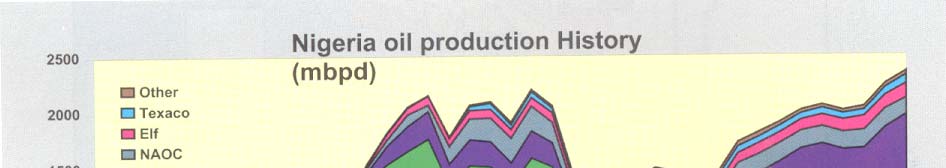


breeding niches are destroyed by these causes. Also effluent discharges from mining companies,
agrochemical and fertilizer companies, hospitals adversely affect the fishes and the food chain.
Urban solid wastes (domestic and office wastes) are sometimes dumped into the coastal waters
leading to algae boom which affect phyto-and Zoo planktons production as well as the fishes.
There is great need to encourage fish farmers in the GCLME areas. This can be done by
establishing fish ponds in various locations in each country, and by establishing aquacultures in
suitable areas where finger-limps can be raised. For food crops such as rice, maize, cassava, water
yams, bananas and plantains that can be grown in these areas, flood-oil-,salt-resistant varieties can
be breed for planting in these areas. These can be very promising. Agriculture is geared to
sustainable human resources.
3.3.5 Oil and Gas
Nigeria is the largest oil producing country in the Guinea Current Large Marine Ecosystem
(GCLME) area. Cameroon and Gabon are the other countries that produce oil in the GCLME area.
The first commercial oil was found by Shell in 1956 in Olobiri in present day Bayelsa State. This
was after about 50 years of oil exploration activities in the South Western Nigeria. Since then other
oil companies including Mobil, Texaco, Chevron, Agip, Esso and Elf have joined Shell Petroleum
Development Company (SPDC) of Nigeria in the oil hunt, exploration and production. In 1963, the
first offshore oil was discovered by Gulf, Mobil and Texaco. This rapidly expanded Nigerian oil
activities in the Niger Delta.
Today the Federal Ministry of Petroleum Resources acts as police dog in the oil industry. Federal
Government of Nigeria participation in the oil industry stands at 55% in Shell and 60% in Chevron,
Mobil, Agip, Elf and Texaco. In 1977, the Nigerian National Petroleum Corporation (NNPC) was
formed through the merger of the Ministry of Petroleum Resources and the Nigerian National Oil
Corporation to participate in joint venture operations among the oil Companies. The Corporation
was given powers and operational interest in refining, petrochemicals and products, transportation
and marketing. It is also involved in the exploration and production activities in the offshore Niger
Delta.
Figure 5.3-3. Nigeria Oil production History
Source: Discover a New Nigeria 2000
44
In the past decade (early 1990s) the importance of gas was recognized by the Federal Government
of Nigeria and the Oil Companies. The mandate is to stop gas flaring by the year 2008. Gas
gathering is taking place in all the operational flow stations. The Nigerian Natural Liquified Gas
(NNLG) has been formed to take care of gas gathering, storing and marketing Oil Companies with
Shell in the lead are working in collaboration with NNLG. The terminal point of gas gathering is
Bonny terminal.
Unfortunately oil and gas exploration and production in the Niger Delta have turned out to be a
cause to the inhabitants than a blessing. The inhabitants lost their occupation (farming and fishing)
due the destructive exploration and production activities of the oil companies on their farms,
vegetation and fisheries. Most of the important flora (Mangroves) and fishes are becoming extinct
or depleted. Oil spillages due to natural and human causes have rendered their farmlands infertile
and their waters unfit for drinking and for fishing activities. These sad environmental conditions
(impact) have triggered conflicts and wars in recent years in many of the oil producing areas.
Other countries are also involved in oil and gas activities (table 3.3-5). Cameroon produces about
6.25 million tons of crude oil per annum in Rio Del Rey Basin in the Nigeria Delta. Cameroon also
has natural gas, which has not been tapped. Similar environmental problems being checked and
managed in the oil producing States by the Federal Government of Nigeria and the Oil Companies
may also be the experiences in Cameroon and Gabon if not checked and managed on time.
Oil and gas, though found in only a few countries in the region, constitute probably the most
important coastal resource in the region. Some of the countries in the region are oil producers and a
few (e.g. Cameroon, Gabon and Nigeria) are net exporters. In 1990, production from oil from the
coastal zone of Nigeria averaged 1,800,000 barrels per day. The proven reserve base of crude oil in
Nigeria is about 18 billion barrels in 1990 rising to about 30 billion in 2002. Other countries with
oil and gas reserves include Cameroon with about 65 million metric tons of crude oil, Cote d'Ivoire
with 15 billion cubic metres of crude oil. Crude oil has recently been found in economic quantities
in Equatorial Guinea and Sao Tome and Principe (e.g., Table 3.3-5).
Table 3.3-5. Oil and Gas Reserves of Some Countries in the GCLME Region
Country Crude
Oil
(1992)
Natural Gas (1992)
thousand tonnes
million tonnes
Benin 117
10
Cameroon 65 95
Cote d'Ivoire
3
100
Equatorial Guinea
1
3
Gabon 190
11
Nigeria 2,040
3,398
Source: World Resources 1994-95
3.3.6 Salt Production
Salt production is an important industry in the Gulf of Guinea, especially in the area between Côte
d'Ivoire and Benin. Large quantities of salt are produced around coastal lagoons. In Ghana, for
example, large-scale commercial salt mining is an important economic activity in coastal wetlands.
45
Vast areas of mangroves are cleared to make way for saltpans. This activity has been identified as
one of the factors threatening the mangrove ecosystem in the region.
The salt that is produced in the coastal area is exported to other areas in the region as well as areas
far from it, e.g., in the Sahelian countries.
3.3.7 Sand Extraction
Direct removal of sand from beaches for the construction industry is a common practice in the sub-
region even though this is illegal in some countries (e.g. Ghana). Sand mining aggravates coastal
erosion problems.
4.0 Policy, Legal, Regulatory and Institutional Setting
The Abidjan Convention defines environmental protection of the GCLME predominantly for Co-
operation in the Protection, Management and Development of the Marine and Coastal Environment
of the West and Central African Region adopted in March 1981. The Abidjan Convention and its
Protocol on Cooperation in Combating Pollution in Cases of Emergency constitute the legal
components of the West and Central African (WACAF) Action Plan. The Convention expresses
the decision of the WACAF Region (from Mauritania to Angola at the time of adoption) to deal
individually and jointly with common marine and coastal environmental problems. The
Convention also provides an important framework through which national policy makers and
resource managers can implement national control measures in the protection and development of
the marine and coastal environment of the WACAF Region. The Emergency Protocol was
designed to assist in the operational response to massive pollution loadings, primarily from
accidental marine oil and chemical spills.
At its first meeting (Abidjan, 20-22 July, 1981), the newly constituted Steering Committee of the
Convention defined the following priorities:
· Development of oil spill contingency plans;
· Combating coastal erosion;
· Prevention, monitoring and control of marine pollution;
· Rational development of coastal zones;
· Capacity building, particularly in the areas of documentation and legislation on coastal and
marine management.
Since its entry into force in August 1984, Parties to the Abidjan Convention have, with UNEP's
assistance, undertaken a number of activities including:
· development of programmes for marine pollution prevention, monitoring and control in
cooperation with IMO, FAO, UNIDO, IOC-UNESCO, WHO, IAEA, etc.
· development of programmes for monitoring, controlling and combating coastal erosion in
cooperation with UNESCO and UNDESA
· development of national environmental impact assessment programmes for particular
coastal sites
· development of national environmental legislation in cooperation with FAO and IMO
As originally envisaged in the provisions of the Convention, the WACAF Regional Coordination
Unit (RCU) was to co-ordinate the implementation of the West and Central African Action Plan
and ensure the most efficient use of the regional sea through concerted actions by Member States
46
and the optimal utilisation of their shared living resources. It was to co-ordinate regional (as
opposed to national) development of the coastal and marine environment and to assist in the
prevention and resolution of disputes that might arise between and among the Parties to the
Convention. Lack of resources for the RCU has adversely affected the implementation of the
above-mentioned projects, however.
Most of the countries of the region have also ratified several international and regional Conventions
relating to the coastal and marine environment such as the International Convention on Civil
Liability for Oil Pollution and MARPOL 73/78 (Also, thematic review) (see Annex I for a full
listing of the pertinent Conventions).
There is an encouraging history of co-operation between the countries bordering the GCLME even
if the results, outputs and impacts have been variable. Examples of collaborative activities under
the Abidjan Convention include "Control of Coastal Erosion in West and Central Africa
(WACAF/3)", "Manual on Methodologies for Monitoring Coastal Erosion in West and Central
Africa (WACAF/6)", "Assessment and Control of Pollution in the Coastal and Marine Environment
of West and Central Africa (WACAF/2 phases I and II)", and more recently WACAF/11 on
"Integrated Watersheds and Coastal Area Management Planning and Development in West and
Central African Region". The countries in the GCLME sub-region also participated in the
continent-wide but far from successful UNDP/UNESCO Regional Project (RAF/87/038) on
Training and Research for the Integrated Development of African Coastal Systems (COMARAF)
and have experience of joint programming in the context of the Fishery Committee for the Eastern
Central Atlantic (CECAF) under the aegis of FAO which has been trying to promote joint actions
on living resource evaluation and fishery statistics
At the recent World Summit on Sustainable Development (WSSD), the governments recognised
that over-fishing and the subsequent declining returns from the fisheries sector are greatly
reinforcing the cycles of coastal poverty for millions of rural fishing communities around the world
especially in sub-Saharan Africa, while at the same time threatening the marine biodiversity and
coastal ecosystems that support fisheries. For this reason, the World Summit on Sustainable
Development (WSSD) felt over-fishing represented a serious crisis meriting a concerted effort by
the international community over the next 10 to 12 years, to restore the world's fisheries to health
by the year 2015 (including the coastal ecosystems that support these fisheries). Some of the
specific actions that participating governments, including the countries of the GCLME region,
agreed to undertake are:
· Maintaining or restoring fish stocks to levels that can produce the maximum sustainable
yield by 2015;
· Assisting developing countries in coordinating policies and programs aimed at the
conservation and sustainable management of fishery resources;
· Strengthening donor coordination and partnerships between international financial
institutions, bilateral agencies and other relevant stakeholders to enable developing
countries to develop their capacity for sustainable use of fisheries;
· Establishing representative networks of marine protected areas, consistent with
international law and based on scientific information; and
· Developing national, regional and international programs for halting the loss of marine
biodiversity, particularly in coral reefs and wetlands.
The activities and programmes including agreed targets and action plans have created a new
awareness of domestic issues and regional problems and engendered a certain sense of urgency on
47
fisheries depletion and environmental matters. However, their overall impact has been impaired by
a lack of success in focusing on transboundary ecosystem-wide International Waters problems and
the need to strengthen environmental and resource stewardship at both national and regional levels.
This has been exacerbated by the absence of a mechanism for funding incremental costs in the
existing Regional Seas Programmes, and a lack of resources for a co-ordination Secretariat. A
proposed strategy for revitalising both the Abidjan and Nairobi Conventions exists and was
embodied in the GEF funded Medium Sized Project implemented by Advisory Committee for the
Protection of the Seas (ACOPS) and which ended with a "Partnership Conference" in September
2002 on the sidelines of the World Summit on Sustainable Development (Rio + 10 Conference) in
South Africa.
National policy and legal framework can be found in the National Reports developed in the support
of this project.
5.0 Major Perceived Transboundary Problems and Issues
The identification of the major perceived3 problems and issues (MPPIs) is a first step in the TDA
process and it constitutes the justification for the subsequent in-depth analyses. The significance of
the perceived issues and problems should be substantiated on scientific, environmental, economic,
social and cultural grounds. The MPPIs represent the perceptions of the scientific and expert
community on the priority environmental issues of the region.
This section of the TDA analyzes the MPPIs to identify the technical basis supporting or refuting
each MPPI as a priority issue in the GCLME region. The intent is to provide a technical rationale
for prioritizing the MPPIs, to help guide the direction of future interventions to improve the
regional environment. It will be of no use to identify major intervention efforts for an MPPI if the
technical basis supporting its priority is missing. In such a case, the MPPI can be dismissed as a
non-priority issue, or just as importantly, gaps in knowledge can be identified, and filling the gaps
can become the next step towards addressing that particular MPPI.
The State of Coastal and Marine Environment of the Gulf of Guinea report
(UNIDO/UNDP/NOAA/UNEP, 1998), the Coastal Areas Profiles of the GOG LME coastal states,
the National Reports and the Regional Synthesis report summarises some of the studies that have
been conducted in the coastal and marine environment of the GCLME. The various studies indicate
alarming rates of decline of fisheries resources and significant levels of pollution including
pathogens and micro-organisms in sewage, industrial effluents with high organic loading and
hazardous chemicals, heavy metals, oils and hydrocarbons, tar balls in beaches, as well as serious
problems of coastal erosion and coastal areas management. Other studies have also concentrated on
weeds, water hyacinth and algal blooms. Studies have been conducted on marine fisheries
resources of the Guinea Current region by CECAF, FAO, FRU-ORSTOM. Marine environmental
and pollution monitoring programmes have also been carried out by WACAF in collaboration with
UNEP/FAO/WHO/IAEA. A review of the status of marine fisheries resources in 1994 indicates
that apart from offshore demersal resources, all other fisheries in the sub-region are near to full or
fully exploited (T.O. Ajayi, 1995). This has resulted in loss of food security and increased conflicts
between commercial (industrial) and artisanal (community-based) fisheries.
In summary, it is recognised that the coastal and the marine ecosystem of the GCLME and its
3 "Perceived" is used to include issues which may not have been identified or proved to be major problems as yet due to data gaps or lack
of analysis or which are expected to lead to major problems in the future under prevailing conditions.
48
resources have witnessed various environmental stresses as a result of the increasing socio-
economic and unsustainable development activities. All the above studies and assessments have
identified four broad coastal and marine environmental problems and issues in the GCLME region:
1.
Decline in GCLME fish stocks and unsustainable harvesting of living resources;
2.
Uncertainty regarding ecosystem status, integrity (changes in community composition,
vulnerable species and biodiversity, introduction of alien species) and yields in a highly
variable environment including effects of global climate change;
3.
Deterioration in water quality (chronic and catastrophic) from land and sea-based
activities, eutrophication and harmful algal blooms;
4.
Habitat destruction and alteration including inter-alia modification of seabed and
coastal zone, degradation of coastscapes, coastline erosion.
The socio-economic and cultural implications from the above broad issues can be tremendous in
terms of income reduction arising from a loss of fisheries stocks and catches, loss of recreation and
tourism amenities and an increase in water treatment and coastal protection costs. Because of the
paucity of reliable, detailed and historic scientific data on coastal, marine and freshwater
environment in the GCLME region, a certain degree of uncertainty still prevails in assessing the
pollution loading in general. There is an urgent need for a precise qualitative and quantitative
assessment of the significant sources of land-based pollution as well as comprehensive assessments
of the state of the fisheries resources and extent of ecosystem degradation (including status and
trends analysis) in the region.
The above-mentioned coastal and marine environmental problems in the GCLME can be broken
down into the following specific problems:
· Large-scale changes in the abundance levels of the resident fish stocks near shore and the
conditions affecting the sustainability of the straddling (shared) and highly migratory
fisheries of the region, both of which have food security and economic implications for the
280 million people of the region;
· Depletion of fisheries resources due to excessive and unsustainable harvesting of fisheries
resources;
· Lack of prediction of natural fluctuations leading to sub-optimal fishing effort;
· Apparent increase in the frequency and extent of coastal erosion placing fisheries and other
coastal communities in danger from loss of roadway and habitable lands;
· The physical destruction of coastal habitats including wetlands and mangroves, resulting in
the loss of spawning and nursery grounds for living resources and the loss of the rich and
varied fauna and flora of the region including some rare and endangered species;
· Uncontrolled and haphazard urbanization of coastal areas across the region that results in
use conflicts and imposes great stresses on the environment and resources;
· Harbour construction activities that generally alter longshore current transport of sediments
and in many cases have led to major coastal erosion and siltation problems;
· Large amounts of sediments emptied by the many large rivers in this region that are
important sources of nutrients and suspended matter to the coastal and marine environment
contributing to eutrophication and harmful algal blooms with serious implications for
ecosystem and human health;
· Input of largely untreated sewage into the coastal environment impacting on health, tourism
and fisheries. Sewage treatment facilities are very limited throughout the region and raw
sewage is discharged both into coastal lagoons and the rivers flowing into them. This,
combined with the limited tidal water exchange of lagoons, has led to widespread
eutrophication;
49
· Discharge of untreated or partially treated industrial wastes directly into coastal water
bodies that contaminate marine life and pose serious threats to human life;
· Use of pesticides, especially the organochlorine group of compounds, in agriculture and
human health protection resulting in an input of residues to the coastal environment that are
harmful to living resources;
· Risks from petroleum pipeline development, accidental spills of petroleum products and
operational discharges from shipping (e.g. ship wastes) and the accidental introduction of
toxic chemicals and exotic species that seriously damage the receiving ecosystem, leading
to food and habitat loss.
The major impacts originating from individual coastal States that are invariably transboundary in
nature in the sub-region include:
· Various states of depletion of straddling and highly-migratory fisheries stocks, including
over-exploited, declining, and slow-recovering as a result of over-fishing and over-
exploitation;
· Wastage through discard of by-catch with consequent loss of marine resources, biodiversity
and biomass;
· Phenomenal rates of erosion of coastlines;
· Loss of critical habitats, particularly mangroves and wetlands, that sustain biological
diversity and provide spawning and nursery grounds of migratory fauna of commercial
importance and endangered species;
· Haphazard and unrestrained over-development of the coastal areas with incidence of
erosion;
· Toxic chemical and oil spills, as well as discharges of oily ballast and exotic biological
species discharges from ship traffic;
· Socio-economic implications including loss of revenue, food security concerns, resource
use conflicts and increasing poverty.
Major Perceived Problems and Issues
From the national reports, questionnaires and other published materials, the TDA Task Team,
constituted under the GCLME PDF-B, taking into consideration the GIWA methodology, analysed
all the identified perceived regional transboundary environmental problems and issues and grouped
them under the following four MPPIs:
· Decline in GCLME fish stocks and unsustainable harvesting of living resources;
· Uncertainty regarding ecosystem status, integrity (changes in community composition,
vulnerable species and biodiversity, introduction of alien species) and yields in a highly
variable environment including effects of global climate change;
· Deterioration in water quality (chronic and catastrophic) from land and sea-based activities,
eutrophication and harmful algal blooms;
· Habitat destruction and alteration including inter-alia modification of seabed and coastal
zone, degradation of coastscapes, coastline erosion.
50
Below, each of these problems and issues is addressed from a status perspective. It answers the
questions: what do we know about each problem/issue? What data support the quantification of
the extent of the problem/issue? Do the data support these as real problems and issues, or just as
perceptions? This analysis took place on a scientific level, including biological, oceanographic,
physical, social and other perspectives on the problem. This is in effect the "status" assessment.
The next step was to perform a causal chain analysis; the major perceived problems and issues were
analyzed to determine the primary, secondary and root causes for these problems/issues.
Identification of root causes is important because root causes tend to be more systemic and
fundamental contributors to environmental degradation. Interventions and actions directed at the
root causes tend to be more sustainable and effective than interventions directed at primary or
secondary causes. Because the linkages between root causes and solutions of the perceived
problems are often not clear to policymakers, however, interventions commonly are mis-directed at
primary or secondary causes.
This TDA attempts to clarify the linkages between root causes and perceived problems, to
encourage interventions at this more sustainable level. Fortunately, root causes are common to a
number of different perceived problems and issues, so addressing a few root causes may have
positive effects on several problems and issues. The root causes of most of the environmental and
resource problems in the GCLME area have to do with inadequate policy, ineffective compliance
monitoring and enforcement, lack of community support and lack of legislation.
5.1
Decline in GCLME fish stocks and unsustainable harvesting of living resources
Status of the problem/issue
In some countries of the region, there is evidence indicating that the artisanal as well as the
commercial fisheries have exceeded or are about to exceed the point of sustainability. Major lines
pf evidence leading to this conclusion include: Decrease in the Catch per Unit Effort (CPUE)
indicates the fisheries is exceeding sustainable yields (Ajayi, 1994); species diversity and average
body lengths of the most important fish have declined (FAO, 2000).
Transboundary elements
Major transboundary elements of the problem can be summarized as follows:
· Loss of income from regional and global trade of marine products
· Region-wide decrease in biodiversity of the marine living resources including the
disappearance of high-quality critical natural resources
· Region-wide destructive fishing techniques degrading mangrove habitats
· Increasing catch effort on pelagic species such as tuna, sardinella
· Non-compliance with the FAO Fisheries Code of Conduct
Environmental impacts
· Loss of biodiversity
· Changes in food web
· Changes in community structure due to over-exploitation of one or more key species
51
· Increased vulnerability of commercially-important species
· Long-term changes in genetic diversity
· Stock reduction
· Loss of predators
· Habitat degradation due to destructive fishing technique
Socio-economic impacts
· Reduced income
· Loss of employment
· Population migration
· Conflicts between user groups
· Loss of recreational opportunities
· Decline in protein
Over-exploitation of fishery resources, the use of destructive fishing practices and the destruction or
modification of ecosystems can significantly affect the region's coastal communities. The GCLME
supports a significant world fishery that is important for food security, and as a source of export
income for the countries bordering this sea. The fisheries sector is highly significant in the GCLME
in the context of domestic food security for the participating countries. Fish consumption is quite
high in the region (see section 3.3-1) and contributes significantly to the protein intakes of the
citizens especially in coastal communities.
Pelagic and demersal fisheries within the region are fully exploited with evidence showing that the
landings of many species are currently declining. The decline in fish availability in the subsistence
sector has led to the adoption of destructive fishing practices such as use of undersize meshes and
blast fishing. Based on present consumption patterns and population growth rates, much of the
region especially the large coastal cities of Lagos, Abidjan, Accra and Doaula, will have to produce
significantly more fish by 2010 just to meet domestic demand. Pressure on the coastal resources is
therefore likely to increase significantly in the immediate future. Despite nutritional requirements
and current population growth rates, the industrial (commercial) fisheries sector in the countries
surrounding the GCLME generally exports the trawl fisheries products (Figure 5.1-1)exacerbating
the problems associated with food security situation in the region.
1000000
800000
600000
Imp
400000
Exp
200000
0
1986 1988 1990 1992 1994 1996 1998
Figure 5.1-1. Fish imports and increasing exports by GCLME Countries
52
The estimate of the numbers of fishing canoes in some countries of the region ranges from 7,350 in
Cameroon, 8,650 in Ghana to 200,000 in Nigeria (Report of Working Commission I: in Ibe et
al.,1998). The motorisation rate for the canoes can reach up to 50% as it does in Nigeria. The
number of fishermen is also quite high: approximately 24,000 in Cameroon and 7,600 in Cote
d'Ivoire. It is estimated that over 60% of current national fish landings in the GCLME region are
made by artisanal fishers (FAO, 1997).
53
Causal chain analysis
A causal chain anlysis was performed to identify the primary, secondary, and root causes of fisheries decline in the region, as illustrated below
Fiqure 5.1-2. Causal Chain Analysis: Decline in GCLME Commercial Fish Stocks and Non-Optimal Harvesting of Living Resources
CAUSES
INAPPROPRIATE
FISHING METHODS &
INADEQUATE CONTROL OF
INCREASING CATCH &
GEAR
ACCESS TO RESOURCES
EFFORT
Inadequate regulatory framework & lack
Lack of or inoperational MCS
Population growth
of enforcement of existing laws
Unavailability of appropriate gear
High demand - local &
Inadequate human capacity
in the local market
International
Lack of intersectoral coordination
Inadequate knowledge
Lack of or inadequate
of stock sustainability
p
rofessional training
Economic pressure & need for foreign
Inappropriate government
exchange
Lack of or insufficient
policies
involvement of stakeholders
Inadequate capacity for
Poverty
Lack of or inadequate regulatory
fisheries management
framework
Lack of awareness and knowledge
Lack of alternative
o BAT
livelihoods
Sectors and Stakeholders
The main government sectors involved in the fisheries issues are the fisheries, agriculture and
environment ministries and agencies, and municipal and state (provincial) governments. The
Stakeholder Analysis identified the energy ministries as major government impact sectors
(perhaps for both oil and gas sector impacts as well as hydropower). Affected stakeholders
include local fishermen, coastal zone residents, and scientific community.
Supporting data:
The continental shelves of Guinea Bissau, Guinea and Sierra Leone are characterized by coastal
fish assemblages (croakers) principally located in nutrient-rich estuarine and inshore areas. The
GCLME is already showing evidence of ecosystem stress with major fluctuations of
commercially valuable species. Significant changes in species composition have occurred over
time as a result of over-exploitation of several demersal and pelagic fish species especially by
foreign trawlers in the offshore areas. The size spectrum of fish is moving towards smaller size
classes. Recent trawl surveys conducted in Ghana showed that significant changes were
occurring in the demersal fish biomass in terms of distribution, abundance and reproductive
strategy.
A case in point is the continuous fluctuations between the two species, the grunt and Triggerfish
in the last two decades. The grunt maintained for a time its position at the top of the list of
demersal fish but later gave way to the triggerfish which dominated the ecosystem from the
early 1970s to the late 1980s, after which time it dramatically decreased in abundance (FAO,
1997). Koranteng and McGlade (2002) attribute the almost complete disappearance of the
Triggerfish after the late 1980s to observed environmental changes and upwelling
intensification in the central part of the GCLME, off Ghana and Cote d'Ivoire (Koranteng,
1988). There was a subsequent increase of the Sardinella population. The Sardinella industry
had collapsed in 1973, but subsequently recovered to unprecedented levels during the 1980s
(Cury & Roy, 2002). The exploitation rate applied to cuttlefish stocks has been increasing since
1984 and by 1990 was considered to be equal to, or slightly above, the optimal fishing effort.
The rate of growth of these organisms appears faster than previously estimated (FAO, 1997).
Such changes in fishery patterns appear, in part, to be related to overfishing, as evidenced by a
decline of Catch-Per-Unit- Effort and the taking of young immature fish by artisanal fishermen.
They also appear to be related to environmentally-driven changes to pelagic stock distribution.
For instance, CECAF (1994) assessed the biomass of the small pelagics in the western and
central Gulf of Guinea as 392,000mt. The current level of exploitation in the area is about
257,000mt annually clearly showing over-exploitation (Mensah & Quaatey, 2002). The
observed recent high catches of the resource (which exceed the estimated potential yield) are
due mainly to the intensity of upwelling in the area).
In Guinea, current estimates based on recent trawl surveys indicate a total biomass of demersal
resources to be around 180,000 t, of which 44,000 t are of high or medium commercial value.
Assessments made by CECAF in 1991 were updated in 1994 (Working Group held at the
Centre national des sciences halieutiques de Boussoura, Conakry, Guinea) and show that total
demersal biomass decreased by around 50% between 1991 and 1994. The decrease in biomass
of the main demersal species, such as croakers, threadfins and sicklefish, was higher than 50%.
It was suggested that this change in biomass was related to the recent increase of small-scale
artisanal and industrial fishing efforts. Interactions with the more commercial large-scale
fisheries have led to major problems for the traditional artisanal fishery. Fishery production of
the coastal area up to 20m depth was estimated at about 40,000 t per year.
55
Trawl surveys carried out on the Guinea continental shelf have shown that between 1985 and
1990 the estimated biomass of coastal resources in waters less than 20 m deep (roughly up to 15
nm offshore) declined from 112,000 to 49,000 t during the rainy season and from 72,000 to
48,000 t during the dry season. This reduction between 1985 and 1990 can be explained by the
increase in fishing activity of trawlers in inshore areas.
In Sierra Leone, the artisanal fishery exploits small pelagic species only. Their current level of
catches ranges between 22,000 and 30,000 t. Acoustic surveys have estimated biomass to be
between 70,000 and 120,000 t, suggesting that controlled development of the industrial sub-
sector may be possible. Current annual landings for demersal stocks by trawlers ranged from
8,000 to 20,000 t between 1991 and 1993. Reduced catch rates are currently observed in the
fishery and the level of exploitation of demersal fish stock is considered high. MSY has been
estimated to lie between 46,500 t and 65,000 t.
Current annual production of Southern pink shrimp in Sierra Leone was found to fall within the
MSY estimate of 2,600 to 3,500 t. Reduced catch rates are currently observed in the fishery,
and the level of exploitation of shrimp is considered high. In the west and central Gulf of
Guinea, potential catches of shrimps were estimated at 4,700 t, and stocks were considered
over-exploited. Demersal resources are fully exploited with biomass estimates ranging between
64,000 and 104,000 t.
Marine resources of the Gulf of Guinea are mainly exploited by Côte d'Ivoire, Ghana, Togo,
Benin, Nigeria, Cameroon and Equatorial Guinea, among others. Multi-species fisheries are
common in the Gulf of Guinea. Small pelagic resources are exploited by small-scale gillnets
and semi-industrial purse-seine in Côte d'Ivoire, Ghana, Togo and Benin and exclusively by
small-scale fisheries in Nigeria and Cameroon. Coastal demersal resources are composed of
sciaenids (exploited by small-scale and semi-industrial fisheries in Nigeria, Benin, Togo and
Cameroon), groupers and snappers (fished in Togo and Ghana with hooks-and-lines in
untrawlable areas), and sparids (Côte d'Ivoire and Ghana). The white shrimp resources off
Nigeria and Cameroon are fished exclusively by artisanal fishery while pink shrimp is exploited
by trawlers of the semi-industrial fishery. Penaeid shrimps in Togo and Benin and in Côte
d'Ivoire are caught in lagoon fisheries. The offshore demersal resources of Ghana and Côte
d'Ivoire are made up of sparids along with the slope community, while the offshore demersal
resources of Nigeria and Cameroon are primarily drift fish and redfishes.
The recent biomass estimates of 7,000 t in Congo and 31,000 t in Gabon for stocks of
Sciaenidae and Sparidae were based on acoustic surveys carried out in 1994. Demersal
resources were either close to, or fully exploited. Effort reduction and redistribution would be
beneficial, as fishing concentrates in the inshore zone and on juveniles. Small pelagic species
(sardinellas, mackerels and anchovies) are important but unstable resources in the Western Gulf
of Guinea (Côte d'Ivoire-Ghana-Togo-Benin) and their stocks are shared. Sardinella stocks
seem to be in good shape. Substantial recruitment of S. aurita has been observed in Ghana and
Benin in 1988 and 1989. The fishing pattern in recent years has been different from that of 1985
and 1987, with regard to the availability of the resources. Potential catches of small pelagics in
the west and central Gulf of Guinea have been estimated at 330 000 t and are fully exploited.
Little is known about pelagic and demersal resources in the whole southern Gulf of Guinea.
Many countries have not developed an appropriate database and research structures to analyze
stock exploitation status.
Acoustic surveys in the northern shelf of Angola indicated during 1985-1989 a decline in the
biomass of small pelagics (sardinella and horse mackerel). The trend has dramatically reversed
during the 1990s and the current biomass level now exceeds 500 000 t. Horse mackerel (T.
trecae) biomass was estimated at about 250 000 t (1994). High biomass values for both round
sardinella and Madeira sardinella were also recorded in the South Gabon - Congo region, 135
56
000 t in 1994. Horse mackerel biomass was estimated at 25 000 t. These estimates indicate a
considerable increase in biomass compared to previous survey results, confirming the trends
observed in Angola. Small pelagic stocks are considered under-exploited.
The maximum sustainable yield (MSY) for Nigerian fisheries was estimated by Tobor (1990) at
240,000 mt. According to Moffat and Linden (1995), official catch figures have greatly
exceeded the MSY for 1980 to 1989. In spite of the limitations of estimating MSY in
circumstances where catch efforts and standing catch data may be inadequate, there are other
pointers to declining fish depletion and over-exploitation. In Rivers State of Nigeria for
example, between 1980 and 1982, catches which ranged between 86,000 to 107,000 tonnes,
decreased to values ranging between 16,000 and 19,000 tonnes in the 1986 to 1987 period
(Moffat and Linden, 1995). This supports the notion that catches were well above the carrying
capacity for several years.
Environmental changes manifesting a periodic variability in coastal upwelling intensities are
playing a role in coastal pelagic fish abundance fluctuations. For instance, the east and west
flows and position of the Guinea Current may play a role in these population fluctuations.
Shifts in biomass appear to be connected to a shift in the boundary of the Guinea Current.
These alterations have been linked to oceanographic changes including the southward
displacement of the Intertropical Convergence Zone (ICTZ) during Atlantic El Ninos.
A large artisanal fisheries sector with strong traditional roots in the region had used bottom set
nets, hook and line and beach seines to catch demersal fish for the populations of Sierra Leone,
Ghana and Togo. After the 1960s, the GCLME's transboundary straddling and migratory
stocks attracted commercial offshore fishing fleets. Their fishing efforts exerted extreme
pressure on the fishing resources, placing them at risk of collapse. This was exarcebated after
1982 by the return of local industrial fleets that had previously fished other EEZ waters but
were barred from them according to the new UNCLOS provisions pertaining to Exclusive
Economic Zone. This resulted in a significant increase in trawling effort and landings
(especially of demersal fisheries). The time series analysis of Catch-Per-Unit-Effort (CPUE) of
Koranteng (2002) for both small-sized inshore vessels and industrial trawlers in Ghana showed
a consistent rise in industrial trawling from the mid-1970s and a downward trend in the late
1980s in inshore seasonal fishing. There was also a consistent rise in industrial trawling effort
and a decline in that of inshore trawlers operated by artisanal fishermen. The CPUE exceeded
sustainable yields in some of the countries bordering the GCLME and led to a decline in both
demersal and pelagic species diversity and average body lengths of the most important fish
species.
Tables 5.1-1 through 5.1-2 present some basic information regarding the fisheries in the region.
Taken together, they indicate both rising catches due to overfishing, and declining catches due
to depleted fisheries. Figures 5.1-2 through 5.1-5 demonstrate the variety of fisheries in the
GCLME, and the history of their catch. Unfortunately, data are neither consistent through time
nor complete, and so the inference regarding depletion of resources is based on a synthesis of
available data.
57
Table 5.1-1. Average Annual Marine Fish Catch and Percentage Change of Countries in the
GCLME
Country Average
1993-95
(103
Percent change
mT)
1983-85
Angola 77.5
(1)
Benin 13.5 192
Cameroon 41.9
25
Congo 17.5 8
Cote d'Ivoire
57.5
(22)
Equatorial Guinea
3.3
15
Gabon 240
28
Ghana 299.6 34
Guinea
60.3
130
Guinea Bissau
5.3
75
Liberia 3.8
(61)
Nigeria 187
14
Sierra Leone
47.1
34
Togo 8.7 (23)
Negative numbers are in parentheses
Source: World Resources 1998-99
58
Figure 5.1-2. Mean Catch Rates Recorded in the F.T. Susainah Survey, 1999
0 - 20 m
1 8 0 .0 0
1 6 0 .0 0
1 4 0 .0 0
r
)
/
h 120.00
g
k
M ollus cs
( 1 0 0 .0 0
te
a
Crus taceans
8 0 .0 0
r
h
Finfis h
6 0 .0 0
tc
a
C
4 0 .0 0
2 0 .0 0
0 .0 0
C I
GH
TO-B E
N I
C A
Countr y
21 - 40 m
2 0 0 .0 0
1 8 0 .0 0
1 6 0 .0 0
r 140.00
/
h
g
k 1 2 0 .0 0
M ollus cs
(
te 1 0 0 .0 0
a
Crus taceans
r
8 0 .0 0
h
Finfis h
tc
a
6 0 .0 0
C
4 0 .0 0
2 0 .0 0
0 .0 0
C I
GH
TO-B E
NI
C A
Countr y
41- 60 m
3 0 0 .0 0
2 5 0 .0 0
r
/
h 200.00
g
k
(
M ollus cs
te 1 5 0 .0 0
a
Crus taceans
r
h
tc
Finfis h
1 0 0 .0 0
a
C
5 0 .0 0
0 .0 0
C I
GH
TO-B E
N I
C A
Countr y
59
Figure 5.1-3. National and Foreign Fleet Catches in the GCLME Region, January 1998
Catches of ISSCAAP Group 45 (shrimp, prawns, etc.) represent 1.4% of the total catches.
Southern pink shrimp catches started to become significant in 1966 and have since regularly
increased with a sharp peak, reaching 19 000 t in 1993 before declining to 14 000 t in 1994. The
deepwater rose shrimp fishery started from nothing in 1971 and catches have shown a great
variability, with a very high value of 19 000 t in 1978 but only about 5 000 t in 1986-88 and
1992-94. (ISSCAAP= International Standard Statistical Classification of Aquatic Animals and
Plants)
60
Figure 5.1-4. Shrimp Catches for the GCLME Region
Source: FAO, 1997
Table 5.1-2. Densities (Kg/ha) and Catch Rates Kg/h of Total Demersal Resources and Selected
Species Obtained in Trawling Surveys on the Continental Shelf of Ghana, 1963-1990
SPECIES
*GTS
Densities (kg/ha)
CPUE
1963-64 1969-70 1981-82 1985-86 1989-90 1990
B. auritus
24-35
2,4
-
8,3
3,5
0,2
E. aeneus
1-24
0,5
-
2,1
0,7
0,8
P. bellottii
12-103
1,6
-
4,9
1,4
1,4
D. canariensis
1-15
1,3
-
2,2
0,9
1,0
S. caeruleostictus
4,39
1,0
-
2,7
1,1
1,8
D. volitans
1,86
0,9
-
0,2
0,6
2,5
P. prayensis
9,26
0,7
-
2,7
1,2
0,7
Sepia spp
1-12
1,2
-
1,2
0,6
3,8
TOTAL
23,5
kg/ha
36,0 93,9 62,1 19,4 22,8
DEMERSAL
* Guinea Trawling Survey
Sources: FRUB, Tema, In Ajayi (1994)
61
Figure 5.1-5. Fisheries Catch in the Guinea Current Large Marine Ecosystem
(source: University of British Columbia, at http://data.fisheries.ubc.ca)
62
5.2
Uncertainty regarding ecosystem status, integrity (changes in community
composition, vulnerable species and biodiversity, introduction of alien species) and yields
in a highly variable environment including effects of global climate change
Status of the problem
Environmental changes manifesting a periodic variability in coastal upwelling intensities are
playing a role in coastal pelagic fish abundance fluctuations in the GCLME. For instance, the
east and west flows and position of the Guinea Current may play a role in noticeable population
fluctuations of the Triggerfish that appeared in large quantities in the 1970s but have now
completely disappeared. Shifts in biomass appear to be connected to a shift in the boundary of
the Guinea Current. These alterations have been linked to oceanographyic changes including
the southward displacement of the Intertropical Convergence Zone (ICTZ) during Atlantic El
Ninos. In addition to natural variability, the ecosystem status is affected by human activities
(overfishing, introduction of alien species, and contamination, for instance). Inadequate state of
knowledge of the ecosystem status and lack of regional coordination in studies of biodiversity,
habitats, and ecotones hinders effective management on a national and regional level.
The most significant changes on the abundance of fish species in the region are fluctuations in
sardinella species, dramatic increase in the abundance of triggerfish (Balistes capriscus)
between 1973 and 1988 and the decline of the species since 1989 (Koranteng, 2001).
Occasional changes have been witnessed in the biodiversity of the region. The Bivalves species
(Chlamys opercularis) was caught in large quantities as never before during a trawl survey
conducted in 1998. It has been suggested that the bivalve species may have been introduced
into the region through ship ballast water. These changes in biodiversity have been attributed to
both natural (intensification of the minor upwelling, water temperature changes) increase in
salinity of shelf waters (Binet, 1995) and changes in meteorological and other oceanographic
conditions (reduction of rainfall, acceleration of winds and alteration of current patterns (Binet,
1995) and changes in nearshore biophysical processes (Koranteng, 2001).
Transboundary elements
The Guinea Current environment is highly variable and the ecosystem is naturally adapted to
this change. Sustained large-scale environmental events such as ENSO, flooding, algal blooms,
Benguela and Canary Current intrusions and changes in winds, however, affect the ecosystem
as a whole, compounding the negative effects of fishing. These events and changes generally
have their origin and cause outside of the GCLME, but are of such a scale that the impacts
occur in their international waters areas of all sixteen countries i.e. the changes propagate across
external GCLME boundaries and internal geopolitical boundaries. The poor ability to predict
events and changes limits the capacity to manage effectively system wide. Additionally, the
GCLME is believed to play a significant role in global ocean and climate processes and may be
an important site for the early detection of global climate change.
Most harvested fish species are shared between countries and straddle geopolitical boundaries.
Past over-exploitation of targeted fish species has altered the ecosystem as a whole, impacting
at all levels, including on top predators and reducing the gene pool. Some species, e.g. sea
turtles, are threatened or endangered. Exotic species have been introduced into the Guinea
Current Region. (This is recognised as a global transboundary problem.)
63
Environmental impacts
Fluctuations in biodiversity
Socio-economic impacts
Food deficit/abundance depending on phase of cycle of natural variability
Lack of ability to depend on reliable artisanal fisheries in some cases
Instability in coastal populations due to fluctuating food sources
Possible intrusion of offshore/industrial fisheries into areas of conventional artisanal fisheries
when offshore resources are declining
Sea-level rise and other global change impacts may affect the coastal populations and
infrastructure (e.g., Table 5.2-1 and 5.2-2).
Table 5.2-1. Summary of Impacts and Response Costs for a One-Meter Sea-Level Rise in Nigeria
Land at risk (km2)
18,120 to 18,396
Population at risk
3,180,000
Value at risk (million)
US$18,134
Important area protection
US$558 to 668
Total protection
US$1,424 to 1,766
Source: French and Awosika, 1993
Table 5.2-2. Estimated Number of People (in millions) That Will be Displaced by Sea-Level
Scenarios
Slr Scenarios
0.2m
0.5m
1.0m
2.0m
Barrier
0.6 1.5 3.0 6.0
Mud
0.032 0.071 0.140 0.180
Delta
0.10 0.25 0.47 0.21
Strand
0.014 0.034 0.069 0.610
Total
0.75 1.86 3.68 10.00
% Total Pop.
0.07 1.61 3.20 8.70
Source: Awosika et al., 1992
64
Causal chain analysis
A causal chain analysis was conducted to determine the primary, secondary, and root causes of
global change and uncertainty in ecosystem status.
Figure 5.2-1. Uncertainty Regarding Ecosystem Status and Yields in a Highly Variable
Environment Including Effects of Global Climate Change
CAUSES
Lack of data and information
Poor knowledge of the impact of
global climate change on oceanic
Lack of human and institutional
capacity
Lack of adequate financial
resources for monitoring and
survey of ecosystem
Sectors and stakeholders
Stakeholders for global change are varied and inclusive. Prominent stakeholders include:
Artisanal
fishermen
Coastal populations interacting with artisanal fisheries
Local
governments
Tradesmen
Children and women
65
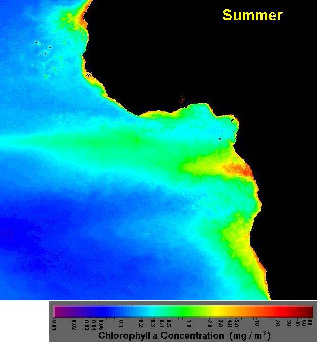
National governments responsible for social welfare of its people
Supporting data
Plankton research in the Gulf of Guinea began in the late nineteenth century with oceanic
expeditions to the area by some European countries to assess the biodiversity in the region.
Among the major expeditions were the Buccaneer in 1886, Valvivia in 1898, Meteor in 1925,
Dana in 1930, the Atlantide in 1945-46 and the Calypso in 1956 (Voss, 1966). Following such
expeditions, the role of plankton in the region's marine productivity gained importance and
national institutions responsible for fisheries included plankton monitoring in their activities.
For example, in Ghana the Fisheries Research and Utilization Branch (now Marine Fisheries
Research Division) carried out monthly monitoring of zooplankton from 1962 to 1995 (Mensah
and Koranteng, 1988; Mensah 1966). The data provided a crude indication of the size of future
fish stocks an increase in secondary production meant enough food for fish larvae and thus an
increase in fish stock.
The GCLME is considered a Class I, highly productive (>300 gC/m2-yr) ecosystem based on
SeaWiFS global primary productivity estimates (Figures 5.2-2 through 5.2-5). Primary
productivity peaks from June to September, stimulated by nutrient level increases related to the
first rains in June, upwelling later in the year, and large riverine floods from September to
October. Because of the shallow depth of the Guinea Current and vertical migration patterns of
the zooplankton, the phytoplankton and zooplankton biomass cycles are in phase with seasonal
upwelling. The zooplankton biomass peaks very soon after the phytoplankton blooms. The
plankton survey, using Ships of Opportunity, conducted in the waters of the Gulf of Guinea
LME during the pilot phase GOGLME project was the first regional effort to monitor the
plankton in the sub-region. The results have provided spatial and temporal information on
plankton variability in the area. The data are also being used, in conjunction with other
parameters, in estimating the carrying capacity of the Gulf of Guinea fishery.
5.2-2: Primary Productivity estimated from SeaWiFS data for Summer.
66
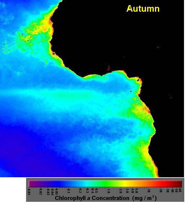
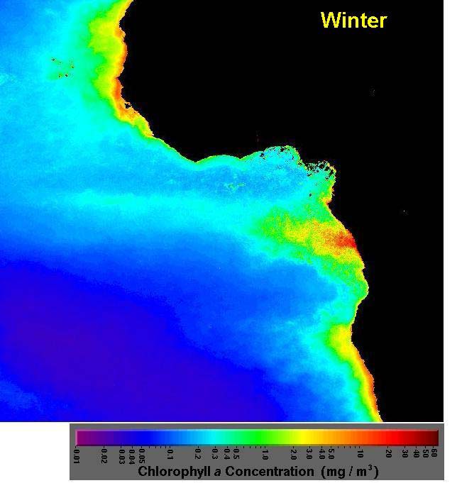
5.2-3 Primary
Productivity
estimated from SeaWiFS data for Fall
5.2-4 Primary
Productivity
estimated from SeaWiFS data for Winter
67
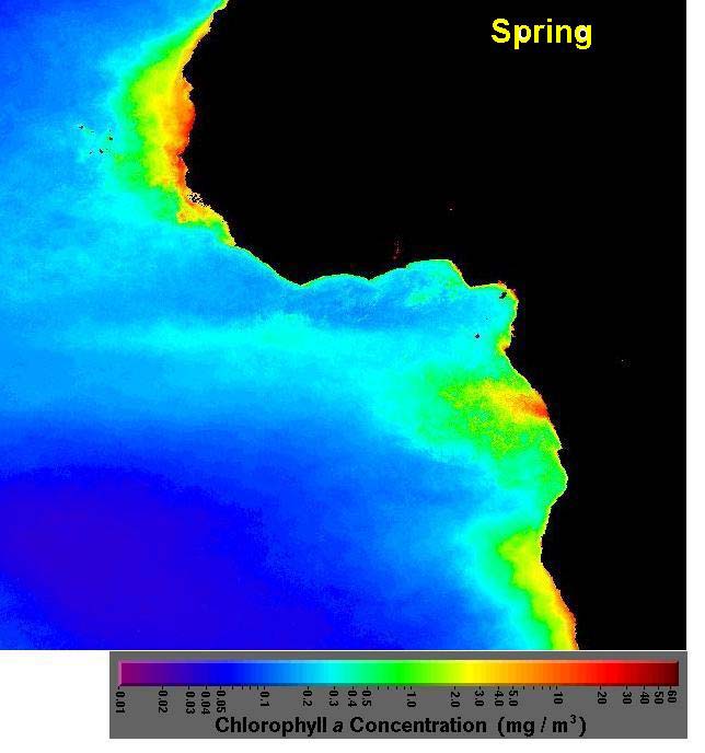
5.2-5 Primary Productivity estimated from SeaWiFS data for Spring
The Primary productivity surveys in the Gulf of Guinea, using these ships of opportunity
towing Continuous Plankton Recorders (CPR), indicated new and emerging patterns of
productivity that contain at the same time hopeful and distressing signals (Figures 5.2-6 through
5.2-8). The hopeful signs come from the discovery of new areas of upwelling (e.g. off Benin
and Nigeria) besides those already known which has led to upward revisions of potentially
available fish stocks in the Gulf of Guinea. The distressing signs arise from the increasing
occurrence of harmful algal blooms indicating intense eutrophication and therefore excessive
nutrient loading in the Gulf of Guinea from anthropogenic sources. There is a need for more
assessment of plankton amount and type, for more information on currents, upwellings and the
availability of nutrients for ocean fauna and flora. Continuous Plankton Recorder (CPR) tows
must continue to build upon already acquired results, and must be extended to the natural limits
of the LME in order to build a comprehensive picture of productivity patterns on an ecosystem-
wide level, with regard to the LME's carrying capacity for living resources.
Figure 5.2-6. Plankton Monitoring Routes in the Gulf of Guinea
68
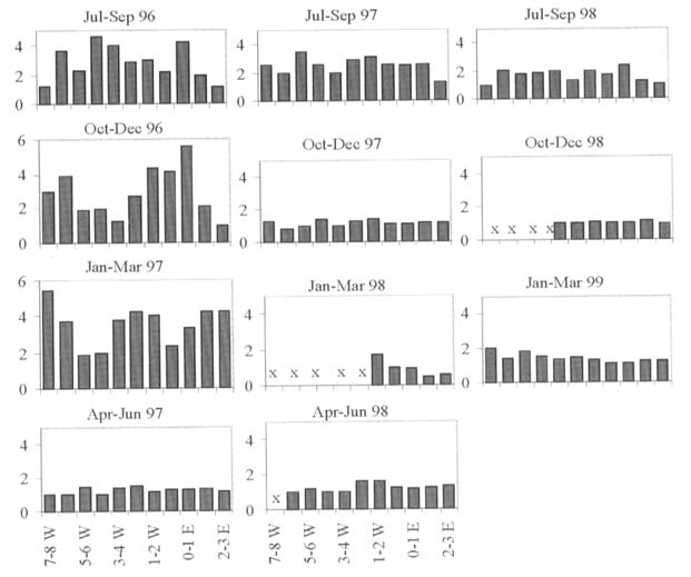
Figure 5.2-7. Mean Seasonal Phytoplankton Colour Taken in Each Degree of Longitude Along the
CPR Routes
Source: SAHFOS Report, 1999
Figure 5.2-8. Primary Productivity Patterns in the CECAF Region Covering the GCLME
As discussed in more detail in Section 5.1, the GCLME is rich with living marine resources and
commercially-valuable fishes, both marine and coastal. Fish species include croaker, grunts,
snapper, sardinella, triggerfish and tuna. During the last two decades there have been
substantial fluctuations in the fishery, with the triggerfish (Balistes carolinensis) increasing
dramatically in the 1970s followed by a severe decrease and the 1973 collapse of the Sardinella
fishery. The latter subsequently recovered to unprecedented levels during the 1980s (Binet, et
al., 1991). The changes in fishery patterns appear to be related to a new geographical
distribution of pelagic stocks. Shifts in fisheries populations may be caused by environmental
factors. For instance, Ibe and Ojo (1994) observed that, with the exception of Ethmalosa sp.,
the Sardinellas appear not to be abundant in the water sectors where the mixed layer is of low
salinity and warm water present all the year round (T>240C; /<35o/oo). With global warming it
is thus likely that the Sardines may not be found in the Grain Coast and Bight of Biafra sectors
that exhibit the above-mentioned characteristics.
69
The respective east and west flows and position of the Guinea Current may play a role in
population shifts. Acoustic surveys taken between 1980 and 1990 indicated a sudden increase
in fish density on the Ivorian shelf (see Marchal, 1993). The shift in biomass appears to be
related to a shift in the boundary of the Guinea Current. These alterations are probably linked
to distant climate anomalies, such as the southward displacement of the ICTZ during Atlantic
El Nińos. A greater understanding of oceanographic processes is needed to improve ecological
forecasts. There are indications that anticipated sea-level rise due to climatic changes would
affect the aquatic life especially in the brackish waters of the GCLME (Ibe and Ojo, 1994).
The change in water level, when it occurs, is likely to upset the breeding habits of some fish
already used to existing habitats while new species may or may not survive in the new
environment. It is also expected that by possible reduction in upwelling certain types of fish
production will be reduced.
Environmental monitoring in the GCLME region relies mainly on a set of coastal stations, on
the Comprehensive Ocean Atmosphere Data Set (COADS) database and on satellite imagery.
This provides useful information on a limited set of variables such as SST and wind. These
variables can be related to fish population dynamics at different scales of observation including
short-term changes in fish availability, year-to-year abundance or lower frequency regime
shifts. The joint Soviet-Sierra Leone oceanographic cruises in Sierra Leone waters in 1987-
1988 reported a warming up of the waters and a change in the composition of the fish stocks,
but longer term data are required before definite inferences can be made concerning the short
term trends in fisheries composition/changes due to impacts of climate change. In addition,
salinity stress consequent upon the ingress of seawater due to sea-level rise would lead to
disruption of the coastal fishery by causing disorganization in the faunal assemblages in
estuarine, deltaic and lagoonal environments resulting in the redistribution of species and
failures in the reproduction and survival of their eggs/spores and larvae/sporophytes.
Predator/prey relationships would be altered to the advantage of predators.
Along the Cote d'Ivoire continental shelf, environmental patterns have been investigated using
data collected from 1966 to 1984 (Morliere and Rebert, 1972; Hisard, 1973; Colin, 1988).
Characteristics of coastal upwelling and their interannual variability are well documented
(Morliere, 1970; Voituriez, 1981; Ibe and Ajayi, 1984). Along the Cote d'Ivoire shoreline, this
seasonal enrichment supports pelagic and demersal fisheries, both very sensitive to
environmental change (Binet et al.,1991; Pezennec and Bard, 1992; Binet, 1993). Continental
influence is linked to four major rivers namely Cavally, Sassandra and Bandama Rivers flowing
directly to the Gulf of Guinea, while the Comoe River flows seaward through the Ebrie Lagoon
and the Vridi Canal. These large river inputs are high during the flood season from October to
December. Rainfalls in the coastal forest area induce local river floods during the rainy
seasons, from April to June and from October to November (Binet, 1993; Mensah, 1991).
Since 1982, a weekly hydrological sampling (temperature, salinity and Secchi disk
measurements) has been maintained around the Abidjan coastal zone (Bakayoko 1990; Cissoko
et al.,1995, 1996). The study was to describe the seasonal and interannual fluctuations of
physical parameters in relation to major continental (rain, river floods) and oceanographic
events (upwelling) in the northern Gulf of Guinea during the 1992-1997 period and to compare
these data to older information; and to assess the respective importance of these hydrological
factors on the pelagic system (bacteria and phytoplankton) in that coastal station. Results
obtained from the study shows that hydrological conditions observed at the coastal station off
Abidjan are strongly influenced by the seasonal variability of three major phenomena: rainfalls,
river floods and upwellings. Upwelling enriches the neritic ecosystem, exerting an immediate
infuence on biological production, on phytoplankton and consequently, on bacterioplankton.
Therefore, during four to five months (main upwelling plus short cold events), the coastal
ecosystems can be considered as productive.
The neritic area along the eastern Cote d'Ivoire coastline can be presently considered as more
productive than a few decades ago with the nutrient-poor situation lasting less time, and the
nutrient-rich situation lasting longer. This could explain the recent outburst of small pelagic
70
fishes (Sardinella aurita) in this part of the GCLME (Arfi et al.,2002). This supports the earlier
environmental time series analysis conducted by Koranteng and Pezennec (1998) showing
transition from a depleted to a prosperous state of Sardinella aurita as CPUE increased from
0.8 to 7.2 tons/day before and after 1980 during the upwelling period.
Numerous sources of data have been used to evaluate the natural variability of the GoGLME
during the pilot project. These include some of the methods indicated in Table 5.2-3.
The above impacts are a few of the possible documented consequences of global warming and
climatic changes on the ocean dynamics of the GCLME region. These can be further elucidated
through the collection of more observational data and development of regional oceanographic
models. The partnership with GOOS-Africa would facilitate the development of environmental
prediction models for the GCLME region.
The sudden collapse of the Ghana-Ivoiro sardinella fishery from 95,000 t (over and above
40,000 t predicted MSY) to 2,000t a year and its seeming substitution by Balistes spp., trigger
fish recording 200,000 tonnes a year up from nothing at all have been recorded in the GCLME.
Off Nigeria, tiger prawns, Penaeus monodon hitherto unknown have become commercial
whereas Parapeneopsis atlantica, brown shrimp; diminished in abundance. The fisheries
assessment survey cruise conducted during the pilot phase Gulf of Guinea LME project found
Chlamys sp in quantities hitherto unrecorded. Without a doubt environmental and climatic
forcing (Koranteng and McGlade 2002) causative of biomass flips or species succession have to
be further researched and factored into management strategies for ecosystem (including species
composition and biodiversity) preservation (Ajayi, 2001).
There has been a noticeable increase in the incidence of aquatic weed infestation in some of
these countries. Aquatic weeds are a real scourge in coastal waters due to the environmental
and socio-economic impacts. For a decade in In Côte d'Ivoire these weeds have invaded
coastal sites, drifting with freshwater. The Ivorien government has been aware of the harmful
effects of these plants since 1980. The first specie, Pistia stratiotes, was endemic to
freshwaters. Then in 1984, a new specie, Salvinia molesta, originating from America, was
introduced. In 1986, a third specie, Echornia crassipes, was introduced. Most of the large
reservoirs are colonised (Ayamé I and II, Taabo and Buyo), as are the rivers and the lagoons
(Ebrié and Aby). Large rafts of E. Crassipes and associated species are carried seaward and
then run aground on the beaches.
Invasion of GCLME coastal waters by aquatic weeds has some negative impacts on the fishing
activities and on the fishing zone. Most of the time, the fishing activities are slowed down and
even stopped for weeks or months until the weeds disappear. It is difficult, even impossible, to
use castnets or mesh nets for fishing. The setting of traps is also difficult because of the
inaccessibility of most of the fishing zone. This phenomenon is common in the Aby Lagoon
where the boats cannot dock. Furthermore, the aquaculture systems such as the acadjas
established in the lagoon cannot be exploited because the entire surface of the lagoon is covered
with the weeds. It is difficult to estimate the cost of these impacts on fisheries activities.
The periodic invasion of the Ebrié Lagoon by these aquatic plants slowed down the activities in
the port (difficulties for ferry boats or other boats to move or to dock in the port, obstruction of
the fishing port). Periodically, the same problem is observed in other coastal waters where the
riverine rural population has some difficulties moving by boat from one village to another. It is
also difficult to estimate the cost of these impacts on navigation.
One other notable aquatic invasive weed, the water hyacinth, has thrived to the detriment of
native species, thereby upsetting the ecological balance and the biological diversity of the
region. The increased loading of the coastal waters with nutrients has provided a conducive
environment for the growth of the water hyacinths which has spread and covered all of the
surface water in the coastal areas from the Benin Republic in the west to the Cross river
71
(Nigeria) and to Cameroon in the east. Since the broadcasting in 1985, this phenomenon has
attracted the urgent attention of the governments in the region and that of the Economic
Community of West Africa States (ECOWAS) with the organization of public seminars with
the attendance of experts from within and outside the region. The Governments have accorded
the issues of eutrophication and invasive aquatic species topmost priority in their national
planning and have set up national committees for its eradication. Unfortunately, little or no
progress has been recorded in these efforts to control eutrophication, harmful algal blooms and
invasive aquatic species due to the non-adoption of a transboundary and multi-sectoral
approach.
Coastal habitats such as shallow estuaries, bays, lagoons and wetlands that are often reclaimed
or cleared for habitation, development or agricultural purposes are the most productive nursery
grounds for major fish or shellfish. They are therefore critical habitats, which underpin the
regenerative capacity of the fishery of the sea (Ibe, 1993). The mangrove forest in the
southeastern Niger Delta, estimated to cover approximately 7000km2 is the largest in Africa and
the third largest in the world. It plays a vital role as producers of nutrients in primary and
secondary productivity and in supporting biologically diverse communities of terrestrial and
aquatic organisms of direct and indirect economic value and transboundary significance.
The mangrove ecosystem and associated wetlands are under pressure from overcutting (for fuel
wood and construction timber) and from other anthropogenic impacts (e.g. clearing for
aquaculture practise) thereby jeopardising their roles in the regeneration of living resources
(which translates into a loss or reduction of fishery resources) and `custodians' of biological
diversity as well as in the restoration of the ecosystem quality (Ibe, 1993). The pressure of a
subsistence population has adversely affected these mangroves but the discovery of
hydrocarbon in the Niger Delta in the mid 1950s may have been the final straw. However, as a
result of the development of large urban centres with significant industrialization and human
incursion into the coastal fronts, the extent of these lagoon mangroves has been reduced and
several species that could be expected to occur are no longer to be found (Saenger et al.,1997).
In the last decade or so the Nypa Palm, and exotic species has become distributed throughout
the Niger Delta invading and replacing native mangrove species and their associated animal
species from many mangrove habitats. Its rapid propagation rate however threatens mangroves
further in the region with all known negative consequences. Field assessments carried out
during the Pilot Phases Project revealed that the rapidly growing Nypa Palm is presently
confined to southeastern Niger Delta. Its rapid propagation rate however threatens mangroves
further afield in the region with all the known negative consequences. It has become quite
important to clear the invasive Nypa Palm species that has invaded the Niger Delta and
degraded its ecosystem and simultaneously restore the original mangrove vegetation as a civic
duty to preserve the integrity of this ecosystem with all the promises this actions holds for the
shared International Waters and resources of the GCLME.
72
Table 5.2-3. Ecological Processes and Related Scales of Observation for the Ecological and
Environmental Data. Methods Used and Main Results Obtained in Cote d'Ivoire
Ecological
Scale of
Ecological Environmental
Method Results
process
observation
data
data
Availability Fortnight CPUE SST
(coastal, Multivariate Depend on enrichment
COADS)
time series
process
analysis
School size
Fortnight,
Catch per SST (coastal,
Regression Depends
on
food
month
set
COADS)
availability
Seasonal
Month Catch CUI,
SST
Comparative Depend on differential
Migration
coastal and
dynamics
food production
COADS
(CUI)
Changes in
Month,
Catch SST
coastal,
Spatial
Depend on yearly
Migration
annual
Satellite
upwelling
strength of the
(Meteosat)
index
upwelling
Inter-annual
Annual Catch, SST, wind
Climprod
Depend on
abundance
CPUE
(production
availability/Abundance
models
OEW (optimal
GAM)
environmental
window)
Long-term
Decadal Catch,
SST (coastal,
GAM, STL
Change in the seasonal
abundance
CPUE
COADS)
(generalized pattern and in the long
additive
term environment
models)
Retention
Decadal Eggs
and
SST (COADS), Models (3D, Double cell circulation
area
larvae
satellite
IBM)
Reproductive Microscale Individual Global change
Comparative Ecology of individuals
behaviour
fish
Evolutionary
dynamics
ecology,
in space
IBM
(NOTES: CUI= Coastal Upwelling Index; IBM= Individual Based Models; GAM= General
Additive Models)
Source: adapted from Roy et al.,2002
5.3
Deterioration in water quality (chronic and catastrophic) from land and sea-based
activities, eutrophication and harmful algal blooms
Status of the problem/issue
Pollution from Land and Sea-Based Activities has contributed significantly to the deterioration
of the water quality of the countries of the GCLME. Domestic and industrial pollutants have
mostly been associated with the large coastal cities in the region such as Accra, Abidjan, Lagos,
Douala, Port Harcourt and Luanda (see listing of coasltal cities in Table 3.1-1). Most of the
industries operating in the region are located in or around the coastal areas and discharge
untreated effluents directly into sewers, canals, streams and rivers that end up in the GCLME
causing widespread deterioration in the water quality and the health of the coastal inhabitants.
73
Transboundary elements
Pollution from municipal, industrial and agricultural sources significantly affect transboundary
waters and living marine resources of the GCLME. Although most impacts of chronic
deterioration in water quality are localised (national issues), they are common to all of the
countries and require collective action to address them. Moreover, chronic pollution can favour
the development of less desirable species, and result in species migration. Catastrophic events
such as major oil spills and maritime accidents can produce impacts across country boundaries,
requiring co-operative management and sharing of clean-up equipment and manpower.
Eutrophication and HABs occur in most of the sixteen countries, and these face similar
problems in terms of impacts and management, and which require collective regional action to
address.
Environmental impacts
Environmental impacts of pollution are widespread, and include:
Disease (both human and plants and wildlife wildlife)
Decreased
water
quality
(lower oxygen, lower visibility)
Die-off of coastal plants
Loss
of
biodiversity
Altered habitat
Loss of recreational resources
Degraded groundwater quality
Pollution of food sources
Socio-economic impacts
Socio-economic impacts include:
· Loss of subsistence due to decline in renewable coastal resources
· Increased disease due to degraded food sources and water sources
· Reduced sustainability in coastal villages
· Increased pressure on central governments to produce alternative livelihoods for
population
· Possible political instability at local or national levels
· Loss of water for cattle and other domestic animals
Domestic sewage and other wastes, but also coastal and upstream non point-sources of
pollution from agricultural, forestry and hazardous waste sites constitute sources of
contamination of the fresh drinking water and the water quality in general, both for the surface
and groundwater resources. Indeed, the water quality degradation is generally associated with
health problems because of the presence of pathogens and other micro-organisms, excess of
nitrates and persistent organic micro-pollutants, etc. It is clear, consequently, that human
interference (with the land-based activities) in the region, superimposed on natural degradation
processes in the coastal and marine areas could induce huge disturbances with large impacts in
the concerned environments (loss of habitats and productivity and biodiversity, water quality
74
decline with consequences in the coastal population health, changes in the natural coastal and
marine environment equilibrium with frequent, increasing harmful effects; i.e., microbiological
and bacteriological contamination in the Korle Lagoon in Ghana and in Ebrie and Lagos
lagoons, around Abidjan and Lagos).
Figure 5.3-1. Cholera Cases in Côte d'Ivoire
CHOLERA CASES IN CÔTE D'IVOIRE
1000
800
600
a
s
e
s
of c
Number
400
200
0
1970
1977
1981
1984
1987
1990
1993
Years
Source: Abe et al.,2000
The major socio-economic impact expected as a result of microbiological pollution is a
deterioration of human health (illness and deaths; e.g., Figure 5.3-1). Epidemiological data
show the possible implication of the Ebrié Lagoon and its hydro climatic variations on the
endemics of some diseases such as Cholera, typhoid. Since 1970, infectious diseases involving
bacteria of the Genus Vibrio (such as Vibrio cholerae, V. parahaemolyticus and Aeromonas
spp.) have occurred endemically and sporadically among the riverine population of the Ebrié
Lagoon (Dosso, 1984). Kouadio (pers. Com.) shows that pollution of the Ebrié Lagoon's
shoreline causes olfactory nuisances to the riverine population that has borne a social cost
estimated to be 142.2 million in 1998.
Detailed studies and analysis conducted in the GCLME region and in the entire WACAF region
show clearly that sewage constitutes the main source of pollution as a result of land-based
activities (UNEP, 1999). All the countries assessed reflect high urban, domestic loads,
sometimes from industrial origin, which include BOD, suspended sediments, nutrients, bacteria
and pathogens (Tables 5.3-1, to 5.3-3). The annual total BOD for the entire WACAF region
including the GCLME was estimated to be 288,961 tons from municipal sewage and 47,269
from industrial pollution, while the annual total suspended sediments (TSS) was estimated
around 410,929 tons from municipal sewage and 81,145 tons from industrial pollution. Again,
the rapid growth of urban populations is far beyond the capacity of relevant authorities and
municipalities to provide basic and adequate services such as water supply, sewage and other
wastewater treatment facilities. As a result of these domestic and organic biodegradable
material discharges, contamination of the water quality, surface waters as well as shallow
aquifers and groundwater, is a current phenomenon, mostly in the sub and peri-urban areas
75
where the conditions of overcrowding and poverty are increasing with the growing number of
people.
The main consequences are: public health risks from the presence of sewage pathogens,
eutrophication or oxygen depletion due to excess load of nutrients and organic carbon, as well
as contamination of the marine and human organisms through the aquatic food chain. Indeed, in
all the confined bays and the near-shore zones around the large cities, such as Conakry or
around the most important coastal lagoons in the region (in the Gulf of Guinea with the Ebrie,
Togo, Nokoue, Lagos lagoons), the water quality deterioration resulting from the insidious
sewage run-off phenomenon, in particular during the rainy season, posed a major risk to the
coastal and marine environment and to public health. The chronic lack of hygiene in most of
these environments results in an increase in the number of infections among the population. In
particular, among children, with the result that epidemics of typhoid, hepatitis and malaria are
common.
As agriculture constitutes one of the major sources of income in the region, its intensification
(through irrigation and extension to marginal lands) has led sometimes to the excess use of
nutrients, pesticides and other herbicides and organo-chlorine substances, including certain
forms of POPS. The intensity of the use of POPS varies from country to country depending on
the type of agriculture, but they can constitute a source of pollution that may be of importance
for the GCLME region. Various examples of POPS use can be found in Benin, Cameroon,
Côte d'Ivoire, Nigeria and Sierra Leone. Because of the non-existence of substitutes not only for
pesticides, but also for substances against diseases and public health vectors, chlorine
insecticides have been used for more than 30 years. This is likely to continue if international
efforts to ban them or strictly regulate their circulation and find substitutes are not made.
Oil pollution, which is widespread in the Niger Delta, also results in ecological and public
health problems to which women and children are particularly susceptible. The socio-economic
impacts of oil spills are enormous.
Social disturbances resulting from reactions to oil spills have unquantifiable impacts on the
economy of the immediate areas and communities as well as the nation as a whole. Ghana
alone, for instance, discharges about 1,400 tons of waste oil daily or 500,000 tons annually, and
it is estimated that the entire sub-region discharges about 4,000,000 tons of waste oil into the
GCLME annually.
Poverty is also a major contributing factor to the present degradation of the coastal and marine
environments in the GCLME, since it constitutes a major impediment to the adoption of new
practices or behaviours which are less damaging to these environments. The presence of
bilharzia and other water-borne diseases constitutes another important health risk resulting from
the deterioration of the quality of water in the freshwater environment. This is due in particular
o the changes occurring as a result of the construction of river dams. Good examples can be
found in the Volta and Niger river basins
76
Causal chain analysis
A causal chain analysis was performed to examine the primary, secondary, and root causes of deterioration of water quality.
Figure 5.3-2. Causal Chain Analysis: Deterioration in Water Quality (Chronic and Catastrophic), Pollution from Land and Sea-Based Activities, Eutrophication
and Harmful Algal Blooms.
Pollution of river and coastal waters
Land and Sea-based Activities and sources
Industrial Effluents
Mining/Oil Exploration
Domestic/Municipal Waste
Lack of waste treatment facility
Use of poor technology
Lack
of
waste
Disposed directly into
Lack of waste treatment facility investment
Lack of legal and regulatory framework
Lack of enforcement
Lack of education
Poor ICZM
Institutional weakness
Institutional weakness
Inadequate
National Economic pressure for forex
l ti / li
Overall poor economy
Inadequate legal
77
Lack of enforcement
Sectors and Stakeholders
Sectors and Stakeholders involved with declining water quality are broad. Primary sectors
include:
Mining
City
management
Industry and Finance
Environment
Agriculture
Primary Stakeholders involved with deteriorating water quality include:
Local
Government
National
government
Fishermen
Farmers
Local
villages
Women
and
children
NGOs
Academia
Supporting Data
Human activities have adversely affected the coastal and marine environment of the region,
leading to reduction in the amenity value, loss of biological diversity, and degradation of the
water quality, poor sanitation and negative effects on human health. The main sources of
pollution in the coastal areas of the GCLME are from Land-Based Activities and include:
"point" sources - municipal wastewater (e.g. sewerage and solid waste) and industrial
wastewater containing organic loads, heavy metals and nutrients (e.g table 5.3-5).
"nonpoint" sources - agriculture runoff, such as sediment/silt, salts, and agro-chemicals
(pesticides, herbicides, and fertilizers); urban runoff; mining, such as mine dumps, tailings,
and chemicals; forestry management (logging and clear cutting increase surface runoff and
reduce groundwater replenishment); airborne particulates.
Even though the level of industrial development is still low in the GCLME region, the rate of
industrialization is increasing along the coastal areas. As an example, an estimated 60% of the
industries in countries bordering the Gulf of Guinea are located in coastal cities (UNDP/GEF,
1993), particularly in Nigeria, Côte d'Ivoire and Ghana. These industries consist of oil refineries,
petrochemicals, pharmaceuticals, textile, leather, food & beverage and plastic industries. Mining
operations produce large residues that are discharged into coastal waters. For example, large
quantities of phosphate residues in Cote d'Ivoire and Togo are discharged from the phosphate
industry. Tables 5.3-1 and 5.3-2 show some of the extent of pollution in the GCLME region.
Table 5.3-1. Concentration of Oil and Chlorine Substances in Fishes in the GCLME Coastal and
Marine Areas (ng/g, wet weight)
Localities/Species p,p'-DDE
p,p'-
p,p'-
DDT
PCB References
DDD
DDT
total
FISHES
Nigeria 3.72
0.12
4.37
40.9
Osibanjo and
Bamgbose,
(0.13-
(ND-
(0.15-
(11.0-
1990
14.70)
1.05)
18.60)
225)
Sierra Leone
15
11
46
90
Portmann et
al. 1989
(2-36)
(2-30)
(7-116)
(3-825)
Benin
0.23 1.79 1.86 3.88
Soclo
and
Kaba, 1992
Cote d'Ivoire
1.92
Kaba,
1992
(0.13-
4.3)*
Cameroon
89.5
196
Mbi and
Mbome, 1991
(ND-393) (ND-
983)
MOLLUSCS AND
CRUSTACEANS
Nigeria Shrimps,
37.0
94.5
Osibanjo and
crabs,
Bamgbose,
oysters,
(4.47-
(37-287) 1990
snail
152)
Cote
shrimps
1.0
Kaba,
1992
d'Ivoire
(0.17-
1.9)*
Cameroon shrimps
244
342
Mbi and
Mbome, 1991
(76-540)
(ND-
705)
Cameroon oyster
113
209
Mbi and
Mbome, 1991
(ND-181) (ND-
716)
*) Values converter in weight by dividing original values in dry weight by 3. ND= Not detected
80
Table 5.3-2. Estimated Quantity of Pollutants Discharged to the Ocean from Industrial Sectors in
Some GCLME Countries-Cote d'Ivoire, Ghana, Togo, Benin (Tons per year)
Type of BOD5 SS
Oil & COD Ammonia
Phenols Total
Fluoride Cyanide Total
Industry
Grease
nitrogen
chromium
Phosphorus
Petroleum 537.0 314.2 204.5 1496.3 111.4
2.6
6.8
refining &
handling
Edible oils 1828.6 1599.0
1148.0 4575.6
Beer 2007.4
930.9
2204.2
Soft
241.6 332.1
605.9
drinks
Soap & 93.6 159.5 11.2 234.0
detergents
Textiles
684.5 752.2
8519.2
12.1 12.1
Paint 0.5
0.9 1.5
Flour
57.7 51.3
144.7
Diary
189.0 283.5
483.0
products
Fruits & 82.1 101.3
204.8
vegetables
Meat 1.4
2.2 0.7 3.4
Fertilizer
23525.9
0.9
6.3
2330.8
7063.0
Asphalt 27.8 22.4 9.1 164.1 16.2
0.2 0.5
Steel 14.4
4.4
36.6 0.6
9.0
Aluminum
1874.4
0.6
1250.2
Metal
44.6
1.1 2.2
plating &
coating
Cement 1355.0
3400.3
Coffee 1875.0
150.0
4686.0
Cocoa
329.7 288.3 207.0 824.9
products
Wood
13.2
33.2
2.6
products
(plywood,
veneers,
lumber)
TOTAL 9511.3 31731.5 1585.8 28050.7 1705
181
200
3582.1 9.0
7065.2
Source: UNEP, 1982. Regional Seas Reports & Studies. No 2.
81
Both the increasing rates of the urban population growth (with an average 4-7% growth rate; see
Table 3.1-1) and the industries have created negative synergies in terms of human and
environmental impact on the coastal regions. A variety of types of pollution from sewage,
garbage, industrial and solid waste disposal, oil spills from shipping operations can be found in
increasing amounts in the coastal waters (Tables 5.3-3 through 5.3-5). The deterioration of water
quality is one of the most important aspects of environmental degradation occurring in the
coastal, marine and freshwater areas in the WACAF region. This deterioration is exacerbated by
the often-untreated domestic sewage and industrial effluents being discharged directly into
coastal waters. The total annual biochemical oxygen demand (BOD) load from municipal sewage
was estimated in 1984 to be 62,535 tons in the northern zone, 205,612 tons in the middle zone
and 20,314 tons in the southern zone (Table 5.3-4)
Table 5.3-3. Domestic Waste and Waste Statistics of Some GCLME Countries
City- Country
Per capita water
Wastewater
Per capita solid
used/day
treated %
waste generated
%
Luanda- Angola
50
0
-
Porto Novo- Benin
22
-
0.5
Douala- Cameroon
33
5
0.7
Yaounde- Cameroon
61
20
0.8
Abidjan- Cote d'Ivoire
111
58
1.0
Libreville- Gabon
100
0
-
Accra- Ghana
4
0
0.4
Conakry- Guinea
50
0
0.7
Lagos- Nigeria
80
-
1.1
Lome- Togo
35
-
1.9
Table 5.3-4. Estimated Amount of Municipal Sewage in Comparison with Industrial Pollution in the
WACAF Region Including the GCLME Countries
ZONES
Estimated
Municipal sewage
Industrial pollution
population***
1000*
BOD5
%* SS
%* BOD5
%** SS
%**
t/year
/year
t/year
t/year
Northern 17.350
62.535 21.6 88.930 21.6 15.320 24.5 18.542 20.8
Middle
117.960
205.612 71.1 292.401 71.1 29.962 14.6 61.243 20.9
Southern 36.800
20.814 7.3 29.598 7.3 1.986 9.5 1.360 4.6
TOTAL
172.110
288.961 100.0 410.929 100.0 47.269 16.3 81.145 19.7
* Percentage of the total amount of municipal sewage in the Region
** Percentage on industrial pollution of the amount of municipal sewage in certain zones
*** Estimated population of the Region, but without Mauritania, Cape Verde and Namibia (Africa South of
the Sahara.
Source: UNEP, 1984 Regional Seas Reports and Studies. 4
From industrial pollution, total annual BOD for the region was estimated for the same period to
be 47,269-tons (Table 5.3-2). Various analyses of the water have shown that most of these
discharges contain a heavy load of nutrients, pathogens, microorganisms, organic material,
sedimentary particulates, and also trace metals and synthetic compounds. This type of pollution
may be even more severe and have more negative impacts around the most industrialized large
urban cities: Lagos, Abidjan (Tables 5.3-8 and 5.3-9), Conakry, Accra, etc. Indeed, in these large
cities, most of the pollution originates from BOD5 (12%), total suspended sediments (21%) and
82
chemical oxygen demand (COD, 46%). That these effluents affect the environment can be seen
in biota (e.g., Table 5.3-10).
Organic pollution has resulted in eutrophication and, as reported for the Korle and Chemu II
lagoons in Ghana and several bays of the Ebrie lagoon in Cote d'Ivoire, in nea total oxygen
depletion (Table 5.3-7, Acquah, 1998a; Ajao, 1996; Awosika and Ibe, 1998; Biney, 1994; Dufour
et al., 1985 & 1994; Gordon, 1998; Guiral, 1984; Guiral et al., 1989). Nutrient loading has direct
impact on productivity, fisheries and water quality and is central to the general ecological
functioning of the coastal ecosystem. This is especially true of the GCLME region where nutrient
loading of the coastal water bodies has had a direct negative impact on the fisheries and water
quality and caused outbreaks of water-borne diseases (Acquah, 1998a; Ajao and Anurigwo, 1998;
Dosso et al.,1984; Duchassin et al., 1973; Dufour et al., 1985; Kouassi et al., 1990; Metongo et
al., 1993). The lack of oxygen on the bottom of shallow areas impacted by eutrophication has
also led to massive loss of bottom-dwelling animals. For instance, eutrophication of Nigeria's
coastal lagoons, rivers and streams induced the explosive growth of water hyacinth in the early
1980s covering nearly 800km and severely impeding fishing activities and transportation. The
1990 World Bank estimate for water hyacinth control in Nigeria is US$ 50 million annually.
Table 5.3-5. Pollutant Load and Discharges from Sewage and Domestic Effluents in Cote d'Ivoire
Discharges
BOD5
DOC
TSS
Nitrates Phosphates
Volume
t/year
t/year
t/year
t/year
t/year
(m3/year)
Houses connected in the 67.500
18.222 40.700 18.500 3.052 370
sewer system
Houses not connected in the 97.100
91.797
212.864 212.864
sewer system
Total
164.600
110.019 253.564 231.364 3.052 370
Source: Metongo, 1997
Table 5.3-6. Bacteria Concentration in the Urban Lagoonal Environment in Abidjan
Para
meters Indicator Concentrations
Maximum Minimum
Fecal Streptococcus
Bacteria number/ 100ml 10.000
0
Fecal Coliforms
Bacteria number/ 100ml 100.000
0
Total Coliforms
Bacteria number/ 100ml 100.000
100
Source: Adingra and Arfi, 1997
Table 5.3-7. Typical Levels of Organic Pollution of Some of the Coastal Lagoon Systems in the
GCLME
Korle Lagoon, Chemu II
Lagos Lagoon, Ebrie Lagoon, Background4
Accra1
Lagoon,
Lagos2
Abidjan3
Tema1
DO
(mg/l)
0-6.2 0-0.5 2.2-9.5
n/a 6.4-6.6
BOD
(mg/l)
4.4 71.2-240
n/a n/a 3.2-5.5
PO4-P
(mg/l)
0.86
0.59-2.85 <0.01-0.5 0.06-0.27 0.06-0.09
NH4-N (mg/l)
3.8
1.3-12.6
-
0.18-1.11
0.2
NO3-N (mg/l)
n/a
0.2-0.35
0.1-0.8
0.01-0.28
n/a
Total
coliform
635-1,604
n/a n/a 0-1,735
n/a
83
(No./100 mlx
1000)
1Sources: Biney (1994) and Acquah (1998a); 2Sources: Ajao (1990), Kusemiji et al. (1990) and Oyewo (1999); 3Source: Affian
(1999); 4Values measures for unpolluted lagoons in Ghana (laloi and Mokwe lagoons), according to Biney (1994). n/a: No (reliable)
data available.
Table 5.3-8: Effluent Quality of Some Industry-Specific Discharges into Odaw River and Korle
Lagoon Catchment, Accra, 1994/1995
Pollution Indicator
Food
and
Chemical
World
beverages
Industries
Bank
Industry
Guideline
Guideli
s
nes
Biological Oxygen
Demand (BOD) mg/l
240-4,260
1.0-380
50
Chemical Oxygen
Demand (COD) mg/l
700-30,200
24-6,200
250
pH 4.0-11.04
6.7-7.6
6-9
Conductivity (µs/cm)
2.18-4,600 486-562
Oil & Grease (mg/l)
29-108
24-27
10
Ammonia NH4 (mg/l)
1.2-70.5
0.48-10
Temp.
25.7-41.8
-
Source: EPA Monitoring Results, Accra (1994/1995)
The agricultural run-off from the irrigation patterns in the river valleys and flood-plains (i.e.
interior Niger delta, Volta delta, etc.), including the elevated concentrations of nutrients and
pesticides also contribute to increased eutrophication in the estuaries, deltas, coastal and
freshwater environments in the GCLME. Moreover, the use of a wide range of persistent organic
pollutants (POPs), although the most dangerous of these are banned, including DDT, aldrin and
dieldrin and other organo-phosphorous pesticides, increase the water pollution in the region.
River inputs carry considerable amounts of sediment as a result of soil erosion and deforestation,
which contribute to the siltation of coastal habitats and the decline of water productivity. This
phenomenon, combined with the pollution loads, may explain the considerable problems
encountered now in most of the freshwater aquatic areas, such as the Côte d'Ivoire, Nigeria and
Benin coastal lagoons, with the presence of significant seasonal invasive aquatic weeds.
The other main source of pollution from land-based activities in the GCLME region is
contamination by litter, solid wastes, plastics and other marine debris which threaten marine life,
degrade the visual amenities of marine and coastal areas and has negative effects on tourism and
general aesthetics (table 5.3-11 and 5.3-12). This is particularly frequent along the beaches of the
main GCLME large cities: Conakry, Abidjan, Accra, Lagos, Luanda, and Douala. This situation
is a direct consequence of the growing population densities and their increasing poverty, as well
as the difficulties for the local municipalities and governmental authorities to continue to provide
the populations with adequate basic services (i.e. solid waste final disposal). The loads of trace
and heavy metals, oils, hydrocarbons, including other synthetic organic chemicals micro-
pollutants out of industrial wastes and effluents, ports and harbours in the Gulf of Guinea is
becoming more and more a source of concern for the ecology and the health of the environments.
All these major (point and non-point) sources of degradation from land-based activities show that
norms, adequate legislation, reduction of the various types of waste, discharge treatments, follow-
up campaigns as well as public education and awareness are an absolute need for the GCLME
84
region. To this end, the formulation of realistic and coherent strategies, which aim at preventing
the degradation of the freshwater, coastal and marine environments from land-based activities,
must be a high priority for the region.
Table 5.3-9. Typical Levels of Heavy Metal Pollution in Some of the Coastal Lagoon Systems in the
GCLME
Sample Cd Cr Cu Fe Hg Mn Pb Zn Reference
Sediment (ug/g dry wt)
Lagos
0.01-
2.9-167 1.5-132 510-
98-
0.4-483 7.8-831 Okoye et
Lagoon,
15.5
85548
2757
al., 1991,
Lagos
Oyewo,
1999
Ebrie
20.7-
3.0-
1.3-
0.05-
24.0-
4.0-
5.5-398 Arfi
et al.,
Lagoon,
465
76.3
67.0
0.49
534
88.8
1994
Abidjan
Unpolluted 0.2-5
0.01-
8-60
GESAMP,
sediments
0.08
1985 &
1998
Water (mg/l)
Korle
0.24
0.31
0.08 0.08 Acquah,
Lagoon,
1998b
Accra
(median)
Lagos
0.002
0.003 0.086
0.021 0.009
Okoye,
Lagoon,
1991a
Lagos
(median)
Natural
0.005
0.003
0.003 0.02 Acquah,
sea water
1998b
levels
Shellfish (ug/g fresh wt)
Lagos
0.18
23.6
5.1 240 Okoye,
Lagoon,
1991b
Lagos
(median)
Ebrie
0.35-
17.5-
0.07-
608-
Metongo,
Lagoon,
0.95
33.5
0.19
2115
1991
Abidjan
WHO
2 30 2 2 1000
Kabulu
et
standard
al., 1987
Table 5.3-11. 1996 international coastal clean-up results for some countries in the GCLME
Country Debris
Debris
Length of Length of beach
Collected
collected
beach
cleaned (km)
(pounds)
(kg)_
cleaned
(miles)
Cameroon 16,328
7,422
1.2
0.7
Cote d'Ivoire
5,005
2,275
1.4
0.9
Nigeria 3,121
1,419
2.5
1.6
Source: Awosika, 2002 in LOICZ Reports & Studies No. 25
85
The coastline of the GCLME region lies to the east and is downmind of the main route of oil
transport from the Middle East to Europe. The total volume transported annually along the
GCLME, for example, has been estimated to be 706X106 tonnes (Portmann, 1978) and the
discharge of tank washings from offshore traffic is a significant source of oil on beaches.
However, much of the oil found on beaches is from spills or tank washing discharges from
tankers visiting ports in the region (Portmann et al.,1989).
Significant point sources of marine pollution have been detected around coastal petroleum mining
and processing areas, releasing quantities of oil, grease and other hydrocarbon compounds into
the coastal waters of the Niger delta and off Angola, Cameroon, Congo and Gabon. In the Ebrie
Lagos in Cote d'Ivoire (Marchand and Martin, 1985) a wide range of concentrations (1000-
24,000 mg/kg) of total hydrocarbons was found in lagoon sediments. The highest concentrations
were associated with industrial and domestic sewage discharges. However, a spill of 400 tonnes
of oil at a refinery in 1981 was still clearly detectable in 1983 (Portmann et al.,1989). The number
of offshore platforms and various export/import oil terminals means an inevitable exposure to oil
pollution. About 30% of the approximately 27 oil refineries in the Africa region are located
along the coastline. In the largest oil producing countries, such as Nigeria, Gabon, and Angola
(Table 5.3-12), production is heavily concentrated in offshore and shoreline installations (World
Bank Report, 1994). According to the World Bank (1995), oil producing companies in Nigeria
alone discharge an estimated 710 tons of oil yearly. An additional 2100 tons originate from oil
spills. The patterns of onshore-offshore winds and ocean currents mean that any oil spill from
any of the offshore or shore-based petroleum activities translate easily into a regional problem.
Most of the countries also have important refineries on the coast, only a few of which have proper
effluent treatment plants, thereby adding to the threat of pollution from oil.
In summary (Table 5.3-13), the major contaminants in the GCLME originate from various
domestic discharges and run-offs (including markets, hospitals, etc.), as well as industrial
facilities (from breweries, food, textile, wood processing). Domestic sewage and other wastes,
but also coastal and upstream non-point sources of pollution from agricultural, forestry and
hazardous waste sites constitute sources of contamination of the fresh drinking water and the
water quality in general, both for the surface and groundwater resources. Indeed, the water
quality degradation is generally associated with health problems because of the presence of
pathogens and other microorganisms, excess of nitrates and persistent organic micro-pollutants,
etc. Oil, gas and related products predominate in the some countries in the GCLME, and partly
along the Nigerian, Gabonese, Congolese, and Angolan coasts, where beach pollution by oil in
the form of tar balls and oil spills is frequently observed.
86
Table 5.3-13. Main Contaminants and Their Sources in the GCLME Region
POLLUTANTS PRODUCING
%
INDUSTRY
BOD5 (12 %)*
Beer
22.0
Edible oils
17.3
Textiles
15.9
Total
55.2
SS (20.7 %)
Fertilizer
29.5
Textiles
23.6
Edible oils
8.8
Total
61.9
Oil + grease (18.4 %) Petroleum refining
90.0
Edible oils
7.1
Total
97.1
COD (45.7 %)
Textiles
52.0
Edible oils
11.4
Beer
7.7
Total
71.1
Ammonia nitrogen
Petroleum refining
90.7
Textiles
37.2
Phenols
Wood products
31.9
Total
69.1
Total chrome
Leather
33.5
Textiles
33.0
Total
66.5
Fluoride
Fertilizer
59.9
Aluminium
40.0
Total
99.9
Cyanide
Steel and fabrication
100.0
Total phosphorus
Fertilizer
100.0
* Estimated mass of pollutant as a percentage of the total amount of pollutants released to the Region.
Source: UNEP, 1984. Reg. Seas Rep.& Studies. 46
Results from various studies indicate that as far as pollution from land-based activities is
concerned, the major emerging issues and problems in the GCLME region could worsen in the
near future if preventive and adequate measures are not taken. Those issues are linked to:
Increasing sewage and solid wastes of domestic origin and their effects on public health and
water quality decline;
87
More and more intensive use of nutrients, pesticides, other herbicides and organo-chlorine
substances;
Increasing trace metals, oils, hydrocarbons, including other synthetic organic chemicals
micro-pollutants, from industrial activities, ports; and, to an ever increasing extent;
Atmospheric pollution resulting from gaseous and particulate emissions, from industries and
vehicles.
5.4
Habitat destruction and alteration including inter-alia modification of seabed and
coastal zone, degradation of coastscapes, coastline erosion
Status of the problem/issue
The physical destruction of coastal habitats, including critical wetlands in the GCLME, is causing
the loss of spawning and breeding grounds for most living resources in coastal waters and the loss
of the rich and varied fauna and flora of the region including some rare and endangered species.
Much of the destruction is related to often-haphazard physical development, which exert
phenomenal pollution pressures on this international body of water (WACAF Intersecretariat Co-
ordination Meeting, Rome, 1993). Coastal geomorphological change, erosion and sedimentation
have been identified as having a significant and progressive impact in all the countries in the
GCLME, the problem being acute on the lagoon systems.
Human settlements are regarded as a major contributor to eutrophication and the occurrence of
aquatic weeds in the GCLME and its marine catchment basins. Nearly all major cities,
agricultural plantations, harbours, airports, industries as well as other aspects of the socio-
economic infrastructure in the region are located at or near the coast. Results obtained during the
Pilot Phase GOG-LME Project showed that in Ghana, 55% of the mangroves and significant
wetlands around the greater Accra area have been decimated through pollution and overcutting.
In Benin, the figure is 45% in the Lake Nokoué area, in Nigeria, 33% in the Niger Delta, in
Cameroon, 28% in the Wouri Estuary and in Côte d'Ivoire, about 60% in the Bay of Cocody. A
mangrove environment characterizes the Congo Democratic Republic coast, which extends for 37
km along the Atlantic Ocean. The production of charcoal from mangrove woods and the
pollution caused by hydrocarbon discharge generate serious problems for these forms of critical
habitats. The mangrove losses have been estimated at almost 40% of the total surface mangrove
areas at the mouth of the Congo River (UNEP, 1999).
Transboundary elements
Although most impacts may appear localised, habitat alteration or loss due to fishing, coastline
erosion and crude oil extraction and mining can cause migration of fauna and system-wide
ecosystem change. Uncertainties exist about the regional cumulative impact on benthos resulting
from coastal erosion, mining and associated sediment re-mobilisation. Moreover, certain mining
activities including sand mining and crude oil exploration and extraction are conducted close to
national boundaries and negative consequences may be transmitted across into the adjacent
country's EEZ. Inadequately planned coastal developments result in degradation of coastscapes
and reduce the regional value of tourism.
88
Environmental impacts
Loss
of
habitat
Loss of nursery grounds leading to declining productivity
Loss
of
Biodiversity
Loss of Fisheries resources
Change in land use
Socio-economic impacts
Major socio-economic impacts include:
Loss
of
livelihoods
Increased
poverty
Lack of social stability
Possible
political
unrest
Starvation
Increased
disease
Displacement of villages/populations
Coastal vegetation in the region has been decimated by both natural and anthropogenic activities
to the extent that a large percentage of the primeval vegetation has been replaced with new
species. Modification of the ecosystem in Nigeria, for instance, is a result of man-made and
natural activities. While 30% of the modification is caused by natural activities, the remaining
70% are caused by man-made activities (Awosika et al., 2001). The natural causes of the
modification are storm surge, sea-level rise, salt-water intrusion, subsidence and flooding. The
man-made causes are changes in land development and unsustainable exploitation of ecosystem
resources. These causes are linked to activities in eight sectors, namely urbanisation (25%),
energy production (5%), fisheries (10%), agriculture (15%), mining (10%), fishery (15%),
industry (10%) and leisure/tourism (10%). Activities that result in changes in land development
are linked to urbanisation (25%), agriculture (15%), mining (10%) and forestry (15%) sectors
(Awosika et al., 2001). As of 1980 about 60% of the mangroves in Guinea and nearly 70% of
the mangrove vegetation in Liberia were reported to have been lost (Awosika, 2002). The hardy
grass Paspalum vaginatum has now replaced the original mangrove vegetation in these countries.
Coastal erosion is the most prevalent coastal hazard in the GCLME region. In Nigeria, coastline
erosion causes serious concerns because it uproots coastal settlements, decimates agricultural and
recreational grounds, destroys harbour and navigation structures, dislodges oil producing and
export handling facilities and upsets the hydrological regime in the coastal areas (Ibe, 1988). The
same scenario is evident in all the other countries of the GCLME. Although natural causes like
low coastal topography, high wave energy and nature of sediment are responsible for these high
rates of erosion, anthropogenic activities such as construction of harbour protecting structures,
jetties, beach sand mining, construction of dams upstream and deforestation are mostly
responsible for the high rates of erosion. Harbour construction activities have altered longshore
current transport of sediments and in many cases have led to major erosion and siltation
problems. Erosion rates caused by port structures in Liberia, Togo, Benin and Nigeria sometimes
reach a staggering 15-25 m per year and threaten infrastructure and services (Ibe and Quelennec,
1989). Typical areas of erosion include:
89
Guinea: Murdy and Sexton (1986) reported erosion phenomena in the northern part of
Camagenne Peninsula. Widespread erosion has also been reported along the Koba area
especially at the mouth of the canals dug to drain excess water from the rice fields to the
ocean;
Sierra Leone: Collins et al. (1983) reported widespread erosion between Freetown and the
eastern border especially off Sherbro Island;
Liberia: Coastal erosion along the Liberian coast has been reported around cities like
Buchaner, Greenville, Harper and Robertsport. Around the Organization of African Unity
(OAU) Beach, Shannon (1990) reported erosion rates of 3 m annually;
Cote d'Ivoire: The La Vigie area with its coastal residential area of "Les Tourelles"and
Adjoufun suffered extensive damage from erosion and flooding during the summer storms of
1984. Koffi et al. (1990) reported coastal erosion rates of 1-2 m annually along the
southeastern coast (Fresco, Vridi, Port Bouet to Ghana border). High erosion rates have been
reported in the areas off the Abidjan harbour;
Ghana: Along the Labadi Beach, an erosion rate of 3 m per year was reported in the years
1966 to 1975. At Ada near the Volta estuary erosion rates of 2.2 to 2.4 m annually have been
reported between 1939 and 1976. Along the Keta coast, erosion rates of 4 m to 6 m per year
between 1923 to 1975 have also been reported;
Togo: East of the Lome harbour an erosion rate of 20 m per year has been reported while the
updrift western side has accreted so much that it is threatening to silt up the entrance to the
Lome port. The coastal road at Amelo has also been washed away as a result of the erosion;
Benin: Erosion is very prevalent along Grand Popo, Seme and east of the Cotonou harbour.
According to Adams (1990) erosion was sparked off by the construction of piers around the
coastal areas of Kpeme factory, Aneho town, L.M. Hotel and Hotel da Silva. The New Town
scheme, which was supposed to be a residential "Hollywood"of Benin, has been devastated
by erosion. Many of the roads, houses and other facilities constructed for the residents now
lie under the sea;
Nigeria: Erosion rates of 25 to 30 m annually have been documented along Victoria Beach in
Lagos (Ibe et al. 1984). Although about six sand nourishment projects, including one
completed in 2001, have been implemented on the beach since 1958, erosion continues to
wash off large parts of the coast. Other areas where erosion has been very devastating along
the Nigerian coast include Forcados 20 m per year, Brass 16-19 m per year, Eket 10-13 m per
year and Awoye along the Mahin mud beach 20-30 m per year (Ibe, 1986).
Losses of biodiversity or biological functioning witnessed in the GCLME have also been related
to complex ranges of human and natural drivers fuelling habitat degradation and alteration and
coastal erosion. The concerns about the hazards and economic loss occasioned by erosion have
resulted in intermittent calls for countries of the region with the assistance of donor agencies to
adopt one or more of the known coastal erosion defence measures to stem the phenomenal retreat
of the coastline (Ibe, 1988). Actions to control erosion around these ports are critically important
to maintaining their vitality as sites for growing tourist, recreational, commercial and defence
needs. Efforts in the past at abating the nuisance of erosion of the coastline consisted mainly of
sand replenishement programmes (especially in Nigeria) using sand either from forshore or the
backwaters. These failed to solve the problem as erosion has continued to devastate the coastline
beyond pre-nourishment limits (Ibe, 1988). A review of the situation in Nigeria by Ibe (1988) has
traced the failure of this measure to an inadequate knowledge of the inter-relationship between
nearshore ocean dynamics and shoreline evolution along the Nigerian coast.
Table 5.4-1. Average Annual Erosion Rates and Study Sites* along the Nigerian Coastline
Computed from Results of Historical Studies and/or Beach Profiling
90
Location
Rates of erosion per year (m)
Badagry Beach (Lagos State)
2-6
Victoria Beach (Lagos State)
25-30
Awoye/Molume (Ondo State)
20-30
Ogborodo/Escravos (Bendel State- now Delta State)
18-24
Forcados ((Bendel State- now Delta State)
20-22
Brass (Rivers State- now Bayelsa State)
16-19
Ibeno-Eket (Akwa Ibom State)
10-13
Source: Ibe, 1988
* Periodic sandfilling of the beach in some of these locations e.g. Victoria Beach and Forcados has
prevented them from becoming disaster areas.
91
Causal chain analysis
A causal chain analysis was performed to determine the primary, secondary, and root causes of habitat destruction and alteration.
Figure 5.4-1. Causal Chain Analysis: Habitat Destruction and Alteration, Including inter alia Modification of Seabed and Coastal Zone, Degradation of
Coastscapes and Coastline Erosion
CAUSES
P ollution
Coastal
Destructive fishing methods
Industrial activities
Climate change
Untreated point source discharge
Global warming
Population pressure
Oil exploration
Inadequate control on treatment
disposal of waste
Sand mining
Global warming
Poverty
Sand mining
Siltation
Dredging
Inadequate planning
Lack of education
Lack of regulatory
framework
Coastal Agriculture
Inadequate
enforcement
Training for fishermen
Lack of knowledge
Weak enforcement
Weak legal framework
Lack of alternative
Lack of ICZM
41
livelihood
Sectors and stakeholders
Major sectors include:
Industry
Power and Electricity (dams)
Water use (dams, river modifications)
Agriculture
and
fisheries
Industry
and
finance
Transport
Major stakeholders include:
Local
governments
National
governments
Fishermen
and
farmers
Local
communities
NGOs
Industry
Agriculture
Supporting data
The Gulf of Guinea region has one of the highest population growth rates in the world leading
to population explosions in the cities. Stemming from the region's early association with the
Europeans and its history of trade using the oceans, most of the capital cities are within or
around the coastal areas. The cities have also been major attractions for industries as well as for
migrant workers, fuelling rapid rural to urban migration and increasing the populations in the
coastal areas with all its adverse impacts on the resources of the area. These developmental
activities are leading to major changes and pressures from an increasing population in the
coastal areas of the GCLME have resulted in habitat degradation and alterations including loss
of biological diversity and productivity, pollution and degenerating human health.
The most obvious of these developmental changes are the actual construction of towns with
associated industries and the creation or extension of sea ports (Portmann et al.,1989). Although
these are confined to a few locations they are frequently close to areas that are or could be
exploited as tourist centres and there have been instances where hotels have been constructed
and then affected by expanding towns or coastal erosion brought about by port developments.
One of the severely affected habitats is the mangrove ecosystem. The GCLME region is
endowed with large expanse of mangrove forests scattered all over the region. The mangrove
ecosystem of the Niger Delta in Nigeria is the third largest in the world providing spawning and
breeding grounds for many transboundary fish species and shrimps in the region. The mangrove
forests in the region presently are under pressure from over-cutting (for fuel wood and
construction timber) and from other anthropogenic impacts (e.g. pollution), thereby
jeopardizing their roles in the regeneration of living resources and as reservoirs of biological
diversity (Ukwe et al.,2001). Mangroves are also being affected by erosion, either directly or
indirectly, by changes in salinity and through the construction of canals. The canals, intended
for use as transport pathways, have increased suspended solids in the water leading to
destruction of some benthic fauna. This is followed by more permanent damage as the
hydrological regime as salt intrusion occurs and the spoil banks impede land run-off.
There are substantial numbers of coastal protected areas in the GCLME region, although for
many it has been difficult to determine how far the boundaries extend and to distinguish
whether marine elements are included. Nevertheless, an attempt has been made to identify
84
those having some marine focus and which are primarily coastal land (World Bank/IUCN,
1995). There are no known marine or coastal protected areas in Benin, Ghana, Guinea, Liberia,
Nigeria and Togo. Several countries in the GCLME such as Ghana and Guinea have designated
Ramsar sites, although they have no formal protection.
Nearly all the main rivers of the Guinea Current region have been damned in at least one
location, most of them in the last twenty years or so (UNEP/UNESCO/UN (DIESA), 1985).
The dam on the Volta River, for instance, eliminated the regular flooding in the wet season and
as a consequence several lagoons, which used to be refilled in times of flood, have been lost
(Portmann et al.,1989). A particular concern in the region has been the effect on sediment
transport to the sea. In Nigeria, for instance, there are now eleven River Basin Authorities
manipulating the hydrological cycles and it is estimated that the construction of their dams has
resulted in a 70% loss of sediment catchment area due to the effective entrapment of silt behind
dams (Leeming, 1985; Olofin, 1985). In some cases the loss of sediment input is blamed for
coastal erosion that has occurred since the construction of some dams. A particularly serious
case followed the damming of the Volta River with the partial disappearance of the town of
Keta (UNEP/UNESCO/UN (DIESA), 1985). Similar problems have been reported in the Niger
Delta of Nigeria (McDowell et al.,1983; Ibe and Antia, 1983).
Table 5.4-4. Dams in Nigeria Summarized by State
State
Number of Dams
River
Anambra
4
Nkisi, Effiwa, Abina, Ezamgbo
Bauchi
6
Zala, Jamara, Gongola and 3 others
Bendel 3 Oyeni,
Ikpoba,
Orle
Benue 1 Benue
Borno 2 Ngadda,
Yedacram
Cross River
1
Abep
Federal Capital Territory 1
Usuma
Gongola 1 Mayozanpola
Kaduna
17
Tubo, Galma (2); Damari, Tagrai, Dutsin
ma, Kusheriki, Galma, Kangimi, Bomo
(2), Gurara, Kubani, Sokoto, Tura,
Raffin, Jamuna, Kurmin Bi, Chidaviki
Kano
30
Watari, Jakara, Gari, Kara, Baguada,
Karaja, Kano, Guzu, Magada, Challawa,
Tomes, Tuwari, Dudurun Warrada,
Jalau, Tuwara, Kanya, Marashi, etc
Kwara
5
Oyun, Erigi, Oyi, Kampa and 1 other
Niger
13
Chauchanga, Lugai, Iku, Etswan, Oba
kegi, Datatisaini, Dinya, Niger, Enika,
Kontagora
Ogun 2
Ona,
Oyan
Oyo
20
Ebu, Soro, Osse, Omi, Yegun, Oshun
(2), Ona, Fofo, Ayida, Opeki, Erinle,
Awon, Ofin, Oba, Ara, Alge, Omi, Ogun
Plateau
9
Idyem, Shen, Ravin sanyi (2), Kwalgwal,
Lamingo
85
Sokoto
17
Niger, Sokoto, Gar mache, Rima (2),
Tributary to River Gagara, Karaduwa,
Gada (2), Kurfi (2), Gagoro, Kigo and 2
others
Source: National Inventory on Dams issued by the Department of Water Resources in 1986. Ibe, 1988.
NOTES:
1) Four states Imo, Rivers, Lagos and Ondo have no registered dams. Two States Katsina
and Akwa-Ibom carved out of old Kaduna and Cross River States in September 1987 had
not been created when this list was compiled.
2) A vast majority of the dams are earth dams, others are concrete.
3) Most of the dams are for water supply and irrigation. Some are for Fishery and
Recreation purposes. Others are multipurpose.
The reduction of freshwater and sediment discharge in the lower estuarine reaches of the rivers
due to dam construction have altered the extent of intrusion of the estuarine salt wedge inland.
This has important ecological effects on the flora and fauna of the coastal and nearshore zone in
the region. Ibe (Pers Comm.) pointed out that the reduction in freshwater flow has been
accompanied by a reduction in inputs of nutrients to the coastal areas leading to significant
losses in local fish catches from some parts of the Nigerian coast. A further, more specific
instance followed the impoundment of the Volta River in Ghana in which the alteration in the
salt wedge intrusion resulted in the displacement seawards of the economically important
bivalve Egeria radiate by about 20 km (Ennin and de Graft-Johnson, 1977) in the first decade
after completion of the dam. Breeding grounds now occur less than 10 km from the sea
(Portman et al., 1989). Other effects noticed include the seasonal spread of freshwater
vegetation such as Vallisneria aethiopica, Potomogeton octamebers and Ceratophullum
demersum, as well as the snail hosts of Schistosomiasis (Odei et al., 1981).
Another important anthropogenically-induced alteration of land is brought about by reclamation
of coastal marshland areas (Portman et al., 1989). In 1984 alone, extensive dredging of the
Lagos estuary and the deposition of the spoil in adjoining mangrove swamps led to high
suspended solids in most of the embayment and severe damage to the oyster fisheries (Ibe, Pers.
Comm.). The development of port facilities, especially jetties and breakwaters, and the
construction of oil rigs for exploration and exploitation of crude oil have interrupted long-shore
drift patterns causing striking coastal erosion problems. For example, at Lagos in Nigeria,
Victoria Beach has been eroded 2 km inland since the breakwaters were completed in 1912
(Ibe, 1985). Equally striking is the erosion of 0.5 km at Escravos (also in Nigeria) since
breakwaters were completed in 1964 (Ibe, 1986). Similar problems were created at the Port of
Abidjan when the Canal de Vridi was opened in 1950; since then the beach has eroded to the
east of the canal and a road has been cut through (Portmal et al.,1989). Similar serious erosion
problems have been reported in Benin, Togo, Sierra Leone and Liberia (Abban, 1986). Coastal
areas in the GCLME region are thus, experiencing coastal degradation in the form of coastal
erosion, flooding, deforestation, saltwater intrusion and subsidence. Coastal erosion is
widespread along most of the low-lying areas and even along some of the cliffed coastline of
the region. Erosion rates of up 25 to 30 metres a year have been witnessed in some countries,
principally the Victoria Beach in Lagos, Nigeria (Ibe and Quelennec, 1989).
The physical alteration and habitat modification of the GCLME coastal region through natural
and man-made erosion processes is, in essence, one of the predominant problems of the region.
R. E. Quelennec, 1987, has given some significant examples of coastal erosion in West and
Central Africa:
In Liberia, with a mean recession of 2m per year at Monrovia. Coastal erosion has been
severe in Monrovia, in Buchanan and Greenville as a result of land-based activities.
Between 1981-1997, about 100m of beaches have been lost;
86
In Côte d'Ivoire, with spectacular coastal recession at Port Bouet (more than 10m in 2-3
days, when the phenomenon was aggravated by the construction of the Vridi canal);
In Ghana, with an average of more than 6m/year West of Accra, since the construction of
the Akosombo dam, with the present aggravation of the coastal retreat around Keta;
In Togo and Benin, and due to the construction of the large breakwaters for the Ports of
Lome and Cotonou, coastal retreat has sometimes exceeded 150m in 20 years, East of
Lome; retreats of more than 300 to 500m had been observed East of the port of Cotonou;
In Nigeria, particularly, around Victoria beaches, where recession of more than 500 m have
been recorded since the construction of the Lagos Harbour in 1907;
In Gabon and in Angola, occurrences of rapid downslides at the northern part of Cape
Lopez, littoral of Gabon and very often long sand spits (restingas) breached along the
Angolan coast, have been recorded. Between Luanda and Lobito, coastal erosion has
already caused considerable damage. In some localities such as Porto Amboim and Sumbe,
coastline retreat has been estimated to between 2-3 metres per year, with the collapse of
multiple structures, for example, in Sumbe. The same phenomenon has been noticed in
Luanda where areas situated in low topographical areas near the coastline of Mussulo Island
have been completely destroyed by the erosion.
The coastal erosion process, especially on the sandy or muddy littoral, constitutes one of the
main factors of the degradation of the Guinean coast. Studies undertaken by the Centre de
Recherches Scientifiques de Conakry/Rogbane (CERESCOR) have shown rapid recessions of
the shoreline. The most affected areas are situated in Koba in the northern part of the coast,
Tabounsou in the southern of the coast and in the vicinity of the Conakry peninsula area; in
Koba and Tabounsou, more than 1.8 m per year of coastal retreat have been reported. As a
result, there is a serious threat to tourist infrastructures on the coast as well as some residential
constructions built along the shoreline (UNEP, 1999). Among the causes of this erosion,we can
identify the process of sand mining on the beaches for construction purposes. A large part of
the coastal erosion process increase is due to hydrodynamic and morpho-sedimentary effects as
well as human activities (construction of protection dikes around Conakry harbour, dredging of
channel access, coastal sand mining, anarchical occupation of the littoral by various
constructions). These natural ecological or human modifications can lead, if they persist, to
biological diversity losses and even to the degradation of the entire ecosystem.
Coastal erosion in Sao Tome, particularly in the southern part of the country, has reached an
alarming rate (UNEP, 1999). Some infrastructures (roads, housing, etc.) are seriously
threatened. Studies to be undertaken would seek possible options in terms of costs for reducing,
in the short term, the threat of coastal erosion phenomenon. Beach mining is also cause for
concern. The Government has banned sand mining along the island's beaches, with only a few
exceptions. Intensive beach sand mining poses an ecological threat to the equilibrium of critical
habitats such as the mangroves or estuaries ecosystem.
One of the most serious problems of the Togolese coast is that of coastal erosion. Over an area
of approximately 35 kilometres, between the port and the protected sector, the coast retreats by
approximately 10m per year due to the sedimentary deficit caused by the port (and its dike)
which blocks the sediment transit on its western side and causes the coastline to retreat in the
eastern part of the port of Lome.
Furthermore, the sporadic opening of the lagoonal pass near Aneho as a result of storm waves
and the lagoon flood pressure allows the penetration of marine waters which disturb the
ecosystem of the Togolese brackish lake. However, the brackish lagoonal waters provoked by
freshwater contribution from the Mono River leads to an ecological disequilibrium. These
variations in the quality of the water contribute to the change in the habitats of various areas.
The littoral of the GCLME region has been (and continues to be) subject to significant coastal
erosion processes, linked to natural and man-made causes. The consequences can be sometimes
tremendous, with loss of infrastructures, houses, roads, etc.
87
Causal chain analysis
Figure 5.5-1. Causal Chain Analysis: Loss of Biotic (Ecosystem) Integrity (Changes in Community
Composition, Vulnerable Species and Biodiversity, Introduction of Alien Species, etc.)
CAUSES
Over-exploitation of resources including endangered
species (eg. Sea mitts)
Pollution from land-based sources
and ecosystem degradation
Change in ocean parameters
Introduction of alien species
Oil/gas exploration and exploitation
activities
Inappropriate/illegal fishing
techniques
Reduction of budget of freshwater
and sediments
Construction of dams
Sand mining and land reclamation
activities
Deforestation of mangroves
Coastal erosion
Lack of data and information
Ineffective/inadequate policy and
regulatory framework on ICAM
88
Sectors and stakeholders
Supporting Data
Several environmental factors predispose the GCLME to fisheries stock levels and species
composition. These include hydrography, especially temperature, salinity and other water
quality parameters; tidal ranges; upwelling and thermocline regimes; topography, nature of
bottom and trawlability; primary and secondary productivity; benthos; associated wet lands,
lagoons and their estuarine products and services; terrigenous flush; climate change and
variabilities; Inter Tropical Convergence Zone (ITCZ) movements, and wind forcing; as well as
rainfall and drought cycles. Oil spillage and other marine pollution, marine debris in addition to
nutrient enrichment and eutrophication are major among the anthropogenic factors (Ajayi,
2001).
The sudden collapse of the Ghana-Ivoiro sardinella fishery from 95,000 t (over and above
40,000 t predicted MSY) to 2,000t a year and its seeming substitution by Balistes spp., trigger
fish recording 200,000 tonnes a year up from nothing at all have been recorded in the GCLME.
Off Nigeria, tiger prawns, Penaeus monodon hitherto unknown have become commercial
whereas Parapeneopsis atlantica, brown shrimp; diminished in abundance. The fisheries
assessment survey cruise conducted during the pilot phase Gulf of Guinea LME project found
Chlamys sp in quantities hitherto unrecorded. Without a doubt environmental and climatic
forcing (Koranteng and McGlade 2002) causative of biomass flips or species succession have to
be further researched and factored into management strategies for ecosystem (including species
composition and biodiversity) preservation (Ajayi, 2001).
There has been a noticeable increase in the incidence of aquatic weed infestation in some of
these countries. Aquatic weeds are a real scourge in coastal waters due to the environmental
and socio-economic impacts. For a decade in In Côte d'Ivoire these weeds have invaded
coastal sites, drifting with freshwater. The Ivorien government has been aware of the harmful
effects of these plants since 1980. The first specie, Pistia stratiotes, was endemic to
freshwaters. Then in 1984, a new specie, Salvinia molesta, originating from America, was
introduced. In 1986, a third specie, Echornia crassipes, was introduced. Most of the large
reservoirs are colonised (Ayamé I and II, Taabo and Buyo), as are the rivers and the lagoons
(Ebrié and Aby). Large rafts of E. Crassipes and associated species are carried seaward and
then run aground on the beaches.
Invasion of GCLME coastal waters by aquatic weeds has some negative impacts on the fishing
activities and on the fishing zone. Most of the time, the fishing activities are slowed down and
even stopped for weeks or months until the weeds disappear. It is difficult, even impossible, to
use castnets or mesh nets for fishing. The setting of traps is also difficult because of the
inaccessibility of most of the fishing zone. This phenomenon is common in Aby Lagoon where
the boats cannot dock. Furthermore, the aquaculture systems such as the acadjas established in
the lagoon cannot be exploited because the entire surface of the lagoon is covered with the
weeds. It is difficult to estimate the cost of these impacts on fisheries activities.
The periodic invasion of Ebrié Lagoon by these aquatic plants slowed down the activities in the
port (difficulties for ferry boats or other boats to move or to dock in the port, obstruction of the
fishing port). Periodically, the same problem is observed in other coastal waters where the
riverine rural population has some difficulties moving by boat from one village to another. It is
also difficult to estimate the cost of these impacts on navigation.
One other notable aquatic invasive weed, the water hyacinth, has thrived to the detriment of
native species, thereby upsetting the ecological balance and the biological diversity of the
region. The increased loading of the coastal waters with nutrients has provided a conducive
environment for the growth of the water hyacinths which has spread and covered all of the
89
surface water in the coastal areas from the Benin Republic in the west to the Cross river
(Nigeria) and to Cameroon in the east. Since awareness began in 1985, this phenomenon has
attracted the urgent attention of the governments in the region and that of the Economic
Community of West Africa States (ECOWAS) with the organization of public seminars with
the attendance of experts from within and outside the region. The Governments have accorded
the issues of eutrophication and invasive aquatic species topmost priority in their national
planning and have set up national committees for its eradication. Unfortunately, little or no
progress has been recorded in these efforts to control eutrophication, harmful algal blooms and
invasive aquatic species due to the non-adoption of a transboundary and multi-sectoral
approach.
Coastal habitats such as shallow estuaries, bays, lagoons and wetlands that are often reclaimed
or cleared for habitation, development or agricultural purposes are the most productive nursery
grounds for major fish or shellfish. They are therefore critical habitats, which underpin the
regenerative capacity of the fishery of the sea (Ibe, 1993). The mangrove forest in the
southeastern Niger Delta, estimated to cover approximately 7000km2 is the largest in Africa and
the third largest in the world. It plays a vital role as producers of nutrients in primary and
secondary productivity and in supporting biologically diverse communities of terrestrial and
aquatic organisms of direct and indirect economic value and transboundary significance.
The mangrove ecosystem and associated wetlands are under pressure from overcutting (for fuel
wood and construction timber) and from other anthropogenic impacts (e.g. clearing for
aquaculture practise) thereby jeopardising their roles in the regeneration of living resources
(which translates into a loss or reduction of fishery resources) and `custodians' of biological
diversity as well as in the restoration of the ecosystem quality (Ibe, 1993). The pressure of a
subsistence population has adversely affected these mangroves but the discovery of
hydrocarbon in the Niger Delta in the mid 1950s may have been the final straw. However, as a
result of the development of large urban centres with significant industrialization and human
incursion into the coastal fronts, the extent of these lagoon mangroves has been reduced and
several species that could be expected to occur are no longer to be found (Saenger et al.,1997).
In the last decade or so the Nypa Palm and other exotic species has become distributed
throughout the Niger Delta, invading and replacing native mangrove species and their
associated animal species from many mangrove habitats. Its rapid propagation rate however
threatens mangroves further in the region with all known negative consequences. Field
assessments carried out during the Pilot Phases Project revealed that the rapidly growing Nypa
Palm is presently confined to southeastern Niger Delta. Its rapid propagation rate however
threatens mangroves farther afield in the region with all the known negative consequences. It
has become quite important to clear the invasive Nypa Palm species that has invaded the Niger
Delta and degraded its ecosysem and simultaneously restore the original mangrove vegetation
as a civic duty to preserve the integrity of this ecosystem with all the promises this actions holds
for the shared International Waters and resources of the GCLME.
90
6.0 Analysis of Root Causes of the Identified Problems
Based on the causal chain analyses presented earlier in the TDA (e.g., within each separate section on
MPPIs), the root causes leading to environmental degradation in the GCLME can be summarized.
This analysis identifies the generic root causes of the identified MPPIs in the region so that these may be
addressed through the development and implementation of the regional Strategic Action Programme.
GENERIC ROOT CAUSES
Insufficient capacity
Poor legal
Inadequate
Inadequate planning
Insufficient
development (human
framework at the
implementation of
at all levels
public/stakeholder
and infrastructure)
regional and national
available regulatory
(governance)
involvement, co-
and training
levels
instruments
management
(governance)
(governance)
(governance)
Complexity of
MAJOR TRANSBOUNDARY PROBLEMS
Inadequate financial
ecosystem and high
mechanisms and
degree of variability
support
· Decline in GCLME commercial fish stocks
and non-optimal harvesting of living
resources
· Uncertainty regarding ecosystem status and
yields in a highly variable environment
Poverty
including effects of global climate change
· Deterioration in water quality (chronic and
catastrophic), pollution from Land and Sea
Based Activities, eutrophication and harmful
algal blooms
· Habitat destruction and alteration, including
inter alia modifications of seabed and coastal
zone and degradation of coastscapes, coastline
erosion
· Loss of biotic (ecosystem) integrity (changes
in community composition, vulnerable species
and biodiversity, introduction of alien species
etc)
Sustainable
management and
Assessment of
Maintenance of
utilization of
environmental
ecosystem health
resources
variability,
and management of
ecosystem impacts
pollution
and improvement of
predictability
91
Table 6.0-1. Main Root Causes and Contributing Factors
1.
Complexity of ecosystem and
· Changing state of the Guinea Current
high degree of variability
· Inadequate information and understanding
(resources and environment)
· Difficulty in monitoring and assessment
· Poor predictability
2.
Inadequate capacity
· Colonial/political past
development (human and
· Brain drain
infrastructure) and training
· Limited training opportunities
· Limited number of highly trained
individuals
· Limited funds for infrastructure support
· High prices for imported scientific
equipment
3.
Poor legal framework at the
· Regionally incompatible laws and
regional and national levels
regulations
· Ineffective environmental laws and
regulations
· Environmental Action Plans not being
implemented
· Environmental auditing required
· Noncompliance or non-observance with
laws
· Lack of involvement and buy in by
stakeholders
· Lack of co-management
4.
Inadequate implementation of
· Inadequate compliance and enforcement
available regulatory instruments
(over fishing, pollution)
· Lack of political will
· Inadequate monitoring, control, and
surveillance
· Apparent lack of transparency in the
enforcement of regulations
· Indifference and poor communication
5.
Inadequate planning at all levels · Inadequate intersectoral coordination
· Poorly planned coastal developments
· Inefficient control measures (e.g. to check
coastal erosion)
· Non-operational contingency plans
· Limited time horizon of planners
· Rapid urbanisation and informal settlements
6.
Insufficient public involvement
· Lack of awareness on environmental issues
and public apathy
· Conflicts about rights of access
· Inadequate involvement of the civil society
· Inadequate grassroots participation
· Non-involvement of some stakeholders
7.
Inadequate financial
· Low country GDPs
mechanisms and support
· Unsustainable subsidies
· Inadequate budgetary allocation for
environmental problems and data collection
· Ineffective economic instruments
· Insufficient funding for infrastructure and
management; limited economic opportunity
for technical persons
92
8
Poverty
·
Increasing rural-urban drift
· Ineffective population control programmes
· Lack of knowledge about birth control
· Payment of lip-service to poverty
alleviation
· Unsustainable poverty alleviation
programmes
· Inadequate capital input towards poverty
alleviation
· Unsustainable technologies alternatives to
traditional practice
· Rapid population growth
93
7.0 Priority Areas of Future Interventions
7.1 Synthesis Matrix
Table 7.1-1 is a simplified version of the Synthesis Matrix developed by regional experts at
GCLME workshops. This serves as a logistical "map" of the TDA through examining the
transboundary elements of the problems and then relating them to their major underlying
institutional, social and global root causes, which are discussed in more detail in Section 6.0
above. The matrix identifies three generic areas where proposals for action can be formulated.
These action areas and their more specific "sub-issues" are discussed in detail in Section 7.2
where required actions and outputs are listed.
The numbers in the column labelled "Major Root Causes" correspond to Table 6.0-1 above.
The Action Areas are:
A: Sustainable management and utilization of resources and habitat restoration
B: Assessment of environmental variability, ecosystem impacts and improvement of predictability
C: Maintenance of ecosystem health and management of pollution
Table 7.1-1. Synthesis Matrix
Perceived Major Problem
Transboundary Elements
Major Root Causes Action Areas
Decline in GCLME commercial fish
Most of the regions important harvested resources are shared 1,2,3,4,5,6,7, 8
A,B (C)
stocks both resulting from and leading between countries, or move across national boundaries at
to non-optimal harvesting of living
times, requiring joint management effort
resources
Uncertainty regarding ecosystem Environmental variability/change impacts on ecosystem as a 1,2,3,7 A,B,C
status and yields in a highly variable whole, and poor predictive ability limits effective
environment including effects of management. The GCLME may also be severely impacted
global climate change
by global climate change (subceptibility to increased coastal
erosion and flooding)
Deterioration in water quality
While most impacts are localised, the problems are common 1,2,3,4,5,7 C
(chronic and catastrophic) and to all the sixteen countries and require collective action to
Pollution from Land and Sea Based address the pollution from municipal, industrial and
Activities, eutrophication and harmful agricultural sources. Eutrophication and algal blooms are a
algal blooms
common problem in most of the countries and require
collective action to address
Habitat destruction and alteration, Uncertainties exist about the regional cumulative impact 2,3,5,6,7,8 A,C
(B)
including inter alia modification of from petroleum exploration on benthos and ecosystem effect
seabed and coastal zone, degradation of fishing. Degradation of coastscapes and coastal erosion
of coastscapes and coastal erosion
reduce regional value of tourism
Loss of biotic (ecosystem) integrity* Fishing has altered the ecosystem as a whole, reduced the 1,3,5,6 A,C
(B)
*Changes in community composition, gene pool, and caused some species to become endangered
vulnerable species and biodiversity, or threatened. Introduced alien species are a global
introduction of alien species etc.
transboundary problem
96
7.2
An Overview of Specific Transboundary Problems, Causes, Impacts, Actions Required and
Anticipated Outputs
In the Synthesis Matrix, three broad action areas were identified in order to address the perceived major
GCLME problems and the main root causes of these problems. The action areas correspond to the three
main issues in the GCLME, namely utilization of resources, environmental variability, and ecosystem
health and pollution. For each action area a set of more specific actions was specified in the Synthesis
Matrix. These specific actions were formulated collectively through consensus among stakeholders at the
Second Regional GCLME Workshop to identify the specific problems associated with each main issue.
These have been prioritised and the outputs or solutions emanating from the specific actions have been
listed and costed. The essential information has been summarised in the set of analysis tables, which
follow. These tabular summaries are necessarily brief - often in point form - and where additional
clarification has been deemed necessary, this has been provided following each table in the form of
explanatory notes.
The following tables and explanatory text examine the nature of the specific problems identified as
contributors to ecosystem degradation and change in the GCLME. They examine the management
uncertainties (in the case of environmental variability, the uncertainty of the variability per se) and
knowledge gaps that need to be filled. They present priority practical and implementable proposals for
inclusion in the GCLME SAP and the cost of the required international actions where possible. Finally,
the series of tables identify the outputs (products) that should be obtained through the successful
implementation of the action. Stakeholders for each problem and action area are identified.
TABLE A 1-5 Sustainable Management and Utilization of Resources
A1
Facilitation of Optimal Harvesting of Living Resources
A2
Assessment of Mining and Drilling Impacts and Policy Harmonization
A3
Responsible
Development
of
Mariculture
A4
Protection of Vulnerable Species and Habitats
A5
Assessment of Non-Harvested Species and their Role in the Ecosystem
A6
Facilitation of a functional governanace/ institutional arrangements and
networking
TABLE B 1-3 Assessment of Environmental Variability, Ecosystem Impacts and Improvement of
Predictability
B1
Reducing Uncertainty and Improving Predictability and
Forecasting
B2
Capacity Strengthening and Training
B3
Management of Eutrophication and Consequences of Harmful Algal
Blooms
B4
Control
of
Coastal
Erosion
TABLE C1-5 Maintenance of Ecosystem Health and Management of Pollution
C1
Improvement of Water Quality
C2
Prevention and Management of Oil Spills
C3
Reduction of Marine Litter
C4
Retardation/Reversal
of Habitat Destruction/Alteration
C5
Conservation
of
Biodiversity
TABLES A: SUSTAINABLE MANAGEMENT AND UTILIZATION OF RESOURCES
97
TABLE A1: Facilitation of Optimal Harvesting of Living Resources
PROBLEMS
CAUSES
IMPACT
RISKS/
SOCIO-
TRANS-
ACTIVITIES/
PRIORI
INCRE-
ANTICIPATED
UNCERTAIN
ECONOMIC
BOUNDARY
SOLUTIONS
TY
MENTAL
OUTPUTS
TIES
CONSEQUE
CONSEQUEN
COST (5y)
NCES
CES
A1. Non optimal
· Fishing
· High by-catch · Irreversible
· Variable and · Most
· Provision of 1
$ 1 000 000
· Optimal
harvesting of
overcapacity
& undersize ecosystem
uncertain
harvested
information: to
sustainable
living resources:
·
facilitate
resource
Inadequate
catch
change
job market, resources are
regional
utilization
Non optimal
tools
· Fisheries
· Biodiversity
unemploym
shared
assessments of
· Improved
harvesting
· Inappropriate
impacting
Change
ent
between
shared resources
forecasting
includes over
fishing
productivity
· Habitat
· Loss of
countries or and ecosystem
·Establishment of
harvesting, such
impacts.
methods
cycle
destruction
national
cross national
a regional
·
as overfishing, as
Joint surveys
forum
(including use
· Ecosystem
· Collapse of revenue
borders.
and assessments
$ 2 000 000
· Prevention of
well as wastage
of explosives),
change
commerciall
· Lack of food
Over fishing · Gathering and 1
irresistable
through dumping
undersized
· Resource
y important security:
in one
calibration of
ecosystem
of bycatch and
meshes in nets
depletion
stocks
artisanal
country can baseline
change
the loss in yield
1
$ 400 000
·
information
Poaching
· Human
/industrial
cause
·
by catching and
Analysis of
· Non-
population
· Erosion of depletion in socioeconomic
dumping of
sustainable
movements
sustainable
neighbour
consequences
under-size fish. It
utilization of (local &
livelihoods
country
for the whole
also includes not
ecosystem
1
$ 400 000
resources
regional)
· Missed
Lack of
taking advantage
· Assessment of
· Lack of
· Large
opportunitie
common
of resources with
potential of new
collaborative
variation in
s (under-
regulations
resources
the potential to
assessment and
landings
utilization &
e.g. mesh
· Establish a
offer sustainable
2
$ 1 000 000
monitoring
· Variation in
wastage)
size creates regional forum
development
for stock
· Inadequate
food supply
· Loss of
enforcement
opportunities
assessment,
information
for birds,
competitive
diffulties
ecosystem
1
$ 800 000
(e.g. seaweed,
·
Inadequate
turtles etc.
edge on
· Common
assessment and
some
·
global
problems
annual advice
invertebrates).
management
Conflict (e.g.
markets
· Shared
including advice
This often results · Inadequate
artisanal vs.
solutions
on
from a lack of
control
commercial
harmonization
of management
technology or
· Lack of
vs.
actions and co-
knowledge of the
collaborative
recreational;
management
opportunities
management of
conflict with
available
shared
mining)
98
available.
resources
· Declining
Variability in, e.g.
(including
turtle
small pelagic
fisheries
population
productivity and
management
· Competition
availability can
body e.g.
for exploited
cause socio-
Compact or resources
economic
Commission)
disruption
· Over-
Poaching by distant
harvesting of
fleets.
turtles
Lack of
forecasting
capability
99
A1 Explanatory notes. Problem: Non-Optimal harvesting of living resources
Causes
· Fishing overcapacity Too many fishers, too many boats, excess processing capacity.
· Inadequate tools for assessment Currently available tools for assessment do not always produce
effective results, data for assessment are not equally available and are not in a uniform format.
Assessment tools that are available are not applied equally within the region, and fishing methods are
not sufficiently selective.
· Non-sustainable utilization of resources due to overfishing, high bycatch, catches of small fish and
non-targeted species. This is a tradition in worldwide fisheries management.
· Lack of collaborative assessment and monitoring there is no effective and sustainable mechanism
within the GCLME region to ensure that collaborative assessment takes place.
· Inadequate information the biology of all harvested and potentially harvested species is not always
well known. In the latter, some groups with economic potential, such as seaweeds and some
invertebrates, are very poorly known within the region.
· Inadequate management management due to insufficient information, insufficient harmonization
across transboundaries, vulnerable to pressure from industry, over-riding socioeconomic and political
pressures. Lack of informed advice sometimes results in ill-advised management decisions.
· Inadequate control even when assessments and quotas are used to manage fisheries, the control and
enforcement mechanisms are often lacking particularly where transboundary issues occur
· Lack of collaborative and harmonized management of shared resources.
· Turtle harvesting Food preferences and econmic pressure on local communities and inproper
fishing nets have contributed to the decrease in marine turtle populations, with implications for other
components of the ecosystem.
Impacts
· Resource depletion This is an obvious effect of over-harvesting, a depletion of the resource below
optimal levels.
· High bycatch & undersize fish catch This reduces the productivity of fisheries, and may lead to
ecosystem change (uncertainty) and decreased yields.
· Fisheries impacting productivity cycle The depletion of, for example, a grazer such as sardine from
the system could cause the diversion of production into eutrophication and shift the system out of
balance. Changes in the system could reduce yields in other ways too, e.g. changes that favour large
gelatinous plankton. Recruitment fisheries result in productivity and yields that are less than what
they could be under better management.
· Ecosystem change Over-harvesting of ecologically important species may change the nature of the
ecosystem, such as diverting productivity into decompositional pathways
· Human population migration (local & regional) Declines in opportunities in resource harvesting at
the coast leads to increased migration into cities, and the expansion of urban poverty, exacerbated by
large slumps in catches. (GCLME Thematic Report on Socio-economics & Governance)
· Large variation in landings results should be precautionary approach leading to reduced levels of
over-harvesting. Regularity of employment, reliability of markets, etc. all suffer when variation is
great.
· Variation of food supply for birds, turtles etc. Humans and other organisms compete for food. Over-
harvesting of resources by humans may lead to a decrease in food supply available to seabirds,
turtles, and other marine organisms that may themselves be important as tourism resources.
· Conflict (e.g. artisanal vs. commercial vs. recreational) Artisanal, recreational and commercial
fishers often compete for the same resources. Conflicts among these sectors may increase when
resource become depleted.
· Declining turtle population.
· Competition for exploited resources harvesting of pelagic resources can have an impact on food
availability for other top predators.
100
Risks/uncertainty
· Irreversible ecosystem change The degree to which changes that take place in the ecosystem (as a
result of over-harvesting) are reversible, is not known.
· Biodiversity change Changes in biodiversity (genetic, species, ecosystem) may occur as a result of
the over-harvesting of resources, but the lack of good baseline data makes this difficult to assess.
Hence we do not know the degree to which overfishing affects biodiversity.
· Habitat destruction The degree to which over-harvesting affects habitat through impacts on
dominant species, or directly through impacts of the harvesting technology (e.g. bottom trawls) is
unknown.
· Actions in one country can cause collapse of a shared commercially important stock(eg. Collapse of
Guinea Current fish stock as result of gross overfishing by foreign fleats)
Socioeconomic consequences
· Financial & job numbers Over-harvesting of resources reduces the number of jobs and the financial
gain accruing to coastal communities. Jobs lost in one country may result in an increase in
emigration to another country due to changes in employment opportunities, fishers may move across
boundaries due to decrease in local resources availability causing socio-economic and resource strifes
in other countries.
· Loss of national revenue If resources are over-harvested, or if opportunities to developing new
resources on a sustainable basis are missed, then the contribution of those resources to the national
revenue base is reduced.
· Lack of food security (artisanal/industrial) artisanal fishers depend on fisheries resources directly
for protein (large segments of the population depend on artisanal catches for protein); over-harvesting
by both the artisanal and industrial sector may erode the food security of coastal artisanal fishers and
their families. Loss of jobs in the industrial sector may also increase poverty, and decrease food
security.
· Erosion of Sustainable livelihoods livelihoods of coastal people may often depend on activities that
are based on assets (e.g. fish resources) that are harvested by other sectors. Over-harvesting of those
assets, either by coastal dwellers themselves or by industrial harvesting, may erode the livelihoods of
coastal people, and bring about increased urban migration and increases in urban poverty and the
spreading of poverty-related diseases.
· Missed opportunities (under-utilization & wastage) There may be many opportunities for the novel
utilization of marine resources. Examples include drugs from both inshore and deep-water
invertebrates. A coordinated regional assessment of such resources and coordinated development
could bring regional benefits in this area.
· Competitive edge on global markets Lost markets are difficult to regain e.g. shrimps and lobsters of
high value. Increases or reductions in yields in one area may impact upon another area (country),
resulting in market competition among the GCLME countries. To retain a competitive edge in
rapidly changing markets, stability of the throughput and quality enhancement that comes with that
stability are essential.
Transboundary consequences
· Most of the regions important harvested resources are shared between countries(i.e. stradle national
boundaries), or move across national boundaries at times. (See GLCME Thematic Report on
Fisheries and Regional Synthesis Report). Over-harvesting of a species in one country can therefore
lead to depletion of that species in another, and in changes to the ecosystem as a whole.
· Inappropriate management of regional resources endangers sustainability of resources and
consistency of catches, and leads to sub-optimal use. Lower food production, loss of jobs & national
revenue, and increase reliance on foreign aid. GCLME countries are currently major importers of fish
products.
· Potential irreversible changes in nature of ecosystem due to depletion of widely distributed
ecologically important species.
· Movement of vessels and humans across borders in response to depletion of resources. Increased
local and regional conflicts.
101
· Depletion and/or large-scale distributional shifts in predator species in response to reduced prey
abundance.
Activities/solutions
· Co-management with fishing communities and industry Co-financing from the fishing industry and
other donors is a priority for effective management.
· Provision of information to facilitate regional assessments of shared resources. A structure should be
established to conduct regional stock assessments, ecosystem assessments, evaluate resource-
environmental linkages, and facilitate post-harvest technology. Joint stock assessments with the
BCLME and Canary Current LME should be explored and implemented.
· Joint surveys & assessments Carried out cooperatively will help produce enhanced management
and optimal utilization. These joint surveys will be offered as a 5-year demonstration of the benefits
to the individual nations of joint transboundary assessments.
· Gathering and calibration of baseline information - This should be done on resources, potential
resources before harvest, as well as ecosystems.
· Cooperative analysis of socioeconomic consequences - Analyses of the socioeconomic consequences
of non-optimal and improved use of resources should be done with a view to appropriate intervention
within the framework of improving sustainable livelihoods.
· Cooperative training - Cooperative training will be essential to generate regional capacity needed to
address the transboundary issues, and to promote sustainable intergrated management. Cooperative
training targeted at communities will so be necessary. Training in management, enforcement, and
the creation of new opportunities.
· Cooperative assessment of potential new transboundary resources. Potential new resources in both
offshore and inshore areas in the GCLME, and should have assessments conducted cooperatively.
Priority
· Proposed activities are ranked on a scale of 1-3 in terms of their perceived priority. Only those
activites that address transboundary problems requiring incremental funding are listed.
Anticipated outputs
· Optimal resource utilization This is the most obvious output from the suggested solutions; there
will be a reduction in the exploitation level of resources that are deemed to be over-harvested so that
stocks can be rebuilt to optimum levels, and an increase in the benefit to coastal communities from
the improved utilisation of resources.
· Appropriate legal regimes for fisheries compliance and enforcement
· Improved forecasting Joint assessment will enable improve predictions of sustainable resource-
harvest levels.
· Establish regional structure This regional structure will be responsible for producing annual stock
assessment reports, annual ecosystem reports, and provide advice or suggestions of resource
harvesting levels, and other matters related to resource use, particularly fisheries.
· Training packages on management, enforcement, and opportunity creation all at the regional level
to advance the concept of susatinable intergrated management of the GLCME.
· Improved governance, including use of co-management and appropriate stakeholder involvement
102
TABLE A2: Assessment of Mining and Drilling Impacts and Policy Harmonization
PROBLEMS
CAUSES
IMPACT
RISKS/
SOCIO-
TRANS-
ACTIVITIES/
PRIORIT
INCRE-
ANTICIPATE
UNCERTAI
ECONOMIC BOUNDARY SOLUTIONS
Y
MENTAL
D OUTPUTS
COST (5y)
NTIES
CONSEQUE CONSEQUE
NCES
NCES
A2. Mining and drilling
· Pipelines · Habitat
· Cumulativ · Financial
· ost of the · Policy
1
$ 100 000 · Environmen
impacts: Exploration for ·
Drilling &
destruction
e impacts
&
countries
harmonization
tal
oil and gas is expanding
· Enhanced
$ 100 000]
managemen
throughout the Guinea
dredging
· Seabed
· Effects on
employme
share
consultation
2
t plan
Current with new
· Seismic
modification
benthos
nt benefits
common
sectoral and
· Integrated
offshore oil fields being
managemen
exploratio
· Coastal soil, · Change of · Eexclusio
problems
regional
· Cumulative
$ 500 000
t
developed in Nigeria,
n
beach,
bio-
n of areas
related to
impact
1
[$ 500 000] · Solution to
Cameroon, Sao Tome &
from
crude oil assessment
industry
capacity
Principe, Equatorial
intertidal
diversity
for GCLME
problem
Guinea, Gabon and
and subtidal · Cost/
fishng
drill
· Strengthene
Angola. This involves
profile
benefit
creates
cuttings
d common
drilling, dredging and
destruction
negative
and wastes
regional
seismic exploration.
· Conflicts
immediate · Cumulativ
Policy and
There is substantial oil
Regulation
impacts
e impacts
exploration going on in
(with fishers
the above countries
and fishing
but may are
while the development
communities
have
unknown
of oil/gas fields (with
)
longterm
but may
pipelines) are planned
· Behaviour
benefits as
be
for the ECOWAS
reserves
substantial
countries-the West
of resources
African Gas Pipeline
· Mortality of
including
Project). Capped
larvae
· Reduced
disruption
wellheads hamper
artisanalin
of benthic
fishing while drill
dustrial
habitat
cuttings and
·
hydrocarbon spills
fisheries
Shared
impact on the
· Coastal
solutions
environment. Extensive
tourism
· Spills
Ecosystem effects of
impacted
cross
these activities are not
· Onshore
boundaries
fully known. The extent
of coastal pollution
developme
deriving from Gold
nt
103
miningis not well
effects on
documented but could
coastal
be significant in Ghana
communities,
and Cote d' Ivoire
transboundary area.
from-mining
104
A2 Explanatory Notes. Problem: Mining and Drilling Impacts
Causes
·
Pipelines
·
Drilling & dredging
·
Seismic exploration
Impacts
· Habitat destruction Habitat destruction from onshore crude oil drilling may be localized, but
offshore crudeoil exploration and exploitation disrupts large areas of seabed, disturbs the sediments
and changes the particle size distribution. The impact of this on benthos and other resources,
particularly fisheries resources, needs to be assessed and mitigated if necessary.
· Seabed modification Seabed modification, related to habitat destruction, may impact on the
exploitation of other resources; for example, pipelines and wellheads and their potential impact on
availability of bottom areas to trawl fishing.
· Coastal soil, beach, intertidal and subtidal profile destruction. Coastal mining moves the coastal soils,
alters the beach profile and destroys coastal vegetation, and intertidal and subtidal habitats important
as nursery areas, increased beach erosion.
· Conflicts (fish, oil & gas). Conflicts may arise between different sectors. Appropriate strategies are
needed to decrease the potential for conflict, and to resolve conflicts that arise (e.g. fishing / oil).
· Behaviour (e.g. scaring of mammals and fish during seismic surveys) & mortality (e.g. mortality of
larvae) of resources Fish migrating away from, and fish larvae being killed by activities.
Risks/uncertainty
· Cumulative impacts The cumulative impacts of lots of smaller impacts from crude oil and gas
drilling, as well as the cumulative effects over time, are unknown, but may be significant within the
context of the ecosystem.
· Effects on benthos The effects of mining on benthic communities are uncertain.
· Change of biodiversity It is not known whether mining impacts lead to a reduction in biodiversity
in the mined areas
· Cost/benefit Costs and benefits to the environment from mining and drilling in this perspective are
unknown.
Socioeconomic consequences
· Negative: Exclusion zones around crude oil and mining operations, offshore wellhead
Positive: Reserves A negative effect of crude oil drillingis the closure of large areas of coastline,
restricting access to living resources by coastal dwellers or potential dwellers. A positive effect is that
exclusion zones could act as biotic reserves.
· Reduced artisanal fisheries - This is a negative effect of the exclusion, as well as the impact of
mining-related coastal activities.
· Coastal tourism The closure of large areas of coast reduces the potential for tourism development in
affected areas.
· Onshore development Onshore development increases opportunities for jobs, but also modifies
habitats through construction and pollution. Coastal migration, urbanization and poverty may be an
impact where towns are adjacent to oil drilling areas; disparities in economic opportunities can cause
conflicts.
Transboundary consequences
· Crude Oil and Gas exploration activities occur in some of the countries (GCLME Thematic Reports).
Most of the impacts are localized but uncertainty exists regarding cumulative impacts of oil/gas and
Gold mining that added to impacts of fishing and pollution could be significant. As such as
assessment of the cumulative impacts of mining/drilling is a prerequisite for sustainable intergrated
management of the GCLME.
105
· The oil & gas industries in the region undertake EIA's for all projects and are working together to
consolidate baseline information. This results in an apreciable potential for increasing of co-
financing.
· Most of the countries share common problems relating to oil & gas operations. For example,
conflicts between resource users and extraction industries opportunities.
· Regulation of oil & gas exploration and exploitation and mining activities needs to be standardized
and harmonized within the region.
Activities/solutions
·
Policy harmonization - Cooperative harmonization of oil & gas policies, particularly related to shared
resources and cumulative impacts and their mitigation, will be needed.
·
Cumulative impact assessment for GCLME (industry co-funding) - An overall impact assessment of
the oil & gas industry is needed.
·
Enhanced consultation (sectoral & regional) is needed to reduce impacts of oil & gas and ensure
benefits accrue and conflicts are reduced.
·
Cooperative training will be needed for the effective management of impacts, as well as maintaining
living marine resources that continue beyond mining.
Priority
· Proposed activities are ranked on a scale of 1-3 in terms of their perceived priority. Only those
activities that address transboundary problems requiring incremental funding are listed.
Anticipated outputs
· Environmental management plan An overall environmental management plan for the whole
GCLME will be produced, including management plans for mitigating oil & gas drilling and other
impacts.
· Integrated management will be the output of the above plan.
· Solution to capacity problem This will be the result of training to improve assessment and
management capacity with respect to the transboundary issues.
· Regional training packages on managing crude oil, gas impacts, community development following
oil well and mine closure
· Reduced socio-economic conflicts
106
TABLE A3. Responsible Development of Mariculture
PROBLEMS
CAUSES
IMPACT
RISKS/
SOCIO-
TRANS-
ACTIVITIE
PRIO
INCRE-
ANTICIPATED
UNCERTAI
ECONOMIC BOUNDARY S/
RITY MENTAL
OUTPUTS
COST (5y)
NTIES
CONSEQUE CONSEQUE SOLUTION
NCES
NCES
S
A3. Mariculture is · Inadequate · Threat to
· Environm · Employme · Biological · Undertake
1
$ 300 000 · Report on
under-developed but policy
biodiversity
ental
nt &
invasion to
socioecon
socioeconomic
assessment
this is rapidly
· Differentia · Diseases
variability
sustainabl
adjacent
omic and
· Feasibility report
changing: Mariculture
l regional · Conflict
· Market
e
country by
feasibility
· Harmonised policy
has the potential policy - over
uncertaint
livelihood
alien
assessmen
and regional policy
·
throughout the Guinea
Training package
policies
space/markets
y
s
species
t as basis
Current region to differ in · Eutrophicati · Feasibility · Revenue
· Threat to for and
provide labour-
the three on
· Potential
biodiversit
harmonisa
intensive employment,
countries
growth
y
tion of
protein and foreign · Space
industry
· Common
national
currency from export · Lack of
problems,
policy and
of high value products.
informatio
shared
develop
The responsible
n
solutions
regional
development of a
· Introducti
policy to
mariculture industry is
on of mitigate
hampered by lack of
disease
against
information and
organisms
potential
capacity and lack of
to
problems
harmonised/regional
impacting
and
policy.
wild
promote
resources
responsibl
Ecosystem effects of
e
mariculture
developm
developments are
ent of
uncertain; for example
moricultur
introduction of exotic
e in
species and
GCLME
transboundary
107
consequences thereof.
108
A3 Explanatory Notes. Problem: Mariculture Requires Responsible Development
Causes
· Introduction of exotics Mariculture may use exotic species, which can create threats to biodiversity
& ecosystem function. Both directly through escapees and indirecty through disease organisms.
· Inadequate policy While some countries have policies in place, others do not. Policy may not be
enacted even where it exists.
· Differential regional policy Policies differ among the GCLME countries. It will be necessary to
harmonize policies to minimize transboundary effects of mariculture.
· Space The coastline of the region experiences mostly a high-energy wave climate. This means that
sheltered water space needed for mariculture is limited, and other sectors also make use of sheltered
water, including ports, fisheries and tourism. This results in conflict with other sectors.
· Lack of information. One of the reasons mariculture is poorly developed in the region is lack of
information and lack of capacity. This is particularly true when it comes to the use of mariculture to
develop and broaden the livelihoods of coastal communities.
Impacts
· Threat to biodiversity The introduction of exotic species for mariculture purposes may threaten
indigenous biodiversity by displacing indigenous species.
· Diseases Introduction of species for mariculture may spread disease, and cause other unwanted side
effects.
· Conflict over space/markets Conflicts among sectors for limited sheltered water space are common.
Transboundary conflicts over markets may occur, and countries without clear policies may be denied
certain markets.
· Eutrophication is a consequence of uncontrolled development of feed-based mariculture systems. Such
development must occur only within the confines of strictly enforced guidelines.
Risks/uncertainty
· Environmental variability This creates uncertainty about the suitability of the limited sheltered water
space for mariculture.
· Market uncertainty Means that the development of mariculture carries high risk for potential
entrepreneurs
· Feasibility The feasibility of mariculture is not known for many potential species.
· Threat to biodiversity, introduction and spread of diseases.
Socioeconomic consequences
· Employment & sustainable livelihoods Mariculture has the potential to allow the broadening of the
livelihoods of coastal communities if developed with a sustainable community development policy.
However, harvesters often have difficulty adjusting to mariculture employment.
· Revenue Revenue may accrue not only to entrepreneurs but also to local communities and to the
national revenue base. However, the latter will be small due to the limited water space available.
· Potential growth industry Mariculture is one of the few industries based on living resources that has
growth potential. There is very limited capacity for the expansion of harvesting from the wild. Clear
sight must be kept of the limited space availability though.
Transboundary consequences
· Mariculture is underdeveloped in all countries and is being activity promoted throughout the region in
view of its economic and employment potential. Co-operative transboundary activities that promote
the responsible development of mariculture will minimise negative enviromental consequences and
also help reduce pressure on traditionally (over) harvested resources.
· Differences in policy among countries in the GCLME could lead to conflicts (e.g. as a result spread of
disease from one country to another, alien species invasion of the ecosystem from a country point
109
source, market conflicts etc), and differential development of the mariculture industry. Harmonization
of policy will reduce the potential harmful effects of differential development.
· The introduction of exotic species into the region for mariculture, by any one country, has the
potential to lead to transboundary biological invasions of the target organism or other species
accidentally introduced with it. Such invasions have the potential to be a threat to the biodiversity of
the GCLME as a whole.
Activities/solutions
· Socioeconomic assessment of potential A full socioeconomic assessment needs to be conducted into
the ability of mariculture to contribute to regional economy and the improvement in the living
conditions of coastal communities.
· Feasibility assessment The feasibility of mariculture for particular species in certain areas of the
region needs to be assessed, and the best species for development need to be chosen on the basis of
this assessment.
· Formulate harmonized policy for the region Crucial if the negative effects of one country's policy on
the economic potential of another are to be precluded.
· Training Training will be needed, particularly in terms of promoting community-based mariculture,
as well as the overall management of mariculture in the region.
Priority
· Proposed activities are ranked on a scale of 1-3 in terms of their perceived priority. Only those
activities which address transboundary problems requiring incremental funding are listed.
Anticipated outputs
·
Report on socioeconomic assessment will include advice for action, particularly targeted at
communities
·
Feasibility report - will include advice on recommended species and areas for regional initiatives
·
Policy statement - should look at overall and community potential
·
Training package aimed at managers, communities and potential entrepreneurs.
110
TABLE A4. Protection of Vulnerable Species and Habitats
PROBLEMS
CAUSES
IMPACT
RISKS/
SOCIO-
TRANS-
ACTIVITIE
PRIO
INCRE-
ANTICIPATED
UNCERTAI
ECONOMIC BOUNDARY S/
RITY
MENTAL
OUTPUTS
COST (5y)
NTIES
CONSEQUE CONSEQUE SOLUTION
NCES
NCES
S
A4. Threats to vulnerable
· Salt
· Threat to
· Lack
of · Tourism
· Most
· Assessment
1
$ 2,000 000
· Ecosystem
species: Human impact
production
global
assessment Loss of jobs
vulnerable
of status of
status
on the ecosystem by way
assessment and
of fishing, increasing
· Population
biodiversity
of
from loss of
species
vulnerable
report
pressure on the coastal
migration to
of coastal ecological
resource
occur
species and
· Losses
zone, pollution etc. can
coast
birds/ sea impacts
production
throughout
habitats -
mitigated
impact negatively on
· Pollution
turtles
through
the region, both those
components of the
· Ecosystem
Lack of low reduction of
many
which are
system, in particular top · Reduction
predators such as
of prey
change
cost
nursery
migrate
shared
coastal birds
through
· Loss of
effective
areas
between
between
fishing
wetlands
shoreline
countries.
countries
Vulnerability of
· Historical · Population
erosion
Migration to
National
and those
habitats: Several
control
urgban
activitiies
which play
habitats, in particular
harvesting
reduction
coastal habitats
· Competiti
· Competition
areas
have
a key role in
including nursery
on for space
for exploited Lack of
transboun
whole
habitats have been
& prey ( resources
awareness
Loss of areas
dary
ecosystem.
perturbed or lost as a
·
of impacts to launch consequen · Improved
consequence of
birds,
Loss of
by local fishing
ces.
implementat
development and other
humans)
shoreline
human impacts, e.g. loss · Over-
communiti
canoes
· Common
ion of
of wetlands, destruction
utilization of
es
Problems,
ICAM to
of mangroves, lagoons,
mangroves
shared
control
etc. These have
solutions.
habitat
transboundary
for food etc
destruction
consequences and may
· Shore
be significant globally.
development
· Habitat
exarcebates
restoration
coastal
programmes
erosion
(e.g.
Mangrove
restoration)
111
A4 Explanatory Notes. Problem: Threats to Vulnerable Species and Vulnerability of Habitats
Causes
· Salt production Changes to wetlands and lagoons
· Population migration to coast especially mangroves. This is a worldwide trend. Logical consequence
is a threat to habitats and resources that are attractive to tourists.
· Pollution Impacts on threatened populations and resources.
· Reduction of prey through fishing Humans catch fish that are the food of marine mammals and
seabirds, reducing food available for them.
· Historical harvesting of marine mammals
· Competition for space & prey (birds, humans) competion among the marine organisms for food and
breeding space. They are also in competition for food and space with human populations
· Canals to facilitate oil driling can lead to large scale loss of habitat through erosion
· Disruption of natural shoreline movement and sea level rise can exarcebate beach erosion
Impacts
· Threat to global biodiversity of coastal birds and marine mammals.
· Ecosystem change.
· Loss of wetlands.
· Fish resource reduction This has happened in several lagoons.
·
Competition for exploited resources Harvesting of pelagic resources has had a huge impact on food
availability for other top predators.
·
Loss due to shoreline erosion.
Risks/uncertainty
· Lack of assessments and lack of preventive/ corrective measures can exarcebate impacts.
Transboundary consequences
· Most vulnerable species, including several endemics, occur throughout the region and in some cases
internationally. Some vulnerable habitats occur regionally (e.g. wetlands and lagoons and
mangroves), and many are of importance to migratory species. Therefore the consequences of any
actions, whether national, regional or international, will have direct transboundary consequences and
may be of significance globally.
· National policies to enable protection of vulnerable species and habitats need standardization/
harmonization throughout the region.
Socioeconomic consequences
· Tourism Vulnerable habitats (e.g. wetlands)/ beaches contribute extensively to tourism.
· Migration due to loss of canoe launching areas, loss of fuel, loss of resource productivity can cause
conflicts with other fishing communities or in urban areas.
Activities/solutions
· Assessment of status of vulnerable species and habitats Work has started in some countries, but a
holistic regional study is needed.
· Appropriate mitigation solutions need development and implementation for combatting beach erosion
and reducing unnecessary loss and restoring lagoon productivity
Priority
· Proposed activities are ranked on a scale of 1-3 in terms of their perceived priority. Only those
transboundary activities whihc address transboundary problems requiring incremental funding are
listed
112
Anticipated outputs
· Ecosystem report A report on the status of the ecosystem, and the impacts of human activities on the
relationships among non-consumptive resources, together with management advice. Application of
solutions will mitigate habitat losses
113
TABLE A5. Assessment of Non-Harvested Species and Their Role in the Ecosystem
PROBLEMS
CAUSES
IMPACT
RISKS/
SOCIO-
TRANS-
ACTIVITIE
PRIO
COST (5y
ANTICIPATED
UNCERTAI
ECONOMIC BOUNDARY S/
RITY
OUTPUTS
NTIES
CONSEQUE CONSEQUE SOLUTION
NCES
NCES
S
A5. Role of non- · Lack of
· All impacts · Unable to · Food
· Many non- · Dedicated
1
$ 1 000 000 · Information
harvested species in
information
are unknown
predict
security
targeted
joint
on non-
harvested
the ecosystem is
impacts of
potential
species
surveys
species,
unknown.
changes in · Jobs
have
and
assessment
Assessments of non-
abundanc
·
of
Revenue
transboun
assessmen
ecosystem
harvested species
e of
dary
ts of non-
role.
are not conducted.
unharvest
distributio
harvested
· Ecosystem
Some of these
ed species
ns. Some
transboun
model for
management
species probably
upon
have
dary
.
have high biomass
harvested
potential
species to
and may have
species
for
provide
potential for
· Predator/p
harvesting,
baseline
harvesting (and with
rey
but role in
for
it job and wealth
relationshi
ecosystem
integrated
creation), yet the
ps
is
ecosystem
consequences of
· Large
uncertain.
manageme
harvesting on the
unknown
Action by
nt.
food webs and
biomass
one
presently harvested
· Market
country
species are
potential
could
uncertain. There is
· Economic
disturb
a general lack of
viability
ecosystem
knowledge on the
· Unknown
in absense
subject needed for
impact of
of info.
ecosystem
harvest
management.
· Ecosyste
· Common
m impact
problem,
of
Shared
l i
114
pollution /
solutions
habitat
destructio
n
115
A5 Explanatory Notes. Problem: Unknown Role of Non-Harvested Species in the Ecosystem
Transboundary consequences
· Many unused or underused taxa in the GCLME have transboundary distributions, and therefore any
exploitation or shared knowledge gained in one country would have an effect in all countries. Such
ecosystem effects ought to be addressed in a dedicated manner by gaining basic knowledge of what is
in the system, its biology, and what role it plays, and how it can be impacted by anthropogenic
activity.
Activities/solutions
· Joint dedicated surveys & assessment Such surveys need to be dedicated to the non-harvested
species because of the special technology needed.
Priority
· Proposed activities are ranked on a scale of 1-3 in terms of their perceived priority. Only those
activities which address transboundary problems requiring incremental funding are listed.
Anticipated outputs
· Information on non-harvested species and assessment of their role in the ecosystem.
· Ecosystem model as a tool for sustainable integrated management of the GCLME
TABLES B: ASSESSMENT OF ENVIRONMENTAL VARIABILITY, ECOSYSTEM IMPACTS AND
IMPROVEMENT OF PREDICTABILITY.
116
TABLE B1. Reducing Uncertainty and Improving Predictability and Forecasting
PROBLEMS
CAUSES
IMPACT
RISKS/
SOCIO-
TRANS-
ACTIVITIE
PRIO
INCRE-
ANTICIPATED
UNCERTAI
ECONOMIC BOUNDARY
S/
RITY
MENTAL
OUTPUTS
COST (5y)
NTIES
CONSEQUE CONEQUENC
SOLUTION
NCES
ES
S
B1. The GCLME is a
· Complexity · Change to
· Long-term · Uncertain
Climate
· Develop
1
$ 1 600 000
Regional early
complex and highly
of
coastal
net change employmen change
regional
warning systems for
variable system for
ecosystems
major env.
which there is evidence
processes
or natural t (job losses
· Evaluat
early
from altered
events/change.
of system change and
· Poor
wind
cycles?
and gains)
e
warning
fragmentary but
understandi
Quantification of
field/rainfall
· Time
· Variation in
impacts
system
utility/ application
important evidence of
ng of
· Changes in periods
revenue
of
for env. 1
$ 400 000
of PIRATA for
increasing
processes
coastline
sufficient
·
climate
change
Guinea Current
instability/variability.
Over- and
region
Scales of variability
and cause morphology
long to
under-
change
· Targeted
Information needed
include: A.. large scale
and effect · Damage to detect
utilization
on the
feasibility
to design monitoring/
sustained events; B:
relationship
coastal
changes?
of
GCLM
assessme
predictive systems
decadal changes; and C:
s
infrastructure
resources.
E
nt of
Record of decadal
high frequency short-
ecosystem changes
·
PIRATA
lived events and/or
Poor
·
· Lack of
Regional
1
$ 250 000
episodic events. Human
understandi
Unpredicta
food
Ecosystem
/GOOS-
environmental
analysis/reporting
impacts on the GCLME
ng of global
ble variations
security
· Shifts in Africa
system/ network
(e.g. by fishing) is
driving
in
· Human
distribution of
linkup/ap
Knowledge and
superimposed on the
forces
zooplankton
population
biota
plication
expertise on global
inherent natural
·
to
climate links
variability, and the
(linkages)
and fish
migration
Loss of
1
[$ 1 000 000]
Predictions and
combined effect of
· Lack of egg/larval
· High
species/
GCLME
models
anthropogenic
data/
survival
production
biodiversity
· Targeted
Regional advisory
disturbance and this
information ·
costs
· Altered food transbound
groups
variability have been
Availability of
· Inadequate
Unpredicta
webs
ary
implicated in ecosystem
·National/reg
important/ useful
change and the collapse
mathematic
ble changes
ional
· Disruption of assessment
data
of harvested resources.
al models
in fish
conflicts
faunal
of potential
Regional env.
variability network.
There is also
· Lack of growth,
· Reduced
migrations
hypoxia/
Links with
considerable uncertainty
1
$ 100 000
capacity
mortality and
Fisheries
impacts
Benguela and
regarding ecosystem
capacity to
recruitment
· Conduct
Canary Current
status and yields. Lack
support
· Unsustainable
LMEs
of information about
·
artisanal
management
plankton
d
d
di
f
U
di t
f h
d
d
trawl
117
and understanding of
Unpredicta
fisheries
of shared and
trawl
environmental
ble changes
· Changes in straddling
surveys
variability and system-
1
$ 250 000
in species'
stocks
and
wide impacts hampers
government
sustainable management
abundance,
revenue,
· Altered fish Analyze
of GCLME resources
composition,
private
spawning
plankton
2
[$ 50 000]
and results in the non-
distribution
income and
patterns and
data
optimal utilization of
and
exports.
population
archives
these resources. Coastal
availability
for
2
$ 300 000
erosion is also
shifts
contributing to the
· Regime shifts
· Unpredictable
measure
degradation of
· Cross
fluctuations
ment of 2
$ 50 000
coastlines, and increased
boundary
and
decadal
siltation/sedimentation
movements of
availability of
change
of habitats.
fish, seabirds
fish stocks
· Develop
2
$ 100 000
and seal
· Unpredictable
transboun
· Difficulties in
and variable
dary state
managing
distribution of
of the
1
$ 400 000
resources
fishery
envirome
sustainably
benefits
nt
· Operational
· Regional
analysis/r
difficulties
economic
eporting
with resource
instability and
system.
1
$ 50 000
utilization
unemploymen · Develop
· Assessment
t
links with
of
· Regional
CLIVAR
anthropogeni
conflicts with · Adapt/de
c impacts
other users
velop
difficult
Coastal
predictive
infrastructure
models
· Costly
· Establish
maintenance
regional
of coastal advisory
infrastructure
groups
· Data
118
gathering
communi
ty
projects
· Transbou
ndary env
variabilit
y
networki
ng(incl.
internet)
· Establish
links with
the
Benguela
and
Canary
Current
LMEs
· Improved
governan
ce
119
B1 Explanatory Notes. Problem: Highly Variable System, Uncertainty Regarding Ecosystems
Status and Yields
Causes
The Guinea Current upwelling area is a highly variable with open and variable boundaries. It is unique in
that it is bounded at both ends by cold water systems respectvely viz. Canary and Benguela Current. It
is sensitive to environmental events (variability and change) in the Atlantic. Unlike some other Current
systems (e.g. Humboldt Current in South America) there are few long-term data series to form a baseline
against which changes can be predicted or assessed. There is an uneven spread of data between
disciplines and between the participating countries. Difficulties in predicting changes in the system is a
consequence of:
· Complexity of physical, chemical and biological interactions and processes, and the difficulties in
predicting environmental variability
· Our limited understanding of cause and effect relationships, compounded by the problems of
predicting not only the environmental variability but also ecosystem impacts
· Our limited understanding of driving forces (global linkages). There is also fragmentary evidence
linking variability in the Pacific El Nińo/La Nińa (ENSO) to upwelling regimes in the GCLME. Thus,
although there are pointers to the importance of remote physical (global climate) forcing of the Guinea
Current, the linkages and mechanisms are not understood.
· Lack of data/information: Long-term data series are few and, the ecological processes are poorly
understood.
Inadequate mathematical models applicable to the region: Very little mathematical modeling of the
Guinea Current has been done internationally, and there is a general lack, in the region, of the capacity
(skills and technology) to adapt available models from elsewhere, to run these or to develop new models.
This applies to physical, chemical and biological (ecosystem) modeling. This is a serious drawback to
developing predictive capacity .The (number of qualified personnel, equipment, vessels are limited.
Moreover, emigration has resulted in further shrinkage of the skill pool. Thus is particularly true when
the press of n
Impacts
Processes that give rise to variability in the Guinea Current occur on three temporal and spatial scales (A:
large scale sustained events; B: decadal changes; and C: high frequency short-lived events and/or
episodic events). There is evidence that environmental change/variability does impact on the GCLME in
a number of ways. However, in order that these changes can be predicted sufficiently well to be useful
for ecosystem management, the cause and effect must be properly quantified. The impact of
environmental variability/change includes inter alia the following:
· Change to coastal ecosystems from altered wind field (strength and direction) and/or rainfall
(quantity and distribution)(AB). Changes in wind frequency direction and strength impact on the
supply of nutrients (for productivity), currents and stratification. In addition there is evidence that
SST is related to rainfall in the region ).
· Changes in coastline morphology as a result of climatic regime changes and short term events
(storms) exacerbated by coastal zone management decisions, e.g. porrly placed jettys, hotels on
beaches etc, (BC)
· Short term events (storms) leading to damage to coastal infrastructure (C)
· Variations in zooplankton and fish egg/larval survival and higher level impacts (A, B and C) through
changes in primary production and stratification/turbulence caused by changes in wind frequency,
direction and strength.
· Changes in species' abundance, composition, distribution and availability (A, B and C) i.e. ecosystem
response to environmental change.
· Changes in fish growth, mortality and recruitment (A, B and C) - these have major implications for
resource management.
Cross boundary movements of fish, seabirds turtles and marine mammals (A, B and C). The majorities of
harvested species of fish either straddle country EEZ boundaries or otherwise move across these
120
boundaries from time to time. These movements/shifts are associated with the life histories of the species
and also changes in the environment. The implications if this for sustainable management are obvious,
regime shifts i.e. increased variability or a net change towards altered state (B). For example switching
between species such as the dominance of Balistes in the 1970s and 80s. There is evidence linkuibg this
to temperature and salinity shifts. These regime shifts can occur naturally however the impact of
fishing can exacerbate the problem.
Risks/uncertainty
Limited understanding of this highly variable system means that it is uncertain whether the observed
variability reflects sustained long-term net change or natural cycles, and whether the available data series
are sufficiently long to enable us to determine this.
Socioeconomic consequences
The quality of advice given to resource managers is reduced by the ability to predict, with confidence,
short-, medium- and long-term changes in the Guinea Current system. A consequence of this is that
responsible resource management must err on what is percieved to be (but which may not be) the
conservative side. This leads to:
· Uncertain employment (job losses and gains)
· Variations in revenue
· Sub-optimal utilization of resources (particularly by artisanal fisheries)
· Lack of food security
· Human population movements in response to variable resource availability
· High production costs e.g. in fish processing
· National/regional conflicts
· Changes in government revenue, private income and exports
Transboundary consequences
Sustained major environmental events, decadal change and major short-term perturbations (e.g. 10- or 50-
year storm events) do not respect country EEZ boundaries, but rather impact on the GCLME as a whole.
In other words the types of environmental variability/change that are the focus of the GCLME
programme are system-wide and in essence transboundary. . Many of the transboundary consequences
listed below would occur regardless of the high variability of the system. Nevertheless our ability to
manage them effectively is limited by our predictive capability. Some of the consequences of increased
variability or sustained change include:
Ecosystem
· Shifts in distribution of biota for example Balistes
· Loss of species/biodiversity - Alien species have also displaced indigenous species such as Nypa
palm relacing mangroves in parts of the Niger Delta.
· Altered food webs
· Disruption of fish, bird, turtle and mammal migrations -
Fisheries
· Unsustainable management of shared and straddling stocks
· Altered fish spawning patterns and population shifts
· Unpredictable fluctuations and availability of fish stocks e.g. reduction in the sardine stock in the
1970s
· Unpredictable and variable distribution of fishery benefits
· Regional economic instability and unemployment
· Regional conflicts over declining resources/stocks
Coastal infrastructure
· Costly maintenance of coastal infrastructure as a result of degradation by coastal erosion
Climate Change
· Changes in the status and/or functioning of the GCLME may affect its contribution to global climate
change through its role as a source/sink of CO2 and source of methane.
121
Activities/Solutions
Without good baseline information and wider regional coordination and articulation, major problems and
issues facing the three countries bordering the GCLME cannot be resolved. It is necessary to undertake
targeted assessments of priority environment variability issues/problems and to develop appropriate
systems, linkages and networking.
Development of a suitable needs-driven, cost-effective regional environmental early warning system for
the GCLME by cross linking existing national system
· Feasibilty assessment of the use of information fromo the PIRATA moored buoy array in the tropical
Atlantic to enhance understanding of links between weather, climate and fish. (PIRATA is an
Atlantic equivalent but smaller version of an ocean buoy network in the Pacific, which is used to
forecast EL Nińos and La Nińas. The value of linking the GCLME with the PIRATA system would
be in the forecasting of upwelling regimes and environmental variability and anomalous events
originating in the tropical Atlantic.). If the feasibility assessment were to prove successful (and it
looks like it will), then there is also an excellent chance of ongoing involvement between the region
and PIRATA being funded from country sources and donors.
· Determination of role of upwelling systems as a CO2 source/sink and methane source. The value of
this to the international community has previously been commented on. Moreover it will provide an
obvious link between the International Waters and Climate Change components of GEF. A modest
demonstration project would be appropriate.
· Development of community projects for cost effective environmental information gathering and
environmental education. Public awareness and involvement are seen as essential components for the
successful implementation of the GCLME Programme both for cost effective information
gathering/monitoring and also to help reduce anthropogenic environmental impacts on the ecosystem.
· Analysis of plankton archives and other (oceanographic) data collections baseline information for
measurement of decadal change.
· Develop state of the environment analysis/reporting system for use on a regional basis in the GCLME
· Develop links with CLIVAR and CLIVAR Africa (CLIVAR = Climate Variability and Predictability
Project of the World Climate Research Programme) and with GOOS and GOOS-Africa (GOOS =
Global Ocean Observing System of the Intergovernmental Oceanographic Commission of UNESCO)
· Adapt/develop predictive mathematical models applicable to the region the utility of this has been
referred to elsewhere.
· Establishment of regional advisory groups and networking centres. This is a low cost activity with
potential large benefits.
· Develop transboundary environmental variability networking for region this links in with the
proposed early warning system(see above). It will make extensive use of the internet..
· Establish links with the Canary and Beguela Current LMEs Clearly the GCLME does not function
in isolation from the rest of the south Atlantic, so building bridges/networking with other LME
projects could provide valuable spin-offs in both directions.
Priority
· Proposed activities are ranked on a scale of 1-3 in terms of their perceived priority. Only those
activities which address transboundary problems requiring incremental funding are listed.
Anticipated outputs
· Proven/validated regional environmental early warning system appropriate for the GCLME in a form
which could be used to leverage future country and donor co-financing for permanent
implementation.
· Assessment of utility/application of a PIRATA-type buoy array for the GCLME
· Documented assessment of information needed to design monitoring/predictive systems
· Assessment of decadal ecosystem changes in the GCLME since the 1950s based on
historical/archival data and collections
· An established regional environmental analysis/reporting system/network and activity centre
122
Assessment using the best available knowledge and expertise links between the GCLME and the global
climate
· Useful predictions and models
· Identification of cost-effective early-warning indicators of environmental changes that impact on fish
stocks in the GCLME
· Establishment of regional enviroment network and reporting system - making full use of remotely
sensed products and the internet, in a form that it can be self-sustaining operationally.
123
TABLE B2. Capacity Strengthening and Training
PROBLEMS
CAUSES
I
RISKS/
SOCIO
TRANS-
ACTIVITIES/
PRIORITY IN
UNCERTAINTIES ECONOMIC
BOUNDARY
SOLUTIONS
ME
CONSEQUENCES CONSEQUENCES
CO
(5y
B2. There is a · Limited inter Difficulties in · Commitment to · Sub-optimal or · Uncoordinated
· Assess capacity needs
1
$
shortage in country
to
supporting
over utilization resource
to address
capacity,
exchange
participaione
capacity
of renewable management,
transboundary issues.
expertise and
(training)
in regional development by
resources due in
research and
· Devise strategy * for
ability to
Degrading and
decision
governments of
part to lack of
monitoring
developing job
monitor
downsizing of
making
the GCLME information,
programmes
opportunities, salaries
environmenta
research
processes
region
knowledge and · Management of
and infrastructure
N/A to
l variability, institutionsLimited · Regional
· Political and understanding
overall system · Develop partnerships GEF
to assess the training programs
imbalances
economic
required for by individual with private sector
linkages and · Lack of
in: baseline
uncertainty
resource
countries is not · Creation of regional
ecosystem
running funds
information
management
harmonized.
multidisciplinary
impacts of
· Lack of skills
, predictive
· Unequal
Capacity gaps working groups
this
to maintain capacity,
opportunities for
leads to uneven · Devise, develop and
variability
equipment.
data
resource access/
research
implement appropriate
and to
· Lack of
collection
management
monitoring
training courses
develop a equipment and ability etc.
· Absence of full
effort in the maximizing use of
predictive
supplies
· Inadequate
stakeholder
system as a regional a
1
$2
capability
· Lack of
information
participation
whole with
· Interchange of
required for sufficient
for finding
· Creation of consequences
personnel between
sustainable
person power
indicators
conflict
for resource countries to gain/
integrative
· Lack of
of future
· Poorly informed/
management
transfer expertise and
GCLME
economic
change
advised
· Difficulties with
knowledge
management.
opportunitys
· Lack of
governments at resource co- · Improve networking
There is also · Lack of
sufficient
all levels
operation
via internet
an unequal concern from support
· Low institutional · Inability to
·
1
Improve public
distribution of
the policy
forinteracti
sustainability
monitor or
information/environme
availability
makers on the
on between
manage the
ntal education
capacity
ecosystem
institutions
system as a ·
(human
and
Increase stackholder
h l
124
(human and issues.
· Information
whole involvment
and
co-
infrastructure) · Brain drain
which is
management
$
between
not
participatory
comparable
1
countries.
/ cannot be
integrated
across the
2
region
125
B2 Explanatory Notes. Problem: Lack of Capacity, Expertise and Ability to Monitor
Environmental Variability
Causes
All the countries bordering the GCLME are developing countries with requirement to meet the basic
living needs of their peoples. These countries are attempting to develop their economies and social
structures. Funding for marine monitoring and assessment activities are very limited and policy makers
are not always fully aware of the importance of transboundary environmental variability/change in ocean
management applications. Viewed collectively, the lack of capacity can be ascribed to the following:
· Lower priority placed on environmental issues by policy makers
· Limited inter country exchange of personnel for liaison, experience sharing and training
· Degrading and downsizing of research institutions
· Limited training/skill development programmes
· Limited funds to meet day-to-day running expenses let alone to invest in hardware and capital items.
· Limited skills to maintain equipment.
· Limited availability of equipment and supplies
· Severely limited numbers of trained personnel and an unequal distribution of skills between
countries.
· Inadequate remuneration for regional researchers
· Brain drain; loss of personnel to the private sector and overseas
Impacts
The consequences of insufficient funding of research in the GCLME include:
· Regional imbalances in baseline information, predictive capacity, data collection ability etc.
· Limited ability to participate in regional decision-making processes, as too few people are available
to do the tasks at hand.
· Inadequate information for identifying indicators of future change
· Limited interaction between institutions.
· Collection of information which is not comparable/cannot be integrated across the region
Risks/uncertainty
· Although the governments of the region are committed to capacity (skill/expertise development), this
commitment is according to perceived national priorities. There is uncertainty with regard to the
priority status of marine science, technology and management at the regional level.
· Political and economic uncertainty results in potential "recruits" choosing more lucrative careers
particularly those that favour mobility (emigration).
Socioeconomic consequences
The underestimation by policy makers of the importance of developing and maintaining sufficient
research capacity to manage the resources of the GCLME has resulted in numerous socioeconomic
problems including:
· Sub-optimal or over utilization of renewable resources
· Sub-optimal opportunities for resource access/management
· Absence of comprehensive stakeholder participation
· Creation of conflicts
· Poorly informed/advised governments at all levels
· Low institutional sustainability
All of the above are in turn direct consequences of inadequate/inappropriate communication.
Transboundary consequences
· Non cost-effective resource management, research and monitoring activities (fragmented, poorly
planned and unlikely to achieve the objectives of ensuring sustainable management).
126
· Management of overall system by all 16 countries is not harmonized. Capacity gps leads to uneven
research monitoring effort in the system as a whole with consequences for resource management e.g.
possible bias in information and advice leading to inappropriate decision making.
· Difficulties with co-operation in respect of sustainable resource utilization. A holistic approach is
needed to correct the damage done in the past from fragmentation..
· Inability to monitor or manage the ecosystem as a whole The transboundary nature of the issues and
problems in the GCLME necessitates a holistic approach
Activities/solutions
· The first action must be a comprehensive assessment of the real needs for human capacity and
infrastructural development/maintenance relevant to the identified transbouondary issues in which
clear priorities are listed. This must be executed in co-operation with all stakeholders to ensure a
proper balance and minimum vested interest bias.
· Poor economic opportunities and career prospects are limiting factors. If not addressed, recruitment
and training initiatives will provide little or no long-term benefits. - .
· Develop partnerships with private sector. This will promote private sector "buy-in" and provide a
point of departure for long-term co-financing with industry and business.
· Devise, develop and implement appropriate training courses appropriate for the needs of the region,
maximizing the use of regional resources working groups. This will be a cost-effective suitable for
implementation in developing countries.)
· Creation of regional multidiscipinary working grou0s as a mechanism for consultation, cooperation
and skill development.
· Interchange of personnel between countries to gain/ transfer expertise and knowledge.
· Improve networking via Internet. It is envisioned that increased use of electronic commnication is
the key to the success of the GCLME programme at all levels. It will be particularly beneficial for
training and system monitoring.
· Improve public information/environmental education There is a relative lack of public awareness
about the GCLME, human impacts on the ecosystem, problems to be addressed to ensure its
sustainable utilization and conservation of biodiversity, opportunities for job creation and wealth
generation etc. All stakeholders need to be involved in co-management systems.
Priority
· Proposed activities are ranked on a scale of 1-3 in terms of their perceived priority. Except for
activity asterisked, only those activities that address transboundary problems requiring incremental
funding are listed.
Anticipated outputs
· Capacity development strategy for the region relevant to addressing transboundary concerns as per
the Strategic Action Programme.
· Increase economic and career opportunities within the region.
· New institutional networks taking advantage of the internet and world wide web
· Improved regional management of resources
· Increased multilevel public awareness of the issues and problems and the need for sustainable
integrated management of the GCLME. Increased stakeholder involvement and co-management
· Improved infrastructure and improved availability of persons with the necessary skills.
127
TABLE B3. Management of Eutrophication and Consequences of Harmful Algal Blooms
PROBLEMS
CAUSES
IMPACT
RISKS/
SOCIO-
TRANS-
ACTIVITIES
PRIORI INCRE- OUTPUTS
UNCERTAIN ECONOMIC BOUNDAR
/
TY
MENTA
TIES
CONSEQUE Y
SOLUTIONS
L COST
NCES
CONSEQUE
(5y)
NCES
Eutrophication
· Natural
· Poisoning
· Increase or · Human
· Occurrenc · Develop
· BEP/BAT
caused by
processes
and
decrease in
mortality
e of
and
2
$50,000
for
increased nutrient · Introduction
mortality
incidence
· Loss of harmful
implement
agriculture
loadings from of cysts in of human and
tourism
algal
Best
municipal
surface
consumers
intensity of
revenue
blooms in
Environme
· HAB
(sewage) and
waters
of marine HABs
· Increased
the
ntal
regional
agricultural
· Nutrient
organisms
· Role of cost of GCLME
Practices/B
network
sources is
loading of
· Mortality
HABs in shellfish
· Migration
est
increasing in the
coastal
(mass) of the system
productio
s of
Available
region. Algal
waters from
marine
as a whole
n
species
Techniques
· Regional
blooms are a anthropogeni
organisms
· Contributio
(monitorin
across
for
contingency
conspicuous
c activities
· Disruption
n of
g, testing,
national
agriculture
plan
feature of
· Changing
of
anthropoge
depuration
boundarie
for
1
$350
upwelling systems.
state of the
mariculture
nic nutrient
)
s
reduction
000
· Public
Harmful algal Guinea
activities
loading to · Loss of (See Notes)
of nutrient
education
blooms haave been
ecosystem
· Interferenc
incidence
fish/
loadings
materials
increasingly noted · Introduction
e with of HABs
shellfish/
· Develop an
throughout the of exotic recreationa
maricultur
Eutrophicat
world. The
species
l use of the
e markets
ion and
· Proactive
frequency of
sea
and jobs
HAB
management
occurrence, spatial
· Anoxia
assessment
2
extent and duration
which in
and
$100
of harmful algal
turn may
reporting
000
blooms needs to be
cause
system for
documented for the
mortalities
GCLME
2
GCLME. The
of marine
region as a
effect of harmful
organisms
whole
$50 000
l l
bl
i
128
algal blooms is
· Regional
manifested in two
HAB
main ways:
contingenc
2
production of
y plans
toxins which cause
· Communit
[$50
mortalities of
y projects
2
000]
shellfish, fish and
linked to
human; and anoxia
ministries
in inshore waters
of
(Nationa
which also can
agriculture
l)
lead to massive
and health
mortalities of
· Mitigation
marine organisms.
of impacts
of HABs
· Improve
national
capacity to
monitor
eutrophicat
ion and
toxins/spec
ies
129
B2 Explanatory Notes. Problem: Eutrophication and Harmful Algal Blooms (Habs)
Causes
· Natural processes Algal blooms occur naturally in the GCLME. Some may be harmful. Human
impact can cause HABs to spread, and introduce exotic HAB species into the GCLME.
· Introduction of cysts into surface waters Human activities such as drilling, dredging and certain
types of fishing disturb the sediments and can release cysts of HAB species into the water column,
thereby triggering new blooms, and expanding the area impacted by HABs.
Nutrient loading of coastal waters from anthropogenic activities Increased nutrient loading of coastal
waters from e.g. sewage discharges, agriculture and industries increase the probability of occurrence of
HAB outbreaks.f HABs may occur as the result of changes in the state of the Guinea Current ecosystem.
(System-wide monitoring for HABs would be required to discern any definite trend.) There is little or no
control over the discharge of ballast water from ships entering national waters in the three countries, and
there is a suspicion that these discharges may spread of HABs in the GCLME.
Impacts
HABs affect a wide spectrum of activities in the marine environment. The impacts include:
· Poisoning and mortality of human consumers of marine organisms can occur from HABs.
· Mortality (mass) of marine organisms. The species at highest risk are the filter feeders (e.g. oysters)
and organisms that consume these filter feeders. Mortality can be caused directly by toxins and
clogging of gills, and indirectly by depletion of oxygen in the water column.
· Disruption of mariculture activities Mariculture is dependent on good water quality. HABs result in
disruption or closure of mariculture facilities necessitating expensive water treatment, isolation of
facilities, etc. Depending on the nature of the mariculture venture and the HAB, the
closure/disruption can be short-lived or permanent.
· Interference with recreational use of the sea Apart from being toxic and unsightly, some HABs
cause respiratory problems in swimmers and those living in close proximity to the sea.
· Anoxia which in turn may cause e mortalities of marine organisms
Uncertainties
· Unknown incidence of HABs as a consequence of insufficient monitoring.
· Role of algal blooms in the system as a whole
· Contribution of anthropogenic nutrient loading to incidence of HABs
Socioeconomic consequences of potential HABs occurrences
· Human mortality. Deaths have occurred and numerous people have suffered respiratory difficulties
and gastro-intestinal problems as a consequence.
· Loss of tourism revenue (see impacts)
· Increased cost of shellfish production (monitoring, testing, depuration)
· Loss of fish/shellfish/mariculture markets and jobs. Mariculture is a potentially valuable growth
industry in the GCLME. It is constrained by a general lack of information and knowledge, including
lack of information about the potential of the HAB problem in the GCLME.
Transboundary consequences
· Incidence and effects of HABs are commo n threats to all countries
· HAB outbreaks can be extensive and straddle national boundaries. In addition advective processes
together with shipping operations, and bottom trawling, and dredging can redistribute cysts across
national boundaries.
Activities/solutions
· Develop and implement Best Environment Practices/Best Available Techniques for agriculture to
reduce discharge of nutrients
130
· Develop an HAB reporting system for GCLME region as a whole. This is seen as a high priority
within the GCLME. It is also essential for the development of a sustainable mariculture industry.
· Community awareness projects linked to national ministries of health to alert the public to dangers
associated withpotential HABs as needed.
· Develop national/regional HAB contingency plans which include early warning systems and
guidelines for medical practitioners to deal with HAB associated problems
· Improve national capacity to analyze for toxins and identify harmful species by sharing expertise
between countries
· Mitigation of impacts of HABs on mariculture operations (e.g. relocation of mussels rafts, treat
blooms with "herbicides")
Priority
· Proposed activities are ranked on a scale of 1-3 in terms of their perceived priority. Except for
activities asterisked, only those activities which address transboundary problems requiring
incremental funding are listed.
Anticipated outputs
· BEP/BAT for agriculural practices
· Established HAB regional reporting network, with transboundary early warning system(to alert
neighbouring state when required)
· Regional contingency plan for dealing with effects of HABs implemented in all countries as needed,
· Public education materials prepared and distributed regionally s needed
· Substantial contribution to the sustainable and responsible development of mariculture within the
GCLME.
· Proactive integrated management in general.
131
TABLES C: MAINTENANCE OF ECOSYSTEM HEALTH AND MANAGEMENT OF POLLUTION
TABLE C1-3
Improvement of Water Quality; Reduction of Land-Based Sources of Pollution; Prevention and Management of Oil Spills; Reduction of Marine
Litter
PROBLEMS
CAUSES
IMPACT
RISKS/UNC
SOCIO-
TRANS-
ACTIVITIE
PRIO INCRE-
ANTICIPAT
ERTAINTIE
ECONOMIC BOUNDARY
S/SOLUTIO
RITY MENTA
ED
S
CONSEQUE
CONSEQUE
NS
L COST OUTPUTS
NCES
NCES
(5y)
C1. Deterioration in · Unplanned
· Public
· Few or no · Loss of
· Transbound · Develop
1
$100 000
· Shared
coastal water coastal
health
baseline
tourism
ary
standard
solutions for
quality: Coastal
developmen · Reduced
data
· Higher
pollutant
environme
water
developments
t
yields
· Performanc
health
transport
ntal
quality
and rapid
· Chronic oil · Unsafe
e standards
costs
· Migration
quality
management
expansion of pollution
edible
and
· Altered
of marine indicators/
· Regional
coastal cities,
· Industrial
organisms
thresholds
yields
organisms,
criteria
$50 000
protocols
much of which
pollution
· Changes in · National
· Reduced
e.g. seals
· Establish
1
and
was unforeseen · Sewage
species
commitme
resource
· Negative
regional
agreements
or unplanned, pollution
dominance
nt to
quality
impacts on
working
· Improved
has created
· Air
· Ecosystem
capacity-
· Aesthetic
straddling
groups
$100 000
pollution
pollution
pollution
health,
building
impacts
stocks
· Training
control
"hotspots".
· Mariculture
productivit
· Cause-
· Lowered
· "Hotspots"
in marine 2
· Socioecono
Aging water
· Lack of y and
effect
quality of common
pollution
$50 000
mic uplift
treatment
policy on resilience
relationshi
life
solutions
control
infrastructure
waste & oil · Loss of ps
· Loss of
· Plan/adapt
and inadequate
recycling
jobs at
employme
regional
1
policy/monitorin
·
Growth in regional
nt
pollution
(National)
g/ enforcement
coastal
level
monitorin
aggravates the
informal
g
problem.
settlements
framewor
$1 500 000
k
1
· Establish
effective
enforceme
$2 000 000
nt
1
132
agencies *
· Demo
projects
on
1
pollution
control
and
prevention
· Demo
projects
on ICAM
· Joint
surveillan
ce
C2. Major oil spills: · Sea
· Coastline
· Recovery
· Opportunit · Resource
· Regional
1
$500 000 Regional
A substantial worthiness
degradatio
period
y costs sharing for
contingen
contingency
volume of oil is
of vessels/ n
· Cost
(e.g.
containmen
cy plan
plan., shared
mined and
equipment
· Mortality
recovery
tourism,
t,
developm
resources,
transported
· Military
of coastal mechanism
fisheries,
surveillance
ent
rehabilitation
through the
conflict
fauna and s
salt
,
· Research/
plans,
GCLME region · Sabotage
flora
· Return to production)
rehabilitatio
modeling
3
regional
(from oil
· Human
peace in
· Altered
n, etc.
of
protocols and
terminals in error
Angola
yields
· Ramsar site
recovery
agreements
producing
· Reduced
protection
periods
countries) and
resource
(border
· Public
3
within it, and
quality
wetlands)
awareness
there is a
· Aesthetic
· Transbound
of
significant risk
impacts
ary
notificatio
3
of contamination
pollutant
n
of large areas of
transport
procedure
fragile coastal
s
environments
· Port state
from major
control
133
accidents,
damage to
straddling stocks
and coastal
infrastructure.
C3. Marine litter: · Growth of · Faunal
· Accumulati · Loss of
· Transbound · Litter
1
1 000 000 · Cleaner
There is a coastal
mortality
on zones
fishing
ary
recycling
beaches
serious growing
settlements
· Negative
· Illegal
income
transport
(Ghana
· Education
problem
· Poor waste aesthetic
hazardous
· Public
demo
material/
throughout the managemen
impacts
waste
health
project)
3
documents
GCLME.
t
· Damage to
disposal
· Cleanup
· Harmoniz
available
· Little public
fishing
costs
ation of
regionally
awareness
equipment
· Loss of
packaging
· Standardiz
and few
tourism
legislation
ed policies
incentives
· Job
· Public
1
$50 000
and
· Illegal
creation in
awareness
legislation
disposal
informal
· Port
1
$100 000
on
from vessels
sector
reception
packaging/
· Poverty of
facilities
2
$50 000
recycling
coastal
· Regulator
incentives
communitie
y
s
enforceme
2
· Ghost
nt
fishing
· Standardiz
1
· Fishing
ed policies
discards
· Seafarer
education
134
C1 Explanatory Notes. Problem: Deterioration in Water Quality
Causes
· Activities are mainly focused around urban centers, increasing urbanization and associated knock-on
effects. Worst effected areas are are the coastal cities where majority of the population reside and the
industries are sited
· Various sectors contributing to pollution, with varied degrees of cross sector co-operative
management
· Knock-on effect of introduced mariculture species and associated water quality pollution effects in
protected embayments
· Variable consistency in application of policy, both nationally and regionally
· Informal and formal settlements vary in their control of pollution discharges. Pollution is increasing
due to urbanization.
· Shipping activities and hydrocarbon exploration and production are major sources of chronic oil
pollution.
Impact
· Avariety of factors are responsible for deterioration of human health and ecosystem health/resiliance
(GCLME Thematic Report on Pollution)
· Species invasion (poorly planned mariculture enterprises), changes in species dominance, reduced
yields from ecosystem.
· Loss of jobs at regional level, reduction of regional tourism potential
Risks/uncertainty
· Limited data available from which to evaluate existing water quality, so it is difficult to establish a
regional baseline.
· Validity of existing standards and thresholds within the regional context is uncertain.
· Tracing of impacts back to initial causes is difficult and causation is often unknown.
· Reduction of pollution in worst affected areas may not be practicable on short/medium term.
Socioeconomic consequences
· Input of nutrients and associated pollution may cause a short-term increase in production, combined
with longer-term stock failure.
· These consequences are interrelated: pollution decreases tourism, which reduces jobs, which
increases poverty, which in turn increases pollution.
Transboundary consequences
· Deterioration of water quality may cause species migration (temporary/permanent). Pollutants from
industries/activities near to country borders can be transported across boundaries by prevailing
currents.
· Impacts are (variably) common to each of the participating countries a "generic" project with
flexibility to meet nations' needs should be established. Establishment of common policy is
necessary to minimise transboundary impacts.
· Most water quality issues are common to at least two of the countries and require common strategy
and collective action to address.
Activities/solutions
· An overall regional working group should be established to effectively co-ordinate integrated
solutions to:
Environmental quality indicators
Marine pollution control and surveillance
Regional monitoring/inspection of coastal zone
Regional enforcement of standards
135
Prevention of "polluters" escaping controls by locating in adjacent countries.
Priority
· Proposed activities are ranked on a scale of 1-3 in terms of their perceived priority. Except where
asterisked, only those activities which address transboundary problems requiring incremental funding
are listed.
Anticipated outputs
· Integrated local, national, or regional system implementation with decrease in pollution and
associated long-term savings in clean-up and education costs. It is anticipated that the benefits which
will be demonstrated by the proposed actions will be such that leverage of national or donor funding
for continued implementation following the conclusion of the GCLME will be possible in view of the
benefits which will acrue from a modest investment.
C2 Explanatory Notes. Problem: Major Oil Spills
Causes
· Variability of seaworthiness of vessels operational from the region, as well as transport through the
region.
Impacts
· General coastal degradation (temporary habitat loss), with varied recovery rate, depending on species
vulnerability and spill intensity. (Associated monitoring of fauna/flora recovery is essential.)
Risks/Uncertainty
· Recovery period in system is sensitivity-dependent
· Regional and national peace and political stability are most conducive to programme success.
· General environmental deterioration leads to aesthetic deterioration and then tourism loss.
Socioeconomic impacts
· Revenue loss is a function of spill intensity and environmental sensitivity, and duration of spill.
Transboundary consequences
· Regional co-operation needed in use of equipment/manpower.
· Riparian/estuarine boundaries are particularly vulnerable.
· Co-operative management of spills moving across borders. (Management/clean-up of a major spill
near country boundary can only be effective if comensurate actions are taken by the neighbouring
state)
Activities/solutions
· Regional co-operation paramount in standards development: policy, equipment, and techniques.
· Dmonstration projects on pollution reduction and control and ICAM
Priority
· Proposed activities are ranked on a scale of 1-3 in terms of their perceived priority. Only those
activities that address transboundary problems requiring incremental funding are listed.
Anticipated outputs
· Regional policy and optimal utilization of resources.
C2 EXPLANATORY NOTES. PROBLEM: MARINE LITTER
136
Causes
· Rapid urbanization and unplanned settlement, with variable and limited/no control by authorities.
· Existing formal infrastructure unable to cope with expanding informal developments.
· Public apathy/indifference.
· "Lost" fishing equipment and associated "wastes."
· Non-returnable/disposabale nature of containers of packaging used in the region. (Absense of
regulations and incentatives for return of containers and use of biodegradable materials)
Impacts
· Aesthetic and multiple impacts are associated with economic loss, although there may be job creation
in the informal sector (waste management).
· Plastics and ropes (including fishing lines) present a significance amd growing hazard to marine
mammals and seabirds (entanglement, ingestion)
Risks/uncertainty
· Volume of hazardous substances dumping unknown.
· Need to identify areas of waste accumulation through natural processes.
· Positive impacts (job creation in informal sector) are balanced by lack of incentives not to litter.
· Potential degree of transboundary movement.
· Issues common to all countries create a "blueprint" and apply flexibly to all countries.
Activities/solutions
· Public awareness is key to successful implementation and a sustained clean environment primary
focus is seafarers
· Common policy/practice and implementation i.e. "return" (bottles) product incentives common
policy re boundary transfer and legislation (packaging) review.
Priority
· Proposed activities are ranked on a scale of 1-3 in terms of their perceived priority. Only those
activities which address transboundary problems requiring incremental funding are listed.
Anticipated outputs
· Clean coastal zone
· Educated and up lifted public
· Improved legislation and standards implemented from local/national/ regional levels ~ coordinated
· Reduction in negative impacts on marine mammals and seabirds(particularly relevant to
threatened/endangered species)
137
TABLE C4. RETARDATION/ REVERSAL OF HABITAT DESTRUCTION/ALTERATION.
PROBLEMS
CAUSES
IMPACT
RISKS/UNCERT
SOCIO-
TRANS-
ACTIVITIES/SO
PRIORIT
INCRE-
ANTICIPATED
AINTIES
ECONOMIC
BOUNDARY
LUTIONS
Y
MENTAL
OUTPUTS
CONSEQUENC
CONSEQUENC
COST (5y)
ES
ES
C4. Habitat alteration/
· Demersal
· Increased
· Near-
· Costly
· Sediment
· Document
1
$ 50 000
· Comprehensiv
destruction (see also A4).
trawling
turbidity
complete lack
infrastructure,
transport
fully
e status report
Several habitats have been · Variable river
(sediment
of data
rehabilitation
· Common
presented
altered or lost as a
sediment
plumes, etc)
· No
&
problems, e.g.
status
1
$150 000
· Regional early
consequence of
input and
· Benthic
framework
maintenance
erosion
· Adapt &
warning
development and other
changing land
community
for impact
· Loss in
· Redistribution
apply regional
system ad
human impacts. Impacts
use
destruction
monitoring
mariculture
of marine marine and
action plan
can be categorized into · Oil/gas
· Mobilization of · Cumulative
production
fauna as a
coastal early
three areas, viz.:
exploration/
heavy metals
local vessel · Decreasing
consequences
warning
2
$100 000
· Transboundary
production
· Faunal impacts
impacts
human health
of habitat system and
causality
1. Coastal progradation/
and spills
e.g. reproductive · Climate
via heavy alteration
action plan
established
redistribution;
· Mariculture
failure
change
metal
· Assess
1
$50 000
2. Nearshore (< 30m)
· Natural
· Potential
· Distinguishin
contamination
causality of
3. Shelf/slope (200 m)
sediment
Increased
g impacts
· Loss of
habitat
transport
frequency of from natural
fisheries
alteration.
(altered
HABs
spatial and
productivity/
· Adapt & 1
$100 000
erosion)
· Coastal erosion
temporal
revenue,
apply
· Regional
· Built coastal · Organic
variation
· Opportunity
standard
structures and
structures
loading/anoxic
costs
environmental
agreements
· Human
conditions
quality
1/2
[$50 000]
settlement and
criteria
· Improved
resource use
· Adapt &
coastal
· Mangroves/co
apply regional
planning
astal
structure to
(Integrated
deforestation
address
Coastal Areas
·
problems
Management)
· Adapt &
apply
expertise in
coastal
processes
138
C4 Explanatory Notes. Problem: Ecosystem Health Declining
Causes
· Coastal progradation ~ sand mining activities, subsequent longshore redistribution of sands
sedimentation of mangroves and other natural processes.
· Coastal destabilization due to anthropocentric activities.
· Natural sediment movement (natural rehabilitation of mined areas ~ masking actual impacts, which
may possibly occur later and be more severe.
· Various fishing activities
Impacts
· Oil exploration-generated drilling and plumes ~ potential re mobilization of heavy metals (food chain
impacts) from dredging and water quality deterioration.
· Mariculture can cause local organic loading and anoxic conditions.
· Habitat modifications impact on HABs.
Risks/uncertainty
· Incomplete/lack of data ~ severely limiting ~ but increasingly available due to mining companies'
existing programmes.
· Should standardize framework for evaluation of impacts.
· Impacts from multiple vessels in close proximity unknown ~ carrying capacity to be determined.
· Necessary to distinguish anthropogenic impacts from natural variability.
· Altered sediment structure and particle size composition with consequence for benthos and
remobilization of certian minerals(metals).
Socioeconomic consequences
· Unknown costs of rehabilitation and subsequent evaluation of rehabilitation success.
· Human health affected through knock on effect in food chains.
· Loss of revenue from renewable resources.
Transboundary consequences
· Marine fauna migrating due to habitat loss.
· Sediment remobilization.
Activities/solutions
· The present status requires proper documentation, and establishment of baseline at regional level.
· Establish/identify regional parameters for approach to early warning systems and associated quality
performance standards.
· Develop mechanisms of co-operation between industries, ministries and other stakeholders, and
strengthen capacity
· Needs-assessment to improve coastal management expertise.
Priority
· Proposed activities are ranked on a scale of 1-3 in terms of their perceived priority. Only those
activities which address transboundary problems requiring incremental funding are listed.
139
TABLE C5. Conservation of Biodiversity
PROBLEMS
CAUSES
IMPACT
RISKS/UNC
SOCIO-
TRANS-
ACTIVITIE
PRIOR
INCRE-
ANTICIPA
ERTAINTIE ECONOMIC BOUNDARY S/SOLUTIO
ITY
MENTA
TED
S
CONSEQUE CONSEQUE NS
L COST OUTPUTS
NCES
NCES
(5y
C5.Loss of biotic
· Introducti
· Local
· Source of · Loss in
· Transfer
· Harmoniz
1
$50 000
· Harmoni
integrity: This refers
on of alien
extinction
alien
communit
of alien e regional
zed
to ecosystem
species
especially of
commens
y income species via
policies
regional
impacts including · Selective
benthic
als?
from
shipping/
· Link with
policy
changes in
fishing
species
· Invasive
fishing
maricultur
GEF
2
· Co-
community
mortality
· Introduction
ability?
and
e
ballast
Financing
composition,
(targeted
of pathogens · Beneficial
maricultur
· Natural
water
species diversity, fishing)
· Genetic
or
e
processes
project
1
$30 000
and introduction of · Incident
impoverish
harmful?
· Potential
· Fisher
· Regional
· Regional
alien species a set
mortality
ment (loss · No
public
migration
fishing
protocols
of measures of bycatch/
of
baseline
health
· Shared
policies
ecosystem health.
discharges
resilience)
data
impacts
stocks
co-
1
$1 500
· Establish
· Pollution
· Opportunit
manageme
000
ment of
impact
y costs,
nt
negotiate
· Over-
e.g.
· Identificat
d marine
harvesting
tourism
ion of
protected
· Habitat
· Political
MPAs
areas
alteration
pressure to
(incl.
2
· Biodivers
(e.g.
over-
Transboun
$20 000
ity
destructio
harvest
dary
conservat
n of
· Lost
areas)-
ion
mangrove
income
Benin
baseline
areas),
prolonged
demo
1
· Reductio
beach
recovery
proposal
$50 000
n/ control
erosion
time
· Identify
of alien
· Lack of
· Uncertaint
genetic
introducti
implement
y of
population
ons,
140
ation of
sustainabl
s
policy
internation
e
structures
decisions
al laws
livelihood
· Develop
, forum
s
forum for
establish
· Modificati
stakeholde
ed
on of food
r
source of
participati
consumers
on and
negotiatio
n of
biodiversit
y code of
conduct
141
C5 Explanatory Notes. Problem: Loss of Biotic Integrity
Causes
· Introduction of alien species
· Changes in community composition, population distribution and abundance due to overfishing,
selective fishing (targeted at a particular species), and incidental (bycatch) mortality.
· Other identified causes included pollution impacts, habitat alteration (including mangrove
destruction), and lack of implementation of international conventions (e.g. Convention on Biological
Diversity and marine treaties).
· Lack of holistic approach to ecosystem management i.e. only management of individual
species/components in isolation.
Impacts
· Introduction of pathogens and other commensal species: Alien species (intentionally or inadvertently
imported) may arrive with unseen viruses, ectoparasites, and other commensals.
· Genetic impoverishment refers to the loss of genetic variability as a result of population `bottlenecks'
(severe crash in population numbers) which will normally reduce population resilience and fitness
(ability to cope with future environmental change).
Risks/uncertainty
· Invasive ability: the ability of introduced species to survive, reproduce and replace indigenous
species.
· Beneficial or harmful? The "beneficial" assessment is perceived as a socioeconomic one (e.g.
shrimps are more easily marketed in select sizes from mariculture than in wild harvest ), but the
"harmful" assessment is primarily an ecological one. (On the longer term, what may at present be
perceived as beneficial may not be sustainable. This has serious implications for sustainable
integrated management of the ecosystem.
Socioeconomic consequences
Alien species:
· Potential public health impacts refer primarily to pathogens imported with ballast water aliens.
· Opportunity costs: for example, alien infestations can cause a loss of diving tourism revenue.
Fishing impacts:
· Political pressure to over-harvest: In a population recovery period, low quotas often cannot be
implemented due to political pressure (leading to a very much longer recovery period).
· Loss of income: Prolonged recovery periods strain the industry through loss of revenue. Uncertainty
of sustainable livelihoods: Government policy incentives are needed to encourage alternative job
creation to sustain fishers during low yield periods, or a temporary industry shutdown.
· Modification of food source of consumers: in much of West Africa large segments of the populations
depends on fish for their main protein source particularly dried small pelagics. A shift to other marine
fish would be difficult due to lack of refrigeration or the processing capabilities.
· Migration of fishers -- when over-harvesting causes depletion of fish stocks, fishers may be forced to
move.
Activities and solutions
· Cognisance is taken of the existing GEF international ballast water management project, which may
include some countries in the GCLME region in its suceeding phases.
· **NB: The oil producing countries in the GCLME are very concerned about uncontrolled dumping /
flushing from ships generally (including bilge waters not just marine litter and ballast water).
· Regional (GCLME region) policy on aquaculture / mariculture should be developed and then
harmonized with those of neighbouring countries, including Canary and Benguela LME regions.
(Refer to B-3)
142
· Regional (& national) management plan for biodiversity conservation must include a framework for
assessment and prediction of environmental change impacts.
· Identification of marine protected areas: Attention can also be given to possible marine protected
areas that have transboundary implications.
· Identify genetic structure of populations: an essential component of a regional biodiversity
conservation management plan. It has important implications for fisheries management (do countries
manage the same or different stocks of individual species?).
Activities/solutions
· Harmonisation of national policies and the development of a regional policy.
· Establish/identify regional parameters for approach to early warning systems and associated quality
performance standards.
· Develop mechanisms of co-operation between industries, ministries and other stakeholders, and add
capacity
· Needs-assessment to improve coastal management expertise.
Priority
· Proposed activities are ranked on a scale of 1-3 in terms of their perceived priority. Only activities
that address transboundary problems requiring incremental funding are listed.
Anticipated outputs
· Regional quality indicators: Adapt and apply existing environmental quality indicators to the GCLME
for specified variables.
· Harmonised regional policy and emergence of regional protocols
· The establishment of a forum for stakeholder participation in negotiating a biodiversity code of conduct
is seen as an important outcome.
143
TABLE C6. Inadequate/Inappropriate Data and Information Management
PROBLEMS
CAUSES
IMPACT
RISKS/UNC
SOCIO-
TRANS-
ACTIVITIES/S
PRIORIT
INCR
ANTICIPAT
ERTAINTIE ECONOMIC BOUNDARY OLUTIONS
Y
E-
ED
OUTPUTS
S
CONSEQUE CONSEQUE
MEN
NCES
NCES
TAL
COST
(5y
C6.Inadequate/Inappro
· Poor data · Extensive
· Political
· Poor data- · Difficult
· Establish a
priate data and generation
gaps in data
and
based
inter
regional
information
· Poor
series
economic
planning
country
cooperation
management
capacity
· data
uncertaint
· Poorly
data
for data
and
exchange/
y
informed
standardis
standards,
infrastruct
communicat
· Political
stakeholde
ation and dissemination
ure for ion barriers
will
rs at all calibration
and a GIS
data
· Inadequate
·
levels
· Lack of
· Set up a
support
regional
inter
network
and
integration
country
between
networkin
of scientific
data
centres of
g
efforts and
comparabi
excellence, for
· Extensive
monitoring
lity
training,
disaggrega
programmes
· Poor ata exchange and
ted data
· poor data-
and
support
across
based
informatio · Collaborate
countries
decision-
n
with
· Lack of making
disseminat
appropriate
awareness · poor
ion across
international
of data environment
the
Agencies in
systems
al data
countries
the use of IT
· Use of availability,
to develop the
wrong IT
and
regional
approache
disseminatio
potential in
s
n methods.
the
144
· lack of
management
critical
of data and
equipment
information;
for
· Set up and
comprehen
develop a
sive
Guinea
monitoring,
Current Large
data
Marine
analysis,
Ecosystem
processing
regional data
and storage
base and
of
website ;
informatio
· Provide
n
equipment
support to the
national data
and
information
management
centres
145
TABLE C7. Governance and Institutional Framework.
PROBLEMS
CAUSES
IMPACT
RISKS/UNCERT
SOCIO-
TRANS-
ACTIVITIES/SO
PRIORIT
INCRE-
ANTICIPATED
AINTIES
ECONOMIC
BOUNDARY
LUTIONS
Y
MENTAL
OUTPUTS
CONSEQUENC
CONSEQUENC
COST (5y
ES
ES
C7.Inadequate/Inappropriate
· Decision
· Alienation of
· Political and · Absence of
· ICAM
Governance Regime
Making
stakeholders in
economic
full
· Facilitate
Process most
environmental
uncertainty
stakeholders'
functional
times atop-
arrangement
· Political will
participation
region wide
bottom
· Non-
·
· Poorly
governance /
Approach
coordination and
informed
institutional
· Poor
standardisation
government at
framework
interlinkages
of environmental
all levels
and linkages
across
arrangement
· Centres of
sovereign,
· Inability to
Excellence
political and
enforce region
designation
language
wide
· Environmenta
boundaries
environmental
l awareness
· Lack of arrangement
· Facilitation of
coordination
laws/practice
effective
of
enforcement
environmental
· Development
Arrangement
of regional
· Poor
· Development
environmental
of regional
awareness and
environmental
rights
laws /
· Inadequate
regulations
region wide
· Regional
institutional
court
framework
(environment
· Inadequate
al)
region wide
legal and
regulatory
framework
146
What is not immediately apparent from the above tables is that there are a number of generic actions that
cut across the specific actions within each of the three broad action areas, and indeed even between the
broad action areas. For the sake of completeness the essence of this alternative but complementary
approach is as follows:
Action Area A: Sustainable management and utilization of resources
Generic Actions:
· Capacity strengthening and training
· Joint surveys and assessments of shared resources and intercalibration.
· Policy harmonization and integrated management
· Co-financing with private sector/industry
· Development of alternative means of livelihoods or new industries (e.g. mariculture, tourism)
· Facilitation of a functional governance / institutional arrangements and networking
· Develop existing data and information network and management system through capacity
building, improved infrastructure and institutional management.
· Strengthening of governance
Action Area B: Assessment of environmental variability, ecosystem impacts and improvement of
predictability
Generic Actions:
· Capacity strengthening and training for management of transboundary concerns
· Regional networking and international linking
· Development of regional early warning system, assessment and prediction capability (including
re-assessments) and joint response policies
· Cross-cutting demonstration projects
· Facilitation of functional institutional arrangements
· Promote cooperation and improvement of transboudary connections based on the data and
information management expertise available in the existing centres of excellence
· Strengthening of governance
Action Area C: Improvement of ecosystem health and management of pollution
Generic Actions:
· Capacity strengthening and training
· Policy harmonization, and development
· Development of regional framework for assessment
· Establishment of effective surveillance and enforcement agencies
· Development of stakeholder participation structures
· Facilitation of a functional governance / institutional arrangements and networking
· Strenghtening of governance
What emerges quite clearly from the above approach is that generic actions, such as capacity
strengthening and training, the development of regional collaboration or networking in respect of surveys
and assessments, and policy development and harmonization, are over-arching actions. These are obvious
priorities for GEF support.
147
Table 7.0-1. Proposed Areas for Action to Address Environmental Problems in the GCLME Region
A.
Sustainable
· Facilitation of optimal harvesting of
management and living resources
utilization of
· Protection of critical habitats and
resources and vulnerable species of biodiversity
habitat restoration
· Restoration of degraded critical habitats
· Responsible development of mariculture
· Assessment of non-harvested species
and role
B.
Assessment of
· Reducing uncertainty and improving
environmental
predictability and environmental
variability,
forecasting
ecosystem impacts · Capacity strengthening and training
and improvement of · Management of eutrophication and
predictability
consequence of potential harmful algal
blooms
· Control of coastline erosion
C.
Maintenance of
· Improvement of water quality
ecosystem health
· Assessment and management of land-
and management of
based sources and disposal pollution
pollution
· Monitoring the levels and effects of
pollutants for compliance enforcement
· Identification of hotspots and critical
areas and examination of mitigating /
alleviation factors
· Harmonisation of regulations and
regional cooperation
· Prevention and management of oil spills
· Reduction of marine litter
· Retardation/reversal of habitat
destruction/alteration
· Conservation of biodiversity
· Improve integrated coastal area
management in urban, rural and
industrial areas
· Strengthening Public Private
Partnerships
· Strengthen National & Regional
capacity for assessment and evaluation
148
8.0 Ecological Quality Objectives
The synthesized Regional report and the draft preliminary Transboundary Diagnostic Analysis identified
the major perceived problems of the GCLME as decline in GCLME fish stocks; uncertainty in ecosystem
status, integrity, and yields; deterioration in water quality; and habitat destruction and alteration.
For a number of these issues and problems, quantitative indicators of loss or degradation are not
available. In some cases, the data and information are not uniform throughout the region. Further in-
depth studies or retrieval of data and information may be required in order to establish definitive
Ecological Quality Objectives (EQOs) for protection and management of natural resources and the
environment. However, preliminary EQOs and targets have been established/proposed for the key issues
identified for priority action in the immediate future.
Environmental Quality Objectives, Targets and Priority Actions:
As an approach to categorize and prioritize interventions for each major perceived problem and issue, the
MPPIs were recast into overall Environmental Quality Objectives.
The environmental impacts, socio-economic impacts, and root causes of the various MPPIs overlap to a
great extent as might be expected as is indicated in the Synthesis Matrix. Recognizing these overlaps and
the priorities derived from the TDA process, the EQOs were limited to three overarching objectives:
1) Achieve Sustainable Fisheries
Targets
· Fisheries structure restored to natural condition of the 1950s by 2020
· Recovery of two important commercial/artisanal fish species by 2015
Priority Actions
· Complete effective regional stock assessment 2008
· Put in place quota system by 2008
· Implement effective monitoring and enforcement by 2010
· Enhance food security by using alternative sources such as aquaculture/mariculture
· Develop and agree on species management plans for three important threatened species
· Conserve/protect critical habitats
2) High Quality Water to Sustain Balanced Ecosystem
Targets
· Reduce inputs of priority pollutants to the sea by 10% by 2015
· Improve water quality in 32 priority coastal areas by 2010
Priority Actions
· Develop effective regional monitoring, database and reporting capacity for water quality
· Agree on regional environmental quality standards
· Implement legal/regulatory changes to support water quality objectives
· Provide investments in sewage treatement and industrial process controls to reduce inputs of
heavy metals, POPs, excessive nutrients and other priority pollutants
3) Balanced Habitats for Sustainable Ecology and Environment
Targets
· Halt net loss of mangroves by 2015
149
· Reduce eutrophied coastal waters by 50% by 2015
· Restore beach sediment supply to slow coastal erosion at ten sites by 2010
Priority Actions
· Inventory, monitor and replant mangroves
· Implement legal/regulatory reforms to protect critical habitat such as mangroves
· Develop regional agreement on sediment sharing and its restoration
· Develop research and monitoring capability for assessing eutrophication and its causes
· Develop concrete management plans with supporting legislation for priority eutrophic sites,
including investment activities
Each of the three over-arching EQOs addresses more than one of the MPPIs identified in the region. As
such, implementing actions to achieve these EQOs will address the GCLME's MPPIs.
1) Achieve Sustainable Fisheries
Addresses the following MPPIs:
· Decline in GCLME fish stocks and non-optional harvesting of living resources;
· Uncertainty regarding ecosystem status and yields in a highly variable environment including the
effects of global climate change;
· Loss of biotic (ecosystem) integrity (changes in community composition, vulnerable species and
biodiversity, introduction of alien species, etc.).
2) High Quality Water to Sustain Balanced Ecosystem
Addresses the following MPPIs:
· Decline in GCLME fish stocks and non-optional harvesting of living resources;
· Deterioration in water quality (chronic and catastrophic) pollution from land and sea-based
activities, eutrophication and harmful algal blooms;
· Habitat destruction and alteration including inter-alia modification of seabed and coastal zone,
degradation of coastscapes and coastline erosion;
· Loss of biotic (ecosystem) integrity (changes in community composition, vulnerable species and
biodiversity, introduction of alien species, etc.).
3) Balanced Habitats for Sustainable Ecology and Environment
Addresses the following MPPIs:
· Decline in GCLME fish stocks and non-optional harvesting of living resources;
· Deterioration in water quality (chronic and catastrophic) pollution from land and sea-based
activities, eutrophication and harmful algal blooms;
· Habitat destruction and alteration including inter-alia modification of seabed and coastal zone,
degradation of coastscapes and coastline erosion;
· Loss of biotic (ecosystem) integrity (changes in community composition, vulnerable species and
biodiversity, introduction of alien species, etc.).
150
Figure 8-1. Map of linkages between Major Perceived Problems and Issues with the Areas of
Intervention (EQOs) identified in the SAP.
M P P I T O S A P L IN K A G E
M P P I
A R E A S O F
1 .
D E P L E T E D
IN T E R V E N T IO N
F IS H E R IE S
1 .
A C H IE V E
2 .
E C O S Y S T E M
S U S T A IN A B L E
U N C E R T A IN T Y
F IS H E R IE S
3 .
D E T E R IO R A T E D
2 .
H IG H Q U A L IT Y
W A T E R Q U A L IT Y
W A T E R F O R
B A L A N C E D
4 .
H A B IT A T
E C O S Y S T E M
D E S T R U C T IO N
3 .
B A L A N C E D H A B IT A T
5 .
L O S S O F B IO T IC
F O R S U S T A IN A B L E
IN T E G R IT Y
E C O L O G Y
151
9.0 Bibliography
Adamec, D., and J. J. O'Brien, 1978: The seasonal upwelling in the Gulf of Guinea due to remote forcing,
J. Phys. Oceanogr., 8, 1050-1062.
Ajayi, 1994, The Status of Marine Fishery Resources of the Gulf of Guinea: In: Proc. 10th Session FAO,
CECAF, Accra, Ghana, 10-13 October 1994).
Arnault, S., 1987: Tropical Atlantic geostrophic currents and ship drifts, J. Phys. Oceanogr, 18, 1050-
1060.
Awosika, L.F. and Ibe, A.C., 1998: Geomorphic features of the Gulf of Guinea shelf and littoral drift
dynamics PP21-27. In Nearshore Dynamics and Sedimentology of the Gulf of Guinea (Eds. Ibe, A.C.,
Awosika, L.F. and Aka, K). IOC/UNIDO. CEDA Press Cotonou
Awosika L.F., Coastal erosion in West Africa: causes, effects and response options. Paper presented at
the International Convention on Rational Use of the Coastal Zone, 1992. Bordeaux, France.
Awosika L.F., A.C. Ibe and P. Schroeder, eds., Coastlines of western Africa: a compilation of papers
presented at Coastal Zone, 1993. New York, American Society of Civil Engineers.
Bainbridge, V. 1972. The zooplankton of the Gulf of Guinea. Bull. Mar. Ecol. 8:61-97.
Bakun, A., 1978: Guinea Current Upwelling. Nature, 271, 147-150.
Binet, Denis. 1983a. Phytoplancton et production primaire des regions côtiérs ŕ upwellings saissoniers
dans le Golfe de Guinée. Océanogr. Trop. 18:331-355.
Binet, Denis. 1983b. Zooplancton des régions côtiére ŕ upwellings saisonniers du Golfede Guinée.
Océanogr. Trop. 18:357-380.
Binet, D., 1997: Climate and pelagic fisheries in the Canary and Guinea currents 1964-1993: The role of
Trade Winds and the Southern Oscillation. Oceanologia Acta, 20, 177-190.
Binet, Denis. 1988. Role possible d'une intensification des alizés sur le changement de répartitiondes
sardines et sardinelles le long de la côte ouest africaine. Aquat. Living Resour. 1:115-132.
Binet, Denis and Emile Marchal, 1993. The Large Marine Ecosystem of Shelf Areas in the Gulf of
Guinea: Long-Term Variability Induced by Climatic Changes. In Kenneth Sherman, et al. (eds.), Large
Marine Ecosystems: Stress, Mitigation, and Sustainability (Washington, D.C.: American Association for
the Advancement of Science, 1993) pp. 104-118.
Binet, Denis, et al. 1991. Sardinella aurita de Côte d'ivoire et du Ghana: Fluctuations halieutiques et
changements climatiques. In: Pęcheries ouest-africaines. Variabilité, instabilité e et changement, pp.320-
342. Ed. by P. Cury and C. Roy. ORSOM, Paris.
Bourlčs, B., M. D'Orgeville, G. Eldin, Y. Gouriou, R. Chuchla, Y. Du Penhoat and S. Arnault, 2002. On
the evolution of the thermocline and subthermocline eastward currents in the equatorial Atlantic.
Geophysical Research Letters, 23/08/02 - 10.1029.
FAO, Revue de la pollution dans l'environnement aquatique africain. Document Technique du CPCA N°
25, 1994, préparé par D. Calamari et H. Naeve. 129 p.
152
Gordon, A.L. and K.T. Bosley, 1991: Cyclonic gyre in the tropical South Atlantic. Deep- Sea Res. 38,
323-343
Henin, C., P. Hisard, and B. Piton, 1986: Observations hydrologiques dans l'ocean Atlantique Equatorial,
Ed. ORSTOM, FOCAL, 1, 1-191.
Hisard, P. 1988. El Nińo response of the tropical Atlantic Ocean during the 1984 year. Int. Symp. Long-
Term Changes. Mar. Fish Pop. 1986. Vigo, Spain pp.273-290.
Ibe, A.C. and E.E. Antia, Preliminary assessment of the impact of erosion along the Nigerian
shoreline. NIOMR Techn. Paper N° 13, 1993.
Ibe, A.C. and R.E. Quelennec, Methodology for the assessment and control of coastal erosion in West
and Central Africa. UNEP regional Seas reports and Studies, N° 107, 1989.
International Union for the Conservation of Nature (IUCN). Wetland Management and Rural
Development in West Africa. Progress report N° 3 (1 December 1990 - 30 May 1991). Document
prepared for the Ministry of Foreign Affairs, The Hague. IUCN, Gland, Switzerland, 1991.
Coastal and marine biodiversity report for UNEP (OCA/PAC): identification, establishment and
management of specially protected areas in the WACAF region. Report for Mauritania, Senegal, Gambia,
Guinea-Bissau, Guinea, Sierra Leone, Côte d'Ivoire, Ghana, Benin and Nigeria. Gland, Switzerland:
IUCN, 1992.
Mendelssohn, R. and Cury, P. 1987. Fluctuations of a fortnightly abundance index of the Ivoirian coastal
pelagic species and associated environmental conditions. Can. J.Fish. Aquat. Sci. 44:408-421.
Moroshkin et al., 1970: Water circulation in the eastern South Atlantic Ocean. Oceanology, 10, 27-34.
Pezennec, O., et al. 1993. La pęche des petites espčces pélagiques en Côte d'Ivoire. In Environment et
ressources aquatiques de Côte d'Ivoire. I. Le milieu marin. Ed. by P. LeLoeuff, et al.. ORSTOM, Paris.
Philander, S.G.H., 1979: Upwelling in the Gulf of Guinea. Journal of Marine Research, 37, 23-33.
Picaut, J., 1983: Propagation of the seasonal upwelling in the eastern equatorial Atlantic. J. Phys.
Oceanogr, 13, 18-37.
PNUE, Etudes de polluants marins provenant de sources industrielles dans la région de l'Afrique de
l'Ouest et du Centre. Rapports et études des mers régionales n° 2 - en collaboration avec l'ONUDI, 1982.
119 p.
PNUE, Plan d'action pour la protection et la mise en valeur du milieu marin et des zones côtičres de la
région de l'Afrique de l'Ouest et du Centre. Rap. Etud. PNUE; Mers. Reg., 1983, (27): 15p.
PNUE, Plan d'action pour la protection, la gestion et la mise en valeur du milieu marin et des zones
côtičres de la région de l'Afrique de l'Est. Rap. Etud. PNUE; Mers Reg., 1985, (61): 9p.
Portmann, J.E. et al., Etat du milieu marin: région de l'Afrique de l'ouest et du centre. PNUE Rap. Etud.
Mers Rég., 1989, (108): 36 p.
Prescott, 1993. Role of National Political Factors in the Management of LMEs: Evidence from West
Africa. In Kenneth Sherman, et al. (eds.), Large Marine Ecosystems: Stress, Mitigation, and
Sustainability (Washington, D.C.: American Association for the Advancement of Science, 1993) pp. 280-
291.
153
Richardson, P.L. and S.G.H. Philander, 1987: The seasonal variations of surface currents in the tropical
Atlantic Ocean: A comparison of ship drift data with results from a general circulation model. Journal of
Geophysical Research, 92, 715-724.
Richardson, P.L. and G.Reverdin, 1987: Seasonal cycle of velocity in the Atlantic North Equatorial
Countercurrent as measured by surface drifters, current meters, and ship drifts. Journal of Geophysical
Research, 92, 3691-3708.
Richardson, P.L., and D. Walsh, 1986: Mapping climatological seasonal variations of surface currents in
the tropical Atlantic using ship drifts, Journal of Geophysical Research, 91, 10537-10550.
Stramma, L., and F. Schott, 1999: The mean flow field of the tropical Atlantic Ocean. Dee-Sea Res., 46,
279-303.
United Nations, World Urbanization, Prospects for 1990. United Nations Population Division. New York:
United Nations.
UNDP, Water pollution control and biodiversity conservation in the Gulf of Guinea: large marine
ecosystem project proposal to the GEF, 1993 (EG/RAF/92/G34).
UNEP, The status of oil pollution and oil pollution control in the west and central African region. UNEP
regional seas reports and studies n° 4 - in cooperation with Inter-governmental Maritime Consultative
Organization, 1982, 190 p.
UNEP, Coastal Erosion in West and Central Africa. UNEP Regional Seas Reports and Studies (67).
Nairobi: UNEP, 1985.
State of the Marine environment: West and Central Africa Region. UNEP Regional Seas Reports
and Studies (108). Nairobi: UNEP, 1989.
______ The West African Action Plan: evaluation of its development and achievements. UNEP Regional
Seas Reports and Studies (101). Nairobi: UNEP, 1989.
______ Protection of the Marine Environment from Land-based activities. Report for the West and the
Central African Region prepared by A. M. Kouassi & C. A. Biney. Redkjavik. 6-10 May 1995.
WCMC, Ecologically Sensitive Areas in Africa, I. Occidental and Central Africa. Report compiled by
WCMC for the World Bank, Washington, DC, 1993.
______ Ecologically Sensitive Areas in Africa, IV. West Africa. Report compiled by WCMC for the
World Bank, Washington, D.C, 1993.
______ Ecologically Sensitive Areas in Africa, V. Sahel. Report compiled by WCMC for the World
Bank, Washington, D.C, 1993.
154
155
Annex A: List of Conventions and Agreements
International Conventions and Agreements of which countries in the GCLME Region are parties to. Date of ratification given; x indicates convention
signed/ratified but no date (in indicated year) given.
GBI
GUI
SLE
LIB
CIV
GHA TOG BEN
La convention sur la pęche et la conservation des
ressources biologiques de la haute mer
20-Mar-66
1963 Act Regarding Navigation and Economic Cooperation
between the States of the Niger Basin.
21-Nov-80
1964 Agreement on the River Niger Commission and
Navigation
and
Transport.
21-Nov-80
1964 Convention on the Development of the Lake Chad
Basin.
1966 Convention internationale sur les lignes de charges
1968 African Convention on the Conservation of Nature and
Natural
Resources.
12-Dec-89
16-Jun-69
X 1979
1969 International convention on civil liability for damages
due to pollution by hydrocarbons (and amendments)
29-Nov-89
15-Jun-75
X
1969 International convention on the open sea intervention in
case of accident likely to lead to a pollution by
hydrocarbons
Bruxelles,
1969
26-Nov-69
7-Apr-88
30-Jan-86
1971 International Convention on the Establishment of an
International Fund for Compensation for Oil Pollution
Damage.
29-Nov-89
5-0ct-87 X
30-Jan-86
International Convention for the Conservation of
Atlantic
Tunas
X
1971 Ramsar convention relative to humid areas of
international importance so as to guarantee reinforced
protection of stay and nestling place of some migratory
24-Sep-92
09-Jun-95
species
Feb-93
X
1971 Traite interdisant de placer des armes nucleaires et
d'autres armes de destruction massive sur le fond des
Mar 1989
07-Jul-96
156
mers et des oceans ainsi que dans leur sous-sol
1972 Convention on the Protection of the World Cultural and
Natural Heritage.
18-Jun-79
1987
X
14-sep-86
1972 Convention sur le reglement international pour la
prevention des abordages en mer
1972 Convention on the Prevention of Marine Pollution by
the Dumping of Wastes.
Apr 1991
09-oct-87
1982 1982
1973 International convention against ships pollution
(MARPOL) London
May 1991
5-0ct-87
09-May-90 01-Nov-85
1973 Convention on endangered wild fauna and flora species
28-May-
international trade (CITES) Washington
20-Dec-81
Feb-93
X 84
1974 Convention internationale sur la sauvegarde de la vie
humaine (SOLAS)
Nov 1980
X
1979 Convention on the Conservation of Migratory Species
28-May-
of Wild Animals.
87 1994
01-Apr-86
157
GBI
GUI
SLE
LIB
CIV
GHA TOG BEN
1981 Convention for Cooperation in the Protection and
Development of the Marine and Coastal Environment
23-May-
of the West and Central African Region.
81
05-Aug-84 23-03-81 1984 07-Sep-97
1981 Protocol relative to cooperation as regards fight against
pollution in case of critical situation Abidjan
23-Mar-81
05-Aug-84
16-Aug-83
1994
1982 Convention on the Law of the Sea.
29-Nov-89
1994
X 19-Aug-94 30-Aug-83
1985 Vienna Convention for the Protection of the Ozone
Layer.
Apr
1983
1983 1983 1983
1986 Convention concernant la securite dans l'utulisation de
l'ambiente
1983
1983 1994
1987 Montreal Protocol on Substances that Deplete the
Ozone Layer.
1983
1982 1983
1989 Basel Convention on the Transboundary Movement of
Hazardous Wastes and their Disposal.
1995
09-Jun-94
1991 Convention d'Abuja instituant une communauté
economique africaine
1993
1989 1993
1992 Amendement au protocole de Montréal
Nov 1992
1992 Convention cadre des Nations Unies sur les
changements climatiques
01-Mar-94
08-Mar-95 16-Mar-93
1992 Convention on climate change Rio de Janeiro
1994
14-Nov-94
1994
1992 Water pollution Control and Biological Diversity
Conservation in the Large Marine Ecosystem of the
Gulf of Guinea, Vienna
1995
1992 Convention de Dakar sur la coopération des états
riverains
de
l'Atlantique
07-May-
1992 Convention on biological diversity Rio de Janeiro
93
14-Nov-94
04-Oct-95 30-Jun-94
1994 Convention sur la desertification
19-Apr-97
11-Jul-96
158
NIG
CAM
GAB
EQG
CON
DRC ANG SAO
La convention sur la pęche et la conservation des
ressources biologiques de la haute mer
1963 Act Regarding Navigation and Economic Cooperation
between the States of the Niger Basin.
1963
01 Feb 66
1964 Agreement on the River Niger Commission and
Navigation and Transport.
1964
1964 Convention on the Development of the Lake Chad
Basin. 1964
1966
1966 Convention internationale sur les lignes de charges
14 Aug 84
1968 African Convention on the Conservation of Nature and
Natural Resources.
1968
29 Sep 78 15-Sep-68
13-Nov-76
1969 International convention on civil liability for damages
due to pollution by hydrocarbons (and amendments)
1969 International convention on the open sea intervention in
case of accident likely to lead to a pollution by
29-Nov-
hydrocarbons Bruxelles, 1969
1981 14 May 84
69
1971 International Convention on the Establishment of an
International Fund for Compensation for Oil Pollution
Damage.
1981 12 Aug 84
International Convention for the Conservation of
Atlantic Tunas
1971 Ramsar convention relative to humid areas of
international importance so as to guarantee reinforced
protection of stay and nestling place of some migratory
29 Jun-
species
96
15-Sep-94
1971 Traite interdisant de placer des armes nucleaires et
d'autres armes de destruction massive sur le fond des
mers et des oceans ainsi que dans leur sous-sol
07-Jul-96
1972 Convention on the Protection of the World Cultural and
Natural Heritage.
1972
07 Dec 82
-
17-Dec-75
1972 Convention sur le reglement international pour la
1972 14 May 84
159
prevention des abordages en mer
1972 Convention on the Prevention of Marine Pollution by
the Dumping of Wastes.
1975
1982
16-Oct-75
1973 International convention against ships pollution
En
27 Jan
(MARPOL) London
1973
cours
1983
1973 Convention on endangered wild fauna and flora species
international trade cities Washington
05 Jun 81 3-Mar-73
18-Oct-76
1974 Convention internationale sur la sauvegarde de la vie
humaine (SOLAS)
25May 80
1979 Convention on the Conservation of Migratory Species
of Wild Animals.
1975
07 Sep 81
3 Mar 99
160
NIG
CAM
GAB
EQG
CON
DRC ANG SAO
1981 Convention for Cooperation in the Protection and
Development of the Marine and Coastal Environment
23-Mar-
of the West and Central African Region
01 Mar 83 81
15 Dec 85
1981 Protocol relative to cooperation as regards fight against
pollution in case of critical situation Abidjan
01 Mar 83
1982 Convention on the Law of the Sea.
1994 19 Nov 85 10-Dec-82
17-Feb-89
1985 Vienna Convention for the Protection of the Ozone
Layer.
1983
22 Sep 88
Mar 1994 15-Sep-94
1986 Convention concernant la securité dans l'utulisation de
l'amiante
1983
20 Feb 89
1987 Montreal Protocol on Substances that Deplete the
Ozone Layer.
01 Jan 89
15-Sep-94
1989 Basel Convention on the Transboundary Movement of
Hazardous Wastes and their Disposal.
15-Sep-94
1991 Convention d'Abuja instituant une communauté
economique africaine
1988
1991
1992 Amendement au protocole de Montréal
10 Aug 92
Mar 1994
1992 Convention cadre des Nations Unies sur les
changements
climatiques
1996
8-Dec-94
1992 Convention on climate change Rio de Janeiro
19 Oct 94
1992 Water pollution Control and Biological Diversity
Conservation in the Large Marine Ecosystem of the
Gulf of Guinea, Vienna
Dec 93
1992 Convention de Dakar sur la coopération des états
riverains
de
l'Atlantique
1992 Convention on biological diversity Rio de Janeiro
19 Oct 94 12-Jun-92
1996
15-Sep-94
1994 Convention sur la desertification
Jun-95
8 Jan 99 11-Sep-97
161
ANNEX B: BRIEF HISTORY OF THE GCLME PROJECT
In spite of the various sectoral national monitoring and assessment efforts, coastal area and
marine data and information provide limited transboundary and integrated regional information
upon which management actions and political decisions can be based at regional level
negotiations. They are also invariably not designed to assess long-term trends and potential
threats of cumulative impacts of human activities. Until recently most laboratories in the region
did not have standardised methodologies and techniques for sampling, analysis and interpretation
of data. There were relatively limited regional inter-calibration exercises to make their results
inter-comparable prior to the implementation of the pilot phase Gulf of Guinea LME Project.
The countries have recognised the environmental and socio-economic challenges facing their
common marine, coastal and freshwater resources and have accepted the need for joint
stewardship in managing the commonly shared resources of the GC LME in order to ensure its
future sustainability.
Regional Cooperative Efforts for Joint Management of the Guinea Current LME
The international community has long recognized the need to manage the marine environment,
especially the maritime zones outside the jurisdiction of coastal States. In particular,
Governments have been enjoined to take early action to adopt effective national measures for the
control of significant sources of marine pollution, including land-based activities, living marine
resources depletion and habitat degradation4. Governments were also mandated, through various
international protocols, to coordinate such management actions regionally and globally. The
Abidjan Convention for Co-operation in the Protection, Management and Development of the
Marine and Coastal Environment of the West and Central African Region was born out of the
need to undertake regional and common approaches to the prevention, reduction and combating
of pollution in the marine environment, the coastal areas and related inland waters of western
Africa.
Motivated by the outcome and declarations made at the United Nations Conference on the
Environment and Development (UNCED), a couple of international researchers proposed the
adoption of the large marine ecosystem (LME) concept as the ecological framework to achieve
the UNCED objectives. The LME concept, which was adopted by the Global Environment
Facility (GEF) and member countries, not only provides a holistic and integrated approach for the
prevention of pollution in marine and coastal environments, but also provides specific
recommendations for the :
· development and enhancement of the productivity and potential of living marine
resources, and
· promotion of integrated management and sustainable development of coastal, marine
and associated environments.
The current GEF LME Project Approach to integrated management, and sustainable development
and use of the resources of/the coastal areas and marine environment is a programme that
facilitates the development of a regional Strategic Action Plan (SAP) by coastal States towards
long-term management through international co-operation within a subregional, inter-regional, or
regional framework. This approach is designed is to support and supplement national efforts of
coastal states to promote integrated management and sustainable development of coastal and
marine areas under the coastal states jurisdiction including their Exclusive Economic Zones
(EEZ).
4 Stockholm Declaration on the Human Environment (1972)
The Guinea Current region was one of the first regions where the LME concept was first applied
for coastal and marine environmental management. The Global Environment Facility (GEF)
funded pilot phase project titled, "Water Pollution Control and Biodiversity Conservation in the
Gulf of Guinea Large Marine Ecosystem" was implemented between 1995-1999. The project, an
the initiative of five ( later six with the participation of Togo) countries in the region [namely
Benin, Cameroon, Côte d'Ivoire, Ghana, Nigeria and Togo] was implemented with the technical
assistance of UNIDO, UNDP, UNEP and the US-NOAA (under the United States Department of
Commerce) and the collaboration of a host of national, regional and international organizations.
The GOG-LME project represented a regional effort to assess, monitor, restore and enhance the
ecosystems capacity and productivity in order to sustain the socio- economic opportunities for the
countries in the coming decades.
The development objective of the Gulf of Guinea LME (GOG-LME) project was "the restoration
and sustenance of the health of the Guinea Current LME and its natural resources, particularly as
it concerns the conservation of its biological diversity and the control of water pollution".
The following specific strategic objectives were established for the project:
·
Strengthening regional institutional capacities to prevent and remedy pollution of the
Gulf of Guinea LME and associated degradation of critical habitats;
·
Developing an integrated information management and decision making system for
ecosystem management;
·
Establishing a comprehensive programme for monitoring and assessing the living
marine resources, health, and productivity of the Gulf of Guinea LME;
·
Preventing and controlling land-based sources of industrial and urban pollution;
·
Developing national and regional strategies and policies for the long-term
management and protection of the Gulf of Guinea LME.
An approach adopted in project implementation was to build onto already existing national
infrastructures a regionally co-ordinated and integrated programme of monitoring and assessment
and developing among others:
·
a system for joint fishery surveys for assessing changes in the spawning stock
biomass (ssb) of the important species
·
a structured regional monitoring programme to determine the quality of the coastal
areas and the health of the GOG Marine Ecosystem
·
a system of coastal and marine ecosystem measurements, information synthesis, and
reporting for mitigation of coastal stress
·
indices of environmental quality assessment of the coastal and marine ecosystem.
The initiation of the GOG LME and the implementation of the capacity building component for
monitoring and assessment of the coastal areas and marine environment significantly contributed
to the following positive developments including:
·
Laboratories across the region presently using standard validated methods for data
generation and also periodic inter-calibration to ensure inter-comparability of results
·
Productivity monitoring with continuous plankton recorder (CPR) on weekly tows
have been in progress since November 1995 using ships of opportunity. The results of
the monitoring will constitute the basis of estimating marine living resources.
163
·
Mangrove surveys and studies that have resulted in the publication of draft mangrove
distribution and disturbance maps. The maps will form the basis of proposals for
mangrove restoration schemes
·
Application of Standard methods for coastal wetlands pollution using WHO Rapid
Assessment Guidelines. This has been used in assessing the pollution state of selected
lagoons.
·
Fisheries stock monitoring in collaboration with ORSTOM has been undertaken in a
living resource survey in the Western Gulf for assessment of fish stocks and their species
diversity.
·
Installation of a GIS system for data-base development at the national and regional
level, and established protocols for effective exchange of data and information between
participating countries, as well as exposing them to other global institutes. Facilitated
scheme of co-operation and mutual assistance such as pooling available equipment and
facilities in addition to sharing experience and exchanging data and information.
A regional GOG LME environmental monitoring and assessment has thus been born under the
GEF project.
Achievements under the pilot phase Gulf of Guinea LME
The outstanding accomplishments of the Pilot-Phase GEF Gulf of Guinea Large Marine
Ecosystem (GOG LME) Project (1995 - 1999), as verified in Tri-Partite Review Reports and the
Final In-Depth Evaluation, is ample proof of the catalytic and defining roles that GEF
incremental funding can play. Some of the results achieved during the pilot phase include:
· adoption of Ministerial level ACCRA DECLARATION(1998) aimed at
institutionalising a new ecosystem-wide paradigm consistent with GEF operational
guidelines for joint actions in environmental and living resource assessment and
management in the Gulf of Guinea and beyond;
· substantial progress in building regional and national water quality, productivity and
fisheries assessment and management capabilities based on standardised
methodologies;
· planning and implementation of 2 co-operative surveys (first in the western gulf in
July/ August, 1996 and secondly in the entire Gulf, Feb/March, 1999) of demersal
fish populations conducted by the 6 countries . The data, albeit limited, have served
already as the basis for certain common national regulatory actions for the co-
ordinated management of the fish stocks of the Gulf;
· definition of regional effluent standards based on a detailed survey of industries and
recommendations made for the control and significant reduction of industrial
pollution;
· deriving from the survey in (4) above, a successful campaign for reduction,
recovery, recycling and re-use of industrial wastes based on the concept of the
"waste stock exchange management system" was launched in Ghana as a cost
effective waste management tool. The concept will be extended to other project
countries;
· initiation of co-operative monitoring of the productivity of the LME using ships of
opportunity. The results give indications of the carrying capacity of the ecosystem
which enables projections on food security and by extension, social stability in the
sub- region;
· preparation of coastal profiles for the 6 project countries, followed by the
development of National Guidelines for Integrated Coastal Areas Management
164
(ICAM) and the preparation of draft national ICAM plans which were in different
stages of adoption by the end of the Pilot Phase Project.
· establishment of cross-sectorial LME committees in the participating countries
consistent with the cross sectorial approach implied in integrated management.
· accelerating the creation of national and regional data-bases, using harmonised
architecture, as decision making support tools.
· facilitating the establishment of a functional non-governmental organisation (NGO)
regional network.
· promoting active grassroots and gender participation in discussion, decision making
and interventions in environmental and resources management ;
· active collaboration arrangements with other projects and organisations in the region;
· initiation of community-based mangrove restoration activities in all project countries
· successful completion of 41 training workshops with 842 participants (416 in
regional workshops and 426 in National ICAM workshops), resulting in the setting
up of a regional network of over 500 contactable specialists linked by electronic mail;
· development of a preliminary Transboundary Diagnostic Analysis (TDA) for the
Gulf of Guinea.
Birth of a successor Project Moving from the GOGLME to the GCLME
Recognizing all the achievements of the pilot phase GOG-LME project as listed above, the
Committee of Ministers responsible for the project during their First Meeting in Accra, Ghana in
June 1998 called for initiation of an expanded project to include all 16 countries situated within
the natural limits of the Guinea Current Large Marine Ecosystem. The communiqué issued after
the meeting (The Accra Declaration) stated, among others, that "The development of a Strategic
Action Plan including a full Transboundary Diagnostic Analysis leading to the second phase of
the Project should be accelerated". In response to the Ministers' request, a PDF-B project
"Development of a Strategic Action Programme for the Guinea Current Large Marine Ecosystem
(GCLME)" was initiated in 2001 with the support of GEF, UNIDO, UNDP, UNEP and US-
NOAA.
The Commanding Activity of the PDF Block-B Process was the organisation, in Accra, Ghana
from 14-18 May 2001, of three back-to-back meetings namely the Working Group (WG),
Stocktaking (SG) and Project Steering Committee (PSC), under the aegis of the Abidjan
Convention for Co-operation in the Protection, Management and Development of the Marine and
Coastal Environment of the West and Central African Region. The objectives of the meeting
included the following:
· to review existing information relating to issues and problems of the marine and coastal
environment of the GCLME, especially issues of transboundary nature;
· to examine on-going activities, projects and programmes addressing these issues and
problems;
· to identify pilot projects for implementation; and
· to set national and regional strategies and priorities for action to be included in the
Project Brief for a supplementary PDF-B or full project.
The stocktaking objectives covered areas beyond the GCLME geographic definitions. The
Workshop was designed to bring together stakeholders not only from the GCLME region but also
from the Canary Current LME (CCLME) region to the north and Benguela Current LME
(BCLME) to the south in addition to representatives of some GEF projects in the greater western
African coast from Mauritania to South Africa.
The Stocktaking Workshop was successful in affording:
165
· an "umbrella" under which the 16 countries of the Project established ownership of the
Project and agreed on rudimentary mechanisms for consultation and coordination
· the first platform for the various regional GEF Projects to begin the important tradition of
sharing lessons learned to date through experience and on a continuing basis as the
implementation of GEF assisted projects in western Africa continue.
· an opportunity to discuss the issue of potential overlap between the GCLME Project and
complementary GEF Projects in western Africa in order to achieve complementarity and
avoid duplication.
· Presentation of a set of Initial Assessments for the 10 new countries and updated national
profiles for the 6 pilot phase countries including a regional synopsis of tranboundary
issues and priorities.
· Presentation and discussion of an initial compendium of 6 country-identified
demonstration activities to be implemented in each of the six Pilot Phase countries and 3
regional demonstration activities that would have ecosystem-wide execution.
· the constitution of a GCLME-wide Steering Committee that provided guidance on the
preparation of this PDF-B proposal and which will oversee subsequent phases of project
development and implementation.
One of the principal outputs of the stocktaking process is the Regional Synthesis Report. The
report highlights transboundary issues pertinent to the marine and coastal environment of the
Guinea Current region and their root causes including the areas where priority management
actions should be urgently undertaken. The report also provides background material necessary
for the completion of the full Transboundary Diagnostic Analysis (TDA) and the preparation of a
full Project Brief. This last objective takes account of the existence of a preliminary TDA
developed during the pilot phase Gulf of Guinea LME project that involved six participating
continues. The regional synthesis report thus describes the existing environmental and socio-
economic situation in the GCLME based on the:
· questionnaires completed by experts from each of the 16 participating countries;
· country reports prepared by national experts;
· thematic area reports prepared by experts who were actively involved in the pilot phase
Gulf of Guinea LME project and based on activities undertaken during the project;
· comments received from the various stakeholders that participated in the Working Group
and Stocktaking Workshops.
The Thematic/Sectoral Reviews were provided by regional experts on the following areas:
· Plankton Survey in the Gulf of Guinea
· Nutrients and Water Quality
· Fish and Fisheries
· Industrial Pollution
· Mangroves
· Socio-economics and Governance
· Integrated Coastal Area Management (ICAM)
· Coastal Erosion
· Geographic Information System
· Information Communication Technology and
· Capacity Building
The bulk of the initial allocation of PDF Block-B funds were used to assure the planning and
166
successful organisation of the Stocktaking Workshop. Thus, It was recognised up-front during the
approval of the PDF Block-B Activity that the financial requirement for the Stocktaking
Workshop limited funding for the other tasks of preparing a 16 country TDA and Project Brief for
a full project and that it was likely that a extra funds would be required to further the stakeholders
"buy in" process, define national and regional demonstration project options, and to complete a
full scale project brief and ultimately the IAs' respective Project Documents. With the
recommendation of the Working Group and Stocktaking Workshops and the endorsement of the
Project Steering Committee, UNIDO, UNDP, UNEP and US-NOAA finalised the supplementary
PDF B which was approved by GEF in November 2002.
The objectives of the supplementary PDF B include to:
Complete a full Transboundary Diagnostic Analysis (TDA) for the entire 16 country region
and a stakeholder involvement plan,
Define environmental quality objectives that will provide the first step in an adaptive
management strategy for the LME to be encapsulated in the Strategic Action Programme
(SAP, to be fully developed within the first six months of the full sized project, along with a
comprehensive set of process, stress reduction and environmental status indicators).
Fully identify and define a set of 9 country and regional replicable and sustainable national
and regional activities and approved by the Steering Committee (that will make a significant
contribution to resolving the priority transboundary issues, conserving the fisheries resources
and/or protecting globally significant aquatic biodiversity) and complete an analysis of their
benefits, incremental costs and co-funding. These 9 demonstration projects will facilitate
early implementation of selected elements of the SAP.
Develop a regional approach for a Regional Programme of Action on Land Based Activities
(RPA/LBA) to facilitate the preparations of National Action Plans that will lead to the
formulation and endorsement of a new Protocol on LBA for the Abidjan Convention, in
conformance with an ecosystems approach to the assessment and management of the
GCLME.
Enable the preparation of the Project Brief and respective IA Project Documents.
Develop full project activities to assist the Secretariat of the Abidjan Convention to develop
the necessary capacity to coordinate and sustain implementation of the SAP following
cessation of GEF support.
The full phase GCLME project would assist these 16 countries in making changes in the ways
that human activities are conducted in the different sectors to ensure that the GCLME and its
multi-country drainage basins can sustainably support the socio-economic development of the
region. A project goal would be to build capacity of Guinea Current countries to work jointly to
define and address transboundary priority environmental issues within the framework of their
existing responsibilities under the Abidjan Convention and its Protocol. It is clear from the results
of the stocktaking workshop that the participating countries endorse the need to recover depleted
fish stocks, restore damaged coastal habitats, and control coastal pollution.
167
ANNEX C: List of Ongoing and Past Projects Relevant to the Implementation of the
TDA
1. Project
EP/GLO/201/GEF/FAO
Title: Reduction of Environmental Impact from Tropical Shrimp Trawling, through
the Introduction of By -catch Reduction Technologies and Change of
management"
Participating countries
This project involves 13 countries: 7 for full participation (Nigeria, Iran, Venezuela, Costa Rica,
Mexico. Indonesia and Philippines) and 6 others that will participate to the Project through joint
activities with one of the main partners (Cameroon, Barhain, Colombia Cuba, Trinidad and
Tobago). Two countries of the GCLME i.e. Cameroon and Nigeria are involved in this project.
These countries are characterized by the fact that they actively participated at preparatory phase,
and also have important shrimp fisheries, but the catches are generally smaller than for the main
participating countries.
Project Objectives
This Project will address the problem of discarding unwanted by-catch and juvenile food fish in
particular through the introduction of appropriate fishing technologies and practices, in
combination, where appropriate, with introduction of legislation and a management framework
including control and enforcement strategies.
The overall objective of the Project is then to reduce discard of fish captured by shrimp , trawlers,
primarily by introducing technologies that reduce the catch of juvenile food fish secondary
through management and research in the biology of the exploited resources and fishing gear
fields.
The ultimate output of the project will be the adoption by several of the participating countries of
fishing technologies and practices that are environmentally friendly, so that their shrimp trawling
fisheries will enhanced in terms of the environmental performance and reduction of biological
impacts and be regarded as more sustainable in the future a direct outcome of the project will be
the reduction in number of juveniles caught by trawlers using BRDs (By catch Reduction
Devices) compared to trawlers not using such devices.
Outcome of the project
Part of the overall Work-plan of project EP/GLO/201/GEF is to monitor in each participating
country:
· The ongoing evolution of the commercial shrimp trawling fisheries, covering the number
of each major type of vessel involved, estimates of fishing effort and records of their
landings;
· The typical rate of shrimp-catch, by-catch and discards made over an annual cycle by
typical vessels from each main sector of the commercial shrimp-trawling fleet, both
before, and after adoption of By-catch Reduction Devices (BRDs) by these vessels;
168
· The socio-economic changes which may be brought about by the adoption of BRDs in
the commercial shrimp trawling fleets:
Possible linkages
This project will be very useful for the assessment and sustainable management and conservation
of biodiversity regional project for data collection since arrangements have been made with
industrial fishing companies to use their vessels to collect data and information. The GCLM
project should also use this approach with regard to fishing industries
2.
Global International Water Assessment (GIWA)(GEF-UNEP)
What is GIWA?
GIWA is the GEF/UNEP project; it makes a major contribution to policies and actions that will
lead to protection and more sustainable use of international waters; the products of GIWA are
expected to represent the most objective comprehensive assessment of transboundary water
issues, and their societal root causes, conducted so far.
GIWA carries out collection of data and their processing in 66 sub-regions simultaneously, makes
full use of existing assessments and all other available information, incorporate the findings of
past water-related programmes and work in close partnership with ongoing programmes to
maximize the overall benefit.
The Gulf of Guinea is one of the 66 sub-regions identified by GIWA (Sub-region 42). The GIWA
work so far in the Gulf of Guinea concern water assessment of the four basins within the Gulf of
Guinea, notably: Congo Basin, Volta Basin, Niger Basin and the Comoe Basin. In each of these
basins, environmental assessment of water based on GIWA methodology has been done:
assessment of key environmental concerns and issues. Problem areas identified are. I) Freshwater
shortage; ii) Pollution; iii) Habitat and community modification; iv) Unsustainable exploitation of
fisheries and other living resources and v) Global change
Possible linkages
Information gather by GIWA will be very useful to finalize the TDA and other aspects of the
project. Within the UNEP context, the Regional Seas Programme which includes 13 conventions
and action plans and involves more than 40 states; the Global Programme Action for Protection
of the Marine Environment from Land-based Activities; the programmes for the management of a
number of transboundary river basins as well as number of conventions for which UNEP provides
the secretariat
3. Ocean Data and Information Network for Africa, Second Phase (ODINAFRICA-II)
IOC/UNESCO/Government of Flanders
Objectives of ODINAFRICA-II
ODINAFRICA-II is an initiative of 20 African coastal states (12 in the west and Central Africa
and Mediterranean: Tunisia, Morocco, Senegal, Guinea Conakry, Côte d'Ivoire, Ghana, Togo,
Benin, Nigeria, Cameroon, Gabon and 8 in East Africa: Kenya, Tanzania, Madagascar,
Seychelles, Comoros, Mozambique, South Africa, Mauritius). The overall objective of the project
169
is to reinforce capacity building of participating countries on ocean data and information
management by providing them will adequate training, equipment and internet facilities; create
national data center with aim to collect, analyze and disseminate ocean data and information. A
network of scientists and institutions has been established within these countries
Possible linkages
Eight countries of the GCLME are part of ODINAFRICA-II project; the 6 countries that
participated in the first phase of the GOGLME are also part of ODINAFRICA. The network put
in place will be very useful for the implementation of the GCLME and also will bear some cost.
4. Control of Exotic Aquatic Weeds in Rivers and coastal Lagoons to Enhance and
Restore Biodiversity in Côte d'Ivoire (UNDP-GEF-Biodiversity)
The infestation of bodies of water by invasive aquatic plants (IAP) initially observed in the early
1980s is now reaching alarming proportions. The main invasive species is Eichhornia crassipes
but Salvinia molesta and Pitia stratiotes have also been observed, as have other species (lotus,
nymphaea, etc) These weeds are seriously impacting the life of riparian human population; they
also pose threat to aquatic life. Some freshwater bodies are entirely covered. Aquatic life is also
impacted by chemical shock in the lagoons brakish water where large quantities of water
hyacinth are carried by floods and accumulate to rot. It is necessary to preserve the very rich but
as yet little known biodiversity of the Ivorian ecosystems
Possible synergies should be develop between the GCLME and this project in the context of
aquatic biodiversity conservation, pollution
5. Coastal wetlands management in Ghana (UNDP-GEF-International Waters)
Design and implementation of a Coastal Zone Management Plan to protect five environmentally
sensitive and threatened coastal Ramsar sites of global importance for migratory birds. The
project includes: a) monitoring of ecological conditions at the sites; b) preparation and
implementation of site management programs and the training of site managers and wardens; and
c) relocation of a sewage plant outlet that would have discharged into Sakumo Lagoon.
Possible linkages: collaboration will be developed between the GCLME, in particular the
demonstration project on mangrove in Nigeria and the integrated coastal zone management
project in Cameroon and the Ghana project.
6.
Reversing Land and Water Degradation Trends in the Niger Basin
(UNDP-World Bank-GEF-International waters)
The objective of this project is the sustainable development of the Niger Basin and the protection
of its dry land and aquatic resources and associated biodiversity; the project will support the nine
riparian countries which include the following GCLME countries: Benin, Cameroon, Côte
d'Ivoire, Guinea Conakry, Nigeria
Possible linkages: countries cited above should at their national level develop synergies with this
project with aim to avoid duplication of activities and also to learn from their experience
170
7.
Integrated management of the Volta River Basin (UNEP/UNDP-GEF-
International
Waters)
The objective of the proposed project is to facilitate the establishment of a multi-country
management framework, to produce a diagnostic of main transboundary issues, and to define
agreed measures to reverse/prevent resources degradation (Strategic Action programme). The
GCLME countries involved in this project are: Benin, Côte d'Ivoire, Ghana, and Togo
Possible linkages: countries cited above should at their national level develop synergies with this
project with aim to avoid duplication of activities and also to learn from their experience
8.
African Water Page
The main objective of the African Water Page, published by the Water Policy International is to
increase communication on the Continent of Africa between people working on water. However,
the level of connectivity to the Internet is very low. With other forms of communication being a
difficulty, the Internet adds enormous potential to data accessibility for professionals, particularly
those working in Government service. Not only is data more accessible, but with email, News
Groups and WWW communication between sector professionals can also be enhanced. There is a
distinct sense of isolation of people working, sometimes against daunting odds, in countries all
around Africa. As the African Water Page develops, one of the objectives is to encourage African
professionals to become members of a closed forum for sharing of information and support, and
to promote frank discussion about some of the difficulties facing African professionals.
Possible linkages: this will be important for dissemination of the project information; the
regional project on information should establish collaboration with African Water page and gain
for their experience
9.
Major intergovernmental agreements in the GCLME
9.1. Convention for Cooperation in the Protection and Development of the Marine
and Coastal Environment of the West and Central African Region
Under the Abidjan Convention, adopted in 1981 and in force 1984, the contracting Parties agree
to take all appropriate measures to prevent, reduce, combat and control pollution of the
Convention area and to ensure sound environmental management of natural resources using for
this purpose the best practicable means at their disposal, and in accordance with their capabilities.
There is one protocol to the Convention: protocol concerning cooperation in combating pollution
in cases of emergency, adopted in 1981 and in force in 1984
9.2.
Convention Creating the Niger Basin Authority
The Convention, adopted in 1980 and in force in 1982, creates the Authority. Its aim is to
promote the co-operation among member States and ensure an integrated development of the
Niger Basin in all fields, by developing its resources particularly in the fields of energy, water
resources, agriculture, animal husbandry, fishing and fisheries, forestry nd forestry exploitation,
transport, communications and industry. The Authority is directed to the harmonization of
national development policies in the basin through the implementation of integrated development
projects and programmes. The protocol relating to the Development Fund of the Niger Basin was
adopted with the Convention in 1980.
171
9.3.
International Convention for the Conservation of Atlantic Tunas
This Convention was adopted 1966 and entered into force in 1969. The purpose of the
Convention is the conservation of the resources of tuna-like fishes of the Atlantic Ocean
9.4.
International Commission for the Conservation of Atlantic Tunas (ICCAT)
This Commission was established in 1969, under the Convention, as an inter-governmental
fishery organization responsible for the conservation of tunas and tuna-like species in the Atlantic
Ocean and its adjacent seas. ICCAT is the only fisheries organization that can undertake the range
of work required for the study and management of tunas and tuna-like fishes in the Atlantic. The
Commission's work requires the collection and analysis of statistical information relative to
current conditions and trends of fishery resources in the Convention area
Possible linkages: Most of the countries within the GCLME are signatory of these conventions
and commissions. The GCLME should take advantage of existence of these conventions and
commissions and develop collaboration for sharing experience develop synergies with aim to
protect and conserve the CGLME
10. Other projects
10.1. Conservation and sustainable use of forest ecosystems of central Africa region project
(Le projet (ECOFAC) financing by European Union;
10.2. Programme of protection and development of marine and coastal environment for West
and Centre Africa region (WACAF) jointly implemented by FAO and UNEP in
collaboration with UNESCO and IUCN
10.3. Maritime Fisheries project implemented by FAO within the frame work of the COREP
(Fishery Committee of the Gulf of Guinea) with the head office in Libreville, Gabon.
10.4. Tropical Forestry Action Programme(PAFT) , a regional initiative with national
component and supported by OIBT(Organisation International des Bois Tropicaux)
and various donors
10.5.
Regional project on on Environmental Information management (PRGIE)
implemented within the framework of GEF World Bank in collaboration with FAO and
USAID
10.6. Central Africa Regional project on Environment (CARPE), an initiative of USAID for
the countries of the Congo Basin
10.7. Sustainable Management of Central Africa Wetland Forest Ecosystems Programme
implemented by IUCN, with GEF support
Possible linkages: there is no framework of coordination to avoid duplication. The GCLME is an
opportunity to develop synergies and collaboration mechanism with all these initiatives.
172
ANNEX D: List of Acronyms
ACOPS
Advisory Committee for the Protection of the Seas
AfDB
African
Development
Bank
APR
Annual
Programme/Project
Report
BCLME
Benguela Current Large Marine Ecosystem
CBD
Convention
on
Biological
Diversity
CBO
Community
Based
Organization
CCLME
Canary Current Large Marine Ecosystem
CECAF
Fishery Committee for the Eastern Central Atlantic
CEDA
Centre for Environment and Development in Africa
COMARAF
Training and Research for the Integrated Development of
African
Coastal Systems
CPUE
Catch
per
Unit
Effort
CTA
Chief
Technical
Advisor
DIM
Data
and
Information
Management
EIA
Environmental
Impact
Assessment
EQO
Environmental
Quality
Objective
ESI
Environmental
Status
Indicator
FAO
Food and Agriculture Organization of the United Nations
FEDEN
Foundation
for
Environmental Development and Education in
Nigeria
GCC
Guinea
Current
Commission
GCLME
Guinea Current Large Marine Ecosystem
GEF
Global
Environment
Facility
GIS
Geographic
Information
System
GIWA
Global
International Waters Assessment
GOG-LME
Gulf of Guinea Large Marine Ecosystem
HAB
Harmful
Algal
Bloom
IA
Implementing
Agency
ICAM
Integrated
Coastal
Areas
Management
ICARM
Integrated Coastal Area and River Basin Management
ICS-UNIDO
International Centre for Science and High Technology - UNIDO
ICZM
Integrated
Coastal
Zone
Management
IGCC
Interim
Guinea
Current
Commission
IMC
Inter-Ministerial
Committee
IMO
International
Maritime
Organization
IOC-UNESCO
Intergovernmental Oceanographic Commission of UNESCO
IUCN
The
World
Conservation
Union
IW:LEARN
International Waters (IW) Learning, Exchange and Resource
Network Program
LBA Land-Based
Activities
LME
Large Marine Ecosystem
LOICZ
Land-Oceans Interactions in the Coastal Zone
M&E
Monitoring and Evaluation
MOU Memorandum
of
Understanding
MPPI
Major Perceived Problems and Issues
NAP
National
Action
Plan
173
NEAP
National
Environmental
Action
Plan
NEPAD
The New Partnership for Africa's Development
NFP
National
Focal
Point
NGO
Non-governmental
Organization
NPA/LBA
National
Programme
of Action/Land-Based Activites
NOAA
National
Oceanic
and
Atmospheric
Administration
OP
Operational
Program
PCU
Project
Coordination
Unit
PDF
Project
Development
Facility
PI
Process
Indicator
PIR
Project
Implementation
Review
PPER
Project
Performance
and
Evaluation
Review
PSC
Project
Steering
Committee
RCU
Regional
Coordination
Unit
RPA/LBA
Regional
Programme
of Action/Land-Based Activities
SAP
Strategic
Action
Programme
TDA
Transboundary
Diagnostic
Analysis
UNDESA
United Nations Department of Economic and Social Affairs
TPR
Tri-Partite
Review
UNDP
United
Nations
Development
Programme
UNEP
United
Nations
Environment
Programme
UNESCO
United
Nations
Educational,
Scientific and Cultural Organization
UNIDO
United
Nations
Industrial Development Organization
USAID
United States Agency for International Development
WACAF
West and Central African Action Plan
WHO
World
Health
Organization
WSSD
World Summit on Sustainable Development
174
ANNEX J
COPIES OF GEF OPERATIONAL FOCAL POINT ENDORSEMENT LETTERS
ANGOLA
BENIN
CAMEROON
CONGO DEMOCRATIC REPUBLIC
CONGO
COTE D'IVOIRE
GABON
GHANA
GUINEA
GUINEA BISSAU
GUINEA EQUATORIAL
LIBERIA
NIGERIA
SAO TOME & PRINCIPE
SIERRA LEONE
TOGO