


INTERNATIONAL WATERS
EXPERIENCE NOTES
2
http://www.iwlearn.net/experience
2008-001
Connecting GEF Projects with a Global
Audience: Outreach Initiatives of the
South China Sea Project
Abstract: A large number and wide variety of information and data outputs were produced as part of the
South China Sea and Gulf of Thailand project (SCS project). This note covers the efforts of the SCS
project to build awareness of these outputs via the Internet by: (1) building the online visibility of the SCS
project website; and (2) by providing website visitors with an engaging and interactive insight into project
interventions and achievements. A combined strategy of improving the search engine friendliness and
content richness of the SCS project website resulted in a large increase in the number of visitors
accessing the website via Internet search engines. The creation of a SCS project layer for viewing on
Google Earth also assisted in building awareness of project outputs and interventions. It also resulted in
several unanticipated outreach benefits, including addition of the project to Google's Outreach Showcase
and its promotion in the official Google news as "a great example of how to connect with a wide
audience". The technical aspects of this work represent application of basic operating practices for online
businesses to a GEF project. The potential for replicating the online outreach initiatives of the SCS project
in other projects is high, particularly considering the outcomes were achieved using freely available
software designed for use by non-Information Technology specialists.
Christopher Paterson
patersonc@un.org
South China Sea and Gulf of Thailand Project
1
Connecting GEF Projects with a Global Audience: Outreach Initiatives
of the South China Sea Project
Experience of the GEF sponsored
"Reversing Environmental Degradation Trends in the South China Sea and
Gulf of Thailand"
GEF Project ID: 885
PROJECT DESCRIPTION
Background
The Global Environment Facility (GEF) project
The number and variety of information and data
entitled "Reversing Environmental Degradation
outputs produced by large multi-lateral,
Trends in the South China Sea and Gulf of
intergovernmental GEF projects is often large
Thailand" (SCS project) is a seven country
and diverse. In the case of the SCS project
project, addressing environmental degradation
these include inter alia: four regional databases;
from habitat loss, land based pollution, and over-
a repository of more than 1,700 project
exploitation of fisheries resources. The project
documents and publications; online modelling
was launched in 2002 to create an environment
tools; a large collection of regionally specific
at the regional level, in which collaboration and
training materials; and a catalogue of multi-
partnership in addressing environmental
media public awareness resources. Ensuring
problems of the South China Sea, between all
ease of online access to such outputs is
stakeholders, and at all levels is fostered and
increasingly becoming an expectation of donors
encouraged; and to enhance the capacity of the
and project partners, and the common approach
participating governments to integrate
adopted by projects has been to make outputs
environmental considerations into national
accessible on the Internet via websites based on
development planning.
Content Management System (CMS) software.
The project has created and empowered a
The project document for the SCS project did
network of partners involving over four hundred
not envisage the development of a project
national and regional institutions and
website. A basic website was created in 2002
organisations. The information and data
however, to overcome problems with the
compiled and generated by this network is a
electronic distribution of meeting documents
valuable resource for participating governments,
caused by unreliable e-mail communication and
communities, and other organisations in the
limited e-mail inbox space at that time. During
implementation and coordination of
the early stages of the operational phase of the
environmental management interventions in the
project (2005) it became apparent that the
South China Sea and Gulf of Thailand. These
website could be used to: improve the flow of
information outputs of the project are accessible
project news and information between and
online via the SCS project website at
among project partners and demonstration sites;
<http://www.unepscs.org>.
enhance accessibility to project outputs; and to
facilitate the online sharing of information and
This experience note describes initiatives of the
experiences relating to project execution. The
project to connect a wide audience with the SCS
project website was subsequently redeveloped
project website and its wealth of information
in the final quarter of 2005 using free, open
resources. These initiatives represent one
source software.
aspect of the broader information management
and communications work of the SCS project
How to Improve Awareness of the SCS Project
that has been documented in the South China
Website and Information Resources?
Sea Knowledge Document on Information
Management (UNEP, 2007).
During the project's second Regional Scientific
Conference in November 2005 it was identified
THE EXPERIENCE
that the continued use of the project's
information and data outputs would likely
2
depend on three key factors: (1) the ease of
Yahoo, are information retrieval systems
accessibility to the outputs; (2) the user-
designed to assist in finding information on the
friendliness of the website and databases in
Internet and can contribute to a large
which the outputs are contained; and (3) the
percentage of overall traffic to an individual
general level of awareness of the existence of
website.
the project website. The first two factors were
initially addressed as part of the redevelopment
Limited Online Promotion of Project
of the website in 2005, which involved the
Interventions and Outputs at the Implementing
creation of databases that were intuitive and
Agency Level
provided for high speed access to information
and data. Accessibility to outputs and the user-
Web links to project websites from GEF
friendliness of the project website and its
Implementing Agency websites represent an
associated databases was progressively
excellent possible source of website traffic and
enhanced during the period 2006-2008.
mechanism for building awareness of GEF IW
project interventions and outputs. Implementing
Raising the general awareness of the website
Agency websites experience very high levels of
and databases was addressed at the project
traffic, such that prominent linkages between
level by assigning rights and responsibilities to
them and project websites could assist in
project partners for the continued revision and
directing large numbers of Internet users to
update of the website and databases. Ensuring
project outputs. The level of support in this
the longer-term success of the website,
respect varies considerably between
measured in terms of its profile as an
Implementing Agencies, and for example, the
information resource relating to the
author could not find one prominent link from the
environmental management of the South China
United Nations Environment Programme
Sea and Gulf of Thailand, as well as its level of
(UNEP) website <http://www.unep.org> to the
use, would require building awareness of its
SCS project website at the time of preparing this
existence at both regional and global levels.
note.
Challenges
Similarly the author could not find one single
reference to any SCS project output on the main
The main questions with respect to building
UNEP website or working links to the project on
awareness of the SCS website and databases
the website of UNEP's Division of Global
and increasing its level of usage were: (a) how
Environment Facility Co-ordination (DGEF)
to best promote the SCS project website; and
<http://dgef.unep.org>. The consequence of this
(b) how to provide website visitors with an
is that for the 12 month period to 1st September
interactive and engaging insight into SCS project
2008, few if any visitors to the SCS project
activities, outputs, and achievements. With
website came via a UNEP webpage. This
Internet use growing globally during the period
contrasts significantly with the efforts of UNDP
of project implementation, and at a high rate in
to promote GEF project outputs via their "In the
most participating countries (e.g. >8,500 percent
Spotlight" section of <http://www.undp.org/gef>,
in Viet Nam from 2000-2008), enhancing the
and similar innovative work being undertaken by
online visibility of the project website was
the GEF Small Grants Programme at
identified as a priority activity.
<http://sgp.undp.org>, a highlight being the
recent launch of the SGP online training module
Online visibility of a website is measured most
on persistent organic pollutants <http://www.sgp-
broadly by website "traffic" (or number of visits).
pops.org>. A similar facility for the dissemination
Traffic is categorised by three sources. The first
of GEF project information and news exists on
being "direct traffic" which refers to individuals
the World Bank website at
having arrived at the site after entering the site's
<http:www.worldbank.org/gef>, although this
URL (e.g., http://www.unepscs.org) into their
does not appear to be updated as frequently as
web-browser and loading the webpage. The
UNDP's GEF web pages.
second is traffic from "referring sites" which
involves visitors arriving at the site after having
Limitations of the IW:LEARN Website as a Tool
clicked on a link to the website placed on
for the Online Promotion of GEF Project
another website. The third is traffic via search
Websites
engines. Search engines, such as Google and
3
The website of the GEF supported International
Waters Learning and Exchange and Resource
The Approach Adopted
Network (IW:LEARN) was developed to facilitate
the integration, exchange and accessibility of
Recognising the above mentioned challenges in
data and information between and among GEF
promoting the SCS project website and
IW projects, their partners, and stakeholders.
databases online, the SCS project embarked on
Part of this initiative involved establishment of a
a two-track approach to: (1) build the online
central metadata directory of all available IW
visibility of the information base, measured by
project data and information, with the aim of
the number of visitors to the website and the
serving as a single entry point for access to GEF
ranking of the website by key search engines for
IW project information. The online repository of
search terms including "South China Sea",
IW project information established through
combination of coastal habitat types (e.g.
IW:LEARN includes inter alia a projects
mangroves) and countries (e.g. Thailand), and
database linked to compilations of outputs from
project demonstration site names; and to (2)
individual projects and programmes.
provide website visitors with a more engaging
and interactive insight into project interventions
The effectiveness of the IW:LEARN website as a
and achievements.
referring site for individual project websites is
constrained at this stage by several factors. The
Building the Online Visibility of the SCS Project
first is the lack of a prominent link to the
Website
IW:LEARN website from any of the GEF
Implementing Agency websites.1 Such links
Enhancing the online visibility of the SCS project
would act to guide users of Implementing
website involved implementation of initiatives to
Agency websites to the IW:LEARN website and
improve the ease of searching and ranking of
ultimately websites of individual projects. This
the website by main search engines. The
weakness is moderated to some degree through
specific constraint addressed was the use of
the inclusion of prominent links to IW:LEARN in
non-Search Engine Friendly URLs by the
the main menu of the GEF website and the main
Content Management System (CMS) software
GEF IW webpage.
which is based on the PHP coding system.
Standard HTML websites are designed such
Another constraining factor is the type of
that the URLs for each page reflect the meta-
information contained in the IW:LEARN website
description and content for the pages, and
itself. Whilst the IW:LEARN website is ranked
include key search words for the website. The
highly by Internet search engines for search
standard URLs used by new CMS software
terms such as "IW:LEARN", "International
provide for little control over URL keywords, and
Waters", and "Waters Projects", the meta-data
for example, are presented to search engines
type information contained in the website for
and users as
individual projects precludes it from ranking
"http://www.unepscs.org/index.php?option=com
highly in search results for more technical,
_content&task=view&id=16&itemid=55".
project specific terms. For example, the search
terms "Mangroves Thailand", "Seagrass China",
In order to enable the use of key search terms in
or "Coral Reefs Vietnam" are of high relevance
the URLs of the SCS project website, a
to the SCS project but it is unlikely that Internet
component that re-writes the CMS style URLs to
users searching these terms will connect with
be search engine and user friendly was installed
the IW:LEARN website. Whilst it is recognised
during the first quarter of 2007. The hierarchical
that the IW:LEARN website was not designed
structure and linkages between key sections of
for this purpose, its limitations in terms of
the site were also redesigned at this time with
attracting Internet users searching for specific
the aim of improving the indexing of pages by
information about individual shared water bodies
search engines. The result of this action was
should be recognised2.
that URLs for each page of the site now contain
meaningful keywords that relate to the site's key
1 One can locate the IW:LEARN link within three
sections, menus, and content items. An example
clicks via the UNDP-GEF website
of a redesigned URL is
2 The SCS project acknowledges addition of a
"http://www.unepscs.org/Fangchenggang_Mang
prominent link to www.unepscs.org from the
rove_Habitat_Demonstration_Site_in_China.htm
IW:LEARN homepage in late 2007 to assist in
l".
overcoming some of these limitations.
4
The initiatives described above were effective in
The main Content Management System files for
increasing the online visibility of the SCS project
the site were also optimised in order to obtain
website. Data relating to the duration of visits
higher keyword densities in each of the
and content accessed by visitors during the
individual pages. The site's RSS feed was
October 2006 � September 2007 period indicate
redeveloped to include all content items added
that the website's content was relevant to
to the site's "blog", front page, and project e-
approximately 25 percent of visitors.
newsletter. In addition to its' potential usefulness
Approximately 18.3 percent of users spent
in syndicating project news, the RSS feed was
between 15-30 minutes on the site, with nearly
included on the site to ensure that new content
seven percent accessing site content for in
is indexed and searched by search engines
excess of 1 hour. In contrast, 35 percent of
promptly after addition to the site.
users were recorded to leave the site within 30
seconds of having loaded the homepage.
During the second quarter of 2007, the website's
document repository and multi-media library was
Experience during the periods April-June 2007
redeveloped to include all project outputs, which
and July-September 2007 indicated that regular
at the time involved addition of approximately
additions of new and diverse website content
1,400 project documents, 3.5 hours of project
and promotion of this content in a "Highlights"
videos, public awareness materials, and a large
section on the website homepage was an
gallery of South China Sea related photos. All
effective means of increasing the number of
new content items were renamed using keyword
visitors moving through the site rather than
dense filenames to improve the indexing of
immediately out, after having arrived.
content by search engines. This led to an
Redevelopment and promotion of the South
approximate 9-fold increase in the total SCS
China Sea document repository, and
project content indexed as part of the SCS
establishment of the online multi-media library
website by Google, with a total of 10,800
and catalogue of community awareness
individual pages indexed for materials during the June-July 2007 period, led
<www.unepscs.org> on 1st September 2008
to marked increases in the number of visitors
(approximately equal to the total for
accessing these parts of the website.
<www.iwlearn.net> at the same time).
It was identified in the third quarter of 2007
This combined strategy of improving the search
however, that accessibility to and use of project
engine and user friendliness of the website's
outputs could be improved by providing visitors
URLs, combined with a substantial increase in
with a more engaging and interactive insight into
the "content richness" of the website has
project interventions and achievements. The
enhanced the overall visibility of the website
following outlines the steps taken to do this and
significantly. On 1st September 2008 the website
highlights several unanticipated outcomes:
ranked sixth from 8,220,000 web pages indexed
by Google.com for the keywords "South China
1. Selection of the Google Earth Platform
Sea". At the same time in 2006, the project
website did not rank in the top 100 pages of
The Google Earth system
Google search results for the same search
<http://earth.google.com> was launched in
terms. Data on the usage of the website from 1st
2005. The technology was first introduced to the
October 2006 � 31st September 2007 indicates
SCS partner network during the 2005 round of
that 242,400 visitors from 119 countries
working group meetings (July-September) and
accessed the website during that one year
was discussed briefly during the project's
period. These visitors accessed more than 1.35
second Regional Scientific Conference
million pages or content items (e.g. documents,
(November 2005). The potential uses for Google
videos) during that year, and all seven countries
Earth identified at that time included: the
participating in the project featured in the top 20
validation of information regarding the extent of
countries in terms of the number of visitors
coastal habitats (particularly mangroves and
during the period (UNEP, 2007).
wetlands); estimation of the number of small
fishing vessels in remote coastal areas; the
Development of an Engaging and Interactive
extent of mariculture activities; and general
Information Tool
coastal use planning.
5
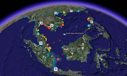
Since then the freely available Google Earth
visitors with an opportunity to interactively
system has been installed by more than 350
access information about the project's partner
million individuals, drawing more installations
network, explore the project's suite of habitat
than Microsoft's Windows XP operating system.
demonstration sites, and access information and
It is available in 14 different languages, and
data for more than 135 mangrove, coral reef,
includes sub-metre high resolution satellite
seagrass, and wetland sites studied during the
images for 30 percent of the world's land surface
project. The description bubbles developed for
and 50 percent of the world's population. It is
each site also contain links to key project
now a widely used feature of the Internet, and
information resources, e.g., publications relating
has been developed by Google to enable non-IT
to the project's scientific and project
specialists to use the system as a Geographical
management innovations. The key to this
Information System (GIS) by integrating
initiative has been putting project information
placemarks, textual descriptions, images, video,
and outputs together with 3-dimensional satellite
and 3D models into the global GIS. These
images and Google Earth's rich information
features coupled with the interactive 3-
base. This enables website visitors to view
dimensional Google Earth browser, led to the
project information in the context of information
selection of the platform as a tool to provide
relating to nearby cities and coastal
website visitors with a more engaging overview
communities, local terrain, proximity to other
of project interventions, outputs, and
projects, and the enormity of environmental
achievements.
issues facing the South China Sea.
2. Development of a Project Layer for Google
3. Unanticipated Outcomes of the Google Earth
Earth
Initiative
The development of the Google Earth project
layer resulted in several unanticipated
outcomes. The first and perhaps most beneficial
in terms of outreach was the selection of the
SCS project layer by Google for inclusion in the
Google Earth Outreach Showcase3 in February
2008. The Google Earth Outreach programme
was launched in June 2007 to provide non-profit
and public benefit organisations with the
knowledge and resources required to put the
hundreds of millions of Google Earth users into
contact with their work. The addition of the SCS
Development of content for viewing on Google
project layer to the Google showcase was
Earth has been simplified through the creation of
supported by the posting of a news item on the
the Keyhole Mark-up Language (KML) by
project in the official online Google Earth news4.
Google. Based on the Extensible Mark-up
This news item highlighted the layer as "a great
Language (XML) known by most web
example of how to connect with a wide
developers, KML enables the setting of variables
audience", and was widely syndicated across
(e.g. latitudes/longitudes and altitude) which
the Internet.
dictate how content is displayed on Google
Earth maps. The KML coding language was
The SCS project was featured as the most
developed to be sufficiently flexible such that
recent entry to the Google Earth Outreach
pure HTML webpage code can be embedded
Showcase for more than one month during the
within it. This feature enables the creation of
first quarter of 2008, and was one of the six
files which combine the interactivity with Google
Google Earth layers featured on the showcase
Earth provided by KML with well crafted HTML
homepage for much of the second quarter of
web pages or "description bubbles" for individual
2008. Similarly a notice posted in the
sites or an entire layer of sites for viewing within
the Google Earth browser.
3
This technology was used to create an extensive
http://earth.google.com/outreach/kml_entry.html#tSou
layer for the SCS project for viewing within
th China Sea Project
4
Google Earth. The layer provides website
http://google-latlong.blogspot.com/2008/02/south-
china-sea-project.html
6
environment section of the Google Earth e-
access to it and raising awareness of its
forum highlighting the SCS project layer
existence at both the project and global level.
received more than 27,000 views within one
week of its posting. This coupled with the wide
Need for Content Rich and Search Engine
syndication of the Google news item on the SCS
Friendly Websites
project led to a marked increase in the number
of visitors to the project website. Website usage
Despite minimal promotion of the SCS project
data compiled for the period 1st April � 30th June
and outputs at the Implementing Agency level, it
2008 (260,912 visits) indicate that 5 times more
has been demonstrated that it is possible for
individuals visited the website compared to the
individual GEF projects to connect with a global
same period in 2007 (53,566 visits).
audience by (a) improving the online visibility of
their websites and (b) via the development of
A recent positive impact of this has been that a
tools that enable Internet users to interact with
couple based in the United States accessed the
project information in an intuitive and engaging
project website via Google Earth and have
manner. The former was largely achieved in the
subsequently requested their friends and family
SCS project by improving the structure of the
to make donations to coral reef related activities
project website and by ensuring the systematic
of the SCS project in Thailand rather than buy
and regular uploading of content and project
gifts for their upcoming wedding. It was
outputs. This strategy enabled the ranking of the
subsequently agreed that donations would be
project website on a Google search of the terms
made directly to Thailand's Mu Koh Chang
"South China Sea" to jump more than 100
Habitat Demonstration Site and it is anticipated
places from 2006 � 2007, such that the website
that funding of up to US$5,000 will be
has ranked in the top 10 of more than 8 million
contributed to the project as a result of this.
pages indexed by Google for the South China
Sea continuously since then. This has led to a
The Google Earth layer has also subsequently
large and increasing number of visitors
been embedded into the SCS project website
accessing the website via key search engines.
and it is anticipated that this will act as the
regional GIS database for the South China Sea
Harnessing the Power of Google Earth
during the period of Strategic Action Programme
(SAP) implementation <http://gis.unepscs.org>.
Greatest outreach success has been gained by
This has provided a cost-effective means of
linking the project website with the global
filling a long term need of the SCS project, i.e.,
geographical search engine, Google Earth. It is
an interactive and intuitive GIS that can be
unlikely however, that the SCS project's layer on
easily accessed and updated by project partners
Google Earth would have received the same
online via the project website.
level of recognition by Google or level of interest
by its large community of users if it was not
RESULTS AND LEARNING
backed by the content rich SCS project website.
It is apparent that Google Earth is a highly
The large number and wide range of outputs
effective outreach tool for GEF projects and
generated through the operation of large multi-
programmes, although the experience of the
lateral, intergovernmental GEF International
SCS project suggests that it should ideally be
Waters projects creates a need for repositories
utilised by a project only following the
that provide for the efficient online storage,
substantive development of its own website.
searching, and download of project outputs. In
Given the large number of Google Earth users,
many cases such outputs will act as inputs to
the establishment of Google Earth layers by
future interventions or as important references in
projects which link to content poor websites
gauging the effectiveness of past and on-going
could possibly have negative outreach impacts
activities. Well designed online repositories of
for the project. A well designed Google Earth
project information and outputs also have
layer featuring the entire International Waters
significant potential in terms of promotion of
portfolio with links to information for each project
GEF and participating country interventions, and
could possibly act as a highly effective "referral
as useful reference material for external
tool" for waters projects. Such a tool currently
organisations in the design and implementation
does not exist and could be a cost-effective way
of projects. Ensuring the continued use of such
of meeting this need, whilst simultaneously
information and data requires facilitating ease of
7
raising global awareness of GEF International
reflects the importance assigned by these
Waters interventions.
organisations to inter-project and inter-agency
information sharing.
Dependence on Effective Communication
Mechanisms
The effectiveness of the IW:LEARN website may
have been improved significantly by the simple
The large number of SCS project outputs, which
addition of prominent links to the IW:LEARN
represent the cornerstone of the SCS project
project from the GEF agency websites, all of
website, and which justify the outreach actions
which experience significantly higher volumes of
of the project, would likely not have been
traffic compared to most individual project
achieved without the effective operation of the
websites. Similarly, it was only through the
unique project management framework
preparation of this note that the scarcity of SCS
developed for the SCS project (see UNEP,
project related information on the UNEP and
2005). The extensive project partner network
UNEP/DGEF websites became apparent. Such
which features the direct involvement of more
"firewalling" of responsibility for information and
than 100 organisations in the execution of
knowledge sharing between those executing
project activities, and more than 400 institutions
and implementing projects appears to restrict
indirectly involved through individual
the level of information exchange required to
participation in meetings and national activities,
maximise global awareness of GEF project
represents numerous entry points to an
interventions.
enormous number of national level sources of
data and information relating to the science and
REPLICATION
management of habitats, fisheries, and land-
based pollution in the South China Sea and Gulf
The potential for replication of the outreach
of Thailand.
initiatives of the SCS project is high, particularly
considering that the outcomes were achieved
The project management framework facilitated
using freely available open-source software. The
the effective flow of information and data
main challenges other projects will face in
between and among all partners. The structure
replicating the activity will likely relate to the
emphasised and fostered networking from the
selection of user-friendly and intuitive
regional to local level, and established strong
information and data management tools, as well
feed back loops between regional, national, and
as the regular development and uploading of
site level entities. This enabled the full range of
content to keep their websites current and
scientific information and data required to
ranked highly by Internet search engines. For
address the issues identified in the
busy Project Co-ordinating Units which are often
Transboundary Diagnostic Analysis for the SCS
staffed with non-IT specialists the latter can at
to be compiled and used as part of the process
first appear daunting. The increasing user-
of revising the regional Strategic Action
friendliness of modern Content Management
Programme for the South China Sea.
System software makes this task easier
Collectively these information and data
although it would likely require decentralisation
achievements of the project are of regional and
of responsibility for the submission of news and
perhaps global significance.
information to project partners within the
participating countries.
Attempts to establish a global network for the
sharing of experiences and knowledge between
Similarly the potential for replicating the Google
International Waters projects have been
Earth initiative of the project is also high. The
implemented as part of the IW:LEARN project.
Google Earth Outreach webpage
The experience of the SCS project is that the
<http://earth.google.com/outreach/tutorials.html>
effectiveness of this system in terms of
contains a wealth of online guides, video
promoting project interventions and
tutorials, and templates to guide first time users
achievements will be limited without increased
through the development and integration of
support in terms of online networking from
project information into Google's global GIS. The
Implementing Agencies. The low profile of and
Google Earth Community
complete lack of links in some instances to the
<http://bbs.keyhole.com>, an online forum with
IW:LEARN website on Implementing Agency
more than 1,000,000 registered users, is
websites is cause for concern, particularly if it
another excellent source of information and
8
guidance for projects wishing to develop their
achievements of the SCS project represent the
own Google Earth layers.
most successful use of Google Earth by a GEF
project to date.
SIGNIFICANCE
The objective of this work was to enhance
The SCS Project Steering Committee noted
awareness of the SCS website and databases,
during its eighth meeting in August 2008 that the
with the aim of contributing to the longer-term
SCS project website provides a rich and
goal of ensuring the continued use of SCS
extremely valuable source of information, data,
project outputs and information resources. The
databases, training materials, models and other
true significance of the work described in this
items of relevance to the South China Sea. This
note will perhaps be best measured at regular
intergovernmental body recommended that
intervals post project, particularly during the
online accessibility to the information resources
period of SAP implementation, when the use of
currently available on the website should be
project information and data can be best
maintained during Strategic Action Programme
measured.
(SAP) implementation, and that re-design of the
website should be undertaken where
REFERENCES
appropriate to facilitate the online sharing of
information with respect to implementation of
UNEP, 2005. Managing Multi-Lateral,
both National Action Plans and the regional
Intergovernmental Projects and
SAP. The Project Steering Committee went
Programmes, the case of the UNEP/GEF
further. They directed that the COBSEA
Project Entitled: "Reversing Environmental
Secretariat, as the permanent regional
Degradation Trends in the South China Sea
intergovernmental body take responsibility for
and Gulf of Thailand". South China Sea
maintaining a South China Sea website,
Knowledge Document No. 1.
encompassing the entirety of the data and
UNEP/GEF/SCS/Inf.1
information generated through the South China
UNEP, 2007. Establishing an Online
Sea project. In doing so they recognised that
Collaborative Information Base in the
these data and information would form an
Context of the UNEP/GEF Project Entitled:
invaluable resource for the countries of the
"Reversing Environmental Degradation
region in implementing the SAP.
Trends in the South China Sea and Gulf of
Thailand". South China Sea Knowledge
The actions of the SCS project to improve ease
Document No. 6. UNEP/GEF/SCS/Inf.6
of access to and general awareness of the SCS
website and its databases will contribute to
KEYWORDS
ensuring that existing information resources are
used by staff of regional and national
Information
organisations concerned with SAP
Data
implementation. This is significant as the vast
Outreach
majority of data and information accessible via
South China Sea
the website was used in setting SAP targets and
Gulf of Thailand
the design of proposed activities, and will act as
a baseline in assessing the effectiveness of
The Global Environment Facility (GEF)
future interventions.
International Waters Experience Notes series
helps the transboundary water management
The technical aspects of this experience do not
(TWM) community share its practical
represent a real innovation of the project, rather
experiences to promote better TWM.
application of successes achieved elsewhere to
Experiences include successful practices,
a GEF project. The technical approaches
approaches, strategies, lessons, methodologies,
adopted by the project and reported on in this
etc., that emerge in the context of TWM.
note represent basic operating practices for
online businesses. Similarly, the Google Earth
To obtain current IW Experience Notes or to
technology has been used successfully by a
contribute your own, please visit
large number of other environment organisations
http://www.iwlearn.net/experience or email
and NGOs involved in waters management. To
info@iwlearn.net.
the best of the author's knowledge however, the
9