UNEP - UNITED NATIONS ENVIRONMENT PROGRAMMME
GEF - GLOBAL ENVIRONMENT FACILITY
MID-TERM EVALUATION REPORT
OF GEF PROJECT (GF/1010-01-05)
"ARGENTINA-BOLIVIA: IMPLEMENTATION OF THE
STRATEGIC ACTION PROGRAM FOR THE
BERMEJO RIVER BINATIONAL BASIN"
Marcelo H. García
Final Report
March 2005
Revised September 2005
1
Table of Contents
1. INTRODUCTION AND BACKGROUND
1.1 Bermejo River Basin and Sediment Related Issues
1.2 Implementation of the Strategic Action Plan
2. MID-TERM EVALUATION PROCEDURE
3. MAJOR PROVISIONS OF THE PROJECT DOCUMENT
3.1 Project Goals
3.2 Project Components:
Deleted: 
3.2.1 Component 1: Institutional Development.
Formatted: Bullets and Numbering
3.2.2 Component 2: Environmental Protection and Rehabilitation.
Deleted: 
Deleted: 
3.2.3 Component 3: Sustainable Development of Natural Resources
Deleted: 
3.2.4 Component 4: Public Awareness, Participation, and Replication of Project
Deleted: 
Activities
Deleted: .
Deleted: 
4. CURRENT STATUS OF THE PROJECT
5.
PROJECT PERFORMANCE TO DATE
5.1 Evaluation of Project Components in the Context of the ProDoc Workplan
Deleted: 
5.2 Project Components
5.2.1 Component 1: Institutional Development
5.2.1.1 Development and Strengthening of the Institutional Framework
5.2.1.2 Development of a Legislative, Economic, and Environmental
Framework
5.2.2 Component 2: Environmental Protection and Rehabilitation
5.2.2.1 Soil Management and Erosion Control in Critical Areas
5.2.2.2 Consolidating Protected Areas and Protecting Biodiversity
5.2.2.3 Protection and Restoration of Water Quality
5.2.3. Component 3: Sustainable Development of Natural Resources
5.2.3.1 Implementation of Planning Framework for Integrated Water
Resource Management and Sustainable Development
5.2.3.2 Sustainable Practices for Rehabilitation of Degraded Areas in the
Chaco and Yungas Regions
5.2.3.3 Community Extension Programs for Sustainable Production and
Natural- Resource Management
2
5.2.3.4 Sustainable Agriculture and Soil Conservation Practices along the
San Jacinto Project Area
5.2.3.5 Securing of Financial Resources for the Bermejo River Basin
5.2.4 Component 4: Public Awareness, Participation, and Replication of
Deleted: 
Activities
5.3. Project Enhancement beyond ProDoc Provisions
Deleted: 
Deleted: .
6. SUMMARY OF ACHIEVEMENTS AND PROGRESS TOWARDS OVERALL
Deleted: 
PROJECT OBJECTIVES
7. OVERALL CONCLUSIONS AND RECOMMENDATIONS
8. LIST OF ANNEXES
9. RATING OF PROJECT SUCCESS TO DATE
10. SUSTAINABILITY
11. REPLICABILITY
12. OVERALL EFFECTIVENESS OF PROJECT COORDINATION AND
MANAGEMENT
13. APPROPRIATENESS OF OVERALL COSTS OF PROJECT
COORDINATION/MANAGEMENT IN RELATION TO COSTS OF
SUBSTANTIVE ACTIVITIES
14. REFERENCES
ANNEX 1
ANNEX 2
3
4
1.
INTRODUCTION
1.1. Bermejo River Basin and Sediment Related Issues
The binational basin of the Bermejo River covers an area of about 123,000 km˛. The river
rises in the Andes Mountains in northwestern Argentina and southern Bolivia and flows for
some 1,300 km across the vast Chaco Plains serving as an important ecological corridor
linking the Andes Mountains with the Atlantic Ocean. The Upper Bermejo Basin (50,000
km˛) is shared by Argentina and Bolivia while the Lower Bermejo Basin (73,000 km˛) lies
entirely within Argentina. The basin comprises three major features: the Eastern Cordillera of
the Andes with altitudes of between 3,000 and 4,600 m above sea level; the Sub-Andean
Ridge that runs north-south at altitudes of around 2,000 m; and, finally, the Chaco Plain lying
between 200 and 400 m above mean sea level. The population of the basin is of the order of
1,200,000 inhabitants.
This river system contributes the largest amount of Andean sediments to the Paraguay-
Parana-LaPlata River system and plays a major role in the ecological and morphological
dynamics of the Parana River, including its floodplains and delta, and the La Plata River,
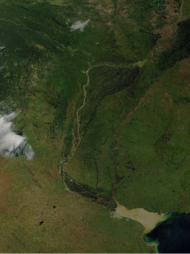
which, on average, receives more than 100 million tonnes of sediment annually (Figure 1).
Most of the suspended sediment reaching the estuary of the La Plata River and the Atlantic
Ocean originates in the Bermejo River basin (Amsler and Prendes, 2000).
Figure 1. Satellite image of La Plata River Basin showing suspended sediments largely derived from the
Bermejo River
Sediment loads contributed by the Bermejo River basin are among the largest in the world.
Rivers can transport sediment in suspension, via turbulence, or as bedload along the bottom
and stream banks (Garcia, 1999). The sediment transported in suspension consists of: (a) bed
5
material, mainly fine sand and silt resuspended from the bottom; and (b) fine material, mainly
clay commonly known as "washload." The amount of fine sediment transported in suspension
by a river as washload does not depend on the sediment transport capacity of the river but is
rather a function of how much fine sediment a given watershed will yield. There is a strong
correlation between watershed soil erosion and the washload conveyed by a river system.
However, not all the sediment eroded in a watershed ends up in the river, so a distinction
needs to be made between watershed sediment erosion and downstream sediment yield
(Walling, 1989). In the case of the Bermejo River, the washload is extremely large (to be
exact more than 100 million tonnes per year) and constitutes the main source of sediment to
the Parana-La Plata River system (Alarcón et al., 2003). Even though the flow discharge of
Formatted
the Bermejo River is very small when compared with other rivers in the La Plata River Basin,
its sediment load is several orders of magnitude larger than those of the Paraguay and Upper
Parana Rivers. For example, in the Middle Parana River, the Bermejo River contributes only
5% of the liquid flow discharge but about 95% of the suspended sediment discharge (Alarcón
et al., 2003). Every year, tens of millions of dollars go into dredging and maintenance of
harbours and navigational waterways along the Paraná River. It should be clear that even a
modest reduction on the amount of sediment produced and delivered by the Bermejo River
basin could have a socio-economic impact on the Paraná-La Plata River system. Even if the
erosion of sediment cannot be reduced in the upper watershed, sediment management along
the Lower Bermejo, for instance with permeable dikes, could have a double benefit by
making the course of the river more stable and reducing the amount of sediment delivered to
the Paraguay river during floods.
Many environmental and water management issues within the Bermejo River basin are also
related to the dynamics of sediments, including erosion, transportation and deposition and the
resulting river morphology and planform geometry. For example, in the Lower Bermejo
Basin, close to the town of Laguna Yema in Formosa, Argentina, the lateral migration of the
river channel makes it practically impossible to have a reliable continuous source of water for
both human consumption and the irrigation of agricultural land. In the Upper Bermejo basin,
the San Jacinto Reservoir near Tarija, Bolivia, is steadily filling up with sediments thus
reducing its capacity for storing water, a fact that has motivated the Tolomosa and Mena
River projects for sediment control. These two examples show the need to assess
sedimentation processes within the Bermejo River basin for the benefit of sustainable water
management and land use.
Understanding the hydrologic, sedimentologic and ecologic balance of the Bermejo River
basin has the potential to provide more widespread benefits, such as in the case of the
upcoming UNEP-OAS-GEF Plata River Basin Programme. Only the river basins of China
and Nepal have rates of sediment erosion and yield comparable to those observed in the
Bermejo River basin, making it a rather unique river system on the American continent.
There are two further aspects that make the Bermejo River basin different from those of
similar river systems around the world. First, the population of the watershed is rather small
and, second, the extent of environmental degradation can still be reduced or curtailed with the
introduction of appropriate measures. Thus there is a unique opportunity for sustainable river
basin management in the region, which in other parts of the world can no longer be achieved
since the degree of environmental degradation has extended beyond critical levels (UNESCO,
1999).
Deleted: 
6
1.2. Implementation of the Strategic Action Plan (SAP)
In 1995, the governments of Argentina and Bolivia established the Binational Commission for
the Development of the Bermejo and Tarija River Basins (COBINABE). With support from
the GEF, UNEP, the OAS and a number of regional agencies, a Transboundary Diagnostic
Analysis (TDA) was prepared as the basis for the formulation of a Strategic Action
Programme (SAP). The first phase of the project comprised the formulation of the SAP and
was undertaken between August 1997 and June 2000.
The TDA identified six priority areas relating to the conservation, rehabilitation and
preservation of the basin's ecosystems:
I.
Soil degradation, intense erosion and desertification;
II.
Water shortages and limited availability;
III.
Degradation of water quality;
IV.
Habitat destruction, loss of biodiversity and the deterioration of terrestrial and
aquatic resources;
V.
Losses from flooding and other natural disasters; and
VI.
Deteriorating living conditions among the inhabitants of the basin and the loss of
cultural resources.
On the basis of an extensive process of public consultation, a long-term action plan was
prepared that was designed to not only to attack the fundamental causes of the critical
environmental degradation affecting the basin, but also to promote sustainable development
for communities in the region. This second phase was directed towards the implementation of
the SAP and included four groups of priority activities that constitute the four components of
the current project phase:
I. Institutional strengthening and the development of an effective legal and
institutional framework for integrated planning and management of water
resources;
II. Protection and rehabilitation of the environment;
Deleted: 
III. Sustainable development of natural resources; and
Deleted: 
IV. Promoting public awareness and participation and replicating project activities in
Deleted: 
other regions of the La Plata River basin.
For each of these four broad components, there are a number of sub-projects (a total of 34)
that are being implemented by various executing agencies, including consultants, universities,
government agencies and NGOs. The SAP project coordination unit has offices in both
countries (Tarija and Buenos Aires) and, on the Argentinean side, there is now a local office
in the city of Salta. There are technical teams in each of the countries responsible for
planning, outsourcing and supervising the execution of the sub-projects.
The Bermejo SAP project has an estimated cost of US $19.77 million1 and a duration of about
4.5 years (June 2001 - November 2005), which means that the project is now well past its
midpoint.
1 Of which the GEF is contributing $11.04 million, the governments $8.43 million, and the UNEP and OAS the
remaining $0.30 million.
7
This report presents the mid-term evaluation of the Bermejo River SAP Project as specified in
the ProDoc.
2.
MID-TERM EVALUATION PROCEDURE
Deleted: 
Formatted: Bullets and Numbering
This mid-term evaluation follows the terms of reference (TOR) provided by UNEP, the
guidance provided by the evaluation Team Leader, J Michael Bewers, and basic
considerations agreed upon during the evaluators' meeting held in Brasilia in October 2004.
For the purposes of this mid-term evaluation, several documents were reviewed. These
documents were provided by UNEP, OAS, GEF, the Regional Commission for the Rio
Bermejo (COREBE) and the Binational Commission for the Development of the Upper
Bermejo River and Grande de Tarija River Basins (COBINABE).
These documents included the following:
The Project Document (ProDoc) for the Bermejo Project;
Deleted: 
The Transboundary Diagnostic Analysis (TDA);
The Strategic Action Program for the Bermejo River Basin (SAP);
Financial
Reports;
Consultants´
Reports;
and
Documents from workshops (on topics such as risk management, hydrometeorological
network, etc.)
In order to conduct a more effective mid-term evaluation, a field mission was undertaken to
permit visits to several demonstration sites and to interview relevant actors involved in the
activities developed within the project. The field mission took place from December 6 to
December 17, 2004.
Several meetings with the technical teams and consultants from both countries took place in
Buenos Aires, Salta and Tarija. A list of all the persons met during the mission is given in
Annex 1.
More than 30 PowerPoint presentations were provided by technical teams, consultants,
NGOs, and local groups (e.g., Women of Tilcara).
Several field trips were conducted to observe directly the progress of different erosion and
sediment control works at strategic points in the watershed as well as other projects being
conducted within the framework of the SAP such as the Hydrometeorological Network.
These included visits to the following locations.
1) Tilcara, Argentina: Plant Nursery, Piedmont Erosion Control Works, Land
Deleted: 
Management Plan, activities of the Women of Tilcara, etc. on the Huasamayo River.
2) Iruya, Argentina: Construction of River-Bed Control Structures, Bank-Erosion
Protection Structures, Waste Treatment System, Rain Water Drainage System,
Irrigation Canals, School, etc. on the Iruya River.
3) Hydrometeorological Stations on the Bermejo and Rio Grande de Tarija Rivers,
Argentina-Bolivia.
8
4) Calderas, Bolivia: Sediment Control in the Santa Ana River basin.
5) Santa Ana, Bolivia: San Jacinto Reservoir and Irrigation System.
6) Churquis and Pampa Redonda, Bolivia: Sediment Control in Tolomosa-Mena River
Basins.
7) Tarija, Bolivia: Construction of building for COBINABE.
8) San Lorenzo, Bolivia: Environmental Cleanup of the Guadalquivir River.
Two workshops were being conducted at the time of the field mission. The first workshop
was given by consultants (EVARSA) at the COREBE office in the city of Salta to train
technicians from government agencies in the operation of the Hydrometeorological Network
implemented as part of the SAP. The second workshop, on Flood Risk Management, was
held at the school of Iruya and was organized by the Civil Protection Division of the Province
of Salta, under the auspices of the Bermejo SAP project. People participating in both
workshops were informally interviewed to gather their opinions about the workshops in
general as well as the quality of the presentations.
3.
MAJOR PROVISIONS OF THE PROJECT DOCUMENT
Deleted: 
3.1. Project Goals
Formatted: Bullets and Numbering
The primary objectives of this GEF International Waters project are to assist the governments
of Argentina and Bolivia in addressing the root causes of the principal environmental
problems affecting the Bermejo River basin with a focus on their main transboundary
manifestations - namely, sediment erosion, transport, and deposition - and to promote the
sustainable development of the Bermejo River Binational Basin (BRBB).
Activities for the control of land degradation caused by agricultural activities, the prevention
of erosion, and sediment control (including: the creation, restoration and protection of natural
vegetated areas; the conservation of aquatic and terrestrial habitat; support for popular
participation in the management of natural resources through improved access to information
and enhancement of public awareness; and the control of water-borne contaminants) have
been selected in order to catalyze the implementation of specific actions as recommended in
the formulation of the SAP.
3.2. Project Components:
Formatted: Bullets and Numbering
The proposed project activities are designed to catalyze the implementation of actions
necessary to address the root causes of priority transboundary problems identified during SAP
formulation with primary focus on soil degradation and sediment transport. The project
activities are designed to implement an integrated programme of river basin management in
the BRBB and are concentrated in four principal components outlined below.
3.2.1. Component 1: Institutional Development and Strengthening for Integrated Water
Resources Planning and Management
Deleted: .
This component was designed to provide a broadly-based, participatory and institutional
framework. This includes developing and strengthening the legal basis underlying the
regulation, planning, and environmental and social evaluation, environmental zoning, and
economic and financial arrangements that are indispensable for effectively implementing
9
sustainable measures for prevention, restoration, planning, and development of the natural
resources identified in the SAP.
3.2.2. Component 2: Environmental Protection and Rehabilitation
This component was designed to extend the implementation of feasible measures of basin
management identified during the formulation of the SAP. The activities programmed for this
component address specific transboundary aspects identified in the TDA. In particular,
planned actions focus on soil management and sediment transport control, either by means of
feasible specific prevention and control measures or by preserving the natural landscape in
critical, erosionprone areas through the consolidation of protected areas. Complementary
basic natural resource studies and the maintenance of the quality of the basin's water
resources are parts are included in this component.
3.2.3. Component 3: Sustainable Development of Water Resources
This component encourages the implementation of alternative production modes that are
environmentally friendly or that, at the least, minimize environmental degradation, especially
land degradation and soil erosion, while at the same time providing greater economic
opportunities for local populations in a context of integrated management of water resources
and sustainable development planning for the basin as a whole.
3.2.4. Component 4: Public Awareness, Participation and Replication of the Project
Deleted: 
Activities
This component embraces activities to identify and coordinate the interests of people and
organizations with economic and/or institutional responsibilities in the basin, including those
within the agricultural and private industrial sectors. A central theme of this component is to
inform the citizenry, including corporate entities, within the basin through an integrated
programme of environmental education, institutional transparency and the exchange of
information among communities, organizations, and government agencies. In this component,
actions are considered for sharing experience and promoting international and regional
cooperation aimed at identifying mechanisms that will enhance positive synergies at the
broader level within the Plata River basin.
4.
CURRENT STATUS OF PROJECT
Deleted: 
This project was intended to be executed in 4.5 years with a commencement date of June
Formatted: Bullets and Numbering
2001 and completion date of November 2005. Most of the project components have made
steady progress towards meeting their goals and it is expected that the SAP implementation
project can be completed as planned. However, because of the nature of some activities, a
few sub-projects will most likely need more time to achieve their objectives. For instance,
Deleted: 
more time will be needed to observe and to monitor the performance and impact of certain
activities. This is definitely true in the case of structural and non-structural approaches to
erosion and sedimentation control because both hydrologic and sedimentological time scales
are rather long when compared with the lifetime of the project.
Basin stakeholders visualize this project as a "short-term" SAP that has the potential to serve
as a catalyst for the preparation of a much larger "long-term" SAP for the Bermejo River
Binational Basin. Because of the characteristics of the Bermejo River basin and its relevance
to the region, it is apparent that the only way to establish an integrated and sustainable river
10
basin management programme will be over many years of work. The current implementation
of the SAP provides a good foundation for the development of a longer-term SAP.
Deleted: 
5.
PROJECT PERFORMANCE TO DATE
5.1. Evaluation of Project Components in the Context of the ProDoc Workplan
The mid-term evaluation for the project components in the context of the ProDoc are based on
the information provided in Section 2 above. Each component of the project is evaluated
separately for consistency with the ProDoc.
5.2. Evaluation of Project Components
5.2.1. Institutional Development and Strengthening
Institutional strengthening is one of the most important aspects of this project. Changes in
government usually wreak havoc in programmes like this one, it is therefore important to
ensure that, despite political changes, SAP implementation will continue to move forward. A
good deal of effort has gone into the strengthening of the Comisión Binacional del Río
Bermejo and Rio Grande de Tarija (COBINABE) and the Comisión Regional del Río
Bermejo (COREBE).
Since January 2001, COBINABE has signed more than 30 agreements for collaboration with
government agencies, universities and NGOs within the framework of the SAP. A list of all
the agreements and the institutions and agencies involved is given in Annex 2.
A basin-wide Hydrometeorological Network (HN) has been implemented consisting of 12
sub-stations. The network will collect meteorological (precipitation, temperature, humidity,
etc.) and river flow (discharge, water elevation) data on a continuous basis. It will have two
operational centers, one in Tarija, Bolivia and the other in Oran, Salta.
COBINABE has now an office in the city of Salta and COREBE has representatives in all the
provinces in the basin. This is an important initiative because it has augmented the
operational capacity and has centralized many activities closer to the area where the sub-
projects take place. The Salta office will house the database for the Hydrometeorological
Network. It will also, in the future, serve as the centre from which the Civil Protection
Division of Salta will issue flood warnings.
A new building is also being constructed in Tarija, Bolivia, for the Oficina Tecnica Nacional
(OTN) that will be shared with the Pilcomayo River Basin Technical Office (PNUMA 2200).
This is relevant as the Bermejo and Pilcomayo River Basins share many similarities making it
possible to optimize the use of resources (computer centre, field equipment, demonstration
projects, etc.). As stated above, one of the operational centers for the Hydrometereological
Network will be located in the new OTN.
Two water quality laboratories have also been created, one in Chaco, Argentina, and the
second in Tarija, Bolivia (PNUMA 2202). Given that water quality is a major issue, both
laboratories will be providing a very important service to the inhabitants of the region while
11
generating an important benchmark database on water quality that will be very useful for
future project evaluations.
The international nature of the SAP for the Bermejo has facilitated the interaction between
the Governments of Argentina and Bolivia. There is evidence that Bermejo SAP project is
being used to discuss the role of government and potential legislation to satisfy the goals of
the SAP. The development of a Regional Coordination Committee, a Regional Steering
Deleted: 
Commission and an Inter Ministry Committee has strengthened the actions of the SAP and
other organizations within the basin.
Recently, the Governments of Argentina and Bolivia, motivated by trade negotiations about
natural gas, have declared their mutual interest in going ahead with the construction of one
three planned large dams near the border between both countries. This has created even more
interest in the activities conducted within the project and has brought more visibility to
COBINABE. However a word of caution is necessary here. Due to the high sediment loads
Formatted
in the Bermejo watershed the useful life of a reservoir can be drastically reduced, rendering
the impoundment useless in just a few years of operation. Thus before an investment of such
Formatted
magnitude is made to construct a dam, a very thorough sedimentation analysis should be
conducted to assess the potential sedimentation of the reservoir (Garcia, 1999).
Formatted
5.2.2. Environmental Protection and Rehabilitation
5.2.2.1. Soil Management and Erosion Control in Critical Areas
Sedimentation basins have been built to trap sediments in the watershed of the Santa Ana
River, Bolivia (PNUMA 2208). They have been quite efficient in capturing substantial
amounts of debris and sediment (see Figure 2). At the same time, these small impoundments
have provided much-needed water to the local people for irrigation of crops and livestock. As
the basins fill up with sediment, the local peasants use them as agricultural plots. This
activity increases the protection of the soil against further erosion.
In the Tolomosa (Mena sub-basin) River Basin, a number of low-head dams have been built
with gabions having the goal of curtailing sediment erosion and preventing the silting of the
San Jacinto Reservoir (PNUMA 2207). During an intense rainfall event that took place
during the site visit, the dams were observed to perform quite well. The water impounded by
the dams is also being used for irrigation of crops in areas were water is extremely scarce.
12
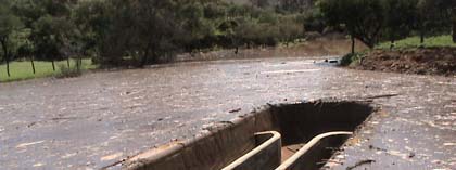
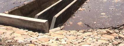
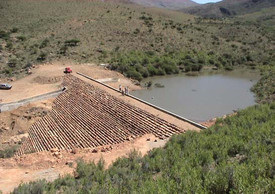
Figure 2. Sedimentation Basin in the Santa Ana River Basin, Calderas, Bolivia
Figure 3. Sedimentation Basin in the Santa Ana River Basin, Calderas, Bolivia
The rates of soil erosion in this region are amongst the highest in the world. Accordingly, the
sediment erosion control measures implemented so far can be considered a success.
Several activities are also underway in the Iruya River basin as part of the SAP
implementation (PNUMA 2209). Here the situation is more complicated because erosion by
the Milmahuasi River is endangering a large number of houses perched atop of one of its
margins (Figure 4). The city of Iruya is located at the confluence of the Milmahuasi and the
Colanzuli Rivers. Taking advantage of a geological hardpoint (fulcrum), a control structure
(rock water fall) is being built to prevent further lowering of the riverbed along the
Milmahuasi. Riverbed sills and streambank protection structures have also been built along
the Colanzuli River following the recommendations of an Italian expert (Filippi-Gilli, 2002).
While the activities conducted under the SAP project are helping, it is clear that a lot more
13
work is needed in Iruya before the situation can be considered under control. For instance,
the drainage of rainwater from houses and streets in the city promotes the erosion of soil
where the city stands. This needs immediate attention before matters get worse. A large
portion of the city, previously used for agricultural land, has already been scoured away by
the combined erosive action of the Milmahuasi and Colanzuli Rivers. This erosive process
will continue its course, eventually endangering the whole town of Iruya and its people.
Fig. 4. Upstream view of Milmahuasi River (Iruya). Notice houses perched atop the right margin of the river
The city of Tilcara, Jujuy, has erosion and sedimentation problems as a consequence of its
location on an alluvial fan. It sits at the confluence of the Grande and Huasamayo Rivers. As
part of the SAP project, several erosion prevention measures have been implemented. They
include reforestation of eroded areas and construction of erosion control structures (see Figure
5). While the structures have been built correctly, population growth has been such that in the
case of an extreme hydrologic event, these structures will capture sediment but flooding will
be unavoidable because people have been building houses right next to, or downstream of, the
erosion control installations.
Urban planning is a major issue in Tilcara with many conflicting interests at play. Land use
should go hand-in-hand with soil erosion and flood control measures given that the city is
located on an alluvial fan. To make matters worse, the bed of the Huasamayo River is
progressively aggrading so that, before too long, the mean ground elevation of some areas in
Tilcara could very well be below the riverbed elevation. This could be a disaster during a
major flood and the topic needs immediate attention as the number of tourists as well as the
local population continues to increase. Several land use plans have been made by
universities and NGOs. However no consensus seems to be within reach. Local grass roots
efforts (e.g., by the Women of Tilcara) seem to be the most effective way to get input and
help from the local population (PNUMA 2202).
One of the most positive activities taking place within the project in Tilcara is the tree and
plant nursery project (PNUMA 2210). This project involves the participation of several
members of the community and has a very important educational component. The plants and
14
trees are transplanted and used to reduce soil erosion in Tilcara, Iruya, and at other locations
throughout the watershed. Produce from the vegetable garden is used to feed low-income
families and more than one hundred children every day at the dining rooms tended for by
women volunteers adjacent to the nursery.
Figure 5. Piedmont erosion control structures in Tilcara, Jujuy
Deleted: .
5.2.2.2. Consolidating Protected Areas and Protecting Biodiversity
The consolidation of the Ecologic Corridor Tariquia-Baritu-Tariquia can be considered as one
of the main milestones of SAP-Bermejo project (PNUMA 2214). This is a high visibility
project that allows for the participation of government agencies, local communities and
NGOs.
Ecotourism is being explored along the piedmont of the National Parks of Calilegua and El
Rey (PNUMA 2211). Questions remain as to the infrastructure requirements for such a
growing industry. Excellent progress has also been made with the Yungas project in the
provinces of Salta and Jujuy as well as the Biological Reserve of Sama in Bolivia (PNUMA
2215). The biodiversity of these areas is globally unique and they must be protected at all
costs. The Yungas project has already attracted financial help from several national and
international agencies, including the French Government. The fact that the ProYungas
Foundation has worked in the area for more than a decade has had an important positive
influence on this SAP project component.
The Presidents of Argentina and Bolivia have expressed their full support for the
Transboundary Biological Reserve of the Yungas (PNUMA 2214) and have declared this
project of binational importance.
A plan for the preservation and management of the Biological Reserve of Sama, Bolivia, has
been formulated and approved (PNUMA 2215). A study of biodiversity on the Bolivian side
of the Bermejo River basin is also making steady progress (PNUMA 2213). A demonstration
project on the fixation of carbon in the sub-Andean region is its design phase (PNUMA
2212).
15
5.2.2.3. Protection and Restoration of Water Quality
Pilot water treatment plants have been installed in rural communities near the town of
Tomatitas, Bolivia, with the goal of cleaning-up the Guadalquivir River (PNUMA 2218). The
water treatment system includes a system of trenches in the ground coupled with irrigation
canals. So far, the clean-up effort has been very effective. The Guadalquivir River affords
many recreational opportunities to the citizens of Tarija and its surroundings. This
environmental clean-up effort has great potential for replication in many small rural
communities throughout the Bermejo River basin.
There is a clear need for the project to finalize the assessment and design phase and to move
ahead with the construction of water pollution control facilities in the area of the Bermejo
Triangle, where currently all the waste water, both human and industrial, goes into the
Bermejo and Rio Grande de Tarija Rivers without undergoing any type of treatment
(PNUMA 2219).
The city of Iruya has successfully implemented a solid waste treatment system just outside the
town that indirectly helps in improving water quality in the town (PNUMA 2209). The town
has its own small water treatment system for treating water prior to its release to the Colanzuli
River. No chlorination of the treated water seems to be taking place at this time so there still
remains some level of biological contamination. This could pose risks to small communities
downstream of Iruya that may be using river water for human consumption.
5.2.3. Sustainable Development of Natural Resources
5.2.3.1. Implementation of Planning Framework for Integrated Water Resource
Management and Sustainable Development
Formulation and development of an Integrated Water Resource Management and Sustainable
Development Plan (IWRMP) constitutes one of the biggest challenges for the SAP project.
While progress has been made in terms of information gathering and dissemination, studies,
analyses, sharing of experience and demonstrations, it is fair to say that the implementation of
an IWRMP in the Bermejo River is still in its early stages. The implementation of such an
important framework for decision-making should be given high priority at this stage.
However, this undertaking hinges on the development of most of the activities under the SAP
project, particularly institutional strengthening, so it can be expected that an integral plan
might not be produced prior to the completion of the project.
5.2.3.2. Sustainable Practices for Rehabilitation of Degraded Areas in the Chaco and
Yungas Regions
The ProYungas Foundation has leveraged the support from the SAP project (PNUMA 2222)
and from other programmes to develop a project geared towards: a) strengthening community
organizations (e.g., mothers clubs and producers groups); b) sustainable agricultural
production (community plant nurseries, fruit cultivation, irrigation systems, apiculture,
forestation, etc.); c) production and commercialization of local artwork (i.e., artesanias); and
d) participation of local and native communities.
16
A great deal of effort has also gone into helping rural communities, including the Wichi
Indians, along the Chaco region of Salta (PNUMA 2224). This area presents some unique
challenges but progress is being made mainly through the education of children at Technical
School No 29 "Justo Pastor Santa Cruz". The main objective here is to improve the living
conditions of the native people and to ensure that these remote communities can become self-
sustaining through sustainable agricultural practices, including swine production and the
exploitation of unique forest products such as the Algarrobo that yields one of the most
popular woods for furniture making. Harsh climatic conditions make working conditions
very difficult in this region of the Bermejo River Basin. Water is a precious commodity here
and, when it rains, sediment erosion is exacerbated by the lack of vegetative cover.
5.2.3.3. Community Extension Programmes for Sustainable Production and Natural
Resource Management
This is an area where progress is being made by encouraging families in various communities
to get involved in different activities. For instance, the ProYungas Foundation (PNUMA
2222) reports that, in the field of agricultural production, the degree of family participation is
comparatively high (Lipeo 100%, Baritú 100%, Los Toldos 37%, Los Naranjos 100%, San
Andrés 15%).
5.2.3.4.Sustainable Agriculture and Soil Conservation Practices along the San Jacinto
Project Area
The design phase of this component has been completed (PNUMA 2225). Irrigation canals,
as well as erosion control structures, will be built. Demonstration projects will be set up in 5-
hectare land parcels. Local communities are very enthused with this project since it gives
them an opportunity to become self-sufficient.
5.2.3.5. Securing Financial Resources for Bermejo River Basin Management
Non-reimbursable loans from the Comision Andina de Fomento (CAF) have been negotiated
by COBINABE. The ProYungas Foundation has obtained additional support for its activities
within the framework of the SAP from the French Government.
The Prefecture of Tarija will invest U$S 12,000,000 in infrastructure for the environmental
cleanup of the Guadalquivir River (PNUMA 2218). The Prefecture has also expressed
Deleted: -
interest in supporting other projects within the SAP. There are several other projects (e.g.,
irrigation of calderas and flood protection of Tarija) that have a good chance of receiving
additional financial support.
5.2.4. Public Awareness, Participation and Replication of Activities
Public awareness has been a trademark of the project since the very formulation of the
Bermejo SAP project. This continues to be the case with the assistance of workshops,
seminars and presentations (PNUMA 2228). A sticker with the legend "Soy tu rio (Bermejo),
cuidame" helps the COBINABE in spreading the word about the Bermejo River and its
relevance to the inhabitants of the basin.
17
A programme of Environmental Education has been designed in collaboration with the
University "Juan Misael Saracho" in Bolivia (PNUMA 2227). When approved by the
Ministry of Education, this will be the first programme of its kind in Bolivia.
An excellent teaching manual for elementary school teachers about the Bermejo River
watershed was also produced under the implementation of the SAP project (PNUMA 2227).
This publication is unique for it introduces young readers to water management issues within
the Bermejo River Basin. More than 3,000 copies have been distributed.
The educational component of the Bermejo SAP project has great potential for replication in
other watersheds of Latin America. It should become a model of how to generate
environmental awareness among people of all ages (PNUMA 2228).
A school has been built in Colanzuli, with partial support from the SAP project. This
construction includes a water supply system that is shared with local agricultural producers.
The implementation of the Hydrometerorological Network, consisting of pluviometers and
streamflow gauges, among other instruments, has been completed (PNUMA 2231). An alert
system for flooding is currently undergoing testing. This network forms part of a basin-wide
information system for water resources management being implemented as part of the project.
5.3. Project Enhancement Beyond ProDoc Provisions
An interesting initiative between Argentina, Bolivia and Paraguay has added a new dimension
to the Bermejo project that was not considered in the ProDoc provisions. This is the Yrendá-
Toba-Tarijeńo Aquifer, which covers an area of about 300,000 square kilometers. Until
recently, most of the efforts were focused only on surface water resources. With this new
initiative, groundwater resources will also receive much needed attention. At the same time,
the global benefits of the Bermejo SAP project will become more apparent as the neighboring
Pilcomayo River basin shares similar issues. Resources will now be shared more equitably
between COBINABE and the Trinational Comisión of the Pilcomayo River thanks to the
attention to the Acuífero Yrendá-Toba-Tarijeńo. The European Union is also involved in this
undertaking. Both groups will be housed in the same building currently under construction in
Tarija, Bolivia.No other obvious enhancements beyond those stipulated in the ProDoc were
Deleted: 
observed as part of the MidTerm review.
6. SUMMARY OF ACHIEVEMENTS AND PROGRESS TOWARDS OVERALL
PROJECT OBJECTIVES
Achievements and progress towards overall project objectives can be summarized for each
project component as follows.
6.1. Institutional Development and Strengthening
The development of a Regional Coordination Committee, a Regional Steering Commission
and an Inter-Ministry Committee has strengthened the actions of the SAP project and
organizations within the basin.
18
COBINABE has signed more than 30 agreements for collaboration with government
agencies, universities and NGOs within the framework of the project.
COBINABE has now an office in the city of Salta and COREBE has representatives in all
provinces in the basin.
A new building is almost finished in Tarija, Bolivia, for the OTN, which will be shared with
the Pilcomayo River Basin Technical Office.
A basin-wide Hydrometeorological Network (HN) has been created that consists of 12
substations and will have operational centres in Oran, Salta and Tarija.
Water quality laboratories have been created, one in Chaco, Argentina, and the second in
Tarija, Bolivia
6.2. Environmental Protection and Rehabilitation
Sedimentation basins built to trap sediments in the watershed of the Santa Ana River, Bolivia,
have been quite efficient in capturing substantial amounts of debris and sediment. Local
farmers are benefiting from this basins as they provide both water for cattle as wells as new
plots of land to grow vegetables.
Several low-head dams have been built in the Tolomosa River Basin, Bolivia, with the goal of
curtailing sediment erosion and preventing the siltation of the San Jacinto Reservoir.
A control structure has been built to prevent further lowering of the riverbed along the
Milmahuasi River in Iruya, Salta. Riverbed sills and streambank protection structures have
also been built along the Colanzuli River. More work is needed here to prevent further
Formatted
damage to the city since the current activities are not be enough to control the lateral
Formatted
migration of the river towards the city. The city of Iruya and its people are in imminent
Formatted
danger.
Formatted
In the City of Tilcara, Jujuy, which sits at the confluence of the Grande and Huasamayo
Rivers, several sediment erosion prevention measures have been implemented. They include
reforestation of eroded areas and construction of erosion control structures to reduce sediment
transport during extreme hydrologic events. A land use plan accepted by all the stakeholders
needs to be developed. As explained above the city is located in an alluvial fan, making it
vulnerable to mudflows and floods.
The plant and tree nursery in Tilcara has both involved the local community and provided
much needed vegetation to protect areas at risk of severe erosion.
The consolidation of the Ecologic Corridor Calilegua-Baritu-Tariquia is one of the main
achievements of the SAP-Bermejo project. This is a high visibility activity that allows for the
participation of government agencies, local communities and NGOs.
Ecotourism is being explored along the piedmont of the National Parks of Calilegua and El
Rey. This is a promising undertaking since it could bring much needed investment for
infrastructure to the region.
19
The Presidents of Argentina and Bolivia have expressed their full support for the
Transboundary Biological Reserve of the Yungas and have declared this project of binational
interest. Developments in this area should be followed closely in the context of energy issues
(i.e. natural gas) in the region.
A plan for the preservation and management of the Biological Reserve of Sama in Bolivia,
has been formulated and approved by the Bolivian Government. This is important given the
political instabilities observed in the government.
Pilot water treatment plants have been installed in rural communities near the town of
Tomatitas, Bolivia, with the goal of cleaning-up the Guadalquivir River. These plants will
serve as models for other remote communities in the region, which currently lack water
treatment facilities.
The city of Iruya has successfully implemented a solid waste treatment system just outside of
the town that indirectly helps in improving water quality in the town. Other communities in
the area (e.g. San Isidro) might follow the example of Iruya and build similar infrastructure.
6.3. Sustainable Development of Natural Resources
The ProYungas Foundation has leveraged the support from the SAP with support from other
organizations to develop a program geared towards: a) strengthening of community
organizations; b) sustainable agricultural production; c) production and commercialization of
local artwork; and d) participation of local and native communities. Of all the projects
reviewed this is the one that clearly shows success in terms of attracting support from a
number of national and international organizations. It is important to recognize that the
ProYungas Foundation activities predate the SAP project.
Deleted:
A substantial effort has gone into helping rural communities, including the Wichi Indians,
improve their living conditions though sustainable development in the Chaco region of Salta.
This project needs more financial support since the funding they are receiving does not
commensurate with the magnitude of the water and sanitary problems of these Indian
communities.
Non-reimbursable loans from the Comision Andina de Fomento (CAF) have been negotiated
by COBINABE to support sustainable development. However is not clear how successful
these negotiations have been and what project within the SAP will benefit form such loans.
The Prefecture of Tarija will invest several million dollars in infrastructure for the
environmental clean up of the Guadalquivir River, a major recreational resource for Tarija
and its suburbs. There are several other projects (e.g., irrigation of Calderas and flood
protection of Tarija) that have a good chance of receiving financial support. In addition, a
portfolio has been prepared with a list of projects for support by potential donors. This
initiative by the Bolivian office of COBINABE could be emulated by it Argentinean
counterpart.
6.4. Public Awareness, Participation, and Replication of Activities
20
Public awareness has been a hallmark of the project since the formulation of the Bermejo
SAP. This continues to be the case through the medium of workshops, seminars, and
presentations.
A program on Environmental Education has been designed, which is the first of its kind in
Bolivia. It is pending approval by the Ministry of Education.
An excellent Teaching Manual for elementary schools teachers about the Bermejo River
watershed was also produced under the implementation of the SAP. This publication is
special since it introduces young readers into water management issues within the context of
the Bermejo River basin. This activity adds an element of replicability that is very important
for global benefits.
The educational component of the Bermejo project has great potential for replication in other
watersheds of Latin America. It should become a model of how to generate environmental
awareness among people of all ages.
6.5. Additional Benefits
At the time of the MidTerm evaluation it is not easy to identify additional benefits not
considered in the ProDoc.
Deleted: 
7.
OVERALL CONCLUSIONS AND RECOMMENDATIONS
Deleted: 
Overall, project implementation is making steady progress towards satisfying its objectives.
Formatted: Bullets and Numbering
The underlying issue that permeates all the activities of the Bermejo SAP project is sediment
erosion, transport and deposition. Sediment dynamics in the watershed constraints land use
development and reduces the lifetime of infrastructure such as roads, bridges and water
supply reservoirs. This does not mean that there are no other important problems (e.g.,
sustainable development), but the fact is that excess sediment is the most pervasive
characteristic of the Bermejo River and its tributaries. Dealing with this sediment
management problem head on will result in local as well as global benefits. It then becomes
necessary to examine the sediment problem in a global context in order to assess the potential
benefits of the Bermejo River SAP.
In a book written by Eckholm (1976) contended "excess sediment is the major form of
human-induced water pollution in the world today and exacts a heavier cost...possibly more
than all other pollutants combined." Similar sentiments have been used to emphasize the
importance of problems of loss of reservoir storage due to sedimentation (e.g., Mahmood,
1987), the off-farm impact of eroded sediment (Clark et al., 1985), the role of sediments in
the transport of contaminants (Novotny and Chesters, 1982), and various other environmental
and operational problems associated with enhanced suspended sediment transport in rivers.
These include biological and recreational impacts, as well as the sedimentation of
navigational channels and harbors. These problems have a very significant economic
dimension; for example, Clark et al. (1985) estimated that the annual economic cost of off-
farm sediment problems in the United States was of the order of US$ 6.1 billion at 1980
prices and similar calculations undertaken in South Africa by Braune and Looser (1989) have
estimated the cost of off-site damage caused by soil erosion to be of the order of US$ 36
million. Both of these estimates exclude less tangible environmental damage and
degradation, which as in the case of the Bermejo River Basin is extremely difficult to
quantify. They therefore are likely to be underestimates of the true cost of soil erosion.While
Deleted: 
21
is true that most of the erosion in the Upper Bermejo River basin is due to the geologic and
climatic characteristics of the region, in some areas of the watershed human activities have
accelerated the process of soil erosion and land degradation. Such is the case of the Iruya
River, which constitutes the major contributor of sediment to the Bermejo River (Rafaelli,
2003). Originally the Iruya River flowed into the Blanco River, but the inhabitants of Oran,
Salta, afraid of damaging floods changed the course of the Iruya River connecting it to the
Pescado River with a makeshift channel around 1860. The present situation can be observed
in Figure 1, where also the Blanco River and Oran are seen. The exact date of the works
Formatted
remains unknown but by the first flood in 1865 the Iruya River already flowed into the
Pescado River instead of the Blanco River. As a result, the Iruya River started flowing into a
lower level downstream, triggering a process of riverbed degradation that started traveling
upstream as the river attempted to adjust its bottom gradient. Such degradational process has
not reached an equilibrium slope to this date and is the cause of many of the problems the city
of Iruya has today as mentioned above. This is an example of a local "river engineering"
project that has impacted the dynamics of sediment in the Bermejo River for more than a
century and will continue to do so unless it receives attention (Perez-Ayala et al., 1998).
Deleted: 
The Bermejo River Basin constitutes a "natural laboratory" where much can be learned about
erosion and sedimentation at the watershed scale as well as within a global context as
presented above. As explained in the introduction to this report, the sediment erosion rates
observed in the Bermejo River Basin are among the highest in the world, so much so that the
basin exports more than 100 million tons a year into the Parana-La Plata River system. It is
clear that a sediment management program could have a positive impact both at the local
level, where most of the SAP erosion control measurements are implemented (i.e. Iruya,
Tilcara, San Jacinto, etc) and lateral channel migration damages roads and leaves water
intakes high and dry (i.e. Lower Bermejo), and at the global level where the Bermejo River
sediments have a definitive impact as well (i.e. La Plata River, Atlantic Ocean). It is important
to realize that the Bermejo sediments also play a very important role in the ecosystem and
floodplain dynamics along the Parana River in their journey towards the Atlantic Ocean.
Sediment transport during extreme hydrologic events, such as the debris flows and mud
floods commonly observed in Iruya and Tilcara, also has an impact on important
infrastructure such as water intakes, bridges, highways, and pipelines. (Brea and Spalletti,
2003).
22
Figure 1: Detail of Upper Bermejo basin focusing on Iruya River (Rafaelli, 2003).
Deleted: 
The main recommendations resulting from this mid-term evaluation are the following:
Formatted
Deleted:
1) All the activities conducted under the SAP framework should continue to receive financial
support, as they are all very relevant to the success of this project. All the project components
are making good progress and are contributing to the overall objectives of the project.
2) Project coordination should be improved so that progress can be made in all fronts of
this challenging undertaking. Measures should be implemented (e.g., timely release of
funds, progress reports, etc.) to ensure that steady progress is made in all the sub-projects
so that the project can be completed in a timely fashion. Quarterly meetings should be
implemented to integrate all the subprojects and to ensure that progress is being made
accordingly. A website listing all the SAP projects and their ongoing activities should be
developed. This will also facilitate the work of future review missions.
Deleted: 
3) An analysis should be conducted of the environmental and socio-economic impacts of
erosion and sedimentation management for both the watershed scale (i.e., the Bermejo River
basin) and the global scale (i.e., LaPlata River basin). The La Plata River basin covers
3,170,000 square kilometers in five countries and is the fifth largest in the world (Danilevsky,
1987). Something remarkable is that the Bermejo River basin covers only 123,000 km˛ (to be
accurate only 3.9% of the La Plata River basin surface area) yet it contributes 95% of the total
suspended sediment load that reaches the mouth of the La Plata River. It should be clear that
the Bermejo River does have an global impact in term of sediment fluxes to the oceans
(UNESCO, 1999; Syvitski et al, 2003).
Deleted:
4) The Cities of Iruya, Salta, and Tilcara, Jujuy, could benefit from an in-depth alluvial fan
Deleted: 
and river morphodynamic analyses with the goal of increasing the level of protection against
23
the existing risk of catastrophic erosion and flooding. This should be done sooner rather than
later as the situation is quite critical in both cases, despite the positive measures that have
already been taken, or are under development, within the rubric of the Bermejo project.
Deleted: 
5) A hydro-sedimentologic model for the prediction of the erosion, transport and fate of
sediment in the Bermejo River basin should be developed, calibrated and validated with the
observations made with the recently installed hydrometeorological network as well as existing
historical data. Such a model would provide a management tool to assess sediment dynamics
within the basin and predict the effect of potential erosion control measures in the upper
watershed (i.e., sedimentation reservoirs) as well as on the river morphodynamics (i.e.,
meandering, lateral migration and channel avulsion) in the lower watershed. The hydro-
sedimentological model should also account for mass sediment transport phenomena such as
debris flows and mud floods that are commonly observed in the upper watershed of the
Bermejo River (Brea and Spalletti, 2003).
6) A GIS-based "Sediment Yield Map" should be developed for the Bermejo River basin,
Deleted: 
similar to the one produced for Southern Africa by Roseboom and Lotriet (1992). Such a
map would greatly facilitate sediment erosion control and management as well as land use
planning and soil conservation. Much of the data and information needed to develop a map
are already available (e.g. Rafaelli, 2003).
8.
LIST OF ANNEXES
Annex 1: Persons Interviewed During the December 2004 Field Mission
Annex 2: Institutional Agreements made by COBINABE
24
9.
RATING OF PROJECT SUCCESS TO DATE
As requested in the TOR, the midterm evaluation needs to include ratings of several
aspects of the SAP Bermejo. Following the guidelines provided in the TOR and based on the
material presented above, the following ratings are given in table format for the overall SAP
project to date:
Project Aspect
Rating
Timeliness 2
Achievement of Results and Objectives
1.5
Attainment of Outputs
1.5
Completion of Activities
1.5
Project Executed within Budget
1.5
Impact Created by the Project
1
Sustainability 1.5
Stakeholder Participation/Public Involvement
1
Monitoring and Evaluation
2
Overall Rating
1.5
Formatted
Formatted
10. SUSTAINABILITY
For a project to be sustainable it has to work along with nature. There are several components
Formatted
of the SAP Bermejo project that meet this condition. For instance, the "Tariquia-Baritu-
Formatted
Calilegua Ecological Corridor" and the Biological Reserve of Sama in Bolivia" are both
candidates for the sustainable development of ecotourism. On the other hand, activities
associated with sediment management will facilitate development and the longevity of
Formatted
infrastructure such water supply reservoirs, roads, water intakes, and gas pipelines but will,
Formatted
most likely, not be sustainable since it will be a constant battle with the nature.
Formatted
11. REPLICABILITY
Formatted
Most of the components of this project can be replicated along the Andes region since the
problems and challenges with water/sediment management are very similar. The educational
component of the Bermejo project should be used as a model of how to educate and engage
communities on watershed management issues throughout Latin America.
12. OVERALL EFFECTIVENESS OF PROJECT COORDINATION AND
Formatted
MANAGEMENT
The overall effectiveness of the project coordination and management was found to be
Formatted
excellent in Bolivia. On the other hand, the much larger geographic area covered by projects
Formatted
that are coordinated from two different technical offices located both in Salta and in Buenos
Formatted
Aires, makes the project coordination and management much more difficult and consequently
Formatted
25
less effective in Argentina. A field office in the Lower Bermejo area could help in this regard
since there would be more opportunity for direct contact with the people working in remote
areas. Recommendation 2 above gives some suggestions about additional measures that could
Formatted
be taken to improve the overall effectiveness of the project management.
Formatted
Formatted
Deleted:
13. APPROPRIATENESS OF PROJECT MANAGEMENT/COORDINATION
COSTS IN RELATION TO THE COST OF SUBSTANTIVE ACTIVITIES
The cost associated with project management and coordination in relation to the cost of the
rest of the activities seems adequate. However there are several small projects in Argentina
that could use more financial support and perhaps this could be accomplished, for instance, by
reducing some of the administrative costs associated with the two technical offices as
mentioned above. It seems that the people working in remote areas of the watershed, where
the largest impact of the SAP substantive activities can be expected, could use more guidance
and support.14. REFERENCES
Deleted: 
Alarcon, J., R. Szupiany, M. D. Montagnini, H. Gaudin, H. H. Prendes y M. L. Amsler, 2003.
"Evaluacion del Transporte de Sedimentos en el Tramo Medio del Rio Parana," Primer
Simposio Regional sobre Hidraulica de Rios, Instituto Nacional del Agua (INA), Ezeiza,
Buenos Aires, Argentina, Noviembre.
Amsler, M. and Prendes, H., 2000. "Transporte de Sedimentos y Procesos Fluviales Asociados," in
El Rio Parana en su Tramo Medio, C. Paoli and M. Schreider, Eds., Centro de Publicaciones,
Universidad Nacional del Litoral, Santa Fe, Argentina.
Braune, E. and U. Looser, 1989. "Cost Impacts of Sediments in South African Rivers," in Sediment
and the Environment, Proceedings of the Baltimore Symposium, IAHS Publication No 184,
131-143.
Brea, J.D. and P.D. Spalletti, 2003. "Flujos Densos e Hidraulica de Rios," Primer Simposio
Regional sobre Hidraulica de Rios, Instituto Nacional del Agua (INA), Ezeiza, Buenos Aires,
Argentina, Noviembre.
Clark, E.H., Haverkamp, J.A., and W. Chapman, 1985. "Eroding Soils: The Off-Farm Impacts,"
The Conservation Foundation, Washington D.C.
Danilevski, A., 1987. "Development of the Rio de la Plata System," Journal of Water Resources
Planning and Management, ASCE, vol. 113, N6, November, pp 761-778.
Eckholm, E.P., 1976. "Losing Ground," Norton, New York.
Filippi-Gilli, E., 2002. "Propuesta de Sistematizacion de la Cuenca del Rio Iruya," PEA Bermejo.
Garcia, M.H., 1999. "Sedimentation and Erosion Hydraulics," Chapter 6 in Hydraulic Design
Handbook, L. Mays (Editor-in-Chief), McGraw-Hill, New York.
Mahmood, K., 1987. Reservoir Sedimentation: Impact, Extent and Mitigation, World Bank
Technical Paper No 71, Washington D.C.
Novotny, V. and G. Chesters, 1981. "Handbook of NonPoint Pollution: Sources and Management,
Van Nostrand Reihnhold, New York.
26
Perez-Ayala, Rafaelli, S., Brea, J.D., y M. Peviani, 1998. "Programa de Manejo Integrado de la
Cuenca del Rio Iruya: Metodologia para su Desarrollo," XVII Congreso Nacional del Agua y
II Simposio de Recursos Hidricos del Cono Sur, Santa Fe, Argentina.
Rafaelli, S. 2003. Paisaje erosivo en cuencas de montańa. Modelación con extrapolación espacial
ascendente. Tesis de doctorado en ciencias de la ingeniería. Facultad de ciencias exactas,
físicas, y naturales. Universidad Nacional de Córdoba, Argentina. (in Spanish)
Roseboom, A., and H.H. Lotriet, 1992. "The New Sediment Yield Map for Southern Africa," in
Erosion and Sediment Transport Programmes for River Basins, IAHS, Publication 210, 527-
538.
Syvitski, J.P.M., Peckham, S.D., Hilberman, R., and T. Mulder, 2003. "Predicting the Terrestrial
Flux of Sediment to the Global Ocean: a Planetary Perspective," Sedimentary Geology, vol.
162, 5-24.
UNESCO, 1999. "Study of Erosion, River Bed Deformation and Sediment Transport in River Basins
as Related to Natural and Man-Made Changes," Technical Documents in Hydrology, No10,
International Hydrological Programme, Paris, France.
Walling, D.E., 1989. "Linking Erosion and Sediment Yield: some problems of interpretation,"
International Journal of Sediment Research, 4, 13-26.
ANNEX 1
Persons and Groups Interviewed During December 2005 Mission
Argentina
Amb. Julio San Millan
Edgardo Sosa
Carlos Brieva
Daniel Brea
Claudio Daniele
Rita Jordan
27
Marta Odriozola
Graciela Adan
Adolfo Larran
Oscar Dean
Elisa Cozzi
Rafael Lopez Diaz
Mario Montero
Edgardo Castellanos
Jorge Pilar
Carlos Diez San Millan
Susana Chalabe
Patricia Lopez Saenz
Maria Ester Altube
Alejandro Brown
Hugo Infante
Fernando Carbone
Women of Tilcara (grassroots organization)
Mayor of Tilcara
School Teacher and Students, Iruya, Salta
School Teachers in Colanzuli, Salta
Risk Management Workshop Instructors and Participants in Iruya, Salta
Hydrometeorological Network Workshop Participants in City of Salta
ProYungas Foundation Members
EVARSA Consultants
Bolivia
Gabriel Gaite
Alfonso Vacaflores
Amado Montes
Mario Solis
Humberto Alzerreca
Daniel Canedo
Remy Kilibarda
Ronald Pasig
DHV Consultants
AGROSIG Consultants
COTED Consultants
28