


CARP
CTMFM
"Environmental Protection of the Río de la Plata and its
Maritime Front:
Pollution Prevention and Control, and Habitat Restoration"
Transboundary Diagnostic Analysis
Synthesis for Policymakers
December 2006
UNDP/GEF Project RLA/99/G31
International Waters Operational Programme 8
Transboundary Diagnostic Analysis: Synthesis for Policymakers 1


Administrative Commission for the Río de la Plata (CARP)
Bi-national Technical Commission for the Maritime Front (CTMFM)
"Environmental Protection of the Río de la Plata and its Maritime Front:
Pollution Prevention and Control, and Habitat Restoration"
FREPLATA
UNDP/GEF Project RLA/99/G31
Transboundary Diagnostic Analysis
Synthesis for Policymakers
December, 2006
2
Recommended citation for this publication:
FREPLATA, 2006. Transboundary Diagnostic Analysis: Synthesis for Policymakers. Technical Report FREPLATA. "Environmental Protection of
the Río de la Plata and its Maritime Front. Pollution Prevention and Control, and Habitat Restoration". UNDP/GEF/RLA/99/G31.
3
Preface
The Project Environmental Protection of the Río de la Plata and its Maritime Front: Pollution Prevention and Control and Habitat
Restoration (FREPLATA), to give it its full name, is a joint initiative of the Governments of the República Argentina (referred to as
Argentina in this text) and the República Oriental del Uruguay (referred to as Uruguay in this text), which is being carried out within the
framework of the Treaty of the Río de la Plata and its Maritime Front, signed by both countries in 1973. The Project execution agency is a
Consortium set up by the Administrative Commission for the Río de la Plata (CARP) and the Bi-national Technical Commission for the
Maritime Front (CTMFM), two Argentine-Uruguayan governmental organizations established in 1976, in accordance to the terms of the
Treaty. The Global Environment Facility is one of the main financing agencies of FREPLATA. The United Nations Development
Programme (UNDP) is the GEF implementation agency for the Project.
This Synthesis for Policymakers is a non-technical summary of the main points contained in the Transboundary Diagnostic Analysis
(TDA). It is designed to inform policymakers and other interested groups and stakeholders, and to facilitate their participation in the
second stage of FREPLATA: the design of a Strategic Action Programme (SAP), that shall include proposals for specific measures to
address the problems identified in the TDA. Nevertheless, great care has been taken to ensure that the document supplies the reader a
complete picture of the present situation of the environment of the Río de la Plata and its Maritime Front and of the main development
trends for the next decades, so as to provide a sound basis for the adoption of policies.
One of the main precedents of the Project was the United Nations Conference on Environment and Development (Río de Janeiro, 1992);
another precedent is the significant development of the environmental legislation and governmental institutions in Argentina and
Uruguay. The Project, therefore, responds to an important demand in both countries and takes advantage of an existing legal and
institutional framework
The TDA is the outcome of five years of dedicated work by a large number of specialists from Argentina and Uruguay and is based upon
the expert judgment of the best available data. Perhaps one of the main contributions made by the Project until now is the strategy
adopted since its early stages, of carrying out most of the research, studies and analysis activities by means of bi-national, inter-
disciplinary working groups. This strong emphasis on participation has led to the creation of a wide and dynamic network among
research institutions, hydrographic services and governmental agencies in both countries. This work has been coordinated and developed
by the expert staff of the FREPLATA Executive Unit in Montevideo (and at its office in Buenos Aires). The outcome has been a work of
over 200 detailed scientific and technical reports containing the information that underpins the TDA.
The TDA will always be a dynamic work and in permanent development. The coordinators would appreciate feedback and comments on
this document. Full information on the Project and its outputs is available on the internet at www.freplata.org.
FREPLATA, December 2006.
4
Contents
Abbreviations and Acronyms.......................................................................................................................................................................8
1. Context. ....................................................................................................................................................................................................9
1.1.- The Río de la Plata and its Maritime Front..................................................................................................................................9
1.2.- The Project. ................................................................................................................................................................................10
2. A sense of place......................................................................................................................................................................................14
2.1.- General characteristic of the Project Area. ................................................................................................................................14
2.2.-The natural environment .............................................................................................................................................................16
The FREPLATA Project has successfully integrated a very large knowledge base on the natural environment of the RPMF in
order to create an operational baseline from which future change can be assessed...........................................................................16
2.2.1. Physical conditions...................................................................................................................................................................16
2.2.2. Habitat ..............................................................................................................................................................................................17
2.2.3. Ecology of commercially exploitable species..........................................................................................................................20
2.3.-Economy. ....................................................................................................................................................................................22
2.4.-Social context..............................................................................................................................................................................24
3. The system boundaries. ..........................................................................................................................................................................26
4. Transboundary issues and associated problems. ....................................................................................................................................28
4.1.-Why are the problems transboundary?. ......................................................................................................................................28
4.2.-The main transboundary problems identified. ............................................................................................................................29
4.3.-Stakeholder perceptions of the issues. ........................................................................................................................................42
4.4.-Summary of transboundary priorities. ........................................................................................................................................43
5. Research the causes of the transboundary problems..............................................................................................................................44
5.1.-Understanding causality..............................................................................................................................................................44
5.2.-Current environmental pressures. ...............................................................................................................................................44
5.3.-The Sectoral Analysis. ................................................................................................................................................................46
5.4.-Root causes and cause and effect................................................................................................................................................46
5.5.-Trends and emergent issues. .......................................................................................................................................................49
5.6.-Social impacts and perspectives for action. ................................................................................................................................50
5.7.-Stakeholder views on causes of environmental problems in the RPMF.....................................................................................51
6. The key concern: governance and investments for managing and resolving transboundary issues. .....................................................53
6.1.- Introduction................................................................................................................................................................................53
5
6.2.1.The Treaty of the Río de la Plata and its Maritime Front. ........................................................................................................55
6.2.2. Relationship with National legislation. ....................................................................................................................................56
6.2.3. Decentralization of legal duties and responsibilities................................................................................................................56
6.2.4. Institutional arrangements. .......................................................................................................................................................56
6.2.5. Analysis of the strengths and weaknesses of legislation related to the environment of the RPMF.........................................57
6.3.-Institutions and their Responsibilities for the Development of the Transboundary Diagnostic Analysis. .................................57
6.4.-Relevance of current structures and powers, the case of protected areas. ..................................................................................61
6.5.-Social participation of stakeholders involved in the governance................................................................................................64
6.6.-Economic instruments................................................................................................................................................................64
7. Key gaps and uncertainties.....................................................................................................................................................................66
References. .................................................................................................................................................................................................67
Annex 1. Causes and effects of human impact on the Río de la Plata and its Maritime Front and potential actions that may be
considered during the development of a Strategic Action Programme (SAP)...........................................................................................69
Figures
Figure 1.1. Localization of Río de la Plata and its Maritime Front in South America.
Figure 1.2. Jurisdictional limits established by the Treaty of the Río de la Plata and its Maritime Front
Figure 2.1. Distribution of urban population and political boundaries in the hinterland to the RPMF.
Figure 2.2. Conceptual outline of salinity distribution in a longitudinal cut of the Río de la Plata.
Figure 2.3. Zonation of the RPMF and position of the key environments and fronts.
Figure 2.4. Main zones for reproduction (spawning) of fish and squid species.
Figure 2.5. Distribution of (1) Keystone macro-invertebrates (mussels, scallops, crabs) and (2) `Charismatic' megafauna.
Figure 2.6. Total catch (tons) of main species in the Common Fishing Zone of the RPMF.
Figure 3.1. Hierarchy of scales illustrated through their management objectives.
Figure 4.1. Distribution of heavy metals and litter in relation to the turbidity maximum front and point sources of pollution.
Figure 4.2. Distribution of chromium in sediments from the RPMF.
Figure 4.3. Distribution of invasive species and harmful algal blooms in the RPMF.
Figure 4.4. Indicators of alterations of benthic habitats.
Figure 4.5. Stakeholders interaction.
Figure 4.6. Stakeholder analysis of priority issues.
Figure 5.1. Water quality pressures and state changes in Autonomous City of Buenos Aires and selected coastal municipalities of Buenos Aires
Province.
Figure 5.2. Root cause variables and their immediate consequences.
6
Figure 5.3. Past evolution of per capita GDP in the RPMF region and projection for three scenarios.
Figure 5.4. Cargo (tons) carried by ships in the region and possible tendencies for three possible scenarios.
Figure 6.1. Priority aquatic areas for protection identified during FREPLATA.
Figure 6.2. Areas with legal protection.
Figure 6.3. Institutional organizational used for the TDA.
Tables
Table 2.1 Number of animal species belonging to three representative classes: fish, mollusks, and copepods.
Table 4.1 Major transboundary problems identified and their scientific evidence base.
Table 4.2 Tentative prioritization of issues.
Table 5.1 Key pressures associated with transboundary issues.
Table 5.2 Sectoral analysis showing the relative contribution of various sectors to transboundary problems.
Table 5.3 Estimated values for the root cause variables following the three scenarios.
Table 5.4 Relationship between socioeconomic development, flow of environmental goods and services in the region.
Table 5.5 Priorities by main stakeholder groups.
Table 6.1 Principal regional and bilateral agreements of direct relevance to the RPMF, and their institutional arrangements.
Table 6.2 Legislation in Argentina and Uruguay associated of environmental management.
Table 6.3 Analysis of strengths and weaknesses of the current legal system.
Boxes
Box 1.1 A framework for adaptive management of the fluvio-marine environment.
Box 2.1 An increasingly urban environment.
Box 2.2 Physical characteristics of the Río de la Plata and its Maritime Front.
Box 2.3 The importance of the turbidity front.
Box 5.1 The DPSIR model.
Box 5.2 What are ecosystem goods and services?.
7
Abbreviations and Acronyms
ANP
National Port Administration
MACN
Natural History Argentinean Museum
ASP
Amnesic shellfish poison
"Bernardino Rivadavia"
CARP
Administrative Commission for the Río de la
MARPOL
Convention for the Prevention of Marine
Plata
Pollution from Ships
CARU
Administrative Commission for the Río
MERCOSUR
Southern Common Market
Uruguay
MVOTMA
Ministry of Housing, Land management and
CFZ
Common Fishing Zone
Environment
CONICET
National Council of Scientific and Technical
NAP
National Action Plan
Investigations
NGOs
Non Governmental Organizations
CTMFM
Bi-national Technical Commission for the
PCBs
Polychlorinated Biphenyls
Maritime Front
POPs
Persistent Organic Pollutants
DINAMA
National Directorate of Environment
PSP
Paralytic shellfish poison
DINARA
National Directorate of Aquatic Resources
PSU
Practical Salinity Units
DSP
Diarrheic shellfish poison
RPMF
Río de la Plata and its Maritime Front
EcoQOs
Ecosystem Quality Objectives
SAGPyA
Secretariat of Agriculture, Livestock, Fish and
ENSO
El Nińo Southern Oscillation
Food
EPU
Executive Project Unit
SAP
Strategic Action Programme
FAO
Food and Agriculture Organization of the
SSP
Undersecretary for Fisheries and Aquaculture
United Nations
SHN
Naval Hydrographic Service
GDP
Gross Domestic Product
TDA
Tranboundary Diagnostic
GEF
Global Environment Facility
Analysis
GIS
Geographical Information System
UBA
Buenos Aires University
GIWA
Global International Water Assessment
UNDP
United Nations Development Programme
HABs
Harmful algal blooms
UNEP
United Nations Environmental Programme
ILPLA
Limnology Institute "Raúl Ringuelet"
UNLP
National University of La Plata
INIDEP
National Institute for Fisheries Research and
Development
8
1. Context.
1.1.- The Río de la Plata and its Maritime Front.
The Project Area is the Río de la Plata and its Maritime Front as
delimited in the Treaty of the Río de la Plata and its Maritime Front
signed by Argentina and Uruguay in 1973. From the point of view of
International Law, the Project Area, therefore, comprises a river
sector subject the legal regime of internal waters, and a maritime
sector: the Maritime Front. This overlaps part of the territorial waters
and the economic exclusive zone of Argentina and Uruguay. The
Area is included within the technical concept of "international
waters" and "transboundary waters" as applied by the Global
Environment Facility.
Situated on the South American coast on the upper Southwest
Atlantic, the total surface area of the Río de la Plata and its Maritime
Front involved is of approximately 252,000 km2 (Figures 1.1; 1.2).
This can be compared, for instance, with the surface of the Baltic
Sea, which is of 377,000 km2.
Economic and social development in Argentina and Uruguay is
increasing the pressure on the aquatic environment in the Project
Area. To this long term trend one should add the development in the
Río de la Plata and
rest of Plata Basin.
its Maritime Front
Although that vast, complex and dynamic aquatic region has specific
and unique features, it also shares some characteristics with similar
regions elsewhere. Therefore, the FREPLATA Project, in the same
measure that it has learned from similar experiences, can also provide
a valuable example for other comparable transboundary waters
regimes elsewhere.
Figure 1.1. Localization of Río de la Plata and its Maritime Front
in South America.
Transboundary Diagnostic Analysis: Synthesis for Policymakers 9
1.2.- The Project.
by the scientific research institutes of Argentina and Uruguay, their
The aim of the Project is to contribute to the long term goal of
respective hydrographic services, governmental agencies as well as
mitigating the degradation of the transboundary environmental
civil society organizations.
resources of the Río de la Plata and its Maritime Front and enhancing
The Global Environment Facility was established in 1991 as a
the sustainable use of these resources by the inhabitants of the region.
mechanism to provide "new and additional grant and concessional
To achieve this end, the Project Document defines three main
funding to meet the agreed incremental costs of measures to achieve
immediate objectives: to develop a Transboundary Diagnostic
agreed global environmental benefits". The Operational Strategy
Analysis (TDA), which will fill critical information gaps and provide
objective for the international waters focal area is to contribute
key data and tools for the Strategic Action Programme (SAP); to
primarily as a catalyst in the implementation of a more
prepare and adopt a SAP of policy, proposals of legal and
comprehensive-based approach to managing international waters
institutional order and priority investments aimed at reducing,
and their drainage basins as a means to achieve global
controlling and monitoring pollution, and the protection and
environmental benefits. The goal of GEF international waters
conservation of biodiversity; and, finally, strengthening and
projects is to assist countries to use the full range of technical,
sustaining the framework for the implementation of that Programme.
economic, financial, regulatory and institutional measures needed to
The Project is financed with resources provided by the Global
implement sustainable development strategies for international
Environment Facility (GEF), other international governmental
waters. The GEF also seeks to act as a catalytic agent that lays the
agencies for instance the French Fund for the World Environment
foundations for investment.
and the Inter-American Development Bank - and Argentina and
The Project execution unit is a Consortium established by the
Uruguay. The United Nations Development Programme (UNDP) is
Administrative Commission for the Río de la Plata (CARP) and the
the GEF implementation agency for the Project. It is only fair to
Bi-national Technical Commission for the Maritime Front
stress the generous contribution in information, work and time made
(CTMFM).
Transboundary Diagnostic Analysis: Synthesis for Policymakers 10
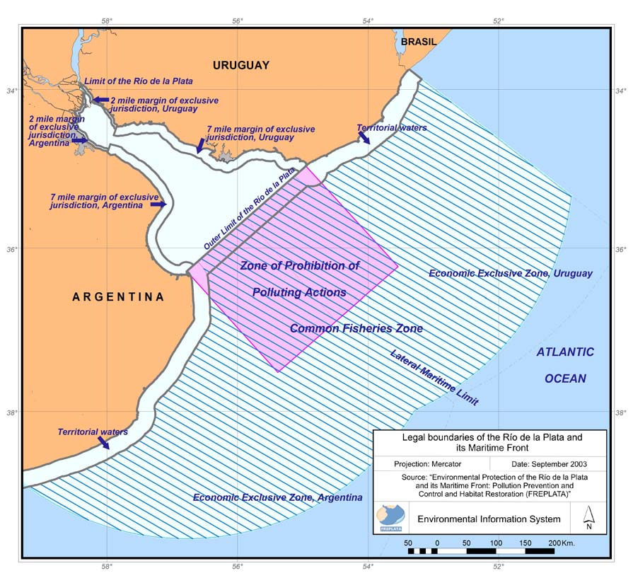
Figure 1.2. Jurisdictional limits established by the Treaty of the Río de la Plata and its Maritime Front (Source: FREPLATA, 2005).
Transboundary Diagnostic Analysis: Synthesis for Policymakers 11
1.3.- The ecosystem approach and adaptive management.
the context of an aquatic environment, the ecosystem approach can
be defined as "the comprehensive integrated management of human
The methodology used for the TDA has taken into account the
activities, based on best scientific knowledge about the ecosystem
ecosystem approach (also known as ecosystem-based management)
and its dynamics, in order to identify and take action on influences
and the notion of adaptive management.
that are critical to the health of the aquatic ecosystems, thereby
The basic framework for the Project is the Treaty, in particular its
achieving sustainable use of ecosystem goods and services and
provisions on the protection of the aquatic environment. In fact the
maintenance of ecosystem integrity" (Laffoley et al., 2004). This
origins of the Project can be traced to the United Nations Conference
definition reflects the close relationship between people and the
on the Environment and Development, held at Río de Janeiro in
aquatic environment, acknowledging that fluvio-marine
1992. The structure has been enriched since then by a significant
environmental problems are of anthropic origin. The human
number of multilateral, regional and bilateral agreements dealing
sustainability depends on appropriate information that implies a
with environmental issues signed by both countries, and relevant for
balance between the use and conservation of natural resources.
the Project Area, by their increasingly comprehensive national
A key requirement for any ecosystem-based management system is
legislation and by a structure of governmental organizations having
the periodic assessment of the natural environment, human pressures
as a objective the protection of the environment. In this respect, the
on it and institutions capable of reducing or removing the pressures.
Project is contained in a much wider normative and institutional
Data and information will never be complete however and so an
"landscape", which has been charted as part of the TDA studies. A
important part of the ecosystem approach is adaptive management
number of treaties signed by Argentina and Uruguay, as well as an
combined with the precautionary approach. Adaptive management,
important body of "soft law" instruments, as well as internal
sometimes described as `learning through doing', recognizes the need
legislation of both countries have incorporated the concept of
to manage ecosystems in a stepwise manner. That approach to
ecosystem (in some moment the Treaty of 1973 refers to bio-
management makes the best possible use of available information but
ecological systems). Early attempts at management of transboundary
accepts that there is always uncertainty associated with the results
waters tended to be reactive responding to each problem as it arose,
and relies heavily on scenario-building to select the best option. A
sectoral limited cooperation between different economic or
basic model for adaptive management is illustrated in Box 1.1.
administrative sectors, and centralist decisions were taken by
The present document summarizes the scientific information
central authorities with limited consultation of local interested parties
informed in the TDA on (1) the boundaries of the system (not just the
(stakeholders). Strategies to protect natural systems frequently paid
geographical boundaries, but the temporal ones), (2) of the
little attention to the needs of human users of the environment. On
environmental problems in the region, (3) their social consequences,
the other hand, human activities often failed to recognize the inherent
(4) the underlying causes of the problems, and (5) the existing
limitations of the natural environment to provide goods and services.
legislation, policies and economic instruments in both coastal
Bridging this division called for a new approach to policy and
countries that can help resolve the problems and prevent their
eventually led to the development of the ecosystem approach in
reoccurrence. This will provide basic inputs for the application of
which considerable emphasis is placed on achieving sustainability. In
adaptive management methodologies.
Transboundary Diagnostic Analysis: Synthesis for Policymakers 12
Box 1.1. A framework for adaptive management of the fluvio-marine environment
This figure illustrates the
The important feature of
practical approach to adaptive
Periodic assessment (TDA)
the adaptive management
management developed from Studies of
· System boundaries (space and time)
framework is that it
experiences in a number of GEF
initial
· Scoping of environmental & social impacts
recognises that
· Research on causality
International Waters Projects as
conditions
improvements in the
· Review of institutions, laws, policies,
well as in Europe through the
economic instruments
status of the fluvio-marine
North Sea Ministerial Process.
environment often require
The approach is designed to
decadal timeframes, but
involve stakeholders in setting
Robust, quantitative,
political planning
Environmental state indicators
long-term Ecosystem Quality
p
EcoQOs
processes rarely involve
o
to measure levels of impact
(typically valid for 1
Objectives (EcoQOs). These are
cycles of more than a few
decade)
c
k
lo
key attributes of the system if it
years. Operational targets
were in good ecological health.
can be designed to be
e
e
dba
The EcoQOs are set following
f
Short-term
Stress reduction and
process indicators to
reached relatively quickly
w
completion of the TDA - a
l
o
targets
measure socio-economic
and with crediting given
S
c
k
(Typically valid 5 yrs)
drivers, pressures and
multidisciplinary assessment
to those involved. The
ba
project performance
conducted through a `joint fact
EcoQOs can also be
e
e
d
finding' process where
Regular monitoring (all indicators)
reviewed periodically,
s
t
f
p
stakeholder representatives work
Fa
loo
enabling them to be
alongside specialists. The
adjusted as scientific
Status and trends
Regulations and compliance
EcoQOs are an easy to
information improves or
understand expression of the
the environment changes.
vision of what the water body
Each review provides an
would be like if it were sustainably managed. It requires improved
opportunity to maintain knowledge and political momentum.
understanding of the factors leading to degradation, and the
Adaptive management requires a firm commitment to the long-term
management actions required to control them. The initial agreed
monitoring of meaningful indicators and full disclosure of all
actions taken to reduce human pressure on the environment can be
information obtained. Carefully chosen indicators, supported by
expressed as short-term operational targets, closely linked to
scientific research, may provide early warnings of major ecosystem
regulatory mechanisms. This allows a pragmatic stepwise approach
changes. The TDA of FREPLATA is an important first step in an
towards achieving the EcoQOs; progress towards the EcoQO is
adaptive management strategy for this transitional water body.
monitored after each step and new operational targets are agreed for
each subsequent one.
Transboundary Diagnostic Analysis: Synthesis for Policymakers 13
2. A sense of place.
2.1.- General characteristic of the Project Area.
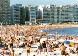
Box 2.1. An increasingly urban environment
Biological productivity in the Project Area is very high, particularly in
The figure shows the changing demography in Argentina and Uruguay since
fisheries, and it contains globally significant biodiversity; river,
1950. The populations of both countries have become increasingly urban over
coastal and high seas species develop all or part of their life cycle in
the past 50 years and are projected to become over 93% urban by 2030
the Project Area. A great overlap of species from warm, temperate
(FAOStat, 2006). Also shown on the figure are the populations of
and cold waters is found in the area. The exploitation of shared fishing
Montevideo, where almost half of the population of Uruguay resides, and
resources is very significant for the economies of both countries.
Buenos Aires with 31% of the national population of Argentina residing. The
The main urban centres of both countries are located on the coasts of
rapid expansion of the population of Buenos Aires contributes to explain the
the Río de la Plata and its Maritime Front (Figure 2.1), as well as
considerable pressure from land-based activities on the southern margin of the
leading economic activities. Industrial, agricultural and port activities,
RPMF.
together with fisheries and tourism, are an important source of
livelihood for a significant percentage of the population. In Argentina
Urban development in Argentina and Uruguay
the coastal area concentrates 45% of all industrial activity and 35% of
its population, while in Uruguay it contains approximately half of its
100
16
total population and most of its economic, industrial and port
activities. The waterbody is therefore a sink for substantial urban,
14
90
)
agricultural and industrial pollution, and suffers from habitat
ion
12
degradation due to dredging, sedimentation and the alteration of
80
10
illions
% Urban Argentina
hydrological processes caused by construction of numerous dams in
m
% Urban Uruguay
the basin.
70
populat
8
a
l (
pop Buenos Aires
6
a
pit
60
pop Montevideo
urban
%
4
50
Pop. c
2
40
0
1950
1960
1970
1980
1990
2000
2010
2020
2030
Year
Population statistics for Autonomous City of Buenos Aires and Montevideo refer to
the metropolitan areas of the cities (Source: http://faostat.fao.org/
http://www.demographia.com/; http://www.ine.gub.uy).
Transboundary Diagnostic Analysis: Synthesis for Policymakers 14
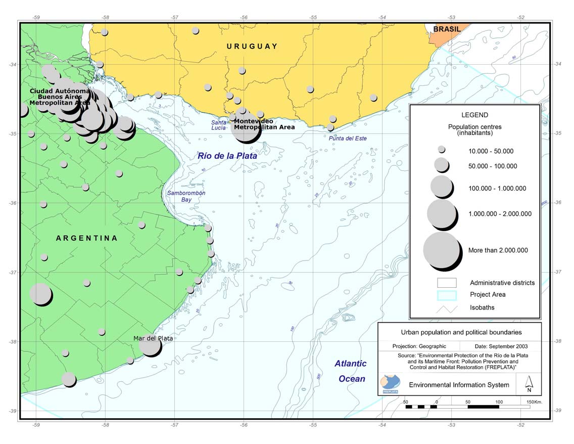
Figure 2.1. Distribution of urban population and political boundaries in the hinterland to the RPMF (Source: FREPLATA, 2005).
Transboundary Diagnostic Analysis: Synthesis for Policymakers 15
2.2.-The natural environment.
The FREPLATA Project has successfully integrated a very large
The salinity conditions are somewhat similar for the two seasons; the
knowledge base on the natural environment of the RPMF in order to
transition waters of the Río de la Plata (mixed seawater and freshwater)
create an operational baseline from which future change can be
can be seen further offshore in summer and are transported towards the
assessed.
coast of Brazil in winter due to strengthened NE currents. Temperature
changes markedly between summer and winter and the range of
2.2.1. Physical conditions.
temperature in the headwaters of the Río de la Plata is much greater
The physical environment of the Río de la Plata and its Maritime Front
than in adjacent coastal Atlantic Ocean (i.e. the freshwater part of the
depends on the dynamics between the flow of water from its vast basin
system is comparatively hotter in summer and colder in the winter).
(the fourth largest in the world) on one hand, and the winds, tides and
currents of the South Western Atlantic on the other. The average flow of
Box 2.2. Physical characteristics of the Río de la Plata and its
water into the system is some 24,000 m3/sec., sufficient to maintain a
Maritime Front.
considerable part of the system in a permanently freshwater state.
However, this flow is very variable; the flow rate of water down the
· Surface area of the Rio de la Plata: 35,500 km2
largest rivers (Paraná and Uruguay) seems to be increasing since the
· Length: 327 km
1970's but suffers huge variations, especially during `ENSO' (El Nińo
· Width at the mouth: 230 km (between Cabo San Antonio in
Southern Oscillation) years when it may reach more than 60,000 m3/sec.
Argentina and Punta del Este in Uruguay)
Such variability make it necessary to qualify all statements about the
· Area of Plata Basin discharging to the RPMF: 3.1*106 km2.
physical system very carefully we talk about `mean conditions' but
· Average freshwater input from rivers: 694 km3/year (5th highest
the conditions at any moment of time may differ considerably.
globally)
The difficulty to predict conditions in the system is made more complex
· Tides: Semidiurnal with large diurnal variations
by variability in the coastal seas. Variations in winds for example,
· Tidal range: 0.3 1.0 metres
particularly those blowing along its axis, can cause major changes in
· Salinity gradient: 0 34 PSU
water level near the head of the Río de la Plata: storm surges and floods
· Concentration of suspended solids: 50 300 mg/l
in SE winds or very low waters limiting navigation and drinking water
· Surface area of the Maritime Front: 216,000 km2 (oceanic space
supply following NW winds. Winds blowing perpendicular to its axis
that consists of the Common Fishing Zone of the Treaty)
promote a pattern of circulation that can also result in large eddies1
(gyres), most notably in Bahía Samborombón where they are a semi-
permanent feature.
1 Eddies are water movements, similar to vortexes that move in contrary sense
to a main current.
Transboundary Diagnostic Analysis: Synthesis for Policymakers 16
Freshwater tends to float over seawater in wedge form and to some
ecology and management. They are illustrated in Figure 2.3 and will
extent this occurs in the RPMF (Figures 2.2).
now be described in more detail:
Mixing occurs across an area of rather abrupt change called a `front'.
1. Freshwater environment.
As its name indicates, the Río de la Plata and its Maritime Front is
Salinity range: <2 PSU2
characterised by this phenomenon, actually three fronts, the most
Surface area: 10,500 km2
notable of which is at the seaward limit of the Río de la Plata itself.
Predominantly soft (very fine) sediments
This area extends until the imaginary line that unites Punta Piedras
Punta Tigre, this area has the characteristics of a huge river and is
Turbidity
Surface Saline
Front
rich in freshwater species, some of which migrate into the river
0
High
systems of the Plata Basin. It is situated in front of one of the most
sedimentation
populous regions of Argentina (Autonomous City of Buenos Aires
Progressive
salinization
and its Metropolitan Area).
Between this zone and the next, there is a turbidity front that is key to
5
Halocline
understanding the geology, chemistry and ecology of the system
(Box 2.3.).
FRESHWATER
(m)
SEAWATER
epth
2. Brackish (transitional) zone.
D
Salinity range: 2-25 PSU
Progressive
10
desalinization
Surface area: 19,700 km2
Bottom Saline
Predominantly soft (fine) sediments
Front
This area extends from the imaginary line that unites Punta Piedras -
Punta Tigre until the imaginary line among Punta Rasa - Punta del
Barra del Indio
Este. This is the region where freshwater and seawater are mixed by
15
wind and current energy. It is characterized by strong currents along
the Uruguayan coast. Mixing is not uniform; in some situations, there
Figure 2.2. Conceptual outline of salinity distribution in a
may be a strong gradient of salinity with fresher water in the surface
longitudinal cut of the Río de la Plata. Red arrows indicate the
layer than at the bottom. The biota in this zone must be resistant to
waters dynamics (Source: Acha and Mianzán, 2003).
large changes of salinity.
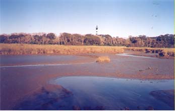
2.2.2. Habitats.
The fronts in the RPMF and the five aquatic environments they
2 The abbreviation PSU refers to `practical salinity units', an international
contain are fundamentally important for its geology, chemistry,
unit corresponding approximately to parts per thousand of dissolved salt.
Transboundary Diagnostic Analysis: Synthesis for Policymakers 17
Box 2.3. The importance of the turbidity front.
When rivers meet the sea, it is common to observe a zone of very turbid
water. This is caused by two simultaneous processes:
(1) Some natural substances (organic and inorganic) dissolved in
freshwater flocculate out and precipitate when the salinity suddenly
increases.
(2) Salt water pushing into the inlet from the sea travels along the
bottom (because it is denser and therefore heavier) and this acts like
a wedge, forcing light material that has settled on the floor back
into suspension. The `light material' includes the substances that
have flocculated as well as associated bacteria and some sediment.
The material that forms the turbidity front is chemically very active and
many substances are attracted to its surface (a process known as
adsorption), or are incorporated into it (by absorption). This mechanism
tends to remove contaminants such as heavy metals from the water, as well
as some organic contaminants. In effect, it protects the downstream coastal
zone from some of the contaminants introduced in the river basin. On the
other hand, it also causes a build-up of these contaminants in the turbidity
front itself. Since the front is also area of great biological activity, there is a
danger that the accumulated contaminants can enter the trophic chain with
deleterious consequences.
Transboundary Diagnostic Analysis: Synthesis for Policymakers 18
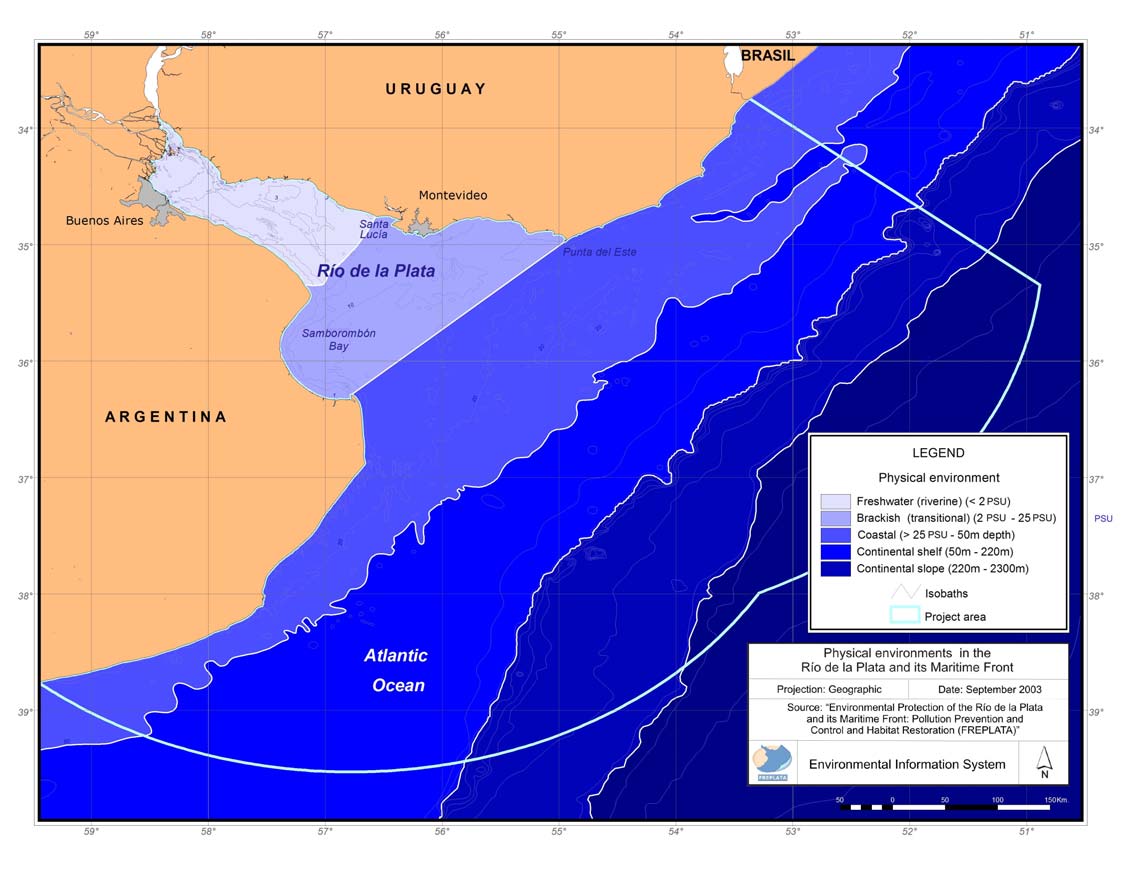
Figure 2.3. Zonation of the RPMF and position of the key environments and fronts (Source: FREPLATA, 2005).
Transboundary Diagnostic Analysis: Synthesis for Policymakers 19
3. Coastal waters
Table 2.1 indicates the biological richness of each of the zones. The
Salinity range: > 25 PSU
very large number of mollusk species in the coastal zone is a
Surface area: 67,900 km2
consequence of an efficient food supply, limited salinity range and
Predominantly sandy sediments
relatively undisturbed sediments. On the other hand, high copepod
This is a region that extends from the coast until the isobath of 50
diversity on the continental slope is indicative of the oceanic food
meters and this is an area where freshwater and seawater continues to
chains in this region. Relatively few of the species are shared between
mix. However, the water remains in the area for long enough for large
the freshwater and marine (Zones 3-5) habitats; each has its
communities of free floating microscopic algae (phytoplankton) to
characteristic fauna. However, because of the dynamic nature of the
develop using the nutrient (nitrogen and phosphorus compounds) that
systems and its connection with neighboring systems, there are few
are transported down the river and from coastal sources. This forms
truly endemic species.
the base of a rich food chain leading to an abundance of fish,
crustaceans and mollusks. There is a front within this zone where the
Table 2.1 Number of animal species belonging to three representative
lower salinity coastal water meets seawater transported by coastal
classes: fish, mollusks, and copepods3. Mianzán (2002).
currents (Figure 2.3).
Zone
Fish
Mollusks
Copepods
4. Continental shelf waters.
Freshwater 53
144 31
Surface area: 78,100 km2
Brackish 46
103
21
Predominantly sandy sediments
Coastal 60
474
29
Continental shelf
49
91
34
This is a region that extends from the isobath from the 50 meters to
Continental slope
27
118
88
the isobath of 220 m. Coastal currents (seasonally the warm Brazil
Total 146
757
98
Coastal Current in summer and the cold Malvinas Current in winter)
predominate in this region and provide connectivity with systems to
the North and South. It is enriched by biological material carried from
2.2.3. Ecology of commercially exploitable species.
the Río de la Plata through the coastal zone. Hard substrates provide a
good substrate for bivalve mollusks (e.g. mussels).
The importance of the characteristic zones and the processes that
occur along fronts are illustrated in Figure 2.4 which shows the
5. Continental slope waters.
distribution of areas for reproduction (spawning areas) of key fish and
Surface area: 45,300 km2
squid species in the RPMF. The green area on the map corresponds to
This is a region that extends from the isobath from the 220 meters to
the turbidity maximum and the reproduction areas of brackish species
the isobath of 2300 m. There is usually a front between the continental
such as the White Croaker (Micropogonias furnieri), gobies
shelf and this region. This is a truly oceanic region with
(Gobiosma parri), or Brazilian menhaden (Brevoortia aurea).
characteristics that are mostly defined by the general circulation of the
Southern Atlantic.
3 These are small crustaceans that graze on phytoplankton and are a key
component in marine food chains leading to fish.
Transboundary Diagnostic Analysis: Synthesis for Policymakers 20
Figure 2.4. Main zones for reproduction (spawning) of fish and squid species (Source: FREPLATA, 2005).
Transboundary Diagnostic Analysis: Synthesis for Policymakers 21
There are no spawning areas in the central part of the brackish zone of
offshore is very limited. Coastal sites, particularly wetlands, are also
the system. However, the fronts within the coastal water zone are
important for wintering, feeding and breeding areas for birds, several
areas of reproduction for a large number of species. The inner part of
species of which are now considered as threatened or even critically
this zone (pink area) is characterized by species such as the striped
endangered. Conservation of coastal zones is clearly important if a
weakfish (Cynoscion guatucupa), proposed as a biomonitor of
holistic approach is to be taken to management of the RPMF.
organochlorine pesticides in fluvio-marine and near-coastal zones, the
southern kingfish (Menticirrhus americanus) a scianids, scad (e.g.
2.3.-Economy.
Trachurus lathami), sprats and the silver porgy (Diplodus argenteus).
Further offshore (orange on the map) reproductive areas are also
The land area adjacent to the RPMF is of huge economic importance
found for the chub mackerel (Scomber japonicus), as well as many of
to both countries; 36.1% (13.1 million habitants) of the population of
the species from the adjacent inshore area. The front that divides the
Argentina and 70% of the population of Uruguay (2.35 million
continental shelf from the continental slope is a spawning area for
habitants) live near the shores of the RPMF. The two countries will be
hake (Merlucius hubbsi). Most importantly, it is the area for
considered separately:
reproduction of squid (Illex argentinius) that supports an important
fishery. The entire shelf is a spawning area for the argentine anchovy
Argentina
(Engraulis anchoita).
The participation of the Autonomous City of Buenos Aires and the
The importance of this mapping exercise is that it illustrates the close
Buenos Aires Province in Argentina's gross domestic product (GDP)
association between key life stages of fish and oceanographic features
was 57.5% in 2000. The city is the district with most commerce
of the region, particularly frontal areas. Figure 2.5, showing the
(wholesale and retail), is the main centre for provision of services in
distribution of commercially important invertebrate species (mussels,
the country, national administrative capital and the main hub for air,
scallops and crabs) as well as `charismatic4 megafauna' (whales, sea
road and sea transport. Some 80% of its economic activity is based in
lions and sea turtles) strengthens this point even further. Mussel beds
services and commerce and the remaining 20% consists of the
are located in the area of the salinity front between the transitional
manufacturing industry (18% of the industrial production in the
waters of Río de la Plata and the coastal zone. Crabs reach a
country). Buenos Aires Province has an important agricultural
particularly high density in the nearshore areas of Bahía
production: 40% of the national production of cereals and 37% of
Samborombón, where water is entrained from the front of turbidity
cattle. It has an important mining industry (construction material) and
maximum.
includes 46.4% of the nation's industrial production (principally oil
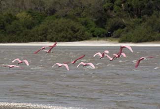
As regards the charismatic megafauna, their presence (and huge
refineries, chemicals, engineering, pharmaceuticals, milk products and
conservation value) in the system is important. The coastal and
refrigeration). Fisheries are a major activity with ports in Mar de
nearshore distribution of the marine species (whales, turtles, sea lions)
Plata, Quequén and General Lavalle accommodating approximately
is partly because of the importance of coastal sites for breeding. In the
50 % of the national high seas fleet.
case of whales and sea turtles, knowledge of their distribution
4 Charismatic is a term used to reflect the level of public interest in these
species (unlike most other non commercial aquatic organisms).
Transboundary Diagnostic Analysis: Synthesis for Policymakers 22
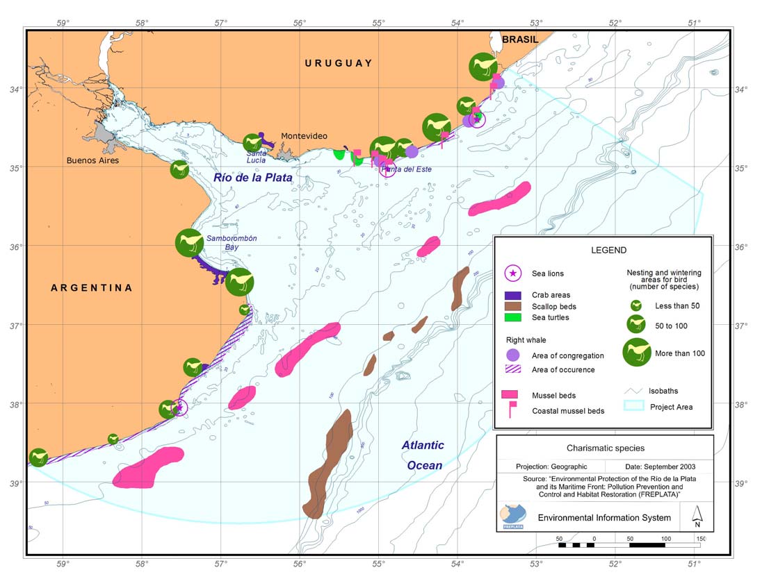
Figure 2.5. Distribution of (1) Keystone macro-invertebrates (mussels, scallops, crabs) and (2) `Charismatic' megafauna (Source:
FREPLATA, 2005).
Transboundary Diagnostic Analysis: Synthesis for Policymakers 23
Uruguay
consensus between the fishing industry and society on the regulatory
The coastal zone of Uruguay includes six administrative divisions
framework necessary for this to happen.
(departamentos): Colonia, San José, Canelones, Montevideo,
Maldonado and Rocha. Jointly, these account for 87% of the national
manufacturing industry, 82% of the services and 73% of the
300000
construction. Most of the economic activity is concentrated in
250000
Montevideo however, and the district accounts for 59% of the Gross
National Product of Uruguay (including 71% of its industry and 66%
200000
of services).
150000
Tons
Role of the MERCOSUR
100000
The MERCOSUR was established by the Treaty of Asunción in 1991
50000
to lead to a common market area between Argentina, Brazil, Paraguay
and Uruguay. Since that time, trade between countries in the region
0
has increased rapidly. In 1980, exports by Argentina and Uruguay to
the other (current) MERCOSUR countries were 14.2% and 32.9% of
1997
1998
1999
2000
2001
2002
2003
2004
2005
2006
their total trade respectively. In 2000, this had risen to 31.8% and
ARGENTINA (Ton)
44.6%. Some of this success has been achieved through improved
Years
URUGUAY (Ton)
transport routes including new roads and fluvial transport in the
TOTALES (Ton)
Paraná and Paraguay rivers. Maritime trade with overseas still
dominates, however. In 2000, Argentina exported 69.577 million tons
of cargo by ship (84.1% of exports) and imported 17.877 million tons
Figure 2.6. Total catch (tons) of main species in the Common
(82.8% of imports). For Uruguay, maritime exports were 2.65 million
Fishing Zone. (Source Argentinean catch: SAGPyA, informed to
tons and imports 3.47 tons (60.24% of this was oil).
CTMFM. Sources Uruguayan catch: DINARA, informed to
CTMFM).
Fisheries
Fishing is one of the most important economic activities in the RPMF.
2.4.-Social context.
Total catch in the Common Fishing Zone reached 269.467 tons in
1997 but diminished approximately in half starting from the 2001
Social situation
(Figure 2.6). Several of the target species have reached or exceeded
Given the predominance (and expansion) of the urban population in
sustainable limits and both countries are taking urgent measures to
the region, it is important to understand their social realities,
conserve stocks. Clearly, recovery of the fisheries is an important
especially when planning actions for protecting the environment.
priority for both countries. However, there remains a lack of clear
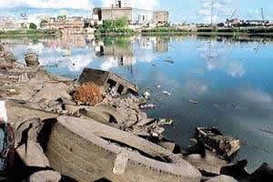
Poverty in the Metropolitan Area of the Autonomous City of Buenos
Aires increased continuously through the decade of the 90s. In this
Transboundary Diagnostic Analysis: Synthesis for Policymakers 24
case, the largest conurbation in the region, there are areas with
particularly large numbers of marginalized people, and these often
coincide with places where environmental degradation is acute.
Examples are the following rivers Matanza, Riachuelo, Reconquista,
Luján and the Río de la Plata itself. These rivers have been receptors
of effluent for many years. In the Matanza-Riachuelo basin alone,
there are half a million people living precariously in unauthorized
settlements. Only 50% of the population of the city is connected to the
municipal sewerage system and many residents discharge their waste
into wells in the shallow aquifer.
On the other hand, Buenos Aires obtains 75% of its drinking water
from the Río de la Plata. The river represents a source of sustenance, a
convenient place to dispose of waste and a constant threat from
flooding and pollution. However, local authorities are not complacent
and, since 1998, developed a Plan for Environmental Management of
the Basin (Control of floods and prevention of pollution in the
Matanza-Riachuelo Basin).
Montevideo's most serious problem is the urban expansion along a
more extensive area to detriment of natural environment.
Transboundary Diagnostic Analysis: Synthesis for Policymakers 25
3. The system boundaries.
In order to apply ecosystem based management, it is important to
the Treaty of the Rio de la Plata and in the Joint Declaration
understand the system boundaries. These can be defined in a number
regarding the External Limits of the Río de la Plata of January 30th,
of different contexts according to the problem being managed. Figure
1961.
3.1 illustrates a hierarchy of scales from very local to global.
Different issues require different management scales. The global
The Article 2 defines a zone of exclusive jurisdiction adjacent to the
transport of invasive species for example, cannot be tackled without
coasts of each Party in the Río de la Plata. This zone has a width of
actions at the global scale but some aspects of coastal pollution only
seven nautical miles between the external limit of the Río de la Plata
require actions in one district or municipality of a single state (though
and the imaginary straight line between Colonia (República Oriental
this may need national-level legislation in response to needs
del Uruguay) with Punta Lara (República Argentina) and from this
articulated by an international agreement).
last line to the parallel of Punta Gorda has a width of two nautical
miles. However, its outer limits shall be inflected as necessary so that
The political boundaries for the Río de la Plata and its Maritime
they do not go beyond the edges of channels in waters shared by the
Front have been established through the mechanisms outlined in 2.4.
Parties and so that port access channels are included.
A more detailed account of the legislative issues will be given in
Such limits shall be no closer than 500 meters to the edges of
Section 6 of this report. The current section will describe the
channels situated in shared waters, nor shall they be more than 500
boundaries themselves.
meters from the edges and the mouth of port access channels.
For the Río de la Plata, the area covered by the Treaty is stated as
follows:
At first sight, the boundaries agreed upon in the Treaty appear
The Article 1 stipulates that the Río de la Plata extends from the
complex, but they are the outcome of careful negotiations between
Punta Gorda Parallel (its limit with the Río Uruguay) to the
the countries. It is important to note however that for the purposes of
imaginary straight line that joins Punta de Este (República Oriental
agreeing policies for reducing the environmental pressures on the
del Uruguay) with Punta Rasa of Cabo San Antonio (República
RPMF, it is often necessary to work within larger boundaries that
Argentina), which is its limit with the Atlantic Ocean. In the
encompass the source of the problem, as well as the problem itself.
Maritime Front, the Parties agreed in the Treaty to set up two
An example of this is the issue of land-based sources of pollution
bilateral special areas which overlap their respective economic
where it is necessary to incorporate the source of pollution within the
exclusive zones: the Zona Común de Pesca (Common Fishing Zone)
boundary of the study and the boundary of any policy developed to
and the Zona de Prohibición de Acciones Contaminantes (Pollution
resolve the problem. This issue will be discussed further in Section 6.
Activities Prohibition Zone), in conformity with the dispositions of
Transboundary Diagnostic Analysis: Synthesis for Policymakers 26
WHY?
Achieve global improvements in aquatic systems
Resolve transboundary problems in catchments/
WHAT?
sea areas
Manage and improve quality of River (national),
WHY?
HOW?
Coastal zone (national)
WHAT?
Protect Lake, lagoon, wetland
HOW?
Rationalize use of water/space by local
communities and associated industries
Activate individuals to improve household
practices impacting environment
Figure 3.1. Hierarchy of scales illustrated through their management objectives. Management goals (the `what' question) at any level in the
hierarchy serves to address issues (the `why?' statement) at a higher level and requires action (the `how' statement) at a lower level. The `why-
what-how' scale can be moved to any point on the hierarchy. The scale applicable to FREPLATA is shaded green.
Transboundary Diagnostic Analysis: Synthesis for Policymakers 27
4. Transboundary issues and associated problems.
to which energy from tides and currents transports polluted
4.1.- Why are the problems transboundary?
sediments from coastal sources such as the Metropolitan
Area of Buenos Aires or from the Plata Basin, as well as
The Río de la Plata and its Maritime Front is a transboundary aquatic
solid wastes from terrestrial and aquatic sources.
system and as such, the effects of pollution and biodiversity loss are
d) The turbidity maximum is a zone where various species of
shared by the two States and impact them in a tangible manner.
demersal (associated to bottom) and pelagic fish aggregate to
Furthermore, it is important to recall that the Río de la Plata and its
feed, spawn, and develop their early life stages. An example
Maritime Front is a very dynamic system and pollutants (especially
of a demersal species and commercially important is the
heavy metals and persistent organic pollutants) are transported by the
white croaker (Micopogonias furnieri). There are other areas
water column, sediments and living organisms.
of aggregation, of different species, along the southern
The Precautionary Principle is one of the underlying principles
coastal margin (adjacent to the Argentinean coast of the Río
adopted by both countries. This implies the need to adopt
de la Plata). This shore includes the coastal sector of the
preventative measures when there is reasonable doubt or risk of
Metropolitan Area of Buenos Aires, where there is the
causing harm; in this particular case where an activity on land or sea
largest concentration of urban/industrial development. Other
could increase the risk of health problems for humans or
sectors of this shore show low levels of pollution or are not
deterioration of the natural environment in the region.
polluted at all. This sector includes Bahía Samborombón,
With respect to transboundary environmental problems in the region,
which is a nursery area for fish and an important habitat for a
the following key points can be made:
number of migratory bird species. It should be pointed out
that physical processes cause dispersion of contaminants but
a) The transboundary problems originate from activities on land
food chain biomagnifications provide the ultimate link to
as well as in the aquatic area.
humans, a fact clearly demonstrated in FREPLATA studies.
b) As has been demonstrated by a large number of authors,
e) The Río de la Plata is the main center for ports and
water circulation in the FREPLATA study area is complex
transshipments for Argentina and Uruguay and this presents
and is affected by various natural drivers; its dynamics can
major risks of transboundary pollution, either from accidents
rapidly transport contaminants introduced at the coastal zone
(e.g. the major oils spills from Magdalena, Buenos Aires
to distant parts of the system. In this manner, any pollutant
Province in 1999, and Maldonado-Punta del Este area,
introduced into the system in waters of one country poses a
Uruguay, in 1997) or operational activities related to
tangible risk to the waters of its neighbour.
shipping (e.g. dredging, waste discharge, introduction of
c) Within the system, there is a turbidity maximum
opportunistic invader species through ballast water
(corresponding to a `front' between freshwater and seawater)
discharge, operational oil spills, bilge discharges of used oil
Transboundary Diagnostic Analysis: Synthesis for Policymakers 28
polluted with polyaromatic hydrocarbons, etc.). The lack of
associated since pollution also impacts on aquatic biota, and invasive
suitable reception facilities for ballast water, shipboard
species and harmful blooms can threaten human health.
waste, sewage water makes it difficult for shipping
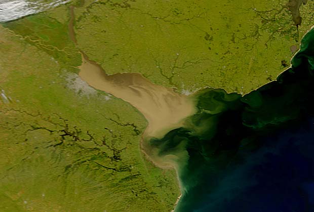
Figures 4.1 to 4.3 illustrate the transboundary issues for the cases of
companies to comply with international regulations (e.g.
pollution and invasive species. Figure 4.1 is a schematic summary of
MARPOL).
pollution data from surveys conducted as part of FREPLATA. It
f) The development of the fishing industry in the common use
clearly illustrates the importance of the turbidity maximum for
water of the Río de la Plata and in the Common Fisheries
determining the distribution of pollutants (for the reasons explained
Zone established in the Treaty requires the adoption of
in Box 2.3.). The position of this turbidity maximum is significant in
adequate management measure in order to avoid it, having an
the geographical context of the region. Many pollutants introduced in
adverse impact on biodiversity.
the post populous part of Argentina (Metropolitan Area of Buenos
Aires), or from upstream parts of the Plata Basin, will be detained in
4.2.- The main transboundary problems identified.
the turbidity maximum, and may become buried in the underlying
sediments. Pollutants introduced on the Uruguayan coast in the
By following the approach used by the Global International Waters
region of Montevideo will enter the system seawards from the
Assessment (GIWA) it was possible to identify the following priority
turbidity maximum and have a different kind of impact on the
transboundary problems related to environmental degradation:
system, especially as this is the region of strongest seaward currents.
Fortunately, coastal pollution has not yet affected severly the
1. Chemical pollution (includes oil)
common use areas. The case of chromium (Figure 4.2) illustrates this
2. Microbiological pollution
point well. This figure shows the distribution of chromium in
3. Eutrophication and harmful algal blooms
sediments in the area covered by the Treaty. Chromium is a toxic
4. Suspended solids
heavy metal originating from metallurgic industries and tanneries. It
5. Introduction of exotic species
rarely represents a major threat to human health in marine systems.
6. Alteration / Destruction of natural habitats
The data has been classified in terms of safe levels (below the
7. Loss of biological diversity
guidance levels for action) green dots; above precautionary limits
(between the guidance levels and the probably effect levels) - yellow
Subsequent work to understand the main causal chains that have led
dots; and hazardous concentrations (above the level of probable
to problems will be summarized in section 5 of this report.
effects) - shown as red dots. The distribution of the data with respect
to the guidance and probable effects levels are shown in the graph in
A detailed analysis of the scientific evidence supporting these
the bottom right-hand corner of the figure 4.1. Note that the guidance
findings is provided in Table 4.1. The problems can be grouped into
and `effects' levels are different for freshwater and seawater.
two types (1) Pollution (presenting a direct threat to human health
Sediments would be regarded as hazardous in only one case (in the
through direct exposure or the trophic chain) and (2) Ecosystem
turbidity maximum). However, a number of points exceeded
alterations (as a result of habitat and/or biodiversity loss,
guidance levels (Environment Canada 2002), particularly in the
eutrophication, invasive species introduction and the overexploitation
southern part of the freshwater zone, in Bahía Samborombón and in
of living renewable resources). These two major issues are closely
Transboundary Diagnostic Analysis: Synthesis for Policymakers 29
one station in front of Montevideo. A similar situation was observed
interpretation of this finding. However, careful monitoring will be
with copper but no station exceeded the `effects' level for lead or
needed in the future.
cadmium and few were registered above guidance levels.
The situation is quite different for stations with coastal waters,
Historical trends in Eutrophication (the overenrichment of the water
particularly in the South. Sediments along the entire freshwater
with nutrients) in the Rio de la Plata are poorly understood. Recent
sector of Argentina frequently exceeded the `effects' level for
studies have indicated considerable contemporary levels of
chromium, mercury, lead and PCBs. In the case of Uruguay, such
eutrophication that are associated with nutrient runoff from the
high concentrations were observed only adjacent to the port of
agricultural sector as well as from urban effluent. The dynamics of
Montevideo.
the nutrient cycle is very complex given the physical characteristics
There is little evidence of major bioconcentration of contaminants
of the Rio de la Plata.
through the food chain in the RPMF. However, in the region close to
pollution sources, some very high concentrations have been
There appears to be a growing incidence of harmful algal blooms
registered. Indeed concentrations up to 9 g/g of PCBs were
(HABs) that may be symptomatic of this phenomenon. This problem
registered in freshwater tarpon (Sábalo Prochilodus lineatus) and
is illustrated in Figure 4.3. There are two distinct types of HAB in the
Argentinean law now prohibits its capture in the Río de la Plata.
region, those associated with freshwater and those characteristic of
Tarpon caught near the very polluted Riachuelo River in Buenos
marine (including brackish systems).
Aires contained up to 4 g/g of lead, a very high concentration that
would pose a hazard for human consumption. There is a slight risk of
The most notable freshwater HABs are from blue-green algae
polluted fish from hot spot areas migrating into adjacent areas and
(cyanophytes). Dense blooms of these species are a nuisance and can
the situation should be monitored carefully from time to time. Studies
cause oxygen depletion, but a particular problem in the Río de la
of biological effects of pollution (i.e. effects to aquatic animals) have
Plata is the species Microcystis aeruginosa. Some strains of
not been conducted systematically.
Microcystis sp. may produce toxins that have been reported to result
in health problems to animals that drink the water, and minor skin
Issues of microbiological pollution are discussed in Table 4.1. This
irritation and gastrointestinal discomfort in humans that come in
is largely a nearshore problem that impedes the use of coastal waters
contact with toxic blooms.
for recreation and poses threats to humans through the consumption
of polluted seafood (especially mussels). There is little current
In the brackish and marine regions of the system, dinoflagellates are
evidence of its transboundary nature. A more complex issue
responsible for HABs. These are phytoplankton species, only some
however, is that of the vibrium of cholera. This has been found in
of which are toxic. Unfortunately, some of the toxins they produce
large areas in the system by a number of studies such as that of
are pathogenic and others cause major fish kills. Toxins generally
Binsztein et al., (2004). These authors found the cholera was viable
reach humans via shellfish in which they tend to become
but nonculturable (VNC) but stated that "under favorable conditions,
concentrated. The following types of toxin have been reported in the
the VNC form of V. cholerae can revert to the pathogenic,
region:
transmissible state". Recent studies have shown that V. chlorerae is
almost ubiquitous in tropical waters and care must be taken on the
Transboundary Diagnostic Analysis: Synthesis for Policymakers 30
(1) Paralytic shellfish poison (PSP), a problem that affects all
In the brackish zone of the RPMF, information is only beginning to
coastal areas of Argentina and Uruguay in the region of the
emerge regarding the extent of invasions. Not all of these have
Maritime Front. Sporadic outbreaks occur between spring
arrived in ballast waters or attached to the hulls of ships. The Asian
and summer (occasionally in autumn). There have been a
carp (Cyprinus carpio) was introduced into ponds in Buenos Aires
number of incidents of humans affected by this toxin.
Province in 1925 but gradually escaped, affecting the entire
(2) Amnesic shellfish poison (ASP), which has serious affects on
freshwater zone Río de la Plata and penetrating brackish regions as
the neurological system in humans. The first case of ASP
far as Río Samborombón. It appears to be displacing some native
was reported in July 2000 on the continental shelf of Buenos
species though the full implications of its presence have not been
Aires.
fully studied.
(3) Diarrheic Shellfish Poisoning (DSP), which produces nausea
and diarrhea in human consumers of affected shellfish but
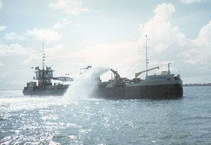
Suspended solids are a problem in the Río de la Plata (where the
has not led to fatalities or other serious complications. The
channels require continual dredging) but these are brought naturally
species responsible for this phenomenon has been detected in
by the tributary rivers. Management of spoils from dredging is a
waters of the RPMF but it is not known if this is causing
problem however, and where the dredged material is seriously
disease.
polluted, this represents a transboundary problem.
Invasive species are a growing problem in the region. Their presence
The destruction of natural habitats in the RPMF is one of the most
is best recorded in the freshwater part of the system where two
serious transboundary problems. This occurs as a consequence of
species have caused major change:
three main pressures: (1) trawling; (2) dredging of navigation
channels and subsequent dumping of dredged spoils; and (3)
(1) Golden mussels (Limnoperna fortunei), introduced
alterations of marginal coastal ecotones (lagoons, wetlands and
accidentally from China around 1991. This is rapidly
shores).
spreading upstream into the Paraná, Paraguay and Uruguay
rivers (at about 240 km per year). It blocks water intakes as
This problem is illustrated in Figure 4.4, which shows the intensity of
well as causing huge changes in the structure of biological
trawling and channel dredging. Trawling data is limited to the
communities.
Argentinean industrial fleet (no data available for Uruguay) and is
(2) Asian clam (Corbicula sp), introduced in the 60s and 70s
largely in the range of about 2,000 to 20,000 hours/year/degree
from SE Asia, perhaps even as live food for ships' crews. It
square in waters below 50 meters depth. Roughly speaking, 20,000
has also become distributed in much of the Plata Basin and
hours of trawling would cover about 5-10% of the area of a square.
causes huge problems for water supply systems. It has
This is less than for the intensively trawled areas of Europe and the
altered food chains by favoring fish species that are its
USA where damage to benthic systems has been clearly
predators and by propitiating aquatic plants growth.
demonstrated, but nevertheless warrants more detailed study. It
should be borne in mind that this is only partial data and that
Uruguayan fishing effort is at least as big as that of Argentina.
Transboundary Diagnostic Analysis: Synthesis for Policymakers 31
Transboundary Diagnostic Analysis: Synthesis for Policymakers 32
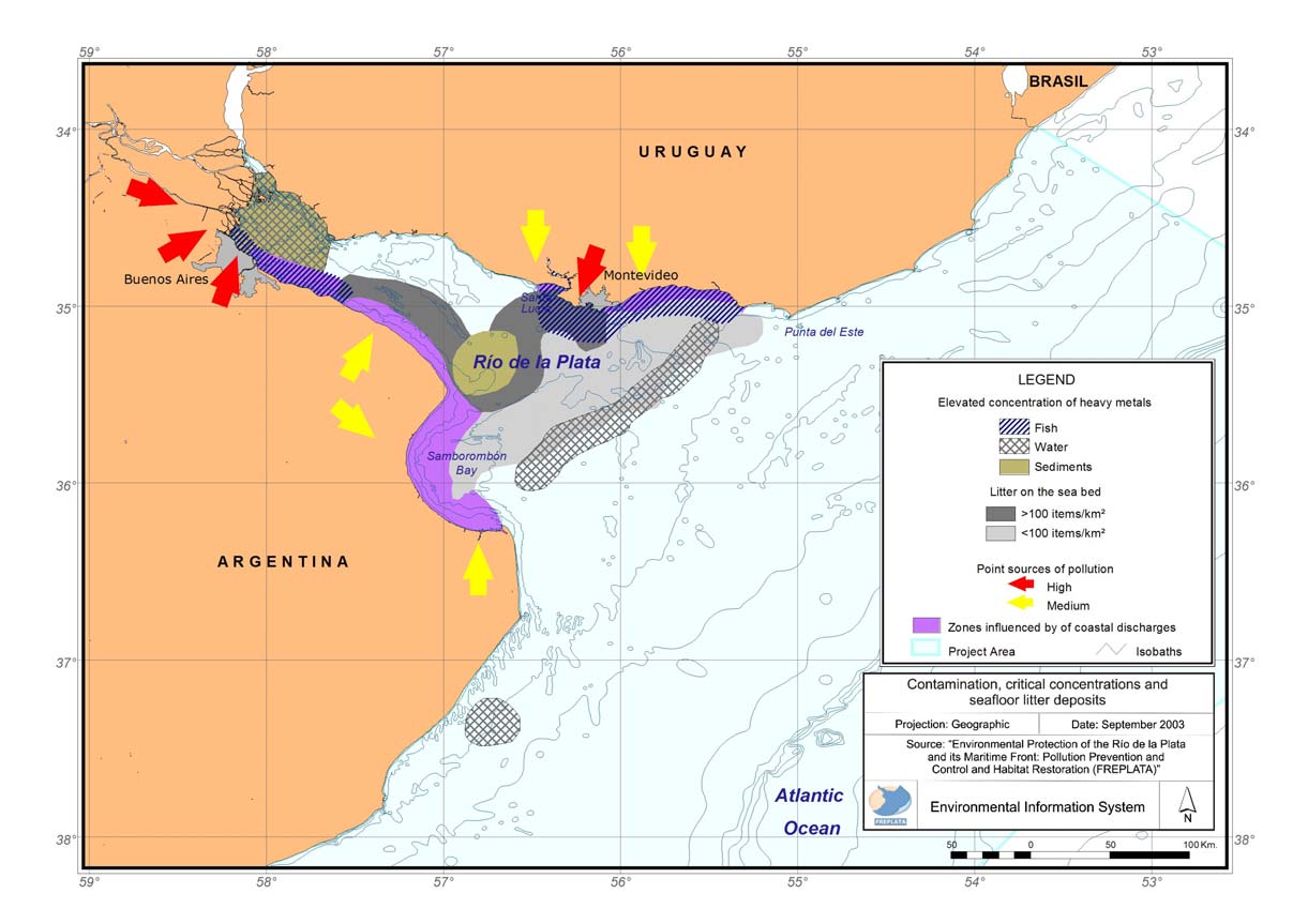
Figure 4.1. Distribution of heavy metals and litter in relation to the turbidity maximum front and point sources of pollution (Source:
FREPLATA, 2005).
Transboundary Diagnostic Analysis: Synthesis for Policymakers 33
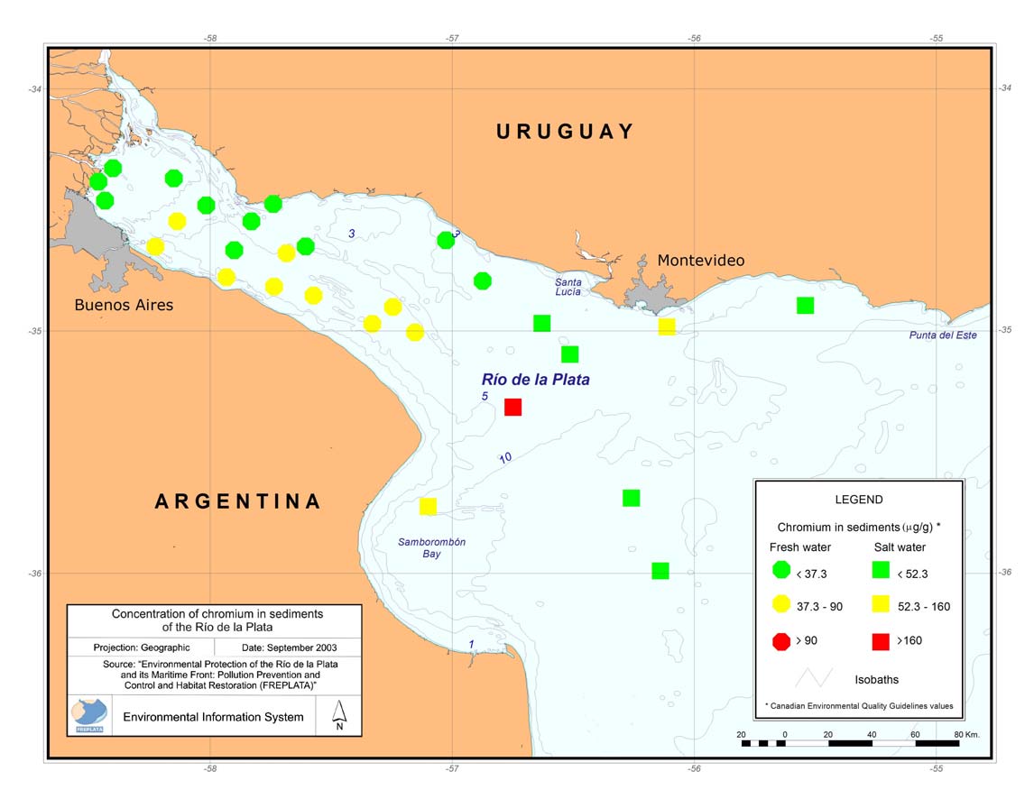
Figure 4.2. Distribution of chromium in sediments from the RPMF (Source: FREPLATA, 2005).
Transboundary Diagnostic Analysis: Synthesis for Policymakers 34
Studies by FREPLATA and associated projects such as ECOPLATA
(in Uruguay) have shown major alteration (physical infrastructure and
invasive species) in lagoons, wetlands and shores in the region. Many
of these habitats serve as nursery areas for fish species and it is very
likely to have impacted fisheries and biological diversity in the
RPMF.
The impact on biological diversity is a problem that would accrue
from most of the other problems outlined above. In addition to these,
it is important to note that there is heavy fishing pressure in the
region. It is worth mentioning that FAO data shows most stocks in the
area to be exploited to their limits, and in some cases overexploited.
There are problems related to discards, incidental capture (of non-
target species) and by-catch. All of these have negative implications
for biological diversity, as well as for the sustainability of fishing
itself. Evidence from many other parts of the world indicates that
overfishing is the prelude to unpredictable shifts in the ecosystem,
some of which may be irreversible in the short and medium term.
Transboundary Diagnostic Analysis: Synthesis for Policymakers 35
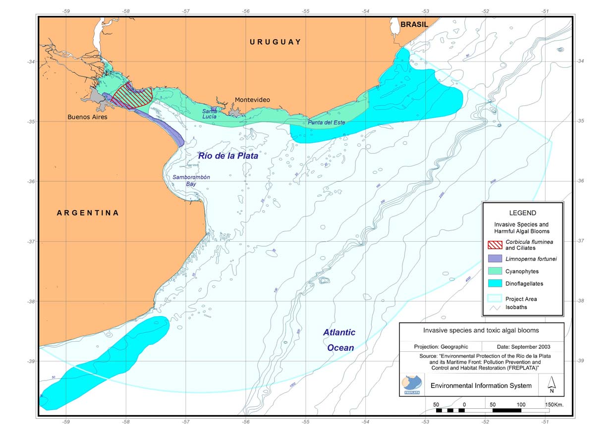
Figure 4.3. Distribution of invasive species and harmful algal blooms in the RPMF (Source: FREPLATA, 2005).
Transboundary Diagnostic Analysis: Synthesis for Policymakers 36
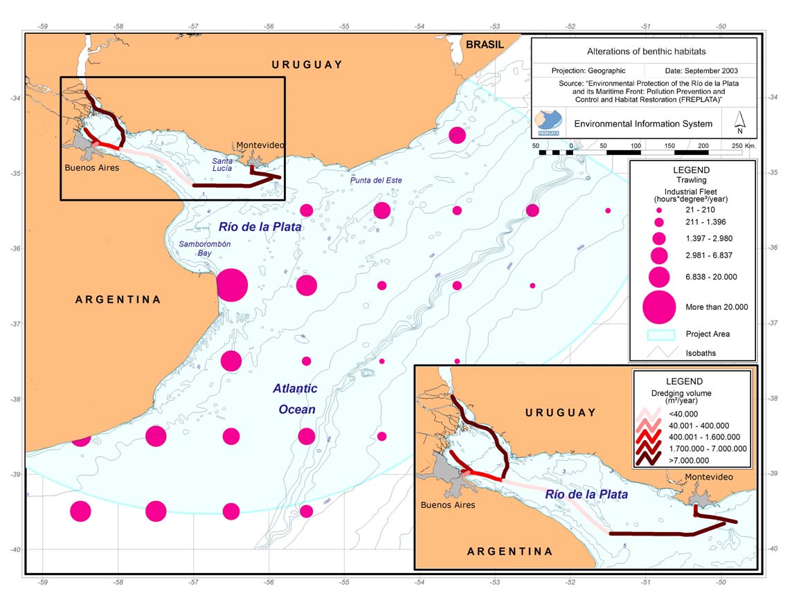
Figure 4.4. Indicators of alterations of benthic habitats (Source: FREPLATA, 2005).
Transboundary Diagnostic Analysis: Synthesis for Policymakers 37
Table 4.1. Major transboundary problems identified and their scientific evidence base.
Issue
Problem
Evidence base
Transboundary nature of the
Comments
problem
Elevated metal concentrations are The peculiarities of dynamics of the The main pollution problems in the system are observed in the
clearly associated with coastal Río de la Plata and the fluvio-marine nearshore zone as a result of land based discharges. Particular
zones in urban and industrialized geochemistry result in the accumulation attention is drawn to the maximum turbidity zone (or front) where
areas. There is evidence that the of metals in particular areas of the fine sediments accumulate from the Plata Basin (particularly from
heavy metals are concentrated in system and resuspended them in the the Paraná River), as well as to the Argentinean coastal nearshore
commercial fish species such as water column. Furthermore, the biota zone of the Río de la Plata where sediments tend to be
Micropogonias furnieri,
affected by these metals (through their resuspended. The zone of maximum turbidity serves as an area for
Cynoscion guatucupa y Mugil bioconcentration) is mostly mobile solid wastes to accumulate (such as plastic waste from municipal
Heavy metal
liza. (FCS, 1997; Carsen et al., throughout the system.
Pollution
garbage from the cities of Buenos Aires, La Plata y Montevideo;
pollution
2004; Marcovechio, 2004;
Acha et al., 2003).
FREPLATA, 2005; Volpedo y Pollutants accumulated in sediments
Fernández Cirelli, 2006). In a and the associated water column may Coastal pollution is also particularly severe adjacent to the
limited number of cases the metal impact key habitats and spawning and maximum turbidity zone (Bazán and Janiot, 1991; Janiot et al.,
concentrations pose a risk to nursery areas of fish. Dredging 2003; Carsen et al., 2004).
human health.
operations to represent a particularly
important risk for metal resuspended, The southern coastal margin of the system (Argentinean coast of
as does the dumping of dredged the Río de la Plata) is an area that constitutes an extensive hot-
materials.
spot for pollution; or rather a succession of hot spots more than
100 km long and 2-3 km wide. In this strip, very high levels of
Petroleum hydrocarbons represent There appears to be a steady rise in the contaminants are observed in sediments, biota and the water
a continuous risk for
discharge of POPs to the system, column.
transboundary pollution, given the affecting the quality of exploitable fish
heavy (and increasing) shipping and contaminating sediments and the The reduction of transboundary impacts of land-based pollution
Persistent
traffic.
water column (Colombo et al. 2000; (including microbiological) require that urban effluents be
organic
2003 a; 2003b; EWSAMER, 2002)
addressed. Investments by the respective governments in
pollutants
There is a notable area of
sanitation will need to include treatment options.
(POPs) and
pollution hot spots of varying Discharge of petroleum hydrocarbons
petroleum
dimensions located in a 100 km has already impacted coastal margins
hydrocarbons belt close to the southern shore of as well as the main body of water
the system. This includes rather shared between the two countries in the
high levels of POPs, particularly RPMF.
PCBs and pesticides, in water,
sediments and biota.
Transboundary Diagnostic Analysis: Synthesis for Policymakers 38
Issue
Problem
Evidence base
Transboundary nature of the
Comments
problem
Some coastal areas are clearly Most of the microbial pollution is Cholera (Vibrium cholerae), has been detected in a form that is
affected by microbial pollution limited to nearshore coastal areas (in viable but non-culturable. It is considered to pose a significant
and there is evidence that sewage the proximity of effluent sources). risk for the system (as it may become increasingly viable in the
pollution includes potentially However, given the dynamics of the future). There have been no outbreaks of cholera since the 19th
Microbial
pathogenic viruses and parasites.
system, the area under risk extends well century and Uruguay has been declared as cholera free.
pollution
into the shared part of the RPMF. There
is an additional risk from sewage from Given this situation, it is recommended to continue monitoring for
ships that is currently inadequately Vibrium cholerae as there is a very small risk that it could be
regulated.
introduced from outside the system (Costagliola et al., 2005).
HABs caused by cyanophytes and Blooms are mostly associated with Historical trends in eutrophication in the Río de la Plata are
dinoflagellates are regular events increases in nutrient discharges from poorly understood. Recent studies have indicated considerable
that have intensified in recent tributary rivers (including the Plata contemporary levels of eutrophication that are associated with
years. They affect biota (some Basin) and these may impact any part nutrient runoff - particularly nitrogen compounds - from the
species cause fish kills) and the of the RPMF.
agricultural sector (application of fertilisers, erosion, castle
human population directly
breeding). This situation helps to explain the large blooms of
(nuisance to recreation, dangerous
blue-green algae (cyanophytes) in the fresh and brackish regions
Harmful
marine toxins in seafood and
of the RPMF.
Eutrophication
algal blooms
respiratory problems in sensitive
(HABs)
members of the coastal human
There has been clear evidence of an increase in incidents of `red
population).
tides' caused by dinoflagellates, both in Argentina and Uruguay,
as well as the shared waters of the RPMF (Carretto et al., 2004).
Fortunately, there have been few human illnesses reported but the
presence of species known to produce potentially fatal
neurotoxins is a significant risk. It also poses a risk to the
livelihood of artisanal fishers in both countries, notably those
dedicated to exploiting blue mussel beds.
Transboundary Diagnostic Analysis: Synthesis for Policymakers 39
Issue
Problem
Evidence base
Transboundary nature of the
Comments
problem
The deposition of suspended Siltation is a continuous problem for The amount of sediments dredged annually in the Río de la Plata
solids is a natural problem. The navigation in the RPMF, requiring is enormous; approximately 25,000,000 m3 (FREPLATA, 2005)
dynamics of the system and constant dredging. This in turn
potential future changes in sometimes mobilizes polluted sediment
climate and upstream land use that is subsequently transported and
Sediments and
Sediment
make it increasingly necessary to dumped in another part of the system.
Suspended
transport and take action to mitigate the Some sediments in the areas adjacent to
Solids
sedimentation situation.
the southern coast of the RPMF are
highly polluted and pose a considerable
risk (FCS, 1997; Colombo et al.,. 2003;
2003b; Carsen et al., 2004).
Erosion is not a transboundary
problem.
Destruction
Habitat destruction is caused by Habitat destruction is a transboundary Trawling is one of the most common fishing techniques in the
of benthic
unsustainable methods of resource problem because it affects migratory or RPMF (used in the main fisheries for hake and white croakers).
habitats
extraction (such as trawling), highly mobile species, including many According to official data of the Undersecretary for Fisheries and
(related to
dredging of undisturbed areas and commercial fish species and decreases Aquiculture in Argentina (SSP-SAGPyA), some areas are trawled
fishing) and
certain types of pollution.
ecosystem resilience. The loss of 4 or 5 times per year, with consequent removal of most benthos.
coastal habitats (such as wetlands and These numbers would be much higher if the effects of the
Loss of
those of
intertidal zones), threatens biodiversity, Uruguayan fleet were considered. In addition to the impacts on
biodiversity
coastal
margins
recruitment of fish and crustaceans to benthic diversity, fisheries production itself may suffer since the
commercial stocks, and migratory birds lost benthos is the main food for several fish species.
feeding or over-wintering.
Trawling is a transboundary problem in
the RPMF because most of it occurs in
the common fishing zone.
Transboundary Diagnostic Analysis: Synthesis for Policymakers 40
Issue
Problem
Evidence base
Transboundary nature of the
Comments
problem
The loss of biodiversity in the Biodiversity loss is clearly a Fishing produces impacts through overfishing, excessive by-
RPMF is reflected in the number transboundary problem in the system.
catch, incidental capture, and habitat loss. Some gear, especially
of species, some of which are
trawls, gillnets and long lines, catch a number of non-commercial
endemic, that are classified as
species. This sometimes leads to significant loss of ecosystem
endangered or requiring
resilience, damaging a large number of populations of species
Overfishing
conservation.
such as rays, sharks, sea birds, sea turtles and marine mammals.
The problem of overfishing is often combined with habitat
destruction, pollution and the introduction of exotic species. It is
difficult to isolate the individual causes of ecosystem degradation.
For the SW Atlantic, 31 exotic Invasive species are an inherently The best known cases are:
species and 46 or unknown origin transboundary problem. In the RPMF,
have been recorded (Orensanz et most of the exotic species come from Limnoperna fortunei (golden mussels), Corbicula fluminea
al., 2002). Though most of these SE Asia, transported in ships' ballast (Asian clam) and Cyprinus carpio (carp).
Introduction
may be found in the RPMF water. Another route to the system is
Invasive
In the transitional and marine waters of the RPMF, there are less
of exotic
(Penchaszadeh, 2005), empirical through escape from aquaculture
species
reports of invasive species and even less knowledge of there
species
evidence of their impacts exists in operations; examples being carp that impacts. The other cases are, Ficopomatus enigmaticus
few cases, mostly in the interior escaped from fish farms in Argentina (polychaete, reef builder), Rapana venosa (carnivorous sea-snail
zone of the Río de la Plata.
and can now be found along the coast that has caused serious damage in other systems), Balanus
of Uruguay, and white sturgeon that are glandula y B. amphitrite (cirripeds).
cultivated in Uruguay.
Transboundary Diagnostic Analysis: Synthesis for Policymakers 41
· Implementation and improved management of aquatic protected
4.3.-Stakeholder perceptions of the issues.
areas.
A major effort was made by FREPLATA specialists to assess the
· Economic development that takes account of conservation of
perceptions of stakeholders regarding the environmental problems of
natural resources and environmental quality.
the RPMF. The term `stakeholder' is employed to describe anyone
· Strengthening the participation of the society in environmental
with a role or legitimate interest in the problem, its solution or the
decision making.
use or protection of the ecosystem and its resources. In the
· Strengthening regional cooperation in environmental management
FREPLATA surveys, 338 stakeholders were consulted (equally
of transboundary aquatic systems.
divided between the two countries. These included the following
· Improving information flow regarding environmental impact and
segments (a full list of stakeholders is published in the FREPLATA
management of industrial and urban wastes.
stakeholder survey report): Figure 4.5.
Each stakeholder was requested to prioritize these themes using a
scale from 1-9. The overall results are illustrated in Figure 4.6 (a
STATE
more detailed sector-by-sector analysis may be found in the original
report). The nine themes have been reordered by aggregate priority
and the corresponding scores illustrated for each country.
In general, there is a strong similarity between the opinions of
MEDIA AND
CIVIL
stakeholders from both countries. However, respondents from
EDUCATION
SOCIETY
Argentina gave the highest priority to pollution reduction, whereas
this took seventh place for the case of Uruguay. This appears to
reflect the technical information presented in section 4.2; pollution is
more serious along the coast of Metropolitan Area of Buenos Aires
PRIVATE
City than in Uruguayan coast, Argentinean people are concerned
SECTOR
about it. Both groups gave a very high priority to `Economic
development that takes account of conservation of natural resources
Figure 4.5. Stakeholders interaction.
and environmental quality', a re-statement of the principle of
sustainable development. This is very encouraging and will be
Through questionnaires, workshops and focus groups, the work
discussed further in later sections of this report.
focused on the following priority themes:
· Responsible fishing.
Of the transboundary environmental issues, the following stakeholder
· Pollution reduction in the Río de la Plata.
priorities emerge:
· Land use without damaging coastal habitats.
Uruguay: Biodiversity conservation> Coastal habitats> Pollution>
·
Protected Areas> Responsible Fishing.
Conservation of Biological Diversity.
Transboundary Diagnostic Analysis: Synthesis for Policymakers 42
Argentina: Pollution> Biodiversity conservation> Coastal habitats>
4.4.-Summary of transboundary priorities.
Protected Areas> Responsible Fishing.
In assigning the order of priorities, it is noted that the differences
Assigning priority to environmental issues is largely a value
between successive scores are often minor but it is clear that less
judgment; there is no absolute measure of importance. Nevertheless,
priority is afforded to offshore issues (fishing, marine protected
it is possible to distinguish human caused issues that have a
areas) than the visible issues nearer home. This may well reflect the
significant transboundary component. This was done in Table 4.1 and
attention given to these issues in the media and through formal
the accompanying text. In each case, significant gaps in knowledge
education rather than a judgment based upon technical information.
remain, giving rise to uncertainty regarding the impacts of the
6. Economic development that takes account of
problems identified. An objective analysis would take the following
6
conservation of natural resources and environmental
6.8
form (Table 4.2):
quality
6.9
2. Pol ution reduction in the Rio de la Plata
Table 4.2. Tentative prioritization of issues. *minor impact to
4.8
***** major impact.
5.3
4. Conservation of Biological Diversity
5.2
Issue
Local impact Transboundary Uncertainty
impact
5.2
3. Land use without damaging coastal habitats
5.2
Pollution
***** *** **
Eutrophication
**** *** ***
7. Strengthening the participation of society in
4.4
environmental decision making.
5.3
Sediments and
** * **
suspended
8. Strengthening regional cooperation in environmental
4.5
solids
managements.
5
Loss of
***** ***** ****
9. Improving information flow regarding waste
4.5
biological
environmental impact and management
4.9
diversity
Introduction of
**** **** ****
5. Implementation and improved management of aquatic
3.8
protected areas
3.9
exotic species
3.6
1. Responsible fishing
The table reflects the detailed discussions in Table 4.1 and is broadly
3.5
consistent with the stakeholder assessment for local impacts.
0
1
2
3
4
5
6
7
8
However, it is argued that the stakeholder assessment does not fully
Score
reflect the transboundary issues because of limited technical
information available to many of the stakeholders. Hopefully, the
Uruguay
Argentina
TDA will help to change this situation though large uncertainties in
Figure 4.6. Stakeholder analysis of priority themes. (Source:
scientific knowledge remain.
FREPLATA, 2005).
Transboundary Diagnostic Analysis: Synthesis for Policymakers 43
5. Research the causes of the transboundary problems.
5.1.-Understanding causality.
Table 5.1. Key pressures associated with transboundary issues.
In order to resolve the environmental problem, local or
Issue
Problem
Key Environmental Pressures
transboundary, it is necessary to understand the causes of the
· Streams and small rivers carrying effluent
problem. It is not sufficient to understand the immediate causes but to
discharges from industry, particularly in the
explore the underlying causes that are often rooted in the economy,
Heavy metal
metropolitan areas of Buenos Aires and
pollution
Montevideo.
structures of governance and stakeholder engagement in the issues.
· Municipal discharge.
These are often complex and interwoven; indeed their complexity is
· Redistribution of sediments following dredging.
often a reason for inaction in dealing with them as it is very difficult
· Streams and small rivers draining agricultural
to assign responsibilities and define `who does what' in the
areas.
Persistent organic
subsequent Strategic Action Program if the causal links are not Pollution
· Upstream sources from the Plata Basin.
pollutants (POPs)
·
understood.
Municipal discharge.
and petroleum
· Industrial chemical effluent.
Box 5.1 shows the model that was employed in FREPLATA for
hydrocarbons
· Operational oil spills.
understanding causality. Understanding the drivers of change also
· Atmospheric deposition.
allowed an analysis to be made of future scenarios for the system.
· Discharge of poorly treated municipal sewage.
The institutional and legal issues will be summarized in Section 6.
·
Microbial Pollution
Discharge from ships.
The current section will initially focus on examining current causes
· Agricultural and food processing waste
and prioritizing them. It will also examine the stakeholder
discharged to streams/rivers.
·
perspectives of some of the underlying issues.
Nutrients introduced via streams and rivers as a
Harmful algal
Eutrophication
result of agricultural activities.
blooms (HABs)
· Municipal effluent.
5.2.-Current environmental pressures.
Sediments and
·
Sediments transport High natural loads of sediments from the Paraná
suspended
and sedimentation
River.
Earlier chapters have indicated some of the direct pressures on the solids
· Inappropriate use of fishing techniques
RPMF resulting from economic activity. These are summarized on
Destruction of
including trawling.
Table 5.1.
benthic habitats
Loss of
·
(related to fishing)
Dredging of shipping channels.
The complexity of these pressures is illustrated in Figure 5.1 which biological
and those of coastal · Construction of coastal infrastructure that
examines the coastal pollution sources and associated state changes in diversity
margins
impedes water circulation or destroys wetlands,
selected districts along the coast of Metropolitan Area of Buenos
shores or other habitats.
Aires. The schematic figure shows sources of pollution and the
Overfishing
· Excessive fishing effort.
principle contaminants of concern that were used to classify the
· Discharge of ballast water from ships.
Introduction
·
waters in terms of their pollution status.
Transport of fouling organisms attached to
of exotic
Invasive species
ships' hulls.
species
· Accidental releases from aquaculture centers.
Transboundary Diagnostic Analysis: Synthesis for Policymakers 44
Box 5.1. The DPSIR model.
Environmental pressures: These are the immediate human-related causes of
the state change, for example, the discharge of a pollutant from a factory or
The current analysis employed the Drivers Pressures State Changes-
municipality.
Impacts Response (DPSIR) model widely used by organizations such as the
Socio-economic drivers: These are the economic or social activities that lead
OECD, European Environment Agency and UNEP. Its current form is
to the pressure. The economy is usually divided into sectors and it is
illustrated in Figure following:
important to understand the relationship between the environmental pressure
and the activities of the sector. Beyond the sectoral nature economy, there are
often a number of social and economic root causes that drive economic
activity in a particular direction and determine the practices the sectors adopt.
External variability: This includes natural variability in the system and the
Socio-
consequences of long-term climate change, some of which is also due to
economic
human activities.
DRIVERS
External
Institut-
variability
Social and economic impacts: These are the economic costs and changes to
ional
the welfare of stakeholders as a result of environmental state changes. Not all
BARRIERS
of these are easily measurable because, for example, the loss of a particular
for change
Policy
Environ-
species, habitat or landscape may affect aesthetic or `existence' values that
RESPONSE
.
mental
are hard to measure economically but nevertheless important.
options
PRESSURES
Environ-
Policy response options are the proposed solutions to the problem and are
mental
often triggered by demands from affected stakeholders. Solutions close to the
STATE
drivers are more likely to be sustainable but are usually hardest to negotiate.
changes
Solutions to the pressures may include `end of pipe' solutions (such as waste
Social and
water treatment plants). Solutions at the level of impact consist of
economic
compensation for the damages incurred.
IMPACTS
Institutional barriers for change are a recognition that policy by itself does
not usually bring about the desired change. It is necessary to understand the
institutional (legal and economic) framework and negotiate feasible and cost-
The DPSIR model, modified to show the institutional barriers to
effective solutions that often require (or result in) its reform. This is the
change (Source: Mee, 2005)
essence of the Strategic Action Program approach of the GEF.
The schematic diagram has the following key elements:
The current TDA examines the part of the diagram illustrated with Yellow
Environmental state changes: These are the measurable changes in the
and orange boxes. Causality is measured in terms of the D-P-S-I relationship.
environment that result from a combination of human and natural pressure.
For the Global Environmental Facility, the term status is often employed
In the context of aquatic systems, it is important to show that a change is
instead of `state' and drivers and pressures are collectively described as
really occurring or is very likely to be occurring (where information on
stress, the objective being institutional and legal reforms and investments to
biological or ecosystem effects is not readily available).
bring about stress reduction.
Transboundary Diagnostic Analysis: Synthesis for Policymakers 45
The map (Figure 5.1.) also illustrates the proximity to polluted areas
of water dumping on the coast. This explains the greater popular
concern in Buenos Aires regarding pollution. Additionally, the
diagram shows the shipping channels that require continual dredging.
It is apparent that polluted sediments deposited in these channels will
be redistributed when the dredging spoils are dumped.
t
It is self evident that a detailed examination of individual pollution
ctor
v
ices
spor
Se
sources will be required when the Strategic Action Program (SAP) is
Transboundary
al Sector
r
an
negotiated for the RPMF. It is customary to prepare the National
problem
a
l Ser
trial
t
ur
Port s
c T
Action Plan (NAP) at this stage and this process provides an
a
ti
Fisheries
opportunity to revisit strategies for dealing with problems that are
Indus
Agricul
Municip
Aqu
predominantly of national interest.
Chemical and
petrochemical
1
3
5
4
2
5
5.3.-The Sectoral Analysis.
Pollution
Microbiological
In order to understand the relationship between environmental
5
4
3
1
2
5
Pollution
problems in the region and their key sectoral drivers, a sectoral
analysis has been conducted. This is presented in Table 5.2. Spaces
left blank on the table indicate improbable sector-problem
Eutrophication
3
2
4
1
5
3
combinations. This table enables corrective actions to be prioritised,
though only dealing with top priority sector-problem combination
Suspended
solids
- - - - - -
would be unlikely to resolve the environmental problems in their
totality as it is often the combined pressure that causes the problems.
Habitat
1
3
5
4
2
2
5.4.- Root causes and cause and effect.
destruction
Figure 5.2 identifies root causes drivers and presents their overall
Biodiversity loss
1
4
2
5
3
1
relationship with key pressure on the environment of the RPMF.
These will be used to examine possible future trends for the system.
Introduction of
-
3
2 - 1
3
exotic species
Table 5.2. Sectoral analysis showing the relative contribution of various
sectors to transboundary problems. The data is ordered by relative
contribution (1 = top contribution, 5 = lowest contribution ).
Transboundary Diagnostic Analysis: Synthesis for Policymakers 46
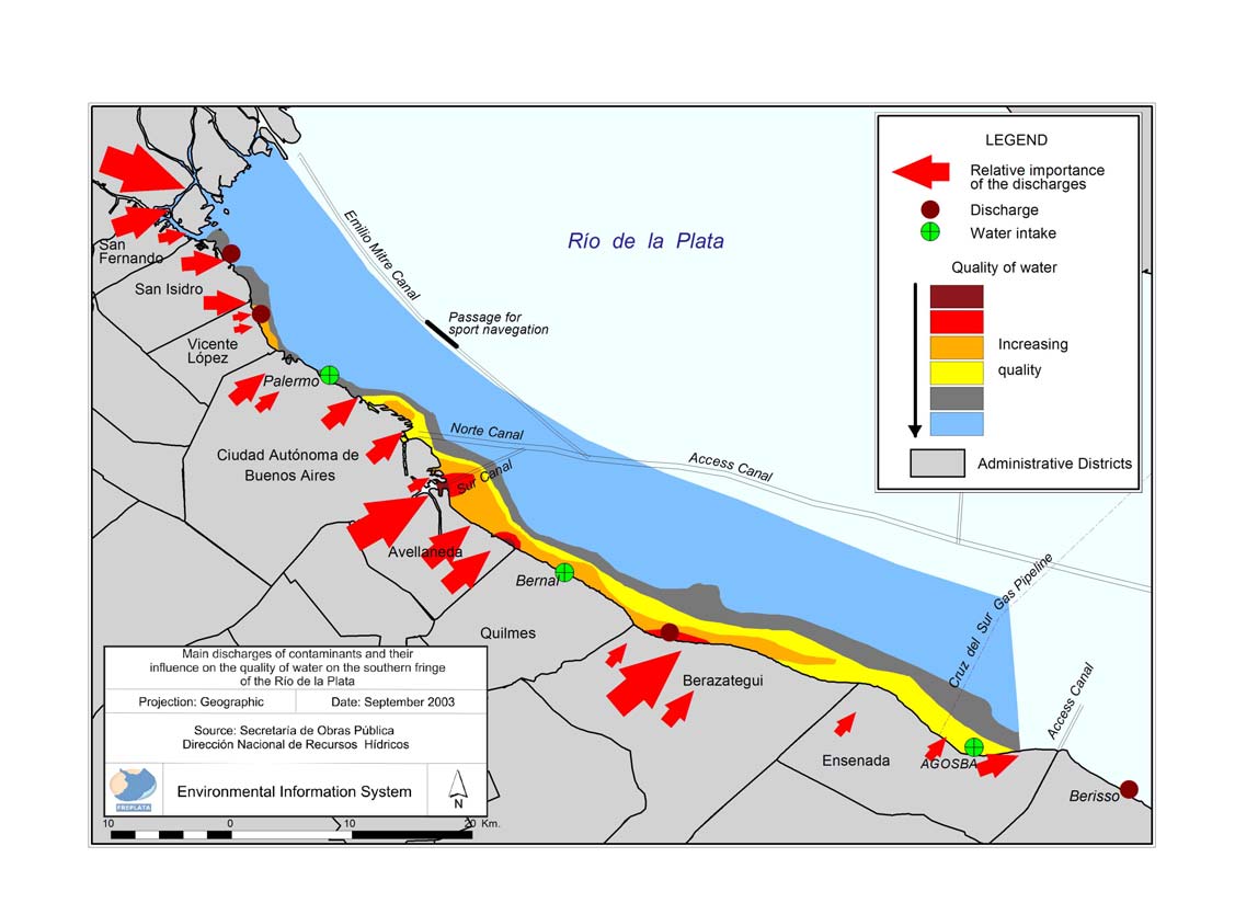
Figure 5.1. Water quality pressures and state changes in the Autonomous City of Buenos Aires and selected coastal municipalities of
Buenos Aires Province (Source: FREPLATA, 2005).
Transboundary Diagnostic Analysis: Synthesis for Policymakers 47
The root cause drivers indicated in Figure 5.2 are chosen for their
will be important to evaluate the likely consequence of climate change
relevance and because there are substantial data set to support them.
in order to develop adaptive measures.
The drivers are described as follows:
1. Population growth
As shown in Box 2.1 population in the region has risen sharply
IMMEDIATE NEGATIVE
(mostly in Argentina) and how it is becoming increasingly urbanized.
This places increase demands on the system for water and for sewage
CONSEQUENCES
disposal as well as transport and food supply.
1. Increase in the waste loads
ROOT CAUSE
2. Social and economic development
(in particular urban
DRIVERS
effluent).
Information is readily available on economic development in the form
2. Increase in direct
of indices such as Gross Domestic Product (GDP), which measures
population pressure on
expenditure on tradable goods and services, and the Human
Population
coastal space.
Development Indicator that incorporates measures of human welfare.
growth
3. Increase in the volume of
solid waste
3. Agroindustrial activities
Social and
4. Increase in the economic
These are tending to increase in both countries, enhanced by global
economic
pressure on coastal space
markets. We have shown in Section 2.3 that the metropolitan areas of
development
(for development
Buenos Aires and Montevideo generate 65% and 87% of the
purposes).
industrial GDP of their respective countries. Watercourses flowing
Agroindustrial
5. Increase in loads (and
change in composition) of
through industrial municipalities such as Riachuelo in Buenos Aires
activities
agro-industrial wastes.
or Pantanoso in Montevideo are already heavily polluted.
6. Overexploitation of fish
Aquatic transport
stocks and the introduction
4. Aquatic transport
of exotic species.
In Section 2.3 we demonstrated the importance of this sector. The Río
Climate change
7. Increased risk of spills
de la Plata is a transport hub for maritime transport and increasingly
(operational and
for fluvial transport to the vast hinterland to drainage by the Paraná
accidental).
and Paraguay rivers. Some 92 million tons of cargo were shipped
8. Increased dredging.
through its ports in 2003. 10.7 million tons of this was fluvial.
9. Invasion of exotic species
in ballast wares and
through fouling.
5. Climate change
10. Sea level rise.
This will inevitably have a major impact on the system in the future,
11. Alteration in tributary river
though its effects are not currently evident (they may be present, but
flow.
are difficult to distinguish from natural variability in the short term). It
Figure 5.2. Root cause variables and their immediate consequences.
Transboundary Diagnostic Analysis: Synthesis for Policymakers 48
5.5.-Trends and emergent issues.
Sufficient is known of the past and current trends in the five root
ns
cause drivers to be able to model their potential behavior in the future.
There is no intention to predict the future, simply to provide a number
of possible scenarios that encompass the likely future situation at 25
and 50 years from present. The three scenarios adopted model high,
medium and low growth. Currently, there is no indication which of
Thousands of to
these pathways is the most likely.
tons
5
Figure 5.4 Cargo (tons) carried by ships in the region and possible
nt 199
tendencies for three possible scenarios: A maximum GDP; B intermediate
GDP and C minimum GDP.
The output of this analysis is shown in Table 5.3 and provides a basis
US$ consta
for examining the potential environmental implications of growth in
the region. It must be stressed that the scenarios presented here are
evitable; they can be changed by human intervention following the
Figure 5.3. Past evolution of per capita GDP in the RPMF region and
principles of sustainable development. However, they help to
projection for three scenarios.
demonstrate what may well happen if no such action is taken. They
also demonstrate that the protection of the RPMF cannot be achieved
Two examples are shown of this modeling work. The first, in Figure
in isolation from the wide spectrum of actions required to pursue a
5.3, illustrates the model for growth in GDP. The past trend shows the
policy of sustainable development, a policy already embraced by both
sharp economic decline that hit the region after 1999 and illustrates
countries and by the neighboring countries in the Plata Basin, but one
the difficulty in predictive modeling; few would have anticipated the
that presents many challenges to implement.
scale of the economic setback. The second example (Figure 5.4) is for
the case of shipping. Here, the trend is much clearer from the outset;
all three scenarios show a significant increase in cargo volume.
Transboundary Diagnostic Analysis: Synthesis for Policymakers 49
Table 5.3. Estimated values for the root cause variables following
Table 5.4. Impact of socioeconomic development on the flow of
the three scenarios.
environmental goods and services in the region. 3 = most severe.
Sum 1 shows the impact magnitude. Sum 2 shows the impact vulnerability
Possible scenarios
Impact on the use of goods and
A
B
C
services in the region
Root cause variable
(maximum
(intermediate
(minimum
growth)
growth)
growth)
Possible negative
Sum 1
2000 2025 2050 2025 2050 2025 2050
consequences
s
ts for
f
a
una
r
ie
a
tion
Population size
15.27 18.86 22.47 17.97 20.64 17.11 18.89
Drinking water
Habita
flora &
Fishe
resources
Recre
Transport
(millions of inhab.)
Increase in the waste loads (in
Economic growth
particular urban effluent)
3
2
2
2 0 9
GDP per cap; US$,
11,324 12,208 14,150 11,626 12,953 11,073 11,895
1995)
growth
Increase in direct population
Industrial activity
Population
pressure on coastal space
3
2
2
3 0 10
(Industrial GDP;
39,483 59,073 82,971 53,070 71,202 47,653 60,580
millions of US$, 1995)
Increase in the volume of solid
.
ent
waste
2
2
2
2 0 8
Aquatic transport
m
79.5 187.5 296.6 170.5 28.7 153.5 223.4
(millions tons cargo)
Increase in the economic
Climate change
S
o
cio-econ
pressure on coastal space (for
2
2
1
2 0 7
develop
(sea level, average cm
development purposes)
1.2 19 37.5 2.9 5.8 2.2 4.3
for Argentina and
Increase in loads (and change
Uruguay)
in composition) of agro-
3
3
2
2 0 10
industrial wastes
5.6.- Social impacts and perspectives for action.
Food
Overexploitation of fish stocks
production
and the introduction of exotic
0
3
3
1 0 7
The information presented in Table 5.3 suggests that pressures on the
species
RPMF are likely to increase unless appropriate policies are
Increased risk of spills
developed. This is explored further in Table 5.4 where the impact on
(operational and accidental)
3
3
2
3
1 12
t
the system to produce goods and services (Box 5.2) is modeled based
Increased dredging
on the combination of projections of root cause drivers in Table 5.3.
1
2
1
1 0 5
Note that the most severe impacts are both local and transboundary.
transpor
Invasion of exotic species in
Drinking water supply is local issues (potentially vulnerable to
ballast wares and through
1
3
2
1 0 7
transboundary pollution) whereas habitats are natural assets under
Aquatic
fouling
national sovereignty that supply goods and services that are of
Sea level rise
national and transboundary interest.
1
1
1
2 0 5
te
Clima
change
Alteration in tributary river
flow
2
2
3
2
1 10
Sum 2
21 25 21 21 2
Transboundary Diagnostic Analysis: Synthesis for Policymakers 50
The table in Annex 1 presents the overall sequence between the root
originating in Argentina than vice versa. This corresponds
causes of environmental degradation, their immediate consequences
well with our finding regarding pollution but not with other
(pressures), the state changes they produce to the natural
issues.
environment and the social impacts. The table also lists potential
3. A very low priority was assigned to protected areas and
options for priority actions to resolve the problems indicated. The
fisheries, a finding that contrasts with the scientific evidence
options need to be evaluated carefully as part of the Strategic Action
summarized in this report. This suggests that information
Program process and are intended as indicative at this stage. Note
flow is inadequate on marine issues in the region.
that many of them are repeated across the various problem areas
4. There is a clear difference in perception of the need to
demonstrating that there are common needs to be addressed.
strengthen participation of society in environmental decision
making between Argentina and Uruguay. This issue was
5.7.- Stakeholder views on causes of environmental problems in
given a very low priority in Argentina compared with
the RPMF.
Uruguay. Even civil society representatives limited
themselves to declaring this as a medium priority in
The stakeholder surveys introduced in section 4.3 of this report also
Argentina whereas civil society and the national media gave
provide valuable insight on understanding and opinions regarding
it a high rating in Uruguay. The origin of this difference is
causality. Table 5.5 is a map of the outcome of the survey showing
unclear as both countries currently appear to enjoy a high
how individual groups of stakeholders prioritize a number of issues
level of participatory democracy.
that include environmental concerns and responses. The first five
statements are a reflection of environmental issues and the
subsequent four reflect the ability of the two countries to respond to
them.
At first sight, the information appears to show no clear pattern.
However, careful examination reveals some important information:
1. Stakeholders in both countries regard sustainable
development (statement 6) as a clear priority. Social and
economic development has been indicated as a major driver
for environmental degradation (Annex 1) so the importance
given to "economic development that takes account of
conservation of natural resources and environmental quality"
is an indication of willingness to develop sustainable
responses.
2. Much lower priority was assigned to strengthening regional
cooperation and improving information flow in Argentina
and in Uruguay. This suggests that Uruguayan stakeholders
are more concerned about transboundary problems
Transboundary Diagnostic Analysis: Synthesis for Policymakers 51
Box. 5.2. What are ecosystem goods and services?.
Table 5.5. Priorities by main stakeholder groups. H: high priority,
Inevitably, most human activities on the planet have an impact,
L: low priority, M: medium priority.
some
times reversible, on natural ecosystems. We draw upon natural
asset
s as factors of production for most of the goods we use on a day to
Argentina (n= 160)
(1)
(2)
(3)
(4)
(5) (6) (7) (8) (9)
day basis. However, we also make free use of the environment for the
Education - Teachers
L
M L M L M L L L
disposal of waste. In this sense, we sometimes use natural assets twice,
Education Students
L
M L H L M L L L
primarily as a free source of goods and secondly as a way of disposing
Multinational companies
L
H L M L M L L L
Large National companies
M
M
M
M
H L L L L
of the goods and energy or the waste generated in their production. This
Small National companies
L
M L L L M L L L
gradually diminishes the pool of `natural assets', risking not only the
Chambers of Commerce
M
M L L L H L L L
suppl
y of goods and services to human but also the ability of
State National
M
M L L L M L L L
ecosy stems to regenerate and maintain the natural assets themselves.
State Provincial
M L L L L L M
M L
State Buenos Aires (city) L
H
H L L M L M
M
State Municipalities
L
H L L L M L M L
Ecosystem Services
Local Media
L
H L L L M
M L M
Inputs to production
National Media
L
H
M
M L L L L L
Civil Society
L
H L L L M
M L L
Uruguay (n= 168)
(1)
(2)
(3)
(4)
(5) (6) (7) (8) (9)
Private company
L
L
H
M L H L M
M
Natural Assests
Ecosystem
Goods
Public sector company
L
M
M
M L M
M
H
M
Soil, biota (vegetation
Services
Food and fibre,
State National
L
M
M L L H L H L
and fauna), stream, lake,
Maintaining natural
manufactured
wetlands and
assest: re-generation
goods and future
State - Municipal
L
M
M
H L H
M L M
atmosphere
options
Civil Society (RPMF)
L
M
M
M L M
H
M
M
Civil Society (Others)
M
M L M L H
H
M
M
Education Univ and tech
L
M
M
M L H
M L M
Education - others
L
L
M L L H L M
M
Local Media
L
L
M
M L L M L M
Ecosystem
National
Media
L L L M L H
H
M L
Services
Maintaining natural
1. Responsible fishing.
assest: assimilation
2. Pollution reduction in the Río de la Plata.
of by-products
3. Land use without damaging coastal habitats.
4. Conservation of Biological Diversity.
5. Implementation and improved management of aquatic protected areas.
6. Economic development that takes account of conservation of natural
Public accounting (e.g. measures such as Gross Domestic Product)
resources and environmental quality.
usually only considers the flow of money associated with the
7. Strengthening the participation of society in environmental decision
production (or purchase) of goods as a reflection of human labour; it
making.
gives us little indication of the degree to which natural assets are
8. Strengthening regional cooperation in environmental management of
beco
transboundary aquatic systems.
ming exhausted. This is why there is a growing interest in
9. Improving information flow regarding environmental impact and
developing accounting systems that consider the sustainability of
management of industrial and urban wastes.
natural assets (and the flow of goods and services) and the hidden costs
of development.
Transboundary Diagnostic Analysis: Synthesis for Policymakers 52
6. The key concern: governance and investments for managing and resolving transboundary issues.
policy commitments. In the RPMF both kinds of law exist at two
6.1.- Introduction.
levels; international and internal. The following are the main types of
instrument:
The development and the implementation of the best options and
alternatives for the resolution of the identified high-priority problems
International (Table 6.1)
in the TDA requires an extensive approach, that includes all the
· Instruments of global international law - hard law such as the
activities and instruments necessary to establish and to put in practice
Law of the Sea Convention, and soft law such as Agenda 21
the policies and to carry out and to make fulfill the administrative,
and the Johannesburg Declaration (both stating an international
legal and institutional reforms necessary for the implementation of
consensus on the process of sustainable development).
the SAP.
· Regional instruments of which the hard law provisions of the
The approach of governance analysis, understands that not all aspects
Plata Basin Treaty (1969) and the Treaty of Asunción (1991),
of sustainable development can be solved exclusively by
establishing the Southern Common Market (MERCOSUR) are
governments and that decision making powers are also exercised by
particularly important.
other stakeholders and social organizations. Therefore, governance
· Bilateral instruments of which the Treaty of the Río de la Plata
issues emerge like transversal causes that are related to the majority
and its Maritime Front is the most relevant. There are a
of the identified problems.
considerable number of agreements on shared rives.
The governance analysis includes three dimensions: the legal frame,
the institutional frame and the mechanisms of participation of the
Internal
stakeholder and the citizenship.
·
National (or Federal) laws and policies, of which there are a
very large number with relevance to the issues in the RPMF.
6.2.- Legal Juridical Framework
·
Provincial or Departmental laws and policies. There is an
asymmetry between Argentina and Uruguay because the
Norms are the rules by which society operates, either formally
former is a federal state and the latter is unitary and, as a
through policy and law, or informally through culture and traditions.
consequence there are major difference in the level of
Normative law can include `hard law' of a regulatory nature
decentralization of power to make laws and policies.
(enforceable through the judiciary system) and `soft law' such as
declarations and other type of agreements designed to state current
Transboundary Diagnostic Analysis: Synthesis for Policymakers 53
Table 6.1. Principal regional and bilateral agreements of direct relevance to the RPMF, and their institutional arrangements.
Agreement
Countries /Institutions
Relevance for the RPMF
The Treaty provides a normative and
Argentina, Uruguay
institutional frame consistent for the
Treaty of the Río de la Plata and
protection of the aquatic environment in the
Binational commissions:
its Maritime Front (1973).
RPMF and promotes a regime of
Administrative Commission for the Río de la
jurisdictional and common responsibility in
Plata (CARP) and Bi-national Technical
the"waters of common use" and "common
Commission for the Maritime Front (CTMFM)
zone of fishing" (both defined by the Treaty)
Argentina, Bolivia, Brazil, Paraguay, Uruguay
Treaty of the Plata Basin (1969)
Has a coordinating role to ensure harmonic
Inter-governmental Committee for the Plata
and balanced development in the Basin.
Basin (technical body)
Argentina, Brazil, Paraguay, Uruguay and
Treaty of Asunción for the
Venezuela (recently incorporated)
Ensures the opening of regional markets and
establishment of a Southern
the acceleration of economic development.
Common Market (MERCOSUR, Has a permanent secretariat in Montevideo and
Has direct relevance to commerce and
1991).
a number of standing committees and councils,
investments.
the most relevant being the Sub-group (Nş 6)
on Environment.
Agreement on Fluvial Transport Argentina, Bolivia, Brazil, Paraguay, Uruguay Established to assure navigation in the
in the Paraguay-Paraná.(Puerto
Paraguay and Paraná rivers (until Cáceres in
Cáceres-Nueva Palmira)
Intergovernmental Committee for the
Brazil).
Waterway (1992).
Waterway.
Agreement Commission (technical body)
Established to provide guidelines for
Operational Network of
The majority of the marine countries in Latin
harmonization norms for protecting the
Cooperation between Maritime
America.
marine environment, marine security and
Authorities (ROCRAM-1983).
Has a rotating general secretariat between the training of professionals in the maritime and
countries members of the network.
fisheries sectors.
.
Transboundary Diagnostic Analysis: Synthesis for Policymakers 54
6.2.1. The Treaty of the Río de la Plata and its Maritime Front.
responsibilities is that assigned to CTMFM in the marine
environment (the Common Fishing Zone established in Article 73 of
This key agreement was briefly introduced in Section 2 and its
the Treaty). These include the norms for scientific research focused
geographical boundaries described in Section 3; the present section
on (1) the assessment, conservation and preservation of living
will examine its remit and operation.
resources, and their rational exploration, and (2) the prevention and
It is important to bear in mind two key points from earlier sections:
elimination of pollution and any harmful consequences of the
The Treaty deals with two main aquatic zones: the Río de la Plata
exploration and use of the marine environment. It also has the
and the Common Fishing Zone. These are separated by:
function to formulate recommendations and present projects designed
to ensuring that the value and balance of bio-ecological systems are
1) The External Limit of the Río de la Plata declared by
maintained. CTMFM is required to produce norms and measures
Argentina and Uruguay in 1961 and mentioned in the
regarding the rational exploitation of species in the common fisheries
Treaty. The external limit of the Río de la Plata
zone and for the prevention and elimination of pollution. The Parties
corresponds with the transition zone from predominantly
are given flexibility to assign new tasks to the CTMFM.
freshwater to saline waters and the maximum turbidity
In the case of CARP, its responsibilities for research are identical to
zone described in Box 3.1.
CTMFM, but they apply to the River. It is not expected to formulate
2) With regards to the binational commissions CARP and
recommendations and its normative function is focused on "fisheries
CTMFM, Commission has its own jurisdiction. This does
activities in the Río de la Plata in relation to the conservation and
not include, in principle, the exclusive jurisdiction fringe
preservation of living resources". In relation to pollution, the Parties
adjacent to the shoreline of each country in the Río de la
are given flexibility to assign new tasks to each Commission.
Plata, nor the territorial sea of both countries in the
Maritime Front. However, the Treaty establishes the
The Commissions are international organizations with juridical
procedure so that the Commissions can carry out specific
personality composed by the Delegations of each country and which
activities in those areas, for instance scientific research.
meet on a monthly basis. It has Technical and Administrative
Secretaries and a number of Subcommissions on specific issues,
Nevertheless, it is important to keep in mind the Treaty states a
including environmental affairs. Each Commission directs its
general obligation to protect and preserve the aquatic environment in
communications to the Parties through the respective Ministry of
general terms, with particular emphasis on the prevention of
Foreign Affairs. However, the Commissions can directly request
pollution (article 48) and establishes a complete ser of rules with that
technical information from the different governmental agencies of
purpose.
the Parties.
Beyond geographical considerations, the two Commissions have
different technical functions. The widest range of duties and
Transboundary Diagnostic Analysis: Synthesis for Policymakers 55
6.2.4. Institutional arrangements.
6.2.2. Relationship with National legislation.
We have outlined some of the institutional arrangements at the
Both countries have a wide spectrum of national legislation of direct
binational level. Both countries are introducing new legislation which
bearing on the protection of the environment in the RPMF. Studies
frequently leads to significant developments in the existing
by FREPLATA have indicated a total of 49 new acts of primary
institutional arrangements for the protection of the environment.
legislation in the region since 1990, 35 in Argentina and 32 in
Among the key scientific institutions one can mention the Buenos
Uruguay. Of these, 18 consist of national ratification of wider
Aires University (UBA), the National University of La Plata
international agreements. This reflects the importance of
(UNLP), the Limnology Institute "Raúl Ringuelet" (ILPLA), the
international law as an influence on national agendas.
Natural History Argentinean Museum "Bernardino Rivadavia"
(MACN), the National Council of Scientific and Technical
6.2.3. Decentralization of legal duties and responsibilities.
Investigations (CONICET), the National Institute for Fisheries
Research and Development (INIDEP) and the Navy Hydrography
There are great similarities between the legal systems in the two
Service (SHN, part of the Navy). The Autonomous City of Buenos
countries. One important difference however, is that Argentina has a
Aires has created a Ministry of the Environment. In Buenos Aires
federal political organization, whereas Uruguay has a unitary
Province, those issues depend of the Secretary of Environmental
organization, with a significant degree of decentralization. This
Policy (depend to the Chief of Cabinet). There are a considerable
reflects their differences in surface and population. In Argentina, the
number of additional ministries and sub-dependencies involved in
Autonomous City of Buenos Aires and Buenos Aires Province have
issues relevant for the protection of the Río de la Plata and its
independent political structures and relationships to the Federal
Maritime Front environment.
administration. Argentina is subdivided in provinces and these are
In Uruguay, despite its unitary political organization, there exists a
subdivided in municipalities and the Autonomous City of Buenos
significant degree of functional and territorial decentralization. The
Aires in circumscriptions, while Uruguay is subdivided in
key institutional actors include the National Directorate for the
"Departments".
Environment (DINAMA), the recently created National Directorate
Decentralization of duties and responsibilities is a continuing process
for Water and Sanitation (DINASA), both in the sphere of the
in Argentina and it will be important to engage with the appropriate
Ministry for Housing, Territorial Planning and Environment
structures during the negotiation process for the Strategic Action
(MVOTMA), the Uruguayan Coastguard (part of the Navy), and the
Programme. Table 6.2 indicates the major differences between the
National Directorate for Aquatic Resources (DINARA) in the
two countries with respect to competence on a wide range of
Ministry of Livestock, Agriculture and Fisheries. There exists a
environmental matters.
technical advisory interagency organization, with representation of
stakeholder organizations (COTAMA). Other relevant governmental
actors are the National Port Administration (ANP), with several areas
of responsibility for conservation and protection of the aquatic
environment in port areas, and the State Sanitary Works (responsible
Transboundary Diagnostic Analysis: Synthesis for Policymakers 56
for the water supply and sewerage, except in Montevideo). The
The Commissions constituted this Consortium on July 19th, 1998,
Governments of the six coastal Departments have a number of
through a joint resolution, to establish the executing organization
responsibilities which have to do with the control of effluents and
of FREPLATA.
protection of coastal areas.
Commission of Direction of the CARP-CTMFM Consortium
(CDC)
6.2.5. Analysis of the strengths and weaknesses of legislation
This consists of the Presidents of the delegations of Argentina and
related to the environment of the RPMF.
Uruguay in each of the Commissions. It has executive
responsibility for FREPLATA and will be responsible for ensuring
Table 6.3 presents a summary of the strengths of the current legal
the adoption of the SAP in representation of the two countries.
regime and the weaknesses it faces. There is a growing recognition in
Coordinating Committee
the region on the need to further coordinate environmental policies
This advises on the strategy and coordination to the project, and
and institutions at the national level. This will be an important issue
contributes to the tasks of obtaining the co-financing and
for discussion during the SAP preparatory process.
strengthening private sector participation. It includes the Board of
Directors of the CARP-CTMFM Consortium, representatives of
6.3.- Institutions and their Responsibilities for the Development
government organizations from Argentina and Uruguay and two
of the Transboundary Diagnostic Analysis.
representatives of the United Nations Development Programme,
UNDP (from Buenos Aires and Montevideo respectively).
The institutional and operational framework of FREPLATA was
They participated fully in formulating the research needs for
established in the project document signed by the CARP-CTMFM
supporting the TDA process, developing appropriate methodology
Consortium and the United Nations Development Programme in
and executing the research.
November 1999 and presented in the figure 6.3.
Project Execution Unit (UE)
This is responsible for the execution of project activities and their
Administrative Commission for the Río de la Plata (CARP) and
day-to-day administration. The work is structured in six areas:
Bi-national Technical Commission for the Maritime Front
Biodiversity, Pollution, Legal and Institutional, Social and
(CTMFM).
Economic, Environmental Information System, Education and
These two international organizations were established by
Communication.
Argentina and Uruguay in accordance with the provisions of the
The Unit comprises of an international coordinator, sectoral
Treaty of the Río de la Plata and its Maritime Front which had
specialist and their assistants, an administrator and supporting staff.
been signed by both countries in 1973. The Commissions have the
Technical Assessment Groups
legal status required for the execution of their functions and
This provides advice to the project team and to promote
communicate with the Governments of the Parties through the
institutional participation in the preparation of the TDA and the
respective Ministries of Foreign Affairs of Argentina and Uruguay.
SAP. These groups consisted of a wide range of Argentinean and
Uruguayan. Within these groups Intersectoral Working Groups
CARP-CTMFM Consortium
stand out.
Transboundary Diagnostic Analysis: Synthesis for Policymakers 57
Table 6.2. Legislation in Argentina and Uruguay associated to environmental management. Tick marks indicate areas of competence, crosses indicate areas
where the authority is not competent within existing legislation and dashes indicate areas for non-relevant combinations.
Area of competence
República Argentina
República Oriental del Uruguay
Governments of the Departments
Buenos
Autonomous
Decrees and resolutions on each theme at the level of Department
Nation
Aires
City of
Nation
Province Buenos Aires
Colonia
San José Montevideo Canelones Maldonado
Rocha
A healthy environment
Water quality
x
x x
x x x
Aquifer (ground water) quality
x
- - - - - -
Discharge of sewage effluent
-
x - x x
x
Limits of discharge (industrial
-
x
x x
x x x
effluent)
Water use
x
x x x x x x
Air quality
x x x x x x
Atmospheric discharge limits
x
X x x x x x x
(gaseous, point sources)
Atmospheric discharge limits
x x x x x x
(mobile sources)
Management of industrial
x
x x x x x x
hazardous waste
Management of urban solid
-
waste
Dredging spoils
x
x x x x x x
Treatment of urban sewage
x
x x x x x x
Coastal zone
x
x
x x
Soil quality
x
x x x x x x
Agrochemicals
x
x x x x x x
Land use planning
x
x
x
x
Biodiversity
- - - - - -
Environmental impact
x x
x
x
assessment
Ports
x
- - - - - -
Navigation
- -
- - - - - -
Parks and protected areas
x
x
Protection of fauna
x x x x x x
Fisheries
x
- - - - - -
Transboundary Diagnostic Analysis: Synthesis for Policymakers 58
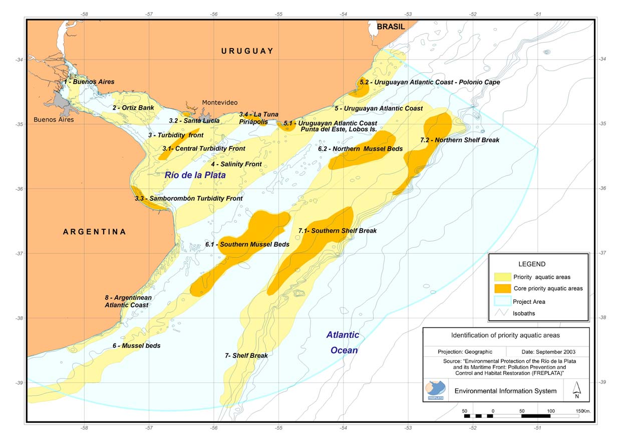
Figure 6.1.Priority aquatic areas for protection identified during FREPLATA, phase one.
Transboundary Diagnostic Analysis: Synthesis for Policymakers 59
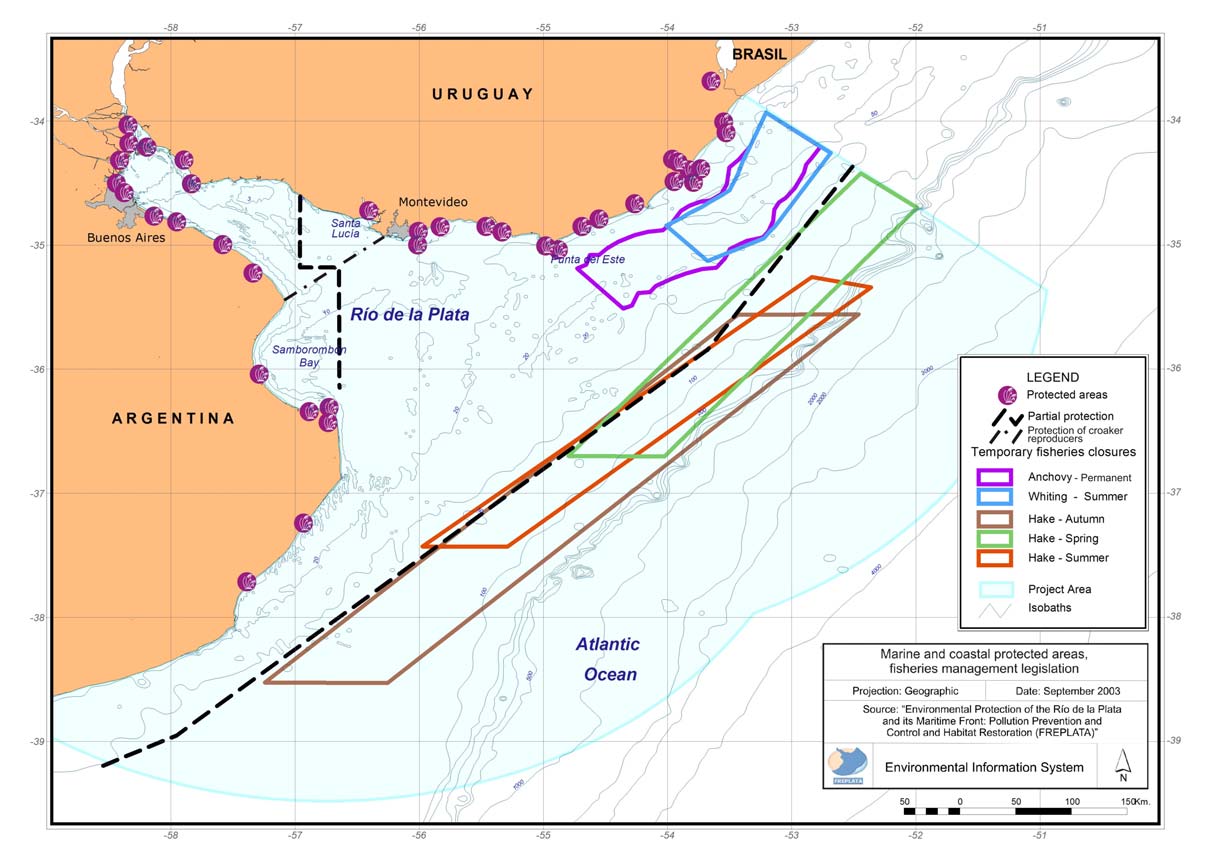
Figure 6.2. Areas with legal protection (Source: FREPLATA; 2005). Note: The hake zones are typical. The zone of protection of croaker reproducers
covered from October 31 to March 1° of every year.
Transboundary Diagnostic Analysis: Synthesis for Policymakers 60
International organization and co-financers
Inter-American Development Bank and the Fond Française pour
The Global Environment Facility (GEF) is the main project donor. Its
L'Environnement Mondial, (technical support agency of the French
support is implemented by the United Nations Development
Government).
Programme (UNDP). Additional support has been obtained from the
Table 6.3.Analysis of strengths and weaknesses of the current legal system.
Strengths
Weaknesses
Strong scientific bases for the use and conservation of aquatic systems,
Sectoral focus, and limited integration of information between both
including the Río de la Plata and its Maritime Front
countries.
Existence of the System of Information
Information disarticulated between organisms and countries.
Treaty of the Río de la Plata and its Maritime Front (1973) provides a
The Treaty does not have competition in the coastal zones therefore each
normative and institutional framework and institutional for the protection of
country adopts legislation that creates advisable and this way there is
the aquatic environment in the RPMF and promotes a regime of common
disarticulation and superposition of jurisdictions, especial in Argentina.
responsibility.
Shared cultural and legal inheritance both at the conceptual level as well as in
Differences between the two countries' policy framework limit integration
terms of the structure and function of the legal frameworks.
objectives.
Parties to international environmental agreements dealing with sustainable
development.
Solid institutions a the different governmental levels
Insufficient human resource capacity, limited financial resources,
fragmented and unarticulated actions.
6.4.-Relevance of current structures and powers, the case of protected areas.
Common Fishing Zone. Those measures include areas where
Figure 6.1 and Figure 6.2 show the relationship between current
trawling is completely and permanently prohibited, areas where only
measures for protecting aquatic life and the vulnerable areas
trawlers of less than a specific length can operate and, finally,
assessment conducted by FREPLATA. There is a strong coincidence
temporary closed areas for trawling. These management tools are
between the two maps. However, both Commissions depending on
implemented with the objective of stock conservation. This
the geographic area involved, have for some time now, been
experience showed that the Treaty and the two binational
establishing different kinds of protected areas for purposes of stock
Commissions provide the legal and institutional means for the
conservation, in the offshore areas of the Río de la Plata and in the
definition of common policies and legislation for the protection of
Transboundary Diagnostic Analysis: Synthesis for Policymakers 61
stocks in those offshore areas, although, as it is often the case, the
challenge is always how to ensure compliance and effective
enforcement.
Transboundary Diagnostic Analysis: Synthesis for Policymakers 62

FREPLATA Project
CARP-CTMFM
Consortium
Directorate Commission
Coordinating
(CDC)
Committee
Technical
Management Unit
Assessment
Groups
Intersectoral
Working Groups
Figure 6.3. Institutional organization used in the TDA.
Transboundary Diagnostic Analysis: Synthesis for Policymakers 63
6.5.-Social participation of stakeholders involved in the
their effectiveness within the TDA preparation process revealed the
governance.
following:
Problems with current instruments for environmental management:
The identification of agents and institutions key involved in the
(a) The majority of instruments applied are of a legal rather than
study, administration and management of resources of the RPMF
technical and economic nature. There are a number of norms
offered important information on the knowledge of system and bonds
that are currently impossible to apply because of the
between transboundary problems and root causes, and allowed to
unavailability of appropriate technology, their economic cost
identify so much the present restrictions and barriers for
or the lack of a strategy for innovation in the private sector.
implementation of actions as existing opportunities at current
This has the outcome that a number of norms are not
structures and systems (development of capacities, alert networks,
sanctioned or remain unimplemented, given that strict
training, etc.).
application would result in massive closure of industries,
The stakeholder participation involved in TDA preparation, was
particularly small medium sized enterprises, leading to a
promoted through the Technical Groups of Evaluation that were
high social cost.
formed by numerous specialists and representatives of civil society
(b) There is a problem of overlapping instruments that have been
institutions.
developed to achieve different objectives (and sometimes
With respect to governance, both governments are committed to
with contradictory criteria). In some cases there are conflicts
enhancing the participation of civil society. There is a wide
between pollution control systems and systems for
experience in this field in both countries and there are a number of
environmental impact assessment. On other occasions,
very active NGOs. These have been protagonists for improving
instruments are applied with dissimilar objectives such as the
environmental education and keeping environmental issues on the
use of emission standards. As mentioned earlier, there are
political agenda. Despite this, it is clear that there still insufficient
overlaps in jurisdiction (local, regional and national) and a
diffusion of information on transboundary environmental issues. This
lack of coordination within sectors of the same
lack of information was revealed in the stakeholders surveys
administration.
conducted by FREPLATA which provided clear evidence of
(c) State reforms in the 1990s often focused on reducing
diminishing interest in environmental issues away from the coast.
personnel and downscaling budgets and this sometimes
reduced the capacity to monitor and regulate.
6.6.- Economic instruments.
(d) There has, until now, been no systematic evaluation of the
results or effectiveness of environmental management
Economic instruments, including taxes, fees, levies and incentives,
instruments. In many cases new instruments have been
are an important tool for discouraging activities that damage the
introduced without removing or modifying the existing ones.
environment and for financing remedial measures. The two main
principles underlying their application are the Polluter Pays Principle
Strengths and weaknesses of current economic instruments in the
and User Fees. Studies conducted during the late 1990s evaluation of
region:
Transboundary Diagnostic Analysis: Synthesis for Policymakers 64
control in Zárate-Campana (out of the FREPLATA area) which
In Argentina the implementation of economic instruments has
achieved a positive relationship between private industry and
resulted in new institutional capacity for water management. Tools
government that led to treatment facilities for the elimination of
for management, regulation and monitoring have been developed and
cyanide in liquid effluents.
a geographical information system (GIS) has been established in the
Directorate for Aquatic Pollution Control. Despite this series of
In Uruguay, strictly speaking there are no economic instruments in
norms, considered to be comprehensive, the current system of
place. There are fees for services such as drinking water or sanitation
instruments has not succeeded to achieve the goal of reducing
but these have not been designed to change behavior towards the
industrial pollution for the following reasons:
environment. Currently, the entire basis of environmental legislation
· The charges were not designed as economic incentives for
in the country is the `command-control' paradigm.
environmental policy (i.e. for changing polluters' behavior)
but focused on covering the operating costs of provincial of
Public-private partnerships have been relevant for improving the
national agencies.
application of specific environmental policies. The use of legal
· There have been insufficient human resources and fiscal
mechanisms accompanied by a strategy of voluntary agreements with
measures for full implementation, and in recent years there
the private sector has achieved significant progress in controlling
was a problem of discontinuity within institutions
pollution in the Department of Montevideo. The `Industrial Pollution
responsible for their operation. This led to much mobility of
Reduction Plan' in the framework of a wider agreement, was agreed
personnel.
between the Environmental Commission and the Uruguayan
· Effective evaluation and process monitoring measures have
Chamber for Industry. This is guaranteeing real progress towards
not been implemented. Institutional overlap also diminished
improving water quality in the main watercourses of the City.
the effectiveness of the system as the control mechanisms
were sometimes the responsibility of more than one
Perspectives
organization; some companies could be taxed by the State
The issue of integrated systems for environmental management that
and the Province.
incorporate various kinds of instrument (legal and economic) is a
· There has been no concerted dialogue between the private
matter that should be high on the agenda during the negotiations for a
sector and the regulatory organizations during the design of
Strategic Program of Action for the RPMF. One of the main results
the instruments and their social viability was not tested
of the FREPLATA workshops was interest from both the public and
properly. This leads to a risk of conflict between the
private sectors in the design and implementation of incentive
objectives of reducing pollution and keeping factories
mechanisms, particularly economic instruments for financing
running.
pollution control. This could be used to supplement the command-
control provisions and increase their effectiveness.
On the other hand, in Argentina in the 1990s initiatives were
developed for public-private partnerships in the management of
industrial effluents. A good example was the program for pollution
Transboundary Diagnostic Analysis: Synthesis for Policymakers 65
7. Key gaps and uncertainties
The current version of the TDA has been developed on the basis of
produce data that can be easily understood by those
comprehensive reports produced by FREPLATA. They provide clear
responsible for budgetary planning. Full studies of economic
evidence of transboundary problems in the RPMF. As with most
valuation are complex, but an initial appraisal would be very
studies of this kind, there are always some gaps that can be identified
useful for policy development purposes. Hard choices will
with the advantage of hindsight. The following are areas that warrant
have to be made on which options to pursue and these should
further study in the future:
be informed by the possible economic information.
(1) Information on the biological effects of pollution in the
RPMF. Techniques are now available to study the
(5) Studies of migratory species that interact with neighboring
implications of various contaminants coexisting in the aquatic
systems. The RPMF is an open system that interacts with
environment. Their application would help to clarify whether
neighboring sea areas. An appraisal of the level of overlap
or not pollution constitutes a problem in the Maritime Front
would help to inform policymakers at national and
Area.
international levels.
(2) More comprehensive information on the damage to
communities and ecosystems in areas of intense resource
(6) Studies of the technology currently employed for pollution
extraction, particularly from trawling. Though there is clearly
control and its technical and cost effectiveness. This would be
intense pressure from this activity, considerable uncertainty
useful when designing future interventions and economic
remains as to whether or not it is causing lasting damage and
instruments. It can be included as part of the SAP process.
to which benthonic communities.
(3) Studies of the impact of resource exploitation on pelagic
ecosystems. Studies from many other parts of word area
demonstrating that this is one of biggest issues impacting the
environment globally. It is unfortunate that this body of
evidence has not yet been gathered for the RPMF, despite
clear evidence of overexploitation of some of the target
species (Figure 2.5.).
(4) Studies of the loss of economic value caused by ecosystem
and landscape degradation. Such studies could be an
important part of future decision making because they
Transboundary Diagnostic Analysis: Synthesis for Policymakers 66
References.
ACHA , E.M.; MIAZAN H.W..2003. El estuario del Río de la Plata:
COLOMBO, J.C.; BARREDA, A.; LANDONI, P.; CAPPELLETTI, N.;
donde el río se encuentra con el mar. Ciencia Hoy 13 (73): 10-20.
MIGOYA, C. 2003b. Contaminantes orgánicos persistentes en el Río de
la Plata. V Jornadas Nacionales de Ciencias del Mar, Mar del Plata,
ACHA, E.M.; MIANZAN, H.W.; IRIBARNE, O.; GAGLIARDINI, D.A.;
Argentina.
LASTA, C.; DALEO, P. 2003. The role of the Río de la Plata bottom
salinity front in accumulating debris. Marine Pollution Bulletin. 46(2),
COSTAGLIOLA, M.; PERESSUTTI, S.; GARCÍA, A. 2005. Evaluación y
197-202.
estudio de Vibrio cholerae, bacterias biodegradadoras de contaminantes
y bacterioplancton heterotrófico Informe Técnico FREPLATA-
BAZÁN, J.M.; JANIOT, L.J. 1991. Zona de Máxima Turbidez y su
INIDEP. http://www.freplata.org
Relación con otros Parámetros del Río de la Plata. DIGIP-SIHN.
Departamento de Oceanografía. Informe Técnico N° 65191.
EWSAMER (Eastern and Western South America Regional Report). 2002.
BINSZTEIN,N.; COSTAGLIOLA,M.C.; PICHEL, M.; JURQUIZA, V.;
regionally based assessment of persistent toxic substances. United
RAMÍREZ, F.C.; AKSELMAN, R.; VACCHINO, M.; HUQ, A.;
Nations Environment Programme (UNEP). Chemicals. Global
COLWELL, R. 2004. Viable but Nonculturable Vibrio cholerae in the
Environment Facility (GEF).
Aquatic Environment of Argentina. Applied and Environmental
FAOStat, 2006. http://www.demographic.com
Microbiology70 (12): 7481-7486
FCS, FRANJA COSTERA SUR. 1997. Calidad de las aguas de la franja
CARRETO, J.I.; MONTOYA, N.G.; AKSELMAN, R. 2004. Análisis
costera sur del Río de la Plata (San Fernando-Magdalena). Ed. Consejo
diagnóstico de la Problemática de las Floraciones Algales en el Río de
Permanente para el Monitoreo de la Calidad de las Aguas de la Franja
la Plata y su Frente Marítimo. Informe Técnico FREPLATA-INIDEP.
Costera Sur del Río de la Plata.
http://www.freplata.org
FREPLATA 2005. Análisis de Diagnóstico Transfronterizo del Río de la
CARSEN, A.; PERDOMO, A.; MARTIN, A. 2004. Contaminación de
Plata y su Frente Marítimo. Documento Técnico. Proyecto Protección
Aguas Sedimentos y Biota. Informe Técnico FREPLATA.
Ambiental del Río de la Plata y su Frente Marítimo: Prevención y
http://www.freplata.org
Control de la Contaminación y Restauración de Hábitats.
COLOMBO, J.C.; BILOS, C.; REMES LENICOV, M.; COLAUTTI, D.;
http://www.freplata.org
LANDONI, P.; BROCHU, C. 2000. Detritivorous Fish Contamination
JANIOT, L.; SIK, E.; MARCUCCI, O.; GESINO, A.; MOLINA, D.;
in the Río de la Plata Estuary. A Critical Accumulation Pathway in the
MARTÍNEZ, L.; MARCUCCI, P. 2003. Contaminantes Orgánicos
Cycle of Anthropogenic Compounds. Canadian Journal of Fisheries and
Persistentes (COPS) y Metales Pesados en Agua y Sedimentos del Río
Aquatic Sciences. 57, 1139-1150
de la Plata y su Frente Marítimo. V Jornadas Nacionales de Ciencias del
COLOMBO, J.C.; BARREDA, A.; CAPPELLETTI, N.; MIGOYA, C.;
Mar, Mar del Plata, Argentina. Diciembre, 2003
SKORUPKA, C. 2003a. Contaminantes orgánicos en aguas y
LAFFOLEY, D d'A.; MALTBY, E.; VINCENT, M.A.; MEE, L.; DUNN,
sedimentos de afluentes del litoral Argentino. V Jornadas Nacionales de
E.; GILLILAND, P.; HAMER, J.P; MORTIMER., A.; POUND, D.
Ciencias del Mar, Mar del Plata, Argentina.
2004. The Ecosystem Approach. Coherent actions for marine and
coastal environments. Peterborough, English Nature. 65pp.
Transboundary Diagnostic Analysis: Synthesis for Policymakers 67
MARCOVECHIO, J.E. 2004. The use of Micropogonias furnieri and Mugil
ORENSANZ, J.M.; SCHWINDT, E.; PASTORINO, G.; BORTOLUS, A.;
liza as bioindicators of heavy metals pollution in La Plata river estuary,
CASAS, G.; DARRIGRAN, G.; ELÍAS, R.; LÓPEZ GAPPA, J.J.;
Argentina. Science of the Total Environmet: 323: 219-226
OBENAT, S.; PASCUAL, M.; PENCHASZADEH, P.; PIRIZ, M.L.;
SCARABINO, F.; SPIVAK, E.D.; VALLARINO, E.A. 2002. No
MEE, L. 2005. Assessment and monitoring requirements for the
longer the pristine confines of the world ocean: a survey of exotic
adaptive management of Europe's regional seas. In Vermaat, J.,
marine species in the south western Atlantic. Biological Invasions 4:
Bouwer, L., Turner, K., and Salomons, W. (Eds) Managing
115-143.
European Coasts, Past, Present and Future. Springer-Verlag,
Berlin, 227-237
PENCHASZADEH, P.E. (ed). 2005. Invasores. Invertebrados exóticos en el
Río de la Plata y Región Marina Aledańa. EUDEBA, Buenos Aires.
NAGY, G.; SANS, K.; LAGOMARSINO, J.; ANDRÉ, E. 2004. Estado
VOLPEDO, A.V.; FERNÁNDEZ CIRELLI, A. 2006. Otolith chemical
trófico y cargas de los afluentes al Río de la Plata y Océano Atlántico.
composition as an useful tool for sciaenids stock discrimination in the
Informe técnico FREPLATA-Facultad de Ciencias.
Southwestern Atlantic. Scientia Marina 70(2): 2-22.
http://www.freplata.org
Transboundary Diagnostic Analysis: Synthesis for Policymakers 68
Annex 1. Causes and effects of human impact on the Río de la Plata and its Maritime Front and potential actions that may be considered
during the development of a Strategic Action Programme (SAP).
Immediate
Negative impacts (State
Root cause
Negative impacts on
consequences
Changes) on the
Options for priority action
variables
society
(Pressures)
ecosystem5
Legal frameworks coordinated between the various jurisdictions and
organizations.
Increase in mortality or
Implementation of a societal strategy of environmental education and
disease in sensitive species
Danger of intoxication
information
(CZ)
through direct contact with
polluted water.
Organized participation of civil society
Biomagnification of toxic
substances in trophic chains Danger of intoxication from Coastal zone management plans
(RP, MF)
consumption of polluted
species.
Integrated and coordinated information systems
Alteration of reproductive
or migratory behavior of
Loss of recreational use and Plans for capacity building for public and private sector decision
sensitive species (T, RP,
of economic value of the
makers
MF)
polluted water.
Bi-national strategies for improving compliance of existing
Reduction in primary
Conflicts between
international juridical instruments
Increase in the
and/or secondary
jurisdictions and their
POPULATION
waste loads (in
Institutional strengthening programs
production in the ecosystem competencies.
GROWTH
particular urban
(RP,MF)
Monitoring programs for accident early warning and water quality
effluents)
Loss of sales of aquatic
Alteration of the physical or products because of public
Maps showing sensitive areas
chemical characteristics of
concerns.
Bi-national criteria for the quality of water, ecosystems and sediments
water and sediments
Fisheries loss.
(RP,CZ)
Early warning systems for harmful algal blooms
Loss of quality of water,
Increase in the frequency or biota and sediments.
Strategies for managing and monitoring urban and industrial wastes
duration of harmful algal
blooms (T,RP,MF)
Increases in health
Program for information and diffusion of environmental monitoring
expenditure.
information
Increase in eutrophication
(RP)
Increases in the cost of
Updated and technical and economically viable standards for urban
producing potable water.
and industrial effluents and discharges
Sanitation plans with improved coverage and level of treatment
5 Types of impact: T = Transboundary; CZ = Coastal Zone; RP = Río de la Plata; MF = Maritime Front region; FZ = Frontal zones
Transboundary Diagnostic Analysis: Synthesis for Policymakers 69
Immediate
Negative impacts (State
Root cause
Negative impacts on
consequences
Changes) on the
Options for priority action
variables
society
(Pressures)
ecosystem6
Legal frameworks coordinated between the various jurisdictions and
organizations.
Implementation of a societal strategy of environmental education and
information
Coastal environments
modified/deteriorated (CZ)
Organized participation of civil society
Increase in coastal erosion
Coastal zone management plans
(CZ)
Conflicts in use of space
Integrated and coordinated information systems
Reduction in natural
Reduction in environmental
habitats and/or degradation
quality.
Plans for capacity building for public and private sector decision
makers
Increase in direct
of protected areas (CZ, RP,
POPULATION
Changes in artisanal fishing
population pressure MF)
Institutional strengthening programs
GROWTH
on coastal space
Loss of value of the
Changes in the biodiversity
ecosystem (existence value
Maps showing sensitive areas
of species and the species
as well as economic value)
composition of
Policies of territorial spatial planning
communities (RP, MF)
Loss in the tourism sector
Bi-national strategies for biodiversity in the study area
Alteration of habitats
Management plans for species at risk
(reduction, fragmentation)
(CZ, RP, MF)
Programs for sustainable tourism
Mechanisms for local public participation in managing coastal zones
and small catchments
Programs for aquatic protected areas
6 Types of impact: T = Transboundary; CZ = Coastal Zone; RP = Río de la Plata; FM = Maritime Front region; FZ = Frontal zones
Transboundary Diagnostic Analysis: Synthesis for Policymakers 70
Immediate
Negative impacts (State
Root cause
Negative impacts on
consequences
Changes) on the
Options for priority action
variables
society
(Pressures)
ecosystem7
Legal frameworks coordinated between the various jurisdictions and
organizations
Implementation of a societal strategy of environmental education and
Deterioration of the
information
aesthetic quality and loss of
Organized participation of civil society
Alteration of habitats (CZ,
value of landscapes.
RP, MF)
Coastal zone management plans
Increase in costs clean-up
Integrated and coordinated information systems
Increase in the
Health impacts on species
Increase in the costs in the
Plans for capacity building for public and private sector decision
volume of solid
(CZ)
artisanal fisheries sector
makers
waste
Accumulation of solid
through increased wear and
Bi-national strategies for the enactment of existing international legal
wastes in the turbidity front
tear
instruments
(CZ, FZ)
SOCIAL AND
Alteration of artisanal
Programs for institutional strengthening
ECONOMIC
fisheries
Environmental sensitivity maps
DEVELOPMENT
Territorial spatial planning policies
Strategies for the environmental management, monitoring and
evaluating solid wastes
Legal frameworks coordinated between the various jurisdictions and
organizations
Implementation of a societal strategy of environmental education and
Coastal environments
information
modified or degraded (CZ)
Conflicts in the use of land
Organized participation of civil society
space
Increase in coastal erosion
Increase in the
Coastal zone management plans
(CZ)
Loss of environmental
economic pressure
Integrated and coordinated information systems
quality
on coastal space
Loss of biological diversity
Plans for capacity building for public & private sector decision makers
(for development
(RP, MF)
Changes in artisanal fishing Programs for institutional strengthening
purposes)
Alteration of components
Loss of value of the
Environmental sensitivity maps
of the ecosystem (RP, MF,
ecosystem
Territorial spatial planning policies
FZ)
Bi-national strategies for biodiversity conservation in the RPMF
Management plans for species at risk
Sustainable tourism programs
7 Types of impact: T = Transboundary; CZ = Coastal Zone; RP = Río de la Plata; MF = Maritime Front region; FZ = Frontal zones
Transboundary Diagnostic Analysis: Synthesis for Policymakers 71
Immediate
Negative impacts (State
Negative impacts on
Root cause variables
consequences
Changes) on the
Options for priority action
society
(Pressures)
ecosystem8
Legal frameworks coordinated between the various jurisdictions and
organizations
Implementation of a societal strategy of environmental education and
information
Organized participation of civil society
Increase of point and
Risks to human health
diffuse loads of organic and
Coastal zone management plans
inorganic contaminants to
Limits to sustainable
Integrated and coordinated information systems
the water body (T, CZ)
development
Plans for capacity building for public and private sector decision
Increase in mortality and/or Decline in the quality of
makers
disease in sensitive species
life
(RP, CZ)
Institutional strengthening programs
Conflicts in the use of
Biomagnification of toxic
coastal/aquatic space
Water quality monitoring and early warning programs
Increase in loads
substances via trophic
Altered use of land space
Bi-national criteria for the quality of water, ecosystems and sediments
(and change in
chains (RP,MF)
AGROINDUSTRIAL
including urbanization
Early warning systems for harmful algal blooms
composition) of
ACTIVITIES
Alteration of reproductive
processes in the coastal
agro-industrial
and/or migratory behavior
zone and key sectors in the
Strategies for managing and monitoring urban and industrial wastes
wastes
(T, RP, MF)
basin
Program for information and diffusion of environmental monitoring
Reduction of primary or
Changes of mentality and
information
secondary production of the conflicts of interest
Updated and technical and economically viable standards for urban
ecosystem (RP)
between different sectors of and industrial effluents and discharges
society regarding the
Increase in the incidence of
exploitation of resources
Instruments for improving public-private collaboration and
harmful algal blooms (T,
and water bodies
partnerships
RP, MF)
Loss of ecological value
Mechanisms for local public participation in managing coastal zones
and small catchments
Programs for air quality monitoring
Plans for the promotion of clean technologies and sustainable
management
8 Types of impact: T = Transboundary; CZ = Coastal Zone; RP = Río de la Plata; MF = Maritime Front region; FZ = Frontal zones
Transboundary Diagnostic Analysis: Synthesis for Policymakers 72
Immediate
Negative impacts (State
Negative impacts on
Root cause variables
consequences
Changes) on the
Options for priority action
society
(Pressures)
ecosystem9
Legal frameworks coordinated between the various jurisdictions and
Alteration of reproductive
organizations
and/or migratory behavior
of sensitive species (T, RP,
Implementation of a societal strategy of environmental education and
MF)
Loss of ecological value
information
Reduction of primary or
Loss of fisheries yield;
Organized participation of civil society
secondary production of
transfer of the fishing effort
the ecosystem (RP)
to other species and
Coastal zone management plans
Overexploitation of
fisheries impact on
Alteration of biodiversity
Integrated and coordinated information systems
AGROINDUSTRIAL fish stocks and the
associated species
(RP, MF)
ACTIVITIES
introduction of
Plans for capacity building for public and private sector decision
Reduction of jobs in the
exotic species
Changes in productivity
makers
fisheries sector
and/or biodiversity of
Bi-national strategies for improving compliance of existing
ecosystems (CZ)
Alteration of fisheries
international juridical instruments
activities
Alteration of interspecies
Bi-national strategies concerning the introduction and control of
interactions in the
Crisis in the fisheries sector exotic species
ecosystem (RP, MF)
Strategies for integrated management and monitoring of fisheries
resources
Sustainable sectoral reform in the fisheries sector
9 Types of impact: T = Transboundary; CZ = Coastal Zone; RP = Río de la Plata; MF = Maritime Front region; FZ = Frontal zones
Transboundary Diagnostic Analysis: Synthesis for Policymakers 73
Immediate
Negative impacts (State
Root cause
Negative impacts on
consequences
Changes) on the
Options for priority action
variables
society
(Pressures)
ecosystem10
Legal frameworks coordinated between the various jurisdictions and
organizations
Implementation of a societal strategy of environmental education and
Danger of intoxication
information
Increase in mortality and/or
through direct contact with
disease in sensitive species
polluted water
Organized participation of civil society
(RP, CZ)
Danger of intoxication from Coastal zone management plans and integrated and coordinated
Biomagnification of toxic
consumption of polluted
information systems
substances via trophic
species
Plans for capacity building for public and private sector decision
chains (RP,MF)
Loss of recreational use and makers
Alteration of reproductive
of economic value of the
AQUATIC
Increased risk of
Bi-national strategies for improving compliance of existing
and/or migratory behavior
polluted water
TRANSPORT
spills (operational
international juridical instruments
of sensitive species (T, RP,
and accidental)
Conflicts between
MF)
Institutional strengthening programs
jurisdictions and their
Reduction of primary or
competencies
Water quality monitoring and early warning programs
secondary production of the Loss of sales of aquatic
Maps showing sensitive areas
ecosystem (RP)
products because of public
Program for information and diffusion of environmental monitoring
concerns
information
Fisheries loss
Programs for air quality monitoring
Instruments for improving public-private collaboration and
partnerships
Information campaigns and awareness directed and the maritime and
port communities
10 Types of impact: T = Transboundary; CZ = Coastal Zone; RP = Río de la Plata; MF = Maritime Front region; FZ = Frontal zones
Transboundary Diagnostic Analysis: Synthesis for Policymakers 74
Immediate
Negative impacts (State
Root cause
Negative impacts on
consequences
Changes) on the
Options for priority action
variables
society
(Pressures)
ecosystem11
Legal frameworks coordinated between the various jurisdictions and
organizations
Alteration and loss of
Implementation of a societal strategy of environmental education and
habitats (by dredging) (RP)
information
Alteration of benthic
Impacts on fishing
Organized participation of civil society
community composition
Increase in health risks by
Coastal zone management plans
and species richness (RP)
inappropriate disposal of
Integrated and coordinated information systems
Increased dredging
Loss of secondary
dredged spoils
production of the
Loss of recreational use by
Plans for capacity building for public and private sector decision
ecosystem (RP)
inappropriate disposal of
makers
Remobilization (dumping)
dredged spoils
Bi-national strategies for improving compliance of existing
of potentially contaminant
international juridical instruments
sediments (RP, CZ)
Bi-national criteria for the quality of water, ecosystems and sediments
AQUATIC
Bi-national strategies for the mitigation of the negative impacts of
TRANSPORT
dredging
Legal frameworks coordinated between the various jurisdictions and
organizations.
Implementation of a societal strategy of environmental education and
Alteration in fishing
information
Changes in the productivity
activity.
Organized participation of civil society
and/or biodiversity of
Rapid deterioration of
ecosystems (T, CZ, RP,
Coastal zone management plans
Invasion of exotic
engineering material and
MF)
species in ballast
infrastructure (e.g. water
Integrated and coordinated information systems
wares and through
Alteration of the
intakes)
Plans for capacity building for public and private sector decision
fouling
interspecies relationships of Increase in the cost of
makers
the ecosystem (RP, MF,
operation and maintenance
FZ)
of dams and water
Bi-national strategies for improving compliance of existing
international juridical instruments
purification plants.
Bi-national strategies concerning the introduction and control of
exotic species.
Information campaigns and awareness directed and the maritime and
port communities
11 Types of impact: T = Transboundary; CZ = Coastal Zone; RP = Río de la Plata; MF = Maritime Front region; FZ = Frontal zones
Transboundary Diagnostic Analysis: Synthesis for Policymakers 75
Immediate
Negative impacts (State
Root cause
Negative impacts on
consequences
Changes) on the
Options for priority action
variables
society
(Pressures)
ecosystem11
Legal frameworks coordinated between the various jurisdictions and
organizations
Implementation of a societal strategy of environmental education and
information
Loss of physical space and
Increase in coastal erosion
coastal infrastructure
Organized participation of civil society
(CZ)
Sea level rise
Loss of aesthetic quality
Coastal zone management plans
Alteration and loss of
and devaluation of physical
ecosystems (CZ)
Integrated and coordinated information systems
space
Water quality monitoring and early warning programs
Policies of terrestrial spatial planning
Plans for monitoring and early warning for sea level rise
CLIMATE
CHANGE
Legal frameworks coordinated between the various jurisdictions and
Increase in erosion in the
organizations
hydrographic basin (T)
Devaluation of physical
Implementation of a societal strategy of environmental education and
Alteration and loss of
spaces
information
ecosystems (CZ, RP)
Increase in the vulnerability Organized participation of civil society
of the coastal population
Alteration in
Alterations in the
Coastal zone management plans
tributary river flow
concentration of nutrients
Alterations in navigation
(RP, CZ)
Integrated and coordinated information systems
Alterations in the supply of
Increase in sediment loads
electricity and drinking
Water quality monitoring and early warning programs
to the system (CZ, RP)
water
Bi-national criteria for the quality of water, ecosystems and sediments
Early warning systems for harmful algal blooms
Transboundary Diagnostic Analysis: Synthesis for Policymakers 76