Synopsis Inception workshop for the project
"Caspian Water Quality Monitoring and Action Plan for Areas of Pollution Concern"
Tacis/2005/109244
Venue: Nissa Hotel, Ashgabat, Turkmenistan; 17 and 18 May 2007
I.
INTRODUCTION
This Workshop was organized by the DHV/COWI Consortium to discuss the findings of the Inception Phase
for this project and to adjust the work plan to the needs and recommendations of the beneficiaries. The
SAPIC of Turkmenistan helped prepare and realize the venue in Hotel Nissa in Ashgabat, excellently
supporting the event in all aspects, including help with accommodation, translation, visa, transport, logistics,
administration and visibility. The Workshop was attended by about 30 participants, including most of the
SAPICs and PRAGs of the riparian states, the CEP Management from Tehran, representatives of the
International Oil Industry along the Caspian, representatives of the Turkmenistan MNP, EcoCaspoControl
and the port sector. The Turkmenistan Minister of MEP opened the Workshop on Thursday and attended
final meetings on Friday. Representatives of EU and UNDP attended the opening as well and delivered
welcome words. Television, radio and written press paid ample attention to the event.
II.
OPENING SESSIONS
Mr. Makhtumkuli Akmuradov, Minister of Nature Protection of Turkmenistan expressed a warm
welcome to the participants and expressed his gratitude to EU TACIS for enabling this event in
Turkmenistan. He gave an overview of Turkmenistan's ongoing activities for improving the environment in its
Caspian coastal zone, articulating these efforts needs to be embedded in the CEP context as will be
endorsed under the Tehran Convention. In this regard he referred to the First Convention of the Parties,
CoP1, scheduled next week in Baku. He wished participants a good and fruitful event. The list of
participants including their coordinates is attached to this synopsis.
Mr Young, UNDP Turkmenistan rearticulated the efforts UNDP, UNEP and GEF are making since 1995 in
establishing a joint Caspian Environment Program (CEP). He reminded EU through TACIS has been
involved from the very start and that this project will be a new opportunity where EU can give momentum to
the pollution monitoring and action planning for the Caspian areas of pollution concern.
Mr. Michael Wilson, EU TACIS Turkmenistan welcomed the project in Turkmenistan and framed the
initiative within the project completed already under TACIS. He expressed his gratitude to Ms Lena Nielsen
Project Manager for this project in EuropeAid for enabling it; reminding short communication lines between
Brussels and Ashgabat are kept-up. He reminded pollution control and action planning is an important
aspect of improving the water quality of the Caspian, but in doing is, due attention has to be paid to another
aspect: climate change! Exploring and exploration of the huge oil and gas fields along and in the Caspian
not only is a risk for the aquatic ecosystem. The enlarged release of carbon dioxide into the atmosphere is a
thread requiring counter measures. Carbon sequestering is not in the scope of this project, but the impact of
climate change will affect all activities in the Caspian region, including monitoring and action planning. He
stressed the present project should remind this.
1
Mr. Gijs Kok, Team Leader DHV/COWI Consortium (TL) expressed his gratitude for the excellent hosting
of the Workshop by MNP and said personal words of thanks to the Minister, SAPIC, and other speakers. He
welcomed all participants, especially the representatives of the oil industry and he wished the coming
dialogue would enable the Consortium to find the right focus facilitated by a good road map.
He recalled the project is supported under the EU's neighborhood policy. This will enable Consortium
seeking galvanized and harmonized solutions. In this regard the Project will build at the pillars of ECs
neighborhood policies, by making the lighthouse function work, stimulating the regional policy dialogue and
providing policy instruments and financial support, enabled by TACIS. In this regard he referred to the EU
Water Framework Directive (WFD). The WFD is an example of a water policy instrument aiming at uniform
standards, legally binding in a trans-boundary context, binding time frames with agreed infringement
procedures, anchored in an economic framework demanding cost-effective measures; and supported by
public participation, (http://ec.europa.eu/environment/water/water-framework/index_en.html).
He introduced participants to the program of the Workshop, articulating the Workshop is an opportunity for
open discussion, where the agenda will facilitate the interaction between the parties.
TL explained Workshop arrangements:
Participants introduced themselves
Mr. Vladimir Glazovsky, Ministry of Nature Protection/ P-RAG Member for Turkmenistan was
regretted. In his place Russian Mr. Anatoly Krutov, Consortium's short term expert for the
Inception Phase, was appointed acting Chairman / Facilitator.
Mr. Dirkjan Douma, Assistant Expert of Consortium was nominated treasurer.
III.
PRESENTATIONS BY CEP EXPERTS
Mr. Hamidrezah Gaffarzadeh, CEP Manager, PCU, Tehran expressed this TACIS project is timely and
needed to sustain activities that are already going on seven years. At the same time the TACIS Aid is
flexible in its mandate. The CEP has addressed the pollution issues right from the very beginning in 1997.
During the First CEP Phase in 1998 in Ramsar it was agreed Caspian Regional Pollution Centers would be
established in Baku and Iran. The Baku Center was helped by the EU; the Iran Center by UNDP. In the first
Phase of CEP sediment samples were collected. The picture obtained did not really meet the expectation of
what thought to be the situation. Possibly samples were not collected in a representative way and results did
not show a trend.
In the Second Phase, the Caspian Regional Thematic Activity Centers for Pollution (CRTCs) were a
abandoned. In stead P-RAGs, Pollution Regional Action Groups were formed, to replace the CRCTs. The P-
RAG is a consultative body on pollution control strategies, meeting twice a year. It is for the CoP1 to decide
the P-RAGs can continue. P-RAG's institutional arrangements are in place:
1. A Regional Water Quality Monitoring Program, RWQMP was agreed upon, delineating how to
sample, where to sample, etc
2. A work plan for pollution action planning was agreed, supported by protocol for land-based pollution
sources.
We must assure that what has been assured will not be lost and that the results obtained are transferred to
the CoP.
CEP2 will come to an end in this year. It is GEF to decide if there is a Third Phase for CEP. The Caspian is
interesting: oil and environment, but GEF also says, the region is not poor. It sometimes is said, "We do not
2
need the money; we need the dialogue". Whoever submits the money, the problem always is how to spend it
the best possible way. Is it pollution, fisheries, invasive species, coastal zones,etc?
The perspective is we have to find common ground. Not to redo what we have done, but to fill in the gaps
and to add those aspects that are needed, additionally. If the Consortium works into this direction, the CEP
aspects the results project will be very concrete and very useful.
Mr. Reza Sheikholeslami Pollution Expert, PCU, Tehran, presented CEP-II Regional Pollution Related
Activities in the Caspian Sea.
Related Pollution Activities include:
1. Review Study on the Status of Pollution Information/Institutions in the Caspian Region;
2. Assistance in the design, promotion and implementation of a cost effective and affordable regional
monitoring program;
3. Carrying out an inter-calibration exercises among Caspian States Laboratories, for POPs/PTS
measurements;
4. Preparation of a common guideline for sediment sampling and pollutant analyses;
5. In conjunction with the oil industry develop an environmental rapid assessment
methodology/program using bio-marker techniques;
6. Further surveys of the coastal sediments, assessing the impact of key transboundary
contaminants;
7. Surveys of major contaminants in Volga Delta and Kura River;
8. Rapid Assessment of Pollution from Land Sources in Near Caspian Watershed;
9. Development of Regional Action Plan for addressing the activities contributing to transboundary
PTS contaminants;
10. POPs Pilot Projects for Control/Reduction/Elimination of POPs in the region;
11. Desk Study on Contamination of Certain Caspian Rivers;
12. Activities in relation to Anomalous Algal Bloom in Southern Caspian (AAB).
Ad 1: The Review Study on the Status of Pollution Information/Institutions in the Caspian Region was based
on a Questionnaire filled-in by the Caspian states (2004) including:
Responsible organization for Contaminant Monitoring;
Laboratories activities on contaminant measurements;
Specialized institutions/laboratories involved in eco-toxicity and biomarker technique application in
contaminant monitoring and assessment;
Responsible organizations for Monitoring of Pollution sources and control;
National POPs and PTS related activities in connection to the Caspian Sea.
Ad 2: The Assistance in the design, promotion and implementation of a cost effective and affordable regional
monitoring program was delivered. PRAG (IV), was held in Baku, 11-13 October 2005, the meeting
collectively agreed on the elements and structure of a Regional Pollution Monitoring Program in the Caspian
Sea. Major elements are:
Sampling media: bottom sediments of coastal waters
Contaminant parameters: DDT, Lindane, TPH for Organic Compounds and Hg, Cu, Zn for Trace
Metals
Complementary parameters: grain size, TOC, Al, CO3 and Fe
Number of stations: 5 � 8 in each coastal waters of country
Sampling frequency : once a year
Timing: the same period all over the sea, suggested July � September.
3
Using common guidelines for sampling, sample handling, sample preparation and analyses
Following institutes were involved:
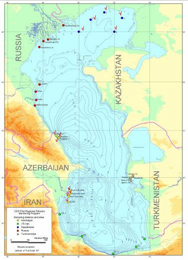
Azerbaijan: Caspian Complex Environmental Monitoring Administration (CCEMA) of MENR
I.R. Iran: Department of the environment, Marine Environment Bureau
Kazakhstan: Kazhydromet
Russia: SOI, Roshydromet
Turkmenistan: Caspoecocontrol
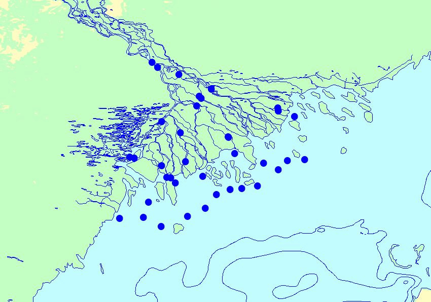
The position of the RQWMP sampling stations were chosen as follows:
Ad 3: The outcome of inter -calibration exercises among Caspian States Laboratories for POPs/PTS
measurements were as follows:
Proficiency test (Metals, PCBs and CPs) has been conducted among the laboratories in the region,
supported by MESL/IAEA-Monaco to assess the capability of local laboratories;
The results have shown that only limited numbers of local nominated laboratories performances
were satisfactory in measurements of certain metals;
None of nominated laboratories performances were satisfactory in PCBs and CPs measurements.
4
Ad 4: A common regional guideline was developed for monitoring of POPs/PTS in sediment including
sampling, sample handling and analyses in cooperation with MESL/IAEA-Monaco.
Ad 5: In conjunction with the oil industry an environmental rapid assessment methodology/program using
bio-marker techniques is being developed. A Scientific workshop was held on application of Biomarker
Technique in environmental monitoring and management, 21-23 February 2005, Baku with focus on new
techniques that potentially could be applied in contaminant monitoring and assessment particularly in oil
fields operations. A brief introduction to some of the biomarker techniques was also presented to the
participants at the Caspian Laboratory in Baku.
An illustration of the technology was presented:
Biomarkers refer to any biological response in a living organism resulting from the exposure to a pollutant
chemical (chemicals). Biomarkers sometimes are confused with a term used for organic chemical markers
(e.g. persistent components in oil, such as pristane, phytane, and hopane, etc.
The biomarkers are defined as biochemical, cellular, physiological or behavioral variations that can be
measured in tissue or body fluid samples or at level of the whole organism, providing evidence of exposure
to and/or effects of one or more chemical pollutants, [Depledge, M].
Ad 6: Further surveys of the coastal sediments, assessing the impact of key transboundary contaminants
were implemented:
5
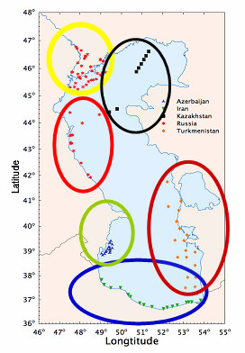
Surveys of Major contaminant: (2005 Caspian Scientific Cruise)
A total of 74 duplicated sediment samples were obtained for PTS analysis including:
AZ:
16 samples
IR:
19 samples
TK:
18 samples
RU:
13 samples
KZ:
8 samples
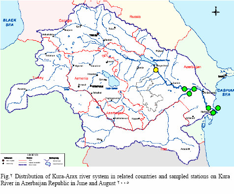
a. Surveys of Major contaminant: 2005 Kura River Contaminant Surve. Surveys obtained 12
Suspended Material (6 in June and 6 in August) and one bottom sediment samples:
6
b. Surveys of Major contaminant: 2005 Volga Delta Contaminant Survey. From 30 stations, 24
sediment samples were obtained from Volga delta:
Ad 7: Rapid Assessment of Pollution from Land Sources in Near Caspian Watershed. The GIWA
methodology http://giwa.ico3.com/giwa/index.html was used to prepare point and non point sources
inventory and a one day training workshop was held in Baku to introduce the GIWA model.
Ad 8: Development of Regional Action Plan for addressing the activities contributing to transboundary PTS
contaminants (RPAP): The Action Plan (RPAP) for Caspian Region was developed by the international
consultant Ms.Katar�na Magulov� and close cooperation/collaboration of 5 national consultants in 2006.
Ad 9: The Development of Regional Action Plan for addressing the activities contributing to transboundary
PTS contaminants (RPAP) included:
i.
Action program to prevent illegal use and trade with POPs pesticides;
ii.
Action program to clean up stores of obsolete POPs agrochemicals located in the near Caspian
region and ESD of the obsolete stocks;
iii.
Action program to clean up sites contaminated with PTS having major potential to pollute the
Caspian Sea
iv.
Action program to raise awareness about potential hazards due to PTS in the general public (use
of agrochemicals, entering POPs stores/contaminated sites uncontrolled burning of waste, etc.)
v.
Action program to establish infrastructure for environmentally sound storage and destruction /
disposal of POPs;
vi.
Action program to prevent / mitigate impact of large oil spills from exploitation, transport, processing
and accidents;
7
vii.
Action program to prevent illegal use and trade with POPs pesticides;
viii.
Action program to clean up stores of obsolete POPs agrochemicals located in the near Caspian
region and ESD of the obsolete stocks;
ix.
Action program to clean up sites contaminated with PTS having major potential to pollute the
Caspian Sea;
x.
Action program to raise awareness about potential hazards due to PTS in the general public (use
of agrochemicals, entering POPs stores/contaminated sites uncontrolled burning of waste, etc.);
xi.
Action program to establish infrastructure for environmentally sound storage and destruction /
disposal of POPs;
xii.
Action program to prevent / mitigate impact of large oil spills from exploitation, transport, processing
and accidents; and
xiii.
Ad 10: POPs Pilot Projects for Control/Reduction/Elimination of POPs in the region.
Ad 10: POPs Pilot Projects for Control/Reduction/Elimination of POPs in the region include:
Azerbaijan: "Clean up of the territory of warehouse base for poison-chemicals of the Salian district
and reburying of the POPs." Grantee: SHAFA-I Ltd., Baku;
I.R.Iran: "Application of insect sex pheromones and appropriate pesticide application techniques in
order to reduce the pesticide residues on rice in paddy fields and the environment in Mazandaran
Province". Grantee: Biocontrol Research Laboratory - PPDRI � Amol.;
Kazakhstan: no study launched because low use of POPs;
Russia: "Development and introduction to technologies and mobile pilot model of the installation
for utilization of agricultural pesticides by method of thermal destruction". Grantee: The Institute of
Social-economic Strategic Monitoring,;
Turkmenistan: "Sustainable (POPs-free) development of agricultural activities through the
introduction of POPs free technologies of plant protection and training of local farmers". Grantee:
Communal Services of Essenguly Etrap;
Ad 11: Desk Study on Contamination of Certain Caspian Rivers. In general, in flowing studies, there are
lacks of data on contaminant, and the quality of available data is poor, e.g:
Collection of the existing contaminant data and information on Volga, Terek and Ural rivers; and
Collection of the existing contaminant data and information on Sefidroud River in Iran.
Ad 12: Activities in relation to Anomalous Algal Bloom in Southern Caspian (AAB): September 2005
experienced unprecedented bloom Anomalous Algal Bloom-(AAB) in the Iranian coast. Large algal bloom of
such scale was never observed before in open waters of the Southern Caspian. The Nodularia was
identified as responsible specie for the bloom.
Remote sensing researches were carried out by Marine Hydro-physical Institute of Ukrainian
Academy of Sciences. AAB on MODIS satellite images: a) August 17, 2005 b) September 1, 2005
illustrate it. Chlorophyll-a and WLR412 concentration maps for September 01, 2005 deliver
additional information.
Field investigations were undertaken by IFRO supported by CEP, August-September 2006.
Conclusions on Monitoring:
In general, the region suffers from lack of reliable contaminant data particularly on POPs /
PTS in order to have proper assessment. Unfortunately the data on other types of
contaminants or parameters also is weak;
At present, the member states are not at the situation that can effectively implement the
regional monitoring. Their national monitoring plan clearly indicates this status. The main
reason/or root cause is that there is no well defined/ users or demand for the output of the
monitoring. (there is no proper link between monitoring and environmental management);
The performances of Local laboratories in the region for PCBs and CPs are not satisfactory;
Investigation needs to be continued for improving the assessment and understanding of
contaminant changes and trends in Caspian Sea;
8
Quality of the contaminant data needs to be cross checked by internationally qualified
Laboratory/laboratories. More cooperation/collaboration of Caspian countries in this
Connection Is highly necessary;
Application of Biomarker Technique particularly in monitoring of oil field and capacity
building of the region in this connection could be recommended.
9
IV
BRIEFS BY SAPICs AND PRAG MEMBERS
Azerbaijan: Mr. Mirsalam Ganbarov, Head of the Caspian Complex Environment Monitoring office
and Mr. Mammadhuseyn Muslimov, Head of National Monitoring Department.
The water quality of Azeri's coastal are is an issue of great concern. Oil and gas extraction and processing
are wide spread, ship-building is booming; sewage outfalls are still not remediated, but sanitation plans are
in place and to be implemented in 5 years. Abcheron Peninsular is a very serious problem. An action plan
was developed September 2006:
1. Identification of hotspots
2. Areas with leakage and spillage
3. Vessel remains
4. Waste dumps
5. Improved ecological legislation
6. Expansion of national park's area.
Azerbaijan's 900 km of coastline has more than 300 land-based pollution sources, which have been listed.
Pollution loads assessments have been partially completed. There is no "Polluters pay mechanism" in place
yet; the law to be adopted. There are 6 research vessels, some with deep water winches available. Mr. Oleg
Voitsekovytch, Water Quality Monitoring Expert Consortium (KE2), requested details on tonnage,
power, winch capacity etc. These will be answered forthcoming visit. TL reminded oceanographic survey
data are yearly published in Russian.
Islamic Republic Iran: Ms Parvin Farshchi, SAPIC/ I.R.Iran: The subjects demanded in the program are
at a too high level of detail. Mr. Reza Sheikholeslami's presentation is a good synopsis. What SAPIC wants
to add are:
1. The relation between pollution and health is not understood, yet;
2. Recreational water quality is the issue of concern for the Iranian Coast;
3. River fluxes need to be identified;
4. Land-based sources to be identified;
5. Ballast problems need urgent attention;
6. Risk assessment is neglected at large;
7. No regulation as yet for POPs and PT;
8. WB to finance POPs and PTS initiatives in IR Iran. .
The presentation of Ms Parvin Farshchi, SAPIC/ I.R.Iran (see web-site) offers detailed information on the
actors and programs engaged in the CEP in IR IRAN::
Organizations/Institutions
Main Laboratories, including an overall evaluation:
o
Laboratories are in possession of good infrastructure for different contaminants,
specially for organic and inorganic substances
o
Availability of Expertise: Not involved in routine monitoring of contaminants and
mostly project oriented;
o
QA/QC needs improvement; Limited Inter-calibration Exercise;
o
No systematic contaminant monitoring in terms of POPs and PTS;
o
POPs Enabling Activity is at its early stage and only Inventory of POPs completed
Laboratories Involved in Eco-toxicity and Biomarker Techniques Application in Contaminant
Monitoring and Assessment
Recommendations: RPAP is suggested to include:
o
Biota as another media for sampling and analysis of targeted contaminants and eco-
toxicological studies
o
Recreational water monitoring to include Microbial Pollution and Eutrophication
o
Assessment of Interrelationship between Pollution and Human Health
o
Monitoring of Harmful/ any Algal Bloom
10
o
Determination of flux of major contaminants in main rivers
o
Land based assessment of major river watershed
o
Relevant component on invasive species
o
Risk Assessment Component
o
Improvement of QA/QC and Inter-calibration Exercise
o
Development of Regional Standards for selected Pollutants
Kazakhstan: Mr Serik Akhmetov SAPIC/ Kazakhstan and Mr. Almaz Bazarbaev, Leading Scientific
Employee of the Kazakh Scientific and Research Institute on Monitoring and Climate: The
Government of Kazakhstan through KazHydromet and the Oil Industry make large efforts in monitoring,
budget and efforts-wise.
1. MEP makes integrating efforts, storing and retrieving available data on a monthly basis in Astana;
2. There is a joint initiative of a local gas and space research company to make visual surveillances
from space, using satellite images;
3. A workshop is planned to discuss an action plan for oil spill abatement;
4. The oil and gas fields are very high in sulfur. An open depot stores 9 million tons of sulfur. One
million tons are yearly added. Some part is exported by train to Russia. Release of sulfates implies
contamination of sediments with sulfur. Under anaerobic conditions these sediments produce toxic
H2S.
5. Soil degradation and salinization widely occur;
6. More than 200 oil wells are flooded regularly. Suggestions were made to include some of these
wells in this project.
7. Death of young seals occurred this spring time; a reason is not known. Possibly the mild winter has
impacted on seal's virus resistance; another possibility is release of H2S from sediments, adding
synergistic effects.
8. Radio-active tailings are being investigated with special equipment; suggested was not to include
this aspect into the project;
9. There is a special antimonopoly law deciding which data are in and which data are not in the public
domain. Data on quality of sediment that now are in the public domain can be shared by writing
letter to MEP Astana.
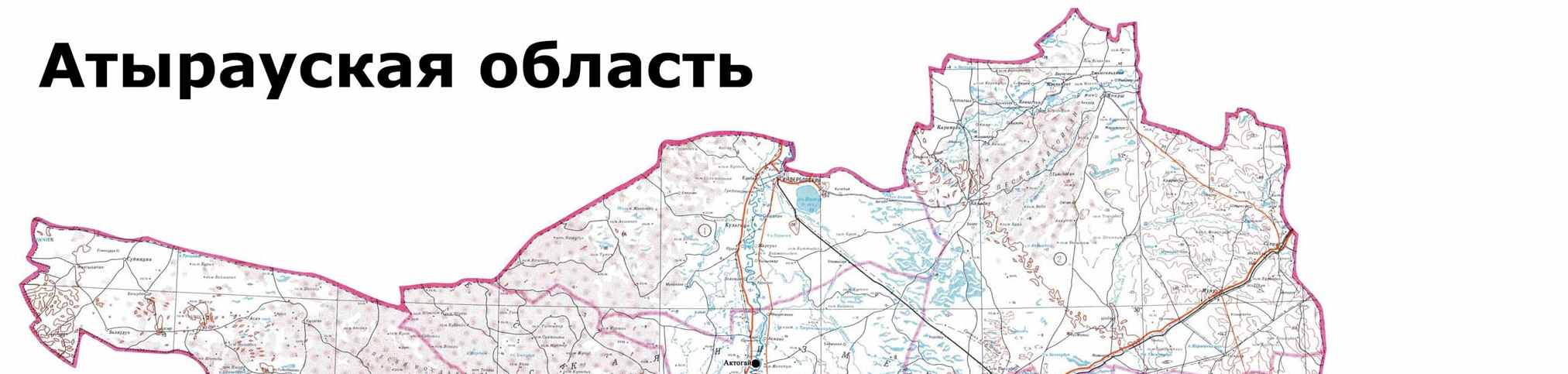
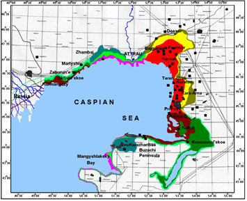
The presentation was illustrated by pictures of the recent field surveys made in Atyrau (2005) nand
Mangestal Oblasts (2006).
11
In discussions, Mr. Vladimir Markov, Deputy Director of the Russian Centre for International Projects
questioned about above point 9. KE2 suggested paying attention to impact of sea level fluctuations relations
and impact of atmospheric deposition.
Russia: Mr. Alexander Korshenko, State Oceanographic Institute, Head of Marine Pollution
Monitoring Laboratory presented the situation for the regional laboratories in Russia:
1. The Astrakhan Center on Hydrometeorology monitored about 40 stations in the Northern Caspian
1978-1992. Standard Hydrochemistry included Nutrients, Total Petroleum Hydrocarbons, Phenols
and Ammonium.
2. Occasional Scientific Cruises and Projects are executed since 1992.
3. Dagestan's Coastal Waters are monitored since 2006. In October 2006 these 36 Stations included
Surface & Near bottom layers in the depth zone of 4 - 24 m relative to Caspian Sea level. They
cover 8 spot locations and the transect ion Chechen-Mahachkala
4. Standard hydrochemistry includes Temperature, Salinity Alkalinity, pH, Oxygen Saturation, Total-
Phosphate, Silicates, Nitrites / Nitrates / Ammonium / Total-N;
5. Pollution includes Detergents, Total Petroleum Hydrocarbons, Phenols, Cu;
6. The Astrakhan and Dagestan Hydrometeorology Centers are the principle laboratories. Astrakhan
has boating facilities to investigate the river; Dagestan has two ships plus analytical capacity. The
Dagestan Center has demonstrated some data processing and data presentation capacity,
reflected in water quality isopleths for the Yalama � Samur River.
Turkmenistan, Ms. Gozel Orazdurdyyeva, SAPIC explained the concerns for pollution of sea water, soil,
groundwater around Turkmenbasy Bay and the port of Cheleken. The first concern oil refineries, the second
oil transport. Contingency planning and emergency response planning are under developed and an
adequate risk assessment for incidents, accident and major catastrophes is missing. Typical examples are:
Turkmenbashi Oil Refinery (TOR)
Khazar Chemical Plant (KhCP)
Exploitation and extraction in the coastal area (concern Turkmenoil and other companies)
Offshore oil extraction ("Dragon oil" company)
Transportation and delivery of oil and oil products (Turkmenoil, Turkmen Marine and River Lines,
TOR)
The CaspoEcoControl laboratory in Turkmenbasy is lacking adequate equipment and training. There is a
sincere need for upgrading equipment and capacity building. The research vessel is being refurbished.
Typical national measures envisaged include:
Strengthening pollution monitoring;
Promoting pollution reduction;;
Pollution prevention during oil transportation;
Collection/utilization of oil products and other industrial wastes;
Pollution prevention from sewerage
Strengthening oil spill response
Ecology of the Caspian � its Priorities � The problem of pollution and its solution:
TDA � identification of the transboundary problems, detailed cause �chain analyses. Pollution is
one of main priorities today.
SAP � actions for solution of this problem were identified together with other problems actions as a
whole on the region
12
NCAP � national environmental issues were identified and actions for their solutions with time
framework were pointed
References to built on are:
Ecotoxicity Study in the first CEP phase;
Sea-Cruise - 2005. (Assessment of key transboundary pollutants in water and sediments in the
whole costal zones of the Caspian)
RPAP- Regional Action Plan on Persistent toxic substances (PTS)
Rapid Assessment of Pollution Sources (RAPS)
National pollution monitoring program � contribution into Regional Pollution Monitoring Programme
(PRPM)
In general discussions, Mr Markov addressed the definition issues, demanding a glossary, notably in
Russian language. The proper citation if the Tehran Convention was another issue brought to attention of
TL.
V.
CONTRIBUTIONS BY THE OIL INDUSTRY:
Mr. Phillip Jones , (London, UK) Agip Consortium Kazakhstan, Environmental Monitoring Engineer
Mr Jones reflected on KCO's data bases collected since 1993 complemented by AGIP surveys, starting in
2001. AGIPs monitoring mainly focused on baseline data collection for supporting EIAs for oil exploration.
AGIP established commitments for water quality monitoring, mostly based on in-situ equipment measuring
salinity, dissolved oxygen, pH, turbidity and chlorophyll. Other parameters analyzed in the laboratory
concern N, P and Si components, trace metals and hydro carbons.
Since 2005 AGIP is making proficiency testing for Kazakh laboratories. QA/QC is promoted by preparing a
Common Quality Assurance Manual. Laboratories contracted by AGIP do have to comply with this. The
traceability of results now is strongly being enhanced. Further steps are underway to assure the quality of
data.
Nevertheless, the Kashkam oil field is very large and monitoring results reflect snap shots. Chlorophyll now
for example is observed with satellite images, offering a complete picture for the ice bound and ice free parts
of the Northern Caspian. Still the need for collecting ground truth data exists and logistical conditions are not
simple.
AGIP is investigating more advanced methods for continuous monitoring and data logging, for example for
nutrients, meeting the usual constraints. The scope for continuous monitoring is fairly limited. Biomarkers
are considered as well as application of a muscle watch system.
Mr. Kasimov Yu. Dragon Oil, Turkmenistan
DRAGON Oil collects data on surface water, seawater and sediment, basically to cover the baseline data
demands of EIAs for oil exploration and exploitation purposes. The data do not show the company is doing
something wrong. Severak surveys have been made. Sampling is positioned using satellite images. These
are annotated land based pollution sources, for example those affecting Turkmenbashy Bay. In the past
much waste was disposed in the Bay. Now the situation has improved. The presentation was illustrated by a
nice slide show, showing the peaceful coexistence of oil industry and nature.
Mr. Barsuk N., EMEROL LTD. Ireland, Turkmenistan branche
GIS based information systems provide a fair understanding of the impact of petroleum industry activities.
Modeling also has provided further understanding. Now between 75% and 90% of all information used every
day is GIS-based, providing a spatial picture of impacts. Oil drift models offer a complementary tool for
tracing the trajectory of incidental oil spills. A typical example of mass balance modeling was presented,
showing the impact of oil spill modeling at the Turkmenbashy Bay, with mass balance. In compliance with
the Aarhus Convention data are published on a website, referred to as the: "Caspian Response Resource
List". This displays names of providers of applied methods, like the USGS, US Coast Guard, US EPA, US-
Defense, etc.
13
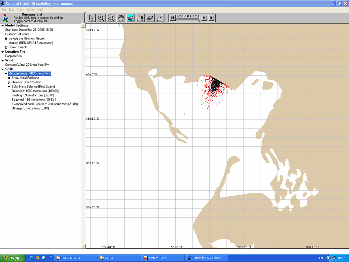
Example of mass balance model predicting impact of oil spill
Saimonov Bay receives 100,000 tons of oil each year. Emphasis is on measuring the impact by TPH
(Total Petroleum Hydrocarbons), copper and phenols.
Lenses of free liquid oil waste have been formed above the groundwater table, so-called
"Free Oil Contaminants" (FOCs). Such lenses have been formed under the TBR, the Ufra
transshipment tank farm, along large oil- and product pipelines, and at other place. They result from
leakage and incidental pollution and are a thread to seawater and the drinking water supply.
In Grozny Refinery hundreds thousand tons of oil products have accumulated in the lens floating
at the groundwater table. Now oil wastes combined with river water are discharging at the Caspian
Sea and its unique biological resources are threatened with an ecological catastrophe.
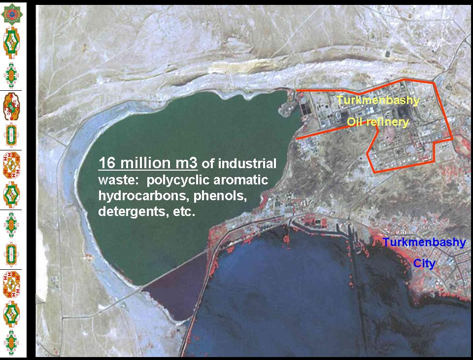
Turkmenbashy refinery has always used the Saimonov Bay as a point of final discharge of industrial
liquid wastes and sewage.
Now Saimonov Bay contains more than 16 million m3 of a mixture of brine, sludges, hydrocarbons
including most dangerous polycyclic aromatic hydrocarbons, bitumen, asphaltens, gums, synthetic
organic compounds, sulfur-organic and chlorine-organic compounds, heavy metals, phenols,
detergents, feces, virulent bacteria, etc. Photo and gas spectrometry are used to analyze the
leachates. EcoCaspoControl is a partner in this.
In the area of Saimonov Bay the streams of liquid oil waste discharge directly at the coast.
Currently at the eastern coast of the Saimonov Bay many cases of oil waste seepage are
observed, about 2 km of the coastline is strongly polluted with heavy oil. The volume of liquid oil
waste accumulated in the Bay in 1999 from industrial discharge of TBR was approximately 70-140
ton, and combined with drain of subsoil water � 6 000 ton (almost a hundred times greater!) As a
result, the content of oil waste in water of the Bay reaches 5-12 ppm.
14
Development of environmental norms and standards, Impact assessment (EIA)
At the coastal zone of Turkmenistan now an ambitious construction is under realization. The tourist
complexes are creating (hotels, restaurants, and recreation centers), modern roads are laying, port facilities
are reconstructing, power stations, desalinization plants and boilers are constructing. Current environmental
permits of existing and new enterprises and entities are obsolete, and Environmental abstracts of projecting
documentation for new objects under construction very often are not matching to modern requirements. This
situation demands special scientific research for development of unified environmental norms and standards
and draft projects for:
Contamination sources inventory;
Maximum permitted emissions;
Maximum permitted discharge;
Maximum permitted quantity of solid waste;
Statement on Environmental impact assessment
VI.
PRESENTATION OF THE DRAFT INCEPTION REPORT:
Introduction of the Project by TL
With reference to the presentation at the website, TL rearticulated the project objectives:
The broad overall objective is to improve quality of the marine and coastal environment of the
Caspian Sea through the Caspian Environment Program (CEP)
The project purpose is to assist in achievement of
o
Target 2.1 (Regional Water Quality Monitoring Program - RWQMP) and
o
Target 3.2 (Regional Pollution Action Plan - RPAP) of Environmental Quality Objective III
(Improve Caspian Water Quality) of the Strategic Action Program (SAP) for the Caspian.
15
TL reiterated the amended project objectives:
SAP Target 2.1 of November 5, 2003, now converted per October 2006 into
Target 3.1: "Develop and implement a regional water quality-monitoring Program focused on critical
contaminants and hotspots, (H) 1-5 years"; and
SAP Target 3.2 of November 5, 2003, now converted per October 2006 into
Target 1.2: "Undertake a comprehensive land-based source assessment and develop a regional
action plan to remediate areas of pollution concern identified, (H) 1-5 years".
TL recalled the Tasks and Activities proposed by the Consortium in response to the ToR:
Task 1: Project Management and Reporting
o
Project cooperation and communication
o
Preparation of the Work Plan
Task 2: Collection of existing data and identifying main pollution sources (added by Consortium)
Task 3: Design and implementation of an enhanced RWQMP
Task 4: Deployment of equipment and procurement of vessels and samples analysis for four
RWQMP cruises
Task 5: Production of RPAPs
In regard of the preparation of the Work plan, the SAPICs and PRAGs highlighted the need to very
carefully consider the recommendations made in this Inception Workshop and to be modest in water
quality modeling efforts.
TL elaborated Tasks briefly, making reference to the proposal, and explained the procedures for recruiting
local experts. SAPICS agreed to limit the number of experts and agreed with TLs proposal to work on the
basis of assignment notes, based on an performance based input output approach, backed by time sheets.
The proposal for using small boats for sampling near shore water quality was positively received, though the
use of deep water vessels for sampling deeper water was not excluded. Prerogative is to have a clear
picture of the nature and extent of the polluted zones. The extents of these zones often are revealed from
the air. Satellite images can be very useful for identifying these zones.
Key Expert no 2 1 : Water Quality Monitoring Mr Oleg Voiitsekhovitch in cooperation with KE3
Environmental Expert, Mr Jan H�ybye / COWI Denmark (regretted), presented building bricks for a
water quality-monitoring program focused on critical contaminants and �hotspots�
In response to the amended project objectives, KE23 emphasized:
This conversion prompts the Consultant to put more efforts in identifying and mitigating land based
pollution sources that affect the Caspian Sea.
Rather than GIWA (Global International Water Assessment), the Consultant therefore suggested
applying OECD's DPSIR (Driver, Pressure, State, Impact and Response) approach both to
RWQMP and RPAP.
However due attention will be given to the existing information as presented in the sheets. See overview
consulted documents.
Not all hot spots can be covered in present projects. A possible priority setting was suggested:
Azerbaijan
Baku
Bay
and (A1)
Oil product
Absheron
municipal, BOD
Kura River
(A-2)
NORM, Nitrogen
Sumgait
(A-3)
Pesticides, (DDTs),
PBs,
Heavy metals
1 In cooperation with Key Expert 3, Jan Agerholm H�ybye, Environmental Expert who was regretted.
16
Iran
Sefid Rood River (I-1)
Bandar Anzali
(I-2)
Municipal waste water
Chalus/Noshahr
(I-3)
Industrial
impact
(
Gorgan Bay
heavy metals)
(I-4)
CPs, PBs
Turkmenistan
Krasnavodsk
(T1)
Municipal,
Chelekan
(T2)
Heavy metals,
NORM
Kazakhstan
Ural
River
del (K1)
Oil and oil products
Aterau
(K2)
Heavy metals,
Aktau
(K3)
PB,s
Russia
Oil product
Derbent (Terek)
(R1)
municipal,
BOD,
Makhachkala
(R2)
Nitrogen
Volga River delta
(R3)
NORM,
Pesticides, (DDTs),
PBs, Heavy metals
This strategy will serve the two main purposes of the current project:
To address the most significant pollution sources (main objective for the RWQMP and RPAP); and
to demonstrate how amelioration projects can be designed for the various key types of pollution
(RPAP). These demonstration activities will provide the basis (handbook, methodology guidelines)
for CEP's further work.
CEP is already carrying our rather wide monitoring activity at the Caspian Sea (RPMP). Therefore
RMQP and RPMP must be well harmonized and coordinated.
The main issues to be considered as a part of studies in justification of RWQMP are:
Inflow and water level data
Water quality data and Bottom sediment contamination and its adsorption capacity and
contaminants remobilization
Sedimentation fluxes
Specific "Hot spots" and impact area identification
Monitoring data feedback and Data exchange
Status of laboratory conditions and needs identification
QA/QC status in national laboratories, identification of the key reference laboratories for Proficiency
testing exercises
Concept of the Database
Models validation and Model utilization as a tool for RWQMP optimization.
Water balance drivers:
The main drivers of the Caspian Sea are Volga River, Precipitation and Evaporation.
Evaporation is essentially the only mechanism transporting water away from the Sea
Inflow to the Caspian Sea is dominated by precipitation and river discharge from Volga, which in
total accounts for more than 90%.
Important note: Volga River is main water flux contributor. It is not a fact that Volga is a major contributor of
the pollution loading in to the Caspian Sea.
The Caspian Sea water level dynamics and Pollution concerns:
17
Long-term trends: driven by the climate and the human interventions (water extractions and dam
construction and operation):
Short-term Storm Surges: During Surges the water level for the short period (some hours) can increase to
1,5 - 3,0 m. MIKE-21 may be successfully applied for diagnostic analyses of the impact of the potentially
polluted territories and coastal zones
Examples are: flooding of the Tengiz depot are (2003) and Karaton-Teren' Uzek, agriculture lands washout.
November 2004.
Identification of the Main Impacts on Water Quality is one of the most important tasks for RWQMP:
Sources
Source functions
Impact area
Criteria for Impact Assessment
Critical impacts and their drivers
Critical pathways
Seasonality
Long-term prediction
Pragmatic approach based on:
Regional screening and
"Hot spot" focused RWQMP strategy
During recent years the number of Caspian Sea pollution Studies have been carried out. They provide a
good basis for the analyses:
Oil products in water
POPs and PTS in water and sediment;
18
Available data suggest:
The largest Nutrients pollution source is the rivers from the Russia (Volga River)
The second largest source of pollution comes from municipalities (Iran, Azerbaijan).
70% of the oil pollution originates in Russia (via rivers) and coastal industrial activities in
Azerbaijan, Iran and Kazahkstan (?)
DDT, PCBs - comes mainly from Kura River and Iranian Cost
It will not be possible to pay full attention to all APCs and all problem areas during the present project; rather
monitoring efforts will be concentrated to areas where there is a concerted response envisaged, based on
the DPSIR methodology:
The Concept of the new RWQMP for the Caspian countries will be developed by discussing, presenting and
proposing appropriate methodologies for:
Monitoring selected Areas of Pollution Concern;
Mapping and estimation of major pollution sources; and
Develop Proposals for typical/demonstration pollution control and remediation actions/feasibility
studies.
This strategy will serve the two main purposes of the current project:
To address the most significant pollution sources (main objective for the RWQMP and RPAP); and
To demonstrate how amelioration projects can be designed for the various key types of pollution
(RPAP). These demonstration activities will provide the basis (handbook, methodology guidelines)
for CEP's further work.
CEP already is carrying out rather wide monitoring activity at the Caspian Sea (RPMP). Therefore RMQP
and RPMP must be well harmonized and co-coordinated.
In this regard distinction has to be made between:
Baseline monitoring already provided by national Services; and
Specific monitoring for RWQMP to be provided under this TACIS project.
The baseline monitoring concerns:
River Water inflow
Regular Hydrological and Oceanographic observation (level, water balance, water mass exchange,
water dynamic, water dispersion, ventilation,
Physical parameters (CTD profiles)
Hydrochemistry (pH, salinity, transparent, conductivity
Basic Hydrobiology (chlorophyll, phyto- and zoo plankton
Others
The specific monitoring objectives are:
19
To identify the major sources of sea water and bottom sediment pollution and also its impact areas
for the main regionally important pollutants based on its regional environmental risk potential and
DPSR approach;
To demonstrate the comparability of the monitoring data and to implement QA/QC program at the
Caspian Sea countries;
To validate the modeling tools to be chosen for simulation of the temporal and spatial dynamic of
the contaminants in the sea water;
To develop proposal for optimal (cost effective and informative) national and regional WQMP,
which will make possible to monitor the current state of Environment, to justify and estimate
Effectiveness of the SPD implementation.
QA/QC � Quality Assurance/Quality Control:
Quality assurance is an integral part of the baseline and source oriented monitoring programs.
Quality assurance should provide a replicable approach enabling comparison of results of different
campaigns, both for different countries, different regions and different years or seasons.
The first Proficiency testing (Metals, PCBs and CPs) has been conducted under supervision of
MEL IAEA. The Reference materials concerned components like BS-1(OC) for PCBs and CPs and
IAEA-405 (about 30 metals);
AGIP initiated and carried out number of inter comparison working with Oil/Gas monitoring sector in
Kazakhstan;
The results show that it is still a beginning of the way toward QA/QC implementation in the most of
Caspian countries.
Reference: http://www.iupac.org
Metrological traceability is an important point:
Comparability: to provide confidence that measurement results agree within the stated
methodology, regardless the time, place and laboratory;
Traceability: to assure results of analysis can be related to the stated reference, usually national
or international standard;
Examples of such standards are: VIM 6.10 � ref: BIPM, IEC, IFCC, ISO, IUPAC, IUPAP, OIML, International
Vocabulary of Basic and General Terms in Metrology, 2nd edition, Geneva, 1993).
Specific methods are needed to measure sediment, considering:
The sediment layer sampled,
The height of overlaying water column
Sediment texture (particle size range or % clay,% slit, % sand)
Organic carbon content, dry matter content, and
other parameters relevant for the specific goal of the analysis, such as pH, redox potential, organic
and/or inorganic carbon content, cat ion exchange capacity, biologic al activity, content in sorption
phases such as iron, aluminum or manganese, type of clay material.
A crucial decision of sediment monitoring is the choice of the horizon to be monitored. Grab samples as
mostly applied so far do not give an accurate picture of the actual or historical conditions. In fact the top
layer reflects the direct impact of present pollutant; the deeper layers provide the evidence of the antecedent
pollution.
Suspended solids:
Please add the special equipment pictures here:
Other aspects to account for concern pathways and fate:
The fate of the nutrients and other, oil products and trace elements from land based pollution
sources entering the Caspian Sea;
Physical, chemical and biological transformation of hydrocarbons, PCBs and oil products and
contaminants,
TENORM (Ra-226., Th-232, Rn-222 , Pb-210, Po-210) and other isotopes having oil and gas
exploration origin at the Coast;
The fate of pesticides (DDTs, lindane,...), and other coming from the agriculture and industrial
sources (heavy metals, phenols other);
The fate of pollutants having the municipal waste water origin (Coli, BOD, Phosphorus, other....);
20
Aerosol fluxes. The fate of aerosol fallout on to the sea and secondary aerosol origin coastal area
pollution;
Sediment fluxes. The fate of the pollutants accumulated in the bottom sediment in their fixed and
mobile phases (adsorption capacities of sediments, rate of sedimentation and remobilization
abilities);
The fate of contaminants assimilation and its uptake by the marine biota and the sea food chain
analyses; others
In this regard the pathways and fate of pollutants in the environment arte both a result of transport and
transformation processes. The persistency, toxicity, and bio-accumulative potential of the substance are vital
indicators for setting priority towards monitoring contaminants. In this regard hydrocarbons, copper and
phenol for example are key examples, though phenol and hydro carbons are degradable and copper is not.
Reference was made to the "Methods for Sediment Sampling and Analysis", prepared by CEP.
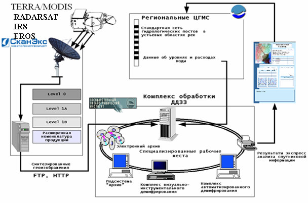
Satellite images can play a vital role in identifying pollution sources: CEP and SOI have very good
experience in using Satellite images resources. SoI applies the following system:
Modeling is important component in RWQMP:
An overall box-model, i.e. a water and pollution mass balance model
A distributed 2D HD/AD model (e.g. MIKE21) for the coastal zone.
Drifting models (for oil dispersion analyses)
MINTEQ type models (mass-exchange boom-sediment � water masses)
BOSS-SMS (RMA) model (wash-out of toxic materials from coastal inundated lands)
Atmospheric dispersion models
The future milestone is develop informational and modeling EDSS
Examples of priority RWQMPs:
Azerbaijan: Target area Baku Bay, Abcheron; Kura, Araks Rivers
21
Expert Mission, visiting Laboratories,
Evaluation of current monitoring programs, analytical and experts capacities
Oil-Drifting Model application discussion
Planning field studies, equipment; Research vessels
Data analyses
Discussion Concept and Regional Monitoring Program ( Baseline and specific RWQMP)
QC/QA planning
IR IRAN:
Target area is the Coastal zone of Guillan and Mazandaran:
Expert Mission, visiting Laboratories,
Evaluation of current monitoring programs, analytical and expert's capacities
Expertise of previous Data with special attention of qualification of the local experts
Consulting in planning of the field studies, air origin, beaches and municipality sources;
Discussion coordination, Data exchange and Concept for National and Regional Monitoring
Program (Baseline and specific RWQMP)
QC/QA planning and potential participation of the Laboratories in compliances with already done
exercises under MEL (IAEA)
Kazakhstan:
Expert Mission, visiting key Laboratories
Evaluation of current monitoring programs
Planning field studies, equipment and specific research needed
Existing Data analyses
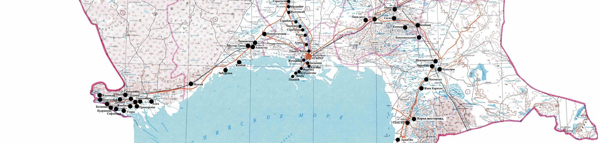
Screening and Sampling exercises ( Atyrau)
Reference Samples to be analyzed in Local Lab oratory and in referee EU Lab.
Discussion RWQMP Concept
Experience of AGIP co-operation and inter-calibration exercises
QC/QA planning
Some Specific expertise needed (for instance Uranium Mile tailing at the coast in Aktau, Koshkar-
Ata or Oil polluted area at the coast)
Russian Federation:
Contracting of experts and Procurement.....)
Expert mission (Moscow + Astrakhan, Makhachkala ?)
Preparation of the Program for sampling
Agreement in methodology and requirements
Cruses, sampling (Volga Delta, Terek River, Dagestan)
Sample (water, bottom sediment forms screening analyses (SOI, Typhoon, Obninsk)
Preparation of the Concepts (drafts) for RWQMP and QA/QC
Turkmenistan:
Contact with CaspEcoControl
Introduction with national monitoring approach
Evaluation of the main sources of pollution
Expertise of former Uranium Mines and tailings impact
Selection of priority and needs for Technical assistance
Constraints for RWQMP implementation
Lack of political support
Different legislative framework
Lack of analytical and technical capacities
Borders and customs issues
Sampling at the restricted areas of the Sea
Constrains on samples transfer out of the countries
Lack of communication
Difference in methodological standards and requirements
Access to the Data and Data exchange
22
Other
Key Expert no 4: Industrial Engineer, Mr Ary de Koning, Sectoral approaches for APC Action
Planning
The Objective of Task 5, Production of Regional Pollution Action Plans (RPAPs) is to develop remediation
action plans for a number of typical problem areas and sites (demonstration projects). The Main Subtasks
are:
a) TA for assessment of current situation
b) Development of action plan
c) Pre-feasibility studies of selected projects
d) Workshops on project progress
e) Know-how dissemination and capacity building
f)
Development of draft guideline for R-PAP
a. TA for assessment of current situation:
Making effective use of information published on the Internet in the regional context, making
reference to the riparian states and river basins, the relevant sectors both land and sea-based;
b. Development of action plan
Collecting baseline information on water polluting industries (existing and abandoned)
Per country
Per river basin
Per sector (industry, power, mining, etc.)
Per habitat; land-, littoral- and sea- based
Selection of industrial sectors of concern
o
EU BREF Documents
o
WB Industry Sector Guidelines
23
o
WB Decision Support System for Integrated Pollution Control (DSS/IPC) with database of
wastewater discharge factors
o
Obsolete or abandoned industrial sites
o
Hazardous waste and mine tailing dumpsites.
Selection of sectors of concern , Examples:
o
(Petro-)Chemical plants
o
(Abandoned) Pesticide factories
o
(Abandoned) Oil production and refining sites
o
Base metal plants (ferro and non-ferro)
o
Metal products finishing factories
o
Textile dying and finishing
o
Pulp and paper mills
o
Leather tanneries
Development of action plan
o
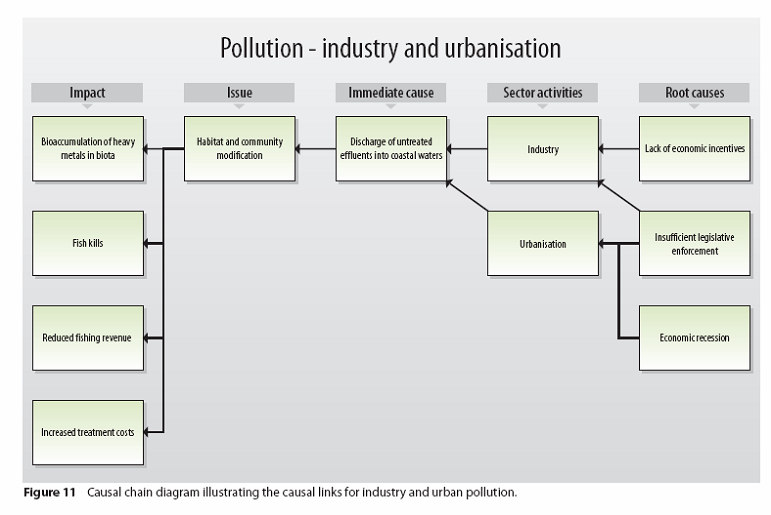
Setting-up the analysis
Drivers (oil and gas exploration, fishing, shipping, sea level fluctuation, urban,
industrial and agriculture, incidents, accident and major catastrophes)
Pressures (emissions, over fishing, submergence or denudation)
State (immission, fisheries stocks, shoreline conditions)
Impact (exposure, uptake and effects on man, biosphere and the built-up
environment)
Responses (mechanisms and instruments for pollution control, marine resource
protection, and shoreline management).
o
Making the diagnosis.
o
Developing scenario's
o
Selecting the most promising options
o
Pre-feasibility studies of selected projects
c. Pre-feasibility studies of selected projects
Proposals for typical/demonstration pollution control and remediation actions/
(Pre-)Feasibility studies
d. Workshops on project progress
Results baseline inventory
Results of analysis and diagnosis, and selection of scenario's and promising options
Results of Feasibility Studies and Action Plans (RPAPs)
e. Know-how dissemination and capacity building
Technical workshops on Industrial Pollution Control (IPC/BAT from BREF and WB)
Technical workshop on set-up of RPAPs according to the developed guideline
Building up of documentation systems and databases for IPC and RPAP development
f. Development of draft guideline for RPAP; Discussion items:
Legal mechanisms for introducing:
Good housekeeping,
Cleaner production, and BATEA (Best Available Techniques Economically Achievable).
Industrial restructuring based on:
Establishing industrial estates
Phasing out and remediation of obsolete processes and industry,
Relocating and concentrating industries,
Closing waste cycles by complementary production processes, joint utilities and facilities)
Financial instruments like:
o
Environmental funding,
o
Financial incentive mechanisms like rapid depreciation, grace periods, revolving funding
o
Improvement of environment by creating of win-win situations between the sectors and the
competent authorities
o
Mechanisms like funds matching and alliance building, enabling sectors to find synergy
with institutional investors
Seeking synergy and political embedding with existing initiatives under CEP-SAP. Priority will be
given to actions that already are embedded in such a context.
Reference was made to following CEP papers:
24
RPAP - Regional PTS Action Program for the Caspian Region, Elaborated under the CEP-SAP
project: Towards a Convention and Action Program for the Protection of the Caspian Sea
Environment";
NPAP - National PTS Action Plan for the Islamic Republic of Iran; Elaborated under the CEP-
SAP project: "Towards a Convention and Action Programme for the Protection of the Caspian Sea
Environment";
Rapid Assessment of Point Sources Pollution in Iranian Part of Caspian Sea Area, using GIWA
Methodology;
Following Tables were presented to illustrate some GIWA results [Source: Global International Waters
Assessment (GIWA) Regional assessment 23 Caspian Sea� 2006 United Nations Environment Program]:
25
KE4 articulated these data need to be further elaborated for making a targeted action plan.
26
TL presented resume on DPSIR and Use of Indicators in Action Planning:
DPSIR builds on the Driving Force-State - Response Framework (OECD-PRS). The PRS philosophy is as
follows:
EU's DPSIR Framework provides an overall mechanism for analyzing environmental problems.
Driving forces, such as industry and transport, produce
Pressures on the environment, such as polluting emissions, which then degrade the
State of the environment, which then
Impacts on human health and eco-systems, causing society to
Respond with various policy measures, such as regulations, information and taxes, which can be
directed at any other part of the system
This causal framework approach for describing the interactions between society and the environment
adopted by the EEA will be used as a rational tool. It is referred to as DPSIR, the Driving Force-Pressure-
State-Impact-Response Framework, (an extension of the PSR model developed by OECD).
In other words DPSIR stands for:
Drivers of sectoral development, based on human activities, exerting
Pressure on the environment (emissions, interventions, depletion of resources, which determine
the
State of the environment (quality of air, water, soil, groundwater, or the intensity of light, heat,
noise, vibration and radiation), resulting in
Impact on health, biosphere and cultural heritage, based on expo-sure, intake and effect, and
prompting
Responses in terms of preventive an curative environmental policies, plans, programs and projects
from the authorities.
27
Following diagram (EEA) illustrates it:
For our project the ultimate question is: "Where, what, when to monitor and how, but especially
WHY? This answer is found by looking at the information we need in order to make action plan to combat
pollution. Therefore we need indicators to formulate, structure, and embed our policies and to monitor the
results for evaluating their success and making the necessary amendments. This has to e based on
indicators at different level of intervention, for
Strategies
Policies
Plans and programs
Projects, considering the
o
Environmental themes and
o
Environmental media
Use of Indicators in Strategic Planning:
For preparing SAPs indicators will be used for evaluating measures in the policy cycle and in the hierarchical
planning. In the policy cycle indicators play a vital role in monitoring policy execution and evaluating impact
and effects of policy. Indicators also are use at different level of intervention, in a hierarchical order for
evaluating strategies, policies, plans and programs, projects, environmental themes and media.
Strategies can be evaluated with OECD/DAC sustainability indicators:
Sustainability
Efficiency
Effectiveness
Impact
Relevance
Bilateral donors often add indicators describing impact on:
Poverty alleviation
28
Gender
Human rights
Democracy
Decentralization
De-concentration and
Good governance
Policies are evaluated with DPSIR indicators:
Drivers of sectoral development
Pressure on the environment
State of the environment
Impact on health, biosphere and cultural heritage,
Responses
Plans and programs can be evaluated with SMART indicators: Investment packages in plans and
programs can additionally be also analyzed with LFA indicators, which should be SMART:
Sensitive
Measurable
Accepted
Representative and
Timely
Projects can be evaluated with Feasibility Indicators: They are applied to assess and monitor technical,
economic, financial, social and environmental viability of specific interventions, for example building a waste
treatment facility; they include econometric indicators like:
B/C (benefit/Cost ratio)
NPV (net present value)
FIRR (financial internal rate of return) as seen from monetary perspective
EIRR (economic internal rate of return) as seen from entrepreneurial perspective
FERR(financial external rate of return) as seen from society and monetary perspective
EERR(economic external rate of return) as seen from society and entrepreneurial perspective
29
Environmental Plan Indicators are applied to the environmental themes considered. These are
Indicators pertaining to the state of the environment as related to the interventions. These are DPSIR-
oriented parameters, with a strong emphasis on emissions or load reductions, in a time and a space frame;
they concern pollution loads typified in Quality and Quantity (Q+Q); for example tons of oil released per
year. EU/ECE Conference in Kiev, 2003, has suggested DPSIR oriented environmental theme indicators,
which are relevant at large as related with
Depletion of water resources,
Deterioration of water quality,
Depletion of natural resources,
Land degradation,
Air pollution,
Noise,
Climate change
Deterioration of nature
Biodiversity and heritage protection
At ground level these indicators are derived from the parameters used to describe the state of the
environment; examples:
Depletion of water resources can be indicated with:
Changes in hydrological regime: water discharge, surface area, water temperature, sediment
load, suspended solids, salinity;
Changes of the piezometric head in the relevant aquifers (in cm)
Changes in the salinity levels in the coastal aquifer system (in mg/l)
Changes in the water balance (at an appropriate sub-basin level) of total annual water use
and recharge (in MCM/yr
Deterioration of water quality can be indicated with:
Reduction in application rate of pesticides and fertilizers;
Indicators to quantify the industries (by type of industry) which have adopted Best Available
Techniques (BAT);
Percentage of dumpsites equipped with proper protection measures (sanitary land-fills);
Percentage of wastewater receiving proper treatment, enabling re-use;
Eutrophication rate: total N, P and chlorophyll A;
Pollution by sewage: O2, Biological Oxygen Demand (BOD), Chemical Oxygen Demand
(COD);
Organic and inorganic pollution: heavy metals, micro-pollutants;
Ecological state: productivity, species diversity, and incidence of fish diseases
Shoreline can be indicated with:
Percentage reduction of waste load entering the recreation zone;
Percentage of wastewater receiving proper treatment, enabling re-use;
Number of Shoreline cleaning actions being carried out
The essential message is that monitoring is a tool for action planning as illustrated in following diagram.
People may think it is a bit complicated, but it is not. The essential message is that monitoring should be
KISS, "Keep It Simple Stupid", and thus will help focus the project to action oriented monitoring enabling
adequate responses.
30
VII.
COMMENTS ON DRAFT INCEPTION REPORT
Caspian countries addressed their comments on the Inception Report articulating the need to well observe
the national interests on one hand, while embedding activities in a common Caspian framework on the
other. They demanded the actions to be well geared to the results achieved under CEP and to fine tune
them to the new Transboundary Diagnostic Analysis (TDA), to be discussed June 6-8, 2007 in Tehran.
The present draft Inception report therefore needs to be further operationalized, enabling a country specific
approach in a common framework. As well financial and staffing issues needs to be further clarified, which
should be done on a country by country basis. Detailed additional comments were submitted on a country by
country basis.
CEP manager strongly articulated to be modest in objectives. Unanimously participants stressed not to over
articulate modeling. In discussing local laboratory capacities, reference can be made to latest experiences of
CEP, KCO and other oil consortia.
VIII.
MAJOR FINDINGS OF THE INCEPTION WORKSHOP:
The TACIS project 2005/109-244 "Caspian Water Quality Monitoring and Action Plan for Areas of Pollution
Concern" is a challenge to strengthen the dialogue and cooperation between the countries around the
Caspian and the EU. The technical assistance will be geared to realize this and the work plan will be
elaborated in this direction. We are planning it for July 1st, 2007.
Turkmenistan as the hosting country of this workshop has shown its great commitment by facilitating it so
well. Now the Minister of Natural Protection of the host country has offered Ashgabat as duty station.
Though initially we all pointed at Baku, the procedural problems faced made us change our mind. If the
logistical problems become under control the Consortium will settle the duty station in Ashgabat. If
necessary and accepted by EU the Consortium may consider keeping-up a logistical basis in Baku, but this
can not be decided now. The contract provides for one duty station only.
The purpose of this project is to develop effective mechanisms for water quality monitoring and action
planning for pollution control, enabling a better protection of the Caspian's pristine ecosystem. All
representatives of the Caspian counties and the representatives of the oil industry expressed their
commitment to help enable this. The outcome should be a strengthened regional dialogue on the water
quality improvement of the Caspian supported by tangible results. This has to be achieved by putting the
national efforts in a regional approach fully in line with the results achieved so far by the Caspian
Environmental program.
31
What we have learned in this workshop that the technical assistance should be targeted towards capacity
building for water quality monitoring and pollution abatement action planning. This means that we have to
change the attitude, to develop new impetus, provide new equipment and new methods, give technical
training, but especially help develop a pragmatic approach that is scientifically justified, replicable, and
accepted and applied in all countries of the Caspian Sea region. A new mentality and an alternative focus
are needed, requiring changes in mind set. The project has to work on this.
As mentioned workshop, there is abundant historical information on the Caspian water quality, mainly
available in Institutes in the Russian Federation. Scientific data have been published in text books. After the
split-up of the FSU each of the riparian states has continued with his own program, but national resources
were limited and the data are not shared between the riparian states. Some routine water quality monitoring
was reinitiated, but the programs are not targeted towards measuring the direct impact of land based
pollution sources. Most important the measurement programs are not action oriented, because the
information is not used for pollution abatement planning. There is weak regulation and permitting, let alone
monitoring for compliance control.
New initiatives however have been developed in relation with identifying pollution loads, especially for zones
affected by oil and gas exploration and exploitation, or uranium mining activities. The most important
monitoring initiatives have been developed by the oil and gas industry, not as regulatory but as a pro-active
instrument. EIA baseline monitoring is carried out to assure operations meet international environmental
standards and the companies are protected against litigation claims. Not only indemnification is driver for
this. Also their business integrity management systems demand it. Sustainable entrepreneurship is
unthinkable without prime attention for health, safety and environment. By developing these baseline data
studies, a wealth of information is acquired, but understandably not disclosed all in the public domain.
Initially starting as a snap shot effort, now the oil industry is working in the direction of a more continuous
monitoring program, acting as an early warning system. The mussel watch is an example.
Not completely these private sector early warning monitoring initiatives stand alone. Supported by TACIS, a
storm surge warning system for the North eastern Caspian has been made operational. It is operated by
KazHydromet, but the results are shared with the oil industry and other stakeholders, enabling smooth
operation and management and enabling emergency preparedness. Another example is the oil drift model,
sponsored by NATO's "Science for Peace Program", enabling better oil spill responses.
In parallel with the private sector, some states are implementing pollution load oriented surveys in the
Caspian coastal zone, for example Kazakstan. These initiatives are very important and need to be
strengthened. As yet the problem is that results are not shared with the other countries. Also within the
countries the information is not part of the public domain, though it is acquired for serving civil society.
Possibly not all this information is of direct importance in the transboundary context. However it is the basis
for assessing pollution loads possibly reaching the Caspian and that is what we want to know: "The quantity
and quality of the land-based pollution loads potentially affecting the Caspian".
Under the umbrella of the Caspian Environmental Program, UNEP's Global Internal Waters Assessment
(GIWA) has been deployed. The results did not yield the information looked for. It possibly is not because of
the method, but because of the lack of access to the information. Mass-balances for pollution loads only can
be drawn up if there is sufficient information on the volume of the flow per unit of time and the concentration
of its constituents on a representative time scale.
Now after the forthcoming First Convention of the Parties of the Tehran Convention in Baku, we have the
opportunity to enter a new era where sharing of information is a common goal and working it out unbiased is
a common good. By doing this we will do our work in the spirit of the Aarhus Convention, enabling free
dissemination and access to information in the public domain. It will bring the region closer to Europe and
Europe closer to you, realizing good neighborhood relations.
The project provides for methods and tools for inter-calibration and limited funds for it are available. The
project also provides funds for logistic support to monitoring land based pollution sources and their impact
on the coastal water. Our project also provides funds for contracting national experts and once the work plan
is approved we will do that, following the TACIS procedures, bearing in mind the national setting in each
country.
A parallel EU project, "Supplies for the Caspian and Black Sea Environmental Projects", tender
EuropeAid/122682/C/SUP/MULTI will provide equipment and our project will seek a strong synergy with it.
32
Substantial time will pass however before this equipment are on the floor of beneficiaries laboratories. This
workshop has taught us as yet we can not bank for a large extent on pollution monitoring budgets of the
riparian states. It is for this reason the project has addressed TACIS for extra support for sampling and
analysis, and access to satellite imagery plus equipment for ground truth fact finding (if not provided under
the separate procurement contract), enabling a rapid and adequate assessment.
Bearing in mind these options and constraints we have to be modest in our objectives and careful in our
operations. We can spend the money only once. For the next six month we concluded we have to
intensively familiarize with the country situations, considering the available information on the hot spots, the
laboratory capacity, the capacity building needs, and most important all work that is about to be completed
under CEPs Regional Environmental Monitoring Program (REMP). To the extent possible we will build on
the results obtained, but we have to work on this new approach where monitoring is synonym with action
planning and action planning unthinkable without monitoring. We will try to fill in the gaps and focus work to
the very national needs, but in a harmonized way enabled by the Tehran Convention.
SAPICs, P-RAGs and representatives of the oil industry have offered the team a very good support and a
wealth of wisdom and experience. We can only jointly do our work by building on this. We hope we can
strengthen this cooperation and thus together achieve a better water quality of the Caspian.
33
34