Global International
Waters Assessment
Regional assessments
Other reports in this series:
Russian Arctic GIWA Regional assessment 1a
Caribbean Sea/Small Islands GIWA Regional assessment 3a
Caribbean Islands GIWA Regional assessment 4
Barents Sea GIWA Regional assessment 11
Baltic Sea GIWA Regional assessment 17
Caspian Sea GIWA Regional assessment 23
Aral Sea GIWA Regional assessment 24
Gulf of California/Colorado River Basin GIWA Regional assessment 27
Yellow Sea GIWA Regional assessment 34
East China Sea GIWA Regional assessment 36
Patagonian Shelf GIWA Regional assessment 38
Brazil Current GIWA Regional assessment 39
Amazon Basin GIWA Regional assessment 40b
Canary Current GIWA Regional assessment 41
Guinea Current GIWA Regional assessment 42
Lake Chad Basin GIWA Regional assessment 43
Benguela Current GIWA Regional assessment 44
Indian Ocean Islands GIWA Regional assessment 45b
East African Rift Valley Lakes GIWA Regional assessment 47
South China Sea GIWA Regional assessment 54
Mekong River GIWA Regional assessment 55
Sulu-Celebes (Sulawesi) Sea GIWA Regional assessment 56
Indonesian Seas GIWA Regional assessment 57
Pacifi c Islands GIWA Regional assessment 62
Humboldt Current GIWA Regional assessment 64
Global International
Waters Assessment
Regional assessment 31
Oyashio Current
GIWA report production
Series editor: Ulla Li Zweifel
Editorial assistance: Matthew Fortnam,
Kristin Bertilius
Maps & GIS: Rasmus Göransson
Design & graphics: Joakim Palmqvist
Global International Waters Assessment
Oyashio Current, GIWA Regional assessment 31
Published by the University of Kalmar on behalf of
United Nations Environment Programme
© 2006 United Nations Environment Programme
ISSN 1651-940X
University of Kalmar
SE-391 82 Kalmar
Sweden
United Nations Environment Programme
PO Box 30552,
Nairobi, Kenya
This publication may be reproduced in whole or in part and
in any form for educational or non-profi t purposes without
special permission from the copyright holder, provided
acknowledgement of the source is made. No use of this
publication may be made for resale or for any other commercial
purpose whatsoever without prior permission in writing from the
United Nations Environment Programme.
CITATIONS
When citing this report, please use:
UNEP, 2006. Alekseev, A.V., Khrapchenkov, F.F., Baklanov, P.J.,
Blinov, Y.G., Kachur, A.N., Medvedeva, I.A., Minakir, P.A. and G.D.
Titova. Oyashio Current, GIWA Regional assessment 31. University
of Kalmar, Kalmar, Sweden.
DISCLAIMER
The views expressed in this publication are those of the authors
and do not necessarily refl ect those of UNEP. The designations
employed and the presentations do not imply the expressions
of any opinion whatsoever on the part of UNEP or cooperating
agencies concerning the legal status of any country, territory,
city or areas or its authority, or concerning the delimitation of its
frontiers or boundaries.
This publication has been peer-reviewed and the information
herein is believed to be reliable, but the publisher does not
warrant its completeness or accuracy.
Publishing house: Kirjastusaktsiaselts MATS, Tallinn
Printed in Estonia by Tallinna Raamatutrükikoda, 2006
Contents
Preface 9
Executive summary
10
Abbreviations and acronyms
12
Regional defi nition
13
Boundaries of the Oyashio Current region
13
Physical characteristics
14
Socio-economic characteristics
19
Assessment 22
Freshwater shortage
22
Pollution
23
Habitat and community modifi cation
24
Unsustainable exploitation of fi sh and other living resources
24
Global change
26
Priority concerns
28
Causal chain analysis
29
Overexploitation
29
Changes in the hydrological cycle
31
Policy recommendations
32
Political framework
32
Policy recommendations
32
Conclusions 34
References 36
Annexes 39
Annex I List of contributing authors and organisations
39
Annex II Detailed scoring tables
40
The Global International Waters Assessment
i
The GIWA methodology
vii
CONTENTS
Preface
This report presents the results of the United Nations Environment
The report presents the results of the workshops, desk research,
Programme/Global International Waters Assessment (UNEP/GIWA) of
information development and policy analysis. The GIWA methodology
the Oyashio Current region. The report is a contribution to UNEP/GIWA
examines fi ve concerns: Freshwater shortage, Pollution, Habitat and
by Russia and was funded by the Pacifi c Geographical Institute, Far East
community modifi cation, Unsustainable exploitation of fi sh and other
Branch of the Russian Academy of Science (FEB RAS). The assessment
living resources, and Global change. During the GIWA workshops for
was conducted in collaboration with the General Northwest Pacifi c
the Scaling and scoping (held 12-14th September 2001 and 9-11th April
Region Environmental Cooperation Center (Japan), the Pacifi
c
2003) and the Causal chain analysis and Policy options analysis (18-
Geographical Institute, the V.I. Il'ichev Pacifi c Oceanological Institute
20th February 2004), the transboundary issues of these concerns were
and the Pacifi c Institute of Fisheries and Oceanography (TINRO-Centre)
assessed, the priority concerns were traced back to their root causes,
(Russia).
and a policy analysis was executed.
A select number of local experts with a range of specialist backgrounds
participated in three workshops hosted by the Pacifi c Geographical
Institute in Vladivostok, Russia. A list of those consulted in the
compilation of this report is presented in Annex I.
PREFACE
9
Executive summary
The GIWA region Oyashio Current is a unique marine ecosystem in
in the Petropavlovsk-Kamchatsky area are inadequate and may lead
the Pacifi c Ocean, characterised by high productivity, an abundance
to the contamination of the surrounding environment. Due to a lack
of diverse fl ora and fauna, and distinct bathymetry, including a narrow
of relevant data in the region, this issue was not prioritised for further
oceanic shelf and the deep Kuril-Kamchatka Trench. The majority of
analysis.
the Oyashio Current drainage basin is located in Russia, and a minor
part in Japan. The Oyashio Current region has attracted signifi cant
The Causal chain analysis identifi ed the following root causes of the
attention from politicians and researchers interested in its biological
overexploitation of fi sh:
and hydrocarbon resources.
Economy: Market reform failures; economic constraints prevent
fi shermen from adopting sustainable technologies; high taxes force
To date, the region has been largely unspoiled by the advances of
fi shermen to exceed their quotas; demand from export markets;
civilization due to its remoteness, with most GIWA concerns having
and fl uctuating market prices have changed the level of fi shing
limited or no impact. The most severe issues are changes in the
pressure on each commercial species.
hydrological cycle and ocean circulation (Global change), and the
Technology: Use of obsolete and non-selective fi shing gear.
overexploitation of the fi sheries (Unsustainable exploitation of fi sh
Governance: Weak regulations; lack of effi
cient state policy; lack
and other living resources). Positive temperature anomalies have
of alternative employment opportunities for fi shermen; and
changed the path of the Kuroshio Current which has consequently
confl icting regional and international fi sheries policies.
infl uenced the productivity of the fi sheries. Storm activity has increased,
Legal: Inappropriate legislation regulating the fi sheries sector in
generating greater energy in surface water layers and causing changes
Russia; laws do not contain the main principles of sustainable
in the thermal fl ux, thus increasing the frequency of severe storms and
fi shing; and inadequate enforcement of laws.
fl oods. These changes are attributed to global climate change and El
Knowledge: Inappropriate assessment methods; inaccurate scientifi c
Nińo Southern Oscillation (ENSO) events. Further, the impacts of global
studies; gaps in fi sheries statistics; and an insuffi
cient understanding
climate change are expected to intensify in the future. Overexploitation,
of ecosystem dynamics.
particularly in the south of the Oyashio Current region, has led to the
Political: Political confl icts regarding fi shing rights.
depletion of the major commercial fi sh stocks. This is mainly attributed
to increased fi shing eff ort and the overcapacity of the fi shing fl eet in
Because parties have expressed commitment towards international
the past two decades, particularly in the salmon, King crab, scallop and
agreements for the conservation and management of the marine
pollock fi sheries.
environment, including the Convention on Biodiversity, the UN Fish
Stocks Agreement of 1995 and the World Summit on Sustainable
Currently, the impacts of pollution from oil spills and radioactive
Development in 2002, it is anticipated that the management of the
waste remain slight. However, due to the expansion of the oil and
fi sheries in the Oyashio Current region will gradually improve.
gas industry in the region, as well as the increased shipment of oil
and gas, the risk of accidental spills and leakages in the future is high.
The Causal chain analysis found that changes in the hydrological
Further, there is concern that the facilities for storing radioactive waste
cycle and ocean circulation have been caused by global issues, such
10
GIWA REGIONAL ASSESSMENT 31 OYASHIO CURRENT
as global warming, which need to be addressed through international
scientifi c and marine environmental management institutions should
initiatives. It was agreed that inadequate progress had been made by
be encouraged in order to share data and techniques with an aim
the international community in mitigating this issue due to the non-
of improving the environmental quality of the entire region for the
implementation of relevant agreements. Despite the inability of the
mutual benefi t of all nations. A priority for the Oyashio Current region
countries in the region to resolve this issue by themselves, it was found
is to improve the understanding of the region's natural environment
that insuffi
cient eff ort has been made in preparation for the predicted
as well as to create an intergovernmental agreement between Russia
climatic induced changes. There is an absence of an eff ective system in
and Japan.
the region to monitor changes in the environment and to respond to
future natural hazards. There is also a lack of knowledge on the aff ect
A multilateral intergovernmental agreement should be initiated. This
of natural variability and anthropogenic activities on the ecosystems of
would aim to: (i) establish an organisation responsible for monitoring
the Oyashio Current, making it diffi
cult to predict the impacts of future
the regional environment; (ii) organise available information on the
climate changes. The ability of fi sheries management to react to climatic
health of the environment; and (iii) establish an intergovernmental
induced changes to the productivity of the fi sheries is hindered by an
commission mandated to coordinate environmental management in
inadequate understanding of the region's ecosystem dynamics and the
the region. The GIWA Task team believes it is necessary to develop and
lack of environmental indicators.
improve the legislative basis at all levels.
The GIWA Task team highlighted the necessity of scientifi c research.
Careful implementation and enforcement of appropriate standards for
the management of the fi sheries is necessary to avoid disputes amongst
the fi shermen of South Kuril. Greater cooperation between the region's
EXECUTIVE SUMMARY
11
Abbreviations and acronyms
APEC
The Asia Pacific Economic Cooperation
IOC Intergovernmental
Oceanographic
Commission
CBD
Convention on Biological Diversity
IPCC Intergovernmental
Panel
on
Climate
Change
CCA
Causal Chain Analysis
IWC
International Wildlife Coalition
EBRD
European Bank of Reconstruction and Development
JICA
Japan International Cooperation Agency
EEZ
Exclusive Economic Zone
LDC London
Dumping
Convention
ENSO
El Nińo Southern Oscillation
LME Large
Marine
Ecosystem
FAO
United Nations Food and Agricultural Organization
NGO
Non Governmental Organisation
FEB RAS
Far East Branch of the Russian Academy of Science
NOA
North Atmospheric Oscillation
GDP
Gross Domestic Product
NOWPAP
Northwest Pacific Action Plan
GEF
Global Environment Facility
PDO Pacific
Decadal
Oscillation
GOOS
Global Ocean Observing System
PICES
North Pacific Marine Science Organization
GIWA
Global International Waters Assessment
PO Policy
Option
GRP
Gross Regional Product
POI Pacific
Oceanological
Institute
GIPME
Global Investigation of Pollution in the Marine Environment
UNEP United
Nations
Environment
Programme
HCZ Hidaka
Collision
Zone
UNESCO
United Nations Educational, Scientific and Cultural Organization
IKIP
International Kuril Island Project
TINRO-Centre Pacific Institute of Fisheries and Oceanography
INPFC
International North Pacific Fisheries Commission
WESTPAC
Working Group for the Western Pacific
List of fi gures
Figure 1
The boundaries of the Oyashio Current region. . . . . . . . . . . . . . . . . . . . . . . . . . . . . . . . . . . . . . . . . . . . . . . . . . . . . . . . . . . . . . . . . . . . . . . . . . . . . . . . . . . . . . . . . . . . . . . . . . . . . . . . . . . . . . . . . . 13
Figure 2
Kluchevskoi volcano. . . . . . . . . . . . . . . . . . . . . . . . . . . . . . . . . . . . . . . . . . . . . . . . . . . . . . . . . . . . . . . . . . . . . . . . . . . . . . . . . . . . . . . . . . . . . . . . . . . . . . . . . . . . . . . . . . . . . . . . . . . . . . . . . . . . . . . . . . . . 14
Figure 3
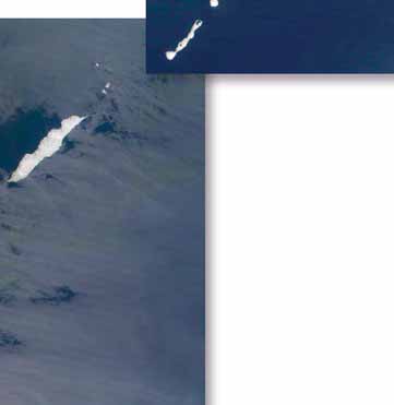
The Kuril Islands. . . . . . . . . . . . . . . . . . . . . . . . . . . . . . . . . . . . . . . . . . . . . . . . . . . . . . . . . . . . . . . . . . . . . . . . . . . . . . . . . . . . . . . . . . . . . . . . . . . . . . . . . . . . . . . . . . . . . . . . . . . . . . . . . . . . . . . . . . . . . . . . 15
Figure 4
Temperature and precipitation distribution in Hokkaido. . . . . . . . . . . . . . . . . . . . . . . . . . . . . . . . . . . . . . . . . . . . . . . . . . . . . . . . . . . . . . . . . . . . . . . . . . . . . . . . . . . . . . . . . . . . . . . . . . . . . . 16
Figure 5
The Kraternaya Bight, Ushishir, Kuril Archipelago. . . . . . . . . . . . . . . . . . . . . . . . . . . . . . . . . . . . . . . . . . . . . . . . . . . . . . . . . . . . . . . . . . . . . . . . . . . . . . . . . . . . . . . . . . . . . . . . . . . . . . . . . . . . . . 16
Figure 6
Sub-arctic gyre in the North Pacific. . . . . . . . . . . . . . . . . . . . . . . . . . . . . . . . . . . . . . . . . . . . . . . . . . . . . . . . . . . . . . . . . . . . . . . . . . . . . . . . . . . . . . . . . . . . . . . . . . . . . . . . . . . . . . . . . . . . . . . . . . . . . 17
Figure 7
Tectonic provinces of the Oyashio Current region. . . . . . . . . . . . . . . . . . . . . . . . . . . . . . . . . . . . . . . . . . . . . . . . . . . . . . . . . . . . . . . . . . . . . . . . . . . . . . . . . . . . . . . . . . . . . . . . . . . . . . . . . . . . . . . 17
Figure 8
Atlantic cod (Gadus morhua) and Pink salmon (Oncorhynchus gorbuscha). . . . . . . . . . . . . . . . . . . . . . . . . . . . . . . . . . . . . . . . . . . . . . . . . . . . . . . . . . . . . . . . . . . . . . . . . . . . . . . . . . . . 18
Figure 9
Industrial output in Kamchatskaya Oblast' in 1995 and 2001.. . . . . . . . . . . . . . . . . . . . . . . . . . . . . . . . . . . . . . . . . . . . . . . . . . . . . . . . . . . . . . . . . . . . . . . . . . . . . . . . . . . . . . . . . . . . . . . . . . . 19
Figure 10
Marine catches in the Oyashio Current. . . . . . . . . . . . . . . . . . . . . . . . . . . . . . . . . . . . . . . . . . . . . . . . . . . . . . . . . . . . . . . . . . . . . . . . . . . . . . . . . . . . . . . . . . . . . . . . . . . . . . . . . . . . . . . . . . . . . . . . . 24
Figure 11
A team of fishermen pull in a net filled with fish on Kuril Islands, Russia. . . . . . . . . . . . . . . . . . . . . . . . . . . . . . . . . . . . . . . . . . . . . . . . . . . . . . . . . . . . . . . . . . . . . . . . . . . . . . . . . . . . . . . . 25
Figure 12
Catch of Walleye pollock (Theragra chalcogramma) in the Oyashio Current. . . . . . . . . . . . . . . . . . . . . . . . . . . . . . . . . . . . . . . . . . . . . . . . . . . . . . . . . . . . . . . . . . . . . . . . . . . . . . . . . . . 25
Figure 13
Linkages between the GIWA concerns. . . . . . . . . . . . . . . . . . . . . . . . . . . . . . . . . . . . . . . . . . . . . . . . . . . . . . . . . . . . . . . . . . . . . . . . . . . . . . . . . . . . . . . . . . . . . . . . . . . . . . . . . . . . . . . . . . . . . . . . . . 28
Figure 14
Causal chain diagram illustrating the causal links for overexploitation of fish.. . . . . . . . . . . . . . . . . . . . . . . . . . . . . . . . . . . . . . . . . . . . . . . . . . . . . . . . . . . . . . . . . . . . . . . . . . . . . . . . . 30
List of tables
Table 1
Age structure of the population in Russia 1991 and 2001. . . . . . . . . . . . . . . . . . . . . . . . . . . . . . . . . . . . . . . . . . . . . . . . . . . . . . . . . . . . . . . . . . . . . . . . . . . . . . . . . . . . . . . . . . . . . . . . . . . . . . . . 19
Table 2
Population of the Kuril Islands 1995-1999. . . . . . . . . . . . . . . . . . . . . . . . . . . . . . . . . . . . . . . . . . . . . . . . . . . . . . . . . . . . . . . . . . . . . . . . . . . . . . . . . . . . . . . . . . . . . . . . . . . . . . . . . . . . . . . . . . . . . . . 19
Table 3
Economic growth rates. . . . . . . . . . . . . . . . . . . . . . . . . . . . . . . . . . . . . . . . . . . . . . . . . . . . . . . . . . . . . . . . . . . . . . . . . . . . . . . . . . . . . . . . . . . . . . . . . . . . . . . . . . . . . . . . . . . . . . . . . . . . . . . . . . . . . . . . . 19
Table 4
Export deliveries of fish and other seafood 1995-1999. . . . . . . . . . . . . . . . . . . . . . . . . . . . . . . . . . . . . . . . . . . . . . . . . . . . . . . . . . . . . . . . . . . . . . . . . . . . . . . . . . . . . . . . . . . . . . . . . . . . . . . . . 20
Table 5
Scoring table for the Oyashio Current region. . . . . . . . . . . . . . . . . . . . . . . . . . . . . . . . . . . . . . . . . . . . . . . . . . . . . . . . . . . . . . . . . . . . . . . . . . . . . . . . . . . . . . . . . . . . . . . . . . . . . . . . . . . . . . . . . . . 22
12
GIWA REGIONAL ASSESSMENT 31 OYASHIO CURRENT
Regional defi nition
This section describes the boundaries and the main physical and
Kuril Islands. After mixing with waters fl owing from the Sea of Okhotsk
socio-economic characteristics of the region in order to defi ne the
through the Bussol Strait, the Oyashio Current branches off along the
area considered in the regional GIWA Assessment and to provide
northern Japanese coast where it meets the warmer Kuroshio Current
suffi
cient background information to establish the context within
off the coast of northern Honshu.
which the assessment was conducted.
Ka
IT
mchatka
ARTS
A
Russia
K
Boundaries of the
T
A
H
KAMCHATSKAYA OBLAST'
C
M
Oyashio Current
A
Z
K
hupanova
region
Petropavloski-Kamchatskiy
The GIWA Oyashio Current region is situated
Elevation/
Depth (m)
in the northwest of the Pacifi c Ocean and
4 000
stretches for 2 000 km from north to south.
2 000
1 000
The region has a total area of approximately
500
)
850 000 km2 including the eastern part of
100
A
0
the Kamchatka Peninsula, the Kuril Islands
I
-50
S
-200
(east of Kamchatskaya Oblast' and Kurilskij
S
-1 000
U
raion of Sakhalinskaya Oblast', Russia), the
-2 000
R
(
east of Hokkaido (three sub-prefectures
S
of Japan: Nemuro, Kushiro and Tokachi)
D
N
A
and the Kuril-Kamchatka Trench. The Kuril-
SAKHALINSKAYA OBLAST'
L
S
Kamchatka Trench extends from north to
I
L
I
south for 1 200 km off the coasts of East
R
U
K
Kamchatka and the Kuril Islands from the
Toka Japan
chi
Nemuro
Kamchatka Strait. The region is connected
-Ga
Obihiro wa
Kushiro
to the Okhotsk Sea and the Bering Sea
(Figure 1). The Oyashio Current Large Marine
Ecosystem (LME) is based on the distinctive
0
500 Kilometres
© GIWA 2005
cold Kuril-Kamchatka Current which fl ows
southwards to the east of Kamchatka and
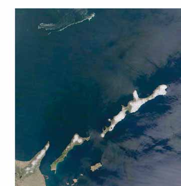
Figure 1
The boundaries of the Oyashio Current region.
REGIONAL DEFINITION
13
A chain of islands stretches from Kamchatka to Japan, dividing the
is found in central Kamchatka. This 8 km long valley comprises over
Okhotsk Sea from the Pacifi c Ocean. These can be divided into two
40 geysers, hot springs, boiling mud pots, steam vents and warm rivers
groups of islands, namely the Small and the Big Kuril Island Chains. The
(Logan 2001).
Small Kuril Chain comprises the southern end of the chain near Japan,
while the Big Chain stretches north to Kamchatka.
The Kuril Islands extend from Hokkaido to the Kamchatka Peninsula
and are surrounded by the Sea of Okhotsk and the Pacifi c Ocean. They
The entire basin lies within Russian territory, except for a small area in
are named after an indigenous population, the Ainu people, who were
the southwest which is Japanese territory.
originally known as the "Kur" people. There are 30 large islands and
more than 20 small islands of the Kuril archipelago that are of volcanic
origin, with a combined total area of nearly 10 500 km2 (Figure 3) (IKIP
1994-1999). The Kuril Islands include approximately 39 active volcanoes
Physical characteristics
(Stephan 1974, IKIP 1994-1999). The highest peaks are Alaid (2 339 m)
on Atlasov Island, Tyatya (1 819 m) on Kunashir Island, and Chikurachky
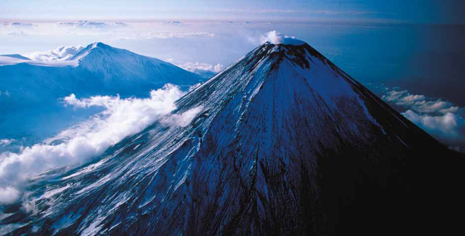
The eastern part of the Kamchatka Peninsula is located in northeast
(1 816 m) on Paramushir Island. Vegetation on the northern and middle
Russia, extending from about 51 to 58° N and from 157 to 164° E. The
islands includes alder thickets (Alnus sp.) and Dwarf Siberian pine (Pinus
Peninsula constitutes the northern link in the 2 000 km Kuril-Kamchatka
pumila). Spruce, fi r, broad leaf forests of Yew (Taxus baccata), Mulberry
island arc. This region contains 28 active volcanoes over 10% of the
(Morus sp.) and oak, as well as bamboo thickets, are very common in the
Earth's total number of active volcanoes and is part of the "Ring of
southern islands. Bear, fox and mink are representative of the Kuril fauna
Fire" the chain of volcanoes encircling the Pacifi c Ocean (Fedotov &
(Agafonova 2000, Barkalov 2002).
Mansurenkov 1991). Kamchatka's volcanic spine includes the Kluchevskoi
Volcano; the largest active volcano in Eurasia and one of the largest in the
Hokkaido is located in the northernmost part of Japan; extending from
world (Figure 2) (Logan 2001). It is nearly 5 000 m in height and 35 times
about 41 to 46° N and surrounded by the Sea of Okhotsk, the Japan
the average productivity of a land volcanoes. Eurasia's only geyser valley
Sea and the Pacifi c Ocean (Figure 1). The majority of eastern Hokkaido
Figure 2 Kluchevskoi
volcano.
(Photo: CORBIS)
14
GIWA REGIONAL ASSESSMENT 31 OYASHIO CURRENT


comprises marshes and hilly areas with peaty soil. Large areas are covered
in volcanic ash where soil fertility is low. Peat soil is present in the lower
Alaid
Shumshu
reaches of the main rivers, such as the Tokachi River, and in the wetlands
Antsiferova
(Hokkaido Government 1998b).
Paramushir
Makanrushi
Climate
The climate of the various parts of the Oyashio region varies considerably.
Onekotan
East Kamchatka and the northernmost islands of the Kuril arc (e.g.
Ekarma
Kharimkotan
Shumshu and Paramushir) have almost arctic climatic conditions,
Chirinkotan
Shiashkotan
while the southern islands (Kunashir and Iturup) contain pockets that
are practically sub-tropical.
Raikoke
The climate and wildlife of Kamchatka are equally diverse. There is a
Matua
moderate maritime zone on the coasts, a continental zone with four
Ushishir
Rasshua
distinct seasons in the central valley and an arctic zone in the northern
Ketoi
Broutona
Simushir
Figure 3
The Kuril Islands.
Chirpoi
Urup
(Source: NASA, IKIP)
Brat Chirpoev
1 400 mm. Winds often reach hurricane strength,
i.e. more than 40 m/s (Tersiev 1998). The Okhotsk
Iturup
Sea is icebound from November to June and
frequently has heavy fogs. The Kuril Islands have
Kunashir
a complex climate, including regular passages
of deep cyclones with strong winds, heavy
precipitation and storms (Tersiev 1998).
Hokkaido is located in a temperate and sub-arctic
Shikotan
climatic zone. Prefectures located in the temperate
zone are subject to monsoons and typhoons which
result in higher temperatures and humidity, as
well as greater precipitation, making the climate
parts of the peninsula. Maximum and minimum temperatures on the
suitable for rice production. The dry and moderate summer climate
islands reach 34°C and -26°C, respectively, but temperatures of -49 to
is suitable for crop production and animal breeding but sub-freezing
-60°C are observed in the central and northern parts of the peninsula.
temperatures and snow do not favour such agricultural activities from
In the coastal areas, between 1 and 6 days per year have temperatures
October to March (Figure 4) (Hokkaido Government 1998a). Although
over 20°C in the summer, whereas the Kamchatka River valley has 35 to
climatic conditions in Hokkaido diff er from region to region, generally
55 days (Tersiev 1998, Newell 2004). Maximum precipitation approaches
large diurnal temperature fl uctuations and cool nights during the summer
2 600 mm/year on the southeastern coasts. Maximum wind speeds in
favour the production of high quality crops.
winter reach 40 m/s on the coast (Logan 2001).
Rivers
The Kuril Islands have a predominantly maritime climate, with no severe
The Tokachi is the only large river in the Oyashio Current region and
frosts or excessive summer heat. Rain and fog are relatively frequent
enters the ocean from eastern Hokkaido. Consequently, there are no
in the summer with total annual precipitation ranging from 1 000 to
international rivers in the region. The eastern part of the Kamchatka
REGIONAL DEFINITION
15
24
140
22
130
20
18
120
Rainfall
16
110
Potential Evaporation
14
)
100
12
90
(°C
10
e
8
(mm)
80
t
ur
6
a
70
4
t
ion
60
2
mper
0
50
Average temperature
T
e
-2
Night-time temperature
40
r
ecipita
-4
Day-time temperature
P
30
-8
20
-8
-10
10
-12
0
y
y
y
s
t
y
y
y
s
t
r
c
h
u
r
c
h
u
April
Ma
June
July
g
g
t
ober
mber
April
Ma
June
July
t
ober
mber
mber
bruar
Ma
ember
e
bruar
Ma
ember
e
e
Januar
Au
v
Januar
Au
v
F
e
pt
Oc
F
e
pt
Oc
e
e
S
No
December
S
No
Dec
Figure 4
Temperature and precipitation distribution in Hokkaido.
(Source: FAO/AGROMET 2005)
Peninsula is characterised by a network of over 110 smaller rivers which
East Kamchatka Current and fl ows southwestwards towards Hokkaido
fl ow into the Pacifi c Ocean. These rivers contribute cool and less saline
where it branches off along northern Japan and meets the warmer
water to the East Kamchatka Current. The largest is the Kamchatka River,
Kuroshio Current off the coast of northern Honshu (Talley & Nagata
which fl ows 758 km from the head river, the Ozernaya Kamchatka, to
1995, Zalogin & Kosarev 1999).
the Pacifi c Ocean, draining a river basin area of 55 900 km2. There are
also numerous lakes, the largest being the Nerpichye in the northeast
The Oyashio Current is strongest in spring and surface temperatures
of Kamchatka which has an area of 552 km2 (Bortin et al. 1999, Chernjaev
vary seasonally from 0°C in early spring to 20°C in the summer. Sub-
2001). Kamchatka rivers generally have very wide fl oodplains which
surface minimum and maximum temperatures occur at depths of
cause them to fl ow over large areas (Logan 2001). They are renowned
approximately 100 m and 300 m, respectively, and the halocline at depths
for large catches of Red salmon
of 200 to 300 m in summer and
(Oncorhynchus nerka).
autumn. A developed seasonal
thermocline is found below
Rivers and streams number
50 m (Kono & Kawasaki 1997).
nearly 4 000 on the Kuril Islands
The topography of the Oyashio
and there are numerous lakes,
Current is characterised by the
including those of crater origin
Kuril-Kamchatka Trench and Rise,
(Figure 5). The highest waterfall
and a continental shelf of limited
in Russia, Ilija Muromets (141 m
width (Tersiev 1998).
high), is located on Iturup Island.
There are many small isolated
The East Kamchatka Current
lakes that dot the majority of
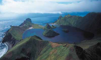
Figure 5
The Kraternaya Bight, Ushishir, Kuril Archipelago.
originates in the Bering Sea and
(Photo: CORBIS)
the islands; at least 19 lakes on
from the northern sub-polar gyre.
Shumshu, 5 on Onekotan, 7 on Simushir, 14 on Iturup, 10 on Kunashir,
It transports approximately 15-25 Sv* in the upper 1 000 m (Talley &
and 8 on Shikotan.
Nagata 1995), whereas the Oyashio Current transports about 10-15 Sv
in the upper 1 000 m east of Hokkaido. Therefore, 5-10 Sv remain in the
Oceanography
sub-arctic gyre while 4-5 Sv enters the sub-tropical gyre. The Kuril Straits
In the Oyashio Current region, the western boundary current merges
are aff ected by strong tidal mixing and tsunamis (Bogdanov et al. 1991,
with the East Kamchatka Current a southwestwardly fl owing western
Talley & Nagata 1995, Nakamura et al. 2000). The Oyashio Current generally
boundary current in the north and the Oyashio Current in the south
fl ows southwestwards from the Kuril Islands but the fl ow pattern varies
(Figure 6). The cold Oyashio Current, known also as the Kuril Current, is
annually. Large eddies propagate against the current and carry warm
formed by the mixing of two sub-arctic waters: the Okhotsk Sea and the
waters of sub-tropical origin northwards. Off the Kuril Islands, the southern
East Kamchatka Current. The Oyashio Current meets waters from the
fl ow bifurcates around these eddies to create the Oyashio coastal and
*1 Sv= 1 million mł/s
16
GIWA REGIONAL ASSESSMENT 31 OYASHIO CURRENT


Cold saline bottom water
Tectonic setting and tsunamis in the Oyashio
Current region
tn
The Kuril Trench was formed by the subduction of the Pacifi c plate under
rre
u
Okhotsk Sea
C
the North American plate and extends from the central area of Kamchatka
Gyre
atka
to Hokkaido (Figure 7). The plate tectonics of the South Kuril Islands and
ch
am
northern Hokkaido region are quite complex and very diff erent to those
Western
East K
Subarctic Gyre
located along the southern part of the Japanese Trench. The South Kuril
Islands are part of the Kuril arc on the boundary of the Okhotsk plate
which has been colliding westwards against the Northeast Japan arc
Subarctic Current
along the Hidaka Collision Zone (HCZ) where new continental crust is
created by active arc-arc collision (Ito et al. 2001).
The complex, seismo-tectonic kinematic processes operating in the
© GIWA 2005
region have been named the "Delamination-wedge-subduction system"
Figure 6
Sub-arctic gyre in the North Pacifi c.
which may apply also to other areas where active arc-arc collision and
(Source: Redrawn from PICES 1993)
concurrent subduction take place (Pararas-Carayannis 2000). The entire
Oyashio off shore branches. During the 1990s, a major thermohaline
area appears to be highly fractured by complex tectonic interactions with
transition occurred within this current system, linked to the relative fl uxes
crust displacements found along the boundaries of broken subplates.
of two major water masses entering the Sea of Okhotsk; warm salty
The Kuril Backarc Basin is a deep basin in the southern Okhotsk Sea,
waters through the Soya Strait and cold fresh waters through the Kuril
northwest of the Kuril arc. These fractured smaller plates, which are in
Island straits. This thermohaline transition was manifest in changes in
close proximity to the tectonically active arc collision area, limit the extent
the temperature and salinity structure of the boundary current regime,
of crust displacements. Consequently, large earthquakes have generated
an alteration of the path of the Oyashio Current and a strengthening
tsunamis that are only locally destructive tsunamis in this region.
and restratifi cation of the coastal Oyashio branch. These changes were
refl ected in the structure of mesopelagic fi sh communities (Yasuda et
Many of the large earthquakes and tsunamis on the Pacifi c side of northern
al. 1996, Nakamura et al. 2000).
Japan and the South Kuril Island area are attributed to subduction along
the Japanese Trench. The tsunamis of October 1963 and October 1994
According to observation data, the general pattern of water circulation
occurred on the Pacifi c boundary of a smaller tectonic subplate, which
within the active sea layer is subject to considerable seasonal variations.
includes the Sea of Okhotsk and a northern part of the Sea of Japan
In autumn, the current speed increases slightly, whereas during the winter
(Pararas-Carayannis 2000). The grinding motion of the North Pacifi c
the currents fl ow in southerly and southwesterly directions in the ice-
Plate against this subplate has resulted in large earthquakes (like those
free areas. The aperiodic currents reach greatest speed in the surface
layer of the southern and peripheral areas of the sea, i.e. the coastal belt,
bays, straits and narrow waters. In typical synoptic conditions, they reach
Ce
C ntral K
ntral K a
a mchatk
mchatk a G
a Gr roup of Basin
oup of Basins s
10 to 20 cm/s over the Kuril hollow, 15 to 40 cm/s near the Kuril Islands
Kor
Koryak-
yak K
- am
a chatk
mchatka Fo
a F l
o dbelt
ldbelt
and 10-15 cm/s in the Kamchatka Current. However, in the deep-water
East K
East Kamchatk
mchatka Uplif
a Uplift
straits of Bussol and Kruzenstern, the speeds of aperiodic currents at
East K
East Kamchatk
mchatka Basin
a Basin
Aleutian
depths of 1 000-2 000 m can exceed 30-45 cm/s (Bogdanov et al. 1991,
Ku
K ril-K
ril-Kamchatk
mchatka Slope
a Slope
Trench
Tersiev 1998, Khrapchenkov & Dmitrieva 2002). Against this background
Onekotan Basin
Onekotan Basin
of general water circulation, quasi-stationary eddies and currents can
Ku
K r
u il Tr
ril T e
r nch
ench
be traced on the surface. Consequently, 2 to 4 anticyclonic eddies with
South Ok
uth Okhotsk Basin
hotsk Basin
diameters of 160 to 240 km can be observed off the Kamchatka Peninsula
South Ku
uth K r
u il Basin
ril Basin
and Kuril hollow every year (Khrapchenkov 1989, Ohtani 1991).
Japan Vo
Japan V lcanic
lcanic Arc
Ar /Ac
c/A c
c re
r te
t d Te
ed T rrane
rrane
To
T kachi Basin
achi Basin
Japan Trench
© GIWA 2005
Figure 7
Tectonic provinces of the Oyashio Current region.
(Source: Geoscience Interactive Databases 2001)
REGIONAL DEFINITION
17


of 1963 and 1994) but with less vertical subduction and more rotational
movement. Therefore, despite its large magnitude, the earthquake of
1994 resulted in only 0.5 m of land subsidence but caused extensive
lateral movement on Shikotan Island (Pararas-Carayannis 2000).
Biological resources
The southern Kuril coastal waters have some of the richest biological
resources in the world due to the convergence of cold and warm sea
currents. Economically valuable fi sh from cold water climates include
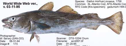
Walleye pollock (Theragra chalcogramma), Atlantic cod (Gadus morhua)
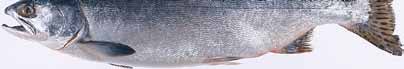
Figure 8
Atlantic cod (Gadus morhua) and Pink salmon
(Oncorhynchus gorbuscha).
(Figure 8), Atlantic mackerel (Scomber scomber), fl ounder (Platychthys spp.),
(Photo: W. Savary, Regulatory Fish Encyclopedia)
Atlantic halibut (Hippoglossus hippoglossus) and salmon (Salmonidae).
Other species of fi sh, such as Pacifi c saury (Cololabis saira), tuna (Thunnus
Freshwater fi sh
spp.) and sardine (Sardina spp.), migrate to the coastal waters of Kunashir
At least 48 species of freshwater fi sh (including anadromous forms)
from sub-tropical waters. Hundreds of thousands of Pink and Chum
are found in freshwater habitats in Kamchatka, Hokkaido and Sakhalin
salmon (Oncorhynchus gorbuscha, O. keta) (Figure 8) migrate through the
Island but only 18 species are known to inhabit the Kuril archipelago
southern Kuril Islands via the rivers and streams of Kunashir. Various types
(Arzamastzev et al. 2001, Agafonova 2000, Gritsenko 2000). Nine of these
of invertebrates live off Kunashir Island, although only a small number
are found throughout the Kurils (anadromous salmonids and osmerids, and
have been analysed. Many of these species, such as crab, shrimp, sea
euryhaline gasterosteids) and, in addition to these, one species is reported
urchin, squid, sea slug, and scallop, are of economic value (Agafonova
to inhabit the northern Kurils (an osmerid, Hypomesus olidus) and three
2000, Gritsenko 2000, Shuntov 2001, Baklanov et al. 2003). Pacifi c saury,
species the southern Kurils (the osmerids, Hypomesus nipponensis and H.
squid and Walleye pollock accounted for 19.5%, 19.6% and 10.1%,
japonicus, and a gasterosteid, Pungitius sinensis). Three other species have
respectively, of the total fi shery catch in the Russian EEZ in 2003.
been reported in Iturup (a cyprinid, Tribolodon brandti, and two gobiids,
Tridentiger obscurus and Chaenogobius urotaenia), three in Shikotan (the
The waters around Kamchatka are inhabited by the rare Blue whale
gobiids, Luciogobius guttatus, Chaenogobius mororanus and C. castaneus)
(Balaenoptera musculus), Fin whale (B. physalus), Sperm whale (Physeter
and two in Kunashir (the gobiids, Luciogobius guttatus and Chaenogobius
macrocephalus) and Killer whale (Orcinus orca) (Shuntov et al. 1993, Shuntov
urotaenia). In eastern Hokkaido, volcanic activities have infl uenced the
2001). According to various sources there are between 10 000 and
character of the regional hydrology and its biological resources.
14 000 Northern sea lions (Eumetopias jubatus) on the Kamchatka
rockeries and 6 000 on the Kuril Islands (Burkanov & Semenov 1991,
Distribution of biological resources
Maminov et al. 1991), up to 17 000 sea otters on the southern Kamchatka
The Bussol strait in the central area of the Kuril Arc where there is strong
and northern Kurils, and between 3 000 and 5 000 Killer whales in the
tidal mixing contains phytoplankton concentrations of over 5 000 mg/m3,
adjacent southwestern Bering Sea (Sobolevsky & Mathisen 1996). Between
and the front where the cold Oyashio Current meets the warm Kuroshio
125 000 to 253 000 dolphins migrate to the Russian Exclusive Economic
Current off northern Japan has some of the most productive waters in
Zone (EEZ), especially during the summer (Shuntov 2001).
East Asia (Lapshina 1996, Shiomoto 2000).
Freshwater and terrestrial molluscs
The Oyashio Current region is a Large Marine Ecosystem (LME) which
Little is known of the molluscan fauna in the Kurils. Among the freshwater
is considered a Class I, highly productive ecosystem with more than
species are nine bivalves (one endemic) and eight gastropods (two
300 g C/m2/year (Sea Around Us Project 2004). The Oyashio LME is
endemic). There are 12 known species of terrestrial gastropods and
known for its high biological productivity and diversity of fauna and
another seven listed as possible inhabitants of the islands (Arzamastzev
fl ora. Phytoplankton in this LME has traditional spring bloom dynamics
et al. 2001). In the southern Kurils, numerous endemic populations of
leading to a typical phytoplankton, macrozooplankton and fi sh food
bivalves are said to inhabit the small isolated lakes that dot the islands.
web. Odate (1991, 1994) estimates the zooplankton biomass at 1.1 to
Furthermore, an estimated 50 species of terrestrial gastropods that inhabit
3.7 million tonnes. It is believed that a high zooplankton biomass depends
the more heavily vegetated southern islands are yet to be identifi ed
on the cold waters of the Oyashio Current below the thermocline (Sea
(Bogatov & Zatravkin 1990, Bogatov pers. comm.).
Around Us Project 2004).
18
GIWA REGIONAL ASSESSMENT 31 OYASHIO CURRENT
Socio-economic characteristics
Table 1
Age structure of the population in Russia 1991 and
2001.
Population
Age structure
1991
2001
The population dynamics correspond to the region's socio-economic
Below
Above
Below
Above
Working
Working
development and to the level of State support for the Russian Far East. One
working
working
working age
working
age (%)
age (%)
age (%)
age (%)
(%)
age (%)
of the most signifi cant declines in population among the Pacifi c coastal
Russia
24.3
56.7
19.0
19.3
60.1
20.6
regions during the period 1991-2000 was observed in Kamchatskaya
Far East
27.6
61.4
11.0
20.6
64.7
14.7
Oblast', which saw 20% decline (Russian Statistical Yearbook 2001, Russian
Kamchatskaya Oblast'
27.2
66.8
6.0
19.0
69.7
11.3
Regions 2001). The age structure of the population in the Russian Far
Sakhalinskaya Oblast'
26.5
62.8
10.7
19.4
66.5
14.1
East is shown in Table 1.
(Source: Russian Statistical Yearbook 1992, 2001)
Table 2
Population of the Kuril Islands 1995-1999.
The population of Kamchatka was 389 100 in 2000, with a population
1995
1996
1997
1998
1999
density of 0.8 persons/km2. A large proportion of the population lives in
Central Kuril Islands
9 102
8 463
8 300
8 110
7 992
the eastern part of the peninsula around Avacha Bay. In 2000, half of the
North Kuril Islands
4 501
4 239
4 100
4 100
4 079
population lived in the cities of Petropavlovsk-Kamchatsky (197 100) and
South Kuril Islands
8 302
6 246
6 630
6 396
6 675
Elizovo (37 900). Kamchatka is located far from large industrialised cities
Kuril Islands (Total)
21 905
18 948
19 030
18 606
18 746
and transportation routes. Untouched by the advances of civilisation, the
(Source: Eremina et al. 2000)
majority of the peninsula is uninhabited. In the north of the peninsula,
Table 3
Economic growth rates.
the indigenous people of Kamchatka the Koryaks, the Itelmen, the
Economic growth rate (% of preceding period)
Chukchies and the Evens have maintained their traditional ways of
1991
1995
1997
1998
1999
2000
2001
life (Logan 2001).
Investment Kamchatskaya Oblast'
97.6
ND
92.0
93.0
104.3
ND
ND
projects
Sakhalinskaya Oblast'
ND
ND
99.1
95.9
119.1
ND
ND
The total population of the three administrative districts of the Kuril
Industrial
Kamchatskaya Oblast'
92
108
ND
95
ND
107
99
production
Islands is slightly below 19 000 (Table 2). The Islands are very sparsely
Sakhalinskaya Oblast'
103
109
ND
104
ND
113
109.5
populated, with fewer than 2 people/km2. The most populated cities
Agricultural Kamchatskaya Oblast'
ND
81
ND
102
ND
113
91.4
output
and villages in the Kuril Islands are Severo-Kuril'sk, Kuril'sk and Yuzhno-
Sakhalinskaya Oblast'
ND
82
ND
112
ND
92
130.5
Note: ND = No Data.
Kuril'sk (Eremina et al. 2000).
(Source: Russian Regions 2001)
In 1995, the population in the eastern part of Hokkaido (the
1995
2001
three prefectures: Nemuro, Kushiro, and Tokachi) was approximately
740 000. The population density was 68 persons/km2. The largest
city in Hokkaido is Kushiro, which had a population of 205 640 in 1990
(Hokkaido Government 1998a).
Economy
In 1991, the dissolution of the Soviet Union became a key factor in the
decline of production and the regional economy faced collapse. Since
then, the Russian Far East economy has experienced a severe and long
Electric power industry
Fuel industry
Machine-building and metal working
recession. Only since 2000 has the Russian economy had stable annual
Timber, wood-processing and pulp-and-paper
Construction materials industry
growth. Table 3 shows the economic growth rates in the Russian Far
Food industry
East and Figure 9 shows the structure of industrial output in 1995 and
Figure 9
Industrial output in Kamchatskaya Oblast' in 1995 and
2001 in Kamchatskaya Oblast'.
2001.
(Source: Russian statistic yearbook 1996, Russian Regions 2001)
The economy in Kamchatka is predominantly based on fi shing
following the development of the electric power generation and
(accounting for 80% of the economy) its associated industries (e.g.
nonferrous metallurgy industries. Economic activities are concentrated
ship maintenance) and, more recently, tourism. The economy expanded
in the largest city, Petropavlovsk-Kamchatsky (Alekseev & Baklanov 2002,
REGIONAL DEFINITION
19
Baklanov et al. 2003). After the fi sheries industry, the timber, light and
Fisheries
food industries are secondary in importance. The region's energy industry
The fi shing industry dominates the Kamchatka economy due to the high
relies on imported fuel. Recently, geothermal power stations, geothermal
concentration of biological resources and the large spawning grounds
heat supply systems, wind-driven power plants and hydroelectric power
of Pacifi c salmon in the region. The fi sheries industry in the Russian Far
plants have been developed.
East comprises fi shing, processing, specialised facilities and services,
and fi sh stock management organisations. In many regions this industry
The abundance of marine biological resources surrounding the Kuril
is closely linked with other sectors of the economy. It is serviced by a
Islands has made the fi sheries industry its primary economic activity
large number of specialised industries such as shipbuilding and repair,
(Table 4). The Kuril Islands are known also for their geothermal resources.
ports, transport and reefer fl eet, and manufacturers of fi shing gear and
On Kunashir Island, geothermal heat resources have been used for the
packing materials. Auxiliary services (including procurement, sales,
provision of electricity and heating. Surrounding Iturup Island, studies
communication and construction) provide support to both the fi shing
on the ocean geothermal reservoir have been undertaken and reserves
industry and the specialised services involved.
of two-phase geothermal fl uids have been discovered. Specialists
estimate the capacity of these reserves at 30 MW which is enough to
Concerning pollock activities in the western Bering Sea, Kamchatskaya
meet the island's electricity and heat requirements for the next 100 years.
Oblast' is second in importance after Primorye. Conover (1997) lists
Geothermal reserves on Paramushir Island have been less researched,
eleven fi shing organisations that are associated with pollock fi shing
although there are known to be considerable reserves of geothermal
in the Bering Sea. In 1996 and 1997, Kamchatka fi shermen caught 23%
water with temperatures between 700 and 950°C (Eremina et al. 2000).
of the region's pollock quota (516 000 tonnes) and 22% of the western
Furthermore, the Kuril Islands have substantial reserves of titanium and
Bering Sea quota (96 000 tonnes). The main fi shing port is Petropavlovsk-
sulphur, and gold has also been discovered.
Kamchatskiy (Wespestad 1996, Ozolin'sh & Spiridonov 2001).
Table 4
Export deliveries of fi sh and other seafood 1995-1999.
The Pacifi c coast surrounding the Kuril Islands is among the most
1995
1996
1997
1998
1999
productive areas of ocean in the world and constitutes Russia's largest
Export (USD)
12 586 200
8 665 000
4 067 300
6 252 800
16 938 600
fi shing ground. Approximately 40 fi shing companies in Sakhalinskaya
Export (tonnes)
2 493
1 811
1 861
4 247
9 131
Oblast' are involved in pollock fi shing in the region, though none are
(Source: Eremina et al. 2000)
specifi cally associated with western Bering Sea pollock (Conover 1997).
The majority of the companies are located in the cities of Nevelsk, Yuzhno-
Agriculture is comparatively well developed in East Kamchatka and poorly
Sakhalinsk and Kholmsk on the southernmost point of the island. The Kuril
developed in the south Kuril Island of Kunashir. A large proportion of
Islands shelf is favourable for the harvesting of King crab (Paralithodes
food products is imported from other Russian Far East regions and other
camtschaticus), shrimp, mussels and other bivalves. There has been
countries. Agriculture generates 44.2 million USD, of which vegetables
concern over the depletion of certain species, particularly King crab,
produce 29.1 million USD and animal production, 15.1 million USD
however there is generally minimal overexploitation of other species in
(Russian Regions 2001, Eremina et al. 2000).
the region (Arzamastzev et al. 2001, Sea Around Us Project 2004). The
total annual fi sh quota for the islands is 1.4 million tonnes and for sea
Hokkaido's rich forests and its proximity to the sea make the island the
invertebrates (squid, shrimps, oysters, etc.), 345 000 tonnes (Eremina et
national base for food supply in Japan; its gross agricultural product is
al. 2000, Ozolin'sh & Spiridonov 2001).
nearly 10 000 million USD. Traditional food processing industries thrive
and many technologically orientated companies have recently located
Hokkaido has excellent off shore fi shing grounds, including the continental
in Hokkaido. Regarding industry in Hokkaido, 3.3% (1.3% of the national
shelf which stretches northwards. In 2001, marine fi shery and aquaculture
total) of GRP is from primary industries, 21% (28.1%) from secondary
production was 1.58 million tonnes (26.3% of the nation's total) and
industries and 77.5% (74.8%) from tertiary industries. Compared with the
generated 2.7 billion USD. Many valuable fi sh species thrive in these
rest of Japan, the manufacturing industry is less signifi cant in Hokkaido
waters, including salmon, pallas, herring, fl ounder, mackerel, cod and
contributing 10.4% to GRP (half the national GRP) and consisting
halibut which account for 90% of the total annual catch (Noto & Yasuda
largely of food, pulp/paper, ceramics, stone and clay industries rather than
1999). The major species which are artifi cially cultivated and propagated in
processing and assembly industries (Annual Economic Calculation Report
Hokkaido are restricted in numbers due to the environmental conditions
for Hokkaido Citizens for FY 2001 in Hokkaido Government 2004).
of the region. Almost all are northern forms which have their major
20
GIWA REGIONAL ASSESSMENT 31 OYASHIO CURRENT
distribution range in Hokkaido. Recently, the cultivation of fi sh and other
territorial waters near Kunashir, Iturup Islands and Habomai. Several
marine organisms has become commercially signifi cant for Hokkaido,
further agreements are currently under development. The validity
and seed production systems have been established for some of the
period of the agreement allowing Laminaria extraction by Japan in the
most important northern species.
area of Signalny Island was extended in 1999.
International cooperation
Three North Pacifi c Ocean rim countries (Canada, Japan and the United
Water management in the Oyashio Current region is aff ected by several
States) organised the International North Pacifi c Fisheries Commission
international programmes:
(INPFC) to regulate catches in the Oyashio LME. INPFC was dissolved
The Action Plan for the Protection, Management and Development of
and the Convention for the Conservation of Anadromous Stocks in the
the Marine and Coastal Environment of the Northwest Pacifi c Region
North Pacifi c Ocean was established in February 1993.
(NOWPAP UNEP). Originally, Japan supported the idea of NOWPAP
but felt that a lack of consensus on the issue would prevent diplo-
The International Kuril Island Project (IKIP 1994-1999) is an international
matic relations between some of the countries.
collaboration of American, Russian and Japanese scientists to survey the
International Maritime Organisation (IMO). Russia and Japan have
plants, insects, spiders, freshwater and terrestrial molluscs, freshwater
signed 10 and 8 of the pollution treaties, respectively. However,
fi shes, amphibians and reptiles of the Kuril Archipelago. Participating
only Russia has joined the 1973 Intervention Convention. They have
institutions include the University of Washington (United States), the
both acceded to the International Convention for the Prevention
Far East Branch of Russian Academy of Sciences (Russia) and Hokkaido
of Pollution from Ships (1973), as modifi ed by the Protocol of 1978
University (Japan).
(MARPOL 73/78).
London Dumping Convention (LDC). Both Japan and Russia are
Between 1994 and 2005, the basic purposes and tasks of the Federal
parties to the 1972 LDC. LDC members have an obligation to report
programme of socio-economic development of the Kurils in the Sakhalin
ocean-dumping permit activity so that all concerned countries are
area were:
aware of the kind and quantity of wastes that enter their shared
Constant geo-strategic development of the Kurils in the interests
waters. The signatories approved permanent total bans on toxic
of the Russian Federation.
industrial waste disposal at sea, beginning in 1996.
The creation of infrastructure and the stimulation of investment
The Asia Pacifi c Economic Cooperation Forum (APEC). The APEC
for the development of major branches of the economy and the
environment ministers met in Vancouver in March 1994 to discuss
realisation of programmes and projects of international cooperation
a regional environmental strategy. Marine pollution was among the
in the Kurils.
topics discussed.
Stable socio-economic development in the Kurils (Russian Federation
Working Group for the Western Pacifi c (WESTPAC). WESTPAC has
Government 2001).
focused on intercalibration exercises, with the collaboration of the
Global Investigation of Pollution in the Marine Environment (GIPME)
Russia and Japan signed in 2000 a programme of economic joint
and the International Oceanographic Commission (IOC) Group of
development of South Kuril. The programme promotes joint Russian-
Experts on Methods, Standards and Intercalibration (GEMSI).
Japanese investigations.
Both countries have also signed the UNESCO World Heritage Convention,
Academic institutes include the Far East Branch of the Russian Academy
United Nations Convention on Biological Diversity (CBD) and Ramsar
of Science and TINRO-Centre. Data is collected during marine expeditions,
Convention on wetlands, and are members of the North Pacifi c Marine
which can be classed into three groups:
Science Organization (PICES).
Complex expeditions on the research ships of the TINRO-Centre;
Scientifi c research expeditions on ships of diff erent organisations;
There is an agreement between the Japanese and Russian Federation
and
governments permitting Japanese fi shing in the Russian Federation
Fishing trips with observers.
REGIONAL DEFINITION
21
Assessment
Table 5
Scoring table for the Oyashio Current region.
This section presents the results of the assessment of the impacts of
Assessment of GIWA concerns and issues according to
The arrow indicates the likely
each of the fi ve predefi ned GIWA concerns i.e. Freshwater shortage,
scoring criteria (see Methodology chapter)
direction of future changes.
T
T
C
C
Increased impact
Pollution, Habitat and community modifi cation, Unsustainable
A 0
No known impacts
A 2
Moderate impacts
IMP
IMP
T
T
No changes
C
C
exploitation of fi sh and other living resources, Global change, and
A 1
Slight impacts
A 3
Severe impacts
IMP
IMP
Decreased impact
their constituent issues and the priorities identifi ed during this
ts
ts
process. The evaluation of severity of each issue adheres to a set
core**
Oyashio Current
of predefi ned criteria as provided in the chapter describing the
ts
ts
vironmental
t
her community
v
erall S
GIWA methodology. In this section, the scoring of GIWA concerns
En
impac
E
c
onomic impac
Health impac
O
impac
O
Priority***
and issues is presented in Table 5.
Freshwater shortage
0*
0
0
0
0
5
Modification of stream flow
0
Pollution of existing supplies
0
Changes in the water table
0
T
Pollution
0*
0
0
0
0
4
C
A
Freshwater shortage
IMP
Microbiological pollution
0
Eutrophication
0
Chemical
0
The GIWA Oyashio Current region has abundant water resources. Within
Suspended solids
0
the boundaries of the drainage basin, total annual precipitation rates
Solid wastes
1
Thermal
0
increase from south to north: from 1 000 to 1 400 mm in the Kuril Islands
Radionuclides
0
to 2 600 mm in the southeast of Kamchatka. However, humidity varies
Spills
1
comparatively little over the same area as evaporation increases at nearly
Habitat and community modification
0*
0
0
0
0
3
the same rate (from 100 to 250 mm annually) (Tersiev 1998, Logan 2001).
Loss of ecosystems
0
Modification of ecosystems
1
This results in an extensive river and lake network. There are more than
Unsustainable exploitation of fish
1*
0
0
1
0.5
2
110 rivers and thousands of streams which fl ow into the Pacifi c Ocean
Overexploitation
1
on the east coasts of the Kamchatka Peninsula and Kuril Archipelago,
Excessive by-catch and discards
0
the largest being the Kamchatka River. There are also many lakes, the
Destructive fishing practices
1
largest being the Nerpichye in the northeast of Kamchatka (Bortin 1999,
Decreased viability of stock
0
Impact on biological and genetic diversity
0
Chernjaev 2001). As a result of these hydrological features, there is an
Global change
1*
1
0
0
0.5
1
abundant freshwater supply in the region, with more than 150 000 m3
Changes in hydrological cycle
2
per person annually (Bortin et al. 1999).
Sea level change
0
Increased UV-B radiation
0
Changes in ocean CO source/sink function
1
2
Freshwater shortage is therefore not a signifi cant concern for the region.
*
This value represents an average weighted score of the environmental issues associated to
Correspondingly, the GIWA issues of modifi cation of stream fl ow, changes
the concern.
**
This value represents the overall score including environmental, socio-economic and likely
in the water table, and pollution of existing supplies were assessed as
future impacts.
*** Priority refers to the ranking of GIWA concerns.
having no known impact. However, it should be noted that there is
22
GIWA REGIONAL ASSESSMENT 31 OYASHIO CURRENT
evidence of localised pollution of surface waters in the regions of
Consequently, many submarines remain inoperative at the dockside,
Kamchatka and on some of the Kuril Islands (Tkalin 1991a,b), although
resulting in the degradation of their nuclear reactors. As a result, accidents
the impact of this contamination on the region's international waters
are becoming more common. In 1997 a decommissioned Charlie-class
is negligible as the Oyashio Current has a vast dispersion capacity.
nuclear submarine sank at Rybachy after corrosion allowed water to
Industrial infrastructure that could result in the modifi cation of stream
seep into its hull (Ikeuchi et al. 1999, Petterson et al 1999, Newell 2004,
fl ow, pollution, or aquifer draw-down is largely non-existent.
Larin 2004)
Conclusion and future outlook
The main potential sources of radioactive pollution in the region are:
Freshwater shortage is not a major concern for the Oyashio Current
(i) nuclear submarine bases; (ii) ship-repair yards for nuclear submarines;
region neither at present, nor in the foreseeable future. Kamchatka,
(iii) civil enterprises, where civil vessels with nuclear energy installations
the Kuril Islands and Hokkaido have extensive supplies of high quality
are based, repaired and maintained; and (iv) sites used for the temporary
freshwater in their lakes and rivers.
storage of radioactive waste and spent nuclear fuel.
Spills
The issue of spills was considered to have slight impacts in the region.
T
C
A
Pollution
IMP
At present, crude oil spills in the Oyashio region are rare. Isolated and
relatively minor oil spills have been recorded in the Kuril Straits and off
The GIWA assessment concluded that presently only the issues of solid
the East Kamchatka coast. According to the GIWA Task team, oil slicks
wastes and spills have a slight impact for the Oyashio Current region. The
have been observed in the oil extraction areas of Sakhalin. Currents
issues of microbiological pollution, eutrophication, chemical pollution,
fl owing from the Okhotsk Sea and the Soya Current transport this oil
suspended solids, thermal pollution and radionuclide pollution were
contamination to the southern Kuril Straits.
considered to have no known impacts and are therefore not further
discussed.
The region has a dense network of navigation routes traversing its waters.
Many large vessels, including fi shing and merchant vessels and tankers,
Environmental impacts
sail through the waters of the Kuril Islands discharging oil hydrocarbons
Avacha Bay, on the Kamchatka Penninsula, has increasingly become
both deliberately and accidentally .
a source of chemical and radioactive pollution for the Pacifi c coastal
water. However, there is currently no comprehensive assessment of the
Further exploitation of hydrocarbons in the Sakhalin region and the
ecological health of the region's coastal zone.
subsequent increase in oil transport is likely to increase the quantities
of contaminants in the Oyashio Current region. According to the GIWA
Solid wastes
Task team, there is currently a maximum of fi ve spills per year originating
The impacts of solid wastes were assessed as slight due to the prevalence
from vessels carrying oil products from the southern ports of Far East
of such wastes near human settlements, including seasonal camps.
Russia, particularly Kamchatka. All oil vessels from these ports travel
These are predominantly timber and ligneous wastes, which are found
through the Kuril Straits in close proximity to the islands. Furthermore,
along the entire coastline, and municipal waste of various origins and
fi shing vessels travel through the straits en-route to the Sea of Okhotsk,
descriptions which accumulates in bays that are in close proximity to
the Bering Sea and the northwest Pacifi c Ocean. However, there is a
coastal settlements and ports. There is no quantitative information on
dearth of information on the adverse environmental eff ects of spills
solid wastes.
in the region.
Radionuclides
Socio-economic impacts
This issue was considered to have no known impacts in the region. In
The GIWA Task team concluded that there is no known economic, health
the coastal waters of the Kamchatka Peninsula, however, there is some
or other social and community impacts as a result of pollution in the
evidence of radionuclide contamination and there remains a potential
Oyashio Current region. If pollution intensifi es in the future, however,
for future incidents originating from disused nuclear submarines. Due
there will be possible costs from the disruption of shipping, marine
to a changing political climate and defi ciencies in the Russian economy,
reserves and marine scientifi c activities during the assessment and
it has become no longer viable to maintain the submarine fl eet.
clean-up of spills.
ASSESSMENT
23
Conclusions and future outlook
be between 2.5 to 5 billion USD (according to experts from the Russian
Overall, the impact of Pollution under present conditions was assessed
State Committee for Environmental Protection and the Federal Border
as slight. The most relevant GIWA issues for the Oyashio Current were
Guard Service). More than 4 million tonnes of bioresources are harvested
identifi ed as solid wastes and spills. At present the region's ecosystems,
annually in the Russian Far East EEZ. The most sought after species in
excluding Avacha Bay, are in a relatively satisfactory condition. However,
this region are salmon, Walleye pollock, crab, shrimp, sea urchin and sea
due to the rapid development of oil and gas deposits on the Kamchatka
cucumber (Greenpeace 2000, Ozolin'sh & Spiridonov 2001, Baklanov
and Sakhalin shelves and the increased volume of oil and gas transported
et al. 2003).
through the Oyashio Current region, oil spills are considered to be a
signifi cant future threat to the region. Radionuclides have little eff ect
Fisheries regulations in the region stipulate that all by-catch should
on the regional environment at present, but their impact may increase
be landed, although it is generally believed that some discards occur.
with the further corrosion of Russian submarines.
However, it is diffi
cult to assess to what degree this is practiced due to
an absence of control and monitoring programmes. The GIWA issues of
decreased viability of stock, excessive by-catch and discards, and impact
on biological and genetic diversity were assessed as having no known
T
C
A
Habitat and community
IMP
impacts and are therefore not discussed further.
modification
Environmental impacts
There is no record of serious loss of habitat in the region and there are
Overexploitation
consequently no known impacts from this issue. There is evidence,
The commercial fi sheries of the Oyashio Current, such as some stocks
however, of some minor habitat modifi cation as a result of the
of Pacifi c salmon, King crab, scallop and Pacifi c sardine, are exploited
construction of ports, tourism activities and the construction of dams.
above biologically safe limits (Ozolin'sh & Spiridonov 2001, Baklanov et
This issue was considered to have slight environmental impacts.
al. 2003, Titova 2003). The issue of overexploitation was considered to
be moderate only in the southern Kuril area and slight in the remaining
Since the region has a relatively small economy and is sparsely populated,
part of the region.
habitat modifi cation in the region has had no known socio-economic
impacts.
Russia licenses foreign fi shermen to operate inside the Russian economic
zone. Catch quotas are allocated for the various fi sh species. Up to
Conclusions and future outlook
150 Russian fi shing vessels, as well as Japanese, Taiwanese and Chinese
Habitat and community modifi cation is assessed as having no known
vessels, and fl ag of convenience ships are believed to practice illegal
impacts. The majority of the regional ecosystems are located far from the
salmon and calamari fi shing in the region during the summer. Records
developed coastal regions of Japan and Russia, and consequently are not
of illegal fi shing activities in Russian territorial waters have not been
aff ected by economic development. Wetlands and rivers were considered
disclosed. Figure 10 demonstrates how the marine catches of the main
by the GIWA Task team to have experienced slight environmental impacts
commercial species of the Oyashio Current LME have declined since
but these are localised with no transboundary consequences.
the 1990s.
700 000
Herring-likes
Perch-likes
600 000
Other fishes & inverts
Cod-likes
T
C
Flatfishes
A
Unsustainable exploitation of
500 000
Molluscs
IMP
Scorpionfishes
onnes)
Salmon, smelts, etc
fish and other living resources
400 000
(t
Sharks & rays
Anchovies
t
ch
300 000
a
Tuna & billfishes
C
Crusteceans
Total catch
The fi sheries of the Pacifi c coast of the Kuril Islands are among the most
200 000
productive in the world. The Oyashio Current LME constitutes Russia`s
100 000
and Japan's largest fi shing grounds. The majority of this productive area
0
1950
1955
1960
1965
1970
1975
1980
1985
1990
1995
2000
is situated in Russia's 200 nautical mile Exclusive Economic Zone (EEZ).
Year
Many commercially valuable fi sh species thrive in these waters. Russia's
Figure 10 Marine catches in the Oyashio Current.
annual income from the regional marine bioresources is estimated to
(Source: Sea Around Us Project 2004)
24
GIWA REGIONAL ASSESSMENT 31 OYASHIO CURRENT
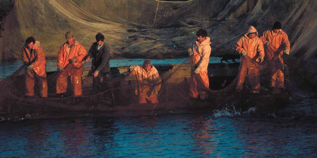
Figure 11 A team of fi shermen pull in a net fi lled with fi sh on Kuril Islands, Russia.
(Photo: CORBIS)
Between 1990 and 1996, fi sheries production in the Russian Far East
Destructive fi shing practices
declined by 35% (Baklanov et al. 2003, Titova 2003). Catches for each
The GIWA assessment considered the impacts of destructive fi shing
individual species have varied from this overall trend: salmon catches
practices as slight. In Russia, driftnets a destructive pelagic fi shing
have not changed; catches of fl ounder have increased by about 15%;
method are widely used. In 2000, 74 Japanese vessels using driftnets
and crab and King crab catches have declined by almost 70%. The shelf
were licensed to exploit 16 500 tonnes of salmon in the Russian EEZ
of the Kuril Islands favours the harvesting of crabs, shrimp, bivalve and
(Greenpeace 2000). The Russian fi shing fl eet began to employ driftnet
mussels (Arzamastzev et al. 2001). The populations of these species have
fi shing methods only in 1997. Today, approximately fi ve Russian driftnet
been severely depleted, particularly the King crab, although this has not
vessels are in operation, the majority of which are used for scientifi c
been attributed to any single factor, such as overfi shing (Baklanov et al.
studies of species stocks. For salmon fi shing, ships tend to use standard
2003). Catches of Walleye Pollock have declined from over 55 000 tonnes
50x8 m driftnets that when interconnected with one another make up
in the mid 1980s to less than 15 000 tonnes in the last fi ve years (Sea
a 4 km long set of nets. According to regulations the total length of sets
around us project 2004) (see fi gure 12).
installed by one ship cannot exceed 32 km and the distance between
the sets should be at least 4 km. The ends of each set are marked with
buoys and radio beacons. Meshes with less than 110 mm diagonal are
60 000
prohibited. Commercial ships commonly use nets with a mesh of 124 to
50 000
132 mm (Greenpeace 2000).
40 000
The fi sheries quota system is also applicable to all vessels using driftnets,
30 000
which are liable for inspection by Russian offi
cials (Ozolin'sh & Spiridonov
T
onnes
2001). However, only fi ve inspectors are employed for the entire Kuril
20 000
Islands region, which covers an area of 840 000 km2 (Ozolin'sh &
10 000
Spiridonov 2001, Sea Around Us Project 2004).
0
1950
1955
1960
1965
1970
1975
1980
1985
1990
1995
2000
Socio-economic impacts
Year
The fi sheries and its associated industries are the primary economic
Figure 12 Catch of Walleye pollock (Theragra chalcogramma) in
activities for the coastal communities of eastern Hokkaido (Japan) and
the Oyashio Current.
(Source: Sea around us project 2004)
the Russian coast of Kamchatka and the Kuril Islands. However, the
ASSESSMENT
25
overexploitation of certain commercial species and reduced catches
infl uenced the productivity of the Longfi n codling (Laemonema longipes)
has not signifi cantly aff ected the economy of these communities in terms
and mackerel; and (ii) changes in the energy active zone causing changes
of employment, income, and investment activity. Economic impacts
in the thermal fl ux, as well as an increased frequency of heavy storms
from the Unsustainable exploitation of fi sh and other living resources
and fl oods (Noto & Yasuda 1999, Yoshinari & Yasuda 1999).
were considered to be negligible.
The sub-arctic Kuril Current fl ows into Japanese coastal waters, providing
There is no evidence of a direct link between the level of exploitation
a rich habitat for a variety of fi sh and making the region one of the most
of the Oyashio Current fi sh stocks and the health of the population.
productive fi shing areas in the world. The most signifi cant eff ect of global
Therefore, this concern was not considered to have any known health
warming on the region is predicted to be changes in epipelagic fi sh
impacts on the region.
resources. Japan's future fi shery production will mostly depend upon
changes in the course and fl ow of the Japanese Current caused by global
Illegal foreign fi shermen are operating in fi shing grounds that have
warming (Yasuda & Watanabe 1994, IPPC 2001).
been traditionally fi shed by the coastal communities. There is concern
amongst these communities over the depletion and possible exhaustion
Concerning long-term changes, some researchers believe that global
of the fi sh stocks which are fundamental to their livelihoods (Figure
warming will lead to reductions in the fl ows of both the Kuril and the
11). Therefore, this concern was assessed as having slight social and
Japanese currents, and that the thickness of the mixed layer will be
community impacts.
reduced if marine winds also weaken (Noto & Yasuda 1999, IPPC 2001).
Based on the primary production volume off shore of Kushiro in Hokkaido
Conclusions and future outlook
during years when the waters are relatively warm compared to those
According to the GIWA Task team, the Unsustainable exploitation of fi sh
when it is relatively cold, it appears that global warming in this region
and other living resources has a slight impact on the Oyashio Current
will lead to a reduction in primary production. Additionally, the southern
region. The issues of overexploitation and destructive fi shing practices
limit of salmon habitats is expected to move northwards as a result of
around the Kuril Islands were also assessed as having a slight impact.
global warming (IPPC 2001).
The overexploitation and discarding of fi sh in the Oyashio Current region
is likely to remain a problem in the foreseeable future. However, the
Research has identifi ed a relationship between higher global temperatures
intensity of overfi shing is generally not too severe, allowing stocks to
and an increase in sardine numbers (Omori & Kawasaki 1995). This fi eld
restore themselves periodically . As a result of the development of other
however requires further study, including an examination of the infl uence
marine sectors in northeastern Russia and Japan, it is likely that regional
of shifting climates on the ecosystems of the region.
dependency on the fi shing industry will be reduced in the forthcoming
decades, which in turn will reduce the socio-economic impacts of a
In coastal areas, the primary production volume of phytoplankton will
downturn in the fi sheries sector. The realisation of the Federal Program
increase as a result of rising water temperatures, resulting in a greater
for the socio-economic development of the Kuril of the Sakhalin area
food supply for fi sh. The quantity of coldwater seaweed may diminish
(1994-2005) and cooperation between Russia and Japan will result in
which, in turn, could lead to a reduction in the populations of abalone,
the creation of necessary infrastructure and a favourable investment
turbos, sea urchins and other sessile organisms, including macrophytic
climate for the development of the Kuril Islands and the waters of the
algae, corals, sponges, bryozoans and ascidians (Global Warming Impacts
Oyashio Current.
Assessment Working Group 2001). In coastal areas with breakwaters or
other coastal protection structures where the shoreline cannot move
further inland, productivity may fall when sea levels rise because of the
loss of tidal fl ats and seaweed beds.
T
C
A
Global change
IMP
The average water temperature of streams and rivers is estimated to rise
Environmental impacts
by between 1 and 4°C as a result of global warming. Consequently, the
Changes in the hydrological cycle and ocean circulation
habitat of Dolly varden (Salvelinus malma) will decline by 25 to 74% and
This issue was assessed as having moderate impacts due to the following
that of Whitespotted charr (S. leucomaenis) by 4 to 46% (Global Warming
environmental changes: (i) positive sea temperature anomalies and
Impacts Assessment Working Group 2001).
changes in the meandering path of the Kuroshio Current, which has
26
GIWA REGIONAL ASSESSMENT 31 OYASHIO CURRENT
Despite abundant precipitation, it is diffi
cult for Japan to fully utilise its
early 1970s increased surface chlorophyll concentrations, which might
water resources due to physical constraints. Precipitation varies greatly
have caused higher zooplankton production and better feeding
throughout Japan and the nation's rivers are short and steep, with
conditions for sardine larvae.
relatively small catchment basins. According to hydro-meteorological
A considerable weakening of the southward intrusion of the
models, global warming may lead to lower precipitation rates in Hokkaido,
Oyashio Current off the east coast of Japan from 1988 to 1991 led
higher evaporation from the land surface and a consequential reduction
to a reduction in plankton biomass in the transition zone between
in water resources.
the Kuroshio and Oyashio currents in late spring and early summer,
and caused a series of recruitment failures of Japanese sardine.
According to Global Warming Impacts Assessment Working Group
(2001) the following conclusions have been drawn from the hydrological
Sea level change and Increased UV-B radiation as a result of
research conducted so far:
ozone depletion
The
eff ects on fl ow from a 10% change in precipitation are greater
According to the GIWA Task team, this issue has no known impacts.
than those from a 3°C temperature rise.
There may be possible sea level rise on the coast of Japan, although
If a 3°C temperature rise is accompanied by a 10% increase in
only a limited stretch of the coastline, mainly in eastern Hokkaido, will
precipitation, the average fl ow will not decline signifi cantly in
be aff ected.
low-fl ow conditions but will increase by about 15% in high-fl ow
conditions.
Changes in the ocean CO source/sink function
2
A rise in temperature will mean that what was once snowfall will
Despite incomplete research, the GIWA Task team considered this
change to rainfall and winter snows will melt earlier. As a result,
issue to have a slight impact on the region as they had "reasonable
the fl ow will increase from January through to March and decrease
suspicions" that current global change is impacting the aquatic system
between April and June.
enough to alter its source/sink function for CO . However, there have
2
been no measurable changes. The Oyashio region is a CO source during
2
The regional climate fl uctuates as a result of variations in mean global
the winter due to deepwater upwelling and also a CO sink during the
2
characteristics and climatic phenomena such as the North Atmospheric
summer as a result of biological activities. In fact, the region has the
Oscillation (NOA), the Pacifi c Decadal Oscillation (PDO) and the El Nińo-
highest biological CO drawdown in the global ocean. Global change
2
Southern Oscillation (ENSO). To date, most studies considering the
may infl uence both physical and biological processes in this region and
impacts of climate variability on the regional marine ecosystem have
change the function of the carbon cycle (DeGrandpre et al. 2002, PICES
used correlation statistics of a given population and physical climate
2003). The infl uence of global change is observed not only in surface
indices.
currents but also in deep water circulation, with subsequent impacts
on biological production in the region.
The eff ects of a shift in the climate regime on ENSO activities, winter
monsoon patterns, western boundary currents and upper ocean
Socio-economic impacts
stratifi cation, as well as the resultant biological impacts are summarised
The economic impacts for the whole region are assessed as slight.
as (Noto & Yasuda 1999, Omori & Kawasaki 1995, Global Warming Impacts
Global change has infl uenced the living conditions of fi shermen and
Assessment Working Group 2001):
their communities. Because the economy of the area is based on fi shing,
Variations in atmospheric conditions infl uence the intensity of the
depleted fi sh stocks as a result of global changes have had economic
winter monsoon, the depth of the upper mixed layer and the path
consequences. The following impacts have been identifi ed that may
of the Kuroshio and Oyashio currents.
be associated, to some extent, with global changes:
In the western sub-arctic Pacifi c, phytoplankton biomass was
Human migration from the Kuril Islands and Kamchatka. This has
higher from the mid 1960s to mid 1970s than in the preceding and
been attributed to severe climatic conditions and 90 years of weak
succeeding decades, corresponding to a transition of the westerly
economic growth in Russia (Russian Statistical Yearbook 1996, 2001,
currents from a meandering to a straighter path.
Eremina et al. 2000).
Plankton biomass in the Oyashio Current region has decreased since
Emergency response costs for severe environmental conditions e.g.
the early 1970s.
fl ooding caused by increasingly frequent storm surges (Tersiev 1998,
In the northwestern sub-tropical Pacifi c a reduction in winter cooling
PICES-GLOBEC 2003).
and vertical mixing associated with the calm and warm winter of the
Increased cost of coastal protection.
ASSESSMENT
27
Loss of income and foreign exchange from a downturn in the
There is currently a lack of research on the infl uence of global changes
fi sheries sector.
on the productivity of the fi sheries. However, specialists from academic
institutes, including the Far East Branch of the Russian Academy of
There is concern about the possible eff ects of rising sea levels and
Science, TINRO-Centre and Japanese universities and institutions, are
increasingly frequent storm surges on Japan's socio-economic system.
presently investigating this concern. According to the GIWA Task team,
The existing social infrastructure and socio-economic system has
the infl uence of global changes on depleted fi sh stocks have increased
been optimised for the present climate conditions. Concerning global
unemployment rates and reduced income and investment activity.
warming, the eff ects of higher sea levels, higher temperatures and from
changing precipitation and typhoon patterns would be serious and
Furthermore, the analysis suggests that overfi shing in the Oyashio
wide-ranging (Global Warming Impacts Assessment Working Group
Current region could become less severe due to the implementation
2001, IPCC 2001).
of regulatory and control measures. Overexploitation of fi sh resources
was considered to be moderate only in the southern Kuril area where
There are no known health or other social and community impacts from
illegal fi shing is prevalent.
global changes in the region.
The GIWA Task team identifi ed a strong linkage between Global change
Conclusion and future outlook
and Unsustainable exploitation of fi sh and other living resources in the
Overall, global change is considered to have slight impacts on the region.
Oyashio Current region (Figure 13) due to changes in pelagic fi sh
The following changes have been observed in recent years: positive
abundance caused by changes in water temperature and a reduction
temperature anomalies; changes in the meandering path of the Kuroshio
in the fl ow of currents. There are weaker linkages between Global change
Current, which has infl uenced the productivity of the fi sheries; changes
and Freshwater shortage as well as Habitat modifi cation. The GIWA Task
in the energy active zone; changes in the thermal fl ux; and increasing
team also recognised a weak linkage between Habitat modifi cation and
frequency of severe storms and fl oods. The economy of the region is
the Unsustainable exploitation of fi sh and other living resources.
predominantly dependent on fi shing. Climatic changes have led to
reduced catches, thus having economic consequences. Global climate
trends are expected to exacerbate the environmental and economic
impact of this concern in the future. Health and other community
I. Freshwater
shortage
impacts will most likely not change.
III. Habitat and
Priority concerns
II. Pollution
community
modification
At present, the concerns with the highest severity for the region are Global
change, in particular the issue of changes in the hydrological cycle, and
Unsustainable exploitation of fi sh and other living resources, specifi cally
IV. Unsustainable
the issue of overexploitation. The concerns were ranked as follows:
exploitation of living
V. Global change
1. Global
change
resources
2. Unsustainable exploitation of fi sh and other living resources
Figure 13 Linkages between the GIWA concerns.
3. Habitat and community modifi cation
4. Pollution
5. Freshwater
shortage
28
GIWA REGIONAL ASSESSMENT 31 OYASHIO CURRENT
Causal chain analysis
This section aims to identify the root causes of the environmental and socio-economic impacts resulting from those issues
and concerns that were prioritised during the assessment, so that appropriate policy interventions can be developed and
focused where they will yield the greatest benefi ts for the region. In order to achieve this aim, the analysis involves a step-
by-step process that identifi es the most important causal links between the environmental and socio-economic impacts,
their immediate causes, the human activities and economic sectors responsible and, fi nally, the root causes that determine
the behaviour of those sectors. The GIWA recognises that, within each region, there is often enormous variation in capacity
and great social, cultural, political and environmental diversity. The Causal chain analysis uses a relatively simple and
practical analytical model. For further details on the methodology, please refer to the GIWA methodology chapter.
The concerns of Unsustainable exploitation of fi sh and other living resources
overall, catches of some commercial fi sh species now exceed biologically
and Global change were considered as the GIWA Oyashio Current region's
safe limits. A large proportion of catches go unreported which means
priority concerns. Concerning Unsustainable exploitation of fi sh and other
fi shermen exceed their allocated fi shing quotas, thus leading to overfi shing
living resources, the issue of overexploitation was selected, and for Global
(Greenpeace 2000, Ozolin'sh & Spiridonov 2001, Titova 2003).
change the issue of changes in the hydrological cycle and ocean circulation.
These issues have transboundary impacts as both the Russian and Japanese
Root causes
territories are highly dependent on the fi sheries and have experienced
Economy
climate changes. The focus of the Causal chain analysis is to determine
Foreign trade liberalisation has led to a sharp growth of interest rates and
the drivers of these two prioritised issues, so that they can be addressed
prices for fuel and materials in Russia. Vessel owners lack the fi nancial
by policy makers rather than the more visible causes.
resources to invest in the modernisation of the fl eet and their fi shing
equipment in order to meet the requirements of sustainable fi shing.
A decline in the profi tability of fi shing has led to increased poaching
Overexploitation
and unregistered landings in order to avoid taxation. High taxes in the
fi sheries sector in Russia and the non-conformity of the tax system to
Figure 14 shows the causal chain diagram of overexploitation in the
the specifi c character of the fi shery have also led to catches exceeding
Oyashio Current region.
quotas. The introduction of fi shing auctions with prices for quota-rights
has only served to increase overfi shing (Titova 2001).
Immediate causes
Overexploitation in the Oyashio Current region has primarily been a result
Technology
of increased fi shing eff ort and the overcapacity of the fi shing fl eet in
There are often signifi cant by-catch and discards associated with the
the past 10 to 15 years, particularly in the salmon, King crab, scallop and
cod fi sheries. This is due to the employment of outmoded and non-
pollock fi sheries. Although overfi shing has caused only slight impacts
selective fi shing gear and the use of inappropriate or illegal fi shing
CAUSAL CHAIN ANALYSIS
29
Issues
Immediate causes
Sectors/Activities
Root causes
Economy
Overexploitation
Increased fishing efforts
- Failures of privatisation
Fisheries
- Decreased profitability
- Reduction of consumed fish
Knowledge
Fishermen exceed
- Lack of fisheries data
fishing quotas
- Low quality of collected data
- Insufficient understanding of the ecology of
commercial species
Technology
Overcapacity of fishing fleet
- Non-selective fishing gear
- Illegal fishing gear
Governance
- Lack of catch statistics
- Disrespect for legislation
- Lack of efficient state policy to reduce unemployment
- Uncoordinated management
Political
- Lack of cooperation and dialogue between
nations
Legal and regulatory
- Weak Russian fishery law
- Insufficient long-term management plan
- Insufficient legislation regarding protection
and conservation of marine living resources
Global change
Figure 14 Causal chain diagram illustrating the causal links for overexploitation of fi sh.
practices. Bottom trawling for cod, perch, Black halibut and American
salmon, King crab, scallop and pollock). Additionally, a variable market
plaice destroys benthic habitats.
price for fi sh products has led to fl uctuations in the level of fi shing
pressure on diff erent fi sh species.
Governance
There is a lack of effi
cient state policy aimed at reducing unemployment
Legal and regulatory
among fi shermen, supporting the coastal fi shery and improving living
Russian Fishery Law is particularly weak as it does not refl ect the current
standards in coastal settlements. The fi sheries industry is the economic
market situation nor contain the main principles of sustainable fi shing.
backbone of these communities; in order to reduce overexploitation,
Weak legislation and a lack of enforcement enable fi shermen to exceed
alternative livelihood strategies and greater governmental support are
their quotas. The state regulatory system for the long-term management
required.
of marine living resources lacks an eff ective mechanism to control illegal
fi shing. Although the level of illegal fi shing in Russian territorial waters is
Uncoordinated management has led to confl icting regional and
never declared, it is known that many pirate fi shing vessels of Russian,
international policies regarding the use of biological resources (Kotenev &
Japanese, Chinese (mainly calamari and non-salmon species) and
Zaytseva 2003, Titova 2003). This has, for example, led to the concentration
Taiwanese origin, as well as fl ag of convenience ships, operate in these
of King crab exploitation around East Kamchatka and the Kuril Islands.
waters. Fishermen often violate fi sheries legislation. It has been argued
that fi shing quotas are too meagre, so fi shermen have no choice but to
The rapid transition from the centralised planned economy to the free
catch illegal quantities of fi sh in order for their business to survive.
market system in Russia did not allow for the creation of market structures
and an adequate system of auctions in the fi sheries sector. There was a
There is an absence of Federal Law regarding the fi shery and the
lack of state support for the national fi shery sector during the period of
protection and conservation of marine living resources in order to
market reforms (Ozolin'sh & Spiridonov 2001, Titova 2001, 2003).
meet the requirements of sustainable fi shing and to reduce poaching
and corruption. Without such laws many provisions of the "Conception
The reduction in state control over fi sheries export activities and the
of the development of the fi shery sector of the Russian Federation until
increasingly export-oriented fi shery has increased fi shing pressure on the
the year 2020" cannot be fulfi lled.
most commercially attractive species on the world market (for example
30
GIWA REGIONAL ASSESSMENT 31 OYASHIO CURRENT
The Federal Border Service is now responsible for the enforcement of
prevent the implementation of a Russian-South Korean agreement on
fi sheries laws. Fishery inspectors only control coastal and inland fi sheries
the fi shing of Pacifi c saury off the southern Kuril shores.
while the Marine Guard of the Federal Border Service patrols the EEZ
with the use of marine boats and planes. According to media reports and
newsletters of the North Pacifi c Anadromous Fish Commission, the seizure
of illegally operating fi shing boats is common (Greenpeace 2000).
Changes in the
hydrological cycle
Knowledge
The credibility of scientifi c recommendations and predictions is diluted
Climate changes in the region are predominantly a result of global
by a high level of scientifi c uncertainty and a lack of fi sheries data. While
issues, in particular global warming. It is not within the scope of the
researchers are aware of the inaccuracies of their recommendations,
GIWA Assessment to analyse the root causes of global climate change
politicians and industry offi
cials do not take this into account when
as these are issues that need to be addressed at the global level rather
formulating policies (Ozolin'sh & Spiridonov 2001).
than within the region. It was agreed, however, that inadequate progress
had been made by the international community in mitigating this issue
Knowledge of the fi sheries is lacking due to gaps in fi sheries statistics;
due to the non-implementation of relevant agreements.
the low quality of collected data on which the science is based; and an
insuffi
cient understanding of the ecology of some commercial species
The GIWA Task team analysed the region's precautionary responses to
and of the region's ecosystems.
the predicted global changes and found that the region is inadequately
prepared to react to the anticipated changes in the environmental
Political
conditions. Climate change greatly infl uences the distribution and
The region is governed by Japan and Russia. Fishing rights in the region,
abundance of biological resources, including the fi sheries. There is an
sovereignty over the South Kuril Islands, and a weak Russian economy
absence of an eff ective system in the region to monitor changes in the
at the beginning of the 1990s appear connected. The question of
environment and to respond to future natural hazards. Knowledge is
sovereignty over the islands, a legacy from World War II, is a nationalist
lacking regarding the impacts of climatic variability on the ecosystems of
issue as well an economic question for the two nations. Japan refers to the
the Oyashio Current region, making it diffi
cult to predict the impacts of
four southern Kuril Islands as its `northern territories' and has off ered to
future climate changes. The ability of fi sheries management institutions to
buy them from Russia. Regarding fi shing rights, Russia currently allocates
react to climatically induced changes to the productivity of the fi sheries
Japan only a small proportion of fi sh in the region and has also issued
is hindered by an inadequate understanding of the ecosystem dynamics
fi shing licenses to countries such as South Korea, North Korea and Ukraine
of the region and the lack of environmental indicators.
whose fi shermen all operate near the Kuril Islands. Japan is seeking to
CAUSAL CHAIN ANALYSIS
31
Policy recommendations
This section aims to identify feasible policy recommendations that target key components identifi ed in the Causal chain analysis
in order to minimise future impacts on the transboundary aquatic environment. Recommended fi ndings were identifi ed through a
pragmatic process that evaluated a wide range of potential fi ndings proposed by regional experts and key political actors according
to a number of criteria that were appropriate for the institutional context, such as political and social acceptability, costs and benefi ts,
and capacity for implementation.
In the GIWA Oyashio Current region, Global change and Unsustainable
by several international programmes. The Northwest Pacifi c Action
exploitation of fi sh and other living resources were identifi ed as the
Plan and the Northeast Asian Regional Global Ocean Observing System
priority concerns and, specifi cally, their respective constituent issues of
(GOOS) promote intergovernmental mechanisms to facilitate regional
changes in the hydrological cycle and overexploitation, respectively.
cooperation and coordination. Further details of relevant regional
This section provides alternative courses of action that may be taken
organisations and programmes are presented in the Regional defi nition
by regional policy makers. The causes of Global change need to be
section under International cooperation.
addressed at a global forum rather than within the region.
Feasible policy relevant fi ndings that target key components identifi ed
in the Causal chain analysis will be outlined in order to minimise future
Policy recommendations
impacts on the transboundary aquatic environment. Recommended
policy options were identifi ed by regional experts and key political
A priority for the Oyashio Current region is to improve the knowledge
representatives. The policy relevant fi ndings presented in this report
and understanding of the region's natural environment and to create an
require additional detailed analysis beyond the scope of GIWA and, as
intergovernmental agreement between Russia and Japan.
a consequence, they are not formal recommendations to governments
but rather contributions to broader policy processes in the region.
The conclusion of the multilateral (including Russian Federation and
Japan) intergovernmental agreement is needed for the:
Organisation of an international environmental monitoring system
in the region.
Political framework
Organisation of available information on the health of the
environment in the region.
Politicians and administrative authorities in Russia and Japan are
Creation of an intergovernmental commission with a mandate to
aware of the threat that the priority concerns pose to socio-economic
coordinate environmental management in the region.
development. Accordingly, a large number of policy initiatives,
Comprehensive study of the impacts of future changes in the
both national and international, have been instigated. The issue of
hydrological cycle and ocean circulation on the fi sheries of the
changes in the hydrological cycle and its infl uence on the issue of
Oyashio Current region.
overexploitation in the Oyashio Current region is under consideration
32
GIWA REGIONAL ASSESSMENT 31 OYASHIO CURRENT
Promotion of cooperation and integration between the region's
Many of the root causes of changes in the hydrological cycle and
national scientifi c and environmental management institutions in
ocean circulation are global issues that can not be resolved by Russia
order to share data and techniques with an aim to improve the
and Japan alone. These countries can, however, stress the severity
environmental quality of the entire region for the mutual benefi t
of climate change on the natural resource dynamics and human
of both nations.
population of Kamchatka and the Kuril Islands in the global forum. The
potential future impacts from climate change on the region need to
To address the lack of knowledge, further studies and actions are
be identifi ed and presented based on scientifi c studies to enable the
required, including:
formulation of precautionary measures. Climate change needs to be
A comprehensive oceanographic survey of the currents.
addressed through international cooperation and the implementation
A survey of fi sh stocks and other bio-resources.
of international agreements, such as the Kyoto Protocol.
The development of a model of hydrological and ecological
processes in the region which is able to simulate the impacts from
International organisations, such as the Northwest Pacifi c Action Plan
anthropogenic activities, such as oil spills.
(NOWPAP), United Nations Environment Programme (UNEP) and the
The creation of a monitoring network and information management
North Pacifi c Marine Science Organization (PICES) are aware of the
system to regularly assess the ecological quality of the region.
ecological and socio-economic threats from climate change and the
The development and improvement of the legislative basis at all
overexploitation of fi sh. They should continue to actively participate
levels.
in international discussions aimed at mitigating the impacts of global
environmental changes on marine ecosystems.
POLICY RECOMMENDATIONS
33
Conclusions
The GIWA Assessment of the Oyashio Current region identifi ed priorities
impacts experienced within the Oyashio Current region as a result
that should be addressed by policy makers in order to improve the
of climate change and to take active participation in discussing and
environmental health of the region's transboundary waters. Because
formulating solutions to the root causes of the Global change concern.
the region is located far from the developed coastal regions of Japan
The region is currently ill prepared to respond to future changes in the
and Russia, it is largely not aff ected by economic development. The
hydrological cycle that are likely to aff ect fi sh stocks. This is alarming
most signifi cant threats to the region are posed by Global changes and
given the importance of the fi sheries to the regional economy. There
the Unsustainable exploitation of fi sh and other living resources, and,
is an absence of a regional system capable of monitoring climatic
more specifi cally, the issues of changes in the hydrological cycle and
changes and a lack of knowledge regarding its infl uence on the future
overexploitation.
abundance and distribution of biological resources.
Positive temperature anomalies have changed the path of the Kuroshio
Fishermen employ outmoded and non-selective fi shing equipment
Current which has consequently infl uenced the productivity of the
and due to economic diffi
culties they lack the necessary capital to invest
fi sheries. Storm activity has increased, thus generating greater energy
in modern fi shing gear essential for sustainable fi shing. Fishermen argue
in surface water layers and causing changes in the thermal fl ux. These
that due to the inappropriate taxation system they are forced to exceed
changes are attributed to climate changes caused by global warming
their quotas in order to make a profi t. The fi sheries in the region are
and ENSO events. Overexploitation in the Oyashio Current region has
poorly regulated with weak legislation that has not been formulated
been caused mainly by increased fi shing eff ort and the overcapacity
based on the principles of sustainable fi shing. Enforcement is ineff ective
of the fi shing fl eet in the past two decades, particularly in the salmon,
and illegal fi shing is known to occur in the region. The governments of
King crab, scallop and pollock fi sheries. The growing export market
the region have not provided alternative employment opportunities in
has encouraged the industry to concentrate fi shing eff ort on these
coastal settlements in order to reduce the fl eet capacity. In addition, a
commercially attractive species. A large proportion of catches go
lack of knowledge regarding commercial species and their ecosystems
unreported which means fi shermen exceed their allocated fi shing
does not allow fi sheries managers to make informed decisions.
quotas, leading to overfi shing. However, the intensity of overfi shing
is generally not too severe, allowing stocks to restore themselves
A priority for the Oyashio Current region is to improve the understanding
periodically.
of the region's natural environment. Studies that are currently needed
include: (i) a comprehensive oceanographic survey of the currents; (ii)
The principal root causes for changes in the hydrological cycle and
full estimate of marine living resources; (iii) a model of basic hydrological
ocean circulation can not be resolved solely by Russia and Japan.
and ecological processes in the region which could simulate the impacts
However, climate change is signifi cantly impacting the natural
from anthropogenic activities; (iv) the creation of a monitoring network
resource dynamics, and social and economic integrity of Kamchatka
and information management system to regularly assess the ecological
and the Kuril Islands. Climate change is a global issue that needs to
quality of the region; and (v) a comprehensive study of the impact of
be addressed through international cooperation. It is important for
future changes in the hydrological cycle and ocean circulation on the
regional policy makers to inform the international community of the
issues of overexploitation and habitat modifi cation in the Oyashio
34
GIWA REGIONAL ASSESSMENT 31 OYASHIO CURRENT
Current region. Cooperation and integration between the region's
(i) establish an organisation responsible for monitoring the environment
national scientifi c and environmental management institutions should
in the region; (ii) organise available information on the health of the
be promoted in order to share data and techniques with an aim to
environment in the region; and (iii) establish an intergovernmental
improve the environmental quality of the entire region for the mutual
commission mandated to coordinate environmental management in
benefi t of both nations.
the region. The GIWA Task team believes it is necessary to develop and
improve the legislative basis at all levels.
A multilateral (including Russian Federation and Japan)
intergovernmental agreement should be created. This would aim to:
CONCLUSIONS AND RECOMMENDATIONS
35
References
Agafonova, T.B. (ed.) (2000). Aquatic biological resources of the Urup
Conover, S. (1997). The 1997/98 Directory of Russian Far East fi shing
Island (Kuril Islands). VNIRO Publishing House, Moscow, Russia. (In
companies. Alaska Center for International Business, Anchorage,
Russian)
United States.
Alekseev, A.V. and Baklanov, P.Ya. (2002). Development strategy for fuel
DeGrandpre, M.D., Sutherland, S.C., Sweeney, C., Poisson, A., Metzl, N.,
and energy resources of the Far East economy until 2020. Publishing
Tillbrook, B., Bates, N., Wanninkhof, R., Feely, R.A., Sabine, C., Olafsson,
House Dal'nauka, Vladivostok, Russia. (In Russian)
J. and Nojiri, Y. (2002). Global sea-air CO fl ux based climatological
Arzamastzev, I.S., Yakovlev, Yu.M., Evseev, G.A., Gul'bin, V.V., Klochkova,
surface ocean pCO, and seasonal biological and temperature
N.G., Selin, N.I., Rostov, I.D., Yurasov, G.I., Zhuk, A.P. and Buyanovsky,
eff ects. Deep-Sea Research 49:1601-1622.
A.I. (2001). Atlas of trade invertebrates and algaes in the Russian
Eremina, E.A., Zhabotinskaja, T.G., Lemzekova, I.G. and Vlasenko, L.E.
Far East Seas. Avante Publishing House, Vladivostok, Russia. (In
(2000). Economy of Kuril areas in fi gures. A statistical year-book/
Russian)
Sakhalin oblkomstat. (In Russian)
Baklanov, P.Ya., Arzamastsev, I.S. and Kachur, A.N. (2003). Management
FAO/AGROMET (2005). METART data. Food and Agriculture
of nature in a near-shore area: Problems of control in the Far East
Organization of the United Nations. Retrieved May 2005 from:
of Russia. Publishing House Dal'nauka, Vladivostok, Russia. (In
http://metart.fao.org/
Russian)
Fedotov, S. and Mansurenkov, Y. (1991). Active volcanoes of Kamchatka.
Barkalov, V.Y. (2002). Outline of vegetation. p 35-66 In: Flora and Fauna
Nauka, Russia. (In Russian)
of the Kuril Islands: Results of the International Kuril Island Project.
Geoscience Interactive Databases (2001). Institute for the study of the
Dalnauka Publishing House, Vladivostok. (In Russian)
continents, Cornell University, Ithaca, United States. Retrieved
Bogatov, V.V. and Zatravkin, M.N. (1990). Gasteropods of fresh and
September 2005 from: http://atlas.geo.cornell.edu/webmap/
brackish waters of the Far East USSR. Far East Branch, Academy of
Global Warming Impacts Assessment Working Group (2001). Committee
Science, Vladivostok, Russia. (In Russian)
for studying Global warming issues, Ministry of the Environment.
Bogdanov, K.T., Gorbachev, V.V. and Moroz, V.V. (1991). Tide atlas of the
Environmental and socio-economic impacts of climate change in
Bering Sea, Okhotsk Sea and the Sea of Japan. Far East Branch,
Japan.
Russian Academy of Sciences, Dal'nauka Publishing House,
Greenpeace (2000). Drifnet Fisheries in Russia, Background document.
Vladivostok, Russia. (In Russian)
Retrieved May 2005 from: http://archive.greenpeace.org/oceans/
Bortin, N.N., Milaev, V.M. and Chernjaev, A.M. (1999). Amur Basin. p 172
globaloverfi shing/fareast_bg.html
206 In: Russia: River basins. Publishing House Aerokosmologia,
Gritsenko, O.F. (ed.) (2000). Aquatic biological resources of the northern
Ekaterinburg, Russia. (In Russian)
Kuril Islands. VNIRO Publishing House, Moscow, Russia. (In Russian)
Burkanov, V.N. and Semenov, A.R. (eds.) (1991). Counts of Steller sea lions
Hokkaido Government (1998a). Hokkaido long-term comprehensive
at Kamchatka and The Commander Islands, U.S.S.R. US Department
plan third term: 1998-2007. Retrieved October 2003 from: http://
of Commerce, Seattle, United States. Main SH11.A18 no. 91-13.
www.pref.hokkaido.jp/skikaku/sk-kkaku/gaiyo/index_e2.html
Chernjaev, A.M. (ed.) (2001). Waters of Russia: State, using, protection.
RosNIIVH Publishing House , Ekaterinburg, Russia. (In Russian)
36
GIWA REGIONAL ASSESSMENT 31 OYASHIO CURRENT
Hokkaido Government (1998b). White book of land use. Retrieved
Logan, A. (2001). Discover the wonders of Kamchatka. Retrieved October
October 2003 from: http://www.pref.hokkaido.jp/etc/overview/
2003 from: http://www.kamchatkapeninsula.com/index.html
overview-e.html
Maminov, M., Wilson, D., Bogan, M., Brownell Jr., R. and Burdin, A.
Hokkaido Government (2004). Outline of Hokkaido Economy 2004.
(1991). Geographic variation in Sea otters, Enhydra lutris. Journal of
Retrieved February 2005 from: http://www.pref.hokkaido.jp/keizai/
Mammalogy 72:22-36.
kz-krkyt/eng/index.html
Nakamura, T., Awaji, T., Hatayama, T. and Akitomo, K. (2000). Tidal
Ikeuchi, Y., Amano, H., Aoyama, M., Berezhnov, V.I., Chaykovskaya, E.,
exchange through the Kuril Straits. Journal of Physics Oceanography
Chumichev, V.B., Chung, C.S., Gastaud, J., Hirose, K., Hong, G.H., Kim,
30:1622-1644.
C.K., Kim, S.H., Miyao, T., Morimoto, T., Nikitin, A., Oda, K., Povinec, P.P.,
Newell, J. (2004). The Russian Far East: A reference guide for conservation
Pettersson, H.B.L., Tkalinm, A., Togawa, O. and Veletova, N.K. (1999).
and development. Daniel & Daniel Publishers Inc, McKinleyville,
Anthropogenic radionuclides in seawater of the Far Eastern seas.
United States.
Science of the Total Environment 237-238:203-212.
Noto, M. and Yasuda, I. (1999). Fluctuations in Japanese sardine
IKIP (1994-1999). Island Info, International Kuril Island Project. University
populations with relation to the sea surface temperature in the
of Washington Fish Collection. Retrieved May 2005 from: http://art
Kuroshio Extension. p 166-178 In: Ecosystem dynamics of the
edi.fi sh.washington.edu/okhotskia/ikip/Info/index.htm
Kuroshio-Oyashio transition region. Proceedings of the International
IPPC (2001). Climate Change 2001: Impacts, adaptation and vulnerability
Marine Science Symposium. Published by Japan Marine Science
Contribution of Working group II to the third assessment report of
Foundation, Japan.
international plant protection convention, Geneva, Switzerland.
Odate, K. (1991). Distribution of zooplankton biomass in the
Ito, T., Kazuka, T. and Abe, S. (2001). Delamination-wedge-subduction
Northwestern Pacifi c Ocean, 1951-1988: Mean wet weight of
system in the Hidaka collision zone (HCZ) of Arc-Arc Type, Hokkaido,
collections by year, month and 1-degree squares. Tohoku National
Japan A factory of continental crust, Tectonics II: Fold-thrust belts
Fisheries Research Institute, Japan.
and collisional processes, Geological Society of America annual
Odate, K. (1994). Zooplankton biomass and its long-term variation in
meeting, November 5-8, 2001, Boston, United States.
the western North Pacifi c Ocean, Tohoku sea area, Japan. Bulletin
Khrapchenkov, F.F. (1989). Hydrologic structure and the distribution
of Tohoku National Fisheries Research Institute 56:115-173.
of energy of eddies in the Kamchatka Current. Meteorologija I
Ohtani, K. (1991). To confi rm again the characteristics of the Oyashio.
Gidrologija 1:65-71. (In Russian)
Bulletin of the Hokkaido Natural Fisheries Research Institute 55:1-24.
Khrapchenkov, F.F. and Dmitrieva, E.V. (2002). An analysis of the seasonal
(In Japanese with English abstract)
variability in the upper mixed layer depth of Far East Seas. p 428-
Omori, M. and Kawasaki, T. (1995). Scrutinising the cycle of worldwide
431 In: The 17th International Symposium on Okhotsk Sea & Sea Ice.
fl uctuations in the sardine and herring populations by means of
Abstracts, 2002, Mombetsu, Hokkaido, Japan.
singular spectrum analysis. Bulletin of the Japanese Society of
Kono, T. and Kawasaki, Y. (1997). Modifi cation of the western sub-arctic
Fisheries Oceanography 59:361-370.
water by exchange with the Okhotsk Sea. Deep-sea Research 44
Ozolin'sh, A.V. and Spiridonov, V.A. (2001). Conservation strategy for the
(4):689-711.
coastal zone biodiversity of the Far eastern ecoregion. WWF Project.
Kotenev, B.N. and Zaytseva, Yu.B. (2003). Priority tasks for the Conception
Vladivostok, Russia. (In Russian)
of fi sheries development in the Russian Federation (2003-2020), and
Pararas-Carayannis, G. (2000). The earthquake and tsunami of October
on actions essential for its realisation. Ribnoe hosjaistvo 6:18-20. (In
4, 1994 in the Kuril Islands. Retrieved May 2005 from: http://
Russian)
www.drgeorgepc.com/Tsunami1994RussiaKurils.html
Lapshina, V.I. (1996). Quantitative seasonal and year-to-year changes of
Petterson, H.B.L., Amano, H., Berezhnov, V.I., Chaykovskaya, E.,
phytoplankton in the Okhotsk Sea and off Kuril Area of the Pacifi c.
Chumichev, V.B., Chung, C.S., Gastaud, J., Hirose, K., Hong, G.H., Kim,
PICES Scientifi c Report 6:240-247. North Pacifi c Marine Science
C.K., Kim, S.H., Lee, S.H., Motimoto, T., Nikitin, A., Oda, K., Povinec,
Organization, Sidney, Canada.
P.P., Suzuki, E., Tkalin, A., Togawa, O., Veletova, N.K., Volkov, Y. and
Larin, V. (2004). Russian nuclear sharks: (Refl ection with elements of
Yoshida, K. (1999). Anthropogenic radionuclides in sediments in
systematisation and analyses): History of development, disasters,
the NW Pacifi c Ocean and its marginal seas. Results of the 1994-
decommission and perspectives. KMK. Tovarishchestvo nauchnykh
1995 Japanese-Korean-Russian Expeditions. Science of the Total
izdanii. (In Russian)
Environment 237-238:213-224.
REFERENCES
37
PICES (1993). Hunter, J. and Wada, T (eds.) Coastal pelagic fi shes (part
Stephan, J.J. (1974). The Kuril Islands: Russian-Japanese frontier in the
1) and Subarctic gyre (part 2). PICES Scientifi c report No 1. North
Pacifi c. Clarendon Press, New York, United States.
Pacifi c Marine Science Organization, Sidney, Canada.
Talley, L.D. and Nagata, Y. (1995). The Okhotsk Sea and Oyashio Region.
PICES (2003). CO in the North Pacifi c Ocean. PICES Working Group 13
PICES Scientifi c Report No. 2, North Pacifi c Marine Science
Final Report. Report 24, North Pacifi c Marine Science Organization.
Organisation, Sidney, Canada.
Retrieved May 2005 from: http://pices.int/publications/scientifi c_
Tersiev, F.S (ed.) (1998). Proekt "Seas" Gidrometeorologija and
reports/Report24/default.aspx
gidrochimija morei, Tom IX Okhotsk Sea, Gidrometeoisdat. (In
PICES-GLOBEC (2003). International program on climate change and
Russian)
carrying capacity. The BASS/MODEL Report on trophic models of
Titova, G. (2001). Rental payments for aquatic bioresources. Part 1. An
the sub-arctic Pacifi c basin ecosystems. Report 25, North Pacifi c
evaluation of Russia's state quotas management system. Geophylos
Marine Science Organization-Global Ocean Ecosystem Dynamics.
01(2).
Retrieved May 2005 from: http://pices.int/publications/scientifi c_
Titova, G.D. (2003). Crisis in the world fi sheries: economic and legal
reports/Report25/default.aspx
problems. St. Petersburg, Russia. (In Russian)
Russian Federation Government (2001). Social-economic development
Tkalin A.V. (1991a). Present state of organic chemical pollution of the
of Kuril Islands and Sakhalin area (1994-2005 years). Federal target
Western Pacifi c Ocean surface waters. Ocean Research 13(2):103-
program, Moscow Russia. (In Russian)
108.
Russian Regions (2001). Basic indicators of the socio-economic situation
Tkalin A.V. (1991b). Chemical pollution of the NW Pacifi c. Marine
in the regions of the Far-Eastern federal district in January-
Pollution Bulletin 22:455-457.
December, 2001, Khabarovsk, Russia. (In Russian)
Wespestad, V. (1996). Trends in North Pacifi c pollock and harvest
Russian Statistical Yearbook (1992). State committee of the Russian
prospects for 1997 and beyond. Presented at the Groundfi sh Forum,
Federation of statistics, p 82-86. Moscow, Russia. (In Russian)
London, United Kingdom.
Russian Statistical Yearbook (2001). State committee of the Russian
Yasuda, I., Okuda, K. and Shimizu, Y. (1996). Distribution and modifi cation
Federation of statistics, p 105-124. Moscow, Russia. (In Russian)
of the North Pacifi c intermediate water in the Kuroshio-Oyashio
Sea Around Us Project (2004). A global database of marine
Interfrontal zone. Journal of physical oceanography 26:448-465.
fi sheries and ecosystems. Fisheries Centre, University of British
Yasuda, I. and Watanabe, Y. (1994). On the relationship between the
Columbia, Vancouver, Canada. Retrieved May 2005 from: http://
Oyashio front and saury fi shing grounds in the northwestern Pacifi c.
www.seaaroundus.org/lme/SummaryInfo.aspx?LME=51
Fisheries Oceanography 3:172-181.
Shiomoto, A. (2000). Chlorophyll-a and primary production during
Yoshinari, H. and Yasuda, I. (1999). Characteristics of North Pacifi c
spring in the oceanic region of the Oyashio Water, the northwestern
intermediate water in the Kuroshio-Oyashio interfrontal zone. p
Pacifi c. Journal of the Marine Biological Association of the United
44-53 In: Ecosystem dynamics of the Kuroshio-Oyashio transition
Kingdom 80(2):343.
region. Proceedings International Marine Science Symposium.
Shuntov, V., Volkov, A., Temnyka, O. and Dylepova, E. (1993). Pollock in
Published by Japan Marine Science Foundation, Japan.
the ecosystems of the far-eastern seas. Pacifi c Institute of Fisheries
Zalogin, B.S. and Kosarev, A.N. (1999). The Seas. Mysl' Publishing House,
and Oceanology, Vladivostok, Russia. (In Russian)
Moscow, Russia. (In Russian)
Shuntov, V.P. (2001). Biology of the Far East Seas of Russia. Volume I.
TINRO Centre Publishing House, Vladivostok, Russia. (In Russian)
Personal communication
Sobolevsky, Y.I. and Mathisen, O.A. (1996). Distribution, abundance,
Bogatov, V.V. (Institute of Biology and Soil Sciences, Far East Branch,
and trophic relationships of Bering Sea cetaceans. p 265-275 In:
Russian Academy of Sciences, Vladivostok)
Mathisen, O.A. and Coyle, K.O. (eds.). Ecology of the Bering Sea:
a review of Russian literature. Alaska Sea Grant College Program,
Fairbanks, United States.
38
GIWA REGIONAL ASSESSMENT 31 OYASHIO CURRENT
Annexes
Annex I
List of contributing authors and organisations
Name
Institutional affiliation
Country
Field of work
Authors
Arkady V. Alekseev
Presidium of Far East Branch of the Russian Academy of Science
Russia
Environmental protection
Fedor F. Khrapchenkov
Pacific Oceanological Institute, Far East Branch of the Russian Academy of Science
Russia
Physical oceanography
Peter J. Baklanov
Pacific Geographical Institute, Far East Branch of the Russian Academy of Science
Russia
Nature management
Ivan S. Arzamastsev
Pacific Geographical Institute, Far East Branch of the Russian Academy of Science
Russia
Natural science
Yury G. Blinov
The Pacific Institute of Fisheries and Oceanography
Russia
Fish ecology
Far Eastern Regional Hydrometeorological Research Institute of Russian Federal Service for Hydrometeorology and Environmental
Alexander V. Tkalin
Russia
Oceanographer
Monitoring, FERHRI-Rosgidromet
D.L. Pitruk
Institute of Marine Biology, Far East Branch of the Russian Academy of Science
Russia
Marine biology
Anatoly N. Kachur
Pacific Geografical Institute, Far East Branch of the Russian Academy of Science
Russia
Nature management
Irina A. Medvedeva
Pacific Geographical Institute, Far East Branch of the Russian Academy of Science
Russia
Natural science
P.A. Minakir
Institute of Economic Forecasting, Far East Branch of the Russian Academy of Science
Russia
Economy
Galina D.Titova
Laboratory of Natural Resources Management Economics, Research Center of Environmental Safety, Russian Academy of Science
Russia
Environmental economy
Aleksandr Fedorovsky
Far Eastern National University
Russia
Economy
Hiroyuki Ishitobi
Special Monitoring & Coastal Environmental Assessment Regional Activity Centre, Northwest Pacific Action Plan
Japan
Natural science
Regional GIWA Task team
Arkady V. Alekseev
Presidium of Far East Branch of the Russian Academy of Science
Russia
Environmental protection
Fedor F. Khrapchenkov
Pacific Oceanological Institute, Far East Branch of the Russian Academy of Science
Russia
Physical oceanography
Hiroyuki Ishitobi
Special Monitoring & Coastal Environmental Assessment Regional Activity Centre, Northwest Pacific Action Plan
Japan
Natural science
Peter Ya. Baklanov
Pacific Geographical Institute, Far East Branch of the Russian Academy of Science
Russia
Nature management
Anatoly N. Kachur
Pacific Geographical Institute, Far East Branch of the Russian Academy of Science
Russia
Nature management
Boris A. Voronov
Water and Ecology Problems Institute, Far East Branch of the Russian Academy of Science
Russia
Biology
Yury G. Blinov
Pacific Institute of Fisheries and Oceanography
Russia
Fish ecology
Aleksandr Fedorovsky
Far East State University
Russia
Economy
Ivan S. Arzamastsev
Pacific Geographical Institute, Far East Branch of the Russian Academy of Science
Russia
Natural science
Vladimir M. Shulkin
Pacific Geographical Institute, Far East Branch of the Russian Academy of Science
Russia
Marine chemistry
Anatoly V. Moshkov
Pacific Geographical Institute,Far East Branch of the Russian Academy of Science
Russia
Natural science
Gennady P. Skrilnik
Pacific Geographical Institute, Far East Branch of the Russian Academy of Science
Russia
Natural science
Evgeniya V. Terekhova
Cathedra of foreign languages, Far East Branch of the Russian Academy of Science
Russia
Interpreter
Svetlana Savintsteva
Cathedra of foreign languages, Far East Branch of the Russian Academy of Science
Russia
Interpreter
Irina A. Medvedeva
Pacific Geographical Institute, Far East Branch of the Russian Academy of Science
Russia
Biology
Galina D. Dimova
Pacific Geographical Institute, Far East Branch of the Russian Academy of Science
Russia
Interpreter
Galina D. Titova
Laboratory of Natural Resources Management Economics, Research Center of Environmental Safety, Russian Academy of Science
Russia
Environmental economy
Ki-Suk Lee
Department of Geography Education Seoul National University
South Korea
Urban development
Tatiana A. Belan
Far Eastern Regional Hydrometeorological Research Institute
Russia
Pollution monitoring
ANNEXES
39
Annex II
Detailed scoring tables
I: Freshwater shortage
II: Pollution
Weight
Weight
Environmental
Environmental
Environmental issues
Score
Weight
averaged
Environmental issues
Score
Weight
averaged
concern
concern
score
score
1. Modification of stream flow
0
N/a
Freshwater shortage
0
4. Microbiological
0
N/a
Pollution
0
2. Pollution of existing supplies
0
N/a
5. Eutrophication
0
N/a
3. Changes in the water table
0
N/a
6. Chemical
0
N/a
7. Suspended solids
0
N/a
Criteria for Economics impacts
Raw score
Score
Weight %
8. Solid wastes
1
N/a
Very small
Very large
Size of economic or public sectors affected
0
N/a
0 1 2 3
9. Thermal
0
N/a
Minimum
Severe
Degree of impact (cost, output changes etc.)
0
N/a
10. Radionuclides
0
N/a
0 1 2 3
Occasion/Short
Continuous
Frequency/Duration
0
N/a
11. Spills
1
N/a
0 1 2 3
Weight average score for Economic impacts
0
Criteria for Economics impacts
Raw score
Score
Weight %
Criteria for Health impacts
Raw score
Score
Weight %
Very small
Very large
Very small
Very large
Size of economic or public sectors affected
0
N/a
Number of people affected
0
N/a
0 1 2 3
0 1 2 3
Minimum
Severe
Minimum
Severe
Degree of impact (cost, output changes etc.)
0
N/a
Degree of severity
0
N/a
0 1 2 3
0 1 2 3
Occasion/Short
Continuous
Occasion/Short
Continuous
Frequency/Duration
0
N/a
Frequency/Duration
0
N/a
0 1 2 3
0 1 2 3
Weight average score for Economic impacts
0
Weight average score for Health impacts
0
Criteria for Health impacts
Raw score
Score
Weight %
Criteria for Other social and
Raw score
Score
Weight %
community impacts
Very small
Very large
Number of people affected
0
N/a
Very small
Very large
0 1 2 3
Number and/or size of community affected
0
N/a
0 1 2 3
Minimum
Severe
Degree of severity
0
N/a
Minimum
Severe
0 1 2 3
Degree of severity
0
N/a
0 1 2 3
Occasion/Short
Continuous
Frequency/Duration
0
N/a
Occasion/Short
Continuous
0 1 2 3
Frequency/Duration
0
N/a
0 1 2 3
Weight average score for Health impacts
0
Weight average score for Other social and community impacts
0
Criteria for Other social and
Raw score
Score
Weight %
community impacts
N/a = Not applied
Very small
Very large
Number and/or size of community affected
0
N/a
0 1 2 3
Minimum
Severe
Degree of severity
0
N/a
0 1 2 3
Occasion/Short
Continuous
Frequency/Duration
0
N/a
0 1 2 3
Weight average score for Other social and community impacts
0
N/a = Not applied
40
GIWA REGIONAL ASSESSMENT 31 OYASHIO CURRENT
III: Habitat and community modification
IV: Unsustainable exploitation of fish
Weight
and other living resources
Environmental
Environmental issues
Score
Weight
averaged
concern
score
Weight
Environmental
Environmental issues
Score
Weight %
averaged
Habitat and community
concern
12. Loss of ecosystems
0
N/a
0
score
modification
13. Modification of ecosystems or
Unsustainable
14. Overexploitation
1
N/a
1
ecotones, including community
1
N/a
exploitation of fish
structure and/or species composition
15. Excessive by-catch and
0
N/a
discards
16. Destructive fishing practices
1
N/a
Criteria for Economics impacts
Raw score
Score
Weight %
Very small
Very large
17. Decreased viability of stock
Size of economic or public sectors affected
0
N/a
0
N/a
0 1 2 3
through pollution and disease
Minimum
Severe
18. Impact on biological and
Degree of impact (cost, output changes etc.)
0
N/a
0
N/a
0 1 2 3
genetic diversity
Occasion/Short
Continuous
Frequency/Duration
0
N/a
0 1 2 3
Criteria for Economics impacts
Raw score
Score
Weight %
Weight average score for Economic impacts
0
Very small
Very large
Size of economic or public sectors affected
0
N/a
Criteria for Health impacts
Raw score
Score
Weight %
0 1 2 3
Minimum
Severe
Very small
Very large
Degree of impact (cost, output changes etc.)
0
N/a
Number of people affected
0
N/a
0 1 2 3
0 1 2 3
Occasion/Short
Continuous
Minimum
Severe
Frequency/Duration
0
N/a
Degree of severity
0
N/a
0 1 2 3
0 1 2 3
Occasion/Short
Continuous
Weight average score for Economic impacts
0
Frequency/Duration
0
N/a
0 1 2 3
Criteria for Health impacts
Raw score
Score
Weight %
Weight average score for Health impacts
0
Very small
Very large
Criteria for Other social and
Number of people affected
0
N/a
Raw score
Score
Weight %
0 1 2 3
community impacts
Minimum
Severe
Very small
Very large
Degree of severity
0
N/a
Number and/or size of community affected
0
N/a
0 1 2 3
0 1 2 3
Occasion/Short
Continuous
Minimum
Severe
Frequency/Duration
0
N/a
Degree of severity
0
N/a
0 1 2 3
0 1 2 3
Occasion/Short
Continuous
Weight average score for Health impacts
0
Frequency/Duration
0
N/a
0 1 2 3
Criteria for Other social and
Raw score
Score
Weight %
Weight average score for Other social and community impacts
0
community impacts
Very small
Very large
Number and/or size of community affected
1
N/a
0 1 2 3
N/a = Not applied
Minimum
Severe
Degree of severity
1
N/a
0 1 2 3
Occasion/Short
Continuous
Frequency/Duration
1
N/a
0 1 2 3
Weight average score for Other social and community impacts
1
N/a = Not applied
ANNEXES
41
V: Global change
Weight
Environmental
Environmental issues
Score
Weight
averaged
concern
score
19. Changes in the hydrological cycle
2
N/a
Global change
1
20. Sea level change
0
N/a
21. Increased UV-B radiation as a
0
N/a
result of ozone depletion
22. Changes in ocean CO2
1
N/a
source/sink function
Criteria for Economics impacts
Raw score
Score
Weight %
Very small
Very large
Size of economic or public sectors affected
1
N/a
0 1 2 3
Minimum
Severe
Degree of impact (cost, output changes etc.)
1
N/a
0 1 2 3
Occasion/Short
Continuous
Frequency/Duration
1
N/a
0 1 2 3
Weight average score for Economic impacts
1
Criteria for Health impacts
Raw score
Score
Weight %
Very small
Very large
Number of people affected
0
N/a
0 1 2 3
Minimum
Severe
Degree of severity
0
N/a
0 1 2 3
Occasion/Short
Continuous
Frequency/Duration
0
N/a
0 1 2 3
Weight average score for Health impacts
0
Criteria for Other social and
Raw score
Score
Weight %
community impacts
Very small
Very large
Number and/or size of community affected
0
N/a
0 1 2 3
Minimum
Severe
Degree of severity
0
N/a
0 1 2 3
Occasion/Short
Continuous
Frequency/Duration
0
N/a
0 1 2 3
Weight average score for Other social and community impacts
0
N/a = Not applied
Comparative environmental and socio-economic impacts of each GIWA concern
Types of impacts
Environmental score
Economic score
Human health score
Social and community score
Concern
Overall score
Rank
Present (a)
Future (b)
Present (a)
Future (b)
Present (a)
Future (b)
Present (a)
Future (b)
Freshwater shortage
0
0
0
0
0
0
0
0
0
5
Pollution
0
0
0
0
0
0
0
0
0
4
Habitat and community
0
0
0
0
0
0
0
0
0
3
modification
Unsustainable exploitation of fish
1
1
0
0
0
0
1
1
0.5
2
and other living resources
Global change
1
1
1
1
0
0
0
0
0.5
1
42
GIWA REGIONAL ASSESSMENT 31 OYASHIO CURRENT
The Global International
Waters Assessment
This report presents the results of the Global International Waters
Adequately managing the world's aquatic resources for the benefi t of
Assessment (GIWA) of the transboundary waters of the Oyashio
all is, for a variety of reasons, a very complex task. The liquid state of
Current region. This and the subsequent chapter off er a background
the most of the world's water means that, without the construction
that describes the impetus behind the establishment of GIWA, its
of reservoirs, dams and canals it is free to fl ow wherever the laws of
objectives and how the GIWA was implemented.
nature dictate. Water is, therefore, a vector transporting not only a
wide variety of valuable resources but also problems from one area
to another. The effl
uents emanating from environmentally destructive
activities in upstream drainage areas are propagated downstream
The need for a global
and can aff ect other areas considerable distances away. In the case of
international waters
transboundary river basins, such as the Nile, Amazon and Niger, the
assessment
impacts are transported across national borders and can be observed
in the numerous countries situated within their catchments. In the case
of large oceanic currents, the impacts can even be propagated between
Globally, people are becoming increasingly aware of the degradation of
continents (AMAP 1998). Therefore, the inextricable linkages within
the world's water bodies. Disasters from fl oods and droughts, frequently
and between both freshwater and marine environments dictates that
reported in the media, are considered to be linked with ongoing global
management of aquatic resources ought to be implemented through
climate change (IPCC 2001), accidents involving large ships pollute public
a drainage basin approach.
beaches and threaten marine life and almost every commercial fi sh stock
is exploited beyond sustainable limits - it is estimated that the global
In addition, there is growing appreciation of the incongruence
stocks of large predatory fi sh have declined to less that 10% of pre-
between the transboundary nature of many aquatic resources and the
industrial fi shing levels (Myers & Worm 2003). Further, more than 1 billion
traditional introspective nationally focused approaches to managing
people worldwide lack access to safe drinking water and 2 billion people
those resources. Water, unlike laws and management plans, does not
lack proper sanitation which causes approximately 4 billion cases of
respect national borders and, as a consequence, if future management
diarrhoea each year and results in the death of 2.2 million people, mostly
of water and aquatic resources is to be successful, then a shift in focus
children younger than fi ve (WHO-UNICEF 2002). Moreover, freshwater
towards international cooperation and intergovernmental agreements
and marine habitats are destroyed by infrastructure developments,
is required (UN 1972). Furthermore, the complexity of managing the
dams, roads, ports and human settlements (Brinson & Malvárez 2002,
world's water resources is exacerbated by the dependence of a great
Kennish 2002). As a consequence, there is growing public concern
variety of domestic and industrial activities on those resources. As a
regarding the declining quality and quantity of the world's aquatic
consequence, cross-sectoral multidisciplinary approaches that integrate
resources because of human activities, which has resulted in mounting
environmental, socio-economic and development aspects into
pressure on governments and decision makers to institute new and
management must be adopted. Unfortunately however, the scientifi c
innovative policies to manage those resources in a sustainable way
information or capacity within each discipline is often not available or
ensuring their availability for future generations.
is inadequately translated for use by managers, decision makers and
GLOBAL INTERNATIONAL WATERS ASSESSMENT
i
policy developers. These inadequacies constitute a serious impediment
The Global Environment Facility (GEF)
to the implementation of urgently needed innovative policies.
The Global Environment Facility forges international co-operation and fi nances actions to address
six critical threats to the global environment: biodiversity loss, climate change, degradation of
international waters, ozone depletion, land degradation, and persistent organic pollutants (POPs).
Continual assessment of the prevailing and future threats to aquatic
The overall strategic thrust of GEF-funded international waters activities is to meet the incremental
ecosystems and their implications for human populations is essential if
costs of: (a) assisting groups of countries to better understand the environmental concerns of
their international waters and work collaboratively to address them; (b) building the capacity
governments and decision makers are going to be able to make strategic
of existing institutions to utilise a more comprehensive approach for addressing transboundary
policy and management decisions that promote the sustainable use of
water-related environmental concerns; and (c) implementing measures that address the priority
transboundary environmental concerns. The goal is to assist countries to utilise the full range of
those resources and respond to the growing concerns of the general
technical, economic, fi nancial, regulatory, and institutional measures needed to operationalise
public. Although many assessments of aquatic resources are being
sustainable development strategies for international waters.
conducted by local, national, regional and international bodies, past
United Nations Environment Programme (UNEP)
assessments have often concentrated on specifi c themes, such as
United Nations Environment Programme, established in 1972, is the voice for the environment
biodiversity or persistent toxic substances, or have focused only on
within the United Nations system. The mission of UNEP is to provide leadership and encourage
partnership in caring for the environment by inspiring, informing, and enabling nations and
marine or freshwaters. A globally coherent, drainage basin based
peoples to improve their quality of life without compromising that of future generations.
assessment that embraces the inextricable links between transboundary
UNEP work encompasses:
freshwater and marine systems, and between environmental and
Assessing global, regional and national environmental conditions and trends;
Developing international and national environmental instruments;
societal issues, has never been conducted previously.
Strengthening institutions for the wise management of the environment;
Facilitating the transfer of knowledge and technology for sustainable development;
Encouraging new partnerships and mind-sets within civil society and the private sector.
International call for action
University of Kalmar
University of Kalmar hosts the GIWA Co-ordination Offi ce and provides scientifi c advice and
administrative and technical assistance to GIWA. University of Kalmar is situated on the coast of
The need for a holistic assessment of transboundary waters in order to
the Baltic Sea. The city has a long tradition of higher education; teachers and marine offi cers have
been educated in Kalmar since the middle of the 19th century. Today, natural science is a priority
respond to growing public concerns and provide advice to governments
area which gives Kalmar a unique educational and research profi le compared with other smaller
universities in Sweden. Of particular relevance for GIWA is the established research in aquatic and
and decision makers regarding the management of aquatic resources
environmental science. Issues linked to the concept of sustainable development are implemented
was recognised by several international bodies focusing on the global
by the research programme Natural Resources Management and Agenda 21 Research School.
environment. In particular, the Global Environment Facility (GEF)
Since its establishment GIWA has grown to become an integral part of University activities.
The GIWA Co-ordination offi ce and GIWA Core team are located at the Kalmarsund Laboratory, the
observed that the International Waters (IW) component of the GEF
university centre for water-related research. Senior scientists appointed by the University are actively
suff ered from the lack of a global assessment which made it diffi
cult
involved in the GIWA peer-review and steering groups. As a result of the cooperation the University
can off er courses and seminars related to GIWA objectives and international water issues.
to prioritise international water projects, particularly considering
the inadequate understanding of the nature and root causes of
environmental problems. In 1996, at its fourth meeting in Nairobi, the
causes of degradation of the transboundary aquatic environment and
GEF Scientifi c and Technical Advisory Panel (STAP), noted that: "Lack of
options for addressing them. These pro cesses led to the development
an International Waters Assessment comparable with that of the IPCC, the
of the Global International Waters Assessment (GIWA) that would be
Global Biodiversity Assessment, and the Stratospheric Ozone Assessment,
implemented by the United Nations Environment Programme (UNEP) in
was a unique and serious impediment to the implementation of the
conjunction with the University of Kalmar, Sweden, on behalf of the GEF.
International Waters Component of the GEF".
The GIWA was inaugurated in Kalmar in October 1999 by the Executive
Director of UNEP, Dr. Klaus Töpfer, and the late Swedish Minister of the
The urgent need for an assessment of the causes of environmental
Environment, Kjell Larsson. On this occasion Dr. Töpfer stated: "GIWA
degradation was also highlighted at the UN Special Session on
is the framework of UNEP´s global water assessment strategy and will
the Environment (UNGASS) in 1997, where commitments were
enable us to record and report on critical water resources for the planet for
made regarding the work of the UN Commission on Sustainable
consideration of sustainable development management practices as part of
Development (UNCSD) on freshwater in 1998 and seas in 1999. Also in
our responsibilities under Agenda 21 agreements of the Rio conference".
1997, two international Declarations, the Potomac Declaration: Towards
enhanced ocean security into the third millennium, and the Stockholm
The importance of the GIWA has been further underpinned by the UN
Statement on inter action of land activities, freshwater and enclosed
Millennium Development Goals adopted by the UN General Assembly
seas, specifi cally emphasised the need for an investigation of the root
in 2000 and the Declaration from the World Summit on Sustainable
ii
REGIONAL ASSESSMENTS
Development in 2002. The development goals aimed to halve the
International waters and transboundary issues
proportion of people without access to safe drinking water and basic
The term "international waters", as used for the purposes of the GEF Operational Strategy,
sanitation by the year 2015 (United Nations Millennium Declaration
includes the oceans, large marine ecosystems, enclosed or semi-enclosed seas and estuaries, as
well as rivers, lakes, groundwater systems, and wetlands with transboundary drainage basins
2000). The WSSD also calls for integrated management of land, water and
or common borders. The water-related ecosystems associated with these waters are considered
living resources (WSSD 2002) and, by 2010, the Reykjavik Declaration on
integral parts of the systems.
The term "transboundary issues" is used to describe the threats to the aquatic environment
Responsible Fisheries in the Marine Ecosystem should be implemented
linked to globalisation, international trade, demographic changes and technological advancement,
by all countries that are party to the declaration (FAO 2001).
threats that are additional to those created through transboundary movement of water. Single
country policies and actions are inadequate in order to cope with these challenges and this makes
them transboundary in nature.
The international waters area includes numerous international conventions, treaties, and
agreements. The architecture of marine agreements is especially complex, and a large number
The conceptual framework
of bilateral and multilateral agreements exist for transboundary freshwater basins. Related
conventions and agreements in other areas increase the complexity. These initiatives provide
and objectives
a new opportunity for cooperating nations to link many diff erent programmes and instruments
into regional comprehensive approaches to address international waters.
Considering the general decline in the condition of the world's aquatic
the large-scale deforestation of mangroves for ponds (Primavera 1997).
resources and the internationally recognised need for a globally
Within the GIWA, these "non-hydrological" factors constitute as large
coherent assessment of transboundary waters, the primary objectives
a transboundary infl uence as more traditionally recognised problems,
of the GIWA are:
such as the construction of dams that regulate the fl ow of water into
To provide a prioritising mechanism that allows the GEF to focus
a neighbouring country, and are considered equally important. In
their resources so that they are used in the most cost eff ective
addition, the GIWA recognises the importance of hydrological units that
manner to achieve signifi cant environmental benefi ts, at national,
would not normally be considered transboundary but exert a signifi cant
regional and global levels; and
infl uence on transboundary waters, such as the Yangtze River in China
To highlight areas in which governments can develop and
which discharges into the East China Sea (Daoji & Daler 2004) and the
implement strategic policies to reduce environmental degradation
Volga River in Russia which is largely responsible for the condition of
and improve the management of aquatic resources.
the Caspian Sea (Barannik et al. 2004). Furthermore, the GIWA is a truly
regional assessment that has incorporated data from a wide range of
In order to meet these objectives and address some of the current
sources and included expert knowledge and information from a wide
inadequacies in international aquatic resources management, the GIWA
range of sectors and from each country in the region. Therefore, the
has incorporated four essential elements into its design:
transboundary concept adopted by the GIWA extends to include
A broad transboundary approach that generates a truly regional
impacts caused by globalisation, international trade, demographic
perspective through the incorporation of expertise and existing
changes and technological advances and recognises the need for
information from all nations in the region and the assessment of
international cooperation to address them.
all factors that infl uence the aquatic resources of the region;
A drainage basin approach integrating freshwater and marine
systems;
A multidisciplinary approach integrating environmental and socio-
The organisational structure and
economic information and expertise; and
implementation of the GIWA
A coherent assessment that enables global comparison of the
results.
The scale of the assessment
Initially, the scope of the GIWA was confi ned to transboundary waters
The GIWA builds on previous assessments implemented within the GEF
in areas that included countries eligible to receive funds from the GEF.
International Waters portfolio but has developed and adopted a broader
However, it was recognised that a truly global perspective would only
defi nition of transboundary waters to include factors that infl uence the
be achieved if industrialised, GEF-ineligible regions of the world were
quality and quantity of global aquatic resources. For example, due to
also assessed. Financial resources to assess the GEF-eligible countries
globalisation and international trade, the market for penaeid shrimps
were obtained primarily from the GEF (68%), the Swedish International
has widened and the prices soared. This, in turn, has encouraged
Development Cooperation Agency (Sida) (18%), and the Finnish
entrepreneurs in South East Asia to expand aquaculture resulting in
Department for International Development Cooperation (FINNIDA)
GLOBAL INTERNATIONAL WATERS ASSESSMENT
iii
1b
1c
1d
16
15
11
14
12
1a
13
17
28
10
18
25
30
9
19
23
7
22
8
31
6
24
33
20
34
26
2
5
27
50
51
32
21
36
37
41
52
4
49
53
43
54
55
65
42
3
56
42
46
42
47
62
40b
57
40a
40a
47
47
45b
59
39
45a
58
64
60
44
38
61
63
66
GIWA 2006
1a Russian Arctic (4 LMEs)
8 Gulf of St Lawrence
17 Baltic
Sea
(LME)
26 California Current (LME)
38 Patagonian Shelf (LME)
45b Indian Ocean Islands
52 Arabian
Sea
(LME)
61 Great
Australian
Bight
1b Arctic
Greenland
(LME)
9 Newfoundland
Shelf
(LME)
18 North
Sea
(LME)
27 Gulf of California (LME)
39 Brazil
Current
(LME)
46 Somali Coastal
53 Bay of Bengal
62 Pacifi c Islands
1c Arctic
European/Atlantic
10 Baffi
n Bay, Labrador Sea,
19 Celtic-Biscay
Shelf
(LME)
28 Bering Sea (LME)
40a Northeast Brazil
Current (LME)
54 South China Sea (2 LMEs)
63 Tasman
Sea
1d Arctic North American
Canadian Archipelago
20 Iberian Coastal Sea (LME)
30 Sea of Okhotsk (LME)
Shelf (2 LMEs)
47 East
African
Rift
55 Mekong
River
64 Humboldt Current (LME)
2
Gulf of Mexico (LME)
11 Barents
Sea
(LME)
21 North
Africa
and
31 Oyashio
Current
(LME)
40b Amazon
Valley Lakes
56 Sulu-Celebes
Sea
(LME)
65 Eastern Equatorial
3 Caribbean
Sea
(LME)
12 Norwegian
Sea
(LME)
Nile River Basin (LME)
32 Kuroshio
Current
(LME)
41 Canary
Current
(LME)
49 Red Sea and
57 Indonesian
Seas
(LME)
Pacifi c (LME)
4 Caribbean
Islands
(LME)
13 Faroe
plateau
22 Black Sea (LME)
33 Sea of Japan (LME)
42 Guinea Current (LME)
Gulf of Aden (LME)
58 North Australian
66 Antarctic (LME)
5 Southeast
Shelf
(LME)
14 Iceland
Shelf
(LME)
23 Caspian
Sea
34 Yellow Sea (LME)
43 Lake
Chad
50 Euphrates and
Shelf (LME)
6 Northeast
Shelf
(LME)
15 East
Greenland
Shelf
(LME)
24 Aral Sea
36 East China Sea (LME)
44 Benguela Current (LME)
Tigris River Basin
59 Coral
Sea
Basin
7 Scotian
Shelf
(LME)
16 West
Greenland
Shelf
(LME)
25 Gulf of Alaska (LME)
37 Hawaiian
Archipelago
(LME)
45a Agulhas Current (LME)
51 Jordan
60 Great Barrier Reef (LME)
Figure 1
The 66 transboundary regions assessed within the GIWA project.
(10%). Other contributions were made by Kalmar Municipality, the
Large Marine Ecocsystems (LMEs)
University of Kalmar and the Norwegian Government. The assessment of
Large Marine Ecosystems (LMEs) are regions of ocean space encompassing coastal areas from river
regions ineligible for GEF funds was conducted by various international
basins and estuaries to the seaward boundaries of continental shelves and the outer margin of the
major current systems. They are relatively large regions on the order of 200 000 km2 or greater,
and national organisations as in-kind contributions to the GIWA.
characterised by distinct: (1) bathymetry, (2) hydrography, (3) productivity, and (4) trophically
dependent populations.
The Large Marine Ecosystems strategy is a global eff ort for the assessment and management
In order to be consistent with the transboundary nature of many of the
of international coastal waters. It developed in direct response to a declaration at the 1992
world's aquatic resources and the focus of the GIWA, the geographical
Rio Summit. As part of the strategy, the World Conservation Union (IUCN) and National Oceanic
and Atmospheric Administration (NOAA) have joined in an action program to assist developing
units being assessed have been designed according to the watersheds
countries in planning and implementing an ecosystem-based strategy that is focused on LMEs as
of discrete hydrographic systems rather than political borders (Figure 1).
the principal assessment and management units for coastal ocean resources. The LME concept is
also adopted by GEF that recommends the use of LMEs and their contributing freshwater basins
The geographic units of the assessment were determined during the
as the geographic area for integrating changes in sectoral economic activities.
preparatory phase of the project and resulted in the division of the
world into 66 regions defi ned by the entire area of one or more
The global network
catchments areas that drains into a single designated marine system.
In each of the 66 regions, the assessment is conducted by a team of
These marine systems often correspond to Large Marine Ecosystems
local experts that is headed by a Focal Point (Figure 2). The Focal Point
(LMEs) (Sherman 1994, IOC 2002).
can be an individual, institution or organisation that has been selected
on the basis of their scientifi c reputation and experience implementing
Considering the objectives of the GIWA and the elements incorporated
international assessment projects. The Focal Point is responsible
into its design, a new methodology for the implementation of the
for assembling members of the team and ensuring that it has the
assessment was developed during the initial phase of the project. The
necessary expertise and experience in a variety of environmental
methodology focuses on fi ve major environmental concerns which
and socio-economic disciplines to successfully conduct the regional
constitute the foundation of the GIWA assessment; Freshwater shortage,
assessment. The selection of team members is one of the most critical
Pollution, Habitat and community modifi cation, Overexploitation of fi sh
elements for the success of GIWA and, in order to ensure that the
and other living resources, and Global change. The GIWA methodology
most relevant information is incorporated into the assessment, team
is outlined in the following chapter.
members were selected from a wide variety of institutions such as
iv
REGIONAL ASSESSMENTS
an assessment did not exist. Therefore, in order to implement the GIWA,
a new methodology that adopted a multidisciplinary, multi-sectoral,
Steering Group
multi-national approach was developed and is now available for the
implementation of future international assessments of aquatic resources.
GIWA Partners
IGOs, NGOs,
Core
Thematic
The GIWA is comprised of a logical sequence of four integrated
Scientific institutions,
Team
Task Teams
private sector, etc
components. The fi rst stage of the GIWA is called Scaling and is a
66 Regional
process by which the geographic area examined in the assessment is
Focal Points
defi ned and all the transboundary waters within that area are identifi ed.
and Teams
Once the geographic scale of the assessment has been defi ned, the
Figure 2
The organisation of the GIWA project.
assessment teams conduct a process known as Scoping in which the
magnitude of environmental and associated socio-economic impacts
universities, research institutes, government agencies, and the private
of Freshwater shortage, Pollution, Habitat and community modifi cation,
sector. In addition, in order to ensure that the assessment produces a
Unsustainable exploitation of fi sh and other living resources, and Global
truly regional perspective, the teams should include representatives
change is assessed in order to identify and prioritise the concerns
from each country that shares the region.
that require the most urgent intervention. The assessment of these
predefi ned concerns incorporates the best available information and
In total, more than 1 000 experts have contributed to the implementation
the knowledge and experience of the multidisciplinary, multi-national
of the GIWA illustrating that the GIWA is a participatory exercise that
assessment teams formed in each region. Once the priority concerns
relies on regional expertise. This participatory approach is essential
have been identifi ed, the root causes of these concerns are identifi ed
because it instils a sense of local ownership of the project, which
during the third component of the GIWA, Causal chain analysis. The root
ensures the credibility of the fi ndings and moreover, it has created a
causes are determined through a sequential process that identifi es, in
global network of experts and institutions that can collaborate and
turn, the most signifi cant immediate causes followed by the economic
exchange experiences and expertise to help mitigate the continued
sectors that are primarily responsible for the immediate causes and
degradation of the world's aquatic resources.
fi nally, the societal root causes. At each stage in the Causal chain
analysis, the most signifi cant contributors are identifi ed through an
analysis of the best available information which is augmented by the
expertise of the assessment team. The fi nal component of the GIWA is
GIWA Regional reports
the development of Policy options that focus on mitigating the impacts
of the root causes identifi ed by the Causal chain analysis.
The GIWA was established in response to growing concern among the
general public regarding the quality of the world's aquatic resources
The results of the GIWA assessment in each region are reported in
and the recognition of governments and the international community
regional reports that are published by UNEP. These reports are designed
concerning the absence of a globally coherent international waters
to provide a brief physical and socio-economic description of the
assessment. However, because a holistic, region-by-region, assessment
most important features of the region against which the results of the
of the condition of the world's transboundary water resources had never
assessment can be cast. The remaining sections of the report present
been undertaken, a methodology guiding the implementation of such
the results of each stage of the assessment in an easily digestible form.
Each regional report is reviewed by at least two independent external
UNEP Water Policy and Strategy
reviewers in order to ensure the scientifi c validity and applicability of
The primary goals of the UNEP water policy and strategy are:
each report. The 66 regional assessments of the GIWA will serve UNEP
(a) Achieving greater global understanding of freshwater, coastal and marine environments by
as an essential complement to the UNEP Water Policy and Strategy and
conducting environmental assessments in priority areas;
(b) Raising awareness of the importance and consequences of unsustainable water use;
UNEP's activities in the hydrosphere.
(c) Supporting the eff orts of Governments in the preparation and implementation of integrated
management of freshwater systems and their related coastal and marine environments;
(d) Providing support for the preparation of integrated management plans and programmes for
aquatic environmental hot spots, based on the assessment results;
Global International Waters Assessment
(e) Promoting the application by stakeholders of precautionary, preventive and anticipatory
approaches.
GLOBAL INTERNATIONAL WATERS ASSESSMENT
v
References:
AMAP (1998). Assessment Report: Arctic Pollution Issues. Arctic
Monitoring and Assessment Programme (AMAP), Oslo, Norway.
Barannik, V., Borysova, O. and Stolberg, F. (2004). The Caspian Sea Region:
Environmental Change. Ambio, 33:45-51.
Brinson, M.M. and Malvárez, A.I. (2002). Temperate freshwater wetlands:
types, status, and threats. Environmental Conservation, 29:115-133.
Daoji, L. and Daler, D. (2004). Ocean Pollution from Land-based Sources:
East China Sea, China. Ambio, 33:98-106.
FAO (2001). Reykjavik conference on responsible fi sheries in the marine
ecosystem. Iceland, 1-4 October 2001.
IOC (2002). IOC-IUCN-NOAA Consultative Meeting on Large Marine
Ecosystems (LMEs). Fourth Session, 8-9 January 2002, Paris,
France.
IPCC (2001). Climate Change 2001: The Scientifi c Basis. Contribution
of Working Group I to the Third Assessment Report of the
Intergovernmental Panel on Climate Change. In: Houghton,
J.T., Ding, Y., Griggs, D.J., Noguer, M., van der Linden, P.J., Dai, X.,
Maskell, K. and Johnson, C.A. (eds). Cambridge University Press,
Cambridge, United Kingdom and New York, NY, USA.
Kennish, M.J. (2002). Environmental threats and environmental future of
estuaries. Environmental Conservation, 29:78-107.
Myers, R.A. and Worm, B. (2003). Rapid worldwide depletion of predatory
fi sh communities. Nature, 423:280-283.
Primavera, J.H. (1997) Socio-economic impacts of shrimp culture.
Aquaculture Research, 28:815-827.
Sherman, K. (1994). Sustainability, biomass yields, and health of coastal
ecosystems: an ecological perspective. Marine Ecology Progress
Series, 112:277-301.
United Nations conference on the human environment (1972). Report
available on-line at http://www.unep.org
United Nations Millennium Declaration (2000). The Millennium
Assembly of the United Nations, New York.
WHO-UNICEF (2002). Global Water Supply and Sanitation Assessment:
2000 Report.
WSSD (2002). World Summit on Sustainable Development.
Johannesburg Summit 2002. Key Outcomes of the Summit,
UN Department of Public Information, New York.
vi
REGIONAL ASSESSMENTS
The GIWA methodology
The specifi c objectives of the GIWA were to conduct a holistic and globally
The assessment integrates environmental and socio-economic data
comparable assessment of the world's transboundary aquatic resources
from each country in the region to determine the severity of the
that incorporated both environmental and socio-economic factors
impacts of each of the fi ve concerns and their constituent issues on
and recognised the inextricable links between freshwater and marine
the entire region. The integration of this information was facilitated by
environments, in order to enable the GEF to focus their resources and to
implementing the assessment during two participatory workshops
provide guidance and advice to governments and decision makers. The
that typically involved 10 to 15 environmental and socio-economic
coalition of all these elements into a single coherent methodology that
experts from each country in the region. During these workshops, the
produces an assessment that achieves each of these objectives had not
regional teams performed preliminary analyses based on the collective
previously been done and posed a signifi cant challenge.
knowledge and experience of these local experts. The results of these
analyses were substantiated with the best available information to be
The integration of each of these elements into the GIWA methodology
presented in a regional report.
was achieved through an iterative process guided by a specially
Table 1 Pre-defi ned GIWA concerns and their constituent issues
convened Methods task team that was comprised of a number of
addressed within the assessment.
international assessment and water experts. Before the fi nal version
of the methodology was adopted, preliminary versions underwent
Environmental issues
Major concerns
an extensive external peer review and were subjected to preliminary
1. Modification of stream flow
testing in selected regions. Advice obtained from the Methods task
2. Pollution of existing supplies
I Freshwater shortage
3. Changes in the water table
team and other international experts and the lessons learnt from
preliminary testing were incorporated into the fi nal version that was
4. Microbiological
5. Eutrophication
used to conduct each of the GIWA regional assessments.
6. Chemical
7. Suspended
solids
II Pollution
8. Solid
wastes
Considering the enormous diff erences between regions in terms of the
9. Thermal
10. Radionuclide
quality, quantity and availability of data, socio-economic setting and
11. Spills
environmental conditions, the achievement of global comparability
12. Loss of ecosystems
required an innovative approach. This was facilitated by focusing
III Habitat and community
13. Modification of ecosystems or ecotones, including community
modification
structure and/or species composition
the assessment on the impacts of fi ve pre-defi ned concerns namely;
Freshwater shortage, Pollution, Habitat and community modifi cation,
14. Overexploitation
15. Excessive by-catch and discards
IV Unsustainable
Unsustainable exploitation of fi sh and other living resources and Global
16. Destructive fishing practices
exploitation of fish and
change, in transboundary waters. Considering the diverse range of
17. Decreased viability of stock through pollution and disease
other living resources
18. Impact on biological and genetic diversity
elements encompassed by each concern, assessing the magnitude of
19. Changes in hydrological cycle
the impacts caused by these concerns was facilitated by evaluating the
20. Sea level change
V Global change
impacts of 22 specifi c issues that were grouped within these concerns
21. Increased uv-b radiation as a result of ozone depletion
22. Changes in ocean CO2 source/sink function
(see Table 1).
THE GIWA METHODOLOGY
vii

political boundaries but were instead, generally defi ned by a large but
T
ransboundar
The GIWA approach
discrete drainage basin that also included the coastal marine waters into
which the basin discharges. In many cases, the marine areas examined
1
Scaling
st
W
o
D
e
during the assessment coincided with the Large Marine Ecosystems
rkshop
tailed
y
D
(LMEs) defi ned by the US National Atmospheric and Oceanographic
iagnostic
A
s
Scoping
sessment
Administration (NOAA). As a consequence, scaling should be a
relatively straight-forward task that involves the inspection of the
Analysis
boundaries that were proposed for the region during the preparatory
Causal Chain
2 nd
Analysis
phase of GIWA to ensure that they are appropriate and that there are
W
orkshop
no important overlaps or gaps with neighbouring regions. When the
Policy Option
proposed boundaries were found to be inadequate, the boundaries of
Analysis
the region were revised according to the recommendations of experts
from both within the region and from adjacent regions so as to ensure
that any changes did not result in the exclusion of areas from the GIWA.
Once the regional boundary was defi ned, regional teams identifi ed all
SAP
the transboundary elements of the aquatic environment within the
SAP
region and determined if these elements could be assessed as a single
Figure 1
Illustration of the relationship between the GIWA
coherent aquatic system or if there were two or more independent
approach and other projects implemented within the
systems that should be assessed separately.
GEF International Waters (IW) portfolio.
The GIWA is a logical contiguous process that defi nes the geographic
Scoping Assessing the GIWA concerns
region to be assessed, identifi es and prioritises particularly problems
Scoping is an assessment of the severity of environmental and socio-
based on the magnitude of their impacts on the environment and
economic impacts caused by each of the fi ve pre-defi ned GIWA concerns
human societies in the region, determines the root causes of those
and their constituent issues (Table 1). It is not designed to provide an
problems and, fi nally, assesses various policy options that addresses
exhaustive review of water-related problems that exist within each region,
those root causes in order to reverse negative trends in the condition
but rather it is a mechanism to identify the most urgent problems in the
of the aquatic environment. These four steps, referred to as Scaling,
region and prioritise those for remedial actions. The priorities determined
Scoping, Causal chain analysis and Policy options analysis, are
by Scoping are therefore one of the main outputs of the GIWA project.
summarised below and are described in their entirety in two volumes:
GIWA Methodology Stage 1: Scaling and Scoping; and GIWA Methodology:
Focusing the assessment on pre-defi ned concerns and issues ensured
Detailed Assessment, Causal Chain Analysis and Policy Options Analysis.
the comparability of the results between diff erent regions. In addition, to
Generally, the components of the GIWA methodology are aligned
ensure the long-term applicability of the options that are developed to
with the framework adopted by the GEF for Transboundary Diagnostic
mitigate these problems, Scoping not only assesses the current impacts
Analyses (TDAs) and Strategic Action Programmes (SAPs) (Figure 1) and
of these concerns and issues but also the probable future impacts
assume a broad spectrum of transboundary infl uences in addition to
according to the "most likely scenario" which considered demographic,
those associated with the physical movement of water across national
economic, technological and other relevant changes that will potentially
borders.
infl uence the aquatic environment within the region by 2020.
Scaling Defining the geographic extent
The magnitude of the impacts caused by each issue on the
of the region
environment and socio-economic indicators was assessed over the
Scaling is the fi rst stage of the assessment and is the process by which
entire region using the best available information from a wide range of
the geographic scale of the assessment is defi ned. In order to facilitate
sources and the knowledge and experience of the each of the experts
the implementation of the GIWA, the globe was divided during the
comprising the regional team. In order to enhance the comparability
design phase of the project into 66 contiguous regions. Considering the
of the assessment between diff erent regions and remove biases
transboundary nature of many aquatic resources and the transboundary
in the assessment caused by diff erent perceptions of and ways to
focus of the GIWA, the boundaries of the regions did not comply with
communicate the severity of impacts caused by particular issues, the
viii
REGIONAL ASSESSMENTS
results were distilled and reported as standardised scores according to
Table 2
Example of environmental impact assessment of
Freshwater shortage.
the following four point scale:
Weight
0 = no known impact
Environmental
Environmental issues
Score
Weight %
averaged
concerns
1 = slight impact
score
2
=
moderate
impact
1. Modification of stream flow
1
20
Freshwater shortage
1.50
3 = severe impact
2. Pollution of existing supplies
2
50
The attributes of each score for each issue were described by a detailed
3. Changes in the water table
1
30
set of pre-defi ned criteria that were used to guide experts in reporting
Table 3
Example of Health impacts assessment linked to one of
the results of the assessment. For example, the criterion for assigning
the GIWA concerns.
a score of 3 to the issue Loss of ecosystems or ecotones is: "Permanent
Criteria for Health impacts
Raw score
Score
Weight %
destruction of at least one habitat is occurring such as to have reduced their
Very small
Very large
surface area by >30% during the last 2-3 decades". The full list of criteria is
Number of people affected
2
50
0 1 2 3
presented at the end of the chapter, Table 5a-e. Although the scoring
Minimum
Severe
Degree of severity
2
30
0 1 2 3
inevitably includes an arbitrary component, the use of predefi ned
Occasion/Short
Continuous
Frequency/Duration
2
20
0 1 2 3
criteria facilitates comparison of impacts on a global scale and also
Weight average score for Health impacts
2
encouraged consensus of opinion among experts.
The trade-off associated with assessing the impacts of each concern
After all 22 issues and associated socio-economic impacts have
and their constituent issues at the scale of the entire region is that spatial
been scored, weighted and averaged, the magnitude of likely future
resolution was sometimes low. Although the assessment provides a
changes in the environmental and socio-economic impacts of each
score indicating the severity of impacts of a particular issue or concern
of the fi ve concerns on the entire region is assessed according to the
on the entire region, it does not mean that the entire region suff ers
most likely scenario which describes the demographic, economic,
the impacts of that problem. For example, eutrophication could be
technological and other relevant changes that might infl uence the
identifi ed as a severe problem in a region, but this does not imply that all
aquatic environment within the region by 2020.
waters in the region suff er from severe eutrophication. It simply means
that when the degree of eutrophication, the size of the area aff ected,
In order to prioritise among GIWA concerns within the region and
the socio-economic impacts and the number of people aff ected is
identify those that will be subjected to causal chain and policy options
considered, the magnitude of the overall impacts meets the criteria
analysis in the subsequent stages of the GIWA, the present and future
defi ning a severe problem and that a regional action should be initiated
scores of the environmental and socio-economic impacts of each
in order to mitigate the impacts of the problem.
concern are tabulated and an overall score calculated. In the example
presented in Table 4, the scoping assessment indicated that concern III,
When each issue has been scored, it was weighted according to the relative
Habitat and community modifi cation, was the priority concern in this
contribution it made to the overall environmental impacts of the concern
region. The outcome of this mathematic process was reconciled against
and a weighted average score for each of the fi ve concerns was calculated
the knowledge of experts and the best available information in order
(Table 2). Of course, if each issue was deemed to make equal contributions,
to ensure the validity of the conclusion.
then the score describing the overall impacts of the concern was simply the
arithmetic mean of the scores allocated to each issue within the concern.
In some cases however, this process and the subsequent participatory
In addition, the socio-economic impacts of each of the fi ve major
discussion did not yield consensus among the regional experts
concerns were assessed for the entire region. The socio-economic
regarding the ranking of priorities. As a consequence, further analysis
impacts were grouped into three categories; Economic impacts,
was required. In such cases, expert teams continued by assessing the
Health impacts and Other social and community impacts (Table 3). For
relative importance of present and potential future impacts and assign
each category, an evaluation of the size, degree and frequency of the
weights to each. Afterwards, the teams assign weights indicating the
impact was performed and, once completed, a weighted average score
relative contribution made by environmental and socio-economic
describing the overall socio-economic impacts of each concern was
factors to the overall impacts of the concern. The weighted average
calculated in the same manner as the overall environmental score.
score for each concern is then recalculated taking into account
THE GIWA METHODOLOGY
ix
Table 4
Example of comparative environmental and socio-economic impacts of each major concern, presently and likely in year 2020.
Types of impacts
Environmental score
Economic score
Human health score
Social and community score
Concern
Overall score
Present (a)
Future (b)
Present (c)
Future (d)
Present (e)
Future (f)
Present (g)
Future (h)
Freshwater shortage
1.3
2.3
2.7
2.8
2.6
3.0
1.8
2.2
2.3
Pollution
1.5
2.0
2.0
2.3
1.8
2.3
2.0
2.3
2.0
Habitat and community
2.0
3.0
2.4
3.0
2.4
2.8
2.3
2.7
2.6
modification
Unsustainable exploitation of fish
1.8
2.2
2.0
2.1
2.0
2.1
2.4
2.5
2.1
and other living resources
Global change
0.8
1.0
1.5
1.7
1.5
1.5
1.0
1.0
1.2
the relative contributions of both present and future impacts and
should be regarded as a framework to guide the analysis, rather than
environmental and socio-economic factors. The outcome of these
as a set of detailed instructions. Secondly, in an ideal setting, a causal
additional analyses was subjected to further discussion to identify
chain would be produced by a multidisciplinary group of specialists
overall priorities for the region.
that would statistically examine each successive cause and study its
links to the problem and to other causes. However, this approach (even
Finally, the assessment recognises that each of the fi ve GIWA concerns
if feasible) would use far more resources and time than those available
are not discrete but often interact. For example, pollution can destroy
to GIWA1. For this reason, it has been necessary to develop a relatively
aquatic habitats that are essential for fi sh reproduction which, in turn,
simple and practical analytical model for gathering information to
can cause declines in fi sh stocks and subsequent overexploitation. Once
assemble meaningful causal chains.
teams have ranked each of the concerns and determined the priorities
for the region, the links between the concerns are highlighted in order
Conceptual model
to identify places where strategic interventions could be applied to
A causal chain is a series of statements that link the causes of a problem
yield the greatest benefi ts for the environment and human societies
with its eff ects. Recognising the great diversity of local settings and the
in the region.
resulting diffi
culty in developing broadly applicable policy strategies,
the GIWA CCA focuses on a particular system and then only on those
Causal chain analysis
issues that were prioritised during the scoping assessment. The
Causal Chain Analysis (CCA) traces the cause-eff ect pathways from the
starting point of a particular causal chain is one of the issues selected
socio-economic and environmental impacts back to their root causes.
during the Scaling and Scoping stages and its related environmental
The GIWA CCA aims to identify the most important causes of each
and socio-economic impacts. The next element in the GIWA chain is
concern prioritised during the scoping assessment in order to direct
the immediate cause; defi ned as the physical, biological or chemical
policy measures at the most appropriate target in order to prevent
variable that produces the GIWA issue. For example, for the issue of
further degradation of the regional aquatic environment.
eutrophication the immediate causes may be, inter alia:
Enhanced nutrient inputs;
Root causes are not always easy to identify because they are often
Increased
recycling/mobilisation;
spatially or temporally separated from the actual problems they
Trapping of nutrients (e.g. in river impoundments);
cause. The GIWA CCA was developed to help identify and understand
Run-off and stormwaters
the root causes of environmental and socio-economic problems
in international waters and is conducted by identifying the human
Once the relevant immediate cause(s) for the particular system has
activities that cause the problem and then the factors that determine
(have) been identifi ed, the sectors of human activity that contribute
the ways in which these activities are undertaken. However, because
most signifi cantly to the immediate cause have to be determined.
there is no universal theory describing how root causes interact to
Assuming that the most important immediate cause in our example
create natural resource management problems and due to the great
had been increased nutrient concentrations, then it is logical that the
variation of local circumstances under which the methodology will
most likely sources of those nutrients would be the agricultural, urban
be applied, the GIWA CCA is not a rigidly structured assessment but
or industrial sectors. After identifying the sectors that are primarily
1 This does not mean that the methodology ignores statistical or quantitative studies; as has already been pointed out, the available evidence that justifies the assumption of causal links should
be provided in the assessment.
x
REGIONAL ASSESSMENTS
responsible for the immediate causes, the root causes acting on those
The policy options recommended by the GIWA are only contributions
sectors must be determined. For example, if agriculture was found to
to the larger policy process and, as such, the GIWA methodology
be primarily responsible for the increased nutrient concentrations, the
developed to test the performance of various options under the
root causes could potentially be:
diff erent circumstances has been kept simple and broadly applicable.
Economic (e.g. subsidies to fertilisers and agricultural products);
Legal (e.g. inadequate regulation);
Global International Waters Assessment
Failures in governance (e.g. poor enforcement); or
Technology or knowledge related (e.g. lack of aff ordable substitutes
for fertilisers or lack of knowledge as to their application).
Once the most relevant root causes have been identifi ed, an
explanation, which includes available data and information, of how
they are responsible for the primary environmental and socio-economic
problems in the region should be provided.
Policy option analysis
Despite considerable eff ort of many Governments and other
organisations to address transboundary water problems, the evidence
indicates that there is still much to be done in this endeavour. An
important characteristic of GIWA's Policy Option Analysis (POA) is that
its recommendations are fi rmly based on a better understanding of
the root causes of the problems. Freshwater scarcity, water pollution,
overexploitation of living resources and habitat destruction are very
complex phenomena. Policy options that are grounded on a better
understanding of these phenomena will contribute to create more
eff ective societal responses to the extremely complex water related
transboundary problems. The core of POA in the assessment consists
of two tasks:
Construct policy options
Policy options are simply diff erent courses of action, which are not
always mutually exclusive, to solve or mitigate environmental and
socio-economic problems in the region. Although a multitude of
diff erent policy options could be constructed to address each root
cause identifi ed in the CCA, only those few policy options that have
the greatest likelihood of success were analysed in the GIWA.
Select and apply the criteria on which the policy options will be
evaluated
Although there are many criteria that could be used to evaluate any
policy option, GIWA focuses on:
Eff ectiveness (certainty of result)
Effi
ciency (maximisation of net benefi ts)
Equity (fairness of distributional impacts)
Practical
criteria
(political
acceptability,
implementation
feasibility).
THE GIWA METHODOLOGY
xi
Table 5a: Scoring criteria for environmental impacts of Freshwater shortage
Issue
Score 0 = no known impact
Score 1 = slight impact
Score 2 = moderate impact
Score 3 = severe impact
Issue 1: Modification
No evidence of modification of stream
There is a measurably changing trend in
Significant downward or upward trend
Annual discharge of a river altered by more
of stream flow
flow.
annual river discharge at gauging stations
(more than 20% of the long term mean) in
than 50% of long term mean; or
"An increase or decrease
in a major river or tributary (basin >
annual discharges in a major river or tributary Loss of >50% of riparian or deltaic
in the discharge of
40 000 km2); or
draining a basin of >250 000 km2; or
wetlands over a period of not less than
streams and rivers
There is a measurable decrease in the area
Loss of >20% of flood plain or deltaic
40 years (through causes other than
as a result of human
of wetlands (other than as a consequence
wetlands through causes other than
conversion or artificial embankment); or
interventions on a local/
of conversion or embankment
conversion or artificial embankments; or
Significant increased siltation or erosion
regional scale (see Issue
construction); or
Significant loss of riparian vegetation (e.g.
due to changing in flow regime (other than
19 for flow alterations
There is a measurable change in the
trees, flood plain vegetation); or
normal fluctuations in flood plain rivers);
resulting from global
interannual mean salinity of estuaries or
Significant saline intrusion into previously
or
change) over the last 3-4
coastal lagoons and/or change in the mean
freshwater rivers or lagoons.
Loss of one or more anadromous or
decades."
position of estuarine salt wedge or mixing
catadromous fish species for reasons
zone; or
other than physical barriers to migration,
Change in the occurrence of exceptional
pollution or overfishing.
discharges (e.g. due to upstream
damming.
Issue 2: Pollution of
No evidence of pollution of surface and
Any monitored water in the region does
Water supplies does not meet WHO or
River draining more than 10% of the basin
existing supplies
ground waters.
not meet WHO or national drinking water
national drinking water standards in more
have suffered polysaprobic conditions, no
"Pollution of surface
criteria, other than for natural reasons; or
than 30% of the region; or
longer support fish, or have suffered severe
and ground fresh waters
There have been reports of one or more
There are one or more reports of fish kills
oxygen depletion
supplies as a result of
fish kills in the system due to pollution
due to pollution in any river draining a
Severe pollution of other sources of
point or diffuse sources"
within the past five years.
basin of >250 000 km2 .
freshwater (e.g. groundwater)
Issue 3: Changes in the No evidence that abstraction of water from Several wells have been deepened because Clear evidence of declining base flow in
Aquifers are suffering salinisation over
water table
aquifers exceeds natural replenishment.
of excessive aquifer draw-down; or
rivers in semi-arid areas; or
regional scale; or
"Changes in aquifers
Several springs have dried up; or
Loss of plant species in the past decade,
Perennial springs have dried up over
as a direct or indirect
Several wells show some salinisation.
that depend on the presence of ground
regionally significant areas; or
consequence of human
water; or
Some aquifers have become exhausted
activity"
Wells have been deepened over areas of
hundreds of km2;or
Salinisation over significant areas of the
region.
Table 5b: Scoring criteria for environmental impacts of Pollution
Issue
Score 0 = no known impact
Score 1 = slight impact
Score 2 = moderate impact
Score 3 = severe impact
Issue 4:
Normal incidence of bacterial related
There is minor increase in incidence of
Public health authorities aware of marked
There are large closure areas or very
Microbiological
gastroenteric disorders in fisheries product
bacterial related gastroenteric disorders
increase in the incidence of bacterial
restrictive advisories affecting the
pollution
consumers and no fisheries closures or
in fisheries product consumers but no
related gastroenteric disorders in fisheries
marketability of fisheries products; or
"The adverse effects of
advisories.
fisheries closures or advisories.
product consumers; or
There exists widespread public or tourist
microbial constituents of
There are limited area closures or
awareness of hazards resulting in
human sewage released
advisories reducing the exploitation or
major reductions in the exploitation or
to water bodies."
marketability of fisheries products.
marketability of fisheries products.
Issue 5:
No visible effects on the abundance and
Increased abundance of epiphytic algae; or
Increased filamentous algal production
High frequency (>1 event per year), or
Eutrophication
distributions of natural living resource
A statistically significant trend in
resulting in algal mats; or
intensity, or large areas of periodic hypoxic
"Artificially enhanced
distributions in the area; and
decreased water transparency associated
Medium frequency (up to once per year)
conditions, or high frequencies of fish and
primary productivity in
No increased frequency of hypoxia1 or
with algal production as compared with
of large-scale hypoxia and/or fish and
zoobenthos mortality events or harmful
receiving water basins
fish mortality events or harmful algal
long-term (>20 year) data sets; or
zoobenthos mortality events and/or
algal blooms; or
related to the increased
blooms associated with enhanced primary
Measurable shallowing of the depth range
harmful algal blooms.
Significant changes in the littoral
availability or supply
production; and
of macrophytes.
community; or
of nutrients, including
No evidence of periodically reduced
Presence of hydrogen sulphide in
cultural eutrophication
dissolved oxygen or fish and zoobenthos
historically well oxygenated areas.
in lakes."
mortality; and
No evident abnormality in the frequency of
algal blooms.
xii
REGIONAL ASSESSMENTS
Issue 6: Chemical
No known or historical levels of chemical
Some chemical contaminants are
Some chemical contaminants are above
Chemical contaminants are above
pollution
contaminants except background levels of
detectable but below threshold limits
threshold limits defined for the country or
threshold limits defined for the country or
"The adverse effects of
naturally occurring substances; and
defined for the country or region; or
region; or
region; and
chemical contaminants
No fisheries closures or advisories due to
Restricted area advisories regarding
Large area advisories by public health
Public health and public awareness of
released to standing or
chemical pollution; and
chemical contamination of fisheries
authorities concerning fisheries product
fisheries contamination problems with
marine water bodies
No incidence of fisheries product tainting;
products.
contamination but without associated
associated reductions in the marketability
as a result of human
and
catch restrictions or closures; or
of such products either through the
activities. Chemical
No unusual fish mortality events.
If there is no available data use the following
High mortalities of aquatic species near
imposition of limited advisories or by area
contaminants are
criteria:
outfalls.
closures of fisheries; or
here defined as
If there is no available data use the following
Some use of pesticides in small areas; or
Large-scale mortalities of aquatic species.
compounds that are
criteria:
Presence of small sources of dioxins or
If there is no available data use the following
toxic or persistent or
No use of pesticides; and
furans (e.g., small incineration plants or
criteria:
If there is no available data use the following
bioaccumulating."
No sources of dioxins and furans; and
bleached kraft/pulp mills using chlorine);
Large-scale use of pesticides in agriculture
criteria:
No regional use of PCBs; and
or
and forestry; or
Indications of health effects resulting
No bleached kraft pulp mills using chlorine Some previous and existing use of PCBs
Presence of major sources of dioxins or
from use of pesticides; or
bleaching; and
and limited amounts of PCB-containing
furans such as large municipal or industrial Known emissions of dioxins or furans from
No use or sources of other contaminants.
wastes but not in amounts invoking local
incinerators or large bleached kraft pulp
incinerators or chlorine bleaching of pulp;
concerns; or
mills; or
or
Presence of other contaminants.
Considerable quantities of waste PCBs in
Known contamination of the environment
the area with inadequate regulation or has
or foodstuffs by PCBs; or
invoked some public concerns; or
Known contamination of the environment
Presence of considerable quantities of
or foodstuffs by other contaminants.
other contaminants.
Issue 7: Suspended
No visible reduction in water transparency; Evidently increased or reduced turbidity
Markedly increased or reduced turbidity
Major changes in turbidity over wide or
solids
and
in streams and/or receiving riverine and
in small areas of streams and/or receiving
ecologically significant areas resulting
"The adverse effects of
No evidence of turbidity plumes or
marine environments but without major
riverine and marine environments; or
in markedly changed biodiversity or
modified rates of release
increased siltation; and
changes in associated sedimentation or
Extensive evidence of changes in
mortality in benthic species due to
of suspended particulate No evidence of progressive riverbank,
erosion rates, mortality or diversity of flora
sedimentation or erosion rates; or
excessive sedimentation with or without
matter to water bodies
beach, other coastal or deltaic erosion.
and fauna; or
Changes in benthic or pelagic biodiversity
concomitant changes in the nature of
resulting from human
Some evidence of changes in benthic or
in areas due to sediment blanketing or
deposited sediments (i.e., grain-size
activities"
pelagic biodiversity in some areas due
increased turbidity.
composition/redox); or
to sediment blanketing or increased
Major change in pelagic biodiversity or
turbidity.
mortality due to excessive turbidity.
Issue 8: Solid wastes
No noticeable interference with trawling
Some evidence of marine-derived litter on
Widespread litter on beaches giving rise to Incidence of litter on beaches sufficient
"Adverse effects
activities; and
beaches; or
public concerns regarding the recreational
to deter the public from recreational
associated with the
No noticeable interference with the
Occasional recovery of solid wastes
use of beaches; or
activities; or
introduction of solid
recreational use of beaches due to litter;
through trawling activities; but
High frequencies of benthic litter recovery
Trawling activities untenable because of
waste materials into
and
Without noticeable interference with
and interference with trawling activities;
benthic litter and gear entanglement; or
water bodies or their
No reported entanglement of aquatic
trawling and recreational activities in
or
Widespread entanglement and/or
environs."
organisms with debris.
coastal areas.
Frequent reports of entanglement/
suffocation of aquatic species by litter.
suffocation of species by litter.
Issue 9: Thermal
No thermal discharges or evidence of
Presence of thermal discharges but
Presence of thermal discharges with large
Presence of thermal discharges with large
"The adverse effects
thermal effluent effects.
without noticeable effects beyond
mixing zones having reduced productivity
mixing zones with associated mortalities,
of the release of
the mixing zone and no significant
or altered biodiversity; or
substantially reduced productivity or
aqueous effluents at
interference with migration of species.
Evidence of reduced migration of species
noticeable changes in biodiversity; or
temperatures exceeding
due to thermal plume.
Marked reduction in the migration of
ambient temperature
species due to thermal plumes.
in the receiving water
body."
Issue 10: Radionuclide
No radionuclide discharges or nuclear
Minor releases or fallout of radionuclides
Minor releases or fallout of radionuclides
Substantial releases or fallout of
"The adverse effects of
activities in the region.
but with well regulated or well-managed
under poorly regulated conditions that do
radionuclides resulting in excessive
the release of radioactive
conditions complying with the Basic Safety
not provide an adequate basis for public
exposures to humans or animals in relation
contaminants and
Standards.
health assurance or the protection of
to those recommended under the Basic
wastes into the aquatic
aquatic organisms but without situations
Safety Standards; or
environment from
or levels likely to warrant large scale
Some indication of situations or exposures
human activities."
intervention by a national or international
warranting intervention by a national or
authority.
international authority.
Issue 11: Spills
No evidence of present or previous spills of
Some evidence of minor spills of hazardous Evidence of widespread contamination
Widespread contamination by hazardous
"The adverse effects
hazardous material; or
materials in small areas with insignificant
by hazardous or aesthetically displeasing
or aesthetically displeasing materials
of accidental episodic
No evidence of increased aquatic or avian
small-scale adverse effects one aquatic or
materials assumed to be from spillage
from frequent spills resulting in major
releases of contaminants
species mortality due to spills.
avian species.
(e.g. oil slicks) but with limited evidence of
interference with aquatic resource
and materials to the
widespread adverse effects on resources or
exploitation or coastal recreational
aquatic environment
amenities; or
amenities; or
as a result of human
Some evidence of aquatic or avian species
Significant mortality of aquatic or avian
activities."
mortality through increased presence of
species as evidenced by large numbers of
contaminated or poisoned carcasses on
contaminated carcasses on beaches.
beaches.
THE GIWA METHODOLOGY
xiii
Table 5c: Scoring criteria for environmental impacts of Habitat and community modification
Issue
Score 0 = no known impact
Score 1 = slight impact
Score 2 = moderate impact
Score 3 = severe impact
Issue 12: Loss of ecosystems or
There is no evidence of loss of
There are indications of fragmentation Permanent destruction of at least one
Permanent destruction of at least one
ecotones
ecosystems or habitats.
of at least one of the habitats.
habitat is occurring such as to have
habitat is occurring such as to have
"The complete destruction of aquatic
reduced their surface area by up to 30
reduced their surface area by >30%
habitats. For the purpose of GIWA
% during the last 2-3 decades.
during the last 2-3 decades.
methodology, recent loss will be
measured as a loss of pre-defined
habitats over the last 2-3 decades."
Issue 13: Modification of
No evidence of change in species
Evidence of change in species
Evidence of change in species
Evidence of change in species
ecosystems or ecotones, including
complement due to species extinction
complement due to species extinction
complement due to species extinction
complement due to species extinction
community structure and/or species
or introduction; and
or introduction
or introduction; and
or introduction; and
composition
No changing in ecosystem function
Evidence of change in population
Evidence of change in population
"Modification of pre-defined habitats
and services.
structure or change in functional group
structure or change in functional group
in terms of extinction of native species,
composition or structure
composition or structure; and
occurrence of introduced species and
Evidence of change in ecosystem
changing in ecosystem function and
services2.
services over the last 2-3 decades."
2 Constanza, R. et al. (1997). The value of the world ecosystem services and natural capital, Nature 387:253-260.
Table 5d: Scoring criteria for environmental impacts of Unsustainable exploitation of fish and other
living resources
Issue
Score 0 = no known impact
Score 1 = slight impact
Score 2 = moderate impact
Score 3 = severe impact
Issue 14: Overexploitation
No harvesting exists catching fish
Commercial harvesting exists but there One stock is exploited beyond MSY
More than one stock is exploited
"The capture of fish, shellfish or marine
(with commercial gear for sale or
is no evidence of over-exploitation.
(maximum sustainable yield) or is
beyond MSY or is outside safe
invertebrates at a level that exceeds the
subsistence).
outside safe biological limits.
biological limits.
maximum sustainable yield of the stock."
Issue 15: Excessive by-catch and
Current harvesting practices show no
Up to 30% of the fisheries yield (by
30-60% of the fisheries yield consists
Over 60% of the fisheries yield is
discards
evidence of excessive by-catch and/or
weight) consists of by-catch and/or
of by-catch and/or discards.
by-catch and/or discards; or
"By-catch refers to the incidental capture
discards.
discards.
Noticeable incidence of capture of
of fish or other animals that are not the
endangered species.
target of the fisheries. Discards refers
to dead fish or other animals that are
returned to the sea."
Issue 16: Destructive fishing
No evidence of habitat destruction due Habitat destruction resulting in
Habitat destruction resulting in
Habitat destruction resulting in
practices
to fisheries practices.
changes in distribution of fish or
moderate reduction of stocks or
complete collapse of a stock or far
"Fishing practices that are deemed to
shellfish stocks; or
moderate changes of the environment;
reaching changes in the environment;
produce significant harm to marine,
Trawling of any one area of the seabed
or
or
lacustrine or coastal habitats and
is occurring less than once per year.
Trawling of any one area of the seabed
Trawling of any one area of the seabed
communities."
is occurring 1-10 times per year; or
is occurring more than 10 times per
Incidental use of explosives or poisons
year; or
for fishing.
Widespread use of explosives or
poisons for fishing.
Issue 17: Decreased viability of
No evidence of increased incidence of
Increased reports of diseases without
Declining populations of one or more
Collapse of stocks as a result of
stocks through contamination and
fish or shellfish diseases.
major impacts on the stock.
species as a result of diseases or
diseases or contamination.
disease
contamination.
"Contamination or diseases of feral (wild)
stocks of fish or invertebrates that are a
direct or indirect consequence of human
action."
Issue 18: Impact on biological and
No evidence of deliberate or accidental Alien species introduced intentionally
Measurable decline in the population
Extinction of native species or local
genetic diversity
introductions of alien species; and
or accidentally without major changes
of native species or local stocks as a
stocks as a result of introductions
"Changes in genetic and species diversity No evidence of deliberate or accidental
in the community structure; or
result of introductions (intentional or
(intentional or accidental); or
of aquatic environments resulting from
introductions of alien stocks; and
Alien stocks introduced intentionally
accidental); or
Major changes (>20%) in the genetic
the introduction of alien or genetically
No evidence of deliberate or accidental
or accidentally without major changes
Some changes in the genetic
composition of stocks (e.g. as a result
modified species as an intentional or
introductions of genetically modified
in the community structure; or
composition of stocks (e.g. as a result
of escapes from aquaculture replacing
unintentional result of human activities
species.
Genetically modified species
of escapes from aquaculture replacing
the wild stock).
including aquaculture and restocking."
introduced intentionally or
the wild stock).
accidentally without major changes in
the community structure.
xiv
REGIONAL ASSESSMENTS
Table 5e: Scoring criteria for environmental impacts of Global change
Issue
Score 0 = no known impact
Score 1 = slight impact
Score 2 = moderate impact
Score 3 = severe impact
Issue 19: Changes in hydrological
No evidence of changes in hydrological Change in hydrological cycles due
Significant trend in changing
Loss of an entire habitat through
cycle and ocean circulation
cycle and ocean/coastal current due to
to global change causing changes
terrestrial or sea ice cover (by
desiccation or submergence as a result
"Changes in the local/regional water
global change.
in the distribution and density of
comparison with a long-term time
of global change; or
balance and changes in ocean and coastal
riparian terrestrial or aquatic plants
series) without major downstream
Change in the tree or lichen lines; or
circulation or current regime over the
without influencing overall levels of
effects on river/ocean circulation or
Major impacts on habitats or
last 2-3 decades arising from the wider
productivity; or
biological diversity; or
biodiversity as the result of increasing
problem of global change including
Some evidence of changes in ocean
Extreme events such as flood and
frequency of extreme events; or
ENSO."
or coastal currents due to global
drought are increasing; or
Changing in ocean or coastal currents
change but without a strong effect on
Aquatic productivity has been altered
or upwelling regimes such that plant
ecosystem diversity or productivity.
as a result of global phenomena such
or animal populations are unable to
as ENSO events.
recover to their historical or stable
levels; or
Significant changes in thermohaline
circulation.
Issue 20: Sea level change
No evidence of sea level change.
Some evidences of sea level change
Changed pattern of coastal erosion due Major loss of coastal land areas due to
"Changes in the last 2-3 decades in the
without major loss of populations of
to sea level rise has became evident; or
sea-level change or sea-level induced
annual/seasonal mean sea level as a
organisms.
Increase in coastal flooding events
erosion; or
result of global change."
partly attributed to sea-level rise
Major loss of coastal or intertidal
or changing prevailing atmospheric
populations due to sea-level change or
forcing such as atmospheric pressure
sea level induced erosion.
or wind field (other than storm
surges).
Issue 21: Increased UV-B radiation as No evidence of increasing effects
Some measurable effects of UV/B
Aquatic community structure is
Measured/assessed effects of UV/B
a result of ozone depletion
of UV/B radiation on marine or
radiation on behavior or appearance of
measurably altered as a consequence
irradiation are leading to massive loss
"Increased UV-B flux as a result polar
freshwater organisms.
some aquatic species without affecting
of UV/B radiation; or
of aquatic communities or a significant
ozone depletion over the last 2-3
the viability of the population.
One or more aquatic populations are
change in biological diversity.
decades."
declining.
Issue 22: Changes in ocean CO
No measurable or assessed changes
Some reasonable suspicions that
Some evidences that the impacts
Evidences that the changes in
2
source/sink function
in CO source/sink function of aquatic
current global change is impacting the
of global change have altered the
source/sink function of the aquatic
2
"Changes in the capacity of aquatic
system.
aquatic system sufficiently to alter its
source/sink function for CO of aquatic
systems in the region are sufficient to
2
systems, ocean as well as freshwater, to
source/sink function for CO .
systems in the region by at least 10%.
cause measurable change in global CO
2
2
generate or absorb atmospheric CO as a
balance.
2
direct or indirect consequence of global
change over the last 2-3 decades."
THE GIWA METHODOLOGY
xv