
PACIFIC ADAPTATION TO CLIMATE CHANGE
PALAU PROJECT PROPOSAL
Developed in collaboration with the Office of Environmental
Response and Coordination, Palau
1
TABLE OF CONTENT
PROJECT SUMMARY--------------------------------------------------------------------- 3
I. INTRODUCTION -------------------------------------------------------------------- 6
1.1 The need for Adaptation to Climate Change ------------------------------------ 6
1.2 Objective of Pacific Adaptation to Climate Change (PACC) ----------------- 7
1.3 Scope of the Proposal --------------------------------------------------------------- 8
II. GENERAL OVERVIEW ------------------------------------------------------------8
2.1 Situation Analysis -------------------------------------------------------------------- 8
2.2 Climate change vulnerabilities -----------------------------------------------------11
2.3 General background -----------------------------------------------------------------11
III. Baseline Scenario and PACC Intervention ---------------------------------------16
3.1 Current and Future Vulnerability---------------------------------------------------16
3.2 Current development efforts--------------------------------------------------------17
3.3 Gaps------------------------------------------------------------------------------------17
3.4 PACC Intervention-------------------------------------------------------------------18
PART IV. PALAU PACC PROJECT-------------------------------------------------20
4.1 Project Purpose-----------------------------------------------------------------------20
4.2 Project Outcomes---------------------------------------------------------------------20
4.3 Project Outputs------------------------------------------------------------------------20
4.4 Implementation Arrangements for PACC-----------------------------------------25
4.5 Project Management Unit-----------------------------------------------------------26
4.6 Budget and Co-financing Sources--------------------------------------------------26
4.7 Monitoring and Evaluation----------------------------------------------------------26
Figure 1.0
Figure 2.0
Figure 3.0
Figure 4.0
Figure 5.0
Annex 1.0.
References
2
PACC PROJECT SUMMARY
I. Country
Ł
Palau
II.
Title Ł Palau's 'Land-to-Sea' Approach to Climate Change Adaptation Project
III.
National Executing Body Ł The Office of Environmental Response and Coordination,
Office of the President of the Republic of Palau
IV.
Cost of Project Ł USD 800,000
Co-Financing Ł USD 2,400,000
V.
Funding Agency Ł Global Environment Facility (GEF)
VI.
Implementing Agency Ł United Nations Development Programme (UNDP)
VII.
Background to the Consultation
Palau became the thirteenth country to be part of the Pacific Adaptation to Climate Change
project on the 10th of December 2007. As a result of this development, an in-country
consultation was carried out with government agencies, quasi-government organizations, and
non-state actors as well as members of State governments and the Ngatpang community in
Palau on the 28th of January to the 8th of February 2008.
This project proposal is a result of the consultation and it details the climate change
vulnerabilities faced by Marshall Islands and proposes a way forward in terms of addressing
the issues using national and PACC project resources to build current and future resilience.
The consultation was facilitated by the Secretariat of the Pacific Regional Environment
(SPREP), the implementation partner of the UNDP-GEF PACC project. Prior to the
consultation, SPREP was informed by Palau through the Office of the Environmental
Response and Coordination that Palau would be focusing on food production and food
security as the focal sector to be addressed by PACC. It was reported that other donor support
were already flowing towards water and integrated coastal management, the other two focal
sectors of the PACC project.
The consultation was largely based on two critical questions; i) what are the baseline
adaptation activities in the food production and food security sector that Palau have already
undertaken on climate change adaptation; and ii) what further activities should be addressed
by the PACC project that would assist Palau increase its resilience to current and future
changes in climate.
3
This proposal is divided into two main parts. Part 1 looks at the background information
particularly the climate change vulnerabilities that Palau is currently facing and rationale to
the proposed course of action and Part 2 looks at the detail project proposal for Palau to be
implemented by the PACC project.
VIII. The Pacific Adaptation to Climate Change (PACC) project
The principal objective of the PACC is to facilitate the implementation of long-term
adaptation measures to increase the resilience of a number of key development sectors in the
Pacific island countries to the adverse impacts of climate change. A framework for PACC
(PACC framework) will be developed through a consultative process involving all relevant
stakeholders (including national governments and their respective agencies, institutions,
departments and ministries, and non-government organizations, where appropriate, CROP
agencies, donor partners, private sector, where appropriate, and others deemed necessary).
The PACC framework will guide the implementation of the PACC at the national (including
community and/or village) and regional levels.
IX.
Eligibility to the GEF
The Republic of Palau will be part of 12 other Pacific Island countries that would be
accessing the Special Climate Change Fund (SCCF) of the GEF. Palau has ratified the United
Nations Framework Convention on Climate Change (UNFCCC) in March 2000 and the
Kyoto Protocol (KP). It is therefore, eligible under the guidance and procedures of the GEF
to access GEF resources and financing for its adaptation programmes. The PACC project for
Palau is also consistent with the Palau Master Plan 1999 and the policies and plans of the
Ministry of Resources and Development and the Bureau of Agriculture. The PACC project
has been endorsed by the GEF operational focal point and a letter to that effect has been sent
to the GEF and SPREP.
X.
Linkages to regional/national sustainable development priorities
The PACC project is very closely aligned to the Palau Master Plan, which details the policy
direction for Palau in terms of development. A key component of the plan is environment
sustainability to ensure development is sustainable. Other key documents include the Bureau
of Agriculture's action plan on food production and food security, the State of Ngatpang's
aquaculture policy and development plans etc. At the regional level, the work of the PACC
fits in very well with the Pacific Islands Framework Convention on Climate Change which is
a regional document detailing priorities of Pacific Island countries on climate change.
There is also a clear complimentarity between the PACC and two GEF projects that are also
being implemented through UNDP in Palau. One is the Integrated Water Resources
Management (IWRM) that looks at promoting proper watershed management practices. The
promotion of proper watershed practices will reduce land degradation while preserving
ecosystem stability, functions, and services such as soil and watershed protection, water
purification and nutrient retention. The project proposes to demonstrate proper maintenance
and management of a critical water source through re-introduction of native plant species to
help stabilize the soil, use of bioindicators as low-cost monitoring tools, and proper
4
mitigation of road drainage, with outcomes to be replicated within the Republic and the
region. The demonstration project will be in the Ngerikiil Watershed in the State of Airai,
Republic of Palau.
The second GEF project is the Oceanic Fisheries project, which deals with deep ocean
fisheries management.
5
I. INTRODUCTION
1.1 The need for adaptation to climate change
1. It is recognized by the International Panel on Climate Change (IPCC) that developing
countries particularly Small Island Developing States are particularly vulnerable to
climate change (IPCC AR4, 2007). The future of many Pacific Island nations is already
being shaped by climate change events. According to McKenzie et al (2005), the total
replacement costs for Cyclone Heta in Niue were estimated to be almost 200 percent of
the annual GDP. The effects of climate change, and the need for concerted and
coordinated action to address its effects, are no longer a matter of political debate. For
some Pacific Island countries, it is a question of survival.
2. Pacific island countries are among the most vulnerable nations in the world to the
impacts of extreme weather events. The most substantial impacts of climate change
include losses of coastal infrastructure and land, more intense cyclones and droughts,
failure of subsistence crops and coastal fisheries, losses of coral reefs and mangroves, and
the spread of certain diseases. Climate change will affect the Pacific way of life and the
sustainable development of many islands in profound ways unless an effort is made to
start planning on how adaptation to these changes need to be addressed.
3. Generally for the Pacific region, climate changes are expected to include:
i) Increased average air and ocean temperatures Ł which will have impacts on
precipitation, sea levels, winds, tides and other key climate conditions.
ii) Increases in sea-surface temperature Ł which have been linked to increases in
the frequency and severity of tropical cyclones.
iii) Sea-level rise Ł as ocean temperatures rise, thermal expansion of ocean waters
leads to a rise in sea levels causing loss of land, coastal erosion and increased salt
intrusion.
iv) Greater climate extremes Ł e.g. droughts, storms and floods.
v) Changes in rainfall Ł the effect will vary across different island countries, and
will impact on water resource management, particularly in areas dependent on
shallow aquifers and rainwater harvesting.
4. The impact of climate change in the Pacific Islands region is likely to be more severe
than in other areas because of the unique geographical, socio-cultural and economic
characteristics of PICTs. These impacts are likely to include the following:
4.1 Agriculture sector Ł Food insecurity concerns resulting from reduced food
production due to salt-water intrusion and soil salinity; excessive rainfall;
6
increased flooding; soil erosion; and shift of habitat for certain crops that will
grow only in cooler mountain environments, which will shift gardens further
away from human settlements.
4.2 Fisheries sector Ł Tuna Fisheries: While tuna are adaptable to climate
variability, changing sea temperatures will influence total stocks and
migratory patterns, shifting tuna away from current migratory routes. This
will have serious consequences for tuna fisheries in most of the member
PICTs. Coastal Fisheries: the combination of increasing sea-temperatures and
sea-level rise will result in changes to coastal circulation patterns, thereby
affecting nutrient supply, lagoon flushing, coastal erosion, and possibly ocean
acidity and coral bleaching. These will affect both the reef building capacity
of corals as well as the spawning cycles of reef fishes and invertebrates.
Increased incidence of coral bleaching and ciguatera fish poisoning will also
be seen.
4.3 Human settlements Ł the majority of population settlement and critical
infrastructure in most PICTs is located in coastal areas. Villages, towns,
cities, and key infrastructure such as hospitals, schools, power plants and
distribution systems, etc. are mostly located in coastal areas. In an
increasingly urbanized Pacific, with many people residing in informal
settlements, under very crowded conditions, poor housing and limited access
to basic amenities, climate change is expected to place major burden on
already stressed urban management.
4.4 Health sector Ł climate change and environmental factors constitute a major
determinant of health, either directly by causing an increasing incidence of
vector-borne and environment-linked diseases, lack of available clean water
or indirectly by preventing access to, or destroying, health facilities.
4.5 Potential extinction of sovereign states Ł some of the Pacific's most beautiful
countries, in particular atoll countries, are at grave risk in the long term if the
current trends observed in extreme weather conditions and sea-level rise
continue along the projected path within the next century.
1.2 Objective of the PACC
5. Given the foregoing urgency for the need for adaptation to climate change in the
Pacific island countries, a Pacific Adaptation to Climate Change (PACC) has been
developed to assist with the implementation of adaptation measures in 13 countries of the
region. Palau, as one of the participant countries will participate in the PACC to
implement adaptation measures to enhance its resilience to the adverse impacts of climate
change in the longer term.
6. The principal objective of the PACC is to facilitate the implementation of long-term
adaptation measures to increase the resilience of a number of key development sectors in
the Pacific island countries to the adverse impacts of climate change. A framework for
PACC (PACC framework) will be developed through a consultative process involving all
relevant stakeholders (including national governments and their respective agencies,
institutions, departments and ministries, and non-government organizations, where
7
appropriate, CROP agencies, donor partners, private sector, where appropriate, and others
deemed necessary). The PACC framework will guide the implementation of the PACC at
the national (including community and/or village) and regional levels.
1.3 Scope of proposal
7. As one the of the key outcomes of the in-country consultations is to determine
detailed adaptation activities and baselines in each country, this report provides the
outcomes of the Palau in-country consultations on PACC which were held from the 28th
of January to 08th February, 2008. The report is divided into two main sections: section I
outlines the urgency for adaptation to climate change in SIDS, building on the IPCC
fourth assessment report; section 2 provides a general overview of the climate change and
development situation (situation analysis) in Palau covering issues relating to assessment
of impacts of climate change on the biophysical and human systems and stakeholder
analysis; section 3 covers sectoral analysis with regard to a methodology and/or a criteria
used to select a priority sector for adaptation intervention, institutional and development
baselines within the priority sector as well as the analysis of the impacts of climate
change within the priority sector; section 4 provides information of the delivery
mechanism for full-sized project implementation of PACC-Palau and section 5 covers the
project goals, outcomes, outputs and activities. The letter of endorsement for co-financing
and list of individuals/experts and their respective institutions consulted during the in-
country consultation are appended as annexes in section 6.
II. GENERAL OVERVIEW
2.1 Situation Analysis
8. The Republic of Palau is an archipelago in the Western Pacific located between 70
North latitude and 134║ East longitude. Palau consists of over 500 islands covering a land
area of 535 sq km. Out of the hundreds of islands in the Republic, only 9 are currently
inhabited (Figure 1.0).
8
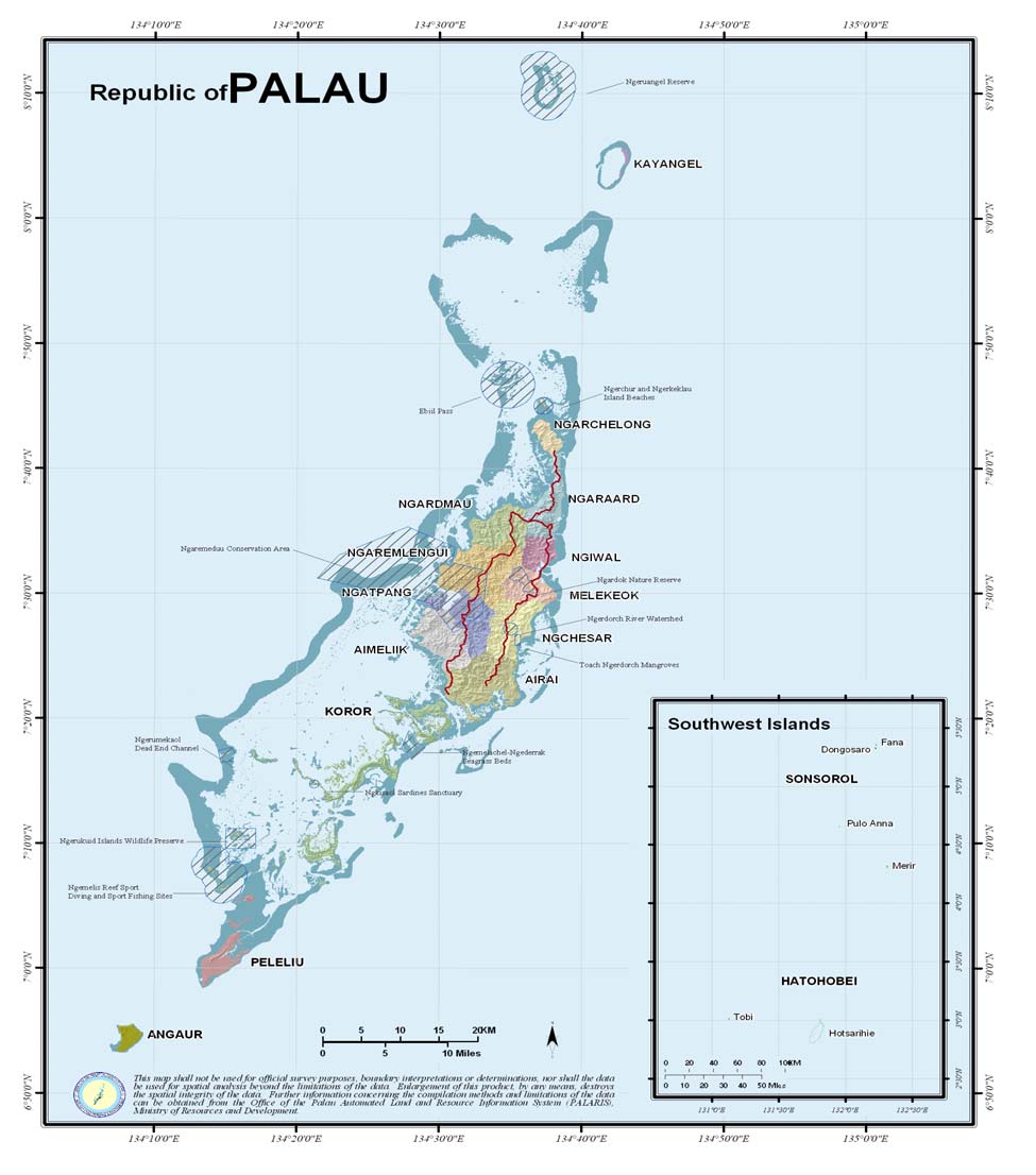
Figure 1.0 MAP OF PALAU
9
9. In Palau, as is the case for most Pacific Island countries, the climate is influenced by a
number of factors such as trade wind regimes, the paired Hadley cells and Walker
circulation, seasonally varying convergence zones such as the South Pacific Convergence
Zone (SPCZ), semi-permanent subtropical high-pressure belts, and zonal westerlies to the
south, with the El Ni±o Southern Oscillation (ENSO) as the dominant mode of year to
year variability (Fitzharris, 2001; Folland et al., 2002; Griffiths et al., 2003). The
Madden-Julian Oscillation (MJO) also is a major mode of variability of the tropical
atmosphere-ocean system of the Pacific on times scales of 30 to 70 days (Revell, 2004),
while the leading mode with decadal time-scale is the Interdecadal Pacific Oscillation
(IPO) (Salinger et al., 2001). A number of studies suggest the influence of global
warming could be a major factor in accentuating the current climate regimes and the
changes from normal that come with ENSO events (Hay et al., 2003; Folland et al.,
2003).
10. Recent studies in the southern Pacific region show that the annual and seasonal ocean
surface and island air temperatures have increased by 0.6 to 1.0oC since 1910 throughout
a large part of the South Pacific, southwest of the South Pacific Convergence Zone
(SPCZ) where as decadal increases of 0.3 to 0.5oC in annual temperatures are only
widely seen since the 1970, preceded by some cooling after the 1940, which is the
beginning of the record, to the northeast of the SPCZ (Salinger, 2001; Folland et al.,
2003).
11. Palau's climate is tropical with a mean annual rainfall of around 370 centimeters. The
heaviest rains are due to monsoonal storms that generally occur between the middle of
June through August. The highest daily rainfall occurred in April 1979 with 43
centimeters. There averages 263 days with rainfall greater than 0.025 centimeter. The
average monthly rainfall for July is 45.8 centimeters. Pre-WWII Japanese Forestry
rainfall records show a slightly higher rainfall amount than the 30 years of Koror records.
12. Prevailing winds are the northeastern trade winds, with a mean wind speed of 9.65
kilometer per hour. The average annual temperature is 27.6 degrees Celsius. The average
annual maximum temperature is 30.9 degrees Celsius and the average annual minimum
temperature is 24.2 degrees Celsius. The lowest temperature occurred in January 1998 at
20.6 degrees Celsius and the highest was 35 degrees Celsius on June 1976. There are
approximately 72 days where the temperature goes above 32.2 degrees Celsius (90░F).
Palau has moderate levels of sunshine. The normal relative humidity averages 85 percent.
June is slightly higher with 86 percent and April being the driest with 83 percent.
13. Palau lies outside of the "Typhoon belt" of the northern equatorial Pacific. However,
winds pick-up speed during typhoon events that veer close to the islands. Maximum
winds recorded were during typhoon events that approached within 150 kilometers of
Babeldaob. The major typhoons include: Gelda, December 15, 1959 with 140-knot winds
(260 km/h); Louise, November 16, 1964, with 100-knot winds (185 km/h); Opal,
December 11, 1964, with 140-knot winds (260 km/h); and Mike, November 10, 1990,
with 135 knot winds (250 km/h) (NOAA National Weather Service, Guam).
10
14. In 2001, Tropical Storm Utor, with wind speeds of up to 120 km/hr, caused minor
damage to infrastructure, mainly due to minor landslides caused by excessive rains. El
Ni±o of 1998 bleached 30% of Palau's coral reefs in some areas and in extreme cases
100% of the corals were bleached. During this time, the lowest amount of rainfall was
recorded and streams dried up while larger rivers had low flow. Water hours were applied
to public water supply systems due to lower intake rates from rivers.
2.2 Climate change vulnerabilities
15. According to a draft Second National Communication report provided to the PACC
Team, Palau is outside of the main tropical cyclone track of the northwestern Pacific,
however it was directly affected by Tropical Storm Utor in 2001. Also, the effect of EL
Nino brings drought to Palau and according to some estimates, it extends the dry season
from its usual 1.5 months to 2-3 months. In such cases, crops are seriously affected and
livelihood in general. The period after this, which is the La Nina, higher than average
rainfall is expected along with more intense and more frequent storms.
16. According to the 2nd NATCOM assessment results, saltwater inundation is a serious
problem that is plaguing farmers in Palau. Even though agriculture in Palau has been
relative small in scale, contributing only 6.2% of the GDP, there are a lot of small-scale
taro farms dispersed around the main island of Babeldaob. Cultivation of taro is critical to
Palau's socio-economic development and cultural as well as religious obligations. It is
usually cultivated very close to the sea and faces the threat of saltwater inundation and
wave overtopping.
17. During field visit discussions, the Chairman of Ngatpang Maritime Authority Mr.
Selestino Otong (Pers Com, 2008) he pointed out that over the years, farmers have also
experienced bleaching in clams they are breading out in the reefs. This may be caused by
changes in sea surface temperature as well as salinity of the salt water. According to Mr.
Selestino this may have impacted on growth rate of clams, mud crabs and grouper fish
they are farming in the area. These projects are directly subjected to ocean current
changes, sea surface temperature change as well as salinity changes. The milkfish on the
other hand is sheltered in land in man-made ponds. It is well established that marine
environments are vulnerable to climate change because sea-level rise and seawater
temperature increase could cause massive impact to the marine ecosystem. If seawater
temperature increases by 10C, as was the case for the 1997/1998 El Nino event, it could
cause the average sea surface temperature of Palau (which is normally around 290C to
increase to 300C level which is the threshold point for coral bleaching in Palau (Patrick,
Pers Comm.) lead to further marine environmental effects as the marine food chain is
connected. The impact would become worse by climate change.
2.3 General background
Palau
18. The Republic of Palau is made up of about 350 islands in the far western Pacific
Ocean. It stretches between 2 and 8 degrees north of the equator, with the main island
11
group lying between 6 and 8 degrees north latitude and 134o and 135o east longitude. It
is approximately 3220 kilometers south of Tokyo and 1600 east southeast of Manila.
Palau has a total land mass of 487 square kilometers. The largest island is Babeldaob,
with an area of 334 sq. km. Ten of Palau's 16 states lie on this island. The capital is
Ngerelmud, located in Melekeok, on the central east side of Babeldaob. South of
Babeldaob is the island of Koror, which is the central commercial site and former capital
of the Republic. Stretching south of Koror for 45 km are hundreds of tiny mushroom-
shaped islands, the world reknown "Rock Islands". At the southern boundary of the Rock
Islands is the low island of Peleliu and 11 km south of Peleliu is another inhabited island
low island, Angaur. 360 km southwest of Koror are two more of Palau's states,
Hatohobei and Sonsorol, which are composed of groups of tiny atolls. Though relatively
small in total land area, Palau has a coastline of 1,519 km.
Ngatpang State: the PACC Pilot Site
19. Ngatpang state is located on the western side of Babeldaob Island. Its neighbors
include Aimlek state to the south, Ngaremiengui state to the north and Ngchaser to the
east. The state is approximately 3900 ha (9700 acres) in size with the state capital located
at Ngatpang village. Ngeremeduu bay and its associated features dominate Ngatpang
state; the bay and the watershed are the largest in the republic. Portions of the land have
been designated as the Ngeremeduu conservation area and are co-managed by Aimelik,
Ngatpang and Ngaremlengui.
20. Much of Ngatpangs coastal area is fringed with mangroves. Ngatpang is the only state
to have non-contiguous state lands. State lands are located on the Ngerekimadel
peninsula and inland from Ngeremeduui bay. Its two main settlement areas are Ngatpang
village and Ibobang village with Ibobang being a relatively recent settlement. Ngatpang
relies on roads within AimElik to reach the extension of Ngatpang's state lands on the
Ngerekimadel peninsula. Ibobang is accessible via a branch road from the existing north-
south road running from Airai to Ngaremlengui. Principal land uses in Ngatpang include
residential, subsistence agriculture and some small-scale commercial agriculture and
mari-culture.
21. There are a total of 156 ha (389 ac) of wetland habitat in Ngatpang, occurring for the
most part along the low-lying areas of the Ngkebeduul river drainage and inland of the
mangroves at Ngeremeduu Bay. There are a total of 476 ha (1190 ac) of mangrove forests
in Ngatpang, ringing Ngeremeduu bay a large (14 ha/ 33ac) mangrove stand near
ngatpang village was degraded in the early 1990s as the result of road and small boat
harbor construction. The state has proposed a development of an aqua culture facility in
the degraded area. Both wetlands and mangroves are considered an island-wide resource,
warranting coordinated management planning among the states.
22. Ngatpang has rich and diverse marine resources due to Ngeremeduu bay and the
associated outer and inner reef. Rabbit fish, sea cucumbers and mangrove crabs are
examples of prevalent species. The offshore and near shore areas are considered a major
fishery on the island. Catch data collected by division of marine fishery resources in 1992
12
indicate that Ngatpang ranks fifth in the commercial finfish production. Ngeremeduu bay
is responsible for over half of all mangrove crab collected and sold. Toachel mlengui is
an important spawning site for a number of important species and the endangered dugong
and green and hawksbill turtles frequent the waters off the southern half of the states west
coast. Due to its proximity to Toachel Melgui, Ngatpang has ready access to a number of
the dive spots located along the outer reef, including Wild West Coral Garden, Satan
Corner and Devils Playground. The sea grass beds near Ngerkeal, which are frequent by
dugongs, are degraded (heavily silted) due to the impacts from the power plants
construction nearby in Aimelik.
23. Ngatpang, like most states on Babeldaob, consist on relatively flat ridge top, steep
stream valleys and flatter lands near the coast. The near-coastal lands adjacent to
Ngatpang village and some of the ridge top land near the compact road alignment are the
most appropriate areas for development. Slope gradient data for Ngatpang is shown
below:
Percent
Area, HA
Area, Ac
Percent of total
0% to 12%
490
1211
12%
12% to 30%
1110
2743
28%
>30% 2330 5757 60%
Total
land
3930 9711 100%
Office National Planner, Office of the President
24. 53% of soils in Natpang are rated as moderately or highly erodible or a actively
eroding. Soils with potential to support agriculture are predominantly found on the
Ngatpang peninsula area, north of the Tabecheding Falls and along the Nkebeduul
drainage. Soils capable of supporting agro forestry generally occur in large tracts
eastward from the mangrove areas; such soils are only sparsely found on the peninsula
area.
25. Agriculture is considered to be on the states primary economic development
priorities. Coconut plantations ring the village of Ngatpang. Within the villages of
Ngatpang and Ibobang, family gardens are common, with more variety and sophisticated
agricultural methods being conducted in the area. The area by the north dock at Ngatpang
village is covered in mixed coconut plantation. Abandoned coconut plantations are found
on the peninsula east of Lauroro. Extensive areas around Ibobang and the drainages of
the Tabecheding, Ngatpang and Ngimet rivers were in cultivation during the Japanese
era; copra, pineapple and other row crops were prevalent. Most of these plantation areas
face saltwater intrusion given their close proximity to the sea.
26. With the opening of the Compact Road the central portion of the state will be easily
accessible from the new road and from the coast. This will create new opportunities for
development in the highland areas. The state dock is located at Ngatpang village.
27. Water is supplied to Ngatpang from a diversion on the Ngekebeduul river east of the
village. This water is stored in tanks and supplies Ibobang and outlying areas. Water is
13
supplied to Ngatpang village form the diversion on the Engas stream located west of the
road into the villager at Aimelik state boarder. The watershed for this diversion lies
entirely in Aimelik state. Supplemental water is supplied by rooftop rainwater catchments
systems at individuals home.
Ngatpang State development programmes
28. The Ngatpang State development programme is linked very closely to the National
Master Plan, which provides a nation wide guidance to development at the national and
state level. It emphasizes the following themes:
Ę Sustainability and land use compatibility in all new development.
Ę Protecting the traditional way of life and quality of life for the citizens of the state.
Ę Establishing the states desired "carry-capacity" for new growth and development
and ensuring that [A] growth does not happen in an uncontrolled manner and [B]
public services, facilities and infrastructure are not stressed beyond their capacity.
Ę Protecting Natural and Cultural resources in the context of economic development
and population growth.
29. For the Ngatpang State development plan, the upland areas within Ngatpang are good
expansion areas for agriculture due to their amendable soils and abundant water supply
from the Tabecheding, Ngatpang and Ngimet rivers. The move to the uplands would
address the issue of salt-water inundation that is already plaguing the current farmers at
present however, widespread clearing of forests would be unsustainable in the long-term
and should be strongly prohibited. Therefore, if there are practices or technologies that
can be used in the current low lying areas to address saltwater inundation, every attempt
should be made to address them to avoid encroaching into higher topographies or forest-
lands.
30. Aquaculture according to the Master Plan should be considered only for mangrove
areas already degraded. If the project fails, negative repercussions would not be that great
as the mangrove area was already degraded.
31. Most land use and development planning guidelines applicable to Ngatpang are
contained within the Nationwide Goals, Objectives and Management Guidelines
presented in chapter 3, along with the supplement to these presented in Babeldaob island-
wide discussion in section 4.2 and Ngatpang-specific goals and objectives presented
above. Of particular importance in Ngatpang are the following that address.
Ę Completion of the state master plan, including all recommended components (i.e.,
eco-tourist historic preservation, roadways, ports and docks, water supply.
Wastewater management, solid waste management, electrical power, etc.).
Ę Prioritizing the preservation of agriculture potential (section 4.9,2.2) as much as
possible when this potential overlaps that for community, tourism, or other
developed land uses.
14
Ę Identifying and planning for tourism development at locations and in tensities
supported by the citizens of the state.
Ę Evaluating cultural resources within the state and nominating additional sites to
the national register in order to ensure their preservation.
Ę Minimising development in steep areas and within water supply watersheds.
Ę Developing better data on marine resource yields and utilizing these data in the
form of fishing moratoriums, catch limits, etc. to ensure against over-harvesting in
the near and off shore areas as the result of subsistence, commercial and/or sport
fishing.
Ę Expand present knowledge regarding environmentaly sound methods levels and
locations of potential coastal aquaculture.
Ę Maintaining mangrove and stream course buffers to protect sensitive mangrove
communities and drinking water supply.
Ę Consider designating more mangrove area as protected areas as per
recommendations made by Metz (2000) and others.
Ę Caution in proposing or considering development in remote areas, where
infrastructure costs would be high and unnecessary fragmentation of natural
vegetation/habitat would result.
15
III. Baseline Scenario and PACC Intervention
3.1 Current and Future Vulnerability
32. The Second National Communication to the UNFCCC for Palau has just been
completed (2nd NATCOM, 2007). Findings point to three main issues of critical
importance at the national and local level scale. The first is the issue of drought, second
intense rainfall and frequent storms and third, sea level rise. The first and second issues
are directly linked to the El Nino and La Nina events; the third can be a result of melting
ice and thermal expansion of the ocean a result of global warming or tectonic activities.
33. According to the 2nd NATCOM findings, El Nino brings drought like conditions to
Palau and La Nina higher than average rainfall with more intense and more frequent
storms. Also, in an El Nino situation, sea surface temperature do change which could
impact negatively on corals and other mari-culture activities being carried out in the
ocean at such a time. During the 1997-1998 EL Nino event, the very dry season in Palau
according to estimates extended from its usual 1.5 months to 2-3 months. In such cases,
crops are seriously affected and consequently, livelihoods of the general populace. It was
also highlighted in the report that even though Palau is outside of the main tropical
cyclone track of the northwestern Pacific, it was directly affected by Tropical Storm Utor
in 2001.
34. According to the 2nd NATCOM assessment results, as a result of sea level rise,
saltwater inundation is a serious problem that is plaguing farmers in Palau particularly
taro farmers that use the low lands close to the coastal areas. Even though agriculture in
Palau is relatively small-scale, contributing only 6.2% of the GDP, there are a lot of
small-scale taro farms dispersed around the main island of Babeldaob, which includes the
PACC pilot area, Ngatpang State. Cultivation of taro is critical to Palau's socio-economic
development and cultural as well as religious obligations. It is usually cultivated very
close to the sea and faces the threat of saltwater inundation and wave overtopping. Due to
temperature changes in the ocean as a result of El Nino events, mari-culture activities
such as clam, crab and grouper fish farming may be impacted upon. Anecdotal
information from Mr. Selestino Otong (Pers Com, 2008), Chairman of the Ngatpang
State Marine Authority, indicated that farmers have reported clam-bleaching when sea
surface temperatures increase. Although more studies need to be undertaken, some effort
needs to be done now to address the issue.
35. The 4th IPCC Assessment Report (2007) is projecting warming of about 0.2░C per
decade for a range of SRES emission scenarios. Best estimates and likely ranges for
globally average surface air warming for six SRES emissions marker scenarios are given.
For example, the best estimate for the low scenario (B1) is 1.8░C (likely range is 1.1░C to
2.9░C), and the best estimate for the high scenario (A1FI) is 4.0░C (likely range is 2.4░C
to 6.4░C). This could mean an increase in El Nino and La Nina situations for Palau,
which could exacerbate current vulnerabilities people are already facing. Observations
show that the average temperature of the global ocean has also increased to depths of at
least 3000 m and that the ocean has been absorbing more than 80% of the heat added to
16
the climate system. This means that the air temperature rise could lead to sea surface
temperature rise. Such scenarios do not augur well for land and mari-culture farmers who
depend on the land and ocean resources to eke out a living. With additional stressors
added onto the current vulnerable situations of farmers and their farming systems, land
and the sea based farmers will be forced to look for alternative livelihoods which could
include relocating to Koror the commercial district of Palau to look for job opportunities.
3.2 Current Development Efforts
36. The State of Ngatpang has embarked on a programme of agricultural and mari-culture
farming over the years. With assistance from the Ngatpang State and National
Government, farmers are encouraged to go into rabbit fish farming, sea cucumbers, clam,
crabs and other forms of mari-culture farming. The offshore and near shore areas are
considered a major fishery on the island. Catch data collected by division of marine
fishery resources in 1992 indicate that Ngatpang ranks fifth in the commercial finfish
production. However, over the years they have experienced major set-backs due to the
impacts of warming waters, changes in salinity, and other stressors which include
thievery of seedlings of clams and crabs. Also, due to the large amounts of mangrove
areas those are already degraded, farmers are now utilizing them in a productive way.
37. On the land, farmers are encouraged to go into taro production in a big way. In the
current State Plan for Ngatpang, the upland areas are good expansion areas for agriculture
due to their amendable soils and abundant water supply from the Tabecheding, Ngatpang
and Ngimet rivers. The move to the uplands would address the issue of salt-water
inundation that is already plaguing the current farmers at present however, widespread
clearing of forests would be unsustainable in the long-term. Therefore, if there are
practices or technologies that can be used in the current low lying areas to address
saltwater inundation, every attempt should be made to address them to avoid encroaching
into higher topographies or forest-lands.
3.3. Gaps
All the development efforts described above had not take current and future climate
change in their development planning. A review of the existing legislations for Ngatpang
State reveals that no effort has been made in the past to address any climate change issues
in the State plans, policies and budgets. This could stem from the fact that State Officials
even though they receive concerns from farmers and also are able to witness impacts of
changes in climate in their current development programmes, often they do not
necessarily attribute this to climate change but some weather change or storms etc. This
is a general observation that is true for most Pacific Islands, therefore, it is important also
to address the issue of awareness and capacity development in the Sate of Ngatpang to
better equip them to address the issue of changes in climate now and in their future
planning programmes. It is assumed that this is a scenario common for all the 12 Palau
States and any effort to address this would provide a very important lesson that other
States in the Republic will learn from.
17
3.4 PACC Intervention
The PACC climate change adaptation activities for Ngatpang State would assist by
providing alternative solutions to real problems faced by farmers which include salt water
inundation on taro patches close to the sea and also the impacts of warming waters and
changes in salinity to the grouper fish, rabbit fish, clams and crab culture programmes
currently implemented in Ngatpang State. The PACC intervention as indicated in the next
section of this report takes into consideration a vision by the government and non-state
actors consulted during the PACC consultation process that food security for Palau means
a holistic approach to addressing food security issues from the land to the sea. The PACC
project therefore takes the conceptual approach of addressing vulnerability of
development programmes that are in the interface between the land and the sea (see
figure 3.0).
38. The `land to sea' concept is not new. Similar concepts have been promoted in the
development arena around the globe, which include the `white-and-blue' and `from-
ridge-to-reef concepts. The main driver of the `land to sea' concept as proposed for Palau
is that development programmes implemented on the land will impact on the sea and vice
versa. It takes a more holistic ecosystems approach to development as opposed to current
piece-meal development programmes currently undertaken by the Ngatpang State. This
connectivity will assure that future development programmes at the State level would
have a longer term vision and understanding of impacts that will happen particularly in a
world where climate change will largely change for the worse.
39. An important innovation as well for PACC is that it provides a clear link between two
GEF projects; one already being implemented (Oceanic Fisheries Project) and the other
in the GEF pipeline to be implemented soon (Integrated Water Resource Management
(IWRM)). IWRM will provide useful lessons from a watershed perspective and this
would certainly help in addressing the issue of saltwater inundation currently faced by
farmers'. The Oceanic Fisheries Project will provide lessons on the interface between
near-shore fisheries and deep-sea fisheries issues. Lessons from the two GEF projects
would be incorporated as part of the PACC package to be implemented in the State of
Ngatpang.
18

Figure 2.0 Proposed Concept for Palau
Proposed Concept for PACC Palau
POLICY Ł AGRICULTURE AND AQUACULTURE TO BE SUSTAINABLY DEVELOPED
IWRM
ECOSYSTEMS APPROACH
CONTRIBUTION
CONCEPTUAL
TO FOOD PRODUCTION AND
N
SCALE
FOOD SECURITY: From the
M
Land to the Sea
O
A
TI
IN
A
Drought
Taro and
S
related
other crops
Agroforestry System
problems on
T
land
R
E
A
Salt water
Interface
Capacity Building and
inundation
agriculture and
M
Mainstreaming to include
into low-
aquaculture
inputs from PALARIS, Palau
elevation
Community Col ege etc.
IN
agricultural
lands
IMPLEMENT
G
High water
Clam, mud
Aquaculture Farming
temperature
Oceanic
System
and sea level
crab and
Fisheries
change
milkfish
Contribution
40. There are also plans to disseminate lessons from the PACC project interventions in
Ngatpang State to two other States of the Republic of Palau.
19
PART IV. PALAU PACC PROJECT
4.1 Project Purpose
41. The purpose of this project is to promote a systems approach to climate change
adaptation that takes a holistic view of climate change issues that are adversely impacting
development programmes that are situated on the interface between the land and the sea.
A better understanding of the risks involved and how people have adapted over the years
will provide valuable insight to improving the current and future adaptive capacity of
communities at the pilot site, Palau in general and other countries of the pacific region.
4.2 Project Outcomes
42. There are two main outcomes that would be addressed under PACC Palau. The first
deals with direct implementation of adaptation options and the second deals with
mainstreaming. The two outcomes compliment and inform each other.
Outcome One: Resilience of the food production & security sector to climate change
in Palau enhanced.
43. This outcome will assist Palau to implement long-term adaptation measures to
increase the resilience of its food production and security sector to the adverse impacts of
climate change.
Outcome Two: State policies and programmes in the food production & security
sector integrate climate change adaptation priorities.
44. This outcome will assist Palau to implement long-term adaptation measures to
increase the resilience of its food production and security sector to the adverse impacts of
climate change.
4.3 Project Outputs
Output 1.1 Guidelines to improve resilience of coastal food production systems to the
impacts of climate change developed.
Output 1.2 Measures identified in the Guideline (2.6.1a) to improve resilience of coastal
food production systems implemented in a pilot demonstration (with co-financing
support).
This output will assist the Ngatpang Maritime Authority in the State of Ngatpang to
develop their capacity to design guidelines and technologies to enhance resilience of their
coastal food production systems to the impacts of climate change. The State of Ngatpang
largely uses the coast and land interface to develop their agriculture and aquaculture
programmes for subsistence and commercial purposes. This interface is now under threat
from changes in sea level as well as sea surface temperature. According to preliminary
results of the 2nd National Communication vulnerability and adaptation assessments,
20
saltwater inundation is a serious problem that is plaguing farmers in the low lying areas
of Ngatpang State and other states of Palau. Even though agriculture in Palau is relatively
small-scale, contributing only 6.2% of the GDP, there are a lot of small-scale taro farms
dispersed around the main island of Babeldaob, which includes Ngatpang State.
Cultivation of taro is critical to Palau's socio-economic development and cultural as well
as religious obligations. It is usually cultivated very close to the sea and faces the threat
of saltwater inundation and wave overtopping. In the near shore area, aquaculture and
mariculture activities such as clam, crab and grouper fish farming are already being
affected by changes in sea surface temperature particularly during an El Nino. Ngatpang
State Marine Authorities reported that farmers have reported clam bleaching when sea
surface temperatures increase. The IPCC Fourth Assessment Report notes that due to the
warming of the globe, it is likely that more El Nino like events would be happening and
this could have serious consequences for the people and their livelihoods. Cofinancing
support would be provided from several sources which include the Palau Community
College Extension and Research, Palau Community Agency and Government
departments that would be supporting the project at various stages. The Ngatpang State
Government is also committing space and in-kind support for the project at the State level
to ensure that work is carried out accordingly. Activities to be undertaken would include:
Activity 1: Salt tolerant taro varieties utilized in taro patches affected by salt water
intrusion.
45. This activity would address the issue of salt water inundation into taro patches
through the use of salt water tolerant taro varieties. Taro (Colocasia esculanta) is an
economic crop and of major cultural significance to Palauans. One of the solutions that
would be implemented is the testing and introduction of salt water tolerant taro varieties
into Ngatpang State. The current baseline notes that there are no taro salt water tolerant
varieties in the whole of Palau. Therefore, there is a need to search regionally particularly
to other States of the Federated States of Micronesia and other countries in the South
Pacific to see if such salt tolerant varieties are available in their countries for use in Palau.
46. The tasks identified below will be implemented during the course of the project:
i)
Identification and collection of salt water tolerant taro varieties;
ii)
Evaluation and selection of salt water tolerant taro varieties;
iii)
Propagation and distribution of salt water tolerant taro varieties in Ngatpang State;
iv)
Monitoring on site performance; and
v)
Share lessons, information and experiences to other States of Palau and other PACC
countries.
Primary agency: Palau Community College Ł CRE
Secondary agency: Bureau of Agriculture and Palau Community Action Agency,
Secretariat of the Pacific Community, FAO, Taiwan Technical Mission, ROC, Micronesia
region.
Possible Activity Indicators:
21
i)
By year three, at least twenty varieties have been collected and evaluated for salt
water tolerance;
ii)
By the fourth year, those varieties which were identified, propagated and distributed
to taro farmers in the pilot site;
iii)
Monitoring and evaluation of the identified taro varieties in the pilot site; and
iv)
Most successful taro varieties identified to be propagated and distributed to other
taro farmers.
Activity 2: Salt-water intrusion into taro patches prevented.
47. This activity would address the issue of salt water inundation into taro patches
through the use of appropriate traditional and contemporary technologies to completely
stop salt water inundation of taro patches. Through the assessment of traditional practices
and current practices, the best adaptation implementation option would then be
implemented to address the problem. The baseline scenario is that at present, once salt
water seeps into or displaces the fresh water in the taro patches, farmers abandon the taro
plots and move in-land or completely shift to other crops. In the process, more
deforestation takes place, people encroach to steeper slopes to plant therefore creating
further problems such as soil erosion, silting of water ways and in the long-term
destroying the biodiversity of downstream marine population.
48. The tasks identified below will be implemented during the course of the project:
i)
Identify and assess appropriate prevention measures;
ii)
Apply the appropriate prevention measure;
iii)
Monitor and evaluation of activity;
iv)
Mapping of affected taro areas; and
v)
Share lessons, information and experience to other PACC countries.
Primary agency: Bureau of Agriculture
Secondary agency: EQPB, PCAA, PALARIS
Possible Activity Indicators:
i)
By the end of year one, the MAPPING of the areas affected by salt water intrusion
have been identified and mapped;
ii)
Baseline data of salt intrusion collected from identified taro areas (salinity and
temperature);
iii)
By the end of second year, appropriate prevention measures have been identified and
put into practice; and
iv)
Monitoring and evaluation of prevention measures to identify appropriate prevention
measures.
Activity 3: Water management to address extreme weather events in taro
production areas.
22
49. This activity would address the issue of salt water inundation into taro patches
through the use of appropriate water management practices to completely stop salt water
inundation of taro patches. Water management is critical in taro cultivation for Palau as
most farmers' utilize low lands for cultivation. Given that most taro plots are in low lying
areas where the soil layers are deeper and richer, if compared to higher elevation soils,
water if not carefully managed can cause water logging, leading to comb-rot and also
salt-water can displace fresh water leading to higher soil salinity.
50. The tasks identified below will be implemented during the course of the project:
i)
Identify traditional and contemporary water management practices in taro production
areas;
ii)
Assess and identify best adaptation option and document; and
iii)
Implement the adaptation option whether it is rehabilitate, modification and/or
implementation of new practice or systems
Primary agency: PCAA
Secondary agency: EQPB, OERC, CIP, BOA, SOPAC
Possible Indicators:
i)
By end of second year, at least two traditional practices are located and
documented; and
ii)
By end of fourth year, at least one traditional practice is being implemented
successfully
Activity 4: Availability of raw and processed food products in case of extreme
weather events.
51. This activity would address the issue of food security through the development of taro
and other agricultural and aquaculture produce into a diversified range of food products.
Post harvest preparation is important in terms of ensuring that food is available during
extreme weather events. Work will be carried out to teach the Ngatpang communities to
work on improving their knowledge base as well as their skills in post harvest food
preparation. Through the assistance of key stakeholders, the community will also be
assisted to seek income generating opportunities which will augur well in terms or
resilience building.
52. The tasks identified below will be implemented during the course of the project:
i)
Utilizing appropriate post harvest technology taking into consideration shelf life,
new products and income generation;
ii)
Diversifying range of food crops resilient to extreme weather events; and
iii)
Piloting alternate food products at community level
23
Primary agency: Palau Community College Ł CRE
Secondary agency: BOA, FAO, USP, SPC DSAP
Possible Indicators:
i)
By the end of year one, a food technology class conducted for farmers' (women);
ii)
By end of year three, shelf life of taro products identified and evaluated; and
iii)
By year four, at least two farmers from Ngatpang have commercialized and
marketed new taro products.
Activity 5: Aquaculture practices enhanced to accommodate sea surface
temperature and sea level change.
53. This activity would address the issue of food security through the enhancement of
current aquaculture programmes involving clam, grouper fish and crab farming to take
into consideration current and future changes in climate. It is already reported by farmers
dealing with clam farming that bleaching of clam shells do happen when sea surface
temperatures increase. Such phenomenon affects the growth rate of clams and fish
leading to higher rate of mortality. The El Nino of 1997-1997 seriously affected
aquaculture farmers in Palau.
54. The tasks identified below will be implemented during the course of the project:
i)
Document current practice and experience;
ii)
Monitor twice a week basis sea surface temperature, salinity and sea level change
in aquaculture system and how it impacts on growth rate of clams and crabs,
bleaching and survival rates;
iii)
Review and refine current practice taking into account results of monitoring; and
iv)
Increase number of farmers undertaking improved clam and crab farming
techniques/practices
Primary agency: Ngatpang Marine Authority
Secondary agency: Bureau of Marine Resources, FAO, SPC
Possible Indicators:
i)
Surface temperature, salinity and sea level change recorded, analyzed and
reported by end of every year;
ii)
By year three, some modifications have been developed based on results pf
monitoring; and
iii)
By year four, at least five farmers have adopted improved clam and crab farming
techniques.
Activity 6: State policies and guidelines put in place to accommodate sea surface
temperature and sea level change in clam, crab, and milkfish farming production.
24
55. This activity deals with mainstreaming climate change into the Ngatpang State
policies and guidelines. Current development activities at Ngatpang State, which includes
clam, grouper fish and crab farming, have not taken current and future changes in climate
into consideration. Therefore, it is incumbent for these development initiatives to
anticipate current and future changes in climate as reported by the IPCC Fourth
Assessment Report (AR4) and act accordingly through appropriate policies and
guidelines. In such a scenario, the issue of climate change consideration takes a longer
term perspective beyond the life of the PACC project.
56. The tasks identified below will be implemented during the course of the project:
i)
Develop policies and guidelines for the above using the bottom-up approach
ii)
Work with the State to demarcate clam/crab/milkfish farming areas
Primary agency: Ngatpang State Government
Secondary agency: BMR, FAO, SPC, EQPB,
Possible Indicators:
i)
By year four, aquaculture policies that take into consideration climate change are
developed and adopted by the Ngatpang State;
ii)
By year three, aquaculture farming areas identified, demarcated and mapped;
Activity 7: Capacity development on climate change and food security enhanced
57. This activity would address the issue of capacity enhancement and development
involving technical officers from the national and state governments, quasi-government
agencies, non-state actors and members of communities. The output would involve the
development of a training module on climate change that touches on the various issues,
climate change impacts already felt in Ngatpang State and how adaptation could be
implemented. It would also provide opportunities for training and other awareness
programmes to be developed and implemented that would assist in the overall resilience
enhancement of the government's manpower and systems and members of the
community.
58. The tasks identified below will be implemented during the course of the project:
i)
Develop communication strategy for the PACC project based on lessons from
each output (including television programmes)
iii)
Draft Training Module
iv)
Provide training on climate change adaptation & food security using above
module to communities and technical officers
v)
Participate and assist agriculture awareness programmes on food security
Primary agency: OERC Ł Joe Aitaro
25
Secondary agency: PACC CORE Group
Possible Indicators:
i)
By end of year two, a communication strategy is developed;
ii)
By end of year three, training module that incorporates lessons from the outputs is
developed;
iii)
By year four, training and other capacity development activities identified in the
communication strategy is implemented.
26
PROJECT LOG FRAMES AND INDICATORS
Project Log Frame and indicators for Palau would be finalized during the inception
meeting of the PACC project.
27
4.4 Implementation Arrangements for PACC
59. The PACC project will be coordinated through the Office of Environmental Response
and Coordination, which is part of the Office of the President of the Republic of Palau. A
National Climate Change Country Team exists in Palau and currently provides overall
guidance and coordination of all climate change projects in Palau (see figure 4.0).
60. The following organizations are members of the Palau NCCCT and will also
contribute to the PACC project implementation:
Ę OERC Ł Office of Environmental Response and Coordination
Ę Palau Community College
Ę Palau Community Action Agency
Ę Bureau of Agriculture, Ministry of Resources & Development
Ę Bureau of Marine Resources, Ministry of Resources & Development
Ę Palau Environmental Quality Protection Board
Ę Palau Automated Land and Resource Information Systems (PALARIS)
Ę Ngatpang State Government
Ę Ngatpang Maritime Authority
61. The implementation of project activities at the national level will be based on the
"country team" approach and it will continue to provide an overall guidance and
coordination role for the PACC project at the national level. As part of it's activities, the
Palau NCCCT, will provide oversight and approve work programmes and budgets for the
implementation of project activities at the national level (see figure 4.0).
4.5 Project Management Unit
62. In addition to the NCCCT and as per the requirement of UNDP, a Project
Management Unit (PMU) will be established within the Office of Environmental
Response and Coordination. Their will be a Project Manager/National Coordinator
(PM/NC) for PACC to be recruited and will work full time on the project and paid by the
project. The PM/NC, among others, will be responsible for the day-to-day management
and implementation of all national project activities.
28
BUDGET
Responsible ERP/Atlas
Budget Description
Budget
Code
Total
Year 1/08 Year 2/09Year 3/10Year 4/11Year 5/12 Budget
Outcome 1
71200
International Consultants ( including national regional staffing)
10,000
10,000
0
0
0
0
10,000
71300
Local Consultants (including national staffing)
30,000
5,000
5000
10,000
5,000
5,000
30,000
71400
Contractual Services - Ind
20,000
5,000
5,000
5,000
5,000
0
20,000
71600
Travel
20,000
0
5,000
5,000
5,000
5,000
20,000
72100
Contractual Services - Co
40,000
10,000
10,000
10,000
10,000
0
40,000
72200
Equipment & Furniture
10,000
5,000
1,000
3,000
1,000
0
10,000
72400
Communication & Audio Visual equipment
4,000
2,000
500
500
500
500
4,000
72500
Supplies
1,000
500
100
100
200
100
1,000
72800
Information technology and Outreach
3,000
500
1,000
500
1,000
0
3,000
74200
Printing, Publishing & Production
2,000
0
500
500
500
500
2,000
Subtotal
140,000
38,000
28,100
34,600
28,200
11,100
140,000
Outcome 2
71200
International Consultation
10,000
10,000
0
0
0
0
10,000
71300
Local Consultants
60,000
10,000
20,000
20,000
5,000
5,000
60,000
71400
Service Contracts - Ind
150,000
30,000
50,000
50,000
10,000
10,000
150,000
71600
Travel
20,000
2,000
5,000
5,000
5,000
3,000
20,000
72100
Contractual services - Co
320,000
55,000 105,000
55,000
55,000
50,000
320,000
72200
Equipment & Furniture
10,000
0
5,000
5,000
0
0
10,000
72500
Supplies
50,000
10,000
10,000
10,000
10,000
10,000
50,000
72400
Audio Visual Equipment and Communication
20,000
5,000
5,000
5,000
2,500
2,500
20,000
72800
Information Technology Equipment and Outreach
15,000
5,000
4,000
3,000
2,000
1,000
15,000
74200
Printing and Publications
15000
5,000
4,000
3,000
2,000
1,000
15,000
Subtotal
670,000
132,000 208,000 156,000
91,500
82,500
670,000
Outcome 3
71200
International Consultants
71300
Local Consultants
0
29
71600
Travel
20,000
4000
4000
4000
4000
4000
20,000
72100
Contractual Services - Co
0
Subtotal
20,000
4000
4000
4000
4000
4000
20,000
Outcome 4
71300
Local Consultants
88,758
17752
17752
17752
17752
17750
88,758
Subtotal
88,758
17752
17752
17752
17752
17750
88,758
Total
918,758
191,752 257,852 212,352 141,452
115,350
918,758
30
4.7 Monitoring and Evaluation
Project monitoring and evaluation will be conducted in accordance with established
UNDP and GEF procedures and will be provided by the project team and UNDP Samoa
MCO with support from UNDP/GEF. The Logical Framework Matrix in Section II
provides performance and impact indicators for project implementation along with their
corresponding means of verification. These will form the basis on which the project's
Monitoring and Evaluation system will be built.
The following sections outline the principle components of the Monitoring and
Evaluation Plan and indicative cost estimates related to M&E activities. The project's
Monitoring and Evaluation Plan will be presented and finalized at an Inception Report
following a collective fine-tuning of indicators, means of verification, and the full
definition of project staff M&E responsibilities.
4.7.1 Monitoring Responsibilities and Events
A detailed schedule of project reviews meetings will be developed by the PMO, in
consultation with project implementation partners and stakeholder representatives and
incorporated in the Project Inception Report. Such a schedule will include: (i) tentative
time frames for Tripartite Reviews (TPR), PEG Meetings and relevant advisory and/or
coordination mechanisms at national levels and (ii) project related Monitoring and
Evaluation activities.
Day to day monitoring of implementation progress will be the responsibility of the PMO
in consultation with the UNDP Samoa MCO based on the project's AWP and its
indicators. The PMO will inform UNDP Samoa MCO of any delays or difficulties faced
during implementation so that the appropriate support or corrective measures can be
adopted in a timely and remedial fashion.
The RPM and the responsible UNDP-GEF RTA will fine-tune the progress and
performance/impact indicators of the project in consultation with the full project team at
the IW and assisted by UNDP Samoa and UNDP-GEF HQ, as appropriate. Specific
targets for the first year implementation progress indicators together with their means of
verification will be developed at the IW. These will be used to assess whether
implementation is proceeding at the intended pace and in the right direction and will form
part of the AWP. The local implementing agencies will also take part in the Inception
Workshop in which a common vision of overall project goals will be established.
Targets and indicators for subsequent years would be defined annually as part of the
internal evaluation and planning processes undertaken by the project team. The
measurement impact indicators will be undertaken through subcontracts or retainers with
relevant institutions or through specific studies that are to form part of the projects
activities.
31
Periodic monitoring of implementation progress will be undertaken by the UNDP Samoa
MCO through quarterly meetings with the project staff; or more frequently as deemed
necessary. This will allow parties to take stock and to troubleshoot any problems
pertaining to the project in a timely fashion to ensure smooth implementation of project
activities.
UNDP Samoa MCO and UNDP-GEF RCU, as appropriate, will conduct yearly field
visits to pilot implementation sites, or more often based on an agreed upon scheduled to
be detailed in the project's Inception Report/AWP to assess first hand project progress.
Any other member of the PEG can also accompany, as decided by the PEG. A Field Visit
Report will be prepared by UNDP Samoa MCO and circulated no less than one month
after the visit to the project team, all PEG members, and UNDP-GEF.
Annual Monitoring will occur through the Tripartite Review (TPR). This is the highest
policy level meeting of the parties directly involved in the implementation of a project.
The project will be subject to a TPR at least once every year. The first such meeting will
be held within the first twelve months of the start of full implementation. The Executing
Agency will prepare an Annual Project Report (APR) and submit it to UNDP Samoa
MCO and the UNDP-GEF RCU at least two weeks prior to the TPR for review and
comments.
4.7.2 Annual Project Report (APR)
Palau will be required to produce APRs as a UNDP requirement to SPREP. This is part
of SPREP's oversight, monitoring and project management procedures at national level.
It is a selfŁassessment report by project management to SPREP which it will synthesis
with other APRs from other countries and will be presenting the APR to UNDP Samoa.
An APR will be prepared on an annual basis prior to the Tripartite Project Review, to
reflect progress achieved in meeting the project's AWP and assess performance of the
project in contributing to the intended outcomes through outputs and partnership work.
The format of the APR is flexible but should include the following:
An analysis of project performance over the reporting period, including outputs
produced and, where possible, information on the status of the outcome;
The constraints experienced in the progress towards results and the reasons for
these;
The three (at most) major constraints to achievement of results;
AWP, CAE and other expenditure reports (ERP generated);
Lessons learned; and
Clear recommendations for future orientation in addressing key problems in lack
of progress.
4.7.3 Quarterly Progress Reports
Palau is also required to provide short reports outlining main updates in project progress
will be provided quarterly to SPREP the Implementing Partner along with (1) financial
32
report and advance request for the upcoming quarter (2) workplan and budget for the
upcoming quarter.
4.7.4 Project Terminal Report
During the last three months of the project the project team will prepare the Project
Terminal Report. This comprehensive report will summarize all activities, achievements
and outputs of the Project, lessons learnt, objectives met, or not achieved structures and
systems implemented, etc. and will be the definitive statement of the Project's activities
during its lifetime. It will also lay out recommendations for any further steps that may
need to be taken to ensure sustainability and replicability of the Project's activities.
33
Figure: 3.0 Palau Institutional Arrangement
MRD-
PPUC
PALARI
PWD
EQPB
MOH-
PLANNING &
ENV.
MOS-
NATIONAL
CLIMATE CHANGE
PMs
CUSTOM
COMMITTEE
SPREP
TECHNICAL
PACC NATIONAL
UNDP
ADVISORY
FOCAL POINT - OERC
GROUP
SPC
PROJECT
OTHERS
MANAGEMENT UNIT
Output 1:
Output 2:
Output 3: Output 4:
Output 5: Output 6:
34
Reference
Adger, N., Mace, M.J., Paavola, J., and Razzaque, J., 2003: Justice and equity in
adaptation. Tiempo 52, 19-22.
Adger, W. N., S. Huq, K. Brown, D. Conway, M. Hulme, 2003: Adaptation to climate
change in the developing world. Progress in Development Studies, 3 (3), 179-195.
Agrawala, S., T. Ota, J. Risbey, M. Hagenstad, J. Smith, M. van Aalst, K. Koshy and B.
Prasad., 2003: Development and Climate Change in Fiji: Focus on Coastal
Mangroves: OECD
ADB (Asian Development Bank) 2004: Environmental Pacific Regional Strategy, 2005-
2009, ADB Manila, Philippines, 105 pp
Barnett, J., 2001: Adapting to climate change in Pacific Island Countries: The problem of
uncertainty. World Development, 29, 977-993
Becken, S., 2004: Climate change and tourism in Fiji: vulnerability, adaptation and
mitigation. University of the South Pacific, Final Report, 70 pp.
Becken, S., 2005: Harmonising climate change adaptation and mitigation: the case of
tourist resorts in Fiji. Global Environmental Change, 15, 381-393.
Brazdil, R., T. Carter, B. Garaganga, A. Henderson-Sellers, P. Jones, T. Carl, T. Knustson,
R.K. Kolli, M. Manton, L.J. Mata, L. Mearns, G. Meehl, N. Nicholls, L. Pericchi, T.
Peterson, C. Price, C. Senior, Q.C. Zeng, and F. Zwiers, 2002: IPCC Workshop on
changes in extreme weather and climate events, Workshop Report, Beijing, China,
11-13 July, 2002, 41- 42. Accessed 15.11.2004 at
http://www.ipcc.ch/pub/extremes.pdf
Burns, W.C.G., 2002: Pacific island developing country water resources and climate
change. In The World's Water (3rd Edition). P. Gleick (ed), pp. 113-132..
FAO (Food and Agriculture Organization of the United Nations) 2004: FAO and SIDS:
Challenges and Emerging Issues in Agriculture, Forestry and Fisheries. Paper
prepared by the Food and Agriculture Organisation (FAO) on the occasion of the
inter-regional conference on small island developing states (SIDS), Bahamas 26-30
January 2004, Bahamas. Rome.
Folland, C.K., J.A. Renwick, M.J. Salinger, N. Jiang, and N.A. Rayner, 2003: Trends and
variations in South Pacific Islands and ocean surface temperatures. Journal of
Climate., 16, 2859-2874
Folland, C.K., J.A. Renwick, M.J. Salinger, and A.B. Mullan, 2002: Relative influences
of the Interdecadal Pacific Oscillation and ENSO on the South Pacific Convergence
Zone. Geophysical Research Letters, 29, 21-1-21-4
Griffiths, G.M., M.J. Salinger, and I. Leleu, 2003: Trends in extreme daily rainfall across
the south pacific and relationship to the South Pacific convergence zone. J.
Climatol., 23, 847-869.
IPCC, 2001: Climate Change 2001: The Scientific Basis. Contribution of Working Group
I to the Third Assessment Report of the Intergovernmental Panel on Climate Change,
J.T. Houghton, Y. Ding, D.J. Griggs, M. Noguer, P.J. van der Linden, X. Dai, K.
Maskell, and C.A. Johnson (eds.), Cambridge University Press, Cambridge, United
Kingdom and New York, NY, USA, 881 pp.
Lal, M., 2004: Climate change and small island developing countries of the South
Pacific, Fijian Studies, Special Issue on Sustainable Development, V2(1), 15-31.
35
Lal, M., H. Harasaw and K. Takahashi, 2002: Future climate change and its impacts over
small
island
states,
Climate Research, 19, 179-192.
Manton, M.J., P.M. Dellaa-Marta, M.R. Haylock, K.J. Hennessy, N. Nicholls, L.E.
Chambers, D.A. Collins, G. Daw, A. Finet, D. Gunawan, K. Inape, H. Isobe, T.S.
Kestin, P. Lefale, C.H. Leyu, T. Lwin, L. Maitrepierre, N. Oprasitwong, C.M. Page,
J. Pahalad, N. Plummer, M.J. Salinger, R. Suppiah, V.L. Tran, B. Trewin, I. Tibig,
and D. Yee, 2001: Trends in extreme daily rainfall and temperature in southeast Asia
and the south Pacific: 1961-1998. J. Climatol., 21, 269-284.
McKenzie, E., Prasad, B, and Kaloumaira, A. 2005. Economic Impact of Natural
Disasters on Development in the Pacific A SOPAC and USP Report. Suva, Fiji.
Nurse, L., G. Sem, J.E. Hay, A.G. Suarez, P.P. Wong, L. Briguglio and S. Ragoonaden,
2001: Small island states. . In: Climate Change 2001: Impacts, Adaptation, and
Vulnerability. J.J. McCarthy, O.F. Canziani, N.A. Leary, D.J. Dokken, and K.S.
White (eds.). Contribution of Working Group II to the Third Assessment Report of
the Intergovernmental Panel on Climate Change, Cambridge University Press,
Cambridge, United Kingdom and New York, NY, USA, pp. 842-975.
Nurse, L., and R. Moore, 2005: Adaptation to global climate change: an urgent
requirement for Small Island Developing States. Review of European Community
and International Law (RECIEL), 14 (2), 100-107.
Otong, S. 2008. Personal Communication. Chairman Ngatpang Marine Authority.
Pelling, M., and J.I. Uitto, 2001: Small island developing states: natural disaster
vulnerability and global change. Environmental Hazards, 3, 49-62.
UNFCCC Second National Communication. 2008. A Preparatory Workshop on Vulnerability and
Adaptation Assessment for the Republic of Palau. Office of the Environmental Response and
Coordination. Unpublished report.
U.S. Census Bureau, International Data Base (IDB), Country Summary: Palau. Retrieved 2008.
Internet address, http://www.census.gov/ipc/www/idb/country/psportal.html
World Bank, 2000: Cities, Seas and Storms: Managing Change in Pacific Island
Economies. Vol. IV, Adapting to Climate Change. World Bank, Washington, D.C. 72
pp.
World Bank, 2002: Cities, Seas and Storms: Managing Change in Pacific Island
Economies. World Bank, Washington, D.C
World Bank, 2006: Not If, But When: Adapting to Natural Hazards in the Pacific islands
Region: A Policy Note. World Bank, Washington, D.C., USA, 60 pp.
36